
EES Chapter 2 - Project rationale
26
Environment Effects Statement Chapter 2 Project rationale
Transcript of EES Chapter 2 - Project rationale
Environment Effects Statement
Chapter 2 Project rationale
2 - PROJECT RATIO
ANLE
Chapter 2 – Project Rationale | 2–1
Chapter 2 Chapter 2Project Rationale
2.1 Introduction This chapter discusses the rationale for North East Link including the strategic and policy drivers and the key benefits that would be derived from the project
Over the past 50 years, Melbourne has experienced major changes in population, economic structure and urban built environment. Melbourne is the nation’s fastest growing capital and is predicted to surpass the population of Sydney in the future. The economy has transitioned from manufacturing-based industries to information and service-based industries. These changes in population and economic structure have caused spatial reorganisation of the city, with people increasingly unable to live close to key business centres.
Population, economic and spatial changes will continue to increase pressure on Melbourne’s infrastructure and services, with a growing demand for travel putting the city’s transport networks under particular strain. At the same time, rapid advances are occurring in vehicle technology, including the possible introduction of driverless or fully autonomous vehicles. All these changes must be planned for and addressed to maintain Melbourne’s productivity, competitiveness and liveability.
By improving the cross-city network, it is anticipated that North East Link would address a number of these pressures. North East Link would better connect households to jobs, services and education, increasing economic opportunity for households. Non-local traffic would be moved out of residential areas, improving local amenity and safety. Many businesses would be better connected with suppliers and gain efficiencies in the delivery of goods, achieved by reducing congestion and improving travel time reliability. These factors are expected to contribute benefits to the wider economy, making Victoria more competitive.
The project rationale is based on the North East Link Business Case, released in 2018, which is publicly available and can be drawn upon for further information.
Environment Effects Statement
2–2 | Chapter 2 – Project Rationale
2.2 Critical drivers of change A number of factors have contributed to the transport challenges that Melbourne currently faces. These include changes to population size and distribution, economic structure and spatial organisation as discussed below.
2.2.1 Population size and distribution
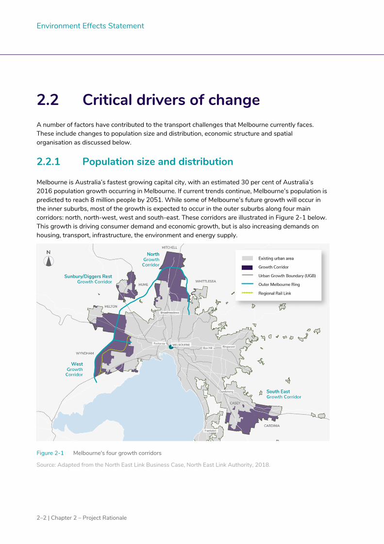
Melbourne is Australia’s fastest growing capital city, with an estimated 30 per cent of Australia’s 2016 population growth occurring in Melbourne. If current trends continue, Melbourne’s population is predicted to reach 8 million people by 2051. While some of Melbourne’s future growth will occur in the inner suburbs, most of the growth is expected to occur in the outer suburbs along four main corridors: north, north-west, west and south-east. These corridors are illustrated in Figure 2-1 below. This growth is driving consumer demand and economic growth, but is also increasing demands on housing, transport, infrastructure, the environment and energy supply.
Figure 2-1 Melbourne's four growth corridors
Source: Adapted from the North East Link Business Case, North East Link Authority, 2018.
Chapter 2 – Project Rationale | 2–3
2.2.2 Economic structure
Victoria’s economy has transformed over the last 30 years from a manufacturing-base to an information and services-based economy. Since the 1950s, the contribution of manufacturing to the economy has declined from around 40 per cent to less than 7 per cent, while service industries have risen from around 60 per cent to nearly 90 per cent.
More than 400,000 new jobs were created in Victoria from 2006 to 2016. The predominant increases have been in: household services including health care and social assistance; arts and recreation; education and training; and accommodation and food.
Highly skilled workers are benefiting from the growth of knowledge-intensive industries while others are impacted by the loss of manufacturing jobs, particularly in the city’s outer western, northern and eastern suburbs. These changes have created new economic, social and spatial structures and transformed the way economic value is created.
2.2.3 Spatial organisation
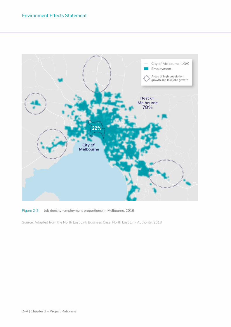
Economic productivity depends on efficiently connecting workers with employers and the providers of goods and services with customers and suppliers. As Melbourne has grown, the ability to facilitate these connections has declined. Over the past 70 years, Melbourne’s economic spatial structure has spread from the city centre to the middle and outer suburbs, leading to the creation of secondary business centres. However, the distribution of jobs is not aligning with population growth in Melbourne’s outer suburbs. This has created a disconnection between where people live and where they work. This is illustrated in Figure 2-2 below.
The central city remains competitive for most economic functions, but businesses face high overhead costs. Businesses in secondary centres have lower overhead costs but have lesser accessibility due to congestion and limited transport options. Declining housing affordability in inner urban areas means that many people live in areas where access to jobs and services is limited. The continued evolution of Melbourne’s spatial structure translates into increasingly constrained access for businesses to markets and for households to jobs and services. A key challenge for Melbourne is to adjust to this changing spatial organisation with a largely radial transport network.
Environment Effects Statement
2–4 | Chapter 2 – Project Rationale
Figure 2-2 Job density (employment proportions) in Melbourne, 2016
Source: Adapted from the North East Link Business Case, North East Link Authority, 2018
Chapter 2 – Project Rationale | 2–5
2.3 Strategic context Driven by changes in population, economy and spatial structure, Melbourne faces a number of transport challenges which are outlined below.
2.3.1 Poor cross-city movements
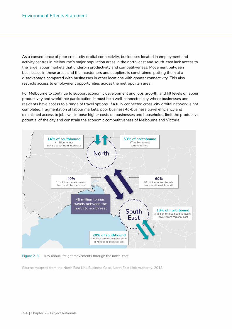
Melbourne’s cross-city road network connects major population, employment, service and industrial centres across the city’s north, east and south-east. It facilitates access to Melbourne Airport and other significant gateways and freight hubs, and provides links to the wider metropolitan road network. This vital role in facilitating freight flows across Melbourne is illustrated in Figure 2-3. It supports high value economic journeys across and around metropolitan Melbourne, including commuter journeys to employment and activity centres, business-to-business trips and metropolitan, regional and interstate freight movements.
Cross-city orbital movements between Melbourne’s west and north are facilitated via the M80 Ring Road (otherwise known as the Metropolitan Ring Road) extending from the Princes Freeway in Altona to the Greensborough Bypass. Movements between the east and south-east are enabled by EastLink, which traverses the outer eastern suburbs between Donvale and Seaford. However, there is no freeway-standard connection for cross-city orbital movements between the eastern terminal of the M80 Ring Road and the Eastern Freeway and northern end of EastLink.
This poor connectivity in the north-east means that arterial and local roads accommodate these cross-city movements as well as local traffic movements. Increasing demand for travel through, within and to and from the north-east has led to high levels of congestion, increased travel times and poor reliability for road users, and created a significant barrier to the movement of people and goods around Melbourne and Victoria.
‘Cross-city’ versus ‘orbital’ movements Generally, ‘cross-city movements’ refers to travel across Melbourne from one part of the city to another, such as using arterial roads to travel from Bundoora in the north to Box Hill in the east. ‘Orbital movements’ refers to travel around Melbourne via the outer suburbs, such as using the M80, arterial roads and the Monash Freeway to travel from Broadmeadows in the north to Dandenong in the south-east. Only a small number of trips are truly ‘orbital’ in that they travel along the full extent of the city’s orbital network. Most journeys use part of the orbital network to move across the city in a variety of directions: from the west to the north-east, from the north-west to the east, from the south-east to the north and so on. These trips along sections of the orbital network are referred to as cross-city orbital movements.
Environment Effects Statement
2–6 | Chapter 2 – Project Rationale
As a consequence of poor cross-city orbital connectivity, businesses located in employment and activity centres in Melbourne’s major population areas in the north, east and south-east lack access to the large labour markets that underpin productivity and competitiveness. Movement between businesses in these areas and their customers and suppliers is constrained, putting them at a disadvantage compared with businesses in other locations with greater connectivity. This also restricts access to employment opportunities across the metropolitan area.
For Melbourne to continue to support economic development and jobs growth, and lift levels of labour productivity and workforce participation, it must be a well-connected city where businesses and residents have access to a range of travel options. If a fully connected cross-city orbital network is not completed, fragmentation of labour markets, poor business-to-business travel efficiency and diminished access to jobs will impose higher costs on businesses and households, limit the productive potential of the city and constrain the economic competitiveness of Melbourne and Victoria.
Figure 2-3 Key annual freight movements through the north-east
Source: Adapted from the North East Link Business Case, North East Link Authority, 2018
Chapter 2 – Project Rationale | 2–7
2.3.2 Inefficient freight movement between Melbourne’s north and south-east
The north-east corridor plays a vital role in facilitating freight flows across Melbourne from the north to the east and south-east. This includes linking regional areas such as Gippsland and industrial areas, freight gateways and distribution centres in the south-east (such as Dandenong and the Port of Hastings) with the Hume Freeway and Melbourne Airport to facilitate interstate and international exports. It supports a number of specific transport and logistics tasks including the Melbourne Airport industrial precinct, Melbourne Market (Epping) and supermarket distribution centres in the north, east and south-east.
With strong growth expected in Victorian and Melbourne freight demand over the next 30 years, moving goods through this corridor efficiently is critical to business competitiveness and to supporting high value industries.
The lack of efficient cross-city movements through the north-east means that, on average, traffic travels around 20 per cent slower between the north and south-east compared with the north and south-west, increasing travel time by around 25 per cent. This is especially problematic for freight operators and business customers moving goods from interstate to destinations in the south-east industrial areas and beyond. Road connections between Melbourne’s western region and its northern industrial area are suitable for High Productivity Freight Vehicles (HPFV), which facilitates the effective and efficient flow of freight. However, the road network within the north east is not suited to heavy vehicles, with weight limits along the Eastern Freeway and curfews on arterial roads.
With no fully connected freeway link, freight flows across Melbourne from the north to the east and south-east currently rely heavily on arterial roads through the north-east to travel between the M80 Ring Road and the Eastern Freeway including Greensborough Road, Rosanna Road, Manningham Road, Bulleen Road, Burke Road and Fitzsimons Lane. These roads are struggling to cater for growing and competing travel demands and constrain cross-city access for freight. This also contributes to increased transaction costs, which are the costs associated with the exchange of goods or services (such as transportation) on top of the cost of the product. This is illustrated in Figure 2-4 below.
High Productivity Freight Vehicle Network High Productivity Freight Vehicles (HPFV) allow operators to move increased volume and mass by using larger, safer and more productive trucks. HPFV help alleviate pressure on the infrastructure network and give operators more flexibility to select the most suitable vehicle configuration to transport goods efficiently.
VicRoads has approved specific routes on which HPFV can travel. These routes make up the HPFV Network.

Environment Effects Statement
2–8 | Chapter 2 – Project Rationale
Figure 2-4 Victoria's HPFV Mass Network Map
Source: Adapted from the North East Link Business Case, North East Link Authority, 2018.
2.3.3 Congestion and heavy vehicles on local and arterial roads
Congestion on the north-east arterial road network combined with a lack of safe and appropriate walking and cycling facilities mean longer and less predictable travel times for residents and reduced access to local services, schools, recreation facilities and valued community places such as parks. High traffic volumes and congestion can expose residents to higher levels of noise and emissions, and an increased risk of road crashes.
These factors are diminishing the Victorian Government’s ability to realise the 20-minute neighbourhood, which is a key platform of Plan Melbourne 2017–2050, and are reducing the capacity of the north-east to contribute to managing Melbourne’s future population growth in a sustainable way that supports liveable, healthy and attractive communities.
Chapter 2 – Project Rationale | 2–9
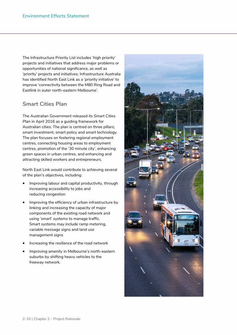
Heavy vehicles are a significant cause of local traffic congestion, contributing to increased emissions and traffic noise, and creating safety risks for motorists, cyclists and pedestrians. These impacts have the potential to restrict options for future land use and make it harder to attract new residents to the area.
Plan Melbourne 2017–2050 establishes the spatial directions for growth and land use change across the city over time. With Melbourne’s population forecast to reach 8 million by 2051, suburbs in the north and north-east would need to accommodate a significant proportion of the city’s growth from 2016 to 2046. The ability of these regions to support this growth is at risk due to an unconnected freeway network and already congested arterial road network that are unable to meet current and future transport needs.
2.4 Policy context This section summarises the policy context for North East Link. It describes the national, Victorian and local government policies, plans and frameworks relevant to development of road projects in Victoria.
2.4.1 National context
Australian Infrastructure Plan
The Australian Infrastructure Plan (2016) developed by Infrastructure Australia provides an investment roadmap for Australia, setting out challenges and opportunities over the next 15 years as well as the solutions required to keep up with projected population growth and drive productivity. Infrastructure Australia is an independent statutory body with a mandate to prioritise and progress nationally significant infrastructure. Four headline aspirations are identified in the Australian Infrastructure Plan, as follows:
• Productive cities, productive regions
• Efficient infrastructure markets
• Sustainable and equitable infrastructure
• Better decisions and better delivery.
Infrastructure Australia released an Infrastructure Priority List in March 2018, which provides decision-makers with a prioritised list of potential projects and initiatives to best address Australia’s infrastructure needs. Projects are defined as potential infrastructure solutions for which a full business case has been completed by the proponent and positively assessed by the Infrastructure Australia Board, while initiatives are potential infrastructure solutions for which a business case has not yet been completed.
Environment Effects Statement
2–10 | Chapter 2 – Project Rationale
The Infrastructure Priority List includes ‘high priority’ projects and initiatives that address major problems or opportunities of national significance, as well as ‘priority’ projects and initiatives. Infrastructure Australia has identified North East Link as a ‘priority initiative’ to improve ‘connectivity between the M80 Ring Road and Eastlink in outer north-eastern Melbourne’.
Smart Cities Plan
The Australian Government released its Smart Cities Plan in April 2016 as a guiding framework for Australian cities. The plan is centred on three pillars; smart investment, smart policy and smart technology. The plan focuses on fostering regional employment centres, connecting housing areas to employment centres, promotion of the ‘30 minute city’, enhancing green spaces in urban centres, and enhancing and attracting skilled workers and entrepreneurs.
North East Link would contribute to achieving several of the plan’s objectives, including:
• Improving labour and capital productivity, through increasing accessibility to jobs and reducing congestion
• Improving the efficiency of urban infrastructure by linking and increasing the capacity of major components of the existing road network and using ‘smart’ systems to manage traffic. Smart systems may include ramp metering, variable message signs and land use management signs
• Increasing the resilience of the road network
• Improving amenity in Melbourne’s north-eastern suburbs by shifting heavy vehicles to the freeway network.
Chapter 2 – Project Rationale | 2–11
Heavy Vehicle Road Reform
The Heavy Vehicle Road Reform is an initiative of the Transport and Infrastructure Council, aiming to turn the provision of heavy vehicle road infrastructure into an economic service where feasible. This would foster a market to better align heavy vehicle user needs with the level of service provided, with the charges paid for the services invested back into heavy vehicle road services. Currently, work is being undertaken to improve the transparency of expenditure and investment in freight transport.
The M80 Ring Road and Eastern Freeway are identified by the Transport and Infrastructure Council in Key Freight Routes: Road Expenditure and Investment Plans 2016–17 to 2019–20 Victoria (2017) as national ‘key freight routes’, for which the council aims to continue investment to meet the needs of users and strengthen the resilience of the freight network.
2.4.2 Victorian context
Transport Integration Act 2010
The Transport Integration Act 2010 (‘TIA’) is Victoria's principal transport statute. Its aim is to develop ‘an integrated and sustainable transport system that contributes to an inclusive, prosperous and environmentally responsible state’. The TIA sets out the key policies and objectives that guide the development of the Victorian transport system. It provides a framework to ensure the elements of Victoria’s transport are considered as a unified system and that transport and land use planning are integrated.
Under the TIA, a transport body must have regard to the objectives and decision-making principles when exercising any decision under transport legislation. These include the precautionary principle, the transport user perspective, considering the ‘triple bottom line’ as well as sustainability.
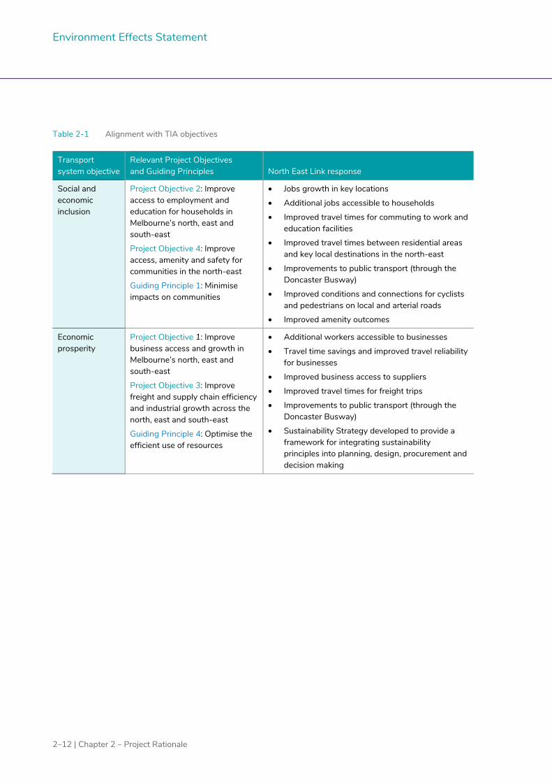
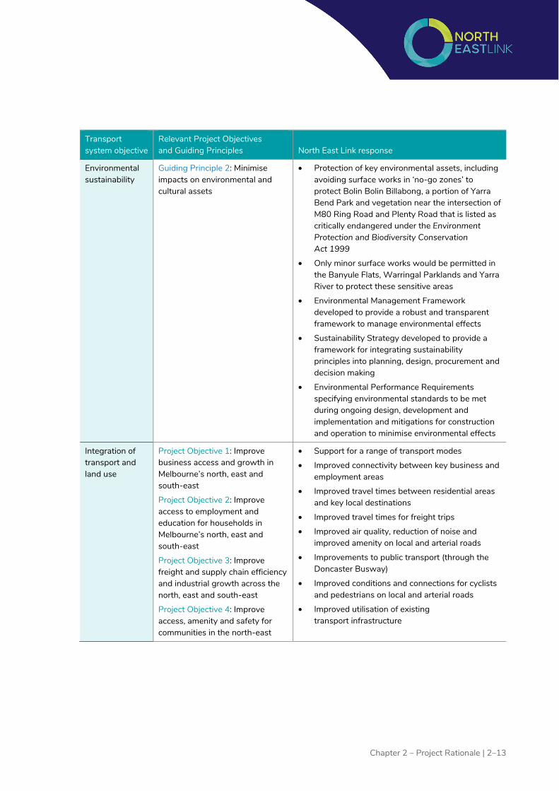
The TIA outlines six objectives for the transport system. A high-level summary of how North East Link is expected to address each objective is provided in Table 2-1. For the full list of the North East Link Project Objectives and Guiding Principles refer to Chapter 1 – Introduction.
Environment Effects Statement
2–12 | Chapter 2 – Project Rationale
Table 2-1 Alignment with TIA objectives
Transport system objective
Relevant Project Objectives and Guiding Principles North East Link response
Social and economic inclusion
Project Objective 2: Improve access to employment and education for households in Melbourne’s north, east and south-east Project Objective 4: Improve access, amenity and safety for communities in the north-east Guiding Principle 1: Minimise impacts on communities
• Jobs growth in key locations
• Additional jobs accessible to households • Improved travel times for commuting to work and
education facilities • Improved travel times between residential areas
and key local destinations in the north-east
• Improvements to public transport (through the Doncaster Busway)
• Improved conditions and connections for cyclists and pedestrians on local and arterial roads
• Improved amenity outcomes
Economic prosperity
Project Objective 1: Improve business access and growth in Melbourne’s north, east and south-east Project Objective 3: Improve freight and supply chain efficiency and industrial growth across the north, east and south-east Guiding Principle 4: Optimise the efficient use of resources
• Additional workers accessible to businesses
• Travel time savings and improved travel reliability for businesses
• Improved business access to suppliers
• Improved travel times for freight trips • Improvements to public transport (through the
Doncaster Busway) • Sustainability Strategy developed to provide a
framework for integrating sustainability principles into planning, design, procurement and decision making
Chapter 2 – Project Rationale | 2–13
Transport system objective
Relevant Project Objectives and Guiding Principles North East Link response
Environmental sustainability
Guiding Principle 2: Minimise impacts on environmental and cultural assets
• Protection of key environmental assets, including avoiding surface works in ‘no-go zones’ to protect Bolin Bolin Billabong, a portion of Yarra Bend Park and vegetation near the intersection of M80 Ring Road and Plenty Road that is listed as critically endangered under the Environment Protection and Biodiversity Conservation Act 1999
• Only minor surface works would be permitted in the Banyule Flats, Warringal Parklands and Yarra River to protect these sensitive areas
• Environmental Management Framework developed to provide a robust and transparent framework to manage environmental effects
• Sustainability Strategy developed to provide a framework for integrating sustainability principles into planning, design, procurement and decision making
• Environmental Performance Requirements specifying environmental standards to be met during ongoing design, development and implementation and mitigations for construction and operation to minimise environmental effects
Integration of transport and land use
Project Objective 1: Improve business access and growth in Melbourne’s north, east and south-east Project Objective 2: Improve access to employment and education for households in Melbourne’s north, east and south-east Project Objective 3: Improve freight and supply chain efficiency and industrial growth across the north, east and south-east Project Objective 4: Improve access, amenity and safety for communities in the north-east
• Support for a range of transport modes • Improved connectivity between key business and
employment areas • Improved travel times between residential areas
and key local destinations
• Improved travel times for freight trips • Improved air quality, reduction of noise and
improved amenity on local and arterial roads • Improvements to public transport (through the
Doncaster Busway)
• Improved conditions and connections for cyclists and pedestrians on local and arterial roads
• Improved utilisation of existing transport infrastructure
Environment Effects Statement
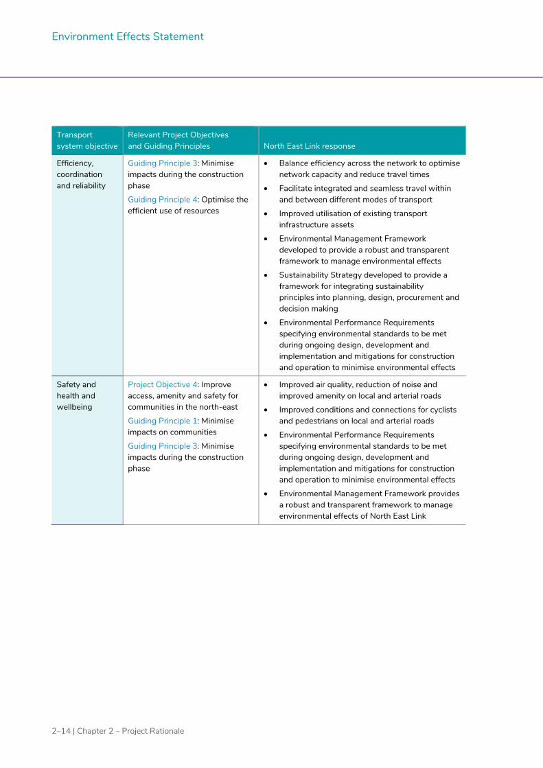
2–14 | Chapter 2 – Project Rationale
Transport system objective
Relevant Project Objectives and Guiding Principles North East Link response
Efficiency, coordination and reliability
Guiding Principle 3: Minimise impacts during the construction phase Guiding Principle 4: Optimise the efficient use of resources
• Balance efficiency across the network to optimise network capacity and reduce travel times
• Facilitate integrated and seamless travel within and between different modes of transport
• Improved utilisation of existing transport infrastructure assets
• Environmental Management Framework developed to provide a robust and transparent framework to manage environmental effects
• Sustainability Strategy developed to provide a framework for integrating sustainability principles into planning, design, procurement and decision making
• Environmental Performance Requirements specifying environmental standards to be met during ongoing design, development and implementation and mitigations for construction and operation to minimise environmental effects
Safety and health and wellbeing
Project Objective 4: Improve access, amenity and safety for communities in the north-east Guiding Principle 1: Minimise impacts on communities
Guiding Principle 3: Minimise impacts during the construction phase
• Improved air quality, reduction of noise and improved amenity on local and arterial roads
• Improved conditions and connections for cyclists and pedestrians on local and arterial roads
• Environmental Performance Requirements specifying environmental standards to be met during ongoing design, development and implementation and mitigations for construction and operation to minimise environmental effects
• Environmental Management Framework provides a robust and transparent framework to manage environmental effects of North East Link
Chapter 2 – Project Rationale | 2–15
Principles and objectives of ecologically sustainable development
The Ministerial guidelines for assessment of environmental effects under the Environment Effects Act 1978 specify the objective "to provide for the transparent assessment of potential environmental effects of proposed project, in the context of applicable legislation and policy, including principles and objectives of ecologically sustainable development". Under these guidelines, ecologically sustainable developed is defined as "development that improves the total quality of life, both now and in the future, in a way that maintains the ecological processes on which life depends". The objectives of ecologically sustainable development focus on community, wellbeing, equity and protecting biological diversity which are supported by a number of guiding principles.
Ecologically sustainable development has been integrated into the assessment of North East Link through the scoping requirements and the principles and objectives have been considered in the development of the evaluation objectives. As the environmental effects of North East Link have been assessed against the evaluation objectives, consideration of ecologically sustainable development has been integral to the preparation of the EES and the supporting technical reports.
Planning Policy Framework
The Planning Policy Framework (PPF) provides overarching policy guidance across all Victorian planning schemes. It ensures the objectives of planning in Victoria set out in section 4 of the Planning and Environment Act 1987 are applied through appropriate policies and decision-making and fostered through appropriate land use and development policies and practices that integrate environmental, social and economic factors in the interest of net community benefit and sustainable development.
• Integrated transport – The PPF objective (Clause 18.01-1S) is 'to create a safe and sustainable transport system by integrating land use and transport'. This is evident in the strategy to develop integrated and accessible transport networks to connect people to jobs and services, and goods to market. North East Link aligns with the strategies identified to achieve this objective, including improving the road network in growth areas and outer suburbs to provide access to jobs and services with better public transport connections through the Doncaster Busway, and better local travel options for walking and cycling to support 20-minute neighbourhoods.
• Transport system – The PPF objective (Clause 18.01-2S) is 'to coordinate the development of all transport modes to provide a comprehensive transport system'. North East Link supports the strategies identified to achieve this objective by incorporating the provision of public transport and cycling infrastructure in a major new road project, locating transport routes to achieve the greatest overall benefit to the community, ensuring the design, construction and management would reduce environmental impacts and improve links to existing transport systems.
Environment Effects Statement
2–16 | Chapter 2 – Project Rationale
• Sustainable personal transport – The PPF objective (Clause 18.02-1S) is 'to promote the use of sustainable personal transport'. North East Link incorporates new walking and cycling paths and routes that link to the metropolitan-wide network of bicycle routes. Project planning has also considered how North East Link would integrate with and deliver improvements to public transport. The new Doncaster Busway is an example of how public transport improvements are a key part of North East Link.
• Road system – The PPF objective (Clause 18.02-3S) is 'to manage the road system to achieve integration, choice and balance by developing an efficient and safe network and making the most of existing infrastructure'. North East Link aligns with this objective by delivering a high quality connection with an integrated traffic management system, improving key freight routes, and completing the orbital ring road in Melbourne’s outer suburbs. The project also incorporates measures that make better use of existing roads, such as bicycle lanes.
• Freight links – The PPF objective (Clause 18.05-1S) is 'to develop the key Transport Gateways and freight links and maintain Victoria’s position as the nation’s premier logistics centre'. North East Link supports this objective by leveraging the ability to run high productivity freight vehicles (HPFV) on an orbital motorway system.
Local Planning Policy Framework
The Local Planning Policy Framework (LPPF) is specific in content to each municipality and comprises two components; the Municipal Strategic Statement (MSS) and Local Planning Policies (LPP).
The MSS is a concise statement of the key strategic planning, land use and development objectives for the municipality and the strategies and actions for achieving the objectives.
LPP are tools used to implement the objectives and strategies of the MSS and include a policy statement of intent or expectation.
Each municipal planning scheme includes land use planning and environmental policies relevant to North East Link to varying degrees. Generally, relevant policies in the planning scheme include issues relating to land use planning, transport, infrastructure provision, environmental considerations and urban and public realm design.
The planning schemes relevant to North East Link are:
• Banyule Planning Scheme
• Boroondara Planning Scheme
• Manningham Planning Scheme
• Nillumbik Planning Scheme
• Whitehorse Planning Scheme
• Whittlesea Planning Scheme
• Yarra Planning Scheme.
Chapter 2 – Project Rationale | 2–17
Plan Melbourne
Plan Melbourne 2017–2050 is a metropolitan planning strategy that defines the future shape of the city and the state for the next 35 years. Plan Melbourne seeks to integrate long-term infrastructure, transport and land use planning to align with Melbourne’s future population, employment, housing and environmental needs.
Plan Melbourne envisages an integrated transport system connecting people to jobs and services in efficient, reliable ways. Specific to transport, Plan Melbourne details the need to keep up with the anticipated growth of an extra 10.4 million trips per day over Melbourne’s transport network by 2050, which will require major investment in road and rail transport.
Plan Melbourne sets seven outcomes for Melbourne’s development. To varying degrees, improved transport connectivity will contribute to achieving these objectives including creating liveable communities and neighbourhoods, delivering jobs and investment, maximising the growth and potential of Victoria and enhancing Victoria’s connectivity.
North East Link is consistent with Plan Melbourne in the following ways:
• Strengthening the connection to regional Victoria by improving movements between the M80 Ring Road and Eastern Freeway
• Improving the connection between business precincts and residential areas, better connecting workers to employment
• Shifting traffic from local and arterial roads to North East Link, improving amenity and safety for residents, local businesses and pedestrians and cyclists
• Reducing congestion and enhancing the resilience of the road network to reduce business and personal costs of travel
• Enhancing the network for freight and vehicles involved in the delivery of goods, creating benefits for businesses, consumers and the wider Victorian economy
• Providing enhanced pedestrian and cycling paths through neighbourhoods and along strategic cycling corridors to facilitate direct active transport links across Melbourne
• Improving public transport through the provision of the Doncaster Busway.
Environment Effects Statement
2–18 | Chapter 2 – Project Rationale
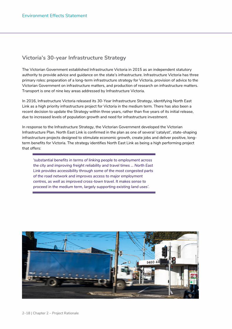
Victoria’s 30-year Infrastructure Strategy
The Victorian Government established Infrastructure Victoria in 2015 as an independent statutory authority to provide advice and guidance on the state’s infrastructure. Infrastructure Victoria has three primary roles: preparation of a long-term infrastructure strategy for Victoria, provision of advice to the Victorian Government on infrastructure matters, and production of research on infrastructure matters. Transport is one of nine key areas addressed by Infrastructure Victoria.
In 2016, Infrastructure Victoria released its 30-Year Infrastructure Strategy, identifying North East Link as a high priority infrastructure project for Victoria in the medium term. There has also been a recent decision to update the Strategy within three years, rather than five years of its initial release, due to increased levels of population growth and need for infrastructure investment.
In response to the Infrastructure Strategy, the Victorian Government developed the Victorian Infrastructure Plan. North East Link is confirmed in the plan as one of several ‘catalyst’, state-shaping infrastructure projects designed to stimulate economic growth, create jobs and deliver positive, long-term benefits for Victoria. The strategy identifies North East Link as being a high performing project that offers:
‘substantial benefits in terms of linking people to employment across the city and improving freight reliability and travel times … North East Link provides accessibility through some of the most congested parts of the road network and improves access to major employment centres, as well as improved cross-town travel. It makes sense to proceed in the medium term, largely supporting existing land uses’.
Chapter 2 – Project Rationale | 2–19
Victorian Freight Plan: Delivering the goods
The Victorian Government has released a state-wide plan to support industries involved in the movement of goods. The plan sets out short, medium and long-term priorities to support freight and logistics systems, which are prioritised as follows:
1 Manage existing and proposed freight corridors and places in conjunction with urban form changes
2 Reduce the impact of congestion on supply chain costs and communities
3 Plan for Victoria’s future port capacity
4 Stay ahead of the technology curve.
North East Link is consistent with the plan in the following ways:
• Commercial vehicle trips to and from industrial and commercial precincts in and out of the north-east corridor (particularly Latrobe, Epping and Broadmeadows) are likely to benefit from North East Link through reduced travel times, traffic decongestion and improved travel reliability.
• North East Link seeks to address the lack of HPFV access along the north-east corridor, where it has been estimated that the lack of existing access increases the number of trips by approximately 15 percent.
• As Melbourne’s population and economy grows, the movement of goods around the city via the West Gate Bridge and M1, which also serve as the key access routes to the Port of Melbourne and central city, is forecast to increase. Without North East Link, this would lead to further congestion and delays for commuter and freight traffic, reduced landside access for the Port of Melbourne, and a less than optimal logistics landscape.
• By improving access between the north, east and south-east, North East Link will provide industrial and warehousing precincts in the north with access to a much greater proportion of the metropolitan population, and allow logistics businesses to optimise their costs around improved transport links.
Environment Effects Statement
2–20 | Chapter 2 – Project Rationale
2.5 Satisfying the project objectives As outlined in Chapter 1 – Introduction, four project objectives were established to guide the development of North East Link. Table 2-2 summarises how North East Link is expected to meet these objectives.
Table 2-2 North East Link project objectives
Objective North East Link response
Improve business access and growth in Melbourne’s north, east and south-east
Reduction of congestion on arterial and local roads and enhancements of cross-city movements would benefit businesses by promoting cost savings associated with reduced travel times and improving business-to-business connectivity. North East Link would particularly benefit businesses involved in the transfer of goods and freight transport by reducing travel times and strengthening the resilience of the road network. This would promote the growth of businesses that benefit in the north, east and south-east.
Improve household access to employment and education in Melbourne’s north, east and south-east
By linking Melbourne’s north, east and south-east, North East Link would better connect households to employment and educational precincts (such as the Latrobe National Employment and Innovation Cluster), reduce congestion, improve travel time reliability and enhance network resilience. North East Link would also divert through traffic from local roads, allowing local traffic to better connect to local facilities such as schools and businesses.
Improve freight and supply chain efficiency and industrial growth across the north, east and south-east
Improvement to cross-city movements would improve supply chain efficiency, particularly for businesses involved in freight and the transfer of goods. Increased productivity due to greater efficiency would also promote industrial growth with Melbourne becoming a more attractive place for business start-ups, expansions and relocations.
Improve access, amenity and safety for the communities in the north-east
Improved connections between the north, east and south-east would reduce the reliance on local and arterial roads in the north-east. Benefits for residents and businesses would include reduced noise pollution, improved air quality, safer local roads, less time lost sitting in traffic and reduced feelings of stress. Freeing up arterial connections in the north-east to carry the appropriate vehicles and trips would also better connect residents to key local destinations (such as schools and recreational facilities) and provide more opportunities for people to take up walking and cycling.
Chapter 2 – Project Rationale | 2–21
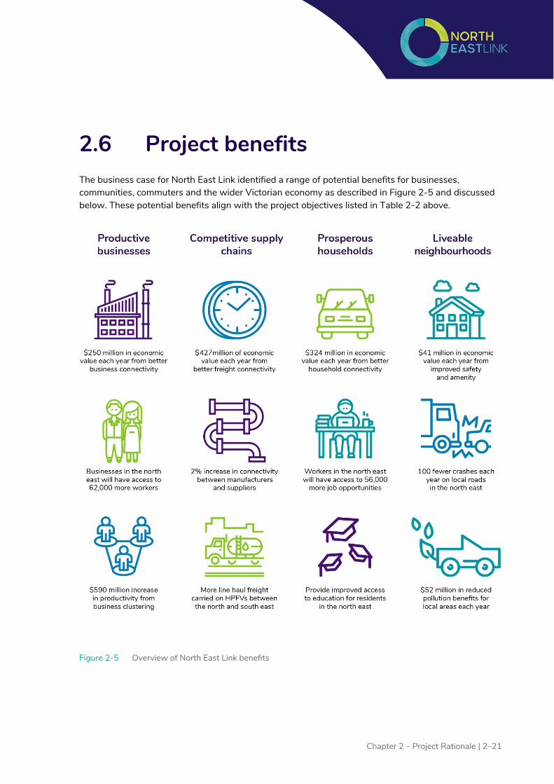
2.6 Project benefits The business case for North East Link identified a range of potential benefits for businesses, communities, commuters and the wider Victorian economy as described in Figure 2-5 and discussed below. These potential benefits align with the project objectives listed in Table 2-2 above.
Figure 2-5 Overview of North East Link benefits
Environment Effects Statement
2–22 | Chapter 2 – Project Rationale
2.6.1 Productive businesses
When deciding where to locate, businesses consider how connected a place is to sources of workers, suppliers and customers. This is a key focus of Plan Melbourne which includes a policy to facilitate the development of national employment and innovation clusters (NEICs), one of which is the La Trobe NEIC in Melbourne’s north-east (Plan Melbourne Policy no. 1.1.3). See Chapter 13 – Land use planning for further detail on the La Trobe NEIC. North East Link would foster better connections between the north, east and south-east of Melbourne, attracting more investment to these areas by making them more viable options for business start-ups, expansions and relocations. The improved connectivity would enhance the ability of businesses to share infrastructure and to match workers to jobs. Better business-to-business interactions would be facilitated, helping businesses in these areas to grow. Overall, improved connectivity is estimated to provide $250 million in economic value each year. Enhancing connections also provides benefits through promoting business clustering, which is the geographic connection of business, suppliers and other associated groups. This is anticipated to provide $590 million in economic value to businesses due to North East Link.
The metropolitan area accommodates a relatively large number of businesses and a significant proportion of Melbourne’s labour supply, which heavily depend upon cars for mobility due to the disconnected patterns of population and employment across the city. By providing a faster, more reliable connection to key employment areas in the north, east and south-east, North East Link would improve access for businesses to a larger pool of job seekers. This includes providing improved access to the La Trobe NEIC. It is anticipated that North East Link would improve connectivity to provide better access to businesses in the north east for an additional 62,000 workers and create an estimated 5,500 jobs.
2.6.2 Competitive supply chains
Better cross-city connections would provide a basis for a range of supply chain improvements and efficiencies, which would reduce transport costs for businesses. These savings would flow through to lower consumer prices and enable productivity benefits across the wider economy.
Broader benefits would be enjoyed by businesses across Melbourne, particularly those involved in the physical delivery of goods and services. Manufacturing businesses in Melbourne’s east and south-east would be able to access Melbourne Airport and key distribution facilities in the city’s north more efficiently. Some capacity on the M1 corridor would also be released, providing further efficiency for freight movements.
Providing an alternative, fully connected route for HPFV would reduce reliance on the M1 corridor for heavy vehicle freight movement and allow for more line haul freight to be carried on HPFV between the city’s north and south-east.
Overall, improvements to the network are anticipated to provide an estimated $148 million reduction in vehicle operating costs each year for freight vehicles and $427 million due to better freight connectivity.

Chapter 2 – Project Rationale | 2–23
2.6.3 Prosperous households
Improving connectivity and addressing capacity constraints in Melbourne’s north-east would reduce congestion and improve travel times. This would increase household access to employment, expanding the range and number of jobs available and boosting household income levels, particularly in the city’s outer suburbs where access to these opportunities is restricted.
Households in Melbourne’s south-east would also experience travel time savings, with journeys between the north and south-east expected to be 30 minutes faster.
Residents in Melbourne’s north-east who rely on public transport would also benefit with faster travel times, due to the dedicated Doncaster Busway. Running on the outside edge of the Eastern Freeway, the busway would provide an express, direct connection to existing bus lanes on Hoddle Street from the Doncaster Park and Ride. These bus lanes improve travel time reliability and bypass congestion on the freeway and ramps, resulting in increased average speeds for buses. This has been estimated to reduce travel times by up to 35 per cent for Doncaster Busway routes on the Eastern Freeway, and up to 15 per cent on the arterial road network.
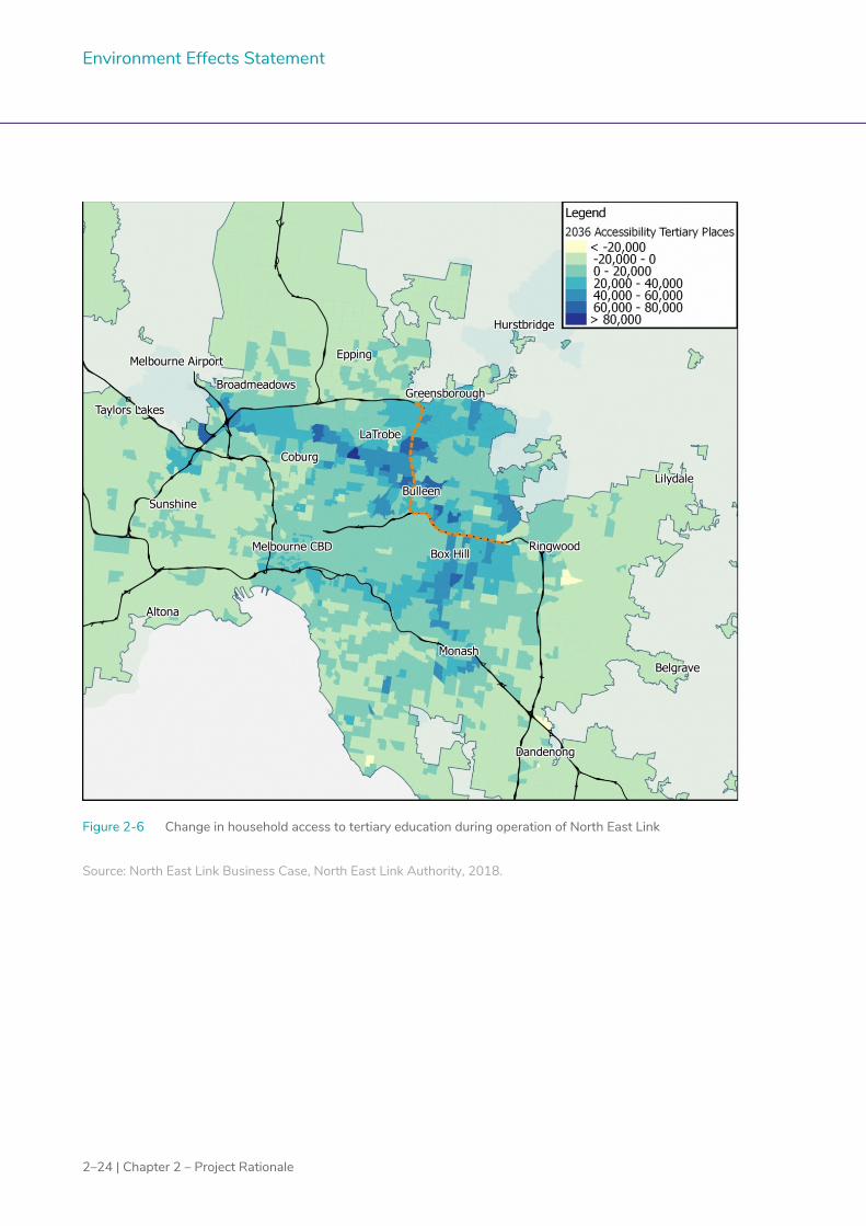
Improved travel times and connectivity in the north-east of Melbourne would better connect households to educational facilities, helping develop skilled labour and improve the range of accessible jobs. Change in household access to tertiary education is illustrated in Figure 2-6 below. Better connectivity is anticipated to generate $324 million in economic benefits to Victorian households each year.
Environment Effects Statement
2–24 | Chapter 2 – Project Rationale
Figure 2-6 Change in household access to tertiary education during operation of North East Link
Source: North East Link Business Case, North East Link Authority, 2018.
Chapter 2 – Project Rationale | 2–25
2.6.4 Liveable neighbourhoods
More efficient links between the north, east and south-east of Melbourne would reduce the reliance on local and arterial roads by removing non-local traffic. Reduced traffic would be experienced on a number of roads in the north-east including Rosanna Road, Greensborough Road, Manningham Road and Fitzsimons Lane. This is expected to benefit these areas including through improved air quality improvements, reduced traffic noise, improved visual amenity due to reduced congestion, and less vehicle collisions. It is projected that North East Link would move 15,000 trucks off local roads each day, significantly improving local amenity. Improved safety and amenity are expected to generate $41 million in economic value each year and reduce the number of vehicle crashes in the north-east by 100 each year.
Freeing up arterial connections in Melbourne’s north-east to carry the appropriate vehicles and trips would also better connect residents to key local destinations such as schools and recreational facilities. The walking and cycling network would also be enhanced by the completion of the North East Bicycle Corridor, a new commuter cycling route to the city along the Eastern Freeway, two new crossings of the Yarra River and improved cycling connections to expand the Strategic Cycling Corridor network, as identified by VicRoads (2016). For further detail on the proposed shared use paths, see Chapter 8 – Project description. The cumulative effect of these benefits would be a better quality of life and wellbeing for people living in Melbourne’s north-east.


![EES Feynman - Harrow School - Project Report [3.2]](https://static.fdocuments.in/doc/165x107/5695d2441a28ab9b0299c177/ees-feynman-harrow-school-project-report-32.jpg)

