Editing in ArcGIS 10 - Juniper GIS Services, Inc. · Templates initially created from visible...
74
Editing in ArcGIS 10 1/72 Copyright 2010-2012 – John Schaeffer\Juniper GIS Presentation Objectives What’s Changed Feature Templates Construction Tools Editing Tools Snapping Editing Attributes Tips and Tricks This PowerPoint is available at www.junipergis.com>links>presentations
Transcript of Editing in ArcGIS 10 - Juniper GIS Services, Inc. · Templates initially created from visible...

Editing in ArcGIS 10
1/72 Copyright 2010-2012 – John Schaeffer\Juniper GIS
Presentation Objectives
What’s Changed
Feature Templates
Construction Tools
Editing Tools
Snapping
Editing Attributes
Tips and Tricks
This PowerPoint is available at www.junipergis.com>links>presentations
Editing in ArcGIS 10
2/72 Copyright 2010-2012 – John Schaeffer\Juniper GIS
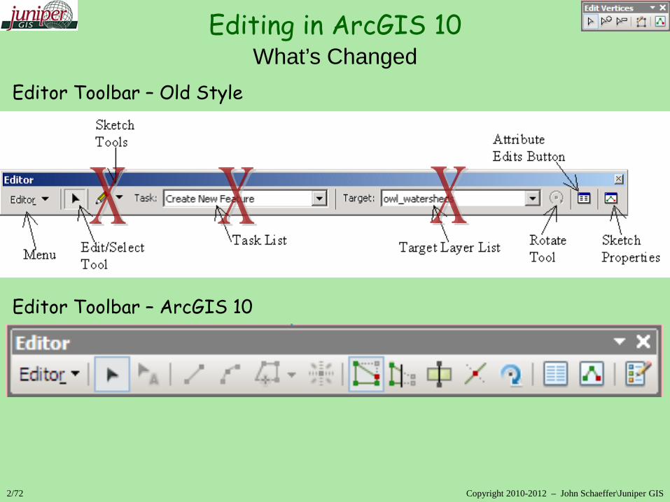
What’s Changed
Editor Toolbar – Old Style
Editor Toolbar – ArcGIS 10
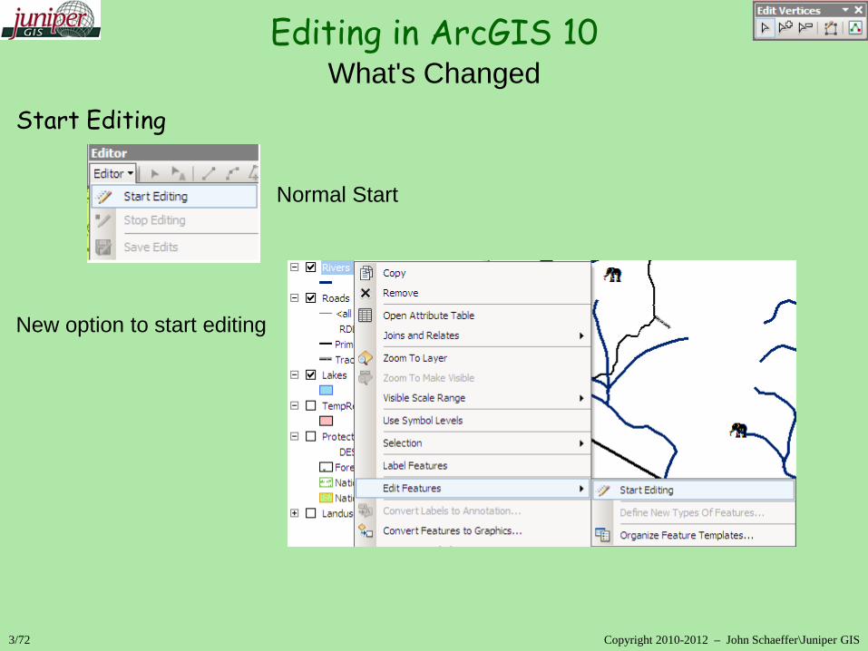
Editing in ArcGIS 10
3/72 Copyright 2010-2012 – John Schaeffer\Juniper GIS
What's Changed
Start Editing Normal Start New option to start editing
Editing in ArcGIS 10
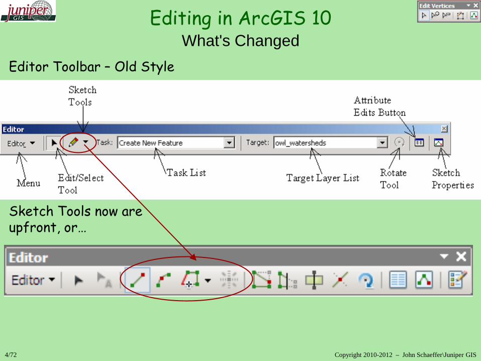
4/72 Copyright 2010-2012 – John Schaeffer\Juniper GIS
What's Changed
Editor Toolbar – Old Style Sketch Tools now are upfront, or…

Editing in ArcGIS 10
5/72 Copyright 2010-2012 – John Schaeffer\Juniper GIS
What's Changed
Editor Toolbar – Old Style … on the Feature Construction “mini” toolbar

Editing in ArcGIS 10
6/72 Copyright 2010-2012 – John Schaeffer\Juniper GIS
What's Changed
Editor Toolbar – Old Style Feature Templates ArcGIS 10
Some Tasks in Create Features
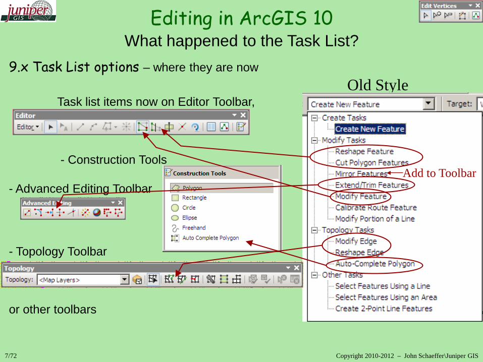
9.x Task List options – where they are now Old Style Task list items now on Editor Toolbar, - Construction Tools - Advanced Editing Toolbar - Topology Toolbar or other toolbars
Editing in ArcGIS 10
7/72 Copyright 2010-2012 – John Schaeffer\Juniper GIS
What happened to the Task List?
Add to Toolbar

8/72 Copyright 2010-2012 – John Schaeffer\Juniper GIS
Feature Templates – used to define how features and attributes will work Construction Tools
Editing Tools
Editing in ArcGIS 10 ArcGIS 10 Editing Overview – 5 key pieces

9/72 Copyright 2010-2012 – John Schaeffer\Juniper GIS
Snapping Editing Attributes
Editing in ArcGIS 10 ArcGIS 10 Editing Overview
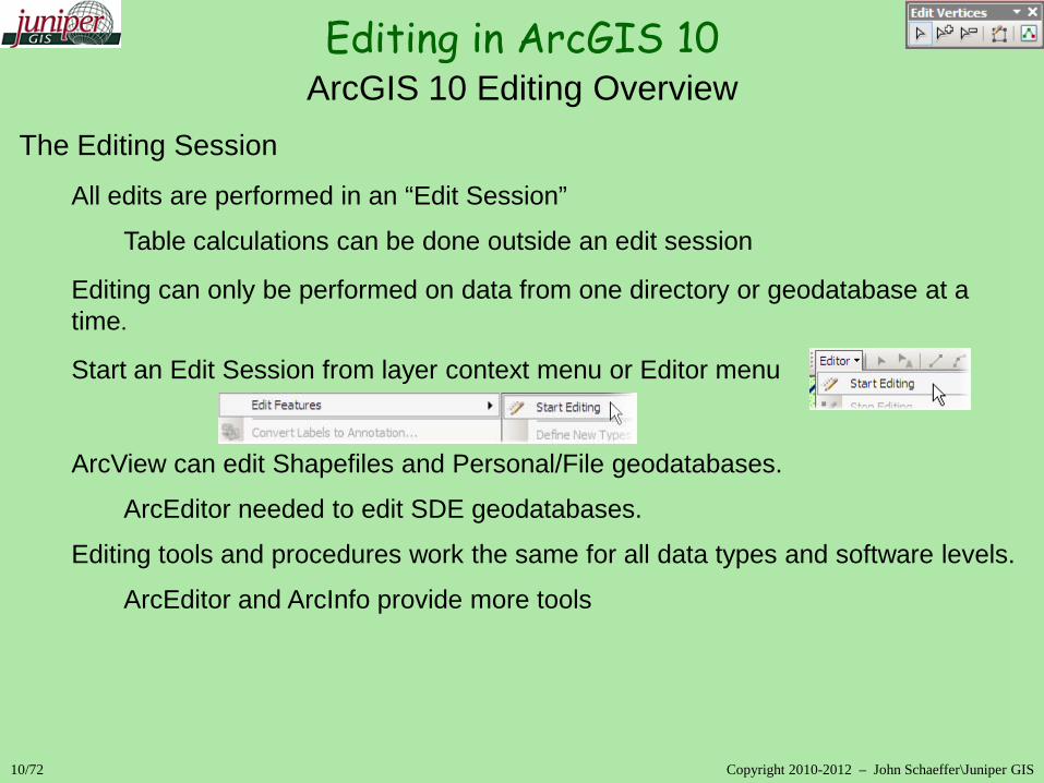
10/72 Copyright 2010-2012 – John Schaeffer\Juniper GIS
The Editing Session
All edits are performed in an “Edit Session”
Table calculations can be done outside an edit session
Editing can only be performed on data from one directory or geodatabase at a time.
Start an Edit Session from layer context menu or Editor menu ArcView can edit Shapefiles and Personal/File geodatabases.
ArcEditor needed to edit SDE geodatabases.
Editing tools and procedures work the same for all data types and software levels.
ArcEditor and ArcInfo provide more tools
Editing in ArcGIS 10 ArcGIS 10 Editing Overview
11/72 Copyright 2010-2012 – John Schaeffer\Juniper GIS
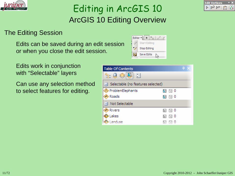
The Editing Session
Edits can be saved during an edit session or when you close the edit session.
Edits work in conjunction with “Selectable” layers
Can use any selection method to select features for editing.
Editing in ArcGIS 10 ArcGIS 10 Editing Overview

12/72 Copyright 2010-2012 – John Schaeffer\Juniper GIS
The Editor Toolbar
Contains most editing commands and options
Open by clicking on the Editor Button or opening the toolbar from Customize>Toolbars.
Editing in ArcGIS 10 ArcGIS 10 Editing Overview
13/72 Copyright 2010-2012 – John Schaeffer\Juniper GIS
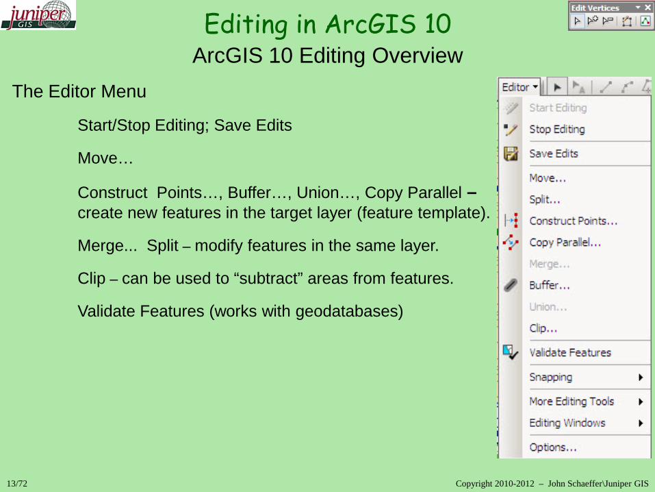
The Editor Menu
Start/Stop Editing; Save Edits
Move…
Construct Points…, Buffer…, Union…, Copy Parallel – create new features in the target layer (feature template).
Merge... Split – modify features in the same layer.
Clip – can be used to “subtract” areas from features.
Validate Features (works with geodatabases)
Editing in ArcGIS 10 ArcGIS 10 Editing Overview

14/72 Copyright 2010-2012 – John Schaeffer\Juniper GIS
The Editor Menu
Snapping – opens snapping dialog box More Editing Toolbars Editing Windows
Editing in ArcGIS 10 ArcGIS 10 Editing Overview

15/72 Copyright 2010-2012 – John Schaeffer\Juniper GIS
The Editor Menu
Editor Menu Options…
Options for Topology, Units, Annotation and Attributes
Sticky move tolerance
Classic Snapping
Show Mini toolbar
Stream Tolerance
Editing in ArcGIS 10 ArcGIS 10 Editing Overview

Editing in ArcGIS 10
16/72 Copyright 2010-2012 – John Schaeffer\Juniper GIS
Create Feature Window
Create Features Window Combines “Target Layer” & “Sketch” tools & “Task List”
“Target Layers” become “Feature Templates”
Some “Task List” and “Sketch” tool items included in the Construction Tools section
Construction Tools change depending on feature type
Each Template has a default tool
Editing in ArcGIS 10
17/72 Copyright 2010-2012 – John Schaeffer\Juniper GIS
Create Feature Window
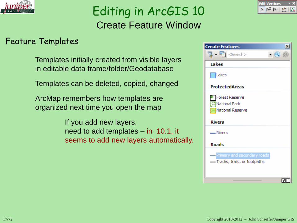
Feature Templates Templates initially created from visible layers in editable data frame/folder/Geodatabase
Templates can be deleted, copied, changed
ArcMap remembers how templates are organized next time you open the map
If you add new layers, need to add templates – in 10.1, it seems to add new layers automatically.

Editing in ArcGIS 10
18/72 Copyright 2010-2012 – John Schaeffer\Juniper GIS
Create Feature Window
Feature Templates Feature Templates are based on current symbology
Can have multiple “templates” for each layer
Best to set symbology before starting to edit
Set symbology on categorical data, not quantitative
Turn off layers you don’t need - keeps the Create Features dialog cleaner

Editing in ArcGIS 10
19/72 Copyright 2010-2012 – John Schaeffer\Juniper GIS
Create Feature Window
Feature Templates - Template Properties Default Construction Tool
Default Attribute Values
Tags & Description
Cannot change symbology
Editing in ArcGIS 10
20/72 Copyright 2010-2012 – John Schaeffer\Juniper GIS
Create Feature Window
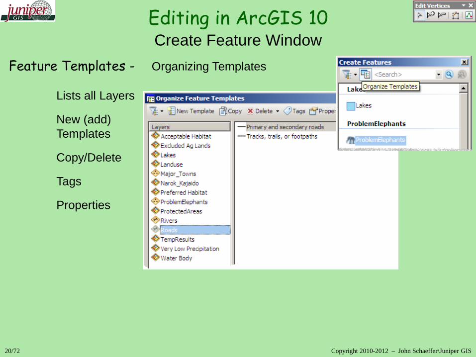
Feature Templates - Organizing Templates Lists all Layers
New (add) Templates
Copy/Delete
Tags
Properties
Editing in ArcGIS 10
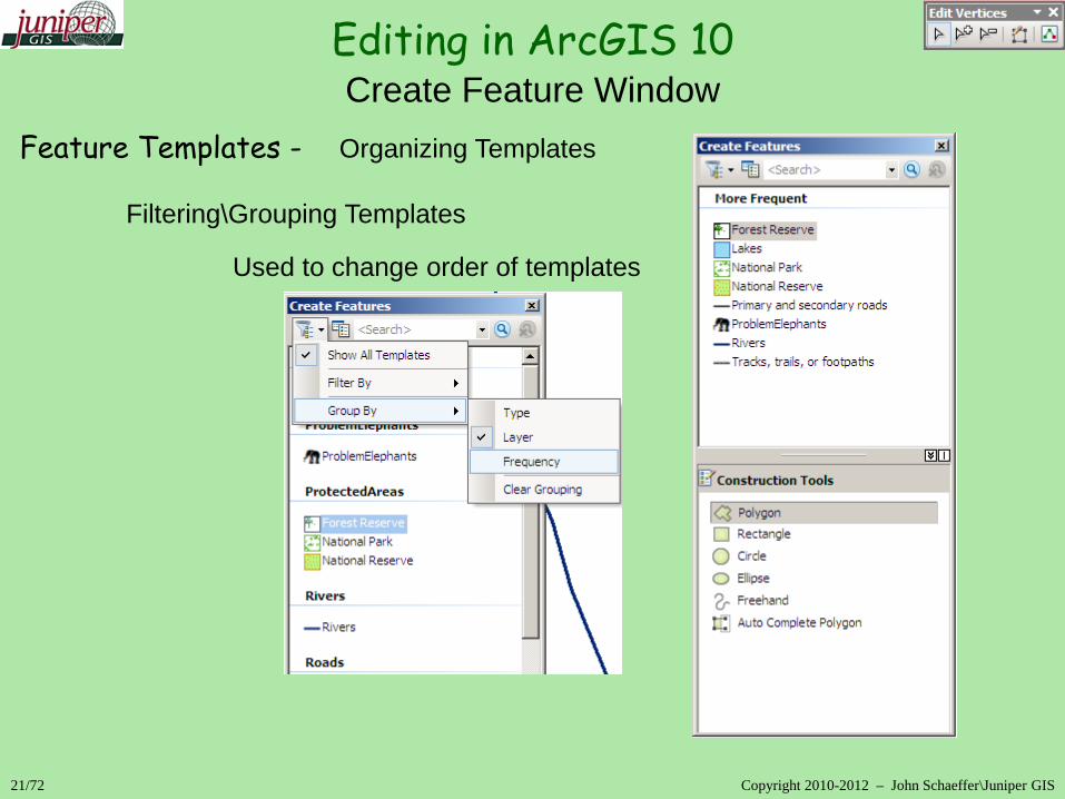
21/72 Copyright 2010-2012 – John Schaeffer\Juniper GIS
Create Feature Window
Feature Templates - Organizing Templates Filtering\Grouping Templates
Used to change order of templates
Editing in ArcGIS 10
22/72 Copyright 2010-2012 – John Schaeffer\Juniper GIS
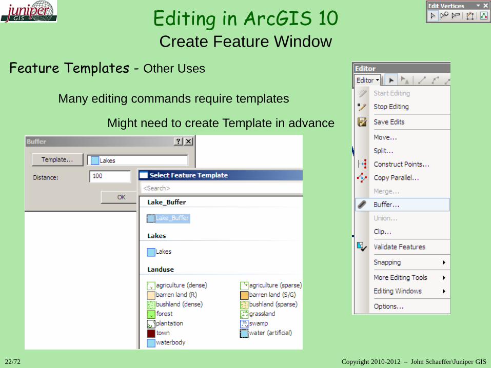
Create Feature Window
Feature Templates - Other Uses Many editing commands require templates
Might need to create Template in advance
Editing in ArcGIS 10
23/72 Copyright 2010-2012 – John Schaeffer\Juniper GIS
Create Feature Window
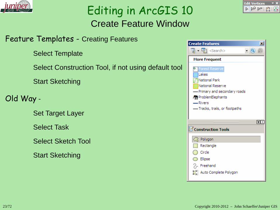
Feature Templates - Creating Features
Select Template
Select Construction Tool, if not using default tool
Start Sketching Old Way -
Set Target Layer
Select Task
Select Sketch Tool
Start Sketching

Editing in ArcGIS 10
24/72 Copyright 2010-2012 – John Schaeffer\Juniper GIS
Creating Features
Feature Construction Tools – located many places Construct Tools in Create Features
Default Tool set as part of Template Properties
Choices change depending on feature type

Editing in ArcGIS 10
25/72 Copyright 2010-2012 – John Schaeffer\Juniper GIS
Creating Features
Feature Construction Tools Construction Methods\Tools on Editor Toolbar
Straight Segment (Sketch)
End Point Arc Segment
Midpoint
Trace
Point
Right Angle
Distance-Distance & Distance-Direction
Intersection
Arc Segment, Tangent Curve Segment, & Bezier Curve Segment

Editing in ArcGIS 10
26/72 Copyright 2010-2012 – John Schaeffer\Juniper GIS
Creating Features
Feature Construction Tools Feature Construction Mini toolbar
Straight Segment (Sketch)
End Point Arc Segment
Trace; Etc…
Constrain Parallel – select feature to mimic
Constrain Perpendicular
Finish Sketch
Undo
Use Tab key to move toolbar up or down in 10.0
Use Tab key to temporarily display or hide in 10.1

Editing in ArcGIS 10
27/72 Copyright 2010-2012 – John Schaeffer\Juniper GIS
Creating Features
Feature Construction Tools Sketch Tool Context Menu Opened by right-clicking an existing feature or an empty space. Similar to 9.x

Editing in ArcGIS 10
28/72 Copyright 2010-2012 – John Schaeffer\Juniper GIS
Creating Features
Feature Construction Tools Topology Toolbar Construct Polygons – Creates polygon features from selected lines, requires existing polygon template
Requires ArcEditor Moved to Advanced Editing Toolbar in 10.1

Editing in ArcGIS 10
29/72 Copyright 2010-2012 – John Schaeffer\Juniper GIS
Creating Features
Feature Construction Tools
Editor Menu Commands for creating new features
Construct Points… – creates points along selected line segment
Copy Parallel…
Buffer… – creates Polygon if Feature Template is a Polygon, creates closed line if Feature Template is a Line.
Union… – Creates new feature from multiple selected features - works on point, line and polygon features
- some tools require a template

30/72 Copyright 2010-2012 – John Schaeffer\Juniper GIS
Feature Editing – Workings with Sketches
Sketches are the representation of the feature and are what is actually being edited.
Sketches from existing features are highlighted in cyan with green vertexes; Sketches for new features will display with current symbology and green vertexes. Certain tools work differently depending on whether you’re selecting Sketches or Features.
Sketches are converted back to features when editing is saved or stopped.
Stop sketching by hitting F2 key
Editing in ArcGIS 10 Editing Features
31/72 Copyright 2010-2012 – John Schaeffer\Juniper GIS
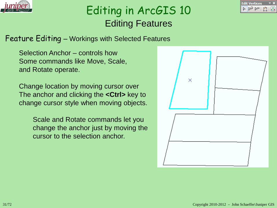
Feature Editing – Workings with Selected Features
Selection Anchor – controls how Some commands like Move, Scale, and Rotate operate.
Change location by moving cursor over The anchor and clicking the <Ctrl> key to change cursor style when moving objects.
Scale and Rotate commands let you change the anchor just by moving the cursor to the selection anchor.
Editing in ArcGIS 10 Editing Features

Editing in ArcGIS 10
32/72 Copyright 2010-2012 – John Schaeffer\Juniper GIS
Editing Existing Features
Feature Editing – Editing Vertices
Double-click a feature with the Edit Tool or click Edit Vertices on the Editor Toolbar to display sketch vertices
Use Edit Vertices mini toolbar to Modify, Add, Delete a vertex, or to Finish Sketch or open Sketch Properties More Tools added in 10.1

Editing in ArcGIS 10
33/72 Copyright 2010-2012 – John Schaeffer\Juniper GIS
Feature Editing - Sketch Context Menu Open by right-clicking a Sketch Similar to 9.x Can change segment type
Editing Existing Features

Editing in ArcGIS 10
34/72 Copyright 2010-2012 – John Schaeffer\Juniper GIS
Editing Existing Features
Feature Editing
Editor Toolbar Options
Edit Vertices
Reshape Feature
Cut Polygon
Split Line
Rotate
Editing in ArcGIS 10
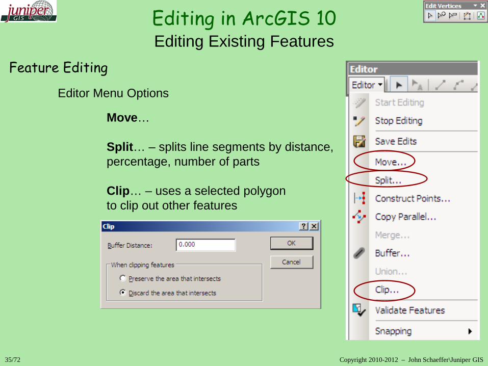
35/72 Copyright 2010-2012 – John Schaeffer\Juniper GIS
Editing Existing Features
Feature Editing
Editor Menu Options
Move… Split… – splits line segments by distance, percentage, number of parts Clip… – uses a selected polygon to clip out other features

Editing in ArcGIS 10
35/72 Copyright 2010-2012 – John Schaeffer\Juniper GIS
Editing Existing Features
Feature Editing
Editor Menu Options
Move… Split… – splits line segments by distance, percentage, number of parts Clip… – uses a selected polygon to clip out other features

Editing in ArcGIS 10
36/72 Copyright 2010-2012 – John Schaeffer\Juniper GIS
Editing Existing Features
Feature Editing
Advanced Editing Toolbar – 10.0
Fillet
Trim & Extend
Line Intersection
Explode Multi-part Features Generalize & Smooth
Topology Toolbar – 10.0 Split Polygons – splits multiple polygons with a selected line
Requires ArcEditor - Moved to Advanced Editing Toolbar in 10.1

Editing in ArcGIS 10
37/72 Copyright 2010-2012 – John Schaeffer\Juniper GIS
Editing Existing Features
Feature Editing
Advanced Editing Toolbar – 10.1
Align to Shape
Replace Geometry
Construct/Split Polygons/Planerize
Generalize & Smooth
Topology Toolbar – 10.1

Editing in ArcGIS 10
38/72 Copyright 2010-2012 – John Schaeffer\Juniper GIS
Editing Existing Features
Feature Editing Editing Toolbox – new in 10; requires ArcEditor, works on entire feature class.
Densify – adds vertexes to features
Erase Point – erases points within or outside of selected feature
Extend or Trim Line – extends or trims line features to another feature up to a specified distance
Flip Line – flips start point to end point for lines
Generalize – opposite of Densify
Snap – snaps vertices in one layer to vertices, edges, or endpoints of another layer. Works like a bulk snap.

Editing in ArcGIS 10
39/72 Copyright 2010-2012 – John Schaeffer\Juniper GIS
Snapping
How Snapping Works
Snaps for all features are active by default
Snap tips show which snap/feature will be used
Each snap type has unique icon
Cannot set snap priority for layer or type
Can turn snap types on/off Can use “classic” snapping - Editor>Options

Editing in ArcGIS 10
40/72 Copyright 2010-2012 – John Schaeffer\Juniper GIS
Snapping
How Snapping Works – Snapping Toolbar
Turn on Snapping Toolbar from Editor menu Standard Snaps - Point, Endpoint, Vertex, Edge
Turn Snapping on/off; Activate individual snap types
New Snaps - Intersection, Midpoint, Tangent

Editing in ArcGIS 10
41/72 Copyright 2010-2012 – John Schaeffer\Juniper GIS
Snapping
How Snapping Works – Snapping Toolbar
Snapping Options
Snapping tolerance is in Pixels only, not Map Units Can change Snap Tip symbology

42/72 Copyright 2010-2012 – John Schaeffer\Juniper GIS
Classic Snapping
Set snapping priority – Layer at top of list has priority
Set snap type for each layer or for sketches.
Set Snap tolerance through Snapping>Options…
Can be more useful in some cases
Turn classic snapping on in Editor>Options
Editing in ArcGIS 10 Snapping

Editing in ArcGIS 10
43/72 Copyright 2010-2012 – John Schaeffer\Juniper GIS
Editing Attributes
Attribute Editor Similar to 9.x
Options for sorting fields, fields to display
Expand relationships for joins & relates
Select Layer name to edit all selected features
Select Feature to edit individual features

Editing in ArcGIS 10
44/72 Copyright 2010-2012 – John Schaeffer\Juniper GIS
Editing Attributes
Field Calculator
Similar to 9.x
Can use Python or VB Script

Editing in ArcGIS – Advanced Editing Tools
Advanced Editing Toolbar
10.1
Topology Toolbar 10.1
Spatial Adjustment Toolbar
Working with ArcGIS
45/72 Copyright 2010-2012 – John Schaeffer\Juniper GIS
Editing in ArcGIS 10
46/72 Copyright 2010-2012 – John Schaeffer\Juniper GIS
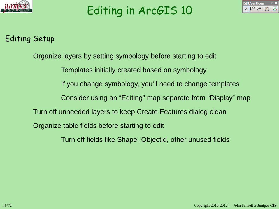
Editing Setup Organize layers by setting symbology before starting to edit
Templates initially created based on symbology
If you change symbology, you’ll need to change templates
Consider using an “Editing” map separate from “Display” map
Turn off unneeded layers to keep Create Features dialog clean
Organize table fields before starting to edit
Turn off fields like Shape, Objectid, other unused fields

Editing in ArcGIS – Editing keyboard shortcuts Shortcuts common to all editing tools Z Zoom In X Zoom Out C Pan V Show vertices Esc Cancel Spacebar Suspend snapping Edit tool Shift Add to/remove from selection Ctrl Move the selection anchor N Next selected feature Trace tool Tab Trace the other side of an edge O Open Trace Options dialog box
47/72 Copyright 2010-2012 – John Schaeffer\Juniper GIS
Editing in ArcGIS 10

48/72 Copyright 2010-2012 – John Schaeffer\Juniper GIS
Editing Basics and Setup
Editor Menu – Options\Attributes
Automatically display the attributes dialog when editing
Tips and Tricks

49/72 Copyright 2010-2012 – John Schaeffer\Juniper GIS
Editing Basics and Setup
Editor Menu – Options\Units
Specifies Direction Types and Units for entering Angles Units for Distance can be changed on-the-fly by using abbreviations – m, mi, ft, ‘, etc.
Tips and Tricks

50/72 Copyright 2010-2012 – John Schaeffer\Juniper GIS
Editing Basics and Setup
Feature Template Construction Tools - Auto Complete Polygon
Only works when completing to feature in the same layer
For the same effect in different layers, draw the new polygon overlapping an existing polygon, then clip the new polygon with the existing polygon
Tips and Tricks
51/72 Copyright 2010-2012 – John Schaeffer\Juniper GIS
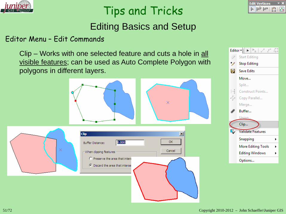
Editing Basics and Setup
Editor Menu – Edit Commands
Clip – Works with one selected feature and cuts a hole in all visible features; can be used as Auto Complete Polygon with polygons in different layers.
Tips and Tricks
52/72 Copyright 2010-2012 – John Schaeffer\Juniper GIS
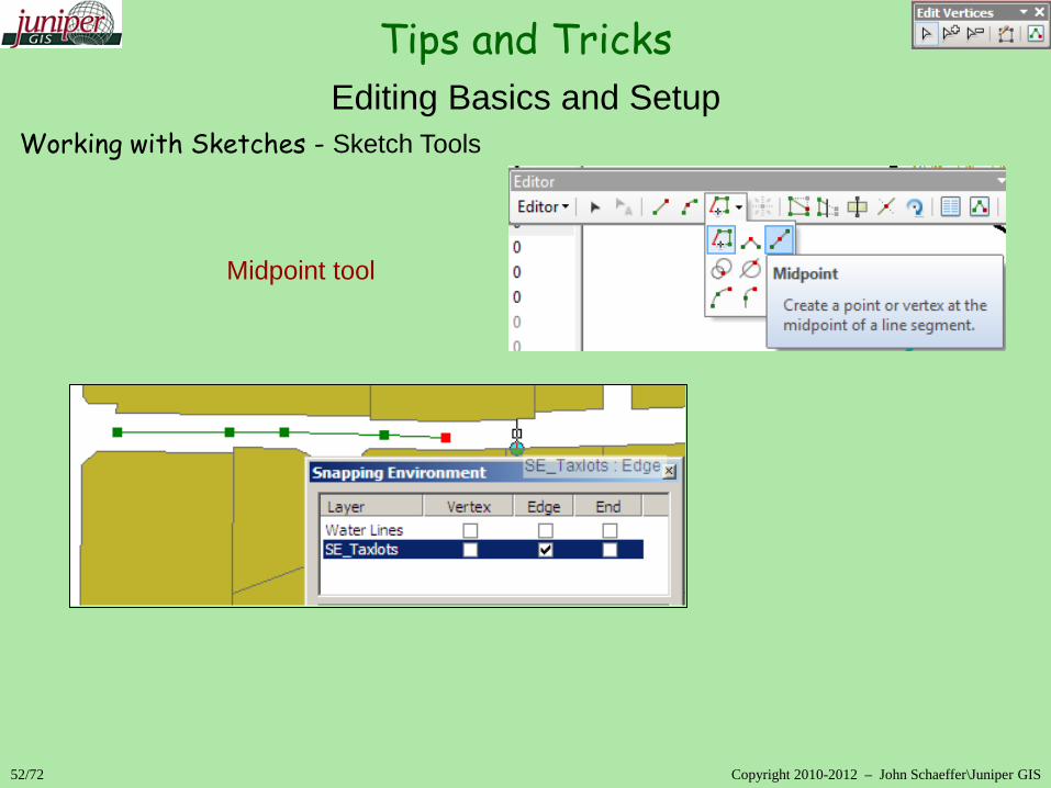
Editing Basics and Setup
Working with Sketches - Sketch Tools Midpoint tool
Tips and Tricks
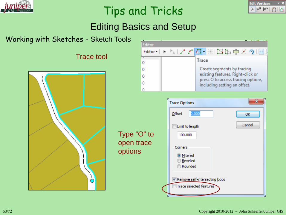
53/72 Copyright 2010-2012 – John Schaeffer\Juniper GIS
Editing Basics and Setup
Working with Sketches - Sketch Tools Trace tool Type “O” to open trace options
Tips and Tricks

54/72 Copyright 2010-2012 – John Schaeffer\Juniper GIS
Other Editing Toolbars
Advanced Toolbar
Extend\Trim – extends\trims lines to selected feature
Tips and Tricks

55/72 Copyright 2010-2012 – John Schaeffer\Juniper GIS
Other Editing Toolbars
Advanced Toolbar
Line Intersection – creates an intersection in a line at actual or implied intersection
Tips and Tricks

56/72 Copyright 2010-2012 – John Schaeffer\Juniper GIS\Juniper GIS
Other Editing Toolbars Spatial Adjustment Toolbar
Defines which data will be adjusted.
Controls how the adjustment methods will work, including adjustment area.
Provides tools for creating and managing displacement links
Sets parameters for attribute transfers
Tips and Tricks

57/72 Copyright 2010-2012 – John Schaeffer\Juniper GIS\Juniper GIS
Other Editing Toolbars Spatial Adjustment Toolbar - Rubbersheeting
- Adjustment is applied piecewise throughout the layer or selected features, rather than equally to all features as in the transformation methods.
Features are stretched and straight lines are preserved
Features can be held in place with Identity Links
After adjustment, all displacement links become Identity links.
Adjustment can be limited to a specified area or applied to the entire extents
Tips and Tricks

58/72 Copyright 2010-2012 – John Schaeffer\Juniper GIS\Juniper GIS
Other Editing Toolbars Spatial Adjustment Toolbar - Edge Snap\Edgematching
- uses Rubbersheeting methods to match features along edges of layers.
Match source layer to target layer or match to midpoints of links
Match is based on displacement links that can be added manually, from a file, or automatically by drawing a window around the features to be matched.
Edgematching can be enhanced by specifying common attributes between layers to use for matching
Tips and Tricks

59/72 Copyright 2010-2012 – John Schaeffer\Juniper GIS\Juniper GIS
Other Editing Toolbars Spatial Adjustment Toolbar - Attribute Transfer
Lets the user transfer attributes and geometry between features
Indicate source and target layers or features
Attribute transfer can be between features in the same layer or in different layers.
Specify the fields to transfer
Fields can be “mapped” between layers, as long as the data type is the same
Tips and Tricks

Map Topology Limited topology created in ArcMap with ArcView\ArcEditor.
Works with Shapefiles as well as Geodatabase feature classes.
Cluster tolerance can be set.
Cannot use Geodatabase Topology Rules or set Ranks
Limited tools
ArcView – Topology Edit Tool & Show Shared Features
ArcEditor – Construct and Split Polygons
60/72 Copyright 2010-2012 – John Schaeffer\Juniper GIS
Other Editing Toolbars Tips and Tricks

61/72 Copyright 2010-2012 – John Schaeffer\Juniper GIS
Other Editing Toolbars Map Topology Editing – Map Topology Geometry
Works with logical edges and logical nodes
Edges – shared parts of coincident lines or polygon boundaries.
Nodes – vertices at the end of an edge or where features intersect.
Hold down the “N” key to select nodes; “E” to select edges. 10.1 – just select
Right-click on the edge and select the appropriate options. 10.0 10.1 10.0
Tips and Tricks

Topology Edit Tasks – tasks from the Editor Toolbar that work with map topology
Select shared features to edit with the Topology Edit tool
Reshape Edge – use Sketch tools to define how to reshape
Modify Edge – use the Topology Edit or normal Edit tool to move shared vertexes.
Generalize Edge – Generalizes an edge and maintains coincidence.
62/72 Copyright 2010-2012 – John Schaeffer\Juniper GIS
Other Editing Toolbars Tips and Tricks
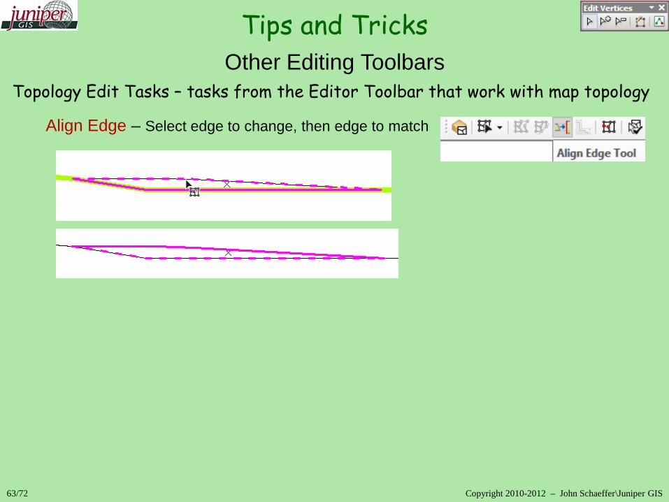
Topology Edit Tasks – tasks from the Editor Toolbar that work with map topology
Align Edge – Select edge to change, then edge to match
63/72 Copyright 2010-2012 – John Schaeffer\Juniper GIS
Other Editing Toolbars Tips and Tricks

Cogo Toolbar – working with coordinate geometry in ArcMap
64/72 Copyright 2010-2012 – John Schaeffer\Juniper GIS
Other Editing Toolbars Tips and Tricks
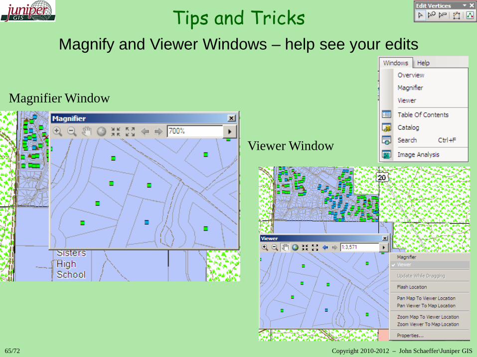
65/72 Copyright 2010-2012 – John Schaeffer\Juniper GIS
Magnify and Viewer Windows – help see your edits Magnifier Window Viewer Window
Tips and Tricks

Integrate Tool – Data Management>Feature Classes>Integrate
Works out of an edit session, no undo - so work on copy of data
66/72 Copyright 2010-2012 – John Schaeffer\Juniper GIS
Bulk Editing Tips and Tricks

67/72 Copyright 2010-2012 – John Schaeffer\Juniper GIS
Field Calculator – VB examples Replace – Search and Replace
Editing Attributes Tips and Tricks

67/72 Copyright 2010-2012 – John Schaeffer\Juniper GIS
Field Calculator – VB examples Replace – Search and Replace
Editing Attributes Tips and Tricks
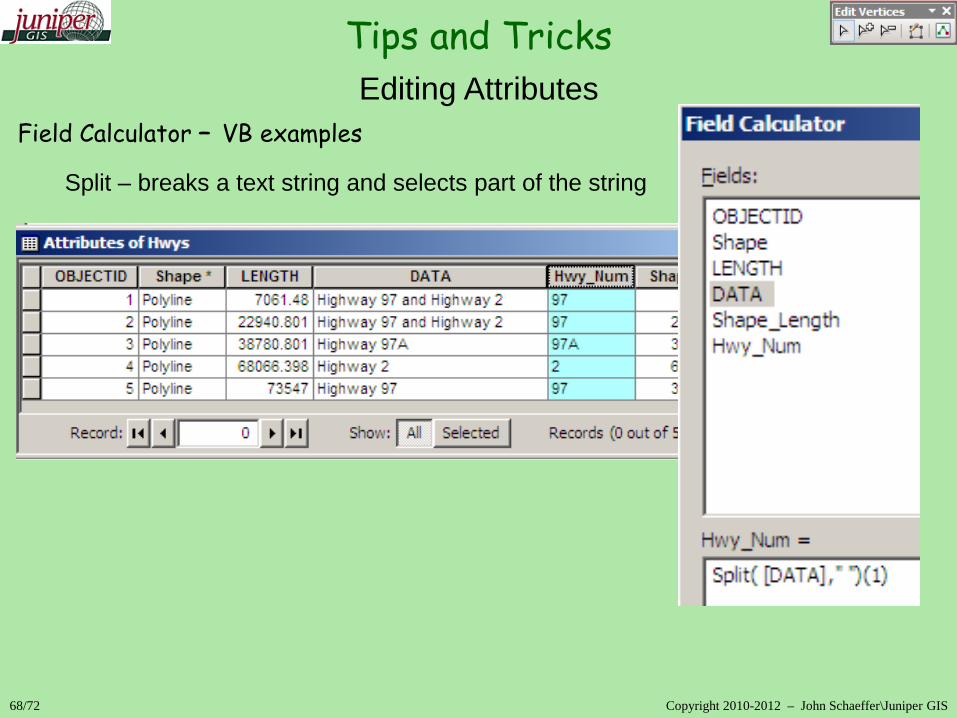
68/72 Copyright 2010-2012 – John Schaeffer\Juniper GIS
Field Calculator – VB examples Split – breaks a text string and selects part of the string
Editing Attributes Tips and Tricks
69/72 Copyright 2010-2012 – John Schaeffer\Juniper GIS
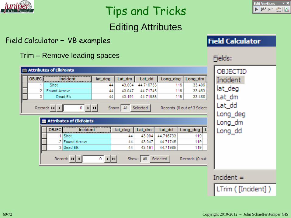
Field Calculator – VB examples Trim – Remove leading spaces
Editing Attributes Tips and Tricks

70/72 Copyright 2010-2012 – John Schaeffer\Juniper GIS
Field Calculator – VB examples Compound Calculations\Converting numbers to string with &
Editing Attributes Tips and Tricks
Editing in ArcGIS 10
71/72 Copyright 2010-2012 – John Schaeffer\Juniper GIS
Conclusion
More Help
ESRI Help and Resource Center
ESRI web-based training
Free Editing Modules SCGIS Webinars Juniper GIS Webinars on Editing
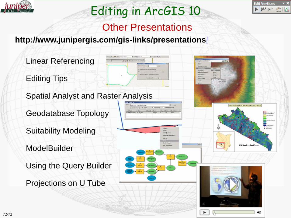
http://www.junipergis.com/gis-links/presentations/
Linear Referencing Editing Tips Spatial Analyst and Raster Analysis Geodatabase Topology Suitability Modeling ModelBuilder Using the Query Builder Projections on U Tube
Other Presentations Editing in ArcGIS 10
72/72