Edinburgh Marina Environmental Impact Assessment Report...
30
Edinburgh Marina Granton Harbour Ltd Edinburgh Marina Environmental Impact Assessment Report: Non-Technical Summary September 2018
Transcript of Edinburgh Marina Environmental Impact Assessment Report...

Edinburgh Marina Granton
Harbour Ltd
Edinburgh Marina
Environmental Impact Assessment Report: Non-Technical
Summary
September 2018

Edinburgh Marina
Environmental Impact Assessment Report: Non-Technical
Summary
Client: Edinburgh Marina Granton Harbour Ltd
Document number: 8379
Project number: 770288
Status: Final
Author: Various
Reviewer:
Date of issue: 28 September 2018
Glasgow Aberdeen Inverness Edinburgh
Craighall Business Park
8 Eagle Street
Glasgow
G4 9XA
0141 341 5040
www.envirocentre.co.uk
Banchory Business
Centre
Burn O’Bennie Road
Banchory
AB31 5ZU
01330 826 596
Alder House
Cradlehall Business Park
Inverness
IV2 5GH
01463 794 212
Suite 114
Gyleview House
3 Redheughs Rigg
Edinburgh
EH12 9DQ
0131 516 9530
This report has been prepared by EnviroCentre Limited with all reasonable skill and care, within the terms of
the Contract with Edinburgh Marina Granton Harbour Ltd (“the Client”). The report is confidential to the Client,
and EnviroCentre Limited accepts no responsibility of whatever nature to third parties to whom this report may
be made known.
No part of this document may be reproduced or altered without the prior written approval of EnviroCentre
Limited.
[Redacted]
Edinburgh Marina Granton Harbour Ltd September 2018
Edinburgh Marina; Environmental Impact Assessment Report: Non-Technical Summary
i
Contents 1 introduction ..................................................................................................................................................... 1
1.1 Terms of Reference ................................................................................................................................. 1 1.2 Structure of this Non-Technical Summary .............................................................................................. 2
2 THE PROPOSED DEVELOPMENT ...................................................................................................................... 4 2.1 The Site .................................................................................................................................................... 4 2.2 The Proposed Development .................................................................................................................... 5 2.3 Vehicular Access ...................................................................................................................................... 6
3 EIA METHODLOGY AND SCOPING.................................................................................................................... 7 3.1 General EIA Methodology ....................................................................................................................... 7 3.2 Scoping as part of the EIA Process .......................................................................................................... 7 3.3 Consultation ............................................................................................................................................ 7 3.4 Scope of the Environmental Impact Assessment Report (EIAR) ............................................................. 8
4 WATER ENVIRONMENT & COASTAL PROCESSES ............................................................................................. 9 4.1 Introduction ............................................................................................................................................ 9 4.2 Potential Impacts and Significance of Effects ......................................................................................... 9
5 Marine ECOLOGY and Ornithology ................................................................................................................ 11 5.1 Introduction .......................................................................................................................................... 11 5.2 Potential Impacts and Significance of Effects ....................................................................................... 11 5.3 Potential Effects after Mitigation .......................................................................................................... 12
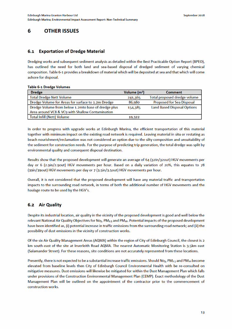
6 OTHER ISSUES ................................................................................................................................................ 13 6.1 Exportation of Dredge Material ............................................................................................................ 13 6.2 Air Quality ............................................................................................................................................. 13 6.3 Terrestrial Noise .................................................................................................................................... 14 6.4 Population and Human Health .............................................................................................................. 14 6.5 Navigation ............................................................................................................................................. 14 6.6 Climate Change ..................................................................................................................................... 15 6.7 Natural Disasters ................................................................................................................................... 15 6.8 Major Accidents .................................................................................................................................... 15
7 CUMULATIVE EFFECTS ................................................................................................................................... 17 8 CONCLUSIONS ............................................................................................................................................... 19
Appendices A Figures
Site Location
Masterplan
Dredge Areas & Volumes
Tables Table 6-1 Dredge Volumes .................................................................................................................................... 13 Table 6-2: Assessment of Potential Effects – Major Accidents ............................................................................. 15 Table 7-1: Dredge Volumes ................................................................................................................................... 17 Table 7.2: Summary of Disposal Sites ................................................................................................................... 17 Table 7-3 Dredge material from Rosyth and Leith Maintenance Dredge ............................................................. 18

Edinburgh Marina Granton Harbour Ltd September 2018
Edinburgh Marina; Environmental Impact Assessment Report: Non-Technical Summary
1
1 INTRODUCTION
1.1 Terms of Reference
This Non-Technical Summary (NTS) is designed to stand apart from the main Environmental Impact Assessment
Report (EIAR) whilst providing a summary in non-technical language of the main findings. For full details
pertaining to any part of this NTS, please refer to the associated EIAR. The purpose of EIA is to determine the
likelihood of the proposed development of causing significant effects on the environment; to predict the
magnitude of potential effects and provide mitigating measures that will reduce the significance of such effects.
This NTS has been prepared to accompany an application to Marine Scotland in respect of a proposal by
Edinburgh Marina Granton Harbour Ltd for the redevelopment of Edinburgh Marina within Granton Harbour.
The proposed development is part of the Granton Harbour regeneration development; a development that was
granted Outline Planning Permission (now Planning Permission in Principle) by City of Edinburgh Council in 2003
under planning application reference 01/00802/OUT, as detailed by the Report of Handling1.
The application was accompanied by an Environmental Statement (ES) produced by Robert Turley Associate on
behalf of Forth Properties Ltd. The application was granted permission subject to a number of planning
conditions including one requiring all Reserved Matters Applications to be submitted within 15 years from the
date of permission, i.e. by June 2018. Since the original planning permission was granted, a series of revisions to
the proposed site layout and development have remained as originally approved. As such, a number of Matters
Specified in Conditions (MSC) applications, formerly Reserved Matters Applications, have been submitted and
approved for various development plots, and some development plot approvals have already been implemented.
A Formal Screening Request was submitted by Cameron Planning for a Marine Licence application for the Marina
Development and associated works: MSC planning permission was granted pursuant to the original permission
in April 2017 for, “the formation of a new Marina Office with associated retail and café space, and new
community boat yard with associated dry stack”. Marine Scotland provided a Screening Opinion on the 16th
October 2017 and concluded that the proposed works fall under paragraphs 1(e), 10(m), and 12(a) of Schedule
2 of the EIA Regulations and as such, an EIA must be carried out.
Marine Scotland provided a Screening Opinion on the 16th October 2017 and concluded that the proposed works
fall under paragraphs 1(e), 10(m), and 12(a) of Schedule 2 of the EIA Regulations and as such, an EIA must be
carried out.
The proposed marine works associated with the wider Edinburgh Marina development comprises:
Length of stone revetment to harbour;
Length of vertical quay wall to harbour;
Backfilling of land protected by quay wall and stone revetment;
Formation of marina;
Extension to existing north mole breakwater; and
Harbour dredging.
1http://citydev-portal.edinburgh.gov.uk/idoxpa-web/files/00DB0FD94CC20316931B1A365C15AA5D/pdf/01 00802 OUT-REPORT OF HANDLING-3759387.pdf (accessed 26/07/2018)

Edinburgh Marina Granton Harbour Ltd September 2018
Edinburgh Marina; Environmental Impact Assessment Report: Non-Technical Summary
2
At a meeting with Victoria Bell and Louise Wilcox in Marine Scotland offices on 14th February 2018 advice was
provided that the EIA should focus on the principal issues identified in the 5th February, 2018 EIA Screening
Opinion, specifically sediment transportation and coastal processes alongside assessment work relative to the
Habitat Regulations Appraisal process.
The EIA Scoping Report submitted to Marine Scotland on 10th April 2018 was based upon the Screening Opinion
and subsequent Marine Scotland advice and set out the proposed EIA methodology upon which we requested a
formal notification from Marine Scotland within a five week time period as specified under regulation 14 (7) of
the EIA Regulations.
An EIA Scoping Opinion was issued on 14th June 2018 with detailed information provided in the specialist topic
sections. The Scoping opinion scoped in the following:
Marine Ecology – Mammals & Non Native Species
Water Environment & Coastal Processes – Waves
Water Environment & Coastal Processes – Sediment Transport
Water Environment & Coastal Processes – Water Quality
Marine Ecology - Otters
Marine Ecology – Ornithology
Noise (marine)
Major Accidents
The purpose of this NTS is to explain the environmental assessment of the proposed development and report its
results, and is designed to stand apart from the main Environmental Impact Assessment Report (EIAR) volume.
1.2 Structure of this Non-Technical Summary
The NTS is set out in the same chapter format as the EIAR, to facilitate cross-referencing and to offer a summary
of the environmental findings that will be submitted. The sections within this NTS are therefore as follows:
1 Introduction
2 Proposed Development
3 EIA Methodology and Scoping
4 Water Environment & Coastal Processes
5 Marine Ecology and Ornithology
6 Other Issues
7 Cumulative Effects
8 Conclusions
The NTS summarises the key findings from the environmental impact assessment (EIA) process. Where the
assessment results in potential adverse effects on the environment, measures to address and control effects,
known as mitigation measures are identified. The assessment then presents the overall effects remaining after
mitigation has been applied; these are referred to as the residual effects.
The overall suite of documents associated with the EIA includes the following:
The Environmental Impact Assessment Report – which reports upon the potentially significant
environmental effects of the proposed development on the receiving environment, and comprises of
the following:
o Volume 1 – Written Statement – this includes the written assessment and contains discussion
of potentially significant environmental effects;

Edinburgh Marina Granton Harbour Ltd September 2018
Edinburgh Marina; Environmental Impact Assessment Report: Non-Technical Summary
3
o Volume 2; Figures – this volume includes figures, drawings and diagrams which support Volume
1; and
o Volume 3; Technical Appendices – this volume contains the technical background reports
written and used to derive the environmental assessment.
Non-Technical Summary (NTS) – this document.

Edinburgh Marina Granton Harbour Ltd September 2018
Edinburgh Marina; Environmental Impact Assessment Report: Non-Technical Summary
4
2 THE PROPOSED DEVELOPMENT
2.1 The Site
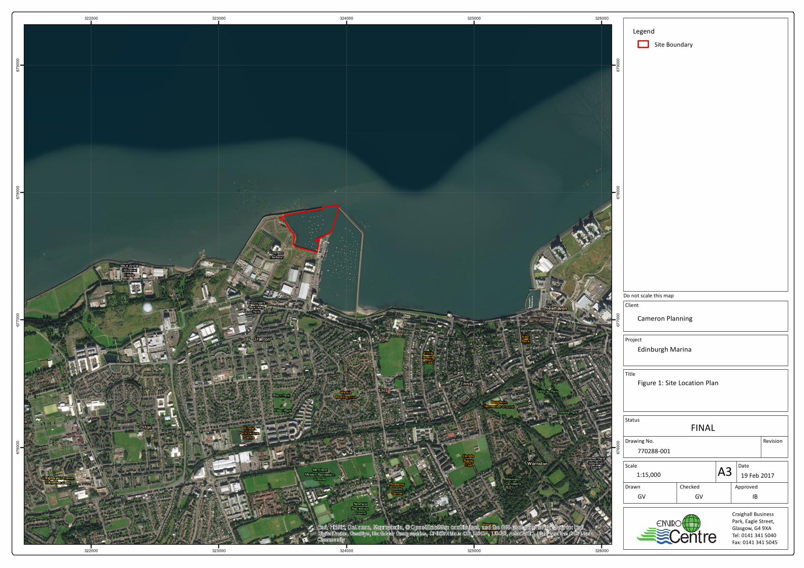
Granton forms part of Edinburgh’s waterfront along the Firth of Forth, and is historically, an industrial area having
a large harbour. Granton Harbour was first constructed in the late 1830’s, and has since had a number of new
berths constructed over the following 180 years. Within the surrounding area there is a combination of
commercial/industrial premises, residential and vacant ground.
At present, much of the western harbour at Granton (the site) comprises of predominantly reclaimed land from
the sea, consisting of vacant brownfield land which is scheduled for development under the approved 2003
masterplan and a number of subsequent reserved matters and MSC permissions. The overall topography of the
surrounding area is generally flat, with the proposed marine works development situated at the edge, and within
the extents of the harbour.
The proposed Edinburgh Marina development sits within the Granton Harbour regeneration development area,
approximately 4km north of Edinburgh City Centre and fronting the Firth of Forth. It is approximately 9.5Ha,
bounded to the north by the Western Breakwater, to the east by the Eastern Harbour and to the south by wider
regeneration proposals and developments. The nearest residential development is situated on Merlin Avenue,
approximately 90m south of the proposed development.
Edinburgh Marina from North Mole looking south
Edinburgh Marina – Looking towards North Mole
North Mole – Harbour Side
North Mole – Firth of Forth Side

Edinburgh Marina Granton Harbour Ltd September 2018
Edinburgh Marina; Environmental Impact Assessment Report: Non-Technical Summary
5
Location of the Western Revetment from North Mole
North Mole from the Proposed Revetment
Southern Quay Wall looking east to Middle Pier
Looking east towards Middle Pier
2.2 The Proposed Development
The proposed development encompasses four aspects of the marine works:
Harbour Dredging – To ensure efficient operation of the existing harbour, the harbour bed needs to be dredged
to the required depth. The potential for environmental impact during dredging works and as part of sea disposal
of sediment material will be addressed as part of the Marine Scotland Dredging Licence Application and the
supporting BPEO.
As part of the separate Marine Scotland Licence application, a Sediment Risk Assessment will be undertaken
along with a Best Practicable Environmental Option (BPEO) assessment for the dredging and disposal associated
with the Edinburgh Marina Project.
Quay Wall Works – the existing quay wall is dilapidated and poorly defined. The proposed quay wall works aims
to formalise the water/land margin, providing the public with context to this area of wider regeneration
development. The location and extent of the proposed quay wall and revetment works are demonstrated in
Drawing 115875/021 contained within Volume 2 of this EIAR. The northern section of the works will reconstruct
the sloping masonry revetment, maintaining the connection to the existing northern breakwater, and will be
225m in length. The southern section of the works will comprise of a vertical quay wall with associated sheet
piling that will be 110m in length and situated adjacently to the proposed boatyard.
From the original planning application that was granted planning permission in principle in 2003, there is to be an area of backfill to the west of the revetment and quay wall. This will form the public realm associated with the new hotel and serviced apartments on Plot 35 of the masterplan (The current planning application reference

Edinburgh Marina Granton Harbour Ltd September 2018
Edinburgh Marina; Environmental Impact Assessment Report: Non-Technical Summary
6
is 17/05306/AMC). The material to be used to backfill the quay wall has been previously stockpiled on site, and the site to the west and south-west will be regraded to form the approved surface finish levels.
North Mole Extension – Granton Harbour is a long-established harbour which is protected by an existing sea wall
to the north. Drawing No. A-P-00G7-005H contained within Volume 2 demonstrates is spatial relationship within
the site boundary. The proposed marine works comprise further extension to the existing North Mole structure
in order to better protect the harbour mouth from excessive wave action. The proposed linear extent of the
North Mole extension is 50m. The extension will be vertical faced on the harbour side and sloping masonry on
the seaward side as illustrated in Drawings 115875/0027, contained within Volume 2. A method statement for
the North Mole Extension is contained within Volume 3, Technical Appendix 2.1 of this EIAR. The north mole is a
partially Listed Building, at its western extremity, and as such, any works to this section require to be considered
under Listed Building Regulations. It is understood that any works proposed to this western section will fall under
repairs and maintenance to the existing structure.
New Marina – The proposed marina comprises 340 number of berths of different sizes to accommodate varying
sized vessels, the proposed layout (dated 9th May, 2017) as detailed by Drawing No. A-P-00G7-005H, contained
within Volume 2. The linear extent of the berth is 4,407m and the marina development will extend approximately
32.1% of the available useable water area within the harbour. The marina area will extend to approximately
22,879m2. The marina will be formed through a series of floating berths and pontoons that will rise and fall with
the tide (Refer to Drawing No. A-P-00G7-005H within Volume 2 of this EIAR).
At present, methods of construction and their timing are not formalised in detail. To ensure that risks of adverse
impacts are identified and kept to acceptable limits, construction management plans will be a requirement within
construction contracts for individual developers.
It is estimated that the marina development as described above would take approximately 15 months to
construct. The proposed development will be indicatively phased as follows.
Proposed Development Component Timing
Dredging and Reclamation Month 1-3
Construct quay wall and foundations Month 3-6
Piling Month 3-6
North Moll Extension and Breakwater Month 7-8
Place rock armouring Month 8-10
Construct pontoons Month 10 -14
Services to pontoons Month 15
Any assumptions used within the relevant assessments throughout the EIAR have also been included. Where
timing is Month 1-3 for example, this implies a 3 month construction period.
2.3 Vehicular Access
Vehicular access to the site is proposed from the existing roundabout junction of Granton Square, with a second
access on West Harbour Road. Close liaison with the traffic management section of City of Edinburgh Council
should be made in relation to the agreed routes and hours of working for construction vehicles.

Edinburgh Marina Granton Harbour Ltd September 2018
Edinburgh Marina; Environmental Impact Assessment Report: Non-Technical Summary
7
3 EIA METHODLOGY AND SCOPING
3.1 General EIA Methodology
The purposed of an EIA is to identify and evaluate the likely significant effects of a proposed development on the
environment, and identify measures to mitigate or manage any significant adverse effects before a planning
application is determined. The EIA process provides an opportunity to ‘design out’ adverse effects wherever
possible by making alterations to the design of the proposed development before the application is submitted,
and is based upon consultee feedback. Where adverse effects cannot be designed out, mitigation measures can
be proposed to avoid, compensate, or reduce significant environmental effects to an acceptable level.
The environmental information gathered during the EIA is derived through a systematic process of identification,
prediction and evaluation of the likely significant environmental effects of the proposed development. This
process includes identifying the sensitivity of the baseline conditions/receptors; predicting the magnitude of
potential impacts; predicting the significant effect of the impacts; detailing mitigation measures; predicting the
potential residual effects as well as the potential cumulative impacts. The results and findings are presented in
full within the EIAR and summarised in this document.
3.2 Scoping as part of the EIA Process
Scoping is defined as ‘the way in which key issues are identified from a broad range of potential concerns for
inclusion in EIA studies, the areas affected, and the level to which they should be studied’. Furthermore, the
scoping process enables the topics to be covered in the Environmental Impact Assessment Report (EIAR) to be
agreed and for those topics not considered pertinent to be scoped out of the study or reduced in scope (i.e.
topics where it is unlikely that significant environmental effects will occur
3.3 Consultation
Consultation responses were obtained from the following organisations in respect of the Scoping Reports issued
to Marine Scotland. On receipt of the scoping opinion request documentation, the Scottish Ministers, in
accordance with The Marine Works (Environmental Impact Assessment) (Scotland) Regulations 2017, initiated a
30 day consultation process, which commenced on 12 April 2018. The following bodies were consulted:
• Association of Salmon Fishery Boards • City of Edinburgh Council • Executive Health and Safety (“HSE”) • Eyemouth Fishery Office • Forth District Salmon Fishery Board • Forth Ports • Granton and District Community Council • Historic Environment Scotland (“HES”) • Marine Safety Forum • Marine Planning and Policy • Maritime and Coastguard Agency (“MCA”) • Ministry of Defence (“MOD”) • North and East Coast Inshore Fisheries Group • Northern Lighthouse Board (“NLB”) • Royal Forth Yacht Club • Royal Society for the Protection of Birds Scotland (“RSPB”) • Royal Yachting Association Scotland (“RYA”)

Edinburgh Marina Granton Harbour Ltd September 2018
Edinburgh Marina; Environmental Impact Assessment Report: Non-Technical Summary
8
• Scottish Environment Protection Agency (“SEPA”) • Scottish Fishermen’s Federation • Scottish Fishermen’s Organisation • Scottish Natural Heritage • Scottish Water • Scottish Wildlife Trust • The Crown Estate • Transport Scotland • UK Chamber of Shipping • Visit Scotland • Whale and Dolphin Conservation (“WDC”)
3.3.1 Responses received
From the list above a total of 12 responses were received. In addition, relevant advice was sought from Marine
Scotland Science. The purpose of the consultation was to obtain advice and guidance from each consultee or
advisor as to which potential effects should be scoped in or out of the EIA. The 12 respondents included the
following:
1. City of Edinburgh Council 2. Forth Ports 3. Historic Environment Scotland 4. Maritime and Coastguard Agency 5. Ministry of Defence 6. Northern Lighthouse Board 7. Royal Society for the Protection of Birds 8. Royal Yachting Association 9. Scottish Environment Protection Agency 10. Scottish Natural Heritage 11. Transport Scotland 12. Whale and Dolphin Conservation
A Scoping Opinion was received from Marine Scotland on 14th June 2018. The opinions provided in the Scoping
Opinions were used to inform the EIA process by shaping the methodologies and the inclusion and exclusion of
particular environmental topics and features for assessment.
3.4 Scope of the Environmental Impact Assessment Report (EIAR)
Scoping is defined as ‘the way in which key issues are identified from a broad range of potential concerns for
inclusion in EIA studies, the areas affected, and the level to which they should be studied’. Furthermore, the
scoping process enables the topics to be covered in the ES to be agreed and for those topics not considered
pertinent to be scoped out of the study or reduced in scope (i.e. topics where it is unlikely that significant
environmental effects will occur).
Based on the consultation undertaken and responses received to date, a view was reached on the key topics to
be assessed and included as a full impact assessment chapter as part of the EIA. These were:
Water Environment;
Ecology (including Underwater Noise);
Other Issues (Exportation of Dredge Material by Road, Air Quality, Terrestrial Noise, Population and
Human Health, Navigation Climate Change, Natural Disasters, Major Accidents); and
Cumulative Effects;
Schedule of Mitigation

Edinburgh Marina Granton Harbour Ltd September 2018
Edinburgh Marina; Environmental Impact Assessment Report: Non-Technical Summary
9
4 WATER ENVIRONMENT & COASTAL PROCESSES
4.1 Introduction
Water Environment and Coastal Processes; Chapter 4 of the associated EIAR has assessed potential impacts of
the proposed development at Edinburgh Marina for water, sediments and coastal processes.
Due to the marine nature of the construction works, investigations were required to incorporate topographic,
bathymetric and hydraulic modelling of the study area to gain an in-depth understanding of local sea bed and
wave/tidal climate. Investigations of the physical properties of sea-bed sediment including chemistry, particle
size and predicted patterns of sediment distribution were completed by geo-technical specialists.
4.2 Potential Impacts and Significance of Effects
Those construction components which are predicted to have the greatest potential impact upon the water
environment are, (i) the dredging of the basin; (ii) construction of infrastructure including North Mole extension
/pontoons; and (iii) working operations of the marina.
It is predicted that the specified works could potentially result in some adverse effects upon the water
environment and its processes.
Contamination of coastal waters or sediments from construction vehicles is feasible during construction works.
Modification of the natural hydrology of a site is another possibility in developments of this nature. Marine
construction works also have the potential to alter coastal processes involving wave and tidal regimes and can
ultimately influence sediment transport and deposition around the harbour.
The impacts of sediment discharge/dispersion resulting from dredging and piling of the sea bed upon the marine
designations are predicted to be negligible in significance while impacts upon the coastal waters and sediment
of Granton Harbour is expected to be minor (post-mitigation).
The wave disturbance modelling undertaken for the proposed construction indicates that the new breakwater
will result in a reduction in significant wave height within the western harbour of up to -1m compared with
existing conditions during a 1 in 50 year storm event from the north-east. Smaller reductions in significant wave
height (-0.1 to -0.5m) are predicted in the vicinity of the middle pier, whilst negligible change is predicted within
the eastern harbour (-0.1 to +0.1m). Immediately outside the Granton Harbour entrance modelling indicates that
wave reflection from the new breakwater will produce minor increases in significant wave height during a 1 in
50 year storm from the north-east. During a 1 in 1 year storm event from the north-east a similar pattern of
impact, but of lower magnitude, is observed for all areas of the.
Wave disturbance modelling of storm events from the north-west has also been undertaken to assess the impact
of the proposed breakwater. During a 1 in 50 year storm event from the north-west the modelling results indicate
that the breakwater construction will result in slight reductions in significant wave height within both the western
(-0.05 to -0.3m) and eastern (-0.05 to -0.1m) harbours as a result of attenuation of wave. The breakwater will
produce a slight increase in significant wave height within the approaches to the harbour as a result of wave
reflection. During a 1 in 1 year storm event from the north-west a similar pattern of impact, but of lower
magnitude, is observed for all areas of the harbour
Some of the more enduring effects such as altering of wave climate, although considered to be permanent,
remain negligible in significance, with these conclusions being fully supported by wave modelling. Other impacts
from pollutant incidences concerning water and sediment quality are heavily mitigated for within the Schedule

Edinburgh Marina Granton Harbour Ltd September 2018
Edinburgh Marina; Environmental Impact Assessment Report: Non-Technical Summary
10
of Mitigation, namely the requirement for an over-arching Construction Environmental Management Plan
(CEMP). Design mitigation also stated the need for determining the Best Practicable Environmental Option
(BPEO) report as part of Marine Licensing obligations for dredge and reclamation material.
Overall, the impact of the proposed development on the wave climate within Granton Harbour is considered to
be of negligible magnitude
4.2.1 Significance of Effects
Overall the effects of the proposed development on the water environment and coastal processes are not considered to be significant.

Edinburgh Marina Granton Harbour Ltd September 2018
Edinburgh Marina; Environmental Impact Assessment Report: Non-Technical Summary
11
5 MARINE ECOLOGY AND ORNITHOLOGY
5.1 Introduction
The Marine Ecology and Ornithology Chapter of the associated EIAR, has considered the potential for impact of
the proposed development upon marine mammals, otter and birds.
For a development of this nature which requires considerable construction works below Mean High Water
Springs (MHWS), assessment must consider not only the direct impacts upon marine mammals, otters and birds
but on designated nature conservation site, including internationally important such as:
Firth of Forth SPA
Forth Islands SPA
Imperial Dock Lock, Leith SPA
Their qualifying Important Ecological Features (IEF) include Grey Seal. Those specified marine mammals were
consequently included in the assessment. Birds were scoped out of the assessment whilst bit were subsequently
scoped back in at the request of the Regulators as were otters.
5.2 Potential Impacts and Significance of Effects
The criteria used for predicting impact upon ecological systems considers magnitude, extent, duration,
reversibility, timing and frequency of the potential effect of the proposed development.
The assessment concurred that underwater noise and acoustic disturbance, vibration; and suspended sediment
derived from marine construction works were identified as potentially significant in their impact upon the above
specified marine mammals, birds, otters and habitat receptors.
Left unmitigated, dredging and piling have potential to disturb the foraging and migratory behaviour in fish or
cause hearing injuries to marine mammals.
Pollution to water bodies from construction vehicles, refuelling and storage of oils, fuels and chemicals,
engineering works and use of artificial lighting were also identified as possible factors in the assessment.
In line with the findings of CEDA (2011), noise associated with dredging is unlikely to be significant and will not
cause injury to marine mammals, otters or birds.
However, there is the potential for piling noise to affect cetaceans and migratory fish. The effects of piling noise
are therefore predicted to be Intermittent and most severe locally although of potentially some relevance over
a moderate extent (e.g. 1 km from the marina). For cetaceans such effects are predicted to only affect a small
number of animals due to the low significance of the area. Whilst there may be effects on seals, this area is not
recognised as being of specific importance for seal species. In addition they are less sensitive to noise than
cetaceans. The development area is considered to be of any particular importance for salmonids during the run
however this period will be avoided. With regards to birds, the effects of piling with be restricted to startling
birds.
Once the piling is complete marine mammals, otters and birds will repopulate the area and so the impacts will
be short term, intermittent and negligible. Noise during operation will be confined to intermittent vessel engine
noise and maintenance dredging.

Edinburgh Marina Granton Harbour Ltd September 2018
Edinburgh Marina; Environmental Impact Assessment Report: Non-Technical Summary
12
With reference to piling, the high pressure of the impulsive sounds originating from pile driving activity can cause
physical damage to marine organisms that are close to the origin of the sound. The zone for this type of impact,
the zone of injury, is defined as the range over which received sound pressures may cause an animal to suffer
from physical injury or loss of sensitivity in its auditory system (Madsen et al. 2006).
While piling will be “noisier” than dredging operations, the Zone of injury – Area closest to the noise source where
the noise levels may be high enough to cause a physiological impact such as TTS or PTS
5.3 Potential Effects after Mitigation
The ecology chapter concludes that following the proposed mitigation, which has been designed upon review of
engineering design and construction techniques, adverse effects will not be significant.

Edinburgh Marina Granton Harbour Ltd September 2018
Edinburgh Marina; Environmental Impact Assessment Report: Non-Technical Summary
14
6.3 Terrestrial Noise
Baseline noise surveys were completed by EnviroCentre for early morning and daytime in close proximity to the
proposed development (as part of a noise assessment carried out for an associated planning application on
behalf of Granton Central Developments) in August 2017. Baseline noise comprised of road and air traffic and
birdcalls (seagull) in addition to construction activity during the day – denoting an overall
residential/commercial/industrial land use of the study area.
The proposed development requires substantial engineering of marina infrastructure and associated noisy
construction activities such as piling and dredging of components such as the quay wall and infill of the
reclamation. Noise impacts upon local sensitive receptors are subsequently expected. At present, construction
methodology has not been detailed or scheduled and as such it is not possible to set out precise noise impacts
in terms of nature, activity combinations and durations as yet. Furthermore, operating times and mitigative
measures will only become apparent on confirmation of engineering specification. It should be noted however
that informed co-ordination of construction activities, schedules and durations will go some way in alleviating
noise impacts from the construction phase of the proposed development.
On the basis of assessment of comparable projects, noise impacts are not anticipated to be significant due to the
temporary nature of construction works.
6.4 Population and Human Health
The focus of a population and health assessment should be in direct proportion with likely significant effects of
the development. In the case of Granton Harbour, effects pertaining to human health have been identified as
noise, vibration and air quality – as outlined in sections 4.2 and 4.3. Due to the temporary nature of the
construction phase, it is concluded that effects will not be significant upon Population and Human Health.
6.5 Navigation
The construction and operational phase of the proposed development pose specific navigational considerations
pertaining to each phase.
Construction-phase impacts are expected to arise from the placement of a construction plant at the dredged
inner-construction area. The requirement for a floating piling rig and barge (for pile transportation) will likely
potentially impede vessel movements of existing traffic to some extent.
The introduction of marina and breakwater structures may initially increase risk of collision and lessen capacity
for safe manoeuvring in the vicinity of the proposed development. On its completion, an increase in the number
of marina users will be likely be the case, contributing overall to conflicting use of shipping and ferry vessel routes
in the Firth of Forth.
Plans to extend the North Mole (the existing northern breakwater) by 50m are included within proposals. This
sea wall already promotes ease of navigation by forming the outer margin of the navigation channel. Three new
approach markers (port and starboard flashing hand buoys) will signal the approach channel. Notice to mariners
will be issued prior to works in keeping with harbour emergency procedures and to ensure the safe operation of
the harbour for existing marine traffic. Construction-related mitigation will be based upon risk assessments of
individual components/activities in the marine environment (ie. piling operations in the navigation channel, use
of cranage). Construction-based mitigation will be consolidated when the methodology is established/approved
by the engineering consultants.


Edinburgh Marina Granton Harbour Ltd September 2018
Edinburgh Marina; Environmental Impact Assessment Report: Non-Technical Summary
16
Risks of vessel
accidents (including
spillages and pollution
incidents)
(Construction)
Unlikely Severe Low/Moderate will be controlled
through a CEMP which
will ensure compliance
with the health and
safety Construction
Regulations
High
Risks from spills, fire or
explosion
Unlikely Severe Low/Moderate None Required High
Risks of vessel
accidents (including
spillages and pollution
incidents) (Operation)
Unlikely Severe Low/Moderate None Required High

Edinburgh Marina Granton Harbour Ltd September 2018
Edinburgh Marina; Environmental Impact Assessment Report: Non-Technical Summary
18
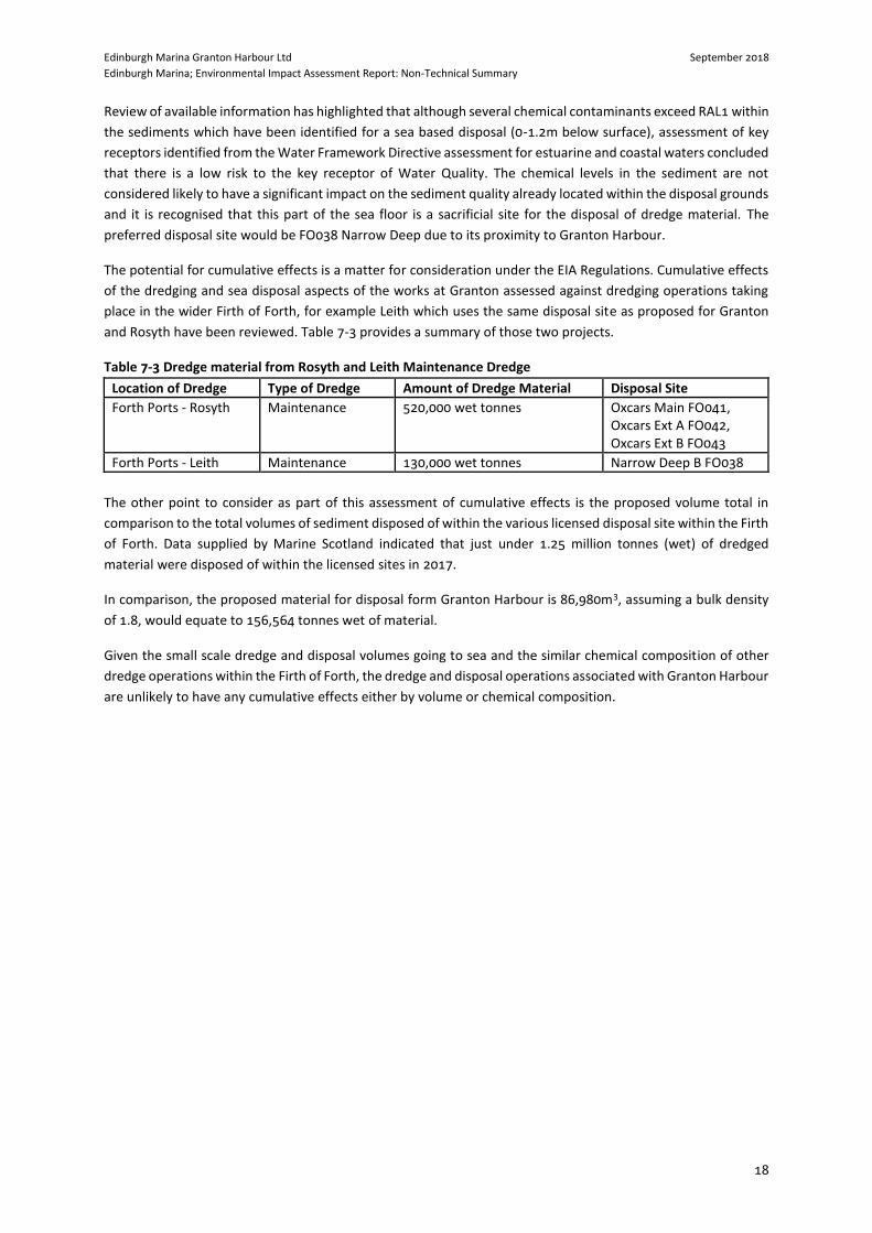
Review of available information has highlighted that although several chemical contaminants exceed RAL1 within
the sediments which have been identified for a sea based disposal (0-1.2m below surface), assessment of key
receptors identified from the Water Framework Directive assessment for estuarine and coastal waters concluded
that there is a low risk to the key receptor of Water Quality. The chemical levels in the sediment are not
considered likely to have a significant impact on the sediment quality already located within the disposal grounds
and it is recognised that this part of the sea floor is a sacrificial site for the disposal of dredge material. The
preferred disposal site would be FO038 Narrow Deep due to its proximity to Granton Harbour.
The potential for cumulative effects is a matter for consideration under the EIA Regulations. Cumulative effects
of the dredging and sea disposal aspects of the works at Granton assessed against dredging operations taking
place in the wider Firth of Forth, for example Leith which uses the same disposal site as proposed for Granton
and Rosyth have been reviewed. Table 7-3 provides a summary of those two projects.
Table 7-3 Dredge material from Rosyth and Leith Maintenance Dredge
Location of Dredge Type of Dredge Amount of Dredge Material Disposal Site
Forth Ports - Rosyth Maintenance 520,000 wet tonnes Oxcars Main FO041, Oxcars Ext A FO042, Oxcars Ext B FO043
Forth Ports - Leith Maintenance 130,000 wet tonnes Narrow Deep B FO038
The other point to consider as part of this assessment of cumulative effects is the proposed volume total in
comparison to the total volumes of sediment disposed of within the various licensed disposal site within the Firth
of Forth. Data supplied by Marine Scotland indicated that just under 1.25 million tonnes (wet) of dredged
material were disposed of within the licensed sites in 2017.
In comparison, the proposed material for disposal form Granton Harbour is 86,980m3, assuming a bulk density
of 1.8, would equate to 156,564 tonnes wet of material.
Given the small scale dredge and disposal volumes going to sea and the similar chemical composition of other
dredge operations within the Firth of Forth, the dredge and disposal operations associated with Granton Harbour
are unlikely to have any cumulative effects either by volume or chemical composition.

Edinburgh Marina Granton Harbour Ltd September 2018
Edinburgh Marina; Environmental Impact Assessment Report: Non-Technical Summary
19
8 CONCLUSIONS
This NTS reports upon the findings of the EIAR, which has been shaped by, consultation and assessment. The
purpose of the EIAR, and the EIA process, is to establish potentially significant environmental effects and avoid
or mitigate these where applicable.
The EIAR has established a schedule of mitigation contained within Chapter 8: Schedule of Mitigation contained
within the EIAR. Mitigation and enhancement measures shall be implemented through-out the construction and
operation of the proposed development.
The EIAR has established that due to the iterative design process and implementation of suitable mitigation
measures, potentially significant adverse effects resulting from the proposed development have been minimised.
The associated EIAR concluded that through the implementation of prescribed mitigation measures during the
construction phase, and in light of the new recreational function proposed by the marina; that environmental
effects are either localised (i.e. wave action); or short-term (i.e. for underwater noise) and to be expected with
developments of this nature.

Edinburgh Marina Granton Harbour Ltd September 2018
Edinburgh Marina; Environmental Impact Assessment Report: Non-Technical Summary
APPENDICES

Edinburgh Marina Granton Harbour Ltd September 2018
Edinburgh Marina; Environmental Impact Assessment Report: Non-Technical Summary
A FIGURES

Edinburgh Marina Granton Harbour Ltd September 2018
Edinburgh Marina; Environmental Impact Assessment Report: Non-Technical Summary
Site Location
Do not scale this map
RevisionDrawing No.
Title
Scale Date
Drawn Checked Approved
Status
Craighall BusinessPark, Eagle Street,Glasgow, G4 9XATel: 0141 341 5040Fax: 0141 341 5045
Project
Client
A31:15,000
770288-001
GV GV IB
19 Feb 2017
LegendSite Boundary
Esri, HERE DeLorme, MapmyIndia, © OpenStreetMap contributors, and the GIS user community, Source: Esri,DigitalGlobe, GeoEye, Earthstar Geographics, CNES/Airbus DS, USDA, USGS, AeroGRID, IGN, and the GIS UserCommunity
322000
322000
323000
323000
324000
324000
325000
325000
326000
326000
6760
00
6760
00
6770
00
6770
00
6780
00
6780
00
6790
00
6790
00
Cameron Planning
Edinburgh Marina
Figure 1: Site Location Plan
FINAL

Edinburgh Marina Granton Harbour Ltd September 2018
Edinburgh Marina; Environmental Impact Assessment Report: Non-Technical Summary
Masterplan


Edinburgh Marina Granton Harbour Ltd September 2018
Edinburgh Marina; Environmental Impact Assessment Report: Non-Technical Summary
Dredge Areas & Volumes