Edinburgh Airport Arrival and Departures · 18 Procedure Design Report (inc. Draft SIDs, STARs and...
68
Edinburgh Airport Arrival and Departures Version 2.0 Airspace Change Proposal Prepared by JB NATS Airspace Change Assurance Team Version Date Changes 1.0 3 rd August 2017 Initial submission. 1.1 9 th August 2017 Updated section 5.7 2.0 3 rd August 2018 Updates to sections 1, 4, 5, 6, 7 Changes to RWY06 departures.
Transcript of Edinburgh Airport Arrival and Departures · 18 Procedure Design Report (inc. Draft SIDs, STARs and...

Edinburgh Airport Arrival and Departures
Version 2.0
Airspace Change Proposal
Prepared by JB
NATS Airspace Change Assurance Team
Version Date Changes
1.0 3rd
August 2017 Initial submission.
1.1 9th
August 2017 Updated section 5.7
2.0 3rd
August 2018 Updates to sections 1, 4, 5, 6, 7 Changes to RWY06 departures.
© 2018 Edinburgh Airport August 2018 Page 2
Table of contents 1 Introduction 5
New RNAV1 SIDs and Arrival Transitions 5 1.1
2 Justification and Objectives 7
Justification 7 2.1
Objectives 7 2.2
Alignment with the CAA’s Future Airspace Strategy (FAS) Principles 7 2.3
3 Current Airspace 8
Current aircraft flight paths 8 3.1
Current aircraft altitudes 8 3.2
Existing track concentrations 8 3.3
Traffic Figures and Aircraft Types for the year 2016 13 3.4
Operational Efficiency, Complexity, Delays and Choke Points 14 3.5
Environmental Issues 14 3.6
Safety 14 3.7
4 Proposed Routes 15
Requirements 15 4.1
Naming convention 15 4.2
Proposed SIDs 16 4.3
Proposed RNAV1 Arrival Transitions and Hold 18 4.4
What Would Change Under the Proposal 19 4.5
Proposed Implementation 21 4.6
Modernising the air route infrastructure 21 4.7
Revision of minimum radar separation 22 4.8
Radar, Communications and Navaid coverage 22 4.9
Route Usage and Traffic Forecasts 22 4.10
Controlled Airspace 25 4.11
RNAV equipage 25 4.12
Route allocation 25 4.13
Time-bound SIDs 26 4.14
Omnidirectional Departures (ODD) 26 4.15
Link routes 28 4.16
STARs 29 4.17
GNSS approaches 30 4.18
5 Impacts of Airspace Change 31
Net Impacts Summary for Proposed Routes 31 5.1
Noise and population impacted 31 5.2
Overall noise impact – Leq Analysis 32 5.3
Night Noise Impact 35 5.4
© 2018 Edinburgh Airport August 2018 Page 3
Noise Impact - WebTAG Analysis 37 5.5
Future Population Growth 38 5.6
Concentration of traffic 38 5.7
Ground Holding 38 5.8
Biodiversity 38 5.9
Local Air Quality 38 5.10
CO2 emissions & fuel burn 39 5.11
CO2 Emissions Impact - WebTAG Analysis 39 5.12
Tranquillity and Visual Intrusion 41 5.13
Schools and Hospitals 41 5.14
Military airspace users 41 5.15
General Aviation (GA) airspace users 42 5.16
Impact on Aviation Safety, including safety analyses and complexity. 42 5.17
Other ATC Units Affected by the Proposal 42 5.18
Commercial Air Transport Impact & Consultation 42 5.19
Economic Impact 43 5.20
Sponsoring Unit Training Requirements 43 5.21
Procedure Flight Validation (Flyability) 43 5.22
Resilience to Bad Weather 43 5.23
6 Analysis of options 44
Introduction 44 6.1
Design Principles and Envelope discussion 44 6.2
Design Options – General 45 6.3
Design Options – Discussion of route options and selection of preferred routes 45 6.4
Proposed RNAV1 Arrival Transitions 49 6.5
Link routes 49 6.6
Cramond Offset Options 49 6.7
Design options 50 6.8
Consideration of Impact on Cramond and Fife coast/Dalgety Bay. 51 6.9
7 Consultation 54
Consultation overview 54 7.1
Consultation 1 – Design Envelopes 54 7.2
Consultation 2 – Design Options 54 7.3
Consultation 3 – Changes to Designs for RWY 06 Departures 54 7.4
8 Airspace Description Requirement 56 9 Supporting Infrastructure & Resources 57 10 Operational Impact 58 11 Airspace & Infrastructure Requirements 59 12 Environmental Requirements 61

© 2018 Edinburgh Airport August 2018 Page 4
References Ref No.
Title Changes since initial ACP submission
1 Initial Consultation Document (June 2016). n/a 2 Initial Consultation Feedback Report (Nov 2016) n/a 3 Second Consultation Document (Jan 2017). n/a
3a Third Consultation (Supplementary) Document (May 2018). New material 4 Second Consultation Feedback Report (July 2017) n/a
4a Third Consultation (Supplementary) Feedback Report (July 2018) New material 5 CAP725 CAA Guidance on the Application of the Airspace Change
Process. n/a
6 CAP1385 PBN Enhanced Route Spacing Guidance n/a 7 ERCD Technical Note (25/04/2018): Edinburgh Airport – new SIDs ACP
noise assessment Updated version reflects new
routes 8 Habitats Regulations Appraisal (HRA) Screening Report No change 9 ICAO Document 8168 PANS-OPS Vol I & II n/a
10 CAP1498 Definition of Overflight n/a 11 NATS Analytics report A17032: Edinburgh ACP Departures Emissions
Analysis Updated v4.1 reflects new routes
12 DfT Guidance to the Civil Aviation Authority on Environmental Objectives Relating to the Exercise of its Air Navigation Functions (Oct 2017)
Updated Oct 2017
13 Local Air Quality impact Report No change 14 Route Spacing Analysis Report Updated v6.3 reflects new routes 15 Edinburgh Manual of Air Traffic Services (MATS) Part 2, Edition 1/18 (7-
Mar-2018) page 54) n/a
16 Edinburgh Airport Masterplan (Nov 2016) n/a 17 Quantitative Safety Assessment (RADSIM analysis) (not for public
release) Updated v4.0 reflects new routes
18 Procedure Design Report (inc. Draft SIDs, STARs and Arrival charts for proposed routes)
Updated v4.0 reflects new routes
19 Flight Validation Plan Updated v3.0 reflects new routes 20 Flight Validation Report Updated v2.0 reflects new routes 21 Analysis of Route E vs H use No change 22 Cramond offset options drawing. No change 23 Draft AIP submission (from standard CAA Excel sheet for WGS84
coordinate & bearing/distance validation) Updated v4.0 reflects new routes
24 Drawings of routes and link routes (layered pdf). Updated to reflect new routes 25 EAL Environmental Impact Assessment (including Lnight) Updated Issue 7 June 2018
reflects new routes 26 RNAV1 DME/DME Performance Assessment No change 27 RNP Approach Safety Case No change 28 LoA between Edinburgh ATC and RAF Kirknewton New material 29 WebTAG results for noise impacts New material 30 WebTAG results for CO2 emissions New material

© 2018 Edinburgh Airport August 2018 Page 5
Edinburgh Airport Ltd is proposing changes to the arrival and departure routes to/from Edinburgh
Airport.
We propose to introduce a system of RNAV1 Standard Instrument Departures (SIDs) and RNAV1
Arrival Transitions. These new routes will take advantage of improved navigational capability
which will allow enhanced systemisation and enable more efficient use of the airspace which will in
turn increase the capacity of the airspace and the runway. This will also enable the environmental
impact of aircraft to be reduced by reducing the total number of people overflown, and reducing
average CO2 emissions per flight.
We undertook three periods of consultation.
The first consultation took place from 6th
June to 19th
September 2016 (a period of 14 weeks) and requested feedback by asking “What local factors should be taken into account when determining the position of the route within the design envelop and why?”. The initial consultation document is included as Ref 1. This consultation received 5880 responses. The feedback received was analysed and the Feedback report is included as Ref 2.
The second consultation took place from January 30th
to May7th
2017 (a period of 14 weeks) and requested feedback on the proposed routes. (Ref 2). This consultation received 3963 responses.
The third consultation took place from May 24th
to June 28th
2018 (a period of 5 weeks) and focused on changes to the proposed route designs for the runway 06 departures. The third consultation document is included as Ref 3a. This consultation received 1167 responses. The feedback received was analysed and the Feedback report is included as Ref 4a.
This Airspace Change Proposal (Version 2.0) has been modified from the initial submission to the
CAA, primarily due to changes to the Runway 06 departure routes. These changes are intended to
minimize impacts on the communities most affected by these routes.
If the proposal is approved by the CAA, implementation of the proposal will occur at an appropriate
opportunity but not before 28th February 2019. The target for implementation is AIRAC 03/2019.
This Airspace Change Proposal has been progressed under the CAP725 regulatory framework.
New RNAV1 SIDs and Arrival Transitions 1.1
This ACP proposes that all existing conventional SIDs will be replaced with new RNAV1 SIDs. New
RNAV1 arrival transitions will be introduced. STARs will be RNAV5. For aircraft which are not
RNAV1 compliant omnidirectional departures will be introduced, and non-RNAV1 arrivals will be
vectored from the hold.
Figure 1 Proposed RNAV1 SIDs
1 Introduction
© E
AL 2
018 e
xcept O
rdnance S
urv
ey d
ata
©
Cro
wn c
opyright and d
ata
base
rig
ht 2018

© 2018 Edinburgh Airport August 2018 Page 6
Figure 2 Proposed RNAV1 Arrival Transitions
© E
AL 2
018 e
xcept O
rdnance S
urv
ey d
ata
©
Cro
wn c
opyright and d
ata
base
rig
ht 2018
Note larger versions of these figures are provided in Section 4.
© 2018 Edinburgh Airport August 2018 Page 7
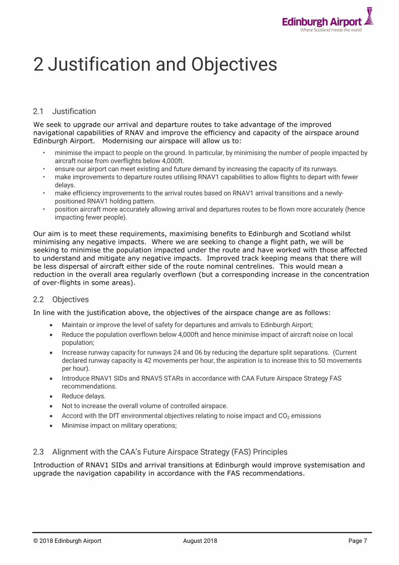
Justification 2.1
We seek to upgrade our arrival and departure routes to take advantage of the improved
navigational capabilities of RNAV and improve the efficiency and capacity of the airspace around
Edinburgh Airport. Modernising our airspace will allow us to:
• minimise the impact to people on the ground. In particular, by minimising the number of people impacted by aircraft noise from overflights below 4,000ft.
• ensure our airport can meet existing and future demand by increasing the capacity of its runways. • make improvements to departure routes utilising RNAV1 capabilities to allow flights to depart with fewer
delays. • make efficiency improvements to the arrival routes based on RNAV1 arrival transitions and a newly-
positioned RNAV1 holding pattern. • position aircraft more accurately allowing arrival and departures routes to be flown more accurately (hence
impacting fewer people).
Our aim is to meet these requirements, maximising benefits to Edinburgh and Scotland whilst
minimising any negative impacts. Where we are seeking to change a flight path, we will be
seeking to minimise the population impacted under the route and have worked with those affected
to understand and mitigate any negative impacts. Improved track keeping means that there will
be less dispersal of aircraft either side of the route nominal centrelines. This would mean a
reduction in the overall area regularly overflown (but a corresponding increase in the concentration
of over-flights in some areas).
Objectives 2.2
In line with the justification above, the objectives of the airspace change are as follows:
Maintain or improve the level of safety for departures and arrivals to Edinburgh Airport;
Reduce the population overflown below 4,000ft and hence minimise impact of aircraft noise on local population;
Increase runway capacity for runways 24 and 06 by reducing the departure split separations. (Current declared runway capacity is 42 movements per hour, the aspiration is to increase this to 50 movements per hour).
Introduce RNAV1 SIDs and RNAV5 STARs in accordance with CAA Future Airspace Strategy FAS recommendations.
Reduce delays.
Not to increase the overall volume of controlled airspace.
Accord with the DfT environmental objectives relating to noise impact and CO2 emissions
Minimise impact on military operations;
Alignment with the CAA’s Future Airspace Strategy (FAS) Principles 2.3
Introduction of RNAV1 SIDs and arrival transitions at Edinburgh would improve systemisation and
upgrade the navigation capability in accordance with the FAS recommendations.
2 Justification and Objectives

© 2018 Edinburgh Airport August 2018 Page 8
Current aircraft flight paths 3.1
Figure 3 to Figure 5 illustrate the current day flight paths of aircraft arriving and departing to/from
runways 24 and 06. These plots are generated from radar data and show the density of the flight
paths. Red areas indicate the highest concentration of flight paths, with yellow/green less so and
grey areas show where there are only occasional flights.
The pattern of traffic on any particular day depends on the direction of the wind, since this
determines which runway is used. The prevailing wind is from the south west, in 2016 runway 24
was used, 69% of the time and runway 06 was used 31% of the time. In 2016 runway 30/12 was
only used on 66 occasions, (less than 0.1% of the time).
Figure 3 shows traffic patterns over a two week period including periods when both runway 24 and
runway 06 were in use.
Figure 4 shows traffic patterns on days when the wind is predominantly from the west, which
results in runway 24 being used.
Figure 5 shows traffic patterns on days when the wind is predominantly from the east, which
results in runway 06 being used.
Arrivals to Edinburgh Airport from the south are routed via the TALLA VOR radio beacon (27nm
south of the airport) to the TWEED hold (see Appendix A) (a point 17nm south of the airport).
Currently aircraft are vectored by Air Traffic Control (ATC) to join the final approach. Even though
there is no formal route it can be seen from Figure 4 and Figure 5 that there is a high degree of
consistency in the instructions given.
Current aircraft altitudes 3.2
The typical altitudes at points on the current day flight paths are indicated on Figure 4 and Figure
5. ATC will always seek to climb departures to higher altitudes early and not to descend arrivals
prematurely; this is better for noise levels and the reduction of CO2 and other emissions. However
maintaining safe separation can constrain the altitudes they can achieve.
Existing track concentrations 3.3
Figure 3 to Figure 5 show the current day spread of flight paths.
These figures show the density of flight paths1 so that the current number of flights over any given
location in a typical day can be gauged. These give a good indication of where the main
concentrations of flights currently occur.
Where there is a spread of flight paths, this is a result of many factors including:
the different speeds and performance of the various aircraft types. (In general, slower aircraft [e.g. turbo props and smaller aircraft] will turn with tighter radii, while larger jet aircraft fly faster and turn with wider radii);
vectoring by Air Traffic Control (note for departures, aircraft are not vectored off the defined routes until they are above 3000ft);
variation due to wind and different runway operation.
For reference the current conventional Standard Instrument Departure (SID) route definitions and
Standard Terminal Arrivals (STARs) routes are available here.
(http://www.nats-uk.ead-it.com/public/index.php%3Foption=com_content&task=blogcategory&id=62&Itemid=111.html)
1 These are derived from radar data taken from June 2015.
3 Current Airspace

© 2018 Edinburgh Airport August 2018 Page 9
Once above 4,000ft aircraft are often tactically vectored by ATC and are instructed by ATC to leave
the SID. Hence above 4,000ft the departure flight paths may be more dispersed.
This can be seen in Figure 4 and Figure 5 by the dispersed nature of the departures which fan-out
as they get further from the airport.
Likewise, from around 3,000 - 4,000ft arrivals converge on the final approach path. Prior to this
they are generally coming from the same direction (e.g. from TWEED as discussed in the previous
section) however they are in a broader swathe. ATC position them this way to keep them
separated from one another and to ensure that they have the right spacing when joining final
approach and for landing.
The colour coding on the track pictures show the number of flights that overfly areas and Table 1
shows the total number of flights heading to/coming from each direction.

© 2018 Edinburgh Airport August 2018 Page 10
Figure 3: Current-day flight paths (2 week period, including use of runways 06 and 24)
© E
AL 2
018 e
xcept O
rdnance S
urv
ey d
ata
© C
row
n c
opyright and d
ata
base r
ight 2018

© 2018 Edinburgh Airport August 2018 Page 11
Figure 4: Current-day flight paths with typical altitudes, Runway 24 (Westerly Operations)
© E
AL 2
018 e
xcept O
rdnance S
urv
ey d
ata
© C
row
n c
opyright and d
ata
base r
ight 2018

© 2018 Edinburgh Airport August 2018 Page 12
Figure 5: Current design envelopes with typical altitudes, Runway 06 (Easterly Operations)
© E
AL 2
018 e
xcept O
rdnance S
urv
ey d
ata
© C
row
n c
opyright and d
ata
base r
ight 2018

© 2018 Edinburgh Airport August 2018 Page 13
Traffic Figures and Aircraft Types for the year 2016 3.4
Table 1 below shows the average usage for each departure route.
Route
%
(of those using the SID/STAR)
Average flights per day 2016 (note 1)
Departures
GOSAM 51% 95
TALLA 42% 78
GRICE 7% 13
Arrivals
STIRA 8% 15
TWEED 92% 171
Table 1: Average daily route usage Note 1: runway 24 is used 69% of the time, and runway 06, 31% of the time. This means that for each route shown in Table 1 the average number of flights per day would apply to the runway 24 routes for 252 days per year and runway 06 for the remaining 113 days per year.
Table 2 below shows the mix of aircraft types departing from Edinburgh based on the calendar
year 2016. The following data tables describe the aircraft types operating from Edinburgh Airport.
Aircraft type Number Percentage
A319 9360 16.48%
DH8D 8561 15.07%
B738 8395 14.78%
A320 7948 14.00%
E190 4128 7.27%
B733 2801 4.93%
SF34 2280 4.01%
AT76 1748 3.08%
D328 1540 2.71%
E170 1415 2.49%
B752 1230 2.17%
A321 1095 1.93%
B763 814 1.43%
RJ1H 635 1.12%
B737 379 0.67%
B788 344 0.61%
Others (each <0.5%) 4120 7.25% Table 2: Aircraft types (by number of departures 2016)

© 2018 Edinburgh Airport August 2018 Page 14
Operational Efficiency, Complexity, Delays and Choke Points 3.5
The frequency at which aircraft are able to depart in succession is determined by wake vortex
category pairs, and also by the route design. Currently due to the geometry of the departure
routes, the standard departure interval between successive departures is two minutes. This two
minute standard departure interval results in delays at busy times, especially during the first
rotation wave of departures in the morning. Hence the initial portion of the departure routes is a
bottle-neck which limits the runway capacity and causes delays.
The current declared runway capacity is 42 movements per hour. The target runway capacity if
the proposed changes are implemented is 50 movements per hour. How this would be achieved
is outlined in section 4.10.
During the analysis of route options one option considered was to include a route (Hw) to GOSAM
(see Consultation book Ref 3 page 112). This was proposed to allow flights to GOSAM to be split
between a left turn out and a right turn out SID. Analysis was performed to determine the
benefit of this and the impact of mixing jet and turbo-prop traffic on this route. This analysis (see
Ref 21) concluded that routing all jet traffic via route E to GOSAM (rather than using Hw, which
would mix turbo-props and jets) gives better capacity when the traffic grows. Hence this solution
provides improved long term resilience. On this basis route option Hw has not been progressed.
Environmental Issues 3.6
Currently the predominant environmental issue is the impact of aircraft noise on local populations
due to overflights below 4,000ft. As outlined in the consultation document (Ref 1) para 10.2, the
highest priority environmental objective for this ACP is to minimise the population overflown
below 4,000ft and hence minimise the noise impact on the local population. Other environmental
objectives are to minimise the population overflown by aircraft between 4,000-7,000ft, minimise
CO2 emissions and improve average exhaust emissions below 1,000ft on a per flight basis.
Detailed analysis of the environmental impact of the proposed new routes is given in section 5.
This includes analysis of the current vs proposed routes for the impact on CO2 emissions, fuel
burn, track mileages, noise impact, tranquillity, population overflown, biodiversity, and local air
quality.
Safety 3.7
There are no specific safety issues in the current operation. Ensuring the safety of proposed
changes is a priority for Edinburgh Airport. Safety representatives from SARG have had oversight
of the safety assurance process.
All proposed procedures have been designed in accordance with ICAO PANS-OPS RNAV procedure
design criteria (ref 10).
See paragraph 5.17 for further safety details for this proposal.

© 2018 Edinburgh Airport August 2018 Page 15
Requirements 4.1
In line with the objectives listed in section 2.2 the following requirements have particular
relevance for the proposed route designs
Improve departure intervals for subsequent departures;
Maintain or improve the level of safety for departures and arrivals to Edinburgh Airport;
Minimise impact of aircraft noise on local population;
Minimise impact on military operations;
No additional controlled airspace required for changes
Naming convention 4.2
The airspace design has been developed over a period of several years including three periods of
public consultation. During the evolution of the design the names of routes and waypoints have
changed from working names earlier in the project (e.g. during consultation) to officially reserved
ICAO approved ICARD five letter name code designators. Multiple route options were consulted
upon; the route and waypoint names have been consistently maintained as per the table below
which provides a cross-reference if required when referring to historic documents such as the
consultation material. The routes proposed herein include the reference to the route option that
was used in Consultation 2. E.g. ARLER1C (A3) is the reference used herein for the proposed
ARLER1C SID, which corresponds with route option A3 from consultation 2. The two character
route reference (e.g. A3) is used as a short-hand name reference in some parts of the ACP, and
provides a consistent reference.
Procedure design and IFP flight validation used working names for waypoints and routes since the
official ICARD reserved names were not available at that time. Table 3 below provides a cross
reference.
4 Proposed Routes

© 2018 Edinburgh Airport August 2018 Page 16
Current route
Consultation 1 Consultation 2 Working names used during procedure design and flight
validation
Proposed SIDs - with end waypoint [and link route]
TLA6C Swathe, RWY 24 departures left
turnout
Route options A1 –A7
A3 = (ARBOR1C) A6 = (ACORN1C)
ARLER1C (A3) [Z507 ARLER, TLA] EVTOL1C (A6) [Z509 EVTOL-TLA]
GOSAM1C Swathe, RWY 24 departures straight out
Route options B1 –B6
B2 = (BEECH1C) B5= (BRIER1C)
LIKLA1C (B2) [N537 LIKLA, GOW, MAC] MAVIX1C (B5) [Z500, MAVIX, GOSAM]
GRICE3C Swathe, RWY 24 departures right
turnout
Route options C1 –C5
C5 = (CEDAR1C) GRICE4C (C5)
n/a Swathe, RWY 24 departures right
turnout
Route options D0 - D5
D0 = (DOWEL1C) VOSNE1C (D0) [Z506 VOSNE, HAVEN]
GOSAM1D Swathe, RWY 06 departures left
turnout
Route options E1 –E7
E7 = E op 2 (ELDER1D) EMJEE1D (E7A) [N537 EMJEE, LIKLA, GOW, MAC] [Z500 EMJEE, MAVIX]
GRICE4D Swathe, RWY 24 departures left
turnout
Route options F1 –F6
F2a = F opt 2 (FLORA 1D) GRICE5D (F2a)
TLA6D Swathe, RWY 06 departures right
turnout
Route options G1 –G6
G5 = G (DOWEL1D) VOSNE1D (G5) [Z506 VOSNE, HAVEN]
n/a Swathe, RWY 06 departures right
turnout
Route options H1 –H4
H2 = H opt 1 (HEATH1D) KRAGY1D (H2) [Z507 KRAGY, ARLER, TLA]
Table 3: Route name cross reference table.
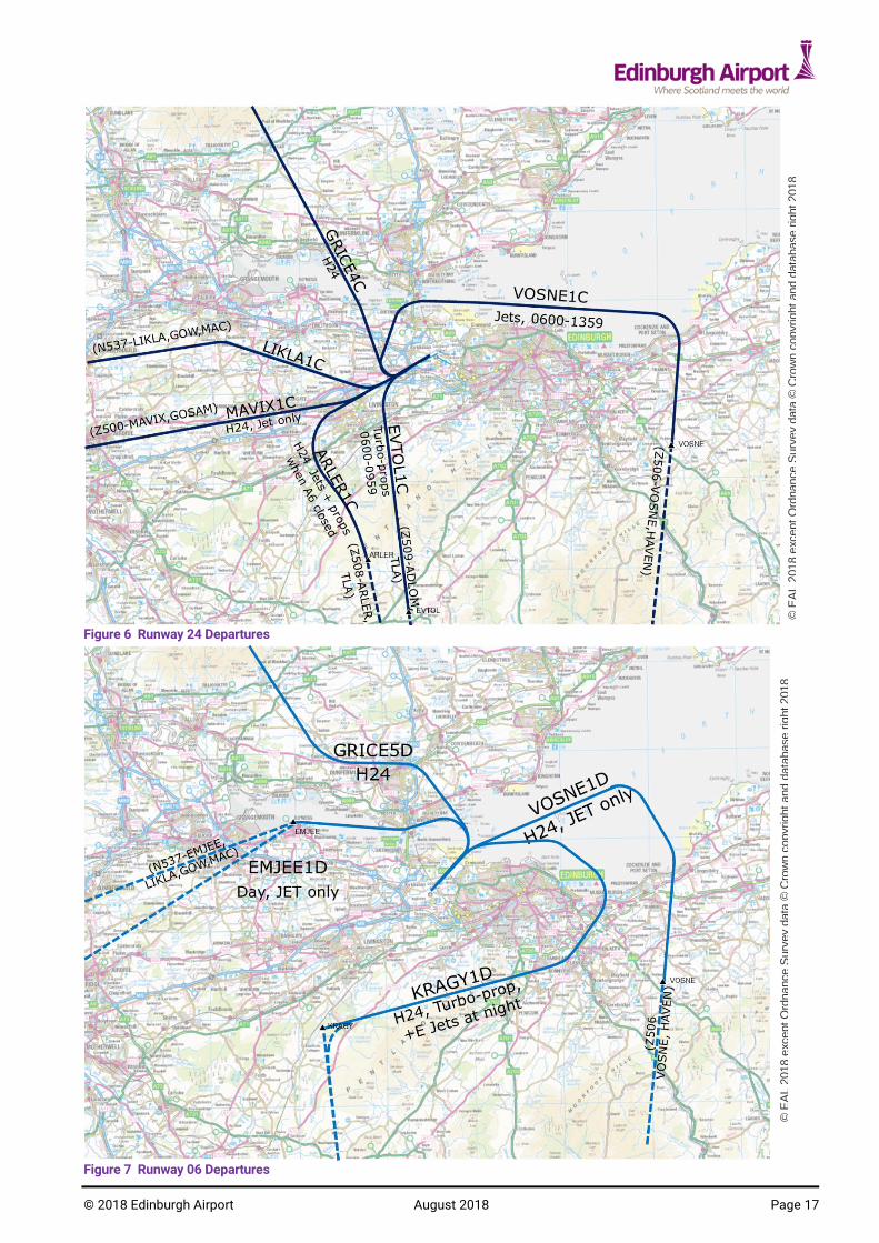
Proposed SIDs 4.3
Overview diagrams of the proposed SIDs are given in Figure 6 and Figure 7 below.
Details of the route usage and traffic allocation are given in section 4.5. Link routes are detailed
in section 4.16.
© 2018 Edinburgh Airport August 2018 Page 17
Figure 6 Runway 24 Departures
Figure 7 Runway 06 Departures
© E
AL 2
018 e
xcept O
rdnance S
urv
ey d
ata
© C
row
n c
opyright and d
ata
base r
ight 2018
© E
AL 2
018 e
xcept O
rdnance S
urv
ey d
ata
© C
row
n c
opyright and d
ata
base r
ight 2018

© 2018 Edinburgh Airport August 2018 Page 18
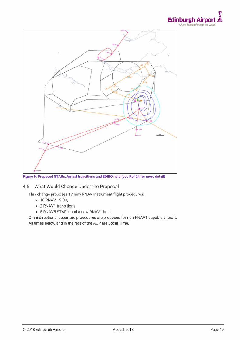
Proposed RNAV1 Arrival Transitions and Hold 4.4
The proposed RNAV1 arrival transitions are shown in Figure 8 below. These will provide closed
loop transitions for arrivals from the south, from the EDIBO hold to final approach for runways 24
and 06. The introduction of arrival transitions will enable flight crew to manage descent planning
better and hence facilitate continuous descent approaches (CDAs) more reliably. Draft charts of
the Arrival transitions are provided in Ref 18.
A new RNAV1 hold is proposed at EDIBO. The hold is positioned 3nm to the east of the current
TWEED hold (see Figure 9). This hold is required since the alignment of the current TWEED hold
is not suitable for integration with the proposed RNAV1 arrival transitions. The EDIBO hold also
gives improved route separation from the proposed SIDs. The minimum altitude for holding (min
stack) is FL70/FL80 depending on atmospheric pressure. Since flights in the hold are at or above
7000ft the impact of holding on stakeholders on the ground aircraft is minimal.
Figure 8: Proposed Arrival transitions Runway 06 and 24
© E
AL 2
018 e
xcept O
rdnance S
urv
ey
data
© C
row
n c
opyr
ight and d
ata
base r
ight 2018
© 2018 Edinburgh Airport August 2018 Page 19
Figure 9: Proposed STARs, Arrival transitions and EDIBO hold (see Ref 24 for more detail)
What Would Change Under the Proposal 4.5
This change proposes 17 new RNAV instrument flight procedures:
10 RNAV1 SIDs,
2 RNAV1 transitions
5 RNAV5 STARs and a new RNAV1 hold.
Omni-directional departure procedures are proposed for non-RNAV1 capable aircraft.
All times below and in the rest of the ACP are Local Time.

© 2018 Edinburgh Airport August 2018 Page 20
Table 4: Proposed routes with usage.
2 The times of operation of all SIDs will be subject to review at the PIR. 3 Please note that in Ref 18 there are two options for the draft SIDs for MAVIX1C and LIKLA1C. The difference between the options is the end altitude of the SID. If the RULUR hold is approved in the NATS FASIN ScTMA ACP, option 1 (end altitude FL100) will be used for each. If the RULUR hold is not approved (LANAK remains as extant) Option 2 (end altitude of 6000ft) will be used.
Route Description Usage (note destinations are guidance and not compulsory)
RNAV1 SIDs from runway 24
ARLER1C (A3)
Truncated RNAV1 replication of the current conventional TLA 6C
H24. Departures to south via TLA (Note: in practice ARLER1C will not be used between 0600-0959 weekdays
2, since jets will route via VOSNE1C (D0)
and non-jets via EVTOL1C (A6).) Non-jets will use this route between 1000-0559 when A6 closed. A3 and A6 will not be used simultaneously.
EVTOL1C (A6)
new RNAV1 route, early turn to TALLA
Non-jets only, 0600-0959 weekdays2.
Departures to south via TLA Note: RAF 2FTS (parent unit of the RAF volunteer gliding squadron based at RAF Kirknewton) have agreed in the LoA that gliding starts only after 1000 on weekdays. Hence there is no dependency on gliding activity.
LIKLA1C (B2)3
new RNAV1 route, “MAVIX offload” route, avoids Livingston
0600-22592 Jet only
Transatlantic & Ireland Departures to West via GOW &TRN: Ireland, Canaries, Portugal, USA, Canada, Mexico, South/Central America, Caribbean (Destination ICAO Codes:, EGAx, EIxx, Gxxx, LPxx, LExx Kxxx, Cxxx, Sxxx, Mxxx, Txxx)
MAVIX1C (B5)
3
Truncated RNAV1 replication of the current conventional GOSAM 1C
H24 Jet only Departures to South and East via GOSAM: UK, Europe (Destination ICAO Codes: Exxx, Lxxx (except LPxx and LExx))
GRICE4C (C5)
new RNAV1 replacement for the GRICE3C, gives early turn to GRICE
H24 All aircraft types Departures to north via GRICE.
VOSNE1C (D0)
new RNAV1 route, early right turn to HAVEN. Time-restricted limited use.
0600-13592 Weekdays. Jet only
Departures to South via HAVEN (takes traffic off the ARLER1C (A3) route during these times) Europe, Russia, Middle/Far East, China (Destination ICAO Codes: Exxx (except EGxx, EIxx), Lxxx, Oxxx, Rxxx, Uxxx, Vxxx, Wxxx, Zxxx)
RNAV1 SIDs from runway 06
EMJEE1D (E7A)
new truncated RNAV1 replacement for the GOSAM1D, keeping the route more over the water
0600-22592 Jet only
Departures via GOSAM/GOW: UK, Ireland, Canaries, USA, Canada, , Mexico, South/Central America, Caribbean (Destination ICAO Codes: EGxx, EIxx, Gxxx, Kxxx, Cxxx, Sxxx, Mxxx, Txxx) Note: the closing time of this SID can be tactically varied to close earlier (by agreement between EDI ATC and Prestwick Centre).
GRICE5D (F2a)
new RNAV1, replacement for the GRICE4D
H24 Departures to north via GRICE. All aircraft types
VOSNE1D (G5)
new RNAV1 route to HAVEN H24 Departures to south via HAVEN. Jet only Europe, Russia, Middle/Far East, China (Destination ICAO Codes: Exxx (except EGxx, EIxx), Lxxx, Oxxx, Rxxx, Uxxx, Vxxx, Wxxx, Zxxx)
KRAGY1D (H2)
new RNAV1 replacement for the TLA6D
H24 Non-jet during day 0600-2259; All aircraft types 2300-0559
2

© 2018 Edinburgh Airport August 2018 Page 21
New RNAV1 arrival transitions
24 Arrival RNAV1 Transition from EDIBO hold to runway 24
H24
06 Arrival RNAV1 Transition from EDIBO hold to runway 06
H24
New RNAV5 STARs
RNAV5 STARs via TWEED
RNAV5 STARs to replace extant TWEED 2B/2C/2D/3A STARs terminating at EDIBO.
H24 (see para 4.17)
RNAV5 STARs via STIRA
RNAV5 STAR to replace extant STIRA 1A STAR terminating at STIRA.
H24 (see para 4.17)
Table 4 (cont): Proposed routes with usage.
Figure 6 and Figure 7 show an overview of the proposed routes and Table 4 details the route
usage.
Further details on usage are given in section 4.10.
The majority of the proposed SIDs and associated link routes interface with the existing enroute
network at the same points as extant (GRICE, TLA, GOSAM). The exceptions to this are routes
D0 and G5 which connect to existing point HAVEN, and route B2 which connects at LIKLA to a
new link route to GOW (and thence to TRN via P600 and MAC via N537).
Note. The promulgated routes to TLA, HAVEN, GOSAM and GOW have been be truncated earlier,
with link routes introduced such that flight-planned fuel can be optimised. (see draft SIDs Ref 18
and section 4.16).
Further details of the proposed RNAV5 STARs are given in section 4.17.
Proposed Implementation 4.6
The implementation is targeted for AIRAC 03/2019 (28th Feb 2019).
Modernising the air route infrastructure 4.7
As described in the consultation document (Ref 3) and feedback report (Ref 4), Edinburgh Airport
Ltd (EAL) propose to replace the extant conventional SIDs and STARs with RNAV1 procedures.
The CAA’s Future Airspace Strategy (FAS)4 also recommends that the ATS route network is
improved, to take advantage of available technology such as RNAV1.
The proposed change to PBN procedures is targeted to be complete before the withdrawal of the
VORs listed in Table 5 below, which are being withdrawn from service as part of the NATS VOR
rationalisation programme.
VOR being decommissioned
Used by current EGPH conventional procedures
Deadline for procedures to be removed
Proposed date of decommissioning
Glasgow – GOW GOSAM 1D SID, STIRA STAR
Dec 2019 May 2020
Perth – PTH STIRA STAR Dec 2019 May 2020
Turnberry – TRN GOSAM 1D SID, GOSAM 1C SID, TWEED STAR
Dec 2019 May 2020
Table 5 VOR rationalisation – conventional procedures affected.
Most commercial aircraft already have the ability to conform to RNAV1. The RNAV1 equipage rate
for aircraft which operate from Edinburgh Airport is currently 91.3%5 (see Ref 3, Table 15) .
Procedures for non-RNAV1 compliant aircraft are covered below in Section 4.12.
4 Civil Aviation Authority, Future Airspace Strategy for the United Kingdom 2011 to 2030 www.caa.co.uk/FAS 5 NATS PBN equipage survey Jan-Feb 2017, % of airframes for flights originating from Edinburgh Airport.

© 2018 Edinburgh Airport August 2018 Page 22
Revision of minimum radar separation 4.8
PC implemented 3nm radar separation6 on the 2nd March 2017. Edinburgh ATC currently operates
using 3nm radar separation. However since Prestwick Centre (PC) implemented 3nm separation,
procedures have not been updated between Edinburgh Radar and PC. Hence currently PC is only
authorised to operate using the previous separation standard i.e. 5nm within the Edinburgh CTA.
In order to take full advantage of the PC 3nm separation a number of enhancements are required
to the systems between Edinburgh and PC. These are:
Requirement and function of 3nm capability with adjacent sectors: Tay, Galloway North, Talla North.
Manual of Air Traffic Services (MATS) Part 2 procedures will be updated to document the procedures required for the transition between adjacent ANSPs and sectors to take advantage of 3nm separation.
Note that these enhancements are independent of the ACP. However use of the proposed routes
to the full extent does assume that this capability is in place. If it is not, 2 minute separation
intervals will have to be used to ensure 5nm separation on handover to PC.
Radar, Communications and Navaid coverage 4.9
This proposal does not propose any new controlled airspace. All proposed routes are within
existing CAS where radar and comms coverage are well proven. RNAV1 Navaid coverage
(DME/DME) is demonstrated in the coverage plots included as Reference 26.
Route Usage and Traffic Forecasts 4.10
The frequency at which aircraft are able to depart in succession is determined by wake vortex
category pairs, and also by the route design. Currently due to the geometry of the departure
routes, the minimum standard departure interval permitted between successive departures is two
minutes (see Ref 15, MATS Pt2 page 56 Section 2 Chapter 1 para 1.1.2). This two minute
standard departure interval results in delays at busy times, especially during the “first rotation”
departures in the morning. The geometries of the proposed routes enable some aircraft to turn
earlier. This in turn allows the departure interval to be reduced to 1 minute between some
successive departure pairs (see Table 6 below) .
Ref 17 details the safety analysis undertaken by NATS to identify minimum safe departure
spacing for the proposed RNAV Standard Instrument Departures (SIDs). The analysis was
performed using the validated Reduced Angles of Divergence Simulator (RADSIM) method for 1
minute splits collision risk estimation, or bespoke analysis as appropriate. Where the angle of
separation between route pairs is greater than 45 degrees, separation is sufficient and 1 minute
standard separation can be used.
6 Between PC controllers under specified conditions in specified areas (details not included here).

© 2018 Edinburgh Airport August 2018 Page 23
RWY 24
Proposed Route Pair Std Dep Sep Int
Notes / RADSIM images
EVTOL1C (A6) / ARLER1C (A3)
n/a EVTOL and ARLER will not be used simultaneously.
EVTOL1C (A6)/ MAVIX1C (B5)
2 minute >45° Non- assessed. Limited matching speed group traffic turbo-props on EVTOL1C jets on MAVIX1C.
EVTOL1C (A6) / LIKLA1C (B2)
2 minute >45° Non- assessed. Limited matching speed group traffic turbo-props on EVTOL1C jets on LIKLA1C.
EVTOL1C (A6) / GRICE4C (C5)
1 minute >45° ICAO-compliant for any speed group
EVTOL1C (A6) / VOSNE1C (D0)
1 minute >45° ICAO-compliant for any speed group
ARLER1C (A3) / MAVIX1C (B5)
1 minute RADSIM analysis ref 17
ARLER1C (A3) / LIKLA1C (B2)
1 minute RADSIM analysis ref 17
ARLER1C (A3) / GRICE4C (C5)
1 minute >45° ICAO-compliant for any speed group
ARLER1C (A3) / VOSNE1C (D0)
1 minute >45° ICAO-compliant for any speed group
MAVIX1C (B5) / LIKLA1C (B2)
1 minute RADSIM analysis ref 17
MAVIX1C (B5) / GRICE4C (C5)
1 minute >45° ICAO-compliant for any speed group
MAVIX1C (B5) / VOSNE1C (D0)
1 minute >45° ICAO-compliant for any speed group
LIKLA1C (B2) / GRICE4C (C5)
1 minute RADSIM analysis ref 17
LIKLA1C (B2) / VOSNE1C (D0)
1 minute >45° ICAO-compliant for any speed group
GRICE4C (C5) / VOSNE1C (D0)
2 minutes RADSIM analysis ref 17, 2 mins due to common first turn
Table 6 Table of proposed departure separation intervals

© 2018 Edinburgh Airport August 2018 Page 24
RWY 06
Proposed Route Pair Std Dep Sep Int
Notes / RADSIM images
EMJEE1D (E7A) / GRICE5D (F2a)
2 minutes RADSIM analysis ref 17
EMJEE1D (E7A) / VOSNE1D (G5)
1 minute RADSIM analysis ref 17
EMJEE1D (E7A) / KRAGY1D (H2)
1 minute >45°
GRICE5D (F2a) / VOSNE1D (G5)
1 minute
>45°
GRICE5D (F2a) / KRAGY1D (H2)
1 minute >45°
VOSNE1D (G5) / KRAGY1D (H2)
1 minute G is jet only, H is Turbo-prop only. MATS Pt2 speed tables used to manage different speed aircraft.
Speed table interval as per MATS part 2 (ref 15 page 56) still apply. These add additional time for dis-similar aircraft types. Note. The above standard departure separation intervals are dependent on 3nm separation handovers between EGPH and Prestwick Centre. If 3nm handover separations are not approved all departures will revert to 2 minute separations (see section 4.8).
Table 6 (cont) Table of proposed departure separation intervals
The number of flights per day using each of the proposed routes are shown in Table 8 below. A
detailed map of the routes (layered pdf) is available in Ref 24.
In order to minimise the impact of overflights below 4,000ft on the local communities, time-
bound restrictions have been placed on some proposed routes as outlined in.
Table 7 below shows the forecast percentage use of each route for the appropriate runway. Note
Runway 24 is used ~68% of the time and runway 06 ~32% of the time.
2019 2024
Rwy 24
ARLER1C (A3) 19.7% 19.7%
EVTOL1C (A6) 4.3% 4.3%
LIKLA1C (B2) 25.8% 25.8%
MAVIX1C (B5) 8.6% 8.6%
GRICE4C (C5) 4.9% 4.9%
VOSNE1C (D0) 4.9% 4.9%
Rwy 06
EMJEE1D (E7A) 11.2% 11.2%
GRICE5D (F2a) 1.8% 1.8%
VOSNE1D (G5) 10.4% 10.4%
KRAGY1D (H2) 8.3% 8.3% Table 7 Traffic forecast per route (percentage of annual flights) .
Table 8 below shows the forecast number of aircraft which would use each route per day
(assuming the runway is in use all day) for the appropriate runway.

© 2018 Edinburgh Airport August 2018 Page 25
2019
(7.4% total growth) 2024
(20% total growth)
Rwy 24
ARLER1C (A3) 50.8 56.8
EVTOL1C (A6) 11.0 12.3
LIKLA1C (B2) 66.6 74.4
MAVIX1C (B5) 22.2 24.8
GRICE4C (C5) 12.6 14.1
VOSNE1C (D0) 12.7 14.2
Rwy 06
EMJEE1D (E7A) 62.1 69.4
GRICE5D (F2a) 10.2 11.3
VOSNE1D (G5) 57.9 64.7
KRAGY1D (H2) 46.2 51.7 Table 8 Traffic forecast per route (number of flights per day when runway in use).
Traffic growth applied is:
2016 (source data) to 2019 (implementation): 2016 + 7.4%* 2016 (source data) to 2024 (implementation +5 years): 2016 + 20.0%*
* (ref 16) EAL Masterplan (page 60) Traffic Forecast
Controlled Airspace 4.11
There is no change proposed to the controlled airspace. The proposed new routes are contained
within existing controlled airspace. There is no proposal in this ACP to release controlled airspace
or raise the base of controlled airspace. A future ACP is planned concerning the possibility of
closing runway 12/30. Closure of runway 12/30 may permit the airspace bases in the south
eastern quadrant of the CTA to be raised.
RNAV equipage 4.12
The equipage rate for aircraft operating from Edinburgh Airport which are RNAV1 capable is
currently 91.3%7.
Aircraft not suitably equipped or certified to fly RNAV1 SIDs would flight-plan an omnidirectional
departure (see section 4.15). This takes the aircraft straight out to a point 3nm from the runway
end, at which point the aircraft is vectored by ATC to join the en-route structure.
Arrivals would be radar vectored from the hold to the appropriate instrument approach IAF. All
non-RNAV1 aircraft will be radar monitored by ATC to ensure separation is maintained from all
other traffic.
Note that while 8.7% of the aircraft movements are not RNAV1 capable, a high proportion of this
figure is composed of a small number of airframes which operate regularly to/from Edinburgh.
For example several ATR 76 aircraft operated by Stobart Air and one Avro RJ-100 (BAe146)
operated by Brussels Airlines form the majority of these flights. Note since these statistics were
compiled the Avro RJ-100 (BAe146) operated by Brussels Airlines has stopped operating from
Edinburgh.
Route allocation 4.13
The route allocation according to destination is shown in Table 4.
This route allocation system would not preclude controllers from vectoring flights, or from giving
“tactical directs”, if they perceive an advantage in flexibility or efficiency.
7 NATS PBN equipage survey Jan-Feb 2018 based on % airframes using EGPH.

© 2018 Edinburgh Airport August 2018 Page 26
RNAV1 capable aircraft will be best served by flight-planning the RNAV1 routes. There will be no
advantage to RNAV1 aircraft filing omnidirectional departures (see section 4.15), and this will be
discouraged except for RNAV1 departures to PIPAR.
Traffic that currently files via TLA to route via SAB and leave CAS, will in the future flight plan via
TLA or HAVEN as follows (note tactical directs to SAB will be given where possible if traffic allows,
e.g. VOSNE-SAB)
Departures R24, (route ARLER1C (A3)) ARLER, TLA
Departures R24, (route EVTOL1C (A6)) EVTOL, TLA
Departures R24 (route VOSNE1C (D0), Jet only), VOSNE, HAVEN
Departures R06, (route KRAGY1D (H2)) KRAGY, TLA
Departures R06 (route VOSNE1D (G5), Jet only) VOSNE, HAVEN
Time-bound SIDs 4.14
The use of the proposed SIDs relies on some routes only being available for restricted times.
(see Table 4 ). For example route VOSNE1C (D0) would only be available from 0600-0959. The
time relates to the take-off time. In order that flights do not contravene the time restrictions,
ATC will ensure that the aircraft commence taxi with sufficient time such that take off can occur
before the cut-off time. If there are delays longer than 10 minutes for departure, ATC would use
their discretion to stop issuing clearance for the route in question earlier. Changing the flight’s
route clearance during taxi is to be avoided wherever possible.
Omnidirectional Departures (ODD) 4.15
Each runway will have an omnidirectional departure defined. These will be described in the AIP
Airport textual data (EGPH AD 2.22 Flight Procedures).
An omnidirectional departure is a convenient and simple method of ensuring obstacle clearance
for IFR departing aircraft. An omnidirectional departure procedure is designed on the basis that
an aircraft maintains runway direction to a minimum height of 500ft above aerodrome level
before commencing a turn.
Where additional height is required for obstacle clearance the straight departure is continued until
reaching the required turn altitude/height or a procedure design gradient (PDG) in excess of the
standard 3.3% is promulgated.
On reaching the specified turn altitude/height a turn in any direction may be made to join the en-
route phase of flight.
Omnidirectional departures are promulgated in the UK IAIP Part 3 AERODROMES (AD) AD 2.22.
Below is the suggested text for the Edinburgh Omnidirectional departures.
Omnidirectional Departures
Description Restriction
RWY 24 Climb straight ahead MAG track 241° to 636ft then turn on track climbing to enroute safety altitude/MSA.
PDG 4.6% to 2200ft then 3.3%. No turn before DER.
RWY 06 Climb straight ahead MAG track 061° to altitude 636ft then turn left MAG track 041° and climb to enroute safety altitude/MSA.
PDG 4.8% to 1600ft then 3.3%. No turn before DER.
RCF As per standard procedure
ATC can vector a flight on an ODD once it has climbed above the designated altitude. However in
order to keep aircraft within the NPR, ATC will vector along the nominal route centreline until the
aircraft is at least above 4,000ft.
Figure 10 to Figure 11 below show the expected patterns of vectoring by ATC of non-RNAV1
capable flights. Since the great majority of non-RNAV1 aircraft are non-jets they will tend to be
routed via routes A and C (when runway 24 is in operation), and routes F and H (when runway 06
is in operation).
Since there is no SID to PIPAR and N864, departures to the north via PIPAR will be via ODD.

© 2018 Edinburgh Airport August 2018 Page 27
The use of N864 will be unchanged i.e. “Between TLA and ASNUD (formerly ANGUS), established
from 0001 on Saturday to 2359 on Sunday as an alternative route when AWY P600, to the south
of Perth (PTH), has been made available to Portmoak for gliding activity. However, aircraft may
flight plan to use this route at any time during the above hours.” (AIP ENR 3.1-81).
This means that airway N864 may be used at any time during the weekend, not just when there
is gliding activity. Outside those times, Loganair flights sometimes request this routing (typically
in the evening) and accept ATSOCAS until they join P600 at ASNUD. This can give a time/distance
saving, especially when departing from runway 06.
Figure 10: Runway 24 Omnidirectional departures, expected vectoring patterns
© E
AL 2
018 e
xcept O
rdnance S
urv
ey d
ata
© C
row
n c
opyright and d
ata
base r
ight 2018

© 2018 Edinburgh Airport August 2018 Page 28
Figure 11: Runway 06 Omnidirectional departures, expected vectoring patterns
Link routes 4.16
In order to provide the most efficient flight planning/fuel uplift solution the SIDs have been
truncated at the following positions with link routes connecting to the en-route network. See
Table 9 and Figure 12.
Note: Z502 is proposed in the NATS ScTMA ACP.
Proposed route Ends at End level Link route(s) Route Designator
ARLER1C (A3) ARLER 6000 ARLER, TLA Z507
EVTOL1C (A6) EVTOL 6000 EVTOL, TLA Z509
LIKLA1C (B2) LIKLA FL100 (expect FL90 by PHW31) LIKLA, GOW N537
MAVIX1C (B5) MAVIX FL100 (expect FL90 by PHW30) MAVIX, FENIK MAVIX, GITGU
Z500 Z502
GRICE4C (C5) GRICE 6000 n/a n/a
VOSNE1C (D0)
VOSNE FL150 VOSNE, HAVEN Z506
EMJEE1D (E7A)
EMJEE FL100 EMJEE, LIKLA, GOW EMJEE, MAVIX, FENIK EMJEE, MAVIX, GITGU
N537 Z500 Z500, Z502
GRICE5D (F2a)
GRICE 6000 n/a n/a
VOSNE1D (G5)
VOSNE FL150 VOSNE, HAVEN Z506
KRAGY1D (H2)
KRAGY FL100 KRAGY, ARLER, TLA Z507
Table 9 Link routes
© E
AL 2
018 e
xcept O
rdnance S
urv
ey d
ata
© C
row
n c
opyright and d
ata
base r
ight 2018

© 2018 Edinburgh Airport August 2018 Page 29
Designators for the link routes have been reserved by the CAA.
Figure 12: Proposed link routes
The above link routes provide network connectivity. These have been agreed with NATS
Prestwick Centre, and were tested during the real time simulations run by Prestwick Centre.
STARs 4.17
The extant conventional STARs (STIRA and TWEED) and TWEED BRNAV STAR will be withdrawn
from service. New RNAV5 STARs as shown in Table 10 are proposed. (See Ref 24 for overview
drawing and Ref 18 for draft charts).
Existing STAR Proposed RNAV5 replacement
(note ICAO start point naming standard used. Designators to be confirmed by CAA)
Associated RNAV1 Hold
TWEED3A (RNAV5) ESKDO 1E EDIBO
TWEED2B (conventional) BLACA 1E EDIBO
TWEED2C (conventional) BLACA 1F EDIBO
TWEED2D (conventional) HAVEN 1E EDIBO
STIRA 1A (conventional) PERTH 1E STIRA
Table 10: Proposed STARs
Note the conventional EDN 1E, 2E and 3A STARs were required to cover navaids being out of
service. With the introduction of the RNAV5 STARs and associated RNAV1 holds this is no longer
necessary, hence the EDN STARs will be withdrawn (with no replacement).

© 2018 Edinburgh Airport August 2018 Page 30
Non-RNAV1 equipped aircraft (i.e. RNAV5) will flight plan to EDIBO then direct to the
airport. Holding for non-RNAV1 aircraft will be “as directed by ATC” at EDIBO using the same
orientation as the published RNAV1 hold. RNAV5 holding at FL110 and below will not be laterally
separated from the routes. RNAV5 holding at FL120 or above it will be level separated from the
departure routes.
Ref 24 is a drawing of the proposed STARs with relation to the EDIBO hold and SID routes.
The proposed STARs are not systematically separated from the departure routes.
GNSS approaches 4.18
One RNAV1 GNSS approach will be introduced for each of runway 24 and 06. These will serve as
contingency for the conventional approaches. Draft charts of the proposed GNSS approaches
are available in Ref 18.

© 2018 Edinburgh Airport August 2018 Page 31
Net Impacts Summary for Proposed Routes 5.1
Category Impact Evidence
Safety/Complexity Increased predictability of flight paths, reduction in complexity of ATC task due to systemisation.
Route spacing analysis See Para 5.17
Capacity/Delay Peak runway capacity is expected to increase from 42 to 50 movements per hour. This will have the effect of reducing departure delays.
See Para 3.5
Fuel Efficiency/CO2 Total annual change:
2019: -9,867 tonnes fuel / -31,377 tonnes CO2
2024: -11,024 tonnes fuel / -35,058 tonnes CO2
Monetised benefit (WebTAG) £14,594,863
See Para 5.11
Noise – Leq/SEL Reduction in total number of people within Leq contours, and most SEL footprints.
Monetised benefit (WebTAG) £200,318.
See Para 5.2
Tranquillity, visual intrusion
(AONBs & National Parks)
No impact See Para 5.13
Local Air Quality Small average Improvement (per flight) anticipated.
See Para 5.10
Other Airspace Users Minimal impact, no changes to volume of CAS. See Paras 5.14,
Table 11: Net Impacts Summary
In accordance with the DfT’s recommended altitude based priorities (see ref 3, section 10.2 and
ref 12 section 4), the primary environmental objective of the proposed changes is to reduce the
impact of aircraft noise due to aircraft below 4,000ft. However the reduction in fuel burn/CO2
provides further benefit to the environment.
Noise and population impacted 5.2
The changes to noise impacts are analysed in “ERCD Technical Note (v.3): Edinburgh Airport –
new SIDs ACP noise assessment” and the update of this to incorporate changes post-consultation
“Edinburgh Airport new SIDs ACP - revised summer day Leq contours” (ref 7). This analysis
examines the impact of the proposed new routes in terms of the change to:
Leq 16hr contours – these show the overall daily noise exposure in the vicinity of the airport (to min 51dBA Leq contour)
SEL footprints for the most frequent and noisiest aircraft types using each route. (Required by CAP725 for assessing night noise impact)
5 Impacts of Airspace Change

© 2018 Edinburgh Airport August 2018 Page 32
Overall noise impact – Leq Analysis 5.3
The change in population within the Leq contours is summarised in table 11 below:
Leq (dBA)
contour
2019 2024
Population within contour Delta Population within contour Delta
Current† Proposed‡ Current* Proposed‡
> 51 35,100 33,100 -6% 37,300 36,300 -3%
> 54 11,600 10,400 -10% 13,800 12,600 -9%
>57 4,200 3,900 -7% 4,600 4,300 -7%
>60 2,100 2,100 0% 2,700 2,900 7%
>63 400 400 0% 400 400 0%
>66 200 200 0% 300 300 0%
>69 <100 <100 0% <100 <100 0%
>72 0 0 0% 0 0 0%
† current airspace, unconstrained growth Figures from Ref 7
Current airspace constrained growth ‡ proposed airspace, unconstrained growth
(Note populations are rounded to the nearest 100. The population database used is a 2016
update of the 2011 Census supplied by CACI Ltd.)
Table 12 Summary of Leq contour population data
This shows that the proposed new routes would reduce the number of people within the Leq
contours. Hence this indicates that on aggregate the new routes represent a reduction of the
overall noise impact on the local community.
Note that where practicable the new routes have been deliberately positioned to avoid population
centres. Hence even though the area of the contours increase to 2024 due to traffic growth, the
population impacted by the new routes would be less for the majority of the contours than if the
current routes are retained.
Traffic growth used for the noise analyses is:
2016 (source data) to 2019 (implementation): + 7.4%* 2016 to 2024 (implementation +5 years): + 20.0%* 2016 to 2024 (no airspace change, hence constrained growth): + 15.99%
* (ref 16) EAL Masterplan (page 60) Traffic Forecast

© 2018 Edinburgh Airport August 2018 Page 33
Figure 13: Edinburgh 2019 average summer day (70% W/30% E) 51-72 dBA Leq noise contours – existing SIDs (No change)
Figure 14: Edinburgh 2019 average summer day (70% W / 30% E) 51-72 dBA Leq noise contours – with proposed SID usage

© 2018 Edinburgh Airport August 2018 Page 34
Figure 15: Edinburgh 2024 average summer day (70% W / 30% E) 51-72 dBA Leq noise contours – with proposed SID usage (implementation + 5 years)
Figure 16: Edinburgh 2024 average summer day (70% W / 30% E) 51-72 dBA Leq noise contours – no ACP, constrained traffic growth (No airspace change)

© 2018 Edinburgh Airport August 2018 Page 35
Night Noise Impact 5.4
Night noise impact has been assessed via the use of SEL footprints which relate to a single
overflight event. ERCD report (Ref 7) details the noise levels. Table 13 to Table 15 below
compare the area, population and number of households within the 80 and 90 SEL(dBA)
footprints for the extant versus proposed routes. Table 13 details the populations within the
contours for the most frequent aircraft type (Boeing 737-800). This is representative of
approximately 53% of the aircraft movements at Edinburgh (Boeing 737 and Airbus A320/319
family).
Table 14 details the populations within the contours for the noisiest aircraft type (Airbus A330).
As such this gives the worst case in terms of noise exposure. The A330 represents 0.5% of
flights (between 1 and 2 flights per day).
Table 15 details the populations within the contours for a large twin turbo-prop aircraft type (e.g.
DeHavilland Dash-8/Q400). This is of interest for those routes which are reserved for turbo-prop
operations (i.e. route EVTOL1C (A6)).
At night it is proposed that all traffic will route via GRICE or TALLA. In Table 13 to Table 15 the
routes which will be used at night are outlined in bold and shaded grey. Figures corresponding to
RWY06 are coloured Blue.
SID Runway SEL (dBA) Area (km2) Population
(% change) Households
Existing SIDs
TALLA 24 > 80 27.3 13,200 5,600 24 > 90 4.7 500 200
GOSAM 24 > 80 27.4 12,000 4,900 24 > 90 4.7 500 200
GRICE 24 > 80 28.0 12,900 5,300 24 > 90 4.7 500 200
GOSAM 06 > 80 25.7 3,200 1,400 06 > 90 4.7 100 < 100
GRICE 06 > 80 25.4 3,200 1.400 06 > 90 4.7 100 < 100
TALLA 06 > 80 25.3 3,300 1,400 06 > 90 4.7 100 < 100
Proposed SIDs
ARLER1C (A3) 24 > 80 27.3 12,800 (-3%) 5,400 24 > 90 4.7 500 200
MAVIX1C (B5) 24 > 80 27.4 12,200 (+1.7%) 5,000 24 > 90 4.7 500 200
LIKLA1C (B2) 24 > 80 27.6 6,600 2,800 24 > 90 4.7 500 200
GRICE4C (C5) 24 > 80 26.4 6,100 (-53%) 2,800 24 > 90 4.7 500 200
VOSNE1C (D0) 24 > 80 26.6 4,800 2,200 24 > 90 4.7 500 200
EMJEE1D (E7A) 06 > 80 26.0 3,700 1,600 06 > 90 4.7 100 <100
GRICE5D (F2a) 06 > 80 25.3 3,700 (+15%) 1,500 06 > 90 4.7 100 <100
VOSNE1D (G5) 06 > 80 25.3 3,500 1,500 06 > 90 4.7 100 <100
KRAGY1D (H2) 06 > 80 25.3 3,900 (+18%) 1,700 06 > 90 4.7 100 <100
Table 13 Boeing 737-800 (B738) SEL footprints Notes: Populations and households are given to the nearest 100. The population database used is a 2016 update of the 2011 Census supplied by CACI Ltd.
The B737 as a large Jet will not use route A6.
The results for the most frequent aircraft type given In Table 13 show that:

© 2018 Edinburgh Airport August 2018 Page 36
For runway 24 operations the proposed ARLER1C (A3) route shows a small reduction (3%) in population overflown compared to the extant. The GRICE1C (C5) route results in a reduction of population within the SEL 80dBA contour of 53%.
For runway 06 operations the proposed GRICE5D (F2a) route results in an increase of population within the SEL 80dBA contour of 15%, The KRAGY1D (H2) route results in an increase of population within the SEL 80dBA contour of 18%.
SID Runway SEL (dBA) Area (km2) Population (%
change)
Households
Existing SIDs TALLA 24 > 80 57.1 38,700 16,200 > 90 8.6 700 300
GOSAM 24 > 80 55.0 50,400 21,300 > 90 8.6 700 300
GRICE 24 > 80 55.5 36,600 15,400 > 90 8.6 700 300
GOSAM 06 > 80 51.6 18,300 8,000 > 90 8.3 300 100
GRICE 06 > 80 53.5 7,800 3,300 > 90 8.3 300 100
TALLA 06 > 80 51.7 6,600 2,800 > 90 8.3 300 100
Proposed SID
ARLER1C (A3) 24 > 80 57.1 39,700 (+2.6%) 16,200 > 90 8.6 700 300
MAVIX1C (B5) 24 > 80 55.0 50,300 (0%) 21,200 > 90 8.6 700 300
LIKLA1C (B2) 24 > 80 55.1 16,200 7,000 > 90 8.6 700 300
GRICE4C (C5) 24 > 80 50.7 8,800 (-76%) 4,100 > 90 8.6 700 300
VOSNE1C (D0) 24 > 80 51.1 12,500 5,700 > 90 8.6 800 300
EMJEE1D (E7A) 06 > 80 51.3 18,900 8,100 > 90 8.3 300 100
GRICE5D (F2a) 06 > 80 53.8 9,300 (+19%) 3,900 > 90 8.3 300 100
VOSNE1D (G5) 06 > 80 51.2 6,800 2,900 > 90 8.3 300 100
KRAGY1D (H2) 06 > 80 51.2 7,000 (+6%) 3,000 > 90 8.3 300 100
Table 14 Airbus A330 (EA33) SEL footprints Notes: Populations and households are given to the nearest 100. The population database used is a 2016 update of the 2011 Census supplied by CACI Ltd.
The A330 as a large Jet, will not use route EVTOL1C (A6).
The routes which will be used at night are outlined in bold.
The results for the noisiest aircraft type (A330) type given In Table 14 show that:
For runway 24 operations the proposed ARLER1C (A3) route shows a small increase (+2.6%) compared to the extant; the population overflown by the MAVIX route is unchanged; the GRICE4C (C5) route results in a reduction of population within the SEL 80dBA contour of 76%.
For runway 06 operations the proposed GRICE5D (F2a) route results in an increase in population within the SEL 80dBA contour of 19%, the KRAGY1D (H2)route results in an increase in population within the SEL 80dBA contour of +6%.

© 2018 Edinburgh Airport August 2018 Page 37
SID Runway SEL (dBA) Area (km2) Population Households
Proposed SID EVTOL1C (A6) 24 > 80 3.9 300 100 > 90 0.4 0 0
GRICE4C (C5) 24 > 80 3.9 300 100 > 90 0.4 0 0
Table 15 Large twin-turboprop (LTT) SEL footprints
Large twin-turboprop (LTT) SEL footprints are provided for A6-EVTOL1C (see Table 15) since this
route will be reserved for turbo-props only. As can be seen in Ref7 Fig 8, the SEL footprints do
not extend as far as the first turn. Hence there will be no change in the population within the LTT
SEL 80dBA contour.
The population figures in Table 12 to Table 15 above, use population data provided by CACI Ltd.
(This database is a 2016 update of the 2011 Census, including Scottish: Local Authority Mid-Year
Estimates, LSOA (lower-level data-zones) Population Mid-Year Estimates, Local Authority
Population Projections, Principal National Population Projections.)
Noise Impact - WebTAG Analysis 5.5
The change in noise impact has been assessed and monetised using the WebTAG noise impact
spreadsheet (Ref 29). The results of the change in noise impact are summarised below. The
monetised benefit is quantified as being £200,318 (npv).
For the 1,400 individuals who are shown to experience a worse forecast noise output, 1,300 have
a forecast noise increase from 45dBA to 46dBA; and the remaining 100 showed a forecast
increase from 55dBA to 56dBA.
Noise Workbook - Worksheet 1
Proposal Name: Edinburgh RNAV SIDs/STARs
Present Value Base Year 2010
Current Year 2018
Proposal Opening year: 2019
Project (Road, Rail or Aviation): aviation
WebTAG
assessment
Sensitivity test excluding
impacts below 51 dB (for
aviation proposals only)
Net present value of change in noise (£, 2018 prices): £200,318 £339,462
*positive value reflects a net
benef it (i.e. a reduction in noise)
Net present value of impact on sleep disturbance (£, 2018 prices): -£159,088 -£19,944
Net present value of impact on amenity (£, 2018 prices): £250,904 £250,904
Net present value of impact on AMI (£, 2018 prices): -£1,906 -£1,906
Net present value of impact on stroke (£, 2018 prices): £43,985 £43,985
Net present value of impact on dementia (£, 2018 prices): £66,422 £66,422
Quantitative results
individuals experiencing increased daytime noise in forecast year: 200
individuals experiencing reduced daytime noise in forecast year: -2500
individuals experiencing increased night time noise in forecast year: 1400
individuals experiencing reduced night time noise in forecast year: 0
Qualitative Comments:
Data Sources:
ERCD ANCON noise analysis (Leq16hr) Ref 7
Ricardo Energy & Environment noise analysis (Lnight) Ref 26

© 2018 Edinburgh Airport August 2018 Page 38
Future Population Growth 5.6
During consultation, information was requested from stakeholders regarding future population
growth. In particular information was requested to identify areas allocated for future housing
development. As a result information was provided by several Local Authorities, Community
Councils and housing development companies.
Predicted future population growth was reviewed across all communities using Local Authority
plans and National Records of Scotland. Large housing developments were identified in
Winchburgh, East Calder/Calderwood and Dunfermline & Halbeath, with smaller housing
developments in communities including South Queensferry, Broxburn, Dechmont/Bangour,
Livingston, Rosyth, Dalgety Bay & Hillend, Inverkeithing, Aberdour, Burntisland, Kinghorn and
Cowdenbeath.
With the benefit of the information yielded from consultation, these developments were able to be
taken into account post-consultation. As a result some routes were changed, and some routes
were restricted in their time of use.
Concentration of traffic 5.7
When following RNAV1 routes, aircraft follow the routes more consistently than when using
conventional radio navigation aids. This is due to the improved track-keeping ability of RNAV1.
Improved track-keeping means that there will be less dispersal of aircraft either side of the route
nominal centrelines. This will result in a reduction in the overall area regularly overflown (but a
corresponding increase in the concentration of over-flights in some areas). In designing the
routes we have positioned them to, where possible, over-fly the fewest number of people. This is
in accordance with DfT guidelines (ref 12) which recommend concentration vs dispersal.
Ground Holding 5.8
Average ground holding times with current operations are:
Taxi time main apron to Runway 24 – 6 mins, average holding time – 4.6 mins Taxi time main apron to Runway 06 – 8 mins, average holding time – 3.9 mins
After introduction of the proposed routes it is expected that the average ground holding time will
be reduced by circa 30 seconds. Note that during the peak periods when the delays are worst the
ground holding time will be reduced by more than 1 minute per flight. E.g. if there are three
aircraft in a queue for departure and due to reduced departure intervals each is able to be given a
1 minute split, then the benefit accumulates for those at the back of the queue. For example
(compared to 2 minute splits) for three aircraft awaiting departure, for the first aircraft the delay
is reduced by 1 minute, for the second it would be 2 minutes and for the third it would be 3
minutes (a total of 6 minutes reduced delay).
Biodiversity 5.9
Edinburgh Airport commissioned a Habitats Regulations Appraisal (“HRA”) screening to ensure
that it does not adversely affect any designated sites protected by either Council Directive
92/43/EEC on the conservation of natural habitats and of wild fauna and flora (“the Habitats
Directive”) or Council Directive 2009/147/EC on the conservation of wild birds (codified version)
(“the Birds Directive”). This study concluded that the proposed Edinburgh Airport Airspace
Change programme would have no likely significant effect to any Natura 2000 sites (see Ref 8).
Local Air Quality 5.10
There is a small change to flight profiles below 1,000ft for the runway 06 departures, due to the
change to the “Cramond offset” (see section 6.7). Also the proposed changes are expected to
reduce the amount of delay on the ground at busy times. Hence this will result in shorter
queuing times for departures per flight, which is likely to result in reduced exhaust emissions at
ground level. Hence an assessment of the forecast impact on local air quality has been
undertaken.
The LAQ analysis compares the current day local air quality, and assesses the forecast change
(due to the proposed changes in flight patterns).

© 2018 Edinburgh Airport August 2018 Page 39
The report (Ref 13) analyses the following:
There is no Air Quality Management Area (AQMA) at the departure end of Runway 06 (the Cramond end). Given the lack of other sources of pollutants the airspace change presents no risk of statutory LAQ limits being breached.
The small change to the lateral offset for 06 departures (i.e. changing the Cramond offset by a few degrees) will not result in a change in the quantity of exhaust emissions.
While there is an AQMA at the departure end of runway 24 (Glasgow Rd AQMA), this is primarily in place to monitor road traffic pollution.
The SIDs departing from runway 24 are not being changed below 1,000ft, hence flights departing from runway 24 will not result in any change to LAQ in the AQMA.
The reduction of departure interval (to 1 minute splits) should reduce the time which aircraft have to wait on the ground for departure for runway 06 (see section 5.8). This will reduce the amount of emissions from aircraft into the Glasgow Rd AQMA due to aircraft awaiting departure. This will have a beneficial effect on LAQ.
The local air quality is currently well within statutory limits for the AQMA. (Glasgow Road AQMA:
for this AQMA road traffic is the primary source of pollutants). The forecast change in local air
quality due to aircraft emissions is likely to be a small reduction, and the levels of pollutants will
remain well below the statutory limits.
CO2 emissions & fuel burn 5.11
CO2 emissions and fuel burn have been analysed in the NATS Analytics report A17032: Edinburgh
ACP Departures Emissions Analysis v4.1 (ref 11).
This analysis forecasts that the proposed changes would result in a reduction in fuel burn and CO2
emissions per annum after implementation (-9,867 tonnes of fuel/-31,377 tonnes of CO2 p.a.).
This reduction in fuel burn/CO2 provides benefit to the environment and also represents a cost
saving to airlines in terms of reduction in fuel cost, and reduction in traded carbon offset
payments.
Some proposed routes are longer and some shorter with better climb/descent profiles. On
aggregate there is forecast to be a benefit in the average fuel burn & CO2 emissions as
summarised in Table 16 below (see Ref 11 for detailed results).
Year Fuel Burn Change (tonnes p.a.)
CO2 Emissions Change
(tonnes p.a.)
Traded Sector
(82.2%)
Non-traded sector
(17.8%)
Implementation (2019) -9,867 -31,377 -25,792 -5,585
Imp + 5 years (2024) -10,446 -33,218 -27,305 -5,913
Imp + 10 years (2029) -11,025 -35,058 -28,818 -6,240
Table 16 Annual change in CO2 emissions and fuel burn
CO2 Emissions Impact - WebTAG Analysis 5.12
The change in CO2 emissions has been assessed and monetised using the DfT WebTAG
greenhouse gases impact spreadsheet (Ref 30). The WebTAG outputs sheet is given below. The
calculated NPV benefit for the CO2 emissions is £2,597,893 (npv) assuming 82.2% / 17.8% split
between traded and non-traded sectors. Flights whose origin and destination are both within the
EU are categorised as intra-EU and the CO2 for these flights is assumed to be traded. For flights
whose origin or destination is outside of the EU, the CO2 attributable to these flights is assumed
to be non-traded.
The NPV benefit of traded sector carbon dioxide equivalent emissions of the proposal is
£5,539,273 (npv). Although WebTag does not include this amount in the total, this amount
would be saved by the airlines due to not having to trade/offset this CO2.

© 2018 Edinburgh Airport August 2018 Page 40
Greenhouse Gases Workbook - Worksheet 1
Scheme Name: EGPH SIDs & STARs
Present Value Base Year 2010
Current Year 2018
Proposal Opening year: 2019 Road/Rail
Road
Project (Road/Rail or Road and Rail): road/rail Rail
Overall Assessment Score:
Net Present Value of carbon dioxide equivalent emissions of proposal (£): £2,597,893*positive value reflects a
net benef it (i.e. CO2E
emissions reduction)
Quantitative Assessment:
Change in carbon dioxide equivalent emissions over 10 year appraisal period (tonnes): -365,393
(between 'with scheme' and 'without scheme' scenarios)
Of which Traded -300352.635
Change in carbon dioxide equivalent emissions in opening year (tonnes): -31,377
(between 'with scheme' and 'without scheme' scenarios)
Net Present Value of traded sector carbon dioxide equivalent emissions of proposal (£): £5,539,273*positive value reflects a
net benef it (i.e. CO2
emissions reduction)
Change in carbon dioxide equivalent emissions by carbon budget period:
Carbon Budget 1 Carbon Budget 2 Carbon Budget 3 Carbon Budget 4
Traded sector 0 0 -104983.0452 -138036.816
Non-traded sector 0 0 -22734 -29891
Qualitative Comments:
The proportion of intra-EU flights is 82.2% hence this proportion of the CO2 is classed as traded sector.
Sensitivity Analysis:
Upper Estimate Net Present Value of Carbon dioxide Emissions of Proposal (£): £3,896,839
Lower Estimate Net Present Value of Carbon dioxide Emissions of Proposal (£): £1,298,946
Data Sources:
(N.B. this is not additional to the appraisal value in cell I17, as the cost of traded sector emissions is assumed to
be internalised into market prices. See TAG Unit A3 for further details)
The proportion of flights who's origin/destination is outside the EU is 17.8% hence this proportion of the CO2 is classed as
non-traded sector.

© 2018 Edinburgh Airport August 2018 Page 41
Tranquillity and Visual Intrusion 5.13
Tranquillity and visual intrusion are required to be considered where proposals change the flight
paths of aircraft above a National Park or Area of Outstanding Natural Beauty. The routes
proposed herein do not impact any National Parks or AONBs. Edinburgh Airport has none-the-
less commissioned an Environmental Assessment to evaluate the impact on Tranquillity and
Visual intrusion. This is included as Reference 25.
Schools and Hospitals 5.14
The design process has taken into consideration the location of schools and hospitals due to their
noise sensitive nature. The map below shows the locations of schools (purple circles - size of
circle proportional to number of pupils) and hospitals (blue circles - size of circle proportional to
number of beds). The proposed routes are depicted with departures in blue and arrivals in red.
For the departures the point at which aircraft would reach 6000ft altitude is marked for various
climb gradients (corresponding to fast & slow climb rates). Further information relating to how
diversity and equality have been considered are included in Reference 4a.
Military airspace users 5.15
The RAF Kirknewton 661 Volunteer Gliding Squadron is based at Kirknewton (Lothian) Airfield.
This is in close proximity to Edinburgh Airport and there is a dependency on gliding activities and

© 2018 Edinburgh Airport August 2018 Page 42
route A6 (EVTOL1C). As such it is proposed that route A6 (EVTOL1C) will not be used when
gliding is in progress. The draft LoA with RAF Kirknewton (see Ref 28) has been agreed.
Due to the proposed time restriction in usage of route the EVTOL1C (0600-0959 weekdays only),
it has been agreed that gliding operations will be started after 1000h (local time) on weekdays
which negates the need for notification/coordination.
General Aviation (GA) airspace users 5.16
Notwithstanding the gliding at RAF Kirknewton, the proposed airspace change will have no impact
on GA airspace users. There are no changes proposed to controlled airspace and GA users of
Edinburgh Airport will not be adversely affected.
Impact on Aviation Safety, including safety analyses and complexity. 5.17
Ensuring the safety of proposed changes is a priority for Edinburgh Airport. The following safety
analyses have been prepared:
RNP Approach safety case (Ref 27). This covers the GNSS approaches plus aspects such as the GNSS SiS disruption and aircraft technical failure relevant to the whole design,.
The Route Spacing Analysis Report (Ref 14) demonstrates compliance with the CAAs PBN Enhanced Route Spacing Guidance CAP1385 (Ref 6) and also contains a total design risk calculation.
Quantitative Safety Assessment of routes separations (Ref 17). This is a statistical analysis of route pairs using RADSIM simulation which quantifies the collision risk. This informs the allowable minimum departure separations.
Safety representatives from SARG have had oversight of the safety assurance process.
Other ATC Units Affected by the Proposal 5.18
NATS Prestwick Centre (PC) and Glasgow Airport were identified as key stakeholders in the
proposed changes. Both NATS PC and Glasgow have contributed to design workshops to ensure
that the impact of the designs does not detrimentally impact the network and wider airspace.
Glasgow Airport was supportive of all the proposed routes. They did express concern over
route H2-GOSAM regarding possible interaction with the LANAK hold. However this route option
is no longer being progressed.
NATS Prestwick Centre provided a detailed response to consultation including a list of matters
to be addressed. Most of these related to the proposed interface between Edinburgh ATC and
NATS PC ATC. Simulation of the end to end design was undertaken by NATS PC in November
2017. This provided safety assurance evidence necessary to close the matters raised in the
original consultation response. All the items on Prestwick Centre’s action tracker have been
closed.
Ref 3 section 12.4 lists the LoAs in place with other organisations. Of these only one (RAF
Kirknewton) was identified as needing to be reviewed and re-signed. A draft of the LoA which
has been agreed with RAF Kirknewton is included in Ref 28.
Currently there is not an LoA with NATS Prestwick Centre, however as a result of Edinburgh ATC
transitioning to a different ANSP an LoA will be required.
Commercial Air Transport Impact & Consultation 5.19
The following airlines were briefed on the changes at the Edinburgh Flight Operations
Performance and Safety Committee (FLOPSC):
Jet2,
FlyBe,
EasyJet,
Etihad,
Ryanair.
These operators expressed support for the proposed changes.

© 2018 Edinburgh Airport August 2018 Page 43
The following airlines supported and participated in the airspace change programme by providing
flight simulation facilities and crew to test fly the proposed procedures as part of the flyability
validation programme:
British Airways,
FlyBe,
EasyJet,
Ryanair.
All the above airlines were supportive of the proposed airspace changes at Edinburgh.
NATMAC stakeholders representing commercial air transport were also involved in the
consultation.
Economic Impact 5.20
Edinburgh Airport is a key component of the national transport infrastructure which brings an
important contribution to the economy of the UK. Edinburgh Airport is the 6th busiest airport in
the UK, and the busiest in Scotland. The contribution to the UK economy of the activity
generated by the airport is worth almost £1 billion every year and provides 23,000 jobs.
Edinburgh Airport’s sharp growth since 2013 means that it now handles 13.4 million passengers
per year (2017).
The benefits of improving the airport’s route network, to the UK’s position in world markets and
to the national economy are substantial.
It is forecast that the growth in passengers and air traffic will continue. Enhancing the capacity of
our runway and the departure and arrival routes which serve it, will help the airport to operate
efficiently as the traffic levels grow. No analysis has been undertaken to quantify the monetary
benefit of the proposed changes to the local economy.
Sponsoring Unit Training Requirements 5.21
Air Navigation Solutions Ltd will be responsible for training of staff in the use of the proposed
routes. See Section 9g. Please contact ANS for further details.
Procedure Flight Validation (Flyability) 5.22
Ref 19 Flight Validation Plan, details the flight validation that was planned and undertaken.
Ref 20 Flight Validation Report, details the results of the flight validation programme.
Resilience to Bad Weather 5.23
Resilience of the ATC system to bad weather such as strong winds or thunderstorms was not a
primary design objective. As such no claims are made as to the performance of the proposed
new routes in bad weather.
Strong winds. We make no claim that the proposed airspace design performs better or worse than the existing conventional routes during strong winds. RNAV1 track keeping performance in strong winds is generally better than conventional, however we have not made any claims relating to this with relation to resilience to bad weather. Flyability validation testing has been undertaken of all SIDs and arrival transitions and this includes strong wind scenarios in the most unfavourable directions (see Ref 20). Hence the ability of aircraft to fly the procedures in strong winds has been tested.
Disruptive weather events/extreme weather e.g. Thunderstorms/Cbs. There has been no modelling/simulation to specifically test the resilience and use of alternative routings during thunderstorms etc. No claims are made that the proposed design improves the resilience of the airspace to extreme weather, since this has not been tested/simulated.
Icing conditions. The occurrence and impact of icing conditions on the airspace operation and capacity are expected to be unchanged from extant. This has not been tested/simulated.
High/Low pressure. The occurrence and impact of unusually high/low atmospheric pressure conditions, on the airspace operation and capacity are expected to be unchanged from extant. This has not been tested/simulated.

© 2018 Edinburgh Airport August 2018 Page 44
Introduction 6.1
EAL has utilised an end-to-end airspace design process characterised by steps, starting with
‘design principles’, through ‘design envelopes’ and finally to specific route alignments. Three
separate formal periods of public consultation were undertaken. The consultation book for the
first consultation is included as reference 1. This consultation (from June to September 2016)
sought feedback on the design principles and requested information regarding anything within the
design envelopes which might influence the design. This consultation received over 5,880
responses. The feedback from Consultation 1 is described in detail in the “Initial consultation
report” which is included as reference 2.
The design process took the feedback from Consultation 1 and used it to inform the design
process. Consultation 2 focused on describing the design options considered, presenting multiple
route options. Analysis and evaluation of each option was presented, along with the preferred
option for each route, and the rationale for why these were selected as preferred options. The
consultation book for the second consultation is included as reference 3. This second
consultation received over 3,900 responses. The “Consultation Feedback Report” for Consultation
2 is included as reference 4.
Subsequent to changes being made to the design of the RWY06 departures, a third period of
consultation was undertaken (Consultation 3). The feedback from the second and third
consultations has influenced the final design in many fundamental ways. The changes introduced
as a direct result of consultation feedback are described in section 6.4 below.
Each step through the design and consultation process reduces the number of options whilst
increasing the detailed understanding of those options that move through to the next stage. The
finalised design proposed herein is the result of the refinement of the options.
Design Principles and Envelope discussion 6.2
Design considerations/principles and the initial design envelopes were described in the first
consultation document (ref 2) page 45 -73, and the second consultation (ref 4) sections 10 and
11.
The proposed routes have been designed in accordance with the CAA PBN enhanced route
spacing guidance in a terminal environment (CAP1385) using a minimum radar separation (MRS)
of 3nm.
Sector procedures will ensure safe, efficient interactions when transiting between sectors. These
have been based on current-day vectoring practices with the proposed aircraft flows being
positioned in the same general areas as today.
Flight planning rules will ensure that aircraft are flight planned to follow the appropriate route,
and each route will keep aircraft separated safely when they are established on routes. ATC will
continue to monitor the traffic flows but intervention will be required less often.
The adjoining NATS Prestwick Centre sectors also have 3nm radar separation environments. The
route spacing has been optimised to take account of the common radar separation standards,
ensuring that transfer to the next sector would always give at least the required 3nm radar
separation. (see para 4.8).
Where possible routes have been designed to be systematically separated (separation is analysed
in Ref 14). However if this is not achievable, the route interactions have been designed to be no
worse than those in place today.
6 Analysis of options

© 2018 Edinburgh Airport August 2018 Page 45
Design Options – General 6.3
Do nothing (rejected) 6.3.1
The NATS VOR rationalisation programme has imposed a deadline for EAL to upgrade to PBN and
replace all conventional procedures by December 2019 (see Table 5). Hence the conventional
procedures have to be replaced with PBN procedures by this deadline. As such “doing nothing” is
not a viable option.
CAS containment options 6.3.2
Variations of the minimum CAS containment have been considered. The default minimum CAS
containment is 3nm between the outer-most route centre-line and the edge of CAS. This is in
line with extant CAA guidelines. 3nm containment has been used for all new routes except:
route F2a (RWY06 GRICE) - minimum separation of 2.0nm from the route centreline and the corner of CAS. This keeps the route 0.5nm further north which moves it further from the centre of Dunfermline. Mitigation of the reduced containment distance will be ATC radar monitoring of aircraft on this route.
Replicate all the current conventional routes (rejected) 6.3.3
The most basic option would have been to replicate all the current day conventional routes using
PBN. Whilst this would protect against the VOR rationalisation, it would not permit improvements
such as reducing the number of people impacted by aircraft noise and improving the capacity of
the airport. While some of the routes proposed are essentially replications of the existing
conventional SIDs (i.e. proposed routes ARLER1C and MAVIX1C) in all other cases there was
sufficient benefit to justify proposing new flight paths. Hence the option of replication of all
conventional routes was not progressed.
Design Options – Discussion of route options and selection of preferred routes 6.4
The design envelopes as consulted upon in Consultation 1 were based on the limits of what could
be achieved using RNAV1 coding of a fly-by waypoint followed by turn-to-fix. However as a result
of feedback from Consultation 1, and in order to minimise noise exposure at low altitudes other
coding possibilities (which could facilitate a tighter first turn) were explored. This resulted in the
use of “fly-over, direct-to-fix” coding being introduced as an option. This had the result that
some of the routes in Consultation 2 were slightly outside of the original design envelopes
identified in Consultation 1. The second consultation explained this (ref 4 section 8.9) and as
such the options presented in Consultation 2 were fully consulted upon.
The design options considered for each route are described in detail in the consultation document
(ref 3) section 9.
Following the feedback from the consultation many changes were made in order to address issues
raised during consultation. Table 17 below describes the resulting routes which are being
proposed, and describes changes which have been made in light of feedback from consultation.
ACP Proposal*
Route (names as consltn)
Option pref’d in Consult
n
Proposed Usage
ARLER1C (A3) + EVTOL1C (A6)
A-TALLA A6 For consultation, route A6 (EVTOL1C) was presented as the preferred option. A3 (ARLER1C) represents replication of the existing conventional route. In light of feedback from consultation it was decided to restrict the hours of use of Route A6. This combined with the decision to restrict the use of route D, resulted in there being a need for a TALLA route for jet aircraft. Hence route A3 (ARLER1C) is proposed, for aircraft routing to TALLA. Usage: A3 (ARLER1C) will be available H24, for all aircraft types. A6 (EVTOL1C) will be restricted for use between 0600-0959 and will only be available for turbo-props.

© 2018 Edinburgh Airport August 2018 Page 46
ACP Proposal*
Route (names as consltn)
Option pref’d in Consult
n
Proposed Usage
LIKLA1C(B2) + MAVIX1C(B5)
B2-GOSAM/ B5-GOSAM
B2 + B5 B5 (MAVIX1C) is similar to the current-day runway 24 GOSAM SID. B2 (LIKLA1C) is a new route which avoids overflight of Livingston. B2 (LIKLA1C) will be for jet oceanic departures. In response to feedback from consultation, the use of this route has been limited to day only (0600-2159). B5 (MAVIX1C) will be used by non-oceanic jet departures. (H24) Usage: Route B2 (LIKLA1C) will be restricted to use between 0600-2159. When closed at night these departures will be re-routed via B5 (MAVIX1C). Please note that in Ref 18 there are two options for the draft SIDs for MAVIX1C and LIKLA1C. The difference between the options is the end altitude of the SID. If the RULUR hold is approved in the NATS FASIN ScTMA ACP, option 1 (end altitude FL100) will be used for each. If the RULUR hold is not approved (LANAK remains as extant) Option 2 (end altitude of 6000ft) will be used.
GRICE4C (C5) C-GRICE C5 The C5 (GRICE4C) route is similar to the current-day 24 GRICE SID. Usage: H24. All aircraft types.
VOSNE1C (D0)
D-HAVEN D0 Route D provides a new right-turn departure to HAVEN from runway 24. Due to concerns raised during consultation, the use of this route has been restricted to use between 0600-1359. When closed departures will route via A3 (ARLER1C).
EMJEE1D (E7A)
E-GOSAM E6 During consultation 2 route E6 was proposed as the preferred option. Changes made to the initial runway 06 departure track (Cramond offset) resulted in flyability issues with route E6. Hence option E6 had to be rejected. Route E7 was developed with a modification to the initial offset angle. This revised route E7 was the subject of further consultation (consultation 3) in May/June 2018. The resulting route EMJEE1D is proposed as the final proposed route. The E7 (EMJEE1D) route is similar to the current-day 06 GOSAM1D SID, with the benefit of an increased offset angle (20°) for the initial departure track, which moves departures away from Cramond. In response to feedback from consultation, the use of this route has been limited to day only (0600-2259). Usage: for jets, restricted to use between 0600-2259. When closed at night, jet departures will route via H2 (KRAGY1D).
GRICE5D (F2a)
F-GRICE F2a The F2a (GRICE5D) route is similar to the current-day 06 GRICE SID. The new routing avoids the centre of Dunfermline and hence overflies fewer people. Usage: H24
VOSNE 1D (G5)
G-HAVEN G5 The G5 (VOSNE1D) route keeps departures over the Firth of Forth until above FL100 before crossing the coastline at Cockenzie and Port Seton. Usage: for jets H24
KRAGY1D (H2)
H-TALLA H2 The H2 (KRAGY1D) route keeps departures over the Firth of Forth until above FL60 before crossing the coastline at Musselburgh. Usage: H24 for turbo-props; for jets only when E closed at night (2300-0559).
Table 17 Summary of routes proposed – modifications arising from consultation
Draft charts of the proposed SIDs and arrival transitions are available in Ref 18. Below is a description of the evolution of the design for each route.
Route A 6.4.1
Options considered and consulted upon for Route A to TALLA were presented in the second
consultation (Ref 3) pages 41-49. Particular issues relating to route A include:
Minimising overflight of Livingston;
proximity of the RAF Kirknewton (Lothian) Airfield and gliding operations therein

© 2018 Edinburgh Airport August 2018 Page 47
new housing developments at East Calder
Analysis of responses to consultation regarding route A is presented in Ref 4 page 64. The
sentiments expressed for route A were 35% positive, 42% negative and 23% neutral.
In the light of feedback from consultation the use of route A6 has been restricted to peak hours
only (0600-0959). When route A6 is closed, a route to TALLA is still required, and hence route
A3 is proposed. A3 was consulted upon and is equivalent to the current conventional TALLA SID.
For those under route A3 there will be relatively little change from the current day. Also due to
the restricted use of route D, there was need for a TALLA route for jet aircraft.
Route A6 will be introduced for turbo-props at peak times only. This will also reduce the
overflight of those under A3, when A6 is in use.
Route B 6.4.2
Options considered and consulted upon for Route B were presented in the second consultation
(Ref 3) pages 50-59.
Analysis of responses to consultation regarding route B is presented in Ref 4 page 72. The
sentiments expressed for route B were 28% positive, 40% negative and 32% neutral.
Route B2 routes a proportion of flights away from the densely populated area of Livingston.
Following consultation, in light of feedback received the additional restriction was added to such
that route B2 is closed from 2300-0559. This is to provide respite to the populations under this
route.
Route C 6.4.3
Options considered and consulted upon for Route C were presented in the second consultation
(Ref 3) pages 60-69. Particular issues relating to route C include:
new housing developments at Winchburgh
positioning first turn to minimise noise impact on Broxburn/Uphall/Dechmont
Analysis of responses to consultation regarding route A is presented in Ref 4 page 64.
Analysis of responses to consultation regarding route C is presented in Ref 4 page 80. The
sentiments expressed for route C were 27% positive, 54% negative and 19% neutral.
The design of route C has been optimised to facilitate the earliest turn possible for the first turn.
The objective of this was to position the turn over the industrial areas to the east of Broxburn
where aircraft are at low altitude. This minimises the noise impact where it is most significant at
the lowest altitude.
Route D 6.4.4
Options considered and consulted upon for Route D were presented in the second consultation
(Ref 3) pages 70-79 Particular issues relating to route D include:
positioning first turn to minimise noise impact on Broxburn/Uphall/Dechmont
new housing developments at Winchburgh
Analysis of responses to consultation regarding route D is presented in Ref 4 page 88. The
sentiments expressed for route D were 20% positive, 67% negative and 13% neutral.
The proposed design of route D has been optimised to facilitate the earliest turn possible for the
first turn. The objective of this is to position the turn over the industrial areas to the east of
Broxburn where aircraft are at low altitude. This minimises the noise impact where it is most
significant at the lowest altitude. The proposed time-bound restriction on usage will limit the use
to four hours per day (0600-0959) in order to provide respite to the populations under this route.
Route E 6.4.5
Options considered and consulted upon for Route E were presented in the second consultation
(Ref 3) pages 80-89. After the initial ACP submission, guidance from the CAA indicated that
departure from strict PANS-OPS requirements could be permitted and hence options based on
larger (20°) offset angles were considered (applicable to all RWY06 departures). Particular issues
relating to route E include:
Cramond offset

© 2018 Edinburgh Airport August 2018 Page 48
Overflight of Dalgety Bay, Inverkeithing, North Queensferry
Flyability
Analysis of responses to consultation 2 regarding route E is presented in Ref 4 page 96. The
sentiments expressed for route E were 28% positive, 60% negative and 12% neutral.
The preferred route presented during consultation 2 was E6 which aimed to facilitate the earliest
turn possible in order to keep flights over the water and minimise overflight of Dalgety
Bay/Inverkeithing. During flyability flight validation testing, it was shown that proposed changes
to the initial runway 06 departure track (Cramond offset) resulted in some aircraft types/FMS
combinations not being able to fly this route (see Ref 20). Route E7 was validated as flyable.
Modified versions of E7 with increased offset angles were tested to endeavour to design a route
which was both flyable, further from Cramond, and as far away from the Fife coastline as
possible. The resulting route E7 represents the best option which keeps the flight paths as far to
the south as possible while still being flyable. Since this option represented a slight modification
from that proposed in consultation 2, the additional consultation 3 was undertaken with
stakeholders in the affected areas (see section 7 for timeline). The final route EMJEE1D is the
option that is proposed.
This route will be time-bound, with usage restricted to day (0600-2259) in order to provide
respite at night to the populations under the route. Note: the closing time for the EMJEE1D can
be varied tactically to close earlier, subject to coordination/agreement with Prestwick Centre.
Route F 6.4.6
Options considered and consulted upon for Route F were presented in the second consultation
(Ref 3) pages 90-99. Particular issues relating to route F include:
Cramond offset
Overflight of Dunfermline, Dalgety Bay, Inverkeithing
Containment within CAS
Analysis of responses to consultation 2 regarding route F is presented in Ref 4 page 104. The
sentiments expressed for route F were 19% positive, 63% negative and 18% neutral.
The proposed route F2a is as per the preferred option presented during consultation 2 with the
additional increase in Cramond off-set to 20° as consulted upon in consultation 3. The route
positioning endeavours to minimise overflight of Cramond, Dalgety Bay, Inverkeithing and
Dunfermline. The corner of CAS requires that the route dog-legs north of Dunfermline, however
in practice once above 6000ft traffic will be vectored direct GRICE.
Route G 6.4.7
Options considered and consulted upon for Route G were presented in the second consultation
(Ref 3) pages 100-109 Particular issues relating to route G include:
Cramond offset
Separation from route H
Containment within CAS
Analysis of responses to consultation regarding route G is presented in Ref 4 page 112. The
sentiments expressed for route G were 35% positive, 43% negative and 22% neutral.
The proposed route G5 is as per the preferred option presented during consultation 2 with the
additional increase in Cramond off-set to 20° as consulted upon in consultation 3. . The route
positioning endeavours to position flights over water until they are above FL100, thus minimising
noise impact on populations under this route. CAS containment prevents the route from being
positioned further east. Positioning further west impacts route H.
Route H 6.4.8
Options considered and consulted upon for Route H were presented in the second consultation
(Ref 3) pages 110-119 Particular issues relating to route H include:
Cramond offset
Overflight of Edinburgh, Leith, Musselburgh
Separation from route G

© 2018 Edinburgh Airport August 2018 Page 49
Analysis of responses to consultation regarding route H is presented in Ref 4 page 120. The
sentiments expressed for route H were 26% positive, 49% negative and 25% neutral.
The proposed route H2 is as per the preferred option presented during consultation 2 with the
additional increase in Cramond off-set to 20° as consulted upon in consultation 3. . The route
positioning endeavours to position flights over water until they are above FL80, and away from
the City centre, thus minimising noise impact on populations under this route.
Proposed RNAV1 Hold 6.4.9
A new RNAV1 hold is proposed at EDIBO. The hold is positioned to the east of the TWEED hold
(see section 4.4 and ref 24).
The option of maintaining the existing TWEED hold was considered, however for the following
reasons it was discounted:
current procedures direct aircraft to TARTN then south back to TWEED to take up the hold. This configuration would be difficult to integrate into the arrival transition design as an RNAV hold can only have one holding waypoint.
the hold would have to be reconfigured using TARTN as the holding point.
The current direction of the hold would not integrate efficiently with the RNAV1 arrival transitions.
The protected area would need to be re-assessed.
The TWEED protected area balloons to the north such that both routes A and H would pass within the hold protected area. Lateral separation would therefore not be not possible and the routes would have to be kept down at 6000’ for vertical separation. This would incur fuel burn/CO2 emissions penalty.
Non-RNAV1 capable aircraft will be instructed to hold at EDIBO as directed by ATC (note all
aircraft are required to be RNAV5 equipped). Inbound RNAV5 traffic will be vectored by
Edinburgh ATC, and outbound KRAGY departures will remain under Edinburgh ATC control until
above the inbound traffic. Once above the inbound traffic, out-bounds can be handed off to
Prestwick Centre.
At FL120 and above level separation from departure routes is assured (see ref 14).
Proposed RNAV1 Arrival Transitions 6.5
RNAV1 arrival transitions from the EDIBO hold to runway 24 and 06 are proposed as shown in
Figure 8.
Analysis of responses to consultation regarding the arrival transitions are presented in Ref 4
pages 128-139. The sentiments expressed for the 24 arrival transition were 29% positive, 51%
negative and 20% neutral, and for the 06 arrival transition were 35% positive, 26% negative and
39% neutral.
The arrivals transitions proposed herein are unchanged from those presented in the consultation.
Draft charts of the Arrival transitions are provided in Ref 20.
Link routes 6.6
The link routes are described in section 4.16. The first design option is to route the SIDs to the
existing network interface points (GRICE, GOSAM, TLA, HAVEN). However at the request of NATS
Prestwick Centre the preference is that the SIDs are truncated to terminate at earlier points. This
facilitates the most efficient flight planning/fuel uplift solution. Note the proposed link routes are
to the same points as consulted upon. Truncation of SIDs by introducing link routes does not
change the flight paths significantly.
Cramond Offset Options 6.7
Due to its proximity to the airport and position, Cramond is overflown by aircraft arriving onto
R24. For aircraft departing from R06 a left turn (offset) of 17° has been in place since the
runway was completed (c.1977). This is designed to avoid direct overflight of Cramond by
aircraft departing from R06 and mitigate the impacts of aircraft noise on the community.
We were keen to ensure that this turn (referred to as the “Cramond offset”) remained, and to use
optimal RNAV coding and geometries to improve the situation for Cramond residents where
possible.

© 2018 Edinburgh Airport August 2018 Page 50
During the design process much effort has been expended to explore the possibilities of varying
the offset for departures from runway 06. The objective of this was to attempt to further
minimize the noise exposure experienced by the community of Cramond due to departures from
runway 06. Many different combinations have been suggested and tested as outlined below.
Design options 6.8
Consultation 1
Description Outcome
This swathe consultation presented the design envelopes, showing the extents of possible route positions. See consultation 1 document (Ref 1).
Cramond, Fife Coast, Dalgety Bay, Inverkeithing, Rosyth, Dunfermline identified as areas potentially impacted by noise due to low altitude aircraft. For consideration in design.
Consultation 2
Eight options E1a/E1b to E7 were presented and consulted upon. See consultation 2 document (Ref 3).
Originally E6 was the preferred option, however this was rejected due to flyability issues, hence E7 was progressed to the next stage.
Flight Validation Sessions 1-9
Two route options for route E were tested and validated in Flight simulation.
Option 1 was selected since it resulted in reduced overflight of the Fife coast.
Initial ACP Submission
The route E design in the initial ACP utilised RNAV coding that permitted climb to altitude and then turn direct to fix (which could occur before the DER).
This was rejected since turns before the DER were not acceptable to CAA.
As a result the route E designs were re-worked to ensure that no turns occurred before the runway 06 DER.
Flight Validation Round 10-11
Opt Coding Description Outcome
1 CF (course to fix) WP at DER, CA (course to altitude) to 500AAL, CF (direct to fix) 15° from CL (current ACP design)
Solution proposed in ACP v1. PANS OPS compliant, aircraft climb on runway heading to 500ft, then turn immediately direct to next fix which is positioned 15° offset from the DER.
Acceptable but less benefit for Cramond due to smaller angle of offset.
2 CF WP at 0.5NM, CA to 500AAL, CF 15° from CL (slightly less demanding)
As Option 1 but first CF waypoint is 0.5nm from DER along the extended runway centreline
Impact worse than today for Cramond due to smaller angle of offset and late turn point.
3 CF WP at 0.5NM, CA to 500AAL, CF 18° from CL (current conventional overlay)
As Option 2 but offset, 18° Impact similar to today for Cramond due to same angle of offset and late turn point.
4 CF WP at DER, CA to 500AAL, CF 18° from CL
As Option 1 but offset, 18°
Acceptable but less benefit for Cramond than preferred option.

© 2018 Edinburgh Airport August 2018 Page 51
5 CF WP at DER, CA to 500AAL, DF 20° from CL
As Option 1 but offset, 20°. Provides greatest benefit to Cramond.
Preferred option – proposed herein maximum benefit for Cramond, proven angle of offset.
6 CF WP at 0.5NM, CA to 500AAL, DF 20° from CL (slightly less demanding alternative)
Need to add the final options Acceptable but less benefit for Cramond.
7 CF WP at DER, CA to 500AAL, DF >20° from CL
Options with offset greater than 20 were considered.
Discarded due to greater impact on Fife coast and flyability issues.
Table 18 Runway 06 design options
Consideration of Impact on Cramond and Fife coast/Dalgety Bay. 6.9
Option 5 (in bold in Table 18 above) was presented in Consultation 3 as the final proposed option
for route E (EMJEE1D). EAL completed a discretionary consultation activity to ensure that any
additional impacts, on relevant communities, from varying the offset were fully considered (Ref
3A and Ref 4A).
Figure 17 below shows the comparison of the nominal centrelines for the existing GOSAM1D
(blue) vs the proposed EMJEE1D (black). The red-yellow-green swathe shows the current day
dispersal of flight paths. Figure 17 shows that the increase in the Cramond offset angle to 20°
moves the route away from Cramond in the area where the impact is greatest (on initial climb-
out, due to the low altitude of the aircraft at this point on the departure). The nominal centreline
for the climbing left turn which commences abeam Cramond Island and completes abeam Dalgety
Bay is little changed from the current day. The exit from this turn is angled such that the flight
paths are displaced further south over the Firth of Forth (but closer to North Queensferry). The
aircraft altitude abeam Dalgety Bay will be 4000-6000ft (see Figure 18). Faster aircraft may still
fly outside the nominal centreline (as they do today) which will cause them to overfly Dalgety
Bay.
In summary the experience of aircraft overflights due to the change from the GOSAM1D to the
EMJEE1D will be:
in Cramond - a small improvement due to the movement of the nominal centreline to the north-west.
in Dalgety Bay - will be virtually unchanged compared to the current day.

© 2018 Edinburgh Airport August 2018 Page 52
Figure 17: Current day flight paths, existing GOSAM1D nominal centreline (blue) vs proposed EMJEE1D nominal centreline (black).
Once past the Forth bridges the EMJEE1D turns right to keep the flight path over the firth for
longer. This avoids Blackness and crosses back over the coastline at Grangemouth at which point
aircraft will be at approximately 14,000ft or higher.

© 2018 Edinburgh Airport August 2018 Page 53
Figure 18: EMJEE1D typical altitude profile.

© 2018 Edinburgh Airport August 2018 Page 54
Consultation overview 7.1
Edinburgh Airport has undertaken a cumulative total of over six months of consultation on its ACP
proposals split into the following:
Consultation 1: June – September 2016 (14 weeks): objective to gather information within set swathes to assist in the option design process.
Consultation 2: January – May 2017 (14 weeks): objective to gather comment on proposed options for proposed flight paths.
Consultation 3 May - June 2018 (5 weeks): focused on changes to the proposed route designs for the runway 06 departures.
All three consultations were independently assessed by the Consultation Institute. They involved
a rich dialogue and listening exercise with a range of audiences from local communities, to
aviation stakeholders, airlines and the wider tourism and business communities.
They involved letter drops to over 643 000 residents across Central Scotland, public meetings,
drop in sessions, polling, focus groups, dedicated consultation websites, media advertising,
billboard advertising, radio and TV advertising, targeted social media campaigns, PR campaigns
and public affairs activity.
Edinburgh Airport engaged fully with stakeholders throughout all consultations, sharing its
findings and its rationale for its decisions. The consultation documents and feedback reports are
provided in Refs 1-4a.
Consultation 1 – Design Envelopes 7.2
Consultation 1 started on the 6th June and finished on 19th September 2016, a period of 14 weeks
(see ref 1 for consultation document). The consultation received a total of 5,880 responses, 89
from organisations and elected officials, and 5,791 from individuals. The feedback from
Consultation 1 assisted us in understanding the views of stakeholders concerning issues that may
arise from altering arrival and departure flight paths (see ref 2 for feedback report). This fed
into the design process enabling us to develop viable options to maximise operational benefits
and minimise community impacts.
Consultation 2 – Design Options 7.3
Consultation 2 started on the 13th January and finished on 6th May 2017, a period of 14 weeks
(see ref 3 for consultation document). The consultation was originally planned for 13 weeks to
allow for Easter holidays, and was extended by a further week to allow stakeholders additional
time to submit responses. This consultation showed multiple design options, showed how these
had been evaluated, and how the resulting preferred options had been selected. Feedback from
the consultation was used in formulating the final design routes and operating practices (see ref
4/4a for consultation feedback report). Consultation 2 received a total of 3,963 responses, 79
from organisations and elected officials, and 3,884 from individuals.
Consultation 3 – Changes to Designs for RWY 06 Departures 7.4
Subsequent to the redesign of the RWY06 SIDs a further period of limited consultation was
necessary.
EAL continued consultation with stakeholders on the Fife coast and Cramond during the redesign
work on initial tracks of 06 routes. The localised Consultation 3 activity was undertaken as a best
practice approach, with independent oversight and review by the Consultation Institute (see ref
3a for the consultation 3 document).
7 Consultation

© 2018 Edinburgh Airport August 2018 Page 55
Consultation 3 started on 24th May and closed on 28th June 2018. This was originally a four‐week
consultation, but after feedback from stakeholders and communities, we took the decision to
extend the Supplementary Consultation by one week. Consultation 3 received 1167 responses.
Consultation 3 was a discretionary consultation activity which completed the ongoing engagement
with the communities on the Fife coast and Cramond.
It was intended to ensure that, having designed a number of iterations of the RWY 06 initial track
redesigns in line with CAA design requirements and tested them in flight simulations, that any
additional impacts on these communities could be considered. (See ref 4a for the consultation 3
feedback report).

© 2018 Edinburgh Airport August 2018 Page 56
CAP 725 Appendix A Paragraph A5 provides a list of requirements for a proposed airspace
description. These are listed below:
CAA CAP725, Appendix A paragraph 5 Requirement. “The proposal should provide a full description of the proposed change including the following:”
Description for this Proposal
a The type of route or structure; e.g. Airway, UAR, Conditional Route, Advisory Route, CTR, SIDs/STARs, Holding Patterns, etc;
See section 4
b The hours of operation of the airspace and any seasonal variations;
See section 4
c
Interaction with domestic and international en-route structures, TMAs or CTAs with an explanation of how connectivity is to be achieved. Connectivity to aerodromes not connected to CAS should be covered;
See para 4.16
d Airspace buffer requirements (if any); N/A
e
Supporting information on traffic data including statistics and forecasts for the various categories of aircraft movements (Passenger, Freight, Test and Training, Aero Club, Other) and Terminal Passenger numbers;
See paras 3.4 and 4.10
f Analysis of the impact of the traffic mix on complexity and workload of operations;
See paras 4.5 and 5.17
g
Evidence of relevant draft Letters of Agreement, including any arising out of consultation and/or Airspace Management requirements;
See section 5.18. (LoAs will be updated pre-implementation, presuming approval)
h
Evidence that the Airspace Design is compliant with ICAO Standards and Recommended Practices (SARPs) and any other UK Policy or filed differences, and UK policy on the Flexible Use of Airspace (or evidence of mitigation where it is not);
CAP1385 applied, with supporting evidence, also CAS containment evidence See para 5.17 and Refs 5, 6, 9, 18, 20.
i The proposed airspace classification with justification for that classification;
No change to extant airspace classification.
j
Demonstration of commitment to provide airspace users equitable access to the airspace as per the classification and where necessary indicate resources to be applied or a commitment to provide them in-line with forecast traffic growth. ‘Management by exclusion’ would not be acceptable;
The classification of the airspace volumes would be honoured as per AIP ENR 1.4
k Details of and justification for any delegation of ATS.
No change to delegation of ATS.
8 Airspace Description Requirement
© 2018 Edinburgh Airport August 2018 Page 57
CAA CAP725 Appendix A Paragraph A6 provides a list of requirements for supporting
infrastructure/resources. These are listed below:
CAA CAP725, Appendix A Paragraph 6, general Requirements
Evidence of Compliance/Proposed Mitigation
a
Evidence to support RNAV and conventional navigation as appropriate with details of planned availability and contingency procedures.
See Report on RNAV1 coverage (Ref 26)
b
Evidence to support primary and secondary surveillance radar (SSR) with details of planned availability and contingency procedures.
No change, demonstrably adequate for purpose
c Evidence of communications infrastructure including R/T coverage, with availability and contingency procedures.
No change, demonstrably adequate for purpose
d
The effects of failure of equipment, procedures and/or personnel with respect to the overall management of the airspace must be considered.
Failure modes will be analysed and appropriate contingency procedures established.
e
The Proposal must provide effective responses to the failure modes that will enable the functions associated with airspace to be carried out including details of navigation aid coverage, unit personnel levels, separation standards and the design of the airspace in respect of existing international standards or guidance material.
Failure modes will be analysed and appropriate contingency procedures established.
f A clear statement on SSR code assignment requirements is also required.
No change to SSR code allocation.
g
Evidence of sufficient numbers of suitably qualified staff required to provide air traffic services following the implementation of a change.
Email from General Manager ATS (Edinburgh)(Air Navigation Services) stated:
I confirm that ANS has an ATCO training plan in place and will have sufficient numbers of suitably qualified staff required to provide a safe and efficient air traffic service at Edinburgh Airport following the implementation of the planned Airspace Change in February 2019.
Email embedded (remove from redacted version)
Edinburgh ACP ATCO Training.msg
9 Supporting Infrastructure & Resources
© 2018 Edinburgh Airport August 2018 Page 58
CAA CAP725 Appendix A Paragraph A7 provides a list of requirements for operational impact.
These are listed below:
CAA CAP725, Appendix A paragraph A7 requirements. “An analysis of the impact of the change on all airspace users, airfields and traffic levels must be provided, and include an outline concept of operations describing how operations within the new airspace will be managed. Specifically, consideration should be given to:”
Evidence of Compliance/Proposed Mitigation
a Impact on IFR General Air Traffic and Operational Air Traffic or on VFR General Aviation (GA) traffic flow in or through the area;
See Section 5
b Impact on VFR operations (including VFR Routes where applicable); See para 5.16
c Consequential effects on procedures and capacity, i.e. on SIDs, STARs, and/or holding patterns. Details of existing or planned routes and holds;
See Section 4 Ref 18 (draft SIDs, arrivals transitions) and Ref 24 (routes, holds, link routes).
d Impact on aerodromes and other specific activities within or adjacent to the proposed airspace;
See Section 5. No change to operation or use of danger areas, TRAs etc.
The Concept of operations can be obtained from the ANS General Manager ATS (Edinburgh)
e Any flight planning restrictions and/or route requirements. See Section 4, 6.4 and Ref 14
10 Operational Impact

© 2018 Edinburgh Airport August 2018 Page 59
CAA CAP725 Appendix A Paragraphs A11-A14 provide a list of requirements for airspace and
infrastructure. These are listed below:
CAA CAP725, Appendix A paragraph A11: General Requirements
Evidence of Compliance/Proposed Mitigation
a
The airspace structure must be of sufficient dimensions with regard to expected aircraft navigation performance and manoeuvrability to fully contain horizontal and vertical flight activity in both radar and non-radar environments;.
See para 4.11
b
Where an additional airspace structure is required for radar control purposes, the dimensions shall be such that radar control manoeuvres can be contained within the structure, allowing a safety buffer. This safety buffer shall be in accordance with agreed parameters as set down in SARG Policy Statement ‘Special Use Airspace - Safety Buffer Policy for Airspace Design Purposes’;
N/A The proposed new CAS volume is not adjacent to any Special Use structures such as danger areas.
c
The Air Traffic Management (ATM) system must be adequate to ensure that prescribed separation can be maintained between aircraft within the airspace structure and safe management of interfaces with other airspace structures;
The ATM system in the airspace is currently adequate for tactical vectoring to 3nm MRS. The ATM system is currently adequate for maintaining separations within the airspace and safe management of the interfaces. The proposed systemised route structure will improve the safe management of the airspace. See paras 4.8 and 5.17, and Refs 5, 6, 14
d
Air Traffic Control (ATC) procedures are to ensure required separation between traffic inside a new airspace structure and traffic within existing adjacent or other new airspace structures;
ATC procedures will ensure this. See paras 4.8 and 5.17, and Refs 5 & 6.
e Within the constraints of safety and efficiency, the airspace classification should permit access to as many classes of user as practicable;
No change to airspace volume or classification proposed.
f There must be assurance, as far as practicable, against unauthorised incursions. This is usually done through the classification and promulgation.
No change to the volume of CAS. Route changes will be promulgated via AIRAC cycle.
g
Pilots shall be notified of any failure of navigational facilities and of any suitable alternative facilities available and the method of identifying failure and notification should be specified;
Should such a failure occur, pilots will be notified by NOTAM and advised of appropriate measures required to be taken.
h
The notification of the implementation of new airspace structures or withdrawal of redundant airspace structures shall be adequate to allow interested parties sufficient time to comply with user requirements. This is normally done through the AIRAC cycle;
This will be promulgated via AIRAC cycle.
i There must be sufficient R/T coverage to support the ATM system within the totality of proposed controlled airspace.
No change from today’s CAS. R/T coverage demonstrably adequate as per current day.
j If the new structure lies close to another airspace structure or overlaps an associated airspace structure, the need for operating agreements shall be considered;
See section 5.14 & 5.18 (LoAs will be updated pre-implementation, presuming approval)
k
Should there be any other aviation activity (low flying, gliding, parachuting, microlight site, etc.) in the vicinity of the new airspace structure and no suitable operating agreements or ATC Procedures can be devised, the Change Sponsor shall act to resolve any conflicting interests;
There are no known aviation activities requiring additional operating agreements. Should such a conflict occur, the sponsor will act to resolve it.
11 Airspace & Infrastructure Requirements

© 2018 Edinburgh Airport August 2018 Page 60
CAA CAP725, Appendix A paragraph A12: ATS Route Requirements
Evidence of Compliance/Proposed Mitigation
a
There must be sufficient accurate navigational guidance based on in-line VOR/DME or NDB or by approved RNAV derived sources, to contain the aircraft within the route to the published RNP value in accordance with ICAO/EuroControl Standards;
Navaid coverage supports RNAV1 based on DME/DME only in the region from 3000ft+. See Report on RNAV1 coverage (Ref 26). Note most aircraft do not rely on DME/DME for RNAV1.
b Where ATS routes adjoin Terminal Airspace there shall be suitable link routes as necessary for the ATM task;
Appropriate link routes are part of this proposal (see para 4.16, 6.6, Ref 14, Ref 24).
c All new routes should be designed to accommodate P-RNAV navigational requirements.
New routes will be RNAV1. Current routes that get amended will remain RNAV5.
CAA CAP725, Appendix A paragraph A13: Terminal Airspace Requirements
Evidence of Compliance/Proposed Mitigation
a The airspace structure shall be of sufficient dimensions to contain appropriate procedures, holding patterns and their associated protected areas;
No relevant changes to Terminal Airspace except minor amendments to some STARs at high level and appropriate link routes as part of this proposal (see para 4.7 and chart Ref 24).
b There shall be effective integration of departure and arrival routes associated with the airspace structure and linking to designated runways and published IAPs;
No relevant changes to Terminal Airspace except minor amendments to some STARs at high level and appropriate link routes as part of this proposal (see para 4.7 and chart Ref 24).
c Where possible, there shall be suitable linking routes between the proposed terminal airspace and existing en-route airspace structure;
No relevant changes to Terminal Airspace except minor amendments to some STARs at high level and appropriate link routes as part of this proposal (see para 4.7 and chart Ref 24).
d The airspace structure shall be designed to ensure that adequate and appropriate terrain clearance can be readily applied within and adjacent to the proposed airspace;
No terrain clearance issues for this proposal.
e
Suitable arrangements for the control of all classes of aircraft (including transits) operating within or adjacent to the airspace in question, in all meteorological conditions and under all flight rules, shall be in place or will be put into effect by Change Sponsors upon implementation of the change in question (if these do not already exist);.
Suitable arrangements for control of all classes of aircraft exist in the airspace. These will be applied appropriately according to the proposed classification of the airspace.
f
Change Sponsors shall ensure that sufficient VRPs are established within or adjacent to the subject airspace to facilitate the effective integration of VFR arrivals, departures and transits of the airspace with IFR traffic;
No VRP issues for this proposal.
g There shall be suitable availability of radar control facilities; Radar control will be provided. See para 4.9
h
Change Sponsors shall, upon implementation of any airspace change, devise the means of gathering (if these do not already exist) and of maintaining statistics on the number of aircraft transiting the airspace in question. Similarly, Change Sponsors shall maintain records on the numbers of aircraft refused permission to transit the airspace in question, and the reasons why. Change Sponsors should note that such records would enable ATS Managers to plan staffing requirements necessary to effectively manage the airspace under their control;
No change to existing procedure
i All new procedures should, wherever possible, incorporate Continuous Descent Approach (CDA) profiles after aircraft leave the holding facility associated with that procedure.
See para 4.4
CAA CAP725, Appendix A paragraph A14: Off Route Airspace Requirements
Evidence of Compliance/Proposed Mitigation
There are no proposed changes to off route airspace structures.

© 2018 Edinburgh Airport August 2018 Page 61
This section details the required elements of an Environmental Assessment for ACP development,
based upon CAP725 Appendix B.
The requirements in this section are grouped by the degree of compliance expected from airspace
change sponsors. In following this guidance:
Must – change sponsors are to meet the requirements in full when this term is used.
Should – change sponsors are to meet these requirements unless there is sufficient reason which
must be agreed in writing with the SARG case officer and the circumstances recorded in the formal
airspace change documentation.
May – change sponsors decide whether this guidance is appropriate to the circumstances of the
airspace change.
Requirement Ref. Page
1
In order to ensure that the various areas for environmental assessment by SARG are addressed, Change Sponsors should submit the documentation with the following clearly defined sections:
Description of the airspace change (refer to 28 – 33);
Traffic forecasts (refer to 34 – 38);
An assessment of the effects on noise (refer to Sections 4 and 5);
An assessment of the change in fuel burn/CO2 (refer to Section 6);
An assessment of the effect on local air quality (refer to Section 7); and
An economic valuation of environmental impact, if appropriate (refer to Section 9).
General Para 2 B-1
See Section 4 for description.
This change would not influence the growth of traffic, but a forecast is provided in para 4.10.
See Section 5 for assessments of changed impacts on noise, fuel burn/CO2, and local air quality.
WebTAG economic evaluation of environmental impact due to noise and CO2 have been performed. See Refs 29 & 30.
2
It is considered unlikely that airspace changes will have a direct impact on animals, livestock and biodiversity. However, Change Sponsors should remain alert to the possibility and may be required to include these topics in their environmental assessment.
General Para 18 B-4 No change in impact, see para 5.9
3 Environmental assessment should set out the base case or current situation so that changes can be clearly identified.
General Para 19 B-4 See para 3.6 and environmental report Ref 11.
4 Environmental assessment should follow the Basic Principles listed in CAP 725.
General Para 20 B-4 CAP725 basic principles have been followed
5 A technical document containing a comprehensive and complete description of the airspace change including the environmental impact will be required and must be produced for all airspace changes.
General Para 25 B-6
See Sections 3 and 5, and environmental report Ref 11, noise analysis Ref 7, LAQ ref 13 Environmental assessment ref 26 HRA screening report Ref 8
6
It may be appropriate for Change Sponsors to produce a more general description of the airspace change and the rationale for its proposal in an easy-to-read style for public consumption. If such an additional separate document is produced, it must contain details of the environmental impact of the proposal.
General Para 25 B-6 See ref 31. An ACP v2.0 update will be provided for the public shortly after submission.
7
The environmental assessment must include a high quality paper diagram of the airspace change in its entirety as well as supplementary diagrams Illustrating different parts of the change. This diagram must show the extent of the airspace change in relation to known geographical features and centres of population
Airspace Design
Para 28 B-7
PDF chart supplied, with switchable layers
(Ref 18 and 24).
12 Environmental Requirements

© 2018 Edinburgh Airport August 2018 Page 62
8
The proposal should consider and assess more than one option, then demonstrate why the selected option meets safety and operational requirements and will generate an overall environmental benefit or, if not, why it is being proposed.
Airspace Design
Para 29 B-7 See Section 6.
9
The Change Sponsor must provide SARG with a complete set of coordinates describing the proposed change in electronic format using World Geodetic System 1984 (WGS 84). In addition, the Sponsor must supply these locations in the form of Ordnance Survey (OS) national grid coordinates.
Airspace Design
Para 30 B-7 See Ref 23, Draft AIP data.
10
This electronic version must provide a full description of the horizontal and vertical extent of the zones and areas contained within the airspace change. It must also include coordinates in both WGS 84 and OS national grid formats that define the centre lines of routes including airways, standard instrument departures (SID), standard arrival routes (STAR), noise preferential routes (NPR) or any other arrangement that has the effect of concentrating traffic over a particular geographical area.
Airspace Design
Para 30 B-7 See Ref 23, Draft AIP data.
11
Change Sponsors should provide indications of the likely lateral dispersion of traffic about the centre line of each route. This should take the form of a statistical measure of variation such as the standard deviation of lateral distance from the centre line for given distances along track in circumstances where the dispersion is variable.
Airspace Design
Para 31 B-7 See Ref 17 –See also Refs 5, 6 and 10 for CAP1385 compliance.
12
Sponsors may supply the outputs from simulation to demonstrate the lateral dispersion of traffic within the proposed airspace change or bring forward evidence based on actual performance on a similar kind of route. It may be appropriate for Sponsors to explain different aspects of dispersion e.g. dispersion within NPRs when following a departure routeing and when vectoring – where the aircraft will go and their likely frequency
Airspace Design
Para 31 B-7 See section 5.7.
13
Change Sponsors must provide a description of the vertical distribution of traffic in airways, SIDs, STARs, NPRs and other arrangements that have the effect of concentrating traffic over a particular geographical area
Airspace Design
Para 32 B-7 Mimics current operations
14
For departing traffic, sponsors should produce profiles of the most frequent type(s) of aircraft operating within the airspace. They should show vertical profiles for the maximum, typical and minimum climb rates achievable by those aircraft.
Airspace Design
Para 32 B-7 Diagrams of climb performance included in Ref 3 Section 9, for each route e.g. Fig 7.
15 A vertical profile for the slowest climbing aircraft likely to use the airspace should also be produced.
Airspace Design
Para 32 B-8 See Ref 3 Section 9, for each route e.g. Fig 7.
16 All profiles should be shown graphically and the underlying data provided in a spread sheet with all planning assumptions clearly documented.
Airspace Design
Para 32 B-8 See Ref 3 Section 9, for each route e.g. Fig 7.
17 Change Sponsors should explain how consideration of CDA and LPLD is taken into account within their proposals
Airspace Design
Para 33 B-8
Introduction of RNAV1 arrival transitions will improve pilot descent planning capability, and hence enhance the ability of IFR traffic to perform CDAs & LPLD
18 In planning changes to airspace arrangements, sponsors may have conducted real and/or fast time simulations of air traffic for a number of options.
Traffic Forecasts
Para 34 B-8
Simulation has been undertaken in coordination with the NATS PLAS project however independent simulation has not been performed.
19 Change Sponsors must include traffic forecasts in their environmental assessment.
Traffic Forecasts
Para 35 B-8 Traffic forecast is provided in para 4.10.
20
Information on air traffic must include the current level of traffic using the present airspace arrangement and a forecast. The forecast will need to indicate the traffic growth on the different routes contained within the airspace change volume.
Traffic Forecasts
Para 35 B-8 Traffic forecast is provided in para 4.10.

© 2018 Edinburgh Airport August 2018 Page 63
21 The sources used for the forecast must be documented. Traffic Forecasts
Para 35 B-8
See para 4.10.
Ref 16. EAL Masterplan (page 60) Traffic Forecast
22
Typically, forecasts should be for five years from the planned implementation date of the airspace change. There may be good reasons for varying this – for example, to use data that has already been made available to the general public at planning inquiries, in airport master plans or other business plans
Traffic Forecasts
Para 36 B-8 Forecast is provided in para 4.10.
23
It may also be appropriate to provide forecasts further into the future than five years: examples are extensive airspace changes or where traffic is forecast to grow slowly in the five-year period but faster thereafter.
Traffic Forecasts
Para 36 B-8 N/A
24
It may be appropriate for Change Sponsors to outline the key factors [affecting traffic forecasts] and their likely impact. In these circumstances, Sponsors should consider generating a range of forecasts based on several scenarios that reflect those uncertainties – this would help prevent iterations in the assessment process.
Traffic Forecasts
Para 37 B-8 A range of forecasts has not been produced – Base Case only.
25
Traffic forecasts should contain not only numbers but also types of aircraft. Change Sponsors should provide this information by runway (for arrivals/departures) and/or by route with information on vertical distribution by height/altitude/flight level as appropriate.
Traffic Forecasts
Para 38 B-9 Aircraft type mix, see para 3.4
26
Types of aircraft may be given by aircraft type/engine fit using ICAO type designators. If this is not a straightforward exercise, then designation by the UK Aircraft Noise Contour Model (ANCON) types or by seat size categories would be acceptable
Traffic Forecasts
Para 38 B-9
Aircraft type mix, see para 3.4
Also analysis of traffic mix on routes E & H Ref 21.
27
Change Sponsors must produce Leq, 16 hours noise exposure contours for airports where the proposed option entails changes to departure and arrival routes for traffic below 4,000 feet agl based on the published minimum departure and arrival gradients. Under these circumstances, at least three sets of contours must be produced:
Current situation – these may already be available as part of the airport’s regular environmental reporting or as part of the airport master plan;
Situation immediately following the airspace change; and
Situation after traffic has increased under the new arrangements (typically five years after implementation although this should be discussed with the SARG Project Leader).
Noise Para 44 B-11 See Section 5 and Ref 7
28
The contours should be produced using either the UK Aircraft Noise Contour Model (ANCON) or the US Integrated Noise Model (INM) but ANCON must be used when it is currently in use at the airport for other purposes.
Noise Para 46 B-12 See Section 5 and Ref 7
29 Terrain adjustments should be included in the calculation process (i.e. the height of the air routes relative to the ground are accounted for).
Noise Para 47 B-12 See Ref 7
30 Contours must be portrayed from 57 dBA Leq, 16 hours at 3 dB intervals.
Noise Para 48 B-12 See Section 5 and Ref 7
31 Contours should not be produced at levels below 54 dBA Leq, 16 hours because this corresponds to generally low disturbance to most people.
Noise Para 48 B-12 Contours to 51dBA have been produced.
32 Change Sponsors may include the 54 dBA Leq, 16 hours contour as a sensitivity analysis but this level has no particular relevance in policy making.
Noise Para 48 B-12 Contours to 51dBA have been produced.
33
A table should be produced showing the following data for each 3 dB contour interval:
Area (km2); and
Population (thousands) – rounded to the nearest hundred.
Noise Para 49 B-12 See Section 5 and Ref 7

© 2018 Edinburgh Airport August 2018 Page 64
34
It is sometimes useful to include the number of households within each contour, especially if issues of mitigation and compensation are relevant:
This table should show cumulative totals for areas/populations/households. For example, the population for 57 dBA will include residents living in all higher contours.
The source and date of population data used should be noted adjacent to the table. Population data should be based on the latest available national census as a minimum but more recent updated population data is preferred.
The areas calculated should be cumulative and specify total area within each contour including that within the airport perimeter.
Noise Para 50 B-12 See Section 5 and Ref 7
35
Contours for assessment should be provided to SARG in both of the following formats:
Electronic files in the form of a comma delimited ASC2 text file containing three fields as an ordered set (i.e. coordinates should be in the order that describes the closed curve) defining the contours in Ordnance Survey National Grid in metres:
Field Name Units
1 Level dB
2 Easting six figure easting OS national grid reference (metres)
3 Northing six figure northing OS national grid reference (metres)
Paper version overlaid on a good quality 1:50 000 Ordnance Survey map. However, it may be more appropriate to present contours on 1:25 000 or 1:10 000 Ordnance Survey maps.
Noise Para 51 B-13 KMZ format files of contours provided.
36
Contours for a general audience may be provided overlaid on a more convenient map (e.g. an ordinary road map with a more suitable scale for publication in documents). The underlying map and contours should be sufficiently clear for an affected resident to be able to identify the extent of the contours in relation to their home and other geographical features. Hence, the underlying map must show key geographical features, e.g. street, rail lines and rivers.
Noise Para 53 B-13 See para 5.2 and Ref 7
37
SEL footprints must be used when the proposed airspace includes changes to the distribution of flights at night below 7,000 feet agl and within 25 km of a runway. Night is defined here as the period between 2300 and 0700 local time. If the noisiest and most frequent night operations are different, then footprints should be calculated for both of them. A separate footprint for each of these types should be calculated for each arrival and departure route. If SEL footprints are provided, they should be calculated at both 90 dBA SEL and 80 dBA SEL.
Noise Para 56 B-13 See Section 5 and Ref 7
38 SEL footprints may be used when the airspace change is relevant to daytime only operations. If SEL footprints are provided, they should be calculated at both 90 dBA SEL and 80 dBA SEL.
Noise Para 56 B-14 See Section 5 and Ref 7
39
SEL footprints for assessment should be provided to SARG in both of the following formats:
Electronic files in the form of a comma delimited ASC2 text file containing three fields as an ordered set (i.e. coordinates should be in the order that describes the closed curve) defining the footprints in Ordnance Survey National Grid in metres:
Field Field Name Units
1 Level dB
2 Easting six figure easting OS national grid reference (metres)
3 Northing six figure northing OS national grid reference (metres)
Paper version overlaid on a good quality 1:50 000 Ordnance Survey map. However, it may be more appropriate to present footprints on 1:25 000 or 1:10 000 Ordnance Survey maps.
Noise Para 57 B-14 KMZ format files of SEL footprints provided.

© 2018 Edinburgh Airport August 2018 Page 65
40
SEL footprints for a general audience may be provided overlaid on a more convenient map (e.g. an ordinary road map with a more suitable scale for publication in documents). The underlying map and footprints should be sufficiently clear for an affected resident to identify the extent of the footprints in relation to their home or other geographical features. Hence, this underlying map must show key geographical features, e.g. streets, rail lines and rivers. Calculations should include terrain adjustments as described in the section on Leq contours
Noise Para 58 B-14 See Ref 7
41
Change Sponsors may use the percentage highly annoyed measure in the assessment of options in terminal airspace to supplement Leq. If they choose to use this method, then the guidance on population data for noise exposure contours set out should be followed. Sponsors should use the expression and associated results in calculating the number of those highly annoyed. If they wish to use a variant method, then this would need to be supported by appropriate research references.
Noise Para 65 B-15 Not Applicable
42
Change Sponsors may use the LDEN metric but, if they choose to do so, they must still produce the standard Leq, 16 hours contours as previously described. If airspace change sponsors wish to use the LDEN metric they must do so in a way that is compliant with the technical aspects of the Directive and any supplementary instructions issued by DEFRA. Sponsors should note the requirement for noise levels to be calculated as received at 4 metres above ground level. In particular, the guidance on how contours are to be portrayed, as described in the section dealing with Leq contours applies. Calculations should include terrain adjustments as described in the section on Leq contours. An exception regarding LDEN contours is the production of a table showing numerical data on area, population and households which should be presented by band (e.g. 55 dBA to 60 dBA) rather than cumulatively as for UK Leq contours (e.g. >55 dBA). Change Sponsors should make it clear where areas/counts are by band or cumulative.
Noise
Para 67 & 69 & 70
B-15 & B-16
Not Applicable
43
Change Sponsors may use the LNight metric within their environmental assessment and consultation. If they do so, SEL footprints must also be produced. Calculations should include terrain adjustments as described in the section on Leq contours.
Noise Para 73 B-16 See Ref 25 Lnight contours.
44 Change Sponsors may use difference contours if it is considered that redistribution of noise impact is a potentially important issue.
Noise Para 78 B-17 Not Applicable
45 Change Sponsors may use PEI as a supplementary assessment metric. Noise Para 85 B-19 Not Applicable
46 Change Sponsors may use the AIE metric as a supplementary assessment metric. If the sponsor uses PEI as a supplementary metric then AIE should also be calculated as both metrics are complementary.
Noise Para 87 B-19 Not Applicable
47 Change Sponsors may vary the information displayed in Operations Diagrams providing that the diagram is a fair and accurate representation of the situation portrayed.
Noise Para 88 B-20 Not Applicable
48
Change Sponsors may use maximum sound levels (Lmax) in presenting aircraft noise footprints for public consumption if they think that this would be helpful. This does not replace the obligation to comply with the requirement to produce sound exposure level (SEL) footprints, where applicable.
Noise Para 95 B-21 See Ref 3 and Ref 7
49
Change Sponsors may produce diagrams portraying maximum sound event levels (Lmax) for specific aircraft types at a number of locations at ground level beneath the airspace under consideration. This may be helpful in describing the impact on individuals. It is usual to include a table showing the sound levels of typical phenomenon e.g. a motor vehicle travelling at 30 mph at a distance of 50 metres.
Noise Para 96 B-21 See Ref 3 and Ref 7
© 2018 Edinburgh Airport August 2018 Page 66
50
Change Sponsors must demonstrate how the design and operation of airspace will impact on emissions. The kinds of questions that need to be answered by the sponsor are:
Are there options which reduce fuel burn in the vertical dimension, particularly when fuel burn is high e.g. initial climb?
Are there options that produce more direct routeing of aircraft, so that fuel burn is minimised?
Are there arrangements that ensure that aircraft in cruise operate at their most fuel-efficient altitude, possibly with step-climbs or cruise climbs?
Climate Change
Para 102
B-22 See Section 5 and Ref 11
51
Change Sponsors should estimate the total annual fuel burn/mass of carbon dioxide in metric tonnes emitted for the current situation, the situation immediately following the airspace change and the situation after traffic has increased under the new arrangements – typically five years after implementation. Sponsors should produce estimates for each airspace option considered.
Climate Change
Para 106
B-23 See para 5.11 and Ref 11
52
Change Sponsors should provide the input data for their calculations including any modelling assumptions made. They should state details of the aircraft performance model used including the version numbers of software employed.
Climate Change
Para 107
B-23 See Ref 11
53
Where the need to provide additional airspace capacity, reduce delays or mitigate other environmental impact results in an increase in the total annual fuel burn/ mass of carbon dioxide in metric tonnes between the current situation and the situation following the airspace change, Sponsors should provide justification.
Climate Change
Para 108
B-23 Not applicable, per flight CO2/Fuel burn reduction forecast
54
Change Sponsors must produce information on local air quality only where there is the possibility of pollutants breaching legal limits following the implementation of an airspace change. The requirement for local air quality modelling will be determined on a case by case basis as discussed with the SARG Project Leader and ERCD. This discussion will include recommendations of the appropriate local air quality model to be used. Concentrations should be portrayed in microgrammes per cubic metre (μg.m-3). They should include concentrations from all sources whether related to aviation and the airport or not. Three sets of concentration contours should be produced:
Current situation – these may already be available as part of the airport’s regular environmental reporting or as part of the airport master plan;
Situation immediately following the airspace change; and
Situation after traffic has increased under the new arrangements – typically five years after implementation although this should be discussed with the SARG Project Leader.
Local Air Quality
Para 115
B-25 See para 5.10 and Ref 13
55
Contours for assessment should be provided to SARG in similar formats to those used for noise exposure contours. Where Change Sponsors are required to produce concentration contours they should also produce a table showing the following data for concentrations at 10 μ.m-3 intervals:
Area (km2); and
Population (thousands) – rounded to the nearest hundred.
Local Air Quality
Para 116
B-25 See Ref 13
56
The source and date of population data used should be noted adjacent to the table. Population data should be based on the latest available national census as a minimum but more recent updated population data is preferred.
Local Air Quality
Para 117
B-25 See Ref 13

© 2018 Edinburgh Airport August 2018 Page 67
57
Change Sponsors may wish to conduct an economic appraisal of the environmental impact of the airspace change, assessing the economic benefits generated by the change. If undertaken, this should be conducted in accordance with the guidance from HM Treasury in the Green Book (HM Treasury, 2003). If Change Sponsors include a calculation of NPV then they must show financial discount rates, cash flows and their timings and any other assumptions employed. The discount rate must include that recommended in the Green Book currently set at 3.5%. Additionally, other discount rates may be used in a sensitivity analysis or because they are representative of realistic commercial considerations
Economic Valuation
Para 124 & 126
B-27 No such appraisal has been
undertaken. See para 5.20.

© 2018 Edinburgh Airport August 2018 Page 68
End of document