Economic and Social Development along the Urban-Rural ...
40
Policy Research Working Paper 9756 Economic and Social Development along the Urban-Rural Continuum New Opportunities to Inform Policy Andrea Cattaneo Anjali Adukia David L. Brown Luc Christiaensen David K. Evans Annie Haakenstad eresa McMenomy Mark Partridge Sara Vaz Daniel J. Weiss Social Protection and Jobs Global Practice August 2021 Public Disclosure Authorized Public Disclosure Authorized Public Disclosure Authorized Public Disclosure Authorized
Transcript of Economic and Social Development along the Urban-Rural ...

Policy Research Working Paper 9756
Economic and Social Development along the Urban-Rural Continuum
New Opportunities to Inform Policy
Andrea CattaneoAnjali Adukia
David L. BrownLuc ChristiaensenDavid K. Evans
Annie HaakenstadTheresa McMenomy
Mark PartridgeSara Vaz
Daniel J. Weiss
Social Protection and Jobs Global PracticeAugust 2021
Pub
lic D
iscl
osur
e A
utho
rized
Pub
lic D
iscl
osur
e A
utho
rized
Pub
lic D
iscl
osur
e A
utho
rized
Pub
lic D
iscl
osur
e A
utho
rized

Produced by the Research Support Team
Abstract
The Policy Research Working Paper Series disseminates the findings of work in progress to encourage the exchange of ideas about development issues. An objective of the series is to get the findings out quickly, even if the presentations are less than fully polished. The papers carry the names of the authors and should be cited accordingly. The findings, interpretations, and conclusions expressed in this paper are entirely those of the authors. They do not necessarily represent the views of the International Bank for Reconstruction and Development/World Bank and its affiliated organizations, or those of the Executive Directors of the World Bank or the governments they represent.
Policy Research Working Paper 9756
The economic and social development of nations relies on their population having physical access to services and employment opportunities. For the vast majority of the 3.4 billion people living in rural locations, this largely depends on their access to urban centers of different sizes. Similarly, urban centers depend on their rural hinterlands. Building on the literature on functional areas/territories and the rural-urban continuum as well as insights from central place theory, this review paper advances the notion of catchment
areas differentiated along an urban-to-rural continuum to capture these urban-rural interconnections. It further shows how a new, publicly available data set operationalizing this concept can shed new light on policy making across a series of development fields, including institutions and gover-nance, urbanization and food systems, welfare and poverty, and access to health and education services. Together the insights support a more geographically nuanced perspective on development.
This paper is the product of a collaborative effort between the Food and Agriculture Organization, researchers at Cornell University, Curtin University, Ohio State University, the University of Chicago, the University of Washington, the Telethon Kids Institute, the Center for Global Development and the Social Protection and Jobs Global Practice of the World Bank. It is part of a larger effort by the World Bank to provide open access to its research and make a contribution to development policy discussions around the world. Policy Research Working Papers are also posted on the Web at http://www.worldbank.org/prwp. The authors may be contacted at [email protected].

Economic and Social Development along the Urban-Rural Continuum: New Opportunities to Inform Policy
Andrea Cattaneo1 | Anjali Adukia2 | David L. Brown3 | Luc Christiaensen4 | David K. Evans5 | Annie Haakenstad6 | Theresa McMenomy1 | Mark Partridge7 | Sara Vaz1 | Daniel J. Weiss8,9
1 Agri-Food Economics Division, Food and Agriculture Organization (FAO) of the United Nations, Rome, Italy 2 Harris School of Public Policy, University of Chicago and NBER 3 College of Agriculture and Life Sciences – Global Development, Cornell University 4 Jobs Group, World Bank 5 Center for Global Development 6 Institute for Health Metrics and Evaluation (IHME), University of Washington 7 Department of Agricultural, Environmental, and Development Economics, The Ohio State University 8 Curtin University, Bentley WA 6102, Australia 9 Telethon Kids Institute, Nedlands WA 6009, Australia
JEL: O18, O20, R11, R58
Keywords: rural–urban linkages, city–region systems, territorial development, poverty analysis, access to health, access to education.

2
1. Introduction
The global population is often categorized as living either in urban centers or in rural areas. Partly this is because data comes with a simple (and convenient) rural–urban breakdown and because national ministries are often divided by rural and urban mandates (Forster & Mattheisen, 2016). Consequently, much development literature focuses on the urban–rural divide, with rural areas typically lagging behind their urban counterparts (Bailey, Jensen, & Ransom, 2014; Loh & Hadden Love, 2020).
Many disciplines have long recognized this dichotomy as inadequate (Champion & Hugo, 2004). A strict division of governance in rural and urban mandates is not adequate to understand and act upon poverty and undernourishment, education and health, environmental management, or even development more generally. It is one’s position along the urban-rural continuum and within the hierarchical settlement system that affects social and economic development and well-being. This perspective prompts a more nuanced examination of spatial relationships as they relate to development along a continuum, compared with the more conventional rural-urban binary. It can also provide insights that are useful for the development and administration of public policy and the targeting of investment and governmental assistance.
Rather than a bounded territorial space, the rural–urban continuum views the interface between rural and urban areas as a place of exchange and socioeconomic interaction. For example, urban to rural migration tends to link urban and rural places rather than separating them as most rural in-movers retain their urban job and commute to the city on a daily basis (Champion, Coombes, & Brown, 2009). At the same time, as societies evolved and became more connected – through infrastructure and information and communication technology (ICT) – the differences between urban and rural blurred. Consequently, multiple measures have been developed expressing the gradation in rurality (Brown, Cromartie, & Kulcsar, 2004; Li, Long, & Liu, 2015; Waldorf & Kim, 2015) or urbanicity (Cyril, Oldroyd, & Renzaho, 2013; Dahly & Adair, 2007) to analyze issues of economic and social development. Doing so is important both for conceptual and empirical reasons.
A newly developed global spatial data set1 by Cattaneo, Nelson & McMenomy (2021) opens up new opportunities to more systematically account for these rural-urban interconnections. This paper explores its applicability and relevance for policy making across a series of fields with a focus on developing countries, where adequate and easily accessible data for a more integrated territorial approach to development have so far been largely absent. The paper proceeds as follows. Drawing on the literature, Section 2 first briefly reviews how a rural-urban lens falls far short of capturing important nuances in development dynamics across space and why a more continuous urban-rural perspective is needed. Section 3 then takes stock of the two major approaches that go beyond the urban–rural dichotomy in analyzing drivers of economic and social development and provides a conceptual framework merging the merits of each, i.e. the urban-rural catchment area approach differentiated along an urban hierarchy (from megacities to small towns). The global spatial data set constructed using this framework is then briefly compared to another recent development, by Moreno-Monroy and
1 Data can be downloaded and visualized with https://data.apps.fao.org/?share=g-90e451f8f10c9894243a4885d8d1be5f.

3
co-authors (2020), mapping functional economic areas globally. Section 4 outlines how the use of the urban-rural catchment area perspective along the urban hierarchy and the associated data can be used to improve policy making across a series of development fields. Section 5 concludes.
2. The urban-rural continuum in development
Conceptually, the urban–rural continuum is produced by social and economic relationships within and between places. Individual places matter. It is a dynamic, multi-scalar settlement system that merges nodal activities with inter-nodal flows of people, resources, and information (Massey, 1994). Social and economic relationships also extend beyond municipal or political boundaries, and the interface between places is often a space of considerable social, economic and political interaction, rather than an impermeable boundary (Lichter & Brown, 2011). It is this combination of place-based activities and interrelationships with other spaces that enables people to solve their everyday challenges such as making a living, obtaining health care, or becoming educated (Heley & Jones, 2012; Shucksmith, Brown, & Vergunst, 2012). These interfaces are dynamic and change over time as the transactions and mobilities between constituent areas ebb and flow. Hence, the rural–urban continuum’s social, economic organization and spatial development emerges from effective and efficient inter-place relationships. It manifests itself in differentiated development outcomes along the continuum, which further differ along the urban hierarchy.
For example, Ferré and co-authors (2012) not only find that poverty is both more widespread and deeper in very-small and small towns than in large or very large cities, generally due to lack of access to basic infrastructure services, such as electricity. They also find that the location of the town itself matters. Small towns located near major urban centers may experience lower poverty rates while those in remote areas are poorer. City size may also affect nonfarm employment opportunities, farm incomes, and agricultural-input use in proximate rural areas. Vandercasteelen and co-authors (2018) find that in Ethiopia, urban proximity has a strong positive effect on agricultural-output prices and on uptake of modern inputs and yields on farms, but the effects on prices and intensification measures are lower for farmers in the rural hinterlands of secondary towns compared to primate cities. Conversely, in Ghana, Diao and co-authors (2019) find no effect in agricultural technologies among farmers in surrounding rural areas of cities, but they do find that proximity to larger cities is associated with a lower probability of being poor and a higher probability of households engaging solely in rural nonfarm employment.
Yet, the greater rural poverty reduction potential of larger cities, although intuitive, does not mean that city growth contributes more to poverty reduction overall. On the contrary, growth of towns matters far more than does the growth of cities in reducing poverty nationally (Christiaensen & Kanbur, 2017; Gibson, Datt, Murgai, & Ravallion, 2017). Impacts on rural areas are also not always linear in city size. For example, in Mexico, positive effects on rural areas peak with city populations between 350,000 and 500,000 (Berdegué & Soloaga, 2018). All these results indicate that cities –and their sizes– can affect the development dynamics of the territories in which they are situated, but that the magnitude of the impact by city size is context dependent.
Nowhere are the interlinkages between rural areas and urban centers more apparent than when dealing with the food system. Livelihoods of rural populations often depend on their connection to peri-urban
4
and urban food spaces, while cities depend on surrounding peri-urban and rural areas for food and ecosystem services. For example, agriculture in the proximity of urban centers is often flourishing through more intensive production of high value crops, and direct marketing (FAO, 2017). Better urban–rural linkages can also improve food and nutrition security (Dubbeling et al., 2016), and enhance livelihoods of urban and rural primary producers, processors, and traders (Blay-Palmer et al., 2018). Analyzing food systems along the urban–rural continuum can capture important differences in food insecurity rates (Gundersen et al., 2017).
For a rural location, the size of nearby urban centers will affect opportunities for agricultural producers. Market access is more difficult for smallholders in countries with greater urban concentration in few cities, while it is easier in countries with more towns and small and medium cities (Proctor & Berdegué, 2020). City–region food systems prove that food issues are not easily circumscribed within convenient, static boundaries but must instead be addressed from a larger regional or territorial perspective that encompasses urban/peri-urban and rural spaces and multiple jurisdictions in which food systems operate. Consequently, many countries, including Brazil, China, India, Indonesia and some countries in West Africa have strengthened these rural–urban linkages (Tefft, Jonasova, Adjao, & Morgan, 2017). Governments in Latin America, South Asia, and Europe also have public policies on short food supply chains (i.e. chains that have geographical proximity, low intermediation, and stronger social capital) that are often linked to small producers or for the enhancement of regional agrifood heritages (Proctor & Berdegué, 2020).
More nuanced rural-urban differences also exist in health outcomes. Ameye & De Weerdt (2020) find that child stunting in Sub-Saharan Africa varies by level of urbanization, first improving with increasing city size and then worsening for cities over one-million. Similarly, in India and Sri Lanka increasing urbanicity comes along with increased body-mass index and low physical activity in India and Sri Lanka (Allender et al., 2010, 2011) and greater prevalence of obesity and hypertension in China (Jones-Smith & Popkin, 2010; Van de Poel, O’Donnell, & Van Doorslaer, 2009). In India, obesity is furthermore higher among rural people living closer to cities because they have less diverse and nutritious diets and are more likely to take nonfarm jobs that require fewer calories.
Meaningful intra-rural differences are also found when rural is disaggregated into finer categories based on population size and degree of remoteness (James, 2014; Pong, DesMeules, & Lagacé, 2009). Studies report higher cancer incidence and mortality in nonmetro areas in the United States (Blake et al., 2017), as well as lower survival rates for lung cancer patients in more rural areas of France (Pozet et al., 2008). Difficulty in accessing primary care providers is reported as being a major concern in rural areas and acting as a direct threat to rural residents (Bolin et al., 2015; Douthit, Kiv, Dwolatzky, & Biswas, 2015).
Just as with access to health services, the delivery of education in rural areas faces differentiated challenges linked to long distances. Low population density can make education investments costly, and limited infrastructure (whether roads, electricity, or internet) can enhance the friction of distance. Differences are particularly stark across low- and middle-income countries, where rural children are much less likely to complete primary school (World Bank, 2018) and transition to secondary school (Bashir, Lockheed, Ninan, & Tan, 2018). Distance to the nearest school can be a substantial barrier for a child getting an education in a rural area, particularly in remote areas. This is the case, for example,

5
in rural Guinea-Bissau (Boone et al., 2014) and Nigeria (Helen, Fazlur, & Sourav, 2020), but also in high-income countries, such as Norway and the United Kingdom (Dickerson & McIntosh, 2013; Falch, Lujala, & Strøm, 2013).These gaps in access extend to quality. Students in rural areas and small towns of countries at all levels of development perform significantly worse on exams (Bashir, Lockheed, Ninan, & Tan, 2018; Mullis, Martin, Foy, & Arora, 2012). Yet, rural areas are not always disadvantaged across all dimensions. Gagnon & Mattingly (2018) find that U.S. racial and ethnic achievement gaps are smaller in rural areas than those found in city groups.
Variation in educational outcomes across the urban–rural continuum can be explained by several factors, including differences in infrastructure, human resources (e.g., teacher recruitment, monitoring, and skills upgrading), and differing expectations about education from students, families, and policy makers. This variation makes it necessary to go beyond the urban–rural dichotomy, considering social, economic, and other contextual factors, as well as the way they interact with educational processes and outcomes along the continuum (Biddle & Azano, 2016; Burdick-Will & Logan, 2017). Some countries already distinguish school location based on where they are along the urban–rural continuum. One demonstration is the calculation of teacher hardship pay (Pugatch & Schroeder, 2014). In Zambia, schools were classified into four categories, based on distance to the nearest district center. Before that, a more complex formulation incorporated distance to an array of amenities (Chelwa, Pellicer, & Maboshe, 2019). Some high-income countries also distinguish school location based on the full urban–rural continuum, such as the United States (National Center for Education Statistics (NCES), 2020), Australia, and other OECD countries (Echazarra & Radinger, 2019). In OECD’s Programme for International Student Assessment (PISA), students’ exam results are divided into five categories on location of school ranging from villages of fewer than 3,000 inhabitants to large cities of more than 1 million inhabitants.
Strong rural-urban connectivity can also contribute to poverty reduction by facilitating employment opportunities, food security, and access to health and education services through effective inter-scalar relationships. It can also affect institutions. Although rural and urban voters are often portrayed as opposites, differences are best understood as a continuum, not a dichotomy (Lichter & Ziliak, 2017). For instance, despite U.S. rural counties tending to be more conservative, there is variation within these rural areas (Scala & Johnson, 2017). When discussing behaviors or social organization, Lichter & Brown (2011) state very clearly that U.S. spatial and social boundaries are diverging and rural and urban are increasingly interdependent, making it more difficult to discuss social change in rural (or urban) areas without acknowledging the other.
Clearly, rural–urban linkages that produce the urban–rural continuum are important factors for policy makers to take into account when allocating resources or designing programs and must be better mapped and understood. The next section reviews different approaches on how to do so.
3. Different mapping approaches
Characterizing the connectedness between rural areas and urban centers can be done from a number of different perspectives. It can be from the standpoint of an urban center, with a geographic scope limited to its immediate rural surroundings, or from the perspective of rural locations and the specific

6
needs of the people who live there. These different vantage points lead to different approaches for considering rural-urban linkages, which we outline and compare in this section.
Functional economic areas (FEA)
A century ago, “rural” began not far from where urban areas or city boundaries ended. Primitive communication networks and limited mobility made access to urban services from rural locations time- consuming. With weak socioeconomic spillovers, it was reasonable to think of rural and urban as isolated from one another. By the mid-20th century improvements in transportation and ICT had changed this. Greater rural-urban spillovers increased the need for regional policy making. The growing geographical span of urban integration with their nearby hinterlands led governments to map functional economic areas (FEAs), also called functional urban areas,2 reflecting the rural–urban regional interdependencies and spillovers within an urban center’s “area of influence.”
Functional areas are typically defined by factors such as retail catchment areas, public-service delivery areas such as for health care, and commuting flows. A key theoretical consideration in developing FEAs is the geographical reach of an urban area’s agglomeration economies into its hinterlands (Partridge, Rickman, Ali, & Olfert, 2008; Stimson et al., 2016). In practice, FEAs are typically based on commuting flows, because this data is more easily available. They then take on a local labor market definition.
The number and scope of FEAs vary by country. Most developed countries label FEAs as metropolitan areas. The United States uses counties in their construction. Some others (e.g. Canada, France, and Sweden) use rural and urban municipalities. Inclusion within a metropolitan area implies sufficient economic interdependence, which is usually proxied by commuting patterns.
FEAs often form the basis of empirical studies in planning, economic geography, regional and urban economics, and other spatially designed empirical analysis. They help understand regional economies and the economic interdependence within city-centered regions, and the significant spillovers that are generated, such as for transportation, housing, economic development, public-service provision, and environmental protection that regional policies should consider.
A related approach is that of city–region systems. Generally, a city–region encompasses nodes of human activity that tend to overlay relatively large cities with systems of medium-sized cities in proximity. City–regions, like FEAs, determine the economic and social developments of proximate suburbs, peri-urban/exurban areas, and associated rural hinterlands (Rodríguez-Pose, 2008). In fact, if properly constructed, FEAs will approximate a city–region with sufficient economic and social integration to function as a regional economy. The city–region can be a single urban center and surrounding periphery as long as there is sufficient economic and social integration—much like the definition of metropolitan areas. There also can be co-agglomerations, in which the region includes
2 Besides functional areas, there are a host of similar terms used across countries and academia: e.g., functional economic areas, functional economic regions, city regions, functional urban regions, metropolitan/micropolitan areas, census agglomerations, local labor market areas, commuting zones, and travel-to-work areas (see review in Berdegué et al., 2019). For simplicity, we refer to these as FEAs.
7
multiple large urban centers in proximity along with their hinterland. The salient features of a city–region and how it is represented continues to be debated, particularly the multi-scalar and multi-temporal quality of city–regions and their governance (Moisio & Jonas, 2018; Neuman & Hull, 2009). Regional governance is an important area of research because different public services can have differing regional reaches and economies-of-scale in their delivery.
FEAs and city-region systems have been typically confined to developed countries due to a lack of commuting data elsewhere. More recently, scholars have proposed using satellite images, such as those of nighttime lights, to assess urban/rural regions in developing countries or to construct functional spatial units (usually metropolitan areas or cities), but this had until recently only been applied to a small set of countries (e.g. Dingel et al., 2019). There are no global examples of these different approaches yet.
The only global source of FEA data is Moreno-Monroy and co-authors (2020)3, who use travel times and a probabilistic model to delineate commuting zones – or FEAs – at the global scale even when commuting data is inadequate. Their method delineates agglomerations of people rather than concentrations of human activities, such as built-up areas or nightlights, thus capturing a larger array of human settlements, as well as differences in development levels and physical structures. This analysis makes it possible to assess some key features of metropolitan areas and to separately assess population dynamics in urban centers and commuting zones.
Rural–urban continuum
In parallel with the development of the FEAs, starting in the mid-20th century, social scientists increased efforts to move away from a rural–urban dichotomy towards a continuum ranging from remote rural to dense urban settings with territorial classifications of the relative degree of “rurality” or “urbanicity.” A prominent example is the nine-category Rural–Urban Continuum Codes (RUCC) produced by the U.S. Department of Agriculture (USDA) beginning in the 1970s (Hines, Brown, & Zimmer, 1975). The RUCC either categorized counties as “metropolitan” based on total metropolitan population or “nonmetropolitan” based on their “urban” population and the county’s adjacency to metropolitan. USDA further supplemented the RUCC with other classifications including 1) Urban Influence Codes, which differ from the RUCC primarily in providing more nonmetropolitan categories, 2) Rural–Urban Commuting Area Codes (RUCA) that approximate labor markets, and 3) Frontier and Remote Codes (FAR) to identify challenges in accessing services in remote areas (Cromartie, 2015). These classifications generated broad multidisciplinary interest in empirical analyses. The codes have been used extensively in contexts of analyzing variation along the rural-urban continuum of obesity and physical activity, epidemiological studies, voting patterns, ethno-racial diversity, disaster resilience, food insecurity, and access to education (see Cattaneo and co-authors (2021) for a brief review).
Woods & Heley (2017) and Hopkins & Copus (2018) compare rural–urban categorizations across several countries. For example, they describe national efforts that distinguish across types of urban areas (Austria, Canada, New Zealand, Northern Ireland, and Scotland), as well as those emphasizing
3 Data can be downloaded from http://data.europa.eu/89h/347f0337-f2da-4592-87b3-e25975ec2c95 and visualized with http://www.worldcitiestool.org/.

8
rural dimensions (for Belgium, Chile, Czech Republic, England, Hungary, India, Indonesia, Scotland, Spain, Turkey, and Wales). For some of these countries, both the urban and rural dimensions are disaggregated as part of a more detailed typology. Urban accessibility is featured in multiple classifications as a measure of travel costs in acquiring urban services and employment opportunities. Hopkins & Copus (2018) describe typologies identifying the strength of economic linkages between urban areas and their surrounding rural areas (for France, Switzerland, and Mexico).
Different definitions, however, challenge comparability across countries. The OECD introduced a regional typology that primarily uses population density to categorize them as predominantly rural, predominantly intermediate, or predominantly urban regions (Dax, 1996). However, this typology is sensitive to the level of geography used in the typology’s derivation. The European Commission uses a gridded typology overlaid with an accessibility dimension specifying whether predominantly intermediate or predominantly rural regions are remote (i.e. at least half of its population lives more than an hour from a city of over 50 000) (Eurostat, 2019).
Urban–rural catchment areas: Urban planning meets rural development
Both functional areas and the rural-urban continuum have been influential approaches; however, their application has been limited in developing countries. This is due in large part to their data requirements, but also because they are often focused on a specific dimension (e.g. agglomeration economies, or remoteness) where a broader development perspective might be needed. The urban-rural catchment area (URCA) approach, introduced by Cattaneo and co-authors (2021), overcomes the main challenge of data availability in developing countries, and tries to provide a broad perspective. An URCA represents the extended area of influence of an urban center, essentially relaxing the requirement for strong social and economic interaction of an FEA. It emerges endogenously based on an urban center’s size and where other urban centers are located.
URCAs are defined by matching all rural locations to their urban center of reference based on the time needed to reach it. A hierarchy of urban centers by population size (largest to smallest) is used to determine which center is the point of reference for a given rural location: proximity to a larger center dominates over a smaller one in the same travel time category. Each rural location is allocated to one defined category: less than one hour, one to two hours, and two to three hours travel time to one of seven urban center size categories. If needed, this information can be used to develop urban-rural continuum indicators of the kind presented above. Figure 1 presents, in a stylized manner, the steps to estimate these URCAs based on travel time.
Figure 1. Illustration of the URCA classification by city size and proximate areas of different minimum travel times to these cities

9
Source: Cattaneo, Nelson & McMenomy (2021)
A theoretical underpinning for urban–rural catchment areas can be found in Central Place Theory (CPT) as developed by Walter Christaller and others in the mid-20th century (Mulligan, Partridge, & Carruthers, 2012). CPT’s main tenets incorporate the functional interdependence between a central place (i.e. a town or an urban center) with its surrounding rural area along with the hierarchical level of the central place’s goods and services—i.e., there is an urban hierarchy of central places running from “tiny places” that provide only the most basic services such as a convenience store, up to the most-populated central places that can provide the entire range of goods and services including the most specialized ones.
The CPT framework has proven useful for academics and policy makers in describing regional public service delivery, infrastructure provision, economic development, etc. (Mulligan, Partridge, & Carruthers, 2012). CPT is directly related to travel time or travel cost from one’s location to the appropriate central place with the desired good or service (which can vary across goods, e.g., travel time to a trauma hospital leads to different catchment areas than do convenience stores). In terms of our framework, a key concept in Christaller’s CPT is the range of a central-place function. The upper limit is ideally the maximum distance for which a good sold at a central place will be demanded. However, where there is another nearby central place that offers the same good, then there is a point at which it becomes less costly for the purchaser to choose the other center. That point defines the real range of a good (King & Golledge, 1978). The distinction between the ideal and real ranges of a central place function is illustrated in Figure 2, where the ideal range is shown as s1 and the real range as s2.
Figure 2. Ideal and Real Ranges of a Central Place Function in Christaller’s theory
10
Source: King & Golledge (1978)
The URCA approach exploits this intuition by using travel time to locations as a proxy for cost and adopting an urban hierarchy based on city size to classify rural locations as gravitating around a specific urban center, as advocated by Partridge et al. (2007; 2008). This allows one to endogenously determine catchment areas of urban centers and do so in an exhaustive manner. Once these spatial urban–rural catchment areas (URCAs) are identified, the approach classifies the global population, allocating rural populations around differently-sized cities. Results can be mapped globally and consistently and then aggregated as administrative unit statistics to define an urban–rural continuum at any specified level of aggregation.
Potential applications in developing countries
The three approaches presented above have been developed to assess, from different perspectives, the degree of interconnection between locations. The availability of two global data sets –providing estimates for FEAs (Moreno-Monroy, Schiavina, & Veneri, 2020) and URCAs (Cattaneo, Nelson, & McMenomy, 2021)– is an opportunity for development practitioners. Comparing the two approaches, one finds that FEAs tend to be more limited in their geographical extent to be able to capture sufficient economic spillovers to justify shared rural-urban governance. Researchers use FEAs if they desire a division into areas that are strongly affected by urban agglomeration economies versus those that are “rural” or weakly influenced by urban effects. The latter are excluded from the FEA, and therefore, in most situations, the approach does not provide an exhaustive partition of areas and population. Another feature of FEAs that affects how areas are partitioned is that a minimum threshold, usually of 50,000 people, is needed for there to be sufficient agglomeration economies. Therefore, FEAs are not focused on the rural-urban continuum per se; FEAs truncate the urban–rural continuum at the point where agglomeration economies become too weak and tend to exclude smaller urban centers.
URCAs, on the other hand, are focused on the full rural–urban continuum, linking even distant rural locations that may not have a strong social and economic integration with their urban center of reference.4 This is facilitated by the use of an urban hierarchy and a travel-time gradient as opposed to a commuting time threshold.5 URCAs also use 20,000 people as lower bound on population of an urban center to capture also towns without strong agglomeration economies. These differences are exemplified by Moreno-Monroy and co-authors (2020) identifying 8,790 FEAs globally that have agglomeration economies as a guiding principle, whereas Cattaneo and co-authors (2021) identify 30,709 URCAs globally that are more oriented to representing heterogeneity along the urban-rural continuum. These differences translate into FEAs representing just about half of the world population through its focus on agglomeration economies, compared to 99 percent for URCAs focusing on the whole continuum.
In summary, FEAs will be more appropriate when one needs revealed economic interdependence with sufficient levels of economic spillovers, whereas URCAs will be more useful if there is a need to be exhaustive in accounting for the whole population in a region or country. Information used in the
4 The rural-urban continuum approach is not included as it can be obtained as a special case of the URCA approach by assigning the administrative unit to one of its categories. 5 Using travel-time gradients also greatly simplifies the need for commuting data that are often unavailable, especially in developing countries.
11
URCA approach, such as travel time from a rural location to the urban center of reference, can be used to approximate commuting thresholds where commuting data are not available, but it would substitute only in part for a full-fledged FEA exercise.
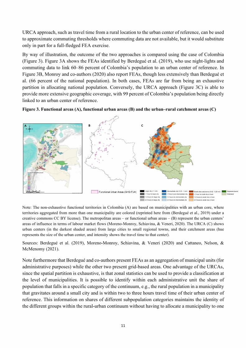
By way of illustration, the outcome of the two approaches is compared using the case of Colombia (Figure 3). Figure 3A shows the FEAs identified by Berdegué et al. (2019), who use night-lights and commuting data to link 60–86 percent of Colombia’s population to an urban center of reference. In Figure 3B, Monroy and co-authors (2020) also report FEAs, though less extensively than Berdegué et al. (66 percent of the national population). In both cases, FEAs are far from being an exhaustive partition in allocating national population. Conversely, the URCA approach (Figure 3C) is able to provide more extensive geographic coverage, with 99 percent of Colombia’s population being directly linked to an urban center of reference.
Figure 3. Functional areas (A), functional urban areas (B) and the urban–rural catchment areas (C)
Note: The non-exhaustive functional territories in Colombia (A) are based on municipalities with an urban core, where territories aggregated from more than one municipality are colored (reprinted here from (Berdegué et al., 2019) under a creative commons CC BY license). The metropolitan areas – or functional urban areas – (B) represent the urban centers’ areas of influence in terms of labour market flows (Moreno-Monroy, Schiavina, & Veneri, 2020). The URCA (C) shows urban centers (in the darkest shaded areas) from large cities to small regional towns, and their catchment areas (hue represents the size of the urban center, and intensity shows the travel time to that center).
Sources: Berdegué et al. (2019), Moreno-Monroy, Schiavina, & Veneri (2020) and Cattaneo, Nelson, & McMenomy (2021).
Note furthermore that Berdegué and co-authors present FEAs as an aggregation of municipal units (for administrative purposes) while the other two present grid-based areas. One advantage of the URCAs, since the spatial partition is exhaustive, is that zonal statistics can be used to provide a classification at the level of municipalities. It is possible to identify within each administrative unit the share of population that falls in a specific category of the continuum, e.g., the rural population in a municipality that gravitates around a small city and is within two to three hours travel time of their urban center of reference. This information on shares of different subpopulation categories maintains the identity of the different groups within the rural-urban continuum without having to allocate a municipality to one

12
category or another. Allocating the municipality to a specific category produces a classification as the RUCC.
4. New opportunities for informing development policy
As indicated earlier, the urban–rural continuum is more than an aggregation of individual places and extends beyond strictly economic relationships to engage with access to a wide range of social, economic, and civic opportunities. Viewing social and economic transformations through the lens of the urban–rural continuum identifies both challenges and opportunities for development. Challenges for improving governance, and opportunities for enhanced access to employment, services, and various types of institutional resources. As Jones & Woods (2013) have persuasively argued, place matters to its residents even in a highly mobile society. Place-based and spatially networked institutions contribute to solving the challenges of everyday life throughout the urban–rural continuum.
4.1 Institutions and governance
While the rural–urban continuum owes an intellectual debt to central place theory, which is hierarchical and mechanistic, it allows in fact for a variety of power arrangements based in social and institutional relationships and permits a less asymmetrical balance of power with ample room for “rural agency.” The relative power of places at various spatial scales is a combination of their institutional competency and how they are embedded in multi-scalar relationships where much social, economic and political life is transacted (Brown & Shucksmith, 2017).
The development of collaborative, mutually beneficial inter-place relationships contributes to community development – including natural resource management and health service delivery – throughout the urban–rural continuum globally. And, while larger places tend to have greater power than their smaller counterparts, smaller places – especially those with capable governments and institutions – can establish egalitarian relationships with their larger neighbors. Examples of relatively egalitarian multi-scalar relationships include the direct marketing of food through farmer’s markets, roadside stands, and local community-supported agriculture (Jablonski, McFadden, & Colpaart, 2016); rural landfills for urban waste where the recipient community determines the type and volume of waste accepted and the tipping fees, while receiving environmental remediation; and collaborative watershed management (e.g. New York City and a coalition of 42 rural towns developed a mutually-advantageous memorandum of agreement protecting the rural environment while assuring a safe and ample water supply to the city (Pfeffer & Wagenet, 2003)).
Governance of the environment and natural resources has an important spatial dimension consistent with the urban-rural continuum as developed in Murali et al. (2019). In the simplest sense, most natural resources are located in rural areas but consumed in metropolitan areas. Ownership and control of the extraction, processing and use of resources has often been dominated by urban elites (Caudill, 1963). A more democratic form of resource governance would engage local rural communities so that workers’ rights, environmental protection and other local priorities are considered. Rivers, aquifers, and other water sources typically flow across political jurisdictions, and between rural and urban areas, thereby providing a basis for collaborative governance. As Pfeffer & Wagenet (2003) have
13
demonstrated, collective rural-urban water management is indeed possible, but there are many other instances where the use of water is not collectively governed.
Tourism and recreation are other activities linking urban and rural communities, whereby the sites of outdoor recreation are often located in rural areas and small towns while the demand for leisure is concentrated in urban counterparts. Without collaborative governance, rural areas would have little incentive to protect the environment for urban demand for recreation, creating a potentially large environmental inefficiency. Even if the regulation of these activities is developed at higher levels of government implementation is local.
A research agenda that examines shared interests and collaboration among places is an important basis for development. Future research should focus on the institutions providing services, employment, and civic participation. It should examine how relationships between places develop over time, how power is distributed, and how inter-place spaces are governed (including the roles of both public and private actors). A major question is whether multi-scalar governance is democratic. Since governance typically adheres to municipalities, the multi-scalar model embedded in the rural-urban continuum transcends such boundaries raising the question of responsiveness and accountability. Research should explore how the “soft space” approach may obscure power inequalities within and between places that undermine democracy.
A variety of methodological approaches will be needed including grounded case studies with a mix of qualitative and quantitative data, and analysis of secondary data aggregated into substantively meaningful spatial categories. For example, the development of the RUCC in the US informs the design and implementation of a wide range of social and economic programs. In the institutional realm, for example several scholars have used the RUCC framework to examine ideological and political differences across the rural-urban continuum (Kelly & Lobao, 2019; Scala & Johnson, 2017). The URCA global data set facilitates this type of analysis in other countries where data of this kind are not readily available.
The challenge of a new research agenda lies in avoiding the trap of going from one oversimplified categorization to another. The URCA approach provides a broader classification that allows for a more nuanced representation of identity; however, it does not directly examine how institutions and governance vary across the rural-urban continuum. Regardless of how it is aggregated, secondary data analysis does not directly examine the nature and change of relational dynamics that produce the rural-urban continuum. This is well illustrated, for example, by the findings from a case study in the United States on service access for elderly rural persons which showed how rural places with greater access to health services had stronger local institutions and more effective relationships with other places at the same or higher spatial scales (Brown et al., 2019). Other dimensions will have to be incorporated and overlaid with the URCA global data set, such as industrial hubs, service centers, or as satellites to other centers. A similar approach could be followed in classifying rural areas based on the agrarian structure and modes of agricultural production. These, in combination with case studies, could shed new light on bi-directional interactions between urban agglomerations and with their surrounding areas.

14
4.2 Economic opportunities
City–region systems: “Landscapes” of opportunity or rural stagnation?
Enhanced governance for city–regions can strengthen urban–rural linkages and, in turn, can generate a range of environmental, socioeconomic and governance benefits for both urban and rural areas (Forster et al., 2015). Indeed, there is a long history of regionalizing economic development centered around “regional” urban centers. They can provide an anchor for the surrounding hinterlands to provide jobs for rural commuters and labor supply for urban firms, retail and producer services, as well as public services including libraries or museums, health care, and social services to the hinterlands. Thus, a key reason to accurately define FEAs is to inform policies regarding the optimal size of territories for the most efficient governance arrangements.
To understand the role of cities in the prosperity of their surrounding hinterlands, the concepts of spread and backwash are valuable. Spread effects occur when urban growth creates commuting opportunities for rural workers, improved markets for rural products, and urban-to-rural migration of urban residents who wish to live in a rural area but commute back to the city for work (Brown, Champion, Coombes, & Wymer, 2015; Champion, Coombes, & Brown, 2009). Backwash occurs when urban growth attracts rural migrants to urban areas, especially among the high-skilled and entrepreneurial, creating a rural brain drain. Other backwash factors include financial capital being drained from rural areas to support urban investments and a loss in rural innovative capacity. Unlike spread, backwash effects hinder growth in nearby rural areas. Examining the United States and Canada, Partridge and co-authors (2007) and Ganning and co-authors (2013) find that spread effects predominate across most of the urban–rural continuum and that these effects diminish with distance to an urban center. Rural areas with a high quality-of-life (e.g. good public schools) are most likely to benefit because they attract urban families.
Spread and backwash effects can also be nonlinear. For instance, Partridge and co-authors (2009) and Chen & Partridge (2013) find that spread effects are the dominant urban–rural spillover in the United States and China, respectively; however, they also find that being in the “shadow” of large cities reduces the economic growth of nearby small- and medium-sized cities because firms in the largest cities have competitive advantages from their better access to agglomeration economies. Likewise, Lavesson (2018) and Tsvetkova and co-authors (2017) find that business start-ups and small business activity in Sweden and the United States, respectively, are depressed in rural areas and smaller cities that are closer to large cities because they lag in agglomeration economies.
Whether spread or backwash effects dominate greatly depends on the time period and stage of economic development and technological progress. For example, in the early stages of farm consolidation and capital-intensive and labor-saving agricultural techniques, many farmers lost their work and were forced to migrate to urban areas. While this facilitated faster urban growth and created rural economic opportunities for commuters, it also led to imbalanced growth in cities, meaning that backwash effects initially overwhelmed spread. However, as the farm sector’s employment share declined, ongoing labor-saving productivity growth releases fewer and fewer agricultural workers to be potential out-migrants to urban areas, meaning that spread effects from urban growth now more than offset backwash effects.

15
The theory that urban-led growth produces spread effects into proximate rural areas was initially proposed by Francois Perroux (1955), who called it “growth poles” theory.6 According to this theory, regional development policies focused on urban centers are prone to generate more jobs, leading to rural prosperity from rural–urban commuting and new urban markets for rural products. During massive agricultural restructuring in Europe, however, because backwash forces were initially dominant, the theory grew unpopular. It may be that growth pole policy was simply ahead of its time.
Close relatives to growth-pole policies are those related to regionalization, which attempt to address fragmented local-governance structures. To illustrate, metropolitan areas in the United States can have over 100 local government authorities with distinct objectives that end up competing with each other. Enhanced regionalization of local governments could help address this issue and link the rural hinterlands, which lack the resources to efficiently provide basic public functions (Fox & Krishna Kumar, 1965). Likewise, Olfert et al. (2014) illustrate how urban-centered growth can facilitate rural growth in Chile and Peru by creating commuting opportunities. Stabler & Olfert (2002) also recommend this approach of leveraging agglomeration economies to create more urban jobs for rural commuters, as opposed to dispersing funds for rural communities without considering the importance of rural–urban linkages.
So far, our focus has been on regions centered around one main urban center. However, what about cases with urban–rural regions containing multiple urban areas, all within rough commuting distance? In this case, instead of one dominant urban center, there are multiple centers in a polycentric system—i.e., rural areas are then influenced by multiple cities, rather than only the nearest city (Berdegué & Soloaga, 2018; Ganning, Baylis, & Lee, 2013). In this case, we would move towards a “system of systems” approach. However, there is no clear agreement about how to define polycentric systems and the existing empirical evidence is at best fragmented and disjointed (Hoyler, Kloosterman, & Sokol, 2008), suggesting an area ripe for further investigation. There is an array of methods and indicators to capture polycentric city–regions, including city size, commuter data, retail trade patterns, firm dynamics, and changes in economic profiles and ICT. Such approaches can be augmented by expanding the standard URCA approach to help identify polycentric systems and to provide comparable global data. Capturing the polycentricity of urban systems would require changing the prioritization algorithm in the URCA approach to identify a primary and a secondary urban center of reference. The hierarchy of urban places can be differentiated not only by their size but by the number and order of the functions offered by them, or the price of services and goods.
Designing more realistic polycentric regions at global scale can simulate the evolution of urban systems for government investments such as in infrastructure (e.g., building a road from a city to a rural area may change the “city of reference” for that rural area). In turn, applying the rural–urban continuum can better target which rural areas will benefit the most and promote efficient infrastructure placement.
Food systems along the rural-urban continuum
One spin-off of city–regions is city–region food systems (Blay-Palmer et al., 2018; Forster et al., 2015), which generally describe how urbanization affects food systems (Seto & Ramankutty, 2016).
6 See Parr (1973) for a review of the growth poles literature.
16
The city–region food system framework can provide a manageable approach to strengthen agri-food and urban–rural linkages. These linkages are important since food is typically somewhat bulky and/or perishable, so that much of it is traded locally, rendering the city-region a natural place to examine food flows as well as food price gradients within the broader food system. In developing countries where the agri-food sector represents a large share of employment, improvements in urban–rural linkages can have considerable effects on the broader regional economy, including through the development of local agri-businesses to store, process, and trade the primary products produced.
Applied to the food system the city-region concept refers to the complex network of actors, processes, and relationships to do with food production, processing, marketing, and consumption that exist in a given geographical region that includes a more or less concentrated urban center and its surrounding peri-urban and rural hinterland (Jennings, Cottee, Curtis, & Miller, 2015). As aforementioned, the term city–region is typically associated with large cities and their surrounding areas; however, it also applies to small and medium-sized towns that can serve to link the more remote small-scale producers and their agricultural value chains to urban centers and markets in developing countries.
Tefft, Jonasova, Adjao & Morgan (2017) suggest the development of a typology of cities to assist in the task of orienting food system interventions to groupings of cities that share similar characteristics in terms of population and relation to the agri-food system. In their classification, agriculture towns or cities have smaller but fast-growing populations and are in agricultural production areas with a key role in the rural economy, whereas medium and large secondary cities together, are currently challenged to modernize food system architecture and strengthen food businesses to cater to the needs of diverse consumers. Finally, Tefft and co-authors (2017) refer to global megacities as those having more mature economies, served by vibrant modern, traditional and informal food systems that are challenged to operate in congested environments, many of them in need of upgrading.
Towns and small and medium cities increasingly provide services to agriculture because it is here that producers, including smallholders, access essential inputs and services needed to increase productivity and help to secure access to better markets (Proctor & Berdegué, 2020). This can be through output market structures and their related services, input services, banks for financial intermediation provision, or extension services. Similarly, food processing is in many instances quite decentralized, which means towns and small and medium cities play a central role with impacts on the local economy and on rural and urban labor markets. Of the industrial sectors, food manufacture is a key sub-sector that has potential for reducing poverty, especially in rural areas, because it is less spatially concentrated than other sectors and is able to generate linkages with services, manufacturing and construction in both the informal and formal sectors (Cazzuffi, Pereira-López, & Soloaga, 2014).
The most effective project entry points may differ between types of cities and rural area characteristics. For example, the integration of food system interventions in urban development projects may be suited to large secondary cities and megacities, while agriculture value chain projects may be appropriate for small agriculture cities and their surrounding areas. Tefft and co-authors (2017) present policy, investment and capacity-enhancing interventions that differ significantly by city type. For example, small cities and towns in agriculture regions could strengthen their focus on agri-food processing as their proximity to raw material increases their cost competitiveness. Towns or cities may also be prioritized in actions that look to improve market access and efficiency or seek to strengthen agri-food
17
processing in close proximity to the key agricultural commodity inputs (Tefft, Jonasova, Adjao, & Morgan, 2017). Conversely, focusing on high-quality, transparent and efficient wholesale markets may be key in sub-regional and regional cities, as well as improving agricultural and food extension services (Proctor & Berdegué, 2020).
The URCA approach can be particularly useful in the context of city-region food systems, both in terms of providing information to assess the boundaries of a CFRS, as well as the infrastructure in place that provides connectivity. Information on the location of cities, road, railroad, waterways, and ports can be incorporated in the URCA data set, providing a spatial representation of production and consumption within catchment areas. In essence the URCA approach provides a global data set that enables the approach suggested by Tefft and others (2017) on the development of a typology of cities to assist in the task of orienting food system interventions, including to examine their resilience.
The role of small and intermediate cities in development
The renewed interest in small, and especially intermediate urban centers, comes in part from the recognition that in many countries, a growing share of the urban population lives in these locations (Tacoli, 2017). Aside from where people reside, the interest in smaller and intermediate urban centers is linked to economic development of rural areas, poverty reduction, and reducing migration to larger cities that would mitigate congestion effects (Berdegué et al., 2015; Berdegué & Soloaga, 2018; Christiaensen & Todo, 2014; Diao, Magalhaes, & Silver, 2019). The growth of even small towns is being explicitly promoted by local, national and international policies. For example, the United Nations’ New Urban Agenda supports balanced territorial development policies and plans that strengthen the role of small and intermediate cities and towns in food systems, housing, infrastructure, and public service delivery. They also facilitate effective trade links across the urban–rural continuum that ensure small-scale farmers and fishers are linked to value chains and markets (United Nations, 2017). Of course, as described above, in selecting locations to promote local growth, one must weigh agglomeration economies and technological change that limit the ability of small towns and cities to be regional engines of growth.
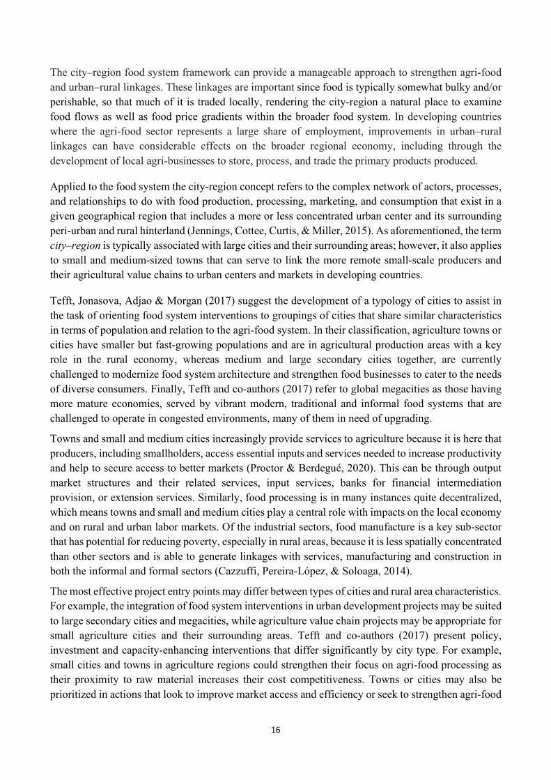
Figure 4. Ratio of population in catchment area of urban centers to that in their urban core for cities of different sizes: globally and by country income group (2015)
Note: Catchment area population refers to people outside of the urban core but within 3-hour travel time.

18
Source: authors’ elaboration based on Cattaneo, Nelson, & McMenomy (2021).
The ability to portray the URCAs of all urban centers in the world opens new possibilities to understand how rural–urban linkages may vary as a function of city size. For example, Cattaneo and co-authors (2021) describe the varying capacity of differing-sized cities to engage a proportionate rural population in their surroundings. This is visible in Figure 4, where the ratio of population outside the core of an urban center to its core is lowest for “mega” cities with a population of over 5 million and for towns of less than 50,000 people. Globally, this ratio is approximately four-times higher for intermediate cities, indicating that there is a relatively larger population share living in rural catchment areas of intermediate cities than for the largest cities or smallest towns. Indeed, as Partridge (2010) and Dijkstra and co-authors (2013, 2015) point out, intermediate-sized cities also have the advantage of generally being the fastest growing cities across the developed world. Figure 4 also indicates that small cities with populations ranging from 50,000 to 500,000 also sustain a substantial population in their catchment areas. The figure further reveals that the general inverted U-shaped profile of these ratios across the smallest towns to the largest cities is consistent regardless of average per-capita income levels.
The cause of this observed phenomenon warrants further investigation and could be tied to economic geography and the strategic location of smaller cities relative to varying-sized central places. Others note that intermediate-sized cities benefit from having sufficient agglomeration economies without the wide-scale congestion effects found in the largest cities (Partridge, 2010). Smaller and intermediate urban areas perform several essential functions, from market nodes for various services and goods, leading to increased nonfarm employment for their own population and that of their surrounding rural region. The different proportions of rural population to the core city identified in Figure 4 has implications for planning and development. For one, it supports the notion that faster growth in medium-size cities and relatively manageable congestion improves access to jobs, which in turn supports a larger rural population in their catchment areas.
In sum, this entire discussion of regions and the rural–urban continuum indicates more emphasis should be placed on small- and intermediate-sized cities, in developing smallholder agriculture, diversifying livelihoods, creating nonagricultural employment opportunities, and fostering broader development. To be sure, if there is a higher proportion of rural residents relying on services in intermediate-sized cities, this creates challenges for planning. While academics have recently recognized the importance of intermediate cities, national policy makers are often reluctant to target them given the outsized political power and attention received by the largest cities and capital cities (e.g., Dijkstra and co-authors, 2015). Yet, if smaller- and intermediate-sized cities do not garner sufficient public investment and infrastructure, then the potentially fastest-growing economic engines would be undermined.
4.3 Welfare and distributional challenges
One stylized fact about poverty is that it varies substantially across space, both in terms of share and density. Poverty rates are much larger in rural than in urban areas (Beegle & Christiaensen, 2019) and across urban areas they usually decrease with city size (Ferré, Ferreira, & Lanjouw, 2012). Poverty rates have further been reported to increase with distance from the urban center (Christiaensen &
19
Vandercasteelen, 2019). Poverty density, on the other hand, is seen to drop dramatically with distance from the urban center, consistent with the concentration of the rural population in the peri-urban areas reported in the URCA global database. Overlaying information from the Demographic and Health Surveys, the Afrobarometer, and pollution data with population density data from the Gridded Population of the World Version 4 (GPWv4) for Sub-Saharan Africa, Gollin and co-authors (2021) further show the existence of rising gradients by population density in a series of poverty correlates such as private wealth and consumption, housing quality, access to public goods and amenities, and child health. They do not find any decline in air quality nor a noticeable increase in crime.
Yet, the spatial information base underpinning these findings is often crude or limited to a few case countries7 and the importance of different economic forces (agglomeration, skill sorting) affecting these outcomes, the strength of which differs along the urban hierarchy, and by extension, the surrounding hinterlands, remains poorly understood. Just like all urban areas are not the same, neither are all rural places made equal: not all rural societies are constituted by dispersed and relatively isolated villages, with little access to services and living off agriculture only and other primary activities. In fact, less than 1 percent of the global population lives in the rural hinterland (Cattaneo, Nelson, & McMenomy, 2021). On the other hand, in Sub-Saharan Africa, only 12 percent lives within 1 hour from a large city, while 41 percent of the rural population lives within 1 hour from a small city or town. As a result, it may be that strengthening bonds between smaller cities and surrounding rural areas has a greater potential for economic growth and poverty reduction than a focus on large cities, which are further away from where the poor live. For their case region Kagera, in Tanzania, De Weerdt and co-authors (2021) thus find that the deterring effect of distance by far outweighs the attraction of greater earning opportunity at the urban destination, with both effects reinforced for lesser educated and poorer populations. It explains why many rural–urban migrants end up in towns rather than cities.
Ultimately, these are empirical questions which require understanding how rural populations “gravitate” around different city types and, subsequently, integrating this information with spatial information on poverty. Regression-based poverty mapping using census data already represented a paradigm shift in the level of detail with which geographical patterns of poor populations could be mapped and understood. Combined with the URCA database, the link between a country’s urban hierarchy, with its rising gradient in earning opportunities and amenities, and poverty, mostly concentrated in the rural areas, can now be better understood and poverty reducing efforts better targeted across different URCAs.
To illustrate this, Figure 5 compares for Nigeria, the new disaggregated poverty map developed by the World Bank (2014) with the URCAs (Figure 5) and examines how this can support improved geographical targeting of poverty alleviation programs in the country. At the national scale, the broad pattern of poverty distribution is of predominately lower poverty rates in southwestern regions, with a general progression to higher poverty rates to the north and east. Almost a fifth of the population lives in large cities, and more than 40 percent in intermediate and small cities, or towns. The remainder mostly live 1-hour away from an urban center.
7 Gollin, Kirchberger and Lagakos (2021) are a notable exception.

20
Figure 5. Poverty rate (A) and the urban–rural catchment areas (B) in Nigeria
Note: Figure (A) shows poverty headcount rates in Nigeria between 2012 and 2013 at the local government area level. The primary data source for this project was the 2012/13 (wave 2) GHSPanel, part of the Living Standards Measurement Surveys (LSMS) Integrated Surveys on Agriculture project conducted jointly by the World bank and Nigerian National Bureau of Statistics.
Source: World Bank (2014) and Cattaneo, Nelson, & McMenomy (2021)
The relationship between poverty, and city size and location, can also be explored more systematically (Table 1). As expected, areas with a higher share of population residing in large cities or within one hour away are highly negatively correlated with poverty. Living in an intermediate city is also negatively correlated with being poor, while the opposite occurs for peri-urban areas of these cities. As we move along the continuum towards smaller cities and towns, as well as more remote rural areas, we start seeing a positive correlation with poverty. Table 1. Pearson’s correlation coefficients between the poverty rate and urban/rural settlement categories in Nigeria
Variables Poverty rate Poverty rate 1.000 Share of population in large city -0.414*** (0.000) Share of population in intermediate city -0.138*** (0.000) Share of population in small city 0.107*** (0.003) Share of population in town 0.137*** (0.000) Share of population in dispersed town -0.004 (0.904) Share of population in hinterland 0.019 (0.590) Share of population <1 hour to a large city -0.102*** (0.004) Share of population <1 hour to an intermediate city 0.168*** (0.000) Share of population <1 hour to a small city 0.335*** (0.000)

21
Variables Poverty rate Share of population <1 hour to a town 0.059* (0.103) Share of population 1-2 hours to a large city 0.080** (0.026) Share of population 1-2 hours to an intermediate city 0.090** (0.012) Share of population 1-2 hours to a small city 0.168*** (0.000) Share of population 1-2 hours to a town 0.070** (0.050) Share of population 2-3 hours to a large city -0.025 (0.494) Share of population 2-3 hours to an intermediate city 0.009 (0.792) Share of population 2-3 hours to a small city 0.083** (0.022) Share of population 2-3 hours to a town 0.045 (0.214)
Legend: * p<.05; ** p<.01; *** p<.001
Source: authors’ elaboration
These results shed a much finer lens on poverty along the rural–urban continuum (going well beyond the traditional rural–urban characterization) and help draw attention to the role of local governments in smaller towns and cities in fighting poverty, in their urban areas as well as their hinterlands. By exploiting recent advances in artificial intelligence and access to satellite imagery, the prediction accuracy of the disaggregated poverty measures could further be enhanced and the geographies in which the disaggregated poverty measures are predicted better aligned with the geography of the urban–rural catchment configurations (Engstrom, Newhouse, & Soundararajan, 2019; Jean et al., 2016). This would enable more precise estimation of the role of the urban hierarchy and their related hinterlands in poverty outcomes, using consistent city-location categories and similar poverty predictors across countries.
Other welfare outcomes such as dietary diversity and nutritional status (stunting as well as obesity) could be similarly mapped and examined across the urban hierarchy and their hinterlands. As urbanization proceeds, and dietary habits change, often towards more sugary, fat and convenient foods (Cockx, Colen, & De Weerdt, 2018), understanding how the dietary patterns and related health outcomes evolve across the urban–rural spectrum will be important to guide and target food and nutrition interventions. Important research questions include understanding if obesity is limited to large cities, or whether it also appears in their immediate hinterland or smaller towns. Or understanding if stunting improves at low-levels of urbanization and is sustained at high-levels of urbanization, where changing child feeding practices may offset the effects of improved sanitation, as observed in some African countries (Ameye & De Weerdt, 2020). Such questions can now be readily explored across multiple countries by overlaying the many existing georeferenced living standard measurement or demographic health surveys with the urban categorizations and their hinterlands.
4.4 Access to services
Two other policy areas that could be served by public access to the FEA and URCA databases are access to health services and education. These services have a disproportionate impact on the well-
22
being of individuals and the issue of backwash vs. spread is particularly relevant since access to social services relies on human capital and resources that are often only available in urban centers and to a different degree, depending on their size.
Addressing rural–urban disparities in health
Examining health care service availability and use along the rural-urban continuum is critical to understanding and addressing inequities in health outcomes. Consideration of connectedness and CPT can help policy makers effectively target interventions to the specific health needs of populations.
Populations farther away from urban centers, both in rural areas as well as in small towns and cities, often need to travel long distances for specialized or high-quality services, for example to large national or regional hospitals often located in capital cities, thus incurring substantial time and financial opportunity costs (Kruk, Mbaruku, Rockers, & Galea, 2008). This can result in foregone care and, ultimately, avertible death and disability. Inequities in health care access tend to be particularly stark in low- and middle-income countries, where health facilities in rural areas, and even peri-urban areas and small towns, often lack the basic infrastructure for proper health service provision. Facilities in rural areas and small towns are often equipped and designed to provide only basic services, many endure low stocks of drugs and limited equipment, and are staffed by lower qualified health workers, for example nurses and community health workers rather than doctors. Both absenteeism and unfilled posts tend to be more acute problems outside of large cities, as it is difficult to recruit and retain health staff to work in these areas (Daniels et al., 2007). Demand-side barriers, such as disparities in access to insurance, employment and income that enable households to cover the costs of care also differ across the rural-urban continuum and depend heavily on proximity to large population centers.
Improving access to health care for rural and urban populations, particularly when resources are limited, is essentially an optimization challenge, complicated by spatial contextual factors that preclude a “one size fits all” approach. The contextual factors that affect optimal resource utilization and should inform a research agenda include: (1) location-specific health needs defined using deaths and illnesses reported sub-nationally to national ministries of health; (2) geographic distributions of health care resources, including the number of staff employed, beds, functioning equipment, and other supplies; (3) constraints on the supply and demand for health care resources; and (4) potential indirect benefits associated with different resource allocation scenarios, as for example investing in roads to speed up transportation thereby making existing health care facilities more accessible. Addressing the challenge of reducing inequity in health care access along rural–urban gradients necessitates data-driven approaches that take into account where population in an URCA or FEA is located, while also incorporating local expertise on health care needs. In many cases, rural populations are well connected to an urban center, but access to services and opportunities can vary widely with the size of the urban center.
Recent developments that can shape a research agenda for defining health care priorities include global initiatives like the Global Burden of Disease project, which estimate morbidity and mortality for all causes of death in all countries (Vos et al., 2020); open-source initiatives such as OpenStreetMap provide a rich resource of health care facility information; and detailed information on population distributions and characteristics contained within national censuses and mapped at high-spatial resolutions by initiatives such as the WorldPop project (Tatem, 2017). By incorporating such
23
geospatial data sets within analyses of travel time to services or catchment modeling, key constraints of health care accessibility can be quantified (Cattaneo, Nelson, & McMenomy, 2021; Weiss et al., 2018, 2020).
A research agenda focused on assessing health care disparities could proceed by adapting the URCA or FEA approaches to health care. With 90 percent of the world population living either in urban areas or within one hour of an urban center, better understanding of the distinct challenges in access to quality health care faced by populations in urban and peri-urban areas as well as rural areas is required. For instance, in many situations, it may make more sense to think of the URCA or FEA as the relevant catchment area and the health care facilities contained within it as the health care system, rather than considering the catchment area of a single health care facility. Researchers may choose between the two global data sets depending on the focus of their analysis, with FEA data more geared to urban planning and URCAs having a better coverage of rural areas and towns with fewer than 50,000 people. The exhaustive geographic coverage of the URCA approach would allow researchers to associate health care gradients with administrative-level data or survey data suitable for assessing the contextual factors described above. This approach is similar, in principle, to the many applications of the RUCC in the United States in the area of health care (Cyr, Etchin, Guthrie, & Benneyan, 2019). The novelty of the URCA data set for RUCC-like applications is that data are available for any country in the world, and at a level of granularity that can be matched to any administrative level, as we illustrated with the example on poverty levels in Nigeria in Section 3.3. This would then make it possible to provide policy makers with holistic results that lead to more informed resource allocation decisions. It would also enable benchmarking across countries.
A further area of research stems from the scarcity of data characterizing specific health care services provided at known facility locations. While initial efforts have mapped travel time to basic health care globally (Weiss et al., 2020), comprehensive assessments of the availability of specific health care services, such as care for child birth or the treatment of HIV/AIDS, are less common due to lack of data. This knowledge gap represents a substantial opportunity for enumerating and ultimately addressing disparities in health care access. Where high-quality data are available, such as the Malawi 2013-14 Service Provision Assessment (Ministry of Health (MoH) [Malawi] & ICF International, 2014), analyses quantifying spatial disparities in access to services such as pediatric emergency care are possible (Hulland et al., 2019).
Additional research that would inform assessments of disparities in health care include those focused on characterizing health care-seeking behaviors and improving the quality, completeness, and timeliness of data captured in national health care information systems. Refining our understanding of health care-seeking behavior and preferences is required for understanding how far people are willing to travel to seek care (Noor et al., 2006), how care-seeking behavior varies according to the health care service required (for example, because of the desire for privacy), and which facilities care-seekers will utilize (e.g., hospitals vs clinics). Estimating these parameters will require detailed surveys that catalogue patient behavior while also capturing their movements through detailed travel histories or GPS-equipped mobile devices. Methodologically, assessments of care-seeking may draw upon health care catchments modeling (Arambepola et al., 2020; Gao et al., 2016), which could potentially be approximated using URCA or FEA data. Lastly, continued improvement of health care information systems will be critical for accurately estimating the causes and spatial patterns of morbidity and

24
mortality (Haux, 2006). These systems provide the type of data necessary for defining public health priorities and thus play an important role directing expenditure.
The research agenda outlined above can also help to identify opportunities to deploy novel approaches to reduce health care disparities across both urban and rural communities. For example, mobile health clinics and temporary facilities can provide health care for remote populations (Free et al., 2013). Improving the quality of select, less advanced health facilities in rural areas and small urban centers, including by strengthening primary health care, can prevent populations from having to travel long distances for basic services (Buykx, Humphreys, Wakerman, & Pashen, 2010; Chan, 2009). Internet-enabled mobile phones offer the potential for expanding telemedicine services (Africa-EU Partnership, 2015; Martínez, Villarroel, Seoane, & Pozo, 2004). Culturally-sensitive interventions can enhance trust and vouchers for transportation or health services can improve affordability.
In summary, context-specific health care resource optimization is possible through the collection of data sets and application of analyses that address the challenges of localized health needs, geographic distributions of health care resources and populations, constraints, and indirect benefits. By combining multiple, spatially-explicit approaches, improved characterizations of disparities in access to care along the rural-urban continuum are possible. Overall, having geographic-specific information ensures interventions can be deployed to target specific gaps in health system performance, maximizing the impact of investments on health outcomes.
Addressing rural–urban disparities in education
Differences in access to educational services and educational outcomes along the urban–rural continuum are sizeable. New data that provide finer gradations between urban centers and the most remote locations enable innovative research that can improve education policy and outcomes. While educational attainment in rural areas may deliver lower returns on average than in urban areas, in part due to less economic opportunity in rural areas, a lack of data means that research to date has not been able to parse how returns vary across the spectrum of urbanization. New estimates of the returns to schooling, combining household survey data with geolocated data, could illuminate how these returns vary not only across the urban–rural divide but also as students get further from roads that provide access to urban centers (and thus, the formal job market). It could also illustrate the extent to which these returns are mediated through complementary behaviors like migration or inputs like virtual technologies.
A deeper understanding about how policy makers, educators, caregivers, and students see the role of education across the urban–rural continuum can also help improve the quality of education and reduce potential inequalities across children in different geographic spaces. For instance, rural areas often face teacher-specific challenges related to attendance, resources, training, and recruitment. Students in rural areas also access post-secondary education at much lower rates. Rural and remote-area schools also have less access to modern construction materials, transportation, electricity, water, and proper infrastructure; good infrastructure can promote attendance and foster a productive environment that is conducive for learning, particularly when designed to serve the basic needs of its beneficiaries (Beteille et al., 2020). Likewise, teacher and student absenteeism may vary non-linearly and even non-monotonically across the urbanization spectrum. However, very few research studies examine absenteeism across the full spectrum of urbanization. This would be possible, for example, by

25
combining the World Bank’s Service Delivery Indicators (SDI) on teacher absenteeism with geolocated data on schools (Bold et al., 2017). The reasons for absenteeism may vary, for example, if teachers in remote areas with fewer trained professionals are called on to perform a wider array of tasks in the community; this too could be examined by combining the SDI data with geolocated data. Understanding how to deliver technological infrastructure sustainably, however, requires not only geolocated data but also longitudinal data, which are limited in international education studies (McEwan, 2015). More research is thus needed to understand what school design and improvement can be implemented given limited access to building resources in rural areas, and how these vary as schools grow more rural, with decreasing access to urban centers.
Many teachers prefer to teach in urban areas, such that education systems offer financial or other incentives to entice teachers to rural areas (Crawfurd & Pugatch, 2020). Several studies have evaluated whether such programs boost teacher presence in rural schools (Chelwa, Pellicer, & Maboshe, 2019; Elacqua, Hincapie, Hincapié, & Montalva, 2019; Pugatch & Schroeder, 2014). However, the impacts of such a program—and thus its optimal design—may well be non-linear depending on the remoteness of the school and access to urban amenities.
Some challenges are very specific to education. For example, language ability of teachers is a distinct challenge in schools at different points along the urbanization spectrum. Increasing research shows that initial literacy instruction in a language with which students are already familiar (e.g., their native tongue) is most effective (Evans & Mendez Acosta, 2021; Piper, Zuilkowski, & Ong’ele, 2016). Another challenge is that of girls in rural areas having less access to menstrual hygiene management technology and private sanitation facilities compared to girls in urban areas, which can cause them to miss school during their menstrual periods (Adukia, 2017; Kazianga, Levy, Linden, & Sloan, 2013). With both examples, geolocated data together with household and industry surveys could be useful in assessing the incidence of these challenges along the rural-urban continuum and how to address them.
The third and final element to be considered is that of differences in labor demand along the urbanization continuum, which have heterogeneous effects on children’s decisions to attend school. Children are more likely to participate in school when there is an increase (perceived or real) in the educational skill premium, which is likely to be greater in urban areas due to access to more jobs that require differing levels of education, as they did after the introduction of call centers (Jensen, 2012) or the construction of paved roads connecting rural areas to nearby urban areas in India (Adukia, Asher, & Novosad, 2020). These perceptions – which are usually lower in rural areas – affect household investments in education. The urban–rural dichotomy is a poor indicator for this, since access to markets may vary more based on access to urban areas than on whether one is actually based in an urban area. New research can and should explore the reverberations of changes in the educational skill premium in urban centers as one moves further and further away from them, and how the effect of distance is mediated by the size of the urban center of reference.
Alternatively, if changes in labor demand increase the opportunity cost of attending schools, then educational participation can decrease. This happened, for example, after the introduction of manufacturing jobs in Mexico (Atkin, 2016) or an employment guarantee program in India (Adukia, 2020). Understanding the distinct opportunity costs related to school participation across the rural-urban continuum, and how curricular materials can be designed to match the skills and competencies necessary for an improved quality of life and motivate students to stay in school and succeed, is crucial.

26
The distinct challenges across urban and rural areas in education are non-binary, with great variation within both urban and rural areas, depending on population density, infrastructure, distances, and other factors. The solution, likewise, is not merely to provide more of the same services in rural areas that are offered in urban areas. Global data sets like the ones provided by Moreno-Monroy and co-authors (2020) for FEAs, or by Cattaneo and co-authors (2021) for URCAs open new possibilities. Matching them with improved geo-located data—as was done for poverty in Section 3.3—that identify and describe the contexts in which children and youth live, the constraints they face, and their educational participation, is crucial. It will enable policies that are better designed and better targeted so that every child has equal opportunities to fully realize their potential.
5. The way forward
With this review, we revisit rural–urban connectivity, emphasizing the bidirectional nature of rural–urban relationships, and the difficulty of discussing social and economic processes in one area without acknowledging the other. We bring together two different approaches that address territorial issues – functional areas and the rural–urban continuum – and provide a framework for their adaptation and operationalization based on recently published data and the methods to compute it. This area of research is significant for all countries regarding access to employment, education, health services, and opportunities for civic engagement. For low income countries, it is particularly relevant for poverty reduction strategies, organizing city–region food systems, and mobility transitions towards more commuting and less migration. We suggest directions to shift the discussion on development policy towards a more territorial perspective that accounts for interlinkages between different size cities as well as their surrounding rural areas. We argue that the recently developed URCA global data set is an important step forward, especially if complemented with studies, to understand how spatial relationships operate in a variety of social, economic, and developmental contexts. Similarly, the global delineation of metropolitan areas (Moreno-Monroy, Schiavina, & Veneri, 2020) also provides new entry points for informing development policy, particularly for urban planning.
Although not covered in this paper, we acknowledge that, with ICT, rural–urban linkages may become partly decoupled from travel time and distance to an urban center. This trend has, to some extent, increased with the COVID-19 pandemic. In fact, while the pandemic has exacerbated long-standing inequalities – including spatial inequalities along the rural–urban continuum – it has also induced innovation. The consequential health crisis, for example, pushed physicians and health systems worldwide to adopt virtualized treatment approaches between patients and health providers (Webster, 2020). The challenge will be to sustain these innovations on a permanent basis after the pandemic. Rural residents can greatly benefit from enhanced quality-of-life provided by better ICT connectivity for access to e-government, health care, education, etc. However, small towns and rural communities often lack the basic ICT infrastructure needed to prosper in the digital age, namely internet access (Lai & Widmar, 2020), as well as access to digital goods and services such as e-health (Webster, 2020) and online education. This is an interesting avenue for future research that will surely affect social and economic development along the rural–urban continuum.
Another unaddressed, though very important area, is that of natural resource management and, specifically, of ecosystem services – the benefits that people obtain from nature – that also differ along

27
the rural–urban continuum (Murali et al., 2019). Access to local provisioning of these services is relatively limited in urban areas and should be expanded (Bolund & Hunhammar, 1999). On the rural side, although access is more guaranteed, there is also variability, as not all rural households can rely on the direct use of ecosystem services either because of spatial variability or inequality in access to resources. An important research endeavor would be to match geo-located environmental data with socio-economic data in URCAs to analyze the impact of rural–urban linkages in determining ecosystem service provision and use.
28
References
Adukia, A. (2017). Sanitation and Education. American Economic Journal: Applied Economics, 9(2), 23–59. https://doi.org/10.1257/app.20150083
Adukia, A. (2020). Spillover Impacts on Education from Employment Guarantees. Education Finance and Policy, 1–62. https://doi.org/10.1162/edfp_a_00323
Adukia, A., Asher, S., & Novosad, P. (2020). Educational Investment Responses to Economic Opportunity: Evidence from Indian Road Construction. American Economic Journal: Applied Economics, 12(1), 348–376. https://doi.org/10.1257/app.20180036
Africa-EU Partnership. (2015). Success Story: Telemedicine services to Sub-Saharan Africa |. The Africa-EU Partnership. https://africa-eu-partnership.org/en/success-stories/telemedicine-services-sub-saharan-africa
Allender, S., Lacey, B., Webster, P., Rayner, M., Deepa, M., Scarborough, P., Arambepola, C., Datta, M., & Mohan, V. (2010). Level of urbanization and noncommunicable disease risk factors in Tamil Nadu, India. Bulletin of the World Health Organization, 88(4), 297–304. https://doi.org/10.2471/BLT.09.065847
Allender, S., Wickramasinghe, K., Goldacre, M., Matthews, D., & Katulanda, P. (2011). Quantifying Urbanization as a Risk Factor for Noncommunicable Disease. Journal of Urban Health, 88(5), 906–918. https://doi.org/10.1007/s11524-011-9586-1
Ameye, H., & De Weerdt, J. (2020). Child health across the rural–urban spectrum. World Development, 130, 104950. https://doi.org/10.1016/j.worlddev.2020.104950
Arambepola, R., Keddie, S. H., Collins, E. L., Twohig, K. A., Amratia, P., Bertozzi-Villa, A., Chestnutt, E. G., Harris, J., Millar, J., Rozier, J., Rumisha, S. F., Symons, T. L., Vargas-Ruiz, C., Andriamananjara, M., Rabeherisoa, S., Ratsimbasoa, A. C., Howes, R. E., Weiss, D. J., Gething, P. W., & Cameron, E. (2020). Spatiotemporal mapping of malaria prevalence in Madagascar using routine surveillance and health survey data. Scientific Reports, 10(1), 18129. https://doi.org/10.1038/s41598-020-75189-0
Atkin, D. (2016). Endogenous Skill Acquisition and Export Manufacturing in Mexico. American Economic Review, 106(8), 2046–2085. https://doi.org/10.1257/aer.20120901
Bailey, C., Jensen, L., & Ransom, E. (2014). Rural America in a Globalizing World. West Virginia University Press.
Bashir, S., Lockheed, M., Ninan, E., & Tan, J. P. (2018). Facing Forward: Schooling for Learning in Africa. World Bank. https://openknowledge.worldbank.org/bitstream/handle/10986/29377/9781464812606.pdf?sequence=14&isAllowed=y
Beegle, K., & Christiaensen, L. (2019). Accelerating Poverty Reduction in Africa. World Bank Publications.

29
Berdegué, J. A., Carriazo, F., Jara, B., Modrego, F., & Soloaga, I. (2015). Cities, territories, and inclusive growth: unraveling urban–rural linkages in Chile, Colombia, and Mexico. World Development, 73, 56–71.
Berdegué, J. A., Hiller, T., Ramírez, J. M., Satizábal, S., Soloaga, I., Soto, J., Uribe, M., & Vargas, O. (2019). Delineating functional territories from outer space. Latin American Economic Review, 28(1), 4. https://doi.org/10.1186/s40503-019-0066-4
Berdegué, J. A., & Soloaga, I. (2018). Small and medium cities and development of Mexican rural areas. World Development, 107, 277–288. https://doi.org/10.1016/j.worlddev.2018.02.007
Beteille, T., Tognatta, N., Riboud, M., Nomura, S., & Ghorpade, Y. (2020). Ready to Learn : Before School, In School, and Beyond School in South Asia. World Bank. https://openknowledge.worldbank.org/handle/10986/33308
Biddle, C., & Azano, A. P. (2016). Constructing and Reconstructing the “Rural School Problem”: A Century of Rural Education Research. Review of Research in Education, 40(1), 298–325. https://doi.org/10.3102/0091732X16667700
Blake, K. D., Moss, J. L., Gaysynsky, A., Srinivasan, S., & Croyle, R. T. (2017). Making the Case for Investment in Rural Cancer Control: An Analysis of Rural Cancer Incidence, Mortality, and Funding Trends. Cancer Epidemiology Biomarkers & Prevention, 26(7), 992–997. https://doi.org/10.1158/1055-9965.EPI-17-0092
Blay-Palmer, A., Santini, G., Dubbeling, M., Renting, H., Taguchi, M., & Giordano, T. (2018). Validating the City Region Food System Approach: Enacting Inclusive, Transformational City Region Food Systems. Sustainability, 10(5), 1680. https://doi.org/10.3390/su10051680
Bold, T., Filmer, D., Martin, G., Molina, E., Stacy, B., Rockmore, C., Svensson, J., & Wane, W. (2017). Enrollment without learning: Teacher effort, knowledge, and skill in primary schools in Africa. Journal of Economic Perspectives, 31(4), 185–204.
Bolin, J. N., Bellamy, G. R., Ferdinand, A. O., Vuong, A. M., Kash, B. A., Schulze, A., & Helduser, J. W. (2015). Rural Healthy People 2020: New Decade, Same Challenges. The Journal of Rural Health, 31(3), 326–333. https://doi.org/10.1111/jrh.12116
Bolund, P., & Hunhammar, S. (1999). Ecosystem services in urban areas. Ecological Economics, 29(2), 293–301. https://doi.org/10.1016/S0921-8009(99)00013-0
Boone, P., Fazzio, I., Jandhyala, K., Jayanty, C., Jayanty, G., Johnson, S., Ramachandran, V., Silva, F., & Zhan, Z. (2014). The Surprisingly Dire Situation of Children’s Education in Rural West Africa: Results from the CREO Study in Guinea-Bissau (Comprehensive Review of Education Outcomes). In African Successes: Vol. Human Capital (pp. 255–280). National Bureau of Economic Research, Inc.
Brown, D. L., Champion, T., Coombes, M., & Wymer, C. (2015). The Migration-commuting nexus in rural England. A longitudinal analysis. Journal of Rural Studies, 41, 118–128. https://doi.org/10.1016/j.jrurstud.2015.06.005

30
Brown, D. L., Cromartie, J. B., & Kulcsar, L. J. (2004). Micropolitan Areas and the Measurement of American Urbanization. Population Research and Policy Review, 23(4), 399–418. https://doi.org/10.1023/B:POPU.0000040044.72272.16
Brown, D. L., Glasgow, N., Kulcsar, L. J., Sanders, S., & Thiede, B. C. (2019). The multi-scalar organization of aging-related services in US rural places. Journal of Rural Studies, 68, 219–229. https://doi.org/10.1016/j.jrurstud.2018.09.010
Brown, D. L., & Shucksmith, M. (2017). Reconsidering Territorial Governance to Account for Enhanced Rural-Urban Interdependence in America. The ANNALS of the American Academy of Political and Social Science, 672(1), 282–301. https://doi.org/10.1177/0002716217706495
Burdick-Will, J., & Logan, J. R. (2017). Schools at the Rural-Urban Boundary: Blurring the Divide? The ANNALS of the American Academy of Political and Social Science, 672(1), 185–201. https://doi.org/10.1177/0002716217707176
Buykx, P., Humphreys, J., Wakerman, J., & Pashen, D. (2010). Systematic review of effective retention incentives for health workers in rural and remote areas: Towards evidence-based policy. Australian Journal of Rural Health, 18(3), 102–109. https://doi.org/10.1111/j.1440-1584.2010.01139.x
Cattaneo, A., Nelson, A., & McMenomy, T. (2021). Global mapping of urban–rural catchment areas reveals unequal access to services. Proceedings of the National Academy of Sciences of the United States of America, 118(2). https://doi.org/10.1073/pnas.2011990118
Caudill, H. M. (1963). Night Comes to the Cumberlands: A Biography of a Depressed Area (4th ptg edition). Little Brown.
Cazzuffi, C., Pereira-López, M., & Soloaga, I. (2014). Local poverty reduction in Chile and Mexico: the role of food manufacturing growth. Universidad Iberoamericana, Department of Economics.
Champion, T., Coombes, M., & Brown, D. L. (2009). Migration and Longer-Distance Commuting in Rural England. Regional Studies, 43(10), 1245–1259. https://doi.org/10.1080/00343400802070902
Champion, T., & Hugo, G. (2004). New Forms of Urbanization: Beyond the Urban-Rural Dichotomy (T. Champion, Ed.; 1st ed.). Routledge. https://doi.org/10.4324/9781315248073
Chan, M. (2009). Primary health care as a route to health security. Lancet, 373(9675), 1586–1587.
Chelwa, G., Pellicer, M., & Maboshe, M. (2019). Teacher Pay and Educational Outcomes: Evidence from the Rural Hardship Allowance in Zambia. South African Journal of Economics, 87(3), 255–282. https://doi.org/10.1111/saje.12227
Chen, A., & Partridge, M. (2013). When are Cities Engines of Growth in China? Spread and Backwash Effects across the Urban Hierarchy. Regional Studies, 47(8), 1313–1331. https://doi.org/10.1080/00343404.2011.589831
Christiaensen, L., & Kanbur, R. (2017). Secondary towns and poverty reduction: refocusing the urbanization agenda (Working Paper 2017-02). World Bank.

31
Christiaensen, L., & Todo, Y. (2014). Poverty reduction during the rural–urban transformation – the role of the missing middle. World Development, 63, 43–58.
Christiaensen, L., & Vandercasteelen, J. (2019). Earning more on the farm. In K. Beegle & L. Christiaensen (Eds.), Accelerating Poverty Reduction in Africa. World Bank. https://openknowledge.worldbank.org/handle/10986/32354
Cockx, L., Colen, L., & De Weerdt, J. (2018). From corn to popcorn? Urbanization and dietary change: evidence from rural-urban migrants in Tanzania. World Development, 110, 140–159.
Crawfurd, L., & Pugatch, T. (2020). Teacher Labor Markets in Developing Countries.
Cromartie, J. (2015). Appendix B: Historical Development of ERS Rural-Urban Classification Systems. In National Academies of Sciences, Engineering, and Medicine. (Ed.), Rationalizing Rural Area Classifications for the Economic Research Service: A Workshop Summary. The National Academies Press. https://doi.org/10.17226/21843
Cyr, M. E., Etchin, A. G., Guthrie, B. J., & Benneyan, J. C. (2019). Access to specialty healthcare in urban versus rural US populations: a systematic literature review. BMC Health Services Research, 19(1), 974. https://doi.org/10.1186/s12913-019-4815-5
Cyril, S., Oldroyd, J. C., & Renzaho, A. (2013). Urbanisation, urbanicity, and health: a systematic review of the reliability and validity of urbanicity scales. BMC Public Health, 13(1), 513. https://doi.org/10.1186/1471-2458-13-513
Dahly, D. L., & Adair, L. S. (2007). Quantifying the urban environment: A scale measure of urbanicity outperforms the urban–rural dichotomy. Social Science & Medicine, 64(7), 1407–1419. https://doi.org/10.1016/j.socscimed.2006.11.019
Daniels, Z. M., VanLeit, B. J., Skipper, B. J., Sanders, M. L., & Rhyne, R. L. (2007). Factors in recruiting and retaining health professionals for rural practice. The Journal of Rural Health, 23(1), 62–71.
Dax, T. (1996). Defining rural areas – International comparisons and the OECD indicators. Rural Society, 6(3), 3–18. https://doi.org/10.5172/rsj.6.3.3
De Weerdt, J., Kanbur, R., & Christiaensen, L. (2021). When Distance Drives Destination, Towns Can Stimulate Development. IZA. http://ftp.iza.org/dp14157.pdf
Diao, X., Magalhaes, E., & Silver, J. (2019). Cities and rural transformation: A spatial analysis of rural livelihoods in Ghana. World Development, 121, 141–157. https://doi.org/10.1016/j.worlddev.2019.05.001
Dickerson, A., & McIntosh, S. (2013). The Impact of Distance to Nearest Education Institution on the Post-compulsory Education Participation Decision. Urban Studies, 50(4), 742–758. https://doi.org/10.1177/0042098012455717
Dijkstra, L., Garcilazo, E., & McCann, P. (2013). The Economic Performance of European Cities and City Regions: Myths and Realities. European Planning Studies, 21(3), 334–354. https://doi.org/10.1080/09654313.2012.716245
32
Dijkstra, L., Garcilazo, E., & McCann, P. (2015). The effects of the global financial crisis on European regions and cities. Journal of Economic Geography, 15(5), 935–949. https://doi.org/10.1093/jeg/lbv032
Dingel, J. I., Miscio, A., & Davis, D. R. (2019). Cities, lights, and skills in developing economies. Journal of Urban Economics, 103174. https://doi.org/10.1016/j.jue.2019.05.005
Douthit, N., Kiv, S., Dwolatzky, T., & Biswas, S. (2015). Exposing some important barriers to health care access in the rural USA. Public Health, 129(6), 611–620. https://doi.org/10.1016/j.puhe.2015.04.001
Dubbeling, M., Bucatariu, C., Santini, G., Vogt, C., & Eisenbeiss, K. (2016). City Region Food Systems and Food Waste Management: Linking Urban and Rural Areas for Sustainable and Resilient Development. Deutsche Gesellschaft fur Internationale Zusammenarbeit (GIZ) GmbH.
Echazarra, A., & Radinger, t. (2019). Learning in rural schools: Insights from PISA, TALIS and the literature. oecd. https://www.oecd-ilibrary.org/education/learning-in-rural-schools_8b1a5cb9-en
Elacqua, G., Hincapie, D., Hincapié, I., & Montalva, V. (2019). Can financial incentives help disadvantaged schools to attract and retain high-performing teachers?: Evidence from chile. Inter-American Development Bank.
Engstrom, R., Newhouse, D., & Soundararajan, V. (2019). Estimating Small Area Population Density Using Survey Data and Satellite Imagery: An Application to Sri Lanka (Policy Research Working Paper No. 8776). World Bank. https://doi.org/10.1596/1813-9450-8776
Eurostat. (2019). Territorial typologies manual - urban-rural typology. https://ec.europa.eu/eurostat/statistics-explained/index.php?title=Territorial_typologies_manual_-_urban-rural_typology
Evans, D. K., & Mendez Acosta, A. (2021). Education in Africa: What Are We Learning? Journal of African Economies, 30(1), 13–54. https://doi.org/10.1093/jae/ejaa009
Falch, T., Lujala, P., & Strøm, B. (2013). Geographical constraints and educational attainment. Regional Science and Urban Economics, 43(1), 164–176. https://doi.org/10.1016/j.regsciurbeco.2012.06.007
FAO. (2017). The State of Food and Agriculture 2017. Leveraging food Systems for inclusive rural transformation. http://www.fao.org/3/a-i7658e.pdf
Ferré, C., Ferreira, F., & Lanjouw, P. (2012). Is there a metropolitan bias? The relationship between poverty and city size in a selection of developing countries. World Bank Economic Review, 26(3), 351–382.
Forster, T., & Mattheisen, E. (2016). Territorial Food Systems: Protecting the Rural and Localizing Human Rights Accountability. In Right to Food and Nutrition Watch (pp. 36–42).
Forster, T., Santini, G., Edwards, D., Flanagan, K., & Taguchi, M. (2015). Strengthening urban rural linkages through city region food systems.

33
Fox, K. A., & Krishna Kumar, T. (1965). The functional economic area: Delineation and implications for economic analysis and policy. Papers of the Regional Science Association, 15(1), 57–85. https://doi.org/10.1007/BF01947866
Free, C., Phillips, G., Watson, L., Galli, L., Felix, L., Edwards, P., Patel, V., & Haines, A. (2013). The effectiveness of mobile-health technologies to improve health care service delivery processes: a systematic review and meta-analysis. PLoS Med, 10(1), e1001363.
Gagnon, D. J., & Mattingly, M. J. (2018). Racial/Ethnic Test Score Gaps and the Urban Continuum. https://doi.org/10.18113/P8JRRE3302
Ganning, J. P., Baylis, K., & Lee, B. (2013). Spread and backwash effects for nonmetropolitan communities in the U.S. Journal of Regional Science, 53(3), 464–480. https://doi.org/10.1111/jors.12026
Gao, F., Kihal, W., Le Meur, N., Souris, M., & Deguen, S. (2016). Assessment of the spatial accessibility to health professionals at French census block level. International Journal for Equity in Health, 15(1), 125. https://doi.org/10.1186/s12939-016-0411-z
Gibson, J., Datt, G., Murgai, R., & Ravallion, M. (2017). For India’s Rural Poor, Growing Towns Matter More Than Growing Cities. World Development, 98, 413–429. https://doi.org/10.1016/j.worlddev.2017.05.014
Gollin, D., Kirchberger, M., & Lagakos, D. (2021). Do urban wage premia reflect lower amenities? Evidence from Africa. Journal of Urban Economics, 121, 103301. https://doi.org/10.1016/j.jue.2020.103301
Gundersen, C., Dewey, A., Hake, M., Engelhard, E., & Crumbaugh, A. S. (2017). Food Insecurity across the Rural-Urban Divide: Are Counties in Need Being Reached by Charitable Food Assistance? The ANNALS of the American Academy of Political and Social Science, 672(1), 217–237. https://doi.org/10.1177/0002716217710172
Haux, R. (2006). Health information systems–past, present, future. International Journal of Medical Informatics, 75(3–4), 268–281.
Helen, A. A., Fazlur, R. M., & Sourav, M. (2020). Assessment of stakeholders views on accessing quality and equity of basic education in rural communities of Abia State, Nigeria. Educational Research and Reviews, 15(8), 454–464. https://doi.org/10.5897/ERR2020.4018
Heley, J., & Jones, L. (2012). Relational rurals: Some thoughts on relating things and theory in rural studies. Journal of Rural Studies, 28(3), 208–217. https://doi.org/10.1016/j.jrurstud.2012.01.011
Hines, F. K., Brown, D. L., & Zimmer, J. M. (1975). Social and Economic Characteristics of the Population in Metro and Nonmetro Counties, 1970. Economic Research Service, U.S. Department of Agriculture.
Hopkins, J., & Copus, A. (2018). Definitions, measurement approaches and typologies of rural areas and small towns: A review. Aberdeen, Reino Unido, The Social, Economic and Geographical Sciences Group.
34
Hoyler, M., Kloosterman, R. C., & Sokol, M. (2008). Polycentric Puzzles – Emerging Mega-City Regions Seen through the Lens of Advanced Producer Services. Regional Studies, 42(8), 1055–1064. https://doi.org/10.1080/00343400802389377
Hulland, E. N., Wiens, K. E., Shirude, S., Morgan, J. D., Bertozzi-Villa, A., Farag, T. H., Fullman, N., Kraemer, M. U. G., Miller-Petrie, M. K., Gupta, V., Reiner, R. C., Rabinowitz, P., Wasserheit, J. N., Bell, B. P., Hay, S. I., Weiss, D. J., & Pigott, D. M. (2019). Travel time to health facilities in areas of outbreak potential: maps for guiding local preparedness and response. BMC Medicine, 17(1), 232. https://doi.org/10.1186/s12916-019-1459-6
Jablonski, B. B. R., McFadden, D. T., & Colpaart, A. (2016). Analyzing the Role of Community and Individual Factors in Food Insecurity: Identifying Diverse Barriers Across Clustered Community Members. Journal of Community Health, 41(5), 910–923. https://doi.org/10.1007/s10900-016-0171-0
James, W. L. (2014). All Rural Places Are Not Created Equal: Revisiting the Rural Mortality Penalty in the United States. American Journal of Public Health, 104(11), 2122–2129. https://doi.org/10.2105/AJPH.2014.301989
Jean, N., Burke, M., Xie, M., Davis, W. M., Lobell, D. B., & Ermon, S. (2016). Combining satellite imagery and machine learning to predict poverty. Science, 353(6301), 790–794.
Jennings, S., Cottee, J., Curtis, T., & Miller, S. (2015). Food in an Urbanized World: The Role of City Region Food Systems in Resilience and Sustainable Development. FAO and ISU. http://www.fao.org/fileadmin/templates/FCIT/documents/Food_in_an_Urbanised_World_Report_DRAFT_February_2015.pdf
Jensen, R. (2012). Do Labor Market Opportunities Affect Young Women’s Work and Family Decisions? Experimental Evidence from India *. The Quarterly Journal of Economics, 127(2), 753–792. https://doi.org/10.1093/qje/qjs002
Jones, M., & Woods, M. (2013). New Localities. Regional Studies, 47(1), 29–42. https://doi.org/10.1080/00343404.2012.709612
Jones-Smith, J. C., & Popkin, B. M. (2010). Understanding community context and adult health changes in China: Development of an urbanicity scale. Social Science & Medicine, 71(8), 1436–1446. https://doi.org/10.1016/j.socscimed.2010.07.027
Kazianga, H., Levy, D., Linden, L. L., & Sloan, M. (2013). The effects of" girl-friendly" schools: Evidence from the BRIGHT school construction program in Burkina Faso. American Economic Journal: Applied Economics, 5(3), 41–62.
Kelly, P., & Lobao, L. (2019). The Social Bases of Rural-Urban Political Divides: Social Status, Work, and Sociocultural Beliefs. Rural Sociology, 84(4), 669–705. https://doi.org/10.1111/ruso.12256
King, L. J., & Golledge, R. G. (1978). Cities, space, and behavior: The elements of urban geography. Prentice-Hall.
35
Kruk, M. E., Mbaruku, G., Rockers, P. C., & Galea, S. (2008). User fee exemptions are not enough: out-of-pocket payments for ‘free’ delivery services in rural Tanzania. Tropical Medicine & International Health, 13(12), 1442–1451. https://doi.org/10.1111/j.1365-3156.2008.02173.x
Lai, J., & Widmar, N. O. (2020). Revisiting the Digital Divide in the COVID-19 Era. Applied Economic Perspectives and Policy, aepp.13104. https://doi.org/10.1002/aepp.13104
Lavesson, N. (2018). How does distance to urban centres influence necessity and opportunity-based firm start-ups? Papers in Regional Science, 97(4), 1279–1303. https://doi.org/10.1111/pirs.12289
Li, Y., Long, H., & Liu, Y. (2015). Spatio-temporal pattern of China’s rural development: A rurality index perspective. Journal of Rural Studies, 38, 12–26. https://doi.org/10.1016/j.jrurstud.2015.01.004
Lichter, D. T., & Brown, D. L. (2011). Rural America in an Urban Society: Changing Spatial and Social Boundaries. Annual Review of Sociology, 37(1), 565–592. https://doi.org/10.1146/annurev-soc-081309-150208
Lichter, D. T., & Ziliak, J. P. (2017). The Rural-Urban Interface: New Patterns of Spatial Interdependence and Inequality in America. The ANNALS of the American Academy of Political and Social Science, 672(1), 6–25. https://doi.org/10.1177/0002716217714180
Loh, H., & Hadden Love, T. (2020, December 8). The ‘rural-urban divide’ furthers myths about race and poverty—concealing effective policy solutions. Brookings. https://www.brookings.edu/blog/the-avenue/2020/12/08/the-rural-urban-divide-furthers-myths-about-race-and-poverty-concealing-effective-policy-solutions/
Martínez, A., Villarroel, V., Seoane, J., & Pozo, F. D. (2004). Rural telemedicine for primary healthcare in developing countries. IEEE Technology and Society Magazine, 23(2), 13–22.
Massey, D. (1994). Space, Place, and Gender (NED-New edition). University of Minnesota Press. https://www.jstor.org/stable/10.5749/j.cttttw2z
McEwan, P. J. (2015). Improving learning in primary schools of developing countries: A meta-analysis of randomized experiments. Review of Educational Research, 85(3), 353–394.
Ministry of Health (MoH) [Malawi], & ICF International. (2014). Malawi Service Provision Assessment (MSPA) 2013-14. MoH and ICF International. https://dhsprogram.com/pubs/pdf/SPA20/SPA20%5BOct-7-2015%5D.pdf
Moisio, S., & Jonas, A. E. (2018). City-regions and city-regionalism. In A. Paasi, J. Harrison, & M. Jones, Handbook on the Geographies of Regions and Territories (p. 544). Edward Elgar Publishing.
Moreno-Monroy, A. I., Schiavina, M., & Veneri, P. (2020). Metropolitan areas in the world. Delineation and population trends. Journal of Urban Economics, 103242. https://doi.org/10.1016/j.jue.2020.103242
Mulligan, G. F., Partridge, M., & Carruthers, J. I. (2012). Central place theory and its reemergence in regional science. The Annals of Regional Science, 48(2), 405–431. https://doi.org/10.1007/s00168-011-0496-7

36
Mullis, I., Martin, M., Foy, P., & Arora, A. (2012). TIMSS 2011 International Results in Mathematics. TIMSS & PIRLS. https://timssandpirls.bc.edu/timss2011/downloads/t11_ir_mathematics_fullbook.pdf
Murali, R., Suryawanshi, K., Redpath, S., Nagendra, H., & Mishra, C. (2019). Changing use of ecosystem services along a rural-urban continuum in the Indian Trans-Himalayas. Ecosystem Services, 40, 101030. https://doi.org/10.1016/j.ecoser.2019.101030
National Center for Education Statistics (NCES). (2020). Definitions: School Locale Definitions. Rural Education in America. https://nces.ed.gov/surveys/ruraled/definitions.asp
Neuman, M., & Hull, A. (2009). The Futures of the City Region. Regional Studies, 43(6), 777–787. https://doi.org/10.1080/00343400903037511
Noor, A. M., Amin, A. A., Gething, P. W., Atkinson, P. M., Hay, S. I., & Snow, R. W. (2006). Modelling distances travelled to government health services in Kenya. Tropical Medicine & International Health, 11(2), 188–196.
Olfert, M. R., Partridge, M., Berdegué, J. A., Escobal, J., Jara, B., & Modrego, F. (2014). Places for Place-Based Policy. Development Policy Review, 32(1), 5–32. https://doi.org/10.1111/dpr.12041
Parr, J. B. (1973). Growth poles, regional development, and central place theory. Papers of the Regional Science Association, 31(1), 173–212. https://doi.org/10.1007/BF01943249
Partridge, M. (2010). The duelling models: NEG vs amenity migration in explaining US engines of growth: The duelling models. Papers in Regional Science, 89(3), 513–536. https://doi.org/10.1111/j.1435-5957.2010.00315.x
Partridge, M., Bollman, R. D., Olfert, M. R., & Alasia, A. (2007). Riding the Wave of Urban Growth in the Countryside: Spread, Backwash, or Stagnation? Land Economics, 83(2), 128–152. https://doi.org/10.3368/le.83.2.128
Partridge, M., Rickman, D. S., Ali, K., & Olfert, M. R. (2008). Lost in space: population growth in the American hinterlands and small cities. Journal of Economic Geography, 8(6), 727–757. https://doi.org/10.1093/jeg/lbn038
Partridge, M., Rickman, D. S., Ali, K., & Olfert, M. R. (2009). Do New Economic Geography agglomeration shadows underlie current population dynamics across the urban hierarchy?*. Papers in Regional Science, 88(2), 445–466. https://doi.org/10.1111/j.1435-5957.2008.00211.x
Perroux, F. (1955). Note sur la notion de pôle de croissance. Économie Appliquée, 8, 307–320.
Pfeffer, M. J., & Wagenet, L. P. (2003). Communities of Interest and the Negotiation of Watershed Management. In L. Wright Morton & S. S. Brown (Eds.), Pathways for Getting to Better Water Quality: The Citizen Effect (pp. 109–119). Springer. https://doi.org/10.1007/978-1-4419-7282-8_9
Piper, B., Zuilkowski, S. S., & Ong’ele, S. (2016). Implementing Mother Tongue Instruction in the Real World: Results from a Medium-Scale Randomized Controlled Trial in Kenya. Comparative Education Review, 60(4), 776–807. https://doi.org/10.1086/688493

37
Pong, R. W., DesMeules, M., & Lagacé, C. (2009). Rural-urban disparities in health: How does Canada fare and how does Canada compare with Australia? Australian Journal of Rural Health, 17(1), 58–64. https://doi.org/10.1111/j.1440-1584.2008.01039.x
Pozet, A., Westeel, V., Berion, P., Danzon, A., Debieuvre, D., Breton, J.-L., Monnier, A., Lahourcade, J., Dalphin, J.-C., & Mercier, M. (2008). Rurality and survival differences in lung cancer: A large population-based multivariate analysis. Lung Cancer, 59(3), 291–300. https://doi.org/10.1016/j.lungcan.2007.08.039
Proctor, F. J., & Berdegué, J. A. (2020). Food systems at the rural–urban interface. In J. Crush, B. Frayne, & G. Haysom (Eds.), Handbook on urban food security in the global south (p. 432). Edward Elgar Publishing.
Pugatch, T., & Schroeder, E. (2014). Incentives for teacher relocation: Evidence from the Gambian hardship allowance. Economics of Education Review, 41, 120–136.
Rodríguez-Pose, A. (2008). The Rise of the “City-region” Concept and its Development Policy Implications. European Planning Studies, 16(8), 1025–1046. https://doi.org/10.1080/09654310802315567
Scala, D., & Johnson, K. (2017). Beyond Urban Versus Rural: Understanding American Political Geography in 2016 (National Issue Brief No. 124). Carsey School of Public Policy.
Seto, K. C., & Ramankutty, N. (2016). Hidden linkages between urbanization and food systems. Science, 352(6288), 943–945. https://doi.org/10.1126/science.aaf7439
Shucksmith, M., Brown, D., & Vergunst, J. (2012). Constructing the Rural – Urban Interface: Place Still Matters in a Highly Mobile Society. In M. Shucksmith, D. L. Brown, S. Shortall, J. Vergunst, & M. E. Warner (Eds.), Rural Transformations and Rural Policies in the US and UK (0 ed.). Routledge. https://doi.org/10.4324/9780203144275
Stabler, J. C., & Olfert, M. R. (2002). Saskatchewan’s Communities in the 21st Century: From Places to Regions. Canadian Plains Research Center, University of Regina Press.
Stimson, R., Mitchell, W., Flanagan, M., Baum, S., & Shyy, T.-K. (2016). Demarcating functional economic regions across Australia differentiated by work participation categories. Australasian Journal of Regional Studies, The. https://search.informit.org/doi/abs/10.3316/INFORMIT.135124751790063
Tacoli, C. (2017). Why small towns matter: urbanisation, rural transformations and food security. International Institute for Environment and Development.
Tatem, A. J. (2017). WorldPop, open data for spatial demography. Scientific Data, 4(1), 1–4.
Tefft, J., Jonasova, M., Adjao, R., & Morgan, A. (2017). Food systems for an urbanizing world. World Bank Group and FAO. http://documents1.worldbank.org/curated/en/454961511210702794/pdf/Food-systems-for-an-urbanizing-world-knowledge-product.pdf
Tsvetkova, A., Partridge, M., & Betz, M. (2017). Entrepreneurial and Employment Responses to Economic Conditions across the Rural-Urban Continuum. The ANNALS of the American Academy of Political and Social Science, 672(1), 83–102. https://doi.org/10.1177/0002716217711884
38
United Nations. (2017). The New Urban Agenda. Habitat III. https://habitat3.org/the-new-urban-agenda/
Van de Poel, E., O’Donnell, O., & Van Doorslaer, E. (2009). Urbanization and the spread of diseases of affluence in China. Economics & Human Biology, 7(2), 200–216. https://doi.org/10.1016/j.ehb.2009.05.004
Vandercasteelen, J., Beyene, S. T., Minten, B., & Swinnen, J. (2018). Big cities, small towns, and poor farmers: Evidence from Ethiopia. World Development, 106, 393–406. https://doi.org/10.1016/j.worlddev.2018.03.006
Vos, T., Lim, S. S., Abbafati, C., Abbas, K. M., Abbasi, M., Abbasifard, M., Abbasi-Kangevari, M., Abbastabar, H., Abd-Allah, F., Abdelalim, A., Abdollahi, M., Abdollahpour, I., Abolhassani, H., Aboyans, V., Abrams, E. M., Abreu, L. G., Abrigo, M. R. M., Abu-Raddad, L. J., Abushouk, A. I., … Murray, C. J. L. (2020). Global burden of 369 diseases and injuries in 204 countries and territories, 1990–2019: a systematic analysis for the Global Burden of Disease Study 2019. The Lancet, 396(10258), 1204–1222. https://doi.org/10.1016/S0140-6736(20)30925-9
Waldorf, B., & Kim, A. (2015). Defining and measuring rurality in the US: From typologies to continuous indices. In National Academies of Sciences, Engineering, and Medicine (Ed.), Rationalizing Rural Area Classifications for the Economic Research Service: A Workshop Summary. The National Academies Press. https:/doi.org/10.17226/21843
Webster, P. (2020). Virtual health care in the era of COVID-19. The Lancet, 395(10231), 1180–1181. https://doi.org/10.1016/S0140-6736(20)30818-7
Weiss, D. J., Nelson, A., Gibson, H. S., Temperley, W., Peedell, S., Lieber, A., Hancher, M., Poyart, E., Belchior, S., Fullman, N., Mappin, B., Dalrymple, U., Rozier, J., Lucas, T. C. D., Howes, R. E., Tusting, L. S., Kang, S. Y., Cameron, E., Bisanzio, D., … Gething, P. W. (2018). A global map of travel time to cities to assess inequalities in accessibility in 2015. Nature, 553(7688), 333–336. https://doi.org/10.1038/nature25181
Weiss, D. J., Nelson, A., Vargas-Ruiz, C. A., Gligorić, K., Bavadekar, S., Gabrilovich, E., Bertozzi-Villa, A., Rozier, J., Gibson, H. S., Shekel, T., Kamath, C., Lieber, A., Schulman, K., Shao, Y., Qarkaxhija, V., Nandi, A. K., Keddie, S. H., Rumisha, S., Amratia, P., … Gething, P. W. (2020). Global maps of travel time to healthcare facilities. Nature Medicine, 1–4. https://doi.org/10.1038/s41591-020-1059-1
Woods, M., & Heley, J. (2017). Conceptualisation of Rural-Urban Relations and Synergies. University of Aberystwyth (ROBUST Deliverable 1.1).
World Bank. (2014). Poverty Map (Nigeria - Admin 1 and 2 - 2014). https://data.apps.fao.org/catalog/dataset/poverty-map-nigeria-2014
World Bank. (2018). World Development Report 2018: Learning to Realize Education’s Promise. World Bank.