Ecology Strategy Note
14
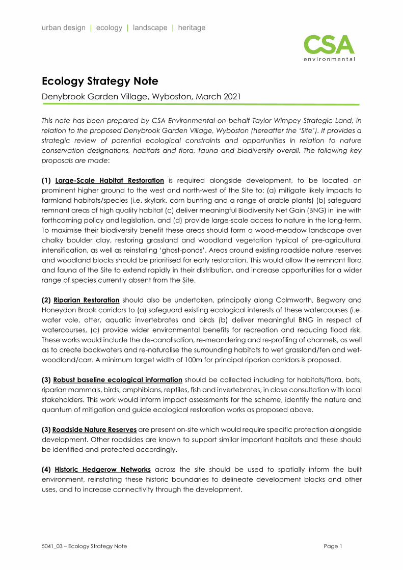
urban design | ecology | landscape | heritage 5041_03 – Ecology Strategy Note Page 1 Ecology Strategy Note Denybrook Garden Village, Wyboston, March 2021 This note has been prepared by CSA Environmental on behalf Taylor Wimpey Strategic Land, in relation to the proposed Denybrook Garden Village, Wyboston (hereafter the ‘Site’). It provides a strategic review of potential ecological constraints and opportunities in relation to nature conservation designations, habitats and flora, fauna and biodiversity overall. The following key proposals are made: (1) Large-Scale Habitat Restoration is required alongside development, to be located on prominent higher ground to the west and north-west of the Site to: (a) mitigate likely impacts to farmland habitats/species (i.e. skylark, corn bunting and a range of arable plants) (b) safeguard remnant areas of high quality habitat (c) deliver meaningful Biodiversity Net Gain (BNG) in line with forthcoming policy and legislation, and (d) provide large-scale access to nature in the long-term. To maximise their biodiversity benefit these areas should form a wood-meadow landscape over chalky boulder clay, restoring grassland and woodland vegetation typical of pre-agricultural intensification, as well as reinstating ‘ghost-ponds’. Areas around existing roadside nature reserves and woodland blocks should be prioritised for early restoration. This would allow the remnant flora and fauna of the Site to extend rapidly in their distribution, and increase opportunities for a wider range of species currently absent from the Site. (2) Riparian Restoration should also be undertaken, principally along Colmworth, Begwary and Honeydon Brook corridors to (a) safeguard existing ecological interests of these watercourses (i.e. water vole, otter, aquatic invertebrates and birds (b) deliver meaningful BNG in respect of watercourses, (c) provide wider environmental benefits for recreation and reducing flood risk. These works would include the de-canalisation, re-meandering and re-profiling of channels, as well as to create backwaters and re-naturalise the surrounding habitats to wet grassland/fen and wet- woodland/carr. A minimum target width of 100m for principal riparian corridors is proposed. (3) Robust baseline ecological information should be collected including for habitats/flora, bats, riparian mammals, birds, amphibians, reptiles, fish and invertebrates, in close consultation with local stakeholders. This work would inform impact assessments for the scheme, identify the nature and quantum of mitigation and guide ecological restoration works as proposed above. (3) Roadside Nature Reserves are present on-site which would require specific protection alongside development. Other roadsides are known to support similar important habitats and these should be identified and protected accordingly. (4) Historic Hedgerow Networks across the site should be used to spatially inform the built environment, reinstating these historic boundaries to delineate development blocks and other uses, and to increase connectivity through the development.
Transcript of Ecology Strategy Note
urban design | ecology | landscape | heritage
5041_03 – Ecology Strategy Note Page 1
Ecology Strategy Note Denybrook Garden Village, Wyboston, March 2021
This note has been prepared by CSA Environmental on behalf Taylor Wimpey Strategic Land, in relation to the proposed Denybrook Garden Village, Wyboston (hereafter the ‘Site’). It provides a strategic review of potential ecological constraints and opportunities in relation to nature conservation designations, habitats and flora, fauna and biodiversity overall. The following key proposals are made: (1) Large-Scale Habitat Restoration is required alongside development, to be located on prominent higher ground to the west and north-west of the Site to: (a) mitigate likely impacts to farmland habitats/species (i.e. skylark, corn bunting and a range of arable plants) (b) safeguard remnant areas of high quality habitat (c) deliver meaningful Biodiversity Net Gain (BNG) in line with forthcoming policy and legislation, and (d) provide large-scale access to nature in the long-term. To maximise their biodiversity benefit these areas should form a wood-meadow landscape over chalky boulder clay, restoring grassland and woodland vegetation typical of pre-agricultural intensification, as well as reinstating ‘ghost-ponds’. Areas around existing roadside nature reserves and woodland blocks should be prioritised for early restoration. This would allow the remnant flora and fauna of the Site to extend rapidly in their distribution, and increase opportunities for a wider range of species currently absent from the Site. (2) Riparian Restoration should also be undertaken, principally along Colmworth, Begwary and Honeydon Brook corridors to (a) safeguard existing ecological interests of these watercourses (i.e. water vole, otter, aquatic invertebrates and birds (b) deliver meaningful BNG in respect of watercourses, (c) provide wider environmental benefits for recreation and reducing flood risk. These works would include the de-canalisation, re-meandering and re-profiling of channels, as well as to create backwaters and re-naturalise the surrounding habitats to wet grassland/fen and wet-woodland/carr. A minimum target width of 100m for principal riparian corridors is proposed. (3) Robust baseline ecological information should be collected including for habitats/flora, bats, riparian mammals, birds, amphibians, reptiles, fish and invertebrates, in close consultation with local stakeholders. This work would inform impact assessments for the scheme, identify the nature and quantum of mitigation and guide ecological restoration works as proposed above. (3) Roadside Nature Reserves are present on-site which would require specific protection alongside development. Other roadsides are known to support similar important habitats and these should be identified and protected accordingly. (4) Historic Hedgerow Networks across the site should be used to spatially inform the built environment, reinstating these historic boundaries to delineate development blocks and other uses, and to increase connectivity through the development.

5041_03 – Ecology Strategy Note Page 2
1.0 Introduction
The c.1,000ha Site is located to the west of Wyboston, south-west of St Neots. It comprises principally arable farmland along with some agriculturally improved grasslands. Other habitats, typical of this lowland agricultural context, include small areas of semi-natural grasslands (including some unimproved grassland road verges), woodland, ponds, agricultural buildings and farmsteads, rural roads, footpaths, watercourses, ditches, a reservoir and fishing lakes.
Despite its size the Site includes only three non-statutory nature conservation designations, comprising unimproved grasslands associated with road-verges.
Plate 1: Site location (external redline, excluding nine areas within internal red lines). Central grid reference: TL134578
2.0 Methods
The Site was visited on 15 October 2020 and 29 January 2021 by Jamie Woollam MCIEEM CEcol during which time the Site was viewed from accessible public roads and footpaths to obtain a broad overview of the Site and its likely ecological interests. No detailed mapping or survey was undertaken.
The Multi-Agency Greenspace Information for the Countryside (MAGIC) database was integrated with regard to statutory nature conservation designations in close proximity to the Site, as well as other information pertinent to ecological interests such as soil types and broad-scale habitat mapping.
Local ecological information was also obtained from Bedfordshire & Luton Biodiversity and Monitoring Centre (BMERC) and the Cambridgeshire & Peterborough Environmental Records Centre (CPERC) including that relating to non-

5041_03 – Ecology Strategy Note Page 3
statutory nature conservation designations and records of notable or protected flora and fauna within the local area.
This report is not intended to fulfil all of the criteria as set out within the Preliminary Ecological Appraisal (PEA) guidelines (CIEEM, 2016). Nonetheless due consideration has been given to this guidance along with wider CIEEM Guidance (2017) and BS2020 Biodiversity in the preparation of this note.
It should be noted that the survey work to inform this report was undertaken outside of the optimal season for botanical survey work.
3.0 Nature Conservation Designations
No statutory nature conservation designations cover the Site.
No international, national or local statutory nature conservation designations are present within 10km, 3km or 3km of the Site respectively.
A total of three non-statutory nature conservation designations, covering two areas of land (road-side verges) which fall within the Site itself. A further 14 designations fall within the wider search area but have not be considered further herein.
Table 1 Nature Conservation Designations
Site Name & Designation
Approximate Distance & Direction from Survey Area
Special Interests or Qualifying Features
International Designations within 10km - National Designations within 3km - Local Designations within 3km - Non-Statutory Designations On-site Upper Staploe Roadside Nature Reserve (RNR)
Located on both sides of unclassified roads south of Duke’s Spinney comprising a wood edge and neutral species-rich boulder clay grassland site with a strong population of the nationally scarce Bath asparagus/spiked star-of-Bethlehem.
Honeydon Road Verge County Wildlife Site (CWS)
Extensive road verges with a wide range of plant species characteristic of unimproved neutral boulder clay grassland. Nationally scarce plants, sulphur clover, Bath asparagus and crested cow-wheat all occur in good numbers.
Honeydon RNR As above.
The Site is well-separated from statutory nature conservation designations such that development of the Site is unlikely to have any direct or indirect effects upon such habitats.
The three non-statutory nature conservation designations within the Site cover a small area of road verge to the north-west. These roadside verges should be retained and protected in their entirety alongside development, including in relation to construction traffic routing and any road improvement works. Furthermore, given

5041_03 – Ecology Strategy Note Page 4
their locations grassland habitats should be created in their vicinity to significantly extend these remnant plant communities and rare plant populations back into areas lost to agricultural land-uses. This should be done through a combination of arable reversion to grassland (e.g. deep ploughing), use of green hay and long-term conservation management, securing a future for rare plants present on-site.
Details of nature conservation designations are provided in Appendix A.
4.0 Habitats & Flora
Historic Context
The Site has gone through changes of land-use and habitat in a comparable way to wider lowland (eastern) England. This includes a typical intensification of arable farming from a mixed farming system, conversion of grasslands to arable, removal of hedgerows and ponds, and the straightening of watercourses. This is likely to have resulted in reduction in abundance and diversity of fauna and flora as a whole.
A number of agricultural dwellings and other farmsteads (e.g. Netherstead Farm) are also now absent from the Site, with their associated orchards, moats and ponds largely gone.
Remnant unimproved grassland communities on roadside verges to the north-west of the Site provide an insight to the quality of habitats lost, with three nationally rare plants still present.
Smaller areas of the Site have undergone historic minerals extraction, including a large gravel extraction the south-east, now flooded and used for fishing lakes, as well as smaller brick clay field/pits to the west along Millroad.
Much of the woodland at the Site was removed several hundred years ago, with no confirmed ancient woodland present on- or adjacent to the Site (N.B. Duke’s Spinney north of the site may be of older/ancient origin). The majority of remnant wooded habitat is present on prominent higher ground to the west and north-west of the Site, likely reflecting the boulder clay condition less suitable to agricultural uses than the lower land to the east.
Notable Plants
The local searches revealed 421 records of 63 notable plants from within the search area.
Of these, 14 species (76 records) originate from the two roadside verges at the Site, including the nationally rare Bath asparagus/spiked star-of-Bethlehem, sulphur clover and crested cow-wheat. However, these and other notable species have been recorded more widely across the whole Site, principally along road verges and in arable field margins. As such, any future work to inform scheme design, impact assessment and strategic habitat creation would require a detailed botanical census of the area. This would allow retention of key habitats, and a robust strategy to extend and improve the habitats upon which these species rely. Community

5041_03 – Ecology Strategy Note Page 5
allotments within new developments may be an important mechanism to maintain populations of certain arable plants which rely on heterogenous cultivation.
In addition to notable plants, records for a number of non-native invasive species have been provided from the within the Site, including Canadian waterweed.
Habitats
The Site currently supports habitats typical of lowland (eastern) England being predominantly arable land, with some modified agricultural grassland, a remnant hedgerow network, woodlands, scrub and occasional ponds, as well as buildings and infrastructure associated with agricultural uses. In addition, the Site includes reservoirs and fishing lakes, watercourses and ditches, and some remnant unimproved/species-rich grasslands along road verges.
Each of these habitats have been briefly discussed below, along with a broad assessment of their ecological interests
Arable
The majority of the Site, in excess of 95%, comprises intensively cultivated arable land across c. 50 fields with no significant areas of ‘set-aside’ noted. Fields across the Site are typically large, with hedgerows having been successively removed over the last c. 150 years. A typical range of crops and cultivation were noted across the Site, with cereal, oil seed rape and some cover crops (e.g. scorpion tail Phacelia sp.) noted.
This habitat is generally of lower intrinsic ecological value, but is likely to support some specialist farmland flora and fauna, determined principally by cultivation regime, agricultural inputs, field size and adjacent hedgerow extent/condition. Some notable arable plants have been recorded on-site, including dwarf spurge, corn mint, field gromwell and field pepperwort.
Grassland
The second most common habitat across the Site is grassland, comprising smaller areas of pasture and agricultural grassland (leys), <10 fields of under 50ha (c. 5% of the Site). Some grazing cattle were observed in one field in winter 2020/21 with other fields likely used for hay/sileage and some livestock grazing. These grasslands are likely to be of lower intrinsic ecological value but with some wider environmental benefits compared with arable land, given the permanence of vegetation and soil structure.
Of this grassland, some even smaller areas, such as those around reservoirs, fishing lakes, and in set-aside land may be of greater ecological interest. Furthermore, many of the road verges within the Site, in particular those protected verges to the north-west, are known to support some of the highest quality grasslands for biodiversity, and are known to support at least three nationally rare species.

5041_03 – Ecology Strategy Note Page 6
Hedgerows and Tree lines
A typical hedgerow network is present across much of the Site, with a large proportion having been grubbed out in the last 150 years as part of agricultural intensification and modern farming policies. Hedgerows appear to be maintained vigorously with no outgrown or wide hedgerows broadly noted across the Site. Typical hedgerows noted were largely species-poor, and predominately hawthorn and blackthorn. Some older hedges, including in the north-west are likely to comprise a wider range of species.
Some mature trees are present in tree-lines or scattered along roadsides, hedgerows and ditches, with a moderate range of native and ornamental varieties typically planted in these agricultural contexts.
Hedgerows and tree lines, along with wooded habitat described below do provide some of the most important habitat resources at the Site, although their isolated and reduced network limits their current ecological interest somewhat.
Woodland & Scrub
A small proportion of the Site (<0.1%/10ha) comprises wooded habitats, including secondary woodland, plantation and scrub. These small areas of habitat are typically to the north-west and west of the Site, and largely isolated within an arable landscape, with only minor hedgerow connections to other habitats. None of these areas are identified under the ancient woodland inventory, many having been planted or self-sown following land-use changes (e.g. cessation of minerals extraction or farming).
These wooded habitats, although small and isolated, and alongside hedgerows, some road-verges and waterbodies, represent some of the most ecologically important features within the Site.
Waterbodies – Standing Water
Standing water within the Site comprises a mix of larger and smaller waterbodies
• A large agricultural reservoir is present to the east of the Site.
• Several large fishing lakes are also present to the south-east on the site of former gravel workings.
• A total of c. 10 smaller ponds are present across the Site, largely remnant field ponds as well as some newly dug agricultural ponds.
• Approximately 20 ‘ghost’ ponds and moats are marked on historic maps which have been lost in the last 150 years. These are largely locations to the north-west, west and centrally along the Colmworth Brook corridor.
These lakes and ponds are likely to represent important habitats in the context of the wider arable landscape, as well as support a range of aquatic and amphibious species.

5041_03 – Ecology Strategy Note Page 7
Waterbodies – running water
Three main riparian corridors are present on or adjacent to the Site, all of which are tributaries to the Great River Ouse located beyond the A1 highway corridor, east of the Site:
• Colmworth Brook: this watercourse runs centrally east-west through the Site and comprises a straightened brook/ditch with largely steep banks, managed intensively from adjacent arable land. Known to historically support a notable population of water vole, a nationally declining riparian mammal.
• Begwary Brook: located to the south of the Site, this brook forms parts of the the Site boundary, and then enters the Site for short stretches to the centre and east. Otters have been recorded on this watercourse.
• Honeydon Brook: this watercourse runs along parts of the northern boundary and enters the Site around Honeydon,
These linear habitat corridors present important habitats in themselves, likely to support a range of riparian specialist wildlife, as well as providing important ecological connectivity for the wider network. Specifically, some of these watercourses have the potential to support some important invertebrate species, including the depressed river mussel known to be historically present nearby.
Summary and Implications
The majority of the Site comprises arable habitats of limited ecological interest such that development of these areas would result in limited ecological impacts to habitats and flora. Scheme design should therefore take full account of habitats of greater interest, namely hedgerows, trees, woodland, permanent grassland, watercourses and water bodies.
Notwithstanding the above, the anticipated large-scale loss of even low importance habitats as a result of development of the Site would result in the net loss of biodiversity. As such, the scheme would need to include large-scale habitat restoration and creation to balance the loss of biodiversity, and where possible, deliver meaningful Biodiversity Net Gain (BNG) demonstrated through robust quantitative biodiversity accounting. The following principals should be adopted:
• Habitat restoration and creation would be focussed on higher ground to the west and north-west of the Site. To maximise their biodiversity contribution, these areas should form a ‘wood-meadow landscape’ over chalky boulder clay, restoring grassland and woodland vegetation typical of pre-agricultural intensification.
• In addition, significant opportunities are available to reinstate ‘ghost-ponds’, through simple excavation and natural recolonisation, which can result in the reestablishment of plant species of local provenance or which have gone locally extinct.
• Areas around existing roadside nature reserves and woodland blocks should be prioritised for early restoration. This would allow the remnant flora and fauna of

5041_03 – Ecology Strategy Note Page 8
the Site to extend rapidly in their distribution, and increase opportunities for a wider range of species absent from the Site.
The scheme design would also need to be informed by the historic hedgerow network, with opportunities to reinstate these linear features and contribute to the integrity of local green infrastructure and connectivity.
In addition to the above, measures to maintain and protect riparian habitats through the Site should be addressed in the following ways, to deliver BNG outcomes for these linear features:
• De-canalisation, meandering and reprofiling of the channels.
• Creation of ‘backwater’ features connected to the main watercourse.
• Re-naturalising the surrounding habitat of watercourses to wet grassland/fen and wet-woodland/carr.
• A minimum target width of 100m for principal riparian corridors is recommended.
Many of the above measures will also provide the means and basis for delivering both mitigation and enhancement measures in respect of fauna, as detailed further below.
5.0 Fauna
The Site, being dominated by intensive arable farmland, is anticipated to support an impoverished fauna, with remnant population of certain species which have adapted to survive within arable landscapes. Each main species/group have been dealt with in turn below.
Bats
The majority of the Site provides very limited opportunities for bats, with navigation routes limited to remnant hedgerow network and watercourses, foraging areas limited in extent and quality, and the frequency of roosting opportunities limited by low tree cover and few older buildings.
Notwithstanding the above, given the size of the Site it is anticipated that smaller areas of habitat will support a range of bat species, with roosts of common species likely to occur on-site.
Other Mammals
The Site is likely to support a number of other commonly encountered mammals, with notable species, including brown hare, hedgehog and harvest mouse recorded on-site or in the surrounding area, and given the presence of some suitable habitats for these species. No records of badger, or evidence of badger was noted on-site, although it is likely that populations exist given their prevalence in the wider landscape.
5041_03 – Ecology Strategy Note Page 9
In addition, given the Site is traversed by a number of watercourses and some standing water features, otter and water vole, known to be present in the local area, are also likely to make use of the Site.
Birds
In excess of 6,000 records have been returned from the search area for 110 bird species. A large proportion of these records arise from bird track data, and include notable species off-site, principally along the Great River Ouse riparian corridor such as waterbirds and migrants.
Records pertaining to the Site alone are more typical species of rural landscapes but do include a range of notable farmland species corn bunting, skylark, yellow wagtail, grey partridge. Other notable species include red kite, kingfisher (associated with riparian habitat), hobby, merlin, winter thrushes (redwing and fieldfare), common crossbill (from pine plantation on southern boundary) and barn owl.
For within the Site boundary, a number of birds listed under Schedule 1 of the Wildlife & Countryside Act (1981) as amended have been recorded. Schedule 1 birds in the local area also include quail, stone curlew, whimbrel, marsh harrier, whooper swan, peregrine and osprey. However, with the exception of barn owl and quail, the likelihood of these species being present on-site is very limited.
Development would result in the fundamental of change of habitats within the Site, displacing many of those species associated with arable landscapes, and encouraging common garden bird species. As such, large-scale habitat creation proposed above to the west of the Site should include equivalent habitat opportunities to mitigate for the loss of farmland bird species, including some larger open areas of short, species rich grassland for ground nesting species. Overall however, it is anticipated that the abundance and diversity of avian populations would increase through the cessation of intensive agricultural and the large scale restoration of habitats.
Reptiles & Amphibians
A small number of records occur for reptiles and amphibians from within the Site, including for grass snake and smooth newt, with local records beyond the Site of common toad, great crested newt, common frog and midwife toad (a non-native species). Overall, given the presence of at least 10 field ponds and some suitable (typically sub-optimal) terrestrial habitat, it is anticipated that the Site supports small populations of reptiles and amphibians associated with those remnant habitats and ponds.
It is anticipated that the overall abundance and diversity of reptile and amphibian populations would increase through the cessation of intensive agricultural and the large-scale restoration of habitats, specifically the restoration of ghost ponds.

5041_03 – Ecology Strategy Note Page 10
Fish
No records have been returned for watercourses within the Site for fish species. However, records of barbel, eel, and brown/sea trout have been returned from the River Great Ouse, and it is likely that bullhead make use of some watercourses nearby. The current condition of watercourses which run through and adjacent to the Site are likely to limit the diversity and abundance of fish populations. As such the cessation of agricultural inputs and the restoration of riparian habitats proposed within the Site are anticipated likely to have significant benefits to local populations.
Invertebrates
The majority of the Site has very limited interest in respect of invertebrate populations, being intensively cultivated arable land, with limited semi-natural features. Furthermore, the condition and abundance of wetland habitats is also likely to limit the diversity or abundance of aquatic invertebrates. Known populations of depressed river mussel are present locally although there is no current data to suggest this species is present within the watercourses on-site
Overall, the cessation of intensive agriculture at the Site and the large-scale restoration of both terrestrial and wetland/riparian habitats proposed within the Site are anticipated likely to have significant benefits to local invertebrate abundance and diversity.
Summary & Implications
Any development of the Site would need to be informed by a detailed suite of survey work covering the majority of the faunal groups above. This survey work would ensure a robust baseline is established in respect of faunal interests and to fully address legal implications.
It is likely faunal mitigation measures would be required, at least in respect of farmland birds, but likely for a wide range of species/groups given the size of the Site. However, given the scope of habitat restoration and creation proposed to address wider biodiversity requirements, such mitigation could be readily delivered alongside/through these wider measures, subject to robust design and relevant planning controls.
6.0 Summary
The majority of the Site comprises habitats of low ecological interest, with an impoverished flora and fauna. As such, well-designed development, retaining the majority of all habitats of greater interest, could be achieved without substantial ecological harm.
To ensure that a net gain in biodiversity is achieved given the scale of development, large-scale habitat restoration will be required, and would be best focussed to the west of the Site and along riparian corridors. This restoration has the potential to deliver significant ecological and wider environmental benefits, as well as providing local access to nature for local residents.

5041_03 – Ecology Strategy Note Page 11
In order for the above to be fully realised, a robust suite of ecological survey and assessments are required over a sufficient time horizon and with engagement and consultation with local stakeholders. This work would ensure the scheme is delivered through the best possible ecological practice, and help to secure local support.

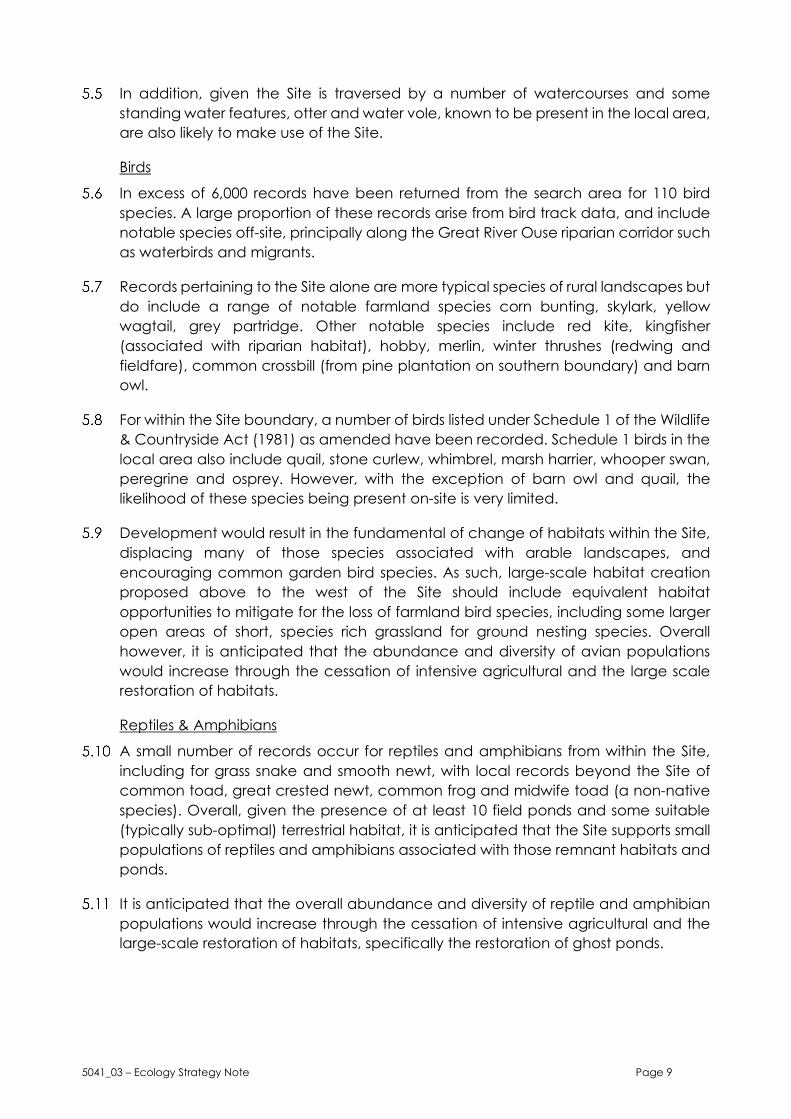
Appendix A
Nature Conservation Designations


xmin = 493500Projection = OSGB36
Statutory Sites_MAGIC
ymin = 249300xmax = 534100ymax = 268600
LegendLocal Nature Reserves (England)National Nature Reserves(England)Ramsar Sites (England)Sites of Special Scientific Interest(England)Special Areas of Conservation(England)Possible Special Areas ofConservation (England)Special Protection Areas(England)Potential Special ProtectionAreas (England)
Copyright resides with the data suppliers and the map must not be reproduced without their permission. Some information in MAGIC is a snapshot of the information that is being maintained or continually updated by the originating organisation. Please refer to the metadata for details as information may be illustrative or representative rather than definitive at this stage.
Map produced by MAGIC on 26 January, 2021.
(c) Crown Copyright and database rights 2021. Ordnance Survey 100022861.
0 1 2km
0 1.5 3
km