ecological study in the porto palermo bay and surrounding areas
52
Support the planning, zoning and development of a Marine Protected Area in the Porto Palermo Bay (Albania), based on sound scientific and socio-economic knowledge ECOLOGICAL STUDY IN THE PORTO PALERMO BAY AND SURROUNDING AREAS
Transcript of ecological study in the porto palermo bay and surrounding areas

Support the planning, zoning and development of a Marine Protected Area in the Porto Palermo Bay (Albania), based
on sound scientific and socio-economic knowledge
ECOLOGICAL STUDYIN THE PORTO PALERMO BAY AND SURROUNDING AREAS

The designations employed and the presentation of the material in this document do not imply the expression of any opinion whatsoever on the part of UNEP/MAP-RAC/SPA concerning the legal status of any State, Territory, city or area, or of its authorities, or concerning the delimitation of their frontiers or boundaries. The views expressed in this publication do not necessarily reflect those of UNEP/MAP-RAC/SPA.
Published by: RAC/SPA
Copyright: © 2015 - RAC/SPA
Reproduction of this publication for educational or other non-commercial purposes is authorized without prior written permission from the copyright holder provided the source is fully acknowledged. Reproduction of this publication for resale or other commercial purposes is prohibited without prior written permission of the copyright holder.
For bibliographic purposes, this volume may be cited as:RAC/SPA - UNEP/MAP, 2013. Ecological study in the Porto Palermo Bay and surrounding areas. By Lefter KASHTA, Sajmir BEQIRAJ, Arjan GACE and Xhemal MATO. Ed. RAC/SPA - MedMPAnet Project, Tunis. 44 pp + annexes.
Layout: Zine El Abidine MAHJOUB and Asma KHERIJI.
Cover photo credit: Alket ISLAMI.Photos credits: Lefter KASHTA, Francesco CINELLI, Sajmir BEQIRAJ, Xhemal MATO, Valbona SIMIXHI, Mathieu FOULQUIÉ and Gerard PERGENT.
This document has been elaborated within the framework of the Regional Project for the Development of a Mediterranean Marine and Coastal Protected Areas (MPAs) Network through the boosting of Mediterranean MPAs Creation and Management (MedMPAnet Project).
The MedMPAnet Project is implemented in the framework of the UNEP/MAP-GEF MedPartnership, with the financial support of EC, AECID and FFEM.

ECOLOGICAL STUDY IN THE PORTO PALERMO BAY AND SURROUNDING AREAS
Regional Project for the Development of a Mediterranean Marine and Coastal Protected
Areas (MPAs) Network through the boosting of MPA creation and management

ECO
LOG
ICAL
STUDY
IN T
HE P
ORT
O P
ALE
RMO
BAY A
ND
SURR
OUNDI
NG
ARE
AS
Study required and financed by:
Regional Activity Centre for Specially Protected Areas (RAC/SPA) Boulevard du Leader Yasser Arafat B.P. 337 1080 Tunis Cedex - Tunisia
In charge of the study:Souha EL ASMI, MedMPAnet Project, RAC/SPA Atef LIMAM, MedMPAnet Project, RAC/SPA
Scientific responsible of the study: Lefter KAShTA, Senior Marine Biologist Sajmir BEQIRA, Marine BiologistArian GAÇE, Marine BiologistXhemal MATo, Community Mobilization Expert
Reference of the study: MoU Nº 04/MedMPAnet/2013

ECO
LOG
ICAL
STUDY
IN T
HE P
ORT
O P
ALE
RMO
BAY A
ND
SURR
OUNDI
NG
ARE
AS
Many valuable natural habitats on the coastal zone in the Mediterranean are not ecologically evaluated to be designated as Coastal or Marine Protected Areas. Enlarging percentage/size of protected areas is required in numerous documents adopted at national and international scale. Within that framework, the “Regional Project for the Development of a Mediterranean Marine and Coastal Protected Areas (MPAs) Network through the boosting of MPAs Creation and Management” (the “MedMPAnet Project”) was developed in order to promote the creation of new protected areas.
The MedMPAnet Project is an integrated part of the UNEP/MAP-GEF MedPartnership Project “Strategic Partnership for the Mediterranean Sea Large Ecosystem” led by UNEP/MAP (Athens) and is implemented by the RAC/SPA (Tunis), with financial support from the European Union (EU), the Spanish Agency for International Cooperation to Development (AECID) and the French Global Environment Facility (FFEM).
More particularly in the framework of the “MedMPAnet Pilot Project in Albania”, the Ministry of Environment, Forest and Water Administration and RAC/SPA have organized in Tirana, on May 3rd, 2012, an Inception Meeting for the Project. During this meeting, the Albanian Ministry of Environment representatives have been informed about the Project activities planned in Albania, and the RAC/SPA representatives get informed about the development made by Albania in terms of marine and coastal protected areas creation. This discussion led also to the choice of the pilot site to be developed as an MPA in Albania, which is the Porto Palermo Bay.
In this regard and in order to help a close coordination and smooth implementation of the MedMPAnet Pilot Project at Albanian national level, it was agreed, based on a joint selection process between RAC/SPA and the Ministry of Environment, to entrust this task to Institute for Nature Conservation in Albania (INCA), an Albanian national organization that will coordinate the Pilot Project implementation on behalf of and in close consultation with the Ministry of Environment, Forest and Water Administration and RAC/SPA.
National context
The situation analysis in the Strategic Plan for Marine and Coastal Protected Areas in Albania (SPMCPA), developed lately with the support of UNDP, concludes that despite the coastal area of Albania being one of the biodiversity hotspots in the Mediterranean Sea, there is a lack of information on the conservation status of key habitats and species, with which to develop an SPMCPA. Gap filling (providing this information) is, therefore, proposed to form a key outcome of the implementation of SPMCPA. The situation analysis indicates that Albanian marine and coastal ecosystems contribute to sustaining human health, lifestyle, and the food production needed for the economic development and well-being of the coastal population. however, Albanian marine and coastal ecosystems are under increasing pressure. The pressure primarily comes from a rapid increase in coastal urban development and the resulting increase in human use of coastal and marine ecosystems.
Despite the significance of marine and coastal ecosystems to the social and economic development of Albania and the increasing pressures that these marine and coastal ecosystems face there is a lack of administrative capacity and availability of financial and in kind resources with which to manage these pressures. Capacity building and financial resourcing are, therefore, proposed to form key outcomes of the implementation of SPMCPA.
The current MCPA system is not representative of the marine and coastal habitats and ecosystems diversity. Indeed, most MCPAs are currently coastal (only one marine PA) and a number of coastal zones are still unprotected despite their essential ecological and socio-economical role on a national or Mediterranean level. 85% of the currently protected coastal sites are along the Adriatic coast which emphasizes the low number of MCPAs on the Ionian coastlines. Existing MCPA in Albania cannot be defined as being part of an ecological network, but are initial systems from which a consistent and coherent network must be established, particularly integrating some MPAs in the open sea.
FOREwORD

ECO
LOG
ICAL
STUDY
IN T
HE P
ORT
O P
ALE
RMO
BAY A
ND
SURR
OUNDI
NG
ARE
AS
The SPMCPA reviewed the criteria for selecting habitats and species to be included within the national network of MCPA. These criteria reflect Albanian national and also international criteria for sustaining marine and coastal biodiversity. The SPMCPA based on these criteria proposed the following areas for gazetting to form the Albanian network of Marine and Coastal Protected areas.
• The Bay of Porto-Palermo
• The area from Vjosa river mouth to Sazan and Karaburun (the entire Vlora Bay)
• The area from Cape Rodoni to Patoku lagoon
• The coastal area from Buna river mouth to Viluni lagoon
The objectives of each MCPA should be to sustain the biodiversity and ecosystem health of the specified area, to contribute to the biodiversity and ecosystem health of the network and to contribute to biodiversity and ecosystem health nationally and internationally.
Project context
The pilot project is supporting the planning, zoning and development of a Marine Protected Area in the Porto Palermo Bay (Albania), based on sound scientific and socio-economic knowledge. It intends also to identify stakeholders’ participation mechanisms to the Porto Palermo Bay MPA management and planning, and support its financial sustainability.
In order to support RAC/SPA in planning, zoning and developing a Marine Protected Area in the Porto Palermo Bay marine area, INCA is required to:
• Carry out an ecological study on the Porto Palermo Bay marine area (mapping of marine habitats, census and inventories of fish and invertebrates, identification of priority areas for conservation, etc.);
• Produce GIS-based maps for the Porto Palermo Bay marine area;
• Undertake a socio‐economic study, with a particular attention on fisheries and fleet operating locally and
in the surrounding areas, touristic activities and any other relevant aspect;
• Identify stakeholders (individuals and organized groups) to participate in the MPA‐creation process, survey their needs and demands and propose participatory mechanisms tailored to the new MPA demonstration area;
• Elaborate a management plan including a zoning for the Porto Palermo Bay marine area;
• Contribute to the establishment of a sustainable financial mechanism of the Porto Palermo Bay MPA;
• Provide support to the on-job training activities that could be assured by international experts associated to the Pilot Project execution.
The good running of the above-mentioned activities will be ensured through a close partnership between INCA and RAC/SPA, in close consultation with the Ministry of Environment, Forest and Water Administration of Albania.
This publication specifically includes the results of the ecological study performed in the Porto Palermo Bay to fill gaps in environmental knowledge ‐ establishing a quantitative description of the marine area to be protected, as well as surrounding areas. It includes results from inventory and spatial distribution of marine, coastal and terrestrial habitats and species (aquaplane surveys, semi‐quantitative sampling by underwater visual transects and digital photographic quadrates) with special attention driven to particularly valuable habitats and species in particular those annexed the SPA/BD Protocol. It also provides necessary information on potentiality of zones for supporting ecological processes important for conservation purposes (habitat for important species, as well as an inventory of main sources of threats and impacts to important habitats and species supporting planning, zoning and development (management, monitoring and evaluation) of the Porto Palermo MPA. It set forward the basis for designing of indicators for ecological monitoring actions in the future.

ECO
LOG
ICAL
STUDY
IN T
HE P
ORT
O P
ALE
RMO
BAY A
ND
SURR
OUNDI
NG
ARE
AS
Foreword
1. Introduction...................................................................................................................................................................................................7
2. Objective of the survey.............................................................................................................................................................................9
3. Methodology................................................................................................................................................................................................11
3.1. Project area.....................................................................................................................................11
3.2. Field survey.....................................................................................................................................13
4. Results of the survey................................................................................................................................................................................15
4.1. Terrestrial habitats...........................................................................................................................15
4.2. Marine benthic communities and habitats......................................................................................20
4.3. Description of benthic habitats for each zone..................................................................................25
4.4. Marine habitats and species of conservation interest........................................................................27
4.5. Fish resources..................................................................................................................................30
4.6. Alien marine species occurring in Porto Palermo area......................................................................31
5. The main source of threats to the Porto Palermo area...........................................................................................................33
6. Indicators and key parameters for monitoring the environmental situation............................................................41
7. References.....................................................................................................................................................................................................43
8. List of fish species
CONTENT

© M
ath
ieu
FOULq
UIe
6

ECO
LOG
ICAL
STUDY
IN T
HE P
ORT
O P
ALE
RMO
BAY A
ND
SURR
OUNDI
NG
ARE
AS
7 Porto Palermo bay, known as Panorma bay in ancient times, is situated in southeast of himara town, at the Ionian Sea coast. The inlet of Panorma is of tectonic origin identified by the jagged coastline known since ancient times and shown in old maps.
Inside of the bay there is a small and attractive rocky peninsula, which enters about 300 meters to the sea. here is a fortress, constructed by Ali Pasha of Tepelena at the end of 18th century in the honor of his wife, Vasiliqia.
Porto Palermo is a protected bay and had a very limited access in the former time (until 1991), as it was a military area. Due to this, marine biodiversity is presumed to have been rich in that period, although the surveys were very limited. Nevertheless, due to the traffic of military vessels, this area might have been impacted.
Currently, the base is used as a mooring site for the Coast Guard and jetty, as well as for anchoring fishing vessels in the southern part.
Aquaculture activity has started in Porto Palermo since 2004 and it is regularly continuing. A fish farm for the cultivation of sea bream (Sparus aurata) and sea bass ( ) has been established in the southern part of the bay.
The surrounding area is generally poor in terrestrial vegetation, but the peninsula and the southern part of the area is covered by ever-green mediterranean vegetation.
This study has been carried out based on the objectives and methodologies defined from the ToR of the project, as follows.
© RAC/SPA, Lefter KASHTA
1. INTRODUCTION

Posi
doni
a o
ceani
ca &
Obla
da m
elanu
ra ©
Ger
ard
PER
GEN
T
8

ECO
LOG
ICAL
STUDY
IN T
HE P
ORT
O P
ALE
RMO
BAY A
ND
SURR
OUNDI
NG
ARE
AS
9 The main objective of this survey is to identify the important habitats and species in project area and the intermediate surroundings.
As regards to the benthic habitats, the objective is to map and assess the seagrass meadows and other habitats, in particular to:
• Provide a spatial description of the seabed environment within and around the Porto Palermo bay, including the identification of important/sensitive habitats and species ;
• Identify the benthic communities present in project area;
• Indicate the presence or absence of Posidonia oceanica beds; and
• Assess the extent of Posidonia oceanica beds and other seagrasses.
Additionally, a description of terrestrial flora and main communities has been required.
© RAC/SPA, Lefter KASHTA
2. OBjECTIvE OF THE SURvEY
© M
ath
ieu
FOULq
UIe
10

ECO
LOG
ICAL
STUDY
IN T
HE P
ORT
O P
ALE
RMO
BAY A
ND
SURR
OUNDI
NG
ARE
AS
11
Figure 1. Core area – the bay (Zone I and Zone II)
3.1. Project area
The ecological study has covered the area inside the Porto Palermo and the intermediate surroundings towards north and south of the bay.
This area has been divided into 3 zones (as illustrated in figures 1, 2, and 3):
• Core area – Porto Palermo bay (Zone I with 6 surveying transects; Zone II with 9 surveying transects);
• North Zone (Llaman bay, with 5 surveying transects);
• South Zone (with 4 surveying transects).
3. METHODOLOGY

ECO
LOG
ICAL
STUDY
IN T
HE P
ORT
O P
ALE
RMO
BAY A
ND
SURR
OUNDI
NG
ARE
AS
12
Figure 2. North Zone (Llaman bay)
Figure 3. South Zone

ECO
LOG
ICAL
STUDY
IN T
HE P
ORT
O P
ALE
RMO
BAY A
ND
SURR
OUNDI
NG
ARE
AS
13
3.2. Field survey
The field investigation for terrestrial flora was carried out in spring, summer and autumn by Lefter Kashta.
The field investigations for the benthic habitats took place during July - August 2013 by Lefter Kashta, Sajmir Beqiraj, Arjan Gaçe and Xhemal Mato. The benthic survey included:
• Extent of mid-littoral and infra-littoral assemblages;
• Extent of Posidonia oceanica meadows and other seagrasses;
• Extent of other assemblages in the upper circalittoral.
The investigation has been organized in surveying transects for each zone, as mentioned above in 2.1, fig. 1, fig. 2 and fig. 3, starting from the coastline and mid-littoral, following with infra-littoral, until the upper circalittoral (usually up to 50 – 70 m depth, depending on bottom topography) for each transect.
The investigation of mid-littoral assembles was based on visual survey from the boat and also by walking along the coast, assessing the species composition and extent of macrobenthic populations.
Shallow infra-littoral, until 3-4 m depth, was mainly surveyed by snorkeling. Predominant species of macrobenthos (macrophytes and macrofauna) and their abundance has been recorded. An underwater camera Sony digital (model Cyber-shot) was used for photo documentation of most important communities.
An underwater video-recorder (model Camera controller CBX GA, Inspecam LX&Z) was used for the survey in the infra-littoral, starting from 3 – 4 m depth, until the upper circalittoral (Fig. 4- a,b,c,d). The video-recorder was launched from a fishing boat that was used during the whole survey at sea. The echo-sounder of the boat was used to measure the depth.
The presence and extent of seagrass beds and other benthic assemblages of infra-littoral and upper circalittoral have been assessed and mapped on the bases of direct observations and analysis of underwater video recordings for each transect.
Mapping and cartography of habitats of the project area has been carried out using the ARCGIS software and combining data from the underwater surveys with the underwater video recorder and experts notes from spot diving and surveys. The topographic maps of Albania are used as reference map for showing all the results of the surveys. Different layers showing all the most important habitats and species in the Porto Palermo bay are produced together with the combined map (Fig. 26) showing the location of all these species and habitats.
a
b
c
d
Figure 4. The underwater video-recorderwith accessories (a, b) and records
taken from the depths (c, d)
© RAC/SPA, Lefter KASHTA
© RAC/SPA, Lefter KASHTA
© RAC/SPA, Lefter KASHTA
© RAC/SPA, Lefter KASHTA

Cym
odoce
a n
odosa
© G
erard
PER
GEN
T
14

ECO
LOG
ICAL
STUDY
IN T
HE P
ORT
O P
ALE
RMO
BAY A
ND
SURR
OUNDI
NG
ARE
AS
15
Description of habitats and species of Porto Palermo area in this report is based mainly on the data collected from the present survey and few data from any previous investigation (Beqiraj, 2006; Beqiraj & Kashta, 2007; Beqiraj et al., 2008; Kashta, 1996). Descriptions in the following are focused on terrestrial and marine habitats, aiming to highlight the most important habitats, species and associations.
4.1. Terrestrial habitats
Sclerophyllous scrub (Matorral) Thermo-Mediterranean and pre-desert scrub Tree-spurge formations
The association with tree spurge (Euphorbia dendroides) has been considered as the most interesting for this area and near unique in Albania. From conservational point of view, Euphorbia dendroides, a “thermo-mediterranean and pre-desert shrub” habitat indicator, is a natural habitat of Community importance coded as 5330, according to the EU habitats Directive.
The floristic composition of this association consists mainly in: Anagyrris feotida, Salvia triloba, Lotus cytisoides, Phlomis fruticosa, Glaucium flavum, Galium aparine, Pistacia terebinthus, Salvia triloba, Calicotome villosa, Spartium junceum, Ruscus aculeatus, Asparagus acutifolius, Urginea maritima, Asphodelus aestivus, Chrysopogon gryllus, Acanthus spinosus, Trifolium angustifolium, Brassica incana, Paliurus spina-christi.
Figure 5. Euphorbia dendroides formationin the peninsula around the castle
Figure 6. Euphorbia dendroides formation on the hills of zone I
©RAC/SPA, Lefter KASHTA
©RAC/SPA, Lefter KASHTA
© RAC/SPA, Lefter KASHTA
4. ReSuLTS oF THe SuRvey

ECO
LOG
ICAL
STUDY
IN T
HE P
ORT
O P
ALE
RMO
BAY A
ND
SURR
OUNDI
NG
ARE
AS
16
Phrygana
This type of vegetation is composed of low shrubs of less than 60 cm high and generally not close to each other. Among characteristic associations of the
area we could mention those dominated by Phlomis fruticosa (assoc. Chrysopogono-Phlometum fruticosae).
The association with Salvia fruticosa L, is another characteristic association for this area.
Figure 7. Aassociation with Phlomis fruticosa
Figure 9. Patches of forest with Quercus ithaburensis subsp. macrolepis in Llamani bay
Figure 8. Association with Salvia fruticosa
© RAC/SPA, Lefter KASHTA
© RAC/SPA, Lefter KASHTA
© RAC/SPA, Lefter KASHTA
© RAC/SPA, Lefter KASHTA

ECO
LOG
ICAL
STUDY
IN T
HE P
ORT
O P
ALE
RMO
BAY A
ND
SURR
OUNDI
NG
ARE
AS
17
Vegetation of Mediterranean pseudo-steppes.
Further degradation of phrygana as a result of overgrazing or on-going burns has affected this formation dominating it by Brachypodium ramosum (assoc. Brachypodietum ramosi) on the calcareous rocks.
Forests dominated by Quercus ithaburensis subsp. macrolepis
This type of vegetation is present in hills of north zone, but it doesn’t form a distinct forest belt.
Quercus ithaburensis subsp. macrolepis, known as Valona oak, might by consider as a relict species that persisted on the Ionian coast since Tertiary period.
Vegetation of coastal rocks
The coasts of Porto Palermo area are mostly rocky. Steep rocks of some tens of meters high are frequently met in this area (western side of the castle, south zone and north zone). The xero-halophytic vegetation of Crithmo-Limonietea class dominates the lowest layer above the level of wave action. The most common species in this zone are Crithmum maritimum, Limonium anfractum, Elymus pycnanthus, Desmazeria marina, Lotus cytisoides, etc., which represent the endemic association Crithmo-Limonietum anfracti.
The upper layer of that vegetation (from 5-6 m to 50 m in certain cases), only periodically powdered by a dry smoke of crystallised salt during the strongest aerosaline storms, is represented by a very rare and spread vegetation of the alliance Capparo-Putorion. The characteristic species of that belt are: Capparis orientalis, Putoria calabrica, Ephedra foemina, etc. In this layer of rare vegetation certain subendemic and relict species have been sheltered like Acis ionica, Athamanta macedonica, Brassica incana subsp. egaea, etc.
Figure 11. Limonium anfractum
Figure 13. Ephedra foeminaFigure 10. Lotus cytisoides
© RAC/SPA, Lefter KASHTA
Figure 12. Capparis orientalis
© RAC/SPA, Lefter KASHTA
© RAC/SPA, Lefter KASHTA
© RAC/SPA, Lefter KASHTA

ECO
LOG
ICAL
STUDY
IN T
HE P
ORT
O P
ALE
RMO
BAY A
ND
SURR
OUNDI
NG
ARE
AS
18
Figure 14. vegetated vertical coastal rocks on the castle peninsula
Acanthus spinosus L.Acis ionica Bareka, Kamari & Phitos Agave americana L.Ailanthus altissima (Mill.) SwingleAira elegantissima SchurAnagyris foetida L.Anogramma leptophyla (L.) LinkAristolochia sempervirens L.Arisarum vulgare Targ-Tozz.Asparagus acutifolius L.Asphodelus aestivus Brot.Asplenium ceterach L.Athamanta macedonica (L.) SprengelBiscutella didyma L.Brasica cretica Lam. subsp. aegaea (Heldr. & Hald.) S. Snogerup, M.A. Gust. & BothmerCapparis orientalis VeillardCalicotome villosa (Poiret) LinkCeltis australis L.Cerinthe major L. var. purpurescensColchicum cupanii GussoneCheilanthes fragrans (L.) Webb & Berth.Chrysopogon gryllus (L.) Trin.Crithmum maritimum L.Cynosurus echinatus L.Desmazeria marina (L.) DruceDiplotaxis viminea (L.) DC. Ephedra foemina Forssk.
Euphorbia dendroides L.Galium aparine L.Glaucium flavum CrantzHeteropogon contartus (L.) P. Beau. Limonium anfractum (Salm.) Salm. Lotus cytisoides L.Malcolmia gaeca subsp. bicolor (Boiss. & Heldr.) Stork Medicago disciformis DC.Olea europaea L. var. sylvestrisOphyoglossum lusitanicum L.Origanum vulgare L.Paliurus spina-christi Mill.Parietaria judaica L.Pistacia terebinthus L.Phlomis fruticosa L.Prasium majus L.Prunus webbii (Spach) Vierh.Punica granatum L.Quercus ithaburensis subsp. macrolepis (Kotschy) Hedge & Yalt.Rhamnus alaternus L.Ruscus aculeatus L.Salvia fruticosa Mill.Silene vulgaris (Moench) GarckeSpartium junceum L.Trifolium angustifolium L.Drimia maritima (L.) StearnValantia muralis L
Plant species recorded in Porto Palermo area
© RAC/SPA, Lefter KASHTA
ECO
LOG
ICAL
STUDY
IN T
HE P
ORT
O P
ALE
RMO
BAY A
ND
SURR
OUNDI
NG
ARE
AS
19
Noteworthy species
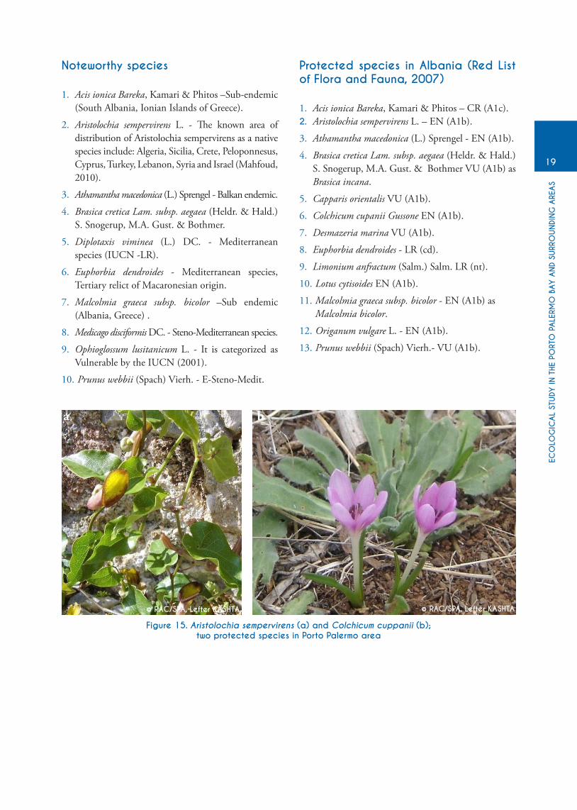
1. Acis ionica Bareka, Kamari & Phitos –Sub-endemic (South Albania, Ionian Islands of Greece).
2. Aristolochia sempervirens L. - The known area of distribution of Aristolochia sempervirens as a native species include: Algeria, Sicilia, Crete, Peloponnesus, Cyprus, Turkey, Lebanon, Syria and Israel (Mahfoud, 2010).
3. Athamantha macedonica (L.) Sprengel - Balkan endemic.
4. Brasica cretica Lam. subsp. aegaea (heldr. & hald.) S. Snogerup, M.A. Gust. & Bothmer.
5. Diplotaxis viminea (L.) DC. - Mediterranean species (IUCN -LR).
6. Euphorbia dendroides - Mediterranean species, Tertiary relict of Macaronesian origin.
7. Malcolmia graeca subsp. bicolor –Sub endemic (Albania, Greece) .
8. Medicago disciformis DC. - Steno-Mediterranean species.
9. Ophioglossum lusitanicum L. - It is categorized as Vulnerable by the IUCN (2001).
10. Prunus webbii (Spach) Vierh. - E-Steno-Medit.
Protected species in Albania (Red List of Flora and Fauna, 2007)
1. Acis ionica Bareka, Kamari & Phitos – CR (A1c).2. Aristolochia sempervirens L. – EN (A1b).
3. Athamantha macedonica (L.) Sprengel - EN (A1b).
4. Brasica cretica Lam. subsp. aegaea (heldr. & hald.) S. Snogerup, M.A. Gust. & Bothmer VU (A1b) as Brasica incana.
5. Capparis orientalis VU (A1b).
6. Colchicum cupanii Gussone EN (A1b).
7. Desmazeria marina VU (A1b).
8. Euphorbia dendroides - LR (cd).
9. Limonium anfractum (Salm.) Salm. LR (nt).
10. Lotus cytisoides EN (A1b).
11. Malcolmia graeca subsp. bicolor - EN (A1b) as Malcolmia bicolor.
12. Origanum vulgare L. - EN (A1b).
13. Prunus webbii (Spach) Vierh.- VU (A1b).
Figure 15. Aristolochia sempervirens (a) and Colchicum cuppanii (b);two protected species in Porto Palermo area
© RAC/SPA, Lefter KASHTA © RAC/SPA, Lefter KASHTA
a b
© RAC/SPA, Lefter KASHTA
ECO
LOG
ICAL
STUDY
IN T
HE P
ORT
O P
ALE
RMO
BAY A
ND
SURR
OUNDI
NG
ARE
AS
20
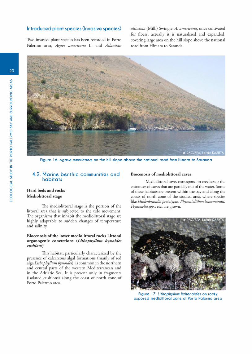
4.2. Marine benthic communities and habitats
Hard beds and rocksMediolittoral stage
The mediolittoral stage is the portion of the littoral area that is subjected to the tide movement. The organisms that inhabit the mediolittoral stage are highly adaptable to sudden changes of temperature and salinity.
Biocenosis of the lower mediolittoral rocks Littoral organogenic concretions (Lithophyllum byssoides cushions)
This habitat, particularly characterized by the presence of calcareous algal formations (manly of red alga Lithophyllum byssoides), is common in the northern and central parts of the western Mediterranean and in the Adriatic Sea. It is present only in fragments (isolated cushions) along the coast of north zone of Porto Palermo area.
Biocenosis of mediolittoral caves
Mediolittoral caves correspond to crevices or the entrances of caves that are partially out of the water. Some of these habitats are present within the bay and along the coasts of north zone of the studied area, where species like Hildenbrandia prototypus, Phymatolithon lenormandii, Peyssonelia spp., etc. are grown.
Figure 17. Lithophyllum lichenoides on rockyexposed mediolitoral zone of Porto Palermo area
Introduced plant species (Invasive species)
Two invasive plant species has been recorded in Porto Palermo area, Agave americana L. and Ailanthus
altissima (Mill.) Swingle. A. americana, once cultivated for fibers, actually it is naturalized and expanded, covering large area on the hill slope above the national road from himara to Saranda.
Figure 16. Agave americana, on the hill slope above the national road from Himara to Saranda
© RAC/SPA, Lefter KASHTA
© RAC/SPA, Lefter KASHTA

ECO
LOG
ICAL
STUDY
IN T
HE P
ORT
O P
ALE
RMO
BAY A
ND
SURR
OUNDI
NG
ARE
AS
21
Figure 18. Mediolittoral caves within Porto Palermo bay
© RAC/SPA, Lefter KASHTA
Figure 19. Association with Cystoseira amentacea var. spicata (north zone of Porto Palermo area)
Infralittoral stage
The infralittoral stage is a benthic environment that is perpetually submerged. The upper limit is normally characterised by the presence of plants that cannot tolerate prolongated emersion, (e.g. Cystoseira), while the lower limit is normally fixed at the maximum depth where it is possible for the marine vascular plants or ‘phanerogame’ (e.g. Posidonia oceanica) to survive.
Biocenosis of infralitoral algae
This biocenosis includes brown, red, and green macroalgae, which are important primary producers and like seagrass, these may provide food, substrate and shelter for a wide variety of animals.
Association with Cystoseira amentacea var. spicata
This association is located in the first meter of the infralittoral and creates belts mainly in exposed coasts of the north zone of Porto Palermo area.
This association, including many strata, is characterized by high species richness; it shelters epibiont organisms and other benthic organisms mainly belonging to the algae, polychaetes, molluscs and crustaceans.
A total of twelve species of green algae, fourteen species of brown algae and twenty five species of red algae were recorded during the survey (Table 1).
© RAC/SPA, Lefter KASHTA

ECO
LOG
ICAL
STUDY
IN T
HE P
ORT
O P
ALE
RMO
BAY A
ND
SURR
OUNDI
NG
ARE
AS
22
Table 1: Seaweeds identified during the benthic survey in Porto Palermo area (July - August 2013)
Green Algae - Chlorophyta
Acetabularia acetabulum (Linnaeus) P.C.SilvaAnadiomene stellata (Wulfen) C.AgardhBryopsis plumosa (hudson) C. Agardh Caulerpa racemosa (Forsskål) J. Agardh var. cylindracea Cladophora prolifera (Roth) KützingCodium effusum (Rafinesque) Delle Chiaje Codium bursa (Linnaeus) C. AgardhFlabellia petiolata (Turra) NizamuddinHalimeda tuna (J. Ellis & Solander) J.V. Lamouroux Ulva intestinalis v. intestinalis Linnaeus Ulva laetevirens Areschoug Valonia utricularis (Roth) C. Agardh
Cladostephus spongiosum (hudson) C. Agardh f. verticilatum (Light foot)Prud’home van Reine Cysoseira amentacea (C. Agardh) Bory var. spicata (Ercegovic) Giaccone Cystoseira barbata (Stackhouse) C. Agardh Cystoseira compressa (Esper) Gerloff & NizamuddinCystoseira corniculata (Turner) Zanardini Cystoseira crinita DubyDictyopteris polipodioides (A. P. De Candolle) J.V. LamouroxDictyota dichotoma (hudson) J. V. Lamouroux var. dichotomaDictyota dichotoma (hudson) J. V. Lamouroux var. intricataDictyota linearis (C. Agardh) Greville Halopteris filicina (Grateloup) KützingPadina pavonica (Linnaeus) J. V.Scytosiphon lomentarius (Lyngbye) LinkStypocaulon scoparium (Linnaeus) Kützing
Brown Algae - Phaeophyta
Acrosymphyton purpuriferum (J. Agardh) G. SjöstedtAmphiroa rigida J. V. Lamouroux Botryocladia botryoides (Wulfen) FeldmannCallithamnion granulatum (Ducluzeau) C. Agardh Chondrophycus papillosus (C. Agardh) Garbary & J. harper Corallina elongata J. Ellis & SolanderGelidium bipectinatum G. Furnari Grateoloupia filicina (J. V. Lamouroux) C. AgardhHildenbrandia rubra (Sommerfeld) MeneghiniJania rubens (Linnaeus) J. V. Lamouroux var. rubensJania rubens (Linnaeus) J. V. Lamouroux var. corniculata(Linnaeus) YendoLiagora distenta (Merthens ex Roth) J. V. LamourouxLithophyllum byssoides (Lamarck) FoslieLithophyllum incrustans PhilippiLithophyllum trochanter (Bory) h.huve ex WoelkerlingLithophyllum stictaeforme (Areschoug) hauckNemalion helminthoides (Velley) BattersNeogoniolithon mamillosum (hauck) Setchell & L. R. MasonOsmundaria volubilis (Linnaeus) NorrisPeyssonelia squamaria (S. G. Gmelin) DecaisnePeyssonelia rubra (Greville) J. AgardhPhyllophora crispa (hudson) P. S. Dixon Pterocladiella capillacea (S. G. Gmelin) Santelices & hommersand Sphaerococcus coronopifolius Stackhouse Tenarea tortuosa (Esper) Me. Lemoine Wrangelia penicillata (C. Agardh) C. Agardh
Red Algae – Rhodophyta

ECO
LOG
ICAL
STUDY
IN T
HE P
ORT
O P
ALE
RMO
BAY A
ND
SURR
OUNDI
NG
ARE
AS
23
Seagrass meadows
Seagrasses are marine Magnoliophytes that form underwater beds, which are very important habitats for marine ecosystems. They provide food and shelter for a large number of marine species; they also prevent beach erosion by stabilizing the sediments through their rhizomes.
Three species of Magnoliophytes are present in the area: Posidonia oceanica, Cymodocea nodosa and Halophila stipulacea. Posidonia oceanica is the most abundant species, which form large meadows in shallow and medium depths at the study area (fig. 20).
Posidonia oceanica meadows
The meadows of Posidonia oceanica are among the most important Mediterranean habitats, and their conservation is a high national and international priority (e.g. EU habitats Directive 92/43/CEE, 21 May 1992). Posidonia oceanica is included in Annex I (strictly protected flora species) of the Berne Convention and Annex II (list of endangered or threatened species) of the Barcelona Convention. Posidonia oceanica is also included in the Red List of Albanian Flora (2007).
Posidonia oceanica meadows have a multi-functional role within coastal systems in terms of primary production, nutrient cycling, sediment stabilization, modification of wave energy gradients and provision of “nursery” habitat for fishes and invertebrates.
The upper limit of Posidonia oceanica meadows in the studied area was identified at 3.5 meters depth and the lower limit at 28 m. A narrow band of Posidonia oceanica, with short leaves, was found in an area of rocky bottom, in front of the castle, at 23 meters depth.
In those zones where water clearness is higher (Zone II, transects 3, 4, 5) Posidonia oceanica beds have been observed occurring in waters exceeding 25-27 m in depth. Zone I, in general, shows a regression of this lower depth limit (18-20m).
The results of this survey suggest that Posidonia oceanica has experienced a decrease in Porto Palermo bay. The presence of surfaces of dead matte within the area reveals that the beds occupied a much greater surface area in the past. We believe this decrease is linked manly with vessel anchoring and the last decade’s constructions of fish farms within the bay.
In shallow waters (2-3m) within the bay there are identified small areas covered with Cymodocea nodosa patches, partly accompanied with Halophila stipulacea (Fig. 22, 23 and 24), in the zone II (transect 1).
Associations of the Coralligenous biocenosis
The Coralligenous belongs to the circalittoral stage, but can exceptionally be found as an enclave in the biocenosis of infralittoral algae, that favors shade. This habitat has often been observed in different sites between 20 m to 60 m depths during this survey.
Figure 20. Dense meadow of Posidonia oceanica at 12 m depth
© RAC/SPA, Xhemal Mato

ECO
LOG
ICAL
STUDY
IN T
HE P
ORT
O P
ALE
RMO
BAY A
ND
SURR
OUNDI
NG
ARE
AS
24
Figure 21. Lower limit of the meadow at 21m depth Figure 22. Dead matte with photophilous algae
Figure 23. Cymodocea nodosa meadow (-3m)
Figure 24. Halophila stipulacea and C. nodosa (-2m) Figure 25. Coralligenous assemblages between sponges and Posidonia
© RAC/SPA, Sajmir BEqIRAj © RAC/SPA, Francesco CINeLLI
© RAC/SPA, Lefter KASHTA
© RAC/SPA, Lefter KASHTA © RAC/SPA, Lefter KASHTA

ECO
LOG
ICAL
STUDY
IN T
HE P
ORT
O P
ALE
RMO
BAY A
ND
SURR
OUNDI
NG
ARE
AS
25
4.3. Description of benthic habitats for each zone
Core area (Zone I and Zone II)
Zone I
In the zone I (fig. 1), the shallow waters of the mid-littoral and upper infra-littoral, from 0 to 3-4 m depth are characterized by stony bottom, mainly barren. In the central part of this zone barren habitat extents up to 6 m depth. The macrobenthos in these depths was predominated by populations of photophilic algae, sponges Chondrilla nucula and the black sea urchin Arbacia lixula. Cystoseira stripes were extending along the coast, up to 1 m depth in the northern part.
Meadows of Posidonia oceanica were mainly degraded in most of the Zone I, especially in its southern part. In this part (south) the upper limit of the meadow varies from 5 to 8.5 m depth. The degradation of the meadow was more evident from 12 m to 16 m and the lower limit was recorded in 18 m. Long bare strips in the bottom, within the Posidonia meadow, in this part may be due to human construction activities for the establishment of the fish farm. Aquaculture development (cultivation of the sea bream and the sea bass) may also be one of the factors for the general degradation of the meadow in this part.
In the northern part of the zone I, the Posidonia meadow seems to be in a better state, with a large cover and density, with the upper limit varying from 4.5 m to 7 m and with the lower limit from 20 m to 26 m depth. A relatively large presence of the sponges was recorded within the Posidonia meadow and a considerable presence of Codium sp. and Pinna nobilis in the northern part.
The upper circalittoral of the Zone I, from 26 to 70 m depth, was mainly predominated by soft bottoms, but with a high variety of microhabitats, including sandy and silt sediments, bare or covered by macroalgae, dead leafs of seagrasses under decomposition, dead shells of mollusks, mainly bivalves, coralligenous and precoralligenous formations predominated by sponges and calcareous algae, organogenic rocks, etc. It is worthy to highlight the presence of precoralligenous and especially coralligenous formation in this area, which plays an important role for increasing the biodiversity, as they are suitable habitats for sheltering a considerable species number of macroalgae, macroinvertebrates and fish. In these bottoms the most common macrofauna was represented by sponges, ascidians, gastropods Natica, Turritella, hexaplex, echinoderms ophidiaster, Echinaster, cnidarian Pennatula etc.
The alien invasive algae Caulerpa reacemosa var. cylindracea (grape Caulerpa) has been recorded near the lower limit of Posidonia meadow in the southern part of the Zone I.
The presence of antic amphorae on the bottom of the southern part of this zone can be considered as an
additional asset for the development of local tourism through diving activities, which also can be attracted by coralliegenous and precoralligenous formations, as well as by the steep underwater slopes that may reach sometimes 40 m depth immediately below the coastline, like in the central part of the Zone I (transect 4, fig. 1).
Zone II
Cystoseira associations were present in several parts between the mid-littoral and upper infralittoral of the Zone II, with the predominance of C. amentacea in the eastern part and C. compressa in the western part of this zone.
Barren coastal areas extent up to 3.5 m and sometimes up to 7 m depth. They are characterized by a high presence of the black sea urchin Arbacia lixula, whose grazing effect is evident in the whole area. The rare macrobenthos in these habitats was mainly represented by the photophilic algae Acetabularia, Jania, Padina, the sponge Chondrilla nucula, the gastropod Cerithium vulgatum and the echinoderms Arbacia lixula and Holothuria tubulosa.
Well developed sponges populations were present in the small caves and crevices in shallow waters, 1 m – 3 m depth, in the southeastern part of the zone II. Patches of the seagrass Cymodocea nodosa (little Neptune grass) were recorded in those depths in the southeastern and northwestern part. A high presence of athozoans was found in the Cymodocea patches in the southeastern part.
Two alien species were recorded in the shallow waters of this zone: small presence of the seagrass Halophila stipulacea (fig. 25) within the Cymodocea patches in southeastern part, in 1 - 2 m depth, and the grape alga Caulerpa reacemosa var. cylindracea in the western part, in 4 m depth.
Inputs of freshwater are present in the coast of southeastern part of the Zone II, which have eroded the coast and created small caves and crevices. A little further in the north, on the eastern coast, the influence of the freshwater is also evident through a strip of freshwater sediments (gravel and sand) that lies from the coastline to 15 m depth on the sea bottom.
Distribution of Posidonia meadows shows a variety of the upper and lower depth limits in the Zone II. Its upper limit varies from 3.7 m in the eastern coast to 6 – 7 m in the western coast of this zone, while the lower depth limit varies from 21 m to 28 m. From the video-records, the cover and density of Posidonia meadow looks high until 12 m depth in most of this area. The degradation and fragmentation of the meadow was more evident from 13 to 16 m depth. Patches of matte morte were relatively abundant within the meadow, especially between 11 and 18 m depth. A highest degradation of the meadow has resulted in the northwestern part, where large bare fragments and matte morte intersect the meadow from 9 m to 16 m depth. In the shallower waters of this part, at 5 m depth, Cymodocea and Caulerpa were often growing on the matte, near the upper limit of Posidonia meadow.

ECO
LOG
ICAL
STUDY
IN T
HE P
ORT
O P
ALE
RMO
BAY A
ND
SURR
OUNDI
NG
ARE
AS
26
on the western coast of the Castle (transect 2, fig. 1) Posidonia meadow was lacking, perhaps due to the immediate depth and very steep slope. In this area, the photophilic algae were found until 18 m depth, while Posidonia was found in small patches on the rocks in 23 m depth, where it was rare and with short leaves.
Communities of macroalgae, sponges and ascidians were relatively well developed in the Posidonia meadow that was also characterized by a high cover of epibiont organisms and mucilaginous algae, especially in the northern and western part of the Zone II.
Several microhabitats were recorded in deeper bottoms, under the lower limit of Posidonia meadow, until
70 m depth. The upper circalittoral, immediately under Posidonia meadow, until 30 m depth was characterized by bare soft bottoms, soft bottoms with macroalgae, matte morte covered by macrolagae, matte morte covered by sediments and soft bottoms covered by dead mollusk shells. From 30-56 m depth, besides some of above mentioned microhabitats, well developed precoralligenous and coralligenous formations were recorded with a high species richness of macroalgae, sponges (Agelas, Axinella), cnidarians (Parazoanthus, Caryophyllia) and ascidians. Soft bottoms with dead leaves of seagrasses under decomposition, ascidians, sponges, as well as bare soft bottoms were common from 40-50 m depth. on the lower depths, until 70 m, the soft bottoms were more homogenous, with bare areas and a little presence of sponges and ascidians.
Figure 26. Map of benthic communities and habitats present in Porto Palermo area
© RAC/SPA, valbona SIMIxHI

ECO
LOG
ICAL
STUDY
IN T
HE P
ORT
O P
ALE
RMO
BAY A
ND
SURR
OUNDI
NG
ARE
AS
27
North zone (Llamani bay)
The North Zone (Llamani bay) represents some peculiarities compared to the other zones of the surveyed area in terms of distribution of benthic biocenosis. Mid-littoral has a well developed associations of Cystoseira and Lithophyllum cushions along almost the whole coast line. At their lower part they are often accompanied by patches of photophilic algae with the predominance of Corallina. Barren areas cover a large portion of the upper infra-littoral, reaching from 5 to 11 m depth. This large representation of the barren areas in this zone, besides the grazing effect by sea urchins, may also be related to the presence of the rocks that were recently thrown in the sea by the illegal and uncontrolled tourist constructions along the coast line and the high human impact. Llamani bay is one of the areas with the highest touristic pressure along the Albanian coast during summer. The rare macrobenthic populations in these depths were represented by mucilaginous and other photophilic algae, black sea urchin Arbacia lixula and sponges predominated by Chondrilla nucula.
A strong fragmentation of the meadows of Posidonia oceanica was evidenced in this zone. A well developed meadow was recorded in the southern part (transect 1, fig.1), with the upper limit at 7 m depth and lower limit at 21 m. Posidonia meadow was totally lacking in the eastern coast (transects 2 and 3 in fig. 1; fig. 27). In this part, at the depths from 11 to 27 m, the rocky bottom is represented by a very rugged relief with steep slopes that may disfavor the development of Posidonia meadows. The macrobenthos in these depths was mainly predominated by macroalgae, often mucilaginous, and sponge’s communities. Another possible reason for the lack of Posidonia in this part may be related to the inputs of cold freshwater from underground springs that may modify the needed values of salinity and temperature for the establishment and development of the meadow. The Posidonia meadow was represented in a relatively good state in the northern and western part of the zone, respectively situated between 8 m and 28 m depth (transect 4, fig. 1) and between 13 m and 20 m depth (transect 5, fig. 1).
Below the Posidonia meadow, from 26 m to 30 m, well developed precoralligenous and coralligenous formations were recorded, with a high presence and diversity of sponges, macroalgae including mucilaginous ones and Caulerpa racemoca var. cylindracea, some rare and isolated bundles of Posidonia with short leaves, free calcareous algae deposited on the bottom and matte morte covered by sediments and dead mollusk shells.
In 30-35 m depth the bottom is mainly covered by coarse sand, while in lower depth, from 40 to 50 m, the bottom consists in soft bottom with presence of precoralligenous and coralligenous formation, high abundance of sponges, echinoderms (mainly Asteroidea and Crinoidea) and dead mollusk shells.
South zone
The survey in the South zone was very rapid and not very detailed due to the weather conditions that limited the field work at sea. The mid-littoral was characterized by a continuous presence of Cystoseira amentacea and other photophilic algae that were very evident until 6 m depth, predominated by Padina, Acetabularia and Dyctyota.
Due to the immediate depth and very steep slope in the western part of the zone, the meadow of Posidonia started at 11 m depth in the northern part (transect 1, fig. 1) and at 13 m depth in the north-western part (transect 2, fig. 2). The lower limit of the meadow in this area was recorded at 20 m depth.
In the central and eastern part of the zone (transects 3 and 4, fig. 1) the upper limit of Posidonia meadow is at 7 m depth, while the lower limit at 19 m. A slight fragmentation of the meadow has been recorded at 12 m depth in the eastern part.
Near the lower border of Posidonia in the eastern part, at 18-19 m depth, coralligenous formations were present, predominated by macroalgae and sponges from the genus Axinella, Agelas and Spongia. Below the Posidonia meadows in the central part, at 22-22 m depth, the bottom is covered by matte morte and bare soft sediments (without macrovegetation).
Coralligenous formations with macroalgae and high diversity of sponges have also been recorded in the north-western part of the zone (transect 1, fig. 1) at 31-33 m depth. In the central and eastern part, at 30-32 m depth, the bottom consists in soft homogenous sediments, without macrovegetation.
4.4. Marine habitats and species of conservation interest
Particular attention has been paid to the vulnerable/sensitive Mediterranean habitats and species of conservation interest that has been published in the relevant following documents:
• Mediterranean ‘Red Book’ of the thread marine vegetation, associations and seascapes of the Mediterranean Sea (UNEP/IUCN/GIS, 1990).
• EU habitat Directive (92/43) with the Annexes:
o I (Natural habitat Types of Community Interest)
o II (Animal and Plant Species of Community Interest)
o IV (Strictly protected species), and
o V (species whose exploitation is regulated)

ECO
LOG
ICAL
STUDY
IN T
HE P
ORT
O P
ALE
RMO
BAY A
ND
SURR
OUNDI
NG
ARE
AS
28
• The Barcelona Convention (1995) related to the Protocol concerning to the Specially Protected Areas and Biological Diversity in the Mediterranean with the Annexes:
o II (endangered or threatened species), and
o III (species whose exploitation is regulated)
o The Alghero Convention (1995) on coastal and marine biodiversity in the Mediterranean
• The Bern Convention (1996) with the Annexes:
o I (strictly protected flora species),
o II (strictly protected fauna species), and
o III (protected fauna species).
• National Red List of Flora and Fauna (2007) Among the most sensitive habitats of the
Mediterranean (UNEP-RAC/SPA. 1997) should be mentioned Lithophylum byssoides (sensitive to hydrocarbons) for the mediolittoral zone, the Cystoseira communities as an index of hydrodynamism at the upper littoral zone l, and the Posidonia oceanica meadows in the infralittoral zone.
Association with Lithophyllum byssoides
White and pallid rose plates and cushions of the calcareous rhodophytes Lithophyllum byssoides on rocky exposed mediolitoral zone. Typical habitat of the Western Mediterranean basin and the Adriatic Sea. Bio - indicator of high quality of water.
International status: Mediterranean ‘Red Book’ (vulnerable habitat), habitat Directive 92/43 (annex I, as reefs); Alghero
Convention (vulnerable habitat); Barcelona Convention (Annex II); Bern Convention (Annex I, as strict protected flora).National status: Red List of Flora and Fauna (2007) EN B1
Association with Cystoseira amentacea var. spicata
This characteristic belt has been observed on some very exposed rocky areas, from 0 to 1 m depth.highly complex habitat; structural and functional high biodiversity. Bio-indicator of the high quality of water.International status: Mediterranean ‘Red Book’; habitat Directive 92/43 (Annex I, as reefs); Alghero Convention; Barcelona Convention (Annex II); Bern Convention (Annex I, as strict protected flora).
National status: Red List of Flora and Fauna (2007) VU B2c
Posidonia oceanica meadows
This community, endemic in the Mediterranean Sea, represents the climax of the infralittoral soft bottoms and among the most important Mediterranean habitats; their conservation is a high national and international priority.International status: Mediterranean ‘Red Book’; habitat Directive (Annex I: * priority habitat); Barcelona Convention (Annex II); Bern Convention (Annex I, as strict protected flora).National status: Red List of Flora and Fauna (2007) VU A2d
Association with Cymodocea nodosa
This important phanerogame colonizes the sand and muddy - sand bottoms, and sometimes replace regressed meadows of Posidonia oceanica, but in the study area it was present in a small surface only, at shallow water of the bay.
International status: Mediterranean ‘Red Book’; Bern Convention (Annex I, as strict protected flora).
© RAC/SPA, Lefter KASHTA

ECO
LOG
ICAL
STUDY
IN T
HE P
ORT
O P
ALE
RMO
BAY A
ND
SURR
OUNDI
NG
ARE
AS
29
Table 2: Marine species of international concern in Porto Palermo, listed in the most important Conventions
Species name
Barcelona protocol(1995)
Bon(2006)
CITES (2006)
Bern(1993)
Ann. II Ann. III App. 1 App. 2 App. 2 App. 2
Magnoliophyta
Posidonia oceanicaPhaeophyta
Cystoseira amentacea var. spicataRhodophyta
Lithophyllum byssoides Lithophyllum trochanterSpongia
Geodia cydoniumHippospongia communisSpongia officinalisPetrobiona massilianaMollusca
Ranella oleariaPinna nobilisCrustacea
Homarus gammarusMaja squinadoScyllarides latusPalinurus elephasEchinodermata
Paracentrotus lividusOphidiaster ophidianusPisces
Hippocampus hippocampusLamna nasusIsurus oxyrinchusSciaena umbraUmbrina cirrosaSyngnathus abasterRostroraja albaXiphias gladiusHippocampus guttulatusSphyrna zygaenaCarcharodon carchariasReptilia
Caretta carettaCetacea
Ziphius cavirostrisDelphinus delphisTursiops truncatus
+
+
++
+
++
+
+
+
+
+++
++
++++
+
++++
++
+
+
+
+
+
++
++
+++
+
+
+
+++
+
++++
++
++++++
+
+
+++

ECO
LOG
ICAL
STUDY
IN T
HE P
ORT
O P
ALE
RMO
BAY A
ND
SURR
OUNDI
NG
ARE
AS
30
4.5. Fish resources
For a very long period, Porto Palermo bay remained isolated and did not develop any other activity. Being a very secret base, the movement of military vessels, were relatively limited. obviously, the fishing activity in the bay was totally prohibited. For more than 30 years (until 1997), this Gulf was undisturbed from biodiversity point of view. There are few reports about the types of fish, mainly associated with the surface observations from ex marines who claim to have seen dolphins enter the bay or «other big fish», making it more as legend. During the July to August period of time, outside of the bay shoals of Bluefin tuna (Thunnus thynnus) had been observe, upward from the Ionian Sea to the Adriatic Sea during migration for reproduction. Fishing activity outside of the base was concentrated mainly for small pelagic from Saranda fleet with light attractions method. In the area of Porto Palermo are found a large diversity of fish but the most common ones are Chelon sp., Mullus surmulletus, Diplodus sp., Coris juli, Serranus cabrilla, Oblada sp., Chromis sp., etc. The list of fish species occurring in and around the Porto Palermo bay is given in the Annex. Following is the description of some of the species of international importance as rare or endangered species that require special protection and preservation of their habitas as foreseen in several international agreements and conventions.
Hippocampus hippocampus - Short snouted seahorse - Kal deti turishkurter
Inhabits dense, complex habitats as well as patchy, relatively open and sparse habitats of coastal areas. Found on soft bottoms amongst rocks and algae, on sparsely vegetated areas, and in coastal lagoons with strong oceanic influences. Mimics the green or yellow coloration of plants allowing it to hide among the vegetation. This ability likely plays a role in seahorse feeding strategy and in predator avoidance. Makes limited daily movements within very restricted home ranges (0.7-18.1 m2). May over-winter in deeper water. Adult dispersal over large distances is probably caused by strong wave action during storms or when it anchors itself to floating debris. Is thought to live for 3-5 years. Because of its short generation time and multiple breeding cycles during each spawning season, resilience is thought to be high. Feeds on small prey and organic debris. has been reared in captivity. Description (based on 35 specimens): Adult height: 7.0-13.0cm. Rings: 11 + 37 (35-38). Snout length: 3.0 (2.8-3.4) in head length. Dorsal fin rays: 17 (16-19) covering 2+1 rings. Pectoral fin rays: 14 (13-15). Coronet: narrow, ridge-like and joined smoothly to nape of neck, or wedge-shaped (front narrow, back high and broad); some specimens with very large angular coronet. Spines: low, very low in adults. other distinctive characters: very short snout (usually less than 1/3 head length) that is slightly upward-bent; prominent eye spine. Colour pattern: mottled brown to yellow, to maroon and rust; also orange, purple or black; sometimes with tiny white dots, but these do not coalesce into thick horizontal wavy lines as in H. guttulatus.
Isurus oxyrinchus - Shortfin mako - Peshkaqen tonil
oceanic, but sometimes found close inshore. Usually in surface waters, down to about 150 m. Coastal, epipelagic at 1->500 m. Adults feed on bony fishes, other sharks, cephalopods; larger individuals may feed on larger prey such as billfish and small cetaceans. ovoviviparous, embryos feeding on yolk sac and other ova produced by the mother. With 4-16 young of about 60-70 cm long. Gestation period lasts 15-18 months, spawning cycle is every 3 years. Some authors have erroneously assumed that two age rings are deposited per year by this species, thus underestimating longevity, age at maturity, and resilience. These data have been removed and replaced by recent, verified estimates. Shortfin mako has been shown to have a marked sexually segregated population structure. Shortfin mako is probably the fastest of all sharks and can leap out of the water when hooked. Potentially dangerous and responsible for unprovoked attacks on swimmers and boats. Dorsal spines (total): 0; Dorsal soft rays (total): 0; Anal spines: 0; Anal soft rays: 0. A large, spindle-shaped shark with large black eyes, a sharp snout, and large, narrow, hooked teeth with smooth edges. Caudal fin lunate, lower lobe strongly developed. Dark blue above, white below. Tiny second dorsal and anal fins. Max length: 400 cm TL male/unsexed; commonlength: 270 cm TL male/unsexed; max. published weight: 505.8 kg; max. reported age: 32 years. Marine; pelagic-oceanic; oceanodromous; depth range 0 - 740 m, usually 100 - 150 m
Lamna nasus – Porbeagle – Tonil
Most abundant on continental offshore fishing banks but also found far from land in ocean basins and occasionally close inshore. Pelagic, epipelagic or littoral shark. highly migratory, moves generally along the continental shelves. one of the most cold-tolerant sharks; Known to temporarily tolerate salinities as low as 10 to follow its prey. Found singly and in schools and feeding aggregations. Feeds on small and medium-sized pelagic schooling species, other sharks, squid and demersal fishes (cod, white hake, red hake, haddock and cusk). Females grow larger than males. Catch records and studies in the northeast Atlantic show segregation by sex and size. Parasites include Phyllobothrium dagnallium (found in stomach, intestine and spiral valve) and Dinobothrium sp. Regarded as potentially dangerous to people because of its size and activity but has never or very seldom been indicted in an attack on people or boats. The flesh of the porbeagle is of good quality and texture and is said to taste like swordfish. Utilized fresh, dried or salted and frozen for human consumption; for oil and fishmeal; fins for shark-fin soup. May be pan-fried and broiled. Max length : 350 cm TL male/unsexed; common length : 244 cm TL male/unsexed; max. published weight: 230.0 kg; max. reported age: 30 years.
Maturity: Lm 175.0, range 170 - 180 cm. Marine; pelagic-oceanic; oceanodromous; depth range 0 - 715 m. Temperate; 2°C - 18°C.

ECO
LOG
ICAL
STUDY
IN T
HE P
ORT
O P
ALE
RMO
BAY A
ND
SURR
OUNDI
NG
ARE
AS
31
Rostroraja alba - White skate – Raxhe
Inhabit shelf and slope waters. Found on sand and rock-sand bottom. A bottom-predator of bony fishes, other elasmobranchs, fish offal, crabs, shrimps, mysids, octopi, and cuttlefish. Minimum depth reported taken from. Maximum length for female is 202 cm. oviparous. Distinct pairing with embrace. Young may tend to follow large objects, such as their mother. Eggs are oblong capsules with stiff pointed horns at the corners deposited in sandy or muddy flats. Egg capsules are 12.5-18.3 cm long and 10.0-13.9 cm wide. About 55-156 eggs are produced per individual annually. A giant skate with a broad-based, abruptly narrow-tipped snout covered with small, sharp thorns; pectoral disc angular, and no thorns on nape or back, but three rows of large thorns on tail. Larger immature and adult individuals grey with numerous small white spots above, underside white with no black pores; hatchlings plain reddish-brown above, often with blue spots, and white below with broad dusky grey margins on disc.
Sciaena umbra - Brown meager - Korbizi
occurs in shallow coastal waters mainly on rocky and sandy bottoms, often entering estuaries and more active at night. Also inhabits caves and reefs. Feeds on small fishes and crustaceans. SCUBA diving observations suggest this to be a very calm fish with remarkable buoyancy control and an ability to move without much apparent effort. Max length : 70.0 cm TL male/unsexed; common length : 28.0 cm TL male/unsexed; max. reported age: 21 years. Dorsal spines (total): 11; Dorsal soft rays (total): 23-25; Anal spines: 2; Anal soft rays: 7 – 8.
Sphyrna zygaena - Smooth hammerhead – Peshkkarabiner
occurs inshore and well offshore, over continental and insular shelves. Coastal, pelagic, and semi-oceanic, but often bottom associated at 1-139 m. Migrates northward in summer; young often in large aggregations of hundreds of individuals. Prefers to feed on small sharks, skates and stingrays, but also preys on bony fishes, shrimps, crabs, barnacles and cephalopods. Viviparous. Regarded as being dangerous to people, though only few can be tentatively attributed to this species due to its occurrence in temperate waters. Reported to cause poisoning. Become sexually mature when 250 to 300 cm long. The female gives birth to 30 - 40 young. Dorsal spines (total): 0; Dorsal soft rays (total): 0; Anal spines: 0; Anal soft rays: 0. A large hammerhead with a notch at the center of head; 1st dorsal fin moderately high, 2nd dorsal and pelvic fins low. olive-grey or dark grey above, white below. Fins nearly plain, dusky or blackish tipped.
Syngnathus abaster - Black-striped pipefish - Gjilpërëza shiritazezë
Euryhaline, found among detritus or vegetation over sand or mud, within a temperature range of 8° to 24°C. Probably an amphidromous species but migratory behaviour needs verification. ovoviviparous. The male carries the eggs in a brood pouch which is found under the tail. Early free-living young measure 23 mm TL. Max length: 21.0 cm TL male/unsexed.
Umbrina cirrosa - Shi drum - Korb i bardhe
Found over rocky and sandy bottoms in coastal waters. Juveniles enter estuaries. Feed on bottom invertebrates. Dorsal soft rays (total): 22-23. Max length: 73.0 cm TL male/unsexed; common length: 40.0 cm TL male/unsexed; max., published weight: 3.1 Kg.
Xiphias gladius – Swordfish - Peshku shtize
Atlantic, Indian and Pacific: tropical, temperate, and sometimes cold waters, including the Mediterranean Sea. highly migratory species. Generally above the thermocline. Larvae are frequently encountered at temperatures above 24 C . Migrate toward temperate or cold waters in the summer and back to warm waters in the fall. Adults are opportunistic feeders, known to forage for their food from the surface to the bottom over a wide depth range. Feed mainly on fishes (Atlantic mackerel, barracudinas, silver hake, redfish, herring and lantern fishes, but also on crustaceans and squids. They use their sword to kill their prey. Large individuals may accumulate large percentages of mercury in its flesh. Are batch spawners. Spawning takes place in Atlantic during spring in southern Sargasso Sea. Migrate to cooler waters to feed. Females grow fastest. Determination of age is difficult since the otoliths are very small and scales are missing in adults. Pelagic eggs measure 1.6-1.8mm and the newly hatched larvae is 4 mm long. Sword is well developed at a length of 10mm and young live pelagically in the upper water layers where they quickly develop into very voracious predators. Mt DNA restriction analysis reveal that genetic differentiation occurs between populations inhabiting the Mediterranean Sea and the tropical Atlantic ocean, indicating little genetic exchange occurring between the two. Maturity: Lm 221.0, range 156 - 250 cm. Max length: 455 cm FL male/unsexed; common length: 300 cm TL male/unsexed; max. published weight: 650.0 kg. Dorsal spines (total): 0; Dorsal soft rays (total): 38-56; Anal spines: 0; Anal soft rays: 16 - 18. Blackish-brown fading to light brown below; 1st dorsal fin with blackish-brown membrane, other fins brown or blackish-brown. A long, flat, sword-like bill and no pelvic fins.
4.6. Alien marine species occurring in Porto Palermo area
Alien species, also called biological invaders or nonindigenous species, are organisms that have been transported by human activity, accidentally or intentionally, into regions where they have not occurred historically.
Grape caulerpa (Caulerpa racemosa var. cylindracea): the invasive variety of C. racemosa, which has been spreading at a rapid rate throughout most of the Mediterranean Sea and the Atlantic, belongs to C. racemosa var. cylindracea (Sonder) Verlaque, huisman et Boudouresque, an endemic taxon from the southwest coast of western Australia (Verlaque et al., 2004; Ruitton et al., 2005).
Following the first record in Vlora bay in 2002, it seems to be common in wide range of depths (1 - 35m) and substrata (sand, mud, rocks, and especially dead matte of Posidonia) along the Albanian coast (Kashta et al., 2005,

ECO
LOG
ICAL
STUDY
IN T
HE P
ORT
O P
ALE
RMO
BAY A
ND
SURR
OUNDI
NG
ARE
AS
32
2008; Maiorano et al., 2011). Possible consequences of Caulerpa racemosa invasion include modifications of physical and chemical conditions (water movement, sediment deposition, substrate characteristics) and the underwater landscape, as well as profound modifications of benthic assemblages (Klein & Verlaque, 2008).
In the project area this species covers large area along north zone (at 26 - 27m depth) and small patches within the bay (from 4 m to 30 m depth).
Halophila stipulacea: this is the only seagrass introduced into the Mediterranean Sea as a Lessepsian immigrant, is nowadays common in the eastern Mediterranean. In the Albanian coast it is recorded in Ksamil, Saranda, himara and Vlora bay (Kashta & Pizutto, 1995).
Nimble spray crab (Percnon gibbesi): it is a primarily an algivorous crab of the shallow infra-littoral rocky shore, with wide native range. P. gibbesi rapidly increased its spatial distribution in the Mediterranean Sea, after its first recording in 1999 in Italy. At present, this crab seems to have colonized most Mediterranean coasts, especially in the middle latitudes. Sightings were recorded along the Albanian coast in 2010 in different localities: Saranda, Porto Palermo, Dhermi, himara Port, Shen Jani- Karaburun, Sazani Island. The invasion of this herbivore species in the shallow rocky infra-littoral of the Mediterranean Sea may add further stress to the already altered ecosystems (Katsanevakis et al., 2011; Zenetos et al., 2011).
a b
c
Figure 27. Alien invasive species in Porto Palermo: a. Caulerpa racemosa var. cylindracea;b. Halophila stipulacea; c. Percnon gibbesi
© RAC/SPA, Lefter KASHTA © RAC/SPA, Lefter KASHTA
© RAC/SPA, Lefter KASHTA

ECO
LOG
ICAL
STUDY
IN T
HE P
ORT
O P
ALE
RMO
BAY A
ND
SURR
OUNDI
NG
ARE
AS
33
Table 3: List of economically important fish species occurring in and around the Porto Palermo bay
Albanian Name
Vopa Dentali Sargu bishtzi Sharan Sargu Sargua Kern i bardhe Kern i hirte Trup merluciBarbuni I shkembit barbuni i baltesMormuri i eger Spalce e kuqe PagriPagri Kerr fundi Palamiti Sardelë Sardinele Skumber Kerr i thellesise Kerr i gurit Kerr bilbil Koce Peshku shtize
English name
Bogue Common dentex Annular seabream Sharpsnout seabream White seabream Common two-banded seabream White grouper Dogtooth grouper Little tunny European hake Red mullet Surmullet Axillary seabream Blackspot seabream Common pandora Red porgy Wreckfish Atlantic bonito European pilchard Round sardinella Chub mackerel Comber Brown comber Painted comber Gilthead seabream Swordfish
Species
Boops boopsDentex dentexDiplodus annularisDiplodus puntazzoDiplodus sargusDiplodus vulgarisEpinephelus aeneusEpinephelus caninusEuthynnus alletteratusMerluccius merlucciusMullus barbatusMullus surmuletusPagellus acarnePagellus bogaraveoPagellus erythrinusPagrus pagrusPolyprion americanusSarda sardaSardina pilchardusSardinella auritaScomber japonicusSerranus cabrillaSerranus hepatusSerranus scribaSparus aurataXiphias gladius
Fishing activities
After 1990, Porto Palermo base lost its military importance. Currently, this base is not included in the Distribution Plan of Army and military presence in it is symbolic. The base used only as moorings for Coast Guard and jetty in the southern part as used for anchoring fishing vessels for certain periods of time.
Fishing in the Gulf of Porto Palermo is a relatively less important activity. Due to the military limitations,
fishing was a limited activity inside of the bay, as artisanal fishing after 1990.
The military presence is a deterrent for any illegal fishing activity inside of the bay. By the other hand, in front of the bay, fishing activity intensified mainly as bottom fishing where the main fishing boats are coming from Saranda and Vlora fleet, but often vessels from Durres, fishing in this area, in depth, because this is one of the best areas for fishing of rose shrimps (Parapeneus longirostris).
5. THE MAIN SOURCE OF THREATS TO THE PORTO PALERMO AREA

ECO
LOG
ICAL
STUDY
IN T
HE P
ORT
O P
ALE
RMO
BAY A
ND
SURR
OUNDI
NG
ARE
AS
34
Inside the bay there is no boat or fishing boats that carry fishing activity, because the small size of the gulf itself and the prohibition of fishing activity provided by the legislation. Porto Palermo on the other side is an important site for refuge to the fishing boats from fishing ports of Vlora and Saranda, intermediate, for anchoring a good part of fishing vessels, which carry between the parts of them. Large fishing vessels Vlora, Saranda and other ports mainly use the port of himara, but given the positioning of the Port of himara (relatively exposed by South winds SE), Porto Palermo constitutes a safe anchorage, mainly for small vessels. however, the lack of port infrastructure (the Port Authority and border police) after anchoring, the bureaucratic procedures are longer. officially, the jetties of Porto Palermo used only for emergency purposes in case of bad weather and after approval of the Port and border police himara. Seabed is rocky with patches of Posidonia and with a variety of sponges, some Pinna shells but regretfully few fish.
Classification of fishing vessels as GFCM/33/2009/3 Implementation of the GFCM Task 1 Statistical Matrix includes the following types of vessels operating at himara region and in front of Porto Palermo Bay:
Inshore boats
• Polyvalent small-scale vessels with engine less than 6 m. All vessels under 6 metres in length (LoA) with engine.
• Polyvalent small-scale vessels with engine between 6 and 12 metres. All vessels between 6 and 12 metres in length (LoA) with engine, that use different gears during the year without clear predominance of one of them or that use a gear not considered in this classification.
These boats operate a number of different gear types in the shallow near coast waters. The boats are typically fairly small (length: from 4 –8 meters, engine: 10 – 92 hP with an average of 20 hP) and are operated as a traditional vessel owner or family type concern with a crew of 1 to 2. The main cost item is fuel which counts for 74% of the
operating cost; other costs include repair, new gear and various fees and charges.
Fishing effort has dropped from an average of 200 days to 170 days annually since 1992. A fishing trip is only six hours long as the fishing ground is close to the area. According to location, gear used and seasonality the catch varies in volume, as does the composition of species. Average catch per trip was said to be 12 kg, with an average price of 8 € per kg. Annual landings are thus calculated at 2.4 MT with a gross value of € 19000 per vessel. It is noted that the average price for the in-shore vessel catch is deemed to be slightly higher than for the other vessels due a better quality of product (e.g. the hook and line fishery catch).
Trawlers
• Trawlers between 12 and 24 m. All vessels, between 12 and 24 metres in length (LoA) allocating more than 50 percent of their effort operating with a demersal trawl.
Trawlers operate in shallow waters and with engine powers in the range 161-280kW. They are normally operated by the owner with a crew of 2-4. Due to the fairly short steaming time and the shallow draft, the engine power is more efficient than in the case of the other trawlers that operate in Albanian waters, where the fuel consumption per hour is higher to reach the same fishing grounds.
Average fishing effort is 40 –50 days per year in this area. Average catch per 10-hour trip is 350 - 450 kg. Fishing vessels, that fishing in this area are from Saranda (3) and Vlora (4). These fishing vessels carry out activities during June to September, while complying with the tourist season by selling products directly to the restaurants of the area. The annual catch ranges from 16,000 – 20,000 kg, and the average first-hand sale price is about 5 -6 € per kg. other vessels from others port fishing during all the year in the waters in front of Porto Palermo, and this area is important for shrimps catches during the period from May to July.
Boat type
Polyvalent small-scale vessels Polyvalent small-scale vessels Trawlers
Total
Length
>6 m6-12 m12-24 m
Number of boats
1317
21
Landing value (Euro)
247’00012’000840’000
1’099’000

ECO
LOG
ICAL
STUDY
IN T
HE P
ORT
O P
ALE
RMO
BAY A
ND
SURR
OUNDI
NG
ARE
AS
35
Based on FAo-AdriaMed methodology and data collected, in the table below is calculated the profit for small-scale fisheries at Porto Palermo bay. The amount of fuel cost and fixed cost are calculated by FAo-Adriamed for this kind of activity in all Adriatic countries. The data are updated based on actual fish price, yearly based.
Regarding trawlers, we are not able to prepare the same table because their activity in the area is seasonal and some fixed cost and taxes are yearly based.
Aquaculture
Marine aquaculture activity with cage culture started for the first time in Albania in 2003. The first permit in Porto Palermo bay was granted in 2004 for the development of marine aquaculture. Permission was granted for eight cages, in the southern part of the bay. In 2005, permission was renewed five-year term.
From the geographical point of view Porto Palermo bay is suitable for the development of marine aquaculture. The bay is protected, relatively deep which made the development of aquaculture in the bay to be economically convenient. In addition, circulation surface during the year pass on the outside of the bay from the South to the North (anticlockwise) drawing water from the Ionian to Adriatic Sea. This surface circulation causes a tenuous current inside bay in a clockwise, ensuring water circulation in the bay. Level and the strength of the superficial circulation is not measured.
Item / Vessel category
TurnoverFuel costFixed costsTotal operating costsProfit before depreciationDepreciationProfit before taxProfit Tax (10)Profit after taxReturn
In-shore
1900011936.24193.8161302,8705002370237208311.23 %
%
74 %26 %100 %
(Values in €)
Figure 28. Fish farm infrastructures within the Porto Palermo bay
© RAC/SPA, Lefter KASHTA

ECO
LOG
ICAL
STUDY
IN T
HE P
ORT
O P
ALE
RMO
BAY A
ND
SURR
OUNDI
NG
ARE
AS
36
The current legislation provides that the issuance of a permit for aquaculture walk through a public tender, following the request by an interested party. Before the race occurs if the area are, concerned it is used or intended to be used by any other sector in official documents or in the strategic plans of development. If the area in question is free, the area is published for public tendering.
In this concept, the process of issuing permits for aquaculture is relatively complete by legislation. Increased activity on Albanian seas leads to competition between sectorial interests, such as shipping and maritime transport, tourism, ports development, fisheries and aquaculture and environmental concerns. Sectorial approaches to the use of maritime resources lead to fragmented policy-making. This places constraints on maritime activities, reducing their potential for growth and impairing the capacity of public bodies to protect the marine environment.
The new law on Aquaculture, prepared with EU assistance foreseen the AZA (Allocation Zone for Aquaculture) Concept. AZA is a planning system aimed at integrating aquaculture activities into coastal zone areas with the other users and to avoid conflicts on the use of these areas. It is considered as a means to improve sustainable
marine aquaculture in the Mediterranean. AZA is then essential to facilitate the coordination of competences among the different public agencies involved in aquaculture licensing and leasing procedures and monitoring.
AZA is intended any spatial planning system or zoning, carried out at local or national level; an AZA is also:
• a marine area where the development of aquaculture is prior to other uses.
• an area dedicated to aquaculture, recognized by physical or spatial planning authorities, that would be considered as a priority for local aquaculture development
The AZA should serve as a basis for the integration of aquaculture activities into the coastal and inland zone management and to meet sustainable development objectives within ecosystem perspectives. An AZA should be accompanied by an appropriate Environmental Monitoring Programme and the sustainability of an AZA should be considered within an EAA (Ecosystem Approach for Aquaculture).
Despite fisheries, at Porto Palermo bay, aquaculture is well developed. In this area, there are four companies; one of them is not active and one has not a valid permit since 2011:

ECO
LOG
ICAL
STUDY
IN T
HE P
ORT
O P
ALE
RMO
BAY A
ND
SURR
OUNDI
NG
ARE
AS
37
Production usually sold in the summer period and producers adjust production cycle to be ready during the months from July to August, which coincides with the period of the tourist season.
The wholesale price from producers is about 6.3 - 6.5 USD/kg, while the retail price has varied at 7.3-7.5 USD/kg. Production does not pass through wholesale channels but is sold directly by producers to consumers, mainly restaurants of the area. Weight of fish varies from 220-330 g/piece and sometime 170 gr/piece.
• Mihal Kokedhima society is intense, where for a smaller surface and a smaller number of cages has a production of about 12 tons. In addition, the place where cages are installed is an area with poor currents and impact on the ecosystem is relatively high. The permit of this firm is over, but still working due to the lack law enforcement.
• Jonic Sea Products Int. is an international society with Israeli partner as majority. The activity of this society is low and the society has financial problems correlated with internal management of society.
• Akuakulture 21 has the contract for an area of 5 hectares. This society not start yet and legally, as ToRo- AS, the contract has no validity. (Article 11/2/e of Regulation nr. 12 “on determining the procedures for the issuance of fishing permits and public competition for fishing activity in the sea, in inland water and marine and land aquaculture”
• Gjikondi society is the last one and now most productive.
Suggestions for the area
In the designation of Porto Palermo as Marine Protected Area, related to the fishery and aquaculture need to take into account these steps:
1. Enforcement MCS (Monitoring, Control and Surveillance) in order to guarantee the fishing ban in the bay;
2. Jetties to be used only for emergency for fishing boats and not during the summer. Large fishing vessels must to use the port of himara for mooring and landing of product;
3. In the process of MPA management must to be involved the local fishermen, artisanal fishing groups (small scale fisheries), and to promote ecotourism and fishing tourism (pesca turismo) as a way to increase revenue and interest in the area ;
4. Complete legal process of cancellation of licenses to entities «ToRo-AS» and «Aquaculture 21» ;
5. Mihal Kokëdhima subject take out the structure and cages, since the permit was finished in 2011 ;
6. Subjects whose aquaculture permit ends in 2018 and 2021 must to adopt their activities in accordance with the new status of the area. For this purpose, with approval of the new law on aquaculture, the subjects must to be treated in accordance with Article 51 of this law (support for Environmental Measures). For this purpose entities, under this law have the right to be compensated for the development of a «Sustainable aquaculture for Compliance with Environmental specific constraints resulting from the designation of the area as a protected area related to the Protection of Natural and Semi-Natural habitats of Wild fauna and flora.
Illegal and uncontrolled fishing
Illegal fishing is a serious threat to fish, mussels, crustaceans and other communities in coastal and marine habitats during the two last decades in Porto Palermo area, like in the whole Albanian coast. Although some measures and legal instruments have been strengthened recently, the situation with illegal fishing is still far of being properly controlled.
No.
1234
Area (ha)
0,43.353.51.5
No. Cages
8402510
Status
activeactiveactiveNot Active
Name
MIHAL KOKEDHIMAJONIC SEA PRODUCTS INTGJIKONDITORO-AS
Production (2012)
12 mt8 mt24 mt0
Permit validity
Not valid from 201131.12.201616.09.202131.12.2018

ECO
LOG
ICAL
STUDY
IN T
HE P
ORT
O P
ALE
RMO
BAY A
ND
SURR
OUNDI
NG
ARE
AS
38
Figure 29. Round holes into the meadows of Posidoniapossible marks of underwater explosions during past years
Destructive harvesting of date mussel
Illegal and destructive harvesting has caused the damage of rocky shore due to the illegal collection of the date mussel Lithophaga lithophaga along Ionian coast of Albania, until 6 - 10 m depth. The traces of this activity are evident from the characteristic holes of Lithophaga extraction in the rocks and stones in Porto Palermo area. Strong measures need to be undertaken to ensure banning of this activity, in order to avoid desertification of marine life along the rocky areas of the coast.
Boat anchoring
As mentioned earlier in this report, Porto Palermo has been used as a marine base since after the Second World War until early ’90. Additionally, during the two last decades it was used as a fishing harbor and yacht’s jetty. Due to this, boat anchoring has continuously been affecting the bottom in the project area. At a depth from 15 and 25 m, along the muddy bottom in front of the docks of the harbor, a scattered meadow of Posidonia has been found, distributed along a series of rows partially covered by mud and a rich epiflora (Fig. 31).
Figure 30. The jetty of Porto Palermo,in front of the Ali Pasha Castle
Figure 31. Physical destruction of Posidonia meadows, close to the harbor
© RAC/SPA, Francesco CINeLLI
© RAC/SPA, Lefter KASHTA
© RAC/SPA, Francesco CINeLLI

ECO
LOG
ICAL
STUDY
IN T
HE P
ORT
O P
ALE
RMO
BAY A
ND
SURR
OUNDI
NG
ARE
AS
39
Fires
The hills around the Porto Palermo bay are often burned by shepherds (Fig. 32), who believe that burning out all the pasture is the most effective and easiest way to improve them. This is a periodical high risk that may inhibit the re-appearance of natural vegetation, including the rare and endangered species of national and international concern.
Coastal constructions
Like in the whole Albanian coast, the illegal and uncontrolled tourist constructions occurred in Porto Palermo area, too, although with a lower pressure compared to nearby areas, such as himara, Qeparo and Saranda. Recently, these constructions did not spare even the coastline, as it was also evidenced during this survey (fig. 33).
Construction activities along the coast cause permanent destruction and alteration of natural habitats, or decreases of habitat size and its fragmentation. Additionally, they destroy the coastal ecosystems by direct burial and siltation, which have a strong impact on marine populations, especially on benthos.
Cattle grazing
During two last decades the use of Porto Palermo area for cattle grazing was totally uncontrolled. Grazing has often affected the sensitive habitats and was spread quite close to the coast line. Although the grazing impact has not been assessed in this area, it is a potential threat for sensitive and endangered habitats and species, if it is not controlled and managed as soon as possible.
Invasive Species
A potential threat to marine biodiversity is that of invasive species Caulerpa racemosa var. cylindracea that is widely dispersed in Porto Palermo area, like in the whole Mediterranean basin, including the Albanian coast of Ionian Sea. As reported by a number of marine biologists, this invasive species is decreasing the biodiversity values of the invaded sea waters. Experimental work (Piazzi et al., 2001a; Piazzi & Cinelli, 2003; Balata et al., 2004) has shown that C. racemosa var. cylindracea invasions have a great impact on Mediterranean macroalgal assemblages on dead mattes of Posidonia oceanica and rocky bottoms, with greater impact on the former.
Despite the limited presence of the two other alien species, the seagrass halophila stipulacea and the Nimble spray crab Percnon gibbesi in Porto Palermo area, their potential impact should be taken into account and measures against their distribution, as well as against other potential invasive species, should be addressed. This is much more relevant if this area will be proclaimed as an MPA in a near future.
Figure 32. Burned hill above the Llamani beach
Figure 33. Illegal constructionin Porto Palermo coast
Figure 34. Cattle grazing on the hill of Ali Pasha Castle in Porto Palermo
© RAC/SPA, Lefter KASHTA
© RAC/SPA, Lefter KASHTA
© RAC/SPA, Lefter KASHTA

© M
ath
ieu
FOULq
UIe
40

ECO
LOG
ICAL
STUDY
IN T
HE P
ORT
O P
ALE
RMO
BAY A
ND
SURR
OUNDI
NG
ARE
AS
41
Indicators and key parameters for monitoring the environmental situation in a MPA are closely related with the principles of its conservation and management. They may vary in number and methodologies, but usually they are related with:
• Changes in abundance of relevant marine features and habitats;
• Presence and absence of species;
• Introduced and invasive species;
• Physical – chemical parameters of water quality.
In the following there are two examples of biological indicators.Indicator: Impact on Posidonia oceanica meadowParameters: Coverage, shoot density, general density, baring, fragmentation.
Estimation of the negative effect of anthropogenic factors (such as anchoring, coastal construction work, bottom trawling, sewage, etc.) on seagrass meadow has to be done by comparing the values attained by selected indicators in sites where this factors are in force, with natural variability of this descriptors. Reference: Conception M-D., Bernard G., GARSIA-Charton J. A. & Peres-Ruzafa A. 2000: Methods for studying impact on Posidonia oceanica meadow.
In: introductory guide to methods for selected ecological studies in marine reserves. Goni R., harmelin-Vivien M., Badalamenti F., Le Direach L., Bernard G. edit., GIS Posidonia publ.
Indicator: Ecological Evaluation Index (EEI) - see Panayotidis et al., 2003.
The phytobenthos is mentioned in the Framework Directive for the Water Policy (WFD, 2000/60/EC) as one of the three quality elements, proposed for the classification of the Ecological Status (ES) of coastal and transitional waters.Parameters: Composition and abundance of the hard bottom phytobenthos (green, brown and red algae) in the upper infralittoral zone (0- 50 cm depth).
Based on the calculated indexes the sampling stations may range in classes of ecological status from “Low” to “high”, in terms of the Water Framework Directive 2000/60/EC.Reference: Panayotidis P., Montesanto B. & S. orfanidis. 2003: Phytobenthos as quality element for the evaluation of the ecological status: a case study of the implementation of the water frame directive (2000/60/ec) in the Mediterranean eco-region - Actes du deuxieme symposium Mediterranean sur la vegetation marine (Athens, 12-13 December 2003).
6. INDICAToRS AND Key PARAMeTeRS FoR MoNIToRINg THE ENvIRONMENTAL SITUATION
© RAC/SPA, Lefter KASHTA

Care
tta c
are
tta &
Cym
odoce
a n
odosa
© G
erard
PER
GEN
T
42

ECO
LOG
ICAL
STUDY
IN T
HE P
ORT
O P
ALE
RMO
BAY A
ND
SURR
OUNDI
NG
ARE
AS
43Balata D., Piazzi L., Cinelli F. (2004): A comparison among macroalgal assemblages in areas invaded by Caulerpa taxifolia and C. racemosa on subtidal Mediterranean reefs. PSZNI Marine Ecology 25: 1–13.
Beqiraj S. (2006): Data on sharks, cetaceans and sea turtles of the Albanian coast- In “Cetaceans, sea turtles and sharks of the Adriatic Sea”. Fondazione Cetacea, Rimini: 21 – 30.
Beqiraj S. & Kashta L. (2007): Preliminary data on benthic macrobenthos of Posidonia oceanica meadows in Albanian coast. – Universiteti i Shkodrës “Luigj Gurakuqi”, Bul. Shk., Ser. Shk. Nat., nr. 57: 179-194.
Beqiraj S., Kashta L., Kuci M., Kasemi D., Mato Xh., Gace A. (2008): Benthic macrofauna of Posidonia oceanica meadows in the Albanian coast. Natura Montenegrina 2008/7(2): 55 – 69.
Conception M-D., Bernard G., GARSIA-Charton J. A. & Peres-Ruzafa A. (2000): Methods for studying impact on Posidonia oceanica meadow. - In: introductory guide to methods for selected ecological studies in marine reserves. Goni R., Harmelin-Vivien M., Badalamenti F., Le Direach L., Bernard G. edit., GIS Posidonia publ.
Council of Europe. (1992). Council Directive 92/43/EEC of 21 May 1992 on the Conservation of Natural Habitats and of Wild Fauna and Flora. Official Journal of European Communities. 22. 7. 92. No 206/7-50.
Council of Europe. (2000): The Water Framework Directive - integrated river basin management for Europe. Directive 2000/60/EC of the European Parliament and of the Council establishing a framework for the Community action in the field of water policy, adopted on 23 October 2000.
Council of Europe. (1979). Convention on the Conservation of European Wildlife and Natural Habitats. Bern, 19. IX. 1979. European Treaty Series - No. 104: 13 p.
CITES. (1973). Convention on International Trade in Endangered Species of Wild Fauna and Flora. Washington, D.C., 3 March 1973.
IUCN (ed.), (2006): The IUCN Red List of Threatened Species. http://www.Redlist.org
Kashta L. & Pizzuto F. (1995). Sulla presenza di Halophila stipulacea (Forskaal) Ascherson nelle coste dell’Albania. - Boll.Acc. Gioenia Sci. Nat. Catania: 161-166.
Kashta L. (1996). Dati sulla distribuzione floristica di alghe rosse (Corallinales) lungo le coste dell’Albania. - Atti Mus. Civ. Stor. nat. Trieste (47): 137-141.
Kashta L., Beqiraj S., Mato Xh., Xhulaj M., Gaçe A. & Mullaj A. (2005): The inventory of habitats with Posidonia oceanica and littoral habitats in Albania, APAWA, Tirana, supported by Ministry of Environment (Technical report).
Katsanevakis S., Poursanidis D., Yokes B., Mačić V., Beqiraj S., Kashta L., Ramzi Sghaier Y., Zakhama-Sraieb R., Benamer I., Bitar G., Bouzaza Z., Magni P., Bianchi C. N., Tsiakkiros L. & Zenetos A. (2011): Twelve years after the first report of the crab Percnon gibbesi (H. Milne Edwards, 1853) in the Mediterranean: current distribution and invasion rates. - Journal of Biological Research-Thessaloniki 16: 224 - 236.
Klein J. & Verlaque M. (2008): the Caulerpa racemosa invasion: A critical review.- Marine Pollution Bulletin 6: 20-225.
Mahfoud H. M. (2010): Evolution of the genus Aristolochia (Aristolochiaceae) in the Eastern Mediterranean including the Near East and Caucasia. Dissertation, Mathematisch-Naturwissenschaftlichen Fakultät der Technischen Universität Dresden.
Maiorano P. Mastrototaro F., Beqiraj S., Costantino G., Kashta L., Gherardi M., Sion L., D’ambrosio P., Tursi A. (2011): Bioecological study of the benthic communities on soft bottom of the Vlora gulf (Albania).- In: Tursi, A. and Corselli, C. (eds.), Coastal Research in Albania: Vlora Gulf. - Journal of Coastal Research, Special Issue No. 58, pp. 95–105. West Palm Beach (Florida), ISSN 0749-0208.
MEDMARAVIS. (1995). The Alghero Convention on Coastal and Marine Biodiversity in the Mediterranean Region, held in Teatro Civico, Alghero (Sardinia), Italy, during 19–22 January 1995.
MMPAU. (2007): Lista e Kuqe e flores dhe Faunes, - Fletorja zyrtare e Republikës së Shqipërisë, Tirane. nr.56, 17 maj 2007.
Panayotidis P., Montesanto B. & S. Orfanidis. (2003): Phytobenthos as quality element for the evaluation of the ecological status: a case study of the implementation of the water frame directive (2000/60/ec) in the Mediterranean eco-region - Actes du deuxieme symposium Mediterranean sur la vegetation marine (Athens, 12-13 December 2003).
7. REFERENCES

ECO
LOG
ICAL
STUDY
IN T
HE P
ORT
O P
ALE
RMO
BAY A
ND
SURR
OUNDI
NG
ARE
AS
44
Piazzi L, Ceccherelli G, Cinelli F. (2001): Threat to macroalgal diversity: effects of the introduced alga Caulerpa racemosa in the Mediterranean. Marine Ecology Progress Series 210:149-159.
Piazzi L, Cinelli F. (2003): Evaluation of benthic macroalgal invasion in a harbour area of the western Mediterranean Sea. European Journal of Phycology 38: 223–231.
Ruitton S., Javel F.,Culioli J.M., Meinesz A., Pergent G. & Verlaque M. (2005): First assessment of the Caulerpa racemosa (Caulerpales, Chlorophyta) invasion along the French Mediterranean coast. - Marine Pollution Bulletin 50: 1061–1068.
UNEP/CMS. (1979). The Convention on the Conservation of Migratory Species of Wild Animals (CMS or Bonn Convention).
Signed in Bon, 1979.
UNEP/IUCN/GIS Posidonie. (1990): Livre rouge ‘Gérard Vuignier’ des végétaux, peuplements et payssages marins menacés de Méditerranée. MAP Technical Report Series, No. 43. UNEP, Athens, 250 pp.
UNEP-MAP. (1998): Rapport de la réunion d’experts sur le type d’habitats marins dans la région méditerranée. United Nations Environment Program, Mediterranean Action Plan, UNEP (oCA)/ MED WG.149/5, 44 pp.
UNEP. (1995): Convention for the Protection of the Marine Environment and the Coastal Region of the Mediterranean. Barcelona, 10. 06. 1995.
Verlaque M., Afonso-Carrillo J., Gil-Rodriguez M. C., Durand Ch., Boudouresque C. F. & Y. Le Parco. (2004): Blitzkrieg in a marine invasion: Caulerpa racemosa var. cylindracea (Bryopsidales, Chlorophyta) reaches the Canary Islands (north-east Atlantic). – Biol. Invasions 6 (3): 269-281.
Zenetos A., Katsanevakis S., Beqiraj S., Mačič V., Poursanidis D., Kasht, L. (2011): Rapid assessment survey of marine alien species in the Albanian and Montenegrin coast. Technical report. RAC/SPA, N° 37/38/39/2010: 54 pp.

ECO
LOG
ICAL
STUDY
IN T
HE P
ORT
O P
ALE
RMO
BAY A
ND
SURR
OUNDI
NG
ARE
AS
8. LIST OF FISH SPECIES
CODE Species English name Albanian Name
AhN Anthias anthias Swallowtail seaperch Shkerp kuqalosh
MGR Argyrosomus regius Meagre Ame
GAR Belone belone Garfish Peshku lejlek
BoG Boops boops Bogue Vopa
oUB Bothus podas Wide-eyed flounder Shkoter kukuvajke
GSM Buglossidium luteum Solenette Gjuhez e verdhe
GUU Chelidonichthys lucerna Tub gurnard Gjel i hirte
MLR Chelon labrosus Thicklip grey mullet Qefulli i dimrit
CMK Chromis chromis Damselfish Peshk gështënje
CBQ Chromogobius quadrivittatus Chestnut goby Burdullak
CoE Conger conger European conger Ngjale e eger
CoL Corallium rubrum Red coral Korali i kuq
CoU Coris julis Mediterranean rainbow wrasse Peshk bari
RDC Dasyatis centroura Roughtail stingray Nështëlie
JDP Dasyatis pastinaca Common stingray Shkotërr
DLP Delphinidae Dolphin Delfinet
DEC Dentex dentex Common dentex Dentali
DEP Dentex gibbosus Pink dentex Ballori
DEL Dentex macrophthalmus Large-eye dentex Dentali symadh
BSS Dicentrarchus labrax European seabass Levreku
SPU Dicentrarchus punctatus Spotted seabass Levreku pikalosh
ANN Diplodus annularis Annular seabream Sargu bishtzi
ShR Diplodus puntazzo Sharpsnout seabream Sharan
SWA Diplodus sargus White seabream Sargu
CTB Diplodus vulgaris Common two-banded seabream Sargua
DNT Donax striatus Shellfish vongola
DXL Donax trunculus Shellfish Vongola, midhja buzeshare
ECh Echiichthys vipera Lesser weever Ranxh helmues, dreq i vogel i detit
GPW Epinephelus aeneus White grouper Kern i bardhe
EFJ Epinephelus caninus Dogtooth grouper Kern i hirte
LTA Euthynnus alletteratus Little tunny Trup
i

ECO
LOG
ICAL
STUDY
IN T
HE P
ORT
O P
ALE
RMO
BAY A
ND
SURR
OUNDI
NG
ARE
AS
CODE Species English name Albanian Name
GUG Eutrigla gurnardus Grey gurnard Gjel gri
RGL Gymnura altavela Spiny butterfly ray Aeroplanke
BRF Helicolenus dactylopterus Blackbelly rosefish Shkerp i thellesise
hXT Heptranchias perlo Sharpnose sevengill shark Peshkaqen me dhembe
SBL Hexanchus griseus Bluntnose sixgill shark Peshkaqen kokeshtypur
hPI Hippocampus guttulatus Long-snouted seahorse Kal deti turigjate
hPh Hippocampus hippocampus Short snouted seahorse Kal deti turishkurter
hDR Hirundichthys rondeletii Black wing flyingfish Dallendyshe krahezeze
SQM Illex coindetii squid Totani
SMA Isurus oxyrinchus Shortfin mako Peshkaqen tonil
LMA Labrus merula Brown wrasse Menulla
Labrus mixtus Cuckoo wrasse Peshk pavode
WRV Labrus viridis Peshk bari
PoR Lamna nasus Porbeagle Tonil
GLR Lepadogaster candollei Connemarra clingfish Ngjitesi njollekuqe
GLP Lepadogaster lepadogaster Shore clingfish Sqepok
LDV Lepidotrigla cavillone Large-scaled gurnard Gjel deti me grope
GoF Lesueurigobius friesii Fries's goby Burdullak
Leucoraja circularis Sandy ray Raje e rrumbullaket
LEE Lichia amia Leerfish Lojba
SSB Lithognathus mormyrus Sand steenbras Murra
LFF Lithophaga lithophaga date shells Gureshpuesi
MGA Liza aurata Golden grey mullet Veshari
MGC Liza ramada Thinlip grey mullet Qefulli i vjeshtës
LZS Liza saliens Leaping mullet Veshverdhi
SQR Lolig vulgaris squid kallamari i bute
ANK Lophius budegassa Blackbellied angler henez deti
MoN Lophius piscatorius Angler peskatrice
hKE Merluccius merluccius European hake merluci
MRK Microchirus ocellatus Foureyed sole Gjuhez brezake
MMI Microstoma microstoma Slender argentine Symadhja
MoX Mola mola ocean sunfish hana
MUF Mugil cephalus Flathead grey mullet Qefulli i veres
MUT Mullus barbatus Red mullet Barbuni I shkembit
MUR Mullus surmuletus Surmullet barbuni i baltes
MSM Mytilus galloprovincialis Mussels midhje
oCC Octopus vulgaris Common octopus oktapodi
SBS Oblada melanura Saddled seabream Melanur
ii

ECO
LOG
ICAL
STUDY
IN T
HE P
ORT
O P
ALE
RMO
BAY A
ND
SURR
OUNDI
NG
ARE
AS
iii
CODE Species English name Albanian Name
oDL Oedalechilus labeo Boxlip mullet Buzemadhi
oYF Ostrea edulis European flat oyster ostrika
SBA Pagellus acarne Axillary seabream Mormuri i eger
SBR Pagellus bogaraveo Blackspot seabream Spalce e kuqe
PAC Pagellus erythrinus Common pandora Pagri
RPG Pagrus pagrus Red porgy Pagri
QAR Parablennius gattorugine Tompot blenny Peshk guri
QAV Parablennius incognitus Blenny Barburiq deti
Parablennius sanguinolentus Rusty blenny Peshk bari
DPS Parapenaeus longirostris Shrimps karkaleci
LPZ Patella spp Limpet patela
SJA Pecten jacobaeus Scallop pekten
oAM Solea impar Adriatic sole Gjuhez deti
SoS Solea lascaris Sand sole Gjuhez e Adriatikut
TGS Penaeus kerathurus Caramote prawn karkalec toke
GFB Phycis blennoides Greater forkbeard Peshk-fik i bardhë
FoR Phycis phycis Forkbeard Peshk-fik i zi
FLE Platichthys flesus European flounder Ushojze e zeze
Polyprion americanus Wreckfish Kerr fundi
oZo Posidonia oceanica Mediterranean tapeweed Bar deti
TUR Psetta maxima rombi
RZV Ranzania laevis Slender sunfish Peshk lepur
RBX Rhinobatos rhinobatos Common guitarfish Peshk kitarë
Rostroraja alba White skate Raxhe
BoN Sarda sarda Atlantic bonito Palamiti
PIL Sardina pilchardus European pilchard Sardelë
SAA Sardinella aurita Round sardinella Sardinele
SLM Sarpa salpa Salema Salpe
CBM Sciaena umbra Brown meagre Korb i zi
MAS Scomber japonicus Chub mackerel Skumber
BLL Scophthalmus rhombus Brill Bishtmellenjeza
EZS Scorpaena elongata Slender rockfish shkerp kuq
MZS Scorpaena maderensis Madeira rockfish Shkerp i kuq
SNQ Scorpaena notata Small red scorpionfish Shkerp i hirte
BBS Scorpaena porcus Black scorpionfish Shkerpi
RSE Scorpaena scrofa Red scorpionfish Shkerp i kuq
SYC Scyliorhinus canicula Small-spotted catshark Mice-deti
SYT Scyliorhinus stellaris Nursehound Dac-deti
CTC Sepia officinalis Common Cuttlefish Sepia
AMB Seriola dumerili Greater amberjack Gofa

ECO
LOG
ICAL
STUDY
IN T
HE P
ORT
O P
ALE
RMO
BAY A
ND
SURR
OUNDI
NG
ARE
AS
CODE Species English name Albanian Name
CBR Serranus cabrilla Comber Kerr i thellesise
SRJ Serranus hepatus Brown comber Kerr i gurit
SRK Serranus scriba Painted comber Kerr bilbil
SoL Solea solea Common sole Gjuhez kanali
SBG Sparus aurata Gilthead seabream Koce
YRS Sphyraena sphyraena European barracuda Shtize
SPZ Sphyrna zygaena Smooth hammerhead Peshkkarabiner
BPI Spicara maena Blotched picarel Maridhe e zeze
SPC Spicara smaris Picarel Maridhë
BRB Spondyliosoma cantharus Black seabream Kantari
SPR Sprattus sprattus European sprat Papaline
SUT Squatina oculata Smoothback angelshark Skadhine
Squilla mantis cikale
SVW Symbolophorus veranyi Large-scale lantern fish Buzoc i hirte
YFC Symphodus cinereus Grey wrasse Peshk bari
YFX Symphodus mediterraneus Axillary wrasse Peshki gjelbert
YFX Symphodus melanocercus Peshk bari
YFM Symphodus melops Corkwing wrasse Peshk bari
YFo Symphodus ocellatus Peshk bari
YFX Symphodus roissali Five-spotted wrasse Buzoc i zi
YFX Symphodus rostratus Peshk bari
YFX Symphodus tinca East Atlantic peacock wrasse Peshk jeshil
KSY Synapturichthys kleinii Klein's sole Gjuhez turke
ShQ Syngnathus abaster Black-striped pipefish Gjilpërëza shiritazezë
SGQ Syngnathus acus Greater pipefish Gjilperez
SGP Syngnathus phlegon Gjilperez
STX Syngnathus tenuirostris Narrow-snouted pipefish Gjilperez turigjate
STQ Syngnathus typhle Broadnosed pipefish Gjilperez
TWL Tellina spp telina
TGV Tetragonurus cuvieri Smalleye squaretail Peshku lime
TMP Thalassoma pavo ornate wrasse Peshk pallua
TTR Torpedo marmorata Marbled electric ray Peshk elektrik i mermerte
TTV Torpedo torpedo Common torpedo Peshk elektrik
PoP Trachinotus ovatus Pompano Lojbe pikaloshe
WEG Trachinus draco Greater weever Dreq deti
hMM Trachurus mediterraneus Mediterranean horse mackerel Stavridh mesdhetar
JAA Trachurus picturatus Blue jack mackerel Stavridh kanali
hoM Trachurus trachurus Atlantic horse mackerel Stavridh
iv

ECO
LOG
ICAL
STUDY
IN T
HE P
ORT
O P
ALE
RMO
BAY A
ND
SURR
OUNDI
NG
ARE
AS
v
CODE Species English name Albanian Name
LhT Trichiurus lepturus Largehead hairtail Peshk shirit
GUN Trigla lyra Piper gurnard Peshk gjel
PoD Trisopterus minutus Poor cod Peshk lakuriq
CoB Umbrina cirrosa Shi drum Korb i bardhe
UUC Uranoscopus scaber Stargazer Peshk çibuk
VEV Venus verrucosa Tartufi i detit
SWo Xiphias gladius Swordfish Peshku shtize

Regional Activity Centre for Specially Protected Areas (RAC/SPA)
Boulevard du Leader Yasser Arafat B.P. 337 - 1080 Tunis Cedex - TUNISIA Tel. : +216 71 206 649 / 485 / 765
Fax : +216 71 206 490 e-mail : [email protected]
www.rac-spa.org