Ecological Risk Assessment of Upper Broken Creek ... - GB CMA
78
Ecological Risk Assessment of Upper Broken Creek and Lower Broken River Peter Newall * , David Tiller # & Lance Lloyd 22 September 2008 * Independent Consulting Aquatic Ecologist; # Karoo Consulting
Transcript of Ecological Risk Assessment of Upper Broken Creek ... - GB CMA

Ecological Risk Assessment of Upper Broken Creek
and Lower Broken River
Peter Newall*, David Tiller# & Lance Lloyd
22 September 2008
*Independent Consulting Aquatic Ecologist; #Karoo Consulting

Blank Page

Broken Creek and River ERA Report…3
Table of Contents
1. EXECUTIVE SUMMARY .......................................................................................................................... 5
2. INTRODUCTION ....................................................................................................................................... 9
2.1 PROJECT AIM ......................................................................................................................................... 10 2.2 SEPP WOV REVIEW ............................................................................................................................. 10 2.3 APPROACH .............................................................................................................................................. 10 2.4 METHODS ............................................................................................................................................... 10 2.5 THE RISK CALCULATOR ......................................................................................................................... 12 2.6 RISK CHARACTERISATION..................................................................................................................... 16
3. BROKEN CREEK ...................................................................................................................................... 17
3.1 INTRODUCTION ...................................................................................................................................... 17 3.2 BACKGROUND ........................................................................................................................................ 17 3.3 SCOPE FOR BROKEN CREEK ERA ........................................................................................................ 23 3.4 BROKEN CREEK RESULTS PART 1: PROBLEM FORMULATION ............................................................ 23
3.4.1 Values and Threats ................................................................................................................. 23 3.4.2 Endpoints and Investigative Question ............................................................................. 24 3.4.3 Conceptual Model .................................................................................................................... 28
3.5 BROKEN CREEK RESULTS PART 2: PRELIMINARY RISK ANALYSES .................................................... 32 3.6 KNOWLEDGE GAPS AND ASSUMPTIONS FOR BROKEN CREEK ERA .................................................. 39
4. BROKEN RIVER ....................................................................................................................................... 41
4.1 INTRODUCTION ...................................................................................................................................... 41 4.2 BACKGROUND ........................................................................................................................................ 41 4.3 SCOPE FOR BROKEN RIVER ERA ......................................................................................................... 43 4.4 BROKEN RIVER RESULTS PART 1: PROBLEM FORMULATION ............................................................. 45
4.4.1 Values and Threats ................................................................................................................. 45 4.4.2 Endpoints and Investigative Question ............................................................................. 45 4.4.3 Conceptual Model .................................................................................................................... 46
4.5 BROKEN RIVER RESULTS PART 2: PRELIMINARY RISK ANALYSES ................................................... 50 4.6 KNOWLEDGE GAPS AND ASSUMPTIONS FOR BROKEN RIVER ERA ................................................... 56
5. SYNTHESIS OF THE RESULTS FROM UPPER BROKEN CREEK AND LOWER
BROKEN RIVER ............................................................................................................................................... 58
5.1 ECOLOGICAL RISK ASSESSMENT ......................................................................................................... 58 5.2 ACHIEVING SEPP WOV: MANAGEMENT ACTIONS & TIMELINES ...................................................... 60 5.3 SUITABILITY OF WOV OBJECTIVES ...................................................................................................... 63 5.4 MONITORING TO FILL KNOWLEDGE GAPS ........................................................................................... 63
6. EXTENDING THE ERA OUTPUTS: POTENTIAL USE IN BAYESIAN MODELS .......... 65
6.1 STRUCTURE OF THE NETWORK .............................................................................................................. 65 6.2 DEFINITION OF VARIABLES AND THEIR STATES................................................................................... 66 6.3 CONDITIONAL PROBABILITY TABLES ..................................................................................................... 72
7. CONCLUSION ........................................................................................................................................... 74
8. REFERENCES ............................................................................................................................................ 76

Broken Creek and River ERA Report…4
Inquiries on this report can be made to:
Lance Lloyd,
Director,
Lloyd Environmental Pty Ltd,
ph: 03 9884 5559, Mob: 0412 007 997,
Fax: 03 9884 7405,
PO Box 3014, SYNDAL, Victoria 3149
Please refer to this document as:
Newall, P.R., Tiller, D., Lloyd, L.N. 2008. Ecological Risk Assessment of Selected Reaches
of Broken River and Broken Creek. Lloyd Environmental Pty Ltd Report to GB CMA, Syndal,
Victoria.
Cover Photo: Caseys Weir, Broken Creek (David Tiller).

Broken Creek and River ERA Report…5
1. EXECUTIVE SUMMARY
This project examined risks to the environmental values of upper Broken Creek and lower
Broken River due to the consistent failure of these waterways to attain State Environment
Protection Policy (Waters of Victoria) [hereinafter referred to as SEPP (WoV)] water quality
objectives for nutrients, dissolved oxygen and turbidity. The areas under investigation
were:
o upper Broken Creek between its origin at Caseys Weir and its confluence with
Boosey Creek near Katamatite; and,
o lower Broken River from its confluence with Holland Creek at Benalla, down to its
confluence with the Goulburn River at Shepparton.
The process used for this assessment is known as Ecological Risk Assessment (ERA) which
has been adopted by EPA Victoria and modified for this Goulburn Broken catchment
application. GB CMA commissioned Lloyd Environmental to apply the process in the
Broken Creek and Broken River, through the completion of ERAs within the context of
identified threats and also considering issues more specific to these catchments, including
consideration of the effects of decommissioning of Lake Mokoan, impacts of bushfires and
fire control measures, and the interests and attitudes of local community and community
groups. The ERA used the native fish community as the assessment endpoint for the
ERAs.
The aim of this project was to undertake ecological risk assessments of threats to the
environmental values of the upper Broken Creek and lower Broken River, using available
information and local knowledge. A corollary aim was to present the information in a
format that will assist with future development of a Bayesian network of the Broken
Creek/River systems.
The values highlighted in the Regional River Health Strategy (RRHS) (GB CMA 2005) for
the Broken Creek and Broken River are shown below:
Broken Creek Values Broken River Values
o Association with wetlands of national
significance
o Wetland of national significance (DIWA
wetland, Lower Broken River)
o Association with Broken Boosey State
Park (a unique linear corridor along the
Broken and Boosey Creeks, with
substantial occurrences of high quality
native vegetation
o Large-bodied fish (Catfish, Murray Cod,
Silver Perch, Golden Perch; Macquarie
Perch)
o Large-bodied native fish (Catfish,
Murray cod, Silver perch, Golden perch)
o Small fish (River Blackfish, Rainbowfish,
Gudgeons, Australian Smelt,
Hardyheads)
o Small native fish (Rainbow fish,
Gudgeons, Hardyheads)
o Macroinvertebrate fauna
o Macroinvertebrate fauna o Riparian zones
o Riparian zones o aquatic macrophytes
o Aquatic macrophytes

Broken Creek and River ERA Report…6
Similarly, the threats identified in the RRHS (GB CMA 2005) and during the Scientific
Workshop for the study area of Broken Creek:
Broken Creek Threats Broken River Threats
o Flow deviation o Flow deviation
o Water quality (turbidity, dissolved
oxygen, nutrients)
o Water quality (turbidity, dissolved
oxygen, nutrients)
o Water quality (SIGNAL Score) o Stock access
o Water quality trends (turbidity) o Introduced flora
o Stock access o Introduced fauna
o Introduced flora o Fish barriers
o Introduced fauna o Land use (including potential irrigation
runoff, erosion)
o Fish barriers o Water extraction
o Land use (including resultant irrigation
runoff, erosion)
o Water extraction
The highest risks to the fish community of the Broken Creek identified through the
preliminary risk analysis were the impacts of fish barriers and introduced fish (both „very
high risk‟). These were primarily a function of exposure, whereby both these threats
impact on the fish community every day, and also a function of probability, with it being
almost certain that the threats have an impact on the fish community. The next highest
risks („high to very high‟) were identified as flow regulation in the section of the Creek
upstream of Flynn‟s Weir, and low dissolved oxygen and introduced macrophytes in the
section of the Creek downstream of Flynn‟s Weir. Risks from introduced fish are probably
the most difficult to manage. The remaining threats are more manageable, although at
varying costs.
The highest risks to the fish community of the Broken River identified through the
preliminary risk analysis were the same as for Broken Creek - the impacts of fish barriers
and introduced fish (both „very high risk‟). These were similarly based on high exposure,
whereby both these threats impact on the fish community every day, and also high
probability, with it being almost certain that the threats have an impact on the fish
community. The next highest risks („high to very high‟) were identified as flow regulation
in all three section of the River downstream of Caseys Weir, and introduced macrophytes,
also in all three section of the River downstream of Caseys Weir. Risks from introduced
fish are probably the most difficult to manage. The remaining threats are more
manageable, although at varying costs.
Although this ERA has focused on the ecological values of the two stream systems, using
the fish communities as endpoints, an additional component of the project brief required
an assessment of the efficacy of proposed management actions to meet SEPP WoV
objectives and the derivation of attainable targets and time lines. Specifically, the water
quality indicators turbidity, nutrients, and dissolved oxygen need to be assessed in
relation to their failure to meet SEPP WoV (see table below).

Broken Creek and River ERA Report…7
Parameter Parameter WoV
Objective
Current status
(approx.)
Resource Condition
Target (75th percentile)
Time
frame
Uncertainty (the confidence level to achieve target in timeframe)
Turbidity
(NTU)
Broken
Creek
<30 >100 <100
WoV Objective (<30)
5 years
15 years
Low to Moderate
Broken
River
>80 <50
WoV Objective (<30)
5 years
15 years
Moderate
Phosphorus
(mg/L)
Broken
Creek
<0.045 >0.15 0.1
0.045 (WoV Objective)
5 years
15 years
Low to Moderate
Moderate
Broken
River
0.1
0.045 (WoV Objective)
2 years
15 years
Low to Moderate
Moderate
DO (%sat) Broken
Creek
>85%<110% 60-100% Maintain current conditions ongoing Moderate to high. High
below Flynns Weir
Broken
River
Maintain current conditions ongoing Moderate

Broken Creek and River ERA Report…8
Management actions that have been recommended for the mitigation of the major risks
include:
o removal of unnecessary fish barriers and installation of fishways (ladders, rock
ramps, bypass channels) elsewhere;
o improvement of riparian and in-stream ecosystem conditions for native fish to,
competitive advantage over exotic fish species;
o consider the potential for use of fish traps in fishways to remove exotic fish;
o management of storage discharges to reflect natural conditions as far as practical;
o an integrated weed control program with nutrient reduction management actions;
o monitoring of dissolved oxygen concentrations during low flow periods;
o provision of fresher flows as needed during dissolved oxygen risk periods;
o undertaking an investigation of potential nutrient and sediment inputs to the
waterways downstream of Caseys Weir; and
o mapping of existing pools within Broken Creek and documenting potential for
habitat improvement and/or deepening.
These management actions were derived assuming that the decommissioning of Lake
Mokoan will proceed, as the decommissioning represents the removal of a major source of
several risks identified.
In addition to the ERAs and resultant management recommendations, this study presents
conceptual models in a way that may, in future, be used in the development of a Bayesian
network. Section 5 of this document presents a Bayesian network structure derived from
the outcomes of the ERA, and also presents the variables, their states and the data used
for development of the structure. Conceptual examples of Conditional Probability Tables
(CPTs) are also presented in Section 5. The CPTs are conceptual only and should not be
used in an actual assessment.

Broken Creek and River ERA Report…9
2. INTRODUCTION
This report contains assessments of the risks to the environmental values of upper Broken
Creek and lower Broken River. The consistent failure of these waterways to attain State
Environment Protection Policy (Waters of Victoria) [hereinafter referred to as SEPP (WoV)]
water quality objectives for nutrients, dissolved oxygen and turbidity has triggered these
assessments (GB CMA 2005, 2008).
The study section of the upper Broken Creek is between its origin at Caseys Weir and its
confluence with Boosey Creek near Katamatite (Figure 3). The study section of the lower
Broken River is from its confluence with Holland Creek at Benalla, down to its confluence
with the Goulburn River at Shepparton (Figure 8).
Victoria‟s Environment Protection Authority (EPA) has adopted a process for determining
the risks to waterways. The process, known as Ecological Risk Assessment (ERA) has been
adapted by the Goulburn Broken Catchment Management Authority (GB CMA) for
application to the Goulburn Broken catchment. GB CMA commissioned Lloyd
Environmental to apply the process in the Broken Creek and Broken River, through the
completion of ERAs within the context of identified threats and also considering issues
more specific to these catchments, including consideration of the effects of
decommissioning of Lake Mokoan, impacts of bushfires and fire control measures, and the
interests and attitudes of local community and community groups. In particular, GB CMA
required:
Identification of the values associated with the selected reaches of upper Broken
Creek and lower Broken River;
Identification of the threats posed to the values associated with the study
reaches;
Explicit statements of investigation for the ERAs;
Development of conceptual models to assist in system description and
assessment;
Preliminary risk assessments using existing information and relevant local
knowledge and including assumptions made during the process;
Documentation of gaps in knowledge and understanding identified during the risk
assessment;
Recommendations for appropriate management actions to protect values within
each waterway and reduce threats to these values; and
Deriving attainable SEPP (WOV) targets and time lines and assessing the efficacy
of recommended actions to meet these targets.
The GB CMA also requested that the conceptual models be built and presented in a way
that may, in future, be used in the development of a Bayesian network (refer Section 5 of
this report). If, at a later time, a Bayesian network is needed, the information collected
can be easily adapted to contribute to the network.

Broken Creek and River ERA Report…10
2.1 Project Aim
The aim of this project was to undertake ecological risk assessments of threats to the
environmental values of the upper Broken Creek and lower Broken River, using available
information and local knowledge.
A corollary aim was to present the information in a format that will assist with future
development of a Bayesian network of the Broken Creek/River systems.
2.2 SEPP WoV Review
A review of regional water quality data against SEPP trigger values undertaken by the GB
CMA (2008) identified several sites within the Goulburn-Broken Catchment as triggering
further investigations. Among the reaches examined, upper Broken Creek and lower
Broken River were identified as being „very degraded‟ and were allocated highest priority
for further action. These two stream sections were recorded as triggering SEPP(WoV) for
nutrients (total phosphorus and total nitrogen), dissolved oxygen and turbidity.
The review undertaken by GB CMA 2008 noted that regulated releases from Lake Mokoan
are likely to have a major impact on water quality in both stream sections, and hence
SEPP(WoV) attainments in each reach. For example, median turbidity in Lake Mokoan is
approximately 130 NTU (GB CMA 2008), substantially above the 75th percentile trigger of
30 NTU for the two stream sections. In contrast, water in the Broken River upstream of
the Lake Mokoan discharge (Pump House at Faithful Street) had a median turbidity of 25
NTU, less than 20% of the Lake Mokoan median.
2.3 Approach
The SEPP (WoV) states that: “The non-attainment of an objective will trigger further
investigation to assess risks to beneficial uses” (Government of Victoria 2003, p. 13).
Beneficial uses can cover a range of uses of a waterway, from social and economic
through to ecological. Within an ERA, the focus is on the ecological uses (values) of the
system. These ERAs have consequently focused on the ecological values of each waterway
and the threats they face. Therefore, although water quality has been the trigger for the
ERAs, the ensuing ERAs do not necessarily focus on the water quality indicators
themselves. Rather, the focus is on the ecological values, the threats, and their
management. However, the values selected for the ERAs must be affected by water
quality changes. The connected nature of stream systems will often mean that mitigation
of one threatening process results in mitigation of others. For example, implementation of
a flow regime to improve the viability of the aquatic fish community may contribute to an
improvement in water quality.
Although beyond the scope of this project, validation of management actions is an
important component of ERA. This entails the monitoring, measurement, recording and
evaluation of any effects from actions undertaken in the management of the waterways.
Validation enables an assessment of the benefits of specific tasks, informing future
decision-making.
2.4 Methods
A representation of the approach used in this study is presented in Figure 1. Following the
project inception meeting and site visit, the problem formulation phase of the ERAs
commenced. This included:
defining the management context;

Broken Creek and River ERA Report…11
identifying relevant values of upper Broken Creek and lower Broken River;
identifying threats to those values;
identifying endpoints to use in the assessment and measurement of condition for
upper Broken Creek and lower Broken River;
development of conceptual models; and
culminated with the identification of an investigative question.
Within an ERA, the focus is on ecological values. Although other values (social and
economic) were identified, these are not considered within the context of an ERA. Problem
formulation included a scientific workshop held by the consultants and the GB CMA.
The investigative question stated the problem, the issue or value to be used for assessing
the status of each waterway (assessment endpoint) and the aspect that is measured to
provide the required information (measurement endpoint). The rationale behind the
selection of endpoints is discussed further in Sections 2 and 3.
Corollary requirements of the study included the identification of knowledge gaps in the
management needs for the values of each waterway, and listing of assumptions made in
the implementation of the study.
Identification of the values, endpoints and investigative question enabled the construction
of a conceptual model of the relevant components of the creek system and interactions
between the value and threats.
Following problem formulation, the threats were qualitatively assessed as risks
(preliminary analysis). The approach used a Risk Calculator (Hydro Environmental 2005)
that incorporated Probability, Exposure and Consequence to derive a Risk Score. This was
undertaken as a Workshop, by the authors of this report. The Risk Calculator is discussed
further in the following sub-section (1.5) of this report.

Broken Creek and River ERA Report…12
Figure 1: Approach to Ecological Risk Assessment of Broken River and Creek
2.5 The Risk Calculator
Risk calculators are nomographs relating probability and exposure to a hazard, through a
tie line, to possible consequences and then to a risk score. They provide a simple, semi-
quantitative method for assessing environmental risks and although originally designed for
calculating environmental risks to humans, they have been adapted by natural resource
management bodies in managing risks to waterways (Hart et al. 2005).
Broken Creek and River ERA Report…13
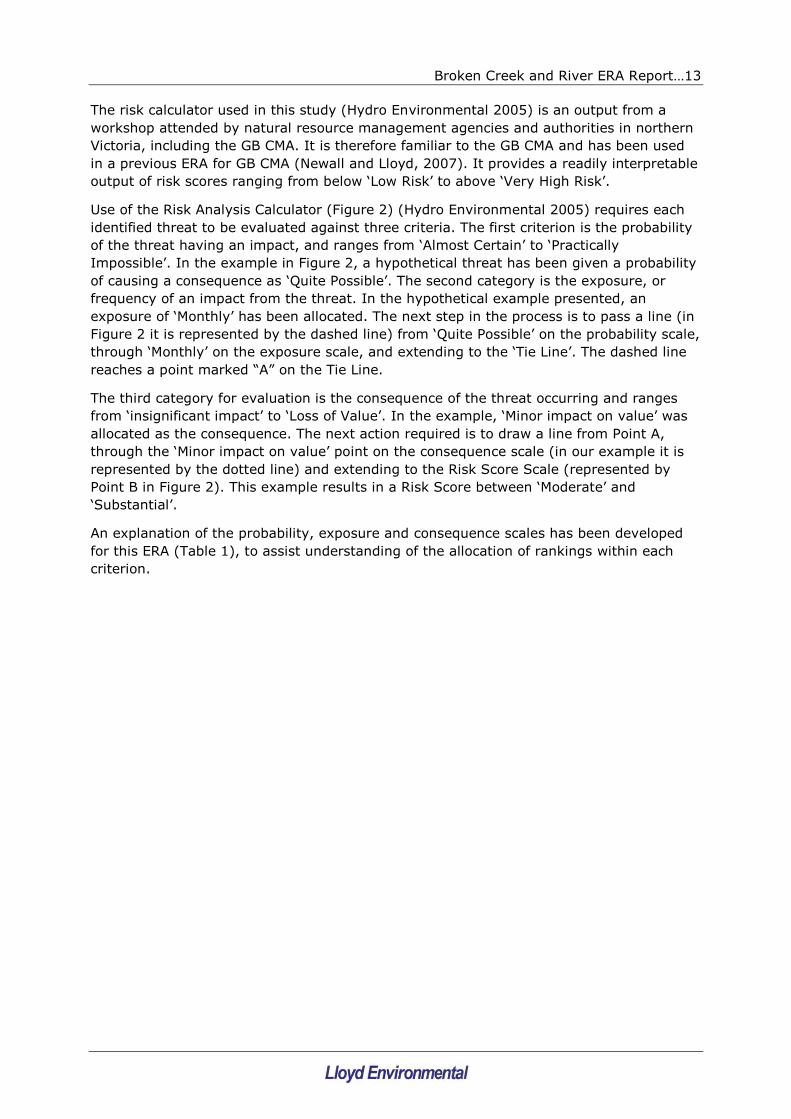
The risk calculator used in this study (Hydro Environmental 2005) is an output from a
workshop attended by natural resource management agencies and authorities in northern
Victoria, including the GB CMA. It is therefore familiar to the GB CMA and has been used
in a previous ERA for GB CMA (Newall and Lloyd, 2007). It provides a readily interpretable
output of risk scores ranging from below „Low Risk‟ to above „Very High Risk‟.
Use of the Risk Analysis Calculator (Figure 2) (Hydro Environmental 2005) requires each
identified threat to be evaluated against three criteria. The first criterion is the probability
of the threat having an impact, and ranges from „Almost Certain‟ to „Practically
Impossible‟. In the example in Figure 2, a hypothetical threat has been given a probability
of causing a consequence as „Quite Possible‟. The second category is the exposure, or
frequency of an impact from the threat. In the hypothetical example presented, an
exposure of „Monthly‟ has been allocated. The next step in the process is to pass a line (in
Figure 2 it is represented by the dashed line) from „Quite Possible‟ on the probability scale,
through „Monthly‟ on the exposure scale, and extending to the „Tie Line‟. The dashed line
reaches a point marked “A” on the Tie Line.
The third category for evaluation is the consequence of the threat occurring and ranges
from „insignificant impact‟ to „Loss of Value‟. In the example, „Minor impact on value‟ was
allocated as the consequence. The next action required is to draw a line from Point A,
through the „Minor impact on value‟ point on the consequence scale (in our example it is
represented by the dotted line) and extending to the Risk Score Scale (represented by
Point B in Figure 2). This example results in a Risk Score between „Moderate‟ and
„Substantial‟.
An explanation of the probability, exposure and consequence scales has been developed
for this ERA (Table 1), to assist understanding of the allocation of rankings within each
criterion.

Broken Creek and River ERA Report…14
B
A
Figure 2: Risk Calculator (example only)

Broken Creek and River ERA Report…15
Table 1: Explanation of scales for the Risk Calculator Criteria
(a) Probability
Probability rating Description
Almost Certain It is expected that this threat will cause some consequence
in almost all circumstances
Quite Possible This threat is likely to cause some consequence in most
circumstances
Unusual but Possible This threat might cause some consequence at some time
Remotely Possible This threat might cause some consequence, but not likely
Conceivable (but very
unlikely)
This threat may cause some consequence but only in
exceptional circumstances
Practically impossible Almost inconceivable that this threat might cause some
consequence
(b) Exposure
Exposure rating Description
10 yearly The ecosystem‟s exposure to any consequences from this
threat will be very rare, at an estimated recurrence of
approximately 10 years
5 yearly The ecosystem‟s exposure to any consequences from this
threat will be rare, at an estimated recurrence of
approximately 5 years
Annually The ecosystem‟s exposure to any consequences from this
threat will be yearly, potentially as part of an annual cycle
of the system (e.g. spring floods) or individual species
(e.g. spawning)
Monthly The ecosystem‟s exposure to any consequences from this
threat will be relatively common, occurring approximately
monthly.
Weekly The ecosystem‟s exposure to any consequences from this
threat will be common, occurring approximately weekly.
Daily The ecosystem‟s exposure to any consequences from this
threat will be continual or nearly so.
Broken Creek and River ERA Report…16
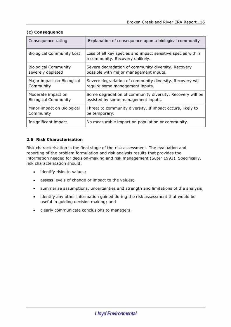
(c) Consequence
Consequence rating Explanation of consequence upon a biological community
Biological Community Lost Loss of all key species and impact sensitive species within
a community. Recovery unlikely.
Biological Community
severely depleted
Severe degradation of community diversity. Recovery
possible with major management inputs.
Major impact on Biological
Community
Severe degradation of community diversity. Recovery will
require some management inputs.
Moderate impact on
Biological Community
Some degradation of community diversity. Recovery will be
assisted by some management inputs.
Minor impact on Biological
Community
Threat to community diversity. If impact occurs, likely to
be temporary.
Insignificant impact No measurable impact on population or community.
2.6 Risk Characterisation
Risk characterisation is the final stage of the risk assessment. The evaluation and
reporting of the problem formulation and risk analysis results that provides the
information needed for decision-making and risk management (Suter 1993). Specifically,
risk characterisation should:
identify risks to values;
assess levels of change or impact to the values;
summarise assumptions, uncertainties and strength and limitations of the analysis;
identify any other information gained during the risk assessment that would be
useful in guiding decision making; and
clearly communicate conclusions to managers.

Broken Creek and River ERA Report…17
3. BROKEN CREEK
3.1 Introduction
The Broken Creek lies within the Goulburn Broken Catchment, diverging from the Broken
River at Caseys Weir west of Lake Mokoan and flowing north-west into the Murray River
(Figure 3). The section of the Broken Creek assessed in this study extends from its point
of divergence with the Broken River, down to its confluence with Boosey Creek near
Katamatite.
Within this section, the Broken Creek is associated with nationally significant wetlands [the
Muckatah Depression and Broken Creek itself have been listed by DIWA (2001)]. State
and nationally threatened flora and fauna have been listed on the floodplain (DIWA 2001),
which contains Public Land Water Frontage Reserves and the Moodie Swamp State Wildlife
Reserve. A range of potential threats to the values of Broken Creek have been identified,
including poor water quality (with declining trends), flow deviation and stock access (GB
CMA 2005).
3.2 Background
The Broken Creek was identified in the Goulburn Broken Regional River Health Strategy
(GB CMA 2005) as not attaining water quality objectives for total nitrogen, total
phosphorus, dissolved oxygen and turbidity as defined in SEPP(WoV). The more recent
review of water quality in the Goulburn Broken Catchment (GB CMA 2008), identified
Broken Creek upstream of Katamatite as a high priority reach for an ecological risk
assessment, based on the Creek‟s continuing failure to attain SEPP(WoV) objectives.
A potentially important impact on the water quality of Broken Creek is the discharge the
creek receives from Lake Mokoan, via Casey‟s Weir. Generally, the discharge from Lake
Mokoan forms all or most of the flow in the Broken Creek above Katamatite. Therefore,
the quality and quantity of the flow in this stretch is almost entirely dependent upon the
discharge from Lake Mokoan.
Lake Mokoan is scheduled to be decommissioned in mid 2009. The recent commissioning
of the Caseys‟ Weir/Major Creek (Tungamah) pipline has reduced the role of the Broken
Creek in delivering irrigation and stock and domestic water.
As a result of the water saving Tungamah Pipeline project, stock and domestic water has
been supplied to landholders in the Tungamah system area eliminating the need for stock
and domestic water supplies to be delivered via the Broken Creek.

Broken Creek and River ERA Report…18
Figure 3: Map of the Broken Creek system, with Reaches 25 – 27 highlighted (Source: GB
CMA 2005)
A detailed discussion of the decommissioning and pipelining is beyond the scope of this
study. However, the following aspects of the new irrigation regime are relevant to the
ecological risk assessment (ERA) of upper the Broken Creek:
irrigation water discharged into Broken Creek will be sourced from the Broken River
(and Lake Nillahcootie rather than from Lake Mokoan;
irrigation water (from the Broken River) will only influence the uppermost reach
(Reach 27) of Broken Creek, with most irrigation water inputs being diverted
before Waggarandall Weir and the small excess water volumes being retained by
the weir;

Broken Creek and River ERA Report…19
Lower volumes of water will be delivered down the Broken Creek, as opposed to
historic flows, as a result of the commissioning of Tungamah Pipeline. Irrigation
water will still be delivered via Upper Broken Creek; and,
downstream of Reach 27, Broken Creek will return to an ephemeral stream with
regular cease-to-flow periods in drier months. Historically there has been an
„inversion‟ in the flow regime, with high summer flows for stock and domestic
purposes, contrasting with the natural flow regime, which typically had low flows
and regular cease-to-flow periods during the summer.
The decommissioning of Lake Mokoan offers the prospect of improved water quality within
the study reach of the Broken Creek. Lake Mokoan has been noted (O‟Brien et al. 1996,
URS 2002) as having poor water quality in terms of turbidity and nutrient concentrations.
An initial comparison of water quality data from Mokoan (at Casey‟s Weir), against Broken
River water upstream of the Lake Mokoan discharge (Holland Creek and Broken River at
Morngag) supports this (Figure 4), showing that the total phosphorus concentrations and
turbidity levels in Casey‟s Weir are substantially higher than the upstream Broken River
sites .This suggests that the input water from Mokoan impacts on the water from
upstream.
Although water from Lake Mokoan may be impacting on the quality of water in the Broken
River, the data presented in Figure 4 also indicate that water quality continues to
deteriorate downstream in the Broken Creek, reaching substantially higher turbidity levels
and total phosphorus concentrations recorded at Katamatite. This is further supported by
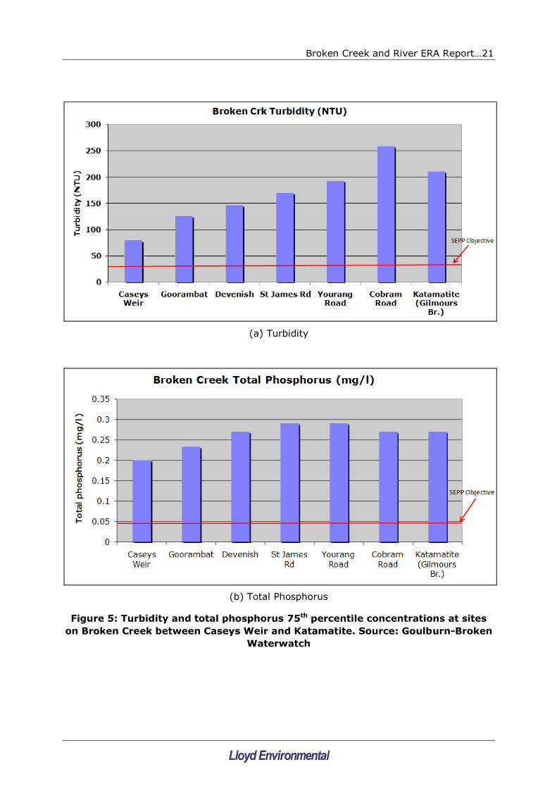
Waterwatch data, showing a trend of increasing turbidity levels and phosphorus
concentrations at several sites between Casey‟s Weir and Katamatite (Figure 5). The data
does not allow a statistical assessment but the rise in these levels are large and ecological
significant. Seventy fifth percentile measures of total phosphorus and turbidity taken by
Waterwatch at the Lake Mokoan outlet are almost identical to those measured at
Goorambat, presented in Figure 5. These data strongly suggest that there are factors
apart from Lake Mokoan impacting on the quality of water in the Broken Creek system
between Casey‟s Weir and Katamatite.
The elevated turbidity concentrations in the waters of Caseys Weir do not correspond with
higher suspended solids levels (refer Case Study 1, p17), suggesting that the turbidity
inputs from Lake Mokoan do not necessarily indicate an increased threat of sedimentation
in the Broken Creek.
Data in Figures 4 and 5 are presented as 75th percentiles as the SEPP (WoV) objectives
are set as 75th percentiles for turbidity and total phosphorus. Data were obtained from the
Victorian Data Warehouse, which contains results from approximately 1980 to present
(Holland Creek and Broken River at Caseys Weir) or 1990 to present (Broken River at
Morngag and Broken Creek at Katamatite) and incorporate at least 200 samples for each
indicator at each site.

Broken Creek and River ERA Report…20
(a) Turbidity
(b) Total Phosphorus
Figure 4: Turbidity and total phosphorus 75th percentile concentrations at
Holland Creek and Morngag (upstream of the Lake Mokoan discharge), the
discharge site (at Caseys Weir) and Katamatite (downstream of the discharge).
Data source: VWQMN
Turbidity Broken Crk
0
20
40
60
80
100
120
140
160
Tu
rb
idit
y N
TU
Holland Creek
Broken River @ Morngag
Broken River @
Caseys Weir
Broken Creek @ Katamatite
Total Phosphorus Broken Crk
0
0.05
0.1
0.15
0.2
0.25
0.3
Holland Creek
Broken River @ Morngag
Broken Creek @ Katamatite
TP
mg
/l
Broken River @ Caseys Weir
Broken Creek and River ERA Report…21
(a) Turbidity
(b) Total Phosphorus
Figure 5: Turbidity and total phosphorus 75th percentile concentrations at sites
on Broken Creek between Caseys Weir and Katamatite. Source: Goulburn-Broken
Waterwatch

Broken Creek and River ERA Report…22
Similar to the results from Case Study 1, Case Study 2 demonstrates an increase in
turbidity over the last decade, accompanied by a decrease in suspended solids
concentrations. However, this temporal decrease in suspended solids must be viewed
within the context of a very large spatial (downstream) increase in both water quality
indicators between Goorambat and Katamatite. Despite a decrease in suspended solids at
Katamatite over the last decade, concentrations remain high.

Broken Creek and River ERA Report…23
3.3 Scope for Broken Creek ERA
The geographical scope of the project covers reaches 27, 26 and 25 (GB CMA 2005) of
Broken Creek (Figure 3). These are defined as:
Reach 27: from the origin of Broken Creek at Casey‟s Weir, to Waggarandall Weir;
Reach 26: from Waggarandall Weir, to Reilly‟s Weir; and
Reach 25: from Reilly‟s Weir to the confluence of Broken Creek and Boosey Creek.
The temporal scope of the project focuses on the future (post-Mokoan) period to 2013
(i.e. 5 years from production of this report). This is because the decommissioning of Lake
Mokoan has been confirmed and management recommendations arising from this study
must be set within that context. This means that the current influences of Lake Mokoan
discharges on the upper Broken Creek must be recognised and removed from the
assessment of post-Mokoan risks.
3.4 Broken Creek Results Part 1: Problem Formulation
3.4.1 Values and Threats
The values highlighted in the Regional River Health Strategy (RRHS) (GB CMA 2005) for
the Broken Creek study area were supplemented during the Problem Formulation Scientific
Workshop. The resulting list of values was:
Association with wetlands of national significance;
Association with Broken Boosey State Park (a unique linear corridor along the
Broken and Boosey Creeks, with substantial occurrences of high quality native vegetation;
Large-bodied native fish (Catfish, Murray cod, Silver perch, Golden perch);
Small native fish (Rainbow fish, Gudgeons, Hardyheads);
Macroinvertebrate fauna;
Riparian zones; and,
Aquatic macrophytes.
Similarly, the threats identified in the RRHS (GB CMA 2005) and during the Scientific
Workshop for the study area of Broken Creek were:
Flow deviation;
Water quality (turbidity, dissolved oxygen, nutrients);
Water quality (SIGNAL Score);
Water quality trends (pH, turbidity);
Stock access;
Introduced flora;
Introduced fauna
Fish barriers; and
Land use (including resultant irrigation runoff, erosion); and,
Water extraction.

Broken Creek and River ERA Report…24
During the Problem Formulation, the threat „water quality (SIGNAL Score)‟ was identified
as a condition of a value (macroinvertebrate community) rather than a threat and was
removed from the list. The „Water quality trend –pH‟ was identified as no longer occurring,
with pH having effectively stabilised (Pat Feehan, personal communication) and was
therefore also removed from the list.
3.4.2 Endpoints and Investigative Question
An „assessment endpoint‟ is a measurable feature of the stream reach that allows accurate
assessment of that feature‟s condition or status. For example, phytoplankton may be a
useful assessment endpoint (or assessment tool) for determining the condition or status of
a water reservoir, due to their response to nutrient concentrations and their influence on
water quality values such as taste and odour. A „measurement endpoint‟ is the critical
aspect of the assessment endpoint that is measured to provide the required information.
For example, „phytoplankton biomass as indicated by chlorophyll-a concentration‟ would
be a useful measurement endpoint for the reservoir.
The list of values for the study area contained several potential study endpoints, including
macroinvertebrate community condition, wetland health and riparian zone condition.
However, the Scientific Workshop determined that the native fish community (large-
bodied and small fish) provide excellent endpoints for determining the condition of the
Creek and assessing any changes due to management actions. This is supported by the
following:
fish are readily identifiable and are a valued component of river ecosystems;
fish are sampled regularly within the Broken system
the condition of the fish community relies on many aspects of ecosystem health,
including several of the other identified values. For example: some species of fish
require healthy wetlands and/or riparian zones for spawning; many species of fish
require an adequate supply of macroinvertebrate fauna for food; the fish
community composition will reflect the influences of flow regimes; and some
species are noted as requiring adequate stands of macrophytes for general habitat
and spawning purposes; and
the fish community is directly and/or indirectly affected by all the water quality
issues that triggered the ERA (turbidity, nutrients, dissolved oxygen).
For this ERA the assessment endpoint is therefore the fish community of the upper Broken
Creek (Reaches 25 to 27 inclusive), and the measurement endpoint is Sustainable Rivers
Fish Index (SR-FI) (MDBC 2004). The Sustainable Rivers Audit (SRA) for the Murray-
Darling Basin established the SR-FI as an overall measure of fish community health. The
index uses the composition and diversity of fish communities and is a good indicator of
river health because it is representative of the quality and quantity of available habitat.
Sampling is conducted in randomly selected 1km reaches on a regular basis. Analysis of
the fish data focuses on fish community composition, including expected versus observed
fish species, the relative abundance by number and weight of native and alien species,
and the age structure of each fish species collected.
The investigative question for this ERA is:
What are the risks to the ecological condition of the native fish community of the
upper Broken Creek (as measured by the SR-FI) from the major threats identified?

Broken Creek and River ERA Report…25
The fish community of the Broken system has been sampled on several occasions (e.g.
Close and Aland 2001, SKM 2008). Table 2 presents the fish species found in the study
reaches and relevant associated ecological information.
The fauna of the Upper Broken Creek is dominated by exotic species (Eastern Gambusia,
Redfin, Carp and Goldfish). The only native fish with high abundance and widespread
distribution are the Australian Smelt and Carp Gudgeon but several are present within the
system including Murray Cod, Golden Perch, Crimson-spotted Rainbowfish and River
Blackfish (McMaster et al. 2008). A significant issue is that the recruitment of native fish
within the system is poor, particularly in comparison to the exotic species. Murray Cod and
Golden Perch populations have been stocked in large numbers (Close and Aland 2001,
McMaster et al. 2008, SKM 2008) indicating these species are likely to be maintained from
stocking and/or emigration from the Broken River rather than local recruitment. The fish
fauna is missing species such as Southern Pygmy Perch, Mountain Galaxias and Flathead
Gudgeon which thought to have been once present. This is not unusual for Southern
Pygmy Perch which has undergone declines across the Murray-Darling Basin but the other
species would be expected to be present. McMaster et al 2008 speculates whether large
stocking of Murray Cod and Golden Perch has increased predation on these smaller
species. It is generally assumed that these large fish being piscivorous may feed upon
smaller fish species and in turn have adverse impacts on the smaller species‟ populations.
The highly regulated flow environment is likely to be the cause of the lack of natural fish
recruitment and a return to a more natural (ephemeral) flow regime will benefit native
species and disadvantage exotic fish. This assumption is being tested by detailed work
being undertaken by Monash University on behalf of GB CMA in the Broken Creek system.

Broken Creek and River ERA Report…26
Table 2: Fish species found in the study reaches of Broken Creek and
associated ecological information
Reach Large-bodied
species
Small-bodied species Ecological notes
27 (Casey‟s to
Waggarandall
Weir)
Murray Cod
Golden Perch
(Exotics: Carp)
Australian Smelt
Carp Gudgeon
Rainbowfish
Blackfish
(Exotics: Goldfish,
Gambusia)
Moderate to good habitat with
a variety of channel and weir
pool habitats containing a
moderate amount of large
woody debris. Perennial flow
retains permanent habitat for
large bodied fish (e.g. Murray
cod and Golden Perch)
Threats include: Exotic fish,
Stock access, poor water
quality (such as high turbidity,
high nutrients and low
dissolved oxygen)
26
(Waggarandall
to Reilly‟s Weir)
Golden Perch
(Exotics: Carp)
Australian Smelt
Carp Gudgeon
Blackfish
(Exotics: Carp, goldfish,
Gambusia,
Weatherloach)
Moderate habitat with a variety
of channel and weir pool
(McLaughlin‟s Weir & Reilly‟s)
habitats containing a low
amount of large woody debris.
Currently* perennial flow (but
lower than Reach 27) retains
permanent habitat for golden
perch but lack of deeper pools
probably limits Murray cod.
Post-Mokoan, more ephemeral
flows will restrict large-bodied
species and encourage smaller
fish.
Threats include: Exotic fish,
significant flow deviation
from natural, poor
invertebrate communities
(indicating poor water
quality via Signal Score),
fish barrier @ Reilly‟s, stock
access, introduced flora and
introduced fauna.
25 (Reilly‟s Weir
to Katamatite)
Golden Perch
(Exotics: Carp)
Australian Smelt
Carp Gudgeon
(Exotics: Carp, Goldfish,
Redfin, Gambusia,
Weatherloach)
Moderate to poor habitat with
a small uniform channel
containing a low amount of
large woody debris. Currently*
perennial flow (but more
natural than upstream
reaches). Lack of pools
probably limits larger fish.
Post-Mokoan, more ephemeral
flows will restrict large-bodied
species and encourage smaller

Broken Creek and River ERA Report…27
fish.
Threats include: Exotic fish,
poor water quality during
prolonged cease-to-flow
periods (high turbidity, low DO
and high nutrients), flow
deviation from natural, and
poor invertebrate
communities (indicating
poor water quality via
Signal Score).
*’Currently’ refers to situation with Lake Mokoan operating

Broken Creek and River ERA Report…28
3.4.3 Conceptual Model
Using the measurement endpoints and the threats to values presented in the previous
Section, a conceptual model was derived for the fish community as an indicator of
ecological condition (Figure 6). The threats to the fish community were divided into direct
threats (those that have the potential to directly impact upon the native fish community);
and indirect threats (those that contribute to the direct threats). For example, „Physical
habitat destruction‟ is a direct threat to the fish community. Factors that may contribute to
Physical habitat destruction, such as stock access to the riparian zone or sedimentation
are indirect threats. The direct threats are represented by the red text boxes in Figure 6
and include:
flow regulation;
barriers to fish movement;
turbidity;
sedimentation;
dissolved oxygen;
introduced pest fish;
introduced plant species; and,
physical habitat destruction.
Flow Regulation: There are two dams upstream of Caseys Weir, Lake Mokoan and Lake
Nillahcootie, which currently regulate flows in the Broken Creek. Lake Mokoan will be
decommissioned and it is expected that as part of changes to the system, flows will
decrease downstream of Flynn‟s Weir, changing the Creek from perennial to ephemeral.
Substantial irrigation pumping is undertaken from Broken Creek between Casey‟s Weir
and Flynns Weir, but this is not expected to affect the perennial nature of the creek
between Casey‟s Weir and Flynn‟s Weir.
Barriers to fish movement: All existing barriers in the Broken Creek downstream of
Katamatite have had fish passage provision installed. In the reaches from Katamatite up
to Casey‟s Weir, Irvine‟s, Reilly‟s, Waggarandall, and Flynn‟s Weirs have all been identified
as fish barriers. Further, a gauging station within the Creek has also been identified as a
potential fish barrier.
Turbidity: Turbidity levels are currently high downstream of Caseys Weir. Turbidity levels
in the Broken River upstream of Caseys Weir are low, suggesting that when Lake Mokoan
is decommissioned levels will decrease substantially. However, similar to nutrient levels,
turbidity increases markedly in the Broken Creek downstream of Casey‟s Weir (Figure 5b),
suggesting that there are other major sources of nutrients entering the stream between
Casey‟s Weir and Katamatite.
Sedimentation: Current turbidity levels immediately downstream of Caseys Weir are high
enough to suggest that a sedimentation threat may exist. However, suspended solids
concentrations in this section are low, suggesting that the turbidity is due to very fine
colloidal material from Lake Mokoan and will contribute little to sedimentation. In contrast,
turbidity and suspended solids both increase to high levels downstream of Goorambat,
indicating a potential threat from sedimentation.
In the past, upstream catchment erosion has been a major source of sediment. This has
resulted in silting of pools and smothering of large woody debris in uppermost reach
(Reach 27) of the Broken Creek (SKM 2006). Ongoing bank and riparian zone erosion are
potential continuing sources of sediment within the Creek. Works are underway to assess

Broken Creek and River ERA Report…29
the usefulness of reinstating deep pools and the effects of sediment load to the creek will
need to be assessed.
Dissolved oxygen: Dissolved oxygen concentrations can be low at times, but
measurements suggest these are not at levels dangerous to native fish. Changes in flow
regime, especially the ephemeral reaches downstream of Flynn‟s Weir, may result in very
low oxygen levels during prolonged dry periods where the pools develop substantial
phytoplankton communities. Sediment oxygen demand may also result in pools with large,
oxygen-consuming, organic loads during prolonged dry spells.
Macrophytes will also influence oxygen levels although macrophytes densities are
generally low. However, the native species, Azolla filliculoides (a floating fern) does form
thick mats on some pools. Macrophyte densities may increase if turbidity levels decrease.
Introduced fish species: Competition and predation by pest fish species is currently
important, and changes in flow regime may, and water quality will, affect them and their
relationships with native species. One mechanism is that Redfin have a competitive
advantage under conditions of low turbidity in their predation ability. Other mechanisms
include the hardiness of Carp and Gambusia under extreme water quality conditions (e.g.
low DO) and these fish have a competitive advantage over natives in these conditions.
Introduced macrophytes: Currently there are no major impacts of introduced
macrophytes on the fish community upstream of Katamatite. Cabomba (Cabomba
caroliniana) has been observed in Casey‟s weir and is therefore a potential threat to
Broken Creek, especially if flows are reduced. In the potentially ephemeral reaches
downstream of Flynn‟s Weir, the potential risk is substantially higher.
Physical habitat destruction: Suitable physical habitat is critical for a healthy fish
community and includes in-stream and riparian zone habitat. Submerged macrophytes in
Broken Creek are generally restricted to scattered clumps, which is likely due to the high
turbidity levels restricting light required for plant growth. Decommissioning of Mokoan
may reduce turbidity levels in the upper parts of the creek, resulting in increased
macrophyte growth. Large wood material is common in the creek and is the major
physical habitat available to fish.
The riparian zones are the major source of organic matter, insects, shading and large
woody debris to the creek. The creation of the Broken-Boosey State park recognises the
value of the riparian zone in the Broken Creek. Grazing access to the riparian zone
seriously impacts its integrity. Decreased sediment loads from the banks of the creek due
to fencing (removing stock access) and revegetation works may reduce the sedimentation
threat to the physical habitat.
Among the indirect threats, the major ones are:
Nutrients: Nutrients themselves do not pose a direct threat to the fish community.
However, elevated nutrient concentrations may lead to excessive growths of algae and
macrophytes. Nutrient concentrations downstream of Caseys Weir are currently high
enough to promote excessive plant growth. However, turbidity is also very high which
limits plant growth due to light limitation. Therefore, nutrients pose a threat to Broken
Creek but the threat is not being activated due the turbidity. Nutrient levels in the Broken
River upstream of Caseys Weir are low, suggesting that when Lake Mokoan is
decommissioned these levels will decrease substantially in the Broken Creek at Caseys
Weir. However, nutrient levels downstream in the Broken Creek increase substantially
(Figure 5a), suggesting that there are other major sources of nutrients downstream of
Caseys Weir. Irrigation return waters and bed and bank erosion are possible sources.

Broken Creek and River ERA Report…30
Land use: The adjacent land use will determine the level of sediment and nutrient
transported to the creek. In general, broad-acre cropping and grazing are not considered
to be a major source of sediment and nutrients to the creek except when they encroach
on the riparian zone. Irrigation however, may deliver substantial quantities of sediment
and nutrients to waterways via irrigation return waters. The increasing concentrations of
total phosphorus and turbidity with distance downstream indicate that some forms of
surrounding land use (including stock access) are contributing to water quality problems.
Direct stock access to streams: Stock access to riparian zones is major cause of
erosion and subsequently a major source of sediment to waterways, and for this reason is
a major focus of management actions. In general, the banks of the Broken Creek are
relatively stable and the level of erosion low, therefore, as a source of sediment and
nutrients the banks of the creek are likely to be low if stock access is removed.

Broken Creek and River ERA Report…31
Figure 6: Conceptual Model of threats to the fish community in the upper Broken Creek

Broken Creek and River ERA Report…32
3.5 Broken Creek Results Part 2: Preliminary risk analyses
The preliminary risk analysis of the upper Broken Creek was undertaken as a workshop by
the authors of this report. In addition to the authors‟ aquatic ecological expertise
(including ecology of fish, algae, macrophytes and macroinvertebrates; water quality;
impacts and management of high nutrients; and catchment management) and collective
experience with the natural resource management issues of the Broken Creek, the
analyses were informed by formal meetings and informal discussions with relevant staff of
the GB CMA, members of the MGBIC and local/regional Waterwatch participants.
The preliminary risk analysis was undertaken for two separate zones within the Creek: (i)
the zone upstream of Flynn‟s Weir; and (ii) the zone from Flynn‟s Weir to Katamatite. The
first zone will continue to receive flows from Casey‟s Weir following the decommissioning
of Lake Mokoan. As a result of the Tungemah pipeline, the second zone will not receive
flows, resulting in several different assessment outcomes from the preliminary risk
analyses. The results from the use of the risk calculator are tabulated and presented in
Table 3.
While fish communities the Broken Creek may be better than in other locations in Victoria,
they are still considered depauperate in relation to their original condition. Some species
are missing or in very low numbers (Catfish, Purple-spotted Gudgeons, Pygmy Perch,
Mountain Galaxias, Flathead Gudgeon & River Blackfish) and common fish are lower than
historical levels (J.O. Langtry in Cadwallader 1977) reports very high levels of native fish
present in Murray system). This risk assessment considered this information as it formed
background information about the ability of the fish fauna to respond to threats and
changed operating conditions.

Broken Creek and River ERA Report…33
Table 3: Risk Scores for the Preliminary and Qualitative Risk Assessment for ecological threats in Broken Creek
Reaches 25 - 27
Threat Source of
potential
threat
Probability Exposure Consequence Risk
Calculator
Score
Flow
regulation
Discharge from
Casey‟s Weir u/s
Flynns
Almost certain Annual to
monthly
Moderate - Major
No Cease to flow – predators remain
Breeding cues reduced
Habitat changed
Production reduced due to lack of flooding
High to
Very High
Discharge from
Casey‟s Weir d/s
Flynns
Conceivable
(but very
unlikely)
5 yearly Insignificant
Little flow change on natural
Low
Fish barriers Irvine & Reilly‟s
Weir
Almost certain Daily Moderate
Prevent breeding migration
Prevent smaller fish to find mates, food resources
and breeding habitat
Very High
Nutrients
(note: not a
direct threat;
impact via
macrophyte
growth &
algal blooms)
Upstream
catchment
Conceivable
(but very
unlikely)
5 to 10
yearly
Insignificant
Short term event
Nutrient increase will be minor in relation to
background levels
Low
Bed Sediments
u/s Flynn‟s
Weir
Conceivable
to Practically
Impossible
10 yearly
Minor
Short term event
Nutrient increase and algal response will be minor in
relation to seasonal conditions (cold)
Low

Broken Creek and River ERA Report…34
Threat Source of
potential
threat
Probability Exposure Consequence Risk
Calculator
Score
Bed Sediments
d/s Flynn‟s
Weir
Quite Possible Annual to 5
yearly
Moderate
DO sags of below 2mg/l
Initial major impact as large fish will be
disadvantaged and small fish will thrive – moderate
on small fish
Moderate to
Substantial
Stream banks Quite Possible Monthly Moderate
Nutrients will cause DO sags of below 2mg/l
Initial major impact as large fish will be
disadvantaged and small fish will thrive – moderate
on small fish
Substantial
to High
Adjacent land
use
Quite Possible Monthly Moderate
Nutrients will cause DO sags of below 2mg/l
Initial major impact as large fish will be
disadvantaged and small fish will thrive – moderate
on small fish
Substantial
to High
Dissolved
oxygen
Phytoplankton
u/s Flynn‟s
Weir
Conceivable
to Practically
Impossible
10 yearly Minor
Short term event
Nutrient increase and algal response will be minor in
relation to seasonal conditions (cold)
Low
d/s Flynn‟s
Weir
Quite Possible Annual Moderate
DO sags of below 2mg/l
Initial major impact as large fish will be
disadvantaged and small fish will thrive – moderate
on small fish
High to
Very High
Broken Creek and River ERA Report…35
Threat Source of
potential
threat
Probability Exposure Consequence Risk
Calculator
Score
Macrophytes
u/s Flynn‟s
Weir
Conceivable
to Practically
Impossible
10 yearly Minor to Insignificant
Short term event
Nutrient increase and macrophyte response will be
slower than algae in relation to seasonal conditions
(cold)
Cabomba might cause DO problems in weir pools
but fish can avoid these pools
Low
Macrophytes
d/s Flynn‟s
Weir
Remotely
Possible
Annual Moderate
DO sags of below 2mg/l
Initial major impact as large fish will be
disadvantaged but small fish will thrive – moderate
impact on small fish
Pools will be isolated and fish can escape
Low to
Moderate
Sediment oxygen
demand
u/s Flynn‟s
Weir
Conceivable
to Practically
Impossible
10 yearly Minor
Short term event
Nutrient increase and algal response will be minor in
relation to seasonal conditions (cold)
Low
Sediment oxygen
demand
d/s Flynn‟s
Weir
Quite Possible Annual to 5
yearly
Moderate
DO sags of below 2mg/l
Initial major impact as large fish will be
disadvantaged and small fish will thrive – moderate
on small fish
Moderate to
Substantial

Broken Creek and River ERA Report…36
Threat Source of
potential
threat
Probability Exposure Consequence Risk
Calculator
Score
Turbidity Upstream
catchment
Conceivable
(but very
unlikely)
5 to 10
yearly
Insignificant
Short term event
Turbidity increase will be minor in relation to
background levels
Low
Stream banks Quite Possible Monthly Minor
Predation from exotics will be lower
Most native will not be affected significantly
Some macrophytes may be affected and have
reduced habitat fish
Moderate to
Substantial
Adjacent land
use
Quite Possible Monthly Minor
Predation from exotics will be lower
Most native will not be affected significantly
Some macrophytes may be affected and have
reduced habitat fish
Moderate to
Substantial
Sedimentation Upstream
catchment
Conceivable
(but very
unlikely)
5 to 10
yearly
Insignificant
Short term event
Sediment increase will be minor in relation to
background levels
Sediment level needs to be very high to have impact
Low

Broken Creek and River ERA Report…37
Threat Source of
potential
threat
Probability Exposure Consequence Risk
Calculator
Score
Stream banks Quite Possible Weekly Minor
Threat to community diversity but likely to be
temporary
Sediment increase will be minor in relation to
background levels
Sediment level needs to be high to have impact
Substantial
to High
Adjacent land
use
Quite Possible Weekly Minor
Threat to community diversity but likely to be
temporary
Sediment increase will be minor in relation to
background levels
Sediment level needs to be high to have impact
Substantial
to High
Introduced
fish
Almost
Certain
Daily Moderate Impacts – some species will decline – all
species will have reduced impacts
Very High
Introduced
macrophytes
u/s Flynn‟s
Weir
Remotely
Possible
Annually Minor - Moderate
Exotic macrophytes will reduce and change nature of
habitat for fish and cause oxygen sags at times –
not just minor consequence as some impacts will
not be temporary
Low (to
Moderate)
d/s Flynn‟s
Weir
Quite Possible Monthly to
Annual
Major
Large infestation of Exotic macrophytes will
significant reduce habitat and change nature of
habitat for fish. Also will cause oxygen sags at times
High to
Very High

Broken Creek and River ERA Report…38
The highest risks to the fish community identified through the preliminary risk analysis
were the impacts of fish barriers and introduced fish (both „very high risk‟). These
were primarily a function of exposure, whereby both these threats impact on the fish
community every day, and also a function of probability, with it being almost certain that
the threats have an impact on the fish community. The next highest risks („high to very
high‟) were identified as flow regulation in the section of the Creek upstream of Flynn‟s
Weir, and low dissolved oxygen and introduced macrophytes in the section of the
Creek downstream of Flynn‟s Weir. Risks from introduced fish are probably the most
difficult to manage. The remaining threats are more manageable, although at varying
costs.
Fish barriers create a variety of problems for individual fish species. For some species
the major impact upon long term survival of the population is by stopping genetic
exchange that would normally occur through finding new mating partners. Barriers to
movement also restrict opportunities for finding new territories for migration and
population expansion, as well as expanding hunting grounds.
Introduced fish - European carp uproot aquatic macrophytes, increasing turbidity and
may compete for food and habitat. Eastern Gambusia also compete for food and habitat,
with small bodied fish and juvenile large-bodied fish and prey on eggs and young of all
native fish. Gambusia is also known to attack the fins of fish much larger than itself
causing them stress and diseases (Lloyd et al. 1986). Small native fish such as Pygmy
Perch are particularly vulnerable to Gambusia (Lloyd 1990). Impacts from Goldfish and
Weatherloach are unknown but if large populations arise they may consume food and
habitat resources of native fish.
The impacts of ongoing flow regulation on the fish population upstream of Flynn‟s Weir
include reduced breeding cues for native species, less habitat heterogeneity from continual
flows, predators remaining and a reduced flooding regime which reduces production within
the system. Sliver and Golden Perch both require flow freshes to stimulate breeding and
Murray Cod recruitment is also enhanced by flow freshes, especially those which connect
marginal and floodplain wetlands. All these species also undertake pre and post-spawning
migrations which if prevented will reduce the reproductive success of these large fish
species. Murray Cod larvae drift downstream and if they are not able to migrate upstream,
the larvae will be washed out of the reach (Koehn & Harrington 2006).
As displayed in the conceptual model (Figure 6), dissolved oxygen is influenced by many
factors. The allocation of a „high to very high‟ risk score for dissolved oxygen
concentrations downstream of Flynn‟s Weir was based on the increased likelihood of
cease-to-flow periods during dryer months, combined with high nutrient concentrations.
Lack of flow reduces aeration of water bodies, particularly pools in warmer seasons. Lack
of flow also promotes settling of suspended particulate matter, thereby increasing light
transmission through the pools and promoting algal growth. Algal growth is already
favoured by the high nutrients within the pools. High algal biomass contributes to
dissolved oxygen stress through two mechanisms. Firstly, although the algae
photosynthesise during the day (producing high dissolved oxygen concentrations), they
also respire (consuming oxygen). During the night, the respiration is not balanced with
oxygen production, leading to an oxygen trough (and a severe oxygen stress for the fish
community) in the water body when algae are present in very high concentrations.
The second mechanism by which high algal concentrations create oxygen stress is through
die-off at the end of their growing period. The decaying (oxidising) algal cells create an
oxygen demand on the water body that can create oxygen troughs for days or even

Broken Creek and River ERA Report…39
weeks, again stressing or even killing the fish community. When this impact occurs in a
flowing system, the fish can often swim to more suitable habitats. However, when this
occurs in pools, the fish are trapped.
The risks posed by introduced macrophytes (in particular, Cabomba) include substantial
loss of physical habitat through prolific growth filling in most available space within a
water body. A large biomass of aquatic weed would also contribute to a diurnal sag in
dissolved oxygen, as described for algal blooms, and the risk will be increased during
cease-to-flow periods.
3.6 Knowledge Gaps and Assumptions for Broken Creek ERA
Knowledge gaps: The major knowledge gaps identified during the development of this
risk assessment, with emphasis on highest risks, include:
quantitative information on the fish species in the study reach of the Broken Creek and
data on the impacts of fish barriers to the native fish community;
quantitative information on the abundance (and its variability) of introduced fish
species and their impact on the distribution and abundances of native fish populations
in the relevant study reaches of the Broken Creek;
quantitative information on the influences of future flow regimes (particularly in the
lower parts of the study) on dissolved oxygen regimes. This information can be
gathered through field studies following the decommissioning of Lake Mokoan;
information on nutrient and turbidity inputs to the Broken Creek downstream of
Caseys Weir. Evidence suggests that there are other sources of nutrients and turbidity
entering the creek downstream of the weir, further increasing the already elevated
measures of these indicators;
extent and rate of sediment inputs to the Broken Creek from adjacent catchment and
riparian land use;
data on the quality and volume of stormwater discharged to the river from Benalla is
unknown. Nutrient and sediment levels increase in Benalla Lake and downstream
(Figure 7) but there are no data on toxicants. It is likely that many of the toxicants
entering Benalla Lake will settle out in the lake and are unlikely to have impacts
further downstream (Hurl et al. 1999; Wong et al. 1999, 2003; Fletcher et al. 2004).
Uncertainties and assumptions: As with any study of lowland rivers, the complexity of
the system can lead to substantial uncertainties, however, all effort has been made to
reduce uncertainties through the identification and analysis of all identified threats. This is
a strength of the ERA approach. A weakness in the process has been the lack of data or
information on nutrient and sediment sources in the creek downstream of Caseys Weir. In
particular, the influence of elevated suspended solids downstream of Goorambat is a high
uncertainty in relation to the native fish community in the post-Mokoan period.
While many assumptions have been made concerning the needs of fish, particularly with
respect to water quality, these are generally based on substantial expert knowledge,
patterns of distribution or known cause effects relationships. Key assumptions include:
Flows in Broken Creek below Flynns Weir will reduce to zero during annual dry
periods
Climate change will not lead to a situation where the majority of the Creek is
completely dry for large periods of time

Broken Creek and River ERA Report…40
dissolved oxygen concentrations around 85% saturation are unlikely to harm any
native fish species and can in fact drop to 2-3ppm before native species are likely
to be impacted (Hydro Environmental 2006), whereas some exotic species are
more likely to withstand those conditions and only become stressed at almost
anoxia (Lloyd et al. 1986).
Fish barriers do prevent fish movement between reaches and no other natural
barriers exist.
That changes to flow regimes will benefit native fish more than exotic species.
The introduced weed Cabomba caroliniana is currently found in Benalla Lake and
Caseys Weir pool and while the extent and speed of spread is unknown it is
believed to be able to infest all standing water bodies downstream.

Broken Creek and River ERA Report…41
4. BROKEN RIVER
4.1 Introduction
The Broken River originates on the north draining slopes of the Great Dividing Range, near
Tolmie, and flows generally north then west to join the Goulburn River at Shepparton. The
focus of this ecological risk assessment is the Broken River from its confluence with
Holland Creek, down to its confluence with the Goulburn River at Shepparton. This section
of river has high community value, is associated with wetlands of national significance and
supports significant fauna and flora, including listed species (Silver Perch, Macquarie Perch
and Murray Cod). In addition, the river has substantial social values (camping, fishing,
passive recreation) and economic benefits (irrigation, domestic and stock water supply).
The lower Broken River consistently triggers the SEPP (WoV) objectives for turbidity,
nutrients and dissolved oxygen, indicating risk to the aquatic ecosystem.
4.2 Background
The Broken River was identified in the Goulburn Broken Regional River Health Strategy
(GB CMA 2005) as not attaining water quality objectives for total nitrogen, total
phosphorus, dissolved oxygen and turbidity as defined in SEPP(WoV). In a more recent
review of water quality in the Goulburn Broken Catchment (GB CMA 2008), Broken River
between Benalla and Shepparton was identified as a high priority reach for an ecological
risk assessment, based on the Creek‟s continuing failure to attain SEPP(WoV) objectives.
A potentially important impact on the water quality of Broken River is the discharge the
River receives from Lake Mokoan, via Stockyard Creek above Casey‟s Weir. The discharge
from Lake Mokoan mixes with waters from upstream in the Broken River (including inputs
from tributaries such as Holland Creek and Ryans Creek) and forms a significant part of
the flow in the Broken River. Therefore, the quality and quantity of the flow in this stretch
is influenced by the discharge from Lake Mokoan.
Lake Mokoan is scheduled to be decommissioned in mid 2009. Upon the decommissioning,
Broken River will return to near-natural flows (Broken River Scientific Panel, 2001), with
the only river regulation coming from Lake Nillahcootie – a relatively small storage of only
40 GL.
The decommissioning of Lake Mokoan offers the prospect of improved water quality within
the study reach of the Broken River. Lake Mokoan has been noted (O‟Brien et al. 1996,
URS 2002) as having poor water quality in terms of turbidity and nutrient concentrations.
An initial comparison of water quality data from Mokoan (at Casey‟s Weir) supports this
(Figure 4, Section 3), showing that the total phosphorus concentrations and turbidity
levels in Casey‟s Weir are substantially higher than the Broken River sites upstream of
Casey‟s Weir (Holland Creek and Morngag). This suggests that the input water from
Mokoan impacts on the water from upstream. Although waters from Lake Mokoan may be
impacting water quality of the water from Broken River, data presented in Figure 7
indicate that water quality continues to deteriorate downstream in Broken River, with
water at Gowangardie having higher total phosphorus concentrations and turbidity levels
than at Caseys Weir. The high turbidities recorded at Gowangardie Weir, however, are not
matched by suspended solids concentrations (VWQMN 2008), indicating little potential risk
of sedimentation impacts.

Broken Creek and River ERA Report…42
(a) Turbidity
(b) Total Phosphorus
Figure 7: Turbidity and total phosphorus concentrations at sites on Broken River
from near the headwaters to Archer Street (Shepparton). Source: Goulburn-
Broken Waterwatch
Data in Figure 7 are presented as 75th percentiles as the SEPP (WoV) objectives are set as
75th percentiles for turbidity and total phosphorus. Data were obtained from the Goulburn-
Broken Waterwatch group and ranges from approximately 1996 to 2008. These data
strongly suggest that there are ongoing impacts to water quality of the Broken River
system between Casey‟s Weir and Gowangardie Weir. Interestingly, both turbidity and
total phosphorus decline slightly between Gowangardie and Archer St. in Shepparton
(Figure 7), but it is unsure whether this decline is significant.

Broken Creek and River ERA Report…43
4.3 Scope for Broken River ERA
The geographical scope of the project covers reaches 3, 2 and 1 (GB CMA 2005) of Broken
River (Figure 8). These are defined as:
Reach 3: From the confluence of Broken River and Holland Creek, down to Caseys
Weir;
Reach 2: From Caseys Weir, down to Gowangardie Weir; and
Reach 1: From Gowangardie Weir down to the confluence of Broken River and the
Goulburn River.
The temporal scope of the project focuses on the future (post-Mokoan) period to 2013
(i.e. 5 years from production of this report). This is because the decommissioning of Lake
Mokoan has been confirmed and management recommendations arising from this study
must be set within that context. This means that the current influences of Lake Mokoan
discharges on the lower Broken River must be recognised and removed from the
assessment of post-Mokoan risks.

Broken Creek and River ERA Report…44
Figure 8: Map of the Broken River system, with Reaches 1 – 3 highlighted (Source: GB
CMA 2005)

Broken Creek and River ERA Report…45
4.4 Broken River Results Part 1: Problem Formulation
4.4.1 Values and Threats
The values highlighted in the Regional River Health Strategy (RRHS) (GB CMA 2005) for
the Broken River study area were similar to those identified for Broken Creek, and the
examination of values and threats at the Problem Formulation Scientific Workshop
produced similar lists:
Values
Wetland of national significance (DIWA wetland, Lower Broken River)
Large-bodied fish (Catfish, Murray Cod, Silver Perch, Golden Perch; Macquarie
Perch);
Small fish (River Blackfish, Rainbowfish, Gudgeons, Australian Smelt, Hardyheads);
Macroinvertebrate fauna;
Riparian zones; and,
Aquatic macrophytes.
Threats
Flow deviation;
Water quality (turbidity, dissolved oxygen, nutrients);
Stock access;
Introduced flora;
Introduced fauna
Fish barriers;
Land use (including potential irrigation runoff, erosion); and,
Water extraction.
4.4.2 Endpoints and Investigative Question
The similarity in the list of values between the upper Broken Creek and the lower Broken
River resulted in the same endpoints being selected – the native fish community. The
native fish community (large-bodied and small fish) provides excellent endpoints for
determining the condition of the River and assessing any changes due to management
actions. This is supported by the following:
fish are readily identifiable and valued component of river ecosystems
fish are sampled regularly within the Broken system
the condition of the fish community relies on many aspects of ecosystem health,
including several of the other identified values. For example: some species of fish
require healthy wetlands and/or riparian zones for spawning; many species of fish
require an adequate supply of macroinvertebrate fauna for food; the fish
community composition will reflect the influences of flow regimes; and some

Broken Creek and River ERA Report…46
species are noted as requiring adequate stands of macrophytes for general habitat
and spawning purposes; and
the fish community is directly or indirectly affected by all the water quality issues
that triggered the ERA (turbidity, nutrients, dissolved oxygen).
For this ERA the assessment endpoint is therefore the fish community of the lower Broken
River (Reaches 3 to 1 inclusive), and the measurement endpoint is Sustainable Rivers Fish
Index (SR-FI) (MDBC 2004). The Sustainable Rivers Audit (SRA) for the Murray-Darling
Basin established the SR-FI as an overall measure of fish community health. The index
uses the composition and diversity of fish communities and is a good indicator of river
health because it is representative of the quality and quantity of available habitat.
Sampling is conducted in randomly selected 1km reaches on a regular basis. Analysis of
the fish data focuses on fish community composition, including expected versus observed
fish species, the relative abundance by number and weight of native and alien species,
and the age structure of each fish species collected.
The investigative question for this ERA is:
What are the risks to the ecological condition of the native fish community of lower
Broken River (as measured by the SR-FI) from the major threats identified?
The fish community of the Broken system has been sampled on several occasions (e.g.
Close and Aland 2001, SKM 2008). Table 4 presents the fish species found in the study
reaches and relevant, associated ecological information. These surveys show that the
Broken River has a reasonably diverse native fish fauna with seventeen native fish species
of fish (Close and Aland 2001). Unfortunately, since European settlement, the Broken
River now also supports eight species of exotic fish. Significantly, Australian Smelt,
Southern Pygmy Perch, Mountain Galaxias, Flathead Galaxias and Carp Gudgeon are all
common in the Broken River (Close and Aland 2001). The river also supports populations
of listed large-bodied fish as well such as Trout Cod, Murray Cod, Macqurie Perch, and
Silver Perch (though Trout Cod may be maintained by repeated stockings (DNRE 2001).
The near natural flow regime of the Broken River means that breeding and recruitment of
native fish occurs regularly and changes from the decommissioning of Lake Mokoan will
only reinforce this healthy community.
4.4.3 Conceptual Model
Using the measurement endpoints and the threats to values presented in the previous
Section, a conceptual model was derived for the fish community as an indicator of
ecological condition. Again, the similarity between the Broken Creek study area and the
Broken River study area has resulted in the same conceptual model being produced
(Figure 6, repeated here as Figure 9).

Broken Creek and River ERA Report…47
Table 4: Fish species found in the study reaches of the lower Broken
River, with associated ecological information
Reach Large-bodied
species
Small-bodied
species
Ecological notes
3 (confluence of
Broken River
and Holland
Creek, down to
Caseys Weir)
Murray Cod
Silver Perch
Golden Perch
Australian Smelt
Gudgeon
Rainbowfish
Blackfish
(Exotics: Carp,
Goldfish, Gambusia)
Moderate to good habitat
with a variety of channel and
weir pool habitats containing
a moderate amount of large
woody debris. Perennial flow
retains permanent habitat for
large bodied fish (e.g. Murray
Cod, Silver Perch and Golden
Perch).
The major threats are
perceived to be water quality
decline, stock access, flow
regulation, and sedimentation
(especially in pool habitat).
2 (Caseys Weir,
down to
Gowangardie
Weir)
Murray Cod
Golden Perch
Australian Smelt
Gudgeon
Rainbowfish
Blackfish
(Exotics: Carp,
Goldfish, Gambusia)
Moderate to good habitat
with a variety of channel and
weir pool habitats containing
a moderate amount of large
woody debris. Perennial flow
retains permanent habitat for
large bodied fish (e.g. Murray
Cod and Golden Perch).
The major threats are
perceived to be water quality
decline, stock access, flow
regulation, and sedimentation
(especially in pool habitat).
1 (Gowangardie
Weir down to
the confluence
of Broken River
and the
Goulburn River)
Murray Cod
Macquarie Perch
Australian smelt
Gudgeon
Blackfish
(Exotics: Carp,
Goldfish, Gambusia)
Moderate to good habitat
with a variety of channel and
weir pool habitats containing
a moderate amount of large
woody debris. Perennial flow
retains permanent habitat for
large bodied fish (e.g. Murray
Cod and Macquarie Perch).
The major threats are
perceived to be water quality
decline, stock access, flow
regulation, and sedimentation
(especially in pool habitat).

Broken Creek and River ERA Report…48
Figure 9: Conceptual Model of threats to the fish community in the lower Broken River

Broken Creek and River ERA Report…49
The threats to the fish community were divided into direct threats (those that have the
potential to directly impact upon the native fish community); and indirect threats (those
that contribute to the direct threats). For example, „Physical habitat destruction‟ is a direct
threat to the fish community. Factors that may contribute to Physical habitat destruction,
such as stock access to the riparian zone or sedimentation are indirect threats. The direct
threats are represented by the red text boxes in Figure 6 and include:
flow regulation;
barriers to fish movement;
turbidity;
sedimentation;
dissolved oxygen;
introduced pest fish;
introduced plant species; and,
physical habitat destruction.
Flow regulation: There are two dams upstream of Caseys Weir which currently regulate
flows in the Broken River. It is expected that a lower flow deviation will occur in Broken
River as a result of decommissioning Lake Mokoan i.e. a closer to natural flow regime.
Irrigation pumping is undertaken downstream, but this is not expected to affect the flow
regime of the river.
Barriers to fish movement: Gowangardie weir currently acts as a barrier to fish
migration. Casey‟s weir and Lake Benalla have had fish passage provision installed.
Turbidity: Turbidity levels are currently high downstream of Caseys Weir. Turbidity levels
in Broken River upstream of Caseys Weir are low, suggesting that when Mokoan is
decommissioned levels will decrease substantially.
Sedimentation: Current turbidity levels downstream of Caseys Weir are high enough to
suggest that a sedimentation threat exists. A major source of turbidity is Lake Mokoan,
however the total suspended solids load is typically low in Lake Mokoan (refer Section
2.2), suggesting that the turbidity from the Lake is due to very fine colloidal material that
will contribute little to sedimentation. Similarly, raised turbidities at Gowangardie Weir are
not accompanied by high suspended solids concentrations (VWQMN 2008).
Dissolved oxygen: Dissolved oxygen levels can at times be low, but measurements
suggest never at levels dangerous to native fish. Changes in flow regime are unlikely to
change this unless the river dries to a series of pools. Macrophytes will also influence
oxygen levels although macrophytes densities are currently low. However, this may
change if macrophyte densities increase due to lower turbidity levels.
Introduced fish species: Competition and predation by pest fish species is currently
important, and changes in flow regime may and water quality will affect them and their
relationships with native species.
Introduced macrophytes: There is currently an impact from Cabomba (Cabomba
caroliniana) in Benalla Weir pool and Cabomba has been observed in Caseys weir.
Cabomba is a potential threat to all downstream reaches of Broken River. Flow reduces
the impact of Cabomba, therefore the major risk is to the weir pools. If flow stop in the
river for any appreciable period of time the risk would also increase outside the weir pools.
Other pest plant species that have been found in the Broken River include the Yellow
Water Lily (Nymphaea mexicana) and Lippia (Phyla canescens).

Broken Creek and River ERA Report…50
Physical habitat destruction: Suitable physical habitat is critical for a healthy fish
community and includes in-stream and riparian zone habitat. Submerged macrophytes in
Broken River are generally restricted to scattered clumps, which is likely due to the high
turbidity levels restricting light required for plant growth. Decommissioning of Mokoan
may reduce turbidity levels in the River, resulting in increased macrophyte growth. Large
wood material is common in the River and is the major physical habitat available to fish.
The riparian zones are a major source of organic matter, insects, shading and large woody
debris to the River. Grazing access to the riparian zone seriously impacts its integrity.
Decreased sediment loads from the banks of the creek due to fencing (removing stock
access) and revegetation works may reduce the sedimentation threat to the physical
habitat.
Among the indirect threats, the major ones are:
Nutrients: Nutrient levels are currently high downstream of Caseys Weir. Levels are high
enough to promote excessive plant growth but turbidity is also very high which limits plant
growth. Nutrient levels in the Broken River upstream of Caseys Weir are low, suggesting
that when Mokoan is decommissioned levels will decrease substantially in Broken River at
Caseys Weir. The influence of turbidity on plants however will also decrease. Nutrient
levels downstream in Broken River increase substantially, suggesting that there are major
sources of nutrients downstream of Caseys Weir. Irrigation return waters and bed and
bank erosion are possible sources.
Stock access to riparian zone: Stock access to riparian zones is major cause of erosion
and subsequently a major source of sediment to waterways, and for this reason is a major
focus of management actions. In general, the banks of Broken River appear relatively
stable and the level of erosion low, therefore, as a source of sediment and nutrients the
banks of the creek are likely to be low unless stock can access the riparian zone. No
geomorphic study has been undertaken to clarify the rate of bank erosion.
Land use: The adjacent land use will determine the level of sediment and nutrient
transport to the river. In general, broad acre cropping and grazing are not considered to
be a major source of sediment and nutrients to the River except when they encroach on
the riparian zone. Irrigation however may deliver substantial quantities of sediment and
nutrients to waterways via irrigation return waters.
Contaminated urban stormwater runoff to the river from Benalla and Shepparton may
have substantial local impact.
4.5 Broken River Results Part 2: Preliminary Risk Analyses
The preliminary risk analysis of the lower Broken River was undertaken as a workshop by
the authors of this report. In addition to the authors‟ aquatic ecological expertise
(including ecology of fish, algae, macrophytes and macroinvertebrates; water quality;
impacts and management of high nutrients; and catchment management) and collective
experience with the natural resource management issues of the Broken River, the
analyses were informed by formal meetings and informal discussions with relevant staff of
the GB CMA, members of the MGBIC and local/regional Waterwatch participants.
The results from the use of the risk calculator in the preliminary risk analysis of lower
Broken River are tabulated and presented in Table 5.
The fish communities in the Broken River are in an excellent condition and are better than
in other locations in Victoria, though some species are not as abundant as in historical
levels (J.O. Langtry in Cadwallader (1977). This risk assessment considered this

Broken Creek and River ERA Report…51
information as it formed background information about the ability of the fish fauna to
respond to threats and changed operating conditions.

Broken Creek and River ERA Report…52
Table 5: Risk Scores for the Preliminary and Qualitative Risk Assessment for ecological threats in Broken River
Reaches 1 - 3
Threat Source of
potential
threat
Probability Exposure Consequence Risk
Rating
Flow
regulation
Discharge from
Casey‟s Weir
(Lake
Nillahcootie)
Almost certain Annual to
monthly
Moderate to- Major
No Cease to flow – predators remain
Breeding cues reduced
Habitat changed
Production reduced due to lack of flooding
High to
Very High
Fish barriers Gowangardie
Weir
Almost certain Daily Moderate
Prevent breeding migration
Prevent smaller fish to find mates, food resources
and breeding habitat
Very High
Nutrients Upstream
catchment
Conceivable (but
very unlikely)
5 to 10
yearly
Insignificant
Short term event
Nutrient increase will be minor in relation to
background levels
Low
Bed Sediments Conceivable to
Practically
Impossible
10 yearly
Minor
Short term event
Nutrient increase and algal response will be minor
in relation to seasonal conditions (cold)
Low

Broken Creek and River ERA Report…53
Threat Source of
potential
threat
Probability Exposure Consequence Risk
Rating
Stream banks Quite Possible Monthly Moderate
Nutrients will cause DO sags of below 2mg/l
Initial major impact as large fish will be
disadvantaged and small fish will thrive – moderate
on small fish
Substantial
to High
Adjacent land
use
Quite Possible Monthly Moderate
Nutrients will cause DO sags of below 2mg/l
Initial major impact as large fish will be
disadvantaged and small fish will thrive – moderate
on small fish
Substantial
to High
Dissolved
oxygen
Phytoplankton Conceivable to
Practically
Impossible
10 yearly
Minor
Short term event
Nutrient increase and algal response will be minor
in relation to seasonal conditions (cold)
Low
Macrophytes Conceivable to
Practically
Impossible
10 yearly
Minor to Insignificant
Short term event
Nutrient increase and macrophyte response will be
slower than algae in relation to seasonal conditions
(cold)
Cabomba might cause DO problems in weir pools
but fish can avoid these pools
Low

Broken Creek and River ERA Report…54
Threat Source of
potential
threat
Probability Exposure Consequence Risk
Rating
Sediment
oxygen demand
Conceivable to
Practically
Impossible
10 yearly
Minor
Short term event
Nutrient increase and algal response will be minor
in relation to seasonal conditions (cold)
Low
Turbidity Upstream
catchment
Conceivable (but
very unlikely)
5 to 10
yearly
Insignificant
Short term event
Turbidity increase will be minor in relation to
background levels
Low
Stream banks Quite Possible Monthly Minor
Predation from exotics will be lower
Most native will not be affected significantly
Some macrophytes may be affected and have
reduced habitat fish
Moderate to
Substantial
Adjacent land
use
Quite Possible Monthly Minor
Predation from exotics will be lower
Most native will not be affected significantly
Some macrophytes may be affected and have
reduced habitat fish
Moderate to
Substantial
Sedimentation Upstream
catchment
Conceivable (but
very unlikely)
5 to 10
yearly
Insignificant
Short term event
Sediment increase will be minor in relation to
background levels
Sediment level needs to be very high to have
impact
Low

Broken Creek and River ERA Report…55
Threat Source of
potential
threat
Probability Exposure Consequence Risk
Rating
Stream banks Quite Possible Monthly Insignificant
Short term event
Sediment increase will be minor in relation to
background levels
Sediment level needs to be high to have impact
Low to
Moderate
Adjacent land
use
Quite Possible Monthly Insignificant
Short term event
Sediment increase will be minor in relation to
background levels
Sediment level needs to be high to have impact
Low to
Moderate
Introduced
fish
Almost Certain Daily Moderate Impacts – some species will decline – all
species will have reduced impacts
Very High
Introduced
macrophytes
Almost Certain Monthly to
Annual
Major
Large infestation of exotic macrophytes will
significantly reduce habitat and change nature of
habitat for fish. Also will cause oxygen sags at times
High to
Very High

Broken Creek and River ERA Report…56
The highest risks to the fish community identified through the preliminary risk analysis
were the impacts of fish barriers and introduced fish (both „very high risk‟). These
were primarily a function of exposure, whereby both these threats impact on the fish
community every day, and also a function of probability, with it being almost certain that
the threats have an impact on the fish community. The next highest risks („high to very
high‟) were identified as flow regulation in all three section of the River downstream of
Caseys Weir, and introduced macrophytes, also in all three section of the River
downstream of Caseys Weir. Risks from introduced fish are probably the most difficult to
manage. The remaining threats are more manageable, although at varying costs.
Fish barriers create a variety of problems for individual fish species. For some species
the major impact upon long term survival of the population is by stopping genetic
exchange that would normally occur through finding new mating partners. Barriers to
movement also restrict opportunities for finding new territories for migration and
population expansion, as well as expanding hunting grounds. Gowangardie Weir was
identified as the barrier to fish movement in the study reach of Broken River.
Introduced fish - European carp uproot aquatic macrophytes, increasing turbidity and
may compete for food and habitat. Eastern Gambusia also compete for food and habitat,
with small bodied fish and juvenile large-bodied fish and prey on eggs and young of all
native fish. Gambusia is also known to attack the fins of fish much larger than itself
causing them stress and diseases (Lloyd et al. 1986). Small native fish such as Pygmy
Perch are particularly vulnerable to Gambusia (Lloyd 1990). Impacts from Goldfish and
Weatherloach are unknown but if large populations arise they may consume food and
habitat resources of native fish.
The impacts of ongoing flow regulation on the fish population due to Lake Nillahcootie
and Caseys Weir include reduced breeding cues for native species, less habitat
heterogeneity from continual flows, predators remaining due to no cease-to-flow periods,
and a reduced flooding regime which reduces production within the system. Sliver and
Golden Perch both require flow freshes to stimulate breeding and Murray Cod recruitment
is also enhanced by flow freshes, especially those which connect marginal and floodplain
wetlands. All these species also undertake pre and post-spawning migrations which if
prevented will reduce the reproductive success of these large fish species. Murray Cod
larvae drift downstream and if they are not able to migrate upstream, the larvae will be
washed out of the reach (Koehn & Harrington 2006).
The risks posed by introduced macrophytes (in particular, Cabomba) include substantial
loss of physical habitat through prolific growth filling in most available space within a
water body. A large biomass of aquatic weed would also contribute to a diurnal sag in
dissolved oxygen. In contrast to Broken Creek where it is a potential threat, Cabomba is a
clear threat in the Broken River, as it has been recorded in the River.
4.6 Knowledge Gaps and Assumptions for Broken River ERA
Knowledge gaps: A major knowledge gap was identified during the development of this
risk assessment; what is causing the increases in turbidity and total phosphorus in Broken
River downstream of Caseys Weir? Two issues need to be investigated:
1. The extent of riparian zone and stream bed and bank damage as a result of stock
access or other impacts.
2. The extent and quality of any irrigation return water inputs to the River.
A recommended assessment study is detailed in Section 4.4 of this report.

Broken Creek and River ERA Report…57
Uncertainties and assumptions: As with any study of lowland rivers, the complexity of
the system can lead to substantial uncertainties, however, all effort has been made to
reduce uncertainties through the identification and analysis of all identified threats. This is
a strength of the ERA approach. A weakness in the process has been the lack of data or
information on nutrient and sediment sources in the river downstream of Caseys Weir.
While many assumptions have been made concerning the needs of fish, particularly with
respect to water quality, these are generally based on substantial expert knowledge,
patterns of distribution or known cause effects relationships.
The introduced weed Cabomba (Cabomba caroliniana) is currently found in Benalla Lake
and Caseys Weir pool and while the extent and speed of spread is unknown it is believed
to be able to infest all standing water bodies downstream.

Broken Creek and River ERA Report…58
5. SYNTHESIS OF THE RESULTS FROM UPPER BROKEN
CREEK AND LOWER BROKEN RIVER
5.1 Ecological Risk Assessment
The Broken Creek and the Broken River are high value ecosystems with many acknowledged
values. The Broken Creek is associated with nationally significant wetlands [the Muckatah
Depression and Broken Creek itself have been listed by DIWA (2001)]. State and nationally
threatened flora and fauna have been listed on the Broken Creek floodplain (DIWA 2001),
which contains Public Land Water Frontage Reserves and the Moodie Swamp State Wildlife
Reserve.
The Broken River also has high ecological value. It is associated with wetlands of national
significance and supports a significant fauna and flora, including listed species (Silver Perch,
Macquarie Perch and Murray Cod).
Preliminary risk assessments using existing information and relevant local knowledge have
identified the most significant threats to the native fish of upper Broken Creek and lower
Broken River. These are summarised in Table 6, with their risk ratings, recommended
management actions, knowledge gaps and assumptions used in their assessments.
Fish barriers and introduced fish species were allocated the highest risk score (Very High) in
both waterways. For fish barriers, provision of upstream and downstream fish access an
important management action. Important management actions for reducing this threat would
include reviewing the necessity of existing barriers and weirs, followed by removal of
unnecessary structures and installation of fishways (ladders, rock ramps, bypass channels) in
other locations. Management of exotic fish species should focus on native ecosystem
management, including improvement of ecosystem conditions (riparian and in-stream) for
native fish, thereby providing some competitive advantage to native fish. Also, use of fish
traps in fishways to remove exotic fish should be explored.
Flow regulation was rated as a High to Very High risk in both stream systems. Flow
management is the key management action for mitigation of this risk. This would include
management of upstream storages to reflect conditions upstream of the storages. In part,
this will occur through changes already planned and underway to reconfigure the system with
the decommissioning of Lake Mokoan.
Introduced macrophytes were also rated a High to Very High risk along the Broken River and
in the reaches of the Broken Creek downstream of Flynns Weir. The species Cabomba
caroliniana has been found in the Broken River, including Caseys Weir, which means it has a
reasonable chance of spreading to the Broken Creek. This weed is hardy and resistant to
management controls and a comprehensive integrated program will be required including
spraying, removal, and drying. The floating fern Azolla filiculoides has been observed to form
thick mats at locations along Broken Creek, particularly within weir pools. The formation of
these thick mats can create a barrier between the water surface and the atmosphere,
impeding aeration of the water and also light penetration within the water. Similar to
Cabomba caroliniana management of Azolla filiculoides will require an integrated program and
may be assisted by nutrient reduction management actions.

Broken Creek and River ERA Report…59
Table 6: Threats rated substantial or higher to the native fish communities of upper
Broken Creek and lower Broken River, with identified knowledge gaps and
assumptions, and recommended management actions.
Threat Risk
Rating
Knowledge Gaps and
Assumptions
Recommended Management
Actions
Fish Barriers Very high Assumption: Daily exposure
to effects of barriers
Knowledge Gaps: Possible
existence of private weirs
acting as barriers
Review barriers to fish
movement;
remove where possible or
install fishways
Introduced
Fish
Very high Assumption: Daily exposure
to effects of introduced
species
Using riparian management
practices (fencing, revegetation)
to improve ecosystem conditions
for native fish;
use fish traps in fishways to
remove exotic fish where
possible
Flow
Regulation: B.
Creek (Caseys
Weir to
Flynn‟s Weir);
B. River (via
Lake
Nillahcootie)
High to
Very high
Assumption: no worsening
of drought/climate
conditions
Knowledge Gap: proposed
post-Mokoan flow regime
(including flow components
– only partly known)
examine optimizing
environmental requirements for
irrigation flow regime;
Introduced
Macrophytes
B River & B
Creek
(downstream
of Flynns
Weir)
High to
Very high
Assumption: slow to still
waters will promote
conditions for some
macrophyte species to
flourish
Develop and implement a
comprehensive integrated weed
control program;
nutrient reduction to reduce
bloom potential
Dissolved
Oxygen (B.
Creek only -
downstream
of Flynn‟s
Weir)
High to
Very high
Assumption: slow to still
flows reduces oxygenation
and promotes
phytoplankton blooms
Knowledge Gaps: extent to
which historical inputs of
sediment may restrict pool
depths
Regular monitoring of D.O.,
particularly in summer/low flow
period
Explore opportunities for
periodic fresher flows when D.O.
reaches minimum threshold;
map existing pools and
document needs for
improvement/deepening
Nutrients
(from stream
banks and/or
adjacent land
Substantial
to high
Assumption: primary impact
via eutrophic reduction of
dissolved oxygen
investigation of nutrient
inputs (use approach described in
this report)
manage inputs based on

Broken Creek and River ERA Report…60
uses).
Downstream
of Caseys
Weir for Creek
& River
Knowledge Gap: Source of
nutrients entering the Creek
downstream of Caseys Weir
investigation outcomes
Sedimentation
(B. Creek
only)
Substantial
to high
Assumption: High TSS does
indicate significant
deposition
Knowledge Gap: Source of
sediment entering the Creek
investigation of sediment
inputs (use approach described
for turbidity investigation in this
report)
Dissolved oxygen was also rated as a High to Very High risk, although only within Broken
Creek downstream of Flynns Weir, based on predicted low flows and cease-to-flow events.
Currently there are no adverse outcomes from dissolved oxygen concentrations on the fish
community. This is unlikely to change in the sections of the Creek above Flynn‟s Weir, as the
system will remain perennial. However, downstream of Flynn‟s weir, the system will become
ephemeral, leading to concentration of nutrients and a building up of algae and macrophytes,
with subsequent decomposition of organic matter and resultant dissolved oxygen reductions,
likely to affect the fish community. Sand accumulation in pools may exacerbate the impacts
of reduced flows, by reducing the depth and number of deep pools that would normally
provide refuge during low flow periods. Recommended management actions for mitigation of
this threat focus on reconnaissance (mapping of existing pools and documenting potential for
improvement and/or deepening); monitoring of dissolved oxygen concentrations (especially
during low flow periods); and provision of fresher flows during high risk periods.
Elevated nutrient concentrations (Broken River and Creek) and sedimentation (Broken Creek
only) were both rated as Substantial to High risks. Ceasing releases from Lake Mokoan will
mean that a point source of nutrients and sediment is eliminated. This will reduce nutrient
concentrations at Casey‟s Weir, however data show that there are substantial sources of
turbidity (Figures 5a and 7a) and nutrients (Figures 5b and 7b) downstream of Casey‟s Weir,
so these reductions will be limited. An investigation as described in Section 4.4 (below) is
recommended for determining the source(s) of the nutrients and sediments. Fencing stock
out from riparian zones will lead to reduced erosion and this will in turn reduce sediment and
nutrient inputs. Similarly, revegetation of riparian zones – including fencing and some direct
seeding or selected planting – will also lead to reduced nutrient and sediment inputs.
5.2 Achieving SEPP WoV: Management Actions & Timelines
Although this ERA has focused on the ecological values of the two stream systems, using the
fish communities as endpoints, an additional component of the project brief required an
assessment of the efficacy of proposed management actions to meet SEPP WoV objectives
and the derivation of attainable targets and time lines. Specifically, the water quality
indicators turbidity, nutrients, and dissolved oxygen need to be assessed in relation to their
failure to meet SEPP WoV.

Broken Creek and River ERA Report…61
Turbidities upstream of Lake Mokoan and in the nearby Ovens River meet the SEPP WoV
objectives (discussed further in Section 4.3, below). This suggests that the current objective
for turbidity (30 NTU) is achievable and should remain. However, substantial increases in
turbidity downstream of Caseys Weir, particularly in the Broken Creek (> 100 NTU) and to a
lesser extent in Broken River (>80 NTU), suggest that SEPP objectives are not likely to be
achieved within these reaches in the near future, despite the planned decommissioning of
Lake Mokoan. Therefore, development of regional Resource Condition Targets (RCTs) (EPA
2003c clause 24 (2)) is warranted. Achievable RCTs are suggested in Tables 7 and 8.
Undertaking an investigation into the source of the high turbidities, as proposed in Tables 7
and 8, can be completed reasonably quickly. A possible approach is described further in
Section 4.4. However, remedial actions may take longer to implement and produce results.
For that reason a time frame of 5 years has been suggested for achieving the interim
turbidity targets.
The nutrients identified as triggering SEPP are total nitrogen and total phosphorus.
Phosphorus is generally a more important nutrient in freshwater systems, in terms of nutrient
impacts. Further, actions undertaken to reduce turbidity and total phosphorus typically lead
to reductions in total nitrogen concentrations. Therefore, the focus of in this document is
directed towards total phosphorus. The total phosphorus objective in SEPP WoV (0.045 mg/L)
was determined using cause-effect information and reference site data (EPA 2003b, Newall
and Tiller 2002).
Concentrations of total phosphorus around 0.1 mg/L in lowland rivers are likely to lead to a
risk of algal blooms (EPA 2003b). These facts suggest that the current objective for total
phosphorus (0.045 mg/L) is a necessary goal for ecological condition and that an interim
target of 0.1 mg/L should be a reasonable interim target. Available data (e.g. Figures 5 and
7) indicate that the discharge from Lake Mokoan is a major contributor to total phosphorus
concentrations in Broken River, whereas Broken Creek clearly suffers from further inputs
downstream of the Lake Mokoan discharge. For this reason, the timeline for achieving the
interim target of 0.1 mg/L in Broken River is set at 2 years (allowing time for the
decommissioning of Lake Mokoan) (Table 8) and 5 years for Broken Creek, to coincide with
the combined „turbidity-phosphorus‟ investigations and follow-up actions.
The dissolved oxygen objective was determined using reference site data (EPA 2003). No
reliable cause-effect data was available however many native fish can tolerate low dissolved
oxygen levels (Treadwell & Hardwick 2003). The current levels are therefore unlikely to have
measurable effects on lowland river biota. The SEPP WoV objective of 85% saturation is likely
to be difficult to achieve in slow flowing lowland rivers and consideration could be given to
revise this level using reference sites which have characteristics much closer to Broken Creek
and Broken River. Until any further revisions, the interim RCT should be to maintain current
levels. This may prove difficult in the Broken Creek downstream of Flynns Weir, where the
Creek will dry to a series of pools during low flow and cease-to-flow periods. The uncertainty
has therefore been rated as high for dissolved oxygen in this section of the Creek (Table 7).

Broken Creek and River ERA Report…62
Table 7: Management actions and targets for triggered SEPP WoV objectives in Broken Creek
Parameter WoV
Objective
Current
status
(approx.)
Management actions Resource
Condition Target
(75th percentile)
Time
frame
Uncertainty (the confidence level to achieve target in timeframe)
Turbidity
(NTU)
<30 >100 BC Remove Mokoan Discharge
Identify and manage sources
in BC d/s Caseys
<100
WoV Objective
(<30)
5 years
15
years
Low to Moderate
Phosphorus
(mg/L)
<0.045 >0.15 Remove Mokoan Discharge
Identify and manage sources
in Broken Ck downstream of
Caseys Weir
0.1
0.045 (WoV
Objective)
5 years
15
years
Low to Moderate
Moderate
DO (%sat) >85%<110% 60-100% Reduce nutrients downstream
of Flynns Weir BC to avoid
algal blooms in pools
Maintain current
conditions
ongoing Moderate to high.
High below
Flynns Weir
Table 8: Management actions and targets for triggered SEPP WoV objectives in Broken River
Parameter WoV
Objective
Current
status
(approx.)
Management actions Resource
Condition Target
(75th percentile)
Time
frame
Uncertainty (the confidence level to achieve target in timeframe)
Turbidity
(NTU)
<30 >80 BR Remove Mokoan Discharge
Identify and manage sources
between Caseys &
Gowangardie Weirs
<50
WoV Objective
(<30)
5 years
15
years
Moderate
Phosphorus
(mg/L)
<0.045 >0.15 Remove Mokoan Discharge
Identify and manage sources
between Caseys &
Gowangardie Weirs
0.1
0.045 (WoV
Objective)
2 years
15
years
Low to Moderate
Moderate
DO (%sat) >85%<110% 60-100% Reduce nutrients downstream
of Flynns Weir BC to avoid
algal blooms in pools
Maintain current
conditions
ongoing Moderate

Broken Creek and River ERA Report…63
5.3 Suitability of WoV Objectives
A recent review of water quality in Broken Creek and Broken River identified several
indicators that triggered the SEPP WoV objectives (GB CMA 2008). The question is whether
these triggers were warranted, that is, „Does a real risk exist in the creek and/or river?‟.
SEPP WoV objectives (annual 75th percentile of monthly data) for the relevant reaches are:
Turbidity 30 NTU
Total phosphorus 0.045 mg/l
Dissolved oxygen 85% saturation
Turbidity: The turbidity objective in SEPP WoV was determined using reference site data
(EPA 2003) as there was no cause-effect data available. Although turbidity levels are
currently high in both the creek and the river, levels are partly elevated as a result of the
discharge from Lake Mokoan, and would be expected to decrease after it is decommissioned.
Levels upstream are considerably lower, and generally meet the SEPP WoV objective. Levels
in the lowland reaches of the nearby Ovens River also meet the objectives. These results
suggest that the aspirational target for turbidity (30 NTU) should remain. The development of
a regional resource condition target (EPA 2003c clause 24 (2)) would be warranted. An
interim level can be aligned to regional management actions that lead to the achievement of
targets.
Total Phosphorus: The total phosphorus (TP) objective was determined using cause-effect
information and reference site data (EPA 2003b, Newall and Tiller 2002). While TP
concentrations are currently high in both the Creek and the River, concentrations in part are
elevated as a result of the discharge from Lake Mokoan, and would be expected to decrease
after it is decommissioned. Concentrations upstream are considerably lower, and either meet
or come close to meeting the SEPP WoV objective. In addition, concentrations of total
phosphorus around 0.1 mg/L in lowland rivers are likely to lead to a risk of algal blooms (EPA
2003b). The current objective therefore should remain. As with turbidity, consideration should
be given to setting a resource condition target for TP. Currently, with TP concentrations
downstream of Casey‟s weir in both the creek and river well in excess of 0.1 mg/L, a resource
condition target of 0.1 mg/L is recommended.
Dissolved oxygen: As described in Section 4.2, above, the SEPP WoV objective of 85%
saturation is likely to be difficult to achieve in slow flowing lowland rivers and consideration
could be given to revise this level using reference sites which have characteristics much
closer to Broken Creek and Broken River. The current dissolved oxygen concentrations are
unlikely to have measurable effects on lowland river biota, with many native fish tolerating
low concentrations (Treadwell & Hardwick 2003).
5.4 Monitoring to Fill Knowledge Gaps
Among the knowledge gaps, the increases in total phosphorus and turbidity beyond the
discharge from Caseys weir presents a gap that is fundamental to the initiation of this
project, potentially a major risk to the Creek ecosystem and may be relatively easily (and
cheaply) resolved.

Broken Creek and River ERA Report…64
Assessment of sources of phosphorus and turbidity in Broken Creek: High levels are
being measured in Broken Creek downstream of Caseys Weir and keep increasing
downstream to Katamatite (Figures 4 and 5, Section 3.2). These results suggest that there
are multiple sources of phosphorus and sediment between Caseys Weir and Katamatite. The
most likely sources would be bank erosion and irrigation return waters, however expert
opinion suggested these sources would contribute little to the creek load of phosphorus and
sediment. A small, targeted project is recommended to investigate this issue.
Aim: Assess phosphorus and turbidity levels in Broken Creek and inputs and evaluate these
results with respect to land use and quality of the riparian zone.
Approach: Turbidity and phosphorus both show the same pattern in the Broken Creek
downstream of Caseys Weir. Therefore it is likely that both have the same sources. Turbidity
is recommended as the primary indicator for this assessment. Measuring bank stability,
vegetation cover and adjacent land use in conjunction with the water quality, should resolve
the sources of both turbidity and phosphorus.
Method:
One dry-weather and one wet-weather sampling trip.
Sample as many locations as possible between Casey‟s Weir and Katamatite.
Measure turbidity at all selected creek sites and also all inflowing waters, using a field
turbidity meter.
Consider total phosphorus sampling only where a substantial input is identified.
Target likely source areas, in particular known erosion hot spots and irrigation return
drains.
Assess bank stability and vegetation cover using ISC approach.
Outcomes:
Map turbidity levels and bank stability and vegetation scores
Assess results against water quality data already collected (VWQMN and WaterWatch
data).
Determine likely source area.
Determine whether further investigations are required.
Data can also be used to assist in informing a Bayesian network.
Other issues: The approach described above can also include measurements of dissolved
oxygen and flow regime (from nearby gauges and also in-stream flow measurements). The
approach could also be used in a similar study along the lower Broken River if nutrient and
turbidity measures do not decrease along this part of the River in the post-Mokoan period.

Broken Creek and River ERA Report…65
6. EXTENDING THE ERA OUTPUTS: POTENTIAL USE IN
BAYESIAN MODELS
As presented in the Introduction to this report (Section 1.1), the GB CMA requested that the
outputs of this project be presented in a form that will contribute in the development of a
Bayesian network/model. A Bayesian network is a model that assesses the relationships
between variables in complex systems and how they interact. Bayesian networks are able to
bring together and incorporate all available types of data, information and knowledge. The
aim of a network is to provide predictions of the overall risk posed to ecological values and
the likely outcomes of different management scenarios. They not only provide quantitative
predictions but explicitly state where the uncertainties are in the information. The models can
be easily updated when more data or information becomes available, improving the
predictions.
Bayesian approaches are now used in many areas of natural resource management (Hart and
Pollino 2008), with aims ranging from:
Determining risks to aquatic ecosystems from multiple threats, such as flow changes,
excessive nutrients, degradation of in-stream habitat, changes to riparian vegetation,
and potential impacts of pest fauna and flora;
Integrating qualitative and quantitative information across a range of disciplines (such
as hydrology, hydraulic and ecological response modelling) and stakeholders;
Evaluating the benefits of management activities (such as maintaining or restoring
certain part of the flow regime), within an adaptive management context, and
prioritising actions to achieve the best outcomes when resources (either capital or
natural) are limited,
Linking investments to resource condition outcomes; and
Informing risk management strategies via scenario analysis.
6.1 Structure of the network
Developing the graphical structure of the network requires the identification of the key
variables (nodes) influencing the endpoint, and the interactions (linkages) between them. The
conceptual models developed during problem formulation for Broken River and Broken Creek
provided the starting point for the network structures. The initial network is overly
complicated and well-substantiated decisions need to be made on what are the key variables
to include in the network. Bayesian networks shouldn‟t be too complex as this reduces their
ability to predict well.
The structure of the Broken River and Broken Creek Bayesian networks was finalized through
focus on the key values and threats identified in the problem formulation workshops, the
analysis of data and information and consultation with ecological experts and the GB CMA. A
single network has been developed for both waterways as it covers the same key variables in
both systems.

Broken Creek and River ERA Report…66
Several factors originally identified as potential influences were assessed as having no
substantial impact on native fish community diversity. For example, although shading is
important it was considered to have minor influence and this influence is likely to be included
within the riparian zone variable.
The final structure of the combined Broken River and Broken Creek network is provided in
Figure 10. It represents the key cause-effect relationships determining a diverse native fish
community in both systems.
6.2 Definition of variables and their states
Network variables (or nodes) need to be clearly defined. They must also be observable and
measurable. The definitions of variables and their states were established using the relevant
literature, data analysis and consultation with ecological experts and the GB CMA. Definitions
of variables, finalised states, data used in finalising states, and parent variables are provided
in Table 9.
The network also contains one integrative variable: „Physical habitat quality‟, (Figure 10).
This variable is not directly observable or measurable. The purpose of integrative variables is
to reduce the number of linkages to a particular variable primarily thereby reducing network
complexity. An added benefit of integrative variables is that they also enhance the predictive
accuracy of the network. The states of the integrative variables are more difficult to define
than other variables, as they are qualitative expressions of condition, e.g. Good, Moderate
and Poor (Table 9). During expert elicitation workshops, it is crucial to discuss the ecological
meaning of the states of these variables, arriving at a group consensus.
Once finalized, ecological experts and GB CMA staff can review the definitions and states for
each variable, and verify their applicability to the Broken River and Broken Creek.

Broken Creek and River ERA Report…67
Figure 10: Bayesian network structure for Broken River and Broken Creek.

Broken Creek and River ERA Report…68
Table 9: Definitions of variables, their states and the data used for Broken Creek Bayesian Network
development
Variable (Nodes) Parent nodes (variables)
States Method for defining variables, states and calculating prior probabilities in CPT
Data Source
DO% surface Flow regime
Macrophytes
Algae
Stream bed
sediments
Poor: < 2 mg/l
Moderate: > 2 <6
mg/l
Good: > 6 mg/l
States were determined by expert opinion. The
CPT can completed using historical and current
water quality data
Expert opinion
(Ecological experts)
Water quality monitoring
data (VWQMN and
WW)
Nutrients Adjacent land
use
Stream bed
sediment
Poor: >0.1 mg/l total
phosphorus
Moderate: >0.5<0.1
mg/l total
phosphorus
Good: <0.5 mg/l
total phosphorus
States have been determined by comparison to
SEPP (WoV) turbidity objectives and expert
opinion. The CPT can be completed using
historical and current water quality data.
VWQMN data
WW data
Stream bed
sediments
nutrient
mobilisation
None Yes: Surface DO
<2mg/l
No: Surface DO
greater than 2 mg/l
States have been determined by expert opinion as
no data are available on streambed sediment
condition (such as redox potential). Dissolved
oxygen levels less than 2 mg/l are likely to result
in the releases of nutrients form bottom sediments.
The CPT can be completed using historical and
current water quality data.
VWQMN data
WW data
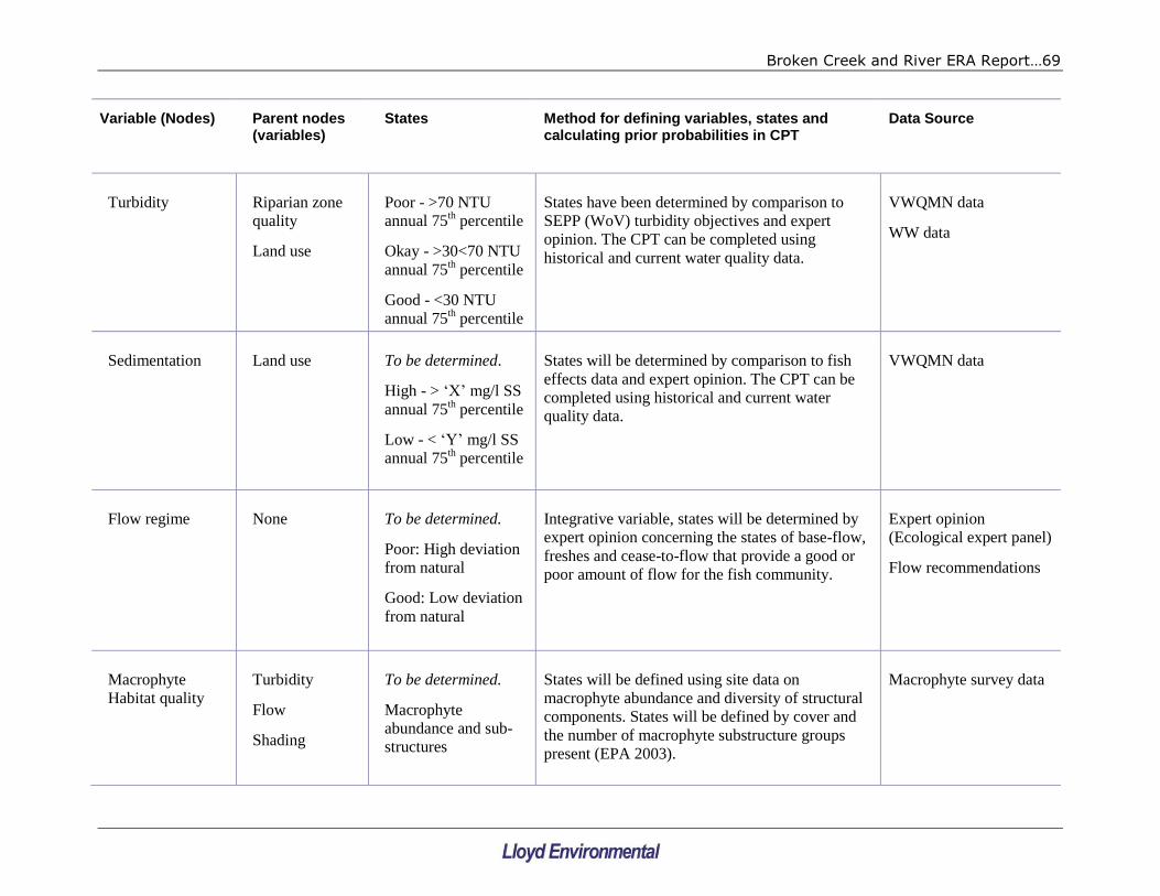
Broken Creek and River ERA Report…69
Variable (Nodes) Parent nodes (variables)
States Method for defining variables, states and calculating prior probabilities in CPT
Data Source
Turbidity Riparian zone
quality
Land use
Poor - >70 NTU
annual 75th percentile
Okay - >30<70 NTU
annual 75th percentile
Good - <30 NTU
annual 75th percentile
States have been determined by comparison to
SEPP (WoV) turbidity objectives and expert
opinion. The CPT can be completed using
historical and current water quality data.
VWQMN data
WW data
Sedimentation Land use To be determined.
High - > ‘X’ mg/l SS
annual 75th percentile
Low - < ‘Y’ mg/l SS
annual 75th percentile
States will be determined by comparison to fish
effects data and expert opinion. The CPT can be
completed using historical and current water
quality data.
VWQMN data
Flow regime None To be determined.
Poor: High deviation
from natural
Good: Low deviation
from natural
Integrative variable, states will be determined by
expert opinion concerning the states of base-flow,
freshes and cease-to-flow that provide a good or
poor amount of flow for the fish community.
Expert opinion
(Ecological expert panel)
Flow recommendations
Macrophyte
Habitat quality
Turbidity
Flow
Shading
To be determined.
Macrophyte
abundance and sub-
structures
States will be defined using site data on
macrophyte abundance and diversity of structural
components. States will be defined by cover and
the number of macrophyte substructure groups
present (EPA 2003).
Macrophyte survey data

Broken Creek and River ERA Report…70
Variable (Nodes) Parent nodes (variables)
States Method for defining variables, states and calculating prior probabilities in CPT
Data Source
Quality physical
in-stream habitat
Macrophyte
habitat quality
Riparian zone
quality
Sedimentation
Poor
Moderate
Good
Integrative variable, states will be determined by
expert opinion concerning the states of macrophyte
habitat, riparian zone and sedimentation to
determine poor, moderate and good physical in-
stream habitat.
Expert opinion
(Ecological expert panel)
ISC data monitoring data
Quality of
riparian zone
None To be determined.
Good: > ISC sub-
component score
Poor: < ISC sub-
component score
States will be determined by expert opinion based
on ISC scores
ISC scores
Land use None
Poor: Substantial
cattle access and/or
runoff from farms,
e.g. irrigation return
drains
Good: no cattle
access or runoff from
farms
Difficult to quantify as little data are available to
assess levels of runoff from farms therefore the
states must be determined by expert opinion.
Maps of drains and local
knowledge from GB
CMA

Broken Creek and River ERA Report…71
Variable (Nodes) Parent nodes (variables)
States Method for defining variables, states and calculating prior probabilities in CPT
Data Source
Fish barriers None
Presence
Absence
GB CMA information and knowledge GB CMA data base and
expert opinion
Literature
Introduced pest
fish species
None Poor: Composition
and number > ‘X’
Good: Composition
and number < ‘X’
States will be determined by expert opinion on the
effects of the relative abundance of introduced pest
species.
GB CMA fish survey
data
Native fish
community
diversity
DO surface
Quality
physical habitat
Flow regime
Barriers
Introduced pest
fish species
At or near natural
condition
Minor modification
Moderate
modification
Major modification
Extreme
modification
States will be defined using the SRA SR-FI index
(MDBC 2003). The CPT will be completed
through expert elicitation.
Fish community
composition and
abundance data and SRA
index score information.

Broken Creek and River ERA Report…72
6.3 Conditional probability tables
The relationship between variables needs to be quantified after the states of the variables
have been defined. Parent variables lead into child variables, and the outcomes of child
variables are conditional on how the parent variables combine. These relationships are
defined using conditional probability tables (CPTs) (see conceptual examples in Tables 10
and 11).
We emphasise that Tables 10 and 11 have no status as real CPTs within any
Bayesian Network – they are provided to demonstrate the approach and concept
of CPT design and filling.
Table 10: Conceptual conditional probability table (CPT) for the variable ‘Physical
Habitat’ based on the model presented in Figure 10
Habitat Condition
Macrophyte
Habitat
Riparian
zone
Sedimentation Poor Moderate Good
Poor Good low 20 30 50
Poor Good high 90 5 5
Poor Poor low 40 30 30
Poor Poor high 99 1 0
Good Good low 0 1 99
Good Good high 60 35 5
Good Poor low 5 30 65
Good Poor high 70 25 5
This table is provided to display the concept of Conditional Probability Tables and is not
designed for quantitative modelling purposes.

Broken Creek and River ERA Report…73
Table 11: Conceptual conditional probability table (CPT) for the variable ‘Native
Fish Community’ based on the model presented in Figure 10. Note missing
variable ‘Introduced Fish’ due to lack of information at this time.
Native Fish Community
Habitat
Condition
Dissolved
oxygen
Flow Poor Moderate Good
Poor Poor Poor 90 10 0
Poor Poor Good 80 20 0
Poor Moderate Poor 70 30 0
Poor Moderate Good 70 30 0
Poor Good Poor 20 70 10
Poor Good Good 20 70 10
Moderate poor Poor 50 50 0
Moderate poor Good 30 70 0
Moderate Moderate Poor 30 70 0
Moderate Moderate Good 10 60 30
Moderate Good Poor 20 70 10
Moderate Good Good 10 50 40
Good poor Poor 30 70 0
Good poor Good 30 70 0
Good Moderate Poor 20 70 10
Good Moderate Good 10 20 70
Good Good Poor 10 40 50
Good Good Good 0 10 90
This table is provided to display the concept of Conditional Probability Tables and is not designed for
quantitative modelling purposes.
The development of CPTs beyond the conceptual examples provided above, and the
subsequent building of a meaningful and operational Bayesian network, would require
substantial resources (in the order of two or three months). This is largely because few
networks have been built that could be taken and adapted specifically for the reaches in
question. Once networks are built that could be adapted for use from similar regions and
reaches, the time required will drop substantially (to as little as a few weeks).
The alternative, used in this project, is to gather the available information, build
conceptual models that reflect Bayesian network structures, and use a semi-quantitative
(ordinal) approach to assessing the influencing of threats and other factors (nodes) on the
listed values. If, at a later time a Bayesian network is needed, the information collected
can be easily adapted to build a quantitative network.

Broken Creek and River ERA Report…74
7. CONCLUSION
This study used the Victorian EPA‟s adopted process for Ecological Risk Assessment (ERA),
to determine and evaluate the risks to selected reaches of upper Broken Creek and lower
Broken River. Using the native fish community as the assessment endpoint for the ERAs,
The following major risks to the waterways were identified:
barriers to fish movement and migration;
presence of exotic fish species;
flow regulation/‟unnatural‟ flow regime;
introduced species of macrophytes;
reduced dissolved oxygen concentrations (Broken Creek only);
elevated nutrient concentrations; and
sedimentation (Broken Creek only).
The sources and magnitudes of nutrient and turbidity inputs to the waterways downstream
of Caseys Weir were identified as major knowledge gap. A specific monitoring plan has
been designed to fill this gap and is presented within this report.
Management actions that have been recommended for the mitigation of the major risks
include:
removal of unnecessary fish barriers and installation of fishways (ladders, rock ramps,
bypass channels) elsewhere;
improvement of riparian and in-stream ecosystem conditions for native fish to,
competitive advantage over exotic fish species;
consider the potential for use of fish traps in fishways to remove exotic fish;
management of storage discharges to reflect natural conditions as far as practical;
an integrated weed control program with nutrient reduction management actions;
monitoring of dissolved oxygen concentrations during low flow periods;
provision of fresher flows as needed during dissolved oxygen risk periods;
undertaking an investigation of potential nutrient and sediment inputs to the
waterways downstream of Caseys Weir; and
mapping of existing pools within Broken Creek and documenting potential for habitat
improvement and/or deepening.
These management actions were derived assuming that the decommissioning of Lake
Mokoan will proceed, as the decommissioning represents the removal of a major source of
several risks identified.
In addition to the ERAs and resultant management recommendations, this study had the
following objectives of:
Broken Creek and River ERA Report…75
1. Setting attainable SEPP (WOV) targets and time lines and assessing the efficacy of
recommended actions to meet these targets. Interim targets were presented for
turbidity and phosphorus, and a revised objective was proposed dissolved oxygen in
both waterways. The turbidity and phosphorus targets included interim targets (two to
five years) and a long-term (fifteen year) target of achieving SEPP (WoV). The
proposed revised objective for dissolved oxygen was maintenance of current conditions
and is based on an expectation that current conditions are not detrimental to native
fish species.
2. Presentation of conceptual models in a way that may, in future, be used in the
development of a Bayesian network. Section 5 of this document presents a Bayesian
network structure derived from the outcomes of the ERA, and also presents the
variables, their states and the data used for development of the structure. Conceptual
examples of Conditional Probability Tables (CPTs) are also presented in Section 5. The
CPTs are conceptual only and should not be used in an actual assessment.

Broken Creek and River ERA Report…76
8. REFERENCES
Broken River Scientific Panel (2001). Report of the Broken River Scientific Panel
on the environmental condition and flows of the Broken River and Broken
Creek. Technical Report 10/2001, Cooperative Research Centre for Freshwater
Ecology, University of Canberra, ACT.
Cadwallader, P.L. (1977). J.O. Langtry‟s 1949-50 Murray River Investigations.
Fish. Widl. Pap. Vict. No. 13.
Close, P. and Aland, G. (2001). The Impact of Instream Barriers on Fish
Assemblages in Lower Reaches of the Broken River and Seven Creeks, and
Preliminary Assessment of fish passage through the Euroa Town and Lake
Benalla Fishways, Victoria. Arthur Rylah Institute for Environmental Research
(Department of Natural Resources and Environment) Report for the Goulburn
Broken Catchment Management Authority, Shepparton, Victoria.
DNRE. (2001). Victorian Aquatic Fauna Database. Historical fish survey data for
the Broken River and Seven Creeks Catchments.
Environment Australia. (2001). A Directory of Important Wetlands in Australia.
Third Edition. Environment Australia, Canberra.
EPA (2003a). Water quality objectives for rivers and streams- Ecosystem
protection. EPA publication no. 791.1
EPA (2003b). Nutrient objectives for rivers and streams- Ecosystem protection.
EPA publication no. 792.1
EPA Victoria (2003c). Rapid bioassessment methodology for rivers and streams.
EPA Victoria publication 604.1
Fletcher, T.D., Poelsma, P., Li, Y., and Deletic, A. (2004). Wet and Dry Weather
Performance of Constructed Stormwater Wetlands. in WSUD 2004 - Cities as
Catchments. International Conference on Water Sensitive Urban Design. SIA.
GB CMA (2005). Goulburn Regional River Health Strategy. Goulburn Broken
Catchment Management Authority, Shepparton, Victoria.
GB CMA (2008). Goulburn Broken catchment SEPP trigger value review. Goulburn
Broken Catchment Management Authority, Shepparton, Victoria.
Government of Victoria. (2003). State Environment Protection Policy (Waters of
Victoria). Victorian Government Gazette No. S 107
Hydro Environmental. (2005). IDMOU – Decision Support System Development
Monitoring and KPI DSS, Step 4. Draft Report to Department of Sustainability
and Environment, Victoria. February 2005.
Hydro Environmental. (2006). Coliban Water Bulk Entitlement Project: Risk
Assessment Workshop Report. Report to Coliban Water.

Broken Creek and River ERA Report…77
Hurl, S; Walker, D and Murray, RS. (1999). Sediment and Heavy Metal Trapping
in a Stormwater Wetland. In: Water 99: Joint Congress; 25th Hydrology &
Water Resources Symposium, 2nd International Conference on Water
Resources & Environment Research; Handbook and Proceedings; pages: 44-
50. Barton, ACT: Institution of Engineers, Australia, 1999.
Koehn, J.D and Harrington, D.J. (2006). Environmental conditions and timing for
the spawning of Murray Cod (Maccullochella peelii peelii) and the endangered
trout cod (M. macquariensis) in southeastern Australian rivers. River res.
Applic. 22: 327–342.
Lloyd, L. N. (1990). Ecological interactions of Gambusia holbrooki with Australian
native fish. In: Pollard, D.A. ASFB Workshop on introduced and translocated
fishes and their ecological effects. Bureau of Rural Resources Proceedings No.
8, AGPS, Canberra.
Lloyd, L. N., A. H. Arthington and D. A. Milton. (1986). The mosquitofish - a
valuable mosquito control agent or a pest? In: Kitching (Ed). The ecology of
exotic plants and animals: some Australian case studies. John Wiley and Sons,
Brisbane.
McMaster, D., Bond, N., Reich, P. and Lake, S. (2008). Research on the
environmental impacts of flow regime reversal and habitat restoration in
Broken and Boosey Creeks. Draft Report, Phase IV: Post-Pipeline Monitoring.
Prepared for the Goulburn Broken Catchment Management Authority, Monash
University.
MDBC (2003). Fish theme audit pilot report – Sustainable River Audit. Murray
Darling Basin Commission. MDBC Report no. 06/04
MDBC (2004). Fish Theme Pilot Audit Technical Report - Sustainable Rivers Audit.
Murray-Darling Basin Commission Publication 06/04, ISBN 1876830735.
Newall, P. and Lloyd, L. (2007). Ecological Risk Assessment of Ryans and Holland
Creeks. Report to the Goulburn Broken CMA June 2007. Peter Newall,
Consulting Aquatic Ecologist, Williamstown, Victoria.
Newall P. and Tiller, D. (2002). Derivation of nutrient guidelines for streams in
Victoria, Australia. Environmental Monitoring and Assessment 74:85-103.
O'Brien, G., Lloyd, L.N. & Loone, J. (1996). Lake Mokoan - Building the Dam was
the Easy Part! ANCOLD 1996 Conference on Dams - "Dams and River Basin
Management", Albury, November 1996.
SKM. (2008). Broken Fish Passage Conceptual Designs – Irvine‟s Weir and Reilly‟s
Weir: CONCEPTUAL DESIGN REPORT (Draft). Sinclair Knight Merz report to
the Goulburn-Broken CMA, 28 April 2008.
Suter, GW (1993). Ecological Risk Assessment. Lewis, Boca Raton

Broken Creek and River ERA Report…78
Treadwell, S. and Hardwick, R. (2003). Review of the Habitat Associations of
Native Fish of the Murray-Darling. A SKM Report to the Murray-Darling Basin
Commission for MDBC SI&E Project 2105
URS (2002). Lake Mokoan Study. Report to Goulburn-Broken CMA.
VWQMN (2008). Data extracted from the Victorian Water Quality Monitoring
Network, via the Victorian Water Data Warehouse:
http://www.vicwaterdata.net/vicwaterdata/home.aspx
Wong, T.H.F., Breen, P.F., Somes, N.L.G, and Lloyd, S.D.. (1999). Managing
urban stormwater using constructed wetlands. Cooperative Research Centre
(CRC) for Freshwater Ecology and Melbourne Water Corporation, Industry
Report 98/7, Second Edition, September 1999
Wong, T. H. F., Breen, P. F., & Lawrence, I. (2003). Constructed wetlands and
ponds. In T. H. F. Wong (Ed.), Australian Runoff Quality. Sydney, Australia:
Institution of Engineers, Australia.