Ecological Character Description - environment.sa.gov.au · Wetland of International Importance...
17
Department for Environment and Heritage Coorong, Lakes Alexandrina and Albert Wetland of International Importance Ecological Character Description www.environment.sa.gov.au
Transcript of Ecological Character Description - environment.sa.gov.au · Wetland of International Importance...

Department for Environment and Heritage
Coorong, Lakes Alexandrina and Albert
Wetland of International Importance
Ecological Character Description
www.environment.sa.gov.au
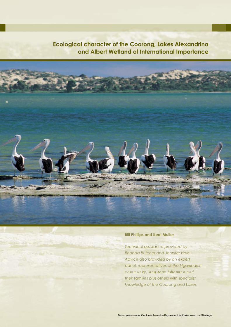
Ecological character of the Coorong, Lakes Alexandrina
and Albert Wetland of International Importance
Bill Phillips and Kerri Muller
Technical assistance provided by
Rhonda Butcher and Jennifer Hale.
Advice also provided by an expert
panel, representatives of the Ngarrindjeri
FRPPXQLW\��ORQJ�WHUP�ÀVKHUPHQ�DQG�
their families plus others with specialist
knowledge of the Coorong and Lakes.

Funding
Funding for this report was provided by both the South
East Natural Resources Management Board and the
South Australian Murray-Darling Basin Natural Resources
Management Board as part of their respective Regional
Investment Strategies. Funding for these strategies is
jointly delivered by the Australian Government’s Natural
Heritage Trust and National Action Plan for Salinity and
Water Quality.
Citation
The preferred citation for this report is as follows:
Phillips, W. and Muller, K. (2006). Ecological Character of
the Coorong, Lakes Alexandrina and Albert Wetland of
International Importance. South Australian Department
for Environment and Heritage.
Cover photographs
Front cover photographs: Russell Seaman (SA DEH);
Kerri Muller; South Australian Tourism Commission; Jason
Higham (PIRSA); Jem Tesoriero (GWLAP); Michael
Hammer. Spine: South Australian Tourism Commission.
Maps
© Department for Environment and Heritage 2006.
All Rights Reserved. All works and information displayed
are subject to Copyright. For the reproduction or
publication beyond that permitted by the Copyright Act
1968 (Cwlth) written permission must be sought from
the Department.
Although every effort has been made to ensure the
accuracy of the information displayed, the Department,
LWV�DJHQWV��RIÀFHUV�DQG�HPSOR\HHV�PDNH�QR
representations, either express or implied, that the
LQIRUPDWLRQ�GLVSOD\HG�LV�DFFXUDWH�RU�ÀW�IRU�DQ\�SXUSRVH
and expressly disclaims all liability for loss or damage
arising from reliance upon the information displayed.
Maps produced by R. Seaman, Regional Conservation,
Department for Environment and Heritage.
Data Source: DEH Projection: Transverse Mercator,
UTM, Zone 54 Complied: 1st June 2006
Datum: Geocentric Datum of Australia, 1994.
Disclaimer
In undertaking this work the project team (see above)
has made every effort to ensure the accuracy of
the information used. Any conclusions drawn or
recommendations made in the report are done in good
faith and the consultants take no responsibility for how
this information and the report are used subsequently
by others. Note also that the views expressed, and
recommendations provided in this report, do not
QHFHVVDULO\�UHÁHFW�WKRVH�RI�SHUVRQV�RU�RUJDQLVDWLRQV�WKDW�
have contributed their views or other materials.
The views and opinions expressed in this publication are
WKRVH�RI�WKH�DXWKRUV�DQG�GR�QRW�QHFHVVDULO\�UHÁHFW�WKRVH�
of the Australian Government or the Commonwealth
Minister for the Environment and Heritage. While
reasonable efforts have been made to ensure that
the contents of this publication are factually correct,
the Commonwealth does not accept responsibility for
the accuracy or completeness of the contents, and
shall not be liable for any loss or damage that may be
occasioned directly or indirectly through the use of, or
reliance on, the contents of this publication.
Copyright and intellectual property
All Ngarrindjeri knowledge presented in this report
remains the property of the Ngarrindjeri Nation and must
not be used without permission from Ngarrindjeri Tendi,
Ngarrindjeri Native Title Management Committee and
Ngarrindjeri Heritage Committee. Otherwise, copyright
and intellectual property for the contents of the report
resides with the South Australian Department for
Environment and Heritage.
For further information please contact:
Department for Environment and Heritage
Telephone: (08) 8555 0296, or
see SA White Pages for your local
'HSDUWPHQW�IRU�(QYLURQPHQW�DQG�+HULWDJH�RIÀFH�
More information available at
www.environment.sa.gov.au
© Department for Environment and Heritage A joint initiative of the Revised March–June 2006 Department for Environment and Heritage FIS 2368.05 South Australian Murray-Darling Basin
Natural Resources Management Board Government South East Natural Resources
ISBN: 1 921238 30 5
This publication is printed on recycled paper. of South Australia Management Board

Project team
The project team consisted of the following people:
Team leaders: Dr Bill Phillips (Mainstream Environmental
Consulting Pty Ltd) and Dr Kerri Muller (Kerri Muller NRM).
Dr Rhonda Butcher (Water’s Edge Consulting) and
Jennifer Hale assisted with technical input, especially
in the early stages of data gathering and analysis,
and the development of the consultation draft of the
report. Derek Walker and Richard Young facilitated the
consultations with the Ngarrindjeri community which were
undertaken by Dr Muller.
Expert Panel and others
who have contributed
For this project, an Expert Panel (see below) was
established to provide direct inputs and review the
draft of the report leading up to when it was circulated
for peer review (see Figure 2 for details). Thereafter the
SURMHFW�WHDP�WRRN�UHVSRQVLELOLW\�IRU�ÀQDOLVLQJ�WKH�UHSRUW�
The development of the report was also assisted by a
number of people who kindly offered expert views on
certain sections or assisted with accessing data and
UHOHYDQW�LQIRUPDWLRQ��7KHVH�SHRSOH�DUH�LGHQWLÀHG�LQ�WKH
Acknowledgements (see below).
Expert Panel Dr Bob Bourman ..........Geomorphologist
Dr Mike Geddes...........Freshwater and estuarine ecologist
Dr Peter Gell ...................Paleolimnologist
Michael Hammer ........Fish biologist, ecologist
Katrina Jensz...................EPBC Act, threatened species;
marine conservation issues; recovery
program; threatened seabirds
Henry Jones .................... /RFDO�ÀVKHUPDQ�DQG�ÀVK�VSHFLDOLVW
Dr David Paton .............Avian biologist
Dr Keith Walker..............River Murray ecological expert
Acknowledgements The project team wishes to thank staff of the South
Australian Department for Environment and Heritage
for their assistance with this report, including Tim Wilson,
Russell Seaman and Brenton Grear. Advice provided by
various people within the Commonwealth Department of
the Environment and Heritage was also
greatly appreciated.
The following people kindly provided information, advice
or expert comment with the development of the early
drafts of this report: Jason Higham, Marcus Pickett,
Tim Vale, Ken Gosbell, Maureen Christie, Adrienne Frears,
Jacqui Symonds and Jason Nicol. Peter Christy and Peter
Goonan (SA EPA) assisted with water quality data. Many
others also provided their views, either in writing or at the
two consultative workshops, and we thank them for
these contributions.
Thanks also go to the members of the Ngarrindjeri
community who were so enthusiastic in providing their
perspectives on the ecological character and other
YDOXHV�RI�WKLV�ZHWODQG��7R�WKH�ÀVKHUPHQ�DQG�IDPLOLHV
who shared their long-term experiences in and around
the Coorong with the project team, we also express our
thanks. Section 7 of the report provides these respective
oral history perspectives.
Final editing, graphic design and production
management coordinated by Ecocreative.
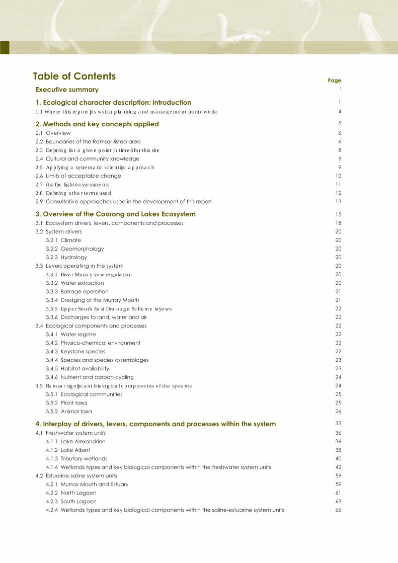
Table of Contents Page
Executive summary i
1. Ecological character description: introduction 1
����:KHUH�WKLV�UHSRUW�ÀWV�ZLWKLQ�SODQQLQJ�DQG�PDQDJHPHQW�IUDPHZRUNV 4
2. Methods and key concepts applied 5
2.1 Overview 6
2.2 Boundaries of the Ramsar-listed area 6
�����'HÀQLQJ�¶DW�D�JLYHQ�SRLQW�LQ�WLPH·�IRU�WKLV�VLWH� 8
2.4 Cultural and community knowledge 9
�����$SSO\LQJ�D�V\VWHPDWLF�VFLHQWLÀF�DSSURDFK 9
2.6 Limits of acceptable change 10
�����¶WUDIÀF�OLJKW·�DVVHVVPHQWV 11
�����'HÀQLQJ�RWKHU�WHUPV�XVHG 12
2.9 Consultative approaches used in the development of this report 13
3. Overview of the Coorong and Lakes Ecosystem 15
3.1 Ecosystem drivers, levers, components and processes 18
3.2 System drivers 20
3.2.1 Climate 20
3.2.2 Geomorphology 20
3.2.3 Hydrology 20
3.3 Levers operating in the system 20
�������5LYHU�0XUUD\�ÁRZ�UHJXODWLRQ 20
3.3.2 Water extraction 20
3.3.3 Barrage operation 21
3.3.4 Dredging of the Murray Mouth 21
�������8SSHU�6RXWK�(DVW�'UDLQDJH�6FKHPH�LQÁRZV 22
3.3.6 Discharges to land, water and air 22
3.4 Ecological components and processes 22
3.4.1 Water regime 22
3.4.2 Physico-chemical environment 22
3.4.3 Keystone species 22
3.4.4 Species and species assemblages 23
3.4.5 Habitat availability 23
3.4.6 Nutrient and carbon cycling 24
�����5DPVDU�VLJQLÀFDQW�ELRORJLFDO�FRPSRQHQWV�RI�WKH�V\VWHPV 24
3.5.1 Ecological communities 25
3.5.2 Plant taxa 25
3.5.3 Animal taxa 26
4. Interplay of drivers, levers, components and processes within the system 33
4.1 Freshwater system units 36
4.1.1 Lake Alexandrina 36
4.1.2 Lake Albert 38
4.1.3 Tributary wetlands 40
4.1.4 Wetlands types and key biological components within the freshwater system units 42
4.2 Estuarine-saline system units 59
4.2.1 Murray Mouth and Estuary 59
4.2.2 North Lagoon 61
4.2.3 South Lagoon 63
4.2.4 Wetlands types and key biological components within the saline-estuarine system units 66
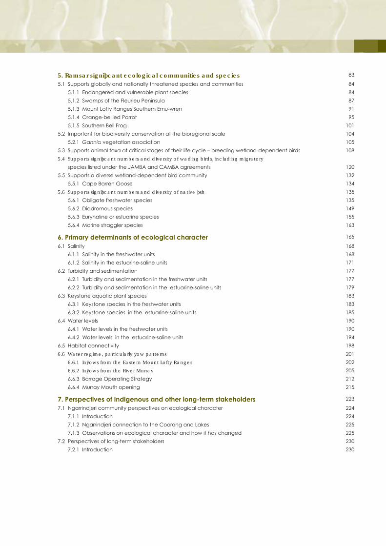
���5DPVDU�VLJQLÀFDQW�HFRORJLFDO�FRPPXQLWLHV�DQG�VSHFLHV� 83
5.1 Supports globally and nationally threatened species and communities 84
5.1.1 Endangered and vulnerable plant species 84
5.1.2 Swamps of the Fleurieu Peninsula 87
5.1.3 Mount Lofty Ranges Southern Emu-wren 91
5.1.4 Orange-bellied Parrot 95
5.1.5 Southern Bell Frog 101
5.2 Important for biodiversity conservation at the bioregional scale 104
5.2.1 Gahnia vegetation association 105
5.3 Supports animal taxa at critical stages of their life cycle – breeding wetland-dependent birds 108
�����6XSSRUWV�VLJQLÀFDQW�QXPEHUV�DQG�GLYHUVLW\�RI�ZDGLQJ�ELUGV��LQFOXGLQJ�PLJUDWRU\
species listed under the JAMBA and CAMBA agreements 120
5.5 Supports a diverse wetland-dependent bird community 132
5.5.1 Cape Barren Goose 134
�����6XSSRUWV�VLJQLÀFDQW�QXPEHUV�DQG�GLYHUVLW\�RI�QDWLYH�ÀVK 135
5.6.1 Obligate freshwater species 135
5.6.2 Diadromous species 149
5.6.3 Euryhaline or estuarine species 155
5.6.4 Marine straggler species 163
6. Primary determinants of ecological character 165
6.1 Salinity 168
6.1.1 Salinity in the freshwater units 168
6.1.2 Salinity in the estuarine-saline units 171
6.2 Turbidity and sedimentation 177
6.2.1 Turbidity and sedimentation in the freshwater units 177
6.2.2 Turbidity and sedimentation in the estuarine-saline units 179
6.3 Keystone aquatic plant species 183
6.3.1 Keystone species in the freshwater units 183
6.3.2 Keystone species in the estuarine-saline units 185
6.4 Water levels 190
6.4.1 Water levels in the freshwater units 190
6.4.2 Water levels in the estuarine-saline units 194
6.5 Habitat connectivity 198
�����:DWHU�UHJLPH��SDUWLFXODUO\�ÁRZ�SDWWHUQV 201
�������,QÁRZV�IURP�WKH�(DVWHUQ�0RXQW�/RIW\�5DQJHV 202
�������,QÁRZV�IURP�WKH�5LYHU�0XUUD\ 205
6.6.3 Barrage Operating Strategy 212
6.6.4 Murray Mouth opening 215
7. Perspectives of Indigenous and other long-term stakeholders 223
7.1 Ngarrindjeri community perspectives on ecological character 224
7.1.1 Introduction 224
7.1.2 Ngarrindjeri connection to the Coorong and Lakes 225
7.1.3 Observations on ecological character and how it has changed 225
7.2 Perspectives of long-term stakeholders 230
7.2.1 Introduction 230
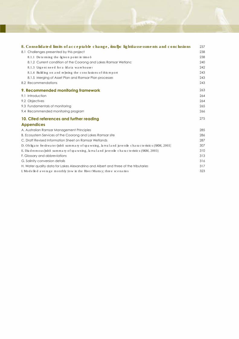
���&RQVROLGDWHG�OLPLWV�RI�DFFHSWDEOH�FKDQJH��¶WUDIÀF�OLJKW·�DVVHVVPHQWV�DQG�FRQFOXVLRQV 237
8.1 Challenges presented by this project 238
�������'HWHUPLQJ�WKH�¶JLYHQ�SRLQW�LQ�WLPH· 238
8.1.2 Current condition of the Coorong and Lakes Ramsar Wetland 240
�������8UJHQW�QHHG�IRU�D�¶GDWD�ZDUHKRXVH· 242
�������%XLOGLQJ�RQ�DQG�UHÀQLQJ�WKH�FRQFOXVLRQV�RI�WKLV�UHSRUW 243
8.1.5 Merging of Asset Plan and Ramsar Plan processes 243
8.2 Recommendations 243
9. Recommended monitoring framework 263
9.1 Introduction 264
9.2 Objectives 264
9.3 Fundamentals of monitoring 265
9.4 Recommended monitoring program 266
10. Cited references and further reading 275
AppendicesA. Australian Ramsar Management Principles 285
B. Ecosystem Services of the Coorong and Lakes Ramsar site 286
C. Draft Revised Information Sheet on Ramsar Wetlands 287
'��2EOLJDWH�IUHVKZDWHU�ÀVK³VXPPDU\�RI�VSDZQLQJ��ODUYDO�DQG�MXYHQLOH�FKDUDFWHULVWLFV��6.0������� 307
(��'LDGURPRXV�ÀVK³VXPPDU\�RI�VSDZQLQJ��ODUYDO�DQG�MXYHQLOH�FKDUDFWHULVWLFV��6.0������� 310
F. Glossary and abbreviations 313
G. Salinity conversion details 316
H. Water quality data for Lakes Alexandrina and Albert and three of the tributaries 317
,��0RGHOOHG�DYHUDJH�PRQWKO\�ÁRZ�LQ�WKH�5LYHU�0XUUD\��WKUHH�VFHQDULRV 323

/LVW�RI�ÀJXUHV� Page
1. The ecological character description in the context of other requirements for the management of
Ramsar sites (DSE, 2005) 3
�� :KHUH�WKLV�UHSRUW�ÀWV�ZLWKLQ�SODQQLQJ�DQG�PDQDJHPHQW�IUDPHZRUNV �
3. Map showing the boundaries of the Ramsar-listed area and other key landmarks 7
4. The limits of acceptable change concept 11
�� 7KH�¶WUDIÀF�OLJKW·�DVVHVVPHQW�FDWHJRULHV ��
�� 2YHUYLHZ�RI�SULPDU\�ZDWHU�VRXUFHV�DQG�ÁRZ�SDWKZD\V�IRU�WKH�&RRURQJ�DQG�/DNHV�5DPVDU�VLWH ��
7. Ecosystem drivers, levers, components and processes that determine ecological charater 19
8. Map of Lake Alexandrina showing the various wetland types 37
9. Map of Lake Albert showing the various wetland types 39
10. Map of the tributary wetlands showing the various wetland types 41
11. Map of Murray Mouth and Estuary showing the various wetland types 60
12. Map of the North Lagoon showing the various wetland types 62
13. Map of the South Lagoon showing the various wetland types 65
14. Provisional map showing distribution of the Fleurieu Swamps within the Ramsar site 89
15. Distribution of the Mount Lofty Ranges Southern Emu-Wren within the Ramsar site 93
16. Map showing annual migration route of Orange-bellied Parrots 97
17. Predicted habitats of the Orange-bellied Parrot within and surrounding the Ramsar-listed area 99
18. Distribution of Southern Bell Frog in South Australia 103
19. Currently mapped distribution of Gahnia plant association 107
��� 7LPLQJV�DQG�RWKHU�GHWDLOV�RI�ÀVK�PLJUDWLRQV�LQ�WKH�&RRURQJ�DQG�/DNHV�5DPVDU�VLWH ���
21. Total catch of Black bream and other species from 1984–85 and 2001–02 in the Lakes and Coorong 161
22. Salinity tolerance ranges of a number of crustaceans, polychaetes etc. in the Coorong 172
23. Longitudinal and vertical salinity patterns along the Murray Mouth and Coorong in
1975, at various times in the 1980s and in January and July 2003 and 2004 174
24. Predicted former distribution of Ruppia megacarpa in the North Lagoon and Estuary 187
25. Comparison of daily water levels at Milang (Lake Alexandrina) under natural and current conditions 191
26. Proposed revised hydrograph for the lakes 193
��� 3URSRVHG�¶LGHDO·�K\GURJUDSKV�IRU�WKH�1RUWK�DQG�6RXWK�ODJRRQ ���
��� 0RGHOHG�DYHUDJH�PRQWKO\�ÁRZV��LQ�0/�GD\��LQ�WKH�5LYHU�0XUUD\�XQGHU�WKUHH�VFHQDULRV�
QDWXUDO�FRQGLWLRQV��0'%&�FDS�FRQGLWLRQV�RI���������DQG�FXUUHQW�FRQGLWLRQV�SOXV�WKH�
1500 GL Expert Reference Panel scenario 206
��� 0HGLDQ�PRQWKO\�ÁRZV�RYHU�WKH�EDUUDJHV�XQGHU�QDWXUDO�DQG�FXUUHQW�FRQGLWLRQV ���
30. Conceptual model of the trend of health in the River Murray System 209
31. Upper South East Drainage Scheme 219
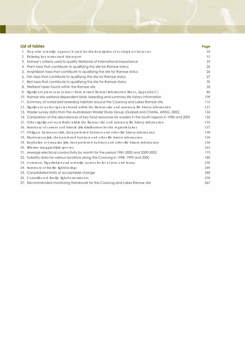
List of tables Page
�� 6WHS�ZLVH�VFLHQWLÀF�DSSURDFK�XVHG�IRU�WKLV�GHVFULSWLRQ�RI�HFRORJLFDO�FKDUDFWHU� ��
�� 'HÀQLQJ�NH\�WHUPV�XVHG�WKLV�UHSRUW ��
3. Ramsar’s criteria used to qualify Wetlands of International Importance 25
4. Plant taxa that contribute to qualifying the site for Ramsar status 26
5. Amphibian taxa that contribute to qualifying the site for Ramsar status 26
6. Fish taxa that contribute to qualifying the site for Ramsar status 27
7. Bird taxa that contribute to qualifying the site for Ramsar status 30
8. Wetland types found within the Ramsar site 35
�� 6LJQLÀFDQW�SODQW�WD[D��H[WUDFW�IURP�UHYLVHG�5DPVDU�,QIRUPDWLRQ�6KHHW��$SSHQGL[�&� ��
10. Ramsar site wetland-dependent birds: breeding and summary life history information 109
11. Summary of noted bird breeding habitats around the Coorong and Lakes Ramsar site 116
��� 6LJQLÀFDQW�ZDGHU�VSHFLHV�IRXQG�ZLWKLQ�WKH�5DPVDU�VLWH�DQG�VXPPDU\�OLIH�KLVWRU\�LQIRUPDWLRQ ���
13. Wader survey data from the Australasian Wader Study Group (Gosbell and Christie, AWSG, 2005) 124
14. Comparison of the abundances of key food resources for waders in the South lagoon in 1985 and 2005 126
��� 2WKHU�VLJQLÀFDQW�ZDWHUELUGV�ZLWKLQ�WKH�5DPVDU�VLWH�DQG�VXPPDU\�OLIH�KLVWRU\�LQIRUPDWLRQ ���
��� 6XPPDU\�RI�FXUUHQW�DQG�KLVWRULF�ÀVK�GLVWULEXWLRQV�IRU�WKH�UHJLRQ·V�/DNHV ���
��� 2EOLJDWH�IUHVKZDWHU�ÀVK��WKHLU�SUHIHUUHG�KDELWDWV�DQG�RWKHU�OLIH�KLVWRU\�LQIRUPDWLRQ ���
��� 'LDGURPRXV�ÀVK��WKHLU�SUHIHUUHG�KDELWDWV�DQG�RWKHU�OLIH�KLVWRU\�LQIRUPDWLRQ ���
��� (XU\KDOLQH�RU�HVWXDULQH�ÀVK��WKHLU�SUHIHUUHG�KDELWDWV�DQG�RWKHU�OLIH�KLVWRU\�LQIRUPDWLRQ ���
��� ¶0DULQH�VWUDJJOHU·�ÀVK�VSHFLHV ���
21. Average electrical conductivity by month for the period 1981-2000 and 2000-2005 175
22. Turbidity data for various locations along the Coorong in 1998, 1999 and 2000 180
��� &RPPRQ��1JDUULQGMHUL�DQG�VFLHQWLÀF�QDPHV�IRU�ORFDO�ÁRUD�DQG�IDXQD ���
��� 6XPPDU\�RI�¶WUDIÀF�OLJKW·�UDWLQJV ���
25. Consolidated limits of acceptable change 245
��� &RQVROLGDWHG�¶WUDIÀF�OLJKW·�DVVHVVPHQWV ���
27. Recommended monitoring framework for the Coorong and Lakes Ramsar site 267

Q Executive summary
In 1985, Australia designated the Coorong and Lakes
Alexandrina and Albert as a Wetland of International
Importance under what is now commonly referred to as
the Ramsar Convention on Wetlands. This designation
carried with it certain responsibilities; one of these being
to manage the site in a way that would maintain its
ecological character.
A description of ecological character is the cornerstone
of management of a Ramsar site (see Figure 1). It
underpins the development of a Ramsar Management
Plan by providing information about the site’s values and
what is needed to maintain or improve those values. It
helps the development of a monitoring and reporting
framework, necessary to determine the ongoing health
of the Ramsar site. Finally, it provides information against
which development activities may be assessed under
the Commonwealth Environment Protection and
Biodiversity Conservation Act, 1999 (EPBC Act) and any
relevant South Australian planning or impact assessment
legislation or processes.
The Coorong and Lakes site meets eight of Ramsar’s
nominating criteria (see Section 3.5). It is renowned for
providing habitat for many waterbird species, however,
it also has many other values that are recognised by the
Ramsar Convention. It has a unique mosaic of 23 wetland
types, ranging from the freshwater lakes into the estuarine
environments of the Coorong. It provides habitat for
nationally threatened species such as the Orange Bellied
Parrot, the Southern Mount Lofty Ranges Emu Wren,
the Murray Hardyhead, the Yarra Pygmy Perch and the
Murray Cod. The site also contains (in part) the critically
HQGDQJHUHG�¶6ZDPSV�RI�WKH�)OHXULHX�3HQLQVXOD·��DV�ZHOO
as the threatened Gahnia sedgeland ecosystem and
a number of nationally listed plant species. In short, it is
ELRGLYHUVLW\�¶KRW�VSRW·�LQ�VRXWKHUQ�$XVWUDOLD�
This report describes in detail the ecological character of
the Ramsar site: the species, communities and habitats
that are found there and the processes and system
drivers, which make this place unique to Australia and
the world. The report applies a systematic approach
for describing ecological character; logically working
through a description of the primary ecosystem drivers,
levers, components and processes that work collectively
WR�VXSSRUW�WKH�YDVW�DUUD\�RI�VLJQLÀFDQW�VSHFLHV�DQG
wetland types. For each of these, where the data
ZLOO�SHUPLW��OLPLWV�RI�DFFHSWDEOH�FKDQJH��GHÀQHG�LQ�
Section 2.6) are recommended in order to guide future
monitoring and management actions. In addition,
VR�FDOOHG�¶WUDIÀF�OLJKW·�DVVHVVPHQWV�DUH�SURYLGHG�DJDLQVW
HDFK�V\VWHP�DWWULEXWH�RU�SDUDPHWHU�H[DPLQHG�WR�UHÁHFW
the overall risk, threat or vulnerability of each.
The Ngarrindjeri Indigenous community and three long-
WHUP�ORFDO�ÀVKHUPHQ�DQG�WKHLU�IDPLOLHV�DOVR�SURYLGHG�WKHLU�
views on the ecological values and assets of this site, and
how these have changed with time. These are presented
in Section 7 of the report and also interlaced throughout
the document in key places where this more anecdotal
�EXW�QR�OHVV�VLJQLÀFDQW��LQIRUPDWLRQ�KHOSV�WR�UHLQIRUFH�RU�
IXUWKHU�HODERUDWH�WKH�VFLHQWLÀF�WH[W��$V�FDQ�EH�VHHQ�LQ�
the report, these insights provide invaluable information
and should be a standard part of future descriptions of
ecological character at other sites.
Apart from documenting ecological character through
Sections 3–8 of the report, a number of conclusions are
drawn that are especially noteworthy, as follows:
From a legal perspective, the Commonwealth EPBC Act
may have no alternative other than to use the condition
of a Ramsar site on the day it was designated (in this case
1 November 1985) as the benchmark condition for the
SXUSRVHV�RI�DSSO\LQJ�LWV�¶5DPVDU�WULJJHU·��+RZHYHU��WKH
conclusion drawn in the report (a view strongly supported
by stakeholders) is that this site had been in ecological
decline for at least 20–30 years prior to the Ramsar listing,
and probably longer. By using 1985 as the benchmark
condition, the ecological character description, and its
associated limits of acceptable change, would be for
an already degraded site. The authors were cognisant of
these two differing perspectives and have endeavoured
to set limits of acceptable change, which, assuming they
are acted on, should arrest the incremental decline in
WKH�¶KHDOWK·�RI�WKLV�V\VWHP��VHH�LW�SODWHDX�DQG�VORZO\�WXUQ
around. How far along that pathway of recovery back
to the condition it once was will be a decision taken by
high-level decisions makers, as will be the rate at which
that recovery takes place.
It is clear that the ecological character
RI�WKLV�VLWH�KDV�EHHQ�DOWHUHG�VLJQLÀFDQWO\� RYHU�WKH�SDVW���²���\HDUV����
)URP�WKH�FRPELQHG�VFLHQWLÀF�DVVHVVPHQW��UHLQIRUFHG�E\
the Indigenous and long-term stakeholder oral histories
and knowledge of the system (see above), it is clear that
the ecological character of this site has been altered
VLJQLÀFDQWO\�HVSHFLDOO\�RYHU�WKH�SDVW���²���\HDUV��7KLV
change would appear to have been accelerated and
exacerbated by water extractions that are too high for
the system to be able to sustain itself through the recent
Executive Summary i

drought conditions, as it would have under natural
conditions. The drought didn’t cause the change in
ecological character, it simply brought it forward.
This view is supported by an examination of the
recommended limits of acceptable change and the
¶WUDIÀF�OLJKW·�DVVHVVPHQWV�SURYLGHG�LQ�WKH�UHSRUW��7KH
conclusion is that this ecosystem has as its primary
determinants of ecological character; salinity, turbidity
and sedimentation, water levels, keystone aquatic
SODQWV��KDELWDW�DYDLODELOLW\�DQG�ÁRZV��)RU�WKHVH�VL[�SULPDU\�
determinants of ecological character, all are presently
outside their recommended limits of acceptable change,
and in many cases not by a small margin. This is a
V\VWHP�WKDW�LV�XQGHU�VLJQLÀFDQW�VWUHVV��DQG�KDV�EHHQ�IRU�
some years.
$V�QRWHG�LQ�WKH�UHSRUW��WKH�¶WUDIÀF�OLJKWV·�DUH�LQ�VRPH
ways analogous with the dials and gauges in the cockpit
of a 767 aircraft; they provide information on how well
the vital functions of that highly sophisticated piece of
technology are performing. For this complex wetland
V\VWHP�WKH\�GR�WKH�VDPH��5HG�¶WUDIÀF�OLJKWV·�DUH�WKRVH�
that would raise alarm for the pilot, as they should for
the managers of this site and the State and Federal
*RYHUQPHQWV��2I�WKH����¶WUDIÀF�OLJKWV·�DVVLJQHG�WR�NH\
functions and attributes of this system by this project
�VHH�7DEOH������QHDUO\�KDOI�DUH�¶UHG·�DQG�RQH�WKLUG�
¶DPEHU·��D�FDWHJRU\�ZKHUH�VHULRXV�FRQFHUQV�DUH�KHOG�
7KLV�UHSRUW�UHSUHVHQWV�WKH�ÀUVW�DWWHPSW�WR�GRFXPHQW�D
comprehensive understanding of ecological character
for this site, and its unequivocal conclusion is that urgent
management interventions are needed if the former
condition is to be reinstated.
)RU�WKHVH�VL[�SULPDU\�GHWHUPLQDQWV�RI�HFRORJLFDO�FKDUDFWHU��DOO�DUH�SUHVHQWO\�outside their recommended limits of
DFFHSWDEOH�FKDQJH��DQG�LQ�PDQ\�FDVHV� QRW�E\�D�VPDOO�PDUJLQ�
The changes to the ecological character of the site
are proceeding faster in some parts of it than others.
The Coorong lagoons, once a predominantly estuarine
environment with some hyper-saline portions, particularly
IDYRXUHG�E\�ZDGLQJ�ELUGV�DQG�ZLWK�JUHDW�GLYHUVLW\�RI�ÀVK
species, are rapidly transforming into more and more
turbid and saline systems. This is seeing the rapid loss
of the keystone Ruppia plant species and with these,
GHFOLQHV�LQ�PXFK�RI�WKH�ELRWD�RI�WKH�&RRURQJ�WKDW�MXVWLÀHG
Ramsar listing.
To summarise the situation, the Coorong ecosystem is
EHFRPLQJ�LQFUHDVLQJO\�VLPSOLÀHG�DV�WKH�ORVV�RI Ruppia
continues; this being a consequence of escalating
salinities, increasingly turbid waters and inappropriate
water levels. All of these are essentially determined by
5LYHU�0XUUD\�ÁRZV�LQWR�DQG�WKURXJK�WKH�V\VWHP��DQG
KLVWRULFDOO\�E\�ÁRZV�IURP�WKH�VRXWK�HDVW�RI�6RXWK�$XVWUDOLD�
Algae and brine shrimp, more typical of a marine
environment, have become dominant biota in the South
Lagoon and parts of the North Lagoon since spring 2005.
The loss of Ruppia�DQG�ZLWK�LW�WKH�VPDOO�KDUG\KHDG�ÀVK��
LV�VLJQDOOLQJ�D�VLJQLÀFDQW�FKDQJH�LQ�KRZ�WKH�&RRURQJ�
functions and the habitats it has to offer.
It is estimated that the former estuarine Coorong
ecosystem is now supported along only a 30 kilometre
stretch from the Goolwa barrages to Pelican Point, this
representing less than 25% of the original area. All of
this indicates that a comprehensive shift in ecological
FKDUDFWHU�LV�XQGHUZD\��:LWKRXW�VLJQLÀFDQW�DQG�XUJHQW
intervention it may prove irreversible. For this reason the
authors are recommending that the Coorong lagoons
and Murray Mouth be proposed for listing as a critically
endangered ecological community under the EPBC Act.
The changes to the lakes environments are proceeding
at a slower pace, but, like the Coorong, they are being
negatively impacted upon by sediments and increasing
VDOLQLW\��$JDLQ��LQ�VLPSOH�WHUPV��WKH�ODFN�RI�ÁRZV�LV�VHHLQJ
the whole system become a sink for salt and silt. This is a
GLUHFW�FRQVHTXHQFH�RI�WKH�UHGXFHG�LQÁRZV�IURP�WKH�5LYHU�
0XUUD\�WKDW�RQFH�SURYLGHG�UHJXODU�IUHVKHQLQJ�ÁRZV�WKDW
also discharged salt and silt out the Murray Mouth.
,Q�WHUPV�RI�WKH�ÁRZV�QHHGHG�IRU�UHVWRULQJ�WKH�HFRORJLFDO
character of the system, there are a number of primary
requirements (see Section 6.6.2 especially) including,
RSHUDWLQJ�WKH�EDUUDJHV�WR�HQVXUH�ORZ�RU�QR�ÁRZ�SHULRGV�
DUH�PLQLPLVHG�DQG�SUHIHUDEO\�WKDW�VXIÀFLHQW�ZDWHU�LV�
available to keep the Murray Mouth open without
dredging, increased frequency of medium-sized or better
ÁRRGV��DQG�WKH�RSSRUWXQLW\�WR�KDYH�VR�QDPHG�KHUH�
¶5DPVDU�VLWH�FRQWLQJHQF\�DOORFDWLRQ·�ZDWHU�DYDLODEOH
to allow managers scope for strategic on-site water
DOORFDWLRQV�WR�EHQHÀWV�WKH�5DPVDU�VLJQLÀFDQW�VSHFLHV�
and ecological communities.
Keeping the Murray Mouth open at all times with
barrage releases rather than dredging should be the
ÀUVW�WDUJHW�WR�UHFRYHULQJ�WKH�HFRORJLFDO�FKDUDFWHU�RI�
this site (see Section 6.6.2 and 6.6.4). It is noted that a
VLPSOLVWLF�FRVW�EHQHÀW�DQDO\VLV��WKDW�H[DPLQHV�ÀQDQFLDO�
considerations only, may indicate that retaining the
The Coorong and Lakes Alexandrina and Albert Ramsar site ii

dredges is a preferred option over securing the water
QHFHVVDU\�WR�NHHS�WKH�PRXWK�RSHQ�ZLWK�ÁRZV��+RZHYHU��LI
WKH�YDOXH�RI�WKH�IXOO�VXLWH�RI�HFRV\VWHP�DQG�RWKHU�EHQHÀWV
WKDW�ZRXOG�FRPH�IURP�WKH�ÁRZ�RSWLRQ�ZHUH�IDFWRUHG�LQ�
then it should be the clearly preferred approach.
2SHUDWLRQ�RI�WKH�ÀVKZD\V�DQG�UHGXFWLRQV�LQ�GXUDWLRQ
DQG�IUHTXHQF\�RI�QR�ÁRZ�SHULRGV�FDQ�EH�HIIHFWLYHO\
achieved with water that is currently available at the site
in most years. This can be done by improving river and
barrage operations and utilisation of storages, such as
/DNH�9LFWRULD��WR�PLPLF�KLJKHU�ÁRZV�RU�H[WHQG�ÁRZ�HYHQWV�
7KLV�V\VWHP�IRUPHG�LQ�UHVSRQVH�WR�YDULDELOLW\�RI�ÁRZV��VHH
several comments from stakeholders in Section 7). That
variability has now been lost, in large part, and the once
UHDVRQDEO\�IUHTXHQW�PHGLXP�WR�ODUJH�ÁRRGV�WKDW�ÁXVKHG�
and freshened the system are becoming less and less
frequent through the combined impacts of upstream
water diversions and climate. It will only be with the return
RI�VXIÀFLHQW�ÁRZV�WR�WKH�ULYHU��WKDW�PHGLXP�VL]HG�ÁRRGV
FDQ�EH�¶PDQXIDFWXUHG·�E\�WKH�ULYHU�PDQDJHUV�WKURXJK�
WKH�WRSSLQJ�XS�RI�WKH�PRUH�IUHTXHQW�VPDOO�ÁRRGV�
It is also clear from historical accounts, and indicated
by recent core sampling and diatom analysis (Gell
and Haynes, 2005), that in the past the South Lagoon
RI�WKH�&RRURQJ�UHFHLYHG�VLJQLÀFDQW�QDWXUDO�ÁRZV�IURP�
the South East region. These served to help freshen that
end of the system, considering that it is 140 kilometres
from the Murray Mouth. Advice from the Ngarrindjeri
FRPPXQLW\�LV�WKDW�ÁRZV�IURP�WKH�VRXWK�HDVW�XVHG�WR�ÁRZ�
along a clear channel of faster moving water in the
centre of the lagoons all the way from Salt Creek to the
0XUUD\�0RXWK�DQG�ZRXOG�SURYLGH�ÁXVKLQJ�ÁRZV�IRU�WKH
&RRURQJ�/DJRRQV��7KHVH�ÁRZV�DUH�QR�ORQJHU�SURYLGHG��
The construction of the Upper South East Drainage
6FKHPH�QRZ�UHJXODWHV�WKHVH�ÁRZV�DQG�GLVFKDUJHV�RQO\
small volumes into the South Lagoon based on a ten
year rolling average. Some Coorong stakeholders have
expressed concerns about the impact this water may
have on the ecology of the southern end of the system
JLYHQ�WKDW�LW�LV�¶GUDLQDJH·�ZDWHU�DQG�FRPHV�IURP�DQ
DJULFXOWXUH�]RQH�ZLWK�VLJQLÀFDQW�GU\ODQG�VDOLQLW\�LVVXHV��$Q\�
attempt to use this water to try to reduce the hyper-
salinity being experienced in the South Lagoon will need
to ensure the water is of a suitable quality. These issues
are being investigated by the Department of Water, Land
and Biodiversity Conservation at present.
The conclusions are therefore that the Coorong portions
of the Ramsar site are critically endangered and
that there are strong signals that the Lakes will follow
WKH�VDPH�SDWKZD\�ZLWKRXW�VLJQLÀFDQW�PDQDJHPHQW�
intervention. It is the recommendation of the authors that,
in accordance with Article 3.2 of the Ramsar Convention,
WKHVH�ÀQGLQJV�EH�FRPPXQLFDWHG�WR�WKH�6HFUHWDULDW�RI
the Convention, and, that consideration be given to
including the site onto Ramsar’s Montreux Record of sites
where change in ecological character is occurring, or
has taken place.
The report makes a number of recommendations, as
presented below from Section 8. It is the view of the
DXWKRUV�WKDW�WKH�ÀQGLQJV�RI�WKLV�UHSRUW�MXVWLI\�WKH�IROORZLQJ�
operational and administrative actions by the South
Australian and Commonwealth governments:
Operationally:
1. Pursue, as a matter of high priority, the measures
needed to be able to meet the limits of acceptable
change recommended by this report, and, in
SDUWLFXODU��WKRVH�VSHFLÀHG�LQ�UHODWLRQ�WR�ÁRZV�LQ
Section 6.6.2, as summarised below:
D� VXIÀFLHQW�ZDWHU�WR�NHHS�WKH�0XUUD\�0RXWK�RSHQ
without dredging
b) increased frequency of medium-sized or better
ÁRRGV�WR�ÁXVK�DQG�¶IUHVKHQ·�WKH�V\VWHP
F� UHGXFHG�GXUDWLRQ�DQG�IUHTXHQF\�RI�QR�ÁRZ�SHULRGV
which are extremely detrimental to the system
G� VXIÀFLHQW�ZDWHU�WR�RSWLPDOO\�RSHUDWH�WKH�ÀVKZD\V�
and provide habitat connectivity between fresh,
estuarine and saline units
H� WKH�RSSRUWXQLW\�WR�KDYH�VR�QDPHG�KHUH�¶5DPVDU�
site contingency allocation’ water available to
allow managers scope for strategic on-site water
DOORFDWLRQV�WR�EHQHÀWV�WKH�5DPVDU�6LJQLÀFDQW
Biological Components.
2. Ensure that barrage operations in the critical period
XQWLO�DGGLWLRQDO�ÁRZV�FDQ�EH�SURYLGHG�DUH�GLUHFWHG�
at ensuring no further reduction in the area of the
remnant 25% of the former estuarine habitat now
found only from the Goolwa Barrage to Pelican Point.
3. Accelerate the examination of the feasibility and
ecological merits of using water from the Upper
South East Drainage Scheme to reduce the very high
salinities of the South Lagoon in the short term.
Executive Summary iii
Administratively:
4. In accordance with Article 3.2 of the Ramsar
&RQYHQWLRQ��WKH�ÀQGLQJV�RI�WKLV�VWXG\�EH�
communicated to the Secretariat of the Convention,
and, that consideration be given to including the site
on Ramsar’s Montreux Record of sites where change in
ecological character is occurring, or has taken place.
5. The Coorong lagoons and Murray Mouth portion of
the site be nominated immediately for listing under
the EPBC Act as a critically endangered ecological
community.
�� 7KH�&RPPRQZHDOWK�*RYHUQPHQW�DOORFDWH�VLJQLÀFDQW
new resources under its $36 million National Biodiversity
¶KRW�VSRWV·�LQLWLDWLYH�WR�VHH�D�UDQJH�RI�WKH�KLJKHVW
priority remedial actions directed at restoring.
ecological character undertaken immediately.
7. The South Australian Government, with the Murray-
Darling Basin Commission and the Commonwealth
Government, undertake a full inventory of relevant
data holdings (including those held by researchers),
with a view to building an integrated and
FRPSUHKHQVLYH�GDWD�¶ZDUHKRXVH·�IRU�WKH�&RRURQJ
and Lakes.
8. The South Australian Government, with the Murray-
Darling Basin Commission and the Commonwealth
Government, agree to merge the planning and
implementation processes for the Asset Environmental
Plan and the Coorong and Lakes Ramsar
Management Plan.
9. Publish this report as loose leaf folder, signaling
the intent to see it continuously improved as new
information comes to light.
The Coorong and Lakes Alexandrina and Albert Ramsar site iv

1
Ecological character description: introduction
A sound understanding of ecological
character should form the benchmark
for management planning and action.

Q Introduction
The Coorong and Lakes Alexandrina and Albert were
GHVLJQDWHG�DV�D�¶:HWODQG�RI�,QWHUQDWLRQDO�,PSRUWDQFH·
under the Ramsar Convention on Wetlands on 1
November 1985. As a Contracting Party to the Ramsar
Convention, Australia has accepted a range of
obligations in relation to the management of those
sites that it designates as Wetlands of International
Importance, or Ramsar sites as they are commonly
known. These obligations are set down in Articles 3.1 and
3.2 of the text of the Convention as given below.
Article 3.1
¶7KH�&RQWUDFWLQJ�3DUWLHV�VKDOO�IRUPXODWH�DQG�LPSOHPHQW�
their planning so as to promote the conservation of the
wetlands included in the List, and as far as possible the
wise use of wetlands in their territory.’
Article 3.2
¶(DFK�&RQWUDFWLQJ�3DUW\�VKDOO�DUUDQJH�WR�EH�LQIRUPHG�
at the earliest possible time if the ecological character
of any wetland in its territory and included in the List has
changed, is changing or is likely to change as the result
of technological development, pollution or other human
interference. Information on such changes shall be
passed without delay to the organization or government
UHVSRQVLEOH�IRU�WKH�FRQWLQXLQJ�EXUHDX�GXWLHV�VSHFLÀHG�LQ
Article 8.’
Since the adoption of the above texts, Conferences of
the Contracting Parties to the Ramsar Convention, and
most notably the 5th Conference in Kushiro, Japan in
�������WKURXJK�5HVROXWLRQV�����DQG������KDYH�VHHQ�ÀW�WR�
interpret these obligations as being an undertaking on
the part of the signatory governments to manage their
5DPVDU�VLWHV�VR�DV�WR�UHWDLQ�WKH�¶HFRORJLFDO�FKDUDFWHU·�
This management undertaking is considered synonymous
ZLWK�WKH�WHUP�WR�¶«�SURPRWH�WKH�FRQVHUYDWLRQ�RI�WKH
ZHWODQGV�LQFOXGHG�LQ�WKH�/LVW�«·�$UWLFOH������
Understanding and describing the ecological
character of a Ramsar site is therefore a fundamental
management tool for signatory governments and the
local site managers. A sound understanding of the
ecological character of a site should form the baseline
or benchmark for management planning and action;
including site monitoring to detect negative impacts
(see Figure 1).
)RU�LWV�SDUW��WKH�5DPVDU�&RQYHQWLRQ�KDV�PRYHG�WR�GHÀQH�
¶HFRORJLFDO�FKDUDFWHU·�DQG�¶FKDQJH�LQ�HFRORJLFDO�
character’, and to provide frameworks and guidelines for
management planning, establishing monitoring programs
DQG�XQGHUWDNLQJ�ULVN�DVVHVVPHQWV��+RZHYHU��GHÀQLWLYH
guidance on how to describe ecological character
has not been forthcoming from the Convention to date
despite recognition that it is needed.
5DPVDU·V�GHÀQLWLRQV��5DPVDU�5HVROXWLRQ�,;����$QQH[�$��
November 2005):
¶(FRORJLFDO�FKDUDFWHU�LV�WKH�FRPELQDWLRQ�RI�WKH
HFRV\VWHP�FRPSRQHQWV��SURFHVVHV�DQG�EHQHÀWV �VHUYLFHV�
that characterize the wetland at a given point in time.’
And
¶«�FKDQJH�LQ�HFRORJLFDO�FKDUDFWHU�LV�WKH�KXPDQ�
induced adverse alteration of any ecosystem
FRPSRQHQW��SURFHVV��DQG�RU�HFRV\VWHP�EHQHÀW �VHUYLFH�·
:LWKLQ�WKLV�FRQWH[W��HFRV\VWHP�EHQHÀWV�DUH�GHÀQHG�LQ� accordance with the Millennium Ecosystem Assessment’s
GHÀQLWLRQ�RI�HFRV\VWHP�VHUYLFHV�DV�WKH�EHQHÀWV�WKDW�SHRSOH
receive from ecosystems.
Domestically, the Australian Government has introduced
legislation, the Environment Protection and Biodiversity
Conservation Act, 1999 (the EPBC Act) that provides a
legal framework for seeing that the ecological character
of all Australian Ramsar sites is retained. The EPBC Act
establishes a Commonwealth process for the referral, and
possible assessment, of proposed actions that may have
D�VLJQLÀFDQW�GHWULPHQWDO�LPSDFW�RQ�¶PDWWHUV�RI�QDWLRQDO�
HQYLURQPHQWDO�VLJQLÀFDQFH·��ZKLFK�LQFOXGHV�5DPVDU�VLWHV
(see Figure 1).
The EPBC Act also requires that the Commonwealth
¶«�XVH�LWV�EHVW�HQGHDYRXUV�WR�HQVXUH�D�SODQ�IRU�PDQDJLQJ
the wetland in a way that is not inconsistent with
Australia’s obligations under the Ramsar Convention
or the Australian Ramsar Management Principles is
prepared and implemented in cooperation with the
State and Territory.’ (Section 3.3.3, of the Act, as provided
in Appendix A).
Taken together, Australia has obligations under the
Ramsar Convention with respect to how designated
Wetlands of International Importance are managed. In
order to meet these obligations the ecological character
of each site needs to be carefully described, and
then used to guide management action and ongoing
monitoring. Such descriptions of ecological character
are also fundamental to the effective implementation
of the Commonwealth’s EPBC Act, which is designed to
ensure Australia is not contravening its site management
obligations under the Ramsar Convention.
The Coorong and Lakes Alexandrina and Albert Ramsar site 2

1
Ramsar site
investigation
Management plan
ECOLOGICAL
CHARACTER
DESCRIPTION
Monitoring program
reference for
assessing impact
reference for
assessing impact
reference
for design
Monitoring
Plan implementation
Environmental
impact assessment
Controlled action
(under the EPBC Act)
Ramsar site listing
) Reporting
Evaluation
(Ramsar information sheet
Figure 1 - The ecological character description in the context of other requirements for the management
of Ramsar sites (DSE, 2005)
Ecological character description: introduction - Section 1 3

The Coorong and Lakes Alexandrina and Albert Ramsar site4
����:KHUH�WKLV�UHSRUW�ÀWV�ZLWKLQ�SODQQLQJ�and management frameworks
As indicated above, the Coorong and Lakes Alexandrina
and Albert were designated as a Ramsar site on 1
November 1985 (see Figure 2). A plan of management
for the site was prepared and put in place in September
2000. While this plan gave some insights into the
ecological assets of the Ramsar area, it did not provide
a detailed description of ecological character.
This project, the Coorong and Lakes Alexandrina
and Albert Ramsar site ecological character project,
is a major component of the Ramsar Plan Review
Process which commenced in July 2004. A revised
Ramsar Management Plan will be prepared following
the preparation of this description of ecological
character. The review of the Ramsar plan is timely
given the multitude of other programs and initiatives
occurring such as the Living Murray Initiative, review
of the Coorong National Park Plan, CSIRO’s Water for
a Healthy Country Initiative, State Natural Resource
Management legislation and institutional changes. This
description of the ecological character of the Coorong
and Lakes Alexandrina and Albert Ramsar site (hereafter
DEEUHYLDWHG�WR�WKH�¶&RRURQJ�DQG�/DNHV·��ZLOO�EH
invaluable in informing these programs and initiatives.
Q