Eaton Neighbourhood Plan 2020-2030 Submission Draft ...
55
1 Eaton Neighbourhood Plan 2020-2030 Submission Draft – January 2020 Eaton, Gawsworth Ward, Cheshire East
Transcript of Eaton Neighbourhood Plan 2020-2030 Submission Draft ...

1
Eaton Neighbourhood Plan
2020-2030
Submission Draft – January 2020
Eaton, Gawsworth Ward, Cheshire East

2
CONTENTS PAGE
1. Foreword 4
2. Introduction 6
2.1 Eaton – an Overview 6
2.10 Landscape 7
2.13 Built Character and Design 8
3. Consultation 9
4. Visions and Objectives 10
5. Built and Natural Environment Policies 12
5.2 BNE1 New Housing 12
5.13 BNE2 Local Green Gaps 16
5.27 BNE3 Local Character and Design 20
5.39 BNE4 Heritage 25
5.50 BNE5 Important Views and Vistas 27
5.56 BNE6 Local Green Spaces 29
5.62 BNE7 Dark Skies 32
5.67 BNE8 Trees, Hedgerows, Watercourses, Lakes and Ponds 34
6. Transport and Infrastructure Policies 37
6.2 TI1 Sustainable Transport 37
6.9 TI2 Footpaths and Access to the Countryside 40
6.15 TI3 Communications Infrastructure 41
7. Community Policies 43
7.2 C1 Leisure and Countryside pursuits 43
7.6 C2 Community Facilities 43
8. Local Economy Policies 46
8.2 LE1 Rural Economy 46
8.8 LE2 Extractive Industries After-Use 47

3
List of Figures and Maps
1.7 Figure A – Designated Neighbourhood Area 5
2.9 Figure B – Map of North Congleton Masterplan at Eaton boundary 7
4.4 Figure B2 – Eaton Neighbourhood Plan - Overall Policies Map 11
5.12 Figure C – Proposed Infill Boundary for Eaton 15
5.26 Figure D – Local Green Gaps 19
5.38 Figure E – Eaton Village Spatial Map 24
5.49 Figure F – Listed Buildings 27
5.61 Figure G – Local Green Spaces 31
5.66 Figure H – Street Lighting 33
5.72 Figure I – Tree Preservation Orders in Eaton 36
6.14 Figure J – Public Rights of Way 41
8.15 Figure K – Sand Quarry 49
Appendices
Appendix 1 – Local Green Space Maps 50
Appendix 2 – Cheshire East Local Plan Policy PG6 – Open Countryside 54
Appendix 3 – Surface Water Hierarchy 55

4
1. FOREWORD
1.1 In March 2012 the Government published the National Planning Policy Framework (NPPF) with immediate effect, which was updated In July 2018. This legislation replaced the former planning regulations with a new planning rulebook which puts localism at the heart of future planning. In April 2012 regulations governing Neighbourhood Planning came into force.
1.2 Neighbourhood Plans allow a community to set out a vision for an area and planning policies for the use and development of land.
1.3 All Neighbourhood Plans must:
• have appropriate regard to national planning policy; • contribute to sustainable development; • be in general conformity with strategic policies in the development plan for the local area; • be compatible with EU obligations and human rights requirements.
1.4 A Neighbourhood Plan must be compatible with national policies and with the policies in
the authority’s local plan. The Cheshire East Local Plan which is the new Development Plan for
Cheshire East was adopted in 2017 and will guide development up to 2030. This neighbourhood
plan is to run for the same period as the Local Plan, expiring in 2030. Cheshire East Local Plan Part
Two, Site Allocations and Development Policies Document (SADPD), will allocate the remaining sites
needed for future development and set out further detailed planning policies to be used when
considering planning applications. The Draft SADPD has had two consultation periods in 2018 and
2019 and it is anticipated that it will be adopted in 2020. In the draft SADPD Eaton is designated as
an ‘infill village’. Infill villages do not have a settlement boundary, have no allocated development
sites and are within the open countryside. Limited infilling will be supported within the village infill
boundaries subject to certain criteria.
1.5 The Eaton Neighbourhood Plan was produced following a resolution to undertake a Plan at
the Parish Council Meeting of 17th
May 2016. A steering group was formed who consulted and
listened to the community on a range of issues that influence the well-being, sustainability and long-term preservation of the parish. Every effort has been made to ensure that the vision, aims, objectives and policies of the Eaton Neighbourhood Plan reflect the views of the majority of the local residents, whilst having regard to local and national policies.
1.6 The proposed Neighbourhood Area was consulted upon from 2nd
September to 26th
October 2016. The original neighbourhood area applied for included the full extent of the parish boundary for Eaton parish. During consultation the Parish Council made representations suggesting parts of the proposed neighbourhood area be excluded on the basis that those areas are more functionally related to Congleton. The Local Planning Authority agreed with the Parish Council and the designated area, excluding a small part of the parish within the settlements of Havannah &
Buglawton, was approved on 28th
October 2016. The report detailing the designation can be viewed
at www.cheshireeast.gov.uk/pdf/planning/neighbourhood-plan/eaton-neighbourhood-area-decision-notice.pdf

5
1.7 Figure A – Map of the Designated Neighbourhood Area

6
2. INTRODUCTION
2.1 EATON –AN OVERVIEW
2.2 Eaton is a small rural village which lies in Cheshire East, inside, and at the southern edge of,
the rural Ward of Gawsworth (formerly the Macclesfield Rural District). Eaton is some 2 miles north
of Congleton town centre. The parish covers roughly 480 hectares, and according to the 2011
census, the population of the parish was 375, in 145 households. The designated Neighbourhood
Plan area does not include a small part of the parish which is more closely aligned with Congleton.
There are therefore approximately 103 households in 107 dwellings in the designated area, and a
population of 231.
2.3 The village lies roughly in the centre of the parish and is fortunate to have within it a church, 2 public houses, a parish hall and a Millennium Park which contains a play area and sports pitch. There is no longer a school in the village.
2.4 Eaton has existed since at least the 12th
century. Eaton Hall was demolished in the 1980s to
make way for the expanding sand quarry, which is still being worked today. The existing quarry and approved quarry extensions cover approximately 38% of the designated Neighbourhood area. How the quarried land may ultimately be restored, is understandably of great importance to the community.
2.5 The village originally consisted of farmsteads and small cottages scattered around the church, Plough Inn and along School Lane, and the original historic core of the village is still identifiable today. Two small housing estates were developed in the 1950s and 1960s creating Crauford Road and Beechwood Drive.
2.6 The designated area is fortunate to be home to four Listed Buildings. Church House, the
Plough Inn and Yew Tree Farm all date from the 17th
century. Christ Church itself was built in 1856-1858. All are listed at grade II.
2.7 Whilst Eaton is in the rural Gawsworth Ward, as defined by the Cheshire East Local Plan, the
parish is located adjacent to the outskirts of the town of Congleton. In June 2016 planning permission was granted for the Congleton Link Road, the route of which partially runs through the
Neighbourhood Plan designated area. In the Cheshire East Local Plan it is recognised that the
Congleton Link Road is at the heart of the development strategy for Congleton.
2.8 The Cheshire East Local Plan Strategy, based on analysis carried out in the North Congleton
Masterplan, identifies a series of strategic sites for development to the North of Congleton and to
the south Congleton Link Road. This includes land south of the Congleton Link Road and south west
of Moss Lane which was identified as a strategic site. Land to the north east of Moss Lane was not
identified as a strategic development site; instead it was identified as of a parkland nature with
medium-high landscape and visual constraint. In recognition of these landscape constraints, it was
recommended that development to the south west of Moss Lane should be more permeable and
lower density. Moss Lane represents the south western boundary of the Eaton Neighbourhood
Plan, land to the south west has been excluded as it is considered to be more closely affiliated with
Congleton. The route of the proposed Congleton Link Road and the allocated strategic site lying
outside the Neighbourhood Plan designated area are shown in 2.9 Figure B, below.

7
2.9 Figure B – Map of North Congleton Masterplan at Eaton boundary
2.10 LANDSCAPE
2.11 Eaton lies within National Character Area 61 – Shropshire, Cheshire and Staffordshire Plain, a pastoral area of rolling plain which is particularly important for dairy farming. The Cheshire Landscape Character Assessment 2008 classifies the parish as lying within the landscape character type of Higher Farms and Woods
The key characteristics of the Higher Farms and Woods Character Type include:-
• Gentle rolling and moderate undulating topography
• A mix of medieval and post-medieval reorganised fields (irregular, semi-regular and regular up to 8ha)
• Hedgerow boundaries and hedgerow trees • High density of woodland – blocks, coverts and riparian • Predominantly low-density dispersed settlements • Ponds • Small mossland areas
2.12 This undulating character type has a rural nature, which is defined by a higher than average density of woodland compared with much of Cheshire. Land use is a mix of arable and pasture, while settlement largely retains its dispersed low-density pattern. Intensive reorganisation during the post-medieval period saw the breakup of medieval field patterns. Small surviving mosses are typical in most areas, as are ponds. Many areas have a very rural character with small, winding country lanes rising and falling over the undulating ground.

8
Eaton farmland areas
2.13 BUILT CHARACTER AND DESIGN
2.14 Cheshire East Council has recently prepared a design guide
https://www.cheshireeast.gov.uk/planning/spatial_planning/cheshire_east_local_plan/supplementa
ry_plan_documents/design-guide-supplementary-planning-document.aspx The guide is geared
principally toward larger scale housing proposals, but is also relevant to smaller scale development.
The intention is to both guide and improve the quality of new development but to also provide a
basis for Cheshire East to reject design that does not contribute in a positive way to Cheshire East as
a place to live. The guide highlights that Cheshire East is a fantastic part of the country, where
picturesque market towns nestle within unspoilt countryside. It is a very special and unique place
that should be protected. Its character and attractiveness underpin the quality of life enjoyed by the
Borough and its residents.
2.15 Five settlement character areas have been identified, and Eaton falls within ‘Silk, Cotton and Market Towns’, which covers the central area of Cheshire East. It is rural in character and defined by a higher than average density of woodland than most of Cheshire.
2.16 The design guide highlights that the boundaries of the settlement edges with the wider open countryside range from coursed stone/brick walling, native and ornamental hedgerows, Cheshire/Parkland style railings, concrete post/panel fences to close boarded timber fences.
2.17 In the settlement character area of Silk, Cotton and Market Towns, brick and render are the traditional choice for external walls with localised areas of stone. Timber is used selectively for decoration. Slate is the predominate material for roofing.

9
3. CONSULTATION
3.1 The Eaton Neighbourhood Plan is a community plan and must derive its vision, objectives
and policies from the community. From the outset the Parish Council were determined that the
residents should be kept informed and given every opportunity to inform the Steering Group of their
views. Communication and consultation, in various forms, have played a major role in formulating
the Neighbourhood Plan.
3.2 It was therefore considered important to -
• Promote a high degree of awareness of the project • Encourage everyone to contribute to the development of the Neighbourhood Plan
• Promote consultation events and provide regular updates on the status of
the Neighbourhood Plan and its development 3.3 Key to this programme was publicity to gain residents’ engagement. This was gained via public meetings, attendance at village events, entries within the local parish magazine, information displayed on the village noticeboard, postal information, and electronic media via the Parish Council website.
3.4 Further information on consultation methods and the results from the consultations can be found in more detail in the Consultation Statement that accompanies the Eaton Neighbourhood Plan.
3.5 The Neighbourhood Area for Eaton Neighbourhood Plan was subject to consultation from
2nd
September to 26th
October 2016 and was formally designated on 28th
October 2016.
3.6 A questionnaire was delivered to every household in the designated area on 26th
November
2016 to be completed by 10th
December 2016. The questionnaire was used as a basis on which to develop the objective, visions and policies. The full analysis of the questionnaire responses can be seen at http://www.eatoncheshire.co.uk/wp-content/uploads/2016/06/Analysis-Report-17.04.2017-final-1.pdf 150 responses were received, an excellent response rate of 72%, and the results were
delivered at a public meeting held on 26th
April 2017 which over 50 residents attended and asked further questions regarding the Neighbourhood Plan.
3.7 The questionnaire was split into sections covering likes and dislikes about Eaton; planning and development; the environment; safety and security, leisure activities, economic development and enterprise, external services; transport; road and highways; comments and demographics.
3.8 When asked what residents like about Eaton, overwhelmingly the answer was the rural character of the village, its safety and peace and quiet and community spirit. When asked what they didn’t like about Eaton, the largest response was speeding, the busyness and pollution of the A536. Residents were also concerned about there being no village shop, poor broadband and the quarry.
3.9 The majority of residents favoured little or no new development, wishing to retain the rural character of Eaton, and were concerned about retaining a green gap between the village and the new strategic housing sites to the north of Congleton.
3.10 The Eaton Neighbourhood Plan was submitted to the list of statutory and other bodies provided by Cheshire East Council as required under Regulation 14, Town and Country Planning, England Neighbourhood Planning Regulations (General) 2012. Comments received were carefully considered and appropriate changes made to the draft plan prior to its final submission.

10
4. VISION AND OBJECTIVES
4.1 The community, via the Neighbourhood Plan, provides a clear message on the acceptable
level and design quality of any development in the Eaton Neighbourhood Plan Area over the lifetime
of the Plan. The community is not averse to change, but it needs to be at the right scale for a rural
village of this size which has already been the subject of fundamental changes in the recent past. The
vision and objectives are based on the key issues raised by local people during the initial stages of
the consultation process. They have been summarised and refined by the Steering Group to form the
basis of the Neighbourhood Plan.
4.2 The vision for Eaton is:
VISION
Eaton is a small, historic and socially thriving community that will retain its quiet, rural identity whilst
supporting its local economy and benefitting from a 21st
Century infrastructure.
4.3 Continuing on from the vision, the following objectives have been identified, and the policies of the Neighbourhood Plan seek to deliver these objectives:
OBJECTIVES
• To protect and enhance the rural setting of Eaton and to establish and maintain a Local
Green Gap between the settlement and Congleton
• To accept small scale housing development on appropriate infill sites and through
conversions • To ensure that any new development is in keeping with local character • To ensure that important views and local green spaces are protected • To protect and enhance heritage assets • To encourage safe and sustainable transport • To ensure improvements to infrastructure • To support and encourage leisure activities and community facilities • To encourage and support a thriving local economy • To continue the good relationship with the sand extraction industry and ensure
that restoration plans will complement the parish

11
4.4 The Map below illustrates various policies discussed within the Neighbourhood Plan.
Figure B2 - Eaton Neighbourhood Plan - Overall Policies Map

12
5. BUILT AND NATURAL ENVIRONMENT POLICIES
5.1 The Eaton Neighbourhood Plan has the following objectives relating to the built and natural environments:
• To protect and enhance the rural setting of Eaton and to establish and maintain a Local Green Gap between the settlement and Congleton • To accept small scale housing development on appropriate infill sites and through conversions • To ensure that any new development is in keeping with local character • To protect and enhance heritage assets • To ensure that important views and local green spaces are protected
5.2 New Housing
POLICY BNE1 – New Housing
The Infill Boundary for Eaton is defined at figure 5.12 Fig C. Within this boundary limited infilling will be supported. Limited infilling is defined as the development of a relatively small gap between existing buildings. Limited infilling will only be permitted where it is: 1. In keeping with the scale, character and appearance of its surroundings and the local area; 2. Does not give rise to unacceptable impacts; and 3. Does not involve the loss of undeveloped land that makes a positive contribution to the character of the area. CEC ‘Settlement and Infill Boundaries Review (2019)’ Beyond the Eaton infill boundary, but adjoining the settlement, infill development will only be supported where it can be clearly demonstrated that the site is functionally and visually part of the village and that the above criteria can be met. Where applicable, Backland and Tandem developments will only be supported where they:
1. Demonstrate a satisfactory means of access to an existing public highway that has an appropriate relationship with existing residential properties;
2. Do not have unacceptable consequences for the amenity of the residents of existing or proposed properties;
3. Are equal or subordinate in scale to surrounding buildings, particularly those fronting the highway; and
4. Are sympathetic to the character and appearance of the surrounding area through its form, layout, boundary treatments and other characteristics.
Outside the Eaton infill boundary, only new housing development may be permitted that accords with Policy PG6 of the Cheshire East Local Plan (see Appendix 2). Proposals for agricultural workers dwellings, or residential properties which support a rural business, must be well related to existing buildings and not have a significantly adverse impact on characteristic features of the landscape. The conversions of farm buildings to residential properties must ensure that any important characteristics and features of the original buildings are retained, that the urbanisation of the development is kept to a minimum, and that the development is kept to the footprint of the original buildings as far as possible.

13
5.3 Evidence and Justification.
5.4 Eaton is a small rural settlement. No strategic need has been identified in the Cheshire East
Local Plan Strategy to deliver housing in Eaton beyond any local needs. This Neighbourhood Plan
recognises that in order to maintain a sustainable and flourishing community, some infill housing
development may be appropriate to meet local housing needs. However, one of the main responses
from the Neighbourhood Plan questionnaire was that people value the rural character of the village,
and it is considered important that any new housing development remains of a scale and in locations
appropriate to the rural environment.
5.5 Development in Eaton has historically been at a slow and steady rate, and any large-scale
development would be out of character with the village. A number of strategic housing sites have
been allocated outside the Eaton Neighbourhood Plan area but on the southern periphery of the
parish and in neighbouring parishes, but these are more closely aligned with Congleton, and
indeed are counted towards the housing figures for this larger key service centre, rather than the
rural area of Eaton. The nett result of all these developments is the encroachment of the local
service centre (Congleton), pressure on infrastructure and a reduction of the area available for
preservation of the village’s rural identity.
5.6 The Cheshire East Council Settlement and Infill Boundaries review 2019 recommended that
the SADPD identified certain villages as villages where limited infill development may be
appropriate. It was recognised that the settlement of Eaton, although relatively small, is a clear
cluster of development with a critical mass and a coherent spatial form. As such the draft Cheshire
East Local Plan Part Two – The Site Allocations and Development Plan Document (SADPD) has
designated Eaton as an ‘infill village’. These are villages that do not have a settlement boundary,
have no allocated development sites and are within the open countryside. Limited infilling will be
supported within infill boundaries and is defined as the development of a relatively small gap
between existing buildings. The draft policy PG10 states that limited infilling will only be permitted
where it is in keeping with the scale, character and appearance of its surroundings and the local
area; does not give rise to unacceptable impacts; and does not involve the loss of undeveloped land
that makes a positive contribution to the character of the area.
5.7 A Neighbourhood Plan can, if it chooses, allocate housing sites and where sites are allocated, it would usually be expected that these would fall within an existing settlement or infill boundary, or a new/revised settlement or infill boundary as defined in the Neighbourhood Plan.
5.8 Eaton Neighbourhood Plan Team produced a Housing Needs Advice Report for the Eaton
Neighbourhood Plan area, following the approach taken by Cheshire East to determine the Housing
Needs of Eaton Neighbourhood area up to the year 2030. This has indicated the likely housing need
for the Neighbourhood Plan Area and helped inform the policies. The Housing Needs Advice Report
was prepared in October 2018, using methodology endorsed by Planning Practice Guidance and best
practice. The Report looked at evidence such as household projections, census data, dwelling
completion rates and the Local Plan Strategy to give an appropriate quantum of housing for the
Neighbourhood Area, along with characteristics of housing need. The Housing Needs Advice Report
can be seen http://www.eatoncheshire.co.uk/wp-content/uploads/2019/01/Eaton-Housing-Needs-
Advice-Report.pdf
5.9 The Housing Needs Advice Report indicates that the range of potential housing needs for the Eaton Neighbourhood Plan Area from 2010 to 2030 could be 5-17 dwellings, of which 12 have already been completed or committed by 2018. This needs total is comprised of the following:-
• Cheshire East Local Plan proportionate figure (households): 17 (There are 20656 households in the rural area of Cheshire East, and 103 households in the Eaton Neighbourhood Plan area – 0.5% of total households in the rural area. If Eaton Neighbourhood Plan area was to take a proportion of

14
the proposed 3378 dwellings to be delivered in the rural areas over the plan period, this would equate to 17 dwellings). • Cheshire East Local Plan proportionate figure (population): 12 (There are 231 residents in the Neighbourhood Plan area of Eaton in 2017. This represents 0.37% of the OSRV (Other Sites and Rural Villages) population of 61760 and would equate to a requirement to deliver 12 dwellings over the plan period from 2010 to 2030.) • MHCLG (Ministry of Housing, Communities and Local Government) Household Projections: 5 (It is projected that by 2030 Cheshire East households will increase to 180 000 from 159 000 in 2010 – an average increase of 1050 households per annum. Eaton Neighbourhood Plan area has a 0.06 % share of all households in Cheshire East, projected forward this gives a figure of 108 households by 2030. With a ratio of 1.04 dwellings per household this equates to 5 dwellings over the plan period). • Dwelling completion rate: 16 (Between 2001-2011 there was an increase of 8 dwellings in the Neighbourhood area, or 0.8 dwellings per annum. Projecting forward to 2030, a figure of 16 dwellings would be arrived at if this rate continued over the plan period).
5.10 From April 2010 to September 2017 there have been 6 residential completions. There are 6
dwellings committed, taking the completions and commitments up to 30th
September 2017 to 12. This figure can be deducted from the potential range of 5-17, making a requirement for between 0-5 more dwellings for the remainder of the plan period (from 2018 to 2030).
5.11 It has not been felt necessary to allocate any further sites for residential development in this Neighbourhood Plan because of the following factors:
a) The small number of dwellings required according to the Housing Needs Advice Report.
b) The proposed designation of Eaton as an infill village in the Cheshire East Site Allocations and Development Policies Document. The housing policies will only allow for appropriate small-scale infill developments, limited in scale in order to remain in keeping with the character of Eaton.

15
5.12 Figure C – Proposed Infill Boundary for Eaton
16
5.13 Local Green Gaps
POLICY BNE2 – LOCAL GREEN GAPS In order to maintain the established character and identity of Eaton, and to prevent coalescence with Congleton, a local green gap has been identified (5.26 Figure D). Within the Green Gap identified at 5.26 Figure D, Policy PG6 ‘Open Countryside’ of the Cheshire East Local Plan will apply. In addition, planning permission will not be granted for the construction of new buildings or the change of use of existing buildings or land that would: 1. Result in the erosion of a physical gap between Eaton and Congleton; or 2. Adversely affect the visual character of the landscape; or 3. Significantly affect the undeveloped character of the local green gap or lead to coalescence between or Eaton and Congleton.
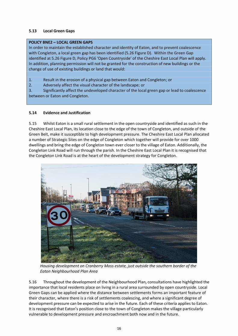
5.14 Evidence and Justification 5.15 Whilst Eaton is a small rural settlement in the open countryside and identified as such in the Cheshire East Local Plan, its location close to the edge of the town of Congleton, and outside of the Green Belt, make it susceptible to high development pressure. The Cheshire East Local Plan allocated a number of Strategic Sites on the edge of Congleton which together will provide for over 1000 dwellings and bring the edge of Congleton town ever closer to the village of Eaton. Additionally, the Congleton Link Road will run through the parish. In the Cheshire East Local Plan it is recognised that the Congleton Link Road is at the heart of the development strategy for Congleton.
Housing development on Cranberry Moss estate, just outside the southern border of the Eaton Neighbourhood Plan Area
5.16 Throughout the development of the Neighbourhood Plan, consultations have highlighted the importance that local residents place on living in a rural area surrounded by open countryside. Local Green Gaps can be applied where the distance between settlements forms an important feature of their character, where there is a risk of settlements coalescing, and where a significant degree of development pressure can be expected to arise in the future. Each of these criteria applies to Eaton. It is recognised that Eaton’s position close to the town of Congleton makes the village particularly vulnerable to development pressure and encroachment both now and in the future.

17
5.17 Local Plan Policy PG6 – Open Countryside states that “the retention of gaps between settlements is important, in order to maintain the definition and separation of existing communities and the individual characters of such settlements”. The written justification highlights that the protection of gaps will make sure that the intrinsic character and beauty of the countryside will be recognised and protected. 5.18 The Local Green Gaps have been designated following guidance prepared by Cheshire East Council for Neighbourhood Plan groups and are considered to align to the approach underpinning Cheshire East’s green gap policy in Part One of the Local Plan Strategy, and the emerging local green gap policy in Part Two of the Local Plan which allows for the identification of local green gaps in Neighbourhood Plans. They will:-
• Provide long term protection against coalescence
• Protect the setting and separate identity of the settlement
• Retain the existing settlement pattern by maintaining the openness of land 5.19 The Eaton Parish Landscape and Village Character Assessment undertaken by eScape highlighted local green gaps that will help prevent the coalescence of Eaton with neighbouring Congleton and ensure that the village retains its identity and does not become a suburb of Congleton town. 5.26 Figure D highlights the proposed green gaps with the green hatching. On the western side of the A536 Macclesfield Road the gap stretches from the southern built up area of Eaton Village, south of the proposed Congleton Link Road, to the Neighbourhood Plan boundary on Moss Lane, to cover an area of parkland character which will provide a buffer between the allocated Congleton strategic sites and the Neighbourhood Plan area. 5.20 The North Congleton Masterplan defines the area south of the proposed Congleton Link Road and north of Moss Lane as being of a parkland character with medium to high landscape and visual constraint, and highlights that the parkland character should be retained. The area is shown as an area of landscape sensitivity, with Cranberry Moss (a site of Special Biological Interest which lies within this section of the proposed green gap) deemed to have too high a landscape value to accommodate development. Additionally, the draft Part Two of the Local Plan, recommends that the proposed settlement limit for Congleton at this point should run along Moss Lane, rather than the Congleton Link Road, indicating that development should stop along the Moss Lane boundary, rather than at the Congleton Link Road, therefore highlighting the preference that the area should remain open, with a gap remaining here (aside from the development of the Congleton Link Road) between Congleton and Eaton. 5.21 Despite the fact that the proposed green gap which lies south of the Congleton Link Road is outside proposed settlement limits and within open countryside; it was not proposed for development in the North Congleton Masterplan - indeed was noted for its landscape value; and despite the location of Cranberry Moss within the proposed gap, a recent planning application for 150 dwellings was submitted for development on the site. This is considerably more dwellings than already exist in Eaton (103 dwellings), and the application was submitted despite Cheshire East Council’s housing policies being up to date and attributed full weight, with a healthy 7.2 years’ housing land supply (November 2018) against an up to date Fully Objectively Assessed Need. The applicants themselves recognised that the land is not an allocated site and it lies within the countryside, beyond defined settlement boundaries, and that the proposals for residential development do not fall within the categories of development which are considered to be acceptable in the open countryside. However, an application was still submitted. This highlights the significant amount of pressure that the gap between Congleton and Eaton is under, and which is likely to continue in the future. 5.22 The recent application was withdrawn, but was recommended for refusal as it would result in a loss of open countryside, would likely to be car dependent, and gave insufficient information concerning ecological matters. It was recognised that the topography of the site is steeply undulating, with the site sloping towards Macclesfield Road, which is very apparent in views from

18
Manchester Road. Development would have led to an adverse landscape and visual impact, not preserving or enhancing the appearance and distinctiveness of the Cheshire East countryside. The trees on the site provide a significant visual amenity, assist in biodiversity and contribute to the landscape character of the area. Furthermore, it was considered that development would have the potential to have a significant adverse effect on the Cranberry Moss Local Wildlife Site and the priority habitats that it supports. 5.23 The photograph below is the view south of the Eaton Millennium Park towards Congleton. The darker shaded field is the area which will be south of the Congleton Link Road to Moss Lane. The distance from the Congleton Link Road to the village would only be the lighter shaded field. This highlights that any potential residential development on the land south of the Congleton Link Road would be clearly visible from the village, eroding the openness of the landscape, damaging the intrinsic beauty of the countryside, encroaching upon Eaton and damaging the identity and character of Eaton as a small, separate, rural village.
The Local Green Gap between Congleton and Eaton. The houses of Congleton are just behind the trees. 5.24 The local green gap to the east of the A536 Macclesfield Road runs south of the church and Yew Tree Farm down to the Neighbourhood Plan boundary and separates Eaton Village from Havannah and Congleton. It will prevent the coalescence of Eaton and Congleton and help to retain the open setting and rural character of the parish. There are very attractive views of the Pennine Hills from this stretch of the A536 and these would also be protected by the Local Green Gap. 5.25 Defining the local green gaps is therefore considered essential to maintain the character and identity of Eaton in the face of significant development pressure. Development on the strategic sites to the south of Moss Lane, the new Congleton Link Road, and the mineral extraction industry account for a large proportion of the parish. It is considered that the proposed green gaps fully align to the emerging local green gap policy in Part Two of the Local Plan, as they are necessary to provide long term protection against coalescence; protect the setting and separate identity of Eaton, and will retain the existing settlement pattern by maintaining the openness of land. Maintaining and enhancing the character and separate identities of the borough’s towns and villages is a key priority of the Local Plan Strategy. The NPPF makes no direct reference to green gaps, but its core principles recognise the importance of the countryside, the natural environment and the character of different areas, which are supported by the application of green gap policy.

19
5.26 Figure D – Local Green Gaps – hatched green on the map below

20
5.27 Local Character and Design
POLICY BNE3– LOCAL CHARACTER AND DESIGN To ensure that buildings, characteristic features and materials are representative of the settlement character of Eaton, the design and layout of any new developments should demonstrate consideration of the Cheshire East Design Guide (2016) and the Eaton Landscape and Village Character Assessment (2018) or any updated version.
Any new development should take the following into account, where appropriate: a) Development adjoining open countryside should provide a sympathetic transition between the rural and village landscape, through appropriate landscaping, design and boundary treatments. b) Boundary treatments in new development should be formed of soft landscaping including trees and hedges c) New development should ensure a positive transition between the countryside and built form d) Development should create gaps in frontages to enable views to the countryside. e) Views to important local landmarks such as The Cloud and Christ Church should be maintained. f) Development should include traditional materials and detailing in new designs, reflective of the high-quality traditional features present in the village. g) Development at the gateways to the core village (5.38 Figure E) should be treated sensitively, incorporating a traditional style and vernacular. h) Development should not be higher than two storeys. i) Development should support features beneficial to wildlife. j) The Green Wedges (4.4 Fig B2) contribute to the rural character of the village. Within the Green Wedges, policy PG6 Open Countryside applies and only development that does not harm the character of the village will be supported. k) Development should, where appropriate, incorporate Sustainable Drainage Systems (SUDS) which avoids all non-permeable surfaces, or delivers a water management system which minimises surface water run-off and ensure that all surface water is addressed within the site boundary. Every option should be investigated before discharging surface water into a public sewerage network, in line with the surface water hierarchy. See appendix 3. 5.28 Evidence and Justification. 5.29 The rural setting of Eaton within the landscape is important to the local community. The Neighbourhood Plan steering group commissioned eScape to prepare a Landscape and Village Character Assessment of Eaton to help inform the policies of the Neighbourhood Plan. The report
was produced in spring 2018. see http://www.eatoncheshire.co.uk/wp-content/uploads/2019/03/Landscape-Village-Character-Assessment-Inc-Appendix-A-V1-1.pdf The report assesses the landscape character and settlement of Eaton village, including the local design vernacular, elements of the landscape, and significant local features that are unique to the parish. It is important that any new development is of high-quality design, enhancing the local character of the parish. 5.30 The 2018 Landscape and Village Character Assessment gave an overview of Eaton, noting that the landscape is pastoral, which creates a strong setting for the village, with the field boundaries dominated by native trees and hedgerows. A series of woodland belts can be seen around the parish, adding further to the green backdrop of the village. The village form and layout are primarily linear, with older, historic buildings and properties now joined by two mid twentieth century small housing developments at Crauford Road and Beechwood Drive, built in the 1950s and 1960s. A number of individual large farmsteads feature prominently in the landscape. The assessment concludes that the village has grown and evolved over the centuries, which is reflected in the architecture, with the sense of place formed as much around the spaces between the buildings as the buildings themselves.

21
5.31 The Landscape and Village Character Assessment gives detailed information on the layout and structure of the village. In particular: • Close proximity of a number of footpaths and leisure routes in to the countryside and down
towards the Dane Valley
• Distinct sense of entrance to the village
• Prominent natural environment
• Most residences are of two storey height, and proportionate to their plots incorporating front and rear gardens
• Where post war, estate style development has taken place, layout is inward facing having turned its back on the countryside. Layout elsewhere is formed through the relation of individual dwellings at low density to their immediate surroundings and tends to be linear ribbon development
• There is a heritage zone making up the heart of the village (see policy BNE4) with a small village green
• The primary residential areas are located centrally within the Neighbourhood Plan Area with the village’s open spaces surrounding this, giving the village its distinctive rural setting.
• The layout, materials, detailing and hard boundary treatments of the two housing developments of the 1950s and 1960s are not characteristic of the vernacular trait of the village and these characteristics should not be accepted in any future development.
• Field boundaries are dominated by native trees and hedgerows, and to the west of the Plough Inn an area of landscape exists which has a parkland feel, a remnant of the wider Eaton Hall setting, and should be protected.
• Within the village are green connections offering views across the landscape via field gates and open gaps to the adjoining fields – which ensure a strong interrelationship between the village and rural setting, bringing the rural landscape into the centre of the village.
• The Tudor properties appear to have had new facades added to the original frontages in the Georgian period; for example, the Plough Inn.
• The Georgian buildings are typical of Cheshire with a warm brindle multi ‘Cheshire brick’, usually in either Flemish Bond or English Bond with headers every 5th or 7th course
• Many older properties have stone heads and sills to their windows
• A ‘cock and hen’ brick banded course at eaves can be found on many buildings
• A wide range of materials are employed throughout as the village has evolved over the centuries.
5.32 Two green wedges in the village add interest along School Lane. Just north of The Plough a field gate adds views west into the parkland landscape, bringing the rural landscape into the heart of the village. Just north of the former school a wide section of street frontage is taken up by a field compartment, providing local views across the rising topography of the field towards the next hedged field boundary. These green connections are part of the intrinsic village character, ensuring a strong interrelationship between the village and rural setting, and ensuring a visual connection and access through to the surrounding countryside. The wedges ensure that the village is strongly referenced back to the surrounding rural landscape, and the Eaton Landscape and Village Character Assessment highlights the contribution that these wedges make to the character of the village.

22
‘Big Wood’ plantation on Back Lane
Beechwood Drive housing Crauford Road housing
Putty Row housing School Lane housing 5.33 Key gateways into the village are defined on the Spatial Map (5.38 Figure E). These are at the north east of the village along Macclesfield Road (A536), where the first signs of the village are the clustered cottages and small holdings located to the east of the road; at Christ Church at the southern entrance to the village, and at the historic farmstead at the junction of Back Lane and School Lane at the north west entrance to the village. This gateway provides a strong introduction to the village, framed and enclosed by the farmstead and other residential properties. These key gateways are important in defining the approach and setting the style of the village. If there were to be any small-scale infill development at these gateways, it must be treated sensitively and incorporate traditional style and vernacular, in order to reflect its importance to the setting and character of Eaton.
5.34 Additionally, Cheshire East Council has recently prepared a supplementary planning document – the Cheshire East Design Guide.

23
https://www.cheshireeast.gov.uk/planning/spatial_planning/cheshire_east_local_plan/supplementa ry_plan_documents/design-guide-supplementary-planning-document.aspx .The guide highlights that the character and attractiveness of Cheshire East underpins the quality of life enjoyed by the Borough and its residents.
5.35 Eaton falls within ‘Silk, Cotton and Market Towns’ character area, which is rural in character
and defined by a higher than average density of woodland compared with much of Cheshire. It acts
as a transitional zone between the flatter expanses in the south of the area and the higher ground to
the north towards the Pennine Fringe. The River Dane flows through the middle of this area (where
Eaton is located) and where much of the steeper ground is wooded and the valley floor consists of
pasture land.
5.36 The design guide highlights that within this character area landmark and header buildings are found within and around the settlements and the landscape setting, views and footpaths out to countryside are important. Residential properties step and flow with the gently rolling topography.
5.37 In order to reflect and enhance the character of Eaton, the Cheshire East Design Guide and the Eaton Landscape and Village Character Assessment Spatial Character Assessment should be consulted on any new development proposals.
The River Dane, Eaton

24
5.38 Figure E - Eaton Village Spatial Map

25
5.39 Heritage
POLICY BNE4 – HERITAGE
A heritage zone is defined and highlighted on 5.38 Figure E. Development of and within close proximity to the heritage zone should be undertaken sensitively with special regard to views, design, setting, materials and street scene.
Acceptable proposals which conserve and enhance Eaton’s historic assets and their setting will be
supported, particularly if the proposals would help retain the assets in active use. Proposals for
development must take into account the scale of any possible harm or loss and the significance of
any heritage assets and will only be supported where it can be demonstrated that substantial
benefits will be achieved when weighed against the harm or loss. Measures should be put in place
to avoid or minimise impact or mitigate damage.
5.40 Evidence and Justification
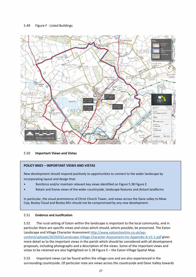
5.41 Eaton is fortunate to have a long and rich heritage, and the village has been occupied since at least the twelfth century. The Neighbourhood Plan designated area has four buildings listed of being of historical or architectural importance, which are highlighted on 5.49 Figure F.
5.42 The listed buildings are Christ Church, which was built between 1856 and 1858 to a design
by Raffles Brown in Gothic Revival style. It is built in stone with a slate roof, and consists of a nave, a
porch, a vestry, a chancel, and a west tower. The tower has buttresses, a stair turret, clock faces, a
battlemented parapet, and a small pyramidal roof. Inside the church is a hammerbeam roof. Church
House was built in the seventeenth century, partly timber framed on a stone plinth and partly in
brick. The Plough Inn also dates from the seventeenth century and is partly timber framed on stone
plinth with rendered panels, and partly in brick with stone dressings. Yewtree Farm, another
seventeenth century property, is a timber framed farmhouse with brick infill on a stone plinth, with
a slate roof. At the rear some wattle and daub infill is still present.
Christ Church Church House
The Plough Inn Yewtree Farm

26
5.43 Further historic assets include the old school, school house and the former Quaker Burial Ground and associated former Quaker schoolmaster’s house opposite (now called Pear Tree Cottage). The Quaker Cemetery was in use as long ago as the 1650s.
5.44 These heritage assets are part of Eaton’s character and are valued by the community. It is important that they are protected from inappropriate development and, where possible, enhanced.
5.45 The Plough Inn lies at the heart of the village, sitting at the junction of Macclesfield Road and
School Lane, and fronts on to the small village green. The green is in essence at the heart of the historic
village and is edged by the inn, a series of Georgian terraces, and the partially timbered Church House.
The Eaton Landscape and Village Character Assessment http://www.eatoncheshire.co.uk/wp-
content/uploads/2019/03/Landscape-Village-Character-Assessment-Inc-Appendix-A-V1-1.pdf
highlighted the importance of this location and features in the street scene, and recommended that the
Neighbourhood Plan should designate this group of buildings and the green as a heritage zone.
5.46 Additionally, the Assessment highlights that the linear form of the key focal elements of Christ Church Tower, the large oak tree within the Millennium Park, the black and white gable of Church House, the Plough Inn frontage and the former school frontage in the streetscene could be described as a ‘string of pearls’ at this local heritage level.
The ‘Big Oak’ in the Millennium Park
5.47 In order to ensure their continued value to the setting and character of the parish, any development of, or within close proximity to, these buildings and landscape features must be undertaken sensitively with special regard to design, setting, materials and street scene.
5.48 One of the core planning principles of the National Planning Policy Framework is to conserve heritage assets in a manner appropriate to their significance, so that they can be enjoyed for their contribution to the quality of life of this and future generations.
27
5.49 Figure F - Listed Buildings
5.50 Important Views and Vistas
POLICY BNE5 – IMPORTANT VIEWS AND VISTAS
New development should respond positively to opportunities to connect to the wider landscape by
incorporating layout and design that:
• Reinforce and/or maintain relevant key views identified on Figure 5.38 Figure E
• Retain and frame views of the wider countryside, landscape features and distant landforms
In particular, the visual prominence of Christ Church Tower, and views across the Dane valley to Mow Cop, Bosley Cloud and Bosley Min should not be compromised by any new development.
5.51 Evidence and Justification
5.52 The rural setting of Eaton within the landscape is important to the local community, and in
particular there are specific views and vistas which should, where possible, be preserved. The Eaton
Landscape and Village Character Assessment http://www.eatoncheshire.co.uk/wp-
content/uploads/2019/03/Landscape-Village-Character-Assessment-Inc-Appendix-A-V1-1.pdf gives
more detail as to the important views in the parish which should be considered with all development proposals, including photographs and a description of the views. Some of the important views and vistas to be retained are also highlighted on 5.38 Figure E – the Eaton Village Spatial Map.
5.53 Important views can be found within the village core and are also experienced in the
surrounding countryside. Of particular note are views across the countryside and Dane Valley towards

28
Mow Cop and The Cloud. “Views towards The Cloud” was the most common response when residents
were asked in the Neighbourhood Plan questionnaire if there were any special views that should be
preserved. Additionally, Christ Church tower is an important local landmark visible from within the
village and further afield. The church occupies a high peninsula on the valley crest overlooking the Dane
Valley. These views to the east and south appear to have been considered on the construction of the
church through the development of ha ha’s to the graveyard boundaries. These ‘hidden’ boundaries
create seamless and unbroken views between the church and wider landscape out towards the Bosley
Cloud, Havannah and Buglawton.
The views across to the Cloud
5.54 The Eaton Landscape and Village Character Assessment highlighted that views to and from the
parish are of importance to Eaton’s character, with the most significant features being the church, the
listed buildings, the rural landscape and trees and hedgerows. The views that can be seen from the
village to the surrounding countryside strengthen the relationship of the village to its rural hinterland,
forming an intrinsic part of the village’s character.
5.55 The NPPF highlights that planning policies and developments should contribute to and enhance the natural and local environment, protecting and enhancing valued landscapes. Cheshire East
Local Plan Strategy Policy SE4 – ‘The Landscape’ written justification highlights that the impacts of
proposed developments upon existing landscape and views of the surrounding area should be assessed
as part of the planning process.

29
5.56 Local Green Spaces
POLICY BNE6 – LOCAL GREEN SPACES
The areas listed below are designated as ‘Local Green Spaces’ which are protected from new development unless very special circumstances can be demonstrated, or where development supports the role and function of the Local Green Space. Acceptable proposals which enhance the local green spaces and their function will be supported.
LGS1 – Millennium Park, Play Area and Sports Pitch
LGS2 - Village Green opposite the Plough Inn
LGS3 – Parish Hall Green Space
LGS4 - Beechwood Drive Green Space
5.57 Evidence and Justification
5.58 The National Planning Policy Framework highlights that local communities through local and
neighbourhood plans should be able to identify for special protection green areas of particular
importance to them. By designating land as Local Green Space local communities will be able to rule out new development other than in very special circumstances. Over 90% of respondents to the
Neighbourhood Plan questionnaire felt that green spaces in and around Eaton should be protected.
5.59 Local Green Space designation should only be used:
● where the green space is in reasonably close proximity to the community it serves;
● where the green area is demonstrably special to a local community and holds a particular local significance, for example because of its beauty, historic significance, recreational value (including as a playing field), tranquillity or richness of its wildlife; and
● where the green area concerned is local in character and is not an extensive tract of land.
5.60 The table below provides information about how the Local Green Spaces meet the criteria in the National Planning Policy Framework. The Local Green Spaces are recognised as important features in the Eaton Landscape and Village Character Assessment, and are identified on 5.61 Figure G below, and in Appendix 1.

30
Open Size Proximity to the Demonstration of Special Value to the Local Space Community Community
Millennium 0.65 ha Located within the village Situated within village, the Millennium Park is Park. With an excellent facility which is central to the play area recreational needs of the village. The and sports recreation area is a much-valued meeting place pitch for the residents of the core of the village but
also a place for the outlying sub areas residents of Eaton to meet with families. The recreation area provides a community area for all. The Millennium Park enjoys protected mature oak trees and includes playground equipment, and has an open, well managed playing field and kickabout pitch. Large trees at the boundary edge of this space bring a sense of greenery and nature into the main A536 carriageway, and the large, historic oak tree forms an important focal point. The Millennium Park is part of the gateway into the village, enjoys lovely views across the landscape and to Mow Cop.
Village 0.04 ha Located within the heart of The village green is small but situated in the Green the village heart of the village within the area classified in opposite the Landscape and Village Character the Plough Assessment as a Heritage Zone, and is framed Inn by important village historical assets such as the
Georgian terraces and listed Plough Inn and Church House. The village green not only has visual amenity value, adding greenery to the centre of the village and being an integral part of the historic core, but also acts as a buffer from the noise of the passing traffic on the A536.
Parish Hall 0.23 ha Located within the village The Parish Hall is within the village and is used Green for garden parties and village festivities. Local Space community groups such as the Brownies meet
weekly at the hall and make much use of this key open space. The green setting and mature trees add much to the visual character of Eaton and are within the area classified in the Landscape and Village Character Assessment as a heritage zone, adding much to the historic sense of place of the village.
Beechwood 0.05 ha Located within the central This attractive small green space is within the Drive residential area of the residential area of the village and is an Green village attractive amenity and visual feature with Space mature trees, bringing a sense of the
countryside into the more built up part of the
village and being much valued by local residents as an important accessible green feature adding to the character of Eaton.

31
5.61 Figure G – Local Green Spaces

32
5.62 Dark Skies
POLICY BNE7 - DARK SKIES
Dark skies are to be preferred over street lights. Any future outdoor lighting systems should have a minimum impact on the environment, minimising light pollution and adverse effects on wildlife. Schemes should reduce the consumption of energy by promoting efficient outdoor lighting technologies, keeping the night-time skies dark and reducing glare.
5.63 Evidence and Justification
5.64 There are a limited number of street lights in Eaton, away from the main A536 carriageway and main residential area, as highlighted on 5.66 Figure H. This lack of street lighting and resultant dark skies add to the rural character and sense of place of the parish.
5.65 The NPPF highlights that planning policies and decisions should ensure that developments limit the impact of light pollution from artificial light on local amenity, intrinsically dark landscapes and nature conservation. Paragraph 13.133 of the Cheshire East Local plan states that the council is aware of the increasing issues arising from artificial lighting, which can often impact upon residential amenity, the character and appearance of an area (particularly rural locations) and the environment.

33
5.66 Figure H – Street Lighting in and around Eaton

34
5.67 Trees, Hedgerows and Watercourses
POLICY BNE8 – TREES, HEDGEROWS, WATERCOURSES, LAKES AND PONDS
Hedgerows, trees, watercourses, lakes and ponds which make a significant contribution to the
amenity, biodiversity and landscape character of Eaton must be preserved, and development which
would adversely impact upon them will not normally be permitted. In exceptional circumstances,
where the benefits of development are considered to outweigh the benefit of preserving trees,
hedgerows and watercourses, development will only be permitted subject to appropriate
mitigation. The retention of trees, hedgerows and watercourses in situ will always be preferable.
Any new developments will, where appropriate, be required to include suitable plantings of trees and hedgerows. The planting of hedgerows as boundaries rather than fencing in all properties will be supported.
Applications on sites where hedgerows follow the historic field plans will be expected to include plans to ensure that these field boundaries are retained and enhanced.
Significant trees include the mature oak in the Millennium Park; those by the Community and Church Hall entrance drive; trees along School Lane; the Diamond Jubilee oaks behind the Plough Inn and the oak tree behind the old school house. Watercourses, lakes and ponds which make a significant contribution to the Neighbourhood Area include the River Dane, its banks and riverine surroundings, the quarry lakes and Cranberry Moss.
Cranberry Moss, Moss Lane
35
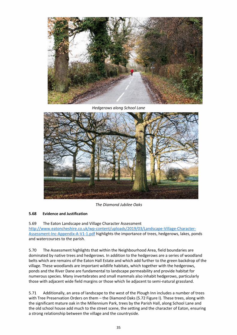
Hedgerows along School Lane
The Diamond Jubilee Oaks
5.68 Evidence and Justification
5.69 The Eaton Landscape and Village Character Assessment http://www.eatoncheshire.co.uk/wp-content/uploads/2019/03/Landscape-Village-Character-Assessment-Inc-Appendix-A-V1-1.pdf highlights the importance of trees, hedgerows, lakes, ponds and watercourses to the parish.
5.70 The Assessment highlights that within the Neighbourhood Area, field boundaries are dominated by native trees and hedgerows. In addition to the hedgerows are a series of woodland belts which are remains of the Eaton Hall Estate and which add further to the green backdrop of the village. These woodlands are important wildlife habitats, which together with the hedgerows, ponds and the River Dane are fundamental to landscape permeability and provide habitat for numerous species. Many invertebrates and small mammals also inhabit hedgerows, particularly those with adjacent wide field margins or those which lie adjacent to semi-natural grassland.
5.71 Additionally, an area of landscape to the west of the Plough Inn includes a number of trees with Tree Preservation Orders on them – the Diamond Oaks (5.72 Figure I). These trees, along with the significant mature oak in the Millennium Park, trees by the Parish Hall, along School Lane and the old school house add much to the street scene, the setting and the character of Eaton, ensuring a strong relationship between the village and the countryside.

36
5.72 Figure I – Tree Preservation Orders in Eaton
5.73 The Assessment noted that a number of properties have boundaries that are made up of
close boarded fences or other hard boundary treatments, which is at odds with the typical
boundaries of the wider rural hinterland. Any opportunities for fencing to be replaced with
hedgerows and trees, or for new infill developments to plant native trees and hedgerows will be
supported, as this will strengthen the village’s green setting, enhance the views of the village from
the surrounding landscape and be ecologically beneficial.
37
6. TRANSPORT AND INFRASTRUCTURE POLICIES
6.1 The Eaton Neighbourhood Plan has the following objectives:-
• To encourage safe and sustainable transport • To ensure improvements to infrastructure
6.2 Sustainable Transport
POLICY TI1 – SUSTAINABLE TRANSPORT
In order to improve sustainable transport and safety and to facilitate cycling and walking, where appropriate, applicants for any new development must demonstrate:
a. Safe walking and cycling routes in the immediate area of the proposed site, with consideration of access to local facilities;
b. The provision of safe cycle storage facilities;
c. How any adverse impacts of traffic from the proposed development will be mitigated;
d. That the most up to date parking standards required by Cheshire East Council will be met and on-site parking must be provided for any new developments.
e. That any proposed site is located in an acceptable place in relation to the existing highway network, especially from a safety and aggregate congestion viewpoint;
f. That the needs of children, horse riders, those with disabilities and the elderly have been positively considered;
g. That any vehicular access arrangements will not be detrimental to the character of village lanes maintaining verges, trees and hedgerows wherever possible.
Where appropriate, development contributions from S106 and CIL will be used to improve traffic safety.
6.3 Evidence and Justification
6.4. Eaton is a quiet village, but increasing traffic on the busy A536 Macclesfield to Congleton Road causes noise and air pollution, disturbance and threatens the safety of residents. The concerns regarding traffic and safety were raised throughout Neighbourhood Plan consultations. Additionally, the Congleton Link Road has planning permission and will partly run through the Neighbourhood Area (see 2.9 Figure B) which is likely to cause further disruption, noise and traffic on the A536. The Parish Council is seeking remedies from the Cheshire East Council to make the A536 Macclesfield Road safer to cross and to give it a quieter surface to reduce traffic noise in the village.

38
Traffic congestion on A536, through the village
6.5 There is little in the way of business employment within the parish. The agricultural activity which was predominant in the past is now much less labour-intensive due to the use of modern technology. Thus most of the villagers of working age travel in order to work. This involves car travel as public transport is infrequent and impractical for many commuting journeys. Indeed, Department of Transport data from 2011 highlighted that only 1.1% of working residents in Eaton travelled to work by public transport, compared to the average in England of 11%.
Agricultural activity within the village

39
6.6 At the time of the 2011 census 61.2% of households in Eaton had two or more cars (compared to 32.1% in England) probably because working adults in the household need to travel to different locations, or at different times. Only 4.1% of households had no car. It takes Eaton residents far longer to access services on foot or using public transport than the county average (Department of Transport data 2011). Accessing public transport at a necessary or convenient time is not always achievable, and this can be a real problem for people without the use of a car.
6.7 In particular, mitigation measures and improvements to be sought may include the lowering of the speed limit to 20 miles per hour on School Lane and the surrounding village lanes; the creation of a shared space or traffic calming surface around the village green in front of the Plough Inn and across both School Lane and Macclesfield Road, to enable safer crossing of the main road between both halves of the village; an average speed camera system for the A536, improved signage on rural lanes to support recreational use; and at the settlement gateways (see 5.38 Figure E) changes in road surface colour and texture, distinctive signage, or tree planting to physically announce the arrival into the village.
6.8 The promotion of sustainable transport is one of the aims of the NPPF (National Planning Policy Framework), which highlights the importance of walking, cycling and public transport.

40
6.9 Footpaths and Access to the Countryside
POLICY TI2– FOOTPATHS AND ACCESS TO THE COUNTRYSIDE
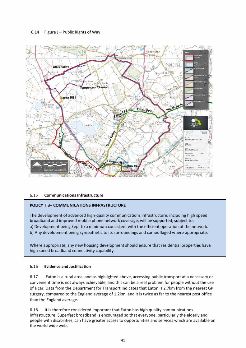
a) Access to the countryside will be promoted through protection and maintenance of the existing Public Right of Way network (see 6.14 Figure J - map of existing Public Rights of Way), its enhancement where possible, and the safety of users of rural roads and lanes. b) Any development that leads to the loss or degradation of any Public Right of Way will not be permitted in other than very special circumstances, and then only if a suitable alternative can be provided. Proposals to divert Public Rights of Way should provide clear and demonstrable benefits for the wider Eaton community. c) Any new development must provide easy, accessible traffic-free routes for non-motorised users (to include pedestrians, disabled people, people with prams or baby-buggies, cyclists and where appropriate equestrians) to open spaces, facilities and nearby countryside. The provision of any such additional routes will be supported. d) The needs of non-motorised users (as described above) must be taken into account in all traffic
planning, but especially in relation to rural lanes and roads. Hazards arising from an increase in
vehicle numbers where agricultural buildings are converted to residential or commercial use will
need to be taken into consideration. Measures to be taken to ensure this may include, for example,
separation of pedestrians/cyclists from vehicular traffic where possible, improvements to signage, or
means of speed reduction.
6.10 Evidence and Justification
Public Footpath towards the north of the village
6.11 The importance of public rights of way to residents was highlighted in the Neighbourhood Plan questionnaire responses, which indicated that over 55% of respondents use the rural lanes or footpaths on a daily or weekly basis, with a further 38% using them monthly or occasionally. Furthermore, over a third of residents who responded replied that they would like to see more rural footpaths created. The footpaths and lanes have important connecting and recreational functions and allow direct access into the countryside. The national trail the Dane Valley Way runs through the Neighbourhood area, serving residents and visitors alike. The footpaths offer strong views over the fields and towards the church tower.
6.12 The Neighbourhood Plan aims to protect the existing network and take opportunities to integrate any new developments with the existing rights of way network and enhance existing provision by creating new links where possible.
6.13 This policy seeks to help deliver one of the NPPF’s aims of conserving and enhancing the natural environment, and also of promoting healthy communities. The NPPF highlights that policies should protect and enhance public rights of way and that opportunities should be sought to provide better facilities for users, for example by adding links to existing public rights of way networks.
41
6.14 Figure J – Public Rights of Way
6.15 Communications Infrastructure
POLICY TI3– COMMUNICATIONS INFRASTRUCTURE
The development of advanced high-quality communications infrastructure, including high speed broadband and improved mobile phone network coverage, will be supported, subject to: a) Development being kept to a minimum consistent with the efficient operation of the network. b) Any development being sympathetic to its surroundings and camouflaged where appropriate.
Where appropriate, any new housing development should ensure that residential properties have high speed broadband connectivity capability.
6.16 Evidence and Justification
6.17 Eaton is a rural area, and as highlighted above, accessing public transport at a necessary or convenient time is not always achievable, and this can be a real problem for people without the use
of a car. Data from the Department for Transport indicates that Eaton is 2.7km from the nearest GP
surgery, compared to the England average of 1.2km, and it is twice as far to the nearest post office
than the England average.
6.18 It is therefore considered important that Eaton has high quality communications infrastructure. Superfast broadband is encouraged so that everyone, particularly the elderly and people with disabilities, can have greater access to opportunities and services which are available on the world wide web.

42
6.19 Additionally, a larger than average percentage of Eaton residents work from home. The
2011 census information indicates that 6.9% of 16-74 year olds work from home, which is higher
than the average in England of 3.5%. The Neighbourhood Plan Questionnaire
http://www.eatoncheshire.co.uk/wp-content/uploads/2019/01/NP_Questionnaire-3.pdf asked
whether there was anything preventing respondents working from home. In the Questionnaire
Analysis Report http://www.eatoncheshire.co.uk/wp-content/uploads/2016/06/Analysis-Report-
17.04.2017-final-1.pdf over 30% responded that poor broadband speed, poor mobile signal, or
both prevented them from working from home. Having a high-quality communications
infrastructure is therefore important to help enable, sustain and develop the businesses of these
residents. 6.20 The Neighbourhood Plan questionnaire asked respondents if they were satisfied with
internet speeds. Of the 132 residents who responded, 70% were either dissatisfied or very
dissatisfied. When asked to measure their speed, the median response was 4Mbps (megabits per
second). The Government’s stated minimum target speed is 10Mbps. 98% of the respondents
received less than this minimum target, highlighting that the broadband service fell well short of
acceptable standards. Since the Neighbourhood Plan Questionnaire was completed, Openreach has
laid on Fibre-to-the-Cabinet (FTTC) high-speed broadband to Eaton which is currently providing
around 30Mbps, but it is not yet clear if any parts of the Eaton parish are still unable to access this
service.
6.21 The questionnaire also asked about mobile phone reception. Of the respondents, 67% received poor service or no signal at all in their homes. Only 12% of respondents had good service. The mobile phone coverage in Eaton needs to be improved. 6.22 One of the aims of the National Planning Policy Framework is to support high quality communications infrastructure. The NPPF highlights that supporting high quality communications infrastructure is essential for sustainable economic growth, and social wellbeing.

43
7. COMMUNITY POLICIES
7.1 The Eaton Neighbourhood Plan has the following objectives:-
• To support and encourage leisure activities and community facilities
7.2 Leisure and Countryside Pursuits
POLICY C1 – LEISURE AND COUNTRYSIDE PURSUITS
The enhancement, protection and development of leisure and countryside pursuits in Eaton will be supported in appropriate locations where there is no significantly harmful impact on the surrounding landscape. In particular, the enhancement of waterways, lakes and ponds for angling and bird watching and the development of bridlepaths and cycleways will be supported. Development which would lead to their loss or degradation will not be supported.
7.3 Evidence and Justification
7.4 Eaton is a small village and whilst not having the resources to build or maintain significant leisure facilities, is fortunate to be surrounded by the countryside and natural features that provide leisure opportunities for many residents and visitors. The lanes, footpaths and the countryside are used by many people for walking and rambling. Horse riders and cyclists also enjoy the rural lanes. The natural environment and accessible countryside features were outlined by residents during consultations as being an intrinsic part of the parish, valued for their attractive visual impact and used by many. Additionally, the water features such as the River Dane, ponds and quarry lakes are valued by anglers and birdwatchers.
7.5 These areas make an important contribution to the valued character of Eaton, through their visual contribution, their amenity value and their wildlife habitats, and as such it is considered important that they are protected, enhanced, and sensitively developed where appropriate. The National Planning Policy Framework highlights that access to high quality open spaces and opportunities for sport and recreation can make an important contribution to the health and wellbeing of communities.
7.6 Community Facilities
POLICY C2 – COMMUNITY FACILITIES
Appropriate proposals for the refurbishment and improvement of community facilities will be permitted, subject to other policies within the Neighbourhood Plan. Changes of use of community facilities to non-community facilities which require planning permission will not normally be permitted, unless any replacement use will provide equal or greater benefits to the community, the facility is replaced elsewhere, or it is demonstrated that the facility is no longer required.
Proposals for appropriate new community and recreational facilities will be supported, subject to other policies within the Neighbourhood Plan.

44
7.7 Evidence and Justification
7.8 Along with the Millennium Park which has a kickabout and play area, there is a recently refurbished Parish Hall, which is central to the village and well used. The hall caters for a range of
community functions, including various activities and classes. The village is also fortunate to be home to a church and two public houses. They help to reduce social isolation and add to the sustainability of the village.
The Parish Hall building and grounds
Waggon & Horses Public House and Accommodation, A34
7.9 The Neighbourhood Plan questionnaire http://www.eatoncheshire.co.uk/wp-content/uploads/2019/01/NP_Questionnaire-3.pdf asked residents what leisure activities they would like to see in Eaton. In the replies analysed in the Questionnaire Analysis Report http://www.eatoncheshire.co.uk/wp-content/uploads/2016/06/Analysis-Report-17.04.2017-final-1.pdf over a third highlighted that they would like to see more rural footpaths, and other suggestions included a bowling green or tennis court. A high number of residents indicated that they rated the refurbished Parish Hall highly and used the Millennium Park occasionally or more often.

45
7.10 In order to ensure the continued vibrancy and vitality of Eaton, and that the parish remains an attractive place to live, work and to visit, it is essential that any loss of the community facilities in the parish is resisted where possible, and that the improvement and enhancement of facilities is supported.
7.11 The NPPF highlights that planning policies and decisions should promote the retention and development of local services and community facilities, such as meeting places, sports venues, cultural buildings, public houses and places of worship.

46
8. LOCAL ECONOMY POLICIES
8.1 The Eaton Neighbourhood Plan has the following objectives:-
• To encourage and support a thriving local economy • To continue the good relationship with the sand extraction industry and ensure that
restoration plans will complement the parish
8.2 Rural Economy
POLICY LE1 – RURAL ECONOMY
Subject to respecting Eaton’s built and landscape character, and environmental and residential amenity impacts being acceptable, the following will be supported –
a) The development of new small businesses and the expansion to an appropriate local scale of existing businesses, particularly on brownfield sites b) Proposals that promote or provide facilities for home working and businesses operating from home c) The sympathetic conversion of existing buildings for business and enterprise d) The diversification of farms and rural businesses e) Agricultural and Horticultural enterprises
8.3 Evidence and Justification
8.4 In Cheshire East, the rural economy represents 32% of the borough’s economy and provides work for 65,000 people. As a rural parish, Eaton should have a strong role in supporting the rural economy, both agriculture and tourism.
8.5 There are limited opportunities for employment in Eaton and many villagers seek to pursue work further afield. The existing businesses and employment opportunities in Eaton therefore help the sustainability of the community.
8.6 Eaton has a higher than average proportion of people aged 16-74 who work from home (6.9% compared to the average in England of 3.5%); who work more than 49 hours a week (19.2% compared to the England average of 13.3%) and/or who are self-employed (20% compared to the England average of 9.8%) (2011 Census). Additionally, only 1.1% of working residents use public transport to get to work, and only 8.4% of people travel less than 2km to work, compared to the average in England of 20%. The rural economy and existing small businesses are a vital part of village life, and any opportunities to improve the capability for residents to work from home, develop existing businesses, or that would enable the start-up of new small businesses appropriate to the rural area would be supported.
8.7 One of the aims of the NPPF is to support a prosperous rural economy. Planning policies should support economic growth in rural areas in order to create jobs and prosperity by taking a positive approach to sustainable new development. The Designated Neighbourhood Area includes a number of farms and the NPPF supports the re-use of existing rural buildings, particularly for economic purposes, and promotes the development and diversification of agricultural and other land based rural businesses.

47
8.8 Extractive Industries After-Use
POLICY LE2 – EXTRACTIVE INDUSTRIES AFTER-USE In accordance with Cheshire Minerals Local Plan Policy, when extraction works at the quarry cease, restoration plans must be well related to the landscape character and appropriate to the open countryside. High quality restoration proposals which lead to suitable development such as agriculture, forestry, amenity, nature conservation or recreational use will be supported, subject to having no detrimental effect on residential amenity, noise pollution or the local road network. In particular, proposals which lead to the creation of informal footpaths and walkways and provide for countryside leisure pursuits such as bird watching, angling and sailing will be supported.
Existing extractive work
8.9 Evidence and Justification
8.10 Eaton has a long and good relationship with the sand extraction industry. The quarry already occupies approximately 38% of the total area of Eaton parish. The extent of the quarry can be seen as the yellow and brown areas on 8.15 Figure K below. As the quarry is such a large and visible element of the parish, its restoration and after-use will have a great impact on the future character of the area and are of much concern to residents. It is vital that proposals do not negatively impact the rural nature of the parish nor adversely affect residential amenity. Many residents are keen to ensure that once the minerals are exhausted, restoration plans will benefit the local character and residents, complementing the quiet rural setting in scale, form and level of use.
8.11 The quarry is outside any defined settlement boundary, and thus lies within the open countryside. The definition of previously developed land in the National Planning Policy Framework glossary excludes land that has been developed for minerals extraction where provision for restoration has been made through development management procedures, and any proposed restoration plans must reflect that the after-use should be appropriate to the open countryside and respect the rural landscape. Uses that are appropriate in the open countryside are detailed in the Cheshire East Local Plan Part One Policy PG6 (see appendix 2). For example, the use of the site for refuse disposal or as a housing or industrial estate will not be appropriate.

48
Furthermore, the adopted Cheshire Minerals Local Plan (saved 2017) Policy 41 Restoration sets out clear requirements for the restoration of future mineral exploration, stating that a restoration scheme must provide for a high standard of conservation and where appropriate, enhancement of the site and provide for the highest practicable standards so as to be suitable for an agreed beneficial after use such as: • Agriculture • Forestry • Amenity • Nature conservation • Recreational use.
8.12 The NPPF indicates that worked land should be reclaimed at the earliest opportunity, and that high-quality restoration and aftercare of mineral sites should take place. The restoration of the quarry offers an opportunity for the parish, and as the residents will be living with the results, it is important that their views are considered in restitution plans. The Neighbourhood Plan questionnaire asked residents what they would like to see happen to the substantial areas left by the sand quarry when it is worked out. The majority of residents wanted to see public walkways around the lakes, and/or the lakes to be used for quiet recreational activities like fishing or sailing. Noisy activities such as power boating or shooting were not considered appropriate. Other suggestions included planting trees around the lakes and leaving them to nature.
8.13 The sand extraction industry has played an important role in the history, economy and landscape of Eaton, and residents and the quarry industry enjoy a long standing and good relationship. The restoration of the quarries once they are exhausted will be a huge change and also an opportunity for the parish. It is vital that a land use that covers such an extensive proportion of the parish is restored sensitively, respects the valued landscape character, the open countryside and residential amenity and where possible benefits the community by providing biodiversity, with recreational and leisure opportunities.
Partial restoration of original sand quarry extraction site
8.14 Future activities in and around the worked-out quarry must not give rise to extra traffic through the village along School Lane, for example traffic heading to a car park. Any car parking should only be accessed directly from the A34. The provision of car parking would open up any future facilities at the worked-out quarry to far more people than the population of Eaton and such extra traffic must not adversely affect the residents of the village.

49
8.15 Figure K - Map highlighting the location of the sand quarry (yellow and brown areas)

50
APPENDIX 1
Local Green Spaces
LGS1 – Millennium Park

51
LGS2 – Village Green
Signage on Village Green

52
LGS3 – Parish Hall Green Space

53
LGS4 – Beechwood Drive

54
APPENDIX 2
Cheshire East Local Plan Policy PG6 – Open Countryside

55
Appendix 3 – Surface Water Hierarchy
Version 5.9 22/01/2020
See Policy BNE3, point K:
Surface water should be discharged in the following order of priority:
1. An adequate soakaway or some other form of infiltration system.
2. An attenuated discharge to surface water body.
3. An attenuated discharge to public surface water sewer, highway drain or another drainage
system. 4. An attenuated discharge to public combined sewer. Applicants wishing to discharge to public sewer will need to submit clear evidence demonstrating why alternative options are not available as part of the determination of their application.