EAST PARKWAY AT BASKINS CREEK BYPASS …gatlinburgtn.gov/pdf/planning/Redevelopment and Urban... ·...
17
Gatlinburg East Parkway at Baskins Creek Bypass Redevelopment & Urban Renewal Plan PUBLIC REVIEW DRAFT Page 1 of 16 CITY OF GATLINBURG REDEVELOPMENT AND URBAN RENEWAL PLAN EAST PARKWAY AT BASKINS CREEK BYPASS DISTRICT Redevelopment Project Number 1 Adopted by the Gatlinburg Redevelopment and Housing Authority: _______________ Adopted by the Gatlinburg City Commission: _______________
Transcript of EAST PARKWAY AT BASKINS CREEK BYPASS …gatlinburgtn.gov/pdf/planning/Redevelopment and Urban... ·...

Gatlinburg East Parkway at Baskins Creek Bypass Redevelopment & Urban Renewal Plan PUBLIC REVIEW DRAFT Page 1 of 16
CITY OF GATLINBURG
REDEVELOPMENT AND URBAN RENEWAL PLAN
EAST PARKWAY AT BASKINS CREEK BYPASS DISTRICT
Redevelopment Project Number 1
Adopted by the Gatlinburg Redevelopment and Housing Authority: _______________
Adopted by the Gatlinburg City Commission: _______________

Gatlinburg East Parkway at Baskins Creek Bypass Redevelopment & Urban Renewal Plan PUBLIC REVIEW DRAFT Page 2 of 16
GATLINBURG CITY GOVERNMENT
Mike Werner, Mayor
Mark McCown, Vice-Mayor
Jerry Hays, Commissioner
Mike Helton, Commissioner
Don Smith, Commissioner
GATLINBURG REDEVELOPMENT AND HOUSING AUTHORITY
Tom Norton, Chairman
Kirby Smith, Vice-Chairman
Jason Seavy, Secretary
Jackie Leatherwood, Member
Matt Zoder, Member

Gatlinburg East Parkway at Baskins Creek Bypass Redevelopment & Urban Renewal Plan PUBLIC REVIEW DRAFT Page 3 of 16
INTRODUCTION
The City of Gatlinburg (the "City") has identified the East Parkway at Baskins Creek Bypass District (the
"District") as an ideal area for redevelopment. On August 4, 2015, the Gatlinburg City Commission created the
Gatlinburg Redevelopment and Housing Authority (the “GRHA”) to assist in the redevelopment of blighted areas
located in the City of Gatlinburg. On October 13, 2015, the GRHA held its first meeting, which was advertised and
open for public attendance. The meeting led to consensus by the GRHA Board to review potential redevelopment
districts at its next meeting. On November 12, 2015, the GRHA Board convened at an advertised and publicly
attended meeting to review three potential redevelopment districts: the Lower Ski Mountain Road Area, the East
Parkway at Baskins Creek Bypass Area, and the East Parkway at Newman Road Area. A November 12, 2015
GRHA Workshop Report and Recommendations Report was presented and is available for public inspection and
review. At the November 12, 2015 meeting, the GRHA Board reached consensus that one Redevelopment and
Urban Renewal Plan should be drafted for the East Parkway at Baskins Creek Bypass Area, following a schedule
for public review and adoption shown later in this report. Efforts to prepare draft plans for the remaining two
potential redevelopment districts were postponed for consideration at a later date.
In response to the GRHA authorization to prepare a draft plan, the East Parkway at Baskins Creek Bypass Plan (the
"Plan") has been submitted as both a redevelopment plan under §13-20-203(B) of the Tennessee Code Annotated
and an urban renewal plan under § 13-20-211 of the Tennessee Code Annotated.
The schedule for public review and plan adoption has been set as follows:
East Parkway at Baskins Creek Bypass
Redevelopment and Urban Renewal Plan Schedule
Tues 2 Feb 2016 Draft Redevelopment Plan Available for Public Review
Tues 2 Feb 2016 Public Hearing Notice Advertisement #1
Fri 5 Feb 2016 Notice to Property Owners (via Certified Mail)
Tues 9 Feb 2016 Public Hearing Notice Advertisement #2
Tues 16 Feb 2016 Public Hearing Notice Advertisement #3
Thurs 25 Feb 2016 DRAFT REDEVELOPMENT PLAN - FORMAL PUBLIC HEARING
Thurs 3 March 2016 Gatlinburg Redevelopment & Housing Authority Consideration of Plan Approval
Tues 8 March 2016 Gatlinburg City Commission Consideration of Plan Approval
The schedule is subject to change pending actions taken by the Gatlinburg Redevelopment and Housing Authority
or the Gatlinburg City Commission.

Gatlinburg East Parkway at Baskins Creek Bypass Redevelopment & Urban Renewal Plan PUBLIC REVIEW DRAFT Page 4 of 16
PROJECT AREA BOUNDARY AND EXISTING CONDITIONS
The proposed redevelopment and urban renewal area (the "Redevelopment Area") is generally bounded by
the East Parkway on the north, Baskins Creek Bypass on the west, and nearly reaches Pine Street on the east (three
parcels in the Pine Street / Cherry Street area are not included). The Redevelopment Area extends approximately
400 to 450 feet to the south from East Parkway, and is depicted on the Exhibit A map attached hereto and described
on Exhibit B attached hereto. The Redevelopment Area includes 28 parcels identified by the Sevier County
Geographic Information System (GIS) records, and encompasses approximately 10.4 acres of land. Topography of
the Redevelopment Area includes gentle slopes along East Parkway, giving way to severe slopes along the southern
boundary of the district. These boundaries are intended to encompass all potential areas identified for
redevelopment and public improvement projects, and may include additional areas reasonably expected to benefit
from redevelopment and/or new investment as a result of increased market demand stemming from the
contemplated improvements.
This Redevelopment Area presently consists of primarily hotels or motels fronting East Parkway that are
either closed and vacant, serving a storage use, or have been converted to extended stay housing. A few retail
businesses, a church, a bank, and a few single family residences are currently located within the Area. The
Redevelopment Area is located within convenient walking distance (1/4 mile) of Gatlinburg’s Parkway, which is
the main tourist activity corridor for the City. The Redevelopment Area is located within a commercial corridor
with other developed properties that are urban in density.
This Redevelopment Area clearly contains significant components of blight, within in the meaning of
Tennessee Code Annotated §13-20-201. While some parts of the Area are used productively, based upon visual
inspections, a number of properties in the area are blighted. Because of these elements of blight, the
Redevelopment Area is the proper subject of a redevelopment plan, and the improvements to be undertaken
pursuant to this plan constitute an eligible redevelopment project under Tennessee Code Annotated § 13-20-201.

Gatlinburg East Parkway at Baskins Creek Bypass Redevelopment & Urban Renewal Plan PUBLIC REVIEW DRAFT Page 5 of 16
REDEVELOPMENT PLAN OBJECTIVES
This Redevelopment and Urban Renewal Plan sets forth the primary objectives to be accomplished through
the redevelopment of the East Parkway / Baskins Creek Bypass Redevelopment Area. Without limiting the
objectives eventually implemented by the City of Gatlinburg, this Plan is intended to identify major objectives and
accomplish the following:
a. Assist the City in establishing standards and guidelines for the redevelopment and continued use of the area,
which will assure adequate light, air, open-space, off-street parking, and the future stability of the entire
area through adequate development.
b. Assist the City in eliminating conditions of blight and in beautifying the area.
c. Assist the City in encouraging effective and desirable uses of land.
d. Enable lot patterns and transportation access that promote desirable land uses and high quality
redevelopment.
e. Assist the City in encouraging and stimulating investment in redevelopment of private property,
recognizing the proximity of the Redevelopment Area to the City’s downtown, and recognizing the
potential of the Area to enhance the role of downtown Gatlinburg as a primary tourist destination.
f. Promote voluntary, market-driven reuse or redevelopment of privately owned properties, vacant parcels or
blighted structures for a compatible mix of hotel, motel, retail, and residential uses.
g. Assist the City in developing a range of options to address potential substandard housing conditions for low
or very low income households that reside in the Redevelopment Area.
h. Assist the City in maximizing the potential economic return to the City of Gatlinburg.
i. Provide proper assurances to neighboring property owners that blight will be addressed and will not
negatively impact their property values or business operations.

Gatlinburg East Parkway at Baskins Creek Bypass Redevelopment & Urban Renewal Plan PUBLIC REVIEW DRAFT Page 6 of 16
RELATIONSHIP TO LOCAL OBJECTIVES
Appropriate Land Uses
All parcels located within the Redevelopment Area are zoned C-2, General Business District, as per Article
VII, Section 707 of the City of Gatlinburg Municipal Zoning Ordinance. The C-2 zoning district permits a wide
range of land uses, including any uses permitted in the C-1, Tourist Commercial District. Primary uses encouraged
in the plan for the Redevelopment Area include hotels, motels, retail stores and shops, restaurants, and residential
dwellings. Other uses normally permitted in the C-2 zoning district are discouraged within the Redevelopment
Area, including auto sales, funeral homes, travel trailer parks, wholesale businesses, warehouses, storage yards and
buildings, and auto repair garages. Given the level of effort required by the City of Gatlinburg to implement the
Redevelopment Plan, single family dwellings should also be discouraged to maximize economic benefits and avoid
inefficient land uses so close to the downtown area. The control of appropriate land uses within the Redevelopment
Area will be accomplished through a development agreement (or similar instrument) between the City of Gatlinburg
and a private redeveloper.
A change is existing C-2 zoning is not contemplated at this time. However, the City of Gatlinburg may
exercise the option of creating a zoning overlay district that applies specifically to the Redevelopment Area, which
may include both land use controls and design guidelines to accomplish the objectives of this plan.
Traffic and Public Transportation
East Parkway (Hwy 321) serves as the primary transportation access corridor to the Redevelopment Area.
This arterial, which is in good condition, is a 5-lane facility with four travel lanes and a center left turn lane.
Capacity and design speeds are appropriate for good levels of service for the Area. Baskins Creek Bypass is a 2-
lane collector street that rises in elevation from its intersection with East Parkway, and serves in a limited capacity
for access to parcels on the western end of the Redevelopment Area. On the eastern end of the Redevelopment
Area, Pine Street rises to intersect with Cherry Street at an elevation at least 20 feet above East Parkway. Without
extensive grading, Cherry Street is not available for access into the Area. East Parkway appears to be the most
viable access corridor for the Redevelopment Area. One other public street, L. R. Reagan Way, provides access to
several residences behind the Red Carpet Inn and Gatlinburg Village complexes. L.R. Reagan Way could provide
access advantages for redevelopment based on its location near the midpoint of the district.

Gatlinburg East Parkway at Baskins Creek Bypass Redevelopment & Urban Renewal Plan PUBLIC REVIEW DRAFT Page 7 of 16
Public transit is currently provided for the Redevelopment Area. The Blue Trolley serves the free
Gatlinburg Park-N-Ride lot located next to City Hall on East Parkway, and offers convenient access to shops,
lodging, and attractions. The route begins at the Gatlinburg Mass Transit Center at traffic light #5 approximately
every 45 minutes and runs along the Parkway to East Parkway, then to the Gatlinburg Community Center before it
returns to the Mass Transit Center along the same route.
Public Utilities
The Redevelopment Area is served by all major public utilities that are considered adequate to serve
development densities permitted by the C-2 zoning district. As part of the redevelopment process, some utility
connections may need to be repaired or replaced, and utilities needed to serve specific developments will need to be
installed. Increased utility capacity will likely not be needed.
Recreational and Community Facilities
Construction or improvement of recreational or community facilities is not envisioned for the
Redevelopment Area. Special attention will be paid to safe and convenient pedestrian circulation and access to
public transit.
REDEVELOPMENT PROCESS
Although the redevelopment area as a whole contains blighted areas, several buildings in the redevelopment
area contain active businesses and sound structures. The intent of the Redevelopment Plan is to stimulate voluntary
redevelopment, reuse, or improvement of private property on specific parcels. A map of the properties within the
redevelopment area boundaries identified as redevelopment candidates has been completed and is part of this plan.
This Redevelopment Plan recommends the involuntary public acquisition of private property for economic
development purposes (transfer from one private owner to another private owner) if voluntary agreements for
redevelopment of improvements cannot be reached with current property owners. Acquisition of private property
for public improvements, both as a partial and/or total purchase, may be required but is not considered to be a
primary objective of this plan.
Blighted properties include any properties that meet the definition of "blighted areas" within the meaning of
Section 13-20-201 of the Tennessee Code Annotated. "Blighted areas" are areas (including slum areas) with

Gatlinburg East Parkway at Baskins Creek Bypass Redevelopment & Urban Renewal Plan PUBLIC REVIEW DRAFT Page 8 of 16
buildings or improvements which, by reason of dilapidation, obsolescence, overcrowding, faulty arrangement or
design, lack of ventilation, light and sanitary facilities, excessive land coverage, deleterious land use, or obsolete
layout, or any combination of these or other factors, are detrimental to the safety, health, morals, or welfare of the
community. Section 13-20-201 specifically defines "dilapidation" as extreme deterioration and decay due to lack
of repairs to and care of the area.
The Gatlinburg Redevelopment and Housing Authority (GRHA) will determine if a specific property is
"blighted" within the Redevelopment Area, and may issue a written request for redevelopment proposals from the
existing owner of that property within 60 days from the date the determination of blight has been made. GRHA will
request each existing owner of a blighted property to submit to GRHA a redevelopment proposal specifying the
intentions of each owner for redevelopment of that owner's property. Each proposal should include, in detail,
descriptions of the intended use of the property, the improvements to be made to the property, a proposed budget for
the cost of improvements, and a timetable for construction. The GRHA may reject a redevelopment proposal for
lack of sufficient information. In addition, each owner must demonstrate in its proposal its financial ability to
complete any proposed redevelopment project, including evidence of the availability of funds to complete the
project. The proposals from property owners must be submitted within 90 days from the date proposals are
requested by the GRHA.
The GRHA will examine the proposals of owners of blighted properties. The GRHA will determine
whether a proposal is consistent with this plan, whether the proposal is feasible, and whether the intended use of the
blighted property is compatible with the land uses recommended in the Redevelopment Plan and applicable City
development regulations. The GRHA may discuss a property owner's redevelopment proposal with the property
owner in whatever fashion the GRHA deems appropriate, and the property owner may resubmit a revised
redevelopment proposal to GRHA upon request by GRHA. However, the final action on any redevelopment
proposal by a property owner will be made by GRHA.
If a property owner whose property has been identified as blighted by GRHA does not agree with GRHA’s
determination, that property owner may request in writing that GRHA reconsider whether the property is blighted.
In such a case, GRHA will review and deny or accept the blight reconsideration request within 60 days from the
date the request was received. If the blight reconsideration request is denied, the property owner will then have 90
days to submit a redevelopment proposal.

Gatlinburg East Parkway at Baskins Creek Bypass Redevelopment & Urban Renewal Plan PUBLIC REVIEW DRAFT Page 9 of 16
If an owner's proposal to renovate its property is approved by GRHA, GRHA and the owner will enter into
a development agreement under which the owner will agree to develop its property as described in its proposal as
approved by GRHA. In the event that any such owner fails to renovate its property in accordance with its
development agreement, GRHA may elect to acquire such property and make it available for redevelopment.
If an owner submits a redevelopment proposal and GRHA does not approve the redevelopment proposal,
GRHA shall notify the owner in writing, specifying the reason or reasons why GRHA did not approve the
redevelopment proposal. The owner shall have 60 days from receipt of the notification to submit a revised
redevelopment proposal responding to the reasons specified in the notification.
If an owner of a blighted property fails to submit a redevelopment proposal, fails to receive approval of its
redevelopment proposal or fails to redevelop its property in compliance with its proposal, GRHA may announce its
intent to acquire such property and solicit proposals to redevelop such owner's property. Responses to such
proposals shall be submitted to GRHA for its review and approval. The GRHA will enter into a development
agreement with any person whose proposal is approved to ensure compliance with the redevelopment proposal. The
GRHA reserves the option of acquisition of individual properties or the acquisition and aggregation of several
properties for future redevelopment consistent with this plan. Any development agreements approved by the
GRHA that include City of Gatlinburg funding shall be approved by the Gatlinburg City Commission.
Anyone who may be aggrieved by any final order or judgment of the Gatlinburg Redevelopment and
Housing Authority may have such order or judgment reviewed by the courts as provided by law.
PROPOSED LAND USES AND BUILDING REQUIREMENTS
The primary land uses encouraged for the Redevelopment Area are set forth below, although other land uses
may be approved by GRHA and the Gatlinburg City Commission as compatible to the primary land uses:
Hotels and motels
Retail stores and shops
Restaurants
Multi-Family Residential Dwellings
Any development permit applications for new construction or modifications to existing structures must
comply with all applicable City of Gatlinburg codes, as is consistent for other properties within the City.

Gatlinburg East Parkway at Baskins Creek Bypass Redevelopment & Urban Renewal Plan PUBLIC REVIEW DRAFT Page 10 of 16
RELOCATION OF RESIDENCES AND BUSINESSES
If any residents of the Redevelopment Area are temporarily or permanently displaced to permit
redevelopment due to the acquisition of their property, GRHA will require assistance be provided to such residents
with relocation benefits and payments and will make every effort to provide relocation options within the
Redevelopment Area if so desired by the resident(s). In any case, GRHA will comply with City ordinances or the
State and Federal Uniform Acts if applicable with respect to relocation. If any substandard dwellings determined to
be blighted are acquired and cleared from the redevelopment area, GRHA, in its role as the City's housing authority,
will strive to provide decent, safe and sanitary housing to any relocated persons at rents within the financial reach of
the persons displaced from such substandard dwellings. If any properties are acquired for redevelopment, the
private redeveloper will be required to comply with the same obligations as those of GRHA. Redevelopment of
some portion of the district for affordable housing will be encouraged. At minimum, the policy of GRHA shall be
to require: (1) a good faith showing of attempts taken to acquire property through voluntary acquisition; and (2) any
residents displaced as the result of redevelopment activities shall be provided an opportunity to reside in the
redevelopment area upon the conclusion of new construction or renovation of existing structures.
LAND ACQUISITION PLAN
The only properties anticipated to be acquired under this plan are: (1) blighted properties identified
for acquisition and redevelopment, and (2) properties that are purchased voluntarily. Such acquisitions are hereby
authorized by this Plan in the manner permitted by applicable law.
Properties identified for acquisition will be obtained through negotiation if possible. Property in the
Redevelopment Area will be acquired by eminent domain as an option of last resort, and eminent domain will be
used only if efforts to reach agreement via voluntarily purchase are unsuccessful. Any condemnation of properties
shall be in compliance with laws of the State of Tennessee, and the owners of any property acquired shall receive
fair market value for their properties. Alternatives to condemnation will include, but not be limited to, (1) voluntary
purchase, (2) purchase of right of first refusal, (3) purchase of easements rather than fee simple ownership if such
purchase satisfies project needs, and (4) voluntary relocation to vacant and available publicly owned property.
Gatlinburg East Parkway at Baskins Creek Bypass Redevelopment & Urban Renewal Plan PUBLIC REVIEW DRAFT Page 11 of 16
Properties acquired by GRHA will be disposed of in accordance with state law and specifically Tennessee
Code Annotated §§ 13-20-204 and 13-20-210 and other applicable provisions of law. As provided in those statutes,
GRHA may dispose of any acquired property at such value as GRHA determines such property should be made
available in order that it may be redeveloped for the purposes set forth in this Plan. Any such dispositions will be
made subject to such restrictions and covenants as GRHA deems necessary to (a) ensure completion of the
redevelopment project after the transfer, (b) maintain the quality of the Redevelopment Area, and (c) ensure the
continued maintenance of the properties in the Redevelopment Area.
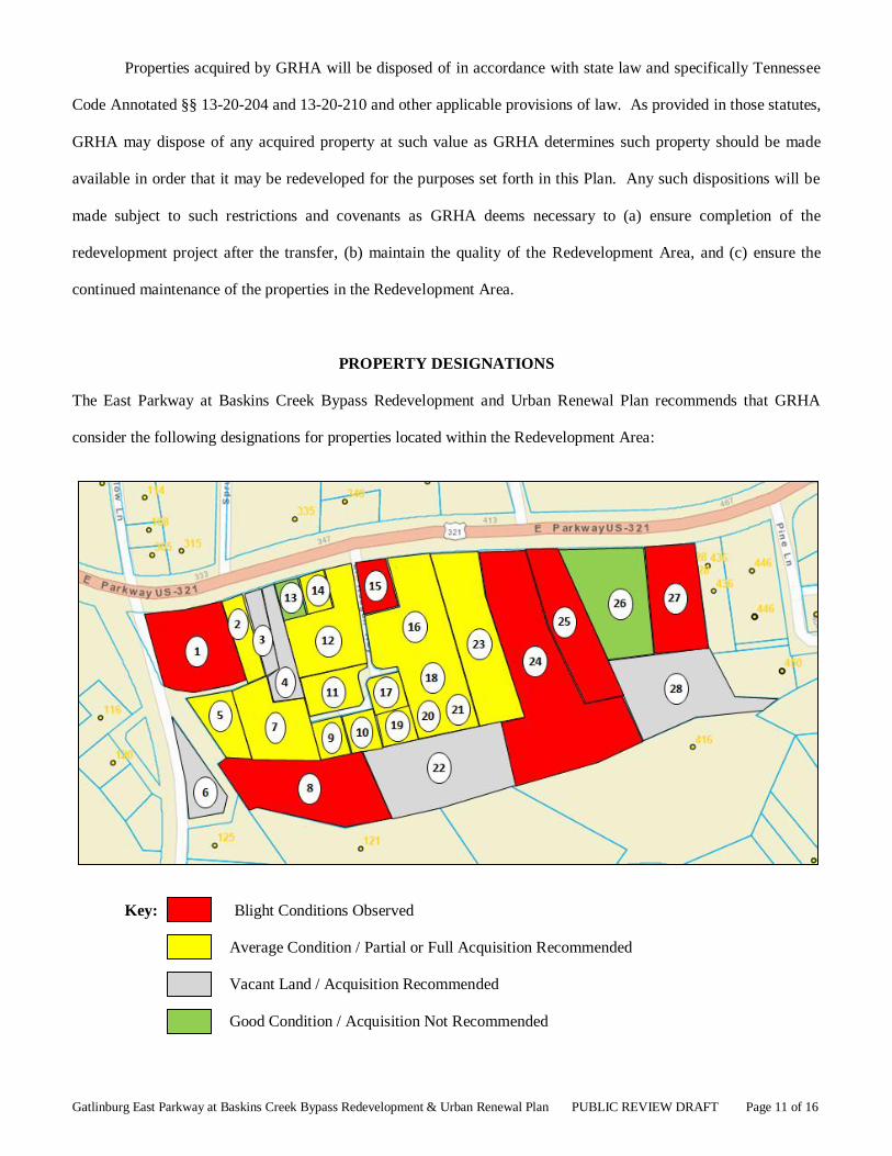
PROPERTY DESIGNATIONS
The East Parkway at Baskins Creek Bypass Redevelopment and Urban Renewal Plan recommends that GRHA
consider the following designations for properties located within the Redevelopment Area:
Key: Blight Conditions Observed
Average Condition / Partial or Full Acquisition Recommended
Vacant Land / Acquisition Recommended
Good Condition / Acquisition Not Recommended

Gatlinburg East Parkway at Baskins Creek Bypass Redevelopment & Urban Renewal Plan PUBLIC REVIEW DRAFT Page 12 of 16
The East Parkway at Baskins Creek Bypass District contains several older structures (12 out of 15
structures were built between 1940 and 1961) that now show signs of blight. Irregular subdivisions of land over
time have created parcels with poor transportation access and limited redevelopment potential. Some structures are
dilapidated, while other properties are excessive in land coverage, have obsolete layouts, have faulty arrangements
or designs, and/or land uses that are harmful to the overall development pattern and economic health of the district.
The properties observed to have blight conditions exhibit similar characteristics. All of them are older
structures with obsolescent design features, compounded by either deferred maintenance or neglect. What were
originally constructed for motel / hotel use are now either vacant, used for storage, or have been converted to
extended stay residential units. A few are for sale and should become acquisition priorities. Two of the properties
have non-functional swimming pools and should be addressed as public safety hazards. At least one structure on
Parcel 24 is in such poor condition that demolition should be pursued to eliminate a severe public safety hazard.
A block of properties located in the western part of the Redevelopment Area have been designated as being
of “Average Condition / Potential Acquisition.” Along with four vacant parcels, many of the improvements on
these properties are obsolescent in design, showing signs of age, and are suspect in terms of renovation feasibility.
Within this category are seven single family residential dwellings, some of which are in poor condition while others
are in average condition. Given the location of this specific Redevelopment Area, single family dwellings are
considered an inefficient use of land and an impediment to drawing higher density activity eastward from the
downtown. Efforts to remove the dwellings and provide expanded opportunities for denser redevelopment are
recommended.
Two properties, the Laurel Grove Baptist Church and the Tennessee State Bank are designated as in good
condition. The church may be a historic resource, and the bank is of relatively new construction. The parcel owned
by the bank directly to the south appears to be a limited value to bank operations and could be considered for
potential redevelopment with access from Cherry Street or Pine Lane.

Gatlinburg East Parkway at Baskins Creek Bypass Redevelopment & Urban Renewal Plan PUBLIC REVIEW DRAFT Page 13 of 16
PROPERTY AND PROJECT MANAGEMENT
If adopted, the East Parkway at Baskins Creek Bypass Redevelopment and Urban Renewal Plan
recommends that the City of Gatlinburg City Manager’s administrative staff be responsible for follow-up and
implementation of the Plan. The primary objectives of project management activities will be to facilitate private
property investment and redevelopment, and to coordinate and manage contracts related to the construction of
private improvements.
FINANCING PLAN EXCLUDING TAX INCREMENT FINANCING PROVISION
Property owners and developers of projects within the Redevelopment Area will be expected to demonstrate
the financial ability to undertake and complete any private redevelopment project.
The GRHA and the City of Gatlinburg do not anticipate funding the cost of private redevelopment projects
within the redevelopment district. Public assistance with particular projects that are essential to the implementation
of the Redevelopment Plan may be considered on a case-by-case basis at some point in the future.
The GRHA and the City of Gatlinburg will NOT exercise its authority to adopt the East Parkway at Baskins
Creek Bypass Urban Renewal and Redevelopment Plan with tax increment financing provisions. The Gatlinburg
City Commission shall provide a written agreement to the Sevier County Commission, which is required as
specified in § 13-20-203 (a)(2) of the Tennessee Code Annotated.
AMENDMENTS AND TERM
This Plan provides broad guidelines for the implementation of the redevelopment of the Redevelopment
Area, and actions taken by GRHA in furtherance of the redevelopment objectives set forth in this Plan may be
undertaken without further approval of the City, unless specified herein. GRHA shall not, however, change any of
the basic objectives of this Plan or expand or contract the boundaries of the Redevelopment Area without receiving
the approval of the Gatlinburg City Commission.
This Redevelopment Plan shall remain in effect until terminated by resolution of the Gatlinburg City
Commission.

Gatlinburg East Parkway at Baskins Creek Bypass Redevelopment & Urban Renewal Plan PUBLIC REVIEW DRAFT Page 14 of 16
EXHIBIT A

Gatlinburg East Parkway at Baskins Creek Bypass Redevelopment & Urban Renewal Plan PUBLIC REVIEW DRAFT Page 15 of 16
EXHIBIT B
REDEVELOPMENT DISTRICT BOUNDARY DESCRIPTION
The following East Parkway at Baskins Creek Bypass Redevelopment District boundary description accompanies the map shown in Exhibit A. All boundary descriptions are approximate and are subject to survey verification
during the redevelopment process.
DISTRICT BOUNDARIES:
SITUATED in the Eleventh (11th) Civil District of Sevier County, Tennessee, and being more particularly described
as follows:
BEGINNING at the point of intersection of E. Parkway and Baskins Creek By-pass, on the northwest corner of
property owned by Farrah Inc. and also known as “Ogles Vacation Motel,” and specifically being Tax Map 126L, Group C, Parcel 17;
Thence with the southeast line of E. Parkway, east 1097.3 feet, more or less, to a point located on the northeast
corner of the property owned by Carl and Faye Ownby and specifically being Tax Map 126L, Group C, Parcel 38, and being a common corner with Tax Map 126L, Group C, Parcel 39;
Thence with the east boundary line of the Ownby property 192.39 feet, more or less, in a south direction to a point being the southeast corner of the Ownby property and a common corner with Tax Map 126L, Group C, Parcel 39
and property owned by Tennessee State Bank being more specifically described as Tax Map 126L, Group C, Parcel
42;
Thence leaving said common corner, south along the common line of Tennessee State Bank (Tax Map 126L, Group
C, Parcel 42) and Tax Map 126L, Group C, Parcel 39, 13 feet, more or less, to a common point with Tennessee
State Bank and Tax Map 126L, Group C, Parcel 41;
Thence with the common line of Tennessee State Bank and Tax Map 126L, Group C, Parcel 41 in a southeasterly
direction for 92.12 feet, more or less, to a common point;
Thence continuing in a southeasterly direction with the common line of Tennessee State Bank and Tax Map 126L,
Group C, Parcel 41, 32.21feet, more or less, to a point;
Thence continuing in a southeasterly direction with the common line, 64.52 feet, more or less, to a common point
between Tennessee State Bank, Tax Map 126L, Group C, Parcel 41, and property owned by Lisa Hays and more
specifically described as Tax Map 126L, Group D, Parcel 31.01;
Thence leaving said common point in a southwesterly direction along the common line of Tennessee State Bank and
the Hays property, 56.67 feet, more or less, to a common point of Tennessee State Bank, Hays, and property owned by Great Smoky Mountains Association, being more specifically described as Tax Map 126L, Group C, Parcel
41.01;
Thence leaving said common point in a west direction, 237 feet, more or less, with the common property line of Tennessee State Bank and Great Smoky Mountains Association to a common point with Tennessee State Bank,
Great Smoky Mountains Association, and the Maury Greenstein property being more specifically described as Tax
Map 126L, Group C, Parcel 35;
Thence leaving said common point in a southwesterly direction, 94.86 feet, more or less, with the common line of
Great Smoky Mountains Association and Maury Greenstein to a point;
Thence in an southwesterly direction 173feet, more or less, to a point being a common point with the City of
Gatlinburg and property owned by Kenneth Leslie and more specifically described as Tax Map 126L, Group C,

Gatlinburg East Parkway at Baskins Creek Bypass Redevelopment & Urban Renewal Plan PUBLIC REVIEW DRAFT Page 16 of 16
Parcel 13;
Thence leaving said point along the common line of the City of Gatlinburg and Leslie, 150 feet, more or less, in an
easterly direction, to a common point of the City of Gatlinburg, Leslie, and the Samuel K. Cox, Sr. property, being
more specifically described as Tax Map 126L, Group C, Parcel 12;
Thence leaving common point in a southwesterly direction, 186 feet, more or less, to a point on the common line of
Cox and the Edwin J. Bridges, Jr. property and more specifically described as Tax Map 126L, Group C, Parcel 14;
Thence with the common line of Cox and Bridges in a northwesterly direction, 174 feet, more or less, to a point;
Thence in a southwesterly direction, 17.6 feet, more or less, to a common point of Cox, Bridges, and the Michael McCroskey property being more specifically described as Tax Map 126L, Group C, Parcel 1;
Thence leaving said point in a northwesterly direction, along the common line of Bridges and McCroskey, 35 feet, more or less, to a common point of Bridges, McCroskey, and the edge of Hickory Lane Right-of-way;
Thence with said common line of McCroskey and Hickory Lane, 54 feet, more or less, in a southwesterly direction
to a point;
Thence along the east boundary of Baskins Creek By-pass, and with the curvature of the right-of-way, in a northerly
direction, 434 feet, more or less, to a point on the northwest corner of property owned by Farrah Inc. and also known as “Ogles Vacation Motel,” and specifically being Tax Map 126L, Group C, Parcel 17, and being the POINT
OF BEGINNING;
BEING known and designated as the East Parkway at Baskins Creek Bypass Redevelopment & Urban Renewal Plan Boundary, consisting of approximately 10.4 acres and including 28 parcels, located in the corporate limits of
the City of Gatlinburg, Tennessee.

Note: The appendix to the Redevelopment and Urban Renewal Plan is available for public
viewing in the offices of the City Manager and the Building and Planning Department.