east Coast Province - Home - New Zealand Petroleum and ... · The East Coast Province covers at...
69
New Zealand Petroleum Basins 38 East Coast Province BASIN SUMMARY The East Coast Province covers at least 180,000 km 2 , and incorporates the Raukumara, East Coast, and Pegasus basins. The geology of the province varies from structurally simple to complex. Prior to the Neogene, all three areas have had a common geological history. Since the Early Miocene, and the inception of Pacific-Australia plate subduction tectonics in the province, some regions have been deformed more greatly than others, particularly the East Coast Basin. Insights from the little deformed Pegasus and Raukumara basins provide insights into the geology of the East Coast Basin. PLAYS + Fault-bounded anticlines + Stratigraphic pinchouts + Turbidite + Fractured limestones + Tight oil/gas resource plays - onshore + Thrust anticlines + Drape over thrust features + Gas hydrates EXPLORATION AND PRODUCTION Wells Over 300 known onshore oil and gas seeps occur in the province, attesting to active petroleum systems. More than 40 wells have been drilled since 1955, all of which are located in the East Coast Basin. Although only three of these wells are located offshore — the most recent being drilled in 2007 — all encountered significant gas shows. The Pegasus and Raukumara basins remain untested. A sub- commercial high-pressure dry gas discovery was made in 1998 at Kauhauroa in northern Hawke’s Bay. Small historical oil production has occurred north of Gisborne, near the Waitangi and Totangi oil seeps. GEOLOGY The sedimentary basins of the East Coast province are thought to have originally formed during the Early Cretaceous as a more-or-less continuous series of depocentres along the ancient Gondwana subduction margin. Seismic evidence from Pegasus Basin clearly shows a fossilised subduction margin and an associated thrust and fold belt underlying much of the north slope of the Chatham Rise. Source Rocks Source rocks in the province were deposited in marine environments, with varying proportions of terrestrial-derived organic material. The main known source rocks are the Whangai and Waipawa formations of Late Cretaceous–Paleocene age. There is a possibility of Early to mid-Cretaceous source rocks in parts of the province. Reservoir Rocks Include mid- to Late Cretaceous transgressive marine sandstones and turbidite sandstones, fractured Late Cretaceous–Paleocene mudstones, Eocene–Oligocene greensands, Neogene turbidite sandstones, shelf sandstones, and bioclastic limestones.
Transcript of east Coast Province - Home - New Zealand Petroleum and ... · The East Coast Province covers at...

New Zealand Petroleum Basins38
East CoastProvinceBASin SummAry
The East Coast Province covers at least 180,000 km2, and incorporates the Raukumara, East Coast, and Pegasus basins. The geology of the province varies from structurally simple to complex. Prior to the Neogene, all three areas have had a common geological history. Since the Early Miocene, and the inception of Pacific-Australia plate subduction tectonics in the province, some regions have been deformed more greatly than others, particularly the East Coast Basin. Insights from the little deformed Pegasus and Raukumara basins provide insights into the geology of the East Coast Basin.
PlAyS+ Fault-bounded anticlines+ stratigraphic pinchouts+ turbidite+ Fractured limestones+ tight oil/gas resource plays - onshore+ thrust anticlines+ Drape over thrust features+ gas hydrates
exPlorAtion And ProduCtion
WellsOver 300 known onshore oil and gas seeps occur in the province, attesting to active petroleum systems. More than 40 wells have been drilled since 1955, all of which are located in the East Coast Basin. Although only three of these wells are located offshore — the most recent being drilled in 2007 — all encountered significant gas shows. The Pegasus and Raukumara basins remain untested. A sub-commercial high-pressure dry gas discovery was made in 1998 at Kauhauroa in northern Hawke’s Bay. Small historical oil production has occurred north of Gisborne, near the Waitangi and Totangi oil seeps.
geologyThe sedimentary basins of the East Coast province are thought to have originally formed during the Early Cretaceous as a more-or-less continuous series of depocentres along the ancient Gondwana subduction margin. Seismic evidence from Pegasus Basin clearly shows a fossilised subduction margin and an associated thrust and fold belt underlying much of the north slope of the Chatham Rise.
source rocksSource rocks in the province were deposited in marine environments, with varying proportions of terrestrial-derived organic material. The main known source rocks are the Whangai and Waipawa formations of Late Cretaceous–Paleocene age. There is a possibility of Early to mid-Cretaceous source rocks in parts of the province.
reservoir rocks Include mid- to Late Cretaceous transgressive marine sandstones and turbidite sandstones, fractured Late Cretaceous–Paleocene mudstones, Eocene–Oligocene greensands, Neogene turbidite sandstones, shelf sandstones, and bioclastic limestones.
EAS
T CO
AST
PR
OV
INC
E
¹
174°E
¹
((
(
(
¹
¹
¹
¹ ¹
¹
¹ ¹
¹
¹
¹
(
((
((
((
(
((
((
¹
((
( ( ( ( (
¹
¹
((
((
((¹
42°S
178°E
178°E
176°E
176°E
174°E 180°
36°S
38°S
38°S
40°S
40°S
42°S
0 100 km
0 - 2 km 2 - 4 km
Fault
Sediment ThicknessLegend
4 - 6 km
Major oil seep Major gas seep
Unknown
Dry hole
Gas shows
Oil & gas shows
Oil shows 6 + kmBasement
deformation
seismic section
RAUKUMARABASIN
Rotokautuku-1
Sys
tem
Rere-1 WaitangiTotangi
front
Kauhauroa-1
COAST
EAST
TaranakiBasin
Kereru-1
Faul
t
WanganuiBasin
MasonRidge-1
North
Islan
d
BASIN
PEGASUSBASIN
Hikurangi
seismic section
CookStrait
+0ª!!
µ
Titihaoa-1
Tawatawa-1Waipatiki
Tane-1
Westcott
Te Hoe-1 Kiakia-1
Tuhara-1
Hawke Bay-1
Opoutama-1
Waitaria-2Ruakituri-1
Rotokautuku
Waingaromia-1
1000
200
1500
1000200
1500
Taradale-1

New Zealand Petroleum Basins40
BASin hiStory
exPlorAtionMore than 40 wells have been drilled onshore in the East Coast Basin since the 1870s when pits and shallow wells were put down in and near oil seeps at Rotokautuku, Waitangi, and Totangi. Among the late 19th century successes were Rotokautuku-5, which produced 270 barrels of oil in its first month of production, Waitangi-1, which produced at a rate of 10 bopd, and the Waingaromia borehole (Waingaromia-1), which produced an estimated 20–50 barrels of oil per day from Miocene rocks until the rig burnt down in 1870. Further south, the Waipatiki-1 and -2 wells (Waipatiki Oilwells Ltd), and Tane-1 (Mangaone Oilfields Ltd) were drilled between 1912 and 1914 and, although each gave strong gas and/or traces of oil at various depths, none produced commercial quantities. It is unclear what the target was in these wells. Several more wells were drilled between 1919 and 1941, including additional shallow wells near the Waitangi oil seep. None discovered commercial quantities of hydrocarbons.
Most wells drilled since then have had shows of oil and/or gas. From the mid-1980s a renewed period of exploration began, with substantial seismic surveys being carried out across the region. Petrocorp Exploration drilled Te Hoe-1 in 1990. This well proved the reservoir potential of Late Cretaceous sandstones, and was the first well in the East Coast region to flow hydrocarbons (gas) under testing from a sealed reservoir when it flared gas briefly. A concerted drilling campaign by Westech in the 1990s discovered
a sub-commercial high-pressure dry gas field at Kauhauroa-1. Following the discovery of gas at Kauhauroa, Westech drilled other nearby structural closures. Although gas shows were recorded from several wells, none were deemed significant. In 2007, Westech drilled Waitahora-1 as a direct offset to the Kauhauroa-1 discovery well. Waitahora-1 encountered high reservoir pressures and gas shows over a 70 m along-hole interval, probably in fractured limestone whilst drilling to the 1,352 m target depth. The well remains suspended awaiting appraisal.
The first offshore well, Hawke Bay-1, was drilled to a total depth of 2,372 m in 1976 by BP, Shell, Aquitaine, and Todd Energy. The structure drilled is a large anticline and the intended target a high-amplitude reflector thought to be a Pliocene limestone. Gas shows were encountered in Middle Miocene marly limestone and thin sandstone. Titihaoa-1 was drilled to 2,727 m by an Amoco-led consortium in 1994, east of Castlepoint, Wairarapa. Gas shows were found in Miocene turbidite sandstones. In 2004, TAP Oil drilled Tawatawa-1, 35 km northeast of Titihaoa-1 to a total depth of 1,560 m. High-pressure gas shows were encountered, but there was no effective reservoir.
No wells have yet been drilled in the Raukumara or Pegasus basins, and their petroleum systems remain untested. The first permit in Pegasus Basin was awarded in late 2012. A moderate level of exploration activity continues in the onshore East Coast Basin at present.

EAS
T CO
AST
PR
OV
INC
E

New Zealand Petroleum Basins42
extentThe East Coast province extends for at least 180,000 km2, incorporating the Raukumara, East Coast, and Pegasus basins east of the North Island of New Zealand.
geologiCAl hiStory
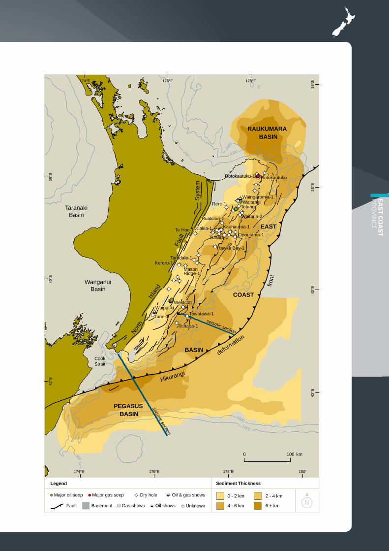
Late Cretaceous-Paleogene Passive MarginSubduction of the relatively buoyant Hikurangi Plateau, a region of thickened oceanic crust, below the Chatham Rise and Pegasus Basin part of the Gondwana margin from c. 110 Ma is inferred to have choked the subduction system along this part of the margin by c. 100 Ma. Late Cretaceous and Paleogene successions are relatively thin in this part of the East Coast province, suggesting a minimal sediment supply. Subduction may have continued until the mid-Late Cretaceous beneath the East Coast and Raukumara basins, though it had most likely ceased here by c. 85 Ma. From the mid-Cretaceous the East Coast province had transitioned from a convergent subduction margin in a prograding, passive continental margin. Passive margin deposition continued relatively uninterrupted until c. 23 Ma.
Up to 4 km of Early and Late Cretaceous cover strata crop out onshore in the East Coast province and several discrete, transgressive, westward-stepping cycles are recognised. Close to the basin margin, shallow marine sandstone facies are common. Away from the margin the predominant lithology is mudstone, with subsidiary intercalations of turbidite sandstones. In general the sequence is upward-fining. Late Cretaceous to Paleocene mudstone and marl of the Whangai and Waipawa formations are capped by Paleocene and Eocene smectitic and calcareous mudstone; maximum subsidence was in the Oligocene.
Neogene convergent tectonicsEstablishment of the modern plate boundary through the New Zealand sub-continent transformed the passive margin setting to a convergent margin forearc in Early Miocene time. A thick package of Late Cretaceous to Oligocene rocks including Cretaceous and Paleogene ophiolite — the East Coast Allochthon, an equivalent of the Northland Allochthon — was obducted and emplaced into the East Coast Basin over part of what is now the Raukumara Peninsula. Similarly, in the Raukumara Basin the eastern margin, now the East Cape Ridge, was uplifted and the East Coast Allochthon was emplaced as a series of thrust sheets by gravity sliding, reaching the basin axis.
Since the Early Miocene ongoing oblique convergence associated with Pacific plate subduction has formed has a complex series of sedimentary depocentres in the East Coast Basin. These mostly comprise a highly faulted and folded accretionary prism with associated slope basins and, to seaward, a less deformed, more distal accumulation. Continued compression has resulted in imbrication and the formation of southwest-northeast oriented elongate anticlines, many bounded to the southeast by steeply dipping reverse faults and thrusts.
SuB-BASinSThe Raukumara Basin is also remarkably little deformed by Neogene tectonics even though it lies west of the modern subduction thrust. The East Coast Ridge may be partitioning plate convergence and therefore isolating the Raukumara Basin from the rest of the subduction margin. The broad synclinal form of the Raukumara Basin has been partly filled during the Neogene by what are thought to be mudstones and turbidite sandstones derived mainly from the uplifted and rapidly eroding Raukumara Peninsula.
By contrast the area of Pegasus Basin has been much-less deformed than the adjacent East Coast Basin due to the former’s position entirely east of the modern subduction thrust. The basin was a depression into which sediments were deposited from the south and west, mainly as turbidite flows. The Neogene succession contrasts with older units in that it is very thick, with more than 6 km of Neogene sediments estimated to fill the axis of the basin. The central part of Pegasus Basin also contains several large anticlines created by blind thrusts rooted to the subduction/strike-slip plate interface.
EAS
T CO
AST
PR
OV
INC
E
?Land
?Lan
d
?Lan
d
SplitRockFm
Fm
Gentle AnnieFm
WFpo
WFtu
WFrk
Authochthon
Authochthon
Allochthon
Allochthon
Mead Hill
WFrk
WFrk
paleogeographyLate Cretaceous (65 Ma)Early Cretaceous (105 Ma)
paleogeography
38°S
174°E
42°S
176°E
174°E
42°S
178°E178°E
174°E
38°S
38°S
40°S
176°E
38°S
40°S
40°S
42°S
176°E
¯
178°E
40°S
42°S
¯
178°E
100 km
Map source: Field & Uruski . (1997)et al
WFpo — Whangai Formation, Porangahau MbrWFrk — Whangai Formation, Rakauroa MbrWFtu — Whangai Formation, Te Uri Mbr
Legend
Non-marine
Shelf
Upper bathyal
Mid/lower bathyal
Present-day eroded edgeof East Coast Allochthon
Well with interval present
Land/erosion

New Zealand Petroleum Basins44
100 km
42°S
174°E
42°S
Late Paleocene (56 Ma)paleogeography
Middle Miocene (14 Ma)paleogeography
WaipawaFm
WaipawaFm
T
178°E
38°S
178°E
38°S
176°E174°E
38°S
40°S
40°S
42°S
176°E
¯
178°E
176°E174°E
38°S
40°S
40°S
42°S
176°E
¯
178°E
Map source: Field & Uruski . (1997)et al
Mead Hill &Amuri fms
unanui Fm(flysch)
WhakatakiFm
(flysch)
Legend
Land/erosion
Shelf
Upper bathyal
Mid/lower bathyal
Present-day eroded edgeof East Coast Allochthon
Well with interval present

EAS
T CO
AST
PR
OV
INC
E
eASt CoASt ProvinCe PlAyS
Numerous prospects have been identified throughout the East Coast province, with the largest closures occurring offshore. Most plays involve fault-bounded anticlines, some of which require fault seal for effective closure. Stratigraphic pinch-outs are another significant play type throughout the stratigraphic record. Overpressure in many East Coast wells, particularly those in the onshore Wairoa area, indicates seal capacity of intervening mudstones is good.
Seismic data suggest that Neogene turbidite sandstones may be thicker and better developed away from the structural highs, suggesting reservoir potential may be better away from the culminations in stratigraphically controlled structures. Fractured reservoirs, particularly Miocene limestone and sandstone, offer
other play types. Pliocene limestone reservoirs, an early target in onshore Hawke’s Bay exploration, have proven to be discontinuous in the subsurface.
Raukumara Basin play types include reactivated Gondwana margin fault anticlines, drapes across topographic features (e.g. the top of the East Coast Allochthon), and stratigraphic plays such as mounded turbidite bodies. Play types identified in the Pegasus Basin include: thrust anticline plays along the margin with the East Coast Basin, similar to those seen throughout the East Coast Basin; in the Pegasus Basin area, a thrust anticline play along the fossil Gondwana margin, now the northern slope of the Chatham Rise; blind thrusts in Neogene turbidites in front of the East Coast margin, and stratigraphic pinch-outs of Neogene turbidite sands against the north Chatham slope.
tight gASExtensive fine-grained rock formations that could potentially yield tight gas occur in many parts of New Zealand, particularly in the onshore East Coast province where exploration and resource assessment are underway. The focus is on the Late Cretaceous–Paleocene Whangai and Waipawa formations, which are typically low to moderate TOC mudstones that compare favourably with the Bakken and Barnett shales of North America. In outcrop, the Whangai Formation shows significant fracture permeability, which may enhance its reservoir potential.
The Whangai and Waipawa formations are known to occur in northern and eastern Wairarapa, southeastern, central and coastal Hawke’s Bay, and the Gisborne-Raukumara areas. They also occur both within the East Coast Allochthon and as autochthonous
ACTIVEPASSIVE Tectonism
Source Rocks
Reservoir Rocks
Seals
Traps
CRETACEOUS PALEOGENE NEOGENEAge
Undiff. Late Cretaceous
Late Cret. rocks, NW Pegasus Basin
Compactional drape
100 50
RAUKUMARA BASIN PETROLEUM SYSTEMS
ACTIVE
Whangai Fm
Overburden Rock
ExpulsionWaipawa Fm
Whangai Fm
Waipawa Fm
PASSIVE Tectonism
Source Rocks
Reservoir Rocks
Seals
Traps
PEGASUS BASIN PETROLEUM SYSTEMS
ACTIVE
Whangai Fm
Overburden Rock
ExpulsionEarly Cret. rocks, NW Pegasus Basin
CRETACEOUS PALEOGENE NEOGENEAge
100 50

New Zealand Petroleum Basins46
rocks beneath the allochthon. The distribution of autochthonous Whangai and Waipawa formations beneath the East Coast Allochthon is very poorly known. However, it is apparent that mature source rocks must exist in places within this structural block as there are numerous active oil and gas seeps — such as the Waitangi, Totangi, and Rotokautuku seeps — that can be geochemically typed to the Whangai Formation. Whether these seeps are sourced from allochthonous or autochthonous Whangai Formation, or a combination of both, remains uncertain.
Overall, the Whangai Formation, which may be up to 600 m thick, has low to moderate source rock potential, although individual members have distinct differences with respect to source rock quality. The Te Uri and Porangahau Members have low source potential, the Rakauroa Member has higher potential — particularly in western areas — and the Upper Calcareous Member has the highest source rock potential, particularly in eastern areas.
The Waipawa Formation is considered to be the most promising source rock in the province, although it
has a patchy distribution and is generally fairly thin (2–50 m thick, average 17 m). Source rock properties indicate that this formation has high generative capacity but it is immature or marginally mature in outcrop sections throughout the East Coast region. Identification of Waipawa-sourced oils in the Raukumara and Wairarapa regions indicates that the formation must reach maturity at depth.
North American experience suggests the costs of assessment and development of tight gas plays may be high. Although the mainly frontier East Coast province currently lacks much petroleum infrastructure, the quantity of tight gas in the basin is potentially large.
gAS hydrAteSGas hydrates are crystalline solids consisting of gas molecules — usually methane — surrounded by a cage of water molecules. They offer a potential future source of natural gas. An established gas hydrate province occurs within the Hikurangi margin of the East Coast province. The hydrate accumulations were discovered from seismic data, based on the
presence of bottom-simulating reflections (BSRs) produced at the base of the gas hydrate stability zone in sediments. Though gas hydrates occur in many parts of New Zealand’s offshore territory the Hikurangi margin is thought to be New Zealand’s most economically promising gas hydrate province, partly because of its proximity to major population centres, and partly because of its favourable geologic setting. To date, the Hikurangi margin is the only region in New Zealand from which gas hydrates have been recovered in shallow sediment cores.
Initial estimates of gas reserves within the 50,000 km2 Hikurangi margin hydrate province are up to approximately 800 TCF. However, most of the gas hydrates are thought to be dispersed and are therefore not of economic interest. Initial estimates of gas volumes in highly concentrated hydrate zones are ~20 TCF, although this figure does not account for the quality of the reservoir rock. Research on the Hikurangi Margin is now focussing on identifying high-quality gas hydrate reservoirs with high permeability and connectivity.
ACTIVEPASSIVE Tectonism
Source Rocks
Reservoir Rocks
Seals
Traps
CRETACEOUS PALEOGENE NEOGENEAge
Undiff. Late Cretaceous
Late Cret. rocks, NW Pegasus Basin
Compactional drape
100 50
RAUKUMARA BASIN PETROLEUM SYSTEMS
ACTIVE
Whangai Fm
Overburden Rock
ExpulsionWaipawa Fm
Whangai Fm
Waipawa Fm
PASSIVE Tectonism
Source Rocks
Reservoir Rocks
Seals
Traps
PEGASUS BASIN PETROLEUM SYSTEMS
ACTIVE
Whangai Fm
Overburden Rock
ExpulsionEarly Cret. rocks, NW Pegasus Basin
CRETACEOUS PALEOGENE NEOGENEAge
100 50

EAS
T CO
AST
PR
OV
INC
E
¹
¹
¹
¹
¹
¹
38°S
WaitangiHill
¹
¹
¹
Kauhauroa
¹
¹
¹
¹
¹
¹
¹
¹
¹
¹
¹
¹
¹
¹
¹
¹
((
(
((
((
(
((
(((
((
((
((
(
((
((
((
((
(( ( ( ( ( ( ( (
((
174°E
HawkeBay
Boar Hill
Tawatawa
Titihaoa
178°E176°E 180°
42°S
100
Leads at multiple stratigraphic levels Undifferentiated onshore leads Leads at Miocene level
Leads at Late Cretaceous-Paleogene level Leads at Early Cretaceous level Leads at Hikurangi Plateau level
Leads compiled from open file petroleum reports
178°E176°E174°E
38°S
40°S
40°S
42°S
0 km
Seahorse complex
Faults¹
ªª+ªªªªªµ
ªµª+ªªªªªªµª
ª
++
+ªª++ª+++ ª++++ªª+++++
+
ªªªªªªªªª==ª ª
++
ª
ªªªª
+++ª
00
=0
ª
ª
Legend

New Zealand Petroleum Basins48
eASt CoASt ProvinCe reServoirS
In the East Coast Basin, the most likely reservoir facies are mid- and Late Cretaceous transgressive marine sandstones and turbidite sandstones, fractured Whangai Formation shale and marl, Neogene turbidites, and Neogene shallow water bioclastic limestones.
CretACeouS reServoirSMid- to Late Cretaceous shelf sandstones and turbidite packets were investigated by Rere-1 and Te Hoe-1, the latter being the first successfully first production of hydrocarbons on test from a sealed reservoir in the East Coast province. Mid-Cretaceous transgressive sandstones of the Tahora Formation have measured porosities of 8.3–17.1% and permeability 0.04–20 mD. Though similar facies are unlikely in offshore East Coast Basin equivalent transgressive sandstones are inferred to be present in Pegasus Basin, onlapping the Chatham Rise. The laterally equivalent though deeper water turbidite sandstones of the Tapuwaeroa Formation have measured porosities of ~9.3–28.5%. Permeability is typically <1 mD but is, in places, up to 198 mD. There is a high probability that equivalent strata of this age are present offshore.
mioCene reServoirSMiocene turbidite sandstone units offer perhaps the best reservoir potential in the province. The Early Miocene deep-marine Rere Sandstone Member yielded gas shows in Kauhauroa-1 although, on test, flow rates were erratic due to sediment blocking the choke. Maximum flow rates were 537 Mscf/day of gas and 550 bbl/day water. Middle Miocene Tunanui Formation turbidite sandstone beds have measured porosities of 8–30% and permeabilities of up to ~150 mD. Through-going fractures parallel to the principal horizontal stress direction suggest potential as a hybrid, clastic-fractured reservoir. Middle Miocene turbidite sandstones of the Whakataki Formation may offer reservoir potential in the Wairarapa area, particularly offshore. Middle Miocene turbidites had prominent gas shows in Titihaoa-1. Middle and Late Miocene turbidites in Tawatawa-1 and also had gas significant shows.
Early Miocene shelf Kauhauroa Limestone has been intersected by at least seven exploration wells in the Wairoa area. Virtually all porosity is thought to be from northeast-striking fracture systems. Initial testing in Kauhauroa-1 flowed gas at 11.5 MMcf/day; in a subsequent 220 hour-long test, flows were recorded as up to 6.2 MMcf/day and up to 2300 bbl/day of water. The similar Late Miocene Kiakia Limestone produced small quantities of gas and water on test in Kiakia-1/1A. Middle Miocene calcareous sandstone and limestone were gas-bearing in Hawke Bay-1, although the unit was not tested. Outcropping coarse-grained shelly limestones of Plio–Pleistocene age have high porosity (commonly 25–32%) and high permeability. The extent of similar bioclastic limestones in the offshore East Coast province is virtually unknown.
rAukumArA BASinBy analogy with the onshore Raukumara Peninsula, the main reservoir facies in the Raukumara Basin are likely to be Cretaceous to Neogene turbidite sandstone bodies. Some limestone units with good reservoir properties may also be present. On land, Whangai Formation mudstones have fracture permeability. Transgressive sandstones of Cretaceous and Paleogene ages may also be present, particularly in the western part of the basin.
PegASuS BASinIn Pegasus Basin, Cretaceous, Paleogene and Neogene transgressive and turbidite sandstones, and fractured Late Cretaceous to Paleocene mudstones, are considered to be the most likely reservoir facies. The Chatham Rise crest is thought to have remained emergent until Eocene time. Transgressive sandstones of Late Cretaceous and Paleogene ages are therefore likely to be present across the northern flank. Much of the Neogene succession in the centre of the basin is inferred to have been deposited by turbidite flows, with turbidite sandstones having reservoir potential. Several large incised channels have been identified along the Chatham Rise margin and these may contain good quality reservoir sands.

EAS
T CO
AST
PR
OV
INC
E
Plio-Pleist.
enecoiM
Olig
o-ce
neenecoE
-oelaPenec
Cre
tace
ous
0
10
20
30
40
50
60
70
80
100
90
110
+
0
++
+++
+
+
+
WhakatakiFormation
Mangaheia Group
Tolaga Group
Wanstead Formation
GentleAnnieFormation
WhangaiFormation
Tahora Formation
Te Wera Fm.
WairataSandstone
KarekareFormation
Glenburn Formation
Weber Formation
Waipawa Formation
Kauhauroa Lst.Kiakia Lst.
Wanstead Formation
East Coast Allochthon
Tokomaru Sandstone
Tunanui Formation
NW
RAUKUMARAPENINSULA
HAWKE’S BAY WAIRARAPA PEGASUSBASINSE
1-ereR
1-yaBek
waH
1-aoahitiT
Conglomeratic
Coal measures
Sandstone
Mudstone
Marl
Limestone
Volcanic
Non deposition
Oil shows Gas shows+
Oil & gas shows0
µLegend

New Zealand Petroleum Basins50
Great South-CanterburyProvinceBASin SummAry
This Province incorporates the Great South and Canterbury Basins, southeast New Zealand. It is a large, little-explored area covering nearly 400,000 km2. Basins originated as Cretaceous failed rifts, evolving into subsiding basins during the Late Cretaceous and Paleocene.
The province has several sub-basins. The Canterbury Basin contains up to 6 km of strata, thickest in the Clipper Sub-basin. The succession is up to 9 km thick in the Great South Basin, being thickest in the Central Sub-Basin.
PlAyS+ stratigraphic drape over basement highs+ Differential compaction+ Faulted anticlines+ Folds+ turbidites + Basin-floor fans and feeder channels+ Current commitment to drill Carrack-Caravel
in 2013/2014+ Potential stratigraphic traps - Late Cretaceous
transgressive sands, prograding deltas, and deep-water fans
exPlorAtion And ProduCtion
WellsThirteen offshore exploration wells, with sub-commercial gas-condensate discoveries in both basins. Galleon-1 tested 10 mmcf/d of gas and 2,300 bbl/d of condensate. Cutter-1 discovered a 56 m gross hydrocarbon column in poor quality sandstones. A sub-commercial gas-condensate discovery in Kawau-1A. which tested 6.7 mmcf/day gas (7% CO2) and 24 bbl/d condensate. Shows in three other wells include Tara-1, which reported “fizz-gas”, Toroa-1, which reported oil staining and strong gas shows associated with oil, and Clipper-1. There is an oil seep onshore at Stewart Island. The most recent well is Horseshoe-1, drilled in 2012 from onshore Stewart Island out into the Basin. Results of this well remain unreported.
geologyThe Canterbury basin contains 5 km, or more, of Cretaceous-Cenozoic sediment and covers more than 40,000 km2. It extends east into deeper water of the Bounty Trough and is contiguous to the south with the larger Great South Basin. The Great South Basin is a complex intracontinental rift formed during the mid-Cretaceous, with several distinct sub-basins containing up to 8.6 km of sedimentary fill. The extent of the basin is often defined by the 2,000 m total sediment thickness isopach.
source rocks Middle Jurassic fluvial sediments (mostly in the Great South Basin), mid-Cretaceous syn-rift fluvial sediments, Late Cretaceous-earliest Paleocene fluvial/marine coaly sediments, and Late Cretaceous-Eocene marine mudstones and shales (e.g., Tartan Formation, equivalent to the Waipawa Formation black shale). Potential source rocks are dominated by coaly facies, c.f. Taranaki Basin. Potential for marine shale source rocks, although maturity is an issue.
reservoir rocks In the Canterbury Basin reservoirs are primarily sandstones, generally quartzose, of Late Cretaceous to Miocene age, ranging from fluvial and paralic to shelf and turbidite depositional settings. In the Great South Basin reservoirs are mostly Cretaceous to Eocene fluvio-deltaic and transgressive marine sandstones. Mid-Cretaceous fluvial facies in Great South Basin, and mid- to Late Cretaceous transgressive to Eocene marine/paralic sands occur in both Canterbury and Great South Basins. Cretaceous–Paleogene turbidite sands are possible in the Great South Basin.

GR
EAT SO
UTH
- C
AN
TERB
UR
Y P
RO
VIN
CE
1500
1000
200
1000
200
1500
200
ª
ª
ª
ª
µ
µ+ª
0
ª
0ª+ª
+ +
=
ª
ª
ª
0ª
172°E
Alpine Fault
Hope Fault
174°E
¹
50°S
48°S
174°E172°E170°E
170°E
168°E166°E 176°E
44°S
168°E
44°S
46°S
48°S
50°S
0 100 km
0 - 2 km 2 - 4 km
Sediment ThicknessLegend
4 - 6 km 6 + km
Galleon-1
Takapu-1A
Pakaha-1
Hoiho-1C
Pukaki-1
Kawau-1A
Clipper-1
Tara-1
Rakiura-1
Resolution-1
Cutter-1
Toroa-1
Chertsey BoreJ.D. George-1
Kate-1
Horseshoe-1
GREATSOUTHBASIN
CANTERBURYBASIN
Unknown
Dry hole
Gas shows
Oil & gas shows
Oil shows
Basement outcrop
Fault +0ª
µ
seismic section
seis
mic
sect
ion
Endeavour-1
Oamaru-1
Ealing-1
Leeston-1
Arcadia-1Kowai-1West Coast
Basins
WesternSouthland
Basins

New Zealand Petroleum Basins52
BASin hiStory
exPlorAtionOnshore wells were drilled as early as 1914 in the Canterbury Basin. The focus is now on the offshore part of the basin, with the most recent well in 2012 from onshore Stewart Island out into the basin. Following the acquisition of seismic surveys, Shell, BP and Todd Oil Services drilled four offshore wells, Endeavor-1, Resolution-1, Clipper-1 and Galleon-1 in the continental shelf in the 1970s and 1980s. Takapu-1A was drilled for Petrocorp at the boundary with Great South Basin in 1978. TAP Oil drilled Cutter-1 in 2006. Both Galleon-1 and Clipper-1 had significant hydrocarbon shows in Cretaceous coal measure sands. Modern reconnaissance seismic surveys extend over the continental shelf and some way beyond the 200 m isobath and there are detailed grids over some areas, including the large Carrack-Caravel prospect, which has been covered by a recent 3D seismic dataset.
Exploration in the Great South Basin began in the early 1970s, when Hunt International Petroleum Company undertook a large regional seismic acquisition programme across a large (402,000 km2) exploration permit. Over 13 years, more than 30,000 km of 2D seismic data were acquired. Hunt went on to drill four wells between 1976 and 1978 (Toroa-1, Pakaha-1, Kawau-1A, Hoiho-1C), with partners Phillips Petroleum and the New Zealand government. Petrocorp, operating for Crown interests, drilled two sole risk wells (Tara-1 and Takapu-1A) in 1978. Placid Oil Company took over as operator in 1982 and drilled Rakiura-1 and Pukaki-1. Toroa-1 drilled more than 300 m of oil shows but the well was plugged and abandoned due to mechanical issues before these could be tested and Kawau-1A was a sub-commercial gas-condensate discovery originally estimated at 461 bcf. Tara-1 had moderate gas-condensate shows and Pakaha-1 drilled gas-bearing sands. The permit was relinquished in 1985.
The western margin of the basin was licensed separately in 1982. More seismic data were acquired and a geochemical survey conducted but there was no drilling. Later permit holders acquired additional seismic data and reprocessed the earlier data and, in 2005, Crown Minerals acquired a 3,000 km 2D seismic data set across the northeast part of the basin. In the licensing round which followed, a large area was awarded to ExxonMobil and Todd Energy, three blocks were taken up by OMV, PTTEP and Mitsui, and one block was awarded to Greymouth Petroleum. These companies have since acquired more than 20,000 km of new 2D, and 1,500 km2 of 3D seismic data in advance of drilling commitments. Shell were also allocated one block as part of the 2012 Block Offer round.
extentThe Great South and Canterbury Basins of southeast New Zealand occupy a region on the landward side of the Gondwana margin of late Mesozoic extension and post-rift passive margin drift. The main basin-fill succession in the region, which may be up to 9 km thick, is of Cretaceous to Recent age.
During the early to middle Mesozoic the region encompassed backarc and forearc positions within the ancient Gondwana subduction margin. Latest Jurassic and earliest Cretaceous rocks of the Clent Hills Group, consisting of conglomerate, sandstone, mudstone and coals, and presently preserved mainly in fault-angle depressions, were deposited in terrestrial to deltaic settings within Canterbury Basin. Although traditionally considered as basement, these rocks may be locally significant to the petroleum geology of the basin. Similarly, Triassic and Jurassic marine and non-marine rocks of the Murihiku terrane, present in the Great South Basin, have traditionally been regarded as basement, though they may also have been the earliest basin-fill. Great South Basin seismic surveys show these rocks are well bedded and gently folded.
GR
EAT SO
UTH
- C
AN
TERB
UR
Y P
RO
VIN
CE

New Zealand Petroleum Basins54
geologiCAl hiStory
Cretaceous riftingRift faulting was active in the Early Cretaceous, and by the Late Cretaceous widespread fluvial systems generally flowing to the northeast had developed along the axes of the major grabens. Whether or not these fluvial systems contributed to a major delta beyond the present limits of the province basin in the Bounty Trough remains unknown. Early basin-fill deposition was in small, rifted basins formed during extension prior to, and in the early stages of, break-up at the eastern Gondwana margin. The rocks include conglomerate, sandstone, mudstone, and in places coal measures of the Hoiho Group in the
Great South Basin. The syn-rift basins were sites of active rifting until about 85 Ma, during which time significant thicknesses of rock were deposited; over 3 km of syn-rift terrestrial sediment was deposited in the Clipper Sub-basin in the Canterbury area.
Late Cretaceous-Neogene passive subsidenceWith continuing subsidence in Late Cretaceous to Paleogene time, the region was gradually inundated. Rocks deposited during this post-rift phase are more widespread and include terrestrial to shallow marine conglomerate, sandstone and mudstone and minor coal measures. Fluvio-deltaic systems including coaly swamps persisted at the western margin of the Great South Basin, with
a source apparently through what is now Foveaux Strait. Paleogene turbidites were deposited across the basin floor in front of the delta. Further transgression during a passive drift phase laid down a thick transgressive marine succession, including quartzose sandstone, greensand, and mudstone up to 4400 m thick. In far offshore regions, background deposition was dominated by fine open-water carbonates. Deposition was mainly in shelf and upper slope settings.
By the late Paleogene sediment source areas were significantly reduced as clastic supply diminished, and carbonate deposition became increasingly widespread across the province.
Wickliffe & Tartan Fm
Taratu Fm
Kawau Sst
Pakaha Gp, Wickliffe & Laing Fm, Penrod Gp
Basement drape
Normal faulting
Taratu Fm & Green Hills Sst
deltaic sandstones
Hoiho GpMurihiku Spgp
Hoiho Gp
Hoiho Gp
PASSIVERIFTINGSUBSIDENCE + UPLIFT Tectonism
Source Rocks
Reservoir Rocks
Seals
Overburden Rock
Traps
RIFTING
Tartan Fm
Taratu, Broken River Fm
Pukeiwitahi, Taratu, Broken River Fm
Taratu & Broken River Fm
Basement drape
Normal faulting
Wangaloa, Waipara Greensand,Homebush Sst
marine mst and shales
Southburn Sand
Clipper Fm
Clipper Fm
Clipper Fm
CONVERGENTPASSIVE Tectonism
Source Rocks
Reservoir Rocks
Seals
Overburden Rock
Traps
RANGITATAOROGENY
turbidite sandstones
CRETACEOUS PALEOGENE NEOGENE
CANTERBURY BASIN PETROLEUM SYSTEMS
GREAT SOUTH BASIN PETROLEUM SYSTEMS
JUR
100150 50Age
CRETACEOUS PALEOGENE NEOGENEJUR
100150 50Age

GR
EAT SO
UTH
- C
AN
TERB
UR
Y P
RO
VIN
CE
Late Neogene deformationThe Canterbury and Great South Basins have not been greatly deformed by the onset of deformation associated with propagation of the modern plate boundary. In Neogene to Recent time Canterbury Basin has mostly remained a moderate distance away from the active plate boundary, and there has been only minor structural inversion and faulting along the northern and western margins of the basin. Only the western margin of the Great South Basin has been affected by the plate boundary deformation. This area has been gently folded into a series of subtle anticlines and synclines.
From the late Neogene to Recent there has been rapid uplift and much erosion of the Southern Alps
and hinterland to the west of the province. The Neogene succession is up to 2,200 m thick in Canterbury Basin, and generally thinner in the Great South Basin. Although much of the Neogene succession offshore is mudstone-dominated, conglomerate and sandstone were deposited in more proximal areas in the west of the Canterbury Basin. The modern Great South Basin continental shelf is underlain by a mix of clastic and cold-water carbonate sediments that have prograded across older strata. Variations in the thickness of the Neogene succession in the region are important for source rock maturation.
There have been several phases of volcanism in the region. Mid-Cretaceous rhyolitic volcanics and ignimbrite were extruded in central
and southern parts of the Canterbury Basin. Paleogene basaltic volcanics include the Endeavour Volcanics in Endeavour-1 and Clipper-1, and Late Eocene to Oligocene rocks at Oamaru and north Canterbury. Banks Peninsula near Christchurch is a Middle Miocene to Pliocene volcano. A Middle Miocene igneous sill occurs in the Resolution-1 well.
Wickliffe & Tartan Fm
Taratu Fm
Kawau Sst
Pakaha Gp, Wickliffe & Laing Fm, Penrod Gp
Basement drape
Normal faulting
Taratu Fm & Green Hills Sst
deltaic sandstones
Hoiho GpMurihiku Spgp
Hoiho Gp
Hoiho Gp
PASSIVERIFTINGSUBSIDENCE + UPLIFT Tectonism
Source Rocks
Reservoir Rocks
Seals
Overburden Rock
Traps
RIFTING
Tartan Fm
Taratu, Broken River Fm
Pukeiwitahi, Taratu, Broken River Fm
Taratu & Broken River Fm
Basement drape
Normal faulting
Wangaloa, Waipara Greensand,Homebush Sst
marine mst and shales
Southburn Sand
Clipper Fm
Clipper Fm
Clipper Fm
CONVERGENTPASSIVE Tectonism
Source Rocks
Reservoir Rocks
Seals
Overburden Rock
Traps
RANGITATAOROGENY
turbidite sandstones
CRETACEOUS PALEOGENE NEOGENE
CANTERBURY BASIN PETROLEUM SYSTEMS
GREAT SOUTH BASIN PETROLEUM SYSTEMS
JUR
100150 50Age
CRETACEOUS PALEOGENE NEOGENEJUR
100150 50Age

New Zealand Petroleum Basins56
174°E172°E
44°S
km
44°S
170°E
42°S
Legend
174°E172°E170°E
42°S
Erosion Terrestrial Shelf Upper bathyal Mid-Lower bathyal Volcanics well with interval present
km
170°E
Mid Cretaceous (105 Ma) paleogeography
0 100
170°E168°E166°E
48°S
0 100
168°E166°E
Late Cretaceous (65 Ma) paleogeography
Map sources: Field . (1989)et al Cook (1999)et al.
50°S
48°S
48°S
50°S
¯
46°S
¯
44°S
46°S
46°S
48°S
44°S
46°S

GR
EAT SO
UTH
- C
AN
TERB
UR
Y P
RO
VIN
CE
End Paleocene (56 Ma) paleogeography
170°E168°E166°E
50°S
0 100 km
174°E172°E170°E
42°S
¯
44°S
44°S
46°S
46°S
48°S
48°S
Middle Miocene (14 Ma) paleogeography
170°E168°E166°E
0 100 km
50°S
174°E172°E170°E
42°S
¯
44°S
44°S
46°S
46°S
48°S
48°S
Legend
Erosion Terrestrial Shelf Upper bathyal Mid-Lower bathyal Volcanics well with interval present
Map sources: Field . (1989)et al Cook (1999)et al.

New Zealand Petroleum Basins58
greAt South-CAnterBury ProvinCe PlAyS
Most wells drilled in the province have targeted closures resulting from differential compaction of sediment draped across basement highs. These basement horsts mostly formed during mid- to Late Cretaceous normal faulting, though multiple stratigraphic levels of trap are present above the structures. Examples include the structures drilled by Resolution-1, Endeavour-1, and the Clipper-1, Kawau-
1A and Galleon-1 discoveries. Kawau-1A, a sub-commercial gas-condensate discovery, remains the only successful test to date of hydrocarbons in the Great South Basin. At the time of discovery the overall reserve was estimated to be 461 BCF of gas. The Galleon-1 well encountered a 21 m-high gas-condensate column deemed non-commercial at the time. Clipper-1 was also a sub-commercial gas-condensate
discovery, and is significant in that it intercepted a previously unknown mid-Cretaceous source rock succession.
Faulted anticlines of Miocene to Recent age, such as that drilled by Kowai-1 in Canterbury Basin, are a less common play type. Primary reservoir targets are Late Cretaceous to Eocene transgressive sandstones.
46°S
46°S
46°S
50°S
0 100 km
Mid Cretaceous play fairways Late Cretaceous play fairways
Paleocene play fairways Middle Miocene play fairways
172°E170°E168°E166°E
46°S
48°S
50°S
¯
172°E
44°S 44
°S
48°S
46°S
48°S
50°S 50
°S
0 100 km ¯172°E170°E168°E166°E
172°E
44°S 44
°S
46°S
48°S
172°E170°E168°E166°E
48°S
50°S
0 100 km ¯
172°E
44°S 44
°S46
°S48
°S50
°S
100
172°E170°E168°E166°E
48°S 48
°S
50°S 50
°S
0 km ¯
172°E
44°S 44
°S46
°S

GR
EAT SO
UTH
- C
AN
TERB
UR
Y P
RO
VIN
CE
46°S
46°S
46°S
50°S
0 100 km
Mid Cretaceous play fairways Late Cretaceous play fairways
Paleocene play fairways Middle Miocene play fairways
172°E170°E168°E166°E
46°S
48°S
50°S
¯
172°E
44°S 44
°S
48°S
46°S
48°S
50°S 50
°S
0 100 km ¯172°E170°E168°E166°E
172°E
44°S 44
°S
46°S
48°S
172°E170°E168°E166°E
48°S
50°S
0 100 km ¯
172°E
44°S 44
°S46
°S48
°S50
°S
100
172°E170°E168°E166°E
48°S 48
°S
50°S 50
°S
0 km ¯
172°E
44°S 44
°S46
°S
Transgressive sandstones may also be present in stratigraphic plays.
A series of broad, low-relief folds affecting relatively young basin-fill sediments lies below the present shelf and slope in the Great South Basin. Two were drilled by Toroa-1 and Tara-1 and both had good shows of hydrocarbons. Toroa-1 encountered oil staining in cuttings, and strong gas
shows associated with oil. However the well was not tested due to mechanical failure. Tara-1 encountered 10–40% hydrocarbon saturation, gas bleeding from cuttings, and C4 and C5 hydrocarbons were detected.
Turbidite fans may provide reservoirs for both structural and stratigraphic traps. Stratigraphic traps may be formed by depositional mounding and
by up-dip pinch-out. Up-dip pinch-outs of Cretaceous to Neogene sandstones are likely along the northwest margin of the Great South Basin. Migration of oil into this area is suggested by the oil seep at Stewart Island.

New Zealand Petroleum Basins60
=
ª
+
ª
ª
0
ª
+
ª
ª
µ
ª+
ª
0+
0
ª
ªªª
44°S
48°S
174°E
174°E
172°E
172°E
170°E
170°E
168°E
168°E
44°S
46°S
46°S
48°S
50°S
50°S
0 100 km
Legend
Cretaceous Paleogene Unknown age
¯Fox
Franz Josef
Barque
Carrack-Caravel
Plays and prospects compiled from open file petroleum reports

GR
EAT SO
UTH
- C
AN
TERB
UR
Y P
RO
VIN
CE
greAt South- CAnterBury ProvinCe reServoirS
Potential reservoirs in the province are dominated by Late Cretaceous to Miocene sandstones, which are generally quartzose, and were deposited in environments ranging from fluvial and paralic to shelf and turbidite settings. In the Great South Basin there is also reservoir potential within Cretaceous to Eocene-aged fluvio-deltaic and transgressive marine sandstones, and Paleogene turbidite sandstones. Provenance of reservoir sands within the Canterbury Basin is likely to be largely from the Otago schist and its less metamorphosed equivalent, the Torlesse terrane. Other source areas locally include mid Cretaceous volcanics.
CretACeouS Syn-rift reServoirSThe most promising reservoir rocks within the province are terrestrial sandstones of the Cretaceous syn-rift succession and fluvial, estuarine, and shallow-marine sandstones within the mid-Cretaceous to Eocene succession. Sandstones of mid Cretaceous age were primarily deposited in fluvial depositional settings. They comprise fining-up alluvial fan to fluvio-deltaic quartz-rich sands with interbedded lacustrine/overbank mudstone and coal. They record progressive onlap of basement rocks during initiation of post-rift subsidence (i.e. post 105 Ma). Earliest deposition appears to have been in Cretaceous half-grabens. Although prone to the effects of burial diagenesis, especially where buried to considerable depths, they could be effective reservoirs. In Canterbury Basin such rocks include the Kyeburn, Horse Range, and Clipper formations. Mid-Cretaceous rocks have been drilled by the Clipper-1 and Endeavour-1 wells. These rocks are 480 m thick at Clipper-1, where porosities of 1 to 16% and permeabilities of 0.07 to 11.5 mD were measured. Mid-Cretaceous rocks of the Hoiho Group
are volumetrically the most significant and the most widespread reservoir unit in the Great South Basin, comprising conglomeratic and sandy lithofacies intercalated with fine-grained lacustrine, overbank and channel abandonment facies that include siltstones, mudstones, and coal measures. Reservoir quality is expected to reflect the nature of the provenance areas as well as depositional and diagenetic processes. The group is dominated by quartzose sands reflecting provenance both from granitoid, metaquartzites, and schistose basement terranes. Six wells, each above a basement high, penetrate the Hoiho Group in the Great South Basin, so not all facies variants of mid-Cretaceous will have been encountered. Reservoir quality of Hoiho Group sandstones may be degraded by the alteration of volcanogenic grains in areas adjacent to Murihiku or Brook Street Terrane basement rocks, as seen at Tara-1.
lAte CretACeouS reServoirSLatest Cretaceous Broken River formation sandstones crop out in the west of the Canterbury Basin and were penetrated in Resolution-1. The formation has measured porosities of 15 to 35% but there is little permeability data. They are generally fine- to medium-grained and interbedded locally with coals and glauconitic sands. The Pukeiwitahi and Taratu formations were intersected in Galleon-1 and Endeavour-1. These are generally quartz-rich sands that locally offer excellent reservoir properties. These paralic, sometimes coaly units are in places overlain by thick, mainly shoreface transgressive quartz-sands of the Late Cretaceous Wangaloa and Herbert formations (correlative of the Kawau Sandstone in the Great South Basin).
Late Cretaceous terrestrial sandstones were drilled in most wells within the Great South Basin, and some have excellent reservoir properties, with porosities up to 25%. They host oil and gas shows in Toroa-1, Pakaha-1 and Tara-1. The early Late Cretaceous Kawau Sandstone is potentially the best quality reservoir sand in the Great South Basin. It was deposited diachronously over much of the basin, in a transgressive shallow-marine setting. The formation is the reservoir for the gas-condensate accumulation in the Kawau-1A well. Late Cretaceous shelf sandstones of the Herbert Formation at Galleon-1 have porosities of 17% and permeabilities of 10 to 100 mD. High flow rates were obtained during testing of Galleon-1 in Canterbury Basin; flow rates of 2,300 bbl/d of condensate and 10 mmscf/d of gas were achieved, indicating the presence of good reservoir facies in the Late Cretaceous succession in offshore parts of the basin.

New Zealand Petroleum Basins62
PAleogene reServoirSLate Cretaceous to Eocene turbidite sandstones and Paleocene–Eocene shallow marine sandstones deposited adjacent to highs also have reservoir potential. Late Cretaceous-Paleocene submarine fans have been recognised from seismic mapping in the deeper parts of the Great South Basin, but there is no drillhole data. The quartz-rich Paleocene aged shelfal Charteris Bay Sandstone, intersected at Resolution 1, can be hundreds of metres thick and has good porosity and permeability. Various Late Cretaceous to Eocene non-marine to shallow-marine sandstones can be expected around the western flank of the Great South Basin, adjacent to paleogeographic highs in central parts of the basin, and potentially along the basin’s eastern margin. They were derived from the inundation and erosion of adjacent hinterland areas. Reservoir quality will reflect variability in provenance and depositional setting. Eocene deltaic deposits, interpreted to be related to
oligoCene-mioCene reServoirSOligocene and Miocene sandstones and limestones may also have reservoir potential in offshore Canterbury Basin, though these are perhaps best regarded as secondary reservoir targets. Miocene sandstones are generally less abundant in the Canterbury Basin, and are more lithic-rich than Cretaceous-Paleocene units. Calcareous and relatively coarse-grained reservoirs that have potential in northwest Canterbury Basin, such as the Mt Brown Formation, are unlikely to extend into offshore parts of the basin.
volCAniC reServoirSCretaceous, Paleocene-Eocene, Oligocene, Miocene and Pliocene volcanic and volcaniclastic rocks are also present locally in the province and might offer additional reservoir potential.
increased tectonic activity associated with oceanic spreading between the Campbell Plateau and Antarctica, are another potential reservoir target. Such deposits may include beach and shoreface sands or lowstand deltas as potential reservoir facies. Terrestrial sandstones of Paleocene and Eocene ages are present in Takapu-1A, Tara-1, and Toroa-1. Good quality shallow marine sandstones of Early Eocene age, with porosities as high as 38%, were drilled in Rakiura-1. Shelf sands of Early Eocene age were also reported from Pakaha-1. Onshore in the Canterbury region, the Eocene-aged Homebush and Iron Creek sandstones — both shallow marine units — have porosities of 30 to 38% and permeabilities between 163 and 6,410 mD. Seismic surveys across the Great South Basin indicate that Paleocene and Eocene turbidite sandstone bodies are common in much of the deep water parts of the basin. Sandstones deposited in deep marine environments were reported from Pukaki-1.

GR
EAT SO
UTH
- C
AN
TERB
UR
Y P
RO
VIN
CE
S NPlio-Pleist
Mio
cene
Tokama Zst
Plio-Pleist
Mio
cene
Olig
ocen
e
0
10
20
30
40
50
60
70
80
90
Eoc
ene
Pal
eo-
cene
Cre
tace
ous
+
+
+
+
GREAT SOUTH BASIN
CANTERBURY BASIN
0
+
+
0
0
0
0
Olig
ocen
eE
ocen
eP
aleo
cene
Cre
tace
ous
Laing Fm
Taratu Fm
Laing Fm
Hoiho Group
Wickliffe Fm
Tucker Cove Fm
Tara
-1
Toro
a-1
Pak
aha-
1
Puk
aki-1
Hoi
ho-1
C
Kawau Sst
Pakaha Group
0
10
20
30
40
50
60
70
80
90
100
Penrod Group
Laing Fm
Hoiho Group
offshore onshoreS N
Clipper Fm.Horse RangeFm.
Pukeiwitahi Fm.
Moeraki Fm.
Endeavour Volcanics
Katiki Fm.Broken River Fm.
Waipara Grnsd Conway Fm.Loburn Mst.
Ashley MstView HillVolcanics
Homebush Sst.
Whiterock Lst.
TokamaZst
Bradley Sst.
TokamaZst
Kowai Fm
Otekaike Lst
Amuri Lst
Southburn Sst
KokoamuGrnsd
Rifle Butts Fm.
Gal
leon
-1
Ende
avou
r-1
Clip
per-1
Res
olut
ion-
1
Conglomeratic
Coal measures
Sandstone
Mudstone
Marl
Limestone
Volcanic
Non deposition
Oil shows Gas shows+
Oil & gas shows0
µLegend

New Zealand Petroleum Basins64
250
250
500
500
500
750
750
1500
1750
1000
1500
500
1500
250
250
1000
2500
3250
250
1250
1000
500
500
1000
1000
1000
1000
250
250
1500
1000
1000
2250
2000
1500
2750
Karewa-1
Kora-1
Pohokura-1Ohanga-2Mangahewa-2 McKee-1
Tariki-1, -1A
Kapuni Deep-1Tui-1Maui-3Maui-1
Kupe South-1Maari-1
Kauhauroa-1
Titihaoa-1
Galleon-1
Kawau-1A175°E
175°E
170°E
170°E
40°S 40S
45°S 45°S
200 km0
DIS
CO
VER
IES
AN
D D
EVELO
PM
ENTS
Discoveries and Developments
introduCtionThe only commercial production today is from the Taranaki Basin. The first well was drilled in 1865 and petroleum has been continuously produced from the basin since about 1900. The modern era of exploration and production began in 1959 with the discovery of gas-condensate at Kapuni on the Taranaki Peninsula. Subsequently, the third offshore well drilled in New Zealand discovered the Maui gas-condensate field in 1969, which at the time was classed as one of the world’s ‘giant’ offshore fields. Some wells have been drilled in other basins, but most remain largely unexplored.
The bigger discoveries made to date are gas-condensate. However, several oil fields have been discovered and geochemical research suggests similar oil potential of the coaly source rocks to that of prolific oil provinces in South East Asia.
At the end of 2011, total ultimately recoverable reserves (P50) in Taranaki amounted to 534.0 mmbbl of oil and condensate and 7,318.7 bcf of gas. Remaining un-produced reserves of oil and condensate were 148.9 mmbbl, and of gas were 1,803.5 bcf.
Whilst the Maui Field contained the bulk of reserves overall, this field is in decline. Two other fields, Maari and Pohokura, currently contain about 56% of the remaining oil and condensate reserves, whilst Pohokura accounts for 38% of remaining gas reserves. The rest of the reserves are distributed across 17 other producing fields.
A variety of successful structural and stratigraphic play types are present in the Taranaki Basin, and discoveries have been made at all potential reservoir levels except the Cretaceous. Of the offshore fields to have recently come on-stream, Maari and Kupe have been known for over two decades. On the other hand, the offshore Tui oilfield was brought onstream within just 4.5 years of its discovery in 2003. New discoveries have been made at a steady rate, and new play types are still being found both onshore and offshore.
Whilst several other basins have had wells drilled, these and far offshore frontier basins remain largely unexplored. Exploration began in the East Coast and Westland basins before 1900, when shallow wells were drilled near oil seeps. Prior to 1970 the majority of exploration was conducted onshore, but with the acquisition of increasing amounts of marine seismic reflection data, offshore well drilling soon followed. In offshore Canterbury, the Galleon-1 well (1985) produced a respectable 10 mmscf/d of gas and 2,300 bbl/d of condensate on test. In the Great South Basin, Kawau-1A in 1977 flowed 6.8 mmscf/d gas and has estimated reserves of 461 bcf. In 1998 an onshore gas discovery was made at Kauhauroa-1, on the North Island’s East Coast. With cheap, readily accessible gas supply from Maui dominating the local marketplace, these discoveries were deemed un-commercial. Their size still precludes their economic viability, but they prove the existence of effective petroleum systems in the respective basins.
A period of concerted data acquisition by Crown Minerals since the mid-2000s, together with improved deep-water drilling and production technology, is shifting the focus of exploration further offshore, where the biggest new discoveries are anticipated. Parts of five frontier offshore basins (Great South, Canterbury, Pegasus, Deepwater Taranaki and Reinga) are currently licensed to large international companies.
This section includes information on two classes of discoveries; the first includes a selection of significant producing fields and the second is a selection of sub-commercial discoveries and shows to illustrate the range of currently known petroleum plays. Each class is ordered by date of discovery and all depths are in metres Measured Depth below Rotary Table (MD) and/or True Vertical Depth Sub Surface (TVDSS). Elevation depth datum is mean sea level. Production and reserves data are sourced from the Energy Data File 2011 and provided as production to date (1 January 2012) and remaining reserves.

New Zealand Petroleum Basins66
PRODUCTION AND RESERVESGross cumulative production from the field as at 1 January 2013 is 1841 bcf gas and 68.3 mmbbl condensate. Estimated remaining reserves (P90) at 1 January 2013 are 116 bcf gas and 2.6 mmbbl condensate.
GEOLOGYThe Kapuni field is a structurally complex 4-way dip closure along the Manaia Anticline, a north-trending fold structure of regional scale bounded on the west side by the Manaia Fault, a major reverse-reactivated normal fault, inverted by Miocene compression events.
The top of the Kapuni structure shows a vertical closure of about 790 m crossed by a pronounced saddle. Some stratigraphic traps may be present where point bar sandstones terminate against flood basin siltstones. The field produces from multiple sandstone reservoirs in the 400 m-thick Eocene Mangahewa Formation. The formation consists
Kapuni Gas-Condensate Field
LOCATION ONSHORE TARANAKI BASIN
CURRENT PERMIT 38839
AREA OF PERMIT 219 km2
OPERATOR Shell Todd Oil Services
DISCOVERED 1959
YEAR ON STREAM 1970
ELEVATION 172 m
RESERVOIR DEPTH 3,300 to 3,800 m TVDSS
RESERVOIR ROCK Mangahewa Formation
GEOLOGICAL AGE Late Eocene
PLAY TYPE Transgressive terrestrial to marginal marine sands in 4-way dip inverted anticline
of sandstone, coal, carbonaceous mudstone, siltstone and mudstone lithologies, which were deposited in terrestrial to marginal marine environments. It comprises a series of stacked sandstone-mudstone-coal cycles, whose origin is attributed to periods of fluctuating sea level.
RESERVOIR CHARACTERISTICSThe main reservoir zones are designated K1A, K1C, K3A, and K3E. High quality reservoir sandstone intervals are present with porosities as high as 20 to 25% and permeabilities of over 500 mD. The average porosity is 15% for depths of about 3,700 m in the field.
FACILITIESKapuni facilities currently consist of 16 wells located on nine well sites around the Kapuni Production Station. Low Temperature Separation Units are installed on the well sites to separate the gas from the liquids (condensate and water) and pre-condition the gas. Via separate
pipeline gathering systems, gas and liquids are transported to the Kapuni processing plant, where the bulk of the gas is diverted, without significant further treatment, for sale into the NGC-owned Gas Treatment Plant. Because gas produced from the Kapuni Field contains approximately 45% CO2, amine scrubbing is used to reduce the CO2 content to acceptable pipeline-entry levels. NGC removes CO2 from the gas and also recovers liquefied petroleum gas (LPG) and natural gasoline products. The in-field gas gathering system also feeds the pipeline to the co-generation facilities at the Fonterra dairy plant in Whareroa. The liquid streams separated by the well site facilities are treated in the Kapuni Production Station; treatment involves separation and stabilisation of water and condensate phases. The water is disposed of via a water injection well, while the condensate is transported by a dedicated cross-country pipeline to Port Taranaki in New Plymouth. From there it is exported by marine tankers to refining destinations.
DIS
CO
VER
IES
AN
D D
EVELO
PM
ENTS
KAPUNI DEEP-1
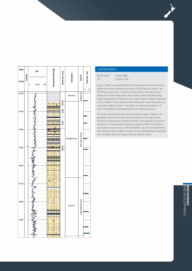
SPUD DATE 3 May 1983 TD 5,664 m MD
Kapuni Deep-1 was drilled to test any deeply buried reservoirs below the known producing zones of the Kapuni Group. The 1975 Kupe discovery, offshore to the south, had found coal measures in the Paleocene and seismic data indicated that these appeared to thicken to the north. Kapuni Deep-1 reached a TD of 5,664 m and drilled thick Paleocene coal measures, as expected. Kapuni Deep-1 was later re-entered as Kapuni-13 and completed as a Mangahewa Formation producer.
The well showed that the source rocks in Kapuni Deep-1 are generally richer and more oil-prone than in the equivalent sections of previously examined wells, and appear to become mature for oil generation between about 3,500 and 4,000 m. No marine source rocks were identified, but oil extracted from the drilling mud at 5,496 m had marine characteristics that did not correlate with the Kapuni Group source rocks.
Depth
(m brt)
GR
0 GAPI Res
ervo
irzo
ne
Fo
rmat
ion
Ep
och
Inte
rpre
ted
lith
olo
gy
Cas
ing
To
tal g
as(%
)
3200
3300
3400
3500
3600
3700
3800
3900
K1A
K1B
K1C
K3A
Mangahewa
Otaraoa
Kaimiro
Olig
ocen
eM
id-L
ate
Eoc
ene
Ear
ly-M
idE
ocen
e
200
0.1 100

New Zealand Petroleum Basins68
PRODUCTION AND RESERVESThe Mangahewa structure was identified as a prospect early in the exploration of Taranaki Basin and was first drilled in 1961. Mangahewa-1 found some gas in the Kapuni Group but was considered sub-economic. Further exploration in the 1990s led to the drilling of the Mangahewa-2 discovery well in 1996. This well located some 20 m of hydrocarbon reservoirs over several zones of “tight gas”. Three zones were hydraulically fractured and only one zone was utilised for short and long-term production testing. Following the flow tests, acquisition of 3D seismic in 1997, and appraisal of the northern flank of the structure with the Ohanga-2 well (1998), permanent production from the field started in September 2001.
Gross cumulative production of the field at 1 January 2013 is 74.8 bcf gas and 1.79 mmbbl condensate. Estimated remaining reserves (P90) at 1 January 2013 are 97.5 bcf gas and 1.6 mmbbl condensate. Todd Energy has reassessed the reserves and appraisal/development opportunities within the Kapuni formation based on well performance
Mangahewa Gas-Condensate Field
LOCATION ONSHORE TARANAKI BASIN
CURRENT PERMIT 38150
AREA 44 km2
OPERATOR Todd Energy
DISCOVERED 1961
YEAR ON STREAM 2001
ELEVATION 120 m
RESERVOIR DEPTH From 3,300 m TVDSS
RESERVOIR ROCK Mangahewa Formation
GEOLOGICAL AGE Late Eocene
PLAY TYPE Transgressive terrestrial to marginal marine sands in broad, low-relief anticline
and subsurface studies. This has resulted in the drilling of appraisal wells Mangahewa-03 (2007), Mangahewa-04 (2009), and Mangahewa-06 (2009). The results of those appraisal wells provided the foundation for the Mangahewa Expansion Project, which was formally announced in January 2012. This expansion project, which is expected to cost in excess of $750 million, and which targets to mature 450 PJ of contingent gas resources into 2P gas reserves, consists of: approximately 25 appraisal and development wells, gas processing facility expansion, installation of additional gas export pipeline and additional gathering lines and wellsite facilities.
GEOLOGYMangahewa is a gas-condensate field located west of the McKee Field and 18 km southeast of New Plymouth. The structure is a broad, low-relief anticline at Kapuni Group level, formed by regional shortening along the eastern margin of Taranaki Basin in the Early to Mid-Miocene. The field is on the same broad structural trend as Pohokura, offshore to the north.
RESERVOIR CHARACTERISTICSIn the Mangahewa Field, the Eocene Mangahewa reservoir sands are sealed by intra-formational shales. Vertical isolation of the various reservoir layers is indicated by different fluid contents, gas composition and pressures.
The reservoir has been more deeply buried than it is today and reservoir porosity and permeability are relatively low as a result. Reservoir quality also varies from sand to sand, depending on grain size, diagenetic effects, and clay content. Porosities range up to 12%, and the main producing interval (MA-72) has an average porosity of 9% and average permeability of 4.5 mD. Production delivery relies on artificial fracturing of the reservoir.
FACILITIESThe Mangahewa facilities consist of eight wells with associated wellsite facilities, connected via multiple gathering lines to the McKee- Mangahewa Production Station. Fluids are treated in a single high pressure gas train. The McKee facilities are used for the provision of utilities and for treating condensate, water and LTS liquids.

DIS
CO
VER
IES
AN
D D
EVELO
PM
ENTS
MANGAHEWA-2
SPUD DATE 15 September 1996 TD 4,376 m MD
Mangahewa-2 was drilled on the crest of a large, low amplitude inversion anticline. Primary targets were the McKee and Mangahewa formations; the Kaimiro Formation was the secondary target. A gas-condensate discovery was made within Mangahewa Formation reservoirs. The lower Mangahewa Formation tends to be of lower permeability but it contains significant thicknesses of gas-bearing sandstone.
Depth
(m brt)
GR
0 GAPI Fo
rmat
ion
NZ
stag
e
Cas
ing
Sh
ow
s
Inte
rpre
ted
lith
olo
gy
Ep
och
To
tal g
as(%
)
3400
3500
3600
3700
3800
3900
4000
4100
4200
4300
Mangahewa
Otaraoa
Matapo
Turi
McKee
Ak
Ab-
Ak
TD
Mid
-Lat
eE
ocen
e
200
0.01 100

New Zealand Petroleum Basins70
PRODUCTION AND RESERVESGross cumulative production of the field as at 1 January 2013 is 3579 bcf gas and 185 mmbbl oil/condensate. Estimated remaining reserves (P90) at 1 January 2013 are 80 bcf gas and 3.2 mmbbl oil/condensate.
GEOLOGYThe field is a large, low relief anticline of approximately 150 km2 areal extent, with the northeast referred to as Maui A, and the southwest as Maui B. The two components are separated by a saddle. The field is bounded to the west by the Whitiki Fault and to the east by the Cape Egmont Fault. Both faults have had reversals of movement, which were critical to forming the Maui structure. The field is in an area of the basin where Miocene shortening and subsequent extension overlap. The Maui structure is interpreted as an inversion structure formed by fault-bend folding during compressional reactivation of the Whitiki Fault.
Maui Gas-Condensate Field
LOCATION OFFSHORE TARANAKI BASIN
CURRENT PERMIT 381012
AREA OF PERMIT 784 km2
OPERATOR Shell Todd Oil Services
DISCOVERED 1969
YEAR ON STREAM 1979
WATER DEPTH 110 m
RESERVOIR DEPTH From 2,700 m TVDSS
RESERVOIR ROCK Mangahewa, Kaimiro and Farewell formations
GEOLOGICAL AGE Paleocene and Eocene
PLAY TYPE Transgressive terrestrial to marginal marine sands in fault-bound dual-crested anticline
The field produces from three reservoirs (C, D and F sands) within the Mangahewa, Kaimiro and Farewell formations of the Eocene to Paleocene Kapuni Group. These formations were deposited on a relatively narrow coastal plain along a fluctuating, northeast- trending shoreline. Movement of the shoreline back and forth across the Maui area, and fluctuations in the rate and locus of sediment supply, have resulted in highly cyclic, intercalated coastal plain and shallow marine strata.
RESERVOIR CHARACTERISTICSThe bulk of gas reserves in the Maui Field are contained in the C sands reservoir, with gas and thin oil columns in the D sands and oil in the F sands reservoir. Porosities in the C sands are up to 27% and permeabilities from 460 to 2,000 mD. The D sands have over 20% porosity and 200 to 500 mD permeability. In the F sands, porosities are over 20% and permeabilities up to several hundred mD.
FACILITIESMaui Field facilities comprise four major components:
+ a multiphase pipeline connects the Maui A platform to the processing plant at Oaonui
+ the Maui Production Station onshore at Oaonui operates to bring gas and condensate to pipeline specifications
+ the Omata Tank Farm is located at the port of New Plymouth. Processed condensate and associated products are stored here before shipping
+ the Maui B platform (15 km from the Maui A) is connected to Maui A via an undersea pipeline. Oil from the F sands was formerly fed directly to Floating Production Storage and Offloading (FPSO) vessel.

DIS
CO
VER
IES
AN
D D
EVELO
PM
ENTS
MAUI-1
SPUD DATE 27 January 1969 TD 3,512 m MD
The field was discovered in 1969 by the Maui-1 well, drilled in the southern B area, and two following wells (Maui-2 and Maui-3) drilled on the A area structure. Maui-1 proved the presence of petroleum, mainly gas and condensate, but with some 10 m of net oil in Eocene sandstone reservoirs with good porosity and permeability. At the time, the Maui Field was one of the largest gas fields in the world, with initial reserves of 3,830 bcf of gas.
MAUI-3
SPUD DATE 25 December 1969 TD 3,401 m MD
The appraisal well Maui-3 was drilled 21.5 km north of Maui-1. New Zealand’s premier offshore oil and gas producing facility, Maui-A, was later built nearby. It was brought on stream in 1979. The uppermost C sand was hydrocarbon-bearing, with identical GOC and OWC as in Maui-1 and -2. The D sand, with a gross hydrocarbon-bearing thickness of 41 m, had a lower OWC than in Maui-1 indicating separate reservoirs in the two culminations. The average porosity of gas-bearing sands in Maui-1 and -3 is 18.8%; permeabilities range from 460 to 2,000 mD.
Depth
(m brt)
Inte
rpre
ted
lith
olo
gy
Sh
ow
s
Met
han
e(p
pm
)
Fo
rmat
ion
Ep
och
Cas
ing
GR
0 GAPI
2400
2500
2600
2700
2800
2900
3000
3100
3200
3300
3400
3500
Lower Manganui
Taimana
Tikorangi
Otaraoa
Turi
Mangahewa,"C" shale
Mangahewa,“C" sand
Lower Turi,"D" shale
Kaimiro,"D" sand
Farewell,"E" shale
North Cape
Olig
oc.-M
ioce
neLa
teE
ocen
eE
arly
-M
idE
ocen
eL.
Pal
eoc.
-E
.Eoc
.P
aleo
cene
Cre
tace
ous
TD
200
0 50000
Farewell
Depth
(m brt) Ep
och
Fo
rmat
ion
Cas
ing
GR
0 GAPI
Sh
ow
s
To
tal g
as(%
)
Lit
ho
log
y(m
ud
log
)
2100
2200
2300
2400
2500
2600
2700
2800
2900
3000
3100
3200
3300
3400
Ear
ly-M
idE
ocen
eEa
rlyEo
cene
Pal
eoce
ne
Moki
Lower Manganui
Taimana
Tikorangi
Otaraoa
Turi
Mangahewa, "C" shale
Mangahewa,"C" sand
Turi,"D" shale
Kaimiro,"D" sand
Farewell "E" shale
TD
200
1000.01
Farewell

New Zealand Petroleum Basins72
PRODUCTION AND RESERVESGross cumulative production of the field at 1 January 2013 is 161 bcf gas and 47.3 mmbbl oil. Estimated remaining reserves at 1 January 2013 were 23.0 bcf gas and 0.8 mmbbl oil. Oil production from the field is primarily through water drive.
During the early 1990s oil production steadily declined, while at the same time gas and water production increased. The re-injection project was upgraded by Todd Energy in 2005, with gas from the northern part of the field being re-injected into the central part. Most down-dip oil wells require gas lift to continue oil flow, and a small water-flood operation in the centre of the field has stimulated production. Treated waste water is injected in a water disposal well.
GEOLOGYThe McKee oil and gas field, located 14 km southeast of Waitara in the northern part of Taranaki Peninsula, is a mature onshore producer.
McKee Oil and Gas Field
LOCATION ONSHORE TARANAKI BASIN
CURRENT PERMIT 38086
AREA 27.4 km2
OPERATOR Todd Energy
DISCOVERED 1979
YEAR ON STREAM 1984
ELEVATION 90 to 150 m
RESERVOIR DEPTH 2,000 to 2,400 m TVDSS
RESERVOIR ROCK McKee Formation
GEOLOGICAL AGE Late Eocene
PLAY TYPE Transgressive marginal marine sands in thrust-faulted anticline
The McKee Field is developed in a thrust-faulted anticline within the Tarata Thrust Zone. The main structure evolved through westward overthrusting on a low-angle fault, as a result of regional compression in the Early to Mid-Miocene. The field is structurally complex and is broken by faults antithetic to the main controlling west-verging fault. Reservoir strata are steeply dipping, at up to 60°. Hydrocarbons in the field are structurally trapped in north-south trending elongate culminations within individual fault-bound blocks and five distinct structural areas with varying pressure and fluid properties are identified.
The principal reservoir is the Late Eocene McKee Formation of the Kapuni Group, a 60 to 100 m thick interval dominated by shoreline sandstones, with some interbedded mudstone and coal. Sand to shale ratio is high but variable in the McKee Formation, particularly in the southern part of the field. In central and northern parts of the field, an intra-McKee Formation shale unit is present, and is up to 15 m thick at Pouri-1A, and 18 m thick at Pukemai-1B.
RESERVOIR CHARACTERISTICSSandstones in the McKee Formation have porosities from 12% to 23% and low to medium permeabilities up to 500 mD, with a trend toward better rock properties in upper stratigraphic intervals. In some reservoir zones quality is reduced by widespread diagenetic modification, principally through pressure solution of quartz, the development of clay, grain fracturing due to overthrusting, and carbonate cementation.
FACILITIESIn 2010 the McKee Field includes 40 wells, linked through product-gathering lines to the McKee Production Station. At the production station, well fluids are separated into gas, oil and water steams and then stabilised. The treated gas is compressed and injected into gas export lines. The stabilised oil is pumped via a 40 km oil line to export storage facilities at Port Taranaki in New Plymouth. Treated produced water is injected in a water disposal well. In late 2011 a LPG recovery plant (27,000 tonne/annum) was commissioned, which can run on imported Pohokura gas and/or McKee-Mangahewa gas.

DIS
CO
VER
IES
AN
D D
EVELO
PM
ENTS
MCKEE-1
SPUD DATE 19 October 1979 TD 3,900 m MD
McKee-1 was drilled as an exploration well to test the McKee structure. The relatively shallow depth of the overthrust Kapuni Group made the structure particularly attractive and the well was subsequently drilled to TDwith no major problems. Waxy, light oil, paraffinic condensate and gas were tested at sub-commercial outputs.
Depth
(m brt)
Fo
rmat
ion
Cas
ing
Sh
ow
s
To
tal g
as(u
nit
s)
GR
0 GAPI
Ep
och
Lit
ho
log
y(m
ud
log
)
2000
2100
2200
2300
2400
2500
2600
2700
2800
2900
3000
3100
3200
3300
3400
3500
3600
3700
3800
3900
Otaraoa
Tariki Eq.
Matapo MemberTuri
McKee
Mangahewa
Otaraoa
Manganui
Taimana
Tikorangi
Otaraoa
Tariki SandstoneEquivalent
Matapo Sandstone?/ Turi
McKee
Mangahewa
Olig
ocen
eE
ocen
eO
ligoc
ene/
Mio
cene
Eoc
ene
200
10000.1

New Zealand Petroleum Basins74
PRODUCTION AND RESERVES
The Maari-Manaia Field was developed on the basis of estimated recoverable reserves of about 50 mmbbl of oil in Moki Formation sands. The successful appraisal of the Eocene Mangahewa Formation in the Manaia prospect has added another 50 mmbbl oil to reserves. Initial production from the Maari-Manaia Field was about 40,000 bopd.
Gross cumulative production of the field at 1 January 2013 is 20.4 mmbbl oil. Associated gas production is not reported but is consumed on site. Estimated remaining reserves at 1 January 2013 were 20.1 mmbbl oil.
GEOLOGYThe Maari-Manaia Field is currently New Zealand’s largest offshore oilfield. Discovered by the Moki-1 well in 1983, it is 80 km from shore in the Southern Inversion Zone. Additional appraisal
Maari-Manaia Oil Field
LOCATION OFFSHORE TARANAKI BASIN
CURRENT PERMIT 38160
AREA 80 km2
OPERATOR OMV New Zealand Limited
DISCOVERED 1983
YEAR ON STREAM 2009
WATER DEPTH 101 m
RESERVOIR DEPTH Stacked reservoirs, between 1,200 to 1,600 m and 2,000 to 2,200 m MD.
RESERVOIR ROCK Multiple reservoir units, including shore-face and turbidite sands
GEOLOGICAL AGE Middle Miocene and Middle Eocene
PLAY TYPE Southern Inversion Zone, Neogene structure with reservoirs primarily in Middle Miocene Moki Formation turbidite sands. Deeper Eocene shallow marine sands are an additional target
wells were drilled in 1985, 1998 and 2003, with the final development decision made in 2005. In 2009, discovery of significant additional oil accumulations in the adjacent Manaia prospect, originally identified in the 1970s-drilled Maui-4 well, effectively doubled field reserves.
The Maari structure is a north-south trending closure. The main reservoir is Middle Miocene turbidite sands of the Moki Formation, with additional accumulations in younger M2A and older Eocene Kapuni Group sands. The closure was formed by Neogene shortening.
RESERVOIR CHARACTERISTICSReservoir quality at Maari is moderate, requiring some artificial lift and water injection for pressure support. Moki Formation sands tested by Maari-1 had porosities of 15 to 26% and permeabilities of 98 mD. The horizontally-drilled Maari-1A
sidetrack showed that successful production could be achieved from the Moki Formation via horizontally -completed wells.
FACILITIESThe Maari-Manaia offshore production site has a wellhead platform (WHP) and an FPSO vessel, the Raroa. Five production wells are located in the Maari sector, with horizontal reservoir sections up to 2,000 m long. The Manaia-1 well in the Manaia sector of the field is the longest extended-reach well drilled in New Zealand. The 147 m-tall WHP “Tirotiro Moana” is usually un-manned. The FPSO vessel has a storage capacity of 590,000 bbl, a production capacity of 40,000 bopd, and water injection capacity of 40,000 bwpd. It is located 1.5 km from the WHP. Maari-Manaia produces a waxy oil, which requires down-hole heating, flow line insulation, and heating processes on the FPSO and WHP.

DIS
CO
VER
IES
AN
D D
EVELO
PM
ENTS
MAARI-1
SPUD DATE 30 October 1998 TD 2,200 m MD
Maari-1 was an exploration/appraisal well primarily drilled to test the Middle Miocene Moki Formation discovery of Moki-1. Secondary objectives were the younger Miocene M2A sands, and Eocene Kapuni Group sands. Moki Formation sands were found to be oil-bearing between 1,265.4 and 1,318.6 m TVDSS. The shallower M2A sand was also found to be oil-bearing, with high porosities of up to 26% and 61% oil saturation. The deeper Kapuni Group sands contained an 8 m gas column and a 33 m oil column.
Following the confirmation of moveable oil in the Moki Formation, Maari-1 was plugged back, and the Maari-1A sidetrack was horizontally drilled to test the formation. Of the 654 m drilled, 563 m was oil-bearing, with an average porosity of 24% and an oil saturation of 75%. On test, Maari-1A produced 4,370 bopd, and was subsequently suspended as an oil discovery.
Depth
(m brt) Cas
ing
GR
0 GAPI
Inte
rpre
ted
lith
olo
gy
To
tal g
as%
Sh
ow
s
Ep
och
Fo
rmat
ion
1100
1200
1300
1400
1500
1600
1700
1800
1900
2000
2100
2200
No
data
Mid Manganui
M2A sand
Mid Manganui
Moki
Lower Manganui
Taimana
OtaraoaIntra Otaraoa glauc.
bedTuri
Mangahewa,C sand
200
1000.01

New Zealand Petroleum Basins76
PRODUCTION AND RESERVESGross cumulative production of the field at 1 January 2013 is 124 bcf gas and 27.0 mmbbl oil/condensate. Remaining reserves at 1 January 2013 estimated as P90 are virtually zero.
GEOLOGYThe Tariki, Ahuroa, Waihapa and Ngaere (TAWN) fields are in the central part of Taranaki Peninsula, about 7 km east of Stratford, along the eastern boundary of Taranaki Basin.
The TAWN fields are formed in overthrust structures within the Tarata Thrust Zone, sub-parallel to the Taranaki Fault. These structures are controlled at depth by low-angle reverse faults of Early to Middle Miocene age. Younger steeply-dipping normal faults of Plio-Pleistocene age offset the shallow stratigraphic succession above the fields.
TAWN Gas-Condensate and Oil Fields
LOCATION ONSHORE TARANAKI BASIN
CURRENT PERMIT 38138
AREA 14.4 km2
OPERATOR NZEC (Tariki, Waihapa, Ngaere), Contact Energy (Ahunoa)
DISCOVERED 1986
YEAR ON STREAM 1996
ELEVATION 200 to 240 m
RESERVOIR DEPTH From 2,050 m TVDSS
RESERVOIR ROCKS Tikorangi Limestone and Tariki Sandstone
GEOLOGICAL AGE Oligocene and Early Miocene
PLAY TYPE Fore-deep slope turbidite sands and fractured limestones in thrust-faulted anticline
Primary reservoirs are fractured limestone of the Oligocene to Early Miocene Tikorangi Formation in the Waihapa/Ngaere oil field and the Oligocene Tariki Sandstone Member of the Otaraoa Formation in the Tariki and Ahuroa gas/condensate fields. The Waihapa Field also contains gas/condensate in the Eocene Mangahewa Formation.
RESERVOIR CHARACTERISTICSThe Tikorangi Formation reservoir is up to 170 m thick and has a well-cemented matrix, with reservoir potential provided by fractures that resulted from the folding and faulting that formed the structural trap.
The Tariki Sandstone is up to 288 m thick in the southeastern region. Reservoir quality is best in the Ahuroa and Tariki wells. Core-derived average porosity and permeability measurements are in the ranges of 12 to 15% and 18 to 142 mD.
FACILITIESThe TAWN fields are fully developed with associated oil and gas production facilities including the Waihapa oil plant and the Tariki Ahuroa gas plant, both located at the Waihapa production station. However, the Ahuroa Field is now being used as a gas storage facility to supply the new 200 MW Stratford power station.

DIS
CO
VER
IES
AN
D D
EVELO
PM
ENTS
TARIKI-1 TARIKI-1A
SPUD DATES 2 March 1986 6 May 1986 TDs 3,191 m MD 2,764 m MD
Tariki-1 was drilled as a wildcat well on the west flank of the Tariki overthrust. The well discovered hydrocarbons in the 155 m MD-thick Oligocene Tariki Sandstone Member. The sandstone had good reservoir properties with 17.5% average porosity, but high water saturation averaging 51%.
The sidetrack Tariki-1A intersected the main thrust fault at the base of the Tariki Sandstone. It was drilled as an up-dip deviated appraisal well, discovering significant quantities of gas and condensate and intersecting the reservoir sand 177 m higher than in Tariki-1. Total thickness of the pay zone was 105.5 m MD (94 m TV) with an average porosity of 16% and water saturation of 13%. During deliverability testing, the well flowed 28.81 mmscf/d and 1,395 bbl/d of condensate through a 48/64” choke.
Depth
(m brt)
Fo
rmat
ion
Ep
och
Cas
ing
Sh
ow
s
Lit
ho
log
y(m
ud
log
)
To
tal g
as(u
nit
s)
GR
0 GAPI
1300
1400
1500
1600
1700
1800
1900
2000
2100
2200
2300
2400
2500
2600
2700
2800
2900
3000
3100
MountMessenger
Manganui
Taimana
Tikorangi
Otaraoa
Tariki SandstoneMember
Otaraoa (intra)
Matapo SandstoneMember
Turi
Mangahewa
Late
Mio
cene
Mid
dle
Mio
cene
Ear
lyM
ioce
neO
ligoc
ene
Late
Eoce
ne
TD
200
10001
Depth
(m brt)
GR
0 GAPI
Sh
ow
s
Lit
ho
log
y(m
ud
log
)
Fo
rmat
ion
Ep
och
Cas
ing
1800
1900
2000
2100
2200
2300
2400
2500
2600
2700
Taimana
Tikorangi
Otaraoa
Tariki SandstoneMember
Turi
Mio
cene
Olig
ocen
eE
ocen
e-E
.O
ligoc
ene
200
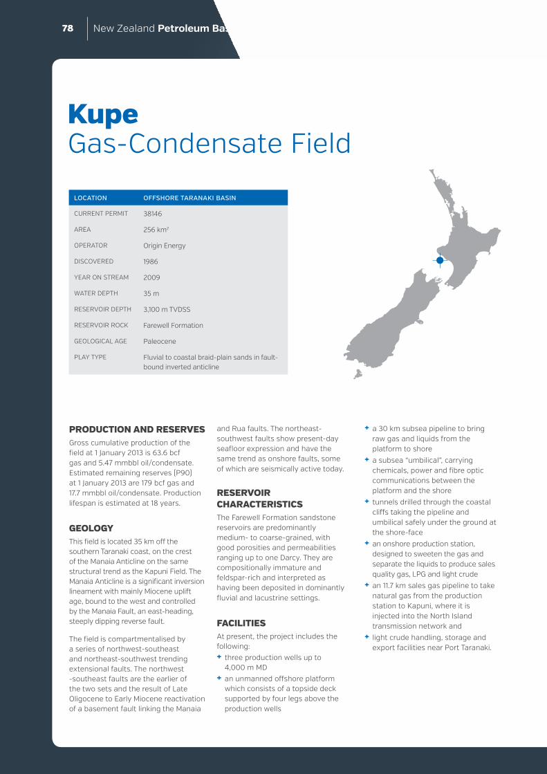
New Zealand Petroleum Basins78
PRODUCTION AND RESERVESGross cumulative production of the field at 1 January 2013 is 63.6 bcf gas and 5.47 mmbbl oil/condensate. Estimated remaining reserves (P90) at 1 January 2013 are 179 bcf gas and 17.7 mmbbl oil/condensate. Production lifespan is estimated at 18 years.
GEOLOGYThis field is located 35 km off the southern Taranaki coast, on the crest of the Manaia Anticline on the same structural trend as the Kapuni Field. The Manaia Anticline is a significant inversion lineament with mainly Miocene uplift age, bound to the west and controlled by the Manaia Fault, an east-heading, steeply dipping reverse fault.
The field is compartmentalised by a series of northwest-southeast and northeast-southwest trending extensional faults. The northwest -southeast faults are the earlier of the two sets and the result of Late Oligocene to Early Miocene reactivation of a basement fault linking the Manaia
Kupe Gas-Condensate Field
LOCATION OFFSHORE TARANAKI BASIN
CURRENT PERMIT 38146
AREA 256 km2
OPERATOR Origin Energy
DISCOVERED 1986
YEAR ON STREAM 2009
WATER DEPTH 35 m
RESERVOIR DEPTH 3,100 m TVDSS
RESERVOIR ROCK Farewell Formation
GEOLOGICAL AGE Paleocene
PLAY TYPE Fluvial to coastal braid-plain sands in fault-bound inverted anticline
and Rua faults. The northeast- southwest faults show present-day seafloor expression and have the same trend as onshore faults, some of which are seismically active today.
RESERVOIR CHARACTERISTICSThe Farewell Formation sandstone reservoirs are predominantly medium- to coarse-grained, with good porosities and permeabilities ranging up to one Darcy. They are compositionally immature and feldspar-rich and interpreted as having been deposited in dominantly fluvial and lacustrine settings.
FACILITIESAt present, the project includes the following:+ three production wells up to
4,000 m MD+ an unmanned offshore platform
which consists of a topside deck supported by four legs above the production wells
+ a 30 km subsea pipeline to bring raw gas and liquids from the platform to shore
+ a subsea “umbilical”, carrying chemicals, power and fibre optic communications between the platform and the shore
+ tunnels drilled through the coastal cliffs taking the pipeline and umbilical safely under the ground at the shore-face
+ an onshore production station, designed to sweeten the gas and separate the liquids to produce sales quality gas, LPG and light crude
+ an 11.7 km sales gas pipeline to take natural gas from the production station to Kapuni, where it is injected into the North Island transmission network and
+ light crude handling, storage and export facilities near Port Taranaki.

DIS
CO
VER
IES
AN
D D
EVELO
PM
ENTS
Depth
(m brt)
GR
0 GAPI
Cas
ing
Fo
rmat
ion
Sh
ow
s
Flu
ore
scen
ce
0
Cu
t
NZ
stag
eE
po
ch
Inte
rpre
ted
lith
olo
gy
1900
2000
2100
2200
2300
2400
2500
2600
2700
2800
2900
3000
3100
3200
3300
3400
3500
UpperManganui
LowerManganui
Taimana
Otaraoa
Farewell
Sw
-Tt
Pl-S
lLw
-Po
low
erLw
LdLw
hD
tM
id-L
ate
Mio
cene
Ear
ly-M
idM
ioce
neE
arly
Mio
cene
Late
Olig
ocen
eE.
-M.O
lig.
Pal
eoce
ne
TD
200
2 0 2
KUPE SOUTH-1
SPUD DATE 30 October 1986 TD 3,503 m MD
The discovery well, Kupe South-1, was drilled up-dip from the Kupe-1 well, to test a flexural culmination defined by various vintages of seismic data. The reservoir sands are Paleocene Farewell Formation braided river-deltaic sandstones. The well flowed 2,000 bopd and 5.4 mmscf/d and was followed by the drilling of the Kupe South-2 well in 1987, and Kupe South-3 and 3a wells, drilled in 1988.
Kupe South-2 and Kupe South-3 both encountered a stratified hydrocarbon reservoir with a significant 20 m oil column underlying a 120 m natural gas column. These three wells formed the basis for the Kupe Central Field Area (CFA) development, proposed in 1999.
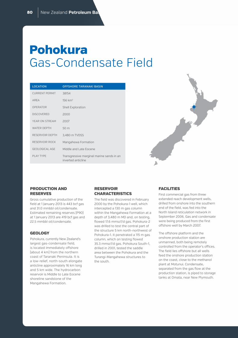
New Zealand Petroleum Basins80
PRODUCTION AND RESERVESGross cumulative production of the field at 1 January 2013 is 443 bcf gas and 31.0 mmbbl oil/condensate. Estimated remaining reserves (P90) at 1 January 2013 are 419 bcf gas and 22.5 mmbbl oil/condensate.
GEOLOGYPohokura, currently New Zealand’s largest gas-condensate field, is located immediately offshore (about 4 km) from the northern coast of Taranaki Peninsula. It is a low-relief, north-south elongate anticline approximately 16 km long and 5 km wide. The hydrocarbon reservoir is Middle to Late Eocene shoreline sandstone of the Mangahewa Formation.
Pohokura Gas-Condensate Field
LOCATION OFFSHORE TARANAKI BASIN
CURRENT PERMIT 38154
AREA 156 km2
OPERATOR Shell Exploration
DISCOVERED 2000
YEAR ON STREAM 2007
WATER DEPTH 50 m
RESERVOIR DEPTH 3,480 m TVDSS
RESERVOIR ROCK Mangahewa Formation
GEOLOGICAL AGE Middle and Late Eocene
PLAY TYPE Transgressive marginal marine sands in an inverted anticline
RESERVOIR CHARACTERISTICSThe field was discovered in February 2000 by the Pohokura-1 well, which intercepted a 130 m gas column within the Mangahewa Formation at a depth of 3,480 m MD and, on testing, flowed 17.6 mmscf/d gas. Pohokura-2 was drilled to test the central part of the structure 5 km north-northwest of Pohokura-1. It penetrated a 115 m gas column, which on testing flowed 35.3 mmscf/d gas. Pohokura South-1, drilled in 2001, tested the saddle area between the Pohokura and the Turangi-Mangahewa structures to the south.
FACILITIESFirst commercial gas from three extended reach development wells, drilled from onshore into the southern end of the field, was fed into the North Island reticulation network in September 2006. Gas and condensate were being produced from the first offshore well by March 2007.
The offshore platform and the onshore production station are unmanned, both being remotely controlled from the operator’s offices. The field lies offshore but all wells feed the onshore production station on the coast, close to the methanol plant at Motunui. Condensate, separated from the gas flow at the production station, is piped to storage tanks at Omata, near New Plymouth.

DIS
CO
VER
IES
AN
D D
EVELO
PM
ENTS
Depth
(m brt)
GR
0 GAPI
Cas
ing
Fo
rmat
ion
Ep
och
Sh
ow
s
Lit
ho
log
y(m
ud
log
)
To
tal g
as%
2900
3000
3100
3200
3300
3400
3500
3600
3700
3800
3900
4000
4100
4200TD
Taimana
Tikorangi
Otaraoa
Matapo SandstoneMember
Turi
Intra Turi Sand
Lower Turi
Mangahewa- coastal facies
/ McKeeequivalent
Omata
Olig
o-M
ioce
neO
ligoc
ene
Eoc
ene
200
1000.01
POHOKURA-1
SPUD DATE 5 February 2000 TD 4,234 m MD
The well targeted the Kapuni Group Mangahewa Formation sands in the Pohokura structure. In total, over 700 m of shallow marine sands were encountered. A gross gas column of 130 m was discovered in the upper part of the primary target. The well was deepened to access the potential of the lower Mangahewa Formation, reaching TD in the Mid-Eocene shales of the Omata Formation. However, logging confirmed no indications of commercial hydrocarbons in the lower section of the formation.
Two drill stem tests were performed in the upper section: the interval 3,625 to 3,634 m MD flowed at 3.5 mmscf/d on a 16/64” choke; the interval 3,553 to 3,570 m MD flowed 16.5 mmscf/d on a 54/64” choke. The well provided a control point for the velocity model in the field and a depth to reservoir close to the crest of the Pohokura structure.

New Zealand Petroleum Basins82
PRODUCTION AND RESERVESThe Tui area oil fields were developed on the basis of 27.9 mmbbl of recoverable oil. Several resource redeterminations have been made since this time and total recoverable reserves are now estimated at 37.6 mmbbl (P90). Several prospects lie within the Tui licence area. Discoveries in these could be tied into existing facilities and prolong the life of the project.
Production rates from the Tui area oil fields have been higher than predicted. Initial production rates were as high as 50,000 bbl/d, at the limit of the FPSO. Rates are currently about 11,000 bopd. The fields also produce gas, with the FPSO Umuroa using about 80,000 m3/day to power its operations, and the remainder flared.
Gross cumulative production of the field at 1 January 2013 is 14.96 bcf gas and 35.5 mbbl oil. Estimated remaining reserves (P90) at 1 January 2013 are 3.5 mmbbl oil.
Tui Area Oil Fields
LOCATION OFFSHORE TARANAKI BASIN
CURRENT PERMIT 38158
AREA 467.2 km2
OPERATOR AWE Taranaki Limited
DISCOVERED 2003
YEAR ON STREAM 2007
WATER DEPTH 123 m
RESERVOIR DEPTH 3,660 m MD
RESERVOIR ROCK Farewell Formation
GEOLOGICAL AGE Late Paleocene
PLAY TYPE Stratigraphic drapes of transgressive Late Paleocene sands over basement
GEOLOGYThe Tui area oil fields on the Western Platform are three small oil accumulations named “Tui”, “Amokura” and “Pateke”. They occur in a shallow marine transgressive Farewell Formation sandstone reservoir, the Kapuni “F” sand. The traps are low relief stratigraphic drapes over pre-existing basement highs. The accumulations lie above a strong aquifer.
The Western Platform is a comparatively stable region to the west of the Cape Egmont Fault Zone and Northern Graben. The reservoirs in the field area comprise part of a west-southwest to east-northeast trending shoreline system. The area is structurally simple and the fields are buried by about 3.5 km of overlying strata.
The discovery well, Tui-1, intercepted a 10 m column of oil. Amokura-1 and Pateke-2, both drilled in 2004, encountered 12 m columns of oil. These three accumulations have been tied into a single set of production facilities. It is thought that the migration pathways that charged the Tui area fields are part of the same system that charged the Maui Field 20 to 25 km to the southeast.
The Tui area oil fields represent a significant discovery for Taranaki Basin as they demonstrate that the Western Platform contains commercially viable petroleum accumulations. The fields were New Zealand’s first stand-alone offshore oil project. They are also remarkable for the short time in which they were brought on stream, with production starting 4.5 years after discovery and 20 months after the final investment decision was made.
RESERVOIR CHARACTERISTICSReservoir quality is generally good, as suggested by the excellent production rates that the fields have displayed thus far. Porosities are 18 to 21%, permeabilities are 1.1 to 2.0 Darcies, and water saturations are about 21 to 32%.
FACILITIESThe Tui development is by four horizontal wells tied back to the FPSO Umuroa. The Umuroa can process up to 50,000 bbl/d oil, 25 mmscf/d gas and 120,000 bbl/d total liquids, and has a storage capacity of 770,000 bbl crude oil. Oil is offloaded to tankers, and then transported to market.

DIS
CO
VER
IES
AN
D D
EVELO
PM
ENTS
TUI-1
SPUD DATE 24 January 2003 TD 3,902 m MD
Tui-1 was drilled to test Eocene shallow marine Kaimiro Formation “D” sands with Miocene Moki “A” turbidite sands a secondary objective and Paleocene Farewell Formation “F” sands an additional target. A 10 m column of high-quality oil was drilled in the Farewell Formation, with its top at a depth of about 3,664 m MD. Tui-1 was plugged and abandoned on 15 February 2003 as an oil discovery.
Depth
(m brt) Cas
ing
GR
0 GAPI
Ep
och
Sh
ow
s
Fo
rmat
ion
To
tal g
as%
Inte
rpre
ted
lith
olo
gy
2600
2700
2800
2900
3000
3100
3200
3300
3400
3500
3600
3700
3800
3900 TD
Olig
ocen
eE
ocen
eP
aleo
cene
Cre
tace
ous
Mid Manganui
Moki 'A'
Mid Manganui
Moki
Lower Manganui
Taimana
Tikorangi
Otaraoa
Turi
Kaimiro"D" sand
Turi
Farewell"F1" sand
Basement
200
1000.1

New Zealand Petroleum Basins84
SIGNIFICANCEThis sub-commercial gas-condensate discovery proves the presence of an effective petroleum system in the Great South Basin. Hydrocarbon shows were recorded from many intervals in Kawau-1A. Significant gas shows were present in Cretaceous reservoirs between 3,565 and 3,710 m. Oil staining was reported from several intervals above the main gas-condensate sands. A drill stem test in Kawau Sandstone at 3,224 to 3,257 m MD produced up to 6.7 mmscf/d of gas with 7% CO2 and 24 bbl/d of condensate. At that time, the overall reserve was calculated to be 461 bcf gas.
Kawau Gas-Condensate Discovery
LOCATION OFFSHORE GREAT SOUTH BASIN
CURRENT PERMIT Not assigned
AREA 16,390 km2
YEAR DRILLED 1977
WATER DEPTH 683 m
RESERVOIR DEPTH 3,224 m MD
RESERVOIR ROCK Near-shore transgressive Hoiho Group sandstone and near-shore Kawau Sandstone
GEOLOGICAL AGE Late Cretaceous
PLAY TYPE Late Cretaceous reservoir in a fault-controlled closure; compactional drape over faulted basement
GEOLOGYThe Kawau structure is a compactional drape trap located close to the longitudinal axis of the Great South Basin. The structure is probably typical of many other potential petroleum targets in the basin. It was tested by Kawau-1A, which was spudded on 20 June 1977, and reached basement at 3,703 m MD and a TD of 3,826 m MD. The main reservoir interval represents marine transgression over block-faulted basement. Source rocks for the trap are interpreted to be mid-Cretaceous coaly facies.
RESERVOIR CHARACTERISTICSThe reservoir tested by Kawau-1A had poor to fair permeability. Uncorrected log-derived porosities were in the 17 to 20% range. Sidewall core measurements indicated porosities of 22 to 28%.
FACILITIESNo facilities or infrastructure are present in the basin.

DIS
CO
VER
IES
AN
D D
EVELO
PM
ENTS
Depth
(m brt) Cas
ing
Sh
ow
s
GR
0 GAPI
Lit
ho
log
y(m
ud
log
)
To
tal g
as(%
)
Fo
rmat
ion
Ep
och
2000
2100
2200
2300
2400
2500
2600
2700
2800
2900
3000
3100
3200
3300
3400
3500
3600
3700
3800TD
Laing
Tartan
Wickliffe (W4)
Wickliffe (W3)
Wickliffe (W3)"Carbonaceousmudstone unit"
Wickliffe (W3)
Wickliffe (W2)
Wickliffe (W1)
"Blundell member"
undiffe-rentiated
basement
Pal
eoce
ne-
Eo
cen
eL
ate
Pal
eoce
ne
Lat
eC
reta
ceo
us
200
0.1 100

New Zealand Petroleum Basins86
SIGNIFICANCEThis sub-commercial gas-condensate discovery proves the presence of an effective petroleum system in Canterbury Basin. The structure is only partially filled and subsequent basin models suggest that the source kitchen is remote from the trap and that petroleum must have migrated some tens of kilometres from the kitchen to the trap. It might be inferred that traps closer to source may be more fully charged.
The Galleon-1 discovery was in a 21 m-thick interval of gas/condensate -bearing sandstone. Testing was carried out through a perforated liner between 2,753 and 2,763 m MD, with maximum flow rates reaching 10.1 mmscf/d gas and 2,300 bbl/d condensate. However, estimated recoverable reserves were deemed too small for commercial development at the time, and the well was plugged and abandoned as a gas-condensate discovery.
GalleonGas-Condensate Discovery
LOCATION OFFSHORE CANTERBURY BASIN
CURRENT PERMIT Not assigned
AREA 1,658 km2
YEAR DRILLED 1985
WATER DEPTH 91 m
RESERVOIR DEPTH 2,750 m MD
RESERVOIR ROCK Herbert and Pukeiwitahi formations
GEOLOGICAL AGE Late Cretaceous
PLAY TYPE Late Cretaceous four-way dip-closed drape over a mid-Cretaceous basement high
GEOLOGYThe Galleon structure is a stratigraphic drape trap of about 40 km2 over a basement horst. It is a good example of an important play type in the offshore Canterbury Basin. The horst is thought to have formed during the mid-Cretaceous. The reservoirs comprise Late Cretaceous shallow marine sands, and post-depositional compactional folding has formed the main part of the trap. The structure was tested as Galleon-1, which was spudded on 15 September 1985, and reached basement at 3,027 m MD and a TD of 3,086 m MD.
RESERVOIR CHARACTERISTICSAverage reservoir porosity in Galleon-1 is 17%, and water saturations are 0.46%. The high flow rates during testing of Galleon-1 indicate that the reservoirs have good permeability.
FACILITIESNo facilities are present in this basin.

DIS
CO
VER
IES
AN
D D
EVELO
PM
ENTS
Depth
(m brt)
Fo
rmat
ion
Ep
och
Sh
ow
s
To
tal g
as(%
)GR
0 GAPI
Cas
ing
Lit
ho
log
y(m
ud
log
)
1800
1900
2000
2100
2200
2300
2400
2500
2600
2700
2800
2900
3000
3100TD
Amuri
Hampden
Moeraki
Tartan Eq
Katiki
Herbert
Pukeiwitahi
Katiki(lower-1)
Zapata LimestoneGalleon Volcanics
Katiki(lwr 2 & 3)
Eoc-
Olig
Eo
cen
eP
aleo
cen
eL
ate
Cre
tace
ou
s
200
0.1 100

New Zealand Petroleum Basins88
SIGNIFICANCEThis sub-commercial oil discovery illustrates the potential of Miocene volcaniclastic reservoirs as viable plays and it shows that Paleogene marine rocks are generating oil in northern parts of the basin.
During the drilling of Kora-1, notable indications of hydrocarbons were recorded from Middle Miocene Mohakatino Formation volcanics, and from Tangaroa Formation sandstone. On test, the Miocene interval produced 1,168 bopd. A 14-day production test from the Kora-1A sidetrack achieved an average flow of 668 bopd. Biodegraded oil was noted from Kora-2 and -3 and no oil was recorded from Kora-4. The Kora Field remains undeveloped, and its small size (about 1 mmbbl) means development is unlikely.
Kora Oil Discovery
LOCATION OFFSHORE TARANAKI BASIN
CURRENT PERMIT Not allocated
AREA 1,400 km2
DISCOVERED 1988
WATER DEPTH 123 m
RESERVOIR DEPTH About 1,700 to 1,800 m MD, and about 3,100 m MD
RESERVOIR ROCK Mohakatino and Tangaroa formations
GEOLOGICAL AGE Middle Miocene and Late Eocene to Early Oligocene
PLAY TYPE Marine source rock-derived oils within buried volcaniclastic apron fans. Also Eocene to Oligocene mass-deposited and turbidite sands
GEOLOGYThe Kora Field is located within a trap formed by a buried Miocene volcanic edifice including complex lithofacies geometries, with doming caused by underlying intrusive igneous rocks. The discovery of oil in the field highlighted two new aspects to Taranaki Basin petroleum geology. Firstly, it illustrated that Miocene volcaniclastic deposits in the north of the basin offered reservoir potential. Secondly, it indicated that oil has been expelled from the late Paleocene Waipawa Formation marine source rock, something not previously identified within the basin. The discovery also showed that Late Eocene to Early Oligocene turbidite sandstones of the Tangaroa Formation, the original target for Kora-1, offer reservoir potential.
The field is located within a fault system that separates the Northern Graben from the Western Platform. The Northern Graben is a late Neogene extensional feature in the eastern part of the Taranaki Basin. Within parts of the graben lie a series of large
volcanic edifices that developed along the eastern margin of the Taranaki Basin during the Miocene, but were especially prominent during the Middle Miocene. These mostly andesitic volcanoes formed positive relief, and generated aprons of volcaniclastic debris, the Mohakatino Formation. Rapid sedimentation and progradation of the continental shelf during the Plio-Pleistocene has buried much of the Northern Graben and the volcanic features within it. Younger rocks of the Giant Foresets Formation form top seal for the underlying Miocene volcaniclastic reservoir.
It has been suggested that oil migrated into the Kora structure along graben- bounding faults in the Late Pliocene. A lack of sufficiently impermeable seal has been postulated, with capillary entry pressure measurements suggesting the Giant Foresets Formation overlying Kora may be capable of withholding a 40 to 120 m hydrocarbon column. Other volcanic features in the basin are more deeply buried and may have more effective seals.

DIS
CO
VER
IES
AN
D D
EVELO
PM
ENTS
RESERVOIR CHARACTERISTICSTangaroa Formation sandstones are typically 100 to 200 m thick and fine- to coarse-grained, commonly present in two intervals separated by a thin limestone. These sands had oil shows in Kora-1 but reservoir quality was poor, due to the presence of silica and carbonate cements, possibly associated with hydrothermal fluid migration.
The stratigraphic relationships between potential reservoir rocks within the Mohakatino Formation are complex and difficult to predict. Core measurements from the Kora-1A sidetrack indicate porosities from 9 to 28% with relatively low permeabilities of 0.1 to 200 mD. However, some high permeabilities also exist, with good flow rates obtained from clast-supported volcaniclastic conglomerates.
KORA-1
SPUD DATE 10 November 1987 TD 3,421 m MD
Kora-1 was drilled to test Eocene Tangaroa Formation sands within a large dome structure associated with a Miocene volcano. Significant hydrocarbon indications were encountered in the upper parts of a succession of Miocene volcaniclastic rocks at a depth of 1,785 m. Additional shows were also encountered in the Tangaroa Formation between 3,131 and 3,244 m. Drill stem tests of the Tangaroa Formation produced very small quantities of oil, and it was concluded that the formation was tight. The Miocene volcaniclastics flowed 1,168 bopd on test, after which Kora-1 was plugged back and the Kora-1A sidetrack drilled to evaluate the potential. A long-term production test yielded an average flow rate of 668 bopd. The well was plugged and abandoned.
Depth
(m brt)
GR
0 GAPI
Sh
ow
s
Lit
ho
log
y(m
ud
log
)
Met
han
e(p
pm
)
Fo
rmat
ion
Ep
och
Cas
ing
1700
1800
1900
2000
2100
2200
2300
2400
2500
2600
2700
2800
2900
3000
3100
3200
3300
3400
Kora Volcanics
Manganui(Lower)
Taimana
Tikorangi
Tangaroa
Turi
Mio
cene
Ear
lyM
ioce
neO
ligoc
ene
Mid
dle
toLa
teE
ocen
e
TD
200
0 70000

New Zealand Petroleum Basins90
SIGNIFICANCEAlthough deemed non-commercial, the Titihaoa dry gas accumulation represents an example of the potential for significant hydrocarbon discoveries in the offshore East Coast Basin. It illustrates the presence of thick successions of sandstone-bearing strata within large structural closures and demonstrates that generation and migration of hydrocarbons has occurred in the region. The presence of overpressured horizons demonstrates that seal capacity is good. Successful discoveries might be made in the structural lows around anticlines, where sands are inferred to be thicker and better developed, with elements of stratigraphic trapping.
Titihaoa-1 intercepted a column of gas-bearing rock over 800 m thick. Some thin sandstone beds produced significant gas kicks, and maximum total gas of 80.2% was recorded at a depth of 1,943 m MD. The gas
Titihaoa Gas Show
LOCATION OFFSHORE EAST COAST BASIN
CURRENT PERMIT Not allocated
YEAR DRILLED 1994
WATER DEPTH 126 m
RESERVOIR DEPTH About 1,500 to 2,700 m MD
RESERVOIR ROCK Turbidite sandstones
GEOLOGICAL AGE Middle Miocene
PLAY TYPE Neogene mass-emplaced sandstones within a late Neogene hanging wall anticline
composition was almost entirely methane, with minor propane, and the well was considered non-commercial. However, a post-drill analysis estimated that the Titihaoa structure may hold up to 400 bcf of recoverable gas.
GEOLOGYThe Titihaoa structure, covering about 30 km2, is one of many fault-bound, hanging wall, anticlinal closures that underlie offshore parts of the East Coast Basin. These structures developed during Neogene compression, a consequence of proximity to the modern subduction margin. The closure was tested by Titihaoa-1.
The Titihaoa structure lies with the accretionary prism, a structurally complex zone overlying the subducting Pacific Plate, comprising accreted sediments and slope basins imbricated during the Neogene. Anticlinal closures are common in the
hanging walls of reverse faults in this area and the areas of closure vary significantly. The region is thought to include a large thickness of potential Cretaceous and Paleogene source rocks at depth. Reservoirs are primarily Neogene turbidite sandstones. Fine-grained mudstones and marls provide seal.
RESERVOIR CHARACTERISTICSThe reservoir succession in Titihaoa-1 consists of thin-bedded Middle Miocene turbidite sands. These rocks are fine-grained and moderately well sorted, with porosities of about 15 to 20%. Permeabilities, estimated from Modular Dynamic Test (MDT) tool pressure build-ups, were about 20 mD and greater.

DIS
CO
VER
IES
AN
D D
EVELO
PM
ENTS
TITIHAOA-1
SPUD DATE 11 November 1994 TD 2,740 m MD
Titihaoa-1 was a wildcat well drilled offshore from Castlepoint by Amoco NZ Exploration Company. The second well to be drilled in offshore East Coast, it was designed to test possible thick Early Miocene and Oligocene sandstone reservoirs. The well was drilled 237 m beyond the anticipated TD but the rocks penetrated were no older than Middle Miocene. Gas shows were recorded throughout the well, although the lack of well developed reservoir sands meant it was deemed non-commercial.
Depth
(m brt)
Met
han
e(%
)
Cas
ing
GR
0 GAPIL
ith
olo
gy
(mu
dlo
g)
Ep
och
Fo
rmat
ion
Sh
ow
s
1100
1200
1300
1400
1500
1600
1700
1800
1900
2000
2100
2200
2300
2400
2500
2600
2700
TD
Late
Mio
cene
Mid
dle
Mio
cene
WhangaehuMudstone
Whangaehu -CalcareousMudstoneMember
Whakataki
No
show
s
200
1000.1

New Zealand Petroleum Basins92
SIGNIFICANCEThe Kauhauroa sub-commercial dry gas discovery is significant in several ways. It proves the reservoir properties of sandstones and fractured limestone and demonstrates that seals are effective despite very high over-pressures encountered at shallow depths. The gas appears to have a thermogenic component, further proving maturity in the onshore East Coast Basin.
Gas was discovered mainly in fractured Kauharoa Limestone, but also in sandstone reservoirs. Tunanui Formation sandstones flowed gas in Kauhauroa-5 and the Rere Sandstone Member was tested in Kauhauroa-1. Waitahora-1, drilled in 2007 as a direct offset to Kauhauroa-1, recorded gas shows over a 70 m along-hole interval, probably from fractured limestone.
Gas is 98% methane, with negligible amounts of higher hydrocarbons. Isotopic analyses indicate that a thermogenic source is possible, although a mixed biogenic-thermogenic source is more likely. This is consistent with isotopic analyses obtained from surficial gas seeps elsewhere in the Wairoa area. When first tested, Kauhauroa-1 yielded a stabilised flow
Kauhauroa Gas Discovery
LOCATION ONSHORE EAST COAST BASIN
CURRENT PERMIT 38346
AREA 5,582 km2
OPERATOR Westech Energy NZ Ltd
DISCOVERED 1998
RESERVOIR DEPTH About 1,100 to 1,600 m MD
RESERVOIR ROCK Kauhauroa Limestone
GEOLOGICAL AGE Early to Middle Miocene
PLAY TYPE Fractured shallow marine limestones and Neogene mass-emplaced sandstones within a late Neogene fault-cored anticline
of 11.5 mmscf/d from the Kauhauroa Limestone. A following test yielded erratic flows. There are no published estimates of reserves and the field remains suspended awaiting appraisal.
GEOLOGYThe Kauhauroa Field is located in one of many northeast-southwest trending anticlines in the Wairoa area of northern Hawke’s Bay, produced by late Neogene compression. The structure has been tested by eight wells. Its discovery by Kauhauroa-1 in 1998 highlighted the previously unknown potential of the Early and Middle Miocene shallow marine Kauhauroa and Kiakia limestones as fractured reservoirs in the East Coast Basin. Small flows of gas were also achieved from several sandstone units, including the Middle Miocene Tunanui Formation intercepted by Kauhauroa-5, the late-Early Miocene Rere Sandstone Member of the Waingaromia Formation in Kauhauroa-1, and the Early Miocene Whangara Sandstone in Kauhauroa-4B.
The Kauhauroa structure occurs along the crest of the asymmetric Kauhauroa Anticline, which is developed as a hanging-wall fold above a west-dipping reverse fault.
Several back-thrusts verge off the primary fault in the structure, variably offsetting the main reservoir interval. The structure is 15 km long and 6 to 9 km wide. Its crest is separated by a saddle from a less tightly folded, southwestern extension. The trend of the anticline is discernable from outcrop geology.
RESERVOIR CHARACTERISTICSFractured Kauhauroa Limestone, the presence of which was unknown prior to the drilling of Kauhauroa-1, is the main reservoir. The Early to Late Miocene Kiakia Limestone is another fractured limestone reservoir first identified during the Wairoa drilling programme. Porosity is primarily from fractures, which are often well imaged on geophysical image logs. The Kauhauroa structure exhibited significant overpressures, indicating the effective seal capacity of the thick overlying Neogene mudstones.
FACILITIESNo infrastructure or facilities have been developed in the Kauhauroa Field area.

DIS
CO
VER
IES
AN
D D
EVELO
PM
ENTS
KAUHAUROA-1
SPUD DATE March 4 1998 TD 1,221.6 m MD
Kauhauroa-1 was the first well to test a series of Neogene structural traps in the Wairoa area of onshore northern Hawke’s Bay. Several potential Miocene to Pliocene reservoirs were targeted. The Kauhauroa-1 well tested the potential of the Kauhauroa Anticline, near the small village of Frasertown.
The well drilled through several previously unknown lithological units. Significant gas overpressures were encountered and mud weights of up to 17.2 ppg were required. Gas shows were recorded in the Makareao Sandstone Member, a then-unknown member of the Late Miocene Poha Formation. Shows were also recorded from the turbidite sands of the Early Miocene Rere Sandstone Member. The most significant gas shows were encountered in the Early Miocene Kauhauroa Limestone, a formation unknown prior to the drilling of Kauhauroa-1. On test, up to 11.5 mmscf/d of methane flowed from this unit. Kauhauroa-1 was completed and suspended as a gas discovery.
Depth
(m brt) Cas
ing
GR
0 GAPIS
ho
ws
Lit
ho
log
y(m
ud
log
)
Fo
rmat
ion
Ep
och
To
tal g
as%
600
700
800
900
1000
1100
1200
TD
MakareaoSandstone
Member
PindariMudstone
TangihauMudstone
RereSandstone
Member
KauhauroaLimestone
Mid
-Lat
eM
ioce
neE
arly
Mio
cene
200
1000.01

New Zealand Petroleum Basins94
SIGNIFICANCEThe discovery of gas in the Karewa Field led to the identification of a new play concept in Taranaki Basin, highlighting the possibility of discovering commercial volumes of gas in shallow, relatively young rocks. Gas in the structure is inferred to be biogenic as it is more than 97% methane. However, some higher hydrocarbons were reported.
Options are being investigated to bring the field on stream. Proved and probable reserves, announced by the operator in 2007, indicated that the Mangaa Formation sands hold about 145-178 bcf of gas and that nearby prospects could yield another 130 bcf.
GEOLOGYKarewa is located within the Northern Graben, about 40 km offshore from Raglan. The graben is a late Neogene extensional feature along the eastern
Karewa Gas Discovery
LOCATION OFFSHORE TARANAKI BASIN
CURRENT PERMIT 38602
AREA 244 km2
OPERATOR Todd Petroleum Mining Company Ltd
DISCOVERED 2003
WATER DEPTH 89 m
RESERVOIR DEPTH About 2,000 m MD
RESERVOIR ROCK Mangaa Formation sandstone fans
GEOLOGICAL AGE Early to Late Pliocene
PLAY TYPE Neogene mass-emplaced basin-floor sandstones within a late Neogene hanging wall anticline. Charged with biogenically derived gas
margin of Taranaki Basin. The Karewa prospect was identified from high resolution seismic data as a possible hydrocarbon anomaly. The structure is a Pliocene feature associated with slope failure within the prograding Giant Foresets Formation above a Miocene volcanic body. Soling-out of a north-south oriented listric fault within intra-Mangaa Formation claystone helped produce a roll-over within the Mangaa Formation C-1 sand. The small four-way dip closure was mapped with about 50 m of total relief.
Pre-drill assessment was that Paleocene marine rocks were the most likely source of any hydrocarbons in the prospect. Older and more deeply buried Late Cretaceous rocks were considered unlikely to have been effective sources due to the young age of the structure. However, isotopic
analysis of headspace gas from Karewa-1 indicates that the methane is biogenically derived. No liquid hydrocarbons were encountered.
The Karewa Field occurs in a similar stratigraphic position to the nearby Kahawai-1 well, where gas is also inferred to be biogenically derived. Other similar gas accumulations are likely to occur in this part of Taranaki Basin, offering opportunities for the discovery of comparatively shallow gas accumulations in basin-floor sands.
RESERVOIR CHARACTERISTICSThe reservoir is Pliocene Mangaa Formation C-1 sands. Based on wire-line log analysis, sands have an estimated average porosity of 25.5% and a water saturation of 27.7%.

DIS
CO
VER
IES
AN
D D
EVELO
PM
ENTS
KAREWA-1
SPUD DATE 26 December 2002 TD 2,225 m MD
Karewa-1 was drilled to test Mangaa Formation C-1 sands, which were subsequently encountered between 1,930 and 1,942 m. Wire-line log testing indicated the formation is gas-charged, with 11.2 m of net pay. The well was plugged and abandoned as a gas discovery.
Depth
(m brt) Cas
ing
Lit
ho
log
y(m
ud
log
)
Fo
rmat
ion
Ep
och
GR
0 GAPIS
ho
ws
To
tal g
as%
1500
1600
1700
1800
1900
2000
2100
2200
Giant Foresets
MangaaC-1 sand
Mangaa
Plio
cene
TD
200
0.01 100

New Zealand Petroleum Basins96
SIGNIFICANCEThe Waka Nui-1 well is the only offshore petroleum exploration well north of Auckland and provides important lithologic and age control in the Northland and Reinga basins.
The well intersects a nearly complete Cenozoic sequence and Mesozoic Murihiku Supergroup rocks, all of which may be part of the petroleum system in these basins. Information from the well is critical for tying seismic data and constraining interpretations of the tectonic history and depositional environment in the entire offshore region northwest of New Zealand. Most of the recent seismic surveys in the Reinga, Northland and Deepwater Taranaki basins include lines that tie into Waka Nui-1 such is the importance of the well for stratigraphic and structural control.
Waka Nui-1
LOCATION OFFSHORE NORTHLAND BASIN
CURRENT PERMIT Not allocated
YEAR DRILLED 1999
WATER DEPTH 1454.9 m
RESERVOIR DEPTH 3464 m MD
RESERVOIR ROCK Middle Cretaceous syn-rift sediments (amalgamated fluvial sandstones, lacustrine shoreline and deltaic facies) and basal fluvial sandstones deposited during the period of initial rift fill.
GEOLOGICAL AGE Paleocene
PLAY TYPE Cretaceous sediments draped across the dip slope of a large tilted fault block
GEOLOGYThe well was drilled to test Cretaceous coal measures interpreted to be draped across the dip slope of a large tilted fault block. The upper part of the drilled sequence largely matched the well prognosis however no Cretaceous- aged section was encountered in the well.
The primary target interval was found to consist of non-reservoir early Paleocene volcanigenic conglomerates and sandstones unconformably overlying indurated volcaniclastic pre-rift Murihiku strata (middle Jurassic), separated by a 95 Ma hiatus at the unconformity.
No Upper Eocene sands were encountered below the Tikorangi Formation, and the Tikorangi Formation was thicker than prognosed. The Paleocene Turi Formation, also thicker than prognosed, encompassed the entire interval prognosed to be of Late Cretaceous age, and contained a Waipawa Formation condensed interval. A transgressive sand sequence of Paleocene age (rather than late Cretaceous) was also encountered, but is highly volcanigenic and has little reservoir potential.
RESERVOIR CHARACTERISTICSThe purpose of the well was to test the reservoir potential and quality of the Middle and Upper Cretaceous sandstones, and the Late Cretaceous transgressive sandstones and Eocene turbiditic sandstone. None of these sediments were encountered in the well. Instead, the target interval consisted of non-reservoir volcanigenic sediments.
Average porosities in the well range between 10 to 20%. The interval 3455.5-3474 m contains a transgressive sand considered the best reservoir rock in the well. The wireline log response of the sand is definitely not that of clean quartz sand. This interval saw a fresh water influx while drilling, an indicator of some porosity and permeability.
Detrital quartz and feldspar grains taken from a sidewall core sample at 3482 m (a transgressive sand unit) contain oil bearing fluid inclusions. The low Grains containing Oil Inclusions (GOI) value of 0.2% is consistent with oil migration through rocks with high water saturation.

DIS
CO
VER
IES
AN
D D
EVELO
PM
ENTS
WAKA NUI-1
SPUD DATE: 30 April 1999 TD: 3,681 m MD
Waka Nui-1 was a wildcat exploration well drilled approximately 100 km west of Kaipara Harbour, off the northwest coast of Northland by Conoco Northland Ltd in 1999.
The well was designed to determine the reservoir potential and quality of the Middle and Upper Cretaceous sandstones, and the Late Cretaceous transgressive sandstone and Eocene turbiditic sandstone. The upper part of the drilled sequence largely matched the well prognosis however the predicted Cretaceous coal measures were not encountered. The well reached a total depth of 3681 m MD. No oil shows and only trace amounts of gas were recorded, and the well was plugged and abandoned.
Depth
(m brt)
GR
0 200GAPI
Cas
ing
Met
hane
(ppm
)
0.0001 1
Form
atio
n
Lith
olog
y(m
udlo
g)
Epoc
h
Show
s
3400
3500
3600
TD
lower TuriFormation
Kapuni Groupequivalent
MurihikuSupergroup
Pal
eoce
neE
arly
-Mid
dle
Jura
ssic
No
show
s.
The oil inclusions occur on fractures in detrital minerals however, the timing of oil migration relative to diagenesis cannot be constrained. The low GOI value can be interpreted as migration to a trap lacking closure or an oil charge to a valid trap, but with insufficient volume to form an oil column.
Geochemical analyses are inconclusive due to mud contamination in the samples. The one sample not largely affected by contamination was terrestrial in origin and characterised as being fully mature. The depositional environment is possibly anoxic. The source rock of the sample is believed to be a late mature coal.

New Zealand Petroleum Basins98
2000
2000
200
200
200
2000
2000
2000
2000
2000
2000
2000
2000
200
200
200
200
200
2000
2000
2000
2000
200
200
165°E 170°E 175°E 180° 175°W
165°E 170°E 175°E 180°
35°S
40°S
45°S
50°S
35°S
40°S
45°S
50°S
BellonaBasin
ChallengerPlateaubasins
Fiordlandbasins
Great SouthBasin
CanterburyBasin
Pukaki Basin
CampbellBasin
Outer CampbellBasin
WesternSouthland
basins
Chatham Slope BasinPegasus
Basin
EastCoastBasin
TaranakiBasin
NortheastSlopeBasin
ReingaBasin
NorfolkBasin
Late Cretaceous - Neogene passive margin
Cretaceous - Paleogene intraplate rifting;Neogene intraplate subsidence
Cretaceous - Paleogene rifting; Neogenebackarc or transform
Late Cretaceous passive margin; Neogeneconvergent margin overprint
© GNS Science
Rauku
mar
a Basin
Hav
re T
roug
h
WKW*
* Waikato, King Country & Whanganui basins
WestCoastbasins
DeepwaterTaranaki
Northland
BountyTrough
New CaledoniaBasin

FUTU
RE
FRO
NTIER
S
Future Frontiers
WeStern frontier BASinS
The Bellona Basin is located along the western margin of the Challenger Plateau. The New Caledonia Basin extends northwestwards from the Taranaki shelf between the Challenger Plateau and the Northland Shelf/Norfolk Ridge.
BASiS for inferring thiCk BASin-fill SequenCe
+ Regional seismic (reflection and refraction) data, satellite gravity data, gravity models.
inferred geology And AnAlogueS + Analogues – Gippsland and Bass Strait basins of SE Australia. New Caledonia Basin – Rockall Trough-Faeroes-Shetland Channel system west of the British Isles.
+ Challenger Plateau and Lord Howe Rise basins –transgressive terrestrial and marginal marine sediments, deposited during post-rift regional subsidence. By the Eocene, most or all of the region was entirely marine.
+ New Caledonia Basin – Cretaceous clastics and volcaniclastics deposited in fluvial and marginal marine environments. Terrigenous clays and mudstones, and authigenic limestone. Early Miocene volcanic activity.
Petroleum ProSPeCtivity + Older parts of the basins may contain terrestrial and marginal marine source rocks.
+ Granitic basement along the Challenger Plateau margin – good source of high-quality reservoir rocks.
+ Regional tilting may have affected migration pathways. + Potential oil seeps along the southern flank of the Challenger Plateau identified by satellite radar studies.
+ Rift sequence in New Caledonia Basin buried to a depth great enough for thermal maturation.
+ Structural and stratigraphic traps may exist at a number of levels in New Caledonia Basin.
CAmPBell PlAteAu BASinS
Pukaki, Campbell and Outer Campbell basins lie south of Great South Basin on the Campbell Plateau.
BASiS for inferring thiCk BASin-fill SequenCe
+ Regional seismic and satellite gravity data.
inferred geology And AnAlogueS + Analogue – Great South Basin. + Oldest sediments interpreted as a syn-rift and transgressive terrestrial and marginal marine sequence.
+ Subsidence ended about 45 million years ago. + Post-Paleocene, carbonate content increases. + Post-Eocene sediments primarily carbonate oozes and chalks.
Petroleum ProSPeCtivity + Thick coal measures may be present along the outer margin of Campbell Plateau.
+ Potential source and reservoir rocks – Cretaceous and Paleogene transgressive deposits and deep water turbidites.
+ Larger basins could have sufficient thickness of sediments to generate hydrocarbons.

New Zealand Petroleum Basins100
deeP-WAter CAnterBury BeneAth Bounty trough
A thick sedimentary sequence believed to be present beneath the modern Bounty Trough, in water depths of 1500 to 3000 m. Considered a province of the contiguous Canterbury Basin however no structural boundary between the two basins.
BASiS for inferring thiCk BASin-fill SequenCe
+ Regional seismic profiles, inferred geology and analogues + Analogue – Canterbury and Great South basins. + Oldest sediments interpreted to be a transgressive terrestrial and marginal marine sequence.
+ Subsidence ended about 45 million years ago. + Neogene sediments are primarily carbonate oozes and chalks.
Petroleum ProSPeCtivity + Probably prospective. + Coal measures and good reservoir sands in the rift and early transgressive sequences.
+ Some areas of basin-fill are sufficiently thick to have generated hydrocarbons.
northeASt SloPe BASin
Lies to the northeast of North Island, beneath 200 to 2,000 m of water. Covers the outer continental shelf, continental slope, and part of the Northland Plateau.
BASiS for inferring thiCk BASin-fill SequenCe
+ Regional seismic lines and gravity data.
inferred geology And AnAlogueS + Analogues – Raukumara, East Coast, Pegasus, and Chatham Slope Basins.
+ The Northeast Slope Basin contains relatively undisturbed sedimentary rocks overlying a more disrupted, layered to chaotic unit (Northland Allochthon).
+ Upper part of Neogene succession turbidites and hemipelagic limestones.
+ Early Miocene volcaniclastics and bioclastic limestone. + Underlying units may include Cretaceous to Oligocene continental slope and basin floor clastic sediments above a Gondwana margin succession.
Petroleum ProSPeCtivity + Little is known about the prospectivity. + Potential oil seeps are across the basin. + Some basin-fill rocks are within the oil and gas generation windows.
+ Source rocks – Cretaceous marine mudstones, Paleocene Waipawa Formation black shale.
+ Reservoir rocks – Late Cretaceous quartzofeldspathic turbidite sandstones, fractured Whangai Formation siliceous mudstone, chert and marl, and Miocene turbidites, coquina limestones and fractured limestones.
+ Traps – Early and Middle Miocene broad fault- bounded anticlines.

FUTU
RE
FRO
NTIER
S
ChAthAm SloPe BASin
Overlies the northern slope of Chatham Rise.
BASiS for inferring thiCk BASin-fill SequenCe
+ Seismic lines, gravity data (large linear gravity low). + Inferred geology and analogues. + Analogue – none identified. + Basal succession below Chatham Slope - Gondwana margin accretionary wedge.
+ Igneous and sedimentary rocks from the Hikurangi Plateau are likely to be incorporated within, and partially subducted below, the paleo-accretionary wedge whch forms Chatham Rise.
+ Following cessation of Cretaceous subduction, depositon of Late Cretaceous and Paleogene passive margin succession.
+ By the Neogene, the region had subsided and only small volumes of clastic sediment reached it.
Petroleum ProSPeCtivity + Little can be inferred from present knowledge.
murChiSon BASin
Part of the West Coast basins group, on and offshore the West Coast of the South Island. Murchison Basin is considered to be a southern extension of the productive Taranaki Basin.
BASiS for inferring thiCk BASin-fill SequenCe
+ Seismic surveys , gravity surveys.
inferred geology And AnAlogueS + Analogue – Taranaki Basin. + Late Eocene coal measures with interbedded and overlying sandstones and mudstones unconformably overlie basement.
+ Oligocene mudstones with interbedded sandstones and limestones.
+ Miocene and younger mudstones, sandstones and conglomerates.
+ Normal faults control Eocene source rock distribution and Oligocene seal facies and thickness.
Petroleum ProSPeCtivity + Anticlinal prospects. + Significant number of oil and gas seeps. + Potential reservoirs occur in all the main stratigraphic units. + Source rocks – coal measures, carbonaceous mudstones. + Oil source rocks lie within oil window at economically drillable depths = large oil plays with good hydrocarbon prospects.
+ Seals (interbedded siltstones, mudstones and claystones) generally 2,000 m thick.
+ Coal measures equivalent to the upper Kapuni Group, the major hydrocarbon bearing unit in the Taranaki Basin.

New Zealand Petroleum Basins102
WAikAto, king Country And WAngAnui BASinS
A series of mainly Neogene depocentres east of Taranaki Fault. King Country and Waikato basins are essentially entirely onshore. Wanganui Basin extends eastwards to the central North Island axial ranges and offshore from central and southern North Island.
BASiS for inferring thiCk BASin-fill SequenCe
+ Seismic surveys.
inferred geology And AnAlogueS + Analogue – none identified. + Waikato Basin - Late Eocene coal measures deposited between flanking basement highs, then overtopped by estuarine to open marine facies deposited during transgression.
+ Bathyal mudstone and turbidites were deposited following subsidence in Early Miocene time.
+ King Country Basin – thin sedimentary succession preserved.
+ Oligocene coal measure and limestone deposition. Early Miocene erosion, then deposition of paralic rocks, including coal measures.
+ Wanganui Basin – Late Miocene deposition of paralic and shallow-marine sediments. Shelf facies overlain by outer shelf to bathyal and basin-floor fan deposits, overtopped by progradational shelf systems.
+ Southward depocentre migration continues.
Petroleum ProSPeCtivity + Little thermogenic oil and gas potential, perceived to be thermally immature and lacking good source rocks.
+ Sub-bituminous coal seams in Waikato Basin have considerable coal seam gas potential.
+ Sedimentary thicknesses are generally too thin to generate and expel petroleum.
+ Eocene, Oligocene and Miocene coal measures present in King Country and Waikato regions.
+ Reservoir rocks – Eocene to Quaternary fluvial sandstones, shelf sandstones, basin-floor fans, and Oligocene to earliest Miocene limestones.
+ Plays – inversion structures, anticlines, stratigraphic pinch-outs, and drapes over pre-existing basement relief.
WeStern SouthlAnd BASinS
Onshore Te Anau and Waiau basins, and offshore from west to east, the Puysegur, Balleny, Waitutu, and Solander Basins. Southern limits of the offshore basins unknown.
BASiS for inferring thiCk BASin-fill SequenCe
+ Regional seismic data.
inferred geology And AnAlogueS + Analogue – Taranaki Basin. + Early to mid-Cretaceous terrestrial conglomerate and sandstone, with lesser lacustrine deposits. Eocene coarse-grained alluvial fan deposits, fluvial sandstones, mudstones and coals are overlain by Oligocene bathyal marine mudstones with intercalated turbidite sandstones. Miocene deep-water mudstone, sandstone and limestone.
+ Marine deposition ceased in the Middle Miocene in the Te Anau Basin; younger beds are non-marine conglomerates and sandstones. In the Waiau Basin, marine mudstone deposition continued through to the Pliocene.
+ Cambrian to Early Cretaceous basement rocks. + Plio-Pleistocene arc volcanism.
Petroleum ProSPeCtivity + Gas seeps, oil shales, degraded oil in outcrop, and a show in an exploration well indicate an effective petroleum system.
+ Coal seam gas found in Cretaceous and Eocene coal measures in the Waiau Basin may be commercial.
+ Large number of potential traps. + Source rocks – Cretaceous syn-rift sediments, some potential in Eocene lacustrine mudstones. More oil prone than those in Taranaki.
+ Reservoir rocks – Late Cretaceous and Eocene fluvial sandstones, Oligocene turbidites, and Miocene turbidite sandstones in the offshore.
+ Plays – anticlines, stratigraphic pinch-outs, and drapes over pre-existing basement relief.

recommended reading
referenCeS
tArAnAkiKing, P.R., Thrasher, G.P., Bland, K.J., Carthew, P., D’Cruz, D., Griffin, A.G., Jones, C.M., Strogen, D.P. 2010. Cretaceous- Cenozoic geology and petroleum systems of the Taranaki Basin, New Zealand. Digitally remastered version. GNS Science, Lower Hutt. Institute of Geological & Nuclear Sciences monograph 13. 1 CD.
Strogen, D.P. (compiler) 2011. Updated paleogeographic maps for the Taranaki Basin and surrounds. GNS Science, Lower Hutt. GNS Science Report 2010/53. 83 p.
Uruski, C.I., Wood, R. 1991. A new look at the New Caledonia Basin, an extension of the Taranaki Basin, offshore North Island, New Zealand. Marine and Petroleum Geology (8): 379-391.
Uruski, C.I., 2008. Deepwater Taranaki, New Zealand: structural development and petroleum potential. Exploration Geophysics 39 (2): 94-107.
reingA – northlAndBache, F., Stagpoole, V., Sutherland, R. 2013. Seismic Stratigraphy of the Reinga Basin, NW New Zealand: Tectonic and Petroleum Implications. In Rosen N.C. et al. (eds.) New understanding of the Petroleum Systems of Continental Margins of the World. GCS-SEPM Foundation. 32nd Annual Bob F. Perkins Research Conference.
Bache, F., Sutherland, R., Stagpoole, V.M., Herzer, R.H., Collot, J., Rouillard, P. 2012. Stratigraphy of the southern Norfolk Ridge and the Reinga Basin: a record of initiation of Tonga-Kermadec-Northland subduction in the southwest Pacific. Earth and planetary science letters 321/322: 41-53.
Bierbrauer, K., Herdy, T.J., Rek, A., Mills, K.L. 2008. Offshore Northland Basin – Frontier exploration north of the established Taranaki Hydrocarbon Province. New Zealand Petroleum Conference 2008, Auckland, New Zealand.
Stagpoole, V., Reid, E., Browne, G.H., Bland, K., Ilg, B., Griffin, A., Herzer, R.H., Uruski, C. 2009. Petroleum prospectivity of the Reinga Basin, New Zealand. GNS Science, Lower Hutt. Ministry of Economic Development New Zealand Unpublished Petroleum Report PR 4037.
Uruski, C.I., Reid, E., Stagpoole, V., Herzer, R., Griffin, A. Bland, K., Ilg, B., Browne, G. 2010. The Reinga Basin, North Island, New Zealand. APPEA journal 50: 287-308.
eASt CoASt ProvinCeField, B.D., Uruski, C.I. 1997. Cretaceous-Cenozoic geology and petroleum systems of the East Coast region, New Zealand. Institute of Geological & Nuclear Sciences, Lower Hutt, New Zealand. Institute of Geological & Nuclear Sciences monograph 19. 301 p.
Stagpoole, V., Field, B., Sutherland, R., Uruski, C., Zink, K. 2008. Petroleum prospectivity of the Raukumara Basin, New Zealand. Ministry of Economic Development New Zealand Unpublished Petroleum Report PR 3921.
Uruski, C.I., Field, B.D., Funnell, R., Hollis, C., Nicol, A., Maslen, G. 2006. Developments in the central and northeastern East Coast Basin, North Island, New Zealand. APPEA journal 46 (1): 215-235.
Uruski, C.I., Kennedy, C., Stagpoole, V., Sutherland, R., Henrys, S. 2008. The discovery of a new sedimentary basin: Offshore Raukumara, East Coast, North Island, New Zealand. APPEA journal 48: 53-68.
Uruski, C.I. 2010. Breaking new ground – again! The Pegasus subbasin of the East Coast Basin, North Island, New Zealand. ASEG Conference 2010, Sydney, Australia.
Uruski, C.I., Bland, K. 2011. Pegasus Basin and the prospects for oil and gas. Ministry of Economic Development New Zealand Unpublished Petroleum Report PR 4326.

New Zealand Petroleum Basins104
greAt South–CAnterBury ProvinCeField, B.D., Browne, G.H., Davy, B.W., Herzer, R.H., Hoskins, R.H., Raine, J.I., Wilson, G.J., Sewell, R.J., Smale, D., Watters, W.A. 1989. Cretaceous and Cenozoic sedimentary basins and geological evolution of the Canterbury Region, South Island, New Zealand. New Zealand Geological Survey, Lower Hutt. New Zealand Geological Survey Basin Studies 2. 94 p.
Cook, R.A., Sutherland, R., Zhu, H. and others. 1999. Cretaceous – Cenozoic geology and petroleum systems of the Great South Basin, New Zealand. Institute of Geological & Nuclear Sciences, Lower Hutt, New Zealand. Institute of Geological & Nuclear Sciences monograph 20. 188 p. + 2 enclosures.
Dixon, B.T., Mogg, W.G., Robinson, S.J., Beckman, D.W., Pass, G.P. 2010. Offshore Canterbury Basin – Efficient use of emerging technology in the advancement of frontier exploration. In 2010 New Zealand Petroleum Conference proceedings. Wellington, Ministry of Economic Development. 1 CD.
Exxon Mobil Exploration Company, 2010. Great South Basin 3D/2D Seismic Interpretation Report – PEP 50117. Ministry of Economic Development New Zealand Unpublished Petroleum Report PR 4233. 42 p.
Exxon Mobil Exploration Company, 2010. Great South Basin Open Acreage 2D Seismic Interpretation Report, PEP 50117. Ministry of Economic Development New Zealand Unpublished Petroleum Report PR 4234. 18 p.
Killops, S.D., Cook, R.A., Sykes, R. 1997. Petroleum potential and oil-source correlation in the Great South and Canterbury basins. New Zealand Journal of Geology and Geophysics (40): 405-423.
Mogg, W.G., Aurisch, K., O’Leary, R., Pass, G.P. 2008. Offshore Canterbury Basin – beyond the shelf edge. In 2008 New Zealand Petroleum Conference proceedings. Wellington, Ministry of Economic Development. 24p.
Schiøler, P., Rogers, K., Sykes, R., Hollis, C.J., Ilg, B., Meadows, D., Roncaglia, L., Uruski, C. 2010. Palynofacies, organic geochemistry and depositional environment of the Tartan Formation (Late Paleocene), a potential source rock in the Great South Basin, New Zealand. Marine and Petroleum Geology (27): 351-369.
Sykes, R., Funnell, R.H. 2002. Petroleum source rock potential and generation history in the offshore Canterbury Basin. New Zealand Unpublished Openfile Petroleum Report PR 2707. 140 p.
Uruski, C.I., Kennedy, C., Harrison, T., Maslen, G., Cook, R.A., Sutherland, R., Zhu, H. 2007. Petroleum potential of the Great South Basin, New Zealand – new seismic data improves imaging. APPEA journal 47 (1/2): 145-161.
frontier BASinSCollet, T., Johnson, A., Knapp, C., Boswell, R. (eds.) 2009. Natural Gas Hydrates: Energy Resource Potential and Associated Geologic Hazards. AAPG Memoir 89.
Griffin, A.G. 2009. Overview of shale gas: exploration and exploitation characteristics and issues based on experience from the United States, and implications for New Zealand. GNS Science, Lower Hutt. GNS Science Report 2009/70. 72 p.
Kamp, P.J.J., Vonk, A.J., Bland, K.J., Hansen, R.J., Hendy, A.J.W., McIntyre, A.P., Ngatai, M., Cartwright, S.J., Hayton, S., Nelson, C.S. 2004. Neogene stratigraphic architecture and tectonic evolution of Wanganui, King Country, and eastern Taranaki basins, New Zealand. New Zealand Journal of Geology and Geophysics 47(4): 625-644.
Pecher, I.A., Gorman, A.R., Henrys, S.A., Stagpoole, V., Fohrmann, M., Toulmin, S. 2010. Gas Hydrate Exploration on the Hikurangi Margin, New Zealand 2010. GNS Science, Lower Hutt. GNS Science Report 2010/10. 31 p.
Hoskins, R.H., Raine, J.I., Smale, D. 1986. Cretaceous and Cenozoic sedimentary basins of the West Coast Region, South Island, New Zealand. DSIR, Wellington. NZ Geological Survey Basin Studies 1. 89 p.
Turnbull. I.M., Uruski, C.I. 1993. Cretaceous and Cenozoic sedimentary basins of Western Southland, South Island, New Zealand. DSIR, Wellington. New Zealand Geological Survey basin studies 4 (also known as Institute of Geological & Nuclear Sciences monograph 1). 86 p.
Uruski, C.I. 1993. Petroleum potential of Western Southland, South Island, New Zealand. PESA journal (July 1993): 55-66.
Uruski, C.I. 2000. Petroleum potential of New Zealand’s deepwater basins. In: 2000 New Zealand Petroleum Conference proceedings. Wellington, Ministry of Economic Development. Pp 146-152.
Uruski, C.I. 2010. New Zealand’s deepwater frontier. Marine and Petroleum Geology 27 (2010): 2005-2026.

Links
New Zealand Petroleum & Minerals www.nzpam.govt.nz
Online Exploration Database data.nzpam.govt.nz
Petroleum Basins Explorer data.gns.cri.nz/pbe
Ministry of Business, Innovation & Employment (MBIE) www.mbie.govt.nz
Health & Safety (MBIE) www.osh.dol.govt.nz
Inland Revenue www.ird.govt.nz
Maritime New Zealand www.maritimenz.govt.nz
Environmental Protection Authority (EPA) www.epa.govt.nz
Ministry of Primary Industries www.mpi.govt.nz
GNS Science www.gns.cri.nz
Petroleum Exploration & Production Association New Zealand (PEPANZ) www.pepanz.com

New Zealand Petroleum & Minerals, Ministry of Business, Innovation & Employment, PO Box 1473, Wellington 6140.
Telephone: +64 3 962 6179 Facsimile: +64 4 471 0187
Email: [email protected]: www.nzpam.govt.nz