East Bay Hills Roadside Vegetation Treatment Standards
12
East Bay Hills Roadside Vegetation Treatment Standards HEF Approval 4/18/2003 HILLS EMERGENCY FORUM
Transcript of East Bay Hills Roadside Vegetation Treatment Standards

East Bay HillsRoadside VegetationTreatment Standards
HEF Approval 4/18/2003
HILLS EMERGENCY
FORUM
East Bay Hills Roadside StandardsHEF Approval 4/18/03 Page 1 of 15
East Bay Hills Roadside Standards
Jurisdictions in the East Bay HillsThe East Bay Hills consists of multiple jurisdictions (as shown on the following map) that
establish fire related codes and enforce these standards.
• The three cities of Berkeley, El Cerrito and Oakland are responsible for establishing
standards for roadside clearances within their city boundaries.
• University of California of Berkeley is located on lands owned by the State Board of
Regents. The State Fire Marshall and the California Department of Forestry and Fire
Protection have responsibility for these state lands.
• The Lawrence Berkeley National Laboratory is responsible for establishing roadside
clearance criteria within its boundaries, and for implementing the annual work to maintain
these criteria.
• The region includes two special districts. Authorizing state legislation for East Bay Regional
Park District and East Bay Municipal Utility District empower them to set standards for their
own lands.
• The area also includes roadsides owned and managed by the State (CalTrans), Alameda
County and Contra Costa County which set their own standards for maintenance.
Many of these jurisdictions geographically overlap resulting in questions of who establishes and
enforces fire codes for any given parcel of land. Because all of the jurisdictions can be impacted
by wildland fire, the stakeholder agencies have come together to create a regional standard for
roadside clearances to increase safety in the hills.
Existing StandardsThe Uniform Fire Code Division II Environmental Hazard Controls, Appendix II-A Suppression
and Control of Hazardous Fire Areas provides for Clearance of Brush or Vegetative Growth
from Roadways in Section 17 as paraphrased below:The Chief may remove and clear within 10’ on each side of roadway all flammable vegetation or other
growth. May enter upon private property to clear. Does not apply to single specimens of trees, ornamental
shrubbery or cultivated groundcovers provided that they do not form a means of readily transmitting fire.
“Roadway” applies to portion of highway or private street improved or ordinarily used for vehicular
traffic. This section also enables the chief to require reasonable alternatives measures.
Section 16 provides for Clearance of Brush or Vegetative Growth from Structures (paraphrased):Maintain around and adjacent to such building or structure a firebreak made by removing and clearing
away for a distance not less than 30’ on each side all flammable vegetation or other combustible growth.
Section shall not apply to single specimens of trees, ornamental shrubbery or similar plants used as

East Bay Hills Roadside StandardsHEF Approval 4/18/03 Page 2 of 15
Figure 1
Map of Jurisdictions in the East Bay Hills
EBMUD
CLAREMONTCANYON
CLAREMONTCANYON CLAREMONT
CANYON
TEMESCAL
TILDEN
BE
RKEL
EY
OA
KLAN
D
ORIND AUNI N C ORP ORATED
UNI NC
ORPO
RAT ED
OAKL
AND
SIBLEY
LBNL
U.C. BERKELEY
LBNL

East Bay Hills Roadside StandardsHEF Approval 4/18/03 Page 3 of 15
groundcovers provided they do not form a means of rapidly transmitting fire from the native growth to any
structure. Remove portion of any tree that extends within 10’ of the outlet of any chimney. Maintain any
tree adjacent to or overhanging any building free of dead-wood. Maintain roof of any structure free of
leaves, needles or other dead growth.
Chief may require additional fire protection or firebreak. Removal of all brush, flammable vegetation or
combustible growth. Grass and vegetation located more than 30 feet from such building and less than 18”
in height may be maintained where necessary to stabilize the soil and prevent erosion.
This code has been adopted by adoption of the 2001 California Uniform Fire Code through local
ordinances by the Cities of Berkeley, Oakland and El Cerrito and applies to all lands within their
sphere of influence. The state and special districts work cooperatively with the cities and use
this same standard when establishing clearance from structures.
For the State Responsibility Areas, Public Resource Code 4291 sets standards for vegetation
clearance around structures, but there are no established standards for roadside clearances
included in this code.
Claremont Canyon as a Model for Regional StandardsThe East Bay hills have been divided into 34 compartments for fire management pre-planning
and fire fighting. Claremont Canyon is located in two of these compartments and is being
studied as a model for establishing regional roadside clearance standards.
The roadside clearance standards are a part of the system of fire management within a fire
management compartment. Roadside clearance needs to support the fire management strategy
established by fuel breaks. The other mitigation measures in the compartment need to be
considered as the roadside standards are being established for the area. The goals for fire
management in each compartment include:
1. Ignition reduction
2. Fire containment.
3. Safety of the public and emergency management personnel (evacuation/ access)
In extreme weather conditions the goal may only be to buy time for evacuation, in more normal
weather conditions all three goals apply.
System of Establishing Standards for Claremont Canyon.
1. Identify the fire management compartment and strategic roadways.
2. Define the goals for the roadside in terms of fire performance (ignition reduction,
containment strategies/ sub compartments, evacuation etc.)
3. Identify other goals or values that need to be incorporated into the treatment considerations:
riparian areas, protected species, slope stability, slope aspect, erosion control etc.

East Bay Hills Roadside StandardsHEF Approval 4/18/03 Page 4 of 15
Figure 2
Fire Management Compartments in the East Bay Hills
OAKLAND 08
EBRPD 17
EBRPD 04
OAKLAND 10
EBRPD 19
EBRPD 13
BERKELEY 01
EBRPD 16
OAKLAND 01
OAKLAND 09
EBRPD 18
EBRPD 06
EBRPD 02
EBRPD 12
OAKLAND 03
OAKLAND 04
OAKLAND 02 EBRPD 10
OAKLAND 05
EL CERRITO 01
EBRPD 08
OAKLAND 06
EBRPD 11
EBRPD 05
EBRPD 09
OAKLAND 07
EL CERRITO 02
EBRPD 15
EBRPD 01
EL CERRITO 04
EBRPD 14
EL CERRITO 03
EBRPD 03
EBRPD 07
#
#
#
##
#
# #
#
#
#
#
#
#
#
#
#
#
#
#
#
#
##
#
#
EBMUD 6
EBMUD 12
EBMUD 13
#
#
#
EBMUD 14
EBMUD 17
#
#
EBMUD 18EBMUD 19
EBMUD 20
##
#
# EBMUD 20
EBMUD 30
EBMUD 31
##
EBMUD 31EBMUD 31 ##
#
#

East Bay Hills Roadside StandardsHEF Approval 4/18/03 Page 5 of 15
Figure 3
Strategic Roadways in the North Part of the East Bay Hills
East Bay Hills Roadside StandardsHEF Approval 4/18/03 Page 6 of 15
4. Evaluate the roadside to identify the various conditions to be mitigated.
5. Identify the appropriate mitigation strategies.
6. Prioritize for implementation with other fire management treatments in the compartment.
Implementation will need to address both priorities and financial considerations. The
development of the implementation plan is a second step after identification of the issues and
evaluation of the appropriate mitigation. It is recognized that fuel break work and roadside
clearance could be competing for the same mitigation funds. There is a need for both a short
term and a long-term approach. The timing of funding and work cycles will need to be
incorporated into the implementation plan.
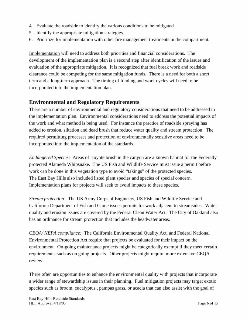
Environmental and Regulatory RequirementsThere are a number of environmental and regulatory considerations that need to be addressed in
the implementation plan. Environmental considerations need to address the potential impacts of
the work and what method is being used. For instance the practice of roadside spraying has
added to erosion, siltation and dead brush that reduce water quality and stream protection. The
required permitting processes and protection of environmentally sensitive areas need to be
incorporated into the implementation of the standards.
Endangered Species: Areas of coyote brush in the canyon are a known habitat for the Federally
protected Alameda Whipsnake. The US Fish and Wildlife Service must issue a permit before
work can be done in this vegetation type to avoid “takings” of the protected species.
The East Bay Hills also included listed plant species and species of special concern.
Implementation plans for projects will seek to avoid impacts to these species.
Stream protection: The US Army Corps of Engineers, US Fish and Wildlife Service and
California Department of Fish and Game issues permits for work adjacent to streamsides. Water
quality and erosion issues are covered by the Federal Clean Water Act. The City of Oakland also
has an ordinance for stream protection that includes the headwater areas.
CEQA/ NEPA compliance: The California Environmental Quality Act, and Federal National
Environmental Protection Act require that projects be evaluated for their impact on the
environment. On-going maintenance projects might be categorically exempt if they meet certain
requirements, such as on going projects. Other projects might require more extensive CEQA
review.
There often are opportunities to enhance the environmental quality with projects that incorporate
a wider range of stewardship issues in their planning. Fuel mitigation projects may target exotic
species such as broom, eucalyptus , pampas grass, or acacia that can also assist with the goal of

East Bay Hills Roadside StandardsHEF Approval 4/18/03 Page 7 of 15
Base Map Copyrighted 1999 by the California Automobile Association
Reproduced by Permission.
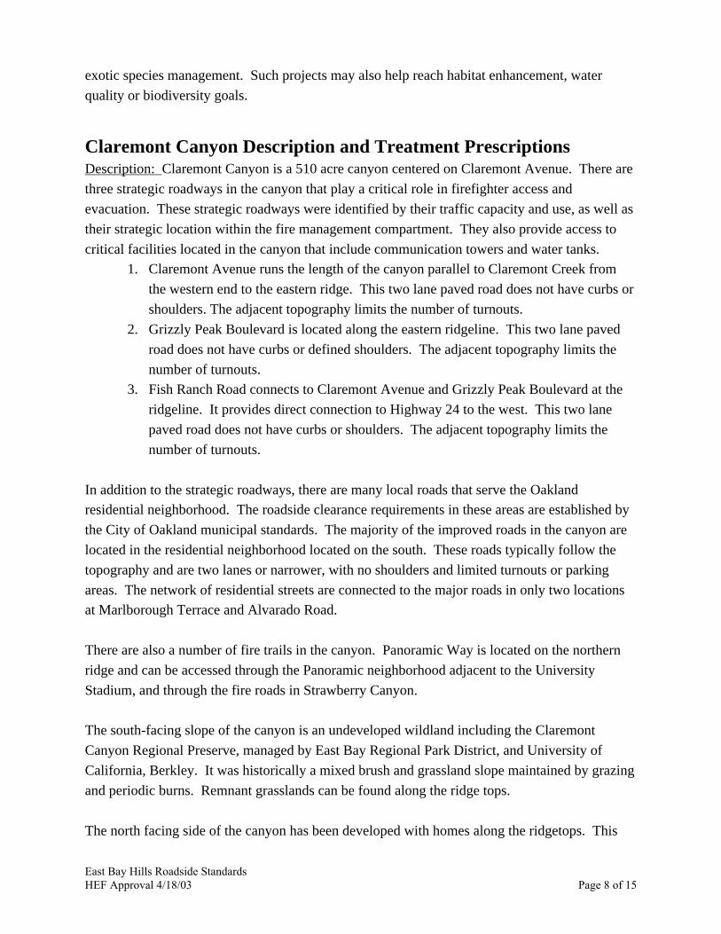
Figure 4
Context of Map of Claremont Canyon
East Bay Hills Roadside StandardsHEF Approval 4/18/03 Page 8 of 15
exotic species management. Such projects may also help reach habitat enhancement, water
quality or biodiversity goals.
Claremont Canyon Description and Treatment PrescriptionsDescription: Claremont Canyon is a 510 acre canyon centered on Claremont Avenue. There are
three strategic roadways in the canyon that play a critical role in firefighter access and
evacuation. These strategic roadways were identified by their traffic capacity and use, as well as
their strategic location within the fire management compartment. They also provide access to
critical facilities located in the canyon that include communication towers and water tanks.
1. Claremont Avenue runs the length of the canyon parallel to Claremont Creek from
the western end to the eastern ridge. This two lane paved road does not have curbs or
shoulders. The adjacent topography limits the number of turnouts.
2. Grizzly Peak Boulevard is located along the eastern ridgeline. This two lane paved
road does not have curbs or defined shoulders. The adjacent topography limits the
number of turnouts.
3. Fish Ranch Road connects to Claremont Avenue and Grizzly Peak Boulevard at the
ridgeline. It provides direct connection to Highway 24 to the west. This two lane
paved road does not have curbs or shoulders. The adjacent topography limits the
number of turnouts.
In addition to the strategic roadways, there are many local roads that serve the Oakland
residential neighborhood. The roadside clearance requirements in these areas are established by
the City of Oakland municipal standards. The majority of the improved roads in the canyon are
located in the residential neighborhood located on the south. These roads typically follow the
topography and are two lanes or narrower, with no shoulders and limited turnouts or parking
areas. The network of residential streets are connected to the major roads in only two locations
at Marlborough Terrace and Alvarado Road.
There are also a number of fire trails in the canyon. Panoramic Way is located on the northern
ridge and can be accessed through the Panoramic neighborhood adjacent to the University
Stadium, and through the fire roads in Strawberry Canyon.
The south-facing slope of the canyon is an undeveloped wildland including the Claremont
Canyon Regional Preserve, managed by East Bay Regional Park District, and University of
California, Berkley. It was historically a mixed brush and grassland slope maintained by grazing
and periodic burns. Remnant grasslands can be found along the ridge tops.
The north facing side of the canyon has been developed with homes along the ridgetops. This

East Bay Hills Roadside Standards
HEF Approval 4/18/03 Page 9 of 15
Figure 5
Treatment Areas in Claremont Canyon

East Bay Hills Roadside StandardsHEF Approval 4/18/03 Page 10 of 15
area was heavily impacted by the 1991 Tunnel Fire so many of the homes have been rebuilt to
newer fire codes. Vegetation is primarily ornamental trees, shrubs and ground covers around
homes. On the north slope of the canyon below the homes are undeveloped wildlands including
the City of Oakland managed Garber Park and Gwinn Canyon managed by East Bay Regional
Park District. Garber Park is primarily Oak woodland reflective of the moister north facing
slope. Gwinn Canyon is a mosaic of moist Oak woodland on the sheltered slopes, with a mix of
brushlands on the drier slopes.
Fire Management Strategy in the Canyon
The overall goals for Claremont Canyon are to enhance firefighter operations and safety through
strategic fuel management. These include:
1) reduce roadside ignition potential,
2) support the development of fire management units in the canyon with sheltered
fuelbreaks and
3) reduce the fuel load in critical locations adjacent to the road to provide enough time for
successful initial attack
These goals recognize that in severe east wind conditions the fire may not be able to be
contained within the canyon. The roadsides would be managed for access and egress under these
conditions. Under the more typical west wind conditions, the fuel reduction strategies will
provide time for fire fighters to arrive and fight the fires.
Treatment Strategies
Treatment strategies have been developed based on the conditions found along the corridor and
are shown in the following photo series. Each year a multi-agency team will inventory the area
and establish an annual work plan that identifies and prioritizes the fuel modification projects for
the following year’s budget cycle.
The general treatments have been established as the following:
Roadside Clearance Standard:Adopt as a regional standard Section 17 of the Uniform Fire Code Division II Environmental
Hazard Controls, Appendix II-A Suppression and Control of Hazardous Fire. (paraphrased)
The Chief may remove and clear within 10’ on each side of roadway all flammable vegetation or other
growth. May enter upon private property to clear. Does not apply to single specimens of trees, ornamental
shrubbery or cultivated groundcovers provided that they do not form a means of readily transmitting fire.
“Roadway” applies to portion of highway or private street improved or ordinarily used for vehicular
traffic. This section also enables the chief to require reasonable alternatives measures.

East Bay Hills Roadside StandardsHEF Approval 4/18/03 Page 11 of 15
Along the three major roadsides the flashy grasses and other small easily ignited materials (1
hour fuels) with be treated on an annual basis for 10’ from the pavement edge. This treatment is
aimed at reducing roadside ignitions.
Additional Fire Mitigation StrategiesRoadside clearances shall be supported by additional fuel modifications established on project
specific basis based on site conditions, fire behavior and suppression strategies. Strategies to be
considered include:
1) Protect values at risk (homes, offices, critical infrastructure etc.) with vegetation
modification.
2) In strategic areas, where highly flammable brush or Eucalyptus trees are adjacent to the road,
establish additional 30’ of sheltered fuel break.
2a. Remove the shrubs (10 hour fuels) to create an open mosaic of grassland and less than
30% shrub density.
2b. Remove any ladder fuels beneath the Eucalyptus trees (loose bark and low hanging
branches) to 10 feet.
2c. Dense stands of Eucalyptus along the road will have trees removed to thin the stand with
a long term goal of phased elimination.
2d. The understory of native Oaks, Bays and other trees may also need to be treated to reduce
their potential for a crown fire.
2e. Trees, ornamental shrubbery and cultivated ground covers that do not form a means of
readily transmitting fire shall be retained.
3) Modify vegetation to create potential containment areas taking advantage of existing roads
and topographic features.
4) Where appropriate, incorporate safety zones for firefighters by modifying additional
vegetation to reduce the flame length.

East Bay Hills Roadside StandardsHEF Approval 4/18/03 Page 12 of 15
Treatment Strategies
Oak Woodland on Moist Slopes and Riparian Corridor
Along Claremont Avenue near the bottomof the canyon. Claremont Creek in culverton left.
Moist oak woodland slope with understoryferns and herbaceous plants.
No Hazard Reduction Needed.
Along Claremont Avenue near the bottomof the canyon. Claremont Creek or right.
Riparian corridor on right side of picture.Willow and other streamside vegetation.
Treat grassy road edge on top of bankonly. Do not treat creek area.

East Bay Hills Roadside StandardsHEF Approval 4/18/03 Page 13 of 15
Rocky Steep Slopes with Thin Soil
Grizzly Peak north of Claremont Avenue.
Steep rocky slopes with thin soil and littlevegetation.
Treat only flashy grass fuels at toe ofslope. Do not disturb shrubs or othervegetation that helps stabilize the slope.
Grizzly Peak near Marlborough Terrace.
Steep rocky slopes with thin soil and littlevegetation.
Treat only flashy grass fuels at toe ofslope. Do not disturb shrubs or othervegetation that helps stabilize the slope.

East Bay Hills Roadside StandardsHEF Approval 4/18/03 Page 14 of 15
Brush & Scrub DominantDry North Coast Scrub and French Broom
Lower Claremont Avenue near homes
Mixed shrub including French broom,coyote brush and blackberry.
Treat to break up continuity and reduceoverall fuel load.
Grizzly Peak Drive north of ClaremontAvenue near Chapparal Hills.
Dense stand of mature coyote brush.
Treat to break up continuity and reduceoverall fuel load.
Along Grizzly Peak north of ClaremontAvenue.
Dense stand of mature coyote brushdownslope from road. Slope > 30%.
Treat to break up continuity and reduceoverall fuel load. Treamtment shouldnock down or cut off tops of shrurbs. Tohelp maintain slope stability, do notdistrub rootballs or remove entire plant.

East Bay Hills Roadside StandardsHEF Approval 4/18/03 Page 15 of 15
Second Growth Eucalyptus Forest
Treated Eucalyptus stand.
No further hazard treatment needed.
Second growth Eucalyptus stand.
Treat to remove ladder fuels and reduceoverall stand density.