Earthquake Disaster Management in the World - … Disaster Management in the World ... Turkey and...
64
UNESCO International Platform for Reducing Earthquake Disasters (IPRED) 2015 Tokyo Workshop Report Earthquake Disaster Management in the World – UNESCO / IPRED Activities – 13 March, 2015 GRIPS, Tokyo UNESCO, IISEE/BRI, GRIPS 1
Transcript of Earthquake Disaster Management in the World - … Disaster Management in the World ... Turkey and...
UNESCO International Platform for Reducing Earthquake Disasters (IPRED) 2015 Tokyo Workshop Report
Earthquake Disaster Management in the World
– UNESCO / IPRED Activities –
13 March, 2015
GRIPS, Tokyo
UNESCO, IISEE/BRI, GRIPS
1

UNESCO International Platform for Reducing Earthquake Disasters (IPRED) 2015 Tokyo Workshop Report
Earthquake Disaster Management in the World
– IPRED Activities –
13 March, 2015
GRIPS, Tokyo
2
UNESCO International Platform for Reducing Earthquake Disasters (IPRED) 2015 Tokyo Workshop Report Index
Preface ----------------------------------------------------- 4 IPRED 2015 Tokyo Workshop
1. Program -------------------------------------------------- 5
2. Greetings ----------------------------------------------- 6
3. Keynote Speech ---------------------------------------- 8
4. IPRED Presentations ------------------------------ 14
5. Japanese Presentations --------------------------- 45
6. Summary and Closing ------------------------------ 62
3
Preface Huge earthquake disaster damages occurred recently all over the world. International Platform for Reducing Earthquake Disasters, IPRED, is one of the UNESCO’s projects and was launched in 2007 in cooperation with Building Research Institute and the other 9 universities or research institutions in the countries having experiences of earthquake hazards. IPRED aims to promote collaboration between member countries to global earthquake disaster reduction in the fields of building and housing. For this purpose, the global network of research, training and education in earthquake disaster reduction is indispensable. One of the remarkable activities of IPRED is the institutional system of a speedy dispatch of an international post-earthquake investigation team after the occurrence of great earthquakes. At the 2011 Van Earthquake in Turkey and also at the 2014 Bohol Earthquake in Philippines, the field surveys were conducted along the system and their research reports were published. Earthquake disasters would occur anywhere on this planet. They instantly destroy the human’s long-term efforts for development such as city buildings and rural houses. It is still necessary for us to move forward with the IPRED project. Vulnerable buildings and houses are the key, therefore National Graduate Institute for Policy Studies (GRIPS), International Institute of Seismology and Earthquake Engineering (IISEE) of Building Research Institute, and IPRED/UNESCO provide an opportunity to introduce research results and information on earthquake and tsunami disaster management from member countries, universities and research centers. This report summarizes contents and outcomes of the IPRED international workshop on March 12, 2015 held in Tokyo, as a reference.
Shoichi ANDO, Professor of GRIPS Toshiaki Yokoi, Director of IISEE/BRI
4

Collapsed Hospital by 2008 Sichuan EQ
Collapsed Hotel by 2011 Great East Japan EQ/Tsunami
1. Program
Earthquake Disaster Management in the WorldIPRED activities
Objective: Huge earthquake disaster damages occurred recently all over the world. Vulnerable buildings and houses are the key therefore National Graduate Institute for Policy Studies (GRIPS), International Institute of Seismology and Earthquake Engineering (IISEE), Building Research Institute, and IPRED/UNESCO provide an opportunity to introduce research results information on earthquake and tsunami disaster management from member countries, universities and research centers.
Date: 13 March, 2015 (Friday), Time: 10:00 17:00, Open from 9:30 AMVenue: Sokairo Hall, 1st Floor of GRIPS at Roppongi, Tokyo (see Map below) Max. 250 persons
PROGRAM Moderator: Michael C. Huang, Dr. student, GRIPS
--- Greetings by Host 10:00 – 10:20Isao Nishiyama BRI (Deputy Chief Executive)Mikitaka Masuyama GRIPS (Vice-Rector)Soichiro Yasukawa UNESCO (Program Specialist)
Morning Session 10:20 – 12:20--- Key-note Speech (10:20 – 11:00)
Yuji Ishiyama: Prof. Emeritus, Hokkaido Univ. (IPRED advisor)Trend of Earthquake Disaster Management in Japan & the World
--- Speech from the World 1: (15 min. per presenter, Q&A is put last part of AM.Anita Firmanti: Director General, RIHS, Ministry of Public Works, IndonesiaDevelopment of earthquake hazard risk map for better city planningCarlos Gutierrez M.: Research Director, CENAPRED, MexicoSeismic vulnerability assessment for popular housing in MexicoCarlos Zavala: Prof., Nat. Tech. Univ., (ex-Director, CISMID), PeruNon-engineering constructions a permanent risk for the emerging townsYuksel Ercan: Prof., Istanbul Technical University, TurkeyEvaluation of the seismic safety of a typical RC school building and its retrofitting --
Afternoon Session 13:45 – 16:55--- Speech from the World 2: (Same as in the morning)
Radu Vacareanu: Vice Rector, Bucharest Tec. Univ., RomaniaNew Developments in Probabilistic Seismic Hazard Analysis for RomaniaTanaktan Abakanov: Director, Inst. of Seismology (ISMES) KazakhstanComprehensive geodynamical investigation in oil and gas field of KazakhstanRaúl Alvarez Medel: Prof., Engineer, Univ. of Cathorica, Chile
National Research Center for Integrated Natural Hazards Management --Hatem Odah: Director of NRIAG, Min. of Scientific Research, Egypt
NRIAG's efforts in mitigating EQ risks moving from observation to alarmingEdgar Peña Prof., Head of Dept., National Univ. of El Salvador
Advances and Challenges in Seismic Engineering and Seismology for El Salvador--- GRIPS and BRI Presentations: (15:15 – 16:45 + Q&A in total 10 min.)
Kenji Okazaki: Prof., Kyoto Univ.Actual conditions of Non-engineered Construction in Developing CountriesTatsuo Narafu: Senior Specialist ? , JICA
Technical cooperation by JICA to mitigate disaster on non-engineered constructionShoichi Ando: Prof., GRIPS Disaster Management Policy Program2011 Great East Japan EQ and Trend of Tsunami Evacuation BuildingsNaomi Honda: Senior Coordinator for Int`l Cooperation of BRIRole of Int'l Inst. of Seismology and Eq. Engineering, BRI and future perspectiveTatsuya Azuhata: Int`l Inst. of Seismology and Eq. Engineering, BRIRecent Research Activities on Building Seismic Design Force in BRI
--- Summary and Closing: (16:55 – 17:00)Jair Torres: UNESCO
Objective: Huge earthquake disaster damages occurred recently all over the world. Vulnerablebuildings and houses are the key therefore National Graduate Institute for Policy Studies (GRIPS), International Institute of Seismology and Earthquake Engineering (IISEE), Building Research Institute, and IPRED/UNESCO provide an opportunity to introduce research results information on earthquakeand tsunami disaster management from member countries, universities and research centers.
UNESCO International Platform for Reducing Earthquake Disasters (IPRED) 2015 Tokyo Workshop
---
5
IPRED Tokyo WorkshopEarthquake Disaster Management in the World: IPRED activities
10:00 a.m. – 5:00 p.m., March 13, 2015Sokairo Hall, 1st Floor of GRIPS, Tokyo
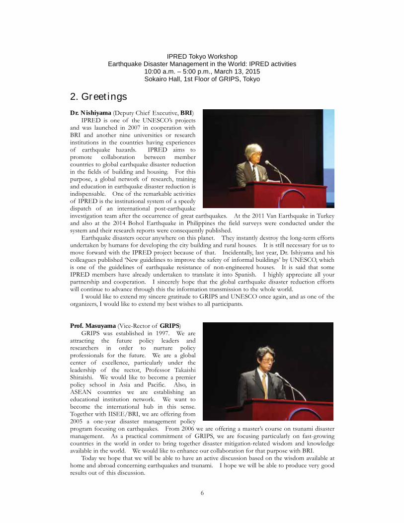
2. Greetings Dr. Nishiyama (Deputy Chief Executive, BRI) IPRED is one of the UNESCO’s projects and was launched in 2007 in cooperation with BRI and another nine universities or research institutions in the countries having experiences of earthquake hazards. IPRED aims to promote collaboration between member countries to global earthquake disaster reduction in the fields of building and housing. For this purpose, a global network of research, training and education in earthquake disaster reduction is indispensable. One of the remarkable activities of IPRED is the institutional system of a speedy dispatch of an international post-earthquake investigation team after the occurrence of great earthquakes. At the 2011 Van Earthquake in Turkey and also at the 2014 Bohol Earthquake in Philippines the field surveys were conducted under the system and their research reports were consequently published. Earthquake disasters occur anywhere on this planet. They instantly destroy the long-term efforts undertaken by humans for developing the city building and rural houses. It is still necessary for us to move forward with the IPRED project because of that. Incidentally, last year, Dr. Ishiyama and his colleagues published ‘New guidelines to improve the safety of informal buildings’ by UNESCO, which is one of the guidelines of earthquake resistance of non-engineered houses. It is said that some IPRED members have already undertaken to translate it into Spanish. I highly appreciate all your partnership and cooperation. I sincerely hope that the global earthquake disaster reduction efforts will continue to advance through this the information transmission to the whole world. I would like to extend my sincere gratitude to GRIPS and UNESCO once again, and as one of the organizers, I would like to extend my best wishes to all participants. Prof. Masuyama (Vice-Rector of GRIPS) GRIPS was established in 1997. We are attracting the future policy leaders and researchers in order to nurture policy professionals for the future. We are a global center of excellence, particularly under the leadership of the rector, Professor Takaishi Shiraishi. We would like to become a premier policy school in Asia and Pacific. Also, in ASEAN countries we are establishing an educational institution network. We want to become the international hub in this sense. Together with IISEE/BRI, we are offering from 2005 a one-year disaster management policy program focusing on earthquakes. From 2006 we are offering a master’s course on tsunami disaster management. As a practical commitment of GRIPS, we are focusing particularly on fast-growing countries in the world in order to bring together disaster mitigation-related wisdom and knowledge available in the world. We would like to enhance our collaboration for that purpose with BRI. Today we hope that we will be able to have an active discussion based on the wisdom available at home and abroad concerning earthquakes and tsunami. I hope we will be able to produce very good results out of this discussion.
6
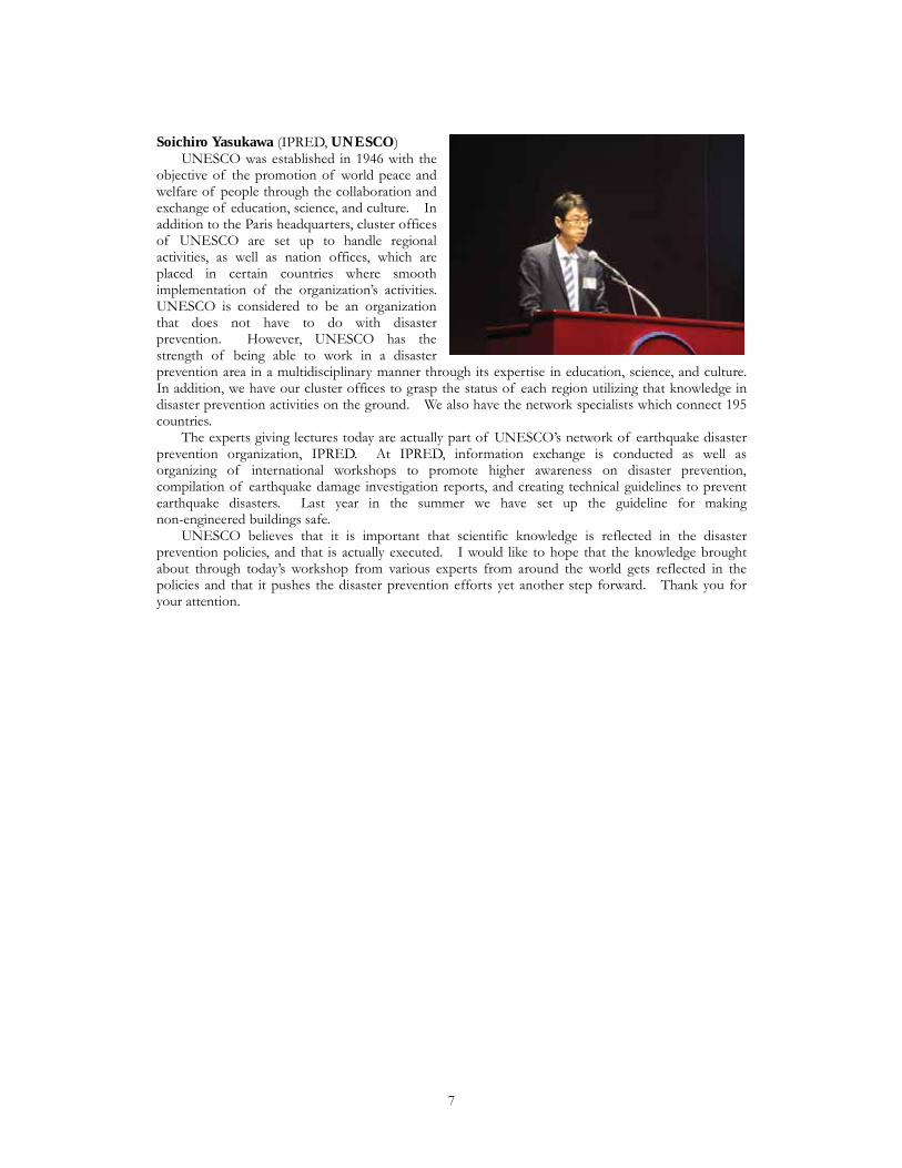
Soichiro Yasukawa (IPRED, UNESCO) UNESCO was established in 1946 with the objective of the promotion of world peace and welfare of people through the collaboration and exchange of education, science, and culture. In addition to the Paris headquarters, cluster offices of UNESCO are set up to handle regional activities, as well as nation offices, which are placed in certain countries where smooth implementation of the organization’s activities. UNESCO is considered to be an organization that does not have to do with disaster prevention. However, UNESCO has the strength of being able to work in a disaster prevention area in a multidisciplinary manner through its expertise in education, science, and culture. In addition, we have our cluster offices to grasp the status of each region utilizing that knowledge in disaster prevention activities on the ground. We also have the network specialists which connect 195 countries. The experts giving lectures today are actually part of UNESCO’s network of earthquake disaster prevention organization, IPRED. At IPRED, information exchange is conducted as well as organizing of international workshops to promote higher awareness on disaster prevention, compilation of earthquake damage investigation reports, and creating technical guidelines to prevent earthquake disasters. Last year in the summer we have set up the guideline for making non-engineered buildings safe. UNESCO believes that it is important that scientific knowledge is reflected in the disaster prevention policies, and that is actually executed. I would like to hope that the knowledge brought about through today’s workshop from various experts from around the world gets reflected in the policies and that it pushes the disaster prevention efforts yet another step forward. Thank you for your attention.
7
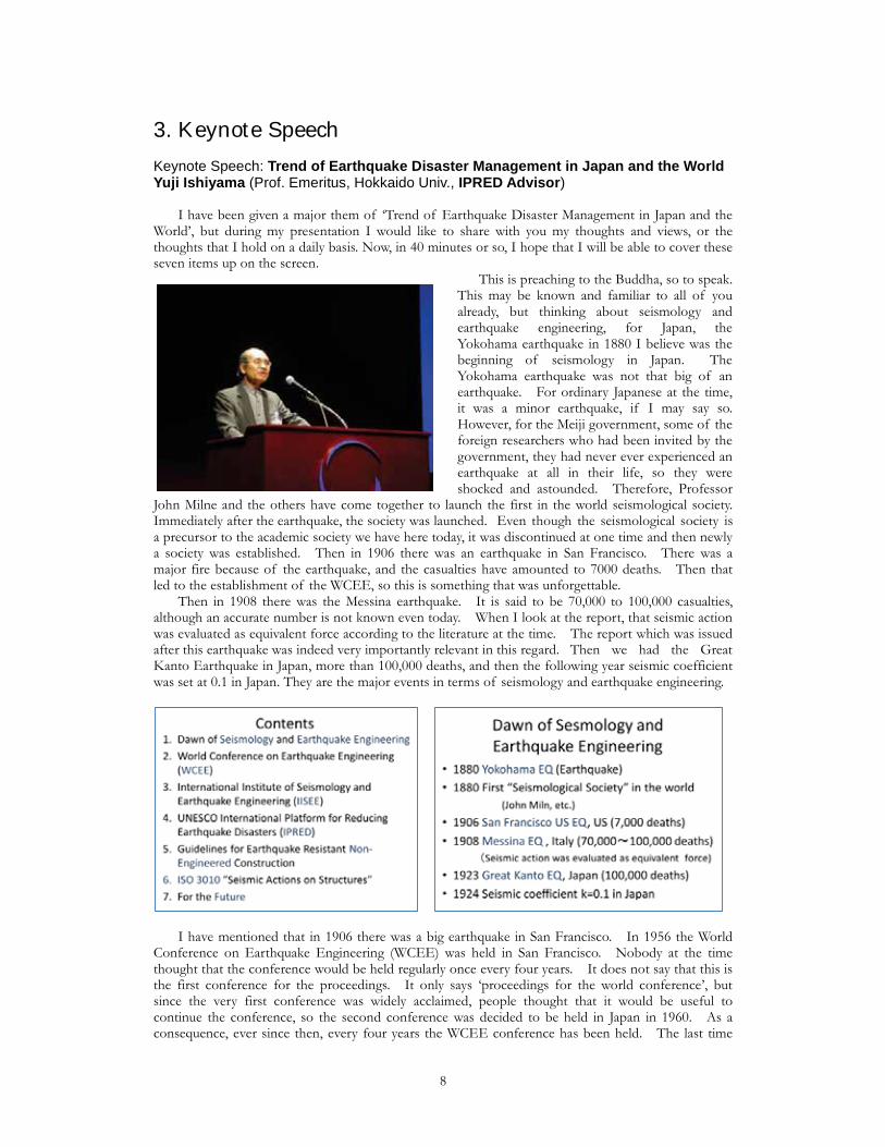
3. Keynote Speech Keynote Speech: Trend of Earthquake Disaster Management in Japan and the WorldYuji Ishiyama (Prof. Emeritus, Hokkaido Univ., IPRED Advisor) I have been given a major them of ‘Trend of Earthquake Disaster Management in Japan and the World’, but during my presentation I would like to share with you my thoughts and views, or the thoughts that I hold on a daily basis. Now, in 40 minutes or so, I hope that I will be able to cover these seven items up on the screen.
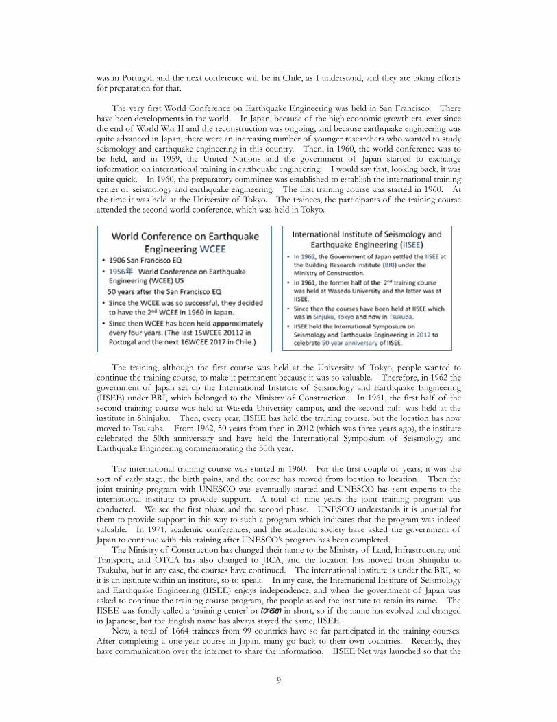
This is preaching to the Buddha, so to speak. This may be known and familiar to all of you already, but thinking about seismology and earthquake engineering, for Japan, the Yokohama earthquake in 1880 I believe was the beginning of seismology in Japan. The Yokohama earthquake was not that big of an earthquake. For ordinary Japanese at the time, it was a minor earthquake, if I may say so. However, for the Meiji government, some of the foreign researchers who had been invited by the government, they had never ever experienced an earthquake at all in their life, so they were shocked and astounded. Therefore, Professor
John Milne and the others have come together to launch the first in the world seismological society. Immediately after the earthquake, the society was launched. Even though the seismological society is a precursor to the academic society we have here today, it was discontinued at one time and then newly a society was established. Then in 1906 there was an earthquake in San Francisco. There was a major fire because of the earthquake, and the casualties have amounted to 7000 deaths. Then that led to the establishment of the WCEE, so this is something that was unforgettable. Then in 1908 there was the Messina earthquake. It is said to be 70,000 to 100,000 casualties, although an accurate number is not known even today. When I look at the report, that seismic action was evaluated as equivalent force according to the literature at the time. The report which was issued after this earthquake was indeed very importantly relevant in this regard. Then we had the Great Kanto Earthquake in Japan, more than 100,000 deaths, and then the following year seismic coefficient was set at 0.1 in Japan. They are the major events in terms of seismology and earthquake engineering.
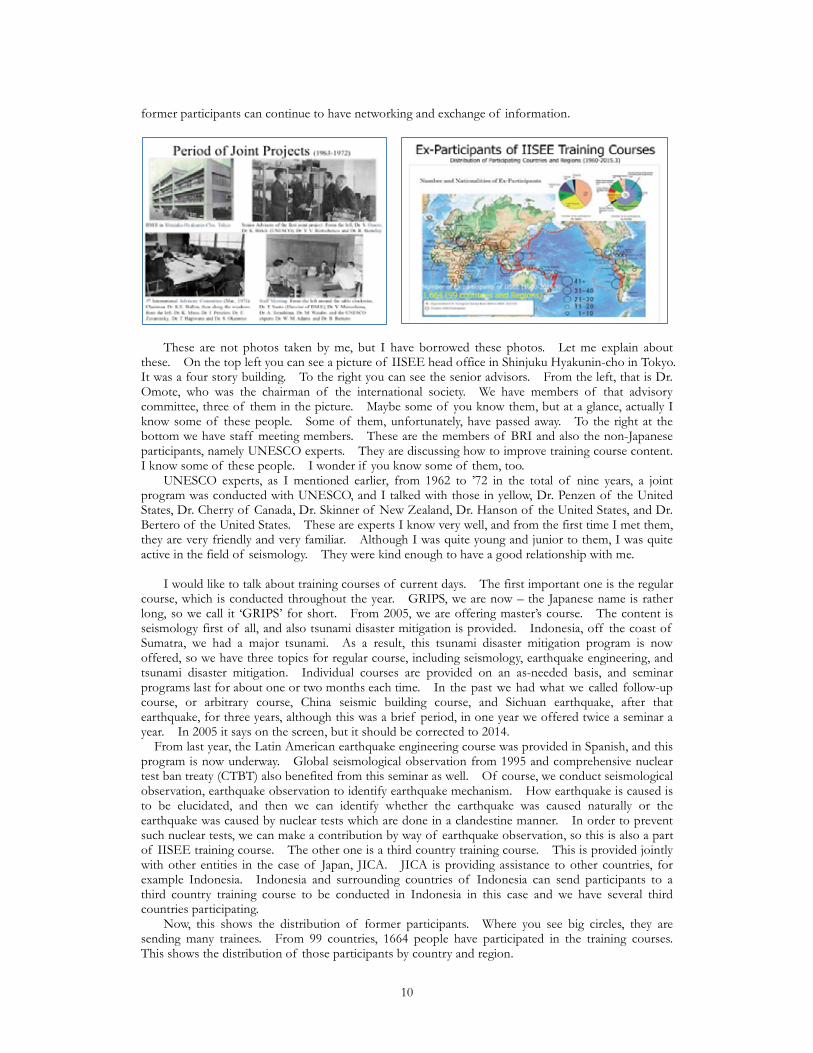
I have mentioned that in 1906 there was a big earthquake in San Francisco. In 1956 the World Conference on Earthquake Engineering (WCEE) was held in San Francisco. Nobody at the time thought that the conference would be held regularly once every four years. It does not say that this is the first conference for the proceedings. It only says ‘proceedings for the world conference’, but since the very first conference was widely acclaimed, people thought that it would be useful to continue the conference, so the second conference was decided to be held in Japan in 1960. As a consequence, ever since then, every four years the WCEE conference has been held. The last time
8
was in Portugal, and the next conference will be in Chile, as I understand, and they are taking efforts for preparation for that. The very first World Conference on Earthquake Engineering was held in San Francisco. There have been developments in the world. In Japan, because of the high economic growth era, ever since the end of World War II and the reconstruction was ongoing, and because earthquake engineering was quite advanced in Japan, there were an increasing number of younger researchers who wanted to study seismology and earthquake engineering in this country. Then, in 1960, the world conference was to be held, and in 1959, the United Nations and the government of Japan started to exchange information on international training in earthquake engineering. I would say that, looking back, it was quite quick. In 1960, the preparatory committee was established to establish the international training center of seismology and earthquake engineering. The first training course was started in 1960. At the time it was held at the University of Tokyo. The trainees, the participants of the training course attended the second world conference, which was held in Tokyo.
The training, although the first course was held at the University of Tokyo, people wanted to continue the training course, to make it permanent because it was so valuable. Therefore, in 1962 the government of Japan set up the International Institute of Seismology and Earthquake Engineering (IISEE) under BRI, which belonged to the Ministry of Construction. In 1961, the first half of the second training course was held at Waseda University campus, and the second half was held at the institute in Shinjuku. Then, every year, IISEE has held the training course, but the location has now moved to Tsukuba. From 1962, 50 years from then in 2012 (which was three years ago), the institute celebrated the 50th anniversary and have held the International Symposium of Seismology and Earthquake Engineering commemorating the 50th year. The international training course was started in 1960. For the first couple of years, it was the sort of early stage, the birth pains, and the course has moved from location to location. Then the joint training program with UNESCO was eventually started and UNESCO has sent experts to the international institute to provide support. A total of nine years the joint training program was conducted. We see the first phase and the second phase. UNESCO understands it is unusual for them to provide support in this way to such a program which indicates that the program was indeed valuable. In 1971, academic conferences, and the academic society have asked the government of Japan to continue with this training after UNESCO’s program has been completed. The Ministry of Construction has changed their name to the Ministry of Land, Infrastructure, and Transport, and OTCA has also changed to JICA, and the location has moved from Shinjuku to Tsukuba, but in any case, the courses have continued. The international institute is under the BRI, so it is an institute within an institute, so to speak. In any case, the International Institute of Seismology and Earthquake Engineering (IISEE) enjoys independence, and when the government of Japan was asked to continue the training course program, the people asked the institute to retain its name. The IISEE was fondly called a ‘training center’ or toresen in short, so if the name has evolved and changed in Japanese, but the English name has always stayed the same, IISEE. Now, a total of 1664 trainees from 99 countries have so far participated in the training courses. After completing a one-year course in Japan, many go back to their own countries. Recently, they have communication over the internet to share the information. IISEE Net was launched so that the
9
former participants can continue to have networking and exchange of information.
These are not photos taken by me, but I have borrowed these photos. Let me explain about these. On the top left you can see a picture of IISEE head office in Shinjuku Hyakunin-cho in Tokyo. It was a four story building. To the right you can see the senior advisors. From the left, that is Dr. Omote, who was the chairman of the international society. We have members of that advisory committee, three of them in the picture. Maybe some of you know them, but at a glance, actually I know some of these people. Some of them, unfortunately, have passed away. To the right at the bottom we have staff meeting members. These are the members of BRI and also the non-Japanese participants, namely UNESCO experts. They are discussing how to improve training course content. I know some of these people. I wonder if you know some of them, too. UNESCO experts, as I mentioned earlier, from 1962 to ’72 in the total of nine years, a joint program was conducted with UNESCO, and I talked with those in yellow, Dr. Penzen of the United States, Dr. Cherry of Canada, Dr. Skinner of New Zealand, Dr. Hanson of the United States, and Dr. Bertero of the United States. These are experts I know very well, and from the first time I met them, they are very friendly and very familiar. Although I was quite young and junior to them, I was quite active in the field of seismology. They were kind enough to have a good relationship with me. I would like to talk about training courses of current days. The first important one is the regular course, which is conducted throughout the year. GRIPS, we are now – the Japanese name is rather long, so we call it ‘GRIPS’ for short. From 2005, we are offering master’s course. The content is seismology first of all, and also tsunami disaster mitigation is provided. Indonesia, off the coast of Sumatra, we had a major tsunami. As a result, this tsunami disaster mitigation program is now offered, so we have three topics for regular course, including seismology, earthquake engineering, and tsunami disaster mitigation. Individual courses are provided on an as-needed basis, and seminar programs last for about one or two months each time. In the past we had what we called follow-up course, or arbitrary course, China seismic building course, and Sichuan earthquake, after that earthquake, for three years, although this was a brief period, in one year we offered twice a seminar a year. In 2005 it says on the screen, but it should be corrected to 2014. From last year, the Latin American earthquake engineering course was provided in Spanish, and this program is now underway. Global seismological observation from 1995 and comprehensive nuclear test ban treaty (CTBT) also benefited from this seminar as well. Of course, we conduct seismological observation, earthquake observation to identify earthquake mechanism. How earthquake is caused is to be elucidated, and then we can identify whether the earthquake was caused naturally or the earthquake was caused by nuclear tests which are done in a clandestine manner. In order to prevent such nuclear tests, we can make a contribution by way of earthquake observation, so this is also a part of IISEE training course. The other one is a third country training course. This is provided jointly with other entities in the case of Japan, JICA. JICA is providing assistance to other countries, for example Indonesia. Indonesia and surrounding countries of Indonesia can send participants to a third country training course to be conducted in Indonesia in this case and we have several third countries participating. Now, this shows the distribution of former participants. Where you see big circles, they are sending many trainees. From 99 countries, 1664 people have participated in the training courses. This shows the distribution of those participants by country and region.
10
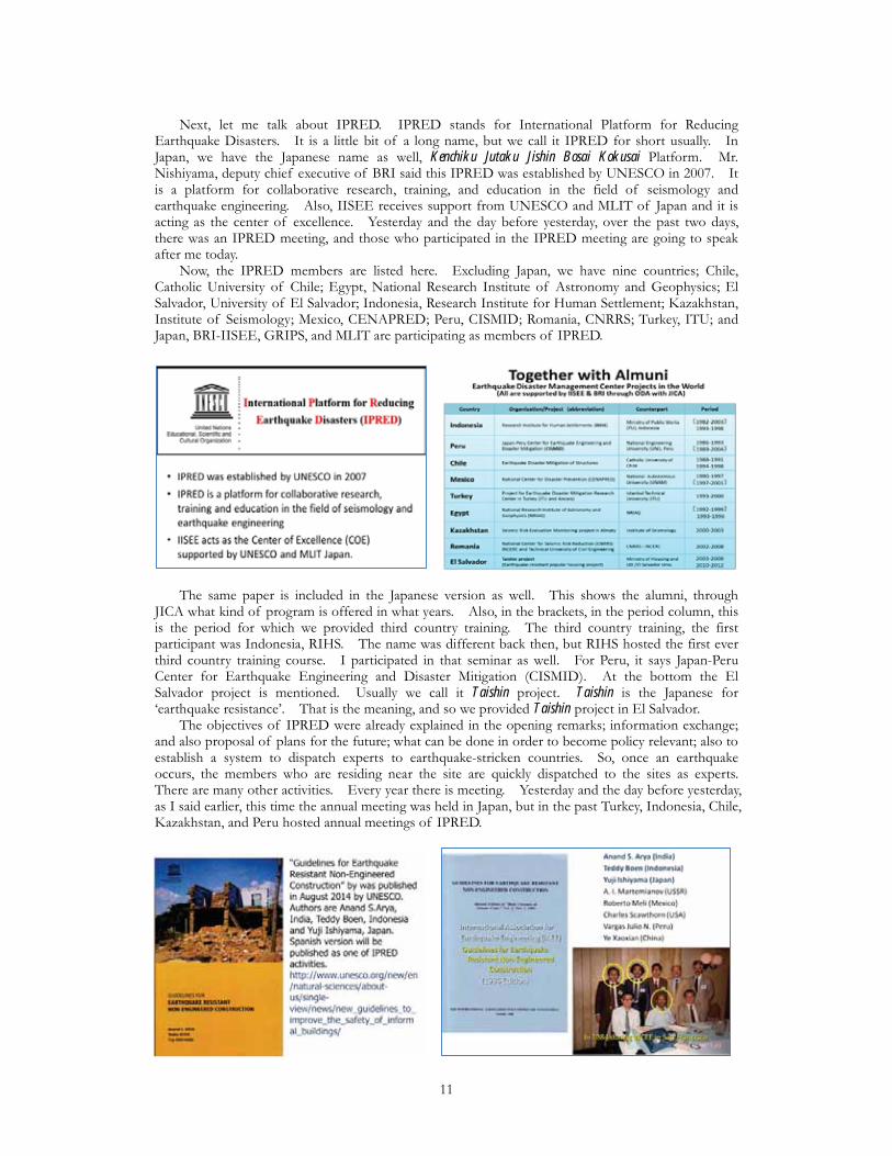
Next, let me talk about IPRED. IPRED stands for International Platform for Reducing Earthquake Disasters. It is a little bit of a long name, but we call it IPRED for short usually. In Japan, we have the Japanese name as well, Kenchiku Jutaku Jishin Bosai Kokusai Platform. Mr. Nishiyama, deputy chief executive of BRI said this IPRED was established by UNESCO in 2007. It is a platform for collaborative research, training, and education in the field of seismology and earthquake engineering. Also, IISEE receives support from UNESCO and MLIT of Japan and it is acting as the center of excellence. Yesterday and the day before yesterday, over the past two days, there was an IPRED meeting, and those who participated in the IPRED meeting are going to speak after me today. Now, the IPRED members are listed here. Excluding Japan, we have nine countries; Chile, Catholic University of Chile; Egypt, National Research Institute of Astronomy and Geophysics; El Salvador, University of El Salvador; Indonesia, Research Institute for Human Settlement; Kazakhstan, Institute of Seismology; Mexico, CENAPRED; Peru, CISMID; Romania, CNRRS; Turkey, ITU; and Japan, BRI-IISEE, GRIPS, and MLIT are participating as members of IPRED.
The same paper is included in the Japanese version as well. This shows the alumni, through JICA what kind of program is offered in what years. Also, in the brackets, in the period column, this is the period for which we provided third country training. The third country training, the first participant was Indonesia, RIHS. The name was different back then, but RIHS hosted the first ever third country training course. I participated in that seminar as well. For Peru, it says Japan-Peru Center for Earthquake Engineering and Disaster Mitigation (CISMID). At the bottom the El Salvador project is mentioned. Usually we call it Taishin project. Taishin is the Japanese for ‘earthquake resistance’. That is the meaning, and so we provided Taishin project in El Salvador. The objectives of IPRED were already explained in the opening remarks; information exchange; and also proposal of plans for the future; what can be done in order to become policy relevant; also to establish a system to dispatch experts to earthquake-stricken countries. So, once an earthquake occurs, the members who are residing near the site are quickly dispatched to the sites as experts. There are many other activities. Every year there is meeting. Yesterday and the day before yesterday, as I said earlier, this time the annual meeting was held in Japan, but in the past Turkey, Indonesia, Chile, Kazakhstan, and Peru hosted annual meetings of IPRED.
11
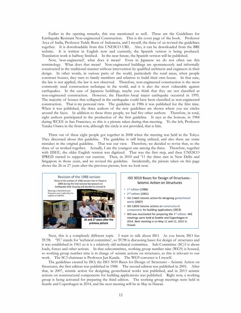
Earlier in the opening remarks, this was mentioned as well. These are the Guidelines for Earthquake Resistant Non-engineered Construction. This is the cover page of the book. Professor Arya of India, Professor Teddy Boen of Indonesia, and I myself, the three of us revised the guidelines together. It is downloadable from this UNESCO URL. Also, it can be downloaded from the BRI website. It is written in English now and currently, the Spanish version is being produced. Translation work is halfway finished. In the near future, the Spanish version will be published. Now, ‘non-engineered’, what does it mean? Even in Japanese we do not often use this terminology. What does that mean? Non-engineered buildings are spontaneously and informally constructed in the traditional manner without intervention by qualified architects and engineers in their design. In other words, in various parts of the world, particularly the rural areas, when people construct houses, they turn to family members and relatives to build their own house. In that case, the law is not applied, the law is not observed. Therefore, non-engineered construction is the most commonly used construction technique in the world, and it is also the most vulnerable against earthquakes. In the case of Japanese buildings, maybe you think that they are not classified as non-engineered construction. However, the Hanshin-Awaji major earthquake occurred in 1995. The majority of houses that collapsed in the earthquake could have been classified as non-engineered construction. That is my personal view. The guideline: in 1986 it was published for the first time. When it was published, the three authors of the new guidelines are shown where you see circles around the faces. In addition to these three people, we had five other authors. Therefore, in total, eight authors participated in the production of the first guideline. It says at the bottom, in 1984 during WCEE in San Francisco, so this is a picture taken during that meeting. To the left, Professor Yutaka Osawa in the front row, although the circle is not provided, that is him. Three out of these eight people got together in 2008 when the meeting was held in the Tokyo. They discussed about this guideline. The guideline is still being utilized, and also there are some mistakes in the original guideline. That was our view. Therefore, we decided to revise that, so the three of us worked together. Actually, I am the youngest one among the three. Therefore, together with IISEE, the older English version was digitized. That was the first step, and then UNESCO IPRED started to support our exercise. Then, in 2010 and ’11 the three met in New Delhi and Singapore in those years, and we revised the guideline. Incidentally, the picture taken on this page shows the 26 or 27 years after the previous picture, how we look now.
Next, this is a completely different topic. I want to talk about ISO. As you know, ISO has TC98. ‘TC’ stands for ‘technical committee’, so TC98 is discussing bases for design of structures and it was established in 1961 so it is a relatively old technical committee. Sub-Committee (SC)3 is about loads, forces and other actions. In that subcommittee, working group number nine (WG9) is housed, so working group number nine is in charge of seismic actions on structures, so this is relevant to our work. The SC3 chairman is Professor Jun Kanda. The WG9 convener is I myself. The guidelines created by ISO, the ISO 3010 Bases for Design of Structures – Seismic Action on Structures, the first edition was published in 1988. The second edition was published in 2001. After that, in 2007, seismic action for designing geotechnical works was published, and in 2013 seismic actions on nonstructural components for building applications was published. Right now, a working group is being activated for preparing the third edition. The working group meetings were held in Seattle and Copenhagen in 2014, and the next meeting will be in May in Hawaii.
12
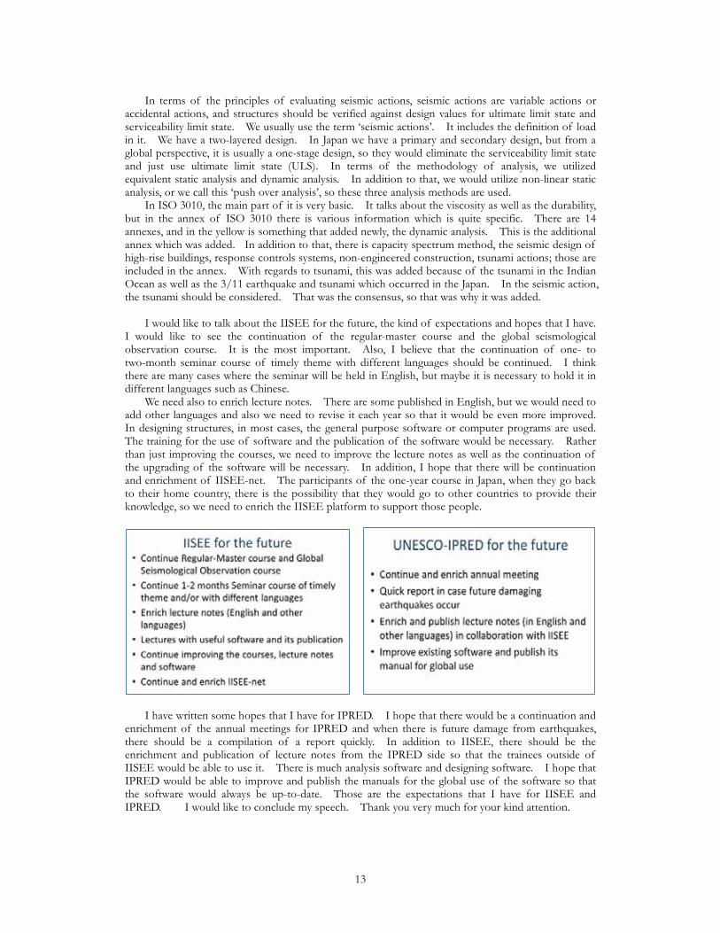
In terms of the principles of evaluating seismic actions, seismic actions are variable actions or accidental actions, and structures should be verified against design values for ultimate limit state and serviceability limit state. We usually use the term ‘seismic actions’. It includes the definition of load in it. We have a two-layered design. In Japan we have a primary and secondary design, but from a global perspective, it is usually a one-stage design, so they would eliminate the serviceability limit state and just use ultimate limit state (ULS). In terms of the methodology of analysis, we utilized equivalent static analysis and dynamic analysis. In addition to that, we would utilize non-linear static analysis, or we call this ‘push over analysis’, so these three analysis methods are used. In ISO 3010, the main part of it is very basic. It talks about the viscosity as well as the durability, but in the annex of ISO 3010 there is various information which is quite specific. There are 14 annexes, and in the yellow is something that added newly, the dynamic analysis. This is the additional annex which was added. In addition to that, there is capacity spectrum method, the seismic design of high-rise buildings, response controls systems, non-engineered construction, tsunami actions; those are included in the annex. With regards to tsunami, this was added because of the tsunami in the Indian Ocean as well as the 3/11 earthquake and tsunami which occurred in the Japan. In the seismic action, the tsunami should be considered. That was the consensus, so that was why it was added. I would like to talk about the IISEE for the future, the kind of expectations and hopes that I have. I would like to see the continuation of the regular-master course and the global seismological observation course. It is the most important. Also, I believe that the continuation of one- to two-month seminar course of timely theme with different languages should be continued. I think there are many cases where the seminar will be held in English, but maybe it is necessary to hold it in different languages such as Chinese. We need also to enrich lecture notes. There are some published in English, but we would need to add other languages and also we need to revise it each year so that it would be even more improved. In designing structures, in most cases, the general purpose software or computer programs are used. The training for the use of software and the publication of the software would be necessary. Rather than just improving the courses, we need to improve the lecture notes as well as the continuation of the upgrading of the software will be necessary. In addition, I hope that there will be continuation and enrichment of IISEE-net. The participants of the one-year course in Japan, when they go back to their home country, there is the possibility that they would go to other countries to provide their knowledge, so we need to enrich the IISEE platform to support those people.
I have written some hopes that I have for IPRED. I hope that there would be a continuation and enrichment of the annual meetings for IPRED and when there is future damage from earthquakes, there should be a compilation of a report quickly. In addition to IISEE, there should be the enrichment and publication of lecture notes from the IPRED side so that the trainees outside of IISEE would be able to use it. There is much analysis software and designing software. I hope that IPRED would be able to improve and publish the manuals for the global use of the software so that the software would always be up-to-date. Those are the expectations that I have for IISEE and IPRED. I would like to conclude my speech. Thank you very much for your kind attention.
13

4. IPRED Presentations Speeches from the World 1 Development of Earthquake Hazard Risk Map for Better City PlanningAnita Firmanti (Director General, RIHS, Ministry of Public Works, Indonesia)
I am Anita Firmanti from the Research Institute for Human Settlements, Indonesia. Today it is a great pleasure for me to present my paper with a title of ‘Development of Earthquake Hazard Risk Map for Better City Planning’. This is the outline of my presentation. First is an introduction, second is general procedure of seismic microzonation, and third one is seismic analysis, and vulnerability analysis, and risk analysis, and then conclusion.
Indonesia lies in a very hazardous earthquake area like Japan, so we are affected by three major plates. First is the Indian-Australia, and Eurasian, and also the Pacific plates, and a minor one is from the Philippines, especially for the northern part of Sulawesi. In recent years, maybe also Professor Ishiyama mentioned, in 2004 we had the Aceh with a magnitude of about nine, and in 2006 we had in Jakarta, and 2007 in Padang, and in 2009 also in Padang area, in Nias also, so we suffered with hundreds of thousands of casualties because of the tsunami, especially in Aceh. Therefore, we need a strategy for seismic risk reduction. This is what I mentioned before. This is the historical earthquake data, so almost every time we have an earthquake sometimes with a five or six magnitude. Sometimes it happens, especially you can see this part is very strongly affected by earthquakes, but fortunately this area is not a dense area, so that is fortunate for us. The ministry of public works is one of the members of National Disaster Mitigation under the coordination of the National Disaster Mitigation Agency. We have to perform initiatives for disaster mitigation program in scientific or engineering, so for your information, our institute also has to establish the national guidelines for buildings and the environments. For the main studies related to the seismic risk reduction, we do the preventive, emergency response, reconstruction, and rehabilitation, so seismic hazard analysis and vulnerability assessment, risk analysis, building structure system, and we do the Indonesia building code revision, so now we have the 2012 version. For the map we had the 2010, and now under revision we will establish the new map in 2015. We do also seismic microzonation. The program in the field of seismic mitigation, we develop seismic microzonation maps for city scale, so we started with Jakarta city because Jakarta is very important. Jakarta is the capital city, and we do it with Bandung Institute of Technology. We do also with the climatological and geophysical agency, and of course with the local government. We
14
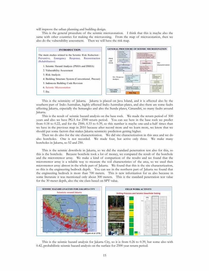
will improve the urban planning and building design. This is the general procedure of the seismic microzonation. I think that this is maybe also the same with other countries for making the microzoning. From the map of microzonation, then we also do the vulnerability assessment. Then we will have the risk map.
This is the seismicity of Jakarta. Jakarta is placed on Java Island, and it is affected also by the southern part of Indo-Australian, highly affected Indo-Australian plates, and also there are some faults affecting Jakarta, especially the Semangko and also the Sunda plates, Cimandiri, so many faults around Jakarta. This is the result of seismic hazard analysis on the base rock. We made the return period of 500 years and also we have PGA for 2500 return period. You can see here in the base rock we predict from 0.18 to 0.22, and for the 2500, 0.33 to 0.39, so this number is maybe one-and-a-half times than we have in the previous map in 2010 because after record more and we learn more, we know that we should put some factors that makes Jakarta seismicity prediction getting higher. Then we do also for the site characterization. We did site characterization in this area and we do also boreholes. One is not recorded. We made four, but active only three. We make many boreholes in Jakarta, so 52 and 250. This is the seismic downhole in Jakarta, so we did the standard penetration test also for this, so this is the borehole. Because borehole took a lot of money, we compared the result of the borehole and the microtremor array. We make a kind of comparison of the results and we found that the microtremor array is a reliable way to measure the soil characteristics of the area, so we used then microtremor array almost in the whole part of Jakarta. We found that this is the site characterization, so this is the engineering bedrock depth. You can see in the northern part of Jakarta we found that the engineering bedrock is more than 700 meters. This is new information for us also because in some literature it was mentioned only about 300 meters. This is the standard penetration test value for the 30 meter depth, also the site class based on SPT value.
This is the seismic hazard analysis for Jakarta City, so it is from 0.26 to 0.39, but some also with 0.42, probabilistic seismic hazard analysis on the surface for 2500 year return period.
15
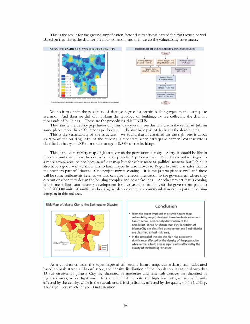
This is the result for the ground amplification factor due to seismic hazard for 2500 return period. Based on this, this is the data for the microzonation, and then we do the vulnerability assessment.
We do it to obtain the possibility of damage degree for certain building types to the earthquake scenario. And then we did with making the typology of building, we are collecting the data for thousands of buildings. These are the procedures, this HAZUS. Then this is the density population of Jakarta, so you can see this is more in the center of Jakarta some places more than 400 persons per hectare. The northern part of Jakarta is the densest area. This is the vulnerability of the structure. We found that in classified for the right one is about 49-50% of the building, 20% of the building is moderate, when earthquake happens collapse rate is classified as heavy is 1.83% for total damage is 0.03% of the buildings. This is the vulnerability map of Jakarta versus the population density. Sorry, it should be like in this slide, and then this is the risk map. Our president’s palace is here. Now he moved to Bogor, so a more severe area, so not because of our map but for other reasons, political reasons, but I think it also have a good – if we show this to him, maybe he also moves to Bogor because it is safer than in the northern part of Jakarta. One project now is coming. It is the Jakarta giant seawall and there will be some settlements here, so we also can give the recommendation to the government where they can put or when they design the housing complex and other facilities. Another project that is coming is the one million unit housing development for five years, so in this year the government plans to build 200,000 units of multistory housing, so also we can give recommendation not to put the housing complex in this red area.
As a conclusion, from the super-imposed of seismic hazard map, vulnerability map calculated based on basic structural hazard score, and density distribution of the population, it can be shown that 13 sub-districts of Jakarta City are classified as moderate and nine sub-districts are classified as high-risk areas, so no light one. In the center of the city, the high risk category is significantly affected by the density, while in the suburb area it is significantly affected by the quality of the building. Thank you very much for your kind attention.
16

Seismic Vulnerability Assessment for Popular Housing in MexicoCarlos Gutierrez M. (Research Director, CENAPRED, Mexico)
Thank you very much. Good morning for all of you. I would like to thank GRIPS for giving the opportunity to share with some experiences and some recent results that we have had. I will talk about the seismic vulnerability assessment for popular housing in Mexico. We have been using our large-scale structures laboratory in CENAPRED. We have been using this laboratory for as many as 25 years so far, and we have had very good results with some Japanese researchers and also by ourselves.
Briefly I will mention that this is the main scheme that we use (as many other countries) to talk about how the risk is composed. Of course, the hazard is in this case the earthquake. We study it from the historical point of view and also from the instrumental point of view. We take into account the cost of the exposed elements, of course the persons, human lives. We do not quantify human lives in terms of money, but we take a very close interest in it. However, the main point in this case for the houses and buildings is that we consider the square meter as the unit to quantify the risk and also the money, in a general sense, the dollars. Talking about vulnerability, we have a very large universe of constructions, also housing/dwellings in Mexico built with different procedures commonly with no building code, and we have to define typology to know and to work with this full universe. This typology takes into account the materials, the geometrical features, and requires quite very careful field surveys, especially after the earthquake occurs. This is what I was talking about. We have to know about the systems to be affected, so we have to establish a typology of what we want to know; the geographical distributions, where they are deployed, where they were built; the areas, costs, and persons potentially affected, so that is what I was mentioning a few minutes ago, the amount of exposed elements. In this case, we have some typical constructions in the countryside. Some of them are the clay bricks. Some of them are built with adobe, and some of them are using wood. For this kind of typology, as I mentioned, we have to develop vulnerability functions in order to calculate in order to have a good risk assessment. Necessary data about exposed elements I have already mentioned. We need to know the geographical location per element, but in this case, talking about the huge, big human settlements, it is very close to impossible to asses it per element for every plot of land, for every single house, so we take into account the percentage for each typology in big areas in municipalities, states, or big cities, as is the case of Mexico City. The representative value I already mentioned is the square meter and we need to assign each system or geographical area a vulnerability function in order to have a catalog. In this case, I will mention later this figure. This is what we call a part of a catalog of vulnerability
17
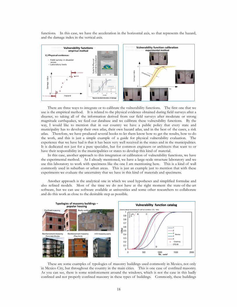
functions. In this case, we have the acceleration in the horizontal axis, so that represents the hazard, and the damage index in the vertical axis.
There are three ways to integrate or to calibrate the vulnerability functions. The first one that we use is the empirical method. It is related to the physical evidence obtained during field surveys after a disaster, so taking all of the information derived from our field surveys after moderate or strong magnitude earthquakes, we feed our database and we calibrate these vulnerability functions. By the way, I would like to mention that in our country we have a public policy that every state and municipality has to develop their own atlas, their own hazard atlas, and in the best of the cases, a risk atlas. Therefore, we have produced several books to let them know how to get the results, how to do the work, and this is just a simple example of a guide for physical vulnerability evaluation. The experience that we have had is that it has been very well received in the states and in the municipalities. It is dedicated not just for a pure specialist, but for common engineers or architects that want to or have their responsibility in the municipalities or states to develop this kind of material. In this case, another approach to this integration or calibration of vulnerability functions, we have the experimental method. As I already mentioned, we have a large-scale structure laboratory and we use this laboratory to work with specimens like the one I am mentioning here. This is a kind of wall commonly used in suburban or urban areas. This is just an example just to mention that with these experiments we evaluate the uncertainty that we have in this kind of materials and specimens. Another approach is the analytical one in which we used hypotheses and simplified formulae and also refined models. Most of the time we do not have at the right moment the state-of-the-art software, but we can use software available at universities and some other researchers to collaborate and do this work as close to the desirable step as possible.
These are some examples of typologies of masonry buildings used commonly in Mexico, not only in Mexico City, but throughout the country in the main cities. This is one case of confined masonry. As you can see, there is some reinforcement around the windows, which is not the case in this badly confined and not properly confined masonry in these types of buildings. Commonly, these buildings
18
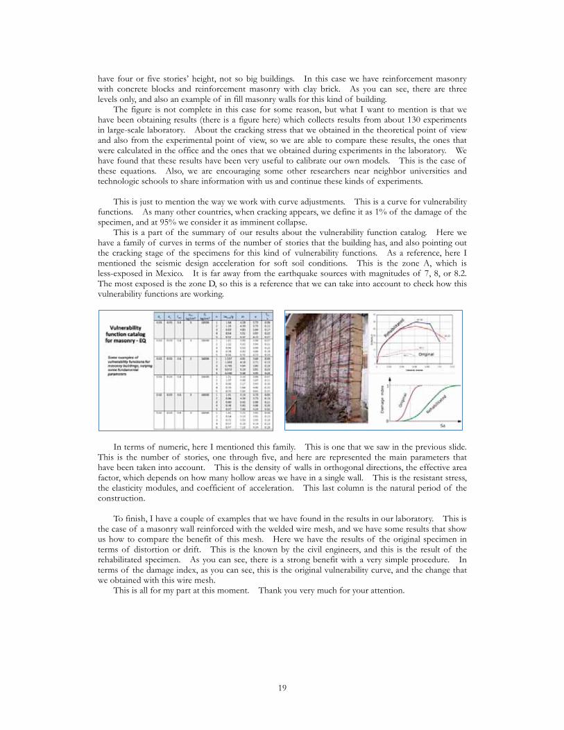
have four or five stories’ height, not so big buildings. In this case we have reinforcement masonry with concrete blocks and reinforcement masonry with clay brick. As you can see, there are three levels only, and also an example of in fill masonry walls for this kind of building. The figure is not complete in this case for some reason, but what I want to mention is that we have been obtaining results (there is a figure here) which collects results from about 130 experiments in large-scale laboratory. About the cracking stress that we obtained in the theoretical point of view and also from the experimental point of view, so we are able to compare these results, the ones that were calculated in the office and the ones that we obtained during experiments in the laboratory. We have found that these results have been very useful to calibrate our own models. This is the case of these equations. Also, we are encouraging some other researchers near neighbor universities and technologic schools to share information with us and continue these kinds of experiments. This is just to mention the way we work with curve adjustments. This is a curve for vulnerability functions. As many other countries, when cracking appears, we define it as 1% of the damage of the specimen, and at 95% we consider it as imminent collapse. This is a part of the summary of our results about the vulnerability function catalog. Here we have a family of curves in terms of the number of stories that the building has, and also pointing out the cracking stage of the specimens for this kind of vulnerability functions. As a reference, here I mentioned the seismic design acceleration for soft soil conditions. This is the zone A, which is less-exposed in Mexico. It is far away from the earthquake sources with magnitudes of 7, 8, or 8.2. The most exposed is the zone D, so this is a reference that we can take into account to check how this vulnerability functions are working.
In terms of numeric, here I mentioned this family. This is one that we saw in the previous slide. This is the number of stories, one through five, and here are represented the main parameters that have been taken into account. This is the density of walls in orthogonal directions, the effective area factor, which depends on how many hollow areas we have in a single wall. This is the resistant stress, the elasticity modules, and coefficient of acceleration. This last column is the natural period of the construction. To finish, I have a couple of examples that we have found in the results in our laboratory. This is the case of a masonry wall reinforced with the welded wire mesh, and we have some results that show us how to compare the benefit of this mesh. Here we have the results of the original specimen in terms of distortion or drift. This is the known by the civil engineers, and this is the result of the rehabilitated specimen. As you can see, there is a strong benefit with a very simple procedure. In terms of the damage index, as you can see, this is the original vulnerability curve, and the change that we obtained with this wire mesh. This is all for my part at this moment. Thank you very much for your attention.
19
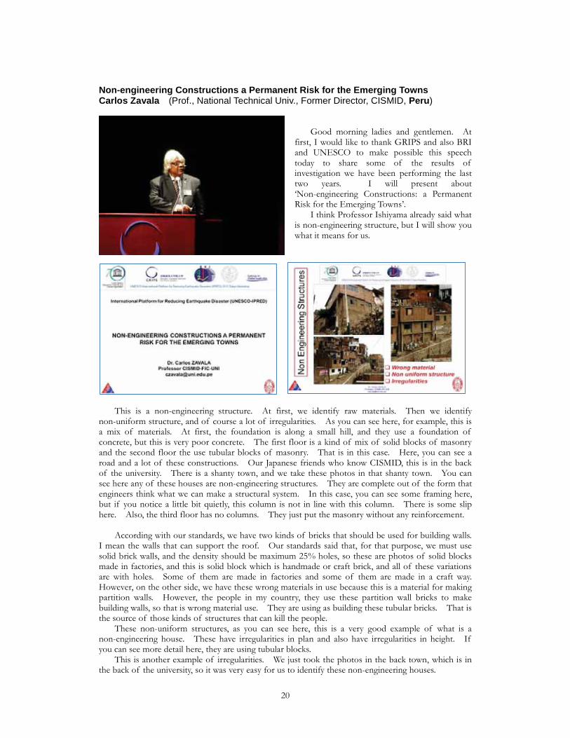
Non-engineering Constructions a Permanent Risk for the Emerging TownsCarlos Zavala (Prof., National Technical Univ., Former Director, CISMID, Peru)
Good morning ladies and gentlemen. At first, I would like to thank GRIPS and also BRI and UNESCO to make possible this speech today to share some of the results of investigation we have been performing the last two years. I will present about ‘Non-engineering Constructions: a Permanent Risk for the Emerging Towns’. I think Professor Ishiyama already said what is non-engineering structure, but I will show you what it means for us.
This is a non-engineering structure. At first, we identify raw materials. Then we identify non-uniform structure, and of course a lot of irregularities. As you can see here, for example, this is a mix of materials. At first, the foundation is along a small hill, and they use a foundation of concrete, but this is very poor concrete. The first floor is a kind of mix of solid blocks of masonry and the second floor the use tubular blocks of masonry. That is in this case. Here, you can see a road and a lot of these constructions. Our Japanese friends who know CISMID, this is in the back of the university. There is a shanty town, and we take these photos in that shanty town. You can see here any of these houses are non-engineering structures. They are complete out of the form that engineers think what we can make a structural system. In this case, you can see some framing here, but if you notice a little bit quietly, this column is not in line with this column. There is some slip here. Also, the third floor has no columns. They just put the masonry without any reinforcement. According with our standards, we have two kinds of bricks that should be used for building walls. I mean the walls that can support the roof. Our standards said that, for that purpose, we must use solid brick walls, and the density should be maximum 25% holes, so these are photos of solid blocks made in factories, and this is solid block which is handmade or craft brick, and all of these variations are with holes. Some of them are made in factories and some of them are made in a craft way. However, on the other side, we have these wrong materials in use because this is a material for making partition walls. However, the people in my country, they use these partition wall bricks to make building walls, so that is wrong material use. They are using as building these tubular bricks. That is the source of those kinds of structures that can kill the people. These non-uniform structures, as you can see here, this is a very good example of what is a non-engineering house. These have irregularities in plan and also have irregularities in height. If you can see more detail here, they are using tubular blocks. This is another example of irregularities. We just took the photos in the back town, which is in the back of the university, so it was very easy for us to identify these non-engineering houses.
20

What can we make to decrease the vulnerability on these non-engineering structures? Same as in Mexico, we need to retrofit these houses, so Peruvian government last year started a pilot program to identify 300 houses in the town of the north part of the city. The name of this town is Comas. They will apply retrofitting in 300 houses through a bonus. They will give the owner a bonus in order for them to retrofit the house, but how can they do that? So we make a study under the SATREPS program with the support of JICA, the Peruvian government, and JST to make this kind of test. At first, we make materials tests. We will make compression prism and shear wallets. I will show you the results.
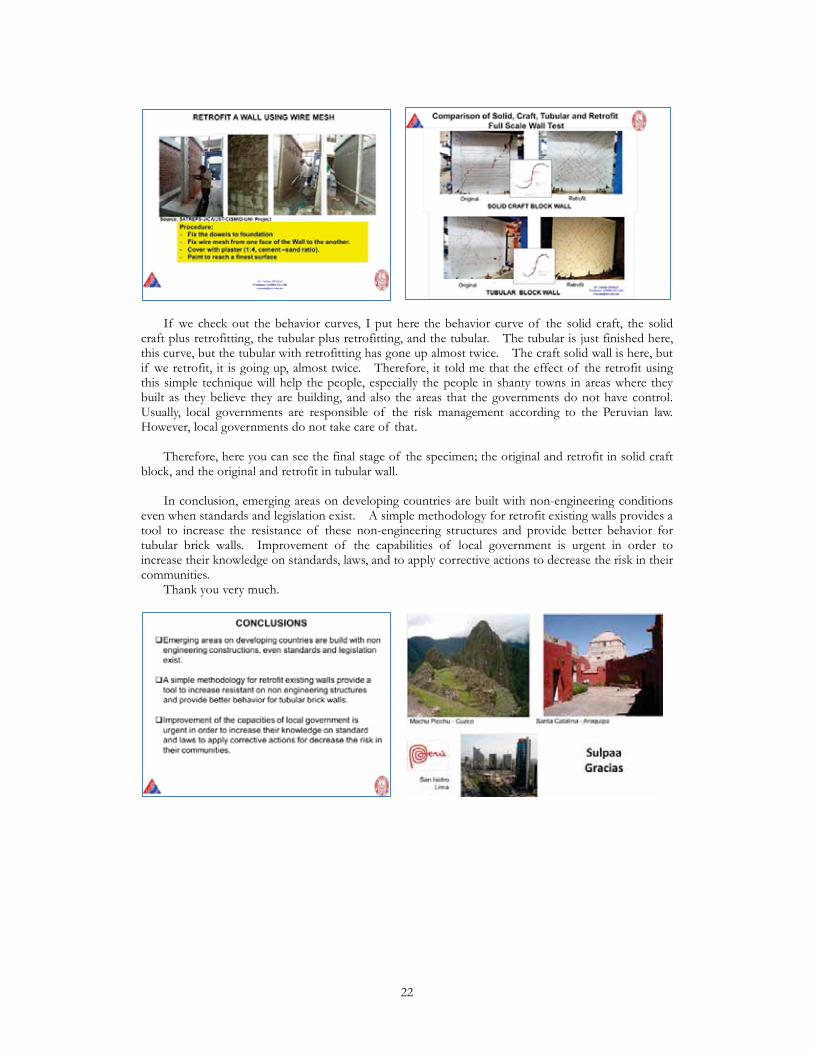
Here are the four types I mentioned before. The green one is the industrial one, factory-made. The craft one is the blue one, and the tubular brick (I mean the partition that is used as build wall) is the orange, but that is a partition with retrofit. We put a sandwich of wire mesh and concrete mortar as a retrofit. The tubular original is in red. We have the four types of samples with tests in order to identify these curves. As you can see, the industrial is the best one. The second is the craft one for compression capacity, and the worst is the tubular. This is the tubular. This is a sample. People are using these kinds of bricks. However, if they have no quake, they will not have problems because this has some capacity for service load, but for quakes, it will not be a service stage. There will appear the shear. Let us see what happened with the wallets. These are the wallets’ test, the same. We have the industrial one. Then we have the craft one, the tubular, and the tubular retrofitted if we see under the shear capacity of the wallets. The worst, of course, the tubular one, but this tubular has the wire mesh, if you see here it will increase the capacity in shear. Also, the industrial, of course, confirmed, is the best one. Then we continue with the next step. We make full-scale tests on walls. I will show you the results comparing this behavior between the original and the retrofit walls. As I mentioned before, around 60% of the people in urban areas live in these kinds of houses, especially in Lima. As you can see, they grow to three stories, and even they have four stories, so we consider 20 tons as actual load for the test. Here is the test setup. We have two jacks here for applying axial load, and also we have two jacks to apply horizontal load. Here are the results. If you can see here, this is the solid craft wall and this is tubular wall. We do not put the comparison with the industrial because industrial is outstanding, let us say. However, here, if we compare this solid craft wall, we have a shear resistance of around 18 tons. However, if we check out the tubular one, it has less than 14, so it means that the capacity is very low, and ductility, of course, is very low. You reach here even almost 10 millimeters, but here you have less than two millimeters. We applied this technique that I think is a very easy technique, the same as Mexico. This is the use of wire mesh. We can put dowels in the existing foundation and then we can fix the wire mesh side to side putting some wires inside the masonry. Then we can put the plaster with a cement/sand ratio of 1:4. Then you paint and finish the surface. Let us see what happened. Here is the solid craft with retrofitting, so I told you before, was 18 tons capacity, so we have almost 40. That means twice. Here is the tubular with the retrofitting, so it was almost 14, so we have almost 35. It means going up.
21
If we check out the behavior curves, I put here the behavior curve of the solid craft, the solid craft plus retrofitting, the tubular plus retrofitting, and the tubular. The tubular is just finished here, this curve, but the tubular with retrofitting has gone up almost twice. The craft solid wall is here, but if we retrofit, it is going up, almost twice. Therefore, it told me that the effect of the retrofit using this simple technique will help the people, especially the people in shanty towns in areas where they built as they believe they are building, and also the areas that the governments do not have control. Usually, local governments are responsible of the risk management according to the Peruvian law. However, local governments do not take care of that. Therefore, here you can see the final stage of the specimen; the original and retrofit in solid craft block, and the original and retrofit in tubular wall. In conclusion, emerging areas on developing countries are built with non-engineering conditions even when standards and legislation exist. A simple methodology for retrofit existing walls provides a tool to increase the resistance of these non-engineering structures and provide better behavior for tubular brick walls. Improvement of the capabilities of local government is urgent in order to increase their knowledge on standards, laws, and to apply corrective actions to decrease the risk in their communities. Thank you very much.
22

Evaluation of the Seismic Safety of a Typical RC School Building and Its RetrofittingYuksel Ercan (Prof., Istanbul Technical University, Turkey)
I will share my experience about the school buildings, for the retrofitting of existing school buildings in two extreme cases. One is located in the relatively poor areas of the country, and the second one is the highly populated cities of the country, and makes some comparison between the responses. Depending on this research, we will get some results for the government to understand for the future possibilities, which type of retrofitting techniques should be used for the school type reinforced concrete buildings. Actually, there are many buildings which are constructed by
using the same construction plan or load-carrying system all over the country. Depending on the previous experience, we got very bad damages and collapse for these types of buildings.
This is one of the buildings you see on the figure. The first story of the building unfortunately collapsed and almost 86 children died from this collapse. You see from the figure that the first story of the building is disappearing. Many died, all casualties are existing in this story. For this reason, especially for the relatively developed part of the country, there are many school buildings which should be revised or decreasing the amount of risk for the upcoming earthquakes. For example, in this figure you see that two figures. On the left side, the building is working properly, but after the earthquake, especially it includes many shear walls in it, but their locations are not selected properly. You see very heavy damage on the building on the right hand side figure. We
23

have checked the results why these types of damages are existing for this building, and makes making some nonlinear analysis using the existing tools. I will show some results depending on the building. The importance of the building is related with that because the same structural drawings are used for different parts of the country, making some small revision depending on the condition of the rural areas. For example, these two figures are almost the same, or these two buildings have almost the same structural load-carrying system with the collapsed one, but making some arrangement for the linearly located shear walls in it. On the left hand side, you see the collapsed building plan, and there are three main reinforced concrete shear walls. You see that the L-shape and rectangular shear walls are located in different positions, but on the newest version, which this plan is applied also for both of these primary schools, and there are again similar shear walls, but additional shear walls are added to the opposite part of the structure. It means that there are maybe some effects of torsion and the plan should be considered in the original design of the buildings. The material quality is relatively low, especially for the outside of the central cities, and making some nonlinear analysis for these buildings, we will get some results and will share with you the results, especially for the first building.
As you see, there are some structural properties that are seen on the figure. Now we are trying to understand the reason why the collapse is concentrated on the left part, especially, on the building. We repeated some pushover analysis for the case of the Y direction in plus and minus directions, and also one inclined lateral loading is applied to the building. In this case, a similar collapse mechanism is caught with the existing one. You see that the orientation of the loading, it may be important for the understanding of the reason of the real collapse. I can show you the capacities of the three alternative cases. You see that the yellow one is the lowest one, and the other two cases are relatively larger than the yellow one. We made some conclusions, and you will get the conclusions from the pamphlet.
I will skip to the second part of my presentation. In this part, again, we are studying a school building, but in this case, the system is relatively large, and these types of construction plans are used especially for the highly populated cities in Turkey.
24

Again, there are several reinforced concrete members, but we have only a limited amount of shear walls positioned on the same direction, and their dimensions are relatively low compared with the plan area of the building. There are some structural properties. Generally, they are constructed as four- or five-story reinforced concrete buildings, and the concrete quality is around C20, but the real case after construction, sometimes we are getting lower values compared with the estimated one. The acceleration intensity is around 0.4 g, and we also applied building importance factor because it is used as school building in our case. Also, depending on the existing earthquake code, we used good confined shear wall hatch, as you see. There are good confinement reinforcements located at the end of the shear walls, and there are many hooks and other reinforcement located properly in the cross section of the shear wall. Also, in the definition of the column reinforcement, you see that the vertical and horizontal reinforcements are crossed properly. By using this information, we have produced a mathematical model of the structure by using the computer software Perform. Making some arrangement for the plastic capacities of the cross sections for columns and beams and also shear walls, we applied fiber models for the definition of shear walls. As you see from the natural vibration periods of the structure, one direction is relatively soft compared with the other one. If you apply performance condition of immediate occupancy, you will see that, in the weak direction, almost the first two stories are really vulnerable, and you got damage on many columns and beams in this structure. If you evaluate the same direction for the life safety case, the number of the members which are vulnerable is relatively low as compared with previous one. The same process could be repeated for the strong direction, in this case because of the probably existence of shear walls or some direction of the columns, the damage is relatively low compared with the weak direction.
For this case we added the red-colored shear walls for the retrofitting purposes to the structure. As you see, totally there are eight shear walls that are added to the structure. To represent the soil conditions and the effect of the foundation on shear walls, we made some assumption about the soil springs. It means weak and strong type soil conditions are inserted into the mathematical model. By using the earthquakes even in FEMA-695, we applied many nonlinear analyses to understand the capacity of the structure for the retrofitted, or, of course, even for the bale case, and we got some very good results compared with the previous case. For example, in the weak direction, again, the number of the collapsed members is dramatically low compared with the previous case, and you see that only that some beam-type elements are vulnerable for this direction. Depending on this information, we have generated some fragility curves making more reasonable the results to represent someone else, and in this case we have defined some damage conditions, for example in this case mild damage condition, moderate one, and high damage condition. You see that there are three lines, red, green, and blue. The red one is the original case. Blue and green ones are the cases for retrofitted with two different types of soil conditions. As you see from the figure, if you apply a 0.6 g case, you will get very different probability of damages. For example, we apply a 0.6 case, almost 90% or 95% damage probability exists for the
25
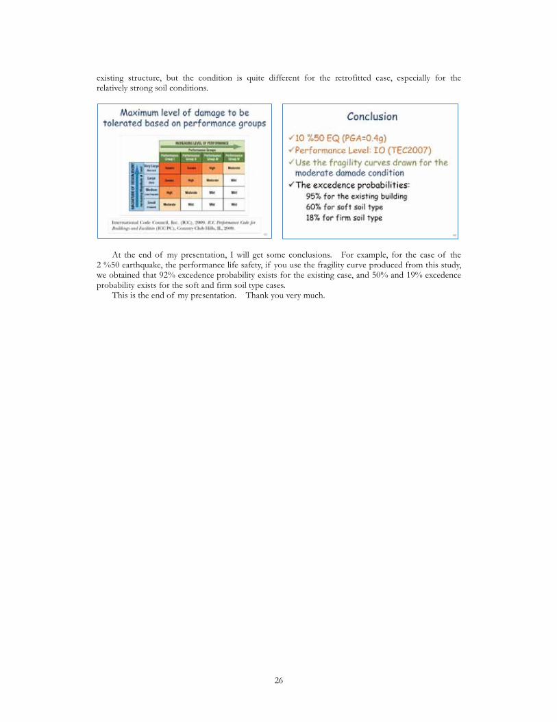
existing structure, but the condition is quite different for the retrofitted case, especially for the relatively strong soil conditions.
At the end of my presentation, I will get some conclusions. For example, for the case of the 2 %50 earthquake, the performance life safety, if you use the fragility curve produced from this study, we obtained that 92% excedence probability exists for the existing case, and 50% and 19% excedence probability exists for the soft and firm soil type cases. This is the end of my presentation. Thank you very much.
26

Morning Session Question & Answer Session (Huang) We had a very informative and very insightful four presentations from Indonesia, Mexico, Peru, and Turkey. Now we would like to take a few questions from the floor. (Q1) Good morning, everyone. My name is Carlos Cuadra. I am from Peru, but working here at Akita Prefectural University. I would like to make some comments about the non-engineering structures. Well, actually, in this case, we as engineers are offering to the people still all technology, I think, so maybe it is a challenge for all engineers just to continue the research on structural engineering to find some new material, new technology. I mean high technology material just to offer this technology to people because in other areas we have very high technology like smartphones, like plasmas television, or something like that, but in the case of housing technology, we are still trying to use this non-engineering structure, trying to improve these kinds of buildings. I think, yes, it is necessary, but also it is necessary to find new technology. Also, from the presentation, I understand it is necessary to go back again to the original material. I mean we need to research on the kinds of materials because sometimes, for example, poor concrete, or poorly restrained bricks are originated from, as Mr. Zavala said, wrong materials, and wrong understanding of the technology. For example, we use poor mortar for masonry. Maybe the proportion is one to five or even one to eight, very, very poor mortar, but even using the very same proportion of cement, sometimes we get a poor mortar because the material itself the sand is different, so it is necessary to search also this original material. Also, I want to ask some questions to Professor Zavala about the tubular masonry wall. You are using also columns? Yes, so how is the proportion to the shear wall that the columns take in this case? (Zavala) Thank you for the question, Professor Cuadra. I do not have the exact number. The proportion of what the concrete takes is a little bit more than 60%, so if there is not confinement, that will not resist anything. Another comment: just we have the picture over there, so we should look for the pass. I think so. In our case in Peru, we have very gorgeous structures like Machu Picchu. You can see on the picture this is the stone masonry. It is heritage for humanity, and it still stands, so why is it standing? It is because of the wall density, huge wall density. Also, the other picture, you can see Santa Catalina in Arequipa. This is for nuns. Nuns live there since the times of the colony, but this is architecture exported from Spain. Also, wall density is very huge. The thickness is 80 cm. In Lima, you will find high-rise buildings, of course. However, the people who live in Lima in the shanty towns, they are building in their own way. Why? It is because the local government permitted it. I think yesterday in the IPRED meeting we were discussing. We should change the language for those people because all of us know about nonlinearity, materials, and everything. We know. We are engineers and architects and we know very well how to design earthquake-proof structures. However, who will deal with those structures? It is the local governments, and local governments, they do not take care sometimes. Even in my country, the law changed in 2011 and now local government is responsible for the loss of life if there is an earthquake, so the mayor will go to jail if something happened. Therefore, they started to take care maybe since last year because they know there is a new law and the law says that they are responsible for that. Therefore, we need to teach those people who are not engineers, who deal with the money of the taxes how to check their community, how to retrofit their community. That is why the ministry of construction in my country has this pilot program to retrofit 300 houses in one community to show these mayors how to improve their communities. Of course, it will take time, but I am sure that we need to change the language to talk to these people. These people have the bad custom to ask if they will win votes if they made actions. Well, in this case, they will save lives, but how to talk with them is an enigma, I guess, because I am in this business more than 30 years, and I do not find yet the way to talk with the mayor of a city. It is quite complicated. (Huang) Thank you very much, Professor Zavala. It is a great privilege that we have a practitioner, scholars and specialists, even policy maker in this place, so it will be a very fruitful dialog.
27

Afternoon Session: Speeches from the World 2 New Developments in Probabilistic Seismic Hazard Analysis for RomaniaRadu Vacareanu (Vice Rector, Bucharest Tec. Univ., Romania)
Good afternoon, everybody. I am very pleased and honored to be here today and I would like to extend my gratitude to GRIPS, UNESCO, and BRI for having the opportunity to share some new developments in probabilistic seismic hazard analysis for Romania. After a brief introduction, a few words about the seismicity of Romania, then the ground motion prediction equations used, the logic tree approach, some results, and some conclusions.
Of course, this is the not the first probabilistic seismic hazard analysis for Romania as there were many previous probabilistic seismic hazard analyses for Romania, but this we might say that it is based on the largest database, and based on the state-of-the-art methods used in this kind of analysis today. For Romania, there are 13 crustal sources and one sub-crustal source that are affecting the Romanian territory. You might notice the sources here, so some of the sources are within Romania, some of the sources are outside Romania like this one, but by far the most important seismic source affecting the Romanian territory is this source here in this region that is sub-crustal. This means that the depth of the earthquake is in excess of 60 km, so usually we have earthquakes from 60 to 170, 180 kilometers. We used the catalogs that were developed by the National Institute for Earth Physics in a European project in the SHARE project. According to this catalog, so using this analysis, we defined for each and every seismic source we defined the year of completeness, the magnitude of completeness, and the maximum magnitude. All the magnitudes expressed here are moment magnitudes. You can notice that, for Vrancea sub-crustal, the seismic source that I told you is the most important source affecting Romanian territory, the maximum moment magnitude is 8.2. For the rest of the sources, for the crustal sources, it is this source from Bulgaria with a high magnitude is 7.8. After discussing about the seismicity, we have to discuss about ground motion prediction equations, so what ground motion prediction equations did we use in our analysis. We used the four ground motion prediction equations that were selected in the SHARE project and used subsequently in the Global Earthquake Model project. You can notice the relations are Youngs, Zhao, Atkinson and Boore, and Lin and Lee. However, none of these relations have a particular feature, and I will show you the feature and I will come back afterwards.
28

In Romania we have the Carpathian Mountains. These are the Carpathian Mountains, and the epicenters of the earthquakes from Vrancea are in this particular region. There is a very different attenuation of the seismic waves in front of the Carpathian Mountains and in the back of the Carpathian Mountains. Because of this, we need ground motion prediction equations that can take into account these very particular features in Vrancea. Because of this, we developed a new ground motion prediction equation. This ground motion prediction equation takes into account the different type of attenuation in fore-arc regions and the back-arc regions of Romania. As for the crustal sources, this kind of problem does not occur, so we used the ground motion prediction equations of Cauzzi and Faccioli, Akkar and Bommer, and Idriss. Of course, we tested all of the ground motion prediction equations because you cannot use them as they are. You have to test them in order to assign some weights to these ground motion prediction equations. We published several papers with the test, and the test is performed against these two databases. The first database here is for Vrancea sub-crustal sources. You can notice that the records are both from digital and analog instruments. The strong ground motion records are in all categories of terrain from terrain soil class A to soil class C. This is not according to NEHRP. It is according to Eurocode 8, so soil class A is rock and B and C they are soil. This is a database for sub-crustal and this is the database for crustal.
Here we have the map of Romania. The epicenters of the 10 earthquakes we are using in the analysis, and the position of the seismic stations recording these 10 earthquakes. For sub-crustal sources, you have again the position of the epicenters, and the seismic stations that recording strong ground motions from this particular earthquake. Then, after we tested, we used the numerical values in order to propose some weights for the logic trees. Each and every ground motion prediction equation will have a weight. We will do the analysis with each and every ground motion prediction equation and finally the weighted average will be used as a final result. These are the weights proposed in SHARE and GEM projects. These are new weights we are proposing for probabilistic seismic hazard analysis of Romania for sub-crustal source and for the crustal sources.
Moving to the logic tree, the logic tree has two branches: one for sub-crustal and one for crustal sources, but these two branches are added here. Then you have split branches for different
29
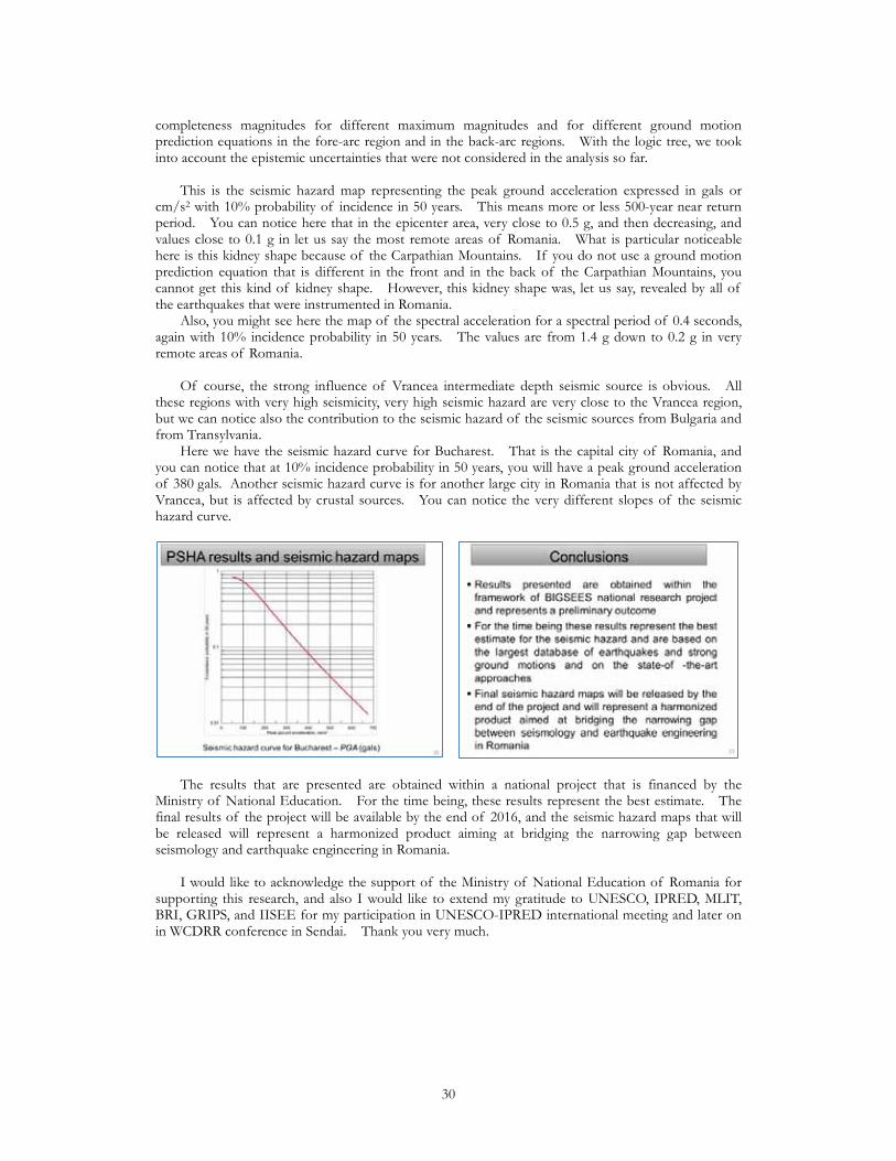
completeness magnitudes for different maximum magnitudes and for different ground motion prediction equations in the fore-arc region and in the back-arc regions. With the logic tree, we took into account the epistemic uncertainties that were not considered in the analysis so far. This is the seismic hazard map representing the peak ground acceleration expressed in gals or cm/s2 with 10% probability of incidence in 50 years. This means more or less 500-year near return period. You can notice here that in the epicenter area, very close to 0.5 g, and then decreasing, and values close to 0.1 g in let us say the most remote areas of Romania. What is particular noticeable here is this kidney shape because of the Carpathian Mountains. If you do not use a ground motion prediction equation that is different in the front and in the back of the Carpathian Mountains, you cannot get this kind of kidney shape. However, this kidney shape was, let us say, revealed by all of the earthquakes that were instrumented in Romania. Also, you might see here the map of the spectral acceleration for a spectral period of 0.4 seconds, again with 10% incidence probability in 50 years. The values are from 1.4 g down to 0.2 g in very remote areas of Romania. Of course, the strong influence of Vrancea intermediate depth seismic source is obvious. All these regions with very high seismicity, very high seismic hazard are very close to the Vrancea region, but we can notice also the contribution to the seismic hazard of the seismic sources from Bulgaria and from Transylvania. Here we have the seismic hazard curve for Bucharest. That is the capital city of Romania, and you can notice that at 10% incidence probability in 50 years, you will have a peak ground acceleration of 380 gals. Another seismic hazard curve is for another large city in Romania that is not affected by Vrancea, but is affected by crustal sources. You can notice the very different slopes of the seismic hazard curve.
The results that are presented are obtained within a national project that is financed by the Ministry of National Education. For the time being, these results represent the best estimate. The final results of the project will be available by the end of 2016, and the seismic hazard maps that will be released will represent a harmonized product aiming at bridging the narrowing gap between seismology and earthquake engineering in Romania. I would like to acknowledge the support of the Ministry of National Education of Romania for supporting this research, and also I would like to extend my gratitude to UNESCO, IPRED, MLIT, BRI, GRIPS, and IISEE for my participation in UNESCO-IPRED international meeting and later on in WCDRR conference in Sendai. Thank you very much.
30
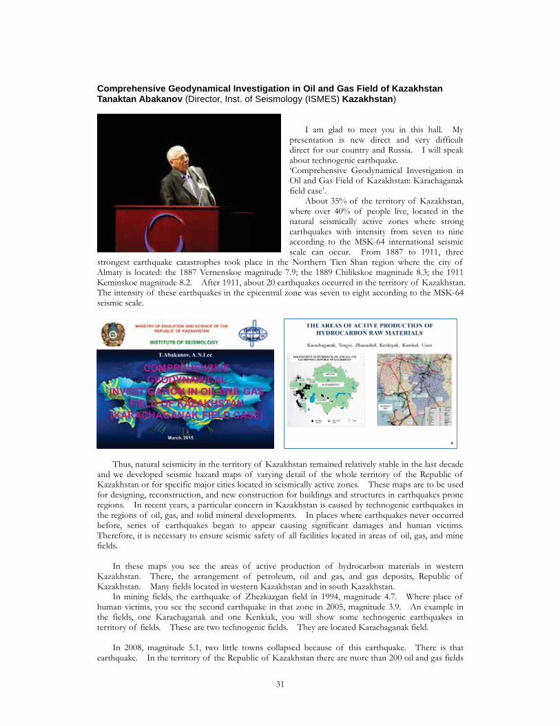
Comprehensive Geodynamical Investigation in Oil and Gas Field of KazakhstanTanaktan Abakanov (Director, Inst. of Seismology (ISMES) Kazakhstan)
I am glad to meet you in this hall. My presentation is new direct and very difficult direct for our country and Russia. I will speak about technogenic earthquake. ‘Comprehensive Geodynamical Investigation in Oil and Gas Field of Kazakhstan: Karachaganak field case’. About 35% of the territory of Kazakhstan, where over 40% of people live, located in the natural seismically active zones where strong earthquakes with intensity from seven to nine according to the MSK-64 international seismic scale can occur. From 1887 to 1911, three
strongest earthquake catastrophes took place in the Northern Tien Shan region where the city of Almaty is located: the 1887 Vernenskoe magnitude 7.9; the 1889 Chilikskoe magnitude 8.3; the 1911 Keminskoe magnitude 8.2. After 1911, about 20 earthquakes occurred in the territory of Kazakhstan. The intensity of these earthquakes in the epicentral zone was seven to eight according to the MSK-64 seismic scale.
Thus, natural seismicity in the territory of Kazakhstan remained relatively stable in the last decade and we developed seismic hazard maps of varying detail of the whole territory of the Republic of Kazakhstan or for specific major cities located in seismically active zones. These maps are to be used for designing, reconstruction, and new construction for buildings and structures in earthquakes prone regions. In recent years, a particular concern in Kazakhstan is caused by technogenic earthquakes in the regions of oil, gas, and solid mineral developments. In places where earthquakes never occurred before, series of earthquakes began to appear causing significant damages and human victims. Therefore, it is necessary to ensure seismic safety of all facilities located in areas of oil, gas, and mine fields. In these maps you see the areas of active production of hydrocarbon materials in western Kazakhstan. There, the arrangement of petroleum, oil and gas, and gas deposits, Republic of Kazakhstan. Many fields located in western Kazakhstan and in south Kazakhstan. In mining fields, the earthquake of Zhezkazgan field in 1994, magnitude 4.7. Where place of human victims, you see the second earthquake in that zone in 2005, magnitude 3.9. An example in the fields, one Karachaganak and one Kenkiak, you will show some technogenic earthquakes in territory of fields. These are two technogenic fields. They are located Karachaganak field. In 2008, magnitude 5.1, two little towns collapsed because of this earthquake. There is that earthquake. In the territory of the Republic of Kazakhstan there are more than 200 oil and gas fields
31
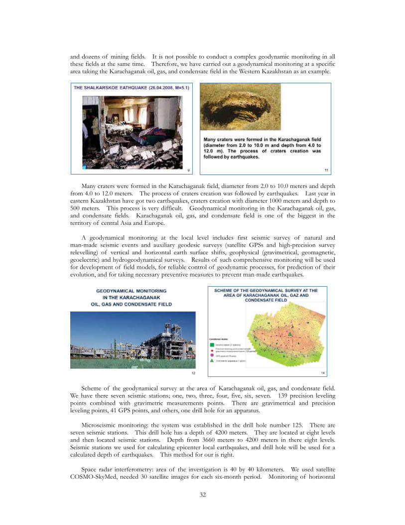
and dozens of mining fields. It is not possible to conduct a complex geodynamic monitoring in all these fields at the same time. Therefore, we have carried out a geodynamical monitoring at a specific area taking the Karachaganak oil, gas, and condensate field in the Western Kazakhstan as an example.
Many craters were formed in the Karachaganak field, diameter from 2.0 to 10.0 meters and depth from 4.0 to 12.0 meters. The process of craters creation was followed by earthquakes. Last year in eastern Kazakhstan have got two earthquakes, craters creation with diameter 1000 meters and depth to 500 meters. This process is very difficult. Geodynamical monitoring in the Karachaganak oil, gas, and condensate fields. Karachaganak oil, gas, and condensate field is one of the biggest in the territory of central Asia and Europe. A geodynamical monitoring at the local level includes first seismic survey of natural and man-made seismic events and auxiliary geodesic surveys (satellite GPSs and high-precision survey relevelling) of vertical and horizontal earth surface shifts, geophysical (gravimetrical, geomagnetic, geoelectric) and hydrogeodynamical surveys. Results of such comprehensive monitoring will be used for development of field models, for reliable control of geodynamic processes, for prediction of their evolution, and for taking necessary preventive measures to prevent man-made earthquakes.
Scheme of the geodynamical survey at the area of Karachaganak oil, gas, and condensate field. We have there seven seismic stations; one, two, three, four, five, six, seven. 139 precision leveling points combined with gravimetric measurements points. There are gravimetrical and precision leveling points, 41 GPS points, and others, one drill hole for an apparatus. Microseismic monitoring: the system was established in the drill hole number 125. There are seven seismic stations. This drill hole has a depth of 4200 meters. They are located at eight levels and then located seismic stations. Depth from 3660 meters to 4200 meters in there eight levels. Seismic stations we used for calculating epicenter local earthquakes, and drill hole will be used for a calculated depth of earthquakes. This method for our is right. Space radar interferometry: area of the investigation is 40 by 40 kilometers. We used satellite COSMO-SkyMed, needed 30 satellite images for each six-month period. Monitoring of horizontal
32

and vertical displacement accuracy of estimation is 20 millimeters. There it shows an example of this space radar monitoring.
Space radar interferometry used together with precision leveling. An example: there is horizontal/vertical speed of displacement by GPS measuring during 2010. We organized with a complex system in 2010. Geodynamical monitoring in the Karachaganak field will be a base for creating the geodynamical monitoring system in the other oil and gas fields in the territory of the Republic of Kazakhstan. At this time, we are working together with Russia and specialists from Great Britain. In Russia, at this time, there are very many earthquakes occurred. In Great Britain, they investigated their technogenic earthquake in the area of the Atlantic Ocean. We will investigate seismic process technogenic in area of the Caspian Sea. This problem for us to Russia to our country is new and in the future we will show all of our materials. In this presentation I may not show all of the materials. Very big and rich materials we have on investigation in Karachaganak field. Thank you for your attention.
33
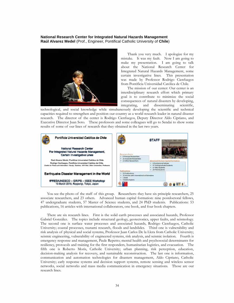
National Research Center for Integrated Natural Hazards ManagementRaúl Alvarez Medel (Prof., Engineer, Pontifical Catholic University of Chile)
Thank you very much. I apologize for my mistake. It was my fault. Now I am going to make my presentation. I am going to talk about the National Research Center for Integrated Natural Hazards Management, some certain investigative lines. This presentation was made by Professor Rodrigo Cienfuegos from Pontificia Universidad Católica de Chile. The mission of our center: Our center is an interdisciplinary research effort which primary goal is to contribute to minimize the social consequences of natural disasters by developing, integrating, and disseminating scientific,
technological, and social knowledge while simultaneously developing the scientific and technical capacities required to strengthen and position our country as a world research leader in natural disaster research. The director of the center is Rodrigo Cienfuegos, Deputy Director Aldo Cipriano, and Executive Director Juan Soto. These professors and some colleagues will go to Sendai to show some results of some of our lines of research that they obtained in the last two years.
You see the photo of the staff of this group. Researchers: they have six principle researchers, 25 associate researchers, and 23 others. Advanced human capital formation: nine postdoctoral fellows, 47 undergraduate students, 57 Master of Science students, and 24 PhD students. Publications: 53 publications, 16 articles with international collaborators, one book, and four book chapters. There are six research lines. First is the solid earth processes and associated hazards, Professor Gabriel González. The topics include structural geology, geotectonics, upper faults, and seismology. The second one is surface water processes and associated hazards, Rodrigo Cienfuegos, Catholic University; coastal processes, tsunami research, floods and landslides. Third one is vulnerability and risk analysis of physical and social systems, Professor Juan Carlos De la Llera from Catholic University; seismic engineering, vulnerability of engineered systems, risk analysis, and seismic isolation. Fourth is emergency response and management, Paule Repetto; mental health and psychosocial determinants for resiliency, protocols and training for the first responders, humanitarian logistics, and evacuation. The fifth one is Roberto Moris, Catholic University; urban planning, risk perception, education, decision-making analysis for recovery, and sustainable reconstruction. The last one is information, communication and automation technologies for disasters management, Aldo Cipriano, Catholic University; early response systems and decision support systems, remote sensing and wireless sensor networks, social networks and mass media communication in emergency situations. Those are our research lines.
34
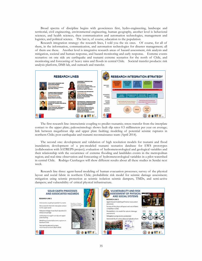
Broad spectra of discipline begins with geosciences first, hydro-engineering, landscape and territorial, civil engineering, environmental engineering, human geography, another level is behavioral sciences, and health sciences, then communication and automation technologies, management and logistics, and political science. The last is, of course, education to the population. Research integration strategy: the research lines, I told you the six ones. Of course, for all of them, in the information, communication, and automation technologies for disaster management; all of them use these. Another level is integrative research areas of hazard assessment, risk analysis and mitigation, societal and human response, and hazard monitoring and early response. Extreme events scenarios: on one side are earthquake and tsunami extreme scenarios for the north of Chile, and monitoring and forecasting of heavy rains and floods in central Chile. Societal transfer products: risk analysis platform, DMS lab, and outreach and transfer.
The first research line: interseismic coupling to predict tsunamis; stress transfer from the interplate contact to the upper plate; paleoseismology shows fault slip rates 0.5 millimeters per year on average; link between megathrust slip and upper plate faulting; modeling of potential seismic ruptures in northern Chile; post-earthquake and tsunami reconnaissance team (April 2014). The second one: development and validation of high resolution models for tsunami and flood inundation; development of a pre-modeled tsunami scenarios database for EWS prototypes (collaboration with SATREPS project); evaluation of hydrometeorological and geological variables and their relationship with the occurrence of extreme flooding and landslides events in the metropolitan region; and real-time observation and forecasting of hydrometeorological variables in a pilot watershed in central Chile. Rodrigo Cienfuegos will show different results about all these studies in Sendai next week. Research line three: agent-based modeling of human evacuation processes; survey of the physical layout and social fabric in northern Chile; probabilistic risk model for seismic damage assessment; mitigation using seismic protection as seismic isolation seismic dampers, TMDs, and semi-active dampers; and vulnerability of critical physical infrastructure.
35

Line four: analysis of current psychological first aid practices in Chile; mental health outcomes and determinants in the 2010 Maule earthquake and tsunami (resiliency factors); individual SES vulnerability index for post-traumatic stress disorder; evaluation of emergency drills, signs and preparedness; and modeling of shelter location and aid distribution in chain during a natural disaster for EES in the north of Chile. Research line five: data collection and analysis of legal framework, instruments, and policies for territorial planning and risk reduction; research on evacuation plans and psychosocial factors affecting evacuation behavior (education plans); assessment of public risk perceptions, tolerability and acceptability judgments through data collection and analysis; and decision making model for recovery response related to housing and urban development. The last one: deployment of wireless sensor networks in a pilot watershed (Quebrada de Ramón); research on technologies applied to social networks, behavior, and effect of mass and social media during natural disasters; research on early response systems and early warning systems, important for avoiding damage for scientists. International networks: of course, researcher exchange programs; shared graduate degree programs; summer institutes for graduate students. In North America: the University of Notre Dame, Cornell University, Johns Hopkins University, US Geological Survey, California Polytechnic State University, and FEMA. In Europe: German Research Center for Geoscience, Technische Universität Darmstadt, DLR Germany, TU Delft, Université de Grenoble, Université de Bordeaux, and Global Earthquake Model. South America: Universidad de San Luis, Universidad Nacional de Ingeniería in Perú, and CISMID Perú. Asia Pacific: Japan International Cooperation Agency, Port and Airport Research Institute through SATREPS project, Meteorological Research Institute, Japan Agency for Marine-Earth Science and Technology, Kansai University, Tohoku University, and Tokyo University.
Dialog, outreach, and technology transfer in different fields, areas, and countries like CIGIDEN and CCHC seminar on reconstruction, with the participation of Yoshihiro Ayusawa, Director of the Reconstruction Agency of Japan. CIGIDEN is a workshop for the interdisciplinary discussion between natural science and applied science researchers; KIZUNA; training session in psychological first aid for primary health in Iquique; seminar with the University of Notre Dame; and also in SATREPS. We have many places to transfer technology. Now I am going to show briefly some slides for some results of one research, ‘Benchmarking of Tsunami Inundation Models’ for Rodrigo Cienfuegos, Suarez, Urrutia, Aránguiz, and Gonzalez. You know that, like in Japan, Chile is a seismic country which has had great tsunamis like in 2010 or Iquique in 2014. We have many, many different tsunamis for all of our history. The objectives of this specific work is to validate propagation and inundation models; benchmarking and testing of models in the Chilean context; create with high resolution dynamic inundation maps; validate tsunami models to study the potential impact of containers in port areas (it is also very important, this kind of thing); and evaluate evacuation plans and mitigation options. The methodology: benchmarking with laboratory cases; validation of the models with the
36
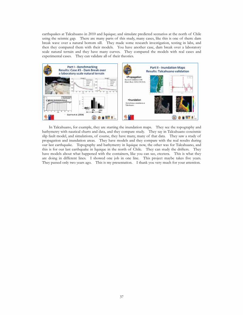
earthquakes at Talcahuano in 2010 and Iquique; and simulate predicted scenarios at the north of Chile using the seismic gap. There are many parts of this study, many cases, like this is one of them: dam break wave over a natural bottom sill. They made some research investigation, testing in labs, and then they compared them with their models. You have another case, dam break over a laboratory scale natural terrain and they have many curves. They compared the models with real cases and experimental cases. They can validate all of their theories.
In Talcahuano, for example, they are starting the inundation maps. They see the topography and bathymetry with nautical charts and data, and they compare study. They say in Talcahuano coseismic slip fault model, and simulations, of course, they have many, many of that data. They saw a study of propagation and inundation areas. They have models and they compare with the real results during our last earthquake. Topography and bathymetry in Iquique now, the other was for Talcahuano, and this is for our last earthquake in Iquique in the north of Chile. They can study the drifters. They have models about what happened with the containers, like you can see, etcetera. This is what they are doing in different lines. I showed one job in one line. This project maybe takes five years. They passed only two years ago. This is my presentation. I thank you very much for your attention.
37
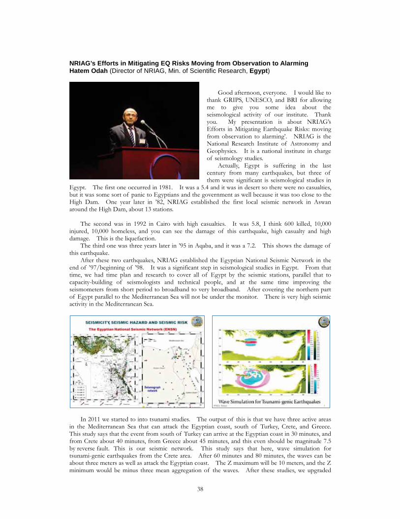
NRIAG’s Efforts in Mitigating EQ Risks Moving from Observation to AlarmingHatem Odah (Director of NRIAG, Min. of Scientific Research, Egypt)
Good afternoon, everyone. I would like to thank GRIPS, UNESCO, and BRI for allowing me to give you some idea about the seismological activity of our institute. Thank you. My presentation is about NRIAG’s Efforts in Mitigating Earthquake Risks: moving from observation to alarming’. NRIAG is the National Research Institute of Astronomy and Geophysics. It is a national institute in charge of seismology studies. Actually, Egypt is suffering in the last century from many earthquakes, but three of them were significant is seismological studies in
Egypt. The first one occurred in 1981. It was a 5.4 and it was in desert so there were no casualties, but it was some sort of panic to Egyptians and the government as well because it was too close to the High Dam. One year later in ’82, NRIAG established the first local seismic network in Aswan around the High Dam, about 13 stations. The second was in 1992 in Cairo with high casualties. It was 5.8, I think 600 killed, 10,000 injured, 10,000 homeless, and you can see the damage of this earthquake, high casualty and high damage. This is the liquefaction. The third one was three years later in ’95 in Aqaba, and it was a 7.2. This shows the damage of this earthquake. After these two earthquakes, NRIAG established the Egyptian National Seismic Network in the end of ’97/beginning of ’98. It was a significant step in seismological studies in Egypt. From that time, we had time plan and research to cover all of Egypt by the seismic stations, parallel that to capacity-building of seismologists and technical people, and at the same time improving the seismometers from short period to broadband to very broadband. After covering the northern part of Egypt parallel to the Mediterranean Sea will not be under the monitor. There is very high seismic activity in the Mediterranean Sea.
In 2011 we started to into tsunami studies. The output of this is that we have three active areas in the Mediterranean Sea that can attack the Egyptian coast, south of Turkey, Crete, and Greece. This study says that the event from south of Turkey can arrive at the Egyptian coast in 30 minutes, and from Crete about 40 minutes, from Greece about 45 minutes, and this even should be magnitude 7.5 by reverse fault. This is our seismic network. This study says that here, wave simulation for tsunami-genic earthquakes from the Crete area. After 60 minutes and 80 minutes, the waves can be about three meters as well as attack the Egyptian coast. The Z maximum will be 10 meters, and the Z minimum would be minus three mean aggregation of the waves. After these studies, we upgraded
38
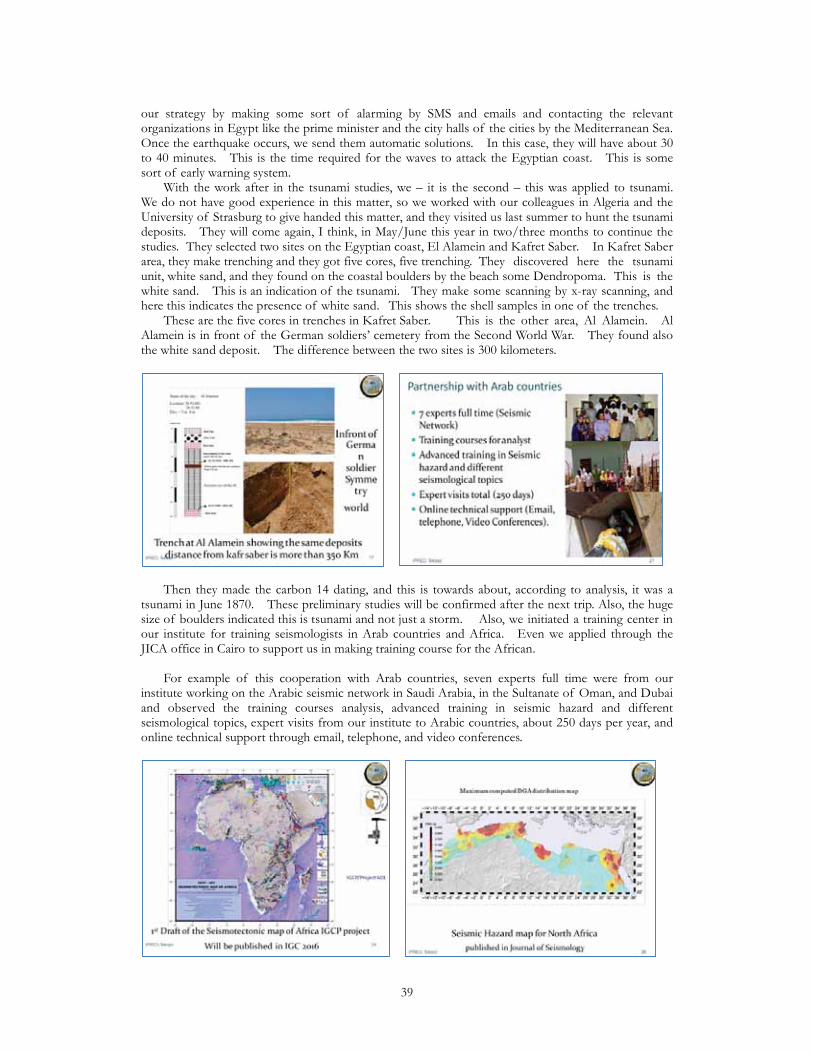
our strategy by making some sort of alarming by SMS and emails and contacting the relevant organizations in Egypt like the prime minister and the city halls of the cities by the Mediterranean Sea. Once the earthquake occurs, we send them automatic solutions. In this case, they will have about 30 to 40 minutes. This is the time required for the waves to attack the Egyptian coast. This is some sort of early warning system. With the work after in the tsunami studies, we – it is the second – this was applied to tsunami. We do not have good experience in this matter, so we worked with our colleagues in Algeria and the University of Strasburg to give handed this matter, and they visited us last summer to hunt the tsunami deposits. They will come again, I think, in May/June this year in two/three months to continue the studies. They selected two sites on the Egyptian coast, El Alamein and Kafret Saber. In Kafret Saber area, they make trenching and they got five cores, five trenching. They discovered here the tsunami unit, white sand, and they found on the coastal boulders by the beach some Dendropoma. This is the white sand. This is an indication of the tsunami. They make some scanning by x-ray scanning, and here this indicates the presence of white sand. This shows the shell samples in one of the trenches. These are the five cores in trenches in Kafret Saber. This is the other area, Al Alamein. Al Alamein is in front of the German soldiers’ cemetery from the Second World War. They found also the white sand deposit. The difference between the two sites is 300 kilometers.
Then they made the carbon 14 dating, and this is towards about, according to analysis, it was a tsunami in June 1870. These preliminary studies will be confirmed after the next trip. Also, the huge size of boulders indicated this is tsunami and not just a storm. Also, we initiated a training center in our institute for training seismologists in Arab countries and Africa. Even we applied through the JICA office in Cairo to support us in making training course for the African. For example of this cooperation with Arab countries, seven experts full time were from our institute working on the Arabic seismic network in Saudi Arabia, in the Sultanate of Oman, and Dubai and observed the training courses analysis, advanced training in seismic hazard and different seismological topics, expert visits from our institute to Arabic countries, about 250 days per year, and online technical support through email, telephone, and video conferences.
39
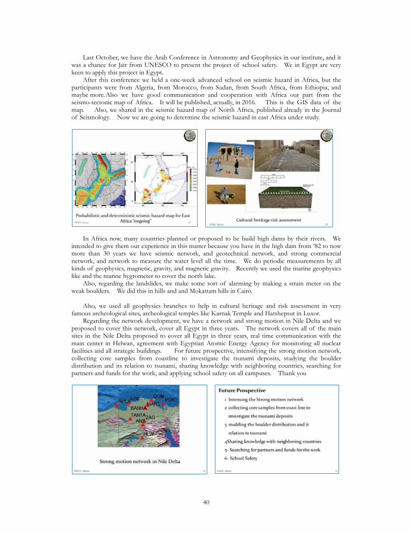
Last October, we have the Arab Conference in Astronomy and Geophysics in our institute, and it was a chance for Jair from UNESCO to present the project of school safety. We in Egypt are very keen to apply this project in Egypt. After this conference we held a one-week advanced school on seismic hazard in Africa, but the participants were from Algeria, from Morocco, from Sudan, from South Africa, from Ethiopia, and maybe more. Also we have good communication and cooperation with Africa our part from the seismo-tectonic map of Africa. It will be published, actually, in 2016. This is the GIS data of the map. Also, we shared in the seismic hazard map of North Africa, published already in the Journal of Seismology. Now we are going to determine the seismic hazard in east Africa under study.
In Africa now, many countries planned or proposed to be build high dams by their rivers. We intended to give them our experience in this matter because you have in the high dam from ’82 to now more than 30 years we have seismic network, and geotechnical network, and strong commercial network, and network to measure the water level all the time. We do periodic measurements by all kinds of geophysics, magnetic, gravity, and magnetic gravity. Recently we used the marine geophysics like and the marine hygrometer to cover the north lake. Also, regarding the landslides, we make some sort of alarming by making a strain meter on the weak boulders. We did this in hills and and Mokattam hills in Cairo. Also, we used all geophysics branches to help in cultural heritage and risk assessment in very famous archeological sites, archeological temples like Karnak Temple and Hatshepsut in Luxor. Regarding the network development, we have a network and strong motion in Nile Delta and we proposed to cover this network, cover all Egypt in three years. The network covers all of the main sites in the Nile Delta proposed to cover all Egypt in three years, real time communication with the main center in Helwan, agreement with Egyptian Atomic Energy Agency for monitoring all nuclear facilities and all strategic buildings. For future prospective, intensifying the strong motion network, collecting core samples from coastline to investigate the tsunami deposits, studying the boulder distribution and its relation to tsunami, sharing knowledge with neighboring countries, searching for partners and funds for the work, and applying school safety on all campuses. Thank you
40

Advances and Challenges in Seismic Engineering and Seismology for El SalvadorEdgar Peña (Prof., Head of Dept., National Univ. of El Salvador)
Thank you very much, everybody. First of all, thank you very much to GRIPS, BRI, IISEE, and obviously to UNESCO in order to give us this chance to introduce the activities that we are conducting in our country. In El Salvador we have different seismic sources, as you can see. We are surrounded by the Cocos plate, Caribbean plate, and North American plate. We have problems with this area, this portion. There are a lot of local earthquakes that are not only the subduction area, the volcanic region of El Salvador. The volcanic chain in is this line, so many problems,
most of the intensity map. This is a big abstract of all the destruction that earthquakes have caused during the recent years. This is the death toll that we have. Maybe 1986 had the most destructive earthquake, was a local earthquake, maybe 5.6 in magnitude, but the depth was around 7 km.
The 2001 earthquake that occurred in January/February, one month difference, as you can see, one was in the Pacific Ocean, was felt in the whole country, and the other was felt only in the local portion of El Salvador. The first one produced a lot of landslides, especially this one, which killed around 700 people. The second one destroyed all of the housed remained during the first earthquake. Most of the destruction of this earthquake was not related to buildings. It was related for houses. That was a big problem, especially because, at the beginning, everybody was thinking about okay, no building collapsed, the guidelines of construction were okay. However, the houses were totally destroyed, basically because the guidelines were not well-designed. The seismic hazard studies that we have conducted in the country started maybe in 1979. Sadaiku Hattori was the first to give us some information about the acceleration that we can expect, so the PGA for El Salvador, for the Central America region. After that, other similar investigations were conducted. Maybe the last one, because we use this as a parameter for the seismic design of structures, is in 1986. The Universidad Nacional Autónoma de México (UNAM), Singh, he was conducting the study, and we followed this information in order to get the 1994 seismic design code of the country. We had three different studies at that time. If my memory is not so bad, Mexico, Germany, and Italy conducted the same research, but with different results. In the end, let us say that we trusted in this information in order to conduct the maps. Recently, in 2008, one project of the observatory of the environment, they asked for Italy. In order to make this kind of study, we collected some of the acceleration of the PGA, the macrozonation of the country in order to understand the situation of the acceleration. This is for a 500-year period.
41
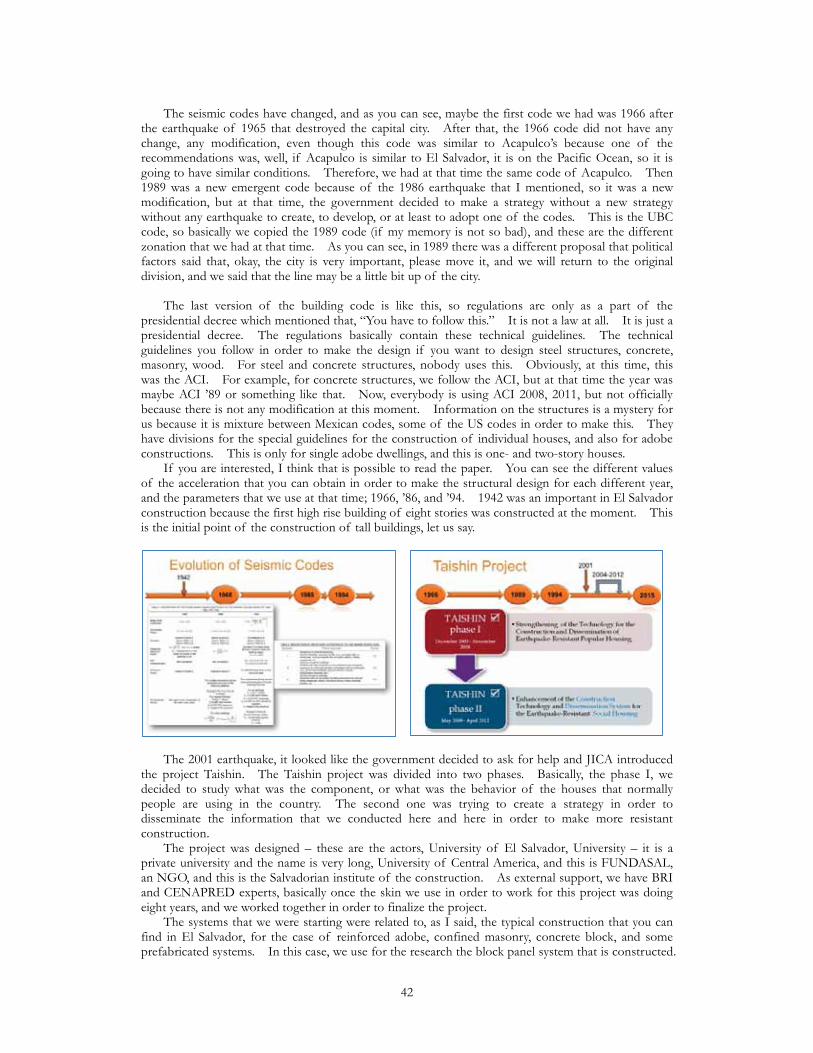
The seismic codes have changed, and as you can see, maybe the first code we had was 1966 after the earthquake of 1965 that destroyed the capital city. After that, the 1966 code did not have any change, any modification, even though this code was similar to Acapulco’s because one of the recommendations was, well, if Acapulco is similar to El Salvador, it is on the Pacific Ocean, so it is going to have similar conditions. Therefore, we had at that time the same code of Acapulco. Then 1989 was a new emergent code because of the 1986 earthquake that I mentioned, so it was a new modification, but at that time, the government decided to make a strategy without a new strategy without any earthquake to create, to develop, or at least to adopt one of the codes. This is the UBC code, so basically we copied the 1989 code (if my memory is not so bad), and these are the different zonation that we had at that time. As you can see, in 1989 there was a different proposal that political factors said that, okay, the city is very important, please move it, and we will return to the original division, and we said that the line may be a little bit up of the city. The last version of the building code is like this, so regulations are only as a part of the presidential decree which mentioned that, “You have to follow this.” It is not a law at all. It is just a presidential decree. The regulations basically contain these technical guidelines. The technical guidelines you follow in order to make the design if you want to design steel structures, concrete, masonry, wood. For steel and concrete structures, nobody uses this. Obviously, at this time, this was the ACI. For example, for concrete structures, we follow the ACI, but at that time the year was maybe ACI ’89 or something like that. Now, everybody is using ACI 2008, 2011, but not officially because there is not any modification at this moment. Information on the structures is a mystery for us because it is mixture between Mexican codes, some of the US codes in order to make this. They have divisions for the special guidelines for the construction of individual houses, and also for adobe constructions. This is only for single adobe dwellings, and this is one- and two-story houses. If you are interested, I think that is possible to read the paper. You can see the different values of the acceleration that you can obtain in order to make the structural design for each different year, and the parameters that we use at that time; 1966, ’86, and ’94. 1942 was an important in El Salvador construction because the first high rise building of eight stories was constructed at the moment. This is the initial point of the construction of tall buildings, let us say.
The 2001 earthquake, it looked like the government decided to ask for help and JICA introduced the project Taishin. The Taishin project was divided into two phases. Basically, the phase I, we decided to study what was the component, or what was the behavior of the houses that normally people are using in the country. The second one was trying to create a strategy in order to disseminate the information that we conducted here and here in order to make more resistant construction. The project was designed – these are the actors, University of El Salvador, University – it is a private university and the name is very long, University of Central America, and this is FUNDASAL, an NGO, and this is the Salvadorian institute of the construction. As external support, we have BRI and CENAPRED experts, basically once the skin we use in order to work for this project was doing eight years, and we worked together in order to finalize the project. The systems that we were starting were related to, as I said, the typical construction that you can find in El Salvador, for the case of reinforced adobe, confined masonry, concrete block, and some prefabricated systems. In this case, we use for the research the block panel system that is constructed.
42
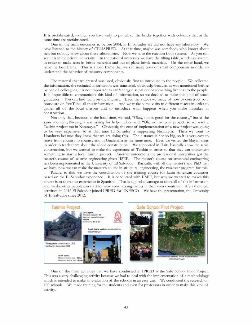
It is prefabricated, so then you have only to put all of the bricks together with columns that at the same time are prefabricated. One of the main outcomes is, before 2004, in El Salvador we did not have any laboratory. We have listened to the history of CENAPRED. At that time, maybe was somebody who knows about her, but nobody knew about these laboratories. Now we have the reaction floor system. As you can see, it is in the private university. In the national university we have the tilting table, which is a system in order to make tests in brittle materials and out-of-plane brittle materials. On the other hand, we have the load frame. This is a load frame that we can make tests on small components in order to understand the behavior of masonry components. The material that we created was used, obviously, first to introduce to the people. We collected the information, the technical information was translated, obviously, because, as was mentioned before by one of colleagues, it is not important to say ‘energy dissipation’ or something like that to the people. It is impossible to communicate this kind of information, so we decided to make this kind of small guidelines. You can find them on the internet. Even the videos we made of how to construct your house are on YouTube, all this information. And we make some visits to different places in order to gather all of the local masons and to introduce what happens when you make mistakes in construction. Not only that, because, at the local time, we said, “Okay, this is good for the country,” but at the same moment, Nicaragua was asking for help. They said, “Oh, we like your project, so we want a Taishin project too in Nicaragua.” Obviously, the cost of implementation of a new project was going to be very expensive, so at that time El Salvador is supporting Nicaragua. Then we went to Honduras because they knew that we are doing this. The distance is not so big, so it is very easy to move from country to country and in Guatemala at the same time. Even we visited the Mayan areas in order to teach them about the adobe construction. We supported in Haiti, basically know the same construction, but we wanted to make the experience of Taishin in order so that they can implement something to start a local Taishin project. Another outcome is the professional universities got the master’s course of seismic engineering given IISEE. The master’s course on structural engineering has been implemented in the University of El Salvador. Basically, with all the master’s and PhD that we have, now we can make the master’s course in structural engineering, the two-year program for this. Parallel to this, we have the coordination of the training course for Latin American countries based on the El Salvador experience. It is conducted with IISEE, but why we wanted to makes this course is to share our experience in Spanish. That is a good advantage to share all of the information and maybe other people can start to make some arrangements in their own countries. After these old activities, in 2012 El Salvador joined IPRED for UNESCO. We have the presentation, the University of El Salvador since 2012.
One of the main activities that we have conducted in IPRED is the Safe School Pilot Project. This was a very challenging activity because we had to deal with the implementation of a methodology which is intended to make an evaluation of the schools in an easy way. We conducted the research on 100 schools. We made training for the students and even for professors in order to make this kind of activity.
43

Another additional activity that we had is from 2013 to 2015, the Vice Ministry of Housing and Urban Development asked us to continue with the activities with their own budget. I mean that the universities have the laboratories and we are using them in order to conduct other research activities. In the case of the private universities following the activities of the concrete block, the national universities conducted activities in confined masonry. Another additional activity that we have conducted at this time is the UNIDO and the Vice Ministry of Housing and Urban Development created at the University of El Salvador the development of a training course for masons. One of the problems is that, if you do not a good-quality mason, it is impossible, even if you guideline has a lot of good information. Now we are trying to deal with this implementation of the seismic risk assessment in urban areas. We are using the software of the World Bank, the CAPRA. Now the ministry of public works has made a call for all of the entities (universities/private companies) in order to make a new building code in El Salvador in order to modify all of these small codes to make chapters for one unique building code.
Therefore, there was a slow evolution of this until 2004 where the Taishin project appears in the country. The movement after that has been very fast. Now we moving, obviously, trying to improve the building codes, the local construction guidelines, training for engineers and masons, and the assessment of retrofitting of the special facilities of schools and hospitals using extra stages that could be easy in order to implement them. Our final goal now is to develop the earthquake disaster management for urban areas in El Salvador. That is one of the main goals that we have now. That is our challenge for our future activities. Thank you very much for your attention.
44

5. Japanese Presentations GRIPS and BRI Presentations Actual conditions of Non-engineered Construction in Developing CountriesKenji Okazaki (Prof., Kyoto Univ.)
Good afternoon, ladies and gentlemen. For my part, I would like to speak about the non-engineered construction, which was already mentioned during the morning session. I would like to look at the global situation for non-engineered structures. I often use this table and I would like to start my presentation with this table. Looking at the past three decades, the worst 10 disasters with the largest fatalities starting from Armenia with fewer fatalities, Armenia, Iran, Venezuela, Iran, Pakistan, China, Myanmar, Bangladesh,
Haiti, Indonesia. There are many things I can say over this table, but one thing is, as is noted at the bottom, deadly disasters are mostly caused by earthquakes. For example, in Bangladesh in 1970, the Bhola cyclone, as super cyclone that came where 300,000 to 500,000 people that perished. In 1991 and 2007 there were super cyclones, but much fewer fatalities. In the recent Cyclone Sidr, it was only about 4000 because of the breakwater seawalls being quite effective in preventing deaths. We are not able to have long-term forecasts for inundation flooding, so there are fewer fatalities, but earthquakes are still terrible. They are still very disastrous. Apart from number two, it is mostly earthquakes. Especially in the 1980s it was one, but in the 1990s three, but in the 2000s, a great many earthquakes, so you can see that big earthquakes are occurring more recently. There are more retrofitting technologies available, but there seems to be an increased number of fatalities because of non-engineered structures.
This is a famous phrase: earthquakes do not kill people, buildings do! This is a famous expression. For cyclones or floods, it is directly from the disasters, but for earthquakes, those structures and buildings that you would have construct yourself from natural disasters are actually killing you. First all, earthquakes happen all of a sudden. You cannot really predict the occurrence of earthquakes, and in earthquakes most of the victims are killed in their own houses. More than half of the world population lives in non-engineered masonry buildings. Technology, for instance steel structures and reinforced concrete, technology is advanced, but for non-engineered buildings, the countermeasures are still lacking. Now, what we call non-engineered houses are mostly masonry, to accumulate using adobe, this is the most traditional, using sun-dried bricks, and you also have stone, timber, and bricks. There are
45
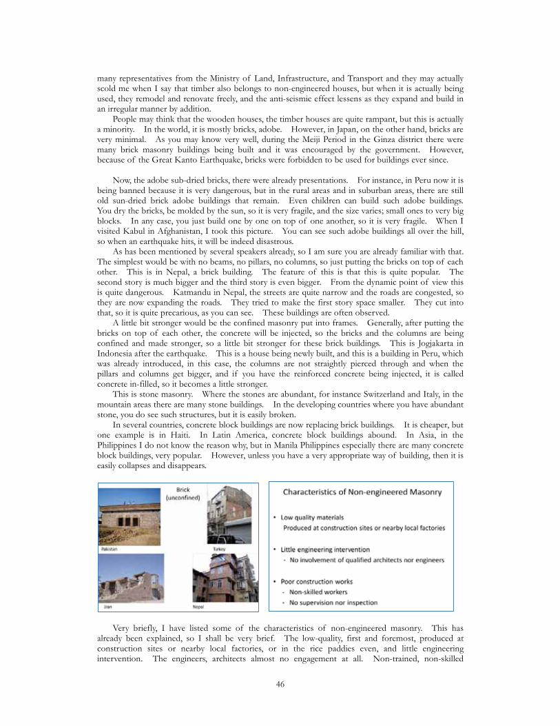
many representatives from the Ministry of Land, Infrastructure, and Transport and they may actually scold me when I say that timber also belongs to non-engineered houses, but when it is actually being used, they remodel and renovate freely, and the anti-seismic effect lessens as they expand and build in an irregular manner by addition. People may think that the wooden houses, the timber houses are quite rampant, but this is actually a minority. In the world, it is mostly bricks, adobe. However, in Japan, on the other hand, bricks are very minimal. As you may know very well, during the Meiji Period in the Ginza district there were many brick masonry buildings being built and it was encouraged by the government. However, because of the Great Kanto Earthquake, bricks were forbidden to be used for buildings ever since. Now, the adobe sub-dried bricks, there were already presentations. For instance, in Peru now it is being banned because it is very dangerous, but in the rural areas and in suburban areas, there are still old sun-dried brick adobe buildings that remain. Even children can build such adobe buildings. You dry the bricks, be molded by the sun, so it is very fragile, and the size varies; small ones to very big blocks. In any case, you just build one by one on top of one another, so it is very fragile. When I visited Kabul in Afghanistan, I took this picture. You can see such adobe buildings all over the hill, so when an earthquake hits, it will be indeed disastrous. As has been mentioned by several speakers already, so I am sure you are already familiar with that. The simplest would be with no beams, no pillars, no columns, so just putting the bricks on top of each other. This is in Nepal, a brick building. The feature of this is that this is quite popular. The second story is much bigger and the third story is even bigger. From the dynamic point of view this is quite dangerous. Katmandu in Nepal, the streets are quite narrow and the roads are congested, so they are now expanding the roads. They tried to make the first story space smaller. They cut into that, so it is quite precarious, as you can see. These buildings are often observed. A little bit stronger would be the confined masonry put into frames. Generally, after putting the bricks on top of each other, the concrete will be injected, so the bricks and the columns are being confined and made stronger, so a little bit stronger for these brick buildings. This is Jogjakarta in Indonesia after the earthquake. This is a house being newly built, and this is a building in Peru, which was already introduced, in this case, the columns are not straightly pierced through and when the pillars and columns get bigger, and if you have the reinforced concrete being injected, it is called concrete in-filled, so it becomes a little stronger. This is stone masonry. Where the stones are abundant, for instance Switzerland and Italy, in the mountain areas there are many stone buildings. In the developing countries where you have abundant stone, you do see such structures, but it is easily broken. In several countries, concrete block buildings are now replacing brick buildings. It is cheaper, but one example is in Haiti. In Latin America, concrete block buildings abound. In Asia, in the Philippines I do not know the reason why, but in Manila Philippines especially there are many concrete block buildings, very popular. However, unless you have a very appropriate way of building, then it is easily collapses and disappears.
Very briefly, I have listed some of the characteristics of non-engineered masonry. This has already been explained, so I shall be very brief. The low-quality, first and foremost, produced at construction sites or nearby local factories, or in the rice paddies even, and little engineering intervention. The engineers, architects almost no engagement at all. Non-trained, non-skilled
46
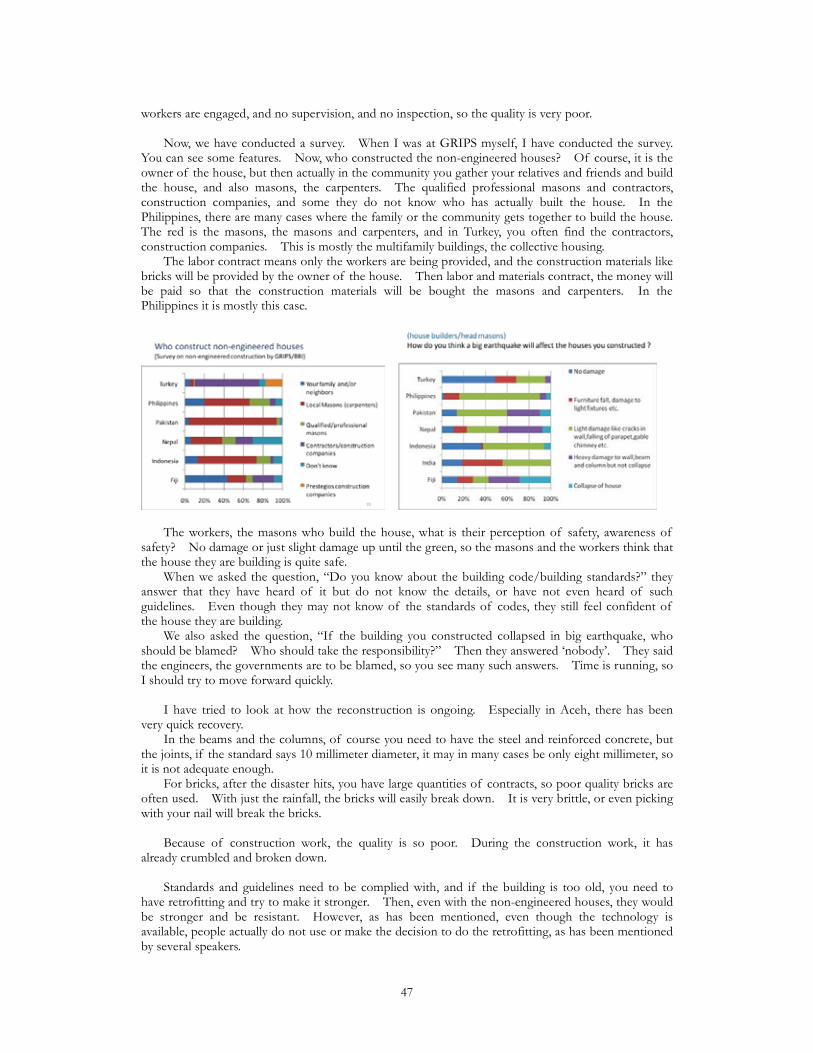
workers are engaged, and no supervision, and no inspection, so the quality is very poor. Now, we have conducted a survey. When I was at GRIPS myself, I have conducted the survey. You can see some features. Now, who constructed the non-engineered houses? Of course, it is the owner of the house, but then actually in the community you gather your relatives and friends and build the house, and also masons, the carpenters. The qualified professional masons and contractors, construction companies, and some they do not know who has actually built the house. In the Philippines, there are many cases where the family or the community gets together to build the house. The red is the masons, the masons and carpenters, and in Turkey, you often find the contractors, construction companies. This is mostly the multifamily buildings, the collective housing. The labor contract means only the workers are being provided, and the construction materials like bricks will be provided by the owner of the house. Then labor and materials contract, the money will be paid so that the construction materials will be bought the masons and carpenters. In the Philippines it is mostly this case.
The workers, the masons who build the house, what is their perception of safety, awareness of safety? No damage or just slight damage up until the green, so the masons and the workers think that the house they are building is quite safe. When we asked the question, “Do you know about the building code/building standards?” they answer that they have heard of it but do not know the details, or have not even heard of such guidelines. Even though they may not know of the standards of codes, they still feel confident of the house they are building. We also asked the question, “If the building you constructed collapsed in big earthquake, who should be blamed? Who should take the responsibility?” Then they answered ‘nobody’. They said the engineers, the governments are to be blamed, so you see many such answers. Time is running, so I should try to move forward quickly. I have tried to look at how the reconstruction is ongoing. Especially in Aceh, there has been very quick recovery. In the beams and the columns, of course you need to have the steel and reinforced concrete, but the joints, if the standard says 10 millimeter diameter, it may in many cases be only eight millimeter, so it is not adequate enough. For bricks, after the disaster hits, you have large quantities of contracts, so poor quality bricks are often used. With just the rainfall, the bricks will easily break down. It is very brittle, or even picking with your nail will break the bricks. Because of construction work, the quality is so poor. During the construction work, it has already crumbled and broken down. Standards and guidelines need to be complied with, and if the building is too old, you need to have retrofitting and try to make it stronger. Then, even with the non-engineered houses, they would be stronger and be resistant. However, as has been mentioned, even though the technology is available, people actually do not use or make the decision to do the retrofitting, as has been mentioned by several speakers.
47
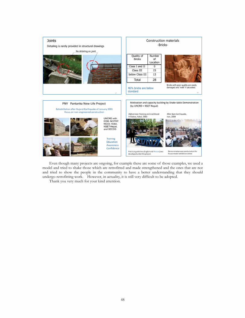
Even though many projects are ongoing, for example these are some of those examples, we used a model and tried to shake those which are retrofitted and made strengthened and the ones that are not and tried to show the people in the community to have a better understanding that they should undergo retrofitting work. However, in actuality, it is still very difficult to be adopted. Thank you very much for your kind attention.
48
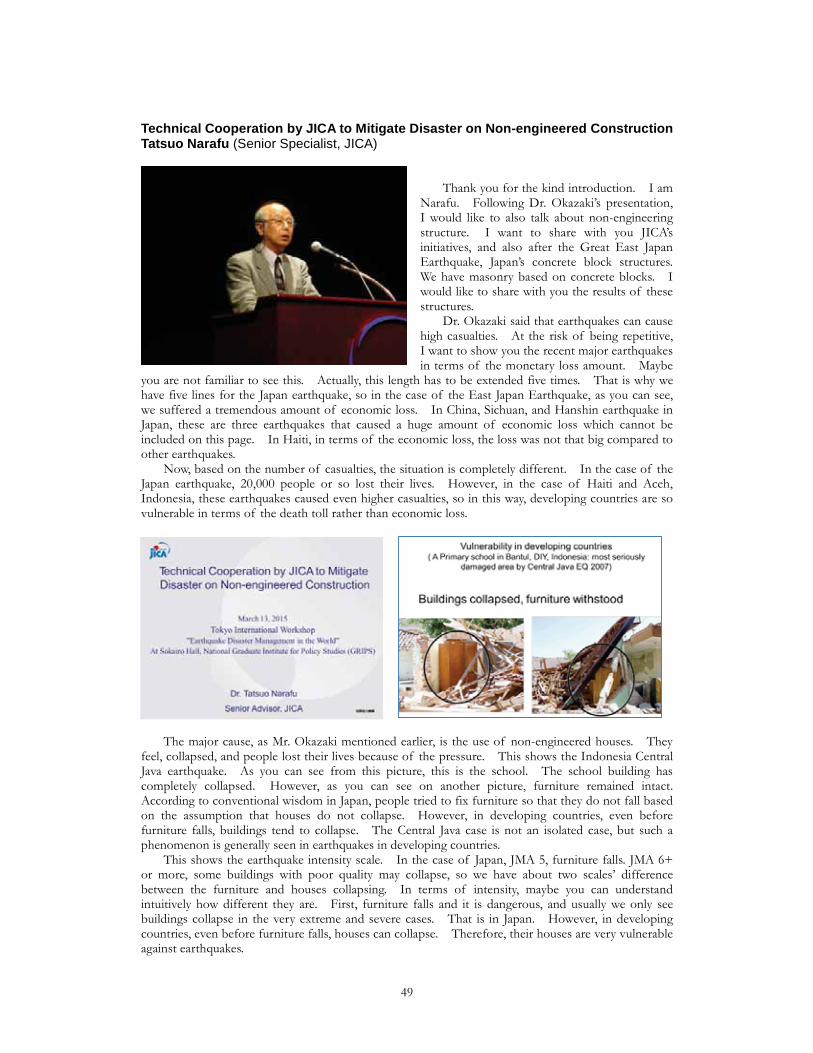
Technical Cooperation by JICA to Mitigate Disaster on Non-engineered ConstructionTatsuo Narafu (Senior Specialist, JICA)
Thank you for the kind introduction. I am Narafu. Following Dr. Okazaki’s presentation, I would like to also talk about non-engineering structure. I want to share with you JICA’s initiatives, and also after the Great East Japan Earthquake, Japan’s concrete block structures. We have masonry based on concrete blocks. I would like to share with you the results of these structures. Dr. Okazaki said that earthquakes can cause high casualties. At the risk of being repetitive, I want to show you the recent major earthquakes in terms of the monetary loss amount. Maybe
you are not familiar to see this. Actually, this length has to be extended five times. That is why we have five lines for the Japan earthquake, so in the case of the East Japan Earthquake, as you can see, we suffered a tremendous amount of economic loss. In China, Sichuan, and Hanshin earthquake in Japan, these are three earthquakes that caused a huge amount of economic loss which cannot be included on this page. In Haiti, in terms of the economic loss, the loss was not that big compared to other earthquakes. Now, based on the number of casualties, the situation is completely different. In the case of the Japan earthquake, 20,000 people or so lost their lives. However, in the case of Haiti and Aceh, Indonesia, these earthquakes caused even higher casualties, so in this way, developing countries are so vulnerable in terms of the death toll rather than economic loss.
The major cause, as Mr. Okazaki mentioned earlier, is the use of non-engineered houses. They feel, collapsed, and people lost their lives because of the pressure. This shows the Indonesia Central Java earthquake. As you can see from this picture, this is the school. The school building has completely collapsed. However, as you can see on another picture, furniture remained intact. According to conventional wisdom in Japan, people tried to fix furniture so that they do not fall based on the assumption that houses do not collapse. However, in developing countries, even before furniture falls, buildings tend to collapse. The Central Java case is not an isolated case, but such a phenomenon is generally seen in earthquakes in developing countries. This shows the earthquake intensity scale. In the case of Japan, JMA 5, furniture falls. JMA 6+ or more, some buildings with poor quality may collapse, so we have about two scales’ difference between the furniture and houses collapsing. In terms of intensity, maybe you can understand intuitively how different they are. First, furniture falls and it is dangerous, and usually we only see buildings collapse in the very extreme and severe cases. That is in Japan. However, in developing countries, even before furniture falls, houses can collapse. Therefore, their houses are very vulnerable against earthquakes.
49
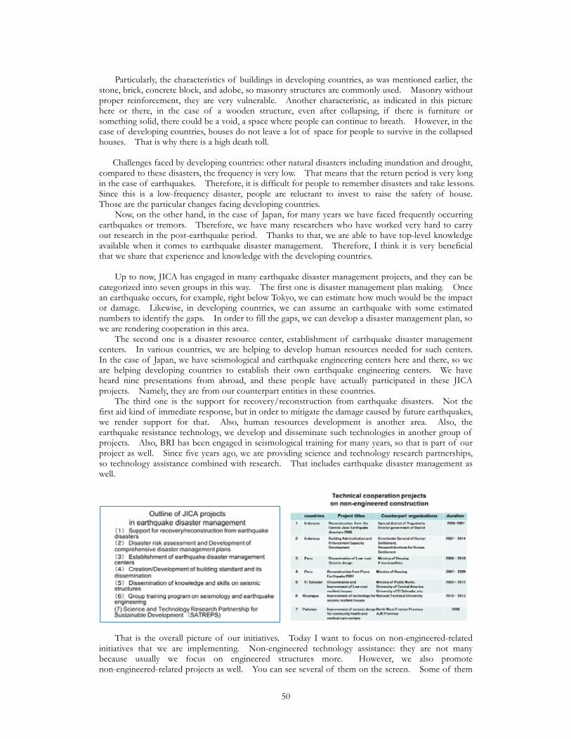
Particularly, the characteristics of buildings in developing countries, as was mentioned earlier, the stone, brick, concrete block, and adobe, so masonry structures are commonly used. Masonry without proper reinforcement, they are very vulnerable. Another characteristic, as indicated in this picture here or there, in the case of a wooden structure, even after collapsing, if there is furniture or something solid, there could be a void, a space where people can continue to breath. However, in the case of developing countries, houses do not leave a lot of space for people to survive in the collapsed houses. That is why there is a high death toll. Challenges faced by developing countries: other natural disasters including inundation and drought, compared to these disasters, the frequency is very low. That means that the return period is very long in the case of earthquakes. Therefore, it is difficult for people to remember disasters and take lessons. Since this is a low-frequency disaster, people are reluctant to invest to raise the safety of house. Those are the particular changes facing developing countries. Now, on the other hand, in the case of Japan, for many years we have faced frequently occurring earthquakes or tremors. Therefore, we have many researchers who have worked very hard to carry out research in the post-earthquake period. Thanks to that, we are able to have top-level knowledge available when it comes to earthquake disaster management. Therefore, I think it is very beneficial that we share that experience and knowledge with the developing countries. Up to now, JICA has engaged in many earthquake disaster management projects, and they can be categorized into seven groups in this way. The first one is disaster management plan making. Once an earthquake occurs, for example, right below Tokyo, we can estimate how much would be the impact or damage. Likewise, in developing countries, we can assume an earthquake with some estimated numbers to identify the gaps. In order to fill the gaps, we can develop a disaster management plan, so we are rendering cooperation in this area. The second one is a disaster resource center, establishment of earthquake disaster management centers. In various countries, we are helping to develop human resources needed for such centers. In the case of Japan, we have seismological and earthquake engineering centers here and there, so we are helping developing countries to establish their own earthquake engineering centers. We have heard nine presentations from abroad, and these people have actually participated in these JICA projects. Namely, they are from our counterpart entities in these countries. The third one is the support for recovery/reconstruction from earthquake disasters. Not the first aid kind of immediate response, but in order to mitigate the damage caused by future earthquakes, we render support for that. Also, human resources development is another area. Also, the earthquake resistance technology, we develop and disseminate such technologies in another group of projects. Also, BRI has been engaged in seismological training for many years, so that is part of our project as well. Since five years ago, we are providing science and technology research partnerships, so technology assistance combined with research. That includes earthquake disaster management as well.
That is the overall picture of our initiatives. Today I want to focus on non-engineered-related initiatives that we are implementing. Non-engineered technology assistance: they are not many because usually we focus on engineered structures more. However, we also promote non-engineered-related projects as well. You can see several of them on the screen. Some of them
50
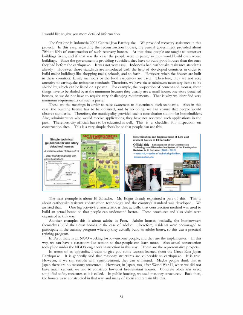
I would like to give you more detailed information. The first one is Indonesia 2006 Central Java Earthquake. We provided recovery assistance in this project. In this case, regarding the reconstruction houses, the central government provided about 70% to 80% of construction of such recovery houses. At that time, people are taught to construct buildings freely, and if that was the case, the people were in panic, so they would build even worse buildings. Since the government is providing subsidies, they have to build good houses than the ones they had before the earthquake. It was not very easy. Indonesia had earthquake resistance standards already. However, those standards are introduced with the help of developed countries in order to build major buildings like shopping malls, schools, and so forth. However, when the houses are built in these countries, family members or the local carpenters are used. Therefore, they are not very attentive to earthquake resistance standards. Therefore, we have these minimum necessary items to be abided by, which can be listed on a poster. For example, the proportion of cement and mortar, these things have to be abided by at the minimum because they usually use a small house, one-story detached houses, so we do not have to require very challenging requirements. That is why we identified very minimum requirements on such a poster. These are the meetings in order to raise awareness to disseminate such standards. Also in this case, the building license has to be obtained, and by so doing, we can ensure that people would observe standards. Therefore, the municipality provided such a consultation station for homebuilders. Also, administrators who would receive applications, they have not reviewed such applications in the past. Therefore, city officials have to be educated as well. This is a checklist for inspection on construction sites. This is a very simple checklist so that people can use this.
The next example is about El Salvador. Mr. Edgar already explained a part of this. This is about earthquake-resistant construction technology and the country’s standard was developed. We assisted that. One big activity’s characteristic is this: actually, that construction method was used to build an actual house so that people can understand better. These brochures and also visits were organized in this way. Another example: this is about adobe in Peru. Adobe houses, basically, the homeowners themselves build their own homes in the case of adobe. Therefore, residents were encouraged to participate in the training program whereby they actually build an adobe house, so this was a practical training program. In Peru, there is an NGO working for low-income people, and they are the implementer. In this way, we can have a classroom-like session so that people can learn more. Also actual construction took place under the NGO’s engineer’s instruction in this way. These are the representative projects. In terms of an appendix, I want to give you some lessons learned from the Great East Japan Earthquake. It is generally said that masonry structures are vulnerable to earthquake. It is true. However, if we can retrofit with reinforcement, they can withstand. Maybe people think that in Japan there are no masonry structures. However, in Japan, too, after World War II, when we did not have much cement, we had to construct low-cost fire-resistant houses. Concrete block was used, simplified safety measures as it is called. In public housing, we used masonry structures. Back then, the houses were constructed in that way, and many of them still remain like this.
51
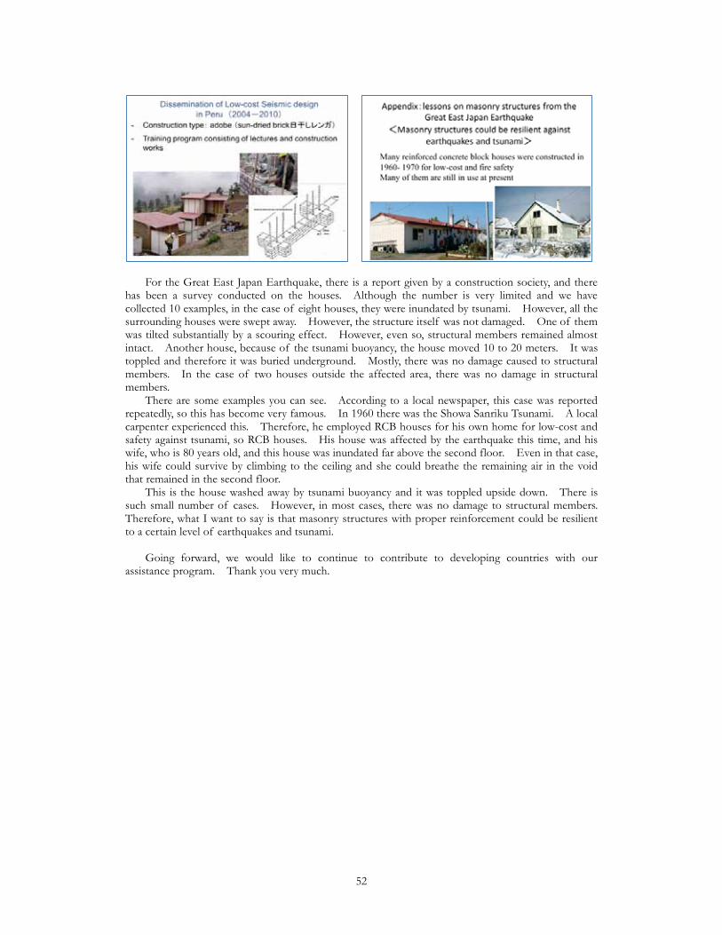
For the Great East Japan Earthquake, there is a report given by a construction society, and there has been a survey conducted on the houses. Although the number is very limited and we have collected 10 examples, in the case of eight houses, they were inundated by tsunami. However, all the surrounding houses were swept away. However, the structure itself was not damaged. One of them was tilted substantially by a scouring effect. However, even so, structural members remained almost intact. Another house, because of the tsunami buoyancy, the house moved 10 to 20 meters. It was toppled and therefore it was buried underground. Mostly, there was no damage caused to structural members. In the case of two houses outside the affected area, there was no damage in structural members. There are some examples you can see. According to a local newspaper, this case was reported repeatedly, so this has become very famous. In 1960 there was the Showa Sanriku Tsunami. A local carpenter experienced this. Therefore, he employed RCB houses for his own home for low-cost and safety against tsunami, so RCB houses. His house was affected by the earthquake this time, and his wife, who is 80 years old, and this house was inundated far above the second floor. Even in that case, his wife could survive by climbing to the ceiling and she could breathe the remaining air in the void that remained in the second floor. This is the house washed away by tsunami buoyancy and it was toppled upside down. There is such small number of cases. However, in most cases, there was no damage to structural members. Therefore, what I want to say is that masonry structures with proper reinforcement could be resilient to a certain level of earthquakes and tsunami. Going forward, we would like to continue to contribute to developing countries with our assistance program. Thank you very much.
52

2011 Great East Japan EQ and Trend of Tsunami Evacuation BuildingsShoichi Ando (Prof., GRIPS Disaster Management Policy Program)
I would like to give the presentation under the title ‘Recovery from the 2011 Great East Japan Earthquake and New Research Tsunami Evacuation Buildings in the Whole of Japan’. First of all, on behalf of the organizers, I would like to thank you for participating in today’s workshop. I would like to thank IPRED members from abroad, Professor Okazaki, as well as JICA’s Dr. Narafu. I will be talking especially on the Great East Japan Earthquake, but at the end, I will be talking about the research made nationwide on tsunami evacuation buildings.
As you know, two days ago was the fourth anniversary of the Great East Japan Earthquake. Starting from tomorrow in Sendai for a week there is a disaster prevention conference by the UN which is held every decade. Because Sendai has suffered from the 3/11 earthquake, it will be held in Sendai. When the Great East Japan Earthquake occurred, I was part of the IISEE of BRI. I was in Tsukuba when the Great East Japan Earthquake occurred, but when the training was being conducted for the students was happening, this earthquake occurred and I need to check whether they were safe. The BRI refrained from going to the affected areas for a month, but after April we conducted research on-site several times. I was part of the research members and these are the pictures that I have taken back then.
Behind all of the pictures are the lives of various people. This is from Otsuchi Town. This was taken about a month-and-a-half after 3/11, and a month after this picture was taken, it was put back to the sea. There were various reasons why this was taken back to the sea. There was the concern of a collapse of the building it is on, and also this boat Hamayuri is a tourist boat, so it was considered that it could be used again. This is a picture of a reinforced concrete (RC) building, but it was a very shocking picture. The tsunami could destroy such a robust building. Even there was a – well, it was uprooted and it was upturned. There were piles, but it was upturned even though it was steel frame, so it was very shocking. This is very famous. This is Taro’s breakwater. At IISEE each year, even before the earthquake, we have taken our trainees that this kind of breakwater had been built in Japan to prevent tsunami disasters. This breakwater itself had remained. However, it did not serve the function it was supposed to serve. There are some breakwaters which had suffered such drastic damage. Here I will be talking about some numbers. This is the data of the damage from the Great East Japan Earthquake for Iwate, Miyagi, and Fukushima prefectures. It is a comparison of the three prefectures. In terms of casualties, Miyagi (especially Ishinomaki) suffered huge damage, also for totally collapsed houses. The casualties per 100 collapsed housing, Iwate suffered the biggest damage.
53

The extent of the damage from tsunami and the earthquake was biggest in Iwate. This shows the bar graph of casualties per population and the number of collapsed houses, so it is the comparison with the three prefectures. This is the analysis by municipalities. This is casualties per municipality. On an absolute value, Ishinomaki City by far suffered the biggest damage. In terms of the totally collapsed houses, it was Sendai City which suffered the biggest damage. It was more than 25,000. If you look at the number of the persons missing as well as the casualties in Sendai City, it was approximately 700. Ishinomaki and Sendai, there were more than 20,000 houses destroyed, but nearly 4000 people died in Ishinomaki and in Sendai it was around 700. Why the difference? I would like to explain using this slide. The Sanriku area is shown in the blue and south of Sendai (the plains) is indicated in the green. Casualties per inundated area, person per square kilometers, the Sanriku area suffered a bigger loss. This shows the plot of what I have explained. The extent of the damage was bigger in Sanriku, as you can see from this chart. This compares the absolute number of casualties and the number of totally collapsed houses. This is Ishinomaki and Sendai, and you can tell that, by the individual municipalities, Ishinomaki and Sendai suffered the biggest losses from the perspective of casualties in Ishinomaki and the total number of houses destroyed.
Why is there a five times difference between Ishinomaki and Sendai in the number of casualties? One is urban planning. This is the urban planning map, and this is the inundated area map on the right. The center of Sendai is here where the Shinkansen bullet train station is. It is more than 10 kilometers away from the coast, so there was no damage from the tsunami. The inundated area includes five kilometers inland from the coast. This white area is the coordination adjustment area. Sasanishiki and koshihikari rice are grown where the rice paddies are. This is area where only rice paddies are located, so luckily, the total number of houses destroyed was very big, but from the perspective of inundation, it was not that the metropolitan area was directly hit. On the other hand, the Ishinomaki inundation area is shown in the pink. If you look at Onagawa, which you have seen in the picture earlier on, only the urban area had been hit by the tsunami. Ishinomaki had also been hit in most of the urbanized areas. What is different from Sendai is that the heavily populated area had been hit by tsunami. Going back to Miyako City, this shows the comparison of the pictures before the tsunami in 2007and one month after the 3/11 earthquake in 2011. This is Onagawa one month-and-a-half after the tsunami and six months after the tsunami. Japan cleans up very fast. With regards to the Great East Japan Earthquake, just like in today’s workshop, GRIPS and BRI had worked together on the project. GRIPS and BRI have compiled all of the photographs taken by both parties and we have handed that out to you. You see the detailed pictures and the comparison charts in the handout. In the back you will see the URL website and the URL of the website as well as the English translated version. That was the extent of the damage of the earthquake. From tomorrow, there will be the conference, and 10 years ago it was held in Hyogo. At that conference, the Hyogo Framework of Action was compiled and at Sendai this Hyogo Framework of Action will be reviewed and improved for the next 10 years. Number four: reduction of potential risks is where the building-related issues are concentrated.
54
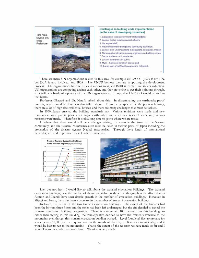
There are many UN organizations related to this area, for example UNESCO. JICA is not UN, but JICA is also involved, and JICA is like UNDP because they are supporting the development process. UN organizations have activities in various areas, and ISDR is involved in disaster reduction. UN organizations are competing against each other, and they are trying to get their opinions through, so it will be a battle of opinions of the UN organizations. I hope that UNESCO would do well in that battle. Professor Okazaki and Dr. Narafu talked about this. In disseminating the earthquake-proof housing, what should be done was also talked about. From the perspective of the popular housing, there are a lot of high-rise residential houses, and there are many challenges that must be tackled. In 1950, Japan enacted the building standards law. Various revisions were made and new frameworks were put in place after major earthquakes and after new research came out, various revisions were made. Therefore, it took a long time to get to where we are today. I believe that there would still be challenges arising, for example the issue of the ‘weaker community’ and the tsunami countermeasures must be taken in various parts of Japan including the prevention of the disaster against Nankai earthquakes. Through these kinds of international networks, we need to promote these kinds of initiatives.
Last but not least, I would like to talk about the tsunami evacuation buildings. The tsunami evacuation buildings, how the number of them has evolved is shown on this graph in the affected areas. Aomori and Ibaraki have seen drastic growth in the number of evacuation buildings. However, in Miyagi and Iwate, there has been a decrease in the number of tsunami evacuation buildings. In Iwate, this is one of the two tsunami evacuation buildings. The extent of the tsunami had been the bottom three floors and the other had been left undamaged, but the city decided to cancel the tsunami evacuation building designation. There is a mountain 100 meters from this building, so rather than staying in this building, the municipalities decided to have the residents evacuate to the mountains even though this tsunami evacuation building worked. Level four, level five, to prepare for a once every 10,000 year earthquake was on the minds of the City of Kamaishi municipality, and it would be best to run to the mountains. That is the extent of the research we have made so far and I would like to conclude my speech here. Thank you very much.
55
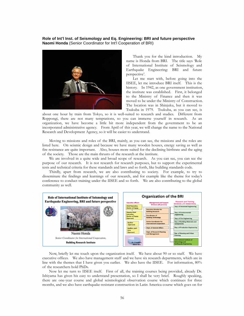
Role of Int’l Inst. of Seismology and Eq. Engineering: BRI and future perspectiveNaomi Honda (Senior Coordinator for Int’l Cooperation of BRI)
Thank you for the kind introduction. My name is Honda from BRI. The title says ‘Role of International Institute of Seismology and Earthquake Engineering: BRI and future perspective’. Let me start with, before going into the IISEE, let me introduce BRI itself. This is the history. In 1942, as one government institution, the institute was established. First, it belonged to the Ministry of Finance and then it was moved to be under the Ministry of Construction. The location was in Shinjuku, but it moved to Tsukuba in 1979. Tsukuba, as you can see, is
about one hour by train from Tokyo, so it is well-suited to research and studies. Different from Roppongi, there are not many temptations, so you can immerse yourself in research. As an organization, we have become a little bit more independent from the government to be an incorporated administrative agency. From April of this year, we will change the name to the National Research and Development Agency, so it will be easier to understand. Moving to missions and roles of the BRI, mainly, as you can see, the missions and the roles are listed here. On seismic design and because we have many wooden houses, energy saving as well as fire resistance are quite important. Also, houses more suited for the declining birthrate and the aging of the society. Those are the main thrusts of the research at the institute. We are involved in a quite wide and broad scope of research. As you can see, you can see the purpose of our research. It is not research for research purposes, but to support the experimental tests and technical criteria for these standards and laws and so forth, like building standards code. Thirdly, apart from research, we are also contributing to society. For example, to try to disseminate the findings and learnings of our research, and for example like the theme for today’s conference to conduct training under the IISEE and so forth. We are also contributing to the global community as well.
Now, briefly let me touch upon the organization itself. We have about 90 or so staff. We have executive offices. We also have management staff and we have six research departments, which are in line with the themes that I have given you earlier. We also have the IISEE. For information, 80% of the researchers hold PhDs. Now let me turn to IISEE itself. First of all, the training courses being provided, already Dr. Ishiyama has given his easy to understand presentation, so I shall be very brief. Roughly speaking, there are one-year course and global seismological observation course which continues for three months, and we also have earthquake-resistant construction in Latin America course which goes on for
56
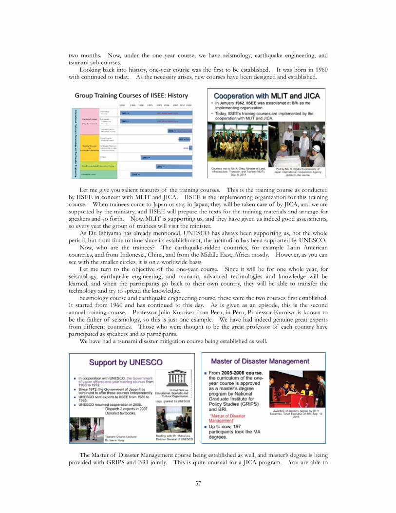
two months. Now, under the one year course, we have seismology, earthquake engineering, and tsunami sub-courses. Looking back into history, one-year course was the first to be established. It was born in 1960 with continued to today. As the necessity arises, new courses have been designed and established.
Let me give you salient features of the training courses. This is the training course as conducted by IISEE in concert with MLIT and JICA. IISEE is the implementing organization for this training course. When trainees come to Japan or stay in Japan, they will be taken care of by JICA, and we are supported by the ministry, and IISEE will prepare the texts for the training materials and arrange for speakers and so forth. Now, MLIT is supporting us, and they have given us indeed good assessments, so every year the group of trainees will visit the minister. As Dr. Ishiyama has already mentioned, UNESCO has always been supporting us, not the whole period, but from time to time since its establishment, the institution has been supported by UNESCO. Now, who are the trainees? The earthquake-ridden countries, for example Latin American countries, and from Indonesia, China, and from the Middle East, Africa mostly. However, as you can see with the smaller circles, it is on a worldwide basis. Let me turn to the objective of the one-year course. Since it will be for one whole year, for seismology, earthquake engineering, and tsunami, advanced technologies and knowledge will be learned, and when the participants go back to their own country, they will be able to transfer the technology and try to spread the knowledge. Seismology course and earthquake engineering course, these were the two courses first established. It started from 1960 and has continued to this day. As is given as an episode, this is the second annual training course. Professor Julio Kuroiwa from Peru; in Peru, Professor Kuroiwa is known to be the father of seismology, so this is just one example. We have had indeed genuine great experts from different countries. Those who were thought to be the great professor of each country have participated as speakers and as participants. We have had a tsunami disaster mitigation course being established as well.
The Master of Disaster Management course being established as well, and master’s degree is being provided with GRIPS and BRI jointly. This is quite unusual for a JICA program. You are able to
57
acquire a master’s degree. It is something beneficial. 197 participants have been conferred the master’s degree so far. The topics of the individual study are also wide and broad, as you can see. Apart from the degree, many awards and honors are being conferred trying to motivate the participants. A newly established course is the global seismological observation course. 186 trainees have undergone course. Just today there will a completion ceremony. This has already ended, but we used to have a China seismic building course, which lasted from 2009 to 2012, and this is a very good example. In 2008 there was a big earthquake in China, the Sichuan Earthquake. Immediately in the follow year 2009, this new course was launched. One characteristic is that, in four years, 72 structural engineers were trained, and when they went back to China, they were also able to train 324 poor engineers, and then those 324 poor engineers have conducted lectures and briefing session and they in turn nurtured 8833 general engineers. Therefore, you can see that it has multiplied and expanded. This is a course started from last year: earthquake resistant construction in Latin America course. As was already explained earlier, two-month training course focusing on Latin America. One feature is that it in the Spanish language. Also, with the researchers in different countries and also government bureaucrats and those people who are involved in reconstruction, those speakers come in pairs. Therefore, those trainees come in pairs so that, immediately after going back, they will be able to put into action the ideas and technology learned.
Now, we would like to continue to strengthen our courses and recruit new participants. There are some countries where the number of participants is quite minimal, so we would like to reinforce those countries and we would like to strengthen networking with IPRED and try to transmit information and try to communicate with the whole world. We would like to be the core engine for such a network. Thank you very much for your kind attention.
58
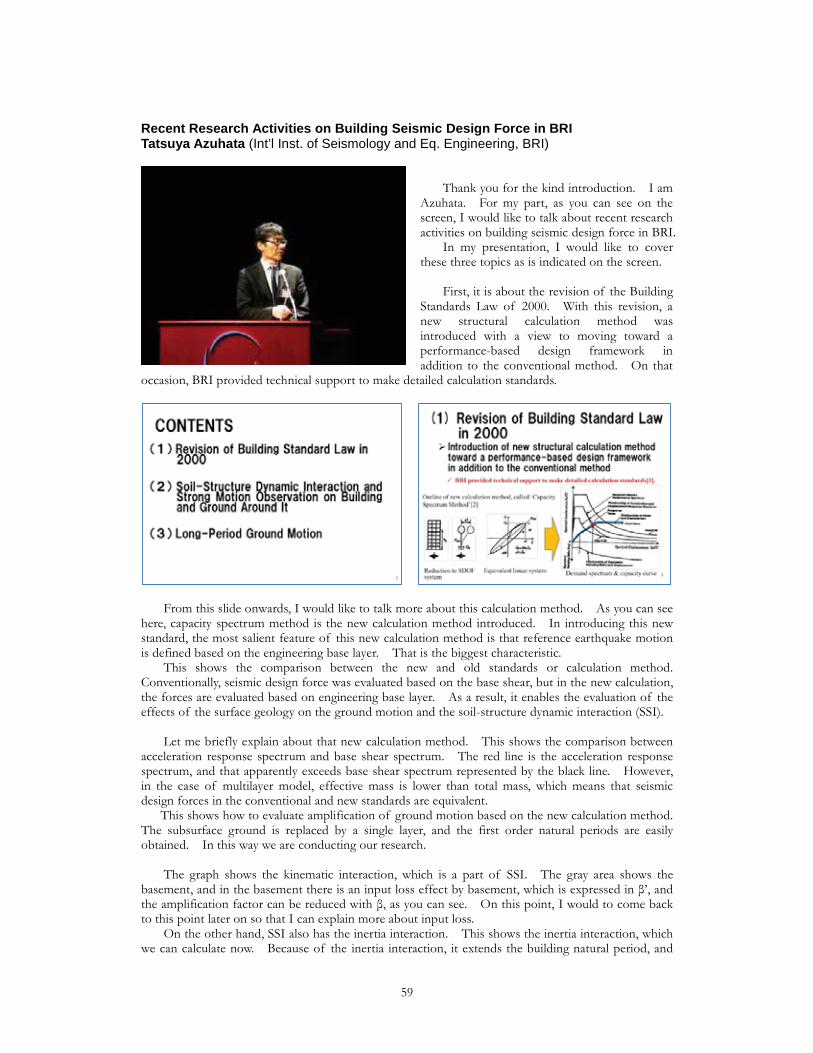
Recent Research Activities on Building Seismic Design Force in BRITatsuya Azuhata (Int’l Inst. of Seismology and Eq. Engineering, BRI)
Thank you for the kind introduction. I am Azuhata. For my part, as you can see on the screen, I would like to talk about recent research activities on building seismic design force in BRI. In my presentation, I would like to cover these three topics as is indicated on the screen. First, it is about the revision of the Building Standards Law of 2000. With this revision, a new structural calculation method was introduced with a view to moving toward a performance-based design framework in addition to the conventional method. On that
occasion, BRI provided technical support to make detailed calculation standards.
From this slide onwards, I would like to talk more about this calculation method. As you can see here, capacity spectrum method is the new calculation method introduced. In introducing this new standard, the most salient feature of this new calculation method is that reference earthquake motion is defined based on the engineering base layer. That is the biggest characteristic. This shows the comparison between the new and old standards or calculation method. Conventionally, seismic design force was evaluated based on the base shear, but in the new calculation, the forces are evaluated based on engineering base layer. As a result, it enables the evaluation of the effects of the surface geology on the ground motion and the soil-structure dynamic interaction (SSI). Let me briefly explain about that new calculation method. This shows the comparison between acceleration response spectrum and base shear spectrum. The red line is the acceleration response spectrum, and that apparently exceeds base shear spectrum represented by the black line. However, in the case of multilayer model, effective mass is lower than total mass, which means that seismic design forces in the conventional and new standards are equivalent. This shows how to evaluate amplification of ground motion based on the new calculation method. The subsurface ground is replaced by a single layer, and the first order natural periods are easily obtained. In this way we are conducting our research. The graph shows the kinematic interaction, which is a part of SSI. The gray area shows the basement, and in the basement there is an input loss effect by basement, which is expressed in ’, and the amplification factor can be reduced with , as you can see. On this point, I would to come back to this point later on so that I can explain more about input loss. On the other hand, SSI also has the inertia interaction. This shows the inertia interaction, which we can calculate now. Because of the inertia interaction, it extends the building natural period, and
59
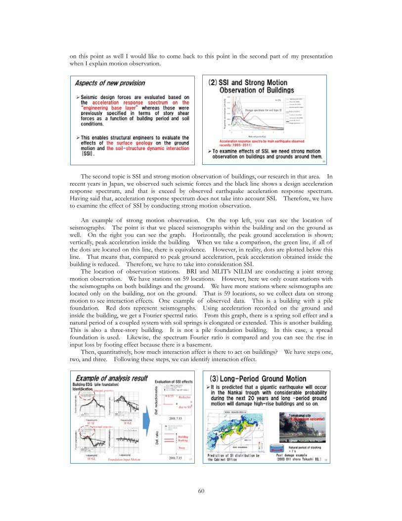
on this point as well I would like to come back to this point in the second part of my presentation when I explain motion observation.
The second topic is SSI and strong motion observation of buildings, our research in that area. In recent years in Japan, we observed such seismic forces and the black line shows a design acceleration response spectrum, and that is exceed by observed earthquake acceleration response spectrum. Having said that, acceleration response spectrum does not take into account SSI. Therefore, we have to examine the effect of SSI by conducting strong motion observation. An example of strong motion observation. On the top left, you can see the location of seismographs. The point is that we placed seismographs within the building and on the ground as well. On the right you can see the graph. Horizontally, the peak ground acceleration is shown; vertically, peak acceleration inside the building. When we take a comparison, the green line, if all of the dots are located on this line, there is equivalence. However, in reality, dots are plotted below this line. That means that, compared to peak ground acceleration, peak acceleration obtained inside the building is reduced. Therefore, we have to take into consideration SSI. The location of observation stations. BRI and MLIT’s NILIM are conducting a joint strong motion observation. We have stations on 59 locations. However, here we only count stations with the seismographs on both buildings and the ground. We have more stations where seismographs are located only on the building, not on the ground. That is 59 locations, so we collect data on strong motion to see interaction effects. One example of observed data. This is a building with a pile foundation. Red dots represent seismographs. Using acceleration recorded on the ground and inside the building, we get a Fourier spectral ratio. From this graph, there is a spring soil effect and a natural period of a coupled system with soil springs is elongated or extended. This is another building. This is also a three-story building. It is not a pile foundation building. In this case, a spread foundation is used. Likewise, the spectrum Fourier ratio is compared and you can see the rise in input loss by footing effect because there is a basement. Then, quantitatively, how much interaction affect is there to act on buildings? We have steps one, two, and three. Following these steps, we can identify interaction effect.
60
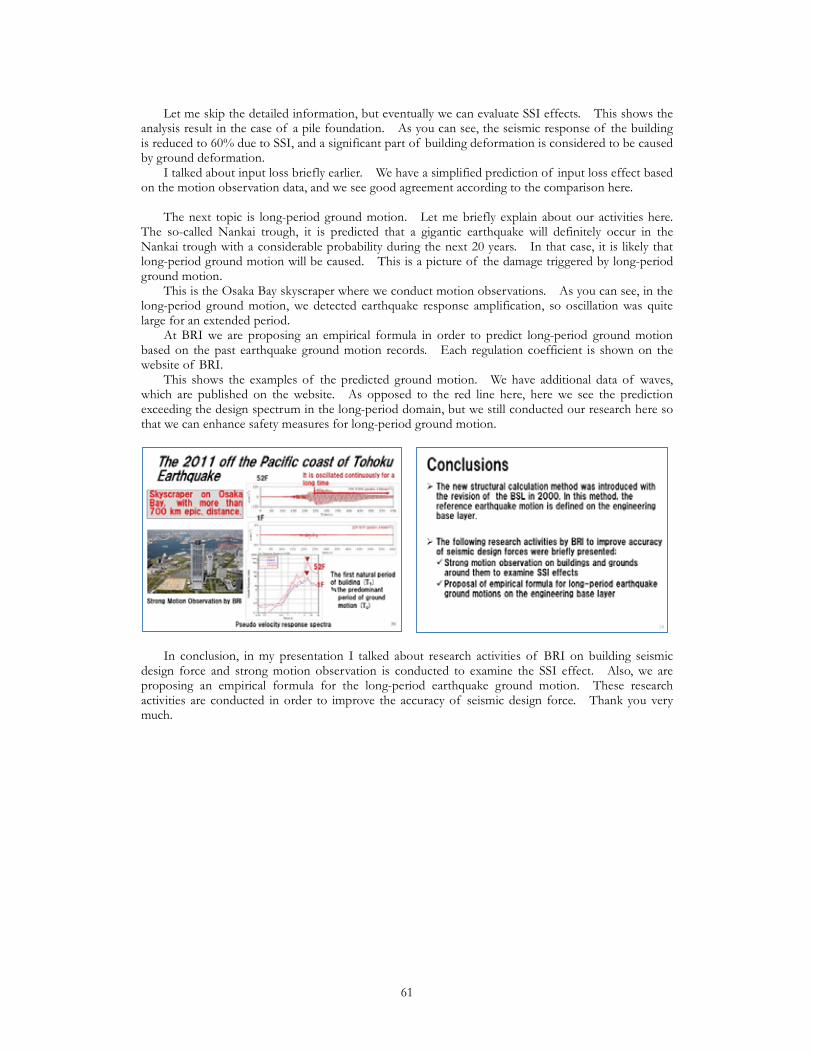
Let me skip the detailed information, but eventually we can evaluate SSI effects. This shows the analysis result in the case of a pile foundation. As you can see, the seismic response of the building is reduced to 60% due to SSI, and a significant part of building deformation is considered to be caused by ground deformation. I talked about input loss briefly earlier. We have a simplified prediction of input loss effect based on the motion observation data, and we see good agreement according to the comparison here. The next topic is long-period ground motion. Let me briefly explain about our activities here. The so-called Nankai trough, it is predicted that a gigantic earthquake will definitely occur in the Nankai trough with a considerable probability during the next 20 years. In that case, it is likely that long-period ground motion will be caused. This is a picture of the damage triggered by long-period ground motion. This is the Osaka Bay skyscraper where we conduct motion observations. As you can see, in the long-period ground motion, we detected earthquake response amplification, so oscillation was quite large for an extended period. At BRI we are proposing an empirical formula in order to predict long-period ground motion based on the past earthquake ground motion records. Each regulation coefficient is shown on the website of BRI. This shows the examples of the predicted ground motion. We have additional data of waves, which are published on the website. As opposed to the red line here, here we see the prediction exceeding the design spectrum in the long-period domain, but we still conducted our research here so that we can enhance safety measures for long-period ground motion.
In conclusion, in my presentation I talked about research activities of BRI on building seismic design force and strong motion observation is conducted to examine the SSI effect. Also, we are proposing an empirical formula for the long-period earthquake ground motion. These research activities are conducted in order to improve the accuracy of seismic design force. Thank you very much.
61
(Huang) If there are any questions for the afternoon presentations, please feel free to pose them. Thank you very much for your participation in today’s international workshop between UNESCO, IPRED, and GRIPS. For the closing remarks, we would like to invite UNESCO division Earth Sciences and Geo-Hazards Risk Reduction, Mr. Jair Torres, for today’s closing remarks. Summary and Closing (Jair Torres: UNESCO) Good afternoon. Thank you everybody for coming here. I guess it was a very productive meeting. We did not see any kind of questions, so everything was clear for everybody. We are very happy for this. I would like to start these final remarks thanking our local partners BRI, IISEE, MLIT, JICA, and of course GRIPS for hosting this very interesting meeting that I hope has been of your major interest. UNESCO has been working for many years in disaster risk reduction activities, and part of the activities that UNESCO has been promoting in in relation with the reduction of earthquake disasters. In this sense, I would like to thank all of the international participants that have come from different parts of the world to come here to share their experience and knowledge on how to improve disaster risk reductions through a better understanding of engineering aspects, but not only in the engineering aspects, but also in the non-engineering aspects of their building construction in their own countries. Thank you for this sharing of knowledge. We have seen that it is very important to talk not only about our science knowledge and understanding about engineering, but also about how our societies have been growing and have been building their own human settlements. Now we are talking and we could see it this morning with the keynote speech of Professor Ishiyama about the non-engineering constructions and the need to try to find ways to retrofit these houses, these kinds of constructions, but also about the importance of transmitting the knowledge to our local communities in a language that they can understand what is important for us and that we can really reduce the risk. We have realized in the last 30 years that we have to start working together different areas of science and different areas of social society in order to better communicate together. 30 years ago we were working earthquake engineers in one part, seismologists in one part, geologists in another part, social scientists in another part, and we can call it atomization of specialties was generating difficulties in order to better understand the needs of our societies. Now part of the last 10 years of the Hyogo Framework for Action and the base of what will come after the Sendai meeting will be the necessity to work together the different disciplines and the different specialties in order to propose another way of reducing the risk. This is why UNESCO is very much interested in reducing risk activities. It is part of our mandate. We have been working on education, science, and culture in order to have interactions between these three important issues of society for better understanding and promoting disaster risk reduction activities. With these final remarks, I would like to thank you all for taking the time to come here to see and to listen to these very interesting presentations and for being interested in contributing with your knowledge, with your research, and your very clever new ideas about making a safer world for everybody. Thank you for being here and I hope to see you all in the coming months and years. (Huang) Thank you very much, Mr. Torres. We would like to conclude the Tokyo international workshop ‘Earthquake Disaster Management in the World: IPRED activities’.
62

Draft Report
63
UNESCO International Platform for Reducing Earthquake Disasters (IPRED) 2015 Tokyo Workshop Report Earthquake Disaster Management in the World IPRED Activities –
January 2016 National Graduate Institute for Policy Studies (GRIPS) Building Research Institute (BRI)
64