Central inteligencia Ambiental Mexicali, Reunión regional en Mexicali
Upload
mente-cuanticaCategory
view
2.720download
0
MEXICALI MEXICALI 7.2 EARTHQUAKE7.2 EARTHQUAKE
SUNDAY, APRIL 4, 2010SUNDAY, APRIL 4, 2010

MEXICALI BAJA CALIFORNIA, MEXICO
7.2 EARTHQUAKE1 min. 29 secs.
SUNDAY, APRIL 4, 2010
A RECAP OF WHAT REALLY HAPPENED
Prepared by Jaime Leal-Anaya

EARTHQUAKE DATA• MAGNITUDE: 7.2 Richter Scale• LENGTH: 89 secs• DATE: Sunday, April 4, 2010. (more than 4,000 aftershocks, 2-5 Richter)• TIME: 15:40:41 hrs• EPICENTER: 31.128 N, 115.303 W• DEPTH: 6.21 miles (10 km)• LOCATION: 37 miles from Mexicali, 38 miles from San Luis, Río Colorado,
103 miles from Tijuana/San Diego, CA. • DEATH: 2• WOUNDED: 254• POEPLE WHO LOST THEIR HOMES: 35,000
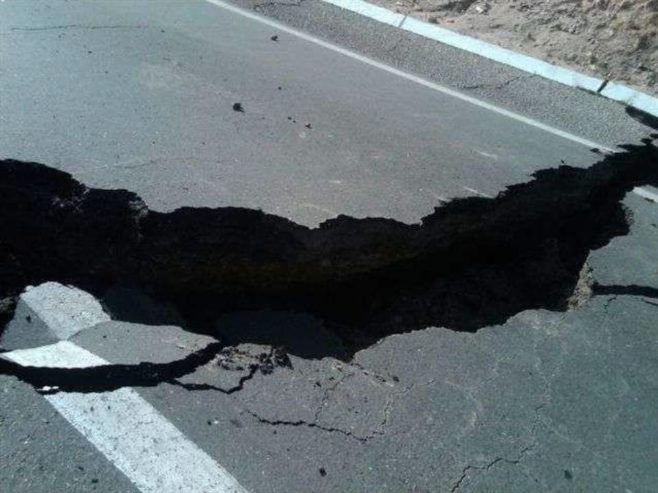
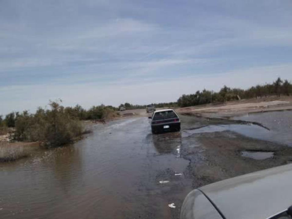
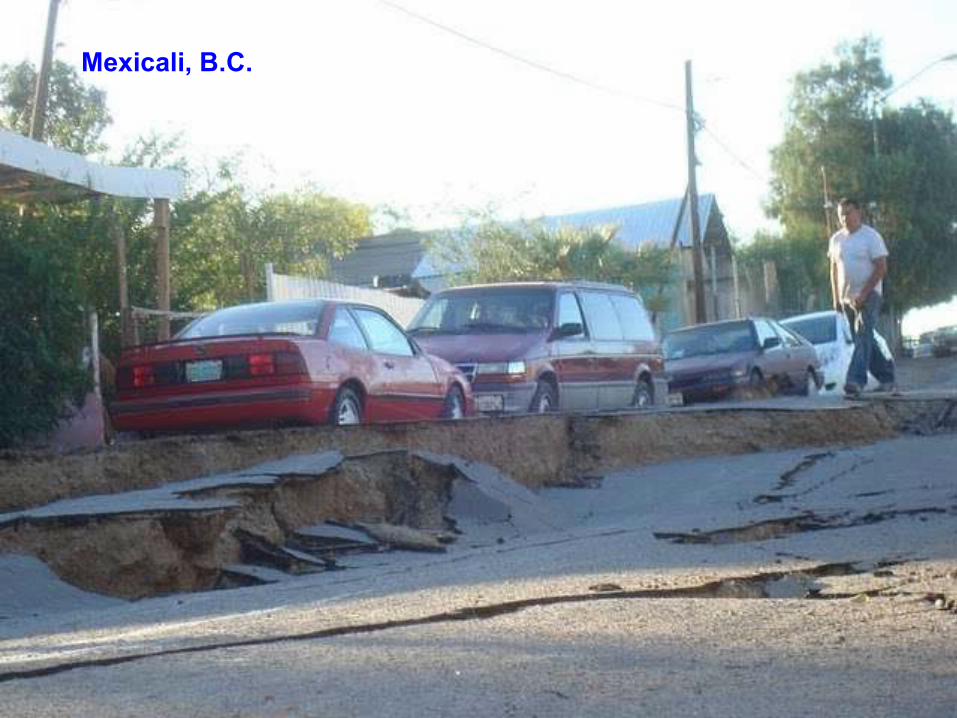
• ROADS DAMAGED: 100 miles, mainly in the agricultural area. El Faro-Kilómetro 57 Rd. was completely destroyed. Several bridges collapsed and roads cracked open and sunk.
• FLOODS: 60,000 Hectares (1 Hectare = 2.47 Acres) of agricultural land flooded with the collapse of the watering concrete channel systems for agriculture. 60 communities flooded as well.
• GEYSERS: New geisers appeared in people’s yards all over the valley issuing forth large amounts of Sulfur smelling underground water.

925 Arftershocks the first two days after the quake925 Arftershocks the first two days after the quake


To date, there have been well more than 4,000 well more than 4,000 earthquakesearthquakes associated with the Sierra El Mayor
[Mexicali] earthquake. Post-processing analysis will likely reveal many more smaller events (<M3.0) that were not
triggered, or that may be within triggers of larger events. The relocations for foreshocks, aftershocks, and
the mainshock are shown below.
The map above is the latest showing the Hauksson-Shearer relocations. A cluster of events are trending at the north end of the sequence, on the US side of the US-Mexico border. A
M3.8 event occurred here on April 7th, 2010. Click on the map for larger version.
http://www.scsn.org/2010sierraelmayor.html
SCSN Update - Wednesday, April 14th, 2010 10:12AM

Field Report Update - Wenesday, April 6th, 2010 10:30AMJohn Fletcher, Prof. CICESE, Tom Rockwell Prof. SDSU, Javier Gonzalez-Garcia, Scientist, CICESE, Ken Hudnut, Scientist, USGS Anthony Guarino, Seismic Analyst, Caltech Seismological LabThe magnitude 7.2 Sierra El Mayor earthquake caused extensive surface rupture on a 28 km portion of the Borrego fault in northern Baja California Norte, Mexico. The approximate endpoints of the rupture are as follows; the southeast end is located at 32° 25.6'N; -115° 34.3'W. The rupture continues on a N36°W orientation to the northwest end, located at 32°37.1'N; -115°44.6'W. At the northwest end of the fault rupture on the Borrego fault, many splay faults wrap northward along the west side of El Centinela mountain.

There was ~20-40 centimeters of slip on the Pescadores fault along this short section (see photo below). This location was observed only during air reconnaissance, and more field work will be required, despite difficult vehicle access to this remote area. Initial interpretation of today's observations is that the rupture process likely began on Pescadores fault, which is aligned N40°W from the epicenter. Possibly rupture proceeded from the epicenter for 18 km to the northwest along the Pesdadores fault. Based on seismological source-time function studies, we think there may then have been pause, possibly 6-12 secs, and then triggering of a much larger rupture along the Borrego fault after rupture had slowed and then skipped over to the Borrego fault. Extensive liquefaction-related features were observed along canal levees, which also experienced widespread shattering along the levee crests. Other phenomena were also observed or reported, such as minor flooding, ground failure/cracking (not related to tectonic faulting), and sand blows.


The Cucapah Mountains (next to the Centinela, Laguna Salada, and Mexicali) shaking the sand off seconds after the earthquake!


Mexicali-Tijuana Road, near El Centinela and Cucapah Mountains

Mexicali-Tijuana Road, near El Centinela and Cucapah Mountains


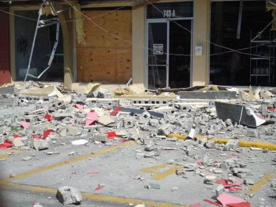
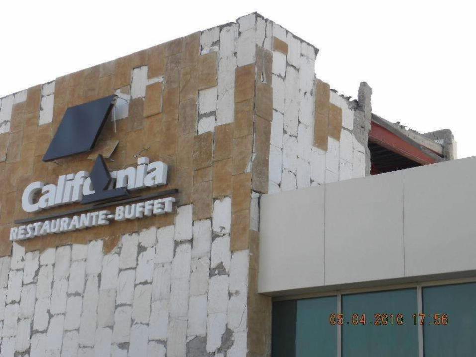
PLAZA FIESTA MALL, MEXICALI, B.C.


Vista Hermosa, Mexicali, B.C.

It’s a miracle there were only two people reported dead from the earthquake!

Downtown, Mexicali, B.C.


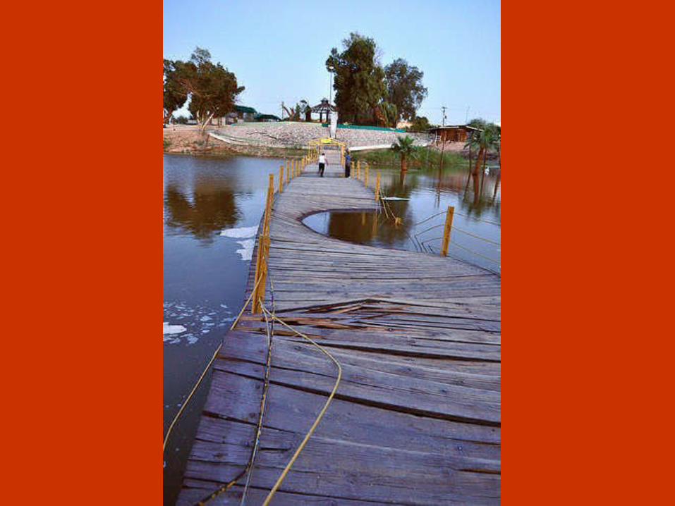
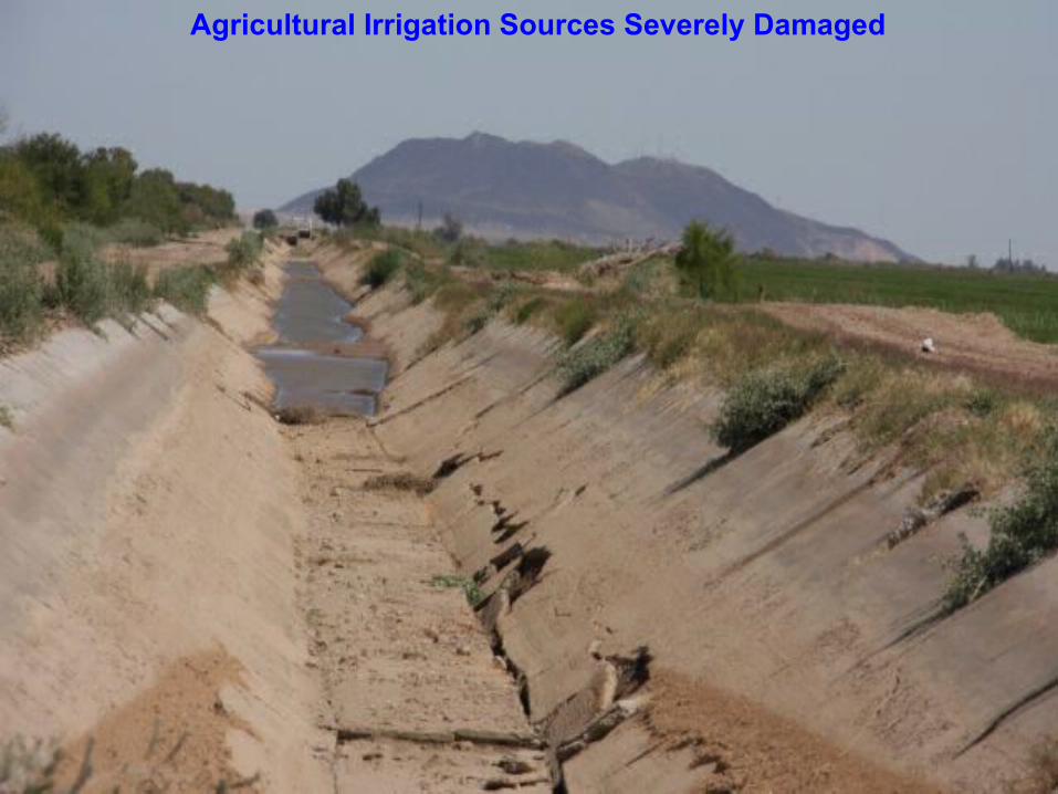
Agricultural Irrigation Sources Severely Damaged

The Water for Agriculture has Vanished,As well as the livelihoods and sustenance of millions of people

There is no information yet as to how long it will take to repair it

Near the source of the agricultural water system, the flood reached 5 ft. In the community when it broke apart


Mexicali, B.C.

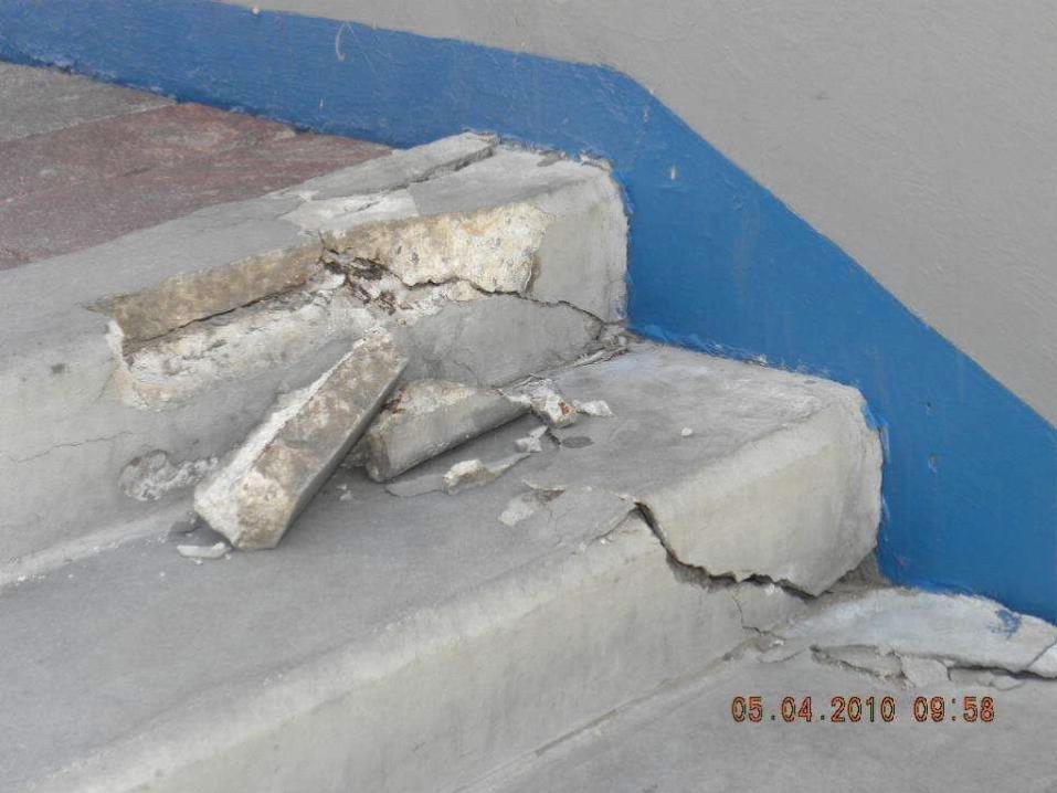
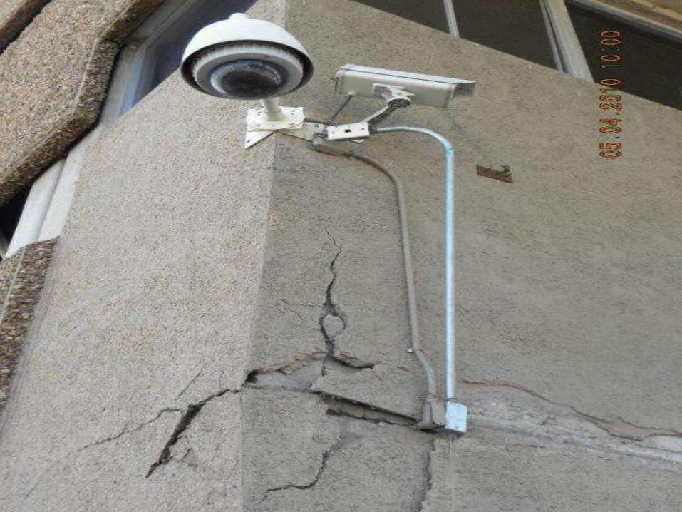
Earth Displacement, Mexicali, B.C.Something never before seen in this seismic region

100 miles of damaged and impassable roads in the region


Caída de postes


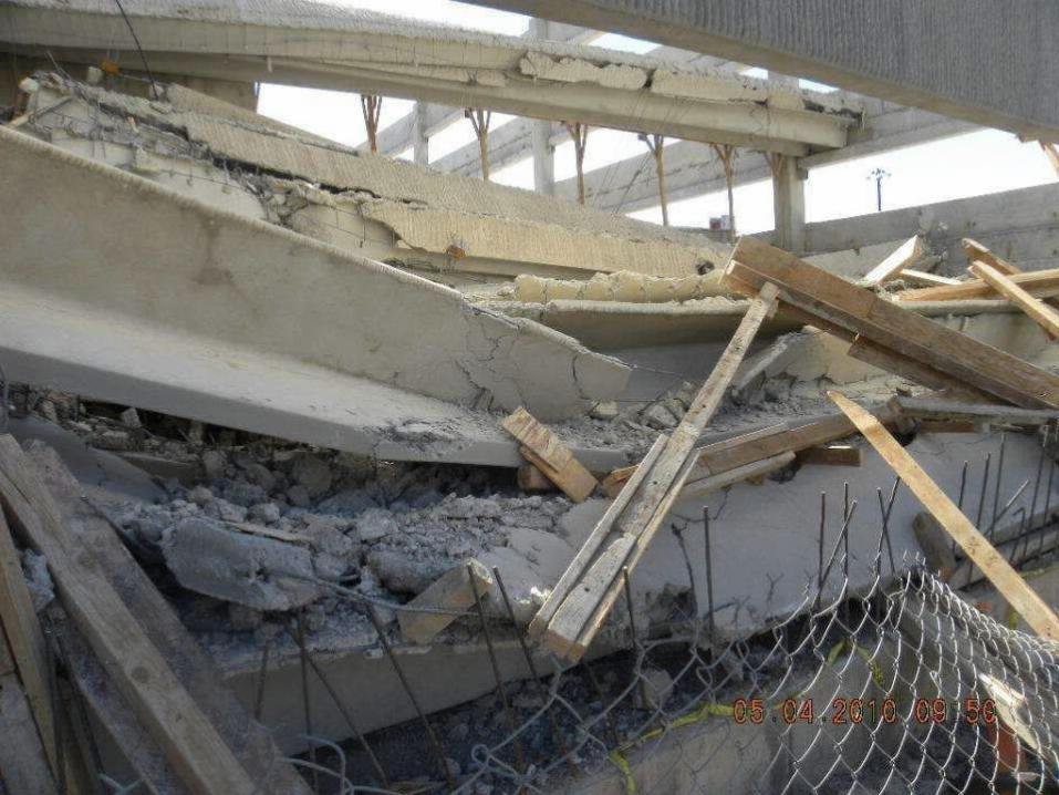
Parking Lot Building Collapsed During EarthquakeGovernment District, Mexicali, B.C.

A BIT MORE THAN A FEW OBJECTS FALLING OFF PEOPLE’S SHELVES AS THE NEWS REPORTS CLAIMED
WAS ALL THAT HAPPENED

GOVERNMENT BUILDING, MEXICALI, B.C.


FOR SOME REASON, THE MEDIA IS NOT COVERING THE THOUSANDS WHO ARE NOW HOMELESS
IN THE AGRICULTURAL AREA OF THE MEXICALI VALLEY


35,000 people who lost their homes are now living in tents and make-shift homes . . . even cars!


Lilian Tapia, RSE Coordinator in LA, California, and a group of friends with Ricardo "El Mandril" from the L.A. Radio Station 97.7 "La Raza, collected and distributeddonations of food and water and basic needs to the most affected and the poor.
Lilian Tapia

The Mexican Army helped unload and distribute the goods


The children still play and smile unaware on the streets but their elders wonder what will be of their futurenow that their homes, their crops and life’s-work is
broken in pieces and the water is polluted.

Reports are now coming through in the media on the contamination of the water in the large agricultural area of Mexicali
and the excessive amounts of salts, minerals, and contaminants in the water coming from beneath the ground to the surface at random places.
Not only are the present crops and the livelihood and fortune of thousands of people lost, but they are calling for at least a full year before the water
goes back to its normal state to allow agriculture in the region.
The local newspaper La Cronica recently repoted the results of the laboratory analysis of the water carried out by the farmers themselves
which confirm the facts:http://www.lacronica.com/EdicionEnLinea/Notas/Noticias/02052010/444796.aspx
There is much more coming to the surface from independent sources who want to know the truth.
Government officials insist on glossing over this crisis, and the real significance and implications of this situation have been absent from most
of the media to-date. No one seems to be asking whether what is happening in Mexicali is also part of a larger picture that includes the rest
of the Californias on both sides of the border.

We would like to thank Emiliano Castro Vizcarra
For the excellent video report he created and his call for help.See his video clip: (original in Spanish)
“Entre Grietas”http://www.youtube.com/watch?v=-5-mOxHKES8
Or with English subtitles here:“Between the Cracks”
http://www.dailymotion.com/video/xd3dmv_between-the-cracks_news?subtitle=en(select the icon for CC o the top of the screen, and choose subtitles)
(Soon it will be available in English in YouTube as well)
Do not miss it! And thank you for your support

We would also like to thank Lilian Tapia and her friends from L.A. Radio 97.7 “La Raza”
for their support with the information in this slide show and the help they have brought to the people of Mexicali,
also my brother Eduardo Leal-Anaya for his firsthand reports and photos of the situation on the ground,
as well as everyone else who sent me their personal photographs, reports, and updates.
IF YOU WOULD LIKE TO HELP:Contact Lilian Tapia for details:Phone in USA: (323) 806-2661
Lilian is working together with the “Institute for Women” in Mexicali, (Instituto de la Mujer) to bring help directly to those
in greatest need in the Mexicali Valley.