Earthqu2ke Prediction and Hazard Mitigation- Options for ...
120
Earthqu2ke Prediction and Hazard Mitigation-- Options for USGS and NSF Programs September 15, 1976
Transcript of Earthqu2ke Prediction and Hazard Mitigation- Options for ...

Earthqu2ke Prediction and Hazard Mitigation-
Options for USGS and NSF Programs
September 15, 1976


NOT ICE
THIS DOCUMENT HAS BEEN REPRODUCED FRO.M THE
BEST COpy FURNISHED US BY THE SPONSORING
AGENCY,'J~LTHOUGH IT IS RECOGNIZED THAT CER
TAIN PORTIONS ARE ILLEGIBLE, IT IS BEING RE
LEASED IN THE INTEREST OF MAKING AVAILABLE
AS MUCH INFORMATION AS POSSIBLEo


4. Title and SU:btitle"Earthquake Prediction and Hazard Mitigation--Options for USGSand NSF Programs"
BIBLIOGRAPHIC DATASHEET
12
•
5. Report Date (Prepara-Sept 15, 1976 tion DatE6.
7. Author(s) Advlsory Gp on Earthquake PredlctlOn & Hazard Mltlgation and USGS/NSF Staff Planning Group
9. Performing Organization Name and Address Same as No.7, above. Care of:National Science FoundationOADjSTIA, Room 12251800 G Street, N.W.Washington, D.C. 20550
12. Sponsoring Organization Name and Address
Science Adviser to the PresidentExecutive Office of the PresidentWashington, D.C. 20500
8. Performing Organization Rept.No.
10. Project/Task/Work Unit No.
11. Contract/Grant No.
13. Type of Report & PeriodCovered
Final Report14.
15. Supplementary NotesThe Advisory Group was appointed by the Science Adviser to the President for the purposeof preparing this report.16. Abstracts
This document constitutes a plan based upon staff working papers, two Advisory Gpmeetings (June and August 1976), input fr Advis Gp members and subpanels, and comments,suggestions and criticism received from others. Contents include 4 chapters: (I) Introduction, including list of Advis Gp members; (II) Brief assessment of available-5ocial,political, economic measures for mitigating impacts of earthquakes and the current stateof the technological basis for these measures; (III) Discussion of current earthquakeresearch efforts and options for future augmentation of earthquake research, includingactivities, funding levels, technical milestones, and public benefits; (IV) Discussionof the efforts and options for improving utilization of research results and coordination mechanisms. The document builds upon numerous studies of the earthquake problemand analyses of strategies for response to it that have already been made. Some of themost significant of these are listed in Appendix I.
17. Key Words and Document Analysis.
EarthquakesEarth movementsGeological faultsSeismic epicenterSeismic wavesSeismologyShock wavesSoil dynamicsTsunamisEarthquake warning systems17b~ Identifiers/Open-Ended Terms
17c. COSATI Field/Group
170. Descriptors
Seismic arraysSeismic detectionSeismological stationsSeismic investigationSeismic prospectingSeismic reflectionSeismic refractionSeismic surveysSeismographs
SeismometersHazardsSafety devicesSafety engineeringSafety warning systems
18. Avail~bility Statement
Release Unlimited.
'M NTIS-35 (REV. 10-73) ENDORSED BY ANSI AND UNESCO. F
19.. Security Class (ThisReport)
UNCLASSIFIED2U. Security Class (This
PageUNCLASSIFIED
THIS FOR\! \lAY BE REPRODLCED
21. -No. of Pages
-
USCOMM-DC 8265- P 74


PREFACE
At the request of the Science Adviser to the President thisplan presents options for augmenting the earthquake related researchprograms of the Department of Interior/U.S. Geological Survey (USGS)and the National Science Foundation (NSF). It was prepared by anexternal Advisory Group on Earthquake Prediction and Hazard Mitigationand a special staff planning group from USGS and NSF.
In focusing on the programs of these two agencies we would beremiss in not pointing out the importance of related activities ofother agencies wllich we assume will continue and be strengthened.We have sought their comments on this plan and received valuableinputs from them. These other Departments and Agencies include the:
Department of InteriorBureau of Reclamation
Department of Housing and Urban DevelopmentFederal Disaster Assistance AdministrationFederal Insurance Administration
Department of CommerceNational Oceanic and Atmospheric AdministrationNational Bureau of Standards
Department of DefenseAdvanced Research Projects AgencyDefense Civil Preparedness AdministrationCorps of Engineers
Department of Transportat:ionFederal Highway Admini:3tration
General Services Administ:rationFederal Preparedness Agency
National Aeronautics and Space Administration
Energy Research and Development Administration
Veterans Administration
Nuclear Regulatory Commission
/I


Table of Contents
Page
10 Introduction ----------~------------~------------------------ 1
II, Measures for Mitigating Earthquake Effects ------------------ 17
A. Possible Mitigation Measures - What can we do? --.-------- 17
B, Current Mitigation Practices - What are we doing? ------- 19
C, Dependence of Mitigation Measures on TechnologicalInformation - What might we do better? ------------------ 23
D. Status of Technological Information Required forMitigation - What do we know? ------------------~-------- 24
III. Program Options ---------------------,---------------~--------32
Ao Program Objectives ",-------------,------------------------ 32
B, Program Elements ----------------,---------------~--------33
1. Fundamental Earthquake Studies --------------,-------- 37
2. Prediction ----~-------------------------------------48
3. Induced Seismicity ---------------------------------- 61
4. Hazards Assessment ---------------------------------- 67
5. Engineering ----------------------------------------- 75
6. Research for Utilization ---------------------------- 91
IV. Utilization of Program Results ------------------------------105
References -------~------------------------------------------------108
Appendix 1 ------~---------~--------------.---------------------109


I. Introduction
Ao The Nature of the Earthquake Problem
The popular conception of earthquake hazard in the United States
limits it to the Pacific Coast~ especially California, and to such well-
known earthquake disasters as the ones at San Francisco in 1906, Long
Jeach in 1933~ southern Alaska in 1964, and San Fernando in 1971. But
major earthquakes are by no means unknown to the rest of the country.
Earthquakes occurred in the St. Lawrence River region on several occa-
sions from 1650 to 1928, in the vicinity of Boston in 1755, in the Central
Mississippi Valley at New Madrid, Missouri in 1811 and 1812, in Charleston,
South Carolina in 1886, and at Hebgen Lake, Montana in 1959. Known
damaging earthquakes in the United States through 1970 are shown in Figure 1.
Because of the extensive development in this century, recurrence
of a great earthquake would result in much greater damage and loss.
lU10ther catastrophic San Francisco earthquake, for example, could cause
losses in the tens of billions of dollars. Clearly, earthquakes now pose
an increasingly costly threat to the local and national community.
What is more, earthquakes~afTecthuman beings and the::i..iactiv:fties
over widely spread areas. The San Franciseo quake was felt over a
400,000 square mile area; the quakes at Charleston. New Madrid, and along
the St. Lawrence were felt over an area of 2 million square miles. And
in 1973, earthquakes were felt in 34 states. This last figure may be a
better index of the extent of earthquake hazard in the United States.
A recent study suggests that all or portions of 39 states lie in regions
of major and moderate risk -- with a combined population in 1970 of
more than 70 million persons. Current construction investments are
estimated at approximately $150 billion per year of which about $50 billion

per year is for construction located in high and modera'te sei.sm:Lc regions
of the cou:ntry~ and this cumulative inV!28tme'1t niS:~c1s protc~ction.
Fortunately. a damaging earthquake at a
rare event in this country. Aad perhaps that is
s::U:e is a relatively
the average annual
loss from earthquakes is relatively low. Du::r.ing the past century, it
has amounted to about $30 nd.Ilion per year. Hm'J8Ver, h::Lstorical data
can be misleading. The oi dense populations in seismically
hazardous regions, for example? is a relatively recent phenomenon in the
United States. If such development continues est:lmates of the average
loss for the rest of this century }:·e.sult:ing from. earthquakes could exceed
$1 billion per year
Earthquakes
listed in Table I. The
tn substantia-I property da-mage since 1860 are
figures for these events are given in
teLlnS of then-current dollars and do not represent present inflated
values. Deaths from U,So earthquakes are shotqn in Table 2. It should
be noted that property damage and loss of life are only two aspects of
loss due to earthquakesD Other losses include injuries 9 economic loss
due to casualties, loss of income due to business disruption, cost of
emergency operations, and so Oil, There is little available data on the
extent of these indirect costs of earthquakes 0 They most certainly
exceed the direct costs.
2

Losses from earthquakes are not limited to the direct effects of
faulting and shaking. l~e seismic seawaves, or tsunamis, often associated
with large submarine or coastal zone earthquakes can cause great damage
by inundation and wave impact on shorelines thousands of miles from
their source. as well as on shorelines near the epicenter of the earth
quake that produces them. For example, Hila, Hawaii suffered extensive
damage from a tsunami generated off the Chilean coast in 1960. Table 3
lists damage and loss of life from tsunamis affecting the United States.
Zones of earthquake vulnerability are shown in a general way by
seismic risk maps (Figure 2, conterminous United States; Figures 3 and
L,<. Alaska and Hawaii) 0 Risk zone levels. ranging from 0 (no damage) to
3 (major damage), are defined in the legend of Figure 2. The distribu
tion of population and states by risk zone is summarized in Table 4.
Several events of the past year or so have brought renewed attention
to the threat of earthquakes. On February 1975 a major earthquake of
magnitude 7.3 destroyed the town of Haichellg in the Peoples Republic of
China and damaged industrial plants. Chinese scientists actually predicted
this earthquake. The population was removed from hazardous buildings and
only a few were killed even though 1 million people live in the area.
According to recent reports Chinese scienti.sts successfully predicted
earthquakes in May 1976 (Yunnan Province)c;.nd August 1976 (Szechwan
Province) and endangered people were evacuated from hazardous structures.
3

The Chinese~ however, did not predict accurately what may be one of the worst
earthquakes in this century. that struck the Tangshan-Tientsin region of north
China on July 27. 19760 Other disastrous earthquakes have struck Guatemala.
Italy. Western New Guinea, Bali and ~lindanao in the Philippine Islands in 19760
This year will be recorded as possibly the worst, and certainly one of
the worst, years in this century for deaths due to earthquakes 0
In the Los Angeles area. Geological Survey scientists reported an
uplift of the earth's crust along a section of the San Andreas Fault that
has been relatively quiet since a great earthquake in 18570 This uplift
is not necessarily an earthquake precursor, since such uplifts are not
always followed by a major earthquake, but it is cause for concern.
While there are understandable disagreements as to priorities
within Federal earthquake research efforts 9 there is no disagreement
regarding the probability of a very high payoff of a well-plap~ed
research program. There is now an overwhelming CODcensus among workers
in earthquake-related research (e,g., seismologists. geologists. engin
eers. social scientists) that we are ready to make substantial progress
4
toward relieving the threat from earthquakeB. In addition~ there is
general agreement that we have adequate pro:Eessional and technical per
sormel to undertake additional efforts should greater funding levels be
made available.
wnile both public and private decisionG and resource commitments
are difficult in problem areas such as earthquakes because while they
can be catastrophic they have a relatively :Low probability of occurring
in a specific 10caU.on over short periods of time 9 it is important to
recognize that~
a. Decisions are being made continuously regarding the location
and design of earthquake-sensitive facilities that require judg
ments about seismic hazards and knowledge that are not adequately
available; and 9
b. government and private groups spend a great deal of money on
relief of earthquake disasters; therefore; it is in our national
interest to seek effective ways to mitigate these disasters.
Bo Some Recent Actions
Early last "'inter, these items and recEmt earthquakes :1..n other parts
of the world were brought to the attention of the President by several
means. The Presidential science advisory committees known as the Baker
Ramo Committees. then examining new opportunities in science, determined
that the area of earthquake hazard reduction might be an area where in
creased research could be especially beneficial. Discussion of this
5

subject among officials of the Executive Bra.nch ~ilas being undertaken at
about the time that extensive land uplift in southern California centered
on Palmdale was first reportedo In response to this situation 9 it was
decided to reprogram 206 million dollars in research funds of the USGS
and NSF, of which 201 million dollars is to monitor the uplift and 005
million is to partially restore reductions in the USGS earthquake hazard
reduction program 0 ~fuether this uplift is a premonitor of an earthquake
is as yet unclear. The research to be undertaken by the Geological Survey
and non-government resear~h organizations is intended to help determine
whether this is indeed the case. and to evaluate the potential hazardo
The growing prospects for earthquake prediction~ based in part em
the still tentative experience of the Chinese, Japanese, and the Soviets
suggest that in coming decades we may have a capability to predict earth
quakes in the United Stateso The achievement of prediction will depend
largely on the capability and capacity of our scientists to observe
and interpret premonitory effectso It should be noted~ however, that
local communities and State governments need to m~ke changes in their
land use and building codes to reduce earthquake vulnerability if the
goal of a significant capability to predict the location, time and magnitude
of earthquakes is to result in reduction in property damage and life loss.
6

Damaged. or collapsing structures are tOne source of most life loss
and injury during an earthquake; therefore, nearly all impacts of an
earthquake ultimately revolve around damage to structures. Although
the Federal Government has been funding most research on earthquake
pl:ediction and ha2:ard mitigation s the prind.pal responsibility for
applying this knowledge to th~ reduction of damage to build;ings rests
with State and local government: and private individuals. Thus, the
actual limitation of the impact of earthqu~te prediction and mitigation
research lies in non~Federal hands.
As noted above, the reprogramming of funds from the NSF and the
USGS to undertake a $2.6 million research activity will help us under-
stand the Palmdale uplift as a possible premonitory effect of a major
southern California earthquakeo In addition, NSF and USGS were asked by
the Science Adviser to jointly prepare a plan to outline the research
which would be necessary to provide the technological base for making
predictions, changing building codes, and restructuring land use. An
outside Advisory Group on Earthquake Prediction and Hazard 11itigation
to assist in this effort was established.
A list of the members of the Science Adviser's Advisory Group on
Earthquake Prediction and Hazard Mitigation follows:
Dr. Nathan NEWMARK (Chairman)Professor, Dept. of Civil EngineeringUniversity of Illinois
Dr. Shelton ALEXANDERProfessor. Dept. of Geology & GeophysicsPennsylvania State University
7
D1:. Clarence ALLENProfessor~ Divo of Geological &
Planetary SciencesCalifornia Institute of Technology
Dr:. John A. BLUMEPresident 0 DRS!JA Blume & AssociatesScm Francisco. California
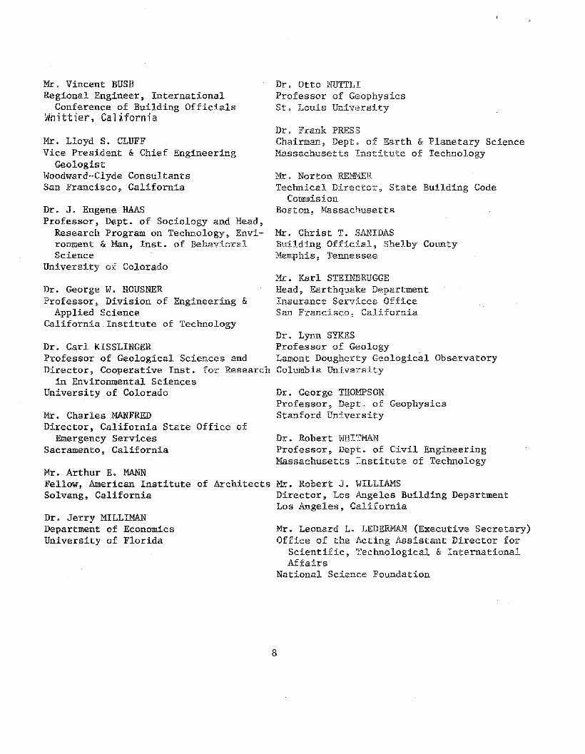
Mr. Vincent BUSHRegional Engineer, International
Conference of Building OfficialsWhittier, California
Mr. Lloyd S. CLUFFVice President & Chief Engineering
GeologistWoodward-Clyde ConsultantsSan Francisco, California
Dr. J. Eugene HAASProfessor, Dept. of Sociology and Head,
Research Program on Technology, Environment & Man, lnst. of BehavioralScience
University of Colorado
Dr. George W. HOUSNERProfessor, Division of Engineering &
Applied ScienceCalifornia Institute of Technology
Dr. Carl KlSSLINGERProfessor of Geological Sciences andDirector, Cooperative Inst. for Research
in Environmental SciencesUniversity of Colorado
Mr. Charles MANFREDDirector, California State Office of
Emergency ServicesSacramento, California
Dr. Otto NUTTLIProfessor of GeophysicsSt. Louis University
Dr. Frank PRESSChairman, Dept. of Earth & Planetary ScienceMassachusetts Institute of Technology
Mr. Norton REM11ERTechnical Director, State Building Code
CommisionBoston, Massachusetts
Mr. Christ T. SANIDASBuilding Official, Shelby CountyMemphis, Tennessee
Mr. Karl STElNBRUGGEHead, Earthquake DepartmentInsurance Services OfficeSan Francisco, California
Dr. Lynn SYKESProfessor of GeologyLamont Dougherty Geological ObservatoryColumbia University
Dr. George THOMPSONProfessor, Dept. of GeophysicsStanford University
Dr. Robert WHITMANProfessor, Dept. of Civil EngineeringMassachusetts Institute of Technology
Mr. Arthur E. MANNFellow, American Institute of Architects K~. Robert J. WILLIAMSSolvang, California Director, Los Angeles Building Department
Los Angeles, CaliforniaDr. Jerry MILLIMANDepartment of EconomicsUniversity of Florida
Mr. Leonard L. LEDERMAN (Executive Secretary)Office of the Acting Assistant Director for
Scientific~ Technological & InternationalAffairs
National Science Foundation
8

Co The Contents of This Plan
This document constitutes a plan based upon staff working papers, the
Advisory Group meetings of June 14, 1976 and August 12-13, 1976, inputs
from Advisory Group members and subpanels, and comments, suggestions, and
criticism received from otherso
The contents of the remaining chapters of this draft plan are as follows:
Chapter II ~ A brief assessment of the available social, political,
and economic measures for mitigating the impacts of
earthquakes and the current state of the technological
basis for these measuresu
Chapter III - A discussion of current earthquake research efforts and
options for future augmerltation of earthquake research -
including activities, fUIlding levels, technical milestones,
and public benefits.
Chapter IV - A discussion of the efforts and options for improving
utilization of research results and coordination
mechanisms 0
This document builds upon the numerous studies of the earthquake
problem and analyses of strategies for response to it that have already
been made. Some of the most significant of these are listed in Appendix 1.
9

~('O ... ,l Qcun,c ,nd ArlT\O~,,"t"C Adm,msl"hCtl[lw,ronmenl.1 OIl. ~.w,ce
Rt1'woIt1970Ed,t,on
LEG;JiQ
• lnte-nsity VII·VIII
• Inten!'iit):VUJ-IX
@ Intensitj'IX·X
~ Intensity X·XII
109'11$'I""
..""-~CO..
1!====!!!""b==~k=-=='~=~~~~-'~-~-=~!;:=~"dJkl\~====:dL_"" --..- ~__~ =-__-'-__".
If=========!J ..
Figure 1. Intensity and location of known damaging earthquakes inthe United States throuqh 1970.
10

Table 1 - Property Damage in Major U.S. Earthquakes in Millions of
Dollars (Actual) ~ 1865-1975*
DamageYear locali~ ($M)
1865 San Fr<mcisco. Calif. .51868 San Francisco, Calif. .41872 Owens Valley, Calif. .31886 Ch<\rleston, S.C. 23.01892 Vacaville, Calif. .21898 Mare Island, Calif. 1.41906 San Francisco, Calif. 524.0
1915 Imperial Valley, Calif. .91918 Puerto Rico (tsunami damage from 4.0
earthquake in Mona Pas3a9_e!1918 San Jacinto and Hemet, Ca 1if, .21925 Santa Barbara, Calif. 8.01933 Long Beach, Calif. 40.01935 Helena, Mont. 4.01940 Imperial Valley, Calif. 6.01941 Santa Barbara, Calif. .11941 Torrance-Gardena, Calif. 1.01944 Cornwall, Canada-Massena, N.Y. 2.01946 Hawaii (tsunami damage from f1arthquake 25.0
in Aleutians)1949 Puget Sound, Wash. 25.01949 Terminal Island, Calif. (oil wellu onlyl 9.01951 Terminal Island, Calif. (oil well!: only) 3.01952 Kern County, Calif. 60.01954 Eureka-Arcata, Calif. 2.11954 Wilkes-Barre, Pa. 1.01955 Terminal Island, Calif. (oil well!; only) 3.01955 Oakland-\,iValnut Creek, Calif. 1.01957 Hawaii (tsunami damage from earthquake 3.0
in Aleutians)1957 San Francisco, Calif. 1.01959 Hebgen Lake, Mont. (damage to timber no
and roads)1960 Hawaii and U.s. West Coast (tsunami 25.5
damage from earthquake off Chile coast)W61 Terminal Island, Calif. (oil wells onlv) 4.51964 Alaska and U.S. West Coast (includes 500.0
tsunami damage from earthquake nearAnchorage)
1965 Puget Sound, Wash. 12.51966 Dulce, N. Mex. .2'/969 Santa Rosa, Calif. 6.31971 San Fernando, Calif. 553.01973 Hawaii 5.61975 Aleutian Is. 3.51975 Idaho/Utah {Pocatello Valley 1.01975 Hawaii 3.01975 Humboldt, Calif. .3'1975 Orovi 11 e, Calif. 2.5
----TOTAL 1878,0
* These damage estimates are at the time of the earthquake., They donot include the effects of 'inflation, They are not estimates of thelikely damage if a similar earthquake occurred todayQ

Table 2 - Lives Lost in Major U.S. Earthquakes, 1811-1975*
7/65
2
403027/60
f5700
Itl~ H3
249
113
New Mackid, Mo.New Madrid, Mo.San Juan Capistrano, Calif.Hayward, Calif.Owens Valley, Calif.Charleston, S.C.San Jacinto, Calif.S3" Calif.
Valley, Ca~iLPuerto Rico (tsunami i'rorn earth.
quake in Mona PassageSanta Barbara, Calif.Santa Barbara, Cam.Humboidt County, Calif.Long Becu:~h~ C(?;HtKosmo, UtahHe~ena~ Mon~~
irnperial Vi3Hey, Calif.Hawaii {tsunami from earthquake
in Aleutians!?uget Sound, WaSll.158m County, Cam'.i:::ureka-Arcata, Cam.Oaidand, Calif.Khantaak Island and lituva Bay,
I\~aska
Hebgen lakel' Mont.Hila, Hawaii (tsunami from ea~J1
CjlJiJke off Chi!e coast)Prince WWiam Sound, Alaska
(tsunamijPuget Sound, Wa&J";.San Fernando, Ca~if.
HcH'laii
Year
1925192619321933193419351940191.16
18H1812181218681872188618991906HH51913
19491952195419551958
19591960
1964
19651911
1915
* These figures are the lives lost at the time of the earthquake anddo not reflect the likely 10$s of life if a similar earthquake wereto occur today.

Table 3 - Casualties and Damage in the United States from Tsunamis*·
EstimatedYear Dead Injured Damage Area
($000)
1908 5 iiawaii
19'0 .. l),.merican SamoS)
19J~8 100 HawaiiHjqg 40 250 Puerto Rico
1922 50 t-iawaii,California,American Samot)
1923 ~ 4,000 Hawaii
1\933 200 Hawaii
1946 173 163 25,000 Hawaii,Alaska,West Coast
1952 1,200 IV! idway Island,Hawaii
HI~58 2 50 Alaska'i9~7 4,000 Hawaii,
West Coast1960 61 232 25,500 Hawaii,
West Coast,i\merican Samoa!
1964 122 200 104,000 Alaska,West Coast"Hawaii
1965 10 Alaska
1975 2,000 Hawaii
"Damage reported, but no estimates available.
** These figures are the lives lost at the time of the tsunami and donot reflect the likely loss of life if a similar earthquake andtsunami were to occur today.

3~;)
\l@>
"'W
ill"Il
l,.
I , ,
----"r--
-·~-·-'1\·-·,
.1
I
~._.
~I
,
Ir--
-'--
-1_
I~J-+
-----)
f---
----\
Il."-V--\-Z~r-(.e::
_l_
),\)~
i_~.-.
_)
\~C-l~Lc:--=:;~t1
----
i---f
.h"\
-4--
I\{
_1:J
ryrv)~~
\:
I)
'.
2r~t~"
r\9'
'1V
\I~
2{f~'
\.I
~"'\\
-.'-
nI
"r
\~
,f,
rq---r'-
!--
-~J
11"f~
__
)d
;:;-
t~_
_/
t-_
_~._._
_.;~_-.G
~A
\
--.
-I
\\
,>---.
---__
__!
.I
~~-.=c-;"l
l':2
It-
j---
----
-----
.+-
\:"
---
II-l'
'i
•'f
.\
.....
'JIi
:,
I~~o""'if'
VI'-.
.'.
i;
-'.
1.I'£'-
K''~--~
-'l'~)
'-.
\\
l'
4:M
l"-
oj
........
._'"
r~-~
-.~-
....
"'j'.
,'.
....---
____
_I
--r
I,v
©__
•__
-§[
!;J;
Mil:
i41$
[{OlJ
ilt<l.1i
'OfF
'if~~i!J1i
\j1¥~©5'
i'A!iE~"
_'.t
L'-"-h
.L'~
--':=
::'-.J~
..--
?,c~[
O-N
o<!"
'''ao;
e.I~
©.
\.li'
.".,
V.r
\2!~-~
---~-
...-_.-J,.--~_
_-_
.,_
!"J
r-JO'i~
[i"'i\:.'
;m';;;'1cl['
)'tt!J~:clr3
~~fnt:afiffi
:!y"t1rVs.ma
YC~~us-adamt
Jg€l"'
Z/
~\~,viY
,.-L'''--'
'''__$''''''
"".,,~~~\~
__"~._."'
~'\.
IIIzl
'c'C
tu'e
s""
til
IwW
l."re
rJtl
l!J
'?no
o;fl
,eal
e,Ih
~!'I
0"1
I\.\
\&.
05£
<:0
"0(/
$:O
O?'
e-5i
J'O
!WS
to",
1"i'I
$III
SS
Van
dVI
'./
\il~'
;13\\
t;1II'
wlM
M,'
Sca
"'.
,i'e
'\
[39
'
ZO'>'
d[:Ii
~Mo
di'i
ale
dariV
l8e,
c(ll'r
e'lJ(j
nd~10
"'Iw~i!y
VII
of
IllG
MS
,t0
Sl:"
'le.
\e\
.e'~
e,c<
ee,.J\-
-'·Z
ON
[3
-1';-1
a.1o.,
d"lJn"
fl~:C
ll"~,s
!x,,,d
$!(lm
le,,
,,ty
VIII
S.f\d
h"'l'
wll
ollf
1a'V
LtH
."~!I
J.\..~_
\.
,~_
-co"<
oj1
-::.
"ni
lsW
ll)p
1$~~
on
Ihe
llrnl
",n
dl~!"btJ!IC'"
of
diff
ilagl
n&ea
rth
qu
at'e
san
dih
0._
__
'-\
.M
M.·
"'le
n§lt
~s~s_iated
With
Ii'~
"arl
hQ
ua
kr."
evio
<mee
of
stm
in'e
!S.1
('J:
$nd
fOi"
l$id
ets!
'on
01m
2lIN
goot
ogic
stru
ctu
res
and
prov
once
sb1Jli~
100
0D
$!lO
C.a
ted
""t"
!Wrthqlw~e
3CliV
liy.
The
llrO
Ollo
h!fr
eque
ncy
ofoc
curr
ence
011>
1iH!
3\
dam
a€l."
3e:
arth
quak
esef
tc~ch
201"
1\2'
was
notc
onzJ
Qer
edin
assi
gnin
gra
tings
to~~'~~""~:1~=t;?~"(J:;"':"~c.,!O
\th
il\,:IartO',J~
lCJ'\.~5.
"--
-,",._
"~
'-"~
',__
.,
.~~~
~~~j~n
l~~'~_
Sem~o~
~~:L~"
".~_..
,j_
_~_~
~~~.~L
~~==.~
,,~=,~
L~,,~~
==,"L__
~l-.~__
,_,~~=~~~~_==~=~J
US
'Ii
ll"Il
lS·
100-
'O
S"00
"tis
.SO
>?s
o
8--j.
'"$,
.,.d
~
F-;qUl~e
2(Alge\l'missen~
1969
)

~ () ~!i£ ~'LJF §'O
S.:r_~n!l£ "'~[S
PACIFIC OC£AfJ
SEiSMIC ZCll\:i[ [!J].!'W
IlLIlSK&
Figure 3 - Seismic Risk Map of Alaska(Uniform Building Code~ 1973)
NA\1Ai I
OAHU ~:!~ MOLOKAI •
?~~"
cQ\~OOLAWE" n/' ~~
Figur~ 4 - Seismic Risk Map of Hawaii(Uniform Building Code. 1973)
15

Table 4 - U.S. Population vs. Earthquake Risk Zones
Risk ZoneMill ions
Population%of rota ~~
i~lJmbe\" of Sto:teskffected
o (low)
1
2
3 (high)
TOTAL
115
31
203
8 5
57 IJ ",,',i"L ~"
20 39
15 21
51 ~;
*Including the District of Columbia

110 Hea:3ures for l\1itigating Earthquake Effects
A, Possible l'Iiitigation Measures--What can ",e do?
l'Ilitigating the impact of an earthquake disaster requires social,
economic, and political actions 9 especially at State and local levels. But
the extent to which these mitigation action:3 are effective <and the cost of
these actions depends in large measure on the extent to which they are based
(}l:i factual informat:1ol.1 about the physical pl:ocesses involved. Potential
and actual earthquake disasters in other pa:cts of the world and in the U.S.
have demonstrated that reliable earthquake prediction can rcaduce casualties,
that improved design and construction pract:lces can reduce casualties and
decrease losses 9 and that soundly based rel:lef policies can reduce post~
event suffering and accelerate the return of the commul:"dty to its normal
functioning. There are five basic strategiHs that can be undertaken by
individuals, groups and government entities" as appropriate, to moderate impacts:
o Preparation <- Preparation for an earthquake includes having plans
for warning~ response and recovery. These steps reduce the
economic and social dislocations by community preparedness prior
to the event, providing relief during the emergency period, and
assisting in redevelopment and recovery.
o Land Use - By considering the regional and local variation of
seismic risk in local and State land use plans, the vulnerability
of new development can be reduced. Each of the prin.cipal sources
of earthquake damage (eogo ground shaking, fault movement, ground
failure) is affected by the type of soil and geologie properties
17

of the sites and the position of the s:l.te ';.,rith regard. to the
location of the earthquake. Effective local and Ste,te lan,a use
controls can either p)C(~vent occupation of a haZardous site" or
characterize the hazards at the site so t:hat facilit:~es can be
appropriately designed and built.
• Building Codes~ Standards and Design Practices ~ The principle
that the public has a right to control private and public property
for the minimum safety of occupants lies behind public regulation
of building. Such regulations are generally adopted as la\-18 of
local communities ~ e. go building codes" codes and standards
may be applied to new construction, and, potentially, to the correction
or elimination of hazardous old buildings. In addition~ conditions
have been adopted for the receipt of financing, eog. the Ninimum
Property Standards of FHA, or for the receipt of relie£~ e.go flood
plain zoning. Such regulations and conditions thus enable the
community to express values and establish priorities.
• Insurance and Relief ~ The economic impact can be moderated by
insurance~ loan programs 9 and public and private relief efforts.
Historically ~ the public and government 11,a'\1e responded to the
suffering of disaster victims both through the prov:tsion of
immediate economic aid and long-term economic ass:Lstance. Insur
ance provides one means to spread the economic risk of the disaster.
@ Information and Education - Through inform.ation and education,
individuals acquire the background for makirlg decisions at Federal,
18

State. local. corporate and family levels. The acceptance and
effectiveness of any mitigation measures--many of which require
an economic commitment-~will depend eritically on the public's
perception of the necessity and util:Lty of the measures~ as well
as on the reliability of the technological information upon which
they are based.
13, Current Hitigation Practices-~What are 'He doing?
Each of these TIlitigation means is now 'being utilized to some extent.
¥illny more preventive and protective actions can be taken before an emergency
to reduce the hazards of an earthquake. and plans can be prepared for
promp·i:. efficient handling of casualties and. problems afterward. Communications
systems~ such as between hospitals and police units. can be developed, serums
and medicines can be stockpiled, and alternate transportation routes can be
planned. Exercises and tests designed around earthquake scenarios can be
undertaken. So can a plan of adrrrinistrative action continuously updated
by an ever-changing group of public officials.
A great many potentially affected communities have no disaster plans.
and present levels of preparedness commonly fail to address earthquake
hazards. Long-term recovery in the public sphere is often limited to
grants and loans which end up encouraging redevelopment as vulnerable as
ever to earthquakes.
The State of California has begun to take advantage of the existing
i·J.formation on eart.hquake hazards in the development of land use regula
tion and building codesu Land use planning and control has been little
19

used as a mitigation measure outside that State. In 1971, the California
legislature adopted an amendment to the State Planning Law that requires
a "Seismic Safety Element" as a Il1.andatory part of t:h.e General Plan of
each city and county. Information about the locations of fault traces
likely to rupture during future earthquakes has been taken advantage of
in California by the passage and implementation of the Alquist~Priola
Geologic Hazard Zones Act of 1972. This act requires the State Geologist
to delineate zones along active faults in which special geologic studies
must be carried out prior to development. Implemen:i:at ion of similar
acts has not begun in other states with active faults capable of surface
rupture. Some cities and counties, in California particularlY9 have
taken advantage of information about landslides and landslide hazards
in local land use planning, but this practice is not widespread. Sub-
stantial progress has been achieved on techniques for delineating lique
faction hazard. But the data base on subsurface conditions is vastly
inadequate for land use planning, and little effort has been made to use
the existing data for planning and control. In Japan and the Soviet Union,
many cities in earthquake-prone regions are Hzoned U~ to reflect anticipated
variations in earthquake shaking--the most pervasive earthquake hazard-
based on the distribution of geologic deposits. Such work has only begun
in a very experimental way in the United States. The assessment of earth
quake hazards at specific sites is for the most part restricted to special
facilities, particularly those that pose substantial life hazards (e.g.,
20
reactors and dams) OT those that are very expensive (e.g., tall buildings).
These assessments commonly raise issues which cannot be satisfactorily
resolved because of an insufficient data base or an inadequate understand
ing of the threatening phenomena.
Building codes~~which provide the most effective check against build
ing collapse in an earthquake-~vary greatly in their incorporation of
seismic safety provisions and in practice. Further, many aspects of earth
quake-resistant design cannot be covered effectively in building codes.
These aspects must include the responsibility of the architect and engineer.
A code is of value only as long as it is followed, enforced, and maintained.
Construction practices also playa critical role. The success of the Field
Act in California in reducing damage to schools during earthquakes demon
strates the efficacy of a comprehensive program of building regulation,
design review, construction inspection, and maintenance.
Although earthquake insurance is generally available, the vast majority
of residential property owners do not take advantage of it. In California,
following the San Fernando earthquake of 1971, there was no substantial
increase in the total premiums w£itten for earthquake insurance 0 Insurance
companies have not successfully promoted earthquake insurance. Insurance
without hazard mitigation requirements would reduce incentives to employ
earthquake-resistant design and other hazard reduction procedures. The
current state of earthquake hazard mitigation information, procedures~ and
practices has to date impeded development of insurance plans.
The availability of information about earthquake hazards does not, of
itself~ insure the use of that information. However 9 where it exists and
21

the citizenry is aware and concerned, steps can and have been taken-
for example, amending land use policies and buildL~g codes to reflect
seismic and geologic conditions. But more importaJ~t9 no mitigation
measure can succeed in a pluralistic society like oar ovm without a
solid base of public understanding. To date, the dissemination of infor
mation to the public has been primarily in response to inquiries by
individuals or the press. Little or no effort has been made to educate
the public systematically about the causes and effects of earthquakes and
what they can do to moderate the impacts. As an ~~structive example-
albeit in a political environment drastically different from our own--the
earthquake hazard mitigation program in the People's Republic of China
has a strong public education component. The value of this effort can be
seen vividly in the response of the Chinese people to the Haiching earth
quake of February 4, 1975. First, an unsuccessful and then, finally, a
successful prediction of an earthquake were pr=ceded by an intensive
public education campaign. As a result of this campaign, the people
understood not only the causes and effects of possible earthquakes, but
also the uncertainties of the predictions. They were able to put the
inconveniences associated with an uncertain prediction into perspective
with the severe risks associated with the earthqua](e. Consequently, they
were socially and psychologically prepared for the earthquake, and the
trauma and suffering were lessened by the actions taken.
22

o
c. Dependence of Mitigation Measures on Technological Information-
What might we do better?
How will better understanding of the physical bases of earthquakes
lead to an increased ability to mitigate the hazard through social means?
All of the mitigation means depend on technological information, which
can be classified iuto four categories:
Prediction - forecasting the time, place, magnitude and
ground motion of an earthquake.
Induced Seismicity- prevention or modification of an inadvertantly
induced or natural earthquake.
Hazard Assessment - identification and analysis of the poten
tial for earthquakes within a region, their frequency and
their effects.
Engineering - design and construction of facilities for accep
table performance during and after an earthquake.
Examination reveals several areas wher(~ increased understanding pro-
vides substantial additional leverage for mitigation. The following are
some examples.
1) Preparedness could be made more effective by a reliable earth
quake Prediction capability. Emergency services could be put on
the alert. Hazardous structures could be selectively reinforced
or evacuated 9 depending ou the time available. Management plans of
critical utility services and potentially hazardous facilities-
such as dams~ nuclear reactors. pipelilles 9 etc.--could be altered
23

for more satisfactory post-earthquake operation.
2) Land use decisions could be more effective if information
from Hazard Assessment of the location of faults and unstable site
conditions were available.
3) Building Codes and Standards --as the first line of defense
against earthquake disaster--can be made more effective by better
application and improvement of Engineering techniques~
4) Insurance could be a more viable mitigating factor if increased
information about seismic risk from Hazard Assessment were avail-
able.
5) Information and Education, as the primary means involving the
general population in mitigation, must flow from fundamental under
standing. Information and education are critical~ considering that
most significant Preparedness, Land Use and Building Codes and Stan
dards decisions are made and implemented at the local level.
6) Understanding of I~duced Seismicity would permit the adoption of
appropriate mitigation measures around new large reservoirs.
7) Incentives provided by Federal and State Governments could help
local jurisdictions deal more effectively with reducing earthquake
vulnerability, particularly in the upgrading of existing hazardous
structures and conditions.
D. Status of Technological Information Required for Mitigation--What
do we know?
The technological bases for mitigation of earthquake hazards are at
24

a variety of stages of development. Some techniques, such as earthquake
prediction and control are at an embryonic s;tage. At the same time,
some techniques for earthquake hazard evaluation and engineering design
have already been developed to a high degree but have not yet been
applied to many hazard~prone regions. Other techniques, such as
the delineation of active faults, are partially developed and have
"been applied successfully in some regions already; the results of
these applications are currently being used as the basis for land
use planning decisions. Because these techniques are in various
stages of readiness, the results from research on earthquake prediction
and hazards mitigation will have impacts on a variety of time scales.
Some results can be implemented immediately~ others will not be ready for
yearsc
The hypothesis that earthquakes are generated by the release of
elastic strain energy-·-formulated by Reid following the 1906 San Francisco
earthquake--underlies thinking about earthquake prediction today. Coupled
with the modern concepts of plate tectonics, this classical idea gives
earth scientists fundamental confidence that earthquakes can be predicted.
The as yet poorly understood link in this pt"ocess is the fai1ure--or actual
earthquake itse1f--and phenomena leading up to this failure.
Research programs in the USSR, Japan, People's Republic of China and
u.s. have detected several possible precursors to earthquakes and models
and theories to explain them. The precursors include variations in the
25

velocity of seismic waves, the magnetic field, electrical resistivity,
tilt and strain at the Earth's surface, water level in wells and others.
Many attempts--principally based on analogy with laboratory experiments-
to explain the processes leading up to an earthquake and to interpret
the precursors have led to some success. However, there is not yet a uni
fying theoretical framework.
Observations with sufficient density in time and space are required
to detect, document and analyze earthquake precursors. The relative infre
quence of moderate earthquakes in any particular small area and the vast
ness of the potential source areas make this a large and costly task.
Supporting laboratory, theoretical and computational studies are needed to
provide a basis for interpretation of the precursors.
While not all the desired instrument systems are developed to' the
point where massive deployment is reasonable, some systems are well dev
eloped, field tested, and ready. Included in the latter category are short
period seismometer and telemetry systems, tiltmeters, magnetometers,
gravimeters, some types of strainmeters, water-level recorders, digital
telemetry systems, laser distance-ranging systems and classical surveying
techniques. While improvements and evolutionary changes can be expected
in these systems, substantial development work is still required in systems
to measure deep electrical resistivity, telluric currents, geochemical
parameters and stress, for some kinds of strainmeters, for multicolor
laser-ranging systems, and other proposed instrumental and observational
systems.
26
Substantial progress has been made over the last several years in
the development of techniques and programs for the automatic processing
and manipulation of the data recorded by these systems. These tech
niques are ready for application to the massive volumes of data that
could be collected.
There are over 20 cases around the world where the filling of large
r,~servoirs appears to have triggered or induced earthquakes. The trig
gered earthquakes range from microearthquakes recorded only instrumentally
to earthquakes as large as magnitude 6-1/2. The largest earthquake
thought to be so induced~ near the Koyna Dam in India~ December 10, 1967~
resulted in 177 killed~ 2,300 injured and extensive damage. While few
large reservoirs are known to have triggered earthquakes~ there is currently
no accepted procedure to determine in advance of construction whether fil
ling a reservoir will trigger an earthquake. Nor is there a procedure
defined to allow operation of a reservoir (:raising and lowering the head
of water behind the dam) without danger of triggering earthquakes.
Experience with inadvertantly triggered earthquakes associated with
the deep waste disposal well near Denver, Colorado, and in a recently com
pleted earthquake-control experiment in an oilfield near Rffilgely, Colorado,
shows that man can influence the occurrence of earthquakes under certain
conditions. The procedure is based on the llubbert-Rubey hypothesis that
an increase in the pore pressure of fluids at depth results ina decrease
in shear strength in the rock or fault zone:) which could in turn allow the
release of tectonic strain in an earthquakeo The experiences at Denver and
27

~figeiy confirmed this hypothesis. It is reasonable to expect that
€eeftftiques based on this hypothesis can be developed that can greatly
reduce, if ndteiiminate, the problem of the inadvertant triggering of
earthquakes; Further, it is possible that this hypothesis might lead
in certain areas to a technique for modifying natural earthquakes.
the assessment of seismic risk--i;e., the expectable size and fre-
queney af earthquakes~~throughthe United states is fundamental to all
evaluation of earthquake hazard. A variety of seismic risk maps have
Deen prepared for all or paft of the United States, but the relatively
eliort (ffom a geologic point of view) period of observation and the lack
of understanding of the physical and geologic origins of earthquakes,
particularly iri the easterri U.S., have made these maps deficient in
important respects. Most maps, for example, have been based on historic
data. alone. The less than 300 years of written history for most of the
u.s. is inadequate to estima.te reliably a phenomenon that may reoccur
oniy every several hundred years or more in some regions. Obviously a
~reat need exists to utiliie geoldgic data on the recency of fault move-
rl'1ent and ot.her tectonic activity iii order to extend this time base and
to apply sophisticated probability techniques to the estimation of seismic
rf.sk. SoDie regions are covered poorly, if at: all, by existing maps.
Some techniques fof mapping a.rid evaluating earthquake geologic hazards
Afe relat.ively well developed. Within certain constraints, faults capable
df rupturing the ground surface can be recogriized and mapped. Techniques
alsd. e'x:ts€ for identifying slopes susceptible to landsliding. The processes
28

of soil liquefaction and differential settlement are understood in gen
eral terms, if not in detail. Rough techniques for predicting tectonic
surface distortions and level changes, crit:Lcal for the prediction of the
post-earthquake operability of canals and pipelines also exist.
The most pervasive and important hazard--ground shaking--can now be
estimated only within broad limits. The strength and character of ground
shaking at a site depend on the geologic conditions there, as well as on
the distance and characteristics of the earthquake's source. Not all of
the mechanisms and details of this dependence are clear.
Most of these techniques for hazard assessment require additional
development, but most may be applied region by region at present to vary
ing degrees. They require 'substantial field investigation and the gather
ing of significant regional geologic data. To predict areas susceptible to
liquefaction, for example, requires substantial information about subsurface
soil and ground water conditions. Only in the San Francisco Bay region,
where experimental projects have been undenlay for several years, are data
bases nearly adequate. Elsewhere, efforts to obtain.the required data and
apply these techniques have begun only at a low level or are nonexistent.
Methodology for estimating earthquake damage and loss, including meth
ods for estimating damage patterns, is developing. Obviously such method
ology would be of great value in making social and economic decisions
ranging from insurance to relief and recovery.
Earthquake engineering encompasses various disciplines" including
architecture, structural, and mechanical engineering and others. It is
29

concerned with the design and development of physical systems that with
stand earthquakes.
An earthquake causes damage to a supported structure by heavy ground
shaking, slow or rapid fault slip, subsidence and landslides. Fundamental
to understanding these damaging phenomena is the accurate knowledge of
how the ground moves. There are two essential approaches to gaining this
,information: first, placing instruments to measure how the ground responds
to earthquakes; and second, developing analytic models that consider source
mechanism, propagation path properties, and soil conditions. Such models
may anticipate site spectra, maximum acceleration, duration, velocity, and
displacement and time histories and help formulate and verify analytic
procedures.
A structure can be damaged either by the failure of the soils or rock
that support it (and/or its subsequent movement under gravitational loads),
or by the shaking transmitted to it by the surrounding soil. When soils
are strongly shaken they may amplify the displacement imparted to the sup
ported structure or may fail through a variety of mechanisms, including
settlement of cohesionless soils, bearing capacity failure, embankment
failure and soil liquefaction.
Structural integrity depends upon the complementary activities of
design and construction. The basic problem in design is to synthesize the
structural configuration (size, shape, materials and interrelation of load
bearing and nonload bearing elements) with methods of fabrication so that
the structure will safely and economically withstand earthquake induced
30
loadso Analysis forms the basis for design. The ability to analyze a
hypothetical structure for the stresses and displacements produced by a
specified loading is essentialo The more accurately this can be done,
the more efficient and economical is the design and the more reliable the
ciesign factor of safety. The design and analysis processes are complica
ted because: First. even simple structures are exceedingly complex dynamic
systems; second. the nature of earthquake occurrences and input motions is
probabilistic; and third, the construction process leads to a structure
that cannot be precisely described. Design and analysis must be carried
out for all aspects of the structure, load bearing and nonload bearing,
and by each member of the design team: the architect. foundation engineer,
structural engineer. and mechanical engineero Of special importance are
assessing and possibly improving the earthquake resistance of structures
built with inadequate resistance.
The operation of a community during an.d after an earthquake depends
upon how well the utility and public service facilities function as a sys~
tem with elements located at many sites. The failure of an element can
cause the total system to malfunction or be inoperative. Thus the design
of system elements must consider the seismic performance characteristics
required of the total system, not just the individual elements. Both
physically connected (e.g. water distribution), and nonconnected (eog.
hospitals, clinics and laboratories) systems must be considered. The
design of systems with appropriate seismic resistive characteristics is
intimately related to local and regional planning. Such planning must con
sider both the direct impact of ground displacement and ground shaking as
vIell as the indirect. impacts indicated above.
31

III. Program Options
A. Program Objectives
The goal of earthquake prediction and hazard mitigation activities
is to reduce casualties, damage~ and social and economic disruption from
earthquakes. The social~ economic, and political actions that can be
taken to attain this goal are based on technological capabilities that
require development through research. The primary objectives of this
research are:
• Earthquake Prediction - Develop the capability to predict the
time, place, magnitude and effects of earthquakes so that more
effective preparedness actions can be undertaken.
• Earthquake Modification and Control - Develop techniques that
allow the control or alteration of seismic phenomena.
• Land Use - Develop procedures for assessing seismic risk and
evaluating earthquake hazards so that appropriate construction
and land use plans can be implemented.
• Design Improvement - Develop improved, economically feasible
design and construction methods for building earthquake resistant
structures of all types and for upgrading existing structures.
• Social and Behavioral Response - Develop an understanding of the
factors that influence public utilization of earthquake mitiga
tion methods.
Because present knowledge is inadequate to develop acceptable procedures
32

for many aspects of earthquake mitigation, decision makers are severely
constrained in actions they can take to reduce earthquake losses. For
example 9 many factors influence the intensity of ground shaking by an
earthquake, but an accepted procedure has not been developed for evaluat
ing the relevant parameters. As a consequence, local and State land use
zoning based on seismic risk cannot be implemented except in a very limited
way, Similarly, earthquake precursors have been widely observed, but their
characteristics are not sufficiently well known and instruments are not
deployed in sufficient numbers to permit reliable earthquake prediction.
The basic approach to earthquake prediction and hazards mitigation is to
undertake research on the scientific and engineering problems that currently
slow application. At the same time. improved implementation procedures
must be developed, Regardless of our limited understanding of earthquake
mitigation methods, investments are being made, structures are being built,
land is being developed, earthquake precursors are being observed, and
interpretations based on current understanding are being made,
B, Program Elements
The activities of earthquake predictio:n and hazard mitigation are
grouped for programnlatic purposes into six main elements, four of which
parallel the physical adjustments and goals described earlier. The other
two, numbers 1 and 6 below, are identified separately to emphasize that
the program should span the whole spectrum of studies from fundamental
research to applications, The Elements are:
1. Fundamental Earthquake Studies
33

2. Prediction
3. Induced Seismicity
4. Hazards Assessment
5. Engineering
6. Research for Utilization
The nature of these Elements is discussed in the following sections.
Each Program Element is divided into Subelements and Activities. FY 76
(ending June 30, 1976) appropriations and FY 77 budget requests are
shown. Funds provided for studying the land uplift in southern California
are also shown. In addition, the tables give funding options as recom
mended by the Advisory Group and the NSF and USGS staff.
In the tables in the following sections on each Element, funding
levels are indicated as follows:
FY 76 Act - Actual funding in FY 1976. The amounts in parentheses
in this column are the funds provided for new studies of the land uplift
in southern California.
FY 1977 Req. - Requested funding in the President's FY 1977 budget.
FY 1978, 1979, and 1980: A, B, and C - Three funding options for
augmenting the USGS and NSF earthquake prediction and hazard mitigation
research programs are presented. Option C is clearly the preferred and
most effective option for accomplishing the objectives spelled out in this
plan. Option A is considered to be barely adequate to accomplish the
objectives of this plan and will require postponement of implementation
of many important aspects of this plan. The FY 1978 Option A would
34

provide significant improvement in the national capability to accomplish
the objectives, but will necessitate a longer time period and the
elimination of certain activities as the discussions of public benefits~
and technical milestones spell out. Option B is an intermediate option
between the highest funding levels of Option. C and the lowest funding
levels of Option A.
On the next page there is a Summary table that shows the amounts
recolTImended for each Element and the totals.
35
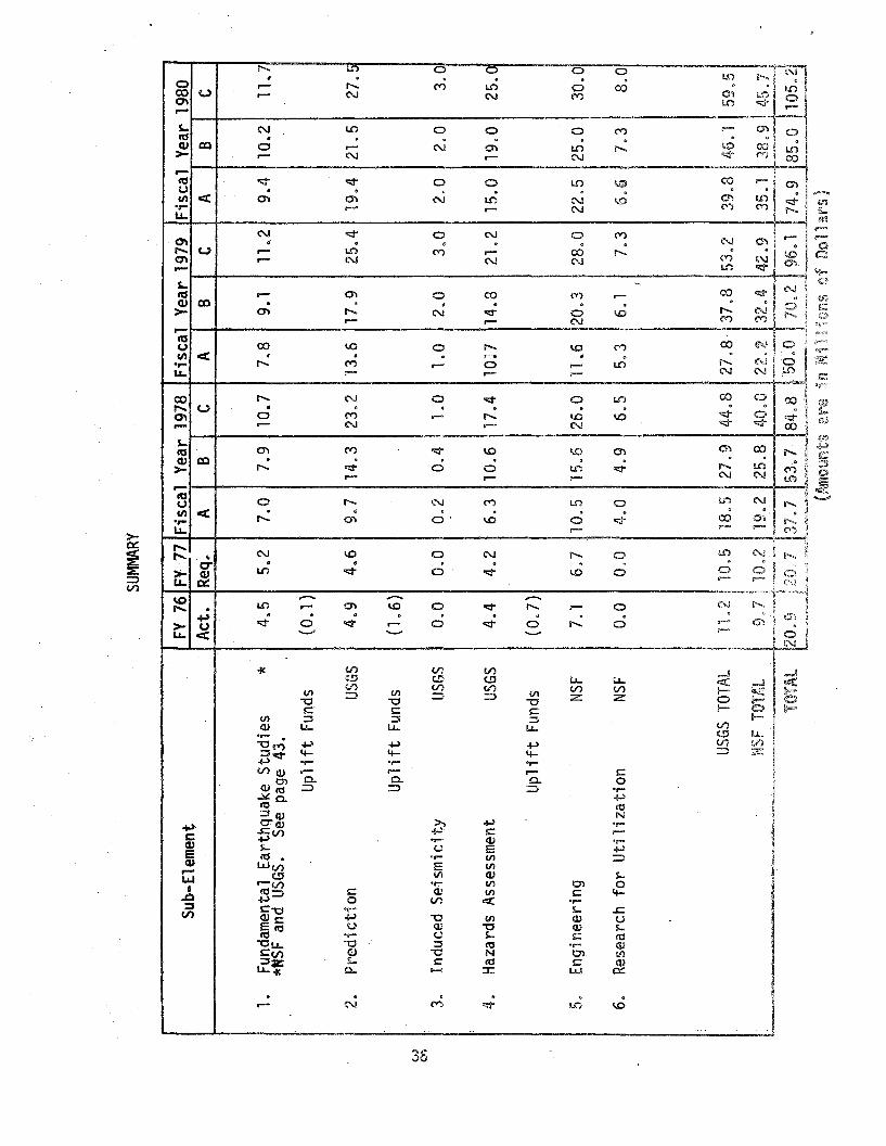
v.)
0'
SUMM
ARY
Sub-
Ele
men
tFY
76FY
·77
Fis
cal
Yea
r19
78F
isca
lY
ear
1979
Fis
cal
Yea
r19
80A
ct.
Req.
.A
BC
AB
CA
BC
1.Fu
ndam
enta
lE
arth
quak
eS
tudi
es*
4.5
5.2
7.0
7.9
10.7
7.8
9.1
11..2
9.4
10.2
11.7
*NSF
and
USGS
.Se
epa
ge43
.,
Upl
ift
Fund
s(O
.l)
2.P
redi
ctio
nUS
GS4.
94.
69.
714
.323
.213
.617
.925
.419
.421
.527
.5
Upl
ift
Fund
s(1
.6)
i
3.In
duce
dS
eism
icit
yUS
GS0.
00.
00.
20.
41.
01.
02.
03~0
2.0
2.0
3.0
:
4.H
azar
dsA
sses
smen
tUS
GS4.
44.
26.
310
.617
.41
0n
14.8
21.2
15.0
19.0
25.0
Upli
ftFu
nds
(0.7
)
5.E
ngin
eeri
ngNS
F7.
16.
710
.515
.626
.011
.620
.328
.022
.525
.030
.0
6.R
esea
rch
for
Uti
liza
tion
NSF
0.0
0.0
4.0
4.9
6.5
5.3
6.1
7.3
6.6
7.3
8.0
,
USGS
TOTA
L11
.2la
.518
.527
.944
.827
.837
.853
.239
.846
.159
.5
NSF
TOTA
L9
,710
.219
.225
.840
.022
.232
.442
.935
.138
.945
.7
'rDTA
l20
.9,~~
]~2~~~
~1~~2-
."~~~'
,.~~~~
.~t~~.
:,~~.6
.174
.985
.010
5.2
(~lgUnts
a~~
inM
illi
ons
ofD
olla
rs)

" .10 Fundamental Ealhthquake Studies
Two distinct'ly different approaches to the attainment of reliable
earthquake prediction can be envisioned. The first involves continuing
in-depth studies and measurements of a basic nature directed at the
development of a thorough understanding of the natural phenomena involved.
The second is a comprehensive empirical program to seek consistently
reliable indicators from field measurements made on well-chosen
secondary parameters (precursors). At our present state of knowledge,
there seems no question that both approaches must be implemented in
parallel.
In addition to providing the infrastructure on which an applied
program is based, a solid independent program of fundamental studies
vJill help assure that an emp"lrical program is scientifically sound
and flexible, will provide direction for the optimal use of its resources
and, of course, will provide the basis for a new start if current
empirical approaches prove inadequate.
An empirical program will necessarily give priority to those pre
cursors and geographical regions considered to be most promising. At
the same time fundamental studies should be conducted in a number of
other tectonic settings which will give us the long-time baseline
required to distinguish anomalies from ordinary values or behavior
in all major active seismic zones in the country. Seismicity and
microseismicity studies should be conducted in all these areas,
particularly in the Eastern United States, to better delineate the
active seismic zones and relate them to geology.
37

To establish a scient:-Ific rather than an emp-irical approach to
the prediction of earthquakes and of destructive ground motion requires
a greatly increased understanding of the physical processes leading to
and constituting an earthquake. We must understand these processes under
conditions that exist in the upper crust, lower crust and upper mantle.
We must develop theoretical models of the earthquake process consistent
with the above i nformati on. Both pre-earthquake phenomena and the
ground motion caused by the earthquake are tightly linked with the
faulting process itself. not yet know what physical properties
are the most critical 9 or the nature of the instability that causes
an earthquake. The failure criteria and the role of stick-slip and
pre-seismic~ or co-seismic creep must be understood in order to
calculate the fault propagation in the stress fie"!d and to determine
the energy budget. In tion, the material properties and the
tectoni c setti ng affect amount of energy rel eased and the
characteristics of the generated motion~ Such studies have been
'going on for many years ~ in theory, in the laboratory, and in the
field. However, there is still a long way to go.
The new plate tectonic theory envisions the earthls surface
as comprised of a discrete number of large plates moving in relation
ship to each other. This concept hasaTlowed us to explain the
distribution of the bulk of the world~s earthquakes and their seismic
radiation patterns. We need a more detailed knowledge of how stress
is accumulated, distributed and released along the boundaries of
38

39

for earthquake prediction research, there are a number of independent
stations and nets, portable and permanent. that can be expected to
contribute vital information to the problem.
Object; yes
g To obtain a comprehensive understanding of the natural phenomena
involved in the earthquake process.
® Improve global neblOrks of se-lsrnogy'aph stations to provide a
sound data base for stud-les in observational seismology and
provide associated data services.

Activities
Q. The Earthquake Process - Develop a fundamental understanding of the
earthquake process
1) Develop theoretical models based on laboratory data and field
observations. Study physical properties of rocks at conditions
similar to those in the earth's crust and upper mantle and
determine seismic source .parameters from field observations.
b. The Implications of Plate Tectonics for Earthquake Hazards Reduction
Determine how stress is accumulated, distributed, and released along
boundaries of moving plates and in plate interiors.
1) Determine relative motions of plates, refine definitions of
plate boundaries, determine deep-crustal and upper-mantle
structure, identify seismic gaps, measure stress and deformation
of plate boundaries and in intraplate regions, study the relation
ship of seismicity to geologic structures in intraplate regions.
c. Global Seismology - Collect and disseminate seismological data from
around the world.
1) Operate the Worldwide Standardized Seismograph Network (WWSSN) and
reestablish a maintenance program for the stations that lapsed
several years ago.
2) Operate the data acquisition and processing capability of the
National Earthquake Information Service, including use of satellite
telecommunications, issuance of new seismicity maps, and routine
computation of the parameters of the earthquake mechanism.
41
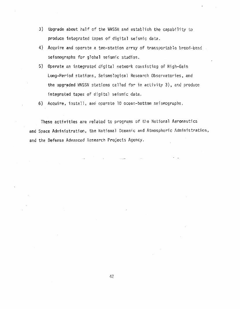
3) Upgrade about half of the WWSSN and establish the capability to
produce integrated tapes of digital seismic data.
4) Acquire and operate a ten-station array of transportable broad-band
seismographs for global seismic studies.
5) Operate an integrated digital network consisting of High-Gain
long-Period stations 3 Seismological Research Observatories, and
the upgr?ded WWSSN stations called for in activity 3), and produce
integrated tapes of digital seismic data.
6) Acquire, install. and operate 10 ocean-bottom seismographs.
These activities are related to programs of the National Aeronautics
and Space Administration. the National Oceanic and Atmospheric Administration.
and the Defense Advanced Research Projects Agency.
42

~ w
Pre
sen!
and
Prop
osed
Fund
ing
Opt
ions
~
Ele
men
t:1.
Fund
amen
tal
Ear
thqu
ake
Stu
dies
-_
]~_"_
...~_~.~'"'_.._
__~_~~o_~"_""'~_
_'_~'
Sub-
EJem
ent
FY76
FV17
Fis
calYea~
1978
Fis~l
Yea
r.197
9F
isca
lY
ear_l~~Q__
Act
.R
eq"
AB
CA
BC
AB
C~~
..•~---
.-
a,Th
eE
arth
quak
ePr
oces
sNS
F1.
11
.62.
32.
63
.42.
63.
03.
63.
03.
33.
8
1Do
The
Impl
icat
ions
ofP
late
Tec
toni
csNS
F1.
51
.92
A2
,7~"
12.
7,
3.0
4.0
3.0
3,3
3.9
I,
for
Ear
thqu
ake
Haz
ard
Red
uctio
n;
c.G
loba
lSe
ism
olog
yUS
GS1
.91.
72.
32.
63.
22.
53.
13.
63
.43.
64.
0
, i i
TOTA
L4.
55
.27.
07.
910
.77.
89.
111
.29
.410
.211
.7
(Am
ount
sar
ein
Mil
lion
so
fD
olla
rs)

Public Benefits and Technical Milestones
It is not realistic to attempt to predict the outcome of a funda
mental research program in terms of "technical milestones". Nevertheless,
we can reasonably predict that a significantly increased research effort.
focused on projects with a strong potential for application to the earth
quake prediction and hazard reduction program, will result in a more
comprehensive understanding of the earthquake process. Progress in such
basic understanding can be expected to increase the efficiency as well
as the reliability of earthquake prediction, in that the large costs
of gathering data by dispensing large arrays of field instruments could
be reduced if we had comprehensive theories requiring relatively few
data points. Strong, continuous support for the basic research program
is thus likely to be highly cost-effective in the long-range earthquake
program. Present approaches to the problem, while promising, may
conceivably fail. If that happens, we will need the reservoir of
'imaginative ideas, new experiments and basic theory that fundamental
studies can generate.
Current Program
The NSF fundamental earthquake research effort is heavily lev~raged
for returns from two to ten or more years in the future. The size of
the program is constrained by the availability of funding, rather than
the lack of good proposals. Available statistics easily demonstrate
that a substantial pool of unfunded or underfunded talent exists in
the universities that can be used effectively to achieve more rapid
44

progress toward the goals of the program. Because of the steadily
increasing scientific interest in this area and the important economic
and humanitarian need to forecast earthquakes reliably, the FY 77 budget
in the Earth Sciences contains a proposed budget of $3.5M for funda
mental earthquake studies. This figure, of course, was not proposed as
an adequate response to an accelerated national program.
The FY 76-77 support of observational seismology by the USGS
does not allow for necessary maintenance and calibration visits to
stations of the Worldwide Standardized Seismic Network, nor for the
desired upgrading of selected stations.
The Opti ons
Fundamental Research (NSF)
The proposed expenditures for fundamental research on earthquakes
averages 9% of the total program over all the available options. This
percentage decreases steadily from 12.5% at the lowest option in FY 78
"to 7.3% at the highest option in FY 80.
In light of the current state of the art in earthquake prediction
and rela!ej_~~pects of hazard reduction" this is considered a conservative
level of effort and fully compatible with the national need to achieve
new fundamental data.
The following table indicates that Option A and B represent gradually
increasing budgets, in which Option B allows the attainment of a given
level of support one year sooner than Option A. In contrast, Option C,
the preferred budget, represents nearly level funding (FY 78-80) at a
45


community for many years. Support for this operation is included
herein because data from this network is indispensable for modern
earthquake research. The existence of data from this network is
responsible, in a major way, for the rapid advances in seismology,
earthquake prediction, and plate tectonics in recent years.
Option A will allow a stable, just sufficient, operation of the
WWSSN, and the operation of the data acquisition and processing capability
of the National Earthquake Information Service (NElS) in FY 78-80,
a very limited start in upgrading a few of the WWSSN stations in FY
79, and the incorporation of the existing High Gain-Long Period
stations and Seismic Research Observatories into an expanded WWSSN
in FY 80.
Option B will allow a partial reestablishment of the maintenance
program that lapsed several years ago, the upgrading of about half of
the WWSSN stations to produce integrated types of digital seismic
'data by the end of FY 80.
Option C allows the acquisition and operation of a ten-station
array of broad-band seismographs for global seismic studies.
47

Reproduced frombest available copy.

resources than in the U.S. Consequently, in some regions, prediction
represents the logical focus for reducing earthquake casualties. Develop
ment of reliable earthquake prediction techniques would be of major
benefit to the safety of Americans and people throughout the world living
tn earthquake-prone regions.
Earthquake prediction depends on detecting precursors prior to
earthquakes. Reliable prediction depends on observing a variety of
precursors, understanding their causes, and understanding the basic
physics of the earthquake source. Thus a prediction research program
must be broad-based but will depend heavily on observations of precursors
and earthquakes within networks of a variety of densely spaced instru
ments. The rate of progress toward a predi ction capabil ity is directly
linked to the rate with which precursors can be observed. Multiple
observations on a variety of instruments are needed to develop an'accurate
physical model for earthquake precursors. Dense instrumentation of an
active fault zone with a wide variety of sensors costs about $12K per
kilometer of fault to install and about $7K per kilometer to operate
each year.
The existing U.S. program has progressed significantly. Reliable
instruments for detecting most suspected precursors have been developed~
tested~ and deployed in small prototype arrays. Real-time and automated
data processing techniques have been developed. Hypotheses as to the
nature of the earthquake source and the cause of precursors have been
developed and partially tested in the laboratory. Now that this groundwork
has been laid s expansion of the national effort can be undertaken efficiently.
49


Activities
a. Deformation Monitoring Instrumentation (Purchase and Installation)
Measure ground deformation in active seismic regions to monitor the
long-term accumulation of strain. determine the physics of the seismic
source, and observe precursors.
1) Deploy continuously recording strain meters, tiltmeters, tide
gauges, gravimeters, water-well level monitors, etc., in selected
areas of high or unique seismicity.
bo Seismic-Monitoring Instrumentation (Purchase and Installation)
Determine the patterns of seismicity in time and space, the physics
of the seismic source, and the variation in time of seismic source
and seismic wave parameters.
1) Deploy narrow and broad-band seismic instruments in selected
areas of high or unique seismicity.
c, Geochemical. Magnetic, Electrical and Other Instrumentation (Purchase
and Installation) - Study other types of phenomena that have been
reported as earthquake precursors.
1) Deploy geochemical sensors, magnetometers, resistivity arrays,
telluric sensors, self-potential sensors, etc., and carry out
studies with animals in selected areas of high or unique seismicity.
d. Operations - Operate networks of instruments installed and provide
bulletins and computer files of uniformly processed data to provide
bases for development of a theoretical and empirical framework for
earthquake prediction.
1) Operate networks of instruments including maintenance and
routine data processing in selected areas of high or unique
sei smi C"j ty.
51


h. Detailed Analysts of Data and Theoretical Modeling - Analyze field
and laboratory data~ and develop and test hypotheses concerning the
physics of the failure process and precursory phenomena 0
1) Detailed analysis~ theoretical modeling and synthesis of results
from:
{) Strain Data
o Seismic Data
a Other Data and Syntheses
i, Instrument Development - Develop and improve instruments for field
use that show significant promise of detecting earthquake precursors.
1\} Develop or complete development of instruments, such as a portable
multi-wavelength laser-ranging device. portable long-base tilt-
meters, broad-band seismometers, data telemetry systems, absolute
gravimeters, stress detectors, etc q and improve the reliability
and sensitivity of instruments already utilized.
j. Laboratory Studies - DeteIT~ine the physical behavior of rocks near
rupture and mode"1 earthquake processes in the laboratory with speci fi c
application to earthquake prediction.
1) Examine the properties of rocks, the physics of fracture, and the
occurrence of precurso~s prior to fracture on rock samples in
the laboratory. Model earthquake processes in the 1aboratory.
2) Conduct laboratory experiments using large-size samples and small-
scale field experimentso
53

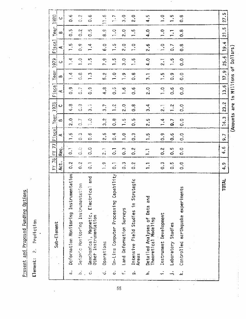
U1
CJ1
Pre
sent
and
Prop
osed
Fund
ing
Opt
ions
Element~
2,P
redi
ctio
n
--
....
.-~.~-~~,,~.~~
_._~.__.
'-----_._-~.--_
...._,._
...,._--
Sub-
Ele
men
tFV
76FV
17Fi
sca.
1Y
ear
1978
Fis
cal
Yea
r'19
19F
isca
lY
earl~~Q
__A
ct.
Req•.
AI
B""
CA
BC
AB
C~.,~~~
..
1.5
12.0
,).,
Def
orm
atio
nM
onito
ring
Inst
rum
enta
tion
0.2
0.1
4.8
0.9
1.4
1.4-
1.5
0.5
0.6
Ii,-
Seis
mic
Mon
itori
ngIn
stru
men
tati
on0
,20.
010
,3II
(\"7
nQ
,n
"7n
81
f\.
()Oi
0.2
I0,
2i
1.'
,i
u.
#U~J
iv.
II
'I.>0
!'V
'-'0
..1
I!
!Geochemical~
Magnetic~
Ele
ctri
cal
and
O.1
0.0
0.6
I'"'
!~
3.1
I00
91.
31.
51.
40.
500
6c.
~.u
Oth
etIn
stru
men
tati
on
doO
pera
tions
1.9
201
2.6
302
301
4.8
502
7.9
600
8.9
11.6
I
e.O
n-li
neC
ompu
ter
Pro
cess
ing
Cap
abil
ity
O.1
0.1
0.4
0.8
1.2
0.5
La
1.5
1.5
1.0
1.7
f.La
ndD
efor
mat
ion
Surv
eys
0.3
0.3
1.0
1.5
2.0
1.6
1.9
3.0
2.0
2.0
3.0
g.In
tens
ive
Fie
ldS
tudi
esin
Str
ateg
ic0.
20.
20.
30.
50.
80.
60.
81.
51
.01.
52.
0A
reas
h.D
etai
led
Ana
lyse
sof
Dat
aan
d1.
11.
11.
52.
53
.42.
03.
14.
02.
64.
04.
5T
heor
etic
alM
odel
ing
i.In
stru
men
tD
evel
opm
ent
0.3
0.2
0.9
1.4
2.1
1.0
1.5
2.1
1.0
1.0
1.0
j.L
abor
ator
yS
tudi
es0.
50.
50.
6G
.71.
20.
60.
91.
50.
71.
11.
5
k,C
ontr
olle
dea
rthq
uake
expe
rim
ents
0,0
0,0
0.0
0.0
0.0
0.0
0.0
0.0
0.8
0.8
0.8
I I
TOTA
L4.
94.
69
.714
.323
.213
.017
...92~
.•419
.421
.527
.5
(Am
ount
sar
ein
Mil
lion
sof
Dol
lars
)


scientists judge that observations are needed with a dense network of
comprehensive instrumentation for on the order of 10 magnitude 5 or larger
earthquakes as an adequate data base for either establishing a sound
basis for prediction or deciding that the problem is much more difficult
than presently believed. Acquisition of these observations is a specific
goal for earthquake prediction efforts.
The rate of precursor observation is directly related to the
number of instruments deployed and the level of earthquake activity in
the area monitored. Several factors influence program planning to make
the Observations:
~ Observations can be made at considerably lower cost in California
and Nevada than elsewhere in the U.S. This is shown by detailed
analysis of the seismicity per unit area~ accessibility of
the seismic zones~ and logistical support required. Such
observations, however, will not necessarily lead to development
of a nationwide prediction capability.
@ Instrumentation in areas of relatively low seismidty yields
declining returns in precursor observation for invested funds!
except in areas where a large earthquake appears imminent
based, for example, on seismic gap theory and observations of
possible p~ecursors, or in areas of unique seismicity.
@ Economies of scale permit observational functions to be
expanded pl~oportionany more rapidly than analytical, laboratory,
theoretica'l aVid computational functions.
Taking these factors into account the costs and times to "achieve
prediction~1l i.e., observe the 10 magnitude 5 or larger earthquakes,
can be estimated as follows:
57


Fiscal Year
77 78 79 80 81 82. 83 84
"-,-..
C B A
BC A
C B
C B
C B A
C B
C B A
is
h-
u- C B A
- C B A
--- -------
2. Undertake comprehensive studiesof earthquake precursors otherthan seismic and strain:
Technical Milestones
10 Establish dense seismic andstrain instrumentation andundertake surveys of landdeformation in areas of high orunique seismicity.
Water well level
Electrical resistivityMagnetic fieldGeochemical content of ground
waterAnimal behavior
3. Establish a computer-based dataprocessing capability for bothreal-time monitoring and analysof earthquake precursors.
4. Develop new instrumentation andtechniques9 and utilize for eartquake precursor detection:
Three-color laser ranging instrment
Gravimeters for vertical deformation
_.-_.----- --------_.~------- -----------
59


3. Induced Seismi~i'~Y
Recent research at Rangely, Colorado has demonstrated that fluid
pressure has a profound effect on earthquake activity. This phenomenon
was originally observed as an inadvertent effect of injecting water
underground at high pressure. In experiments at Rangely, Colorado, earth
quakes were successfully controlled by altering the fluid pressure within
a fault: lowering the pressure halted the earthquakes; raising the fluid
pressure above a critical value started the earthquakes up again. Injec
tion is becoming more common with the advent of deep well disposal of
noxious wastes and secondary recovery of oil. Thus, deep-well injection
poses both a risk of increased local seismicity and offers the potential
for releasing seismic energy in earthquakes that are below the damaging
level.
Fil 1i n9 reservoi rs behi nd dams has apparently triggered earthquakes,
as large as magnitude 6 to 6 1/2 in a few cases causing damage and
loss of life. Although triggering of these events by increase of fluid
pressure is likely to be the cause, at present there is no sound basis for
evaluating which reservoirs might trigger earthquakes, or what to do about
earthquake activity once it is stimulated. The Rangely experience suggests
that certain engineering actions may be available te limit reservoir-induced
se; sm; city.
The Rangely experiment also suggests that potentially destructive
natural earthquakes are, at least theoretically, controllableo The ability
to control them successfully would depend on, among other things, the
penneabi 1i ty of fi'Hfl t zones.
61

s

a. Reservoir-Induced Earthquakes - Determine the effects of reservoirs
on seismic activity and the reasons for these effects.
1) Monitor in detail the seismicity, the strain field, and the fluid
pressure at depth around major reservoirs before, during, and
after they are constructed.
b, Drilling into Fault Zones - Determine the physical properties of
fault zones and fault gouge.
1) Drill several holes into major faults and measure such properties
as permeability, porosity, elastic parameters, temperature, fluid
pressure and stress.
These activities are focused on the process of reservoir-induced
earthquakesalld are considered to be supplementary to monitoring and
baseline studles by agencies responsible for reservoirs, e.g., the
Bureau of Reclamation and the Corps of Engineers.
63

o

Public Benefits and Technical Milestones
Studies of induced seismicity will lead to improved knowledge
about how reservoir -impoundment and fluid injection in deep wells
ccwse earthquakes. This information in turn will aid in developing
better criteria for siting and operating reservoirs and injection wells.
The public will benefit from incr~ased safety from both dam failure
and triggered earthquakes 9 and from savings in economic loss that could
result if a dam could not be utilized or if construction were delayed
owing to unresolved issues related to induced seismicity.
Progress in understanding induced seismicity requires 1nstrumental
observations of a variety of phenomena that could be affected by
reservoirs and injection wells: seismicity~ land deformation~ and
fluid pressure in wells. Past studies, both in the U.S. and foreign
countries 9 have focused only on seismicity. and often a bare mirl1mum
of seismograph stat-ions have been deployed with resulting deficiencies
in data. Consequently. existing information on induced seismicity is
fragmentary and does not provide a sound basis for establishing criteria.
Comprehensive studies of large reservoirs are needed.
Technical milestones for induced seismicity~ therefore 9 mark the
installation of instrumentation and the undertaking of surveys to monitor
reservoir impoundment or well injection. Such studies must precede
construction by a year or more to establish baseline data. and should
continue for several years or more depending on the nature of the project.
Interpretation of data on induced seismicity can be greatly
enhanced if information on the physical properties of material at
depth in the vici~ity of the earthquakes is available. For example,
65


4. Hazards Assessment
Earthquake hazards assessment involves the delineation and character
ization of potential effects from seismically induced processes at or near
the ground surface. Estimates of how strongly and how often the ground
will shake are basic to building codes and engineering design. Knowledge
of areas susceptible to strong shaking~ ground failures surface faulting s
or inundation by tsunamis or dam failure is necessary for land-use planning
in earthquake-prone regions. Appraisals of probable damage patterns can
guide both pre- and post-disaster planning. The accurate assessment of
earthquake hazards «lso is a key element in effective action to take
advantage of an earthquake prediction capability.
At present~ our ability to evaluate earthquake hazards varies con
siderably~ with the state of the art at different stages for' different
hazards. For example~ many faults capable of displacing the ground
surface can be recognized and mapped, and expectable future movement can
be estimated within reasonable limits. In contrast 9 the current capability
for assessing of other types of earthquake hazards has some severe limita-
tions. The potential effects of strong ground motion presently can be
characterized only in the most general way, and the predict10n of possible
earthquake-induced landsl iding or 1iquefaction is even more di-fficult.
There are few geologic or geophysical bases at present for deciding where
and how often earthquakes in the eastern and central United States are
1ikely to occur.
This program element has two aspects (l) the geographic delineation
of potential earthquake hazards~ initially using existing methods and
(2) the development of improved techniques.
67

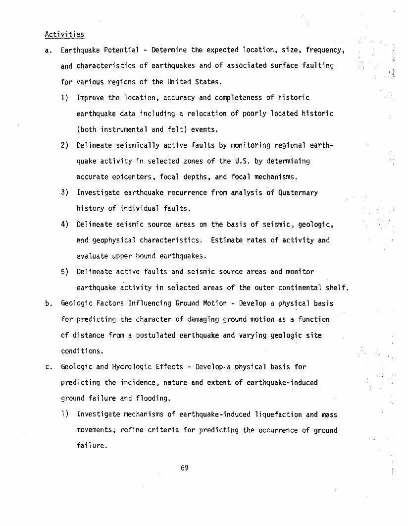
Activities
a. Earthquake Potential - Determine the expected location, size, frequency,
and characteristics of earthquakes and of associated surface -faulting
for various regions of the United States.
1) Improve the location, accuracy and completeness of historic
earthquake data including a relocation of poorly located historic
(both instrumental and felt) events.
2) Delineate seismically active faults by monitoring regional earth
quake activity in selected zones of the U.S. by determining
accurate epicenters, focal depths, and focal mechanisms.
3) Investigate earthquake recurrence from analysis of Quaternary
history of individual faults.
4) Delineate seismic source areas on the basis of seismic 9 geologic,
and geophysical characteristics. Estimate rates of activity and
evaluate upper bound earthquakes.
5) Delineate active faults and seismic source areas and monitor
earthquake activity in selected areas of the outer continental shelf.
b. Geologic Factors Influencing Ground Motion - Develop a physical basis
for predicting the character of damaging ground motion as a function
of distance from a postulated earthquake and varying geologic site
conditions.
c. Geologic and Hydrologic Effects - Deve10p·a physical basis for
predicting the incidence 9 nature and extent of earthquake-induced
ground failure and flooding.
1) Investigate mechanisms of earthquake-induced liquefaction and mass
movements; refine criteria for predicting the occurrence of ground
failure.
69

2) Develop improved methods to predict inundation and the consequences
of flooding caused by subsidence, tectonic downwarping, massive
landslides into water, tsunamis, and other secondary earthquake
effects.
3) Conduct geologic hazards evaluations of the effects of damaging
earthquakes.
d. Earthquake Hazards - Delineate geographical variations in the nature
and likelihood of occurrence of earthquake hazards.
1) Prepare refined probabilistic ground motion maps for entire
United States.
2) Expand state-of-the-art evaluation and mapping of earthquake
hazards (ground shaking and failure, surface faulting, elevation
changes, and inundation) in areas of high seismic risk; develop
new methods for probabilistic hazard evaluation, including
faulting, ground failure, and tsunami effects.
e. Earthquake Risk - Evaluate earthquake risk ~n a nationwide and regional
basis.
1) Develop and improve methods for estimating damage and loss based
on probabilistic maps of earthquake hazards. Apply methods to
estimate risk on a regional and nationwide basis.
These activities are related to programs of the Department of
Housing and Urban Development, the Nuclear Regulatory Commission, the
Department of Tr~nsportat;on, and the Veterans Administration.
70
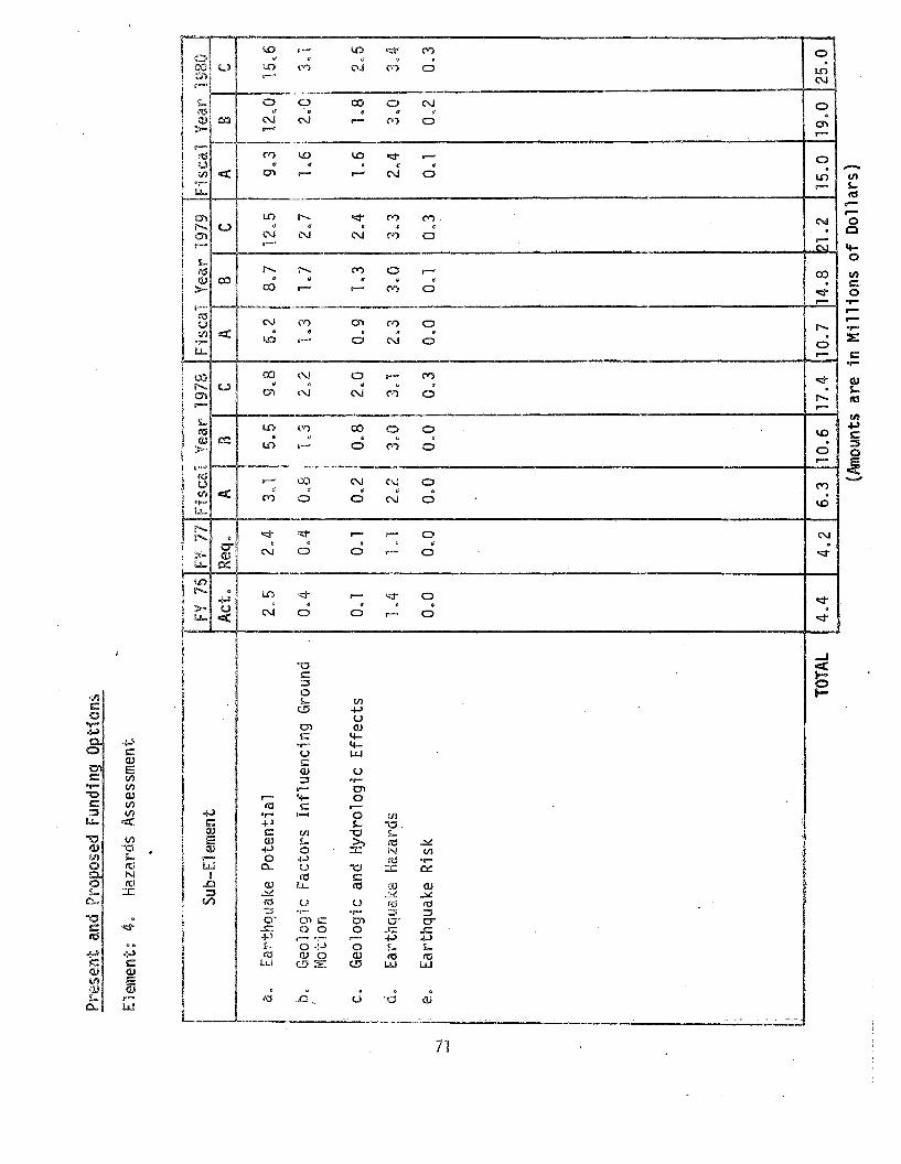
'-.I
--'
Prqs
ent
and
Propos~d
Fund
ing
QE!io
ns
Ele
men
t:4.
Haz
ards
Ass
essm
ent
,...._~,~-----~-~
=~
.~,...<.~~>~~.~-~
_..,~.,~"-~,.~._._---<->
--"-
_.-
--_
.-.---~
Su
b-E
lem
en
tFY
76FV
77F
isca
lV
eal"
1978
Fis
cal
Vea
l"19
79F
isca
lY~~Jg~~
Act
.R
eq.
AlB
CA
BC
AB
C,.
3150
5a.
Ear
thqu
ake
Pot
enti
al2.
52.
49,
,86.
28.
71
2.5
9.3
12.0
15.6
004
j0
.8,
1.3
',
b,
Geo
logi
cF
acto
rsIn
flue
ncin
gG
roun
d0
.42,
.21.
31.
72.
71
.62.
.0'
3.1
,M
ot")o
n
c.G
eolo
gic
and
Hyd
rolo
gic
Eff
ects
O.1
O.1
0.2
0.8
2.0
0.9
1.3
2.4
1.6
L8
2 06
d,E
arth
quak
eH
azar
ds10
41.
12"
230
0.
30.1
2.3
3.0
3.3
2.4
3.0
3.4-
,E
arth
quak
eR
isk
0.0
0.0
0.0
0.0
0.3
0.0
0.1
0.3
O.1
0.2
0.3
'e.
i; , I
TOTA
L4.
44.
26.
310
.617
.410
.714
.821
.215
.019
.025
.0
(Am
ount
sar
e1n
Mil
lion
sof
Dol
lars
)

on
of
on maps
that
effects"
public
rnerrt fi d"
c"
any region.
Maps are and special=purpose
maps are sometimes lss selected
pararneters nr s tigatior..
Development of new techniques for evaluation is also an important
product of hazards assessment research. An example is the specification
of seismic design criteria for a critical facility such as a nuclear
reactor or dam at a particular site. New methods in hazards evaluation
require synthesis of data and theory from many fields of earthquake
research and com~only entail laboY'atory and field investigations.
Consequently, technical milestones in hazards assessment studies
mark the completion of the data gathering or research phase of particular
studies and publication of significant contributions to the information
base for decision making, Milestones can be developed for both
geographical areas and scientific topics. Level of effort, i.e.,
professional manpower, and dates of important publications are both
useful measures in the case of hazards assessment.
The year of attainment of major technical milestones for each
funding option is shown in the following table.
73

C B A
C B
f' 8"r B:~
C B
C
"~~~f'\J
f' B ,~iO't! !'\
('" B A~,
'"l.
f" B(~
._~ of,
Earthqua~~e Recu~rence
Surface Faul
Stro~g Ground Shaking
Buffalo Region
Seattle
20 comprehensived1evT-11e\~,~<>'--~~!r"" c" {.:,'1 nrC: e
for evaluation:
1. Publish maps and113.;;:12,
land use plannip'fepa. j n
hi

5" Engineering
Earthquake engineering involves the design and development of the
physical environment to withstand earthquakes. It encompasses many
fields including architecture~ structural engineering, mechanican
engineering and systems design. It serves as a bridge between the
ec,rth sciences~ oceanography~ and theoretical mechanics, on the one
h&nd~ and engineering design and construction practice, systems planning,
and social and economic assessments of hazard and risk on the other.
E~gineering studies interface with geological studies of hazards and
their mitigation 9 and with seismological studies of ground motion
and its recurrence. Research in earthquake engineering aims at improving
the procedures used in engineering design, in land-use and systems planning,
and in codes and regulations. The protection of human life and
pl'operty are bas i c to l:mgi neer<lng des ign.
The Characterization of earthquake ground motions as input
motions for engineering studies depends upon the procedures used in the
design and planning process. In the design of simple, non~critical
structures, the general level of ground motion in frequently occurring
events and the maximum probable motion from infrequently occurring
events are both important. On the other hand, a characterization of the
time-history of anticipated motion at both levels of severity is required
in the analysis of critical facilities.
Research can define the relative motion of nearby points on the
ground surface and at different depths. These re1at; ve moti ons may
influence the design of extended structures such as dams, multi-span
75

connected systems
Research can ne potential merit or in selecting
foundation designs~ elevat ons 9 a va us site conditions.
s.tudy of how
the supporting soils structure be 10cated at
terns should not be
located where soil failure (liquefaction or 1andsli ng) is likely to
occur. Many times~ dge approaches~
at sites where soil filure is likely.
In such cases~ methods ling soil lure Dr alleviating its
consequences must be
The analysis and desi structures and systems depends on the
fon~ulatiora of appropri 1:ical representations
of their characteris cSo models mu.st represent the capacity of
the structures and systems at various 1 s of motion which occur
in potentially damagi ude multidimensional.
teristicsD present. design procedures
are largely based on linear~ elastic, one mens10nal models. To obtain
the data required to evaluate procedures wil1 require using
instrumenta.tion of v'e1'11 strw::t!~res in seiSrrrlCBi-h active areas as wen
as laboratory studies timate capacity of eleme~ts and subs truc-
tures. Since the analysis structu~A·es syst~~s at damaging motion
levels involves nonlinear analyses are

necessarily compleJzo In the design of large or critical structures and
systems it is necessary to develop reliable methods that sequentially
lncrease in complexity as the design process proceeds. The economics of
the design and construction of smaller, noncritical structures does not
permit extensive or complex design or analysis of individual structures~
In spite of the fact that they comprise the largest aggregate value
of structures likely to be damaged.
Many systems (e.g. pipeline~ water mains, power grids) must
cross areas where they are likely to be damaged. Consequently, design
of such systems must minimize the damage, provide for temporary rerouting
of service, and pennit rapid ~epair and reconstruction. Similar
principles should be applied to the planning of fire, police and regional
hospital facilities that become critical in the immediate aftermath of
a damaging earthquake.
Darns, reservoirs, tanks 9 and other structures that contain water
and other liquids pose a special set of earthquake hazards. The action
cf the liquid within the structure creates complex loading under the
dynamic conditions during an earthquake and the failure of such structures
can cause serious flooding. As noted earlier in the section on induced
seismicity, large reservoirs may stimulate local seismic activity. The
extent to which this activity should influence the dam's design and
aperation is not yet clear.
A tsunami can cause great damage to coastal regions by both inundation
and the force of moving water. Selective land use is usually the most
appropriate way to mitigate this impact. But the design of facilities that
must be located along the shore, must also allow for the impact of the
tsunami.77

ice
aft.ermath
2(; systems
to
architects $

Subelement a. Characterization of ground motion for structural analysis
and design.
Objective: Develop methods to characterize the nature of the input
motions and corresponding response of simple systems for
use in engineering analysis, planning, and design.
Activities
10 Develop analytic models to estimate the special characteristics of
ground motion and the acceleration, velocity, and displacement time
histories of this motion for use as input motion in structural
analysis and design. Such models will include the effects of the
earthquake source, the transmission path, the amplification caused
by local site conditions, and the influence of the presence of a
structure on this motion (soil-structure interaction).
2. Develop techniques for measuring the severity of earthquake effects
based on parameters significant in engineering analysis and
design. Apply these techniques in post-earthquake investigations
and pilot studies of zoning.
Subelement b: Acquisition of Strong-Motion Data
Objective: Obtain a comprehensive data base on the nature of the
earthquake motions at typical sites and in representative
structures.
Activities:
,. Improve the national strong~motion instrumentation network by:
(a) Replacing obsolete instruments,
(b) Installing adequate instrumentation arrays in all seismic
regions,
79

{;:" ,~_.:! ,-:>
t\cti
embankments
L
1i
foundations

deep foundatlo~s)~ and develop criteria for selecting a type of
foundation appropriate to various settings and soil conditions.-
Subelement d: Investigations of Structural Response
Objective: Develop analytical procedures for characterizing the earth
quake response of structures and structural elements based
on both analytical and experimental studies.
Activities:
1. Investigate the dynamic behavior of structures and components
experimentally to determi~e performance characteristics up to
ultimate capacity and to provide a basis for the formulation,
development, and validation of analytical methods of analysis and
design. This may require the development of substantial new
experimental facilities.
2. Develop analytical methods to characterize the earthquake response
of structures and structural components with an emphasis on three
dimensional, nonlinear, and inelastic behavior to ultimate capacity.
Simplify these analytical procedures for computer aided structural
design.
3. Develop methods to assess the hazard vulnerability of existing
structures and to upgrade their performance when subjected to
earthquake motions.
Subelement e: Studies of Special Structures· and Systems
Objective~ Develop analytical methods to evaluate the earthquake
response of special types of structures (dams, critical
facilities~ bridges and other extended structures) and
81

(
ze the
08 as hospitals.
ned
the
"i i ty and pub 1-, c
emergency
Develop
queso

A::tivities:
1. Investigate all potentially damaging earthquakes in the u.s. with
an emphasis on correlations of damage or lack of damage with design
and construction practices.
2. Investigate earthquakes in foreign countries that are likely to
provide information that can improve engineering design and construction
practices in the u.s.
These activities are related to programs of the National Bureau of
Standards s the Department of Transportation, the Department of Housing
and Urban Development and other agencies concerned with earthquake
resistant design of structures.
83

Pr'E
:Sen
t{,\b
1dP
ropo
sed
Fu
nd
infl
Ont~ons
c"''
''''
-..=
'D~.
-·,,
''''
''''
''''
'','
''-'
''''
''.~
~~..,."..=~~_
Element~
5.E
ngin
eeri
ng
5!.d:J
=Ele
mel
llt
2,,5
I2,
,0Le
Al
?,"
"'0
0
II II
3"f
]~
"1'j
<d'°
0i\
r':;
...J
:!
~r~
i::'[
rf::~.?
q.,
.;",
-,j
I!'~A
(',
", ,88
,ft ;I ~ \
,-~
,.:r:;
l'"
.J;.""
','I I'
n,~L
:.:~
oq£)
,~.J
C,
'~n
c.,}
jq~J
,,0
<'1 J"<:
;2
.~''7
-j<;
}~
?,,;2
c,"4~.
s
('104
·0
.3O
.
f'1 ':;.:,J
(~('
.','
:,y
~iZ
o',~
0"1
(,9il
0,,9
r:(\,~6
~3c
,
'"'7
il(1'~"
'"rJ
'1"~
1"'1
1'J
'21
,/",
U(j
,J~
.'c"
,l
~~~
"e~
t~,~
to,
h~
d(\
c.=II
'x~'.
:\,,)
~~S
'H'io
ra
~]
Inve
s
~~on
'K:
c~
.r;: ,.a.
Gro
und
Mot
ion
Cha
ract
eriz
atio
n
n~
E~~
b:l
,
TOTA
L7.
'jf"
"1O
.i
.511
5.6
126.
0il
l.0
I2
2.5
I25
.0I
30
.0
(Am
ount
s~n'e
inr'H
'IHon
so
fD
olla
rs)
Public 8enefits and Technical Milestones
The predominant public benefits from a sound earthquake engineering
research program are improvements in planning and design that lead
directly to reduced casualties and property damage during an earthquake,
and "Indirectly reduced investment required to achieve this adequate
earthqua.ke performm1ct:~o
The reduction in total losses is accomplished by the cooperation of
all groups and professionals involved in the construction process. These
include professional engineers and architects, builders, model code
arod local building regulatory groups, local government officials,
and those in private "lndusb'yo With the concerted assistance of all
pal"ties the mitigation of life and property losses as a result of an
earthquake can be achieved. Successful mitigation can only be realized
tl'1rough assimi la tion and dissemi nati on of information and knowledge to
all parties concerned in its application.
The benefits of a well planned engineering research program become
apparent when one considers that construction investments alone are at
a rate of approximately $150 billion per year. Of this total amount,
$50 billion per year is located in high and moderate seismic regions of
the country. Tangible benefits from a sound program of earthquake
mitigation include: the reduction in down time and subsequent loss of
production, much of which is required for the basic needs of the
community; reduced loss of sel"vices such as water supplies~ communications,
85

utility lines~ and total operation
and functioning of a commtm'H:YQ Intangible inc1ude the greatly
lessened social and economic sruptions that accompany any disastero
Although an earthqua.ke shock is an action that is only momentary in
duration~ its devastati may disrupt a communi a.nd the
surrounding region for years or even decades 0
The realization af be~efits from an increased program in earth~
quake engineering r~sea 1y in the rate at
ts are incorporated i
engineel"i and constr~ctiQn practi.ces~ ion of anyone of the
three levels of funding 11 determi ~1f; priorities and rate
of accomplishment of Some results can
the res uH:s of ft"ttlr'e ea rthqua kes
that are not yet predi e 1D timeo Other results can be achieved at
a rate more directly th the rate of expenditure of fundiHg.
The degree to ich the results will reduce losses in lives
and property damage wi1 defj8rild on the rate of incorporation of the
research results into practiceo
The fOllowing table i C3:tes the anti year of attainment of
technical milestones for each funding option.
86

Fiscal Year
Bey,77 78 79 80 81 82 83 84 84
put Motions.
ed on peakC B A
include the C " B Ace 9 trans=site'
l-structure.'
.
estimating C B As, includingn bo
-- -
ectrum tech- C B Aesign toffects.
lic:able to C ABres.
character= C B Ae severity in9 design
for including C ABers in micro-
etwork ofntation.
struments ABC
gional arrays. C B A
- and three- C B AI
tative types C B A
motion C B A
i j
d. Improve response sp~lques for use in dinclude inelastic e
a, Improve methods basparameters,
c. velop methods fortime-history motion6rfects indicated i
D. Develop methods toaffects of the sourmission paths localcond1t1ons~ and soiinteraction.
e. Develop methods appunderground structu
f. Develop methods for1z1n9 the earthquakterms of engineerinparameters,
d. Instrument represenof structures.
g. Develop techniquesengineering parametzonation processes.
b. Develop adequate re
c. Develop special twodimensional arrays.
e. Develop new stronginstrumentation.
1. Characterization of In
2. Improve the National NStrong=Motion Instrume
a. Replace obsolete in
Technical Milestones
87

A
A
A
A
AS
AS
B
c
B
Bc
b. Determine the dynamic capacityof smal1~scale structures a~d
substructures experimentallY.
a. Determine the dynamic capad.tyof components and subassembliesexperimentally.
c. Develop analytical methods tocharacterize the ultimate capacity of structural systems.
b. Develop analytical methods toevaluate liquefaction and landslides.
e. Develop Criteria for the selection of types of foundationsappropriate to various seismicsettings and soil conditionso
d. Investigate the dynamic responseand des i gn of va d Oli1S types offoundat"l ons.
4. Investigations of StructuralResponse.
Techni ca1 t~i les tones
Fiscal Year
~r-l'--r-\~~0I I ~ i, 1 " 'l IBey.~ 77~ULJ...zL\ 80-1~C!. ! 82 I 83 J 84 L§.Li':1 ~ i ~+, r~ I
2. Improve the National ~e~wo~k of ~ I,! I,." I,' 1,1 I I Iii !' 1,\ IStrong-Motion Instruml::i"n:atlon (carll,) I" 1,' i ! i ' , I 1 !
i ~ i1 I I ! I' !!. f ',1 I 11 I' I •f. Expand the strong-moti on n~tvJork ~ ~ , I " C ' B ' A I
to include selected sites in I I I I I I Iother parts of the ~'!orld. ~ i! I ii' I I
ii ' Ii i Ig. Improve the data dissemination ' C B ! A" ! !
operations. 'I!,' I ' I I~ ! Y ,
i I I i I3. Investigate Dynamic Soil Properties'i I I!
son Failures~ and Foundat'Jori 'lgni~1 :,i"~,' III B ", ~I":"" A I;'"
a. improved techrd qjues for i , C Ining the dynamic proper- I !
ti es of soil s both in-sHLI and 11,,/;, ',' I ~ I"
in the laboratory. ' ; "i~
I C "II B~
,I I~ 9
c. Assess the probability of I I'controlling soil failure during .earthquakes. ·1
I I C I,
rI I C! I
I II Ii I!g C g, A
I c ,I
,II
IIl
! I 1 'i
l~-~~,-J,,~=~~- ~~~~?r~~' "-~~__'-_.J<-_...JJ-_...:J,._~
88

Fi sca 'I Year;--
t
BeY~77 78 79 80 81 82 83 84 84 '
al
ods for C B A
I
ess-lng the C B Ast]('uc~
stems 0
essing the C ASmechalli-
ems.
Structures
,
n, and C B Aminimize
nfacil-j -
I-'
n, and C B Aminimize
n power, andes.
for C B Aof dams,including
ined .
for C ABf wavesseiches,sign of ,
nning, C B An oficetheh"
~quakeso i
~
I~
Iiu ~<
do Develop simplified methcomputer-aided des'ign.
a. Develop analysis, desigconstruction methods tothe earthquake impact 0hospitals and emergencyHes. '
e, Deve10p methods for asshazard vulnerability oftures and structural sy
f. Develop methods for asshazard vulnerabn!ty ofcal and electrical syst
bo Develop analysis, desigconstruction methods tothe earthquake impact 0plants~ utility systemsother commumity lifelin
Co Improve the techniquesanalyzing the responsereservoirs, tanks s etc.the effect of the contaliquids.
do Improve the proceduresanalyzing the effects 0generated by tsunamis~
or landslides on the destructures.
eo Develop methods for pladesign, and constructioutility and public servfacilities to minimizedisruption during earth
Techlrl:a.l Mi 'j as tones
5. Investigations of Specialand Systems.
4. Inv2stigations of StructurResponse (cont~~ued)o
89
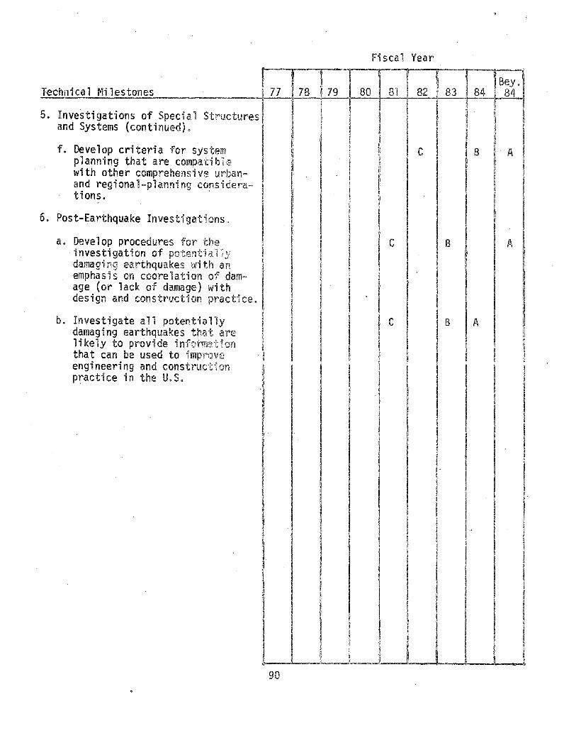
, "I5. Investigations of Special Structuresl
and Systems (continued). ~
f. Develop criteria for systemplanning that are compatib1e !with other comprehensive urban- n
and regional-planning considera- Itions. I
Bey.84
A
i I~ I
IJ! II," 1I
I
Ii
A
I B
Ir:
i
-r83 I 84
f81 i 82
Fi sea1 Year
!I8079: 78IinTechniea1 Mi lestones
6. Post-Earthquake Investigations.
a. Develop procedures for theinvestigation of potential Idamaging earthquakes with anemphasis on coorelation of damage (or lack of damage) with .design and construction practice. !
b. Investigate all potentially Idamaging earthquakes that are Ilikely to provide information Ithat can be used to improve "I
engineering and constructionpractice in the U.S.
I
I·
III
IIII'I

6. Research for Utilization
The previous sections of this plan have concentrated on the develop-
ment of physical science and technology capabilities to reduce earthquake
impacts. Research has focused primarily on technologically oriented
solutions to problems of natural hazards~ rather than on the social.
economic. legal~ and political factors which lead to the adoption or
nonadoption of technological findings. The present section describes
activities to develop social adjustments that can be undertaken by in
dividuals~ private groups and government, especially at thE! local and
State level~ to mitigate earthquake impacts.
In Chapter II 9 possible mitigation measures were discussed which, if
adopted. could reduce earthquake impacts. Among these measures are
Preparation, Land Use, Building Codes and Standards, Insurance and Relief
Incentives, and Information and Education. While each of these is being
pursued in varying degrees and with widely divergent effectiveness, there
is scant research that has been performed or is currently underway to.
develop more effective and efficient adoption and implementation of
mitigation measures.
Changes in building codes and land-use regulations, and the issuance
of earthquake predictions and warnings can have serious ramifications for
the social, economic, legal and political aspects of American life.
Whether a research product has a positive or negative effect in mitigating
earthquake hazards, or is ignored altogether, could depend very much on
the method of communication and utilization of the product. The use of
any research product is highly unlikely unless it is made adaptable to a
recognizable need in a form appropriate for fulfilling that need.
91

It is essential that a thorough analysis be made of the options for
loss reduction through social mitigation measures~-lar.d use, preparedness s
relief, recoverY5 standards setting (codes), insurance, public information,
and educationo Adoption of an appropriate balance among these measures
depends on a fundamental understanding of. and the a lity to establish
a meaningful social and economic benefit-cost ationshipc
The object of corrmunity preparedness is to enhance the stability of
the community in time of di and to reduce losses, Community pre
on the assumption that an earth-
quake occurs without warning, In some areas the country! there may
be specific event warnings based on developing capability for earth-
quake predictions. Communi prepai"'(:!dness as developed by local, State
or private entities can both by preparation of plans
for actions to be taken event OCCLrrs or ·~s forecast~ and by
adopting strategies 1n buildings land and facilities use that decrease
vulnerability.
Public reaction to the issuance of an earthquake prediction will be
very difficult to anticipate, It is clear that public information programs,
preparedness planning, and governmental coordination must go hand in hand
with prediction. The potential positive benefits of predictions are clear
in the saving of lives and reduction of damage. But potential negative
effects of predictions are also presento
In public and private actions society regulates physical development
through local and State building codes, land use controls, building
occupancy codes, insurance requirements, mortgage and finance require-
ments, taxation policies, police powers 9 etc. ke safety involves
92.
decisions and actions on the part of the individual~ property owner,
financing agency, architect, engineer, builder, foreman, inspector,
manufacturer of components, insurer, and appropriate officials of the
municipality or other governmental subdivision. Participants in the
decision process are often so remote in time and place from the in
dividual victim in the event of disaster that in some cases they may
feel little sense of responsibility. Experience has shown that because
of the apparent low probability of immediate catastrophe, decision makers
tend to ignore their responsibility.
One of the problems in the transfer of technology to an intended
beneficiary is that often there is a mismatch between what is offered and
the capability of the user to implement it. Some of this disparity is
due to impediments caused by established functional responsibilities
of the user and institutions. Current understanding of the relationship
between the effective generation and implementation processes of new
information is limited. A sound overall utilization strategy requires an
understanding of these processes.
Objectives
• Define options for the mix of measures to mitigate earthquake
hazards by considering research, social, economic, lega1 9 and
political barriers and incentives to policy implementation.
~ Assess public and private regulation impacts and develop alternatives
where necessary~
~ Facilitate the beneficial utilization of earthquake hazard mitigation
measures by developing effective techniques for communicating
information to the public and decision makers.
93

e Increase the capability of public officials to implement earth
quake hazard mitigation measures through land-use planning~
preparedness planning, building regulation, and disaster response.
@ Define alternatives the private sectoY' could adopt for mitigating
earthquake hazards.
Activities
a. Allocation of Earthquake Mitigation Resources: Develop comprehensive
cost-benefit methods of analysis to provide a basis for choosing among
possible earthquake mitigation actions.
1) Evaluate how people and organizations establish acceptable levels of
risk for low-probability and potentially catastrophic events.
2) Develop a prototypical economic model for earthquake-prone
regions for estimating the interactions among the public and
private sectors for various earthquake mitigation measures
(e.g. financial sector, building codes, land use, prediction).
3} Study the economic incentives and disincentives to correct or
eliminate existing hazardous conditions, including buildings.
This includes the availability of public and private financing.
4) Examine comprehensively the national implications of
regional and local earthquake mitigation practices, and the
local implication of regional and national practices and
policies.
5) Develop cost-benefit analyses applicable to decisions at the
individual, group, and community levels through case studies.
94

6) Study alternate strategies of mitigation based on comprehensive
planning s statutory regulation, etc.
b. Preparedness: Develop a basis fOf preparedness planning in antici
pation of an impending eart~quake ..
1) Investigate the division of functions and responsibilities
among public and private sectors and develop plans for the
coordination of preparedness and response activities.
2) Establish socioeconomic monitoring to develop baseline data
to evaluate the impact of earthquake predictions and other
mitigation procedures.
3) Examine the social, economic, legal, and political aspects
of earthquake predictions and develop recommendations for
maximizing the benefits of prediction.
4) Initiate comprehensive investigations of the legal issues
likely to be encountered in the application of earthquake
mitigation procedures.
5) Investigate the likely political consequences of alternative
preparedness programs through case studies.
6) Develop model policies for implementing preparedness activities
on local. state, and regional basis.
95

c. Relief and Rehabilitation: Assess and develop means to provide
for the relief and rehabilitation of the disaster-struck community.
1) Develop and implement a comprehensive program to evaluate
relief and rehabilitation programs; develop program guidelines
to hasten community recovery and decrease future vulnerability
to earthquake and other hazard agents.
2) Examine the trade-offs between the provision of post-disaster
relief and rehabilitation and financial assistance for pre
disaster hazard reduction.
3) Conduct long-term, longitudinal studies of the return of the
disaster-struck community, family, public agencies and
utilities to normalcy. Such studies should include all aspects
of the pre- and post-disaster periods as well as very long
response.
4) Systematically conduct post-audits to collect information on
the consequences of major disasters (including non-earthquake
occurences).
5) Prepare model legislation to implement relief and rehabilitation.
d. Information Flow: Develop effective methods for communicating
earthquake hazard mitigation information to decision makers and the
public.
1) Investigate the flow of information within institutions and
develop alternative ways to facilitate this flow.
2) Conduct training programs (e.g. seminars~ continuing education
to institutionalize earthquake mitigation measures in State and
local government.
96

3) Establish WOY'kshops with representatives of the private sector
(e.g. engineers, architects, bankers, model code agencies) on
methods of reducing earthquake losses.
4) Initiate an information program to acquaint the public with
earthquake hazard mitigation measures.
5) Examine alternative information strategies for informing the
public of services and facilities available to reduce the
disaster's impact,
e, Regulation and Assessment: Assess public and private regulation
impacts on the achievement of disaster mitigation.
1) Assess the impact of earthquake mitigation measures on public
and private attitudes and practices.
2) Evaluate the effectiveness of physical regulation (e.g. building
code, land~use controls, occupancies) to achieve given levels of
earthquake protection.
3) Evaluate the effectiveness of financial regulations and prac
tices (e,g. insurance, mortgage and financial regulations,
taxation policies) to achieve given levels of earthquake
protection.
4) Evaluate the effectiveness of regulatory, operation and invest
ment policies of public utilities (e.g. water~ communications,
transportation) in hazard prone areas to provide short and long
term essential public services.
5) Prepare model legislation for different mitigation strategies
based on matrix of seismic hazard and mitigation/benefit.
97

6) Analyze the feasibility and impact of extensive local micro
zonation.
7) Evaluate regulation and zoning changes to modify hazard of
existing buildings.
These activities are related to programs of all governmental agencies
concerned with reducing earthquake losses.
98

Pre
sen
tan
dP
ropo
sed
Fund
ing
Opt
ions
Element~
6.R
esea
rch
for
Uti
liza
tio
n
----"""-~~~,.
~-=~---~_._~
,-~---
ent
FY76
FY
i7F
isca
lY
ear
1978
Fis
cal
Yea
r19
79F
isca
lY
ear
1980
Act
.R
eq",
~'_~F-.B~:~~[
CAf
BC
AB
C'-
""=
C-_
."-
gati
onR
esou
rces
0.0
O~O
O~8
0~8
1.1
1.0
LO
1.5
L4
1.5
1.9
,i
Ii
i0.
0Q
oO'
0.8
0.8
1.2
1.2
1.2
1.2
0.8
1.2
'L
3
bil
itat
ion
0.0
0.0
0.0
0.0
0.8
0.0
0.8
0.8
008
1.0
1.2
\AIQ
oOO~O
2.4
2.L
I·2
A2.
220
22.
22~O
2,0
2.0
Ass
essm
ent
0.0
0.0
0.0
0..9
1.0
0.9
0.9
1.6
1.6
1.6
1.6
I ..
TOTA
L0.
00'
.04
.04
.96.
55.
36.
17.
36.
67.
38
.0
Sub-
Elem
-~~~'-"""-""""==-------~-~--
Cl.
Ear
thqu
ake
Mitl
.!\l
1oca
tion
d.In
form
atio
nFl
o
c.R
elie
fan
dRe
ha
'b.
Pre
par
edn
ess
==-~=","~~~.
le.
Reg
ulat
ion
and
r.o r.o
(Am
ount
sar
ein
Mil
lion
sof
Dol
lars
)
Public Benefits and Technical Milestones
If research is not put to practical application it becomes an
academic exerciseo Therefore 9 in order to real:ize the greatest benefit
from research it is extremely important that the results be brought to the
attention of potential user groups and/or decision making bodies.
The benefits to be derived by the general public are a greater
awareness of the destruction which earthquakes can produce and the real
ization that the extent of destruction can be limited by their actions in
preparing for the emergency to the extent that current knowledge allows.
The ultimate benefits are the reduced losses of life 9 injuries, and
property damage, and the continued functional ope\"ation of the general
community life and activities with a minimum of disruption.
The process of applying the results of research to a community is
complex and varied and it involves all the elements and activities of the
community.
The local governing and regulatory bodies can benefit from the research
activities by hav"ing data, and information available to assist them in their
decisions involving building code changes and approvals, land use zoning
and planning, emergency services preparation~ utility preparedness for
emergency measures, and a total plan for disaster response.
The public would benefit directly because they would be informed of
the hazards and risks involved and could take appropriate action to suit
their own particular situaticno Private organizations would benefit
because they would become aware of the dangers and risks and prepare for
them in advance. Professionals from all fields would benefit from the
application studies by incorporating the results into their activities
at a very early stage in order to Hmit tota (1 losses of the cOlmluni ty
100

\vhen a cl"isaster occurs" The enti re community will thus benefit from
the application of research results.
The dissemination of information to the decision makers depends
directly upon the effort expended. To achieve an early utilization a
maximum effort should be initiated at an early stage in order to develop
the paths of communications and understanding. In this manner, future
research results can be disseminated rapidly and efficiently with a
maximum of utilization.
The following table indicates the anticipated year of attainment
of technical milestones for each funding option.
101

It i.\....._-"-_-.ijIL_-L....-..J\...,.- ......._---4-_--!i_--J'--__"
Technical Milestones
1. Determine acceptable levels of riskfor low-probabi1ity and potentiallycatastrophic events.
2. Develop a prototypical economicmodel for earthquake-prone regionsfor estimating the interactionsamong the public and private sectorsfor various earthquake mitigationmeasures (e.g., insurance, buildingcodes, land use, prediction).
3. Determine alternative economicincentives and disincentives tocorrect or eliminate existinghazardous conditions, includingbuildings.
4. Develop methods to quantify thenational implications of regionaland local earthq~ake mitigation I'
practices, and the local implication,of regional and national practicesand policies.
5. Develop cost-benefit analysesapplicable to decision at theindividual and group level.
6. Ascertain strategies for mitigationbased on a mix of alternatives:structural, nonstructural, social,public and private practices.
7. Develop effective management techniques for coordination of preparedness activities.
8. Develop and update model policiesfor implementing preparednessactivities on local, State andregional basis.
9. Establish socioeconomic' monitoringto develop baseline data to evaluate the impact of earthquakepredictions and other mitigationprocedures (continuing).
77 i 78
c
ABC
ABC
-I79.-1
Be I
ABC
C
c
c
B
ABC
B
C
B
ABC
I
B
B
A
A
A
A
A
102

Fiscal YearI i ~ t !
l Bey.77 78 79 80 8'~ 82 83 84 84
s for maxi~ IpredictiOflo C B A I
',the evalua- BC Ae program forion.
the provision C B A A'f and reha-ncialster hazard
ngitudi na1 BC A Aof the
collect ABC Asequencesntinuing for
ABclel legisla- , ABC ABCef and
ys to faeil i - BC ! Ato and
ams to C C C Cquake miti-te and localg).
represen- C • C C Csector-on
rthquake
n program to ABCth earth-n measures,
eness of C BA I.g .• buildingl !5, occupan= I
I.levels of ! ~
-LlI ~ j
Techn 'I co. 1 r1i ItS tones
18. Conduct workshops withtatives of the privatemethods of reducing ealosses (continuing).
19. Initiate an informatioacquaint the public wiquake hazard mitigatio
20, Determine the effect;vphysical regulation (ecode 9 land-use controlcies) to achieve givenearthquake protection,
16. Develop alternative watate information flowwithin institutions.
13. Initiate long-term!) 10studies of the returnutilities to normalcy.
14. Conduct post-audits toinformation on the conof major disasters (coan options).
17. Conduct training progrinstitutionalize earthgation measures in Stagovernments {continuin
12. Determine policies ono~ post-disaster reliebilitation versus finaassistance for predisar(~duction.
11. Develop guidelines fort'Jon of ex cornprehensivrelief and rehabilitat
10. DI:velop recommendationm1zing the benefits of
15. Prepare and update modticn to implement relirehabil Hati on.
103

Fiscal Year
80 1 81 82 183t fBeyJ
Tedmi ca 1 N'i 1est-ones 77 78 791
84 tA-121. Determine the effectiveness of IC B A i I •
~ u ~
financial regulations and prac- I I I
tices (e. g. , insurance, mortgageI
. Iand financial regulations, ! I
~,
taxation policies) to achieve ~,
! Igiven levels of earthquake protec- ~
I I
tion. I22. Determine the effectiveness of C ! B Ai Iregulatory, operational and invest- Iment policies of public utilities(e.g., water, communications,transportation) in hazard-proneareas to provide short- and 10ng-
Iterm essential public services.
23. Prepare and update model legisla- ABC ABC ABCtion for different mitigationstrategies.
I I~ !
I !tl,
I II~ IiI
IIi
I
!
II !I
! II
I
III
I ~
t
!
1"11
IV. Utilization of Results
Scientific and technological knowledge and its application should
not be separated. One of the most significant benefits from the produc
tion of such information ;s in its ultimate application, or in its
contribution to the process of technologically based change. Dissemination
of the results of this program of research in the most appropriate forms
is essential. Existing mechanisms and incentives do not appear to be
adequate, however, to assure improvement in professional practice result
ing from scientific and technological advancements. Practitioners and
researchers could be more effective in communicating their knowledge,
experience, and needs among themselves and between the two groups.
Communication of information is needed by the researcher, the
practitioner, public agencies, private organizations and individuals.
Research results and data must be readily available to other researchers
to form the basis for further development, evaluation and validation.
Similarly, research results must be available in an appropriate form to
those who need it. This step must be pursued carefully so that it does
not precipitate action based on inconclusive results or inadequate
understanding of the implications.
The benefits of research are best brought to the professions and
public policy-setting agencies in a synthesized form where care has been
exercised to evaluate its technical merit and its validity.
The most significant primary influences of the practitioners use of
information are legal mandates, economic considerations, and the
recognition of liability and professional responsibility. Effective
understanding can only be developed by the training and experience of
105

practical application. Consultants and advisors learn from education,
training, experience, contact with other consultants, and technical
translating publications that are synthesized from research results. It
is important to note that research results per se do not have a particularly
important direct impact on the practitioner. The traditional reliance
upon conferences, workshops, libraries and educational materials, while
important intermediaries in bringing the results of research to practice,
are in themselves incomplete.
These information flow considerations form the basis for the overall
utilization objectives:
Foster the training and experience of practicing professionals,especially through prototype on-the-job demonstration projects.
Prepare and distribute research syntheses and technology translating publications.
Facil Hate the exchange of information and experience amongpracticing professionals.
These objectives will be augmented by activities that support
technology transfer, e.g.:
Workshops and conferences,
Preparation of instructional materials,
Information and data services,
Publications.
The research process itself must be supported by readily accessible
data and results from other researchers. This will be achieved through
publications, information, and data services tailored to facilitate ready
access and timely availability.
One of the most important aspects of facilitating improvements in
the public's practice of earthquake mitigation is to make sure not only
that products of research and experience are channeled to the user, but
10fi
i. !l

also that those who are performing the research and who have the
experience are aware of the problems faced by the practitioner. These
needs will be met by conducting
Regular workshops of users to surface and identify problemsneeding resolution,
Surveys of how practicing professionals use information,
Periodic priority assessments,
Regular evaluations of research programs and projects withemphasis on the r,rogram's relationship to user needs andcapabilities.
The implementation of many of the methods developed in this program
of research will depend upon actions taken by local, regional. and State
governmental units. It is well established that in many jurisdictions
there is not as much willingness to innovate as there is to imitate.
Thus, it is likely that some form of incentives will be necessary to aid
communities in undertaking selected applications. In some cases it may
be in the interest of the Federal Government to provide continuing incen-
tives for the achievement of selected objectives. Notable among these
may be financial incentives to upgrade the seismic performance of
existing buildings. particularly those of special importance to the
community after an earthquake occurs.
Clearly implicit in this plan is the need for central coordination
of the interests and activities of many organizations in Federal,
State, and local governments, as well as in the private sector, all
having important roles in earthquake hazards reduction. Central
coordination of these diverse groups could best be done at a high
level in Federal Government (e.g., the Executive Office of the President).
107
REFERENCES
Budgeting Justification for Earthquake Engineering Research.
John H. Wiggins. et al •• A Report Prepared for the National Science
Foundation. Redondo Beach~ California~ J. H. Wiggins Company~ 1974
Seismic Risk Studies. S. T. A1germissen 9 Reprinted from the Proceedings
of the Fourth World Conference on Earthquake Engineering~
VaL 1,pp. 14-27 ~ Santi ago 9 Chil e $ 1969
Uniform Building CO~~o International Conference of Building
Officials, Whittier, California, 1973
108
r tJ

APPENDIX 1
Major Published Reports on Studies Neededto Mitigate Earthquake Effects
Earthquake Prediction. Report of the Ad Hoc Panel on Earthquake
Prediction of the Office of Science and Technology, Executive
Office of the President, 1965.
Proposal for a Ten-Year National Earthquake Hazards Program. Report
of the Ad Hoc Interagency Working Group for Earthquake Research
of the Federal Council for Science and Technology, Interior-
U.S. Geological Survey, Washington, D.C., 1968.
Earthquake Engineering Research. NAE Committee on Earthquake
Engineering Research, National Academy of Sciences, Washington, D.C.,
1969.
Toward Reduction of Losses from Earthquakes. NRC Committee on the
Alaska Earthquake, National Academy of Sciences, Washington, D.C.,
1969.
Seismology: Responsibilities and Requirements of a Growing Science.
Part I, Summary and Recommendations; Part II, Problems and Prospects.
NRC Committee on Seismology, National Academy of Sciences,
Washington, D.C., 1969.
Report of the Task Force on Earthquake Hazard Reduction, Program
Priorities. Office of Science and Technology, Executive Office
of the President, 1970.
The San Fernando Earthquake of February 9, 1971: Lessons from a
Moderate Earthquake on the Fringe of a Densely Populated Region,
A report of the Joint Panel on the San Fernando Earthquake,
109

(Clarence R. Allen, Chairman), National Academy of Sciences and
National Academy of Engineering, Washington, D.C., 1971.
Earthquakes Related to Reseryoir Filling, A report by the Joint Panel
on Problems Concerning Seismology and Rock Mechanics, National
Academy of Sciences and National Academy of Engineering, 1972.
Strong-Motion Engineer!ng~~t~~~l~Y-: The Key to Understanding and
Reducing the Da~~~in9 Effects of Earthguakes, A report of the Panel
on Strong-Motion Seismology, National Academy of Sciences,
Washington, D.C" 1973.
Meeting the Earthgua~Chal1enge: Final Re~)rt to the Legislature,
State of Californi"~, JOhlt Committee on Seismic Safety,
Alfred E. Alquist, Chairman, Sacramento, California 9 1974.
Earthquake Prediction au:!d Public Policy, A rl~port of the Panel on
the Public Policy Implications of Earthquake Prediction, National
Academy of Sciences, Washington, D.C., 19:75.
Assessment of Research on Natural Hazards, Gilbert F. White and
J. Eugene Haas, the MIT Press, 1975
Predicting Earthquakes: A Scientific and Technical Evaluation.-
with Implications for Society, A report of the Panel on Earthquake
Prediction of the Committee on Seismology, National Academy of
Sciences, Washington, D.C., 1976
110