Earth Science
56
Earth Science Plate Tectonics
-
Upload
logan-chandler -
Category
Documents
-
view
24 -
download
0
description
Earth Science. Plate Tectonics. Essential Question. What is the history of Plate Tectonics? What are the mechanisms?. Geosphere Use the plate tectonics theory to explain features of the earth’s surface and geological phenomena, and describe evidence for the plate tectonics theory. - PowerPoint PPT Presentation
Transcript of Earth Science

Earth Science
Plate Tectonics

Essential Question
• What is the history of Plate Tectonics?
• What are the mechanisms?

Geosphere
Use the plate tectonics theory to explain features of
the earth’s surface and geological phenomena, and describe evidence
for the plate tectonics theory.

Crust: The Earth’s Skin, outer layer
Mantle: upper part is able to flow very slowly
Core: interior at high temperature and pressure
Key conceptsEarth Composition

starryskies.com/.../Earth/ under_the_surface.html


Evidence of “continental drift”—.
•Physical fit of continents•Fossil evidence•Measurements of movement•Rock layer sequences•Glacial evidence
Key concepts
Alfred Wegener


What is the theory of continental drift?
• the idea that the continents were once all joined together in one super-continent called Pangaea and slowly moved to their current positions

http://wrgis.wr.usgs.gov/docs/parks/animate/A08.gif

What evidence supports the theory of continental drift?

http://www.abdn.ac.uk/zoohons/lecture1/img008.GIF
Shoreline Fit of the Continents

Fossil Evidence
The fossils from the exact same animals are found on continents separated by vast oceans.

Matching Rock Layers

Glacier Evidence
Glaciers scars are found on continents which are today too warm for glaciers.

How fast are the plates moving?

Essential Question:
You may wonder…Why are the
continents moving?

Seafloor Spreading
The oceans are widening along the mid-ocean ridges.

Volcanoes located along ocean ridges erupt, creating new ocean floor.


Plates—continental crust, oceanic crust
Features—faults, trenches, mid-ocean ridges, folded mountains, hot spots, volcanoes
Related actions —earthquakes, volcanic activity, seafloor spreading, mountain building, convection in mantle.
Key concepts

Three Types of Plate Boundaries
• Divergent
• Convergent
• Transform

The earth’s lithosphere is broken into huge sections called plates that are in constant motion.

What are the plates made of?
• Ocean plates are made of basalt.
• Continental plates are made of granite.

Divergent Plate Boundaries
Two land or ocean plates move apart in opposite directions. Magma flows to the surface between
them creating new crust.
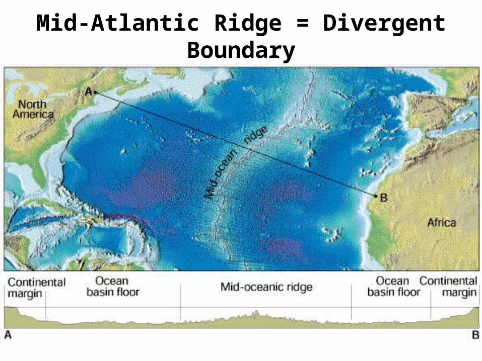
Mid-Atlantic Ridge = Divergent Boundary


http://www.geo.lsa.umich.edu/~crlb/COURSES/270/Lec12/spreexamples.jpeg

Iceland – a continent directly over the Mid-Atlantic Ridge

Subduction Zones
• An ocean plate and a continental plate hit head-on. The ocean plate subducts under the continent forming a trench. The subducting plate melts. Magma rises to the surface creating a string of volcanic mountains parallel to the shoreline.

Andes Mountains
Subduction zones form chains of volcanic mountains along the shoreline.

Collision Zones
Two continents hit head-on, crinkling up the land into a high mountain chain.

India’s Collision with Asia
Himalayas

The Himalayas Are Born…
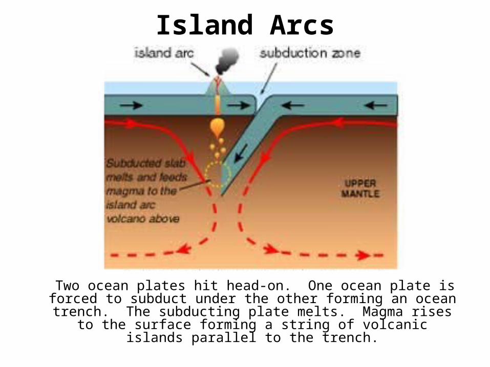
Island Arcs
Two ocean plates hit head-on. One ocean plate is forced to subduct under the other forming an ocean trench.
The subducting plate melts. Magma rises to the surface forming a string of volcanic islands parallel to the trench.

The Aleutian Islands


Forces—tension, compression shearing
Key concepts
Ask a Geologist
Ask an earth scientist

How does tectonic activity affect the earth’s crust?
• Builds mountains
• Creates deep ocean trenches
• Causes earthquakes
• Create volcanoes


Ocean Trenches
http://www.nhusd.k12.ca.us/ALVE/wow/Ocean/seafloor.gif


Volcanoes

Most volcanoes occur at plate boundaries…

http://www.thirteen.org/savageearth/hellscrust/assets/images/ringoffire.jpg


Recent patterns of earthquake and volcanic activities; maps showing the direction of movement of major plates and associated earthquake and volcanic activity
Compressional boundaries: folded mountains, thrust faults, trenches, lines of volcanoes (e.g. Pacific “ring of fire”)
Tensional boundaries: mid-ocean ridges, rift valleys
Shearing boundaries: lateral movement producingfaults (e.g. San Andreas Fault).
Real-world contexts:

http://www.gfz-potsdam.de/pb2/pb22/projects/mamba.html

Resources• http://www.calstatela.edu/faculty/acolvil/plates/pangaea.jpg
• http://platetectonics.pwnet.org/img/wegener.jpg
• http://home.tiscalinet.ch/biografien/images/wegener_kontinente.jpg
• http://library.thinkquest.org/17457/platetectonics/comic.jpg
• http://www.soc.soton.ac.uk/CHD/classroom@sea/carlsberg/images/fossil_correlation_lge.jpg
• http://earthobservatory.nasa.gov/Library/Giants/Wegener/Images/plate_boundaries.gif
• http://www.calstatela.edu/faculty/acolvil/plates/atlantic_profile.jpg
• http://pubs.usgs.gov/publications/graphics/Fig16.gif
• http://cps.earth.northwestern.edu/SPECTRA/IMG/basalt.png
• http://cc.usu.edu/~sharohl/granite.jpg
• http://tlacaelel.igeofcu.unam.mx/~GeoD/figs/tgondvana_ice.jpg
• http://www.physics.uc.edu/~hanson/ASTRO/LECTURENOTES/F01/Lec11/Pangaea.gif
• http://www.poleshiftprepare.com/glacial_striation.jpg

• http://www.ggs.org.ge/plates.jpg• http://earth.geol.ksu.edu/sgao/g100/plots/1008_world_volc_map.jpg• http://www.aeic.alaska.edu/Input/affiliated/doerte/personal/aleutians/
ak_map_big.jpg• http://www.4reference.net/encyclopedias/wikipedia/images/
Aleutians_aerial.jpg• http://www.avo.alaska.edu/gifs/2-3/02-95-03.jpg• http://www.soc.soton.ac.uk/CHD/classroom@sea/carlsberg/images/
island_arc.jpg• http://nte-serveur.univ-lyon1.fr/nte/geosciences/geodyn_int/tectonique2/
himalaya/images/Fig5a_inde.gif• http://terra.kueps.kyoto-u.ac.jp/~sake/himalaya.jpg• http://www.andes.org.uk/peak-info-5000/sabancaya.jpg• http://www-step.kugi.kyoto-u.ac.jp/~keizo/photos/andes.JPG• http://www.letus.northwestern.edu/projects/esp/top10/andespage/
andesphysical.jpg
• http://www.soc.soton.ac.uk/CHD/classroom@sea/carlsberg/images/atlantic_tectonics%20.jpg