Eagle Mountain Pumped Storage Project No. 13123 Final ... 12.9 - Class I...History of Research ......
79
Eagle Mountain Pumped Storage Project No. 13123 Final License Application Technical Appendices for Exhibit E, Applicant Prepared Environmental Impact Statement. Volume 3 of 6 Palm Desert, California Submitted to: Federal Energy Regulatory Commission Submitted by: Eagle Crest Energy Company Date: June 22, 2009 GEI Project No. 080473 ©2009 Eagle Crest Energy Company PUBLIC
Transcript of Eagle Mountain Pumped Storage Project No. 13123 Final ... 12.9 - Class I...History of Research ......

Eagle Mountain Pumped Storage Project No. 13123 Final License Application Technical Appendices for Exhibit E, Applicant Prepared Environmental Impact Statement. Volume 3 of 6 Palm Desert, California
Submitted to: Federal Energy Regulatory Commission Submitted by: Eagle Crest Energy Company
Date: June 22, 2009 GEI Project No. 080473 ©2009 Eagle Crest Energy Company
PUBLIC

12 Appendix C – Technical Memoranda
12.9 Class I Cultural Resources Investigation for the Proposed
Eagle Mountain Pumped Storage Project.
A CLASS I CULTURAL RESOURCES INVESTIGATION
for the PROPOSED EAGLE MOUNTAIN PUMPED STORAGE
PROJECT, RIVERSIDE COUNTY, CALIFORNIA
Prepared for:
Eagle Crest Energy Company 1 El Paseo West Building, Suite 204
74199 El Paseo Drive Palm Desert, CA 92260
Prepared by:
Jerry Schaefer ASM Affiliates, Inc. 2034 Corte del Nogal
Carlsbad, California 92011
PN 14011
Keywords: USGS 7.5-minute Corn Springs, Desert Center, East of Victory Pass, and Victory Pass quads; Chuckwalla Valley, Eagle Mountain Mine, Riverside County; Desert Training Center, Camp Desert Center, World
War II, Historic Trash Scatters; Class III Field Inventory.
April 2009


Table of Contents
Eagle Mountain Pumped Storage Transmission Line-Class I Cultural Resources i
TABLE OF CONTENTS Chapter Page
MANAGEMENT SUMMARY ................................................................. iii
1. PROJECT DESCRIPTION.............................................................. 1
2. ENVIRONMENTAL AND CULTURAL CONTEXT ............................. 5 NATURAL SETTING .............................................................................. 5
Geomorphology and Geology .................................................................. 6 Vegetation ......................................................................................... 6 Vertebrate Fauna ................................................................................. 7
PALEOENVIRONMENTS ........................................................................ 8 CULTURAL SETTING ............................................................................ 9
History of Research .............................................................................. 9 Cultural Periods and Patterns .................................................................11
3. RESEARCH DESIGN AND METHODS........................................... 29
4. PREVIOUS CULTURAL RESOURCES INVESTIGATIONS ................ 31 PREVIOUS REPORTS ............................................................................31 NATIVE AMERICAN HERITAGE COMMISSION RESULTS ..........................36
5. PREVIOUSLY RECORDED CULTURAL RESOURCES..................... 37 Prehistoric Cultural Resources ................................................................38 Historic Cultural Resources ...................................................................40
6. SENSITIVITY, DATA GAPS, AND RECOMMENDATIONS................ 43 SENSITIVITY.......................................................................................43 DATA GAPS AND RECOMMENDATIONS.................................................44
7. CONCLUSIONS.......................................................................... 45
REFERENCES.................................................................................... 47
APPENDICES..................................................................................... 59 APPENDIX A. Native American Heritage Commission Response APPENDIX B. Confidential Site Records APPENDIX C. Confidential Previous Studies and Recorded Site Maps

Table of Contents
ii Eagle Mountain Pumped Storage Transmission Line-Class I Cultural Resources
LIST OF FIGURES Page Figure 1. Project location map.......................................................................... 2 Figure 2. Eagle Mountain Pumped Storage Project................................................. 3
LIST OF TABLES Page Table 1. Eastern Information Center Report Listing..............................................33 Table 2. Previously Recorded Cultural Resources in or near the Eagle Mountain
Pumped Storage Project Area............................................................37 Table 3. Previously Recorded Prehistoric Sites, by Generalized Types
(Primary Number P-33-)..................................................................38 Table 4. Previously Recorded Historic Sites, by Generalized Types
(Primary Number P 33-)..................................................................40

Management Summary
Eagle Mountain Pumped Storage Transmission Line-Class I Cultural Resources iii
MANAGEMENT SUMMARY
A Class I cultural resources inventory of previously recorded sites was conducted for Eagle Crest Energy’s proposed Eagle Mountain Pumped Storage Project. This information is provided for the proponent, the Federal Energy Regulatory Commission, and the Bureau of Land Management (BLM) in support of regulatory and permitting procedures, including the Applicant Prepared Environmental Impact Statement. The inventory focused on the 500 kV transmission line and alternatives, a preferred and alternative interconnection collection substation, water pipeline, and water wells. The preferred transmission line extends for 13.5 mi. and alternatives include an additional 6 mi. of alignment, with a right-of-way 200 ft. wide. The water line routes include 15 mi. of alignment with a 60-ft.-wide right-of-way. The records search also included the general site plan that encompasses the former Kaiser Eagle Mountain Mine within which two reservoirs and an electrical generating station are proposed. A larger buffer extending 1 mi. out from the all of the above project components was used as the study corridor for the records search, encompassing 49,833 acres. This larger corridor provides additional information to interpret sites within the project area, assess general areas of potential sensitivity, and accommodates increasingly precise project design specifications and potential redesigns as constraints and opportunities are assessed in the environmental analysis. The inventory included cultural resource records at the Eastern Information Center (EIC) of the California Historic Resources Inventory System (CHRIS), housed at the University of California, Riverside and of sacred lands records at the California Native American Heritage Commission. The BLM Palm Springs Field Office, was also consulted concerning possible unrecorded sites and sensitivities in the study area. ASM Affiliates files identified 26 reports and 31 cultural resources previously recorded within the study corridor. The reports document archaeological inventory efforts in an undetermined but fairly small portion (3 mi. of transmission line – less than 10 percent) of the linear study corridor, and a somewhat greater portion of the project area proper. About 50 percent (n = 15) of the recorded resources in the study area are prehistoric, and 50 percent (n = 15) are historic in age. The majority of the recorded resources are comparatively minor. Some 16 percent (n = 5) are isolated finds, including three prehistoric lithics, one milling stone, and one historic ceramic. Many other sites consist of small prehistoric lithic scatters, a pot drop, possible rock rings and cleared circles, and bedrock milling. However, potentially more significant resources are also present in the study area, consisting of several portions of a major east-west trail network with associated features. Significant historic sites in the study area include two stick figure petroglyphs associated with an early wagon road and possibly a cenotaph associated with “Desert Steve” Ragsdale, three historic sites associated with Camp Young/Desert Center and the World War II-era Desert Training Center/California-Arizona Maneuver Area, a historic well, the Eagle Mountain Mine and community and radio control tower, and the Colorado River Aqueduct and Eagle Mountain Pumping Station. Less significant historic sites include remains of a blacktopped road and various historic post-World War II trash scatters.

Management Summary
iv Eagle Mountain Pumped Storage Transmission Line-Class I Cultural Resource
The only potentially significant previously recorded historic period resources in the project’s Area of Potential Effects (APE) are the Colorado River Aqueduct, an underground portion of which the transmission line would span, and possibly portions of Eagle Mine and Industrial Railroad. Generally speaking, the project area appears to contain the potential for significant prehistoric and historic cultural resources, although they are widely distributed and to a large extent avoided by the proposed transmission line and water line portion of the project. Further evaluation may be needed of the Eagle Mountain Mine and community and Eagle Mountain Industrial Railroad, although potential impacts appear to be avoidable. When the project’s APE has been more exactly defined, further cultural resource studies should include systematic archaeological surveys to inventory the portions of the APE that have not previously been addressed, evaluation of resources within the APE for National Register of Historic Places (NRHP) eligibility; Native American and SHPO consultation, and development of measures to mitigate any impacts to NRHP-eligible properties. Current record search data suggest that no historic properties will be affected by the proposed project.

1. Project Description
Eagle Mountain Pumped Storage Transmission Line-Class I Cultural Resources 1
1. PROJECT DESCRIPTION
The Eagle Mountain Energy Company proposes to develop the Eagle Mountain Pumped Storage Project located near the towns of Eagle Mountain and Desert Center in Riverside County, California (Figure 1). The proposed project is a hydroelectric pumped storage project that will provide system peaking capacity and electrical system regulating benefits to Southwestern electric utilities. The project will use off-peak energy to pump water from the lower reservoir to the upper reservoir during periods of low electrical demand and generate on-peak energy by conveying water from the upper to the lower reservoir through the generating units during periods of high electrical demand. The upper and lower reservoirs will be formed from existing mining pits; however, two small dams will be required at the upper reservoir to create the proposed volume of energy storage. Other important elements of the project and the focus of this Class I cultural resource records search are the preferred and alternate 500 kV transmission line routes. The preferred route follows an alignment from the Eagle Mountain Mine through a pass to the east of Eagle Mountain Pumping Plant of the Colorado River Aqueduct, and south along Eagle Mountain Road. Approximately 2 mi. north of Interstate 10 the route proceeds southeast to the preferred Interconnection Collector Substation, located west of Desert Center. An alternative transmission line route would continue south along Eagle Mountain Road and then veer southwest to the alternative Network Connection Point. This alternative is not preferred because of potential impacts to cultural resources associated with the evacuation hospital of the World War II Camp Desert Center. The other principal element is the water line that proceeds southeast from the Eagle Mountain Mine and parallel to an existing transmission line and gas corridor to the vicinity of the Desert Center Airport. The preferred 500 kV line is approximately 13.5 mi. long and 200 ft. wide while the alternative lines add an additional 6 mi. of examined route. Each of the Interconnection Collector Substation areas covers 25 acres. The eastern substation is the preferred one for the reasons stated above. The water line routes extend for approximately 13.5 mi. and are 60 ft. wide. Three currently identified well locations in the Chuckwalla Valley were also examined for the records search (Figure 2). The present study is designed to provide Class I cultural resources investigations to support a Traditional License Application to the Federal Energy Regulatory Commission (FERC) by Eagle Crest Energy. It includes a collection and assessment of existing information concerning cultural resources likely to be affected by the project, an evaluation of the potential for additional resources in the affected areas, and recommendations for future studies needed to comply with Section 106 of the National Historic Preservation Act and other applicable cultural resources laws and regulations.

1. Introduction
2 Eagle Mountain Pumped Storage Transmission Line-Class I Cultural Resource
Figure 1. Project location map.

1. Project Description
Eagle Mountain Pumped Storage Transmission Line-Class I Cultural Resources 3
Figure 2. Eagle Mountain Pumped Storage Project.


2. Environmental and Cultural Context
Eagle Mountain Pumped Storage Transmission Line-Class I Cultural Resources 5
2. ENVIRONMENTAL AND CULTURAL CONTEXT
The following discussion draws substantially upon the background discussion for a previous project that was located, in part, in the same region (Schaefer 2003). This chapter describes the natural and cultural setting of the project area. The project traverses the north-central margin of the Colorado Desert, centering on the Chuckwalla Valley and north-eastern Eagle Mountains. This region has a long cultural history extending back more than 10,000 years. The affiliation of a particular Native American group with Chuckwalla Valley is somewhat uncertain (Heizer 1978); ethnographic and historic evidence suggests possible links with three distinct groups: the Halchidhoma, Desert Cahuilla, and Chemehuevi. Since the Euro-American occupation of the region, the cultural landscape has been altered by a variety of land uses relating to travel, settlement, mining, water reclamation, and military preparedness. Throughout the cultural history of the Colorado Desert, human activities have been closely tied to the distribution of natural resources and other aspects of the natural setting. Water, vegetation communities, animal habitat, and lithic raw material were not evenly distributed across the landscape. Prehistoric archaeological evidence is therefore also likely to be non-randomly distributed, as the prehistoric hunter-gatherers keyed onto these critical resources during their seasonal rounds. Both short-term and long-term climatic fluctuations almost certainly also affected the intensity of land use over time. The natural topography influenced the location of trails and other land use patterns. Dynamic forces of erosion and of alluvial and eolian deposition also determined the preservation, integrity, and visibility of archaeological sites.
NATURAL SETTING
The project area is located on the northern margin of the Colorado Desert Region area, which in turn is a northwestern subregion within the more widespread Sonoran Desert. This area typically consists of a series of northwest-to-southeast trending mountain ranges interspaced with basins filled with alluvial or lacustrine sediments. Elevations along the project corridor range from more than 1,600 ft. above mean sea level (amsl) in the northwest, on the eastern margin of Eagle Mountains, to 345 ft. amsl at the eastern extreme. Few areas of North America are hotter or dryer than the Colorado Desert. Modern climatic conditions provide for dry, mild winters and dry, hot summers. Mean winter lows of 44º F and a mean summer highs of 104º F are typical, with record highs of 120º F. Rainfall data from Indio between 1877 and 1987 record an annual average of only 5.54 in., with extremes between 0.18 and 11.50 in. annually. Violent summer storms are not unusual, but most precipitation falls in mid-winter. The Colorado River was the most reliable and abundant source of water in the region, supplemented by a few widely dispersed springs elsewhere.
2. Environmental and Cultural Context
6 Eagle Mountain Pumped Storage Transmission Line-Class I Cultural Resource
Water sources are extremely scarce through the Chuckwalla Valley, but several springs are widely dispersed in the mountains to the north and south. They include, from west to east, Lost Palms Oasis, Hayfield Springs, Corn Springs, and McCoy Springs. Such water sources were foci of prehistoric activities. More ephemeral water sources are represented by the dry lakes (playas) and pans that were used during periods of relatively greater rainfall or especially wet winters. They include Palen Lake and Ford Dry Lake. Geomorphology and Geology
The project area owes many of its characteristic features to its location adjacent to the Salton Rift. This distinct physiographic feature consists of a massive graben created at an interface of the North American and Pacific tectonic plates. The San Andreas Fault and the Transverse Ranges are prominent geomorphic features marking this plate boundary. The mountain ranges and alluvial basins farther north and east are more characteristic of the Basin and Range Province, also a result of uplifting along the plate boundary’s subduction zone. The Eagle Mountains are composed primarily of Precambrian igneous and metamorphic rocks, Mesozoic granitic rocks, and Pleistocene nonmarine sediments – lithologies of only limited usefulness to the region’s prehistoric inhabitants, although Euro-American miners subsequently exploited them (Jennings 1967). Other ranges framing the project area include the Coxcomb, Palen, and McCoy mountains to the north of Chuckwalla Valley and the Chuckwalla, Little Chuchwalla, and Mule mountains to the south, adding pre-Cretaceous metasediments to the mix of lithologies. The project area proper runs almost exclusively through areas of Quaternary alluvium, lake deposits, and dune sand. Very active geomorphic processes of erosion and deposition along this route may have been responsible for poor preservation or visibility of archaeological sites. One geological deposit in the Chuckwalla Valley – Alligator Rock – was the focus of extensive prehistoric lithic procurement activities. Located just southwest of Desert Center, Alligator Rock is a prominent ridge containing dikes of aplite, a relatively fine-grained plutonic rock composed of quartz and alkali feldspar. Thousands of years of aplite procurement as a lithic raw material have resulted in a substantial quarry site complex that extends over a 1-mi.2 area. The quarry site complex is listed on the NRHP as the North Chuckwalla Mountain Quarry District. The other major sources of prehistoric tool stone were the many pebble covered desert pavements of fine-grained cryptocrystalline silicate rock along the Colorado River Valley. Vegetation
The project route crosses two main vegetation communities: creosote bush scrub and desert microphyll woodland (Carrico et al. 1982). The creosote bush scrub community ranges from non-alkali alluvial flats to rocky slopes. Characteristic species include creosote (Larrea tridentata) and white bursage or burrobush (Ambrosia dumosa). Well-drained alluvial slopes also support encelia (Encelia farinosa) and desert trumpet (Eriogonum inflatum). Annual
2. Environmental and Cultural Context
Eagle Mountain Pumped Storage Transmission Line-Class I Cultural Resources 7
grasses that occur throughout this community were primary food resources for prehistoric Native Americans. The desert microphyll woodland community occurs in drainages descending from the mountains on either side of Chuckwalla Valley. Characteristic trees include catclaw (Acacia gregii), palo verde (Cercidium floridum), desert willow (Chiopsis lindearis), smoke tree (Dalea spinosa), and ironwood (Olneya tesota). Shrub species include sweetbush (Bebbia juncea), cheese bush (Hymenoclea salsola), and desert lavender (Hyptis emoryi). Native Americans harvested catclaw and palo verde bean pods in late spring and early summer to pound them into a nutritious meal. Willow bark fiber was made into cordage, skirts, breechcloths, and other objects, while firewood and construction materials were available from all the trees (Bean and Saubel 1972). Vertebrate Fauna
Mammals with the greatest economic importance to Colorado Desert peoples included desert cottontail (Sylvilagus audubonii), black-tailed jackrabbit (Lepus californicus), several rodent species, mule deer (Odocoileus hemionus), and Nelson’s bighorn sheep (Ovis canadensis nelsoni). Predators that are known to occur in the area include mountain lion (Felis concolor), badger (Taxidea taxus), kit fox (Vulpes macrotis), and bobcat (Felis rufus). Desert cottontail is most abundant in sand dune areas such as those found in the eastern Chuckwalla Valley. Black-tailed jackrabbits have a more widespread distribution on desert floors, floodplains, washes, and rocky slopes. Mule deer were most likely to be encountered in desert washes, while the elusive bighorn sheep could be ambushed at desert tanks or oases when they came down from the mountain slopes to get water (Jaeger 1965; Ryan 1968). Wild game played a less significant role in the diet of ethnohistoric Colorado River peoples than for the desert groups, but it may have had more importance in earlier times, prior to the introduction of horticulture. A wide variety of fish, reptiles, birds, and mammals are found along the Colorado River and its adjacent deserts, and many species had economic importance to the Colorado River peoples (Castetter and Bell 1951). Fish were the most important source of animal protein and included razorback sucker (Xyrauchen texanus), bonytail chub (Gila elegans), striped mullet (Mugil cephalus), various minnows (Cyprinidae), and machete (Elops affinis). Some of these species are now extinct on the lower Colorado River, having been replaced by introduced species such as catfish (Gobalet 1994; McGinnis 1984). Many species of raptors, wading birds, songbirds, and migratory waterfowl inhabited the riparian margins of the Colorado River. Raptors had ceremonial uses, while migratory birds and their eggs were exploited for food. Bird species included bald eagle (Haliaeetus leucocephalus), golden eagle (Aquila chrysaetos), osprey (Pandion haliaetus), Wilson’s warbler (Wilsonia pusillus), American coot (Fulica americana), mallard (Anas plathyrhynchos), great blue heron (Ardea herodias), and clapper rail (Rallus longirostris).

2. Environmental and Cultural Context
8 Eagle Mountain Pumped Storage Transmission Line-Class I Cultural Resource
PALEOENVIRONMENTS
Evidence of prehistoric environmental conditions in the study region is very limited. Pollen-bearing stratified deposits from caves or lake beds are not as common in the Colorado Desert as they are in the Great Basin, where most of the desert climatic reconstructions are based. Evidence indicates that while early Holocene conditions were wetter and cooler than present, permitting greater use of the study area and especially around the boundaries of Palen Lake and Ford Dry Lake. Generally modern desert conditions were already in existence by the end of the early Holocene period with periods of more extensive drought in the Late Holocene (Thompson 1984). Paleoclimatic reconstructions, based on pack rat (Neotoma sp.) midden analyses, indicate that at elevations below 1,000 ft. there has been little climatic change along the Lower Colorado and Gila rivers over the last 13,000 years (Van Devender 1990). The region may have been a refugium for lower Sonoran creosote-scrub habitat during the Pleistocene period (Cole 1986). At higher elevations in the mountains, pack rat midden analyses indicate the presence of a juniper woodland habitat in the Late Pleistocene between 20,000 and 9000 B.C. These xeric woodlands continued through the early Holocene between 9000 and 6000 B.C., before finally retreating to higher elevations during the Middle Holocene and being replaced with the current creosote scrub and desert riparian habitat (King and Van Devender 1977; Van Devender and Spaulding 1983). The last century has seen some of the hottest and driest conditions in at least the last 400 years (Hastings and Turner 1965:188). Based on current information, the climatic history of the general region may be summarized as follows (Van Devender and Spaulding 1983):
• Late Pleistocene (20,000 to 9000 B.C.): Cooler and wetter conditions supported pinyon-juniper woodlands, extensive deep lakes, and savannah grasslands or creosote scrub at low elevations.
• Early Holocene (9000 to 6000 B.C.): Gradual warming and drying conditions resulted in the shrinking of lakes and replacement of woodlands by creosote scrub communities at lower levels.
• Middle to Late Holocene (6000 B.C. to present): Warm and dry conditions continued, dominated by summer monsoons in the desert Southwest and winter storms along the Pacific Coast. Lakes in low-lying basins completely dried up or became ephemeral in nature. Local fluctuations in temperature and aridity may have produced ecological variations of no greater magnitude than those known from historic records. Droughts may have been more frequent and severe during the period between 5000 and 2500 B.C.

2. Environmental and Cultural Context
Eagle Mountain Pumped Storage Transmission Line-Class I Cultural Resources 9
CULTURAL SETTING
History of Research
An outline of Colorado Desert culture history has been generally accepted by the archaeological community, but not without the realization that it is a tentative construct, with many details that are still unknown or not well understood. Ironically, the problem is most acute along the lower Colorado River itself, where late prehistoric and ethnohistoric period occupations were most intense. Most of the major aboriginal occupation sites were on the lower terraces of the Colorado River, but none of these have been investigated, evidently because they are buried beneath many feet of alluvial deposits, have been destroyed by agricultural development, or are now obscured by impenetrable stands of tamarisk and reeds. The culture history for the region is based on the pioneering work of Malcolm J. Rogers in many parts of the Colorado Desert, primarily carried out during the 1920s and 1930s (Rogers 1939, 1945, 1966). Since then, several overviews and syntheses have been prepared, and each succeeding effort had been able to draw upon previous studies and add new data and interpretations. Rogers established the first systematic culture history and artifact typologies of the Colorado Desert. His investigations of San Dieguito and Archaic flaked stone tools and settlement patterns (Rogers 1929, 1939, 1958, 1966) and of Yuman ceramics and culture history (Rogers 1936, 1945) remain a foundation for current archaeological research in the area. Most research during the last 25 years has been sponsored or mandated by government agencies for compliance with state and federal laws. Independent research has also been conducted for academic theses and dissertations and by local institutions such as Imperial Valley College and University of California, Riverside. Of particular note is the corpus of federal agency overviews and management plans that identified cultural contexts, research domains, and management issues for most of the Colorado Desert. Margaret Weide and Pat Barker prepared one of the earliest syntheses of information on the Yuha Desert in southwestern Imperial County for the BLM (see Wilke 1978). This study included discussions relevant to the culture history of the Colorado Desert as a whole, including the Colorado River Valley (Weide 1974). An updated synthesis addressing the Colorado Desert Planning Units was prepared by Elizabeth von Till Warren and her collaborators (1981). This is a particularly succinct and useful review of information on environments, prehistory, and ethnography, although a bit out of date. For southwestern Arizona, Randall H. McGuire and Michael B. Schiffer (1982) reviewed over 50 previous research projects and prepared cultural syntheses that are also applicable to southern California. One of the most valuable contributions in that volume is Michael R. Waters’ (1982a, 1982b) study of Patayan ceramics, based largely on the unpublished notes and field collections of Rogers. More recently, Jerry Schaefer (1994a) updated and corrected Waters’ discussion of the time ranges and spatial distribution of various Patayan ceramic types, based on a review of recent excavations in the Colorado Desert.

2. Environmental and Cultural Context
10 Eagle Mountain Pumped Storage Transmission Line-Class I Cultural Resource
At present, the earliest sites in the vicinity of the project area date to the early-middle Archaic period (5000-3000 B.C.), as represented by the lithic complex in the Pinto Basin of Joshua Tree National Monument (Campbell and Campbell 1935) and at ephemeral pans such as the ones found within the Chuckwalla Valley. Absolute dates for this period remain problematical (Schroth 1994; Warren 1984). For the lower Colorado River Valley, Jeannne Swarthout and Christopher E. Drover (Swarthout 1981a, 1981b, 1981c; Swarthout and Drover 1981) prepared detailed overviews that divided the river into four reaches: from Lee’s Ferry to Grand Wash Cliffs, from Grand Wash Cliffs to Davis Dam, from Davis Dam to the International Border, and the Lower Virgin River. These studies emphasized the limitations of previous work because of inconsistent site records and a lack of stratified sites. However, they did provide a careful review of the environment and culture history, as well as present proposals for future research. The study of Reach 3, from Davis Dam to the International Border (Swarthout and Drover 1981) is most applicable to the study area and one of the best in the series. Two ethnographically based settlement models were presented, one for the Mohave in Mohave Valley and the other for the Halchidhoma and Quechan on the Colorado River. Although the lack of preserved sites on the valley floor makes it difficult to test Swarthout and Drover’s models, related test implications can be developed for the temporary camps and resource extraction sites in the deserts away from the river. A more recent overview of the lower Colorado River by Connie L. Stone (1991) extended the history of research and review of current research issues. Stone identified major cultural resource types, from rock rings to rockshelters, and provided summary statements of their potential research values and applicable investigative procedures. She also provided valuable maps of major intaglio and rock art sites, trail systems, and generalized prehistoric land use. Finally, Stone updated the discussion of management issues. Statistical Research has been engaged in a series of surveys along the lower Gila and Colorado rivers. One aspect of these studies was the documentation of milling implement quarries, the closest of which is at Palo Verde Point (Schneider 1994). Of particular interest are the many geoglyph and rock art sites that Jeffrey H. Altschul and Joseph A. Ezzo interpreted as part of a ceremonial complex involving the entire Lower Colorado River region. A symposium highlighted the cultural significance of these sites for the Yuman tribes of the Colorado River and the productive results that can be derived from uniting Native American perspectives and scientific archaeological interpretation (Ezzo 1994; Ezzo and Altschul 1993). Schaefer (1994b) proposed additional research issues that linked the treatment of archaeological sites in the desert and river valley zones. In another article, he summarized and critiqued recent data recovery projects in the Colorado Desert with an emphasis on understanding the chronology of Lake Cahuilla, settlement patterns, and the problems of interpreting sites on desert pavements (Schaefer 1994c). Most recently, Schaefer and Don Laylander (2007) offered a synthesis of work on Colorado Desert prehistory over the last 20 years.

2. Environmental and Cultural Context
Eagle Mountain Pumped Storage Transmission Line-Class I Cultural Resources 11
Cultural Periods and Patterns
Five successive periods, each with distinctive cultural patterns, may be suggested for the Colorado Desert, extending back over a period of at least 12,000 years. They include (1) Early Man (Malpais); (2) Paleoindian (San Dieguito); (3) Archaic (Pinto and Amargosa); (4) Late Prehistoric (Patayan); (5) Historic (Ethnohistoric and Euro-American). Early Man Period (Malpais Pattern) (50,000-10,000 B.C.)
The Malpais Pattern is represented by a complex of archaeological remains that has been hypothesized by some scholars to date between 50,000 to 10,000 B.C. (Begole 1973, 1976; Davis et al. 1980; Hayden 1976). Rogers (1939, 1966) originally used the term for cleared circles, tools, and rock alignments that appeared to be ancient and that he later classified as San Dieguito I. Malpais has continued to be applied to heavily varnished choppers and scrapers found on desert pavements of the Colorado, Mojave, and Sonoran deserts that are believed to predate the Paleoindian period of projectile point use. Although few would reject most of the items as being culturally produced artifacts and features, the methods used to date them are highly subjective and have been assailed on many grounds (McGuire and Schiffer 1982:160-164). Arguments in favor of early occupations in the Colorado Desert have been further eroded by the redating of the Yuha Man. Originally dated as over 20,000 years old on the basis of radiocarbon analysis of caliche deposits, more reliable dates of actual human bone fragments based on the accelerator mass spectrometer (AMS) radiocarbon method now place the burial at only about 5000 years B.C. (Taylor et al. 1985). Paleoindian Period (San Dieguito Pattern) (10,000-6000 B.C.)
Most of the aceramic lithic assemblages, rock features, and cleared circles in the Colorado Desert have been assigned to the San Dieguito pattern. Rogers first defined the pattern on the basis of surface surveys in western San Diego County, but he later refined his understanding of the pattern with at excavations at the C. W. Harris site, a few miles up the San Dieguito River from the Pacific coast (Rogers 1939, 1966). Rogers saw three phases of the San Dieguito pattern in its Central Aspect (which included the Colorado and Mojave deserts and the western Great Basin). Each successive phase was thought to have been characterized by the addition of new, more sophisticated tool types to the preexisting tool kit. Current understanding of the lithic technology of the San Dieguito pattern focus on percussion-flaked cores and the resulting debitage, with little or no pressure flaking evident during the first two phases. Tools from San Dieguito I and II phases include bifacially and unifacially reduced choppers and chopping tools, concave-edge scrapers (spokeshaves), bilaterally notched pebbles, and scraper planes. Appearing in the San Dieguito II phase are finely made blades, smaller bifacial points, and a greater variety of scraper and chopper types. It appears that the San Dieguito III phase tool kit became appreciably more diverse with the introduction of fine pressure flaking. Tools include pressure-flaked blades, leaf-shaped projectile points, scraper planes, plano-convex scrapers, crescentics (which may have been amulets), and elongated bifacial knives (Rogers 1939, 1958, 1966; Warren 1967; Warren and True 1961). Various

2. Environmental and Cultural Context
12 Eagle Mountain Pumped Storage Transmission Line-Class I Cultural Resource
attempts have also been made to associate cleared circle features with the San Dieguito phases, but no convincing chronological scheme has yet emerged (Pendleton 1984). Because of the largely surface character typical of desert sites and the scarcity of chronological indicators, it has been difficult to substantiate the validity of Rogers’ phase designations as temporal indicators, that is, chronologically successive changes in the tool kit of a long-lived culture. Some of the variations may have developed contemporaneously, in response to ecological or aesthetic requirements. Subsequent excavations at the C. W. Harris site in coastal San Diego County also failed to confirm Rogers’ original observation of a stratigraphic separation between San Dieguito II and III assemblages (Warren 1967:171-172). Indeed, without a stratified context to demonstrate succession, the distinctions may as likely be due to economic specialization at a specific site or to sampling error, rather than to technological change through time. Rogers (1966:39) also identified different settlement patterns for each phase, but Sheila J. Vaughan (1982:6-11) argued that these distinctions were inadequately defined and inconsistently applied. The San Dieguito pattern, as reconstructed from assemblage characteristics and site associations, represented a hunter-gatherer adaptation by which small mobile bands exploited small and large game and collected seasonally available wild plants. The absence or scarcity of milling tools in San Dieguito assemblages has been seen as reflecting a lack of hard nuts and seeds in the diet, as well as being a cultural marker separating the San Dieguito culture from the later Desert Archaic culture (Moratto 1984; Rogers 1966; Warren 1967). However, manos and portable metates are now increasingly recognized at coastal sites that have been radiocarbon dated to earlier than 6000 B.C. Arguments have also been made for the presence of a well-developed early grinding tool assemblage, based on finds from the Trans-Pecos area of Texas (Ezell 1984). In regard to the Colorado Desert, Lorann Pendleton (1984:68-74) noted that most ethnographically documented pounding equipment for processing hard seeds and wild mesquite and screwbeans was made out of wood and would not have been preserved at open archaeological sites. Site distributions indicate some of the basic elements of the San Dieguito settlement system. The sites may be located on any flat area, but the largest aggregations occur on mesas and terraces overlooking large washes or the margins of lakes. These are areas where a variety of plant and animal resources were located and where water was at least seasonally available. Pendleton (1984) made a strong case, based on an ethnographic analogy with the Colorado River Yumans, that San Dieguito occupation in the eastern Colorado Desert would have been focused on the river floodplain. She tested her model with the large array of data from the Picacho Basin and argued desert areas away from the river were used only to a limited degree, to take advantage of special resources within the foraging radius of logistically organized collecting groups. Archaic Period (Pinto and Amargosa Patterns) (6000 B.C.-A.D. 500)
The Pinto and Amargosa patterns are considered regional specializations within the widespread hunting-gathering adaptations that characterized the Archaic period (Campbell and Campbell

2. Environmental and Cultural Context
Eagle Mountain Pumped Storage Transmission Line-Class I Cultural Resources 13
1935). Pinto and Amargosa sites occur more frequently in the Great Basin, Mojave Desert, and Sonoran Desert east of the Colorado River than in the Colorado Desert, where few Pinto or Amargosa (i.e., Elko series) projectile points have been identified on the desert pavements. It has been suggested that the California deserts were inhospitable during the Archaic period, particularly during the so-called Altithermal phase between 5000 and 2000 B.C., and that the mobile hunter-gatherers were forced to concentrate around limited locations or move to more habitable regions (Crabtree 1981; Schaefer 1994c; Weide 1974). Some late Archaic sites have been identified along the boundary between the low desert and the Peninsular Ranges and at favored habitats at springs and tanks. The most substantial site from this period documented in the Colorado Desert is Indian Hill Rockshelter in Anza-Borrego Desert State Park where 1.5 m of Archaic period cultural deposits were excavated below a late prehistoric component (McDonald 1992). Most significant were 11 rock-lined cache pits and numerous hearths, indicative of either a residential base or a temporary camp in which food storage was integral to the settlement-subsistence strategy. Also recovered were numerous Elko Eared dart points, flaked stone and milling tools, and three inhumations, one of which was radiocarbon dated to 4,070 ±100 years B.P. Two similar rock-lined pits were excavated at a small rockshelter in Tahquitz Canyon near Palm Springs (Bean et al. 1995). The small quantity of artifacts at the latter site suggested strategically stored food and seed processing equipment that was used by small mobile groups. More recently, a late Archaic period campsite was also identified in 8-m-deep dune deposits adjacent to the north shoreline of Lake Cahuilla (Love 1996). Other Archaic sites have been recently discovered in interlacustral deposits on the bed of Lake Cahuilla in the northern Coachella Valley and also the first substantial habitation site from this period has been found near Desert Hot Springs (Schaefer and Laylander 2007). Radiocarbon dates of almost 3000 B.P. and associated bird and fish bone confirm a late Archaic period Lake Cahuilla occupational horizon. Additional Archaic sites fairly certainly are still to be discovered, buried under alluvial fans and wash deposits, sand dunes, Lake Cahuilla sediments, or Colorado River valley alluvium. Late Prehistoric Period (Patayan Pattern) (A.D. 500-1900)
Major innovations during this period included the introduction of pottery making by the paddle-and-anvil technique and bow-and-arrow technology, perhaps around A.D. 800, and the introduction of floodplain agriculture at about the same time (Rogers 1945). Exact dating of early domesticates is lacking (Schroeder 1979). Agriculture and ceramics were probably introduced either from northwestern Mexico or from the Hohokam culture on the Gila River (McGuire and Schiffer 1982; Rogers 1945; Schroeder 1975, 1979). Between A.D. 1000 and 1700, desert peoples of this region appear to have extended their focus somewhat away from the Colorado River floodplains to a more mobile, diversified resource procurement pattern, with increased travel between the river and Lake Cahuilla to the west (Pendleton 1984). Long-range travel to special resource collecting zones and ceremonial locales, trading expeditions, and possibly warfare are reflected by the numerous trail systems seen throughout the Colorado Desert. Pot drops, trailside shrines, and other evidence of transitory activities are often associated with these trails (McCarthy 1982, 1993). The present
2. Environmental and Cultural Context
14 Eagle Mountain Pumped Storage Transmission Line-Class I Cultural Resource
study corridor roughly parallels an important travel route between the Colorado River and the Coachella Valley. Several local varieties of pottery appeared during the Late Prehistoric period (Waters 1982a, 1982b). Many of the pictographs, petroglyphs, and bedrock grinding features in the Colorado Desert have also been associated with the Patayan pattern, although it is difficult to date such features directly or to determine their cultural affiliations. During this period, and possibly also in the preceding Archaic period, specific volcanic and sandstone rock outcrops along the Colorado and Gila rivers were exploited for the manufacture of stone pestles and portable milling slabs (Schneider 1993, 1994). With the completion of the final recession of Lake Cahuilla around A.D. 1700, the Patayan III phase emerged, apparently including a return to reliance on the Colorado River floodplain as well as some floodplain agriculture along the New and Alamo rivers in Imperial Valley, where mixed horticultural/hunter-gatherer economies were practiced. Historic Period (Native American Ethnohistoric and Euro-American Patterns) (post A.D. 1540)
Colorado River People The Halchidhoma were a Yuman-speaking group who lived along the Palo Verde Valley of the lower Colorado River Valley in the vicinity of modern Parker and Blyth. Although somewhat distant from the project area, they are likely to have traveled between their homeland and the Coachella Valley via the Chuckwalla Valley. In the early seventeenth century, they were living on the lower Colorado River below its junction with the Gila River, but in the eighteenth century they were reported in the area around Blythe. During the early nineteenth century, conflicts with their River Yuman neighbors, the Quechan and the Mohave, forced the Halchidhoma to move east to the middle Gila River, where they merged socially and culturally with the Maricopa. Because of these historical circumstances, traditional Halchidhoma culture is less well known than that of other River Yuman groups (Harwell and Kelly 1983; Spier 1933). However, studies of the other groups shed light on Halchidhoma lifeways (Bee 1981, 1983, 1989; Castetter and Bell 1951; Forbes 1965; Forde 1931; Knack 1981; Kroeber 1925; Pendleton 1984; Stewart 1983; Woods 1982). The first historic accounts of the native inhabitants of the lower Colorado River were made by Spanish explorers. The first professional anthropological account was by Alfred L. Kroeber (1920, 1925), who conducted extensive fieldwork, particularly among the Mohave in the Needles area, between 1900 and 1910. Because the River Yumans were generally so successful in keeping Spanish missionaries out of their territory and because of their relative spatial and cultural isolation from Euro-Americans for a long period, the Colorado River Yumans maintained their languages, religion, and cultural practices to a much greater degree than most coastal California groups. Early ethnographers during the period between 1900 and 1950 were able to record a rich oral literature and reconstruct pre-contact lifeways to a considerable degree. However, many aspects of traditional technology, such as ceramics and the production of flaked and ground stone tools, had been lost due to the rapid adoption of Western material culture. A Yuman emphasis on spiritual concerns over material things and a preoccupation
2. Environmental and Cultural Context
Eagle Mountain Pumped Storage Transmission Line-Class I Cultural Resources 15
with warfare meant that a rich oral tradition of myths, epic stories, and battle narratives was still extant at the beginning of this century and continues down to the present. The lower Colorado River area was characterized by shifting tribal territory and tribal boundaries throughout early historic times due to intensive inter-tribal warfare (Forbes 1965). When Hernando Alarcón sailed up the lower Colorado River in 1540, he described a condition of incessant warfare. During Juan de Oñate’s 1605 expedition, he found the Halchidhoma living south of the Gila River confluence. In the area that included Palo Verde Valley, south of the ethnographically familiar Mohave, Oñate encountered a group labeled the Bahacecha, whose identification with any subsequently known ethnographic group is uncertain (Laylander 2004). Almost a century passed until the Jesuit missionary Eusebio Francisco Kino’s 1700 and 1701 visits to the juncture of the Gila and Colorado rivers. The Yuma crossing area was again visited by the 1774 and 1775-1776 Anza expeditions that brought settlers from Sonora to California. The Franciscan missionary Francisco Garcés left the second expedition at Yuma and explored the Colorado River as far north and east as the Hopi mesas. Garcés wrote one of the first detailed descriptions of the Halchidhoma, who at that period were found to have moved north between the Quechan and Mohave territories, from the Palo Verde Valley to the area just below Parker. Spanish-Quechan interactions increased for a few years after the Anza expeditions, until two settlements with attached missions were established in 1780 near the confluence of the Colorado and Gila rivers. These efforts at Spanish colonization were motivated by the strategic important of the Colorado River crossing. However, conflicts between the settlers and the Quechan soon led to an uprising and massacre of the Euro-Americans in 1781. Contacts between the River Yumans and outsiders were few and often hostile throughout the ensuing half-century. It appears from historical accounts and Yuman oral histories that the Halchidhoma were in an almost constant state of war with the Quechan and Mohave. The Halchidhoma, in turn, established alliances with the Cocopa and Maricopa, among others, in their efforts to maintain their territory. Eventually the Halchidhoma could no longer withstand the two-front attacks from the north and south. They gradually moved off the river to join kindred River Yuman groups in Maricopa territory on the middle Gila River after a temporary stay in northern Sonora. By around 1825-1830, most Halchidhoma had left the Colorado River, and the last families left by 1840. There is no complete description of the lifeways of the Halchidhoma as they were lived on the Colorado River, because the Halchidhoma had begun to be assimilated into the Maricopa more than a half century before scientific ethnographies began to be written. Today the Halchidhoma are most closely associated with the Laveen community on the Salt River Reservation in Arizona, although descendants are distributed over several reservations (Harwell and Kelly 1983:74). Leslie Spier (1933) was fortunate to have a Halchidhoma elder as the principal

2. Environmental and Cultural Context
16 Eagle Mountain Pumped Storage Transmission Line-Class I Cultural Resource
informant for his landmark study of Gila River Yumans. By this time, many elements of Piman and Maricopa culture had been adopted, but some valuable information could still be derived concerning oral traditions. It is reasonable to assume Halchidhoma lifeways were very similar to those the Quechan and Mohave when they occupied the Colorado River. In principle, the following description of Yuman society would apply to all of the River Yumans. The focus on riverine subsistence resources encouraged a mixed foraging way of life for the River Yumans. Foods procured by seasonal rounds of hunting, fishing, and gathering supplemented small-scale agricultural practices. According to Robert L. Bee (1983), the Mohave relied more heavily on agriculture than did the Cocopa in the Colorado River’s delta or the Quechan. In their study of Yuman agricultural strategies, Edward F. Castetter and William H. Bell (1951) estimated that about half of the Mohave diet derived from farming. They estimated that the Cocopa, by contrast, derived only about 30 percent of their diet from agriculture because of greater access to a diversity of habitats; the Quechan (and presumably also the Halchidhoma) diet was intermediate between the Mohave and the Cocopa (Bee 1983). Agricultural strategies were designed to optimize use of floodwaters bringing the necessary moisture to the fields, which tended to be quite small in size (2-3 acres). Aboriginal cultivated crops included maize, beans, squash, melon, and various semi-wild grasses. Seeds were planted in newly deposited sediments after the floodwaters had receded. The River Yumans also used more than 75 wild plant foods as food sources, the most important being mesquite and screwbean. The primary source of dietary animal protein came from fish caught in the Colorado River. Among the more important species were the humpbacked sucker and Colorado pike minnow. Regularly hunted game included small mammals such as rabbits, squirrels, and pack rats. Larger game that figured in the diet included deer and bighorn sheep, but these were probably hunted with less frequency and were less abundant than small game. However, their meat was highly regarded by the River Yumans, particularly in winter, when reliable sources of dietary fat were in especially short supply. Swarthout and Drover’s (1981) Model II characterizes the Quechan and Halchidhoma settlement and subsistence strategy on the Colorado River below Topoc. This model presumes a low reliance on cultigens, accounting for no more than 30 to 40 percent of the annual dietary intake (Castetter and Bell 1951:74). Residential bases were centered on the Colorado River but conformed to a bipolar pattern. Spring and summer houses were located near each agricultural field, but up on the mesas, where they would be safe from floods (Kelly n.d.:55), while open-air ramadas were constructed on the floodplains adjacent to the fields. During this time, small parties sought out wild vegetal resources along the floodplain and adjacent washes. Mesquite and screwbean were important staples that were relied upon as stored staples during the winter months, especially if domestic crop harvests were inadequate. The winter season was a time to relocate to residential bases on upper Colorado River terraces, lower bajadas, and lower mountain slopes. Winter homes were more substantial earth-covered lodges (Kelly n.d.:55). The population subsisted on stored domestic and wild foods, in addition to what wild game could be had. Additional temporary camps would be established in outlying areas for extracting

2. Environmental and Cultural Context
Eagle Mountain Pumped Storage Transmission Line-Class I Cultural Resources 17
specific animal, vegetal, or lithic resources. As soon as the spring floods subsided, the population would then resume their lower terrace residences. Yuman groups were organized into patrilineal, exogamous, totemic clans (referred to as sibs in the early literature). Each clan or cimul was named after a plant, animal, or natural object, and this name was borne only by female members (Gifford 1918). There were no clan leaders, and the clan did not have special ceremonial or sociopolitical functions. Clans were not localized at specific rancherias; the latter contained members of several clans. Each localized rancheria or band recognized a leader (pi’pa taxa’n) who was called on to settle disputes, be responsible for the social and economic welfare of his people, decide on seasonal moves, and determine when to move the entire rancheria if necessary. His power was quite restricted, and he had limited influence. His position was achieved through dreaming, force of character, and demonstrated ability. Each tribal group also recognized a paramount chief (kwoxot) who might rise from the ranks of the rancheria leaders. This position may have become more important during the historic period as a result of contacts with Euro-American political and military institutions. A chief was not required to show prowess in warfare, and indeed he was expected to remain in the village or refrain from battle. Special war leaders (kwanami) were recognized for military tasks. Unlike other southern California groups where the primary political allegiance and identity lay with the localized band, members of the River Yuman groups thought of themselves as belonging to a true nation. Julian H. Steward (1955:159-161) postulated that Yuman clans evolved from localized patrilineages like those found among the Cahuilla, but which had become dislocated and clustered into larger settlements as a result of the higher population densities afforded by horticulture. Growing population size in other areas of southern California brought about increasingly sedentary bands, but instead of band size growing there was shrinking of band territories. This pattern did not occur on the Colorado River, where people moved freely from one settlement to another. Entire settlements had to shift within the confines of the floodplain, depending on the location of arable land after each flood season. Steward identified warfare as another factor inhibiting the localization of clans and promoting increases in band size. Larger social groups afforded greater protection against enemy attacks. The apparent emphasis on warfare in Colorado River Yuman culture has been the subject of considerable anthropological discussion. Chris White (1974) emphasized the ecological reasons for warfare, including environmental circumscription, high population density, and environmental instability. Edward W. Gifford (1931:161), Clifton B. Kroeber (1980), and Kroeber and Bernard L. Fontana (1986) stressed the deeply ingrained ideological and cultural values that were attached to personal battle in River Yuman culture. They argue that fighting was seen by its participants as a necessary means to enhance the spiritual power of the entire tribe, without regard to any material benefits. Probably both factors operated to shape the Yuman warrior tradition over time. Both ecological and cultural/ideological factors are intertwined in a complex and dynamic system, much as Roy A. Rappaport (1968) demonstrated for the role of warfare among New Guinea tribes people.

2. Environmental and Cultural Context
18 Eagle Mountain Pumped Storage Transmission Line-Class I Cultural Resource
It is difficult to portray the complex and esoteric nature of River Yuman spirituality because it is a dynamic belief system in which dreaming, adherence to traditional learning, personal experiences, and varying patterns of acculturation affect its expression. This worldview stresses the interconnection of daily life with religion, in contrast to Western culture, in which the sacred and secular are more clearly segregated. The secular world exists concurrently with the spiritual world for traditional River Yumans, and the spiritual world can be experienced through dreams, vision quests, song cycles, the telling of the creation narrative, and many other oral traditions (Hinton and Watahomigie 1984; Kroeber 1925, 1948). The Desert Cahuilla: An Interior Southern California People Good ethnographic studies of the Cahuilla who lives to the west of the project area are comparatively numerous (e.g., Barrows 1900; Bean 1972; Bean and Saubel 1972; Curtis 1926; Drucker 1937; Heizer 1974; Hooper 1920; Kroeber 1908; Patencio 1943; Strong 1929). Lowell John Bean (1978) summarized much of the information on the Cahuilla. While the principal residential loci of the Cahuilla were in the Coachella Valley and the Santa Rosa and San Jacinto Mountains, they were known to have traveled and maintained cultural contact with lower Colorado River peoples. The Chuckwalla Valley would have been one of their principal travel corridors for this purpose. Cahuilla and related Takic (“Shoshonean”) speakers of the Uto-Aztecan linguistic stock, such as the Luiseño, Serrano, and Gabrielino, may have migrated south from the southern Great Basin into coastal southern California and the Colorado Desert. However, the specific period or periods, directions, and circumstances of this migration remain unclear (e.g., Golla 2007; Koerper 1979; Laylander 2007; Moratto 1984:165). Some estimates based on glottochronology and the distribution of archaeological assemblages would put the movement somewhere between A.D. 1 and 1000, most likely around A.D. 500 but possibly as early as 500 B.C. What role these Takic speakers had in the development of the Patayan pattern in the Colorado Desert remains unclear. The ancestors of the River Yumans are most often identified as the source of ceramics, cremation practices, agriculture, some architectural forms, and some stylistic and symbolic representations. The Takic migrations may have coincided with the introduction of bow-and-arrow technology, but no direct association has been established. They may have contributed specific hunting and gathering techniques as well as cosmological and symbolic elements to the Patayan cultural system. A dozen or more politically autonomous landholding clans owned territories within the region. Ideally, each of these territories extended from the desert or valley floor to mountain areas, encompassing several biotic zones. Clans were composed of one or more lineages, each of which owned an independent community area within the larger clan area. Cahuilla oral histories indicate that some clans replaced others, often by force, and also that new lineages would bud off from clans to establish new territories. Cahuilla mythology and oral tradition indicate that when Lake Cahuilla dried up, it was the mountain people who resettled the desert floor. By 1850, at least 17 rancherias are known in the Coachella Valley, most of them associated with hand-dug wells, springs, or palm oases. Reservoirs, irrigation ditches, and

2. Environmental and Cultural Context
Eagle Mountain Pumped Storage Transmission Line-Class I Cultural Resources 19
agricultural fields are documented at least as far back as the early nineteenth century (Wilke and Lawton 1975:21, 30ff). In addition to each lineage’s residential area and other locations within a clan territory that it owned in common with other lineages, ownership rights to various food-collecting, hunting, and other areas were claimed by the various lineages. Individuals owned specific areas or resources, such as plant foods, hunting areas, mineral collecting places, and sacred spots used only by shamans, healers, and ritual practitioners. While villages were occupied year-round, a large number of their inhabitants would leave at specific times to exploit seasonally ripening foods in different environmental zones. Temporary camps would be established in these food-collecting areas, and surpluses would be transported back to the main village. Mountain Cahuilla would move to the upper desert areas and establish temporary camps to process agave in late winter and early spring, and then move to lower desert areas to harvest mesquite beans in the late spring. Conversely, the Desert Cahuilla ascended the mountains in the fall for the pinyon and acorn harvests. Other springtime resources included yucca, wild onion, barrel cactus and other cactus fruits, goosefoot, and grass seeds. Other major upper-desert resources collected in summer included berries, manzanita, and wild plum. Fall was the season to gather grass seeds, chia, saltbush seeds, palm tree fruit, thimbleberry, wild raspberry, juniper berry, and choke berry. Many animal resources were hunted; bighorn sheep and deer hunts often coincided with the pinyon harvest. Rabbits were the most common game throughout the year. Bean and Katherine Saubel (1972:20) estimated that no village was located more than 26 km from all of the food-gathering areas within its territory and that 80 percent of all food resources could be found within an 8-km foraging radius around the village. Such ideal proximity to diverse habitats was made possible by the steep topographic gradient on the eastern side of the San Jacinto and Santa Rosa mountains. Cahuilla clans varied in population size from 100 to several thousand people. They were arranged so that each community was placed in an area near significant water and food resources. Communities were generally several kilometers from their neighbors, and within a community, houses and structures were placed at some distance from each other. Often a community would spread across 2-3 km. Each nuclear and extended family had houses and associated structures for food storage and shaded work places for processing foods and manufacturing tools. Each community contained the house of the lineage or clan leader: the net. This position was often hereditary within families of high social status. The paxa was another hereditary leader with responsibilities for managing ritual events. Other important ceremonial positions included the shaman (púul), singer (háwaynik), and diviner (tet§ayawiš). There were a number of non-official ritual practitioners. Within each community was a ceremonial house (kiš§ámnawet) where most major religious ceremonies of the clan were held. These took place with considerable frequency. The most significant ceremonies focused upon the proper care of the deceased members of the linage or

2. Environmental and Cultural Context
20 Eagle Mountain Pumped Storage Transmission Line-Class I Cultural Resource
clan. In addition to house and ceremonial structures, there were storage granaries, sweathouses, and song houses (for recreational music). Close to each community were many food resources, building materials, minerals, and medicines. Usually an area within 1-5 km contained the bulk of materials needed for daily subsistence, although the territory of a given clan might be larger, and longer distances were traveled to get precious or necessary resources that were located at higher elevations. While most daily secular and religious activities took place within the community, there were places at some distance from the community, such as acorn and pinyon groves, where people stayed for extended periods. Throughout the area there were sacred places used primarily for rituals, inter-clan meetings, caching sacred materials, and shamans’ activities. Cave sites or walled cave sites were used for temporary camping, storing of foods, fasting by shamans, and use as hunting blinds. The Desert Cahuilla began to become familiar with Europeans as early as 1797. Often their relatives in western Cahuilla areas were baptized and worked among the Spanish. In addition, runaway neophytes sought refuge among the desert tribes. The impact of the Spanish mission system and colonization along the coast was much less immediate and profound among the isolated desert and mountain groups. More direct influence was not felt until after the establishment of the San Bernardino estancia in 1819 and of a cattle ranch at San Gorgonio subsequently. When the Romero Expedition passed though the area in 1823-1824, it was clear that the Cahuilla were accustomed to seeing vaqueros employed by the rancho driving cattle through the area. Certainly by 1823 the Cahuilla were not only familiar with Hispanic ways but were comfortable in dealing with them, as evidenced by their reaction to the members of the Romero Expedition (Bean and Mason 1962). The expedition reported that the Cahuilla at Toro were engaged in agricultural pursuits, growing corn and melons, and were already familiar with the use of horses and cattle. Political leadership became more centralized during the Spanish and Mexican periods, as Europeans recognized high-ranking or charismatic clan leaders as representing entire tribal areas (Strong 1929:149). Emerging as central figures were Juan Antonio among the Mountain Cahuilla and Chief Cabazon in the desert. As early as 1844, Juan Antonio led several mountain clans to the San Gorgonio pass area to provide security for Rancho San Bernardino. His group played a significant role during the Mexican-American War, siding with the Mexicans against the Luiseño who supported the American invaders (Phillips 1975). The 1848 Treaty of Guadalupe Hidalgo obligated the Americans to preserve the liberty and property of the prior inhabitants of California. The U.S. government in 1850 appointed three commissioners to conduct negotiations with tribal leaders across California in order to settle all land rights issues. One of the 18 treaties to be drafted covered the Cahuilla, Serrano, and Luiseño and was signed in Temecula on January 5, 1852. The tribal leaders were promised supplies, food, and technical training in return for accepting specified reservation lands. But as was so often repeated throughout the American West, local Euro-Americans lobbied against the treaty and the U.S. Senate never ratified it. The traditional territorial base of the Cahuilla continued to shrink as whites flooded into the area to claim the best farming and grazing lands.
2. Environmental and Cultural Context
Eagle Mountain Pumped Storage Transmission Line-Class I Cultural Resources 21
European diseases were probably beginning to take their toll on the Cahuilla in the early 1800s, but they became particularly severe in the 1860s. The most dramatic episode was the great smallpox epidemic of 1863 that killed Juan Antonio as well as many bearers of traditional tribal culture. Survivors of previously autonomous clans clustered into the remaining villages or founded new settlements in an accelerated process of population aggregation and reorganization. This process continued through the following decades. The Cahuilla land base was substantially reduced in the 1860s and 1870s as the U.S. government ceded alternate sections within 10 mi. of the new transcontinental railroad route to the railroad companies. Sections 16 and 36 of every township were also removed from federal control as a school tax base. Any de facto Native American control of larger territorial bases was undermined in 1876 when President Ulysses S. Grant issued an Executive Order setting aside small reservations for all groups classified as “Mission Indians.” These reservations included the sections or parcels in which the Cahuilla had aggregated during the previous decades and in which they had made improvements for farming. The following year, another Executive Order by President Rutherford Hayes set aside even-numbered sections and certain other unsurveyed portions of townships for Indian reservations. The result was a checkerboard pattern of Indian-controlled land, encompassing 48 sections, spread across the eastern edge of the Santa Rosa and San Jacinto mountains and the Coachella Valley (Cultural Systems Research 1983). With various additions and withdrawals over time, this has remained the permanent land base of the Cahuilla to the present. As traditional lifeways became more difficult to maintain, the Cahuilla adapted to their new geographical and political environment by taking jobs at American ranches, towns, and cities. The 1860s through 1880s was a period of increased acculturation, as new technologies, material goods, and practices were incorporated into the traditional lifeways of the reservation. Ceremonial practices remained particularly strong despite Catholic and Protestant influences on the reservations. Ceremonial houses still existed through the 1950s, 1960s, and early 1970s, and many cultural traditions still remain part of westernized lifestyles. Many Cahuilla retain an acute interest in the cultural heritage and cultural resources of their traditional territories. The Chemehuevi: A Great Basin People In late prehistoric times, the Chemehuevi occupied desert areas west of the Mohave and north of the Cahuilla. Subsequently, during the early historic period, they took over the portion of the lower Colorado River valley that had previously been held by the Bahacecha and the Halchidhoma. Chemehuevi speech is a dialect of the Southern Paiute or Ute language, belonging to the Numic branch of Uto-Aztecan family. Although the time of Chemehuevi entry into eastern California remains unclear, it was probably in the period between A.D. 1200 and 1500, when brown ware pottery and twined basketry became conspicuous in archaeological sites (Kelly and Fowler 1986). The Chemehuevi lived in smaller and more mobile groups than the Cahuilla or the Yumans, in order to adapt to the sparser and more widely distributed resources of their desert. They

2. Environmental and Cultural Context
22 Eagle Mountain Pumped Storage Transmission Line-Class I Cultural Resource
subsisted primarily on small game and a wide variety of seasonally available wild plants. Seed plants were especially important. The Chemehuevi were allied with the Mohave and Quechan, and they were allowed plots of land to cultivate crops in Mohave territory. One of Isabel Kelly’s consultants related that most Chemehuevi did not begin to move down to the Colorado River until after 1833 and before the founding of Fort Mojave in 1859 (Kelly n.d.:28). This would also have been the period when the Halchidhoma left the river. As a result of their close association, the Chemehuevi share some elements of material culture with the Mohave, such as ceramic styles, square metates, some earth-covered house forms, storage platforms, song series, dream emphasis, warfare patterns, and personal adornment. Other aspects of Chemehuevi culture are distinctively Great Basin, such as their extremely fine basketry. The Chemehuevi have distinguished themselves from their Yuman neighbors by their very different mythology, worldview, religious practices, kinship system, and political organization (Laird 1976, 1984). Like the Yumans, the Chemehuevi were great travelers and regularly visited the Kawaiisu, Serrano, Vanyume, Cahuilla, Quechan, and Kumeyaay. They may even have visited the western California coast to trade. They occasionally joined the Quechan and Mohave in battles against the Halchidhoma. When the Halchidhoma finally left the river by 1840, the Chemehuevi made use of some of the vacated river valley, particular the Parker and Chemehuevi valleys. However, hostilities broke out between the Chemehuevi and Mohave between 1865 and 1871 when the Mohave began moving south to inhabit the newly created Colorado River Reservation. The Chemehuevi retreated westward into the desert, where they took refuge with the Cahuilla near Banning and in the Coachella Valley, and with the Serrano at Twentynine Palms. Additional land was added to the Colorado River Reservation in 1874 in order to encourage the Chemehuevi to move there from areas near Blythe, Needles, Beaver Lake, and Chemehuevi Valley. Both peaceful and forceful efforts by the U.S. government to move the Chemehuevi onto the reservation were met with mixed results, and it was not until the early 1900s that the Chemehuevi agreed to move. The Euro-Americans and Other Newcomers The following brief discussion focuses on several historic-period themes for which cultural resources are most likely to be represented in the project area: features relating to mining, transportation, and World War II military training. Mining The first mining efforts in the general region may have taken place in the Cargo Muchacho Mountains (hard rock mining) and Potholes (placer mining) areas in 1780-1781 near Yuma, contemporary with the short-lived Franciscan missionary efforts at the confluence of the Gila and Colorado rivers. Extensive mineral exploration began in the early 1860s, when the Mother Lode gold mines in the Sierra Nevada were becoming played out and miners looked for new discoveries in other parts of the American West. One of the first and largest mining booms occurred in the La Paz and Castle Dome districts on the Arizona side of the Colorado River opposite Blythe. Miners from California and Sonora poured into the area in the early 1860s

2. Environmental and Cultural Context
Eagle Mountain Pumped Storage Transmission Line-Class I Cultural Resources 23
and 1870s. The Bradshaw Road (Trail) was established as a stagecoach and supply haul route from 1862 to 1877 providing a major transportation link between Los Angeles and the ferry to Ehrenberg, Arizona (Johnston 1987). It ran from San Bernardino through the San Gorgonio Pass, down the Coachella Valley to Dos Palmas, through Salt Creek Pass between the Orocopia and Chocolate mountains, then along the Chuckwalla Mountains and through the Little Mule Mountains to the Colorado River. It is generally accepted that this route follows the Native American Cocomaricopa Trail, although McCarthy (1982) identifies the major east-west trail through Chuckwalla Valley, CA-RIV-79, as the Cocomaricopa Trail. The greatest period of activity was between the 1870s through 1890s and was facilitated by the Southern Pacific Railroad, which reached Yuma in 1877, and by links on the river provided by commercial riverboat traffic (Vredenburgh et al. 1981:8). This improved means of access to the Colorado River and the initiation of a tri-weekly stage between Yuma and Ehrenberg in 1880 finally put the Bradshaw Road out of business. Early prospects are known from Mule Mountains in 1861 and in the Big Maria Mountains and neighboring McCoy Mountains as early as 1862 when they were part of the Ironwood Mining District (Vredenburgh et al. 1981:24, 40; Warren et al. 1981:97). The Big Maria Mountains, originally called the Half-Way Mountains by the 1858 Ives expedition, were referred to as the Chemehuevi Mountains on maps from the 1860s (Gunther 1984:310-311). It was probably during this period that portions of the Big Marias, the McCoy Mountains (named after prospector William McCoy), and the Palen Mountains (named after prospector Matt Palen) were included in the Chemehuevi Mining District (Vredenburgh et al. 1981:40; Warren et al. 1981:105). By 1909, the so-called Chemehuevi Mountains were christened the Santa Marias and divided into the Big Maria (east) and Little Maria (west) ranges. Mineral deposits include gold, silver, fluorite, manganese, copper, gypsum, and uranium (Warren et al. 1981:96). Eagle Mountain, at the northern and western end of the present project area, was the focus of prospecting by Joe Torres as early as late 1870s and early 1880s. He identified a magnetite deposit but made no claim as he was after previous metals. That distinction came to Jack Moore who in 1881-1882 staked a claim and with his father and two other partners founded the Eagle Mountain Mining District for the exploitation of iron, gold, and silver. The Iron Chief, Black Eagle, and other claims were among those with gold but also rich iron content. They failed to maintain the necessary assessment work to validate the claim, however, and the area was abandoned for mineral development until 1895. That year L. S. Barnes of Mecca, a former student of the Colorado School of Mines, began to consolidate the claims after examining Joe Torres’ original iron ore samples. Barnes completed his consolidation by 1912 and sold the package to Henry E. Harriman, CEO of the Southern Pacific Railroad (SPRR). Harriman’s goal was to challenge J. P. Morgan’s U.S. Steel Trust by threatening a viable West Coast industry, thereby lowering the price of steel he had to pay for his own railroad. Harriman bought a steel mill in San Pedro, California and surveyed a rail spur. Possibly a bluff, he succeeded in lowering the price of steel for the SPRR but died before it could be determined if he meant to carry through with his scheme (Belden 1964a; Hilton 1949; Love 1994).

2. Environmental and Cultural Context
24 Eagle Mountain Pumped Storage Transmission Line-Class I Cultural Resource
World War II saw an enormous demand for steel, but during this time the Joshua Tree National Monument was formed, including the Eagle Mountain claims, thus protecting the ore bodies from mining. Henry J. Kaiser then took interest in the Eagle Mountain claims. From road contracting, Kaiser distinguished himself as a member of the team who built Boulder and Bonneville dams. He owned a steel mill at Fontana and the Vulcan iron mine near Kelso in the Mojave Desert that supplied materials for his west coast shipyards. Requiring more steel, he managed to purchase the Eagle Mountain claims from the Harriman heirs with the proviso that the SPRR be used to ship the ore. Having won a legal challenge to the claims, Kaiser succeeded in having the Joshua Tree Monument boundaries shifted to exclude the Eagle Mountain properties. He then commenced work in 1944 to survey a new railroad route with a necessary limited grade of only 2 degrees between Eagle Mountain and the SPRR. Three routes were surveyed; the one chosen went south through Salt Creek to emerge between the Orocopia and Chocolate mountains at Durmid in the Coachella Valley where the line connected with the SPRR at Ferrum Junction, then continued west to the Fontana steel mill (Backman 1949; Belden 1964b). Construction on the railroad began in 1947 and was completed on June 23, 1948, as the Kaiser Industrial Railroad. Ore shipment from the mine began immediately and by 1971 the Eagle Mountain Iron Mine was producing 90 percent of California’s total iron output (USDI Bureau of Mines 1971). Over 4,000 people were employed in the operation, making the Eagle Mountain Mine Riverside County’s largest employer. The company town of Eagle Mountain included schools, fire and police departments, civic facilities, 416 rental houses, 185 trailers, 383 dormitory rooms, and 32 apartments (Bull et al. 1991). Kaiser Steel’s need to provide medical care for their employees evolved into what we now know as Kaiser Permanente. Competition from abroad and other economic factors caused the mine to close in 1983 after 35 years in operation. Much of the housing stock was either removed, left vacant, or vandalized. By 1994, a school, a new low security prison (1988-2001), and some rental properties remained at Eagle Mountain but it is largely relegated to a ghost town today (Love 1994). Transportation A portion of the project area closely parallels Interstate 10, a major transportation artery connecting the Los Angeles area with Arizona and points east. The route was probably also used prehistorically as it represented a relatively low (but dry) corridor for travel between the lower Colorado River in Palo Verde Valley and the Coachella Valley. During the early twentieth century, as the region’s highway system was gradually developed, the route was known under a succession of different designations, including Legislative Route 64 and U.S. Route 60. As late as 1926, the portion of the route through Chuckwalla Valley was unimproved. Interstate 10 was finally completed by 1968. Water The Colorado River Aqueduct runs through the study area, with the Eagle Mountain Pumping Station located at the far eastern tip of the Eagle Mountains. The proposed 500 kV transmission line and water line cross underground portions of the aqueduct along Phoneline Road, 3.1 and 6.2 mi., respectively, north of the pumping station. The aqueduct was constructed between 1931 and 1941 by the Metropolitan Water District (MWD) as one of the

2. Environmental and Cultural Context
Eagle Mountain Pumped Storage Transmission Line-Class I Cultural Resources 25
major Colorado River water delivery public works projects that included the construction of Boulder Dam and the All-American Canal. The first water deliveries began on January 7, 1939. The original engineering was conducted under a $2 million bond issued from the Department of Water and Power, with construction undertaken by MWD for $220 million. Originally conceived by William Mulholland and designed by MWD Chief Engineer, Frank E. Weymouth, it was intended to provide Los Angeles with more drinking water, but since the end of World War II, the distribution system has been extended to serve much of southern California’s domestic, agricultural, and industrial needs from Ventura to San Diego. The intake pumps are located at Lake Havasu above Parker Dam on the Colorado River. From here, the aqueduct travels 242 mi. across the Colorado Desert through 63 mi. of open canals, 92 mi. of tunnels, and 84 mi. of buried conduit and siphons. The aqueduct terminates at Lake Mathews near Corona. Five pumping stations take the water over mountainous terrain. With a capacity of 1,600 cubic feet per second, the average annual throughput is estimated at 1.2 million acre-feet per year (Bean 1968:398-401; Cooper 1968:87-89; Metropolitan Water District of Southern California 1941). As the largest public works project during the Great Depression, the project employed 10,000 people at any one time and when completed, was recognized as a pivotal component of Los Angeles’ enormous growth during World War II and in the following decades. It remains a linchpin in southern California’s vital infrastructure. In 1955 and 1994, the American Society of Civil Engineers (ASCE) recognized the Colorado River Aqueduct as one of the “Seven Engineering Wonders of American Engineering” (ASCE Website). Desert Training Center/California-Arizona Maneuver Area (DTC/C-AMA) The deserts of southern California and western Arizona became the focus of important training exercises during World War II. This activity left abundant physical traces on the landscape. The Desert Training Center (DTC) was opened on April 30, 1942. The normally serene desert gave way to the rumble of tanks and staccato of machine guns for almost two years, until 1944. The largest military training installation ever to be created (approximately 10,130 mi.2), the facility had General George S. Patton, Jr., as its first commanding officer (Bischoff 2000; Henley 1989; Meller 1946). Patton proclaimed the DTC “probably the largest and best training ground in the United States” (Meller 1946:35). It served the vital purpose of conditioning troops to desert warfare conditions and tactics in preparation for the North African Campaign. The center was also used to field-test equipment and supplies. The original facility extended from the Colorado River on the east to a point slightly west of Desert Center on the west, and from Searchlight, Nevada, on the north, to Yuma, Arizona, on the south. This region was ideally suited for the purpose, in that it contained a variety of terrain types and no large population centers (Howard 1985:273-274). Patton left with his troops for North Africa later in 1942, but the facility continued to operate throughout the war, processing several million troops. However, following the success in North Africa, an emphasis on desert warfare was no longer necessary. The name of the Desert Training Center was changed to the California-Arizona Maneuver Area (C-AMA or CAMA)
2. Environmental and Cultural Context
26 Eagle Mountain Pumped Storage Transmission Line-Class I Cultural Resource
on October 20, 1943, and its purpose was expanded to serve as a simulated theater of operations emphasizing large-scale logistics and not exclusively desert warfare tactics. This included solving complex communications and supply problems and Army Air Forces support of ground troops (Howard 1985). The facility provided training for combat troops, service units, and staff under conditions similar to a combat theater of operations. Under Major General Charles H. White, the training area was enlarged by another 6,251 mi.2 and extended from Gila Bend on the east to Pomona on the west, and from Yuma on the south to Boulder City on the north (Howard 1985:281-282). Command would change three more times before C-AMA closed. Headquarters and the first camp for the DTC/C-AMA was at Camp Young, located at a place called Shaver’s Summit, now known as Chiriaco Summit after Joseph Chiriaco from whom Patton bought 28 acres for a token sum of five dollars (Bischoff 2000:12-16). It is listed as a California State Historic Landmark (No. 985). This location and others along the Chuckwalla Valley corridor were chosen because of the easy access to supplies via the road to the Coachella Valley and the SPRR, and ample water to be derived from the Colorado River Aqueduct. Although most closely associated with Patton’s short residence during the formative months of the DTC, Camp Young is located some 29 km west of Desert Center and the southern end of the study area. In all, there were 11 major camps, seven of them in California and four in Arizona. Camp Rice, home to the 5th Armored Division, and Rice Army Airfield were one of the smaller bases strategically located on the Atchison, Topeka and Santa Fe Railroad line west of Parker (Lynch et al. 1982). Larger divisional camps that may have deployed troops into the project area include Camp Iron Mountain, Camp Granite, and Camp Coxcomb, located north of Desert Center. A network of railroad lines and major roads connected all the divisional camps and depots. Farther out across the desert landscape were the smaller camps and bivouacs for specific field exercises. For example, a platoon might build rock blinds from which they could practice the defense of a mountain pass (Vredenburgh et al. 1981). During the DTC period, exercises emphasized operating with a restricted water supply, sustaining operations remote from railheads, navigating and resupplying under the cover of darkness, and combined training with the Army Air Forces (Howard 1985:274). A four-phase training program was developed that would not exceed six weeks in duration. First phase training emphasized the individual, crew, squad, section, and platoon. The second phase concentrated on the company and battery. The third phase consisted of battalion training, and the fourth emphasized the combat team whereby armored units, air, and ground forces were all coordinated. The training program ended with an exercise lasting several days and covering about 300 mi. Advanced supply bases were established along projected routes, tactical maneuvers were conducted in darkness, and tactical bivouacs were established in the presence of hostile air and mechanized threats (Howard 1985:278; Meller 1946:13). Training during the C-AMA period consisted of a 13-week program. Firing ranges of all types were constructed and troops trained with pistols, machine guns, rifles, and artillery. They also
2. Environmental and Cultural Context
Eagle Mountain Pumped Storage Transmission Line-Class I Cultural Resources 27
took courses in infantry tactics using live ammunition. Emphasis was placed on development of platoon efficiency. Platoons of 40 to 45 men were sent out on six-day field problems involving directional skills and coordination with supply units. The three final weeks consisted of maneuvers. The first exercise involved a defensive force establishing a position for the purpose of protecting a vital area or installation. The second exercise consisted of field maneuvers that simulated a campaign of approximately 11 days and 10 nights designed to test the endurance of units and their ability to fight and resupply over great distances while providing daily maintenance of equipment and recovery and evacuation of disabled vehicles (Meller 1946:62). Spartan camp conditions were deliberately maintained to provide soldiers with a realistic, battle-ready experience. Through the history of C-AMA, orders were periodically given to prevent any center from lapsing into more comfortable conditions, although Camp Young appears to have been an exception. No units were allowed to stay too long at any center. The most mobile were supplied with B-rations and C-rations, and no screened eating areas would be provided. The Ground Surgeon was well aware that during the warmer seasons, flies would cause near-epidemics of dysentery. Screened eating areas were therefore advised for service units that had to remain in certain areas, such as base camps, for longer periods. However, orders were subsequently given that no new screened areas were to be built and old ones would not be maintained. Iced fresh food was also prohibited. Lowered morale from the monotony of B-rations, disease outbreaks and even some reported deaths, and public protest eventually led to some relaxation of these severe conditions. Shortly before C-AMA was closed, all units were allowed to enjoy A-rations (Meller 1946:50-55). The divisional camp closest to the project area was Camp Desert Center, located between Camp Young and Desert Center and extending immediately east of Eagle Mountain Road and north of the old highway that preceded Interstate 10. Very little documentary information is currently known for Camp Desert Center, nor are is its specific history and range of functions clearly understood. The BLM did not include Camp Desert Center in its interpretive plan for the major camps of the DTC/C-AMA, although it includes preservation and interpretive goals for the other major sites (USDI, Bureau of Land Management 1986). The 34,000-acre area included a cantonment with tent housing, an observer’s camp, an ordinance camp, an evacuation hospital, a quartermaster truck site, and an extensive maneuver area. Bischoff (2000:58-60) reports that not much is left of Camp Desert Center except for rock-lined paths, tent pads, oiled road surfaces, and trash scatters with many gas, oil, and food containers. Locals report artifacts extending for a substantial distance north of Desert Center. Bischoff also reports 1940s-era refuse near the Eagle Mountain Mine Industrial Railroad, although that association may indicate they postdate the DTC/C-AMA. The full extent of the complex, including the hospital, has not been previously recorded. E Clampus Vitus historians have conducted more research on the hospital and have made a more committed identification of the site as such. With the BLM, they are about to unveil a new historical monument at the hospital site with the following text:

2. Environmental and Cultural Context
28 Eagle Mountain Pumped Storage Transmission Line-Class I Cultural Resource
36TH EVACUATION HOSPITAL (SM) During the opening days of World War II, more than 18,000 square miles of the Arizona and California desert were designated by the U.S. Army as a military training facility. The facility, conceived by General George Patton and referred to as the Desert Training Center (DTC), was designed to prepare troops for the rigors of desert warfare in the invasion of North Africa. Operating from 1942–1944, the DTC expanded far beyond its original scope, and became known as the California-Arizona Maneuver Area (C-AMA) in 1943. Numerous camps were established throughout the desert, in addition to airfields, supply depots, hospitals, firing ranges, and maneuver areas. Over the two year life of the Desert Training Center, more than 1.2 million troops were hardened for battle in the deserts of California and Arizona. Located just to the north are the archaeological remnants of the Evacuation Hospital Camp Site. The 36th Evacuation Hospital was stationed here for training from May to December 1943. Evacuation hospitals were 400 bed facilities that provided care to sick and wounded soldiers under combat conditions. The 36th was located at this site until it participated in IX Corps maneuvers, whereupon it moved by Camp Dunlap, near Niland. During this time it maintained a 100-bed base hospital here while the rest of the unit was deployed elsewhere. At the end of maneuvers, the entire hospital was relocated to this original site. The 36th Evacuation Hospital served in the Pacific Theater of operations where it took part in the New Guinea, Luzon and Leyte campaigns and the occupation of Japan and was stationed in Vietnam from 1966 to 1969.
This monument is dedicated to the men and women who served in this unit By the Billy Holcomb Chapter of the Ancient Order of E Clampus Vitus
and the Bureau of Land Management.
May 2nd, 2009

3. Research Design and Methods
Eagle Mountain Pumped Storage Transmission Line-Class I Cultural Resources 29
3. RESEARCH DESIGN AND METHODS
The present Class I study has involve requesting information on previously identified cultural resources and studies on record at the EIC and with the California Native American Heritage Commission (NAHC) in Sacramento. The information is provided as the first step in identifying historic properties eligible for the National Register of Historic Places that may be affected by the proposed project, in compliance with Section 106 of the National Historic Preservation Act. As noted above, for these investigations two areas have been considered: the provisional “project area proper” plotted by geographic information system (GIS) mapping as a 200-ft.- wide transmission line route, a 60-ft.-wide waterline route, three well locations, and the larger site plan of the proposed reservoirs and related facilities. A broader study corridor extends out 1 mi. around the project area proper. The records search data have been used to assess:
• the extent of previous studies of cultural resources completed within the project area proper and within the study corridor;
• the number and character of previously recorded cultural resources within the project area proper and within the study corridor;
• the likelihood of additional cultural resources being present in portions of the study corridor that have not yet been systematically inventoried, and the probable character of such unidentified resources; and
• the additional inventories, evaluation studies, and mitigation measures that are likely to be needed to deal with cultural resources as the development of the project advances.


4. Previous Cultural Resources Investigations
Eagle Mountain Pumped Storage Transmission Line-Class I Cultural Resources 31
4. PREVIOUS CULTURAL RESOURCES INVESTIGATIONS
A search of cultural resource records at the EIC was performed on April 25, 2008, supplemented by reports available at ASM Affiliates. The search identified 26 previous reports that had addressed portions of the study corridor, of which nine are mapped as including portions of the project area proper. A total of 31 cultural resources had been recorded within the study corridor; of these only one falls at least in part within the preferred project: an underground portion of site P-33-011265, the Colorado River Aqueduct, is crossed by both the transmission line and water line.
PREVIOUS REPORTS
As noted, 26 reports addressing portions of the study corridor have been identified (Table 1). Of these, 35 percent (n = 9) address the project area proper. The study corridor amounts to approximately 49,833 acres. Because many of the previous reports have addressed small linear corridors or irregularly shaped areas, it is not possible to give a precise estimate as to how much of either the project area proper or the larger corridor has previously been systematically inventoried for cultural resources. Based on an impressionistic inspection of the coverage maps (Confidential Appendix C), it appears that the portion of the actual project area that has been systematically inventoried is unlikely to have exceeded 10 percent, with the smallest portions being the linear elements of the transmission line and water line. Larger contiguous areas within and around the Eagle Mountain Mine (4,656 acres) and Townsite (404 acres) near the northern terminus of the transmission line and the reservoirs have been surveyed (Bull et al. 1991; Schmidt 1995). A much smaller portion of the larger study corridor has been investigated. Previous studies that are likely to be found to have addressed significant portions of the project’s ultimate APE include Cowan and Wallof (1977; RI-00220), Wallof and Cowan (1977; RI-00222), Carrico et al. (1982; RI-00221), Bull et al. (1991; RI-03321), Love (1994; RI-03949), and Schaefer (2003):
• Cowan and Wallof (1977) and Wallof and Cowan (1977) reported a 1976 archaeological survey of 200 linear mi. for the earliest alternative routes of the Palo Verde-Devers 500 kV Transmission Line, both north and south of Interstate 10. The northern route bisects both the transmission and water line routes although no sites were recorded at the Information Center within the project area proper. The 1976 survey corridor was 400 ft. wide and was surveyed intensively, in 12-m interval transects. However, standards for recording sites were relatively restrictive: resources classified as isolates included lithic scatters with less than 15 items per 10 m2; ceramic scatters with less than 5 items per 10 m2; prehistoric trails, rock rings, and other

4. Previous Cultural Resources Investigations
32 Eagle Mountain Pumped Storage Transmission Line-Class I Cultural Resource
isolated features; and historic remains except for pre-1950 scatters with more than 10 items per 10 m2, structures, military encampments, and mine buildings. Most of these

4. Previous Cultural Resources Investigations
Eagle Mountain Pumped Storage Transmission Line-Class I Cultural Resources 33
Table 1. Eastern Information Center Report Listing
Report
No. Year Author(s) Title Affiliation No. of
Resources Acreage
Rl-00099 1973 McWilliams, S.R. Archaeological Survey Of Proposed County Dump 4 1/2 Miles North Of Desert Center.
Authors 2 160
Rl-00220* 1977 Cowan, Richard;
Kurt Wallof
Interim Report-Fieldwork and Data Analysis: Cultural Resource Survey Of The Proposed Southern California Edison Palo Verde-Devers 500 Kv Power Transmission Line
ARU, UC Riverside 102 0
Rl-00221 1982 Carrico, R.; D.
Quillen, D. Gallegos
Cultural Resource Inventory And National Register Assessment Of The Southern California Edison Palo Verde To Devers Transmission Line Corridor (California Portion)
Westec Services, Inc. 355 6120
Rl-00222 1977 Wallof, Kurt;
Richard Cowan Final Report: Cultural Resource Survey Of The Proposed Southern California Edison Palo Verde-Devers 500kv Power Transmission Line
ARU, UC Riverside 21 0
Rl-00498* 1978 Swenson, James An Archaeological Assessment Of A Portion Of The Se 1/4 Of Section 36, T3s, R14e, SBBM, Near Eagle Mountain, Riverside County, California
ARU, UC Riverside 7 150
Rl-00672 1980 McManus, James Addendum Phase I Archaeological Survey Report For Proposed Berm And Channel West Of Desert Center, Riverside County, California, 11-RIV-10, PM 104.7
Caltrans, District II, San Diego
6 0.4
Rl-00673 1980 Salazar, Lucian Historic Property Survey Report: 11-RIV-10, 104.7, 11209-192511 (Construct Berm And Channel)
Caltrans, District II, San Diego
6 0.4
Rl-00674 1979 Oxendine, Joan Archaeology Phase I Survey Report: Proposed Berm And Channel At 11-RIV-10, PM 104.7, Desert Center, 11209-192511
Caltrans, District II, San Diego
14 3.7
Rl-00813 1980 Bureau of Land Management
Eastern Riverside County Geothermal Temperature Gradient Holes Bureau of Land Management
13 0
Rl-00982 1980 Crew, Harvey An Archaeological Survey Of Geothermal Drilling Sites In Riverside County Scientific Applications 33 0
Rl-01654 1983 Bowles, Larry An Archaeological Assessment For TPM 18983, Parcel No. 808-083-004 Authors 8 915
RI-01855 1984 Weil, Edward; Jill Weisbord;
E.Blakeley
Cultural Resources Literature Search, Records Check And Sample Field Survey For The California Portion Of The Celeron/ All American Pipeline Project
Applied Conservation Technologies, Inc.
0 172.97
RI-02210 1986 Underwood, J.; J.
Cleland; C Woods; R. Apple
Preliminary Cultural Resources Survey Report For The US Telecom Fiber Optic Cable Project, From San Timoteo Canyon To Socorro, Texas: The California Segment.
Dames and Moore 13 0
RI-02285* 1988 Mitchell, Mike Letter Report: Proposed Land Exchange With The Nature Conservancy Authors 0 110
RI-03151 1991 Broeker, Gale Letter Report: CA066-9NO-1, Hindley Mining Test Units, CAMC238008. Bureau of Land Management
1 14
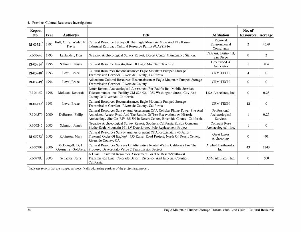
4. Previous Cultural Resources Investigations
34 Eagle Mountain Pumped Storage Transmission Line-Class I Cultural Resource
Report No. Year Author(s) Title Affiliation
No. of Resources Acreage
RI-03321* 1991 Bull, C.; S. Wade; M.
Davis Cultural Resource Survey Of The Eagle Mountain Mine And The Kaiser Industrial Railroad, Cultural Resource Permit #CA881916
Regional Environmental
Consultants 2 4659
RI-03648 1993 Laylander, Don Negative Archaeological Survey Report, Desert Center Maintenance Station. Caltrans, District II,
San Diego 0 2
RI-03914* 1995 Schmidt, James Cultural Resource Investigation Of Eagle Mountain Townsite Greenwood &
Associates 1 404
RI-03948* 1993 Love, Bruce Cultural Resources Reconnaissance: Eagle Mountain Pumped Storage Transmission Corridor, Riverside County, California
CRM TECH 4 0
RI-03949* 1994 Love, Bruce Addendum Cultural Resources Reconnaissance: Eagle Mountain Pumped Storage Transmission Corridor, Riverside County
CRM TECH 0 0
RI-04152 1998 McLean, Deborah Letter Report: Archaeological Assessment For Pacific Bell Mobile Services Telecommunications Facility CM 826-02, 1083 Washington Street, City And County Of Riverside, California
LSA Associates, Inc. 0 0.25
RI-04452* 1993 Love, Bruce Cultural Resources Reconnaissance, Eagle Mountain Pumped Storage Transmission Corridor, Riverside County, California
CRM TECH 12 0
RI-04570 2000 DeBarros, Philip Cultural Resources Survey And Assessment Of A Cellular Phone Tower Site And Associated Access Road And The Results Of Test Excavations At Historic Archaeology Site CA-RIV-6513H In Desert Center, Riverside County, California
Professional Archaeological
Services 1 0.25
RI-05245 2005 Schmidt, James Negative Archaeological Survey Report: Southern California Edison Company, Blythe-Eagle Mountain 161 kV Deteriorated Pole Replacement Project
Compass Rose Archaeological, Inc.
1 0
RI-05272* 2003 Robinson, Mark Cultural Resources Survey And Assessment Of Approximately 40 Acres: Fraternal Order Of Eagles# 4455 Kaiser Road Project, North Of Desert Center, Riverside County, CA
Great Lakes Archaeology
0 40
RI-06707 2006 McDougall, D; J.
George; S. Goldberg Cultural Resources Surveys Of Alternative Routes Within California For The Proposed Devers-Palo Verde 2 Transmission Project
Applied Earthworks, Inc.
43 1243
RI-07790 2003 Schaefer, Jerry A Class II Cultural Resources Assessment For The Desert-Southwest Transmission Line, Colorado Desert, Riverside And Imperial Counties, California
ASM Affiliates, Inc. 0 600
* Indicates reports that are mapped as spedcifically addressing portions of the project area proper.

4. Previous Cultural Resources Investigations
Eagle Mountain Pumped Storage Transmission Line-Class I Cultural Resources 35
would be classified as sites under today’s standards. These “isolates” were not recorded by Cowan and Wallof at the EIC and only appear as tabular listings in their report. Some may have been recorded during subsequent surveys along the same corridor.
• Carrico et al. (1982) reported a 1980 survey of the same alignment as the 1976 Palo Verde-Devers 500 kV Transmission Line survey. The 1980 survey also included a corridor that was 400 ft. wide and was surveyed in 12-m intervals. Criteria for distinguishing sites from isolates were less restrictive than in the 1976 study: isolates were defined as five or fewer prehistoric or historic artifacts within a 25-m distance. Most of the recorded sites were south of Interstate 10 and outside the project area. This route was ultimately built but the sites were evaluated in the field prior to construction and as a result, these sites no longer exist.
• Schaefer (2003) reported a Class I and II study for 527 linear mi. of alternative routes for the Desert-Southwest power transmission line, including 16.5 mi. of new surveys. The alignments addressed were generally the same as those previously addressed in the reports by Cowan and Wallof (1977), Wallof and Cowan (1977), and Carrico et al. (1982). Additional fieldwork in 2002 consisted of surveying 16.5 mi. of generally 1-mi. long, 150-m (500-ft.) wide sample units with transects at 20-m (65-ft.) intervals. The survey corroborated the Carrico et al. survey results and identified the Alligator Rock National Register of Historic Places site complex as the only known sensitive zone near the current project area.
• Bull et al. (1991) reported a 1990 survey of 4659 acres for the previously proposed solid waste landfill project. This survey overlaps much of the northern extent of the proposed transmission line and portions of the site plan at the former Eagle Mountain Mine, including the Eagle Mountain Industrial Railroad route. This area is generally characterized by relatively rugged terrain, and the 1990 survey coverage in this area was not systematic, but was focused on ridgelines, saddles, and drainages. Scatters of more than three items within a 25-m radius were classified as sites although none were recorded in the current project area. Their conclusion was that the area possessed low sensitivity for archaeological sites. The Bull et al. investigations included ethnographic interviews by subconsultant Cultural Systems Research, Inc., under the direction of Lowell J. Bean, Sylvia Brakke Vane, and Jackson Young. These ethnographic investigations included field visits and interviews with one Cahuilla, one Chemehuevi, and two Mohave consultants, as well as phone interviews with other groups and an ethnohistoric literature review. Both the Chemehuevi and Cahuilla elders recounted knowledge of hunting activities in the Eagle Mountains but no groups attributed sacred sites or special spiritual or cultural significance to the area. Opposition to the solid waste landfill project was noted, however, for environmental reasons. CSRI’s conclusion was that the project posed no impacts to traditional cultural or sacred values.
• Love conducted Class I literature reviews and reconnaissance (i.e., windshield) level surveys for a similar (in part) transmission line route (1993) and water pipeline (1994) as the present project and for an earlier proposed pumped storage project at Eagle Mountain. The study area was visually inspected by driving on existing roads and doing
4. Previous Cultural Resources Investigations
36 Eagle Mountain Pumped Storage Transmission Line-Class I Cultural Resource
on-foot spot checks. Unlike the present proposed transmission line corridor, the earlier proposed route paralleled the eastern side of Eagle Mountain Road and veered northeast at the Pumping Station holding pond. The literature reviews included inspection of 1850s Government Land Office (GLO) maps and surveyor notes and Riverside County Historical Division archives that informed on the present study. The only identifiable resource on the 1857 GLO maps within the current project is “Brown’s (Wagon) Road” which crosses the southern portion of Eagle Mountain Road. Love also conducted in-field visits with Cahuilla elder and former tribal historian, Anthony Andreas, Jr. He specifically identified the east-west trail segments as particularly important evidence of the cultural interaction between the Cahuilla and the Mohave (Love 1993:11). Otherwise, Love predicted that both the general areas of the current transmission line and water line routes would possess low sensitivity for cultural resources.
NATIVE AMERICAN HERITAGE COMMISSION RESULTS
A formal inquiry with the Native American Heritage Commission (NAHC) program analyst, David Singleton, resulted in no identified Native American sites in the Sacred Lands Files (Appendix A). Thirteen tribal groups or individuals were identified, however, who may have knowledge of cultural resources in the project area. They include John A. James, Chairperson, Cabazon Band of Mission Indians (Cahuilla); Joseph Hamilton, Chairman, Ramona Band of Cahuilla Mission Indians; Patricia Tuck, Tribal Historic Preservation Officer, Agua Caliente Band of Cahuilla Indians; Diana L. Chichuaha, Cultural Resources Coordinator, Torres-Martinez Band of Cahuilla Indians; Michael Contreras, Cultural Heritage Program Manager, Morongo Band of Cahuilla Indians (Cahuilla, Serrano); Luther Salgado, Sr., Cahuilla Band of Indians; Joseph Hamilton, Chairman, Ramona Band of Cahuilla Mission Indians; Ann Brierty, Policy/Cultural Resources Department, San Manuel Band of Mission Indians (Serrano); Darrell Mike, Chairperson, Twenty-nine Palms Band of Mission Indians (Chemehuevi); Charles Wood, Chairperson, Chemehuevi Reservation; Joseph (Mike) R. Benitez (Chemehuevi); Michael Tsosie, Cultural Contact, Colorado River Reservation (Mohave, Chemehuevi); and Linda Otero, Director, AhaMaKav Cultural Society, Fort Mojave Indian Tribe.
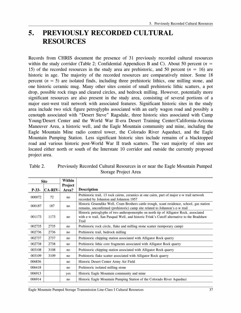
5. Previously Recorded Cultural Resources
Eagle Mountain Pumped Storage Transmission Line-Class I Cultural Resources 37
5. PREVIOUSLY RECORDED CULTURAL RESOURCES
Records from CHRIS document the presence of 31 previously recorded cultural resources within the study corridor (Table 2; Confidential Appendices B and C). About 50 percent (n = 15) of the recorded resources in the study area are prehistoric, and 50 percent (n = 16) are historic in age. The majority of the recorded resources are comparatively minor. Some 18 percent (n = 5) are isolated finds, including three prehistoric lithics, one milling stone, and one historic ceramic mug. Many other sites consist of small prehistoric lithic scatters, a pot drop, possible rock rings and cleared circles, and bedrock milling. However, potentially more significant resources are also present in the study area, consisting of several portions of a major east-west trail network with associated features. Significant historic sites in the study area include two stick figure petroglyphs associated with an early wagon road and possibly a cenotaph associated with “Desert Steve” Ragsdale, three historic sites associated with Camp Young/Desert Center and the World War II-era Desert Training Center/California-Arizona Maneuver Area, a historic well, and the Eagle Mountain community and mine, including the Eagle Mountain Mine radio control tower, the Colorado River Aqueduct, and the Eagle Mountain Pumping Station. Less significant historic sites include remains of a blacktopped road and various historic post-World War II trash scatters. The vast majority of sites are located either north or south of the Interstate 10 corridor and outside the currently proposed project area. Table 2. Previously Recorded Cultural Resources in or near the Eagle Mountain Pumped
Storage Project Area
Site
P-33- CA-RIV-
Within Project Area? Description
000072 72 no Prehistoric trail, 13 rock cairns, ceramics at one cairn, part of major e-w trail network recorded by Johnston and Johnston 1957
000187 187 no Historic Gruendike Well, Cram Brothers cattle trough, scant residence, school, gas station remains, unconfirmed (prehistoric) camp site related to Johnston’s e-w trail
001173 1173 no Historic petroglyphs of two anthropomorphs on north tip of Alligator Rock, associated with e-w trail, San Pasqual Well, and historic Frink’s Cutoff alternative to the Bradshaw Trail
002735 2735 no Prehistoric rock circle, flake and milling stone scatter (temporary camp)
002736 2736 no Prehistoric trail, bedrock milling
002737 2737 no Prehistoric chipping station associated with Alligator Rock quarry
002738 2738 no Prehistoric lithic core fragments associated with Alligator Rock quarry
003108 3108 no Prehistoric chipping station associated with Alligator Rock quarry
003109 3109 no Prehistoric flake scatter associated with Alligator Rock quarry
006836 no Historic Desert Center Army Air Field
006418 no Prehistoric isolated milling stone
006913 yes Historic Eagle Mountain community and mine
006914 no Historic Eagle Mountain Pumping Station of the Colorado River Aqueduct

5. Previously Recorded Cultural Resources
38 Eagle Mountain Pumped Storage Transmission Line-Class I Cultural Resource
Site
P-33- CA-RIV-
Within Project Area? Description
008392 6123H no Historic 1920s surveyors camp from the Colorado River Aqueduct surveys including hearth and artifacts; later 1969 claim marker
011265 6726H yes Historic Colorado River Aqueduct
012295 7019H no Historic mid-twentieth century trash pit, most removed during mechanical trenching
014207 no Historic trash scatter, concrete cistern or well, dirt road, mid-nineteenth century
014181 no Historic mine claim cairns (5) and trash scatter
014182 no Prehistoric isolated basalt flake
014194 no Prehistoric isolated quartz flake
014195 no Prehistoric isolated quartz flake
015097 no Historic WWII-era DTC/C-AMA tent pads, rock alignments and trash
015098 no Prehistoric cleared circle or rock ring (problematic)
015100 no Prehistoric cleared circle or rock ring (problematic)
015106 yes Prehistoric ceramic “pot drop” of 12 buff ware sherds (in alternative alignment)
015970 yes Prehistoric rock ring (in alternative alignment)
015971 no Historic WWII-era DTC/C-AMA mortared rock alignment and clearings (hospital?)
015972 no Historic blacktopped paved road
015973 no Historic refuse dump associated with old gas station location
016946 no Historic Eagle Mountain Mine radio control tower and storage structure
017343 no Historic isolated ceramic mug
Prehistoric Cultural Resources
Prehistoric resource types represented in the sample include two different segments of the same east-west trail, a temporary camp, four lithic scatters or chipping stations, a rock ring and two cleared circle features, one ceramic pot drop, and four isolated finds (Table 3).
Table 3. Previously Recorded Prehistoric Sites, by Generalized Types (Primary Number P-33-).
Trail Temporary
Camp
Lithic Scatter/Chipping
Station
Cleared Circle/Rock
Ring Ceramic Pot Drop Isolates
000072 002735 002737 015098 015106 006418
002736 002738 015100 014182
003108 015970 014194
003108 014195
None of these resources are located within the APE.
• Temporary camps are informally distinguished from artifact scatters by the greater
diversity of artifact types, often with features. The one site of this type, P-33-002735, included a rock ring, lithics, and two portable milling slabs. Because temporary camps

5. Previously Recorded Cultural Resources
Eagle Mountain Pumped Storage Transmission Line-Class I Cultural Resources 39
contain more complex patterns of prehistoric remains, they are more likely than simple scatters to be determined to constitute significant resources. This site is located in relative isolation to the south of Interstate 10, but in the same general vicinity of the majority of prehistoric lithic scatters and isolates of materials derived from Alligator Rock. This southern location would also make it associated with the general east-west travel route through the Chuckwalla Valley.
• The two trails, P-33-000072 and P-33-002736, are the previously recorded segments of the major east-west transit route through the Chuckwalla Valley. Much of this route has been traced by Johnston and Johnston (1957), extending west through the San Gorgonio Pass and east to the Colorado River. Numerous pot drops were recorded along the route. A separate branch that goes south through the Coachella Valley and east through Salt Creek Pass is better known as the Cocomaricopa Trail but McCarthy (1982) identifies the route through the Chuckwalla Valley by the same name. Both routes, it seems, were major prehistoric and ethnohistoric transportation corridors, recognized by archaeologists and Native American consultants alike as a significant element in the regional cultural history. Depending on their integrity and further research, they are likely to be eligible for the National Register of Historic Places. The project area appears to remain north of the trail network and poses no impact to any preserved remains.
• Four lithic scatters sites are located south of Interstate 10 and contain the types of plutonic aplite associated with the North Chuckwalla Mountain Quarry National Register of Historic Places District around Alligator Rock. They are outside of the district boundaries and represent peripheral sites to the main lithic procurement area. They are not likely to be NRHP-eligible but in any event are not within the project area.
• One rock ring, P-33-015970, is located in the alternative transmission line route while the two cleared circles are located just to the south. The two cleared circles are problematic and may result from deflation of natural ground rodent mounds and not from cultural factors. If cultural, these type of features bear witness to temporary encampment. They typically have no associated cultural materials although should be tested if impacts are projected to occur, which is unlikely given this is not a preferred alignment.
• Prehistoric isolates consist of single artifacts in theses cases. Three of the four isolates are stone flakes and one is a milling stone. None are located in the project area with with the study corridor. Normally, isolates are treated as categorically ineligible for the NRHP due to limited research values and do not require any further treatment or consideration.
• One ceramic pot drop, P-33-015106, is of the site type often associated with routes of travel. Although pot drops are generally considered not NRHP-eligible, recent advances in thermoluminescence dating and materials analysis suggest they have greater research value than previously thought. It is located at the southernmost tip of the alternative powerline route near Interstate 10 and therefore outside the preferred project area.

5. Previously Recorded Cultural Resources
40 Eagle Mountain Pumped Storage Transmission Line-Class I Cultural Resource
A likelihood of special ethnic importance for contemporary Native Americans is not evident at any of the resources previously identified in the study corridor, and as suggested by previous Native American ethnographic work associated with the proposed Eagle Mountain solid waste landfill project (Bull et al. 1991). Nevertheless, ongoing consultation with local Native American groups is likely to be required as the development of the project progresses. Historic Cultural Resources
Historic-period cultural resources that have previously been identified in the study corridor include a well and cattle trough complex, the Colorado River Aqueduct and the Eagle Mountain Pumping Station, a workers camp associated with the construction of the aqueduct, two sites with rock alignments and other features associated with the World War II DTC/C-AMA, the Desert Center Army Air Base (now in part the Desert Center Airport), the Eagle Mountain Mine and all facilities, the Eagle Mountain Mine Radio Control Tower, two mining sites associated with claims or prospectors camps, one paved road surface, three post-war trash deposits, and one isolate (Table 4). In large measure, evaluating the significance of such resources is likely to be based on archival background research used to determine whether the archaeological remains can be linked to interpretable historic contexts and whether they possess either significant research potential or historic preservation values. A careful evaluation of integrity will also be important. In some cases, surface collections or test excavations may be required.
Table 4. Previously Recorded Historic Sites, by Generalized Types (Primary Number P 33-).
Rock Art Well, Cattle Trough, etc.
Colorado River
Aqueduct WWII
Military Mining Road Trash Deposit Isolate 001173 000187 006914 006836 006913 015972 012295 017343
008392 015097 014181 014207
011265 016971 016946 015973 Resources in bold are located at least partially within the APE
• The Gruendike Well site, P-33-000187, is located on the USGS Corn Springs 7.5-minute map southeast of the Desert Center Airport and was recorded in 1978 based on an interview with the son of Steve Raysdale who was the original resident in 1915. Remains of an old school, cattle trough, and gas station complex were said to exist but integrity is noted to be very poor.
• One of the historic road segments, P-33-015972, is located south of the project APE, parallel to Interstate 10. The historic Brown’s wagon road route crosses the transmission line alternative but is only known from GLO maps and has not been officially recorded. An alternative to the Bradshaw Trail route known as Frink’s Cutoff Alternative is associated with a historic petroglyph site at the northern tip of Alligator Ridge, P-33-000173. This is also located outside the project APE.

5. Previously Recorded Cultural Resources
Eagle Mountain Pumped Storage Transmission Line-Class I Cultural Resources 41
• Military features and deposits in the study corridor relate to the World War II Desert Training Center/California-Arizona Maneuver Area (P-33-015097 and P-33–016971). Most of the residential or cantonment facilities are concentrated around Interstate 10 but are known to extend over a large area. Bischoff (2000) suggests that the rock-lined walkways on the east side of Eagle Mountain Road near the southern extent along a pipeline road may remain from the evacuation hospital and not Camp Desert Center proper. E Clampus Vitus and the BLM are about to recognize this general area as such. Some alignments and clearings have been previously recorded in 2007 as P-33-016971, extending across Eagle Mountain Road and may be specifically associated. In any case, the preferred transmission line alignment will avoid this area. The Riverside County Historical Commission recognizes the Desert Training Center in the vicinity of Desert Center as a Point of Historical Interest (Riv-022). Remains of the DTC Army Air Base were recorded in 1982 by a Riverside Historical Commission staffer as P-33-006836. The current airport utilizes the southern arm of what was a V-shaped landing strip, with the apex pointing east. Remains from World War II include concrete slabs from the link trainer building, headquarters building, flagpole stump, and officers’ facilities. All of these are outside the project APE.
• The proposed transmission line and water line will span a buried portion of the Colorado River Aqueduct, P-33-011265. This is the only previously recorded cultural resource that occurs directly within the project APE, except for the mine proper. An aqueduct feature, the Eagle Mountain Pumping Station (P-33-006914), is located 1 mi. from the project area proper and will not be subject to any direct impacts from the transmission line project.
• The entire Eagle Mountain Mine and company town of Eagle Mountain was recorded by a Riverside Historical Commission staffer as P-33-006913 in 1982, shortly before the mine closed for good. A historical marker commemorates the early claims from the 1880s, L. S. Barnes’ sale to the SPRR in 1909, Kaiser Steel’s acquisition in 1944, and the beginning of ore shipments to Fontana in 1948. Specific facilities that are mentioned include the iron ore mine with offices, mining equipment, railroad yard, residential community, stores, school, and playground that was constructed of discarded mining equipment. The site form, however, fails to identify the boundaries of the 57-acre site, specific feature locations, nor does it constitute a full inventory that may be found in Schmidt (1995) although no site form updates were prepared. More recently, the radio control tower and storage structure was recorded in the central part of the mine (P-33-016946). Other mining-related site, P-33-014181, is a group of late-dated mine claim cairns and associated trash. The Riverside County Historical Commission recognizes Eagle Mountain Iron and the Desert Center Area as a Point of Historical Interest (Riv-041)
• Three historic trash deposits have been recorded within the project area proper (P-33-012295, P-33-014207, and P-33–015973). All of these deposits appear to date from the middle twentieth century and postdate the DTC-C/AMA.

5. Previously Recorded Cultural Resources
42 Eagle Mountain Pumped Storage Transmission Line-Class I Cultural Resource
• One historic isolate, a ceramic mug, was recorded (P-33-017343). As is the case with prehistoric isolates, such resources are normally treated as categorically ineligible for the NRHP and do not require any further consideration or treatment.

6. Sensitivity, Data Gaps, and Recommendations
Eagle Mountain Pumped Storage Transmission Line-Class I Cultural Resources 43
6. SENSITIVITY, DATA GAPS, AND RECOMMENDATIONS
SENSITIVITY
The small number of cultural resources previously recorded within the study corridor, based on moderately limited amounts of inventory work, indicates the general archaeological sensitivity of the area and the likely presence of additional resources that may be eligible for the NRHP. The data suggest a low sensitivity for prehistoric cultural resources throughout the project area. The reasons include lack of permanent or seasonal water sources or stable food sources to sustain either residential or temporary camps, lack of lithic resources on the spotty desert pavements within the project area (with Alligator Rock to the south being the main local lithic tool stone source), location of the project to the north of the documented archaeological remains of the major east-west trail through the Chuckwalla Valley, and impacts to the integrity of old land surfaces from alluvial stream channels and historic era activities. Historic sites are more likely to occur within the project area. The most sensitive would be the remains of Camp Desert Center and the evacuation hospital at the southern end of Eagle Mountain Road. These loci appear to be to the south of the alternative or western Interconnection Collection Substation. The preferred transmission line route and Interconnection Collection Station is located 2 mi. to the north and east, respectively, of the known DTC/C-AMA features. For that reason, the preferred eastern substation and transmission line route is less likely to cause impacts to significant cultural resources related to the DTC/C-AMA. The transmission and water lines cross over buried portions of the Colorado River Aqueduct, which is very likely to be eligible for the NRHP based on its historical significance under Criteria A and C. The aqueduct is not visible from the surface in this area, however, except for a road and flood control berm. Impacts to materials, feeling, setting, and association are therefore expected to fall below a level of significance. The transmission line also crosses over the Eagle Mountain Industrial Railroad in two places. A formal significance determination of the rail line remains to be undertaken by the BLM but if found to be NRHP-eligible, some impacts to setting and feeling are likely to occur, although not rising to a level of effect. A large majority of the previously recorded resources are either isolates or small artifact scatters, and these are likely to require only minimal treatment in connection with the project. However, a few more substantial prehistoric and historic sites, especially those related to the major prehistoric east-west trail network and later historical routes of travel are located in the study corridor, but remain outside the APE. Such sites still are likely to require consideration of measures to avoid impacts to them if they are determined to be historic properties eligible for the NRHP.

6. Sensitivity, Data Gaps, and Recommendations
44 Eagle Mountain Pumped Storage Transmission Line-Class I Cultural Resource
Potential cumulative indirect impacts from the proposed project are expected to be very low. The current roads throughout the project area provide abundant access that would not be appreciably increased by the proposed project. Currently anticipated results of a Class III survey of the transmission line and water line indicate no historic properties exist where these alignments diverge from existing access roads. Security measures around the Eagle Mountain Mine complex also would be expected to remain the same or be improved.
DATA GAPS AND RECOMMENDATIONS
A substantial portion of the 200-ft. right-of-way and any associated areas that together will ultimately define the project’s APE will probably lie in areas that have not yet been systematically inventoried for cultural resources. This includes the Eagle Mountain Mine and community. It is currently premature to assess impacts to this site until more project specifications are known for the reservoirs, generating plant, and associated features, although it appears from preliminary schematics that most character-defining elements of the Eagle Mountain Mining Complex will be avoided. Early historic mining elements are likely to have been completely eliminated by the later iron mine. In any event, a complete, intensive archaeological survey of all previously unsurveyed areas in the APE will be an essential first step that will be required by the BLM. Both previously and newly recorded cultural resources that are identified within the project’s APE will need to be evaluated for their potential eligibility for the NRHP, if avoiding them does not appear feasible. Evaluation is likely to involve such methods as archival research; surface observation, mapping, and collection; subsurface test excavations; and laboratory analyses. If resources are determined to be eligible for the NRHP and project impacts to them cannot be prudently avoided, archaeological data recovery or other mitigation measures may be required. If inventory or testing work identifies particular locations with a high potential to contain significant buried cultural resources, archaeological monitoring of ground-disturbing activities may be required during the construction of the project.
7. Conclusions
Eagle Mountain Pumped Storage Transmission Line-Class I Cultural Resources 45
7. CONCLUSIONS
Several basic conclusions are supported by the data identified during a search of cultural resources records relating to previous reports and site/isolate records, and by an analysis of those data:
• Previous investigations have addressed a small fraction of what has been treated provisionally as the project area proper and a somewhat larger fraction of the wider study corridor (extending out 1 mi. on either side of the project area proper).
• Cultural resources previously recorded within the corridor include 31 prehistoric and historic sites or features including 5 isolated finds. Only two of these resources are located within the project area proper.
• Areas particularly notable for cultural resources include Eagle Mountain for historic-period resources and the World War II DTC/C-AMA Facilities. However, sites and isolates are scattered throughout the study corridor as a whole, and, with the exception of the rugged uplands of the Eagle Mountains at the western end, most portions of the corridor can be considered to have low sensitivity.
• Archaeological isolates or relatively small, simple sites make up the largest portion of the previously recorded cultural resources. Such resources as these will require minimal efforts to manage, in connection with the project. However, several potentially more significant sites are also present in the study corridor and in the project area proper, and some additional sites of similar character may be anticipated when systematic inventory data become available. These resources will require further consideration.
• The logical next steps appear to be to define the project area (the 200-ft. right-of-way and any other areas of potential project impacts) more closely and to do a systematic archaeological survey of the portions of this APE that have not previously been adequately surveyed. Where sites are present and project impacts to them cannot easily be avoided, it will be necessary to evaluate their potential NRHP eligibility, for instance through background research and/or archaeological field-testing. Further measures may be required to mitigate project impacts to sites that are found to be NRHP-eligible, although current data suggest no adverse effects to historic properties.


References
Eagle Mountain Pumped Storage Transmission Line-Class I Cultural Resources 47
REFERENCES
Barrows, David Prescott 1900 Ethno-Botany of the Cahuilla Indians. University of Chicago Press.
Bean, Lowell John
1972 Mukat’s People: The Cahuilla Indians of Southern California. University of California Press, Berkeley.
1978 Cahuilla. In California, edited by Robert F. Heizer, pp. 575-587. Handbook of North American Indians, Vol. 8, William C. Sturtevant, general editor. Smithsonian Institution, Washington, D.C.
Bean, Lowell John, and William Marvin Mason
1962 Diaries and Accounts of the Romero Expeditions in Arizona and California, 1823-26. Desert Museum, Palm Springs.
Bean, Lowell J., and Katherine Saubel
1972 Temalpakh: Cahuilla Indian Knowledge and Usage of Plants. Malki Museum Press, Banning, California.
Bean, Lowell John, Jerry Schaefer, and Sylvia Brakke Vane
1995 Archaeological, Ethnographic, and Ethnohistoric Investigations at Tahquitz Canyon, Palm Springs, California. Cultural Systems Research, Menlo Park, California.
Bean, Walton
1968 California: An Interpretive History. McGraw-Hill Book Company, New York. Bee, Robert L.
1981 Crosscurrents along the Colorado. University of Arizona, Tucson. 1983 Quechan. In Southwest, edited by Alfonso Ortiz, pp. 86-98. Handbook of North
American Indians, Vol. 10, William C. Sturtevant, general editor. Smithsonian Institution, Washington, D.C.
1989 The Yuma. Chelsea House, New York. Begole, Robert S.
1973 An Archaeological Survey in the Anza-Borrego Desert State Park: 1972 Preliminary Report. Pacific Coast Archaeological Society Quarterly 9(2):27-55.
1976 A Continuing Archaeological Survey in the Anza-Borrego Desert State Park: 1975-1976 Report. Pacific Coast Archaeological Society Quarterly 12(2):1-24.

References
48 Eagle Mountain Pumped Storage Transmission Line-Class I Cultural Resource
Belden, L. Burr 1964a That’s Iron in Them Thar Desert Hills. San Bernardino Sun-Times, February
16. 1964b Kaiser Revived Iron Mines. San Bernardino Sun-Time, February 23.
Bischoff, Matt C.
2000 The Desert Training Center/California-Arizona Maneuver Area, 1942-1944: Historical and Archaeological Contexts. Statistical Research Technical Series No. 75. Tucson, Arizona.
Bull, Charles S., Sue A. Wade, and McMillan Davis
1991 Cultural Resource Survey of the Eagle Mountain Mine and the Kaiser Industrial Railroad, Cultural Resource Permit #CA881916. RECON, San Diego.
Campbell, Elizabeth W. C., and William H. Campbell
1935 The Pinto Basin Site: An Ancient Aboriginal Camping Ground in the California Desert. Southwest Museum Papers No. 9. Los Angeles.
Carrico, Richard L., Dennis K. Quillen, and Dennis R. Gallegos
1982 Cultural Resource Inventory and National Register Assessment of the Southern California Edison Palo Verde to Devers Transmission Line Corridor (California Portion). WESTEC Services, San Diego.
Castetter, Edward F., and William H. Bell
1951 Yuman Indian Agriculture. University of New Mexico Press, Albuquerque. Cole, Kenneth L.
1986 The Lower Colorado River Valley: A Pleistocene Desert. Quaternary Research 25:392-400.
Cooper, Irwin
1968 Aqueduct Empire: A Guide to Water in California, Its Turbulent History and Its Management Today. Arthur H. Clark Company, Glendale, California.
Cowan, Richard A., and Kurt Wallof
1977 Interim Report – Field Work and Data Analysis: Cultural Resource Survey of the Proposed Southern California Edison Palo Verde-Devers 500 kV Power Transmission Line. Archaeological Research Unit, University of California, Riverside.
Crabtree, Robert H.
1981 Archaeology. In A Cultural Resources Overview of the Colorado Desert Planning Units by Elizabeth von Till Warren, Robert H. Crabtree, Claude N.

References
Eagle Mountain Pumped Storage Transmission Line-Class I Cultural Resources 49
Warren, Martha Knack, and Richard McCarthy, pp. 25-54. California Desert District, USDI Bureau of Land Management, Riverside, California.
Cultural Systems Research
1983 Paniktum Hemki: A Study of Cahuilla Cultural Resources in Andreas and Murray Canyons. Menlo Park, California.
Curtis, Edward S.
1926 The North American Indian. Vol. 15. University Press, Cambridge, Massachusetts.
Davis, Emma Lou, Kathryn H. Brown, and Jacqueline Nichols
1980 Evaluation of Early Human Activities and Remains in the California Desert. Great Basin Foundation, San Diego.
Drucker, Philip
1937 Culture Element Distributions: V., Southern California. Anthropological Records 1:1-52. University of California, Berkeley.
Ezell, Paul H.
1984 A New Look at the San Dieguito Culture. San Diego State University Casual Papers in Cultural Resource Management 3(2):103-109.
Ezzo, Joseph A. (editor)
1994 Recent Research along the Lower Colorado River. Statistical Research Technical Series No. 51. Tucson, Arizona.
Ezzo, Joseph A., and Jeffrey H. Altshul
1993 Glyphs and Quarries of the Lower Colorado River Valley: The Results of Five Cultural Resources Surveys. Statistical Research, Tucson, Arizona.
Forbes, Jack D.
1965 Warriors of the Colorado: The Yumas of the Quechan Nation and Their Neighbors. University of Oklahoma Press, Norman.
Forde, C. Daryll
1931 Ethnography of the Yuma Indians. University of California Publications in American Archaeology and Ethnology 28:83-278. Berkeley.
Gifford, Edward W.
1918 Clans and Moieties in Southern California. University of California Publications in American Archaeology and Ethnology 14:155-219. Berkeley.
1931 The Kamia of Imperial Valley. Bureau of American Ethnology Bulletin No. 97. Washington, D.C.

References
50 Eagle Mountain Pumped Storage Transmission Line-Class I Cultural Resource
Gobalet, Kenneth W. 1994 Additional Archaeological Evidence for Colorado River Fishes in the Salton
Basin of Southern California. Bulletin of the Southern California Academy of Sciences 93(1):38-41.
Golla, Victor
2007 Linguistic Prehistory. In California Prehistory: Colonization, Culture, and Complexity, edited by Terry L. Jones and Kathryn A. Klar, pp. 71-82. Altamira Press, Lanham, Maryland.
Gunther, Jane Davies
1984 Riverside County, California, Place Names: Their Origins and Their Stories. Rubidoux Printing, Riverside, California.
Harwell, Henry O., and Marsha C. S. Kelly
1983 Maricopa. In Southwest, edited by Alfonso Ortiz, pp. 71-85. Handbook of North American Indians, Vol. 10, William C. Sturtevant, general editor. Smithsonian Institution, Washington, D.C.
Hastings, James R., and Raymond M. Turner
1965 The Changing Mile: An Ecological Study of Vegetation Change with Time in the Lower Mile of an Arid and Semi-Arid Region. University of Arizona Press, Tucson.
Hayden, Julian
1976 Pre-altithermal Archaeology in the Sierra Pinacate, Sonora, Mexico. American Antiquity 41:274-289.
Heizer, Robert F.
1974 An Early Cahuilla Ethnographic Sketch. The Masterkey 48(1):14-21. 1978 California. Handbook of the North American Indians, Vol. 8, William C.
Sturtevant, general editor. Smithsonian Institution, Washington, D.C. Henley, David
1989 “The Land that God Forgot...”: The Saga of Gen. George Patton’s Desert Training Camps. Lahontan Valley Printing, Fallon, Nevada.
Hilton, John
1949 Henry Kaiser Came to the Desert for Iron. Desert Magazine March:5-9. Hinton, Leanne, and Lucille J. Watahomigie
1984 Spirit Mountain: An Anthology of Yuman Story and Song. University of Arizona Press, Tucson.

References
Eagle Mountain Pumped Storage Transmission Line-Class I Cultural Resources 51
Hooper, Lucille 1920 The Cahuilla Indians. University of California Publications in American
Archaeology and Ethnology 16:315-380. Berkeley. Howard, George W.
1985 The Desert Training Center/California-Arizona Maneuver Area. Journal of Arizona History 26:273-294.
Jaeger, Edmund C.
1965 The California Deserts. Fourth edition. Stanford University Press, Stanford, California.
Jennings, Charles W.
1967 Salton Sea Sheet. Geologic Map of California. California Division of Mines and Geology, Sacramento.
Johnston, Francis J.
1987 The Bradshaw Trail. Historical Commission Press, Riverside, California. Johnston, Francis J., and Patricia H. Johnston
1957 An Indian Trail Complex of the Central Colorado Desert: A Preliminary Survey. University of California Archaeological Survey Reports 37:22-34. Berkeley.
Kelly, Isabel T.
n.d. Chemehuevi Field Notes: General Ethnological Information [1932-1933]. Unpublished manuscript (Book 17), on file, Bancroft Library, University of California, Berkeley.
Kelly, Isabel T., and Catherine S. Fowler
1986 Southern Paiute. In Great Basin, edited by Warren L. d’Azevedo, pp. 368-397. Handbook of North American Indians, Vol. 11, William C. Sturtevant, general editor. Smithsonian Institution, Washington, D.C.
King, James E., and Thomas R. Van Devender
1977 Pollen Analysis of Fossil Packrat Middens from the Sonoran Desert. Quaternary Research 8:191-204.
Knack, Martha
1981 Ethnography. In A Cultural Resources Overview of the Colorado Desert Planning Units, by Elizabeth von Till Warren, Robert H. Crabtree, Claude N. Warren, Martha Knack, and Richard McCarty, pp. 55-82. California Desert District, USDI Bureau of Land Management, Riverside, California.

References
52 Eagle Mountain Pumped Storage Transmission Line-Class I Cultural Resource
Koerper, Henry 1979 The Question of the Chronological Placement of the Shoshonean Presence in
Orange County, California. Pacific Coast Archaeological Society Quarterly 22(3):69-84.
Kroeber, A. L.
1908 Ethnography of the Cahuilla Indians. University of California Publications in American Archaeology and Ethnology 8:29-68. Berkeley.
1920 Yuman Tribes of the Lower Colorado River. University of California Publications in American Archaeology and Ethnology 16:475-485. Berkeley.
1925 Handbook of the Indians of California. Bureau of American Ethnology Bulletin No. 78. Washington, D.C.
1948 Seven Mohave Myths. Anthropological Records 11:1-70. University of California Press, Berkeley.
Kroeber, Clifton B.
1980 Lower Colorado River Peoples: Hostilities and Hunger, 1850-1857. Journal of California and Great Basin Anthropology 2:187-190.
Kroeber, Clifton B., and Bernard L. Fontana
1986 Massacre on the Gila. An Account of the Last Major Battle Between American Indians, with Reflections on the Origin of War. University of Arizona Press, Tucson.
Laird, Carobeth
1976 The Chemehuevis. Malki Museum Press, Banning, California. 1984 Mirror and Pattern: George Laird’s World of Chemehuevi Mythology. Malki
Museum Press, Banning, California. Laylander, Don
2004 Geographies of Fact and Fantasy: Oñate on the Lower Colorado River, 1604-1605. Southern California Quarterly 86:309-324.
2007 Linguistic Prehistory and the Archaic-Late Transition in the Colorado Desert. Paper presented at the Conference on the Archaic-Late Transition in the Colorado Desert, Borrego Springs, California.
Love, Bruce
1994 Addendum Cultural Resources Reconnaissance: Eagle Mountain Pumped Storage Transmission Corridor, Riverside County. CRM Tech, Riverside, California.
1996 Archaeology on the North Shoreline of Ancient Lake Cahuilla. CRM TECH, Riverside, California.

References
Eagle Mountain Pumped Storage Transmission Line-Class I Cultural Resources 53
Lynch, John S., John W. Kennedy, and Robert L. Wooley 1982 Patton’s Desert Training Center. Council on America’s Military Past, Fort
Myer, Virginia. McCarthy, Daniel
1982 The Coco-Maricopa Trail Network. In Cultural Resource Inventory and National Register Assessment of the Southern California Edison Palo Verde to Devers Transmission Line Corridor (California Portion), by Richard L. Carrico, , Dennis K. Quillen, and Dennis R. Gallegos, Appendix C. WESTEC Services, San Diego.
1993 Prehistoric Land-Use at McCoy Spring: An Arid-Land Oasis in Eastern Riverside County, California. Unpublished Master’s thesis, Department of Anthropology, University of California, Riverside.
McDonald, Alison Meg
1992 Indian Hill Rockshelter and Aboriginal Cultural Adaptation in Anza-Borrego Desert State Park, Southeastern California. Unpublished Ph.D. dissertation, Department of Anthropology, University of California, Riverside.
McGinnis, Samuel M.
1984 Freshwater Fishes of California. University of California Press, Berkeley. McGuire, Randall H., and Michael B. Schiffer
1982 Hohokam and Patayan: Prehistory of Southwestern Arizona. Academic Press, New York.
Meller, Sidney L.
1946 The Army Ground Forces: The Desert Training Center and CAMA. Historical Section Study No. 15.
Metropolitan Water District of Southern California
1941 The Great Aqueduct: The Story of the Planning and Building of the Colorado River Aqueduct. Metropolitan Water District of Southern California, Los Angeles.
Moratto, Michael J.
1984 California Archaeology. Academic Press, Orlando, Florida. Patencio, Francisco
1943 Stories and Legends of the Palm Springs Indians. As told to Margaret Boynton. Palm Springs Desert Museum, Palm Springs.

References
54 Eagle Mountain Pumped Storage Transmission Line-Class I Cultural Resource
Pendleton, Lorann 1984 Archaeological Investigations in the Picacho Basin. Wirth Environmental
Services, San Diego. Phillips, George Harwood
1975 Chiefs and Challengers: Indian Resistance and Cooperation in Southern California. University of California Press, Berkeley.
Rappaport, Roy A.
1968 Pigs for the Ancestors: Ritual in the Ecology of A New Guinea People. Yale University Press, New Haven, Connecticut.
Rogers, Malcolm J.
1929 Report on an Archaeological Reconnaissance in the Mojave Sink Region. San Diego Museum of Man Papers No. 1.
1936 Yuman Pottery Making. San Diego Museum of Man Papers No. 2. 1939 Early Lithic Industries of the Lower Basin of the Colorado River and Adjacent
Areas. San Diego Museum of Man Papers No. 3. 1945 An Outline of Yuman Prehistory. Southwestern Journal of Anthropology 1:167-
198. 1958 San Dieguito Implements from the Terraces of the Rincon-Pantano and Rillito
Drainage System. The Kiva 24(1):1-23. 1966 Ancient Hunters of the Far West. Union Tribune Publishing, San Diego.
Ryan, R. Mark
1968 Mammals of Deep Canyon, Colorado Desert, California. Desert Museum, Palm Springs, California.
Schaefer, Jerry
1994a The Stuff of Creation: Recent Approaches to Ceramics Analysis in the Colorado Desert. In Recent Research along the Lower Colorado River, edited by Joseph A. Ezzo, pp. 81-100. Statistical Research Technical Series No. 51, Tucson, Arizona.
1994b The Colorado Desert. In Research Design for the Lower Colorado Region, by Jeffrey H. Altschul, pp. 21-38. Statistical Research Technical Report No. 93-19. Tucson, Arizona.
1994c The Challenge of Archaeological Research in the Colorado Desert: Recent Approaches and Discoveries. Journal of California and Great Basin Anthropology 16:60-80.
2003 A Class II Cultural Resources Assessment for the Desert-Southwest Transmission Line, Colorado Desert, Riverside and Imperial Counties, California. ASM Affiliates, Carlsbad, California.

References
Eagle Mountain Pumped Storage Transmission Line-Class I Cultural Resources 55
Schaefer, Jerry, and Don Laylander 2007 The Colorado Desert: Ancient Adaptations to Wetlands and Wastelands. In
California Prehistory: Colonization, Culture, and Complexity, edited by Terry L. Jones and Kathryn A. Klar, pp. 247-257. Altamira Press, Lanham, Maryland.
Schmidt, James
1995 Cultural Resource Investigation of Eagle Mountain Townsite. Greenwood & Associates.
Schneider, Joan S.
1993 Aboriginal Milling-Implement Quarries in Eastern California and Western Arizona: A Behavioral Perspective. Unpublished Ph.D. dissertation, Department of Anthropology, University of California, Riverside.
1994 Milling-Implement Quarrying and Production Bordering the Lower Colorado and Lower Gila Rivers: Archaeological, Ethnographic and Historical Evidence for an Aboriginal Industry. In Recent Research Along the Lower Colorado River, edited by Joseph A. Ezzo, pp. 101-117. Statistical Research Technical Series No. 51, Tucson, Arizona.
Schroeder, Albert H.
1975 The Hohokam, Sinagua and the Hakataya. Imperial Valley College Occasional Paper No. 3. El Centro, California.
1979 Prehistory: Hakataya. In Southwest, edited by Alfonso Ortiz, pp. 100-107. Handbook of North American Indians, Vol. 9, William C. Sturtevant, general editor. Smithsonian Institution, Washington, D.C.
Schroth, Adella B.
1994 The Pinto Point Controversy in the Western United States. Unpublished Ph.D. dissertation, Department of Anthropology, University of California, Riverside.
Spier, Leslie
1933 Yuman Tribes of the Gila River. University of Chicago Press. Steward, Julian H.
1955 Theory of Culture Change. University of Illinois Press, Urbana. Stewart, Kenneth M.
1983 Mohave. In Southwest, edited by Alfonso Ortiz, pp. 55-70. Handbook of North American Indians, Vol. 10, William C. Sturtevant, general editor. Smithsonian Institution, Washington, D.C.

References
56 Eagle Mountain Pumped Storage Transmission Line-Class I Cultural Resource
Stone, Connie L. 1991 The Linear Oasis: Managing Cultural Resources Along the Lower Colorado
River. Cultural Resource Series Monograph No. 6. USDI Bureau of Land Management, Phoenix.
Strong, William D.
1929 Aboriginal Society in Southern California. University of California Publications in American Archaeology and Ethnology 26:1-358. Berkeley.
Swarthout, Jeanne
1981a Final Report for an Archaeological Overview for the Lower Colorado River Valley, Arizona, Nevada, and California: Reach 1, Lee’s Ferry to Grand Wash Cliffs. Museum of Northern Arizona, Flagstaff.
1981b Final Report for an Archaeological Overview for the Lower Colorado River Valley, Arizona, Nevada, and California: Reach 2, Grand Wash Cliffs to Davis Dam. Museum of Northern Arizona, Flagstaff.
1981c Final Report for an Archaeological Overview for the Lower Colorado River Valley, Arizona, Nevada, and California: Reach 4, Lower Virgin River. Museum of Northern Arizona, Flagstaff.
Swarthout, Jeanne, and Christopher E. Drover
1981 Final Report for an Archaeological Overview for the Lower Colorado River Valley, Arizona, Nevada and California: Reach 3, Davis Dam to the International Border. Museum of Northern Arizona, Flagstaff.
Taylor, R. E., L. A. Payen, C. A. Prior, P. J. Slota Jr., R. Gillespie, J. A. J. Gowlett, R. E.
M. Hedges, A. J. T. Jull, T. H. Zabel, D. J. Donahue, and R. Berger 1985 Major Revisions in the Pleistocene Age Assignments for North American
Skeletons by C-14 Accelerator Mass Spectrometry: None Older than 11,000 C-14 Years B.P. American Antiquity 50:136-140.
Thompson, Robert
1984 Past Environment. In Archaeological Investigations in the Picacho Basin, by Lorann Pendleton, pp. 10-15. Wirth Environmental Services, San Diego.
USDI, Bureau of Land Management
1986 Desert Training Center, California-Arizona Manuever Area Interpretive Plan. U.S. Department of the Interior, Bureau of Land Management, California Desert District.
USDI, Bureau of Mines
1971 Economic Evaluation of California-Nevada Iron Resources and Iron Ore Markets. U.S. Department of the Interior, Bureau of Mine Information Circular IC-8511.
References
Eagle Mountain Pumped Storage Transmission Line-Class I Cultural Resources 57
Van Devender, Thomas R. 1990 Late Quaternary Vegetation and Climate of the Sonoran Desert, United States
and Mexico. In Packrat Middens: The Last 40,000 Years of Biotic Change, edited by J. L. Betancourt, Thomas R. Van Devender, and Paul S. Martin, pp. 134-165. University of Arizona Press, Tucson.
Van Devender, Thomas R., and W. Geoffrey Spaulding
1983 Development of Vegetation and Climate in the Southwestern United States. In Origin and Evolution of Deserts, edited by Stephen G. Wells and Donald R. Haragan, pp. 131-156. University of New Mexico Press, Albuquerque.
Vaughan, Sheila J.
1982 A Replicative Systems Analysis of the San Dieguito Component at the C. W. Harris Site. Unpublished Master’s thesis, Department of Anthropology, University of Nevada, Las Vegas.
Vredenburgh, Larry M, Gary L. Shumway, and Russell D. Hartill
1981 Desert Fever: An Overview of Mining In the California Desert. Living West Press, Canoga Park, California.
Wallof, Kurt, and Richard A. Cowan
1977 Final Report – Cultural Resource Survey of the Proposed Southern California Edison Palo Verde-Devers 500 kV Power Transmission Line. Archaeological Research Unit, University of California, Riverside.
Warren, Claude N.
1967 The San Dieguito Complex: A Review and Hypothesis. American Antiquity 32:168-185.
1984 The Desert Region. In California Archaeology, by Michael J. Moratto, pp. 339-430. Academic Press, Orlando, Florida.
Warren, Claude N., and Delbert L. True
1961 The San Dieguito Complex and Its Place In California Prehistory. University of California, Los Angeles, Archaeology Survey Annual Report 1960-1961:246-291.
Warren, Elizabeth von Till, Robert H. Crabtree, Claude N. Warren, Martha Knack, and Richard McCarthy
1981 A Cultural Resources Overview of the Colorado Desert Planning Units. USDI Bureau of Land Management, California Desert District, Riverside, California.

References
58 Eagle Mountain Pumped Storage Transmission Line-Class I Cultural Resource
Waters, Michael R. 1982a The Lowland Patayan Ceramic Tradition. In Hohokam and Patayan: Prehistory
of Southwestern Arizona, edited by Randall H. McGuire and Michael B. Schiffer, pp. 275-298. Academic Press, New York.
1982b The Lowland Patayan Ceramic Typology. In Hohokam and Patayan: Prehistory of Southwestern Arizona, edited by Randall H. McGuire and Michael B. Schiffer, pp. 537-570. Academic Press, New York.
Weide, David
1974 Regional Environmental History of the Yuha Desert Region. In Background to Prehistory of the Yuha Desert Region, by Margaret L. Weide and James P. Barker, pp. 4-15. Archaeological Research Unit, University of California, Riverside.
White, Chris
1974 Lower Colorado River Area. Aboriginal Warfare and Alliance Dynamics. In Antap, California Indian Political and Economic Organization, edited by Lowell J. Bean and Thomas F. King, pp. 111-136. Ballena Press Anthropological Papers No. 2 Ramona, California.
Wilke, Philip J.
1978 Late Prehistoric Human Ecology at Lake Cahuilla, Coachella Valley, California. Contributions of the University of California Archaeological Research Facility No. 38. University of California, Berkeley.
Wilke, Philip J., and Harry W. Lawton
1975 Early Observations on the Cultural Geography of the Coachella Valley. In The Cahuilla Indians of the Colorado Desert: Ethnohistory and Prehistory, pp. 9-43. Ballena Press, Ramona, California.
Woods, Clyde M.
1982 APS/SDG&E Interconnection Project Native American Cultural Resources: Miguel to the Colorado River and Miguel to Mission Tap. Wirth Associates, San Diego.

Appendices
Eagle Mountain Pumped Storage Transmission Line-Class I Cultural Resources 59
APPENDICES


Appendices
Eagle Mountain Pumped Storage Transmission Line-Class I Cultural Resources
APPENDIX A
Native American Heritage Commission Response


Appendices
Eagle Mountain Pumped Storage Transmission Line-Class I Cultural Resources
APPENDIX B
Confidential Site Records

APPENDIX B Confidential Site Records
This information is privileged, not for release. It has been redacted from this document and bound under separate cover, titled:
Exhibit E, Applicant Prepared Environmental Impact Statement, Privileged Information
Volume 4 of 6.


Appendices
Eagle Mountain Pumped Storage Transmission Line-Class I Cultural Resources
APPENDIX C
Confidential Previous Studies and Recorded Site Maps

APPENDIX C Confidential Previous Studies and Recorded Site Maps
This information is privileged, not for release. It has been redacted from this
document and bound under separate cover, titled:
Exhibit E, Applicant Prepared Environmental Impact Statement, Privileged Information
Volume 4 of 6.