EA Riverside Development Project - National Park … E.O. 11988 Floodplain Management ... 5.0 EA...
49
Environmental Assessment Riverside Rehabilitation Project St. Croix National Scenic Riverway March 7, 2003
Transcript of EA Riverside Development Project - National Park … E.O. 11988 Floodplain Management ... 5.0 EA...

1
Environmental Assessment
RiversideRehabilitation Project
St. Croix National Scenic Riverway
March 7, 2003
2
TABLE OF CONTENTS1.0 PURPOSE AND NEED..................................................................................................................................... 5
1.1 BACKGROUND ................................................................................................................................................. 51.2 PROBLEM STATEMENT..................................................................................................................................... 61.3 SUMMARY OF PURPOSE AND NEED:............................................................................................................... 10
2.0 ALTERNATIVES............................................................................................................................................ 10
2.1 PREFERRED ALTERNATIVE ............................................................................................................................ 102.1.1 Boat/Canoe Landings......................................................................................................................... 122.1.2 Parking Areas ..................................................................................................................................... 122.1.3 Restroom Facilities............................................................................................................................. 122.1.4 Potable Water ..................................................................................................................................... 122.1.5 Day Use/Picnic Area .......................................................................................................................... 122.1.6 Edge Delineation ................................................................................................................................ 122.1.7 Camping ............................................................................................................................................. 132.1.8 Environmental Issues......................................................................................................................... 132.1.9 Trash Collection ................................................................................................................................. 132.1.10 Wisconsin Department Of Transportation ........................................................................................ 142.1.11 Ethnographic Resources .................................................................................................................... 14
2.2 ALTERNATIVE 1 ............................................................................................................................................. 142.2.1 Boat/Canoe Landings......................................................................................................................... 142.2.2 Parking Areas ..................................................................................................................................... 142.2.3 Restroom Facilities............................................................................................................................. 142.2.4 Potable Water ..................................................................................................................................... 142.2.5 Day Use/Picnic Area .......................................................................................................................... 172.2.6 Edge Delineation ................................................................................................................................ 172.2.7 Camping ............................................................................................................................................. 172.2.8 Environmental Issues......................................................................................................................... 172.2.9 Trash Collection ................................................................................................................................. 172.2.10 Wisconsin Department Of Transportation ........................................................................................ 17
2.3 ALTERNATIVE 2 ............................................................................................................................................. 182.3.1 Parking Areas ..................................................................................................................................... 18
2.4 COMPARATIVE SUMMARIES OF ALTERNATIVES ............................................................................................. 192.5 NO ACTION ALTERNATIVE............................................................................................................................. 222.6 ENVIRONMENTALLY PREFERABLE ALTERNATIVE.......................................................................................... 22
2.6.1 Needs Of The Visitor .......................................................................................................................... 222.6.2 Protection Of Significant Resources.................................................................................................. 232.6.3 Protection Of Archeological And Historical Resources.................................................................... 232.6.4 Preservation Of The Environment..................................................................................................... 242.6.5 Environmentally Preferred Alternative ............................................................................................. 24
3.0 AFFECTED ENVIRONMENT...................................................................................................................... 26
4.0 IMPACTS......................................................................................................................................................... 29
4.1 IMPACTS OF PREFERRED ALTERNATIVE......................................................................................................... 294.1.1 Impact Definition ............................................................................................................................... 294.1.2 Cumulative Impacts............................................................................................................................ 304.1.3 Geological Resources - Soils .............................................................................................................. 304.1.4 Air Quality, Traffic And Noise........................................................................................................... 314.1.5 Water Quality...................................................................................................................................... 314.1.6 Streamflow, Land Use, and Land Values .......................................................................................... 31

3
4.1.7 Floodplains ......................................................................................................................................... 314.1.8 Wetlands ............................................................................................................................................. 314.1.9 Vegetation ........................................................................................................................................... 324.1.10 Threatened, Endangered and Rare Species....................................................................................... 324.1.11 Wildlife................................................................................................................................................ 324.1.12 Exotic Species ..................................................................................................................................... 334.1.13 Recreation And Visitor Use................................................................................................................ 334.1.14 Archeological, Historical and Cultural Resources............................................................................ 344.1.15 Socioeconomics, Low Income and Minority Populations, Ethnography ......................................... 344.1.16 Scenic Resources ................................................................................................................................ 344.1.17 Concerns Raised Through Public Scoping........................................................................................ 34
4.2 IMPACTS OF ALTERNATIVE 1 ......................................................................................................................... 364.2.1 Geological Resources - Soils .............................................................................................................. 364.2.2 Vegetation ........................................................................................................................................... 364.2.3 Exotic Species ..................................................................................................................................... 364.2.4 Recreation And Visitor Use................................................................................................................ 364.2.5 Archeological, Historical and Cultural Resources............................................................................ 36
4.3 IMPACTS OF ALTERNATIVE 2 ......................................................................................................................... 374.3.1 Geological Resources - Soils .............................................................................................................. 374.3.2 Air Quality, Traffic And Noise........................................................................................................... 374.3.3 Vegetation ........................................................................................................................................... 374.3.4 Threatened, Endangered and Rare Species....................................................................................... 374.3.5 Recreation And Visitor Use................................................................................................................ 374.3.6 Concerns Raised Through Public Scoping........................................................................................ 38
4.4 IMPACTS OF NO ACTION ALTERNATIVE ......................................................................................................... 384.4.1 Geological Resources - Soils .............................................................................................................. 384.4.2 Air Quality, Traffic And Noise........................................................................................................... 384.4.3 Threatened, Endangered and Rare Species....................................................................................... 384.4.4 Exotic Species ..................................................................................................................................... 384.4.5 Recreation And Visitor Use................................................................................................................ 384.4.6 Scenic Resources ................................................................................................................................ 38
4.5 REGULATIONS AND POLICIES ......................................................................................................................... 394.5.1 Endangered Species Act of 1973, as amended .................................................................................. 394.5.2 E.O. 11988 Floodplain Management ................................................................................................ 394.5.3 E.O. 11990 Protection of Wetlands.................................................................................................... 394.5.4 National Historic Preservation Act and E.O. 11593 ......................................................................... 394.5.5 Architectural Barriers Act of 1968 and the Rehabilitation Act of 1973 ........................................... 404.5.6 Wild and Scenic River Act of 1968 .................................................................................................... 40
4.6 SUMMARY TABLE OF ENVIRONMENTAL CONSEQUENCES.............................................................................. 414.7 EVALUATION OF IMPAIRMENT ....................................................................................................................... 44
4.7.1 Evaluation of Impairment Due To The Preferred Alternative ......................................................... 444.7.2 Evaluation of Impairment Due To Alternative 1 .............................................................................. 444.7.3 Evaluation of Impairment Due To Alternative 2 .............................................................................. 454.7.4 Evaluation of Impairment Due No Action Alternative. .................................................................... 46
5.0 EA CONSULTATIONS .................................................................................................................................. 46
6.0 BIBLIOGRAPHY............................................................................................................................................ 47
7.0 APPENDIX A................................................................................................................................................... 48
7.1 DESIGN CRITERIA SUBMITTED TO NATIONAL PARK SERVICE MIDWEST REGION LANDSCAPE ARCHITECT .... 48

4
TABLE OF FIGURES
FIGURE 1. REFERENCE MAP FOR LOCATING RIVERSIDE. ................................................................................................. 7FIGURE 2. AREA MAP SHOWING GENERAL LOCATIONS OF THE NATIONAL PARK SERVICE RIVERSIDE LANDING AND
WISCONSIN DEPARTMENT OF TRANSPORTATION RIVERSIDE WAYSIDE. SHAPES, SIZES AND LOCATIONS OFFACILITIES AND FEATURES ARE APPROXIMATE...................................................................................................... 8
FIGURE 3. EXISTING CONDITIONS AND FACILITIES AT RIVERSIDE WAYSIDE. CONTOUR INTERVALS AND TREES AREALSO SHOWN. ....................................................................................................................................................... 9
FIGURE 4. PREFERRED ALTERNATIVE AT RIVERSIDE WAYSIDE. ................................................................................. 11FIGURE 5. ALTERNATIVE 1 FOR RIVERSIDE WAYSIDE................................................................................................. 16FIGURE 6. LOCATION OF CAMPSITES AND LANDINGS WITHIN 13 - 15 RIVER MILES OF RIVERSIDE LANDING. ............... 28

5
1.0 PURPOSE AND NEED
1.1 Background
The St. Croix National Scenic Riverway (Riverway) was established in 1968 as a component of theNational Wild and Scenic Rivers System and is a unit of the National Park System (NPS). Thepark includes 103 miles (166 km) of the St. Croix River between the Xcel Energy hydroelectricdam at St. Croix Falls, Wisconsin and the dam at Gordon Flowage and all 99 miles (159 km) of itstributary the Namekagon River in northwestern Wisconsin. The boundary of the Riverway includesthe adjacent uplands averaging one-quarter mile from the shoreline. Much of the St. Croix Riverforms part of the border between the states of Minnesota and Wisconsin.
The park receives an estimated 500,000 visitors annually. The primary visitor use along theRiverway occurs on the water surface in the form of boating and canoeing. In 1990 approximately14,000 visitors used trails along the Riverway for the purpose of hiking, hunting and fishing access,cross-country skiing and nature observation. Recreational use is expected to increase given theclose proximity of the Riverway to Minneapolis/St. Paul, a heavily populated metropolitan area.
The National Park Service strives to balance the need for access to the rivers with the need toprotect the significant values for which the St. Croix National Scenic Riverway was established. These values of significance are defined by the General Management Plan, Upper St. Croix andNamekagon Rivers (USDI 1998) as:
"The upper riverway is significant because:• The St. Croix River is one of the last undisturbed, large floodplain rivers in the
upper Mississippi River system.• The riverway is an unrivaled combination of exceptional natural resources and
scenic, aesthetic, cultural, and recreational values in proximity to major urbanpopulation centers in the upper Midwest.
Specifically, the riverway has a number of outstandingly remarkable naturalresource values:• Ninety percent of the upper riverway retains the essential qualities of a free-
flowing river in spite of the presence of several small dams and one large dam.• The high quality of the water of the Upper St. Croix river resulted in both
Wisconsin and Minnesota designating it as "outstanding resource waters," whichis the highest designation possible.
• The St. Croix National Scenic Riverway is a protected north-south corridor thatserves as a refuge for large populations of diverse flora and fauna, includingfederally and state-listed threatened and endangered species.
• The St. Croix River contains the greatest diversity of mussels in the upperMississippi River System.
6
In addition the riverway has numerous remarkable scenic, aesthetic, cultural andrecreational values:• The Upper St. Croix combines high-quality river canoeing with multiday canoe
camping along 200 miles of a scenic, publicly managed and accessible, andrelatively undeveloped river shoreline.
• As they travel the river, visitors can observe the convergence of three terrestrialbiological communities (prairie, hardwood and warm-water communities.
• The St. Croix River has a national reputation for excellent smallmouth bassfishing and the Namekagon River for trout fishing.
• Visitors have extended opportunities to experience the solitude and beautyinherent in the riverway's exceptional natural resources.
• The St. Croix and Namekagon rivers, a traditional corridor between the GreatLakes and the Mississippi Valley, retain numerous archeological and historicresources that reflect centuries of human use of a riverine environment.
1.2 Problem Statement
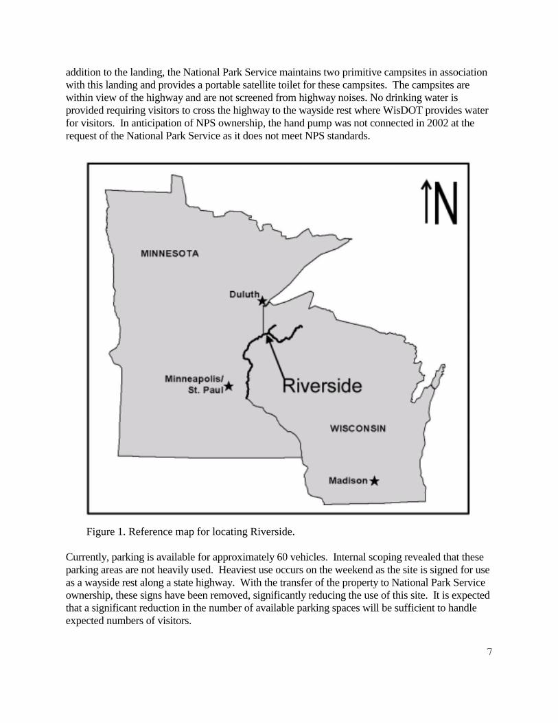
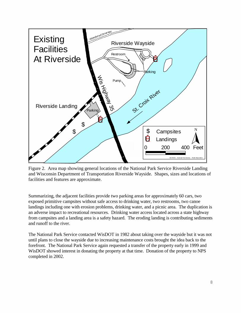
There are nearly 50 landings as access points for canoes and boats along the St. Croix andNamekagon rivers including the two adjacent facilities in northern Burnett County in BlaineTownship, T42N - R15W Section 33, at river mile 131.7: Riverside Landing and RiversideWayside (Figure 1). Riverside Landing is owned and operated by the National Park Service. Across Wisconsin State Highway 35 to the east, Wisconsin Department of Transportation operatesthe Riverside Wayside. The Wisconsin Department of Transportation (WisDOT) has operated thesite as a wayside rest since 1972 when the current facilities were constructed. WisDOT acquiredthe property in 1967. A third, but informal landing, just downstream, is used for trailer access andas a water site for use in fighting fires by the Wisconsin Department of Natural Resources. Thesefacilities adversely impact the scenic and recreational resources by duplicating facilities at adjacentsites.
The wayside as constructed by WisDOT (Figures 2 and 3.) includes a canoe ramp, two pavedparking areas for a total of 36 cars plus 11 slots for over-sized vehicles, paved circulation roads,vault toilets, a hand pumped well for drinking water, and a picnic area. The parking area can beseen from the river and storm water from the parking lot drains directly to the river. The asphaltcanoe ramp is heavily eroded and is not available for use by trailers. It is likely the ramp was alwaysintended for use as a canoe launch only. The site is currently used as a canoe landing and also byNational Park Service staff for environmental education purposes. The shallow water at this site isexcellent for the popular "Rivers Are Alive" program. Across Wisconsin Highway 35 to the east isRiverside Landing maintained by the National Park Service. Because of their strategic location,just a few miles downstream from the confluence of the Namekagon and St. Croix rivers, theseadjacent sites are among the National Park Service's most heavily used put-in and take-out points.
The landing maintained by the National Park Service has a 10-15 car gravel-surfaced parking lot infull view of the highway and the river. There is a mowed grass buffer between the parking lot andthe carry-in landing for canoes. The landing is a popular access point for canoe outfitters. In
7
addition to the landing, the National Park Service maintains two primitive campsites in associationwith this landing and provides a portable satellite toilet for these campsites. The campsites arewithin view of the highway and are not screened from highway noises. No drinking water isprovided requiring visitors to cross the highway to the wayside rest where WisDOT provides waterfor visitors. In anticipation of NPS ownership, the hand pump was not connected in 2002 at therequest of the National Park Service as it does not meet NPS standards.
Figure 1. Reference map for locating Riverside.
Currently, parking is available for approximately 60 vehicles. Internal scoping revealed that theseparking areas are not heavily used. Heaviest use occurs on the weekend as the site is signed for useas a wayside rest along a state highway. With the transfer of the property to National Park Serviceownership, these signs have been removed, significantly reducing the use of this site. It is expectedthat a significant reduction in the number of available parking spaces will be sufficient to handleexpected numbers of visitors.
8
N
200 0 200 400 Feet
$$
ÊÚ
Riverside Wayside
Riverside Landing
ÊÚ$ Campsites
LandingsW
is Highway 35
St. Croix
River
Parking
ÊÚ
ExistingFacilitiesAt Riverside
8/27/2002 Na tional Park Service Robin Maer ckle in
Abandoned Driveway
Parking
&
Restroom
Pump
Figure 2. Area map showing general locations of the National Park Service Riverside Landingand Wisconsin Department of Transportation Riverside Wayside. Shapes, sizes and locations offacilities and features are approximate.
Summarizing, the adjacent facilities provide two parking areas for approximately 60 cars, twoexposed primitive campsites without safe access to drinking water, two restrooms, two canoelandings including one with erosion problems, drinking water, and a picnic area. The duplication isan adverse impact to recreational resources. Drinking water access located across a state highwayfrom campsites and a landing area is a safety hazard. The eroding landing is contributing sedimentsand runoff to the river.
The National Park Service contacted WisDOT in 1982 about taking over the wayside but it was notuntil plans to close the wayside due to increasing maintenance costs brought the idea back to theforefront. The National Park Service again requested a transfer of the property early in 1999 andWisDOT showed interest in donating the property at that time. Donation of the property to NPScompleted in 2002.

9
Figure 3. Existing conditions and facilities at Riverside Wayside. Contour intervals and trees are also shown.

10
The donation of this property gives the National Park Service the opportunity to further the goalsof protecting the Riverway by: 1) Enhancing the scenic view from the river through reduction ofthe number of landings at this site and removing or screening facilities from the river. 2)Reducing the erosion and potential pollution from asphalt and sediment at the canoe landing at thewayside rest. 3) Providing a landing that is available to canoes and boats on trailers. 4) Providingvisitors with drinking water that meets NPS standards without the need to cross a state highway. 5)Providing improved camping opportunities that are out of sight of the highway and further removedfrom highway noise. 6) Provide good access to water for use in fighting fires.
1.3 Summary of Purpose and Need:
In summary, the purpose of this project is to provide facilities (landing, campsites, drinkingwater, toilets and picnic area) for visitors while reducing duplication of those facilities. The needis to reduce impacts (recreational, scenic and water quality) to a Wild and Scenic River. Theneed occurs at this time because previously the facilities at the wayside were under Stateownership and not under NPS control.
2.0 ALTERNATIVES
2.1 Preferred Alternative
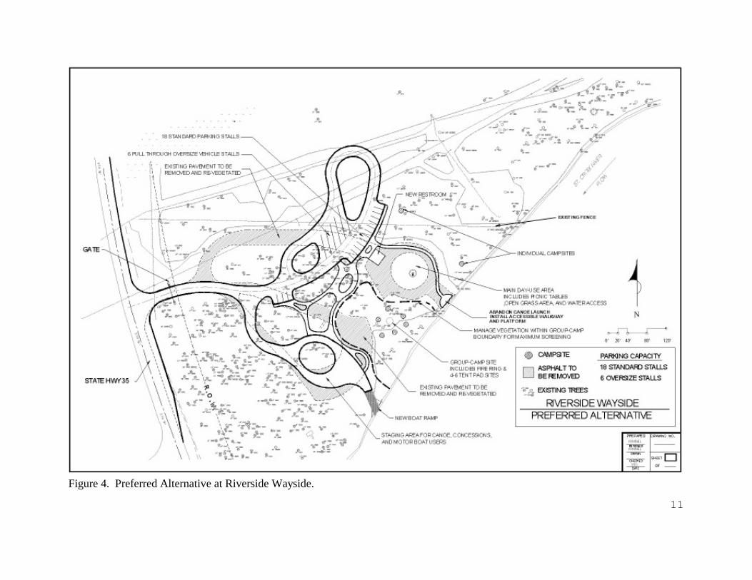
The Proposal: The facilities at Riverside Wayside and Riverside Landing will be combined intoone location at the site of Riverside Wayside. This would be accomplished by 1) constructing andmaintaining a redesigned parking lot; 2) relocating and replacing the water system to NPSstandards; 3) replace the three existing landings with a new landing just downstream of the Waysideramp; 4) relocating the picnic area; 5) construction and maintenance of two campsites and onegroup campsite (Figure 4) between the former parking lots; 6) construction of a pad and accessibleramp from the parking area to the river; and 7) closing and revegetation of the formerdriveway/access north of and adjacent to Riverside Wayside. The current NPS Riverside Landingwill be closed when the new facilities are open for public use. This will be accomplished byclosing the landing, the associated campsites, and the parking lot and revegetation of the entire site. The gravel parking lot will be scarified with a rake on a backhoe to break up the compacted soiland covered with topsoil prior to revegetation. The boulders marking the edge of the parking areawill be moved to boundary between NPS ownership and the township road right-of-way to preventvehicle access to the area.
Design criteria were given to a National Park Service Landscape Architect to provide conceptualdrawings of a redesigned site. The criteria were developed through scoping meetings held withinthe park with all staff invited. A request for public input resulted in two responses, one of whichaddressed design criteria and concern about "over-doing" construction at landings. The designcriteria submitted to the landscape architect are included in Appendix B. Features of this proposalinclude:
11
Figure 4. Preferred Alternative at Riverside Wayside.
12
2.1.1 Boat/Canoe LandingsThe canoe landing at Riverside Landing will be closed. A new landing will be constructed at theRiverside Wayside in a location used prior to 1967. This landing will be usable by both boats ontrailers and canoes. The landing will be constructed of gravel fill and concrete planking and willbe graded to prevent erosion. Concrete planking consists of 8' - 10' long planks of concreteconnected together by chains like a ladder, laid on the bottom of the prepared ramp bed. The 4" -6" gap between the planks will be filled with gravel. An informal landing a short distancedownstream from Riverside Landing will be closed. This downstream site is used as a fire truckfilling area and the new boat/canoe landing will replace that site. Canoes will still be able to landat the current landing at Riverside Wayside as this will be the access for campsites to bedeveloped in that vicinity.
2.1.2 Parking AreasThe parking area at WisDOT Riverside Wayside will be replaced at a new location fartherremoved from the river. This lot will have room for 18 cars with 6 pull through spaces foroversized vehicles such as vehicles with trailers and buses. Accessible parking for visitors withdisabilities will be provided. There will be no parking provided at the NPS Riverside Landing. Existing pavement at the wayside will be removed and planted with native plants except aroundthe parking area, picnic area and camping areas, where turf grasses would be planted andmaintained. Vegetation will include trees, shrubs, grasses and other herbaceous ground cover.
2.1.3 Restroom FacilitiesThe portable toilets at NPS Riverside Landing will be removed. The existing restroom WisDOTRiverside Wayside will be dismantled and replaced by a new facility at a new location northeastof the current location. The building will be dismantled and the existing vault will be removedand properly disposed of according to regulations. Clean fill will be used to fill in the area andthe site will be graded to match the area. The new restroom facility will be located within thepreviously disturbed footprint and convenient to all users.
2.1.4 Potable WaterThe configuration of the existing well and its design prevents it from meeting NPS standards andit will be shut down. The pump will be removed and the well properly capped and abandoned. A new well will be drilled near the new parking area. No problems are expected in drilling andinstalling a new well. This well will be housed in a small structure that will may also serve as abulletin board to post park information. The well will use a submersible electrical pump. Apower line will be connected by buried line to the nearest utility pole located near the entrance tothe wayside. Drinking fountains and a tap will be provided to supply water to visitors.
2.1.5 Day Use/Picnic AreaA day use area with 4-5 picnic tables will be installed and maintained in the area now occupiedby the paved turn loop at wayside landing. Turf grasses will be planted and maintained in thisarea. A pad at the rivers edge will be connected to the parking lot by an accessible walkway.
2.1.6 Edge DelineationThe existing wood posts lining the drives will be removed. Curbs and/or gutters and/or

13
landscaping will be used to control drainage or mark the edges of roadways and parking areas. Water will be directed away from landings to prevent direct runoff into the river. Overlanddrainage and filtration through soils will be the goal.
2.1.7 CampingThe existing campsites at the NPS site across the highway will be closed and restored with nativevegetation, but not until after replacement campsites are constructed within the RiversideWayside. Two campsites will be constructed and maintained near the existing paved turn loop,one to the north and one to the east (Figure 4). Each campsite will include a fire ring, a picnictable, and room for 1-3 tents. A group campsite will be installed adjacent to the new parkingarea and between the existing parking areas (Figure 4). This group campsite will include severalpicnic tables, at least one fire ring and room for 4-6 tents. Native vegetation will be planted toscreen all sites from the parking area. In addition, vegetation will be managed to maximizescreening from the river and between the camping and day use areas.
A camping spot for a campground host was considered for this alternative but was eliminated fortwo reasons; cost and lack of need. However, the area of revegetation due west of the pullthrough parking areas could be used should the need ever arise.
2.1.8 Environmental IssuesThere are no historic structures or cultural landscapes associated with site. However, anarcheological survey revealed an area where shovel tests are believed to have found a contiguousarcheological site with good integrity outside current disturbed areas. In addition shovel testsrevealed some archeological artifacts remaining adjacent to disturbed areas. It is likely thatconstruction of the current Wayside Rest destroyed most of the archeological resources there. Construction of the camping sites and adjacent parking area may impact, though not adverselyimpact, the archeological site. The campsites will be surveyed by an archeologist prior toconstruction. One or more of the disturbed areas may still contain archeological resources andrequire data recovery as mitigation. In addition, an archeologist may be required to be on sitewhen the asphalt is removed to determine site integrity on those areas where there appears tohave been less disturbance prior to laying the asphalt. Trails will be established to direct visitorsbetween the camping area and the river and away from archeological resources. At the request ofthe St. Croix Chippewa Indians of Wisconsin, a fence will also be installed to direct traffic,limiting and containing potential impacts to sensitive areas. Construction will comply withrequests from the Wisconsin State Historical Preservation Office to minimize impacts to thearcheological sites. To minimize impacts upon mature trees, a map of all trees greater than 12"in diameter in the project area was forwarded to the landscape architect prior to designing thisalternative. This map will also be used for the technical construction drawings.
2.1.9 Trash CollectionThe National Park Service maintains a "Carry-in Carry-out" policy regarding trash within theRiverway. No trash or recycling receptacles will be provided following this policy.
14
2.1.10 Wisconsin Department Of TransportationThere will be a 100' Right-of-way from the centerline of the highway into the property. It willrequire a turn lane for traffic leaving State Highway 35 into the redesigned site (Figure 4).
2.1.11 Ethnographic ResourcesThere are no known traditional or cultural uses or associations at this site. Consultations with thethree Native American Tribes associated with the Riverway elicited no concerns regarding thissite.
2.2 Alternative 1
Alternative 1 (Figure 5) has many similarities to the Preferred Alternative. Like the PreferredAlternative, this proposal would rehabilitate and combine the facilities located at RiversideWayside and Riverside Landing into one side of the highway at Riverside Wayside. At the NPSRiverside Landing this will be accomplished by closing the landing and associated campsites andrevegetation of the entire site. A smaller parking lot serving approximately 5 cars with trailerswould remain at Riverside Landing for snowmobile trailhead use and as a bus transfer location. Other features of this alternative include the following:
2.2.1 Boat/Canoe LandingsThe boat launch would remain in the existing location but would be rehabilitated and stabilized inorder to make it accessible for trailers. Expanded parking for vehicles with trailers would be nearthe boat launch. No accessible ramp to the river is planned for this alternative.
2.2.2 Parking AreasThe main parking areas would be redesigned but in similar locations to the current design tomaximize the use of existing paved areas. The main parking area would be pulled back from theriver farther than the existing lot to better protect the view from the river and to slow runoff to theriver. This parking lot will accommodate day use and oversized vehicles and vehicles with trailers. A total of 32 standard and 10 oversize stalls will be available for use.
2.2.3 Restroom FacilitiesThe restroom facilities and well would remain in the current locations. The restroom facilitiescould be refurbished or completely rebuilt on site. The existing vault would be tested for tightnessand repaired or replaced if it leaks.
2.2.4 Potable WaterThe existing well at WisDOT Riverside Wayside does not meet NPS standards and will be eitherrehabilitated or shut down. If abandoned, the existing pump will be removed and the well properlycapped and abandoned. A new well will be drilled nearby and will use a submersible electricalpump. A power line will be connected by buried line to the nearest utility pole located near theentrance to the wayside. Drinking fountains and a tap will be provided to supply water to visitors.

15

16
Figure 5. Alternative 1 for Riverside Wayside.

17
2.2.5 Day Use/Picnic AreaThe day use/picnic area would be concentrated in the area between the existing parking lots. Itwould be expanded into the current main parking area where pavement will be removed and turfgrasses will be planted and maintained.
2.2.6 Edge DelineationThe existing wood posts lining the drives will be removed. Curbs and/or gutters and/or swales willbe used to control drainage or mark the edges of roadways and parking areas. Water will be directedaway from landings to prevent direct runoff into the river. Overland drainage and filtration throughsoils will be the goal.
2.2.7 CampingA camping area would be developed northeast of the trailer parking area. Five individual campsitesand a group campsite would surround a parking area and thus be accessible by car. Camping invehicles, camper shells, or trailers would be prohibited. This parking area will be separate fromother parking areas.
A pull in camping spot is reserved for a campground host, labeled as "HOST SITE" on figure 5. Avolunteer campground host may be recruited for this site if the need arises. This site willaccommodate a small camping trailer and may have electrical hook-ups for the resident there.
2.2.8 Environmental IssuesThe only cultural resources known at this site are archeological resources. An archaeologicalsurvey revealed potential sites that needed to be protected. Trails will be established to directvisitors between the camping area and the river. An extensive archeological survey will berequired because this alternative is more likely to impact archeological and historical resources. As in the preferred alternative, an archeologist will survey campsites prior to construction andalso be on hand to survey under the asphalt as it is removed. A fence will also be installed todirect traffic, further limiting potential impact to these areas. As in the Preferred Alternative, amap of all trees greater than 12" in diameter in the project area was forwarding this request to thelandscape architect prior to designing this alternative. This map will be used to minimizeimpacts to these trees when the technical construction drawings are made. The entrance road isshifted approximately 80 feet north to accommodate turning radiuses combined with the desire tomove parking back away from the river.
2.2.9 Trash CollectionNo trash or recycling receptacles will be provided following the National Park Service's carry-incarry-out policy.
2.2.10 Wisconsin Department Of TransportationThere will be a 100' Right-of-way from the centerline of the highway into the property. It willrequire a turn lane for traffic leaving State Highway 35 into the redesigned site (Figure 4).Mowedareas will be significantly reduced and native plantings will replace many of these areas includingthose areas where pavement has been removed. Th

18
2.3 Alternative 2
This alternative is identical to the Preferred Alternative with the exception that the parking areaat Riverside Landing will remain but be reduced to accommodate five cars. This parking areamay have use for snowmobile trailhead use and as a bus transfer point. The rest of the parkingarea will be planted with native vegetation for screening and restoration. Only the differencesbetween the two alternatives are included below.
2.3.1 Parking AreasParking at the NPS Riverside Landing would be reduced from the approximately 20 vehiclecapacity to accommodate 5 vehicles. The remaining portion of the parking lot will be restored bybreaking up the compacted gravel and soil with a rake on a backhoe and covered with topsoilprior to planting with native plants. Vegetation will include trees, shrubs, grasses and otherherbaceous ground cover. The large rocks/small boulders marking the edge of the parking areawould be moved to the boundary of the new parking area and along the boundary of the townshiproad (Markville Road) right-of-way to prevent entry by vehicles beyond the parking area.

19
2.4 Comparative Summaries of Alternatives
Table 1. Comparative summary of Alternatives
PreferredAlternative
Alternative 1 Alternative 2 No ActionAlternative
General Close all facilities atRiverside Landing.Riverside Wayside wouldbe redesigned and rebuilt.
Close all facilities atRiverside Landing.Riverside Wayside wouldbe redesigned and rebuiltand will include campsitesaccessible by vehicle.
Close all facilities atRiverside Landing exceptreduce parking toaccommodate 5 cars.Riverside Wayside wouldbe redesigned and rebuilt.
All facilities at RiversideLanding and RiversideWayside remain open,except drinking water,duplicating them on bothsides of State Highway 35.
Boat/CanoeLanding
New boat & canoe access250' southwest of currentWayside canoe access. Close informal boat ramp0.25 mile downstream.
Wayside canoe accessrehabilitated to allowboats on trailers andaddress erosion problems.Close informal boat ramp0.25 mile downstream.
New boat & canoe access250' southwest of currentWayside canoe access.Close informal boat ramp0.25 mile downstream.
Two canoe access pointsremain open. Will requirefuture work to stabilizeerosion at Wayside canoeaccess.
Parking Areas Redesigned parking areasout of view from the riverwill accommodate 18standard and 6 oversizevehicles.
Redesigned parking areasout of view from the riverwill accommodate 32standard and 10 oversizevehicles, plus for 12 forthe campsites, plus 5standard stalls at RiversideLanding.
Redesigned parking areasout of view from the riverwill accommodate 18standard and 6 oversizevehicles, plus 5 standardstalls at RiversideLanding.
Existing parking lotsremain with capacity for46 standard and 16+oversize vehicles, most infull view from the river.
RestroomFacilities
New vault toilet at a newlocation replaces theexisting structure at theWayside.
New vault toilet at a newlocation replaces theexisting structure at theWayside.
New vault toilet at a newlocation replaces theexisting structure at theWayside.
Portable toilets and sub-standard vault toiletsremain.
Potable Water New well replaces old at a New well replaces old at a New well replaces old at a Old well will be properly
20
PreferredAlternative
Alternative 1 Alternative 2 No ActionAlternative
new location. new location. new location. capped. No water will besupplied.
Day Use/PicnicAreas
Redesigned picnic arealocated between existingparking lots. Accessibleramp from parking area topad at river edge.
Redesigned picnic arealocated between existingparking lots.
Redesigned picnic arealocated between existingparking lots. Accessibleramp from parking area topad at river edge.
Existing picnic arearemains open at theWayside location
EdgeDelineation,Runoff Control
Curbs and/or guttersand/or landscaping will beincorporated into design tominimize or slow runoff. Posts will be removed.
Curbs and/or guttersand/or landscaping will beincorporated into design tominimize or slow runoff. Posts will be removed.
Curbs and/or guttersand/or landscaping will beincorporated into design tominimize or slow runoff. Posts will be removed.
Water from parking areaswill continue to rundirectly into river. Postswill continue to rot andneed replacement.
Camping2 campsites plus a groupcampsite will beconstructed near theexisting canoe launch.
5 campsites accessible byvehicle or canoe plus agroup campsite clusteredaround a separate parkingarea.
2 campsites plus a groupcampsite will beconstructed near theexisting canoe launch.
2 campsites remain openat the Riverside Landing.
EnvironmentalIssues
May impact, but notadversely, archeologicalresources. Soil erosionand spread of exotic plantswill be reduced.
May impact archeologicalresources. Mitigation maybe required. Soil erosionand spread of exotic plantswill be reduced.
May impact, but notadversely, archeologicalresources. Soil erosionand spread of exotic plantswill be reduced.
Limited potential impactto cultural resources. Soilerosion and spread ofexotic plants likely tocontinue.
TrashCollection
Collection of trash andrecyclables will bediscontinued.
Collection of trash andrecyclables will bediscontinued.
Collection of trash andrecyclables will bediscontinued.
Collection of trash andrecyclables will bediscontinued.
Wisconsin DOTWisDot will retain a 100'right-of-way on the eastside of the highway.
WisDot will retain a 100'right-of-way on the eastside of the highway.
WisDot will retain a 100'right-of-way on the eastside of the highway.
WisDot will retain a 100'right-of-way on the eastside of the highway.

21
PreferredAlternative
Alternative 1 Alternative 2 No ActionAlternative
EthnographicResources
None known from thissite.
None known from thissite.
None known from thissite.
None known from thissite.

22
2.5 No Action Alternative
Under this alternative, the rehabilitation of Riverside Wayside would not take place and bothlandings would remain open. Few changes to current facilities would take place. No changeswould be expected to the plant or wildlife community. The nearest landing for boats with trailerswould be the informal site 0.25 mile downstream, which may make the site subject to erosion. It isexpected that the canoe landing at the wayside will continue to erode and will require further actionto reduce or eliminate the erosion and tripping hazard potential. The water supply will have to beclosed and/or replaced to maintain it at NPS standards. Existing camping facilities at the landingwould remain in view of the highway. Noise from the highway will continue to be easily heard atthe campsites. Visitors using the campsites would continue to need to cross State Highway 35 toaccess drinking water, if provided. Both parking lots would remain visible from the river. Collection of trash and recyclable materials would be discontinued at the wayside location inkeeping with the National Park Service's 'carry-in, carry-out' policy.
2.6 Environmentally Preferable Alternative
An environmentally preferred alternative will balance the needs of the visitor, protect the significantvalues for which the Riverway was established, protect archeological and historical resources andwill result in preservation of the environment. The Environmental Protection Agency defines theenvironmentally preferred alternative as "…the alternative that causes the least damage to thebiological and physical environment; it also means the alternative which best protects, preserves,and enhances historic, cultural, and natural resources." (USDI 2000, Chap. 3, 2.7D, page 23). Forthis Environmental Assessment, four main criteria are considered: Needs of the visitor; Protectionof significant resources; Protection of archeological and historic resources; and Preservation ofthe environment. These criteria are derived from the significant values as described by the GeneralManagement Plan (USDI 1998). These significant values are derived from the Organic Actestablished the National Park Service and the Wild and Scenic Rivers Act that established the St.Croix National Scenic Riverway. The needs of the visitor is included under this definition becauseof their emphasis as significant to the Riverway under the General Management Plan.
Each of the impact topics listed in Table 2 could also be listed within one or more of the four maincriteria chosen for determining the environmentally preferable alternative. In several cases theimpact topic was a non-issue as little or no impact occurred in any of the alternatives. Others, whileneeding to be discussed under impacts, do not significantly add to the decision-making process fordetermining the environmentally preferable alternative. Though each topic is not specificallydiscussed, they were considered and generally lumped into each of the four main criteria as listed inthe text below.
2.6.1 Needs Of The VisitorVisitors' needs must address both day use and overnight use. These needs include: reasonableaccess to the river by individuals, groups and outfitters; sufficient parking space at landings for dayuse, environmental education and overnight use; a sufficient number of reasonably spacedcampsites that are accessible by boat and/or foot; aesthetically pleasing surroundings with humandevelopment kept to a minimum; a safe and clean environment for these and other recreational
23
activities. The impact topic from Table 2 considered here is recreation/visitor use.
The basic needs of the visitor as identified above are provided by each of the three alternatives witha few differences. Drinking water is not provided by the No Action Alternative. In Alternative 1,Alternative 2 and the Preferred Alternative the visitor experience is improved through constructionof campsites that are more aesthetically pleasing and a reduction of views of human disturbancesalong the river. The Preferred Alternative and Alternative 2 provide an accessible ramp from theparking area to provide access to the river. These three alternatives also include a boat ramp thatprovides access for small fishing boats on trailers. All alternatives provide a sufficient number ofcampsites. Sufficient parking is supplied by all alternatives, however, the Preferred Alternativedoes not specifically provide parking for snowmobiles. Communication with local a snowmobilegroup has suggested that parking at this site is unnecessary. When viewed only from theperspective of the needs of the visitor, either the Preferred Alternative, Alternative 1, or Alternative2 would be the Environmentally Preferred Alternative.
2.6.2 Protection Of Significant ResourcesThe significant values that may be affected by each alternative include cultural, scenic andrecreational opportunities. The recreational opportunities include high-quality canoe camping withmultiple day camping opportunities, access for fishing, and extended opportunities to experiencethe solitude and beauty of the Riverway. An environmentally preferred alternative should enhancethese values by reducing evidence of modern human presence while providing boat access andcamping opportunities and protecting archeological resources. The impact topic from Table 2considered here is scenic resources. Cultural resources are considered separately in section 2.6.3.
This section discusses primarily scenic resources. The impacts to recreational opportunities areaddressed above in 2.6.1 and these are limited to camping and availability of drinking water. Archeological resources are discussed in the following section. Alternative 1, Alternative 2 and thePreferred Alternative will improve scenic resources through improved screening of facilities and anincrease in native vegetation communities. The No Action Alternative will leave existing impactsto the scenery in place. When viewed only from the perspective of the scenic resources Alternative1, Alternative 2 or the Preferred Alternative could be considered the Environmentally PreferredAlternative.
2.6.3 Protection Of Archeological And Historical ResourcesArcheological resources are most likely to be protected by the No Action Alternative as there willbe no immediate ground disturbance but could have minor long-term disturbance from visitor use. Alternative 1 will likely have an adverse impact upon archeological resources. Additional surveysand extensive excavation will need to occur to mitigate impacts. The Preferred Alternative andAlternative 2 were developed to prevent impacts, but it is recognized minor impacts may occur atdevelopment or through long term visitor use. Therefore minor impacts of these resources mayoccur but no adverse impact. Viewed only from this perspective, the No Action Alternative orpossibly the Preferred Alternative or Alternative 2 would be the Environmentally PreferredAlternative. The impact topics from Table 2 considered here are prehistoric resources, ethnographyand historic resources.
24
2.6.4 Preservation Of The EnvironmentPreservation of the environment includes limiting or eliminating erosion potential, minimizing thenumber of native trees and other vegetation that will be impacted or removed, and restoration andpreservation of native habitat to the maximum extent possible. The impact topics from Table 2considered here are: air quality; soils; water quality; floodplains; wetlands; vegetation; wildlife,and; threatened, endangered and rare species.
The No Action Alternative will leave existing erosional features in place and will require work instabilizing the canoe landing at the wayside at a future date. However, the No Action Alternativewill leave all trees whereas the two other alternatives will require a moderate number of maturetrees (25-60) to be removed. The Preferred Alternative, Alternative 1 and Alternative 2 willeliminate mowing in a large portion of the wayside and will include restoration with nativevegetation where asphalt is removed. The Preferred Alternative will result in the largest area ofrevegetation. Native plant communities will be encouraged or planted. In the long term, thenumber and diversity of trees, understory trees and shrubs and ground vegetation is expected toincrease in all except the No Action Alternative. The Preferred Alternative and Alternative 2 willbest control erosion but removes a moderate number of trees. Despite the short-term impact throughthe number of trees removed in all but the No Action Alternative, the long-term outcome will be amore diverse population of trees while keeping the same number or more trees than now exist. ThePreferred Alternative combines the best erosion control with the largest area of revegetation with asmaller moderate number of trees cut. Therefore from the perspective of only preserving theenvironment the Preferred Alternative would be the Environmentally Preferred Alternative.
2.6.5 Environmentally Preferred AlternativeThe Preferred Alternative is considered the best fit as the environmentally preferred alternative. This alternative is chosen from the four alternatives given: Preferred Alternative, Alternative 1,Alternative 2 and No Action Alternative. A summary table (Table 2) was used to assist in thisselection. Given the four criteria used to select the environmentally preferred alternative, no onealternative stood out as the most obvious choice. Alternative 1 is eliminated because it is likely tohave an adverse impact to archeological resources and the highest number of mature trees removed. The No Action Alternative only has a potential for minor long term impact to archeologicalresources but maintains impacts to scenic resources through duplication of facilities visible from theriver and mowed areas, impacts to recreational resources because of non-aesthetic campingfacilities and lack of drinking water, and impacts to water quality from an eroding landing. Although both the Preferred Alternative and Alternative 2 may have a minor impact toarcheological resources, they are not considered adverse and less severe than those impacts to otherresources caused by the No Action Alternative. Of those two, the Preferred Alternative providesthe largest area of native plant restoration. Therefore the Preferred Alternative is the best fit as theEnvironmentally Preferred Alternative.
25
Table 2. Summary table used to determine which alternative best fits the description of the Environmentally Preferred Alternative. The text is highlighted in bold, italicized, and the background shaded in each box where it best fits the description of theEnvironmentally Preferred Alternative. More than one alternative may fit the description for environmentally preferred for a givencriteria.
Needs of the VisitorProtection of Significant
Scenic ResourcesProtection of
Archeological ResourcesPreservation of the
EnvironmentPreferredAlternative
Provides sufficient parkingarea, drinking water,addition of a boat ramp,aesthetically pleasingcampsites and anaccessible ramp to the river
Provides best protection ofscenic and recreationalresources through reducednumber of visible facilities
Minor impact, but noadverse impacts toarcheological resources.Will require an archeologistpresent during certain stagesof construction.
Removal of approximately27 mature trees, largestarea of rehabilitation onboth sides of the road withnative vegetation, reducederosion potential
Alternative 1Provides sufficient parkingarea, drinking water,addition of a boat ramp,and an increase in numberof campsites that are alsomore aesthetically pleasing
Provides best protection ofscenic and recreationalresources through reducednumber of visible facilities
Would likely have anadverse impact toarcheological resources. Will require mitigation,additional surveys, andpossibly extensiveexcavation.
Removal of approximately59 mature trees,rehabilitation of large areason both sides of the roadwith native vegetation,reduced erosion potential
Alternative 2 Provides sufficient parkingarea, drinking water,addition of a boat ramp,aesthetically pleasingcampsites and anaccessible ramp to the river
Provides best protection ofscenic and recreationalresources through reducednumber of visible facilities
Minor impact, but noadverse impacts toarcheological resources.Will require an archeologistpresent during certain stagesof construction.
Removal of approximately27 mature trees,rehabilitation of large areason both sides of the roadwith native vegetation,reduced erosion potential
No ActionAlternative Provides sufficient parking
area, no drinking water, noboat ramp, and no change innumber of campsites
Scenic resources remainimpacted by duplicatefacilities, lack of screening. Best protection of culturalresources
Potential long term minorimpacts to archeologicalresources
No mature trees cut,conversion of turf grasses tonative vegetation does notoccur, erosion continues atWayside's canoe landing

26
3.0 AFFECTED ENVIRONMENT
St. Croix National Scenic Riverway is located on the Minnesota-Wisconsin border and innorthwestern Wisconsin. The proposed project is on the north side of the St. Croix River adjacentto Wisconsin State Highway 35 in northern Burnett County in Blaine Township, T42N R15WSection 33 (Figure 1). Areas directly affected by the proposed development include the NPSlanding, the Riverside Wayside Rest, the adjacent National Park Service lands north of the waysideand an informal boat landing one quarter mile downstream of Riverside Landing. The adjacentNational Park Service lands, purchased in fee in 1970, is included because development in both thePreferred Alternative and Alternative 1 will occur partly on this property. Recreationalopportunities will also be affected as access to the river, number and location of campingopportunities, and scenic views will be affected.
The St. Croix National Scenic Riverway is one of the most biologically diverse units of theNational Park Service in the Midwest. The linear extent of the Riverway across varied terrestrialand aquatic habitats results in a variety of invertebrates, amphibians, reptiles, birds, and mammalsthat inhabit and use the Riverway. Moreover, the park is an important location for rare species ofplants and animals. Five species of animals, peregrine falcon (Falco peregrinus), bald eagle(Haliaeetus leucocephalus), gray wolf (Canis lupus), winged mapleleaf mussel (Quadrula fragosa)and Higgins' Eye pearly mussel (Lampsilis higginsi) are present within the Riverway and federallylisted as endangered or threatened. Ten other species known to exist within the Riverway arecurrently proposed for federal listing, and 78 other species of amphibians, birds, fish, insects,mammals, molluscs, plants, and reptiles are presently listed as endangered, threatened, or of specialconcern by the states of Minnesota and/or Wisconsin. A bald eagle nest, active in 2001, is locatedapproximately 0.4 miles northeast of the proposed development project but was abandoned in 2002.The nearest nest active in 2002 is located 1.8 miles up river and is probably used by the same pairas the former site. As many as eight wolf packs have been located along the Riverway with oneterritory that includes the Riverside area (WDNR 2001). Wolf tracks from several wolves werefound within the adjacent National Park Service land northeast of the wayside in January 2002. Apark neighbor reported an active wolf den within 2 miles of Riverside in 2000 but this has not beenconfirmed. However, it would be within a known wolf pack territory. Except for the bald eagleand the gray wolf, none of the above species are known to breed or reside within the affected area,nor are they expected to be affected by this project.
Numerous prehistoric archeological sites are found along the St. Croix National Scenic Riverway. These sites illustrate human occupation of the area from the Archaic and Woodland through theHistoric period. Two sites in the Riverway are listed on the National Register of Historic Places. The wayside has been found to contain numerous indications of previous occupation by NativeAmericans. A survey suggests that the artifacts found represent a significant Middle to LateWoodland and early Historic site. The investigating archeologist recommends that this site beconsidered eligible for listing to the National Register of Historic Places.
The National Park Service strives to maintain those values for which the Riverway wasestablished. To aid in reaching this goal, the General Management Plan (USDI 1998) divides the

27
Riverway into management zones that describe the experience visitors should encounter withinthose zones. Most of the St. Croix River in the affected area is designated as 'near-primitivenorthwoods' as described below:
"An area managed as near-primitive northwoods will provide a natural landscape that istypified by or reflects the northwoods ecosystem. There may be signs of people, butgenerally it will look like a natural, remote, primitive area. Visitors will likely encounterwildlife, and there will be many opportunities for high-quality fishing. Most visitors willbe on foot, paddling, or engaged in other human powered outdoor recreational activities,although some low-speed motorboat travel will also be permitted.
Because access will be limited in this area there will be fewer visitors and manyopportunities to find solitude and quiet. Encounters with National Park Service staff willalso be infrequent. These areas will offer opportunities for challenge and adventure. Development, including NPS facilities, will be rare - one could go for long stretches andsee no development. Small, primitive campsites (i.e., cleared areas with fire rings and pittoilets, which are not accessible by road), designated trails, and access points may bepresent. Onsite controls and restrictions may be used for resource protection and visitorsafety, including some resource modifications that blend in with the naturalenvironment."
The 'near-primitive northwoods' zone is the least developed, most natural zone within theRiverway. Due to existing development, the General Management Plan designates theimmediate 0.5 mile stretch of river around Riverside as a 'developed recreation area'. This zoneis described below:
"This area will be characterized by planned development that blends with the northwoodsecosystem. Architectural style, detailing, and color schemes will blend into and notdetract from the natural beauty of the area. Development will be clustered and sensitivelyplaced to minimally disturb the natural landscape… Natural, social, and built elementsall will contribute to the visitor experience. Opportunities still will be available forfishing and observing wildlife… This area will provide many opportunities for groupexperiences. There will often be large numbers of visitors, and the probability ofencountering other visitors and land managers will be high… Both motorboats andhuman-powered outdoor recreational activities will be permitted as long as they cancoexist with other uses. The area could accommodate a moderate to high level ofrecreation and/or administrative development. NPS facilities, which will be in clustersand sensitively designed and placed, may include visitor and environmental educationcenters, interpretive structures, primitive and developed campsites, campgrounds, smalland large access points, and administrative structures… Resources will be modified forvisitor and NPS operational needs and to mitigate and minimize resource impacts due tovisitor use."
The extent and magnitude of development proposed within the range of alternatives fit within those

28
guidelines described above. National Park Service staff and park neighbors anecdotally report asmany as 30 vehicles using these parking lots at one time though generally use is considerably less. A significant amount of cars may be attributed to use of the site as a State Highway Wayside Rest. Traffic counters are not used so actual use is unknown. The wayside is closed during winter andNPS staff report occasional use by vehicles with snowmobile trailers at the Riverside Landingparking lot.
The number and location of campsites in the preferred alternative is different than the currentconfiguration. This affects the availability of recreational opportunities. Camping is limited to onenight per site. Campsites are located throughout the Riverway allowing overnight use accessed bywater and/or foot. Campsites are spread out to allow visitors to maintain distance from each otherbut also to allow for varied trip locations and travel distances by boat or canoe. Two campsites arecurrently located at Riverside Landing. Nineteen campsites are located within 10 miles on the St.Croix and Namekagon rivers (Figure 6). Of these, only one campsite is located downstream, 2.2miles from Riverside. Five campsites, including a group campsite, are located upstream on the St.Croix River with the nearest 0.8 miles away at Big Island. The remaining thirteen campsites within10 river miles of Riverside are located upstream on the Namekagon River. Four of these are groupcampsites. The ten mile distance was subjectively chosen as a reasonable distance for daily travel.
ÊÚ
ÊÚ
ÊÚ
ÊÚ
$
$$$$
ÊÚ
ÊÚ
ÊÚÊÚ
ÊÚ
ÊÚ
ÊÚ
$$
$$X
$$
$ÊÚ$
$
$$$$$$
$$$$
$
$
$
$
$ÊÚ
$
$$$
$ÊÚ$$
ÊÚ$$$
$$
ÊÚ
$
$
LandingLanding
LandingLanding
Landing
Landing
Landing
Landing
Landing
Landing
Riverside LandingLanding
LandingLanding
Roads
$ CampsiteÊÚ Landing
Legend N
Robin Maercklein NPS 12/6/2001
Wis 35
Wis
35
Wis 77
Wis 77MN 48
Min
neso
ta
Wis
cons
in
Cro
i x
River
St.
St. Croix River
Nam
e
kagonRiver0 5 10
MilesFigure 6. Location of campsites and landings within 13 - 15 river miles of Riverside Landing.
Most of the proposed development site lies within the landscaped area of the wayside. It contains amature forest with understory removed and mowed turf grasses. The overstory is dominated by redpine (Pinus resinosa) but also includes significant amounts of white pine (Pinus strobus), quakingaspen (Populus tremuloides), red oak (Quercus rubra), paper birch (Betula papyrifera), and whitespruce (Picea glauca). Most of these trees fall within 6-30 inches in diameter at breast height.

29
Understory shrub species outside of and at the edge of the present developed area consist ofAmerican hazelnut (Corylus americana), red-osier dogwood (Cornus stolonifera), northernelderberry (Sambucus canadensis) and saplings of the above trees and green ash (Fraxinuspennsylvanica). Ground cover is primarily mowed grasses with native and non-native species at theperimeter of the mowed areas. Spotted knapweed (Centaurea maculosa), an invasive exotic plantspecies, is found near the landing at the wayside rest and within adjacent National Park Servicelands north of the wayside. This plant is typical of disturbed and/or grazed areas and could easilycolonize newly disturbed areas.
Glaciers deposited the parent materials of the soils presently within the St. Croix watershed. Theseinclude calcareous material from southern Canada, and bedrock materials from the Laurentianshield area of Minnesota and Ontario. Unconsolidated glacial sands, clays, silt loams, sedimentaryrocks and gravel are typical. According to Burnett County General Soil Map (Burnett County Landand Water Conservation District, 1968) soils at the site are classified as "Miscellaneous Land TypesAssociation". This association was designed to include the "…conglomeration of miscellaneousland types, soil complexes and soil types which occur mainly along the St. Croix River in such apattern and size that it is impossible to separate them on a map of this scale." These soil typesinclude sandy loam, loamy sand, and gravelly sandy loam: soils typical of glacial deposits in thisarea. The Soil Conservation Service (USDA 1971) gives a similar description as "…alluvial lands,sandy".
Warm summers and cold winters characterize the climate in the St. Croix River basin. Majorrecreational use of the rivers is primarily confined to spring, summer, and fall. From freeze-up inNovember to the April ice breakup, use along the river diminishes although cross-country skiing isa favorite activity. Snowmobile use on the river is prohibited upstream from Riverside but isallowed below the bridge on the frozen surface of the river. Tracks from snowmobiles arefrequently observed and indicate some use in this area. Annual precipitation averages from 26inches (66 cm) to 30 inches (76 cm) per year.
Water quality of the St. Croix River is considered outstanding. Ground water in Burnett County isgenerally good.
4.0 IMPACTS
4.1 Impacts of Preferred Alternative
4.1.1 Impact DefinitionImpacts are defined by intensity as:• Negligible - Impacts occur, but are so minute that they have no observable effects on
plants and animals and the ecosystems supporting them.• Minor: Impacts are detectable, but the severity and timing of changes are not expected
to be outside the natural variability (natural variability) and not expected to have anylong-term effects on biological resources or ecosystems. Population numbers,population structure, genetic variability, and other demographic factors for species may

30
have small, short-term changes, but long-term characteristics remain stable. Keyecosystem processes may have short-term disruptions that are within natural variability,and habitat for all species remains functional.
• Moderate: Impacts are detectable and the severity and timing of changes are expectedto be outside the natural variability for short periods of time and changes within thenatural variability may be long-term in nature. Population numbers, populationstructure, genetic variability, and other demographic factors for species may have smallto moderate, short-term declines, but rebound to pre-impact numbers. Species are notat risk of being extirpated from the park, key ecosystem processes may have short-termdisruptions that are outside natural variability (but return to natural variability), andhabitat for all species remains functional.
• Major: Impacts are detectable and the severity and timing of changes to parametermeasurements are expected to be outside the natural variability (natural variability) forshort to long periods of time - or even be permanent. Changes within the naturalvariability may be long-term or permanent in nature. Timing of the impacts isimportant with respect to species or ecosystem functioning. Population numbers,population structure, genetic variability, and other demographic factors for species mayhave large, short-term declines with long-term population numbers significantlydepressed. In extreme cases, species may be extirpated from the park, key ecosystemprocesses may be disrupted, or habitat for any species is rendered non-functional.
Impacts are defined by duration as:• Short-term: Impacts are temporary, lasting at most throughout construction.• Moderate-term: Impacts are temporary, lasting less than a year.• Long-term: Impacts are temporary or permanent, remaining over a year.
4.1.2 Cumulative ImpactsCumulative effects due to the preferred alternative are considered to be none except a possiblelong-term beneficial minor impact. The Riverside area lies within the 'Developed Recreation'area and the proposal calls for a lower level of development than would be allowed asdescribed under the park's General Management Plan. The number of campsites is expectedto remain similar and parking area will be slightly reduced.
4.1.3 Geological Resources - SoilsMost of the development occurs in nearly level topography and generally slopes to the north awayfrom the river. The steepest slopes occur at the bank of the river. Control of soil erosion duringand after construction is expected to protect water quality in the river. Erosion control blankets andseeding of exposed soils where appropriate will be used to control erosion. One to three water barsmay be installed at the site of the Wayside Rest landing to control future erosion. Use of siltbarriers during construction will limit or eliminate siltation into the river and aquatic fauna shouldnot be affected unless an extreme storm event occurs. In the event a major storm does occur duringthe most vulnerable point in construction (maximum exposed disturbed soils), moderate-term,moderate (more likely minor) impacts may impact mussel fauna in the riverbed in a narrow bandfor 100-200 meters downstream. Minor short-term impacts may occur to other aquatic fauna asthey are displaced by sediments. Sediment deposition would be expected to minor and transitory,dispersing with the next flood, the following spring being the longest term. Long-term beneficial

31
impacts are expected to occur as erosion potential will be reduced through replacement andrevegetation of an eroding landing with a landing with less erosion potential. Impacts due toerosion and/or siltation are expected to be minor and short or moderate-term, lasting mainly duringthe construction period but up to a year or two for seeded vegetation to cover exposed soils.
Compaction of soils is expected where parking and driving surfaces occur. Compacted soils underexisting paved areas where rehabilitated will in time, loosen through invasion by roots andburrowing animals. Soils under some paved areas will be broken up to aid in restoration to nativevegetation. Compaction impacts are minor and long-term but both beneficial and adverse, andapproximately equal to each other.
4.1.4 Air Quality, Traffic And NoiseShort-term minor impacts are expected to air quality during demolition and construction. Noise and traffic will be temporarily increased during this project. A beneficial, long-term,moderate impact will occur due to screening campsites and the landing from the noise oftraffic on State highway 35.
4.1.5 Water QualityThere is a potential for short-term minor impact to water quality due to sedimentation and runoff. See section 4.1.3 above. In accordance with the Clean Water Act, appropriate project design usingbest management practices will be employed to reduce erosion and sedimentation. Long-termimpacts are expected to be negligible or beneficial through elimination of an eroding landing. Thus, the proposal will be in compliance with the Clean Water Act.
A Section 404 permit will be required from the US Army Corps of Engineers for construction ofthe boat ramp. Despite the use of state of the art sedimentation barriers, there is potential for anadverse, short to moderate-term, minor impact to water quality lasting during construction due tosedimentation.
4.1.6 Streamflow, Land Use, and Land ValuesNo impacts are expected in these categories, individually, cumulatively, directly or indirectly.
4.1.7 FloodplainsThere should be no adverse effect on floodwaters or flood elevations. By their nature, canoeaccesses and boat landings on rivers can only be located within a floodplain. These facilities willbe constructed in a manner that will minimize or eliminate damage due to flooding and will nothave adverse effects upon floodwaters or flood elevations. Thus, the National Park Service is incompliance with the intent of Executive Order 11988 (Floodplain Management).
4.1.8 WetlandsNo wetlands exist within the project site except those contained within the bed of the river. Construction of a landing is not expected to impact wetlands at this site. Thus, the National ParkService will be in compliance with the intent of Executive Order 11990 (Protection of Wetlands).

32
4.1.9 VegetationLarge trees at the Wayside Rest were surveyed resulting in a map of the area showing thedistribution of all trees larger than 12 inches in diameter. Based upon the drawing of thePreferred Alternative, approximately 27 trees in this category will be cut and removed. Thisincludes one white spruce (Picea abies), three aspen (Populus tremuloides) and 23 pine(Pinus strobus and P. resinosa). The exact number of impacted trees will vary dependingupon final architectural drawings and implementation of construction. This is considered tobe a moderate adverse impact that will eventually (10-20+ years) before being planted treesgrow to mature sizes.
Riverside Landing and the abandoned driveway north of the Wayside will be planted withnative grasses, forbs, shrubs and trees. Most areas currently managed as turf will be plantedwith these combinations resulting in an increase in native vegetation. This is considered to bemoderate-term and long-term moderate beneficial impact to the vegetation.
4.1.10 Threatened, Endangered and Rare SpeciesKnown terrestrial federally listed species in the region include the bald eagle and gray wolf. Known active bald eagle nests are at least 1.8 miles from the proposed project. These eagles areunlikely to be affected by project construction. This project is within guidelines for activities as setforth by the Northern States Bald Eagle Recovery Plan. Due to screening and distance, this projectis unlikely to impact bald eagles. Gray wolves have been reported to den within two miles ofRiverside. Although tracks in winter show that wolves have passed through the immediate area, itis not expected that construction will affect the resident wolf pack as they are already accustomed tohuman activity at this site. In addition, the construction will take place at time when human activityis already common at the site. Snowmobiles users occasionally use the existing parking lot atRiverside Landing and this lot will be eliminated. Assuming wolves may be stressed by thepresence of snowmobiles, there is a potential long-term, minor, beneficial impact upon this speciesthrough a possible reduction of snowmobiles on National Park Service property. Thus, there shouldbe no adverse impact to any federally-listed species as a result of this project.
A 1992-1993 field survey for rare plants in the Riverway found no state or federally listed speciesin the proposed project or surrounding area and the area was generally considered unlikely tocontain rare species. A field check for rare or listed plant species was conducted within theproposed project area by a National Park Service biologist in spring of 2001. No rare or state orfederally listed plant species were located at or in close proximity to the proposed project area. There should be no effect on any state or federally-listed or federally-proposed species. Implementation of any of the alternatives is therefore in compliance with the Endangered SpeciesAct of 1973, as amended.
In keeping with NPS policy, the project has been designed to avoid impact to state-listed plants oranimals. There should be no adverse effect to any state-listed or state-proposed plant or animalspecies.
4.1.11 WildlifeThere should be no adverse impact to either large or small vertebrate species, including competition

33
for nesting or breeding sites. Some mature trees will be cleared for the redesigned parking lots androads. This thinning of the trees and simultaneous termination of management for turf grasses willlikely encourage understory growth of shrubs and herbaceous ground cover resulting in a morediversified habitat leading to minor changes of vertebrate species. Native plantings in previouslydeveloped areas will also lead to a greater diversification of plant species at the project site. However, some small ground dwelling vertebrates and invertebrate species may be disturbed anddislocated to adjacent sites. This impact is expected to be short-term lasting approximately threemonths during construction. Impacts over a moderate time period (1-3 years) will occur as animalsare displaced. Overall long-term impact is considered negligible or beneficial as new habitatbecomes available through revegetation of the mowed areas. Although vertebrate and invertebratespecies of the site have not been surveyed, no long-term (greater than three years) adverse impact isanticipated.
4.1.12 Exotic SpeciesSpotted knapweed is present within the proposed development area. This invasive exotic planteasily invades disturbed areas that also have plenty of sunshine. It is common to abundant withinthe Riverway in abandoned fields, landings, campsites and some mowed lawns and trails. A smallnumber of plants are located adjacent to the Wayside canoe ramp. It is likely that these plants andassociated soils (and hence the seed bank) will be moved/removed through construction of theproposed accessible platform and walkway. Larger populations of this plant are present in the openareas within the northern third of the proposed parking lot. As this plant easily invades disturbedsoils, out-competes with native plants, and disrupts native plant communities, it is important toprevent the spread of this species. Impacts, beneficial or adverse are considered to be minor in anycase as the plant is already common in parts of this site. Mitigation for this exotic plant includes: 1)The use of sediment barriers for soil erosion should also prevent the spread of seeds into the river.2) Native vegetation and turf grasses where appropriate, will be planted to compete with knapweed. 3) Soils known to contain knapweed seeds will not be distributed to uninfested areas. 4) Allflowers and/or seed heads will be removed and destroyed prior to construction. 5) ResourceManagement staff from the National Park Service will monitor the site following construction andmechanically remove any knapweed before it becomes established within the developed areas. Mitigation efforts will have a long-term beneficial impact through the removal of two or threepopulations of spotted knapweed.
4.1.13 Recreation And Visitor UseA beneficial long-term impact is expected upon recreational use through more aestheticallypleasing campsites that are screened from the bridge and a reduction of traffic noise heard atthose sites compared to the present location. This screening will consist of a combination oftrees, shrubs and ground vegetation. It is expected that this screen will develop in 5-10 yearsafter planting.
No specific parking for snowmobiles will be provided at Riverside. Use of parking at this sitehas been considered unnecessary by a local snowmobile club. Therefore impacts to recreationand visitor use is expected to be long-term but negligible.
Drinking water and access by small boats on trailers will be provided. Also a walkway and

34
platform will be provide an accessible means from the parking area to the water for theNational Park Service's popular Rivers Are Alive program.
The proposed project will provide access to existing recreational opportunities for Riverwayvisitors that could enhance their experience in visiting the St. Croix National Scenic Riverway. Signs and notices at the bulletin board will provide an opportunity to orient and educate visitors andthus increase appreciation for the Riverway and reduce unauthorized uses of the area.
4.1.14 Archeological, Historical and Cultural ResourcesBecause of the potential for archeological resources in the area, a field survey of the project areawas conducted in 2001 by a qualified archeologist. Results of this survey concluded that there is asignificant Middle to Late Woodland and early Historic site on the property. Materials recoveredsuggest that the site should be considered eligible for listing on the national Register of HistoricPlaces (NPS, Midwest Archeological Center Memorandum, 12/21/2001). A preliminary reportfurther recommends that development should protect the site from impacts due to construction,landscaping and visitor use. The preferred alternative was designed to the extent possible to avoidimpacts to known archeological resources. Both construction and visitor use areas have beenlocated away from the known archeological sites. The area visitor use development is being limitedto, has seen previous development. It is unknown however, if the current paved areas cover anyarcheological resources. It is possible that additional archeological sites might be disturbed duringsite development and an archeologist will be required to be present during ground disturbance tosalvage any resources that might be found. To prevent long-term impacts due to visitor use, a fencewill be installed to direct visitors away from archaeological resources. This fence is a direct resultof a request received during internal scoping from St. Croix Chippewa Indians of Wisconsin. Additional protective measures will be taken as needed to comply with requests from theWisconsin State Historical Preservation Office. The result is that there may be a minor impact butno adverse impact to archeological resources. Through protection and data recovery if needed, theNational Park Service will be in compliance with the National Historic Preservation Act with littleif any loss of data or resources.
4.1.15 Socioeconomics, Low Income and Minority Populations, EthnographyThere are no expected effects on the socioeconomic status of the region, to low income populationsor to minority populations as a result of the project development.
4.1.16 Scenic ResourcesA beneficial long-term impact (in this case, greater than five years) is expected to the scenicvalues of the Riverway. Views of parking lots and campsites will be screened with nativevegetation from both the river and the Highway 35 bridge. In addition, visitor safety will beimproved by eliminating the need to cross the highway to access drinking water.
4.1.17 Concerns Raised Through Public ScopingTwo concerns were raised by members of the public during the public scoping. A concernreceived during public scoping was to prevent "over-doing construction." Furthercommunication with this person where potential construction was described brought no

35
further comments. Another concern was raised regarding the potential impacts toarcheological resources. This organization requested that a fence be installed to direct visitorsaway from potentially impacting resources. This fence will be installed but is not shown inthe figures as its exact location will be determined prior to construction. This alternative willsatisfy concerns raised by the public during scoping.
36
4.2 Impacts of Alternative 1
The definitions of impacts are above in section 4.1.1. The impacts of Alternative 1 are expected tobe the same as the Preferred Alternative with the following exceptions:
4.2.1 Geological Resources - SoilsPotential for soil erosion and sediment input to the river is higher in this alternative due to potentialvisitor access along the steep banks. These impacts are likely to be short-term and negligible butmay be cumulatively more significant when combined with other natural or human caused erosionand sedimentation on the river. If erosion occurs, signing or fencing to keep visitors out, orinstallation of steps may be required to prevent impacts from becoming cumulatively significant.
4.2.2 VegetationMore large trees, 12 inches in diameter and larger, will be removed in this alternative. Basedupon the drawing of this alternative, approximately 59 trees in this category will be cut andremoved. This includes two white spruce, three aspen, two black oak (Quercus velutina) and52 pine. The exact number of impacted trees will vary depending upon final architecturaldrawings and implementation of construction.
4.2.3 Exotic SpeciesPotential for spotted knapweed expansion is greater in this alternative due to the increaseddevelopment area. Although mitigation includes mechanical removal, a larger area increases thechance that individual plants are missed. Assuming mechanical removal is completely successful,there should be a long-term beneficial impact as 2-3 populations of knapweed will be removed.
4.2.4 Recreation And Visitor UsePossible beneficial impacts are expected upon the recreational use of the Riverway through theaddition of campsites available for visitors.
4.2.5 Archeological, Historical and Cultural ResourcesThere is expected to be an impact to prehistoric and historical resources due to construction ofadditional campsites and increased use by campers. Because of the widespread locations ofcultural items found, limited areas are available for locating camping sites that will not impactthe archeological resources. These impacts will be through bank erosion due to campersaccessing the river and through direct impacts at the campsite and parking areas. Diversion ofvisitors from other sensitive areas will be through use of fencing and trails but is not expected tocompletely eliminate impacts as visitors strive to take the most direct route to access the river. Impacts will require mitigation, possibly through an archeological excavation of all potentiallyimpacted areas. This mitigation could be costly, removing funds from other parts of thisdevelopment.

37
4.3 Impacts of Alternative 2
The definitions of impacts are above in section 4.1.1. The impacts of Alternative 2 are expected tobe the same as the Preferred Alternative with the following exceptions:
4.3.1 Geological Resources - SoilsThe largest area of compacted soils will be rehabilitated in Alternative 2. Compacted soils underexisting paved areas where rehabilitated will in time, loosen through invasion by roots andburrowing animals. Compaction impacts are long-term but both beneficial and adverse, andapproximately equal to each other.
4.3.2 Air Quality, Traffic And NoiseShort-term minor impacts are expected to air quality during demolition and construction. Noise and traffic will be temporarily increased during this project. A beneficial, long-term,moderate impact will occur due to screening campsites and the landing from the noise oftraffic on State highway 35. Noise, traffic and impacts to air quality from snowmobiles atparking areas on National Park Service property may be reduced resulting in a beneficial,long-term, minor impact.
4.3.3 VegetationLarge trees at the Wayside Rest were surveyed resulting in a map of the area showing thedistribution of all trees larger than 12 inches in diameter. Based upon the drawing of thePreferred Alternative (same as Alternative 2), approximately 27 trees in this category will becut and removed. This includes one white spruce (Picea abies), three aspen (Populustremuloides) and 23 pine (Pinus strobus and P. resinosa). The exact number of impacted treeswill vary depending upon final architectural drawings and implementation of construction. This is considered to be a moderate, adverse impact that will eventually diminish (10-20+years) by being replaced by planted trees.
Riverside Landing and the abandoned driveway north of the Wayside will planted with nativegrasses, forbs, shrubs and trees. Most areas currently managed as turf will be planted withthese combinations resulting in an increase in native vegetation. This is considered to be abeneficial moderate- and long-term moderate impact to the vegetation.
4.3.4 Threatened, Endangered and Rare SpeciesGray wolves have been reported to den within two miles of Riverside. Although tracks in wintershow that wolves have passed through the immediate area, it is not expected that construction willaffect the resident wolf pack as they are already accustomed to human activity at this site. Inaddition, the construction will take place at time when human activity is already common at the site.The proposed smaller lot will limit snowmobile use at this site to no more than current levels.
4.3.5 Recreation And Visitor UseA small parking area for snowmobiles will be retained at Riverside Landing. No change inthe number of visitors is expected. No impact upon recreation and visitor use is expected as aresult of this change.
38
4.3.6 Concerns Raised Through Public ScopingA concern received during public scoping was to prevent "over-doing construction." Furthercommunication with this person where potential construction was described brought nofurther comments. Elimination of the parking area further reduces construction at Riversideand should satisfy this comment.
4.4 Impacts of No Action Alternative
The definitions of impacts are above in section 4.1.1. There will be little or no impacts under thisalternative. However, if a lack of improvement can be considered an adverse impact, then adverseimpacts will occur to visitor enjoyment of the river. The following sections describe impacts due tono action taken.
4.4.1 Geological Resources - SoilsSoils and water quality are both expected to be impacted through erosion of the existing landing atthe wayside. Adverse impacts to water quality are considered to be minor and localized, however,they may be cumulatively more significant when combined with other natural or human causederosion and sedimentation on the river.
4.4.2 Air Quality, Traffic And NoiseThe existing campsites are impacted visually and by noise of traffic on Highway 35. Traffic onHighway 35 is likely to increase with the growing population in northwestern Wisconsin, thusincreasing this impact in the future.
4.4.3 Threatened, Endangered and Rare SpeciesStudies in Voyageurs National Park suggest that wolves may be more stressed when subjected tonoise of snowmobiles. Use of the Riverside Landing for snowmobile trailhead parking couldsignificantly increase given the capacity at the current parking area. There is a potential for anadverse, long-term, minor to impact to the wolves in the area. Snowmobiles are not allowed onRiverway property or on the frozen surface of the river north of the highway bridge at Riverside. Any effect upon wolves would mainly be limited to areas outside the river and National ParkService property.
4.4.4 Exotic SpeciesExotic plants, specifically spotted knapweed, are expected to continue spreading through lack ofaction in this alternative. Native communities, especially those in full sunlight, are likely to havelong-term minor impacts as knapweed out competes for space, water and soil.
4.4.5 Recreation And Visitor UseVisitor enjoyment will be impacted by traffic noise and visual exposure to State Highway 35 asdescribed under 4.4.2. If drinking water is provided at the wayside in the future, visitors will stillhave to cross the highway to access it.
4.4.6 Scenic ResourcesThe scenic resources will continue to be adversely impacted by having two landings located in close

39
proximity. In addition, the three parking lots will remain visible from the river.4.5 Regulations and Policies
4.5.1 Endangered Species Act of 1973, as amendedNo adverse impacts to listed species are expected as a result of the proposed parking lotconstruction (USFWS, pers. comm., 2002). Bald eagles nest along the St. Croix River with thenearest nest located approximately 1.8 miles northeast of this site, which places it beyond therecommended buffer zones in the Management Guidelines for Bald Eagle Management, St. CroixNational Scenic Riverway (USDI 2001). These guidelines are adapted from the Northern StatesBald Eagle Recovery Plan (USDI 1983). The nest is not visible from the Riverside developmentsite.
A pack of gray wolves is known to use the area. No impacts are expected to this pack.
Should rare species be found to occur at, or in close proximity to the proposed development, theproject location and/or design will be reevaluated and/or adjusted in consultation with the U.S. Fishand Wildlife Service. If these measures are taken, there should be no adverse impact to any listedor proposed listed plant or animal species.
4.5.2 E.O. 11988 Floodplain ManagementPart of this area is subject to flooding and is situated in a floodplain. Parts of the area wereinundated during the record flood of spring 2001. This does not include the area where the parkinglot, well or the toilets will be installed. By their nature, canoe accesses and boat landings on riverscan only be located within a floodplain. These facilities will be constructed in a manner that willminimize or eliminate damage due to flooding and will not have adverse effects upon floodwatersor flood elevations. Thus, the National Park Service is in compliance with the intent of ExecutiveOrder 11988.
4.5.3 E.O. 11990 Protection of WetlandsNo wetlands exist at this site other than those contained within the bed of the river. These will notbe affected.
4.5.4 National Historic Preservation Act and E.O. 11593Because of a potential for archeological resources in the project area, a compliance related fieldsurvey was conducted in 2001 by a qualified NPS archeologist. Results of this survey concludedthat there is a significant Middle to Late Woodland and early Historic site on the property. Materials recovered suggest that the site should be considered eligible for listing in the nationalRegister of Historic Places (NPS, Midwest Archeological Center Memorandum, 12/21/2001). Thisdraft report further recommends that development should protect the site from landscaping andvisitor use impacts. The preferred alternative was designed to leave significant archeologicalresources intact and direct visitor use away from sensitive areas. Archeological excavation may berequired to mitigate impacts if additional archeological resources are found during construction.Thus, the National Park Service will be in compliance with the National Historic Preservation Act.

40
4.5.5 Architectural Barriers Act of 1968 and the Rehabilitation Act of 1973An accessible walkway, ramp and pad will be constructed between the parking area and the canoeaccess point at the day use and campsite area. Other accessible facilities include the vault toilets,drinking water, picnic tables and grills. Reasonable accommodations will be made to the extentpossible.
4.5.6 Wild and Scenic River Act of 1968Impacts to a Wild and Scenic River could include impacts to those resources for which theRiverway was established. These include scenic, recreational, geologic, fish and wildlife, historicor cultural resources. Scenic and recreational resources are expected to be beneficially affected. Noimpact is expected upon geologic, fish or wildlife resources. Potential adverse impacts to historicresources exist but will be eliminated through proper planning, siting of facilities, and care duringconstruction. If these measures are followed, there should be no impacts to a Wild and ScenicRiver.

41
4.6 Summary Table of Environmental Consequences
TABLE 3: SUMMARY OF ENVIRONMENTAL CONSEQUENCESImpact Topic Preferred Alternative: New
Parking Design, New Landing,New Facilities
Alternative 1: Drive-inCampsites, New Parking Designand Rehabilitation Of ExistingFacilities.
Alternative 2: New ParkingDesign, New Landing, NewFacilities, Parking Area ReducedAt Riverside Landing
No Action Alternative:Duplication Of Facilities, ScenicAnd Recreational ImpactsRemain, No Drinking Water
GeologicalResources -Soils
Long-term minor impacts to soilsremoved, compacted duringconstruction, or covered bypavement. Beneficial long-termimpacts through reduction oferosion.
Long-term minor impacts to soilsremoved, compacted duringconstruction, or covered bypavement. Potential for adverseimpacts through erosion by socialtrails to access the river. Beneficial long-term impactsthrough reduction of erosion.
Long-term minor impacts to soilsremoved, compacted duringconstruction, or covered bypavement. Beneficial long-termimpacts through reduction oferosion.
Minor impact as soil is erodedfrom current landing area at thewayside.
Air Quality Short-term minor impacts duringdemolition and construction.
Short-term minor impacts duringdemolition and construction.
Short-term minor impacts duringdemolition and construction. Negligible or no impact.
Traffic &Noise
Short-term moderate impacts dueto noise and traffic duringconstruction. Long termbeneficial impacts from noisedue to screening and distancingfrom the highway.
Short-term moderate impacts dueto noise and traffic duringconstruction. Long termbeneficial impacts from noisedue to screening and distancingfrom the highway.
Short-term moderate impacts dueto noise and traffic duringconstruction. Long termbeneficial impacts from noisedue to screening and distancingfrom the highway.
Long-term impact from trafficand noise upon visitors atcampsites.
Water QualityLong-term beneficial impact dueto reduction of erosion atlandings.
Long-term beneficial impact dueto reduction of erosion atlandings.
Long-term beneficial impact dueto reduction of erosion atlandings.
Minor impact due to erosion atexisting landing until futurerehabilitation.
Streamflow No impact. No impact. No impact. No impact.Floodplains No impact No impact. No impact No impact.Wetlands No impact. No impact. No impact. No impact.Land Use,Land Values No impact. No impact. No impact. No impact.
Vegetation
Adverse impacts throughremoval of approximately 27trees at least 12" in diameter. Beneficial long-term impactsthrough planting of native plantsand conversion of large areas of
Adverse impacts throughremoval of approximately 59trees at least 12" in diameter. Beneficial long-term impactsthrough planting of native plantsand conversion of large areas of
Adverse impacts throughremoval of approximately 27trees at least 12" in diameter. Beneficial long-term impactsthrough planting of native plantsand conversion of large areas of No impact.

42
Impact Topic Preferred Alternative: NewParking Design, New Landing,New Facilities
Alternative 1: Drive-inCampsites, New Parking Designand Rehabilitation Of ExistingFacilities.
Alternative 2: New ParkingDesign, New Landing, NewFacilities, Parking Area ReducedAt Riverside Landing
No Action Alternative:Duplication Of Facilities, ScenicAnd Recreational ImpactsRemain, No Drinking Water
turf grasses to native groundcover species and understorytrees and shrubs.
turf grasses to native groundcover species and understorytrees and shrubs.
turf grasses to native groundcover species and understorytrees and shrubs.
Threatened,Endangeredand RareSpecies No impact. No impact. No impact. No impact.
Wildlife
Short-term adverse impacts dueto displacement of small animals. Long-term beneficial impact dueto expansion of native habitat forbirds and other small animals.
Short-term adverse impacts dueto displacement of small animals. Long-term beneficial impact dueto expansion of native habitat forbirds and other small animals.
Short-term adverse impacts dueto displacement of small animals. Long-term beneficial impact dueto expansion of native habitat forbirds and other small animals. No impact.
Exotic Species
Beneficial long-term minorimpact as two small spottedknapweed populations areremoved or controlled.
Beneficial long-term minorimpact as two small spottedknapweed populations areremoved or controlled.
Beneficial long-term minorimpact as two small spottedknapweed populations areremoved or controlled.
Adverse long-term minor impactas two small spotted knapweedpopulations are not removed orcontrolled.
Recreation /Visitor Use
Beneficial impact through theaddition of a landing that willaccommodate small boats ontrailers. Beneficial impact onvisitors using campsites due toreduced traffic noise and lights. Short-term adverse impact due toclosure of Wayside duringconstruction. Improved access todrinking water.
Beneficial impact on visitorsusing campsites due to reducedtraffic noise and lights. Short-term adverse impact due toclosure of Wayside duringconstruction. Long-termbeneficial impact due to additionof boat ramp, more campsitesand drive-in access. Improvedaccess to drinking water.
Beneficial impact through theaddition of a landing that willaccommodate small boats ontrailers. Beneficial impact onvisitors using campsites due toreduced traffic noise and lights. Short-term adverse impact due toclosure of Wayside duringconstruction. Improved access todrinking water.
Long-term, localized adverseimpact at the existing campsitesand landing from noise and lightsof traffic. Lack of safe access todrinking water.
PrehistoricResources
Potential for minor long-termadverse impact due to soildisturbance from visitor use. Impact will be limited oreliminated by use of fencing,signage and trail construction todivert visitor foot traffic.
Potential for minor long-termadverse impact due to soildisturbance from visitor use.Impact will be limited by use offencing, closure signs and trailconstruction but theireffectiveness in limiting impact is
Potential for minor long-termadverse impact due to soildisturbance from visitor use. Impact will be limited oreliminated by use of fencing,signage and trail construction todivert visitor foot traffic. Little or no impact.

43
Impact Topic Preferred Alternative: NewParking Design, New Landing,New Facilities
Alternative 1: Drive-inCampsites, New Parking Designand Rehabilitation Of ExistingFacilities.
Alternative 2: New ParkingDesign, New Landing, NewFacilities, Parking Area ReducedAt Riverside Landing
No Action Alternative:Duplication Of Facilities, ScenicAnd Recreational ImpactsRemain, No Drinking Water
questionable. Construction ofdeveloped components wouldrequire archeologists to furthersurvey and/or excavate tomitigate impact to archeologicalresources.
HistoricResources Potential for minor long-term
adverse impact due to soildisturbance from visitor use. Impact will be limited oreliminated by use of fencing,signage and trail construction todivert visitor foot traffic.
Potential for minor to moderatelong-term adverse impact due tosoil disturbance from visitor use.Impact will be limited by use offencing, closure signs and trailconstruction but theireffectiveness in limiting impact isquestionable. Construction ofdeveloped components wouldrequire archeologists to furthersurvey and/or excavate tomitigate impact to archeologicalresources.
Potential for minor long-termadverse impact due to soildisturbance from visitor use. Impact will be limited oreliminated by use of fencing,signage and trail construction todivert visitor foot traffic. Little or no impact.
Socio-economics No impact. No impact. No impact. No impact.Minority andLow IncomePopulations No impact. No impact. No impact. No impact.Ethnography No impact. No impact. No impact. No impact.
ScenicResources
Long-term beneficial impacts dueto screening of parking lots andreduction in number of landings.
Long-term beneficial impacts dueto screening of parking lots andreduction in number of landings.
Long-term beneficial impacts dueto screening of parking lots andreduction in number of landings.
Long-term, localized adverseimpact due to visual intrusion ofadjacent landings and parkingareas visible from the river.

44
4.7 Evaluation of Impairment
In managing units of the national park system, the National Park Service may undertake actions thathave both beneficial and adverse impacts on park resources and values. However, by the provisionsof the laws governing the NPS, the Service is prohibited from taking or authorizing any action thatwould, or is likely to, impair park resources or values for which the park was established. Whatfollows here is a discussion of evaluation of impairment for each park resource or value that couldconstitute impairment if adversely impacted.
St. Croix National Scenic Riverway was established for its outstandingly remarkable scenic,recreational, geologic, fish and wildlife, historic, cultural, or similar values.
4.7.1 Evaluation of Impairment Due To The Preferred Alternative• Scenic values are generally referred to those as seen from the water. This project can be seen
from the river and will have an effect upon those values. As designed in the preferredalternative, evidence of human presence and development as seen from the river will be reducedthrough removal of visible facilities and through vegetative screening. This project will notderogate the scenic value of the Riverway.
• Recreational values include boating and activities associated with boating, use of trails, andother land based activities such as hiking, hunting and fishing. Access to the river for boatingand camping will likely be improved by this project. This project will not derogate theseactivities.
• Geologic values include glacial and river landforms such as islands, sandbars, floodplains,glacial river terraces and valleys, and other evidence of glaciation. This project will not affectany geologic landform.
• Fish and wildlife values include terrestrial and aquatic life forms. Erosion prevention shouldimprove current conditions and thus improve conditions for aquatic life forms. A small numberof terrestrial animals will be displaced or removed but the numbers are considered insignificant.Native vegetation will be used to replace non-native exotic species providing improved andexpanded habitat for terrestrial species. There will not be a derogation of fish and wildlifevalues at this site.
• Historic and cultural values include prehistoric and historic evidence of human occupation atthe site as well as ethnographic affiliation to the site. While the archeological site in the area ofthe wayside should be considered significant, siting of development under the preferredalternative will protect the remaining intact portion from adverse impacts. There may be minorimpacts but no adverse impacts are expected to the archeological resources. The area is notknown to be a sacred site or have other special importance to any ethnic groups. This projectwill not cause a derogation of historic or cultural values.
Therefore, according to the above statements, no scenic, recreational, geologic, fish or wildlife,historic or cultural, or other similar values will be impaired by this project as proposed in thePreferred Alternative.
4.7.2 Evaluation of Impairment Due To Alternative 1• Scenic values are generally referred to those as seen from the water. This project can be seen
45
from the river and will have an effect upon those values. As designed in Alternative 1,evidence of human presence and development as seen from the river will be reduced throughremoval of visible facilities and through vegetative screening. This project will not derogate thescenic value of the Riverway.
• Recreational values include boating and activities associated with boating, use of trails, andother land based activities such as hiking, hunting and fishing. Access to the river for boatingand camping will likely be improved by this project. This project will not derogate theseactivities.
• Geologic values include glacial and river landforms such as islands, sandbars, floodplains,glacial river terraces and valleys, and other evidence of glaciation. This project will not affectany geologic landform.
• Fish and wildlife values include terrestrial and aquatic life forms. Erosion prevention andreduction should improve current conditions and thus improve conditions for aquatic life forms. A small number of terrestrial animals will be displaced or removed but the numbers areconsidered insignificant. Native vegetation will be used to replace non-native exotic speciesproviding improved and expanded habitat for terrestrial species. There will not be a derogationof fish and wildlife values at this site.
• Historic and cultural values include prehistoric and historic evidence of human occupation atthe site as well as ethnographic affiliation to the site. While the archeological site in the area ofthe wayside should be considered significant, siting of development under Alternative 1 willprotect the remaining intact portion from adverse impacts through mitigating efforts ofrecovery. There may be minor impacts but no adverse impacts are expected to thearcheological resources. The area is not known to be a sacred site or have other specialimportance to any ethnic groups. This project under Alternative 1 will not cause a derogation ofhistoric or cultural values.
4.7.3 Evaluation of Impairment Due To Alternative 2• Scenic values are generally referred to those as seen from the water. This project can be seen
from the river and will have an effect upon those values. As designed in Alternative 2,evidence of human presence and development as seen from the river will be reduced throughremoval of visible facilities and through vegetative screening. This project will not derogate thescenic value of the Riverway.
• Recreational values include boating and activities associated with boating, use of trails, andother land based activities such as hiking, hunting and fishing. Access to the river for boatingand camping will likely be improved by this project. This project will not derogate theseactivities.
• Geologic values include glacial and river landforms such as islands, sandbars, floodplains,glacial river terraces and valleys, and other evidence of glaciation. This project will not affectany geologic landform.
• Fish and wildlife values include terrestrial and aquatic life forms. Erosion prevention shouldimprove current conditions and thus improve conditions for aquatic life forms. A small numberof terrestrial animals will be displaced or removed but the numbers are considered insignificant.Native vegetation will be used to replace non-native exotic species providing improved andexpanded habitat for terrestrial species. There will not be a derogation of fish and wildlifevalues at this site.

46
• Historic and cultural values include prehistoric and historic evidence of human occupation atthe site as well as ethnographic affiliation to the site. While the archeological site in the area ofthe wayside should be considered significant, siting of development under Alternative 2 willprotect the remaining intact portion from adverse impacts. There may be minor impacts but noadverse impacts are expected to the archeological resources. The area is not known to be asacred site or have other special importance to any ethnic groups. This project underAlternative 2 will not cause a derogation of historic or cultural values.
4.7.4 Evaluation of Impairment Due No Action Alternative.• Scenic values are generally referred to those as seen from the water. This project can be seen
from the river and will have an effect upon those values. The No Action Alternative will retainimpacts due to duplicity of landings and parking lots visible from the river. This project will notderogate the scenic value of the Riverway, but does not reduce impacts.
• Recreational values include boating and activities associated with boating, use of trails, andother land based activities such as hiking, hunting and fishing. The No Action Alternative willnot derogate these activities.
• Geologic values include glacial and river landforms such as islands, sandbars, floodplains,glacial river terraces and valleys, and other evidence of glaciation. The No Action Alternativewill not affect any geologic landform.
• Fish and wildlife values include terrestrial and aquatic life forms. Erosion and runoff atRiverside Wayside canoe launch will continue and could have a negligible to minor impactupon aquatic animals. However, this is not considered a permanent impact as remedial actionwill likely take place in the future. Therefore, there will not be a derogation of fish and wildlifevalues at this site due to the No Action Alternative.
• Historic and cultural values include prehistoric and historic evidence of human occupation atthe site as well as ethnographic affiliation to the site. While the archeological site in the area ofthe wayside should be considered significant, the No Action Alternative will likely protect theremaining intact portion from adverse impacts. There may be minor impacts but no adverseimpacts are expected to the archeological resources. The area is not known to be a sacred siteor have other special importance to any ethnic groups. The No Action Alternative will not causea derogation of historic or cultural values.
Therefore, according to the above statements, no scenic, recreational, geologic, fish or wildlife,historic or cultural, or other similar values will be impaired by this project as proposed in the NoAction Alternative.
5.0 EA CONSULTATIONS
A press release written to solicit input and ideas for this project was sent to the National ParkService's media list and partners list. These lists include government entities, newspapers,television and radio stations within and adjacent to the St. Croix National Scenic Riverway and theMinneapolis-St. Paul region. The press release contained a description of possible changesproposed at the site and a description of the site. Both the press release and an included cover letterrequested input regarding this project. Only two responses were received, both by telephone. One
47
respondent gave information regarding a former Civilian Conservation Corp possibly located at thesite. The second respondent expressed concern about "over-doing construction" at landings.
Internal scoping took place through staff meetings that addressed criteria desired for the project. ANational Park Service Landscape Architect from the Midwest Regional Office used these criteria todesign possible arrangements of facilities. Further meetings reviewed submitted designs to producepreferred alternatives and recommendations for changes. Three alternative drawings were reviewedwith one sent back for modification. This alternative was further modified followingrecommendations from archaeologists at the NPS Midwest Archeological Center, Lincoln,Nebraska. In addition, during consultation, the St. Croix Chippewa Indians of Wisconsin requesteda fence be installed to prevent impacts to archeological resources. This fence was incorporated intoall alternatives except the No Action Alternative.
A draft of this environmental assessment (EA) was reviewed by the Endangered SpeciesCoordinator, US Fish and Wildlife Service, Green Bay Field Office, Green Bay, Wisconsin. Thedraft EA included data regarding local gray wolf and bald eagle distribution and nesting data.
This draft of this environmental assessment (EA) was also reviewed by the Midwest RegionalOffice, National Park Service, in Omaha, Nebraska. Their comments led to considerable changes,though none changing the proposals, methods, or impacts.
The draft of this environmental assessment (EA) was also reviewed by Wisconsin State HistoricalPreservation Office, Madison, Wisconsin.
This environmental assessment was prepared by an Interdisciplinary Team of the St. Croix NationalScenic Riverway including:
Jerry Cummings District Foreman and Acting Facility ManagerRon Erickson Manager, Educational Partnerships TeamRandy Ferrin Chief, Resource ManagementBob Kammel Landscape Architect, Midwest Regional Office, National Park ServiceRobin Maercklein Biologist/Resource Management Specialist and lead authorJill Medland Planning and Compliance SpecialistJean Schaeppi Environmental SpecialistRobert Whaley District RangerKeith Nelson Sub-district RangerMarianna Young GIS Specialist
6.0 BIBLIOGRAPHY
Burnett County Land and Water Conservation District. 1968. Burnett County, Wisconsin, GeneralSoil Map. Northwest Regional Planning Commission, Wisconsin. 48pp.
USFWS. 2002. Personal communication 11/4/2002, from Joel Trick, Biologist, Green Bay FieldOffice, U. S. Fish and Wildlife Service.

48
USDA, Soil Conservation Service. 1971. Soils of the St. Croix Scenic Riverways Project. SoilConservation Service, U. S. Department of Agriculture. 206 pp.
USDI, National Park Service. 2000. St. Croix National Scenic Riverway, Minnesota andWisconsin, 2000 Superintendent's Compendium. National Park Service, St. Croix Falls NationalScenic Riverway, St. Croix Falls, Wisconsin. 20pp.
USDI, U. S. Fish and Wildlife Service. 1983. Northern States Bald Eagle Recovery Plan. U.S.Fish and Wildlife Service, Denver, Colorado. 76+pp.
USDI, National Park Service. 1998. General Management Plan, Upper St. Croix and NamekagonRivers. USDI, St. Croix Falls, Wisconsin. 69pp.
USDI, National Park Service. 2000. Director's Orders #12 & Related Guidance forEnvironmental Compliance. USDI, NPS, Midwest Region. 212+pp.
USDI, National Park Service. 2001. Management Guidelines for Bald Eagle Management, St.Croix National Scenic Riverway. Unpublished. 2pp.
Wisconsin Department of Natural Resources. 2001. Progress report of wolf population monitoringin Wisconsin for the period October 2000 - March 2001. Unpublished. 36pp.
7.0 APPENDIX A
7.1 Design Criteria Submitted to National Park Service Midwest RegionLandscape Architect
1. LANDING: Provide a launch area on the site that could accommodate canoes as well asfishing boats on trailers. Most of the use is expected to be from canoeists. The primary motorboat use is from small fishing boats. If an adequate boat launch was provided at Riverside,an informal launch area downstream could be closed. This launch may also become a firetruck water filling area.
2. PARKING CAPACITY: Parking lot(s) should accommodate 10 oversize vehicle/trailers andthe current 36 parking slots. Parking at the NPS landing would be reduced from 20 to 5 slotsfor snowmobile trailhead parking and use for bus transfers.
3. RESTROOM: Ideally, the existing facility would be rehabilitated or replaced. The existingsize of the restroom is adequate but complaints include: it smells in summer; it is dark anddingy; the vault needs to be checked for leaks.
4. POTABLE WATER: The existing well does not meet NPS standards, will need chlorinating,and the hand pump will need to be replaced with a submersible pump. A well house willneed to be constructed. The well could be relocated and/or water could be pumped to amaximum of 3 drinking fountains to serve the various activities at the site.
5. PICNIC AREA: Provide a day use area with 4-5 picnic tables and 3 raised grills. No picnic
49
shelter will be necessary.6. EDGE DELINEATION: The existing wood posts lining the drives should be removed.
Curbs and gutters can be use to control drainage or mark the edges of roadways and parkingareas.
7. CAMPING: Relocate the existing campsites at the current NPS site across the highway andrelocate them into the general area of the adjacent National Park Service land (6 campsites).This will eliminate a safety issue of campers having to cross the highway to access drinkingwater at the wayside. The existing sites would be restored with native vegetation. Campsitesshould include a picnic table and a fire ring. Campsites should be within view of theirvehicle but visitors should expect to walk a short distance to their campsite. If possible, 2-3sites will be clustered for use by larger groups. Space should be allowed for possible futureself-serve registration kiosk and a possible camp host site. The camping area design shouldconsider the needs of visitors in the following scenarios: camping and then starting their tripin the morning; visitors taking out and camping the night before going home the next day;and visitors canoeing down river, spending the night and then continuing their trip.
8. ENVIRONMENTAL ISSUES: Although no environmental issues were originally deliveredto the landscape architect, existing and potential erosion at the current boat launch needed tobe addressed. It was suggested to move the launch downstream to the location used prior toWisDOT ownership. In addition, an archaeological survey revealed potential sites thatneeded to be considered. Other issues raised included: minimize the impact on undisturbedareas (leave as many trees as possible); pull back parking as much as possible from the river’sedge and have a vegetative screen from the river.
9. TRASH COLLECTION: No trash or recycling receptacles should be provided following theNational Park Service's carry-in carry-out policy.
10. WISCONSIN DEPARTMENT OF TRANSPORTATION: There will be a 100' Right-of-wayfrom the centerline of the highway into the property. It will require a turn lane for trafficleaving State Highway 35 into the redesigned site.
11. MISCELLANEOUS: A bulletin board should be near the landing and there should be anarea for a three-sided interpretive panel within the site.