E936 Public Disclosure Authorized - The World...
69
E936 REPUBLIC OF UGANDA UGANDA INVESTMENT AUTHORI1Y PROPOSED SECOND UGANDA PRIVATE ECTOR COMPETITIVENESS PROJECT ENVIRONMENTAL AND SOCIAL MANAG MENT FRAMEWORK FOR KAMPALA INDUST IAL BUSINESS PARK (KIBP) AT NAMAN E FINAL REPORT SUBMITTED BY MALICK AK. JOHN FEBRUARY 27, 2004 Public Disclosure Authorized Public Disclosure Authorized Public Disclosure Authorized Public Disclosure Authorized Public Disclosure Authorized Public Disclosure Authorized Public Disclosure Authorized Public Disclosure Authorized
Transcript of E936 Public Disclosure Authorized - The World...

E936
REPUBLIC OF UGANDA
UGANDA INVESTMENT AUTHORI1Y
PROPOSED SECOND UGANDA PRIVATE ECTORCOMPETITIVENESS PROJECT
ENVIRONMENTAL AND SOCIAL MANAG MENTFRAMEWORK FOR KAMPALA INDUST IAL
BUSINESS PARK (KIBP) AT NAMAN E
FINAL REPORT
SUBMITTED BY
MALICK AK. JOHN
FEBRUARY 27, 2004
Pub
lic D
iscl
osur
e A
utho
rized
Pub
lic D
iscl
osur
e A
utho
rized
Pub
lic D
iscl
osur
e A
utho
rized
Pub
lic D
iscl
osur
e A
utho
rized
Pub
lic D
iscl
osur
e A
utho
rized
Pub
lic D
iscl
osur
e A
utho
rized
Pub
lic D
iscl
osur
e A
utho
rized
Pub
lic D
iscl
osur
e A
utho
rized

UGANDA
SECOND PRIVATE SECTOR COMPETITIVENESS II PROJECT
CONTENTS
Page
A. EXECUTIVE SUMMARY ...................................................1
B. Introduction ...................................................9
1. Background ...............................................9
2. The Project .9
3. Key development issues and rationale for Bank involvement .10
4. Proposed project development objectives .11
5. Preliminary project description .11
C. ENVIRONMENTAL ASSESSMENT OF PROJECT SITES ........................................ 12
1. Scope of Work .12
2. Environmental Legislation .18
D. ENVIRONMENTAL PROFILE .22
1. Bio-physical setting .22
2. Topography .22
3. Geology / Geomorphology .24
4. Climate .26
5. Hydrology (Surface water, groundwater, and flood levels) .26
6. Flora and fauna .30
E. SOCIO-ECONOMIC SURVEY .34
1. The socio-economic environent .34
(b) Levels of education ........................... 35
(d) Land tenure/ land use in Namanve ........................... 35
(e) Economic Activities ........................... 36
(g) Public Health ........................... 37
(h) Accessibility To Public Utilities ........................... 37
2. Waste disposal and land pollution ........................... 38
3. Air and noise pollution ........................... 39
2

4. N atural resource use ...................................... 4.................................... 40
F. Prediction of Impacts ......................................... 1........., . 411. The site ..................
4........................ ........ 412. Air, noise and dust pollution .................. 4........................ ........ 433. Water pollution .................. 4........................ ........ 454. Waste handling and soil contamination .................. 6........................ ........ 465. Socio-economy .................. 4........................ ........ 47
G. ESMF, EMP AND MITIGATION MEASURES ........................... ........................ 481. The site ..................
4........................ ........ 482. Air, noise and dust pollution ................................................... 503. Water pollution .................................................. 51
H. CONCLUSIONS AND RECOMMENDATIONS ........................... ....................... 571. Location ..................
5....................... ........ 582. Effluent disposal .................. 5....................... ........ 583. Waste handling and soil pollution .................. 8....................... ........ 584. Toxic and hazardous waste .................. 5....................... ........ 595. Soil contamination/ pollution .................................................. 606. Measures to be implemented during construction .......................................... ........ 607. Monitoring, Management and Capacity Building (including expenditure . 608. Other issues ....... 6....................... ........ 61
I. FURTHER WORK ........ ...................... 63
J. LIST OF PEOPLE I HAVE MET ........ ...................... 64
K. REFERENCES PUBLICATIONS ........................... ...................... ........ 64
3

A. EXECUTIVE SUMMARY
The Uganda Investment Authority (UIA) proposes to construct an Industrial and Business Park
at Namanve, approximately 1 1km east of Kampala. GIBB (Eastern Africa) Ltd was contracted to
undertake the final planning and engineering services designs for part of the park in late April
1999. In June 2000, the United Nations International Development Organization (UNIDO)
undertook to take over and fund a portion of the Contract.
The park is approximately 894 ha in size and comprises four estates, namely Namanve North,
South A, South B and South C estates. Under the Contract, detailed planning and designs were to
be provided in respect of Namanve North and South A estates with provision for logical
extension of services to Namanve South B and South C estates. This was subsequently changed
such that detailed planning and designs would be undertaken in respect of Namanve South A and
B estates with provision for extension of services to Namanve North and South C estates.
Inception and Interim reports were submitted in June and October 1999 respectively. The
Inception report outlined preliminary planning and the design criteria to be adopted for the
engineering designs. The Interim report outlined the planning layouts and preliminary designs in
respect of the engineering services. Formal comments on the reports were received by GIBB
(Eastern Africa) Ltd in February 2000 and were included Draft Final Design report, which was
accompanied by the following documents, submitted in November 2000:
o Environmental Impact Assessment report
o Draft Tender Documents, comprising Contract Documentation, Bills of Quantities,
Li Technical Specifications and Tender Drawings
o Draft Engineer's Cost Estimate (Confidential).
A presentation on the Infrastructure Designs was made to the UIA Board and representatives
from other organizations in early February 2001. Comments on the Draft Final Report, Draft
Tender Documents, Draft Engineers Cost Estimate Y and Environmental Impact Assessment
Report were received early July 2001. Further comments were received in early August 2001 on
the Environmental Impact Assessment Report from the National Environment Management
Authority (NEMA).
The Final Design Report, Tender Documents and Environmental Impact Assessment Report
issued incorporating these comments. The report covers the following detail designs in respect of
Namanve South A and B estates:o Planningo Roadso Hydrology and surface water drainage
o Sewerage systemo Sewage treatment workso Water supplyo Electrical power supply and telecommunications
The following are the salient features to be noted in the planning and design of the estates:

o Out of the 894 ha total area of Namanve Industrial and Business Park, approximately 190ha comprises undevelopable swamps and natural drainage area. Abou 576 ha of land isavailable for lease as industrial, business, institutional or residential lots. Of this 116.2and 147 ha, totaling 263.2 ha of business and industrial plots, lie n South A and Brespectively, and comprises the areas to be developed in the first phase.
o More than 50% of the area of land in Namanve South A and B c nsists of swampywetlands with ground water levels in the lower reaches close to t e ground surface.Consequently approximately 60% of the road network will be const cted on importedfill material. The roads are thus between 1.Om and 1.6 m above groun level in these fillareas.
o As a result of the topography and ground conditions, the drainage of t e site in the lowerreaches is difficult. However, as required, most of the drainage has bee designed as sub-surface piped drainage except at the lower ends where open channels h ye been designeddue to low gradients. Separate outfalls have been provided from ea h sub-catchment,draining directly into the wetland.
L Due to the topography of the site, the gravity sewerage network cor sists of relativelydeep sewers and includes two sewerage-pumping stations.
L The sewage treatment works for Namanve North, South A and South is located in theswampy area within Namanve South B, just south of the Kampala-Jir a railway line. Itincorporates a pumping station at the inlet works. The treatment proc ss utilizes wastestabilization ponds. The construction of the treatment works will be phased and willeventually cover an area of approximately 41 ha. Any developer unab e to comply withthe requirements of discharge into the main sewerage system will be r quired to providetreatment facilities on site, before discharging into the parks sewerage s stem.
o A plot has been designated in Namanve North where the proposed 132/ 3 kV substationswill be designed and constructed by the Uganda Electricity Board (UE ). The whole sitewill be supplied by underground 33 kV ring feeders from the substatio . When NamanveNorth and South C are developed the services in Namanve South and B will beextended into the new areas.
This report presents the findings and recommendations of an environmental i pact assessment(EIA) of the proposed development of Namanve Industrial and Business Par , carried out byGIBB (Eastern Africa) Ltd. for the Uganda Investment Authority (UIA).
IntroductionChapter 1 outlines the background, scope of work, objectives and methodology of the study. TheUganda Investment Authority (UIA) proposes to develop an industrial and usiness park inNamanve. The proposed site is located approximately 11 km east of Kamp la straddling theKampala - Jinja road, and is approximately 1,006 ha in area. The site was fo erly NamanveCentral Forest Reserve and was degazetted by the government of Uganda in 19 6. This land wasthen placed under the ownership of the UIA.
2

Environmental legislationChapter 2 reviews the legislative framework in Uganda with particular reference to relevant
environmental legislation. The National Environmental Statute of 1995 regulates environmental
issues in Uganda. Schedule III of the statute lists projects requiring environmental impact
assessments and urban developments, which include the establishment of industrial estates, are
among the projects listed in the Schedule.
Environmental profileChapter 3 describes the environmental profile of the project area with regard to both biophysical
and socio-economic factors.
Socio-Economic SurveyChapter 4 provides an overview of the socio-economic situation in area surrounding proposed
business park.
Prediction of impactsChapter 5 provides a prediction of the environmental impacts expected during the construction
and operational phases of the proposed development. In predicting impacts, the following
environmental components have been appraised:
o Topographyo Geology and soils.• Flora and fauna.L The wetland / swamp area.u Air, noise and dust pollution.o Water pollution.L Waste handling and soil contamination.
L Socio-economy.
Mitigation measuresChapter 6 provides mitigation measures for the negative impacts predicted in Chapter 5. Table 1
below summarizes the potential impacts identified during the study and the corresponding
mitigation measures proposed.
Conclusions and RecommendationsThe study has highlighted various existing and potential impacts within the site proposed for the
development of Namanve Industrial and Business Park. Mitigation measures have been proposed
for potentially adverse impacts. These have been summarized in Chapters 5 and 6. This chapter
concludes the report by highlighting the main issues identified in the study.
LocationThe location of the proposed project site in Namanve will have a significant impact on the
Namanve wetland area. From a socio-economic standpoint, the proposed site is strategically
located in terms of proximity to Kampala for trade and commerce transactions. This is
advantageous, as there is access to skilled and unskilled labour to work during the construction
and operation phases of the project.

Effluent disposalThe environmental impact assessment (EIA) of the proposed development h s shown that greatconcern lies with the disposal of effluent and its impact on the Namanve sw mp and ultimatelyon Lake Victoria, the drinking water source for the residents of Kampala. Ind stries are requiredby law to pre-treat their effluent in order to comply with Ugandan efflu nt regulations fordischarge of effluent/wastewater to a sewage treatment works, 1997 and revis d in 1999.
It is planned that all industries will pre-treat their waste which will then pas through a sewagetreatment works. The outflow will then pass through the natural wetland syste s. There is a needto develop stringent monitoring and enforcement of this process.
Given that:o Once completed Namanve area will be the biggest industrial compl x to impact Inner
Murchison Bay;Li It will be developed over a considerable period of time (10 years or mo e);Li The range and types of industries that may be set up there will be diver e,
There is a serious need to guarantee the future of the water quality and to mit gate pollution andeutrophication of the Bay. Regular testing would therefore be required of the e fluent at the pointit exits each industry and at the influent and effluent points of the sewage treatment works.Monitoring of Lake Victoria water quality, fauna and flora will provide ba eline data on thetrends of pollution or contamination and its effect on the environment. Industries shouldtherefore be responsible for the proper treatment of their effluent before discharge into anywetland. Strict penalties for defaulters will be absolutely necessary.
Solid waste
UIA should formulate a waste management plan for solid waste for Nama e. All industriesshould submit a waste management plan detailing all construction and perational wastemanagement and disposal plans.
GIBB understands that the strategy is to outsource solid waste managem nt facilities andmaintenance to private companies and contractors. Thus, we would suggest t at the concerneddistricts (Wakiso and Mukono), hold a meeting with UIA and NEMA to discuss availableoptions as soon as possible to identify one to three suitable locations for sol d waste disposal.The following issues should be taken into consideration:
Li Legal requirements for the disposal of hazardous and non-hazardous wa teo The types of industries in the Park; options for solid waste disposa for the specific
industries;Li Environmental impacts, monitoring procedures and mitigation measur s for the various
disposal methods;Li Recycling and waste reduction activities on an industry specific basis;Li Due consideration of domestic solid waste from the surrounding populal ion incorporating
the projected population growth connected with the Industrial Park; and
4

o Disposal of sludge from sewage works.
Toxic and hazardous waste
In terms of industrial layout by category, the information on potential industries or industry types
is not yet available from the UIA / management authority. It is strongly recommended that strict
adherence to the guidelines issued for Industrial Estates within the Pollution Prevention
Abatement Handbook, 1998. In addition to these guidelines, the Pollution Prevention Abatement
Handbook sub-divides industry into 40 sectors that range from dairy industries to vegetable oil
processors. We would therefore recommend sub-division according to these 40 major sectors and
encourage similar industries i.e. food industries to be grouped together and separate from
petroleum-based industries.
Of specific concern at Namanve is the high water table in many areas, but not all parts of the
Park. Industries that have the potential to contaminate the water table such as petroleum- based,
petrochemical-based, tanneries or pulp and paper mills etc. should be located on higher ground
and ideally on impermeable soils. In addition, groundwater monitoring wells should be installed.
NEMA is advised to establish standards for treatment and handling of hazardous and toxic waste
material and to ensure that viable options exist before allowing industries to generate hazardous
waste.
According to the National Environmental Statute of 1995, individual environmental impact
assessments will be required by law for the development of each and every industry in the new
Park. Risk assessment and risk management is industry-specific. Computer programmes, such as
WAZAN (World Bank Hazard Analysis programme) and PHAST (Process Hazards Assessments
Screening Tools programme) can be used to model the risk of individual sites and processes.
Soil Contamination/PollutionNo industry should contaminate or pollute the underlying soil/geology. This can be prevented by
construction of secondary containment, use of spill prevention equipment, contingency planning
(site and park specific), and investing in spill response equipment. Industries should indicate the
measures they will employ in preventing soil contamination and pollution as a pre- requisite to
obtaining authorization to begin construction.
Measures to be implemented during construction
The construction site should be kept clean at all times and appropriate measures should be taken
for the storage, transportation and disposal of waste materials. Sanitary facilities for their work
force. Proposed sanity arrangement should be submitted to UIA for approval before commencing
construction work.
Li All vehicles should be maintained in accordance with the original manufacturer's
specifications and manuals in order to minimize noise, soil and air pollution caused by oil
leaks and emissions.
5

o The Industrial Developers, through their Contractor, shall take all reas nable measures toprevent spillage and leakage of materials likely to pollute air, soils and watercourses.Similarly, precautions should be made to minimise soil erosion from e site through theuse of berms or silt fences.
L The Industrial Developers, through their Contractor, should take preca tions to minimizeair pollution. The routing of trucks and other vehicles should minimi e and mitigate theeffects of generation of dust and vehicle emissions on the surrounding nhabited areas.
L The Industrial Developers, through their Contractor, should prepare an implement a SiteEnvironment, Health and Safety Plan detailing preventive measure concerning fire,product release, worker injury and waste management. Where applica le, a detailed SpillContingency Plan should be put in place according to international stan ards.
L The Industrial Developers, through their Contractor should demonstrat that all materialsused (quarry stone, fill material, wood, steel etc.) are from environm ntally responsiblesources. Wood and wood-products should ideally be certified by the ForestryStewardship Council or similar organization and all quarry materials hould come fromquarries or borrow pits that have approved rehabilitation plans.
Monitoring, Management and Capacity Building
As stipulated earlier in the report, it was clear that either a unit within U I.A be created tooversee the park development or a park authority is created, the latter being t preferred optionbeing the overall work load of U.I.A. In this regard, the consultant given the b dgetary constraintof the G.O.U also recommends budgetary support to the unit or authority for a period of four (4)years at which time the park should be self- financing. NEMA should also enefit from Banksupport to ensure adherence to national environmental legislation and notabl the World Banksafeguard policies.
Other Issues
a) Awareness and educationOfficer, in conjunction with the UIA, should immediately work towards the in orporation of theNamanve catchments into the Inner Murchison Bay water-monitoring schem . In addition, theofficer should have a pivotal role in environmental education and awaren ss for all peopleworking in Namanve.
The Environmental Officer should be made aware of, and be provided with, the latest copy of theexisting standards and guidelines for air, water and soil. Particular emphasis sh uld be placed onthe implications of Lake Victoria being the source of drinking water for the p ople of Kampalaand its surroundings, in addition to being the sink for waste water disposal for I amanve.
b) RegionalplanningThe subject site straddles two districts namely Wakiso and Mukono Districts. This implies thatthe impact of the proposed industrial park will be evident in these two areas. I is important that
6

the Districts are represented and incorporated in the planning process and the industrial park and
its projected impacts are taken into consideration when the planning committees in the respective
districts are deliberating on issues.
There should be regional integrated planning to avoid undesirable degradation and unplanned
settlement. This would involve input from Wakiso and Mukono District representatives and the
UIA planning committee at the pre-construction phase.
c) Awareness promotionIn order to increase the level of awareness about the proposed Namanve project and its
implications, planning authorities in the respective districts of Mukono and Wakiso should
ensure that the communities around the park are appropriately sensitized about the realities
associated with development of an industrial park near them. This should be initiated by the
UIA.
d)Alternative water supplyOur socio-economic survey indicated that presently the people living around Namanve North and
Namanve South 'A' depend upon water from protected and unprotected springs as well as
boreholes some of which are located in the proposed industrial area. The number of people living
in or at the periphery of the proposed Park is estimated to be between 5,000 and 8,000. On the
assumption that all these people obtain water from sources inside the proposed Park area it will
be necessary to provide between 250 m3 and 400 m3 of water per day, based on 50 litres per
person per day for low-income settlements. Planning should be initiated to upgrade this provision
in five years as it is likely that many people will graduate from low to middle income eamers
over the forthcoming decade.
We further recommend that this planning be incorporated into the overall planning and costing
for water provision to the Industrial Park.
Industries should ensure that routes to natural water sources are preserved for access by villagers.
If this is not possible, the industry should offer viable altematives, including; sinking of
boreholes incorporating a system for maintaining the boreholes to ensure sustainable water
supply. Coca-Cola has set a precedent by drilling and equipping two boreholes for use by the
surrounding community to replace the two wells that will be lost through construction of the
proposed facility in Namanve.
e) WetlandThe protection of wetlands in Uganda is a pertinent issue and should be tackled effectively. The
main issue will be enforcement of the protection of the swamp area within Namanve. The
Wetland Inspection Division and NEMA's monitoring departments both have limited staffing
and have a countrywide mandate. The onus will therefore fall on the Environmental Officer
proposed to manage the environmental matters within the proposed site. Monitoring of this site
will include the suggestions outlined.
J, Transportation
7

Transportation is an issue as there will be a need to increase the number of blic (and private)vehicles on the main Kampala/Jinja road to cater for the large work force that ill be commutingdaily to the site. This will result in an increase in air pollution and the potential for accidents onthe roads.
g) Construction MaterialsDuring the construction phase there will be a large demand for constructio i material such assand, murram and timber. If not properly regulated this may result in u sightly landscapemodification and natural resource depletion.
h) FloodingThe subject site has a very low topographic gradient and a shallow water t ble (1 m.b.g.l. insome places), and this increases the potential for flooding. It is recommende that constructionbelow the 1136 .3 lake level be avoided.
i) Flora andfaunaThere were some flora and fauna of conservation interest identified, which s ould be protected.This will go hand in hand with the preservation of the areas set aside as c nservation areas.Sponsorship for such activities could be obtained from the industries themselv s.
FURTHER WORK
Further work and investigations are required in the following areas:o A time series water quality analysis should be carried out on River Namanve and the
outlet into Lake Victoria.
o A groundwater and aquifer status survey of the Namanve area shoul be conducted inconjunction with mapping of possible sources of contamination (such a pit-latrines), andlikely contamination migration routes.
o A survey of the health status of the people living in the Namanve are a, particularly onrespiratory related diseases, should be carried out to establish the healt condition of thepopulation. This information could then be used as a point of referenc in the event thatissues relating to health are raised in connection with the Namanve Ind trial Park.
L An air quality survey, particularly for vehicle emissions, should be arried out over aperiod of time to establish the current air quality standards and t model possibledispersal characteristics of air pollution.
o Plans for solid waste management should be formulated.
L Awareness should be created with regard to the Park's intended func ions, particularlyamong those living adjacent to the proposed park site. This should be arried out beforeconstruction begins on the industrial park.

o Environmental management should be institutionalized with the appointment of an
Environmental Officer.
o A socio-economic study of the impact of HIV/AIDS and STDs on the communities living
adjacent to the proposed project area should be conducted. It is recommended that all the
items listed above should be addressed exhaustively at the planning stage of the proposed
project. Recommended precautions: Certain precautions should be taken. These include
but should not be limited to:
o Identification and harmonization of the activities and expectations of stakeholders. This
should involve regular consultative meetings to harmonize development activities.
L Demarcation and possible gazetting of the wetlands (conservation areas) should be
undertaken to pre-empt future encroachments;
o The channel in the upper Namanve Swamps should not be lined nor extended to the
Kayobe Swamp. This will ensure that the wetland remains intact and there is adequate
Seepage of treated effluent through the wetland.
B. INTRODUCTION
1. Background
Uganda has achieved remarkable economic growth since the launching of the Economic
Recovery Program in 1987 that restored macro-economic stability and spurred private
investments. The Government of Uganda (GOU) has embarked on an economic growth strategy
to diversify exports and enhance competitiveness based on the "Vision 202 5-A Strategic
Framework/or National Development published in 1999, the Medium Term Competitiveness
Strategy (MTCS), the Program for Modernization of Agriculture (PMA) and the revised Poverty
Eradication Action Plan (PEAP). This strategy is based on the development of a competitive
manufacturing sector for both domestic and export markets and the GOU has taken various
initiatives to improve the investment climate in Uganda to attract investment
Uganda is positioning itself to take advantage of export opportunities in emerging sectors such as
organic agriculture products, horticulture, information and communication technologies and light
manufacturing. The GOU is taking steps to improve the infrastructure for manufacturing
including improving the transportation network infrastructure and services to lower costs and
improve reliability and efficiency of transport services. The shortage of serviced industrial land
is a major constraint for the expansion of the manufacturing sector and the GOU is keen to
establish modern industrial parks to facilitate manufacturing investments.
2. The Project
The Objective of the proposed Second Private Sector Competitiveness Project is to assist the
Government of Uganda in increasing the growth of its private sector and specifically to increase
9

the level of exports and to improve the performance of Micro, Small and edium Enterprises(MSMEs). The project intends to achieve this by improving: (i) the efficie cy of trade relatedservices; (ii) the investment climate; (iii) output and employment in firms, in articular MSMEs;(iv) financial markets for MSME; and (v) project implementation and coordin tion.
3. Key development issues and rationale for Bank involvement
Uganda experienced significant growth in the '90s and a reduction in the in idence of poverty.The challenge for the Govenument, since 2000, has been to maintain growth 1 vels beyond 5.6%,in order to achieve similar or higher levels of poverty reduction. This is mad more difficult byunfavorable world market prices for traditional export commodities. While aintaining policiesthat have worked in the past, such as a stable macro economic policy, the G vement aims toaccelerate the economic transformation process by supporting the private sector's ability torespond to market opportunities. Recent studies and consultation with the pri ate sector confirmthat slow growth and inconsistency in emerging export areas are due to i efficiencies in thecommodity supply chain. These are caused by: (a) inefficient trade and in estment services,including the business environment; (b) inadequate infrastructure; and (c) lir ited private sectorcapacity.
To address these issues, The Government has developed a Medium-Tern CompetitivenessStrategy (MTCS) and Strategic Exports Policy (SEP) and requested suppo from the donorcommunity to develop and implement development programs that will contri ute to the successof this new development scenario. The World Bank's Country Assistance trategy (CAS) for2003-006 is currently under preparation, however, the CAS approach will be onsistent with theGovernment's Poverty Eradication Action Plan (PEAP) and the Poverty eduction StrategyPaper (PRSP). The proposed project supports the achievement of major pillar in the PEAP andPRSP, namely: (i) directly increasing the ability of the poor to raise their in omes; (ii) directlyimproving the quality of the life of the poor; and (iii) creating an enablin environment foreconomic growth and structural transformation. The proposed project suppo s both pillars (i)and (iii). In particular, the project will contribute to increased income of ru al households byenabling them to participate in export supply chains that generate increasin value for directemployees or for micro small and medium enterprises (MSME). The project ill also include aMSME component within the umbrella IDA/IFC MSME initiative, which we t to the board on12 June 2003.
The Uganda Private Sector Competitiveness Project, which closed in Decembe 2002, wasdesigned to make the private sector more competitive in the domestic and inte ational markets.The project achieved (i) a better-structured and regular private public sector di logue; (ii) animprovement in institutional capacity in the public and the private sector, such s the UgandaInvestment Authority (UIA) and private sector representative organizations suc as the PrivateSector Foundation Uganda (PSFU); and (iii) an improvement of know-how an management atfirm level. The project ICR rated the project as satisfactory. Building on past a complishmentsand the established public private public dialogue, the project will address (i) r aining gaps inthe business environment which have been highlighted in recent analysis; (ii) s ale up thesuccessful firm level capacity building to focus more on exports and (iii) provi e a new set ofsupport to improve trade and investment in global export markets. The project esign and
10

approach will build on experiences and best practices from projects funded by other donors, such
as USAID, DFID, and the EU and will therefore, seek to expand the outreach or accelerate the
implementation of successful projects. The project will also identify key policy issues, which are
best addressed through the PRSC policy instrument and incorporate these into PRSC 4 and
PRSC 5.
4. Proposed project development objectives
The project objective is to improve the competitiveness of the private sector in international and
regional export markets. This will be achieved by: (a) improving the efficiency of trade related
services to the private sector; (b) improving the investment climate, by reducing business
registration time and simplifying the process of business registration; (e) reducing set up cost and
time for enterprises by providing access to minimum infrastructure services; (d) improving
supply chain efficiency for high value export crops; and (e) improving the capacity of the private
sector in particular MSMEs to respond to changing market requirements.
5. Preliminary project description
Component 1: Improving the efficiency of trade related services
The project will support the Government to (i) streamline procedures, regulations and guidelines
in customs administration, export licenses and certification; (ii) establish clear regulation and
guidelines for public or private provision of standards and certification of export related
products; and (iii) provide institutional and capacity building to public institutions involved in
delivering services as in (i) and (ii).
Component 2: Establishing a competitive investment climate
This component will focus on (a) improving the overall business environment: the project will
support the government in simplifying and modernizing commercial laws, rationalizing the
registration of businesses, particularly in areas that involve MSMEs, and will provide
institutional and capacity building for related institutions; (b) establishing a minimum
infrastructure platform for rapid export growth: the project will support government to establish
private sector led industrial zones to enable quick and easy access to industrial land, and to
establish efficient air cargo services by upgrading the airport facilities as an air-cargo hub for
Lake Victoria.
Component 3: Improving private sector capacity, in particular MSMEs
The project will support the private sector, in particular MSMEs, to develop their capacity to
supply products according to export market requirements and thus to increase their output and
increase employment. The project will a) using the matching-grant approach, provide vocational
training and business development services; b) improve technology and market information
transfer by establishing a business linkage programme; and c) improve financial services by
supporting the transition of Micro Finance Institutions (MFIs) to formally registered MFIs
(supply side) and encouraging repayment behavior by establishing a "Better Business Behavior
registration and compliance program (demand side).

Component 4: Project implementation and coordination Private Sector Foun tion Uganda(PSFU), an association comprising of membership organizations (Uganda Ma ufacturesAssociation, Uganda Farmers Association, etc.) is mandated to lead the privat sector dialoguewith government and to be the private sector advocate. The project will streng hen the PSFU to(a) make it operationally sustainable; (b) lead private sector dialogue with Go emment; (c) leadthe private sector consultation and (d) implement the private sector project on he behalf ofGovernment and the private sector beneficiaries.
C. ENVIRONMENTAL ASSESSMENT OF PROJECT SITES
The study carried out by GIBBS (Eastern Africa) in its Environmental Impact ssessment ofNamanve Industrial and Business Park of March 2002 clearly defines the envi nmental status,the relevant legislation, the profile of the project area and a prediction of meas res that should beput in place.
1. Scope of Work
In developing the ESMF, the consultants carried out the following tasks:
(i) Review the biophysical characteristics of the environment i the areas to becovered by the project, and highlight the major constraints tha need to be takeninto account in the course of project implementation;
(ii) Assess the potential environmental and social impacts of constr iction activities inthe areas and recommend mitigation measures as appropria -e, including costestimates;
(iii) Assess the potential environmental and social impacts of the rovision of waterpoints and sanitation facilities under the project, and make reco mendations;
(iv) Assess the need for liquid and solid waste collection, disposal and managementunder the proposed project, and make recommendations accordi gly;
(v) Review Ugandans environmental policies, legislation, regulatory andadministrative frameworks in conjunction with the World Ban s ten Safe guardpolicies. Where there are gaps between these policies, make re ommendations asto how to close these gaps in the context of the proposed project as appropriate;
(vi) Review the Conventions and Protocols to which Uganda is a si atory;
(vii) Assess existing environmental assessment and management ca acity, as well asthe capacity to implement the proposed mitigation mea ures, and makerecommendations as appropriate, including potential capac ty building andtraining needs and their costs;
12
(viii) Prepare an Environmental and Social Management Framework (ESMF), which
will allow the screening of the potential enterprises to be located in the park. The
screening process will enable the responsible authorities to assess potential
environmental and social impacts related to site selection, construction /
rehabilitation of accommodations, as well as the provision of water points, solid
and liquid waste facilities i.e. treatment plants. The ESMF will further outline a
process for mitigation and management of the potential negative impacts as well
as regular monitoring and evaluation of these impacts.
(ix) Prepare an Environmental Management Plan (EMP) with appropriate costing and
clear institutional arrangements for its implementation. The EMP should outline:
(i) potential environmental and social impacts resulting from project for
implementation of the mitigation measures; (ii) monitoring indicators; (iii)
institutional responsibilities for monitoring the implementation of the mitigation
measures; (iv) cost estimates for these activities; and (v) time horizons for
implementation of the EMP. This report is essentially based on the report carried
out by GIBBS (Eastern Africa) for the Uganda Investment Authority (U.I.A).
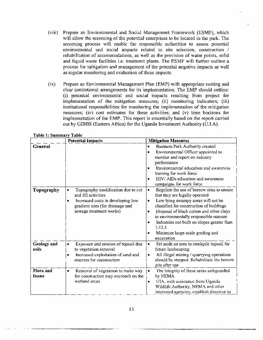
Table 1: Summary TablePotential Impacts Nlitigation Mleasures
General * Business Park Authority created* Environmental Officer appointed to
monitor and report on industryperformance
* Environmental education and awarenesstraining for work force
* HIV/ AIDs education and awarenesscampaigns for work force
Topography * Topography modification due to cut * Regulate the use of borrow sites to ensure
and fill activities that they are legally operated
* Increased costs in developing low * Low lying swampy areas will not be
gradient sites (for drainage and classified for construction of buildings
sewage treatment works) * Disposal of black cotton and other claysin environmentally responsible manner
* Industries not built on slopes greater than1:12.5
* Minimize large-scale grading andexcavation
Geology and * Exposure and erosion of topsoil due * Set aside an area to stockpile topsoil for
soils to vegetation removal future landscaping
* Increased exploitation of sand and * All illegal mining / quarrying operations
murram for construction should be stopped. Rehabilitate the borrowpits after use
Flora and * Removal of vegetation to make way * The integrity of these areas safeguarded
fauna for construction may encroach on the by NEMAwetland areas * UIA, with assistance from Uganda
Wildlife Authority, NEMA and otherinterested agencies, establish directive to
13
conserve and mana e rare and threatenedspecies
* Business Park Env ronmental Officermonitors all operati ns
* Environmental Of cer ensuresappropriate action t ken to conservespecies and habitats
* Landscaping to inc ude indigenousspecies with special emphasis on rare andthreatened species a well as fruitproducing trees and species havingmedical uses
* All landscaping inc ude Phoenix reclinataand Rothmannia sp. - UIA to establishminimum number o indigenous trees andplant species to be p anted and maintainedon each plot, relativ to size
* Site plans consider nd protect maturemature indigenous ees
* Public spaces, park , and sports fieldsplanted with indige us shade trees
* All proposed busin sses submitEnvironmental Imp t Assessment,Conservation and P llution PreventionPlan
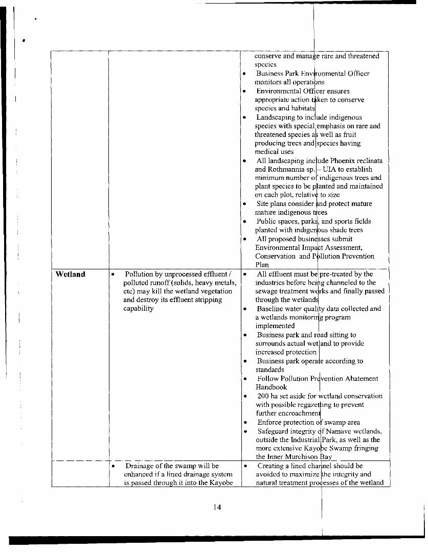
Wetland * Pollution by unprocessed effluent / * All effluent must be pre-treated by thepolluted runoff (solids, heavy metals, industries before bei g channeled to theetc) may kill the wetland vegetation sewage treatment w rks and finally passedand destroy its effluent stripping through the wetlandcapability * Baseline water qual ty data collected and
a wetlands monitori g programimplemented
* Business park and r ad sitting tosurrounds actual wet and to provideincreased protection
* Business park opera e according tostandards
* Follow Pollution Pr vention AbatementHandbook
* 200 ha set aside for etland conservationwith possible regazet ing to preventfurther encroachmen
* Enforce protection o fswamp area* Safeguard integrity ( f Namave wetlands,
outside the Industrial Park, as well as themore extensive Kayo e Swamp fringingthe Inner Murchison 3ay
* Drainage of the swamp will be * Creating a lined cha nel should beenhanced if a lined drainage system avoided to maximize he integrity andis passed through it into the Kayobe natural treatment pro esses of the wetland
14

swamp
Air pollution * Increased levels of pollution due to * Traffic emissions monitored and legally
Emissions an increase in motorized traffic and permitted levels should not be exceeded
emissions from industrial processes * Industries comply with air emission
Dust Pollution * Modification of microclimate standards which are monitored and
* Un-paved access roads that will be enforced
used daily by trucks and other * NEMA encourage the use of cleaner
construction vehicles will generate production technologies for all industrial
large amounts of dust processes
* Some industrial processes may * Proper filtering of industry air emissions
expose their employees to large * Monitoring studies recommended in order
amounts of dust and particulate to establish baseline data
matter * During construction, un-paved roads
should be water sprayed to reduce dust
* Employers should provide protectiveequipment e.g. dust masks
* Industries construct well-ventilatedfactories/workshops
Noise pollution * Increased traffic noise from * Movement of vehicles and operation of
construction and transportation construction machinery should be
vehicles and machinery confined to daytime* Trucks and heavy vehicles use routes that
do not pass directly in front of homes
* Noise levels not to exceed stipulatedlevels
* Avenues of trees along roads to help
mitigate vehicular noise and dust
Toxins/ * All effluent treated
Hazardous * Regular testing
Waste * Follow guidelines and standards set forth
in Pollution Abatement Handbook
* Substantial penalties for defaulters
* Holding ponds for treated effluent
* Construct secondary containment* Businesses located on impermeable soils
* Spill prevention equipment* Contingency plans for individual
businesses and for entire business park
* Spill response equipment* Industries establish plan for pollution
prevention prior to authorizingconstruction
* NEMA establish standards for treatmentand handling of hazardous and toxic waste
* UIA and NEMA ensure viable optionsexist prior to allowing industries togenerate hazardous or toxic waste
* Risk assessment and risk managementusing computer programmes such as
15

World Bank Hazar Analysis programmeor Process Hazards AssessmentsScreening Tools pr gramme to model riskof individual sites d processes
Water * Industrial effluent may pollute * All industries pre-t eat effluent before it ispollution springs, streams and rivers sent to the treatment works
* Construction of pit-latrines may * Industries adhere to Standards forreach the high water table and Discharge of Efflue nt or Wastewater 1999contaminate the aquifer and Pollution Prev tion Abatement
* Potential for pollution of Handbookgroundwater from improper * Follow recommen ations outlined inindustrial practice National Environm nt Regulations 2000
* Pollution in Inner Murchison Bay * Stringent monitori g and enforcement ofand Lake Victoria waste treatment an effluent standards
* Treated waste disc arged into wastestabilization ponds md sewage treatmentworks
* Latrine constructio monitored by publichealth officials
* A specific monitor ng programimplemented by the UIA in conjunctionwith NEMA and th DWD
* Regular water qual ty sampling fromRiver Namanve at outlet into LakeVictoria, Namanve 'retland, and InnerMurchison Bay
* Regular testing at p oint of exit for eachindustry, at influent and effluent points ofsewage treatment w rks
* Install ground wate monitoring wells* Water quality samp es collected quarterly
from all boreholes within a 2 km radius ofIndustrial Park which also forms baselinedata
* Restoration ecolog in area of sewagetreatment to upgrad the status of papyrusand other species
* Water from industri al sites should bepassed through oil- rater separators toremove impurities b fore it reacheswetlands
16

Solid Waste * Encourage reduction and recycling ofwaste
* UIA formulate waste management planfor solid waste for Namanve
* All industries submit waste managementplan detailing all construction andoperational waste management anddisposal plans
* Establish arrangements to utilize landfillat Mpererwe
* Efforts made by Gov. of Uganda toaddress need for solid waste and MedicalWaste disposal sites
Construction . * Appropriate storage, transport, anddisposal of waste materials
* Sanitary facilities for work force that doesnot seep into wetland
* Proper vehicle maintenance* Prevent spillage and leakage of materials* Minimize soil erosion through use of
berms or silt fences* Prepare and implement Site
Environmental, Health and Safety Plan* Prepare Spill Contingency Plan according
to international standards* Materials used from environmentally
responsible sources ie: wood productscertified by Forestry Stewardship Council,quarry materials from sites with approvedrehabilitation plans
Social * Human health problems. * Appropriate filtration of smoke stacks
* Employment opportunities for * Improvement of income levels and living
unskilled workers during standards for the community
construction for the community * Provide training for community members
living around the project area for employment in business park
* Increase in HIV / AIDS and STDs * Provide focused training for women
cases in the project area which also accounts for special needs ie:
* Unplanned influx of population and child care, etc.
settlement * The health status of the Namanve areashould be monitored and steps taken toprevent occurrence of HIV / AIDS andSTDs through education and awarenesscampaigns in communities and for workforce
* Provide piped water, or where appropriate- boreholes, to surrounding communities
* Sensitize communities on issuesassociated with residing near to businesspark
17

* Provide environme tal education andsensitization to com munities and workforce
* Regional planning which includes district_ _ _ __ _ representatives in pi anning process
2. Environmental Legislation
Environmental legislation, standards and guidelines identified to be relevant for this studyinclude:
* The National Environmental Statute, 1995;* National Policy for the Conservation and Management of Wetland Re sources, 1995;* Standards for Discharge of Effluent or Wastewater, 1999;* Draft Standards for Air Quality, 1997;* Draft Standards for Noise and Vibration, 1997;* Draft Standards for Soil Pollution, under preparation;:National Environment (Wetlands, River banks and Lake sh re management)
Regulations, 2000.
Where considered necessary, Ugandan legislation, standards or guidelines have been comparedwith other regulations, such as Dutch, or Kenyan regulations.
The National Environmental Statute, 1995The National Environmental Statute of 1995 regulates environmental issues in Uganda. ScheduleIII of the statute provides a list of projects that require an environmental impac t assessment to beundertaken prior to project implementation. Urban developments, including th e establishment ofindustrial estates, are among the projects listed in the Schedule (page 80, Secti n 2).
The Statute defines an environmental impact assessment as 'a systematic exa ination conductedto determine whether or not a project will have any adverse impacts on th environment'. Inaddition, GIBB has outlined in its report, appropriate mitigation measures foT negative impacts,enhancement measures for the identified positive impacts and proposed mon itoring proceduresfor the project.
The National Environmental Management Authority (NEMA) established u der the Statute isthe principal agency responsible for the management of the environment an( was created as aresult of the National Environmental Action Plan (NEAP) of 1994.
One of the important functions of NEMA, in addition to reviewing policies d environmentalimpact statements, is to establish national environmental standards in consul ation with variouslead agencies. Standards and guidelines identified during the study to be relev ant for this projectare detailed in table 2 of this report.
The National Environmental Statute also places restrictions on the use of w tlands under PartVII, Environmental Management, (Section 37, page 37). The management of wetlands is givenmore emphasis in the National Policy for the Conservation and Manage ment of WetlandResources, 1995, as described in paragraph immediately below.
18

National Policy for the Conservation and Management of Wetland Resources, 1995
Uganda was the first African country to develop a national wetlands policy. The strategy most
pertinent to this study, as outlined in this Policy, is transcribed below:
Any wetland serving as a source of water supply or receiving effluent as part of a designated
service to any human settlement shall be declared a fully protected wetland from any
encroachment, drainage or modification.
Explanation: Wetlands can preserve the purity of water by their filtration and buffering capacity.
One of the important reasons for this policy arises from the extensive draining of wetlands for
horticulture where these areas also serve as water purification centres. In addition such drainage
has led to changes to the hydrological cycle i.e. increase in floods, reduction in low flows and
increase in sediment runoff.
National Environment (Wetlands, River banks and Lake Shore Management) Regulations, 2000
Section 21 of the National Environment Regulations 2000 states that each Local Governmentshall after the recommendation of the appropriate local environmental committee make by-laws
(a) identifying river banks and lake shores within their jurisdiction which are at risk from
environmental degradation; (b) promoting soil conservation measures along river banks and lake
shores including the following;(i) Bunding;(ii) Terracing;(iii) Mulching;(iv) Tree planting or agro forestry(v) Grassing;(vi) Soil engineering, compaction and placement of fills;(vii) Zoning and planning;(viii) Gabions;(ix) Control of livestock grazing.
Section 29, Part (2), of the same Regulation states that rRivers not specified in the Sixth
Schedule shall have a protected zone of thirty meters from the highest water mark of the river.
Section 30, Part (1) states that all shores of lakes specified in the Seventh Schedule [Lake
Victoria is in the 7th Schedule] to these Regulations shall have a protected zone of two hundred
meters measured from the low watermark.
Standards for Discharge of Effluent or Wastewater, 1999
The Ugandan Standards for effluent discharges to land or to an aquatic environment set
maximum permissible limits (MPL) for selected parameters. The standards are established for a
broad range of organic and inorganic compounds and are summarized in Table 2 below.
General obligations to mitigate pollution and the duty to keep records of offences are also
outlined in these Standards, These regulations are particularly pertinent to the proposed
development and are quoted below.
19

General obligation to mitigate pollutionSection (4) Part (1) of the Standards for Discharge of Effluent or Wastewater, 999, states:
Every industry or establishment shall install at its premises anti-pollution quipment for thetreatment of effluent and chemical discharge emanating from the industry or e ablishment.
Section (4) Part (2) of the Standards for Discharge of Effluent or Waste ater states: Anti-pollution equipment installed, under such regulation (1) shall be based on t e best practicablemeans, environmentally sound practice or other guidelines as the Execu ve Director maydetermine.
Duty to keep records (from the Standards for Discharge of Effluent or Wastew ter, 1999).Section (5) Part (1), (a) of the Effluent Discharge Standards states: Keep a reco d of the amountof waste generated by the activity and of the parameters of the discharges.
Section (5) Part (1), (b) states: Submit the record referred to in paragraph (a to the ExecutiveDirector and to any other relevant lead agency, every three months from the ommencement ofthe activity for which the permit was issued.
Section (5) Part (1), (c) states: Report to the Executive Director any abnorm I discharges. Theabnormal discharges are interpreted to be any discharge or emission that exce ds the maximumlevel listed in the standards articulated above.
Liabilities for offences (from the Standards for Discharge of Effluent or Waste ater, 1999)Section (6) (1) states: A person who contravenes these Regulations (standards r discharge ofeffluent or wastewater) commits an offence and is liable, on conviction, to imp sonment for aterm not exceeding eighteen months or to a fine not less than one hundred and ighty thousandshillings and not more than eighteen million shillings or both.
Section (6) (2) states: The Executive Director may, in addition to any penal y imposed underSub-Regulation (1), give directions as to steps to be taken to mitigate the da age caused as aresult of the contravention, and the person liable shall comply with the directio s.
Draft air quality standards and guidelines, 1997Uganda formulated draft air quality standards in 1997. These cover polluti n control in theoccupational and ambient environment. These standards were being finalized a the time the EIAwas carried out.
The draft air quality standards identify the individual pollutants, applicable indu trial sources andpermissible limits, as outlined in Table 2 below.
Table 2: Uganda National Standards for Emissions, 1997Pollutant Exposure tinme Stanidard applicable to StandardTotal suspended 24 hr Industries (e.g. cement, lime), quarry, |0.1 tlg ni" 3particles grain millers, coffee processors,
pharmaceuticals and any other trade
20

Sulphur dioxide 24 hr Combustion processes, boilers or any 0.15 ppm
process involving sulphur burning
Carbon monoxide 8hr Combustion process boilers 9.0 ppm
Ozone 1 hr Mineral water bottling 0.10 ppm
Nitrogen oxides (NO) 24 hr Combustion process, boilers 0.05 ppm
Lead 1 month Battery manufacture and repair, metal 1.0 ppm
fabrication
Carbon dioxide 8hr Breweries, soft drink industries 9.0 ppm
Sulphur trioxide 24 hr Sulphur burning sulphuric acid 200 ug m'3
manufacture
VOC's (Volatile 8hr Breweries, fuel depots and stations, 6 mg m'3
organic carbonsSilica 24 hr Construction industry, detergent and 200 ug m-3
manufacture, quarries
Soot 24 hr Combustion, charcoal and brick making, 500 ug m'3
boilers
Ammonia 24 hr Refrigeration, chemical stores and labs, 200 ug m-3
fish processing
Hydrogen sulphide 8hr Waste water treatment, tanneries 15 ug m-3
Acid mist 24 hr Acid manufacture, battery manufacture 100 ug mIl
and acid changing, chemical stores and
labs
Asbestos 24 hr Construction industry, garages/car 0.01 fibres ml-l
repairs, asbestos manufacture
Cement 24 hr Cement industries, construction 200 pg m-3
Lime 24 hr Tile and brick industries, ceramic 200 pg m-3
industries, construction
Ceramics 24 hr Tile and brick industries, ceramic 200 pg m-3
industries, construction
Electrode manufacture 24 hr Electrode manufacture, garages/car 150 pg m-3
emissions repairs, welding, metal fabrication
Cotton fibers 24 hr Cotton farming, ginning and export, 200 pg m-3
textile manufacture
Coffee dust 24 hr Coffee processing and trading 200 pg m-3
Synthetic fibres 24 hr Synthetic textiles manufacture 0.01 fibres ml- I
Tea dust 24 hr Tea rocessing and trading 200 pg m-3
Tobacco dust 24 hr Cigarette manufacture including tobacco 200 pg m-3
curing and tobacco farming
Grain dust 24 hr Grain milling, bakeries, feed mills, 200 pg m-3
breweries, agriculture
Wood dust 24 hr Saw mills, timber works and furniture 1 mg m-3
making, construction
Phosphates 24 hr Fertilizer manufacture, soap and 200 pg m-3
detergents industry
Copper dust 1 month Copper mining and processing, metal 1.0 pg m-3
works and fabrication
Pesticides 24 hr Pest control and plant protection See Appendix E(Mean dailyemnissionsstandards for
21

_ pesticides)Hydrocarbons 24 hr Chemical stores and labs, fuel depots 5 mg m-3
and stationsBagasse 24 hr Sugar processing plants 200 pg m-3Smoke Not to exceed 4 Industry, trade or any combustion Ringlemann scale
min in any one process No. 2 or40%hour observed at 6m or
moreChlonrne 24 hr Water treatment, fish processing, 200 pg m-3
chemical stores and labsWhatever the regulations, the World Bank safeguard measures will prevail.
D. ENVIRONMENTAL PROFILE
1. Bio-physical setting
This chapter describes the bio-physical setting of the project site. As stated in ection 1, the siteis divided into 5 estates namely Namanve North, South A, South B and South 1 and South C2.Century Bottling company (Coca-Cola) have developed a site on the Namanve North estate.
The following environmental components are addressed in this section:* Topography;* Geology/ geo-morphology;* Seismicity;* Soils;* Climate;* Hydrology (surface water, groundwater, and flood levels);* Flora, fauna and avifauna.
2. Topography
Namanve Central Forest Reserve (CFR) was an artificial forest created early tl is century. It wasdeclared a forest reserve in 1968 for the growing of trees for firewood and n, t as an animal orvegetation sanctuary. In late 1996, the Government of Uganda de-gazetted 1,0 6 hectares of theNamanve CFR and re-zoned the area for industrial use. The land was then placed under theownership of Uganda Investment Authority (UIA). The natural vegetation of the area wasoriginally swamp and closed forest. This was altered by a tree plantation pr gramme in 1928(Eggeling, 1935). The Forestry Department cleared most of the indigenous rest and plantedEucalyptus trees.
The proposed project site stretches approximately three to four kilometers in wudth from west toeast and about eight kilometers from north to south. Namanve is at a heil t of about 1,143m.a.s.l. (UIA Planning Report, 1995).
The general slope is southwards within the Lake Victoria drainage basin. The la id is mainly low-lying, surrounded by low relief, expressed by a difference of about 180 metres between hilltops
22

and valleys. This forms a repeating pattern of hill, pediment-slope and swamp-filled valley
(Pallister, 1959).
Namanve North and South A estates display the greatest variation in topography of the project
site. The landscape in these two estates is typified by broad valleys, which are filled with fine
sediments deposited by runoff water.
The wetland area flows in a southerly direction draining into Kayobe swamp, and opens out into
Murchison Bay to the east of Port Bell.
(a) Namanve North:
Namanve North estate is situated north of the Kampala/Jinja road. This estate is bounded to the
southeast by the Namanve Tree Seed Research Station and private land; and to the west partly by
the Coca-Cola bottling plant and partly by private land. To the north and south the proposed site
is bordered by private land. A murram road runs parallel to the Tree Seed Research Station and
continues northwards through the estate, running along the boundary at the northern end (.
The northern tip of the estate, tapers off into a narrow almost triangular shape and characterized
by the steep slopes of the eastern part of Buto hill.
The River Namanve traverses the site in a north south direction. The land slopes towards the
river from the west and north west and into a central valley which is crossed by the
(Kampala/Jinja) road. The gradient varies from 1:10 to 1:70 (UNIDO/UTNCTAD. 1999).
(b) South A:
South A estate is situated immediately south of the Kampala/Jinja road. The narrow gauge
Mombassa-Kampala railway traverses the northern end. The eastern boundary borders the
Kabaka's (traditional king) land. A substantial portion of this estate is relatively level with grades
in the order of 1:90 (UIA Report, 1997).
On the eastern side of the South A estate the land slopes southwards towards the River Namanve
at grades of between 1:25 and 1:75 (UNIDO/UNCTAD, 1999). In this low lying area, poor
drainage was evident, particularly in the sections where the Namanve river traverses the
Kampala / Jinja road via a culvert, opening out into South B estate.
An area of relatively high ground opposite the entrance to the Coca-Cola site slopes eastwards in
the direction of the Kabaka's land and southwest in the direction of River
Namanve.
(a) South B:
South B estate is situated immediately south of the old Kampala/Jinja road and south west of
South A estate. This estate is bounded to the east by the western slopes of Kolo hill and to the
west by the eastern slopes of Kirinya and Bukasa hills and to the south by the Kayobe swamp.
23
River Namanve runs nearly through the center of the estate and is flanked b low-lying land oneither side. Much of this area lies below the estimated 100-year flood level for Lake Victoria,which has been calculated to be 1136.30 a.s.i. (UNIDO/UNCTAD, 1999).
(b) South C (Cl and C2):
South C estate is divided into two areas, namely; Cl (324 ha) and C2 (47 ] a), as indicated inFigure 1.
South Cl and C2, which form South C estate are situated south east of South A estate and southeast of South B estate. It is located south of the railway line and the access ro d to the village ofNamiryango. The western side of this estate is bounded by the slopes of Kolo hill and theKayobe Swamp, to the south by the Senyi Forest Plantation and to the east y high ground atNamiryango (UNIDO/UNCTAD, 1999).
A rectangular shaped section of the estate protrudes to the east and has a co] *dor of low lyingland running down its centre in an east - south direction, bordered by the soutl eastern slopes ofNantabulirwa hill and the western slopes of Namiryango hill.
3. Geology/ Geomorphology
The proposed project site is part of the narrow, down-warped northern c tchment of LakeVictoria. It is underlain by granitoid schistose rocks of the Basement Comple (Pallister, 1959).These are deeply weathered and generally not exposed at the surface. The hi ls rise only about1 lOm above Lake level, and are rounded and capped with laterite soil. he highest point,Nantabulirwa hill, rises to over 1,350m above sea level while Buto hill, the pr posed location ofthe water supply to Namanve North estate, is over 1,316.6m above sea level (P llister, 1959).
The hills rise abruptly from a series of aggradations slopes, apparently the sult of old Laketerraces, from which clay for brick making and sand are currently being extrac ed. The lithologyis poorly exposed and overlain by thick deposits of clay and clayey gravel. It c n be inferred thatthe underlying rocks comprise undifferentiated granitoid gneiss with some late granite includingthe migmatised Buganda Series. These all belong to the Basement Complex o the Precambrianera. A small section of the project site (part of South C2) is overlain by inter- ngering depositsbelonging to the Cainozoic era. These include Holocene swamp, alluvium and 1 custrine deposits(Geological survey of Uganda - Kampala, Sheet N. A. 36 - 14. Scale 1: 250,000 1962).
Table 3 below presents data from the Waterpoint and Groundwater Database (D rectorate ofWater Development - DWD, 1999). The table provides the average depth to the bedrock takenfrom nine (9) boreholes within a 2 km radius of the site.
Table 3: Depth to the bedrockBorehiole No. Location (Dist,lct) NlMetres below, ground level1 Wakiso 42.0-2 Wakiso 32.0
24

3 Wakiso 33.3
4 Wakiso 37.2
5 Wakiso 28.1
6 Wakiso 45.0
7 Mukono 36.0
8 Mukono 24.4
-9 Mukono 39.0
Average 35.22
(a) Seismicity
Figure 3 shows no major fault lines within the project site. However Kampala and its environs
are subject to seismic activity and the area is classified as Zone V as defined in the modified
Mercalli Scale (UNIDO/UNCTAD, 1999). The Modified Mercalli Intensity Scale is commonly
used in the United States by seismologists seeking information on the severity of earthquake
effects. Intensity ratings are expressed as Roman numerals between I at the low end and XII at
the high end. A Zone V earthquake would exhibit the following: Almost everyone feels
movement. Sleeping people are awakened. Doors swing open or close. Dishes are broken.
Pictures on the wall move. Small objects move or are turned over. Trees might shake. Liquids
might spill out of open containers.
3.4 Soils
Soils in the Namanve area fall within the Buganda Quartenary complex. There are various soil
types that fall within this category (Pallister, 1959), ranging from shallow, murram-based
lithosols on the ridges, through deep, reddish and free-draining hillside latosols with termitaria,
through heavy, brown to grey and black clay loams and finally to sticky valley clays
(Banage, 1999).
With reference to Figure 4, two main types of soil occur in the project area. The first belongs to
the Buganda Series and comprises red loams or clay-loams and has a high productivity rating.
Further south, the soils belong to the Kabira and Katera Series, which comprise yellow red
loams, and strong brown loamy sands, which have an agricultural productivity rating that, varies
from medium to low nil (Kampala Soils Map, 1:250,000, 1961).
More specifically, two types of clay material have been identified in the Namanve area:
1) Alluvial or transported clays - these are grey plastic clays which appear to be typical
swamp clay deposits.2) Sedentary type clays - these are mottled, grey-yellowish, brown sandy clays formed in-situ by
the weathering of the Precambrian granitoid-gneiss and granites. These normally underlie the
alluvial clays and are common towards the middle reaches of the gentle slopes of the broad
valleys (J.H. Musisi, 1986).
Coarse, medium and fine-grained sands and gravels can be observed in the upper reaches of the
broad topographical low (closer to the swamps). At the time of the study the sands and gravel
25

were being exploited for building and construction activities. The deposit of sands (course,medium and fine-grained) and gravel already mentioned have been legally anc illegally exploitedin the past. In Namanve South B, Cl and C2 estates, illegal sand extraction has been going onsince the 1970s. Spurred by the current building boom in Kampala, this activi y has extended allover the reserve. It is particularly prevalent in Namanve North and South C 1.
A small portion of the project site in the south eastern corner of South C2 e tate is covered bylateritic soils which are about 1 to 2 metres thick and overlie quartzitic gne ss. The remainingarea along the eastern boundary between the lateritic soils in the south and t. e red sands to thenorth is covered by 40 cm of thick black sandy loams with over 35 cm of con lomerate which inturn overlie gravely white sands (ERS Report, 1997).
With the exposure of the soils after excavation, drying out takes place and this esultsinoxidation, possibly leading to increased acidity of the soils (Lind, 1956).
4. Climate
(a) Rainfall
The climate in the project area is tropical, relieved by elevation and proximity Io Lake Victoria.The area, which borders the Lake, experiences a mean annual rainfall of 1600 - 2000 mm(Mukono District Plan, 1996). There are two wet seasons:
* Long rains - generally begin in March and may extend into July;* Short rains - normally between September and November
(b) Temperature
January and February are generally the hottest months, May, June and Ju y are the coolest(Eggeling, 1936). Mukono district, in which a greater portion of the project site falls, experiencesa mean annual maximum temperature of 25 to 27.50 C, and a mean annual min mum temperatureof 15 -17.5° C (Mukono District Plan, 1996).
(c) WindThe prevailing wind is southeasterly. Diurnal wind variation is experienced due to the proximityof Lake Victoria. A northeasterly wind is often experienced during the night (B ick Making inMukono District, 1996).
5. Hydrology (Surface water, groundwater, and flood levels)
(a) Surface water
The Namanve Catchment is one of eight drainage areas emptying into Inner M rchison Bay. It isthe largest in area (86.7 km2) and has the largest areas of both dry land (65.1 k 2) and swamp orwetland (21.6 km2). The catchment has the shape of an inverted equilateral tria gle with its apexat Lake Victoria, and the sides bordered by the ridges of the hills of Bukasa, irinya, Mukireku
26

and Kazinga to the west, Buto, Kiwanga, Namanve and Nantabulirwa to the north and north-east
and Namilyango, Degeya, Senyi and the Zinga Island to the east (Banage,1999).
The topography and original drainage were described by Eggeling (1935). Rivers Namanve from
the west, Bumbubumbu and Nabubaza from the north and two other easterly streams (Nakigyebe
and another - name unknown) originally emptied into the Namanve Swamp. The system was
canalised to the Lake to drain the swamp by the Namanve/Bumbubumbu Channel: (2 m wide, 1-
2 m deep) between 1929 and 1932 (Eggeling, 1935). Maintenance of the channel was abandoned
in 1957 leading to the re-flooding of the surrounding areas and the lower; wetlands (Hughes,
1961). The River Namanve flows through a road culvert on Kampala/Jinja, which was observed
to block during periods of heavy rainfall.
As the River Namanve flows into Namanve South A estate, its course straightens out on reaching
the thickly vegetated area. It then crosses beneath the Mombasa / Kampala railway and the old
Jinja road via a culvert and broadens out into the wetland area. This area is characterized by
typical wetland vegetation including papyrus and is the area of slowest movement, indicating a
relatively low gradient. The Namanve river follows a course of approximately 5 km through the
proposed site area into Kayobe swamp and finally into the open waters of Murchison Bay.
There are few minor tributaries feeding river Namanve and discussions with the District Water
Officer of Mukono District revealed that much of the water is derived from small springs. Two
streams originate from the two springs that occur at the boundary of the Coca Cola bottling plant
and join at the lower end of the plant to form the major drainage outlet (Namanve River) on the
site (Coca-Cola Report, 1997).
(b) Groundwater
During the field study, nine boreholes located within a 2 km radius of the proposed project site
were identified. Most of the boreholes are located due north of Namanve North estate. The
location data were obtained using a Global Positioning System (GPS). Borehole yield data for all
the boreholes were not available at the time of the field study. Table 4 lists the locations of
boreholes.
Table 4: Borehole location survey in the Namanve area:BH EASTINGS NOTHINGS COUNTY SUB-COUNTY DISTRICT COMMENT
1 0464404 0039850 Kyadondo Kira Wakiso National Tree Seed Centre,functioning.
2 0463676 0039909 Kyadondo Kira Wakiso Mr. Akabwai, functioning.
3 0463332 0039907 Kyadondo Kira Wakiso Bweyogerere PrimarySchool Junction, at the sideof the school, functioning.
4 0463460 0040416 Kyadondo Kira Wakiso Bweyogerere Health Centre.Currently not functional butthe water was not drinkableoriginally. No. WDD 3678.
5 0462876 0040703 Kakajjo Kira Wakiso Near Kakajjo PrimarySchool. Not functioning,No. WDD 6013.
6 0465336 0040394 Mukono Goma Mukono Coca-Cola borehole 2. Notfunctioning - high iron
27

content.7 0464267 0040760 Kyadondo Kira Wakiso Belonged to Progressive
Secondary School.Abandoned in 1996.
8 0463305 0040983 Mukono Goma Mukono Near Progressive SecondarySchool. Functioning, No.DS 444.
9 0465363 0040129 Mukono Goma Mukono Coca-Cola borehole_ 1. Functioning
Source: GIBB data collectionBHNo. - Borehole Number (these numbers correspond with thc se in Figure 2).
Water analysis certificates for the boreholes adjacent to the Coca-Cola Century BottlingCompany premises were obtained from the company and are included in Appe ndix G (BH No. 6and BH No. 9).
Water samples were collected for physico-chemical analysis from four boreho les; BH No. 1, BHNo. 2, BH No. 3 and BH No. 8. The physico-chemical parametres in the sam les were analyzedby the Directorate of Water Development (DWD).
Table 5; Summary table of physico-chemical analysis results for Borehole No. 1, 2, 3 and8. 1
Parameter Sample s National Gui eline Values
BH BH BH BH Drinking EffluentNo.1 No.2 No.3 No.8 water
PH (Units) 6.4 6.0 5.9 6.0 6.0-8.0 5.5-8.5EC (u S/cm) 133 122 108 128 -TDS (mg/l) 93 85 <81 90 1000 1200Turbidity (NTU) 4.00 2.00 17.00 11.00 10 _ 300Total Alkalinity 65 51 81 60 -(mg/l)Bicarbonates (mg/l) 80 62 99 73 -Total hardness (mg/l) 47 39 70 52 600Calcium (mg/I) 7.2 12 23 11 100Magnesium (mg/l) 7.0 2.1 2.9 6.1 100Sodium (mg/1) 14.6 12.0 12.5 13.5 *200Potassium (mg/l) 3.8 3.8 3.8 44.6 -Total Iron (mg/l) 0.23 0.89 0.96 1.36 1 10Chloride (mg/l) 5 5 4 4 250 500Sulphate (mg/l) 11 3 9 11 250 500Nitrates (mg/l) 0.14 0.42 0.81 0.87 5 20Nitrites (mg/I) 0.006 0.012 0.021 0.014 0 2.0Phosphates (mg/I) 0.11 0.18 0.1 0.08 - 10BOD (mg/I) ND 1.4 7.6 1.6 _ 50
Source: DWD Technical report on water quality analysis for GIBBWHO guideline
28

ND - not done
Comments on the physico-chemical analyses:
The results obtained were analyzed to obtain an estimate of the accuracy of the laboratory data.
The checks were carried out using the WATEVAL water quality evaluation program written by
A.W. Hounslow and Kelly D. Goff.
Table 6: Analysis reliability checks
Reliability Check Attenti BH No. BH No. BH No. BH No.on 123 8value
Ion Sum cation - sum anions *I00 (%! >5% -0.23% 7.14% 3.15% 29.11%
balance Sum cations + sum anionsTDS Difference between TDS reported >5% -38.7% -19.1% -92.6% -83.8%
and TDS calculated (%)Hardness Difference between reported >5% 0.4% 1.0% 0.9% -1.1%
hardness and calculated hardness
TDS/ TDS/ Conductivity >0.55 0.97 0.83 1.44 1.29
Cond <0.75
The following can be inferred from table 6* The solutions tested should be electrically neutral. The sum of cations should equal the
sum of anions. The percentage difference in the ion balance should be less than 5% as
indicated in Table 6. BH No. 2 and 8 had percentage difference values significantly
higher than 5%.* Calculated hardness should equal reported hardness. A discrepancy may indicate
incorrect copying of reported data. This check assumes that hardness was calculated by
the lab and not determined chemically.
If should be noted that some margin of error is to be expected in any analysis. The analysis
reliability checks summarized in Table 6 indicated that the results from all four boreholes
contained a significant margin of error and should therefore be treated with caution. On the
whole however, the following can be concluded:
Physical quality: The water from BH No. 1 and BH No. 2 was clear in appearance and had low-
lornis of turbidity of 4.00 and 2.00 NTU (ref. Table 4) well below the guideline values of 10
NTU and 300NTU for turbidity for drinking water and effluents respectively. BH No. 3 and bi-i
No. 8 water were colored in appearance and had elevated turbidity of 17.00 and 11.00 NTU
respectively which is above the turbidity guideline value of 10 NTU for drinking water.
Chemical quality: Generally the samples show acceptable chemical characteristics for most of
the parametres analyzed, well within the guideline values for both drinking water and effluent
standards as indicated. However, BH No. 8 water shows unacceptable physico- chemical
characteristics. Minor treatment for the removal of iron and reduction of turbidity is necessary
29

for water from this source to comply with the Drinking Water Guidelines ar d serve as a watersupply source.
(c) Flood levels
A site visit carried out after a heavy downpour revealed flooded and water log ed areas.Flooding was particularly pronounced in the South A, B and C2 estates.
The maximum historical flood in the Lake Victoria Basin (as measured by D D level gauge No.81201 at Jinja) is 1136.3 m.a.s.l. This level was measured in 1964, which is own to have beenan exceptionally wet year. Incremental lake levels for various flood return pe ods are shown inTable 7.
Table 7: Incremental flood levels for various return periods
Rettrn periods Lake level (metres above ea level)2 years 1135.05 years 1135.51 0 years 1135.825 years 1136.050 years 1136.1I100 years 1136.2Maximum Historical Flood (200 years) 1136.3
Source: Namanve Industrial and Business Park, Draft Final De ign Report.
6. Flora and fauna
(a) Flora
The natural vegetation of the area was originally swamp and closed forest. Thi - was altered by atree plantation programme in 1928 (Eggeling, 1935). The Forestry Departme t cleared most ofthe indigenous forest and planted Eucalyptus trees (Eucalyptus robusta and Eu alyptus saligna).These were used for the production of poles, firewood and charcoal (Hughes,1 61).
As early as 1934, it was stated that; "The advance of cultivation into areas of n ural vegetationhas changed the soil composition and structure. There is a delicate balance bet een plantcommunities and drainage and the zoning of flora from swamp to dry land" (st y by Eggeling,1934 in Pallister, 1959). Such land when left fallow displays new plant associat ons.
Historical Flora
The Namanve Central Forest Reserve boasts the first Working Plan of any forest reserve inUganda (FD/MP, 124/29, see: Hughes, 1961) made in 1929. Similarly, Namanv Swamp was thefirst wetland to have its ecology documented. Eggeling (1934, 1935) took advantage of thedrainage channel traverse cut to investigate the flora and fauna of the swamp. H e recognized anddescribed seven plant communities of the virgin swamps as follows:
30

* Nymphaea (Water Lily) Zone.* Fringing Papyrus Community.* Fern and Sedge Community.* Limnophyton Community.* Papyrus Swamp.* Miscanthidium Swamp.* Phoenix Swamp.
Eggeling (1935) mentioned tropical rain forest and mapped the forests of Bukasa, Senyi, Kolo
and Namanve but did not categories them. Judging by the present remnants of recorded forest
species, these forests would have been similar to others surrounding the northern and western
Lake Victoria shores. Changes in these communities have taken place from both ends of the
succession. Drainage, human disturbance and afforestation have altered the landward side as had
already been noted by Eggeling (1934, 1935). The lakeside flora communities have also
experienced changes, particularly due to siltation, water level fluctuations, eutrophication and.
recently, invasion of the Lake by the water hyacinth (Eichhornia crassipes).
Little, if any, vegetation in the Namanve swamp has not been influenced by man and even the
indigenous forests are considered secondary growth. The complex degenerate association of
vegetation outside the swamp has largely been induced by cultivation, grazing and fire (Sangster,
1950 in Pallister 1959).
The results of the floral survey conducted as part of this study are described below
(a) Namanve North
Eucalyptus grandis was the major crop in two plots surveyed and the canopy was more or less
closed. In the third quadrant E. robusta and E. deglupta were the major trees, but the canopy was
more open and the ground waterlogged. The area lies west of the Coca-Cola Century Bottling
Company site, across River Namanve. There was considerable diversity, with over 100 plant
species found.
The northern part of the area had grassy areas as well as swamps with C. papyrus, Typha
austrialis, Phragmites australis and various sedges. A rare species of Rothmannia sp.
(Rubiaceae) was recorded. There was widespread evidence of the area having been disturbed by
cultivation, sand and gravel mining, as well as brick making.
(b) South A
The major crop in the estate was E. grandis. This had been harvested and replaced by a tangle of
Lantana camara. Further south there was an almost impenetrable wet forest of
Phoenix reclinata and other moisture-loving plants. Partly due to the thick canopy of Phoenix
and Lantana, there were relatively few other species. The total number of species found was 29.
31
The rare Rothmannia sp. was again recorded here, as was the threatened Mel cia excelsa. Therewere stumps of robusta and a few live trees recorded in the Phoenix swamp, pparently affectedby the flooding and swamp forest re-growth. Much cultivation and sand minin was observed.
(c) South B
There were healthy plantations of E. grandis planted by private leasees on t e raised ground inthe vicinity and to the west an Arboretum was observed. The rest of the ar a surveyed was aflood plain, which had been heavily inundated by the 1960 floods. Dead tree of the E. robustaspecies were found scattered in the swamp.
The dominant plant species observed was C. papyrus and other sedges of t e herb and sedgecommunity. Only a few woody and climber species were recorded amongst seventeen speciesfrom the survey quadrants. Cattle grazing, cultivation and sand mining were re orded.
(d) SouthC(ClandC2)
Much of this area is under cultivation and subject to sand-mining activities. Or the raised groundnear Kolo, Senyi and Degeya there are private lease woodlots. The rest of th area to the southhas papyrus, grass and sedge swamp. The historical swamp- fringing forest h disappeared, butPhoenix fringes still remain. The number of plant species recorded in the area was 26, includingthose from opportunistic observations.
(e) The Namanve and Kayobe Swamp System
South of Namanve South B and west of South C I, there are extensive wetlands These are anextension of the wetland ecosystem which falls within the degazetted areas, tha are proposed tobecome public open spaces. It is convenient to refer to these as the "Namanve etlands". Furthersouth, they merge into the large Kayobe Swamp fringing Inner Murchison Bay. Although thesewetlands are extra-limital to the proposed Park, they were given a cursory surv y because theyare proposed to be the receiving environment for future Namanve effluent.
It is worth noting that the conversion of the swamp and indigenous fore into eucalyptusplantations did not completely eliminate the plant biodiversity. Small ecologic niches remainedand gave rise to continuity of certain species. Some, especially climbers, adap ed themselves toplantation forest conditions. In other cases, as mentioned by Eggeling (1934, 935), new nicheswere created for additional species. This contrasts with the anticipated conditi ns of total forestclearance, which will leave no refugia for the species.
The ecological survey indicated that:* The fringing natural forest has disappeared;* There has been an over-cutting of Phoenix reclinata. However, in pl ces, it is making
good regrowth;* The papyrus community is in good condition and has had little human interference;* There is greater expanse of Miscanthidium than reported by Eggeling 1935) in the mid
of the swamp, which appears to be silting up;
32

* The observation from the Lake found no remains of the water lily community except a
few water cabbages (Pistia stratiotes) mixed in with the water hyacinth (Eichhornia
c/"ass/ioes).j Except on a few grassy beaches (mostly with Vosia cusp/data, sedges and
ferns), C. Jpapyrus extended to the Lake open water.
Table 8 Number of plant species found in the proposed Namanve estates
Estate No. Of Plant Species No of Quadrants
Namanve North 143 3
Namanve South A 29 2
Namanve South B 17 2
Namanve South C1 and C2 26 2
TOTAL 215 9
Source: Namanve Industrial and Business Park, Kampala. An Ecological and
Environmental Study, Draft Report, by Professor W. B. Banage, 1999.
Plant species of conservation interest
Fifteen plant species identified on site are of special interest because they are rare, threatened, or
have environmental and economic value. Over and above these, various species found in the
wetlands have medicinal, utilitarian or food value (Anon 1996; Omagor, 1996). Others serve in
ecological roles in effluent stripping. In Namanve, a number of orchids endemic to swamps are
known, whose habitat conditions will be reduced by the construction activities for the proposed
Industrial Park. Cynorchis anacamptoides, Nervitia afze/ii, Habenaria sp, Disa eminii, Satyrium
crassicaule, S. ni/oticum, were found to grow only in modified swamp, while Eulophia
porphrysog/ossa, E. paludicola, E. wilsoni, E.ango/ensis and E. a/ata grow in modified papyrus
swamps (Eggeling, 1935).
Fauna
Draining of the swamp and repeated slashing of the vegetation necessary for the protection of the
young trees in the Eucalyptus woodlots has already caused a number of changes in the status of
the fauna living in Namanve.
Mammals
A total of 49 rodents and 4 shrews were recorded, representing twelve species. Apart from G.
dolichurus caught at the base of a palm tree that is known to be a climber, other species caught in
small numbers were just coincidental, they are not specific to the area. The few specimens and
species caught from South Cl and C2 were attributed to the fact that traps were laid during the
day and were left for one night only. In addition, the abundant food sources in the gardens
including cassava, sweet potatoes, etc probably lowered the effect of the bait.
All the species caught are characteristic of savannah habitats, present in woodlands and
grasslands in many parts of Uganda(Delany, 1975, Kityo and Dickson, 1996. Information
provided by the local farmers and the forest guard, include sightings of wild pigs, bushback,
mongoose, cane rats and civets(after Coca Cola report, 1997). Twelve other species of mammals
33

are also known to have been sighted in the project area as listedand titled " Other mammalsopportunistically seen in the region.
Avifauna
Birds have often been suggested as an appropriate group to serve as bio-indicators ofenvironmental conditions (Diamond and Filion, 1987; Furness et al, 1993). T ley fulfill most ofthe criteria listed by Pearson (1995) for a good indicator group for mo itoring: they aretaxonomically well-known and stable, populations are readily surveyed and rf anipulated, highertaxa occupy a breadth of habitat and a broad geographical range; and pop lations (for manyspecies at least) are specialized within a narrow habitat.
E. SOCIO-ECONOMIC SURVEY
The following aspects were appraised during the socio-economic survey;* Population;* Levels of education;* Land tenure systems in Uganda;* Land tenure/land use in Namanve;* Economic activities;* Employment;* Public health;* Accessibility to public utilities;* Waste disposal and land pollution;* Air/ noise pollution;* Natural resource use / market for natural resources,* Sites of scenic, architectural, archaeological and religious signifi ance.
1. The socio-economic environment
(a) PopulationThe community in the area surrounding Namanve is of mixed ethnic bac grounds. This isbecause the area lies very close to Kampala city. About half of the residents have lived in thearea for many decades, and the other half is composed of residents who purch sed plots of landand have settled in the area in recent decades. According to the survey carried out, thecommunities include Baganda (majority), Basoga, Basamya, Banyarwanda, Ba iga, Banyankole,Bagisu and Ateso.
According to the Local Council (L.C.) officials in the area, there are eight L.C.I villages inMukono district and three L.C.I villages in Wakiso District that share borders ith the proposedpark. Nantabulirwa, one of the villages in Mukono District, is estimated to ha a population ofapproximately 1,000 people, and it is estimated to have the largest population f all the villagesbordering the proposed park. According to the L.C. officials, the rest of the vill es are estimatedto have an average population ranging from 700 to 900 people each. Thus t e estimated totalpopulation living around the proposed park ranges between 5,000 and 8,000 pe le.
34
(b) Levels of educationThe majority of the residents are semi-literate. The sample survey indicated that a few people in
surrounding areas could speak English as a second language, and some of them are either
retrenched or retired office workers. It was not possible to carry out a thorough survey on the
levels of education due to the project time constraint. The comments made here are based on
focus group discussions held in Namanve North and Namanve South A.
(c) Land tenure systems in UgandaThere are different types of land tenure systems in Uganda namely:
* Mailo;* Customary;* Freehold;* Leasehold.
Private ownership of land is under leasehold, freehold, and mailo land tenure systems.
Mailo Land TenureThe Mailo land tenure system under the Uganda Agreement of 1900, resulted in a total of 9,003
square miles of land in Buganda being shared out among the Protectorate Government, the
Kabaka (traditional king), chiefs and notables. Mailo land title is issued in perpetuity.
Customary land tenureCustomary land tenure is the oldest from of tenure and can supersede all other forms of land
tenure, depending on the particular situation and above all, the length of residency of the
occupant.
Freehold land tenureFreehold land tenure is limited to a number of churches and schools, which had established a
presence by 1900. Under freehold tenure, the title runs in perpetuity. Normally, no conditions are
attached to how much land can be granted to such institutions.
Leasehold Land TenurePublic land in Kampala is allocated to the City by the Uganda Land Commission (ULC). The
Kampala City Council (KCC) is in turn responsible for leasing land to suitable applicants for
development on a leasehold basis. Formal land transfers are regulated and governed by the
Urban Authorities Act (1965) and Land Reform Decree (1975). Mailo landowners may also
grant leases to various types of developers. Public and private leases typically run for either 49 or
99 years.
In 1996, approximately 1,006 ha of Namanve Central Forest Reserve became the proposed site
for an industrial area to be managed by the Uganda Investment Authority (UIA) (UIA Planning
Report, 1993).
(d) Land tenure/ land use in NamanveNamanve Central Forest Reserve (CFR) was an artificial forest created early this century. It was
declared a forest reserve in 1968 for the growing of trees for firewood and not as an animal or
vegetation sanctuary. In late 1996, the Government of Uganda de-gazetted 1,006 hectares of the
35

Namanve CFR and re-zoned the area for industrial use. The land was the placed under theownership of Uganda Investment Authority (UIA). The natural vegetatio of the area wasoriginally swamp and closed forest. This was altered by a tree plantation p rogramme in 1928(Eggeling, 1935). The Forestry Department cleared most of the indigenous forest and plantedEucalyptus trees.
The plan to convert the area to forest plantation was necessitated by:* The need for fuel for industrial and domestic use;* The need for fuel for the railway engines of the Kenya and Uganda Railways;* The demand for poles for electrical transmission and building;* The public health purpose of controlling malaria by draining swam s;* Silvicultural research for which an Arboretum was established.
The predominant land tenure systems around Namanve are Mailo land and lea ehold. Part of thearea bordering the proposed park in Mukono District is Mailo land belonging t the Kabaka(traditional king) of Buganda. Other neighboring areas were also identified as \ Iailo landbelonging to other landlords in the area. The majority of the residents in Nanta bulirwa villagebordering Namanve South A are squatting on Mailo land. It is worth noting th t no people werefound living on the land proposed for the industrial park.
Presently, the proposed site supports small-scattered subsistence farms growin > mainly cassava,sweet potatoes, sugarcane, yams, cabbage, beans etc. Cattle are also grazed in he area. As partof the compensation agreement residents were granted the right to continue far ming in the areauntil such a time that the site would be needed for development. By allowing c ntinued use byresidents additional encroachment into the area was prevented.
Some sections of the proposed site area are used for sand mining and brick ma ing activities.When the area was still a forest reserve, mining activities were discouraged by the ForestryDepartment (Interim Report on the Evaluation of Namanve North Clay Deposi , May 1990).There seems to be no enforcement of this as sand and clay mining is prevalent n the area.
The Namanve area, being a former forest reserve, is not inhabited. The surrou ing areashowever, are observed to be densely populated with low-income housing. Som cash crops suchas coffee were observed in small stands. Privately owned wood lots comprise ainly ofeucalyptus tree species (predominantly in the Namanve North estate). Traces o tropical highforest are evident particularly in South C estate but have been largely degraded or encroached.
(e) Economic ActivitiesAccording to the survey, the main economic activities include brick making, s d mining, small-scale peasant agriculture and petty trade. It was observed that sand mining, bri k- making,cultivation and cattle grazing were being carried out both within the proposed r ark site, as wellas outside, on private land nearby.
Interviews with the people living in Namanve revealed that peasants were allo ed to grow cropssuch as sweet potatoes and maize on the former forest reserve land after hich the Forestry
36

Department planted eucalyptus trees. Others have continued cultivating on the former reserve
land due to shortage of private land for cultivation elsewhere.
It was indicated that most people are engaged in more than one activity. There are no people who
solely depend on cultivation because the plots of land are too small to generate sufficient income
for survival. Supplementary activities such as petty trade, sand extraction, brick making and sale
of manual labour are all carried out as a means of livelihood.
(f) EmploymentNo detailed survey on employment levels has been carried out in the area. However, it was
indicated during discussions that most able-bodied people are unemployed. This was reiterated
by a number of middle-aged men who revealed that they had been retrenched and had nothing to
do. A number of young men were also observed loitering along the road and at the trading centre
in Nantabulirwa. The need for employment was strongly voiced in both Kazinga and
Nantabulirwa villages.
(g) Public HealthThe sample survey did not address the detailed issues on public health in communities living
around the proposed park. Observations and discussions, however, revealed that there is no
major problem regarding accessibility to health services since the area lies close to the city
(approximately 11 km) where medical services are easily available. It was also noted that
currently there is affordable transport to the city for all the people residing within the area around
Namanve. It costs Uganda Shs 1,000 (one way) to travel to and from the city. The main concern
raised was the high cost of private medical care since affordable public health facilities are
limited. Small clinics were observed in trading centres. The survey also revealed that the
majority of the people in the areas surveyed had access to public health facilities such as latrines.
A few cases were observed where walls of the latrines were partly broken.
(h) Accessibility To Public UtilitiesAccessibility to public utilities was addressed for electricity, telephone services, and water
supply as follows:
ElectricityIt was indicated during discussions that communities around Namanve North and South A have
access to electricity. In Namanve North, there is a power grid passing over the area. It was
observed that several households in areas around both Namanve North and South A were
serviced with electricity, particularly those situated near the road. Some of the households were
not connected to the electric power supply because the owners could not afford to pay for
electricity.
Telephone ServiceTelephone lines are available in Namanve North and South A. The issue regarding the use of
telephone services was associated with affordability of the service. The majority of the residents
in the area do not use telephones because they cannot afford the costs of installation and
operation. In Namanve North and South A, only a few households had access to telephone
services.
37

Water SupplyPresently the people living around Namanve North and Namanve South A dep nd on naturallyoccurring water sources found in the project site. The water is accessed from p otected andunprotected springs as well as boreholes. There is piped water reaching the ne Coca-Cola sitenear Namanve North, but the water is not available to local communities. Arou d NamanveSouth A, almost all the residents in Nantabulirwa depend on water wells situat d in the proposedproject site. There is plenty of naturally occurring water but almost all of it is i the areademarcated for the industrial park. In Namanve North, however, there are natu al water sources(springs) available on private land outside the project site. The supply of water in Mukonodistrict is not the responsibility of the National Water and Sewerage Corporati n. However, theGovernment is planning a water project to provide water for the district from L ke Victoria(District State of Environment report - Mukono, 1997). The same applies for akiso district.
2. Waste disposal and land pollution
Sanitation and wastewater disposalfacilitiesThe communities surrounding the proposed park are semi-rural. There are no s werage facilitiesin the area. Toilet facilities observed consisted of pit latrines housed in small in formal structures.
Solid waste disposalHousehold solid waste materials are disposed of either in gardens or in the b sh that surroundsmany of the houses. Small scale burning of household solid waste was also o served. There areno formal waste disposal services available to the communities from their r spective districtssince the area is regarded as rural and is therefore not covered by the KC waste disposalsystem.
Namanve Forest has been used as a dumping ground. Forest Department files r cord dumping ofbroken bottles in 1987 "on the road off the Main Highway to Jinja that leads to 4amanveRailway Station" by the Lake Victoria Bottling Company (FD/KP File 3/22 vol II). TheCompany was supposed to be allocated a dumping pit. No record of the clean u or the pit wasfound during this study. During the survey, it was observed that large amounts f solid waste aredumped at the project site by commercial waste generators from Kampala and i s environs. Thiswas evident in Namanve North, South A and South B areas (Photograph No. 4).
There were complaints by forest officers of similar acts of refuse dumping by K C in the samelocation in 1987. Most urban centers dump their waste in open sand/brick miniin pits, which arecommon in close proximity to urban centres (State of the Environment Report, ' 00/2001).During this study, recent dumping of soft drink and beer cans was discovered al ng the Old JinjaRoad between the Arboretum and the Namanve/Bumbubumbu Channel, in Nam nve South B.They were partially removed after media publicity.
In Namanve North, the study also found three recent dump sites of medical was by the roadsidein the Buto stream valley. This indicates an increasing tendency to dispose of u ban waste in thearea since degazettement.
38

Currently, there is no waste disposal site within a 5 km radius of the proposed Namanve
Industrial and Business park site. The nearest official landfill site is located at Mpererwe
approximately 13 km due west of the proposed industrial area and is managed KCC. According
to the waste disposal engineers at KCC, there are no plans to cater for the solid waste generated
from the industrial and business park at Namanve as this area falls outside their jurisdiction.
Toxic/Hazardous Waste DisposalEnquiries were made with Forestry Department staff and a search made of their files for
evidence that any liquids, chemicals or any other hazardous materials were stored in the
Namanve Reserve. No such evidence was found.
(a) Veterinary land useFor some time in the 1970s, an area in Namanve Forest was used for quarantining slaughter
cattle from Karamoja for disease control. An area of 477.5 acres (193.2 Ha) adjacent to Bukasa
and south of the railway was acquired by the Veterinary Department for this purpose and for
other uses. Although only a part of this land was used, a "Machakos" dip and slaughter facilities
were erected next to the Arboretum. The entire dip and other concrete structures still exist,
though the Veterinary Department ceased using the facilities in the mid-seventies.
The acaricide used has not been identified though in the 1 960s it could have been arsenic- based,
and the spent material may have been emptied into the swamps nearby (Banage, 1999).
(b) ExplosivesThe Ministry of Internal Affairs had requested 5 ha of land in Namanve in the early 1 990s for
use as a national explosives magazine. There is no evidence that a national explosives magazine
was ever built on the proposed site. In any case, it would have been located in Bukasa where
there is a rifle range, and this is located outside the project site.
3. Air and noise pollution
Air pollutionThe sources of air pollution at the time of the study were minimal, and the air quality appears to
be good. Existing air polluting activities include vehicle emissions from the Kampala / Jinja road
and from trucks and other motor vehicles accessing the sand mining and brick making sites.
In a domestic setting, air pollution results from cooking using wood stoves or open fires and/or
the firing process in brick making. The fuel of choice for these processes is mainly firewood.
An additional source of air pollution is from the dry grass, which is placed on the top of the brick
kilns and bums for up to 24 hours, producing a large amount of smoke.
Noise pollutionCurrently the main sources of noise are from:
* Vehicles transporting sand from the mining areas within the proposed site area in
Namanve out towards the main road (particularly in Namanve North and South C).
39

* Vehicles traveling along the Kampala/Jinja road, which separat s Namanve Northfrom South A.
4. Natural resource useSince the proposed site was originally a forest reserve, there was legally no use made of theresources from the land. Maintaining the land as a reserve for many years faci itated the retentionof natural resources that could have been depleted had it been open to private ise.
The major natural resources found in the area include water, sand, clay anc trees. Despite thearea having been reserved for forestry use, local communities have been extracting thoseresources both for local use and for sale. The materials consumed locally are mainly water, fuelwood and building materials. The extraction of sand has attracted commerc al interests due tohigh demand from the growing construction industry in Kampala city, and its urroundings.
It is worth noting that the extraction of natural resources in the area is partly arried out on land,which the locals consider to be "common property". Therefore, in their vie , resources can beexploited on a "free access" basis. The materials extracted from the forme forest reserve aretreated as if they were common property, although they are legally owned by t ie Government.
Sand miningIt was estimated that on average, more than 20 lorries of sand (approximat ly 20 to 35 tonnecapacity) are extracted from the area daily. During the survey, at one poi t over five lorriescarrying sand to the city were seen in a period of about an hour.Various individuals interviewed indicated that the main reason some members of thecommunities extract natural resources from the surrounding area is due to thei inability to accessaffordable alternatives. Those who are engaged in sand extraction are driv n by the need forincome. There are limited sources of income generation in the area, and sand extraction is one ofthem.
Subsistence farmingPeople interviewed also mentioned that the land in the reserve is important fa nland for the localpopulation. In Kazinga village alone (Namanve North), it was estimat d that over 200households are currently growing food crops such as sweet potatoes and c ssava in the areaproposed for the industrial park. In South 'A', it was indicated during discussi ns that more than50% of the population in Nantabulirwa grow food crops in the reserve.
Fuel-wood collectionIn addition to growing food crops and extracting sand from the propose project site, thecommunities extract fuel wood and poles from the reserve. It was indicated luring discussionsthat although it was not officially allowed, community members have been gc ing to the reserve,sometimes secretly, to extract resources.
Brick makingBrick making was observed to be one of the major income-generating acti vities in the area.Bricks are made from clay found near the proposed project site and often withi the reserve.
40

Natural resources found on private land are extracted on a lease basis. It was noted in Kazinga
for example, that some form of rent is paid. For instance, UShs 10,000 is paid by brick makers to
the landlord for every 1,000 bricks sold. Each brick is sold for between Ushs. 70 - 80.
Market for natural resourcesThe main marketable products based on natural resources are sand and bricks. Some firewood
from the forest is also sold, but on a smaller scale. Over the past decade, demand for building
materials in and around Kampala city has risen tremendously. This has in turn pushed up the
demand for sand and bricks from Namanve due to its proximity to Kampala city.
In addition, over time, the population in Kampala, and the corresponding demand for residential
facilities, has been growing. This has created extension of residential buildings eastwards
towards Namanve. With this extension, the demand for sand, bricks and fuel wood continues to
grow. The fuel wood is particularly in high demand for firing bricks. Concern was expressed in
Kazinga village that there is an increasing shortage of fuel wood for firing bricks. It is considered
to be a major constraint in the brick-making industry.
Sites of scenic, architectural, archaeological and religious significance
Inquiries made at the Department of Surveys and Mapping, and the office of the Commissioner
for Antiquities and Museums, did not reveal any recorded areas of specific scenic, architectural,
archaeological, or religious significance. In addition, the Forestry Department has no record of
sites that fall within this category.
F. PREDICTION OF IMPACTS
Any industrial facility has several types of impact on the community and environment in which it
is located. The proposed development of Namanve Industrial and Business Park is a large and
unique project by Ugandan standards, and the impacts predicted will be on a large scale.
The impacts of an industrial project usually emanate from the industries themselves, from
associated activities either during construction, operation or decommissioning of the industries.
The existing and potential environmental impacts related to the activities of the proposed
Namanve industrial park can be sub-divided into positive and negative impacts. It is important to
consider the duration of the impact and at what phase of the project it occurs, e.g. is it short term
or long term and does it occur during construction, operational or decommissioning phases. The
impact of the environment on the industrial park has also been considered.
In some cases, the impacts outlined below are generalised as the final list of organizations
intending to construct plants in Namanve was unavailable at the time this study was carried out.
1. The site
Topography
41

The topography will be altered by the cut and fill activities that will accompa ny the constructionphase, as the individual industries source material and prepare their sites fo constructing theirfacilities. The impact of this is considered to be moderate and negative.
The low gradient particularly in South B area will present some problems in c nstruction ofinfrastructure, drainage and sewage treatment works. The impact of this is con sidered to besignificant and negative.
Geology and soilsActivities carried out during the site preparation and construction phase will re sult in exposure ofthe top soil to erosion particularly in the areas with steep slopes such as Nama yve North, andSouth C2 areas. The impact of this is considered to be slight and negative. The high demand forconstruction materials such as sand and murram, may result in unregulated qu rries and borrowpits within Namanve and its surroundings. This has the potential to create hug unsightly pits inthe landscape. The impact of this is significant and negative.
During construction, there will be a need to rehabilitate areas that are curren ly being exploitedfor sand and/or brick making material, to make them suitable for constructi n. Some of theseareas being exploited (particularly in South Cl) fall within the area that has b en designated as aconservation region for the wetland habitat. In these areas vegetation strippir g has taken place,most notably of Phoenix reclinata, and will therefore need to be replantec or replaced. Theimpact of this is significant and negative.
Forest clearance will impact the soils and water cycle causing greater run-ofl , erosion, floodingand ultimately contributing to the increasing pollution and eutrophication of th e inner MurchisonBay (Kansiime et al. 1994, 1995). As a consequence, the quality of the water supply forKampala, already affected by developments in the Nakivubo and Wankoloko lo catchments willreceive an extra burden from the Namanve catchment. The impact of this is significant andnegative.
Flora andfaunaBoth floral and faunal habitats will be destroyed or reduced by industrial evelopment. Thegeneral impact of forest clearance will be loss of plant species and fauna whose habitats and foodchains are destroyed.
Some animal species able to live under urban conditions will adapt to the ne habitats createdand in some cases there will be substitution with new species. Some bird an mammal speciesare likely to adapt by becoming scavengers when their natural food chains are isrupted (Banage,1999). Particularly vulnerable are the species of plants and animals listed as being globally orregionally threatened.. The three species of birds listed as being globally threa ened (Collar et al.1994) are: Papyrus Yellow Warbler (Cloropeta gracilirostris), Papyrus G noiek (Laniariusmufumbiri) and the Great Snipe (Gallinago media). Although not sighted in this study, they maybe existing in small numbers. The impact of this is considered to be significant and negative.
The wetland/swamp area
42

The proposed development at Namanve has set aside nearly 200 hectares for wetland
conservation in sections of South B, Cl and C2 estates. This area is declared un- developable
because it is relatively flat (slope of 1:200) and swampy, and would require substantial drainage
infrastructure.
There is widespread concern that developments at Namanve will further exacerbate the
deteriorating pollution situation in the inner Murchison Bay that is caused by the discharges from
the Nakivubo and Wankolokolo catchments. A recently concluded study and monitoring
programme of the conditions in Bay catchments, initiated before degazettement, did not include
Namanve. Although the Kayobe Wetlands were found to be in good condition in the present
survey, no baseline studies have been done on them. There is, however no reason to suppose that
the wetlands will not be adequate to remove nutrients and pollutants as they are known to do
elsewhere (Kansiime, et al. 1994 in Banage, 1999).
A sewage treatment plant is proposed. Before passing into the sewage treatment works, there will
be pre-treatment of effluent by the industries whose effluent quality does not meet the required
standards to be deposited directly in the sewage treatment works. After treatment on site, the
effluent will be deposited in the sewage treatment works. The doubly treated industrial effluent
and sewage will then be passed through the wetlands first within the Namanve Estate (South B
and C1) to finally drain into Kayobe Wetlands and then out into Lake Victoria (Murchison Bay).
This study assumes and advocates that wetlands and conservation areas are those which will be
retained in more or less their natural state while public open spaces may be areas more or less
drained and landscaped. In this regard, both the large areas in South B and at then southern end
of South Cl in which the sewage treatment plants will be located are recommended to be
retained as natural wetlands. They will be the immediate receiving environment for the treated
effluent and an effort at restoration ecology to upgrade the status of their papyrus and other
species stands should be carried out.
The sanitary wetlands in South B and Cl, by being kept natural, would not only serve to strip
treated effluent, but would also act as sedimentary traps for the increased run-off from a
Namanve denuded of its forest trees in developing the Industrial and Business park. For this
purpose, the wetlands as prescribed appear adequate but this will necessitate safeguarding the
integrity of the Namanve wetlands, outside the Industrial Park, as well as the more extensive
Kayobe Swamp fringing the Inner Murchison Bay (Banage, 1999).
2. Air, noise and dust pollution
Air pollutionEmissions of gaseous pollutants can have adverse health or productivity effects on human
beings, animals and vegetation and can degrade man-made structures (FEPA, 1995).Areas in
which industrial activities could affect air quality may include:
* Climatic impacts (stratospheric ozone depletion, greenhouse effects, etc), caused by
emission of carbon dioxide into the atmosphere due to industrial process;
43
* Acidification of the environment through sulphur and nitrous oxid emissions, causedby the burning of fossil fuels in industrial processes as well as from vehicles andgenerators. This situation would be made worse by deforestation removal of carbonsinks);
* Human health impacts; from inhalation of high concentrations of armful substancesespecially as an occupational hazard in some industries (such as, building materialsused e.g. asbestos);
* Pungent odours from storage of raw materials, disposal of wa tes on land-sites,industrial process;
* Continuous air pollution (over a long period of time), due to in ineration of solidwaste by individual industries on site will take place if no proper I gal landfill site isidentified for use by the industries in Namanve.
The potential impact of air pollution is industry dependent but is considere to be slight andnegative. A list of the specific industries proposed to occupy the site was not a ailable at the timeof the assessment.
DustDuring construction and particularly during the dry seasons there will be incre sed levels of dustcreated in Namanve. This will be caused by the trucks and other vehicles movi g within the areaand also as a result of removal of much of the vegetation currently covering he proposed site,leaving large areas bare and exposed. The issue of increased dust production ill mainly be anoccupational health hazard (for those working on site), but will also affect th se living directlyalong the routes to be used by the trucks and other vehicles. This is considered o be a significantand negative impact.
Upon completion some industries may produce dust or particulate matter th t is corrosive orirritating to human beings, animals or man-made structures. The impact f this is entirelydependent on the volume and quality of emissions produced.
Noise pollutionAn increased level of noise is to be expected during the construction and ope ational phases ofindustrial development. During the construction phase, one main source of oise will be theincreased flow of vehicular traffic, and another from construction machinery o -site. This couldaffect the human habitations adjacent to the industrial park, as well as the re aining ecologicalniches (particularly the fauna) that will be conserved.
During the operation phase the main area of noise pollution foreseen will b in the industrieswhose production process involves the use of loud machinery (e.g. foundries . This will be anoccupational problem to be handled by the employers in the affected indust es. Again this isindustry dependent but the significance of this is considered to be slight and ne ative. As Ugandacurrently has power supply fluctuations, the use of generators will be prevalen in the industrial
44

park and this will be another possible source of noise and air pollution. The impact of this is
considered to be significant and negative.
3. Water pollution
Surface water(a) Effluent discharge
Water quality and related beneficial uses are often most affected by industrial development. Most
of the industries that propose to set up in Namanve will produce effluent. The proposed treatment
works are designed based on the understanding that NEMA will enforce effluent standards, and
that this effluent will be pre-treated and channeled into the R. Namanve which ultimately drains
into the Kayobe wetland and then further on into Murchison Bay of Lake Victoria. Of particular
concern are industries with high water consumption as their effluent levels may be
correspondingly high.
Water quality data for the rivers flowing into R. Namanve were not available from DWD for this
study. It was therefore not possible to determine the state of the surface water as an indication of
what pollution levels and possible upstream sources could be.
The R. Namanve and associated tributaries will be polluted in the event of discharge of effluent
into them by the industries. The specific significance of the impact on the water quality will
depend for instance on the flow rates and concentrations of pollutants, such as solids, heavy
metals, other toxins, turbidity, alkalinity, acidity, temperature and other parametres of the
effluent as well as the volume and quality of receiving waters and their uses (FEPA, EIA
Sectoral Guidelines, 1995).
Pollution of the Namanve river will result in contamination of the swamp into which it flows.
This could cause the eventual death of riparian plants in this region thereby reducing the
effectiveness of the swamp to filter the effluent that will be deposited into it. Although the
swamps have an effluent stripping capacity for water flowing through them, there is a limit
beyond which this property is no longer available. The impact of pollution of the swamp and the
waters beyond it is fundamental as L. Victoria (at the Port Bell point), is the main water source
for the Kampala area.
The impact of any industry not complying with the standards given is considered to be
significant and negative.
(b) Surface runoff
Areas of hard-standing will increase with the construction of industries, which will increase the
volume of runoff from the various sites. Runoff will also be increased when the vegetation is
cleared. This will increase the amount of water going to the wetlands in any given event. The
impact of unregulated runoff is significant and negative.
Groundwater
45

The water in the boreholes in the Namanve area is reputedly of good quality an fit for humanand animal consumption. Existing boreholes within a 2 km radius of the site ar currently usedmainly for domestic purposes.
As the water table is shallow, construction of industries in the area has a high potential ofreducing the quality of water in the area and the potential for contamination m y be escalated byinfiltration. Surface spills and illegal dumping of hazardous materials and astes threaten thegroundwater quality. The impact of this is considered to be significant and neg tive.
The potential for groundwater contamination in the area will also come f m the increasedpopulation who, it is anticipated, will come to the site as casual labourers (10 income bracket),and will live in villages which have no sewerage system in place. Adjacent to he Namanve site,pit latrines will be widely used. Leachate has the potential to contaminate the oundwater fromun-supervised digging of pit latrines that reach or drain down to ground ater levels. Thepotential impact of this is significant and negative.
FloodingThis situation is of particular concern as the area is prone to water logging due o a high watertable. The potential for flooding is most likely in the regions below the 1136 m .s.l level whichdelineates the 200 year recurrence flood level. The potential impact of industrie being locatedbelow the 1136 m a.S.I. level is significant and negative.
4. Waste handling and soil contamination
Solid wasteThe absence of a legal, managed waste disposal site in or near Namanve i cause for muchconcern. To date, the UIA has not made provision for a disposal site in or ear the Namanvearea, which is outside the jurisdiction of the KCC. Industries in the area ill produce largeamounts of solid waste and with no proper disposal system in place, large he ps of waste willaccumulate around or near Namanve. This may lead some industries to find alt mative means ofdisposal, such as incineration. Century Bottling Company has raised the possi ility of acquiringa dedicated portion of land (from the Kampala Municipality) where broken bo les can be storedpending recycling (Coca Cola, 1997). There is also the possibility that some i dustries may tryand locate off site illegal dumping grounds (such as has been the case i some areas ofNamanve). The impact of this is significant and negative.
Toxic and hazardous wasteSome industries may produce hazardous or toxic waste. Uganda does not have site for the safetreatment or disposal of this type of waste. This could result in illegal dump ng of hazardouswastes into pits, drains or elsewhere. The impact of this is significant and negati e.
Soil contaminationUnregulated industrial activity may result in contamination of the underlying s ils and geology.This could be caused by leaching of contaminants from industrial refuse, or c emical releases.Soil contamination can in turn lead to groundwater contamination. The impact of this is industrydependent, but is considered to be moderate and negative.
46

5. Socio-economy
Although most of the settlements are outside the area demarcated for development into an
industrial park, the people living on the periphery of the proposed site in Namanve will be
impacted by developments around them, and will in turn also have an impact on the industrial
park.
National and regional economy
The proposed project has the potential to:* Provide a suitable avenue for foreign investment in Uganda, and thus boost the
economy as a whole.* Encourage secondary development which will occur peripheral to the industrial
activity along new access roads, utilities and towns, which will be established to serve
industrial facilities.a Create employment opportunities, both during the construction and operation phases.
Upon completion, it is estimated that there will be about 600 hectares of industrial sites,
employing approximately 100 people per hectare. This would translate into 60,000 workers in
the Industrial Park when it is fully developed (UNIDO/ UNCTAD, 1998). The impact of this is
significant and positive.
Industrial work-force in Namanve
The socio-economic survey (Tumusiime,1999) indicates that there 5,000-8,000 inhabitants in 11
villages surrounding the proposed site, and these people are largely engaged in agriculture.
Growth of industry and business may lead to a rapid increase in this population due to an influx
of migrant workers, and the growth of nearby town centres (such as Seeta) towards Namanve. If
unplanned, this will transform the area into a semi-rural /urban slum, with increased crime and
other social vices.
Population levels will rise suddenly with the influx of labourers and this will cause pressure on
the need for food, water, shelter, sanitation, medical services, transportation, education and other
social services. If not properly planned and managed, fulfilling these basic needs may become a
burden and could cause severe social problems.
There is high potential for a marked increase of HIV/AIDS with the introduced community of
migrant labourers (truck drivers, casual labourers etc). The impact of this is considered to be
significant and negative.
WomenThe livelihood of women in particular and men and children in general in the area will be
adversely affected by the industrial development. This is due to the fact that women are mainly
the ones who cultivate the land, collect firewood and draw water for domestic use. Industrial
development will for the most part reduce the land on which they are currently cultivating their
crops. Access to water points may be closed off, or may be more difficult to access resulting in
increased distances to be traveled to obtain water. In addition, land on which herds of cattle are
grazed will be greatly reduced. This impact is significant and negative.
47
TransportationIf not properly designed and maintained, infrastructure development will resul in an increase infeeder roads and thus an increase in associated traffic.
Over 60,000 workers are expected to work either as casual labourers or as full time employees inNamanve. Many will either cycle, walk or take public transport to work. If o e assumes that anaverage of 30,000 people (half the total estimated work force) will be using public transport toget to work daily, this will result in approximately 2,500 mini-bus journeys (1 2 people per mini-bus) every morning and evening on the single carriage Kampala-Jinja road. This will place addedpressure on the transport system and will ultimately increase both vehicle anl human traffic onthe roads.
There will be a marked increase in heavy vehicle traffic as trucks and other achinery will beused during the construction phase. During the operation phase, industries w 11 need trucks andtrailers to transport their good to various destinations for redistribution. Thi will result in anincrease in slow traffic on the roads increasing the potential for accide tS in addition todegradation of the roads. As many of the settlements in the Namanve area h ye direct roadsidefrontage, the potential for accidents will increase at the turn-off points. Th impact of this isconsidered to be significant and negative.
G. ESMF, EMP AND MITIGATION MEASURES
In this chapter, where a negative impact has been predicted, appropriate mitiga ion measures areproposed. It should be noted that these mitigation measures are necessary to en ure that thenegative impacts predicted are reduced or removed completely.
1. The site
The true wetland area will be left aside and industries will be constructed on th dry land whichsurrounds the wetland. The business park, road network, and rail line passing a ng the edgesenclose the wetland in such a way as to provide greater protection than is curre tly enjoyed bythe wetland.
Alternative Site
The site selected was the only feasible site in the area available to the Gove ent of Ugandabased on accessibility, ownership, and appropriate land quality. The site s owned by theGovernment and has no one living in the area. Currently, full time site security s provided by theUIA until such a time that the land would be needed for development of the business park. In2000 compensation was paid to residents for trees that they were growing n the area underpermit from the forestry department. A case-by-case treatment of other residu 1 issues based oncultural norms is nearly completed. However, nearby residents are still allowe to collect waterfrom the existing water sources. As the business park will surround the actual etland and actionto mitigate adverse impacts are planned, it is deemed that these impacts on wetland will beminor.
48

Topography
* The steeper areas within Namanve should be developed into housing complexes instead of
being used to accommodate industries. Industries should not be built on slopes greater
than 1:12.5 as described in further detail in Section 2.1.2 of the Draft Design Report of
December 2000. Consideration should therefore be given to construction of housing
complexes or establishing recreational areas and green parks in steep areas. It is
understood that the UIA or management authority are likely to outsource the
development of this land on a competitive basis.
* Large-scale grading and excavation should be minimised.
* In developing industrial sites, if large quantities of fill material are required they must be
obtained from sustainable sources and rehabilitation plans implemented. Impact to the
water table should be minimised. Disposal of black cotton and other clays must be
undertaken in an environmentally responsible manner with rehabilitation preferably using
indigenous trees, shrubs and grasses.
Geology and soils
The conservation areas that have been stripped of most of their vegetation due to sand mining
and brick-making activities should be re-vegetated. Soil removed from other areas in Namanve
to make way for construction, should be used to fill the pits left behind, before planting takes
place.
Flora and fauna
The directive to conserve and manage identified species must come from the UIA or
management authority. In order for the directive to be feasible, assistance is required from
multiple agencies including the Uganda Wildlife Authority (UWA), NEMA, and other interested
parities such as the Museums and the Park/Green area officers for the concerned districts. We
envisage that the ideal person to co-ordinate this mitigation measure is the Environmental
Officer.
When a potential developer proposes to develop a plot of land, the plans must be submitted for
approval to the UIA / management authority and the Environmental Officer must be part of the
approval process. An Environmental Impact Assessment (EIA) carried out for each industrial
development should identify the exact number of plants, birds and other species that require
conservation and management identified within a given plot. The Environmental Officer in
conjunction with NEMA and UWA would then be in charge of ensuring that appropriate action
is taken to conserve these species and their habitats.
Conservation may involve on-site protection, or relocation to an approved site. Innovative and
practical solutions may need to be employed which could include the uprooting and replanting of
49

flora within a given area and the funding/support of green areas with spec fic habitats in theoverall Park.
(a) Flora
This study has highlighted a number of rare and threatened plants, animals and birds.* The UIA should require that a minimum number of indigenous trees a] d plant species be
planted and maintained on each plot, relative to the size. One such species would bePhoenix reclinata.
* Site plans should take into consideration mature indigenous trees nd protect them.Indigenous tree species to be protected include Pseudospon lius microcarpa,Beilschmeidia ugandensis, Morinda lucida, Antiaris toxicaria, Mae opsis eminii andLovoa trichiliodes. This can be regulated by the UIA in conjunction w th NEMA and theUWA.
* Public open spaces, parks and sports fields should be planted with loc al shade trees e.g.Melicia excelsa, Markahamia spp, and local grasses e.g. Paspalum c njugatum and P.commersoni for cover. Avenues of trees along roads will help mitig te vehicular noiseand dust.
* Endangered, threatened and rare species (e.g. Phoenix reclinata, T ichilia dregeana,Melicia excelsa), ecologically useful species e.g. Ficus spp, Canah m schweinfurthii,Halea stipulosa, etc) and the rare Rothmannia sp. should be conserved or multiplied andplanted as part of the re-vegetation and landscaping activities.
* Ornamental plants e.g. Marantochloa lucantha, M. purpurea, Afrom mum angustifoliashould be cultivated, to add aesthetic value.
(b) Fauna
* The impact on all fauna will be severe due to habitat loss. By carefully sa feguardingrefugia during construction, and re-vegetation, use of local plant specie as well asestablishment of gardens, water pools and parks, after construction, will not onlyconserve but lead to recovery of some species. UIA would be in charge Df overseeing thisprocess, guided by NEMA.
* In addition to the indigenous trees, fruit producing trees e.g. Ficus, Phoe ix and Canariumspecies should be promoted to attract birds as well as to provide perche and nesting sites.
* It would be important to keep the wetlands un-polluted so that the depen ent fauna such asamphibians and birds are minimally affected. The areas designated as onservation areasshould be managed by the UIA under the guidance of UWA and NEMA.
2. Air, noise and dust pollution
50
Air pollution* Industries should comply with the air emission standards outlined during both the
construction and operation process. Monitoring programmes should be mandatory and
enforced.
* Residential areas should be zoned up-wind of heavy industrial operations. This will help
ensure that respiratory health problems are prevented, and will reduce noise impact.
* Industries whose employees are exposed to air pollution as an occupational health hazard
should ensure that they issue proper protective equipment. This requirement is industry
specific. The industries affected should also employ engineered controls such as
appropriate ventilation and air monitoring.
* Appropriate filtration needs to be put in place. Overall filtration mechanisms will ensure
that smoke stacks will be kept at a level that does not impact human health or adversely
impact the surrounding area.
Noise pollution* Noise levels should not exceed those stipulated by NEMA.
* During both the construction and operational phases, the contractors should confine the
movement of heavy vehicles (trucks, etc.) to daytime hours so as to cause minimal
disturbance to people living adjacent to the industrial site.
Dust pollution* Contractors should minimise dust levels by dousing exposed surfaces regularly with clean
water during construction, particularly during dry seasons.
* As far as possible, trucks and heavy vehicles should use routes that do not pass directly in
front of people's homes (particularly those living adjacent to Namanve).
* During operation, industries producing dust will be creating an occupational health hazard
to their employees. Proper protective equipment should be issued to all employees at risk.
Engineering controls such as appropriate ventilation and air monitoring should also be
employed
3. Water pollution
Surface water(a) Degradation of river banks
In order to safeguard the existing rivers found in Namanve (R. Namanve, R. Bumbubumbu and R.
Nabubasa), the recommendations outlined in the National Environment Regulations (Wetlands,
river banks and Lake shore Management), 2000 should be adhered to. This is a particular
compliance that can be monitored by the proposed Environmental Officer to ensure that L.
Victoria and its associated rivers are protected and properly managed.
51
(b) Effluent
All industries within Namanve should pre-treat their waste as per Secti n (4) (1), of theStandards for Discharge of Effluent or Wastewater, 1999, which states: Every industry orestablishment shall install at its premises anti-pollution equipment for the tr atment of effluentand chemical discharge emanating from the industry or establishment.' GIBB's NamanveIndustrial and Business Park, Draft Design Report, December 2000 prov des the dischargestandards for the effluent/wastewater to a sewage treatment works. Thus, ef fluent entering thecentral sewage treatment works should comply with these Standards. Regular checks should bemade at the influent and effluent points.
* As a double check, occasional samples should be collected from Lake Victoria. Theresponsibility for this testing is likely to fall with DWD, but may be hared with UIA orthe management authority and NEMA.
* A complete assessment of the receiving capacity of the wetland to iandle effluent fortertiary treatment should be carried out to ensure that there is minin um impact on thewetland.
* The points at which the treated effluent is deposited into the swamp and the point atwhich it enters Lake Victoria, should have regular water quality c cks organised byNEMA in conjunction with the Environmental Officer.
Table 9: Impacts and Mitigation MeasuresPotential Impacts Mitigation Nleasures
General * Business Park Aut ority created* Environmental Offi er appointed to
monitor and report n industryperformance
* Environmental edu ation and awarenesstraining for work fo ce
* HIV/ AIDs educati n and awarenesscampaigns for work force
Topography * Topography modification due to cut * Regulate the use of orrow sites to ensureand fill activities that they are legally perated
* -Increased costs in developing low * Low lying swampy reas will not begradient sites (for drainage and classified for cons ction of buildingssewage treatment works) * Disposal of black c tton and other clays
in environmentally r sponsible manner* Industries not built on slopes greater than
1:12.5* Minimize large-scal,e grading and
excavation
52

Geology and * Exposure and erosion of topsoil due * Set aside an area to stockpile topsoil for
soils to vegetation removal future landscaping
* Increased exploitation of sand and * All illegal mining / quarrying operations
murram for construction should be stopped. Rehabilitate the borrowpits after use
Flora and * Removal of vegetation to make way * The integrity of these areas safeguarded
fauna for construction may encroach on the by NEMA
wetland areas * UIA, with assistance from Uganda
Wildlife Authority, NEMA and otherinterested agencies, establish directive to
conserve and manage rare and threatenedspecies
* Business Park Environmental Officermonitors all operations
* Environmental Officer ensuresappropriate action taken to conservespecies and habitats
* Landscaping to include indigenousspecies with special emphasis on rare and
threatened species as well as fruitproducing trees and species havingmedical uses
* All landscaping include Phoenix reclinataand Rothmannia sp. - UIA to establishminimum number of indigenous trees andplant species to be planted and maintainedon each plot, relative to size
* Site plans consider and protect maturemature indigenous trees
* Public spaces, parks, and sports fieldsplanted with indigenous shade trees
* All proposed businesses submitEnvironmental Impact Assessment,Conservation and Pollution PreventionPlan
Wetland * Pollution by unprocessed effluent / * All effluent must be pre-treated by the
polluted runoff (solids, heavy metals, industries before being channeled to the
etc) may kill the wetland vegetation sewage treatment works and finally passed
and destroy its effluent stripping through the wetlands
capability * Baseline water quality data collected and
a wetlands monitoring programimplemented
* Business park and road siting to surroundsactual wetland to provide increasedprotection
* Business park operate according tostandards
* Follow Pollution Prevention AbatementHandbook
* 200 ha set aside for wetland conservation
53

with possible regaze ting to preventfurther encroachme t
* Enforce protection of swamp area* Safeguard integrity :f Namave wetlands,
outside the Industria Park, as well as themore extensive Kay be Swamp fringingthe Inner Murchison Bay
* Drainage of the swamp will be * Creating a lined cha nnel should beenhanced if a lined drainage system avoided to maximiz the integrity andis passed through it into the Kayobe natural treatment pr cesses of the wetlandswamp
Air pollution * Increased levels of pollution due to * Traffic emissions m Dnitored and legallyEmissions an increase in motorized traffic and permitted levels sho ld not be exceeded
emissions from industrial processes * Industries comply M ith air emission* Modification of microclimate standards which are monitored and* Un-paved access roads that will be enforced
used daily by trucks and other * NEMA encourage t e use of cleanerconstruction vehicles will generate production technolo ies for all industriallarge amounts of dust processes
* Some industrial processes may * Proper filtering of i idustry air emissionsDust pollution expose their employees to large * Monitoring studies i ecommended in order
amounts of dust and particulate to establish baseline datamatter * During construction, un-paved roads
should be water spra yed to reduce dust* Employers should p rovide protective
equipment e.g. dust nasks* Industries construct well-ventilated
factories/workshopsNoise pollution * Increased traffic noise from * Movement of vehic es and operation of
construction and transportation construction machin ry should bevehicles and machinery confined to daytime
* Trucks and heavy v hicles use routes thatdo not pass directly in front of homes
* Noise levels not to e xceed stipulatedlevels
* Avenues of trees al ng roads to helpmitigate vehicular n oise and dust
Toxins/ * All effluent treatedHazardous * Regular testingWaste * Follow guidelines a d standards set forth
in Pollution Abatem nt Handbook* Substantial penaltie for defaulters* Holding ponds for ti eated effluent* Construct secondar) containment* Businesses located on impermeable soils* Spill prevention equ ipment* Contingency plans f cr individual
businesses and for e itire business park* Spill response equip ment
54

* Industries establish plan for pollutionprevention prior to authorizingconstruction
* NEMA establish standards for treatmentand handling of hazardous and toxic waste
* UIA and NEMA ensure viable optionsexist prior to allowing industries togenerate hazardous or toxic waste
* Risk assessment and risk managementusing computer programmes such asWorld Bank Hazard Analysis programmeor Process Hazards AssessmentsScreening Tools programme to model riskof individual sites and processes
55
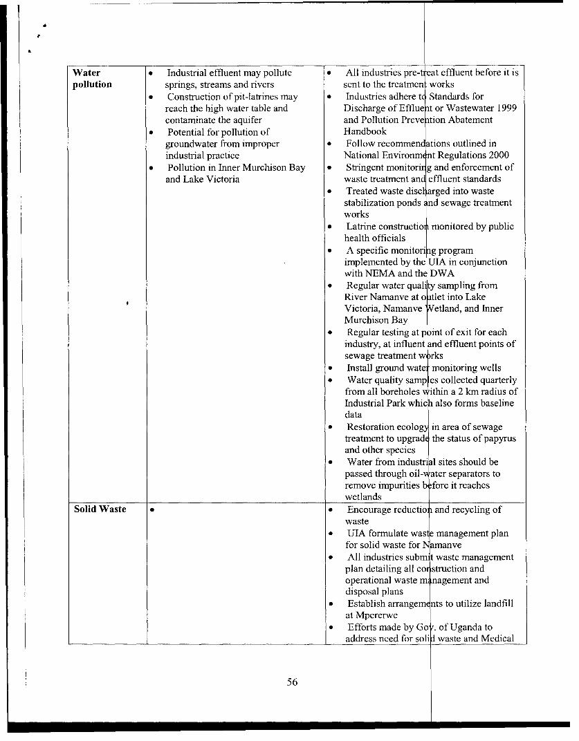
Water * Industrial effluent may pollute * All industries pre-t eat effluent before it ispollution springs, streams and rivers sent to the treatmen works
* Construction of pit-latrines may * Industries adhere tz Standards forreach the high water table and Discharge of Efflue nt or Wastewater 1999contaminate the aquifer and Pollution Preve ntion Abatement
* Potential for pollution of Handbookgroundwater from improper * Follow recommen ations outlined inindustrial practice National Environm nt Regulations 2000
* Pollution in Inner Murchison Bay * Stringent monitorir g and enforcement ofand Lake Victoria waste treatment and effluent standards
* Treated waste discl arged into wastestabilization ponds Lnd sewage treatmentworks
* Latrine constructio monitored by publichealth officials
* A specific monitori ng programimplemented by the UIA in conjunctionwith NEMA and the DWA
* Regular water qual sampling fromRiver Namanve at o atlet into LakeVictoria, Namanve 'Aetland, and InnerMurchison Bay
* Regular testing at p Dint of exit for eachindustry, at influent nd effluent points ofsewage treatment w rks
* Install ground wata -monitoring wells* Water quality samp es collected quarterly
from all boreholes vithin a 2 km radius ofIndustrial Park which also forms baselinedata
* Restoration ecolog) in area of sewagetreatment to upgrade the status of papyrusand other species
* Water from industri al sites should bepassed through oil- ater separators toremove impurities b fore it reacheswetlands
Solid Waste . * Encourage reductio and recycling ofwaste
* UIA formulate wasl e management planfor solid waste for N amanve
* All industries subm t waste managementplan detailing all cor struction andoperational waste m nagement anddisposal plans
* Establish arrangem nts to utilize landfillat Mpererwe
* Efforts made by Gov. of Uganda toaddress need for soli I waste and Medical
56

Waste disposal sites
Construction . * Appropriate storage, transport, anddisposal of waste materials
* Sanitary facilities for work force that doesnot seep into wetland
* Proper vehicle maintenance* Prevent spillage and leakage of materials
* Minimize soil erosion through use ofberms or silt fences
* Prepare and implement SiteEnvironmental, Health and Safety Plan
* Prepare Spill Contingency Plan accordingto international standards
* Materials used from environmentallyresponsible sources ie: wood productscertified by Forestry Stewardship Council,quarry materials from sites with approvedrehabilitation plans
Social * Human health problems. * Appropriate filtration of smoke stacks
* Employment opportunities for * Improvement of income levels and living
unskilled workers during standards for the community
construction for the community * Provide training for community members
living around the project area for employment in business park
* Increase in HIV / AIDS and STDs * Provide focused training for women
cases in the project area which also accounts for special needs ie:
* Unplanned influx of population and child care, etc.
settlement * The health status of the Namanve areashould be monitored and steps taken toprevent occurrence of HIV / AIDS andSTDs through education and awarenesscampaigns in communities and for workforce
* Provide piped water, or where appropriate- boreholes, to surrounding communities
* Sensitize communities on issuesassociated with residing near to businesspark
* Provide environmental education andsensitization to communities and workforce
* Regional planning which includes districtrepresentatives in planning process
H. CONCLUSIONS AND RECOMMENDATIONS
The study has highlighted various existing and potential impacts within the site proposed for the
development of Namanve Industrial and Business Park. Mitigation measures have been proposed
for potentially adverse impacts. This chapter concludes the report by highlighting the main issues
identified in the study.
57
1. Location
The location of the proposed project site in Namanve will have a significant iiegative impact onthe Namanve wetland. Impacts, however, will be mitigated to prevent or reduc e the magnitude ofnegative impacts.
From a socio-economic standpoint, the proposed site is strategically located in terms ofproximity to Kampala for trade and commerce transactions. This is advantage us, as there isaccess to skilled and unskilled labour to work during the construction and ope ation phases of theproject.
2. Effluent disposal
The environmental impact assessment (EIA) of the proposed development ha s shown that greatconcern lies with the disposal of effluent and its impact on the Namanve sw amp and ultimatelyon Lake Victoria, the drinking water source for the residents of Kampala. Ind stries are requiredby law to pre-treat their effluent in order to comply with Ugandan efflue nt regulations fordischarge of effluent/wastewater to a sewage treatment works, 1997 and revisc d in 1999.
It is planned that all industries will pre-treat their waste which will then pass through a sewagetreatment works. The outflow will then pass through the natural wetland systei ns. There is a needto develop stringent monitoring and enforcement of this process. The Gaba Nvater supply intakeworks is some 2 km to the west of the proposed site and while it is unlikely th at toxins will reachthe works, this cannot be assumed without further work on issues such as wa ter quality, currentflows etc.
Given that:* Once completed Namanve area will be the biggest industrial comple x to impact Inner
Murchison Bay;* It will be developed over a considerable period of time (10 years or mo re);* The range and types of industries that may be set up there will be divers e,
There is a serious need to guarantee the future of the water quality situation from Gaba WaterWorks, and to mitigate pollution and eutrophication of the Bay. Regular testi ng would thereforebe required of the effluent at the point it exits each industry and at the influent and effluent pointsof the sewage treatment works. Monitoring of Lake Victoria water quality, fauna and flora willprovide baseline data on the trends of pollution or contamination and its effect on theenvironment. Industries should therefore be responsible for the proper treatm nt of their effluentbefore discharge into any wetland. Strict penalties for defaulters will be absol itely necessary.
3. Waste handling and soil pollution
Solid wasteUIA should formulate a waste management plan for solid waste for Namanve.
58

All industries should submit a waste management plan detailing all construction and operationalwaste management and disposal plans.
GIBB understands that the strategy is to outsource solid waste management facilities andmaintenance to private companies and contractors. Thus, we would suggest that the concerneddistricts (Wakiso and Mukono), hold a meeting with UIA and NEMA to discuss availableoptions as soon as possible to identify one to three suitable locations for solid waste disposal.The following issues should be taken into consideration:
* Legal requirements for the disposal of hazardous and non-hazardous waste;* The types of industries in the Park; options for solid waste disposal for the specific
industries;* Environmental impacts, monitoring procedures and mitigation measures for the various
disposal methods;* Recycling and waste reduction activities on an industry specific basis;* Due consideration of domestic solid waste from the surrounding population incorporating
the projected population growth connected with the Industrial Park; and* Disposal of sludge from sewage works.
4. Toxic and hazardous waste
In terms of industrial layout by category, the information on potential industries or industry typesis not yet available from the UIA / management authority. It is strongly recommended that strictadherence to the guidelines issued for Industrial Estates within the Pollution PreventionAbatement Handbook, 1998. In addition to these guidelines, the Pollution Prevention AbatementHandbook sub-divides industry into 40 sectors that range from dairy industries to vegetable oilprocessors. We would therefore recommend sub-division according to these 40 major sectors andencourage similar industries i.e. food industries to be grouped together and separate frompetroleum-based industries.
Of specific concern at Namanve is the high water table in many areas, but not all parts of thePark. Industries that have the potential to contaminate the water table such as petroleum- based,petrochemical-based, tanneries or pulp and paper mills etc. should be located on higher groundand ideally on impermeable soils. In addition, groundwater monitoring wells should be installed.
NEMA is advised to establish standards for treatment and handling of hazardous and toxic wastematerial and to ensure that viable options exist before allowing industries to generate hazardouswaste.
According to the National Environmental Statute of 1995, individual environmental impactassessments will be required by law for the development of each and every industry in the newPark. Risk assessment and risk management is industry-specific. Computer programmes, such asWAZAN (World Bank Hazard Analysis programme) and PHAST (Process Hazards AssessmentsScreening Tools programme) can be used to model the risk of individual sites and processes.
59

5. Soil contamination/ pollution
No industry should contaminate or pollute the underlying soil/geology. This ca n be prevented byconstruction of secondary containment, use of spill prevention equipment, con ingency planning(site and park specific), and investing in spill response equipment. Industries sl ould indicate themeasures they will employ in preventing soil contamination and pollution as a pre- requisite toobtaining authorisation to begin construction.
6. Measures to be implemented during construction
The construction site should be kept clean at all times and appropriate measure s should be takenfor the storage, transportation and disposal of waste materials. Sanitary facilitie s for their workforce. Proposed sanity arrangement should be submitted to UIA for approval b efore commencingconstruction work.
* All vehicles should be maintained in accordance with the origi ial manufacturer'sspecifications and manuals in order to minimise noise, soil and air poll ation caused by oilleaks and emissions.
* The Industrial Developers, through their Contractor, shall take all reas nable measures toprevent spillage and leakage of materials likely to pollute air, soils and watercourses.Similarly, precautions should be made to minimise soil erosion from the site through theuse of berms or silt fences.
* The Industrial Developers, through their Contractor, should take preca utions to minimizeair pollution. The routing of trucks and other vehicles should minimi e and mitigate theeffects of generation of dust and vehicle emissions on the surrounding inhabited areas.
* The Industrial Developers, through their Contractor, should prepare an d implement a SiteEnvironment, Health and Safety Plan detailing preventive measur s concerning fire,product release, worker injury and waste management. Where applica le, a detailed SpillContingency Plan should be put in place according to international standards.
* The Industrial Developers, through their Contractor should demonstra e that all materialsused (quarry stone, fill material, wood, steel etc.) are from envirom entally responsiblesources. Wood and wood-products should ideally be certifiecI by the ForestryStewardship Council or similar organisation and all quarry materials should come fromquarries or borrow pits that have approved rehabilitation plans.
7. Monitoring, Management and Capacity Building (including expenditu re)
As stipulated earlier in the report, it was clear that either a unit within .I.A be created tooversee the park development or a park authority is created, the latter being t e preferred optionbeing the overall work load of U.I.A. In this regard, the consultant given the budgetary constraintof the G.O.U also recommended budgetary support to the unit or authority for a period of four(4) years at which time the park should be self- financing. NEMA should also benefit from bank
60

support to ensure adherence to national environmental legislation and notably the World Banksafe guard policies.
8. Other issues
a) Awareness and education
Officer, in conjunction with the UIA, should immediately work towards the incorporation of theNamanve catchment into the Inner Murchison Bay water-monitoring scheme. In addition, theofficer should have a pivotal role in environmental education and awareness for all peopleworking in Namanve.
The Environmental Officer should be made aware of, and be provided with, the latest copy of theexisting standards and guidelines for air, water and soil. Particular emphasis should be placed onthe implications of Lake Victoria being the source of drinking water for the people of Kampalaand its surroundings, in addition to being the sink for waste water disposal for Namanve.
b) Regional planning
The subject site straddles two districts namely Wakiso and Mukono Districts. This implies thatthe impact of the proposed industrial park will be evident in these two areas. It is important that
the Districts are represented and incorporated in the planning process and the industrial park andits projected impacts are taken into consideration when the planning committees in the respectivedistricts are deliberating on issues.
There should be regional integrated planning to avoid undesirable degradation and unplannedsettlement. This would involve input from Wakiso and Mukono District representatives and theUIA planning committee at the pre-construction phase.
Socio-economy
c) Awareness promotion
In order to increase the level of awareness about the proposed Namanve project and itsimplications, planning authorities in the respective districts of Mukono and Wakiso shouldensure that the communities around the park are appropriately sensitised about the realitiesassociated with development of an industrial park near them. This should be initiated by the
UIA.
61

d) Alternative water supply
Our socio-economic survey indicated that presently the people living around manve North andNamanve South A depend upon water from protected and unprotected springs S well asboreholes some of which are located in the proposed industrial area. The numb r of people livingin or at the periphery of the proposed Park is estimated to be between 5,000 an 8,000. On theassumption that all these people obtain water from sources inside the proposed ark area it willbe necessary to provide between 250 m3 and 400 m3 of water per day, based o 50 litres perperson per day for low-income settlements. Planning should be initiated to upg ade this provisionin five years as it is likely that many people will graduate from low to middle ir come earnersover the forthcoming decade.
We further recommend that this planning be incorporated into the overall pla ing and costingfor water provision to the Industrial Park.
Industries should ensure that routes to natural water sources are preserved for a cess by villagers.If this is not possible, the industry should offer viable alternatives, incl ding; sinking ofboreholes incorporating a system for maintaining the boreholes to ensure ustainable watersupply. Coca-Cola has set a precedent by drilling and equipping two boreho] s for use by thesurrounding community to replace the two wells that were lost through con truction of theirfacility in Namanve.
e) WetlandThe protection of wetlands in Uganda is a pertinent issue and should be tackle effectively. Themain issue will be enforcement of the protection of the swamp area withi Namanve. TheWetland Inspection Division and NEMA's monitoring departments both hay limited staffingand have a countrywide mandate. The onus will therefore fall on the Envir nmental Officerproposed to manage the environmental matters within the proposed site. Moni oring of this sitewill include the suggestions outlined.
f) Transportation
Transportation is an issue as there will be a need to increase the number of publi (and private)vehicles on the main Kampala/Jinja road to cater for the large work-force that wI p be commutingdaily to the site. This will result in an increase in air pollution and the potential f r accidents onthe roads.
g) Construction Materials
During the construction phase there will be a large demand for construction mate ral such assand, murram and timber. If not properly regulated this may result in unsightly la idscapemodification and natural resource depletion.
h) Flooding
62

d) Alternative water supply
Our socio-economic survey indicated that presently the people living around amanve North and
Namanve South A depend upon water from protected and unprotected spring as well as
boreholes some of which are located in the proposed industrial area. The nu ber of people living
in or at the periphery of the proposed Park is estimated to be between 5,000 nd 8,000. On the
assumption that all these people obtain water from sources inside the propo d Park area it will
be necessary to provide between 250 m3 and 400 m3 of water per day, base on 50 litres per
person per day for low-income settlements. Planning should be initiated to pgrade this provision
in five years as it is likely that many people will graduate from low to mid le income earners
over the forthcoming decade.
We further recommend that this planning be incorporated into the over I planning and costing
for water provision to the Industrial Park.
Industries should ensure that routes to natural water sources are preserve for access by villagers.
If this is not possible, the industry should offer viable alternative , including; sinking of
boreholes incorporating a system for maintaining the boreholes to nsure sustainable water
supply. Coca-Cola has set a precedent by drilling and equipping two oreholes for use by the
surrounding community to replace the two wells that were lost thro gh construction of their
facility in Namanve.
e) WetlandThe protection of wetlands in Uganda is a pertinent issue and should e tackled effectively. The
main issue will be enforcement of the protection of the swamp ea within Namanve. The
Wetland Inspection Division and NEMA's monitoring departments both have limited staffing
and have a countrywide mandate. The onus will therefore fall on the Environmental Officer
proposed to manage the environmental matters within the proposed ite. Monitoring of this site
will include the suggestions outlined.
f) Transportation
Transportation is an issue as there will be a need to increase the nutber of public (and private)
vehicles on the main Kampala/Jinja road to cater for the large work force that will be commuting
daily to the site. This will result in an increase in air pollution and t e potential for accidents on
the roads.
g) Construction Materials
During the construction phase there will be a large demand for co struction material such as
sand, murram and timber. If not properly regulated this may result in unsightly landscape
modification and natural resource depletion.
h) Flooding
62

The subject site has a very low topographic gradient and a shallow water table (1 m.b.g.l. in
some places), and this increases the potential for flooding. It is recommended that construction
below the 1136 .3 lake level be avoided.i) Flora and fauna
There were some flora and fauna of conservation interest identified, which should be protected.
This will go hand in hand with the preservation of the areas set aside as conservation areas.
Sponsorship for such activities could be obtained from the industries themselves.I. FURTHER WORK
Further work and investigations are required in the following areas:* A time series water quality analysis should be carried out on River Namanve and the outlet
into Lake Victoria.
* A groundwater and aquifer status survey of the Namanve area should be conducted in
conjunction with mapping of possible sources of contamination (such as pit-latrines), and
likely contamination migration routes.* A survey of the health status of the people living in the Namanve area, particularly on
respiratory related diseases, should be carried out to establish the health condition of the
population. This information could then be used as a point of reference in the event that
issues relating to health are raised in connection with the Namanve Industrial Park.* An air quality survey, particularly for vehicle emissions, should be carried out over a period
of time to establish the current air quality standards and to model possible dispersal
characteristics of air pollution.
* Plans for solid waste management should be formulated.* Awareness should be created with regard to the Park's intended functions, particularly
among those living adjacent to the proposed park site. This should be carried out before
construction begins on the industrial park.* Environmental
management should be institutionalized with the appointment of an
Environmental Officer.
* A socio-economic study of the impact of HIV/AIDS and STDs on the communities living
adjacent to the proposed project area should be conducted.is recommended that all the items listed above should be addressed exhaustively at the
*ning stage of the proposed project. Recommended precautions: Certain precautions should
ken. These include but should not be limited to:
63

* Identification and harmonisation of the activities and expectations of takeholders. Thisshould involve regular consultative meetings to harmonise developmen activities.
* Demarcation and possible gazetting of the wetlands (conservation areas) should beundertaken to pre-empt future encroachments;
* The channel in the upper Namanve Swamps should not be lined nor exte ded to theKayobe Swamp. This will ensure that the wetland remains intact and th re is adequateSeepage of treated effluent through the wetland.
J. LIST OF PEOPLE I HAVE MET
1. Maggie Kigozi, Executive DirectorUganda Investment Authority
2. Patrick Nyaika, DirectorUganda Investment Authority
3. Barnabas MwesigyeUganda Investment Authority
4. Justine Ekaat, DirectorEnvironmental; monitoring and compliance
5. Nelson Ofwono, Consultant
K. REFERENCES PUBLICATIONS
1. Banage W.B, 1999. Nainanve Industrial and Business Park - An Ecolo ical and Environmental Study. Draft Report. Kampala, (unpublished report).
2. Environmental Risk Services (Pty) Ltd. 23 April, 1997. Century B ttling CompanyLimited, Final Environmental Impact Statement for the Proposed ottling Plant atNamanve (unpublished report).
3. FEPA, 1995. Environmental Impact Assessment Sectoral Guidelines Manufacturingindustries. Federal Environmental Protection Agency (FEPA), Nigeria.
4. IUCN, 1996. Initial Environmental Assessment of Brick-making in ukono District.National Wetlands Conservation and Management Programme.
5. J.H. Musisi (Geologist), September 1986. Assessment and Evaluation o Namanve ClayDeposit - Near Kampala Sheet 71/1, Geological Survey and Mines Dep rtment, Uganda(unpublished report).
64

6. J.T. Tuhumwire (Geologist), September 1988. Brief Report on Work Carried out for
Bricon (U) Ltd. at Namanve Near Kampala, Sheet 71/1,. Geological Survey and Mines
Department, Uganda (unpublished report).
7. L.C. Beadle and E.M. Lind, August, 1959. Research on the Swamps of Uganda.
Departments of Zoology and Botany, Makerere College,'Kampala, Uganda.
8. Ministry of Natural Resources, 1995. National Policy for the Conservation and
Management of Wetland Resources. Ministry of Natural Resources.
9. NEMA, January 1997. Draft Environmental Standards and Preliminary Environment
Impact Assessment for Control of Noise Pollution. First Edition. NEMA, Uganda
(unpublished report)
10. NEMA, 1997. Guidelines for Environmental Impact Assessment in Uganda, 1997.
NEMA, Uganda.
11. NEMA, January 1997. Proposed Environmental Air Quality Standards for Uganda. First
Draft. (unpublished report).
12. NEMA.1997. District State of Environment Report. For Mukono, Mpigi (Wakiso) and
Kampala Districts. NEMA, Uganda.
13. Tuhumwire Joshua T., Katto Edward, 1990. An Interim Report on the Evaluation of
Namanve North Clay Deposit, Geological Survey and Mines Department,
ReportNo.JTT/1 5EK/3.
14. Tumusiime Malachi B., 1999. The Namanve Indusrial and Business Park -socio-
economic study. Final report. Kampala, (unpublished report).
15. United Nations Industrial Development Organisation (UNIDO) and Unitec Nations
Conference on Trade and Development (UNCTAD), March 1998. P re-feasibility study
and preliminary design proposals for the Namanve Industrie Park. Draft final report for
the Uganda Investment Authority (unpublished report).
16. The National Environment (Standards for Discharge of Effluent into Water or on Land)
Regulations, 1999. NEMA, Uganda.
65