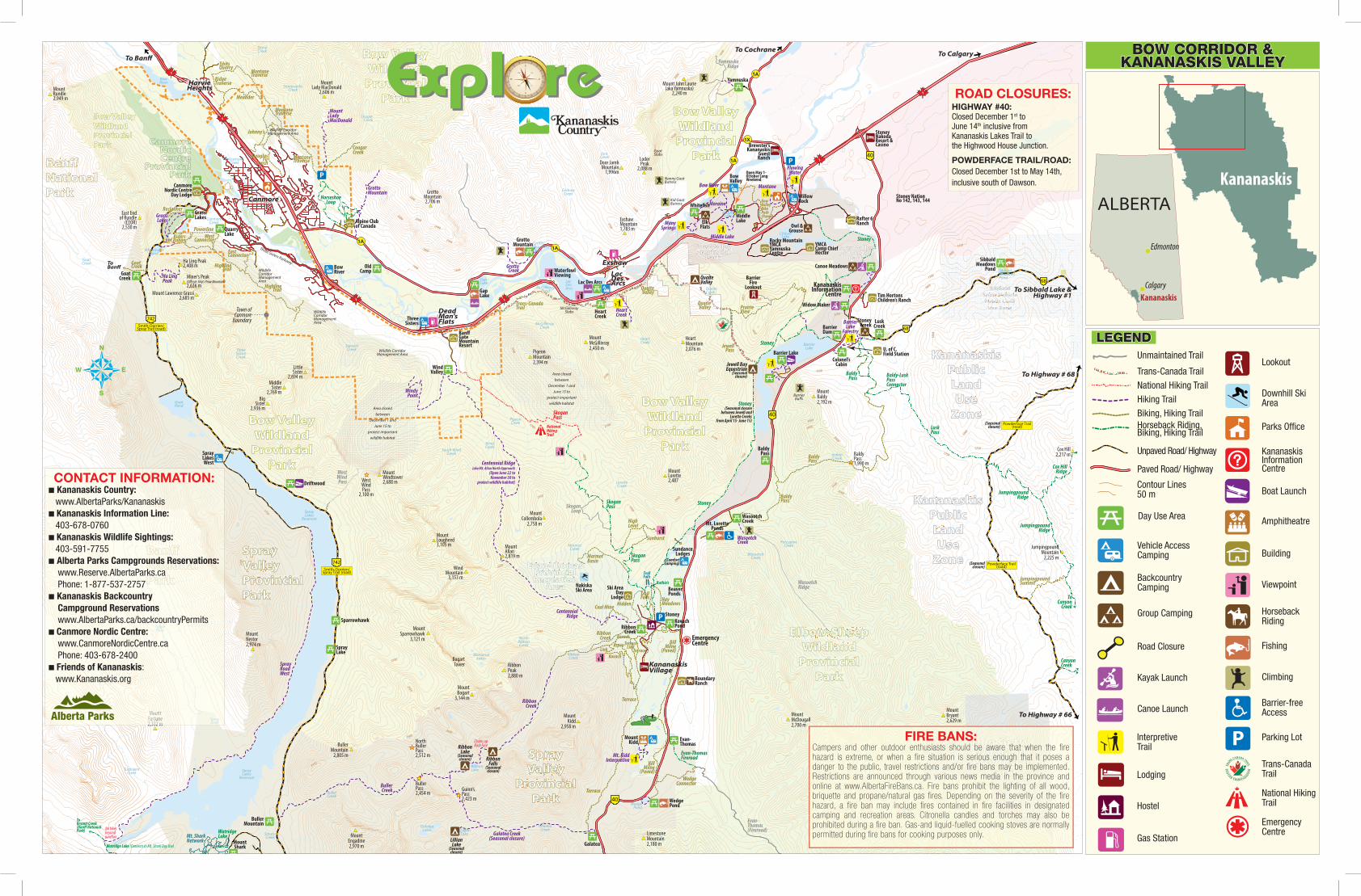
E Exxpl pl SW SE rree - Alberta Parks AlbertaParks.ca Ranch Rafter 6 Ranch Boundary Ranch Stoney...
2
2300 2400 1400 1600 1800 2000 2200 2500 1700 1500 1500 2000 1650 1700 1900 1800 1650 1350 1800 1700 1800 1750 1550 1500 1800 2000 1900 1750 1750 2050 1900 2100 2200 2000 1450 2000 2150 2200 2200 2350 2200 2150 1700 2050 1900 2550 2500 2600 1800 2450 1750 2400 2100 2550 2600 West Wind Pass 2,100 m 21 215 15 21 21 21 2 15 50 50 50 50 50 150 15 0 0 0 0 0 0 0 0 0 50 50 0 0 0 200 00 20 0 00 00 00 00 00 22 22 22 22 22 220 2 20 22 22 20 2 2 2 P 1 1 1 1 1 1 1A 40 40 40 742 Smith-Dorrien/ Spray Trail (road) 742 Smith-Dorrien/ Spray Trail (road) 68 68 Powderface Trail (road) 1A 1A 1A 1X 2600 2700 2600 2450 900 Powderface Trail (road) P P Exshaw Dead Man’s Flats Canmore Harvie Heights Lac Des Arcs Kananaskis Information Centre Emergency Centre Loder Peak 2,088 m Exshaw Mountain 1,783 m Grotto Mountain 2,706 m Mount Lady MacDonald 2,606 m Mount Rundle 2,949 m East End of Rundle (EEOR) 2,530 m Ha Ling Peak 2,408 m Miner’s Peak (Official: Ship’s Prow Mountain) 2,636 m Mount Lawrence Grassi 2,685 m Mount Windtower 2,688 m Mount Lougheed 3,105 m Little Sister 2,694 m Middle Sister 2,769 m Big Sister 2,936 m Pigeon Mountain 2,394 m Mount McGillivray 2,450 m Heart Mountain 2,076 m Guinn’s Pass 2,423 m Buller Pass 2,454 m North Buller Pass 2,512 m Mount Engadine 2,970 m Buller Mountain 2,805 m Mount Bogart 3,144 m Mount Sparrowhawk 3,121 m Mount Allan 2,819 m Wind Mountain 3,153 m Mount Lorette 2,487 Kananaskis Village Mount Baldy 2,192 m Mount Kidd 2,958 m Baldy Pass 1,990 m Cox Hill 2,217 m Jumpingpound Mountain 2,225 m Mount McDougall 2,700 m Mount Bryant 2,629 m Limestone Mountain 2,180 m Grotto Mountain Gap Lake Old Camp Mount Shark Buller Mountain Spray Lake Sparrowhawk Driftwood Grassi Lakes Heart Creek Lac Des Arcs Lusk Creek Colonel’s Cabin Barrier Dam Widow Maker Canoe Meadows Middle Lake Whitefish Yamnuska Barrier Lake Wasootch Creek Mt. Lorette Ponds Beaver Ponds Kovach Pond Ribbon Creek Evan- Thomas Wedge Pond Galatea Sibbald Meadows Pond Mount Kidd Barrier Lake Forestry Middle Lake Many Springs Bow River Moraine Montane Flowing Water Yamnuska Ridge Skogan Pass Heart Creek Skogan Loop Centennial Ridge (aka Mt. Allan North Approach) (Open June 22 to November 30 to protect wildlife habitat) Skogan Pass High Level Sunburst Skogan Pass Marmot Basin Stoney Stoney Centennial Ridge Coal Mine Hidden Ribbon Creek Link Kovach Kovach Terrace Terrace Link Aspen Ribbon Creek Galatea Creek (Seasonal closure) Evan-Thomas Fireroad Wedge Connector Evan- Thomas (Fireroad) Terrace Wasootch Creek Baldy Pass Baldy-Lusk Pass Connector Lusk Pass Jewell Pass Quaite Valley Prairie View Stoney Bow Valley Bike Path (Paved) Quaite Valley Ribbon Falls (Seasonal closure) Ribbon Lake (Seasonal closure) Lillian Lake (Seasonal closure) Hay Meadows Troll Falls Nakiska Ski Area Sundance Lodges Jewell Bay Equestrian (Seasonal closure) Bow Valley Willow Rock Elk Flats Owl & Grouse Stoney Creek Barrier Fire Lookout Brewster’s Kananaskis Guest Ranch Rafter 6 Ranch Boundary Ranch Stoney Nakoda Resort & Casino (Comfort Camping) YMCA Camp Chief Hector Rocky Mountain YMCA Yamnuska Centre Open May 1- October Long Weekend Mount John Laurie (aka Yamnuska) 2,240 m Door Jamb Mountain 1,996m Kid Goat Butress Nanny Goat Butress Goat Slabs Jura Creek Exshaw Creek McGillivray Creek Heart Creek Quaite Creek Quaite Valley Waterfowl Viewing McGillivray Slabs Banff Gate Mountain Resort Pigeon Creek Wind Creek South Wind Creek Mount Collembola 2,758 m Bogart Tower Ribbon Peak 2,880 m North Ribbon Creek Memorial Lakes Mount Fortune 2,332 m Tim Hortons Children’s Ranch U. of C. Field Station Goat Pond Spray Lakes Reservoir Lillian Lake Galatea Lakes Ribbon Lake Buller Creek Smuts Creek Spray River Turbulent Creek Three Sisters Creek Goat Creek Whiteman’s Pond Canmore Creek Policeman’s Creek Bow River Stone Creek Stoneworks Creek Cougar Creek Gap Lake Lac Des Arcs McGillivray Pond Grotto Mountain Pond Middle Lake Chilver Lake Sibbald Meadows Pond Canyon Creek Wasootch Creek Porcupine Creek Indian Creek Barrier Lake Lorette Creek Marmot Creek Ribbon Creek Galatea Creek Wedge Pond Spray Lakes West Area closed between December 1 and June 15 to protect important wildlife habitat National Hiking Trail Ruthie’s Troll Falls Ski Area Day Lodge Canmore Nordic Centre Day Lodge Bow River Three Sisters Quarry Lake Wind Valley Goat Creek Grotto Creek Stoney Barrier Buffs Baldy Pass Baldy Pass (Seasonal closure) (Seasonal closure) To Banff To Calgary To Cochrane To Sibbald Lake & Highway #1 To Highway # 68 To Highway # 66 Grassi Lakes Wildlife Corridor Management Area Wildlife Corridor Management Area Reclaimer Riders of Rohan Powerline Highline Trail West Connector East Connector Ha Ling Peak Goat Creek To Banff Highline Trail Wildlife Corridor Management Area Wildlife Corridor Management Area Town of Canmore Boundary Montane Traverse Tibits Quarry Ridge Traverse Meander Johnny’s Montane Traverse Cougar Creek Mount Lady MacDonald Grotto Mountain Montane Traverse Horseshoe Loop Spray Lakes Reservoir Stoney Nation No 142, 143, 144 Jumpingpound Ridge Jumpingpound Summit Cox Hill Ridge Jumpingpound Ridge Canyon Creek To Canyon Creek Trans-Canada Trail Windy Point Stewart Creek Buller Creek Bill Milne (Paved) Watridge Lake Mt. Shark Network To Bryant Creek (Banff National Park) Mount Nestor 2,974 m Spray Road West Spray River Area closed between December 1 and June 15 to protect important wildlife habitat (Seasonal closure between Jewell and Lorette Creeks from April 15- June 15) Baldy Pass Wasootch Ridge Stoney Chains up Rock Face Three Sisters Parkway Alpine Club of Canada No bikes beyond junction Watridge Lake (Connects to Mt. Shark Day Use) Bill Milne (Paved) Mt. Kidd Interpretive Terrace West Wind Pass Douglas Fir Bench Spray r S Sp p pra pray y y S S S S S S r r r p p p p p a a y y y y y y S S S p p a a Valley al V V V Valle alley alley alley y l l l l l l l Va V V V Va e e e Va a a y y y y y y alle a e Provincial ov o ro Prov rovi rovin rovin n n c c ia al l l P P P P c c c n n n n o o o o o r r r r a a v v v inci i n n a k k k k Park a Pa rk Pa Pa Pa k k k k P P P P P Park k r r r a a a a a a k k a Bow Valley Wildland Provincial Park Bow Valley l ll w ow w e B o o o ow Val w w e ey Bo Bo Bow Vall Bow Valle ow Valley ow Valley ow Valle w V w V l l l l l l l l l l l B B B B B B B B Va V Va V B B e e e e Va a a a y y y w w w w w w w y y e e B B B a a e e e land an a d nd nd nd and an a a la dl d dl dl ld ld ld d Wil Wi Wil Wi W W W W W i d d d d d d d l l l d d d l l l l l W W W W W W W W W W W W W W n n n n a a a a i i d d dlan n W W W dland Provincial nc n n in ro v o ro r r al al ia ia cia ci nci inc inc vin vin Provi Prov Prov Pro Pro l l l l l P P P P P P P c c c c r r r r r r a a a a a n n n n n n n o o o o o i i i i i i i v v v v n n a k k k k Park k ar a rk rk ark ark Pa Pa Pa P P P k k k k k k k P P P P P P P k k k k r r r r a a ark k k a Bow Valley Wildland Provincial Park more Canmore more m C Ca a e e or mo an C C C C C C C C C C r r e e e e e e o o o m m n n a a a nmore re anmore C ic ic ic ic di d Nord d rd No i d d d d N N N N c c c c c or o i c c c c N N N d d d rd Ce Centre Centre ntre r nt Ce C C C C t t e e e e e e e e e e r r r r n n e e ntre re re e C C ial al ia al ia nc nci inc n ci i in Provi ov vi P Pr Pr o ov v i i i i l l P P P P P vi vi c r r n n o o a a a v v v v i i in n ro r a k ar ark Par a rk Pa k k P P P P rk r r a a a a a a k k Spray y ay ay ay ay ay ra r pr pr p p Sp Sp S S S S S S S S S r r r r p p p p p a a a a a y y y y y y y y S S S pra Valley a y Valle Valle Valle Valle Valley Valley Valley Va Va Va l l l l l l l l l l l Va V V V V V V V V e e e e e Va a Va a a a y y y y y y y y y y e e alle e Provincial a al in Pro Prov Provin Provinc nc nci ci cia cia ia ia ia ia ial al al al l l l l l l l P P P P P P P P c c c c c r r r r r a a a a a a a a n n n n o o o o o i i i i i i i i v v v v n n a a a k k k k Park Pa a rk rk ark Park Park Park Par Par Pa k k k k k k k k P P P P P Park k k k r r r r r r r r a a a a a a a a k k a Evan-Thomas m ma a -T T h ho o E Ev va n n-T T h o m ma s s h h h -T T T E E E a a a m m m o o n n a a van-Thomas v -Thoma a an-Thomas Provincial c ci ia r o P Pr P Pr ro ov i n cia al l l P P P P P P P a a n n o o r r r r c c c i i i i i v v a Recreation ea a R R Re ec c re e ation n R R R t t R R n n a a a a e e e ecr e o o c c i i ecre e a Area r A A A Are Area Area ea A A A A A A A A A A A A A A A a a a e e e r r r e e a Bow Valley Wildland Provincial Park Bow Valley Bow Valle y f f Bow Vall B Bow Valle e Valley y w Valley y Bow Valle e f f cial a a a a ia l Provincial a al al al P Provin a Park k Park k ark ley Bow Valley Va ow Bo Bo ey y Bow Vall B B Va Va Bow Valle a w w Bow Valley cial l Provincial n vin ov ro Pr al P P P P ovin o o r r r i i v v ncia Park rk Par Pa Pa k k P P P P P P k k a a a a r r r a a ark ff ff Banff nff a Ban Ban Banff Ban nff ff ff ff ff B B B B Banff B n n n n a a a a n n n ff ff ff ff B B a a a National a al nal nal nal on o o o io i Nat Nat Na Na l l l l l N N N N N N t t t n n n o o o o o a a a a a a a a a a i i i N N N N n n ationa a ationa k k k k Park P rk rk rk ar ar P k k k k k P P Park k k r r r r a a ark a Elbow-Sheep E El S S he e Elb b S Sh b b h b E l El e ee e -S w-Sh Elb Elbo Elbo Elbow-Shee Elbow-Sheep ow-Sheep w-Sheep w-Sheep w-She w- h h h h h h h h b b b b b b l l l l l l S S S S S S E E E E E E E E E p p p e e e e e e e e w w w w e e e e bow-Sheep p - - eep p land a la la an an and la la land land dl dl dl dl ld ld ld ld d d Wil Wi il il l Wi W W W Wi d d d d l l l l l l d d d d d l l l l W W W W W W W W W n n n n a a a a a a a i i i d d d d n n W W W W a a a dland Provincial a i vi v ov n n in o r r ro ia i c nc P al a ov o ovi rovinc Provinci Provincia Provincial l l l P P P P P P P c c c c c r r r r a a a n n n n n n n n o o o o o o v v i i i i i n n n a k k k Park ar a P Pa Par rk k k k P P P P P P P k k r r a a a ark k a kis s s kis Kananask K K Ka K na nas na ananask a K k k k K K K K K K K K K K s s s s s s s a a a n n n a a n n n n a a a a is i Kananaskis a lic c c ic li bl b Pub Pu u ub Pu ub l l l b b b b b P P P P P c c c c c u u u u u i i i c c b b ub Land a a n n L an nd d d L L L n n n n a a a a nd n and Use s e U Us se e U U U U s s s s e e e e e e e e e Use U Zone on ne Zo n ne Z Z Z Z Z n n n n n o o e e e e e ne e kis ki s Kananask a an n n a Ka a an an na a s nask na ana K k k K K K K s s s s s s a a a a n n n n n a a n n n a a a a a a a s s i i n n n n K K ana a ananaskis lic i i ic bl b b bl Pub ub ub Pu P bl b b P P P Public c c i i i i u u u c c b b ub Land n d an n n nd La La d d d d d L L L n n n n n a a a d d and Use Us s se Use U U U U U U U U U s s s e e e e Use U Zone ne e e Z Zo e ne on Zon Z Z Z Z Z Z Z e e e n n n o o o ne n e e Bow Valley Wildland Provincial Park Sibbald S S Si Si b ib bb bb ba ba al al ld ld d d S S Si Si b ib bb bb ba ba al al ld ld d d b ib d S Sibbald bbal Snow Vehicle S S n Sn no no ow ow w w V V Ve Ve eh eh hi hi ic ic cl cle e e S S n Sn no no ow ow w w V V Ve Ve eh eh hi hi ic ic cl cle e e ic i ow Snow Vehicl now Vehicle Public Land P P u b bl ic c L L a n d d P P Pu Pu u ub b b bli bli ic ic c L c L La La a an n n d nd d d P P u u b b l l c ic L L a a n n d d nd d d d bli ublic L nd Public La Use Zone U U s Us e e Z e Z Z Zo o o n n e e U U U Us Us e se Z e Z Zo Zo o on n n e ne e n e se Z o ne Mount u nt Mo o u un nt t Fortune Fortu un un ne e 2,332 m 2,332 m m m ay Spray pra r River ve Spray ra ra Sp ra ray River e ve ff ff ff Banff nff n B ff nff n n an a a Ba B ff ff ff ff ff ff ff B B B B Banff B n n n a a a n n ff ff ff ff B B a National a na n on io ti al al a na n n n o o io tio ati at a Na N l l l N N t t t t a a a a n n n n n o o o o o o a a a i i i i Nation n ationa k k k k Park P rk ar a k k k k Park k k r r r a a a a k k a 2,332 m 2,332 m m m ■ Kananaskis Country: www.AlbertaParks/Kananaskis ■ Kananaskis Information Line: 403-678-0760 ■ Kananaskis Wildlife Sightings: 403-591-7755 ■ Alberta Parks Campgrounds Reservations: www.Reserve.AlbertaParks.ca Phone: 1-877-537-2757 ■ Kananaskis Backcountry Campground Reservations www.AlbertaParks.ca/backcountryPermits ■ Canmore Nordic Centre: www.CanmoreNordicCentre.ca Phone: 403-678-2400 ■ Friends of Kananaskis: www.Kananaskis.org Canyon n ny C nyon a Creek e e C Don Getty et et y y t y tt et e e n on o n Getty on Getty Do Do Don Get Don Get on Gett on Gett Don G G G G G G G G G D D D D D t t t t t t t t t t t D D e e e e e n n n n n n n n y y y y y y e e d d d d d land n n l land n and and l l l dl d dl dl d d d d d ld ld d d ld l l l l Wil il W il Wi W W W W W a a a a n n n n i i i i d d d d d d d n n a a dland d d Wi W W W W W W W W W Provincial r P Pr ro r c v o o v v o P al v ovi ovin rovincia rovincia Provincia Pr Pr Provinci l l P P P P P P P Provincia a a c c c c c n n n n o o o o o o o o r r r r i i i i i i i i v v v v v n n n a k k k k Park a r Pa Pa Par ark ark rk k k k k P P P P P r r r r r a a a a a a a a k a Chiniki Lake HIGHWAY #40: Closed December 1 st to June 14 th inclusive from Kananaskis Lakes Trail to the Highwood House Junction. POWDERFACE TRAIL/ROAD: Closed December 1st to May 14th, inclusive south of Dawson. ROAD CLOSURES: CONTACT INFORMATION: FIRE BANS: Campers and other outdoor enthusiasts should be aware that when the fire hazard is extreme, or when a fire situation is serious enough that it poses a danger to the public, travel restrictions and/or fire bans may be implemented. Restrictions are announced through various news media in the province and online at www.AlbertaFireBans.ca. Fire bans prohibit the lighting of all wood, briquette and propane/natural gas fires. Depending on the severity of the fire hazard, a fire ban may include fires contained in fire facilities in designated camping and recreation areas. Citronella candles and torches may also be prohibited during a fire ban. Gas-and liquid-fuelled cooking stoves are normally permitted during fire bans for cooking purposes only. N W E S Day Use Area Kayak Launch P Interpretive Trail Lodging Hostel Gas Station Road Closure Group Camping Backcountry Camping Vehicle Access Camping Lookout Downhill Ski Area Parks Office Kananaskis Information Centre Boat Launch Amphitheatre Building Viewpoint Horseback Riding Fishing Climbing Barrier-free Access Parking Lot Trans-Canada Trail National Hiking Trail Emergency Centre Paved Road/ Highway Unpaved Road/ Highway Unmaintained Trail Trans-Canada Trail National Hiking Trail Hiking Trail Biking, Hiking Trail Horseback Riding, Biking, Hiking Trail Contour Lines 50 m 0 20 40 60 8 0 100 120 140 16 0 180 200 220 2 40 2 6 0 2 8 0 3 00 320 340 N W E S NW NE SW SE Expl re Expl re Calgary Edmonton Kananaskis ALBERTA Kananaskis BOW CORRIDOR & KANANASKIS VALLEY LEGEND Canoe Launch
Transcript of E Exxpl pl SW SE rree - Alberta Parks AlbertaParks.ca Ranch Rafter 6 Ranch Boundary Ranch Stoney...
2300
2400
14001600
1800
2000 2200
2500
1700
1500
1500
2000
1650
1300
1700
1900
1800
1650
1350
1800
1700
1800
1750
1550
1500
1800
2000
1900
17501750
2050
1900
2100
2200
2000
1450
2000
2150
2200
2200
2350
2200
21501700
2050
1900
2550
2500
2600
1800
2450
1750
2400
2100
2550
2600
WestWindPass
2,100 m
21502150215021502150215021502150215021502150215021502150215021502150215021502150215021502150215021502150
220022002200220022002200220022002200220022002200220022002200220022002200220022002200220022002200220022002200
P
1
1
1
1
1
1 1A
40
40
40
40
742Smith-Dorrien/
Spray Trail (road)
742Smith-Dorrien/
Spray Trail (road)
742Smith-Dorrien/
Spray Trail (road)
68
68
Powderface Trail(road)
1A
1A1A
1X
2600
2700
2600
2450
2800
2750
2000
2400
1900
1900
Powderface Trail(road)
P
P
Exshaw
DeadMan’sFlats
Canmore
HarvieHeights
LacDesArcs Kananaskis
InformationCentre
EmergencyCentre
LoderPeak
2,088 m
ExshawMountain1,783 m
GrottoMountain2,706 m
MountLady MacDonald
2,606 mMountRundle2,949 m
East Endof Rundle
(EEOR)2,530 m
Ha Ling Peak2,408 m
Miner’s Peak(O�cial: Ship’s Prow Mountain)2,636 m
Mount Lawrence Grassi2,685 m
MountWindtower2,688 m
MountLougheed3,105 m
LittleSister
2,694 mMiddle
Sister2,769 m
BigSister
2,936 m
PigeonMountain2,394 m
MountMcGillivray2,450 m
HeartMountain2,076 m
Guinn’sPass2,423 m
BullerPass2,454 m
NorthBullerPass2,512 m
MountEngadine2,970 m
BullerMountain
2,805 m
MountBogart
3,144 m
MountSparrowhawk
3,121 m
MountAllan2,819 m
WindMountain
3,153 m
MountLorette2,487
KananaskisVillage
MountGalatea3,185 m
TheFortress3,000 m
MountChester3,054 m
MountJames
Walker3,035 m
MountIn�exible
3,000 m
MountLawson
2,795 m
MountMurray
3,024 m
MountBurstall2,760 m
MountBaldy2,192 m
MountKidd
2,958 m
MountSmuts2,938 m
MountShark2,786 m
MountGlasgow2,935 m
BaldyPass1,990 m
Cox Hill2,217 m
JumpingpoundMountain
2,225 m
MountMcDougall2,700 m
MountBryant2,629 m
MountHoward2,777 m
FisherPeak
3,053 m
MountFullerton2,728 m
MountRemus2,688 m
MountRomulus2,832 m
MountHood2,903 m
MountPackenham3,000 m
MountEvan-Thomas3,097 m
The Wedge2,652 m
LimestoneMountain2,180 m
CommonwealthPeak
2,774 mMount
Birdwood3,097 m
GrottoMountain
GapLake
OldCamp
Sawmill
Burstall PassChester Lake
MountShark
BullerMountain
SprayLake
Sparrowhawk
Driftwood
GrassiLakes
HeartCreek
Lac Des Arcs
LuskCreek
Colonel’sCabin
BarrierDam
Widow Maker
Canoe Meadows
MiddleLake
White�sh
Yamnuska
Barrier Lake
WasootchCreekMt. Lorette
Ponds
BeaverPonds
KovachPondRibbon
Creek
Evan-Thomas
WedgePond
Galatea
Opal
GrizzlyCreek
SibbaldMeadows
Pond
EauClaire
MountKidd
BarrierLake
Forestry
Middle Lake
ManySprings
Bow River
Moraine
Montane
FlowingWater
YamnuskaRidge
SkoganPass
HeartCreek
SkoganLoop
Centennial Ridge(aka Mt. Allan North Approach)
(Open June 22 toNovember 30 to
protect wildlife habitat)
SkoganPass
HighLevel
Sunburst
SkoganPass
MarmotBasin
Stoney
Stoney
CentennialRidge
Coal Mine Hidden
RibbonCreek
LinkKovach
Kovach
TerraceTerrace
LinkAspen
RibbonCreek
Galatea Creek(Seasonal closure)
Evan-ThomasFireroad
WedgeConnector
Evan-Thomas(Fireroad)
Terrace
WasootchCreek
BaldyPass
Baldy-LuskPassConnector
LuskPass
JewellPass
QuaiteValley Prairie
View
Stoney
BowValleyBikePath(Paved)
QuaiteValley
RibbonFalls
(Seasonalclosure)
RibbonLake
(Seasonalclosure)
LillianLake
(Seasonalclosure)
HayMeadows
TrollFalls
NakiskaSki Area
SundanceLodges
Jewell BayEquestrian
(Seasonalclosure)
BowValley
WillowRock
ElkFlats Owl &
Grouse
StoneyCreek
BarrierFire
Lookout
Brewster’sKananaskis
GuestRanch
Rafter 6Ranch
BoundaryRanch
StoneyNakodaResort &Casino
(ComfortCamping)
YMCACamp ChiefHector
Rocky MountainYMCAYamnuskaCentre
Open May 1-October LongWeekend
Mount John Laurie(aka Yamnuska)
2,240 m
Door JambMountain
1,996m
Kid GoatButress
Nanny GoatButress
GoatSlabsJura
Creek
ExshawCreek
McGillivrayCreek
HeartCreek
QuaiteCreek
QuaiteValley
WaterfowlViewing
McGillivraySlabs
Ban�GateMountainResort
PigeonCreek
WindCreek
South WindCreek
MountCollembola
2,758 m
BogartTower Ribbon
Peak2,880 m
NorthRibbonCreek
MemorialLakes
MountFortune2,332 m
Tim HortonsChildren’s Ranch
U. of C.Field Station
RummelLake
(Winter Only)
GoatPond
SprayLakes
Reservoir
WatridgeLake
RummelLake
SharkLake
CommonwealthLake
BurstallLakes
HogarthLakes
MudLake
BurstallCreek
FrenchCreek
Smith-DorrienCreek
HeadwallCreek
ChesterCreek
ChesterLake
HeadwallLakes
JamesWalkerCreek
KentCreek
FortressLake
LillianLake
GalateaLakes
RibbonLake
BullerCreek
SmutsCreek
RummelCreek
MountEngadine
Lodge
SprayRiver
TurbulentCreek
ThreeSistersCreek
GoatCreek
Whiteman’sPond
CanmoreCreek
Policeman’sCreek
BowRiver
StoneCreek
StoneworksCreek
CougarCreek
GapLake Lac
DesArcsMcGillivray
Pond
GrottoMountainPond
MiddleLake
ChilverLake
Old Fort Creek
ChinikiLake
SibbaldMeadowsPond
NahahiCreek
ShoulderCreek
LittleElbowRiver
CanyonCreek
WasootchCreek
PorcupineCreek
IndianCreek
BarrierLake
LoretteCreek
MarmotCreek
RibbonCreek
GalateaCreek
WedgePond
RockyCreek
KananaskisRiver
GrizzlyCreek
Ripple RockCreek
HoodCreek
SprayLakesWest
Area closedbetween
December 1 andJune 15 to
protect importantwildlife habitat
NationalHikingTrail
Ruthie’s
TrollFalls
Ski AreaDay
Lodge
CanmoreNordic Centre
Day Lodge
BowRiver
ThreeSisters
QuarryLake
WindValley
GoatCreek
RoadClosed
GrottoCreek
Stoney
BarrierBu�s
BaldyPass
BaldyPass
(Seasonalclosure)
(Seasonalclosure)
To BanffTo Calgary
To Cochrane
To Sibbald Lake &Highway #1
To Highway # 68
To Highway # 66
To Highway # 40(15 km)
GrassiLakes
Wildlife CorridorManagement Area
Wildlife CorridorManagement Area
Reclaimer
Ridersof Rohan
Powerline
HighlineTrail
WestConnector
EastConnector
Ha LingPeak
GoatCreekToBanff
HighlineTrail
WildlifeCorridorManagementArea
WildlifeCorridorManagementArea
Town ofCanmore
Boundary
MontaneTraverse
TibitsQuarry
RidgeTraverse
Meander
Johnny’s
MontaneTraverse
CougarCreek
MountLadyMacDonald
GrottoMountain
MontaneTraverse
HorseshoeLoop
SprayLakes
Reservoir
Stoney NationNo 142, 143, 144
JumpingpoundRidge
JumpingpoundSummit
Cox HillRidge
JumpingpoundRidge
CanyonCreek
ToCanyon
Creek
Trans-CanadaTrail
WindyPoint
StewartCreek
BullerCreek
BillMilne
(Paved)
EauClaire
FortressJunction
Mount Romulus
LittleElbow
LittleElbow
ChesterLake
ChesterLake
Graupel
FrostHeave
Snowdrift
SawmillLoop
Mt. Murray
HogarthLakesLoop
BurstallPass
BurstallPass
BurstallPass
2,380 m
KarstSpring
WatridgeLakeMt. Shark
Network
ToPalliser
Pass(Ban�
NationalPark)
ToBryant Creek(Ban� NationalPark)
MountNestor2,974 m
SprayRoadWest
SprayRiver
Area closedbetween
December 1 andJune 15 to
protect importantwildlife habitat
(Seasonal closurebetween Jewell and
Lorette Creeksfrom April 15- June 15)
BaldyPass
WasootchRidge
Stoney
Chains upRock Face
Three Sisters Parkway
Alpine Clubof Canada
No bikesbeyondjunction
Watridge Lake (Connects to Mt. Shark Day Use)
BillMilne
(Paved)
Mt. KiddInterpretive
Terrace
WestWindPass
DouglasFirBench
SpraySpraySpraySpraySpraySpraySpraySpraySpraySpraySpraySpraySpraySpraySpraySpraySpraySpraySpraySpraySpraySpraySpraySpraySpraySpraySpraySpraySpraySpraySpraySpraySpraySpraySpraySpraySpraySpraySpraySpraySpraySprayValleyValleyValleyValleyValleyValleyValleyValleyValleyValleyValleyValleyValleyValleyValleyValleyValleyValleyValleyValleyValleyValleyValleyValleyValleyValleyValleyValleyValleyValleyValleyValleyValleyValleyValleyValleyValleyValleyValleyValleyValley24
00
ProvincialProvincialProvincialProvincialProvincialProvincialProvincialProvincialProvincialProvincialProvincialProvincialProvincialProvincialProvincialProvincialProvincialProvincialProvincialProvincialProvincialProvincialProvincialProvincialProvincialProvincialProvincialProvincialProvincialProvincialProvincialProvincialProvincialProvincialProvincialProvincialProvincialProvincialProvincialProvincialProvincialProvincialProvincialProvincialProvincialProvincialParkParkParkParkParkParkParkParkParkParkParkParkParkParkParkParkParkParkParkParkParkParkParkParkParkParkParkParkParkParkParkParkParkParkPark
Bow ValleyWildland
ProvincialPark
Bow ValleyBow ValleyBow ValleyBow ValleyBow ValleyBow ValleyBow ValleyBow ValleyBow ValleyBow ValleyBow ValleyBow ValleyBow ValleyBow ValleyBow ValleyBow ValleyBow ValleyBow ValleyBow ValleyBow ValleyBow ValleyBow ValleyBow ValleyBow ValleyBow ValleyBow ValleyBow ValleyBow ValleyBow ValleyBow ValleyBow ValleyBow ValleyBow ValleyBow ValleyBow ValleyBow ValleyBow ValleyBow ValleyBow ValleyBow ValleyBow ValleyBow ValleyBow ValleyBow ValleyBow ValleyBow ValleyBow ValleyBow ValleyBow ValleyBow ValleyBow ValleyBow ValleyBow ValleyBow ValleyBow ValleyBow ValleyBow ValleyBow ValleyBow ValleyBow ValleyBow ValleyBow ValleyBow ValleyBow ValleyBow ValleyBow ValleyBow ValleyBow ValleyBow ValleyBow ValleyBow ValleyBow ValleyBow ValleyBow ValleyBow ValleyBow ValleyBow ValleyBow ValleyBow ValleyBow ValleyBow ValleyBow ValleyBow ValleyBow ValleyWildlandWildlandWildlandWildlandWildlandWildlandWildlandWildlandWildlandWildlandWildlandWildlandWildlandWildlandWildlandWildlandWildlandWildlandWildlandWildlandWildlandWildlandWildlandWildlandWildlandWildlandWildlandWildlandWildlandWildlandWildlandWildlandWildlandWildlandWildlandWildlandWildlandWildlandWildlandWildlandWildlandWildlandWildlandWildlandWildlandWildlandWildlandWildlandWildlandWildlandWildlandWildlandWildlandWildlandWildlandWildlandWildlandWildlandWildlandWildlandWildlandWildlandWildlandWildlandWildlandWildlandWildlandWildlandWildlandWildlandWildlandWildlandWildlandWildlandWildlandWildlandWildlandWildlandWildlandWildlandWildland
ProvincialProvincialProvincialProvincialProvincialProvincialProvincialProvincialProvincialProvincialProvincialProvincialProvincialProvincialProvincialProvincialProvincialProvincialProvincialProvincialProvincialProvincialProvincialProvincialProvincialProvincialProvincialProvincialProvincialProvincialProvincialProvincialProvincialProvincialProvincialProvincialProvincialProvincialProvincialProvincialProvincialProvincialProvincialProvincialProvincialProvincialProvincialProvincialProvincialProvincialProvincialProvincialProvincialProvincialProvincialProvincialProvincialProvincialProvincialProvincialProvincialProvincialProvincialProvincialProvincialProvincialProvincialProvincialProvincialProvincialProvincialProvincialProvincialProvincialProvincialProvincialProvincialProvincialProvincialProvincialParkParkParkParkParkParkParkParkParkParkParkParkParkParkParkParkParkParkParkParkParkParkParkParkParkParkParkParkParkParkParkParkParkParkParkParkParkParkParkParkParkParkParkParkParkParkParkPark
Bow ValleyWildland
ProvincialPark
CanmoreCanmoreCanmoreCanmoreCanmoreCanmoreCanmoreCanmoreCanmoreCanmoreCanmoreCanmoreCanmoreCanmoreCanmoreCanmoreCanmoreCanmoreCanmoreCanmoreCanmoreCanmoreCanmoreCanmoreCanmoreCanmoreCanmoreCanmoreCanmoreCanmoreCanmoreCanmoreCanmoreCanmoreCanmoreCanmoreCanmoreCanmoreCanmoreCanmoreCanmoreCanmoreCanmoreCanmoreCanmoreCanmoreCanmoreCanmoreNordicNordicNordicNordicNordicNordicNordicNordicNordicNordicNordicNordicNordicNordicNordicNordicNordicNordicNordicNordicNordicNordicNordicNordicNordicNordicNordicNordicNordicNordicNordicNordicNordicNordicNordicNordicNordicNordicNordicNordicNordicNordicNordicNordicCentreCentreCentreCentreCentreCentreCentreCentreCentreCentreCentreCentreCentreCentreCentreCentreCentreCentreCentreCentreCentreCentreCentreCentreCentreCentreCentreCentreCentreCentreCentreCentreCentreCentreCentreCentreCentreCentre
ProvincialProvincialProvincialProvincialProvincialProvincialProvincialProvincialProvincialProvincialProvincialProvincialProvincialProvincialProvincialProvincialProvincialProvincialProvincialProvincialProvincialProvincialProvincialProvincialProvincialProvincialProvincialProvincialProvincialProvincialProvincialProvincialProvincialProvincialProvincialProvincialProvincialProvincialProvincialProvincialProvincialProvincialProvincialProvincialProvincialProvincialProvincialProvincialProvincialProvincialProvincialProvincialProvincialProvincialProvincialProvincialProvincialParkParkParkParkParkParkParkParkParkParkParkParkParkParkParkParkParkParkParkParkParkParkParkParkPark
SpraySpraySpraySpraySpraySpraySpraySpraySpraySpraySpraySpraySpraySpraySpraySpraySpraySpraySpraySpraySpraySpraySpraySpraySpraySpraySpraySpraySpraySpraySpraySpraySpraySpraySpraySpraySpraySpraySpraySpraySpraySpraySpraySpraySpraySpraySpraySpraySpraySpraySpraySpraySpraySpraySprayValleyValleyValleyValleyValleyValleyValleyValleyValleyValleyValleyValleyValleyValleyValleyValleyValleyValleyValleyValleyValleyValleyValleyValleyValleyValleyValleyValleyValleyValleyValleyValleyValleyValleyValleyValleyValleyValleyValleyValleyValleyValleyValleyValleyValleyValleyValleyValleyValleyValleyValleyValleyValleyValleyValleyValleyValleyValleyValleyValleyValleyValleyValley
ProvincialProvincialProvincialProvincialProvincialProvincialProvincialProvincialProvincialProvincialProvincialProvincialProvincialProvincialProvincialProvincialProvincialProvincialProvincialProvincialProvincialProvincialProvincialProvincialProvincialProvincialProvincialProvincialProvincialProvincialProvincialProvincialProvincialProvincialProvincialProvincialProvincialProvincialProvincialProvincialProvincialProvincialProvincialProvincialProvincialProvincialProvincialProvincialProvincialProvincialProvincialProvincialProvincialProvincialProvincialProvincialProvincialProvincialProvincialProvincialProvincialProvincialProvincialProvincialProvincialProvincialProvincialProvincialProvincialProvincialProvincialProvincialProvincialProvincialProvincialProvincialProvincialProvincialProvincialProvincialProvincialParkParkParkParkParkParkParkParkParkParkParkParkParkParkParkParkParkParkParkParkParkParkParkParkParkParkParkParkParkParkParkParkParkParkParkParkParkParkParkParkParkParkParkParkParkParkParkParkParkParkParkParkPark
Evan-ThomasEvan-ThomasEvan-ThomasEvan-ThomasEvan-ThomasEvan-ThomasEvan-ThomasEvan-ThomasEvan-ThomasEvan-ThomasEvan-ThomasEvan-ThomasEvan-ThomasEvan-ThomasEvan-ThomasEvan-ThomasEvan-ThomasEvan-ThomasEvan-ThomasEvan-ThomasEvan-ThomasEvan-ThomasEvan-ThomasEvan-ThomasEvan-ThomasEvan-ThomasEvan-ThomasEvan-ThomasEvan-ThomasEvan-ThomasEvan-ThomasEvan-ThomasEvan-ThomasEvan-ThomasEvan-ThomasEvan-ThomasEvan-ThomasEvan-ThomasEvan-ThomasEvan-ThomasEvan-ThomasEvan-ThomasEvan-ThomasEvan-ThomasEvan-ThomasEvan-ThomasEvan-ThomasProvincialProvincialProvincialProvincialProvincialProvincialProvincialProvincialProvincialProvincialProvincialProvincialProvincialProvincialProvincialProvincialProvincialProvincialProvincialProvincialProvincialProvincialProvincialProvincialProvincialProvincialProvincialProvincialProvincialProvincialProvincialProvincialProvincialProvincialProvincialProvincialProvincialProvincialProvincialProvincialProvincialProvincialProvincialProvincialProvincialProvincialRecreationRecreationRecreationRecreationRecreationRecreationRecreationRecreationRecreationRecreationRecreationRecreationRecreationRecreationRecreationRecreationRecreationRecreationRecreationRecreationRecreationRecreationRecreationRecreationRecreationRecreationRecreationRecreationRecreationRecreationRecreationRecreationRecreationRecreationRecreationRecreationRecreationRecreationRecreation
AreaAreaAreaAreaAreaAreaAreaAreaAreaAreaAreaAreaAreaAreaAreaAreaAreaAreaAreaAreaAreaAreaAreaAreaAreaAreaAreaAreaAreaAreaAreaAreaAreaAreaAreaArea
Bow ValleyWildland
ProvincialPark
Bow ValleyBow ValleyBow ValleyCamp ChiefBow ValleyCamp ChiefBow ValleyBow ValleyCamp ChiefBow ValleyCamp ChiefCamp ChiefBow ValleyCamp ChiefBow ValleyBow ValleyBow ValleyBow ValleyBow ValleyBow ValleyBow ValleyBow ValleyCamp ChiefCamp ChiefProvincialProvincialProvincialProvincialProvincialProvincialBow ValleyProvincialBow ValleyBow ValleyProvincialBow ValleyBow ValleyProvincialBow ValleyProvincialProvincialProvincialProvincialBow ValleyProvincialBow ValleyBow ValleyProvincialBow ValleyBow ValleyProvincialBow ValleyBow ValleyProvincialBow ValleyBow ValleyProvincialBow ValleyProvincialProvincialProvincialBow ValleyProvincialBow ValleyProvincialProvincialBow ValleyBow ValleyBow ValleyBow ValleyBow ValleyBow ValleyBow Valley
ParkParkParkParkPark
Bow ValleyBow ValleyBow ValleyBow ValleyBow ValleyBow ValleyBow ValleyBow ValleyBow ValleyBow ValleyBow ValleyBow ValleyBow ValleyBow ValleyBow ValleyBow ValleyBow ValleyBow ValleyBow ValleyProvincialBow ValleyProvincialBow ValleyProvincialProvincialProvincialProvincialProvincialProvincialProvincialBow ValleyProvincialBow ValleyBow ValleyProvincialBow ValleyBow ValleyProvincialBow ValleyBow ValleyProvincialBow ValleyBow ValleyProvincialBow ValleyBow ValleyProvincialBow ValleyBow ValleyProvincialBow ValleyBow ValleyProvincialBow ValleyBow ValleyProvincialBow ValleyBow ValleyProvincialBow ValleyProvincialProvincialProvincialBow ValleyProvincialBow ValleyBow ValleyProvincialBow ValleyProvincialProvincialProvincialProvincialProvincialProvincialProvincialProvincialProvincialProvincialProvincialProvincialProvincialBow ValleyBow ValleyBow ValleyBow ValleyBow ValleyBow ValleyBow ValleyBow Valley
ParkParkParkParkParkParkParkParkParkParkParkParkParkParkParkParkParkParkParkParkParkParkParkParkPark
BanffBanffBanffBanffBanffBanffBanffBanffBanffBanffBanffBanffBanffBanffBanffBanffBanffBanffBanffBanffBanffBanffBanffBanffBanffBanffBanffBanffBanffBanffBanffBanffBanffBanffBanffBanffBanffBanffBanffBanffBanffBanffNationalNationalNationalNationalNationalNationalNationalNationalNationalNationalNationalNationalNationalNationalNationalNationalNationalNationalNationalNationalNationalNationalNationalNationalNationalNationalNationalNationalNationalNationalNationalNationalNationalNationalNationalNationalNationalNationalNationalNationalNationalNationalNationalNationalNationalNationalNationalNationalNationalNationalNationalNationalNationalNationalNationalNationalNationalNationalNationalNationalParkParkParkParkParkParkParkParkParkParkParkParkParkParkParkParkParkParkParkParkParkParkParkParkParkParkParkParkParkParkPark
Elbow-SheepElbow-SheepElbow-SheepElbow-SheepElbow-SheepElbow-SheepElbow-SheepElbow-SheepElbow-SheepElbow-SheepElbow-SheepElbow-SheepElbow-SheepElbow-SheepElbow-SheepElbow-SheepElbow-SheepElbow-SheepElbow-SheepElbow-SheepElbow-SheepElbow-SheepElbow-SheepElbow-SheepElbow-SheepElbow-SheepElbow-SheepElbow-SheepElbow-SheepElbow-SheepElbow-SheepElbow-SheepElbow-SheepElbow-SheepElbow-SheepElbow-SheepElbow-SheepElbow-SheepElbow-SheepElbow-SheepElbow-SheepElbow-SheepElbow-SheepElbow-SheepElbow-SheepElbow-SheepElbow-SheepElbow-SheepElbow-SheepElbow-SheepElbow-SheepElbow-SheepElbow-SheepElbow-SheepElbow-SheepElbow-SheepElbow-SheepElbow-SheepElbow-SheepElbow-SheepElbow-SheepElbow-SheepElbow-SheepElbow-SheepElbow-SheepElbow-SheepElbow-SheepElbow-SheepElbow-SheepElbow-SheepElbow-SheepElbow-SheepElbow-SheepElbow-SheepElbow-SheepElbow-SheepElbow-SheepElbow-SheepElbow-SheepElbow-SheepElbow-SheepElbow-SheepElbow-SheepElbow-SheepElbow-SheepElbow-SheepElbow-SheepElbow-SheepElbow-SheepElbow-SheepElbow-SheepElbow-SheepElbow-SheepElbow-SheepElbow-SheepElbow-SheepElbow-SheepElbow-SheepWildlandWildlandWildlandWildlandWildlandWildlandWildlandWildlandWildlandWildlandWildlandWildlandWildlandWildlandWildlandWildlandWildlandWildlandWildlandWildlandWildlandWildlandWildlandWildlandWildlandWildlandWildlandWildlandWildlandWildlandWildlandWildlandWildlandWildlandWildlandWildlandWildlandWildlandWildlandWildlandWildlandWildlandWildlandWildlandWildlandWildlandWildlandWildlandWildlandWildlandWildlandWildlandWildlandWildlandWildlandWildlandWildlandWildlandWildlandWildlandWildlandWildlandWildlandWildlandWildlandWildlandWildlandWildlandWildlandWildlandWildlandWildlandWildlandWildlandWildlandWildlandWildlandWildlandWildlandWildlandWildlandWildlandWildlandWildlandWildlandWildlandWildland
ProvincialProvincialProvincialProvincialProvincialProvincialProvincialProvincialProvincialProvincialProvincialProvincialProvincialProvincialProvincialProvincialProvincialProvincialProvincialProvincialProvincialProvincialProvincialProvincialProvincialProvincialProvincialProvincialProvincialProvincialProvincialProvincialProvincialProvincialProvincialProvincialProvincialProvincialProvincialProvincialProvincialProvincialProvincialProvincialProvincialProvincialProvincialProvincialProvincialProvincialProvincialProvincialProvincialProvincialProvincialProvincialProvincialProvincialProvincialProvincialProvincialProvincialProvincialProvincialProvincialProvincialProvincialProvincialProvincialProvincialProvincialProvincialProvincialProvincialParkParkParkParkParkParkParkParkParkParkParkParkParkParkParkParkParkParkParkParkParkParkParkParkParkParkParkParkParkPark
KananaskisKananaskisKananaskisKananaskisKananaskisKananaskisKananaskisKananaskisKananaskisKananaskisKananaskisKananaskisKananaskisKananaskisKananaskisKananaskisKananaskisKananaskisKananaskisKananaskisKananaskisKananaskisKananaskisKananaskisKananaskisKananaskisKananaskisKananaskisKananaskisKananaskisKananaskisKananaskisKananaskisKananaskisKananaskisKananaskisKananaskisKananaskisKananaskisKananaskisKananaskisKananaskisKananaskisKananaskisKananaskisKananaskisKananaskisKananaskisKananaskisKananaskisKananaskisKananaskisKananaskisKananaskisKananaskisKananaskisPublicPublicPublicPublicPublicPublicPublicPublicPublicPublicPublicPublicPublicPublicPublicPublicPublicPublicPublicPublicPublicPublicPublicPublicPublicPublicPublicPublicPublicPublicPublicPublicPublicPublicPublicPublicPublicPublicPublicPublicPublicPublicPublicPublicLandLandLandLandLandLandLandLandLandLandLandLandLandLandLandLandLandLandLandLandLandLandLandLandUseUseUseUseUseUseUseUseUseUseUseUseUseUseUseUseUseUseUseUseUseUseUseUseUseUse
ZoneZoneZoneZoneZoneZoneZoneZoneZoneZoneZoneZoneZoneZoneZoneZoneZoneZoneZoneZoneZoneZoneZoneZoneZone
KananaskisKananaskisKananaskisKananaskisKananaskisKananaskisKananaskisKananaskisKananaskisKananaskisKananaskisKananaskisKananaskisKananaskisKananaskisKananaskisKananaskisKananaskisKananaskisKananaskisKananaskisKananaskisKananaskisKananaskisKananaskisKananaskisKananaskisKananaskisKananaskisKananaskisKananaskisKananaskisKananaskisKananaskisKananaskisKananaskisKananaskisKananaskisKananaskisKananaskisKananaskisKananaskisKananaskisKananaskisKananaskisKananaskisKananaskisKananaskisKananaskisKananaskisKananaskisKananaskisKananaskisKananaskisKananaskisKananaskisKananaskisKananaskisKananaskisKananaskisKananaskisKananaskisKananaskisKananaskisKananaskisKananaskisPublicPublicPublicPublicPublicPublicPublicPublicPublicPublicPublicPublicPublicPublicPublicPublicPublicPublicPublicPublicPublicPublicPublicPublicPublicPublicPublicPublicPublicPublicPublicPublicPublicPublicLandLandLandLandLandLandLandLandLandLandLandLandLandLandLandLandLandLandLandLandLandLandLandLandLandLandLandLandUseUseUseUseUseUseUseUseUseUseUseUseUseUseUseUseUseUseUseUseUseUseUse
ZoneZoneZoneZoneZoneZoneZoneZoneZoneZoneZoneZoneZoneZoneZoneZoneZoneZoneZoneZoneZoneZoneZoneZoneZoneZoneZoneZoneZoneZone
Bow ValleyWildlandProvincialPark
SibbaldSibbaldSibbaldSibbaldSibbaldSibbaldSibbaldSibbaldSibbaldSibbaldSibbaldSibbaldSibbaldSibbaldSibbaldSibbaldSibbaldSibbaldSibbaldSibbaldSibbaldSibbaldSibbaldSibbaldSibbaldSibbaldSibbaldSibbaldSibbaldSibbaldSibbaldSibbaldSibbaldSibbaldSibbaldSibbaldSibbaldSibbaldSibbaldSnow VehicleSnow VehicleSnow VehicleSnow VehicleSnow VehicleSnow VehicleSnow VehicleSnow VehicleSnow VehicleSnow VehicleSnow VehicleSnow VehicleSnow VehicleSnow VehicleSnow VehicleSnow VehicleSnow VehicleSnow VehicleSnow VehicleSnow VehicleSnow VehicleSnow VehicleSnow VehicleSnow VehicleSnow VehicleSnow VehicleSnow VehicleSnow VehicleSnow VehicleSnow VehicleSnow VehicleSnow VehicleSnow VehicleSnow VehicleSnow VehicleSnow VehicleSnow VehicleSnow VehicleSnow VehicleSnow VehicleSnow VehicleSnow VehicleSnow VehicleSnow VehicleSnow VehicleSnow VehicleSnow VehicleSnow VehicleSnow VehicleSnow VehicleSnow VehicleSnow VehicleSnow VehicleSnow VehiclePublic LandPublic LandPublic LandPublic LandPublic LandPublic LandPublic LandPublic LandPublic LandPublic LandPublic LandPublic LandPublic LandPublic LandPublic LandPublic LandPublic LandPublic LandPublic LandPublic LandPublic LandPublic LandPublic LandPublic LandPublic LandPublic LandPublic LandPublic LandPublic LandPublic LandPublic LandPublic LandPublic LandPublic LandPublic LandPublic LandPublic LandPublic LandPublic LandPublic LandPublic LandPublic LandPublic LandPublic LandPublic LandPublic LandPublic LandPublic LandPublic LandPublic LandPublic LandPublic LandPublic LandPublic LandPublic LandPublic LandPublic LandPublic LandPublic LandPublic LandPublic LandPublic LandPublic LandPublic LandPublic Land
Use ZoneUse ZoneUse ZoneUse ZoneUse ZoneUse ZoneUse ZoneUse ZoneUse ZoneUse ZoneUse ZoneUse ZoneUse ZoneUse ZoneUse ZoneUse ZoneUse ZoneUse ZoneUse ZoneUse ZoneUse ZoneUse ZoneUse ZoneUse ZoneUse ZoneUse ZoneUse ZoneUse ZoneUse ZoneUse ZoneUse ZoneUse ZoneUse ZoneUse ZoneUse ZoneUse ZoneUse ZoneUse ZoneUse ZoneUse Zone
MountMountMountMountMountMountMountMountMountFortuneFortuneFortuneFortuneFortuneFortune2,332 m2,332 m2,332 m2,332 m2,332 m
SpraySpraySprayRiverRiverRiverSprayRiverSpraySprayRiverSpraySprayRiverSpray
SpraySpraySpraySpraySpraySprayRiverRiverRiverSprayRiverSpraySprayRiverSpraySprayRiverSpray
BanffBanffBanffBanffBanffBanffBanffBanffBanffBanffBanffBanffBanffBanffBanffBanffBanffBanffBanffBanffBanffBanffBanffBanffBanffBanffBanffBanffBanffBanffBanffBanffBanffBanffBanffBanffBanffBanffBanffBanffBanffBanffBanffBanffNationalNationalNationalNationalNationalNationalNationalNationalNationalNationalNationalNationalNationalNationalNationalNationalNationalNationalNationalNationalNationalNationalNationalNationalNationalNationalNationalNationalNationalNationalNationalNationalNationalNationalNationalNationalNationalNationalNationalNationalNationalNationalNationalNationalNationalNationalNationalNationalNationalNationalNationalNationalNationalNationalNationalNationalNationalParkParkParkParkParkParkParkParkParkParkParkParkParkParkParkParkParkParkParkParkParkParkParkParkParkPark
2,332 m2,332 m2,332 m2,332 m2,332 m
� Kananaskis Country: www.AlbertaParks/Kananaskis� Kananaskis Information Line: 403-678-0760� Kananaskis Wildlife Sightings: 403-591-7755� Alberta Parks Campgrounds Reservations: www.Reserve.AlbertaParks.ca Phone: 1-877-537-2757� Kananaskis Backcountry Campground Reservations www.AlbertaParks.ca/backcountryPermits� Canmore Nordic Centre: www.CanmoreNordicCentre.ca Phone: 403-678-2400� Friends of Kananaskis: www.Kananaskis.org
albertaparks.ca
CanyonCanyonCanyonCanyonCanyonCanyonCreekCreekCreekCreek
CanyonCreek
CanyonCanyonCreek
CanyonCanyonCreek
CanyonCanyonCreek
Canyon
Don GettyDon GettyDon GettyDon GettyDon GettyDon GettyDon GettyDon GettyDon GettyDon GettyDon GettyDon GettyDon GettyDon GettyDon GettyDon GettyDon GettyDon GettyDon GettyDon GettyDon GettyDon GettyDon GettyDon GettyDon GettyDon GettyDon GettyDon GettyDon GettyDon GettyDon GettyDon GettyDon GettyDon GettyDon GettyDon GettyDon GettyDon GettyDon GettyDon GettyDon GettyDon GettyDon GettyDon GettyDon GettyDon GettyDon GettyDon GettyDon GettyDon GettyDon GettyDon GettyDon GettyDon GettyDon GettyDon GettyDon GettyDon GettyDon GettyDon GettyDon GettyDon GettyDon GettyDon GettyDon GettyDon GettyDon GettyDon GettyDon GettyDon GettyDon GettyDon GettyDon GettyDon GettyDon GettyDon GettyWildland
Don GettyDon GettyWildland
Don GettyWildlandWildlandWildlandWildlandWildlandWildlandWildlandWildlandWildlandWildlandWildlandWildlandWildlandWildlandWildlandWildlandWildlandWildlandWildlandWildlandWildlandWildlandWildlandWildlandWildlandWildlandWildlandWildlandWildlandWildlandWildlandWildlandWildlandWildlandWildlandWildlandWildlandWildlandWildlandWildlandWildlandWildlandWildlandWildlandWildlandWildlandWildlandWildlandWildlandWildlandWildlandWildlandWildlandWildlandWildlandWildlandWildlandWildlandWildlandWildlandWildlandWildlandWildlandWildlandWildlandWildlandWildlandWildland
Don GettyWildland
Don GettyDon GettyWildland
Don GettyDon GettyWildland
Don GettyDon GettyWildland
Don GettyDon GettyWildland
Don GettyDon GettyWildland
Don GettyDon GettyWildland
Don GettyDon GettyWildland
Don GettyDon GettyWildland
Don GettyDon GettyWildland
Don GettyDon GettyWildland
Don GettyDon GettyWildland
Don GettyDon GettyWildland
Don GettyDon GettyWildland
Don GettyDon GettyWildland
Don GettyDon GettyWildland
Don GettyDon GettyWildland
Don GettyDon GettyWildland
Don GettyDon GettyWildland
Don GettyDon GettyWildland
Don GettyDon GettyWildland
Don GettyDon GettyWildland
Don GettyDon GettyWildland
Don GettyDon GettyWildland
Don GettyDon GettyWildland
Don GettyDon GettyWildland
Don GettyDon GettyWildland
Don GettyDon GettyWildland
Don GettyWildlandWildlandWildlandWildlandWildlandWildlandWildlandWildland
Don GettyWildland
Don GettyDon GettyWildland
Don GettyDon GettyWildland
Don GettyDon GettyWildland
Don GettyWildlandWildlandWildlandWildland
ProvincialProvincialProvincialProvincialProvincialProvincialProvincialProvincialProvincialProvincialProvincialProvincialProvincialProvincialProvincialProvincialProvincialProvincialProvincialProvincialProvincialProvincialProvincialProvincialProvincialProvincialProvincialProvincialProvincialProvincialProvincialProvincialProvincialProvincialProvincialProvincialProvincialProvincialProvincialProvincialProvincialProvincialProvincialProvincialProvincialProvincialProvincialProvincialProvincialProvincialProvincialProvincialProvincialProvincialProvincialProvincialProvincialProvincialProvincialProvincialProvincialProvincialProvincialProvincialProvincialProvincialProvincialProvincialProvincialProvincialProvincialProvincialProvincialProvincialParkParkParkParkParkParkParkParkParkParkParkParkParkParkParkParkParkParkParkParkParkParkParkParkParkParkParkParkParkParkParkParkParkParkParkParkParkPark
ChinikiLake
HIGHWAY #40:Closed December 1st toJune 14th inclusive fromKananaskis Lakes Trail tothe Highwood House Junction.
POWDERFACE TRAIL/ROAD:Closed December 1st to May 14th, inclusive south of Dawson.
ROAD CLOSURES:
CONTACT INFORMATION:
FIRE BANS:Campers and other outdoor enthusiasts should be aware that when the fire hazard is extreme, or when a fire situation is serious enough that it poses a danger to the public, travel restrictions and/or fire bans may be implemented. Restrictions are announced through various news media in the province and online at www.AlbertaFireBans.ca. Fire bans prohibit the lighting of all wood, briquette and propane/natural gas fires. Depending on the severity of the fire hazard, a fire ban may include fires contained in fire facilities in designated camping and recreation areas. Citronella candles and torches may also be prohibited during a fire ban. Gas-and liquid-fuelled cooking stoves are normally permitted during fire bans for cooking purposes only.
N
W E
S
P
Day Use Area
Kayak Launch
PInterpretiveTrail
Lodging
Hostel
Gas Station
Road Closure
Group Camping
BackcountryCamping
Vehicle AccessCamping
Lookout
Downhill SkiArea
Parks Offi ce
KananaskisInformationCentre
Boat Launch
Amphitheatre
Building
Viewpoint
HorsebackRiding
Fishing
Climbing
Barrier-freeAccess
Parking Lot
Trans-CanadaTrail
National HikingTrail
EmergencyCentre
Paved Road/ Highway
Unpaved Road/ Highway
Unmaintained Trail
Trans-Canada Trail
National Hiking Trail
Hiking Trail
Biking, Hiking TrailHorseback Riding, Biking, Hiking Trail
Contour Lines50 m
0 20 40 60 8 0 100 120 140 160 180 200
220
24
0
260
280
3
00
320
340
N
W E
S
NW NE
SW SEExpl reExpl re
Calgary
Edmonton
Kananaskis
ALBERTAKananaskis
BOW CORRIDOR &KANANASKIS VALLEY
LEGEND
Canoe Launch
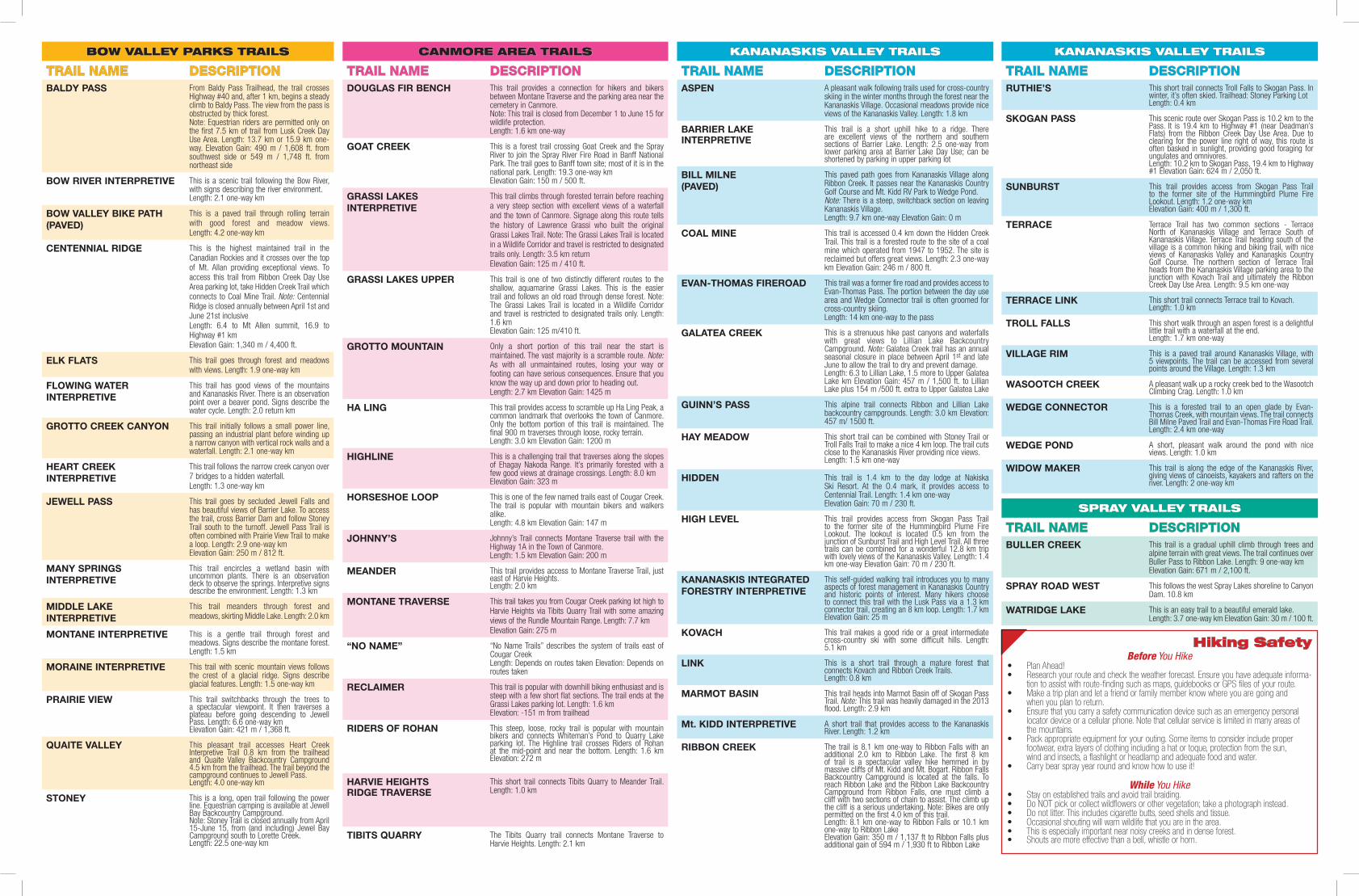
BOW VALLEY PARKS TRAILS
TRAIL NAME DESCRIPTIONBALDY PASS From Baldy Pass Trailhead, the trail crosses
Highway #40 and, after 1 km, begins a steady climb to Baldy Pass. The view from the pass is obstructed by thick forest.Note: Equestrian riders are permitted only on the first 7.5 km of trail from Lusk Creek Day Use Area. Length: 13.7 km or 15.9 km one-way. Elevation Gain: 490 m / 1,608 ft. from southwest side or 549 m / 1,748 ft. from northeast side
BOW RIVER INTERPRETIVE This is a scenic trail following the Bow River, with signs describing the river environment.Length: 2.1 one-way km
BOW VALLEY BIKE PATH(PAVED)
This is a paved trail through rolling terrain with good forest and meadow views.Length: 4.2 one-way km
CENTENNIAL RIDGE This is the highest maintained trail in the Canadian Rockies and it crosses over the top of Mt. Allan providing exceptional views. To access this trail from Ribbon Creek Day Use Area parking lot, take Hidden Creek Trail which connects to Coal Mine Trail. Note: Centennial Ridge is closed annually between April 1st and June 21st inclusiveLength: 6.4 to Mt Allen summit, 16.9 to Highway #1 kmElevation Gain: 1,340 m / 4,400 ft.
ELK FLATS This trail goes through forest and meadows with views. Length: 1.9 one-way km
FLOWING WATER INTERPRETIVE
This trail has good views of the mountains and Kananaskis River. There is an observation point over a beaver pond. Signs describe the water cycle. Length: 2.0 return km
GROTTO CREEK CANYON This trail initially follows a small power line, passing an industrial plant before winding up a narrow canyon with vertical rock walls and a waterfall. Length: 2.1 one-way km
HEART CREEKINTERPRETIVE
This trail follows the narrow creek canyon over 7 bridges to a hidden waterfall.Length: 1.3 one-way km
JEWELL PASS This trail goes by secluded Jewell Falls and has beautiful views of Barrier Lake. To access the trail, cross Barrier Dam and follow Stoney Trail south to the turnoff. Jewell Pass Trail is often combined with Prairie View Trail to make a loop. Length: 2.9 one-way kmElevation Gain: 250 m / 812 ft.
MANY SPRINGSINTERPRETIVE
This trail encircles a wetland basin with uncommon plants. There is an observation deck to observe the springs. Interpretive signs describe the environment. Length: 1.3 km
MIDDLE LAKE INTERPRETIVE
This trail meanders through forest and meadows, skirting Middle Lake. Length: 2.0 km
MONTANE INTERPRETIVE This is a gentle trail through forest and meadows. Signs describe the montane forest. Length: 1.5 km
MORAINE INTERPRETIVE This trail with scenic mountain views follows the crest of a glacial ridge. Signs describe glacial features. Length: 1.5 one-way km
PRAIRIE VIEW This trail switchbacks through the trees to a spectacular viewpoint. It then traverses a plateau before going descending to Jewell Pass. Length: 6.6 one-way kmElevation Gain: 421 m / 1,368 ft.
QUAITE VALLEY This pleasant trail accesses Heart Creek Interpretive Trail 0.8 km from the trailhead and Quaite Valley Backcountry Campground 4.5 km from the trailhead. The trail beyond the campground continues to Jewell Pass.Length: 4.0 one-way km
STONEY This is a long, open trail following the power line. Equestrian camping is available at Jewell Bay Backcountry Campground.Note: Stoney Trail is closed annually from April 15-June 15, from (and including) Jewel Bay Campground south to Lorette Creek.Length: 22.5 one-way km
CANMORE AREA TRAILS
TRAIL NAME DESCRIPTIONDOUGLAS FIR BENCH This trail provides a connection for hikers and bikers
between Montane Traverse and the parking area near the cemetery in Canmore.Note: This trail is closed from December 1 to June 15 for wildlife protection.Length: 1.6 km one-way
GOAT CREEK This is a forest trail crossing Goat Creek and the Spray River to join the Spray River Fire Road in Banff National Park. The trail goes to Banff town site; most of it is in the national park. Length: 19.3 one-way kmElevation Gain: 150 m / 500 ft.
GRASSI LAKES INTERPRETIVE
This trail climbs through forested terrain before reaching a very steep section with excellent views of a waterfall and the town of Canmore. Signage along this route tells the history of Lawrence Grassi who built the original Grassi Lakes Trail. Note: The Grassi Lakes Trail is located in a Wildlife Corridor and travel is restricted to designated trails only. Length: 3.5 km returnElevation Gain: 125 m / 410 ft.
GRASSI LAKES UPPER This trail is one of two distinctly different routes to the shallow, aquamarine Grassi Lakes. This is the easier trail and follows an old road through dense forest. Note: The Grassi Lakes Trail is located in a Wildlife Corridor and travel is restricted to designated trails only. Length: 1.6 kmElevation Gain: 125 m/410 ft.
GROTTO MOUNTAIN Only a short portion of this trail near the start is maintained. The vast majority is a scramble route. Note: As with all unmaintained routes, losing your way or footing can have serious consequences. Ensure that you know the way up and down prior to heading out.Length: 2.7 km Elevation Gain: 1425 m
HA LING This trail provides access to scramble up Ha Ling Peak, a common landmark that overlooks the town of Canmore. Only the bottom portion of this trail is maintained. The final 900 m traverses through loose, rocky terrain.Length: 3.0 km Elevation Gain: 1200 m
HIGHLINE This is a challenging trail that traverses along the slopes of Ehagay Nakoda Range. It’s primarily forested with a few good views at drainage crossings. Length: 8.0 kmElevation Gain: 323 m
HORSESHOE LOOP This is one of the few named trails east of Cougar Creek. The trail is popular with mountain bikers and walkers alike.Length: 4.8 km Elevation Gain: 147 m
JOHNNY’S Johnny’s Trail connects Montane Traverse trail with the Highway 1A in the Town of Canmore.Length: 1.5 km Elevation Gain: 200 m
MEANDER This trail provides access to Montane Traverse Trail, just east of Harvie Heights.Length: 2.0 km
MONTANE TRAVERSE This trail takes you from Cougar Creek parking lot high to Harvie Heights via Tibits Quarry Trail with some amazing views of the Rundle Mountain Range. Length: 7.7 kmElevation Gain: 275 m
“NO NAME” “No Name Trails” describes the system of trails east of Cougar CreekLength: Depends on routes taken Elevation: Depends on routes taken
RECLAIMER This trail is popular with downhill biking enthusiast and is steep with a few short flat sections. The trail ends at the Grassi Lakes parking lot. Length: 1.6 kmElevation: -151 m from trailhead
RIDERS OF ROHAN This steep, loose, rocky trail is popular with mountain bikers and connects Whiteman’s Pond to Quarry Lake parking lot. The Highline trail crosses Riders of Rohan at the mid-point and near the bottom. Length: 1.6 km Elevation: 272 m
HARVIE HEIGHTSRIDGE TRAVERSE
This short trail connects Tibits Quarry to Meander Trail. Length: 1.0 km
TIBITS QUARRY The Tibits Quarry trail connects Montane Traverse to Harvie Heights. Length: 2.1 km
KANANASKIS VALLEY TRAILS
TRAIL NAME DESCRIPTIONASPEN A pleasant walk following trails used for cross-country
skiing in the winter months through the forest near the Kananaskis Village. Occasional meadows provide nice views of the Kananaskis Valley. Length: 1.8 km
BARRIER LAKE INTERPRETIVE
This trail is a short uphill hike to a ridge. There are excellent views of the northern and southern sections of Barrier Lake. Length: 2.5 one-way from lower parking area at Barrier Lake Day Use; can be shortened by parking in upper parking lot
BILL MILNE(PAVED)
This paved path goes from Kananaskis Village along Ribbon Creek. It passes near the Kananaskis Country Golf Course and Mt. Kidd RV Park to Wedge Pond.Note: There is a steep, switchback section on leaving Kananaskis Village.Length: 9.7 km one-way Elevation Gain: 0 m
COAL MINE This trail is accessed 0.4 km down the Hidden Creek Trail. This trail is a forested route to the site of a coal mine which operated from 1947 to 1952. The site is reclaimed but offers great views. Length: 2.3 one-way km Elevation Gain: 246 m / 800 ft.
EVAN-THOMAS FIREROAD This trail was a former fire road and provides access to Evan-Thomas Pass. The portion between the day use area and Wedge Connector trail is often groomed for cross-country skiing.Length: 14 km one-way to the pass
GALATEA CREEK This is a strenuous hike past canyons and waterfalls with great views to Lillian Lake Backcountry Campground. Note: Galatea Creek trail has an annual seasonal closure in place between April 1st and late June to allow the trail to dry and prevent damage.Length: 6.3 to Lillian Lake, 1.5 more to Upper Galatea Lake km Elevation Gain: 457 m / 1,500 ft. to Lillian Lake plus 154 m /500 ft. extra to Upper Galatea Lake
GUINN’S PASS This alpine trail connects Ribbon and Lillian Lake backcountry campgrounds. Length: 3.0 km Elevation: 457 m/ 1500 ft.
HAY MEADOW This short trail can be combined with Stoney Trail or Troll Falls Trail to make a nice 4 km loop. The trail cuts close to the Kananaskis River providing nice views.Length: 1.5 km one-way
HIDDEN This trail is 1.4 km to the day lodge at Nakiska Ski Resort. At the O.4 mark, it provides access to Centennial Trail. Length: 1.4 km one-wayElevation Gain: 70 m / 230 ft.
HIGH LEVEL This trail provides access from Skogan Pass Trail to the former site of the Hummingbird Plume Fire Lookout. The lookout is located 0.5 km from the junction of Sunburst Trail and High Level Trail. All three trails can be combined for a wonderful 12.8 km trip with lovely views of the Kananaskis Valley. Length: 1.4 km one-way Elevation Gain: 70 m / 230 ft.
KANANASKIS INTEGRATEDFORESTRY INTERPRETIVE
This self-guided walking trail introduces you to many aspects of forest management in Kananaskis Country and historic points of interest. Many hikers choose to connect this trail with the Lusk Pass via a 1.3 km connector trail, creating an 8 km loop. Length: 1.7 kmElevation Gain: 25 m
KOVACH This trail makes a good ride or a great intermediate cross-country ski with some difficult hills. Length: 5.1 km
LINK This is a short trail through a mature forest that connects Kovach and Ribbon Creek Trails.Length: 0.8 km
MARMOT BASIN This trail heads into Marmot Basin off of Skogan Pass Trail. Note: This trail was heavily damaged in the 2013 flood. Length: 2.9 km
Mt. KIDD INTERPRETIVE A short trail that provides access to the Kananaskis River. Length: 1.2 km
RIBBON CREEK The trail is 8.1 km one-way to Ribbon Falls with an additional 2.0 km to Ribbon Lake. The first 8 km of trail is a spectacular valley hike hemmed in by massive cliffs of Mt. Kidd and Mt. Bogart. Ribbon Falls Backcountry Campground is located at the falls. To reach Ribbon Lake and the Ribbon Lake Backcountry Campground from Ribbon Falls, one must climb a cliff with two sections of chain to assist. The climb up the cliff is a serious undertaking. Note: Bikes are only permitted on the first 4.0 km of this trail.Length: 8.1 km one-way to Ribbon Falls or 10.1 km one-way to Ribbon LakeElevation Gain: 350 m / 1,137 ft to Ribbon Falls plus additional gain of 594 m / 1,930 ft to Ribbon Lake
KANANASKIS VALLEY TRAILS
TRAIL NAME DESCRIPTIONRUTHIE’S This short trail connects Troll Falls to Skogan Pass. In
winter, it’s often skied. Trailhead: Stoney Parking LotLength: 0.4 km
SKOGAN PASS This scenic route over Skogan Pass is 10.2 km to the Pass. It is 19.4 km to Highway #1 (near Deadman’s Flats) from the Ribbon Creek Day Use Area. Due to clearing for the power line right of way, this route is often basked in sunlight, providing good foraging for ungulates and omnivores.Length: 10.2 km to Skogan Pass, 19.4 km to Highway #1 Elevation Gain: 624 m / 2,050 ft.
SUNBURST This trail provides access from Skogan Pass Trail to the former site of the Hummingbird Plume Fire Lookout. Length: 1.2 one-way kmElevation Gain: 400 m / 1,300 ft.
TERRACE Terrace Trail has two common sections - Terrace North of Kananaskis Village and Terrace South of Kananaskis Village. Terrace Trail heading south of the village is a common hiking and biking trail, with nice views of Kananaskis Valley and Kananaskis Country Golf Course. The northern section of Terrace Trail heads from the Kananaskis Village parking area to the junction with Kovach Trail and ultimately the Ribbon Creek Day Use Area. Length: 9.5 km one-way
TERRACE LINK This short trail connects Terrace trail to Kovach.Length: 1.0 km
TROLL FALLS This short walk through an aspen forest is a delightful little trail with a waterfall at the end.Length: 1.7 km one-way
VILLAGE RIM This is a paved trail around Kananaskis Village, with 5 viewpoints. The trail can be accessed from several points around the Village. Length: 1.3 km
WASOOTCH CREEK A pleasant walk up a rocky creek bed to the Wasootch Climbing Crag. Length: 1.0 km
WEDGE CONNECTOR This is a forested trail to an open glade by Evan-Thomas Creek, with mountain views. The trail connects Bill Milne Paved Trail and Evan-Thomas Fire Road Trail.Length: 2.4 km one-way
WEDGE POND A short, pleasant walk around the pond with nice views. Length: 1.0 km
WIDOW MAKER This trail is along the edge of the Kananaskis River, giving views of canoeists, kayakers and rafters on the river. Length: 2 one-way km
SPRAY VALLEY TRAILS
TRAIL NAME DESCRIPTIONBULLER CREEK This trail is a gradual uphill climb through trees and
alpine terrain with great views. The trail continues over Buller Pass to Ribbon Lake. Length: 9 one-way kmElevation Gain: 671 m / 2,100 ft.
SPRAY ROAD WEST This follows the west Spray Lakes shoreline to CanyonDam. 10.8 km
WATRIDGE LAKE This is an easy trail to a beautiful emerald lake.Length: 3.7 one-way km Elevation Gain: 30 m / 100 ft.
Hiking SafetyBefore You Hike
• Plan Ahead!• Research your route and check the weather forecast. Ensure you have adequate informa-
tion to assist with route-fi nding such as maps, guidebooks or GPS fi les of your route.• Make a trip plan and let a friend or family member know where you are going and
when you plan to return. • Ensure that you carry a safety communication device such as an emergency personal
locator device or a cellular phone. Note that cellular service is limited in many areas ofthe mountains.
• Pack appropriate equipment for your outing. Some items to consider include proper footwear, extra layers of clothing including a hat or toque, protection from the sun,wind and insects, a fl ashlight or headlamp and adequate food and water.
• Carry bear spray year round and know how to use it!
While You Hike• Stay on established trails and avoid trail braiding.• Do NOT pick or collect wildfl owers or other vegetation; take a photograph instead.• Do not litter. This includes cigarette butts, seed shells and tissue.• Occasional shouting will warn wildlife that you are in the area.• This is especially important near noisy creeks and in dense forest.• Shouts are more effective than a bell, whistle or horn.