dZ d '/ W d,t z í WKs ZE E E - UN-GGIMggim.un.org/IGIF/documents/SP1 - Appendices 13Dec2019...Title...
17
APPENDICES STRATEGIC PATHWAY 1: GOVERNANCE AND INSTITUTIONS
Transcript of dZ d '/ W d,t z í WKs ZE E E - UN-GGIMggim.un.org/IGIF/documents/SP1 - Appendices 13Dec2019...Title...
APPENDICES STRATEGIC PATHWAY 1: GOVERNANCE AND
INSTITUTIONS
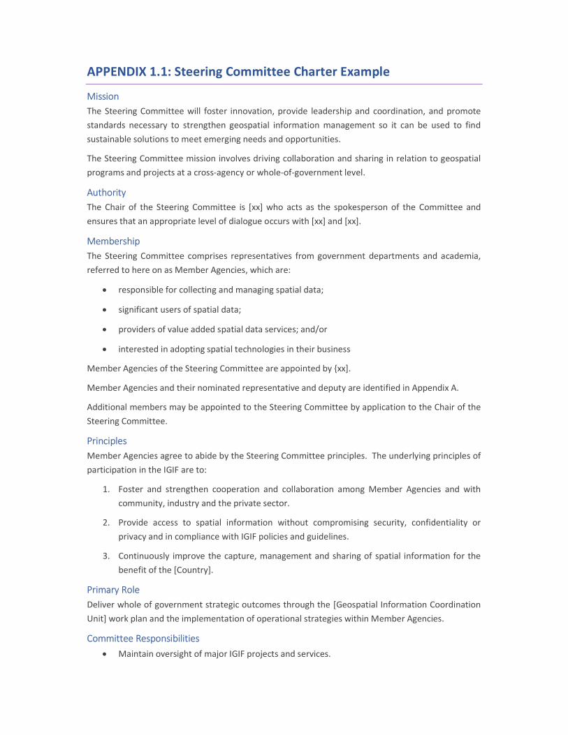
APPENDIX 1.1: Steering Committee Charter Example
Mission The Steering Committee will foster innovation, provide leadership and coordination, and promote standards necessary to strengthen geospatial information management so it can be used to find sustainable solutions to meet emerging needs and opportunities.
The Steering Committee mission involves driving collaboration and sharing in relation to geospatial programs and projects at a cross-agency or whole-of-government level.
Authority The Chair of the Steering Committee is [xx] who acts as the spokesperson of the Committee and ensures that an appropriate level of dialogue occurs with [xx] and [xx].
Membership The Steering Committee comprises representatives from government departments and academia, referred to here on as Member Agencies, which are:
responsible for collecting and managing spatial data;
significant users of spatial data;
providers of value added spatial data services; and/or
interested in adopting spatial technologies in their business
Member Agencies of the Steering Committee are appointed by {xx].
Member Agencies and their nominated representative and deputy are identified in Appendix A.
Additional members may be appointed to the Steering Committee by application to the Chair of the Steering Committee.
Principles Member Agencies agree to abide by the Steering Committee principles. The underlying principles of participation in the IGIF are to:
1. Foster and strengthen cooperation and collaboration among Member Agencies and with community, industry and the private sector.
2. Provide access to spatial information without compromising security, confidentiality or privacy and in compliance with IGIF policies and guidelines.
3. Continuously improve the capture, management and sharing of spatial information for the benefit of the [Country].
Primary Role Deliver whole of government strategic outcomes through the [Geospatial Information Coordination Unit] work plan and the implementation of operational strategies within Member Agencies.
Committee Responsibilities Maintain oversight of major IGIF projects and services.
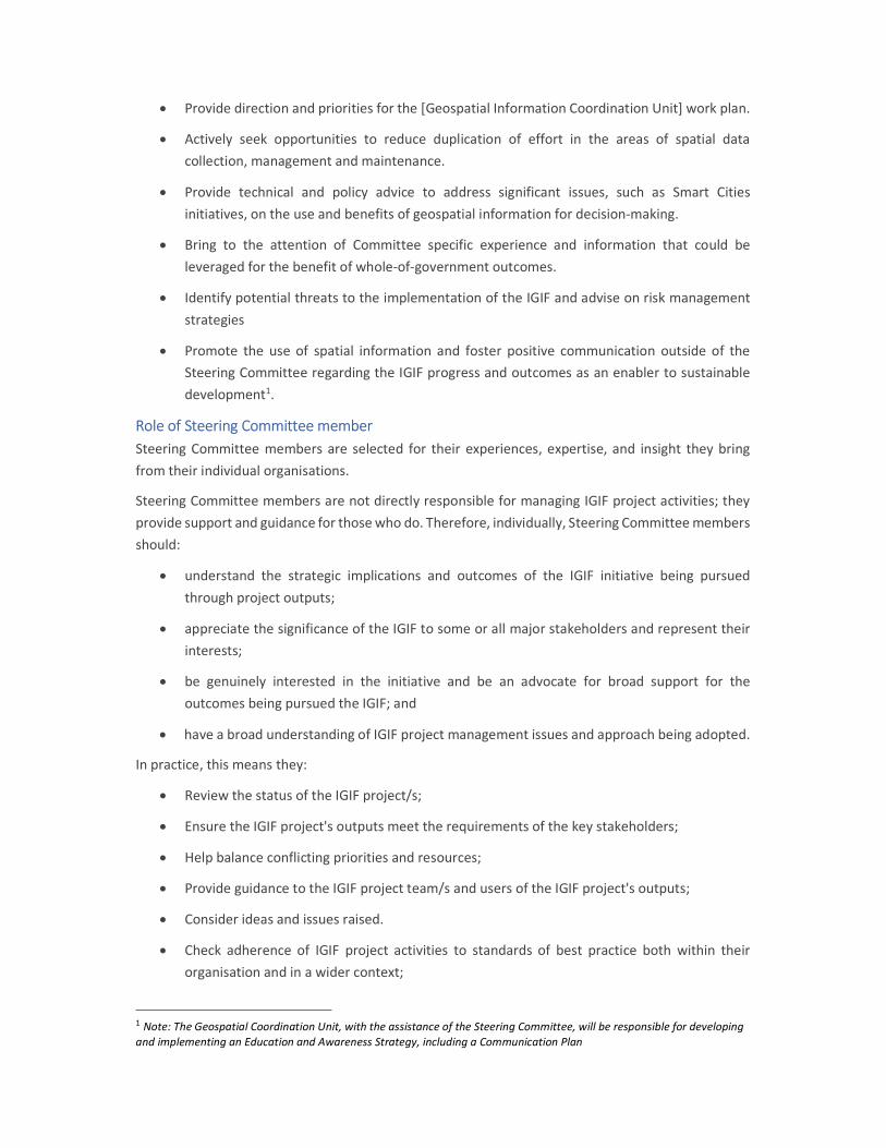
Provide direction and priorities for the [Geospatial Information Coordination Unit] work plan.
Actively seek opportunities to reduce duplication of effort in the areas of spatial data collection, management and maintenance.
Provide technical and policy advice to address significant issues, such as Smart Cities initiatives, on the use and benefits of geospatial information for decision-making.
Bring to the attention of Committee specific experience and information that could be leveraged for the benefit of whole-of-government outcomes.
Identify potential threats to the implementation of the IGIF and advise on risk management strategies
Promote the use of spatial information and foster positive communication outside of the Steering Committee regarding the IGIF progress and outcomes as an enabler to sustainable development1.
Role of Steering Committee member Steering Committee members are selected for their experiences, expertise, and insight they bring from their individual organisations.
Steering Committee members are not directly responsible for managing IGIF project activities; they provide support and guidance for those who do. Therefore, individually, Steering Committee members should:
understand the strategic implications and outcomes of the IGIF initiative being pursued through project outputs;
appreciate the significance of the IGIF to some or all major stakeholders and represent their interests;
be genuinely interested in the initiative and be an advocate for broad support for the outcomes being pursued the IGIF; and
have a broad understanding of IGIF project management issues and approach being adopted.
In practice, this means they:
Review the status of the IGIF project/s;
Ensure the IGIF project's outputs meet the requirements of the key stakeholders;
Help balance conflicting priorities and resources;
Provide guidance to the IGIF project team/s and users of the IGIF project's outputs;
Consider ideas and issues raised.
Check adherence of IGIF project activities to standards of best practice both within their organisation and in a wider context;
1 Note: The Geospatial Coordination Unit, with the assistance of the Steering Committee, will be responsible for developing and implementing an Education and Awareness Strategy, including a Communication Plan
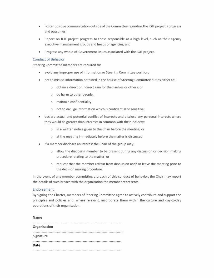
Foster positive communication outside of the Committee regarding the IGIF project's progress and outcomes;
Report on IGIF project progress to those responsible at a high level, such as their agency executive management groups and heads of agencies; and
Progress any whole-of-Government issues associated with the IGIF project.
Conduct of Behavior Steering Committee members are required to:
avoid any improper use of information or Steering Committee position;
not to misuse information obtained in the course of Steering Committee duties either to:
o obtain a direct or indirect gain for themselves or others; or
o do harm to other people.
o maintain confidentiality;
o not to divulge information which is confidential or sensitive;
declare actual and potential conflict of interests and disclose any personal interests where they would be greater than interests in common with their industry:
o in a written notice given to the Chair before the meeting; or
o at the meeting immediately before the matter is discussed
If a member discloses an interest the Chair of the group may:
o allow the disclosing member to be present during any discussion or decision making procedure relating to the matter; or
o request that the member refrain from discussion and/ or leave the meeting prior to the decision making procedure.
In the event of any member committing a breach of this conduct of behavior, the Chair may report the details of such breach with the organisation the member represents.
Endorsement By signing the Charter, members of Steering Committee agree to actively contribute and support the principles and policies and, where relevant, incorporate them within the culture and day-to-day operations of their organisation.
Name …………………………………………………………………………………………. Organisation ………………………………………………………………………………………….. Signature ………………………………………………………………………………………… Date …………………………………………………………………………………………
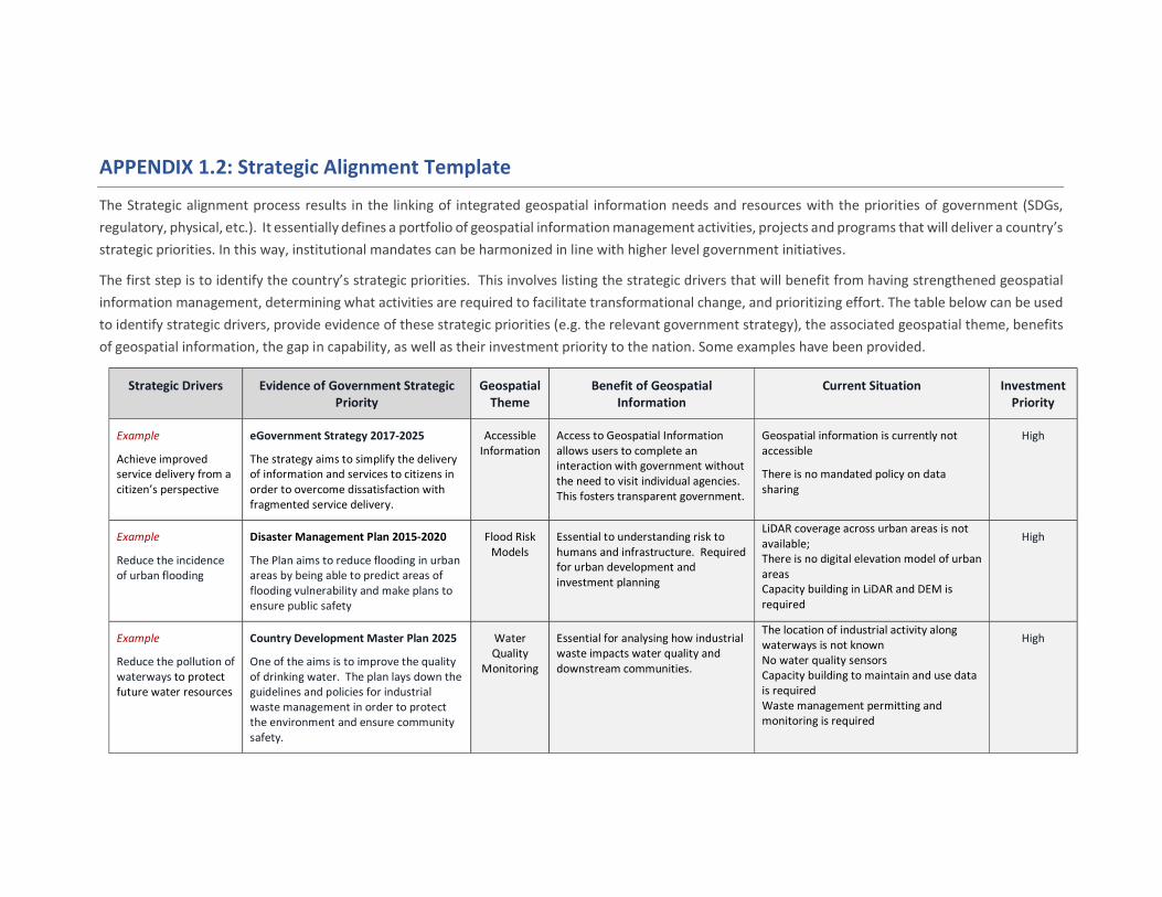
APPENDIX 1.2: Strategic Alignment Template
The Strategic alignment process results in the linking of integrated geospatial information needs and resources with the priorities of government (SDGs, regulatory, physical, etc.). It essentially defines a portfolio of geospatial information management activities, projects and programs that will deliver a country’s strategic priorities. In this way, institutional mandates can be harmonized in line with higher level government initiatives.
The first step is to identify the country’s strategic priorities. This involves listing the strategic drivers that will benefit from having strengthened geospatial information management, determining what activities are required to facilitate transformational change, and prioritizing effort. The table below can be used to identify strategic drivers, provide evidence of these strategic priorities (e.g. the relevant government strategy), the associated geospatial theme, benefits of geospatial information, the gap in capability, as well as their investment priority to the nation. Some examples have been provided.
Strategic Drivers Evidence of Government Strategic Priority
Geospatial Theme
Benefit of Geospatial Information
Current Situation Investment Priority
Example
Achieve improved service delivery from a citizen’s perspective
eGovernment Strategy 2017-2025
The strategy aims to simplify the delivery of information and services to citizens in order to overcome dissatisfaction with fragmented service delivery.
Accessible Information
Access to Geospatial Information allows users to complete an interaction with government without the need to visit individual agencies. This fosters transparent government.
Geospatial information is currently not accessible
There is no mandated policy on data sharing
High
Example
Reduce the incidence of urban flooding
Disaster Management Plan 2015-2020
The Plan aims to reduce flooding in urban areas by being able to predict areas of flooding vulnerability and make plans to ensure public safety
Flood Risk Models
Essential to understanding risk to humans and infrastructure. Required for urban development and investment planning
LiDAR coverage across urban areas is not available; There is no digital elevation model of urban areas Capacity building in LiDAR and DEM is required
High
Example
Reduce the pollution of waterways to protect future water resources
Country Development Master Plan 2025
One of the aims is to improve the quality of drinking water. The plan lays down the guidelines and policies for industrial waste management in order to protect the environment and ensure community safety.
Water Quality
Monitoring
Essential for analysing how industrial waste impacts water quality and downstream communities.
The location of industrial activity along waterways is not known No water quality sensors Capacity building to maintain and use data is required Waste management permitting and monitoring is required
High
APPENDIX 1.3: Guidance for Vision, Mission and Goal Statements
The Integrated Geospatial Information Framework has Vision and Mission statements and eight Goals. These may be adopted by countries for their own purposes to align with their geospatial information strategies and national priorities.
Alternatively, countries may have existing goals they would prefer to use or would like to establish their own specific goals for integrated geospatial information management. Their existing goals could be modified to align with information gathered through materials in the Development Account Project.
Countries will wish to establish their own vision, mission and goals when:
the vision, mission and goals need to be aligned specifically to the strategic initiatives and priorities of government. This is important. The vision and mission statements, and goals need to inspire and motivate united action.
the goals need to be realistic, manageable, achievable and appropriate to a country’s current situation. This may mean breaking goals down into shorter term goals that can be accomplished more easily and more frequently.
Country-specific Vision, Mission and Goals form part of a Country’s Geospatial Strategy.
Vision, Mission and Goal statements are best developed in a workshop setting that include a broad cross-section of stakeholders. The final version should be shared with the stakeholders and if possible, posted so that anyone can see them.
The following information is provided to assist countries in developing their own goals, and vision and mission statements.
1. Vision Statement The objective of writing a Vision Statement is to provide purpose and a source of inspiration for what you are trying to achieve.
Vision statements are typically short and engaging. They reflect what you want to achieve, core community values and socio-economic priorities and how the vision will be achieved. Some examples are provided below.
Our Vision is to:
Achieve sustainable development through the effective use of geospatial information for improved
evidence-based decision making: or
Empower decision-making and innovation by connecting people with geospatial information
anywhere, anytime, and on any device: or
Towards a safer [Country] – Reducing the impact of disasters using geospatial information.
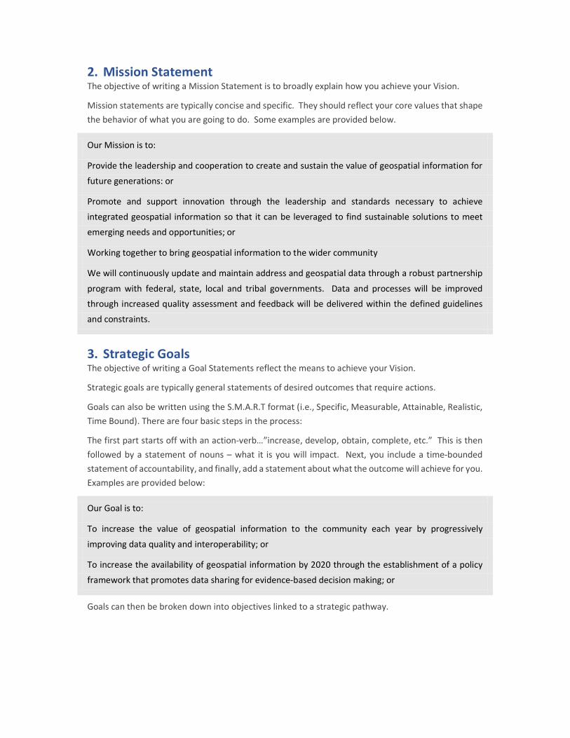
2. Mission Statement The objective of writing a Mission Statement is to broadly explain how you achieve your Vision.
Mission statements are typically concise and specific. They should reflect your core values that shape the behavior of what you are going to do. Some examples are provided below.
Our Mission is to:
Provide the leadership and cooperation to create and sustain the value of geospatial information for
future generations: or
Promote and support innovation through the leadership and standards necessary to achieve
integrated geospatial information so that it can be leveraged to find sustainable solutions to meet
emerging needs and opportunities; or
Working together to bring geospatial information to the wider community
We will continuously update and maintain address and geospatial data through a robust partnership
program with federal, state, local and tribal governments. Data and processes will be improved
through increased quality assessment and feedback will be delivered within the defined guidelines
and constraints.
3. Strategic Goals The objective of writing a Goal Statements reflect the means to achieve your Vision.
Strategic goals are typically general statements of desired outcomes that require actions.
Goals can also be written using the S.M.A.R.T format (i.e., Specific, Measurable, Attainable, Realistic, Time Bound). There are four basic steps in the process:
The first part starts off with an action-verb…”increase, develop, obtain, complete, etc.” This is then followed by a statement of nouns – what it is you will impact. Next, you include a time-bounded statement of accountability, and finally, add a statement about what the outcome will achieve for you. Examples are provided below:
Our Goal is to:
To increase the value of geospatial information to the community each year by progressively
improving data quality and interoperability; or
To increase the availability of geospatial information by 2020 through the establishment of a policy
framework that promotes data sharing for evidence-based decision making; or
Goals can then be broken down into objectives linked to a strategic pathway.
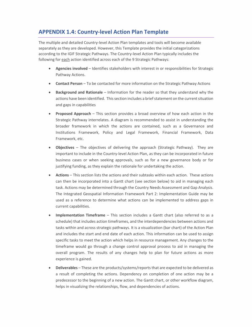
APPENDIX 1.4: Country-level Action Plan Template
The multiple and detailed Country-level Action Plan templates and tools will become available separately as they are developed. However, this Template provides the initial categorizations according to the IGIF Strategic Pathways. The Country-level Action Plan typically includes the following for each action identified across each of the 9 Strategic Pathways:
Agencies involved – Identifies stakeholders with interest in or responsibilities for Strategic Pathway Actions.
Contact Person – To be contacted for more information on the Strategic Pathway Actions
Background and Rationale – Information for the reader so that they understand why the actions have been identified. This section includes a brief statement on the current situation and gaps in capabilities
Proposed Approach – This section provides a broad overview of how each action in the Strategic Pathway interrelates. A diagram is recommended to assist in understanding the broader framework in which the actions are contained, such as a Governance and Institutions Framework, Policy and Legal Framework, Financial Framework, Data Framework, etc.
Objectives – The objectives of delivering the approach (Strategic Pathway). They are important to include in the Country-level Action Plan, as they can be incorporated in future business cases or when seeking approvals, such as for a new governance body or for justifying funding, as they explain the rationale for undertaking the action.
Actions – This section lists the actions and their subtasks within each action. These actions can then be incorporated into a Gantt chart (see section below) to aid in managing each task. Actions may be determined through the Country Needs Assessment and Gap Analysis. The Integrated Geospatial Information Framework Part 2: Implementation Guide may be used as a reference to determine what actions can be implemented to address gaps in current capabilities.
Implementation Timeframe – This section includes a Gantt chart (also referred to as a schedule) that includes action timeframes, and the interdependencies between actions and tasks within and across strategic pathways. It is a visualization (bar chart) of the Action Plan and includes the start and end date of each action. This information can be used to assign specific tasks to meet the action which helps in resource management. Any changes to the timeframe would go through a change control approval process to aid in managing the overall program. The results of any changes help to plan for future actions as more experience is gained.
Deliverables – These are the products/systems/reports that are expected to be delivered as a result of completing the actions. Dependency on completion of one action may be a predecessor to the beginning of a new action. The Gantt chart, or other workflow diagram, helps in visualizing the relationships, flow, and dependencies of actions.
Outcomes – This section identifies the things that change because an action has been completed i.e. the real or tangible differences that are being made towards strengthening integrated geospatial information management, and consequently, progress towards achieving the SDGs. The outcomes may be written as benefits. This information can be shared with stakeholders and any oversight to indicate the value proposition of the outcome.
Risk and Mitigation – With any Action Plan there is a risk of not being able to complete actions. This section identifies the risks, their likelihood and severity, and the risk mitigation strategy that needs to be put in place. In some cases, risks are external and may not be within the control of the organization. In these cases, it is important to communicate potential impacts of risk to the action and program and consider proactive steps that can be taken to avoid these risks.
Budget Estimation - This section identifies the budget required for each action. A budget includes sources of funding or income, planned expenses that include resource/people costs and other expenses. Labor is normally one of the highest costs for a program, as most geospatial activities require staff to conduct the work. Other expenses could include such items as IT procurement and/or maintenance, IT services, travel, building/equipment rental, training and so forth.
Funding Status – This section identifies the funding sources, or the approach being used to seek funding or in-kind support, such as potential partnerships. Examples of funding include allocation from central government, financial partnership with other government agencies, and donor programs from other countries and/or NGOs. While in-kind services are normally not a funding source, they do offer a financial benefit to the organization. Some countries also include funds from the sale of geospatial products. Oftentimes, these estimates are greater than the amounts realized through sales.
Monitoring and Evaluation: This section identifies the success indicators, reporting mechanisms (traffic light reporting, evidence of achievement, etc.). Monitoring and evaluation requires discipline to periodically check the status of the program. Monitoring also includes establishing a culture of open dialogue when something changes from the planned set of actions. Knowing problems occur as soon as possible helps in controlling the resulting impact and provides more time to propose options for mitigating the problem.
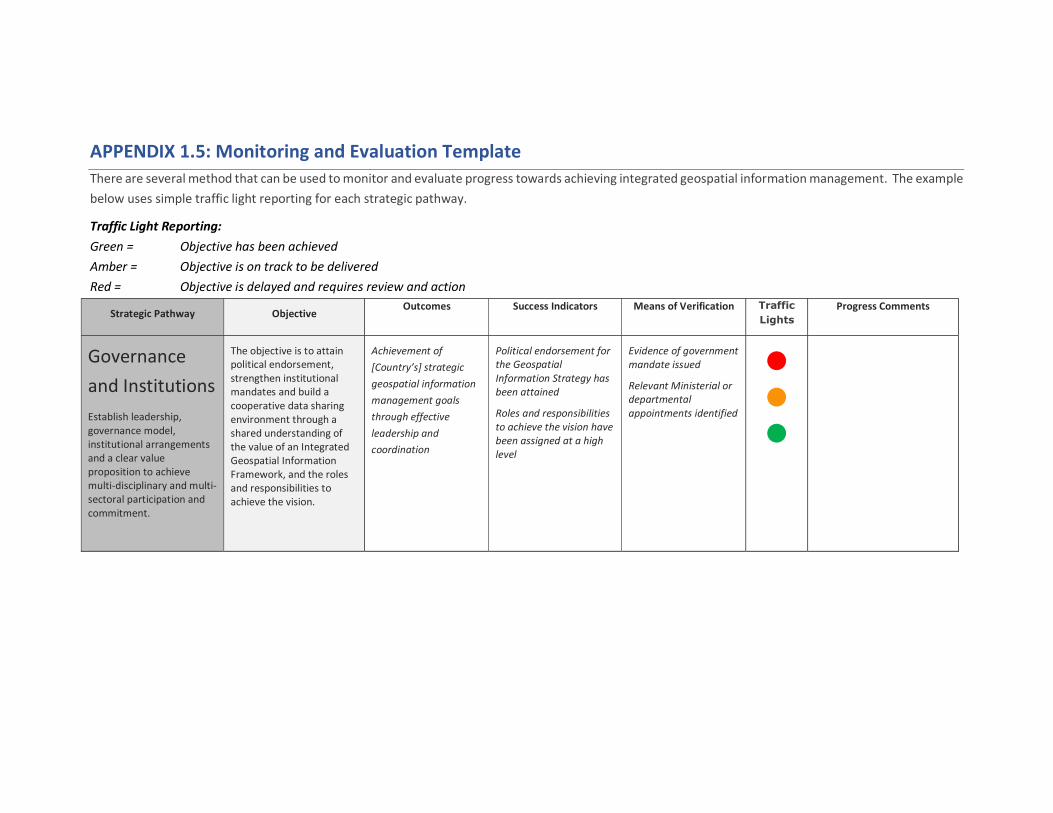
APPENDIX 1.5: Monitoring and Evaluation Template There are several method that can be used to monitor and evaluate progress towards achieving integrated geospatial information management. The example below uses simple traffic light reporting for each strategic pathway.
Traffic Light Reporting: Green = Objective has been achieved Amber = Objective is on track to be delivered Red = Objective is delayed and requires review and action
Strategic Pathway Objective Outcomes Success Indicators Means of Verification Traffic
Lights Progress Comments
Governance and Institutions Establish leadership, governance model, institutional arrangements and a clear value proposition to achieve multi-disciplinary and multi-sectoral participation and commitment.
The objective is to attain political endorsement, strengthen institutional mandates and build a cooperative data sharing environment through a shared understanding of the value of an Integrated Geospatial Information Framework, and the roles and responsibilities to achieve the vision.
Achievement of [Country’s] strategic geospatial information management goals through effective leadership and coordination
Political endorsement for the Geospatial Information Strategy has been attained
Roles and responsibilities to achieve the vision have been assigned at a high level
Evidence of government mandate issued
Relevant Ministerial or departmental appointments identified
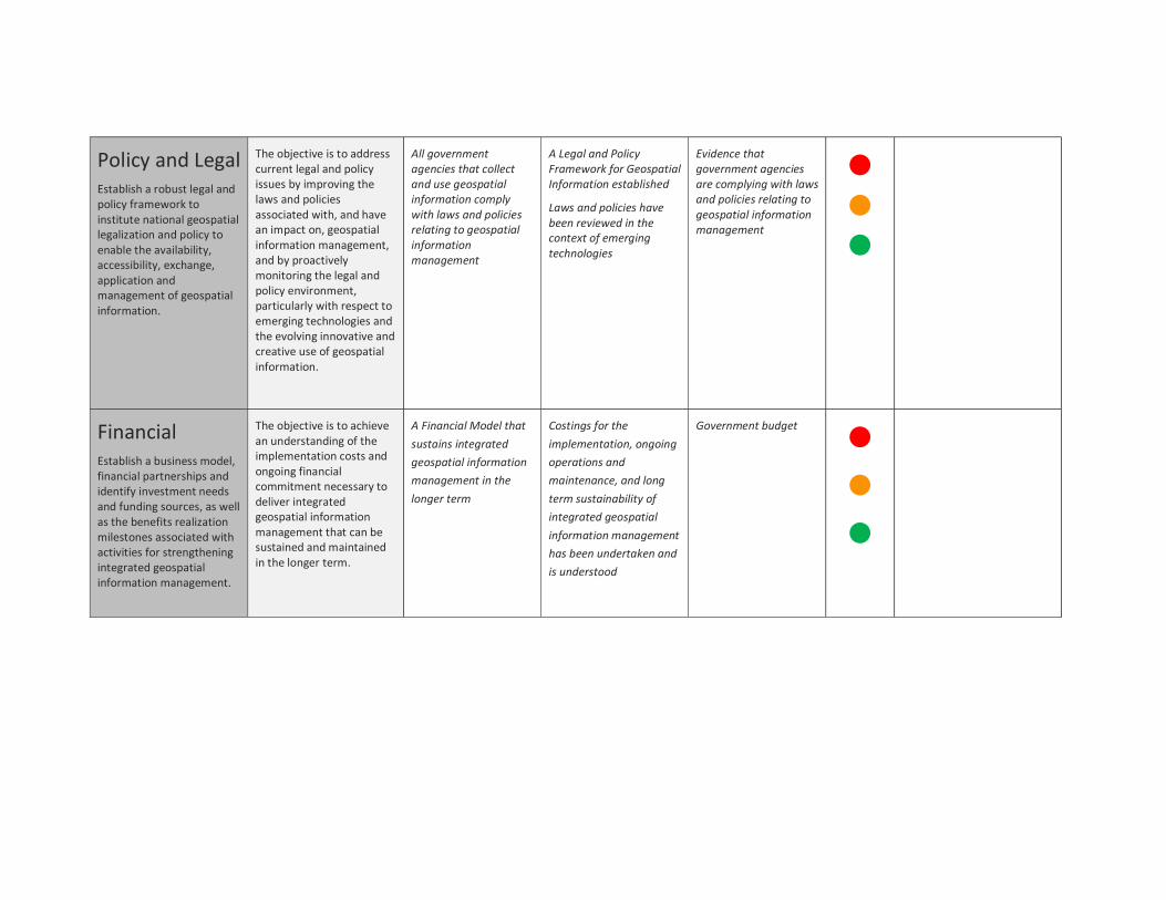
Policy and Legal Establish a robust legal and policy framework to institute national geospatial legalization and policy to enable the availability, accessibility, exchange, application and management of geospatial information.
The objective is to address current legal and policy issues by improving the laws and policies associated with, and have an impact on, geospatial information management, and by proactively monitoring the legal and policy environment, particularly with respect to emerging technologies and the evolving innovative and creative use of geospatial information.
All government agencies that collect and use geospatial information comply with laws and policies relating to geospatial information management
A Legal and Policy Framework for Geospatial Information established
Laws and policies have been reviewed in the context of emerging technologies
Evidence that government agencies are complying with laws and policies relating to geospatial information management
Financial Establish a business model, financial partnerships and identify investment needs and funding sources, as well as the benefits realization milestones associated with activities for strengthening integrated geospatial information management.
The objective is to achieve an understanding of the implementation costs and ongoing financial commitment necessary to deliver integrated geospatial information management that can be sustained and maintained in the longer term.
A Financial Model that sustains integrated geospatial information management in the longer term
Costings for the implementation, ongoing operations and maintenance, and long term sustainability of integrated geospatial information management has been undertaken and is understood
Government budget
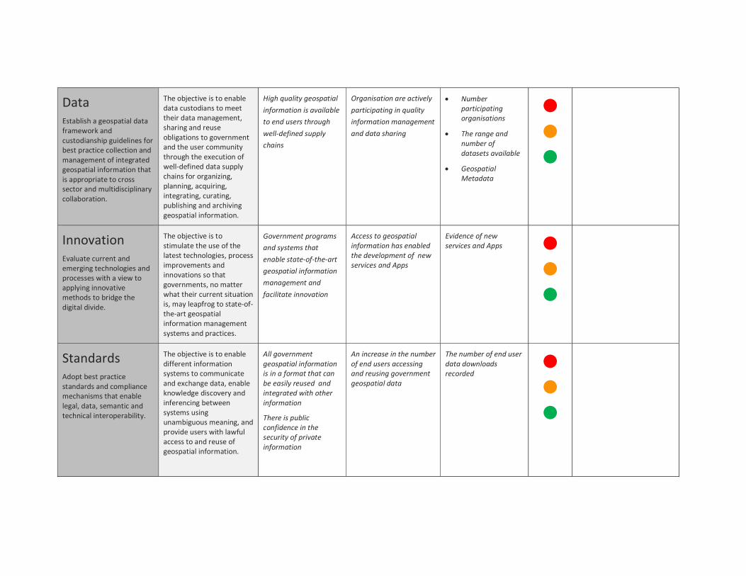
Data Establish a geospatial data framework and custodianship guidelines for best practice collection and management of integrated geospatial information that is appropriate to cross sector and multidisciplinary collaboration.
The objective is to enable data custodians to meet their data management, sharing and reuse obligations to government and the user community through the execution of well-defined data supply chains for organizing, planning, acquiring, integrating, curating, publishing and archiving geospatial information.
High quality geospatial information is available to end users through well-defined supply chains
Organisation are actively participating in quality information management and data sharing
Number participating organisations
The range and number of datasets available
Geospatial Metadata
Innovation Evaluate current and emerging technologies and processes with a view to applying innovative methods to bridge the digital divide.
The objective is to stimulate the use of the latest technologies, process improvements and innovations so that governments, no matter what their current situation is, may leapfrog to state-of-the-art geospatial information management systems and practices.
Government programs and systems that enable state-of-the-art geospatial information management and facilitate innovation
Access to geospatial information has enabled the development of new services and Apps
Evidence of new services and Apps
Standards Adopt best practice standards and compliance mechanisms that enable legal, data, semantic and technical interoperability.
The objective is to enable different information systems to communicate and exchange data, enable knowledge discovery and inferencing between systems using unambiguous meaning, and provide users with lawful access to and reuse of geospatial information.
All government geospatial information is in a format that can be easily reused and integrated with other information
There is public confidence in the security of private information
An increase in the number of end users accessing and reusing government geospatial data
The number of end user data downloads recorded
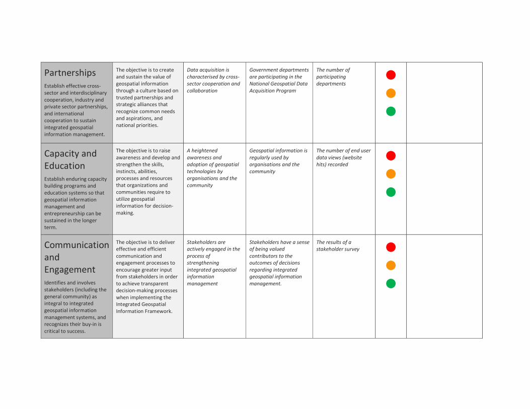
Partnerships Establish effective cross-sector and interdisciplinary cooperation, industry and private sector partnerships, and international cooperation to sustain integrated geospatial information management.
The objective is to create and sustain the value of geospatial information through a culture based on trusted partnerships and strategic alliances that recognize common needs and aspirations, and national priorities.
Data acquisition is characterised by cross-sector cooperation and collaboration
Government departments are participating in the National Geospatial Data Acquisition Program
The number of participating departments
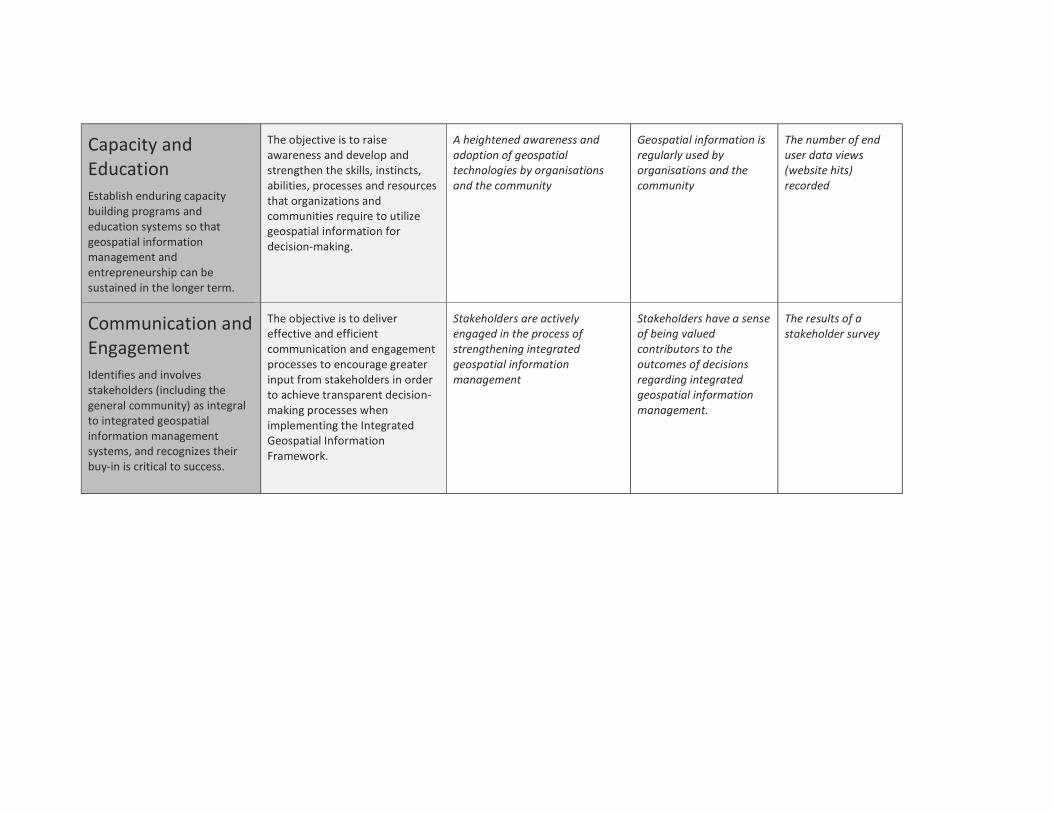
Capacity and Education Establish enduring capacity building programs and education systems so that geospatial information management and entrepreneurship can be sustained in the longer term.
The objective is to raise awareness and develop and strengthen the skills, instincts, abilities, processes and resources that organizations and communities require to utilize geospatial information for decision-making.
A heightened awareness and adoption of geospatial technologies by organisations and the community
Geospatial information is regularly used by organisations and the community
The number of end user data views (website hits) recorded
Communication and Engagement Identifies and involves stakeholders (including the general community) as integral to integrated geospatial information management systems, and recognizes their buy-in is critical to success.
The objective is to deliver effective and efficient communication and engagement processes to encourage greater input from stakeholders in order to achieve transparent decision-making processes when implementing the Integrated Geospatial Information Framework.
Stakeholders are actively engaged in the process of strengthening integrated geospatial information management
Stakeholders have a sense of being valued contributors to the outcomes of decisions regarding integrated geospatial information management.
The results of a stakeholder survey
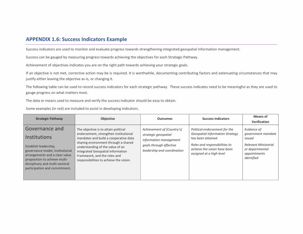
APPENDIX 1.6: Success Indicators Example
Success indicators are used to monitor and evaluate progress towards strengthening integrated geospatial information management.
Success can be gauged by measuring progress towards achieving the objectives for each Strategic Pathway.
Achievement of objectives indicates you are on the right path towards achieving your strategic goals.
If an objective is not met, corrective action may be is required. It is worthwhile, documenting contributing factors and extenuating circumstances that may justify either leaving the objective as-is, or changing it.
The following table can be used to record success indicators for each strategic pathway. These success indicates need to be meaningful as they are used to gauge progress on what matters most.
The data or means used to measure and verify the success indicator should be easy to obtain.
Some examples (in red) are included to assist in developing indicators.
Strategic Pathway Objective Outcomes Success Indicators Means of Verification
Governance and Institutions Establish leadership, governance model, institutional arrangements and a clear value proposition to achieve multi-disciplinary and multi-sectoral participation and commitment.
The objective is to attain political endorsement, strengthen institutional mandates and build a cooperative data sharing environment through a shared understanding of the value of an Integrated Geospatial Information Framework, and the roles and responsibilities to achieve the vision.
Achievement of [Country’s] strategic geospatial information management goals through effective leadership and coordination
Political endorsement for the Geospatial Information Strategy has been attained
Roles and responsibilities to achieve the vision have been assigned at a high level
Evidence of government mandate issued
Relevant Ministerial or departmental appointments identified
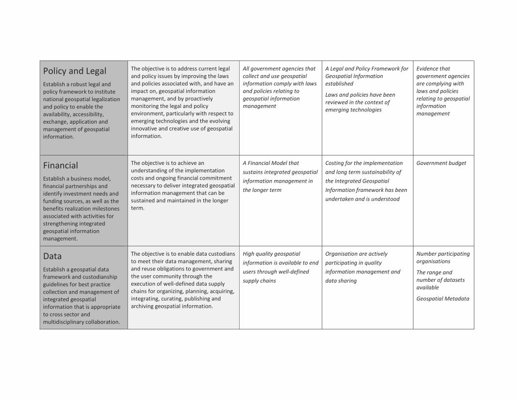
Policy and Legal Establish a robust legal and policy framework to institute national geospatial legalization and policy to enable the availability, accessibility, exchange, application and management of geospatial information.
The objective is to address current legal and policy issues by improving the laws and policies associated with, and have an impact on, geospatial information management, and by proactively monitoring the legal and policy environment, particularly with respect to emerging technologies and the evolving innovative and creative use of geospatial information.
All government agencies that collect and use geospatial information comply with laws and policies relating to geospatial information management
A Legal and Policy Framework for Geospatial Information established
Laws and policies have been reviewed in the context of emerging technologies
Evidence that government agencies are complying with laws and policies relating to geospatial information management
Financial Establish a business model, financial partnerships and identify investment needs and funding sources, as well as the benefits realization milestones associated with activities for strengthening integrated geospatial information management.
The objective is to achieve an understanding of the implementation costs and ongoing financial commitment necessary to deliver integrated geospatial information management that can be sustained and maintained in the longer term.
A Financial Model that sustains integrated geospatial information management in the longer term
Costing for the implementation and long term sustainability of the Integrated Geospatial Information framework has been undertaken and is understood
Government budget
Data Establish a geospatial data framework and custodianship guidelines for best practice collection and management of integrated geospatial information that is appropriate to cross sector and multidisciplinary collaboration.
The objective is to enable data custodians to meet their data management, sharing and reuse obligations to government and the user community through the execution of well-defined data supply chains for organizing, planning, acquiring, integrating, curating, publishing and archiving geospatial information.
High quality geospatial information is available to end users through well-defined supply chains
Organisation are actively participating in quality information management and data sharing
Number participating organisations
The range and number of datasets available
Geospatial Metadata
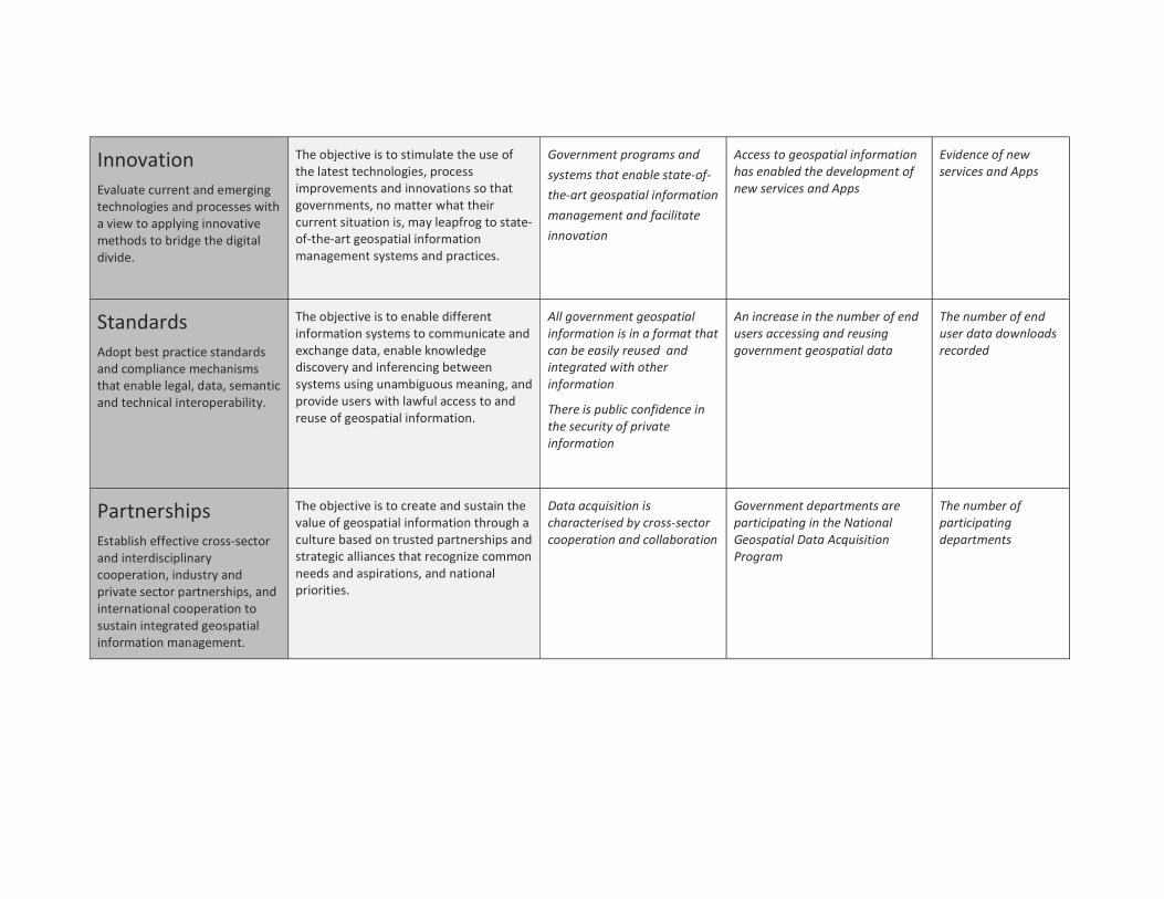
Innovation Evaluate current and emerging technologies and processes with a view to applying innovative methods to bridge the digital divide.
The objective is to stimulate the use of the latest technologies, process improvements and innovations so that governments, no matter what their current situation is, may leapfrog to state-of-the-art geospatial information management systems and practices.
Government programs and systems that enable state-of-the-art geospatial information management and facilitate innovation
Access to geospatial information has enabled the development of new services and Apps
Evidence of new services and Apps
Standards Adopt best practice standards and compliance mechanisms that enable legal, data, semantic and technical interoperability.
The objective is to enable different information systems to communicate and exchange data, enable knowledge discovery and inferencing between systems using unambiguous meaning, and provide users with lawful access to and reuse of geospatial information.
All government geospatial information is in a format that can be easily reused and integrated with other information
There is public confidence in the security of private information
An increase in the number of end users accessing and reusing government geospatial data
The number of end user data downloads recorded
Partnerships Establish effective cross-sector and interdisciplinary cooperation, industry and private sector partnerships, and international cooperation to sustain integrated geospatial information management.
The objective is to create and sustain the value of geospatial information through a culture based on trusted partnerships and strategic alliances that recognize common needs and aspirations, and national priorities.
Data acquisition is characterised by cross-sector cooperation and collaboration
Government departments are participating in the National Geospatial Data Acquisition Program
The number of participating departments
Capacity and Education Establish enduring capacity building programs and education systems so that geospatial information management and entrepreneurship can be sustained in the longer term.
The objective is to raise awareness and develop and strengthen the skills, instincts, abilities, processes and resources that organizations and communities require to utilize geospatial information for decision-making.
A heightened awareness and adoption of geospatial technologies by organisations and the community
Geospatial information is regularly used by organisations and the community
The number of end user data views (website hits) recorded
Communication and Engagement Identifies and involves stakeholders (including the general community) as integral to integrated geospatial information management systems, and recognizes their buy-in is critical to success.
The objective is to deliver effective and efficient communication and engagement processes to encourage greater input from stakeholders in order to achieve transparent decision-making processes when implementing the Integrated Geospatial Information Framework.
Stakeholders are actively engaged in the process of strengthening integrated geospatial information management
Stakeholders have a sense of being valued contributors to the outcomes of decisions regarding integrated geospatial information management.
The results of a stakeholder survey