
Dynamic Fusion Module Evolves Drivable Area and Road ...
11
This article has been accepted for inclusion in a future issue of this journal. Content is final as presented, with the exception of pagination. IEEE TRANSACTIONS ON CYBERNETICS 1 Dynamic Fusion Module Evolves Drivable Area and Road Anomaly Detection: A Benchmark and Algorithms Hengli Wang , Graduate Student Member, IEEE, Rui Fan , Member, IEEE, Yuxiang Sun , Member, IEEE, and Ming Liu , Senior Member, IEEE Abstract—Joint detection of drivable areas and road anomalies is very important for mobile robots. Recently, many semantic segmentation approaches based on convolutional neural networks (CNNs) have been proposed for pixelwise drivable area and road anomaly detection. In addition, some benchmark datasets, such as KITTI and Cityscapes, have been widely used. However, the existing benchmarks are mostly designed for self-driving cars. There lacks a benchmark for ground mobile robots, such as robotic wheelchairs. Therefore, in this article, we first build a drivable area and road anomaly detection benchmark for ground mobile robots, evaluating existing state-of-the-art (SOTA) single- modal and data-fusion semantic segmentation CNNs using six modalities of visual features. Furthermore, we propose a novel module, referred to as the dynamic fusion module (DFM), which can be easily deployed in existing data-fusion networks to fuse different types of visual features effectively and efficiently. The experimental results show that the transformed disparity image is the most informative visual feature and the proposed DFM- RTFNet outperforms the SOTAs. In addition, our DFM-RTFNet achieves competitive performance on the KITTI road benchmark. Index Terms—Deep learning in robotics and automation, dynamic fusion, mobile robots, semantic scene understanding. Manuscript received December 9, 2020; accepted February 17, 2021. This work was supported in part by the National Natural Science Foundation of China under Grant U1713211; in part by the Hong Kong RGC Collaborative Research Fund under Grant C4063-18G; in part by the HKUST-SJTU Joint Research Collaboration Fund under Project SJTU20EG03; in part by the Young Scientists Fund of the National Natural Science Foundation of China under Grant 62003286; and in part by the HK PolyU Start-up Fund under Grant P0034801. This article was recommended by Associate Editor Y. Yuan. (Hengli Wang and Rui Fan contributed equally to this work.) (Corresponding author: Ming Liu.) Hengli Wang and Ming Liu are with the Department of Electronic and Computer Engineering, The Hong Kong University of Science and Technology, Hong Kong, SAR, China (e-mail: [email protected]; [email protected]). Rui Fan is with the Department of Computer Science and Engineering, University of California San Diego, La Jolla, CA 92093 USA, and also with the Department of Ophthalmology, University of California San Diego, La Jolla, CA 92093 USA (e-mail: [email protected]). Yuxiang Sun is with the Department of Mechanical Engineering, The Hong Kong Polytechnic University, Hong Kong (e-mail: [email protected]). Color versions of one or more figures in this article are available at https://doi.org/10.1109/TCYB.2021.3064089. Digital Object Identifier 10.1109/TCYB.2021.3064089 I. I NTRODUCTION M OBILE robots are becoming increasingly popular in our daily life thanks to their benefits. Self-driving cars, for example, can greatly reduce traffic accidents [1]–[3]. Ground mobile robots, such as robotic wheelchairs and sweep- ing robots, can significantly improve people’s comfort and life quality [4]–[6]. Visual environmental perception and autonomous navigation are two fundamental components in mobile robots. The former analyzes the input sensory data and outputs environmental perception results, with which the latter enables the robot to autonomously move from its current posi- tion to its destination [7]–[9]. Among all visual environmental perception tasks for mobile robots, the joint detection of driv- able areas and road anomalies at the pixel level is a crucial one. Accurate and efficient drivable area and road anomaly detec- tion can help avoid accidents for such vehicles. Note that in this article, a drivable area refers to a region in which mobile robots can navigate safely, while a road anomaly refers to a region with a height difference from the surface of the drivable area. With the rapid development of deep-learning technologies, many semantic segmentation approaches based on convo- lutional neural networks (CNNs) have been proposed, and these methods can be used for drivable area and road anomaly detection. For example, Chen et al. [10] proposed DeepLabv3+, which combines the spatial pyramid pooling (SPP) module and the encoder–decoder architecture to gen- erate semantic predictions. Recently, data-fusion networks have been proposed to improve the detection performance by extracting and fusing two different types of visual features. Specifically, Wang and Neumann [11] proposed a depth- aware operation to fuse RGB and depth images. In addition, Zhang et al. [12] fused RGB images with elevation maps. All of these fusion strategies demonstrated superior performance using multimodal data. A. Motivation and Novel Contributions Different types of mobile robots usually work in different environments, so they usually have different focuses on envi- ronmental perception. Self-driving cars, for example, focus mostly on cars and pedestrians because they run on road- ways. Differently, ground mobile robots need to pay more attention to small obstacles, such as stones and tin cans, 2168-2267 c 2021 IEEE. Personal use is permitted, but republication/redistribution requires IEEE permission. See https://www.ieee.org/publications/rights/index.html for more information. Authorized licensed use limited to: Univ of Calif San Diego. Downloaded on March 24,2021 at 22:36:35 UTC from IEEE Xplore. Restrictions apply.
Transcript of Dynamic Fusion Module Evolves Drivable Area and Road ...

This article has been accepted for inclusion in a future issue of this journal. Content is final as presented, with the exception of pagination.
IEEE TRANSACTIONS ON CYBERNETICS 1
Dynamic Fusion Module Evolves Drivable Areaand Road Anomaly Detection: A Benchmark
and AlgorithmsHengli Wang , Graduate Student Member, IEEE, Rui Fan , Member, IEEE,
Yuxiang Sun , Member, IEEE, and Ming Liu , Senior Member, IEEE
Abstract—Joint detection of drivable areas and road anomaliesis very important for mobile robots. Recently, many semanticsegmentation approaches based on convolutional neural networks(CNNs) have been proposed for pixelwise drivable area and roadanomaly detection. In addition, some benchmark datasets, suchas KITTI and Cityscapes, have been widely used. However, theexisting benchmarks are mostly designed for self-driving cars.There lacks a benchmark for ground mobile robots, such asrobotic wheelchairs. Therefore, in this article, we first build adrivable area and road anomaly detection benchmark for groundmobile robots, evaluating existing state-of-the-art (SOTA) single-modal and data-fusion semantic segmentation CNNs using sixmodalities of visual features. Furthermore, we propose a novelmodule, referred to as the dynamic fusion module (DFM), whichcan be easily deployed in existing data-fusion networks to fusedifferent types of visual features effectively and efficiently. Theexperimental results show that the transformed disparity imageis the most informative visual feature and the proposed DFM-RTFNet outperforms the SOTAs. In addition, our DFM-RTFNetachieves competitive performance on the KITTI road benchmark.
Index Terms—Deep learning in robotics and automation,dynamic fusion, mobile robots, semantic scene understanding.
Manuscript received December 9, 2020; accepted February 17, 2021. Thiswork was supported in part by the National Natural Science Foundation ofChina under Grant U1713211; in part by the Hong Kong RGC CollaborativeResearch Fund under Grant C4063-18G; in part by the HKUST-SJTUJoint Research Collaboration Fund under Project SJTU20EG03; in part bythe Young Scientists Fund of the National Natural Science Foundation ofChina under Grant 62003286; and in part by the HK PolyU Start-up Fundunder Grant P0034801. This article was recommended by Associate EditorY. Yuan. (Hengli Wang and Rui Fan contributed equally to this work.)(Corresponding author: Ming Liu.)
Hengli Wang and Ming Liu are with the Department of Electronicand Computer Engineering, The Hong Kong University of Science andTechnology, Hong Kong, SAR, China (e-mail: [email protected];[email protected]).
Rui Fan is with the Department of Computer Science and Engineering,University of California San Diego, La Jolla, CA 92093 USA, and also withthe Department of Ophthalmology, University of California San Diego, LaJolla, CA 92093 USA (e-mail: [email protected]).
Yuxiang Sun is with the Department of Mechanical Engineering, The HongKong Polytechnic University, Hong Kong (e-mail: [email protected]).
Color versions of one or more figures in this article are available athttps://doi.org/10.1109/TCYB.2021.3064089.
Digital Object Identifier 10.1109/TCYB.2021.3064089
I. INTRODUCTION
MOBILE robots are becoming increasingly popular inour daily life thanks to their benefits. Self-driving
cars, for example, can greatly reduce traffic accidents [1]–[3].Ground mobile robots, such as robotic wheelchairs and sweep-ing robots, can significantly improve people’s comfort andlife quality [4]–[6]. Visual environmental perception andautonomous navigation are two fundamental components inmobile robots. The former analyzes the input sensory data andoutputs environmental perception results, with which the latterenables the robot to autonomously move from its current posi-tion to its destination [7]–[9]. Among all visual environmentalperception tasks for mobile robots, the joint detection of driv-able areas and road anomalies at the pixel level is a crucial one.Accurate and efficient drivable area and road anomaly detec-tion can help avoid accidents for such vehicles. Note that inthis article, a drivable area refers to a region in which mobilerobots can navigate safely, while a road anomaly refers to aregion with a height difference from the surface of the drivablearea.
With the rapid development of deep-learning technologies,many semantic segmentation approaches based on convo-lutional neural networks (CNNs) have been proposed, andthese methods can be used for drivable area and roadanomaly detection. For example, Chen et al. [10] proposedDeepLabv3+, which combines the spatial pyramid pooling(SPP) module and the encoder–decoder architecture to gen-erate semantic predictions. Recently, data-fusion networkshave been proposed to improve the detection performance byextracting and fusing two different types of visual features.Specifically, Wang and Neumann [11] proposed a depth-aware operation to fuse RGB and depth images. In addition,Zhang et al. [12] fused RGB images with elevation maps. Allof these fusion strategies demonstrated superior performanceusing multimodal data.
A. Motivation and Novel Contributions
Different types of mobile robots usually work in differentenvironments, so they usually have different focuses on envi-ronmental perception. Self-driving cars, for example, focusmostly on cars and pedestrians because they run on road-ways. Differently, ground mobile robots need to pay moreattention to small obstacles, such as stones and tin cans,
2168-2267 c© 2021 IEEE. Personal use is permitted, but republication/redistribution requires IEEE permission.See https://www.ieee.org/publications/rights/index.html for more information.
Authorized licensed use limited to: Univ of Calif San Diego. Downloaded on March 24,2021 at 22:36:35 UTC from IEEE Xplore. Restrictions apply.

This article has been accepted for inclusion in a future issue of this journal. Content is final as presented, with the exception of pagination.
2 IEEE TRANSACTIONS ON CYBERNETICS
Fig. 1. Illustration of our drivable area and road anomaly detection framework. It consists of disparity transformation (DT), two encoders (the blue trapezoids),and one decoder (the orange trapezoid). DT first transforms the input disparity image. Then, our DFM dynamically fuses two different modalities of featuresin a multiscale fashion. Finally, the fused feature is processed by five decoder layers and a softmax layer to output the detection result.
since they usually work in indoor environments or on outdoorsidewalks. Unfortunately, current public semantic segmenta-tion benchmarks, such as KITTI [13] and Cityscapes [14],focus mainly on driving scenarios. Other scenarios, such asrobotic wheelchairs running on sidewalks, are not included.Therefore, in this article, we first build a drivable area androad anomaly detection benchmark for ground mobile robotsusing our previously published ground mobile robot perception(GMRP) dataset1 [5], on which the performances of state-of-the-art (SOTA) single-modal and data-fusion networks usingdifferent types of training data are compared in detail.
Recently, incorporating different modalities of visual fea-tures into semantic segmentation has become a promisingresearch direction that deserves more attention [15]. The visualfeatures, such as depth and elevation, can greatly improvethe detection performance. Our recent work [16] introduceda new type of visual feature, referred to as the transformeddisparity image, in which the values of drivable areas becomesimilar but the value differences between drivable areas androad anomalies/damages become significant. This can helpdiscriminate drivable areas and road anomalies.
Moreover, the existing data-fusion networks typically fusetwo different modalities of data by performing simple ele-mentwise addition or feature concatenation. However, we canimprove the detection performance by using more effectivefusion operations. Inspired by the dynamic filtering network(DFN) [17], we propose a novel data-fusion module, called thedynamic fusion module (DFM), as shown in Fig. 1, which canbe easily deployed in the existing data-fusion semantic seg-mentation networks to dynamically generate the fused featurerepresentations using content-dependent and spatially variantkernels.
In the experiments, we first compare our proposed network,referred to as DFM-RTFNet, with ten SOTA single-modalnetworks and four SOTA data-fusion networks, using six dif-ferent types of training data: 1) RGB images; 2) disparityimages; 3) normal images; 4) HHA images; 5) elevation maps;and 6) transformed disparity images. The experimental resultsdemonstrate that the transformed disparity image is the most
1https://github.com/hlwang1124/GMRPD
informative visual feature, and it can greatly improve the driv-able area and road anomaly detection performance. Moreover,our DFM-RTFNet achieves the best overall performance. Wefurther evaluate our DFM-RTFNet on the KITTI benchmarkto validate its effectiveness for self-driving cars, and theexperimental results illustrate that our DFM-RTFNet achievescompetitive performance on the KITTI road benchmark [18].
B. Article Outline
The remainder of this article is organized as follows.Section II reviews related work. Section III introduces ourpreviously published disparity transformation algorithm usedin this article. In Section IV, we introduce our DFM-RTFNet.Section V presents the experimental results and compares ourframework with other SOTA approaches. Finally, we concludethis article in Section VI.
II. RELATED WORK
In this section, we first overview some selected SOTAsingle-modal and data-fusion networks for semantic segmenta-tion. We also compare these networks with our DFM-RTFNetin Sections V-C and V-E. Second, we introduce several visualfeatures acquired from 3-D geometry information. Finally, webriefly review the dynamic filtering techniques.
A. SOTA Networks for Semantic Segmentation
FCN [19] was the first end-to-end single-modal approachfor semantic segmentation. It employs an image classifica-tion network for feature extraction with the fully connectedlayers removed. There are three main FCN variants: 1) FCN-32s; 2) FCN-16s; and 3) FCN-8s, and we use FCN-8s in ourexperiments.
SegNet [20] was the first to present the encoder–decoderarchitecture, which is widely used in current networks. Itconsists of an encoder network, a corresponding decodernetwork, and a final pixelwise classification layer. U-Net [21]is designed based on the concept of the encoder–decoder archi-tecture and adds skip connections between the encoder anddecoder to help restore the location of small objects.
Authorized licensed use limited to: Univ of Calif San Diego. Downloaded on March 24,2021 at 22:36:35 UTC from IEEE Xplore. Restrictions apply.

This article has been accepted for inclusion in a future issue of this journal. Content is final as presented, with the exception of pagination.
WANG et al.: DFM EVOLVES DRIVABLE AREA AND ROAD ANOMALY DETECTION 3
PSPNet [22] was the first to employ a pyramid pool-ing module to extract useful context information for betterperformance. DeepLabv3+ [10] follows this idea and employsdepthwise separable convolution to both atrous SPP (ASPP)and the decoder module. DenseASPP [23] further connects aset of atrous convolutional layers in a dense way.
To further improve the performance, UPerNet [24] tries toidentify many visual concepts, such as objects and textures inparallel; DUpsampling [25] exploits a data-dependent decoderthat considers the correlation among the prediction of eachpixel; and GSCNN [26] utilizes a novel architecture consistingof a shape branch and a regular branch, which can help eachother focus on the relevant boundary information. Moreover,ESPNet [27] decomposes the standard convolution layer tosave memory and computation cost.
As previously mentioned, data-fusion networks have beenproposed to improve detection performance. Such architec-tures generally use two different types of visual features tolearn informative representations. Specifically, FuseNet [28]adopts the encoder–decoder architecture and employs elemen-twise addition to fuse the feature maps of the RGB branchand depth branch. Different from FuseNet, the depth-awareCNN [11] introduces two novel operations: 1) depth-awareconvolution and 2) depth-aware average pooling. These oper-ations can leverage depth similarity between pixels to incor-porate geometric information into the CNN. RTFNet [29] wasdeveloped to enhance the performance of semantic segmen-tation using RGB images and thermal images. It also adoptsthe encoder–decoder design concept and elementwise additionfusion strategy. Moreover, MFNet [30] was developed to fuseRGB images and thermal images for real-time operation.
However, these data-fusion networks often fuse two differ-ent types of information by performing simple elementwiseaddition or feature concatenation. We think that it is difficult tofully exploit two different modalities of data in such a simplefusion way. Different from the previous work, our proposedDFM can dynamically generate the fused feature represen-tations using content-dependent and spatially variant kernels,which can significantly improve the detection performance.
B. Visual Features Acquired From 3-D Geometry Information
Many researchers have proposed visual features computedusing 3-D geometry information to improve the drivablearea and road anomaly detection performance. Specifically,Gupta et al. [31] combined RGB images with normalinformation for multiple tasks, including contour classifica-tion and semantic segmentation. Zhang et al. [12] fusedRGB images with elevation maps to improve the semanticsegmentation performance. In addition, HHA images weredeveloped to act as complementary information for RGBimages [28]. An HHA image has three channels: 1) disparity;2) height of the pixels; and 3) the angle between the nor-mals and the gravity vector based on the estimated groundfloor. In [16] and [32], we proposed a novel visual feature,referred to as the transformed disparity image, in which thedrivable areas and road anomalies are highly distinguishable.The corresponding performance comparison is presented inSections V-C and V-D.
Fig. 2. Illustration of transformed disparity image generation and coarsedrivable area detection.
C. Dynamic Filtering Techniques
The DFN [17] initially implemented the concept of dynamicfiltering for the video prediction task, where the filters aredynamically generated based on one frame to process anotherframe. Recently, several extensions of the DFN have beenproposed. For example, Simonovsky and Komodakis [33]extended the DFN for graph classification. Wu et al. [34]developed an extension of the DFN by dynamically gener-ating weights to enlarge receptive fields for flow estimation.Our proposed DFM can also be regarded as an extension ofthe DFN for data-fusion semantic segmentation. We adopt thesame philosophy as DFN and make specific adjustments tosave GPU memory for multiscale feature fusion, which hasnot been studied by previous papers.
III. DISPARITY TRANSFORMATION
DT [35] aims at transforming a disparity image into a quasibird’s eye view, so that the pixels of drivable areas possesssimilar values, while they differ greatly from those of the roaddamages/anomalies [36]. The expression of DT is as follows:
Dt = Do − f (p, a, θ) + δ (1)
where Do is the original disparity image; Dt is the transformeddisparity image; f is a nonlinear function representing the dis-parities in the drivable area; p = (u; v) is an image pixel;a = (a0; a1) stores the road profile model coefficients; θ isthe stereo rig roll angle; and δ is a constant set to ensure thatthe transformed disparity values are non-negative. θ can beobtained by minimizing [37]
E(θ) = d�d − d�T(θ)(
T(θ)�T(θ))−1
T(θ)�d (2)
where T = [1k, v cos θ −u sin θ ]; d = (d1; . . . ; dk) is a k-entryvector of disparities; u = (u1; . . . ; uk) is a k-entry vector ofhorizontal coordinates; and v = (v1; . . . ; vk) denotes a k-entryvector of vertical coordinates. a can be estimated using [35]
a(θ) =(
T(θ)�T(θ))−1
T(θ)�d. (3)
In this article, we first utilize the road segmentationapproach proposed in [38] to detect a coarse drivable areathrough v-disparity image analysis and disparity image seg-mentation. The disparities in the detected coarse drivablearea are then used to estimate a and θ for disparity imagetransformation, as shown in Fig. 2.
Authorized licensed use limited to: Univ of Calif San Diego. Downloaded on March 24,2021 at 22:36:35 UTC from IEEE Xplore. Restrictions apply.
This article has been accepted for inclusion in a future issue of this journal. Content is final as presented, with the exception of pagination.
4 IEEE TRANSACTIONS ON CYBERNETICS
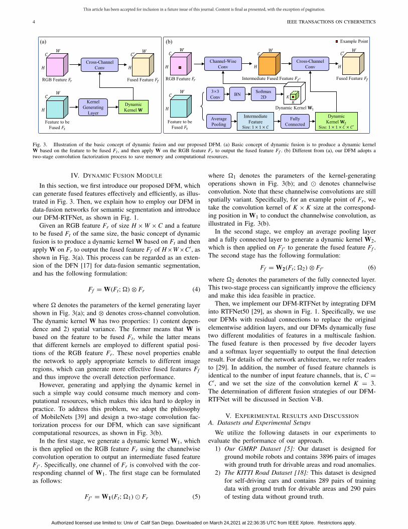
Fig. 3. Illustration of the basic concept of dynamic fusion and our proposed DFM. (a) Basic concept of dynamic fusion is to produce a dynamic kernelW based on the feature to be fused Ft , and then apply W on the RGB feature Fr to output the fused feature Ff . (b) Different from (a), our DFM adopts atwo-stage convolution factorization process to save memory and computational resources.
IV. DYNAMIC FUSION MODULE
In this section, we first introduce our proposed DFM, whichcan generate fused features effectively and efficiently, as illus-trated in Fig. 3. Then, we explain how to employ our DFM indata-fusion networks for semantic segmentation and introduceour DFM-RTFNet, as shown in Fig. 1.
Given an RGB feature Fr of size H × W × C and a featureto be fused Ft of the same size, the basic concept of dynamicfusion is to produce a dynamic kernel W based on Ft and thenapply W on Fr to output the fused feature Ff of H×W×C′, asshown in Fig. 3(a). This process can be regarded as an exten-sion of the DFN [17] for data-fusion semantic segmentation,and has the following formulation:
Ff = W(Ft;�) ⊗ Fr (4)
where � denotes the parameters of the kernel generating layershown in Fig. 3(a); and ⊗ denotes cross-channel convolution.The dynamic kernel W has two properties: 1) content depen-dence and 2) spatial variance. The former means that W isbased on the feature to be fused Ft, while the latter meansthat different kernels are employed to different spatial posi-tions of the RGB feature Fr. These novel properties enablethe network to apply appropriate kernels to different imageregions, which can generate more effective fused features Ff
and thus improve the overall detection performance.However, generating and applying the dynamic kernel in
such a simple way could consume much memory and com-putational resources, which makes this idea hard to deploy inpractice. To address this problem, we adopt the philosophyof MobileNets [39] and design a two-stage convolution fac-torization process for our DFM, which can save significantcomputational resources, as shown in Fig. 3(b).
In the first stage, we generate a dynamic kernel W1, whichis then applied on the RGB feature Fr using the channelwiseconvolution operation to output an intermediate fused featureFf ′ . Specifically, one channel of Fr is convolved with the cor-responding channel of W1. The first stage can be formulatedas follows:
Ff ′ = W1(Ft;�1) � Fr (5)
where �1 denotes the parameters of the kernel-generatingoperations shown in Fig. 3(b); and � denotes channelwiseconvolution. Note that these channelwise convolutions are stillspatially variant. Specifically, for an example point of Fr, wetake the convolution kernel of K × K size at the correspond-ing position in W1 to conduct the channelwise convolution, asillustrated in Fig. 3(b).
In the second stage, we employ an average pooling layerand a fully connected layer to generate a dynamic kernel W2,which is then applied on Ff ′ to generate the fused feature Ff .The second stage has the following formulation:
Ff = W2(Ft;�2) ⊗ Ff ′ (6)
where �2 denotes the parameters of the fully connected layer.This two-stage process can significantly improve the efficiencyand make this idea feasible in practice.
Then, we implement our DFM-RTFNet by integrating DFMinto RTFNet50 [29], as shown in Fig. 1. Specifically, we useour DFMs with residual connections to replace the originalelementwise addition layers, and our DFMs dynamically fusetwo different modalities of features in a multiscale fashion.The fused feature is then processed by five decoder layersand a softmax layer sequentially to output the final detectionresult. For details of the network architecture, we refer readersto [29]. In addition, the number of fused feature channels isidentical to the number of input feature channels, that is, C =C′, and we set the size of the convolution kernel K = 3.The determination of different fusion strategies of our DFM-RTFNet will be discussed in Section V-B.
V. EXPERIMENTAL RESULTS AND DISCUSSIONA. Datasets and Experimental Setups
We utilize the following datasets in our experiments toevaluate the performance of our approach.
1) Our GMRP Dataset [5]: Our dataset is designed forground mobile robots and contains 3896 pairs of imageswith ground truth for drivable areas and road anomalies.
2) The KITTI Road Dataset [18]: This dataset is designedfor self-driving cars and contains 289 pairs of trainingdata with ground truth for drivable areas and 290 pairsof testing data without ground truth.
Authorized licensed use limited to: Univ of Calif San Diego. Downloaded on March 24,2021 at 22:36:35 UTC from IEEE Xplore. Restrictions apply.

This article has been accepted for inclusion in a future issue of this journal. Content is final as presented, with the exception of pagination.
WANG et al.: DFM EVOLVES DRIVABLE AREA AND ROAD ANOMALY DETECTION 5
Fig. 4. Example of the experimental results on our GMRP dataset. DeepLabv3+ [10] and GSCNN [26] are single-modal networks, while FuseNet [28],RTFNet [29], and our DFM-RTFNet are data-fusion networks.
3) The KITTI Semantic Segmentation Dataset [40]: Thisdataset is also designed for self-driving cars and contains200 pairs of training data with ground truth for sceneunderstanding and 200 pairs of testing data withoutground truth.
The total 3896 pairs of images in our GMRP dataset aresplit into a training, a validation, and a testing set that con-tain 2726, 585, and 585 pairs, respectively. The resolutionof input images is downsampled to 320 × 480. We firstconduct ablation studies on our GMRP dataset to: 1) selectthe fusion strategy of our DFM-RTFNet and 2) demonstratethe effectiveness and efficiency of our DFM, as presented inSection V-B.
Then, Section V-C presents a drivable area and roadanomaly detection benchmark for ground mobile robots,which provides a detailed performance comparison of the14 SOTA networks (ten single-modal ones and four data-fusion ones) mentioned in Section II-A and our DFM-RTFNet,with respect to six different types of training data, including
our transformed disparity images. We train each single-modalnetwork with 11 setups. Specifically, we first train each withinput RGB, disparity, normal, elevation, HHA, and trans-formed disparity images (denoted as RGB, Disparity, Normal,Elevation, HHA, and T-Disp), respectively. Then, we traineach with input concatenation of RGB and the other fivetypes of training data separately, denoted as RGB + D,RGB + N, RGB + E, RGB + H, and RGB + T, fol-lowed by training each data-fusion network with same fivesetups. For the training setup, we use the stochastic gradientdescent (SGD) optimizer. Moreover, we train each networkuntil loss convergence and then select the best model accordingto the performance of the validation set. For the quantitativeevaluations, we adopt the F-score (Fsc) and the intersectionover union (IoU) for each class. We also plot the precision–recall curves and compute the average precision (AP) [41]for each class. Furthermore, we compute the mean valuesacross all classes for the three metrics, denoted as mFsc, mIoU,and mAP.
Authorized licensed use limited to: Univ of Calif San Diego. Downloaded on March 24,2021 at 22:36:35 UTC from IEEE Xplore. Restrictions apply.

This article has been accepted for inclusion in a future issue of this journal. Content is final as presented, with the exception of pagination.
6 IEEE TRANSACTIONS ON CYBERNETICS
Fig. 5. Performance comparison among ten SOTA single-modal networks (FCN [19], SegNet [20], U-Net [21], PSPNet [22], DeepLabv3+ [10],DenseASPP [23], UPerNet [24], DUpsampling [25], ESPNet [27], and GSCNN [26]) with 11 training data setups on our GMRP dataset, where the best resultis highlighted in each subfigure.
To better understand how our transformed disparity imageimproves the overall detection performance, we compare itwith another two visual features that can also make thedrivable areas possess similar values. In addition, we ana-lyze the feature variation with and without our DFM toexplore its internal mechanism for improving the detec-tion performance. The experimental results are presentedin Section V-D.
Finally, we conduct experiments to demonstrate the effec-tiveness and efficiency of our approach for self-driving cars.Since our drivable area detection task perfectly matches theKITTI road benchmark [18], we train our DFM-RTFNet usingthe KITTI road training data and submit it to the benchmark.However, since we focus on the detection of drivable areas androad anomalies, we do not submit the results of our approachto the KITTI semantic segmentation benchmark [40]. Instead,we merge its classes into four new classes, unlabeled, drivablearea, vehicles, and pedestrians, because vehicles and pedestri-ans are two important anomalies for self-driving cars. We splitthe KITTI semantic segmentation training data into a train-ing, a validation, and a test set that contains 100, 50, and50 pairs of data, respectively. Then, we compare the perfor-mances between our DFM-RTFNet and four SOTA data-fusionnetworks with respect to six different types of training data.The experimental results are presented in Section V-E.
TABLE IEXPERIMENTAL RESULTS OF OUR ABLATION STUDIES, WHERE (A) IS
THE ORIGINAL RTFNET50 (THE BASELINE SETUP); (B) IS THE SETUP
WITH FEATURE CONCATENATION; (C)–(E) ARE THREE SETUPS WITH
DIFFERENT FUSION STRATEGIES OF OUR DFM-RTFNET; (F) IS THE
SETUP WITH AN SOTA FUSION STRATEGY; AND (G) IS THE ORIGINAL
RTFNET101. BEST RESULTS ARE BOLDED
B. Ablation Study
In this section, we adopt RTFNet50 [29] with input trans-formed disparity images as the baseline to conduct ablationstudies, and (A) of Table I shows the performance of thebaseline. To compare the differences between the setups moreintuitively, we introduce two new metrics: 1) the runtime ofa given setup on an NVIDIA GeForce GTX 1080 Ti graph-ics card and 2) the ratio of the mIoU increment and runtime
Authorized licensed use limited to: Univ of Calif San Diego. Downloaded on March 24,2021 at 22:36:35 UTC from IEEE Xplore. Restrictions apply.

This article has been accepted for inclusion in a future issue of this journal. Content is final as presented, with the exception of pagination.
WANG et al.: DFM EVOLVES DRIVABLE AREA AND ROAD ANOMALY DETECTION 7
Fig. 6. Performance comparison among four data-fusion networks (FuseNet [28], MFNet [30], depth-aware CNN [11], and RTFNet [29]) and our DFM-RTFNet with five training data setups on our GMRP dataset, where D-A CNN is short for depth-aware CNN, and the best result is highlighted in eachsubfigure.
TABLE IIPERFORMANCE COMPARISON (%) ON OUR GMRP DATASET, WHERE
APD AND APR DENOTE THE AP FOR DRIVABLE AREAS AND ROAD
ANOMALIES, RESPECTIVELY. BEST RESULTS ARE BOLDED
increment between a given setup and the baseline η. Let ηi
denote the η of a given setup i, and the expression of ηi is
ηi = mIoUi − mIoUbaseline
Runtimei − Runtimebaseline(%/ms). (7)
η is used to quantify the tradeoff between the improvedperformance and increased runtime of a given setup. Aneffective and efficient setup achieves a high η value.
We first explore different fusion strategies of our DFM-RTFNet and the corresponding performance is presentedin (C)–(E) of Table I. (C) and (D) mean that we only replacethe first and last elementwise addition layer, respectively, withour DFM, and (E) represents the setup shown in Fig. 1.We can observe that (C)–(E) all outperform the commonlyused elementwise addition and feature concatenation strate-gies shown in (A) and (B) of Table I, which demonstrates thatour DFM is an effective module for data fusion. Furthermore,
(E) presents the best performance, and therefore, we adopt thesetup illustrated in Fig. 1 in the rest of our experiments.
In addition, (F) of Table I presents the performance ofthe setup with an SOTA fusion strategy, depth-aware (D-A)operators [11]. We can see that our DFM outperforms itwith a higher η value. Moreover, one exciting fact is thatour DFM-RTFNet with the backbone of RTFNet50 [(E) ofTable I] even presents a better performance than the originalRTFNet101 [29] [(G) of Table I] and the runtime is muchless, which demonstrates the effectiveness and efficiency ofour DFM.
C. Drivable Area and Road Anomaly Detection Benchmark
In this section, we present a drivable area and road anomalydetection benchmark for ground mobile robots. Fig. 4 presentssample qualitative results, from which we can find that ourtransformed disparity images greatly help reduce the noisesin the semantic predictions. Moreover, our DFM-RTFNetpresents more accurate and robust results than all the otherSOTA data-fusion networks with the same input. The corre-sponding quantitative performances are presented in Figs. 5and 6, and the detailed numbers are provided in the benchmarkpage2 for reference. Specifically, our DFM-RTFNet with ourtransformed disparity images as the input increases the meanFsc and mean IoU by around 1.0%–21.7% and 1.8%–31.9%,respectively. We also select several networks that performwell for further performance comparison. The AP compari-son is presented in Table II, and the precision–recall curvesare shown in Figs. 7 and 8. We can clearly observe that ourDFM-RTFNet with our transformed disparity images as inputpresents the best performance. This proves that our trans-formed disparity images and DFM can effectively improve
2https://sites.google.com/view/gmrb
Authorized licensed use limited to: Univ of Calif San Diego. Downloaded on March 24,2021 at 22:36:35 UTC from IEEE Xplore. Restrictions apply.

This article has been accepted for inclusion in a future issue of this journal. Content is final as presented, with the exception of pagination.
8 IEEE TRANSACTIONS ON CYBERNETICS
Fig. 7. Precision–recall curves of different networks on our GMRP dataset.ESPNet [27], GSCNN [26], and DeepLabv3+ [10] are single-modal networks,while FuseNet [28], RTFNet [29], and our DFM-RTFNet are data-fusionnetworks. The orange boxes show the enlarged area for comparison.
Fig. 8. Precision–recall curves of our DFM-RTFNet with five training datasetups on our GMRP dataset. The orange boxes show the enlarged area forcomparison.
the detection performance. In addition, we conduct moreexperiments to explore how our proposed approach enhancesthe detection performance, and the experimental results arepresented in Section V-D.
D. Further Discussion
As aforementioned, our transformed disparity images canmake drivable areas possess similar values, and thus improvethe detection performance. To verify this, we compare ourtransformed disparity images with the other two visual featuresthat have similar properties, that is: 1) normal images and2) elevation maps. Since these three features have differentscales, we introduce a dimensionless metric, the coefficient ofvariation cv, defined as follows:
cv = σ
μ(8)
where σ and μ denote the standard deviation and mean,respectively. A uniform data distribution achieves a low cv
value. Then, we compute the cv of the three visual features onthe drivable areas in our GMRP dataset. Note that for three-channel normal images, we first compute the average valuesacross all channels and use the obtained one-channel averagemaps for comparison. The cv values of normal images [42],elevation maps [43], and our transformed disparity images are0.008, 0.009, and 0.005, respectively. We can see that ourtransformed disparity images achieve a much lower cv value.The sample qualitative results are shown in Fig. 9 also verify
Fig. 9. Example of the drivable area consistency comparison between normalimages, elevation maps, and our transformed disparity images. The orange boxin the RGB image shows the enlarged area for comparison, and the other threeimages present the difference maps from the corresponding mean values inthe enlarged area.
TABLE IIIEXPERIMENTAL RESULTS (%) OF TWO SOTA DATA-FUSION NETWORKS
WITH AND WITHOUT OUR DFM ON OUR GMRP DATASET. BEST
RESULTS FOR EACH NETWORK ARE BOLDED
our conclusion that our transformed disparity images can makethe drivable areas more uniform and thus benefit all networksfor better detection performances.
To explore the internal mechanism of our DFM forimproving the detection performance, we implement it inFuseNet [28], besides RTFNet [29], with the RGB+T setup onour GMRP dataset. The quantitative comparisons are given inTable III, where we can observe that networks with our DFMembedded generally perform better than themselves withoutour DFM embedded. Moreover, we visualize the mean activa-tion maps of the features after the last layers of the encoderswith and without our DFM for each network, as presented inFig. 10. We can observe that the mean activation maps fusedby our DFM can concentrate more on the drivable areas androad anomalies. We conjecture the reason is that the content-dependent and spatially variant properties make our DFM actas a weight modulation operator, which can effectively gen-erate fused features with high activation values in the criticalareas, and thus improve the detection performance.
E. Evaluations on the KITTI Benchmark
1) KITTI Road Benchmark: As previously mentioned, wesubmit the road estimation results of our DFM-RTFNet to theKITTI road benchmark [18]. Experimental results demonstratethat our DFM-RTFNet achieves competitive performance on
Authorized licensed use limited to: Univ of Calif San Diego. Downloaded on March 24,2021 at 22:36:35 UTC from IEEE Xplore. Restrictions apply.

This article has been accepted for inclusion in a future issue of this journal. Content is final as presented, with the exception of pagination.
WANG et al.: DFM EVOLVES DRIVABLE AREA AND ROAD ANOMALY DETECTION 9
Fig. 10. Example of two SOTA data-fusion networks (FuseNet [28] and RTFNet [29]) with and without our DFM embedded, respectively. Feature mapsrefer to the mean activation maps of the features after the last layers of the encoders.
Fig. 11. Example of the testing images on the KITTI road benchmark. The true positive, false negative, and false positive pixels are shown in green, red,and blue, respectively. Significantly improved regions are marked with orange dashed boxes.
Fig. 12. Example of the experimental results on the KITTI semantic segmentation dataset. FuseNet [28], MFNet [30], Depth-aware CNN [11], RTFNet [29],and our DFM-RTFNet are all data-fusion networks. Significantly improved regions are marked with green dashed boxes.
TABLE IVKITTI ROAD BENCHMARK3 RESULTS, WHERE THE BEST RESULTS ARE
BOLDED. NOTE THAT WE ONLY COMPARE OUR APPROACH
WITH OTHER PUBLISHED APPROACHES
the benchmark. Fig. 11 illustrates an example of the test-ing images, and Table IV presents the quantitative results.We can observe that our DFM-RTFNet outperforms exist-ing approaches, which demonstrates its effectiveness andefficiency for self-driving cars.
3http://www.cvlibs.net/datasets/kitti/eval_road.php
TABLE VEXPERIMENTAL RESULTS (%) OF FOUR SOTA DATA-FUSION NETWORKS
AND OUR DFM-RTFNET WITH RESPECT TO DIFFERENT TRAINING DATA
SETUPS ON THE KITTI SEMANTIC SEGMENTATION DATASET. BEST
RESULTS ARE BOLDED
2) KITTI Semantic Segmentation Dataset: Fig. 12 andTable V present the qualitative and quantitative results on theKITTI semantic segmentation dataset [40], respectively. Wecan see that our transformed disparity images greatly improve
Authorized licensed use limited to: Univ of Calif San Diego. Downloaded on March 24,2021 at 22:36:35 UTC from IEEE Xplore. Restrictions apply.

This article has been accepted for inclusion in a future issue of this journal. Content is final as presented, with the exception of pagination.
10 IEEE TRANSACTIONS ON CYBERNETICS
the detection performance, and our DFM-RTFNet presents abetter performance than all other SOTA data-fusion networks,which verifies that our DFM-RTFNet with the RGB + T setupcan be deployed effectively for self-driving cars in practice.
VI. CONCLUSION
In this article, we conducted a comprehensive study on thedrivable area and road anomaly detection for mobile robots,including building a benchmark and proposing an effectiveand efficient data-fusion strategy called DFM. Experimentalresults verified that our transformed disparity images couldenable drivable areas to exhibit similar values, which couldbenefit networks for the drivable area and road anomaly detec-tion. Moreover, our proposed DFM can effectively generatefused features with high activation values in critical areasusing content-dependent and spatially variant kernels, and thusimprove the overall detection performance. Compared with theSOTA networks, our DFM-RTFNet can produce more accu-rate and robust results for the drivable area and road anomalydetection. Hence, it is suitable to be implemented in mobilerobots in practice. Furthermore, our DFM-RTFNet achievescompetitive performance on the KITTI road benchmark. Webelieve that our benchmark and the data fusion idea in ourproposed network will inspire future research in this area. Inthe future, we will develop effective and efficient data-fusionstrategies to further improve the detection performance.
REFERENCES
[1] R. Chai, A. Tsourdos, A. Savvaris, S. Chai, Y. Xia, and C. L. P. Chen,“Multiobjective overtaking maneuver planning for autonomous groundvehicles,” IEEE Trans. Cybern., early access, Mar. 5, 2020,doi: 10.1109/TCYB.2020.2973748.
[2] T. Liu et al., “The role of the hercules autonomous vehicle duringthe covid-19 pandemic: An autonomous logistic vehicle for contactlessgoods transportation,” IEEE Robot. Autom. Mag., early access, Jan. 29,2020, doi: 10.1109/MRA.2020.3045040.
[3] Y. Sun, W. Zuo, H. Huang, P. Cai, and M. Liu, “PointMoSeg: Sparsetensor-based end-to-end moving-obstacle segmentation in 3-D lidar pointclouds for autonomous driving,” IEEE Robot. Autom. Lett., vol. 6, no. 2,pp. 510–517, Apr. 2021.
[4] L. Li, Y.-H. Liu, T. Jiang, K. Wang, and M. Fang, “Adaptive trajectorytracking of nonholonomic mobile robots using vision-based position andvelocity estimation,” IEEE Trans. Cybern., vol. 48, no. 2, pp. 571–582,Feb. 2018.
[5] H. Wang, Y. Sun, and M. Liu, “Self-supervised drivable area and roadanomaly segmentation using rgb-d data for robotic wheelchairs,” IEEERobot. Autom. Lett., vol. 4, no. 4, pp. 4386–4393, Oct. 2019.
[6] H. Wang, R. Fan, Y. Sun, and M. Liu, “Applying surface normalinformation in drivable area and road anomaly detection for groundmobile robots,” 2020. [Online]. Available: arXiv:2008.11383.
[7] Y. Sun, L. Wang, Y. Chen, and M. Liu, “Accurate lane detection withatrous convolution and spatial pyramid pooling for autonomous driving,”in Proc. IEEE Int. Conf. Robot. Biomimetics, 2019, pp. 642–647.
[8] Y. Sun, W. Zuo, and M. Liu, “See the future: A semantic segmenta-tion network predicting ego-vehicle trajectory with a single monocularcamera,” IEEE Robot. Autom. Lett., vol. 5, no. 2, pp. 3066–3073,Apr. 2020.
[9] H. Wang, Y. Sun, R. Fan, and M. Liu, “S2p2: Self-supervised goal-directed path planning using rgb-d data for robotic wheelchairs,” in Proc.IEEE Int. Conf. Robot. Autom., to be published.
[10] L.-C. Chen, Y. Zhu, G. Papandreou, F. Schroff, and H. Adam,“Encoder–decoder with atrous separable convolution for semantic imagesegmentation,” in Proc. Eur. Conf. Comput. Vis., 2018, pp. 801–818.
[11] W. Wang and U. Neumann, “Depth-aware CNN for RGB-D segmenta-tion,” in Proc. Eur. Conf. Comput. Vis., 2018, pp. 135–150.
[12] W. Zhang, H. Huang, M. Schmitz, X. Sun, H. Wang, and H. Mayer,“A multi-resolution fusion model incorporating color and elevation forsemantic segmentation,” Int. Arch. Photogram. Remote Sens. Spat. Inf.Sci., vol. 42, 2017, pp. 513–517.
[13] A. Geiger, P. Lenz, and R. Urtasun, “Are we ready for autonomousdriving? the kitti vision benchmark suite,” in Proc. IEEE Conf. Comput.Vis. Pattern Recognit., 2012, pp. 3354–3361.
[14] M. Cordts et al., “The cityscapes dataset for semantic urban scene under-standing,” in Proc. IEEE Conf. Comput. Vis. Pattern Recognit., 2016,pp. 3213–3223.
[15] R. Fan, H. Wang, P. Cai, and M. Liu, “SNE-roadseg: Incorporatingsurface normal information into semantic segmentation for accu-rate freespace detection,” in Proc. Eur. Conf. Comput. Vis., 2020,pp. 340–356.
[16] R. Fan, U. Ozgunalp, B. Hosking, M. Liu, and I. Pitas, “Pothole detec-tion based on disparity transformation and road surface modeling,” IEEETrans. Image Process., vol. 29, pp. 897–908, 2020.
[17] X. Jia, B. De Brabandere, T. Tuytelaars, and L. V. Gool, “Dynamicfilter networks,” in Proc. Int. Conf. Neural Inf. Process. Syst., 2016,pp. 667–675.
[18] J. Fritsch, T. Kuehnl, and A. Geiger, “A new performance measure andevaluation benchmark for road detection algorithms,” in Proc. IEEEConf. Intell. Transp. Syst., 2013, pp. 1693–1700.
[19] J. Long, E. Shelhamer, and T. Darrell, “Fully convolutional networksfor semantic segmentation,” in Proc. IEEE Conf. Comput. Vis. PatternRecognit., 2015, pp. 3431–3440.
[20] V. Badrinarayanan, A. Kendall, and R. Cipolla, “SegNet: A deep con-volutional encoder–decoder architecture for image segmentation,” IEEETrans. Pattern Anal. Mach. Intell., vol. 39, no. 12, pp. 2481–2495, Dec.2017.
[21] O. Ronneberger, P. Fischer, and T. Brox, “U-Net: Convolutionalnetworks for biomedical image segmentation,” in Proc. Int. Conf. Med.Image Comput. Comput.-Assisted Interv., 2015, pp. 234–241.
[22] H. Zhao, J. Shi, X. Qi, X. Wang, and J. Jia, “Pyramid scene parsingnetwork,” in Proc. IEEE Conf. Comput. Vis. Pattern Recognit., 2017,pp. 2881–2890.
[23] M. Yang, K. Yu, C. Zhang, Z. Li, and K. Yang, “Denseaspp for semanticsegmentation in street scenes,” in Proc. IEEE Conf. Comput. Vis. PatternRecognit., 2018, pp. 3684–3692.
[24] T. Xiao, Y. Liu, B. Zhou, Y. Jiang, and J. Sun, “Unified perceptualparsing for scene understanding,” in Proc. Eur. Conf. Comput. Vis., 2018,pp. 418–434.
[25] Z. Tian, T. He, C. Shen, and Y. Yan, “Decoders matter for semanticsegmentation: Data-dependent decoding enables flexible feature aggre-gation,” in Proc. IEEE Conf. Comput. Vis. Pattern Recognit., 2019,pp. 3126–3135.
[26] T. Takikawa, D. Acuna, V. Jampani, and S. Fidler, “Gated-SCNN: Gatedshape cnns for semantic segmentation,” in Proc. IEEE Int. Conf. Comput.Vis., 2019, pp. 5228–5237.
[27] S. Mehta, M. Rastegari, A. Caspi, L. G. Shapiro, and H. Hajishirzi,“ESPNet: Efficient spatial pyramid of dilated convolutions for semanticsegmentation,” in Proc. Eur. Conf. Comput. Vis., 2018, pp. 552–568.
[28] C. Hazirbas, L. Ma, C. Domokos, and D. Cremers, “FuseNet:Incorporating depth into semantic segmentation via fusion-based cnnarchitecture,” in Proc. Asian Conf. Comput. Vis., 2016, pp. 213–228.
[29] Y. Sun, W. Zuo, and M. Liu, “RTFNet: RGB-thermal fusion networkfor semantic segmentation of urban scenes,” IEEE Robot. Autom. Lett.,vol. 4, no. 3, pp. 2576–2583, Jul. 2019.
[30] Q. Ha, K. Watanabe, T. Karasawa, Y. Ushiku, and T. Harada, “MFNet:Towards real-time semantic segmentation for autonomous vehicles withmulti-spectral scenes,” in Proc. IEEE/RSJ Int. Conf. Intell. Robots Syst.,2017, pp. 5108–5115.
[31] S. Gupta, P. Arbeláez, R. Girshick, and J. Malik, “Indoor scene under-standing with RGB-D images: Bottom-up segmentation, object detectionand semantic segmentation,” Int. J. Comput. Vis., vol. 112, no. 2,pp. 133–149, 2015.
[32] R. Fan, U. Ozgunalp, Y. Wang, M. Liu, and I. Pitas, “Rethinkingroad surface 3D reconstruction and pothole detection: From perspectivetransformation to disparity map segmentation,” IEEE Trans. Cybern.,early access, Dec. 31, 2020 doi: 10.1109/TCYB.2021.3060461, 2021.[Online]. Available: 10.1109/TCYB.2021.3060461
[33] M. Simonovsky and N. Komodakis, “Dynamic edge-conditioned fil-ters in convolutional neural networks on graphs,” in Proc. IEEE Conf.Comput. Vis. Pattern Recognit., 2017, pp. 3693–3702.
[34] J. Wu, D. Li, Y. Yang, C. Bajaj, and X. Ji, “Dynamic filtering withlarge sampling field for convnets,” in Proc. Eur. Conf. Comput. Vis.,2018, pp. 185–200.
Authorized licensed use limited to: Univ of Calif San Diego. Downloaded on March 24,2021 at 22:36:35 UTC from IEEE Xplore. Restrictions apply.

This article has been accepted for inclusion in a future issue of this journal. Content is final as presented, with the exception of pagination.
WANG et al.: DFM EVOLVES DRIVABLE AREA AND ROAD ANOMALY DETECTION 11
[35] R. Fan and M. Liu, “Road damage detection based on unsuperviseddisparity map segmentation,” IEEE Trans. Intell. Transp. Syst., vol. 21,no. 11, pp. 4906–4911, Nov. 2020.
[36] R. Fan, H. Wang, M. J. Bocus, and M. Liu, “We learn better road potholedetection: From attention aggregation to adversarial domain adaptation,”in Proc. Eur. Conf. Comput. Vis., 2020, pp. 285–300.
[37] R. Fan et al., “Learning collision-free space detection fromstereo images: Homography matrix brings better data augmenta-tion,” IEEE/ASME Trans. Mechatronics, early access, Feb. 19, 2021,doi: 10.1109/TAC.2020.2986731.
[38] U. Ozgunalp, R. Fan, X. Ai, and N. Dahnoun, “Multiple lane detectionalgorithm based on novel dense vanishing point estimation,” IEEE Trans.Intell. Transp. Syst., vol. 18, no. 3, pp. 621–632, Mar. 2017.
[39] A. G. Howard et al., “Mobilenets: Efficient convolutional neuralnetworks for mobile vision applications,” 2017. [Online]. Available:arXiv:1704.04861.
[40] H. A. Alhaija, S. K. Mustikovela, L. Mescheder, A. Geiger, andC. Rother, “Augmented reality meets computer vision: Efficient datageneration for urban driving scenes,” Int. J. Comput. Vis., vol. 126, no. 9,pp. 961–972, 2018.
[41] M. Everingham, S. A. Eslami, L. Van Gool, C. K. Williams, J. Winn,and A. Zisserman, “The pascal visual object classes challenge: Aretrospective,” Int. J. Comput. Vis., vol. 111, no. 1, pp. 98–136, 2015.
[42] H. Badino, D. Huber, Y. Park, and T. Kanade, “Fast and accurate compu-tation of surface normals from range images,” in Proc. IEEE Int. Conf.Robot. Autom., 2011, pp. 3084–3091.
[43] S. Gupta, R. B. Girshick, P. A. Arbeláez, and J. Malik, “Learning richfeatures from RGB-D images for object detection and segmentation,” inProc. Eur. Conf. Comput. Vis., 2014, pp. 345–360.
[44] M. Teichmann, M. Weber, M. Zoellner, R. Cipolla, and R. Urtasun,“Multinet: Real-time joint semantic reasoning for autonomous driving,”in Proc. IEEE Intell. Vehicles Symp., 2018, pp. 1013–1020.
[45] N. Garnett et al., “Real-time category-based and general obstacle detec-tion for autonomous driving,” in Proc. IEEE Int. Conf. Comput. Vis.Workshops, 2017, pp. 198–205.
[46] Z. Chen and Z. Chen, “RBNet: A deep neural network for unified roadand road boundary detection,” in Proc. Int. Conf. Neural Inf. Process.,2017, pp. 677–687.
[47] S. Gu, Y. Zhang, J. Yang, J. M. Alvarez, and H. Kong, “Two-viewfusion based convolutional neural network for urban road detection,” inIEEE/RSJ Int. Conf. Intell. Robots Syst., 2019, pp. 6144–6149.
[48] S. Gu, Y. Zhang, J. Tang, J. Yang, and H. Kong, “Road detection throughCRF based lidar-camera fusion,” in Proc. IEEE Int. Conf. Robot. Autom.,2019, pp. 3832–3838.
[49] L. Caltagirone, M. Bellone, L. Svensson, and M. Wahde, “LIDAR–Camera fusion for road detection using fully convolutional neuralnetworks,” Robot. Auton. Syst., vol. 111, pp. 125–131, Jan. 2019.
[50] J.-Y. Sun, S.-W. Kim, S.-W. Lee, Y.-W. Kim, and S.-J. Ko, “Reverseand boundary attention network for road segmentation,” in Proc. IEEEInt. Conf. Comput. Vis. Workshops, 2019, pp. 876–885.
Hengli Wang (Graduate Student Member, IEEE)received the B.E. degree in mechatronics engineer-ing from Zhejiang University, Hangzhou, China, in2018. He is currently pursuing the Ph.D. degree withthe Robotics Institute, Department of Electronic andComputer Engineering, The Hong Kong Universityof Science and Technology, Hong Kong, SAR,China.
His research interests include computer vision,robot navigation, and deep learning.
Rui Fan (Member, IEEE) received the B.Eng.degree in automation from the Harbin Instituteof Technology, Harbin, China, in 2015, and thePh.D. degree in electrical and electronic engineer-ing from the University of Bristol, Bristol, U.K., in2018.
From 2018 to 2020, he was a Research Associatewith the Robotics Institute, The Hong KongUniversity of Science and Technology, Hong Kong,SAR, China. Since 2020, he has been a PostdoctoralFellow with the Department of Computer Science
and Engineering, University of California San Diego, La Jolla, CA, USA.His research interests include computer vision, image processing, high-performance computing, deep/machine learning, and autonomous driving.
Yuxiang Sun (Member, IEEE) received thebachelor’s degree from the Hefei University ofTechnology, Hefei, China, in 2009, the mas-ter’s degree from the University of Science andTechnology of China, Hefei, in 2012, and the Ph.D.degree from The Chinese University of Hong Kong,Hong Kong, in 2017.
He is currently a Research Assistant Professorwith the Department of Mechanical Engineering,The Hong Kong Polytechnic University, Hong Kong.He was a Research Associate with the Department of
Electronic and Computer Engineering, The Hong Kong University of Scienceand Technology, Hong Kong, SAR, China. His current research interestsinclude autonomous driving, deep learning, robotics and autonomous systems,and semantic scene understanding.
Dr. Sun is a recipient of the Best Paper in Robotics Award at IEEE-ROBIO2019 and the Best Student Paper Finalist Award at IEEE-ROBIO 2015.
Ming Liu (Senior Member, IEEE) received theB.A. degree in automation from Tongji University,Shanghai, China, in 2005, and the Ph.D. degreeETH Zürich, Zürich, Switzerland, in 2013.
During his master’s study with Tongji University,he stayed one year with Erlangen–NünbergUniversity, Erlangen, Germany, and FraunhoferInstitute IISB, Erlangen, as a Master VisitingScholar. He is currently with the Electronic andComputer Engineering, Computer Science, andEngineering Departments, Robotics Institute, The
Hong Kong University of Science and Technology, Hong Kong, SAR, China.He is also a Founding Member of Shanghai Swing Automation CompanyLtd., Shanghai. He is a coordinator and is involved in NSF Projects andNational 863-Hi-TechPlan Projects in China. His research interests includedynamic environment modeling, deep learning for robotics, 3-D mapping,machine learning, and visual control.
Dr. Liu was a recipient of the European Micro Aerial Vehicle Competition2009 (second place) and two awards from the International Aerial RobotCompetition 2014 as a Team Member, the Best Student Paper Award as firstauthor for MFI 2012 (IEEE International Conference on Multisensor Fusionand Information Integration), the Best Paper Award in Information for IEEEInternational Conference on Information and Automation 2013 as first author,the Best Paper Award Finalists as coauthor, the Best RoboCup Paper Awardfor IROS 2013 (IEEE/RSJ International Conference on Intelligent Robotsand Systems), the Best Conference Paper Award for IEEE-CYBER 2015, theBest Student Paper Finalist for RCAR 2015 (IEEE International Conferenceon Real-time Computing and Robotics), the Best Student Paper Finalist forROBIO 2015, the Best Student Paper Award for IEEE-ICAR 2017, the BestPaper in Automation Award for IEEE-ICIA 2017, the innovation contestChunhui Cup Winning Award in 2012 and 2013, and the Wu Weijun AIAward in 2016. He was the awardee of IEEE IROS Toshio Fukuda YoungProfessional Award 2018. He was the Program Chair of IEEE RCAR 2016and the International Robotics Conference in Foshan 2017. He was theConference Chair of ICVS 2017.
Authorized licensed use limited to: Univ of Calif San Diego. Downloaded on March 24,2021 at 22:36:35 UTC from IEEE Xplore. Restrictions apply.