
Dusky Track, Fiordland National Park WILD FILE€¦ · Dusky Track, Fiordland National Park WILD...
6
Dusky Track, Fiordland National Park WILD FILE Access Most people walk in the opposite direction to that described in this story. Both ends of the track are only accessible by boat. Some parties fly into Supper Cove by float plane or helicopter, then walk out Grade Difficult Time 8-10 days. Wilmot Pass Rd to Upper Spey Hut, 4-5hr; Upper Spey Hut to Kintail Hut, 5-7hr; Kintail Hut to Loch Maree Hut, 6-8hr; Loch Maree Hut to Supper Cove, 6-8hr; Loch Maree to Lake Roe Hut, 5-7hr; Lake Roe Hut to Halfway Hut, 3-5hr; Halfway Hut to Hauroko Burn Hut, 4-6hr Distance 84km Total ascent 3,828m Map CD06, CE05, CE06 Further Information Lake Hauroko Tours, twice weekly launch on Lake Hauroko: www.wjet.co.nz. Real Journeys, daily service across Lake Manapouri, www.realjourneys.co.nz Description Doing the Dusky, New Zealand’s most difficult track, is not straightforward. The 84km route is about the same length as the Heaphy, but takes twice as long due to the rugged terrain. The track can be walked in either direction – most commonly from south to north, but these notes describe the reverse. To get started on this classic tramp, cross the 414m deep Manapouri Lake to West Arm, board a bus headed for Deep Cove at the head of Doubtful Sound, but after 10 minutes, have the driver stop at the trailhead. Follow the Spey River (which occasionally turns to knee-deep bog) to the first of 21 walk-wires. A boardwalk eventually leads to Upper Spey Hut, and then carries on until it hits the valley wall and climbs upward. A 60- degree rock step requires careful footwork to ascend, eventually, topping out into a hanging valley; a subalpine world of tussock and wild flowers. The track meanders over Centre Pass; the sheer face of Mt Memphis, 1405m, to the left. The trail descends through a tussock basin, skirting a smattering of tiny tarns. Below the bushline, a three-metre drop requires some nerve to negotiate. Beyond this hazard, the terrain is rooted and rough underfoot. A pair of walk-wires are crossed to reach Kintail Hut. Leaving the hut takes you past the restful reaches of Gair Loch, giving way to a track with a handrail chain above the river. The valley widens where the Seaforth River merges into Loch Maree and Loch Maree Hut. The track to Dusky Sound heads west from the hut down the Seaforth River, eventually reaching the north- eastern corner of the sound. At low tide, it’s possible to cross the mudflat to Supper Cove Hut. You’ll need to retrace your steps to Loch Maree Hut the next day. From Loch Maree, there is an arduous ascent onto the Pleasant Range. It’s steep and straight up – no zigzags. At the bushline, snow poles beckon you onwards and upwards in an undulating walk through a tanr- scattered landscape until the roller coaster ride drops to Furket Pass and Lake Roe Hut. Descend into the headwaters of Hauroko Burn and enjoy the easiest section of the trail. In 3.5hr you should arrive at Halfway Hut. Easy peasy! The final day of the walk is along the flats to Hauroko Burn Hut. Spend a night here then meet your scheduled water taxi. Elevation Profile © Wilderness Magazine, www.wildernessmag.co.nz Disclaimer: While every effort has been made to map this route correctly, Wilderness does not accept responsibility for any errors. Users should plan their routes and gather as much information as possible before departing. The GPX file associated with this route has been drawn using Memory-Map software, version 6. Use descretion when following the route, especially when no track is marked on the map. The GPX file in these cases are a ‘best guess’ of the route only. Users should use a combination of GPS, visual observations, maps and compass to find the best possible route. Memory Map shows purple tracks and hut icons as verified routes and huts. Red or blue routes are those drawn by Wilderness.
Transcript of Dusky Track, Fiordland National Park WILD FILE€¦ · Dusky Track, Fiordland National Park WILD...
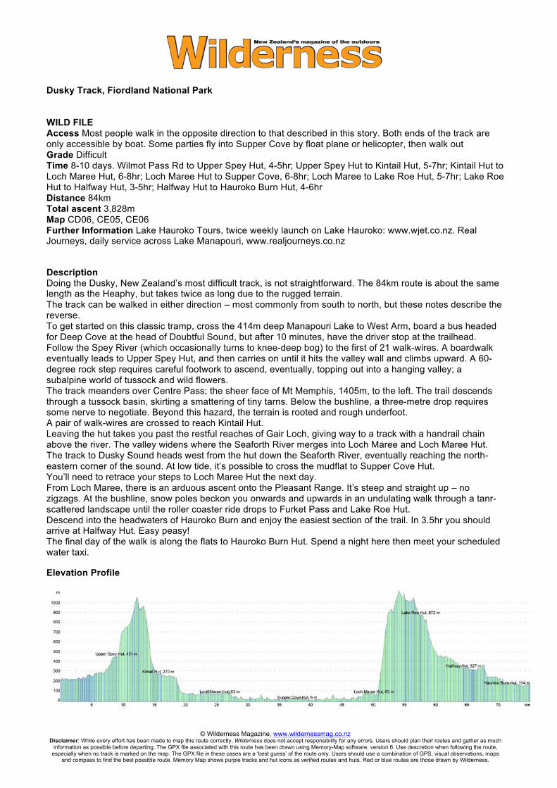
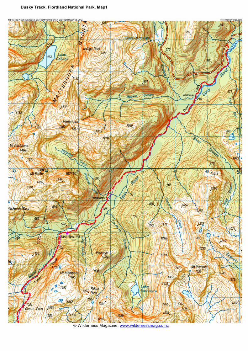
Dusky Track, Fiordland National Park WILD FILE Access Most people walk in the opposite direction to that described in this story. Both ends of the track are only accessible by boat. Some parties fly into Supper Cove by float plane or helicopter, then walk out Grade Difficult Time 8-10 days. Wilmot Pass Rd to Upper Spey Hut, 4-5hr; Upper Spey Hut to Kintail Hut, 5-7hr; Kintail Hut to Loch Maree Hut, 6-8hr; Loch Maree Hut to Supper Cove, 6-8hr; Loch Maree to Lake Roe Hut, 5-7hr; Lake Roe Hut to Halfway Hut, 3-5hr; Halfway Hut to Hauroko Burn Hut, 4-6hr Distance 84km Total ascent 3,828m Map CD06, CE05, CE06 Further Information Lake Hauroko Tours, twice weekly launch on Lake Hauroko: www.wjet.co.nz. Real Journeys, daily service across Lake Manapouri, www.realjourneys.co.nz Description Doing the Dusky, New Zealand’s most difficult track, is not straightforward. The 84km route is about the same length as the Heaphy, but takes twice as long due to the rugged terrain. The track can be walked in either direction – most commonly from south to north, but these notes describe the reverse. To get started on this classic tramp, cross the 414m deep Manapouri Lake to West Arm, board a bus headed for Deep Cove at the head of Doubtful Sound, but after 10 minutes, have the driver stop at the trailhead. Follow the Spey River (which occasionally turns to knee-deep bog) to the first of 21 walk-wires. A boardwalk eventually leads to Upper Spey Hut, and then carries on until it hits the valley wall and climbs upward. A 60-degree rock step requires careful footwork to ascend, eventually, topping out into a hanging valley; a subalpine world of tussock and wild flowers. The track meanders over Centre Pass; the sheer face of Mt Memphis, 1405m, to the left. The trail descends through a tussock basin, skirting a smattering of tiny tarns. Below the bushline, a three-metre drop requires some nerve to negotiate. Beyond this hazard, the terrain is rooted and rough underfoot. A pair of walk-wires are crossed to reach Kintail Hut. Leaving the hut takes you past the restful reaches of Gair Loch, giving way to a track with a handrail chain above the river. The valley widens where the Seaforth River merges into Loch Maree and Loch Maree Hut. The track to Dusky Sound heads west from the hut down the Seaforth River, eventually reaching the north-eastern corner of the sound. At low tide, it’s possible to cross the mudflat to Supper Cove Hut. You’ll need to retrace your steps to Loch Maree Hut the next day. From Loch Maree, there is an arduous ascent onto the Pleasant Range. It’s steep and straight up – no zigzags. At the bushline, snow poles beckon you onwards and upwards in an undulating walk through a tanr-scattered landscape until the roller coaster ride drops to Furket Pass and Lake Roe Hut. Descend into the headwaters of Hauroko Burn and enjoy the easiest section of the trail. In 3.5hr you should arrive at Halfway Hut. Easy peasy! The final day of the walk is along the flats to Hauroko Burn Hut. Spend a night here then meet your scheduled water taxi.
Elevation Profile
© Wilderness Magazine, www.wildernessmag.co.nz Disclaimer: While every effort has been made to map this route correctly, Wilderness does not accept responsibility for any errors. Users should plan their routes and gather as much
information as possible before departing. The GPX file associated with this route has been drawn using Memory-Map software, version 6. Use descretion when following the route, especially when no track is marked on the map. The GPX file in these cases are a ‘best guess’ of the route only. Users should use a combination of GPS, visual observations, maps
and compass to find the best possible route. Memory Map shows purple tracks and hut icons as verified routes and huts. Red or blue routes are those drawn by Wilderness.
Dusky Track, Fiordland National Park. Map1
© Wilderness Magazine, www.wildernessmag.co.nz

Dusky Track, Fiordland National Park. Map2
© Wilderness Magazine, www.wildernessmag.co.nz

Dusky Track, Fiordland National Park. Map3
© Wilderness Magazine, www.wildernessmag.co.nz

Dusky Track, Fiordland National Park. Map4
© Wilderness Magazine, www.wildernessmag.co.nz

Dusky Track, Fiordland National Park. Map5
© Wilderness Magazine, www.wildernessmag.co.nz