Duarte Station Specific Plan -...
159
Transcript of Duarte Station Specific Plan -...


Duarte Station Specific Plan
Adopted December 10, 2013 Ordinance 843
Prepared For:
City of Duarte
Prepared By:
RBF Consulting The Dahlin Group
Economic and Planning Solutions


Acknowledgements City Council
Liz Reilly, Mayor Tzeitel Paras-Caracci, Mayor Pro Tem
John Fasana Margaret Finlay
Sam Kang
Planning Commission William Lawrence, Chairperson Ron Phadnis, Vice Chairperson
Ana Lisa Hernandez Sheryl Lefmann
Shauna Pierce
City Staff Craig Hensley, Community Development Director
Jason Golding, Senior Planner
METRO
The costs associated with the preparation of the Duarte Station Specific Plan and Environmental Impact Report (EIR) were funded primarily through a grant from METRO, the Los Angeles County Metropolitan Transportation Authority. The City of Duarte would like to thank METRO and their Staff for approving funding for the creation of the Duarte Station Specific Plan and related EIR through the Transit Oriented Development (TOD) Planning Grant Program. METRO support has been paramount to the success and completion of these land use planning and environmental documents.

Duarte Station Specific Plan
Table of Contents i
TABLE OF CONTENTS
Section 1 - Introduction 1.1 Executive Summary................................................................................................................................................................ 1-1 1.2 Project Setting ......................................................................................................................................................................... 1-3
1.2.1 Location ...................................................................................................................................................................... 1-3 1.2.2 Surrounding Uses ...................................................................................................................................................... 1-3 1.2.3 Existing Uses .............................................................................................................................................................. 1-7 1.2.4 Existing Zoning and General Plan ............................................................................................................................ 1-7 1.2.5 Background ...............................................................................................................................................................1-10 1.2.6 Relationship to Governing Documents ...................................................................................................................1-11 1.2.7 Required Approvals..................................................................................................................................................1-12 1.2.8 Specific Plan Organization .......................................................................................................................................1-12
Section 2 - Development Plan
2.1 What Is Transit-Oriented Development? .............................................................................................................................. 2-1 2.2 Specific Plan Vision, Goals and Objectives ........................................................................................................................... 2-1
2.2.1 Vision Statement ........................................................................................................................................................ 2-1 2.3 Sustainable Design ................................................................................................................................................................. 2-4 2.4 Land Use Program .................................................................................................................................................................. 2-5
2.4.1 Context ........................................................................................................................................................................ 2-5 2.4.2 Development Concept ............................................................................................................................................... 2-5 2.4.3 Land Use Designations .............................................................................................................................................. 2-8
2.5 Development Scenario ..........................................................................................................................................................2-10 2.5.1 Illustrative Site Plan and Planning Principles .........................................................................................................2-13
Section 3 - Infrastructure and Services Plan
3.1 Circulation Plan ...................................................................................................................................................................... 3-1 3.1.1 Regional Access .......................................................................................................................................................... 3-1 3.1.2 Transit ......................................................................................................................................................................... 3-1 3.1.3 Perimeter Roads ......................................................................................................................................................... 3-2

Duarte Station Specific Plan
ii Table of Contents
3.1.4 Internal Circulation .................................................................................................................................................... 3-2 3.1.5 Parking ........................................................................................................................................................................ 3-6
3.2 Infrastructure Plan.................................................................................................................................................................. 3-6
3.2.1 Domestic Water Service ............................................................................................................................................. 3-6 3.2.2 Sanitary Sewer Service ............................................................................................................................................... 3-7 3.2.3 Drainage Plan ............................................................................................................................................................. 3-9 3.2.4 Grading ......................................................................................................................................................................3-12 3.2.5 Public Services ...........................................................................................................................................................3-13
Section 4 - Land Use and Development Regulations
4.1 General Provisions ................................................................................................................................................................. 4-1 4.1.1 Applicability ............................................................................................................................................................... 4-1 4.1.2 Severability ................................................................................................................................................................. 4-1 4.1.3 Determination of Unlisted Uses ................................................................................................................................ 4-2 4.1.4 Definitions .................................................................................................................................................................. 4-2 4.1.5 Interpretation ............................................................................................................................................................. 4-2 4.1.6 Existing Users ............................................................................................................................................................. 4-2
4.2 Building Use Regulations ...................................................................................................................................................... 4-3 4.2.1 Development Standards ............................................................................................................................................ 4-4 4.2.2 Building Setbacks ....................................................................................................................................................... 4-6 4.2.3 Building Heights ........................................................................................................................................................ 4-9 4.2.4 Ground Floor Design ................................................................................................................................................. 4-9 4.2.5 Street Standards ........................................................................................................................................................4-13 4.2.6 Typical Alley Section ................................................................................................................................................4-16
Section 5 - Design Guidelines
5.1 Site Planning ........................................................................................................................................................................... 5-1 5.1.1 Block Pattern .............................................................................................................................................................. 5-1 5.1.2 Pedestrian Connectivity To and From the Station................................................................................................... 5-2 5.1.3 Parking Areas ............................................................................................................................................................. 5-2
Duarte Station Specific Plan
Table of Contents iii
5.2 General Building Design ........................................................................................................................................................ 5-3 5.2.1 Architectural Character ............................................................................................................................................. 5-3 5.2.2 Building Orientation .................................................................................................................................................. 5-5 5.2.3 Building Massing and Articulation .......................................................................................................................... 5-5 5.2.4 Fenestrations .............................................................................................................................................................. 5-8 5.2.5 Building Materials...................................................................................................................................................... 5-9 5.2.6 Service Areas and Screening of Mechanical Equipment ........................................................................................5-11 5.2.7 Signage .......................................................................................................................................................................5-11
5.3 Design Guidelines by Building Type ...................................................................................................................................5-12 5.3.1 Multi-Family Residential/Mixed-Use ......................................................................................................................5-12 5.3.2 Office/Office Mixed Use ...........................................................................................................................................5-15 5.3.3 Hotel ...........................................................................................................................................................................5-16 5.3.4 Stand Alone Retail ....................................................................................................................................................5-17 5.3.5 Parking Structure ......................................................................................................................................................5-17
5.4 Landscape Guidelines ...........................................................................................................................................................5-18
Section 6 - Administration and Implementation 6.1 Administration ....................................................................................................................................................................... 6-1
6.1.1 Purpose and Overview .............................................................................................................................................. 6-1 6.1.2 Applicability ............................................................................................................................................................... 6-1 6.1.3 Adoption ..................................................................................................................................................................... 6-1 6.1.4 Enforcement ............................................................................................................................................................... 6-2 6.1.5 Interpretation ............................................................................................................................................................. 6-2 6.1.6 Appeals ....................................................................................................................................................................... 6-2 6.1.7 Specific Plan Modifications and Amendments ........................................................................................................ 6-2
6.2 Implementation ...................................................................................................................................................................... 6-5 6.2.1 Certification of Environmental Impact Report ........................................................................................................ 6-5 6.2.2 Mixed-Use Implementation Mechanisms ................................................................................................................ 6-5 6.2.3 Subsequent Approvals and Plans ............................................................................................................................. 6-7
6.3 Maintenance Responsibility and Project Financing ............................................................................................................6-10 6.3.1 Maintenance Responsibility .....................................................................................................................................6-10

Duarte Station Specific Plan
iv Table of Contents
6.3.2 Financing Mechanisms .............................................................................................................................................6-10 Section 7 – Appendices
7.1 General Plan Consistency Analysis ....................................................................................................................................... 7-1 7.1.1 Safety Element ............................................................................................................................................................ 7-1 7.1.2 Open Space and Conservation Element ................................................................................................................... 7-1 7.1.3 Land Use Element ...................................................................................................................................................... 7-2 7.1.4 Housing Element........................................................................................................................................................ 7-3 7.1.5 Economic Development Element .............................................................................................................................. 7-4 7.1.6 Circulation Element ................................................................................................................................................... 7-4
7.2 Adopted Mitigation Monitoring and Reporting Program ........................................................................ following page 7-4

Duarte Station Specific Plan
Table of Contents v
LIST OF FIGURES Figure 1-1 Regional Vicinity .................................................................................................................................................................... 1-2 Figure 1-2 Local Vicinity .......................................................................................................................................................................... 1-4 Figure 1-3 Specific Plan Area ................................................................................................................................................................... 1-8 Figure 2-1 Master Land Use Plan ............................................................................................................................................................ 2-7 Figure 2-2 Development Scenario ..........................................................................................................................................................2-11 Figure 2-3 Illustrative Site Plan ..............................................................................................................................................................2-14 Figure 3-1 Circulation Plan ...................................................................................................................................................................... 3-3 Figure 3-2 Roadway Cross-Sections ........................................................................................................................................................ 3-4 Figure 3-3 Internal Roadway Cross-Sections.......................................................................................................................................... 3-5 Figure 3-4 Water Plan ............................................................................................................................................................................... 3-8 Figure 3-5 Sewer Plan ..............................................................................................................................................................................3-10 Figure 3-6 Drainage Plan ........................................................................................................................................................................3-11 Figure 4-1 Building Setbacks ................................................................................................................................................................... 4-7 Figure 4-2 Building Setback Zones .......................................................................................................................................................... 4-8 Figure 4-3 Building Heights ....................................................................................................................................................................4-10

Duarte Station Specific Plan
vi Table of Contents
Figure 4-4 Residential Transition Zones 1 & 2 ......................................................................................................................................4-11 Figure 4-5 Residential Transition Zones 3 & 4 ......................................................................................................................................4-12 Figure 4-6 Street Section Index Map ......................................................................................................................................................4-14 Figure 5-1 Architectural Character .......................................................................................................................................................... 5-4
Duarte Station Specific Plan
Table of Contents vii
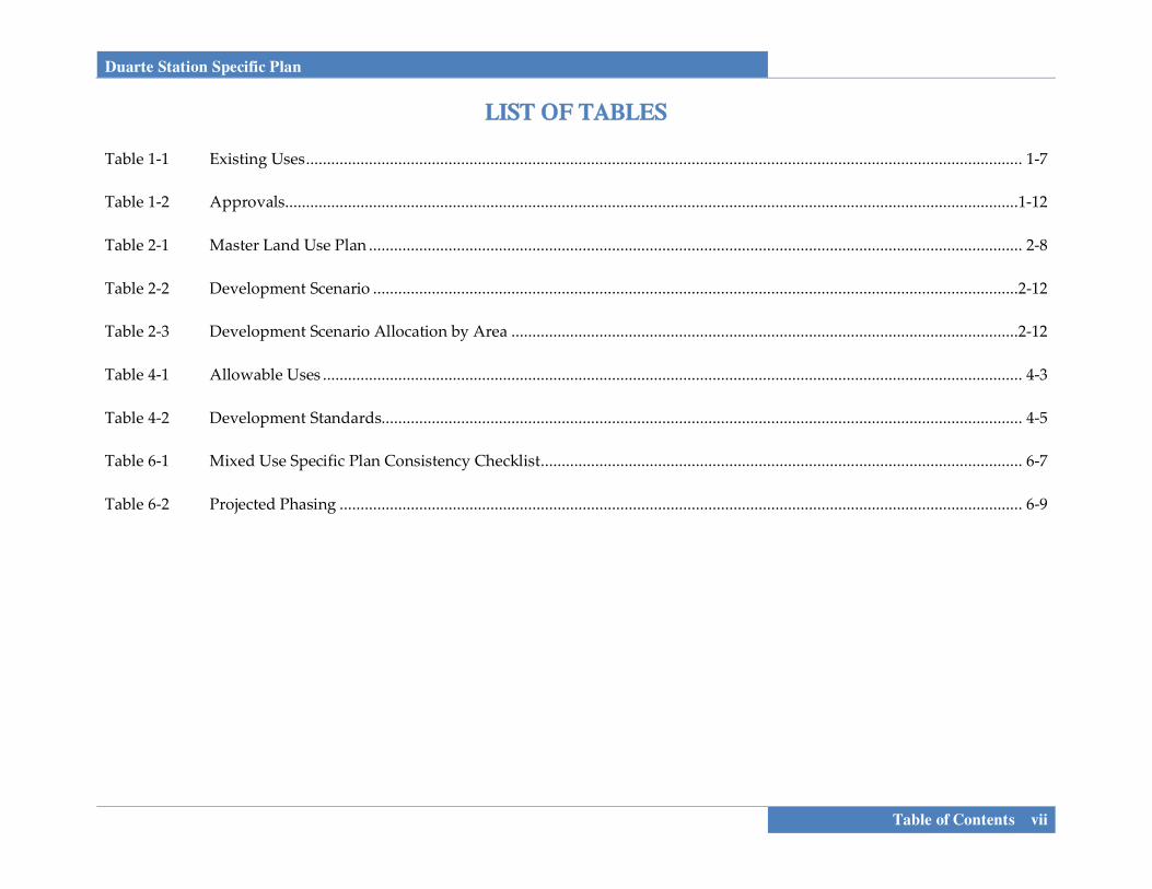
LIST OF TABLES Table 1-1 Existing Uses ........................................................................................................................................................................... 1-7 Table 1-2 Approvals ...............................................................................................................................................................................1-12 Table 2-1 Master Land Use Plan ............................................................................................................................................................ 2-8 Table 2-2 Development Scenario ..........................................................................................................................................................2-12 Table 2-3 Development Scenario Allocation by Area .........................................................................................................................2-12 Table 4-1 Allowable Uses ....................................................................................................................................................................... 4-3 Table 4-2 Development Standards......................................................................................................................................................... 4-5 Table 6-1 Mixed Use Specific Plan Consistency Checklist ................................................................................................................... 6-7 Table 6-2 Projected Phasing ................................................................................................................................................................... 6-9

Duarte Station Specific Plan
viii Table of Contents
This page intentionally left blank.


Duarte Station Specific Plan
Introduction 1-1
SECTION 1.0 INTRODUCTION
1.1 EXECUTIVE SUMMARY The Duarte Station Specific Plan is located in the City of Duarte, California and in Los Angeles County (see Figure 1-1, Regional Vicinity). The approximately 19 acre site is planned as a Transit-Oriented Development (TOD) because of its location adjacent to the City of Duarte Metro Gold Line Station; north of Duarte Road and west of Highland Avenue. Based upon a Master Land Use Plan, the Specific Plan establishes the following land use designations:
Station Plaza Mixed Use. The Station Plaza (SP) designation would allow for local serving retail shops, service uses, cafes, and an outdoor plaza to be developed around the Duarte Station.
Mixed Use. The Mixed Use (MU) designation
incorporates a mixed use approach that allows for a full range of high density residential, office, hotel, and commercial uses.
High Density Residential (HDR). The High Density
Residential land use designation is anticipated to allow maximum flexibility and response to future market conditions and residential trends. Anticipated residential types in the HDR designation include condominiums and apartment units.
Open Space (OS). The Open Space designation provides for up to 0.80 acres of passive open space in the form of a greenbelt, which serves as a buffer between the high density residential uses in the Plan Area and the existing single-family residential to the west and north of the project site. The eastern-most extension of the green space may be narrowed or broken up into smaller open spaces throughout the Plan Area.
In addition, the plaza planned near the Station is intended to be a gathering place and focal point along Highland Avenue that would include landscaping, hardscape features, and public amenities.

P A CI F
I C O
CE
AN
LakePiru
CastaicLake
O R A N G EC O U N T Y
V E N T U R AC O U N T Y
L O S A N G E L E SC O U N T Y
S A N B E R N A R D I N OC O U N T Y
R I V E R S I D EC O U N T Y
10 Mile Radius
5 Mile Radius
101101
395
1
1
2
1
5
5
5
5
126
118 118
241
241
142
134
261
133
138
138
405
405
605
710
110
110
10
10
210
210
210
215
215
210
10
15
15
15
15
405
23
2
14
18
23
23
27
55
73
91
90
91
74
90
57
57
57
60
60
6071
22
Upland
Pomona
Chino
Palmdale
Pasadena
Alhambra
MontereyPark
PicoRivera
DowneySouthGate
Compton
Carson
Hawthorne
Inglewood
CulverCity
SantaMonica
BeverlyHills
ShermanOaks
VanNuys
Hollywood
Bellflower
Lakewood
Arcadia
MonroviaAzuza
DuarteClaremont
SanDimas
WestCovina
La HabraHeights
Brea
Walnut
CovinaBaldwin
Park
Whittier
LaMirada
Burbank
Pacoima
Glendale
LosAngeles
Torrance
SanPedro
LongBeach
HuntingtonBeach
NewportBeach
SantaAna
CostaMesa
GardenGrove
Anaheim
Tustin
Orange
Fullerton
YorbaLinda
IrvineLake
Forest
Fillmore Piru
Moorpark
ThousandOaks
SimiValley
Castaic
SantaClarita
Sylmar
Agoura Hills WoodlandHills
CanogaPark
Chatsworth
WestlakeVillage
Calabasas
Malibu
PalosVerdesEstates
Redondo Beach
Manhattan Beach
El Segundo
Playa Del Rey
Marina Del Rey
Adelanto
Hesperia
SanBernardino
Riverside
Fontana
Ontario
RanchoCucamonga
DiamondBar
Rialto
Corona
Norco
LakeElsinore
Glendora
MorenoValley
Perris
Regional VicinityDUARTE STATION SPECIFIC PLAN
FIGURE 1-18/28/13 JN 130318-19345 MASA Company
0 5 10 miles
ProjectSite

Duarte Station Specific Plan
Introduction 1-3
1.2 PROJECT SETTING 1.2.1 Location The City of Duarte is located in Los Angeles County to the east of Monrovia, south of the City of Bradbury, and west of the City of Azusa along interstate 210. Regional access to the City is provided primarily by the I-210 and I-605 freeways (see Figure 1-1, Regional Vicinity). The Duarte TOD Specific Plan area is approximately 19 acres in size and consists of three parcels located at the northwest and southwest corners of Business Center Drive and Highland Avenue within the heart of the City (see Figure 1-2, Local Vicinity). Roadways that border the parcels include Evergreen Street to the north, Highland Avenue to the east, Duarte Road to the south (including the Metro-owned Gold Line tracks under construction), and Denning Avenue and 3 Ranch Road to the west. Business Center Drive traverses the Specific Plan area in an east-west direction. Additionally, the Los Angeles County Metropolitan Transportation Authority (Metro) -owned right- of-way borders the Specific Plan area to the south; these tracks will function as critical transportation infrastructure to serve as a primary driving factor for the Duarte TOD Specific Plan.
1.2.2 Surrounding Uses The project site is surrounded by the following uses:
North: Evergreen Street and the Foothill Freeway (Interstate 210) are located to the north of the most northern portion of the site. Single-family residential uses are located to the north across Business Center Drive.
West: An approximately 204-unit single-family residential neighborhood south of Evergreen Street, east of Buena Vista Street, north of Duarte Road, and west of the project site.
South: The Los Angeles County Metropolitan Transportation Authority (Metro) -owned railroad right-of-way is directly adjacent to the project site. The City of Hope campus and the Santa Fe Dam Recreational Area, owned by the US Army Corps of Engineers, operated by Los Angeles County Department of Parks and Recreation and located in the City of Irwindale are located to the south of the project site across Duarte Road.
East: The Duarte/Lewis Business Center occupies approximately 40 acres and is located to the east across Highland Avenue, south of the Interstate 210 and west of the San Gabriel Freeway (Interstate 605).

CENTRAL AVENUECENTRAL AVENUE
BUSINESS CTR DR.BUSINESS CTR DR.
EVERGREEN STREETEVERGREEN STREET
EA
ST
FO
RD
AV
E.
EA
ST
FO
RD
AV
E.
VIL
LA
GE
RO
AD
VIL
LA
GE
RO
AD
E.
CIR
CL
E R
OA
DE
. C
IRC
LE
RO
AD
HIG
HL
AN
D A
VE
NU
EH
IGH
LA
ND
AV
EN
UE
SA
NTO
DO
MIN
GO
AV
EN
UE
SA
NTO
DO
MIN
GO
AV
EN
UE
EL
MH
UR
ST
AV
EN
UE
EL
MH
UR
ST
AV
EN
UE
BR
AD
BO
UR
NE
AV
EN
UE
BR
AD
BO
UR
NE
AV
EN
UE
CO
TT
ER
AV
EN
UE
CO
TT
ER
AV
EN
UE
HUNTINGTON DRIVEHUNTINGTON DRIVE
BU
EN
A V
ISTA
ST
RE
ET
BU
EN
A V
ISTA
ST
RE
ET
BU
EN
A V
ISTA
ST
RE
ET
BU
EN
A V
ISTA
ST
RE
ET
E. DUARTE ROADE. DUARTE ROAD
BUSINESS CENTER DRIVEBUSINESS CENTER DRIVE
3 RANCH ROAD3 RANCH ROAD
DU
NC
AN
NO
N A
VE
.D
UN
CA
NN
ON
AV
E.
210
210
605
Local VicinityDUARTE STATION SPECIFIC PLAN
FIGURE 1-26/4/13 JN 130318-19345 MAS
not to scale
PROJECTSITE
PROJECTSITE
A Company

Duarte Station Specific Plan
Introduction 1-5
Existing On-Site Uses

Duarte Station Specific Plan
1-6 Introduction
Existing Edge Conditions
Duarte Station Specific Plan
Introduction 1-7
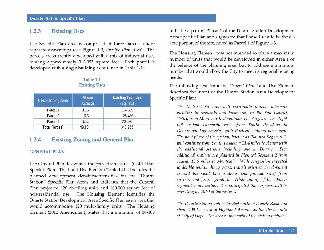
1.2.3 Existing Uses The Specific Plan area is comprised of three parcels under separate ownerships (see Figure 1-3, Specific Plan Area). The parcels are currently developed with a mix of industrial uses totaling approximately 313,955 square feet. Each parcel is developed with a single building as outlined in Table 1-1:
Table 1-1 Existing Uses
Use/Planning Area Gross
Acreage Existing Facilities
(Sq. Ft.) Parcel 1 9.16 114,599 Parcel 2 6.6 128,466 Parcel 3 3.32 70,890
Total (Gross) 19.08 313,955
1.2.4 Existing Zoning and General Plan
GENERAL PLAN The General Plan designates the project site as GL (Gold Line) Specific Plan. The Land Use Element Table LU-4 includes the planned development densities/intensities for the “Duarte Station” Specific Plan Areas and indicates that the General Plan projected 120 dwelling units and 100,000 square feet of non-residential use. The Housing Element identifies the Duarte Station Development Area Specific Plan as an area that would accommodate 120 multi-family units. The Housing Element (2012 Amendment) states that a minimum of 80-100
units be a part of Phase 1 of the Duarte Station Development Area Specific Plan and suggested that Phase 1 would be the 6.6 acre portion of the site, noted as Parcel 1 of Figure 1-3.
The Housing Element, was not intended to place a maximum number of units that would be developed in either Area 1 or the balance of the planning area, but to address a minimum number that would allow the City to meet its regional housing needs.
The following text from the General Plan Land Use Element describes the intent of the Duarte Station Area Development Specific Plan:
The Metro Gold Line will eventually provide alternate mobility to residents and businesses in the San Gabriel Valley from Montclair to downtown Los Angeles. This light rail system currently runs from South Pasadena to Downtown Los Angeles with thirteen stations now open. The next phase of the system, known as Planned Segment 1, will continue from South Pasadena 11.4 miles to Azusa with six additional stations including one in Duarte. Five additional stations are planned in Planned Segment 2 from Azusa, 12.5 miles to Montclair. With congestion expected to double within thirty years, transit oriented development around the Gold Line stations will provide relief from current and future gridlock. While timing of the Duarte segment is not certain, it is anticipated this segment will be operating by 2010 at the earliest. The Duarte Station will be located north of Duarte Road and about 400 feet west of Highland Avenue within the vicinity of City of Hope. The area to the north of the station includes

BUSINESS CENTER DRIVEBUSINESS CENTER DRIVE
BUSINESS CENTER DRIVEBUSINESS CENTER DRIVE
DUARTE ROADDUARTE ROAD
HIG
HLA
ND
AV
EH
IGH
LAN
D A
VE
DEN
NIN
G A
VEN
UE
DEN
NIN
G A
VEN
UE
GLE
NFO
RD
AV
ENU
EG
LEN
FOR
D A
VEN
UE
210
PARCEL 2
PARCEL 1
PARCEL 3
A Company
Specific Plan AreaDUARTE STATION SPECIFIC PLAN
Source: DAHLIN group, 5-13
FIGURE 1-35/31/13 JN 130318-19345 MAS
PARCEL 1: +/- 6.60 AC
PARCEL 2: +/- 9.16 AC
PARCEL 3: +/- 3.32 AC
+/- 19.08 AC
SITE SUMMARY :
0 240'
APPROXIMATE

Duarte Station Specific Plan
Introduction 1-9
about twenty acres of industrial buildings. For purposes of this Land Use Element, it is anticipated this area should be designated a specific plan area. This specific plan should provide for a mixed use transit oriented development. For planning purposes a maximum of 100,000 sq. ft. of retail and office could be accommodated within this area. In addition up to 120 multiple family residential units could be built within this area. Gold Line ridership estimates could eventually require up to 500 parking spaces in close proximity to the Duarte station. The concept is to work with existing property owners and businesses to formulate a specific plan that provides for the before mentioned uses, densities and intensities as well as development standards for a true transit oriented development.
The Duarte Station Area Development Specific Plan is a new land use designation for the 2005 – 2020 General Plan. As with the City Center area, this area is intended to create a unique area oriented towards the future Gold Line station in Duarte. This flexible mixed use area will be located north of the Duarte Station in what is now part of the industrial park west of Highland Avenue.
This mixed use area will also use a specific plan as an implementation tool to achieve the desired objective. The desired objective is to reduce vehicle miles traveled, provide transportation options for existing and future workforce and residents around the Duarte Station, provide location efficiency, expanded mobility, and provide public/private financial return and value recaptured. The specific plan to
implement this objective must provide flexibility in providing vertical and/or horizontal mixed high density residential, commercial uses, office, R&D and industrial uses. As with the City Center plan the Duarte Station Specific Plan which will be the implementation tool for this area must also provide unique parking standards, sufficient residential densities, housing types and appropriate pedestrian friendly design to encourage usage of the Gold Line as a primary mode of travel. Because the timing of the Duarte Station opening is unknown, this Specific Plan must provide even more flexibility for future needs.
ZONING The City’s Zoning Map designates the project site as M-the Light Industrial Zoning District. This zone provides for relatively low-intensity industrial activities that do not involve substantial truck traffic or outdoor fabrication or assembly, do not produce noticeable odors, and do not involve operations normally considered hazardous within an urban environment. With adoption of the Specific Plan the zoning will be changed to a Specific Plan Designation.
Duarte Station Specific Plan
1-10 Introduction
1.2.5 Background
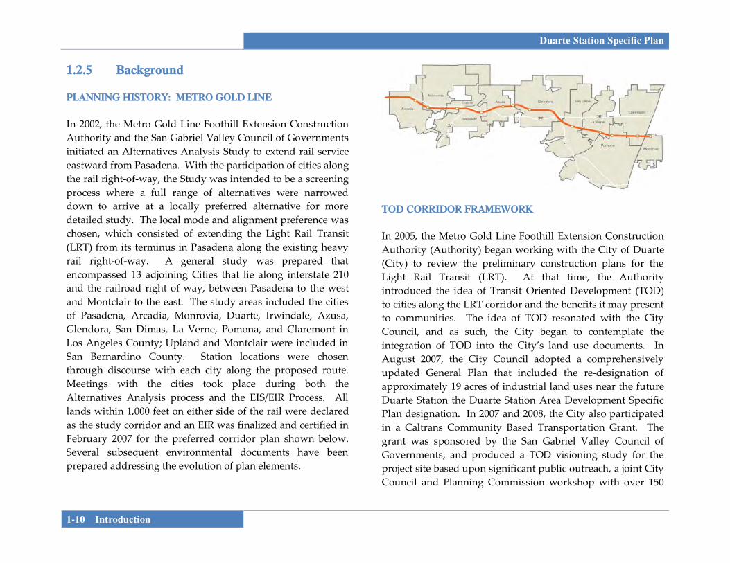
PLANNING HISTORY: METRO GOLD LINE In 2002, the Metro Gold Line Foothill Extension Construction Authority and the San Gabriel Valley Council of Governments initiated an Alternatives Analysis Study to extend rail service eastward from Pasadena. With the participation of cities along the rail right-of-way, the Study was intended to be a screening process where a full range of alternatives were narrowed down to arrive at a locally preferred alternative for more detailed study. The local mode and alignment preference was chosen, which consisted of extending the Light Rail Transit (LRT) from its terminus in Pasadena along the existing heavy rail right-of-way. A general study was prepared that encompassed 13 adjoining Cities that lie along interstate 210 and the railroad right of way, between Pasadena to the west and Montclair to the east. The study areas included the cities of Pasadena, Arcadia, Monrovia, Duarte, Irwindale, Azusa, Glendora, San Dimas, La Verne, Pomona, and Claremont in Los Angeles County; Upland and Montclair were included in San Bernardino County. Station locations were chosen through discourse with each city along the proposed route. Meetings with the cities took place during both the Alternatives Analysis process and the EIS/EIR Process. All lands within 1,000 feet on either side of the rail were declared as the study corridor and an EIR was finalized and certified in February 2007 for the preferred corridor plan shown below. Several subsequent environmental documents have been prepared addressing the evolution of plan elements.
TOD CORRIDOR FRAMEWORK
In 2005, the Metro Gold Line Foothill Extension Construction Authority (Authority) began working with the City of Duarte (City) to review the preliminary construction plans for the Light Rail Transit (LRT). At that time, the Authority introduced the idea of Transit Oriented Development (TOD) to cities along the LRT corridor and the benefits it may present to communities. The idea of TOD resonated with the City Council, and as such, the City began to contemplate the integration of TOD into the City’s land use documents. In August 2007, the City Council adopted a comprehensively updated General Plan that included the re-designation of approximately 19 acres of industrial land uses near the future Duarte Station the Duarte Station Area Development Specific Plan designation. In 2007 and 2008, the City also participated in a Caltrans Community Based Transportation Grant. The grant was sponsored by the San Gabriel Valley Council of Governments, and produced a TOD visioning study for the project site based upon significant public outreach, a joint City Council and Planning Commission workshop with over 150
Duarte Station Specific Plan
Introduction 1-11
residents in attendance, and a summary presentation before the City Council in April 2008. IBI provided market research, created urban design schemes, researched transportation issues, and provided recommendations for each individual station along the extension. The study found that the Foothill Extension Corridor is truly a unique opportunity to accommodate population growth while providing new job centers and thoughtful compact development.
IBI met with the City of Duarte in 2007, and the City requested that IBI evaluate the possibilities and feasibility of a Village Concept north of the proposed station area and south of interstate 210. The urban concept focused on developing compact mixed uses while providing opportunities for growth in office, retail, and hotel land uses. In 2008, IBI prepared the Duarte Gold Line Station Area Vision Report which evaluated the potential for a transit oriented development (TOD) on a 20-acre site adjacent to the proposed Metro Goldline Station. The goal of this study was to develop an overall vision and guiding principles for future development within the station area and to illustrate possible options for organization of land uses, building placement, and built form on the site. A market study, community outreach, and a traffic analysis were also undertaken during the conceptual planning effort. All of these efforts have served as a catalyst for both the City Council and the community to realize a TOD development at the project site. The Duarte City Council is committed to the realization of the Duarte Station Area Development, and as such, supported
City Staff submittal of a METRO Transit Oriented Development (TOD) Planning Grant Program. This program provides funds to encourage local governments to develop and adopt land use regulations that promote sustainable, transit-oriented design principles. The funds allow local governments to adapt their existing general plans, specific plans, zoning, and other ordinances to encourage such sustainable development forms or to develop model ordinances, planning tools, and/or recommendations that will lead to local regulatory changes in support of TOD. In 2012 the City was awarded Round 1 grant funding that was offered to municipalities along the Expo Line Phases 1 & 2, Crenshaw/LAX corridor, and Gold Line Foothill Extension. The grant award allows the City to lead the effort in the preparation of a Duarte Station Area Development Specific Plan and Project-based EIR. 1.2.6 Relationship to Governing Documents As discussed above, a comprehensive regional and local planning effort has been undertaken to implement a TOD Specific Plan for the Duarte Station. Thus, the Duarte Station Specific Plan incorporates objectives and visioning discussed above and reflects the intent of the Certified Final EIRs, as well as the TOD Corridor Development Assessment and the Duarte Station Areas Vision studies prepared by IBI Group. The Duarte TOD Specific Plan is also intended to implement the City of Duarte’s General Plan and Zoning Ordinance.

Duarte Station Specific Plan
1-12 Introduction
SPECIFIC PLAN AUTHORITY The California Government Code (Title 7, Division 1, Chapter 3, Article 8, Sections 65450 through 65457) provides the authority for a city to adopt a Specific Plan by ordinance (as a regulatory plan) or resolution (as a policy driven plan). This Specific Plan is both a regulatory and policy document, and therefore must be adopted by ordinance. The California Government Code establishes a minimum set of requirements for specific plans, which include text and diagrams that specify all of the following in detail:
The distribution, location, and extent of the uses of land, including potential open space, within the Specific Plan Area.
The proposed distribution, location, extent and intensity of major components of public and private transportation, sewage, water, drainage, solid waste disposal, energy, and other essential facilities to be located within the Specific Plan Area and which are needed to support the land uses described in the Specific Plan.
Standards and criteria by which development will proceed, and standards for the conservation, development, and utilization of natural resources, where applicable.
A program of implementation measures including regulations, public works projects, and financing measures necessary to carry out the project.
A statement of the relationship of the Specific Plan to the General Plan.
1.2.7 Required Approvals Implementation of the specific plan will require several approvals as noted in Table 1-2. Subsequent approvals will include site plan/design review and subdivision mapping if needed to create individual lots within the Specific Plan boundaries.
Table 1-2 Approvals
Requested Permit/Approval Approving Agency
Final EIR Certification City of Duarte City Council General Plan Text Amendment City of Duarte City Council
Zone Change/Specific Plan Adoption City of Duarte City Council
1.2.8 Specific Plan Organization The Duarte TOD Specific Plan is composed of several sections, as described in detail below:
Section 1 – Introduction. This section provides background information about the Specific Plan. Since the Specific Plan will be used by a variety of users (such as property owners, City staff, business owners, residents, and elected and appointed officials), a brief

Duarte Station Specific Plan
Introduction 1-13
background of the Specific Plan area and project setting are included. This section provides a very brief description of the history, purpose, and function of the specific plan; it educates the reader on the information contained within the Specific Plan Document in the sections that follow.
Section 2 – Development Plan. Section 2 identifies the fundamental components of the Specific Plan. The detailed land use program is presented through tables and a master land use plan graphic. Public Spaces are also discussed in this Section.
Section 3 – Infrastructure and Services Plan. The Infrastructure and services plan discusses existing conditions and proposed improvements to local circulation, parking, sewer, water, and storm drain systems that would serve the Specific Plan area at full build-out. Improvements proposed are triggered by the Master Development Plan discussed in Section 2. Public and private utility providers are also identified here.
Section 4 – Land Use and Development Regulations. Section 4 provides development standards for proposed development in the Specific Plan area. These regulations are going to be included through a hybrid approach that integrates features of a conventional zoning code and a form based code. Form based codes regulate land uses based on form and function and are based on a “human-use” scale. This section contains development standards for architecture and building
placement, streets and alleys, civic and public places, and landscaped or hardscape areas. The Development regulations complement the Design Guidelines to ensure that quality development occurs in suitable places and spaces.
Section 5 – Design Guidelines. This section provides design guidance for architectural, landscape, signage, lighting, and community artwork features within the Specific Plan area. The purpose of the Design Guidelines is to identify and establish visual themes that are aesthetically pleasing and will result in a cohesiveness to create a “sense of place” for persons that live, work, or congregate within the TOD Specific Plan area.
Section 6 – Implementation and Administration. The intent of this section is to provide methods for eventual construction and build-out of the Specific Plan. An analysis is included ensuring the Specific Plan is consistent with the General Plan. Implementation techniques, tools, and incentives including efficient entitlement processing standards, phasing, cost estimates, and public and private funding and financing mechanisms are also addressed.
Section 7 – Appendices. This section includes the General Plan consistency analysis as well as other supporting information. After approval, the appendices will include the project’s Mitigation Monitoring and Reporting Program (MMRP).
Duarte Station Specific Plan
1-14 Introduction
This page intentionally left blank.


Duarte Station Specific Plan
Development Plan 2-1
SECTION 2.0 DEVELOPMENT PLAN This section of the Duarte Station Specific Plan outlines the master plan for development. In this section a land use plan and tables will be shown to form the land use program for the eventual build-out of the Specific Plan area. The overarching Specific Plan Vision, Goals, and Objectives are stated below followed by the Land Use Program. 2.1 WHAT IS TRANSIT-ORIENTED
DEVELOPMENT? Transit-Oriented Development has many definitions. As defined in the TOD Corridor Development Assessment study prepared by Metro Gold Line as part of the early planning for the Foothill Extension:
Transit-oriented development is typically defined as compact development containing a mix of uses within easy walking distance (a quarter – to one half-mile radius) of transit stations. But a prescribed density or mix of uses can’t ensure the success of a transit oriented development project or guarantee that it will produce more riders for transit. It’s become increasingly clear that TOD cannot be defined by physical form alone, and those high-performing projects – whether performance is judged by financial returns or the number of people who flock there – are best defined by performance criteria that can be used as a planning tool to assess how well a project will function.
TOD is not just development near transit stations but rather it is development that:
• Increases “location efficiency” so that people can walk,
bike and take transit;
• Boosts transit ridership and minimizes the impacts of traffic through access to site-adjacent transit;
• Provides a mixture of land uses;
• Provides value for the public and private sectors, and for both new and existing residents; and
• Creates a sense of community and of place.
2.2 SPECIFIC PLAN VISION, GOALS, AND OBJECTIVES
2.2.1 Vision Statement The Duarte Station Area will become a vibrant, mixed-use transit village that has a focus on residential uses, office, hospitality, and urban green space. The transit station on the project’s southern edge will act as the gateway to the neighborhood with special attention paid to the public realm in the immediate vicinity by creating a park/public plaza bordered by local serving retail uses, so that the station area may also serve as a local gathering place. A strong emphasis will be placed on walkability through a pleasant sidewalk environment where buildings frame the street. The following Goals and Objectives are included below to guide the intent and future development within the Specific Plan area.

Duarte Station Specific Plan
2-2 Development Plan
1. GOAL: A MIXTURE OF LAND USES
a. Objective: Develop a flexible mixed-use land use pattern that incorporates retail, office, hospitality, and residential opportunities that will effectively complement each other and provide maximum land use efficiency, while providing economic and social benefits to all users.
b. Objective: Program retail uses that are neighborhood-
and transit-station serving. 2. GOAL: AN ECONOMICALLY FEASIBLE
DEVELOPMENT
a. Objective: Provide flexible non-residential spaces that can be adjusted to respond to shifts in market demand and allow options throughout various economic cycles and scenarios.
b. Objective: Create a range of residential unit types that
will be accessible to residents of all income levels.
c. Objective: Provide residential opportunities to assist the City of Duarte in meeting their Regional Housing Needs Allocation (RHNA) objectives.
d. Objective: Encourage the development of a hotel to
create local jobs, support City of Hope lodging needs, provide community meeting space, and increase tax revenues within the community.
3. GOAL: TRADITIONAL PEDESTRIAN-ORIENTED STREET PATTERN
a. Objective: Create a “grid-like” block pattern that
effectively provides for compact development with reduced road widths to provide connectivity throughout the site.
b. Objective: Give precedence to pedestrians while
keeping streets narrow to foster multimodal transportation with bicycle, pedestrian, and transit access.
4. GOAL: SUPERIOR URBAN DESIGN
a. Objective: Allow for building types that will achieve desired density ranges to establish a critical mass of residents and employees to support the transit station, maximize transit ridership, and support retail spaces and local employment centers.
b. Objective: Minimize setbacks to allow buildings to
frame and activate the street.
c. Objective: Use trees, shrubs and other landscape and hardscape materials along streets to provide shading, screening, and human scale.
d. Objective: Promote quality architectural design to
establish a consistent contemporary design character that creates an identity in the Duarte Station Specific Plan area.

Duarte Station Specific Plan
Development Plan 2-3
5. GOAL: OUTDOOR SPACES a. Objective: Provide singular or multiple outdoor
spaces, such as an urban green space or public plaza that provides a transition between the station and the surrounding transit village uses in order to provide a public gathering space.
b. Objective: Program outdoor space(s) to accommodate
the needs of various user groups, such as residents, employees, commuters, and visitors.
6. GOAL: AWARENESS OF SURROUNDING
DEVELOPMENT
a. Objective: Create a center that provides desired goods and services to surrounding residents, students, and employees within and surrounding the Duarte Station Specific Plan area.
b. Objective: Provide specific setbacks, height limitations,
upper story step-backs, and landscape requirements to provide for appropriate transitions with adjacent existing residential uses.
c. Objective: Consider the future needs of the City of
Hope as part of land use planning. 7. GOAL: SUSTAINABLE DEVELOPMENT PRACTICES
a. Objective: Identify the level of development proposed within the Specific Plan area, and adhere to Levels of
Sustainable Development Practices as prescribed in Chapter 19.52 of the City’s Development Code.
b. Objective: Ensure that construction and demolition
waste is disposed of in accordance with all City regulations and standards.
c. Objective: Consider building layout, siting, and
building design to not preclude alternative energy production on-site.
d. Objective: Maximize energy efficiency through local and state standards, indoor environmental quality, energy-efficient lighting, building orientation, shading, and implementation of LEED principles and/or attaining LEED Certification.
e. Objective: Reduce heat island effect through site
planning and selection of landscape and hardscape materials.
f. Objective: Incorporate water-efficient design features
such as permeable surfaces, collection devices, biofiltration devices, green rooftops, cisterns, berms and swales, and/or green rooftops.
g. Objective: Include drought-tolerant landscape within
the Specific Plan area.

Duarte Station Specific Plan
2-4 Development Plan
2.3 SUSTAINABLE DESIGN Sustainable design refers to design and construction practices that significantly reduce or eliminate the negative impacts of development on the environment and its inhabitants. The City of Duarte has established Sustainable Development Practices in the Duarte Development Code (DDC) to encourage conservation of natural resources, increased energy efficiency, and the use of sustainable practices in the development process. A sustainable design approach can be defined by a variety of green building practices and the availability of pedestrian-oriented amenities. The essential components that make up a successful sustainable development have been identified by the U.S. Green Building Council (USGBC). The USGBC recognizes that the layout and design of the built environment influences the way residents and visitors experience a neighborhood, and it can impact their quality of life and sense of community. All new construction within the City and this Specific Plan are required to apply sustainable development practices identified in the DDC. The design guidelines and implementation approach provided are aimed at meeting the following objectives:
Encourage development within and near existing communities or public transportation infrastructure to reduce vehicle trips and induce pedestrian activity;
Promote neighborhoods that are physically connected to each other to foster community and connectedness beyond the individual project;
Encourage design of projects that incorporate high levels of internal connectivity and connections to surrounding development to promote a variety of travel options;
Provide direct and safe connections for pedestrians, bicyclists, and drivers to key components of a project, local destinations, and neighborhood centers;
Encourage the design and construction of buildings to utilize green building practices;
Encourage the design and construction of energy efficient buildings to reduce air, water, and land pollution and environmental impacts from energy production and consumption;
Achieve enhanced energy efficiency by creating the optimum conditions for the use of passive and active solar;
Use recycled and other environmentally-friendly building materials whenever possible;
Encourage incorporation of low impact development (LID) and best management (BMP’s) to treat stormwater on-site and infiltrate rainwater as much as possible rather than diverting it into storm drains;
Reduce the impact of heat islands by providing shade structures and trees that can produce large canopies to provide shade. In addition, choose roof paving materials that possess a high level of solar reflectivity.

Duarte Station Specific Plan
Development Plan 2-5
Development applications are required to identify the level of development (project size) and the corresponding required sustainable development practices. Projects at each level shall comply with the provisions identified in Table 3-20 of the DDC, Chapter 19.52, Sustainable Development Practices. 2.4 LAND USE PROGRAM 2.4.1 Context In evaluating the site for development opportunities a number of items were considered, including the following:
Existing conditions related to drainage, circulation, land use, transit, and infrastructure;
Existing plans for the Duarte Station location and orientation as well as Gold Line mitigation requirements from previous environmental analysis;
Stakeholder input from City of Hope regarding future off-campus needs and from existing landowners;
Past studies related to the site by Metro and the Duarte Station Area Plan (March 2008) including input from community meetings and area residents ;
Review of existing Market information; and
Existing General Plan assumptions.
Past community meetings, as part of the 2008 Vision Plan, resulted in the reduction of the Specific Plan area to the area presently proposed. The reduced Plan area no longer includes the existing residential areas surrounding the site. A scoping meeting was held on April 22, 2013 to provide the community with information about the planning process and to solicit comments on the proposed project. In keeping with community input, a transitional edge treatment between proposed new uses and existing residential uses has been incorporated into the plan as outlined in the project’s Development Regulations. 2.4.2 Development Concept The Specific Plan establishes the general type, parameters and character of the development in order to develop an integrated TOD that is compatible with the surrounding area. The Specific Plan’s proximity to freeways, major streets, and planned rail infrastructure makes the Duarte Station Specific Plan an ideal opportunity for the expansion of types and intensities of uses that support the City s goals for the area and are consistent with the City’s desire to incentivize economic development in Duarte. The development concept for the Duarte Station Specific Plan provides flexibility for all property owners to respond to market conditions and develop a mixed use “transit village” that revitalizes the Specific Plan area through the provision of multiple land uses that are complementary to one another. Land uses consist of residential, office, hospitality, and commercial/retail spaces. The mixture of land uses results in

Duarte Station Specific Plan
2-6 Development Plan
the availability of a variety of goods, services, and amenities for residents, employees, or visitors to the Specific Plan area. MASTER LAND USE The Master Land Use Plan provides flexibility for property owners to respond to market conditions. The Master Land Use Plan shows the type of development that is envisioned for the Duarte Specific Area Plan along with circulation improvements that tie the Plan Area together, and integrate the area into the larger context of the City of Duarte. The block pattern and the circulation framework is suggestive and the locations may be adjusted, though it is recommended that the future block and street pattern connect to the existing surrounding context to form a seamless transition from the existing to the proposed. For example, a street may be replaced by a publicly accessible pedestrian mew or an alley if it better serves the final development program, as long as it meets the intent of the Specific Plan. The development of each of the land uses within the Station Area will be over an extended period of time and therefore needs to be flexible enough to respond to changing market demands. To accommodate this flexibility, the land use classifications in this chapter represent adopted policy and are meant to be broad enough to provide flexibility in implementation, but clear enough to provide sufficient direction to carry out the Specific Plan. The type and amount of development for each planning area will ultimately be determined through the entitlement process, subject to the
intensity, development standards, setbacks, and other requirements of this Specific Plan. The Land Use Plan is a graphic representation of policies contained in this Specific. Land use classifications—shown as color/graphic patterns on the plan—allow for a range of uses within each classification. Adopting a mix of land uses around the proposed Duarte Station will generate the greatest benefits for the City of Duarte. Office uses will help establish an employment center, retail uses will serve the residents and employees of the area, and residential units within walking distance of the station will provide the riders necessary to support the Gold Line system. Studies have shown that residential units within walking distance of the stations provide the greatest number of riders compared to other land uses. Based upon the Master Land Use Plan, the Specific Plan is establishing the following land use designations:
Station Plaza Mixed Use
Mixed Use
High Density Residential
Open Space Greenbelt
The Duarte Station Specific Plan is based upon the following Land Uses (see Figure 2-1, Master Land Use Plan and Table 2-1 Master Land Use Plan).

GLE
NFO
RD A
VEG
LEN
FORD
AVE
DEN
NIN
G A
VEDE
NN
ING
AVE
EVERGREEN STEVERGREEN ST
BUSINESSCENTER DRIVEBUSINESSCENTER DRIVE
DUARTE RDDUARTE RD
HIG
HLAN
D AV
EHI
GHL
AND
AVE
GOLD LINE STATION GOLD LINE STATION
BUSINESS CENTER DRBUSINESS CENTER DR
P
PP
PP
64’
LAND USE :
STATION PLAZA MIXED USE
MIXED USE
HIGH DENSITY RESIDENTIAL
OPEN SPACE
PERMISSIBLE RETAIL EDGE
ALTERNATIVE SHAREDPARKING LOCATIONSBETWEEN OFFICEAND GOLDLINE STATION
Note:
STATION PLAZA MIXED USERetail, Open Space, Public Use
MIXED USERetail, Office (max 2.0 FAR),Residential (max 70 du/ac), 250 room hotel
HIGH DENSITY RESIDENTIALResidential (max 70 du/ac)
Centerline of proposedstreets to match withexisting streets
+/- 250’
CL
A Company
Master Land Use PlanDUARTE STATION SPECIFIC PLAN
Source: DAHLIN group, 10-13
0 180'
APPROXIMATE
FIGURE 2-110/24/13 JN 130318-19345 MAS

Duarte Station Specific Plan
2-8 Development Plan
Table 2-1 Master Land Use Plan
2.4.3 LAND USE DESIGNATIONS The Specific Plan’s Land Use Plan includes three land use designations, which are defined below. Each land use is associated with specific intensities and permitted uses, outlined in the Development Regulations of this document. The primary Land Use within the Duarte Station Specific Plan is designated as Mixed Use and is split into two separate categories of Mixed Use. The Mixed Use designation incorporates a range of commercial, retail, cafe, and office amenities while allowing for residential development.
Descriptions of land use designations within the Duarte Station Specific Plan are outlined below. MIXED USE The Mixed Use designation includes two categories of mixed use: a general Mixed Use category, and Station Plaza Mixed Use: Mixed Use (MU)
The general mixed-use designation is intended to provide flexibility within the plan to adapt to changing market conditions. Residential densities are permitted between a minimum of 40 and a maximum of 70 units per acre, along with Office at a maximum 2.0 FAR and a hotel with a maximum of 250 rooms. All of the residential building types allowed in High Density Residential are permitted. Retail, cafe, and commercial service uses that serve employees and residents are permitted and encouraged on the ground floor. Parking is envisioned in parking decks or structures and should be architecturally enhanced as viewed from the streets. Commercial parking in surface lots are strongly discouraged, but may be considered through a Use Permit as part of the Site Plan Review process in order to phase higher intensity development and shared/structured parking. To ensure maximum flexibility, final development locations or quantities of residential, office, or hotel uses
Land Use Designation Density/ Intensity Acreage
Station Plaza Mixed Use -- 0.81
Mixed Use (non-residential) Mixed Use (residential)
2.0 FAR Max 70 du/ac Min 40 du/ac 12.06
High Density Residential Max 70 du/ac Min 40 du/ac
2.55
Open Space -- 0.80
Roads -- 2.87
Total Acreage 19.09
Note: A minimum 178 high density residential units must be located along the western Specific Plan boundary within the High Density Residential land use designation shown in Figure 2-1. The remainder of the units may be located within the Mixed Use land use designation.

Duarte Station Specific Plan
Development Plan 2-9
will be confirmed during the site plan review process as outlined in Section 6, Implementation, of this Specific Plan.
Station Plaza Mixed Use (SP)
This Land Use Designation is located at the corner of Duarte Road and Highland Avenue. A portion of the southern edge and all of the western edge of this land use designation is also planned as a retail edge that would incorporate storefronts facing the station location and the proposed public plaza. The Station Mixed Use Land Use designation consists of approximately 0.81 acres.
The Station Plaza Mixed Use designation is intended to provide for an integrated mix of uses in the area immediately surrounding the Duarte Station. While the primary use in this classification is envisioned to be small-scale, local serving retail, some other commercial uses may be accommodated on upper floors provided they meet the development standards and guidelines. Buildings should not block the pedestrian access to and from the station and a clear and direct pedestrian path from the station to the surrounding streets is required.
No off-street parking is required and adjacent on-street parking satisfies the parking requirement.
HIGH DENSITY RESIDENTIAL (HDR) This land use designation is intended to create a compact residential neighborhood within walking distance of the Duarte station. The Residential land use is located adjacent to
the existing residential uses to provide a buffer between those uses and any non-residential uses proposed in the plan. Residential densities are permitted between a minimum of 40 and a maximum of 70 units per acre for individual parcels. A range of for-sale or rental housing types may be included in a development project, provided the total project meets the density standards. Housing types envisioned in the High Density Residential classification, include flats or townhomes over podium parking, residential wrap buildings with parking structure. Ancillary uses that support the residential uses such as child care facilities may be accommodated in the ground floor. Parking is envisioned in parking structures. The Specific Plan will address the minimum amount of high-density development provided for in the City’s Housing Element (2012 Amendment) and will provide for an increase of housing opportunities. The City intends to adopt a new Housing element that addresses the 2013-2021 planning period in late 2013 and it will incorporate the residential opportunities outlined in this specific plan. To allow maximum flexibility and response to future market conditions and trends, final location of the units will be confirmed during the site plan review process as outlined in Section 6. Anticipated residential types in the HDR land use designation include condominiums, townhomes and/or stacked flat apartment units.

Duarte Station Specific Plan
2-10 Development Plan
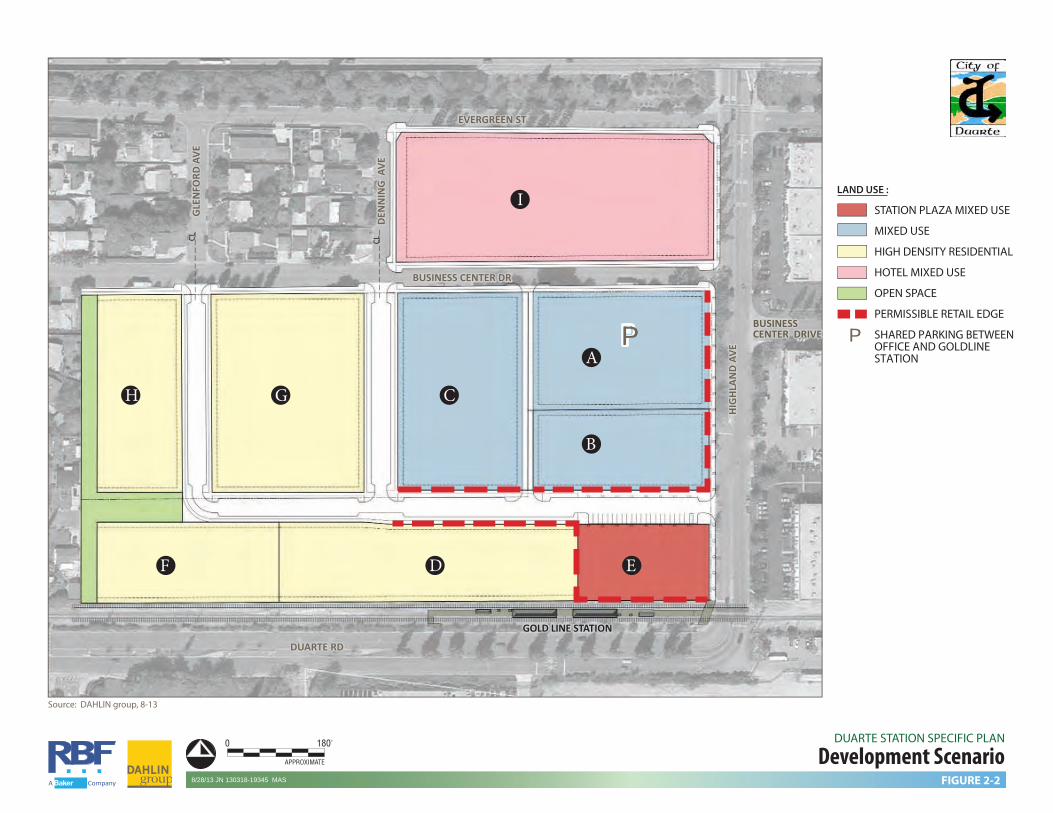
OPEN SPACE GREENBELT (OS) The Duarte Station Specific Plan includes 0.80 acres of passive open space in the form of a public or private greenbelt and plaza spaces within the plan area. The greenbelt serves as a buffer between the high density residential development located along the Specific Plan’s western edge and the adjacent single-family neighborhood to the west. The eastern-most extension of the green space may be narrowed or broken up into smaller open spaces throughout the Specific Plan area to provide an area for residents, employees, or visitors to relax, enjoy a picnic, or throw a frisbee or a ball. Outdoor open space amenities such as swings, a splash pad, or a jungle gym could also be provided. However, a minimum of 0.80 acres of open space must be included for open space and buffering purposes. The publicly accessible plaza planned near the station location is anticipated to include a gathering place and focal point along Highland Avenue that would include landscaping, hardscape features, and public amenities while being surrounded by retail, restaurant, and small-scale entertainment land uses. The plaza area may be counted towards the open space acreage. 2.5 DEVELOPMENT SCENARIO Figure 2-2, Development Scenario, and Tables 2-2, 2-3, show one potential development scenario within the framework of the Master Land Use Plan. For the purpose of this document, this scenario is used to illustrate development standards and
guidelines. Figure 2-2 serves as a concept which is further illustrated in Figure 2-3 Illustrative Site Plan. Development may be permitted in any location within the Specific Plan if requirements outlined in the Development Regulations and Design Guidelines in Sections 5 and 6 are adhered to. Thus, the areas designated for “Mixed Use” on the Master Land Use Plan (Figure 2-1) may be developed with any of the uses listed in Table 4-1, Allowable Uses, so long as the design guidelines and development regulations related to building form are met. The only single use zone within the Specific Plan is the “Residential” category shown on the Master Land Use plan and illustrated as residential in Planning Areas H and F on Figure 2-2. This single-use category is intended to ensure a land use transition between the existing residential neighborhood to the west and potential non-residential uses within the Specific Plan area. The Development Scenario generally represents a maximum development intensity program for analysis in the project’s Environmental Impact Report; while the ultimate mix of uses may differ, impacts of any future development plan would be compared to the Development Scenario analysis to confirm that impacts remain at or below what was analyzed in the EIR.
DEN
NIN
G A
VEDE
NN
ING
AVE
EVERGREEN STEVERGREEN ST
DUARTE RDDUARTE RD
HIG
HLAN
D AV
EHI
GHL
AND
AVE
BUSINESS CENTER DRBUSINESS CENTER DR
CL CL
GLE
NFO
RD A
VEG
LEN
FORD
AVE
PPA
B
CGH
I
D EF
BUSINESSCENTER DRIVEBUSINESSCENTER DRIVE
GOLD LINE STATION GOLD LINE STATION
A Company
Development ScenarioDUARTE STATION SPECIFIC PLAN
Source: DAHLIN group, 8-13
0 180'
APPROXIMATE
FIGURE 2-28/28/13 JN 130318-19345 MAS
STATION PLAZA MIXED USE
MIXED USE
HIGH DENSITY RESIDENTIAL
HOTEL MIXED USE
OPEN SPACE
PERMISSIBLE RETAIL EDGE
SHARED PARKING BETWEENOFFICE AND GOLDLINESTATION
LAND USE :
PP

Duarte Station Specific Plan
2-12 Development Plan
Table 2-2
Development Scenario
Planning Area Ac.
Non-Residential Intensity/Land Use
Residential Unit Count/Land Use
A 1.59 139,000 sf
Office/Mixed Use (Parking)
--
B 1.1 96,000 sf Office Mixed Use --
C 1.84 165,000 sf Office/Mixed Use --
D 1.89 -- 132 du Residential/Mixed Use
E 0.81 12,000 sf Station Plaza Retail --
F 1.19 -- 83 du Residential
G 2.35 -- 165 du Residential/Mixed Use
H 1.36 -- 95 du Residential
I 3.29 Hotel Mixed Use 250 room Hotel --
OS 0.80 -- -- Road 2.87 -- --
Total 19.09 400,000 office 12,000 sf retail 250 room hotel
475 du
Note: A minimum 178 high density residential units must be located along the western Specific Plan boundary within the High Density Residential land use designation shown in Figure 2-1. The remainder of the units may be located within the Mixed Use land use designation.
Land Use Designation Density/ Intensity Acreage
Maximum Permitted
Development Mixed Use General Mixed Use Office Hotel High Density Residential
2.0 FAR
-- Max 70 du/ac
12.06
400,000 sf 250 rooms 297 units
Station Plaza Mixed Use -- 0.81 12,000 sf High Density Residential Max 70 du/ac 2.55 178 units Open Space -- 0.80 -- Roads -- 2.87 --
Total Acreage 19.09 -- Note: A minimum 178 high density residential units must be located along the western Specific Plan boundary within the High Density Residential land use designation shown in Figure 2-1. The remainder of the units may be located within the Mixed Use land use designation.
Table 2-3 Development Scenario Allocation by Area
Duarte Station Specific Plan
Development Plan 2-13
2.5.1 Illustrative Site Plan and Planning Principles
This development scenario is illustrated in Figure 2-3 Illustrative Site Plan. This illustrates the implementation of the project objectives and design principles delineated in the project’s development standards and design guidelines. Although there are a number of ways the land use program could be implemented at the site design level of detail, certain elements and principles must be included. The components of this Specific Plan (Land Use, Development Regulation, and Design Guidelines) include both required elements and encouraged conditions that allow for a broad range of interpretive design solutions intended to guide phased development over the 10+ year period of the specific plan. Depending on the development program and market and site conditions, there will be different approaches to satisfying and meeting the Specific Plan criteria. The following Design Principle graphics illustrate site plan elements that implement some of the recommendations contained in this document. The combined examples provided in the illustrations present opportunities to create an environment that is pedestrian friendly. Proper pedestrian circulation, connectivity, location of amenities, and safety will encourage use and help the project accomplish the City’s vision for creating a vibrant, mixed-use transit village.
These elements include the following components which must be included in any site plan which implements the requirements of this document:
Landscaped buffers at existing residential interface;
Potential pedestrian linkage to the existing neighborhood to provide access to the Duarte Station;
Stepped back buildings at the existing residential interface;
Use of shared driveways between buildings;
Public access connections to the station platform linking the on-site sidewalks, Gold Line parking, and station plaza area;
Plaza space and open spaces as a transition and gathering area;
Corner treatments as part of architectural design.

GLE
NFO
RD A
VEG
LEN
FORD
AVE
DEN
NIN
G A
VEDE
NN
ING
AVE
EVERGREEN STEVERGREEN ST
DUARTE RDDUARTE RD
HIG
HLAN
D AV
EHI
GHL
AND
AVE
GOLD LINE STATION GOLD LINE STATION
BUSINESS CENTER DRBUSINESS CENTER DR
BUSINESS CENTER DRBUSINESS CENTER DR
Illustrative Site PlanDUARTE STATION SPECIFIC PLAN
Source: DAHLIN group, 7-24-13.
0 180'
APPROXIMATE
FIGURE 2-38/28/13 JN 130318-19345 MASA Company

Duarte Station Specific Plan
Development Plan 2-15
Illustration of Design Principles

Duarte Station Specific Plan
2-16 Development Plan
Illustration of Design Principles
Hig
hlan
d A
venu
e
Station Plaza

Duarte Station Specific Plan
Development Plan 2-17
Conceptual Rendering Image of Station Plaza area as viewed from the Highland Avenue/Duarte Road Intersection
Source: Dahlin Group
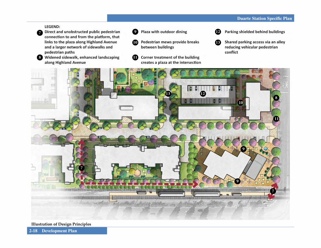
Duarte Station Specific Plan
2-18 Development Plan
Hig
hlan
d A
venu
e
Station Plaza
Illustration of Design Principles

Duarte Station Specific Plan
Development Plan 2-19
Conceptual Rendering Image of Pedestrian Linkage area as viewed looking east to Highland Avenue
Source: Dahlin Group

Duarte Station Specific Plan
2-20 Development Plan
This page intentionally left blank.


Duarte Station Specific Plan
Infrastructure and Services 3-1
SECTION 3.0 INFRASTRUCTURE AND SERVICES This section provides a review of the infrastructure and services that support the project. It identifies required circulation, parking, and any necessary infrastructure improvements associated with the proposed build-out of the Specific Plan. Service and utility providers are also identified below.
3.1 CIRCULATION PLAN 3.1.1 Regional Access Regional access to the Specific Plan area is provided by the Foothill Freeway (I-210) and San Gabriel River Freeway (I-605). The Foothill Freeway is located immediately to the north of the project area; the nearest freeway access is via the Buena Vista on-ramps to the west of the site. Interstate 605 is located approximately one and one-half miles to the east. The Los Angeles County Metropolitan Transportation Authority (Metro)-owned railroad right-of-way is located adjacent to the project area to the south within the planned Duarte transit stop located adjacent to project’s Planning Areas D, E, and F. When completed, the Gold Line will provide regional access to cities to the east and west.
3.1.2 Transit The City has operated a “fixed route” [bus] transit system since 1984. Buses operate along two main routes, weekdays and a single route on Saturdays. The two main transit routes operated by Duarte Transit System are known as the “Blue” and “Green” routes. The “Green” route operates in a counter-clockwise direction. The routes connect with every transit route operated to and through the City of Duarte, operated by Foothill Transit and MTA which provide inter-community public transit service to / from points outside of Duarte. METRO bus line #264 and Foothill Transit Line #272 serve the project area. Line #272 connects with Metrolink Baldwin Park. The Green route presently extends along Evergreen Street, which borders the Specific Plan area on the north and continues on Highland and Duarte Road, passing both the proposed Gold Line parking area within the project and the Duarte Station location. One Green transit stop is located adjacent to the project’s Planning Area I near Highland Avenue. Because of this route’s counterclockwise travel direction the route, potential future transit stops would be located on the east side of Highland Avenue. In addition to the Green route, the commuter line route extends along Evergreen Street. The commuter route travels runs weekdays and picks up passengers from residential areas and drops them off at locations where they can transfer to either Metro or Foothill Transit lines. The city’s transit routes are being modified to serve and enhance ridership to and from the Duarte Station.
Duarte Station Specific Plan
3-2 Infrastructure and Services
3.1.3 Perimeter Roads The Specific Plan area is bordered by Evergreen Street to the north, Duarte Road to the south, Highland Avenue to the east. The I-210 Freeway is located just north of Evergreen Street, in close proximity to the Specific Plan area. Business Center Drive traverses the Specific Plan area in an east/west direction.
• Evergreen Street. Currently, Evergreen Street is a 2-way collector street with one travel lane in each direction that runs in an east/west direction. General Plan right of way for collectors is 60 feet with a 40 foot pavement section.
• Highland Avenue. Highland Avenue is a 2-way Minor
Arterial with four travel lanes. General Plan right of way for minor arterials is 100 feet with a 60 foot pavement section. As mitigation for the Gold Line Foothill Extension, the intersection of Highland Avenue with Business Center Drive will be signalized. A second signal north of the I-210 at Central is also included in the Gold Line mitigation.
• Business Center Drive. Business Center Drive is
currently a 2-way local street with one travel lane in each direction and space for on-street parking on both sides of the street. As mitigation for the Gold Line Foothill Extension, the intersection of Highland Avenue with Business Center Drive will be signalized. Turn movements from the project onto Business Center Drive will be limited to right-out only to limit project-
related traffic through the residential neighborhoods to the west.
• Denning Avenue. Denning Avenue is currently a 2-way
local street with one travel lane in each direction and space for on-street parking on both sides of the street.
• Duarte Road. Duarte road is currently a 4-lane minor
arterial with two travel lanes in each direction; the travel lanes are separated by a planted center median. As mitigation for the Gold Line Foothill Extension, the intersection of Duarte Road at the City of Hope driveway will be signalized.
3.1.4 Internal Circulation The proposed Circulation Plan (see Figure 3-1, 3-2 and 3-3, Circulation Plan and Roadway Cross Sections) identifies a roadway network through the specific plan area to support a variety of potential development plans. Access will be provided via streets or driveways on Business Center or Highland Avenue; as shown on the Circulation Plan. Turn movements from the project onto Business Center Drive will be limited to right-out only to limit project-related traffic through the residential neighborhoods to the west. Internal streets may consist of one of two configurations:
• A 56-foot right of way neighborhood street with two travel lanes, on-street parking, sidewalks and landscaped parkway.

DEN
NIN
G A
VEDE
NN
ING
AVE
EVERGREEN STEVERGREEN ST
I-210I-210
DUARTE RDDUARTE RD
HIG
HLAN
D AV
EHI
GHL
AND
AVE
STATION STATION LOCATION LOCATION
BUSINESS CENTER DRBUSINESS CENTER DR
BUSINESSCENTER DRBUSINESSCENTER DR
56’
56’
64’
64’
CL CL
Centerline of proposedstreets to match withexisting streets
+/- 250’
200’
(max
)
GLE
NFO
RD A
VEG
LEN
FORD
AVE
LAND USE :
PP
Circulation PlanDUARTE STATION SPECIFIC PLAN
Source: DAHLIN group, 5-13
0 180'
APPROXIMATE
FIGURE 3-18/28/13 JN 130318-19345 MAS
EXISTING MINOR ARTERIAL
EXISTING COLLECTOR
EXISTING LOCAL ROAD
PROPOSED LOCAL DRIVE
FUTURE SIGNAL(GOLDLINE MITIGATION)
GOLDLINE PARKING
Right Turn Only Lanes
A Company
PP

MINOR ARTERIALHighland Avenue • Duarte Road
100’ Right of Way
80’ Pavement
14’ Median
COLLECTOR STREETEvergreen Street
60’ Right of Way
40’ Pavement
LOCAL STREETBusiness Center Drive • Denning Avenue • Glenford Avenue
50’- 60’ Right of Way
30’- 40’ Pavement
A Company
Roadway Cross-SectionsDUARTE STATION SPECIFIC PLAN
Note: Sections per General Plan Circulation Element.
FIGURE 3-210/24/13 JN 130318-19345 MAS

SECTION A-A: 64’ LOCAL STREET
64’ Right of Way
36’ Face of Curb
11’7’ Parking8’ 8’7’ Parking 6’ Sidewalk6’ Sidewalk 11’
14’ 14’
SECTION B-B: 56’ LOCAL STREET
56’ Right of Way
34’ Face of Curb
10’7’ Parking5’ 5’7’ Parking 6’ Sidewalk6’ Sidewalk 10’
11’ 11’
A Company
Internal Roadway Cross-SectionsDUARTE STATION SPECIFIC PLAN
FIGURE 3-35/30/13 JN 130318-19345 MAS

Duarte Station Specific Plan
3-6 Infrastructure and Services
• A 64-foot right of way neighborhood street with two travel lanes, widened parkway and sidewalk. On-street parking would be included. This street would provide the primary access into the site and would link Highland Avenue with Business Center Drive.
3.1.5 Parking Presently, surface parking is provided on-site to accommodate the three existing buildings. The parking area at the western edge of the Specific Plan area contains approximately 210 parking spaces, including the underutilized lot that is only 50% paved. The parking area at the eastern side of the Specific Plan area contains approximately 264 parking spaces. The parking area designated for the building along the northern portion of the Specific Plan area (along Evergreen Street) contains approximately 140 parking spaces. Additionally, Business Center Drive accommodates on-street parking spaces on each side of the roadway. The Gold Line will provide a surface parking lot with a minimum of 130 spaces on the project’s northeastern corner at the intersection of Highland Avenue and Business Center Drive in the early phases, increasing to 250 in later phases. This parking is for the use of the transit station. Ultimately, this parking is planned to be accommodated within a structure or incorporated within a mixed use building as a parking requirement on any future use. Parking within the Specific Plan area is outlined in Section 4, Development Regulations. Parking standards will be
determined by a parking study performed by a registered traffic engineer and approved by the Planning Commission as part of the Site Plan and Design Review process. 3.2 INFRASTRUCTURE PLAN
3.2.1 Domestic Water Service The City of Duarte lies within the San Gabriel Groundwater Basin. Water service is provided to the City of Duarte by California American Water (Cal-Am). Cal-Am operates three Division Offices. The City of Duarte is located under the Southern Division which incorporates the Los Angeles County District. This District consists of Baldwin Hills, Duarte, and San Marino service areas. Existing 12-inch water mains occur along the streets of Evergreen Street, and Highland Avenue. A 12-inch water main occurs along Business Center Drive west of Highland Avenue. Smaller diameter lines (4-inch) occur along the streets of Denning Avenue and Glenford Avenue. Proposed new buildings will be served by existing water lines through a series of laterals. The project area lies within the Scott Pressure Zone which has a hydraulic gradient line (HGL) of 691-feet. This level is typically the pad elevation of the water reservoir that supplies water storage for the pressure zone. The HGL immediate at the project area was noted as approximately 684-feet due to the pressure losses within the piping distribution system from the reservoir or booster pump station to the site area. The

Duarte Station Specific Plan
Infrastructure and Services 3-7
elevations of the site range from 496 to 479-feet. Therefore, pressure ranges between 88 to 81-psi. New streets built for the project are anticipated to include a minimum water main of 12-inches connected into the existing Cal-Am system (see Figure 3-4, Water Plan). It is anticipated that private meters and backflow devices would be required for domestic water service and/or separate fire lines. A more refined hydraulic analysis will be coordinated with Cal-Am for future design as individual project move forward. This would accommodate higher fire flows that may be required for the larger buildings proposed. Upsizing the pipe along Denning Avenue may be required depending on the usage and fire flow need of the tenant in Parcel 3. Existing fire hydrants are present around the project boundary. Additional hydrants may be conditioned based upon the site layout at the time of site plan review. Fire flow requirements are based upon building size and building construction type. The latest fire regulations require all buildings to be equipped with a fire sprinkler system, including residential homes sites. Fire flow requirements that were previously provided for the existing structures may increase due to new regulations. Site plans will be submitted to the fire authority in order to obtain a fire flow requirement based upon the tenant type, building size, and building type. The fire authority also determines the flow and time period requirements based upon building and tenant type.
3.2.2 Sanitary Sewer Service Sanitary sewer services within the City are provided by the Los Angeles County Department of Public Works. Local sewer lines within Duarte are owned by the City. The Los Angeles County Department of Public Works (LACDPW) operates and maintains Duarte’s local wastewater conveyance infrastructure, which connects to the County Sanitation Districts of Los Angeles County (CSDLAC) regional trunk sewer lines. Wastewater is conveyed through the CSDLAC’s trunk sewer pipelines to the San Jose Creek Water Reclamation Plant (SJCWRP), located at 1965 Workman Mill Road in unincorporated Los Angeles County (adjacent to the City of Industry), and the Whittier Narrows Water Reclamation Plant (WNWRP), located at 301 North Rosemead Boulevard in the City of South El Monte. New developments are reviewed by the City of Duarte and the LACDPW, at which time an “area study” is conducted to determine the available capacity of local sewer lines that would serve the specific project The Specific Plan area gradually slopes from northeast to southwest with elevations of the site ranging from 496 to 479-feet. The following sewer pipelines exist adjacent to the Specific Plan area:
• An 8-inch VCP sewer occurs along Evergreen Street (formerly Central Avenue). A minimum slope of 0.4% is noted as the sewer slopes in the direction from east to west from Highland Avenue to Glenford Avenue.

GLE
NFO
RD A
VEG
LEN
FORD
AVE
DEN
NIN
G A
VEDE
NN
ING
AVE
EVERGREEN STEVERGREEN ST
DUARTE RDDUARTE RD
HIG
HLAN
D AV
EHI
GHL
AND
AVE
STATION STATION LOCATION LOCATION
BUSINESS CENTER DRBUSINESS CENTER DR
BUSINESSCENTER DRBUSINESSCENTER DRP
P
CL
+/- 250’
Centerline of proposedstreets to match withexisting streets
Existing 12” WaterExisting 12” Water Existing 12” WaterExisting 12” Water
Existing 12” WaterExisting 12” Water
Possible WaterUpsizingPossible WaterUpsizingEx
isti
ng
4”
Wat
erEx
isti
ng
4”
Wat
er
Exis
tin
g 4
” W
ater
Exis
tin
g 4
” W
ater
Existing 8” Water
Existing 8” Water
Existing 12” WaterExisting 12” Water
Exis
tin
g 1
2” W
ater
Exis
tin
g 1
2” W
ater
12” Water 12” Water
12” W
ater
12
” Wat
er
Water PlanDUARTE STATION SPECIFIC PLAN
Source: DAHLIN group, 5-13
0 180'
APPROXIMATE
FIGURE 3-48/28/13 JN 130318-19345 MASA Company
P
LAND USE :
STATION PLAZA MIXED USE
MIXED USE
HIGH DENSITY RESIDENTIAL
OPEN SPACE
PERMISSIBLE RETAIL EDGE
ALTERNATIVE SHAREDPARKING LOCATIONSBETWEEN OFFICEAND GOLDLINE STATION
LEGEND :
EXISTING WATER LINE
PROPOSED WATER LINE

Duarte Station Specific Plan
Infrastructure and Services 3-9
The 8-inch sewer along Evergreen Avenue receives flows from the north via an 8-inch line. The sewer along Evergreen Avenue continues south along Glenford Avenue.
• An 8-inch VCP sewer within Business Center Drive
slopes from east to west. It picks up lines from the north along Denning Avenue, Glenford Avenue, and Fairdale Avenue. It has a minimum slope of 0.64%.
• A County-owned 12-inch sewer exists along Highland
Avenue which is the easterly boundary street of the site. The sewer along Highland appears to receive flows from the easterly development along Business Center Drive and from the north, across the 210 freeway. The sewer grade of the 12-inch sewer is 0.6%. The 12-inch sewer along Highland Avenue continues south to the trunk sewer in Duarte Road where it flows westerly at a grade of 1.208%. The sewer along Duarte Road is on the south side of the proposed Gold Line tracks.
Sewage from the project area could be transferred to any number of sewer pipelines that surround the project. A preliminary sewer plan is outlined in Figure 3-5, Sewer Plan; refined sewer layouts would be submitted as part of site plan submittals for individual development projects. All new developments within the Specific Plan area would be reviewed on a project-by-project basis by the City of Duarte to determine if local sewer lines have sufficient capacity to
accommodate effluent from new development. The City may charge new developments a fee to upgrade or extend local sewer lines, which would be necessary to accommodate new developments. In addition, the LACDPW reviews new developments and assesses fees based on the maintenance of local sewer lines, which would be necessary to accommodate the specific project. 3.2.3 Drainage Plan Currently, no storm drains are present within the perimeter streets on the project boundaries except for a 24-inch storm drain in Highland Avenue. Development in the local vicinity drains via surface flow to an existing 30-inch storm drain which traverses the site. Los Angeles County Flood Control District has an easement for the existing storm drain. The drainage for the overall site in the existing condition is surface runoff flowing in a southwesterly direction, it enters an above ground swale in the parking area of the southern building, collects through drainage grates in the swale and then outlets into an existing 30-inch storm drain pipe which currently traverses the property from the east (Highland Ave) towards 3 Ranch Road, the residential local road on the west side of the site. The project is located in Zone X as shown on Flood Insurance Rate Map (FIRM) and thus is not within a flood plain. The proposed drainage plan (see Figure 3-6, Drainage Plan) shows the anticipated drainage system for the project. Stormwater flows will be conveyed in existing and proposed streets towards the existing 30-inch storm drain.

GLE
NFO
RD A
VEG
LEN
FORD
AVE
DEN
NIN
G A
VEDE
NN
ING
AVE
EVERGREEN STEVERGREEN ST
DUARTE RDDUARTE RD
HIG
HLAN
D AV
EHI
GHL
AND
AVE
STATION STATION LOCATION LOCATION
BUSINESS CENTER DRBUSINESS CENTER DR
BUSINESSCENTER DRBUSINESSCENTER DR
P
P
CL
Centerline of proposedstreets to match withexisting streets
Possible SewerUpsizing
Possible SewerUpsizing
Possible Sewer Upsizing
Possible SewerUpsizing
Existing 12” SEWER 1.208%Existing 12” SEWER 1.208%
Existing 8” SEWER 1.6%Existing 8” SEWER 1.6%
Existing 8” SEWERExisting 8” SEWER
8” 8”
Existing 8” SEWER 0.64%Existing 8” SEWER 0.64%
Exis
tin
g 1
2” S
EWER
0.
60%
Exis
tin
g 1
2” S
EWER
0.
60%
8” 8”
8” 8” 8” 8” 8” 8”
8” 8”
0.70
8%0.
708%
0.708%0.708% 0.708%0.708%
8” 8” 8” 8”
8” or 12”8” or 12”
8” 8”
8” 8” 8” 8”
8” 8”
8” 8” 8” 8”
A Company
Sewer PlanDUARTE STATION SPECIFIC PLAN
Source; DAHLIN group, 5-13
0 180'
APPROXIMATE
FIGURE 3-58/28/13 JN 130318-19345 MAS
P
LAND USE :
STATION PLAZA MIXED USE
MIXED USE
HIGH DENSITY RESIDENTIAL
OPEN SPACE
PERMISSIBLE RETAIL EDGE
ALTERNATIVE SHAREDPARKING LOCATIONSBETWEEN OFFICEAND GOLDLINE STATION
LEGEND :
EXISTING SEWER LINE
PROPOSED SEWER LINE
Centerline of proposedstreets to match withexisting streets
DEN
NIN
G A
VEDE
NN
ING
AVE
EVERGREEN STEVERGREEN ST
DUARTE RDDUARTE RD
HIG
HLAN
D AV
EHI
GHL
AND
AVE
STATION STATION LOCATION LOCATION
BUSINESS CENTER DRBUSINESS CENTER DR
BUSINESSCENTER DRBUSINESSCENTER DR
CL CL
+/- 250’
GLE
NFO
RD A
VEG
LEN
FORD
AVE
24” R
CP24
” RCP
30” RCP30” RCP
Drainage PlanDUARTE STATION SPECIFIC PLAN
Source: DAHLIN group, 5-13
0 180'
APPROXIMATE
FIGURE 3-610/24/13 JN 130318-19345 MAS
EXISTING CATCH BASIN
EXISTING RCP STORM DRAIN
GRATE DRAINS
DIRECTION OF FLOW
A Company
LAND USE :

Duarte Station Specific Plan
3-12 Infrastructure and Services
Hydrology analysis prepared for the project’s Environmental Impact Report indicate that stormwater quantities in the proposed build-out condition will be similar to existing quantities and therefore no significant drainage facilities must be constructed. WATER QUALITY The project is required to comply with the urban runoff pollution control provisions of Chapter 6.15 of the City’s Municipal Code, which regulates the treatment of stormwater runoff from development projects. A preliminary water quality assessment has been prepared for the project as part of the EIR hydrology technical study and identifies pollutant sources associated with the proposed development that may affect the quality of discharges of stormwater from the site. The following is a menu of Best Management Practices for the project, which would be refined for each phase via a Final Water Quality Management Plan/SUSMP or equivalent document to incorporate project-specific Best Management Practices as part of site plan review:
• Bioretention
• Rainfall Harvest and Use (e.g. cisterns, rain barrels, planter areas, permeable surfaces, drywells, French drains, etc.)
• Vegetated Swales
• Vegetated Filter Strips
• Green Roofs
• Infiltration Trenches
• Media Filtration
• Porous Pavement (required)
Permeable Surfaces (e.g. porous concrete/asphalt, block pavers, open cell concrete, reinforced turf, etc.
Other BMPs that may be approved by the City of Duarte or the county-wide program in the future to address the 2012 NPDES Permit requirements
3.2.4 Grading The existing site is generally flat in nature, gradually sloping from northeast to southwest with elevations of the site ranging from 496 to 479-feet. On-site parking lots are designed for positive drainage, sloping to parking lot area drains. No natural slopes or landforms are present. Due to the flat nature of the site, grading for the new development will be minor and will consist of demolition of existing buildings and asphalt parking areas, precise grading of the site of planned structures (which will be detailed at the site plan level of plan review once final architecture and site work has been designed), and placement of foundations for proposed new structures. Because of the flat nature of the site, no significant import or export of soil is expected to occur as part of site development. Prior to issuance of a building permit for any of the proposed structures, a site plan approval will be required, including a precise grading plan based on final architectural design.

Duarte Station Specific Plan
Infrastructure and Services 3-13
3.2.5 Public Services SCHOOLS The Specific Plan area is within the Duarte Unified School District. Duarte High School and Northview Intermediate School are located in close proximity to the Specific Plan area. School fees will be paid at the time of building permit. FIRE Fire protection services are provided to the City by the County of Los Angeles Fire Department (LACFD). LACFD is divided into 22 Battalions, each serving a territory or multiple cities in Los Angeles County. Battalion 16 provides service to Duarte, Covina, Baldwin Park, and Azusa. The Battalion operates out of eight fire stations located within this service area. Fire Station #44 is located at 1105 S. Highland Avenue, in Duarte, less than ½ miles from the Specific Plan area. POLICE Police protection services are provided to the City by the County of Los Angeles Sheriff’s Department. The Department has a satellite station located at 1042 Huntington Drive, located approximately ¾ miles from the Specific Plan area. LIBRARY The Duarte Library is operated by the County of Los Angeles Public Library System. The Duarte Library is located at 1301 Buena Vista Street, about ½ miles from the Specific Plan area.
SOLID WASTE Residential and Commercial solid waste disposal is provided through a contract with Burrtec Waste Services. The City is divided into several zones that designate when solid waste is collected during various weekdays. Burrtec provides all residential and commercial customers with containers for solid waste to be picked up. CABLE, INTERNET, TELEPHONE Cable television service is provided by Charter Communications. Charter Communications also offers internet and telephone service. Telephone is also available to Duarte residents through Verizon, which also offers cable and internet services in some areas. It is anticipated that one (or both) of these providers would provide cable, internet, and telephone service to the Specific Plan area. NATURAL GAS AND ELECTRICITY Natural Gas is provided to the City of Duarte by the Southern California Gas Company. Electricity is provided to the City of Duarte by Southern California Edison. Both of these purveyors would provide natural gas and electricity to the Specific Plan area. Both natural gas and electric service is currently available on adjacent streets and are presently extended into the site.

Duarte Station Specific Plan
3-14 Infrastructure and Services
This page intentionally left blank.


Duarte Station Specific Plan
Development Standards 4-1
SECTION 4.0 DEVELOPMENT STANDARDS The Specific Plan Area has been broadly divided into three major districts, the High Density Residential District, the Station Plaza District, and the Mixed Use District. The High Density Residential District forms the western edge of the site adjacent to the existing single family residential neighborhood. The Station Plaza District is the area immediately to the north of the proposed station and forms the entry to the Specific Plan Area from the platform. The remainder of the site is designated as a Mixed Use District, which allows for the flexibility for the site to adapt to changing market conditions over a longer period of time. This Section describes all the standards and guidelines for street design, site planning, and building design for the Specific Plan Area. The regulations are district and building specific. These are the regulations that govern new construction, as well as alterations and additions, in the Specific Plan Area. To create a vibrant, thriving and special community, the Development Standards for the Specific Plan Area are “Form Based” to create a predictable public realm by establishing guidelines and regulations that focus primarily on the physical form of the environment. By addressing the relationships between building facades and the public realm, the form and mass of buildings in relation to one another, and the scale and types of streets and blocks, through an integrated package of requirements for street and building design, massing and scale
and setbacks, the Standards help in creating a unique character for the Specific Plan Area. The Duarte Station Specific Plan is implemented through policies in this Specific Plan and Development Standards listed in this Specific Plan. The block pattern and the circulation framework is suggestive and the street locations, maybe be adjusted, though it is recommended that the future block and street pattern respect and connect to the existing surrounding context. For example, a street may be replaced by a publicly accessible pedestrian mews or an alley if it better serves the final development program, as long as it meets the intent of the Specific Plan. 4.1 GENERAL PROVISIONS 4.1.1 Applicability Upon adoption by Ordinance, this Specific Plan will constitute the zoning for the Duarte Station Specific Plan area. Subsequent Development Plans or agreements, tract or parcel maps, site plans, or any other action requiring ministerial or discretionary approval relative to the Specific Plan area must be consistent with the Development Regulations contained within this Chapter. 4.1.2 Severability In the event that any regulation, condition, program, portion or policy of this Specific Plan or the application thereof to any person or circumstance is held to be invalid or

Duarte Station Specific Plan
4-2 Development Standards
unconstitutional by any court of competent jurisdiction, such portions shall be deemed separate, distinct and independent provisions and shall not affect the validity of the remaining provisions of this Specific Plan or applications thereof which can be implemented without the invalid provision. 4.1.3 Determination of Unlisted Uses Identification of any land use not specifically covered by the provisions contained herein shall be per the Duarte Development Code (DDC). 4.1.4 Definitions Unless otherwise specified below, terms used in this document shall have the same definitions provided in the City of DDC Chapter 19.160, “Definitions.” The following definitions shall apply to the uses and standards within this Specific Plan: “Live/Work.” A live/work unit is defined as a single residential unit (e.g., studio, loft, or one bedroom) consisting of both a commercial/office and a residential component that is occupied by the same resident. 4.1.5 Interpretation Any ambiguities related to the implementation of this Specific Plan shall be determined as described in the DDC. Such interpretations shall take into account the stated goals and intent of this Specific Plan. Any interpretation made by the
Community Development Director or designee may be appealed to the Planning Commission. 4.1.6 Existing Users Sites within the Specific Plan area that contain uses that are not otherwise consistent with the Specific Plan are deemed “Legacy Sites.” Uses that are currently allowed within the M-1 zoning designation of the City are deemed Legacy Uses. Legacy Uses shall be permitted to continue on Legacy Sites until such time as they are abandoned. A Legacy Use on a Legacy Site is deemed abandoned when (i) any Legacy Use on the Legacy Site has been discontinued for a continuous period of one year or more, (ii) when the owner of a Legacy Site affirmatively indicates in writing that it has abandoned Legacy Uses on the Legacy Site, and/or (iii) the owner of a Legacy Site redevelops the site with a non-Legacy Use. For a multiple tenant building on a Legacy Site: individual tenant spaces that are vacant for more than one year shall not be deemed a discontinuance under this section.
At any time prior to abandonment, Legacy Sites may be expanded by an amount not to exceed five percent (5%) of the building square footage of the subject Legacy Site that existed as of the date of the adoption of the Specific Plan. If a Legacy Site is expanded, reconstructed or repaired in accordance with this paragraph, it shall be subject to site plan and design review as outlined in Section 6 of this Specific Plan, and
Duarte Station Specific Plan
Development Standards 4-3
shall be subject to the development standards set forth for properties in the Industrial Zone, as specified in the Duarte Development Code.
It is the intent of this Specific Plan that Legacy Uses on Legacy Sites are allowed until such time as market conditions cause the property owners to wish to redevelop the Legacy Site with Non-Legacy Uses.
4.2 BUILDING USE REGULATIONS The Duarte Station Specific Plan provides for the development of a mixture of land uses within the Specific Plan area; including residential, commercial, office, and hotel uses. For the purposes of this Specific Plan, all permitted and conditionally permitted uses have been classified into use types. Each use type is defined below and includes uses such as those listed in the applicable tables. The tables include specific permitted, conditional, and prohibited uses. Uses listed as permitted are further regulated herein and are defined as those uses permitted by right subject to approval of site plan/design review. Uses listed as conditional are defined as those which require special consideration either for their impacts on the neighborhood or their design. Those uses expressly permitted within the Specific Plan area are included in Table 4-1, Allowable Uses. The use table is to provide a broad range of allowable uses which promote a compact, urban transit oriented development. Additional uses may be allowed in the future provided they meet the intent
and the vision of the Specific Plan. Uses not listed shall be determined as described in the DDC
Table 4-1 Allowable Uses
Uses or Activity High
Density Residential
Mixed Use
Plaza Mixed Use
Residential Multifamily dwelling units such as stacked flats, apartments, condominiums, with subterranean or structured parking, with a minimum density of 40 du/ac and maximum density of 70 du/ac
P P --
Single Family/Multifamily dwelling units, less than 40 du/ac within a parcel where the parcel average is at least 40 du/ac
P P --
Live/work units -- C --
Retail
Convenience uses such as small scale food sales, delicatessens, bakeries, florists, general retail uses
-- P P
Vendor carts -- C C
Vehicle Rentals, including car sharing -- C C
Eating Establishments, cafes -- P P
Sale of Alcoholic Beverages ancillary to a food use -- C C
Uses Operating between the hours of 12 am and 6 am
-- C C

Duarte Station Specific Plan
4-4 Development Standards
Uses or Activity High
Density Residential
Mixed Use
Plaza Mixed Use
Business, Financial, and Professional Offices — Business or Corporate and Related Services -- P P
Medical Services including medical and dental offices, physical therapy, medical laboratories
-- C --
Research and Development (not associated with primary manufacturing), including research laboratories per DDC
-- P --
Financial Institutions -- P P Service Uses — General Personal services “General” such as barber shops, hair and nail salons, dry cleaning establishments.
-- P P
Professional services such as mailing, duplicating and printing -- P P
Studio: Art, Dance, Martial Arts, Music, Yoga -- C C Uses Operating between the hours of 12 am and 6 am -- C C
Transportation, Communication, and Infrastructure Uses Public and Private Parking Lots and Structures -- C --
Utilities, including Wireless Communication Facilities C C C
Service Uses — Restricted Lodging, including hotels, and extended stay facilities -- C --
Day Care -- C -- Drive Through (any use) -- -- --
P Permitted C Conditional Use Permit required -- Not Permitted
4.2.1 Development Standards The Duarte Station Specific Plan provides a framework to guide the development of a unique opportunity to transform the Plan Area into a vibrant, transit oriented development, key to which are the specific standards and guidelines tailored specifically to that vision. The District Standards establish the Development Standards for all districts to guide future development and accommodate a variety of uses. While the Duarte Station Specific Plan defines setbacks for the Plan Areas, Building and Fire Codes in effect at the time of building permit shall take precedence. Table 4-2 outlines development standards for each zoning district defined by Figure 2-1, Master Land Use Plan. To provide flexibility, a large portion of the site is designated as Mixed Use, so for the illustration of standards the Development Scenario, (which illustrates one potential development scenario within the framework of the Master Land Use Plan) is used. In addition to the specific Development Standards, design guidelines are also included. Where the Specific Plan is silent, the DDC and Municipal Code will prevail.

Duarte Station Specific Plan
Development Standards 4-5
Table 4-2 Development Standards
Land Use High Density Residential Mixed Use Station Plaza
Mixed Use Density/FAR (du/ac) Max.Density: 70
Min. Density: 40 Max. Density: 70 Min. Density: 40 Non-residential: Maximum FAR: 2.0
Maximum FAR: 1.0
Block Dimension Maximum 450’ between publicly accessible paths of travel (vehicular or pedestrian)1 Maximum Building Heights (see Figure 4-1 for transitional requirements)
65’ or 6 stories3
90’ or 7 stories for office or residential3 90’ or 8 stories for Hotel3
45’ or four stories3
Minimum Ground Floor Height
-- 12’ minimum clear (floor to ceiling height)
12’ minimum clear (floor to ceiling height)
Parapets Parapets may extend up to 3’ above the height limit
Setbacks (see Figure 4-2 for setback requirements)
Encroachments Porches, stairs, balconies, bay windows, awnings, may encroach up to 5’ into required setbacks
Trash enclosures may be located in the setback as long as they meet requirements in the design guidelines
Parking Requirements
Off Street Parking Standards
Parking determined on a case by case basis during the site plan review
Determined on a case-by-case basis except for Office uses which shall comply with the City of Duarte Parking Standards
No dedicated parking required if on-street parking is available on streets fronting the plaza
Access and curb cuts
Maximum two curb cuts per block. Exceptions may be allowed during the project approval process
Tandem Parking
Allowed if both spaces are shared by the same unit2
Not permitted Not permitted
Land Use High Density Residential Mixed Use Station Plaza
Mixed Use Bike parking
Secure storage area at 1 space per 4 units, exempting units with private garages
Residential: Secure storage area at space 1 per 4 units, exempting those with private garages Non Residential: 2.5 percent of the Parking requirement.
10 spaces
Group Usable Open Space
200 sf per unit. Private open space4 is not
required for each unit. However, if provided, it may
be deducted from the group open
space requirement. Each
square foot of private open
space shall be considered
equivalent to two square feet of
group open space and may be so
substituted.
Residential: 200 sf per unit. Private open
space4 is not required for each unit. However, if provided, it may be
deducted from the group open space requirement. Each
square foot of private open space shall be
considered equivalent to two square feet of
group open space and may be so substituted.
--
Notes: 1. Maximum dimensions do not apply on parcels adjacent to the rail line. 2. Maximum allowable number of tandem parking spaces to be determined during the project approval
process. 3. Building height shall be measured from the adjacent finished ground level to the top of plate of the
upper most story. 4. Group usable open space shall have a minimum area of 300 square feet and a rectangle inscribed
within it shall have no dimension less than 15 feet. Required usable open space may be located on the roof of an attached garage or carport. Private usable open space located at ground level shall have a minimum area of 100 square feet and a rectangle inscribed within it shall have no dimension less than 8 feet. The minimum area of above ground-level space shall be 50 square feet and a rectangle inscribed within it shall have no dimension less than five feet. Private usable open space shall be adjacent to, and not more than four feet above or below the floor level of the dwelling unit served. For projects that do not meet the Group Open Space standards in- lieu fees and other mitigation measures may be considered on a project by project basis

Duarte Station Specific Plan
4-6 Development Standards
4.2.2 Building Setbacks Building setbacks, along with the building edge, help define the character of the public realm street, especially at the pedestrian level. The setbacks are designed to take into consideration the streets that the setbacks are adjacent to, the intensity of proposed land uses, proposed building mass and scale, and the surrounding context and edge conditions. The setbacks are measured from the back of the walk, right-of-way, or the property line, whichever is applicable, unless otherwise noted. Figure 4-1, Building Setbacks indicates the required setbacks within the Specific Plan Area. Figure 4-2, Building Setback Zones illustrates specific setback sections A-A, B-B, C-C, and D-D, defined in the plan.
Section A-A represents a 10-foot setback zone applicable to most of the planning areas.
Section B-B represents a 20-foot setback zone for the residential edge at Denning Avenue.
Section C-C represents a 25-foot setback zone on Highland Avenue.
Section D-D represents a 30-foot open space buffer adjacent to existing residential uses on the western edge of the property as shown by Section TZ1 (Transition Zone 1) on Figure 4-4, Transition Zones.

DEN
NIN
G A
VEDE
NN
ING
AVE
EVERGREEN STEVERGREEN ST
DUARTE RDDUARTE RD
HIG
HLAN
D AV
EHI
GHL
AND
AVE
GOLD LINE STATION GOLD LINE STATION
BUSINESS CENTER DRBUSINESS CENTER DR
BUSINESSCENTER DRBUSINESSCENTER DR
GLE
NFO
RD A
VEG
LEN
FORD
AVE
AD C
A
B
AD C
A
B
A Company
Building SetbacksDUARTE STATION SPECIFIC PLAN
Source; DAHLIN group, 10-13
0 180'
APPROXIMATE
FIGURE 4-110/24/13 JN 130318-19345 MAS
REQUIRED BUILDING SETBACKS :
0’ BUILDING SETBACK
10’ BUILDING SETBACK
20’ BUILDING SETBACK
25’ BUILDING SETBACK*
30’ OPEN SPACE BUFFER(For Section D-D, refer toSection TZ1 on Figure 4-4)
* SETBACK MEASURED FROM FACE OF CURB OF HIGHLAND AVENUE

ROW
/ Pr
oper
ty li
ne
SECTION A-A: 10’ BUILDING SETBACK
ROW
/Pro
pert
y Li
ne
SECTION B-B: 20’ BUILDING SETBACK
Face
of C
urb
Note: Building setback measured from the face of curb
SECTION C-C: 25’ BUILDING SETBACK
Retail Edge
Offi ce Edge
A Company
Building Setback ZonesDUARTE STATION SPECIFIC PLAN
Source: DAHLIN group, 8-13
FIGURE 4-29/11/13 JN 130318-19345 MAS

Duarte Station Specific Plan
Development Standards 4-9
4.2.3 Building Heights
Building heights help define the character of the public realm along the street, especially at the pedestrian level. The building height strategy is schematically shown in Figure 4-3, Building Heights. Building heights are designated to take into consideration the proposed intensity and type of development and the surrounding context and edge conditions. Building height shall be measured from the adjacent finished ground level to the top of plate of the uppermost floor. To accommodate flexibility in the pattern of development, the maximum building height is regulated by both the number of floors permitted and by total height. Number of floors shall include all habitable floors located above the average finished grade, and shall not include portions of the building substantially submerged or partly submerged below grade. This would accommodate a variety of land uses within the Plan Area while still controlling the urban form and character. Portions of the building that extend above the primary building mass, such as dormers, roof-top cupolas, roof deck trellises, gazebos, and other special features, shall not exceed the maximum height requirement by more than 10 feet. Elevator and mechanical equipment are not subject to height limits as long they meet the screening design guidelines. Where the proposed development area is adjacent to existing single family residential specific height limits and step-back conditions, referred in Figure 4-3, Building Heights as Transition Zones, are mandated. Figures 4-4 and 4-5,
Residential Transition Zones, illustrate the edge conditions and associated transition requirements. 4.2.4 Ground Floor Design The design of the ground floor is of utmost importance in the Specific Plan area, in order to provide an attractive, comfortable, and safe environment for pedestrians. Good design establishes an attractive image and character for the area that makes it desirable for businesses and residents. A number of standards are established to ensure that goals for pedestrian scale are achieved.
Buildings must face the street, and primary building entrances must be oriented towards the street.
The facades facing major streets shall not have blank walls, service entrances, or other features that make the façade look like the back side of a building.
Special standards and guidelines are established for the design of buildings with ground floor commercial space (see Table 4-2). Minimum floor to ceiling heights ensure that the space will serve the needs of retail and restaurant uses that may locate in the space at some point during the lifetime of the building.
Floor elevations of buildings need to be at the sidewalk level, and the use of awnings, change in material, and architectural articulation should be used to create a pedestrian scaled public realm, despite the overall scale and mass of the building.

DEN
NIN
G A
VEDE
NN
ING
AVE
EVERGREEN STEVERGREEN ST
DUARTE RDDUARTE RD
HIG
HLAN
D AV
EHI
GHL
AND
AVE
GOLD LINE STATION
BUSINESS CENTER DRBUSINESS CENTER DR
BUSINESSCENTER DRBUSINESSCENTER DR
GLE
NFO
RD A
VEG
LEN
FORD
AVE
TZ1
TZ2 TZ3
TZ1
TZ4TZ4
TZ2 TZ3
A Company
Building HeightsDUARTE STATION SPECIFIC PLAN
Source; DAHLIN group, 8-13
0 180'
APPROXIMATE
FIGURE 4-39/11/13 JN 130318-19345 MAS
MAXIMUM BUILDING HEIGHTS :
4 STORIES OR 45’
6 STORIES OR 65’
7 STORIES OR 90’
8 STORIES OR 90’
TRANSITION ZONE 1
TRANSITION ZONE 2
TRANSITION ZONE 3
TRANSITION ZONE 4

SECTION TZ1-TZ1: RESIDENTIAL TRANSITION ZONE 1 SECTION TZ2-TZ2: RESIDENTIAL TRANSITION ZONE 2
A Company
Residential Transition Zones 1 and 2DUARTE STATION SPECIFIC PLAN
Source: DAHLIN group, 8-13
FIGURE 4-49/11/13 JN 130318-19345 MAS

SECTION TZ3-TZ3: RESIDENTIAL TRANSITION ZONE 3 SECTION TZ4-TZ4: HOTEL/MIXED-USE TRANSITION ZONE 4
A Company
Residential Transition Zones 3 and 4DUARTE STATION SPECIFIC PLAN
Source: DAHLIN group, 8-13
FIGURE 4-59/11/13 JN 130318-19345 MAS

Duarte Station Specific Plan
Development Standards 4-13
4.2.5 Street Standards This section outlines the design requirements for existing and new streets within the Specific Plan Area. The street design standards are tailored to the type of street, the land use, and the building massing established in the overall plan. Since additional streets may be required beyond those currently indicated in the master land use plan, the Specific Plan also provides for standards and guidelines for future streets that may be needed as the area develops. Figure 4-6, Street Section Index Map, shows the major designated street types within the Specific Plan Area. Detailed street sections of these streets and additional streets are provided in the following sections. The street section drawings specify the following street design standards:
• Travel Lanes Number and Dimensions
• Parking Lanes and Dimensions
• Planter Strips separating curbs and sidewalks
• Sidewalks Location and Dimensions
The 64’ right-of-way local street (Section A-A on the Figure 4-6) will be the primary street within the Specific Plan Area. It will be the main vehicular and pedestrian connection from Highland Avenue and Business Center Drive to the Station Plaza. The street is designed to accommodate vehicular traffic as well as comfortable pedestrian circulation.
Section A-A 64-Foot Right-of-way Local Street

DEN
NIN
G A
VEDE
NN
ING
AVE
EVERGREEN STEVERGREEN ST
DUARTE RDDUARTE RD
HIG
HLAN
D AV
EHI
GHL
AND
AVE
GOLD LINE STATION GOLD LINE STATION
BUSINESS CENTER DRBUSINESS CENTER DR
BUSINESSCENTER DRBUSINESSCENTER DR
GLE
NFO
RD A
VEG
LEN
FORD
AVE
DB
B
A
A C
DB
B
A
A C
A Company
Street Section Index MapDUARTE STATION SPECIFIC PLAN
Source: DAHLIN group, 8-13
0 180'
APPROXIMATE
FIGURE 4-69/11/13 JN 130318-19345 MAS

Duarte Station Specific Plan
Development Standards 4-15
Section C-C 64-Foot Right-of-Way Local Street at Station Plaza
The 64’ right-of-way street section is modified at the Station Plaza to create a more urban and pedestrian friendly character as shown below in Section C-C. The parallel spaces are converted to perpendicular spaces to accommodate for parking for the retail uses around the plaza. The trees are located in grates on the plaza and the plaza paving extends to the edge of the curb to form a continuous urban plaza.
The 56’ right-of-way street, as shown below in Section B-B, will be the local street within the Specific Plan Area. It will connect the proposed neighborhoods to the 64’ right-of-way street or the surrounding existing streets. The street is designed for slow vehicular traffic and a comfortable pedestrian circulation.
Section B-B 56-Foot Right-of-Way Local Street

Duarte Station Specific Plan
4-16 Development Standards
4.2.6 Typical Alley Section The typical alley will be used to access service entries and parking structures. The alleys are designed for vehicular traffic and are not designed to accommodate pedestrian traffic.
Section D-D Typical Alley


Duarte Station Specific Plan
Design Guidelines 5-1
Pedestrian mews between residential buildings.
SECTION 5.0 DESIGN GUIDELINES These Design Guidelines include both mandatory standards and interpretive design guidelines to guide future development within Specific Plan Area. The Guidelines are intended to guide phased development over the period of the specific plan. The word “should” means that an action is required unless a determination is made that the intent of the Guideline is satisfied by other means. Please note that these Guidelines are minimum requirements, and developers may be required to provide additional amenities to meet the goals of the Specific Plan. 5.1 SITE PLANNING
5.1.1 Block Pattern 1. There should be at least one east-west vehicular
connection to Highland Avenue immediately adjacent to the Station Plaza and a north-south connector connecting Business Center Drive to the proposed east-west street.
2. The street pattern throughout the Specific Plan Area
should maximize connectivity throughout the Area for autos, bicyclists, and pedestrians.
3. There should be a distinct hierarchy of circulation including streets, pedestrian walks, and alleys. These should be arranged so that visitors and residents use the primary circulation of streets and pedestrian walks for their primary circulation. Alleys should not be used for primary circulation to the building or unit entries, and buildings should not orient to alleys or parking areas.
4. Proposed street grid in the Specific Plan Area should
provide connectivity to the surrounding existing urban fabric.
5. Outdoor dining areas can encroach in the pedestrian
public right of way as long as there is a clear 6’ wide pedestrian passage that complies with accessible standards. Location and size of such encroachments are subjected to the design review process.

Duarte Station Specific Plan
5-2 Design Guidelines
Protected pedestrian walkway between parking aisles.
Trees in landscape islands.
5.1.2 Pedestrian Connectivity To and From the Station
1. There shall be two pedestrian connections from the project to the station platform adjacent to the fare gates, subject to California Public Utilities Commission (CPUC) approval.
2. The connections shall be direct and unobstructed and at least 6 feet wide. The pedestrian connections shall be designed to meet all applicable accessible standards, per CPUC standards.
3. The connections can be through public plazas, pedestrian mews or outdoor dining areas as long as a clear, unobstructed 6’ wide travel path is accommodated.
4. The pedestrian path should connect to sidewalks and other pedestrian paths within the project to provide a larger, integrated pedestrian circulation framework.
5. The path of travel shall be well lighted to create a safe environment at all times.
6. Development proposals shall include a multi-modal circulation analysis that addresses connectivity of pedestrian, bike, bus and other circulation methods.
5.1.3 Parking Areas 1. Parking is encouraged in structures, below grade or
encapsulated within buildings to reduce the visual impact. Where this is not feasible, surface parking lots should be well-landscaped with trees planted in a regular configuration and properly screened from surrounding streets and buildings.
2. Where parking layout exceeds two rows in depth, parking
should be aligned in the direction of pedestrian movement, and pedestrian island walkways are recommended within planted areas. All landscape areas should be protected with planter curbs a minimum of 6 inches high. All perimeter setback areas should be landscaped.

Duarte Station Specific Plan
Design Guidelines 5-3
3. Broadleaf, deciduous trees should be used in parking lots to provide adequate shade in summer and allow sunlight to penetrate in winter.
4. Trees should be set into a tree grate, planting island or,
landscaped median that is a minimum of 4 feet wide (internal dimension) and well protected by tree guards or other mechanisms.
5. The use of permeable paving, alternative materials, or bio
swales to reduce surface runoff is strongly encouraged, and/or required by the National Pollutant Discharge Elimination Systems (NPDES).
5.2 GENERAL BUILDING DESIGN
5.2.1 Architectural Character The overall goal for the Duarte Station Specific Plan is to create a community of the highest architectural quality, drawing on the site context, individual building programs, and innovative building techniques. The Architectural Design Guidelines illustrate the desired character of the built environment by ad-dressing site, building, and landscape design elements. They are intended to guide development towards a mixed-use community with a distinctive sense of place and a consistent quality, yet allow for diversity and individual neighborhood character. The intended architectural character for the Duarte Station Specific Plan draws from the site’s future, as a transit hub and
a new urban core for the City of Duarte. Drawing on that role and the current industrial usage in and around the site, it is envisioned that buildings will be contemporary in character (see Figure 5-1, Architectural Character). Architectural character will emphasize simple form-based architecture and incorporate contemporary materials. The form-based standards will discourage heavy architectural ornamentation. This will give the community a distinct character that helps to establish its identity. It is envisioned that variation will occur, particularly over time as the community is developed, yet a general character is maintained. 1. In general, buildings should be square shouldered and flat
roofed, with changes in parapet height, overhang or roof form such as shed roofs used to accent features such as entries, stair towers, corners or other special features. Long, unbroken monolithic parapets are discouraged. Green roofs and usable roof decks are highly encouraged.
2. As a unifying element, brick should be used on all
buildings as a predominant design feature. It may be used at the ground floor to create a base to the building; as entire wall elements, as the material for a main tower feature or as panel or framing elements between window walls. Where brick is used, there should be at least some minor change in building plane to express the material change. Surface applied brick should either terminate in a concrete base or extend to the ground and should not appear to float.
Architectural CharacterDUARTE STATION SPECIFIC PLAN
FIGURE 5-15/24/13 JN 130318-19345 MAS
not to scale
A Company
Duarte Station Specific Plan
Design Guidelines 5-5
3. In addition to brick as a required material, other façade materials that are encouraged include corrugated metal, metal panels, smooth stucco, and cementitious panels. Detailing should reinforce the industrial aesthetic of the area. Window walls are encouraged both as wall plane and corner accents and a creative approach to window shapes, sizes and mullion patterns is highly desirable. Accent materials that are encouraged include cut stone, tile, glass block and well-detailed smooth concrete.
4. Windows should be of a scale and grouping to form
portions of the wall, rather than punched openings within a wall. They should be aluminum or clad to have the look of metal. Vinyl windows are strongly discouraged in any buildings over three stories. Windows at the ground floor should be storefront or give the appearance of storefront glazing. Where skylights are used, they should be integral to the design of the roof forms or hidden from ground level view behind parapets.
5. Gates securing structured parking areas should be steel
and reflect the industrial aesthetic, or a custom art piece that enhances the identity of the building of which they are a part.
6. Balconies, decks, and handrails should be steel or other
metal and have industrial inspired scale and detailing. Exposed steel columns are encouraged.
7. Awnings are encouraged along street frontages and should be metal or metal and glass. Canvas and fabric awnings are discouraged.
5.2.2 Building Orientation 1. Buildings should maintain a strong relationship to the
street with primary building entrances oriented toward the street.
5.2.3 Building Massing and Articulation 1. Large expanses of “blank” façade walls are not permitted.
Façades directly facing the street shall be broken into distinct modules or bays along the frontage using three-dimensional surface modulations that extend the human-scaled architectural character and cadence of more active façade areas. The modulations can be achieved with the use of recesses, projections, change in color or material. The depth of recesses and projections should be a minimum of two feet.
2. Buildings should be “four-sided” architecture, meaning that all façades including rear and side façades are to be considered visible (unless facing “blind” onto an adjacent party wall) and should be treated with an architectural façade composition.
3. Buildings should be well articulated by changes in roof heights and vertical planes to reduce the appearance of bulk and create interesting building silhouettes.

Duarte Station Specific Plan
5-6 Design Guidelines
Changes in roof heights and vertical planes reduce the appearance of bulk and mass.
Linear façade broken into shorter lengths with the use of color and recess.
4. Rooftop mechanical equipment should be screened from the street level view and should appear as integrated building forms both in shape and material.
5. Partially submerged parking podiums may be located along public streets and may project above the sidewalk or average finished grade by a maximum of 5 feet.
6. Where possible, horizontal modulation of adjacent buildings should relate across façades to create a consistent pedestrian scale street façade.
7. For trellises, marquees, and architectural canopies; materials, colors, and form should be derived from the building architecture, i.e., a trellis painted the same color as a building’s trim scheme is appropriate.
8. Building corners that face an intersection should strive for a distinctive form with a high level of articulation. Corner treatments may include; a change in height or architectural style, materials, roof form or window pattern, and are encouraged to create a pedestrian gathering experience.
9. The massing of a hotel structure adjacent to Denning Avenue must be consistent with the transition zone requirements shown on Figure 4-5 regarding upper story step backs. In addition to these step backs, the hotel building massing should be positioned away from the Denning Avenue frontage, with parking, parking structures, and/or pool and landscape amenities located adjacent to the residential edge.
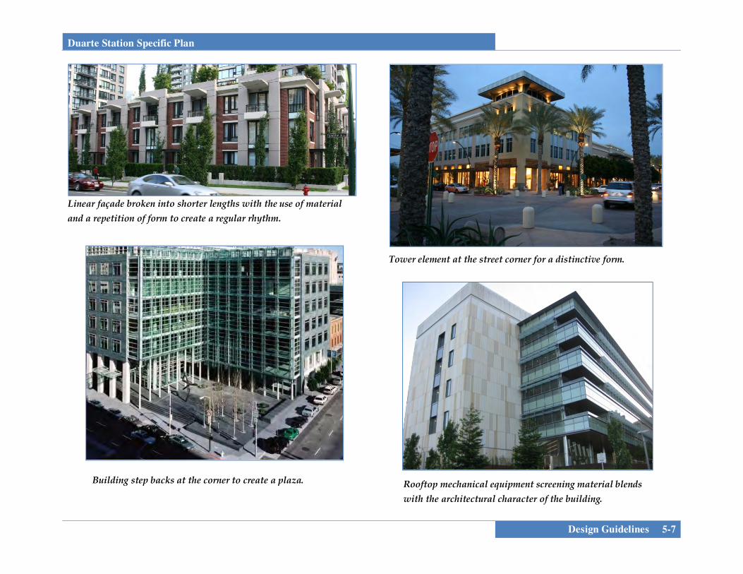
Duarte Station Specific Plan
Design Guidelines 5-7
Building step backs at the corner to create a plaza.
Tower element at the street corner for a distinctive form.
Rooftop mechanical equipment screening material blends with the architectural character of the building.
Linear façade broken into shorter lengths with the use of material and a repetition of form to create a regular rhythm.
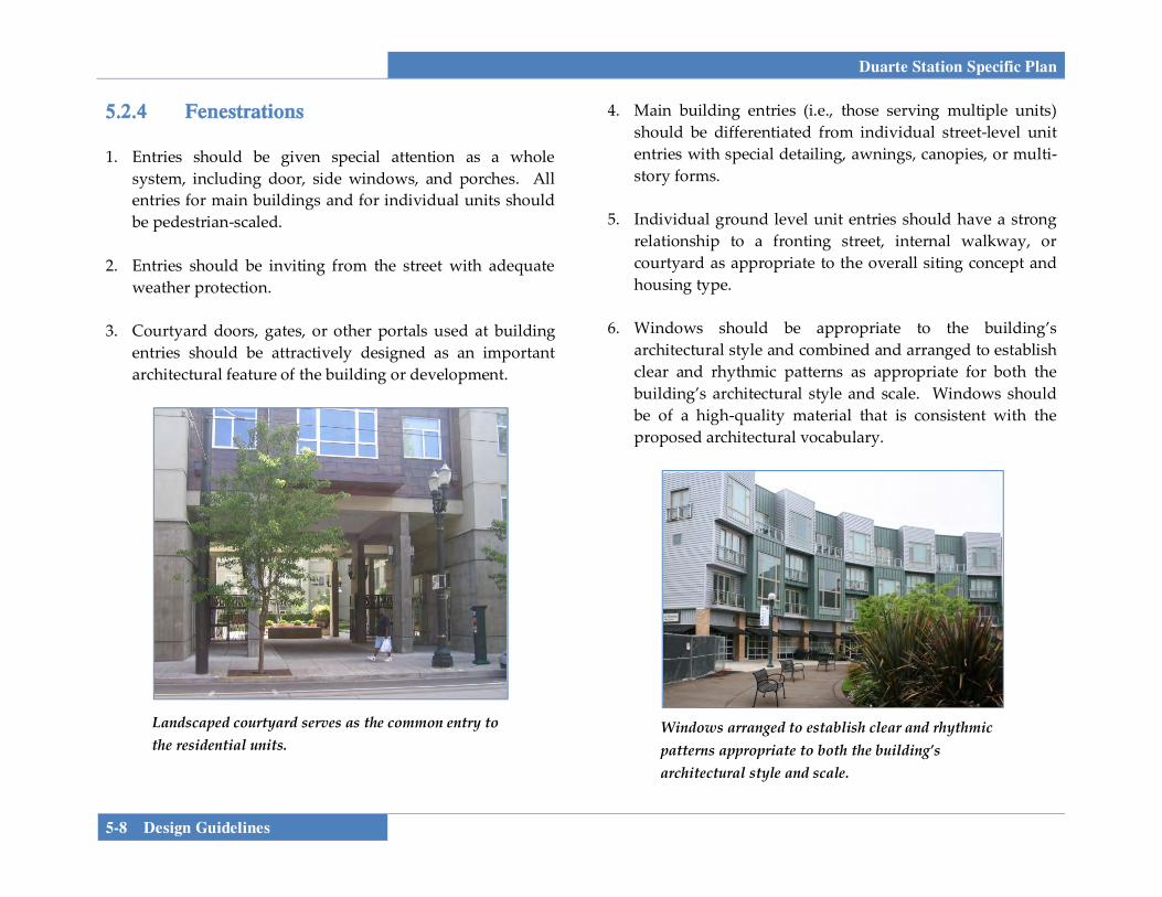
Duarte Station Specific Plan
5-8 Design Guidelines
Landscaped courtyard serves as the common entry to the residential units.
Windows arranged to establish clear and rhythmic patterns appropriate to both the building’s architectural style and scale.
5.2.4 Fenestrations 1. Entries should be given special attention as a whole
system, including door, side windows, and porches. All entries for main buildings and for individual units should be pedestrian-scaled.
2. Entries should be inviting from the street with adequate
weather protection. 3. Courtyard doors, gates, or other portals used at building
entries should be attractively designed as an important architectural feature of the building or development.
4. Main building entries (i.e., those serving multiple units) should be differentiated from individual street-level unit entries with special detailing, awnings, canopies, or multi-story forms.
5. Individual ground level unit entries should have a strong
relationship to a fronting street, internal walkway, or courtyard as appropriate to the overall siting concept and housing type.
6. Windows should be appropriate to the building’s
architectural style and combined and arranged to establish clear and rhythmic patterns as appropriate for both the building’s architectural style and scale. Windows should be of a high-quality material that is consistent with the proposed architectural vocabulary.

Duarte Station Specific Plan
Design Guidelines 5-9
Individual entries from the street for ground floor units.
Change of materials to highlight the fenestration.
7. Windows visible from a street or courtyard, including those on all façades of the buildings that front onto public or private streets or access ways, should have appropriately articulated header, jamb, and sill details to match the aesthetic of the building.
8. Though consistency of window use is generally desirable,
windows may be provided in various shapes and sizes provided they are appropriate to the building’s architectural style or as accents.
9. In residential units with narrow side yards, side elevation
windows should be placed offset from those of the adjacent unit or use obscure glass as appropriate.
10. Doorways should be clearly identified with change in
material, change in plane, or with architectural elements such as a canopy.
5.2.5 Building Materials
1. All materials used should be of high-quality and properly installed.
2. Materials should be attractive, durable, sustainable, low
maintenance, and appropriate to the architectural character.
3. Materials should be incorporated such that they do not
appear to be merely surface applications but as an integral component of the architectural style.
4. Change of material to
accentuate architectural details or articulate the elevation is recommended if the material is appropriate to the architectural character.
5. Material changes should
not occur at external corners, but should occur at interior corners or with a return of at least 6 feet from the external corners or other logical terminations.

Duarte Station Specific Plan
5-10 Design Guidelines
Use of a darker material along the base of the building to highlight the change in use and building façade setback.
The materials and forms of the architectural canopy and balconies complement the overall building architecture.
6. Roof materials should complement the materials and
colors of the façades and provide texture or relief. 7. Rain gutters and down-spouts should be integrated into
the façade. At a minimum, their color should blend with adjacent surfaces.
8. Partially submerged parking podiums that project above
grade should either be integrated into the architectural character of the building above, utilizing cladding or building with materials that extend down from the portions of the building above, or be built with contrasting
materials of a more substantial and permanent character than the portions of the building above to create a base.
9. Trellises, architectural canopies, balconies and other such
design elements should derive their materials, colors, and form from the building architecture.

Duarte Station Specific Plan
Design Guidelines 5-11
5.2.6 Service Areas and Screening of Mechanical Equipment
1. All loading areas should be located at the rear or sides of
buildings and screened from public view. For commercial buildings, where there is no alternative, loading may occur through the front door.
2. Service areas should be located within the envelope of the
building as much as is practical and should not be visible from public streets and spaces.
3. If service areas are not within the building envelope and
cannot be located away from the street front, they should be screened from street level views, including from above. The material, scale, and forms of screening used should complement the design of the main building.
4. Buildings shall have a direct door from the interior to the
service area(s) so that occupants can access such areas without passing through the public right-of-way.
5. Rooftop mounted mechanical equipment should be located
away from the street edge and screened from ground level view behind parapets. Where screening methods other than parapets are used, they should be an integral component of the architectural design or a complimentary accent feature to that design.
6. Attached equipment such as solar panels, antennas, satellite dishes, etc. should be screened from ground level view or integrated into the building design.
7. Ground level mechanical equipment should be located
away from and screened from view from public areas by walls that complement the building architecture or by landscaping.
5.2.7 Signage In compliance with the DDC, a Comprehensive Sign Program is required for development within this Specific Plan to integrate all signs associated with a development.The Comprehensive Sign Program provides a means for the flexible application of sign regulations for projects that require multiple signs in order to maintain consistent standards and sign appearance throughout the project. The ARB is the review authority for the Comprehensive Sign Program. 1. Animated, moving, flashing, blinking, reflecting and
revolving signs are prohibited. 2. Cabinet signs are prohibited.
3. Exposed conduit and tubing is prohibited. All
transformers and other equipment should be concealed.

Duarte Station Specific Plan
5-12 Design Guidelines
Variation in color, façade used to break up the building mass.
4. A coordinated signage plan
should be included for all multi-tenant buildings.
5. Freestanding signs are
discouraged, except at a single major site entry.
6. All signs should be designed to
complement the architectural style and setting of the structure or use it is adjacent to. Building wall and fascia signs should be compatible with the pre-dominant visual elements of the building.
7. The size of signs and sign
letters should be proportional to the space they are located in, with the letters typically between 6 and 16-inches high.
8. Projecting signs mounted
perpendicular to the façade of the building should be located at least 8 feet above the sidewalk. The outside edge should be no more than 4 feet from the face of the building.
9. Window signs should not exceed 15% of the window area.
Signs should not obstruct visibility into and out of the window.
5.3 DESIGN GUIDELINES BY BUILDING
TYPE
5.3.1 Multi-Family Residential/ Mixed-Use 1. Multi-family buildings should be well articulated to break
up the building mass. Variations in floor level, façades, roof styles, architectural details, and finishes that break up the appearance of large buildings should be employed.

Duarte Station Specific Plan
Design Guidelines 5-13
Individual entries for ground floor entries front the street.
Front yard patios used as part of the entry to individual units.
2. Street-facing façades of residential buildings should include stoops, porches, recessed windows, bay windows, and balconies in order to provide visual interest.
3. Porches and balconies that face streets should be
incorporated into the materials and design of the building. Front yard patios can be used or be a part of the entry path or a separate space.
4. Retail and service uses on the ground floor of mixed use
buildings shall have a minimum interior 12 feet clear floor to ceiling height.
5. Storefronts on the ground floor of mixed use buildings
shall have a minimum depth of 40 feet. 6. Commercial hours of operation should not conflict with
adjacent residential uses. 7. Large display windows (large panes or divided lites) are
strongly encouraged. 8. Clear glass should be used. Colored or reflective glass is
not appropriate. 9. All ground floor units within 5 feet of finished grade are
encouraged to have their principal entrance from the street, pedestrian walkway, or open space. If individual entries are not provided than individual private areas such as balconies or decks need to be provided that front on to the street, pedestrian walkway, or open space.
10. Common entries should be a predominant feature of front
façades, and should have a scale that is in proportion to the size of the building and number of units being accessed. Larger buildings should have a prominent, centralized building entrance.
11. Residential entries should be clearly identifiable from the
retail/service entry. 12. Building sides that face a public street, drive, or common
space should be the first choice for entry location.

Duarte Station Specific Plan
5-14 Design Guidelines
Distinctive architectural style at the building corner facing the intersection.
13. The use of awnings is encouraged to provide shelter and
shade along the sidewalk for mixed use buildings. Awnings should be no wider than a single storefront or architectural bay (whichever is narrower).
14. Building corners that face an intersection should strive for
a distinctive form with a high level of articulation. Corner treatments could include; a change in height, a definition of a public plaza, or a change in architectural style, windows, or materials.
Change in glass frontage and transparency helps differentiate the ground floor retail use from the residences above.

Duarte Station Specific Plan
Design Guidelines 5-15
Common entry for the building is emphasized by change in color and scale.
Ornamental garage gate activates the public realm.
Appropriate use of transparency and shading devices along public streets.
15. Entries to underground parking areas which are integrated
with the building are recommended to be gated with a material that is compatible with the architectural vocabulary of the building.
5.3.2 Office/Office Mixed Use 1. Storefronts shall have a minimum depth of 40 feet. 2. Large display windows (large panes or divided lites) are
strongly encouraged. 3. Clear glass should be used. 4. Colored or reflective
glass is not appropriate. 5. Street- and plaza-facing
façades should be lined with windows.
6. Blank walls should not
occupy over 30% of the principal frontage, and a section of blank wall should not exceed 20 linear feet without being interrupted by a window or entry.
7. Elements such as
awnings, arcades, porches, or porticos should be incorporated along the street-facing façades.
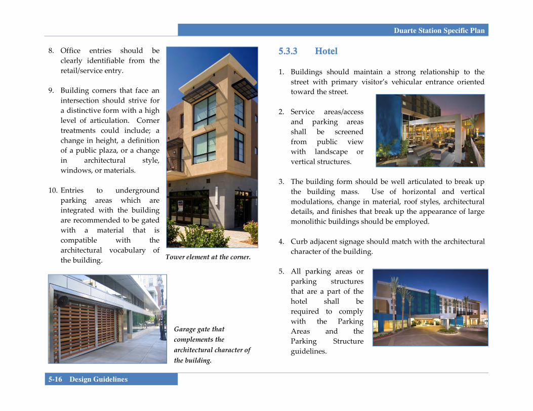
Duarte Station Specific Plan
5-16 Design Guidelines
Tower element at the corner.
Garage gate that complements the architectural character of the building.
8. Office entries should be clearly identifiable from the retail/service entry.
9. Building corners that face an
intersection should strive for a distinctive form with a high level of articulation. Corner treatments could include; a change in height, a definition of a public plaza, or a change in architectural style, windows, or materials.
10. Entries to underground
parking areas which are integrated with the building are recommended to be gated with a material that is compatible with the architectural vocabulary of the building.
5.3.3 Hotel 1. Buildings should maintain a strong relationship to the
street with primary visitor’s vehicular entrance oriented toward the street.
2. Service areas/access
and parking areas shall be screened from public view with landscape or vertical structures.
3. The building form should be well articulated to break up
the building mass. Use of horizontal and vertical modulations, change in material, roof styles, architectural details, and finishes that break up the appearance of large monolithic buildings should be employed.
4. Curb adjacent signage should match with the architectural
character of the building. 5. All parking areas or
parking structures that are a part of the hotel shall be required to comply with the Parking Areas and the Parking Structure guidelines.

Duarte Station Specific Plan
Design Guidelines 5-17
Awnings placed within architectural bays.
6. Shared parking between office and hotel is strongly encouraged.
7. Outdoor recreation areas/pools are to be appropriately
screened from adjacent uses. 5.3.4 Stand Alone Retail 1. Buildings should
maintain a strong relationship to the street or to a public plaza.
2. Storefronts shall
have a minimum depth of 40 feet.
3. Elements such as awnings, arcades, porches, or porticos
should be incorporated along the street/plaza-facing façades.
4. Where the façade of a commercial building is divided into
distinct bays (sections defined by vertical architectural elements such as masonry piers), awnings should be placed within the vertical elements rather than overlapping them.
5. The use of low walls, planters or potted elements to create
outdoor seating areas is encouraged.
6. Building corners that face an intersection should strive for a distinctive form with a high level of articulation. Corner treatments could include; a change in height, a definition of a public plaza, or a change in architectural style, windows, or materials.
5.3.5 Parking Structure
1. Parking structures should be designed in keeping with the character of the primary buildings on or near the site. The parking structure should be architecturally similar with the surrounding buildings in use of materials and color.
2. Parking structure façades should be designed as
compatible visual extensions of other multistory buildings.

Duarte Station Specific Plan
5-18 Design Guidelines
Parking garage façade treatment provides variation and blends with mixed use building.
3. If feasible, active ground-level commercial uses should be incorporated into parking structures along the sidewalk. If ground level commercial uses are not incorporated, then other uses such as public art or murals should be used to lessen the impact of the building at the street level.
4. Auto entries should be located in a manner that minimizes
pedestrian/auto conflicts. There shall be no more than two curb cuts serving the parking structure within a block.
5. Variations in the horizontal and vertical planes of the
façade should be provided to create visual interest and to reduce the mass of the parking structure.
6. Decorative screen and trellis or green screens are
encouraged to provide variation and interest on the façade.
5.4 LANDSCAPE GUIDELINES
Landscape design gives character and definition to the hierarchy of open spaces within this mixed-use area using the following principles:
The provision of an open space program which includes passive space, streetscapes, and social space. Consideration should be given to the orientation of such areas with regard to sunlight and shade.
Using plant species and trees at an appropriate scale to
define, identify, separate and enclose space. The encouragement of visual links throughout the
plan. Creating a balance between community landscapes
while considering the needs for commercial visibility. The use of materials to define pedestrian dominated
areas. A Landscape Concept Plan for the Duarte Station Specific Plan will be provided at the time of site plan/design review to provide for a unified concept for the development. General Guidelines are presented below:
1. All areas not covered by buildings, walkways, driveways, parking spaces, and service areas should be landscaped with drought tolerant plantings. Plant

Duarte Station Specific Plan
Design Guidelines 5-19
materials should favor native and native-compatible plants.
2. Landscaping should enhance the quality of the project
by defining edges, framing and softening the appearance of buildings, defining site functions, screening parking and storage areas, and buffering uses and neighboring properties.
3. Landscaping at the base of buildings is encouraged to
soften the transition between building and streets. 4. Landscaped areas should generally incorporate
plantings utilizing a three tiered system: 1) trees, 2) shrubs or vines, 3) groundcover. Landscaping should be in scale with the adjacent buildings and be of appropriate size at maturity.
5. Placement of landscaping
should not interfere with the lighting of the project area or restrict access to utilities.
6. Planters and pots placed in
building recesses, adjacent to walls, plazas, and courtyards are encouraged. Planters and pots should complement building architecture.
7. Street trees should be spaced appropriately (in
parkway strips or in tree-wells within wider sidewalks or plazas) to emphasize and reinforce the spatial definition between the building, pedestrian environment and the street.
8. Textured paving
materials should be used in pedestrian areas such as pedestrian courtyards or plazas. Bollards should be used at pedestrian crossings to emphasize the pedestrian nature of the street, enhancing safety.
9. Paving materials may include permeable hardscape
materials, to allow for water infiltration and treatment. 10. Bio-retention areas can be used to detain run-off in
planted swales, raised open-bottomed planters, etc. 11. Site furnishings including fixed and moveable seating,
trash receptacles, bike racks, and pedestrian scaled lighting should be of durable and sustainable materials.
12. The type and location of building lighting should
preclude direct glare on to adjacent properties.

Duarte Station Specific Plan
5-20 Design Guidelines
13. Pedestrian scale lighting should be present at entries, plazas, courtyards, parking lots, and other areas where nighttime pedestrian activity is expected.
14. Lighting design of fixtures and their structural support should be architecturally compatible with the architecture of the project.
Three-tiered landscape design that will provide character and definition to the pedestrian linkages throughout the project.


Duarte Station Specific Plan
Administration 6-1
SECTION 6.0 ADMINISTRATION AND IMPLEMENTATION
6.1 ADMINISTRATION
6.1.1 Purpose and Overview The California Government Code (Title 7, Division 1, Chapter 3, Article 8, Sections 65450 et seq.) grants authority to cities to adopt Specific Plans for purposes of implementing the goals and policies of the City’s General Plan. In the City of Duarte Chapter 19.22 and 19.150 of the Development Code establishes the purpose and adoption of Specific Plans. As with General Plans, the Planning Commission must hold a public hearing to consider and provide a recommendation on the Specific Plan to the City Council. The purpose of this chapter is to provide an outline of the steps necessary to implement the Duarte Station Specific Plan and applicable conditions, mitigation measures and regulations in coordination with the City of Duarte and other relevant public agencies. The approval of this Specific Plan, certification of an Environmental Impact Report, and adoption of conditions of approval and a Mitigation Monitoring and Reporting Program (MMRP) will assure that timely mitigation of project impacts take place at the appropriate milestones and in accordance with project implementation.
6.1.2 Applicability All development within the Duarte Station Specific Plan area shall comply with the requirements and standards set forth in this Specific Plan document and the accompanying EIR, conditions of approval and Mitigation and Monitoring Report. Where conflicts exist between the standards contained in this Specific Plan and those found in the City of Duarte General Plan, Development Code or Municipal Code, the regulations and standards in this Specific Plan shall take precedence. Any area of site development, administration, review procedures, environmental review, landscaping requirements, sustainability, and regulations not expressly addressed by this Specific Plan document shall be subject to the provisions of the City of Duarte Development Code, using the context and objectives of the Specific Plan as a guide. The regulations, development standards and guidelines as contained in the Specific Plan shall apply in their entirety in the review of development proposals, site plans, and building permits within its boundaries. The name “Duarte Station Specific Plan” refers to this specific plan document and its supporting information. The final marketing name of the project may differ and will be determined by individual project developers/builders.
6.1.3 Adoption The Duarte Station Specific Plan will be approved in a manner consistent with California Government Section 65451, as well as Article 7 and Chapters 19.22 and 19.150 of the City’s
Duarte Station Specific Plan
6-2 Administration
Development Code. The Duarte Station Specific Plan will be adopted by ordinance and will serve as the zoning for the Specific Plan project area. The approved Specific Plan project site shall be designated on the City’s General Plan Land Use Diagram and Zoning Map as the Duarte Station Specific Plan (SP 17). The land use and development standards identified in this Specific Plan document supersede all zoning regulations to the extent that they would be in conflict with the sections of this Specific Plan.
6.1.4 Enforcement The Duarte Station Specific Plan serves as the implementation tool for the General Plan and the zoning for the Specific Plan area. The Specific Plan addresses permitted uses, development standards, and project design guidelines. The City shall enforce the provisions of the Specific Plan in the same manner that the City enforces the provisions of the General Plan, Municipal Code and Development Code.
6.1.5 Interpretation The development standards and regulations contained in this Specific Plan shall supersede the standards contained in the Duarte Municipal and Development Codes, except where specifically provided in the Specific Plan. Whenever the provisions contained in the Specific Plan conflict with the Municipal or Development Codes, the provisions of the Specific Plan shall take precedence. Any ambiguity concerning the content or application of the Duarte Station
Specific Plan shall be resolved in accordance with the provisions of the Duarte Development Code. Such interpretations shall take into account the stated goals and intent of the Specific Plan. If requested, the Planning Commission may review any administrative interpretation, subject to appeal to the City Council. 6.1.6 Appeals An appeal of any determination, decision, or requirement of City staff or the Planning Commission shall be made in conformance with the procedures established by the Development Code.
6.1.7 Specific Plan Modifications and
Amendments Final development plans for each area of the project may be adjusted or modified based on final design and engineering and the precise development plans of the planning area developer. Documentation of the proposed project, as modified, to support an implementing map, site plan, or use permit must be submitted for the review and approval of the Community Development Department, its Director or their designee. The Community Development Director or their designee shall have the authority to identify and approve, on behalf of the City, minor adjustments or modifications, as defined herein, which substantially conform to the approved Specific Plan.

Duarte Station Specific Plan
Administration 6-3
SUBSTANTIAL CONFORMANCE AND MINOR MODIFICATIONS Minor modifications to the Duarte Station Specific Plan shall not require a Specific Plan Amendment, and shall be subject to a “substantial conformance” determination, an administrative mechanism by which minor modifications to the Specific Plan which do not result in significant impacts and are consistent with the intent of the Plan, shall be permitted without a formal amendment process. The City of Duarte Community Development Director shall make determinations of substantial conformance. Minor modifications that meet the above Substantial Conformance determination may be warranted to accommodate changes resulting from final design and engineering that cause adjustments in roadway alignments, location of utilities or other infrastructure, development of innovative product design, distribution of permitted uses within the Specific Plan, development of Final Design Guidelines, density transfers, or other similar modifications deemed to be minor and which implement the provisions of the plan. Minor modifications or technical adjustments may include, but are not limited to the following:
• Modifications necessary to comply with final
Conditions of Approval or mitigation measures; • Addition of information to the Specific Plan (including
maps or text) for purposes of clarification that does not change the intent of any plan or regulation, as well as correction of any clerical or grammatical errors;
• Adjustments to the alignment, location and sizing of
utilities and facilities or a change in utility and/or public service provider may be approved by the City’s Engineering or Public Works Department so long as the adjustments or changes are found to be in compliance with applicable plans and standards of the agency responsible for such utilities and facilities;
• Change in roadway alignment, width, or
improvements through the final engineering/ improvement plan process so long as minimum rights-of-way meet the standards outlined in the Specific Plan;
• An adjustment of any interior boundary not to exceed
20% of the acreage designated as that land use; • Variation in the number and type of dwelling units or
square footage of non-residential uses within the Specific Plan may occur at the time of design depending on the residential or commercial product identified for development with a particular land use designation;
• Minor adjustments to any of the development
standards or regulations such as modification of wall heights for noise attenuation purposes, modification of allowable encroachments into setbacks, etc. that are specifically allowed under the Development Regulations of this Specific Plan;
Duarte Station Specific Plan
6-4 Administration
• Minor changes to the architectural design guidelines, which guidelines are intended to be conceptual in nature and flexible in implementation;
• Modification of any design element in this Specific
Plan that improves circulation, reduces grading, improves drainage, improves infrastructure, or provides similar utility and reduces operations and maintenance costs;
The minor modifications described and listed above are not comprehensive. Any modification that is deemed by the Community Development Director to be in substantial conformance with the purpose and intent of the Specific Plan shall be permitted. The documentation of substantial conformance may include text and/or maps which describe the nature of all proposed modifications or adjustments to the Specific Plan. This application of substantial conformance with the adopted Specific Plan shall undergo any necessary technical review by City agencies and the Community Development Director or their designee deems necessary to provide for updated conditions of project approval.
AMENDMENTS TO THE SPECIFIC PLAN
If a project applicant seeks a modification or adjustment to the Specific Plan which is deemed by the Community Development Director to be a substantial modification, the Community Development Director shall have the discretion to
refer any such requests to the City’s Planning Commission for review and consideration. Substantial amendments to the Specific Plan require a public hearing before the City’s Planning Commission which will make a recommendation to the City Council for action. The City Council may approve, deny, or conditionally approve amendments to the Specific Plan.
An amendment to the Specific Plan is required if the following occur:
• Changes to the overall Specific Plan boundaries including an expansion of the Specific Plan area (changes to planning area boundaries within the Specific Plan boundaries are deemed minor as noted above and would not require an amendment);
• A change in any other provision, purpose, or standard
of the Specific Plan, which would significantly alter the basic intent, spirit, identity, or concepts of the Specific Plan; or
• An increase in the overall development density
thresholds within the Specific Plan.
An applicant may request amendments to the Duarte Station Specific Plan at any time pursuant to Section 65453(a) of the Government Code. An amendment to the Specific Plan requires public hearings, a recommendation by the City’s Planning Commission and
Duarte Station Specific Plan
Administration 6-5
approval by the City Council. Specific Plan amendments are governed by California Government Code, Section 65456, and require an application and fee to be submitted to the City’s Community Development Department. The application shall state in detail the reasons for the proposed amendment. The Duarte Station Specific Plan shall not be amended unless the following findings are made by the Planning Commission and City Council:
• The Specific Plan or Amendment implements and is
consistent with the General Plan in compliance with Government Code Section 65454.
• The Specific Plan amendment allows for a coordinated
and cohesive development; and • The Specific Plan or amendment provides for the
construction, improvement, or extension of transportation facilities, public utilities and public services required for the long term needs of the project and/or other area residents, and complement the orderly development of the City of Duarte.
6.2 IMPLEMENTATION
6.2.1 Certification of Environmental Impact
Report A Project Environmental Impact Report (EIR) has been prepared for the Duarte Station Specific Plan to analyze
environmental impacts of the project, discuss feasible alternatives, and recommend feasible mitigation measures in compliance with the provisions of the California Environmental Quality Act (CEQA). The EIR analyzes the entire Specific Plan area and addresses potential impacts associated with development of the Specific Plan area. The EIR includes a recommended mitigation monitoring program and analyzes implementing actions for development. Preparation of the EIR was done in conformance with the requirements for environmental documentation for many of the subsequent discretionary and ministerial development applications for the Specific Plan. 6.2.2 Mixed-Use Implementation Mechanisms
As envisioned in this Specific Plan, any mix of uses allowable in the development standards of this document are permitted within the Mixed Use planning areas of this Specific Plan with no subsequent discretionary review other than Site Plan/ Design Review and/or Conditional Use Permit approvals or additional environmental review under CEQA, granted that the mix of uses meets the requirements of the Mixed-Use Implementation Mechanisms established by this Section. The Mixed-Use Implementation Mechanisms control the ultimate mix of uses within the Specific Plan through Development Regulations including allowable uses, building heights, floor area ratios, density restrictions, and open space standards. These are summarized in Table 6-2.

Duarte Station Specific Plan
6-6 Administration
In the event a specific unlisted permitted or conditionally permitted use is identified for a proposed development, a traffic analysis may be required to be prepared by a licensed traffic engineer and reviewed and approved by the City Engineer. Proposed projects will be analyzed in terms of: 1) consistency with the allowable uses as outlined in Section 4 of this document; 2) building heights are reviewed and approved by the Community Development Department; 3) a maximum FAR of 2.0 over the entire Specific Plan area; 4) parking standards identified within Section 4, Development Standards, ensure that parking demand, as associated with each specific use of the development, will be met; 5) the density of all residential uses does not exceed 70 dwelling units per gross acre, measured within each planning area over the entire Specific Plan; and 6) complies with open space requirements identified within Section 4 of this document.
Adjustments to the amount, intensity, or mix of uses may occur if consistent with the Specific Plan subject to a traffic analysis. COMPLIANCE WITH DEVELOPMENT REGULATIONS Proof of Compliance with the following regulations (summarized from Section 4) must be submitted as part of any submittal for a project within the Mixed Use planning areas of the Specific Plan.
• Permitted Uses. The ultimate mixture of uses within the Mixed Use planning areas shall consist entirely of land
uses permitted or conditionally permitted in Section 4, Development Regulations, of this Specific Plan, and consistent with the Design Guidelines outlined in Section 6, Design Guidelines.
• Building Heights. Building heights within the Mixed-
Use planning areas shall be reviewed and approved by the Community Development Department as part of the site plan/design review process.
• Floor Area Ratio (FAR). Development within the
Mixed-Use planning areas must be consistent with the Specific Plan’s maximum floor area ratio (FAR).
• Density Restrictions. Development within the Mixed-
Use planning area must not exceed the project’s density restrictions of 70 dwelling units per gross acre for all residential uses, measured over the entire Specific Plan area. Refer to Section 4, Development Regulations.
• Parking Requirements. Development within the Mixed-
Use planning areas must meet the parking standards established in this document’s Section 4, Development Regulations.
• Open Space Requirements. Development projects must
meet the common and private open space standards established in this document’s Section 4, Development Regulations.

Duarte Station Specific Plan
Administration 6-7
To ensure that development proposals are consistent with the Mixed-Use Implementation Mechanisms described in this section, the following information shall be completed and submitted with proposals for development along with a table that documents the project data to be retained by the Community Development Department (see Appendix B).
Table 6-1
Mixed Use Specific Plan Consistency Checklist
Requirement Description Conformance
1. Permitted Uses Land Uses Permitted or Conditionally Permitted in this document’s Section 4, Development Regulations.
2. Building Heights Building heights shall be reviewed and approved by the Planning Director as part of the site plan review process.
3. FAR A maximum floor area ratio (FAR) of 2.0 over the entire Planning Area. Refer to Specific Plan Section 4.
4. Density
The density of all residential uses does not exceed 70 dwelling units per gross acre, measured within each planning area over the entire Specific Plan. Refer to Specific Plan Section 4.
5. Parking Requirements
Parking standards, as established in this document’s Section 4, Development Regulations are met.
6. Open Space Open space requirements, as established within the Specific Plan Section 4, Development Regulations, are met.
7. General Building Design
Signage, materials, loading, lighting, fenestration established within
Requirement Description Conformance Section 5, Design Guidelines.
8. Substantial Conformance
Per Section 6.2.3 of this Specific Plan
The checklist shall be completed and submitted with the development proposal. Check if the proposed project fully complies with each respective requirement.
6.2.3 Subsequent Approvals and Plans Several levels of subsequent or concurrent approvals are required to implement the project. SUBDIVISION MAPS All subdivision maps filed for properties within the Specific Plan area shall be filed and processed in accordance with the Subdivision Map Act and Chapter 19.72 of Article 5 of the City of Duarte Development Code. Tentative Maps shall be consistent with the vision and sustainable community design standards of this Specific Plan. These maps, once recorded, will create buildable parcels and road rights-of-way and/or private streets. LANDSCAPE MASTER PLAN The first project submitted for Site Plan and Design Review shall be accompanied by a landscape master plan to provide a consistent streetscape concept for the multiple projects within the Specific Plan area. If a single development entity proposes development of the entire Specific Plan area this requirement is superseded by the Design Review requirements which include a landscape plan.

Duarte Station Specific Plan
6-8 Administration
PROJECT APPROVAL PROCESS
1. Substantial Conformance Determination. Prior to submittal to site plan submittal to the ARB, the Community Development Director shall make a finding of conformance with the land use and development standards of this Specific Plan consistent with Table 6-3. For projects within the Duarte Station Specific Plan area, review by Department officials shall constitute determination of consistency of the proposed project with the Specific Plan. The City of Duarte shall make findings that the development proposal is in substantial conformance with the Specific Plan.
2. Site Plan and Design Review. Future developers
within the Specific Plan are required to submit a completed Site Plan and Design Review Application with completed development and architectural plans for all projects to the Planning, Building and Safety, and Public Works/Engineering Divisions of the City of Duarte Community Development Department. Plans may also be submitted to additional departments such as fire, police, or any other departments where review is deemed necessary by the City. The standards for approval of the Site Plan and Design Review of projects within the Specific Plan shall be in accordance with Chapter 19.122.040 D. of the Development Code in addition to the following:
• The project implements the overarching intent of
this Specific Plan; • The project adheres to the land use and
development standards as outlined in the Development Regulations section of this Specific Plan; and
• The project is in substantial conformance with the
site planning and Design Guidelines contained in Sections 5 and 6 of this Specific Plan. Where project design guidelines or criteria conflict with the Standards of Review in Chapter 19.122.040 D. of the Development Code the provisions of the Specific Plan shall prevail.
Approving Authority. Approving authority for Site Plan/Design Review shall be as identified in the Duarte Development Code.
3. Conditional Use Permits. The process and requirements for conditional uses shall be in accordance with the Duarte Development Code.
PHASING Construction of the Duarte Station Specific Plan, including recordation of final subdivision map(s), site plan and design review, and actual construction of buildings, roads, and infrastructure may be progressively done in stages, provided vehicular access, public facilities, and infrastructure are

Duarte Station Specific Plan
Administration 6-9
constructed to adequately service the development, or as needed for public health and safety. The project will be phased to:
• Provide an orderly build-out of the community based upon market demand; and
• Provide adequate infrastructure to service the project. The Specific Plan will be constructed in phases based on market demand and available infrastructure improvements needed to support development. Table 6-2, Projected Phasing, identifies anticipated phasing for the project, based on the maximum build-out Development Scenario outlined in Section 2; different development projects submitted under this Specific Plan may result in a different mix. Phases may occur concurrently so long as the associated infrastructure is provided. Ultimate pace and phasing of the development is dependent on a number of internal and external factors. Market forces will determine the timing of landowner decisions to sell or “redevelop” the properties within the Specific Plan area. As other projects and improvements in the area progress various adjustments and revisions to the project phasing may occur. Revisions to the phasing plan shall be reviewed by the City’s Community Development Department and approved administratively so long as the proposed revisions meet the intent of the Specific Plan and adequately provide for the needs of the community. Any revision to the phasing deemed consistent with the Specific Plan shall not require a specific plan amendment.
Table 6-2 Projected Phasing1
1 Projected phasing is based on the maximum build-out Development Scenario outlined in Section 2; different development projects submitted under this Specific Plan may result in a different mix.
Planning Area Ac.
Non-Residential Intensity/Land Use
Residential Unit Count/Land Use
Phase 1 A 1.59 Parking only --
B 1.1 96,000 sf Office Mixed Use --
D 1.89 -- 132 du Residential/Mixed Use
E 0.81 12,000 sf Station Plaza Retail --
F 1.19 -- 83 du Residential
I 3.29 Hotel Mixed Use 250 room Hotel --
Phase 2
C 1.84 165,000 sf Office/Mixed Use --
G 2.35 -- 165 du Residential/Mixed Use
H 1.36 -- 95 du Residential
Phase 3
A 1.59 139,000 sf
Office/Mixed Use (Parking)
--
Total 19.09 400,000 office 12,000 sf retail 250 room hotel
475 du

Duarte Station Specific Plan
6-10 Administration
CEQA COMPLIANCE AND MITIGATION MONITORING
A program of measures identified in the project’s EIR shall be prepared of measures to mitigate or avoid significant effects on the environment. An approved Mitigation Monitoring Program shall insure that the Duarte Station Specific Plan complies with all applicable environmental mitigation and permit requirements. The final approved Mitigation Monitoring program shall be established upon EIR certification. 6.3 MAINTENANCE RESPONSIBILITY
AND PROJECT FINANCING
6.3.1 Maintenance Responsibility Maintenance responsibility within the Duarte Station project area will be accomplished through a combination of private and public mechanisms. In general, facilities dedicated to public agencies will be maintained by the relevant agency, while private facilities will be maintained by private entities or representative authorized private associations, as discussed below. RESIDENTIAL NEIGHBORHOOD HOMEOWNERS ASSOCIATION A residential Homeowner’s Association (HOA) shall be formed for the maintenance of private facilities held in common ownership, such as project landscaping lanes, private parks, entries, and lighting within individual projects.
BUSINESS ASSOCIATION A Business Association shall be formed to address private roads, shared driveways, landscaping, streetscape amenities, signage, and maintenance within the non-residential areas of the Plan, inclusive of commercial or office uses. 6.3.2 Financing Mechanisms It is expected that a range of funding tools will be tapped to finance transit village development, associated infrastructure, and ongoing operation. As noted earlier, responsibility for implementing these tools will fall to the City, other governmental agencies, private entities, and authorized private associations such as a home owners or business associations. The funding sources identified here are for discussion purposes to determine if the list is complete (and appropriate) and to guide subsequent analytical efforts. The ultimate mix of financing mechanisms will be determined in the implementation process, based on final technical analyses of costs, benefits, and burdens, and on deliberations involving City staff, sponsoring entities, property owners, developers, elected officials, bond counsel, underwriters, finance experts, and others. Regardless of the financing mechanisms selected, any approach should seek to align the sources, timing, and scope of financing to the specified uses, as described by the following principles:

Duarte Station Specific Plan
Administration 6-11
There should be assurances that necessary funding will
be available at the time specific infrastructure items are required.
Financial burdens on development should be kept within industry standards and market constraints.
The plan should be responsive to expected variations in timing, location, and type of development.
The financing tools and their applicability to the Plan Area fall into three distinct categories discussed further below. AREA-SPECIFIC FEES, DEDICATIONS, AND EXACTIONS Area Development Impact Fees. Area development impact fees may be enacted by a legislative body (i.e., city or county) through adoption of an ordinance. Such fees do not require a public vote to be enacted, but they do require public hearings. Area development impact fees must be directly related to the benefits received. Specifically, State law requires that impact fees be shown to have a “rational nexus” or relationship between costs and the impact or demand caused by the new development. They do not create a lien against property but must be paid in full as a condition of approval. Fees are established so that these properties pay their fair share at the time they are ready to be developed. Benefiting properties may be given the option to finance the fees by entering into an Assessment District (AD) or Mello-Roos Community Facility Districts (CFD) (see description of these financing mechanisms below).
Dedications and Exactions. Under the Subdivision Map Act, developers may be required to dedicate land or make cash payments for public facilities required or affected by their project (e.g., road right-of-way fronting individual properties). Dedications are typically made for road and utility right-of-ways, park sites, and land for other public facilities. Cash contributions are made for other public facilities that are directly required by their projects (e.g., payments for a traffic signal). Net New General Fund Revenues. The City of Duarte may elect to use General Fund revenues to help offset the cost of public infrastructure provision. Such a policy might be justified in light of the fact that the proposed Area Plan will generate significant fiscal benefits, as discussed in the Fiscal Impact Analysis in the Appendix (to come). These benefits may be used to back the issuance of tax-exempt bonds. Joint Development. Metro’s Joint Development Program provides a framework for public-private partnership that guides how private entities may conduct development on Metro-owned land to further the agency’s goals of increasing ridership and reducing auto use by directly linking Metro’s transportation network with retail, commercial and housing opportunities. For the Duarte station area, Metro will require land in the Plan Area for surface parking. This land could not only provide additional developable area for commercial uses and increase development density on the site, it could effectively provide—by means of below-market ground rent—a source of assistance to help catalyze further development.

Duarte Station Specific Plan
6-12 Administration
ASSESSMENT AND SPECIAL TAX-SECURED FINANCING Infrastructure Financing District. Qualified entities can create an Infrastructure Financing District (IFD), per the 1990 Infrastructure Financing Act, to pay for the construction of capital facilities that have “communitywide significance and provide significant benefits to an area larger than the area of the district.” Such facilities may include transit, highways, water systems, sewer projects, flood control, child care facilities, libraries, parks, and solid waste facilities. An IFD provides funding by diverting a portion of property tax increment revenue for 30 years to secure the issuance of bonds to finance qualifying projects. The IFD increment is defined as total annual property tax revenue within the district, less a base year amount, less the portion allocated to schools, less the portion claimed by agencies that did not voluntarily approve the IFD formation. As such, IFD tax increment is less than that once generated as redevelopment tax increment, possibly significantly less depending on the specific conditions of each IFD approval. To date, the difficulty in implementing an IFD has limited its use in California. To form an IFD, the qualified entity must develop an infrastructure plan, send copies to every land owner, consult with other local governments, and hold a public hearing. The infrastructure plan must be approved by every local agency that will contribute property tax revenue to the IFD. After this agency approval, the applicant must submit for voter approval to form the IFD (by two-thirds majority), to issue bonds (by two-thirds majority), and to
establish an appropriations limit for the IFD (by simple majority). Even after forming an IFD, bond issuance is difficult. The thirty-year limitation restricts bond capacity. Furthermore, there is no current market for IFD bonds, which have a high-risk profile because tax increment cash flow to service the bond is susceptible to real estate market volatility, and there is no independent real property lien on land within the district to secure the IFD’s obligations. However, in light of these well-documented challenges in forming and utilizing IFDs, several legislative efforts are under discussion to amend the IFD law with key changes including term extension from 30 to 40 years, elimination of voter approval requirements, and the addition of new qualifying project categories. If successful, these revisions could open up a very significant source of infrastructure financing. Special Assessment Districts (1911, 1913, 1915 Acts). California law provides procedures to levy assessments against benefiting properties and issue tax-exempt bonds to finance public facilities and infrastructure improvements. Assessment districts, also known as improvement districts, are subject to majority vote of property owners. Votes are weighted according to the amount of the proposed assessment on the parcel to which the ballot pertains. Assessments are distributed in proportion to the benefits received by each property as determined by engineering analysis and form a lien against property. Special assessments are fixed dollar

Duarte Station Specific Plan
Administration 6-13
amounts and may be prepaid, although they are typically paid back with interest over time by the assessed property owner. Only public infrastructure improvements with property-specific benefits (e.g., roads, drainage, and sewer and water improvements) may be financed with assessments. In addition, standard public finance underwriting criteria requires that the ratio of improved land value to assessment lien be equal to or greater than three to one. Mello-Roos Community Facilities Districts. California’s Mello-Roos Community Facilities Act of 1982 allows for the creation of a special district authorized to levy a special tax and issue tax-exempt bonds to finance public facilities and services. A CFD may be initiated by the legislative body or by property owner petition and must be approved by a two-thirds majority of either property owners or registered voters (if there are more than 12 registered voters living in the area). Special taxes are collected annually with property taxes and may be prepaid if such provisions are specified in the tax formula. The special tax amount is based upon a special tax lien against the property. There is no requirement that the tax be apportioned on the basis of direct benefit. Because there is no requirement to show direct benefit, Mello-Roos levies may be used to fund improvements of general benefit, such as major utilities, fire and police facilities, and libraries and parks, as well as improvements that benefit specific properties. The provision also allows for the allocation of cost burdens to alleviate burdens on specific classes of development.
The potential for a CFD supporting the Duarte Transit Village Plan Area could be significant if the district boundaries include industrial uses east of the site and City of Hope to the South. FEDERAL AND STATE GRANTS The City has in the past received funding for public facilities from other levels of government, including the State and Federal government. Funds from these sources, a selection of which is shown in the table below, may be made available for development in the Plan Area, especially as transit is a preferred public use. The availability, amount, and timing of these funds will need to be further evaluated.
Federal and State Funding Sources
Program Description Moving Ahead for Progress in the Twenty-First Century (MAP-21)
The current iteration of the US DOT Federal-Aid Highway Program, Moving Ahead for Progress in the Twenty-First Century (MAP-21), is in effect through September 2014 (it is re-authorized roughly every six years). Because the process of allocating federal aid is subject to uncertain political outcomes, it is not possible to ascertain what programs will continue through the next version. The California Department of Transportation (Caltrans) and regional planning agencies administer MAP-21 funding. The MAP-21 programs that may be applicable to the Plan Area are discussed briefly below.

Duarte Station Specific Plan
6-14 Administration
Federal and State Funding Sources
Program Description Transportation Alternatives (TA)
Transportation Alternatives consolidates three separate programs under the prior version of the Federal Aid Highway Program: Transportation Enhancements (TE), Safe Routes to School (SR2S), and the Recreational Trails Program (RTP). Of these, TE and SR2S are particularly relevant to opportunities in the Plan Area. TE funds may be used for the planning, design, and construction of bicycle and pedestrian infrastructure such as bikeways, sidewalks, signaling and signage, traffic management techniques, and improvements designed for ADA compliance. SR2S funds are intended to finance healthy alternative approaches to driving or using the bus to go to school on projects within two miles of primary or middle schools. SR2S funds may be used for a range of engineering, traffic calming, and educational projects.
Surface Transportation Program (STP)
The Surface Transportation Program (STP) allocates funds that can be used for a wide range of projects, including road and transit improvements that include bicycle and pedestrian elements. STP provides flexibility to fund improvements that are outside the Federal-aid highway system, so many streets near the Plan Area may be eligible.
Congestion Mitigation and Air Quality Improvement (CMAQ) Program
The CMAQ program is designed to provide funding to support surface transportation projects and other related efforts that contribute to air quality improvements and provide congestion relief. Eligible projects are intended to lower emissions of ozone, carbon monoxide, and/or particulate matter.
Federal and State Funding Sources
Program Description New Freedom Initiative
The New Freedom Initiative is intended to fund improvements that remove barriers to community living for people with disabilities. Among the eligible projects are those that expand transportation options. New Freedom Initiative grants may be used to fund both capital projects and operations and may be applicable for transit and pedestrian infrastructure envisioned for the Plan Area.
Transit-Oriented Development Planning Pilot
This pilot program provides funding to advance planning efforts that support transit-oriented development (TOD) associated with new fixed-guideway and core capacity improvement projects. Eligible recipients include state and local government agencies engaged in comprehensive planning that seeks to enhance economic development and ridership by means of increasing multimodal connectivity and accessibility, enhancing access to transit hubs for pedestrian and bicycle traffic, and promoting and enabling mixed-use development.
AB 2766 Clean Air Funds
The South Coast Air Quality Management District (AQMD) administers this program to fund air pollution reduction efforts. Funding is drawn from automobile registration surcharges. A 40 percent portion of annual disbursement is automatically allocated to South Coast District member cities in proportion to population. The remaining 60 percent is allocated through a competitive grant program for projects that improve air quality. Nearly all Plan Area initiatives may potentially be eligible for funding from AB 2766 grants.

Duarte Station Specific Plan
Administration 6-15
Federal and State Funding Sources
Program Description Bicycle Transportation Account (BTA)
Caltrans administers the Bicycle Transportation Account (BTA), an annual program providing state funds for city and county projects that improve safety and convenience for bicycle commuters. Cities and counties are eligible to apply for BTA funds. Eligibility is based on pre-adoption of a Bicycle Transportation Plan (BTP) that complies with Streets and Highways Code Section 891.4 that has been pre-approved by the appropriate Metropolitan Planning Organization (MPO) or Regional Transportation Planning Agency (RTPA). Eligible uses for the funding include bikeways and related facilities, planning, safety, and education. The BTA is a reimbursement program, which requires allocated funds to be matched by at minimum 10 percent of the total project cost. BTA funds may also be used to apply for and match federal grants or loans. Approximately $7.2 million is appropriated annually for the program state-wide.
California Transit Oriented Development (TOD) Housing Program
This program, funded by the California Department of Housing and Community Development, makes low-interest loans available as gap financing for rental housing developments that include affordable units, and as mortgage assistance for homeownership developments. Loans and grants are available to qualified public entities for infrastructure improvements supporting TOD residential uses or to enable connections between these developments and the transit station
Federal and State Funding Sources
Program Description Community Based Transportation Planning
Caltrans administers a grant program for transportation planning projects to improve mobility and lead to the programming or implementation phase for a community or region. With approximately $9 million in funding distributed through six grant programs annually, the program may offer the City of Duarte additional funding for planning. Each of these six grant programs may be applicable for the Plan Area: Community-Based Transportation Planning, Environmental Justice, Partnership Planning, Statewide or Urban Transit Planning Studies, Rural or Small Urban Transit Planning Studies, and Transit Planning Student Internships.
Environmental Enhancement and Mitigation Program
Caltrans and the California Natural Resources Agency administer the Environmental Enhancement and Mitigation Program, which offers $10 million each year in grants for projects that relate to the environmental impact associated with the modification of an existing transportation facility or construction of a new transportation facility. Of the four grant categories available, two may apply to the Plan Area, area, including grants for Highway Landscaping and Urban Forestry Projects to offset vehicular emissions through planting of trees and other suitable plants; and grants for Mitigation Projects Beyond the Scope of the Lead Agency responsible for assessing the environmental impact of the proposed transportation improvement.
Office of Traffic Safety (OTS)
The California Office of Traffic Safety (OTS) was created to award grant dollars to local and state government departments for development of traffic safety programs. The office is in the state Business, Transportation and Housing Agency, and it functions as a conduit for federal grant money, which it allocates to eight separate program areas, of which two, for Pedestrian and Bicycle Safety and Roadway Safety, may be directly applicable to the Plan Area. City agencies are eligible to apply.

Duarte Station Specific Plan
6-16 Administration
Federal and State Funding Sources
Program Description State-Local Transportation Partnership Program
The State-Local Transportation Partnership Program (SLTPP), administered by Caltrans, is intended to help local agencies fund and construct transportation improvement projects both on and off the State Highway System. The SLTPP is funded by the State Highway Account and is allocated to projects that increase transportation capacity, extend service to a new area, or extends a roadway’s useful life.
Transportation Development Act Article 3 Funds
The Transportation Development Act (TDA) includes two separate public transportation funds—Local Transportation Fund (LTF) and the State Transit Assistance fund—designated for development and support of public transportation needs. Funding is allocated to areas of each county based on population, taxable sales and transit performance. TDA funds may be used for many potential expenses that the transit village may generate, including engineering expenses, right-of-way acquisition, construction, improvements to existing pedestrian infrastructure, ADA compliance, and support facilities, such as transit shelters, bicycle parking, and pedestrian amenities.
Transportation Investment Generating Economic Recovery Program (TIGER)
The original TIGER Grant program, administered by the Department of Transportation (DOT), originated with the American Recovery and Reinvestment Act of 2009 (ARRA) and has been re-authorized for 2013. (If renewed for 2014, the program will likely feature provisions similar to those in 2013.) Through a highly competitive process, $474 million in discretionary grant money will be awarded to projects that achieve goals set forth in the Sustainable Communities Regional Planning Grant Program. These projects include larger-scale planning efforts that join housing, land use, economic and workforce development, transportation, and infrastructure investments that take into account the principles of sustainability, economic revitalization, social equity, public health, and environmental sustainability.

7. APPENDICES

Duarte Station Specific Plan
Appendices 7-1
SECTION 7.0 APPENDICES
7.1 GENERAL PLAN CONSISTENCY ANALYSIS
7.1.1 Safety Element Safety Goal 4: To minimize the risks to lives and property due
to seismic activity. Consistency Statement: The Duarte Station Specific Plan will
directly implement the Safety Goal above. Future construction within the Specific Plan would be performed in accordance with all applicable state and local building regulations, including the 2010 California Building Code and all applicable sections of the Duarte Development Code. Furthermore, each development project would be reviewed by applicable divisions of the Community Development Department as well as any additional necessary City departments prior to construction.
7.1.2 Open Space and Conservation Element Conservation Goal 2: To protect and maintain the local water
supply to ensure that the city's growing demand for water can be met.
Conservation Goal 3: To protect Duarte’s environment
through proper consideration of the environmental implications of new development in the city.
Open Space Goal 1: Protect and/or enhance Duarte’s Open Space acreage.
Open Space Goal 3: To provide parks throughout the city,
on a pedestrian scale as much as possible. Neighborhood parks generally should have a one-half mile service radius.
Air Quality Goal 1: Create Land Use policies that address the
relationship between land use and air quality to protect public health and minimize impacts on existing land use patterns and future land use developments.
Policy AQ 1.1.2: Promote and support mixed-use land patterns
that allow the integration of retail, office, institutional and residential uses.
Objective 1.2: Reduce mobile source emissions by reducing
vehicle trips and vehicle miles traveled associated with land use patterns.
Policy AQ 1.2.1: Establish a Mixed-Use Zoning District that
offers incentives for mixed-use developments. Policy AQ 1.2.2: Create opportunities to receive State
transportation funds by adopting incentives (e.g. and expedited review process) for planning and implementation infill development projects that include job centers and clean transportation nodes (e.g. preparation of a “transit village” plan).
Air Quality Goal 2: Reduce air pollution from mobile sources.
Duarte Station Specific Plan
7-2 Appendices
Objective 2.1: Reduce motor vehicle trips and vehicle miles
traveled. Consistency Statement: The Duarte Station Specific Plan will
directly implement the Open Space and Conservation Goals, Objectives, and Policies listed above. The Duarte Station Specific Plan would be constructed in accordance with the City’s sustainable practices, which are listed in the City’s Development Code and reflected in the Specific Plan Goals and Objectives in Section 2 of this Specific Plan. Considerations have been taken to fully understand and analyze environmental implications associated with the project, as well as mitigate any adverse impacts to the fullest extent feasible.
A minimum of 0.80 acres of open space is anticipated within the Specific Plan, along with a plaza near the station. These will provide spaces for patrons of the Duarte Station Specific Plan to enjoy passive open spaces. Development regulations governing construction within the Specific Plan area are created to regulate building placement, form, massing, and even aesthetics on a human or pedestrian-oriented scale.
The creation of a “transit village” reduces automobile traffic trips, and therefore reduces air pollution. By centering employment, retail, and travel amenities along a major rail corridor, automobile trips for employees or patrons will be reduced. The Duarte Station Specific Plan integrates a mixture of land uses that complement one
another for maximum land use efficiency and yield. Funding for the preparation of the Duarte Station Specific Plan was obtained through a grant obtained by the City to be used for the preparation of a “transit village.”
7.1.3 Land Use Element Land Use Goal 1: Maintain a balanced community consisting
of various residential housing types and densities, commercial activities, industrial development, mixed use where appropriate, and open space.
Land Use Goal 2: Develop compatible and harmonious land
uses by providing a mix of uses consistent with projected future social, environmental and economic conditions.
Policy LU 2.1.1: New infill residential development should be
compatible in design, bulk, and height with existing nearby residential development as referenced in Duarte’s Architectural Design Guidelines.
Land Use Goal 3: Provide unique areas to better serve the
needs of Duarte residents and businesses. Objective 3.1: Improve the land use mix in selected areas so
that it generates synergies and convenience to patrons and residents.
Policy LU 3.1.1: Develop Specific Plan areas which will provide the flexibility needed to make these places unique.

Duarte Station Specific Plan
Appendices 7-3
Policy LU 3.1.4: Create a flexible mixed use Transit Oriented Development Specific Plan for the current non-residential area north of the Duarte Station.
Consistency Statement: The Duarte Station Specific Plan will
directly implement the Land Use Goals, Objectives, and Policies listed above. The Specific Plan proposes a mixture of land uses centered on the proposed Duarte Station that will complement one another in a transit-oriented development. Future development would be infill in nature and would be compatible with surrounding land uses through application of design guidelines and development regulations which provide for buffer areas and architectural transitions adjacent to existing residential uses. The Duarte Station Specific Plan proposes enhanced land use flexibility and would provide transportation and service amenities to residents, employees, and visitors in the area.
Text amendments to the General Plan Land Use Element are proposed, including updates to Table LU-1, Table LU-2, LU-3, and the General Plan Land Use Plan. Textual amendments would also be made as needed throughout the General Plan, particularly in the Specific Plan Areas discussion in the Land Use Element. All modifications to the General Plan Land Use Element associated with the Duarte Station Specific Plan would ensure that the Specific Plan is in conformance with and implements the General Plan.
7.1.4 Housing Element Housing Goal 1: Increase the supply of housing. Policy 1.1.1: Promote and encourage development of housing,
which varies by size, type, design, and type of ownership. Policy 1.1.2: Facilitate construction of low- and moderate-
income housing. Policy 1.1.4: Promote the use of mixed land use techniques and
construction methods to provide more housing and minimize housing costs without compromising basic health, safety and aesthetic qualities.
Housing Goal 3: Provide housing opportunities for all
regardless of age, sex, race, ethnicity, marital status, religion or household composition.
Objective 3.1: Promote housing opportunities for all. Policy 3.1.2: Accommodate the City's fair share of the regional
housing needs. Consistency Statement: The Duarte Station Specific Plan will
directly implement the Housing Element Goals, Objectives, and Policies listed above. The Housing Element identifies the Duarte Station Specific Plan as an area that would accommodate 120 multi-family units. The Housing Element (2012 Amendment) recommends that a minimum of 80-100 units be part of the Phase 1 of the Duarte Station

Duarte Station Specific Plan
7-4 Appendices
Specific Plan. The Specific Plan will address the minimum amount of high density development provided for in the Housing Element. It is anticipated that residential units would be constructed in 1, 2, and 3-bedroom floor plans, and would provide housing choices for people with varying income levels and ages. The units would be located in a “mixed use transit village” area which could minimize overall living expenses for residents because they would have direct access to a regional transit system and a variety of goods and services, as well as employment opportunities.
7.1.5 Economic Development Element Economic Goal 1: Improve the City’s current revenue stream. Economic Goal 4: Enhance Duarte’s employment base with
good paying, high quality jobs. Economic Goal 5: Create efficient Mixed Use Transit Oriented
Development in and around the Duarte Station. Objective 5.1: Reduce vehicle miles traveled, provide
transportation options for existing and future workforce and residents around the Duarte Station, provide location efficiency, expanded mobility, and provide public/ private financial return and value recaptured.
Policy 5.1.1: Create a flexible mixed use Transit Oriented
Development Specific Plan for the non-residential area north of the Duarte Station.
Consistency Statement: The Duarte Station Specific Plan will directly implement the Goals, Objective and Policy listed above. The Specific Plan aims to incentivize development in the Specific Plan area by eliminating time and uncertainty, which in turn reduces dollar costs for potential developers and investors. Setting up a regulatory land use and entitlement framework results in establishing the “rules” of getting projects approved and built. The Specific Plan will facilitate this. The office square footage will contribute to and provide spaces for corporations and businesses to locate to the region, which will result in high-quality, good-paying employment opportunities. The mixed use approach programmed for the Duarte Station will reduce vehicle miles traveled while providing transportation options for residents, employees, and visitors to the area. The Specific Plan also incorporates a flexible approach so that development products, quantities, and types can be modified to reflect potential changes in market demand.
7.1.6 Circulation Element Circulation Goal 3: To increase the use of alternative modes of
transportation for traveling to, from, or through Duarte. Objective 3.1: Encourage and promote the use of travel modes
other than the single occupancy vehicle, such as bus transit, rail transit, carpools, vanpools, bicycling, and walking.
Policy 3.1.1: Continue to promote the development of the MTA Gold Line and a Duarte Station.

Duarte Station Specific Plan
Appendices 7-5
Policy 3.1.2: Coordinate Duarte Transit System with MTA, Foothill Transit and to service major destinations within Duarte including City of Hope, Duarte Station and proposed City Center area.
Policy 3.1.3: Promote the linking of local public transit routes
with that of adjacent jurisdictions and other transit agencies.
Policy 3.1.5: Provide incentives for appropriate pedestrian and
bicycle facilities throughout Duarte, particularly for bike lanes to the Duarte Station.
Consistency Statement: The Duarte Station Specific Plan will
directly implement all Goals, Polices, and Objectives listed above. The Specific Plan is centered on the future Duarte Station, which will increase alternative modes of transportation, including rail transit, walking, and bicycling through provision of amenities for cyclists. The Specific Plan area is located in proximity to the Highland Avenue Commuter Line bus stop and Evergreen Road Green Route stop. Coordination with appropriate transportation agencies would occur during Specific Plan Buildout, as well as the City of Hope. The Duarte Station would also serve to connect Duarte to adjacent cities served by the same rail system.

Duarte Station Specific Plan
7-6 Appendices
This page intentionally left blank.
7. 2 Appendices Adopted Mitigation Monitoring Program
Note: MMRP taken from the Final EIR. Introductory page 11-1 has been removed leaving the MMRP matrix only.


Duarte Station Specific Plan Environmental Impact Report
Final November 2013 11-2 Mitigation Monitoring and Reporting Program
DUARTE STATION SPECIFIC PLAN ENVIRONMENTAL IMPACT REPORT
MITIGATION MONITORING AND REPORTING PROGRAM
Mitigation Measure Monitoring Timing/Frequency
Action Indicating Compliance Monitoring Agency
Verification of Compliance
Initials Date Remarks
AESTHETICS AES-1 Prior to the issuance of a building permit, each project
applicant shall submit a Construction Management Plan for review and approval by the City of Duarte Community Development Director. The Construction Management Plan shall, at a minimum, indicate the equipment and vehicle staging areas, stockpiling of materials, fencing (i.e., temporary fencing with opaque material), and construction haul route(s). Staging areas shall be screened from view from residential properties. Construction worker parking may be located off-site with prior approval by the City; however on-street parking of construction worker vehicles on residential streets shall be prohibited. Vehicles shall be kept clean and free of mud and dust before leaving the development site. Surrounding streets shall be swept daily and maintained free of dirt and debris.
Prior to Issuance of Building Permit
During Construction
Review and Approval of Construction
Management Plan
Issuance of Building Permit
Periodic Site
Inspections During Construction
City of Duarte Community
Development Department
(Public Works and Engineering, Planning and
Building and Safety Divisions)
AES-2 Construction equipment staging areas shall use appropriate screening (i.e., temporary fencing with opaque material) to buffer views of construction equipment and material, when feasible. Staging locations shall be indicated on Final Development Plans and Grading Plans.
Prior to Issuance of Building or Grading
Permit
Review and Approval of
Building Plan(s) and Grading
Plan(s) at Plan Check
Periodic Site
Inspections During Construction
City of Duarte Community
Development Department
(Public Works and Engineering, Planning and
Building and Safety Divisions)
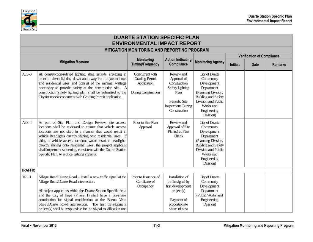
Duarte Station Specific Plan Environmental Impact Report
Final November 2013 11-3 Mitigation Monitoring and Reporting Program
DUARTE STATION SPECIFIC PLAN ENVIRONMENTAL IMPACT REPORT
MITIGATION MONITORING AND REPORTING PROGRAM
Mitigation Measure Monitoring Timing/Frequency
Action Indicating Compliance Monitoring Agency
Verification of Compliance
Initials Date Remarks
AES-3 All construction-related lighting shall include shielding in order to direct lighting down and away from adjacent hotel and residential uses and consist of the minimal wattage necessary to provide safety at the construction site. A construction safety lighting plan shall be submitted to the City for review concurrent with Grading Permit application.
Concurrent with Grading Permit
Application
During Construction
Review and Approval of Construction
Safety Lighting Plan
Periodic Site
Inspections During Construction
City of Duarte Community
Development Department
(Planning Division, Building and Safety Division and Public
Works and Engineering
Division)
AES-4 As part of Site Plan and Design Review, site access locations shall be reviewed to ensure that vehicle access locations are not sited in a manner that would result in vehicle headlights directly shining onto residential uses. If siting of vehicle access locations would result in headlights directly shining onto residential uses, the project applicant shall implement screening, consistent with the Duarte Station Specific Plan, to reduce lighting impacts.
Prior to Site Plan Approval
Review and Approval of Site Plan(s) at Plan
Check
City of Duarte Community
Development Department
(Planning Division, Building and Safety Division and Public
Works and Engineering
Division)
TRAFFIC TRF-1 Village Road/Duarte Road – Install a new traffic signal at the
Village Road/Duarte Road intersection. All project applicants within the Duarte Station Specific Area and the City of Hope (Phase 1) shall have a fair-share contribution for signal modification at the Buena Vista Street/Duarte Road intersection. The first development project(s) shall be responsible for the signal modification and
Prior to Issuance of Certificate of Occupancy
Installation of traffic signal by
first development project(s)
Payment of
proportionate share of cost
City of Duarte Community
Development Department
(Public Works and Engineering
Division)

Duarte Station Specific Plan Environmental Impact Report
Final November 2013 11-4 Mitigation Monitoring and Reporting Program
DUARTE STATION SPECIFIC PLAN ENVIRONMENTAL IMPACT REPORT
MITIGATION MONITORING AND REPORTING PROGRAM
Mitigation Measure Monitoring Timing/Frequency
Action Indicating Compliance Monitoring Agency
Verification of Compliance
Initials Date Remarks
will be reimbursed on a fair share basis by the remainder of the developments in the Duarte Station Specific Area and/or the City of Hope (Phase 1).
TRF-2 Buena Vista Street/Duarte Road – Modify the traffic signal by implementing a right-turn overlap phase at the westbound Duarte Road approach. All project applicants within the Duarte Station Specific Area and the City of Hope (Phase 1) shall have a fair-share contribution for signal modification at the Buena Vista Street/Duarte Road intersection. The first development project(s) shall be responsible for the signal modification and will be reimbursed on a fair share basis by the remainder of the developments in the Duarte Station Specific Area and/or the City of Hope (Phase 1).
Prior to Issuance of Certificate of Occupancy
Modification of traffic signal by
first development project(s)
Payment of
proportionate share of cost
City of Duarte Community
Development Department
(Public Works and Engineering
Division)
TRF-3 Buena Vista Street/Three Ranch Road – Install “KEEP CLEAR” or “DO NOT BLOCK” signing and striping in both directions of travel on Buena Vista Street at the Buena Vista Street/Three Ranch Road intersection. The City shall install the signage and striping and will be reimbursed on a fair-share basis by all development within the Duarte Station Specific Area and the City of Hope (Phase 1).
Prior to Issuance of Certificate of Occupancy
Installation of signage and
striping by City
Payment of proportionate share of cost
City of Duarte Community
Development Department
(Public Works and Engineering
Division)
TRF-4 All project applicants within the Duarte Station Specific Plan shall prepare and submit at their time of their development application to the Community Development Department a traffic study that: 1) documents the project-related trips and
Concurrent with Development Application
Review and Approval of Traffic
Study
City of Duarte Community
Development Department

Duarte Station Specific Plan Environmental Impact Report
Final November 2013 11-5 Mitigation Monitoring and Reporting Program
DUARTE STATION SPECIFIC PLAN ENVIRONMENTAL IMPACT REPORT
MITIGATION MONITORING AND REPORTING PROGRAM
Mitigation Measure Monitoring Timing/Frequency
Action Indicating Compliance Monitoring Agency
Verification of Compliance
Initials Date Remarks
provides a comparative review with the analysis in this EIR, and 2) uses the Highway Capacity Manual (HCM) intersection analysis methodology to determine whether the individual project increases the average delay per vehicle intersections having an existing unacceptable level of service without project traffic. The thresholds to be used for the delay analysis are: a. Signalized Intersections: The project increases the
average delay by more than 5 seconds per vehicle at an intersection having an unacceptable LOS without project traffic.
b. All-Way Stop Intersections: The project increases the
overall average delay by more than 5 seconds per vehicle at an intersection that has an unacceptable LOS without the project and the intersection also meets the peak hour volume signal warrant.
c. One- and Two-Way Stop Intersections:
The project causes the following to occur for the worst-case movement:
The LOS declines to an unacceptable LOS, and The volume to capacity ratio exceeds 0.75, and The 95th percentile queue exceeds 75 feet (3
vehicles), or the project causes the worst-case movement’s acceptable LOS to decline to an
(Public Works and Engineering Division and
Planning Division)
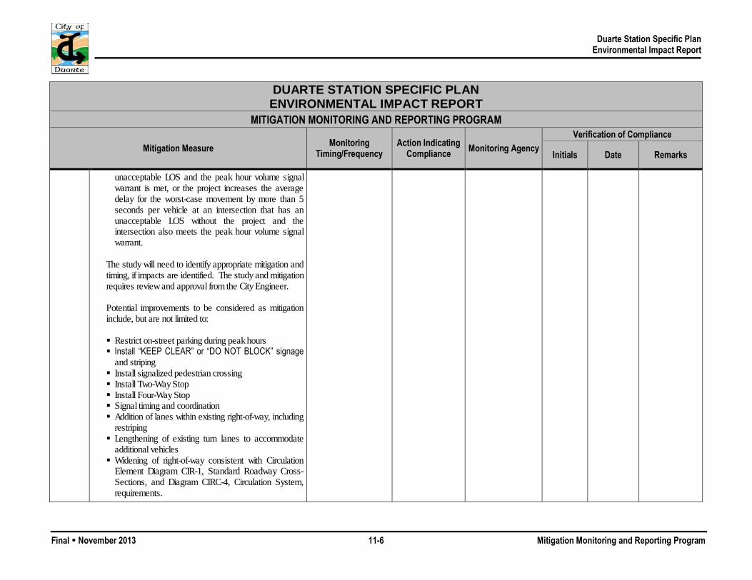
Duarte Station Specific Plan Environmental Impact Report
Final November 2013 11-6 Mitigation Monitoring and Reporting Program
DUARTE STATION SPECIFIC PLAN ENVIRONMENTAL IMPACT REPORT
MITIGATION MONITORING AND REPORTING PROGRAM
Mitigation Measure Monitoring Timing/Frequency
Action Indicating Compliance Monitoring Agency
Verification of Compliance
Initials Date Remarks
unacceptable LOS and the peak hour volume signal warrant is met, or the project increases the average delay for the worst-case movement by more than 5 seconds per vehicle at an intersection that has an unacceptable LOS without the project and the intersection also meets the peak hour volume signal warrant.
The study will need to identify appropriate mitigation and timing, if impacts are identified. The study and mitigation requires review and approval from the City Engineer. Potential improvements to be considered as mitigation include, but are not limited to:
Restrict on-street parking during peak hours Install “KEEP CLEAR” or “DO NOT BLOCK” signage
and striping Install signalized pedestrian crossing Install Two-Way Stop Install Four-Way Stop Signal timing and coordination Addition of lanes within existing right-of-way, including
restriping Lengthening of existing turn lanes to accommodate
additional vehicles Widening of right-of-way consistent with Circulation
Element Diagram CIR-1, Standard Roadway Cross-Sections, and Diagram CIRC-4, Circulation System, requirements.

Duarte Station Specific Plan Environmental Impact Report
Final November 2013 11-7 Mitigation Monitoring and Reporting Program
DUARTE STATION SPECIFIC PLAN ENVIRONMENTAL IMPACT REPORT
MITIGATION MONITORING AND REPORTING PROGRAM
Mitigation Measure Monitoring Timing/Frequency
Action Indicating Compliance Monitoring Agency
Verification of Compliance
Initials Date Remarks
TRF-5 When deemed necessary by the City Community Development Director and/or City Engineer, the project applicant(s) shall prepare, implement, and fund a Neighborhood Traffic Management Plan (NTMP), which shall include three components: education, enforcement, and enhancement. The educational component of the NTMP shall provide the community with a means of understanding traffic management tools and processes and also increase public awareness of the impact that traffic will have on the neighborhood. Educational efforts that could be implemented as part of the NTMP include, but are not limited to, the following: Coordination of neighborhood NTMP meetings Coordination of a speed watch program Coordination of the placement of temporary NTMP
yard signs with volunteers Design and distribution of NTMP brochures Coordination of applicant and/or staff presentations to
neighborhood groups The enforcement component of the NTMP entails focusing law enforcement efforts to acknowledge areas of concern. Enforcement efforts that could be implemented as part of the NTMP include, but are not limited to, the following: Increased enforcement Real-time speed feedback signs
Concurrent with Development Application
Review, Approval, and
Implementation of Neighborhood
Traffic Management Plan
City of Duarte Community
Development Department
(Public Works and Engineering Division and
Planning Division)

Duarte Station Specific Plan Environmental Impact Report
Final November 2013 11-8 Mitigation Monitoring and Reporting Program
DUARTE STATION SPECIFIC PLAN ENVIRONMENTAL IMPACT REPORT
MITIGATION MONITORING AND REPORTING PROGRAM
Mitigation Measure Monitoring Timing/Frequency
Action Indicating Compliance Monitoring Agency
Verification of Compliance
Initials Date Remarks
Signage (“Entering residential neighborhood…”) The enhancement component of the NTMP consists of non-physical and physical transportation system improvements. Numerous traffic-calming devices may be selected by a neighborhood for placement on a street. Potential improvements that could be implemented by the applicant and/or City of Duarte as part of the NTMP include, but are not limited to, the following: Pavement marking/lane narrowing Temporary speed tables Neckdowns/bulbouts (extensions of curbs/corner
sidewalks at an intersection) Choker/Chicane (chokers are build-outs added to a
road to narrow it, while chicanes are sequences of tight serpentine curves designed to slow roadway traffic)
Turn movement restrictions Diagonal intersection diverters Median barrier through intersection Forced turn island
AIR QUALITY AQ-1 Prior to issuance of a Grading Permit, the City Engineer and
the Chief Building Official shall confirm that the Grading Plan, Building Plans, and specifications stipulate that, in compliance with SCAQMD Rule 403, excessive fugitive dust emissions shall be controlled by regular watering or other dust prevention measures, as specified in the SCAQMD’s
Prior to Issuance of Grading Permit
Periodic Site Inspections During
Construction
City of Duarte Community
Development Department
(Public Works and Engineering,

Duarte Station Specific Plan Environmental Impact Report
Final November 2013 11-9 Mitigation Monitoring and Reporting Program
DUARTE STATION SPECIFIC PLAN ENVIRONMENTAL IMPACT REPORT
MITIGATION MONITORING AND REPORTING PROGRAM
Mitigation Measure Monitoring Timing/Frequency
Action Indicating Compliance Monitoring Agency
Verification of Compliance
Initials Date Remarks
Rules and Regulations. In addition, SCAQMD Rule 402 requires implementation of dust suppression techniques to prevent fugitive dust from creating a nuisance off-site. Implementation of the following measures would reduce short-term fugitive dust impacts on nearby sensitive receptors:
All active portions of the construction site shall be watered every three hours during daily construction activities and when dust is observed migrating from the project site to prevent excessive amounts of dust.
Pave or apply water every three hours during daily construction activities or apply non-toxic soil stabilizers on all unpaved access roads, parking areas, and staging areas. More frequent watering shall occur if dust is observed migrating from the site during site disturbance.
Any on-site stockpiles of debris, dirt, or other dusty material shall be enclosed, covered, or watered twice daily, or non-toxic soil binders shall be applied.
All grading and excavation operations shall be suspended when wind speeds exceed 25 miles per hour.
Disturbed areas shall be replaced with ground cover or paved immediately after construction is completed in the affected area.
Track-out devices such as gravel bed track-out aprons (3 inches deep, 25 feet long, 12 feet wide per lane and edged by rock berm or row of stakes) shall be installed to reduce mud/dirt trackout from unpaved truck exit routes. Alternatively a wheel washer shall be used at
Planning, and Building and Safety
Divisions)
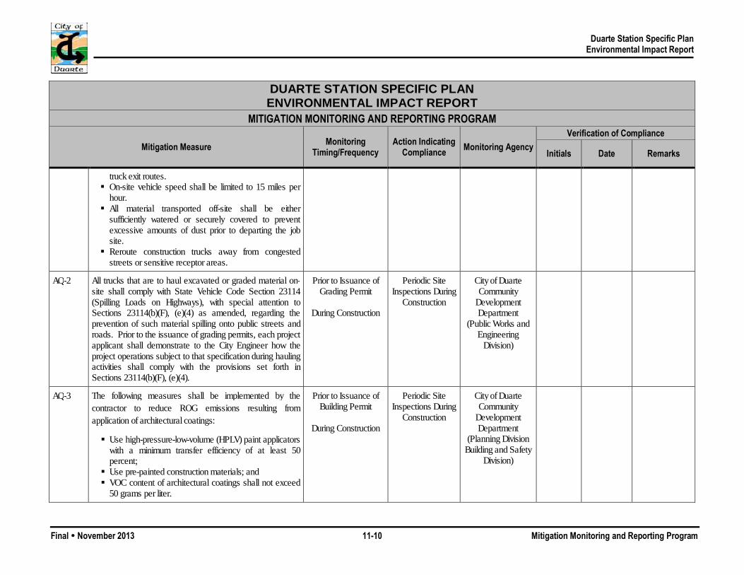
Duarte Station Specific Plan Environmental Impact Report
Final November 2013 11-10 Mitigation Monitoring and Reporting Program
DUARTE STATION SPECIFIC PLAN ENVIRONMENTAL IMPACT REPORT
MITIGATION MONITORING AND REPORTING PROGRAM
Mitigation Measure Monitoring Timing/Frequency
Action Indicating Compliance Monitoring Agency
Verification of Compliance
Initials Date Remarks
truck exit routes. On-site vehicle speed shall be limited to 15 miles per
hour. All material transported off-site shall be either
sufficiently watered or securely covered to prevent excessive amounts of dust prior to departing the job site.
Reroute construction trucks away from congested streets or sensitive receptor areas.
AQ-2 All trucks that are to haul excavated or graded material on-site shall comply with State Vehicle Code Section 23114 (Spilling Loads on Highways), with special attention to Sections 23114(b)(F), (e)(4) as amended, regarding the prevention of such material spilling onto public streets and roads. Prior to the issuance of grading permits, each project applicant shall demonstrate to the City Engineer how the project operations subject to that specification during hauling activities shall comply with the provisions set forth in Sections 23114(b)(F), (e)(4).
Prior to Issuance of Grading Permit
During Construction
Periodic Site Inspections During
Construction
City of Duarte Community
Development Department
(Public Works and Engineering
Division)
AQ-3 The following measures shall be implemented by the contractor to reduce ROG emissions resulting from application of architectural coatings:
Use high-pressure-low-volume (HPLV) paint applicators with a minimum transfer efficiency of at least 50 percent;
Use pre-painted construction materials; and VOC content of architectural coatings shall not exceed
50 grams per liter.
Prior to Issuance of Building Permit
During Construction
Periodic Site Inspections During
Construction
City of Duarte Community
Development Department
(Planning Division Building and Safety
Division)

Duarte Station Specific Plan Environmental Impact Report
Final November 2013 11-11 Mitigation Monitoring and Reporting Program
DUARTE STATION SPECIFIC PLAN ENVIRONMENTAL IMPACT REPORT
MITIGATION MONITORING AND REPORTING PROGRAM
Mitigation Measure Monitoring Timing/Frequency
Action Indicating Compliance Monitoring Agency
Verification of Compliance
Initials Date Remarks
AQ-4 Prior to issuance of any Grading Permit, the City Engineer and the Chief Building Official shall confirm that the Grading Plan, Building Plans, and specifications stipulate that, in compliance with SCAQMD Rule 403, O3 precursor emissions from construction equipment vehicles shall be controlled by maintaining equipment engines in good condition and in proper tune per manufacturer’s specifications, to the satisfaction of the City Engineer. Maintenance records shall be provided to the City. The City Inspector shall be responsible for ensuring that contractors comply with this measure during construction.
Prior to Issuance of Grading Permit
During Construction
Periodic Site Inspections During
Construction
City of Duarte Community
Development Department
(Public Works and Engineering
Division, Planning Division and
Building and Safety Division)
NOISE N-1 Individual project applicants shall prepare a construction
noise management plan that identifies measures to be taken to minimize construction noise on surrounding sensitive receptors (e.g., residential uses and schools) and includes specific noise management measures to be included into project plans and specifications subject to review and approval by the City. These measures shall include, but not be limited to the following: All construction equipment shall be equipped with
mufflers and sound control devices (e.g., intake silencers and noise shrouds) no less effective than those provided on the original equipment and no equipment shall have an un-muffled exhaust.
The City shall require that the contractor maintain and tune-up all construction equipment to minimize noise emissions.
Prior to Issuance of Grading Permit
During Construction
Review and Approval of
Construction Noise Management Plan
Periodic Site
Inspections During Grading and Construction
City of Duarte Community
Development Department
(Public Works and Engineering, Planning, and
Building and Safety Divisions) and Public Safety
Department (Code Enforcement
Division)
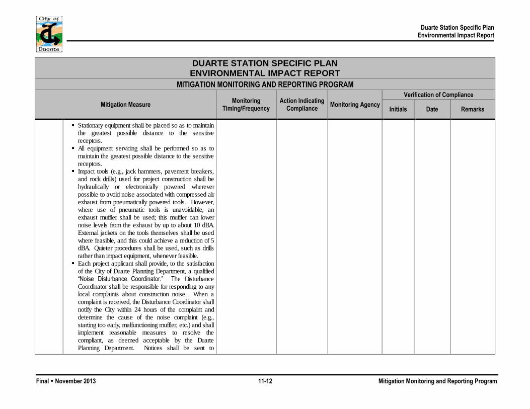
Duarte Station Specific Plan Environmental Impact Report
Final November 2013 11-12 Mitigation Monitoring and Reporting Program
DUARTE STATION SPECIFIC PLAN ENVIRONMENTAL IMPACT REPORT
MITIGATION MONITORING AND REPORTING PROGRAM
Mitigation Measure Monitoring Timing/Frequency
Action Indicating Compliance Monitoring Agency
Verification of Compliance
Initials Date Remarks
Stationary equipment shall be placed so as to maintain the greatest possible distance to the sensitive receptors.
All equipment servicing shall be performed so as to maintain the greatest possible distance to the sensitive receptors.
Impact tools (e.g., jack hammers, pavement breakers, and rock drills) used for project construction shall be hydraulically or electronically powered wherever possible to avoid noise associated with compressed air exhaust from pneumatically powered tools. However, where use of pneumatic tools is unavoidable, an exhaust muffler shall be used; this muffler can lower noise levels from the exhaust by up to about 10 dBA. External jackets on the tools themselves shall be used where feasible, and this could achieve a reduction of 5 dBA. Quieter procedures shall be used, such as drills rather than impact equipment, whenever feasible.
Each project applicant shall provide, to the satisfaction of the City of Duarte Planning Department, a qualified “Noise Disturbance Coordinator.” The Disturbance Coordinator shall be responsible for responding to any local complaints about construction noise. When a complaint is received, the Disturbance Coordinator shall notify the City within 24 hours of the complaint and determine the cause of the noise complaint (e.g., starting too early, malfunctioning muffler, etc.) and shall implement reasonable measures to resolve the compliant, as deemed acceptable by the Duarte Planning Department. Notices shall be sent to

Duarte Station Specific Plan Environmental Impact Report
Final November 2013 11-13 Mitigation Monitoring and Reporting Program
DUARTE STATION SPECIFIC PLAN ENVIRONMENTAL IMPACT REPORT
MITIGATION MONITORING AND REPORTING PROGRAM
Mitigation Measure Monitoring Timing/Frequency
Action Indicating Compliance Monitoring Agency
Verification of Compliance
Initials Date Remarks
residential units immediately surrounding the construction site. The notices that are sent and the signs posted at the construction site shall include the contact name and the telephone number for the Noise Disturbance Coordinator.
Select demolition methods to minimize vibration, where possible (e.g., sawing masonry into sections rather than demolishing it by pavement breakers).
Construction activities shall not take place outside of the allowable hours specified by the City’s Municipal Code Section 9.68.120 (7:00 a.m. and 10:00 p.m.).
N-2 Prior to issuance of building permits, a noise assessment shall be prepared for the hotel and commercial uses to ensure that commercial property loading docks and outdoor mechanical equipment would not exceed the City’s noise limits identified in Municipal Code Section 9.68.050. The noise assessment shall identify any noise control measures necessary to comply with the Municipal Code Noise Regulations. Individual project applicants shall implement all noise control measures identified in the assessment.
Prior to Issuance of Building Permit
During Construction
Review and Approval of Noise
Assessment
City of Duarte Community
Development Department
(Public Works and Engineering, Planning, and
Building and Safety Divisions)
N-3 Prior to site plan approval, the Community Development Director shall confirm that all applicable building plans and specifications include a closed design (i.e., a solid wall) for the walls of parking structures that are within 150 feet of residences, including the western side of the parking structure that faces Denning Avenue. The closed design is only required for walls that face residences.
Prior to Site Plan Approval
Review and Approval of
Building Plans and Specifications
City of Duarte Community
Development Department
(Public Works and Engineering, Planning, and
Building and Safety Divisions)
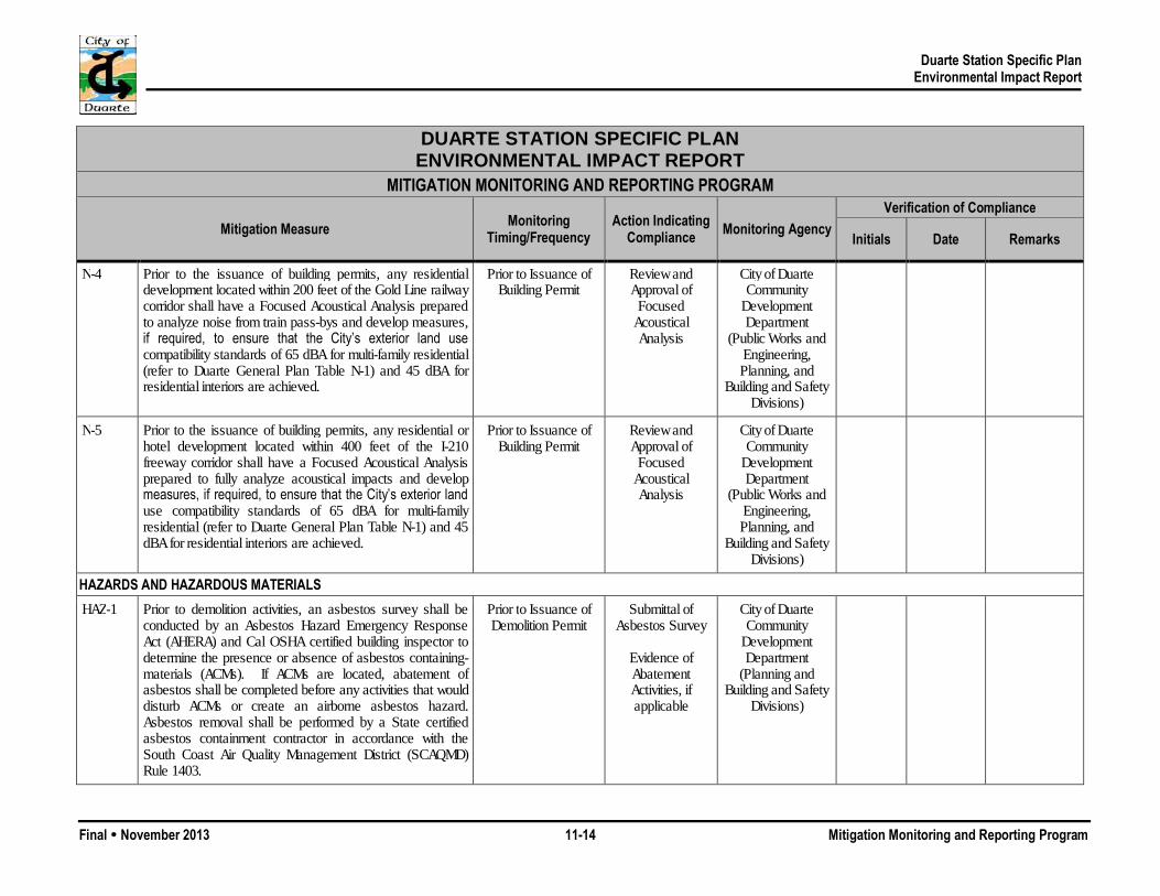
Duarte Station Specific Plan Environmental Impact Report
Final November 2013 11-14 Mitigation Monitoring and Reporting Program
DUARTE STATION SPECIFIC PLAN ENVIRONMENTAL IMPACT REPORT
MITIGATION MONITORING AND REPORTING PROGRAM
Mitigation Measure Monitoring Timing/Frequency
Action Indicating Compliance Monitoring Agency
Verification of Compliance
Initials Date Remarks
N-4 Prior to the issuance of building permits, any residential development located within 200 feet of the Gold Line railway corridor shall have a Focused Acoustical Analysis prepared to analyze noise from train pass-bys and develop measures, if required, to ensure that the City’s exterior land use compatibility standards of 65 dBA for multi-family residential (refer to Duarte General Plan Table N-1) and 45 dBA for residential interiors are achieved.
Prior to Issuance of Building Permit
Review and Approval of
Focused Acoustical Analysis
City of Duarte Community
Development Department
(Public Works and Engineering, Planning, and
Building and Safety Divisions)
N-5 Prior to the issuance of building permits, any residential or hotel development located within 400 feet of the I-210 freeway corridor shall have a Focused Acoustical Analysis prepared to fully analyze acoustical impacts and develop measures, if required, to ensure that the City’s exterior land use compatibility standards of 65 dBA for multi-family residential (refer to Duarte General Plan Table N-1) and 45 dBA for residential interiors are achieved.
Prior to Issuance of Building Permit
Review and Approval of
Focused Acoustical Analysis
City of Duarte Community
Development Department
(Public Works and Engineering, Planning, and
Building and Safety Divisions)
HAZARDS AND HAZARDOUS MATERIALS HAZ-1 Prior to demolition activities, an asbestos survey shall be
conducted by an Asbestos Hazard Emergency Response Act (AHERA) and Cal OSHA certified building inspector to determine the presence or absence of asbestos containing-materials (ACMs). If ACMs are located, abatement of asbestos shall be completed before any activities that would disturb ACMs or create an airborne asbestos hazard. Asbestos removal shall be performed by a State certified asbestos containment contractor in accordance with the South Coast Air Quality Management District (SCAQMD) Rule 1403.
Prior to Issuance of Demolition Permit
Submittal of Asbestos Survey
Evidence of Abatement Activities, if applicable
City of Duarte Community
Development Department
(Planning and Building and Safety
Divisions)
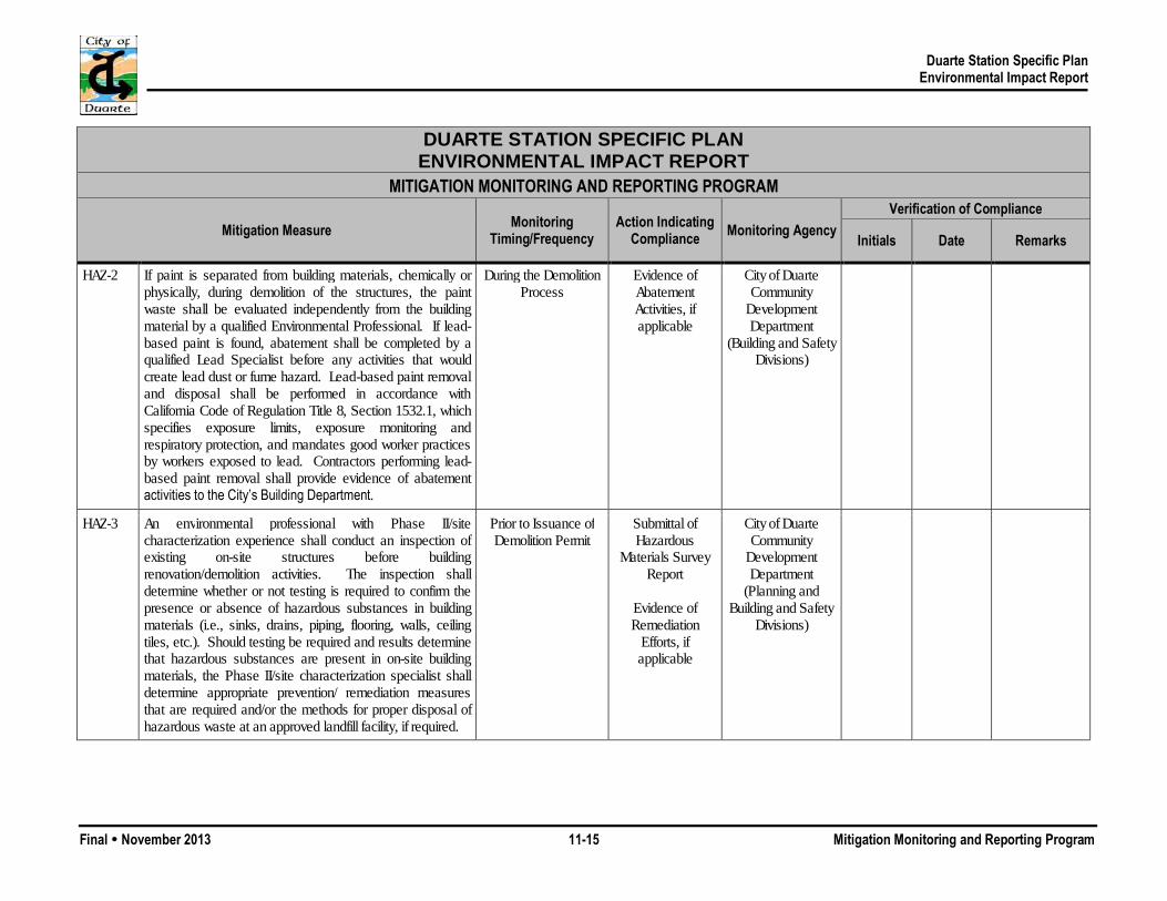
Duarte Station Specific Plan Environmental Impact Report
Final November 2013 11-15 Mitigation Monitoring and Reporting Program
DUARTE STATION SPECIFIC PLAN ENVIRONMENTAL IMPACT REPORT
MITIGATION MONITORING AND REPORTING PROGRAM
Mitigation Measure Monitoring Timing/Frequency
Action Indicating Compliance Monitoring Agency
Verification of Compliance
Initials Date Remarks
HAZ-2 If paint is separated from building materials, chemically or physically, during demolition of the structures, the paint waste shall be evaluated independently from the building material by a qualified Environmental Professional. If lead-based paint is found, abatement shall be completed by a qualified Lead Specialist before any activities that would create lead dust or fume hazard. Lead-based paint removal and disposal shall be performed in accordance with California Code of Regulation Title 8, Section 1532.1, which specifies exposure limits, exposure monitoring and respiratory protection, and mandates good worker practices by workers exposed to lead. Contractors performing lead-based paint removal shall provide evidence of abatement activities to the City’s Building Department.
During the Demolition Process
Evidence of Abatement Activities, if applicable
City of Duarte Community
Development Department
(Building and Safety Divisions)
HAZ-3 An environmental professional with Phase II/site characterization experience shall conduct an inspection of existing on-site structures before building renovation/demolition activities. The inspection shall determine whether or not testing is required to confirm the presence or absence of hazardous substances in building materials (i.e., sinks, drains, piping, flooring, walls, ceiling tiles, etc.). Should testing be required and results determine that hazardous substances are present in on-site building materials, the Phase II/site characterization specialist shall determine appropriate prevention/ remediation measures that are required and/or the methods for proper disposal of hazardous waste at an approved landfill facility, if required.
Prior to Issuance of Demolition Permit
Submittal of Hazardous
Materials Survey Report
Evidence of Remediation
Efforts, if applicable
City of Duarte Community
Development Department
(Planning and Building and Safety
Divisions)

Duarte Station Specific Plan Environmental Impact Report
Final November 2013 11-16 Mitigation Monitoring and Reporting Program
DUARTE STATION SPECIFIC PLAN ENVIRONMENTAL IMPACT REPORT
MITIGATION MONITORING AND REPORTING PROGRAM
Mitigation Measure Monitoring Timing/Frequency
Action Indicating Compliance Monitoring Agency
Verification of Compliance
Initials Date Remarks
HAZ-4 As applicable, each project applicant shall obtain appropriate permits from the Los Angeles County Fire Department Health Hazard Management Division (HHMD), before removing any existing USTs, per the Underground Storage Tank Program. The applicant shall conduct soil/groundwater testing, as requested by the HHMD. Should contamination be present above regulatory thresholds, then the applicant shall remediate appropriately, as required by the HHMD. Should the HHMD refer the case to any other regulatory agency (e.g., the Department of Toxic Substances Control, or Regional Water Quality Control Board, etc.), then the project applicant shall comply with that said agency as well.
Prior to UST Removal Receipt of Permits from Los Angeles
County Fire Department
HHMD
Evidence of Remediation
Efforts, if applicable
City of Duarte Community
Development Department
(Planning and Building and Safety
Divisions)
HAZ-5 Prior to issuance of a grading permit, soil sampling shall occur within the portions of the project site that have historically been utilized for agricultural purposes and may contain pesticide residues in the soil, as determined by a qualified Phase II/site characterization specialist. The sampling shall determine if pesticide concentrations exceed established regulatory requirements and shall identify further site characterization and remedial activities, if necessary. Should further site characterization/remedial activities be required, these activities shall be conducted per the applicable regulatory agency requirements, as directed by the Los Angeles County Fire Department Health Hazard Management Division (HHMD).
Prior to Issuance of Grading Permit
Submittal of Soil Sampling Report
Evidence of Remediation
Efforts, if applicable
City of Duarte Community
Development Department
(Public Works and Engineering
Division, Planning and Building and Safety Divisions)

Duarte Station Specific Plan Environmental Impact Report
Final November 2013 11-17 Mitigation Monitoring and Reporting Program
DUARTE STATION SPECIFIC PLAN ENVIRONMENTAL IMPACT REPORT
MITIGATION MONITORING AND REPORTING PROGRAM
Mitigation Measure Monitoring Timing/Frequency
Action Indicating Compliance Monitoring Agency
Verification of Compliance
Initials Date Remarks
HAZ-6 Prior to issuance of a grading permit, an environmental consultant with Phase II/site characterization experience shall conduct sampling in order to confirm whether or not contaminated soil/groundwater underlies the project site. Should contamination above established regulatory levels be identified, the environmental consultant shall recommend remedial activities appropriate for the proposed future development at the site, in consultation with the Los Angeles County Fire Department Health Hazard Management Division (HHMD) and/or other applicable agencies.
Prior to Issuance of Grading Permit
Submittal of Soil Sampling Report
Evidence of Remediation
Efforts, if applicable
City of Duarte Community
Development Department
(Public Works and Engineering
Division, Planning and Building and Safety Divisions)
HAZ-7 Prior to issuance of a grading permit, a Phase II/site characterization specialist shall conduct appropriate sampling along the southern boundary of the project site (Parcel 1) in order to determine whether or not contaminated soil is present. Should contaminated soil be present, the Phase II/site characterization specialist shall recommend appropriate remediation/safety measures in order to ensure worker safety during construction and public health during proposed project operations.
Prior to Issuance of Grading Permit
Submittal of Soil Sampling Report
Evidence of Remediation
Efforts, if applicable
City of Duarte Community
Development Department
(Public Works and Engineering
Division, Planning and Building and Safety Divisions)
HAZ-8 Prior to issuance of a grading permit, the project applicant shall submit a Worker Safety Plan for site disturbance/ construction activities, in consultation with California Division of Occupational Safety and Health (Cal/OSHA) and Los Angeles County Fire Department Health Hazard Management Division (HHMD). The Worker Safety Plan shall include safety precautions (e.g., personal protective equipment or other precautions to be taken to minimize exposure to hazardous materials) to be taken by personnel when encountering potential hazardous materials, including potential contaminated groundwater.
Prior to Issuance of Grading Permit
Submittal of Worker Safety
Plan
City of Duarte Community
Development Department
(Planning and Building and Safety
Divisions)

Duarte Station Specific Plan Environmental Impact Report
Final November 2013 11-18 Mitigation Monitoring and Reporting Program
DUARTE STATION SPECIFIC PLAN ENVIRONMENTAL IMPACT REPORT
MITIGATION MONITORING AND REPORTING PROGRAM
Mitigation Measure Monitoring Timing/Frequency
Action Indicating Compliance Monitoring Agency
Verification of Compliance
Initials Date Remarks
HAZ-9 If unknown wastes or suspect materials are discovered during construction by the contractor that are believed to involve hazardous waste or materials, the contractor shall comply with the following: Immediately cease work in the vicinity of the suspected
contaminant, and remove workers and the public from the area;
Notify the City Engineer of the City of Duarte; Secure the area as directed by the City Engineer; and Notify the Los Angeles County Fire Department Health
Hazard Management Division’s (HHMD) Hazardous Waste/Materials Coordinator (or other appropriate agency specified by the City Engineer). The Hazardous Waste/Materials Coordinator shall advise the responsible party of further actions that shall be taken, if required.
During the Construction Process
Evidence of Abatement Activities, if applicable
City of Duarte Community
Development Department
(Building and Safety Divisions and Public
Works and Engineering
Division,)
HAZ-10 Prior to issuance of building permits, vapor intrusion investigations shall be conducted by a qualified Environmental Professional, in consultation with the Los Angeles County Fire Department Health Hazard Management Division (HHMD). Should the Environmental Professional determine that proposed buildings could be impacted by vapor intrusion, the Environmental Professional, in consultation with the HHMD and/or other applicable regulatory agencies, shall recommend specific design measures to be incorporated into the buildings’ design that would reduce these indoor air quality concentrations to below regulatory thresholds.
Prior to Issuance of Building Permit
Submittal of Vapor Intrusion
Investigation Report
Incorporation of Design Measures,
as applicable
City of Duarte Community
Development Department
(Building and Safety Divisions)

Duarte Station Specific Plan Environmental Impact Report
Final November 2013 11-19 Mitigation Monitoring and Reporting Program
DUARTE STATION SPECIFIC PLAN ENVIRONMENTAL IMPACT REPORT
MITIGATION MONITORING AND REPORTING PROGRAM
Mitigation Measure Monitoring Timing/Frequency
Action Indicating Compliance Monitoring Agency
Verification of Compliance
Initials Date Remarks
HYDROLOGY, DRAINAGE, AND WATER QUALITY HYD-1 Prior to issuance of any grading or building permit, each
project applicant shall enroll electronically through the SMARTS program to comply with the State of California General Construction Permit. Proof of enrollment must be submitted to the City of Duarte before issuance of grading or building permits. Also, a Stormwater Pollution Prevention Plan (SWPPP) or functional equivalent required at that time shall be reviewed and approved by the Public Works Manager and the City Engineer for water quality construction activities on-site. A copy of the SWPPP or functional equivalent required at that time shall be available and implemented at the construction site at all times. The SWPPP or functional equivalent required at that time shall outline the source control and/or treatment control Best Management Practices to avoid or mitigate runoff pollutants at the construction site to the “maximum extent practicable.”
Prior to Issuance of Grading or Building
Permit
During the Construction Process
Electronic submittal of the Notice of Intent
(NOI)
Review and Approval of the Storm Water
Pollution Prevention Plan
(SWPPP) at Plan Check
City of Duarte Community
Development Department (Public
Works and Engineering Division and
Building and Safety Division)
HYD-2 Concurrent with Site Plan Review or issuance of a grading permit, whichever comes first, a hydrology review shall be conducted by a Registered Civil Engineer for each development phase to ensure that runoff values for each phase remain at or below the runoff values shown in Table 5.9-2, and in compliance with current State law or other applicable statutes.
Concurrent with Site Plan Review or Prior
to Issuance of Grading Permit
Review and Approval of
Hydrology Report
City of Duarte Community
Development Department (Public
Works and Engineering
Division)

Duarte Station Specific Plan Environmental Impact Report
Final November 2013 11-20 Mitigation Monitoring and Reporting Program
DUARTE STATION SPECIFIC PLAN ENVIRONMENTAL IMPACT REPORT
MITIGATION MONITORING AND REPORTING PROGRAM
Mitigation Measure Monitoring Timing/Frequency
Action Indicating Compliance Monitoring Agency
Verification of Compliance
Initials Date Remarks
HYD-3 Prior to the issuance of grading permit, each project applicant shall prepare a plan (i.e., Standard Urban Storm Water Management Plan [SUSMP] or functional equivalent document per current State law or other applicable statutes) in accordance with the guidance to be developed by the NPDES Permit permittees, that includes Low Impact Development and other post-construction Best Management Practices to reduce pollutant loading. The plan shall be reviewed and approved by the Duarte Public Works Manager and City Engineer. The applicant shall be responsible for implement the measures identified in the SUSMP or functional equivalent document.
Prior to Issuance of Grading Permit
Review and Approval of the Standard Urban
Stormwater Mitigation Plan
(SUSMP) or functional
equivalent at Plan Check
City of Duarte Community
Development Department
(Public Works and Engineering Division and
Planning Division)
FIRE PROTECTION FP-1 Adequate access to all buildings on the project site shall be
provided and properly maintained for emergency vehicles during the building construction process to the satisfaction of the Los Angeles County Fire Department.
Prior to and During Construction
Review and Approval of Site Plan(s) at Plan
Check
During Construction
Los Angeles County Fire Department
FP-2 Adequate water availability shall be provided to service construction activities.
During Construction Activities
Proof of receipt of will-serve letter from California
American Water Company
Los Angeles County Fire Department

Duarte Station Specific Plan Environmental Impact Report
Final November 2013 11-21 Mitigation Monitoring and Reporting Program
DUARTE STATION SPECIFIC PLAN ENVIRONMENTAL IMPACT REPORT
MITIGATION MONITORING AND REPORTING PROGRAM
Mitigation Measure Monitoring Timing/Frequency
Action Indicating Compliance Monitoring Agency
Verification of Compliance
Initials Date Remarks
FP-3 Prior to issuance of building permits, a will-serve letter from the California American Water Company shall be obtained by the project applicant, which states that the Water Company can adequately meet water flow requirements.
Prior to Issuance of Building Permits
Proof of receipt of will-serve letter from California
American Water Company
Los Angeles County Fire Department
FP-4 The Los Angeles County Fire Department shall review and comment on each individual site plan submitted, prior to approval by the City of Duarte. Any conditions required by the Los Angeles County Fire Department shall be complied with by the project applicant.
Prior to Site Plan Approval
Review by Los Angeles County Fire Department
Review and
Approval of Site Plan(s) at Plan
Check
City of Duarte Community
Development Department
(Building and Safety Division)
FP-5 Prior to the issuance of building permits, the project applicant shall provide verification that the project complies with all fire prevention provisions required by the Los Angeles County Fire Department.
Prior to Issuance of Building Permits
Review and Approval of Site Plan(s) at Plan
Check
City of Duarte Community
Development Department
(Building and Safety Division)
FP-6 All new structures shall have automatic fire sprinkler systems.
Prior to Issuance of Building Permit
During Operations
Review and Approval of Site Plan(s) at Plan
Check
Los Angeles County Fire Department
City of Duarte Community
Development Department
(Building and Safety Division

Duarte Station Specific Plan Environmental Impact Report
Final November 2013 11-22 Mitigation Monitoring and Reporting Program
DUARTE STATION SPECIFIC PLAN ENVIRONMENTAL IMPACT REPORT
MITIGATION MONITORING AND REPORTING PROGRAM
Mitigation Measure Monitoring Timing/Frequency
Action Indicating Compliance Monitoring Agency
Verification of Compliance
Initials Date Remarks
FP-7 A supervised fire alarm system that meets requirements of the California Fire Code shall be placed in an accessible location with an annunciator.
Prior to Issuance of Building Permit
During Operations
Review and Approval of Site Plan(s) at Plan
Check
Los Angeles County Fire Department
FP-8 Access to and around structures shall meet Los Angeles County Fire Department and California Fire Code requirements.
Prior to Issuance of Building Permit
During Operations
Review and Approval of Site Plan(s) at Plan
Check
Los Angeles County Fire Department
FP-9 A water supply system shall be in place to supply fire hydrants and automatic fire sprinkler systems.
Prior to Issuance of Building Permit
During Operations
Review and Approval of Site Plan(s) at Plan
Check
Los Angeles County Fire Department
FP-10 All traffic signals on public access ways shall include the installation of optical preemption devices.
Prior to Issuance of Building Permit
During Operations
Review and Approval of Site Plan(s) at Plan
Check
Los Angeles County Fire Department
City of Duarte Community
Development Department (Public
Works and Engineering
Division)
FP-11 All electric gates within the project shall install emergency opening devices approved by the Los Angeles County Fire Department.
Prior to Issuance of Building Permit
During Operations
Review and Approval of Site Plan(s) at Plan
Check
Los Angeles County Fire Department

Duarte Station Specific Plan Environmental Impact Report
Final November 2013 11-23 Mitigation Monitoring and Reporting Program
DUARTE STATION SPECIFIC PLAN ENVIRONMENTAL IMPACT REPORT
MITIGATION MONITORING AND REPORTING PROGRAM
Mitigation Measure Monitoring Timing/Frequency
Action Indicating Compliance Monitoring Agency
Verification of Compliance
Initials Date Remarks
SCHOOLS SCH-1 Individual project applicants shall pay all applicable
Development Impact Fees to the Duarte Unified School District prior to issuance of building permits. Proof of fee payment shall be provided to the City of Duarte.
Prior to Issuance of Building Permit
Proof of Payment of Development Impact Fees to
DUSD
City of Duarte Community
Development Department
(Building and Safety Division)
WATER WAT-1 Prior to approval of building permits, individual project
applicants shall conduct hydraulic analysis in coordination with California American Water to determine water system requirements to serve the proposed development. The project applicant shall implement the improvements in accordance with California American Water requirements prior to issuance of building permits and complete all necessary improvements prior to final inspection.
Prior to Issuance of Building Permit
Review and Approval of
Hydraulic Analysis
Implementation of Improvements, if
applicable
City of Duarte Community
Development Department (Public
Works and Engineering
Division)
WAT-2 Prior to approval of building permits, individual project applicants shall submit site plans to the Los Angeles County Fire Department in order to obtain fire flow and storage volume requirements for the proposed development. The project applicant shall submit the fire flow and storage volume requirements to California American Water to determine if adequate fire flow and storage capacity exists to serve the proposed development. If fire flow and storage capacity is found to be inadequate, the project applicant shall design and bond for necessary improvements prior to the issuance of building permits and complete all necessary improvements prior to final inspection.
Prior to Issuance of Building Permit
Verification of Fire Flow and Storage
Volume Requirements
Implementation of Improvements, if
applicable
Los Angeles County Fire Department
City of Duarte Community
Development Department (Public
Works and Engineering
Division)
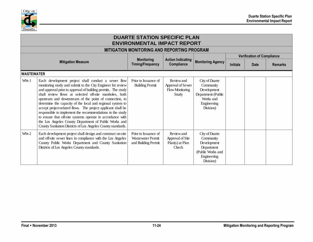
Duarte Station Specific Plan Environmental Impact Report
Final November 2013 11-24 Mitigation Monitoring and Reporting Program
DUARTE STATION SPECIFIC PLAN ENVIRONMENTAL IMPACT REPORT
MITIGATION MONITORING AND REPORTING PROGRAM
Mitigation Measure Monitoring Timing/Frequency
Action Indicating Compliance Monitoring Agency
Verification of Compliance
Initials Date Remarks
WASTEWATER WW-1 Each development project shall conduct a sewer flow
monitoring study and submit to the City Engineer for review and approval prior to approval of building permits. The study shall review flows at selected off-site manholes, both upstream and downstream of the point of connection, to determine the capacity of the local and regional system to accept project-related flows. The project applicant shall be responsible to implement the recommendations in the study to ensure that off-site systems operate in accordance with the Los Angeles County Department of Public Works and County Sanitation Districts of Los Angeles County standards.
Prior to Issuance of Building Permit
Review and Approval of Sewer Flow Monitoring
Study
City of Duarte Community
Development Department (Public
Works and Engineering
Division)
WW-2 Each development project shall design and construct on-site and off-site sewer lines in compliance with the Los Angeles County Public Works Department and County Sanitation Districts of Los Angeles County standards.
Prior to Issuance of Wastewater Permit and Building Permit
Review and Approval of Site Plan(s) at Plan
Check
City of Duarte Community
Development Department
(Public Works and Engineering
Division)