Drummer - Soils 4 Teachers · 2 Fig. 2.Location of the Drummer Series in Illinois extending to the...
5
Drummer Illinois State Soil Soil Science Society of America Photo Soil Monolith: Chip Clark/Smithsonian Institution Introduction Many states have designated state symbols such as bird, flower, fish, tree, rock, and more. Many states also have a state soil – one that has significance or is important to the state. As there are many types of birds, flowers, and trees, there are hundreds of soil types in our state but Drummer is the official state soil of Illinois. How important is the Drummer soil to Illinois? History Drummer was first established as a type of soil in Ford County in 1929. It was named after Drummer Creek in Drummer Township. 1n 1987, Drummer was selected as the state soil by the Illinois Soil Classifiers Association over other soils such as Cisne, Flanagan, Hoyleton, Ipava, Sable, and Saybrook. Since then, Drummer has been repeatedly chosen by other as- sociations who work with soil. In 1992, the Illinois Association of Vocational Agriculture Teachers sponsored a state soil election in their classrooms and Drummer won by a margin of 2 to 1. In 1993, the statewide 4H Youth Conference also selected Drummer out of 6 nomi- nees. Also in 1993 at the FFA state convention, Drummer and Ipava were tied in the contest. Finally, in 2001, after many attempts, it was finally passed by the Illinois Legislature and signed into law by Governor George Ryan. What is Drummer Soil? It is the most common among the dark colored soils or “black dirt” of Illinois. The dark color is due to the high amount of organic matter inherited from the decomposition of the prairie vegetation that is growing on the soil. Drummer soil series consist of very deep, poorly drained soils that were formed in 40 to 60 inches of loess or other silty material and in the underlying loamy strati- fied outwash on nearly level or depressional parts of outwash plains, stream terraces, and till plains. Every soil can be separated into three separate size fractions called sand, silt, and clay, which make up the soil texture. They are present in all soils in different proportions and say a lot about the character of the soil. Drummer’s topsoil is more often silty clay loam in texture but some- times silt loam. The topsoil is black in color and moderately acid to slightly alkaline. Soil texture in the lower layers or subsoil is mainly silty clay loam, with occurrence of silt loam, loam, sandy loam, clay loam, and sandy clay loam possible. The subsoil is grayish brown and gray in color while the soil pH ranges from moderately acid to neutral to moderately alkaline as you go deeper into the soil profile (Figure 1). Fig. 1. Drummer soil profile. Credit: USDA-NRCS
Transcript of Drummer - Soils 4 Teachers · 2 Fig. 2.Location of the Drummer Series in Illinois extending to the...

DrummerIllinois State Soil
Soil Science Society of America
Photo Soil Monolith: Chip Clark/Smithsonian Institution
IntroductionMany states have designated state symbols such as bird, flower, fish, tree, rock, and more. Many states also have a state soil – one that has significance or is important to the state. As there are many types of birds, flowers, and trees, there are hundreds of soil types in our state but Drummer is the official state soil of Illinois. How important is the Drummer soil to Illinois?
HistoryDrummer was first established as a type of soil in Ford County in 1929. It was named after Drummer Creek in Drummer Township. 1n 1987, Drummer was selected as the state soil by the Illinois Soil Classifiers Association over other soils such as Cisne, Flanagan, Hoyleton, Ipava, Sable, and Saybrook. Since then, Drummer has been repeatedly chosen by other as-sociations who work with soil. In 1992, the Illinois Association of Vocational Agriculture Teachers sponsored a state soil election in their classrooms and Drummer won by a margin of 2 to 1. In 1993, the statewide 4H Youth Conference also selected Drummer out of 6 nomi-nees. Also in 1993 at the FFA state convention, Drummer and Ipava were tied in the contest. Finally, in 2001, after many attempts, it was finally passed by the Illinois Legislature and signed into law by Governor George Ryan.
What is Drummer Soil? It is the most common among the dark colored soils or “black dirt” of Illinois. The dark color is due to the high amount of organic matter inherited from the decomposition of the prairie vegetation that is growing on the soil. Drummer soil series consist of very deep, poorly drained soils that were formed in 40 to 60 inches of loess or other silty material and in the underlying loamy strati-fied outwash on nearly level or depressional parts of outwash plains, stream terraces, and till plains.
Every soil can be separated into three separate size fractions called sand, silt, and clay, which make up the soil texture. They are present in all soils in different proportions and say a lot about the character of the soil. Drummer’s topsoil is more often silty clay loam in texture but some-times silt loam. The topsoil is black in color and moderately acid to slightly alkaline. Soil texture in the lower layers or subsoil is mainly silty clay loam, with occurrence of silt loam, loam, sandy loam, clay loam, and sandy clay loam possible. The subsoil is grayish brown and gray in color while the soil pH ranges from moderately acid to neutral to moderately alkaline as you go deeper into the soil profile (Figure 1).
Fig. 1. Drummer soil profile.Credit: USDA-NRCS
2
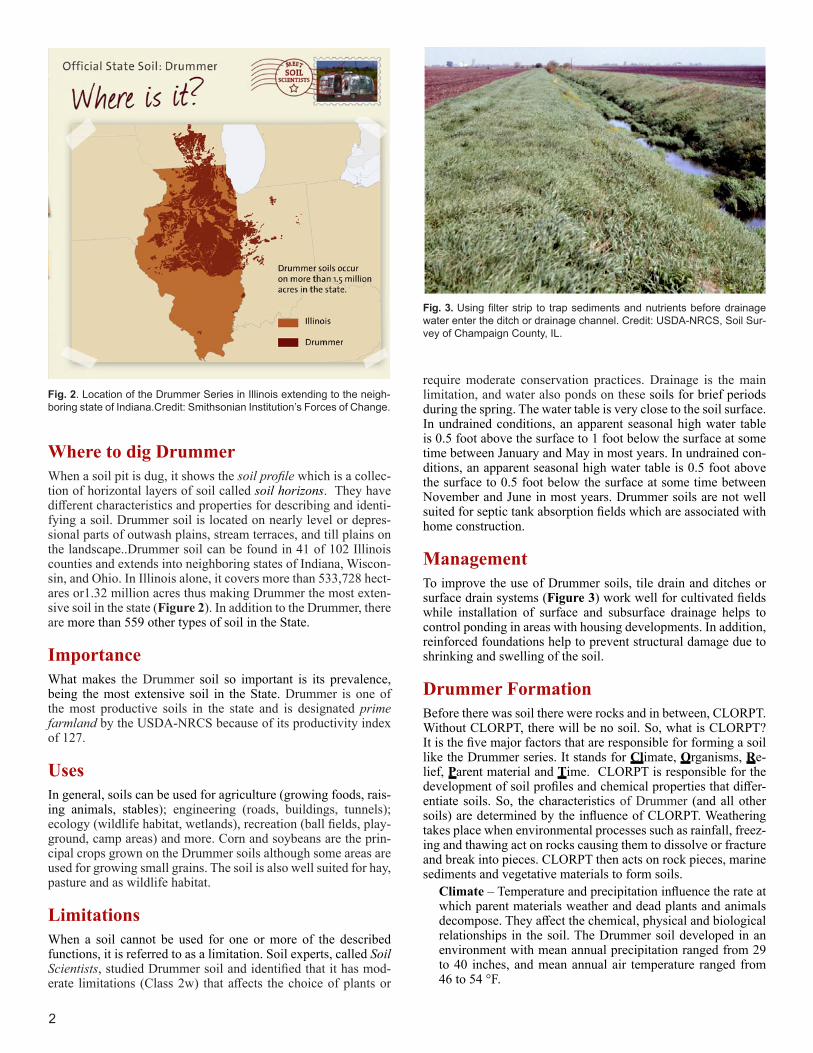
Fig. 2. Location of the Drummer Series in Illinois extending to the neigh-boring state of Indiana.Credit: Smithsonian Institution’s Forces of Change.
Fig. 3. Using filter strip to trap sediments and nutrients before drainage water enter the ditch or drainage channel. Credit: USDA-NRCS, Soil Sur-vey of Champaign County, IL.
Where to dig DrummerWhen a soil pit is dug, it shows the soil profile which is a collec-tion of horizontal layers of soil called soil horizons. They have different characteristics and properties for describing and identi-fying a soil. Drummer soil is located on nearly level or depres-sional parts of outwash plains, stream terraces, and till plains on the landscape..Drummer soil can be found in 41 of 102 Illinois counties and extends into neighboring states of Indiana, Wiscon-sin, and Ohio. In Illinois alone, it covers more than 533,728 hect-ares or1.32 million acres thus making Drummer the most exten-sive soil in the state (Figure 2). In addition to the Drummer, there are more than 559 other types of soil in the State.
ImportanceWhat makes the Drummer soil so important is its prevalence, being the most extensive soil in the State. Drummer is one of the most productive soils in the state and is designated prime farmland by the USDA-NRCS because of its productivity index of 127.
UsesIn general, soils can be used for agriculture (growing foods, rais-ing animals, stables); engineering (roads, buildings, tunnels); ecology (wildlife habitat, wetlands), recreation (ball fields, play-ground, camp areas) and more. Corn and soybeans are the prin-cipal crops grown on the Drummer soils although some areas are used for growing small grains. The soil is also well suited for hay, pasture and as wildlife habitat.
LimitationsWhen a soil cannot be used for one or more of the described functions, it is referred to as a limitation. Soil experts, called Soil Scientists, studied Drummer soil and identified that it has mod-erate limitations (Class 2w) that affects the choice of plants or
require moderate conservation practices. Drainage is the main limitation, and water also ponds on these soils for brief periods during the spring. The water table is very close to the soil surface. In undrained conditions, an apparent seasonal high water table is 0.5 foot above the surface to 1 foot below the surface at some time between January and May in most years. In undrained con-ditions, an apparent seasonal high water table is 0.5 foot above the surface to 0.5 foot below the surface at some time between November and June in most years. Drummer soils are not well suited for septic tank absorption fields which are associated with home construction.
ManagementTo improve the use of Drummer soils, tile drain and ditches or surface drain systems (Figure 3) work well for cultivated fields while installation of surface and subsurface drainage helps to control ponding in areas with housing developments. In addition, reinforced foundations help to prevent structural damage due to shrinking and swelling of the soil.
Drummer FormationBefore there was soil there were rocks and in between, CLORPT. Without CLORPT, there will be no soil. So, what is CLORPT? It is the five major factors that are responsible for forming a soil like the Drummer series. It stands for Climate, Organisms, Re-lief, Parent material and Time. CLORPT is responsible for the development of soil profiles and chemical properties that differ-entiate soils. So, the characteristics of Drummer (and all other soils) are determined by the influence of CLORPT. Weathering takes place when environmental processes such as rainfall, freez-ing and thawing act on rocks causing them to dissolve or fracture and break into pieces. CLORPT then acts on rock pieces, marine sediments and vegetative materials to form soils.
Climate – Temperature and precipitation influence the rate at which parent materials weather and dead plants and animals decompose. They affect the chemical, physical and biological relationships in the soil. The Drummer soil developed in an environment with mean annual precipitation ranged from 29 to 40 inches, and mean annual air temperature ranged from 46 to 54 °F.

Ecoregions of Illinois
3
Fig. 4. Landscape position of Drummer soil relative to other soils . Credit: USDA-NRCS,
Organisms – This refers to plants and animal life. In the soil, plant roots spread, animals burrow in, and bacteria break down plant and animal tissue. These and other soil organisms speed up the breakdown of large soil particles into smaller ones. Plants and animals also influence the formation and dif-ferentiation of soil horizons. Plants determine the kinds and amounts of organic matter that are added to a soil under nor-
mal conditions. Animals breakdown complex compounds into small ones and in so doing add organic matter to soil. Drum-mer developed under luxuriant growth of marsh grasses and sedges that was typical of native prairie at the time. The prai-rie vegetation is responsible for the dark color of the soil, and contributes considerable organic matter content to the soil.
Relief – Landform position or relief describes the shape of the land (hills and valleys), and the direction it faces which makes a difference in how much sunlight the soil gets and how much water it keeps. Deeper soils form at the bottom of the hill rather than at the top because gravity and water move soil par-ticles downhill. Drummer soils are on nearly level or depres-sional parts of outwash plains, stream terraces, and till plains of Wisconsinan Age. Elevation ranges from 500 to 1020 feet above mean sea level. On the landscape, Drummer soils are found on concave slope with less than 1% gradient (Figure 4).
Parent material (C horizon) – Just like people inherit charac-teristics from their parents, every soil inherits some traits from the material from which it forms. Some parent materials are transported and deposited by glaciers, wind, water, or gravity. Drummer soils were formed in 40 to 60 inches of loess and oth-er silty materials and in the underlying loamy stratified outwash.
Fig. 5. Ecoregions of Illinois. Credit: US-EPA.

Time – All the factors act together over a very long period of time to produce soils. As a result, soils vary in age. The length of time that soil material has been exposed to the soil-forming processes makes older soils different from younger soils. Gen-erally, older soils have better defined horizons than younger soils. Less time is needed for a soil profile to develop in a hu-mid and warm area with dense vegetative cover than in a cold dry area with sparse plant cover. More time is required for the formation of a well-defined soil profile in soils with fine tex-tured material than in soils with coarse-textured soil material.
Ecoregions, Soils and Land Use in IllinoisIllinois is divided into 6 broad (Level III) and 25 more detailed (Level IV) ecoregions (Figure 5). These ecological divisions overlap in places with the physiographic divisions and sub-di-visions of Illinois which are as many as the ecological divisions (Figure 6). Drummer soils are located predominantly in the large Central Corn Belt Plains ecoregion, and smaller portions of the Southeastern Wisconsin Till Plains, and Interior River Valleys and Hills ecoregions. The Central Corn Belt Plains is composed of vast glaciated plains that were once largely covered by prai-ries along with Wisconsinan-age (approximately 12,000-110,000
years ago) till and Illinoian-age (approximately 130,000-200,000 years ago) glacial deposits. The area is now dominated by ag-riculture (crops and livestock) and characterized by dark fertile soils. Extensive, nearly level till, lake, and outwash plains with scattered sand sheets and dunes are present. The Southeastern Wisconsin Till Plains ecoregion located at the northern tip of Il-linois is composed of nearly level to hilly till plains, nearly level outwash plains, and hilly moraines, and contains more lakes and marshes that its larger neighbor. Found especially in areas that are depressions in this ecoregion, unlike in Central Corn Belt Plains, are Histosols which are soils that develop from plant organic materials. This ecoregion also serves as a transition of vegetation from hardwood forests and oak savannas to the west and tall-grass prairies that were originally common to the Central Corn Belt Plains ecoregion. A very small amount of the Drum-mer soil occurs within the Interior River Valleys and Hills ecore-gion. This ecoregion is comprised of old till plains, hills, forested river bluffs, major rivers, and valleys containing levees, oxbow lakes, islands, and scattered sand sheets and dunes. Soils in this ecoregion are typically those that develop from several feet of loess and, clay pans, which are soil features that restrict down-ward root growth and groundwater movement, are found in these well-developed soils. Less than 50% of this region is used for crop production, about 30% is in pasture and the rest is in forest.
Physiographic Divisions of Illinois
Fig. 6. Physiographic Regions of Illinois.Credit: IL State Geological Society
4

5585 Guilford RoadMadison WI 53711-5801Tel. 608-273-8080 • Fax 608-273-2021www.soils.org • [email protected]
This state soil booklet was developed under the auspices of the Soil Science Society of America’s K-12 Committee—their dedication to developing outreach materials for the K-12 audience makes this material possible.
Additional ResourcesSoil! Get the Inside Scoop. David Lindbo and others. Soil Science Society of America, Madison, WI.Know Soil, Know Life. David L. Lindbo, Deb A. Kozlowski, and Clay Rob-inson, editors. Soil Science Society of America, Madison, WI.
Web Resources Soils for Teachers—www.soils4teachers.orgSoils for Kids—http://www.soils4kids.org/Have Questions? Ask a Soil Scientist—https://www.soils.org/askSoil Science Society of America—https://www.soils.org/
NRCS ResourcesNatural Resources Conservation Service, Illinois Homepage—https://www.nrcs.usda.gov/wps/portal/nrcs/site/il/home/Natural Resources Conservation Service, Educational Resources—https://www.nrcs.usda.gov/wps/portal/nrcs/main/soils/edu/Natural Resources Conservation Service—https://www.nrcs.usda.gov/wps/portal/nrcs/site/soils/home/Illinois Soil Classifiers Association–http://www.illinoissoils.org/soil-information
ReferencesSoil Survey Staff, Natural Resources Conservation Service, United States Department of Agriculture. Official Soil Series Descriptions. Available online. Accessed January 18, 2017. (https://soilseries.sc.egov.usda.gov/OSD_Docs/D/DRUMMER.html)United States Department of Agriculture, Natural Resources Conser-vation Service, in cooperation with Illinois Agricultural Experiment Station. 2003. Soil Survey of Champaign County, Illinois.United States Department of Agriculture, Natural Resources Conser-vation Service, in cooperation with Illinois Agricultural Experiment Station. 2004 Soil Survey of Ford County, Illinois.Woods, A.J., J.M. Omernik, C.L. Pederson, and B.C. Moran. 2006. Level III and IV Ecoregions of Illinois. United States Environmental Pro-tection Agency. EPA/600/R-06/104.
Author: Wale Adewunmi, Ph.D, CPSS
GlossaryClay: A soil particle that is less than 0.002 mm in diameter. Clay par-ticles are so fine they have more surface area for reaction. They hold a lot of nutrients and water in the soil. A clay soil is a soil that has more than 40% clay, less than 45% sand and less than 40% silt. Ecoregion: Represents areas with similar biotic and abiotic charac-teristics which determine the resource potential and likely responses to natural and man-made disturbances. Characteristics such as cli-mate, topography, geology, soils, and natural vegetation define an ecoregion. They determine the type of land cover that can exist and influence the range of land use practices that are possible.Horizon: see Soil horizonsOrganic matter: Material derived from the decay of plants and ani-mals. Always contains compounds of carbon and hydrogen.Outwash: Gravel, sand, and silt, commonly stratified, deposited by glacial meltwater.Outwash Plain: A landform of mainly sand or coarse textured mate-rial of glacial or fluvial origin. An outwash plain is usually smooth and generally has low relief.Prime Farmland: Land that has the best combination of physical and chemical characteristics for producing food, feed, forage, fiber, and oilseed crops and is available for these uses. It could be cultivated land, pasture land or forest land, or other land but it is not urban or built-up areas or water areas.Sand: A soil particle between 0.05 and 2.0 mm in diameter. Sand is also used to describe soil texture according to the soil textural tri-angle, for example, loamy sand.Silt: A soil particle between 0.002 and 0.05 mm diameter. It is also used to describe a soil textural class.Silty Clay Loam: A classification for soil material that contains a rela-tively large amount of silt (60 to 72%), a lesser quantity of clay (27-40%), and a still smaller quantity of sand (0-20%).Silt Loam: a classification for soil material that contains 12-27% clay, 50% or more silt, or 50-80% silt and less than 12% clay.Soil Horizon: A layer of soil with properties that differ from the layers above or below it.Soil Profile: The sequence of natural layers, or horizons, in a soil. It extends from the surface downward to unconsolidated material. Most soils have three major horizons, called the surface horizon, the sub-soil, and the substratum.Soil Scientist: A soil scientist studies the upper few meters of the Earth’s crust in terms of its physical and chemical properties; distri-bution, genesis and morphology; and biological components. A soil scientist needs a strong background in the physical and biological sciences and mathematics.Soil Texture: The relative proportion of sand, slit, and clay particles that makes up a soil. Sand particles are the largest and clay particles the smallest. Learn more about soil texture at www.soils4teachers.org/physical-properties.Subsoil: (B horizon) The soil horizon rich in minerals that eluviated, or leached down, from the horizons above it. Not present in all soils.Till: Unsorted, non-stratified glacial drift consisting of clay, silt, sand, and boulders transported and deposited by glacial ice.Till Plain: An extensive area of nearly level to undulating soils under-lain by glacial till.Topsoil: (A horizon) The horizon that formed at the land surface. Mostly weathered minerals from parent material with a little organic matter added.Water table: The top layer of ground water where the soil is filled with standing water. It can move up or down during different seasons.