Drill planning for potential IOCG target at Arunta West ... · 07 August 2018 Drill planning for...
19
07 August 2018 Drill planning for potential IOCG target at Arunta West Project Australian Mines Limited (“Australian Mines” or “the Company”) (Australia ASX: AUZ; USA OTCQB: AMSLF; Frankfurt Stock Exchange: MJH) is pleased to provide the accompanying exploration update on drill planning to test potential IOCG target at the Arunta West Project in Western Australia, held by its subsidiary Norwest Minerals. As announced last month 1 , Australian Mines’ Western Australian gold and base metal exploration assets have been transferred to Norwest, a dedicated exploration vehicle seeking to complete an Initial Public Offering (IPO) to raise $6.6 million by the end of October 2018 and pursue a listing on the Australian Securities Exchange. Sincerely Benjamin Bell Managing Director Australian Mines Limited ***ENDS*** For further information: Shareholders contact: Sophia Bolhassan Investor Relations Manager Ph: +61 488 022 944 E: [email protected] Media contact: Michael Cairnduff Cannings Purple Ph: + 61 406 775 241 E: [email protected] https://www.linkedin.com/company/australianmines/ https://twitter.com/ausmines 1 Australian Mines Limited, Gold & copper subsidiary secures $5 million investment, released 26 July 2018 www.australianmines.com.au
Transcript of Drill planning for potential IOCG target at Arunta West ... · 07 August 2018 Drill planning for...

07 August 2018
Drill planning for potential IOCG target
at Arunta West Project Australian Mines Limited (“Australian Mines” or “the Company”) (Australia ASX: AUZ; USA
OTCQB: AMSLF; Frankfurt Stock Exchange: MJH) is pleased to provide the accompanying
exploration update on drill planning to test potential IOCG target at the Arunta West Project in
Western Australia, held by its subsidiary Norwest Minerals.
As announced last month1, Australian Mines’ Western Australian gold and base metal
exploration assets have been transferred to Norwest, a dedicated exploration vehicle seeking
to complete an Initial Public Offering (IPO) to raise $6.6 million by the end of October 2018
and pursue a listing on the Australian Securities Exchange.
Sincerely
Benjamin Bell
Managing Director
Australian Mines Limited
***ENDS***
For further information:
Shareholders contact:
Sophia Bolhassan
Investor Relations Manager
Ph: +61 488 022 944
Media contact:
Michael Cairnduff
Cannings Purple
Ph: + 61 406 775 241
https://www.linkedin.com/company/australianmines/
https://twitter.com/ausmines
1 Australian Mines Limited, Gold & copper subsidiary secures $5 million investment, released 26 July 2018
www.australianmines.com.au

07 August 2018
Norwest stepping-up pursuit of copper-
gold mineralisation at its large North
Dovers anomaly
Arunta West Copper-Gold Project
• New magnetic and gravity data assists planning of diamond drill holes
at North Dovers
• Coincident gravity-magnetic anomaly compares to Ernest Henry and
Olympic Dam IOCG style mineralisation
• EIS co-funded grant to significantly reduce costs of Norwest’s historic
first holes into the North Dovers IOCG target
• Mineral Exploration and Land Access Deed of Agreement in place with
the Tjamu Tjamu (Aboriginal Corporation) RNTBC who manage the land
covered by the Company’s Arunta West Copper-Gold Project.
Australian Mines Limited (“Australian Mines” or “the Company”) (Australia ASX: AUZ; USA
OTCQB: AMSLF; Frankfurt Stock Exchange: MJH) is pleased to report four diamond drill
holes are scheduled to test the Arunta West IOCG target following recent collection and
processing of detailed gravity and magnetic data. The project is currently being transferred
to the Company’s subsidiary Norwest Minerals Pty Ltd1 (“Norwest”), the focus of a recently
announced2 proposal to launch as an Initial Public Offering and Australian Securities
Exchange listing.
1 Norwest Gold Pty Ltd was renamed Norwest Minerals Pty Ltd on 31 July 2018
2 IPO Announcement – Australian Mines Limited, AUZ subsidiary raises $5m to IPO its WA gold and copper portfolio. Released 26 July
2018
Arunta West Copper-Gold Project
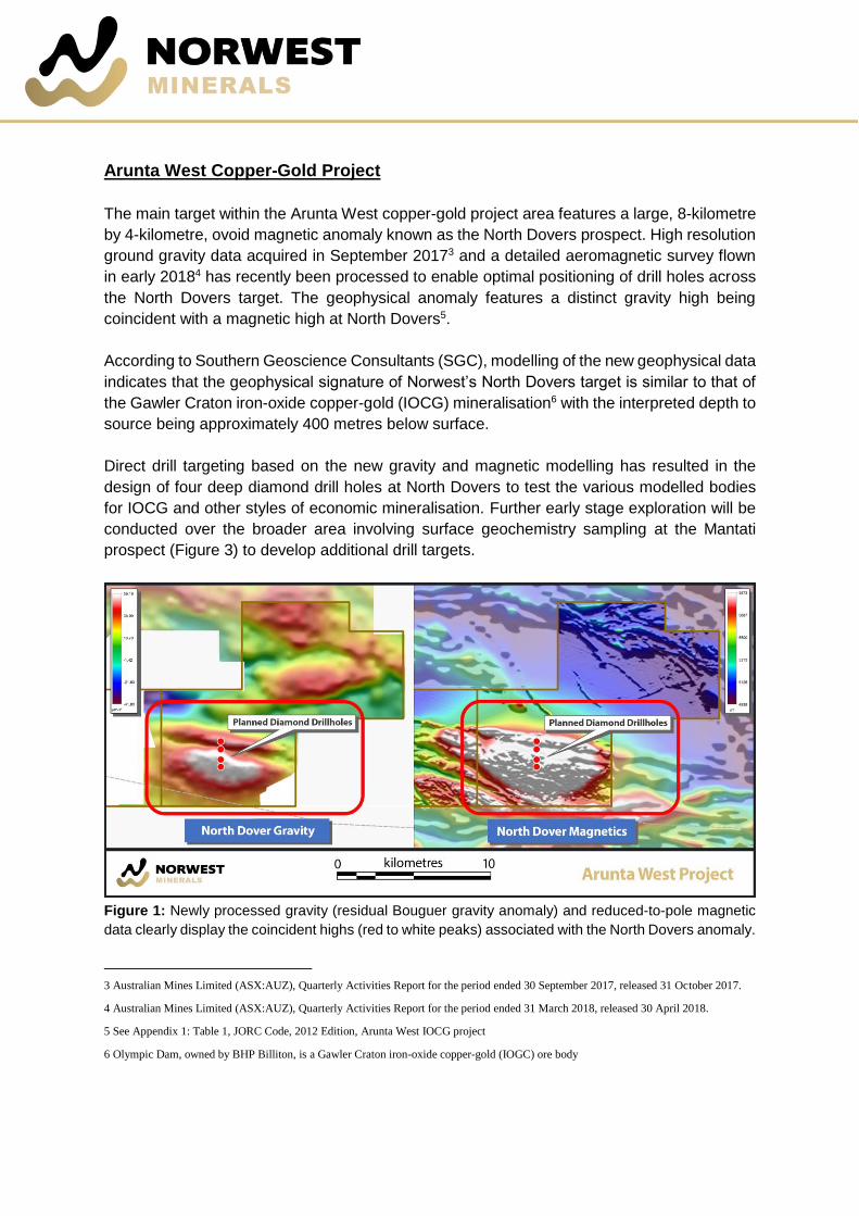
The main target within the Arunta West copper-gold project area features a large, 8-kilometre
by 4-kilometre, ovoid magnetic anomaly known as the North Dovers prospect. High resolution
ground gravity data acquired in September 20173 and a detailed aeromagnetic survey flown
in early 20184 has recently been processed to enable optimal positioning of drill holes across
the North Dovers target. The geophysical anomaly features a distinct gravity high being
coincident with a magnetic high at North Dovers5.
According to Southern Geoscience Consultants (SGC), modelling of the new geophysical data
indicates that the geophysical signature of Norwest’s North Dovers target is similar to that of
the Gawler Craton iron-oxide copper-gold (IOCG) mineralisation6 with the interpreted depth to
source being approximately 400 metres below surface.
Direct drill targeting based on the new gravity and magnetic modelling has resulted in the
design of four deep diamond drill holes at North Dovers to test the various modelled bodies
for IOCG and other styles of economic mineralisation. Further early stage exploration will be
conducted over the broader area involving surface geochemistry sampling at the Mantati
prospect (Figure 3) to develop additional drill targets.
Figure 1: Newly processed gravity (residual Bouguer gravity anomaly) and reduced-to-pole magnetic
data clearly display the coincident highs (red to white peaks) associated with the North Dovers anomaly.
3 Australian Mines Limited (ASX:AUZ), Quarterly Activities Report for the period ended 30 September 2017, released 31 October 2017.
4 Australian Mines Limited (ASX:AUZ), Quarterly Activities Report for the period ended 31 March 2018, released 30 April 2018.
5 See Appendix 1: Table 1, JORC Code, 2012 Edition, Arunta West IOCG project
6 Olympic Dam, owned by BHP Billiton, is a Gawler Craton iron-oxide copper-gold (IOGC) ore body
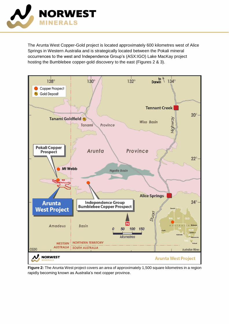
The Arunta West Copper-Gold project is located approximately 600 kilometres west of Alice
Springs in Western Australia and is strategically located between the Pokali mineral
occurrences to the west and Independence Group’s (ASX:IGO) Lake MacKay project
hosting the Bumblebee copper-gold discovery to the east (Figures 2 & 3).
Figure 2: The Arunta West project covers an area of approximately 1,500 square kilometres in a region
rapidly becoming known as Australia’s next copper province.

The project is a joint venture with Jervois Mining Limited (ASX:JRV), which takes in three
tenements covering 345 square kilometres of the prospective Lake Mackay district of Western
Australia. The Company also holds 100% interest in two tenements adjoining the Arunta West
JV area, covering an additional 1,100 square kilometres.
The North Dovers prospect was identified in 1999 by BHP as a potential Ernest Henry-style
copper-gold target7 following a prospectivity study of the region by Australian Geological
Survey Organisation (AGSO)8 and a review of the regional government geophysical data.
BHP’s work revealed a coincident gravity-magnetic anomaly suggestive of an IOCG deposit9.
North Dovers is primarily defined by a strong 1,000 nT magnetic anomaly covering
approximately a 4-kilometre by 8-kilometre area and located immediately south of a major
crustal structure. For reference, the Olympic Dam deposit also produces a 1,000 nT magnetic
anomaly.10
Figure 3: Regional magnetic image across West Arunta region and showing project tenement location.
7 Grimley, M. and Hart, J., 1999. Final Report for Exploration Licences EL80/2039, EL80/2040, EL80/2041, EL80/2042, EL80/2255,
EL80/2256, EL80/2257, EL80/2258, EL80/2259, EL80/2260, EL80/2261 and EL80/2262, and Annual Report for Exploration Licences
EL80/2263, EL80/2264, EL80/2265, and EL80/2424; Mt Webb Joint Venture, WA for the period ending 31st December 1999, BHP
Minerals Pty Ltd, WAMEX Report A59726, 224p. 8 Wyborn, L., Hazell, M. Page, R., Idnurm, M. and Sun, S., 1998. A newly discovered major Proterozoic granite-alteration system in the
Mount Webb region, central Australia, and implications for Cu-Au mineralisation, Australian Geological Survey Organisation (AGSO)
Research Newsletter 28, 1-6. 9 BHP Minerals PTY Ltd, Mt Webb Joint Venture Annual Report, Internal company report (WAMEX number a59726), December 1999 10 J. Austin and C. Foss (2012). “Rich, attractive and extremely dense: A geophysical review of Australian IOCGs” 22nd International
Geophysical Conference and Exhibition, 26-29 February 2012 – Brisbane, Australia

NDVRC01 was later drilled by BHP to test the North Dovers anomaly. Due to strict access
issues the hole was located off the main anomaly and drilling only reached the cover sequence
before being abandoned without achieving its target depth (Figure 4).
The base metal potential of the province was reaffirmed in October 2015 when Independence
Group, in partnership with ABM Resources, announced the Bumblebee copper-gold-silver-
lead-zinc-cobalt discovery immediately east of the Arunta West project area11. Better results
from the IGO/ABM drilling programme along strike of Norwest’s North Dovers (Arunta JV)
target were12:
• 11.4 metres at 7.9 grams per tonne gold, 20.7 grams per tonne silver, 0.8% copper,
1.1% zinc, 0.5% lead and 0.1% cobalt from 284.9 metres13
The prospectivity of the North Dovers target was specifically recognized by the Western
Australian government when they agreed to contribute up to $200,000 toward Norwest’s
upcoming maiden drill programme at North Dovers via their competitive Exploration Incentive
Scheme14.
A Mineral Exploration and Land Access Deed of Agreement has been executed with the Tjamu
Tjamu (Aboriginal Corporation) RNTBC who manage the land covered by the Company’s
Arunta West Copper-Gold Project. This agreement opens up the ability for the Company to
conduct exploration programs (including drilling) across its 1,500 square kilometre Arunta
West tenement holding.
11 ABM Resources, Announcing the Bumblebee gold-copper-silver-lead-zinc-cobalt discovery, released 6 October 2015
12 Shareholders should note that while the geophysical signature of the Company’s North Dovers prospect appears similar to that of
Olympic Dam, and that gold base metal mineralisation has been intersected along strike of the North Dovers target by the Independence
Group / ABM Resources joint venture, there is no guarantee that Norwest Minerals’ exploration programme at North Dovers (Arunta West)
will result in the discovery of a Gawler Craton style iron-oxide copper-gold (IOCG) ore body
13 ABM Resources Limited, AGM Presentation, released 29 November 2017
14 Co-funded exploration drilling R17, 2018-19 successful applicants, Western Australia Department of Mines, Industry Regulation and
Safety, announced 29 May 2018. http://www.dmp.wa.gov.au/Documents/R17_Successful_List.pdf

Figure 4: Residual gravity image showing old BHP drill hole (NDVRC01) collar position relative to the
North Dovers anomaly and Norwest’s planned diamond drilling.
Norwest Minerals Chief Executive Officer, Charles Schaus, commented: “Without
question, the sheer size of the anomaly combined with its magnetic-gravity IOCG signature
makes North Dovers a very exciting exploration target. Plus, the generous government
contribution of up to $200,000 to support Norwest, the first company to drill into the North
Dovers anomaly, certainly lightens our overall financial commitment and risk.”
***ENDS***
For further information:
Shareholders contact:
Charles Schaus
Chief Executive Officer
Ph: +61 (0) 417 944 295
Media contact:
Michael Cairnduff
Cannings Purple
Ph: + 61 406 775 241

Competent Person’s Statement
Exploration Targets and Results
The information in this report that relates to Exploration Results and Exploration Targets is based on
and fairly represents information and supporting documentation prepared by Charles Schaus (CEO of
Norwest Minerals Pty Ltd). Mr. Schaus is a member of the Australian Institute of Mining and Metallurgy
and has sufficient experience of relevance to the styles of mineralisation and types of deposits under
consideration, and to its activities undertaken to qualify as Competent Persons as defined in the 2012
Edition of the Joint Ore Reserves Committee (JORC) Australasian Code for Reporting of Exploration
Results, Mineral Resources and Ore Reserves. Mr Schaus consents to the inclusion in this report of
the matters based on his information in the form and context in which they appear.
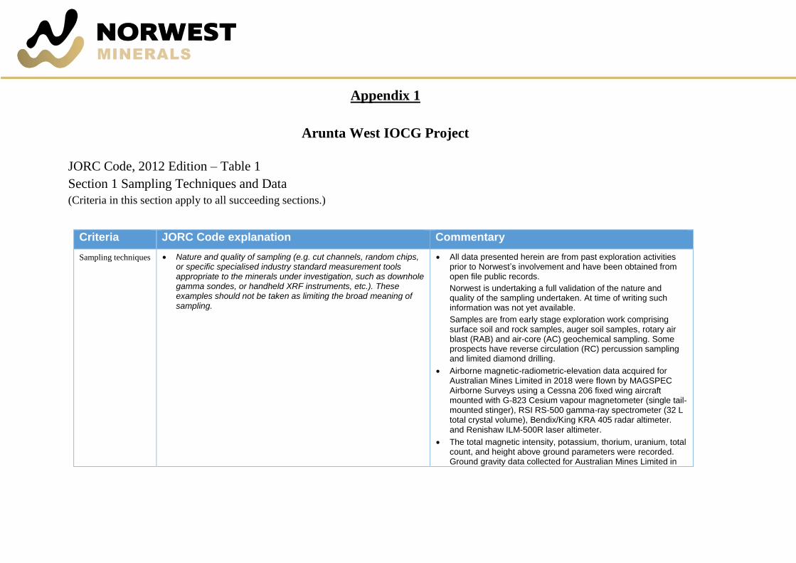
Appendix 1
Arunta West IOCG Project
JORC Code, 2012 Edition – Table 1
Section 1 Sampling Techniques and Data
(Criteria in this section apply to all succeeding sections.)
Criteria JORC Code explanation Commentary
Sampling techniques • Nature and quality of sampling (e.g. cut channels, random chips, or specific specialised industry standard measurement tools appropriate to the minerals under investigation, such as downhole gamma sondes, or handheld XRF instruments, etc.). These examples should not be taken as limiting the broad meaning of sampling.
• All data presented herein are from past exploration activities prior to Norwest’s involvement and have been obtained from open file public records.
Norwest is undertaking a full validation of the nature and quality of the sampling undertaken. At time of writing such information was not yet available.
Samples are from early stage exploration work comprising surface soil and rock samples, auger soil samples, rotary air blast (RAB) and air-core (AC) geochemical sampling. Some prospects have reverse circulation (RC) percussion sampling and limited diamond drilling.
• Airborne magnetic-radiometric-elevation data acquired for Australian Mines Limited in 2018 were flown by MAGSPEC Airborne Surveys using a Cessna 206 fixed wing aircraft mounted with G-823 Cesium vapour magnetometer (single tail-mounted stinger), RSI RS-500 gamma-ray spectrometer (32 L total crystal volume), Bendix/King KRA 405 radar altimeter. and Renishaw ILM-500R laser altimeter.
• The total magnetic intensity, potassium, thorium, uranium, total count, and height above ground parameters were recorded. Ground gravity data collected for Australian Mines Limited in

Criteria JORC Code explanation Commentary
• Include reference to measures taken to ensure sample representivity and the appropriate calibration of any measurement tools or systems used.
• Aspects of the determination of mineralisation that are Material to the Public Report.
• In cases where ‘industry standard’ work has been done, this would be relatively simple (e.g. ‘reverse circulation drilling was used to obtain 1 m samples from which 3 kg was pulverised to produce a 30 g charge for fire assay’). In other cases, more explanation may be required, such as where there is coarse gold that has inherent sampling problems. Unusual commodities or mineralisation types (e.g. submarine nodules) may warrant disclosure of detailed information.
2017 were acquired by specialist contractor Haines Surveys using a Scintrex CG5 Autograv instrument (Serial No. 40381) with Trimble R8 GNSS series geodetic receivers for RTK GPS control.
• All data presented herein are previous and Norwest is undertaking a full validation of the nature and quality of the sampling undertaken.
Norwest has however done sufficient verification of the sampling techniques. The sampling techniques have also been reviewed by the Competent Person’s and in their opinion, provides sufficient confidence that sampling was performed to adequate industry standards and is fit for the purpose of planning exploration programmes and generating targets for investigation.
For the stage of the Arunta West Project the quality of past data is considered fit for purpose.
• All references to mineralisation are taken from reports and documents prepared by previous explorers and have been reviewed by Norwest and considered to be fit for purpose
• All data presented herein are previous and Norwest is undertaking a full validation of the nature and quality of the sampling completed.
Norwest has done sufficient verification of the sampling techniques, in the Competent Person’s opinion to provide sufficient confidence that sampling was performed to adequate industry standards for the time in which it was undertaken and is fit for the purpose of planning exploration programmes and generating targets for investigation.
Drilling techniques • Drill type (e.g. core, reverse circulation, open-hole hammer, rotary air blast, auger, Bangka, sonic, etc.) and details (e.g. core diameter, triple or standard tube, depth of diamond tails, face-sampling bit or other type, whether core is oriented and if so, by what method, etc.).
• Various drill types have been used previously including Vacuum, AC, RAB, RC and diamond. At this time, hole diameters and detailed information regarding drilling has not been compiled for all projects and are not considered material to supporting the assessment of the prospectivity of the Projects
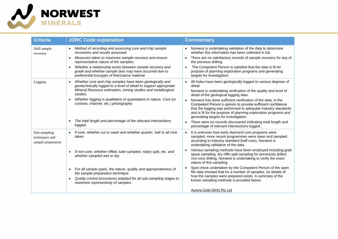
Criteria JORC Code explanation Commentary
Drill sample
recovery
• Method of recording and assessing core and chip sample recoveries and results assessed.
• Measures taken to maximise sample recovery and ensure representative nature of the samples.
• Whether a relationship exists between sample recovery and grade and whether sample bias may have occurred due to preferential loss/gain of fine/coarse material.
• Norwest is undertaking validation of the data to determine whether this information has been collected in full.
• There are no satisfactory records of sample recovery for any of the previous drilling.
• The Competent Person is satisfied that the data is fit for purpose of planning exploration programs and generating targets for investigation.
Logging • Whether core and chip samples have been geologically and geotechnically logged to a level of detail to support appropriate Mineral Resource estimation, mining studies and metallurgical studies.
• Whether logging is qualitative or quantitative in nature. Core (or costean, channel, etc.) photography.
• The total length and percentage of the relevant intersections logged.
• All holes have been geologically logged to various degrees of detail.
Norwest is undertaking verification of the quality and level of detail of the geological logging data.
• Norwest has done sufficient verification of the data, in the Competent Person’s opinion to provide sufficient confidence that the logging was performed to adequate industry standards and is fit for the purpose of planning exploration programs and generating targets for investigation.
• There were no records discovered indicating total length and percentage of relevant intersections logged.
Sub-sampling
techniques and
sample preparation
• If core, whether cut or sawn and whether quarter, half or all core taken.
• If non-core, whether riffled, tube sampled, rotary split, etc. and whether sampled wet or dry.
• For all sample types, the nature, quality and appropriateness of the sample preparation technique.
• Quality control procedures adopted for all sub-sampling stages to maximise representivity of samples.
• It is unknown how early diamond core programs were sampled, more recent programmes were sawn and sampled according to industry standard (half core), Norwest is undertaking validation of the data.
• Various sampling methods have been employed including grab spear sampling, dry riffle split sampling for previously drilled non-core drilling, Norwest is undertaking to verify the exact nature of this sampling.
• Spot check undertaken by the Competent Person of the open file data showed that for a number of samples, no details of how the samples were prepared exists. A summary of the known sampling methods is provided below.
Aurora Gold (WA) Pty Ltd

Criteria JORC Code explanation Commentary
• Measures taken to ensure that the sampling is representative of the in-situ material collected, including for instance results for field duplicate/second-half sampling.
• Whether sample sizes are appropriate to the grain size of the material being sampled.
A single sample from Vacuum drilling was taken at the base of sand cover.
RAB/AC drilling on average two samples were taken per hole one at the base of sand cover and one of bedrock at the bottom of the hole.
RC drilling, in general 4 m composite samples were collected, with two and one metre samples collected from mineralised or quartz rich intersections.
BHP Minerals Pty Ltd
RC drilling, 2 kg samples were collected at 2 m intervals, six metre composite samples were collected and submitted for assay.
FQM Exploration (Australia) Pty Ltd
AC/slim line RC drilling – hydrogeochemical sampling was undertaken from the water table. All 1 m samples were analysed by Olympus Innov-x DP-4050 XRF in the field. Up to 3 m composite spear samples of in-situ regolith, bedrock and selected cover lithologies were sampled.
The checks by the Competent Person of the open file data showed that Aurora Gold (WA) Pty Ltd routinely used duplicate samples and BHP Minerals Pty Ltd routinely used duplicate and standard samples.
• The sampling methods were most likely appropriate for the material being sampled for the purposes of the sampling.
Quality of assay data
and laboratory tests
• The nature, quality and appropriateness of the assaying and laboratory procedures used and whether the technique is considered partial or total.
• Norwest has done sufficient verification of the assay data, in the Competent Person’s opinion to provide sufficient confidence that the assaying was appropriate for the mineralisation present and is fit for the purpose of planning exploration programs and generating targets for investigation. Norwest continues to fully verify the data.

Criteria JORC Code explanation Commentary
• For geophysical tools, spectrometers, handheld XRF instruments, etc., the parameters used in determining the analysis including instrument make and model, reading times, calibrations factors applied and their derivation, etc.
• Nature of quality control procedures adopted (e.g. standards, blanks, duplicates, external laboratory checks) and whether acceptable levels of accuracy (i.e. lack of bias) and precision have been established.
• FQM Exploration (Australia) Pty Ltd used a portable Olympus Innov-x DP-4050 XRF in the field. The also used a ZH Instruments SM30 magnetic susceptibility meter on each 1 m sample.
Norwest has done sufficient verification of the data, in the Competent Person’s opinion to provide sufficient confidence that the quality control procedures were performed to adequate industry standards and is fit for the purpose of planning exploration programs and generating targets for investigation. Norwest continues to fully verify the data.
• 2018 airborne magnetic-radiometric data were quality checked by Southern Geoscience Consultants. Data were of high quality and were within all survey specifications.
• 2017 ground gravity data were quality checked by Southern Geoscience Consultants. Data were of high quality and within all survey specifications. 64 observations were repeated for quality control purposes, giving a repeat percentage of 7.0%. Gravity control for the survey base station was established by two sets of A-B-A ties with the Alice Springs airport isogal 1964910335.
• Not all historical programs detailed the nature of the quality control procedures undertaken. The spot checks by the Competent Person of the open file data showed that for:
Aurora Gold (WA) Pty Ltd
• Vacuum, RAB, AC and RC drilling sampling, duplicates were collected, no mention of blanks or standards.
BHP Minerals Pty Ltd
• RC drilling sampling, both duplicates and standards were used.
Verification of
sampling and
assaying
• The verification of significant intersections by either independent or alternative company personnel.
• Significant intersections have been taken from previous databases. The Competent Persons completed a number of spot checks of the source data and did not identify any material issues with the reported intersections.

Criteria JORC Code explanation Commentary
• The use of twinned holes.
• Documentation of primary data, data entry procedures, data verification, data storage (physical and electronic) protocols.
• Discuss any adjustment to assay data.
No validation or check assaying has yet been carried out by Norwest.
• Norwest is yet to twin any holes from the previous work.
• Norwest has done sufficient verification of the data, in the Competent Person’s opinion to provide sufficient confidence that sampling was performed to adequate industry standards for the time in which it was undertaken and is fit for the purpose of planning exploration programs and generating targets for investigation.
• No adjustments have been made to any of the assay data.
Location of data
points
• Accuracy and quality of surveys used to locate drill holes (collar and down-hole surveys), trenches, mine workings and other locations used in Mineral Resource estimation.
• Specification of the grid system used.
• Quality and adequacy of topographic control.
• Norwest has done sufficient verification of the data, in the Competent Person’s opinion to provide sufficient confidence in the accuracy and quality of survey data and that it is fit for the purpose of planning exploration programmes and generating targets for investigation. Norwest continues to fully verify the data.
• 2018 airborne magnetic-radiometric survey navigation used an integrated Novatel OEM719 DGPS receiver. GPS accuracy tests were performed by accumulating GPS readings for approximately 5 minutes whilst the aircraft was static. All readings (X, Y, Z) were within 2 metres.
• Measurements for the 2018 detailed gravity observations were made using Real Time Kinematic (RTK) techniques giving horizontal and vertical precision of at least 5 cm. Static baseline processing and RTK processing was done using Trimble Business Center Version 2.5 software. All static baselines have been processed to double difference fixed solutions resulting in horizontal and vertical precision of approximately 2 cm.
• Geodetic Datum of Australia 1994 (GDA94), Map Grid of Australia (MGA) Zone 52
• Local topographic control at the projects is variable. It is fit for the purpose of planning future exploration programs. Norwest
Criteria JORC Code explanation Commentary
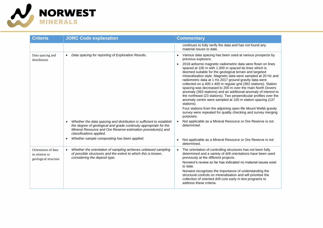
continues to fully verify the data and has not found any material issues to date.
Data spacing and
distribution
• Data spacing for reporting of Exploration Results.
• Whether the data spacing and distribution is sufficient to establish the degree of geological and grade continuity appropriate for the Mineral Resource and Ore Reserve estimation procedure(s) and classifications applied.
• Whether sample compositing has been applied.
• Various data spacing has been used at various prospects by previous explorers.
• 2018 airborne magnetic-radiometric data were flown on lines spaced at 100 m with 1,000 m spaced tie lines which is deemed suitable for the geological terrain and targeted mineralisation style. Magnetic data were sampled at 20 Hz and radiometric data at 1 Hz.2017 ground gravity data were collected on a 400 x 400 m regular grid (362 stations). Station spacing was decreased to 200 m over the main North Dovers anomaly (363 stations) and an additional anomaly of interest to the northeast (23 stations). Two perpendicular profiles over the anomaly centre were sampled at 100 m station spacing (137 stations).
Four stations from the adjoining open-file Mount Webb gravity survey were repeated for quality checking and survey merging purposes.
• Not applicable as a Mineral Resource or Ore Reserve is not determined.
• Not applicable as a Mineral Resource or Ore Reserve is not determined.
Orientation of data
in relation to
geological structure
• Whether the orientation of sampling achieves unbiased sampling of possible structures and the extent to which this is known, considering the deposit type.
• The orientation of controlling structures has not been fully determined and a variety of drill orientations have been used previously at the different projects.
Norwest’s review so far has indicated no material issues exist to date.
Norwest recognises the importance of understanding the structural controls on mineralisation and will prioritise the collection of oriented drill core early in test programs to address these criteria.

Criteria JORC Code explanation Commentary
• If the relationship between the drilling orientation and the orientation of key mineralised structures is considered to have introduced a sampling bias, this should be assessed and reported if material.
• 2018 airborne magnetic-radiometric data were acquired on north-south (000°) flight lines, approximately perpendicular to the strike of the predominant structural/geological trend.
• 2017 ground gravity data were acquired on a regular grid (400 x 400 m) with closer station spacing (100 m and 200 m) along select profiles orientated perpendicular to the strike of the main anomalies.
• There is no apparent bias in any of the drilling orientations used.
Sample security • The measures taken to ensure sample security. • Due to the historical nature of the data, this has not and may not be determinable.
There are no indications that there have been any issues with sample security.
Audits or reviews • The results of any audits or reviews of sampling techniques and data.
• Norwest has not performed any audits at this time.

Section 2 Reporting of Exploration Results
(Criteria listed in the preceding section also apply to this section.)
Criteria JORC Code explanation Commentary
Mineral tenement and land tenure
status
• Type, reference name/number, location and ownership including agreements or material issues with third parties such as joint ventures, partnerships, overriding royalties, native title interests, historical sites, wilderness or national park and environmental settings.
• The security of the tenure held at the time of reporting along with any known impediments to obtaining a licence to operate in the area.
• In September 2016 Australian Mines Limited executed a Mineral Exploration and Land Access Deed of Agreement with the Tjamu Tjamu (Aboriginal Corporation) RNTBC who manage the land covered by the Arunta West Copper-Gold Project.
• Norwest’s has a 100% interest in granted tenements E80/5031 and E80/5032. Granted tenements E80/4820, E804986 and E80/4987 Norwest is in a joint venture with Jervois Mining Ltd where Norwest can earn an 80% interest. Sites of significant heritage value are present within the project area and may be an impediment to conducting ground disturbing exploration activities.
Exploration done by other parties • Acknowledgment and appraisal of exploration by other parties. • All the exploration reported has been completed by a variety of companies, as noted in the text of the reports and described more fully in the open file WAMEX reports referenced throughout the text.
• Previous exploration has been completed on Norwest’s projects by a variety of companies.
Geology • Deposit type, geological setting and style of mineralisation. • The Arunta West Project is situated at the western margin of the Proterozoic Arunta Block of Central Australia. The Arunta Block comprises Paleoproterozoic metamorphosed and deformed igneous and sedimentary rocks. The style of mineralisation targeted is IOCG.

Criteria JORC Code explanation Commentary
Drill hole Information • A summary of all information material to the understanding of the exploration results including a tabulation of the following information for all Material drill holes:
• easting and northing of the drill hole collar
• elevation or RL (Reduced Level – elevation above sea level in metres) of the drill hole collar
• dip and azimuth of the hole
• downhole length and interception depth
• hole length.
• If the exclusion of this information is justified on the basis that the information is not Material and this exclusion does not detract from the understanding of the report, the Competent Person should clearly explain why this is the case.
• Historic drilling of various vintage was conducted by previous explorers using the best practices at that time. Most of the data is in hardcopy and documentation in terms of location of collars, details on etc is minimal. Consequently, the use of any data obtained is recommended for indicative purposes only in terms of potential IOCG mineralisation and for developing Exploration Targets. The historical drill data is neither material to Mineral Asset valuations nor to future Mineral Resource estimates.
• Not applicable, as no information has been excluded.
Data aggregation methods • In reporting Exploration Results, weighting averaging techniques, maximum and/or minimum grade truncations (e.g. cutting of high grades) and cut-off grades are usually Material and should be stated.
• Where aggregate intercepts incorporate short lengths of high grade results and longer lengths of low grade results, the procedure used for such aggregation should be stated and some typical examples of such aggregations should be shown in detail.
• The assumptions used for any reporting of metal equivalent values should be clearly stated.
• All assays are based on previous databases, and upon review have been treated at face value. No validation or check assaying has been carried out by Norwest.
• Not applicable
• Not applicable, as no metal equivalent values have been reported.
Relationship between
mineralisation widths and
intercept lengths
• These relationships are particularly important in the reporting of Exploration Results.
• Previous drilling has mostly been shallow and vertical, and thus does not represent true width intersections. Future work by Norwest will involve validation and reinterpretation of previous results and the drilling of additional holes to determine the orientation of mineralisation and thus true widths.
Criteria JORC Code explanation Commentary
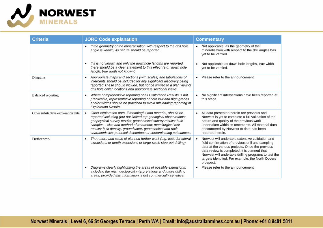
• If the geometry of the mineralisation with respect to the drill hole angle is known, its nature should be reported.
• If it is not known and only the downhole lengths are reported,
there should be a clear statement to this effect (e.g. ‘down hole length, true width not known’).
• Not applicable, as the geometry of the mineralisation with respect to the drill angles has yet to be verified.
• Not applicable as down hole lengths, true width yet to be verified.
Diagrams • Appropriate maps and sections (with scales) and tabulations of intercepts should be included for any significant discovery being reported These should include, but not be limited to a plan view of drill hole collar locations and appropriate sectional views.
• Please refer to the announcement.
Balanced reporting • Where comprehensive reporting of all Exploration Results is not practicable, representative reporting of both low and high grades and/or widths should be practiced to avoid misleading reporting of Exploration Results.
• No significant intersections have been reported at this stage.
Other substantive exploration data • Other exploration data, if meaningful and material, should be reported including (but not limited to): geological observations; geophysical survey results; geochemical survey results; bulk samples – size and method of treatment; metallurgical test results; bulk density, groundwater, geotechnical and rock characteristics; potential deleterious or contaminating substances.
• All data presented herein are previous and Norwest is yet to complete a full validation of the nature and quality of the previous work undertaken within its tenements. All material data encountered by Norwest to date has been reported herein.
Further work • The nature and scale of planned further work (e.g. tests for lateral extensions or depth extensions or large-scale step-out drilling).
• Diagrams clearly highlighting the areas of possible extensions, including the main geological interpretations and future drilling areas, provided this information is not commercially sensitive.
• Norwest will undertake extensive validation and field confirmation of previous drill and sampling data at the various projects. Once the previous data review is completed, it is planned that Norwest will undertake drilling programs to test the targets identified. For example, the North Dovers prospect.
• Please refer to the announcement.