DREDGING, EXTRACTION AND POIL DISPOSAL … · Dredging, Extraction and Spoil Disposal Activities...
85
Dredging, Extraction and Spoil Disposal Activities Department of Primary Industries FHMOP 004 i Fish Habitat Management Operational Policy FHMOP 004 DREDGING, EXTRACTION AND SPOIL DISPOSAL ACTIVITIES Departmental procedures for provision of fisheries comments Emma Hopkins Melissa White July 1998 Fisheries Group DPI
Transcript of DREDGING, EXTRACTION AND POIL DISPOSAL … · Dredging, Extraction and Spoil Disposal Activities...
Dredging, Extraction and Spoil Disposal Activities
Department of Primary Industries FHMOP 004
i
Fish Habitat Management Operational Policy FHMOP 004
DREDGING, EXTRACTION AND SPOIL DISPOSAL ACTIVITIES
Departmental procedures for provision of
fisheries comments
Emma Hopkins Melissa White
July 1998 Fisheries Group
DPI
Dredging, Extraction and Spoil Disposal Activities
Department of Primary Industries FHMOP 004
ii
ISSN 1326-6985 Agdex 043 First published July 1998 Other publications in the QDPI Fish Habitat Management Operational Policy Series:
FHMOP 001: Couchman, D., Mayer, D. and Beumer, J. (1996) Departmental Procedures for Permit Applications Assessment and Approvals for Marine Plants, Queensland Department of Primary Industries Fish Habitat Management Operational Policy FHMOP 001, 62pp. FHMOP 002: Zeller, B. and Beumer, J. (1996). Departmental Procedures for Permit Applications Assessment and Approvals to Perform Works or Related Activity in a Declared Fish Habitat Area, Queensland Department of Primary Industries Fish Habitat Management Operational Policy FHMOP 002, 88pp. FHMOP 003: White, M. and Beumer, J. (1996) Departmental Procedures for Permit Applications Assessment and Approvals for Insect Pest Control in Coastal Wetlands, Queensland Department of Primary Industries Fish Habitat Management Operational Policy FHMOP 003, 56pp. Also: Beumer, J., Carseldine, L. and Zeller, B. (1997) Declared Fish Habitat Areas in Queensland, (Supplement to FHMOP 002), QI97004, Queensland Department of Primary Industries, 178pp.
This document may be cited as:
Hopkins, E. and White, M. (1998) Dredging, Extraction and Spoil Disposal Activities: departmental procedures for provision of fisheries comments, Queensland Department of Primary Industries, Fish Habitat Management Operational Policy FHMOP 004, 79pp.
Information contained in this publication is provided as general advice only. For application to specific circumstances, professional advice should be sought. The Queensland Department of Primary Industries has taken all reasonable steps to ensure the information contained in this publication is accurate at the time of publication. Readers should ensure that they make appropriate enquiries to determine whether new information is available on the particular subject matter. © The State of Queensland, Department of Primary Industries 1998 Copyright protects this publication. Except for purposes permitted by the Copyright Act, reproduction by whatever means is prohibited without the prior written permission of the Department of Primary Industries, Queensland. Publishing Services Queensland Department of Primary Industries GPO Box 46 Brisbane QLD 4001
Dredging, Extraction and Spoil Disposal Activities
Department of Primary Industries FHMOP 004
iii
Foreword This operational policy applies to the provision of Fisheries Group comments on extractive industry and mining, navigational dredging, dredging for waterway management and development and spoil disposal proposals in Queensland. This policy will apply to the majority of situations. It is recognised that proposals will arise where adherence to this policy may not be possible due to peculiar circumstances surrounding a particular proposal. On these occasions, careful documentation of the justification for relaxation of the policy should occur. Fisheries Group comments form a component of the permit assessment process of other agencies and, in most instances, are not directly related to Fisheries approvals, except where the proposed activity interferes with protected marine plants, declared Fish Habitat Areas or with fish ways associated with waterway barrier works (refer Fisheries Act 1994). This policy will be reviewed to allow for any necessary changes. Input and comments are sought from staff using this document as it has been developed to assist Fisheries Group staff in the assessment and provision of comments and recommendations on dredging, extraction and spoil disposal proposals. All comments regarding the quality and applicability of the document are welcome and may be directed to the General Manager (Fisheries Resources Protection). This policy has been prepared by the Marine Habitat Unit of the QDPI Fisheries Group. It may be helpful to refer to the operational policy documents for Marine Plants (FHMOP 001), declared Fish Habitat Areas (FHMOP 002) and Insect Pest Control (FHMOP 003) when preparing Fisheries Group comments relating to proposals to undertake dredging activities. This policy briefly outlines the history, type and extent of dredging activities in Queensland. The nature of Queensland's fisheries and the Department of Primary Industry’s responsibilities under the Queensland Fisheries Act 1994 and Fisheries Regulation 1995 with respect to dredging activities are described. The scope and objectives of the policy are outlined, as are key challenges and policy principles. The decision-making process and implications for the Department, industry and the community of implementing the policy are discussed. Appendices contain detailed information on: dredging activities covered by this policy; potential impacts on fish and fisheries associated with dredging activity; legislation associated with dredging activity; relevant case studies; a description of types of dredges used in Queensland; and spawning and/or migration periods for a selection of fish species. This policy is not a legal document. For details of fisheries legislation, reference should be made to the Fisheries Act 1994 and Regulation 1995 and subsequent Amendments.
Fisheries Group staff involved in the assessment and provision of comments on commercial extraction, navigational dredging, dredging for waterway management and development and spoil disposal proposals are required to follow this policy. Situations and circumstances may arise where comments on a particular proposal will require variation to the stated policy. On every occasion where the policy is varied, the commenting officer should document the reasons on which the comments were based and forward a copy to the Fisheries Resource Protection Division for information.

Dredging, Extraction and Spoil Disposal Activities
Department of Primary Industries FHMOP 004
iv
Table of Contents
Foreword ----------------------------------------------------------------------------------------------- iii
Table of Contents --------------------------------------------------------------------------------------iv
1.0 Introduction and background ----------------------------------------------------------------- 1 1.1 History ------------------------------------------------------------------------------------------------ 1
1.2 Description of Queensland’s Fish and Fisheries ---------------------------------------------- 1
1.3 Value of fish habitats to the fishing industry and the community------------------------- 2
1.4 Dredging activities, as covered by this policy-------------------------------------------------- 2
1.5 The type and extent of dredging activities in Queensland ---------------------------------- 3
1.6 Fisheries Act and responsibilities ---------------------------------------------------------------- 3
1.7 Impacts of and pressures associated with dredging on fisheries resources-------------- 4
1.8 Management of dredging activities in Queensland------------------------------------------- 5
2.0 Scope ----------------------------------------------------------------------------------------------- 6 2.1 Extractive Industry and Mining ----------------------------------------------------------------- 6
2.1.1 Sand and gravel extraction --------------------------------------------------------------------------------7 2.1.2 Mineral exploration and extraction ---------------------------------------------------------------------7
2.2 Navigational Dredging ----------------------------------------------------------------------------- 7 2.2.1 Capital works -------------------------------------------------------------------------------------------------8 2.2.2 Maintenance works------------------------------------------------------------------------------------------8
2.3 Dredging for Waterway Management ---------------------------------------------------------- 8 2.3.1 Beach replenishment/nourishment-----------------------------------------------------------------------8 2.3.2 Flood mitigation ----------------------------------------------------------------------------------------------9 2.3.3 Habitat restoration ------------------------------------------------------------------------------------------9
2.4 Dredging for Development ------------------------------------------------------------------------ 9 2.4.1 Dredging for infrastructure -------------------------------------------------------------------------------9 2.4.2 Reclamation ---------------------------------------------------------------------------------------------------9 2.4.3 Dredging associated with aquaculture operations ------------------------------------------------- 10
2.5 Spoil Disposal --------------------------------------------------------------------------------------- 10
2.6 Dredging within or adjacent to declared Fish Habitat Areas (FHA) -------------------- 10
3.0 Objectives-----------------------------------------------------------------------------------------11
4.0 Key challenges-----------------------------------------------------------------------------------11
5.0 Policy principles---------------------------------------------------------------------------------12 5.1 Ecologically sustainable development (ESD) ------------------------------------------------- 12
5.2 Fisheries Group will not oppose proposals for extractive industry and mining, navigational dredging, dredging for waterway management and development and spoil disposal activities where: ------------------------------------------------------------------------------- 13
5.3 Fisheries Group will oppose proposals for extractive industry and mining, navigational dredging, dredging for waterway management and development and spoil disposal activities where: ------------------------------------------------------------------------------------------ 13
5.4 Mitigation measures------------------------------------------------------------------------------- 14
5.5 Environmental Management Plans------------------------------------------------------------- 15
Dredging, Extraction and Spoil Disposal Activities
Department of Primary Industries FHMOP 004
v
5.6 Rehabilitation of intertidal dredged areas, freshwater extractive industry and mining sites and spoil disposal sites -----------------------------------------------------------------------------15
6.0 Decision making process ----------------------------------------------------------------------17
7.0 Implications of policy --------------------------------------------------------------------------19 7.1 Policy monitoring implications ------------------------------------------------------------------19
7.2 Policy implications for the assessing officer---------------------------------------------------19
7.3 Policy implications for Stakeholder groups ---------------------------------------------------20
8.0 Policy definitions/Glossary--------------------------------------------------------------------22
9.0 Acronyms-----------------------------------------------------------------------------------------26
10.0 References / Suggested reading -----------------------------------------------------------27
Acknowledgments-------------------------------------------------------------------------------------31
APPENDIX 1 Details of the dredging activities covered in this policy ---------------------32 1.0 Extractive Industry and Mining-------------------------------------------------------------------33
1.1 Sand and gravel extraction ---------------------------------------------------------------------------------- 33 1.2 Mineral exploration and extraction ----------------------------------------------------------------------- 36
2.0 Dredging for Navigation --------------------------------------------------------------------------38 2.1 Capital works --------------------------------------------------------------------------------------------------- 38 2.2 Maintenance works-------------------------------------------------------------------------------------------- 38
3.0 Dredging for Waterway Management ---------------------------------------------------------40 3.1 Beach replenishment/nourishment --------------------------------------------------------------------------- 40 3.2 Flood mitigation -------------------------------------------------------------------------------------------------- 40 3.3 Habitat restoration----------------------------------------------------------------------------------------------- 41
4.0 Dredging for Development -----------------------------------------------------------------------43 4.1 Dredging for infrastructure------------------------------------------------------------------------------------ 43 4.2 Reclamation-------------------------------------------------------------------------------------------------------- 43 4.3 Dredging associated with aquaculture ---------------------------------------------------------------------- 44
5.0 Spoil Disposal ---------------------------------------------------------------------------------------46 5.1 Terrestrial and marine disposal------------------------------------------------------------------------------- 46 5.2 General spoil disposal information --------------------------------------------------------------------------- 47
6.0 Dredging Within or Adjacent to Declared Fish Habitat Areas (FHAs) -------------------48
APPENDIX 2 Potential impacts of dredging activities on fish and fisheries habitats---51
APPENDIX 3 Legislation pertaining to dredging activity ------------------------------------56
APPENDIX 4 Case studies -------------------------------------------------------------------------62
APPENDIX 5 Types of dredges in operation in Queensland --------------------------------67
APPENDIX 6 Spawning and migration periods -----------------------------------------------71
APPENDIX 7 Considerations where proposals will impact on marine plants------------77
APPENDIX 8 Future management and research directions---------------------------------78
APPENDIX 9 QDPI Fisheries contacts----------------------------------------------------------79

Dredging, Extraction and Spoil Disposal Activities
Department of Primary Industries FHMOP 004
vi
Dredging, Extraction and Spoil Disposal Activities
Department of Primary Industries FHMOP 004
1
1.0 Introduction and background
1.1 History Since His Majesty’s Colonial Brig Amity arrived in Moreton Bay in 1824, carrying the first white settlers and convicts, the need to provide safe and reliable passage for ships and other vessels has been an integral part of life in the coastal areas of Queensland. Major port works, jetties and wharves were initiated after 1842, when the Moreton Bay district was opened to free settlement and trade. Dredging for navigation in the Brisbane River and other Queensland ports was not fully supported by government until after Separation in 1859, when Queensland became a State in its own right. In 1862, the first steam-driven bucket dredge, the Lytton, arrived in Brisbane. Navigational dredging works commenced in northern Queensland ports soon after, following the discovery of mineral and gold deposits. Cleveland Bay, in the Port of Townsville, was first dredged in 1883 by the Brisbane dredge the Platypus. In 1887, the Platypus was sent to Cairns, where dredging commenced late that year. Capital dredging works on the Port of Weipa began in 1961, following the discovery of metal-grade bauxite deposits. The dredging and spoil disposal methods have remained relatively unchanged for decades. For example, the trailing suction hopper dredge Sir Tomas Hiley has dredged the Port of Cairns annually since the early 1970s, as part of its yearly program of dredging ports from Brisbane to Weipa, and is still in use. There is a long history of extractive industry in Queensland. The vast sand and gravel resources of Moreton Bay and its catchment and of many other coastal and inland regions in the State have long been recognised and exploited for building, landscape, road construction and foundry supplies. Sand and gravel extraction occurs in many of Queensland’s rivers (e.g. South Pine River, Mary River and Tully River), estuaries and bays (e.g. Moreton Bay) both on a large scale commercial basis and by private landholders. Dredging is also undertaken for extraction of mineral sands (e.g. North Stradbroke Island) and for tin and gold (e.g. Palmer and Mitchell Rivers). More recently, the availability of small, highly portable dredges (such as eductor dredges) has seen an increase in gold prospecting in freshwaters.
1.2 Description of Queensland’s Fish and Fisheries Queensland’s large geographic size and associated habitat diversity extend across temperate, sub-tropical and tropical regions and generate fisheries resources which are characterised by a great diversity of species. Australia’s waters contain over 3600 species of fish, 2000 species of decapod crustaceans and tens of thousands of molluscs (Williams and Stewart 1993). In Queensland, there are over 3000 species of freshwater and marine fish, molluscs and crustaceans, many of which have traditional, recreational and/or commercial fisheries importance. The major proportion of Australia’s freshwater fish species are found in Queensland (68%), with 125 species identified from Queensland’s inland waters (QDPI 1992). In many cases, the commercial harvesting of fish stocks in Queensland is based on targeting spawning, migration or feeding aggregations. The commercial fishing catch contributes approximately $175 million to the Queensland economy, based on prices paid to fishers at the
Dredging, Extraction and Spoil Disposal Activities
Department of Primary Industries FHMOP 004
2
wharf (the Gross Value of Production (GVP)) (QDPI 1997). This commercial fishery is divided into sectors, including trawl fisheries (prawn, scallop and stout whiting), net fisheries (coastal finfish, shark and mackerel), the trap fishery for crabs and the line fishery for reef and pelagic fish. Commercial fishing is conducted from approximately 2000 licensed primary vessels and input and output controls are maintained to manage the fishery. The river and inshore beam trawl fishery is also an important supplier of bait prawns to the recreational fishing industry. The target species of the recreational fishing sector are also dependent on estuarine, freshwater and some offshore areas such as reefs. A Queensland Fisheries Management Authority (QFMA) survey in 1996, indicated that about 660,000 people above the age of 14 had been fishing at least once during the previous year. Of these, 92% indicated that they fished in the marine environment, while 28% fished in fresh waters. Using the prices paid to commercial fishers, the value of fish taken by recreational fishers is estimated to be $50 million per year (QDPI 1997). In 1984 the Australian Recreational Fishing Council survey estimated that the national recreational fishery was valued at $2.2 billion annually and that 4.5 million Australians go fishing every year. As well as natural fish stocks, a number of waterways throughout Queensland are artificially stocked to enhance recreational fishing. The State Government’s Recreational Fishing Enhancement Program was established in 1986-87 to create recreational fisheries by stocking fingerlings of popular angling fish. QDPI freshwater stocking programs are in place in approximately 90 dams and waterways throughout the State and regulations are also in place for stocking of private waterways. Marine stocking programs are also in place at a number of locations from the Gulf of Carpentaria to southern Queensland.
1.3 Value of fish habitats to the fishing industry and the community Intertidal flats, sand bars, river banks, sand and gravel banks, freshwater and estuarine wetlands and tidal channels contribute to ecosystem complexity and provide many species with favourable environmental conditions to complete the different stages of their life cycles. Studies estimate that approximately 75% (by weight) of all seafood landed commercially in Queensland is derived from species dependent on estuarine habitats during part of their life cycle (Quinn 1993), although this figure may vary depending on estuary location. Due to the similarity in target species for each fishery, a high proportion of species targeted by the recreational and indigenous fishing sectors is also dependent on estuarine habitats during part or all of their life cycles. Fish and fisheries habitats within many of Queensland’s rivers, streams and estuaries have been altered due to: the direct and indirect effects of agricultural and industry practices; pollution, from point and non-point sources (e.g. urban runoff and town sewage); stream regulation and water harvesting; channelisation (to regulate flows and to reduce flooding); and dredging and extractive activities.
1.4 Dredging activities, as covered by this policy

Dredging, Extraction and Spoil Disposal Activities
Department of Primary Industries FHMOP 004
3
For the purposes of this document, dredging activities in Queensland have been divided into five main categories: • extractive industry and mining: sand and gravel extraction and mineral exploration and
extraction • navigational dredging: capital and maintenance works within a channel, canal, marina or
harbour marked by aids to navigation • dredging for waterway management: dredging for beach replenishment, flood mitigation
and habitat restoration • dredging for development: dredging for infrastructure and reclamation • spoil disposal: disposal of unwanted material obtained during dredging. This policy pertains to the specific freshwater and marine dredging activities outlined in Section 2.0 and detailed in Appendix 1. This policy does not cover activities such as blasting, removal of snags, drain clearing and coral limestone dredging.
1.5 The type and extent of dredging activities in Queensland Due to Queensland’s natural diversity, spanning tropical to temperate habitats, broad regional differences in dredging operations can be discerned. Tropical rivers and catchments in the north of the State are generally shorter than those in the south and have a natural tendency to become more wide and shallow over time. Extractive industry and/or mining occur in most rivers between the Town of 1770 and Cairns. North of Cairns however, the incidence of extraction is less common, with tin and gold being the target material. While large suction dredges undertake navigational dredging in north and central Queensland, the majority of sand extraction is small scale and is carried out by excavators or backhoes. Generally, the number and extent of dredging activities in southern Queensland are more extensive than in the north. In 1997, there were ten active sand extraction Permit areas within northern Moreton Bay carried out by five companies. In 1996, the volume of sand extracted from these sites (more than 100,000 m3) was less than the amount permitted to be taken (>390,000m3) (WBM 1997). In all areas of Moreton Bay and its catchments, applications for extraction of material from floodplains and the instream environment are increasing. Despite this, the magnitude of the effect of dredging and sand extraction in these areas is classed as “moderate” (Brisbane River Management Group 1997). The period during which dredging is permitted for a particular extraction lease is specified on the Permit. However, extraction works are generally conducted during the five week days. When a channel or port is dredged for navigational purposes, the material obtained is generally disposed of in a designated spoil ground (or material placement area (MPA)) or on land. Between 1988 and 1997, authorisation, under the Environment Protection (Sea Dumping) Act 1981, was given for the disposal of over 24 million tonnes of dredged spoil in Queensland waters (Department of Environment Sport and Territories, unpublished data 1997).
1.6 Fisheries Act and responsibilities The Queensland Fisheries Act 1994 and Fisheries Regulation 1995 provide for the “management, use, development and protection of fisheries resources and fish habitats and the management of aquaculture activities, and for related purposes”. This Act encompasses

Dredging, Extraction and Spoil Disposal Activities
Department of Primary Industries FHMOP 004
4
Queensland waters, including marine, estuarine and fresh waters. Fisheries legislation is structured to allow separate responsibilities for day to day management of wild fisheries stocks by QFMA and for day to day management of fisheries habitat and aquaculture by QDPI. All management is undertaken subject to ecologically sustainable development principles. Fish and fisheries habitats are managed under the provisions of the Act, specifically, the protection of marine plants, the declaration of Fish Habitat Areas, the restoration of damaged or destroyed fisheries habitats and provisions for waterway barrier works and fish ways. The legislation provides for the granting of certain approvals to allow works to be undertaken within freshwater, intertidal and subtidal areas. Individual applications are assessed and decisions to issue approvals are based on the type of works proposed and related impacts. Support may be given for proposals where: impacts of such works are minimal; the works are for fisheries purposes and/or community benefit; and appropriate mitigation measures are carried out to counter any approved loss of fisheries habitat. Refer to FHMOP 001, FHMOP 002, FHMOP 003 and the Fisheries Act 1994 for further information. Approvals for dredging activities covered by this policy are not issued under the Fisheries Act 1994. However, if a dredging activity is proposed within a declared Fish Habitat Area or is likely to damage marine plants or impact on fish ways (including waterway barrier works), then an application for a Permit under Section 51 of the Act is required. Refer to Table 1 for the occasions where a Permit under the Fisheries Act 1994 is required for dredging activity and to Section 51 of the Fisheries Act 1994 for more legislative details. Table 1. Proposed works, incorporating dredging activities, which will require a Permit under Section 51 of the Fisheries Act 1994 Habitat Activities that require a Permit under
Section 51 of the Fisheries Act 1994. Without a Permit, an offence is committed under Section:
Freshwater • Waterway barrier works (fish ways) • 112 • Works in a declared Fish Habitat Area * • 122 Brackish/Marine • Works in a declared Fish Habitat Area * • 122 • Disturbance to marine plants • 123 * Refer to FHMOP 002 for more detail
1.7 Impacts of and pressures associated with dredging on fisheries resources The need to carry out dredging activity is recognised, as is the need to reduce and/or prevent the impacts of these activities on fisheries resources. Development in, and adjacent to, coastal wetlands can increase pressures on the marine ecosystem resulting in changes in fisheries productivity, particularly through loss of fisheries habitat and a reduction in water quality. Alteration of foreshore and tidal areas through modification of local hydrological conditions following development (e.g. dredging activities), may cause disturbance/destruction of marine plants, saltmarsh-claypan areas and estuarine fish nurseries. Alteration of the instream environment during freshwater dredging activity (e.g. removal of bed material) may cause bank instability and alter the structural composition of the sediments and reduce the diversity of the instream environment. Impacts on fisheries resources may occur in the short or long term and eventually result in a loss to the community of a shared resource.
Dredging, Extraction and Spoil Disposal Activities
Department of Primary Industries FHMOP 004
5
Inappropriate catchment management, such as poor control over dredging activities, can result in a number of impacts, including reduced water quality, which may alter the sustainability of fisheries resources. Pesticide or herbicide use associated with agricultural land management practices and problems with runoff from acid sulfate soils are ongoing pressures that have the potential to degrade the quality of fisheries resources. The impacts of these pressures are likely to be exacerbated by dredging activity. Potential impacts of dredging activities in coastal areas include direct smothering of habitat components such as seagrass, coral and other benthic organisms, reduction of light from increased turbidity resulting in stress and/or mortality of photosynthetic organisms and remobilisation of heavy metals and pesticides/herbicides. Dredging activities have the potential to detrimentally affect fish habitats and fish stocks. Impacts may be minor and temporary or long term, depending on the scale of the operation. When assessing dredging proposals, it is important to consider the scale of the proposed operation (quantity of material to be removed, time scale for operations etc.) and how this may impact on local fish stock movements and habitats. It is important to consider the period over which operations are to be carried out (e.g. wet/dry season, seagrass flowering periods). Where possible, operations should be timed to avoid disrupting spawning migrations and recruitment periods. Some species (e.g. sea mullet, tailor, bream) make extensive coastal migrations to spawning grounds and these migrations may be disrupted by enroute dredging activity. Spawning and migration periods for a selection of economically important fisheries species are summarised in Appendix 6. Use of fisheries resources at an ecologically sustainable level is the major management responsibility of the Fisheries Group’s assessment of proposed habitat disturbance. Refer to Appendix 2 for details of the potential impacts of dredging activities on fish and fisheries habitats.
1.8 Management of dredging activities in Queensland Fisheries Group does not have direct legislative responsibility for the management of extractive industry and mining, navigational dredging, dredging for waterway management, dredging for development and spoil disposal operations covered by this policy. However, these dredging activities may require complementary approvals under Section 51 of the Fisheries Act 1994, for the disturbance of protected marine plants and/or works within a declared Fish Habitat Area and/or works associated with fish ways, including waterway barrier works. Approvals of this nature may be refused. Fisheries Group provides assessment and comments on proposals for dredging approvals administered by other government agencies. Approvals for dredging activities may be required under a number of Acts including the Commonwealth Environment Protection (Sea Dumping) Act 1981, the Environmental Protection Act 1994, the Canals Act 1958, the Harbours Act 1955 (as preserved under the Transport Infrastructure Act 1994), the Marine Parks Act 1982, the Water Resources Act 1989, or the Integrated Planning Act 1997. Details of legislation associated with extractive industry and mining, navigational dredging, dredging for waterway management, dredging for development and spoil disposal and the government agencies administering these are given in Appendix 3.
Dredging, Extraction and Spoil Disposal Activities
Department of Primary Industries FHMOP 004
6
2.0 Scope This policy covers the operational and procedural requirements for the provision of Fisheries Group comments on proposed dredging activities in Queensland. This policy does not provide location information identifying where dredging activity is supported or not supported by Fisheries Group. Such information is proposed to follow in later departmental plans, prepared separately for marine and freshwater habitats in selected regions of Queensland, documenting the strategic requirements for particular catchments. Dredging activities, of interest to Fisheries Group, currently conducted in Queensland and covered by this policy include: 2.1 Extractive Industry and Mining 2.4 Dredging for Development 2.1.1 Sand and gravel extraction 2.4.1 Dredging for infrastructure
• Freshwater instream 2.4.2 Reclamation • Freshwater offstream 2.4.3 Dredging associated with aquaculture • Marine
2.1.2 Mineral exploration and extraction 2.5 Spoil Disposal 2.2 Navigational Dredging 2.6 Dredging within or adjacent to Declared Fish 2.2.1 Capital works Habitat Areas 2.2.2 Maintenance works 2.3 Dredging for Waterway Management 2.3.1 Beach replenishment/nourishment 2.3.2 Flood mitigation 2.3.3 Habitat restoration A summary of each of these dredging activities is given below. More detail, including:
• a description of the activity • impacts associated with the activity • QDPI Fisheries Group position on the activity • possible mitigation measures • legislation associated with regulation of the activity
is given in Appendix 1.
2.1 Extractive Industry and Mining Fisheries position: Extraction from freshwater floodplains or offstream is preferred by Fisheries Group to instream sand and gravel extraction and mineral exploration and extraction.
Dredging, Extraction and Spoil Disposal Activities
Department of Primary Industries FHMOP 004
7
Refer to Appendix 1 for more detail on extractive industry and mining in Queensland. Approvals under Acts other than those listed below may be required prior to extractive industry and mining works.
2.1.1 Sand and gravel extraction Freshwater instream Instream sand and gravel extraction involves the extraction and removal of materials such as sand, gravel and loam from instream areas of Queensland’s non-tidal waterways and lakes. Such extraction may occur within the running waterway, in dry bunded sections or in naturally dry sections of the waterway. Approvals for sand and gravel extraction are issued, under a number of Acts, administered by Queensland Department of Natural Resources (QDNR), QDPI Forestry, Queensland Department of Environment and Heritage (QDEH) or Local Governments. Where works are proposed within the high banks of a waterway, licensing is administered by QDNR under the Water Resources Act 1989. Freshwater offstream/floodplains While freshwater floodplains are sensitive environments, the extraction of sand and gravel from floodplains and offstream water bodies generally results in fewer environmental impacts than extraction from instream habitats. Local Governments administer licensing of works proposed in alluvial floodplains. Marine Marine extractive industry, for the purposes of this document, encompasses sand and gravel extraction from intertidal or sub-tidal environments, including tidal reaches of waterways. QDEH, under the Section 67 of the Harbours Act 1955 as preserved under Section 236 of the Transport Infrastructure Act 1994, administers approvals for marine extractive industry. Approvals under other Acts may also be required, for example, where works are proposed within the Great Barrier Reef Marine Park, approval is required under the Great Barrier Reef Marine Park Act 1975.
2.1.2 Mineral exploration and extraction Minerals that are mined by dredging techniques may include heavy mineral sands (ilmenite, rutile, zircon and others), tin, gold, silica sand and foundry sand. A processing plant to concentrate the mineral product and waste disposal facilities (including spoil piles and tailings dams) may accompany the dredging activity. The placement and operation of these additional facilities may also impact on the fisheries resources of the area. Dredging for minerals may occur in a number of environments and may impact on Queensland’s fisheries resources. These environments include: freshwater instream areas of non-tidal waterways and lakes (in flowing, ponded (natural or artificial) and dry situations); freshwater floodplains (including alluvial terraces and offstream areas in ponded and dry situations); and marine areas. Onshore exploration and extraction, which may include dredging, is carried out under the authority of the Mineral Resources Act 1989 which is administered by Queensland Department of Mines and Energy (QDME). Offshore mineral exploration and extraction is administered by QDME under the Offshore Minerals Act 1998.
2.2 Navigational Dredging

Dredging, Extraction and Spoil Disposal Activities
Department of Primary Industries FHMOP 004
8
Fisheries position: Proposed maintenance dredging of a site is more likely to be accepted from a Fisheries Group viewpoint than capital works, where impacts of capital works are likely to be high. Fisheries Group generally does not support navigational dredging in freshwater. Refer to Appendix 1 for more detail on navigational dredging in Queensland. Approvals under Acts other than those listed below may be required prior to navigational dredging works. The navigational dredging section applies to works in tidal areas only. While a small amount of navigational dredging occurs in freshwater, this is generally for private maintenance works and is of a small scale. Such activities are covered under Dredging for infrastructure (Section 2.4.1).
2.2.1 Capital works Capital works involve the dredging of a site for the first time, for the purpose of navigation. Examples include the creation of new navigational channels, port areas, marinas, canal construction and port extensions. QDEH administers approvals for capital navigational dredging works under Section 86 of the Harbours Act 1955 as preserved under Section 236 of the Transport Infrastructure Act 1994. Approvals under other Acts, including the Environmental Protection Act 1994 and the Canals Act 1958 may also be required.
2.2.2 Maintenance works Maintenance work incorporates dredging to maintain dimensions of areas previously dredged for navigation purposes and is an ongoing process. Such works include the dredging of a channel following infilling through siltation and sand movement. QDEH under the Environmental Protection Act 1994 administers issue of Environmental Authorities that may be required for maintenance works. Approvals issued for capital works under other Acts may need to be renewed to allow ongoing maintenance.
2.3 Dredging for Waterway Management Fisheries position: The Fisheries Group position on dredging for waterway management is very much case specific. The benefits, for the community or for habitats, of proposed works should far outweigh potential costs (e.g. loss or disturbance of habitat). Refer to Appendix 1 for more detail on dredging for waterway management in Queensland. Approvals under Acts other than those listed below may be required prior to dredging for waterway management.
2.3.1 Beach replenishment/nourishment Beach replenishment involves the dredging of an area of subtidal sandy substratum for the purpose of pumping the spoil (fine sand) onto a designated, degraded beach. The need for beach replenishment usually occurs where there is an insufficient buffer, between the sea and development, to accommodate expected coastal dynamics. It is important that the characteristics of the donor sediment match with the receiving sediments. QDEH administers beach replenishment activities under the Beach Protection Act 1968, the Harbours Act 1955 and the Environmental Protection Act 1994. Sand bypassing and nearshore nourishment are related to beach nourishment works. Sand bypassing is the artificial movement of sand from one side of a river or harbour entrance to the other side, in order to accommodate the natural longshore
Dredging, Extraction and Spoil Disposal Activities
Department of Primary Industries FHMOP 004
9
sediment transport. Nearshore nourishment is where sandy material is intentionally placed in the nearshore zone of the active part of a beach, below the low water level.
2.3.2 Flood mitigation In areas where natural waterways have silted up or have reduced capacity, it may be necessary to dredge a site to increase the water holding capacity and reduce the impacts of floods. It is recognised that dredging for flood mitigation may be an important function, with community benefit. Approvals to dredge for the purpose of flood mitigation are administered by QDNR under the Water Resources Act 1989 for non-tidal areas or River Improvement Trust Act 1940 for tidal and non-tidal areas (where works are undertaken by a River Improvement Trust).
2.3.3 Habitat restoration While not common, it is possible that dredging activities may be required as a means for habitat restoration. Areas may become silted and the best method of restoring previous flows may be to dredge the silted area. Dredging may also be proposed to relocate or re-open migrating waterway mouths. In most cases, this activity is replicating nature by carrying out works at a predetermined time rather than waiting an undefined time for the breakout of the creek. Beach erosion may require dredging activity to provide sand for beach replenishment, as described above. Restoration of a habitat may involve dredging for vector control or for the removal of contaminated sediments.
2.4 Dredging for Development Fisheries position: Fisheries Group does not support dredging activity for the purpose of reclamation of tidal land nor dredging for new aquaculture operations. Where community benefits will occur and appropriate mitigation measures are developed, Fisheries Group may support dredging for infrastructure development. Refer to Appendix 1 for more detail on dredging for development in Queensland. Approvals under Acts other than those listed below may be required prior to dredging for development.
2.4.1 Dredging for infrastructure Dredging for infrastructure includes dredging associated with the construction of bridges, laying of pipes and cables and private maintenance works. It is recognised that laying of underwater pipes and cables is important for community development but extreme care must be taken in the design and timing of the project. While the material being laid may only cover a small area, the disturbance from the works may cover a large area, due to current and tidal flows. Approvals for development works are required under the Integrated Planning Act 1997 administered by the relevant agency, depending on the type of works.
2.4.2 Reclamation Developments involving reclamation may include canal estates, golf courses, port development and airport extensions. Reclamation of land below mean high water spring requires an authority to reclaim land under the provisions of Sections 91 to 93 of the Harbours Act 1955. Approvals for development works are required under the Integrated Planning Act 1997 administered by the relevant agency, depending on the type of works. The Queensland Department of Local
Dredging, Extraction and Spoil Disposal Activities
Department of Primary Industries FHMOP 004
10
Government and Planning (QDLGP) under the State Development and Public Works Organization Act 1971 may also administer approvals.
2.4.3 Dredging associated with aquaculture operations Dredging in relation to aquaculture operations relates to: dredging in preparation for an aquaculture venture; dredging to maintain water inflow and outflow channels; and the impact of dredging for other purposes on active aquaculture operations (e.g. oyster growing areas). Dredging activity associated with an aquaculture facility will require a number of Approvals, as outlined in Appendix 1.
2.5 Spoil Disposal Fisheries position: The disposal of spoil onto non-tidal land is Fisheries Group’s preferred option, with the next option being disposal of spoil onto designated spoil grounds or material placement areas. Refer to Appendix 1 for more detail on disposal of dredged spoil in Queensland. Approvals under Acts other than those listed below may be required prior to spoil disposal. Spoil disposal involves the disposal and management of unwanted dredged material, generally resulting from navigational dredging. Where spoil is disposed on land, exposure of acid sulfate soils and impacts of potential contaminated runoff need to be considered. Spoil must only be disposed in areas where or at times when impacts of turbidity and siltation will be minimal. A Permit is required from Environment Australia under the Environment Protection (Sea Dumping) Act 1981 to allow the disposal of dredged spoil into the sea, outside State waters (as described in Appendix 3 under the Environment Protection (Sea Dumping) Act 1981). An Environmental Authority, under the Environmental Protection Act 1994, will be required for disposal of dredged spoil.
2.6 Dredging within or adjacent to declared Fish Habitat Areas (FHA) Fisheries position: Fisheries Group does not support dredging activities in declared Fish Habitat Areas. Fisheries Group may support permit applications for certain, limited dredging activities. These are described in Section 6 of Appendix 1 and in detail in FHMOP 002. Refer to Appendix 1 for more detail on dredging within or adjacent to declared Fish Habitat Areas in Queensland. Legislation under the Fisheries Act 1994 prohibits unauthorised works being performed within a declared FHA. Dredging activity may be permitted adjacent to declared FHAs or in navigation channels excluded from declared FHAs. Where the creation of a new navigation channel within a FHA is absolutely necessary, revocation of that section of the FHA is required. Refer to FHMOP 002 for further information on activities permitted within declared Fish Habitat Areas.
Dredging, Extraction and Spoil Disposal Activities
Department of Primary Industries FHMOP 004
11
3.0 Objectives The policy objectives are to ensure the protection of Queensland’s fisheries resources and habitats whilst ensuring, enabling and contributing to ecologically sustainable industry and economic development and include: a) ensuring the minimisation of adverse impacts, including direct or indirect damage, to
fisheries resources through dredging activities (i.e. extractive industry, navigational dredging, dredging for waterway management, dredging for development and spoil disposal);
b) achieving optimum community, economic and other benefits obtainable from fisheries
resources; c) ensuring equitable access to fisheries resources; d) providing all stakeholders (e.g. extractive industry/dredge operators, community, fishing
industry, government agencies, landholders, developers, consultants, River Improvement Trusts, educators and non-government organisations) with a clear statement on the Department’s position with regard to the assessment of Permit applications for dredging activity;
e) encouraging the protection and enhancement of fisheries resources; f) providing an assessment process to achieve a) - e).
4.0 Key challenges The development and implementation of an operational policy for the assessment of dredging proposals and provision of Fisheries Group comments presents a number of challenges to both government and the community. The following key challenges should be met: a) increase public awareness of the protection, diversity, role and value of Queensland’s
fisheries resources and the detrimental effects of either temporary or permanent removal and disturbance of fisheries habitats;
b) identify and, where possible, quantify the environmental, biological and fisheries resource
characteristics of the area where dredging activities are proposed. This will enable mitigation and rehabilitation plans to be tailored to the local environment and enable their effectiveness to be measured;
c) identify and, where possible, quantify the potential risks and impacts (including “acceptable”
impacts) of proposed dredging activities. Often the potential risks and impacts will be difficult to quantify and there will be a need to proceed with caution, in keeping with the Precautionary Principle;
d) develop research priorities to increase knowledge of the short and long term impacts of disposal
of dredged spoil on the maintenance of fisheries resources and the biodiversity of the marine
Dredging, Extraction and Spoil Disposal Activities
Department of Primary Industries FHMOP 004
12
habitat. Appropriate rehabilitation techniques need to be developed for adoption at the site impacted by dredging activities. Methods of research will need to be identified along with the possible source of funding (e.g. dredging levies);
e) provide appropriate protocols to ensure consistency in assessment, decision making, research
and provision of Fisheries Group comments relating to navigational dredging, extractive industry and spoil disposal throughout Queensland;
f) ensure compatibility with relevant legislation (refer to Appendix 3) and procedures; g) develop a program to monitor and evaluate the departmental procedures outlined in this policy,
including documentation of activities examined and comments issued; h) take into account and, where possible, quantify the economic, social and other costs to the
fishing community of decisions to issue or refuse issue of Section 51 Permits relating to dredging operations. Often absolute costs associated with decisions will be difficult to quantify;
i) identify any prudent and feasible alternatives to the proposed activity, including the no dredging
option and comparatively evaluate those alternatives in terms of environmental costs and benefits and the ability to mitigate and potential environmental impacts;
j) develop a suite of mitigation options that could be incorporated as part of the process of
provision of Fisheries Group comments.
5.0 Policy principles
5.1 Ecologically sustainable development (ESD) Fisheries Group supports the proper management of Queensland’s fisheries resources, relating to the granting of approvals and/or provision of comments for dredging activities in accordance with the principles of Ecologically Sustainable Development. Specifically: a) maintenance of ecological systems and protection of biodiversity; b) dealing cautiously with risk, uncertainty and irreversibility (the ‘Precautionary Principle’); c) intragenerational equity, which incorporates the costs and benefits of development for all
existing sections (environmental, economic, social and cultural) of the community; d) intergenerational equity, which provides for the needs of future generations, particularly in
terms of protection of biodiversity and the maintenance of ecological systems through proper resource management.
A key component of the policy is to provide for consistent and accountable decision making during assessment of dredging proposals requiring Fisheries Group comments.
Dredging, Extraction and Spoil Disposal Activities
Department of Primary Industries FHMOP 004
13
5.2 Fisheries Group will not oppose proposals for extractive industry and mining, navigational dredging, dredging for waterway management and development and spoil disposal activities where:
a) there are clearly no (or very minimal) immediate or foreseeable, permanent, adverse impacts
on fisheries resources; or
b) there has been a Whole of Government approval for a development to proceed and Fisheries Group comments are sought (negotiation and mitigation still apply);
or c) there are demonstrated Fisheries related benefits;
or d) there are essential community benefits (including maintenance of navigational channels and
beach replenishment programs). Provided the following are ALL in place: e) appropriate mitigation measures have been agreed to by the proponent and by Fisheries
Group; f) appropriate arrangements have been negotiated with Fisheries Group to avoid potential
disruption of fishing activities; g) where requested by the Lead Agency, plans to undertake a monitoring program have been
developed with reference to details of impacts of the dredging activity on the surrounding fish and fisheries habitats;
h) spoil placement is undertaken on terrestrial land or at a designated spoil disposal site (or at
an alternative site agreed to by Fisheries Group); i) where a proposal involves works which will require future maintenance dredging (e.g.
construction of marinas or canal developments), details of locations for future disposal of dredged spoil have been identified;
j) all other necessary Fisheries approvals have been obtained and conditions specified under
any other relevant Act or law are adhered to; k) all other reasonable options have been explored and eliminated.
5.3 Fisheries Group will oppose proposals for extractive industry and mining, navigational dredging, dredging for waterway management and development and spoil disposal activities where:
a) dredging activity is proposed within a declared Fish Habitat Area (FHA) (some exceptions are
detailed in FHMOP 002). Any essential dredging activity within declared FHAs would require revocation of the area where dredging activity is proposed (marked navigational channels are excluded from FHA management). An appropriate buffer (judged on a case by case basis) must be included between a declared FHA and a dredging operation;
Dredging, Extraction and Spoil Disposal Activities
Department of Primary Industries FHMOP 004
14
b) disturbance of fisheries resources is proposed where feasible alternative methods or strategies exist;
c) disturbance of fisheries resources is proposed in areas over which tenure to the land or rights
to access the natural resources cannot be demonstrated (where the Fisheries Group comments do not relate to the provision of tenure or rights);
d) dredging and reclamation activity is proposed on tidal lands for non-marine oriented purposes
(e.g. residential subdivision, airstrip or road construction, hotel construction, refuse disposal, aesthetic purposes, creation of parklands or car parks etc.);
e) capital dredging and reclamation activity within tidal lands are proposed for new aquaculture
purposes (e.g. pond construction) other than minimal impact works associated with the provision of intake and discharge infrastructure (e.g. pipes);
f) capital dredging activity is proposed to gain access to private benefit (commercial or non-
commercial) facilities (e.g. jetties, ramps or pontoons) within natural wetlands or for construction of jetties, boat ramps or pontoons not commencing within the applicants tenured title;
g) proposals for dredging activity have only a minor benefit to the community and do not justify
the level of associated impacts; h) spoil disposal is proposed on tidal lands, other than in a designated spoil disposal site, where
consultation with Fisheries Group by the proponent has not been made; i) the proposed activity will breach other legislation or by-laws.
5.4 Mitigation measures Appropriate mitigation measures (to control, minimise and/or prevent adverse impacts on fisheries resources) are to be undertaken by the proponent. Details on work practices to reduce impacts of dredging activities are included in Appendix 2. Mitigation will be requested for every proposal, as appropriate, and may include one or more of the following: a) inclusion of buffer zones whenever feasible (e.g. 100m buffer zones between the site
boundary or offstream dredging, and settlement ponds, marine plants, tidal lands or FHAs); b) use of alternative work methods, facility design, alternative site locations, equipment, etc. to
reduce the impacts on fisheries resources and habitats; c) schedule dredging activities to minimise environmental effects and/or effects on fisheries
(e.g. conducting works during seasonal natural turbidity, avoiding spawning and migration seasons (particularly when dredging freshwater bars), avoiding seagrass flowering periods and avoiding fishing activities, such as ocean beach fishing);
Dredging, Extraction and Spoil Disposal Activities
Department of Primary Industries FHMOP 004
15
d) reinstate natural flow patterns (e.g. tidal regimes) and rehabilitate fisheries habitats to an
agreed standard (e.g. bed and bank profiles) within the area of disturbance or adjacent area; e) any other relevant offset (e.g. habitat exchange/land swap to ensure no net loss of a habitat
type).
5.5 Environmental Management Plans Where significant impacts on fish and/or fisheries habitat are anticipated, Fisheries Group would request (in its provision of written comments) the preparation of Environmental Management Plans (EMPs) or their equivalent (e.g. Environmental Management Programs, Environmental Management Operation Strategies). EMPs should be included as a condition of a Section 51 Permit (under the Fisheries Act 1994), if required. As a minimum requirement, an EMP for a proposal to undertake dredging activity should outline: • present, future, direct and indirect impacts • timing of works • methods of mitigation of impacts • monitoring programs to be undertaken • methods of rehabilitation following works. These issues will vary according to the location and methods of proposed works. In the case of extractive industry activities occurring in freshwater, an EMP must be completed prior to commencement of works to outline the rehabilitation activities to be undertaken following completion of works. The EMP should be able to stand alone as a separate document for future reference.
5.6 Rehabilitation of intertidal dredged areas, freshwater extractive industry and mining sites and spoil disposal sites
Fisheries Group will support (through the provision of technical advice and guidelines) initiatives by developers, government agencies and the community to undertake rehabilitation of fisheries habitats impacted by dredging activities. In areas where maintenance dredging is required or where marine plants are not disturbed, Fisheries will rely on natural processes to restore fisheries habitat disturbed by dredging activity. Where a Permit under the Fisheries Act 1994 has been issued, restoration, where appropriate, of riparian vegetation, bank profiles and stream beds, may form part of the conditions of Permit. Assessment of the natural community prior to works, including fauna and flora surveys, will enable planning for accurate rehabilitation of a site. Where the fisheries values of a habitat are unlawfully damaged or destroyed, QDPI may issue a “Restoration Notice” under Sections 124 and 125 of the Fisheries Act 1994. A notice to restore
Dredging, Extraction and Spoil Disposal Activities
Department of Primary Industries FHMOP 004
16
may be issued to a person who is suspected, on reasonable grounds, to be responsible for the habitat damage. Natural recolonisation of marine plants is the preferred and generally most successful method of fisheries habitat restoration. However, caution is required in the planning process as some habitats and locations are likely to rehabilitate more successfully than others. Artificial rehabilitation to restore fisheries values is only encouraged where clear benefits to the community can be demonstrated and where the benefits of rehabilitation works strongly outweigh the costs.
Dredging, Extraction and Spoil Disposal Activities
Department of Primary Industries FHMOP 004
17
6.0 Decision making process A critical component of the Policy relates to the adoption of a consistent and accountable assessment mechanism for the provision of Fisheries Group comments relating to proposed dredging activity, Statewide. In order to achieve this, the following decision making process (Figure 1) shall be applied. The decision making process regarding assessment of a Permit application under Section 51 of the Fisheries Act 1994, for work impacting on protected marine plants or declared Fish Habitat Areas, should directly cross reference with FHMOP 001 and FHMOP 002. Where an assessment of an application or proposal is required: a) each proposal will be treated separately and on its merits, justification, manner in which it
complies with Fisheries legislation and policy, and information supplied; b) each proposal will be processed according to departmental administrative standards,
departmental policy and statutory requirements under relevant legislation; c) where appropriate, discussion of the impacts of the proposal will be provided by the
proponent to assessment staff to facilitate review of the relative impacts of the dredging activity on fisheries resources;
d) where possible, on-site inspection will be undertaken for each proposal to ensure that the
extent of any proposed works and their impacts are fully understood by all parties (even in cases where Fisheries Group is providing comments rather than issuing permits). Where appropriate, other government agencies will be invited to participate in the inspections/discussions to ensure a Whole of Government approach is considered;
e) where relevant, on recognition of the potential impacts of any proposed works, a full and
open discussion of the necessary mitigation options will be held with the applicant to ensure that impacts are either temporary or minimal, or if permanent, that appropriate mitigation measures are implemented;
f) where works will require future maintenance dredging, for example the construction of
marinas or canal developments, details of locations for future disposal of dredged spoil are required.
Before any Fisheries Group comments or any recommendations to issue or refuse issue of Section 51 Permits are provided, all alternatives, mitigation options, benefits and costs to fisheries resources must be assessed and documented by following the guidelines provided in FHMOP 001, FHMOP 002 and FHMOP 003 and above in (a) to (f). A flow chart of the general decision making process is given in Figure 1.

Dredging, Extraction and Spoil Disposal Activities
Department of Primary Industries FHMOP 004
18
Figure 1. General decision making process for Fisheries Group input on dredging activity.
No formal approval is required under Fisheries Act. However, advise that impacts on fisheries habitat(s) need to
be addressed
Final assessment /may check comments from other agencies
Decision made to issue/refuse issue of Permit under Fisheries Act
C/Copy of advice to Lead Agency
May require monitoring of compliance
Fisheries comments given to Lead Agency
Concerns with aspects of proposal No concerns with proposal
Follow-up with further assessment and request for additional information
No further Fisheries input
Applicant may appeal against decision
Applicant advises Fisheries of commencement of authorised works
Joint site inspection
Joint site inspection
Applicant to lodge Permit application and fees for
assessment
Lead Agency advised of Fisheries position
Lead Agency (QDEH, QDNR, QDME, QDoT, EPG, GBRMPA, Local Governments, Port Authorities) forwards a copy of proposal to Fisheries
Group (QDPI) for input and provision of comments
QDPI Fisheries Officer assesses proposal (request consultation with fishing organisations where appropriate)
Advise that Permit is required under Fisheries Act
Consultation with Lead Agency
Permit, plan and letter or refusal letter finalised
Mitigation and monitoring options considered
Applicant advised of decision
Dredging, Extraction and Spoil Disposal Activities
Department of Primary Industries FHMOP 004
19
7.0 Implications of policy
7.1 Policy monitoring implications Operational policies developed for fisheries habitat management will be subject to periodic review following the provision of feedback on the implementation of the policy by staff. A review of proposed changes to operational policy shall be undertaken to maintain consistency with existing strategic policies and natural resource management legislation. Similarly, new policies may be developed in accordance with changes to relevant legislation. The policy review process is to be coordinated by Central Office and may be undertaken at any time following determination that the policies are: a) inconsistent with other relevant legislation; b) ineffective with respect to policy objectives; c) cannot be implemented in practice. The policy review process shall include documentation of the following for consideration: a) limitations of the policy; b) an assessment of the effectiveness of the policy for protection of fisheries resources; c) proposed changes to policy; d) new policy proposals.
7.2 Policy implications for the assessing officer The policy aims to encourage and ensure consistency across the State in the manner in which the Department deals with provision of Fisheries Group comments for dredging activities (extractive industry and mining, navigational dredging, dredging for waterway management and development and spoil disposal). The policy will assist officers in delivering a high quality service to clients with reliable levels of consistency and accountability and will encourage a more integrated use of departmental resources. The following comments should be seen as supporting the decision making process as outlined earlier in the policy (Section 6.0). An assessing officer should undertake the following: a) where appropriate, consult with the applicant/proponent, permitting officers, the Local
Government, other Government Departments (QDEH, QDNR, QDME, QDoT, GMRMPA or EPG) and fishing industries on large scale proposals;
b) consider each proposal separately and on its merits, justification, manner in which it
complies with Fisheries legislation and policy and information supplied;
Dredging, Extraction and Spoil Disposal Activities
Department of Primary Industries FHMOP 004
20
c) make a full and reasoned assessment of the proposal, observing the objectives of the
Fisheries Act 1994, considering: the impacts of the proposed works on fisheries resources; the mitigation options for the proposal; and recommend, to the delegated officer, that support for the proposal be given or not be given;
d) where a permit under the Fisheries Act 1994 is required, recommend that further studies be
undertaken if inadequate information is available on which to make a full and reasoned assessment of the proposal;
e) notify Fisheries Group of all developments requiring provision of Fisheries Group
comments on extractive industry and mining, navigational dredging, dredging for waterway management and development and spoil disposal issues, by forwarding a copy of the response to the General Manager;
f) the assessing officer, and all Fisheries Group staff involved in the assessment of dredging
proposals, should be aware of current procedures and policies to enable equitable, consistent and timely provision of Fisheries Group comments and should participate in relevant training opportunities.
Assessment procedures may be required as follows: An officer may be required to assist in preparation of an Information Request or Terms of Reference following a request from another government agency for input to development assessment having impacts on fisheries resources. Such requests are triggered under planning legislation such as the Integrated Planning Act 1997 or the State Development and Public Works Organization Act 1971.
7.3 Policy implications for Stakeholder groups The implications of the policy for stakeholder groups are discussed separately below. Extractive industry/dredge operators This policy provides extractive industry and dredge operators with a clear statement of fisheries interests and concerns and provides a mechanism for allowing sustainable use of resources associated with fisheries habitat and fisheries. Government agencies This policy facilitates a Whole of Government approach to the management of fisheries habitats, in relation to proposed dredging activities. Recognition of responsibilities of each agency (particularly QDEH, QDNR, QDME, QDoT, GBRMPA and EPG) to ensure ecosensitive development adjacent to fisheries habitats is accommodated. This is achieved through active consultation with lead agencies and through recognition of the statutory responsibilities of QDPI in this area. This policy increases the level of cooperation and consultation with Local Governments to further develop complementary strategic planning schemes which will enhance and protect local and regional fisheries. Port Authorities Port Authorities will benefit through the implementation of the policy, which provides available information to enhance the ecosensitive development of port facilities. Recognition of
Dredging, Extraction and Spoil Disposal Activities
Department of Primary Industries FHMOP 004
21
responsibilities of Port Authorities in ensuring ecosensitive development, adjacent to fisheries habitats, is provided for through mutual consultation. Fishing industry The fishing industry (recreational, commercial and traditional) benefits directly from the implementation of this policy through the continued proper management of fisheries habitats. Landholders The implementation of this policy fosters recognition of possible flow-on effects from development and management of land adjacent to fisheries habitats. The orderly development of adjacent lands so as not to adversely affect fisheries habitats will be encouraged. Landholder rights, including ‘riparian’ rights, are recognised by this policy. However, these rights do not preclude the protected status of marine plants under the Fisheries Act 1994. Developers, consultants, River Improvement Trusts This policy enhances recognition of responsibilities for the fisheries resources by potential developers/consultants and those undertaking River Improvement Trust works to encourage ecosensitive development, to minimise impacts on fisheries habitats. Community This policy facilitates the documentation of Queensland fisheries resources to establish an information base for the community to provide comments and suggest action on issues affecting fisheries habitats. Implementation of this policy will ensure the proper use and management of fisheries resources. Community use of fisheries resources (e.g. walking, boating, fishing) will not be restricted by this policy. (Refer to the Fisheries Regulation 1995 (Section 38), in regard to restrictions for works in declared FHAs.) Non-Government organisations (NGOs) and community groups Non-Government organisations (e.g indigenous land councils and working groups, conservation organisations and progress associations) and other community groups (e.g. Landcare groups and Catchment Coordinating Committees) will be better able to make informed decisions and comments on fisheries habitat issues, through greater recognition of the Department’s lead role in the protection of fisheries habitats. Documentation and proper management of fisheries resources will benefit NGOs and will support their programs in fisheries habitats. Research / educators Research is required to fully document Queensland’s fisheries resources and the impacts that dredging activities are likely to have on these resources. This policy highlights the importance of specific research into the impacts and management of dredging activities on the sustainability of fisheries resources.
Dredging, Extraction and Spoil Disposal Activities
Department of Primary Industries FHMOP 004
22
8.0 Policy definitions/Glossary
Acid sulfate soils (ASS): Soil and sediment containing iron sulfides (principally iron pyrite) or containing acidic products of the oxidation of sulfides. When exposed to air, oxidation of sulfides occurs and when the soil’s capacity to neutralise the acidity is exceeded, sulfuric acid is produced (QASSIT 1997).
Aquaculture: The cultivation of live fisheries resources (including fish and
marine plants) for sale other than in circumstances prescribed under a regulation (Fisheries Act 1994 S.4).
Average Material Transport Rate (AMTR): An estimate of the annual average volume of material that can be
sustainably harvested from the river system. This equates to the best approximation of the quantity of instream material that can be consistently harvested without adversely affecting the sediment equilibrium for that reach of stream (QDNR 1997).
Benthic fauna: Aquatic animals living in or on the bottom substratum of a
waterway. Biodiversity: The variety of fauna and flora on earth at the genetic, species and
ecosystem levels. Capital dredging: The dredging of a site for the first time. For example, to create new
navigational channels or port areas, marina or canal construction, port extensions, new berths, new boat harbours and new/extensions to canal estates.
Clean up dredging: The deliberate removal of contaminated material for the purpose of
human health and environmental protection (ANZECC 1997). Declared Fish Habitat Area: An area declared under the Fisheries Act 1994 to be a Fish Habitat
Area. Dredged spoil: Unwanted sediments and materials removed from marine, tidal or
freshwater substrata as a result of dredging activity. Dredging: The permanent, mechanical removal of material of geological
origin from subtidal, tidal and permanently, periodically or intermittently submerged non-tidal land (this term does NOT include removal of coral limestone, snags, wood and other predominantly organic material or creation/clearing of drains).
Dredging, Extraction and Spoil Disposal Activities
Department of Primary Industries FHMOP 004
23
Dredging activity: This term encompasses the dredging activities considered in this document, i.e. extractive industry and mining, navigational dredging, dredging for waterway management, dredging for development and spoil disposal (as outlined in Section 2.0 and detailed in Appendix 1).
Ecosystem: Systems of plants, animals and micro-organisms together with the
non-living components of their environment. No ecosystem is a closed system and the precise meaning varies according to the context.
Ecologically Sustainable Development (ESD): Development carried out in a way that maintains biodiversity and
the ecological processes on which fisheries resources depend; and that maintains and improves the total quality of present and future life. (Fisheries Act 1994 S.25)
Environmental Management Plan (EMP): A plan that describes the objectives, strategies and actions to
manage and/or ameliorate effects of planned works. EMPs are generally developed as conditions of Approvals issued for major development and should incorporate: present, future, direct and indirect impacts; methods of mitigation of impacts; monitoring programs to be undertaken; and methods of rehabilitation following works.
Extractive industry: Extraction of sand, gravel, soil, rock, stone or similar material,
which may contain mineral(s), from land by means of dredging (as defined under “dredging activity” in this document).
Extractive industry facility: A facility involving the extraction of sand, gravel, soil, rock, stone
or similar material from land by means of dredging, excavating, sluicing or any other mode of winning materials from the earth and including, when carried out on the land from which such substances are extracted, or on land adjacent thereto, the treatment of such materials including the crushing and screening and the manufacture of products from such materials (Local Government (Planning and Environment) Act 1990 Schedule 1).
Fish: An animal (whether living or dead) of a species that throughout its
life cycle usually lives in water (fresh or saltwater); or in or on foreshores; or in or on land under water and includes molluscs, crustaceans, marine mammals, coral, fish and the spawn, spat or eggs of fish. “Fish” does not include crocodiles, animals protected under the Nature Conservation Act 1992 or animals prescribed under a regulation not to be fish (Fisheries Act 1994 S.5).
Fish habitat: Includes land, waters and plants associated with the life cycle of
fish, and includes land and waters not presently occupied by fisheries resources (Fisheries Act 1994 S.4).

Dredging, Extraction and Spoil Disposal Activities
Department of Primary Industries FHMOP 004
24
Fish way: A fish ladder or another structure or device by which fish can pass through, by or over waterway barrier works (Fisheries Act 1994 S.4).
Fisheries Group: Refers to the Queensland Department of Primary Industries,
Fisheries Business Group. Fisheries resources: Any part of the ecology of aquatic habitats that is of benefit to fish
and marine plants. Integrated Catchment Management: A community based approach to the management of natural
resources focusing on the development of strategies to achieve the integrated management of land, water, forest, fishery and related biological resources within a river catchment (QDoE 1996).
Lead Agency: The Permitting or Approval agency for dredging activity. Maintenance dredging: Dredging to ensure that previously dredged areas are maintained at
their designed dimensions. Management ‘A’: Those declared Fish Habitat Areas managed under the previous
Fish Habitat Reserve management strategies, allowing for works of a public nature (Plan numbering prefixed with 015, Schedule 7 of the Fisheries Regulation 1995).
Management ‘B’: Those declared Fish Habitat Areas managed under the previous
Wetland Reserve management strategies, allowing for works of a public nature or of a limited private nature (Plan numbering prefixed with 033, Schedule 7 of the Fisheries Regulation 1995).
Marine plant: Includes the following: a plant (a tidal plant) that usually grows on,
or adjacent to, tidal land, whether it is living, dead, standing or fallen; material of a tidal plant, or other plant material on tidal land and a plant, or material of a plant prescribed under a management plan or regulation to be a marine plant. A marine plant does not include a declared plant under the Rural Lands Protection Act 1985 (Fisheries Act 1994 S.8).
Navigational dredging: Dredging of a channel or port area, marked by aids to navigation
(as defined in Division 2, S.6 of the Fisheries Regulation 1995), to improve access for shipping.
Precautionary Principle: Where there are threats of serious or irreversible environmental
damage, lack of full scientific certainty should not be used as a reason for postponing measures to prevent environmental degradation (Inter-Governmental Agreement on the Environment S.3.5.1).
Spoil disposal: The disposal and management of unwanted bed material collected
as a result of dredging.

Dredging, Extraction and Spoil Disposal Activities
Department of Primary Industries FHMOP 004
25
Tidal land: Includes reefs, shoals, mudflats and sandbanks and other land
permanently or periodically submerged by waters subject to tidal influence (Fisheries Act 1994).
Turbidity: Increased levels of suspended particles in a water body. Increased
turbidity will reduce light penetration through water and may clog feeding and breathing apparatus of fish.
Watercourse: A river, creek or stream in which water flows (either permanently
or intermittently) in a natural channel, a natural channel artificially improved or in an artificial channel that has changed the course of the watercourse, that is upstream of the tidal limit. It includes bed and banks and any other element of a river, creek or stream that confines or contains water (Water Resources Act 1989, QDNR 1997).
Waterway: Includes a river, creek, stream, watercourse or inlet of the sea
(Fisheries Act 1994). Waterway barrier works: A dam, weir or other barrier across a waterway (Fisheries Act
1994). Wetland: Areas featuring permanent or periodic/intermittent inundation,
whether natural or artificial, static or flowing, fresh, brackish or saline, including areas of marine water the depth of which at low tide does not exceed six meters (adapted from the Ramsar Convention).
Dredging, Extraction and Spoil Disposal Activities
Department of Primary Industries FHMOP 004
26
9.0 Acronyms AHD Australian Height Datum AMTR Average Material Transport Rate ANZECC Australian and New Zealand Environment and Conservation
Council ASS Acid Sulfate Soils EMP Environmental Management Plan EPG Environment Protection Group, of Environment Australia ESD Ecologically Sustainable Development FHA declared Fish Habitat Area FHMOP 001 Fish Habitat Management Operational Policy 001 (See Couchman
et al. 1996) FHMOP 002 Fish Habitat Management Operational Policy 002 (See Zeller and
Beumer 1996) FHMOP 003 Fish Habitat Management Operational Policy 003 (See White and
Beumer 1996) GBRMPA Great Barrier Reef Marine Park Authority LG Local Government LWM Low Water Mark MPA Material Placement Areas NGO Non-Government Organisation PASS Potential Acid Sulfate Soils QASSIT Queensland Acid Sulfate Soils Investigation Team QDLGP Queensland Department of Local Government and Planning QDME Queensland Department of Mines and Energy QDNR Queensland Department of Natural Resources QDEH Queensland Department of Environment and Heritage QDoT Queensland Department of Transport QDPI Queensland Department of Primary Industries QFMA Queensland Fisheries Management Authority S. Section (referring to a Section of an Act)
Dredging, Extraction and Spoil Disposal Activities
Department of Primary Industries FHMOP 004
27
10.0 References / Suggested reading Anon. (1987) Impact Assessment in Queensland Policies and Administrative Arrangements, The Coordinator-General, Premiers Department, January 1987, 21pp. ANZECC (1997) Assessment of the Sea Disposal of Dredged and Excavated Material: Final Draft Guidelines, Australian and New Zealand Environmental and Conservation Council, 114pp. Beumer, J., Carseldine, L. and Zeller, B. (1997) Declared Fish Habitat Areas in Queensland, Queensland Department of Primary Industries Fish Habitat Management Operational Policy Series: Supplement to FHMOP 002, QI97004, 178pp. Beumer, J., Couchman, D., White, M. and Zeller, B. (1996) Industry Awareness Habitat Workshop Handbook, October 12 & 13 1996, Queensland Department of Primary Industries, Fisheries Group, 91pp. Brisbane River Management Group (1997) State of the Brisbane River, Moreton Bay and Waterways 1996, Report prepared in conjunction with Brisbane River and Moreton Bay Wastewater Management Study, Department of Environment, 116pp. Burchmore, J. (1993) Management of the estuarine habitat. In: Sustainable Fisheries through Sustaining Fish Habitat Workshop, Australian Society for Fish Biology Workshop Proceedings (D.A. Hancock ed.) Australian Government Publishing Service, pp.184-187. Burt, T.N. and Fletcher, C.A. (1997) Dredged material disposal in the sea. Terra et Aqua 66,3-13. Cotterell, E.J. (1998) Fish Passage in Streams: fisheries guidelines for design of stream crossings, Queensland Department of Primary Industries Fish Habitat Guideline FHG001, 50pp. Couchman, D., Mayer, D. and Beumer, J. (1996) Departmental Procedures for Permit Applications Assessment and Approvals for Marine Plants, Queensland Department of Primary Industries Fish Habitat Management Operational Policy FHMOP 001, 62pp. Dall, W. (1981) Observations on the biology of the greentail prawn, Metapenaeus masterii (Haswell) (Crustacea Decapoda: Penaeidae). Australian Journal of Marine and Freshwater Research 9,111-134. Davenport, W. (1986) Harbours and marine: Port and Harbour Development in Queensland from 1824 to 1985, Department of Harbours and Marine, Queensland, 883pp. FHMOP 001 See Couchman et al. 1996 FHMOP 002 See Zeller and Beumer 1996 FHMOP 003 See White and Beumer 1996

Dredging, Extraction and Spoil Disposal Activities
Department of Primary Industries FHMOP 004
28
Gordon, D.M., Collins, P., Baxter, I.N., LeProvost, I. (1996) Regression of seagrass meadows, changes in seabed profiles and seagrass composition at dredged and undredged sites in the Owen Anchorage Region of South-western Australia. In: Seagrass Biology: Proceedings of an International Workshop, Rottnest Island, Western Australia, 25-29 January 1996. (J. Kuo, R. Phillips, D. Walker, H. Kirkman eds), pp. 323-332. Hajkowicz, A. and Kerby, B. (1992) Fishways in Queensland Supporting Technical Information, Queensland Department of Primary Industries, Brisbane, 79pp. Harrison, D.J. (1996) Resource management of marine sand and gravel: A European perspective. In: Partnership in Coastal Zone Management, (J. Taussik and J. Mitchell eds) Samara Publishing Limited, Cardigan, pp. 15-19. Herbich, J.B. (1992) Handbook of Dredging Engineering, McGraw Hill Inc. Herbich, J.B. and Schiller, R.E. (1974) Environmental Effects of Dredging. In: Proceedings of Wodcon (World Dredging Conference) No. 5, Wodcon, U.S.A. Hewitt, C.L. and Martin, R.B. (1996) Port Surveys for Introduced Marine Species – Background Considerations and Sampling Protocols, Centre for Research on Introduced Marine Pests Technical Report Number 4, CSIRO Division of Fisheries, Hobart, 40pp. Jones, G. (1981) Effects of dredging and reclamation on the sediments of Botany Bay. Australian Journal of Marine and Freshwater Research 32,369-377. Jones, G. and Candy, S. (1981) Effects of dredging on the macrobenthic infauna of Botany Bay. Australian Journal of Marine and Freshwater Research 32,379-398. Kailola, P.J, Williams, M.J., Stewart, P.C., Reichelt, R.E., McNee, A. and Grieve, C. (eds) (1992) Australia’s Fisheries Resources, Bureau of Resource Sciences and the Fisheries Research and Development Corporation, 422pp. Kenny, A.J. and Rees, H.L. (1996) The effects of marine gravel extraction on the macrobenthos: results two years post-dredging. Marine Pollution Bulletin 32(8),615-622. Kenny, A.J. and Rees, H.L. (1994) The effects of marine gravel extraction on the macrobenthos: early post-dredging recolonization. Marine Pollution Bulletin 28(7),442-447. Kerby, B.M. and Brown, I.W. (1994) Bream, whiting and flathead in south-east Queensland: a review of the literature, QI94028, Department of Primary industries, Brisbane, Queensland. Kester, D. R., Ketchum, B. H., Duedall, I. W. and Park, P. K. (eds) (1983) Wastes in the Ocean Volume 2: Dredged-Material Disposal in the Ocean, John Wiley and Sons, N.Y., 299pp. Köthe, H.F. (1997) Management of dredged material in Germany: a compromise between economy and ecology. Terra et Aqua 67,16-25. Landin, M.C. (1987) The success story of Galliard Island: a Corps confined disposal facility. In: Proceedings of the Nineteenth Dredging Seminar, Baltimore, Maryland, October 15, 1986, (Herbich, J.B. ed.) pp. 41-54.
Dredging, Extraction and Spoil Disposal Activities
Department of Primary Industries FHMOP 004
29
Masel, J. and Smallwood, D. G. (in prep.) Effects of dredging on postlarval and juvenile prawns in Moreton Bay, Queensland, Australia, (Queensland Department of Primary Industries). Morton, R.M. (1985) The reproductive biology of summer whiting, Sillago ciliata C.&V., in northern Moreton Bay, Queensland. Australian Zoologist 21,491-502. Nuttall, P.M. and Richardson, B.J. (1987) Environmental effects of canal estates in Australia. Water 14,14-17. Penekamp, J.G.S, Epskamp, R.J.C., Rosenbrand, W.F., Mullie, A., Wessel, G.L., Arts, T. and Deibel, I.K. (1996) Turbidity caused by dredging; viewed in perspective. Terra et Aqua 64,10-18. PIANC Working Group (1992) Beneficial Uses for Dredged Material - A Practical Guide, Report of the Permanent International Association of Navigation Congress (PIANC) Working Group 19, Brussels, Belgium, 37pp. Pollock, B.R. (1982) Movement and migrations of yellowfin bream, Acanthopagrus australis (Guenther), in Moreton Bay, Queensland as determined by tag recoveries. Journal of Fish Biology 20,245-252. Pringle, A. W. (1989) The History of Dredging in Cleveland Bay, Queensland and its Effect on Sediment Movement and the Growth of Mangroves, Seagrass and Corals, Great Barrier Reef Marine Park Authority research report, 177pp. QASSIT (1997) Sampling and Analysis Procedure for Lowland Acid Sulfate Soils in Queensland, September 1997, 27pp. Queensland Department of Environment (1996) Proposed Strategy for the Conservation and Management of Queensland’s Wetlands, Discussion Paper, 16pp. Queensland Department of Mines and Energy (1996) Policy and Code of Practice: Environmental Management for Eductor Dredging on Mining Claims, 6pp. Queensland Department of Natural Resources (1997) Guideline: Management of Riverine Quarry Materials, (Document No. RM02), 14pp. Queensland Department of Primary Industries (1997) Queensland’s Fisheries Resources Current Condition and Recent Trends 1988-1995, (Williams, L. ed.), QDPI Information Series QI97007, 101pp. Queensland Department of Primary Industries (1992) Our Inland Wetlands, QDPI, Brisbane 23pp. Queensland Department of Primary Industries (1990) Our Coastal Wetlands, QDPI Brisbane, 11pp. Queensland Department of Transport (1993) Environment Policy for Queensland Ports, 20pp.
Dredging, Extraction and Spoil Disposal Activities
Department of Primary Industries FHMOP 004
30
Queensland Fisheries Management Authority (1997) Moreton Bay Fishery, Discussion Paper No. 6, 146pp. Quinn, R.H. (1993) Fisheries Resources of the Moreton Bay Region, Queensland Fish Management Authority, Brisbane, 53pp. Quinn, R.H. and Beumer, J.P. (1984) Wallum Creek - A study on the regeneration of mangroves. In: Focus on Stradbroke, Stradbroke Island Management Organisation, Amity Point, Boolarong Publications, Brisbane, pp.238-259. Ray, G.L., Clarke, D., Wilber, P. and Fredette, T.J. (1994) Ecological evaluation of mud flat habitats on the coast of Maine constructed of dredged material. Environmental Effects of Dredging, Vol D-94-3, U.S. Army Engineer Waterways Experiment Station, Vicksberg, Mississippi, 6pp. Rivier, B. and Seguier, J. (1985) Physical and biological effects of gravel extraction in river beds. In: Habitat Modification and Freshwater Fisheries: Proceedings of a Symposium of the European Inland Fisheries Advisory Commission, (Alabaster, J.S. ed.), pp.131-146. Roberts, K., J., Marschall, D., G. and Homziak, J. (1992) Economic Potential of Aquaculture in Dredged Material Containment Areas, Mississippi State University, 19pp. Rokosch, W.D. (1993) Dredging: A clean up technique for contaminated aquatic sediments. Terra et Aqua 50,23-36. Ruff, J.S. and Lee, C.R. (1997) Beneficial use of dredged material is “in the bag”. Environmental Effects of Dredging, Vol D-97-1, U.S. Army Engineer Waterways Experiment Station, Vicksberg, Mississippi, 4pp. Sheppard, R. and McKinnon, S. (1997) Fisheries Habitat Information Booklet, Queensland Department of Primary Industries Information Series, Q197127, 55pp. Short, F.T., and Wyllie-Echeverria, S. (1996) Natural and human-induced disturbance of seagrasses. Environmental Conservation 23(1),1-27. Smith, A.K., Holliday, J.E. and Pollard, D.A. (1997) Management of seagrass habitats in NSW estuaries. Wetlands (Australia) 16(2),48-55. Stickney, R.P. and Perlmutter, D. (1975) Impact of intracoastal waterway maintenance dredging on a mud bottom benthos community. Biological Conservation 7,211-226. Visel, T.C. (1988) Mitigation of dredging impacts to oyster populations. Journal of Shellfish Research 7(2),267-270. WBM Oceanics Australia (1997) Sand Extraction in Northern Moreton Bay Management Considerations, Prepared for the Department of Environment, 106pp. White, M. and Beumer, J. (1996) Departmental Procedures for Permit Applications Assessment and Approvals for Insect Pest Control in Coastal Wetlands, Queensland Department of Primary Industries Fish Habitat Management Operational Policy FHMOP 003, 56pp.
Dredging, Extraction and Spoil Disposal Activities
Department of Primary Industries FHMOP 004
31
Williams, M. and Stewart, P. (1993) Australia’s Fisheries In: Australia’s Fisheries Resources, (P.J. Kailola, M.J. Williams, P.C. Stewart, R.E. Reichelt, A. McNee and C. Grieve eds), Bureau of Resource Sciences and the Fisheries Research and Development Corporation, 422pp. Woodford, J. (1995) Sick Bay. The Sydney Morning Herald, 23/12/1995. Zeller, B. (1995) Boondall Wetlands Habitat Maps 1958 – 1994, Queensland Department of Primary Industries, Brisbane, unpublished report. Zeller, B. and Beumer, J. (1996). Departmental Procedures for Permit Applications Assessment and Approvals to Perform Works or Related Activity in a Declared Fish Habitat Area, Queensland Department of Primary Industries Fish Habitat Management Operational Policy FHMOP 002, 88pp.
Acknowledgments This document has been prepared as a compilation of information and management experience associated with extractive industry and mining, navigational dredging, dredging for waterway management and development and spoil disposal. Input has been provided by Fisheries Group staff from Brisbane, Deception Bay and Cairns, as well as staff from QDEH, QDNR, QDME, QDoT, GBRMPA, Ports Corporation Queensland, Gladstone Port Authority and Townsville Port Authority. Specifically, thanks go to John Beumer, John Pollock, Dan Currey, Barry Pollock, Steve Tapsall, Peter Duncan, Claire Peterken, Rob Coles, Peter Finglas, Anne Clarke, Kurt Derbyshire, Rebecca Sheppard, JoAnn Resing, Rod Garret, John Russel, Mike Dredge, Ross Quinn, Scott McKinnon, Sam Miller, Jo Masel, Andrea Owttrim, James Ross and Michael Hutchison for their assistance in providing comments and feedback on early drafts of this document.
Dredging, Extraction and Spoil Disposal Activities
Department of Primary Industries FHMOP 004
32
APPENDIX 1
Details of the dredging activities covered in this policy As summarised in Section 2.0 of this document, the dredging activities currently undertaken in Queensland in fresh and tidal waters and covered in this policy include: 1.0 Extractive Industry and Mining 4.0 Dredging for Development 1.1 Sand and gravel extraction 4.1 Dredging for infrastructure
• Freshwater instream 4.2 Reclamation • Freshwater offstream 4.3 Dredging associated with aquaculture • Marine
1.2 Mineral exploration and extraction 5.0 Spoil Disposal 5.1 Terrestrial and marine disposal 2.0 Navigational Dredging 5.2 General spoil disposal information 2.1 Capital works 2.2 Maintenance works 6.0 Dredging Within or Adjacent to Declared Fish Habitat Areas 3.0 Dredging for Waterway Management 3.1 Beach replenishment/nourishment 3.2 Flood mitigation 3.3 Habitat restoration The details of each dredging activity include:
1) a definition or description of the activity 2) potential impacts associated with the activity 3) Fisheries Group position on the activity 4) possible mitigation measures 5) legislation involved in regulating the activity.
Further details on impacts associated with dredging activity are given in Appendix 2. Details on legislation associated with dredging activity are given in Appendix 3 and further details on types of dredges are given in Appendix 5.

Dredging, Extraction and Spoil Disposal Activities
Department of Primary Industries FHMOP 004
33
1.0 Extractive Industry and Mining
1.1 Sand and gravel extraction 1.1.1 Freshwater instream Definition Instream freshwater sand and gravel extraction involves extraction and removal of materials such as sand, gravel and loam from within the high banks of Queensland’s non-tidal watercourses and lakes. This material is generally used and sold for construction material. This extraction may occur within the flowing water of the watercourse (in-water instream dredging) or in areas within the stream bank, either naturally without flowing water, or within areas that are dry due to the installation of artificial bunds (out-of-water instream dredging). In-water instream dredging is less common in freshwater reaches of watercourses. It is a more common practice in the brackish reaches where the watercourse is large enough to accommodate the dredging equipment. In-water extraction of sand and gravels in natural (unponded) stream reaches normally occurs in waterholes (both natural and created). Dredging within weirs and dam storages also occurs. Out-of-water instream dredging (on dry benches and terraces) is common across the State, particularly in the dry season when a large proportion of banks are dry and only a small section of a watercourse, if any, may be flowing. This method of dredging involves the use of bulldozers and excavators to remove material from within the watercourse banks. It is still classed as dredging as the works are conducted within the banks of the watercourse and will cause downstream impacts on the watercourse when in flood. Impacts Any works that involve in-water instream dredging will cause both direct and downstream impacts. Likely impacts include increased turbidity, disruption of fish movement and riparian vegetation, disturbance/destruction of instream habitat including spawning habitats and changes to the instream profile. Bank stability problems are likely, due to altered hydraulics of the in-stream environment. Instream dredging may also cause further impacts due to the potential exposure of acid sulfate soils. Dredging of weir and dams storages has fewer impacts than dredging of natural stream reaches, due to the reduction of downstream impacts and the natural sediment sink formed by the storage. The impacts of out-of-water instream dredging are reduced in comparison with in-water dredging, as there is no immediate downstream runoff following works. The main impacts are likely to occur following floods, when flows allow disturbed sediments to move downstream. Exposure of potential acid sulfate soils (PASS) leading to ASS is a potential impact of out-of-water instream dredging. Minimising the chance of exposure of PASS is of particular importance in the freshwater environment as there is little buffering capacity compared with that of marine and estuarine systems. Removal of more material that can naturally be replaced in a year (the Average Material Transport Rate (AMTR)) will potentially cause bed and bank instability, which in turn threatens habitat, infrastructure and private lands. Fisheries position
Dredging, Extraction and Spoil Disposal Activities
Department of Primary Industries FHMOP 004
34
In-water instream dredging is the least likely sand and gravel extraction operation to be supported by Fisheries Group, due to the more immediate and direct impacts associated with this method of dredging. As such, Fisheries Group prefers out-of-water instream dredging. Fisheries Group is not able to support the bunding off of a watercourse for dredging activities. Mitigation Site rehabilitation conditions should be included on all QDNR permits. Information on the proposed quantities to be extracted is also required to reduce potential impacts on the physical integrity of the river system. It is important that the amount of material to be extracted does not exceed the AMTR for that point of the river system. It may also be necessary to define a buffer between the boundary of the works and the banks of the watercourse, to reduce the impacts on bank stability and reduce the likelihood of bank erosion, particularly for in-water extraction. Where waterway barriers are created, the installation of a fish way within the watercourse may be requested to minimise the disruption of migratory behaviour of fish. Legislation Approvals for instream sand and gravel extraction may be issued under the Water Resources Act 1989 (administered by QDNR), the Environmental Protection Act 1994 (administered by QDEH), or under the Integrated Planning Act 1997 (administered by the relevant authority). In cases where waterway barrier works are to be constructed, a Permit under the Fisheries Act 1994 (administered by QDPI Fisheries) is required. QDNR disallows any interruption to the flow of water through the site for in-water instream dredging. 1.1.2 Freshwater offstream Definition Offstream extraction, for the purposes of this document, involves the removal of sand and gravel from created water bodies, which may/may not be near natural water bodies (e.g. extraction activities near the South Pine River in southern Queensland). This offstream extraction may also take place within the floodplain environment, which is critical to many freshwater species. The intensive and rapid plankton production during times of flood sustains fish larvae and juveniles within a watercourse. Impacts While offstream dredging activity does not interfere directly with a watercourse, dredging may lower or raise and/or contaminate the watertable. Lowering of the watertable can contribute to the reduction of base flow in the drier times of the year. Impacts from changes in the watertable may be seasonal and not identified for a number of months. Buffers are required between offstream extraction and a natural watercourse. Any breaches of the buffer may cause significant impacts on the watercourse. The offstream habitat also incorporates dredging within the floodplain of a watercourse. Removal of material from a floodplain may not appear to impact the instream fisheries habitat, until a flood event occurs. A major impact of floodplain extraction is the potential to cause a stream to change course if pits are too close to the banks. These operations generally occur in old river channels often cutting across looping bends in the present river. Alterations to the watertable through floodplain extraction or diversion of floodplain waters may lead to loss of vegetation, alteration of the vegetation species composition, water stress and an increased likelihood of exposure of PASS. Floodplains are areas of high biodiversity and alterations to these areas are likely to affect adjacent aquatic areas. Under flood conditions, the alteration of the floodplain structure may cause a reduction in the water holding capacity of the area,
Dredging, Extraction and Spoil Disposal Activities
Department of Primary Industries FHMOP 004
35
resulting in a direct loss of fish habitat and reduced opportunity for fish migrations following floods. Increased runoff following floodplain substratum disturbance is likely to reduce primary productivity, which will impact on the survival of fish larvae and juveniles. Fisheries position Fisheries Group prefers the extraction of sand and gravel from offstream and alluvial floodplains to extraction from the instream habitat, as fewer direct impacts on fisheries habitats are likely. Mitigation Mitigation strategies for offstream extraction include limiting the modification of the hydrological structure of the floodplain and ensuring that acid sulfate soils and heavy metals are not exposed in the works. A buffer zone between any offstream dredging and a natural waterway is required. If this buffer is breached, impacts similar to those for instream works are likely. Legislation Offstream dredging activity may require approval under the Environmental Protection Act 1994, administered by QDEH. QDPI Forestry, under the Forestry Act 1959, administers the issue of approvals for dredging activities on State Land outside the high banks of a watercourse. Extraction from alluvial floodplains (beyond the defined bed and banks) on freehold land requires approval by the Local Government. 1.1.3 Marine Definition Marine extractive industry, for the purposes of this document, encompasses sand and gravel extraction from marine or tidal environments. This includes brackish/saline bays and estuaries under tidal influence. Dredging activities in the marine environment vary in scale from extensive to minimal (e.g. removal of the top of sand bars with front-end loaders). Impacts Extractive dredging in the marine environment has similar impacts to those resulting from freshwater extractive dredging (e.g. increased turbidity, hydrological effects etc). Extraction in the marine environment impacts on marine plants and local tidal fluctuations influence the movement and distribution of sediments and turbidity plumes throughout the water column. Increased turbidity, caused by dredging, will vary in impact on the marine environment depending on the prevailing tidal and current regimes. Fisheries position Generally, works that are proposed where extraction has occurred without major impacts, and subsequent monitoring of the site has been positive, are more likely to be supported by Fisheries Group than new proposals for marine extraction. A proposal will not be supported from a Fisheries viewpoint, if further dredging activity will be severely detrimental to the local environment. There is a need to develop “Regional Dredging Plans” in rivers throughout Queensland, to identify particular areas where Fisheries Group will support extractive industry in marine or tidal environments. This may be achieved though the Regional Coastal Management Planning process, currently administered by QDEH. Mitigation Mitigation methods include preventing works in declared Fish Habitat Areas and minimising disturbance to marine plants. It is important that, where possible, the dredged area is rehabilitated following extraction, or the area is left in such a way that tidal and current regimes
Dredging, Extraction and Spoil Disposal Activities
Department of Primary Industries FHMOP 004
36
will not impact further on the site. Removal of cables and other dredging equipment is mandatory, particularly in areas where trawling may occur or frequent vessel traffic is present. Cooperative interaction between extractive industry and commercial trawling in areas, such as Moreton Bay, needs to occur to ensure the successful operation of multi-use areas. Legislation Licences for marine extractive industry are issued by QDEH under Section 67 of the Harbours Act 1955. Approvals under the Environmental Protection Act 1994 and the Integrated Planning Act 1997 may be required. A Permit will be required under Section 51 of the Fisheries Act 1994 if extraction works directly or indirectly affect marine plants, or if work is to be conducted in the vicinity of a declared Fish Habitat Area.
1.2 Mineral exploration and extraction Definition Mineral extraction involves the removal of material from within a watercourse, an alluvial floodplain or at sea, for the purpose of obtaining minerals. The activity involves extraction, grading and then backfilling. Most mineral extraction, involving dredging, occurs in the freshwater environment rather than the marine environment. Exploratory mining is being undertaken in marine areas for potential mineral extraction operations. In Queensland, four mineral sands: rutile; zircon; ilmenite; and monazite, are considered of economic interest. Exploratory mining and dredging for oil shale are included in the definition of mineral extraction. Dredged material is processed to concentrate the target mineral(s). Processing generally uses water and may produce waste materials such as coarse rock/gravel sands and slimes. As the target mineral often represents only a small fraction of the total extracted volume, considerable quantities of material may be available for return to the stream or disposal as waste. Impacts Disruption of stream flow due to the creation of artificial bunds will inhibit fish movement, particularly migrating species and will also cause problems during flood events. As with most dredging activities, problems with increased turbidity are likely in the vicinity of the activity and downstream. Restructuring of the stream bed or loss of the instream habitat, especially deeper holes, will occur. Damage to aquatic/riparian vegetation is probable, both from the action of the dredge and as a result of construction of access roads and associated infrastructure. Waste from a mining operation entering a stream may have adverse effects on the water flow and the general water quality of the waterway. There is potential for the mass movement of material downstream following processing of extracted materials. Potential impacts of mineral exploration and extraction will also include those outlined above in Sections 1.1.1 and 1.1.2. Fisheries position The need for extraction of minerals from the aquatic environment is recognised. However, the need for caution and best practice when undertaking these activities is seen as a Fisheries priority. Mitigation options must be considered and rehabilitation procedures established prior to extraction. As with sand and gravel extraction, offstream extraction is preferred to instream extraction.
Dredging, Extraction and Spoil Disposal Activities
Department of Primary Industries FHMOP 004
37
Mitigation Mitigation and rehabilitation are important aspects of the mineral extraction process. Emphasis is placed on developing rehabilitation procedures for the site prior to commencement of works. Collection of seed and topsoil, as well as fauna and flora surveys prior to commencement of works, are important in the mitigation of long term impacts. Where the extraction activity involves high impact dredging systems (such as cutter suction, bucket wheel, bucket chain or eductor dredge), the impacts of the individual operations, as well as the cumulative effects of all the works within a watercourse, must be considered. Silt traps and sediment ponds may be utilised in the control of siltation and runoff from extraction or mining areas and also in disposal areas for dredged material. In highly affected areas, artificial (constructed) wetlands may be of benefit in helping to trap runoff, as would the incorporation of buffer zones to restrict stream impacts. Where relevant, mitigation methods, as outlined above in Sections 1.1.1 and 1.1.2 should also be considered. Legislation Licensing for mineral extraction is undertaken by QDME. Onshore exploration and extraction, which may include dredging, is carried out under the authority of the Mineral Resources Act 1989. Offshore mineral exploration and extraction is authorised by the Offshore Minerals Act 1998. Further approval may be required under the Mineral Resources (Adjacent Submarine Areas) Act 1964, which relates to coal mining and petroleum. An exploration permit is commonly taken out as a pre-requisite to a Mining Lease but it is not the only option for pre-requisite tenure. If mining is viable, a Mining Lease must be granted by QDME prior to commencement of works. An impact assessment process is incorporated into the approval of a Mining Lease. Other approvals may be required under the Water Resources Act 1989 (QDNR), the Environmental Protection Act 1994 (QDEH) and the Harbours Act 1955 (QDEH).
Dredging, Extraction and Spoil Disposal Activities
Department of Primary Industries FHMOP 004
38
2.0 Dredging for Navigation For the purposes of this document, navigational dredging applies to works in tidal areas. While a small amount of navigational dredging occurs in freshwater, this is generally associated with private maintenance and development of infrastructure and as such is covered in Section 4 of this Appendix, detailing “Dredging for Development”. Fisheries Group generally does not support navigational dredging in freshwater. Dredging to gain access to drains is not covered by this document.
2.1 Capital works Definition Capital works involve the dredging of completely new sites for the purpose of navigation. Examples include the creation of new navigational channels, port areas, marinas, canal construction and port extensions. Works involving proposed upgrading of existing facility functions (e.g. deepening access channels or harbours to accommodate larger vessels or provide all tide access) are also considered as capital works. Impacts The impacts on fish and fisheries from marine navigational dredging are similar to those resulting from dredging for marine extractive industry. Marine navigational dredging causes social and recreational impacts as well as having implications for commercial and recreational fisheries. Associated impacts include turbidity plumes and disturbance of the marine benthos. Navigational dredging of tidal reaches enables increased use of waterways, which may lead to bank damage due to increased levels of wash from waterway traffic. The impacts of the disposal of material from the initial and subsequent maintenance dredging must be considered. Fisheries position For capital works to be given favourable comments from Fisheries Group, the works must satisfy the criteria outlined in Section 5 of this policy, ensuring that the overall benefits outweigh the environmental costs and that appropriate mitigation occurs. Mitigation Mitigation methods should limit the potential impacts on marine plants and the alteration of the hydrographic structure of the environment. Appropriate rehabilitation and contingency plans should be developed prior to commencement of works, especially in cases where mobilisation of heavy metals and pollutants or exposure of ASS are likely. Legislation QDEH administers approvals for navigational dredging under the Harbours Act 1955, the Environmental Protection Act 1994 and the Canals Act 1958. Approvals under other Acts, including the Fisheries Act 1994, the Marine Parks Act 1982 and the Great Barrier Reef Marine Park Act 1975 may also be required, depending on the location of the proposed area to be dredged.
2.2 Maintenance works
Dredging, Extraction and Spoil Disposal Activities
Department of Primary Industries FHMOP 004
39
Definition Maintenance works include the dredging of areas marked by aids to navigation, to maintain dimensions of previously dredged areas, for example, the dredging of a designated channel after it has been progressively filled in through natural siltation and sand movement. Such works include maintenance of ports, harbours, navigation channels and canals/waterways. Impacts The impacts on fish and fisheries from maintenance dredging are similar to those resulting from capital dredging works. As with other dredging activities, impacts include increased turbidity, disturbance of the marine benthos and possible bank instability. Dredging of operating ports may also increase the chance of translocation of exotic species that have been introduced into a port in ballast water or via hull fouling. Surviving organisms may be translocated from the port to the spoil disposal site. The impacts of the disposal of dredged material must be considered. Fisheries position If historical dredging has occurred in an area, then maintenance dredging is more likely to be accepted from a Fisheries Group viewpoint than capital works, particularly where no major impacts are known and monitoring of the site has been positive. For Fisheries Group to issue supportive comments, it is important that the location for disposal of spoil is identified for future maintenance dredging works. Mitigation Mitigation methods again relate to the minimisation of impacts on the marine habitat, particularly marine plants and declared Fish Habitat Areas. Where possible, the timing of works should avoid impacts on seasonal events such as fish migration and spawning periods and seagrass flowering periods, and preferably be timed to coincide with periods of naturally high turbidity. Legislation Approval under the Environmental Protection Act 1994 may be required for maintenance dredging. Maintenance dredging does not require approval under the Harbours Act 1955 or the Canals Act 1958 providing the limits set by the approved capital dredging are not exceeded. If the maintenance dredging is outside these limits, either an amendment to the Harbours Act 1955 Section 86 approved works or a separate Section 86 application would need to be submitted. Approvals issued for capital works under other relevant Acts may need to be renewed or a new Approval may be required to be issued. Where declared Fish Habitat Areas or marine plants are involved, a Permit under Section 51 of the Fisheries Act 1994 is required.
Dredging, Extraction and Spoil Disposal Activities
Department of Primary Industries FHMOP 004
40
3.0 Dredging for Waterway Management
3.1 Beach replenishment/nourishment Description Beach replenishment involves the dredging of submarine material and placing the material on an eroded or degraded beach. The need for beach replenishment usually occurs where there is an insufficient buffer between the sea and development to accommodate expected coastal fluctuations. Related to beach nourishment works are sand bypassing and nearshore nourishment. Sand bypassing is the artificial movement of sand from one side of a river or harbour entrance to the other side in order to accommodate the natural longshore sediment transport. In practice, sand bypassing may be implemented as a fixed mechanical system or as a program of routine dredging and nourishment. Nearshore nourishment is where sandy material is intentionally placed in the nearshore zone of the active part of a beach below the low water level. This technique recognises the importance of the processes in the nearshore zone in coastal protection and may be a more cost-effective approach to beach replenishment than “traditional” upper beach nourishment. Impacts The major impacts from beach replenishment are likely to be on offshore habitats following the offshore movement of newly placed material. If the material being placed is significantly finer than that at the receiving site, it is likely that much of the material will migrate offshore. Fisheries Position Fisheries Group is likely to give supportive comments for beach replenishment activities where there are obvious community benefits and the works are conducted in such a way that impacts on the marine environment are minimised. Mitigation Mitigation methods need to focus on the types of materials used in the replenishment process, the timing of the works and the reduction of impacts at the donor material site. To reduce the likelihood of the material moving offshore and potentially smothering offshore marine plants, it is important that the material be compatible with the existing sand at the site where the material is to be placed. The source material should be uncontaminated and have a grain size distribution suited to the site conditions. The works need to be timed when local seagrasses are not flowering and if possible, at a time when any silt runoff would be taken past, rather than onto local seagrass beds. Legislation Beach replenishment is administered by QDEH, primarily under the Beach Protection Act 1968 although approval under the Harbours Act 1955 is also required for the removal of material and deposition below the high water mark. Permits or approvals may also be required under the Environmental Protection Act 1994.
3.2 Flood mitigation

Dredging, Extraction and Spoil Disposal Activities
Department of Primary Industries FHMOP 004
41
Description Dredging may be required for flood mitigation, to increase the waterholding capacity of a site to reduce or prevent flooding. Impacts Depending on the extent of the activity, all the typical instream dredging impacts will apply, such as increased turbidity, alteration of hydrology, increased bank instability, disruption to fish migrations and spawning etc. Fisheries Position Only where flood mitigation through dredging it is absolutely necessary will Fisheries Group support a proposal for these works. Appropriate mitigation methods are required. Mitigation The appropriate location of works for maximum flood mitigation benefit and minimum impact on the fisheries resources of the site and timing of works for minimal disruption to fisheries resources are important components of a flood mitigation project. Legislation Approvals for flood mitigation activity are assessed by QDNR under the Water Resources Act 1989 for non-tidal areas or the River Improvement Trust Act 1940 for tidal and non-tidal waters (where works are undertaken by a River Improvement Trust). Approvals under the Environmental Protection Act 1994 and Harbours Act 1955 administered by QDEH may also be required.
3.3 Habitat restoration Description Restoration of fisheries values is a high priority for sound environmental management of fisheries habitat and is encouraged where clear benefits to the community can be demonstrated. It may be necessary, however, to undertake dredging activity for the purposes of habitat restoration. Such activities may include: removal of contaminated sediments from a site by dredging (and disposing of the material at a suitable site for treatment); clearing of blockages in a watercourse built up through siltation; relocation of migrating creek or river mouths; relocation of meandering channels (where management programs provide for the relocation of channels rather than the construction of hard engineering works to contain a channel in a pre-determined area) and dredging to restore fisheries habitats impacted by floods. Impacts The impacts resulting from dredging for habitat restoration will depend on the extent of the proposed works. In cases where siltation has caused bunding of a waterway, a tidal area may have become fresh due to reduced tidal flushing. Removal of a bund, by dredging, to restore tidal flow may further impact on the site due to further alteration of the basic environmental conditions at the site. Fisheries position The Fisheries Group position on dredging for restoration is very much case specific. Site inspections and studies into environmental impacts would be required prior to approval of
Dredging, Extraction and Spoil Disposal Activities
Department of Primary Industries FHMOP 004
42
works. The benefits of any works would need to far outweigh the costs. Plans for the disposal of dredged spoil would also be necessary before works would be permitted, particularly in the case of removal of contaminated sediments. Before the removal or remobilisation of contaminated sediments, it must be shown that their removal from the marine environment would not cause more problems that leaving the sediments undisturbed. Mitigation In all cases where dredging is proposed for habitat restoration, it must be clear that the proposed methods are the most appropriate for each individual case. Works need to minimise impacts and thorough research into the benefits of the restoration is required. Legislation Any dredging activity will require approval under the Environmental Protection Act 1994 and/or under the Harbours Act 1955 (administered by QDEH) depending on the location and extent of works. Any works which impact on marine plants, declared Fish Habitat Areas or work impacting on fish ways (such as the creation or alteration of waterway barriers) require a Permit under Section 51 of the Fisheries Act 1994. Under Section 124 of the Fisheries Act 1994, the chief executive may rehabilitate or restore land at the expense of the proponent or person(s) involved with the disturbance. Under Section 125 the chief executive may order the person(s) involved with the disturbance to rehabilitate a site. Restoration orders do not generally involve dredging activity for the purpose of habitat restoration. In cases where dredging activities may be required for habitat restoration, the benefits of the dredging works must clearly outweigh the costs.
Dredging, Extraction and Spoil Disposal Activities
Department of Primary Industries FHMOP 004
43
4.0 Dredging for Development
4.1 Dredging for infrastructure Description Dredging for the purposes of creating and maintaining infrastructure includes: dredging to lay submarine pipes and cables (e.g. to pass electricity or water to island communities); dredging associated with the construction of bridges; and private maintenance works. Impacts The impacts of laying submarine cables are short term but will extend over an area far greater than the direct extent of the works. Subsidence of the dredged area before the pipe/cable is laid may occur. Turbidity impacts will occur due to the disturbance of soft silts during dredging. Fisheries Position Dredging for infrastructure is generally for community benefit and, while somewhat dependent on the activity, is likely to be supported by Fisheries Group if appropriate mitigation measures are taken and the appropriate legislative approvals are sought. Mitigation Mitigation measures include timing of works to minimise turbidity impacts, disruption of fish migrations or seagrass flowering periods. The spacing of works needs to be considered, where multiple pipes/cables or bridge crossings are involved, due to the potential cumulative impacts at a site and the wide path of disturbance for the laying of even minor pipes/cables. Restoration of substrate profiles after laying of pipes/cables may be required. Legislation Any dredging activities for the purpose of development of infrastructure will require approval under the Integrated Planning Act 1997 and/or the State Development and Public Works Organization Act 1971. Approval may also be required under the Environmental Protection Act 1994.
4.2 Reclamation Description Reclamation works often involve dredging of a site for the purpose of obtaining material to use in the reclamation of lands. This may involve the reclamation of tidal lands or the raising of low lying, flood prone areas. Reclamation may be seen as an option for the disposal of unwanted spoil, obtained, for example, during navigational dredging. Impacts Impacts of reclamation on fisheries resources are severe but are dependent on where the material is placed. Reclamation of tidal lands involves the complete removal of a habitat and complete loss of fisheries habitat. Fisheries position
Dredging, Extraction and Spoil Disposal Activities
Department of Primary Industries FHMOP 004
44
Fisheries Group does not support the reclamation of tidal lands for non-marine purposes or for aquaculture purposes. Appropriate consideration needs to be given to the assessment of reclamation proposals for drainage or flood mitigation works. Mitigation All other development options need to be considered before works are planned on reclaimed land and all other spoil disposal options must be considered before reclamation of any tidal lands. Where tidal lands are to be reclaimed, land exchange may be necessary to preserve another section of tidal lands. Legislation Reclamation is deemed to be an Environmentally Relevant Activity (ERA) under the Environmental Protection Act 1994 if the area to be reclaimed is larger than 20,000m2 or if dredging is required to obtain the material for reclamation. ERAs require approval from QDEH under the Environmental Protection Act 1994. Reclamation of land lying below mean high water spring tide requires Authority under Sections 91-93 of the Harbours Act 1955. Authorisation of works by QDEH under the Beach Protection Act 1968 may also be required. Works for development will require authorisation under the Integrated Planning Act 1997, administered by the relevant authority for the works.
4.3 Dredging associated with aquaculture Definition Dredging associated with aquaculture operations has three main considerations: dredging in preparation for an aquaculture venture (e.g. pond construction); dredging to maintain water inflow and outflow channels (e.g. ancillary infrastructure); and the impact of other dredging activities, such as navigational dredging, on active aquaculture operations (e.g. oyster growing areas). Impacts Impacts of dredging for aquaculture include increased turbidity and the potential impacts on the watertable through the construction of ponds and the connection between these ponds and a natural water source. Dredging for pond construction in areas below 5m AHD increases the likelihood of exposure of acid sulfate soils, causing acidic runoff and reducing the potential viability of the operation. Dredging for other purposes in the vicinity of an active aquaculture operation is likely to detrimentally impact on cultured species. Upstream dredging activities may cause deterioration in downstream water quality to such levels that when an acute pulse of turbid water enters an aquaculture system, the water quality entering the system via intake pipes may exceed the required environmental water quality guidelines for water discharged from these systems. Aquaculture broodstock collection areas (for the collection of prawns, pearl oysters etc.) and oyster growing areas could be adversely impacted as a result of dredged spoil disposal in an area. As filter feeders, species such as oysters are likely to be affected as a result of dredging, particularly if contaminants such as chemicals, pesticides or heavy metals are remobilised during dredging or spoil disposal. Fisheries position
Dredging, Extraction and Spoil Disposal Activities
Department of Primary Industries FHMOP 004
45
Fisheries Group does not, in principle, support dredging for aquaculture operations. Prior to commencement of works, a Permit under the Fisheries Act 1994 is required where a disturbance to marine plants is proposed. Dredging of an aquaculture water intake or outlet channel is not permitted within declared Fish Habitat Areas. Mitigation Greater control of the water quality impacts caused by upstream dredging is required. The location and extent of dredging in the vicinity of aquaculture facilities is required to maintain the aspects of a multi-use area. When dredging is required for the construction of an aquaculture facility, testing for PASS and heavy metals in the soil is imperative. In some circumstances, rehabilitation of aquaculture areas following cessation of operations such as oyster or cage culture may involve dredging, i.e. clean up dredging. Under the Environment Protection Act 1994 mitigation of impacts of wastewater discharge into waterways is regulated through water quality guidelines. The permitted quality of discharged water depends on the waterway into which water is discharged, and the current quality of the system. Environment Australia and QDEH regulate discharge quality levels. Legislation Before construction of an aquaculture site, a number of Permits or approvals may be required under the Environmental Protection Act 1994, the Harbours Act 1955 and/or the Integrated Planning Act 1997. If there is a likelihood of marine plants being impacted, a Permit under the Fisheries Act 1994 is also required. Where dredging operations, close to but not connected with the aquaculture facility, are proposed, it should be noted that it is an offence, under the Fisheries Act 1994, to unlawfully interfere with aquaculture apparatus.
Dredging, Extraction and Spoil Disposal Activities
Department of Primary Industries FHMOP 004
46
5.0 Spoil Disposal
5.1 Terrestrial and marine disposal Definition Spoil disposal involves the disposal and management of material, collected from the substratum during navigational dredging. Impacts The impacts resulting from the disposal of dredged spoil will depend predominantly on the location of disposal and the makeup of the material to be disposed. The major impact of disposal of spoil on tidal or sub-tidal areas, is the smothering of existing marine fauna and flora communities and the alteration of the previous sediment structure. This smothering will decrease light penetration and may increase available nutrients in the water column. A nutrient increase may cause abundant algal growth that may smother other marine plants. Disposal of dredged spoil may also remobilise contaminants previously contained within the sediments. Land based disposal of dredged spoil may lead to the exposure of acid sulfate soils (ASS), causing acidic run-off. The disposal of spoil following navigational dredging of ports may result in the translocation of exotic species introduced into Queensland ports in ballast water or by hull fouling. The disposal of spoil in the vicinity of aquaculture operations and oyster areas is also a potential problem, as outlined above (Section 4.3 Appendix 1). Extraction in non-tidal watercourses produces wastes, predominantly oversize (cobbles) and undersize (fines and silts) materials which require disposal. These piles of waste sediment material may be left within the high banks of the watercourse until taken to market or disposed of. This material may be swept into the flow during floods and add a large silt load causing turbidity and other instream habitat damage. Fisheries position Although dependent on individual cases, Fisheries Group’s preferred spoil disposal option is land based disposal, where assessment of contamination potential has been conducted and necessary treatments determined. Fisheries Group supports disposal of spoil onto designated spoil disposal sites, or material placement areas, where mitigation measures have been considered. Fisheries Group does not support disposal of dredged spoil onto tidal lands or within declared Fish Habitat Areas. A Notice to Mariners is required to advise of imminent or recent disposal to prevent trawling of these areas, particularly in case of disturbed snags and remobilised contaminants. Public notification of expected environmental impacts is required. A spoil disposal Permit holder must follow the guidelines set out in ANZECC (1997). Mitigation Monitoring of the disposal site is a standard condition of a spoil disposal permit. Spoil must be disposed at times and in locations where the impacts of turbidity and siltation will be minimal. The potential for exposure of ASS must also be identified (QASSIT 1997). The timing of the disposal of dredged spoil should avoid impacts on seasonal events such as fish migrations, spawning periods and seagrass flowering periods. Where maintenance dredging is involved, it is
Dredging, Extraction and Spoil Disposal Activities
Department of Primary Industries FHMOP 004
47
important to determine the disposal site for future dredged spoil. Such arrangements, for example, have been made in Townsville where a long term Sea Dumping Permit has been issued to Townsville Port Authority. Legislation A Permit from EPG is required under the Environment Protection (Sea Dumping) Act 1981 to allow the disposal of dredged spoil at sea, outside of State and adjacent coastal waters (as outlined the description of the Environment Protection (Sea Dumping) Act 1981 in Appendix 3). Approval under the Environmental Protection Act 1994 and/or the Harbours Act 1955 may also be required. Where relevant, disposal of dredged material may require approval under the Great Barrier Reef Marine Park Act 1975. In cases where disposal of dredging material onto protected marine plants is proposed, a permit under Section 51 of the Fisheries Act 1994 is required.
5.2 General spoil disposal information Greater involvement of the sand extraction industry in capital and maintenance dredging for navigational purposes would be of future benefit. Opportunities exist for sand to be extracted from channels and used for commercial purposes such as building fill and concrete production. In cases where the choices for dredge spoil stockpiling and sea disposal are limited, such use of dredged spoil would be beneficial in reducing impacts on fisheries habitats. Strategic plans need to be developed whereby, for every dredging application, the location, method and procedure of spoil disposal need to be detailed, particularly for new developments which will require regular maintenance dredging. Ensuring land based spoil disposal or the use of spoil from navigational dredging for commercial purposes would reduce some of the problems and impacts associated with spoil disposal. For disposal of dredged spoil, the decision as to whether material should be relocated in water, used beneficially or treated on land is dependent on these main factors (Köthe 1997): • the volume of dredged material • the degree of contamination in the dredged material • the physical, chemical and biological composition of the dredged material • degree of mobility of material • local current/tidal regimes • realistic alternatives in the region • the use-dependent risks to the environment • the budget of the project owner • political movements and interest groups in the region.
Dredging, Extraction and Spoil Disposal Activities
Department of Primary Industries FHMOP 004
48
6.0 Dredging Within or Adjacent to Declared Fish Habitat Areas (FHAs) Definition Where dredging activities are proposed within or adjacent to declared Fish Habitat Areas (FHAs), reference must be made to both FHMOP 002 and this policy. In general, dredging activities are not permitted within declared FHAs, although there are exceptions (e.g. mineral exploration in Management ‘B’ FHAs) as outlined in FHMOP 002. Marked navigational channels may bisect declared FHAs but are excluded from the FHA. Impacts Impacts of dredging activities in or near FHAs will have similar impacts on the fisheries resources as the other dredging activities outlined in this appendix. Impacts will be dependent on the type, location, extent and timing of works. Fisheries position As outlined in FHMOP 002, permit application for the following dredging activities will be opposed if proposed within declared FHAs: • Dredging of tidal lands for private purpose (e.g. commercial extraction, dredging for access) • Minimal impact exploratory surveys of potential mineral deposits within Management ‘A’
FHAs • Mineral extraction, except where exploratory surveys for mineral deposits, as authorised in
Management ‘B’ FHAs, identify significant deposits (prior to any mineral extraction, that section of the Management ‘B’ FHA would have to be revoked)
• Extractive industry (including gravel dredging) within Management ‘A’ FHAs • New proposals for extractive industry within Management ‘B’ FHAs (current permitted
operations may continue) • Instream sand and gravel extraction exceeding the net downstream bed loading rate required
to replace these materials on an annual basis • Erosion control works (e.g. beach replenishment) in a declared FHA using sediments from
outside the declared FHA • Beach replenishment to control erosion for other than fisheries purposes in Management ‘A’
declared FHAs • Reclamation of land within a declared FHA for:
• provision of public transportation facilities (including car parks) • construction of non-approved access paths, dwellings and facilities (including jetties
or boat ramps) • non-fisheries purposes (including airport runways, residential subdivision,
construction of bird hides and pest control) • aquaculture purposes
• Dredging of a water intake or outlet channel for an aquaculture operation • Placement of underground aquaculture inlet or outlet pipes or ‘elephant trunk’ systems
within Management ‘A’ declared FHAs • Flood mitigation works affecting natural flows (tidal and non-tidal) • Disposal of dredged spoil • Any proposed works having only minor benefit in terms of management, public use and
enjoyment of any declared FHAs for fisheries purposes but which does not justify the impacts.

Dredging, Extraction and Spoil Disposal Activities
Department of Primary Industries FHMOP 004
49
Permit applications for the following activities may be supported in a declared FHA: • Minimal impact exploratory surveys of potential mineral deposits within Management ‘B’
declared FHAs • Beach replenishment to control erosion for community fisheries purposes • Beach replenishment to control erosion for other than fisheries purposes in Management ‘B’
declared FHAs • Placement of underground aquaculture inlet or outlet pipes or ‘elephant trunk’ systems
within Management ‘B’ declared FHAs. Mitigation Where dredging activity is to be conducted in the vicinity of a declared FHA, the intensity of the works must be minimised and the timing and location of the works considered to ensure minimal impacts for the FHA. Legislation Any works within a declared FHA require a Permit under the Fisheries Act 1994. Work outside a declared FHA, which will impact on the FHA, will also require a Permit. The location and extent of proposed works will determine the relevant approvals required under legislation administered by other Departments. Dredging activities within or adjacent to declared FHAs require approval under other relevant legislation.

Dredging, Extraction and Spoil Disposal Activities
Department of Primary Industries FHMOP 004
50
Dredging, Extraction and Spoil Disposal Activities
Department of Primary Industries FHMOP 004
51
APPENDIX 2
Potential impacts of dredging activities on fish and fisheries habitats Dredging activities in Queensland waters may result in a variety of impacts, both detrimental (Table A2-1) and beneficial (Table A2-2). In the Tables below, the potential for impacts caused by dredging activities is indicated. Where an activity is given a solid dot (����) this indicates that there is a high likelihood of such an impact occurring but it will not automatically occur. Impacts, such as changes in species composition, loss of biodiversity and reductions in commercial and recreational fisheries catches, may become apparent immediately or over extended periods of time. Dredging activities may also conflict with other uses of the resource, for example commercial, recreational and indigenous fishing activities. This is a particularly important consideration where dredging activities occur in areas that are normally remote and undisturbed. Downstream impacts following dredging activities in a waterway need to be considered. Permits may be required to account for the downstream impacts from upstream activity. Dredging activity may also have indirect effects on the surrounding area such as: • disturbance caused by vehicle and equipment access • effects of trampling of riparian or tidal lands • relocation of fishing grounds • increased vessel movements in navigation channels, which will cause increased turbulence.
This turbulence may in turn, impact on bank stability, increase turbidity, erode banks, dislodge benthic macroinvertebrates and disturb fish eggs and larvae in the edges of a waterway.
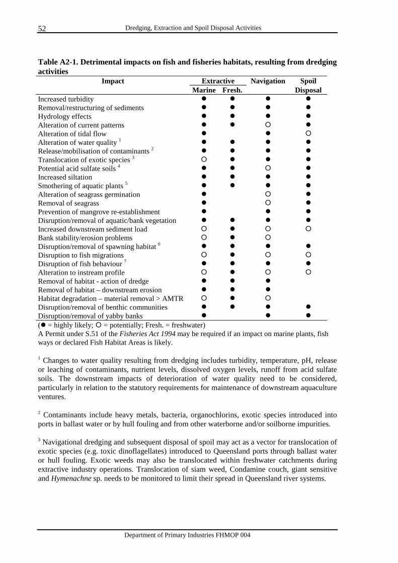
Dredging, Extraction and Spoil Disposal Activities
Department of Primary Industries FHMOP 004
52
Table A2-1. Detrimental impacts on fish and fisheries habitats, resulting from dredging activities
Impact Extractive Navigation Spoil Marine Fresh. Disposal
Increased turbidity � � � � Removal/restructuring of sediments � � � � Hydrology effects � � � � Alteration of current patterns � � � � Alteration of tidal flow � � � Alteration of water quality 1 � � � � Release/mobilisation of contaminants 2 � � � � Translocation of exotic species 3 � � � � Potential acid sulfate soils 4 � � � � Increased siltation � � � � Smothering of aquatic plants 5 � � � � Alteration of seagrass germination � � � Removal of seagrass � � � Prevention of mangrove re-establishment � � � Disruption/removal of aquatic/bank vegetation � � � � Increased downstream sediment load � � � � Bank stability/erosion problems � � � Disruption/removal of spawning habitat 6 � � � � Disruption to fish migrations � � � � Disruption of fish behaviour 7 � � � � Alteration to instream profile � � � � Removal of habitat - action of dredge � � � Removal of habitat – downstream erosion � � � Habitat degradation – material removal > AMTR � � � Disruption/removal of benthic communities � � � � Disruption/removal of yabby banks � � � (� = highly likely; � = potentially; Fresh. = freshwater) A Permit under S.51 of the Fisheries Act 1994 may be required if an impact on marine plants, fish ways or declared Fish Habitat Areas is likely. 1 Changes to water quality resulting from dredging includes turbidity, temperature, pH, release or leaching of contaminants, nutrient levels, dissolved oxygen levels, runoff from acid sulfate soils. The downstream impacts of deterioration of water quality need to be considered, particularly in relation to the statutory requirements for maintenance of downstream aquaculture ventures. 2 Contaminants include heavy metals, bacteria, organochlorins, exotic species introduced into ports in ballast water or by hull fouling and from other waterborne and/or soilborne impurities. 3 Navigational dredging and subsequent disposal of spoil may act as a vector for translocation of exotic species (e.g. toxic dinoflagellates) introduced to Queensland ports through ballast water or hull fouling. Exotic weeds may also be translocated within freshwater catchments during extractive industry operations. Translocation of siam weed, Condamine couch, giant sensitive and Hymenachne sp. needs to be monitored to limit their spread in Queensland river systems.
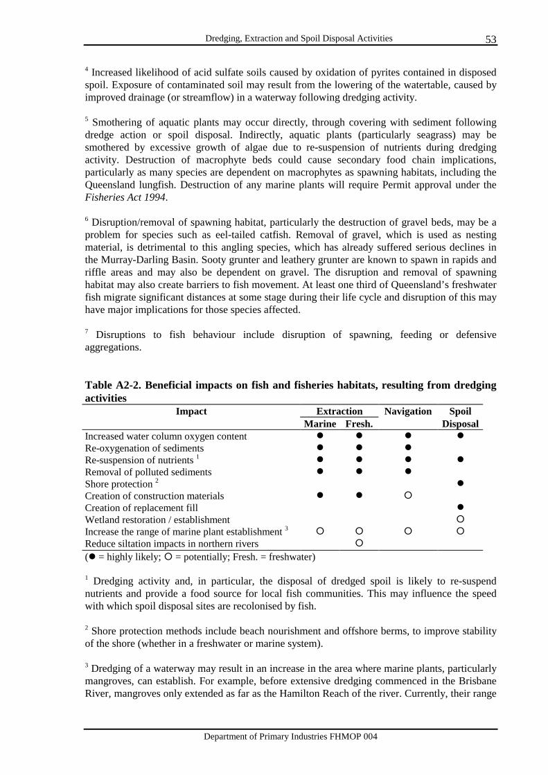
Dredging, Extraction and Spoil Disposal Activities
Department of Primary Industries FHMOP 004
53
4 Increased likelihood of acid sulfate soils caused by oxidation of pyrites contained in disposed spoil. Exposure of contaminated soil may result from the lowering of the watertable, caused by improved drainage (or streamflow) in a waterway following dredging activity. 5 Smothering of aquatic plants may occur directly, through covering with sediment following dredge action or spoil disposal. Indirectly, aquatic plants (particularly seagrass) may be smothered by excessive growth of algae due to re-suspension of nutrients during dredging activity. Destruction of macrophyte beds could cause secondary food chain implications, particularly as many species are dependent on macrophytes as spawning habitats, including the Queensland lungfish. Destruction of any marine plants will require Permit approval under the Fisheries Act 1994. 6 Disruption/removal of spawning habitat, particularly the destruction of gravel beds, may be a problem for species such as eel-tailed catfish. Removal of gravel, which is used as nesting material, is detrimental to this angling species, which has already suffered serious declines in the Murray-Darling Basin. Sooty grunter and leathery grunter are known to spawn in rapids and riffle areas and may also be dependent on gravel. The disruption and removal of spawning habitat may also create barriers to fish movement. At least one third of Queensland’s freshwater fish migrate significant distances at some stage during their life cycle and disruption of this may have major implications for those species affected. 7 Disruptions to fish behaviour include disruption of spawning, feeding or defensive aggregations. Table A2-2. Beneficial impacts on fish and fisheries habitats, resulting from dredging activities
Impact Extraction Navigation Spoil Marine Fresh. Disposal
Increased water column oxygen content � � � � Re-oxygenation of sediments � � � Re-suspension of nutrients 1 � � � � Removal of polluted sediments � � � Shore protection 2 � Creation of construction materials � � � Creation of replacement fill � Wetland restoration / establishment � Increase the range of marine plant establishment 3 � � � � Reduce siltation impacts in northern rivers � (� = highly likely; � = potentially; Fresh. = freshwater) 1 Dredging activity and, in particular, the disposal of dredged spoil is likely to re-suspend nutrients and provide a food source for local fish communities. This may influence the speed with which spoil disposal sites are recolonised by fish. 2 Shore protection methods include beach nourishment and offshore berms, to improve stability of the shore (whether in a freshwater or marine system). 3 Dredging of a waterway may result in an increase in the area where marine plants, particularly mangroves, can establish. For example, before extensive dredging commenced in the Brisbane River, mangroves only extended as far as the Hamilton Reach of the river. Currently, their range

Dredging, Extraction and Spoil Disposal Activities
Department of Primary Industries FHMOP 004
54
extends approximately 70 km further upstream. Disposal of spoil may also create areas suitable for colonisation by marine plants. However, the net effect is the replacement of one habitat type with another. Options to reduce impacts of dredging activities on fisheries habitats Options to consider before works commence 1. Prepare an Environmental Management Plan and/or a statement of environmental impacts for
each new proposal. This should include details on further mitigation of impacts of the dredging activity on fish and fisheries habitats.
2. Provide fish ways to enable fish to move past waterway barriers that might impede migration. 3. Time the works to suit local:
• seagrass flowering periods • fish migrations • fish spawning periods • naturally turbid periods • periods where currents will mitigate turbidity impacts • tidal current variation • prevailing current flow • fishing activities.
4. Undertake measures to reduce turbidity, for example:
• time works to minimise impacts • install silt curtains • exclude areas with a high silt content from dredging activities.
5. Conduct sediment analysis for particle size, sediment constituents, PASS, contaminants and
‘live’ sand depth and develop treatment measures where required. 6. Ensure that the amount of material to be dredged does not exceed that which can be replaced
by natural means (the AMTR). 7. Incorporate buffers between the works and waterway banks, tidal lands or marine plants. 8. Ensure methods are designed to reduce overall impacts on fish and fisheries habitats e.g.:
• use of alternative work methods • facility design • alternative site locations • use of low impact equipment.
Options to consider during/following works
Dredging, Extraction and Spoil Disposal Activities
Department of Primary Industries FHMOP 004
55
1. Ensure the Permit holder is adhering to the details of the Environmental Management Plans. 2. Ensure the sediments to be disposed have been analysed for:
• particle size • PASS • heavy metals • other contaminants • possible translocation of exotic species from ports.
3. Ensure, if necessary, that restoration of the environment is conducted following completion
of works.
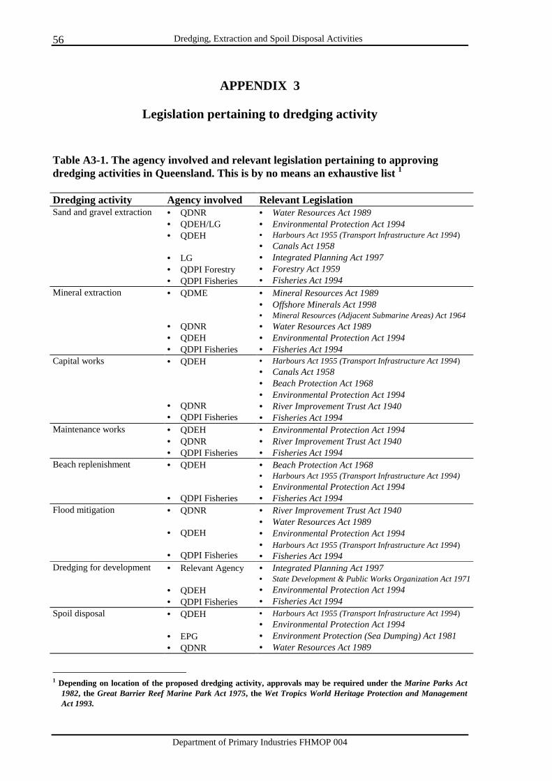
Dredging, Extraction and Spoil Disposal Activities
Department of Primary Industries FHMOP 004
56
APPENDIX 3
Legislation pertaining to dredging activity Table A3-1. The agency involved and relevant legislation pertaining to approving dredging activities in Queensland. This is by no means an exhaustive list 1 Dredging activity Agency involved Relevant Legislation Sand and gravel extraction • QDNR
• QDEH/LG • QDEH • LG • QDPI Forestry • QDPI Fisheries
• Water Resources Act 1989 • Environmental Protection Act 1994 • Harbours Act 1955 (Transport Infrastructure Act 1994) • Canals Act 1958 • Integrated Planning Act 1997 • Forestry Act 1959 • Fisheries Act 1994
Mineral extraction • QDME • QDNR • QDEH • QDPI Fisheries
• Mineral Resources Act 1989 • Offshore Minerals Act 1998 • Mineral Resources (Adjacent Submarine Areas) Act 1964 • Water Resources Act 1989 • Environmental Protection Act 1994 • Fisheries Act 1994
Capital works • QDEH • QDNR • QDPI Fisheries
• Harbours Act 1955 (Transport Infrastructure Act 1994) • Canals Act 1958 • Beach Protection Act 1968 • Environmental Protection Act 1994 • River Improvement Trust Act 1940 • Fisheries Act 1994
Maintenance works • QDEH • QDNR • QDPI Fisheries
• Environmental Protection Act 1994 • River Improvement Trust Act 1940 • Fisheries Act 1994
Beach replenishment • QDEH • QDPI Fisheries
• Beach Protection Act 1968 • Harbours Act 1955 (Transport Infrastructure Act 1994) • Environmental Protection Act 1994 • Fisheries Act 1994
Flood mitigation • QDNR • QDEH • QDPI Fisheries
• River Improvement Trust Act 1940 • Water Resources Act 1989 • Environmental Protection Act 1994 • Harbours Act 1955 (Transport Infrastructure Act 1994) • Fisheries Act 1994
Dredging for development • Relevant Agency • QDEH • QDPI Fisheries
• Integrated Planning Act 1997 • State Development & Public Works Organization Act 1971• Environmental Protection Act 1994 • Fisheries Act 1994
Spoil disposal • QDEH • EPG • QDNR
• Harbours Act 1955 (Transport Infrastructure Act 1994) • Environmental Protection Act 1994 • Environment Protection (Sea Dumping) Act 1981 • Water Resources Act 1989
1 Depending on location of the proposed dredging activity, approvals may be required under the Marine Parks Act
1982, the Great Barrier Reef Marine Park Act 1975, the Wet Tropics World Heritage Protection and Management Act 1993.

Dredging, Extraction and Spoil Disposal Activities
Department of Primary Industries FHMOP 004
57
• QDPI Fisheries • Fisheries Act 1994
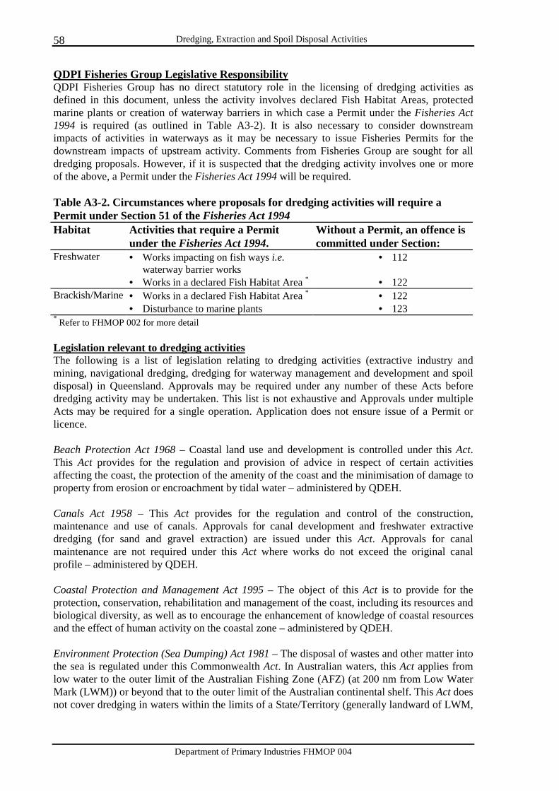
Dredging, Extraction and Spoil Disposal Activities
Department of Primary Industries FHMOP 004
58
QDPI Fisheries Group Legislative Responsibility QDPI Fisheries Group has no direct statutory role in the licensing of dredging activities as defined in this document, unless the activity involves declared Fish Habitat Areas, protected marine plants or creation of waterway barriers in which case a Permit under the Fisheries Act 1994 is required (as outlined in Table A3-2). It is also necessary to consider downstream impacts of activities in waterways as it may be necessary to issue Fisheries Permits for the downstream impacts of upstream activity. Comments from Fisheries Group are sought for all dredging proposals. However, if it is suspected that the dredging activity involves one or more of the above, a Permit under the Fisheries Act 1994 will be required. Table A3-2. Circumstances where proposals for dredging activities will require a Permit under Section 51 of the Fisheries Act 1994 Habitat Activities that require a Permit
under the Fisheries Act 1994. Without a Permit, an offence is committed under Section:
Freshwater • Works impacting on fish ways i.e. waterway barrier works
• 112
• Works in a declared Fish Habitat Area * • 122 Brackish/Marine • Works in a declared Fish Habitat Area * • 122 • Disturbance to marine plants • 123 * Refer to FHMOP 002 for more detail Legislation relevant to dredging activities The following is a list of legislation relating to dredging activities (extractive industry and mining, navigational dredging, dredging for waterway management and development and spoil disposal) in Queensland. Approvals may be required under any number of these Acts before dredging activity may be undertaken. This list is not exhaustive and Approvals under multiple Acts may be required for a single operation. Application does not ensure issue of a Permit or licence. Beach Protection Act 1968 – Coastal land use and development is controlled under this Act. This Act provides for the regulation and provision of advice in respect of certain activities affecting the coast, the protection of the amenity of the coast and the minimisation of damage to property from erosion or encroachment by tidal water – administered by QDEH. Canals Act 1958 – This Act provides for the regulation and control of the construction, maintenance and use of canals. Approvals for canal development and freshwater extractive dredging (for sand and gravel extraction) are issued under this Act. Approvals for canal maintenance are not required under this Act where works do not exceed the original canal profile – administered by QDEH. Coastal Protection and Management Act 1995 – The object of this Act is to provide for the protection, conservation, rehabilitation and management of the coast, including its resources and biological diversity, as well as to encourage the enhancement of knowledge of coastal resources and the effect of human activity on the coastal zone – administered by QDEH. Environment Protection (Sea Dumping) Act 1981 – The disposal of wastes and other matter into the sea is regulated under this Commonwealth Act. In Australian waters, this Act applies from low water to the outer limit of the Australian Fishing Zone (AFZ) (at 200 nm from Low Water Mark (LWM)) or beyond that to the outer limit of the Australian continental shelf. This Act does not cover dredging in waters within the limits of a State/Territory (generally landward of LWM,
Dredging, Extraction and Spoil Disposal Activities
Department of Primary Industries FHMOP 004
59
although in some places State waters extend beyond LWM) or in adjacent coastal waters out to 3 nm except where it may constitute loading for the purpose of disposal – administered by EPG.
A Permit under the Environment Protection (Sea Dumping) Act 1981 is required for: • Disposal of dredged material within Australian waters (all waters between 3nm from
LWM and the edge of the Australian Fishing Zone at 200nm from LWM) • Disposal of dredged material beyond Australian waters from an Australian vessel,
aircraft or platform at sea • Loading material in waters within the limits of a State or the Northern Territory for the
purpose of disposal in Australian waters • Loading material in waters within the limits of a State or the Northern Territory for the
purpose of disposal beyond Australian waters from an Australian vessel, aircraft or platform at sea
• Loading material in Australian waters for the purpose of disposal in Australian waters • Loading material in Australian waters for the purpose of disposal beyond Australian
waters from an Australian vessel, aircraft or platform at sea. Refer to ANZECC (1997) for further detail. Environmental Protection Act 1994 (Sections 38, 41) – This Act establishes a direction for the environmental management of Queensland’s resources, consistent with ecologically sustainable development. The object of this Act is to protect Queensland’s environment while allowing for development that improves the total quality of life, both now and in the future, in a way that maintains the ecological processes on which life depends. Under this Act, an Environmental Authority is required to undertake environmentally relevant activities (ERA), such as dredging material from the bed of any waters (other than dredging by a port authority of material for which a royalty or similar charge is not payable). ERAs relevant to this document are listed in Schedule 1 (Sections 18-21, 38) of the Environmental Protection Regulations 1998 – administered by QDEH and LG. Fisheries Act 1994 (Sections 51, 112, 122-125) – This Act covers the management, use, development and protection/conservation of fisheries resources and fish habitats in Queensland. This Act has no direct control over dredging or extractive industry (other than extraction of coral limestone, for which permits are issued under this Act). However, Section 51 approval is required from QDPI Fisheries under this Act prior to: construction of waterway barrier works (including temporary bunds) (Section 112); works in a declared Fish Habitat Area (Section 122); or works which will damage protected marine plants (Section 123). This Act also provides for the rehabilitation and restoration of land following dredging activity (Section 124, 125) – administered by QDPI Fisheries. Forestry Act 1959 – Under this Act “Sales Permits” and “Quarry Licences” are issued to remove material from State forests or Crown/State land. This Act is to provide for forest reservations, the management, silvicultural treatment and protection of State forests, and the sale and disposal of forest products and quarry material, the property of the Crown on State forests, timber reserves and on other lands – administered by QDPI Forestry. Great Barrier Reef Marine Park Act 1975 – This Commonwealth Act applies when dredging activity is proposed within the Great Barrier Reef Marine Park (GBRMP). Section 38 of this Act prohibits drilling and mining in the GBRMP. Under the Offshore Constitutional Settlement, the GBRMP is primarily a Marine Park and all activities undertaken within it must comply with this Act – administered by GBRMPA and QDEH.
Dredging, Extraction and Spoil Disposal Activities
Department of Primary Industries FHMOP 004
60
Harbours Act 1955 (Sections 67, 86, 91-93) – This Act has been repealed, however, Sections of this Act have been preserved by Section 236 of the Transport Infrastructure Act 1994. Works relating to the protection of foreshores, management of land below high-water mark, construction below the high water mark and reclamation are controlled under this Act. Section 67 approvals are required for removal of material from tidal lands (e.g. commercial extraction of sand and gravel in tidal waters). Section 86 approvals are required for works below High Water Mark – administered by QDEH. Integrated Planning Act 1997 – This Act provides a framework to integrate planning and development assessment so that development and its effects are managed in a way that is ecologically sustainable. Approvals will be issued under this Act to conduct operational work for the removal of rock, stone, gravel, sand, clay, soil or similar material other than by or on behalf of a public sector entity. This Act also defines the process to be followed in assessing any development application involving the taking of quarry materials or material change in land use developments – administered by the relevant agency for individual applications.
This Act was assented to on 1 December 1997 and commenced on 30 March 1998. Transitional provisions have been set out to help the transition between legislation such as the Local Government (Planning and Environment) Act 1990 and how details will be incorporated into the Integrated Planning Act 1997. Assessable, self-assessable and exempt developments are outlined in Schedule 8 of the Act. Assessable developments related to this document include: • removing rock, stone, gravel, sand, clay, soil or similar material from foreshores and
Queensland waters other than by or on behalf of a public sector entity • works within foreshores and Queensland waters other than by or on behalf of a public
sector entity (including reclamation of land) • works that interfere with sand, stone, gravels, rock, clay or other earth in a control
district under the Coastal Protection Management Act 1995 • constructing a canal within the meaning of the Canals Act 1958 • works involving Material Change in Land Use.
Local Government (Planning and Environment) Act 1990 – This Act was repealed following the commencement of the Integrated Planning Act 1997, however, certain provisions have been carried over through specific provisions in the Integrated Planning Act 1997 – administered by LG. Marine Parks Act 1982 – Works within gazetted marine parks are authorised under this Act. This Act is to provide for the setting apart of tidal lands and tidal waters as marine parks. Regulations are made under this Act regarding the taking (including dredging) of material from a designated Marine Park – administered by QDEH. Mineral Resources Act 1989 – This Act is to provide for the assessment, development and utilisation of mineral resources to the maximum extent practicable, consistent with sound economic and land use management. A Permit under this Act is required when extracting minerals from a watercourse. After approval under this Act has been obtained, works must be conducted in accordance with the Code of Practice for Environmental Management for Activities under Exploration Permits and Mineral Development Licences. Environmental documentation covering all aspects of the mining operation, including rehabilitation is required under this Act – administered by QDME.
Dredging, Extraction and Spoil Disposal Activities
Department of Primary Industries FHMOP 004
61
Native Title Act 1993 – This Act recognises native title rights based on the traditions of the indigenous people of Australia. It affords the holders of native title the same procedural rights as the holders of ordinary title. The department responsible for issuing the permit for dredging activities is responsible for considering the impact of the proposed work on native title – administered by relevant agency for individual applications. Nature Conservation Act 1992 – This Act is to provide for the conservation of nature. Approval under this Act is required for works proposed within protected areas i.e. national parks, conservation parks, resources reserves, nature refuges, coordinated conservation areas, or wilderness areas, World Heritage management areas and international agreement areas that in the future may be declared under the Act – administered by QDEH. Offshore Minerals Act 1998 – This Act relates to exploration for, and the recovery of, minerals (other than petroleum) in the first 3 nautical miles of the territorial sea in relation to Queensland – administered by QDME. River Improvement Trust Act 1940 – This Act provides for the protection and improvement of the bed and banks of rivers, the repair and prevention of damage to the bed and banks of rivers, the prevention of flooding and the prevention or mitigation of inundation of certain land by flood water from rivers – administered by QDNR. State Development and Public Works Organization Act 1971 – This Act provides for State planning and development through a coordinated system of public works organisation, for environmental coordination and for related purposes. Under this Act, the Coordinator-General may take material from any watercourse for works undertaken by the Coordinator-General – administered by various Government agencies, outlined in the Impact Assessment in Queensland, Policies and Administrative Arrangements document. Transport Infrastructure Act 1994 (Sections 98, 163, 177, 228-239) – The objective of this Act is to provide a regime that allows for and encourages effective integrated planning and efficient management of a system of transport infrastructure. Sections 67, 86 and 91-93 of the Harbours Act 1955 have been preserved by Section 236 of this Act – administered by QDoT and QDEH. Water Resources Act 1989 (Sections 28, 38, 58-64) – “Quarry Material Permits” are issued under this Act. Permits are issued under this Act for the construction or use of works in a watercourse, particularly extraction of sand and gravel in non-tidal waters such as the removal of quarry material from a watercourse and barrage construction. This Act provides for the State to undertake public works (e.g. dams and weirs), for the licensing of private extraction and permitting of disturbances to the bed and banks of watercourses. This Act controls the management of rivers and streams, and the maintenance of the physical integrity of the watercourse. The Water Resources (Watercourse Protection) Regulation 1993 refers to the destruction of vegetation in a watercourse, excavation in a watercourse and the placing of fill in a watercourse – administered by QDNR. Wet Tropics World Heritage Protection and Management Act 1993 – This Act provides for the protection and management of the Wet Tropics of Queensland World Heritage Areas and applies when dredging applications involve a World Heritage Area – administered by the Wet Tropics Management Authority.

Dredging, Extraction and Spoil Disposal Activities
Department of Primary Industries FHMOP 004
62
APPENDIX 4
Case studies of dredging activities, rehabilitation operations and spoil disposal sites, and their impacts on fisheries habitats.
Dynah Island, Moreton Bay - Queensland Cabbage Tree Creek, north-east of Brisbane, was initially dredged in 1960 to maintain adequate depths for vessel passage in the navigation channel and has since been dredged in 1983, 1987 and 1992. On each occasion, the dredged spoil was pumped onto a non-vegetated, tidal, bunded area above Mean Sea Level on the southern side of the creek, extending Dynah Island (Zeller 1995; Beumer et al. 1996). Since 1992, the site has been regularly monitored, particularly since the declaration of the Boondall Wetlands Reserve by the Brisbane City Council. The placement of spoil at this site has created a sheltered tidal area, well suited for mangrove colonisation. The monitoring of this area prior to and following spoil placement has created a valuable database, documenting both the effect of dredged spoil disposal as a means for creation of enhanced fish habitat, and the changes in this habitat through time. The island has been identified as a habitat for migratory birds. While the mangroves require pruning to ensure more beneficial habitat for wading and migratory birds, the development of Dynah Island has been highly successful. It is likely, however, that spoil from further dredging of Cabbage Tree Creek will not be placed at Dynah Island due to the modification of the tide profile and the possible stranding, above the intertidal zone, of tidal lands and marine plants. Outcomes: • Creation of a new intertidal area as a habitat for mangrove colonisation and migratory
wading bird habitat. • The provision of an important database documenting the progression of such a created
habitat through time. Potential problems: Future disposal of spoil in the area is unlikely, due to the successful colonisation of the site by marine plants and wading birds and the likelihood of stranding currently tidal lands above the high tide mark following further modification of the island. As a result, a new spoil disposal site for further dredging of Cabbage Tree Creek is required. Wallum Creek, North Stradbroke Island - Queensland. In 1978, a bund wall was constructed in Wallum Creek, near Amity Point on North Stradbroke Island. The water in the bunded area was required for mineral sand-mining activities taking place above the existing watertable (Quinn and Beumer 1984). The intertidal area of approximately 20 ha, was flooded and remained submerged for a period of approximately six months. In this time, the mature mangrove community drowned due to lack of oxygen reaching the pneumatophores. The bund was removed in 1979 due to the effect it was having on the mangroves, and rehabilitation of the site began. Mangrove seedlings were transplanted to the site to enhance the re-growth. However, natural recolonisation, predominantly from seeds of the downstream fringing and foreshore mangroves, was greater than that from transplanted seedlings. The growth and spread of mangroves at the site and in nearby unaffected areas have been monitored.
Dredging, Extraction and Spoil Disposal Activities
Department of Primary Industries FHMOP 004
63
This study has demonstrated the impact that longterm flooding can have on a mangrove community. This community originally consisted of a diverse range of mangroves, however, pioneer species such as Avicennia marina have dominated the site. Other species are recolonising but at a much slower rate. It is likely that the community will take a minimum of 20 years to reach previous height and species composition. The speed of the current recovery is likely to have been enhanced by a ready seed source and undisturbed substratum available for the settlement and survival of mangrove propagules. Outcomes: • Impacts of longterm flooding of an area of mangroves have been clearly shown. • In this case, natural recolonisation of mangroves appears to be greater than that resulting
from transplantation of seedlings. • Monitoring of the site over time can give an insight into the time required for recolonisation
and rehabilitation of a large intertidal area after such a major impact. Russell Mulgrave River system - Queensland The Russell Mulgrave catchment covers an area of 1372 km2 south of Cairns. A number of sand and gravel extraction operations are active within the catchment. The largest single operator has recently been licensed to remove 50,000 m3 of material per year. While the majority of extraction operations in the catchment use backhoes, large operations use suction dredges and pump the extracted material to a de-watering plant. Despite extractive industry operating in the Russell Mulgrave catchment for over 10 years, no major monitoring or restoration programs are in progress. The catchment is highly modified. Most of the floodplain and riparian vegetation in the middle and lower reaches of the rivers and associated floodplains has been cleared and sugar cane is farmed on a substantial area of the catchment. Following vegetation clearing, the rivers have become wider and shallower, with a greater proportion of sand in the bed material. The increase in sand and gravel in the system stems predominantly from farm and forest runoff and floodplain alluvium that has washed into rivers. Extensive bank erosion has also occurred. The natural floodplain drainage regimes have been modified, resulting in problems with local area flooding. It has been proposed that continuation of instream sand and gravel extraction and the opening of new areas of the catchment to extraction may improve river conditions by reducing the silt load and increasing the depth of the river. Tight controls on dredging and extraction activity for commercial purposes may enable extraction works to be used to improve waterways. However, sand and gravel extraction is likely to impact heavily on fish and fisheries habitat as well as impacting on the physical properties of the catchment. A catchment wide response to this proposal for further extraction is required due to the ecological links between the different habitats within the catchment and the conservation value of the catchment (60% of the catchment is conserved under the Wet Tropics World Heritage Area). The riparian zones and river corridors are areas where rehabilitation and habitat enhancement are required. Outcomes: • Degradation of riparian zones and floodplains has resulted in the alteration of the natural
waterway. • Increased local flooding and bank instream erosion has resulted from works (offstream and
instream) within the Russell Mulgrave catchment. Potential problems:

Dredging, Extraction and Spoil Disposal Activities
Department of Primary Industries FHMOP 004
64
In addition to the bed and bank problems, uncontrolled sand and gravel extraction can cause destruction of riverine habitat, lowering of water tables and undermining of bridges. Channel deepening and bend straightening leads to erosion and bank stability problems upstream and downstream of the works. Continuation and expansion of extractive operations in the Russell Mulgrave are likely to be detrimental for the catchment. Newport waterways canal estate, Scarborough - Queensland A study of the effects of maintenance dredging on seagrass and associated postlarval and juvenile prawn densities was conducted in the access channel of the Newport waterways canal estate at Scarborough, Moreton Bay (Masel and Smallwood in prep.). Two intertidal sites with seagrass cover were examined, one was located within 200 m of the dredged channel, the impact site. The other site acted as a control. The impacts of dredging on the seagrasses at the site and on the three commercial penaeid prawns in the area (the greasyback prawn (Metapenaeus bennettae), the eastern king prawn (Penaeus plebejus) and the brown tiger prawn (Penaeus esculentus)) were monitored. Immediately following dredging activity, no commercial penaeids were identified at the impact site. M. bennettae was the first penaeid to return to the impact site. P. plebejus was slow to return to the impact site, but was identified at the site within six months of completion of dredging. In the 16 months of monitoring following dredging, P. esculentus did not return to the impact site and no seagrass was recorded at the impact site. It is likely that the habitat preferences of these three penaeid species strongly influenced their recovery time. In previous studies, M. bennettae have been recorded in both vegetated and unvegetated substrata and appear to be tolerant of a range of salinities and temperatures (Dall 1981), which may explain the quick return of this species to the impact site. As P. plebejus is often recorded in unvegetated substrata, a rapid return to the impact site was expected, despite the lack of seagrass. The slow return of this species to the study site may have been linked to increased levels of silt in the water or another environmental factors. P. esculentus did not return to the impact site, which is most likely due to the loss of seagrass following dredging. It is probable that P. esculentus would not return to the site until after seagrass had recolonised. From the examination of the impact of dredging activity on these penaeid species, the influence of seagrass on their distribution is apparent. Dredging has been found to alter sediment composition from sand to mud (Jones 1981) and it is possible that the loss of seagrass resulted from increased silt load, which may have either directly buried the seagrass or reduced the light intensity to levels below the seagrass survival threshold. Outcomes: • Dredging has a direct impact on seagrass habitats, and appears in turn to impact on the
associated fauna. The connectivity of the habitat is apparent from this study. • Dredging should be timed to cause minimal impact on the feeding and migration of fisheries
resources. Botany Bay - New South Wales The development of the third runway of Sydney airport required reclamation of land from Botany Bay. This involved large scale dredging (15 million cubic meters) and the loss of 30 ha of seagrasses and 4 km of sand beaches (Burchmore 1993). This development has caused large-scale changes in Botany Bay. Anecdotal evidence suggests that following these works, recreational beaches are disappearing, fish stocks are falling, oysters are dying and seagrasses
Dredging, Extraction and Spoil Disposal Activities
Department of Primary Industries FHMOP 004
65
are vanishing (Woodford 1995). The disappearance of oysters is of particular concern as these filter feeders may act as environmental indicators of pollution and a general decline in the condition of the environment. In the development of the runway, habitat of the little tern (Sterna albifrons) and migratory wading birds was lost. The Federal Airport Corporation was required to investigate the possible construction of a compensatory bird habitat within Botany Bay (Smith et al. 1997). An EIS was prepared to investigate the relocation of the little tern nesting sites to Towra Spit Island and subsequent stabilisation of the island. The EIS suggested the relocation of 33,000 cubic meters of sand and the construction of four groynes to stabilise Towra Spit Island and create an intertidal area. However, amongst other problems, further dredging will increase the chance of exposure of acid sulfate soils and mobilisation of contaminants in the sediments. NSW Fisheries has not permitted these works to proceed due to further possible destruction of Posidonia seagrass beds. Another problem for NSW Fisheries is that the proposed site is within the Towra Point Aquatic Reserve and as such, the destruction of seagrass within a Reserve opposes NSW Fisheries policy. Outcomes: • A single island remains within Botany Bay, providing intertidal marine plant and wading bird
habitat. • A decision between taking further detrimental action to create a potentially stable area for the
future or to leave the area without further disturbance and monitor its progress is required. Potential problems: It is unclear how long the island will remain without modification, due to currents and tidal patterns within the bay impacting on the island. The only alternative appears to involve further alteration of habitat and the destruction of further large areas of seagrasses. The loss of large areas of Posidonia is significant as this species of seagrass has very poor regenerative capabilities. As such, recolonisation of an area by Posidonia after seagrass removal is unlikely. Sheep Island, Jonesport - United States Over many years of dredging activities, hundreds of sites in the United States have been created from dredged material. The US Army Corps of Engineers has built in excess of 130 wetlands and 2000 islands that have become important habitats for wildlife and fish (Landin 1987). To examine the ecological benefits and the impacts of the creation of intertidal areas and wetlands from dredge spoil, the US Army Engineer division has constructed an intertidal mudflat at Sheep Island near Jonesport, Maine just south of the United States - Canada border (Ray et al. 1994). There are a number of islands in the vicinity, most of which have developed tidal flats in the lee of the islands. The main aim of this project was to determine whether harvestable levels of commercial species such as softshell clams and baitworms would develop in a constructed mudflat, while still supporting a natural infaunal community. After creation of the mudflat in 1988, the site was monitored yearly in 1990, 1991 and 1992. Sediment sizes and infaunal and benthic communities were observed. After the 1992 monitoring, the sediments in the constructed mudflats had a higher organic load than that in the sediments of the reference sites. The population of sandworms and softshell clams at the constructed site (on Sheep Island) was greater than at the reference sites on other islands and in other areas of Sheep Island. This may be due to the softer sediment in the constructed site and the impact of harvesting of sandworms and softshell clams at the reference sites. Little harvesting was seen at the study site, probably as the area is only accessible by boat. Differences in numbers and species of infauna
Dredging, Extraction and Spoil Disposal Activities
Department of Primary Industries FHMOP 004
66
between the study site and the reference site were identified. This difference may be related to sediment type and some bias incurred from the single sampling event per year. Outcomes: • It appears that the habitat created by the disposal of dredged spoil is similar to that of a
natural mudflat - with the abundance and diversity of species from the created site, reflecting that of the natural site.
• Construction of intertidal areas may be a more successful option for spoil disposal than some other methods, although the impacts and success rates are likely to be site specific.
Potential problems: As with all cases of exposure of submerged sediments in an intertidal situation, the possible release of acid sulfate soils and contaminants is a risk. As with all proposals for spoil disposal, the location and method of disposal will be site and season specific.

Dredging, Extraction and Spoil Disposal Activities
Department of Primary Industries FHMOP 004
67
APPENDIX 5
Types of dredges in operation in Queensland There are two main types of dredges operating in Queensland, grab bucket dredges and suction dredges. Navigational dredging is predominantly conducted using suction dredges, while much of Queensland’s extractive industry dredging is conducted using grab dredges. Grab Bucket Dredges A clam shell type grab bucket is lowered from a floating dredge to the sediment and closes on contact with the substratum. Bed material is brought up and loaded into a hopper. The water from this material drains through various screens and filters into a well, from which water is pumped overboard at regular intervals. This dredging method enables the extraction of a wide range of materials, including rocks and snags and is not restricted to the removal of fine, lightweight material, such as fine and coarse sands and muds. Regular grab dredges are generally restricted to working in shallow areas. If the grab is mounted on a dragline however, the dredge can work in a variety of water depths. When mounted on a pontoon, a grab dredge works well in narrow areas (Rokosch 1993). Grab dredges working within Moreton Bay can generally remove a maximum of 700 tonnes in a full barge load (WBM 1997). As with all methods of dredging, turbidity results from the action of the dredge. Turbidity from grab bucket dredges is caused in various stages of the process, such as: when the dredge strikes the sediment; when the closed grab is pulled out of the sediment; leakage from the bucket while it is being raised both through and above the water column; washing of the sediment adhered to the grab from previous hauls; and from excess water from either the storage bins or bilge pumps (WBM 1997). To reduce the level of sedimentation caused by the action of grab dredges, it is possible to use water tight buckets. This has been shown to reduce the turbidity between 30 and 70% (Herbich 1992). Suction Dredges Suction dredges act like underwater vacuum cleaners, drawing bed material into the dredge. Mechanical loosening of the substratum using a cutterhead at the suction mouth (a cutter suction dredge) may enhance the action of the suction dredge. This technique has been used in the extraction of coarse sand from certain sections of the Brisbane River. The action of trailer suction dredges, one of the main dredging units used in Moreton Bay, involves the lowering of a suction arm into the substratum from which a slurry of sediment and water are drawn up and pumped into a hopper. When the hopper is first filled, approximately 20% of the capacity is made up of solids while the remainder is water (containing some suspended solids). The hopper continues to be loaded with slurry to increase the sediment load, while the excess water flows overboard. The overflow water contains suspended solids and leaves a turbidity plume in the wake of the dredge. The extent of this turbidity plume varies depending on the nature of the material being dredged and the local currents. As this type of dredge can function while stationary and also whilst moving at a constant slow pace, the speed with which the dredge is moving affects the size of the turbidity plume. Suction dredging is best suited to the removal of silt and sand from navigation channels. While these dredges are capable of pumping sand, silts and muds ashore from the dredge, sandy clays or clays cannot be pumped from the dredge to the shore and have to be disposed in a material
Dredging, Extraction and Spoil Disposal Activities
Department of Primary Industries FHMOP 004
68
placement area. Movement of larger materials such as rock and debris is not possible with a suction dredge. Suction dredging slurries the sediments in the water, whilst the sediment remains close to its original cohesive state during grab dredging (ANZECC 1997). As such, suction dredges cause greater turbidity effects than grab dredges. Mitigation may be required to reduce the turbidity plumes caused by suction dredging. Pumping hopper overflow waters to ensure material returns closer to the sediment surface will reduce turbidity. In cases where hopper overflow is contained, suction dredging with a hydraulic pipeline becomes a controllable and closed system. As a closed system, it is safer than mechanical dredging methods (e.g. grab dredges) when dealing with contaminated sediments (Rokosch 1993). Initial increases in turbidity, directly following dredging, show limited spatial and temporal extents. Turbidity levels drop to background levels, with the direction and distance of movement of dredging turbidity plumes being dependent on the time of dredging in relation to the tidal cycle and the range of the tide. Turbidity effects predominantly result from: overflow of fine sediment from the hopper; sediment disturbance from the trailing of the suction mouth over the sediment (particularly if there is a cutterhead on the suction mouth); and blockage in the pipeline causing the pumping process to be interrupted, allowing material to escape from the suction mouth (WBM 1997). Details of various suction dredges Suction Hopper Dredges This is the basic suction dredge. It is a stationary dredge, predominantly used to mine sand and silt. The dredged material is generally well mixed. The suction action may be assisted by water jets or teeth, as for the cutter suction dredge. The extracted material is loaded into barges or pumped via pipeline directly to the reclamation area or material placement area. Cutter Suction Dredges This method of dredging uses suction action assisted by a cutter head for mechanical loosening at the suction mouth. While dredging, the cutter head describes arcs in the sediment loosening the material to aid removal. These dredges take the substratum profile down to the required depth at one location before moving onto the next. Dredged material is pumped ashore or pumped into barges via a pipeline. Cutter suction dredges are often used for land reclamation and trench digging particularly where spoil is used for backfilling. The cutterhead can be replaced by several kinds of suction heads for special purposes. For the extraction of mineral sands, the suction dredge acts as a floating pump on a created pond. The dredge advances along the ore body, excavating sand from ahead and the tailing stacker replaces the excavated sand behind the mining plant. As such, the pond advances along the ore-body with the dredge. Trailer Suction Hopper Dredges These dredges are self propelled and conduct dredging while following a pre-set track. The dredge removes a layer of material as it steams along a channel, turns at the end of the dredging area and returns in the opposite direction removing another layer. This operation is repeated until the required depth along the length of the channel is achieved. The action of the dredge is assisted by underwater levellers or scrapers which move material from areas close to sea ways and quays and between moorings, to an area where the suction dredge can function efficiently. The hopper may be emptied by opening bottom doors or valves or by pumping its load ashore. Small trailer dredges have poor capabilities to remove moderately compacted material such as stiff clays. It is possible that hard material may be broken up with the cutterhead of a cutter
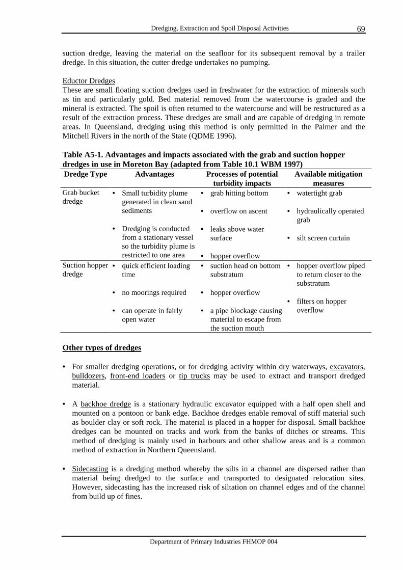
Dredging, Extraction and Spoil Disposal Activities
Department of Primary Industries FHMOP 004
69
suction dredge, leaving the material on the seafloor for its subsequent removal by a trailer dredge. In this situation, the cutter dredge undertakes no pumping. Eductor Dredges These are small floating suction dredges used in freshwater for the extraction of minerals such as tin and particularly gold. Bed material removed from the watercourse is graded and the mineral is extracted. The spoil is often returned to the watercourse and will be restructured as a result of the extraction process. These dredges are small and are capable of dredging in remote areas. In Queensland, dredging using this method is only permitted in the Palmer and the Mitchell Rivers in the north of the State (QDME 1996). Table A5-1. Advantages and impacts associated with the grab and suction hopper dredges in use in Moreton Bay (adapted from Table 10.1 WBM 1997) Dredge Type Advantages Processes of potential
turbidity impacts Available mitigation
measures Grab bucket dredge
• Small turbidity plume generated in clean sand sediments
• Dredging is conducted
from a stationary vessel so the turbidity plume is restricted to one area
• grab hitting bottom • overflow on ascent • leaks above water
surface • hopper overflow
• watertight grab • hydraulically operated
grab • silt screen curtain
Suction hopper dredge
• quick efficient loading time
• no moorings required • can operate in fairly
open water
• suction head on bottom substratum
• hopper overflow • a pipe blockage causing
material to escape from the suction mouth
• hopper overflow piped to return closer to the substratum
• filters on hopper
overflow
Other types of dredges • For smaller dredging operations, or for dredging activity within dry waterways, excavators,
bulldozers, front-end loaders or tip trucks may be used to extract and transport dredged material.
• A backhoe dredge is a stationary hydraulic excavator equipped with a half open shell and
mounted on a pontoon or bank edge. Backhoe dredges enable removal of stiff material such as boulder clay or soft rock. The material is placed in a hopper for disposal. Small backhoe dredges can be mounted on tracks and work from the banks of ditches or streams. This method of dredging is mainly used in harbours and other shallow areas and is a common method of extraction in Northern Queensland.
• Sidecasting is a dredging method whereby the silts in a channel are dispersed rather than
material being dredged to the surface and transported to designated relocation sites. However, sidecasting has the increased risk of siltation on channel edges and of the channel from build up of fines.
Dredging, Extraction and Spoil Disposal Activities
Department of Primary Industries FHMOP 004
70
• Agitation dredging (dredge overflow) is another method of dispersing silt rather than transporting dredged material by other means. The use of ebb tidal flow is important in the further removal of suspended fines. A form of this method of dredge material relocation has been undertaken in the Port of Weipa where in situ dispersal of 35 - 40% of silty material from dredge overflow from the South Channel has occurred. This appears to have led to a decrease in water clarity.
• Draglines deployed from the shore of a waterway may be used to extract sand, gravel and
other alluvial material from rivers.

Dredging, Extraction and Spoil Disposal Activities
Department of Primary Industries FHMOP 004
71
APPENDIX 6
Spawning and migration periods for a selection of Queensland’s fisheries species
This Appendix includes a summary of migration and/or spawning times of a selection of commercially and recreationally important Queensland species. This information is included as a general guide to increase awareness of the importance of certain times and locations for selected fisheries species. It is important to consider fish migrations in relation to dredging operations and how such operations will impact on local fisheries. Figures A6-1 and A6-2 summarise the pattern of spawning activity based on Tables A6-1 to A6-3 according to generalised spawning and migration times. From the figures, it can be seen that the autumn and winter months may be well suited to dredging activity, purely considering spawning and migration times of a selection of marine and freshwater species. Tables A6-1 and A6-2 summarise the spawning times for a selection of Queensland’s marine species. Table A6-3 summarises the spawning and migration times for a selection of Queensland’s freshwater species. These tables are aimed as a guide to the generalised times of movement for a number of species throughout Queensland. To identify the local and regional importance of different fisheries species, a QDPI Fisheries officer should be contacted (a list of Fisheries Group contacts is included in Appendix 9). It is understood that the period in which dredging is undertaken is not always flexible, particularly due to the availability of dredges for navigational dredging in Queensland’s ports. It is important, however, to consider the impact of dredging activities on fisheries resources.
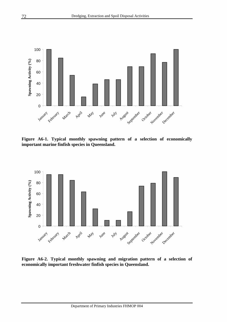
Dredging, Extraction and Spoil Disposal Activities
Department of Primary Industries FHMOP 004
72
0
20
40
60
80
100
Janua
ry
Februa
ryMarc
h Apri
lMay Jun
eJul
y
August
Septem
ber
Octobe
r
Novem
ber
Decembe
r
Spaw
ning
Act
ivity
(%)
Figure A6-1. Typical monthly spawning pattern of a selection of economically important marine finfish species in Queensland.
0
20
40
60
80
100
Janua
ry
Februa
ryMarc
h Apri
lMay Jun
eJul
y
August
Septem
ber
Octobe
r
Novem
ber
Decembe
r
Spaw
ning
Act
ivity
(%)
Figure A6-2. Typical monthly spawning and migration pattern of a selection of economically important freshwater finfish species in Queensland.
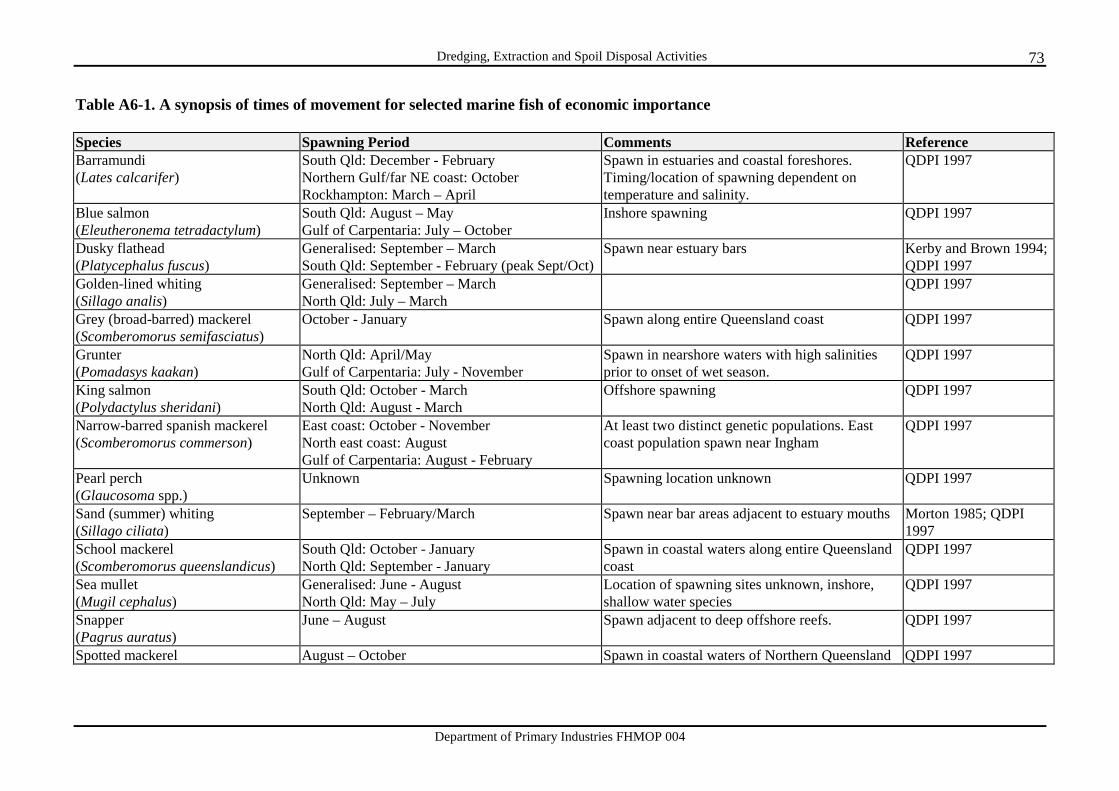
Dredging, Extraction and Spoil Disposal Activities
Department of Primary Industries FHMOP 004
73
Table A6-1. A synopsis of times of movement for selected marine fish of economic importance Species Spawning Period Comments Reference Barramundi (Lates calcarifer)
South Qld: December - February Northern Gulf/far NE coast: October Rockhampton: March – April
Spawn in estuaries and coastal foreshores. Timing/location of spawning dependent on temperature and salinity.
QDPI 1997
Blue salmon (Eleutheronema tetradactylum)
South Qld: August – May Gulf of Carpentaria: July – October
Inshore spawning QDPI 1997
Dusky flathead (Platycephalus fuscus)
Generalised: September – March South Qld: September - February (peak Sept/Oct)
Spawn near estuary bars Kerby and Brown 1994; QDPI 1997
Golden-lined whiting (Sillago analis)
Generalised: September – March North Qld: July – March
QDPI 1997
Grey (broad-barred) mackerel (Scomberomorus semifasciatus)
October - January Spawn along entire Queensland coast QDPI 1997
Grunter (Pomadasys kaakan)
North Qld: April/May Gulf of Carpentaria: July - November
Spawn in nearshore waters with high salinities prior to onset of wet season.
QDPI 1997
King salmon (Polydactylus sheridani)
South Qld: October - March North Qld: August - March
Offshore spawning QDPI 1997
Narrow-barred spanish mackerel (Scomberomorus commerson)
East coast: October - November North east coast: August Gulf of Carpentaria: August - February
At least two distinct genetic populations. East coast population spawn near Ingham
QDPI 1997
Pearl perch (Glaucosoma spp.)
Unknown Spawning location unknown QDPI 1997
Sand (summer) whiting (Sillago ciliata)
September – February/March Spawn near bar areas adjacent to estuary mouths Morton 1985; QDPI 1997
School mackerel (Scomberomorus queenslandicus)
South Qld: October - January North Qld: September - January
Spawn in coastal waters along entire Queensland coast
QDPI 1997
Sea mullet (Mugil cephalus)
Generalised: June - August North Qld: May – July
Location of spawning sites unknown, inshore, shallow water species
QDPI 1997
Snapper (Pagrus auratus)
June – August Spawn adjacent to deep offshore reefs. QDPI 1997
Spotted mackerel August – October Spawn in coastal waters of Northern Queensland QDPI 1997

Dredging, Extraction and Spoil Disposal Activities
Department of Primary Industries FHMOP 004
74
(Scomberomorus munroi) Stout whiting (Sillago robusta)
December – February QDPI 1997
Swallow tail dart (Trachinotus botla)
Generalised: December - February North Qld: November - March
Spawn in semi-surf zones and ocean beaches QDPI 1997
Tailor (Pomatomus saltatrix)
Late winter – spring North Fraser Is.: major spawning site in August - October. Spawning concentrated near headlands
QDPI 1997
Trumpeter (winter) whiting (Sillago maculata)
July - February/March; peak in September - October Moreton Bay: July-February (peak in winter)
Spawn in estuaries QDPI 1997
Yellow finned bream (Acanthopagrus australis)
Generalised: May - August North Qld: May – September
Spawns in estuaries and coastal inshore waters and bars
Kerby & Brown 1994; Pollock 1982
Table A6-2. A synopsis of times of movement for selected economically important penaeid prawns Species Spawning Period Comments Reference Banana prawn (Penaeus merguiensis)
Late autumn – early spring QDPI 1997
Brown tiger prawn (Penaeus esculentus)
Summer Prefer seagrass habitats QDPI 1997
Eastern king prawn (Penaeus plebejus)
Spawn over extended time frames; peak in May – June
Southern Qld distribution. Spawning in water depths >100m
QDPI 1997
Endeavour prawn (Penaeus endeavouri; P. ensis)
Continuous spawning; peak in summer. QDPI 1997
Grooved tiger prawn (Penaeus semisulcatus)
Early summer and autumn Prefer seagrass habitats QDPI 1997
Red spot and Blue-legged king prawns (Penaeus longistylis; P. latisulcatus)
Predominantly winter-spring Northern Qld distribution QDPI 1997
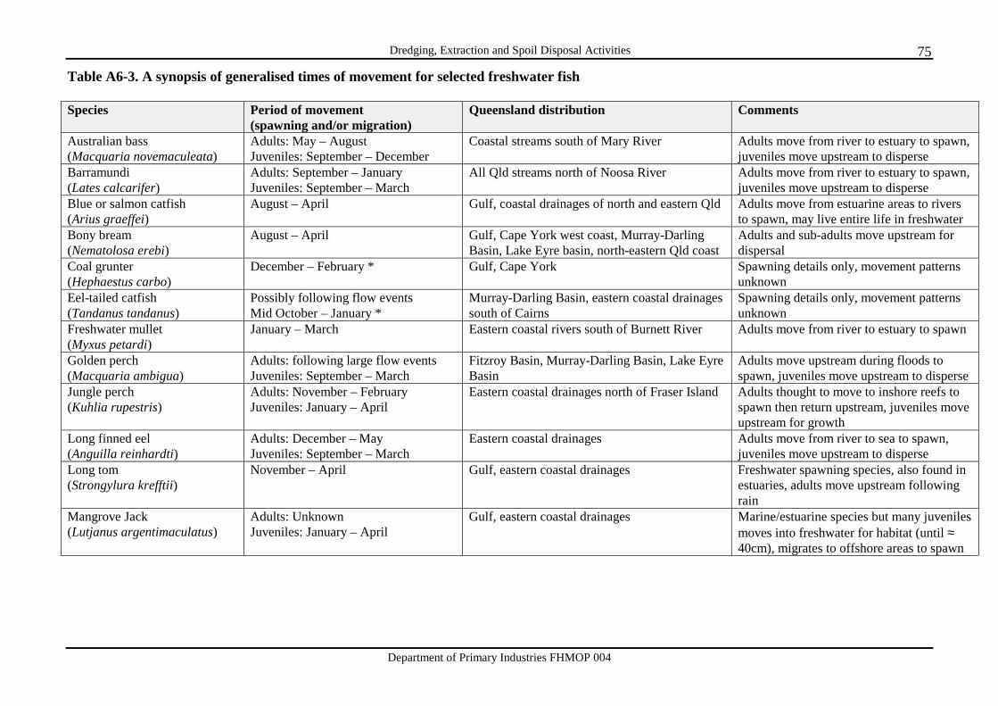
Dredging, Extraction and Spoil Disposal Activities
Department of Primary Industries FHMOP 004
75
Table A6-3. A synopsis of generalised times of movement for selected freshwater fish Species Period of movement
(spawning and/or migration) Queensland distribution Comments
Australian bass (Macquaria novemaculeata)
Adults: May – August Juveniles: September – December
Coastal streams south of Mary River Adults move from river to estuary to spawn, juveniles move upstream to disperse
Barramundi (Lates calcarifer)
Adults: September – January Juveniles: September – March
All Qld streams north of Noosa River Adults move from river to estuary to spawn, juveniles move upstream to disperse
Blue or salmon catfish (Arius graeffei)
August – April Gulf, coastal drainages of north and eastern Qld Adults move from estuarine areas to rivers to spawn, may live entire life in freshwater
Bony bream (Nematolosa erebi)
August – April Gulf, Cape York west coast, Murray-Darling Basin, Lake Eyre basin, north-eastern Qld coast
Adults and sub-adults move upstream for dispersal
Coal grunter (Hephaestus carbo)
December – February * Gulf, Cape York Spawning details only, movement patterns unknown
Eel-tailed catfish (Tandanus tandanus)
Possibly following flow events Mid October – January *
Murray-Darling Basin, eastern coastal drainages south of Cairns
Spawning details only, movement patterns unknown
Freshwater mullet (Myxus petardi)
January – March Eastern coastal rivers south of Burnett River Adults move from river to estuary to spawn
Golden perch (Macquaria ambigua)
Adults: following large flow events Juveniles: September – March
Fitzroy Basin, Murray-Darling Basin, Lake Eyre Basin
Adults move upstream during floods to spawn, juveniles move upstream to disperse
Jungle perch (Kuhlia rupestris)
Adults: November – February Juveniles: January – April
Eastern coastal drainages north of Fraser Island Adults thought to move to inshore reefs to spawn then return upstream, juveniles move upstream for growth
Long finned eel (Anguilla reinhardti)
Adults: December – May Juveniles: September – March
Eastern coastal drainages Adults move from river to sea to spawn, juveniles move upstream to disperse
Long tom (Strongylura krefftii)
November – April Gulf, eastern coastal drainages Freshwater spawning species, also found in estuaries, adults move upstream following rain
Mangrove Jack (Lutjanus argentimaculatus)
Adults: Unknown Juveniles: January – April
Gulf, eastern coastal drainages Marine/estuarine species but many juveniles moves into freshwater for habitat (until ≈ 40cm), migrates to offshore areas to spawn
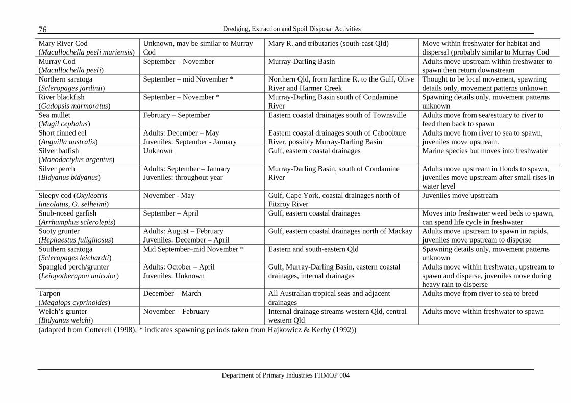
Dredging, Extraction and Spoil Disposal Activities
Department of Primary Industries FHMOP 004
76
Mary River Cod (Macullochella peeli mariensis)
Unknown, may be similar to Murray Cod
Mary R. and tributaries (south-east Qld) Move within freshwater for habitat and dispersal (probably similar to Murray Cod
Murray Cod (Macullochella peeli)
September – November Murray-Darling Basin Adults move upstream within freshwater to spawn then return downstream
Northern saratoga (Scleropages jardinii)
September – mid November * Northern Qld, from Jardine R. to the Gulf, Olive River and Harmer Creek
Thought to be local movement, spawning details only, movement patterns unknown
River blackfish (Gadopsis marmoratus)
September – November * Murray-Darling Basin south of Condamine River
Spawning details only, movement patterns unknown
Sea mullet (Mugil cephalus)
February – September Eastern coastal drainages south of Townsville Adults move from sea/estuary to river to feed then back to spawn
Short finned eel (Anguilla australis)
Adults: December – May Juveniles: September - January
Eastern coastal drainages south of Caboolture River, possibly Murray-Darling Basin
Adults move from river to sea to spawn, juveniles move upstream.
Silver batfish (Monodactylus argentus)
Unknown Gulf, eastern coastal drainages Marine species but moves into freshwater
Silver perch (Bidyanus bidyanus)
Adults: September – January Juveniles: throughout year
Murray-Darling Basin, south of Condamine River
Adults move upstream in floods to spawn, juveniles move upstream after small rises in water level
Sleepy cod (Oxyleotris lineolatus, O. selheimi)
November - May Gulf, Cape York, coastal drainages north of Fitzroy River
Juveniles move upstream
Snub-nosed garfish (Arrhamphus sclerolepis)
September – April Gulf, eastern coastal drainages Moves into freshwater weed beds to spawn, can spend life cycle in freshwater
Sooty grunter (Hephaestus fuliginosus)
Adults: August – February Juveniles: December – April
Gulf, eastern coastal drainages north of Mackay Adults move upstream to spawn in rapids, juveniles move upstream to disperse
Southern saratoga (Scleropages leichardti)
Mid September–mid November * Eastern and south-eastern Qld Spawning details only, movement patterns unknown
Spangled perch/grunter (Leiopotherapon unicolor)
Adults: October – April Juveniles: Unknown
Gulf, Murray-Darling Basin, eastern coastal drainages, internal drainages
Adults move within freshwater, upstream to spawn and disperse, juveniles move during heavy rain to disperse
Tarpon (Megalops cyprinoides)
December – March All Australian tropical seas and adjacent drainages
Adults move from river to sea to breed
Welch’s grunter (Bidyanus welchi)
November – February Internal drainage streams western Qld, central western Qld
Adults move within freshwater to spawn
(adapted from Cotterell (1998); * indicates spawning periods taken from Hajkowicz & Kerby (1992))
Dredging, Extraction and Spoil Disposal Activities
Department of Primary Industries FHMOP 004
77
APPENDIX 7
Considerations where proposals will impact on marine plants If marine plants are to be disturbed, the assessing officer is directed to FHMOP 001 for guidance for assessment. With regard to approvals issued under the Fisheries Act 1994, Fisheries Group does not support the following: a) removal or damage of marine plants for aesthetic or view purposes; b) disturbance of marine plants where other alternatives exist; c) disturbance of marine plants in areas over which tenure to or rights for cannot be
demonstrated; d) reclamation of tidal wetlands and marine plants for refuse disposal, construction of sewage
treatment plants (STPs), creation of parklands, creation of car parks or for pest control. Caution needs to be exercised with proposals for drainage or flood mitigation works;
e) reclamation of tidal lands for aquaculture purposes (e.g. pond construction); f) reclamation of tidal lands for non-marine orientated purposes (e.g. residential subdivision, hotel
construction, etc.); g) dredging of tidal wetlands to gain access to private jetties or ramps.; h) jetties or boat ramps not commencing within the applicants tenured title; i) revetment works without visible proof of bank erosion or slumping; j) proposals having only a minor benefit to the community which does not justify the impacts. Where dredging activities are proposed in or adjacent to a declared Fish Habitat Area, refer to Section 5.5 of FHMOP 002 for a description of the activities that are considered incompatible with FHAs and are therefore not supported by Fisheries Group.
Dredging, Extraction and Spoil Disposal Activities
Department of Primary Industries FHMOP 004
78
APPENDIX 8
Future management and research directions This section includes a brief outline of some of the projects planned to follow this document and suggestions for the development of Fisheries Group involvement with dredging activities and proposals. The first priority, and a supplement to the present document, is the production of a location guide to areas of Queensland indicating Fisheries Group support for dredging, extractive industry and spoil disposal activities in marine and freshwater systems. As with the declared Fish Habitat Areas in Queensland ‘atlas’ (Beumer et al. 1997), this document will provide an easy reference for ecologically sensitive areas and multi-use management areas. It is likely that separate documents will be produced for marine and freshwater areas of Queensland. One of the objectives of the Regional Coastal Management Planning process, being developed by QDEH, is the definition of areas within Queensland that are/are not suitable for dredging. Such information will be helpful for Fisheries Group management purposes. Research is being conducted into the impacts of dredging activities on benthic fauna at Noosa. Unvegetated intertidal habitats are regarded as critical feeding, spawning and nursery areas for estuarine fish, particularly juvenile stages, but are heavily impacted from human activities such as dredging. A project entitled ‘Colonisation of constructed estuarine habitats by benthic fauna and the utilisation of these habitats by economically important fish’ is currently being conducted. This project will examine in detail and at a management scale the spatial and temporal patterns of recruitment of benthic animals to intertidal and subtidal banks created during dredging programs. Another objective is to determine the use of these habitats by commercially and recreationally important fish species and the relative fisheries value, in comparison with similar natural habitats in estuarine systems. A suggestion for the development of Fisheries Group involvement with dredging activities: Due to the potential impacts of dredging on bank vegetation, it is recommended that plans for revegetation of the riparian zone and restoration of bed and bank profiles become a part of the approval process and where appropriate, be included as a prerequisite for dredging activity approvals. As Fisheries Group does not issue dredging or spoil disposal permits, it is likely that such action will have to be instigated by another department such as QDEH or QDNR. Fisheries Group has an important role to play in the assessment of applications for dredging permits/approvals and the provision of comments indicating the Department’s support, or lack thereof, for a given proposal. The role of Fisheries Group is particularly relevant for the management of fisheries habitats (such as destruction of marine plants, work in or near declared Fish Habitat Areas and works impacting on fish ways such as the construction of waterway barrier works). Currently, the entire royalty from dredging permits and approvals in estuarine and marine waters is received by QDEH. There is merit in allocation of a portion of these royalties to fund rehabilitation activities and research into the full impacts of dredging activities on fisheries resources.
Dredging, Extraction and Spoil Disposal Activities
Department of Primary Industries FHMOP 004
79
APPENDIX 9
QDPI Fisheries contacts DPI Call Centre 13 25 23 Head Office Fisheries Group Department of Primary Industries GPO Box 3129 BRISBANE QLD 4001 Phone: (07) 3225 2283 Fax: (07) 3229 8146 Southern Region (NSW/Qld border to Sarina) Southern Fisheries Centre Department of Primary Industries PO Box 76 (13 Beach Road) DECEPTION BAY QLD 4508 Phone: (07) 3817 9500 Fax: (07) 3817 9555 Northern Region (Sarina to Qld/NT border) Northern Fisheries Centre Department of Primary Industries PO Box 5396 (38-40 Tingira St, Portsmith) CAIRNS QLD 4870 Phone: (07) 4035 0100 Fax: (07) 4035 1401