DRCOG Regional Concept of Tra Concept of Transportation...DRCOG Regional Concept of Transportation...
42
DRCOG Regional Concept of Transportation Operations Adopted August 15, 2012 DENVER REGIONAL COUNCIL OF GOVERNMENTS We make life better!
Transcript of DRCOG Regional Concept of Tra Concept of Transportation...DRCOG Regional Concept of Transportation...
DRCOG Regional Concept ofTransportation Operations
Adopted August 15, 2012
DENVER REGIONAL COUNCIL OF GOVERNMENTS
We make life better!

DRCOG Regional Concept
of Transportation Operations
Adopted August 15, 2012
Preparation of this report has been financed in part through grants from the U.S. Department of Transportation, Federal Transit Administration and
Federal Highway Administration

i
Table of Contents
Executive Summary ........................................................................................................................... iii
Introduction .....................................................................................................................................1
Definition of a Regional Concept of Transportation Operations .................................................................. 1
Relationship to Other Planning Documents ................................................................................................. 1
Overview of RCTO Development Process ..................................................................................................... 3
RCTO Purpose and Vision ...................................................................................................................4
Shared Regional Operations Goals & Objectives..................................................................................6
Goal 1: Provide Reliable Transportation Operations for Regional Travelers ............................................... 7
Objective 1.1 Increase trip time reliability on freeways and arterials for all modes ..................... 7
Objective 1.2 Reduce traveler stops and delay due to signal operations .................................... 11
Objective 1.3 Reduce incident duration ....................................................................................... 12
Objective 1.4 Reduce occurrence of secondary incidents............................................................. 14
Goal 2: Provide Safe Transportation Operations for Regional Travelers, and for Public Safety and Construction/Maintenance Personnel........................................................................................... 14
Objective 2.1 Reduce traffic fatality rate ..................................................................................... 14
Objective 2.2 Reduce traffic injury rate ........................................................................................ 15
Objective 2.3 Reduce public safety and construction/maintenance personnel injuries/fatalities15
Goal 3: Provide Transportation Operations Support to non-SOV Modes of Travel ................................... 15
Objective 3.1 Reduce single-occupant vehicle (SOV) mode share ................................................ 15
Objective 3.2 Reduce per capita vehicle-miles traveled (VMT) .................................................... 15
Objective 3.3 Reduce per capita greenhouse gas (GHG) emissions ............................................. 16
General Approach ............................................................................................................................ 17
1. Plan to Collaborate ............................................................................................................................... 17
2. Expand Monitoring Capability and Capacity ........................................................................................ 17
3. Manage Operations .............................................................................................................................. 17
4. Measure Impact ................................................................................................................................... 17
Operational Concept ........................................................................................................................ 19
Initiatives ..................................................................................................................................................... 19
ii
Initiative 1. Continue to coordinate signal timing system management across jurisdictional boundaries ............................................................................................................. 19
Initiative 2: Continue to coordinate and expand freeway management.................................. 20
Initiative 3: Establish Regional Incident Management Process ................................................ 20
Initiative 4: Improve work zone/special event management ................................................... 21
Initiative 5: Define criteria for operations improvements and monitoring for bicycles and pedestrians ............................................................................................................ 22
Initiative C-1: Expand traffic monitoring capabilities and infrastructure .................................... 23
Initiative C-2: Establish shared monitoring between jurisdictions ............................................... 23
Initiative C-3: Further coordinate/integrate multimodal traveler information ........................... 24
Initiative C-4: Expand the shared communications network ....................................................... 25
Initiative C-5: Establish a shared data warehouse and performance reporting process ............. 25
Operational Concept Overview ................................................................................................................... 27
General Roles and Responsibilities ................................................................................................. 27
Board Resolution ......................................................................................................................................... 30
List of Table / Figures Table 1: Goals, Objectives, Initiatives and Performance Measures.............................................................. v Figure 1: Sources of Congestion.................................................................................................................... 7 Figure 2: Sample Illustration of TTI Use for Real-Time Observation ............................................................. 9 Figure 3: Sample Illustration of Travel Time Reliability .............................................................................. 10 Figure 4: General Incident Timeline ............................................................................................................ 13 Figure 5: Operational Concept Relationships ............................................................................................. 29
iii
Executive Summary
The Denver Regional Council of Governments (DRCOG) has prepared this Regional Concept of Transportation Operations (RCTO), which describes the collaborative plan to improve regional operations performance across the region over the next five years. The focus of this RCTO is to improve regional travel reliability, which involves both leveraging existing systems and success of ongoing regional transportation operations initiatives and newly focusing on reducing the impact of traffic incidents.
An RCTO is a management tool used to define and develop strategic implementation planning for transportation systems management and operations and to guide collaborative efforts to improve regional transportation operations performance for travelers. In particular, this RCTO:
• Presents a unified direction for transportation systems management and operations based on a holistic view of the whole region;
• Creates operations objectives and performance measures that can be used in the transportation planning process; and,
• Clarifies the roles and responsibilities of the partners in the collaborative effort.
This RCTO identifies improvements to achieve the following vision:
The regional transportation systems in the Denver metro area will be coordinated across jurisdictions to support and continually improve mobility and safety for all traveler modes. Collectively, the regional transportation system
operators and other stakeholders will provide seamless travel across jurisdictional boundaries and facilitate coordination between transportation modes, which will be supported by a regional multimodal traveler information system and traffic incident management processes.
The core element of the RCTO that assists in establishing a unified direction is the definition of shared goals and objectives. The goals, which are interrelated, are:
Goal 1. Provide reliable transportation operations for regional travelers. This is the primary goal of this RCTO, which builds from current operations management conditions to add capabilities to monitor and manage traffic conditions and improve incident management.
Goal 2. Provide safe transportation operations for regional travelers and for public safety and construction/maintenance personnel. Improvements in transportation operations as part of incident management will also yield safety improvements.
Goal 3. Provide transportation operations support to non-SOV modes of travel. This recognizes the role of transportation operations in achieving certain DRCOG Board-adopted Metro Vision transportation goals1
. It is anticipated that improvements in transportation operations will influence mode choice, departure choice, and route choice.
1 2035 DRCOG Metro Vision Transportation Plan, DRCOG, 2011, p. 5
iv
This RCTO follows a basic approach divided into four elements:
1. Plan to Collaborate. To provide effective regional transportation operations, regional collaboration and partnership are required. Travelers do not recognize jurisdictional boundaries and expect reliable service. Planning for collaboration, consistent with requirements to conduct system engineering analyses for technology-based projects, will prepare the project and the partners prior to moving ahead with detailed design and implementation.
2. Expand Monitoring Capability and Capacity. In order to improve management of operations, roadway conditions must first be monitored. This element promotes the expansion of travel time data collection and volume data along roadway segments as defined in CDOT’s Denver Regional Integrated Traveler Information Display Map Guidelines, which describes data collection and display requirements for CDOT’s traveler information website and other services. This element also promotes the expansion of coverage of roadways with Closed Circuit Television (CCTV) cameras. A critical requirement of this element is that staff resources must be available to both monitor and manage the roadway network.
3. Manage Operations. Increasing the capability to monitor roadway operations will allow operators to make better management decisions for real-time operations. Increased monitoring will also assist operators and planners with investment decisions, as it will allow trouble areas to be identified. Managing roadway operations requires sufficient operations staff equipped with the capability to modify systems controls, adjust traveler information and coordinate with other stakeholders to respond to incidents and other non-recurring congestion due to work zones, special events, and weather.
4. Measure Impact. Performance measurement is key to ensuring that the goals and objectives of this RCTO are met. Performance measurement occurs at two levels: real-time performance measurement and trending performance measurement. The former is used by operators as part of the process of monitoring and managing operations. The latter is used to illustrate trends for operators, decision-makers and the public to determine where trouble spots exist and to inform investment decisions.
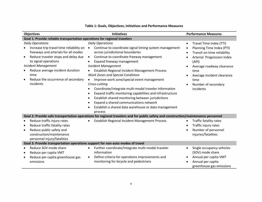
This RCTO defines several initiatives that describe the operational concept – the relationships, high-level operations, and roles and responsibilities of the regional stakeholders. Table 1 summarizes the relationship between the goals and objectives, the initiatives and the performance measures to be used to track the region’s progress.
v
Table 1: Goals, Objectives, Initiatives and Performance Measures
Objectives Initiatives Performance Measures
Goal 1: Provide reliable transportation operations for regional travelers Daily Operations
Increase trip travel time reliability on freeways and arterials for all modes
Reduce traveler stops and delay due to signal operations
Incident Management
Reduce average incident duration time
Reduce the occurrence of secondary incidents
Daily Operations
Continue to coordinate signal timing system management across jurisdictional boundaries
Continue to coordinate freeway management
Expand freeway management Incident Management
Establish Regional Incident Management Process Work Zones and Special Conditions
Improve work zone/special event management Cross-cutting
Coordinate/integrate multi-modal traveler information
Expand traffic monitoring capabilities and infrastructure
Establish shared monitoring between jurisdictions
Expand a shared communications network
Establish a shared data warehouse or data management process
Travel Time Index (TTI)
Planning Time Index (PTI)
Transit on-time reliability
Arterial Progression Index (API)
Average roadway clearance time
Average incident clearance time
Number of secondary incidents
Goal 2: Provide safe transportation operations for regional travelers and for public safety and construction/maintenance personnel
Reduce traffic injury rates
Reduce traffic fatality rates
Reduce public safety and construction/maintenance personnel injury/fatalities
Establish Regional Incident Management Process Traffic fatality rates
Traffic injury rates
Number of personnel injuries/fatalities
Goal 3: Provide transportation operations support for non-auto modes of travel
Reduce SOV mode share
Reduce per capita VMT
Reduce per capita greenhouse gas emissions
Further coordinate/integrate multi-modal traveler information
Define criteria for operations improvements and monitoring for bicycle and pedestrians
Single occupancy vehicles (SOV) mode share
Annual per capita VMT
Annual per capita greenhouse gas emissions
1
Introduction
The Denver Regional Council of Governments (DRCOG) has prepared this Regional Concept of Transportation Operations (RCTO), which describes the collaborative plan to improve regional operations performance across the region over the next five years. The focus of this RCTO is to improve regional travel reliability, which involves both leveraging existing systems and success of ongoing regional transportation operations initiatives and newly focusing on reducing the impact of traffic incidents.
Definition of a Regional Concept of Transportation Operations An RCTO is a management tool used to define and develop strategic implementation planning for transportation systems management and operations strategic implementation planning and to guide collaborative efforts to improve regional transportation operations performance for travelers2
2 Regional Concept for Transportation Operations: The Blueprint for Action, Federal Highways Administration, 2007
. An RCTO focuses on operations objectives and strategies within one or more management and operations functions of regional significance such as traveler information, road weather management, or traffic incident management. In order to establish the collaborative process, the RCTO establishes goals for transportation operations over a five-year period and identifies the relationships, procedures, activities, and resource arrangements required to achieve the goals.
This RCTO serves three important purposes:
• Presents a unified direction for transportation systems management and operations based on a holistic view of the whole region;
• Creates operations objectives and performance measures that can be used in the transportation planning process; and,
• Clarifies the roles and responsibilities of the partners in the collaborative effort.
This RCTO identifies effective improvements that require advances in several operations and management functional areas and will also require closer collaboration from regional partners.
Relationship to Other Planning Documents This RCTO extends directly from the DRCOG Regional Transportation Operations Strategy (RTOS) – Action Plan, which identified completion of this RCTO as a primary action item.
The RCTO also provides direction and context to the pending update of the ITS Architecture for the Denver Regional Area. A regional ITS architecture defines how transportation systems functionally operate, and the information exchanges that must take place between these systems to accomplish transportation services being provided in the region. The architecture provides a framework for the deployment of transportation technology in the region, guiding the development of ITS projects and programs. The operational concept defined in this RCTO will be an input to the regional ITS architecture and will serve to define the near-term elements of the architecture update. Following the architecture update, the RCTO will also guide the development of the ITS Pool Deployment Program, a six-year program for the ITS Pool funds.
The RCTO is developed in the context of recent operations planning documents that have
2
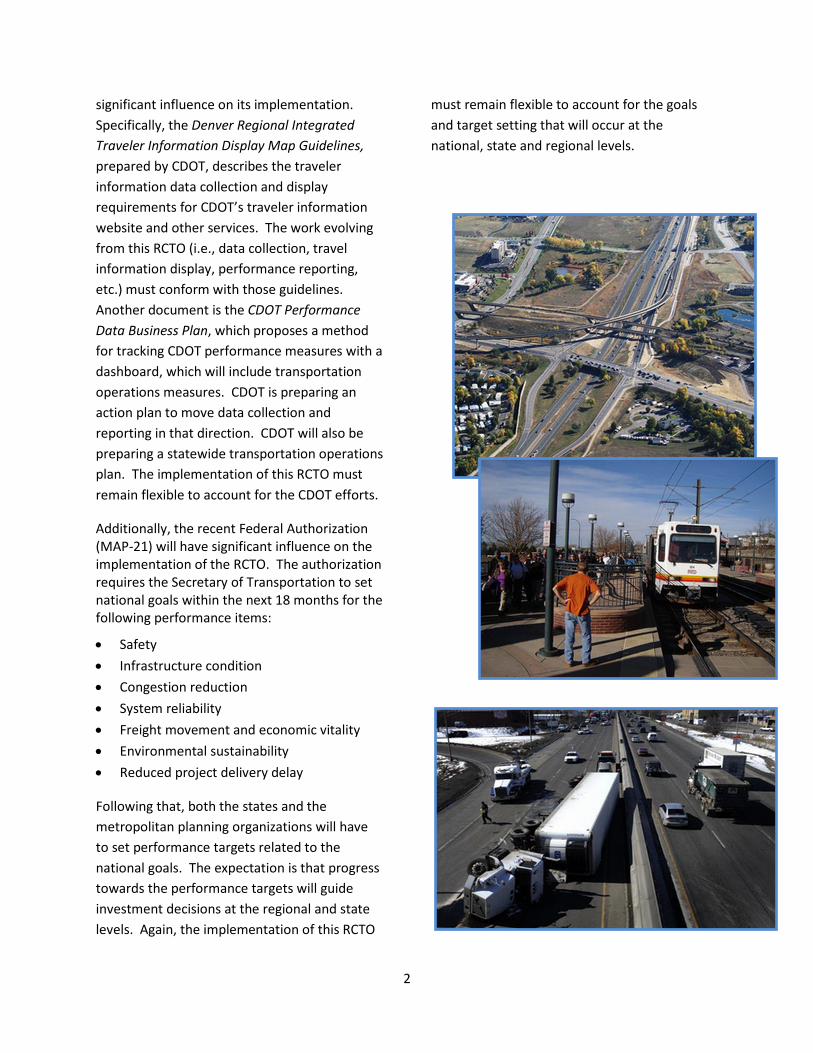
significant influence on its implementation. Specifically, the Denver Regional Integrated Traveler Information Display Map Guidelines, prepared by CDOT, describes the traveler information data collection and display requirements for CDOT’s traveler information website and other services. The work evolving from this RCTO (i.e., data collection, travel information display, performance reporting, etc.) must conform with those guidelines. Another document is the CDOT Performance Data Business Plan, which proposes a method for tracking CDOT performance measures with a dashboard, which will include transportation operations measures. CDOT is preparing an action plan to move data collection and reporting in that direction. CDOT will also be preparing a statewide transportation operations plan. The implementation of this RCTO must remain flexible to account for the CDOT efforts.
Additionally, the recent Federal Authorization (MAP-21) will have significant influence on the implementation of the RCTO. The authorization requires the Secretary of Transportation to set national goals within the next 18 months for the following performance items:
• Safety • Infrastructure condition • Congestion reduction • System reliability • Freight movement and economic vitality • Environmental sustainability • Reduced project delivery delay
Following that, both the states and the metropolitan planning organizations will have to set performance targets related to the national goals. The expectation is that progress towards the performance targets will guide investment decisions at the regional and state levels. Again, the implementation of this RCTO
must remain flexible to account for the goals and target setting that will occur at the national, state and regional levels.
3
Overview of RCTO Development Process DRCOG staff led the members of the Regional Transportation Operations Working Group in the development of this RCTO. This working group is comprised of transportation operators, public safety representatives, and other stakeholders in regional transportation operations. These members and other similar agencies are the partners in the development and implementation of this RCTO. The working group met several times starting in the fall of 2011 to address four main elements of the RCTO development:
• Definition of Purpose and Vision. Working from the vision and strategies discussed in the Regional Transportation Operations Strategy, the working group developed a consensus view of the purpose of the RCTO. The purpose is focused on a short timeframe (5-year period) and is focused on specific areas of improvement needed in the region.
• Definition of Shared Goals and Objectives. This critical step identified focused goals and objectives that are shared by the regional stakeholders—providing a common sense of direction through focused goals and objectives with realistic targets. The working group established that the region lacks a lot of the data required to measure operations performance. Collecting that data and establishing baselines is a specific emphasis of this RCTO.
• Definition of a General Approach to
Achieve the Objectives. The working group developed a general approach to collectively achieve the goals and objectives. The approach involves both infrastructure improvements as well as the establishment of improved institutional partnership and collaboration.
• Definition of an Operational Concept. The final step in the RCTO development process was to prepare an operational concept. The operational concept describes the intended relationship between systems and institutions, which includes the roles and responsibilities of each partner, and identifies general physical improvements. The operational concept is also a key input to the pending update of the ITS Architecture for the Denver Regional Area.
4
RCTO Purpose and Vision
The development of the Regional Transportation Operations Strategy defined a broad vision that also guides this RCTO. The vision is as follows:
This vision recognizes that travelers both expect reliable service for all travel modes and do not recognize jurisdictional boundaries. The purpose of this RCTO is to expand from the vision and describe an implementation plan to provide transportation services to meet those expectations. Necessarily, the implementation plan cannot simply be a description of capital improvements to expand the transportation operations infrastructure, but must describe improvements in collaboration and coordination between and within the jurisdictions and agencies.
This RCTO leverages the existing transportation systems and current successes, moving from that foundation to a new level, providing travelers a higher level of reliability – the travel experience will be similar from day to day.
For example, the region achieved significant success with the Traffic Signal System
Improvement Program (TSSIP). The baseline for the initial TSSIP planning effort identified several traffic signal timing issues across the region, including: • Traffic signal timing was not coordinated
between jurisdictions; • The reliability of signal timing coordination
was poor due to equipment reliability; and, • Not all signal timing plans were well-suited
to existing traffic conditions.
The initial TSSIP recognized that the independent signal systems in the region behave as a single system from the perspective of the traveler. The TSSIP addressed equipment reliability by first identifying minimum system functional requirement necessary for agencies to maintain inter-jurisdictional signal coordination timing plans then programming capital improvements. The TSSIP also established a team of engineers and technicians focused on developing signal timing plans that are both coordinated between jurisdictions and better suited to existing traffic conditions. Achieving the latter requires periodic re-evaluation of the signal timing plans to account for changes in traffic conditions.
Since its beginning, though, the TSSIP has focused on the implementation of good signal timing coordination plans based on a snapshot of typical traffic conditions. With improved equipment and well-developed signal coordination plans, operators are able to better manage the traffic signal system and maintain good timing, but there is no parallel effort to monitor and respond to traffic conditions, which may vary considerably on a daily basis due to unexpected incidents and other events.
RCTO Vision The regional transportation systems in the Denver regional area will be coordinated across jurisdictions to support and continually improve traveler mobility and safety for all traveler modes. Collectively, the regional transportation system operators and other stakeholders will provide seamless travel across jurisdictional boundaries and facilitate coordination between transportation modes, which will be supported by a regional multimodal traveler information system and regional traffic incident management processes.
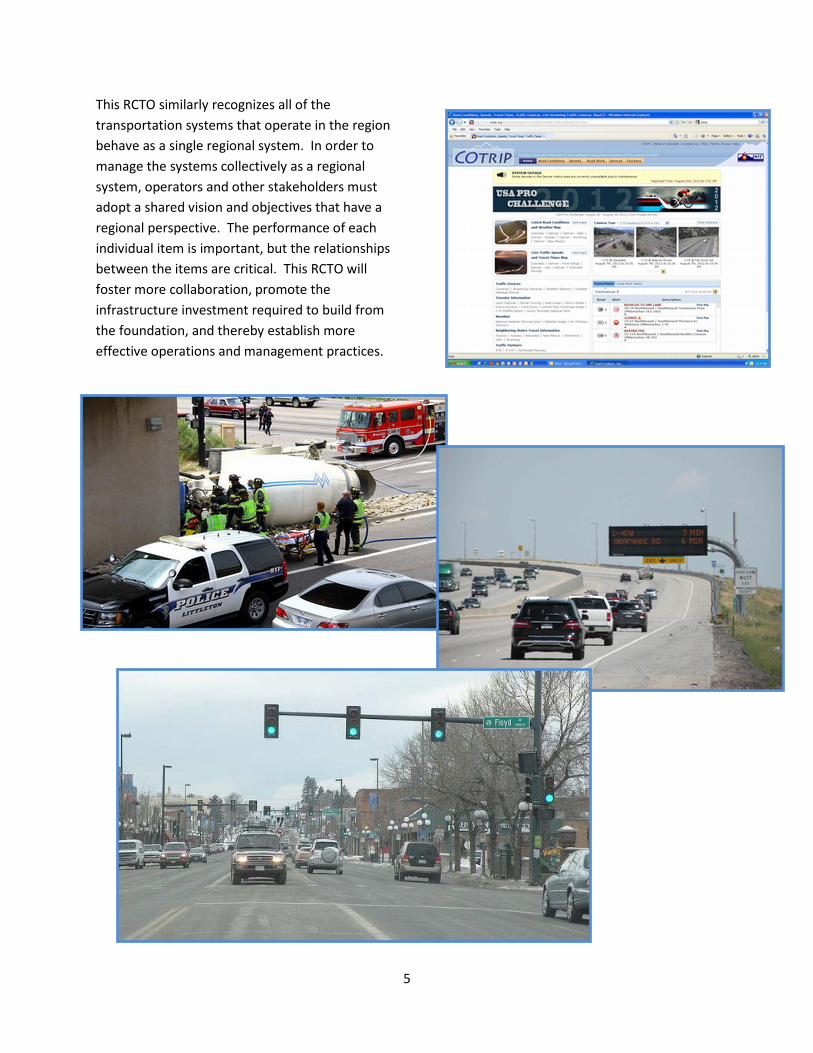
5
This RCTO similarly recognizes all of the transportation systems that operate in the region behave as a single regional system. In order to manage the systems collectively as a regional system, operators and other stakeholders must adopt a shared vision and objectives that have a regional perspective. The performance of each individual item is important, but the relationships between the items are critical. This RCTO will foster more collaboration, promote the infrastructure investment required to build from the foundation, and thereby establish more effective operations and management practices.
6
Shared Regional Operations Goals & Objectives
A core element of this RCTO is the definition of shared goals and objectives that guide regional operations improvements in a unified direction. The goals are:
Goal 1: Provide reliable transportation operations for regional travelers. This is the primary goal of this RCTO, which builds from current operations management conditions to add capabilities to monitor and manage traffic conditions and improve incident management.
Goal 2: Provide safe transportation operations for regional travelers and for public safety and construction/maintenance personnel. Improvements in transportation operations as part of incident management will also yield safety improvements.
Goal 3: Provide transportation operations support to non-SOV modes of travel. This recognizes the role of transportation operations in achieving certain DRCOG Board-adopted Metro Vision transportation goals(1). It is anticipated that improvements in transportation operations will influence mode choice, departure choice, and route choice.
The rest of this section provides more details regarding the goals and their associated objectives. It is the intent of this RCTO to define user-oriented objectives or system performance outcomes as experienced by users. This contrasts with operator-oriented objectives or system performance output objectives. For example, an outcome objective may be to “improve trip travel time reliability on key
corridors” while an output objective is “increase the mileage of key corridor roadways under surveillance.” While the two objectives are related, the former is preferred because it focuses on the user.
It is also the intent of this RCTO that the objectives be SMART. These are objectives that are: • Specific: The objective is a clear target
towards which the regional partners will aim.
• Measurable: The objective is measurable within the partners’ means, and provides feedback that enables the partners to assess the effectiveness of their actions.
• Agreed: The regional partners have come to a consensus on the common operations objective.
• Realistic: The regional partners are reasonably confident that the objective can be achieved within resource limitations and institutional demands.
• Time-bound: The regional partners specify when the operations objective will be achieved.
That said, there are cases where it is difficult to either define outcome objectives or objectives that are SMART due to factors such as lack of relevant data. In those cases, defining objectives that best meet the conditions is a reasonable approach; for example, to define an output objective when it is not possible to measure an outcome objective. These situations will be remarked subsequently. As previously mentioned, it is imperative that the implementation of this RCTO remain flexible in the face of performance measurement definition efforts at the national and state levels. As such, the goals and objectives may need to be modified to respond to those efforts. In addition, progress towards the
7
objectives will be periodically evaluated and the objectives modified as appropriate.
Goal 1: Provide Reliable Transportation Operations for Regional Travelers
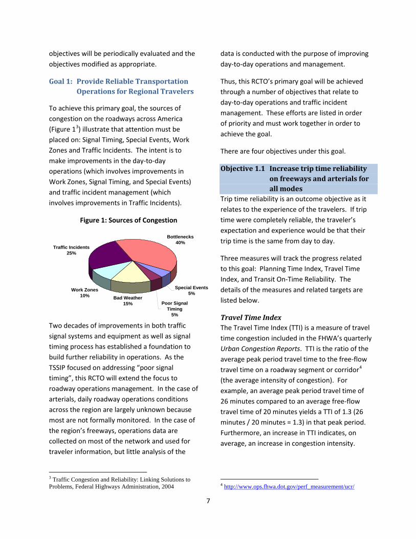
To achieve this primary goal, the sources of congestion on the roadways across America (Figure 13
Figure 1: Sources of Congestion
) illustrate that attention must be placed on: Signal Timing, Special Events, Work Zones and Traffic Incidents. The intent is to make improvements in the day-to-day operations (which involves improvements in Work Zones, Signal Timing, and Special Events) and traffic incident management (which involves improvements in Traffic Incidents).
Two decades of improvements in both traffic signal systems and equipment as well as signal timing process has established a foundation to build further reliability in operations. As the TSSIP focused on addressing “poor signal timing”, this RCTO will extend the focus to roadway operations management. In the case of arterials, daily roadway operations conditions across the region are largely unknown because most are not formally monitored. In the case of the region’s freeways, operations data are collected on most of the network and used for traveler information, but little analysis of the
3 Traffic Congestion and Reliability: Linking Solutions to Problems, Federal Highways Administration, 2004
data is conducted with the purpose of improving day-to-day operations and management.
Thus, this RCTO’s primary goal will be achieved through a number of objectives that relate to day-to-day operations and traffic incident management. These efforts are listed in order of priority and must work together in order to achieve the goal.
There are four objectives under this goal.
Objective 1.1 Increase trip time reliability on freeways and arterials for all modes
Trip time reliability is an outcome objective as it relates to the experience of the travelers. If trip time were completely reliable, the traveler’s expectation and experience would be that their trip time is the same from day to day.
Three measures will track the progress related to this goal: Planning Time Index, Travel Time Index, and Transit On-Time Reliability. The details of the measures and related targets are listed below.
Travel Time Index The Travel Time Index (TTI) is a measure of travel time congestion included in the FHWA’s quarterly Urban Congestion Reports. TTI is the ratio of the average peak period travel time to the free-flow travel time on a roadway segment or corridor4
4
(the average intensity of congestion). For example, an average peak period travel time of 26 minutes compared to an average free-flow travel time of 20 minutes yields a TTI of 1.3 (26 minutes / 20 minutes = 1.3) in that peak period. Furthermore, an increase in TTI indicates, on average, an increase in congestion intensity.
http://www.ops.fhwa.dot.gov/perf_measurement/ucr/
Bad Weather15%
Work Zones10%
Traffic Incidents25%
Bottlenecks40%
Poor Signal Timing
5%
Special Events5%
8
The FHWA Urban Congestion Reports list the TTI measured on a monthly basis for 19 urban areas (not including Denver) across the country. The reports are used to illustrate the national trends – the same can be achieved regionally by calculating the TTI on a segment-by-segment or corridor-by-corridor basis. This will illustrate trends across the region and will allow comparison of congestion intensity between corridors in order to assist with investment decision.
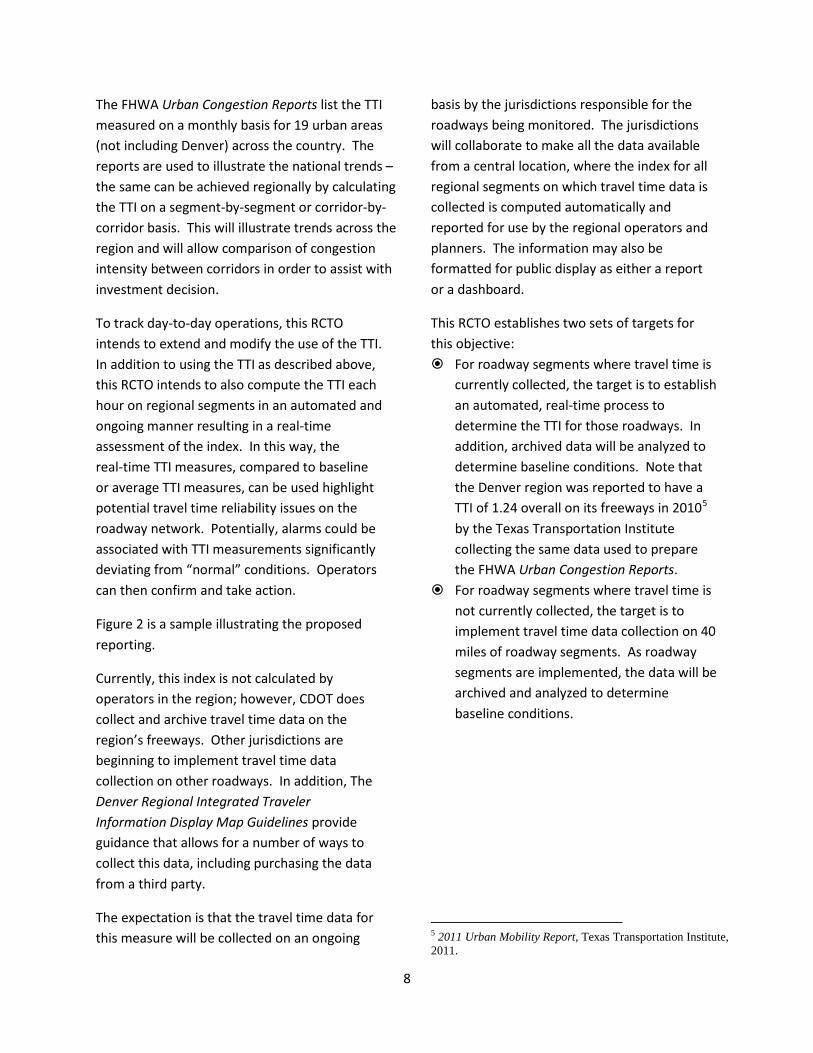
To track day-to-day operations, this RCTO intends to extend and modify the use of the TTI. In addition to using the TTI as described above, this RCTO intends to also compute the TTI each hour on regional segments in an automated and ongoing manner resulting in a real-time assessment of the index. In this way, the real-time TTI measures, compared to baseline or average TTI measures, can be used highlight potential travel time reliability issues on the roadway network. Potentially, alarms could be associated with TTI measurements significantly deviating from “normal” conditions. Operators can then confirm and take action.
Figure 2 is a sample illustrating the proposed reporting.
Currently, this index is not calculated by operators in the region; however, CDOT does collect and archive travel time data on the region’s freeways. Other jurisdictions are beginning to implement travel time data collection on other roadways. In addition, The Denver Regional Integrated Traveler Information Display Map Guidelines provide guidance that allows for a number of ways to collect this data, including purchasing the data from a third party.
The expectation is that the travel time data for this measure will be collected on an ongoing
basis by the jurisdictions responsible for the roadways being monitored. The jurisdictions will collaborate to make all the data available from a central location, where the index for all regional segments on which travel time data is collected is computed automatically and reported for use by the regional operators and planners. The information may also be formatted for public display as either a report or a dashboard.
This RCTO establishes two sets of targets for this objective: For roadway segments where travel time is
currently collected, the target is to establish an automated, real-time process to determine the TTI for those roadways. In addition, archived data will be analyzed to determine baseline conditions. Note that the Denver region was reported to have a TTI of 1.24 overall on its freeways in 20105
For roadway segments where travel time is not currently collected, the target is to implement travel time data collection on 40 miles of roadway segments. As roadway segments are implemented, the data will be archived and analyzed to determine baseline conditions.
by the Texas Transportation Institute collecting the same data used to prepare the FHWA Urban Congestion Reports.
5 2011 Urban Mobility Report, Texas Transportation Institute, 2011.
9
Figure 2: Sample Illustration of TTI Use for Real-Time Observation
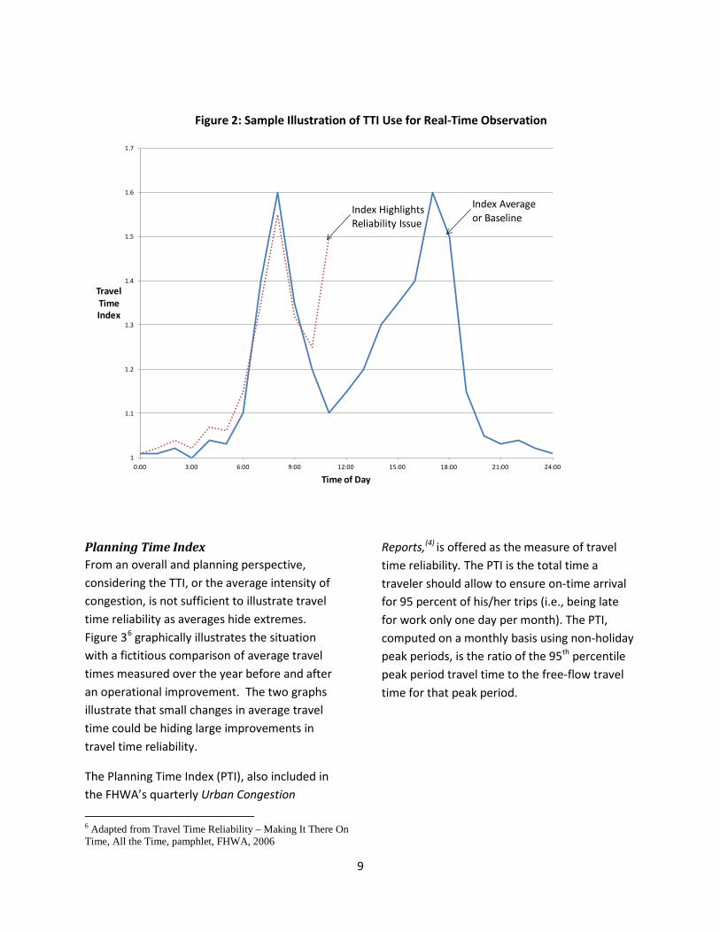
Planning Time Index From an overall and planning perspective, considering the TTI, or the average intensity of congestion, is not sufficient to illustrate travel time reliability as averages hide extremes. Figure 36
The Planning Time Index (PTI), also included in the FHWA’s quarterly Urban Congestion
graphically illustrates the situation with a fictitious comparison of average travel times measured over the year before and after an operational improvement. The two graphs illustrate that small changes in average travel time could be hiding large improvements in travel time reliability.
6 Adapted from Travel Time Reliability – Making It There On Time, All the Time, pamphlet, FHWA, 2006
Reports,(4) is offered as the measure of travel time reliability. The PTI is the total time a traveler should allow to ensure on-time arrival for 95 percent of his/her trips (i.e., being late for work only one day per month). The PTI, computed on a monthly basis using non-holiday peak periods, is the ratio of the 95th percentile peak period travel time to the free-flow travel time for that peak period.
1
1.1
1.2
1.3
1.4
1.5
1.6
1.7
0:00 3:00 6:00 9:00 12:00 15:00 18:00 21:00 24:00
TravelTimeIndex
Time of Day
Index Average or Baseline
Index Highlights Reliability Issue
10
Figure 3: Sample Illustration of Travel Time Reliability
As an example, a 95th percentile peak period travel time of 32 minutes for a month compared to a free-flow travel time of 20 minutes yields a PTI of 1.60 (32 minutes / 20 minutes = 1.6) for that peak period. Furthermore, a decrease in the index illustrates an increase in reliability – the worst travel times of the month are less severe.
This index is not currently calculated by operators in the region and the FHWA does not include Denver in its Urban Congestion Reports. However, CDOT does collect and archive travel time data on the region’s freeways, and CDOT has also identified the PTI as a statewide operations measure that it intends to report to the public. Other jurisdictions are beginning to
Month 1 Month 2 Month 3
TravelTime
Before After
Average Day
Small improvement in average travel time
Month 1 Month 2 Month 3
TravelTime
Before After
Second Worst Day Large improvement in travel time reliability
11
implement travel time data collection on other roadways, which will be guided by the Denver Regional Integrated Traveler Information Display Map Guideline. The document provides guidance that allows for a number of ways to collect this data, including purchasing the data from a third party.
The expectation is that the travel time data for this measure will be collected on an ongoing basis by the jurisdictions responsible for the roadways being monitored. All the data will be available from a central location, where the index for all regional segments on which travel time data is collected is computed automatically and reported for use by regional operators and planners. The information may also be formatted for public display as either a report or a dashboard.
This RCTO establishes two sets of targets for this objective:
For roadways where travel time is currently collected, the target is to establish an automated, real-time process to determine the PTI for those roadways. In addition, archived data will be analyzed to determine baseline data. Note that the FHWA Urban Congestion Reports report PTI trends nationally of between 1.40 and 1.60.
For roadways where travel time is not currently collected, the target is to implement travel time data collection on 40 miles of roadway segments.
Transit On-time Reliability The RTD Board annually sets a number of agency performance goals and objectives that are reported quarterly. One key objective suitable for tracking as part of this RCTO is “Goal 3.1 Maintain system-wide on-time performance for both bus and rail operations”. RTD defines on-time arrival as the bus or train
arriving at a location no more than one minute before and no more than five minutes after the scheduled arrival time.
RTD staff collects arrival data on an ongoing basis and calculates and reports the results on a quarterly basis.
The RTD Board has set the 2013 targets for these indices as:
Objective 1.2 Reduce traveler stops and delay due to signal operations
The objectives here follow those of the TSSIP. Currently, these criteria are measured on a project-by-project basis. Engineers measure the number of stops and the trip travel time for a project corridor both before and after the implementation of new coordinated signal timing plans, which is a snapshot of conditions observed on the days the measurements were taken. This data is used to determine the benefit of the signal timing project,
This RCTO takes this one step further by defining a single index with the intent of continually collecting the data necessary to calculate the index. In this way, operators will be able to track trends in the quality of progression with a numerical indication of when signal timing action is required on the corridor.
The Arterial Progression Index (API) is a measure of the quality of progression of a signalized corridor due to the signal timing coordination and is an indirect measure of the quality of the signal timing coordination. The DRCOG Traffic Operations Program has adapted this index from the Orange County
Local Buses – System-wide 88.0% Regional and Express Buses 94.0% Light Rail 92.0%
12
Transportation Authority (OCTA) Corridor Synchronization Progression Index (CSPI). The API is a combination of the corridor travel time (a measure of overall delay) and the number of stops along the corridor (a measure of intersection approach delay).
The DRCOG Traffic Operations Program is currently baselining the regional corridors at the completion of each signal timing project. This means that DRCOG or an operating agency can periodically conduct travel runs in order to assess the API.
Ultimately, it is intended that the data be collected on an ongoing, real-time basis that can be used to track conditions similar to that intended for the TTI.
This RCTO establishes a target for this objective of completing the process of establishing baseline API for the regional arterial network.
Objective 1.3 Reduce incident duration As indicated previously, it is estimated that traffic incidents are the source of about one quarter of all roadway congestion. The length of time an incident directly impacts the capacity of the roadway largely determines the amount of congestion and diversion that results. The time it takes for transportation operations to recover after the incident is cleared is a function of how long the incident persists before it is cleared. The National Traffic Incident Management Coalition (NTIMC) states that “for every minute that a freeway travel lane is blocked during a peak travel period, four minutes of travel delay results after the incident is cleared.”7
7 Traffic Incident Facts, pamphlet, National Traffic Incident Management Coalition, 2007
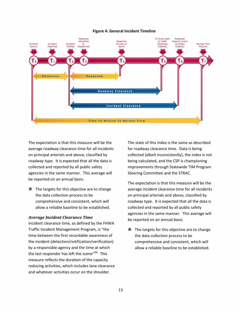
This outcome-objective will be tracked with two measures: average roadway clearance time and average incident clearance time. These measures are illustrated in Figure 48
Average Roadway Clearance Time
.
Roadway clearance time, as defined by the FHWA Traffic Incident Management Program (TIM), is “the time between first recordable awareness of the incident (detection/notification/verification) by a responsible agency and first confirmation that all lanes are available for traffic flow”(8). This measure shows the duration of the blockage of the travel lanes.
Elements of the timeline above are being recorded by the Colorado State Patrol (CSP) and CDOT’s Courtesy Patrol. It is also likely that this information is being recorded by other public safety agencies. However, the CSP recognizes that incident data collection is not currently recorded uniformly or consistently. In fact, the CSP is championing the Statewide TIM Program Steering Committee, a new committee with the goal of promoting good practice and consistency in traffic incident management across the state, and coordinating with the State Traffic Records Advisory Committee (STRAC), a committee comprised of several state agencies that contribute to and utilize traffic data with the goal of improving state traffic data, to improve the traffic data collection processes.
8 Advanced Traffic Incident Management Workshop For Mid-Level Managers, presentation, Denver, CO, December 14-15, 2011
13
Figure 4: General Incident Timeline
The expectation is that this measure will be the average roadway clearance time for all incidents on principal arterials and above, classified by roadway type. It is expected that all the data is collected and reported by all public safety agencies in the same manner. This average will be reported on an annual basis.
The targets for this objective are to change the data collection process to be comprehensive and consistent, which will allow a reliable baseline to be established.
Average Incident Clearance Time Incident clearance time, as defined by the FHWA Traffic Incident Management Program, is “the time between the first recordable awareness of the incident (detection/notification/verification) by a responsible agency and the time at which the last responder has left the scene”(8). This measure reflects the duration of the capacity reducing activities, which includes lane clearance and whatever activities occur on the shoulder.
The state of this index is the same as described for roadway clearance time. Data is being collected (albeit inconsistently), the index is not being calculated, and the CSP is championing improvements through Statewide TIM Program Steering Committee and the STRAC.
The expectation is that this measure will be the average incident clearance time for all incidents on principal arterials and above, classified by roadway type. It is expected that all the data is collected and reported by all public safety agencies in the same manner. This average will be reported on an annual basis.
The targets for this objective are to change the data collection process to be comprehensive and consistent, which will allow a reliable baseline to be established.
14
Objective 1.4 Reduce occurrence of secondary incidents
As with primary incidents, the occurrence of secondary incidents is both an operations and a safety issue. The NTIMC states that secondary incidents, incidents that occur in the queues related to the primary incident, represent 14 to 18 percent of all incidents9 and the likelihood of a secondary incident increases by 2.8 percent for every minute that the primary incident remains a hazard. 10
A secondary incident, as defined by the FHWA, is an incident “occurring from the time of detection of the primary incident where a crash occurs either: a) within the incident scene; b) within the queue caused by the primary incident; or, c) within the queue induced in the opposite direction.”(7)
Achieving this outcome-objective will also have an impact on the average incident duration.
This will be a difficult measure to record. It is not currently recorded in the state, but CSP has coordinated with the STRAC to begin collecting this data.
The expectation is that this measure will be the number of secondary incidents recorded on principal arterials and above. It is expected that all the data is collected and reported by all public safety agencies in the same manner. This measure will be reported on an annual basis.
This RCTO establishes a target for this objective to change the data collection process to be comprehensive and consistent, which will allow a reliable baseline to be established.
9 Improving Traffic Incident Management Together, pamphlet, National Traffic Incident Management Coalition, 2004 10 http://apps.trb.org/cmsfeed/TRBNetProjectDisplay.asp? ProjectID=3390
Goal 2: Provide Safe Transportation Operations for Regional Travelers, and for Public Safety and Construction/Maintenance Personnel
The DRCOG Report on Traffic Safety in the Denver Region illustrates that the region has:
• an annual fatal crash rate of 0.68 fatalities per 100 million vehicle-miles traveled (MVMT) in 2010 and the rate is trending downwards;
• an annual injury crash rate of 71 injuries per 100 MVMT in 2006 and the rate is trending downwards; and ,
• an annual average of 1,200 construction zone crashes between 2004 and 2006, resulting in 400 injuries and seven fatalities on average (construction/maintenance personnel represent about 20 percent of these fatalities).
The following objectives have been established: reduce traffic fatality rates, reduce traffic injury rates, and reduce public safety and construction/ maintenance personnel injury/fatalities.
Objective 2.1 Reduce traffic fatality rate Traffic incident fatality rates are calculated as the number of fatalities per 100 MVMT. The incident data is collected by public safety agencies across the region, which is then compiled by several state agencies and reported by CDOT on an annual basis. The process is largely manual and slow, meaning that the index lags by several years.
The fatal crash rate was 0.68 per 100 MVMT in 2010. DRCOG has set a target of reducing the fatal crash rate to 0.60 per 100 MVMT by 203511
11 2035 DRCOG Metro Vision Regional Transportation Plan, DRCOG, 2011
. Using a straight-line
15
interpolation, this translates to a target of 0.66 per 100 MVMT for the five-year period covered by this RCTO.
Objective 2.2 Reduce traffic injury rate Traffic incident injury rates are calculated as the number of injuries per 100 MVMT. The incident data is collected by public safety agencies across the region, which is then compiled by several state agencies and reported by CDOT on an annual basis. The process is largely manual and slow, meaning that the index lags by several years.
The injury crash rate was 71 per 100 MVMT in 2006(11). DRCOG has set a target of reducing the injury crash rate to 55 per 100 MVMT by 2035. Using a straight-line interpolation, this translates to a target of 68 per 100 MVMT for the five-year period covered by this RCTO.
Objective 2.3 Reduce public safety and construction/maintenance personnel injuries/fatalities
The measure for this objective is the number of the public safety and construction/maintenance personnel injuries and fatalities due to traffic incidents reported by personnel classification and averaged over a five-year period to account for annual variability.
The desire is to have the total count of injuries and fatalities trend downwards, but it will be difficult to discern a trend as the rate of this type of incident varies based on the number of construction zones out on the road and the number of public safety stops.
Currently, classification such as described above is not included in the data reported to DRCOG. As such, it is not possible to define a specific target. Therefore, the target for this objective is to record the data
necessary to distinguish the classifications and establish a reliable baseline.
Goal 3: Provide Transportation Operations Support to non-SOV Modes of Travel
This goal recognizes that transportation operations and management policies and practice, with the intent of providing efficient network operations, influence daily traveler decisions regarding: departure time choice, mode choice, and route choice. Impact on those decisions will in turn impact the region’s overall progress towards certain DRCOG Board-adopted transportation goals.
The 2035 DRCOG Metro Vision Regional Transportation Plan (MVRTP) defines transportation goals for the region. The three objectives for this RCTO goal are three goals in the 2035 DRCOG MVRTP: reduce single-occupant vehicle (SOV) mode share, reduce per capita vehicle miles traveled (VMT), and reduce per capita greenhouse gas (GHG) emissions.
Objective 3.1 Reduce single-occupant vehicle (SOV) mode share
The DRCOG MVRTP target for this objective is to reduce the share of “Drive Alone to Work” from 74 percent currently to 65 percent by 2035. The measure is determined from Census data annually.
Using a straight-line interpolation, this translates to a target of 72 percent for the five-year period covered by this RCTO.
Objective 3.2 Reduce per capita vehicle-miles traveled (VMT)
The DRCOG MVRTP target for this objective is to reduce per capita VMT by 10 percent (from 26.3 to 23.7 miles per day per person) by 2035. The measure is determined by DRCOG’s staff and is
16
reported in the Annual Report on Traffic Congestion in the Denver Region.
Using a straight-line interpolation, this translates to a target of a 2 percent reduction (or 25.8 miles per day per person) for the five-year period covered by this RCTO.
Objective 3.3 Reduce per capita greenhouse gas (GHG) emissions
The DRCOG MVRTP target for this objective is to reduce per capita greenhouse gas (GHG) emissions by 60 percent (from 9,900 to 4,000 pounds per year per person) by 2035. The measure does not have a specific reporting schedule, but projects implemented through this RCTO will document GHG emissions impacts related to the project.
Using a straight-line interpolation, this translates to a target of about 8,700 pounds per year per person for the five-year period covered by this RCTO.
17
General Approach The general approach of this RCTO is most simply explained by listing its four elements:
1. Plan to Collaborate In order to provide regional transportation operations, regional collaboration and partnership is required. Often, operations initiatives are planned and implemented within one jurisdiction, which misses the opportunity for input and partnership from other stakeholders impacted by the initiative. In addition, 23 CFR 940.11 (a) states that “All ITS projects funded with highway trust funds shall be based on a systems engineering analysis.” The initial step in a systems engineering analysis is to describe the project, the project partners and the roles and responsibilities of the partners – a description of collaboration. This RCTO adopts this approach to satisfy both the federal regulations and prepare well for regional operations improvements.
2. Expand Monitoring Capability and Capacity
In order to improve operations and management of the regional roadways, there are two key inter-related elements: the operators must be aware of the roadway conditions and the operators must have the capability to manage situations that are observed. The first of these elements involves the expansion of the capability and the capacity of operators to monitor the regional roadways. This will mean an increase in the collection of travel time data and volume data on roadway segments. It will also mean an increase in the coverage of roadway segments by CCTV cameras, which are critical for confirming operations issues and traffic incidents. Both will require communications infrastructure
expansion and data processing/archiving improvements. Monitoring system and operations performance measures will increase awareness of the roadway conditions, facilitating better management decisions. Underlying the expansion of monitoring infrastructure is a need to expand and make more efficient use of the operator resources responsible for doing the monitoring. Collaboration between jurisdictions (i.e., shared monitoring responsibilities, shared infrastructure and shared resources) may be necessary in order to achieve this efficiency.
3. Manage Operations Managing operations is the “other half” of monitoring operations. Managing operations means modifying systems controls, adjusting traveler information, and coordinating with other stakeholders to respond to incidents and other non-recurring congestion due to work zones, special events, and weather. Managing operations also means improving systems control based on information trends. For example, if the Arterial Progression Index (API) is deteriorating consistently over time on a corridor, it is a cue that the corridor is due to have its signal timing plans evaluated. Or, if the API decreases precipitously on a corridor, it means the signal progression has declined significantly and the responsible operator may need to take immediate action to discern and address the issue. Again, to improve management of regional operations, collaboration in terms of infrastructure, staff, and data sharing is required.
4. Measure Impact Performance measurement supports the other three elements and occurs at two levels: real-time performance measurement and trending performance measurement. The former is used by operators as part of the process to monitor
18
and manage operations. For example, operators will use the comparison of baseline travel time measures with real-time measures to detect abnormalities that require immediate action. The latter is used to illustrate trends for the operators, decision-makers and the public to determine where trouble spots are developing, which will lead to further plans to collaborate on solutions. In both levels, collaboration in terms of data sharing and data management will be necessary in order to be able to monitor and report performance measures effectively.

19
Operational Concept This RCTO provides an operational concept description which will become an input to the Regional ITS Architecture update process. The operational concept in this RCTO is a number of parallel and inter-related initiatives that specifically address the RCTO goals and objectives.
Initiatives There are five initiatives stemming from this RCTO with five cross-cutting initiatives that provide critical support and foundation to the other initiatives:
Initiative 1. Continue to coordinate signal timing system management across jurisdictional boundaries
This initiative addresses:
Objective 1.1 Increase trip time reliability on freeways and arterials for all modes
Objective 1.2 Reduce traveler stops and delay due to signal operations
The efforts under this initiative will be supported by all the cross-cutting initiatives, which, collectively, will improve the ability of operators to monitor the quality of signal coordination and make modifications to improve the service provided. Making decisions regarding new signal timing based on the travel time index, planning time index, and the Arterial Progression Index performance measures will allow a more efficient use of resources. Currently, key corridors are re-evaluated for signal timing plans based mainly on the period of time that has passed since the last timing project. Making decisions based on performance measures will allow prioritization of retiming efforts.
This initiative carries on the TSSIP objectives and activities, investing in signal system improvements where warranted and preparing and implementing signal timing coordination plans. The work will continue to focus on the regional arterial network.
Roles and responsibilities will be: • DRCOG staff will maintain and administer the
TSSIP program with local jurisdiction and CDOT signal operator support.
• The local jurisdiction and CDOT operators will implement and maintain capital improvements.
INITIATIVES 1. Continue to coordinate signal
timing system management across jurisdictional boundaries
2. Continue to coordinate and expand freeway management
3. Establish Regional Incident Management Process
4. Improve work zone/special event management
5. Define criteria for operations improvement and monitoring for bicycles and pedestrians
Cross-cutting C-1. Expand traffic monitoring
capabilities and infrastructure C-2. Establish shared monitoring
between jurisdictions C-3. Further coordinate/integrate
multimodal traveler information C-4. Expand the shared communications
network C-5. Establish a shared data warehouse
and performance reporting process
20
• DRCOG traffic operations staff will prepare and evaluate signal timing plans.
• The local jurisdiction and CDOT operators will implement and maintain signal timing plans.
• The local jurisdiction and CDOT operators will monitor roadway conditions and manage operations.
• DRCOG staff will compile and monitor performance metrics to assist in decision-making for future signal timing projects.
Initiative 2: Continue to coordinate and expand freeway management
This initiative addresses:
Objective 1.1 Increase trip time reliability on freeways and arterials for all modes
The efforts under this initiative will be supported by all the cross-cutting initiatives, which, collectively, will improve CDOT’s ability to manage freeway operations and identify trouble spots for future attention.
This initiative represents the activities and study already underway by CDOT. CDOT currently operates over 70 ramp meters and has an established process to determine when and where further ramp metering is warranted. CDOT currently operates managed lanes in the region and is in various stages of expanding those operations along US 36 and north along I-25. CDOT is also considering implementing active traffic management elements in the US 36 project and along I-70 into the mountains. CDOT has established the Division of Transportation Operations that is responsible for the planning, development, and administration of CDOT’s transportation operations activities, including
coordinating and collaborating with other transportation operations stakeholders.
Roles and responsibilities will be: • CDOT will lead planning, development and
implementation of freeway management activities, partnering with impacted stakeholders.
• CDOT will determine the freeway management roles and responsibilities.
Initiative 3: Establish Regional Incident Management Process
This initiative addresses the following objectives:
Objective 1.3 Reduce incident duration Objective 1.4 Reduce occurrence of secondary
incidents Objective 2.1 Reduce traffic fatality rate Objective 2.2 Reduce Traffic injury rate Objective 2.3 Reduce personnel injuries and
fatalities The primary intent of the regional incident management process is to improve the partnership and cooperation of traffic operations personnel and incident responders to safely and quickly clear incidents on both the regional arterial and freeway networks bounded generally by the 470 freeway ring. The effort will be guided from CDOT’s successes and lessons learned from the CDOT Regions’ and their partners’ efforts to implement and maintain freeway incident management plans. Three key elements that arise from those efforts are partnership, communications, and planning.
The regional process will establish an incident management team responsible for planning, executing, and improving the process. This team, led by CDOT Region 6, will establish the initial
21
process and will continue to meet periodically in an effort to identify and address issues. It is expected that members of this team will also be instrumental members of any after-action reviews that occur for the more significant events.
The regional process will incorporate the existing incident management plans (US 36, south I-25 (T-REX), US 6, I-25 Managed Lanes, E-470 and the Northwest Parkway), that each includes definition of diversion routes as a major element. The process will also recognize that the definition of diversion routes is impractical for many urban locations.
The key focus of the regional process will be to define and implement the flow of incident management communications between responding agencies. The definition of the flow of communications will be based on the existing incident management plans and will be modified to be consistent across the region and utilize existing resources where suitable, including: public safety computer-aided dispatch systems; the Regional Tactical Interoperability Communications (TIC) Plan prepared and maintained by the North Central All-Hazards Region; the WebEOC, the virtual emergency operations center software; and, Connect Colorado, the statewide resource management system. The feasibility and potential of including public safety staff in existing traffic management centers may also be considered.
Another stream in the flow of communications is the traveler information disseminated regarding the incident. CDOT ITS already uses a number of methods to disseminate traveler information and is able to distribute more information, but only if it comes from a trusted source. The process will define and implement improvements that will increase the flow of verified incident information to CDOT ITS. The challenge is that there are tens
of agencies dealing with hundreds of events a day—the process must be automated and streamlined.
The regional process will reinforce the data collection required to adequately and consistently measure incident management performance across the region. This will address the data collection methods and the time required to process the data. Until timely, accurate, and consistent data can be collected, the incident management team will not be able to establish useful incident clearance targets.
The process will improve the notification procedures to both transportation operators and the public through the traveler information systems. This can include custom messaging through the internet or direct feeds from public safety computer-aided dispatch (CAD).
Roles and responsibilities will be: • CDOT R6 will lead the development and
implementation of the regional incident management process.
• Personnel from regional traffic operations, police, fire, and EMS entities will participate as members of the incident management team.
Initiative 4: Improve work zone/special event management
This initiative addresses the following objectives:
Objective 1.1 Increase trip time reliability on freeways and arterials for all modes
Objective 2.3 Reduce public safety and construction/maintenance personnel injuries/fatalities
Work zones and special events are addressed together in this initiative because operations
22
management improvements can be achieved in a similar way – improved coordination in planning for the disruption.
The initiative will borrow from the Work Zone Safety and Mobility Rule and will strive to prepare work zone transportation management plans that include operations and public information elements, especially when it is expected neighboring jurisdictions will be impacted.
The focus of this initiative will be to improve the flow of information regarding work zones and special events to the CTMC to be included in the set of regional traveler information distributed by the CTMC. Much of the information is already available, but available from a number of disparate sources. This initiative will develop a means to draw the information together in one place for better use by both the travelers and the operators.
Roles and responsibilities will be: • DRCOG staff will inventory the work zone and
special event information available from each of the regional jurisdictions.
• DRCOG staff will work with jurisdiction IT and transportation staff to determine the functional requirements to transmit the data to the CTMC.
• Local jurisdictions will develop the necessary interfaces to automatically transmit available work zone and special event information to the CTMC.
Initiative 5: Define criteria for operations improvements and monitoring for bicycles and pedestrians
This initiative supports the following objectives:
Objective 3.1 Reduce SOV mode share
Objective 3.2 Reduce per capita VMT
Objective 3.3 Reduce per capita greenhouse gases
This initiative recognizes the role that transportation operations play in supporting efforts to shift travelers into non-auto modes. An example of this ongoing effort is a shift in pedestrian clearance time at signalized intersection, which gives pedestrians more time to cross the roadway. This change is being made to comply with the current Manual of Uniform Traffic Devices (MUTCD). However, improvements such as this cannot be universally applied without some delay to other users of the roadway. As such, the region’s operators want to ensure that the right improvements are applied in the right situations. For example, CDOT Region 6 has established a policy that calls for an engineering analysis to determine the appropriate walking speed in cases where intersections are over capacity or are near school zones. In this way, the standard is not universally applied; the best choices are made for overall operations at individual intersections.
This is the sort of analysis that this initiative expects to achieve as guidance for pedestrian and bicycle improvements in the region. The guidance will establish best practices for the determination of the most appropriate improvements for common regional situations.
Roles and responsibilities will be: • A local jurisdiction will take the lead in the
development of the criteria document with the support and input from other interested jurisdictions.
23
Initiative C-1: Expand traffic monitoring capabilities and infrastructure
This initiative is a cross-cutting initiative that addresses all of the objectives.
The primary effort of this initiative is to expand the ability of the operator to monitor the roadway conditions through real-time travel time and volume data collection. This can be collected by infrastructure deployed by the regional jurisdictions or it can be purchased from third parties. The Regional Integrated Traveler Information Display Guidelines provides guidance for implementation.
The next priority is the implementation of CCTV cameras to allow operators to more quickly confirm the operations issue and incidents. It is important to note that implementation of cameras requires a broader commitment from the responsible jurisdiction. The infrastructure required to use and share the camera video needs to be maintained to a high level of service. And, in order to be an effective tool, staff resources must be available to monitor the camera video. This may require more staff resources be made available for monitoring or that agreements to more efficiently share resources be established.
The final priority is an effort to collect intersection approach stop or delay data in real time. This is important for the tracking of the arterial progression index and allows signal operators to more quickly localize issues.
Expansion of roadway monitoring will focus on the roadway segments that are the most congested, as determined by DRCOG’s Congestion Management Process, and on roadway segments and intersections that are
assessed to have a poor safety performance score, as determined by the Report on Transportation Safety in the Denver Region. A poor safety performance score is assigned to locations where the crash histories exceed the average for similar facilities by more than 1.5 standard deviations. In addition, as the operators are concerned about the pending changes in operations due to transit park-n-rides implemented due to FasTracks, roadway segments in the proximity of transit park-n-rides will also receive consideration.
Roles and responsibilities will be:
• DRCOG staff, together with the Regional Transportation Operations Working Group, will establish regional priorities for regional investment of monitoring expansion.
• As part of project development for expansion of roadway monitoring, jurisdictions will ensure that staff resources are available to effectively use the monitoring equipment and manage the network. This will be documented as part of the project’s concept of operations.
Initiative C-2: Establish shared monitoring between jurisdictions
This initiative specifically supports the above traffic monitoring initiative.
In order to improve roadway operations, the roadway conditions must be monitored. In order to effectively monitor, staff resources must be available to both monitor and respond to issues. It is not efficient to expect every agency to have the resources to continually monitor their roadways. It may, in some cases, make sense to share monitoring responsibilities between
24
agencies. The types of situations discussed include: • Using existing monitoring staff in one
jurisdiction to monitor roadways in one or more other jurisdictions
• Securing new regional monitoring staff to augment existing staff in existing TMCs
In all cases, the key to shared monitoring is the development of a monitoring plan agreed to by the partner jurisdictions. The monitoring plan will define the network coverage, the time coverage, the monitoring responsibilities, and the process to be used to notify the partner jurisdictions of issues observed for them to take action. The plan will also establish where monitoring data will be collected and how performance measures will be processed and utilized. One partner jurisdiction could take on the responsibility of data collection and storage for the other, meaning that it also is responsible for sharing that data with the CTMC.
No specific relationships or requirements have been defined as part of this RCTO. Leaving these arrangements to develop organically as part of project development is expected to be the most effective and efficient approach, and will ensure the arrangements occur within current institutional and financial frameworks.
Roles and responsibilities will be: • As part of project development for expansion
of roadway monitoring, partner jurisdictions will jointly prepare a monitoring plan to ensure that staff resources are available to effectively use the monitoring equipment and manage the network and that the roles and responsibilities are clearly defined. This will be documented as part of the project’s concept of operations.
• Partner jurisdictions will ensure the infrastructure to support shared monitoring is either available or part of the project.
• Partner jurisdictions will implement the project according to the monitoring plan.
Initiative C-3: Further coordinate/integrate multimodal traveler information
This initiative is cross-cutting and addresses all objectives.
This initiative recognizes that traveler information is an important component of transportation operations. To be effective traveler information must be easily accessible and understood to support traveler decision-making. Currently, freeway, arterial, and transit traveler information are available separately. This limits travelers’ abilities to make travel decisions. For example, if a traveler on the freeway receives information that the travel time on the freeway segment ahead is considerably longer than normal, the traveler may consider taking an alternate route or changing to transit; however, if information regarding those options is not available, the traveler’s ability to make an informed decision is limited.
To best serve the travelers, this RCTO continues to hold the CTMC as the focal point for traveler information in the region. The CTMC is a 24x7 operation, manages many forms of information, distributes information, and acts as a portal to access other traveler information sources. The next step in integration is to move beyond the portal to present multimodal traveler directly.
It is not realistic to expect multimodal integration to advance much further in the next five years. Instead, this initiative will focus on consolidating information at the CTMC; traveler information
25
that is currently available and will be made available through the above initiatives. Specifically, travel time, incident, construction, special event and weather information will be transmitted to the CTMC in accordance with the Regional Integrated Traveler Information Display Guidelines, which defines two methods: direct connection to the CTMC on a shared network or an indirect connection with custom messaging sent through the internet.
Roles and responsibilities will be:
• DRCOG will inventory the means by which regional construction and special event information are currently available.
• Local jurisdictions will coordinate with CDOT ITS on the most effective and efficient means to transmit the data.
• The lead jurisdiction preparing custom messaging through the internet will coordinate with CDOT ITS and will arrange and implement changes in the CTMS to accept the custom messaging. This effort will also establish the regional standard for custom messaging to the CTMC.
Initiative C-4: Expand the shared communications network
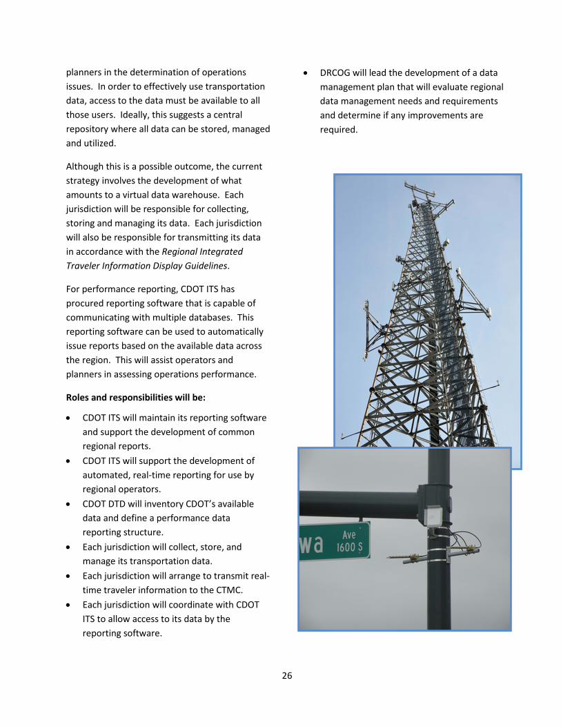
This initiative is cross-cutting and addresses all objectives.
This initiative recognizes that communications connections to support the flow of data between jurisdictions are necessary for shared monitoring and performance measurement. An Ethernet network has been established in the region connecting CDOT ITS, CDOT Region 6, Denver, Lakewood, Douglas County, Littleton and Englewood. Expansion of the Ethernet network to partner jurisdictions will be necessary for
jurisdictions sharing higher bandwidth data flows such as camera videos, roadway performance data, or system health metrics.
As the shared network is a shared resource, all partners on the network will have a responsibility for its management and operations and all partners will have a responsibility to share costs for its development and maintenance. CDOT ITS will lead the management of the network and will maintain their equipment resident within other jurisdictions. All the partners will maintain the network elements within their jurisdiction.
Roles and responsibilities will be:
• As part of project development under other initiatives, local jurisdictions will include the communications network connection in the project. The local jurisdiction will also coordinate with CDOT ITS to determine the network expansion requirements.
• CDOT ITS will be responsible for the day-to-day management of the existing network.
• All partners will maintain the network elements in their jurisdiction and will collaborate to manage plans for network expansion.
Initiative C-5: Establish a shared data warehouse and performance reporting process
This initiative is cross-cutting and addresses all objectives.
Data collected as part of transportation systems operations has many uses: it serves as performance metrics for real-time operations and management; it serves as traveler information for the public; and, it serves to illustrate performance trends that assist operators and
26
planners in the determination of operations issues. In order to effectively use transportation data, access to the data must be available to all those users. Ideally, this suggests a central repository where all data can be stored, managed and utilized.
Although this is a possible outcome, the current strategy involves the development of what amounts to a virtual data warehouse. Each jurisdiction will be responsible for collecting, storing and managing its data. Each jurisdiction will also be responsible for transmitting its data in accordance with the Regional Integrated Traveler Information Display Guidelines.
For performance reporting, CDOT ITS has procured reporting software that is capable of communicating with multiple databases. This reporting software can be used to automatically issue reports based on the available data across the region. This will assist operators and planners in assessing operations performance.
Roles and responsibilities will be:
• CDOT ITS will maintain its reporting software and support the development of common regional reports.
• CDOT ITS will support the development of automated, real-time reporting for use by regional operators.
• CDOT DTD will inventory CDOT’s available data and define a performance data reporting structure.
• Each jurisdiction will collect, store, and manage its transportation data.
• Each jurisdiction will arrange to transmit real-time traveler information to the CTMC.
• Each jurisdiction will coordinate with CDOT ITS to allow access to its data by the reporting software.
• DRCOG will lead the development of a data management plan that will evaluate regional data management needs and requirements and determine if any improvements are required.
27
Operational Concept Overview To summarize the operational concept in another way, this section illustrates the relationships involved in the operational concept and includes a list of general roles and responsibilities. This operational concept is high level and establishes roles and responsibilities that will be refined in the initiatives described above. As such, the ultimate configuration may differ from this overview.
Figure 5 illustrates the relationships contained in the operational concept of this RCTO
General Roles and Responsibilities The general roles and responsibilities listed here do not necessarily represent a commitment of resources on the part of the regional stakeholders. This operational concept describes how the regional stakeholders will work together as they choose to implement transportation operations projects using regional funding.
CTMC12
Staff
Current Colorado Traffic Management Center (CTMC) staff CDOT operations staff Regional monitoring staff Public safety staff (Colorado State Patrol [CSP])
Roles and Responsibilities Inputs
Freeway system monitoring Ramp system monitoring Weather monitoring (include weather data from other jurisdictions) Incident/event notification to CTMC from local traffic management centers (TMC) Public safety computer-aided dispatch (CAD) feed Local TMC feeds: work zones, events
12 The establishment of CDOT’s Division of Transportation Operations is expected to have an impact on CDOT’s organizational structure, roles, and responsibilities.
Outputs Traveler information (travel times, 511, web, GovDelivery, ICM-related) Day-to-day traffic management (freeways) Traffic incident management (freeways) Notification to other TMCs (i.e., City and County Traffic Management (CCTM) website, GovDelivery, email, phone calls) Weather maintenance decisions support system (MDSS) Performance measures:
• Data management • Reporting
Local Jurisdictions Staff
Local jurisdiction operations and maintenance staff Public safety staff
Roles and Responsibilities Inputs
Arterial and state highway system monitoring Parking Management (park-n-Rides and environs) Weather monitoring Notification from CTMC Public safety CAD feed Performance measures reports from CTMC Incident/event notification from CTMC
Outputs Day-to-day traffic management (arterials and state highways) Traffic incident management (arterials and state highways) Operations data to CMTC Data management: • Local data management and
archiving • Custom messaging data feed to
CTMC via internet • Work zones • Special events • Performance measures • Traveler information
28
RTD Staff
RTD dispatch/operations staff
Roles and Responsibilities Inputs
Transit system monitoring Performance measures reports from CTMC Incident/event notification from CTMC
Outputs Day-to-day transit management Transit incident management Traffic incident management Parking Management (park-n-Rides) Traveler information (travel times, 511, web) Data management:
• Local data management and archiving
• Custom messaging data feed to CTMC via internet
• Performance measures • Traveler information
DRCOG Staff
Planning staff Regional monitoring staff
Roles and Responsibilities Inputs
Performance measures reports from CTMC Performance measures reports from RTD Other performance measures (currently consolidated from other state and regional sources)
Outputs Performance measurement coordination
Public Safety Staff
Public dispatch staff Supplemental TMC staff
Roles and Responsibilities Inputs
Incident management coordination with CTMC Incident management coordination with local TMC Performance measures reports from CTMC
Outputs Incident management coordination with CTMC Incident management coordination with local TMC CAD feed to subregional TMC CAD feed to CTMC
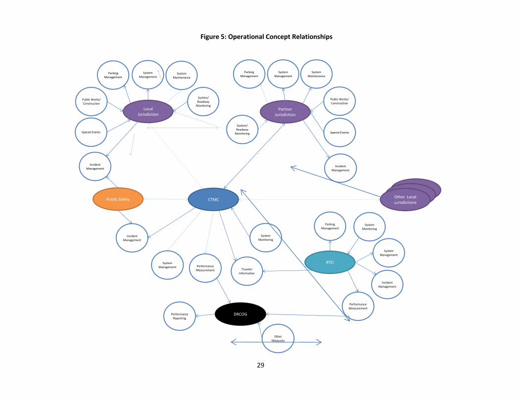
29
Figure 5: Operational Concept Relationships
RTD
Local Jurisdiction
PerformanceMeasurement
System Management
DRCOG
Incident Management
System/Roadway
Monitoring
System Management
System Maintenance
Incident Management
OtherMeasures
System Monitoring
Public Works/Construction
Public Safety
Traveler Information
System Management
System Monitoring
Incident Management
Special Events
PerformanceMeasurement
Local JurisdictionLocal
JurisdictionOther Local Jurisdictions
Parking Management
Parking Management
CTMC
Partner Jurisdiction
System Management
System Maintenance
Parking Management
Public Works/Construction
Special Events
System/ Roadway
Monitoring
Incident Management
PerformanceReporting