Drayton South Coal Project - Environmental Impact Statement/media/Files/A/Anglo-American... ·...
48
DRAYTON SOUTH COAL PROJECT ENVIRONMENTAL IMPACT STATEMENT Executive Summary May 2015
Transcript of Drayton South Coal Project - Environmental Impact Statement/media/Files/A/Anglo-American... ·...
DRAYTON SOUTH COAL PROJECT ENVIRONMENTAL IMPACT STATEMENTExecutive Summary May 2015
HANSEN BAILEY
Environmental Consultants
6/127-129 John Street Singleton NSW 2330 Australia
PO Box 473 Singleton NSW 2330 Australia
T + 61 (2) 6575 2000 F + 61 (2) 6575 2001
www.hansenbailey.com.au

iDrayton South Coal Project Environmental Impact Statement
HANSEN BAILEY
Contents
1 Overview 1
2 Approved Operations 7
3 Project Description 9
4 Regulatory Framework 11
5 Stakeholder Engagement 13
6 Existing Environment 15
7 Impacts, Management and Mitigation 19
8 Management and Monitoring Summary 40
9 Project Justification 41
1 Drayton South Coal Project Environmental Impact Statement
HANSEN BAILEY
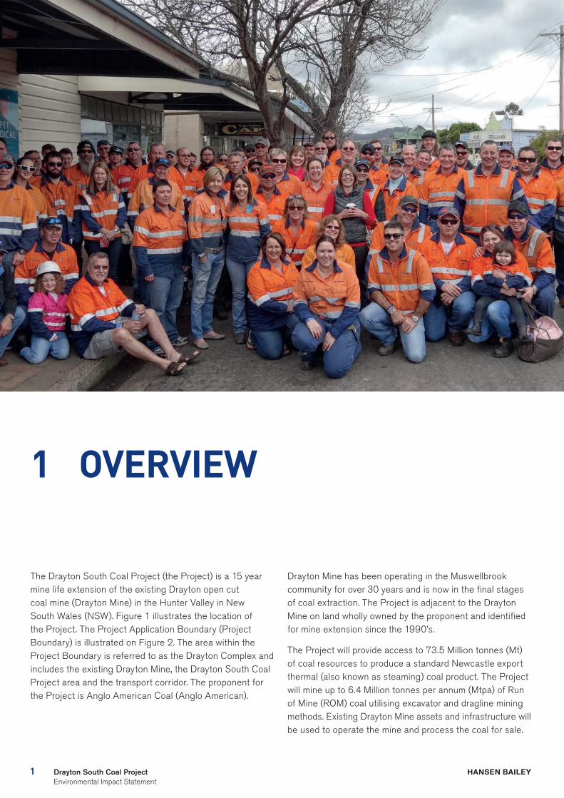
1 OVERVIEW
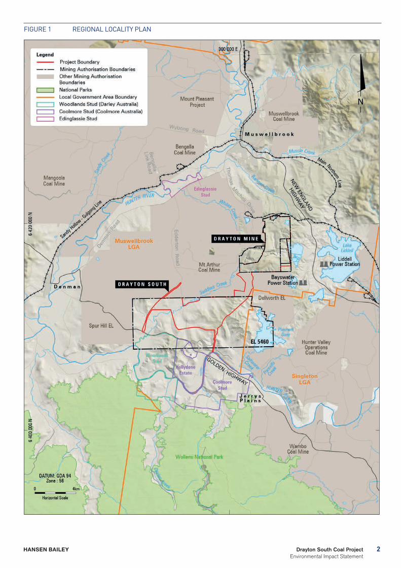
The Drayton South Coal Project (the Project) is a 15 year mine life extension of the existing Drayton open cut coal mine (Drayton Mine) in the Hunter Valley in New South Wales (NSW). Figure 1 illustrates the location of the Project. The Project Application Boundary (Project Boundary) is illustrated on Figure 2. The area within the Project Boundary is referred to as the Drayton Complex and includes the existing Drayton Mine, the Drayton South Coal Project area and the transport corridor. The proponent for the Project is Anglo American Coal (Anglo American).
Drayton Mine has been operating in the Muswellbrook community for over 30 years and is now in the final stages of coal extraction. The Project is adjacent to the Drayton Mine on land wholly owned by the proponent and identified for mine extension since the 1990’s.
The Project will provide access to 73.5 Million tonnes (Mt) of coal resources to produce a standard Newcastle export thermal (also known as steaming) coal product. The Project will mine up to 6.4 Million tonnes per annum (Mtpa) of Run of Mine (ROM) coal utilising excavator and dragline mining methods. Existing Drayton Mine assets and infrastructure will be used to operate the mine and process the coal for sale.
2Drayton South Coal Project Environmental Impact Statement
HANSEN BAILEY
Figure 1 regiONAL LOCALiTY PLAN
3 Drayton South Coal Project Environmental Impact Statement
HANSEN BAILEY
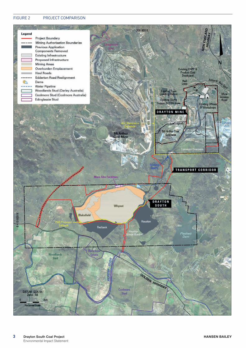
Figure 2 PrOJeCT COMPAriSON
4Drayton South Coal Project Environmental Impact Statement
HANSEN BAILEY
TABLE 1 KEY DIFFERENCES TO THE PREVIOUS DRAYTON SOUTH APPLICATION
ASPECTPREVIOUS APPLICATION (EA 2012)
CURRENT APPLICATION (EIS 2015)
Project Parameters
Resource to be extracted over the Life of Mine (LOM) (tonnes) Total Open Cut Resource - 172 Mt
119 Mt
73.5 Mt
Resource removed to address stakeholder concerns (tonnes) (%) 53 M (31%) 99 M (57%)
Life of Mine (Years) 27 15
Project disturbance footprint (ha) (Reduction %)
1,928 1,441 (25%)
Regional and Local Impacts
Distance between closest point of the mine and horse stud boundary fence (km) 0.5 1.0
Buffer between closest point and horse stud operational area (km) 1.4 2.0
Air quality impacts above background levels to closest horse stud receiver (Annual Average PM10 [µg/m3])
10
2
Noise impacts above background levels to residences and horse stud operational areas 0 0
Average number of days of water release (discharge events) to Hunter River per year Between 30-49 0
Workforce at peak production 500 500
Annual royalties ($) ~ 30 M ~ 30 M
Total royalties for NSW government ($ present value) 320 M 233 M
The continuation of operations at Drayton Mine will allow for the continuation of employment for the local workforce of up to 500 people, continued business to local suppliers, and approximately $30 Million (M) in royalties per year to the state of NSW.
This Development Application has been designed to address the reasons for the refusal by the NSW Planning Assessment Commission (PAC) of a previous application to extend the life of Drayton Mine. In particular the Project footprint has been significantly contracted to specifically meet the recommendations of both the previous Review and Determination PACs. The primary difference to the Project mine design for this application is to locate all mining activities behind the second ridgeline as recommended by the PAC Review Report (shown on Figure 2 as PAC proposed set back). Significantly, this doubles the buffer setback distance from the Coolmore and Woodlands thoroughbred horse studs with mining activities now never closer than 2 kilometres (km) from the horse stud operational areas. The operational areas include all offices, homesteads, stables and associated infrastructure, internal access roads and paddocks where horses are bred and kept.
The Project as proposed:
- Doubles the buffer distance to protect the horse studs from the impacts of mining as recommended in the previous application PAC Review Report and Gateway Panel Report;
- Will have no adverse impact on equine health;
- Will have no impact on the viability of operations at Coolmore or Woodlands Studs and presents no reasonable justification for either horse stud to consider leaving the Hunter Valley Region;
- Will have no impact on the viability of the thoroughbred, viticultural or tourism industries, whilst continuing to deliver significant economic benefits to the local region and NSW; and
- Delivers a project that is in the public interest.
This Executive Summary provides a high level overview of the Project, the environmental assessment process and the key findings of the Environmental Impact Statement (EIS).
Key Differences to the Previous Application The new application addresses the reasons stated by the PAC for refusal of the previous application. Table 1 below outlines the key differences between the current Project and the previous application.
5 Drayton South Coal Project Environmental Impact Statement
HANSEN BAILEY
TABLE 2 PAC RECOMMENDATIONS ADDRESSED
PAC ISSUE RESPONSE
Provide sufficient bufferThe mine plan has been revised to remain entirely behind the PAC recommended second ridgeline. Subsequently the Redbank and Houston mining areas have been removed and the western part of the Blakefield mining area reduced. This has doubled the buffer between the Project and the horse studs and reduced the size of the Project disturbance area by 25%.
Equine health impact
A robust technical assessment has been undertaken on the potential impacts of the revised project by a pre-eminent equine health expert. This assessment has concluded that the Project as proposed will not have any adverse impacts on equine health. The equine health assessment has been peer reviewed by Associate Professor Kristopher Hughes (specialist in equine medicine) and Dr Deborah Racklyeft (specialist in equine medicine). Both have endorsed its approach and findings.
Viability of the horse studs
The mine plan has been revised to remain entirely behind the PAC recommended second ridgeline. This doubles the buffer distance to the horse studs, significantly reduces environmental impacts, ensures that there will be no impact on equine health and removes all views to the Project from the horse studs operational areas. Accordingly the Project as proposed will enable co-existence and in no way impact on the viability of the horse studs.
Economic benefit – Redbank Pit value
The mine plan in this current application remains viable even when subject to worst case sensitivity testing. This is primarily due to a restructuring and reduction of Project capital and a reduction in operating costs.
Public interest
The Project as proposed will provide net social benefits to Australia of between $329 M and $475 M, which includes royalties to the NSW government of $233 M (present value) and company tax payable to the Commonwealth of $93 M. Further, Drayton Mine will continue to provide employment for up to 500 local employees, spend $50 M on local suppliers (generating indirect employment) and provide economic and social contributions to the local community including by way of a Voluntary Planning Agreement (VPA) with Muswellbrook Shire Council (MSC).
PAC Recommendations Addressed Upon review of the PAC Report, a number of aspects of the previous application were identified as key issues that needed to be addressed through changes to the Project mine design. An outline of how the recommendations of the PAC report have been addressed by the Project is provided in Table 2 below.
6Drayton South Coal Project Environmental Impact Statement
HANSEN BAILEY
7 Drayton South Coal Project Environmental Impact Statement
HANSEN BAILEY
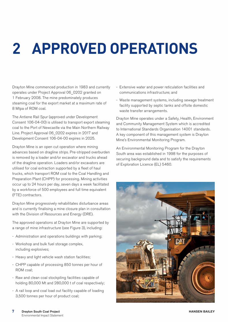
2 APPROVED OPERATIONS
Drayton Mine commenced production in 1983 and currently operates under Project Approval 06_0202 granted on 1 February 2008. The mine predominately produces steaming coal for the export market at a maximum rate of 8 Mtpa of ROM coal.
The Antiene Rail Spur (approved under Development Consent 106-04-00) is utilised to transport export steaming coal to the Port of Newcastle via the Main Northern Railway Line. Project Approval 06_0202 expires in 2017 and Development Consent 106-04-00 expires in 2025.
Drayton Mine is an open cut operation where mining advances based on dragline strips. Pre-stripped overburden is removed by a loader and/or excavator and trucks ahead of the dragline operation. Loaders and/or excavators are utilised for coal extraction supported by a fleet of haul trucks, which transport ROM coal to the Coal Handling and Preparation Plant (CHPP) for processing. Mining activities occur up to 24 hours per day, seven days a week facilitated by a workforce of 500 employees and full time equivalent (FTE) contractors.
Drayton Mine progressively rehabilitates disturbance areas and is currently finalising a mine closure plan in consultation with the Division of Resources and Energy (DRE).
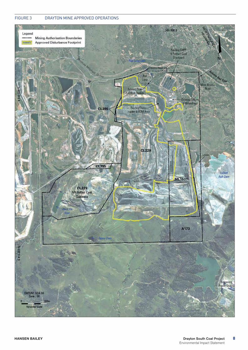
The approved operations at Drayton Mine are supported by a range of mine infrastructure (see Figure 3), including:
- Administration and operations buildings with parking;
- Workshop and bulk fuel storage complex, including explosives;
- Heavy and light vehicle wash station facilities;
- CHPP capable of processing 850 tonnes per hour of ROM coal;
- Raw and clean coal stockpiling facilities capable of holding 80,000 Mt and 280,000 t of coal respectively;
- A rail loop and coal load out facility capable of loading 3,500 tonnes per hour of product coal;
- Extensive water and power reticulation facilities and communications infrastructure; and
- Waste management systems, including sewage treatment facility supported by septic tanks and offsite domestic waste transfer arrangements.
Drayton Mine operates under a Safety, Health, Environment and Community Management System which is accredited to International Standards Organisation 14001 standards. A key component of this management system is Drayton Mine’s Environmental Monitoring Program.
An Environmental Monitoring Program for the Drayton South area was established in 1998 for the purposes of securing background data and to satisfy the requirements of Exploration Licence (EL) 5460.
8Drayton South Coal Project Environmental Impact Statement
HANSEN BAILEY
Figure 3 DrAYTON MiNe APPrOVeD OPerATiONS
9 Drayton South Coal Project Environmental Impact Statement
HANSEN BAILEY
3 PROJECT DESCRIPTION
Anglo American is seeking Development Consent under Division 4.1 of Part 4 of the Environmental Planning and Assessment Act (1979) (EP&A Act) for the continuation of the existing Drayton Mine through the extraction of coal by open cut mining operations in the Drayton South area. The Project will maintain ongoing use of all of the infrastructure at the existing Drayton Mine including the Antiene Rail Spur which will continue to be relied upon for the transport of coal to the Port of Newcastle. The Project involves the:
- Continuation of operations at Drayton Mine as currently approved with minor additional mining within the existing East, North and South mining areas for a period of up to 15 years;
- Development of the Drayton South open cut mining area (within EL 5460) mining up to 6.4 Mtpa ROM coal for 15 years;
- Ongoing employment of a workforce of up to 500 FTE employees;
- Utilisation of the existing Drayton Mine equipment fleet;
- Storage of water, and the emplacement of tailings and rejects generated by the Project in the existing Drayton Mine voids;
- Utilisation of the existing Drayton Mine infrastructure including the CHPP, rail loop and associated infrastructure, workshops, bath houses and administration offices;
- Construction of a transport corridor to the new mining area;
- Continued utilisation of the Antiene Rail Spur off the Main Northern Railway Line to transport product coal to the Port of Newcastle for export;
- Realigning and upgrading a section of Edderton Road;
- Continuation of mutually beneficial arrangements with neighbours AGL Macquarie and Mt Arthur Coal Mine;
- Installation of further water management and power reticulation infrastructure to support the new mining area; and
- Progressive rehabilitation of disturbed areas as mining operations are completed.
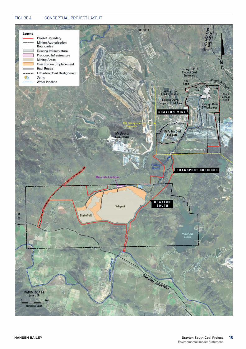
The conceptual layout of the Project is illustrated in Figure 4. Following construction within the Drayton South area, there will be a period when mining will occur at the existing approved Drayton Mine and within the Drayton South area concurrently as mining activities are transitioned. During this period, personnel and equipment will be progressively transferred from Drayton Mine to the Drayton South area. This will continue until mining operations are completed at Drayton Mine.
The Project represents a logical progression from operations at the existing Drayton Mine for the recovery of a known State Significant Coal Resource within the Drayton South mining area. It will also offer continuity of employment for Drayton Mines existing workforce of nearly 500 personnel at a time when thousands of coal mining jobs are being lost from the industry.
Following the PACs refusal of the previous application Anglo American developed this Project mine plan to meet the recommendations of both the previous Review and Determination PACs with all mining activities to now remain behind the PAC-recommended second ridgeline.
10Drayton South Coal Project Environmental Impact Statement
HANSEN BAILEY
Figure 4 CONCePTuAL PrOJeCT LAYOuT

11 Drayton South Coal Project Environmental Impact Statement
HANSEN BAILEY
4 REGULATORY FRAMEWORK
The Project is defined as development “for the purpose of mining that is ‘coal mining’”, as listed under Clause 5 of Schedule 1 of the State Environmental Planning Policy (State and Regional Development) 2011. The Project is declared a State Significant Development and will be subject to the provisions of Division 4.1 of Part 4 of the EP&A Act.
The Project is located on land falling within the Muswellbrook Local Government Area (LGA). Mining as proposed is situated entirely on land within zone RU1 under the Muswellbrook Local Environmental Plan 2009 (Muswellbrook LEP). Mining is permissible within zone RU1 with Development Consent under that LEP. All components of the Project are permissible with development consent under the EP&A Act.
In accordance with Clause 3 of Schedule 2 of the Environmental Planning and Assessment Regulation (2000), Anglo American made a request for the Secretary’s Environmental Assessment Requirements (SEARs) on 12 December 2014. The SEARs for the Project were issued by the Secretary on 19 December 2014.
Revised SEARs were issued by the Secretary on 13 April 2015 to incorporate a number of wording changes requested by Coolmore Australia and Darley Australia and also to include the requirements of a Conditional Gateway Certificate issued over the Project.
The State Environmental Planning Policy (Mining, Petroleum Production and Extractive Industries) 2007 and Strategic Regional Land Use Plan - Upper Hunter (SRLUP) provide for a “Gateway” process as a pre-requisite to making a State Significant Development application. The Gateway process is described as a scientific assessment of the impacts of mining on Strategic Agricultural Land (SAL).
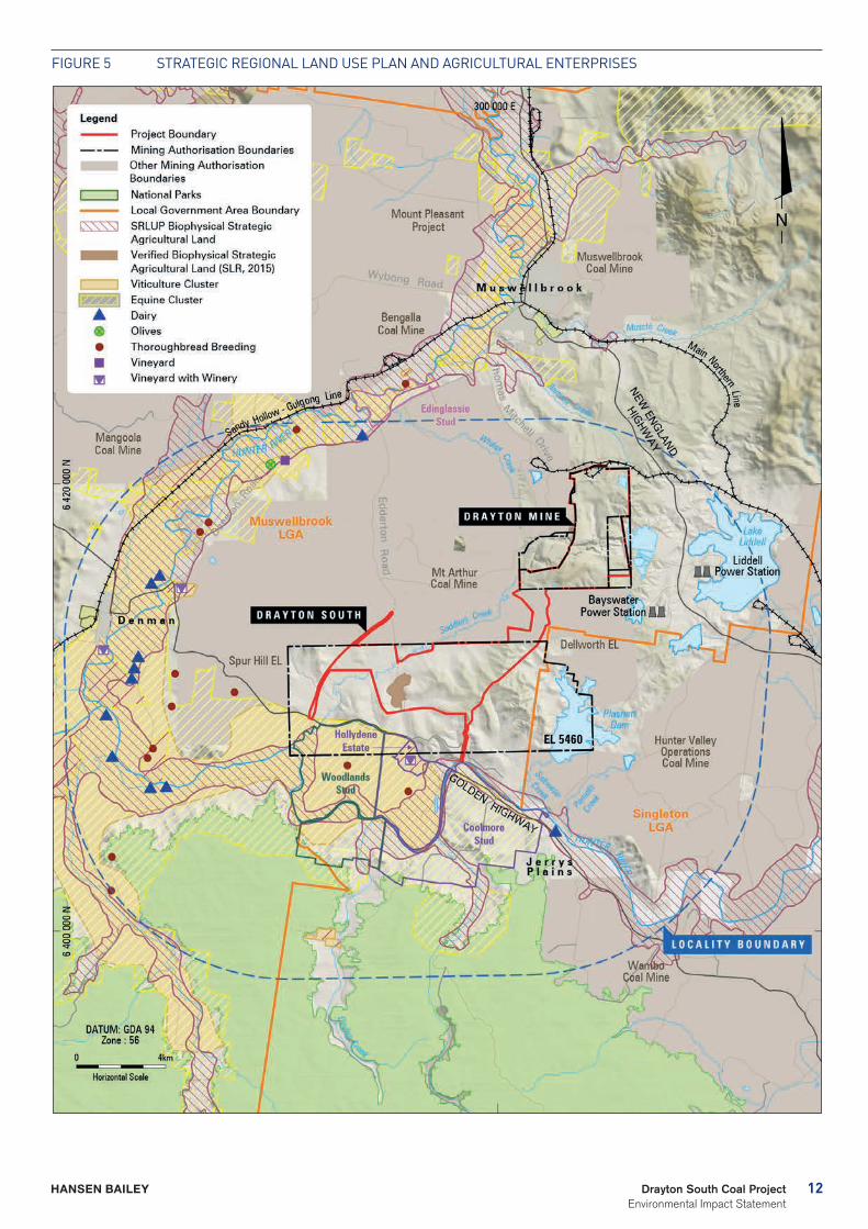
There are two categories of SAL, being Biophysical Strategic Agricultural Land (BSAL) and Critical Infrastructure Cluster (CIC), which is comprised of SAL - Viticulture CIC and SAL - Equine CIC. There is no Equine or Viticulture CIC land within the Project Boundary. However, Equine and Viticulture CIC are located approximately 1 km to the south of the Project Boundary (see Figure 5). Field work conducted in January 2015 confirmed 78.8 ha of land verified as BSAL falls within the Project disturbance footprint.
As a consequence of there being BSAL within the Project Boundary, the Gateway process was triggered for the Project and a Conditional Gateway Certificate was issued for the Project on 2 April 2015.
The Project will seek other relevant approvals under NSW legislation as required.
The Project was referred to the Commonwealth Department of Environment (DoE) on 17 December 2014. On 4 March 2015, the Project was declared a ‘controlled action’ and will subsequently require assessment under the Environment Protection and Biodiversity Conservation Act 1999 (Cth). The Project was considered a controlled action due to its potential impacts on two Matters of National Environmental Significance (MNES), namely:
- Listed threatened species and ecological communities; and
- A water resources, in relation to coal seam gas development and large coal mining development.
DoE has confirmed that the Project is to be assessed under the assessment bilateral agreement with the NSW Government. Further requirements were issued by the DoE on 30 April 2015 and were included as a supplement to the revised SEARs.
12Drayton South Coal Project Environmental Impact Statement
HANSEN BAILEY
Figure 5 STrATegiC regiONAL LAND uSe PLAN AND AgriCuLTurAL eNTerPriSeS
13 Drayton South Coal Project Environmental Impact Statement
HANSEN BAILEY
5 STAKEHOLDER ENGAGEMENT
Stakeholder engagement in relation to exploration and mine development in the Drayton South area commenced in 1980 when the Mount Arthur South Coal Project targeted drilling program commenced. This work culminated in the grant of planning approval in 1986 for a 120 Mt coal mine, a coal mine that was 40 % larger than the one proposed today.
Since Anglo American acquired the Drayton South area in 1998 it has consulted with all relevant stakeholders over its plans to conduct exploration and then develop the area. Specifically, consultation by Anglo American over the Project commenced in earnest in 2005 and has continued with all interested parties since this time.
For Anglo American’s previous application, Project briefings were conducted with neighbouring land owners and the wider local community via telephone, email and community newsletters. During the planning phase, 10 community stakeholders, including Coolmore Australia and Darley Australia, accepted the opportunity to be briefed on the Project. At this time, several working groups were established with neighbouring enterprises and industries, including Coolmore Australia, Darley Australia, Mt Arthur Coal Mine and AGL Macquarie to address key issues and interactions and to further develop cooperative land owner relationships.
14Drayton South Coal Project Environmental Impact Statement
HANSEN BAILEY
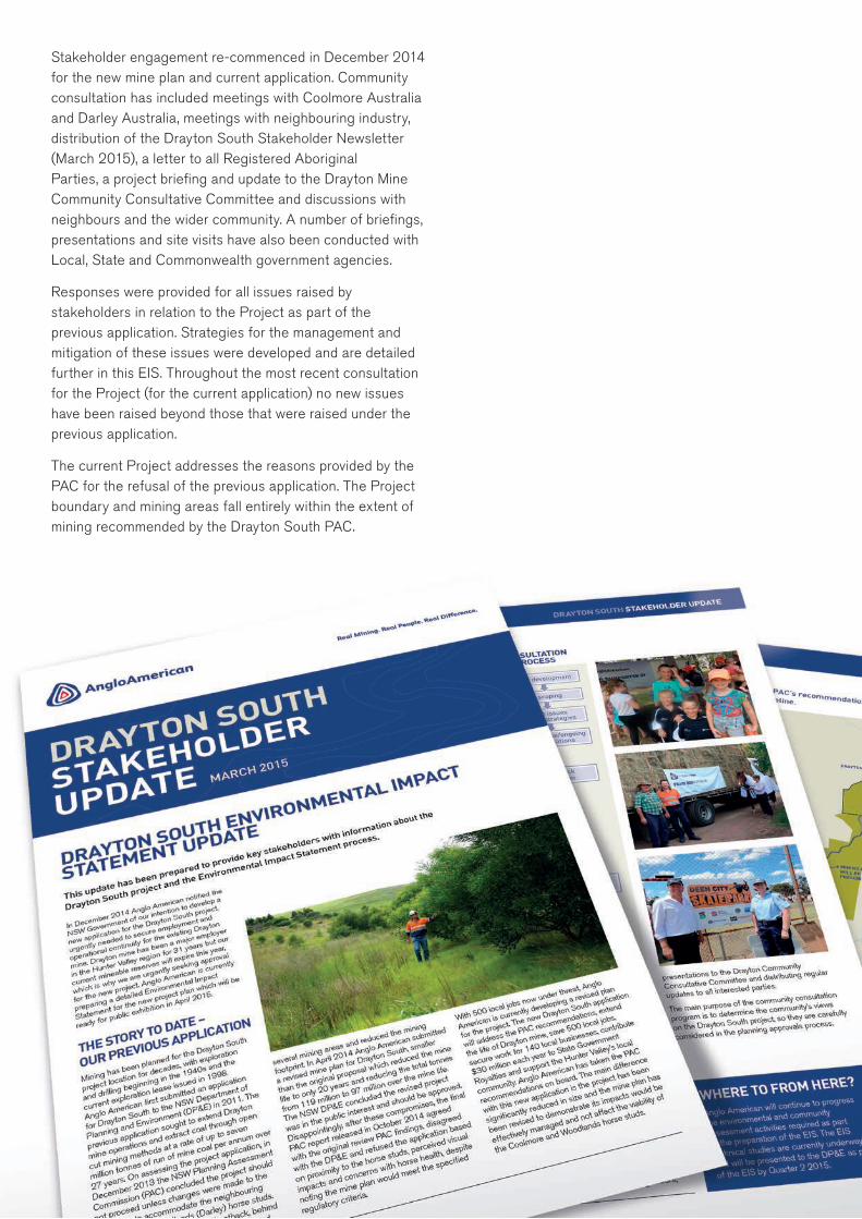
Stakeholder engagement re-commenced in December 2014 for the new mine plan and current application. Community consultation has included meetings with Coolmore Australia and Darley Australia, meetings with neighbouring industry, distribution of the Drayton South Stakeholder Newsletter (March 2015), a letter to all Registered Aboriginal Parties, a project briefing and update to the Drayton Mine Community Consultative Committee and discussions with neighbours and the wider community. A number of briefings, presentations and site visits have also been conducted with Local, State and Commonwealth government agencies.
Responses were provided for all issues raised by stakeholders in relation to the Project as part of the previous application. Strategies for the management and mitigation of these issues were developed and are detailed further in this EIS. Throughout the most recent consultation for the Project (for the current application) no new issues have been raised beyond those that were raised under the previous application.
The current Project addresses the reasons provided by the PAC for the refusal of the previous application. The Project boundary and mining areas fall entirely within the extent of mining recommended by the Drayton South PAC.
15 Drayton South Coal Project Environmental Impact Statement
HANSEN BAILEY
6 EXISTING ENVIRONMENT
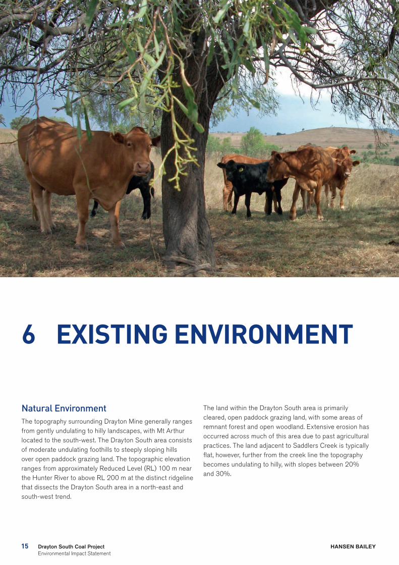
Natural EnvironmentThe topography surrounding Drayton Mine generally ranges from gently undulating to hilly landscapes, with Mt Arthur located to the south-west. The Drayton South area consists of moderate undulating foothills to steeply sloping hills over open paddock grazing land. The topographic elevation ranges from approximately Reduced Level (RL) 100 m near the Hunter River to above RL 200 m at the distinct ridgeline that dissects the Drayton South area in a north-east and south-west trend.
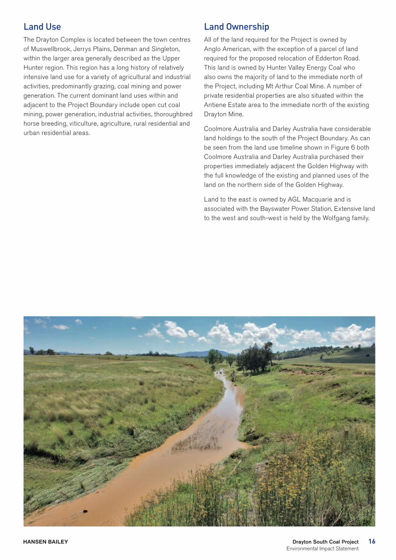
The land within the Drayton South area is primarily cleared, open paddock grazing land, with some areas of remnant forest and open woodland. Extensive erosion has occurred across much of this area due to past agricultural practices. The land adjacent to Saddlers Creek is typically flat, however, further from the creek line the topography becomes undulating to hilly, with slopes between 20% and 30%.
16Drayton South Coal Project Environmental Impact Statement
HANSEN BAILEY
Land UseThe Drayton Complex is located between the town centres of Muswellbrook, Jerrys Plains, Denman and Singleton, within the larger area generally described as the Upper Hunter region. This region has a long history of relatively intensive land use for a variety of agricultural and industrial activities, predominantly grazing, coal mining and power generation. The current dominant land uses within and adjacent to the Project Boundary include open cut coal mining, power generation, industrial activities, thoroughbred horse breeding, viticulture, agriculture, rural residential and urban residential areas.
Land OwnershipAll of the land required for the Project is owned by Anglo American, with the exception of a parcel of land required for the proposed relocation of Edderton Road. This land is owned by Hunter Valley Energy Coal who also owns the majority of land to the immediate north of the Project, including Mt Arthur Coal Mine. A number of private residential properties are also situated within the Antiene Estate area to the immediate north of the existing Drayton Mine.
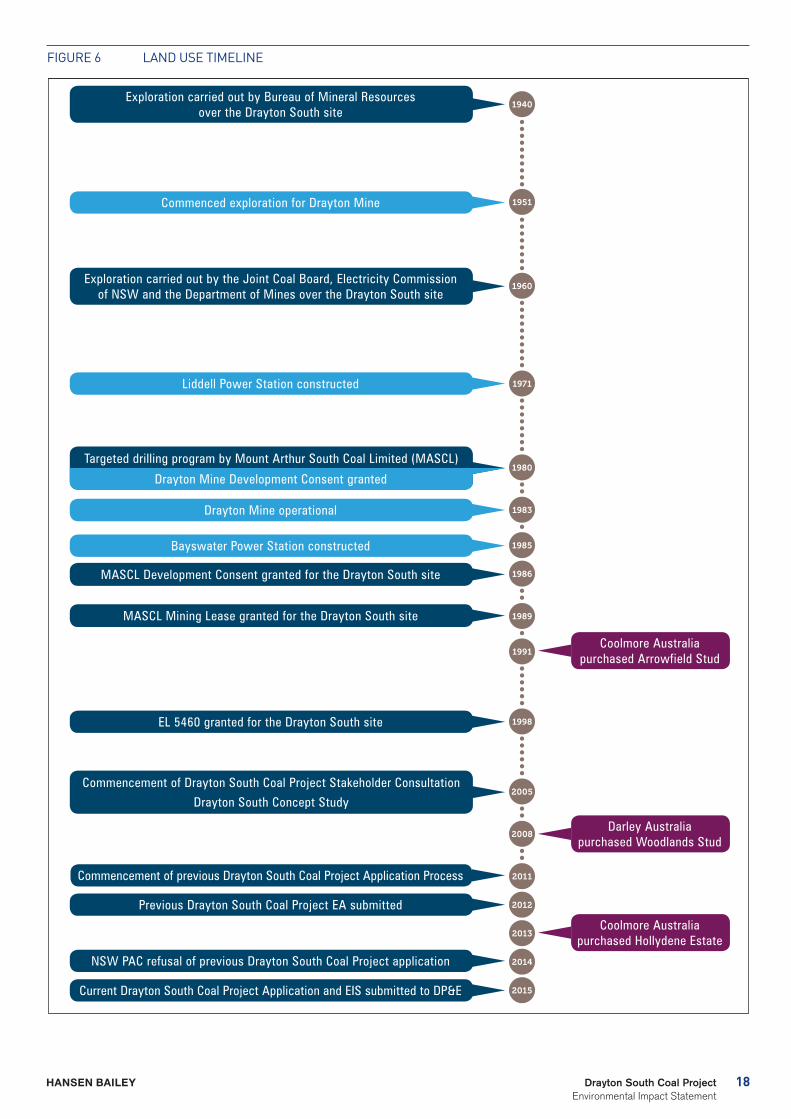
Coolmore Australia and Darley Australia have considerable land holdings to the south of the Project Boundary. As can be seen from the land use timeline shown in Figure 6 both Coolmore Australia and Darley Australia purchased their properties immediately adjacent the Golden Highway with the full knowledge of the existing and planned uses of the land on the northern side of the Golden Highway.
Land to the east is owned by AGL Macquarie and is associated with the Bayswater Power Station. Extensive land to the west and south-west is held by the Wolfgang family.
17 Drayton South Coal Project Environmental Impact Statement
HANSEN BAILEY
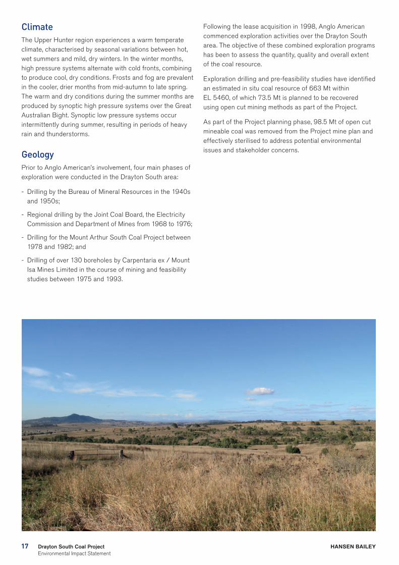
ClimateThe Upper Hunter region experiences a warm temperate climate, characterised by seasonal variations between hot, wet summers and mild, dry winters. In the winter months, high pressure systems alternate with cold fronts, combining to produce cool, dry conditions. Frosts and fog are prevalent in the cooler, drier months from mid-autumn to late spring. The warm and dry conditions during the summer months are produced by synoptic high pressure systems over the Great Australian Bight. Synoptic low pressure systems occur intermittently during summer, resulting in periods of heavy rain and thunderstorms.
GeologyPrior to Anglo American’s involvement, four main phases of exploration were conducted in the Drayton South area:
- Drilling by the Bureau of Mineral Resources in the 1940s and 1950s;
- Regional drilling by the Joint Coal Board, the Electricity Commission and Department of Mines from 1968 to 1976;
- Drilling for the Mount Arthur South Coal Project between 1978 and 1982; and
- Drilling of over 130 boreholes by Carpentaria ex / Mount Isa Mines Limited in the course of mining and feasibility studies between 1975 and 1993.
Following the lease acquisition in 1998, Anglo American commenced exploration activities over the Drayton South area. The objective of these combined exploration programs has been to assess the quantity, quality and overall extent of the coal resource.
Exploration drilling and pre-feasibility studies have identified an estimated in situ coal resource of 663 Mt within EL 5460, of which 73.5 Mt is planned to be recovered using open cut mining methods as part of the Project.
As part of the Project planning phase, 98.5 Mt of open cut mineable coal was removed from the Project mine plan and effectively sterilised to address potential environmental issues and stakeholder concerns.
18Drayton South Coal Project Environmental Impact Statement
HANSEN BAILEY
Figure 6 LAND uSe TiMeLiNe
1940
1951
1960
1971
1980
1983
1985
1986
1989
1991
1998
2005
2008
2011
2012
2013
2014
2015
EL 5460 granted for the Drayton South site
Commencement of previous Drayton South Coal Project Application Process
Coolmore Australia purchased Arrowfield Stud
Darley Australia purchased Woodlands Stud
Coolmore Australia purchased Hollydene Estate
Exploration carried out by Bureau of Mineral Resources over the Drayton South site
Exploration carried out by the Joint Coal Board, Electricity Commission of NSW and the Department of Mines over the Drayton South site
Commenced exploration for Drayton Mine
Bayswater Power Station constructed
Drayton Mine operational
Liddell Power Station constructed
Targeted drilling program by Mount Arthur South Coal Limited (MASCL)
Drayton Mine Development Consent Granted
MASCL Development Consent granted for the Drayton South site
MASCL Mining Lease granted for the Drayton South site
Commencement of Drayton South Coal Project Stakeholder Consultation
Drayton South Concept Study
Previous Drayton South Coal Project EA submitted
NSW PAC refusal of previous Drayton South Coal Project application
Current Drayton South Coal Project Application and EIS submitted to DP&E
Drayton Mine Development Consent granted
D R AY T O N S O U T H C O A L P R O J E C T
FIGURE 5-1
Land Use Timeline
19 Drayton South Coal Project Environmental Impact Statement
HANSEN BAILEY
7 IMPACTS, MANAGEMENT AND MITIGATION
A risk assessment was undertaken to identify potential environmental and social issues associated with the Project. The purpose of the risk assessment process was to prioritise and focus the required environmental assessments for the Project in consideration of the SEARs and the findings from stakeholder engagement.
Key findings from the environmental assessments are discussed below.
EconomicsAn economic impact assessment was undertaken by Gillespie Economics which has determined both the economic efficiency and economic impacts of the Project.
A comprehensive Benefit Cost Analysis, which has included conservative sensitivity modelling, confirms that when production costs (acquisition costs for affected land, opportunity cost of land, operating costs, decommissioning costs, etc.) and production benefits (revenues from production, residual values of land, etc.) are considered, the Project will have total net production benefits of $464 M with a minimum of $330 M of these net production benefits accruing to Australia. Based on this outcome, the Project is considered to be justified from an economic efficiency perspective. This net production benefit is distributed amongst a range of stakeholders including the local community, Anglo American, its shareholders and government.
In summary, the Project is estimated to make up to the following direct and indirect contribution to the New South Wales economy for 15 years:
- $906 M in annual direct and indirect regional output or business turnover;
- $393 M in annual direct and indirect regional value added;
- $188 M in annual direct and indirect household income;
- $233 M in NSW Royalties;
- $25 M in NSW Payroll tax; and
- 2,085 direct and indirect jobs.
The Project will result in the following annual contribution to the Upper Hunter (regional) economy for approximately 15 years:
- $559 M in annual direct and indirect regional output or business turnover;
- $220 M in annual direct and indirect regional value added;
- $71 M in annual direct and indirect household income; and
- 984 direct and indirect jobs.
The technical studies completed as part of this EIS found that, for the new mine plan (defined by the setbacks recommended by the PAC) there would be no impacts on the Coolmore and Woodlands Studs and the amenity of the surrounding landscape. As such there will be no impact on the viability of operations at Coolmore or Woodlands Studs and no reasonable justification for either horse stud to consider leaving the Hunter Valley Region on the basis of environmental impacts from the Project.
An economics expert was engaged to peer review the EIS Economics Assessment Report. Mr Drew Collins found that the economic assessment adequately addresses the SEARs and relevant NSW Government guidelines in relation to economic analysis and that the assessment is “a sound report… appropriately concludes that the Project offers net economic benefits to the region, State and more broadly to Australia, and is therefore desirable from an economic efficiency perspective”.
20Drayton South Coal Project Environmental Impact Statement
HANSEN BAILEY
21 Drayton South Coal Project Environmental Impact Statement
HANSEN BAILEY
SocialThe purpose of the social impact assessment was to develop a profile of the local area (which primarily encompasses the Muswellbrook and Singleton LGAs) and then identify any future social impacts which may result from the Project.
The Muswellbrook LGA and in particular the township of Muswellbrook, has been significantly impacted by the down-turn in the coal mining industry since 2012, largely as a result of workforce downsizing. House prices in the LGA have dropped more than 6% and rental vacancy rates peaked at 14% in 2013.
A recent article in the Newcastle Herald newspaper (May, 2015) compared the unemployment rate for NSW at 6 percent, with the unemployment rate in the Hunter currently at nearly 13 per cent. It is estimated 4, 000 jobs have been lost in the region over the last two years.
The social impact assessment found that the continued operation of Drayton Mine has significant social and economic benefits in the form of continuing employment for a workforce of approximately 500 persons. The Project will enable the mine to continue to be a major employer in the Muswellbrook LGA and contribute $559 M in annual direct and indirect output or business turnover in the Upper Hunter of NSW.
The assessment concluded that given the Project involves continuation of the existing Drayton Mine and that as the current workforce will continue to be utilised, it is considered unlikely to place an unreasonable strain on existing infrastructure, services or the local community.
Anglo American has made an offer to enter into a Voluntary Planning Agreement (VPA) with MSC to provide in kind and monetary contributions to ensure any potential social effects of the Project are mitigated. The net present value of this VPA Offer is $3 M.
Air QualityControl of dust emissions was a key consideration in the design of the Project. Dispersion model predictions from the indicative worst case modelled years (Years 4, 6 and 12) have been compared with relevant air quality criteria. Several iterations of mine plans were modelled throughout the planning phase to consider worst case scenarios and incorporate all reasonable and feasible measures for the Project in order to reduce environmental and social impacts.
Predictions were made for all private and mine owned residences within the modelling domain. The assessment included predictions of air quality concentrations from the Project in isolation as well as the potential cumulative concentrations with other mines in the region and other sources.
The modelling indicates that:
- There are no private receivers predicted to experience dust concentrations above the Environmental Protection Authority’s (EPA) air quality assessment criteria, or the NSW Department of Planning and Environment (DP&E) mitigation/acquisition criteria due to the Project alone;
22Drayton South Coal Project Environmental Impact Statement
HANSEN BAILEY
- When considering the cumulative impacts, there are no predicted exceedances of the annual average criterion at any privately owned receivers;
- In Year 4 and Year 6, only one residence (R60), a mine-owned residence, is predicted to exceed the annual average PM10 criterion; and
- The only additional exceedances of the EPA’s 24-hour average PM10 criterion occur when the background 24-hour average PM10 concentrations are already elevated.
The assessment determined there are no privately owned residences that are predicted to experience annual average PM2.5 concentrations due to emissions from the Project alone above the National Environment Protection Measures (NEPM) standard (8 µg/m3). Similarly no residences are predicted to experience 24-hour average PM2.5 levels above the NEPM standard of 25 µg/m3 as a result of the Project.
A number of control measures have already been incorporated into the Project design based on the existing air quality management measures at Drayton Mine and recommendations of the NSW Coal Mining Benchmarking Study: International Best Practice Measures to Prevent and/or Minimise Emissions of Particulate Matter from Coal Mining.
A real time meteorological monitoring station with predictive software capabilities has been established, enabling meteorological forecasts to be made for upcoming days. These predictions can be utilised in a predictive dispersion model representing the proposed operations and highlight activities with the potential to generate excessive dust. This provides the accountable personnel with the information required to implement appropriate mitigation and management controls to keep emissions to an acceptable level. These management controls may include relocating equipment from exposed locations and shutting down certain activities during certain weather conditions.
All monitoring will be detailed in the revision of the existing Drayton Mine environmental monitoring plan and the Annual Environment Management Report (Annual Review).
NoiseThe existing acoustic environment is influenced by road traffic, mining and industrial development and natural sounds. Similar to air quality, the control of noise was a key consideration in the design of the Project.
Modelling was undertaken for Years 4, 6 and 12 of the Project life to determine the potential worst case noise impacts on nearby receptors in those years. These representative years were identified as the periods most likely to contain the worst case noise levels to receptors in all directions from the Project. The operations modelled in these years included coal mining activities, coal handling and processing and coal loading and transportation via the Antiene Rail Spur.
Predicted noise levels for both construction and operational activities include all feasible and reasonable noise management and mitigation measures. An analysis was undertaken to investigate various noise management measures to be applied to the Project which showed that those measures proposed in this EIS are feasible and reasonable.
For the purpose of the assessment the receivers surrounding the Drayton Complex were divided into two groups being the Drayton Mine receivers (located to the north) and the Drayton South area receivers (located to the south).
Noise modelling indicates that when noise management and mitigation measures are implemented, there are no exceedances of the regulatory amenity noise criteria at any receivers in the vicinity of the Drayton South area. Predicted noise levels are generally lower than the predicted noise levels reported in the previous application.

23 Drayton South Coal Project Environmental Impact Statement
HANSEN BAILEY
There are exceedances of the noise criteria for receivers at Antiene, which are due to activities at the existing Drayton Mine rather than operations at the Drayton South mining area. These exceedances fall in the ‘mild ’ and ‘moderate’ impact categories under the recently released Voluntary Land Acquisition and Mitigation Policy. Anglo American will continue to liaise with the relevant land owners regarding the management and mitigation of noise impacts at Antiene.
Anglo American will revise the existing Drayton Mine noise management plan for the Project. Ongoing monitoring will also be undertaken to confirm the predicted noise levels of the assessment. This will include real time noise monitoring at representative receiver areas surrounding the Drayton Complex to enable ongoing noise management.
BlastingThe Project is likely to require an average of up to five blast events per week during daylight hours to prepare overburden for removal and for coal recovery.
Blasting associated with the Project (with a maximum instantaneous charge of up to 2000 kg) is predicted to produce ground vibration and overpressure levels well below the relevant amenity criteria at all privately owned residences and heritage structures.
Due to the Project being designed to remain behind the southern ridgeline there is a substantial section of elevated ground between the mining areas and sensitive receptors to the south which acts as a noise and overpressure barrier.
Anglo American will update the existing blasting management plan to include appropriate management and mitigation measures to ensure that the relevant criteria are met for all privately owned residences, heritage structures and infrastructure.
Equine HealthAn equine health impact assessment was undertaken by Associate Professor Nicholas Kannegieter, Specialist Equine Surgeon, in order to determine whether the air quality, noise and blasting impacts of the Project have the potential to cause any adverse impacts on the health of thoroughbred horses located at the neighbouring horse studs.
A comprehensive review of the scientific literature was undertaken to evaluate the potential effects of dust, noise, vibration and lighting on equine health. This review found that horses are subjected to high levels of dust, noise, vibration and lighting as part of their normal progression from stud farm to racing stable.
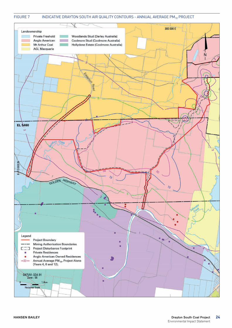
The Project will result in no increases in the annual average PM10 levels at Woodlands Stud receivers and less than 2 µg/m³ at Coolmore Stud receivers (see Figure 7). From the equine literature review it is noted that a maximum recommended level of respirable dust in stables should be 230 µg/m³ (Cargill, 1999), while levels of 80 to 170 µg/m³ are considered normal for a paddock. Therefore an increase of less than 2 µg/m³ (from the current background of 16 µg/m³) to 18 µg/m³ would be considered negligible and have no detectable effect on horse health.
Even based on the worst case scenario for the northern most paddocks at Coolmore and Woodlands Studs there may be a maximum PM10 (24-hour) increase from the Project of between 10 and 25µg/m³ on some days. Based on this assessment and comparison to Cargill’s (1999) maximum recommended level of respirable dust in stables of 230 µg/m³, there will be no risk to pastured horses from combined mine and background PM10 even if the worst case scenario occurred on a regular or even daily basis (which is not predicted to be the case).
Even when worst case operating conditions are modelled for the Project, they will not lead to any exceedances of the cumulative annual average PM10 levels over Coolmore and Woodlands Studs. The cumulative levels remain comparable to or better than those recorded in Kentucky USA which is renowned as the premier area for horse breeding in the world.
Horses are regularly exposed to high noise levels during the course of their life, for example on race days. They are less sensitive to noise than humans. Despite this the literature review indicates that it is appropriate to adopt the noise level criteria suggested for human exposure.
Given that the noise levels are not predicted to exceed the existing background levels at any locations on Coolmore Australia or Darley Australia owned land, noise levels from the Project will not have any impact on the equine population.
24Drayton South Coal Project Environmental Impact Statement
HANSEN BAILEY
Figure 7 iNDiCATiVe DrAYTON SOuTH Air QuALiTY CONTOurS - ANNuAL AVerAge PM10 PrOJeCT
25 Drayton South Coal Project Environmental Impact Statement
HANSEN BAILEY
The EIS has also determined that even under a worst case scenario, that overpressure associated with blasting will be below 105 dBL. This is well below the regulatory amenity limit of 115 dBL. A level of 105 dBL would be perceived as a distant rumbling (similar to distant thunder) and would last for less than 1 second. Overpressure from blasting will also remain far below that of helicopter and aircraft landings at both horse studs and well below that of lightning strikes that occur during frequent thunderstorms in the Hunter Valley. The vibration levels produced by blasting will be barely perceivable at all receivers on the Coolmore Australia and Darley Australia properties. The blasting vibration effects are well below the levels typically experienced by horses during road and air transportation.
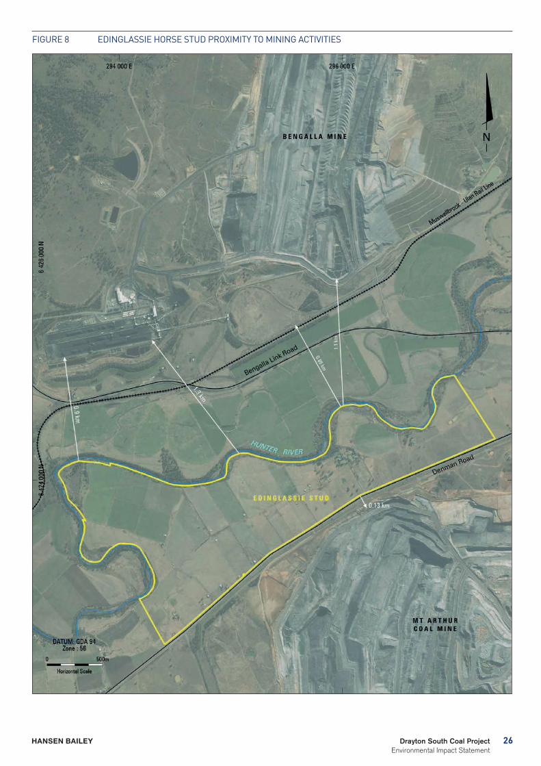
To provide context to the potential impacts of the Project on Coolmore and Woodlands Studs, a comparison is made to the Edinglassie Stud, an Australian thoroughbred stud farm located 7 km south-west of Muswellbrook (see Figure 8). The Edinglassie Stud produces elite thoroughbred racehorses and is located less than 130 m from active mining operations at the neighbouring BHP Billiton Mt Arthur open cut coal mine. Mt Arthur Coal Mine is the largest operating coal mine in NSW and is more than five times the size of the operations proposed at Drayton South. Edinglassie is subject to overpressure levels much higher than those proposed by the Project (commonly in the 120 to 124 dBL range) and there is no evidence to suggest that overpressure generated from blasting causes any adverse impacts to horse health. Given that the Project is located 1 km from either horse studs boundary and over 2 km from both horse studs primary areas of operations (including paddocks where horse are kept), overpressure will not have any adverse effects on horse health.
Based on the Edinglassie Stud example and further anecdotal evidence in relation to the Muswellbrook racecourse and its stable facilities, the levels of impact from vibration will not startle either grazing or stabled racehorses. Therefore, the ground vibration caused by blasting is not expected to have any negative impacts on equine health.
The EIS concludes that noise or overpressure from blasting and mine operations will not induce a flight response in horses on the studs or have any impact on their behaviour. Horses are far more likely to react to lightning strikes and thunder, helicopter landings and farm machinery such as tractors and lawnmowers rather than to distant mine noise. Further it is noted that future planned increases to the capacity of traffic on the Golden Highway would be the most likely source of additional noise outside of the stud’s boundaries.
Due to the mine design and location there will be no direct light encroaching on horse stud livestock. The lighting used at Drayton South will not be directly visible from the studs and any indirect light will not be of sufficient brightness to have any negative effect on breeding cycles.
The findings of the equine health impact assessment are that the Project will have no impact on equine health providing that dust, noise, blasting and light levels remain below the appropriate worst case scenario outcomes predicted throughout the EIS.
Two highly regarded Australian equine specialists independently reviewed the horse health assessment report. Associate Professor Kristopher Hughes has more than 20 years of experience and lists research interests in equine lower respiratory tract diseases, equine gastroenterology, neurology and endocrinology. Dr Deborah Racklyeft has 34 years specialist equine experience and more than 20 years of local experience working as an equine specialist with the Upper Hunter equine industry. Both reviewers concur with and endorse the findings of the equine health impact assessment that the Project will have no impact on equine health.
Anglo American will conduct real-time air quality monitoring, noise monitoring and blast monitoring. All environmental monitoring will be detailed in the revision of the existing Drayton Mine environmental monitoring plan and monitoring data will continue to be reported to the Drayton Mine Community Consultative Committee and in the Annual Review published on the Anglo American website.
26Drayton South Coal Project Environmental Impact Statement
HANSEN BAILEY
Figure 8 eDiNgLASSie HOrSe STuD PrOXiMiTY TO MiNiNg ACTiViTieS
27 Drayton South Coal Project Environmental Impact Statement
HANSEN BAILEY
Visual The visual impact assessment was undertaken to determine the impact of the Project on the visual quality and character of the surrounding area. It involved the development of a 3D model and photomontages of the Project from viewing locations during Years 4, 6, and 12 as representative phases of the Project mine life. The assessment also included a consideration of night lighting impacts.
A key consideration for the Project was to ensure that views of the Project would be screened from the key operational areas of Coolmore and Woodlands Studs, located to the south of the Project. The operational areas include all offices, homesteads, stables and associated infrastructure, internal access roads and paddocks where horses are bred and kept.
This was achieved by constraining the proposed extent of mining to occur north of the ridgelines identified by the PAC in their assessment of the previous Drayton South application. Other mitigation measures incorporated into the design and operating plans for the Project include maintaining the PAC recommended ridgelines (to ensure receptors in the southern and western sectors are visually screened) and tree screens planted along the Golden Highway, along the ridgelines and the Edderton Road realignment to minimise views of the Project.
Mt Arthur Coal Mine, Hunter Valley Operations and the existing Drayton Mine contribute to diffuse light effects in the night sky within the broader locality. These diffuse light affects are largely associated with fixed coal handling facilities and nighttime workshop operations. The additional influence of the Project above the existing diffuse lighting will be negligible as there is very little fixed plant proposed to be constructed at Drayton South.
In assessing the visual impacts that may occur as a result of the Project, it is recognised that scenic and landscape diversity is a key resource base for tourism and associated agricultural enterprises such as viticulture and thoroughbred horse breeding. The visual assessment has definitively concluded that the Project will not lead to any direct impacts on the key operational areas of the Equine and Viticulture CIC lands to the south of the Project.
Anglo American will also conduct ongoing consultation with stakeholders surrounding the site over the life of the Project. Should any issues arise in relation to visual impacts on surrounding sensitive viewing locations, these will be addressed through consultation with the relevant parties.
BiodiversityA biodiversity assessment report was prepared by Cumberland Ecology. This assessment was undertaken to characterise the terrestrial and aquatic flora and fauna within the proposed disturbance area in order to assess the impacts of the Project on biodiversity values and recommend measures to mitigate and manage these impacts. The assessment included a detailed desktop review of previous studies and a comprehensive field study of the Drayton South area and associated areas within Drayton Mine.
A high proportion of the Drayton South area is dominated by extensive areas of native perennial grassland of various diversity and floristic composition that has been derived from the clearing of the original woodland and forest communities. Remnant forest and woodland exist as scattered patches, particularly along riparian corridors and in steeper areas across the Drayton South area. The majority of the remnant forest and woodland within the Drayton South area is dominated by Eucalyptus moluccana (Grey Box), which conforms to the Central Hunter Box-Ironbark Woodland. The remainder of the area is occupied by smaller patches of other threatened and non-threatened communities.
More than 175 fauna species were recorded within the Drayton South area. A large proportion of the recorded species are represented by avifauna and microbats, which are highly mobile. Conversely, reptiles, arboreal mammals and terrestrial mammals do not possess the ability to disperse as freely and as such are not as well represented. Many of the mammals recorded in the survey are represented by stock and exotic species such as cattle, rabbits and mice.
An assessment of the Hunter River identified a total of 23 vertebrate species in the catchment of which 18 were native freshwater fish species and five were alien species. Saddlers Creek was also surveyed and is unlikely to support significant freshwater fish communities but potentially provides some degree of refuge for aquatic fauna during periods of higher flow.
The Project will result in the disturbance of 1,438 ha of vegetation, comprising 291 ha of forest and woodland communities and 1,147 ha of grassland vegetation, progressively over 15 years. It is unlikely to result in significant or long term adverse impacts to Saddlers Creek, the Hunter River or the wider catchment.
Anglo American will develop and implement a biodiversity action plan, which will form a component of the existing Drayton Mine flora and fauna management plan. The plan will guide all facets of biodiversity management and mitigation for the Project, including staged disturbance, rehabilitation activities and offsets where required.
28Drayton South Coal Project Environmental Impact Statement
HANSEN BAILEY
29 Drayton South Coal Project Environmental Impact Statement
HANSEN BAILEY
Biodiversity Offset StrategyA biodiversity offset strategy has been developed to compensate for the loss of Box-Gum Woodland and other native vegetation as a result of the Project.
The biodiversity offset strategy for the Project adopts a ‘maintain and improve’ approach for offsetting. This means that the offsetting strategy will achieve no net loss of biodiversity values, including the area and condition of habitat for fauna, over the life of the Project. Any residual impacts that cannot be offset on site will be compensated through the acquisition of suitable land holdings.
The onsite component of the biodiversity offset strategy comprises of:
- The conservation of existing threatened ecological communities within the Project Boundary;
- The rehabilitation of the Drayton South disturbance footprint with woodland communities; and
- The continuation of the restoration of a significant portion of Saddlers Creek in conjunction with the Catchment Management Authority (now Hunter Local Land Service).
The onsite offsets have been developed to maximise the opportunities for conservation, rehabilitation and restoration in situ, which will address a significant proportion of the Project’s offsetting commitments. However, there is little opportunity to extend Drayton Mine’s current offsetting commitments, including the Drayton Wildlife Refuge. Therefore to compensate for the residual impacts, offsite offsets will form another component of the biodiversity offset strategy to complement the onsite offsets proposed. With the assistance of Cumberland Ecology, Anglo American have identified and secured an offsite biodiversity offset property to ensure that the Project will not result in a net loss in biodiversity.
The biodiversity offset strategy as a whole will address the predicted loss of biodiversity values by provision of 2,747 ha of vegetation, including 1, 277 ha of Box-Gum Woodland (601 ha of woodland and 774 ha of derived native grassland), 638 ha of other endangered forest and woodland communities, 387 ha of non-threatened forest and woodland, and 288 ha of buffer land. The biodiversity offset strategy will also provide large areas of habitat for all of the threatened species that will be impacted by the Project.
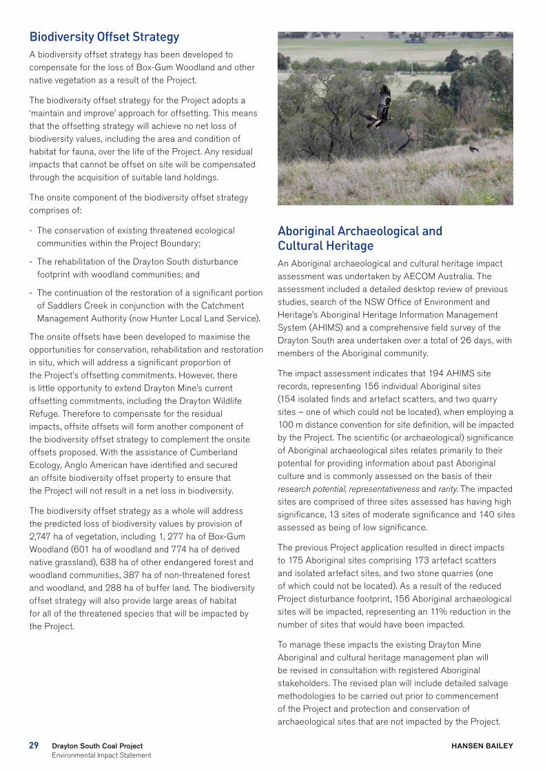
Aboriginal Archaeological and Cultural HeritageAn Aboriginal archaeological and cultural heritage impact assessment was undertaken by AECOM Australia. The assessment included a detailed desktop review of previous studies, search of the NSW Office of Environment and Heritage’s Aboriginal Heritage Information Management System (AHIMS) and a comprehensive field survey of the Drayton South area undertaken over a total of 26 days, with members of the Aboriginal community.
The impact assessment indicates that 194 AHIMS site records, representing 156 individual Aboriginal sites (154 isolated finds and artefact scatters, and two quarry sites – one of which could not be located), when employing a 100 m distance convention for site definition, will be impacted by the Project. The scientific (or archaeological) significance of Aboriginal archaeological sites relates primarily to their potential for providing information about past Aboriginal culture and is commonly assessed on the basis of their research potential, representativeness and rarity. The impacted sites are comprised of three sites assessed has having high significance, 13 sites of moderate significance and 140 sites assessed as being of low significance.
The previous Project application resulted in direct impacts to 175 Aboriginal sites comprising 173 artefact scatters and isolated artefact sites, and two stone quarries (one of which could not be located). As a result of the reduced Project disturbance footprint, 156 Aboriginal archaeological sites will be impacted, representing an 11% reduction in the number of sites that would have been impacted.
To manage these impacts the existing Drayton Mine Aboriginal and cultural heritage management plan will be revised in consultation with registered Aboriginal stakeholders. The revised plan will include detailed salvage methodologies to be carried out prior to commencement of the Project and protection and conservation of archaeological sites that are not impacted by the Project.
30Drayton South Coal Project Environmental Impact Statement
HANSEN BAILEY
Non-Aboriginal HeritageA non-Aboriginal heritage impact assessment was undertaken by AECOM Australia. This assessment identified there are no heritage items or sites within the Project Boundary on statutory United Nations Educational, Scientific and Cultural Organisation, Commonwealth, State or Local Government Lists, Registers or Schedules. One item, the Muswellbrook-Jerrys Plains Landscape Conservation Area (MJPLCA), partially located within the Project Boundary, is listed on the non-statutory, non-government organisation, National Trust (NSW) Register. A further two items assessed as having local significance were identified within the Project Boundary during the field survey – a fence line and the Nissan Hut with Stockyard. A cultural landscape assessment identified historical and aesthetic values of the land within the Project Boundary.
The fenceline and Nissan Hut with Stockyard will be destroyed as a result of the Project and the two landscape features will be indirectly impacted by the Project. In order to retain heritage information about the role and contribution of these items and landscapes it is recommended that photographic records of the landscape areas and archival recordings of the fence line and Nissan Hut with Stockyard are undertaken prior to impacts.
Other items, including a number of historic homesteads, were located outside of the Project Boundary and will not be significantly impacted. The management of heritage items within the Project Boundary will be undertaken through a non-Aboriginal heritage management plan.
Surface WaterA surface water impact assessment was undertaken by WRM Water & Environment. The purpose of the assessment was to characterise the existing catchments, develop a water balance for the Drayton Complex with consideration of the proposed water management system, determine the impacts to surface water and recommend measures to mitigate and manage these impacts.
The surface water model for the Project predicts that there is less than a 10% chance that water will need to be sourced from offsite. Further, if extended dry conditions were to prevail it is likely that the existing Water Allocation Licences (WALs) held by Anglo American will be sufficient to meet demand. As such, the Project will not impact upon the availability of water for agriculture from the Hunter Regulated River Water Source. The Project will be a nil discharge operation.
31 Drayton South Coal Project Environmental Impact Statement
HANSEN BAILEY
The greatest loss of the Saddlers Creek catchment will occur at approximately Year 12 of the Project. At this time, the catchment contributing runoff to Saddlers Creek will reduce by 520 ha (5%). At the end of the Project life, the final Drayton South void will permanently reduce the Saddlers Creek catchment by 305 ha (3%). The Saltwater Creek catchment is already highly impacted as a result of Plashett Dam and the existing operations of Drayton Mine. No additional catchment will be removed from Saltwater Creek as a result of the Project. To mitigate the impact of the loss of catchment flows, a comprehensive rehabilitation program is proposed for Saddlers Creek including an extensive restoration program.
The Project will have an insignificant impact on the Hunter River flows. Under mining conditions, the Project will reduce the catchment draining to the Hunter River at Liddell by a maximum of 0.04%. Under post-mining conditions, the final void will reduce the Hunter River catchment at Liddell by less than 0.02%.
Overall, the surface water impact assessment has determined that the Project will not impact on receiving waters in the locality and as such will not significantly impact on a significant agricultural resource or nearby equine and viticulture CICs.
A revision of the existing Drayton Mine water management system and management plan will be undertaken to encompass the new components, procedures and targets required for the Project. This will include a surface water monitoring program for onsite water sources.
GroundwaterA groundwater impact assessment was undertaken by Australasian Groundwater and Environmental Consultants. The purpose of the assessment was to characterise existing groundwater regimes, assess the impacts of the Project on these groundwater sources and other water users, quantify predicted inflows into the mining areas throughout the life of the Project and recommend measures to mitigate and manage these impacts.
The regional groundwater system within the vicinity of the Drayton South area consists broadly of three aquifer systems including:
- Alluvium along the Hunter River, Saddlers Creek and Saltwater Creek;
- Weathered bedrock (regolith); and
- The coal seams of the Permian Wittingham Coal Measures.
Seepage of groundwater from the aquifers intersected during mining will reduce groundwater pressures in the coal seams and overburden / interburden aquifers around the mining areas. This will lower the water table of an unconfined aquifer or depressurise a confined aquifer.
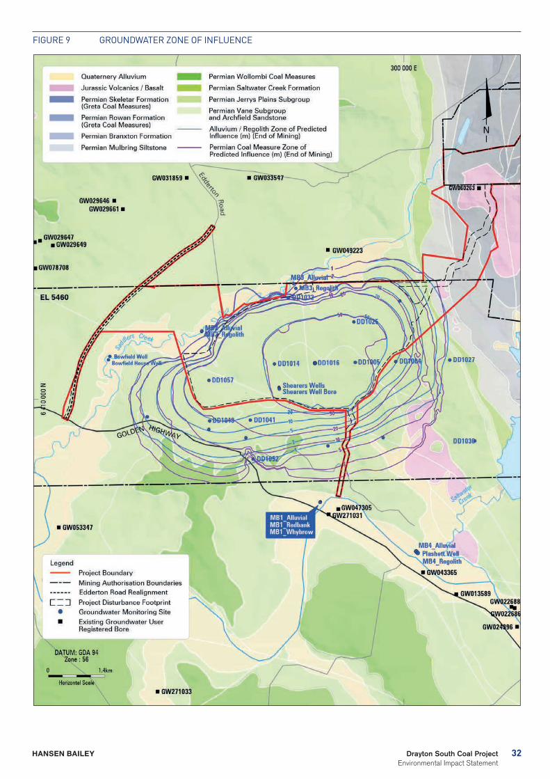
The zone of influence for the shallow regolith / alluvium is predicted to be restricted to the immediate vicinity surrounding the mining areas (see Figure 9). The zone of influence is not predicted to extend into the Hunter River alluvium; however, it is predicted to extend marginally into the Saddlers Creek alluvium.
The zone of influence for the Permian coal measures is predicted to extend under Saddlers Creek alluvium. The zone of influence within the coal measures is not predicted to extend beneath the Hunter River alluvium at the end of mining. In general, the modelled zone of drawdown surrounding the Project is predicted to be limited, as expected for the prevailing low permeability coal measures.
Groundwater quality within the Permian coal measures is generally of poor quality. During mine operations, the net movement of groundwater towards the mining areas will stop the movement of potentially poorer quality water from moving out of the Drayton South area and into the surrounding environment. However, Permian coal measures outside of the Drayton South area will continue to receive recharge via the same processes that occurred pre-mining.
32Drayton South Coal Project Environmental Impact Statement
HANSEN BAILEY
Figure 9 grOuNDWATer ZONe OF iNFLueNCe
33 Drayton South Coal Project Environmental Impact Statement
HANSEN BAILEY
It is predicted that the groundwater quality within the Saddlers Creek and Hunter River alluvium is not expected to measurably change as a result of the Project. Two registered groundwater bores are located within the zone of influence as defined by the 1 m drawdown contour. Both of these groundwater bores are located on land owned by Anglo American, and will be intercepted by mining. No other registered bores are located within the predicted zone of influence.
A groundwater expert was engaged to peer review the EIS groundwater impact assessment. Dr Noel Merrick found that ‘The stated project objectives have been addressed in full in terms of the requirements of the Aquifer Interference Policy’ and ‘…that the Drayton South Groundwater Model has been developed competently and is “fit for purpose” for addressing the potential impacts from the proposed open cut mining operations and for estimating indicative dewatering rates’.
The Gateway Panel, with advice from the Independent Expert Scientific Committee on Coal Seam Gas and Large Coal Mining Development (IESC) and the NSW Minster for Natural Resources, Lands and Water, have confirmed ‘that there is likely to be no significant direct or indirect impacts on highly productive groundwater (within the meaning of the NSW Aquifer Interference Policy (AIP) as a result of the Project’. In fact they state that ‘the water impacts of the proposed mine on the Hunter Alluvial aquifer will be less than the Level 1 Minimal Impact Considerations in the AIP’. The Gateway Panel goes on to say that ‘this is an acceptable level of impact’.
A revision of the existing Drayton Mine water management plan will be undertaken to encompass the new procedures and targets required for the Project to avoid impacting on groundwater and the receiving environment. This will include an extensive groundwater monitoring program.
Soil and Land CapabilityA soil and land capability impact assessment was undertaken by Environmental Earth Sciences.
Four soil types were identified within the Project Boundary all of which were deemed to be suitable for future reuse as top dress materials with available areas proposed to be disturbed within the Project Boundary equal to 3.19 Mm3.
The current land capability classification within the Drayton South area ranges from Class IV to Class VII, with Classes VI and VII dominating the existing landscape. Impacts to the land as a result of the Project will remain within the Drayton South disturbance footprint. Areas outside this are expected to maintain their existing pre-mining class.
The Drayton South area has been assessed against the mapping and criteria outlined in the Strategic Regional Land Use Plan – Upper Hunter and the Interim Protocol for Site Verification and Mapping of Biophysical Strategic Agricultural Land as part of the soil and land capability impact assessment to gain an appreciation of the extent and likely impact of the Project on potential BSAL. The assessment confirmed 78.8 ha of land within the Project Boundary meets the relevant criteria of BSAL even though this area has an agricultural land suitability class of either Class 3 or Class 4 and is currently used by Anglo American leaseholders for beef cattle grazing. The area is unsuitable for cropping or other more intensive agricultural enterprises. It is proposed that the soils from the area identified as being BSAL will be salvaged and utilised to enhance the overall quality of the mine site rehabilitation program.
Post-mining, the objective of the progressive rehabilitation of Drayton South is to return impacted areas to their pre-mining land capability (i.e. suitable for cattle grazing). However it is noted that the majority of the disturbance footprint will be managed as an ecological offset area following its revegetation.
The existing Drayton Mine land management plan will be revised to incorporate relevant mitigation and management measures for the soil resources within the Drayton South area.
AgricultureAn Agricultural Impact Statement was undertaken by Scott Barnett & Associates.
The predominant agricultural land use within the Drayton South area is extensive beef cattle grazing with the major enterprise being beef cattle breeding for the weaner and domestic market. Several other agricultural enterprises operate within the locality of the Drayton South area, including:
- Seven thoroughbred horse studs, including Coolmore and Woodlands Studs (part of the Equine CIC);
- 11 dairies;
- Four vineyards (three with wineries), including Hollydene Estate to the immediate south (part of the Viticulture CIC); and
- An olive grove and olive processing plant.
The significant agricultural resources in the locality of the Drayton South area include the Hunter Regulated River Water Source and Hunter Alluvial Soil Landscape Grouping. Together these resources form the majority of the identified BSAL in the locality (see Figure 5).
The vast majority the Drayton South area is composed of land which is suited to grazing by beef cows for weaner production. The gross value of current agricultural production within the Drayton South area is $318, 267 per annum and the net value is $197, 018 per annum.
34Drayton South Coal Project Environmental Impact Statement
HANSEN BAILEY
The offsite biodiversity offset property is primarily composed of land which is suited to extensive grazing by sheep for breeding and wool. The gross value of agriculture on the offsite biodiversity offset property is $500,828 per annum and the net value is $223,484 per annum.
Any agricultural land that is situated within the Drayton South disturbance footprint and the offsite biodiversity offset property will be removed from production and , in the case of the offsite biodiversity property, reserved in perpetuity as a biodiversity offset for the Project.
The combined gross value of production foregone from the Drayton South disturbance footprint and the offsite biodiversity offset property is $0.8 M per annum. This value is 0.26% of the total agricultural production of the Hunter Region, 0.01% of New South Wales and 0.002% of Australia. The total foregone net agricultural production from agricultural land resources required for the Project is estimated at $8 M present value, in perpetuity. This is significantly less than the present value of net production benefits of the Project to Australia, which is estimated at $464 M.
Verification sampling confirmed 78.8 ha of land within the Project Boundary meets the relevant criteria for BSAL. This area has an Agricultural Land Suitability of either Class 3 or Class 4 and is currently used by Anglo American leaseholders for beef cattle grazing. The area is unsuitable for cropping or other more intensive agricultural enterprises.
Due to the scale and location of the Project it will not materially impact on:
- Availability of land for agricultural purposes including land currently utilised by the thoroughbred horse breeding and viticulture industries;
- BSAL (as the area is suitable for low intensity grazing only);
- Water supply (including highly productive groundwater);
- Surrounding enterprises as a result of excessive dust or noise;
- Traffic regimes along support infrastructure routes associated with neighbouring agricultural enterprises;
- Long term visual amenity of surrounding enterprises;
- Labour supply to agricultural enterprises; and
- Support services directly employed by agricultural enterprises.
35 Drayton South Coal Project Environmental Impact Statement
HANSEN BAILEY
Rehabilitation, Final Landform and Mine ClosureA rehabilitation and mine closure strategic framework and conceptual final landform plan has been developed for the Project.
The rehabilitation strategy for the Project will focus on biodiversity, including the establishment of threatened vegetation communities local to the area and the restoration of Saddlers Creek. Rehabilitation will be guided by:
- The existing Drayton Mine rehabilitation and offset management plan;
- The Mine Rehabilitation and Mine Closure and Completion handbooks;
- The Draft National Recovery Plan for Box-Gum Woodland and Derived Native Grassland; and
- The requirements of the collaborative agreement between Anglo American and the Hunter Local Land Service for the restoration of Saddlers Creek.
The Drayton South and Drayton Mine disturbance footprints, including the final voids at Drayton Mine, will be progressively rehabilitated in areas no longer required to support the Drayton South Project activities as mining advances and/or concludes. A suite of measures will be applied during the rehabilitation program, including erosion and sediment controls, topsoil management and translocation, weed and feral animal controls, and revegetation. The success of rehabilitation efforts will be measured against the completion criteria developed for the Project.
Rehabilitated land within the Drayton South area will achieve a standard whereby vegetation communities are stable and self-sustaining and can be classified as an onsite offset in perpetuity as part of the biodiversity offset strategy for the Project.
The final landform at Drayton Mine, excluding the final voids, is consistent with the surrounding landscape, with slopes of approximately 10 degrees. The final landform will typically be characterised by land capability Class VI and VII. Anglo American will maximise opportunities to use the final voids for storage of water, and rejects and tailings generated from the Drayton South mining areas. All existing mine site facilities and infrastructure located at Drayton Mine and relied upon for the Project will be decommissioned and rehabilitated, as necessary, at the time of cessation of the Drayton South mining activities.
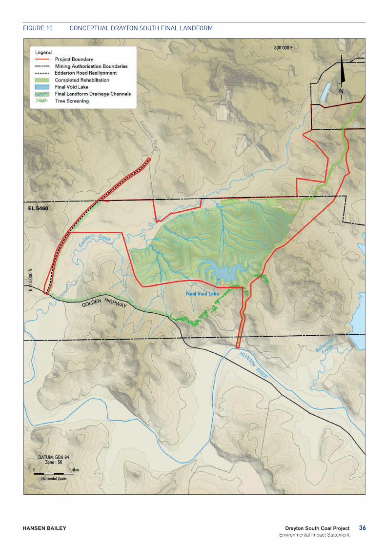
The final landform for the Drayton South area will be shaped to be consistent with the surrounding landscape and free draining, as far as practical (see Figure 10). Surface water runoff and groundwater seepage will settle in the remaining void creating a 43.75 ha final void lake. This represents 3 % of the total Project disturbance area and an area approximately 8.5 % of the size of the adjacent Lake Plashett, which is 513 ha. All Drayton South mine site facilities will be decommissioned and rehabilitated, as necessary, at the time of closure.
The existing mine closure plan for Drayton Mine will be revised, to incorporate the new components of the Project, within five years of closure. The plan will be guided by the Mine Closure and Completion handbook and the Strategic Framework for Mine Closure and shall reflect contemporary expectations, including changes to the final mine plan, regulatory requirements, new technologies and stakeholder expectations.
36Drayton South Coal Project Environmental Impact Statement
HANSEN BAILEY
Figure 10 CONCePTuAL DrAYTON SOuTH FiNAL LANDFOrM
37 Drayton South Coal Project Environmental Impact Statement
HANSEN BAILEY
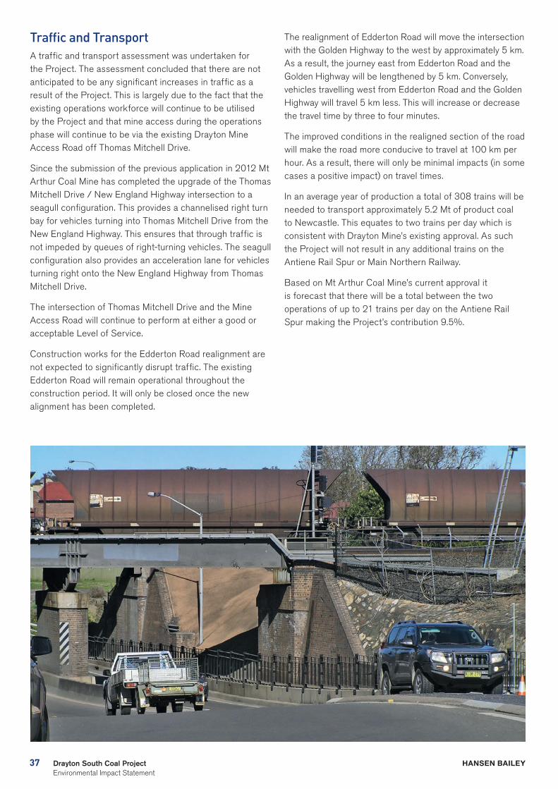
Traffic and TransportA traffic and transport assessment was undertaken for the Project. The assessment concluded that there are not anticipated to be any significant increases in traffic as a result of the Project. This is largely due to the fact that the existing operations workforce will continue to be utilised by the Project and that mine access during the operations phase will continue to be via the existing Drayton Mine Access Road off Thomas Mitchell Drive.
Since the submission of the previous application in 2012 Mt Arthur Coal Mine has completed the upgrade of the Thomas Mitchell Drive / New England Highway intersection to a seagull configuration. This provides a channelised right turn bay for vehicles turning into Thomas Mitchell Drive from the New England Highway. This ensures that through traffic is not impeded by queues of right-turning vehicles. The seagull configuration also provides an acceleration lane for vehicles turning right onto the New England Highway from Thomas Mitchell Drive.
The intersection of Thomas Mitchell Drive and the Mine Access Road will continue to perform at either a good or acceptable Level of Service.
Construction works for the Edderton Road realignment are not expected to significantly disrupt traffic. The existing Edderton Road will remain operational throughout the construction period. It will only be closed once the new alignment has been completed.
The realignment of Edderton Road will move the intersection with the Golden Highway to the west by approximately 5 km. As a result, the journey east from Edderton Road and the Golden Highway will be lengthened by 5 km. Conversely, vehicles travelling west from Edderton Road and the Golden Highway will travel 5 km less. This will increase or decrease the travel time by three to four minutes.
The improved conditions in the realigned section of the road will make the road more conducive to travel at 100 km per hour. As a result, there will only be minimal impacts (in some cases a positive impact) on travel times.
In an average year of production a total of 308 trains will be needed to transport approximately 5.2 Mt of product coal to Newcastle. This equates to two trains per day which is consistent with Drayton Mine’s existing approval. As such the Project will not result in any additional trains on the Antiene Rail Spur or Main Northern Railway.
Based on Mt Arthur Coal Mine’s current approval it is forecast that there will be a total between the two operations of up to 21 trains per day on the Antiene Rail Spur making the Project’s contribution 9.5%.
38Drayton South Coal Project Environmental Impact Statement
HANSEN BAILEY
39 Drayton South Coal Project Environmental Impact Statement
HANSEN BAILEY
Greenhouse Gas The main sources of greenhouse gas emissions from the Project have been identified as resulting from electricity consumption, fugitive emissions of carbon dioxide and methane, diesel usage, explosives usage, and the transport and end use of the product coal.
Scope 1, scope 2 and scope 3 emissions were considered in the assessment of carbon dioxide, methane, nitrous oxide and relevant synthetic gases.
The greenhouse gas emissions from the Project (0.3 Mega tonnes of CO2 equivalent (CO2-e) per annum), including the mining, transportation of the coal to the Port of Newcastle and end usage of the coal represents approximately 0.06% of Australia’s commitment under the Kyoto Protocol (591.5 Mt CO2-e) and a very small portion of global greenhouse emissions.
The emissions estimated to result from the Project will not individually have any significant impact on global warming. Applying the principles of Ecological Sustainable Development, it is considered that there will be no increase or measureable impact on climate change as a result of the Project.
It is noted that Anglo American will implement all feasible and reasonable measures onsite to minimise the greenhouse gas emissions of the Project and ensure it is energy efficient.
GeochemistryOverburden and most coal reject materials from the Project are expected to have very low oxidisable sulfur content and significant excess Acid Neutralising Capacity. These characteristics indicate that the materials are Non-Acid Forming and likely to have a high factor of safety with respect to potential acid generation.
The concentration of total metals detected in overburden materials are well below applied guideline criteria for soils and are unlikely to present any environmental issues associated with revegetation and rehabilitation or have any significant impacts to surface water and groundwater quality.
Some overburden and most coal reject materials have potential sodic properties, which could lead to structural stability issues, including dispersion and erosion. These properties will be managed by the strategic placement of more hostile materials within OEAs. There is a low probability of spontaneous combustion either in situ or for coal, overburden and coal reject materials generated within the Drayton South area.
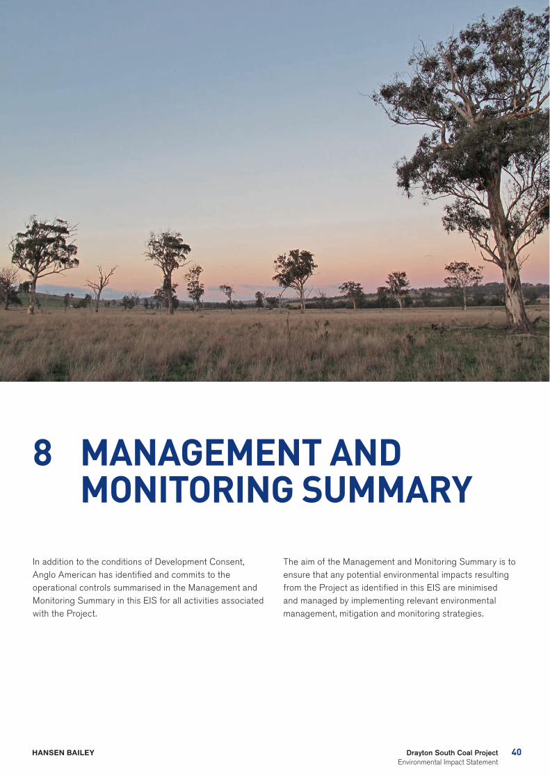
40Drayton South Coal Project Environmental Impact Statement
HANSEN BAILEY
8 MANAGEMENT AND MONITORING SUMMARY
In addition to the conditions of Development Consent, Anglo American has identified and commits to the operational controls summarised in the Management and Monitoring Summary in this EIS for all activities associated with the Project.
The aim of the Management and Monitoring Summary is to ensure that any potential environmental impacts resulting from the Project as identified in this EIS are minimised and managed by implementing relevant environmental management, mitigation and monitoring strategies.
41 Drayton South Coal Project Environmental Impact Statement
HANSEN BAILEY
9 PROJECT JUSTIFICATION
In its 30 years of operation, Drayton Mine has produced over 120 Mt of thermal coal of which 32 Mt has been provided to the Liddell and Bayswater Power Stations and over 88 Mt exported. Drayton Mine has been a major employer of the local community, at its peak employing over 500 FTE workers of which approximately 75% reside in the Upper Hunter region.
Approved mining operations at Drayton Mine are coming to an end. The Project will allow mining to continue, ensuring security of employment for the existing workforce and continuity of the socio-economic benefits for the Hunter region, NSW and Australia.
The Project represents a logical progression from operations at the existing Drayton Mine for the recovery of a known State Significant Coal Resource within the Drayton South mining area. The area has long been set aside for mining by the NSW government and was acquired by Anglo American for the specific purpose of facilitating the continuation of the Drayton Mine.
The existing infrastructure established at Drayton Mine provides the Project with the opportunity to continue to process and produce saleable coal with minimal additional expenditure on fixed plant and equipment. It also avoids the environmental impacts that would be incurred through the development of such facilities.
42Drayton South Coal Project Environmental Impact Statement
HANSEN BAILEY
The Project will ultimately also facilitate the consolidation of operations and approvals with the Drayton South area and Drayton Mine. This will ensure effective management and monitoring of all of the environmental aspects across the Drayton Complex.
Following the PACs refusal of the previous application Anglo American developed this Project mine plan to meet the recommendations of both the previous Review and Determination PACs. All mining activities will remain behind the PAC-recommended setback of the second ridgeline.
The Project will facilitate the recovery of a valuable, export steaming coal resource. Thermal coal remains a highly sought after energy source in Asian countries, including Japan, China and India. These countries continue to be the world’s largest coal importers, and will largely account for an estimated 70% growth in total coal imports from 2009 to 2035 (U.S. EIA, 2011). This increasing demand supports the need for the Project and justifies further investment in the industry.
Exports of product coal generated by the Project will also provide net economic benefits to Australia of between $329 M and $475 M. Royalties for the NSW Government are expected to total $423 M or $233 M (present value using a 7% discount rate).
The Project will also offer continuity of employment for Drayton Mines existing workforce of nearly 500 personnel at a time when thousands of coal mining jobs are being lost from the industry.
The Project has been assessed conservatively on an ‘appropriate worst case’ environmental impact basis, assuming it will operate at a maximum coal production rate of 6.4 Mtpa, with all feasible and reasonable management and mitigation measures being applied. The Project mine plan has been prepared to facilitate resource extraction and economic productivity while ensuring that it will not adversely impact on equine health and the operations of the Coolmore and Woodlands Studs.
The environmental assessment of the Project has adopted the following general methodology:
- Addressing the recommendations of the Review and Determination PAC for the previous application;
- Considering the objects of the EP&A Act, including the principles of Ecologically Sustainable Development and leading practice environmental and social standards;
- Ongoing consultation with stakeholders to identify any additional issues to be addressed in this EIS;
- Undertaking detailed technical assessments to quantify potential environmental impacts with certainty; and
- Developing environmental management and mitigation measures as required.
43 Drayton South Coal Project Environmental Impact Statement
HANSEN BAILEY
Anglo American confirms its commitment to best practice environmental outcomes by making the operational ‘commitments’ described through this EIS. These operational commitments provide certainty that the impacts of the Project will remain within the predictions presented.
The Anglo American commitment to the community to compensate for the socio-economic costs of the Project and to ensure that the benefits from it flow to the local community is manifested in the offer of a VPA to MSC with a net present value of $3 M.
The EIS has quantified the Project’s social and environmental impacts with a high degree of scientific certainty. The Project justification has established that:
- The Project meets the recommendations of both the previous Review and Determination PACs and in doing so ensures the protection of the Coolmore and Woodlands Studs;
- The Project will result in significant economic benefits for the region, State and nation as a whole;
- The Project will benefit the local community by securing the long term direct employment of up to 500 personnel, providing much needed employment and economic stimulus in an area that is currently experiencing a major downturn;
- The continued operation of the Drayton Mine will also stimulate the local economy by creating indirect jobs and commercial opportunities for businesses providing support services to the mining sector; and
- The Project’s social and environmental impacts will be minimised by implementing comprehensive management and mitigation measures.
In addition, the Project will serve the essential purpose of providing thermal coal for current and future generations whilst generating significant economic benefits in the process. The Project’s social and environmental impacts have been minimised as far as practicable by implementing all reasonable and feasible management and mitigation measures.
This EIS concludes that the Project, as proposed, will not adversely impact on equine health and the operations of the Coolmore and Woodlands Studs. The Project will have substantial socio-economic benefits and the EIS cost benefit analysis concludes that the economic benefits of the Project outweigh the costs. This conclusion supports the case that the Project is in the public interest.

DRAYTON SOUTH COAL PROJECT ENVIRONMENTAL IMPACT STATEMENTExecutive Summary May 2015
HANSEN BAILEY
Environmental Consultants
6/127-129 John Street Singleton NSW 2330 Australia
PO Box 473 Singleton NSW 2330 Australia
T + 61 (2) 6575 2000 F + 61 (2) 6575 2001
www.hansenbailey.com.au