Drainage Areas of Texas Streams Colorado River Basin
40
DRAINAGE AREAS OF TEXAS STREAMS COLORADO RIVER BASIN COOPERATORS: LP-145 U. S. GEOLOGICAL SURVEY TEXAS DEPARTMENT OF WATER RESOURCES TEXAS DEPARTMENT OF WATER RESOURCES 1981
Transcript of Drainage Areas of Texas Streams Colorado River Basin

DRAINAGE AREAS OF TEXAS STREAMS
COLORADO RIVER BASIN
COOPERATORS:
LP-145
U. S. GEOLOGICAL SURVEY
TEXAS DEPARTMENT OF WATER RESOURCES
TEXAS DEPARTMENT OF WATER RESOURCES
1981
DRAINAGE AREAS OF TEXAS STREAMS
COLORADO RIVER BASIN
by
H. Tovar and B. N. MaldonadoU.S. Geological Survey
This report was prepared undercooperative agreement between the
U.S. Geological Survey and the TexasDepartment of Water Resources
Texas Department of Water Resources
LP-145
1981

CONTENTS
Page
Metric conversions 1Introduction - 2
Purpose and scope of this report 2Previous reports 2Concepts of drainage areas - 4Description of the basin-- - - - 4
Methods of drainage-area determinations 4Methods of river-mile determination 6Tabulation of data 6References cited 8
in

ILLUSTRATIONS
Page
Figure 1. Map showing State designated river basins and coastalbasins in Texas 3
2. Map showing major streams and tributaries in theColorado River basin 5
TABLE
Table 1. Drainage-area data for the Colorado River basin-
IV

METRIC CONVERSIONS
For readers interested in using the metric system, the inch-pound unitsused in this report may be converted to metric units by the following factors:
From Multiply by To obtain
inch 2.54 centimeter
mile 1.609 kilometer
square mile 2.590 square kilometer

DRAINAGE AREAS OF TEXAS STREAMS
COLORADO RIVER BASIN
By
F. H. Tovar and B. N. Maldonado
U.S. Geological Survey
INTRODUCTION
In 1951, the Federal Inter-Agency River Basin Committee, Subcommittee onHydrology, designated the U.S. Army Corps of Engineers as the coordinatingagency for the determination of drainage areas in the Arkansas and Red Riverbasins. The U.S. Geological Survey was designated as the coordinating agencyfor all other river basins in Texas (fig. 1). In 1979, the U.S. GeologicalSurvey also assumed coordinating responsibility for determination of drainageareas in the Arkansas and Red River basins.
Purpose and Scope of This Report
Data on the drainage areas of Texas streams are being appropriately compiled in cooperation with the Texas Department of Water Resources so thatinformation of uniform accuracy and reliability will be available for hydraulic, hydrologic, or general engineering use. Only recently has large-scaletopographic-map coverage of the Colorado River basin been completed. Themapping was largely financed through a cooperative program between the TexasDepartment of Water Resources and the U.S. Geological Survey. This report givesthe drainage areas as determined by measurements at 429 points within theColorado River basin. These data are tabulated in table 1, which gives thelatitude and longitude of the points of determination, the drainage area insquare miles above each point, and the distance in miles from the point to themouth of the stream.
Previous Reports
Previous reports on the drainage area of Texas streams have been publishedas follows:
Texas Water Commission, 1962, Drainage areas of Texas streams, Sabine Riverbasin and Sabine-Neches coastal area: Circular No. 62-02.
1962, Drainage areas of Texas streams, Neches River basin and Neches-Trinity coastal area: Circular No. 62-03.
1962, Drainage areas of Texas streams, San Jacinto River basin and SanJacinto-Brazos coastal area: Circular No. 62-05.1963, Drainage areas of Texas streams, Trinity River basin and Trinity-San
Jacinto coastal area: Circular No. 63-01.1963, Drainage areas of Texas streams, San Antonio River basin: Circular
CTo. 63-07.1965, Drainage areas of Texas streams, coastal areas between the Brazos
RTver and the Rio Grande: Circular No. 65-01.U.S. Army Corps of Engineers, 1954, Drainage-area data, Arkansas, White, and
Red River basins.
-2-

FIGURE 1.--State designated river basins and coastal basins in Texas

U.S. Geological Survey, 1973, Drainage area of Texas streams, Lavaca Riverbasin: U.S. Geological Survey open-file report.1974, Drainage area of Texas streams, Guadalupe River basin: U.S. Geo
logical Survey open-file report.1977, Drainage area of Texas streams, Brazos River basin: U.S. Geological
Survey open-file report
Concepts of Drainage Areas
The drainage area of a stream at a specified location is defined as anarea, measured in a horizontal plane, that is enclosed by a topographic divideso that direct surface runoff from precipitation normally drains by gravityinto the river basin above the specified point (U.S. Geological Survey, 1960).
The concept of noncontributing areas is not susceptible to precise definition because individual judgment must be used in determining what part of anarea is totally noncontributing and what part may contribute runoff under certain conditions. In this report, a noncontributing area is defined as an areathat contributes no direct surface runoff to the point of measurement. Runoffmay occur within the noncontributing area, but this runoff drains to naturalsurface depressions and does not flow directly to a contributing stream.
Description of the Basin
The western divide of the Colorado River basin is about 80 miles west ofthe New Mexico-Texas State line (fig. 2). The main stem of the Colorado Riverheads near the rim of the High Plains Escarpment.
The data in table 1 indicate the large areas on the High Plains that arecharacterized by playas and other natural depressions that do not contributerunoff to the defined stream systems. Below the High Plains Escarpment, thebasin is characterized by rolling hills. The lower part of the basin is withinthe Gulf Coastal Plain. Average annual rainfall varies from about 10 inches inthe upper part of the basin to about 45 inches at the mouth at the Gulf ofMexico.
The principal tributaries of the Colorado River are: Tobacco Creek, BealsCreek, Concho River, Pecan Bayou, San Saba River, Pedernales River, and LlanoRiver.
METHODS OF DRAINAGE-AREA DETERMINATIONS
Drainage areas are determined at sites of existing and discontinued continuous-record gaging stations and partial-record gaging stations as appropriate, at sites of existing and proposed or considered major dams, at miscellaneous sites where the peak discharge for unusual floods was determined, andat the mouths of significant tributaries.
-4-

lot* from Toxos Oooortmont of Higkwoysand Public Transportation
PrGUtE 2..Major stroams and tributarios in tho Cofarcdo tivor basin
-5-

Drainage boundaries were delineated on U.S. Geological Survey topographicmaps, most of which were at a scale of 1:24,000. The Texas Department of WaterResources reviewed the boundary as drawn between the Colorado River and the RioGrande basins.
An index map of the area (not included in this report) was prepared toshow the relative position of the different maps used. To insure accuratedeterminations, the maps were checked for gaps or overlaps between adjacentsheets, for continuity of topographic or cultural detail between adjacentsheets, and for agreement of latitude and longitude at the borders of adjacentmaps.
All areas and subareas within a quadrilateral, which comprise the areabounded by latitude and longitude within a quadrangle, were measured with adigitizer. Actual areas within a quadrilateral have been computed accurately(Federal Inter-Agency River Basin Committee, 1951, and U.S. Geological Survey,1924), providing an exact check between the total area digitized and the actualarea within each quadrilateral.
Drainage areas are given in table 1 in square miles. Although areas aremeasured to the nearest hundredth of a square mile, the values are rounded tothe nearest square mile for areas of more than 100 square miles, to tenths of asquare mile for areas from 10 to 100 square miles, and to hundredths of a squaremile for areas of less than 10 square miles.
METHODS OF RIVER-MILE DETERMINATION
River mileages on the main stem and major tributaries were obtained fromthe U.S. Army Corps of Engineers (1969) where available. New mileages were compiled from the U.S. Geological Survey maps by using the procedures described bythe Hydrology Committee of the Water Resources Council (Water Resources Council,1968).
Mileages were measured with an electronic digitizer. The accuracy ofmeasurements given in this report are adequate for general purposes, such asmeasuring river lengths or identifying points along a stream. The accuracy maynot be accurate enough for detailed engineering studies in which precisemeasurements are required.
TABULATION OF DATA
The points at which drainage areas were determined (table 1) are tabulatedin downstream order along the main stem. A tributary that enters between twomain-stem points is tabulated between these two points. A similar order isfollowed on all tributaries.
A tabulation includes: (1) The name of the stream; (2) a description ofthe point of determination, including latitude and longitude; (3) the drainagearea above the point, or in the case of a dam, above a plane through the axisof the dam; and (4) the river mile of the point of determination.

Redeterminations of drainage areas were made for several sites at whichthe peak discharge for an unusual flood had been determined. Most of thesedrainage-area values as originally determined and published by the Texas Boardof Water Engineers (1959), were necessarily from the very poor maps availableat the time. The importance of unit values of peak runoff in hydrologic studieswarranted these redeterminations.

REFERENCES CITED
Federal Inter-Agency River Basin Committee, 1951, Inter-agency coordination ofdrainage-area data: Subcommittee on Hydrology, Notes on Hydrologic Activities, Bulletin No. 4, 48 p.
Texas Board of Water Engineers, 1959, Summary of peak flood flow measurementsand other measurements of stream discharge in Texas at points other thangaging stations: Bulletin 5807C, 255 p., 4 pis.
U.S. Army Corps of Engineers, 1969, Colorado River basin, Texas, river mileages:Fort Worth District, 32 p.
U.S. Geological Survey, 1924, Geographic tables and formulas: U.S. GeologicalSurvey Bulletin 650, 4th edition, 424 p.
1960, General introduction and hydrologic definitions, manual of hydrology; Part 1. General surface-water techniques: U.S. Geological SurveyWater-Supply Paper 1541-A, p. 8.
Water Resources Council, 1968, River mileage measurement: Hydrology CommitteeBulletin No. 14, 17 p.
-8-

TABLE 1.--Drainage-area data for the Colorado River basin
Name of stream Point of determination
Drainage area above point(square miles) River miles
above mouth
Noncontributing Contributing
Colorado River Above mouth of Gold Creek
lat 32°38,34M, long lOl^O^" 1.28 9.01 865.2
Gold Creek At mouth
lat 32038'34", long 101°40l23" 187 12.0 0
Colorado River Below mouth of Gold Creek
lat 32038'34", long 101°40'23" 188 21.0 865.2
Colorado River Above mouth of Tobacco Creek
lat 32038'58", long 101o31'05" 188 51.3 850.0
Tobacco Creek At mouth
lat 32038,58", long 101o3r05" 2,141 197 0
Colorado River Below mouth of Tobacco Creek
lat 32°38,58", long 101o3r05" 2,329 248 0
Bull Creeka/
At Diversion Dam near Knapp, TX -
lat 32037'18M, long 101o10'23n 38 417 13.0
Colorado River USGS gage 08118000 at Colorado River Dam(Lake J. B. Thomas) near Vincent, TXlat 32°34'57", long 101o08'09" 2,371 1,018 837.0
Colorado River Above mouth of Bull Creek
lat 32034*57", long lOl^OSW 2,371 1,026 831.8
Bull Creek USGS gage 08118500 near Ira, TXlat 32o36'02", long 101°05'38M 0 ^26.3 2.0
Bull Creek At mouth
lat 32034'57", long 101°05,40" 0 ^28.7 0
Colorado River Below mouth of Bull Creek
lat 32°34l57", long 101°05,40" 2,371 1,055 831.8
Colorado River USGS gage 08118600 below Bull Creek near Ira, TXlat 32°34,57", long 101°05,40" 2,371 1,055 831.8
Colorado River Above mouth of Bluff Creek
lat 32°34,18,\ long 101°03,20" 2,371 1,059 828.8
Bluff Creek USGS gage 08119000 near Ira, TXlat 32°35'29", long 101°03'02" 0 42.6 1.8
Bluff Creek USGS gage 08119100 at mouth near Ira, TXlat 32o34'20", long 101°03'2r' 0 44.1 0
Colorado River Below mouth of Bluff Creek
lat 32°34,18", long 101o03'20" 2,371 1,103 828.8
Colorado River USGS gage 08119500 near Ira, TXlat 32°32,18", long 101°03,12" 2,371 1,112 826.3
Colorado River Above mouth of Willow Creek
lat 32°30,42", long 101o01'44" 2,371 1,118 824.0
Willow Creek At mouth
lat 32°30l42", long 101°01'44" 0 94.7 0
Colorado River Below mouth of Willow Creek
lat 32o30'42", long 101°01'44" 2,371 1,213 824.0
Colorado River Above mouth of Deep Creeklat 32°30,50", long 100°54'42" 2,371 1,288 814.3
Deep Creek Peak discharge site near Dermott, TXlat 32°47,46", long 100°59,41" 0 44.5 22.1
Deep Creek Peak discharge site No. 3 in TBWE Bull. 5807Clat 32°42'16", long 100°54'40" 0 130 21.7
Deep Creek USGS gage 08120500 near Dunn, TXlat 32°34'25", long 100o54*27M 10 188 9.6
Deep Creek At mouth
lat 32°30'50n, long 100°54,42" 10 228 0
a/ Since December 1953, all flou in Bull Creek except part of extreme high floods is diverted into Lake J. B. Thomas.
b/ Does not include drainage upstream from Diversion Dam.
-9

Name of stream
Colorado River
Colorado River
Colorado River
Colorado River
Colorado River
Colorado River
Colorado River
Morgan Creek
Graze Creek
Morgan Creek
Morgan Creek
Morgan Creek
Colorado River
Colorado River
Champion Creek
Champion Creek
Champion Creek
Colorado River
Colorado River
Beals Creek:
Mustang Draw:
Seminole Draw
Wardswell Draw
Seminole Draw
Seminole Draw
Monument Draw
Mustang Draw
Mustang Draw
TABLE 1.--Drainage-area data for the Colorado River basin--Continued
Point of determination
Below mouth of Deep Creeklat 32°30'50", long 100°54,42"
USGS gage 08120700 near Cuthbert, TXlat 32028'38", long 100o56'58"
Peak discharge site No. 6 in TBWE Bull. 5807Clat 32024'39", long 100o54'08"
USGS gage 08121000 at Colorado City, TXlat 32023'33", long 100°52,42"
USGS discontinued gage 08121100 at Colorado City, TXlat 32o23»05", long lOO'Sl'SS"
Peak discharge site No. 7 in TBWE Bull. 5807Clat 32°18,37", long 100o54'56"
Above mouth of Morgan Creeklat 32°18,37", long 100°54,56"
USGS discontinued gage 08121500 near Westbrook, TXlat 32°23,42", long 101°01'32"
USGS discontinued gage 08122000 near Westbrook, TXlat 32°24l59", long 100°01,06"
USGS discontinued gage 08122500 near Colorado City, TXlat 32023'17", long 100°56,59"
USGS gage 08123000 at Colorado City Dam(Lake Colorado City) near Colorado City, TXlat 32o20'41", long 100o55'10"
At mouth
lat 32018'37", long 100°54'56"
Below mouth of Morgan Creeklat 32°18,37", long 100°54'56"
Above mouth of Champion Creeklat 32°16,45M, long 100°52'20"
USGS discontinued gage 08123500 near Colorado City, TX
USGS gage 08123600 at Champion Creek Dam(Champion Creek Reservoir) near Colorado City, TXlat 32°16,53", long 100°51'30"
At mouth
lat 32°16,45n, long 100°52'20"
Below mouth of Champion Creeklat 32°16'45", long 100°52'30"
Above mouth of Beals Creek
lat 32°10'47", long 100°5ri5"
Above mouth of Wardswell Draw
lat 32°39'18", long 102°34,35n
At mouth
lat 32°39'18", long 102o34'35"
Below mouth of Wardswell Drawlat 32°39'18", long 102°34'35"
At confluence with Monument Draw
lat 32°26*42", long 102o20'27n
At confluence with Seminole Draw
lat 32°26'42", long 102o20,27"
At confluence of Seminole Draw and Monument Drawlat 32°26'42", long 102°20'27"
Above mouth of Johnson Draw
lat 32o58'00n, long 101°41'09"
10
Drainage area above point(square miles)
Noncontributing Contributing
River miles
above mouth
2,381 1,516 814.3
2,381 1,531 810.0
2,381 1,579 798.5
2,381 1,585 796.3
2,381 1,587 794.9
2,381 1,645 788.1
2,381 1,648 786.4
42.7 230 15.3
42.7
42.7
42.7
2,424
20.8
2,446
991
1,185
975
2,160
4,715
302
303
1,951
1,971
177
187
2,158
2,253
248
296
786.4
780.8
5.8
780.8
769.8
36.1
113.8

TABLE 1.--Drainage-area data for the Colorado River basin--Continued
Name of stream Point of determination
Drainage area above point(square miles) River miles
above mouth
Noncontributing Contributing
Johnson Draw:
Johnson Draw Above mouth of Midland Draw
lat 31°54l32", long 101°46'03" 141 269 8.2
Midland Draw Above mouth of Monahans Draw
lat 31°51'47M, long 101o53'06" 683 87.1 11.7
Monahans Draw At mouth
lat 31°57'47", long 101°53'06 584 11.9 0
Midland Draw Below mouth of Monahans Draw
lat 31°57,47", long 101°53,06" 1,267 99.0 11.7
Midland Draw At mouth
lat 31°54'32", long 101°46'03" 1,267 139 0
Johnson Draw Below mouth of Midland Draw
lat 31°54,32", long lOl^'OS" 1,408 408 8.2
Johnson Draw At mouth
lat 31°58'00M, long 101°41,09" 1,408 443 0
Mustang Draw Below mouth of Johnson Draw
lat 31o58'00", long 101°41'09" 6,123 966 33.2
Mustang Draw At confluence with Sulphur Springs Drawlat 32°12,17", long lOl^^" 6,270 1,203 0
Sulphur Springs Draw USGS discontinued gage 08123620 near Wellmon, TXlat 33°04'39", long 102°27,50" 605 41.8
"
Sulphur Springs Draw Above mouth of Buzzard Draw
lat 32°13'14", long 101°38'01" 1,361 237"
Buzzard Draw At mouth
lat 32°13,14", long 101°38'01M 146 23.5 0
Sulphur Springs Draw Below mouth of Buzzard Draw
lat 32°13*14", long 101o38'01" 1,507 257-
Sulphur Springs Draw USGS discontinued gage 08123640 Natural DamSalt Lake near Big Spring, TX
lat 32o13'05n, long 101°37'40" 1,507 258 --
Sulphur Springs Draw At confluence with Mustang Draw
lat 32°12,17", long 101o35'53" 1,512 262 0
Beals Creek At confluence of Mustang Draw and Sulphur Springs Drawlat 32012'17", long 101°35'53" 7,782 1,465 75.6
Beals Creek USGS discontinued gage 08123650 above Big Spring, TXlat 32°15,01,\ long 101o29'26" 7,814 1,505 67.5
Beals Creek USGS discontinued gage 08123700 at Big Spring, TXlat 32°15'45", long 101°26'30" 7,814 1,527 64.4
Coahoma Draw USGS discontinued gage 08123750 near Big Spring, TXlat 32°2ri2", long 101°24,10" 0 2.38
-
Bull Creek tributary USGS discontinued gage 08123760 near Forsan, TXlat 32°08,23'\ long 101°10'53" 0 0.40 0.2
Beals Creek USGS gage 08123800 near Westbrook, TXlat 32°lll57", long 101°00'49" 7,814 1,988 19.1
Beals Creek At mouth
lat 32°10,47", long 100o51'15" 7,814 2,055 0
Colorado River Below mouth of Beals Creek
lat 32o10'47", long 100o51'15" 10,260 4,308 769.8
Colorado River USGS gage 08123850 above Silver, TXlat 32°03,13n, long 100o45'42" 10,260 4,650 756.0
Colorado River USGS discontinued gage 08123900 near Silver, TXlat 32°01*10", long 100°44,08" 10,260 4,723 747.8
Colorado River Above mouth of Bitter Creek
lat 31°59'22", long 100°40'44" 10,260 4,745 742.3
-11 -

Name of stream
Bitter Creek
Bitter Creek
Colorado River
Colorado River
Colorado River
Colorado River
Mountain Creek
Mountain Creek
Colorado River
Colorado River
Colorado River
Cow Creek
Cow Creek
Colorado River
Colorado River
Colorado River
Salt Creek:
Salt Creek tributary
Colorado River
Colorado River
Valley Creek
Colorado River
Colorado River
Colorado River
TABLE 1.--Drainage-area data for the Colorado River basin—Continued
Point of determination
USGS discontinued gage 08123920 near Silver, TXlat 31°58'48", long 100°42l52"
At mouth
lat 31°59'22", long 100o40'44"
Below mouth of Bitter Creek
lat 31°59'22", long 100°40,44"
USGS gage 08123950 at Robert Lee Dam(E. V. Spence Reservoir) near Robert Lee, TXlat 31053'54", long 100o30'56"
USGS gage 08124000 at Robert Lee, TXlat 31°53,07M, long 100°28'49"
Above mouth of Mountain Creek
lat 31°53'13M, long 100°28'26"
Peak discharge site No. 8 in TBWE Bull. 5807Clat 31°54'08", long 100°28'34M
At mouth
lat 31°53'13", long 100°28'26"
Below mouth of Mountain Creek
lat Sl^'n", long 100°28'26"
USGS discontinued gage 08124100 near Robert Lee, TXlat 31051'23", long 100°23'02"
Above mouth of Cow Creek
lat 31°51,27", long 100°22,58"
Peak discharge site No. 9 in TBWE Bull. 5807Clat Sl^W, long 100°23'18M
At mouth
lat Sl'SlW, long 100o22'58n
Below mouth of Cow Creek
lat 31°51,27", long 100°22'58"
USGS discontinued gage 08124200 near Bronte, TXlat 31°50l52", long 100o17'56"
Above mouth of Oak Creek
lat Sl^W, long 100°12'34"
USGS discontinued gage 08125450 near Hylton, TXlat 32°07'57", long 100°14,02"
USGS gage 08125500 at Oak Creek Dam(Oak Creek Reservoir) near Blackwell, TXlat 32°02'24,l> long 100°16l03"
USGS discontinued gage 08126000 near Blackwell, TXlat 32°02'19", long lOOnS'lS"
At mouth
lat Sl^W, long 100o12'34"
Below mouth of Oak Creek
lat Sl^W, long 100°12'34"
Above mouth of Valley Creeklat 31°43'02Ht long 100°01'53"
At mouth
lat 31°43,02", long 100°01,53"
Below mouth of Valley Creeklat 31°43l02", long 100°01*53"
USGS gage 08126380 near Ballinger, TXlat 31042'52", long 100°01'37"
USGS discontinued gage 08126400 at Ballinger, TXlat 31°43,57", long 99°57*14"
12-
Drainage area above point(square miles)
Noncontributing Contributing
10,260
10,260
10,260
10,260
10,260
10,260
10,260
10,260
10,260
0
0
10,260
10,260
10,260
0
10,260
10,260
0
10,260
10,260
10,260
3.78
6.59
4,751
29.1
31.6
5,079
5,176
5,176
6.62
9.56
5,185
5,245
5,348
235
6,097
6,098
6,150
River miles
above mouth
742.3
730.8
712.4
712.0
703.4
703.3
*3.8
0
703.3
695.8
687.7
35.0
34.2
0
687.7
666.1
0
666.1
665.8
660.2

Name of stream
Colorado River
Colorado River
Bluff Creek:
Bluff Creek tributary
Bluff Creek
Elm Creek
Coyote Creek
Elm Creek
Elm Creek
Elm Creek
Colorado River
Colorado River
South Concho River:
Dry Creek
South Concho River
South Concho River
South Concho River
South Concho River
Pecan Creek
Pecan Creek
Pecan Creek
South Concho River
South Concho River
TABLE 1.--Drainage-area data for the Colorado River basin--Continued
Point of determination
USGS discontinued gage 08126500 at Ballinger, TXlat 31°43'48", long 99o56'30"
Above mouth of Elm Creek
lat 31°43'55", long 99°56'06"
Above mouth of Bluff Creek
lat 31°51,05", long 99°54'20"
Peak discharge site at Winters, TXlat 31°56'59", long 99°58'15"
At mouth
lat 31°51,05", long 99°54,20"
Below mouth of Bluff Creek
lat 31°51'05", long 99°54l20"
Above mouth of Mud Creek
lat Sl^W, long 99054'32"
At mouth
lat 31°49'20", long 99°54,32"
Below mouth of Mud Creek
lat Sl^^O", long 99°54,32"
Above mouth of Coyote Creeklat 31047'49M, long 99°56'20"
At mouth
lat 31047'49", long 99°56'20"
Below mouth of Coyote Creeklat 31°47,49", long 99o56'20"
USGS gage 08127000 at Ballinger, TXlat 31°44l57n, long 99°56'50"
At mouth
lat 31°43'55", long 99°56,06"
Below mouth of Elm Creek
lat Sl^S'SS", long 99o56'06"
Above mouth of Concho River
lat 31°34'16", long 99°43'28"
USGS discontinued gage 08127100 near Christoval, TXlat 31°05'31", long 100°20I52M
USGS gage 08128000 at Christoval, TXlat 31011'15", long 100°30'06"
At Twin Buttes Dam (South Concho Pool)lat 31°18'47", long 100o29'14"
USGS gage 08131300 above Pecan Creek near San Angelo, TXlat 31o20'13", long 100°28'46"
Above mouth of Pecan Creek
lat 31°20'21", long 100°28'38"
USGS gage 08131400 near San Angelo, TXlat 3l018'32", long 100°26,44"
USGS discontinued gage 08131410 near San Angelo, TXlat Sl^W, long 100°27'30"
At mouth
lat 31°20'21", long 100°28'38"
Below mouth of Pecan Creek
lat 31°20,21", long 100°28'38"
Above mouth of Middle Concho River
lat 31°23'00", long 100°29'06"
13
Drainage area above point(square miles) River miles
above mouth
Noncontributing Contributing
10,260
10,260
0
0
0
10,260
10,260
0
58.6
58.6
58.6
58.6
0
58.6
58.6
4.45
150
269
284
4.0
0
12.1
10.1
338 6.3
93.2 0
431 6.3
450 1.9
456
6,609
6,838
658.9
628.9
13.7
11.7
11.5
3.7
2.4
0
11.5
8.2

Name of stream
Middle Concho River:
Middle Concho River
Centralia Draw
High Lonesome Draw
Centralia Draw
Centralia Draw
South Mustang Draw
Centralia Draw
Centralia Draw
Middle Concho River
Middle Concho River
Tepee Draw
Middle Concho River
Middle Concho River
Middle Concho River
Middle Concho River
Middle Concho River
Spring Creek
Dove Creek
Dove Creek
Spring Creek
Spring Creek
Spring Creek
Twin Buttes Reservoir at
Twin Buttes Dam
Spring Creek
Middle Concho River
Middle Concho River
TABLE 1.--Drainage-area data for the Colorado River basin--Continued
Point of determination
Above mouth of Centralia Draw
lat 31°26,34", long 101°15'23"
Above mouth of High Lonesome Drawlat 31°23'02", long 101°36'22"
At mouth
lat 31o23'02", long 101°36,22"
Below mouth of High Lonesome Drawlat 31°23,02", long 101°36,22"
Above mouth of South Mustang Draw
lat 31025'33", long 101°17,lln
At mouth
lat Sl^S^", long 101°17'11"
Below mouth of South Mustang Draw
lat 31°25'33", long 101°17,11"
At mouth
lat 31026'34", long 101°15,23"
Below mouth of Centralia Draw
lat 31°26,34", long 101°15'23"
Above mouth of Tepee Drawlat 31°25'28", long 101°09'09"
At mouth
lat 31°25'28M, long 101°09f09"
Below mouth of Tepee Draw
lat 31°25,28,,f long lOl'WOg"
USGS gage 08128400 above Tankersley, TXlat 31°25l38", long 100o42'39M
USGS discontinued gage 08128500 near Tankersley, TXlat 31022'35", long lOO^'SO"
At Twin Buttes Dam (Middle Concho Pool)lat 31°22,40", long 100°32,11"
Above mouth of Spring Creeklat 31°22l38", long lOO^O^"
USGS gage 08129300 above Tankersley, TXlat 31°19'48M, long 100o38'24n
USGS gage 08130500 at Knickerbocker, TXlat 31016*24", long 100°37'45n
At mouth
lat 31o19'50n, long 100°36,07"
Below mouth of Dove Creek
lat 31°19'50", long 100°36'07n
USGS discontinued gage 08131000 near Tankersley, TXlat 31°21'30M, long 100°32,05"
At Twin Buttes Dam (Spring Creek Pool)lat 31021l56n, long 100°31'46"
USGS gage 08131200 near San Angelo, TXlat 31°21,56", long 100o3r46M
At mouth
lat 31°22'38n, long 100o30'49"
Below mouth of Spring Creeklat 31022'38", long 100°30'49"
At mouth
lat 31°23'00", long 100°29'06"
- 14
Drainage area above point(square miles)
Noncontributing Contributing
938
938
968
968
968
968
19.7
8.43
8.43
28.1
1,055
997
997
123
180
170
681
703
266
1,611
1,116
1,685
1,713
1,714
405
656
671
672
674
2,388
2,395
River miles
above mouth
58 1
0
58 1
20 9
11 4
3 5
1 .9
10 .4
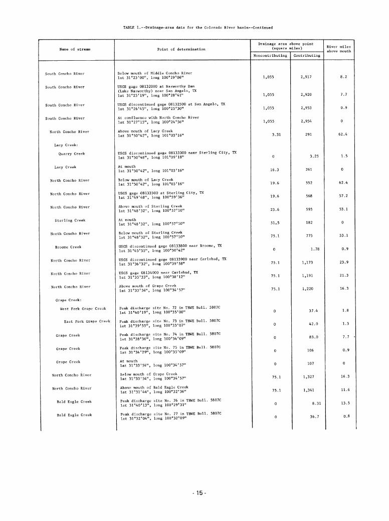
Name of stream
South Concho River
South Concho River
South Concho River
South Concho River
North Concho River
Lacy Creek:
Quarry Creek
Lacy Creek
North Concho River
North Concho River
North Concho River
Sterling Creek
North Concho River
Broome Creek
North Concho River
North Concho River
North Concho River
Grape Creek:
West Fork Grape Creek
East Fork Grape Creek
Grape Creek
Grape Creek
Grape Creek
North Concho River
North Concho River
Bald Eagle Creek
Bald Eagle Creek
TABLE 1.--Drainage-area data for the Colorado River basin--Continued
Point of determination
Below mouth of Middle Concho River
lat 31o23,00", long 100o29l06M
USGS gage 08132000 at Nasworthy Dam(Lake Nasworthy) near San Angelo, TXlat 31023'19", long 100o28'41"
USGS discontinued gage 08132500 at San Angelo, TXlat 31°26'45", long 100°25'3011
At confluence with North Concho River
lat 31°27,15", long 100°24'56"
Above mouth of Lacy Creeklat 31°50'42", long 101o03'16"
USGS discontinued gage 08133300 near Sterling City, TXlat 31°50'48", long 101o09'18"
At mouth
lat 31°50,42n, long 101°03'16"
Below mouth of Lacy Creeklat 31°50'42n, long 101°03'16"
USGS gage 08133500 at Sterling City, TXlat 31°49'48", long 100°59,36"
Above mouth of Sterling Creeklat 31048'32", long 100o57'10"
At mouth
lat 31°48'32", long 100o57'10"
Below mouth of Sterling Creeklat 31°48,32M, long 100o57'10M
USGS discontinued gage 08133800 near Broome, TXlat Sl^S'SS", long 100°50'42"
USGS discontinued gage 08133900 near Carlsbad, TXlat 31°36'32M, long lOO^'SS"
USGS gage 08134000 near Carlsbad, TXlat Sl^W, long 100°38'12"
Above mouth of Grape Creeklat 31°33,54", long 100°34,57"
Peak discharge
lat si^o'ig",
Peak discharge
lat Sl^'SS",
Peak discharge
lat si^s^",
Peak discharge
lat 31°34,29",
At mouth
lat 31°33'54",
Below mouth of
lat 31033'54",
site No. 72 in TBWE Bull. 5807C
long 100°35'00M
site No. 73 in TBWE Bull. 5807C
long 100°33'07"
site No. 74 in TBWE Bull. 5807C
long 100°34,09M
site No. 75 in TBWE Bull. 5807C
long 100o35'09n
Above mouth of
lat 31°31'44",
long 100°34,57"
Grape Creeklong 100°34,57u
Bald Eagle Creeklong 100°32'36"
site No. 76 in TBWE Bull. 5807C
long 100o29'3r*
site No. 77 in TBWE Bull. 5807C
long 100°32,09"
Peak dischargelat 31o40'13",
Peak dischargelat 31°32'04",
15-
Drainage area above point(square miles)
Noncontributing Contributing
2,917
1,055 2,920
1,055 2,953
1,055 2,954
3. 31 291
16.3 261
19.6 552
19.6 568
23.6 593
51.5 182
75.1 775
1,220
37.4
42.0
83.0
106
107
1,327
1,341
8.31
36.7
River miles
above mouth
53.1
0.9
0
16.3
11.6
13.5
0.8
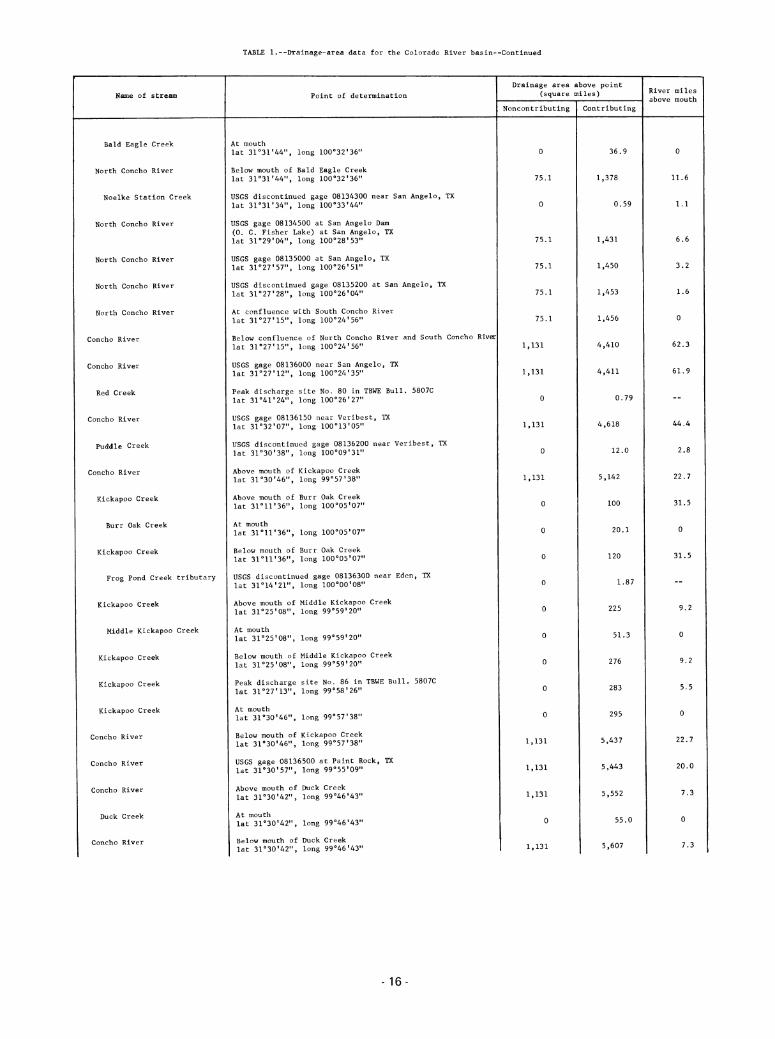
Name of stream
Bald Eagle Creek
North Concho River
Noelke Station Creek
North Concho River
North Concho River
North Concho River
North Concho River
Concho River
Concho River
Red Creek
Concho River
Puddle Creek
Concho River
Kickapoo Creek
Burr Oak Creek
Kickapoo Creek
Frog Pond Creek tributary
Kickapoo Creek
Middle Kickapoo Creek
Kickapoo Creek
Kickapoo Creek
Kickapoo Creek
Concho River
Concho River
Concho River
Duck Creek
Concho River
TABLE 1.--Drainage-area data for the Colorado River basin--Continued
Point of determination
At mouth
lat 31°31,44", long 100o32'36"
Below mouth of Bald Eagle Creeklat 31031'44", long 100o32'36"
USGS discontinued gage 08134300 near San Angelo, TXlat 31°31,34M, long 100°33'44"
USGS gage 08134500 at San Angelo Dam(0. C. Fisher Lake) at San Angelo, TXlat 31°29,04", long 100°28*53"
USGS gage 08135000 at San Angelo, TXlat 31°27,57", long lOO^'Sl"
USGS discontinued gage 08135200 at San Angelo, TXlat 31027'28", long 100°26l04"
At confluence with South Concho River
lat 31027'15", long 100°24,56"
Below confluence of North Concho River and South Concho River
lat 31"27,15", long 100°24,56"
USGS gage 08136000 near San Angelo, TXlat 31°27'12", long 100°24,35"
Peak discharge site No. 80 in TBWE Bull. 5807Clat 31°41,24n, long 100°26'27"
USGS gage 08136150 near Veribest, TXlat 31°32*07", long 100°13'05"
USGS discontinued gage 08136200 near Veribest, TXlat 31o30'38", long 100°09'31"
Above mouth of Kickapoo Creeklat 31°30f46", long 99°57'38"
Above mouth of Burr Oak Creek
lat 31°11'36", long 100°05'07"
At mouth
lat 31°11,36", long 100°05*07"
Below mouth of Burr Oak Creek
lat 31011*36", long 100o05'07"
USGS discontinued gage 08136300 near Eden, TXlat 31°14'21", long 100o00'08"
Above mouth of Middle Kickapoo Creeklat 31°25'08n, long 99°59'20"
At mouth
lat 31°25' ", long 99°59'20"
Below mouth of Middle Kickapoo Creeklat 31°25'08", long gg^^O"
Peak discharge site No. 86 in TBWE Bull. 5807Clat 31027'13", long 99058'26M
At mouth
lat 31°30'46", long 99057'38"
Below mouth of Kickapoo Creeklat 31o30'46", long 99057'38"
USGS gage 08136500 at Paint Rock, TXlat 31o30'57", long 99o55'09n
Above mouth of Duck Creek
lat 31°30'42", long 99°46,43"
At mouth
lat 31°30,42", long 99°^bxUVx
Below mouth of Duck Creek
lat 31°30,42", long 99046'43"
- 16-
Drainage area above point(square miles) River miles
above mouth
Noncontributing Contributing
75.1
0
75.1
75.1
75.1
75.1
1,131
1,131
1,131
36.9
1,378
0.59
1,431
1,450
1,453
1,456
100
20.1
120
1.87
6.6
3.2
1.6
0
44.4
2.8
22.7
31.5
0
31.5
283 5.5
295 0
5,437 22.7
5,443 20.0
5,552 7.3
55.0 0
5,607 7.3

Name of stream
Concho River
Colorado River
Colorado River
Grape Creek
Colorado River
Colorado River
Elm Creek
Colorado River
Colorado River
Colorado River
Colorado River
Mustang Creek
Colorado River
Colorado River
Colorado River
Salt Creek
Salt Creek
Colorado River
Colorado River
Home Creek
Mukewater Creek
Home Creek
Home Creek
Colorado River
Colorado River
Colorado River
Colorado River
TABLE 1.--Drainage-area data for the Colorado River basin—Continued
Point of determination
At mouth
lat 31°34,16", long 99°43'28n
Below mouth of Concho River
lat 31°34,16", long 99°43'28"
Above mouth of Grape Creeklat 31°33,17,», long 99°40'54n
At mouth
lat 31033'17n, long 99°40,54"
Below mouth of Grape Creeklat 31°33'17", long 99°40'54"
Above mouth of Elm Creek
lat 31°31,44", long 99o39'08"
At mouth
lat 31°31,44", long gg^'OS"
Below mouth of Elm Creek
lat 31°31,44", long 99a39,08"
Peak discharge site No. 87 in TBWE Bull. 5807Clat 31o30f32u, long gg^O'^"
At Stacy dam sitelat 31°29'47", long 99o40'05"
Above mouth of Mustang Creeklat 31°28'03", long 98037'35"
At mouth
lat 31o28'03M, long 99°37'35"
Below mouth of Mustang Creeklat 31o28'03", long 99°37,35"
USGS gage 08136700 near Stacy, TXlat 31029*37", long 99°34'25M
Above mouth of Salt Creek
lat 31°25,28", long S^SO'UV
Peak discharge site No. 88 in TBWE Bull. 5807Clat 31°25*48", long 99°32'40"
At mouth
lat 31025'28", long 99°30'47"
Below mouth of Salt Creek
lat 31°25,28"f long 98°30,47"
Above mouth of Home Creeklat 31028'39", long 99013'49"
Above mouth of Mukewater Creeklat 31°30'05'\ long 99°14'52"
At mouth
lat 31°30'05", long 99°14'52"
Below mouth of Mukewater Creeklat Sl'SO'OS", long 99°14'52"
At mouth
lat 31°28'39", long 99013'49"
Below mouth of Home Creeklat 31°28'39", long 99013'49"
USGS gage 08138000 at-Winchell, TXlat 31°28,04", long 99°09f42"
USGS discontinued gage 08138100 at Winchell, TXlat 31°27'28", long 99o06'30H
Above mouth of Deep Creeklat 31°26'55M, long 99o05'37"
17
Drainage area above point(square miles)
Noncontributing Contributing
1,131
11,391
11,391
0
11,391
11,391
0
11,391
11,391
11,391
11,391
0
11,391
11,391
11,391
11,391
11,391
0
0
0
0
11,391
11,391
11,391
11,391
5,634
12,472
12,477
70.4
12,547
12,555
80.5
12,636
12,638
12,647
12,653
135
12,788
12,802
12,898
12,996
13,357
251
121
372
383
13,740
13,788
13,802
13,803
River miles
above mouth
0
628.9
623.8
618.4
616.5
615.1
611.6
0
611.6
604.8
598.0
3.7
0
598.0
566.6
2.8
566.6
560.7
555.9
554.6

Name of stream
Deep Creek
Deep Creek
Deep Creek
Dry Prong Deep Creek
Deep Creek
Colorado River
Colorado River
Clear Creek
Colorado River
Colorado River
Wilbarger Creek
Colorado River
Colorado River
Pecan Bayou:
North Prong Pecan Bayou
North Prong Pecan Bayou
South Prong Pecan Bayou
Pecan Bayou
Pecan Bayou
Little Pecan Bayou
Pecan Bayou
Pecan Bayou
Turkey Creek
Pecan Bayou
Pecan Bayou
Pecan Bayou
TABLE l.--Drainage- : data for the Colorado River basin—Continued
Point of determination
USGS discontinued gage 08139000 subwatershed No. 3
near Placid, TXlat 31°17,25", long 99°09,22"
USGS discontinued gage 08139500 near Mercury, TXlat 31°24'08", long 99°07,17"
USGS discontinued gage 08140000 subwatershed No. 8near Mercury, TX
lat 31023'58", long"99°08,14"
USGS discontinued gage 08140500 near Mercury, TXlat 31°24,09", long 99o08'13"
At mouth
lat 31°26,55M, long S^OS^l"
Below mouth of Deep Creeklat 31026'55", long 99o05'37"
Above mouth of Clear Creek
lat 31°29,21,l> long 99°02,34"
At mouth
lat 31°29'21", long 99°02,34H
Below mouth of Clear Creek
lat 31°29f21'\ long 99°02'34"
Above mouth of Wilbarger Creeklat 31o26,02", long 98053'48"
At mouth
lat 31°26,02n, long 98053'48M
Below mouth of Wilbarger Creeklat 31°26'02", long 98053'48"
Above mouth of Pecan Bayou
lat 31°25,38", long gS^^S"
USGS gage 08140600 at upper Pecan Bayou Dam site No. 7(Lake Clyde) near Clyde, TXlat 32°19'05", long 99028'43"
At confluence with South Prong Pecan Bayou
lat 32°13'06", long 99°26'25"
At confluence with North Prong Pecan Bayou
lat 32°13'06", long 99°26'25"
Below confluence of North Prong Pecan Bayou andSouth Prong Pecan Bayoulat 32°13,06", long 99°26'25"
Above mouth of Little Pecan Bayou
lat 32°00I45M, long 99°14'12"
At mouth
lat 32o00'45M, long 99°14'12"
Below mouth of Little Pecan Bayou
lat 32o00'45n, long 99014'12"
Above mouth of Turkey Creeklat srss^s", long gg^s^s"
At mouth
lat 31°58'28", long 99°08'45M
Below mouth of Turkey Creeklat 31°58'28", long 99°08'45"
USGS discontinued gage 08140700 near Crosscut, TXlat 31°58,24", long 99o07'45"
Above mouth of Jim Ned Creek
lat 31°50,191', long gQ'OO'Sl"
18-
Drainage area above point(square miles)
Noncontributing Contributing
11,391
11,391
0
11,391
11,391
0
11,391
13,872
13,889
122
14,011
14,110
58.6
14,169
14,297
36.9
108
79.3
187
384
28.6
413
449
92.6
541
542
777
River miles
above mouth
549.1
533.0
0
533.0
513.1
13.3
0
82.7
81.5
59.1

Name of stream
Jim Ned Creek
South Fork Jim Ned Creek
Jim Ned Creek
Jim Ned Creek
Jim Ned Creek
Indian Creek
Jim Ned Creek
Hords Creek
Hords Creek
McCall Branch
McCall Branch
Hords Creek
Hords Creek
Hords Creek
Hords Creek
Hords Creek
Hords Creek
Hords Creek
Jim Ned Creek
Jim Ned Creek
Pecan Bayou
Pecan Bayou
Pecan Bayou
Pecan Bayou
Blanket Creek
Pompey Creek
TABLE 1.--Drainage-area data for the Colorado River basin—Continued
Point of determination
Above mouth of South Fork Jim Ned Creek
lat 32°03,18", long 99°35'50"
At mouth
lat 32°03'18", long 99o35'50"
Below mouth of South Fork Jim Ned Creek
lat 32o03'18M, long 99°35»50"
At Coleman Dam (Lake Coleman)lat 32°01'46n, long 99°27*55"
USGS gage 08140800 near Coleman, TXlat 31058,59", long 99°24I52"
At Lake Scarborough Damlat 31053'33", long 99°26,22"
Above mouth of Hords Creek
lat 31°52'11", long 99°16,14"
USGS gage 08141000 at Hords Creek Dam(Hords Creek Lake) near Valera, TXlat si^'ss", long gg^s'ss"
Above mouth of McCall Branch
lat Sl^^S", long 99°32'53M
USGS discontinued gage 08141100 near Coleman, TXlat 31°50,57M, long 99°33'12"
At mouth
lat 31°49'58", long 99°32'53"
Below mouth of McCall Branch
lat 31°49'58", long 99°32'53"
USGS discontinued gage 08141400 near Valera, TXlat 31o50'05", long 99032'28n
USGS gage 08141500 near Valera, TXlat 31°50'03", long 99°32,04"
USGS gage 08142000 at Coleman, TXlat 31o50'55", long S^IS^V
USGS discontinued gage 08142100 at Coleman, TXlat 30°50'29", long 99025'15"
Peak discharge site above Coleman, TXlat 31°49I52,,> long 99°24l48"
At mouth
lat 31°52,11", long 99°16,14"
Below mouth of Hords Creek
lat 31°52'11", long SS'ie'lU"
At mouth
lat 31o50'19M, long 99°00,31"
Below mouth of Jim Ned Creek
lat 31°50'19", long SS^O^V
USGS gage 08143000 at Brownwood Dam(Lake Brownwood) near Brownwood, TXlat 31°50,12", long 99°00'12"
USGS gage 08143500 at Brownwood, TXlat 31043'54", long 98058'25"
Above mouth of Blanket Creek
lat 31°31'20M, long 98°44,42"
Above mouth of Pompey Creeklat 31°32,19,,J long 98°44*30"
At mouth
lat 31°32,19", long 98°44l30"
19-
Drainage area above point
(square miles)
Noncontributing Contributing
307
342
10.6
451
49 3
49 9
1 92
2 59
52 5
53 0
54 2
108
108
1,564
1,565
1,660
1,877
130
River miles
above mouth
10.3
1.7
0
28.3
27.9
59.1
58.7
48.6
14.2
1.8
0

Name of stream
Blanket Creek
Blanket Creek
Pecan Bayou
Pecan Bayou
Pecan Bayou
Brown Creek:
Brown Creek tributary
Brown Creek
Pecan Bayou
Pecan Bayou
Colorado River
Colorado River
San Saba River:
North Valley Prong
North Valley Prong
Middle Valley Prong
Middle Valley Prong
San Saba River
San Saba River
Terrett Draw:
Terrett Draw
Terrett Draw
Terrett Draw tributary
Terrett Draw
Colston Draw
Colston Draw
Terrett Draw
Terrett Draw
TABLE 1.—Drainage-area data for the Colorado River basin—Continued
Point of determination
Below mouth of Pompey Creeklat 31°32'19", long 98o44'30"
At mouth
lat 31°31'20", long 98<,44,42"
Below mouth of Blanket Creek
lat 31°3r20"t long 98°44'42n
USGS gage 08143600 near Mullin, TXlat 31o31'02", long 98044'25"
Above mouth of Brown Creek
lat 31°27'18", long 98°41'53"
USGS discontinued gage 08143700 near Goldthwaite, TXlat 31°31,01", long 98°34l00"
At mouth
lat 31°27'18", long 98°41'53"
Below mouth of Brown Creek
lat 31027'18", long 98041'53"
At mouth
lat 31°25'38n, long 98°43'28"
Below mouth of Pecan Bayou
lat 31°25,38", long 98°43'28n
Above mouth of San Saba River
lat 31o15'10", long 98°35'46"
Peak discharge site No. 93 in TBWE Bull. 5807Clat 30°50'19", long 100°08'41M
At confluence with Middle Valley Prong
lat 30°49'57", long 100o07'27"
Peak discharge site No. 94 in TBWE Bull. 5807Clat 30°49,47", long 100°08'37"
At confluence with North Valley Pronglat 30°49'57", long 100°07,27"
Below confluence of North Valley Prong andMiddle Valley Pronglat 30°49,57", long 100°07,27"
Above mouth of Terrett Draw
lat 30o49'47", long 100°06,58"
Peak dischargelat 30°41'05",
Peak discharge
lat 30o42'49",
Peak discharge
lat SO^'OO",
Above mouth oflat 30o46'57M,
Peak discharge
lat so^^s",
At mouth
lat 30o46'57n,
Below mouth of
lat 30°46'57",
Peak discharge
lat 30o49'26M,
site No. 95 in TBWE Bull. 5807C
long 100°ir06"
site No. 96 in TBWE Bull. 5807C
long 100°10'15"
site No. 97 in TBWE Bull. 5807C
long 100°09'58"
Colston Draw
long 100°07'46"
site No. 98 in TBWE Bull. 5807C
long 100o07'00"
long 100°07l46"
Colston Draw
long 100°07'46"
site No. 99 in TBWE Bull. 5807C
long 100o07'10"
20
Drainage area above point(square miles)
Noncontributing Contributing
11,391
11,391
6.60
6.60
195
195
2,072
2,073
2,099
2,197
2,206
16,503
16,641
323
184
186
18.3
32.8
20.2
64.1
24.0
29.8
93.9
102
River miles
above mouth
0
14.2
13.6
4.1
1.4
0
4.1
0
513.1
479.8
0
1.5
0
141.2
140.7
13.2
10.7
0.8
4.1
1.1
0
4.1
0.5

Name of stream
Terrett Draw
San Saba River
San Saba River
San Saba River
Rocky Creek
San Saba River
San Saba River
Dry Creek
San Saba River
San Saba River
San Saba River
San Saba River
Tiger Creek
San Saba River
San Saba River
Brady Creek:
Brady Creek
Brady Creek
South Brady Creek
Brady Creek
Brady Creek
Brady Creek
Brady Creek
Brady Creek
Brady Creek tributary
Brady Creek
San Saba River
TABLE 1.--Drainage-area data for the Colorado River basin--Continued
Point of determination
At mouth
lat 30°49'47", long 100o06'58"
Below mouth of Terrett Draw
lat 30°49'47M, long 100°06'58"
Peak discharge site No. 103 in TBWE Bull. 5807Clat 30°52'02n, long 100°01,17"
Above mouth of Rocky Creeklat 30°53'18", long 99°57,18"
At mouth
lat 30o53'18", long 99057'18"
Below mouth of Rocky Creeklat 30°53'18", long 99°57'18"
Above mouth of Dry Creeklat 30°54'05", long 99°54l53"
At mouth
lat 30°54,05", long 99°54*53n
Below mouth of Dry Creeklat 30°54,05", long 99°54,53"
USGS gage 08144500 near Menard, TXlat 30°55'08", long 99°47'07"
USGS gage 08144600 near Brady, TXlat 31o00'14", long 99o16*07"
Above mouth of Tiger Creeklat 31o01'44M, long 99o07f39"
At mouth
lat 31°01'44", long 99°07,39"
Below mouth of Tiger Creeklat 31°01'44", long 99o07'39"
Above mouth of Brady Creeklat 31°07'39", long 98°59'14"
USGS gage 08144800 near Eden, TXlat 31°11,03M, long 99°50'27"
Above mouth of South Brady Creeklat 31o09'58", long 99°31'03"
At mouth
lat 31°09'58", long 99°3r03"
Below mouth of South Brady Creeklat 31°09'58", long 99°31l03"
USGS gage 08144900 at Brady Creek Dam(Brady Creek Reservoir) near Brady, TXlat 31o08'28", long 99°23'12"
USGS discontinued gage 08144990 at Brady, TXlat 31°08l02n, long 88°20l41"
USGS gage 08145000 at Brady, TXlat 31°08,17", long 99°20,05"
Peak discharge site No. 118 in TBWE Bull. 5807Clat 31o06,09", long 99017'21"
USGS discontinued gage 08145100 near Brady, TXlat 31°05'05", long 99°17,33"
At mouth
lat 31°07l39", long 98°59'14"
Below mouth of Brady Creeklat 31o07'39", long 98059'14"
21
Drainage area above point(square miles)
Noncontributing Contributing
6.60
6.60
6.60
6.60
612
678
711
110
821
933
1,128
1,626
1,713
82.7
1,796
1,932
111
396
588
611
4.07
803
2,735
River miles
above mouth
140. 7
133. 3
128. 4
0
128 4
125 6
0
125 6
116 3
72 9
61 .3
0
61 .3
48 .0
45.5
0
45.5
35.4

TABLE 1.—Drainage-area data for the Colorado River basin—Continued
Name of stream Point of determination
Drainage area above point(square miles) River miles
above mouth
Noncontributing Contributing
San Saba River Peak discharge site No. 121 in TBWE Bull. 5807Clat 31°07'48", long 98o57'00" 6.60 2,739 45.5
San Saba River Above mouth of Richland Springs Creeklat 31°13'25M, long 98°47,16" 6.60 2,897 25.6
Richland Springs Creek Peak discharge site No. 133 in TBWE Bull. 5807Clat 31°15,38", long 98°50'17" 0 88.4 8.5
Richland Springs Creek At mouth
lat 31D13,25"f long 98047'16n 0 104 0
San Saba River Below mouth of Richland Springs Creek
lat 31°13'25", long 98°47,16" 6.60 3,001 25.6
San Saba River USGS discontinued gage 08145900 near San Saba, TXlat 31012'38", long 98°44,25u 6.60 3,031 19.5
San Saba River USGS gage 08146000 at San Saba, TXlat 31°12'47", long 98o43*09" 6.60 3,039 16.8
San Saba River USGS discontinued gage 08146100 near San Saba, TXlat 31°12'07", long 98°42,45" 6.60 3,040 14.8
San Saba River At mouth
lat 31°15'10", long 98°35'46M 6.60 3,141 0
Colorado River Below mouth of San Saba River
lat 31°15'10", long 98035'46" 11,398 19,782 479.8
Colorado River USGS discontinued gage 08146900 near Chadwick, TXlat 31°14,06M, long 98°33'46" 11,398 19,816 475.6
Colorado River USGS gage 08147000 near San Saba, TXlat 31°13'04", long 98°33'51" 11,398 19,819 474.3
Colorado River USGS discontinued gage 08147100 near San Saba, TXlat 31°12,43M, long 98033'59" 11,398 19,820 473.9
Colorado River Above mouth of Cherokee Creek
lat 31°07,04", long 98°29'43" 11,398 19,961 456.4
Cherokee Creek:
Bee Waterhole Brook Peak discharge site No. 143 in TBWE Bull. 5807Clat 31°59,54", long 98°36'26" 0 4.62 2.9
Cherokee Creek Peak discharge site No. 144 in TBWE Bull. 5807Clat 31°02'05", long 98°34,30" 0 160 10.0
Cherokee Creos Peak discharge site No. 144.1 in TBWE Bull. 5807Clat 31°03'28", long 98°33,12" 0 165 7.8
Cherokee Creek At mouth
lat 31o07'04", long 98°29,43" 0 178 0
Colorado River Belov: mouth of Cherokee Creek
lat 31°07'04'\ long 98°29'43" 11,398 20,139 456.4
Colorado River USGS discontinued gage 08147500 near Tow, TXlat 30°53'24M, long 98026'54" 11,398 20,372 431.6
Colorado River USGS gage 08148000 at Buchanan Dam(Lake Buchanan) near Burnet, TXlat 30°45,04", long 98°25I06M 11,398 20,512 413.6
Colorado River At Roy Inks Dam (Inks Lake)lat 30°43'51", long 98°23,03" 11,398 20,552 409.4
Colorado River Above mouth of Llano River
lat 30o39*18", long 98025'42" 11,398 20,601 400.3
Llano River:
North Llano River Above mouth of Dry Llano Riverlat 30°27'18", long 100°11,42" 1.25 159 33.6
Dry Llano River At mouth
lat 30°27'18", long 100°11,42" 3.89 222 0
22

TABLE 1.--Drainage-area data for the Colorado River basin—Continued
Name of stream Point of determination
Drainage area above point(square miles) River miles
above mouth
Noncontributing Contributing
North Llano River Below mouth of Dry Llano Riverlat 30°27'18", long 100oH'42" 5.14 381 33.6
North Llano River Peak discharge site No. 156 in TBWE Bull. 5807Clat 30o29'18M, long 100°02l4r' 5.14 436 21.5
North Llano River Above mouth of Maynard Creeklat 30°28'59", long 100°02'13n 5.14 436 20.9
Maynard Creek At mouth
lat 30°28'59", long 100o02'13" 0 73.1 0
North Llano River Below mouth of Maynard Creeklat 30°28'59", long 100o02'13" 5.14 509 20.9
North Llano River Above mouth of Copperas Creeklat 30°29'29", long 99059'22" 5.14 522 17.6
Copperas Creek:
West Copperas Creek Peak discharge site No. 157 in TBWE Bull. 5807Clat 30o31'51", long 100°0r54" 0 83.9 1.7
West Copperas Creek At confluence with East Copperas Creeklat 30°3r26", long 100o00'46" 0 86.3 0
East Copperas Creek At confluence with West Copperas Creeklat 30°31'26", long 100°00'46" 0 32.3 0
Copperas Creek At confluence of West Copperas and East Copperas Creeklat 30o31'26", long 100°00,46" 0 119 3.5
Copperas Creek Peak discharge site No. 158 in TBWE Bull. 5807Clat 30°31'05", long 100o00'32" 0 119 2.9
Copperas Creek At mouth
lat 30°29'29", long 99°59'22" 0 122 0
North Llano River Below mouth of Copperas Creeklat 30°29,29", long 99059'22" 5.14 644 17.6
North Llano River Above mouth of Bear Creek
lat 30o31*03n, long 99049'32" 5.14 752 5.0
Bear Creek Peak discharge site No. 160 in TBWE Bull. 5807Clat 30°31'57", long gg^O'll" 0 130 1.3
Bear Creek At mouth
lat 30°31*03", long 99°U9*12" 0 132 0
North Llano River Below mouth of Bear Creek
lat 30°31'03", long 99°49'32" 5.14 884 5.0
North Llano River USGS gage 08148500 near Junction, TXlat 30°31'06", long 99048'39" 5.14 888 4.2
North Llano River At confluence with South Llano River
lat 30°29'32", long 99°45'21" 5.14 910 0
South Llano River:
South Llano River Above mouth of Dry Drawlat 30°14'00", long 100°01'01" 0 306 31.7
Dry Draw At mouth
lat 30°14'00", long 100o01'01" 0 128 0
South Llano River Below mouth of Dry Drawlat 30°14'00", long 100°0r01" 0 434 31.7
South Llano River Peak discharge site No. 161 in TBWE Bull. 5807Clat 30°14,41", long 99°57'30" 0 503 27.3
South Llano River Above mouth of Paint Creek
lat 30°18,17", long 99°54'14n 0 524 21.5
Paint Creek Peak discharge site near Rockspring, TXlat 30°05,52", long 99°46*59n 0 60.8 20.1
Paint Creek Peak discharge site No. 166 in TBWE Bull. 5807Clat 30o17'10", long 99o53'07" 0 21* 1.9
-23-

TABLE 1.--Drainage-area data for the Colorado River basin—Continued
Name of stream Point of determination
Drainage area above point(square miles) River miles
above mouth
Noncontributing Contributing
Paint Creek At mouth
lat 30o18'17n, long 99°54,14" 0 218 0
South Llano River Below mouth of Paint Creek
lat SOnS'n", long 99°54,14" 0 742 21.5
South Llano River Peak discharge site No. 168 in TBWE Bull. 5807Clat 30°20'15", long 99°54'04" 0 748 18.8
South Llano River Above mouth of Cedar Creek
lat 30°28f47M, long 99°45,44»' 0 880 1.1
Cedar Creek At mouth
lat 30o38'47", long 99045'44n 0 52.1 0
South Llano River Below mouth of Cedar Creek
lat 30°28'47", long 99°45,44" 0 932 1.1
South Llano River At confluence with North Llano River
lat 30°29'32", long 99°45'21" 0 933 0
Llano River At confluence of North Llano River and South Llano River
lat 30°29'32", long gg^^l" 5.14 1,843 117.2
Llano River USGS supplemental gage 08149900 near Junction, TXlat SO^O'lS", long 99°44'03" 5.14 1,849 114.8
Llano River USGS gage 08150000 near Junction, TXlat 30o29,51", long 99°kV\9" 5.14 1,851 113.8
Llano River Above mouth of Johnson Fork Creek
lat 30°30,2811, long 99o40'56" 5.14 1,860 109.2
Johnson Fork Creek At mouth
lat WS0%2%"t long 99°40'56" 0 322 0
Llano River Below mouth of Johnson Fork Creek
lat 30°30,28", long 99°40'56" 5.14 2,182 109.2
Llano River Above mouth of Gentry Creeklat 30o31'03", long 99°41,01" 5.14 2,183 108.5
Gentry Creek At mouth
lat 30°3r03", long 99°41'01" 0 55.5 0
Llano River Below mouth of Gentry Creeklat 30o31'03", long 99°41'0r' 5.14 2,239 108.5
Llano River tributary USGS discontinued gage 08150200 near London, TXlat 30°38'22", long 99°35'52" 0 0.58 4.6
Llano River Peak discharge site No. 176 in TBWE Bull. 5807Clat 30o40'39", long 99°20'00" 5.14 2,671 76.4
Llano River Above mouth of James River
lat ZQ02%%5Z%\ long 99°15'10n 5.14 2,752 70.2
James River Above mouth of Little Devils River
lat 30D29,49"1 long 99°23,50H 0 103 17.9
Little Devils River Peak discharge site No. 177 in TBWE Bull. 5807Clat 30°21,47", long 99°23'50" 0 53.8 12.7
Little Devils River At mouth
lat 30°29'49", long 99°23X5Q" 0 142 0
James River Below mouth of Little Devils River
lat 30°29'49", long 99°23,50" 0 245 17.9
James River Peak discharge site No. 178 in TBWE Bull. 5807Clat 30°35,12", long 99°18,38H 0 326 8.6
James River At mouth
lat 30o38'53", long 99°15'10" 0 340 0
Llano River Below mouth of James River
lat 30°38'53", long 99°15'10" 5.14 3,092 70.2
Llano River USGS gage 08150700 near Mason, TXlat 30o39'38", long 99o06'32" 5.14 3,242 61.1
24-

TABLE 1.--Drainage-area data for the Colorado River basin—Continued
Name of stream Point of determination
Drainage area above point(square miles) River miles
above mouth
Noncontributing Contributing
Llano River Above mouth of Beaver Creek
lat 30°39'41", long 99o05'44" 5.14 3,243 60.0
Beaver Creek USGS gage 08150800 near Mason, TXlat 30o38'36", long 99o05'44" 0 215 1.8
Beaver Creek At mouth
lat so^^i", long gg-os'sr1 0 218 0
Llano River Below mouth of Beaver Creek
lat 30o39'41", long 99°05'33M 5.14 3,461 60.0
Stone Creek tributary USGS discontinued gage 08150900 near Art, TXlat 30o44'17", long 99°03'29" 0 0.40
-
Llano River USGS discontinued gage 08151000 near Castell, TXlat 30°42f44", long 98°53,07" 5.14 3,705 44.1
Llano River Above mouth of Hickory Creeklat SO^^S", long 98o53'07" 5.14 3,715 39.6
Hickory Creek Peak discharge site No. 183 in TBWE Bull. 5807Clat 30°42,25", long 98°50'12" 0 152 2.0
Hickory Creek At mouth
lat 30°43'25", long 98048'56" 0 168 0
Llano River Below mouth of Hickory Creeklat SO^W^S", 98°48'56" 5.14 3,883 39.6
Llano River Above mouth of Six Mile Creek
lat 30°44'28", long 98°46'03n 5.14 3,892 35.9
Six Mile Creek Peak discharge site No. 184 in TBWE Bull. 5807Clat SO^^O", long 98°45'46" 0 22.2 1.7
Six Mile Creek At mouth
lat 30o44,28", long 98°46'03" 0 23.5 0
Llano River Below mouth of Six Mile Creek
lat 30°44'28", long 98°46'03" 5.14 3,916 35.9
Llano River Above mouth of Johnson Creek
lat 30°44,50", long SS'^^V1 5.14 4,056 32.8
Johnson Creek USGS discontinued gage 08151300 near Valley Spring, TXlat 30°51*38", long 98°45'40" 0 5.63 13.2
Johnson Creek Peak discharge site No. 185 in TBWE Bull. 5807Clat 30°46l05", long 98°45'40" 0 46.6 3.3
Johnson Creek At mouth
lat 30°44'50M, long 98°43'33" 0 52.7 0
Llano River Below mouth of Johnson Creek
lat 30°44,50", long 98°43'33" 5.14 4,109 32.8
Llano River Above mouth of Pecan Creek
lat 30o45'27", long 98°41,34M 5.14 4,112 30.8
Pecan Creek Peak discharge site No. 186 in TBWE Bull. 5807Clat 30°50'03M, long 98°43'16" 0 45.7 6.1
Pecan Creek At mouth
lat 30°45'27", long 98°41,34" 0 65.2 0
Llano River Below mouth of Pecan Creek
lat 30o45'27", long 98041'34" 5.14 4,177 30.8
Llano River At Llano Dam
lat 30o45'10", long 98o40'34" 5.14 4,189 29.7
Llano River USGS gage 08151500 at Llano, TXlat 30o45'04", long 98°40'10" 5.14 4,192 29.3
Llano River Above mouth of Oatman Creek
lat 30o44'54", long 98°39'16" 5.14 4,192 28.3
Oatman Creek Peak discharge site No. 188 in TBWE Bull. 5807Clat 30o43'22", long 98°40'14" 0 22.6 2.4
-25-

TABLE 1.--Drainage-area data for the Colorado River basin—Continued
Name of stream Point of determination
Drainage area above point(square miles) River miles
above mouth
Noncontributing Contributing
Oatman Creek At mouth
lat 30°44,54M, long 98°39,16" 0 24.9 0
Llano River Below mouth of Oatman Creek
lat 30°44,54M, long 98°39'16" 5.14 4,217 28.3
Llano River Above mouth of Wrights Creeklat 30o45'41", long 98°36'34" 5.14 4,237 22.8
Wrights Creek Peak discharge site No. 189 in TBWE Bull 5807Clat 30°46,IA", long 98°38,05n 0 18.0 3.5
Wrights Creek At mouth
lat 30o45'41", long 98°36,34" 0 22.6 0
Llano River Below mouth of Wrights Creeklat 30°45'41", long 98°36,34M 5.14 4,260 22.8
Llano River Above mouth of Little Llano River
lat 30°46'47", long 98o34f06M 5.14 4,269 19.9
Little Llano River Peak discharge site at Lone Grove, TXlat 30o48'28", long 98°34'39" 0 48.1 2.9
Little Llano River Peak discharge site No. 192 in TBWE Bull. 5807Clat 30°48'08", long 98°34,20" 0 51.0 2.3
Little Llano River At mouth
lat 30°46,47", long 98°34,06" 0 52.8 0
Llano River Below mouth of Little Llano River
lat 30o46'47", long 98°34'06" 5.14 4,322 19.9
Llano River Above mouth of Honey Creeklat 30o39'41", long 98°29'17n 5.14 4,401 5.0
Honey Creek Peak discharge site No. 194 in TBWE Bull. 5807Clat 30o38'll", long 98°31'30" 0 29.1 3.6
Honey Creek At mouth
lat 30o39'41", long 98°29'17" 0 39.7 0
Llano River Below mouth of Honey Creeklat SO^^l", long 98°29,17" 5.14 4,441 5.0
Llano River At mouth
lat SO^'IS", long 98°25'42" 5.14 4,455 0
Colorado River Below mouth of Llano River
lat SO^'LS", long 98°25,42" 11,403 25,056 400.3
Colorado River Above mouth of Sandy Creeklat 30°34'34", long 98°24'44" 11,403 25,084 393.7
Sandy Creek Above mouth of Crabapple Creeklat SO^'O?", long 98043'18" 0 55.2 26.9
Crabapple Creek At mouth
lat 30°33'07", long 98043'18" 0 93.1 0
Sandy Creek Below mouth of Crabapple Creeklat 30°33,071', long gS^'LS" 0 148 26.9
Lost Hollow Creek Peak discharge site No. 196 in TBWE Bull. 5807Clat 30°34,49", long 98°42'05" 0 4.55
-
Lost Hollow Creek tributary Peak discharge site No. 197 in TBWE Bull. 5807Clat 30°34f25", long 98°42,04" 0 0.34
"
Sandy Creek Above mouth of Coal Creek
lat SO^l'SS", long 98°35,12" 0 216 15.5
Coal Creek Peak discharge site No. 198 in TBWE Bull. 5807Clat 30°27,23", long 98o38'20" 0 17.3 8.1
Coal Creek At mouth
lat 30°31,38,lt long 98035'12" 0 49.6 0
Sandy Creek Below mouth of Coal Creek
lat 30°31*38", long 98°35'12" 0 266
-
-26-

TABLE 1.--Drainage-area data for the Colorado River basin—Continued
1
Name of stream Point of determination
Drainage area above point(square miles) River miles
above mouth
Noncontributing Contributing
Sandy Creek Above mouth of Comanche Creek
lat 30°32,35", long 98°32,56" 0 279 12.6
Comanche Creek Peak discharge site No. 199 in TBWE Bull. 5807Clat SO^O^", long 98o33'10" 0 14.6 3.0
Comanche Creek At mouth
lat 30°32,35", long 98°32,56" 0 20.2 0
Sandy Creek Below mouth of Comanche Creek
lat 30°32l35", long 98°32,56" 0 299 12.6
Sandy Creek USGS gage 08152000 near Kingsland, TXlat 30°33'30", long 98028'23" 0 346 6.6
Sandy Creek Above mouth of Walnut Creek
lat SO^^", long 98°25'44M 0 361 2.1
Walnut Creek Peak discharge site No. 201 in TBWE Bull. 5807Clat 30°31'51n, long 98o27'00" 0 21.4 3.9
Walnut Creek Peak discharge site No. 201.1 in TBWE Bull. 5807Clat 30°32'13", long 98°26,46" 0 23.5 3.4
Walnut Creek At mouth
lat SO^^", long 98°25,44" 0 27.4 0
Sandy Creek Below mouth of Walnut Creek
lat 30o33'39M, long 98°25,44" 0 388 2.1
Sandy Creek At mouth
lat 30°34'34", long 98°24'44" 0 391 0
Colorado River Below mouth of Sandy Creeklat 30°34'34", long 98024'44M 11,403 25,475 393.7
Colorado River At Alvin Wirtz Dam (Lake Lyndon B. Johnson)lat 30°33'20", long 98o20'15" 11,403 25,523 387.2
Little Flatrock Creek USGS discontinued gage 08152700 near Marble Falls, TXlat 30°30,52n, long 98°18'44" 0 3.27
"
Colorado River At Max Starcke Dam (Marble Falls Lake)lat 30°33,23n, long 98°15,22" 11,403 25,605 381.8
Colorado River Above mouth of Hamilton Creek
lat 30o34,09", long 98°13*04" 11,403 25,612 378.9
Hamilton Creek Peak discharge site No. 204 in TBWE Bull. 5807Clat 30°39'16", long 98013'43" 0 65.5 8.1
Hamilton Creek At mouth
lat 30o34'09M, long 98°13'04" 0 83.6 0
Colorado River Below mouth of Hamilton Creek
lat 30°34'09", long 98°13,04" 11,403 25,696 378.9
Colorado River Above mouth of Pedernales River
lat SO^^S", long 98°03'35" 11,403 25,829 354.6
Pedernales River Above mouth of Whiteoak Creek
lat 30°13'50", long 99°03'37" 0 135 103.3
Whiteoak Creek At mouth
lat 30°13,50", long 99o03'37" 0 27.7 0
Pedernales River Below mouth of Whiteoak Creek
lat 30°13'50", long 99o03'37" 0 163 103.3
Pedernales River Above mouth of Spring Creeklat 30°12,49", long 99o01'07" 0 170 99.7
Spring Creek USGS discontinued gage 08152800 near Fredericksburg, TXlat 30°18'09", long 99°03'23" 0 16.0 8.4
Spring Creek At mouth
lat 30o12'49", long gg^l'O?" 0 43.2 0
Pedernales River Below mouth of Spring Creeklat 30°12'49", long 99°01,07" 0 213 99.7
27

TABLE 1.--Drainage-area data for the Colorado River basin—Continued
Name of stream Point of determination
Drainage area above point(square miles) River miles
above mouth
Noncontributing Contributing
Pedernales River Peak discharge site No. 207 in TBWE Bull. 5807Clat 30°12*34M, long 99°00'08" 0 216 98.5
Pedernales River Above mouth of Wolf Creek
lat 30°12,22", long 98°58'40" 0 217 96.7
Wolf Creek Peak discharge site No. 208 in TBWE Bull. 5807Clat 30°10,57", long 99°00'06n 0 31.8 3.5
Wolf Creek At mouth
lat 30°12'22n, long 98°58,40" 0 38.8 0
Pedernales River Below mouth of Wolf Creek
lat 30°12,22n, long 98°58'40" 0 256 96.7
Pedernales River Above mouth of Bear Creek
lat 30°12,38", long 98°56'26" 0 266 94.3
Bear Creek Above mouth of Left Bear Creek
lat 30°10,11", long 98°56'06" 0 16.8 4.2
Left Bear Creek At mouth
lat 30°10'11", long 98°56'06" 0 11.8 0
Bear Creek Below mouth of Left Bear Creek
lat 30°10'lln, long 98°56l06" 0 28.5 4.2
Bear Creek Peak discharge site No. 209 in TBWE Bull. 5807Clat 30°10'41", long 98°56,25" 0 30.4 3.5
Bear Creek At mouth
lat 30°12'38", long 98°56*26" 0 36.7 0
Pedernales River Below mouth of Bear Creek
lat 30o12'38n, long 98056'26" 0 303 94.3
Pedernales River Above mouth of Live Oak Creek
lat 30o13'21n, long 98°54,23" 0 314 91.2
Live Oak Creek Peak discharge site No. 210 in TBWE Bull. 5807Clat 30o14'46", long 98°54'56" 0 44.2 2.4
Live Oak Creek At mouth
lat 30°13'21", long 98054'23" 0 45.7 0
Pedernales River Below mouth of Live Oak Creek
lat 30°13,21", long 98°54'23" 0 360 91.2
Pedernales River USGS gage 08152500 near Fredericksburg, TXlat 30°13'13", long 98o52'10M 0 369 88.7
Pedernales River Above mouth of Palo Alto Creek
lat 30o14,21", long gS^'OS" 0 443 78.3
Palo Alto Creek Peak discharge site No. 211 in TBWE Bull. 5807Clat 30°17,25", long 98°47"48" 0 36.3 5.3
Palo Alto Creek At mouth
lat 30°14'21", long 98o46'05" 0 51.3 0
Pedernales River Below mouth of Palo Alto Creek
lat 30°14'21", long 98°46'05" 0 494 78.3
Pedernales River Above mouth of South Grape Creeklat 30o13'58", long 98°43'01" 0 507 74.6
South Grape Creek Peak discharge site No. 212 in TBWE Bull. 5807Clat 30o12'32", long 98°43'29" 0 60.9 2.2
South Grape Creek At mouth
lat 30°13'58", long gS^'Ol" 0 63.0 0
Pedernales River Below mouth of South Grape Creeklat 30o13'58", long gS^'Ol" 0 570 74.6
Pedernales River USGS discontinued gage 08153000 at Stonewall, TXlat 30°14,30", long 98°39,44" 0 609 69.5
Pedernales River USGS gage 08153050 near Stonewall, TXlat 30°14*35M, long 98°39,25" 0 609 69.2
28-

TABLE 1.--Drainage-area data for the Colorado River basin—Continued
Name of stream Point of determination
Drainage area above point(square miles) River miles
above mouth
Noncontributing Contributing
Cane Branch USGS discontinued gage 08153100 at Stonewall, TXlat SO'M'O?", long 98039'21" 0 1.37 0.6
Pedernales River Above mouth of Rocky Creeklat 30o16'10M, long 98°32'01" 0 682 60.2
Rocky Creek Peak discharge site No. 214 in TBWE Bull. 5807Clat 30°15,26", long 98°31'43" 0 27.0 0.9
Rocky Creek At mouth
lat 30°16'10", long 98°32'0r' 0 28.3 0
Pedernales River Below mouth of Rocky Creeklat 30o16'10M, long 98°32,01" 0 710 60.2
Pedernales River Above mouth of North Grape Creeklat 30o19'14", long gS^'Sl" 0 730 54.8
North Grape Creek Peak discharge site No. 215 in TBWE Bull. 5807Clat 30°20'27", long 98029'37" 0 108 2.3
North Grape Creek At mouth
lat 30°19'14n, long 98°29,31" 0 116 0
Pedernales River Below mouth of North Grape Creeklat 30°19,14", long 98°29'31" 0 846 54.8
Pedernales River USGS gage 08153500 near Johnson City, TXlat 30°17'27", long 98°24'01M 0 901 48.0
Pedernales River Above mouth of Miller Creek
lat 30°18,06M, long 98o18'00" 0 959 34.7
Miller Creek Peak discharge site No. 216 in TBWE Bull. 5807Clat 30oll,49", long 98019'52" 0 48.3 12.6
Miller Creek Peak discharge site No. 216 in TBWE Bull. 5807Clat 30o12'08", long gS^'M" 0 49.0 11.9
Miller Creek At mouth
lat 30°18'06M, long 98o18'00" 0 88.5 0
Pedernales River Below mouth of Miller Creek
lat 30o18'06", long 98°18'00" 0 1,048 34.7
Pedernales River Above mouth of Cypress Creeklat 30°21,02'1, long 98°08'13" 0 1,150 14.4
Cypress Creek Peak discharge site No. 217 in TBWE Bull. 5807Clat 30o22'58", long 98°14,58" 0 51.6 10.6
Cypress Creek At mouth
lat 30°21'02n, long 98°08'13" 0 81.7 0
Pedernales River Below mouth of Cypress Creeklat 30°21,02", long gS'OS'lS" 0 1,232 14.4
Pedernales River USGS discontinued gage 08154000 near Spicewood, TXlat 30o25'15", long 98°04,50n 0 1,271 4.9
Pedernales River At mouth
lat 30°25'48", long 98o03'35" 0 1,281 0
Colorado River Below mouth of Pedernales River
lat 30°25,48M, long 98°03,35" 11,403 27,110 354.6
Colorado River USGS gage 08154500 at Mansfield Dam(Lake Travis) near Austin, TX
lat 30°23'29", long 97°54'24" 11,403 27,352 318.0
Colorado River Above mouth of Bull Creek
lat 30°20,51", long 97°47'26" 11,403 27,397 301.8
Bull Creek USGS gage 08154700 at Loop 360 near Austin, TXlat 30°22'19", long 9"7°47,04" 0 22.3 2.5
West Bull Creek USGS discontinued gage 08154750 at Loop 360 near Austin, TXlat 30°21,34", long 97°47,21" 0 6.77 0.1
Bull Creek USGS discontinued gage 08154760 at FM 2222 near Austin, TXlat 30°21,33", long 97°47'13" 0 30.4 1.3
29

TABLE 1.--Drainage-area data for the Colorado River basin—Continued
Name of stream Point of determination
Drainage area above point(square miles) River miles
above mouth
Noncontributing Contributing
Bull Creek At mouth
lat SO^O'Sl", long 97°47l26" 0 31.6 0
Colorado River Below mouth of Bull Creek
lat 30°20'51", long 97°47*26" 11,403 27,429 301.8
Colorado River Above mouth of Bee Creek
lat 30°17,50", long 97°47'15" 11,403 27,438 297.8
Bee Creek USGS gage 08154950 at West Lake Drive near Austin, TXlat SO'lS'll", long 97047'43" 0 3.28 0.6
Bee Creek At mouth
lat 30°17'50", long 97047'15n 0 4.79 0
Colorado River Below mouth of Bee Creek
lat 30°17,50", long 97°47'15" 11,403 27,443 297.8
Colorado River At Tom Miller Dam (Lake Austin) at Austin, TXlat 30°17*37", long 97°47,06" 11,403 27,443 297.6
Colorado River Above mouth of Barton Creek
lat 30°16'01", long 97°45'40M 11,403 27,452 295.1
Barton Creek Above mouth of Little Barton Creek
lat 30°17*43", long 97055,36" 0 78.4 21.0
Little Barton Creek Peak discharge site No. 227 in TBWE Bull. 5807Clat 30o18'17", long 97°57'28" 0 7.66 3.4
Little Barton Creek At mouth
lat 30°17'43", long 97055*36" 0 11.3 0
Barton Creek Below mouth of Little Barton Creek
lat 30°17'43", long 97°55,36" 0 89.7 21.0
Barton Creek USGS gage 08155200 at State Hwy. 71 near Oak Hill, TXlat 30o17'46", long 97°55'31" 0 89.7 20.9
Barton Creek Peak discharge site No. 229 in TBWE Bull. 5807Clat 30°15'08", long 97°48'51" 0 114 6.1
Barton Creek USGS gage 08155300 at Loop 360 near Austin, TXlat 30°14,40", long 97o48'02" 0 116 4.5
Barton Creek USGS gage 08155400 above Barton Springs at Austin, TXlat 30o15'48", long 97046'19" 0 120 0.7
Barton Creek USGS gage 08155505 below Barton Springs at Austin, TXlat 30°15'50", long 97°46'00" 0 120 0.4
Barton Creek At mouth
lat 30o16'01", long 97°45,40" 0 120 0
Colorado River Below mouth of Barton Creek
lat 30o16'01", long 97°45'40" 11,403 27,572 295.1
Colorado River Above mouth of West Bouldin Creek
lat SO'lS'Sl", long 97°45*15" 11,403 27,572 294.7
West Bouldin Creek USGS gage 08155550 at Riverside Drive, Austin, TXlat 30o15'49", long 97045'17" 0 3.12 0.1
West Bouldin Creek At mouth
lat 30o15'51", long 97°45'15" 0 3.13 0
Colorado River Below mouth of West Bouldin Creek
lat 30°15'51", long 97°45I15M 11,403 27,575 294.7
Colorado River Above mouth of Shoal Creek
lat 30°15'54M, long 97°45'02" 11,403 27,575 294.5
Shoal Creek USGS gage 08156650 at Steck Avenue, Austin, TXlat SO^l'SS", long 97°44'11" 0 3.19 8.5
Shoal Creek USGS gage 08156700 at Northwest Park, Austin, TXlat 30o20'44", long 97044'43n 0 7.03 6.9
Shoal Creek USGS gage 08156750 at White Rock Drive, Austin, TXlat 30°20,21", long 97°44'50" 0 7.56 6.4
30

TABLE 1.--Drainage-area data for the Colorado River basin—Continued
Name of stream Point of determination
Drainage area above point(square miles) River miles
above mouth
Noncontributing Contributing
Shoal Creek Peak discharge site at 24th St., Austin, TXlat 30°17'18", long 97°45'11" 0 12.3 1.9
Shoal Creek USGS gage 08156800 at 12th St., Austin, TXlat SO"^^", long 97°45,00" 0 12.8 1.0
Shoal Creek At mouth
lat 30°15'54", long 97°45,02" 0 13.6 0
Colorado River Below mouth of Shoal Creek
lat 30°15'54M, long 97o45'02n 11,403 27,589 294.5
Colorado River USGS discontinued gage 08155700 at Austin, TXlat 30°15'42", long 97°44'41" 11,403 27,589 294.1
Colorado River Above mouth of Waller Creek
lat 30°15*32", long 97044'29" 11,403 27,589 293.8
Waller Creek USGS gage 08157000 at 38th St., Austin, TXlat 30°17'52", long 97043'36" 0 2.31 3.3
Waller Creek Peak discharge site No. 236 in TBWE Bull. 5807Clat 30o17'37", long 97°43,40" 0 2.48 3.0
Waller Creek tributary Peak discharge site No. 237 in TBWE Bull. 5807Clat 30°17'22", long 97°44,04" 0 1.27 —
Waller Creek USGS gage 08157500 at 23rd St., Austin, TXlat 30°17'08", long 97o44'01" 0 4.13 2.2
Waller Creek Peak discharge site No. 238 in TBWE Bull. 5807Clat 30°16'56", long 97°44,00" 0 4.42 1.9
Waller Creek At mouth
lat 30°15'32", long 97°44'29" 0 5.45 0
Colorado River Below mouth of Waller Creek
lat 30°15,32", long 97°44'29" 11,403 27,594 293.8
Colorado River USGS gage 08157900 at Longhom Dam (Town Lake), Austin, TXlat 30°14,58M, long 97°42,47" 11,403 27,600 291.6
Colorado River USGS gage 08158000 at Austin, TXlat 30o14'40", long 97°41'39" 11,403 27,606 290.3
Colorado River USGS discontinued gage 08158000 at Austin, TXlat 30°14l40", long 97041'27" 11,403 27,607 290.1
Colorado River Above mouth of Boggy Creeklat 30°15'42n, long 97°39'37" 11,403 27,609 287.8
Boggy Creek USGS gage 08158050 at US Hwy. 183, Austin, TXlat 30°15'47", long 97°40*20" 0 13.1 0.7
Boggy Creek At mouth
lat 30°15'42", long 97°39,37" 0 13.4 0
Colorado River Below mouth of Boggy Creeklat 30o15'42M, long 97°39'37" 11,403 27,622 287.8
Colorado River Above mouth of Walnut Creek
lat 30°15'42", long 97038'24" 11,403 27,623 286.7
Walnut Creek USGS gage 08158100 at FM 1325, Austin, TXlat 30o24'35", long 97°42,41" 0 12.6 17.0
Walnut Creek Above mouth of Wells Creek
lat 30o23*42n, long 97°40'51" 0 16.6 14.1
Wells Creek USGS discontinued gage 08158130 at Parmer Lane, Austin, TXlat 30°24'31", long 97°40'52" 0 3.85 1.2
Wells Creek At mouth
lat 30°23'42", long 97°40,51" 0 4.18 0
Walnut Creek Below mouth of Wells Creek
lat 30o23'42", long 97°40,51" 0 20.8 14.1
Walnut Creek USGS gage 08158200 at Dessau Rd., Austin, TXlat 30°22,30", long 97°39,37" 0 26.2 11.7
31

Name of stream
Ferguson Branch
Walnut Creek
Little Walnut Creek
Little Walnut Creek
Little Walnut Creek
Walnut Creek
Walnut Creek
Walnut Creek
Walnut Creek
Colorado River
Colorado River
Colorado River
Onion Creek
Onion Creek
South Onion Creek
Onion Creek
Onion Creek
Onion Creek
Onion Creek
Bear Creek
Bear Creek
Bear Creek
Little Bear Creek
Little Bear Creek
Bear Creek
Bear Creek
Onion Creek
TABLE 1.--Drainage-area data for the Colorado River basin—Continued
Point of determination
USGS gage 08158300 at Springdale Rd., Austin, TXlat 30°19,53", long 97°39,12M
Above mouth of Little Walnut Creek
lat 30o17'43", long 97°39'31"
USGS gage 08158400 at IH 35, Austin, TXlat 30°20l57", long 97°41'31"
USGS gage 08158500 at Manor Rd., Austin, TXlat 30°18'34", long 97°40,04"
At mouth
lat 30°17,43", long 97039'31"
Below mouth of Little Walnut Creek
lat 30°17,43M, long 97°39,31"
USGS gage 08158600 at Webberville Rd., Austin, TXlat 30o16'59", long 97°39'17"
USGS gage 08158640 at Southern Pacific Railroad, Austin, TXlat 30°15,58", long 97°39,24"
At mouth
lat 30°15'42", long 97038'24"
Below mouth of Walnut Creek
lat 30o15'42", long 97°38l24"
USGS gage 08158650 at FM 973, Austin, TXlat 30°12,28", long 97°38,15"
Above mouth of Onion Creek
lat 30o12'20", long 97°35,18"
Peak discharge site No. 241 in TBWE Bull. 5807Clat 30°11'13", long 98°06'53"
Above mouth of South Onion Creek
lat 30°08'49", long 98°04*34"
At mouth
lat 30o08'49", long 98o04'34"
Below mouth of South Onion Creek
lat 30°08'49", long 98°04,34"
USGS gage 08158700 near Driftwood, TXlat 30°05'00", long 98o00'29"
USGS gage 08158800 at Buda, TXlat 30°05'10", long 97°50'53"
Above mouth of Bear Creek
lat 30°07,40", long 97°49'13"
USGS gage 08158810 below FM 1826 near Driftwood, TXlat SO^'W1, long 97°56,23"
USGS gage 08158820 at FM 1636 near Manchaca, TXlat 30°08,25", long 97o50l50M
Above mouth of Little Bear Creek
lat 30°07,51", long 97o50'19"
USGS 08158825 at FM 1626 near Manchaca, TX
lat 30°07'32", long 97°51'43"
At mouth
lat 30o07'51", long 97°50'19"
Below mouth of Little Bear Creek
lat 30o07'51", long 97°50,191'
At mouth
lat SO'WW, long 97°49'13"
Below mouth of Bear Creek
lat 30°07'40", long 97049,13"
-32-
Drainage area above point(square miles)
Noncontributing Contributing
0
0
0
0
0
0
11,403
11,403
11,403
1.63
37.6
5.57
51.3
53.5
56.5
27 679
27 694
27 700
36.8
46.2
23.9
12.2
24.0
26.4
21.0
23.1
49.5
50.6
230
River miles
above mouth
0.4
4.0
5.4
1.3
0
4.0
2.8
1.3
0
286.7
280.5
274.8
63.0
58.6
46.1
30.8
2.6
1.3
2.3

TABLE 1.--Drainage-area data for the Colorado River basin—Continued
Name of stream Point of determination
Drainage area above point(square miles) River miles
above mouth
Noncontributing Contributing
Onion Creek Above mouth of Slaughter Creek
lat 30°09'11", long 97°46'48u 0 245 20.0
Slaughter Creek USGS gage 08158840 at FM 1826 near Austin, TXlat 30o12*32", long 97°54,11" 0 8.24 13.1
Slaughter Creek USGS gage 08158860 at FM 2304 near Austin, TXlat 30o09'43", long 97°49,55" 0 23.1 5.5
Slaughter Creek At mouth
lat 30°09'11", long 97°46,48" 0 30.7 0
Onion Creek Below mouth of Slaughter Creek
lat SO'Wll", long 97046'48" 0 276 20.0
Onion Creek Above mouth of Boggy Creeklat SOnO'OS", long 97045'49" 0 277 18.1
Boggy Creek USGS gage 08158880 at Circle S Rd., Austin, TXlat 30o10'50", long 97°46'55" 0 3.58 2.0
Boggy Creek At mouth
lat 30°10'05", long 97°45'49" 0 4.70 0
Onion Creek Below mouth of Boggy Creeklat 30°10'05M, long 97045'49" 0 282 18.1
Onion Creek Above mouth of Williamson Creek
lat 30oll'18", long 97043'19" 0 291 13.0
Williamson Creek:
Fox Branch USGS discontinued gage 08158900 near Oak Hill, TXlat 30°14'01", long 97°52'29" 0 0.18
"
Williamson Creek USGS gage 08158920 at Oak Hill, TXlat 30°14'06", long 97051'36" 0 6.30 13.8
Williamson Creek USGS gage 08158930 at Manchaca Rd., Austin, TXlat SO'IS'IB", long 97°47'36" 0 19.0 8.5
Williamson Creek USGS gage 08158970 at Jimmy Clay Rd., Austin, TXlat SO'll^l", long 97043'56" 0 27.6 1.3
Williamson Creek At mouth
lat 30°11'18", long 97043'19" 0 30.4 0
Onion Creek Below mouth of Williamson Creek
lat 30°11'18", long 97°43,19" 0 321 13.0
Onion Creek USGS gage 08159000 at US Hwy. 183, Austin, TXlat 30°10l40", long 97°41'19" 0 321 10.6
Onion Creek USGS discontinued gage 08159100 below Del Valle, TXlat 30°11'22", long 97°37'12" 0 341 4.4
Onion Creek At mouth
lat 30°12'20", long 97°35*18" 0 344 0
Colorado River Below mouth of Onion Creek
lat 30°12'20", long 97°35,18" 11,403 28,044 274.8
Colorado River Above mouth of Gilleland Creek
lat 30°13,34n, long 97°32'27" 11,403 28,051 271.7
Gilleland Creek Above mouth of Decker Creek
lat 30°14I30M, long 97°33'00" 0 49.1 1.8
Decker Creek Decker Creek Dam (Lake Long)lat 30°17'08", long 97°35,48" 0 9.58 5.9
Decker Creek At mouth
lat 30o14'30", long 97°33'00" 0 17.5 0
Gilleland Creek Below mouth of Decker Creek
lat 30°14'30M, long 97°33'00" 0 66.6 1.8
Gilleland Creek At mouth
lat 30°13'34", long 97°32,27*' 0 75.6 0
33

TABLE 1.--Drainage-area data for the Colorado River basin—Continued
Name of stream Point of determination
Drainage area above point(square miles) River miles
above mouth
Noncontributing Contributing
Colorado River Below mouth of Gilleland Creek
lat 30o13'34M, long 97°32'27" 11,403 28,127 271.7
Colorado River Above mouth of Wilbarger Creek
lat 30°10,54", long 97°22,39" 11,403 28,230 248.3
Wilbarger Creek USGS gage 08159150 near Pflugerville, TXlat 30o27'16M, long 97o36'02" 0 4.61 38.7
Wilbarger Creek At mouth
lat 30°10'54", long 97°22l39" 0 180 0
Colorado River Below mouth of Wilbarger Creeklat 30o10*54M, long 97°22'39" 11,403 28,410 248.3
Colorado River Above mouth of Big Sandy Creeklat 30°09,54", long 97°21,13" 11,403 28,413 245.2
Big Sandy Creek USGS gage 08159165 near McDade, TXlat 30o18'17", long 97017'48" 0 40.0 14.2
Big Sandy Creek USGS gage 08159170 near Elgin, TXlat 30°15'55,,1 long 97°19'40" 0 62.6 10.8
Camp Creek USGS discontinued gage 08159175 near Elgin, TXlat 30°14,52", long 97°19'16" 0 0.36 0.4
Dogwood Creek USGS gage 08159180 near McDade, TXlat 30°14'29", long 97°17'03" 0 0.53
-
Big Sandy Creek At mouth
lat 30o09'54", long 97021'13" 0 110 0
Colorado River Below mouth of Big Sandy Creeklat 30°09'54", long 97021'13" 11,403 28,523 245.2
Colorado River USGS gage 08159200 at Bastrop, TXlat 30°06'20", long 97°19,08" 11,403 28,576 236.7
Colorado River Above mouth of Cedar Creek
lat 30°01'32M, long 97°16,53" 11,403 28,603 224.7
Cedar Creek USGS discontinued gage 08159300 near Bastrop, TXlat 30°01'47", long 97°20*19" 0 280 5.6
Cedar Creek Above mouth of Piney Creeklat 30o02'02n, long 97°18'53" 0 281 3.8
Piney Creek USGS discontinued gage 08159400 near Bastrop, TXlat 30°01'43", long 97°18'55" 0 60.0 0.6
Piney Creek At mouth
lat 30°02'02", long 97°18,53" 0 63.1 0
Cedar Creek Below mouth of Piney Creeklat 30°02'02", long 97°18'53" 0 344 3.8
Cedar Creek At mouth
lat 30o01'32", long 97016'53" 0 351 0
Colorado River Below mouth of Cedar Creek
lat 30°01'32n, long 97°16'53" 11,403 28,954 224.7
Colorado River Above mouth of Little Piney Creeklat 30°01'29", long 97°16'39" 11,403 28,954 224.5
Little Piney Creek Peak discharge site near Bastrop, TXlat 30°01'00", long 97016'38" 0 7.30 0.8
Little Piney Creek At mouth
lat 30°01'29", long 97°16'39" 0 8.25 0
Colorado River Below mouth of Little Piney Creeklat 30o01'29", long 97°16,39" 11,403 28,962 224.5
Colorado River Above mouth of Reeds Creek
lat 30o00'38", long 97014'55" 11,403 28,968 221.3
Reeds Creek USGS discontinued gage 08159450 near Bastrop, TXlat 30o00'26", long 97o15'03" 0 5.31 0.8
-34
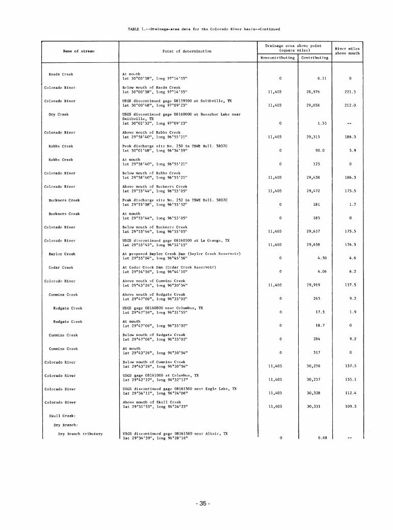
TABLE 1.--Drainage-area data for the Colorado River basin—Continued
Name of stream Point of determination
Drainage area above point(square miles) River miles
above mouth
Noncontributing Contributing
Reeds Creek At mouth
lat 30o00'38", long 97014'55" 0 8.11 0
Colorado River Below mouth of Reeds Creek
lat 30°00'38", long 97°14,55" 11,403 28,976 221.3
Colorado River USGS discontinued gage 08159500 at Smithville, TXlat 30o00'48", long 97o09'23" 11,403 29,058 212.0
Dry Creek USGS discontinued gage 08160000 at Buescher Lake nearSmithville, TXlat 30o02'32", long 97o09'23" 0 1.55 __
Colorado River Above mouth of Rabbs Creek
lat 29°58,40M, long 96°55'21" 11,403 29,313 186.3
Rabbs Creek Peak discharge site No. 250 in TBWE Bull. 5807Clat 30°0r48", long 96054'39" 0 90.0 5.9
Rabbs Creek At mouth
lat 29°58,40", long 96°55,21" 0 125 0
Colorado River Below mouth of Rabbs Creek
lat 29o58'40M, long 96°55,21M 11,403 29,438 186.3
Colorado River Above mouth of Buckners Creek
lat 29°53,44", long 96°53,05" 11,403 29,472 175.5
Buckners Creek Peak discharge site No. 252 in TBWE Bull. 5807Clat 29°53'08", long 96053'52" 0 181 1.7
Buckners Creek At mouth
lat 29°53*44M, long 96°53'05" 0 185 0
Colorado River Below mouth of Buckners Creek
lat 29053'44", long 96°53'05" 11,403 29,657 175.5
Colorado River USGS discontinued gage 08160500 at La Grange, TXlat 29°53,45", long 96°52'15" 11,403 29,658 174.5
Baylor Creek At proposed Baylor Creek Dam (Baylor Creek Reservoir)lat 29°55,04", long 96°45'56" 0 4.50 4.6
Cedar Creek At Cedar Creek Dam (Cedar Creek Reservoir)lat 29°54'56", long 96o44'10,, 0 6.06 6.2
Colorado River Above mouth of Cummins Creek
lat 29°43,26", long 96°30l54" 11,403 29,919 137.5
Cummins Creek Above mouth of Redgate Creeklat 29°47,06", long 96°33,02" 0 265 9.2
Redgate Creek USGS gage 08160800 near Columbus, TXlat 29°47*56", long 96031'55" 0 17.3 1.9
Redgate Creek At mouth
lat 29°47,06", long 96o33'02M 0 18.7 0
Cummins Creek Below mouth of Redgate Creeklat 29°47'06", long 96o33'02" 0 284 9.2
Cummins Creek At mouth
lat 29°43'26", long 96o30'54" 0 317 0
Colorado River Below mouth of Cummins Creek
lat 29043'26", long 96°30,54" 11,403 30,236 137.5
Colorado River USGS gage 08161000 at Columbus, TXlat 29042'22M, long 96032'12n 11,403 30,237 135.1
Colorado River USGS discontinued gage 08161500 near Eagle Lake, TXlat 29°34'11", long 96°24,06" 11,403 30,328 112.4
Colorado River Above mouth of Skull Creek
lat 29°31,53", long 96°24,23" 11,403 30,331 109.3
Skull Creek:
Dry Branch:
Dry Branch tributary USGS discontinued gage 08161580 near Altair, TXlat 29°34,39", long 96°28'16" 0 0.68
-35

Name of stream
Skull Creek
Colorado River
Colorado River
Colorado River
c/West Branch Colorado River —
Colorado River
TABLE 1.--Drainage-area data for the Colorado River basin—Continued
Point of determination
At mouth
lat 29031'53", long 96°24,23"
Below mouth of Skull Creek
lat 29°31'53", long 96024'23"
USGS gage 08162000 at Wharton, TX
lat 29018'32", long 96o06'13"
USGS gage 08162500 near Bay City, TXlat 28°58l26", long 96°00,44"
At mouth
lat 28°38,49H, long 96°00'39"
At mouth
lat 28°38'49", long gS^'SB"
Drainage area above point(square miles)
Noncontributing Contributing
0 112
11,403 30,443
11,403 30,600
11,403 30,837
0 (19.2)
11,403 30,915
£/ West Branch Colorado River does not contribute, but distributes from the Colorado River at certain stages.
-36-
River miles
above mouth


![Journal of Remote Sensing & GIS · physiographic characteristics of the drainage basin, such as size, shape, slope, drainage density and length of the streams etc. [5,6]. The quantitative](https://static.fdocuments.in/doc/165x107/5e86591e4c6b9523356dd773/journal-of-remote-sensing-gis-physiographic-characteristics-of-the-drainage.jpg)