DRAFT SCOPING/ENVIRONMENTAL IMPACT ASSESSMENT REPORT … Heinrich Water Supply Draft... · dra...
78
DRAFT SCOPING/ENVIRONMENTAL IMPACT ASSESSMENT REPORT THE WATER SUPPLY IMPROVEMENT PROJECT TO THE LANGER HEINRICH URANIUM MINE DRAFT 03 23/11/2010 for comment by stakeholders Prepared by: Enviro Dynamics Project proponent: Langer Heinrich Uranium (Pty) Ltd
-
Upload
dangkhuong -
Category
Documents
-
view
225 -
download
1
Transcript of DRAFT SCOPING/ENVIRONMENTAL IMPACT ASSESSMENT REPORT … Heinrich Water Supply Draft... · dra...

DRAFT SCOPING/ENVIRONMENTAL IMPACT
ASSESSMENT REPORT
THE WATER SUPPLY IMPROVEMENT PROJECT TO
THE LANGER HEINRICH URANIUM MINE
DRAFT 03
23/11/2010
for comment by stakeholders
Prepared by: Enviro Dynamics
Project proponent: Langer Heinrich Uranium (Pty) Ltd

The Water Supply Improvement Project to the Langer Heinrich Mine Page | i
23 November 2010 Ι Version 3
EXECUTIVE SUMMARY
Introduction and project description
The Langer Heinrich Mine (LHM) is located approximately 90km east of Swakopmund
in the Namib Naukluft National Park in the Erongo Region of Namibia. Langer
Heinrich Uranium Mine (LHM) focuses on the mining and processing of uranium ore.
The Water Resource Improvement Project is required to secure a water resource for
the future extensions of the mine. It is clear that the water demand of the mine is
reaching the limits of its available resources. .
LHM appointed Enviro Dynamics to conduct an environmental impact assessment
(EIA) of the proposed Water Resource Improvement Project in line with Namibia‟s
Environmental Management Act (2007).
The Terms of Reference for the detailed environmental impact assessment are to:
assess the impacts of the additional water abstraction of
250,000m3/annum from the Husab Berg (HBC) groundwater
compartment to supply the LHM if the capacity of compartment
allows for it;
assess the alternative routes for electricity and water pipeline
infrastructure from the mine to the Swakop River boreholes in terms of
archaeology, vegetation and sense of place; and
assess the impacts related to construction, operation and
maintenance of the water and electricity lines and borehole
infrastructure.
Originally additional abstraction from both the Langer Heinrich- and Husab Berg
Compartments in the Swakop River were included as part of the study. The client
however decided to only investigate the possibility of abstracting 250 000m3/annum
from the Husab Berg Compartment as an option for additional water supply to the
mine.
In order to implement this planned abstraction, additional infrastructure is required
such as water line from the mine to the HBC as well as a power line that supplies
both LHC and HBC. The entire project is situated in the Gawib valley and the
Swakop River valley.
The Scope of the EIA is:
Physically limited to the Gawib River valley and the Langer Heinrich
and Husab Berg groundwater compartments in the Swakop River
valley.

The Water Supply Improvement Project to the Langer Heinrich Mine Page | ii
23 November 2010 Ι Version 3
Geographically placed in the wider socio-economic context of the
Erongo Region. Although the project is relatively small and focused in
size, there are elements to the project that will have to be guided by
the wider context such as the Uranium Rush Strategic Environmental
Assessment.
Public consultation process
Key stakeholders and the Public were invited to participate in the public
consultation process via formal invitation adverts. The consultation process was
guided through a public meeting in Swakopmund and an authorities meeting in
Windhoek on the 4th and 20th of August 2010 respectively. Stakeholders were also
invited to raise issues electronically.
The key issues raised by stakeholders were the potential impact on the regional
groundwater source, and the water table and water quality. These are major
concerns in the context of regional water resource equation in the Erongo Region.
The effect of this on tourism and farming livelihoods as well as the potential impact
on the well known heritage resources of the area were also raised.
Further steps in the public consultation plan included circulation of the Issues and
Responses Trail (a record of all issues raised and the initial responses provided in the
meeting). It is planned to present this Draft Report as part of an Open Day and it will
be circulated for comment to all on the stakeholder database. Comments received
will be incorporated into the Final Environmental Impact Report.
Legal review
A legal framework was compiled for this EIA. It includes the applicable
environmental and water utilisation laws and policies and shows the implications of
each for compliance and implementation. In addition it is emphasised that the
draft Uranium Rush SEA should guide the decision-making process of the project.
Baseline description
The project is located in the Erongo Region, which is one of the more affluent regions
in Namibia with a high average income of N$16,819 per annum but still with a
relatively high unemployment rate of 34%.
The uranium mining industry is one of the two major employers in the region. This
industry is growing significantly and has contributed to the region‟s international
status. Langer Heinrich has 269 employees, 300 long term and 490 short term
subcontractors. Taking into account the workers: dependents ration of 1: 4.3, the
number of dependents benefiting from employment at this mine is 4,554.

The Water Supply Improvement Project to the Langer Heinrich Mine Page | iii
23 November 2010 Ι Version 3
However this also increases the demand for electricity and water, which is a very
limited resource of the region. The region is fairly isolated from the national water
resource base and depends mostly on groundwater from within the region.
Other main economic activities in the region are tourism and commercial fishing.
The project is located in the central Namib Desert which is characterised by rocky
terrain and sensitive gypsum plains. The source of HBC investigated is located in the
Swakop River, which classifies as a linear riparian oasis that has a history of
degradation due to the impact of dams that were built in the 1960s and 1970s.
The groundwater capacity of the HBC is low and recharge is limited due to the
reduction in catchment area by the dams. Therefore the sustainable yield is only
150,000 m3/annum.
The HBC vegetation may be degraded but the impact of water abstraction on
vegetation over time is still uncertain; therefore a cautionary approach of
assessment is required.
The archaeology study identified significant sites close to the infrastructure route
alternatives. The only area that is not sensitive to development in terms of
archaeology is the Gawib River bed.
Impact assessment
The sensitivities identified were screened to identify those that require further
assessment and those that can be dealt with in an EMP without further assessment.
Those that require further assessment were grouped into aspects and the potential
impacts of each were described. This resulted in seven impacts that were assessed
according to the methodology described in Section 7 of the Impact Assessment.
The Table below provides a summary of the Impact Assessment and key mitigation
measures.
Re
late
d
Asp
ec
t Related Impact Rating
before
mitigation
Key Mitigation Rating
after
mitigation
Co
ntin
ue
d/i
nc
rea
sed
gro
un
dw
ate
r a
bst
rac
tio
n
The protection of the limited
regional water resource is
compromised (Combined
impacts No 1, 8)
H Do not abstract from
HBC.
L
The Husab Berg Compartment
water levels will decline below
the acceptable model limits.
H Only abstract up to
150k m3/annum from
HBC.
L
Groundwater dependent M Apply groundwater M

The Water Supply Improvement Project to the Langer Heinrich Mine Page | iv
23 November 2010 Ι Version 3
Re
late
d
Asp
ec
t Related Impact Rating
before
mitigation
Key Mitigation Rating
after
mitigation
riparian vegetation
distribution and density
reduces resulting in reduced
habitat that cannot recover
due to the inferior ability of
the Swakop River to sustain
groundwater dependent
biodiversity once
groundwater levels are
reduced. (Combined Impacts
No 3, 4, 5, 14)
model strictly to
abstraction. Apply a
scientific vegetation
monitoring system.
Do not lower
groundwater level by
more than 10cm
month.
Three project alternatives were investigated namely
Abstracting an additional 250m3/annum groundwater from the HBC.
Finding an alternative source of water in desalination.
No Project alternative.
Finding an alternative source in desalinated water is the most sustainable option.
Conclusions and recommendations
LHM must find improved water sources to be able to implement its future extension
plans. The project investigated these sources which include the use of desalinated
water and increased groundwater. The desalination option is not yet available and
currently the use of groundwater is the short term solution.
The mine should implement the Uranium rush SEA recommendations related to water
for its operations. This will only be possible if Namwater can come to an agreement
with the sole desalinated water supplier, or an alternative desalination plant is
developed. Both these options will take time to implement.
The specific source of groundwater investigated in the HBC is too limited in capacity
to be used on a sustainable basis.

The Water Supply Improvement Project to the Langer Heinrich Mine Page | v
23 November 2010 Ι Version 3
The conclusion of the EIA therefore is that :
In the light of this conclusion the following recommendations are made for LHM:
The proposed abstraction of 250,000m3/annum from the Husab Berg compartment is
not sustainable. The impact of this activity will be high since the sustainable
abstraction rate is only 150,000m3/annum and the SEA gives a clear
recommendation/guideline that future mining activities must source desalinated
water only.
Align with the EQO water recommendation of the Uranium Rush SEA as a matter
of priority.
Make a public commitment not to abstract water from the HBC.
The Water Supply Improvement Project to the Langer Heinrich Mine Page | vi
23 November 2010 Ι Version 3
TABLE OF CONTENT
Executive summary ................................................................................................................... i
Introduction and project description ....................................................................................... i
Public consultation process ...................................................................................................... ii
Legal review ............................................................................................................................... ii
Baseline description ................................................................................................................... ii
Impact assessment ................................................................................................................... iii
Conclusions and recommendations ...................................................................................... iv
Table of content ....................................................................................................................... vi
List of appendixes ..................................................................................................................... x
List of tables ............................................................................................................................ xi
List of figures ............................................................................................................................ xi
List of photos ............................................................................................................................ xi
List of acronyms ...................................................................................................................... xii
1. Introduction ........................................................................................................................ 1
1.1. Background .................................................................................................................... 1
1.2. Rationale of the project ................................................................................................ 1
1.3. Scope of the EIA ............................................................................................................ 1
1.4. The EIA process followed .............................................................................................. 3
2. Project description ............................................................................................................. 5
2.1. Introduction .................................................................................................................... 5
2.2. Project locality ................................................................................................................ 5
2.3. The water resource requirements of LHM ................................................................... 6
2.4. The alternative water resources that may be available to LHM ............................ 7
2.5. Infrastructure requirements to supply more water from the Swakop
River 8
2.6. Technical features of the infrastructure ...................................................................... 9
2.6.1. Pipeline specifications ........................................................................................... 9
2.6.2. Power line specifications ....................................................................................... 9

The Water Supply Improvement Project to the Langer Heinrich Mine Page | vii
23 November 2010 Ι Version 3
2.7. Associated infrastructure ............................................................................................ 10
2.7.1. Power grid .............................................................................................................. 10
2.7.2. Roads ..................................................................................................................... 10
2.7.3. Contractor‟s camp .............................................................................................. 10
2.8. Construction and maintenance process ................................................................. 11
2.8.1. Construction process ........................................................................................... 11
2.8.2. Maintenance process .......................................................................................... 11
2.9. Economic contribution ............................................................................................... 11
2.9.1. Contracts ............................................................................................................... 11
2.9.2. Employment and equipment required ............................................................. 11
2.10. Conclusion .................................................................................................................... 12
3. Public consultation and disclosure ................................................................................ 13
3.1. Introduction .................................................................................................................. 13
3.2. The stakeholders .......................................................................................................... 13
3.3. The meetings to date .................................................................................................. 15
3.3.1. National level ........................................................................................................ 15
3.3.2. Regional and local level...................................................................................... 15
3.4. Issues identified ............................................................................................................ 16
3.5. Key sensitivities .............................................................................................................. 17
3.6. Public feedback .......................................................................................................... 18
4. Legal framework .............................................................................................................. 19
4.1. Introduction .................................................................................................................. 19
4.2. Relevant National and Regional Government Acts and Policies ........................ 19
4.2.1. Other applicable Namibian Legislations .......................................................... 20
4.3. Provisions ....................................................................................................................... 20
4.4. Project Implications ..................................................................................................... 20
4.5. Relevant guiding documents. ................................................................................... 21
4.5.1. Strategic Environmental Assessment of the Central Namib
Uranium Rush ......................................................................................................... 21
4.6. Conclusion .................................................................................................................... 22
5. Socio-economic baseline .............................................................................................. 23
5.1. Introduction .................................................................................................................. 23
5.2. Overview of the Erongo Region ................................................................................ 23
5.2.1. Social environment............................................................................................... 23
5.2.2. Economic environment ....................................................................................... 25

The Water Supply Improvement Project to the Langer Heinrich Mine Page | viii
23 November 2010 Ι Version 3
5.2.3. Land-use activities ................................................................................................ 26
5.2.4. Water supply ......................................................................................................... 28
5.3. Key sensitivities .............................................................................................................. 29
6. Bio-physical baseline ...................................................................................................... 30
6.1. Introduction .................................................................................................................. 30
6.2. Meteorological environment ..................................................................................... 30
6.2.1. Climate................................................................................................................... 30
6.2.2. Temperature .......................................................................................................... 31
6.2.3. Rainfall and evaporation .................................................................................... 31
6.2.4. Wind........................................................................................................................ 31
6.3. Physical environment .................................................................................................. 31
6.3.1. Geology ................................................................................................................. 31
6.3.2. Geohydrology ....................................................................................................... 32
6.3.3. Soils ......................................................................................................................... 32
6.3.4. Surface hydrology ................................................................................................ 33
6.3.5. Existing surface impacts....................................................................................... 34
6.3.6. Visual effects ......................................................................................................... 35
6.4. Biological environment ............................................................................................... 36
6.4.1. Biodiversity ............................................................................................................. 36
6.4.2. Flora ........................................................................................................................ 36
6.4.3. Fauna ..................................................................................................................... 36
6.4.4. Arthopoda ............................................................................................................. 37
6.4.5. Archaeology ......................................................................................................... 38
6.5. Biophysical baseline sensitivities ................................................................................ 38
7. Impact assessment .......................................................................................................... 40
7.1. Introduction .................................................................................................................. 40
7.2. Methodology to screen issues and sensitivities........................................................ 40
7.3. Screening of sensitivities .............................................................................................. 41
7.4. Selection of aspects and impacts from key sensitivities......................................... 44
7.5. Summary of aspects and impacts ............................................................................ 46
7.6. Methodology ................................................................................................................ 46
7.7. Impact assessment ...................................................................................................... 48
7.7.1. Continued regional groundwater resource security perception. ................. 48
7.7.2. Groundwater dependent riparian vegetation distribution and
density reduces resulting in reduced habitat that cannot
recover due to the inferior ability of the Swakop River to sustain

The Water Supply Improvement Project to the Langer Heinrich Mine Page | ix
23 November 2010 Ι Version 3
groundwater dependent biodiversity once groundwater levels
are reduced. ......................................................................................................... 50
7.7.3. The Husab Berg Compartment water levels will decline below
the acceptable model limits. ............................................................................. 49
7.7.4. Water resources on farms to the north of the HBC become more
scarce and difficult to access. ........................................................................... 52
7.7.5. Economic stability and employment opportunity in the Erongo
Region reduces if the mining operations are curtailed by a lack
of water. ................................................................................................................. 53
7.7.6. Destruction of gravel plains surface and vegetation. .................................... 54
7.7.7. Destruction of archaeological sites. .................................................................. 54
7.8. Project alternatives ...................................................................................................... 55
7.8.1. Abstracting an additional 250m3/annum groundwater from the
HBC and LHC. ....................................................................................................... 57
7.8.2. Finding an alternative source of water in desalination. ................................. 58
7.8.3. No Project alternative. ......................................................................................... 59
8. Conclusions and recommendations .............................................................................. 60
8.1. The context of the EIA ................................................................................................. 60
8.1.1. The future planning of the mine ......................................................................... 60
8.2. Key conclusions of the EIA .......................................................................................... 61
8.3. Recommendations of the EIA .................................................................................... 62
9. References ....................................................................................................................... 63
The Water Supply Improvement Project to the Langer Heinrich Mine Page | x
23 November 2010 Ι Version 3
LIST OF APPENDIXES
Appendix A: Registration Letter to Ministry of Environment and Tourism and Plan
of Study
Appendix B: Issues and Responses Trail
Appendix C: Background Information Document
Appendix D: Stakeholders‟ List
Appendix E: Minutes of Authorities Meeting
Appendix F: Minutes of Public Meeting
Appendix G: Husab Berg Compartment Vegetation Study
Appendix H: Husab Berg Groundwater Study
Appendix I: Archaeological Study

The Water Supply Improvement Project to the Langer Heinrich Mine Page | xi
23 November 2010 Ι Version 3
LIST OF TABLES
Table 2-1: Water requirements per stage expansions ....................................................... 7
Table 3-1: Summary of stakeholders ................................................................................... 14
Table 3-2: Summary of newspaper advertisements ......................................................... 16
Table 3-3: Summary of themes resulting from the Public Participation
process ................................................................................................................. 17
Table 3-4: Public Consultation Sensitivities ......................................................................... 18
Table 4-1: Cross-sectoral legislations which influence the environmental
decision-making process for LHM. .................................................................... 20
Table 5-1: Population Figures for the main towns in the Erongo Region
(SAIEA, 2010) ........................................................................................................ 24
Table 5-2: Main Sources of Income in the Erongo Region (NPC, 2001) ........................ 25
Table 5-3: Key socio-economic sensitivities ....................................................................... 29
Table 7-1: Result of screening process for issues and sensitivities. .................................. 41
Table 7-2: Aspects and impacts table (tracked from table 7-1 above). ...................... 44
Table 7-3: Summary of aspects and impacts. .................................................................. 46
LIST OF FIGURES
Figure 1-1: Process of confirming the project. ..................................................................... 2
Figure 1-2: Steps in the EIA Process ........................................................................................ 4
Figure 2-1: : Locality of the LHM in Namibia and the Erongo Region ................................. 5
Figure 2-2: Locality of the existing infrastructure and proposed alternative
routes for new infrastructure in the Swakop River and leading to
the LHM .................................................................................................................. 6
Figure 5-3: Various land uses in the erongo region (SAEIA, 2010) ................................... 28
Figure 6-1: Swakop River catchment area with compartments ..................................... 33
Figure 7-1: Flow chart for the screening of issues and sensitivities. ................................. 41
LIST OF PHOTOS
Photo 3-1: Good attendance at the public meeting held in August 2010. .................. 15
Photo 6-1: Proliferation of tracks along the existing pipeline. ......................................... 34
Photo 6-2: A leak in the existing water line. ....................................................................... 35
Photo 6-3: Visual resources along the proposed power line route ................................ 35
The Water Supply Improvement Project to the Langer Heinrich Mine Page | xii
23 November 2010 Ι Version 3
LIST OF ACRONYMS
BID Background Information Document
BIWAC Bittner Water Consult
°C Degree Celsius
EA Environmental Assessment
ED Enviro Dynamics cc
EIA Environmental Impact Assessment
EMP Environmental Management Plan
GDP Gross Domestic Product
GPS Global Positioning System
HBC Husab Berg Compartment
LHC Langer Heinrich Compartment
LHM Langer Heinrich Uranium Mine
m3/annum Cubic meter per year
mm/annum Millimetre per year
Nampost Namibia Post Ltd
Namwater Namibia Water Corporation
MET Ministry of Environment and Tourism
MME Ministry of Mines and Energy
NGO Non Governmental Organisation
NNNP Namib Naukluft National Park
NPC National Planning Commission
RED Regional Electricity Distributor
SEA Strategic Environmental Assessment
SAEIA South African Institute for Environmental Impact Assessment
SEMP Strategic Environmental Management Plan
WSIP Water Supply Improvement Project

The Water Supply Improvement Project to the Langer Heinrich Mine Page | 1
23 November 2010 Ι Version 3
1. INTRODUCTION
1.1. Background
The Langer Heinrich Uranium Mine (LHM) is located approximately 90 km east of
Swakopmund in the Erongo Region. The mine is situated close to the Swakop River
on the northern boundary of the Namib Naukluft National Park.
The mine was established in 2006 and went into full operation by 2007. Stage 2
expansion of the mine was completed by 2009. Future planning of the mine
includes two more expansions (Stage 3 which is being constructed and planned to
be commissioned in 2011 and Stage 4).
1.2. Rationale of the project
The water resource improvement project is required for the following reasons:
The mine is close to its limits in terms of water available from formal
Namwater sources after the Stage 2 expansion and cannot continue
with the Stage 3 and 4 expansions unless additional water resources
are made available.
The mine requires additional water for dust suppressing purposes and
for certain construction activities for the Stage 3 expansion project.
The alternative water resources available to LHM are currently from groundwater
compartments in the Swakop River, namely the Langer Heinrich and Husab Berg
Compartments, as well as other supply options being investigated in collaboration
with Namwater (i.e. desalinisation options).
1.3. Scope of the EIA
Langer Heinrich Uranium Mine, the project proponent, therefore embarked upon this
project called:
LHM has a permit to abstract 500,000m3/annum of water per annum from the Langer
Heinrich Compartment from the Department of Water Affairs. Currently they use
about 50% of this allotment which might increase to 100%.
The objective of the mine is to apply for a permit to abstract additional water from
the Swakop River. Originally additional abstraction from both the Langer Heinrich-
and Husab Berg Compartments in the Swakop River were included as part of the
study. The client however decided to only investigate the possibility of abstracting
The Water Supply Improvement Project to the Langer Heinrich Mine.

The Water Supply Improvement Project to the Langer Heinrich Mine Page | 2
23 November 2010 Ι Version 3
250 000m3/annum from the Husab Berg Compartment as an option for additional
water supply to the mine.
According to the Namibia Environmental Management Act (2007) the permit
application for the proposed abstraction of water from the Husab Berg
Compartment and construction of associated infrastructure requires an
Environmental Impact Assessment (EIA).
LHM therefore appointed Enviro Dynamics to conduct a full EIA on the project.
The initial objective of the EIA was to assess the viability of increasing the abstraction
of the groundwater from the Husab Berg and Langer Heinrich Compartments in the
Swakop River in the context of the importance of groundwater resources to the
water resource security of the Erongo Region.
Due to the increasing demand pressure on groundwater in the Erongo Region and
the limited capacity of this resource in the region the strategic significance of the
project must be considered also.
Figure 1-1 provides a visual presentation of the nature of the project and how it is to
be considered.
Figure 1-1: Process of confirming the project.
Although the project is relatively small and focused in size, there are elements to it
that will have to be guided by the wider context such as the Uranium Rush Strategic
Environmental Assessment.
Once this consideration is addressed by the EIA the particular objectives of the EIA in
terms of the revised Terms of Reference are to:
assess the impacts of the additional water abstraction of
250,000m3/annum from the Swakop River (Husab Berg (HBC)
groundwater compartment) to supply the LHM;
Environmental Management Plan
Project level consideration
Strategic consideration
Is the project sustainable within the context of the regional water resource
scarcity?
If the project is not sustainable within the regional context, no
further detailed assessment is required.
If the project is sustainable within the
regional context a detailed assessment of the operational aspect
scan be completed.
Detailed assessment is used to develop a
Environmental Management Plan for implemetation of the
project.
The Water Supply Improvement Project to the Langer Heinrich Mine Page | 3
23 November 2010 Ι Version 3
assess the alternative routes for electricity and water pipeline
infrastructure from the mine to the Swakop River boreholes in terms of
archaeology, vegetation and sense of place; and
assess the impacts related to construction, operation and
maintenance of the water and electricity lines and borehole
infrastructure.
The project scope is:
Physically limited to the Gawib River valley and the Husab Berg
groundwater compartments in the Swakop River valley.
Geographically placed in the wider socio-economic context of the
Erongo Region. Although the project is relatively small and focused in
size, there are elements to the project that will have to be guided by
the wider context such as the Uranium Rush Strategic Environmental
Assessment.
The following assumptions are made on the EIA:
This EIA does not assess the existing permit conditions of LHM to
abstract from LHC.
1.4. The EIA process followed
The usual procedure for conducting an EIA is described in Figure 1-2 below. The
procedure is based on the requirements of the Environmental Management Act of
2007.
The EIA team is responsible for coordinating the process as an independent entity
from the project proponent.
In the case of this project the strategic importance of the possible impacts was clear
from the start. The areas that will require specialist attention was also evident and
are defined as follows:
Specialist investigation of the groundwater conditions in the Husab
Berg Compartment.
Specialist investigation of the riparian linear oasis along the Swakop
River in the project area and along the alternative infrastructure routes.
Specialist investigation into the archaeology of the Gawib valley and
Riet area in the project area.
Therefore three specialists were solicited to the project namely:
Bittner Water Consult as geo-hydrologist specialist.
Coleen Mannheimer as vegetation specialist.
John Kinahan as archaeologist.

The Water Supply Improvement Project to the Langer Heinrich Mine Page | 4
23 November 2010 Ι Version 3
Each is a recognized leader in his or her field of specialization.
The decision to conduct a combined Scoping/EIA immediately and not to produce
a Scoping Report first and thereafter conduct the assessment and prepare a
separate EIA Report was communicated to the Directorate of Environmental Affairs
(See Appendix A).
The EIA therefore followed the steps described in Figure 1-2 except for the Report
that is usually produced at the end of the Scoping Phase. The proceedings required
in the Scoping Report have been fully incorporated in this Scoping/EIA Report.
Figure 1-2: Steps in the EIA Process
Screening
No EA required
EA required
ScopingDetermine scope of EAKey issues of concern
Environmental AssessmentAnalyze impacts
Determine mitigation measures
Decision making
ImplementationAppeal
Development not approved
Development approved
STEPS IN THE
EA PROCESS
Environmental Management
Plan (EMP)

The Water Supply Improvement Project to the Langer Heinrich Mine Page | 5
23 November 2010 Ι Version 3
2. PROJECT DESCRIPTION
2.1. Introduction
This Project Description Chapter
defines the project and its role players;
provides the rationale for the project; and
includes a description of the project characteristics.
2.2. Project locality
The LHM is located on the northern edge of the Namib Naukluft National Park in
the Southern Erongo Region of Namibia (see Figure 2-1). The proposed LHM
Water Supply Improvement Project is located in the Gawib River and Swakop
River valleys near the Mine.
Figure 2-1: : Locality of the LHM in Namibia and the Erongo Region
The existing infrastructure, alternative routes for new infrastructure and the
positions of existing and new boreholes is shown in Figure 2-2. Boreholes were
drilled in the HBC as part of the study to conduct amongst others pump tests.
The BID in Appendix C also provides a A4 map of the project proposal.
The Water Supply Improvement Project to the Langer Heinrich Mine Page | 6
23 November 2010 Ι Version 3
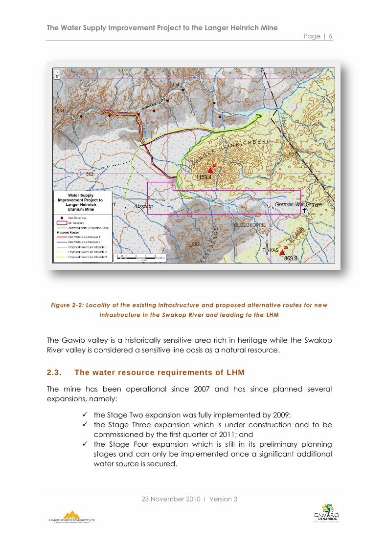
Figure 2-2: Locality of the existing infrastructure and proposed alternative routes for ne w
infrastructure in the Swakop River and leading to the LHM
The Gawib valley is a historically sensitive area rich in heritage while the Swakop
River valley is considered a sensitive line oasis as a natural resource.
2.3. The water resource requirements of LHM
The mine has been operational since 2007 and has since planned several
expansions, namely:
the Stage Two expansion was fully implemented by 2009;
the Stage Three expansion which is under construction and to be
commissioned by the first quarter of 2011; and
the Stage Four expansion which is still in its preliminary planning
stages and can only be implemented once a significant additional
water source is secured.

The Water Supply Improvement Project to the Langer Heinrich Mine Page | 7
23 November 2010 Ι Version 3
For each of the stages which the mine implements it requires additional water
resources. These requirements are explained in Table 2-1.
Table 2-1: Water requirements per stage expansions
It is clear from the table that the
mine is at its limits in terms of the
water resources required to
implement any future
expansions. The mine will
require new water resources to
operate in the future.
2.4. The alternative water resources that may be available to LHM
The current situation with available water resources in the Erongo Region is not
ideal. Supply is mostly from groundwater schemes as Erongo does not have
significant infrastructure connections to the national water resource base in
Namibia.
The two main groundwater resources that are being used by the Region are the
Omdel Aquifer at Henties Bay and the Kuiseb Aquifer at Walvis Bay. Both these
aquifers are managed by Namwater. They are currently utilized to their permitted
limits and the Ministry of Agriculture and Water indicated that they will likely
reduce future volumes to Namwater to prevent over utilization (pers. comm.
Koch, 2010). Namwater has allocated 1.5M m3/pa to LHM from the Omdel
Aquifer and this volume will in all likelihood not be increased. Additional water is
therefore not available to LHM from the Omdel Scheme.
In addition LHM has an existing permit for the use of groundwater from the Langer
Heinrich Compartment (LHC) of the Swakop River valley. The permit, which allows
for the abstraction of 0.5M m3/pa from the LUC must be renewed by the end of
2010.
As explained in SAIEA, 2010 there are three desalination water supply options
which are currently in the pipeline for the Region, as follows.
The AREVA Company mining uranium at Trekkopje developed a
water desalination plant at Wlotzkasbaken. The plant will have a
spare water capacity of 6M m3/pa after supplying the Trekkopje
Mine.
Namwater is considering a desalination plant to be commissioned
by 2014 with which the aim is to supply 25M m3/pa.
STAGE Total water
required Requirement timeline
Stage 2 1.28M m3/pa current
Stage 3 2.25M m3/pa Q3 2011
Stage 4 >6.0M m3/pa ±2014

The Water Supply Improvement Project to the Langer Heinrich Mine Page | 8
23 November 2010 Ι Version 3
There are however constraints to the access of these water supply options (SAIEA,
2010), namely:
Namwater is the only authorized seller of bulk water in Namibia. All
negotiations to access these sources must therefore go through
Namwater; and
the regional pipeline infrastructure is dated and will need
replacement to assure access and uninterrupted supply.
The immediate water supply alternatives (for the stage 3 water
requirements)available to LHM are very limited and therefore the mine decided
to investigate the possible utilization of additional groundwater from the Husab
Berg Compartment (HBC) of the Swakop River aquifer.
2.5. Infrastructure requirements to supply more water from the
Swakop River
The existing and new infrastructure required to supply the mine with water from
the Swakop River is shown in Figure 2-2. The new infrastructure will include:
new pump(s) from the abstraction borehole(s) in the HBC;
new electricity lines from the mine to the existing and new boreholes
in the HBC and LHC;
new water lines from the mine to the new boreholes in the HBC and
LHC; and
new narrow width tracks along the new electricity and water lines
from the mine to the boreholes.
The new boreholes were drilled for testing purposes only in proximity to a number
of existing holes in the LHC and HBC of the Swakop River. These two
compartments stretch from the Namib Naukluft National Park border in the east to
the Husab/Witpoort mountain range, which crosses the Swakop River some 16km
downstream of the Swakop/Gawib River confluence.
From the existing and new boreholes the overhead electrical line and the surface
water lines will follow the Gawib River valley to link with the mine. The alternative
routes (see Figure 2-2) are:
Route 1 from LHM along the Gawib River bed into the Swakop River
bed (preferred route).
Route 2 from the Gawib River / MET road intersection eastwards
along the MET road to the intersection with the existing route to the
Swakop River bed.
Route 3 from the main road to LHM along the MET road to the
intersection with the Gawib River for electrical line only.

The Water Supply Improvement Project to the Langer Heinrich Mine Page | 9
23 November 2010 Ι Version 3
The existing approved route from LHM along the eastern Gawib
Valley edge/ Langer Heinrich Mountain foothills to the Swakop River
bed.
Currently there is one surface water pipeline on the existing approved route that
supplies the mine with water from the existing Swakop River boreholes (in the
LHC).
2.6. Technical features of the infrastructure
The infrastructure that is relevant to the project is:
The borehole layout.
The pipeline details.
The power line features.
The following sections provide technical descriptions of these entities.
2.6.1. Pipeline specifications
The line will be an HDPE, 200/150mm line pressure class 20.
The joint method will be welded.
The pumping capacity will be 75m3/hr.
The spare pumping capacity on existing line is 25m3/hr.
2.6.2. Power line specifications
The line will be a11kV line with 3 cables.
The frame will be made of timber poles with 3 aluminium
conductors.
Height of structure is 9m and will be a single pole structure with an
average distance of 100m between structures.
2x 10 ton trucks will be used to erect the electricity lines. One with the drill and the
other with the rest of the equipment (e.g. poles, electricity line, etc.)
The truck with the drill will reverse in the correct position where the pole needs to
be planted. This is the only area where the truck will have to get of the existing
track to drill the hole but it will be right next to the track and the disturbance will
be limited.
A 350mm diam hole (2m deep) will be drilled.
After the hole is drilled the other truck will pull into the correct
position to plant the pole and to erect the electricity lines.
The Water Supply Improvement Project to the Langer Heinrich Mine Page | 10
23 November 2010 Ι Version 3
The centre of river (washes) will be prevented as far a possible as the poles would
need protection by means of rock and cement (1.5m high) around the base of
the pole. This would also cause bigger disturbance.
2.7. Associated infrastructure
The following infrastructure is associated with the project. The project will make
use of this existing infrastructure during construction or operations.
2.7.1. Power grid
The power line will connect to the existing power supply to LHM. This means the
supply is in place and no additional supply or infrastructure is required.
2.7.2. Roads
The new routes will follow existing tracks in the project area. In the case of Route 1
only the route will be serviced by a new track down the Gawib River bed. No
additional tracks except on Route 1 will be allowed.
The track, whether existing or new, must be properly marked and mapped by
GPS. All construction and maintenance teams must be supplied with a GPS with
the track active.
The track in Route 1 will comprise of following and possible widening of the existing
track in the riverbed, to accommodate the power line and waterline.
2.7.3. Contractor’s camp / laydown area
No contractor‟s camps will be allowed on site. The contractors may use the
existing facilities of LHM for contractors in the mining license area. Management
of the camp will fall under the LHM mining Environmental Management Plan.
The Water Supply Improvement Project to the Langer Heinrich Mine Page | 11
23 November 2010 Ι Version 3
2.8. Construction and maintenance process
2.8.1. Construction process
The construction of the infrastructure will follow the schedule below:
Select route and clear track.
Construct the overhead power line.
Construct the surface waterline.
Borehole site installation.
2.8.2. Maintenance process
Maintenance work is currently done by teams that is guided by the mine‟s
Environmental Management Plan (EMP) and the Environmental Management
System (EMS) and monitored by the environmental unit of the mine.
2.9. Economic contribution
2.9.1. Contracts
The project will be executed through up to four contracts:
Route marking and clearing of the track.
Constructing the overhead power line.
Constructing the surface waterline.
Borehole site installation.
The expected value of the project is not determined yet.
2.9.2. Employment and equipment required
The construction teams may be composed of:
One survey team with a commercial pick-up vehicle to mark and
clear the track/route. The team will mark the route with physical
markers and also with a GPS.
Two teams of 5 people each with two trucks to construct the
overhead power line. The procedure is as follows:
Team 1 will excavate a series of holes per day.
Team 2 will follow immediately and plant the pole in all
excavated holes.
Teams 1 and 2 will string and complete the lines jointly.
One laying team of 5 people with a truck to lay the pipelines and
one connecting team of 3 people with a commercial pick-up
vehicle to join the pipe sections are required.
The Water Supply Improvement Project to the Langer Heinrich Mine Page | 12
23 November 2010 Ι Version 3
Two teams of 7 people with a light commercial pick-up and a truck
each are required for the installation work at the boreholes.
The overall workforce required will therefore consist of up to 5 senior personnel
and 32 semi-skilled and unskilled personnel for a period of up to two months.
2.10. Conclusion
The implementation of the project is not complex and can be managed by
means of an Environmental Management Plan.
The public consultation process of the EIA is explained in the next section.

The Water Supply Improvement Project to the Langer Heinrich Mine Page | 13
23 November 2010 Ι Version 3
3. PUBLIC CONSULTATION AND DISCLOSURE
3.1. Introduction
Public Participation forms an important component of this EIA. It has been defined
by the Draft MET Environmental Assessment Regulations (2010) of the Environmental
Management Act (2007), as a ‘process in which potential interested and affected
parties are given an opportunity to comment on, or raise issues relevant to, specific
matters’.
Besides these legal requirements, it was also endeavoured to follow best practice as
far as stakeholder consultation and feedback is concerned, so that the voice of the
Public may be heard and taken into account during the decision-making process.
Thus, Background Information Documents (BIDs) were distributed and meetings were
held with the stakeholders, creating a platform whereby their concerns could be
conveyed. This fed into the final scope for the EIA, to cover all issues and concerns
raised by the project stakeholders.
The purpose of this section of the report is to 1) indicate the indentified stakeholders;
2) provide feedback of the meetings that have been conducted; and to 3) provide
a summary of the common themes of concerns and comments raised at these
meetings and via electronic communication. A summary of all issues and concerns
that have been raised during public consultation is provided as Appendix B.
3.2. The stakeholders
An interested and affected party can be defined as ‘(a) any person, group of
persons or organization interested in or affected by an activity; and (b) any organ of
state that may have jurisdiction over any aspect of the activity‟ (MET, 2010).
The interested and affected parties for this project were identified using the existing
LHM EIA stakeholders list. This was further augmented using the Enviro Dynamics
stakeholder database.
In addition, advertisements were placed in various newspapers (refer to Table 3.2)
inviting the Public to register as interested and affected parties. Background
Information Documents (BIDs) (Appendix C), along with an invitation to a meeting
was mailed to all registered stakeholders. Stakeholders were also afforded the
opportunity to send questions/comments/issues to the Consultant.
For this project, key stakeholders have been identified at national, regional, and
local level. A summary of these stakeholders are presented in the Table 3-1. The
complete stakeholders list can be viewed in Appendix D. A Site Notice was also
placed at the entrance gate to LHM.
The Water Supply Improvement Project to the Langer Heinrich Mine Page | 14
23 November 2010 Ι Version 3
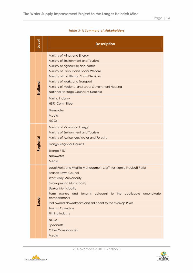
Table 3-1: Summary of stakeholders
Lev
el
Description
Na
tio
na
l
Ministry of Mines and Energy
Ministry of Environment and Tourism
Ministry of Agriculture and Water
Ministry of Labour and Social Welfare
Ministry of Health and Social Services
Ministry of Works and Transport
Ministry of Regional and Local Government Housing
National Heritage Council of Namibia
Mining Industry
HERS Committee
Namwater
Media
NGOs
Re
gio
na
l
Ministry of Mines and Energy
Ministry of Environment and Tourism
Ministry of Agriculture, Water and Forestry
Erongo Regional Council
Erongo RED
Namwater
Media
Loc
al
Local Parks and Wildlife Management Staff (for Namib Naukluft Park)
Arandis Town Council
Walvis Bay Municipality
Swakopmund Municipality
Usakos Municipality
Farm owners and tenants adjacent to the applicable groundwater
compartments
Plot owners downstream and adjacent to the Swakop River
Tourism Operators
Filming Industry
NGOs
Specialists
Other Consultancies
Media
The Water Supply Improvement Project to the Langer Heinrich Mine Page | 15
23 November 2010 Ι Version 3
3.3. The meetings to date
3.3.1. National level
An authorities meeting was held in Windhoek with the national institutional and
regulatory stakeholders on 20 August 2010. Representatives from the Ministry of
Mines and Energy, Ministry of Agriculture and Water Affairs as well as the Directorate
of Water Affairs, attended the meeting. Namwater and the Namibian Heritage
Council were also represented at the meeting. Presentations were made by Enviro
Dynamics, the consultant, as well as by LHM, the project proponent. The minutes of
the meeting are attached as Appendix E.
3.3.2. Regional and local level
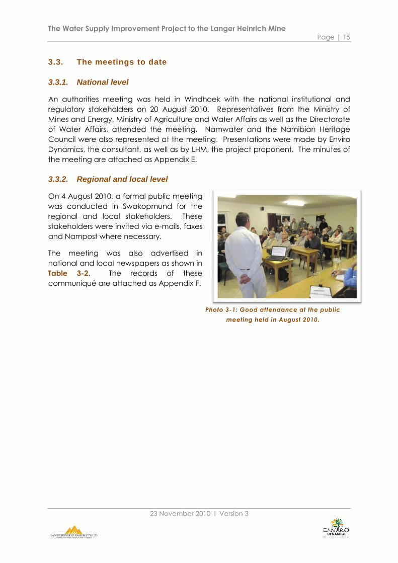
On 4 August 2010, a formal public meeting
was conducted in Swakopmund for the
regional and local stakeholders. These
stakeholders were invited via e-mails, faxes
and Nampost where necessary.
The meeting was also advertised in
national and local newspapers as shown in
Table 3-2. The records of these
communiqué are attached as Appendix F.
Photo 3-1: Good attendance at the public
meeting held in August 2010.

The Water Supply Improvement Project to the Langer Heinrich Mine Page | 16
23 November 2010 Ι Version 3
Table 3-2: Summary of newspaper advertisements
Date National Newspaper Circulation
22 July 2010 Republikein Afrikaans Newspaper, National
29 July 2010 The Namibian English Newspaper, National
Date Local Newspaper Circulation
20 July 2010 Namib Times English & German, Coastal
27 July 2010 Namib Times English & German, Coastal
This formal public meeting provided a platform for the broader community to raise
their issues and concerns, and had 50 attendees. This included plot owners, farmers,
MWAF, MME, MET and the Swakopmund Municipality. Representatives from the
filming industry, tourism, CTAN, Scientific Society Swakopmund, the media and other
uranium mines in the region also attended the meeting (See Appendix F for the
minutes of this meeting.)
The key concerns raised by the attendees can be summarized as the impact on the
groundwater, the water table and quality as well as the existing and future impacts
on groundwater dependent vegetation such as the camel thorn and Anna trees.
The historical and archaeological value of the area under study was also
highlighted. In general, the meeting conveyed groundwater use discontent and the
attendees of the meeting raised various issues.
3.4. Issues identified
The issues that were raised during the above consultation forums, as well as in
writing, as well as responses to these issues have all been collated in the Issues and
Responses Trail (see Appendix B).
Common themes are highlighted and ranked according to the number of times
they were mentioned as an issue. This is presented in the table below.
The Water Supply Improvement Project to the Langer Heinrich Mine Page | 17
23 November 2010 Ι Version 3
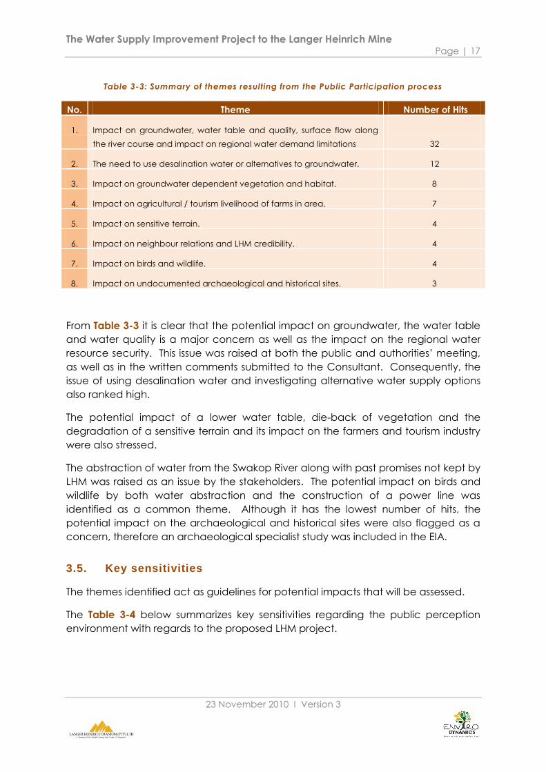
Table 3-3: Summary of themes resulting from the Public Participation process
No. Theme Number of Hits
1. Impact on groundwater, water table and quality, surface flow along
the river course and impact on regional water demand limitations
32
2. The need to use desalination water or alternatives to groundwater. 12
3. Impact on groundwater dependent vegetation and habitat. 8
4. Impact on agricultural / tourism livelihood of farms in area. 7
5. Impact on sensitive terrain. 4
6. Impact on neighbour relations and LHM credibility. 4
7. Impact on birds and wildlife. 4
8. Impact on undocumented archaeological and historical sites. 3
From Table 3-3 it is clear that the potential impact on groundwater, the water table
and water quality is a major concern as well as the impact on the regional water
resource security. This issue was raised at both the public and authorities‟ meeting,
as well as in the written comments submitted to the Consultant. Consequently, the
issue of using desalination water and investigating alternative water supply options
also ranked high.
The potential impact of a lower water table, die-back of vegetation and the
degradation of a sensitive terrain and its impact on the farmers and tourism industry
were also stressed.
The abstraction of water from the Swakop River along with past promises not kept by
LHM was raised as an issue by the stakeholders. The potential impact on birds and
wildlife by both water abstraction and the construction of a power line was
identified as a common theme. Although it has the lowest number of hits, the
potential impact on the archaeological and historical sites were also flagged as a
concern, therefore an archaeological specialist study was included in the EIA.
3.5. Key sensitivities
The themes identified act as guidelines for potential impacts that will be assessed.
The Table 3-4 below summarizes key sensitivities regarding the public perception
environment with regards to the proposed LHM project.
The Water Supply Improvement Project to the Langer Heinrich Mine Page | 18
23 November 2010 Ι Version 3
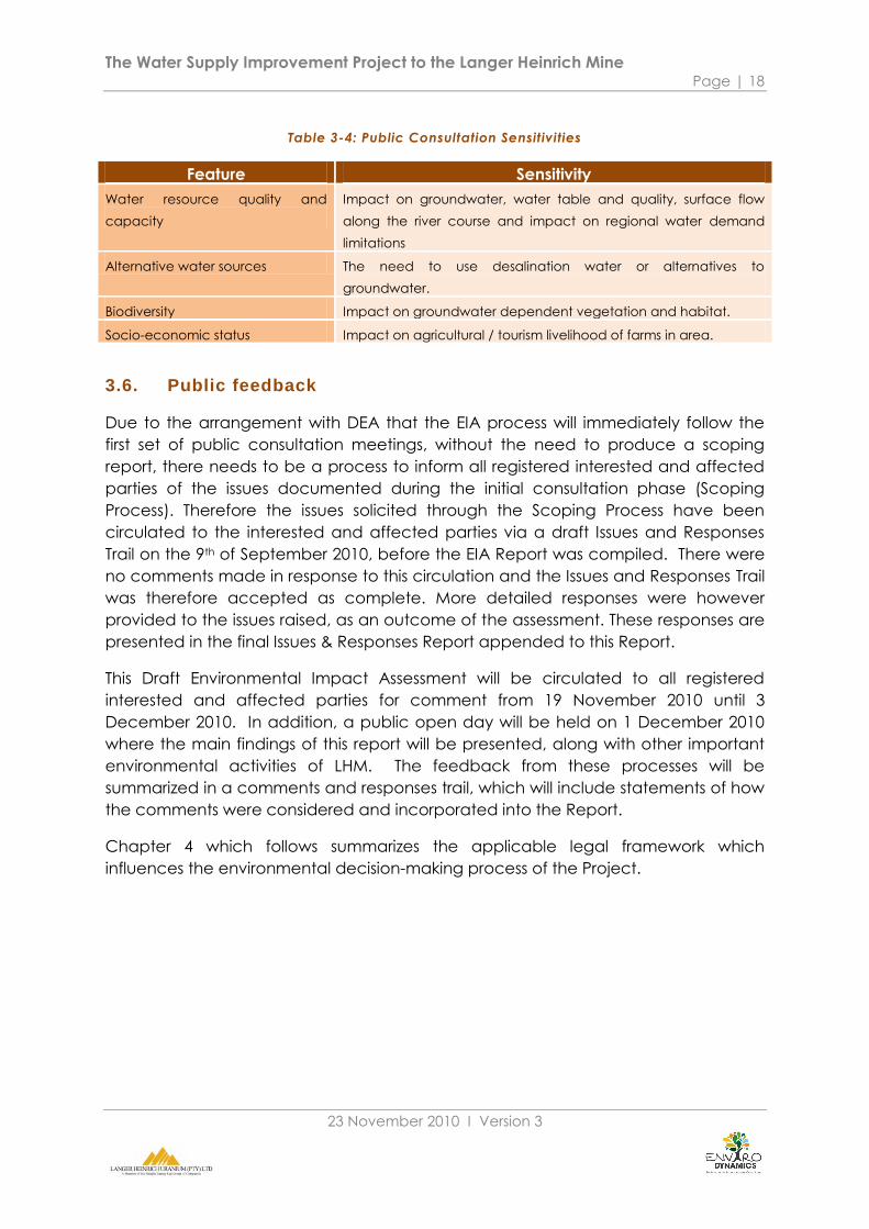
Table 3-4: Public Consultation Sensitivities
Feature Sensitivity
Water resource quality and
capacity
Impact on groundwater, water table and quality, surface flow
along the river course and impact on regional water demand
limitations
Alternative water sources The need to use desalination water or alternatives to
groundwater.
Biodiversity Impact on groundwater dependent vegetation and habitat.
Socio-economic status Impact on agricultural / tourism livelihood of farms in area.
3.6. Public feedback
Due to the arrangement with DEA that the EIA process will immediately follow the
first set of public consultation meetings, without the need to produce a scoping
report, there needs to be a process to inform all registered interested and affected
parties of the issues documented during the initial consultation phase (Scoping
Process). Therefore the issues solicited through the Scoping Process have been
circulated to the interested and affected parties via a draft Issues and Responses
Trail on the 9th of September 2010, before the EIA Report was compiled. There were
no comments made in response to this circulation and the Issues and Responses Trail
was therefore accepted as complete. More detailed responses were however
provided to the issues raised, as an outcome of the assessment. These responses are
presented in the final Issues & Responses Report appended to this Report.
This Draft Environmental Impact Assessment will be circulated to all registered
interested and affected parties for comment from 19 November 2010 until 3
December 2010. In addition, a public open day will be held on 1 December 2010
where the main findings of this report will be presented, along with other important
environmental activities of LHM. The feedback from these processes will be
summarized in a comments and responses trail, which will include statements of how
the comments were considered and incorporated into the Report.
Chapter 4 which follows summarizes the applicable legal framework which
influences the environmental decision-making process of the Project.
The Water Supply Improvement Project to the Langer Heinrich Mine Page | 19
23 November 2010 Ι Version 3
4. LEGAL FRAMEWORK
4.1. Introduction
The legal framework in this chapter includes a review of the relevant policies,
Namibian Acts and guiding frameworks that will have an influence on the project
and its implementation. The chapter concludes with a summary of the potential
influences and conflicts of the Project with the legal framework.
4.2. Relevant national and regional Government acts and policies
Environmental Assessment Policy (1995)
Namibia‟s Environmental Assessment Policy was the first formal effort in the country
to regulate the application of environmental impact assessment that was endorsed
by Cabinet and published in 1995 (MET, 1995). The Policy provides a procedure for
environmental assessments as indicated, which sets out to:
better inform decision makers and promote accountability of decisions
taken;
strive for a high degree of public participation and involvement by all
sectors of the Namibian community in the environmental assessment
process;
take into account the environmental costs and benefits of proposed
policies, programmes and projects;
take into account the secondary and cumulative environmental
impacts of policies, programmes and projects; and
promote sustainable development in Namibia, and especially ensure
that a reasonable attempt is made to minimize anticipated negative
impacts and maximize the benefits of all development.
Environmental Management Act (2007)
Namibia‟s Environmental Management Act was passed in Parliament in October
2007, and gives effect to Namibia‟s Environmental Assessment Policy (Government
of Namibia, 2007). Essentially this Act specifies the environmental assessment
procedures to be followed and the activities requiring EIA (provided in listed
activities). Of relevance to this Project are the following listed activities, provided in
Section 27 of this Act, which include:
water use and disposal;
transportation;
The Water Supply Improvement Project to the Langer Heinrich Mine Page | 20
23 November 2010 Ι Version 3
energy generation and distribution;
The Regulations of this Act are not in force yet which will set the provisions of the Act
in motion. However, the Regulations are in the final stages of development and the
latest version (May 2010) has been used to guide the process of this EIA.
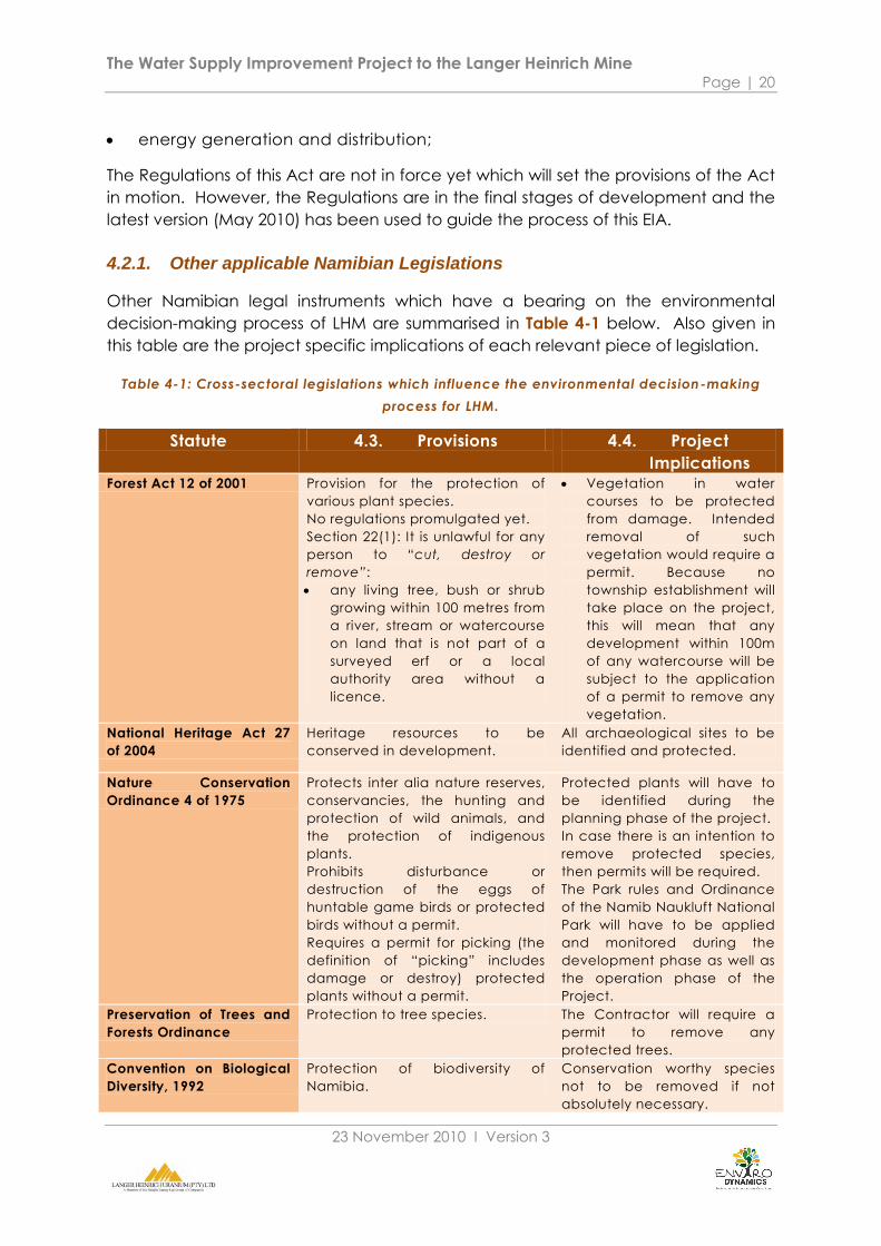
4.2.1. Other applicable Namibian Legislations
Other Namibian legal instruments which have a bearing on the environmental
decision-making process of LHM are summarised in Table 4-1 below. Also given in
this table are the project specific implications of each relevant piece of legislation.
Table 4-1: Cross-sectoral legislations which influence the environmental decision-making
process for LHM.
Statute 4.3. Provisions 4.4. Project
Implications Forest Act 12 of 2001 Provision for the protection of
various plant species.
No regulations promulgated yet.
Section 22(1): It is unlawful for any
person to “cut, destroy or
remove”:
any living tree, bush or shrub
growing within 100 metres from
a river, stream or watercourse
on land that is not part of a
surveyed erf or a local
authority area without a
licence.
Vegetation in water
courses to be protected
from damage. Intended
removal of such
vegetation would require a
permit. Because no
township establishment will
take place on the project,
this will mean that any
development within 100m
of any watercourse will be
subject to the application
of a permit to remove any
vegetation.
National Heritage Act 27
of 2004
Heritage resources to be
conserved in development.
All archaeological sites to be
identified and protected.
Nature Conservation
Ordinance 4 of 1975
Protects inter alia nature reserves,
conservancies, the hunting and
protection of wild animals, and
the protection of indigenous
plants.
Prohibits disturbance or
destruction of the eggs of
huntable game birds or protected
birds without a permit.
Requires a permit for picking (the
definition of “picking” includes
damage or destroy) protected
plants without a permit.
Protected plants will have to
be identified during the
planning phase of the project.
In case there is an intention to
remove protected species,
then permits will be required.
The Park rules and Ordinance
of the Namib Naukluft National
Park will have to be applied
and monitored during the
development phase as well as
the operation phase of the
Project.
Preservation of Trees and
Forests Ordinance
Protection to tree species. The Contractor will require a
permit to remove any
protected trees.
Convention on Biological
Diversity, 1992
Protection of biodiversity of
Namibia.
Conservation worthy species
not to be removed if not
absolutely necessary.
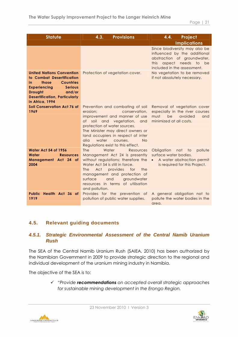
The Water Supply Improvement Project to the Langer Heinrich Mine Page | 21
23 November 2010 Ι Version 3
Statute 4.3. Provisions 4.4. Project
Implications Since biodiversity may also be
influenced by the additional
abstraction of groundwater,
this aspect needs to be
included in the assessment.
United Nations Convention
to Combat Desertification
in those Countries
Experiencing Serious
Drought and/or
Desertification, Particularly
in Africa, 1994
Protection of vegetation cover. No vegetation to be removed
if not absolutely necessary.
Soil Conservation Act 76 of
1969
Prevention and combating of soil
erosion; conservation,
improvement and manner of use
of soil and vegetation, and
protection of water sources.
The Minister may direct owners or
land occupiers in respect of inter
alia water courses. No
Regulations exist to this effect.
Removal of vegetation cover
especially in the river courses
must be avoided and
minimized at all costs.
Water Act 54 of 1956
Water Resources
Management Act 24 of
2004
The Water Resources
Management Act 24 is presently
without regulations; therefore the
Water Act 54 is still in force.
The Act provides for the
management and protection of
surface and groundwater
resources in terms of utilisation
and pollution.
Obligation not to pollute
surface water bodies.
A water abstraction permit
is required for this Project.
Public Health Act 36 of
1919
Provides for the prevention of
pollution of public water supplies.
A general obligation not to
pollute the water bodies in the
area.
4.5. Relevant guiding documents
4.5.1. Strategic Environmental Assessment of the Central Namib Uranium
Rush
The SEA of the Central Namib Uranium Rush (SAIEA, 2010) has been authorized by
the Namibian Government in 2009 to provide strategic direction to the regional and
individual development of the uranium mining industry in Namibia.
The objective of the SEA is to:
“Provide recommendations on accepted overall strategic approaches
for sustainable mining development in the Erongo Region.

The Water Supply Improvement Project to the Langer Heinrich Mine Page | 22
23 November 2010 Ι Version 3
Develop and assess viable scenarios of mining and associated
developments as a basis for subsequent decision-making and formal
planning.
Provide guidance for overall solutions on crucial (cumulative) impacts
and challenges stemming from the mining operations.
Outline a Strategic Environmental Management Plan (SEMP)” (SAIEA,
2010).
The SEA is now approved and it is in the interest of the Proponent to consider its
findings and recommendations.
The SEA (SAIEA, 2010) identifies “Water availability, quality and hydrological
function” as Environmental Quality Objective 7 which states:
To ensure that the public have:
the same or better access to water in future as they have currently,
that the integrity of all aquifers remains consistent with the existing
natural and operational conditions (baseline).
that both the quantity and quality of groundwater are not adversely
affected by prospecting and mining activities.
The targets that relates to the project are:
Uranium Rush does not compromise community access to appropriate
quality water
Uranium Rush does not compromise surface and groundwater
movement and availability
The following recommendations apply to the project:
The mines must use only desalinated water for operations.
The mines may use groundwater temporarily for exploration and
construction.
Only groundwater from the mine pit may be used for dust suppression.
4.6. Conclusion
The relevant legal framework along with relevant guidelines and policies oblige the
Proponent and the Competent Authority, namely the Ministry of Environment and
Tourism, to take certain environmental sustainability principles into account when
considering this project. In addition, there are a number of permit requirements
which need to be adhered to should the Project be implemented.
The following chapters include a summary of the socio-economic and biophysical
baseline of the Project area, from which the future implications of this proposed
project will be assessed.

The Water Supply Improvement Project to the Langer Heinrich Mine Page | 23
23 November 2010 Ι Version 3
5. SOCIO- ECONOMIC BASELINE
5.1. Introduction
This section of the report provides an overview of the receiving socio-economic
environment in which the proposed development will take place. It will form the
baseline against which potential issues and impacts will be identified and assessed.
Consequently, only information relevant to this study will be highlighted.
Since the proposed project is located within the Erongo region, an overview of the
social and economic environments of this region will be provided. In addition, key
land use activities will be emphasised.
5.2. Overview of the Erongo Region
5.2.1. Social environment
5.2.1.1. Population and growth
In 1991 the Erongo Region had a population of 55,470. A decade later, this number
had increased to an estimated 107,663, resulting in an increase of almost 94% during
the period 1991 to 2001 (NPC, 2001). This can partly be attributed to the inclusion of
Walvis Bay into Namibia in 1994, as well as migration to the urban coastal towns.
When comparing the regional annual growth rate of some 3.7%, excluding figures
for Walvis Bay, to the national growth rate of 2.6% and a fertility rate that is lower
than the national average, the high rate of population growth in the region further
reflects immigration to these areas (NPC, 2001; Enviro Dynamics, 2009). In addition,
only 35% of the regional population was born in the Erongo Region while 30% of the
same was born in the north-central regions of Namibia (NPC, 2001).
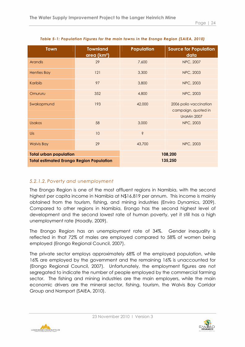
Table 5-1 indicates the population figures for the main urban centers within the
Erongo Region as obtained from the 2001 Population and Housing Census (published
in 2003) as well as figures enumerated for Swakopmund during the 2006 polio
vaccination campaign. These figures for the main urban centers amounts to 108,200
people (SAEIA, 2010). Using this figure and assuming that the urban population forms
80% of the total regional population, the Uranium Rush SEA estimates the regional
population at, 135,250 people. This is higher than the 2001 regional population of
107,663 as well as the estimated figure of 120,460 for the current regional population
using the regional growth rate of 1.3% (SAEIA, 2010).
The Water Supply Improvement Project to the Langer Heinrich Mine Page | 24
23 November 2010 Ι Version 3
Table 5-1: Population Figures for the main towns in the Erongo Region (SAIEA, 2010)
Town Townland
area (km²)
Population Source for Population
data
Arandis 29 7,600 NPC, 2007
Henties Bay 121 3,300 NPC, 2003
Karibib 97 3,800 NPC, 2003
Omururu 352 4,800 NPC, 2003
Swakopmund 193 42,000 2006 polio vaccination
campaign, quoted in
UraMin 2007
Usakos 58 3,000 NPC, 2003
Uis 10 ?
Walvis Bay 29 43,700 NPC, 2003
Total urban population 108,200
135,250 Total estimated Erongo Region Population
5.2.1.2. Poverty and unemployment
The Erongo Region is one of the most affluent regions in Namibia, with the second
highest per capita income in Namibia at N$16,819 per annum. This income is mainly
obtained from the tourism, fishing, and mining industries (Enviro Dynamics, 2009).
Compared to other regions in Namibia, Erongo has the second highest level of
development and the second lowest rate of human poverty, yet it still has a high
unemployment rate (Hoadly, 2009).
The Erongo Region has an unemployment rate of 34%. Gender inequality is
reflected in that 72% of males are employed compared to 58% of women being
employed (Erongo Regional Council, 2007).
The private sector employs approximately 68% of the employed population, while
16% are employed by the government and the remaining 16% is unaccounted for
(Erongo Regional Council, 2007). Unfortunately, the employment figures are not
segregated to indicate the number of people employed by the commercial farming
sector. The fishing and mining industries are the main employers, while the main
economic drivers are the mineral sector, fishing, tourism, the Walvis Bay Corridor
Group and Namport (SAIEA, 2010).

The Water Supply Improvement Project to the Langer Heinrich Mine Page | 25
23 November 2010 Ι Version 3
5.2.1.3. Livelihood strategies
A number of strategies are followed within this region in order to sustain livelihoods.
Wages and Salaries constitute the main source of income for the region as well as
the Swakopmund and Walvis Bay Urban Constituencies at 67%, 73% and 78%
respectively. This is also higher than the national average of 41.4% (NPC, 2001).Table
5-2 below summarizes main sources of income in the Erongo Region.
Table 5-2: Main Sources of Income in the Erongo Region (NPC, 2001)
Source of Income Erongo Region (%) Swakopmund
Constituency (%)
Walvis Bay Urban
Constituency (%)
Farming 4 1 1
Wages & Salaries 67 73 78
Cash Remittances 8 7 4
Business (Non-farming) 8 9 7
Pension 10 8 6
5.2.2. Economic environment
The economic activities of the Erongo Region revolve around its natural resources
both renewable such as fish and water, as well as non-renewable resources which
include minerals.
The reporter, Des Erasmus, from Die Republikein noted „Erongo Region in the grip of
Uranium Fever’ (Erasmus, 2006). This is due to the renewed interest in nuclear energy.
Consequently, with the region now marked as globally important, a number of
uranium mines have been established in this region over the last few years. Rössing
and Langer Heinrich are some of the uranium mining companies currently
operational. Furthermore, a number of companies are exploring their EPL areas to
indentify new prospective sites for uranium mining (Enviro Dynamics cc, 2009).
Uranium exploration and mining activities are expected to have a significant impact
on the Namibian economy during the next few years as increased production
contributes to the growth in GDP. According to the Uranium Rush SEA, the mining
industry throughout Namibia accounts for approximately 20% of the GDP. In 2009,
4% of the GDP was accounted for by the uranium industry (SAIEA, 2010).
Yet, the operations of the uranium mining industry depend on the sustainable supply
of resources such as electricity and water, especially in a water scarce area, and
the creation of sustainable habitats and livelihoods (Enviro Dynamics cc, 2009).
Currently, all the mines except Trekkopje are dependent on Namwater for their
water supply. In the face of the lack of freshwater resources, the future Namwater
desalination plant as a source of water supply is key in the mines optimizing their
operations (SAIEA, 2010).
The Water Supply Improvement Project to the Langer Heinrich Mine Page | 26
23 November 2010 Ι Version 3
Industrial infrastructure is provided by a railway connection that is also used by the
mines to transport final product (uranium oxide) to Walvis Bay from where it is
shipped for export. Consequently, an increase in mining activities has also
contributed to the increase in container shipments through the Port of Walvis Bay.
The Erongo Region is also connected by the national road network to the rest of the
country via Okahandja, Windhoek, and Otjiwarongo and forms part of the Trans
Kalahari Highway. Thus, the transport networks within the Erongo Region play a key
role in the facilitation of trade via Walvis Bay, supporting it as a hub for commercial
trade.
The fishing industry is another key economic activity and forms the base of the
industrial activity in the region (SAIEA, 2010). The commercial fishing industry is the
cornerstone of Walvis Bay‟s economy and is the biggest employer as it employs
approximately 10,000 people throughout its value chain (Enviro Dynamics, 2009).
Agricultural activity in this region is very limited due to the lack of water and aridity of
the soil (Hoadley, 2009). Nonetheless, both communal and commercial farmers can
be found in this region, which mostly keep livestock (Enviro Dynamics, 2009).
These economic activities are also reflected in the various land uses within the
region.
5.2.3. Land-use activities
5.2.3.1. Mining
A number of mines are operational within the Erongo Region. This includes
Navachab near Karibib where gold is mined, a number of marble and granite
mines, and also salt mining near Swakopmund, Cape Cross and Walvis Bay. Other
mining activities include sand mining and gemstones mined by the small miners
(SAIEA, 2010).
As for uranium mining, Rössing and Langer Heinrich are the operational mines. Their
combined productivity has earned Namibia a spot as the fourth largest uranium
producing country in the world (Chamber of Mines of Namibia, 2009). Two new
mines are currently under construction, namely Valencia and Trekkopje.
Langer Heinrich has 269 employees, 300 long term, and 490 short term
subcontractors. Taking into account the workers: dependents ration of 1: 4.3, the
number of dependents benefiting from employment at this mine is 4,554. The Langer
Heinrich, Rössing and Navachab mines combined accounts for almost 3.5% of
employment in the Erongo region.
The Water Supply Improvement Project to the Langer Heinrich Mine Page | 27
23 November 2010 Ι Version 3
5.2.3.2. Agriculture
As previously mentioned, the arid landscape limits agricultural activity in the Erongo
Region. Nonetheless, both commercial and communal farming, such as that of the
Topnaars, are accounted for in this region.
As for commercial farming, a number of farms are situated near the Langer Heinrich
mine. Commercial farming in the region consists of livestock, wildlife, lodges and
game farms as well as irrigation and crop cultivation (Hoadley, 2009). In 2000, only
10km² of land have been cleared for crops which includes the small holdings in the
Swakop River bed (SAIEA, 2010).
5.2.3.3. Conservation and tourism
Almost one third of the Erongo Region is marked as state protected areas (See
Figure 5-1). This can be attributed to the uniqueness and ecological sensitivity of the
Namib Desert. This conservation area in the Erongo Region consists of four national
parks, namely, the National West Coast Tourist Recreational Area, the Cape Cross
Seal Reserve, the Walvis Bay Nature Reserve and Dunes, and the Namib Naukluft
Park (Mendelsohn & al, 2009).
Currently, only LHM is operational in the Namib Naukluft Park. This sets precedence
in operating a mine in a park, thus similar trends might follow from this example.
Apart from conservation, the parks also play an important role in tourism. A number
of tourism companies are operational within this area. Unspoiled landscapes, vast
and quiet spaces along with wildlife and biodiversity play an important role in the
marketing strategies of these companies. Consequently, damage caused to the
landscape by mining activities can adversely impact on the tourism sector.
Approximately 80% of the tourism operators use the Goanikontes-Moon Landscape
and Welwitchia flats in their tours (SAIEA, 2010).
Tourism, over the years, has become a catalyst for the economic activity of
Swakopmund, Walvis Bay and the Erongo Region (NCCI, 2009). This is reflected in
that the Coast and it accommodates 54% of all visitors to Namibia (Leippert, 2009).
Also, the coastal tourism accommodation sector had an output of some N$833.2
million in 2007 (SAIEA, 2010).
The tourism industry in Namibia was expected to contribute 3% to the national GDP
in 2007 (NEPRU, 2007). Furthermore, it is estimated that this industry has created
18,800 jobs in 2006 and has generated N$1,600 million per annum in revenue (SAIEA,
2010).
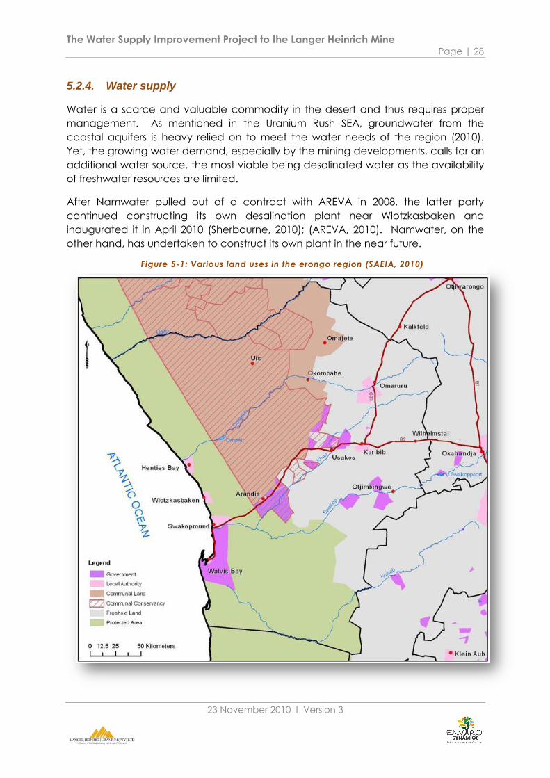
The Water Supply Improvement Project to the Langer Heinrich Mine Page | 28
23 November 2010 Ι Version 3
5.2.4. Water supply
Water is a scarce and valuable commodity in the desert and thus requires proper
management. As mentioned in the Uranium Rush SEA, groundwater from the
coastal aquifers is heavy relied on to meet the water needs of the region (2010).
Yet, the growing water demand, especially by the mining developments, calls for an
additional water source, the most viable being desalinated water as the availability
of freshwater resources are limited.
After Namwater pulled out of a contract with AREVA in 2008, the latter party
continued constructing its own desalination plant near Wlotzkasbaken and
inaugurated it in April 2010 (Sherbourne, 2010); (AREVA, 2010). Namwater, on the
other hand, has undertaken to construct its own plant in the near future.
Figure 5-1: Various land uses in the erongo region (SAEIA, 2010)
The Water Supply Improvement Project to the Langer Heinrich Mine Page | 29
23 November 2010 Ι Version 3
The Omdel Scheme is the main supplier of drinking water to Swakopmund, but is
currently also utilized to its maximum allowed capacity (Hoadley, 2009). Immigration
to this town may increasingly pressurize this source. This water scheme also supplies
water to the LHM for its operations. Currently, the total water demand by the
coastal users is 14.4 Mm³ per annum, of which the mining sector demands 4.6 Mm³
per annum (SAIEA, 2010).
As for water supply to Walvis Bay, the current facilities at the aquifers at Rooibank
and the Kuiseb River are struggling to meet the water demand (Hartmann, 2009.).
Also, should there be another water supply crisis as in March 2009, Walvis Bay will
only be able to supply water for about two to three days (Walvis Bay Municipality,
2008). Apart from the inconvenience for residents, water crises are costly and
hamper various economic activities. During March 2009 an estimated N$20 million
was lost in production (Hartmann, 2009.).
One can conclude that the existing water sources and infrastructure are already
under pressure and the sustainable water supply both locally and on a regional level
is important in sustaining livelihoods as well as economic activities.
5.3. Key sensitivities
The table below summarizes key sensitivities regarding the socio-economic
environment with regards to the proposed LHM project.
Table 5-3: Key socio-economic sensitivities
Feature Sensitivity
Employment The mines are one of two main employers in the Erongo
Region.
Economic contribution Growth in the Uranium industry improves the national and
regional GDP and therefore employment capability.
Water demand pressure The increase in water demand puts pressure on the
limited regional water resource.
Conservation and tourism Mine and related infrastructure development in the
visually/tourism/conservation sensitive areas lowers the
value of access corridors and prime areas affected.
The next chapter includes details of the physical and biological environments of the
Project area.

The Water Supply Improvement Project to the Langer Heinrich Mine Page | 30
23 November 2010 Ι Version 3
6. BIO-PHYSICAL BASELINE
6.1. Introduction
The biophysical baseline reflected in this Chapter includes both information on the
immediate Project area and regional influences that have a bearing on the Project
environment. Those features of the environment which are likely to be affected by
the various project aspects receive stronger emphasis. The chapter concludes with
a summary of the sensitivities in the environment which are likely to be affected by
the project.
6.2. Meteorological environment
6.2.1. Climate
In Africa, Namibia‟s climate is second in aridity only to the Sahara Desert with 92
percent of the land area defined as hyper-arid, arid, or semi-arid (FAO, 2005).
The climate of the Namib Desert is strongly influenced by four features which
enhance its aridity, namely:
the South Atlantic Anticyclonic Cell;
the Benguela Upwelling System;
the Great Escarpment; and
the absence of major topographical features on the 150-km wide
plains.
(Ward, 1983) explain that these features are responsible for the stable climate
experienced in the Namib Desert. The Namib Desert is believed to be 25-80 million
years old with the present hyper-arid phase having persisted for 5 million years.
The cold Benguela current influences the Central Namib coastal zone. It is
positioned in the latitudinal zone of stable descending air, limiting convectional
rainfall throughout much of the interior (Midgley G, 2005). LHM is located at the
edge of this zone.
A high-pressure cell overlying the South Atlantic Ocean frequently forces westerly
winds up to the escarpment, preventing movement of moist air masses from the east
into the Namib (CSIR, 2009). In the winter months, the influence of the Atlantic high-
pressure cell weakens and dry east winds and associated seasonal dust storms (also
called berg winds) cross the Namib to reach the coast (Enviro Dynamics, 2008).

The Water Supply Improvement Project to the Langer Heinrich Mine Page | 31
23 November 2010 Ι Version 3
6.2.2. Temperature
The average annual temperature is 24°C at the mine. Due to the typical desert
climatology, the temperature variation can exceed 30°C on any given day.
Maximum temperature can reach 45°C. Minimum temperatures of 6°C during the
winter months are common (Enviro Dynamics, 2009); (Metago Environmental
Engineers, 2009).
6.2.3. Rainfall and evaporation
Rainfall at LHM and the Namib in general is erratic and low. On average the annual
rainfall is less than 100mm. In contrast evaporation exceeds 2,000mm per annum
(Mendelsohn & al, 2009)
Weather stations at Ganas and Gobabeb show that March (average 28mm), April
(average 9mm), and September (average 22mm) are the peak rainfall months in
this west-central part of the Namib Desert (Enviro Dynamics cc, 2009).
Flash flooding has also been known to occur due to significant rainfall events. The
maximum single recorded rainfall event in the region is 45mm (recorded at Rössing
in 1995) (Metago Environmental Engineers, 2009).
Fog is the predominant moisture supply at the coast resulting from the stable high
pressure Atlantic Ocean cell in combination with the cold upwell from the Benguela
current. The fog precipitation may reach up to 34mm/year and is a stable source of
moisture over long periods (CSIR, 2009).
Most plants and animals in the Central Namib rely on fog for water.
6.2.4. Wind
The wind direction is mainly from the north-west, west and south-west. These winds
are moderate with a speed of between 3m/sec. to 6m/sec. (Metago Environmental
Engineers, 2009).
Strong winds do occur during berg wind conditions in the winter months with wind
speeds of 8m/sec. from an east to north-east direction. These winds are dry and are
capable of raising sandstorms (Seely, M & Pallet, J, 2008).
6.3. Physical environment
6.3.1. Geology
According to the groundwater specialist report (Appendix H, (Bittner, 2010), the
Project area forms part of the Swakop River alluvial aquifer system. The surrounding
rocks consist mainly of Damara sequence rock units such as quartzite, schist and

The Water Supply Improvement Project to the Langer Heinrich Mine Page | 32
23 November 2010 Ι Version 3
marble, granite and gneiss as well as the alluvial deposits of the Swakop River
aquifer and weathered debris deposits.
6.3.2. Geohydrology
The groundwater baseline is described in detail in the groundwater specialist report
(see Appendix H) which focuses on the baseline information required to determine
the sustainable yield of the Husab Berg Compartment (See Figure 6-1: Swakop River
catchment area with compartments).
According to the report the Husab Berg Compartment forms part of the Swakop
River alluvial aquifer system and has limited hydraulic connection to the upstream
Langer Heinrich and the downstream Ida Dome Compartments.
The most important contributing catchment to the Husab Berg Compartment (HBC)
is the Gawib River tributary, which is relatively small.
According to the SEA findings (SAIEA, 2010) there was a pre-dam recharge volume
of 6.3 Mm3/annum in the HBC, which decreased to 4.8 Mm3 after the Von Bach and
Swakoppoort dams were built. The quality of the groundwater is also low.
The average annual recharge to the river alluvium of the HBC was calculated as
approximately 150,000 m³. This volume is considered to be the maximum sustainable
abstraction rate of the HBC as more abstraction might lead to dropping water levels
and pumping from aquifer storage.
6.3.3. Soils
The surface soils of most of the western and central parts of the project area can be
classified as coastal gravel plains. Coastal gravel plains consist of thin soil crusts
approximately 4mm thick. These plains are widely spread in the Namib and they
reach up to the project area and beyond to the east. They are generally either
gypsum crusts (gypcrete) or calcium carbonate crusts (calcrete) that develop from
deposits due to fog precipitation (CSIR, 2009).
The coastal gravel plains of the Central Namib are very fragile systems and are
extremely sensitive to destruction by development activities (NACOMA, 2009).
Gravel plains are usually difficult to restore (Burke, 2005).
The central project area is divided by the Gawib River that mostly contains washed
sandy soils. The soft structure and moisture content of the sand allow for plants to
usually grow larger than in the immediate surroundings.
To the eastern border of the project area the terrain changes to broken mountain
foothills with numerous small riverbeds which contain loose sand to washed pebbles
of various sizes. The terrain between the riverbeds is usually very shallow weathered
material that is loose with bed rock protruding close to the surface.

The Water Supply Improvement Project to the Langer Heinrich Mine Page | 33
23 November 2010 Ι Version 3
6.3.4. Surface hydrology
There are two larger rivers in the project area, namely the Swakop River and the
Gawib River.
The Gawib River is a local tributary to the Swakop River and only flows during rare
thundershowers in the Langer Heinrich Mountain area. Most of the small streams on
the foothills of the Langer Heinrich Mountain contribute to the Gawib River and since
the terrain falls sharply from the mountain to the Swakop River, as well as the type of
rocky soils in the upper catchment, flashfloods would be the norm when the river
does flow.
The Gawib River divides the project area in approximate equal eastern/western
parts and flows from the south-east in a northern direction where it flows into the
Swakop River.
The Swakop River is a regional river with its catchment mainly in the central plateau
of Namibia. The river depends on the upper 39% of the catchment for most of its
flow, where annual rainfall exceeds 300mm/annum. This section of the river
catchment is dammed by the Swakoppoort and Von Bach dams that form the main
source of surface water for the central parts of Namibia (Jacobsen, PJ et al, 1995).
Figure 6-1: Swakop River catchment area with compartments
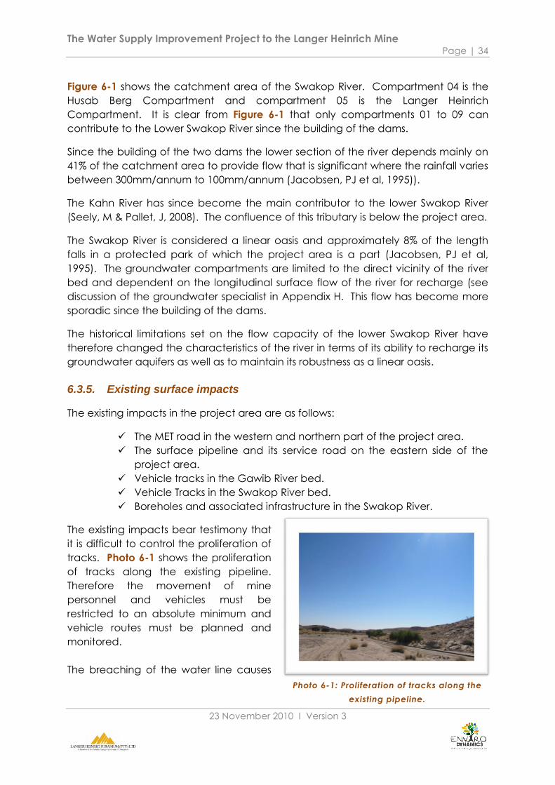
The Water Supply Improvement Project to the Langer Heinrich Mine Page | 34
23 November 2010 Ι Version 3
Photo 6-1: Proliferation of tracks along the
existing pipeline.
Figure 6-1 shows the catchment area of the Swakop River. Compartment 04 is the
Husab Berg Compartment and compartment 05 is the Langer Heinrich
Compartment. It is clear from Figure 6-1 that only compartments 01 to 09 can
contribute to the Lower Swakop River since the building of the dams.
Since the building of the two dams the lower section of the river depends mainly on
41% of the catchment area to provide flow that is significant where the rainfall varies
between 300mm/annum to 100mm/annum (Jacobsen, PJ et al, 1995)).
The Kahn River has since become the main contributor to the lower Swakop River
(Seely, M & Pallet, J, 2008). The confluence of this tributary is below the project area.
The Swakop River is considered a linear oasis and approximately 8% of the length
falls in a protected park of which the project area is a part (Jacobsen, PJ et al,
1995). The groundwater compartments are limited to the direct vicinity of the river
bed and dependent on the longitudinal surface flow of the river for recharge (see
discussion of the groundwater specialist in Appendix H. This flow has become more
sporadic since the building of the dams.
The historical limitations set on the flow capacity of the lower Swakop River have
therefore changed the characteristics of the river in terms of its ability to recharge its
groundwater aquifers as well as to maintain its robustness as a linear oasis.
6.3.5. Existing surface impacts
The existing impacts in the project area are as follows:
The MET road in the western and northern part of the project area.
The surface pipeline and its service road on the eastern side of the
project area.
Vehicle tracks in the Gawib River bed.
Vehicle Tracks in the Swakop River bed.
Boreholes and associated infrastructure in the Swakop River.
The existing impacts bear testimony that
it is difficult to control the proliferation of
tracks. Photo 6-1 shows the proliferation
of tracks along the existing pipeline.
Therefore the movement of mine
personnel and vehicles must be
restricted to an absolute minimum and
vehicle routes must be planned and
monitored.
The breaching of the water line causes

The Water Supply Improvement Project to the Langer Heinrich Mine Page | 35
23 November 2010 Ι Version 3
Photo 6-3: Visual resources along the
proposed power line route
severe trampling by game in very short periods of time. Photo 6-2 shows a leak on
the line and evidence of trampling.
This can be limited to the minimum by
using an electronic leak detection
system on the line.
6.3.6. Visual effects
The visual effect in the project area will be limited to the power line from the mine to
the boreholes in the Swakop River. Photo 6-3 shows the terrain where the line will be
visual. The scale of the terrain is vast. In contrast the power line will be small and the
MET road is closed for tourism activities. The landscape is therefore not visually
sensitive.
The mine closure plan requires that the terrain be restored to its original state.
Photo 6-2: A leak in the existing water line.

The Water Supply Improvement Project to the Langer Heinrich Mine Page | 36
23 November 2010 Ι Version 3
6.4. Biological environment
6.4.1. Biodiversity
The entire project area is included in the Eastern Namib Plains and defined as a
yellow flag area with medium significant biodiversity value. The Swakop River valley
is defined as a red flag area that is of high significant biodiversity value (SAIEA, 2010)
due to its value as a linear oasis.
Therefore any activity in the project area must be evaluated from a conservation
point of view. The preservation of ecological integrity is fundamental to the project
environment and the project activities must not interfere with the functioning of the
ecosystem services in the area.
The fragmentation of especially the linear oasis habitat may lead to significant
changes on a very small scale over long periods of time. These are difficult to
observe and usually go unnoticed until it culminates in a major impact.
6.4.2. Flora
The flora of the Swakop and Gawib River beds as well as the new alternative route
along the MET road is discussed in detail by the vegetation specialist (See Appendix
G, (Mannheimer, 2010).
Vegetation was assessed for sensitivity regarding the impacts of proposed new
infrastructure in the form of a power line and a pipeline. Various route options were
considered. Riparian vegetation in the HBC was assessed for sensitivity to increased
water abstraction.
Riparian vegetation in the Husab Berg Compartment was found to be degraded,
with few Faidherbia albida (juveniles mostly) and small sized Acacia erioloba. The
compartment is heavily infested with Prosopis and Tamarix usneoides. The reason for
this condition of the riparian vegetation is likely to be low water quality than external
factors.
No baseline information is however available to predict how sensitive the vegetation
is to groundwater fluctuations and monitoring over time is required to improve the
predictability of the ecosystem.
6.4.3. Fauna
Compared to reptiles and arthropods, mammals are generally not well represented
in true deserts for a number of reasons, but mainly as a result of a lack of water.
Humans tend to associate significant life with mammals. However, a paucity of
mammal species in the study area does not mean that diversity is low, but rather
that it is unique.

The Water Supply Improvement Project to the Langer Heinrich Mine Page | 37
23 November 2010 Ι Version 3
Special attention must be given to possible reptile habitation of the site especially in
the exposed rock on river banks and the Langer Heinrich foothills due to large areas
of exposed rock and broken terrain (Seely, M et al, 2004).
The Swakop and Gawib Rivers are defined in the Uranium Rush SEA as areas with a
relative high density of wildlife occurrence (SAIEA, 2010).
Mammals that typically occur nomadically in the area are Oryx (Oryx gazella) and
Springbok (Antidorcas marsupialis). Mountain Zebra may traverse the project area
in search of water (SAIEA, 2010).
Small mammals such as ground squirrel, meerkat, mongoose, jackal, bat-eared fox
and aardwolf could visit or be resident in the project area (Seely, M et al, 2004).
Birds form a major component of the ecology in the project area. Possible species
include (Seely, M et al, 2004):
Ostrich.
Lappetfaced Vulture.
Ludwig‟s Bustard.
Ruppel‟s Korhaan.
Ruppel‟s Parrot
Namaqua Sandgrouse.
Black Crow.
The Ludwig‟s Bustard is endemic to the central Namib Gravel Plains. This bird is a low
flyer and the population is estimated at approximately 70,000 to 100,000. The
species typically has a low distribution per km2 (Hockey PAR et al, 2005).
Both the Ludwig‟s Bustard and the Lappetfaced Vulture are susceptible to power
line collisions.
6.4.4. Arthopoda
Although very little insect activity has been observed on site, the following common
beetle species could be present (Seely, M et al, 2004):
Zophisis Amabilis.
Metriopus depressus.
Carchares Macer.
Physosterna cribripes.
Physadesmia globosa
These species are common and widely distributed through the Namib Desert.
The scorpion diversity of the area is above average and the endemism is very high.
This makes the area sensitive for the impact on endemic scorpion species
(Mendelsohn & al, 2009).

The Water Supply Improvement Project to the Langer Heinrich Mine Page | 38
23 November 2010 Ι Version 3
6.4.5. Archaeology
The project area has been identified as a yellow flag area of medium significance
due to its well preserved terrain and the high research value of especially of World
War 1 history (SAIEA, 2010). Of particular value is the overall landscape preservation
that is characteristic to the Gawib valley and surrounds.
Therefore a specialist study has been conducted (see Appendix I, (Kinahan, 2010))
to provide an in-depth assessment of the alternative routes proposed.
An archaeological field survey was conducted to investigate various routes and
localities associated with proposed improvements to water supplies for the LHM.
The survey documented a total of twelve sites, including two pre-colonial graves
and a number of features associated with the conflict at Riet in 1915.
Although the local density of archaeological sites is low, a number of the sites are of
high significance.
On archaeological grounds, the Gawib drainage is therefore considered to be the
least sensitive area investigated and can accommodate infrastructure away from
the sensitive archaeological sites.
6.5. Biophysical baseline sensitivities
The following sensitivities can be derived from the baseline on the biophysical
environment.
Feature Sensitivity
Climate The hyper arid conditions make the restoration of ecosystems and
physical surface damage difficult.
The low precipitation in the desert leads to a very scarce water
resource.
Gravel plains The gravel plains are very sensitive to surface disturbance and are
difficult to restore.
Geo-hydrology The Husab Berg Compartment is sensitive to over abstraction,
additional water abstraction should be very carefully considered.
Surface Hydrology Flashfloods are likely to occur if significant rainfall takes place in the
Gawib River catchment.
The Swakop River‟s ability to recharge groundwater aquifers at
pre-1970 levels has deteriorated significantly due to the building of
the Swakoppoort and Von Bach dams.
Existing surface impacts Control over the movement of vehicles and people in the project
The Water Supply Improvement Project to the Langer Heinrich Mine Page | 39
23 November 2010 Ι Version 3
Feature Sensitivity
area are difficult.
Leaks in the water line causes severe trampling by game in very
short periods of time.
Biodiversity The Swakop River‟s ability to maintain the linear oasis biodiversity at
pre-1970 levels has deteriorated significantly due to the building of
the Swakoppoort and Von Bach dams.
The already destabilized linear oasis biodiversity is sensitive to
further change, even though small and difficult to define.
Flora The vegetation along the proposed routes will be marginally
vulnerable to additional infrastructure and additional activities.
“Lowering of the water table in the HBC by unsustainable
extraction may be expected to reduce the already low numbers
of Acacia erioloba and Faidherbia along the compartment. These
are both protected, and are regarded as keystone species in
riparian ecosystems along the western-flowing ephemeral rivers
Namibia. The lack of data make it difficult to predict outcomes
with any level of certainty, but the available evidence suggests
that loss of these species will result in a knock-on loss of biodiversity
at all levels and in many groups of organisms.
According to the best available model at present (BIWAC 2010),
extraction of 250 000 m3 pa would be unsustainable. It is therefore
recommended that pumping at these levels should not be
undertaken, and that a highly conservative approach to water
extraction be followed” (Mannheimer, 2010)
Fauna The pipeline will fragment ecosystems, especially by being a barrier
to small fauna and arthropoda.
Additional noise and movement of equipment and people will
disturb the normal movement patterns of wildlife.
Reduced groundwater water levels may increase the vulnerability
of the fauna populations of this habitat
Conservation and
Tourism
The Park and its visually/tourism/conservation sensitive areas are
sensitive to the proliferation of infrastructure development.
However, the MET Road is closed for tourist activities which mean
the landscape is not visually sensitive. The mine closure plan
requires that the terrain be restored as close as possible to its
original state.
Archaeology The route alternatives outside the Gawib River are sensitive to
disturbance of scientifically important archaeological sites.

The Water Supply Improvement Project to the Langer Heinrich Mine Page | 40
23 November 2010 Ι Version 3
7. IMPACT ASSESSMENT
7.1. Introduction
The Impact Assessment focuses on evaluating the impacts that may affect the
environment of the project area.
The chapter includes:
A screening process to filter the sensitivities and issues in need of further
consideration from the ones for which further investigation and impact
assessment is not required (i.e. which can be managed in an EMP and
for which adequate information is available to make a decision).
Selection of key sensitivities and issues for an Impact Assessment.
Describe the aspects and impacts derived from the sensitivities.
The methodology of the Impact Assessment.
The Impact Assessment, with mitigation proposals.
Project alternatives.
7.2. Methodology to screen issues and sensitivities
To assist in the identification of key issues, a decision-making process is applied to the
sensitivities (in Chapters 5 and 6) and issues raised (Chapter 3), based on the
following criteria (Figure 7-1).
Whether or not the issue falls within the scope of the EA process and
the responsibility of LHM; and
Whether or not sufficient information is available to respond to the
issue/sensitivity.

The Water Supply Improvement Project to the Langer Heinrich Mine Page | 41
23 November 2010 Ι Version 3
Does the issue fall within the
scope of the EIA and the
responsibility of the
proponent?
YES
Can be
addressed
without further
investigation
required.
Insufficient
information to
address
issue/cumulative
affect required
by law.
Carried over to
EMP Key Issues
Further
investigation
required by EIA
Issue
communicated
to relevant
authority
Closure outside
EIA scope
NO
7.3. Screening of sensitivities
This section provides a summary of the issues identified by all stakeholders and
sensitivities identified from the socio-economic and bio-physical baseline studies.
The result of the selection process is shown in column 3.
Table 7-1: Result of screening process for issues and sensitivities.
Feature No Sensitivity Fall in EIA
scope
Require
impact
assessment
Water resource
quality and
capacity
1 Impact on groundwater, water table and
quality, surface flow along the river course .
Yes Yes
Alternative water
sources
2 The need to use desalination water or
alternatives to groundwater.
On
alternatives
only
On
alternatives
only
Biodiversity 3 Impact on groundwater dependent Yes Yes
Figure 7-1: Flow chart for the screening of issues and sensitivities.
The Water Supply Improvement Project to the Langer Heinrich Mine Page | 42
23 November 2010 Ι Version 3
Feature No Sensitivity Fall in EIA
scope
Require
impact
assessment
riparian vegetation and habitat.
4 The Swakop River ability to maintain the
linear oasis biodiversity at pre-1970 levels
has deteriorated significantly due to the
building of the Swakoppoort and Von Bach
dams.
Yes Yes
5 Additional water abstraction will increase
the pressure on the destabilized linear oasis
biodiversity.
Yes Yes
Employment 6 The mines are one of two main employers
in the Erongo Region.
Yes Yes
Economic
contribution
7 Growth in the Uranium industry improves
the national and regional GDP and
therefore employment capability.
Yes Yes
Water demand
pressure
8 The increase in water demand puts
pressure on the limited regional water
resource.
Yes Yes
Conservation and
tourism
9 Mine and related infrastructure
development in the
visually/tourism/conservation sensitive
areas lowers the value of access corridors
and prime areas affected.
Yes Future use of
the area via
mining closure
10 Impact on future agricultural / tourism
livelihood of farms in area.
Yes Yes
Climate 11 The hyper arid conditions make the
restoration of ecosystems and physical
surface damage difficult.
Yes Yes
Physical
environment
12 The gravel plains are very sensitive to
surface disturbance and difficult to restore.
Yes Yes
Geo-hydrology 13 The Husab Berg Compartment has a limited
water resources and additional abstraction
from it stretches the sustainability of the
source.
Yes Yes
Surface
hydrology
14 Flashfloods are likely to occur if significant
rainfall takes place in the Gawib River
catchment.
Yes No
15 The Swakop River„s ability to recharge Yes Yes

The Water Supply Improvement Project to the Langer Heinrich Mine Page | 43
23 November 2010 Ι Version 3
Feature No Sensitivity Fall in EIA
scope
Require
impact
assessment
groundwater aquifers at pre-1970 levels has
deteriorated significantly due to the
building of the Swakoppoort and Von Bach
dams.
Existing surface
impacts
16 Control over the movement of vehicles
and people in the project area are difficult.
Yes No
17 Leaks in the water line causes severe
trampling by game in very short periods of
time.
Yes No
Flora 18 The route alternatives will lead to the
proliferation of tracks.
Yes No
Fauna 19 The pipeline will fragment ecosystems,
especially by being a barrier to small fauna
and arthropoda.
Yes No
20 Additional noise and movement of
equipment and people will disturb the
normal movement patterns of wildlife.
Yes No
21 Reduced groundwater water levels may
increase the vulnerability of the fauna
populations of this habitat
Yes No
Archaeology 22 The route alternatives are sensitive to
disturbing scientifically important
archaeological sites.
Yes Yes
A list of aspects and related impacts are derived from Table 7-1: Result of screening
process for issues and sensitivities. by selecting the sensitivities which require an
Impact Assessment. The definitions of “Aspect” and “Impact” are as follows:
An activity/facility/product/service is an Aspect when it interacts with
the project environment.
The interaction of an Aspect with the project environment that brings
change to the environment is an Impact.
Each sensitivity is allocated to a typical aspect and then the related impacts for that
sensitivity are described. Table 7-2 provides the results.
The Water Supply Improvement Project to the Langer Heinrich Mine Page | 44
23 November 2010 Ι Version 3
7.4. Selection of aspects and impacts from key sensitivities
Table 7-2: Aspects and impacts table (tracked from table 7-1 above).
No Issue/Sensitivity Related
Aspect
Related Impact
1 Impact on groundwater, water table
and quality, surface flow along the
river course.
Increased
groundwater
abstraction
Lowering of groundwater
table and quality that
reduces regional water
resource base.
3
Impact on groundwater dependent
riparian vegetation and habitat.
Increased
groundwater
abstraction
Groundwater dependent
riparian vegetation
distribution and density
reduces resulting in reduced
habitat.
4 The Swakop River ability to maintain
the linear oasis biodiversity at pre-1970
levels has deteriorated significantly
due to the building of the
Swakoppoort and Von Bach dams.
Increased
groundwater
abstraction
Lower ability of the Swakop
River to sustain groundwater
dependent biodiversity
once groundwater levels
are reduced.
5
Additional groundwater abstraction
will increase the pressure on the
destabilized linear oasis biodiversity.
Increased
groundwater
abstraction
Lower ability of the Swakop
River to sustain groundwater
dependent biodiversity
once groundwater levels
are reduced.
6 The mines are one of two main
employers in the Erongo Region.
Regional
economic
contribution
Economic stability and
employment opportunity in
the Erongo Region reduces
if the mining operations are
curtailed by a lack of water.
7 Growth in the Uranium industry
improves the national and regional
GDP and therefore employment
capability.
Regional
economic
contribution
8 The increase in water demand puts
pressure on the limited regional water
resource.
Increased
groundwater
abstraction
The protection of the limited
regional water resource is
compromised.
10
Impact on future agricultural / tourism
livelihood of farms in area.
Increased
groundwater
abstraction
Water resources on farms to
the north of the HBC
become more scarce and
difficult to access.
11 The hyper arid conditions make the
restoration of ecosystems and physical
Construction
and
Destruction of gravel plains,
surface, and vegetation.

The Water Supply Improvement Project to the Langer Heinrich Mine Page | 45
23 November 2010 Ι Version 3
No Issue/Sensitivity Related
Aspect
Related Impact
surface damage difficult.
maintenance
of the
infrastructure 12 The gravel plains are very sensitive to
surface disturbance and difficult to
restore.
Destruction of gravel plains,
surface and vegetation
13 The Husab Berg Compartment has a
limited water resources and additional
abstraction from it stretches the
sustainability of the source.
Increased
groundwater
abstraction
The Husab Berg
Compartment water levels
will decline below the
acceptable model limits.
15 The Swakop River ability to recharge
groundwater aquifers at pre-1970
levels has deteriorated significantly
due to the building of the
Swakoppoort and Von Bach dams.
Increased
groundwater
abstraction
Lowered ability to recharge
groundwater levels once
used.
21
The route alternatives are sensitive to
disturbing scientifically important
archaeological sites.
Construction
and
maintenance
of the
infrastructure
Destruction of
archaeological sites.
From Table 7-2 we can identify three related aspects that will interact with the
project environment namely:
The abstraction of groundwater from the Husab Berg Compartment.
The contribution of the mine to the regional economy.
Construction and maintenance of the infrastructure
The expected impacts may also be grouped according to their related aspect as
summarised in Table 7-3 below.

The Water Supply Improvement Project to the Langer Heinrich Mine Page | 46
23 November 2010 Ι Version 3
7.5. Summary of aspects and impacts
Table 7-3: Summary of aspects and impacts.
No Related
Aspect
Related Impact
1,
3,
4,
5,
8,
10,
13,
14
Increased
groundwater
abstraction
The protection of the limited regional water resource is compromised
(Combined Impacts no 1, 8).
Groundwater dependent riparian vegetation distribution and density
reduces resulting in reduced habitat that cannot recover due to the
inferior ability of the Swakop River to sustain groundwater dependent
biodiversity once groundwater levels are reduced. (Combined
Impacts No 3, 4, 5, 14)
The Husab Berg Compartment water levels will decline below the
acceptable model limits.
Water resources on farms to the north of the HBC become more
scarce and difficult to access.
6,
7
Regional
economic
contribution
Economic stability and employment opportunity in the Erongo Region
reduces if the mining operations are curtailed by a lack of water.
11,
12,
20
Construction
and
maintenance
of the
infrastructure
Destruction of gravel plains surface and vegetation.
Destruction of archaeological sites.
7.6. Methodology
The impact assessment of each aspect has been conducted by:
naming the impact with a short description;
assessing the impact as per agreed standard criteria used by LHM in
terms of pre- and post mitigation; and
describing mitigation measures.
The assessment is structured as follows:

The Water Supply Improvement Project to the Langer Heinrich Mine Page | 47
23 November 2010 Ι Version 3
PART A: DEFINITION AND CRITERIA*
Definition of
SIGNIFICANCE
Significance = consequence x probability
Definition of
CONSEQUENCE
Consequence is a function of severity, spatial extent and duration
Criteria for ranking
of the
SEVERITY/NATURE
of environmental
impacts
H Substantial deterioration (death, illness or injury). Recommended level will
often be violated. Vigorous community action. Irreplaceable loss of
resources.
M Moderate/ measurable deterioration (discomfort). Recommended level
will occasionally be violated. Widespread complaints. Noticeable loss of
resources.
L Minor deterioration (nuisance or minor deterioration). Change not
measurable/ will remain in the current range. Recommended level will
never be violated. Sporadic complaints. Limited loss of resources.
L+ Minor improvement. Change not measurable/ will remain in the current
range. Recommended level will never be violated. Sporadic complaints.
M+ Moderate improvement. Will be within or better than the recommended
level. No observed reaction.
H+ Substantial improvement. Will be within or better than the recommended
level. Favourable publicity.
Criteria for ranking
the DURATION of
impacts
L Quickly reversible. Less than the project life. Short term
M Reversible over time. Life of the project. Medium term
H Permanent. Beyond closure. Long term.
Criteria for ranking
the SPATIAL SCALE
of impacts
L Localised - Within the site boundary.
M Fairly widespread – Beyond the site boundary. Local
H Widespread – Far beyond site boundary. Regional/ national
PART B: DETERMINING CONSEQUENCE
SEVERITY = L
DURATION Long term H Medium Medium Medium
Medium term M Low Low Medium
Short term L Low Low Medium
SEVERITY = M
DURATION Long term H Medium High High
Medium term M Medium Medium High
Short term L Low Medium Medium
SEVERITY = H
DURATION Long term H High High High

The Water Supply Improvement Project to the Langer Heinrich Mine Page | 48
23 November 2010 Ι Version 3
Medium term M Medium Medium High
Short term L Medium Medium High
L M H
Localised
Within site
boundary
Site
Fairly
widespread
Beyond site
boundary
Local
Widespread
Far beyond site
boundary
Regional/
national
SPATIAL SCALE
PART C: DETERMINING SIGNIFICANCE PROBABILITY
(of exposure
to impacts)
Definite/
Continuous
H Medium Medium High
Possible/ frequent M Medium Medium High
Unlikely/ seldom L Low Low Medium
L M H
CONSEQUENCE
PART D: INTERPRETATION OF SIGNIFICANCE
Significance Decision guideline
High It would influence the decision regardless of any possible mitigation.
Medium It should have an influence on the decision unless it is mitigated.
Low It will not have an influence on the decision.
7.7. Impact assessment
7.7.1. The protection of the limited regional water resource is compromised.
The regional water resource base is limited by nature and currently under threat due
to the drastic regional water demand increase.
The Uranium Rush SEA (SAIEA, 2010) identifies four aquifers being used commercially
to supply the central Erongo Region water demand. These are:
The Omaruru and Kuiseb River aquifers which supply the formal water
demand of the towns, industries and mines in the central Namib.
The Kahn and Swakop River aquifers which supply limited volumes of
water to some prospecting and mining activities.
The cumulative effect of the proliferation of mines using the river aquifers as a source
for their operations will lead to the over abstraction of these primary aquifers (SAIEA,
2010). The Swakop River aquifer mine users may increase from one user to seven
users in the future if this trend is continuing.
If the objective of this project to make more use of groundwater from the Swakop
River aquifer is allowed to proceed, it will set a precedent for future users despite the
recommendations of the SEA.

The Water Supply Improvement Project to the Langer Heinrich Mine Page | 49
23 November 2010 Ι Version 3
It is the recommendation of the Uranium Rush SEA (2010) that:
The mines must use only desalinated water for operations.
The mines may use groundwater temporarily for exploration and
construction.
Only groundwater from the mine pit may be used for dust suppression.
The rationale for the assessment is based on regional data, the Uranium Rush SEA
guidelines/recommendations, and professional opinion.
Impact Aspect Criteria Rating without
mitigation/
enhancement
Rating with
mitigation/
enhancement
The protection of the
limited regional water
resource is
compromised.
Increased
groundwater
abstraction
Severity H L
Duration M M
Spatial Scale H L
Consequence H L
Probability of
occurrence M L
Significance H L
The following mitigation measures are proposed:
LHM should not abstract water from the HBC.
7.7.2. The Husab Berg Compartment water levels will decline below the
acceptable model limits.
Bittner (Appendix H) in his groundwater study has recommended annual abstraction
rate from the Husab Berg Compartment be set at 150,000m3/annum. If the
abstraction rate exceeds this amount, the groundwater model predict a deficit in
annual average recharge and the mine will use the aquifer storage and
groundwater levels will drop below normal reduction levels.
If LHM abstracts the proposed 250,000 m3/annum from the HBC, it will reduce the
aquifer storage annually and the recharge deficit will increase annually.
The rationale for the assessment is based on the Groundwater Specialist Report.
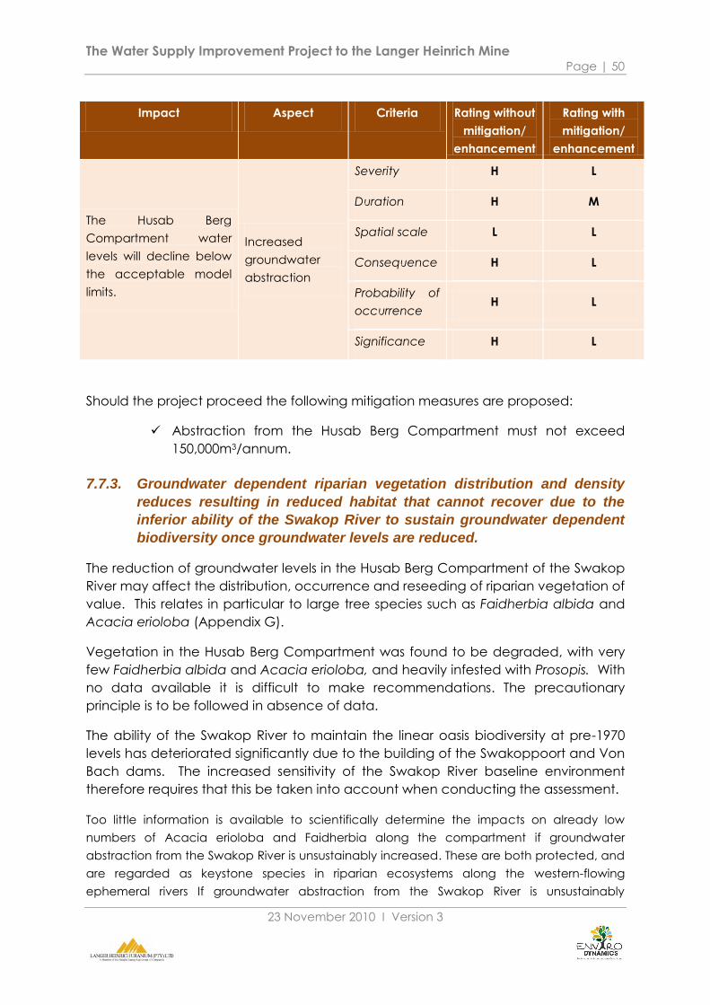
The Water Supply Improvement Project to the Langer Heinrich Mine Page | 50
23 November 2010 Ι Version 3
Impact Aspect Criteria Rating without
mitigation/
enhancement
Rating with
mitigation/
enhancement
The Husab Berg
Compartment water
levels will decline below
the acceptable model
limits.
Increased
groundwater
abstraction
Severity H L
Duration H M
Spatial scale L L
Consequence H L
Probability of
occurrence H L
Significance H L
Should the project proceed the following mitigation measures are proposed:
Abstraction from the Husab Berg Compartment must not exceed
150,000m3/annum.
7.7.3. Groundwater dependent riparian vegetation distribution and density
reduces resulting in reduced habitat that cannot recover due to the
inferior ability of the Swakop River to sustain groundwater dependent
biodiversity once groundwater levels are reduced.
The reduction of groundwater levels in the Husab Berg Compartment of the Swakop
River may affect the distribution, occurrence and reseeding of riparian vegetation of
value. This relates in particular to large tree species such as Faidherbia albida and
Acacia erioloba (Appendix G).
Vegetation in the Husab Berg Compartment was found to be degraded, with very
few Faidherbia albida and Acacia erioloba, and heavily infested with Prosopis. With
no data available it is difficult to make recommendations. The precautionary
principle is to be followed in absence of data.
The ability of the Swakop River to maintain the linear oasis biodiversity at pre-1970
levels has deteriorated significantly due to the building of the Swakoppoort and Von
Bach dams. The increased sensitivity of the Swakop River baseline environment
therefore requires that this be taken into account when conducting the assessment.
Too little information is available to scientifically determine the impacts on already low
numbers of Acacia erioloba and Faidherbia along the compartment if groundwater
abstraction from the Swakop River is unsustainably increased. These are both protected, and
are regarded as keystone species in riparian ecosystems along the western-flowing
ephemeral rivers If groundwater abstraction from the Swakop River is unsustainably

The Water Supply Improvement Project to the Langer Heinrich Mine Page | 51
23 November 2010 Ι Version 3
increased. Evidence suggests that loss of these species will result in a knock-on loss of
biodiversity at all levels, which justify a conservative approach.
The impact on groundwater dependent biodiversity is therefore of even higher
concern because of increased vulnerability of the ecosystem, compared to its pre-
1970 condition. The increased vulnerability of the river system means that the ability
of river is reduced and that activities therefore need to be considered more
stringently.
The rationale of the assessment is based on the specialist vegetation study
(Mannheimer, 2010), keeping the regional baseline conditions in mind.
Impact Aspect Criteria Rating without
mitigation/
enhancement
Rating with
mitigation/
enhancement
Groundwater
dependent riparian
vegetation distribution
and density reduces
resulting in reduced
habitat.
Increased
groundwater
abstraction
Severity H M
Duration M L
Spatial Scale L L
Consequence M M
Probability of
occurrence H M
Significance M M
Should LHM abstract additional groundwater from the HBC the following mitigation
measures are proposed (see p11 of Appendix G for detail):
The modelled threshold water levels proposed by BIWAC (2010) should
be used and should not be breached. In the event of a year, or years,
with below average runoff this model should also be used to reassess
pumping levels.
A rigorous scientific vegetation monitoring system must be put in place.
At the first sign of deterioration in groundwater levels the groundwater
model should be reassessed.
Groundwater levels should not be allowed to drop at a rate higher
than 10cm per month, and should preferably be held below that.
Clearing of Prosopis should be given serious consideration.
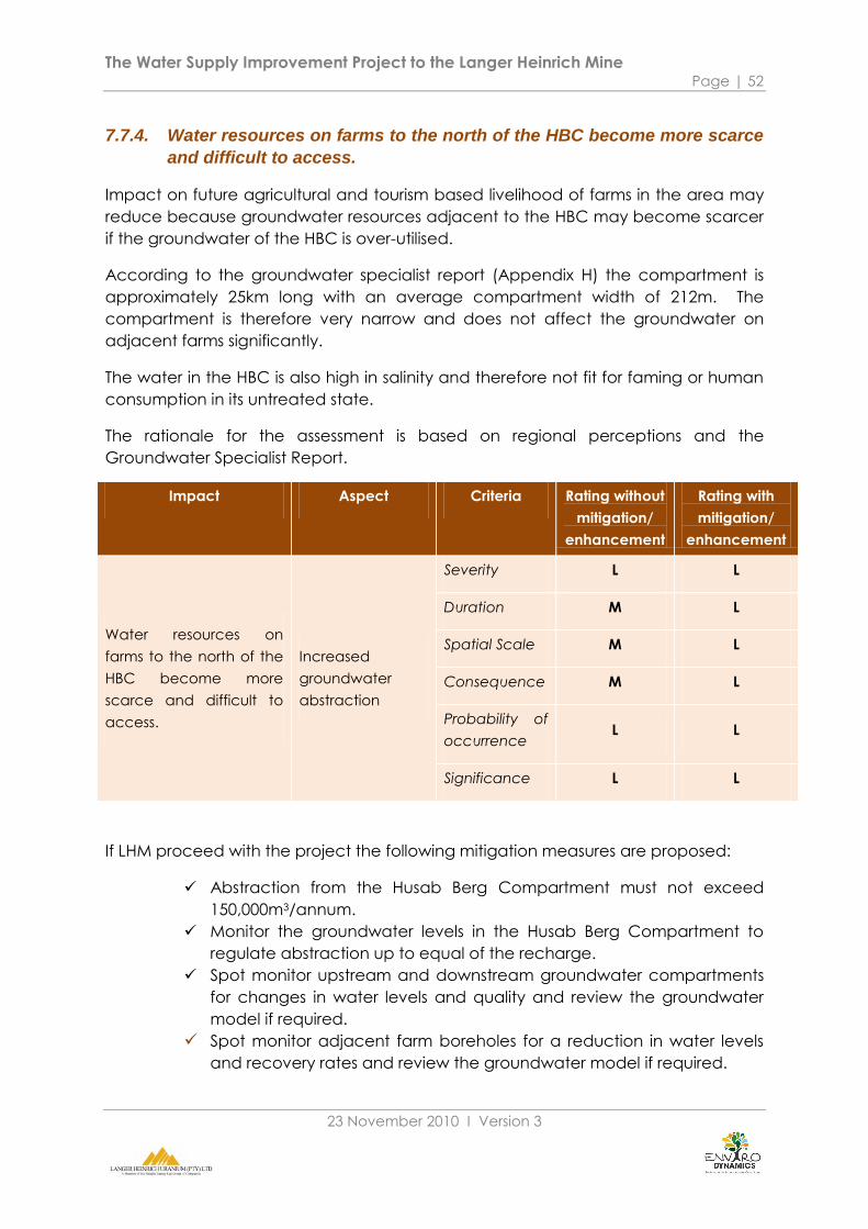
The Water Supply Improvement Project to the Langer Heinrich Mine Page | 52
23 November 2010 Ι Version 3
7.7.4. Water resources on farms to the north of the HBC become more scarce
and difficult to access.
Impact on future agricultural and tourism based livelihood of farms in the area may
reduce because groundwater resources adjacent to the HBC may become scarcer
if the groundwater of the HBC is over-utilised.
According to the groundwater specialist report (Appendix H) the compartment is
approximately 25km long with an average compartment width of 212m. The
compartment is therefore very narrow and does not affect the groundwater on
adjacent farms significantly.
The water in the HBC is also high in salinity and therefore not fit for faming or human
consumption in its untreated state.
The rationale for the assessment is based on regional perceptions and the
Groundwater Specialist Report.
Impact Aspect Criteria Rating without
mitigation/
enhancement
Rating with
mitigation/
enhancement
Water resources on
farms to the north of the
HBC become more
scarce and difficult to
access.
Increased
groundwater
abstraction
Severity L L
Duration M L
Spatial Scale M L
Consequence M L
Probability of
occurrence L L
Significance L L
If LHM proceed with the project the following mitigation measures are proposed:
Abstraction from the Husab Berg Compartment must not exceed
150,000m3/annum.
Monitor the groundwater levels in the Husab Berg Compartment to
regulate abstraction up to equal of the recharge.
Spot monitor upstream and downstream groundwater compartments
for changes in water levels and quality and review the groundwater
model if required.
Spot monitor adjacent farm boreholes for a reduction in water levels
and recovery rates and review the groundwater model if required.

The Water Supply Improvement Project to the Langer Heinrich Mine Page | 53
23 November 2010 Ι Version 3
7.7.5. Economic stability and employment opportunity in the Erongo Region
reduces if the mining operations are curtailed by a lack of water.
The mines are one of two main employers in the Erongo Region. Growth in the
Uranium industry improves the national and regional GDP and therefore
employment capability.
Therefore if the LHM mining is curtailed due to a lack of water supply the economic
contribution and employment capacity of the mine will be reduced. This will have a
significant influence in the regional economic stability and on the lower income
employment rate of the region.
The rationale for the assessment is based on desktop review and professional
opinion.
Impact Aspect Criteria Rating without
mitigation/
enhancement
Rating with
mitigation/
enhancement
Economic stability
and employment
opportunity in the
Erongo Region
reduces if the mining
operations are
curtailed by a lack of
water.
Regional
economic
contribution
Severity M L
Duration L L
Spatial Scale H H
Consequence M M
Probability of
occurrence M L
Significance M L
The following mitigation measures are proposed:
Diversify the water supply resources available to the LHM to include
desalinated water.
Improve the pipeline capacity and reliability of supply from the sources
available to the LHM. This will have to be done in conjunction with
Namwater.
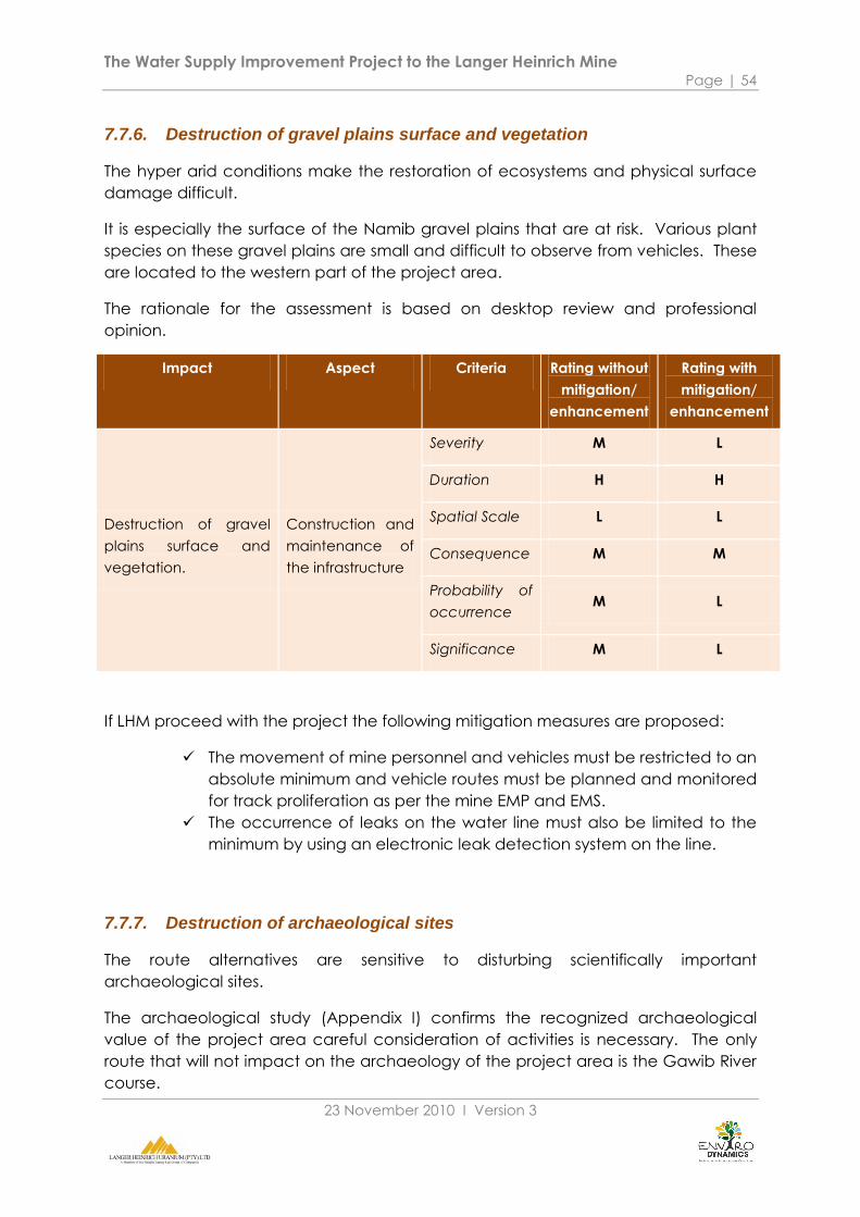
The Water Supply Improvement Project to the Langer Heinrich Mine Page | 54
23 November 2010 Ι Version 3
7.7.6. Destruction of gravel plains surface and vegetation
The hyper arid conditions make the restoration of ecosystems and physical surface
damage difficult.
It is especially the surface of the Namib gravel plains that are at risk. Various plant
species on these gravel plains are small and difficult to observe from vehicles. These
are located to the western part of the project area.
The rationale for the assessment is based on desktop review and professional
opinion.
Impact Aspect Criteria Rating without
mitigation/
enhancement
Rating with
mitigation/
enhancement
Destruction of gravel
plains surface and
vegetation.
Construction and
maintenance of
the infrastructure
Severity M L
Duration H H
Spatial Scale L L
Consequence M M
Probability of
occurrence M L
Significance M L
If LHM proceed with the project the following mitigation measures are proposed:
The movement of mine personnel and vehicles must be restricted to an
absolute minimum and vehicle routes must be planned and monitored
for track proliferation as per the mine EMP and EMS.
The occurrence of leaks on the water line must also be limited to the
minimum by using an electronic leak detection system on the line.
7.7.7. Destruction of archaeological sites
The route alternatives are sensitive to disturbing scientifically important
archaeological sites.
The archaeological study (Appendix I) confirms the recognized archaeological
value of the project area careful consideration of activities is necessary. The only
route that will not impact on the archaeology of the project area is the Gawib River
course.
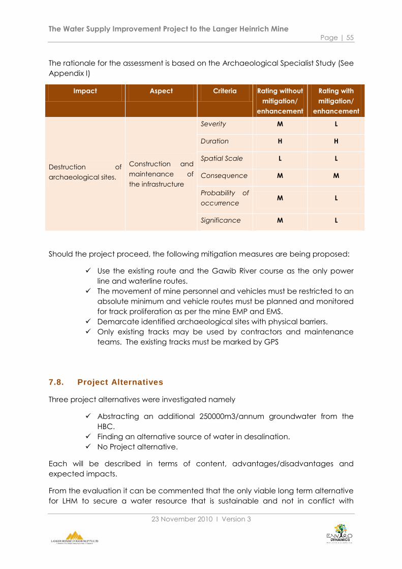
The Water Supply Improvement Project to the Langer Heinrich Mine Page | 55
23 November 2010 Ι Version 3
The rationale for the assessment is based on the Archaeological Specialist Study (See
Appendix I)
Impact Aspect Criteria Rating without
mitigation/
enhancement
Rating with
mitigation/
enhancement
Destruction of
archaeological sites.
Construction and
maintenance of
the infrastructure
Severity M L
Duration H H
Spatial Scale L L
Consequence M M
Probability of
occurrence M L
Significance M L
Should the project proceed, the following mitigation measures are being proposed:
Use the existing route and the Gawib River course as the only power
line and waterline routes.
The movement of mine personnel and vehicles must be restricted to an
absolute minimum and vehicle routes must be planned and monitored
for track proliferation as per the mine EMP and EMS.
Demarcate identified archaeological sites with physical barriers.
Only existing tracks may be used by contractors and maintenance
teams. The existing tracks must be marked by GPS
7.8. Project Alternatives
Three project alternatives were investigated namely
Abstracting an additional 250000m3/annum groundwater from the
HBC.
Finding an alternative source of water in desalination.
No Project alternative.
Each will be described in terms of content, advantages/disadvantages and
expected impacts.
From the evaluation it can be commented that the only viable long term alternative
for LHM to secure a water resource that is sustainable and not in conflict with
The Water Supply Improvement Project to the Langer Heinrich Mine Page | 56
23 November 2010 Ι Version 3
regional forces is to find a desalination water source. This is the only option that will
provide a beneficial outcome in that it achieves the project objectives and
improves the environmental footprint of the mine.
The project alternative of this EIA does not compare favourably to the desalination
alternative. The possible benefits for LHM do not justify the risks and impacts involved
in the alternative.
The no project alternative will only continue to contribute to the deterioration of the
regional water situation and increase the risks that the mine is exposed to. Therefore
it is not advised to merely uphold the status quo on securing a sustainable water
source for the mine at both project and regional levels.

The Water Supply Improvement Project to the Langer Heinrich Mine Page | 57
23 November 2010 Ι Version 3
7.8.1. Abstracting an additional 250,000m3/annum groundwater from the HBC
Description
LHM continues with the project to abstract an additional 250m3/annum from the HBC for the purpose of
mine construction and dust suppression purposes.
Advantages Disadvantages Expected impact areas
Cost of water resource is
low.
The contribution of the
mine to employment and
economic growth
continues in the short term.
LHM improves its control of
a minor component of its
water supply resource.
Water with a high salinity
(not fit for human
consumption) will be used
at LHM.
The volume of water that
the alternative can secure
does not allow for future
extensions of the mine.
The development of the
desalination alternative by
LHM and Namwater is time
consuming.
The negative perception
that LHM is threatening the
regional water resource
security is increased.
The linear oasis of the lower
Swakop River is exposed to
the risk of permanent
deterioration.
The risk of damage to
archaeological sites and
sensitive gravel plains
increase
Unsustainable use of the
HBC groundwater destroy
riparian linear oasis.
Construction related
impacts along the route
alternatives in the Namib
Naukluft National Park.
LHM contributes to the
perception of water
security threats in the
Erongo Region.
Comment
This alternative is not sustainable in the long term at project level and will only provide short term relief
to LHM. The alternative does not align LHM with the recommendations of the Uranium Rush SEA.
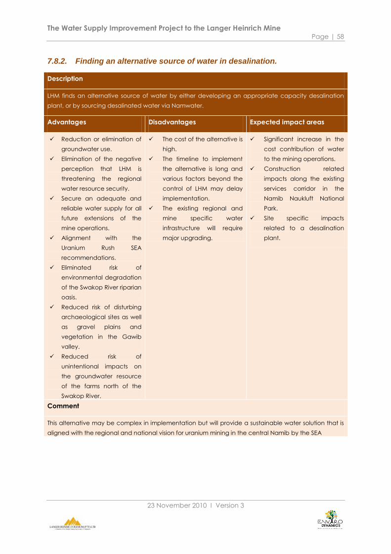
The Water Supply Improvement Project to the Langer Heinrich Mine Page | 58
23 November 2010 Ι Version 3
7.8.2. Finding an alternative source of water in desalination.
Description
LHM finds an alternative source of water by either developing an appropriate capacity desalination
plant, or by sourcing desalinated water via Namwater.
Advantages Disadvantages Expected impact areas
Reduction or elimination of
groundwater use.
Elimination of the negative
perception that LHM is
threatening the regional
water resource security.
Secure an adequate and
reliable water supply for all
future extensions of the
mine operations.
Alignment with the
Uranium Rush SEA
recommendations.
Eliminated risk of
environmental degradation
of the Swakop River riparian
oasis.
Reduced risk of disturbing
archaeological sites as well
as gravel plains and
vegetation in the Gawib
valley.
Reduced risk of
unintentional impacts on
the groundwater resource
of the farms north of the
Swakop River.
The cost of the alternative is
high.
The timeline to implement
the alternative is long and
various factors beyond the
control of LHM may delay
implementation.
The existing regional and
mine specific water
infrastructure will require
major upgrading.
Significant increase in the
cost contribution of water
to the mining operations.
Construction related
impacts along the existing
services corridor in the
Namib Naukluft National
Park.
Site specific impacts
related to a desalination
plant.
Comment
This alternative may be complex in implementation but will provide a sustainable water solution that is
aligned with the regional and national vision for uranium mining in the central Namib by the SEA
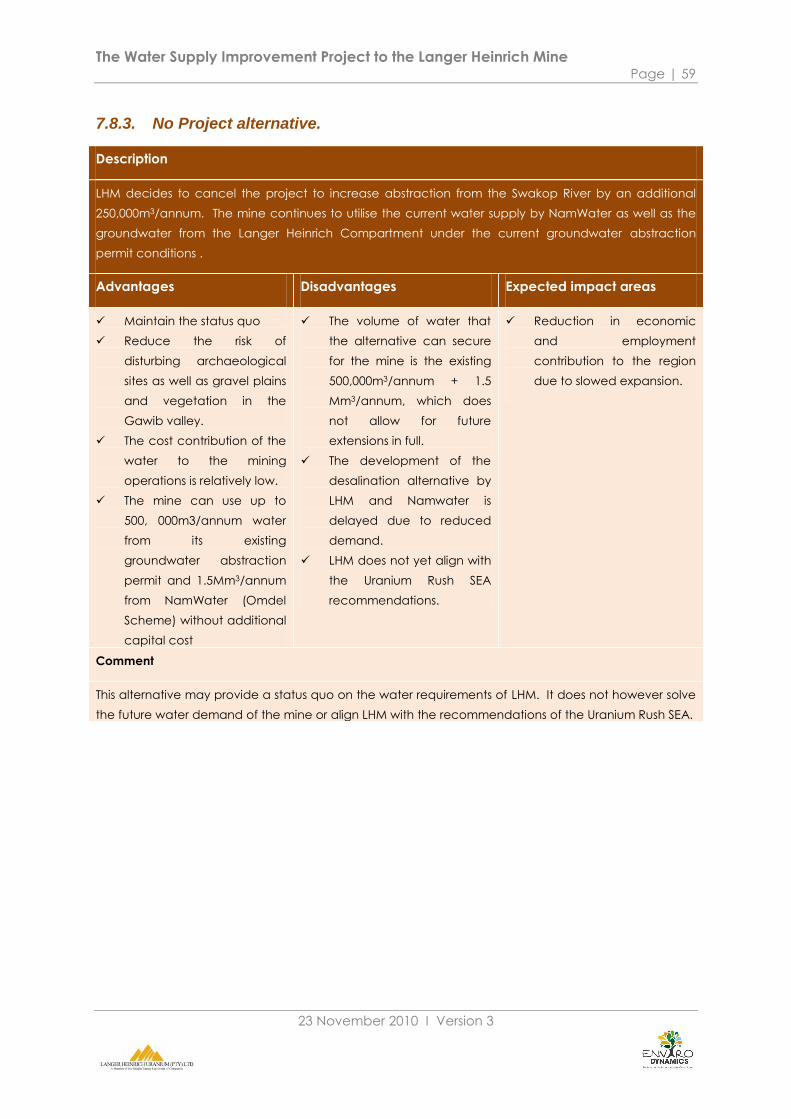
The Water Supply Improvement Project to the Langer Heinrich Mine Page | 59
23 November 2010 Ι Version 3
7.8.3. No Project alternative.
Description
LHM decides to cancel the project to increase abstraction from the Swakop River by an additional
250,000m3/annum. The mine continues to utilise the current water supply by NamWater as well as the
groundwater from the Langer Heinrich Compartment under the current groundwater abstraction
permit conditions .
Advantages Disadvantages Expected impact areas
Maintain the status quo
Reduce the risk of
disturbing archaeological
sites as well as gravel plains
and vegetation in the
Gawib valley.
The cost contribution of the
water to the mining
operations is relatively low.
The mine can use up to
500, 000m3/annum water
from its existing
groundwater abstraction
permit and 1.5Mm3/annum
from NamWater (Omdel
Scheme) without additional
capital cost
The volume of water that
the alternative can secure
for the mine is the existing
500,000m3/annum + 1.5
Mm3/annum, which does
not allow for future
extensions in full.
The development of the
desalination alternative by
LHM and Namwater is
delayed due to reduced
demand.
LHM does not yet align with
the Uranium Rush SEA
recommendations.
Reduction in economic
and employment
contribution to the region
due to slowed expansion.
Comment
This alternative may provide a status quo on the water requirements of LHM. It does not however solve
the future water demand of the mine or align LHM with the recommendations of the Uranium Rush SEA.

The Water Supply Improvement Project to the Langer Heinrich Mine Page | 60
23 November 2010 Ι Version 3
8. CONCLUSIONS AND RECOMMENDATIONS
8.1. The Context of the EIA
8.1.1. The future planning of the mine
The LHM development is still in its early stages. At least one more stage of
development is envisioned and Stage 3 is being constructed. These two stages will
double the water requirements of the mining operations from its current demand.
This strategy necessitated the development of secure adequate water resources for
LHM. The EIA focuses on assessing the viability of using the Husab Berg groundwater
compartment in achieving this objective while other sources are being investigated.
The EIA must be seen in the wider context of the recent Uranium Rush SEA which
gives a clear recommendation that uranium mines must in future use desalinated
water for their operations and that the operational use of groundwater from the
riparian linear oasis along the ephemeral rivers must be phased out.
There are however complex limitations in the implementation of securing this
resource for the mine.
The existing desalination plant can provide excess water that is sufficient for the
future needs of LHM but the responsibility and negotiations for the purchasing of the
water rests with Namwater. Currently there is little guarantee in place that this
source will become available soon.
Namwater also plans to build its own desalination plant. The timeline for this
operation to start with output is still uncertain.
The existing infrastructure will also need to be upgraded through the central Erongo
Region to assure a reliable source at the mine. This is also the responsibility of
Namwater.
LHM faces a complex and uncertain situation in terms of its future water
requirements.
Therefore LHM must investigate the viability of using additional groundwater
resources from the Husab Berg Compartment in the interim.

The Water Supply Improvement Project to the Langer Heinrich Mine Page | 61
23 November 2010 Ι Version 3
8.2. Key Conclusions of the EIA
The key conclusion of the EIA is that:
The following key impacts have been identified during the EIA if the project is
implemented:
The protection of the limited regional water resource is compromised.
The Husab Berg Compartment water levels will decline below the
acceptable model limits should the 250,000m3/annum be abstracted.
On the other hand the following key impact may realize if LHM does not have
access to a sustainable water source:
Economic stability and employment opportunity in the Erongo Region
reduces if the mining operations are curtailed by a lack of water.
The following key concerns have been raised by the various specialist studies during
the EIA:
According to the best available model at present (BIWAC 2010),
extraction of 250 000 m3 pa would be unsustainable. It is therefore
recommended that pumping at these levels should not be
undertaken, and that a highly conservative approach to water
extraction be followed.
Lowering of the water table in the HBC by unsustainable extraction
may be expected to reduce the already low numbers of Acacia
erioloba and Faidherbia along the compartment. These are both
protected, and are regarded as keystone species in riparian
ecosystems along the western-flowing ephemeral rivers Namibia. The
lack of data make it difficult to predict outcomes with any level of
certainty, but the available evidence suggests that loss of these
species will result in a knock-on loss of biodiversity at all levels and in
many groups of organisms (Mannheimer, 2010).
Although the density of archaeological sites found during the
investigation is relatively low, these sites include two pre-colonial
graves. Due to the high to medium significance of impact and the
high level of consequence, any possible or definite exposure should be
considered highly negative.
The proposed abstraction of 250,000m3/annum from the Husab Berg compartment
is not sustainable. The impact of this activity will be high since the sustainable
abstraction rate is only 150,000m3/annum and the SEA gives a clear
recommendation/guideline that future mining activities must source desalinated
water only.

The Water Supply Improvement Project to the Langer Heinrich Mine Page | 62
23 November 2010 Ι Version 3
These concerns justify a conservative approach to the assessment of the viable use
of the Husab Berg Compartment.
LHM should align with the desalination recommendation of the Uranium Rush SEA. It
is also clear that the regional implementation of this recommendation is complex
and subject to a long implementation timeline that is still very uncertain.
8.3. Recommendations of the EIA
The conclusion of the EIA, that the proposed abstraction of 250,000m3/annum from
the Husab Berg compartment is not sustainable and the SEA gives a clear
recommendation/guideline that future mining activities must source desalinated
water only, therefore negates the need for an Environmental Management Plan and
a Record of Decision by MET.
In the light of this conclusion the following recommendations if made for LHM:
Align with the EQO water recommendation of the Uranium Rush SEA as a
matter of priority.
Make a public commitment not to abstract water from the HBC.

The Water Supply Improvement Project to the Langer Heinrich Mine Page | 63
23 November 2010 Ι Version 3
9. REFERENCES
AREVA. (2010). Areva. Retrieved September 2010, from www.areva.com.
Bittner, A. (2010). Groundwater Specialist Report to the EIA: Improvement of water
supply to the Langer Heinrich Mine. Windhoek: Langer Heinrich Uranium Ltd.
Burke, A. (2005). Best practice guidelines for minimising impacts on the flora of the
Southern Namib. Windhoek: EnviroScience / Namibia Nature Foundation.
Chamber of Mines of Namibia. (2009). Annual Review: 2008-2009.
www.chamberofmines.org.na.
CSIR. (2009). EIA for the proposed Desalination Project at Mile 6 near Swakopmund;
Namibia. Stellenbosch: CSIR.
Enviro Dynamics cc. (2009). Scoping Report: Proposed overhead fibre line to Langer
Heinrich Uranium Mine. Windhoek: Telecom Namibia.
Enviro Dynamics. (2008). EIA for Karibib Poultry Project. Windhoek: Enviro Dynamics.
Enviro Dynamics. (2009). Social Impact Assessment for the Expansion of the
Container Terminal at the Port of Walvis Bay. Walvis Bay: Unpublished Report.
Erasmus, D. (2006). Namibia: Erongo Region in Grip of "Uranium Fever". Republikein .
Erongo Regional Council. (2007). Erongo Regional Council. Retrieved August 2010,
from Publications.
FAO. (2005). Country Report - Namibia. FAO Land and Water Development Division.
Government of Namibia. (2007). Environmental Management Act. Windhoek:
Government Gazette.
Hartmann, A. (2009.). Poor Maintenance to Blame for Walvis Water Woes. The
Namibian
Hoadley, M. (2009). Socio-Economic Baseline and Social Impact Assessment for
Langer Heinrich Uranium (Pty) Ltd.
Hoadly, M. (2009). Socio-economic Baseline and Social Impact Assessment for
Langer Hienrich Uranium (Pty) Ltd. Unpublished Report.
Hockey PAR et al. (2005). Roberts Birds of Southern Africa: 7th Edition. Cape Town:
Trustees of the John Voelcker Bird Book Fund.
Jacobsen, PJ et al. (1995). Ephemeral rivers and their catchments. Windhoek: DRFN.
The Water Supply Improvement Project to the Langer Heinrich Mine Page | 64
23 November 2010 Ι Version 3
Kinahan, J. (2010). Archaeological Assessment: EIA for the water supply
improvement project to Langer Heinrich Mine. Swakopmund: Langer Heinrich
Uranium Ltd.
Leippert, M. (2009, October 12). The Tourism and Economy of Walvis Bay. (C.
Biewenga, Interviewer)
Mannheimer, C. (2010). Additional vegetation studies for the water supply
improvement project to the Langer Heinrich Mine (Central Namib). Swakopmund:
Langer Heinrich Uranium Ltd.
Mendelsohn, J., & A Jarvis, C. R. (2002). Atlas of Namibia: A Portrait of the Land and
its People. Capte Town: David Phillip.
Mendelsohn, J., & al, e. (2009). Atlas of Namibia: A Portrait of the Land and its
People. Cape Town: David Philip.
MET. (2010). Draft EIA Regulations. Windhoek.: Ministry of Environment and Tourism.
MET. (1995). Namibia's Environmental Assessment Policy. Windhoek: MET.
Metago Environmental Engineers. (2009). EIA for the proposed expansion project at
Langer Heinrich Mine. Swakopmund: Langer Heinrich Uranium Ltd.
Midgley G, e. a. (2005). Assessment of potential climate change impacts on
Namibia's floristic diversity, ecosystem structure and function. Kirstenbosch: Climate
Change Research Group, South African National Biodiversity Institute.
NACOMA. (2009). Third Draft: Management & Development Plan for the Central
Area of the Namib-Skeleton Coast National Park. Windhoek: NACOMA.
NCCI. (2009). Business Tourism Meeting: Erongo. NCCI Newsletter .
NEPRU. (2007, Accessed Aug 2010). Namibia Economic and Policy Research Unit
(2007). Windhoek, Namibia, Namibia: www.nepru.org.na.
NPC. (2001). 2001 National Housing Cencus: Regional Accounts. Windhoek: Central
Bureau of Statistics.
NPC. (2004). Erongo Regional Poverty Profile. Windhoek: Central Bureau of Statistics.
pers. comm. Koch, H. (2010, 08 04). Future water use. (N. v. Zyl, Interviewer)
SAIEA. (2010). SEA of the Central Namib Uranium Rush. Unpublished Report.
Seely, M & Pallet, J. (2008). Namib: Secrets of a desert uncovered. Windhoek:
Venture Publications.
Seely, M et al. (2004). The Namib: Natural History of an ancient Desert. Windhoek:
DRFN.

The Water Supply Improvement Project to the Langer Heinrich Mine Page | 65
23 November 2010 Ι Version 3
Sherbourne, R. (2010). Guide to the Namibian Economy. Windhoek: Institute for
Public Policy Research.
Urban Dnamics (Pty) Ltd . (2009). Socio Economic Impact Assessment for the
proposed Swakopmund Desalination Plant. Windhoek: Unpublished Report.
Walvis Bay Municipality. (2008). Bay News. Walvis Bay .
Ward, J. e. (1983). On the antiquity of the Namib. South African Journal of Science ,
79; 175-183.


![SEA Scoping Report [Consultation Draft] Annex III](https://static.fdocuments.in/doc/165x107/589ecefa1a28ab3d4d8b54ca/sea-scoping-report-consultation-draft-annex-iii.jpg)