DRAFT ROADMAP FOR REGIONAL SATELLITE … SATELLITE DATA DISTRIBUTION IN REGION III AND IV Version...
13
DRAFT ROADMAP FOR REGIONAL SATELLITE DATA DISTRIBUTION IN REGION III AND IV Version 1.0
Transcript of DRAFT ROADMAP FOR REGIONAL SATELLITE … SATELLITE DATA DISTRIBUTION IN REGION III AND IV Version...

DRAFT ROADMAP
FOR
REGIONAL SATELLITE DATA DISTRIBUTION
IN REGION III AND IV
Version 1.0
Page | 1
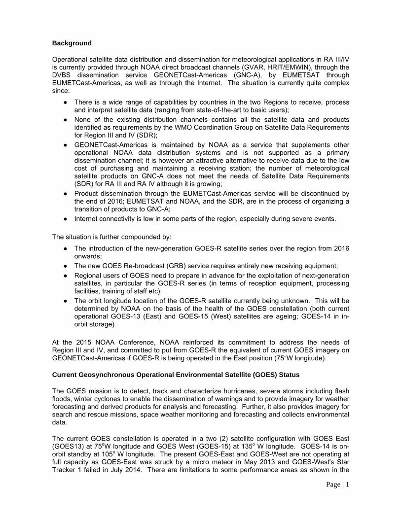
Background Operational satellite data distribution and dissemination for meteorological applications in RA III/IV is currently provided through NOAA direct broadcast channels (GVAR, HRIT/EMWIN), through the DVBS dissemination service GEONETCast-Americas (GNC-A), by EUMETSAT through EUMETCast-Americas, as well as through the Internet. The situation is currently quite complex since:
● There is a wide range of capabilities by countries in the two Regions to receive, process and interpret satellite data (ranging from state-of-the-art to basic users);
● None of the existing distribution channels contains all the satellite data and products identified as requirements by the WMO Coordination Group on Satellite Data Requirements for Region III and IV (SDR);
● GEONETCast-Americas is maintained by NOAA as a service that supplements other operational NOAA data distribution systems and is not supported as a primary dissemination channel; it is however an attractive alternative to receive data due to the low cost of purchasing and maintaining a receiving station; the number of meteorological satellite products on GNC-A does not meet the needs of Satellite Data Requirements (SDR) for RA III and RA IV although it is growing;
● Product dissemination through the EUMETCast-Americas service will be discontinued by the end of 2016; EUMETSAT and NOAA, and the SDR, are in the process of organizing a transition of products to GNC-A;
● Internet connectivity is low in some parts of the region, especially during severe events.
The situation is further compounded by:
● The introduction of the new-generation GOES-R satellite series over the region from 2016 onwards;
● The new GOES Re-broadcast (GRB) service requires entirely new receiving equipment;
● Regional users of GOES need to prepare in advance for the exploitation of next-generation satellites, in particular the GOES-R series (in terms of reception equipment, processing facilities, training of staff etc);
● The orbit longitude location of the GOES-R satellite currently being unknown. This will be determined by NOAA on the basis of the health of the GOES constellation (both current operational GOES-13 (East) and GOES-15 (West) satellites are ageing; GOES-14 in in-orbit storage).
At the 2015 NOAA Conference, NOAA reinforced its commitment to address the needs of Region III and IV, and committed to put from GOES-R the equivalent of current GOES imagery on GEONETCast-Americas if GOES-R is being operated in the East position (75°W longitude). Current Geosynchronous Operational Environmental Satellite (GOES) Status The GOES mission is to detect, track and characterize hurricanes, severe storms including flash floods, winter cyclones to enable the dissemination of warnings and to provide imagery for weather forecasting and derived products for analysis and forecasting. Further, it also provides imagery for search and rescue missions, space weather monitoring and forecasting and collects environmental data. The current GOES constellation is operated in a two (2) satellite configuration with GOES East (GOES13) at 75oW longitude and GOES West (GOES-15) at 135o W longitude. GOES-14 is on-orbit standby at 105o W longitude. The present GOES-East and GOES-West are not operating at full capacity as GOES-East was struck by a micro meteor in May 2013 and GOES-West's Star Tracker 1 failed in July 2014. There are limitations to some performance areas as shown in the

Page | 2
Table 1 below:
Payload Instrument GOES-13(East) Launch: May 2006 Activation: Apr 2010
GOES-14 (Standby) Launch: Jun 2009
GOES-15(West) Launch: Mar 2010 Activation: Dec 2011
Imager G G G
Sounder G G Y (3)
Energetic Particle Sensor (EPS) G G G
Magnetometers G G G
High Energy Proton and Alpha Detector (HEPAD)
G G G
X-Ray Sensor (XRS) Y (1) G G
Solar X-Ray Imager (SXI) Y (2) G G
Spacecraft Subsystems
Telemetry, Command & Control G G G
Attitude and Orbit Control G G G
Inclination Control G G G
Propulsion G G G
Mechanisms G G G
Electrical Power G G G
Thermal Control G G G
Communications Payloads G G G
Table 1: Health of payload instruments on GOES constellation GOES R - Satellite Series The Geostationary Operational Environmental Satellite - R Series (GOES-R) is the next generation of geosynchronous environmental satellites, which will provide atmospheric and surface measurements of the Earth’s Western Hemisphere for weather forecasting, severe storm tracking, space weather monitoring, and meteorological research.
Page | 3
GOES-R will mark a technological advance in geostationary observations. Compared to the current GOES system, the advanced instruments and data processing will provide:
● Three times more spectral information ● Four times greater spatial resolution ● Five times faster coverage ● Real-time mapping of total lightning activity ● Increased thunderstorm and tornado warning lead time ● Improved hurricane track and intensity forecasts ● Improved monitoring of solar x-ray flux ● Improved monitoring of solar flares and coronal mass ejections ● Improved geomagnetic storm forecasting
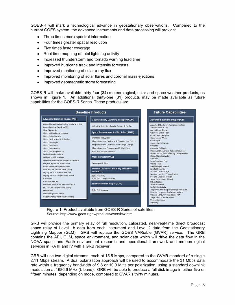
GOES-R will make available thirty-four (34) meteorological, solar and space weather products, as shown in Figure 1. An additional thirty-one (31) products may be made available as future capabilities for the GOES-R Series. These products are:
Figure 1: Product available from GOES-R Series of satellites: Source: http://www.goes-r.gov/products/overview.html
GRB will provide the primary relay of full resolution, calibrated, near-real-time direct broadcast space relay of Level 1b data from each instrument and Level 2 data from the Geostationary Lightning Mapper (GLM). GRB will replace the GOES VARiable (GVAR) service. The GRB contains the ABI, GLM, space environment, and solar data which will drive the data flow in the NOAA space and Earth environment research and operational framework and meteorological services in RA III and IV with a GRB receiver. GRB will use two digital streams, each at 15.5 Mbps, compared to the GVAR standard of a single 2.11 Mbps stream. A dual polarization approach will be used to accommodate the 31 Mbps data rate within a frequency bandwidth of 9.8 or 10.9 MHz per polarization, using a standard downlink modulation at 1686.6 MHz (L-band). GRB will be able to produce a full disk image in either five or fifteen minutes, depending on mode, compared to GVAR’s thirty minutes.
Page | 4
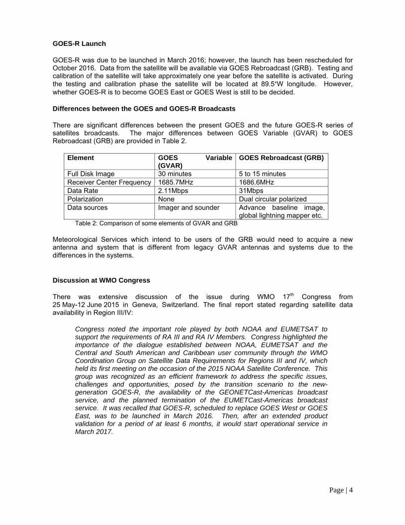
GOES-R Launch GOES-R was due to be launched in March 2016; however, the launch has been rescheduled for October 2016. Data from the satellite will be available via GOES Rebroadcast (GRB). Testing and calibration of the satellite will take approximately one year before the satellite is activated. During the testing and calibration phase the satellite will be located at 89.5°W longitude. However, whether GOES-R is to become GOES East or GOES West is still to be decided. Differences between the GOES and GOES-R Broadcasts There are significant differences between the present GOES and the future GOES-R series of satellites broadcasts. The major differences between GOES Variable (GVAR) to GOES Rebroadcast (GRB) are provided in Table 2.
Element GOES Variable (GVAR)
GOES Rebroadcast (GRB)
Full Disk Image 30 minutes 5 to 15 minutes Receiver Center Frequency 1685.7MHz 1686.6MHzData Rate 2.11Mbps 31MbpsPolarization None Dual circular polarized Data sources Imager and sounder Advance baseline image,
global lightning mapper etc. Table 2: Comparison of some elements of GVAR and GRB Meteorological Services which intend to be users of the GRB would need to acquire a new antenna and system that is different from legacy GVAR antennas and systems due to the differences in the systems. Discussion at WMO Congress There was extensive discussion of the issue during WMO 17th Congress from 25 May-12 June 2015 in Geneva, Switzerland. The final report stated regarding satellite data availability in Region III/IV:
Congress noted the important role played by both NOAA and EUMETSAT to support the requirements of RA III and RA IV Members. Congress highlighted the importance of the dialogue established between NOAA, EUMETSAT and the Central and South American and Caribbean user community through the WMO Coordination Group on Satellite Data Requirements for Regions III and IV, which held its first meeting on the occasion of the 2015 NOAA Satellite Conference. This group was recognized as an efficient framework to address the specific issues, challenges and opportunities, posed by the transition scenario to the new-generation GOES-R, the availability of the GEONETCast-Americas broadcast service, and the planned termination of the EUMETCast-Americas broadcast service. It was recalled that GOES-R, scheduled to replace GOES West or GOES East, was to be launched in March 2016. Then, after an extended product validation for a period of at least 6 months, it would start operational service in March 2017.

Page | 5
The presidents of RA III and RA IV thanked the USA for maintaining the GOES system which is essential for the daily operations of NMHS, and looked forward to the new generation GOES-R series of satellites. They stressed however that most Members would not be prepared to implement a GOES Re-broadcast (GRB) receiving station and that alternative solutions must be found are needed to ensure continuous access to geostationary data. They pointed out that GEONETCast-Americas could be an affordable and efficient alternative, since several Members are already equipped and trained for its use, and such a system is scalable by design to accommodate evolving user needs. Existing EUMETCast-Americas receiving equipment provided by Spain through the Ibero-American cooperation Programme could be converted at very low cost into GEONETCast-Americas stations. RA III and RA IV Members welcomed the distribution of some GOES imagery and products by NOAA over GEONETCast-Americas, and the availability of Meteosat and other products over the EUMETCast-Americas service, taking particularly into account the importance of Meteosat data for meteorological operations of NMHSs in the Eastern part of South America. Being aware of the planned discontinuation of the EUMETCast-Americas broadcast service by EUMETSAT, the RA III and RA IV presidents:
(a) Encouraged the USA and potential partners to join their efforts to expand the GEONETCast-Americas service towards including the products currently distributed by EUMETCast-Americas, with a view to better fulfil regional user needs; (b) Invited EUMETSAT Member States to reconsider the planned discontinuation of the EUMETCAst-Americas service and make best efforts to keep it in place until a satisfactory alternative dissemination as proposed in (a) be implemented.
Noting the needs expressed by RA III and RA IV Members, Congress urged Members to engage in the Coordination Group on Satellite Data Requirements for RA III and RA IV, in order to consider and implement partnership initiatives to ensure a smooth transition from EUMETCast-Americas to alternative data distribution mechanisms such as GEONETCast-Americas
Pathways to Receiving Satellite Imagery post 2016 In light of the situation and discussions at WMO Congress, the following roadmap is intended to provide guidance to Members in the Region, and recommends action in order to:
● Assist Members of RA III and RA IV in achieving user readiness to the next-generation satellites (GOES-R in particular);
● Minimize cost and risks for Members in the steps towards this end;
● Achieve cost-efficient, shared regional satellite data dissemination based on user needs (SDR).
In the following sections, a distinction is made between users that are planning to purchase a GRB station, and those that are not. For the former, GEONETCast Americas should be a data receiving mechanism that minimizes the risk of service interruption during the transition to the new GOES-R system; it could also serve as a back-up system to GRB. For the latter user group, GEONETCast-Americas could be a primary data reception system, although the needs of users for satellite data on this channel are not yet being fully met. Further, the Internet can be a further source of satellite imagery but not necessarily in near-real time.
Page | 6
Internet Access NOAA provides access to satellite imagery through the NOAA's Satellite and Information Services (NESDIS) Office of Satellite and Product Operations (OSPO) either through dedicated websites, which generally have latency of one hour between the time stamp of the imagery and access via the website. Users can also get dedicated access to imagery through the following:
• NPP Data Exploitation (NDE) provides National Polar-orbiting Partnership (NPP) data and derived products.
• GEODIST provides McIDAS products via ADDE. – McIDAS products are satellite imagery and primarily GOES derived products
• DDS (Data Distribution Server) provides all other non-McIDAS operational products. At present users need to complete a standard data access request form to get dedicated satellite imagery access, which is available at http://www.ospo.noaa.gov/Organization/About/access.html. GEONETCast Americas GEONETCast Americas is the western hemisphere component of GEONETCast, a near real time, global network of satellite-based data dissemination systems designed to distribute space-based, airborne and in situ data, metadata and products to a diverse community of users. GEONETCast Americas (GNC-A) has a data rate of 2.0 Mbps and at present it broadcasts satellite imagery in GeoTIFF format with a frequency of thirty (30) minutes and the maximum number of water vapour, infrared and visible imagery in sectors is forty-eight (48) images per sector. Full disk imagery in the three wavelengths is transmitted every three hours and there are other environmental products which are transmitted once per day. The Coordination Group on Satellite Data Requirements for RA III and RA IV has created a comprehensive list of satellite products it believes should be transmitted via GEONETCast Americas. However, due to the limited data rate, the list of satellite products is being prioritized. Roadmap to receive Satellite Imagery Post GOES-R Launch The roadmap is intended for all Meteorological Services whether or not the Service intends to purchase a direct read-out satellite receiver or not. The roadmap below assumes that the launch date of March 2016 has not changed. However, since the launched date has been pushed back to October 2016, the road map is still valid, but the new date would provide Meteorological Services with more time to procure a system. The same premise holds true if GOES-R becomes GOES West instead of GOES East in 2017. Before a Service decides the pathway it wishes to follow, all Meteorological Services of Member States should do an evaluation of their present satellite systems (direct readout or otherwise). The present direct readout systems which are available are GVAR, HRPT and LRIT. With the launch of the GOESR series of satellites, the GVAR systems will become obsolete, but HRIT will be combined in GOES-R with an increased data rate. LRIT users need to completely replace their ground system and HRIT users need to update their software. It is strongly recommended that Meteorological Services which are also Meteorological Watch Offices acquire a direct readout satellite system to service the aviation sector within the flight information region (FIR) for which they are responsible. A funding mechanism which should be explored is cost recovery for meteorological services provided to the aviation sector.
Page | 7
1. Members planning to install GOES-R GRB system (GOES-R becomes GOES East) A Meteorological Service will have to deploy a two-pronged plan of action in order to minimize the time between the decision is taken by the USA to have the GOES-R (or –S) satellite become GOES East, with the concomitant loss of direct-readout satellite data (GVAR), and the reacquisition of satellite data (GRB). Documents and arguments have to be prepared to be used in discussions with the funding bodies (national and/or international) for bolstering the case of why the funds should be expended on the purchase and maintenance of a GRB direct-readout system or systems (if multiple nations are to be involved, then a client/server or Internet distributed systems needs to be considered.). Simultaneously, the technical specification for the GRB system has to be developed (this implies that there has been a discussion of the needs of the Service(s)). Based on discussions, the period for the presentations of arguments to the funding agency or agencies can take at least one year for an agreement to be reached on the intent to purchase the GRB system. It should take at least a further six (6) months for the launch and evaluation of the tender for the purchase of the GRB system(s). Purchase and the delivery and installation after signing of contract will take at least nine (9) months. Hence, the entire process will take at least two (2) years, and possibly 2.5 years. The cost of a GRB system ranges from US$200,000 to $700,000 depending on configuration. Further, the standard warranty period is one (1) year and Meteorological Services will also have to factor in the cost of a maintenance contact after the warranty period and training for both maintenance staff and users. The components of a direct readout system for a Meteorological Service which would have one display unit only, are provided in ANNEX I. In addition, for back-up purposes and during the transition from GOES to GOES-R, Meteorological Services should migrate all of their existing EUMETCast-A receivers to GNC-A; to ensure provision of minimum GOES and Meteosat imagery. Furthermore, Internet-based options using NOAA CLASS and other sources should be explored for additional back-up. 2. Members not planning to install a GOES-R GRB receiving system There are two (2) options available, with option (1) preferable under current Internet connectivity
conditions:
1. GEONETCast-Americas: In RA IV and parts of RA III, GNC-A is used as a secondary system. Hence, while there are datasets available via GNC-A, bandwidth, latency and completeness of the satellite data for operational purposes are issues to be addressed. NOAA are committed to support GEONETCast Americas, and RA III and RA IV Meteorological Services should invest in one or more stations as a measure to reduce the risk of service interruption during the transition to GOES-R, or as back-up.
2. Internet: Through the Internet, a Meteorological Service have the following options: a. Directly from public websites: The problem with this method is the latency of the
imagery available and reliability; b. Extranet/password protected websites: The advantage of this method is that it
requires an agreement between services, which make it more reliable and with predictable latency and the Service will received what they need;
c. FTP access: Not necessarily public, hence, more reliable but specific software maybe needed for viewing the imagery. Usually the software is open-source.
For all systems above, the bandwidth available will limit data availability. For the Internet users’ bandwidth on both ends are crucial. However, the bandwidth available for downloading will in most cases determine how quickly data including satellite imagery is received.

Page | 8
The cost of a GEONETCast-Americas receiving system is between US$5,000 to $30,000 for a simple or turn-key system. In Figure 2, the Gantt chart shows the activities associated with the reception of satellite imagery and/or data and the activities associated with the launch of GOES-R and GOES- S satellites along with the steps for receiving satellite imagery after the launch of GOES-R.
Figure 2: Gantt chart Summary Meteorological Services of Members need to start immediately to assess and then decide on the system(s) which will be used for acquiring satellite imagery after the launch of GOES-R in 2016. Assuming a launch in October 2016 and the satellite is positioned as GOES East after testing and calibration, data will go "live" after October 2017. Hence, Services will have a short timeframe to decide on the system(s) which they will use to acquire satellite imagery without any loss of data.
__________

Page | 1
Page | 1
Background Prior to purchasing a direct-readout satellite system, a Meteorological Service will have to ascertain the area of satellite coverage needed for the service it provides to its users, the products it needs and the size of digital storage it requires if necessary. System Components The main components of the system are:
1. Antenna 2. Reception 3. Processing and visualization; 4. Data storage (optional)
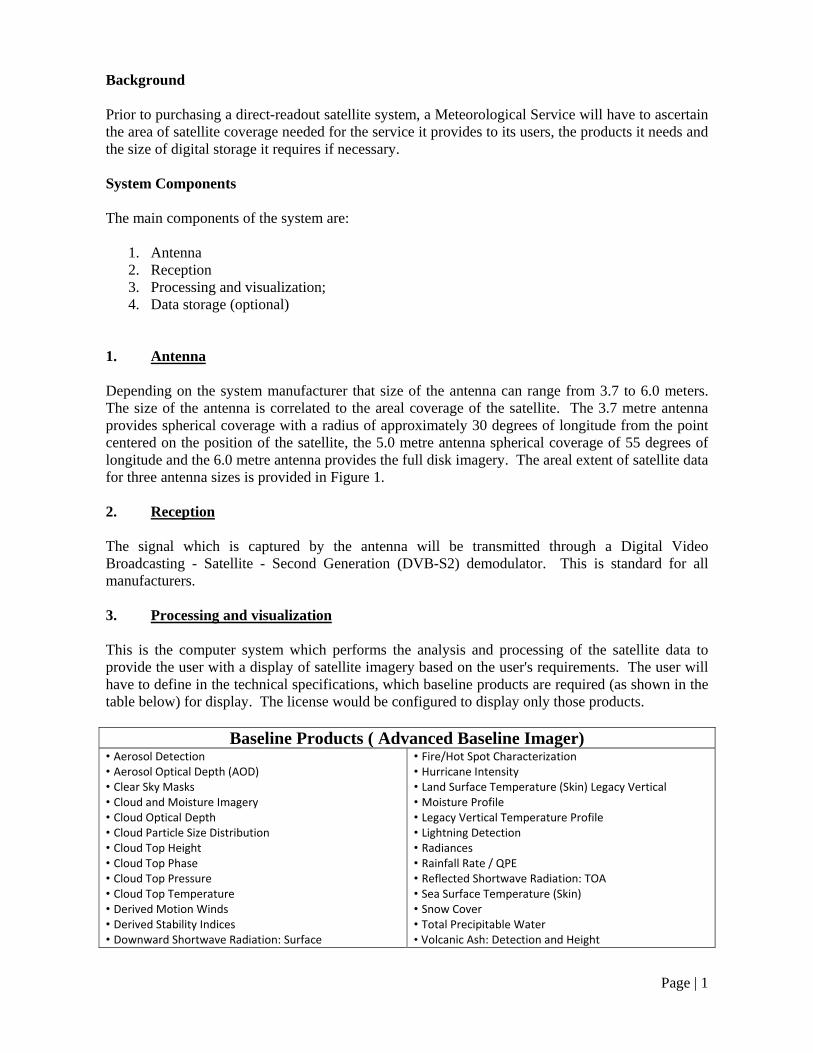
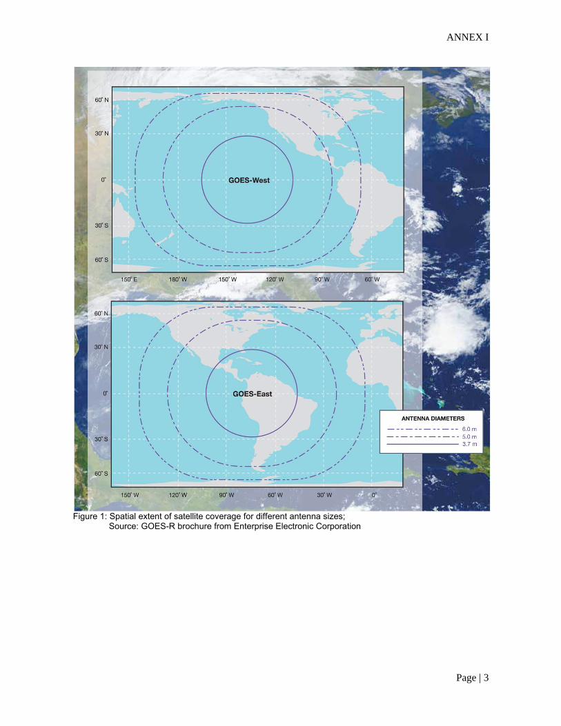
1. Antenna Depending on the system manufacturer that size of the antenna can range from 3.7 to 6.0 meters. The size of the antenna is correlated to the areal coverage of the satellite. The 3.7 metre antenna provides spherical coverage with a radius of approximately 30 degrees of longitude from the point centered on the position of the satellite, the 5.0 metre antenna spherical coverage of 55 degrees of longitude and the 6.0 metre antenna provides the full disk imagery. The areal extent of satellite data for three antenna sizes is provided in Figure 1. 2. Reception The signal which is captured by the antenna will be transmitted through a Digital Video Broadcasting - Satellite - Second Generation (DVB-S2) demodulator. This is standard for all manufacturers. 3. Processing and visualization This is the computer system which performs the analysis and processing of the satellite data to provide the user with a display of satellite imagery based on the user's requirements. The user will have to define in the technical specifications, which baseline products are required (as shown in the table below) for display. The license would be configured to display only those products.
Baseline Products ( Advanced Baseline Imager) • Aerosol Detection • Aerosol Optical Depth (AOD) • Clear Sky Masks • Cloud and Moisture Imagery • Cloud Optical Depth • Cloud Particle Size Distribution • Cloud Top Height • Cloud Top Phase • Cloud Top Pressure • Cloud Top Temperature • Derived Motion Winds • Derived Stability Indices • Downward Shortwave Radiation: Surface
• Fire/Hot Spot Characterization • Hurricane Intensity • Land Surface Temperature (Skin) Legacy Vertical • Moisture Profile • Legacy Vertical Temperature Profile • Lightning Detection • Radiances • Rainfall Rate / QPE • Reflected Shortwave Radiation: TOA • Sea Surface Temperature (Skin) • Snow Cover • Total Precipitable Water • Volcanic Ash: Detection and Height

ANNEX I
Page | 2
Further the license can support the importing of radar data to be layered on the satellite imagery, differencing of wavelengths to produce customized products, the inclusion of custom algorithms etc. It must be noted that there are other products which will be available from the Advance Baseline Imager (ABI) in the future. A maintenance contract must be in place with the direct readout manufacturer after the warranty period has expired to ensure that the equipment is fully configured for the changes in the future satellite broadcasts. 4. Data Storage This optional, however, since the data rate is 31 Mbps, the assigned storage on the computer system which is tasked with analysis and visualization will be limited. Hence, the use of additional storage maybe deemed necessary by the Organization, which has installed the system and this, should be part of the planning process when the technical specifications are developed for the direct readout satellite system. Although, the implementation of the data storage may not occur at the time of installation of the system, proprietary software maybe necessary for the transfer of data.
_______________
ANNEX I
Page | 3
Figure 1: Spatial extent of satellite coverage for different antenna sizes; Source: GOES-R brochure from Enterprise Electronic Corporation