DRAFT RECREATION STUDY TECHNICAL REPORT WEBER ......DRAFT Recreation Study Technical Report...
126
DRAFT RECREATION STUDY TECHNICAL REPORT WEBER HYDROELECTRIC PROJECT RELICENSING FERC PROJECT NO. 1744 Prepared for PacifiCorp Hydro Resources 1407 West North Temple, Room 110 Salt Lake City, Utah 84116 Prepared by Cirrus Ecological Solutions 965 South 100 West, Suite 200 Logan, Utah 84321 (435) 787-1490 www.cirruses.com December 16, 2016
Transcript of DRAFT RECREATION STUDY TECHNICAL REPORT WEBER ......DRAFT Recreation Study Technical Report...

DRAFT RECREATION STUDY TECHNICAL REPORT
WEBER HYDROELECTRIC PROJECT RELICENSING
FERC PROJECT NO. 1744
Prepared for
PacifiCorp Hydro Resources
1407 West North Temple, Room 110 Salt Lake City, Utah 84116
Prepared by
Cirrus Ecological Solutions 965 South 100 West, Suite 200
Logan, Utah 84321 (435) 787-1490
www.cirruses.com
December 16, 2016

This page intentionally left blank

DRAFT Recreation Study Technical Report PacifiCorp’s Weber Hydroelectric Project Relicensing FERC Project No. 1744
i
CONTENTS
Introduction ..................................................................................................................................... 1
Nexus to Project .............................................................................................................................. 1
Project Area .................................................................................................................................... 2
Study Area ...................................................................................................................................... 2
Background Information ................................................................................................................. 2
Methods........................................................................................................................................... 5
Results ............................................................................................................................................. 5
Recreation Supply Analysis ....................................................................................................... 5
Recreation Use and Demand Analysis ....................................................................................... 8
Whitewater Boating Feasibility Study ..................................................................................... 12
Recreation Needs Analysis ...................................................................................................... 18
APPENDICES
Appendix A - Site Photos
Appendix B - Visitor Survey Questionnaire and Results
Appendix C - Whitewater Technical Report
TABLES
Table 1. Recreation amenities at the Weber Hydroelectric Project site.. ....................................... 6
Table 2. Recreation use metric estimates for the Weber recreation site. ....................................... 9
Table 3. Analysis of primitive trail users by use type. Based on data from remote camera. ....... 10
FIGURES
Figure 1. Weber Hydro Relicensing Project Location. .................................................................. 3
Figure 2. Mean Daily Flows in the Project Study Reach in 2015 and 2016 ................................ 13

DRAFT Recreation Study Technical Report PacifiCorp’s Weber Hydroelectric Project Relicensing FERC Project No. 1744
1
INTRODUCTION
PacifiCorp, a subsidiary of Berkshire Hathaway Energy, plans to file an application for
relicensing of the Weber Hydroelectric Project (Project), Federal Energy Regulatory
Commission (FERC or Commission) Project No. 1744, on the Weber River in Weber, Morgan,
and Davis counties in Utah. The current license will expire on May 31, 2020. The Project has a
generation capacity of 3.85 megawatts and is located partially on federal lands managed by the
USDA-Forest Service (USFS), and partially on lands owned by the Union Pacific Railroad
Company (UPR). PacifiCorp filed a Notice of Intent to File Application for New License and a
Pre-Application Document to initiate FERC’s Alternative Licensing Process for the Project on
May 29, 2015.
This document is a recreation resource study technical report to meet FERC licensing
requirements and address study requests from American Whitewater (AW), Trout Unlimited
(TU), and the Utah Division of Wildlife Resources (UDWR). The study includes the following
four components: 1) an inventory of existing recreation facilities and opportunities in the Project
vicinity, 2) a recreation use and demand study, 3) a phased whitewater boating feasibility study,
and 4) a recreation needs assessment. Note that the Whitewater Technical Report is summarized
in the body of this report and included in full text as Appendix C.
According to the approved study plan, the study has two principal objectives:
Characterize existing recreation opportunities and use levels (including those for
whitewater boating) in the Project vicinity. Existing recreation facilities and
opportunities (recreation resource supply) in the Project vicinity will be identified and
mapped. Use of recreation facilities in and near the Project Study Area (recreation
resource demand) including the existing day-use Weber recreation site will be
summarized based on use data, if available, or estimates.
Identify both existing and future recreation needs (including those for whitewater
boating) related to the Project over the term of the new license. Existing needs will
be identified based on current use data and agency consultation. An estimate of
future demand for recreation opportunities at the Project will be made.
NEXUS TO PROJECT
The Project has potential direct and indirect effects on recreation resources and use within and
adjacent to the Project Area, including the affected reach of the river downstream from the dam.
These effects include providing public access to natural open space areas within and surrounding
the Project for a variety of recreation activities, and access to and use of the river, forebay and
tailrace for recreation purposes as well as effects on river flows. PacifiCorp has developed and
operates the existing Weber day-use recreation site. User-defined trails from the recreation site to
the old highway to the west (crossing under I-84) allow unrecorded use of USFS and private
lands during all seasons, most commonly for anglers. The forebay access road is used in all
seasons to access the river both upstream and downstream of the recreation site, again, most
commonly for angling. The recreation site is used for picnicking, most commonly in late spring
and summer, as the low sun angle (due to the narrow canyon walls) creates extended and

DRAFT Recreation Study Technical Report PacifiCorp’s Weber Hydroelectric Project Relicensing FERC Project No. 1744
2
relatively cold and windy winter-like conditions that tend to discourage all but the most cold-
hardy users.
Study results will help inform PacifiCorp, USFS, AW, TU, and other stakeholders by
synthesizing the information collected during the recreation studies and defining existing and
future recreation needs that can reasonably be addressed by the Project and that may be
considered for implementation during a new license term.
PROJECT AREA
For the purposes of this document and the preceding Study Plans, the FERC Project Boundary
(or Project Boundary) is defined as all lands and waters within the existing FERC Project
Boundary for the Weber Hydroelectric Project No. 1744, as denoted on the Project’s Exhibit G.
The Project Area is the area which contains all Project features (encompassing the FERC Project
Boundary as defined above), and which extends out for the purposes of characterization and
analysis from the farthest edge of the Project Boundary, and across the river to the far riverbank
(including the river regardless of which side of the river the Project features are found), as shown
in Figure 1.
STUDY AREA
The Study Area includes the Project Area as described above and shown on Figure 1 along the
Weber River from the diversion dam to the powerhouse, including lands owned by the USFS or
Union Pacific Railroad, as described in the Pre-Application Document. Note that the Study Area
as defined includes the riverbank across from the powerhouse for review of a potential boater
take-out site (this area is within the existing FERC Project Boundary and is covered by
PacifiCorp’s USFS Special Use Permit for the Project, but is also located at the terminus of the
access road leading to the Davis-Weber Irrigation Company’s intake gates and related
infrastructure).
BACKGROUND INFORMATION
The Project Area is located within Weber Canyon and is surrounded by USFS and UPR lands.
The Uinta-Wasatch-Cache National Forest is adjacent to the highly populated and urbanized
Wasatch Front, which stretches from Brigham City, Utah, south to Nephi and includes the state
capital of Salt Lake City. The mouth of Weber Canyon is approximately 8 miles from the Ogden
City center and 30 miles north of Salt Lake City. The western, or down canyon, edge of the
Project Area is approximately 9 miles from the Ogden City center. Recreation is the dominant
land use on surrounding USFS land and includes activities such as camping, hiking, fishing,
picnicking, biking, snowmobiling, and cross-country and downhill skiing.
Weber Canyon itself offers opportunities for fishing in the Weber River and limited (due to the
lack of safe and legal access) hiking along the canyon slopes. Approximately 1,500 feet east of
the Project’s diversion dam, on eastbound Interstate 84, the Utah Department of Transportation
(UDOT) maintains a rest stop. The rest stop has restrooms, water, picnic tables, Americans with
Disabilities Act (ADA) river access for handicapped persons, viewpoints, and irrigated
landscaping. UDOT maintains another rest stop approximately 2 miles east of the Project Area.

DRAFT Recreation Study Technical Report PacifiCorp’s Weber Hydroelectric Project Relicensing FERC Project No. 1744
3
Figure 1. Weber Hydro Relicensing Project Location.

DRAFT Recreation Study Technical Report PacifiCorp’s Weber Hydroelectric Project Relicensing FERC Project No. 1744
4
The existing Weber recreation site is located on USFS land but is operated by PacifiCorp in the
Project Area, immediately downstream from the Weber diversion dam. It includes a small
parking area, five picnic tables, a lawn, fishing access to the river downstream of the dam,
fishing access to the forebay with a platform that meets ADA requirements, and a portable toilet
that is available on a seasonal basis.
Based on the National Park Service’s vehicle occupancy multiplier (2.4 during off-season and
2.7 during peak season) and vehicle count data from a counter located for a year at the entry to
the Weber diversion dam and recreation site, PacifiCorp estimated that approximately 19,454
people visited the recreation site during 2014, with 13,687 visitors during the off season and
5,767 visitors during the peak season (the Friday before Memorial Day through Labor Day).
Because these numbers are based on car count data only, no information exists regarding specific
uses of the area by the visitors noted above during 2014.
Extensive angling use occurs in the bypass reach (i.e., the reach of the river between the dam and
the powerhouse where flows are reduced when the Project is diverting water for power
generation). UDWR completed a creel survey in the Weber River from the mouth of Weber
Canyon upstream to the confluence with Lost Creek. An estimated 66,606 angler trips to this
UDWR-assessed reach were made during 2013 (Nadolski and Penne, 2013). While the creel
survey did not quantify the number of anglers specifically using the PacifiCorp bypass reach, it
would be safe to assume that many of the estimated 19,454 visitors to the recreation site in 2014
were anglers, as public access to much of the remaining reach is limited.
While not designated as a Scenic Highway, Interstate 84 is popular for scenic driving, and at
least one recreational loop drive crosses the Project Area. This recreational loop drive is popular
for Ogden residents and involves taking Interstate 84 through Weber Canyon, past the Project
Area’s east end, turning north on Trappers Loop Road for 8 miles to Pineview Reservoir, and
then returning to Ogden through Ogden Canyon via State Highway 39 along the Ogden River.
Although the Weber River overall offers one of the closest whitewater paddling opportunities for
Wasatch Front boaters, whitewater boating opportunities within the Project Area are limited. The
existing Class III-IV boatable section is relatively short and has limited safe and legal access
options due to the constraints of Interstate 84 and a non-Project irrigation diversion dam located
immediately downstream of the powerhouse. This reach is referred to herein as the Study Reach.
While launching is straightforward from the recreation site put-in, taking out is problematic. The
other limitation on whitewater boating in the Study Reach is sufficient flows. Especially during
dry years (e.g., the last five, 2012 - 2016), which are forecasted to become more the norm in the
Project Area, when the Project is operating, there is rarely enough flow in the bypass reach to
boat without suspending generation. These constraints are discussed in detail below under the
Whitewater Boating Use and Demand Analysis.
There are no commercial whitewater outfitters operating on this reach. None are expected to
operate in the future because the narrow river channel is not suitable for rafts, the pattern of
flows suitable for whitewater boating is unpredictable, and there are challenges with access.
Other recreation opportunities in the Project Area are limited by Interstate 84, the two active
UPR lines, two pipelines, a fiber optic line, steep terrain, and limited safe and legal access. The
potential for trails is limited due to safe access limitations and because users would have to
traverse either the channelized river (and cross under the existing I-84 bridge) or steep canyon
walls on either USFS or private UPR lands.

DRAFT Recreation Study Technical Report PacifiCorp’s Weber Hydroelectric Project Relicensing FERC Project No. 1744
5
Detailed documentation of recreational use of the Project Area is limited, which necessitated this
study. Findings are summarized below under Results.
METHODS
This section provides a description of the proposed study methodologies, including data
collection and analysis techniques, and a schedule including appropriate field season(s) and the
duration.
The study methods involve the following four subtasks:
Recreation Supply Analysis, which inventories recreation facilities and use areas in the
Project Area and their condition;
Recreation Use and Demand Analysis, which identifies existing recreational demand in
the Project Area and estimates future demand for various activities of interest;
Whitewater Boating Feasibility Study, which evaluates whitewater boating use on the
Weber River and possible enhancement measures for whitewater boating opportunities
within the Project’s bypassed reach;
Recreation Needs Analysis, which synthesizes, compiles and analyzes the results of all of
the above analyses into one synthesis study report. This analysis identifies existing and
future recreation needs over the potential term of the new license (30 to 50 years).
The study looked at Project-specific recreation supply and capacity, demand, and current and
future needs in the context of the local supply and projected demand to determine if the existing
Project recreation facilities are fulfilling their intended purpose and meeting recreation needs at
the Project. The results of this analysis will be used in the development of recreation resource
enhancement measures.
RESULTS
Recreation Supply Analysis
This section describes the existing recreation amenities at the Weber recreation site, their
condition, and maintenance requirements.
Existing Recreation Amenities
The existing recreation amenities at the site are listed in Table 1. Appendix A includes all of the
photos referenced below and a map indicating the point from which each was taken.

DRAFT Recreation Study Technical Report PacifiCorp’s Weber Hydroelectric Project Relicensing FERC Project No. 1744
6
Table 1. Recreation amenities at the Weber Hydroelectric Project site. Photos referenced are found in Appendix A.
Project No.
Recreation Amenity Name
Recreation Amenity
Type
Amenity Status
Notes
P-1744
Weber Rec Site Day Use Area
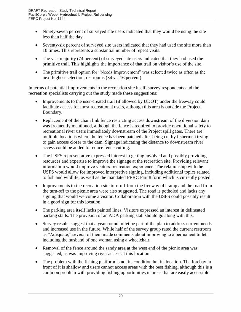
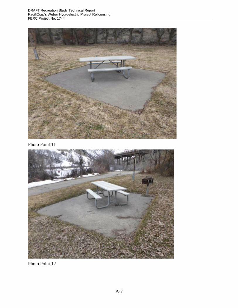
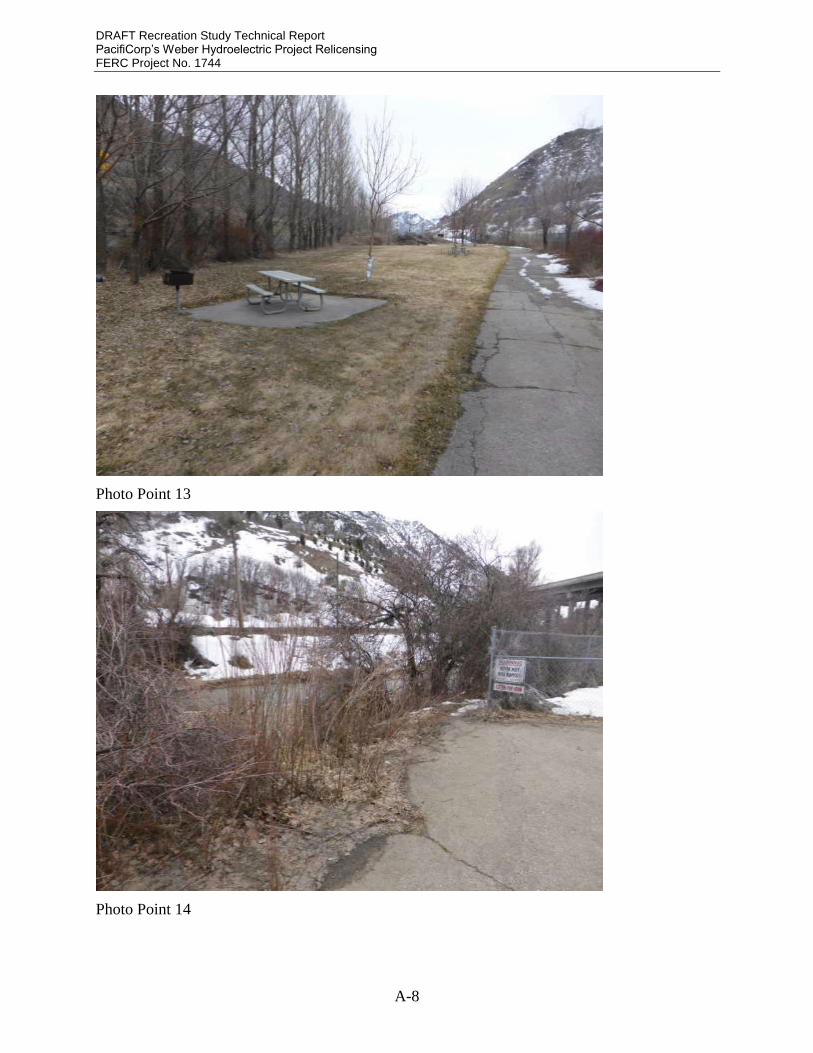
Picnic Area Constructed Parking for approximately 12 vehicles (photo 3), four tables (photos 7, 10, 11, and 12), four grills (photos 7, 10, 11, and 12), trash can (photo 4), and paved path leading to one table and grill (photo 7).
P-1744 Weber Rec Site Day Use Area
Interpretive Display
Constructed Information on Project management, rules, and fishing (photo 5).
P-1744 Weber Rec Site Day Use Area
Fishing Platform
Constructed Fishing platform at forebay, with ADA access and one table (photos 1 and 2).
P-1744 Weber Rec Site Day Use Area
Paved Path Constructed Paved path down the side of the grass area (photo 6 and 9).
P-1744 Weber Rec Site Day Use Area
Informal Use Area
Constructed Open grass area (photo 8 and 13).
P-1744 Weber Rec Site Day Use Area
Active Recreation Area
Constructed Sandbox play area (photo 16).
Amenity Condition and Maintenance
The Weber recreation site day-use area is generally in good condition, but there are some items
that need attention:
The protective shields around the trees, to prevent damage by beavers, are often damaged
or missing.
The picnic tables are in good condition but the BBQ grills are missing from two of the
posts. Maintenance personnel indicate that the grills are stolen from time to time, despite
their being locked to the poles.
The information display panel includes required FERC Part 8 regulations and fisheries
information but is generally lacking in interpretive information about the site, although it
does contain some information about Bonneville cutthroat trout and bluehead sucker, the
two species of concern that are known to occur in the Project Area. It is in need of fresh
paint.
The fishing platform is in good condition with only the railing needing fresh paint.
The paved trail is cracked and buckled due to tree roots and is overhung by branches in
places.
The chain link fence on the south side of the paved trail has numerous patches from
visitors cutting holes in the fence, presumably for fishing access downstream of the dam.
Portions of the barbed wire along the top of this fence are damaged or missing.
The grass is well cared for and in good condition.

DRAFT Recreation Study Technical Report PacifiCorp’s Weber Hydroelectric Project Relicensing FERC Project No. 1744
7
The sandbox area has become overgrown with vegetation and the fence surrounding the
sandbox area is damaged.
The grass appeared to be well maintained and adequately cared for. The dumpster was never
seen to be filled to capacity. The seasonal toilet appeared to receive sufficient maintenance to
accommodate actual use levels throughout the study. Small pieces of scattered trash could be
found in varying concentrations throughout the recreation site as well as along the river, both
upstream and downstream of the dam, along the river corridor, and beneath the overpass.
During winter months, snow removal becomes an additional component of maintenance. This
task is also conducted as needed.
In terms of Americans with Disabilities Act (ADA) compliance, the fishing platform is in
compliance but the trail up to the picnic table nearest the parking lot is above the acceptable
grade and is cracked and buckled by tree roots. The paved path on the south side of the
recreation area is also not ADA compliant due to the aforementioned condition of the asphalt.
The recreation site is an out-of-the-way spot with ready freeway access. As a result, various
illicit activities have been reported anecdotally, generally occurring at night. A Sheriff’s Deputy
attending to a minor incident at the recreation site during the study confirmed this speculation.
PacifiCorp has considered installing a gate at the entrance to the diversion dam and recreation
site that could be closed and locked at night.
Current maintenance conducted by Weber plant personnel at the recreation site entails grass
mowing and edging, lawn watering, sprinkler maintenance and repair, tree branch removal, trash
cleanup, and repair of vandalism. These tasks are conducted on an as-needed basis, as
determined by the Weber personnel. A dumpster and seasonal toilet are also provided and
maintained through contracts with outside companies.
Points of Public Access and Trails
The primary point of public access is through the recreation site picnic area along the paved trail.
Beyond this paved trail, a primitive trail leads visitors further downstream (and outside the
Project Boundary) where additional access is limited due to the positioning of the freeway.
Several unsanctioned pull-off locations exist along the freeway that serve as access points as
well.
Other Recreation Facilities in the Vicinity
The primary recreation facility in the vicinity is the State-managed rest stop located
approximately 0.25 miles up the canyon. While this site is managed by the Utah Department of
Transportation (UDOT), a privately contracted company maintains it. The area primarily
provides a place for motorists to stop and rest, but people frequently use the area to picnic and
fish. The USFS has no developed recreation sites in the vicinity.
The UDOT-managed rest stop absorbs a large amount of traffic. The impacts of this site and its
close proximity to the Weber recreation site are multifaceted. The privately contracted company
does a very good job of maintaining UDOT’s rest stop facilities. When compared to the
recreation site, fishing along this portion of the forebay is better, picnic tables are located closer
to the river, signage is clearer, and the area is generally more accessible.

DRAFT Recreation Study Technical Report PacifiCorp’s Weber Hydroelectric Project Relicensing FERC Project No. 1744
8
The area of primary concern as it relates to dispersed recreational activities is an area adjacent to
Horseshoe Bend, on the old highway right-of-way, where people have been target shooting for
some time. While this area falls outside of the Weber Project boundary (and is located on land
owned partially by UPR and partially by the USFS), the Weber recreation site is the primary
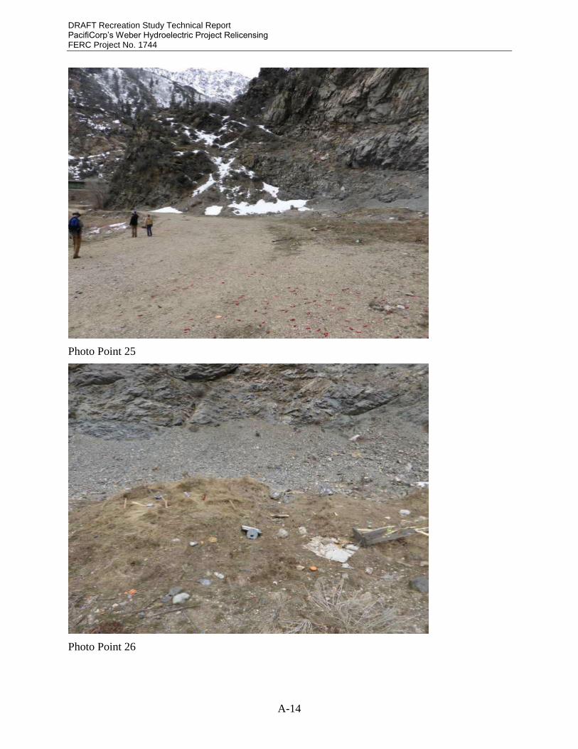
point of access. Photos of this location are in Appendix A (Photos 25 – 27).
Recreation Use and Demand Analysis
USFS representatives contacted for this study said they do not have any information regarding
visitor uses in the Project vicinity. Due to the steepness of the canyon, hunting is the most
common form of dispersed recreation outside of the Project Area.
The Utah 2014 State Comprehensive Outdoor Recreation Plan report shows current uses, visitor
perceptions, and future needs for the Wasatch Front area. This information shows that about half
of the Wasatch Front population regards outdoor recreation as extremely important. Just over
half of these people travel over 25 miles for recreation opportunities. Some information from the
report is relevant to use of the Weber recreation site:
Hiking/backpacking ranks as the most common recreational activity of Wasatch Front
residents, with camping second, and fishing third.
Walking for pleasure or exercise is the most common outdoor activity in the Wasatch
Front area, with playground activities third, wildlife/bird watching fourth, and picnicking
fifth.
City parks are the most important recreational facilities while “Natural Areas” are
second. Most residents are very satisfied with existing city parks.
Additional parks and hiking trails are the top recreational facility needs in the Wasatch
Front area. Additional walking trails rank fifth, and playground equipment ranks ninth.
Visitor Survey
General recreation visitor surveys were conducted over the course of seven periods, once a
month from March through September 2016. Surveyors were at the site approximately 12 hours
each day and offered the survey to every visitor they encountered. In total 51 visitors were
encountered and 47 of those completed the survey. Two of the individuals who declined to take
the survey indicated that they had previously taken it and did not wish to take another. Visitors
were either handed surveys to fill out on their own while at the site, assisted with filling out the
survey while at the site, or given a survey to take home and return by mail, depending on their
preference.
A copy of the survey and tabulated results are included in Appendix B. Many of the individual
results are not discussed in the body of the report; while they may be of interest, they were not
specifically relevant to the objectives outlined in the study plan, although this report does
summarize common and/or specifically relevant findings.
Recreation Use Metrics
UDOT was contacted for visitor use data at the State rest stop and none was available.
Based on data collected over the course of this study, primarily during the visitor-use survey
described in the preceding section, we estimate recreation use at the Weber recreation site in

DRAFT Recreation Study Technical Report PacifiCorp’s Weber Hydroelectric Project Relicensing FERC Project No. 1744
9
Table 2. Although this use estimate is significantly different from the most recent annual vehicle
count use estimate, the following paragraphs discuss the methodology behind the updated, better-
quantified estimate.
Table 2. Recreation use metric estimates for the Weber recreation site.
Estimated Recreation Visits Per Year 3,754
Estimated Recreation Visitor-Days Per Year 605 – 1,248
Site Occupancy (maximum observed during study):
Parking (approximately 12 stalls) 50%
Tables (five tables – four in grass area and one at the fishing platform)
20%
As defined in the study plan, a recreation visit is “a visit by one person to a recreation area for
any portion of a single day.” We have no method of precisely calculating this value since there is
no attendant at the entrance of the recreation area who could keep track of this kind of data. In
order to estimate recreation visits we used data from our survey. Specifically, we used the
average number of people who visited the site on the days we were surveying. Our survey took
place on weekdays as well as on weekends. As expected, weekends had higher average
recreation visits at 12 per day. Weekdays averaged 9.6 recreation visits per day. There are 52
weeks in a year with one additional day outside of those 52 weeks. Depending on the year, that
day may be either a weekend or weekday. Since for 5 out of 7 years that extra day will be a
weekday, we added one additional weekday worth of recreation visits to our yearly total
presented in Table 2.
This estimate of recreation visits per year is substantially lower than the figure for 2014 cited
above under Background Information. This results from several factors. First, the NPS vehicle
occupancy figures of 2.4 and 2.7 for off-peak and peak seasons, respectively, are not reflective of
observed use at the recreation site. Based on our visitor-use survey, actual peak-season
occupancy was 1.4 per vehicle. This is consistent with the prevalence of solitary recreational
pursuits such as fishing, walking, and target shooting that dominate use of this recreation site.
Second, the vehicle counter data used in the 2014 survey included vehicles that drove into the
recreation site and immediately turned around. Again, this is a function of this recreation site’s
unique location, at the same highway exit as the State rest area. Third, the traffic counter data
included PacifiCorp employees visiting the Project facilities, not the recreation area. Based on
these considerations, we are confident that the estimates derived from the visitor-use survey are
more reliable.
We also used survey data to estimate recreation visitor-days. The study plan defines a recreation
visitor-day as “12 hours of use by any combination of users to a recreation area.” In order to
estimate this value we used the survey answers to question 6: “How long did you or are you
going to be recreating at the Weber recreation site today?” Possible answers in the survey were
“short trip (under 3 hours),” “about half the day,” and “the majority of the day.” There was no
pattern evident in the answers to this question based on whether the survey was conducted on a
DRAFT Recreation Study Technical Report PacifiCorp’s Weber Hydroelectric Project Relicensing FERC Project No. 1744
10
weekday or weekend, perhaps due to our small sample size (7 days of visitor surveys); therefore,
we did not distinguish between weekends and weekdays in this calculation.
Seventy-nine percent of respondents selected the “short trip” option, with 15 percent selecting
“about half the day” and 6 percent selecting “the majority of the day.” Given the coarse nature of
these categories, we present recreation visitor-days as a range. For the minimum estimate, we
defined a short trip as 1 hour, half the day as 4 hours, and the majority of the day as 8 hours. For
the maximum estimate, we defined a short trip to be 3 hours, half the day to be 6 hours, and the
majority of the day to be 12 hours. Using the estimated recreation visits per year, the percentages
of answers to question 6, and the two sets of values for question 6 answers, we estimated
recreation visitor days as presented in Table 2.
Site occupancy is presented in Table 2 as maximum occupancy observed at recreation area
facilities over the course of the surveys. Neither parking nor tables were ever observed to be
approaching capacity with maximum parking occupancy at approximately 50 percent (based on a
lot capacity of 12 vehicles) and maximum table occupancy at 20 percent (one of five occupied).
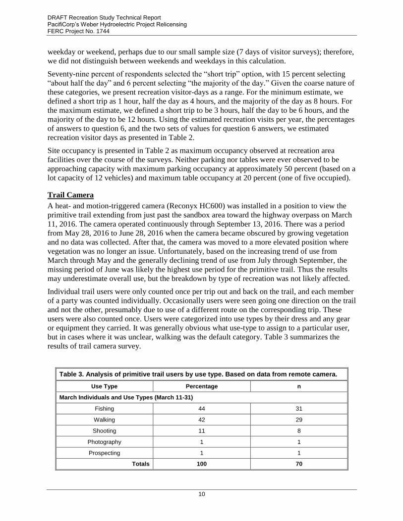
Trail Camera
A heat- and motion-triggered camera (Reconyx HC600) was installed in a position to view the
primitive trail extending from just past the sandbox area toward the highway overpass on March
11, 2016. The camera operated continuously through September 13, 2016. There was a period
from May 28, 2016 to June 28, 2016 when the camera became obscured by growing vegetation
and no data was collected. After that, the camera was moved to a more elevated position where
vegetation was no longer an issue. Unfortunately, based on the increasing trend of use from
March through May and the generally declining trend of use from July through September, the
missing period of June was likely the highest use period for the primitive trail. Thus the results
may underestimate overall use, but the breakdown by type of recreation was not likely affected.
Individual trail users were only counted once per trip out and back on the trail, and each member
of a party was counted individually. Occasionally users were seen going one direction on the trail
and not the other, presumably due to use of a different route on the corresponding trip. These
users were also counted once. Users were categorized into use types by their dress and any gear
or equipment they carried. It was generally obvious what use-type to assign to a particular user,
but in cases where it was unclear, walking was the default category. Table 3 summarizes the
results of trail camera survey.
Table 3. Analysis of primitive trail users by use type. Based on data from remote camera.
Use Type Percentage n
March Individuals and Use Types (March 11-31)
Fishing 44 31
Walking 42 29
Shooting 11 8
Photography 1 1
Prospecting 1 1
Totals 100 70

DRAFT Recreation Study Technical Report PacifiCorp’s Weber Hydroelectric Project Relicensing FERC Project No. 1744
11
Table 3. Analysis of primitive trail users by use type. Based on data from remote camera.
Use Type Percentage n
April Individuals and Use Types (April 1-31)
Fishing 54 86
Walking 34 54
Shooting 11 17
Photography 1 2
Totals 100 159
May Individuals and Use Types (May 1-28)
Fishing 54 100
Walking 31 57
Shooting 9 16
Photography 3 6
Kayaking 3 5
Totals 100 184
June Individuals and Use Types (June 28-30)
Fishing 79 26
Walking 12 4
Shooting 9 3
Totals 100 33
July Individuals and Use Types (July 1-31)
Fishing 73 200
Walking 12 53
Shooting 14 51
Photography 1 2
Totals 100 189
August Individuals and Use Types (August 1-31)
Fishing 68 124
Walking 20 37
Shooting 12 22
Totals 100 183
September Individuals and Use Types (September 1-13)
Fishing 76 50
Walking 22 15
Shooting 2 1
Totals 100 66
Total Individuals and Use Types
Fishing 61 617

DRAFT Recreation Study Technical Report PacifiCorp’s Weber Hydroelectric Project Relicensing FERC Project No. 1744
12
Table 3. Analysis of primitive trail users by use type. Based on data from remote camera.
Use Type Percentage n
Walking 25 249
Shooting 12 118
Photography 1 11
Kayaking <1% 5
Prospecting <1% 1
Totals 100 1,012
Clearly, fishing is the primary recreational use of the Project Area, based on use of the trail
leaving the recreation site, with walking second. During June and July, fishing as a percentage
gained relative to walking, perhaps as a result of summer heat. The third highest use, target
shooting at the informal site adjacent to Horseshoe Bend on the old highway right-of-way,
remained fairly consistent across the study period.
Whitewater Boating Feasibility Study
The relevant results of the associated Whitewater Recreation Study Technical Report are
summarized below. The full report, with complete methods, results, and discussion, is attached
as Appendix C. The objective of this study was to assess whitewater boating opportunities
provided across a range of flow conditions based on the water available in the Study Reach
downstream from the Weber diversion dam.
Whitewater Boating Hydrology Analysis
PacifiCorp maintains a non-consumptive water right of 365 cubic feet per second (cfs) from the
Weber River for power generation. For purposes of this analysis, the average diversion for
generation is assumed to be 300 cfs. During the most recent 10-year flow period (2005 – 2015),
inflows of greater than 380 cfs to the Project (the total of approximate maximum generation flow
and minimum instream flow), measured at the USGS Gateway gage, occurred approximately 31
percent of the time, or 113 days per year. These flows generally occurred from April through
August, coinciding with irrigation season flows that are released upstream from Echo Reservoir.
Inflows of greater than 700 cfs occurred approximately 11 percent of the time, or 40 days per
year, almost exclusively in May and June. The Gateway gage is widely used by boaters and
others to determine the flow in the Study Reach.
A minimum acceptable flow of 450 cfs through the Study Reach was calculated through the
internet survey and focus group discussion (although a minority of focus group attendees
reported boating the Horseshoe Bend section at lower flows), as indicated below in the
Whitewater Boating Use and Demand Analysis. The calculated minimum acceptable flow of 450
cfs in the Study Area is shown as a red line on Figure 2 for reference.
The Project is frequently offline during the winter months, in all but the wettest years, due to
storage reservoirs and interference contracts on the Weber River upstream of the Project. During
the non-operational periods all flows at Gateway gage pass over the Weber diversion dam and
into the Study Reach. In 2015 and 2016 when the Project was offline, data from the Gateway

DRAFT Recreation Study Technical Report PacifiCorp’s Weber Hydroelectric Project Relicensing FERC Project No. 1744
13
gage indicated no flows over 450 cfs, and thus no boating opportunities in the Study Reach,
occurred in 2015 and 2016 (Table 3-1 in Appendix C).
The Project operated for 176 days in 2015 and 217 days in 2016 through September 30, 2016
(end of the period covered by this report; as of November 9, 2016, the Project was still operating
at very low levels). During periods of Project operation, flows greater than 750 cfs are necessary
at Gateway gage for a 450 cfs flow, and thus a whitewater opportunity, in the Study Reach
without reduction of generation. Mean daily flow at Gateway gage during Project operations was
greater than 750 cfs on a single day in 2015 and 2 days in 2016 (note that Figure 2 below shows
flow measurements in the Project study reach rather than values from the Gateway gage. In order
to get Gateway gage values, 300 cfs must be added to the values in Figure 2). Days with
acceptable flows for whitewater boating generally occurred in April and May.
Figure 2. Mean Daily Flows in the Project Study Reach in 2015 and 2016
In short, flows sufficient to boat the Study Reach, from the accessible put-in at the recreation site
to a safely accessible take-out downstream would continue to be rare (based on the most recent
flow data) without interrupting generation.
Whitewater Boating Use and Demand Analysis
Internet Survey and Focus Group
An Internet survey was launched on March 24, 2016, and closed on July 4, 2016. A total of 62
individuals responded to the survey with nine incomplete surveys removed from the overall
0
100
200
300
400
500
600
700
Jan Feb Mar Apr May Jun Jul Aug Sep Oct Nov Dec
Dis
ch
arg
e (
cfs
)
Annual Calendar
Study Reach 2015 Study Reach 2016 Minimum Acceptable Flow

DRAFT Recreation Study Technical Report PacifiCorp’s Weber Hydroelectric Project Relicensing FERC Project No. 1744
14
analysis due to incomplete survey responses. An additional eight surveys were included in the
analysis of the background information but were excluded from the flow analysis due to a lack of
responses for flow-related questions. A total of 45 responses were used in the flow analysis for
this study. Survey respondents were encouraged to report the results of historic trips on the Study
Reach as well as more recent trips. The earliest date for trips reported was November 26, 1976.
The flows cited in trip reports ranged from 241 cfs to 4,300 cfs, as measured at the Gateway
gage.
PacifiCorp hosted a whitewater focus group for the Project on May 3, 2016, from 7:00 to 10:00
p.m. in Ogden, Utah. A total of 30 invitations were delivered, and 15 individuals registered for
the focus session, all of whom participated. Results of the Internet survey and focus group are
summarized below.
Current Use
While this study identified 450 cfs as the minimum acceptable flow for the Study Reach as a
whole, some use occurs at lower flows, mostly confined to the Horseshoe Bend rapid. This
limited use is explained below under Flow Preferences.
Whitewater boating in the Study Reach typically occurs during the spring months, corresponding
with the melting of the lower-elevation snowpack. In 2015, 22 reported trips from Internet
survey participants occurred in the Study Reach from March through September with the
majority of the trips occurring in May and June. In 2016, 11 trips were reported with the majority
of trips occurring in April and a single trip listed for late June.
In general, whitewater boaters indicated they made fewer than five trips to the Study Reach
during the previous 12 months (Figure 3-9 in Appendix C). In fact, 15 participants indicated they
had not paddled the Study Reach in the previous 12 months, whereas 24 respondents indicated
one to five trips in the previous 12 months. Two participants indicated making 6 to 10 trips or 11
to 20 trips, respectively, during the past 12 months. No participants reported making more than
20 trips during the past 12 months.
When asked the total number of trips they have made to the Study Reach for whitewater
recreation over time, the largest number of Internet survey participants (n=17) indicated one to
five trips total, followed by 12 participants indicating 11 – 20 total trips, and 11 participants
indicating more than 20 total trips.
Weekends and weekdays after work hours (typically 5 p.m.) were preferred for trips to the study
reach (Figure 3-12 in Appendix C).
Internet survey participants compared the study reach to local, state, and regional whitewater
rivers using a five-point rating scale ranging from worse than average to among the very best.
The whitewater resources used in the comparison included the Weber River play park, rivers
within a one-hour drive, other rivers in Utah/Idaho/Wyoming, and other rivers in the United
States. For each comparison, the majority of survey respondents rated the Project study reach
worse than average relative to the other whitewater recreation resource comparisons (Figure 3-14
in Appendix C). Four survey respondents identified the study reach as among the very best
within a one-hour drive. In general, the unfavorable rating of the Project study reach increased as
the geographic radius of the comparison expanded (i.e., other rivers in Utah/Idaho/Wyoming and
other rivers in the United States).

DRAFT Recreation Study Technical Report PacifiCorp’s Weber Hydroelectric Project Relicensing FERC Project No. 1744
15
Challenge Level
The majority of Internet survey respondents rated the whitewater difficulty for this section of the
Weber River as Class IV whitewater (Figure 3). Focus group participants provided more detailed
ratings of the whitewater difficulty for the individual rapids across a range of flows. As expected,
considerable discussion ensued among the participants regarding the difficulty of individual
rapids at various flows. Individuals more familiar with the reach and with higher skill levels
tended to rate the whitewater difficulty lower compared to individuals with less experience. In
the end, the focus group participants agreed that the overall rating for the Study Reach is Class
IV, reflecting the difficulty in Horseshoe Bend and Triple Drop rapids.
Figure 3. Study Reach Whitewater Difficulty Based on Internet Survey Responses
Flow Preferences
Focus group participants also provided information on flow preferences. Boaters indicated they
rely on the Gateway gage located directly upstream of the Weber diversion dam for real-time
flow information. The Gateway gage serves as a reference point since the boaters are not
knowledgeable of PacifiCorp’s diversion capacity. During the focus group discussion, boaters
provided their flow preferences based on the Gateway gage flows. Those numbers have been
adjusted (i.e., generation diversions subtracted as appropriate) to reflect flows in the Study Reach
for comparison with flow recommendations provided by the Internet survey participants.
Section 4 of the Internet survey allowed participants to rate a range of flows from 200 to 1,000
cfs in the Study Reach. This comparative flow rating was used to develop flow preference curves
(Figure 4). The minimum acceptable flow was just under 450 cfs. The optimum flow range was
600 to 1,000 cfs (Figure 4). Participants rated 900 cfs as the most acceptable flow between 200
and 1,000 cfs. Internet survey participants were largely in agreement that flows less than 400 cfs
were unacceptable, but as flows increased above 400 cfs the acceptability ratings varied more
broadly (Figure 3-16 in Appendix C).
0
5
10
15
20
25
30
35
40
Class I Class II Class III Class IV Class V
Nu
mb
er
of
Resp
on
ses
Difficulty of Study Reach

DRAFT Recreation Study Technical Report PacifiCorp’s Weber Hydroelectric Project Relicensing FERC Project No. 1744
16
Figure 4. Flow Preference Curve Identifying Minimum Acceptable and Optimum Flow for
Internet Survey Participants
Focus group participants commented that flow preferences have changed due to the changes in
access to the Study Reach. Historically, when access was allowed from I-84 to the bottom of
Horseshoe Bend, the minimum acceptable flow was as low as 140 cfs. Boaters would paddle the
Horseshoe Bend rapid only, because 140 cfs was too low for Ledges 1, 2, and 3 at Triple Drop.
Horseshoe Bend at 140 cfs offered a technical slalom boating opportunity. The current access
restrictions require a higher minimum acceptable flow because more water is needed to navigate
Triple Drop and the 1.2-mile Hell or Highwater section downstream. Focus group participants
indicated the flow needed to navigate that section is 300 cfs, but the minimum acceptable flow is
closer to 400 cfs for Ogden boaters and higher for boaters traveling longer distances.
Given the flow patterns summarized above under Whitewater Boating Hydrology Analysis,
sufficient flows pose a substantial constraint to whitewater recreation in the Study Reach.
River Access
The majority of boaters put in a short distance downstream from the Weber diversion dam where
the paved walking path terminates at the riverbank (Figure 3-18 in Appendix C). River access is
not permitted immediately downstream of the dam for safety and liability reasons. Boaters are
able to launch on a gravel bar approximately 200 meters downstream from the dam (Photo 3-11
in Appendix C). PacifiCorp employees have observed boaters launching in the Project forebay.
One focus group participant said he had paddled over the dam in the past. The dam is not
Marginal Line

DRAFT Recreation Study Technical Report PacifiCorp’s Weber Hydroelectric Project Relicensing FERC Project No. 1744
17
suitable for safe navigation (Photo 3-12 in Appendix C) and paddling over it is discouraged by
PacifiCorp.
After boating the Horseshoe, aka Scrambled Eggs, section of the bypassed reach using the
recreation site put-in, boaters must either carry their boats back upstream along the old highway
bed and back to the put-in, or continue downstream and portage the non-Project diversion
located immediately downstream of the powerhouse. This diversion is owned by the Davis-
Weber Irrigation Company, and it commonly takes most or all of the flow in the Weber River at
that point, limiting options to continue downstream.
The boatable reach of the river is further constrained by being located between the two lanes of
I-84, and the only downstream access route is the road to the Davis-Weber irrigation diversion
dam, which is gated and locked downstream of the potential portage area.
The only other access to the boatable reach is via the old highway bed, and the access point has
been gated and locked by UDOT to prevent recreationists from using a freeway pullout that is
considered unsafe due to the lack of acceleration and deceleration lanes. Due to geomorphology
constraints, there is no room for acceleration or deceleration lanes in the Project Area.
The majority of boaters take out on South Weber Drive, also known as the Mouth of the Canyon
(Figure 3-19 in Appendix C). During the focus group, participants indicated this is the default
location currently, but it’s not preferred because it requires paddling the 1.2-mile Class II-III
section, Hell or High Water, below Triple Drop, portaging around the Davis-Weber Irrigation
Company Dam and paddling another 0.75 mile Class II section that may be severely dewatered
by irrigation flow diversions.
In summary, safe and legal access to the Study Reach is difficult and limits use of the Study
Reach by whitewater boaters.
Whitewater Boating Needs Analysis
Project operations, particularly in the months of April and May, cause a decrease in the number
of whitewater boating opportunities. The Project diverts 300 cfs to the Weber powerhouse when
instream flows at Gateway gage range from 450 to 750 cfs resulting in flows less than the
minimum acceptable in the Study Reach. Mean daily flows between 450 and 750 cfs at Gateway
gage occurred 13 and 26 days respectively in 2015 and 2016, resulting in a total reduction of 39
days of boatable flows. Flows greater than 750 cfs at Gateway gage result in sufficient discharge
in the Study Reach for whitewater boating. Mean daily flows at Gateway gage exceeded 750 cfs
1 day in 2015 and 2 days in 2016.
Potential access improvements could be implemented at the Project Area for river recreation
users. The historic direct access used by boaters to Horseshoe Bend from I-84 is unlikely to be
restored. Vehicles travel in the west bound lane of I-84 at speeds in excess of 75 miles per hour.
Direct access to Horseshoe Bend would require construction of an off and on-ramp to I-84. The
site is physically constrained, eliminating the viability of this option. The current put-in location
at the Weber recreation site is suitable for whitewater boaters to park vehicles and access the
river. The current take-out location is not suitable. A more desirable take-out location upstream
of the Davis-Weber Irrigation Company Dam is needed so boaters do not need to portage the
diversion dam and paddle undesirable low flow conditions to the take-out. A potential parking
area is located on river left adjacent to the Davis-Weber Irrigation Company Dam. Boaters can

DRAFT Recreation Study Technical Report PacifiCorp’s Weber Hydroelectric Project Relicensing FERC Project No. 1744
18
exit the river upstream of the Davis-Weber Irrigation Company Dam and walk a short distance
(approximately 200 yards) to their vehicle.
Typically, a whitewater boating needs analysis would include an assessment of the recreation
opportunities provided by an unregulated river, and then compare those to what might be
available in a post-Project regulated reach. As the Study Reach is heavily regulated, both by
upstream diversions and Project operations, and access to the Study Reach is compromised by a
highway that was constructed after the Project was installed, separating impacts to recreation
(access, flows, Project operations) to the extent necessary to do a complete needs analysis is not
practical. Additionally, due to the run-of-river design and lack of water storage at the Weber
Hydroelectric Project, the Project cannot provide flows sufficient to augment whitewater boating
opportunities without significantly compromising generation. However, the needs analysis
concluded the following:
Flow-dependent recreation opportunities occur infrequently on the Weber River (which is
regulated by upstream water storage and diversion projects beyond PacifiCorp’s control),
including the Study Reach, during the spring season.
These opportunities are hampered by a lack of safe and legal access and egress.
These limited recreation opportunities are affected by Project operations.
Opportunities exist to increase the annual frequency of whitewater boating opportunities
in the Study Reach when flows at Gateway gage are between 450 and 750 cfs.
Notification of planned Project maintenance resulting in increased flow in the Study
Reach could be beneficial to the boating (and fishing) community.
PacifiCorp could participate in agreements to improve access at the Davis-Weber
Irrigation Company Diversion directly downstream of the Weber powerhouse.
Recreation Needs Analysis
Current Needs
Managing the Weber recreation site presents a trade-off between making improvements and
retaining the less-developed character of the site. Survey respondents indicate that they recognize
this trade-off as well. If the area is significantly upgraded, it is likely that use will increase,
which is something visitors commonly want to avoid. It is important to ensure that the facilities
at the recreation site are sufficient to provide for visitors’ needs but also to preserve the lower
use levels and sense of quiet that brings people to the site in the first place.
Survey and trail camera results indicate that fishing, the most common form of recreation at the
recreation site, is what visitors are most concerned about and where additional investment may
be most warranted. Fishermen most strongly suggest that they would like to see improved in-
river fish habitat. At a Project site visit to kick off this study, the UDWR representative said that
there might be interest in making additional investments in the area. This partnership should be
explored, and any reasonable improvements to habitat that can be made in the Project reach
should be assessed.
For example, survey results indicate that fishermen are in favor of improving the trail beneath the
freeway. Respondents noted that rattlesnakes are commonly found beneath the freeway, and one

DRAFT Recreation Study Technical Report PacifiCorp’s Weber Hydroelectric Project Relicensing FERC Project No. 1744
19
photo from the trail camera shows a man carrying a large dead snake on the end of his trekking
pole. This trail could be improved and made safer by moving some large boulders then filling in
the holes with an aggregate to create a trail. Note however that the trail exists in and crosses
UDOT’s I-84 freeway bridge right-of-way (ROW). UDOT engineers may or may not allow any
alteration to the bridge footings that the primitive user-created trail traverses.
Fishermen also indicate that they would like other improved access to the river. The current
primary access point located at the west end of the picnic site could be improved through the use
of boulders to create an easy-to-navigate, natural looking staircase down to the river.
Improved waste collection is an area for improvement as reflected by the survey group. Small
pieces of trash can be found throughout the recreation site, but litter is particularly abundant
along river shores and at the shooting site. Policing this issue would be challenging in terms of
resources, but there may be a good solution through a combination of increased signing and an
additional trash can located on the far end of the picnic site.
Walkers, the second largest user group according to the trail camera data, would benefit from
these trail improvements.
Target shooters are a relatively well-represented group in trail camera photos. While target
shooting is not provided or managed on PacifiCorp Project lands, the recreation site does
currently provide some of the access to an area commonly used for target shooting (above
Horseshoe Bend, on the old highway ROW). Survey respondents commonly identified the
shooting area as a place in need of improvement and management. PacifiCorp has no mandate or
authority to control the shooting area (which is located on land owned partially by UPR and
partially by the USFS), but collaboration with local law enforcement might improve the
situation.
One result of the survey and trail camera data was the relatively small number of kayakers. Only
five individuals from this user group were captured on the trail camera (less than 1 percent of the
total recorded, although the camera was offline for a month during the highest period of use from
May 29 – June 28, 2016), and none were encountered on survey dates. However, the camera data
should not be taken to mean that only five kayakers used the Study Reach during the study
period since many kayakers do not use the primitive trail but instead put in just downstream of
the recreation site, or from a pullout located between the two freeway lanes in the immediate
vicinity of the Horseshoe Bend; either location would not be picked up by the trail camera.
Further, the whitewater user survey data indicated that 11 boaters utilized the area in 2016 (the
year the camera was recording). At any rate, the preceding discussion under Whitewater Boating
Needs Assessment identifies two improvements that would enhance this form of recreation in the
Project Area – notification of when Project maintenance or other conditions were anticipated that
would result in boatable flows in the Study Reach, and potential arrangements to improve take-
out access at the Davis-Weber Irrigation Company Diversion downstream from the Weber
powerhouse. Most other improvements suggested by survey respondents would also benefit
boaters.
Other survey results revealed important information about how this site is used. This information
should be considered when contemplating future management of the Weber recreation site:
The site is used primarily by people who live nearby. Eighty-six percent of surveyed site
users indicated that they reside in Weber, Davis, and Morgan counties.
DRAFT Recreation Study Technical Report PacifiCorp’s Weber Hydroelectric Project Relicensing FERC Project No. 1744
20
Ninety-seven percent of surveyed site users indicated that they would be using the site
less than half the day.
Seventy-six percent of surveyed site users indicated that they had used the site more than
10 times. This represents a substantial number of repeat visits.
The vast majority (74 percent) of surveyed site users indicated that they had used the
primitive trail. This highlights the importance of that trail on visitor’s use of the site.
The primitive trail option for “Needs Improvement” was selected twice as often as the
next highest selection, restrooms (34 vs. 16 percent).
In terms of potential improvements to the recreation site itself, survey respondents and the
recreation specialists carrying out the study made these suggestions:
Improvements to the user-created trail (if allowed by UDOT) under the freeway could
facilitate access for most recreational users, although this area is outside the Project
Boundary.
Replacement of the chain link fence restricting access downstream of the diversion dam
was frequently mentioned, although the fence is required to provide operational safety to
recreational river users immediately downstream of the Project spill gates. There are
multiple locations where the fence has been patched after being cut by fishermen trying
to gain access closer to the dam. Signage indicating the distance to downstream river
access could be added to reduce fence cutting.
The USFS representative expressed interest in getting involved and possibly providing
resources and expertise to improve the signage at the recreation site. Providing relevant
information would improve visitors’ recreation experience. The relationship with the
USFS would allow for improved interpretive signing, including additional topics related
to fish and wildlife, as well as the mandated FERC Part 8 form which is currently posted.
Improvements to the recreation site turn-off from the freeway off-ramp and the road from
the turn-off to the picnic area were also suggested. The road is potholed and lacks any
signing that would welcome a visitor. Collaboration with the USFS could possibly result
in a good sign for this location.
The parking area itself lacks painted lines. Visitors expressed an interest in delineated
parking stalls. The provision of an ADA parking stall should go along with this.
Survey results suggest that a year-round toilet be part of the plan to address current needs
and increased use in the future. While half of the survey group rated the current restroom
as “Adequate,” several of them made comments about improving to a permanent toilet,
including the husband of one woman using a wheelchair.
Removal of the fence around the sandy area at the west end of the picnic area was
suggested, as was improving river access at this location.
The problem with the fishing platform is not its condition but its location. The forebay in
front of it is shallow and users cannot access areas with the best fishing, although this is a
common problem with providing fishing opportunities in areas that are easily accessible
DRAFT Recreation Study Technical Report PacifiCorp’s Weber Hydroelectric Project Relicensing FERC Project No. 1744
21
from the parking area for all ability users. The fishing platform itself is in good condition,
but the handrail could use new paint.
Recreation site trees are being protected from beavers with sheet metal sleeves, secured
with electrical tape. A visitor is seen in one picture from the trail camera carrying one of
these metal sleeves that had come free, and it poses a possible safety hazard. A more
aesthetical looking, safer, and more secure alternative could be used.
Improved access to river flow information would help both boaters and fishing
enthusiasts plan trips to the bypassed reach.
Comments from American Whitewater on the preliminary draft report suggested the need
for a discussion exploring the potential for whitewater flows through suspension of
generation.
Future Needs
In the short to medium term, i.e., the next 10 to 20 years, visitor expectations regarding the types
of recreational experiences available in the Project Area are not expected to change substantially.
The site characteristics that currently limit recreation options, discussed in the preceding
sections, are generally not subject to change. Day use by solitary, local fishermen, walkers, and
target shooters will remain the dominant activity, with whitewater boaters taking advantage of
the Study Reach when flow conditions allow. State of Utah population estimates project
statewide population growth of 44 percent over the next 20 years. Use of the Weber recreation
site could be expected to increase proportionally. Under this projected scenario, the
improvements suggested above – primarily repair and replacement of existing facilities – are
likely to be sufficient to meet anticipated needs.
As previously noted in the Background Information section, the recreation site is sometimes used
for illicit activities at night because it is easily accessible and outside the public eye. PacifiCorp
has considered gating the entrance and locking it at night. This may become a more pressing
need as the area population grows. However, the trail camera study indicated that fishermen
enter and depart before sunrise and after sunset, so nighttime closure would adversely affect that
form of recreation.
Beyond the 20-year horizon through the term of the license, it is difficult to project how
recreational demands on the Project Area and the options available to address them might
change. The site’s physical characteristics will continue to impose hard limits on recreational
potential, but new forms of recreation and associated technologies will undoubtedly emerge.
Witness the rapid growth of mountain biking over the past decade, or the emerging popularity of
flying drones. Population growth will likely continue to accelerate, putting more pressure on all
recreation venues.
In the face of this uncertainty, the most pressing need may be for PacifiCorp to maintain
effective working relationships with its partners in managing Project Area land and resources,
the USFS, UDWR, and UDOT. Through collaboration, these entities can ensure that the Project
and surrounding land and infrastructure accommodate and support changing trends in recreation
as effectively as possible.

DRAFT Recreation Study Technical Report PacifiCorp’s Weber Hydroelectric Project Relicensing FERC Project No. 1744
22
This page intentionally left blank

APPENDIX A – SITE PHOTOS

DRAFT Recreation Study Technical Report PacifiCorp’s Weber Hydroelectric Project Relicensing FERC Project No. 1744
A-1

DRAFT Recreation Study Technical Report PacifiCorp’s Weber Hydroelectric Project Relicensing FERC Project No. 1744
A-2
Photo Point 1
Photo Point 2

DRAFT Recreation Study Technical Report PacifiCorp’s Weber Hydroelectric Project Relicensing FERC Project No. 1744
A-3
Photo Point 3
Photo Point 4

DRAFT Recreation Study Technical Report PacifiCorp’s Weber Hydroelectric Project Relicensing FERC Project No. 1744
A-4
Photo Point 5
Photo Point 6
DRAFT Recreation Study Technical Report PacifiCorp’s Weber Hydroelectric Project Relicensing FERC Project No. 1744
A-5
Photo Point 7
Photo Point 8

DRAFT Recreation Study Technical Report PacifiCorp’s Weber Hydroelectric Project Relicensing FERC Project No. 1744
A-6
Photo Point 9
Photo Point 10
DRAFT Recreation Study Technical Report PacifiCorp’s Weber Hydroelectric Project Relicensing FERC Project No. 1744
A-7
Photo Point 11
Photo Point 12
DRAFT Recreation Study Technical Report PacifiCorp’s Weber Hydroelectric Project Relicensing FERC Project No. 1744
A-8
Photo Point 13
Photo Point 14

DRAFT Recreation Study Technical Report PacifiCorp’s Weber Hydroelectric Project Relicensing FERC Project No. 1744
A-9
Photo Point 15
Photo Point 16

DRAFT Recreation Study Technical Report PacifiCorp’s Weber Hydroelectric Project Relicensing FERC Project No. 1744
A-10
Photo Point 17
Photo Point 18

DRAFT Recreation Study Technical Report PacifiCorp’s Weber Hydroelectric Project Relicensing FERC Project No. 1744
A-11
Photo Point 19
Photo Point 20

DRAFT Recreation Study Technical Report PacifiCorp’s Weber Hydroelectric Project Relicensing FERC Project No. 1744
A-12
Photo Point 21
Photo Point 22

DRAFT Recreation Study Technical Report PacifiCorp’s Weber Hydroelectric Project Relicensing FERC Project No. 1744
A-13
Photo Point 23
Photo Point 24
DRAFT Recreation Study Technical Report PacifiCorp’s Weber Hydroelectric Project Relicensing FERC Project No. 1744
A-14
Photo Point 25
Photo Point 26

DRAFT Recreation Study Technical Report PacifiCorp’s Weber Hydroelectric Project Relicensing FERC Project No. 1744
A-15
Photo Point 27

DRAFT Recreation Study Technical Report PacifiCorp’s Weber Hydroelectric Project Relicensing FERC Project No. 1744
A-16
This page intentionally left blank

APPENDIX B – VISITOR SURVEY QUESTIONNAIRE AND RESULTS

DRAFT Recreation Study Technical Report PacifiCorp’s Weber Hydroelectric Project Relicensing FERC Project No. 1744
B-1
BLANK VISITOR USE SURVEY
Weber General Recreation Visitor Use Survey
PacifiCorp Weber River Hydroelectric Project – Weber Canyon, Weber,
Morgan, and Davis Counties, Utah
Introduction
PacifiCorp owns and operates the Weber Hydroelectric Project on the Weber River in Weber, Morgan,
and Davis counties in Utah. This Project is operated under a license granted by the Federal Energy
Regulatory Commission (FERC Project No. 1744). That license is nearing the end of its term and
PacifiCorp has begun the process of renewing the Project’s license. PacifiCorp would like to take this
opportunity to evaluate the recreation uses associated with the Project.
PacifiCorp is requesting information from you to help in the evaluation of recreation opportunities
associated with the Weber Hydroelectric Project, and on lands surrounding the Project. Please note that
the Weber Recreation Site is unaffiliated with the nearby UDOT Rest Area; the recreation site is related
solely to the Weber Hydroelectric Project. The information you provide will be used to describe the
current recreation uses of the Project and determine the future recreation needs of the Project Area. Your
participation in this survey is voluntary and the information you provide is strictly confidential. Your
information will only be used for the purposes described here.
Thank you for your time and consideration.
To return survey by mail, please send to:
Cirrus Ecological Solutions
965 S 100 W #200
Logan, UT 84321

DRAFT Recreation Study Technical Report PacifiCorp’s Weber Hydroelectric Project Relicensing FERC Project No. 1744
B-2
1. Would you be willing to take a few approximately 10 minutes to complete this survey?
Yes
No
If no:
Primary activity:
Reason for refusal:
2. Is recreation your primary purpose for visiting this site today?
Yes
No
If yes, what is your primary form of recreation at this site today?
If no, what is the purpose of your visit here today?
Working or commuting to work
Stopping to use the restroom
Curious to see where this road goes
Other:
3. Including yourself, how many people are in your group today?
4. How many vehicles did your group use to visit the recreation site today?
5. Does anyone in your group have disabilities?
Yes
No
If yes, are there sufficiently accessible facilities at this site for your activity?
Yes
No
If no, please explain:
6. How long did you or are you going to be recreating at the Weber recreation site today?
Short trip (under three hours)
About half the day
The majority of the day
7. On average, how many times per year do you use this recreation site?
8. Approximately how many times have you used this recreation site in total?
1
2-5
6-10
10-20
20+

DRAFT Recreation Study Technical Report PacifiCorp’s Weber Hydroelectric Project Relicensing FERC Project No. 1744
B-3
9. How did you get information about or hear about this recreation site the first time you visited it?
Stumbled upon it
Word of mouth
Gear/tackle shop
Website If so, which website:
Other:
10. Please indicate: During which seasons have you participated in various activities at the recreation
site?
Activity Type: Never Spring Summer Fall Winter
Walking/Hiking
Fishing from bank/wading above the
dam
Fishing from the platform above the
dam
Fishing from a float tube or similar craft
above the dam
Fishing from bank/wading downstream
from the dam
Whitewater boating
Road cycling
Driving for pleasure
Viewing/photographing natural features
Picnicking
Relaxing/hanging out
Nature study
Escaping city/getting outdoors
Swimming
Bird watching
Other:

DRAFT Recreation Study Technical Report PacifiCorp’s Weber Hydroelectric Project Relicensing FERC Project No. 1744
B-4
11. Did you use the primitive trail passing under the freeway from the recreation site to access the
river during your visit?
Yes
No
If yes, was the trail sufficient to meet your needs?
Yes
No
12. If you are using the river today, did you check the current river flow before your visit?
Yes
No
If yes, where did you get your information regarding flows (USGS ‘Gateway’ gage is the one
located approximately one mile upstream of the hydroelectric Project)?
13. Please indicate: How important were the following factors in selecting this site for recreation
today?
Factor: E
xtr
emel
y
Imp
ort
an
t
Ver
y
Imp
ort
an
t
Som
ew
hat
Imp
ort
an
t
Sli
gh
tly
Imp
ort
an
t
Not
Imp
ort
an
t
Proximity to home
Variety of recreation opportunities
No access fee required
Lack of crowding
Natural setting
Access to river
Access to whitewater boating areas
Onsite restroom facilities
Availability of picnic sites
Pets permitted
Clean/well maintained facilities
Feeling of safety
Handicapped access
Other:

DRAFT Recreation Study Technical Report PacifiCorp’s Weber Hydroelectric Project Relicensing FERC Project No. 1744
B-5
14. If you are participating in whitewater boating during your visit, please indicate: Where did you put
in and take out?
Location Put In Location Take Out Location
Weber Recreation Site (here)
Pulled over on side of I-84 near the Horseshoe
Bend
Davis-Weber Irrigation Company dam (2 miles
downstream from here)
Other:
15. Please indicate: What is your opinion of the condition of the facilities at the recreation site?
Site Feature
Condition
Suggestions for improvement
Exce
llen
t
Ad
equ
ate
Nee
ds
imp
rovem
ent
Not
ap
pli
cab
le
Parking facilities
Picnic facilities
Restrooms
Fishing platform
Primitive trail passing
under the freeway from the
recreation site
Paved walkway running
downriver from recreation
site
Other
Other

DRAFT Recreation Study Technical Report PacifiCorp’s Weber Hydroelectric Project Relicensing FERC Project No. 1744
B-6
16. What are the most important actions that could be taken to improve recreation at this site?
Additional picnic facilities
Improved trail passing under the freeway from the recreation site
Other improved fishing access to river
Improved boater access to river
Improve in-river fish habitat
Improved waste collection
Improved access to information about river flows
Other (Please explain):
17. Please provide any additional comments about recreation at this site you think are important:
18. What is your age?
19. What is your gender?
Male
Female
Other
Prefer not to respond
20. Which racial group do you most closely identify with?
American Indian/Alaska Native
Asian
Black/African American
Native Hawaiian or other Pacific Islander
White/Caucasian
Other: ___________________
Prefer not to respond
21. In what zip code do you reside?
Date:
Time:
Flow Rate:

DRAFT Recreation Study Technical Report PacifiCorp’s Weber Hydroelectric Project Relicensing FERC Project No. 1744
B-7
SURVEY RESPONSE ANALYSIS
Visitor Demographics:
Survey Question: What is your age?
Age Percent n
<25 24 11
26-40 24 11
41-60 35 16
>61 17 8
Total 100 46
Survey Question: What is your gender?
Gender Percent n
Male 96 45
Female 4 2
Other 0 0
Total 100 47
Survey Question: Which racial group do you most closely identify with?
Racial Group Percent n
American Indian/Alaska Native
Asian
Black/African American
Native Hawaiian or other Pacific Islander
White/Caucasian 85 40
Latino 11 5
Other 2 1
Prefer not to respond 2 1
Total 100 47

DRAFT Recreation Study Technical Report PacifiCorp’s Weber Hydroelectric Project Relicensing FERC Project No. 1744
B-8
Survey Question: In what zip code do you reside?
Zip code Location/
Distance from Rec site Percentage n
84040 Layton, UT/7.4 mi. 19% 9
84403 Ogden, UT/22 mi. 11% 5
84050 Morgan, UT/19 mi. 11% 5
84405 Ogden, UT/9.2 mi. 6% 3
84414 Ogden, UT/24 mi. 4% 2
84015 Clearfield, UT/15 mi. 4% 2
84041 Layton, UT/12 mi. 4% 2
84401 Ogden, UT/15 mi. 4% 2
84010 Bountiful, UT/25 mi. 4% 2
84075 Syracuse, UT/19 mi. 4% 2
84070 Sandy, UT/44 mi. 2% 1
84087 Woods Cross, UT/26 mi. 2% 1
84046 Manila, UT/167 mi. 2% 1
84101 Salt Lake City, UT/31 mi. 2% 1
83686 Nampa, ID/331 mi. 2% 1
85383 Peoria, AZ/667 mi. 2% 1
84092 Sandy, UT/51 mi. 2% 1
68930 Montrose, CO/382 mi. 2% 1
84301 Bear River City, UT/46 mi. 2% 1
Total 100% 47
Visitor Characteristics:
Survey Question: Including yourself, how many people are in your group today?
Number in Group Percent n
1 60% 28
2 30% 14
3 10% 5
Total 100% 42
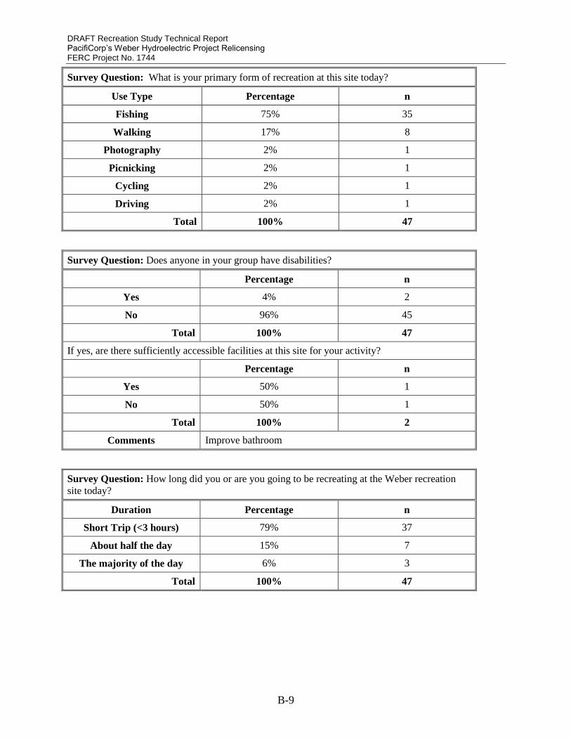
DRAFT Recreation Study Technical Report PacifiCorp’s Weber Hydroelectric Project Relicensing FERC Project No. 1744
B-9
Survey Question: What is your primary form of recreation at this site today?
Use Type Percentage n
Fishing 75% 35
Walking 17% 8
Photography 2% 1
Picnicking 2% 1
Cycling 2% 1
Driving 2% 1
Total 100% 47
Survey Question: Does anyone in your group have disabilities?
Percentage n
Yes 4% 2
No 96% 45
Total 100% 47
If yes, are there sufficiently accessible facilities at this site for your activity?
Percentage n
Yes 50% 1
No 50% 1
Total 100% 2
Comments Improve bathroom
Survey Question: How long did you or are you going to be recreating at the Weber recreation
site today?
Duration Percentage n
Short Trip (<3 hours) 79% 37
About half the day 15% 7
The majority of the day 6% 3
Total 100% 47

DRAFT Recreation Study Technical Report PacifiCorp’s Weber Hydroelectric Project Relicensing FERC Project No. 1744
B-10
Survey Question: On average, how many times per year do you use this recreation site?
Number of Visits Percentage n
<5 32% 15
6-20 23% 11
20+ 45% 21
Total 100% 47
Survey Question: Approximately how many times have you used this recreation site in total?
Number of Visits Average n
1 9% 4
2-5 11% 5
6-10 4% 2
10-20 6% 3
20+ 70% 33
Total 100% 47
Survey Question: How did you get information about or hear about this recreation site the first
time you visited it?
Method Percentage n
Stumbled upon it 52% 25
Word of mouth 46% 21
Gear/tackle shop
Website 2% 1
Other
Total 100% 47

DRAFT Recreation Study Technical Report PacifiCorp’s Weber Hydroelectric Project Relicensing FERC Project No. 1744
B-11
Participation in Activities in the Study Area:
Survey Question: Please indicate: During which seasons have you participated in various
activities at the recreation site?
Season
Activity Type Never Spring Sumer Fall Winter
Participation Percentage
Walking/Hiking 53% 40% 43% 36% 13%
Fishing from bank/ wading
above dam 50% 48% 43% 43% 22%
Fishing from the platform above
the dam 83% 17% 15% 13% 9%
Fishing from a float tube or
similar craft above the dam 83% 4% 9% 4% 2%
Fishing from the bank/ wading
downstream of the dam 15% 76% 76% 68% 45%
Whitewater boating 89% 4% 9% 4% 2%
Road cycling 94% 2% 4% 2% 0%
Driving for pleasure 63% 35% 37% 35% 30%
Viewing/photographing natural
features 55% 40% 40% 38% 32%
Picnicking 60% 26% 40% 30% 2%
Relaxing/hanging out 47% 48% 51% 43% 30%
Nature Study 81% 17% 19% 17% 13%
Escaping city/ getting outdoors 40% 57% 57% 55% 40%
Swimming 91% 0% 9% 2% 0%
Bird watching 72% 26% 28% 19% 17%
Other:

DRAFT Recreation Study Technical Report PacifiCorp’s Weber Hydroelectric Project Relicensing FERC Project No. 1744
B-12
Survey Question: Did you use the primitive trail passing under the freeway from the recreation
site to access the river during your visit?
Response Percentage n
Yes 74% 35
No 26% 12
Total 100 47
If yes, was the trail sufficient to meet your needs?
Yes 64% 30
No 11% 5
N/A 25% 12
Total 100% 47
Survey Question: If you are using the river today, did you check the current river flow before
your visit?
Response Percentage n
Yes 15% 7
No 85% 40
Total 100% 47
If yes, where did you get your information regarding flows (USGS ‘Gateway’ gage is the one
located approximately one mile upstream of the hydroelectric Project))?
Responses:
“Utah angler’s report,” “didn’t find anything,” “Utah stream flow,” “Fishing report,” “USGS
Gateway gage.”

DRAFT Recreation Study Technical Report PacifiCorp’s Weber Hydroelectric Project Relicensing FERC Project No. 1744
B-13
Importance of Factors:
Survey Question: Please indicate: How important were the following factors in selecting this site
for recreation?
Response Average rating of importance from
1 (low) to 5 (high)
Proximity to home 4.15
Variety of recreation opportunities 3.06
No access fee required 4.45
Lack of crowding 4.21
Natural setting 4.08
Access to river 4.34
Access to whitewater boating areas 1.65
Onsite restroom facilities 2.93
Availability of picnic sites 2.6
Pets permitted 2.39
Clean/well maintained facilities 3.56
Feeling of safety 3.91
Handicapped access 2.77
Other “Snow plowed roads,” “Good fishing.”
Survey Question: If you are participating in whitewater boating during your visit, please
indicate: Where did you put in and take out?
Percentage n
Location Put In Location Take Out Location
Weber Recreation Site (here)
Pulled over on side of I-84 near the
Horseshoe Bend
Davis-Weber Irrigation Company dam
(2 miles downstream from here)
Other:
N/A 100% 47
Total 100% 47
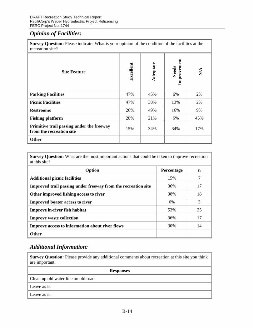
DRAFT Recreation Study Technical Report PacifiCorp’s Weber Hydroelectric Project Relicensing FERC Project No. 1744
B-14
Opinion of Facilities:
Survey Question: Please indicate: What is your opinion of the condition of the facilities at the
recreation site?
Site Feature
Ex
cell
ent
Ad
equ
ate
Nee
ds
Imp
rov
emen
t
N/A
Parking Facilities 47% 45% 6% 2%
Picnic Facilities 47% 38% 13% 2%
Restrooms 26% 49% 16% 9%
Fishing platform 28% 21% 6% 45%
Primitive trail passing under the freeway
from the recreation site 15% 34% 34% 17%
Other
Survey Question: What are the most important actions that could be taken to improve recreation
at this site?
Option Percentage n
Additional picnic facilities 15% 7
Improved trail passing under freeway from the recreation site 36% 17
Other improved fishing access to river 38% 18
Improved boater access to river 6% 3
Improve in-river fish habitat 53% 25
Improve waste collection 36% 17
Improve access to information about river flows 30% 14
Other
Additional Information:
Survey Question: Please provide any additional comments about recreation at this site you think
are important:
Responses
Clean up old water line on old road.
Leave as is.
Leave as is.
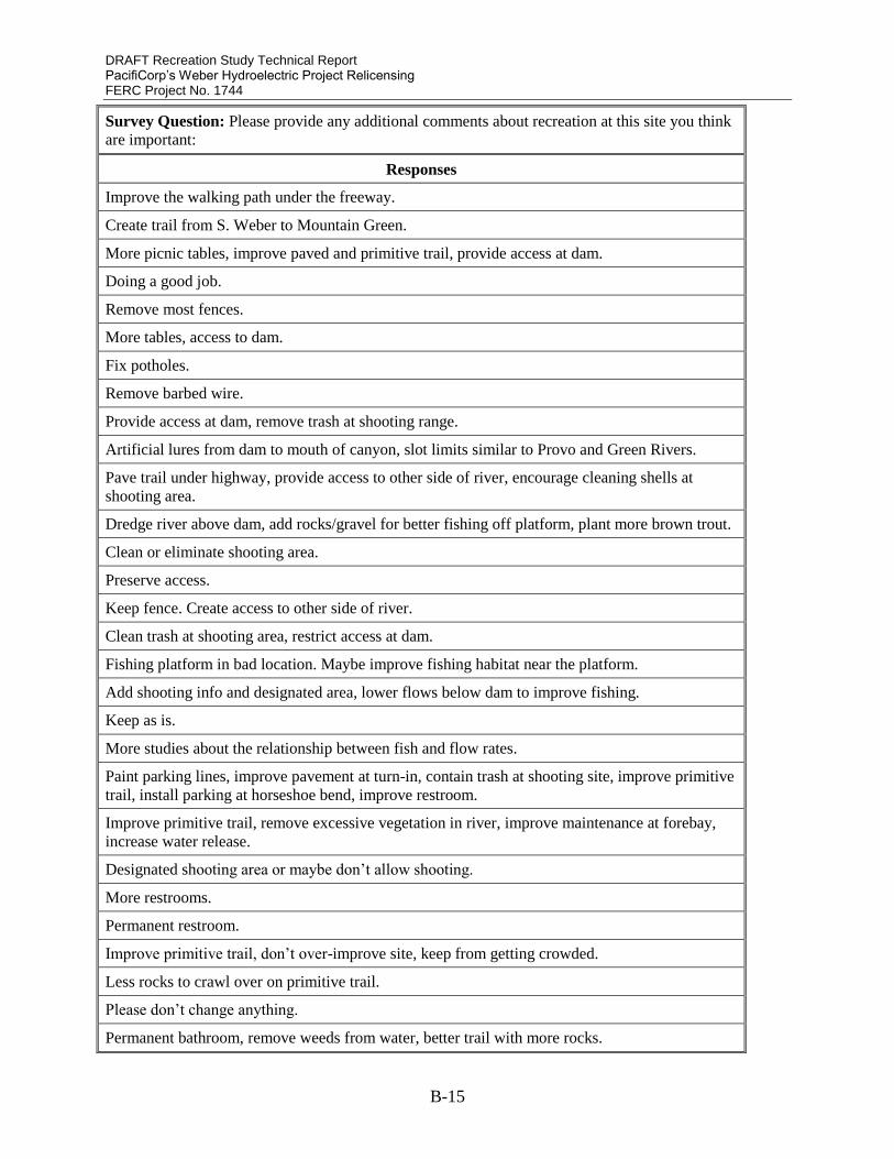
DRAFT Recreation Study Technical Report PacifiCorp’s Weber Hydroelectric Project Relicensing FERC Project No. 1744
B-15
Survey Question: Please provide any additional comments about recreation at this site you think
are important:
Responses
Improve the walking path under the freeway.
Create trail from S. Weber to Mountain Green.
More picnic tables, improve paved and primitive trail, provide access at dam.
Doing a good job.
Remove most fences.
More tables, access to dam.
Fix potholes.
Remove barbed wire.
Provide access at dam, remove trash at shooting range.
Artificial lures from dam to mouth of canyon, slot limits similar to Provo and Green Rivers.
Pave trail under highway, provide access to other side of river, encourage cleaning shells at
shooting area.
Dredge river above dam, add rocks/gravel for better fishing off platform, plant more brown trout.
Clean or eliminate shooting area.
Preserve access.
Keep fence. Create access to other side of river.
Clean trash at shooting area, restrict access at dam.
Fishing platform in bad location. Maybe improve fishing habitat near the platform.
Add shooting info and designated area, lower flows below dam to improve fishing.
Keep as is.
More studies about the relationship between fish and flow rates.
Paint parking lines, improve pavement at turn-in, contain trash at shooting site, improve primitive
trail, install parking at horseshoe bend, improve restroom.
Improve primitive trail, remove excessive vegetation in river, improve maintenance at forebay,
increase water release.
Designated shooting area or maybe don’t allow shooting.
More restrooms.
Permanent restroom.
Improve primitive trail, don’t over-improve site, keep from getting crowded.
Less rocks to crawl over on primitive trail.
Please don’t change anything.
Permanent bathroom, remove weeds from water, better trail with more rocks.

APPENDIX C – WHITEWATER TECHNICAL REPORT
Appendix C - Weber River Hydroelectric Project
FERC No. 1744
Whitewater Recreation Study Technical Report
Prepared for:
PacifiCorp
Salt Lake City, UT
Prepared by:
ERM-West, Inc.
Bigfork, Montana
August 2016

DRAFT Recreation Study Technical Report PacifiCorp’s Weber Hydroelectric Project Relicensing FERC Project No. 1744
(This Page Intentionally Blank)

DRAFT Recreation Study Technical Report PacifiCorp’s Weber Hydroelectric Project Relicensing FERC Project No. 1744
C-i
Contents
1. INTRODUCTION ............................................................................................................... 1
1.1. Study Objectives .................................................................................................................. 1
1.2. Nexus to Project ................................................................................................................... 1
1.3. Project Area ......................................................................................................................... 1
2. METHODS .......................................................................................................................... 1
2.1. Whitewater Boating Hydrology Analysis ............................................................................ 1
2.2. Whitewater Boating Needs Analysis ................................................................................... 3
2.2.1. Level 1 Desktop Effort ..................................................................................................... 4
2.2.2. Level 2 Field Reconnaissance .......................................................................................... 4
2.3. Whitewater Boating Use and Demand Analysis .................................................................. 4
2.3.1. Level 3 Survey Questionnaire .......................................................................................... 4
2.3.2. Level 3 Focus Group ........................................................................................................ 5
2.3.3. Flow Preferences .............................................................................................................. 5
3. RESULTS ............................................................................................................................ 6
3.1. Whitewater Boating Hydrology Analysis ............................................................................ 6
3.2. Whitewater Boating Use, Demand, and Needs Analysis ..................................................... 8
3.2.1. Internet Survey and Focus Group Participation ............................................................... 8
3.2.2. Whitewater Rapids ......................................................................................................... 10
3.2.3. Whitewater Use Patterns ................................................................................................ 16
3.2.4. Whitewater Flow Preferences ........................................................................................ 22
3.2.5. River Recreation Access ................................................................................................ 24
4. DISCUSSION .................................................................................................................... 31
5. REFERENCES .................................................................................................................. 34
DRAFT Recreation Study Technical Report PacifiCorp’s Weber Hydroelectric Project Relicensing FERC Project No. 1744
C-ii
Appendices
Appendix A Whitewater Recreation and Access Internet Survey
Appendix B Focus Group Email Invitation
Appendix C Focus Group Discussion Notes
Appendix D Focus Group Attendance
Appendix E Focus Group Announcement
Appendix F Focus Group Background Survey
List of Tables
Table 2-1: Minimum instream flow requirements based on runoff forecast .................................. 3
Table 3-1. Number of Days with Boating Opportunities 2015-2016 in Project Study Reach........ 7
Table 3-2: Whitewater Rapids in the Study Reach ....................................................................... 12
Table 3-3: Mean Value for Minimum Acceptable and Optimum Flow Written in for the Internet
Survey Participants ....................................................................................................................... 23
List of Figures
Figure 1-1: Weber River Hydroelectric Project Recreation Study Area ........................................ 2
Figure 3-1: Mean Daily Flows at the Gateway gage No. 10136500 .............................................. 6
Figure 3-2: Mean Daily Flows in the Project Study Reach in 2015 and 2016 ............................... 7
Figure 3-3: Age Distribution for Focus Group and Internet Survey Participants ........................... 9
Figure 3-4: Gender of Focus Group and Internet Survey Participants ........................................... 9
Figure 3-5: Whitewater Skill Level for Focus Group and Internet Survey Participants .............. 10
Figure 3-6: Type of Craft used by Focus Group and Internet Survey Participants in the Study
Reach............................................................................................................................................. 10
Figure 3-7: Location of Whitewater Rapids within the Project Study Reach............................... 11
Figure 3-8: Study Reach Whitewater Difficulty Based on Internet Survey Responses ............... 16
Figure 3-9: Number of Trips to the Study Reach by Internet Survey Participants ....................... 17
Figure 3-10: Amount of Time Spent Paddling during a Typical Trip through the Study Reach . 18
Figure 3-11: Number of Laps during the Reported Trip to the Study Reach ............................... 18
Figure 3-12: Timing of a Typical Whitewater Recreation Trip to the Study Reach .................... 19
Figure 3-13: Internet Survey Acceptability Rating for Whitewater Features for the Study Reach
....................................................................................................................................................... 20
Figure 3-14: Internet Survey Comparison of the Study Reach with Local, Regional, and National
Opportunities................................................................................................................................. 21

DRAFT Recreation Study Technical Report PacifiCorp’s Weber Hydroelectric Project Relicensing FERC Project No. 1744
C-iii
Figure 3-15: Flow Preference Curve Identifying Minimum Acceptable and Optimum Flow for
Internet Survey Participants .......................................................................................................... 22
Figure 3-16: Box and Whisker Plot of Flow Comparison Ratings from Internet Survey
Participants .................................................................................................................................... 23
Figure 3-17: Parking Location Frequency for Internet Survey Respondents ............................... 26
Figure 3-18: Put-in Location for Internet Survey Respondents ................................................... 29
Figure 3-19: Take-out Location for Internet Survey Respondents .............................................. 29
List of Photos
Photo 3-1: Upper Section on Horseshoe Bend Rapid at ~40 cfs May 04, 2016 ........................... 13
Photo 3-2: “The Bend” in Horseshoe Bend at ~2500 cfs ............................................................. 13
Photo 3-3: Lower Section on Horseshoe Bend Rapid at ~40 cfs May 03, 2016 .......................... 14
Photo 3-4: Triple Drop Rapid at ~40 cfs May 03, 2016 ............................................................... 14
Photo 3-5: “Ledge 2” in Triple Drop at 1,800 cfs......................................................................... 15
Photo 3-6: “Hell or Highwater” section at ~40 cfs May 03, 2016 ................................................ 15
Photo 3-7: UDOT Rest Area on I-84 Eastbound Lane ................................................................. 25
Photo 3-8: PacifiCorp Weber Recreation Site at Weber Diversion Dam on I-84 Eastbound Lane
....................................................................................................................................................... 25
Photo 3-9: Parking on South Weber Drive Adjacent to River Take-out ...................................... 26
Photo 3-10: Gate Obstructing Access to Old Highway from I-84 Westbound Lane.................... 27
Photo 3-11: River Launch Downstream of Weber Diversion Dam .............................................. 28
Photo 3-12: Weber Diversion Dam............................................................................................... 28
Photo 3-13: Davis-Weber Irrigation Company Dam Obstructing Downstream Navigation ........ 30
Photo 3-14: Gate Restricting Access to Davis-WeberIrrigation Company Dam Take-out .......... 31

DRAFT Recreation Study Technical Report PacifiCorp’s Weber Hydroelectric Project Relicensing FERC Project No. 1744
C-iv
List of Acronyms and Abbreviations
CFS Cubic feet per second
FERC Federal Energy Regulatory Commission
MW Megawatt
NRCS National Resource Conservation Service
NWS National Weather Service
Project Weber River Hydroelectric Project, FERC No. 1744
UDOT Utah Department of Transportation
USGS U.S. Geological Survey

DRAFT Recreation Study Technical Report PacifiCorp’s Weber Hydroelectric Project Relicensing FERC Project No. 1744
C-1
1. INTRODUCTION PacifiCorp’s Weber River Hydroelectric Project (Project), Federal Energy Regulatory
Commission (FERC) Project No. 1744, is a 3.85 megawatt (MW) hydroelectric project located in
northern Utah. It is approximately 30 miles northeast of Salt Lake City and 9 miles southeast of
Ogden, Utah, near the mouth of Weber Canyon on the Weber River. The Project was developed
in the early 1900s to supply electrical generation to the newly growing communities of the
Wasatch Front. The Project’s current FERC license will expire on May 31, 2020. This
Recreation Study was conducted as part of the Project’s relicensing process, with the goal to
collect and organize information about recreation use and access in the study reach, with a focus
on whitewater recreation use on the 1.9-mile reach of the Weber River between the Weber
diversion dam and the powerhouse, where flows are altered by Project operations.
1.1. STUDY OBJECTIVES
The objective of the study is to assess whitewater boating opportunities provided across a range
of flow conditions based on the water available in the Weber River downstream of the Weber
Hydroelectric Project diversion dam and the river access available to recreationists.
1.2. NEXUS TO PROJECT
The Project reduces stream flows in the 1.9-mile study reach. The Project is subject to minimum
instream flows ranging from 34 to 50 cubic feet per second (cfs), depending on the season and
water yields in the Weber River watershed.
1.3. PROJECT AREA
The study reach (Figure 1-1) was chosen because it is used by boaters for whitewater recreation.
Boaters refer to a 0.3-mile section in the study reach as “Horseshoe Bend” and/or “Scrambled
Eggs.” The study reach extends from the Weber diversion dam near the Utah Department of
Transportation (UDOT) Rest Area, to the Project powerhouse and directly upstream from the
Davis-Weber Irrigation Company’s headgates and canal intake.
2. METHODS
2.1. WHITEWATER BOATING HYDROLOGY ANALYSIS
The nearest U.S. Geological Survey (USGS) gage (No. 10136500) to the study reach is located at
Gateway, Utah, just upstream of the Weber Project diversion dam. The Gateway gage has data
available for a period of record that covers 94 years. Data from the Gateway gage was used to
calculate the hydrology for the study reach.

DRAFT Recreation Study Technical Report PacifiCorp’s Weber Hydroelectric Project Relicensing FERC Project No. 1744
C-2
Figure 1-1: Weber River Hydroelectric Project Recreation Study Area
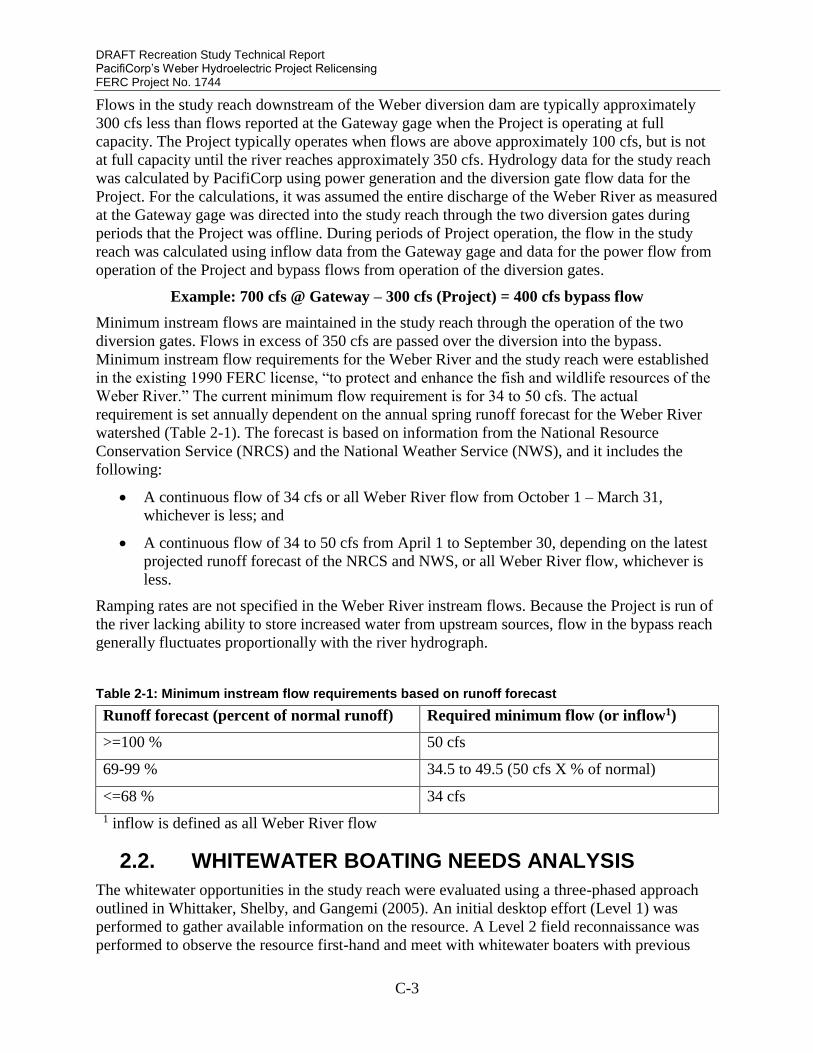
DRAFT Recreation Study Technical Report PacifiCorp’s Weber Hydroelectric Project Relicensing FERC Project No. 1744
C-3
Flows in the study reach downstream of the Weber diversion dam are typically approximately
300 cfs less than flows reported at the Gateway gage when the Project is operating at full
capacity. The Project typically operates when flows are above approximately 100 cfs, but is not
at full capacity until the river reaches approximately 350 cfs. Hydrology data for the study reach
was calculated by PacifiCorp using power generation and the diversion gate flow data for the
Project. For the calculations, it was assumed the entire discharge of the Weber River as measured
at the Gateway gage was directed into the study reach through the two diversion gates during
periods that the Project was offline. During periods of Project operation, the flow in the study
reach was calculated using inflow data from the Gateway gage and data for the power flow from
operation of the Project and bypass flows from operation of the diversion gates.
Example: 700 cfs @ Gateway – 300 cfs (Project) = 400 cfs bypass flow
Minimum instream flows are maintained in the study reach through the operation of the two
diversion gates. Flows in excess of 350 cfs are passed over the diversion into the bypass.
Minimum instream flow requirements for the Weber River and the study reach were established
in the existing 1990 FERC license, “to protect and enhance the fish and wildlife resources of the
Weber River.” The current minimum flow requirement is for 34 to 50 cfs. The actual
requirement is set annually dependent on the annual spring runoff forecast for the Weber River
watershed (Table 2-1). The forecast is based on information from the National Resource
Conservation Service (NRCS) and the National Weather Service (NWS), and it includes the
following:
A continuous flow of 34 cfs or all Weber River flow from October 1 – March 31,
whichever is less; and
A continuous flow of 34 to 50 cfs from April 1 to September 30, depending on the latest
projected runoff forecast of the NRCS and NWS, or all Weber River flow, whichever is
less.
Ramping rates are not specified in the Weber River instream flows. Because the Project is run of
the river lacking ability to store increased water from upstream sources, flow in the bypass reach
generally fluctuates proportionally with the river hydrograph.
Table 2-1: Minimum instream flow requirements based on runoff forecast
Runoff forecast (percent of normal runoff) Required minimum flow (or inflow1)
>=100 % 50 cfs
69-99 % 34.5 to 49.5 (50 cfs X % of normal)
<=68 % 34 cfs
1 inflow is defined as all Weber River flow
2.2. WHITEWATER BOATING NEEDS ANALYSIS
The whitewater opportunities in the study reach were evaluated using a three-phased approach
outlined in Whittaker, Shelby, and Gangemi (2005). An initial desktop effort (Level 1) was
performed to gather available information on the resource. A Level 2 field reconnaissance was
performed to observe the resource first-hand and meet with whitewater boaters with previous

DRAFT Recreation Study Technical Report PacifiCorp’s Weber Hydroelectric Project Relicensing FERC Project No. 1744
C-4
experience and knowledge of the resource. The information gathered in the Level 1 and Level 2
efforts was analyzed to create more detailed summaries of whitewater use patterns and flow
preferences in a Level 3 study effort. The Level 3 effort included deployment of an online survey
questionnaire and a focus group session with whitewater boaters familiar with the study reach.
2.2.1. Level 1 Desktop Effort
The Level 1 desktop effort provided information on the whitewater opportunities in the study
reach including length, access points, whitewater difficulty, rapid names, recommended
navigation routes, flow range, flow information, and safety concerns (American Whitewater
2016).
2.2.2. Level 2 Field Reconnaissance
Identification and documentation of river access for whitewater recreation in the study reach
occurred during the Level 2 field reconnaissance events on March 1, 2016, and May 3, 2016.
Members of the Weber River Recreation Study Technical Group participated in the March 1,
2016 field reconnaissance. Site visit participants provided information on current and historic
access to the river, current and historic use patterns in the study reach, and the range of flows
typically boated. River access locations include areas that could be used for activities including
parking as well as put-in and take-out locations for boats and equipment. Interviews with Project
operators provided information on the timing of flows in the study reach, safety, and access
issues.
2.3. WHITEWATER BOATING USE AND DEMAND ANALYSIS
A whitewater survey questionnaire and focus group were administered to assess whitewater
boating use and demand.
2.3.1. Level 3 Survey Questionnaire
The Weber River Whitewater Internet survey questionnaire design was based on accepted
practices outlined in Whittaker et al. (1993) and Whittaker, Shelby, and Gangemi (2005). The
survey included five sections: an introduction, background information about the participant,
single-flow evaluations of the flow boated, comparisons with other flows, and recreation access
preferences for the study reach. Information gathered from the Level 2 field reconnaissance was
used to develop questions for the Internet survey. The draft Internet survey was presented to the
Weber River Recreation Technical Group for review and comment. Comments were
incorporated into the final survey. A copy of the Internet survey questionnaire is included in
Whitewater Report Appendix A.
The survey was posted using Survey Monkey on March 24, 2016, and remained online 102 days
through July 4, 2016. Participation was solicited electronically by advertising on PacifiCorp’s
Project website and forwarding the survey link to members of the boating community along the
Wasatch front including individuals representing American Whitewater in the relicense
proceeding.
Survey Monkey link: https://www.surveymonkey.com/r/XGKSCHD
PacifiCorp link: http://www.pacificorp.com/es/hydro/hl/weber.html#

DRAFT Recreation Study Technical Report PacifiCorp’s Weber Hydroelectric Project Relicensing FERC Project No. 1744
C-5
2.3.2. Level 3 Focus Group
Survey participants were invited to participate in a focus group session after completing the
Internet survey. Contact information was requested for participants interested in attending the
upcoming focus group meetings. Individuals that expressed interest via the Internet survey
received an email invitation in April 2016 with a reminder and information about the focus group
session (Whitewater Report Appendix B). The invitation requested individuals interested in the
focus group session register/RSVP for planning purposes.
The focus group session was facilitated by a river professional with direct experience conducting
whitewater recreation studies. Background surveys were distributed to focus group participants
to collect demographic, residence, and whitewater experience information that could be used for
analysis of the data. The facilitator explained the focus group objectives and format to the
participants. Next, facilitators reviewed the study reach, described the FERC relicensing process
overview and Recreation Study, identified the Project infrastructure, and provided overviews of
the watershed, flow regulation and the influence of additional projects on the seasonal
hydrograph for the Weber River. The focus group discussion topics were organized into six
categories: flow information, parking and river access (current and historic), rapid names and
whitewater difficulty, flow preferences (minimum acceptable and optimum), whitewater use
patterns, and comparisons with other local whitewater resources. Photographs collected during
the Level 2 field reconnaissance along with maps of the study reach were used in the focus group
session to generate discussion on specific rapids, whitewater difficulty as well as historic and
current river access.
Notes from focus group participants are included in Whitewater Report Appendix C and
included throughout the results.
2.3.3. Flow Preferences
The Internet survey prompted participants to rate eight flows in the study reach in 100 cfs
increments from 200 cfs to 1,000 cfs using a 5-point acceptability rating scale. A whitewater
flow preference curve (flow preference curve) was plotted for whitewater recreation in the study
reach using the 5-point acceptability rating scale. Mean values from the Internet survey were
plotted using the acceptability rating scale on the y-axis to develop flow preference curves. Mean
flow values equal to 3 (marginal) on the flow preference curve were defined as minimum
acceptable. Mean flow values greater than 3 were considered acceptable for the participants. For
this study, and consistent with Whittaker et al. (1993), the optimum recreational flows include
the range of flows beginning at the point in which the curve begins to flatten out and terminates
at the point where there is a sharp decline in respondent acceptability ratings. The results of the
flow preference curve and analysis for the study reach are described in Section 3.5.
Focus group participants were questioned on their flow preferences for the study reach in the
May 3, 2016, focus group session. Participant responses were captured in meeting notes and
synthesized in table format for minimum acceptable and optimum flows.
Focus group participants preferred discussing flows based on the Gateway gage rather than the
flows present in the study reach because study reach flows must be calculated. For the data
analysis in the results section, flow preferences from focus group participants have been

DRAFT Recreation Study Technical Report PacifiCorp’s Weber Hydroelectric Project Relicensing FERC Project No. 1744
C-6
calculated to the flows present in the study reach by subtracting out ~300 cfs. This allowed for
comparison with the results from the Internet survey.
3. RESULTS This section describes the whitewater recreation resource and access in the Project study reach
using information and data gathered in the Level 1, 2, and 3 study efforts.
3.1. WHITEWATER BOATING HYDROLOGY ANALYSIS
PacifiCorp analyzed the 94-year hydrologic record at the USGS Gateway gage in the Pre-
Application Document as the Water Resources Final Study Plan. The analysis evaluated changes
to the hydrology of the study reach over time due to the construction of new water storage and
diversion projects upstream of the Project. These additional water storage and diversion projects
have resulted in reductions to the mean daily flows in the study reach (Figure 3-1). The largest
reduction occurred after the Echo Hydroelectric Project was completed in 1931.
Figure 3-1: Mean Daily Flows at the Gateway gage No. 10136500 (PacifiCorp Final Study
Plan Water Resources, 2016)
Due to low inflows, the Project is typically offline in the winter months. During the non-
operational periods all flows at Gateway gage pass through the Weber diversion dam and into the
study reach. In 2015 and 2016, data from the Gateway gage indicate that no boating
opportunities occurred in 2015 and 2016 when the Project was offline (Table 3-1). Minimum
acceptable flows in the study reach are discussed in Section 3.2.4. The calculated minimum

DRAFT Recreation Study Technical Report PacifiCorp’s Weber Hydroelectric Project Relicensing FERC Project No. 1744
C-7
acceptable boating flow of 450 cfs in the study reach (or 750 cfs on the Gateway gage during
Project operations) is shown as a red line on Figure 3-2 for reference.
Table 3-1. Number of Days with Boating Opportunities 2015-2016 in Project Study Reach
Figure 3-2: Mean Daily Flows in the Project Study Reach in 2015 and 2016
Operation of the Project in 2015 started in late March and continued until mid-October, when the
forebay was drained and the radial gates were opened to the total flow of the river. The Project
operated for a total of 176 days during 2015. The average flow in the study reach during
operation of the Project was 61 cfs, with a minimum flow of 37 cfs, and a maximum of 618 cfs,
which occurred on May 17, 2015. The minimum flow of 37 cfs in the study reach occurred
during approximately 122 of the 176 days that the Project was operating.
In 2016, operation of the Project started in late February and continued until the end of
September (end of the period covered by this report; as of November 9, 2016 the Project is still
operating, although at very low generation levels). Between February 26, 2016 and September
20152016 (thru
Sept 30)2015
2016 (thru
Sept 30)
Project Offline 189 57 > 450 cfs 0 0
Project Operating 176 217 450 - 750 cfs 13 26
Project Operating > 750 cfs 1 2
Flow at
Gateway
Gage
Number of days
Project operations
Number of days
0
100
200
300
400
500
600
700
Jan Feb Mar Apr May Jun Jul Aug Sep Oct Nov Dec
Dis
ch
arg
e (
cfs
)
Annual Calendar
Study Reach 2015 Study Reach 2016 Minimum Acceptable Flow

DRAFT Recreation Study Technical Report PacifiCorp’s Weber Hydroelectric Project Relicensing FERC Project No. 1744
C-8
30, 2016, the Project operated for a total of 217 days. The average flow in the study reach during
operation of the Project in this period was 72 cfs, with minimum flows of 37 cfs (up to April 13,
2016) and 39 cfs (starting April 14, 2016), and a maximum of 467 cfs that occurred on April 24,
2016. Three hydrologic peaks of 400 cfs or greater occurred in the spring of 2016 (April 14-15,
April 24, and May 9, 2016). The minimum flows in the study reach occurred during
approximately 139 of the 217 days that the Project was operating.
During periods of Project operation, flows greater than 750 cfs are necessary at Gateway gage
for a whitewater opportunity in the study reach. Mean daily flow at Gateway gage during
operation of the Project was greater than 750 cfs on a single day in 2015 and 2 days in 2016.
Flows at Gateway gage between 450 and 750 cfs during Project operation result in a flow in the
study reach less than the minimum acceptable flow for whitewater boating. The number of days
when mean daily flows were between 450 and 750 cfs at Gateway gage during operation of the
Project was 13 in 2015 and 26 in 2016. Over the total 94-year period of record, days with
acceptable flows for whitewater boating generally occurred in April and May.
3.2. WHITEWATER BOATING USE, DEMAND, AND NEEDS ANALYSIS
Information on whitewater use patterns, flow preferences and access was gathered through site
visits, boater interviews, the Internet survey and a focus group session. The following section
describes the results from these data collection efforts.
3.2.1. Internet Survey and Focus Group Participation
The Internet survey was launched on March 24, 2016, and closed on July 4, 2016. A total of 62
individuals responded to the internet survey with nine incomplete surveys removed from the
overall analysis due to incomplete survey responses. An additional 8 surveys were included in
the analysis of the background information, but were excluded from the flow analysis due to a
lack of responses for flow-related questions. A total of 45 responses were used in the flow
analysis for this study. Survey respondents were encouraged to report the results of historic trips
on the Horseshoe Bend reach as well as more recent trips. The earliest date for trips reported was
November 26, 1976. The range of flows listed for trip reports ranged from 241 cfs to 4,300 cfs,
as measured at the Gateway gage.
PacifiCorp hosted a whitewater focus group for the Project on May 3, 2016, from 7:00 PM to
10:00 PM in Ogden, UT. A total of 30 invitations were delivered and 15 individuals registered
for the focus session, all of whom participated. A complete list of focus group participants is
provided in Appendix D.
Section 1 of the Internet survey gathered background information on the survey respondent. This
information was used to characterize the pool of survey respondents using the Project study
reach. Similarly, focus group participants were asked to complete the same background questions
at the start of the focus group session. This allowed PacifiCorp to compare the pool of
participants for the Internet survey group and focus group.
The participants in the Internet survey and the focus group had a similar age distribution (Figure
3-3). Participant age ranged from 20 to 69 years with the majority of the participants in the age
category of 30 to 39 years for both groups. The next largest age category for the Internet survey
was 20 to 29 years old, followed by 60 to 69 years (Figure 3-3). The age range for focus group

DRAFT Recreation Study Technical Report PacifiCorp’s Weber Hydroelectric Project Relicensing FERC Project No. 1744
C-9
participants was more evenly distributed compared to the Internet survey. Internet survey and
focus group participants were predominately male (Figure 3-4). The whitewater skill level for
focus group and Internet survey participants included individuals with intermediate, advanced,
and expert skills (Figure 3-5). The majority of participants in both groups self-identified as
having advanced whitewater skills. The number of years of whitewater paddling for the Internet
survey group ranged from 4 to 40 years with an average of 16 years paddling. The focus group
years of paddling ranged from 5 to 40 with an average of 19 years. Hardshell kayaks were the
predominant watercraft used in the study reach by focus group and Internet survey participants
although a small number of participants indicated use of raft, paddle raft, inflatable kayak, and
open-canoe (Figure 3-6).
Figure 3-3: Age Distribution for Focus Group and Internet Survey Participants
Figure 3-4: Gender of Focus Group and Internet Survey Participants

DRAFT Recreation Study Technical Report PacifiCorp’s Weber Hydroelectric Project Relicensing FERC Project No. 1744
C-10
Figure 3-5: Whitewater Skill Level for Focus Group and Internet Survey Participants
Figure 3-6: Type of Craft used by Focus Group and Internet Survey Participants in the
Study Reach
3.2.2. Whitewater Rapids
The overall length of the study reach is approximately 1.9 miles. The whitewater boating
community refers to the study reach as Horseshoe Bend and/or Scrambled Eggs, names which
also specifically refer to a short (0.3 mile) section of continuous whitewater within the overall
study reach that is the primary attraction (Figure 3-7). Within the study reach, the boating
community has names for the more prominent rapids as well as the whitewater difficulty of the
individual rapids (Table 3.2).

DRAFT Recreation Study Technical Report PacifiCorp’s Weber Hydroelectric Project Relicensing FERC Project No. 1744
C-11
Figure 3-7: Location of Whitewater Rapids within the Project Study Reach

DRAFT Recreation Study Technical Report PacifiCorp’s Weber Hydroelectric Project Relicensing FERC Project No. 1744
C-12
Table 3-2: Whitewater Rapids in the Study Reach
1International Scale of Whitewater Difficulty
2 Downstream and technically outside of Project study area
Horseshoe Bend itself is described as three sections: Upper Section (Photo 3-1), the Bend (Photo
3-2) and Bottom Section (Photo 3-3). Triple drop (Photo 3-4) consists of three ledge drops in
quick succession: Ledge 1, Ledge 2 (Photo 3-5) and Ledge 3. Boaters refer to the 1.2-mile
section below Triple Drop to the Weber Powerhouse as “Hell or High Water” (Photo 3-6) but do
not have specific rapid names within that section of the river. Focus group participants
commented that this section can have fun Class IV- play water at flows greater than 1,500 cfs. At
flow levels less than 1,500 cfs, focus group participants commented that this section is less
appealing. In fact, prior to the access restrictions on I-84, most boaters did not paddle below
Triple Drop. Similarly, most boaters formerly avoided the 0.25 mile section upstream of
Horseshoe Bend, electing instead to put-in at the start of the rapid.
Area Project Study Reach Length (miles) Rapid NamesFocus Group Rating
of WW Difficulty1
"Pipe" Area
Section of Weber River
between Highway 84
Bridge to top of
Horseshoe Bend rapid
0.25 Boogey Water II
Upper Section III (III+ >700 cfs)
The BendIV
(IV+ to V >2000 cfs)
Bottom Section III to IV
Ledge 1 IV (III 200 cfs)
0.1 Ledge 2 IV (III 200 cfs)
Ledge 3 IV (III 200 cfs)
Hell or High Water
Section between Triple
Drop and Weber
Powerhouse
1.2 No Defined Rapids III (IV- >1500 cfs)
Weber-Davis Irrigation
Dam to Canyon Mouth2
Section between Irrigation
Dam and South Weber
Drive Take-out
0.75 No Defined Rapids II (IV Portage)
Triple Drop
Horseshoe Bend
(aka Scrambled Eggs)
Section of Weber River
from the top of the bend
to the railroad bridge
Section of Weber River
from the railroad bridge
0.25

DRAFT Recreation Study Technical Report PacifiCorp’s Weber Hydroelectric Project Relicensing FERC Project No. 1744
C-13
Photo 3-1: Upper Section on Horseshoe Bend Rapid at ~40 cfs May 4, 2016
Photo 3-2: “The Bend” in Horseshoe Bend at ~2500 cfs

DRAFT Recreation Study Technical Report PacifiCorp’s Weber Hydroelectric Project Relicensing FERC Project No. 1744
C-14
Photo 3-3: Lower Section on Horseshoe Bend Rapid at ~40 cfs May 03, 2016
Photo 3-4: Triple Drop Rapid at ~40 cfs May 03, 2016

DRAFT Recreation Study Technical Report PacifiCorp’s Weber Hydroelectric Project Relicensing FERC Project No. 1744
C-15
Photo 3-5: “Ledge 2” in Triple Drop at 1,800 cfs
Photo 3-6: “Hell or Highwater” section at ~40 cfs May 03, 2016

DRAFT Recreation Study Technical Report PacifiCorp’s Weber Hydroelectric Project Relicensing FERC Project No. 1744
C-16
The majority of Internet survey respondents rated the whitewater difficulty for the Project reach
of the Weber River as Class IV whitewater (Figure 3-8). Focus group participants provided more
detailed ratings of the whitewater difficulty for the individual rapids across a range of flows. As
expected, considerable discussion ensued among the focus group participants regarding the
whitewater difficulty for individual rapids at various flows. Individuals more familiar with the
reach and with higher skill levels tended to rate the whitewater difficulty lower compared to
individuals with less experience. In the end, the focus group participants agreed that the overall
rating for the study reach is Class IV, reflecting the difficulty in Horseshoe Bend and Triple
Drop rapids.
Figure 3-8: Study Reach Whitewater Difficulty Based on Internet Survey Responses
3.2.3. Whitewater Use Patterns
Whitewater boating in the study reach typically occurs during the spring months, corresponding
with the melting of the lower elevation snowpack. Boaters take advantage of flows in the
Horseshoe Bend section when discharge at the USGS Gateway gage exceeds the Weber
diversion dam capacity. In 2015, trips from Internet survey participants occurred in the study
reach from March through September with the majority of the trips occurring in May and June.
In 2016, the majority of the trips reported occurred in April with a single trip reported for late
June. There are no commercial outfitters operating on this reach; none are expected to operate in
the future due to the narrow river channel not suitable for rafts, unpredictable pattern of flows
suitable for whitewater and challenges with access.
In general, whitewater boaters indicated they made fewer than five trips to the study reach during
the previous 12 months (Figure 3-9). In fact, 15 participants indicated they had not paddled the
study reach in the previous 12 months, whereas 24 respondents indicated 1 – 5 trips in the
previous 12 months. Two participants indicated making 6 – 10 trips or 11 – 20 trips respectively
0
5
10
15
20
25
30
35
40
Class I Class II Class III Class IV Class V
Nu
mb
er
of
Resp
on
ses
Difficulty of Study Reach

DRAFT Recreation Study Technical Report PacifiCorp’s Weber Hydroelectric Project Relicensing FERC Project No. 1744
C-17
during the past 12 months. No participants reported making more than 20 trips during the past 12
months.
When asked the total number of trips they have made to the study reach for whitewater
recreation, the largest number of Internet survey participants (n=17) indicated 1 – 5 trips total to
the study reach, followed by 12 participants indicating 11 – 20 total trips, and 11 participants
indicating more than 20 total trips.
Figure 3-9: Number of Trips to the Study Reach by Internet Survey Participants
Internet survey participants indicate they spend 1 to 2 hours paddling during a typical trip to the
study reach (Figure 3-10). Less than ten participants indicated 2 to 4 hours of paddling time and
no responses were given to indicate a full day of paddling time. Approximately half of the survey
respondents completed a single lap per trip to the study reach while the remainder of the
respondents completed multiple laps. Of the 20 Internet survey participants that completed
multiple runs, 11 completed two laps, 6 completed three laps, and 1 participant each completed
four, five, and six laps (Figure 3-11). Focus group participants traveling longer distances
commented they typically complete multiple laps in a single trip compared to boaters from the
nearby community of Ogden. Weekends and weekdays after work hours (typically 5 PM) were
preferred for trips to the study reach (Figure 3-12). Focus group participants indicated the timing
of trips was largely dependent on the flow conditions and further commented that boaters need to
be opportunistic in a dry state like Utah. In fact, some focus group participants indicated they
would skip work to boat Horseshoe Bend during optimum flow conditions because it occurred
infrequently. The number of trips per year is dependent on the availability of flows.
0
5
10
15
20
25
30
0 Times 1 to 5 Times 6 to 10 Times 11 to 20 Times More than 20Times
Nu
mb
er
of
Re
sp
on
ses
Number of Trips (Previous 12-months) Number of Trips (Total)

DRAFT Recreation Study Technical Report PacifiCorp’s Weber Hydroelectric Project Relicensing FERC Project No. 1744
C-18
Figure 3-10: Amount of Time Spent Paddling during a Typical Trip through the Study
Reach
Figure 3-11: Number of Laps during the Reported Trip to the Study Reach
0
5
10
15
20
25
30
35
40
1 - 2 hours of paddling 2 - 4 hours of paddling Full day of paddling
Nu
mb
er
of
Resp
on
ses
0
5
10
15
20
25
Single run 2 3 4 5 6
Nu
mb
er
of
Resp
on
ses
Number of Laps

DRAFT Recreation Study Technical Report PacifiCorp’s Weber Hydroelectric Project Relicensing FERC Project No. 1744
C-19
Figure 3-12: Timing of a Typical Whitewater Recreation Trip to the Study Reach
Internet survey participants were asked to rate the quality of the study reach for the following
whitewater characteristics: technical boating, whitewater play, powerful hydraulics, and length.
Overall, participants rated the study reach as moderately to totally acceptable for technical
boating and powerful hydraulics (Figure 3-13). In contrast, this same group rated the reach as
unacceptable to marginal for whitewater play and marginal for the length of the run.
Internet survey participants compared the study reach to local, state, and regional whitewater
rivers using a five-point rating scale ranging from worse than average to among the very best.
The whitewater resources used in the comparison included the Weber River play park, rivers
within a one-hour drive, other rivers in Utah/Idaho/Wyoming, and other rivers in the United
States. For each comparison, the majority of survey respondents rated the Project study reach
worse than average relative to the other whitewater recreation resource comparisons (Figure 3-
14). Four survey respondents identified the study reach as among the very best within a 1-hour
drive. In general, the unfavorable rating of the Project study reach increased as the geographic
radius of the comparison expanded (i.e., other rivers in Utah/Idaho/Wyoming and other rivers in
the United States).
0
5
10
15
20
25
30
35
40
45
Weekends Weekdays after work(typically after 5 PM)
Weekdays 8 - 5 PM
Nu
mb
er
of
Resp
on
ses

DRAFT Recreation Study Technical Report PacifiCorp’s Weber Hydroelectric Project Relicensing FERC Project No. 1744
C-20
Figure 3-13: Internet Survey Acceptability Rating for Whitewater Features for the Study Reach
0
2
4
6
8
10
12
14
16
18
20
Totally Unacceptable Moderately Unacceptable Marginal Moderately Acceptable Totally Acceptable
Nu
mb
er
of
Resp
on
ses
Technical Boating Powerful Hydraulics Whitewater Play Areas Length of Run

DRAFT Recreation Study Technical Report PacifiCorp’s Weber Hydroelectric Project Relicensing FERC Project No. 1744
C-21
Figure 3-14: Internet Survey Comparison of the Study Reach with Local, Regional, and National Opportunities
0
5
10
15
20
25
30
35
Compared to the Weber River WWplay park
Compared to other rivers within aone-hour drive
Compared to other rivers inUtah/Idaho/WY
Compared to other rivers in theUSA
Nu
mb
er
of
Re
sp
on
ses
Worse than average Average Better than average Excellent Among the very best

DRAFT Recreation Study Technical Report PacifiCorp’s Weber Hydroelectric Project Relicensing FERC Project No. 1744
C-22
3.2.4. Whitewater Flow Preferences
Focus group participants provided information on flow preferences during the May 3, 2016
session. Boaters indicated they rely on the USGS Gateway gage located directly upstream of the
Weber diversion dam for real-time flow information. The Gateway gage serves as a reference
point since the boaters were not knowledgeable of PacifiCorp’s diversion capacity. During the
focus group, boaters provided their flow preferences based on the Gateway gage flows. Those
numbers have been adjusted to reflect flows in the study reach for comparison with flow
recommendations provided by the Internet survey participants.
Section 4 in the Internet survey allowed participants to rate a range of flows from 200 to 1,000
cfs in the study reach. This comparative flow rating was used to develop flow preference curves
for the Internet survey participants. The minimum acceptable flow was just under 450 cfs for the
Internet survey participant mean responses. The optimum flow range was 600 to 1,000 cfs
(Figure 3-15). Participants rated 900 cfs as the most acceptable flow between 200 and 1,000 cfs.
The minimum acceptable flow identified in the flow preference curve is consistent with the
written response average to Question 17 requesting participants identify their minimum
acceptable flow (Table 3-3). Similarly, the optimum flow identified in the flow preference curve
was consistent with the written responses average to Question 18 requesting participants identify
their optimum flow. Internet survey participants were largely in agreement that flows less than
400 cfs were unacceptable, but as flows increased above 400 cfs the acceptability ratings varied
more broadly (Figure 3-16).
Figure 3-15: Flow Preference Curve Identifying Minimum Acceptable and Optimum Flow
for Internet Survey Participants
Marginal Line

DRAFT Recreation Study Technical Report PacifiCorp’s Weber Hydroelectric Project Relicensing FERC Project No. 1744
C-23
Table 3-3: Mean Value for Minimum Acceptable and Optimum Flow Written in for the Internet Survey Participants
Minimum Acceptable Flow
(cfs) 456
Optimum Flow (cfs) 950
Figure 3-16: Box and Whisker Plot of Flow Comparison Ratings from Internet Survey
Participants (◊ Mean Value)
Focus group participants indicated that flow preferences for the Horseshoe Bend reach are
influenced by travel distance, competing boating opportunities, and access. Boaters with shorter
travel distances (e.g., from Ogden), typically have a lower flow preference than boaters traveling
longer distances from locations such as Salt Lake City. The minimum acceptable flow ranged
from 300 to 700 cfs in the bypass with the latter flow identified by boaters with longer driving
distance. Optimum flows ranged from 700 to 1,200 cfs, again with the latter flow preferred by
individuals traveling from further away. In below-normal precipitation years, flow preference
thresholds for minimum acceptable and optimum flows decrease reflecting the limited
opportunities available, and more than one focus group participant commented that Utah boaters
cannot be too picky. Conversely, when other whitewater opportunities are available in the area,
boaters prefer higher flows in Horseshoe Bend.
1 2 3 4 5
200
300
400
500
600
700
800
900
1000
Stu
dy R
each D
isch
arg
e (
cfs
)
Unacceptable Acceptable

DRAFT Recreation Study Technical Report PacifiCorp’s Weber Hydroelectric Project Relicensing FERC Project No. 1744
C-24
In addition, focus group participants provided flow preferences for high challenge flow
opportunities and a standard flow. High challenge flow recommendations ranged from 2,000 to
4,000 cfs. Participants indicated flows have been boated in this range historically (1984 and
2011) during above normal precipitation years when run-off exceeded storage capacity in the
upstream reservoirs. These flows were paddled by a smaller pool of expert boaters capable of
running continuous Class V rapids. The standard trip flow recommendations were identical to the
optimum flow recommendations, 700 to 1,200 cfs.
Focus group participants commented that flow preferences have changed due to the changes in
access to Horseshoe Bend. Historically, when access was allowed from I-84 to the bottom of
Horseshoe Bend, the minimum acceptable flow was as low as 140 cfs. Boaters would paddle the
Horseshoe Bend rapid only because 140 cfs was too low for Ledges 1, 2, and 3 at Triple Drop.
Horseshoe Bend at 140 cfs offered a technical slalom boating opportunity. The current access
restrictions require a higher minimum acceptable flow because more water is needed to navigate
the 1.2-mile Hell or Highwater section downstream of Triple Drop. Focus group participants
indicated the flow needed to navigate that section is 300 cfs, but the minimum acceptable flow is
closer to 400 cfs for Ogden boaters and higher for boaters traveling longer distances.
3.2.5. River Recreation Access
Information on parking and public access to the study reach was obtained from the Internet
survey and focus group. Internet survey participants were queried on the location for river access
and parking for each trip to the study reach. Focus group participants provided information on
current and historic river access and parking preferences.
Public parking adjacent to the study reach is currently available via the UDOT rest area (Photo 3-
7) located immediately upstream from the Project, and the Weber Recreation Area maintained by
PacifiCorp located at the diversion (Photo 3-8). Parking is also available approximately 1 mile
downstream of the Project powerhouse on South Weber Drive (Photo 3-9). Internet survey
responses indicate the UDOT and adjacent Weber Recreation Area were used the most for
parking near the put-in, and South Weber Drive at the mouth of the canyon for the take-out
(Figure 3-17). Focus group participant access was consistent with the patterns observed for the
Internet survey. Some boaters indicate they use the UDOT rest area for parking instead of the
Weber Recreation Site. Boaters shuttle a vehicle to the take-out at the mouth of the canyon on
South Weber Drive.
There is no other legal public parking adjacent to the study reach between the Weber diversion
dam and the Weber powerhouse. Parking on the shoulder of I-84 is prohibited. Vehicles parked
on the shoulder of I-84 will be ticketed by the Utah highway patrol. Historically, boaters
accessed the old highway from the westbound lane of I-84 directly downstream of the Horseshoe
Bend section for parking. In recent times, UDOT gated access to the old highway from the
westbound lane (Photo 3-10). Entrance to I-84 from the historic highway does not have a
highway on-ramp.
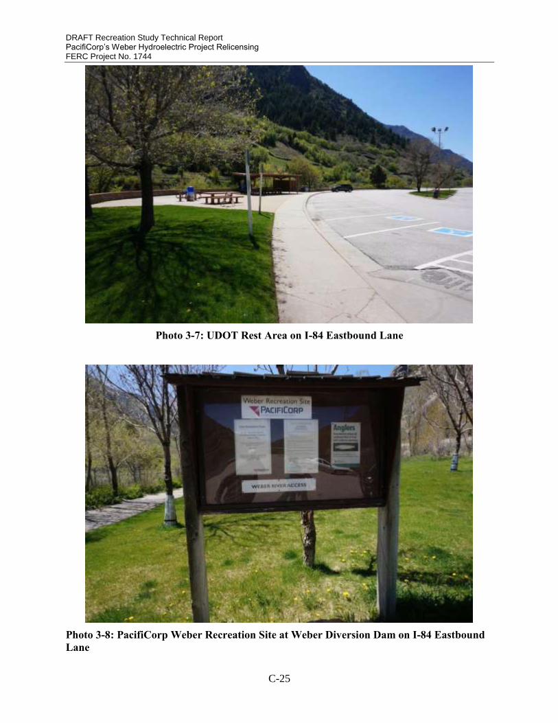
DRAFT Recreation Study Technical Report PacifiCorp’s Weber Hydroelectric Project Relicensing FERC Project No. 1744
C-25
Photo 3-7: UDOT Rest Area on I-84 Eastbound Lane
Photo 3-8: PacifiCorp Weber Recreation Site at Weber Diversion Dam on I-84 Eastbound
Lane
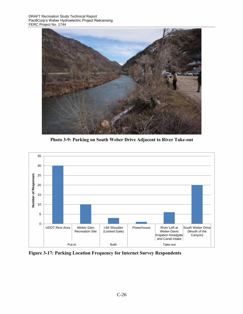
DRAFT Recreation Study Technical Report PacifiCorp’s Weber Hydroelectric Project Relicensing FERC Project No. 1744
C-26
Photo 3-9: Parking on South Weber Drive Adjacent to River Take-out
Figure 3-17: Parking Location Frequency for Internet Survey Respondents
0
5
10
15
20
25
30
35
UDOT Rest Area Weber DamRecreation Site
I-84 Shoulder(Locked Gate)
Powerhouse River Left atWeber-Davis
Irrigation Headgateand Canal Intake
South Weber Drive(Mouth of the
Canyon)
Put-in Both Take-out
Nu
mb
er
of
Re
sp
on
ses

DRAFT Recreation Study Technical Report PacifiCorp’s Weber Hydroelectric Project Relicensing FERC Project No. 1744
C-27
Photo 3-10: Gate Obstructing Access to Old Highway from I-84 Westbound Lane
The majority of boaters put-in on the study reach a short distance downstream from the Weber
diversion dam where the paved walking path terminates at the riverbank (Figure 3-18). River
access is not permitted directly downstream of the Weber diversion dam for safety and liability
reasons. Boaters are able to launch on a gravel bar approximately 200 meters downstream from
the dam (Photo 3-11). PacifiCorp employees have observed boaters launching in the Project
forebay. One focus group participant communicated they had paddled over the dam in the past.
The dam is not suitable for safe navigation (Photo 3-12) and paddling over it is discouraged by
PacifiCorp.
The majority of boaters take out on South Weber Drive, also known as the Mouth of the Canyon
(Figure 3-19). During the focus group, participants indicated this is the default location currently,
but it is not preferred because it requires paddling the 1.2 mile Class II-III section, Hell or High
Water, below Triple Drop, portaging around the Davis-Weber Irrigation Company Dam and
paddling another 0.75 mile Class II section that may be severely dewatered by irrigation flow
diversions.

DRAFT Recreation Study Technical Report PacifiCorp’s Weber Hydroelectric Project Relicensing FERC Project No. 1744
C-28
Photo 3-11: River Launch Downstream of Weber Diversion Dam
Photo 3-12: Weber Diversion Dam

DRAFT Recreation Study Technical Report PacifiCorp’s Weber Hydroelectric Project Relicensing FERC Project No. 1744
C-29
Figure 3-18: Put-in Location for Internet Survey Respondents
Figure 3-19: Take-out Location for Internet Survey Respondents
Focus group participants indicated that historically they accessed the study reach via the old
highway from the westbound lane on I-84. This access point was more convenient because
boaters could park in a single location to concentrate their paddling on the preferred Class IV
Horseshoe Bend section and Triple Drop without the need to do a vehicle shuttle between the
put-in and take-out. Boaters would typically park at the bottom of Horseshoe Bend and walk to
the top with their boats. This allowed boaters to take-out at the bottom of Triple Drop and walk a
short distance back to their vehicle. The proximity of parking adjacent to Horseshoe Bend was
conducive to boaters completing several laps in a 2 hour period.
UDOT eliminated this preferred access location by installing a locked gate restricting access to
the old highway from the westbound lane of I-84. Utah Highway Patrol tickets vehicles parked
0
5
10
15
20
25
30
35
Weber Diversion Dam (downstreamof the UDOT Rest Area, at Weber
Rec Site)
Top of Horseshoe Bend Rapid
Nu
mb
er
of
Resp
on
ses
0
5
10
15
20
25
30
Triple Drop River Left at Weber-Davis Irrigation
Headgate and CanalIntake
Abandoned Bridge atMouth of the Canyon
Nu
mb
er
of
Re
sp
on
ses

DRAFT Recreation Study Technical Report PacifiCorp’s Weber Hydroelectric Project Relicensing FERC Project No. 1744
C-30
on the I-84 shoulder, further eliminating walk-in access on the old highway. Focus group
participants commented that this loss of access has, in part, caused a decrease in the frequency of
use because of the shuttle now required combined with the increased length of the less desirable
Class II water and portage around the Davis-Weber Irrigation Company Dam.
The Davis-Weber Irrigation Company Dam obstructs downstream navigation (Photo 3-13).
Boaters typically portage on river right. Some boaters paddle through the diversion structure
under certain flow conditions. The river right gate was identified as the preferred route to
navigate due to the lack of retentive hydraulics and presence of rebar in the river left diversion
gate. For periods of time when the diversion gates are closed, river right was identified as the
better option to portage around. When operating, the irrigation canal can divert substantial
amounts of water, greatly reducing instream flows downstream of the Davis-Weber Irrigation
Company Dam and potentially impairing suitability for navigation.
A potential take-out location exists directly upstream of the Davis-Weber Irrigation Company
Dam on river left with vehicle parking. Access to this location via South Weber Drive is
currently restricted by a locked gate (Photo 3-14).
Photo 3-13: Davis-Weber Irrigation Company Dam Obstructing Downstream Navigation

DRAFT Recreation Study Technical Report PacifiCorp’s Weber Hydroelectric Project Relicensing FERC Project No. 1744
C-31
Photo 3-14: Gate Restricting Access to Davis-Weber Irrigation Company Dam Take-out
4. DISCUSSION The whitewater study focused on the 1.9-mile section of the Weber River between PacifiCorp’s
Weber diversion dam and powerhouse. Boaters are attracted to an approximate 0.3 mile section
within this 1.9 mile reach, which they call Horseshoe Bend. The Horseshoe Bend section
provides Class IV whitewater paddling opportunities. Boaters have been paddling this reach
since at least the mid-1970s. Historically, boaters were able to access the Horseshoe Bend
section directly, allowing them to concentrate their paddling on the higher gradient and more
difficult 0.3-mile section of the study reach. In essence, Horseshoe Bend presented a “Park and
Play” whitewater opportunity. However, in the past decade, UDOT restricted direct highway
access to Horseshoe Bend. Boaters must now access Horseshoe Bend in a more traditional river
running fashion, including an upstream put-in and a downstream take-out. The put-in and take-
out locations require a vehicle shuttle. Currently, boaters can park near the diversion and paddle
or walk down to the Horseshoe Bend section. The most common take-out location currently is
South Weber Drive downstream of the Davis-Weber Irrigation Company Dam and
approximately 0.75 mile downstream of the PacifiCorp powerhouse.
Internet survey participants identified 450 cfs as the minimum acceptable flow and an optimum
flow range from 600 – 1000 cfs. The minimum acceptable flow for focus group participants
ranged from 300 to 700 cfs while the range for optimum flows was 700 to 1200 cfs. Boaters
reference the USGS Gateway gage for real-time flow information. Flows at the Gateway gage
are approximately 300 cfs greater than flows in the Project study reach March through October.

DRAFT Recreation Study Technical Report PacifiCorp’s Weber Hydroelectric Project Relicensing FERC Project No. 1744
C-32
Flow preferences referenced in this report represent those available in the Project study reach
minus Project diversions.
Project operations, particularly in the months of April and May, cause a decrease in the number
of whitewater boating opportunities. The Project diverts 300 cfs to the Weber powerhouse when
instream flows at Gateway gage range from 450 to 750 cfs resulting in flows less than the
minimum acceptable in the Project study reach. Mean daily flows between 450 and 750 cfs at
Gateway gage occurred 13 and 26 days respectively in 2015 and 2016. Flows greater than 750
cfs at Gateway gage result in sufficient discharge in the Project study reach for whitewater
boating, while the Project is operating. Mean daily flows at Gateway gage exceeded 750 cfs 1
day in 2015 and 2 days in 2016. Focus group participants indicated that flow preferences for the
Horseshoe Bend reach are influenced by travel distance, competing boating opportunities, and
access. Individuals with a tolerance for lower minimum acceptable flows tended to live in closer
proximity to Horseshoe Bend. Boaters traveling longer distances tended to prefer a higher range
of flows. Focus group participants indicated that in years with below-normal precipitation, flow
preferences decreased due to the limited opportunities locally and regionally. Focus group
participants also indicated that the threshold for minimum acceptable and optimum flows is now
higher due to the changes in access that require boaters to paddle more of the study reach than
the preferred whitewater rapids at Horseshoe Bend. The 1.2-mile section below Triple Drop
rapid and the 0.75-mile section downstream of the Davis-Weber Irrigation Company Dam
require higher minimum acceptable and optimum flows than Horseshoe Bend. Focus group
participants commented that the Horseshoe Bend rapid offers a technical boating opportunity at
flows as low as 140 cfs. The current access situation has made it more difficult for boaters to
take advantage of these technical boating opportunities due to the requirements to paddle the
other sections of the river to reach the take-out location.
During the focus group session, boaters commented that the frequency of use has decreased
following UDOT’s access restrictions to Horseshoe Bend. According to focus group participants,
the current access restrictions require boaters to paddle the full 1.9-mile length of the study reach
plus the section of river downstream of the Davis-Weber Irrigation Company Dam. The sections
of the study reach directly upstream and downstream contain Class II-III whitewater difficulty
compared to Class IV for Horseshoe Bend and Triple Drop rapids. These easier sections require
more water to for a quality whitewater recreation experience compared to Horseshoe Bend. The
flows needed to run these sections occur with less frequency than the lower flows needed for the
Horseshoe Bend section.
Boating the Horseshoe Bend reach now requires two vehicles to shuttle between the put-in and
take-out, compared to historical access that allowed boaters to park adjacent to the bottom of the
Horseshoe Bend rapid in the middle of the study reach. The need to shuttle vehicles requires
advance planning and coordination of schedules with one or more boaters to use the resource.
This additional shuttling requirement has caused some focus group participants to lose interest in
Horseshoe Bend.
In order to reach the take-out location, boaters typically portage the Davis-Weber Irrigation
Company Dam. Under certain conditions when the diversion gates are open, paddlers can run the
right hand chute. When the Davis-Weber Irrigation Company Dam is diverting water flows will
be reduced substantially downstream compared to the Horseshoe Bend section. This requires
boaters to navigate the 0.75 miles to the take-out with flows typically below the minimum
acceptable. The combination of the portage and potential for low flow paddling conditions in this

DRAFT Recreation Study Technical Report PacifiCorp’s Weber Hydroelectric Project Relicensing FERC Project No. 1744
C-33
section between the Davis-Weber Irrigation Company Dam and the take-out has led to a decrease
in use according to some focus group participants.
Potential access improvements could be implemented at the Project study reach for river
recreation users. The historic direct access used by boaters to Horseshoe Bend from I-84 is
unlikely to be restored, due to UDOT safety restrictions. Vehicles travel in the west bound lane
of I-84 at speeds in excess of 75 miles per hour. Direct access to Horseshoe Bend would require
construction of an off and on-ramp to I-84. The site is physically constrained, eliminating the
viability of this option. The current put-in location at the Weber Recreation Site is suitable for
whitewater boaters to park vehicles and access the river. The current take-out location is not
suitable. A more desirable take-out location upstream of the Davis-Weber Irrigation Company
Dam is needed so boaters do not need to portage the diversion dam and paddle undesirable low
flow conditions to the take-out. A potential parking area is located on river left adjacent to the
Davis-Weber Irrigation Company Dam. Boaters could exit the river upstream of the Davis-
Weber Irrigation Company Dam and walk a short distance (approximately 200 yards) to their
vehicle.
Typically, a recreation needs analysis would include an assessment of the recreation
opportunities provided by an unregulated river, and then compare those to what might be
available in a post-Project regulated reach. As the study reach is heavily regulated, both by
upstream diversions and Project operations, and access to the study area is compromised by the
highway that was constructed after the Project was installed, separating impacts to recreation
(access, flows, Project operations) to the extent necessary to do a complete needs analysis is not
practical. Additionally, due to the run-of-river design and lack of water storage at the Weber
Hydroelectric Project, the Project cannot provide flows sufficient to augment recreation
opportunities without significantly compromising generation. However, the needs analysis
concluded the following:
Flow-dependent recreation opportunities occur on the Weber River (which is regulated
by upstream water storage and diversion projects beyond PacifiCorp’s control), including
the study reach, infrequently during the spring season;
These opportunities are hampered by a lack of safe and legal access and egress;
These limited recreation opportunities are affected by Project operations;
Opportunities exist to increase the annual frequency of whitewater boating opportunities
in the Project study reach when flows at Gateway gage are between 450 and 750 cfs;
Notification of planned of Project maintenance resulting in increased flow in the study
reach could be beneficial to the boating community;
PacifiCorp could participate in access agreements to improve access at the Davis-Weber
Irrigation Company Diversion directly downstream of the Weber powerhouse.

DRAFT Recreation Study Technical Report PacifiCorp’s Weber Hydroelectric Project Relicensing FERC Project No. 1744
C-34
5. REFERENCES American Whitewater. 2016. National River Database. Accessed: February 2016. Retrieved
from: https://www.americanwhitewater.org/content/Wiki/help:rivers:database/
Whittaker, D., B. Shelby, and J.T. Gangemi. 2005. Flows and Recreation: A Guide to Studies for
River Professionals. Washington, DC: Hydropower Reform Coalition.
Whittaker, D., B. Shelby, W. Jackson, and R. Beschta. 1993. Instream Flows for Recreation: A
Handbook on Concepts and Research Methods. Anchorage, AK: U.S. Department of
Interior, National Park Service.

WW-APPENDIXA
Whitewater Recreation and Access Internet Survey

1. Introduction
Weber River Hydroelectric Project, FERC No. 1744
Weber River Whitewater BoatingSurvey
Please read this before completing the survey.
This survey is part of PacifiCorp’s Weber Hydroelectric Project (Project) relicensing study to collect and organize information aboutwhitewater recreation use on the reach of the Weber River affected by the Project (Project Study Reach). Your participation in thesurvey will help to provide an understanding of the whitewater recreation opportunities on this reach of the river.
The extent of the study area is: the Weber River from the Weber Hydroelectric Diversion Dam near the UDOT Rest Area, to the takeoutlocation approximately 1.9 miles downstream adjacent to the Weber Project powerhouse and across from the Davis-Weber IrrigationCompany’s headgates and canal intake (Figure 1).
This study focuses on boating opportunities provided across a range of flow conditions based on the water available in the Weber Riverdownstream of the Project diversion. The United States Geological Service (USGS) Gateway gage is widely used by boaters andothers to determine the flow in the Project Study Reach. Flows in the Project Study Reach downstream of the Project diversion aretypically 300 cfs less than flows reported at the Gateway gage, when the Project is online. The Project typically operates when flowsare above approximately 100 cfs, but is not at full capacity until ~350 cfs.
In this survey you will rate the flows you boat in the Project Study Reach. Please complete this online survey for each date you boat (orhave boated) this reach on the Weber River. Trips from past years can be entered as well provided you know the date and time of tripand can report on your experience under those flow conditions. Information from repeat paddlers provides valuable comparativeinformation that helps to better understand the boatable flow range. Before completing the survey, please verify online the exactinstream flows for the day you were boating (USGS Gateway Gage No. 10136500 ).
Your participation in this survey is important to the study’s success. As you complete the survey, base your responses on your directexperience with this reach of the Weber River rather than guidebooks, group opinions or historic flow preferences. Also, encouragefellow boaters to participate in this study. The more responses we receive the more useful our results will be. Thank you for taking thetime to complete this short survey, your input is greatly appreciated. PacifiCorp will publish the results of this study in a technical reportthat will be filed with the Federal Energy Regulatory Commission and on our website at: http://www.pacificorp.com/es/hydro/hl/weber.html.
Click "Next" to begin the survey.
WW-A-1

Figure 1: Weber River Recreation Study Area.
WW-A-2

2. Background Information
Weber River Hydroelectric Project, FERC No. 1744
1. Your First and Last Name (for data sorting purposes only):*
Date:
MM
/
DD
/
YYYY
2. What was the date and time of this tripon this reach of the Weber River? (Pleasecomplete a new survey for each daypaddling. Trips from previous years can bereported as well where the date and timeof the trip are known.)
*
3. Gender?*
Male
Female
Age(yrs):
4. Age?
5. In general, how many days a year doyou spend whitewater boating?
1
2-5
6-10
11-20
21-30
31-50
>50
WW-A-3

Other, Please list
6. What type of watercraft did you use for this trip?*
Hardshell kayak
Inflatable kayak
Closed-deck canoe
Open deck canoe with floatation
Cataraft
Raft
Years:
7. How many years have you been using this type ofcraft?
8. How would you rate your skill level with this type of craft?
Novice (comfortable running Class II)
Intermediate (comfortable running Class III)
Advanced (comfortable running Class IV)
Expert (comfortable running Class V)
WW-A-4

3. Rating This Flow
Weber River Hydroelectric Project, FERC No. 1744
9. In general, how would you rate the whitewaterdifficulty on this reach at this flow?*
Class I
Class II
Class III
Class IV
Class V
Class VI
Not sure
Number of times I hit rocks and other obstacles (butdid not stop):
Number of times I was stopped after hitting rocks orother obstacles (but did not have to get out of my boatto continue downstream):
Number of times I had to get out to drag or pull myboat off rocks or other obstacles:
Number of times I had to portage around unrunnablerapids, log jams, or other obstacles:
10. Please estimate the number of hits, stops, boat drags and portages you had on this trip.
1. Totally
unacceptable2. Moderatelyunacceptable 3. Marginal
4. Moderatelyacceptable 5. Totally acceptable
Availability of technicalboating
Availability of powerfulhydraulics
Availability of whitewaterplay areas
Safety
Length of run
Number of portages
Overall rating
11. Please evaluate the flow volume during this trip for your craft and skill level for each of the followingcharacteristics. (choose one rating for each row)*
WW-A-5

12. Are you likely to return to boat this flow you just evaluated?*
Yes
No
13. In general, would you prefer a flow that was lower, higher or about the same as the flow on this trip?*
Lower flow
About the same flow
Higher flow
WW-A-6

4. Comparing Flows
Weber River Hydroelectric Project, FERC No. 1744
Gateway Gage(USGS 10136500)Flow (cfs):
14. What was the flow (cfs) at the USGS GatewayGage when you boated? *
Project Study Reach Flow: USGS Gateway Gage Flow – 300 cfs =
15. Determining flow in the Project Study Reach(method only applicable at flows greater than 350 cfs):Subtract 300 cfs from the USGS Gateway Gage flowyou provided in Question 14. Write that number in thespace below. That is the approximate flow in theProject Study Reach below the Weber Hydro Dam.
Example: 700 cfs at Gateway Gage – 300 cfs = 400cfs in the Project Study Reach
*
WW-A-7

1. Totally
unacceptable2. Moderatelyunacceptable 3. Marginal
4. Moderatelyacceptable
5. Totallyacceptable Don't Know
200 cfs
300 cfs
400 cfs
500 cfs
600 cfs
700 cfs
800 cfs
900 cfs
1000 cfs
16. For comparative purposes, please estimate the quality of the following flows in the Project Study Reachfor your craft and skill level. In making your evaluations, consider all the flow dependent characteristics thatcontribute to a high quality trip (WW challenge, WW play, safety and length of run). If you do not feelcomfortable evaluating a flow you have not seen, select Don't Know. Choose one rating for each flow.
*
cfs:
17. Using flows calculated for the ProjectStudy Reach, what is the minimum acceptable flow foryou on this run in cfs? The minimum acceptable is thelowest flow you would return to boat, not the minimumflow necessary to navigate.
*
cfs:
18. Using flows calculated for the ProjectStudy Reach, what is the optimum flow for you on thisrun in cfs?
*
WW-A-8
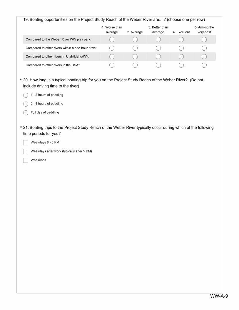
1. Worse than
average 2. Average3. Better than
average 4. Excellent5. Among the
very best
Compared to the Weber River WW play park:
Compared to other rivers within a one-hour drive:
Compared to other rivers in Utah/Idaho/WY:
Compared to other rivers in the USA::
19. Boating opportunities on the Project Study Reach of the Weber River are....? (choose one per row)
20. How long is a typical boating trip for you on the Project Study Reach of the Weber River? (Do notinclude driving time to the river)*
1 - 2 hours of paddling
2 - 4 hours of paddling
Full day of paddling
21. Boating trips to the Project Study Reach of the Weber River typically occur during which of the followingtime periods for you?*
Weekdays 8 - 5 PM
Weekdays after work (typically after 5 PM)
Weekends
WW-A-9

5. Access to the Weber River
Weber River Hydroelectric Project, FERC No. 1744
22. Where did you put-in?*
Weber Diversion Dam (located just downstream of the UDOT Rest Area, at Weber Rec Site)
Top of Scrambled Eggs Rapid (aka top of Horseshoe Bend)
Other, please name
23. Where did you take-out from the river?*
Triple bridges at bottom of Scrambled Eggs Rapid
Davis-Weber Irrigation Company’s headgates and canal intake on River Left across from Weber Powerhouse
Abandoned bridge at mouth of the Canyon
24. Did you do a single run on this date or multiple laps on this trip?*
Single run
Multiple laps (number of laps)
25. Where did you park your vehicle for this trip while boating? (check all that apply)*
UDOT Rest Area
Weber Dam Recreation Site
I-84 shoulder at locked gate
Powerhouse
South Weber Drive access road to Davis-Weber Irrigation Company’s headgates and canal intake on River Left
Abandoned bridge on South Weber Drive at mouth of the Canyon
Other (name)
WW-A-10

26. How many boating trips have you made to the Project Study Reach of the Weber River?*
0 times
1 to 5 times
6 to 10 times
11 to 20 times
More than 20 times
27. How many boating trips have you made to the Project Study Reach of the Weber River in the lasttwelve months?*
0 times
1 to 5 times
6 to 10 times
11 to 20 times
More than 20 times
28. Do you have comments on access to the Weber River for whitewater boating.
29. Do you have other comments about whitewater boating on the Weber River or general commentsabout flows for paddlers?
Email Address:
Phone Number (w/area code)
30. Thank you for participating in the Weber River Hydroelectric Project WhitewaterFlow Study. PacifiCorp will be hosting a focus group with the whitewater communityin the spring. If you would like to participate in the focus group please provide youremail and phone number so we can inform you of the time and location. Alternatively,you can contact Eve Davies at 801-220-2245 to indicate your interest in the focusgroup.

WW-APPENDIXB
Focus Group Email Invitation

FOCUS GROUP INVITATION
WEBER RIVER WHITEWATER STUDY
Thank you for participating in the Weber River Whitewater Boating Survey, and for indicating interest in
participating in the upcoming focus group. Focus group participants will help provide important
information on whitewater use patterns, flow preferences, access issues, and flow information for this
reach of the Weber River, which will complement data gathered through the online survey.
RSVP by Thursday, April 28: To participate in the Focus Group you must RSVP with Miriam Hugentobler
([email protected]) or (801) 652‐8983 by Thursday, April 28. Include your name, email
address, and phone number.
Space is limited for the Focus Group. Do not RSVP if you are uncertain on your attendance, otherwise
you potentially prevent a fellow boater from getting on the list. We will re‐confirm your ability to attend
in advance using the contact information provided in your response; alternate attendees will be notified
in the case of last‐minute cancellations.
Focus group meeting details:
Date: Tuesday, May 03, 2016
Time: 7 – 9 PM (Approximately 1.5 to 2 hours depending on boater input and discussion.)
Location: Ben Lomond Hotel, Browning Room 2510 S. Washington Blvd Ogden, UT
(downtown Ogden at the corner of 25th Street and Washington)
This study is part of the Federal Energy Regulatory Commission’s relicensing process for Weber River
Hydroelectric Project. The study reach is the section of the Weber River from the Weber Hydroelectric
Diversion Dam near the UDOT rest area to the takeout location approximately 1.9 miles downstream
WW-B-1

adjacent to the Weber Project powerhouse and across from the Davis‐Weber Irrigation Company’s
headgates and canal intakes.
For further information, please contact Eve Davies at [email protected] or 801‐220‐2245.
WW-B-2

WW-APPENDIXC
Focus Group Discussion Notes

WEBER RIVER RECREATION FOCUS GROUP
MAY 3, 2016, 7PM
John – introduction
Eve –
Relicensing introduction – ALP=consensus required.
Recreation study: Access changes in 2007 when highway was gated. FERC form 80 every 6 years. 20,000 visitors in 2014 (number of cars). Study will look at who recreators are, possible upgrades to user trail
o Q: consider whether data are accurate due to whether the water year is adequate for paddling.
o Eve: likely that WW use is a much smaller proportion than fishers. But, that’s what this WW study is for.
o Arnie: Access spot on 84-E right above the trestle bridge where the pipe goes over the river. They park between the highway and walk down to shoot in the cove. Not safe, pull off on left side of freeway.
o E: there’s enough concern by UDOT for accidents with pull outs on westbound pullout that they’ve asked highway patrol to ticket people.
o Argument about the 20k visitor use number due to the 2.3 multiplier because fishers only come in 1 generally.
o Bluehead sucker and Bonneville cutthroat trout (one of 2 fluvial populations) = ESA species on weber = fish passage is important in relicensing.
o Tusher dam in Green river – took out a lowhead dam and created a boat passage/fish ladder
o IBT water rights for BOR are attached to weber project water rights o Davis Weber is allowed to take entire river flow. o ISF 34-40 cfs o Comments asking about economics of the project, seeing no point to any modification
Focus Group
Flow information – using gateway gage minus weber hydro flow o Gateway gage is reference, only other is visual, Bill posts on FB o Used to be a rock upstream of davis weber that was used as a stage height gage, but it has
moved o Boaters weren’t sure what the flow was, but knew it was lower than gateway gage o
Access o Current parking locations
Park at PacifiCorp rec area, drop down to river at end of fence o Historic parking
Weren’t concrete barriers at the top – could previously drive right to the top
WW-C-3

Some parked right along the freeway and then walked behind the gate, then walked in with boats. Some never drove along the old highway. From here would just walk to top of horseshoe bend
Can run bend at much lower flow than the three drops – sometimes just do a couple laps of the bend
o Downstream access Pull out right of dam then walk around it Grout on rocks on right is relatively new – when they rebuilt from the blowoff
Immediately after the work it was loose – it has gotten more stable. Right hand gate is easier to run because its not retentive. Left has a retentive
hydraulic and maybe rebar. If you’re taking out river right, easier to do with right gate closed. When right gate is partially open, then can’t run it plus can’t portage on right.
Left portage is long.(Usually can run the little bit of river downstream to the mouth even with minimal water – and when its running enough to paddle isn’t necessarily during irrigation season.
At irrigation gate, sometimes can run just the stretch below the irrigation diversion in high water.
Typical takeout is near the abandoned bridge, park on south side o Parking
Sometimes do laps of horseshoe bend + ledges, particularly because it gets bony below
Many have only ever hiked back up to car, never set shuttle o Put in area has a high drug use problem
Usually cops wait at UDOT rest area then pull over drug users when they pull into PacifiCorp rec area
o Rapid names Highway bridge + boogey water = “pipe” area, class 2 Start of the bend, all runs together – no differentiation, just all called horseshoe
bend from top to railroad bridge
Upper section class 3 to 3+ (bumps up at 700, at 1000 is huge)
Play spot = a boof at higher flows (600 cfs) – middle class 4
Bottom section is more of a rock garden area, class 3-4 Generally scout at the bridge (or “trestle” Triple drop, called drop 1,2,3,
Class 3+ @ 200cfs
Class 4 @ 4-500
Most people say its always class 4.
This reach wouldn’t be safe for class 2-3 boaters; not safe for swimming, walking, etc.
Generally when there’s enough water in there to make it worth boating it’s a class 4 run.
Walk from the bottom of the third drop back to the old highway or carry on downstream
WW-C-4

Section between triple drop and weber powerhouse – hell or high water, surf waves in there at around 350-400 cfs, class 3
Irrigation dam to mouth – no name, class 2 with a class 4 portage and some pin potential
o Flow Flow in bypass reach only, but using gateway gage here. Minimum:
depends on the year and/or if there is boating elsewhere
gage 1500 for people to travel from SLC or PC, Arnie would drive up for 550-600 in gage, others gage 600-700.
In Ogden, gage 525, but only running the bend (or 550 on gage)
Can do the bend with about 140 in the bend as a rock slalom. Would not go below triple drop without 300 in bypass. (gage 440-600).
Optimum
1000 gage (usually Ogden is running then too, some prefer the Ogden)
750-850, maybe get nervous over that flow
1000-1500 for longer drives (longer drivers want more water)
Utah boaters cant be picky High/Challenge flow
2000 gage
3000 gage
You tube w/slow motion – 2900 gage
Some crazy people run it 4000-4500 (2011)
4000 gage 1984 Standard flow – what would you pick
1000-1500 gage
1200 gage
1000 gage o Whitewater Use patterns
Weekdays after work, weekends Since there are limited flows, usually not much choice Opportunistic but don’t take off work to run it. Boating trip 1-2 hours, or just one hour. Trips per year – whenever it flows. Not often Laps: 2 or 3 on bend, whole thing not usually done in laps.
o Comparison with local resources Horseshoe is the most technical and best ride of other sections of the weber. Mouth of Canyon to Riverdale could be worth running at high water (89 to
Riverdale, downstream of diversion dam) class 3+ at really high water – big waves, easy access. Uinta bridge class 4, rest class 3. 3500 cfs. (tier below scrambled eggs if it was in )
Ogden River Narrows way better than Horseshoe bend.
1.5-2 mile section – comparable to wild mile in big fork
WW-C-5

o At least 4 named drops o Class 3-4 o Irrigation release. Used to have a recreational release and a race.
Think the Ogden mayor cancelled it. All depends on level of Pineview reservoir.
Logan River
Staircase o About 1.5 hours from salt lake, 1 hour from Ogden o Section is really narrow, bony, ton of wood, lots of diversions,
finicky o People will boat it but not really worth boating o Weber better than Logan. If both were optimal flows, would
prefer weber.
Upper Logan good (12 miles) at high flows Bear River - Black Canyon
More dependable than weber. May only ever choose weber over bear if weber happens to be a great level and are expecting there to be multiple additional opportunities for the bear
Cottonwood Creek – outflow of Joes valley? Very unusual to run. Very flashy. Bear River Oneida – family section Most similar to Weber is upper stretch of Malad. Consistent flows on Weber
would greatly improve recreational boating on Wasatch o Is there a way for PacifiCorp to notify people if w/d might not be happening
Eve working with FERC on how to report this – also important to fishers. Could we get better, more accurate flow info that people could look up?
WW-C-6

WW-APPENDIXD
Focus Group Attendance

Weber Hydroelectric Project Relicensing Whitewater Boating Focus Group
Browning Room, Ben Lomond Hotel Ogden, UT May 3, 2016
Attending Name Organization Focus
Group Others
x Eve Davies PacifiCorp
x John Gangemi ERM
x Sandy Slater ERM
x Neal Artz Cirrus
x Matt Westover Cirrus
x Nate Hawkes Cirrus
x Miriam Hugentobler Project Coordinator
x Nathan Packham
x Alan McKean
x David Wolfgram
x Dawna Zukirmi
x Scott McKinstry
x Alan Clark
x Ryan Moore
x Gary Nichols
x Tanner Kadlec
x Bill Hunt
x Todd Clark
x Charlie Vincent
x Bryson White
x Jennifer Pemberton Reporter
13 8 TOTAL ‐ 21
WW-D-1

WW-APPENDIXEFocus Group Announcement
Weber River Whitewater Study—Focus Group May 3rd, Ogden, UT PacifiCorp is hosting a whitewater focus group for the Weber River Hydroelectric Project (Project), FERC No. 1744. Focus group participants will help provide an understanding of the whitewater boating opportunities and use patterns on the reach of the Weber River downstream of the Project diversion (Project Study Reach). ERM (Environmental Resources Management) will be conducting the focus group. Your input is needed on whitewater boating opportunities, use patterns, flow preferences, and access in the Project Study Reach. Please RSVP indicating your commitment to attend so we can reserve a seat for you. Space is limited. Date: May 3, 2016 Time: 7:00 PM to 9:00 PM Town: Ogden, UT Please RSVP to [email protected] or (801) 652‐8983 to reserve your seat at the focus group session and to receive the location information. The session will start promptly at 7pm; please arrive a few minutes early so we can start on time. The focus group session will begin with an overview of the Weber Hydroelectric Project and the whitewater reach on the Weber as well as instructions for your input during the focus group. It is imperative all participants receive the instructions. Late comers will not receive this instruction and disrupt the focus group session for other participants. Thank you, Eve Davies PacifiCorp
WW-E-1

WW-APPENDIXFFocus Group Background Survey

BACKGROUND INFORMATION Weber River Hydroelectric Project, FERC No. 1744
1. Name (used for data sorting purposes only): _______________________________________
2. What is the zip code of your permanent residence? _________________________________
3. Did you participate in the 2016 Weber River Whitewater Boating Internet Survey?
___Yes ___No
4. What is your age (yrs)?
___<20
___20-29
___30-39
___40-49
___50-59
___60-69
___70-79
___80-89
___>9
5. Please specify your gender. ___Female ___ Male
6. What type of watercraft do you typically use?
___Hardshell Kayak
___Inflatable kayak
___Closed-deck canoe
___Cataraft
___Open canoe with flotation
___Other, Please list ____________________________________
7. How many years have you been using this type of craft?
Years: ___
8. How would you rate your skill level with this type of craft?
___ Novice (comfortable running Class II)
___ Intermediate (comfortable running Class III)
___ Advanced (comfortable running Class IV)
WW-F-1
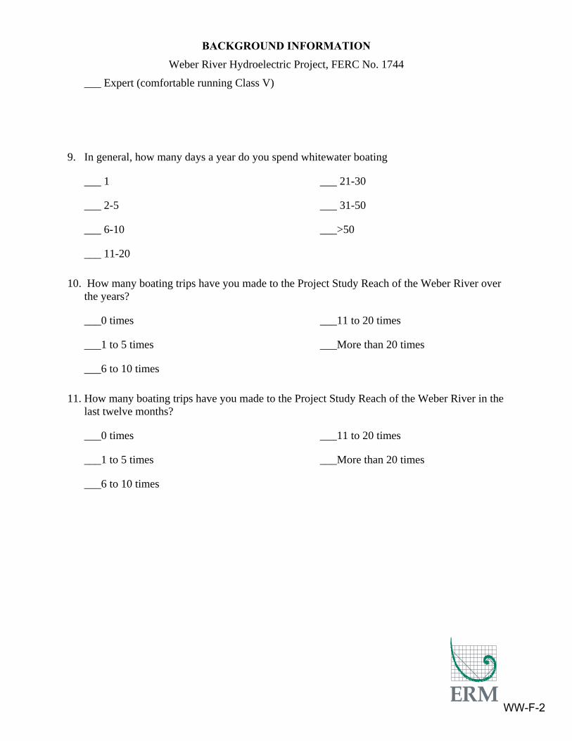
BACKGROUND INFORMATION Weber River Hydroelectric Project, FERC No. 1744
___ Expert (comfortable running Class V)
9. In general, how many days a year do you spend whitewater boating
___ 1
___ 2-5
___ 6-10
___ 11-20
___ 21-30
___ 31-50
___>50
10. How many boating trips have you made to the Project Study Reach of the Weber River over the years?
___0 times
___1 to 5 times
___6 to 10 times
___11 to 20 times
___More than 20 times
11. How many boating trips have you made to the Project Study Reach of the Weber River in the last twelve months?
___0 times
___1 to 5 times
___6 to 10 times
___11 to 20 times
___More than 20 times
WW-F-2