Draft Procedural Guidance for Developing...
101
DRAFT Procedural Guidance for Developing Solar Regional Mitigation Strategies Produced by: Bureau of Land Management The BLM is releasing for public viewing its draft Procedural Guidance for Developing Solar Regional Mitigation Strategies. The guidance is intended to help BLM managers in writing mitigation strategies for Solar Energy Zones as called for in the BLM Western Solar Plan. In March, the BLM released its Regional Mitigation Strategy for the Dry Lake Solar Energy Zone, a pilot effort that has informed the guidance that the BLM is releasing today. Today’s release builds upon efforts already undertaken by the BLM to reach a broad representation of stakeholders, including industry, state and local governments, Tribes, and local communities. A workshop on this topic was recently convened in Denver, CO. That workshop and other outreach efforts are not necessarily reflected in the draft being released today.
-
Upload
trinhquynh -
Category
Documents
-
view
218 -
download
0
Transcript of Draft Procedural Guidance for Developing...

DRAFT Procedural Guidance for
Developing Solar Regional Mitigation Strategies
Produced by: Bureau of Land Management
The BLM is releasing for public viewing its draft Procedural Guidance for Developing Solar Regional Mitigation Strategies. The guidance is intended to help BLM managers in writing mitigation strategies for Solar Energy Zones as called for in the BLM Western Solar Plan. In March, the BLM released its Regional Mitigation Strategy for the Dry Lake Solar Energy Zone, a pilot effort that has informed the guidance that the BLM is releasing today. Today’s release builds upon efforts already undertaken by the BLM to reach a broad representation of stakeholders, including industry, state and local governments, Tribes, and local communities. A workshop on this topic was recently convened in Denver, CO. That workshop and other outreach efforts are not necessarily reflected in the draft being released today.

DRAFT Procedural Guidance for Developing Solar Regional Mitigation Strategies
Produced by: Bureau of Land Management July 2014

Draft Procedural Guidance for Developing SRMSs – July 2014 Page ii
TABLE OF CONTENTS
TERMS AND DEFINITIONS ................................................................................................................. iiv
ABSTRACT .......................................................................................................................................... 1
1. INTRODUCTION AND PURPOSE ...................................................................................................... 2
1.1 Goals of a Solar Regional Mitigation Strategy........................................................................... 3 1.2 Elements of a Solar Regional Mitigation Strategy ..................................................................... 5 1.3 Application of Mitigation Hierarchy In Solar Regional Mitigation ............................................ 6
1.3.1 Avoidance and Minimization ........................................................................................... 6 1.3.2 Compensation for Unavoidable Impacts ......................................................................... 6
1.4 Integration with Other Elements of THE BLM’s Solar Energy Program .................................... 6 1.4.1 Regional Mitigation Policy ............................................................................................... 7 1.4.2 BLM’s Assessment, Inventory, and Monitoring Strategy ................................................ 7 1.4.3 Rapid Ecoregional Assessments ...................................................................................... 7 1.4.4 Existing Land Use Plans ................................................................................................... 8 1.4.5 Rangeland Health Assessments ...................................................................................... 8
1.5 Coordination with Others ......................................................................................................... 8 1.6 Relevant Authorities and Policy ................................................................................................ 9
1.6.1 National Environmental Policy Act .................................................................................. 9 1.6.2 Federal Land Policy and Management Act ...................................................................... 9 1.6.3 Endangered Species Act ................................................................................................ 10 1.6.4 National Historic Preservation Act ................................................................................ 10 1.6.5 Federal Advisory Committee Act .................................................................................. 11
1.7 Dry Lake Solar ENergy Zone Pilot Project ............................................................................... 11
2. SOLAR REGIONAL MITIGATION STRATEGY PROCESS ..................................................................... 13
2.1 Options for Developing Solar Regional Mitigation Strategies ................................................ 13 2.1.1 Precompetitive Lease .................................................................................................... 13 2.1.2 Land Use Planning ......................................................................................................... 13 2.1.3 Competitive Leasing or Project Authorization .............................................................. 13
2.2 Solar Regional mitigation strategy Team Composition, Roles, and Responsibilities .............. 14 2.3 Stakeholder Engagement and Tribal Consultation ................................................................. 15 2.4 Solar Regional Mitigation Strategy Elements .......................................................................... 17
2.4.1 Collect Baseline Data for Assessing Unavoidable Impacts (Element 1) ........................ 17 2.4.2 Assess Degree of Impacts and Identify Resources that May Warrant Regional
Mitigation (Element 2) .................................................................................................. 19 2.4.2.1 Evaluate Geospatial Trends .............................................................................. 21 2.4.2.2 Evaluate Rangeland Health Indicators ............................................................. 26
2.4.3 Identify Regional Mitigation Goals (Element 3) ............................................................ 27 2.4.4 Identify and Evaluate Appropriate Mitigation Locations, Objectives, and
Actions (Element 4) ....................................................................................................... 28 2.4.5 Recommendation of a Method for Calculating Mitigation Compensation
for Solar Energy Zones (Element 5) ............................................................................... 31 2.4.6 Recommendation of a Solar Regional Mitigation Fee Structure (Element 6) ............... 34 2.4.7 Develop Mitigation Monitoring and Adaptive Management Plan (Element 7) ............ 35
2.5 Solar Regional mitigation strategy Implementation ............................................................... 44
Draft Procedural Guidance for Developing SRMSs – July 2014 Page iii
3. REFERENCES ................................................................................................................................ 45
APPENDIX A: Memorandum of Understanding By and Between the BLM and the California Department of Fish and Game ............................................................................................. 49
APPENDIX B: Example Conceptual Models Developed for the Dry Lake Solar Energy Zone ..................... 55
APPENDIX C: Interdisciplinary Team Resource Evaluation Worksheet ...................................................... 59
APPENDIX D: Template Table for Potential Unavoidable Impacts that May Warrant Mitigation ............. 62
APPENDIX E: Mitigation of Impacts on Cultural Resources in Solar Energy Zones .................................... 64
APPENDIX F: Mitigation of Impacts on Visual Resources ........................................................................... 71
APPENDIX G: BLM Screening Matrix for Candidate Regional Mitigation Locations of Solar Energy Zones .................................................................................................................................... 96
FIGURES
Figure 2.4-1. Schematic diagram of solar regional mitigation strategy elements and steps. .................. 18
Figure 2.4-2. Conceptual diagram for estimating conditions and trends of conservation elements in the ecoregion for solar regional mitigation strategies. ................................... 22
Figure 2.4-3. Recommended steps for calculating per-acre mitigation fees. .......................................... 32
Figure 2.4-4. Example of a stratified, nonbiased sampling schema for the Dry Lake Solar Energy Zone. .................................................................................................................................... 41
Figure 2.4-5. Example of a stratified, nonbiased sampling schema for the Gold Butte Area of Critical Environmental Concern. .......................................................................................... 43
TABLES
Table 2.4-1. Examples of geospatial data for use in spatial evaluations of solar regional mitigation strategies. ........................................................................................................... 23
Table 2.4-2. Estimate (based on 2013 costs) of funding needed for management activities to ensure effectiveness and durability. ................................................................................... 34
Table 2.4-3. Recommended methods and measurements for core and contingent indicators. ............ 38
Table 2.4-4. Quantitative indicators and measurements relevant to the three attributes of rangeland health. ................................................................................................................ 39

Draft Procedural Guidance for Developing SRMSs – July 2014 Page iv
TERMS AND DEFINITIONS Additionality: The benefits of compensatory mitigation are demonstrably new and would not have resulted without the compensatory mitigation project. Avoidance mitigation: Avoiding the impact altogether by not taking a certain action or parts of an action. (40 CFR 1508.20(a)) (e.g. may also include avoiding the impact by moving the proposed action to a different time or location.) Compensatory mitigation: Compensating for the (residual) impact by replacing or providing substitute resources or environments. (40 CFR 1508.20(e)) Compensatory mitigation projects/actions: Specific, on-the-ground actions to improve and/or protect habitats (e.g. vegetation treatments, land acquisitions, conservation easements). Compensatory mitigation sites: The durable areas where compensatory mitigation projects will occur. Durability (protective and ecological): The administrative, legal, and financial assurances that secure and protect the conservation status of a compensatory mitigation site, and the benefits of a compensatory mitigation actions, for at least as long as the associated impacts persist. Minimization mitigation: Minimizing impacts by limiting the degree or magnitude of the action and its implementation. (40 CFR 1508.20 (b)) Residual impacts: Impacts from an authorized land use that remain after applying avoidance and minimization mitigation; also referred to as unavoidable impacts. Timeliness: The benefits from compensatory mitigation accruing as early as possible or before impacts have begun.
Draft Procedural Guidance for Developing SRMSs – July 2014 Page 1
ABSTRACT The draft “Procedural Guidance for Developing Solar Regional Mitigation Strategies” describes a framework for studying and preplanning compensatory regional mitigation to address potential unavoidable impacts due to full development of utility-scale solar generation facilities on BLM solar energy zones (SEZs). This report builds on the BLM solar energy mitigation hierarchy, specifically avoidance and minimization measures, as defined in the “Final Programmatic Environmental Impact Statement (PEIS) for Solar Energy Development in Six Southwestern States,” the “Approved Resource Management Plan Amendments/Record of Decision (ROD) for Solar Energy Development in Six Southwestern States,” and the BLM Draft Manual Section 1794, “Regional Mitigation.” This draft procedural guidance leverages cooperating agency, state, and local government input and public input on regional mitigation, including durability and accountability of mitigation investment, and incorporates lessons learned from the Dry Lake SEZ pilot project that was conducted from August 2012 to June 2013 in Clark County, Nevada. This report overviews BLM precompetitive lease, land use planning, and project authorization options and offers a step-by-step, yet iterative, process for developing solar regional mitigation strategies. Seven regional mitigation strategy elements are described and include: (1) collection of baseline data for unavoidable impact assessment, (2) degree of impact assessment in terms of regional conditions and trends, (3) development of mitigation goals, (4) evaluation of mitigation locations and actions, (5) recommendations for calculating SEZ mitigation compensation, (6) recommendations for mitigation fee management, and (7) mitigation monitoring and adaptive management.

Draft Procedural Guidance for Developing SRMSs – July 2014 Page 2
1. INTRODUCTION AND PURPOSE
The Bureau of Land Management (BLM) established a new solar energy program in 2012 with the issuance of the “Final Programmatic Environmental Impact Statement (PEIS) for Solar Energy Development in Six Southwestern States” (Final Solar PEIS) (BLM and DOE 2012) and the BLM’s subsequent record of decision (Solar PEIS ROD) (BLM 2012). Through the ROD, the BLM identified BLM-administered lands to be excluded from utility-scale solar energy development (about 79 million acres, or 319,702 km2). The Solar PEIS ROD also identified specific locations that are both well-suited for utility-scale solar production and have minimal environmental or cultural resource conflicts, where the BLM will prioritize and incentivize solar energy development. These priority areas are referred to as solar energy zones (SEZs) and total about 285,000 acres (1,553 km2). The Solar PEIS ROD also identified extensive programmatic and SEZ-specific design features (i.e., required mitigation measures that are part of the solar energy program) for utility-scale solar energy development on BLM-administered lands, including in SEZs. These design features, in addition to existing BLM right-of-way (ROW) authorization policies, build upon the careful siting of SEZs to further minimize conflicts by avoiding, minimizing, or mitigating for the adverse impacts of solar energy development.
The BLM anticipates that most potential adverse impacts from development in the SEZs can be
effectively identified, avoided, and minimized. Nonetheless, unavoidable impacts from utility-scale solar energy development on public lands may occur. Some of these will be relatively minor and will not impact the achievement of BLM resource and value objectives and, therefore, may not warrant mitigation. Other unavoidable impacts will warrant regional mitigation.
In the Final Solar PEIS and the Solar PEIS ROD, the BLM acknowledged the public’s remaining
concerns about addressing unavoidable adverse impacts. In response to these concerns, the BLM is systematically addressing regional mitigation opportunities by developing solar regional mitigation strategies (SRMSs) for each SEZ1. The BLM’s initial vision for addressing regional mitigation was presented in Appendix A, Section A.2.5 of the Final Solar PEIS. The intent of using the SRMS approach is to allow the BLM to pre-identify any unavoidable impacts from solar energy development in an SEZ that may warrant regional mitigation and to identify potentially appropriate regional mitigation locations and actions. As this approach is new, the BLM launched a pilot project to test, refine, and demonstrate a process for developing SRMSs based on the Dry Lake SEZ in Nevada. The goals of the pilot project were to develop (1) an SRMS for the Dry Lake SEZ and (2) guidance on how to develop SRMSs for other SEZs. This report constitutes the outcome of item 2.
The BLM issued its interim policy on regional mitigation, Instruction Memorandum Number
2013-142, and Draft Manual Section 1794, “Regional Mitigation,” on June 13, 2013 (referred to as the Regional Mitigation Manual in this document) (BLM 2013a). Instruction Memorandum 2013-142 outlines the interim policy for taking a regional approach toward mitigating project impacts and replaces the 2008 BLM offsite mitigation guidance issued in Instruction Memorandum 2008-204. The Regional Mitigation Manual presents a landscape-scale approach to anticipating future mitigation needs and opportunities to promote sustained yield on BLM-managed lands. This report follows the guidance of Instruction Memorandum 2013-142 and the Regional Mitigation Manual on how to develop SRMSs and incorporates public input and experience gained during the Dry Lake SEZ pilot project.
1 In the Final Solar PEIS (BLM and DOE 2012), Appendix A, Section A.2.5, the BLM referred to solar regional
mitigation plans (SRMPs). To be consistent with guidance issued in BLM Instruction Memorandum 2013-142 (BLM 2013a), the BLM adopts the terminology of solar regional mitigation strategies (SRMSs).

Draft Procedural Guidance for Developing SRMSs – July 2014 Page 3
This report uses the description of regional mitigation provided in the Regional Mitigation Manual, which is “Regional mitigation is a landscape-scale approach to mitigating impacts to resources and values managed by the BLM…. in order to provide for sustained yield of resources on the Public Lands. To achieve and sustain BLM resource and value objectives, it may be appropriate to compensate for the direct and indirect impacts of a BLM authorization by conditioning that authorization on the performance of mitigation outside the area of impact” (i.e., offsite or compensatory mitigation).
This report is specific to regional mitigation planning for utility-scale solar energy development
in SEZs but may inform other regional mitigation strategies on public lands. It presents information about SRMSs (including the BLM’s goals for these strategies), relevant authorities, and integration with other programs and initiatives. It also summarizes the activities conducted as part of the Dry Lake SEZ pilot project. 1.1 GOALS OF A SOLAR REGIONAL MITIGATION STRATEGY
The focus of SRMSs will be on those potential resource and value impacts that cannot be avoided or minimized to an acceptable level through onsite mitigation. The BLM will continue to place a priority on avoiding and minimizing impacts within each SEZ by implementing the design features identified in the Solar PEIS ROD and other project-specific mitigation requirements identified through subsequent National Environmental Policy Act (NEPA) analyses and decisions.
Historically, the BLM has considered and implemented mitigation outside the area of impact on a project-by-project basis in the absence of a larger context and clearly defined regional objectives. This approach will be improved upon through implementation of new regional mitigation policy. SRMSs will help the BLM implement this policy by setting the landscape context and defining regional objectives for mitigation occurring outside the area of impact. SRMSs will also help the BLM maximize the effectiveness of regional mitigation investments, better achieve conservation or other resource management outcomes, and provide greater certainty to developers. SRMSs will address potential regional mitigation opportunities at multiple levels (e.g., federal, state, and local) concurrently to avoid duplication and/or unintended consequences.
The goals of an SRMS are to:
• Develop a consistent, regional approach to identifying potential unavoidable impacts that may warrant regional mitigation through a transparent public process that is informed by engaging stakeholders2.
• Maintain incentives for project applicants to develop in SEZs by reducing uncertainty
about mitigation requirements associated with development in an SEZ; coordinating with other regulatory agencies; conducting tribal consultation; and potentially reducing the costs, complexity, and timeline associated with regional mitigation activities and project approvals.
2 Stakeholders in the Dry Lake SEZ SRMS pilot project included federal, state, and local governmental agencies;
nongovernmental organizations; industry and utility representatives; tribal government representatives; and members of the general public.

Draft Procedural Guidance for Developing SRMSs – July 2014 Page 4
• Use science-based criteria and expert/traditional knowledge consistent with U.S. Department of the Interior Secretarial Order No. 3305 (Secretary of the Interior 2010) to identify unavoidable impacts that may warrant mitigation, regional mitigation goals and priorities, and effective mitigation locations and/or actions.
• Recommend mitigation that is durable in terms of lasting impact on lands and resources.
• Identify mitigation strategies that are replicable across the solar energy program and
adaptable to differences in SEZs, individual projects, and technologies.
• Emphasize the mitigation hierarchy (see Section 1.3), including onsite avoidance and minimization requirements established in the Solar PEIS ROD.
• Recommend a method for calculating fair and equitable mitigation compensation
for authorizations in SEZs and potential mitigation fee management structures. Integrate regional mitigation into a long-term monitoring program, and support the BLM’s implementation of an adaptive management approach to solar energy development.
As stated above, the focus of SRMSs will be on unavoidable adverse impacts to the BLM’s
resources and values anticipated on each SEZ. The BLM does not expect, however, that all adverse or unavoidable impacts can or must be fully avoided or mitigated, either in an SEZ or outside the area of impact. A certain level of unavoidable adverse impacts may be acceptable. The BLM will identify the impacts that will not be mitigated during the project-level environmental analysis and in the decision document. As a part of the SRMS development process, the BLM will identify the degree of impacts to resources based on local, landscape, and regional conditions and the contribution to cumulative effects. The BLM’s process for recommending which unavoidable impacts may warrant regional mitigation is discussed in Section 2.4.2.
The draft SRMS approach is intended to streamline the BLM’s identification of regional mitigation requirements and reduce uncertainty associated with development in SEZs and, hence, provide an incentive to develop projects in SEZs. Developers considering projects on variance lands (i.e., outside SEZs) will need to work with the BLM to identify appropriate project-specific regional mitigation measures. These efforts may be informed by an SRMS, particularly when the variance lands are located within the same ecoregion as an SEZ for which an SRMS has been completed.

Draft Procedural Guidance for Developing SRMSs – July 2014 Page 5
1.2 ELEMENTS OF A SOLAR REGIONAL MITIGATION STRATEGY As informed by the Dry Lake SEZ SRMS pilot project, SRMSs should consist of the following elements3, which will be discussed in greater detail in Section 2.4:
1. A description of the SEZ and regional baseline conditions against which unavoidable impacts are assessed.
2. A preliminary assessment of the degree of impacts to resources and identification of
which potential unavoidable impacts may warrant regional mitigation.
3. The identification of regional mitigation goals based on the goals and objectives identified in approved resource management and/or land use plans.
4. The evaluation and recommendation of appropriate mitigation investment
locations, objectives, and actions (to be considered and further refined, as necessary, prior to lease offering).
5. The preliminary identification and recommendation of a method for calculating
mitigation compensation for unavoidable adverse impacts that potentially warrant mitigation (to be refined, as necessary, prior to lease offering or project-specific NEPA evaluations).
6. The preliminary identification and recommendation of a management structure to
hold and apply mitigation investment funds. 7. Planning for mitigation implementation and the development of long-term
monitoring and adaptive management recommendations to evaluate and maximize the effectiveness of regional mitigation actions.
3 In the Final Solar PEIS, the draft process for an SRMS included seven specific elements. While remaining
consistent with the intent of the draft process, the sequence and breakdown of these elements have been modified somewhat in this report to present a more straightforward methodology. In particular, although the transparent stakeholder engagement process is no longer included as a separate SRMS element, it has been retained as an overarching component of the SRMS development process.

Draft Procedural Guidance for Developing SRMSs – July 2014 Page 6
1.3 APPLICATION OF MITIGATION HIERARCHY IN SOLAR REGIONAL MITIGATION
When considering solar energy development authorizations in SEZs, the BLM will evaluate mitigation measures (see 40 CFR 1502.14(f)), including regional mitigation where appropriate. As explained in the Final Solar PEIS, the BLM’s solar energy program employs a mitigation hierarchy4 to address potential impacts from utility-scale solar energy development; the hierarchy consists of avoidance, minimization, and offset (or compensation) for unavoidable impacts. These are discussed in Sections 1.3.1 and 1.3.2.
1.3.1 Avoidance and Minimization
Avoidance is achieved by siting projects so as to avoid conflicts (e.g., by siting projects in an SEZ).
Avoidance of impacts within SEZs is further achieved through the identification of nondevelopment areas within SEZs. The Final Solar PEIS identified such nondevelopment areas within most of the SEZs; these areas included floodplains, wetlands, dry lake areas, and intermittent streams. More nondevelopment areas may be recommended during the SRMS process to be considered in project-specific NEPA analysis. The BLM should also consider avoidance of resource conflicts on a case-by-case basis when preparing SEZs or portions of SEZs for lease offering or when examining project-specific authorizations.
Minimization is achieved through the application of design features (i.e., required onsite
mitigation measures identified in the Solar PEIS ROD), best management practices, and other stipulations. However, not all impacts associated with solar energy development can be eliminated by avoidance and minimization. Some of these unavoidable impacts may warrant regional mitigation.
1.3.2 Compensation for Unavoidable Impacts
If impacts found to warrant mitigation remain after onsite mitigation (i.e., avoidance and minimization) has been applied, regional mitigation is recommended to compensate for the impacts. Developing a strategy for regional mitigation is intended to simplify the process for project-specific authorizations in SEZs. 1.4 INTEGRATION WITH OTHER ELEMENTS OF THE BLM’S SOLAR ENERGY PROGRAM The BLM intends to proceed with a competitive leasing process to facilitate solar energy development projects in SEZs and is currently undertaking a rulemaking process that should enhance the BLM’s regulatory authority for competitive leasing. The BLM’s advance notice of proposed rulemaking was published on December 29, 2011 (Volume 76, page 81,906 of the Federal Register). The BLM anticipates that a competitive process will capture fair market value for the use of SEZ public lands and will ensure fair access to leasing opportunities. The study of potential mitigation locations and actions in SRMSs will ultimately inform how parcels in SEZs are offered competitively (e.g., parcel size
4 In application of the mitigation hierarchy, forms of mitigation measures could include avoiding the impact altogether; minimizing the impact by limiting the magnitude of the action; rectifying the impact by repairing, rehabilitating, or restoring the affected environment; reducing or eliminating the impact over time by preservation and maintenance operations; and compensating for the impact by replacing or providing substitute resources or environments (BLM 2008a).

Draft Procedural Guidance for Developing SRMSs – July 2014 Page 7
and configuration, technology limitations, mitigation requirements, and parcel-specific competitive process). Further, the recommended mitigation compensation in SRMSs will be given consideration by the BLM when it initiates any competitive leasing process in SEZs or during project-specific NEPA analysis.
1.4.1 Regional Mitigation Policy
As previously discussed, the BLM issued interim policy on regional mitigation (Instruction Memorandum 2013-142), along with the Regional Mitigation Manual (BLM 2013a) on June 13, 2013. The Regional Mitigation Manual further defines the offsite mitigation policy issued in 2008 (Instruction Memorandum 2008-204) and promotes a regional approach to mitigation planning and implementation. The updated draft policy clarifies how the BLM should consider and apply mitigation to meet BLM multiple-use and sustained yield management principles while reducing short- and long-term impairment to the environmental quality of the public lands.
1.4.2 BLM’s Assessment, Inventory, and Monitoring Strategy In August 2011, the BLM issued the “Assessment, Inventory, and Monitoring Strategy for Integrated Renewable Resources Management” (AIM Strategy) for condition and trend monitoring of BLM-managed resources and lands (Toevs et al. 2011). A key objective of the AIM Strategy is to establish an approach that will ensure monitoring activities generate data that (1) can be used for multiple purposes at national, regional, and local (field office) levels and (2) are adequate to support informed, defensible land management decisions. The AIM Strategy provides guidance on the (1) development of management questions to guide long-term monitoring activities, conceptual ecological models, and statistically valid sampling frameworks; (2) development of effective and efficient information management systems; and (3) application and integration of remote sensing technologies. A second document issued in August 2011 provides detailed guidance on core indicators of terrestrial ecosystem conditions and methods for measuring those indicators (MacKinnon et al. 2011).
In the Solar PEIS ROD, the BLM committed to developing and incorporating a monitoring and adaptive management plan into its solar energy program to ensure that data and lessons learned about the impacts of solar energy projects will be collected, reviewed, and, as appropriate, incorporated into the BLM’s solar energy program in the future (Appendix A, Section A.2.4 of the Final Solar PEIS). The long-term solar monitoring and adaptive management plan will be based on the AIM Strategy. It is critical that the BLM monitor regional mitigation actions undertaken consistent with an SRMS in order to ensure their long-term effectiveness (discussed in Section 2.4.7). The monitoring of mitigation effectiveness will be integrated into broader solar long-term monitoring efforts.
1.4.3 Rapid Ecoregional Assessments The BLM is in the process of adopting a landscape-scale approach to managing resources on public lands. One component of this approach is the development of rapid ecoregional assessments (REAs). REAs were initiated in 2010 for a number of ecoregions, including the Mojave Basin and Range, Central Basin and Range, Sonoran Desert, and Chihuahuan Desert ecoregions. These four ecoregions encompass 15 of the 19 current SEZs5. The REAs, which are scheduled to be completed in 2013 and
5 The four SEZs located in Colorado fall in the Arizona/New Mexico Plateau ecoregion; an REA has not yet been
developed for this ecoregion.
Draft Procedural Guidance for Developing SRMSs – July 2014 Page 8
2014, synthesize existing information about resource conditions and trends within an ecoregion; highlight and map areas of high and low ecological value; consider potential future scenarios; and gauge the potential risk to these areas from climate change, wildfires, invasive species, energy development (including renewable energy), and urban growth. The REAs provide an important source of information needed to support the development of the SRMSs, including the assessment of baseline conditions within the SEZ and the region (see Section 2.4.1), determination of which unavoidable impacts may warrant mitigation (see Section 2.4.2), development of regional mitigation goals (see Section 2.4.3), identification and evaluation of appropriate mitigation locations, objectives, and actions (see Section 2.4.4), and recommendation of a method for calculating mitigation compensation (see Section 2.4.5).
1.4.4 Existing Land Use Plans The BLM’s land use plans (LUPs) (which include resource management plans) provide the basis for the BLM’s management decisions for defined areas. LUPs are created through a public process, using input from those who have an interest in the lands. In identifying potential unavoidable impacts that may warrant regional mitigation, the BLM will review existing LUPs and other land use planning documents, such as county-level documents (see Section 2.4.2), if available. The BLM will also use these documents to identify resource and value objectives for mitigation to establish regional mitigation goals (see Section 2.4.3). Where LUP revisions are underway or where appropriate, new resource management objectives and/or land use allocations may be recommended through SRMSs.
1.4.5 Rangeland Health Assessments
Rangeland health assessments are conducted and maintained by BLM field offices to evaluate rangeland health and to determine whether land management practices are maintaining land health standards. Land health standards are developed based on the following underlying fundamentals (BLM 2001):
• Watersheds are in, or are making significant progress toward, properly functioning physical condition, including their upland, riparian-wetland, and aquatic components; soil and plant conditions support infiltration, soil moisture storage, and the release of water that are in balance with climate and landform and maintain or improve water quality, water quantity, and timing and duration of flow.
• Ecological processes, including the hydrologic cycle, nutrient cycle, and energy flow, are
maintained, or there is significant progress toward their attainment, in order to support healthy biotic populations and communities.
• Water quality complies with state water quality standards and achieves, or is making
significant progress toward achieving, established BLM management objectives such as meeting wildlife needs.
1.5 COORDINATION WITH OTHERS Federal, state, and local agencies might have specific interests in the outcomes of regional mitigation planning and concurrent or overlapping regulatory authority. SRMSs should therefore address the issues and concerns of these agencies, as well as identify potential intersection with or
Draft Procedural Guidance for Developing SRMSs – July 2014 Page 9
duplication of mitigation requirements. In addition, it is likely that these agencies have relevant data and expertise that can be of value to the BLM in developing an SRMS.
To inform elements of the SRMS, the BLM should consult plans and relevant documents developed by other agencies in the region (e.g., U.S. Fish and Wildlife Service comprehensive conservation plans for wildlife refuges, the Nevada Wildlife Action Plan [NDOW 2012]). The BLM should also coordinate with and engage other agencies’ staff when developing SRMSs. When coordinating with other agencies in the development of an SRMS, it might be useful for the BLM to enter into a memorandum of understanding with the other parties. For an example, see Appendix A.
In addition, the BLM should include consultation with potentially interested and affected tribes in the development of SRMSs. This should be done through government-to-government meetings between the BLM and the tribes, SRMS meetings and webinars, and distribution of SRMS documents and presentations. The tribes should be notified and invited to participate in all stakeholder and public engagement opportunities. 1.6 RELEVANT AUTHORITIES AND POLICY
The BLM considers potential mitigation opportunities in its management of the public lands, consistent with NEPA, the Federal Land Policy and Management Act (FLPMA), and other applicable authorities and policy.
1.6.1 National Environmental Policy Act
NEPA requires federal agencies to “study, develop, and describe appropriate alternatives to recommended courses of action in any proposal which involves unresolved conflicts concerning alternative uses of available resources” (42 U.S.C. § 4332(2)(E)). Furthermore, NEPA was enacted to promote efforts that will prevent or eliminate damage to the human environment. In accordance, federal agencies are required to evaluate the potential impacts of their actions on the natural and human environment and identify all relevant, reasonable mitigation measures that could improve the project (Council on Environmental Quality, Forty Most Asked Questions Concerning CEQ's NEPA Regulations, March 23, 1981, Question 19b). The Council on Environmental Quality identifies mitigation in the NEPA process as measures to avoid, minimize, rectify, reduce, or compensate for environmental impacts (40 CFR 1508.20). The Department of the Interior promulgated its own NEPA implementation regulations in 43 CFR Part 46, addressing the analysis of mitigation measures in Section 46.130. Section 6.8.4 of the BLM Handbook H-1790-1 (BLM 2008a) provides guidance on the preparation of NEPA analyses, with specific discussion on the analysis of mitigation measures and their implementation.
The BLM initiated the Final Solar PEIS to comply with NEPA requirements to assess the potential
environmental, social, and economic effects of its new solar energy program and to amend LUPs to implement the program.
1.6.2 Federal Land Policy and Management Act
The use, occupancy, and development of public lands must be regulated by the Secretary of the Interior, subject to other applicable law, through easements, permits, leases, licenses, or other instruments (FLPMA §302[b]; 43 U.S.C. § 1732[b]). FLPMA requires the BLM to manage public lands “in a

Draft Procedural Guidance for Developing SRMSs – July 2014 Page 10
manner that will protect the quality of scientific, scenic, historical, ecological, environmental, air and atmospheric, water resource, and archeological values….” (FLPMA §102[a][8]). In accordance with FLPMA, the BLM can include mitigation requirements as terms and conditions in the authorizations it issues for appropriate use of public lands.
The BLM is authorized to collect fees to fund regional mitigation under FLPMA Section 307(c), 43 U.S.C. § 1737(c), and the Wyden Amendment, 16 U.S.C. § 1011(a)6. The Regional Mitigation Manual (BLM 2013a) addresses terms and conditions of fee collection under Section 1.6, D-20.
1.6.3 Endangered Species Act
The Endangered Species Act (ESA) is administered by the U.S. Fish and Wildlife Service (USFWS) and the Commerce Department’s National Marine Fisheries Service (NMFS). The USFWS has primary responsibility for terrestrial and freshwater organisms, whereas the NMFS has responsibilities for marine organisms. The ESA provides a program for the conservation of threatened and endangered plants and animals and the habitats in which they are found. Section 7 of the ESA requires that federal agencies, in consultation with the USFWS or NMFS, ensure actions that are authorized, funded, or carried out are not likely to jeopardize the continued existence of any listed species or result in the destruction or adverse modification of designated critical habitat of such species. Section 10 of the ESA also prohibits any action that causes “take”7 of any listed species, as well as the import, export, and trade of listed species. Compensation is one method federal agencies may implement to lessen or mitigate the effects of agency actions on threatened or endangered species listed under the ESA. Compensation is applied after all other possible mitigation measures (see mitigation hierarchy in Section 1.3), particularly avoidance, are considered and implemented. Requiring compensation as a mitigation measure, as defined by the Council on Environmental Quality, is a way to achieve the purposes of the ESA. The BLM is required to collect and provide remuneration fees to the USFWS for projects authorized, funded, or carried out that are likely to adversely affect species or habitats listed under the ESA.
In issuing the Solar PEIS ROD, the BLM complied with ESA requirements by submitting to the
USFWS a programmatic conservation assessment of the BLM’s solar energy program pursuant to Section 7(a)(1) of the ESA and a biological assessment under Section 7(a)(2) regarding the effects of designating the SEZs for solar energy development. On July 20, 2012, the USFWS issued a biological opinion and conservation review for the BLM’s solar energy program (USFWS 2012).
1.6.4 National Historic Preservation Act
The National Historic Preservation Act (NHPA) creates the framework within which cultural resources are managed in the United States. Section 106 of the NHPA defines the process for identifying and evaluating cultural resources and determining whether a project will result in an adverse effect on 6 The Wyden Amendment, 16 U.S.C. 1011(a), provides: “For fiscal year 1997 and each fiscal year thereafter
appropriations made for the Bureau of Land Management … may be used by the Secretary of the Interior for the purpose of entering into cooperative agreements with the heads of other Federal agencies, tribal, State, and local governments, private and nonprofit entities, and landowners for the protection, restoration, and enhancement of fish and wildlife habitat and other resources on public or private land and the reduction of risk from natural disaster where public safety is threatened that benefit these resources on public lands within the watershed.”
7 From Section 3(19) of the ESA, the term “take” means “to harass, harm, pursue, hunt, shoot, wound, kill, trap, capture, or collect, or to attempt to engage in any such conduct.”

Draft Procedural Guidance for Developing SRMSs – July 2014 Page 11
the resource. It also addresses the appropriate process for resolving (mitigating) adverse effects to historic properties. Section 110 of the NHPA directs the heads of all federal agencies to assume responsibility for the preservation of listed or eligible historic properties owned or controlled by their agency. Federal agencies are directed to locate, inventory, and nominate properties to the National Register of Historic Places; to exercise caution to protect such properties; and to use such properties to the maximum extent feasible. The NHPA establishes the processes for consultation among interested parties, the lead agency, and the state historic preservation office and also establishes processes for government-to-government consultation between U.S. government agencies and Native American tribal governments. During development of the Final Solar PEIS, a national solar programmatic agreement was issued between the BLM; the six state historic preservation officers from Arizona, California, Colorado, Nevada, New Mexico, and Utah; and the Advisory Council on Historic Preservation. The solar programmatic agreement establishes the process for NHPA Section 106 compliance for solar energy projects on BLM-administered lands.
1.6.5 Federal Advisory Committee Act The Federal Advisory Committee Act (FACA) creates an orderly procedure by which federal
agencies can seek advice and assistance from citizens and experts. The legislation was enacted to ensure that no particular interest groups would have unfair access to policymakers. It requires that when a federal agency intends to establish, control, or manage a group that gives advice as a group and has at least one member who is not a federal, tribal, state, or local government employee, the agency must comply with FACA and the related administrative guidelines. Depending on their nature and circumstances of creation, some collaborative community working groups may not qualify as an advisory committee under FACA (BLM 2005c). 1.7 DRY LAKE SOLAR ENERGY ZONE PILOT PROJECT In August 2012, the BLM launched a pilot project to test, refine, and demonstrate a process to develop a regional mitigation strategy for the Dry Lake SEZ in Nevada. The goals of the pilot project were to (1) develop an SRMS for the Dry Lake SEZ and (2) develop a report that addresses the lessons learned in the Dry Lake SEZ process to help guide the SRMS process for all the remaining SEZs. The Dry Lake SEZ pilot project was supported by BLM staff from the Colorado Front Range District Office, Washington D.C. Office, National Operations Center in Denver, Nevada State Office, Southern Nevada District Office, and Las Vegas and Pahrump Field Offices. Project technical support was provided by Argonne National Laboratory and the National Fish and Wildlife Foundation. The Dry Lake SEZ pilot project involved extensive engagement with individual stakeholders and stakeholder groups. The project was supported by a public information website8 and was announced via a news release, emails to the Solar PEIS subscriber list, and direct communication with specific stakeholder groups and members. Draft documents were shared with stakeholders via the project website and public workshops. In addition, the BLM invited tribal representatives of the nearby Moapa Band of Paiutes to participate in workshops and webinars and sent workshop materials to more than 10 tribes that might be interested in the outcome of the Dry Lake SRMS pilot project.
8 The Dry Lake SEZ Solar Regional Mitigation Planning Project website is available at:
http://www.blm.gov/nv/st/en/fo/lvfo/blm_programs/energy/dry_lake_solar_energy.html.
Draft Procedural Guidance for Developing SRMSs – July 2014 Page 12
The BLM held four public workshops in Las Vegas and several webinars (agendas, handouts, and
presentation materials from each meeting and webinar are available on the project website):
• August 2012 Workshop: The BLM introduced its goals for the SRMS approach, framework, and pilot project and provided an overview of the AIM Strategy and Dry Lake SEZ; individual stakeholders supplied information to the BLM about potential regional mitigation for the SEZ.
• October 2012 Workshop: The BLM hosted a field visit to the Dry Lake SEZ, provided
an overview of Mojave Basin and Range ecoregional assessments with The Nature Conservancy, and discussed how the BLM intended to identify unavoidable impacts that may warrant regional mitigation.
• December 2012 Webinar: The BLM provided an overview of potential regional
mitigation valuation methods and mitigation structures and discussion of their applicability to the Dry Lake SEZ SRMS.
• January 2013 Webinar: The BLM provided an overview of a potential methodology
for identifying unavoidable impacts that may warrant regional mitigation.
• January 2013 Workshop: The BLM described potential methods, tools, and outcomes for identifying (1) regional trends and unavoidable impacts that may warrant regional mitigation, (2) regional mitigation objectives, (3) mitigation locations and actions, (4) mitigation costing options, and (5) methods for monitoring and adaptive management to evaluate mitigation effectiveness.
• February 2013 Workshop: The BLM presented some preliminary options, and
individual stakeholders supplied the BLM with information about potential (1) mitigation fee valuation/costing, (2) regional mitigation objectives and priority setting, and (3) mitigation fee structures/pooled investment funds and implementation.
• March 2013 Webinar: The BLM presented (1) a preliminary methodology for
identifying potential mitigation fees, (2) a preliminary candidate location screening tool, and (3) draft outlines of the Dry Lake SEZ SRMS (BLM 2013c) and this report.
• May 2013 Webinar: The BLM presented (1) observations by the BLM Washington
Office regarding SRMSs, (2) an overview of lessons learned regarding the SRMS framework, and (3) next steps.

Draft Procedural Guidance for Developing SRMSs – July 2014 Page 13
2. SOLAR REGIONAL MITIGATION STRATEGY PROCESS
The Solar PEIS ROD (BLM 2012) requires that regional mitigation plans be developed for all SEZs (see Section 8 of the ROD). A conceptual framework was presented in the Final Solar PEIS (Section A.2.5) for developing these regional mitigation plans. This report outlines three options for informing future NEPA or planning decisions on SEZ mitigation requirements. For any option used to develop an SRMS, the BLM should implement the steps for developing an SRMS as identified in the Final Solar PEIS and described in the guidance presented in Section 2.4 of this report. 2.1 OPTIONS FOR DEVELOPING SOLAR REGIONAL MITIGATION STRATEGIES
This report outlines three options for the development of SRMSs for existing SEZs, as described in Sections 2.1.1 through 2.1.3. Option 1 is a precompetitive lease study and would result in recommendations to be considered in future NEPA analyses and decisions. Under Option 2, the SRMS would be conducted as part of a land use planning process, and Option 3 is a competitive leasing or project authorization analysis. Options 2 and 3 would be developed concurrent with NEPA analysis. In all cases, an SRMS is developed to inform a BLM decision consistent with NEPA and/or land use planning requirements.
2.1.1 Precompetitive Lease
Under this option, an SRMS would build upon the programmatic-level NEPA analyses for direct,
indirect, and cumulative impacts provided in the Final Solar PEIS and Solar PEIS ROD (BLM and DOE 2012; BLM 2012). The SRMS would be conducted prior to competitive leasing or additional NEPA analyses. The SRMS would not result in any decision but would provide recommendations for regional mitigation that could be analyzed, along with reasonable alternatives to the recommendations specified in the SRMS, as part of the required project-specific NEPA analysis for development in the SEZ. This option would inform future project-level decisions and/or future LUP revisions or amendments. This option was used for the pilot Dry Lake SEZ SRMS.
2.1.2 Land Use Planning
Under this option, an SRMS would be developed as part of an LUP amendment or revision. Developing an SRMS as part of a planning process (and the associated NEPA analysis) would allow the BLM to consider and incorporate elements of the SRMS into the BLM’s land use planning decision.
2.1.3 Competitive Leasing or Project Authorization
Under this option, an SRMS would generally be developed through a NEPA process associated
with a competitive lease or project authorization. Preparation of an SRMS under this option is intended to complement SEZ land use planning decisions established in the Final Solar PEIS and Solar PEIS ROD. NEPA analyses could evaluate restrictions on technologies and/or other restrictions intended to avoid or minimize impacts (e.g., water use restrictions). By combining the development of the SRMS with the competitive lease or project authorization, NEPA analysis would allow the BLM to consider and incorporate elements of the SRMS into the competitive lease or project authorization and any recommended mitigation locations and actions into the NEPA analysis and project authorization decisionmaking process.

Draft Procedural Guidance for Developing SRMSs – July 2014 Page 14
2.2 SOLAR REGIONAL MITIGATION STRATEGY TEAM COMPOSITION, ROLES, AND RESPONSIBILITIES The process of developing an SRMS will involve many, if not all, of the groups identified in this section. A summary of the potential roles and responsibilities of each group is provided. The BLM staff responsible for developing an SRMS should identify the key players in each of these groups and begin coordinating with them as early as possible in the SRMS process. BLM State, District, and Field Offices. Administrative priorities for SRMS development must be established at the state, district, and field office levels. Appropriate resources must be allocated, and reasonable schedules must be established. An interdisciplinary (ID) team should be established to engage resource specialists (see the next paragraph). The BLM assumes that SRMS documents will be coordinated and developed closely between all levels of the agency (i.e., at the Washington Office and state, district, and field office levels). However, for most SRMSs, decision authority will be assigned to the designated line manager or authorized officer; in the case of most SEZs, this will be the field office manager.
BLM Interdisciplinary Team. The ID team will be composed of those resource specialists at the state, district, and field office levels who have the relevant knowledge and expertise to support the analysis of (1) baseline conditions, including regional trends and conditions; (2) potential unavoidable impacts that may warrant regional mitigation; (3) regional mitigation goals; (4) appropriate mitigation locations and actions; and (5) mitigation fees. Members of the ID team should be available to engage with other technical resource specialists involved in the project, coordinating agency staff, and stakeholders throughout the SRMS process. ID team members will not be exclusively dedicated to the SRMS process. However, the SRMS is expected to take a considerable amount of their time, and they should be given direction on how to allocate their time among other responsibilities.
BLM Washington Office. The BLM Washington Office may play a critical role in establishing administrative priorities for developing specific SRMSs and in making policy decisions on issues that have implications and impacts across the BLM solar energy program or other programs. Washington Office staff may also provide expertise on specific technical issues. In particular, Washington Office staff supporting the BLM AIM Strategy, the REA process, and other landscape-scale resource management initiatives can provide valuable assistance to the SRMS process. Economists in the Washington Office may be able to assist specifically with efforts to identify mitigation fees and fee holding structures.
BLM SRMS Project Manager. A project manager needs to be identified and given adequate authority to lead the ID team, manage necessary technical specialists (e.g., other BLM experts, technical support contractors, non-BLM experts), and engage with stakeholders. The project manager will most likely be located in the district or field office; however, someone from the state office might also be tasked. The project manager will be responsible for identifying and communicating with coordinating agencies and stakeholders to ensure their engagement. The project manager also will be responsible for maintaining the budget and schedule of the SRMS process and for producing draft and final deliverables. Ideally, the project manager will be largely dedicated to the SRMS and have limited responsibilities to other projects.
BLM National Operations Center. Staff at the BLM National Operations Center may be able to
provide valuable technical assistance to the SRMS process, either by supplementing the expertise of the ID team or, in some cases, serving as an ID team member.

Draft Procedural Guidance for Developing SRMSs – July 2014 Page 15
Technical Support Contractors. The BLM may contract for technical support to assist the project manager and/or supplement the work of the ID team. This type of support would be particularly valuable if members of the ID team have substantial competing responsibilities.
Coordinating Federal, State, and Local Agency Staff. As discussed in Section 1.7, it is critical that other federal, state, and local agencies are involved in the SRMS process to ensure that (1) their issues and concerns are integrated into the regional mitigation goals and (2) relevant data and expertise in these agencies is incorporated into the process. Staff from these agencies should participate in the SRMS process at the level needed in order to support concurrence by their agency in the content of an SRMS. Tribal Governments. Government-to-government consultation, in accordance with the “Department of the Interior Policy on Consultation with Indian Tribes” (DOI 2011), should be conducted by the BLM for the SRMS process to ensure tribes are adequately informed and have a voice in the process. This will entail separate face-to-face meetings arranged by the BLM and the tribe or requested by the tribe, as well as invitations to all public meetings and webinars and access to all SRMS documentation. In addition to informing the BLM of potential concerns to be aware of in developing regional mitigation goals, tribes may also have access to relevant data and expertise that the BLM should consider. Stakeholders. The BLM is committed to developing SRMSs through a transparent process that engages stakeholders and is consistent with FACA requirements. It is recommended that stakeholders be given an opportunity to provide input on each element of an SRMS (see Section 2.3). Many stakeholders may have relevant data and technical expertise that the BLM should consider when developing an SRMS. Stakeholders should be invited to attend public meetings and webinars, review draft documents, and provide information to the BLM regarding the development of an SRMS. 2.3 STAKEHOLDER ENGAGEMENT AND TRIBAL CONSULTATION The process used to engage stakeholders in the Dry Lake SEZ SRMS pilot project is described in Section 1.7. For precompetitive lease SRMSs, use of a similar process, in accordance with BLM Handbook H-1790-1, is recommended. The process should include:
• Public Announcements: The BLM should issue press releases in local media concerning SRMS development, including public workshops and/or webinars.
• Email Notifications: At the start of the SRMS project, emails should be sent to the
BLM’s solar energy program project website subscriber list9, additional interested parties identified through comments received on the Final Solar PEIS, and specific stakeholders identified through state and/or local BLM offices. Additional emails should be sent announcing all workshops, field trips, webinars, and releases of documents using a project-specific email list targeting stakeholders specifically interested in the given SRMS.
9 The solar energy program website is available at: http://blmsolar.anl.gov.

Draft Procedural Guidance for Developing SRMSs – July 2014 Page 16
• Stakeholder Comment Process and Tools: The BLM should provide stakeholders with information on how and where to submit questions or comments and a point of contact (preferably the BLM project manager).
• Tribal Consultation: The BLM should consult potentially interested and affected
tribes with separate, focused communication, following protocols and using guidance from the local BLM field office’s tribal liaison.
• SRMS Website: The BLM should establish an SRMS website to provide stakeholders
with important project updates and to distribute documents for review.
• Timely Notification: The BLM should provide interested stakeholders with timely notification of SRMS events or new information.
The Dry Lake SEZ SRMS pilot project provided some important lessons regarding stakeholder
engagement; these lessons should be reviewed and incorporated into SRMS planning for other SEZs. Lessons learned include:
• Timing of Stakeholder Engagement and Distribution of Information: To use the stakeholders’ time most efficiently, the BLM should draft several elements of an SRMS before stakeholder engagement is begun. The elements that the BLM could draft before engaging stakeholders include the description of baseline conditions and site conceptual models, identification of potential unavoidable impacts and those impacts that may warrant mitigation, preliminary identification of regional mitigation goals, and, possibly, identification of potential mitigation locations and/or actions. Subsequently, stakeholders and the public should be given an opportunity to provide information and comments to the BLM about these and other elements of the SRMS.
• Location of Stakeholder Meetings: The location should be within close proximity
(less than 50 miles or within the nearest community) to SEZ locations. Field tours of the SEZ should be considered.
• Stakeholder Review Time: Stakeholders should be allowed adequate time to review
SRMS documents prior to and following workshops and webinars. The amount of time required will vary by the volume of material being reviewed, and the BLM should work with stakeholders to develop reasonable review periods, targeting a minimum of 2 weeks.
• Stakeholder Comments: Written stakeholder comments received during
preparation of the SRMS process should be shared with the entire stakeholder group in a timely manner (in accordance with provisions of the Privacy Act). Comment documents may be posted on the public SRMS website.
Draft Procedural Guidance for Developing SRMSs – July 2014 Page 17
2.4 SOLAR REGIONAL MITIGATION STRATEGY ELEMENTS As introduced in Section 1.2, the SRMS process consists of seven elements, which are discussed in the following sections. Step-by-step guidance has been provided for most of the elements. Figure 2.4-1 illustrates each of the elements and associated steps.
2.4.1 Collect Baseline Data for Assessing Unavoidable Impacts (Element 1) In order to determine the unavoidable impacts from solar energy development in SEZs that may warrant regional mitigation, the BLM should collect predevelopment baseline data at the SEZ and regional scale. Due to the large size of the SEZs and the scale of their distribution within the landscape, the BLM will assess regional conditions and trends in addition to SEZ-specific resource conditions and trends in order to evaluate the environmental impacts of solar energy development within SEZs.
Consistent with the BLM AIM Strategy (Section 1.4.2) (Toevs et al. 2011), applicable geographic areas are used to provide context for impact evaluations. These areas will vary by resource such that different geographic areas are relevant for different resources. Examples of geographic areas include ecoregions (e.g., Environmental Protection Agency Level III Ecoregions) for certain ecological resources, large watershed areas (e.g., Hydrologic Unit Code 4 watersheds) for water resources, or a buffer around the SEZ (e.g., 50-mile buffer around the SEZ) for other types of resources. Each of these geographic areas may be delineated to enable spatial analysis in a geographic information system (GIS). The steps in assembling baseline data for assessing unavoidable impacts from solar energy development in an SEZ include:
Step 1: Assemble and review data. The process for assessing the baseline condition of the regions around SEZs should incorporate information from BLM sources, including:
• The Draft and Final Solar PEIS (Since the Final PEIS presents an update of the Draft PEIS, with changes reflected in the environment and impact sections, both documents should be reviewed when assessing baseline conditions for an SEZ.).
• REAs.
• LUPs.
• Rangeland health assessments.
• Other BLM data and information.
Additional sources should also be reviewed as available, including, but not limited to:
• County habitat conservation plans (e.g., RECON, Clark County, and USFWS 2000).
• The Nature Conservancy ecoregional assessments (TNC 2013).

Draft Procedural Guidance for Developing SRMSs – July 2014
Page 18
Figure 2.4-1. Schematic diagram of solar regional mitigation strategy elements and steps.
Draft Procedural Guidance for Developing SRMSs – July 2014 Page 19
• Other agencies’ assessments of conditions (e.g., the Western Governors’ Association’s Crucial Habitat Assessment Tool).
• Scientific literature.
• County-level data.
• Ethnographic reports.
Applicable sources should be reviewed to identify key resources and processes in the region and
to summarize any trends in the status of those resources. This data review will be conducted by local BLM resource specialists (i.e., the ID team) and other BLM staff involved in the strategy’s development.
Under some circumstances, it may be possible and appropriate to coordinate development of an
SRMS in conjunction with an applicant’s preparation of an ESA Section 10 habitat conservation plan (e.g., when the SRMS is being prepared as part of a project authorization) (see Section 2.1.3).
Step 2: Assemble and review data for the SEZ. This step should be accomplished through (1) review of the PEIS data and other SEZ-specific reports (such as mineral potential reports, ethnographic reports, the Biological Opinion and Conservation Review [USFWS 2012], and site-specific biological surveys), (2) field visits, and/or (3) rangeland health assessments of the SEZs. Rangeland health assessments should be conducted in accordance with the methods outlined in BLM Handbook H-4180-1 (BLM 2001). Step 3: Develop a preliminary conceptual model. The baseline data compiled to characterize the region of the SEZ should be used by the BLM ID team and the technical support contractor to develop draft regional conceptual models, which can subsequently be refined to incorporate conditions in the SEZ and assess unavoidable impacts (see Section 2.4.2). Conceptual models depict the current understanding of the interrelationships between key ecosystem components, processes, and stressors and describe the role that resources, individually and in concert with one another, play in the function of the relevant ecological, social, and cultural systems present in the region. Using these models, interactions between human activities (e.g., solar energy development) and environmental resources can be illustrated to better understand the possible relationships of impacts related to solar energy development. These models can also provide the context to identify critical resources at the local scale near the SEZ. Appendix B presents conceptual models that were developed for the Dry Lake SEZ SRMS pilot project.
2.4.2 Assess Degree of Impacts and Identify Resources that May Warrant Regional Mitigation (Element 2)
This evaluation is conducted primarily by the ID team. The ID team may be supplemented with
additional resource specialists from other federal agencies and should consider input from stakeholders. The evaluation should include consideration of whether the degree of impact will limit the BLM’s ability to achieve its sustained yield resource and value objectives through onsite mitigation alone (BLM 2013a). It is recommended that the results of this evaluation be summarized for review by stakeholders; an example resource evaluation worksheet is provided in Appendix C. The summary should explain the rationale for the BLM’s recommendations for mitigation. The ID team should conduct the following steps in identifying impacts that warrant regional mitigation:
Draft Procedural Guidance for Developing SRMSs – July 2014 Page 20
Step 1: Review the potential impacts of solar development. The assessment of unavoidable impacts and determining which impacts potentially warrant mitigation will generally start with the ID team reviewing the Solar PEIS impact assessment and any other relevant environmental impact analyses. The Solar PEIS regional-scale impact assessments of each SEZ can be used to guide the development of a more defined, detailed, and accurate understanding of the impacts of solar energy development within each SEZ. Other impact assessments (e.g., those captured in BLM LUPs) and BLM expert knowledge should also be relied upon to develop a refined understanding of the potential impacts. The impacts assessment should be inclusive of multiple resources (e.g., ecological, cultural, visual, recreation, other land uses, and socioeconomics). The ID team should then summarize the potential impacts to all resources and values that could occur due to utility-scale solar energy development in the SEZ.
Step 2: Review design features and additional mitigation and minimization measures. In Step
2, the ID team should determine which of the potential impacts might be effectively avoided or minimized through application of (1) additional avoidance measures within the SEZ (e.g., preliminary identification of additional existing ROWs or environmentally sensitive areas as nondevelopment areas for consideration in subsequent NEPA analysis), (2) the identified programmatic and SEZ-specific design features established in the Solar PEIS ROD (BLM 2012), and/or (3) additional minimization measures (e.g., additional best management practices for minimizing impacts not identified in the Solar PEIS). Step 1 and Step 2 are iterative. Any additional minimization measure identified should be considered in subsequent NEPA analysis.
Step 3: Evaluate other relevant laws and regulations. The ID team will evaluate requirements of federal environmental laws and regulations promulgated under various authorities (e.g., FLPMA, ESA, NHPA) as related to mitigation. For example, unavoidable impacts to threatened or endangered species will be addressed in accordance with requirements of the ESA.
Step 4: Evaluate degree of impacts and whether they may warrant regional mitigation. The potential impacts that remain after Step 2 constitute the unavoidable impacts. In order to recommend which of the potentially unavoidable impacts may warrant regional mitigation, the ID team should examine the unavoidable impacts in the context of (1) problematic regional trends for the condition of each resource, consistent with the BLM AIM Strategy (Toevs et al. 2011) (see Sections 2.4.2.1 and 2.4.2.2); (2) resource management goals and objectives defined in BLM decision documents (e.g., LUPs and habitat conservation plans); (3) management objectives of coordinating federal, state, and local agencies; and (4) other factors, such as the existing condition of the SEZ . The ID team will assess and make recommendations about whether regional mitigation may be appropriate to address some unavoidable impacts. The results of and rationale for this assessment should be summarized in a table for unavoidable impacts that may warrant mitigation (see Appendix D for a template). Specific methods for assessing unavoidable impacts that may warrant regional mitigation for cultural resources and visual resources are discussed in Appendices E and F, respectively.
Regarding the identification of problematic regional trends (Step 4, Criterion 1), a combination of qualitative and quantitative approaches exist for evaluating problematic regional trends in resource conditions, including (1) geospatial analyses and (2) evaluation of rangeland health assessments, to determine whether land health standards are being maintained. These two approaches may be complementary to one another and are summarized below.
Draft Procedural Guidance for Developing SRMSs – July 2014 Page 21
2.4.2.1 Evaluate Geospatial Trends
Geospatial datasets provide a systematic evaluation of the conditions and trends of resources and values across a region. These types of evaluations of resources and values allow for an understanding of problematic regional trends and identification of those resources in the vicinity of the SEZ that are of regional importance. Depending on the region, the resources and values included in these assessments may include, but are not limited to, important plant and animal habitats and populations; key ecological systems or conservation elements10; highly erodible soils; populations of wild horses and burros; scenic viewsheds; and designated sites of natural, historical, or cultural significance.
The geospatial conditions and trends evaluation consists of three primary steps: (1) collect geospatial data; (2) assess condition; and (3) assess trends. These steps are illustrated in Figure 2.4-2.
Step 1: Collect geospatial data. The geospatial data used in this evaluation need to be collected from multiple sources. The data should be at a landscape scale sufficient to characterize conditions and trends in a broader regional context. The geospatial data that are useful for this type of assessment are available from a variety of open sources. These data include modeled land cover types, species-specific habitat suitability models, and BLM REA data, such as landscape condition models (i.e., landscape intactness model), climate change scenario models, and biodiversity datasets. A list of example geospatial data sources that may be used in the condition and trend assessment is provided in Table 2.4-1.
Step 2: Assess condition. After the data have been compiled in a GIS, the condition of each resource or value needs to be determined on the basis of its distribution (1) across the ecoregion, (2) within the vicinity of the SEZ, and (3) within the SEZ developable area. Condition may be represented as a unit of area (e.g., acreage) or as a percentage of the total distribution in the region or ecoregion. GIS-based approaches using environmental planning software may support condition characterization by incorporating multiple GIS datasets on ecological values and distributions (e.g., Marxan – Ball, Possingham, and Watts 2009; Zonation – Moilanen et al. 2012; Panda – Riolo 2005; LINK – USGS 2011).
10 Conservation elements, as defined in BLM REAs (e.g., Mojave Basin and Range REA [NatureServe 2013]), are
resources of conservation concern that may include habitat or populations of plant and animal taxa (e.g., threatened and endangered species) and ecological systems and plant communities of regional importance.

Draft Procedural Guidance for Developing SRMSs – July 2014 Page 22
Figure 2.4-2. Conceptual diagram for estimating conditions and trends of conservation elements in the ecoregion for solar regional mitigation strategies.

Draft Procedural Guidance for Developing SRMSs – July 2014
Page 23
Table 2.4-1. Examples of geospatial data for use in spatial evaluations of solar regional mitigation strategies.
Dataset Data Type Data Description Sources
Boundary Datasets B1 Regional boundary This dataset depicts the regional extent for evaluating impacts,
determining ecosystem condition and intactness, and identifying mitigation locations. The ecoregional boundary is often used as the regional boundary. Ecoregion boundaries are used in various ecoregional assessments.
BLM REA
B2 Solar project area This dataset depicts the development footprint of the solar energy project. This footprint may be developed by a project proponent, or it may include areas already identified as having high potential for solar energy development (e.g., BLM solar energy zones). BLM solar energy zones were designated in the Solar PEIS ROD.
Final Solar PEIS
B3 Areas with potential for solar energy development (i.e., variance lands)
This dataset depicts areas with potential for solar energy development on BLM lands. These lands are referred to as variance lands in the Final Solar PEIS. These lands are those that have landscape features and solar insolation values appropriate for solar energy development. This dataset may be used to identify future solar energy development areas, as well as regional mitigation locations with similar landscape features.
Final Solar PEIS
Conservation Element Datasets CE1 Land cover types These data depict the vegetative and nonvegetative land cover types in
the ecoregion. Land cover datasets are usually raster datasets with each pixel in the ecoregion representing a unique land cover type. This dataset can be used to determine the number of coarse filter land cover types in the project area and the relative amount of each of these land cover types compared to their distribution in the ecoregion.
Gap analysis programs (e.g., Southwest Regional Gap Analysis Project)
CE2 Distribution and habitat suitability models for threatened, endangered, rare, and regulated species.
These fine filter conservation element data represent available spatial data on the distribution and habitat suitability of threatened, endangered, rare, and regulated species in the ecoregion and, if applicable, in the project area. Depending on the location and the level of previous field work and modeling in the area, it is possible for no data to exist in a certain area, or it is possible for multiple datasets to exist for multiple species. These data may be available as raster or vector data.
BLM REA, Gap analysis programs, state and federal natural resource agencies

Draft Procedural Guidance for Developing SRMSs – July 2014
Page 24
Dataset Data Type Data Description Sources CE3 Status assessment for
ecological conservation elements
Status assessments are generally performed in the BLM's REA of each conservation element. The status assessment provides a rating (low, medium, high) to describe the status of each element in the ecoregion. The status assessment in the BLM REA is based on NatureServe's ecological integrity framework. Status assessments in the BLM REA are available for coarse filter (e.g., land cover) and fine filter (e.g., species) conservation elements.
BLM REAs, The Nature Conservancy, ecoregional assessments, and other sources
CE4 Biodiversity This dataset(s) illustrates the aggregate number of conservation elements in an area, which may be represented in a uniform grid or by watershed.
BLM REAs, The Nature Conservancy ecoregional assessments, and other sources
Change Agent Datasets CA1 Current human
development footprint This raster dataset represents current human developments in the ecoregion.
BLM REAs, The Nature Conservancy ecoregional assessments, and other sources
CA2 Future human development footprint
This raster dataset represents near future (approximately 2025) human developments in the ecoregion based on projected rates of human expansion and renewable energy development.
BLM REAs and other sources
CA3 Future potential climate change
This raster dataset represents areas of higher and lower potential for climate change impacts. It may be developed from models that integrate changes in precipitation, runoff, natural vegetation, and/or temperature.
BLM REAs, U.S. Geological Survey, Intergovernmental Panel on Climate Change, and other sources
CA4 Future potential fire change This dataset represents areas of future increased or decreased potential for human or naturally caused fires.
BLM REAs, LANDFIRE database, and other sources
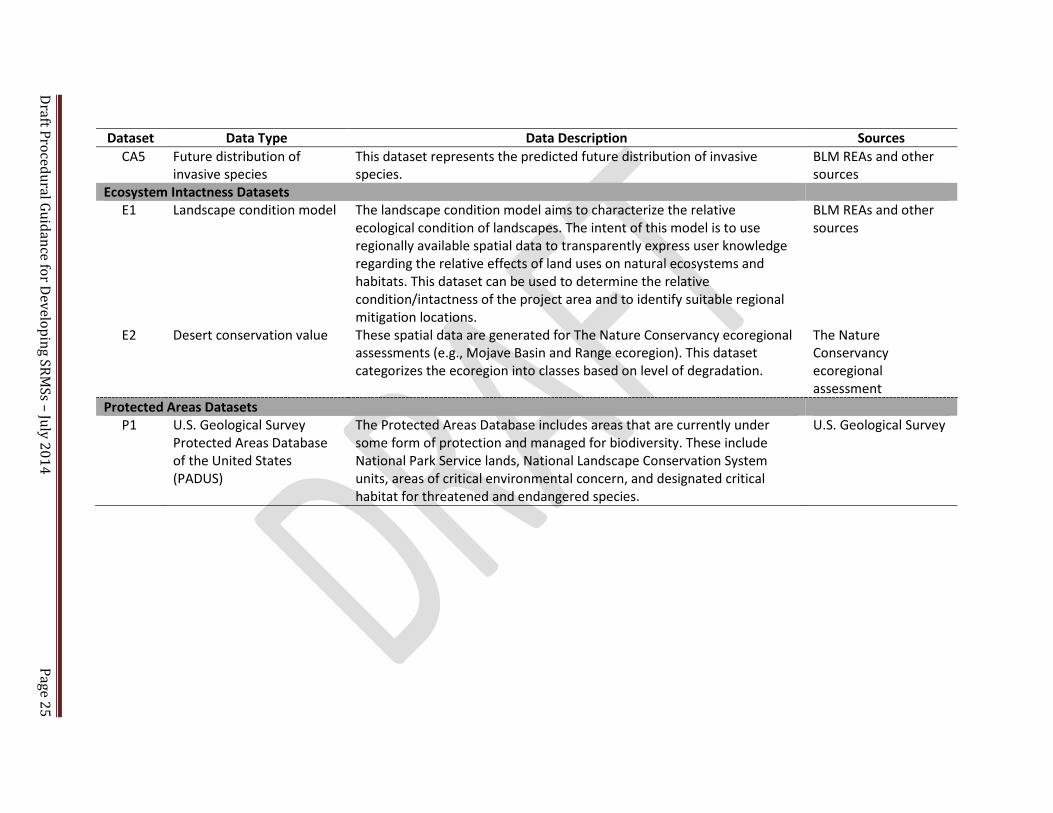
Draft Procedural Guidance for Developing SRMSs – July 2014
Page 25
Dataset Data Type Data Description Sources CA5 Future distribution of
invasive species This dataset represents the predicted future distribution of invasive species.
BLM REAs and other sources
Ecosystem Intactness Datasets E1 Landscape condition model The landscape condition model aims to characterize the relative
ecological condition of landscapes. The intent of this model is to use regionally available spatial data to transparently express user knowledge regarding the relative effects of land uses on natural ecosystems and habitats. This dataset can be used to determine the relative condition/intactness of the project area and to identify suitable regional mitigation locations.
BLM REAs and other sources
E2 Desert conservation value These spatial data are generated for The Nature Conservancy ecoregional assessments (e.g., Mojave Basin and Range ecoregion). This dataset categorizes the ecoregion into classes based on level of degradation.
The Nature Conservancy ecoregional assessment
Protected Areas Datasets P1 U.S. Geological Survey
Protected Areas Database of the United States (PADUS)
The Protected Areas Database includes areas that are currently under some form of protection and managed for biodiversity. These include National Park Service lands, National Landscape Conservation System units, areas of critical environmental concern, and designated critical habitat for threatened and endangered species.
U.S. Geological Survey

Draft Procedural Guidance for Developing SRMSs – July 2014 Page 26
Step 3: Assess trends. The next step in the assessment is to evaluate past and predicted future resource and value trends by conducting a geospatial overlay analysis between the historical and current conditions of focal resources and values and historical, proposed, and/or anticipated future human developments in the ecoregion. Future development scenarios may be modeled independently, or they may be obtained from existing sources. For example, the BLM REAs provide current and future human development footprints that can be used in the trends analysis as shown in Figure 2.4-2.
Beyond establishing a baseline understanding, one use of the results of the conditions and trends assessments is to form a systematic and quantitative understanding of resource vulnerabilities in the ecoregion. Resources and values that exhibit the most vulnerability and will potentially be impacted by development on the SEZ may warrant regional mitigation.
2.4.2.2 Evaluate Rangeland Health Indicators
Consistent with BLM Handbook H-4180-1 (BLM 2001) and the AIM Strategy (Toevs et al. 2011), the evaluation of rangeland health indictors may provide an understanding of the condition and trend of resources and values, how resources and values may be affected by solar energy development, and whether impacts to these resources and values warrant regional mitigation.
An example protocol for interpreting rangeland health indicators is discussed in Pellant et al.
(2005). Some indicators that can be qualitatively or quantitatively evaluated to characterize problematic trends and important resources include the similarity index (range condition) and trend studies. The similarity index can be used as an index of the current plant community in relation to the historic climax plant community or desired plant community. Trend studies characterize the directional change in the current plant community and soils in relation to the community that existed in the past and/or in relation to the desired plant community (Pellant et al. 2005). Three key ecosystem attributes of sustainable terrestrial ecosystems, as measured by rangeland health indicators, provide a fundamental basis for how the BLM can evaluate ecosystems at multiple scales (Toevs et al. 2011). The three attributes are:
1. Soil/Site Stability: The capacity of an area to limit redistribution and loss of soil resources (including nutrients and organic matter) by wind and water.
2. Hydrologic Function (Water Cycle): The capacity of an area to capture, store, and
safely release water from rainfall, runoff, and snowmelt; to resist a reduction in this capacity; and to recover this capacity when a reduction does occur.
3. Biotic Integrity: The capacity of the biotic community to support ecosystem
processes within the normal range of variability, to resist a loss in the capacity to support these processes, and to recover this capacity when losses do occur. The biotic community includes plants, animals, and microorganisms occurring in terrestrial and aquatic environments.

Draft Procedural Guidance for Developing SRMSs – July 2014 Page 27
2.4.3 Identify Regional Mitigation Goals (Element 3)
The BLM’s goal for SRMSs, at the broadest level, is to recommend actions to offset the unavoidable adverse impacts that warrant regional mitigation in order to restore, enhance, and/or preserve the impacted resources and values elsewhere in the region. Another equally important goal of the solar energy program is to identify appropriate regional mitigation measures that do not remove the incentive for solar energy development in the SEZs (see Section 1.1). The BLM will need to balance these goals, to the extent possible, in the process of identifying any recommended mitigation fee (Section 2.4.5).
For unavoidable impacts to ecological resources that the BLM recommends as possibly warranting regional mitigation, the BLM will develop mitigation goals for the affected ecosystem. Restoration, enhancement, and preservation of ecosystems can result in multiple benefits, including benefits for habitat of special status species animals and/or plants, visual resources, cultural resources, etc. Restoration, enhancement, and preservation of an ecosystem benefits the individual components (such as soil, water, air, wildlife, vegetation), the services they provide (such as nutrient cycling, soil stabilization, and the ability to resist the establishment of invasive species), and the human elements they support (such as visual resources, cultural resources, and certain Native American concerns).
The BLM, through SEZ-specific SRMSs, will identify clear and specific regional mitigation goals. These goals will have a clear nexus and be roughly proportional to the potential unavoidable impacts that may warrant regional mitigation. The goals will inform the selection of mitigation locations and actions (see Section 2.4.4). An example of regional mitigation goals recommended for the Dry Lake SEZ SRMS is provided in the text box titled “Examples of Dry Lake Solar Energy Zone Regional Mitigation Goals.” The steps for developing regional mitigation goals include:
Step 1: Identify existing regulatory and LUP goals. The BLM should review existing regulatory requirements and BLM LUP goals for the resources and values in the region (including desired future conditions) and ensure that regional mitigation goals are consistent with existing law, regulation, and policy of the BLM and other agencies.
Step 2: Articulate overarching regional mitigation goals and desired outcomes. To be consistent with the BLM’s principle of multiple use, regional mitigation goals should consider all of the resources and values that will be unavoidably impacted by SEZ development. The goals should be based on an understanding of the affected ecosystem (e.g., the conceptual model); landscape condition; current trends in the condition of resources and values and the external actions that affect that condition; and potential for restoration, enhancement, and/or preservation. In addition, the goals should enhance the ability of state and federal agencies to invest in larger scale conservation and mitigation efforts and prioritize investments (i.e., mitigation stemming from a single SEZ will likely not be the only source of funding for a given regional mitigation effort).

Draft Procedural Guidance for Developing SRMSs – July 2014 Page 28
2.4.4 Identify and Evaluate Appropriate Mitigation Locations, Objectives, and Actions (Element 4)
When the identified mitigation technique involves the restoration, enhancement, or
preservation of lands, an initial set of potential locations that may be appropriate for supporting mitigation actions (i.e., candidate locations) should be identified and screened with respect to their ability to support the regional mitigation goals (see Section 2.4.3). Through a subsequent NEPA process (e.g., at the time of lease offering for specific SEZs), the BLM can then potentially consider these candidate locations in light of regional mitigation goals identified through a land use planning process.
The BLM expects to use various mitigation tools and approaches to screen and select candidate locations. Proximity to SEZs will not be a limiting factor in identifying suitable candidate locations. However, candidate locations should preferably be in the same ecoregion and subregion as the SEZ in order to mitigate for problematic regional conditions and trends (see Elements 1 and 2). The BLM recommends giving priority to sites that present the best options for successful mitigation and meeting the mitigation goals and, potentially, to sites that provide opportunities for achieving several objectives through a single action. One process to consider when identifying candidate locations for regional mitigation involves five steps, as described next.
Step 1: Identify a range of possible mitigation locations and actions. This step involves identifying a range of mitigation locations and actions that could help achieve the regional mitigation goals (see Element 3). The identification process should incorporate the expert knowledge of BLM resource specialists (the ID team), combined with GIS analyses, to find locations that meet a set of basic qualifying criteria (i.e., “go/no-go criteria”) and to recommend mitigation actions that could be
Example of Dry Lake Solar Energy Zone Regional Mitigation Goals The following specific regional mitigation goals were developed for the Dry Lake SEZ SRMS: Desert Tortoise Goal. Mitigate unavoidable impacts to further sustain the populations of federally listed species so they no longer need protection under the Endangered Species Act. Special Status Animal Species Goal. Manage habitats for nonlisted special status species to support viable populations so future listing is not necessary. Special Status Plant Species Goal. Mitigate the loss of plants and habitat for the rosy two-toned penstemon to support viable populations in the same region in which the SEZ is located so future listing of the plant is not necessary. Ecosystem Maintenance Goal. Restore, enhance, and/or preserve the same type of vegetation communities disrupted by development (taking into account the existing landscape condition in the Dry Lake SEZ). Visual Resources Mitigation Goal. Restore, enhance, and/or preserve the visual resource values altered by development of the SEZ (taking into account the existing condition of visual resource values in the Dry Lake SEZ).

Draft Procedural Guidance for Developing SRMSs – July 2014 Page 29
undertaken at each location. GIS tools can also assist in identifying the presence of multiple unique and valuable resources within a given candidate location, to the extent that data are available for this purpose (such analysis for the candidate location can be conducted in the same way as described for SEZ analyses in Section 2.4.2.1). The BLM should consider input on the candidate mitigation locations and actions from stakeholders and affected tribes, especially for identifying possible non-BLM-administered lands that meet the criteria.
A template candidate location screening matrix has been developed to assist in the
recommendation of geographic areas for mitigation investments (see Appendix G). Efforts should be made to ensure that the unavoidable impacts assessed in Element 2 (Section 2.4.2) are considered in the set of candidate locations evaluated. Potential qualifying criteria for mitigation locations include:
1. Location in the same ecoregion and ecological subregion as the SEZ. 2. Location in the same ESA recovery unit as the SEZ (if applicable). 3. Opportunity to mitigate unavoidable impacts to the least common and most geographically
restricted species. 4. Opportunity to mitigate for the identified unavoidable impacts to resources and values that
may warrant regional mitigation. 5. Lands with similar landscape potential, ecological functionality, species habitat types, and/or
natural features. Concurrent with the identification of candidate mitigation locations, the BLM should identify
potential mitigation actions that can be supported at each location. Potential mitigation actions could include, but would not necessarily be limited to, restoration and enhancement activities (e.g., invasive species management, fencing, road closures), law enforcement actions, withdrawal of BLM-administered lands from other uses and/or special land designations/uses11, land acquisition, and conservation banking (e.g., a nonfederal land conservation easement).
Step 2: Identify measurable objectives for each location and action. For each mitigation action (acquisition, restoration, enhancement, preservation, or other) that may be undertaken, the BLM should identify measurable objectives by which it can evaluate the impact of the mitigation action and its success (see also Section 2.4.7). The measureable objectives should be based on the current regulatory requirements, overarching LUP goals, and the desired future condition of the landscape. For each objective, the implementation and timeframe of the action should be specified, including how the durability of the mitigation investment will be ensured over time. Examples of specific mitigation objectives for the Dry Lake SEZ SRMS are provided in the text box titled Dry Lake Solar Energy Zone-Specific Mitigation Objective Examples.
Step 3: Assess and compare alternative mitigation locations and actions. The third step is to
identify and assess alternative candidate mitigation locations and actions, including those recommended by stakeholders, to evaluate their ability to reach the regional mitigation goals and site-specific action
11 Pursuant to the BLM’s Regional Mitigation Manual (BLM 2013a), “the BLM may use the land use planning
process to identify potential mitigation sites and measures on BLM-managed lands.” For BLM-administered lands, including regional mitigation actions for SEZ unavoidable impacts, consideration of special land designation changes, boundary adjustments for areas of critical environmental concern, land and resource use allocations, withdrawals, or other land use allocations would need to be consistent with BLM Handbook H-1790-1 and BLM Handbook H-1601-1.
Draft Procedural Guidance for Developing SRMSs – July 2014 Page 30
objectives. Rangeland health indicators (discussed in Section 2.4.2.2) may be used to evaluate the status of the candidate location lands by comparing them with each other and with the status of the SEZ.
Evaluation criteria have been identified that may be used to support this process. These criteria
are itemized in the template candidate location screening matrix (Appendix G); this matrix may require modification to adequately assess specific mitigation objectives for individual SEZs. The evaluation criteria are intended to capture site characterization elements of the candidate locations and provide a framework to rate and compare the sites. The criteria include:
1. Mitigation Effectiveness: The ability to effectively mitigate and provide additionality (i.e., mitigation in addition to current day-to-day land management obligations). 2. Feasibility: Measures of the degree of difficulty in implementing the actions, the timeline for achieving mitigation success, and cost. 3. Durability: The ability of the mitigation to be lasting over time such that the benefits of mitigation actions remain throughout the impact of the authorization (e.g., in areas with federal agency special designations). 4. Risk: The overall risk to the success of the mitigation efforts.
The scoring component of the candidate location screening matrix allows the BLM to rank and
compare each of the candidate locations in a qualitative and semiquantitative fashion. Data may not be available to support such scoring and ranking for some candidate locations.
Step 4: Prioritize mitigation actions. The fourth step is to prioritize the mitigation actions in terms of which options best meet the regional mitigation goals and site-specific action objectives. The
Dry Lake Solar Energy Zone-Specific Mitigation Objective Examples The following specific mitigation objectives were developed for the Dry Lake SEZ SRMS. Desert Tortoise Objective: Comply with the ESA Section 7 permit issued to the BLM by the USFWS for disturbance of tortoise habitat in the Southern Nevada District Office RMP area. Collect the mitigation fee (currently $810 per acre) for use in supporting the recovery of the species. Special Status Animal Species Objective: Mitigate the loss of habitat by restoring and/or protecting habitat in the same region in which the SEZ is located. Special Status Plant Species Objective: Preserve genetic diversity by seed collection before disturbance, and secure basic scientific information pertaining to the rosy two-toned penstemon. Ecosystem Maintenance Objective: Restore and/or preserve the creosote-bursage vegetation community and ecosystem proportionate to the condition of this same ecosystem in the Dry Lake SEZ and, where possible, in concert with restoration/preservation of special status species (animal and plant) habitat. Visual Resources Mitigation Objective: Restore and/or preserve visual resource values proportionate to expected impacts in concert with ecosystem restoration.
Draft Procedural Guidance for Developing SRMSs – July 2014 Page 31
specific mitigation actions for the SEZ should be prioritized by the order in which they should be accomplished. Priorities should be revisited at the time of implementation to make sure the condition of the selected location, as presented in the candidate location screening matrix (Appendix G) at the time of the establishment of regional mitigation goals and objectives, has not changed.
The screening matrix ultimately is a tool used to prioritize and recommend regional mitigation locations and actions. The BLM authorized officer will select the preferred mitigation locations and actions at the time of the leasing decision or project authorization decision.
2.4.5 Recommendation of a Method for Calculating Mitigation Compensation for Solar Energy Zones (Element 5)
One BLM goal in a regional mitigation strategy is to recommend methods for calculating mitigation compensation (e.g., mitigation fees, other actions) for SEZ authorizations that will: (1) provide funds that will compensate for the unavoidable impacts from solar energy development within SEZs commensurate with the current condition of the SEZ; and (2) incentivize development within SEZs by recommending a method to estimate mitigation costs prior to lease offerings, thus increasing cost certainty for developers. The actual compensation may be a fee and will be developed during the subsequent competitive leasing and/or project authorization processing. In general, the compensation for mitigation should be designed with the focus on the benefits to the resources impacted. An example method to calculate a compensation fee is provided in Figure 2.4-3 and detailed in the following steps.
Step 1: Select appropriate mitigation technique(s). The solar energy program-recommended
base fee for compensation outside the area of impact is the approximate cost of acquiring, restoring/enhancing, or preserving (or some combination therein) an acre of land with similar ecological character in the local area of the SEZ (see Figure 2.4-3). The specific technique or combination of techniques used for an SEZ will depend on the mitigation objectives and the opportunities for regional mitigation. The text box titled Description of Three Replacement Options for Setting a Base Compensation Fee further defines acquisition, restoration/enhancement, and preservation.
Description of Three Replacement Options for Setting a Base Compensation Fee: 1) Acquisition of nonfederal land or rights in
land: Cost of the purchase and/or management (for the term of the SEZ project authorization) of an equivalent acreage in the same state and ecological subregion.
2) Restoration/enhancement of disturbed federal land: Cost to restore/enhance and manage (for the term of the SEZ project authorization) disturbed lands in the same state and ecological subregion.
3) Preservation: This category includes the cost of a variety of mitigation techniques determined to be essential to preserve an area of land used for regional mitigation, including, but not limited to, amendments to existing land-use plans, capital improvements to encourage preservation, and deployment of additional staff to monitor use and enforce compliance.
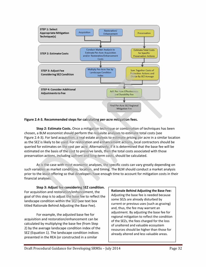
Draft Procedural Guidance for Developing SRMSs – July 2014 Page 32
Figure 2.4-3. Recommended steps for calculating per-acre mitigation fees.
Step 2: Estimate Costs. Once a mitigation technique or combination of techniques has been chosen, a BLM economist should perform the requisite analyses to estimate total costs (see Figure 2.4-3). For land acquisition, a real estate analysis to estimate pricing per acre in a similar location as the SEZ is likely to be used. For restoration and enhancement actions, local contractors should be queried for estimates on the cost per acre. Alternatively, if it is determined that the base fee will be estimated on the basis of the cost to preserve lands, then the total costs associated with those preservation actions, including upfront and long-term costs, should be calculated.
As is the case with most economic analyses, the specific costs can vary greatly depending on such variables as market conditions, location, and timing. The BLM should conduct a market analysis prior to the lease offering so that developers have enough time to account for mitigation costs in their financial analyses.
Step 3: Adjust fee considering SEZ condition.
For acquisition and restoration/enhancement, the goal of this step is to adjust the base fee to reflect the landscape condition within the SEZ (see text box titled Rationale Behind Adjusting the Base Fee).
For example, the adjusted base fee for acquisition and restoration/enhancement can be calculated by multiplying the base fee (from Step 2) by the average landscape condition index of the SEZ (Equation 1). The landscape condition indices presented in the REA (or constructed in a similar
Rationale Behind Adjusting the Base Fee: Adjusting the base fee is needed because some SEZs are already disturbed by current or previous uses (such as grazing) and, thus, the fee may warrant an adjustment. By adjusting the base fee for regional mitigation to reflect the condition of the SEZs, the fees charged for the loss of unaltered and valuable ecosystem resources should be higher than those for already altered and less valuable areas.

Draft Procedural Guidance for Developing SRMSs – July 2014 Page 33
GIS layer, see Section 2.4.2.1) can be used to estimate the average landscape condition index for the SEZ. The REA landscape condition maps provide a percent value between 0 and 1 for each 90-meter square land area within each ecoregion. Values closer to 1 indicate a more intact landscape, while values closer to 0 indicate a more altered landscape12.
Since the cost of preservation measures generally does not change with landscape condition within the SEZ (e.g., the cost of fencing is the same regardless of the landscape condition of the area within the fence), the total preservation costs calculated in Step 2 should not be adjusted by landscape condition. Instead, at this point, the total costs of preservation should be divided by the acreage of the SEZ to determine the adjusted base fee (Equation 2).
Equation 1 Restoration/Acquisition Adjusted Base Fee = Base Fee ($/acre) * Average Landscape Condition Index (%) Equation 2 Per-Acre Preservation Base Fee = Total Base Fee ($)/Developable Area in SEZ (acres)
Step 4: Consider additional adjustments to fee. Several adjustments could be made at this step to,
for example: encourage development within a designated SEZ; incorporate cost recovery for long-term effectiveness and durability; and/or, to avoid duplicating existing mitigation fees.
Adjustment to Encourage Development in a SEZ. For some SEZs, the BLM may apply an adjustment
intended to direct local solar development to the SEZ and not to variance lands. The BLM may use this discretion, on a case-by-case basis, to identify appropriate terms and conditions—including those relating to mitigation—for FLPMA Title V right-of-way authorizations. The Adjustment to Encourage Development in a SEZ would generally take the form of a multiplier applied to the fee calculated in Step 4.
Incorporate Cost Recovery for SEZ Mitigation Effectiveness and Durability. Regardless of the
mitigation techniques chosen, the BLM should incorporate recovery of costs associated with monitoring and ensuring the effectiveness and durability of mitigation actions that should be included for each SEZ. These fees may include the costs associated with law enforcement, mitigation effectiveness monitoring, invasive species management, and the cost of LUP amendments. Example cost estimates for law enforcement and mitigation effectiveness monitoring are provided in Table 2.4-2. The total per-acre Effectiveness and Durability fee can be calculated using Equation 3. The Effectiveness and Durability fee would be added to the fee calculated in Step 3 after it is adjusted to encourage development in a SEZ (if applicable). The actual per-acre effectiveness and durability fee used at each SEZ would be determined during competitive leasing and/or project authorization processing.
Equation 3 Total Per-Acre Effectiveness and Durability Fee = Per-Acre Effectiveness and Durability Fee ($/acre/year)*duration of the impacts (years)
12
The exact methodology used to derive the landscape condition index for each ecoregion can be found in the relevant sections of the REA documentation (e.g., NatureServe 2013).

Draft Procedural Guidance for Developing SRMSs – July 2014 Page 34
Table 2.4-2. Estimate (based on 2013 costs) of funding needed for management activities to ensure effectiveness and durabilitya.
Tasks
Per Acre/ Per Year
Law Enforcement $15
Effectiveness Monitoring $5
Total $20
Annual rate for 5,000-acre SEZ Total 30-year management fee/5,000-Acre SEZ
$100,000 $3,000,000
aThe cost estimates were derived from a cursory market analysis and are shown as an example.
Adjustment for Existing and Duplicative Mitigation Fees. Some SEZs may be subject to preexisting mitigation fees such as ESA Section 7 species recovery fees. In consultation with the U.S. Fish and Wildlife Service, the amount of such fees will be charged to the developer and expended for mitigation of impacts to species listed under the ESA. The BLM should review whether and how such mitigation fees are consistent with regional mitigation goals and objectives and consider whether subtraction from the regional mitigation is warranted to avoid duplicate payment. The Adjustment for Existing and Duplicative Mitigation Fees would be subtracted from the fee calculated in Step 3 after it is adjusted to encourage development in a SEZ (if applicable).
2.4.6 Recommendation of a Solar Regional Mitigation Fee Structure (Element 6)
In general, solar regional mitigation fees will likely be managed as a structured fund and should be applied so as to achieve regional mitigation goals (see Section 2.4.3). Management of solar regional mitigation fees will be consistent with law and policy and procedure set forth in BLM Instruction Memorandum No. 2013-142 and the Regional Mitigation Manual (BLM 2013a).
As indicated in Section D19 of the Regional Mitigation Manual, developers “may agree to perform mitigation outside the area of impact by implementing mitigation projects and measures directly (labor), purchasing private land or conservation easements, and/or contributing financially to a mitigation fund. Financially contributing to a mitigation fund involves one or more payments to a natural resource management agency, foundation, or other appropriate organization for performance of mitigation that addresses the impacts of the land-use authorization.” Section D20 of the Regional Mitigation Manual discusses conditions for the BLM’s acceptance and management of monetary contributions.
Any potential assessment, contribution, and/or management of solar mitigation fees or monies
would be finalized following the BLM’s decision on competitive leasing for an SEZ, project authorization, and/or project-level NEPA. Within an SRMS, Step 1 of this element would consist of recommending a type (or types) of regional mitigation (using permittee-responsible mitigation, purchasing easements, and/or payment of applicable fees). Step 2, which would occur after a project authorization, would be for the BLM to manage regional mitigation funds consistent with the Regional Mitigation Manual, Section D20.

Draft Procedural Guidance for Developing SRMSs – July 2014 Page 35
2.4.7 Develop Mitigation Monitoring and Adaptive Management Plan (Element 7) A long-term monitoring and adaptive management plan should be developed to monitor the effectiveness of design features and other mitigation actions, including regional mitigation actions, and to identify whether there are any other unanticipated effects related to solar energy development. The BLM committed to develop this plan in the Final Solar PEIS and Solar PEIS ROD. As discussed in Section 1.4.2, the BLM developed the AIM Strategy to guide monitoring of conditions and trends for BLM-managed resources and lands (Toevs et al. 2011). The AIM Strategy provides the scientific foundation for developing the solar monitoring plan. Specifically, the solar monitoring plan should address monitoring of both (1) the status, condition, and trend of priority resources and values in the region and (2) the effectiveness of all mitigation measures in order to provide the data needed to inform adaptive management decisions in the solar energy program. This section discusses monitoring activities that meet these objectives. Additional information about how the AIM Strategy will be implemented to support long-term monitoring of solar energy development is provided in Appendix A, Section A.2.4 of the Final Solar PEIS. In the context of solar energy development, long-term monitoring should be conducted to (1) evaluate the effectiveness of all mitigation actions, including both onsite and regional mitigation; (2) detect unanticipated direct, indirect, and cumulative impacts at the project and regional levels; and (3) evaluate the effectiveness of elements of the BLM’s solar energy program (e.g., policies, design features). To ensure that investments in regional mitigation actions are effective and that regional mitigation goals are being met, it is critical for the long-term monitoring plan to include monitoring objectives specific to the regional mitigation locations and actions. The findings of the long-term monitoring activities will be examined by the BLM to support adaptive management for solar energy development (i.e., to identify the need to adjust operational parameters, modify mitigation measures, and/or implement new mitigation to prevent or minimize further impacts).
The following steps should be taken to develop an appropriate mitigation effectiveness monitoring plan and to implement adaptive management. For additional information or technical support regarding any of the following steps, please contact the Assessment and Monitoring Branch at the BLM National Operations Center.
Step 1: Develop management questions and monitoring goals. The BLM ID team will develop
management questions that articulate the issues of concern related to monitoring the previously mentioned elements. The management questions will provide the basis for developing monitoring goals. In planning, a goal is a “descriptive, open-ended, and often broad statement of desired future conditions that conveys a purpose” (USFWS 2000). A monitoring goal thus describes the purpose of monitoring activities in terms of the information desired. Sample management questions and monitoring goals are provided in the text box titled Management Questions and Monitoring Goals Established for the Dry Lake Solar Regional Mitigation Strategy.
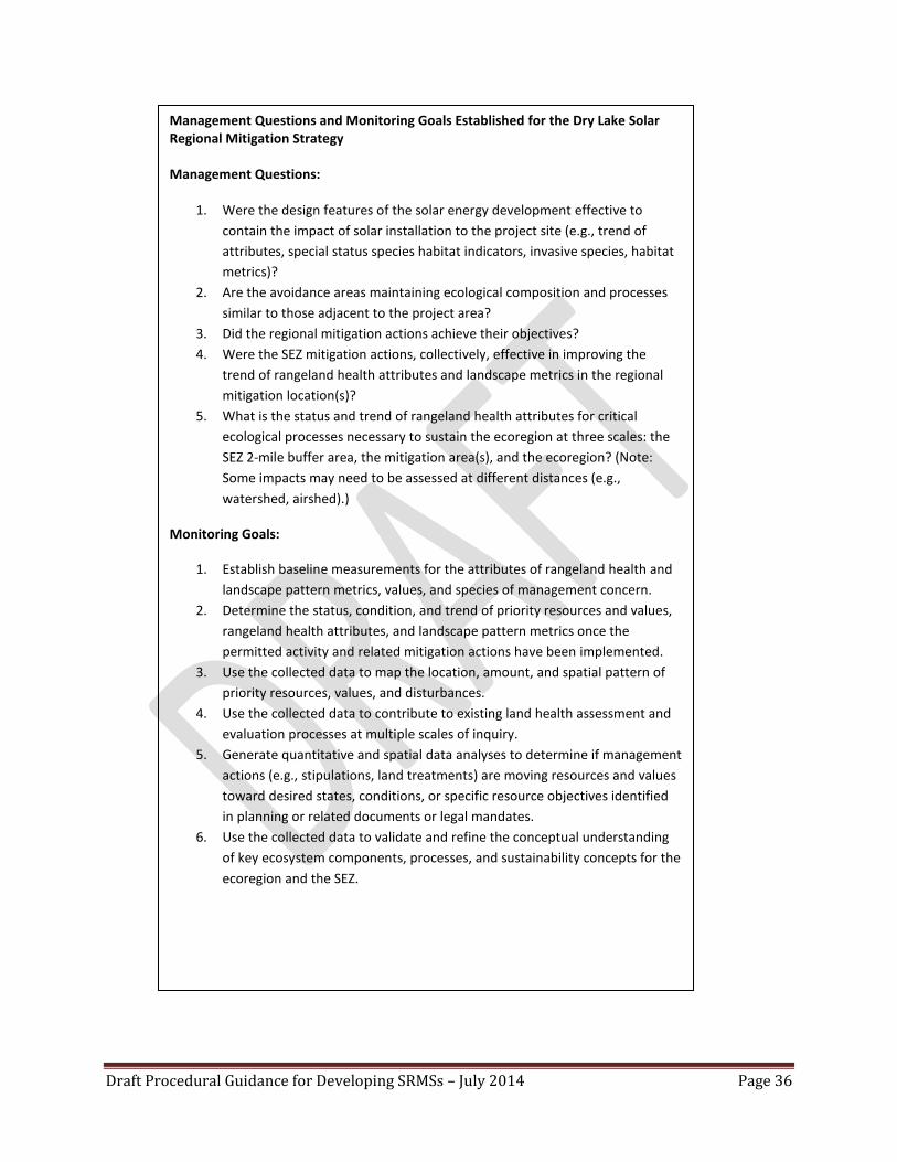
Draft Procedural Guidance for Developing SRMSs – July 2014 Page 36
Management Questions and Monitoring Goals Established for the Dry Lake Solar Regional Mitigation Strategy Management Questions:
1. Were the design features of the solar energy development effective to contain the impact of solar installation to the project site (e.g., trend of attributes, special status species habitat indicators, invasive species, habitat metrics)?
2. Are the avoidance areas maintaining ecological composition and processes similar to those adjacent to the project area?
3. Did the regional mitigation actions achieve their objectives? 4. Were the SEZ mitigation actions, collectively, effective in improving the
trend of rangeland health attributes and landscape metrics in the regional mitigation location(s)?
5. What is the status and trend of rangeland health attributes for critical ecological processes necessary to sustain the ecoregion at three scales: the SEZ 2-mile buffer area, the mitigation area(s), and the ecoregion? (Note: Some impacts may need to be assessed at different distances (e.g., watershed, airshed).)
Monitoring Goals:
1. Establish baseline measurements for the attributes of rangeland health and landscape pattern metrics, values, and species of management concern.
2. Determine the status, condition, and trend of priority resources and values, rangeland health attributes, and landscape pattern metrics once the permitted activity and related mitigation actions have been implemented.
3. Use the collected data to map the location, amount, and spatial pattern of priority resources, values, and disturbances.
4. Use the collected data to contribute to existing land health assessment and evaluation processes at multiple scales of inquiry.
5. Generate quantitative and spatial data analyses to determine if management actions (e.g., stipulations, land treatments) are moving resources and values toward desired states, conditions, or specific resource objectives identified in planning or related documents or legal mandates.
6. Use the collected data to validate and refine the conceptual understanding of key ecosystem components, processes, and sustainability concepts for the ecoregion and the SEZ.

Draft Procedural Guidance for Developing SRMSs – July 2014 Page 37
Step 2: Identify quantitative monitoring objectives and indicators. An objective is a “concise statement of what we want to achieve, how much we want to achieve, when and where we want to achieve it, and who is responsible for the work” (USFWS 2000). Setting monitoring objectives includes specifying the attribute of interest, a quantifiable objective for that attribute, and the indicator(s) to measure the change in the attribute.
Measureable monitoring objectives will be established for each monitoring goal identified in
Step 1. Objectives should include the SMART technical features (Toevs et al. 2011; adapted from Williams, Szaro, and Shapiro 2009): desired amount of change (specific), level of confidence for the measured change (measurable), funding and capacity requirements (achievable), relationship to the management question (relevant), and timeframe during which the measurement occurs to effectively inform management (time sensitive). Objective setting will be based on current regulatory requirements, LUP goals, or the desired future condition consistent with the land potential (as described in the ecological site description, if available – see Step 3). Examples of measureable monitoring objectives are provided in the text box titled Examples of Measureable Monitoring Objectives.
Indicator selection starts with an evaluation of the BLM core and contingent indicators and
methods to see if they provide the information described in the measureable objectives. These indicators and methods offer high-quality, quantitative information relevant to all land cover types the BLM manages (MacKinnon et al. 2011). Table 2.4-3 describes each of the BLM-selected core and contingent indicators and briefly discusses how to measure the indicators. If the BLM indicators do not adequately inform the monitoring objective, supplemental indicators should be added. The selection of supplemental indicators is informed by the relationships identified in the ecosystem conceptual models and/or linked to specific management questions and monitoring goals.
Examples of using the core and contingent indicators to inform the attributes of rangeland
health are found in Table 2.4-4. Quantitative monitoring objectives for these attributes can be developed from information found in ecological site descriptions (Caudle et al. 2013); see Step 3, which follows.
Examples of Measureable Monitoring Objectives An example of a measureable objective for land status/trend of vegetation is:
(1) Detect a difference of 10 percentage points in the average amount of bare ground in the <MITIGATION LOCATION> over a 5-year period with 90% confidence.
(2) Determine whether cover of perennial grasses in the <MITIGATION LOCATION> is at least 25% with 90% confidence.
An example of an objective for special status species is:
(1) Ensure that populations of <SPECIAL STATUS SPECIES NAME> in the <ECOREGION NAME> have not decreased by more than 20% within 5 years of the solar installation with 95% confidence.

Draft Procedural Guidance for Developing SRMSs – July 2014 Page 38
Table 2.4-3. Recommended methods and measurements for core and contingent indicators (reproduced from MacKinnon et al. (2011)).
Method Indicator(s) Description For core indicators Line-point intercept (LPI) with plot-level species inventory
Bare ground, vegetation composition, nonnative invasive species, plant species of management concern
Line-point intercept is a rapid and accurate method for quantifying cover of vegetation and bare ground. Because LPI can underestimate cover of uncommon species, this method is supplemented with searches of a 150-ft (45.7-m) diameter standard plot for at least 15 minutes and until new species detections are more than 2 minutes apart. When performing LPI within tree cover, a modified pin method (e.g., a pivot-table laser or extendable pin) will be used to capture overstory cover.
Vegetation height measurement
Vegetation height Measure height of tallest leaf or stem of woody and herbaceous vegetation (living or dead) within a 6-in (15-cm) radius recorded for points along a transect. If vegetation is taller than 10 ft, a standard tape and clinometer method should be used to estimate vegetation height.
Canopy gap intercept
Proportion of soil surface in large intercanopy gaps
Canopy gap intercept measures the proportion of a line covered by large gaps between plant canopies and is an important indicator of the potential for erosion. Use 1-ft (30-cm) minimum gaps.
For contingent indicators1 Soil stability test Soil aggregate stability This test measures the soil's stability
when exposed to rapid wetting and provides information on integrity of soil aggregates, degree of structural development, resistance to erosion, and soil biotic integrity.
Soil sample collection and analysis
Significant accumulation of toxins
The presence and concentrations of toxins are assessed by collecting three samples from the soil surface and one sample at depths of 0 to 4 in (0 to 10 cm) and 4 to 8 in (10 to 20 cm) using a soil corer and following Forest Inventory Analysis protocol.
1 Contingent indicators are only measured when soil stability or soil contamination may be a problem.
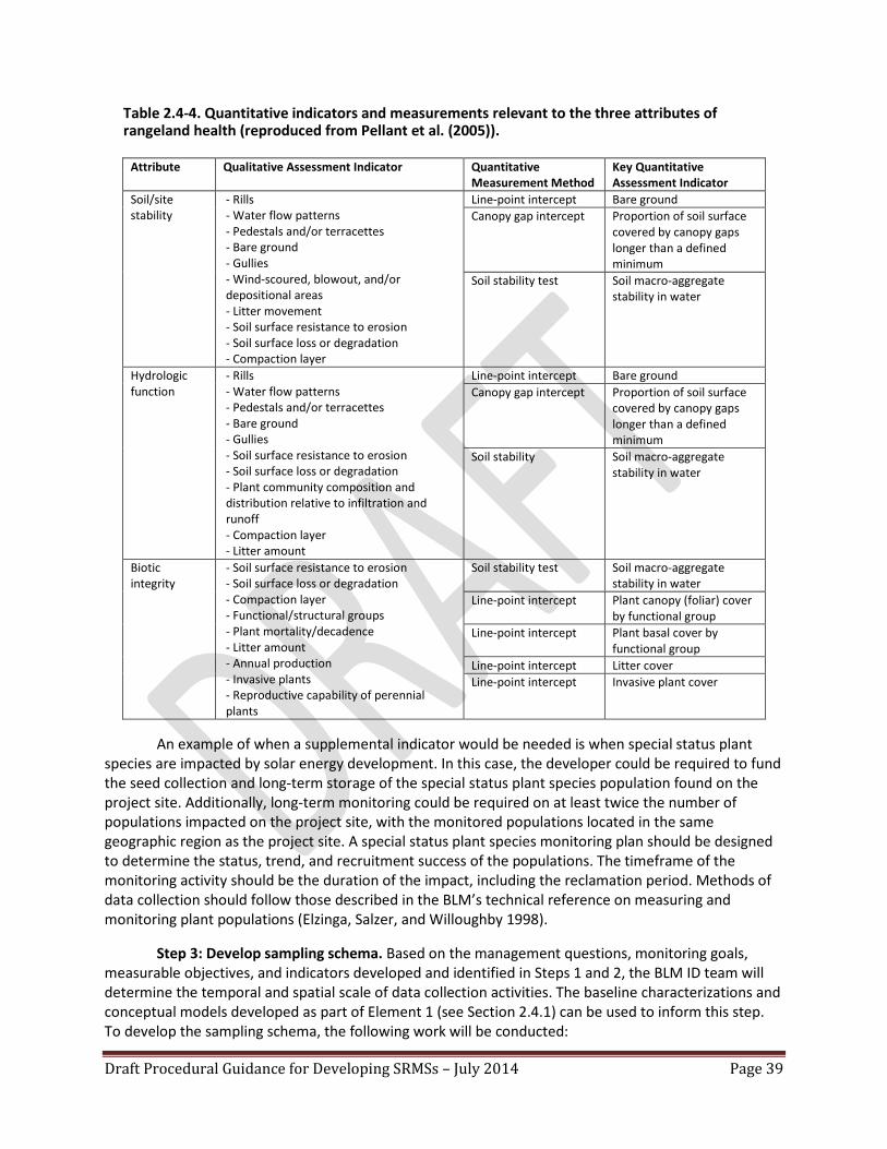
Draft Procedural Guidance for Developing SRMSs – July 2014 Page 39
Table 2.4-4. Quantitative indicators and measurements relevant to the three attributes of rangeland health (reproduced from Pellant et al. (2005)).
Attribute Qualitative Assessment Indicator Quantitative Measurement Method
Key Quantitative Assessment Indicator
Soil/site stability
- Rills - Water flow patterns - Pedestals and/or terracettes - Bare ground - Gullies - Wind-scoured, blowout, and/or depositional areas - Litter movement - Soil surface resistance to erosion - Soil surface loss or degradation - Compaction layer
Line-point intercept Bare ground Canopy gap intercept Proportion of soil surface
covered by canopy gaps longer than a defined minimum
Soil stability test Soil macro-aggregate stability in water
Hydrologic function
- Rills - Water flow patterns - Pedestals and/or terracettes - Bare ground - Gullies - Soil surface resistance to erosion - Soil surface loss or degradation - Plant community composition and distribution relative to infiltration and runoff - Compaction layer - Litter amount
Line-point intercept Bare ground Canopy gap intercept Proportion of soil surface
covered by canopy gaps longer than a defined minimum
Soil stability Soil macro-aggregate stability in water
Biotic integrity
- Soil surface resistance to erosion - Soil surface loss or degradation - Compaction layer - Functional/structural groups - Plant mortality/decadence - Litter amount - Annual production - Invasive plants - Reproductive capability of perennial plants
Soil stability test Soil macro-aggregate stability in water
Line-point intercept Plant canopy (foliar) cover by functional group
Line-point intercept Plant basal cover by functional group
Line-point intercept Litter cover Line-point intercept Invasive plant cover
An example of when a supplemental indicator would be needed is when special status plant
species are impacted by solar energy development. In this case, the developer could be required to fund the seed collection and long-term storage of the special status plant species population found on the project site. Additionally, long-term monitoring could be required on at least twice the number of populations impacted on the project site, with the monitored populations located in the same geographic region as the project site. A special status plant species monitoring plan should be designed to determine the status, trend, and recruitment success of the populations. The timeframe of the monitoring activity should be the duration of the impact, including the reclamation period. Methods of data collection should follow those described in the BLM’s technical reference on measuring and monitoring plant populations (Elzinga, Salzer, and Willoughby 1998).
Step 3: Develop sampling schema. Based on the management questions, monitoring goals, measurable objectives, and indicators developed and identified in Steps 1 and 2, the BLM ID team will determine the temporal and spatial scale of data collection activities. The baseline characterizations and conceptual models developed as part of Element 1 (see Section 2.4.1) can be used to inform this step. To develop the sampling schema, the following work will be conducted:

Draft Procedural Guidance for Developing SRMSs – July 2014 Page 40
Develop a statistically valid and scalable sampling design. The monitoring points are
determined through a statistically based (i.e., randomized) selection process. Once the monitoring extent (i.e., inference area) is determined for each measureable objective, a stratified random technique should be used to select monitoring points such that every location within the monitoring extent has a known and nonzero probability of being selected. Strata should be based on ecological sites (or groupings of similar ecological sites), linear features (e.g., ephemeral washes), and other important landscape components identified in the management questions and monitoring goals to allow for adequate representation of the landscape. Ecological sites are types of land with the potential to produce similar kinds and amounts of vegetation based on soils and climate (Caudle et al. 2013), and ecological sites are the basic units for stratifying landscapes for BLM monitoring activities. Because ecological site descriptions describe the ecological states that can occur in an ecological site and provide expected indicator values for reference states, they are the foundation upon which BLM monitoring data are evaluated. These data are also fundamental for terrestrial upland land health standards and land health evaluations. Where ecological site descriptions have not been developed, land potential metrics can be developed using a combination of field and remote sensing data to describe current and potential future conditions at broad scales.
Plan for monitoring effectiveness of onsite mitigation actions and minimization measures. An example of a sampling schema is presented in Figure 2.4-4. This figure depicts the schema developed for monitoring effectiveness of onsite mitigation actions and minimization measures at the Dry Lake SEZ. The sample population is based on the geospatial footprint of the project area, with a 2-mile buffer area. The allocation of sample sites in the monitoring inference area is determined by the relative area of the stratum, with a minimum of three monitoring points per stratum. Sample sufficiency analysis will be completed for each stratum after the first season of sampling to determine if there were adequate monitoring locations for each stratum. Monitoring in the 2-mile buffer area will inform the BLM about the effectiveness of design features and other mitigation actions, including regional mitigation actions, and whether there are any unanticipated effects in areas immediately adjacent to the impact site.

Draft Procedural Guidance for Developing SRMSs – July 2014 Page 41
Figure 2.4-4. Example of a stratified, nonbiased sampling schema for the Dry Lake Solar Energy Zone.

Draft Procedural Guidance for Developing SRMSs – July 2014 Page 42
Incorporate monitoring of effectiveness of regional mitigation actions. The sampling schema and sufficiency analysis for a regional mitigation action also follows the criterion outlined in the previous paragraph. Additionally, control sample points are added to determine the effectiveness of the mitigation action. Control monitoring sites are chosen outside of the regional mitigation action area based on similarity of soils and potential vegetation in the project area. Control sites can be selected from existing, statistically valid monitoring points outside the project area, such as those from the long-term monitoring sites that are a part of the BLM Landscape Monitoring Framework, the BLM sage-grouse intensification effort, or the monitoring and adaptive management plan for the BLM’s solar energy program (Appendix A, Section A.2.4 of the Final Solar PEIS). An example of the long-term monitoring points that could serve as monitoring control points are represented in Figure 2.4-5. To account for the variability within a stratum, a minimum of three monitoring sites are selected for each stratum. Sufficiency analysis will determine if additional control monitoring points are required.

Draft Procedural Guidance for Developing SRMSs – July 2014 Page 43
Figure 2.4-5. Example of a stratified, nonbiased sampling schema for the Gold Butte Area of Critical Environmental Concern.
Draft Procedural Guidance for Developing SRMSs – July 2014 Page 44
Step 4: Integrate remote sensing monitoring technologies. Considerable work has been done to develop methodologies for processing and analyzing remote sensing data in order to extract information suitable for assessing changes in certain environmental conditions. The AIM Strategy emphasizes the value of integrating remote sensing technologies into long-term monitoring programs, wherever feasible, in order to provide cost-effective methods for collecting data and analyzing status, departure, and rate of change. The AIM implementation lead and/or the AIM remote sensing lead with the Division of Resource Services at the BLM National Operations Center can assist in determining which technologies will help inform the solar mitigation effectiveness and adaptive management monitoring plan.
Step 5: Develop analysis and reporting system. Interpreting monitoring data to determine the
status, departure, or rate of change requires comparison of data collected via field sampling and/or remote sensing against indicators of ecological attributes for reference conditions. These reference conditions should be based on site or landscape potential, which is described in ecological site descriptions or similar reference documents. Ecological sites are the basis for the monitoring schema because they react similarly to natural disturbances and management actions, which can lead to alternative stable states outside the historic potential of the ecological site. For this reason, ecological sites are the basic unit for analysis and reporting in the BLM (Caudle et al. 2013). Elements of an ecological site description that are helpful for defining reference conditions and interpreting departure from reference conditions include: state-and-transition conceptual models of plant community changes in response to disturbance or management; descriptions of the range of plant communities that could exist on the site in addition to the potential vegetation; descriptions of anthropogenic and natural disturbances and their potential to cause changes in plant communities; descriptions of dynamic soil properties (e.g., organic matter content, soil aggregate stability); and amount of bare ground. These elements form a baseline against which to compare and interpret the quantitative indicators derived from monitoring data.
Analysis and reporting at multiple scales is important so that monitoring can inform adaptive
management. Reporting at local, regional, and national scales will inform decisionmakers on the effectiveness of development and management of regional mitigation actions. Reporting should take place every 3-5 years to ensure important changes in indicators are being captured so resource managers can respond.
Step 6: Carry out adaptive management. The BLM will use information derived from monitoring
efforts to determine if regional mitigation goals described in the SRMS are being met. If the goals are not being met, the monitoring results will be used to inform management adjustments to the mitigation locations and actions (e.g., modifying locations or actions and/or adding new mitigation actions). The analysis of monitoring data can also inform whether adjustments are necessary for solar project operational parameters, conceptual models, and the monitoring program itself. Adaptive changes will be subject to environmental analysis, land use planning, and public involvement, as appropriate.
2.5 SOLAR REGIONAL MITIGATION STRATEGY IMPLEMENTATION The BLM ID team should develop a work plan for implementation of the SRMS. The work plan should address the timeframe for the mitigation actions; priorities for implementing mitigation actions; resource requirements; contracting actions for third-party administration of funds, if appropriate; opportunities for collaboration with other organizations; and procedures for reviewing and updating the SRMS.

Draft Procedural Guidance for Developing SRMSs – July 2014 Page 45
3. REFERENCES Ball, I.R., H.P. Possingham, and M.E. Watts. 2009. Marxan and Relatives: Software for Spatial
Conservation Prioritization. p. 185-195. In: Moilanen, A., K.A. Wilson, and H.P. Possingham (eds). Spatial Conservation Prioritization: Quantitative Methods and Computational Tools. Oxford University Press, Oxford, UK.
BLM (Bureau of Land Management). 1998. Proposed Las Vegas Resource Management Plan and Final
Environmental Impact Statement. Bureau of Land Management, Las Vegas Field Office, Las Vegas, NV.
BLM (Bureau of Land Management). 2001. Rangeland Health Standards. BLM Handbook H-4180-1.
Bureau of Land Management, Washington, DC. BLM (Bureau of Land Management). 2005a. Interim Offsite Compensatory Mitigation for Oil, Gas,
Geothermal and Energy Rights-of-Way Authorizations. Instruction Memorandum No. 2005-069. Bureau of Land Management, Washington, DC.
BLM (Bureau of Land Management). 2005b. Land Use Planning Handbook. BLM Handbook H-1601-1.
Bureau of Land Management, Washington, DC. BLM (Bureau of Land Management). 2005c. Bureau of Land Management National Policy for the Federal
Advisory Committee Act: What BLM Staff Need to Know When Working with ADR-Based Collaborative Community Working Groups. Bureau of Land Management, Washington, DC.
BLM (Bureau of Land Management). 2008a. National Environmental Policy Act. BLM Handbook H-1790-
1. Bureau of Land Management, Washington, DC. BLM (Bureau of Land Management). 2008b. Offsite Mitigation. Instruction Memorandum No. 2008-204.
Bureau of Land Management, Washington, DC. BLM (Bureau of Land Management). 2008c. Integrated Vegetation Management. BLM Handbook H-
1740-2. Bureau of Land Management, Washington, DC. BLM (Bureau of Land Management). 2012. Approved Resource Management Plan Amendments/Record
of Decision (ROD) for Solar Energy Development in Six Southwestern States. Bureau of Land Management, Washington, DC.
BLM (Bureau of Land Management). 2013a. Interim Policy, Draft – Regional Mitigation Manual Section –
1794. Instruction Memorandum No. 2013-142. Bureau of Land Management, Washington, DC. http://www.blm.gov/wo/st/en/info/regulations/Instruction_Memos_and_Bulletins/national_instruction/2013/IM_2013-142.html.
BLM (Bureau of Land Management). 2013b. BLM Library, National Operations Center, Denver, CO.
http://www.blm.gov/nstc/library/techref.htm. BLM (Bureau of Land Management). 2013c. Solar Regional Mitigation Strategy for the Dry Lake Solar
Energy Zone. Bureau of Land Management, Southern Nevada District Office, Las Vegas, NV.

Draft Procedural Guidance for Developing SRMSs – July 2014 Page 46
BLM and DOE (Bureau of Land Management and U.S. Department of Energy). 2012. Final Programmatic Environmental Impact Statement (PEIS) for Solar Energy Development in Six Southwestern States. FES 12-24, DOE/EIS-0403. Bureau of Land Management and U.S. Department of Energy, Washington, DC.
Caudle, D., J. DiBenedetto, M. Karl, H. Sanchez, and C. Talbot. 2013. Interagency Ecological Site
Handbook for Rangelands. Bureau of Land Management, U.S. Forest Service, and Natural Resources Conservation Service.
DOI (Department of the Interior). 2011. Department of the Interior Policy on Consultation with Indian
Tribes. http://www.doi.gov/news/pressreleases/Secretary-Salazar-Assistant-Secretary-Echo-Hawk-Launch-Comprehensive-Tribal-Consultation-Policy.cfm.
Elzinga, C.L., D.W. Salzer, and J.W. Willoughby. 1998. Measuring and Monitoring Plant Populations. Tech
Ref 1730-1. Bureau of Land Management, National Business Center, Denver, CO. http://www.blm.gov/nstc/library/pdf/MeasAndMon.pdf.
Environmental Law Institute. 2009. In-Lieu Fee Mitigation: Model Instrument Language and Resources.
Environmental Law Institute, Washington, DC. Herrick, J.E., J.W. Van Zee, K.M. Havstad, L.M. Burkett, and W.G. Whitford. 2005. Monitoring Manual for
Grassland, Shrubland, and Savanna Ecosystems. U.S. Department of Agriculture, Agricultural Research Service, Jornada Experimental Range, Las Cruces, NM.
MacKinnon, W.C., J.W. Karl, G.R Toevs, J.J. Taylor, M. Karl, C.S. Spurrier, and J.E. Herrick. 2011. BLM Core
Terrestrial Indicators and Methods. Tech Note 440. Bureau of Land Management, National Operations Center, Denver, CO.
Moilanen, A., L. Meller, J. Leppänen, F. Montesino-Pouzols, A. Arponen, and H. Kujala. 2012. Zonation:
Spatial Conservation Planning Framework and Software. Version 3.1 User Manual. Department of Bioscience, University of Helsinki, FI. http://www.helsinki.fi/bioscience/consplan/software/Zonation/ZONATION_v3.1_Manual_120416.pdf.
NatureServe. 2013. Mojave Basin and Range Rapid Ecoregional Assessment.
http://www.blm.gov/wo/st/en/prog/more/Landscape_Approach/reas/mojave.html#memo. NDOW (Nevada Department of Wildlife). 2012. Nevada Wildlife Action Plan.
http://www.ndow.org/Nevada_Wildlife/Conservation/Nevada_Wildlife_Action_Plan/. Noon, B.R. 2003. Conceptual Issues in Monitoring Ecological Resources. p. 27-71. In: Busch, D.E., and J.C.
Trexler (eds). Monitoring Ecosystems: Interdisciplinary Approaches for Evaluating Ecoregional Initiatives. Island Press, Washington, DC.
NPS (National Park Service). 2012. Glossary of Terms Used by the NPS Inventory & Monitoring Program.
http://science.nature.nps.gov/im/monitor/Glossary.cfm.

Draft Procedural Guidance for Developing SRMSs – July 2014 Page 47
NRCS (Natural Resources Conservation Service). 2009. National Resources Inventory Grazing Land On-site Study: Handbook of Instructions. U.S. Department of Agriculture, Natural Resources Conservation Service.
Pellant, M., P. Shaver, D.A. Pyke, and J.E. Herrick. 2005. Interpreting Indicators of Rangeland Health,
Version 4. Tech Ref 1734-6. Bureau of Land Management, National Science and Technology Center, Denver, CO. http://www.blm.gov/nstc/library/techref.htm.
RECON, Clark County, and USFWS (Regional Environmental Consultants, Clark County Department of
Comprehensive Planning, and U.S. Fish and Wildlife Service). 2000. Clark County Multiple Species Habitat Conservation Plan and Environmental Impact Statement for Issuance of a Permit to Allow Incidental Take of 79 Species in Clark County, Nevada. RECON, Clark Country, and USFWS, San Diego, CA.
Riolo, F. 2005. Panda: Protected Areas Network Design Application for ArcGIS 9.x.
http://www.mappamondogis.it/panda.htm. Secretary of the Interior. 2010. Ensuring Scientific Integrity within the Department of the Interior.
Secretarial Order No. 3305. Department of the Interior. http://www.doi.gov/news/pressreleases/upload/Sec-Order-No-3305.pdf.
SRM (Society for Range Management). 1999. A Glossary of Terms Used in Range Management. Society
for Range Management. Denver, CO. Stoffle, R.W., M.N. Zedeño, and D.B. Halmo (eds). 2001. American Indians and the Nevada Test Site: A
Model of Research and Consultation. U.S. Department of Energy, Nevada Operations Office, Washington, DC.
SWCA Environmental Consultants. 2013a. California Solar Energy Zones (SEZs): Class II Cultural
Resources Inventory of the Imperial East and Riverside East SEZs, Imperial and Riverside Counties, California. SWCA Environmental Consultants, Phoenix, AZ.
SWCA Environmental Consultants. 2013b. Class II Cultural Resources Inventory of the Amargosa Valley,
Dry Lake Valley North, Gold Point, and Millers Solar Energy Zones, Nye, Lincoln, and Esmeralda Counties, Nevada. SWCA Environmental Consultants, Phoenix, AZ.
SWCA Environmental Consultants. 2013c. Solar Energy Zones (SEZs): Class II Cultural Resources
Inventories of the Brenda, Gillespie, and Agua Caliente SEZs, La Paz, Maricopa, and Yuma Counties, Arizona. SWCA Environmental Consultants, Phoenix, AZ.
TNC (The Nature Conservancy). 2013. Various ecoregional assessments.
http://conserveonline.org/workspaces/cbdgateway/documents/all.html. Toevs, G.R., J.J. Taylor, C.S. Spurrier, W.C. MacKinnon, and M.R. Bobo. 2011. Assessment, Inventory, and
Monitoring Strategy for Integrated Renewable Resources Management. Bureau of Land Management, National Operations Center, Denver, CO.

Draft Procedural Guidance for Developing SRMSs – July 2014 Page 48
USFS (U.S. Forest Service). 2007. Forest Inventory and Analysis National Core Field Guide, Version 4.0. U.S. Department of Agriculture, U.S. Forest Service, Forest Inventory and Analysis National Office, Washington, DC.
USFWS (U.S. Fish and Wildlife Service). 2000. Refuge Planning Overview. 602 FW 1. U.S. Fish and Wildlife
Service, Division of Refuges. http://www.fws.gov/policy/602fw1.html. USFWS (U.S. Fish and Wildlife Service). 2003. Guidance for the Establishment, Use, and Operation of
Conservation Banks. Memorandum. U.S. Fish and Wildlife Service, Washington, DC. USFWS (U.S. Fish and Wildlife Service). 2012. Biological Opinion and Conservation Review. From Gary
Frazer, USFWS Asst Director for Endangered Species, to Michael D. Nedd, Asst Director, Minerals and Realty Management. http://www.solareis.anl.gov/documents/docs/SolarPEIS_Biological_Opinion.pdf.
USGS (U.S. Geological Survey). 2011. LINK: ArcGIS Tools for Conservation Planning.
http://www.umesc.usgs.gov/management/dss/bird_conservation_tools_link.html. Williams, B.K., R.C. Szaro, and C.D. Shapiro. 2009. Adaptive Management: The U.S. Department of the
Interior Technical Guide. U.S. Department of the Interior, Washington, DC.

Draft Procedural Guidance for Developing SRMSs – July 2014 Page 49
APPENDIX A: Memorandum of Understanding By and Between the BLM and the
California Department of Fish and Game

Draft Procedural Guidance for Developing SRMSs – July 2014 Page 50

Draft Procedural Guidance for Developing SRMSs – July 2014 Page 51
Draft Procedural Guidance for Developing SRMSs – July 2014 Page 52
Draft Procedural Guidance for Developing SRMSs – July 2014 Page 53

Draft Procedural Guidance for Developing SRMSs – July 2014 Page 54

Draft Procedural Guidance for Developing SRMSs – July 2014 Page 55
APPENDIX B: Example Conceptual Models Developed for the Dry Lake Solar Energy Zone
Conceptual models are used to understand ecosystem interactions at an ecoregional scale
(Tier 1), the solar energy development scale (Tier 2), and the SEZ-specific scale (Tier 3). The models used for the pilot Dry Lake Solar Energy Zone Solar Regional Mitigation Planning Project (as revised with stakeholder input) are presented here. Additional, more complex models may be constructed if needed to support impact assessment in the future. The Tier 1 model provides a high-level conceptual model for the Mojave Basin and Range ecoregion; it was taken largely from the Mojave Basin and Range REA (NatureServe 2013) and identifies the general ecosystem components. It is expected that this Tier 1 model would be relevant to all SEZs located in the Mojave Basin and Range ecoregion. The Tier 2 model provides more details about the relationships between basic ecosystem components and processes and potential stressors associated with utility-scale solar energy development. It is expected that a majority of the components in this Tier 2 model would be relevant to all SEZs. The Tier 3 model presents an overlay of the Tier 2 relationships on the resources that could be impacted by solar energy development at the Dry Lake SEZ and was developed in conjunction with the assessment of unavoidable impacts for the SEZ (Section 2.4.2).

Draft Procedural Guidance for Developing SRMSs – July 2014 Page 56
Tier 1 Conceptual Model, Mojave Basin and Range Ecoregion Model
Climatic and Physiographic System
Montane Dry Land System
Montane Wet System
Basin Wet System
Basin Dry Land System
Natural Driver Human Driver
Seasonal weather pattern, drought, wind, fire, water runoff-infiltration, evaporation, soil
erosion/disturbance, soil development, soil chemistry, freeze/thaw, nutrient cycling
Snowpack formation/melt, water runoff-detention-recharge, surface flow, aquifer
storage, surface-subsurface water exchange, evaporation, sediment erosion-deposition, connectivity, water chemistry, freeze/thaw
Human Systems(Change Agents and Drivers of Change):
Demography, socioeconomics, policy, resource development
pressure
Grazing, recreation, logging, fire alteration, land conversion,
contamination, invasive species, air pollution, hunting,
wildlife/human conflict, trampling, collecting
Water withdrawal/diversion, grazing, invasive species, water
pollution, wetland drainage, fishing, trampling, recreation

Draft Procedural Guidance for Developing SRMSs – July 2014
Page 57

Draft Procedural Guidance for Developing SRMSs – July 2014
Page 58

Draft Procedural Guidance for Developing SRMSs – July 2014
Page 59
APPENDIX C: Interdisciplinary Team Resource Evaluation Worksheet
Solar energy zone: Resource evaluated13: Summary of potential impacts from solar energy development (from Final Solar PEIS – assumes full build-out of the SEZ and implementation of design features). Direct, indirect, and cumulative impacts to the resource should be summarized: Additional evaluation of potential impacts based on local data: Summary of key design features from the Solar PEIS record of decision (include both programmatic and SEZ-specific): Additional recommended onsite mitigation measures: 13 Resources and impact areas to be evaluated for each SEZ should include those evaluated in the Final Solar PEIS (i.e., acoustics, air quality, cultural,
environmental justice, fire, hazardous waste, hydrology, invasive weeds, lands and realty, livestock grazing, military uses, minerals, Native American concerns, paleontology, recreation, riparian, socioeconomics, soils/erosion, special status species – animals and vegetation, specially designated areas, transportation, wild horses and burros, wilderness and lands with wilderness characteristics, wildlife, vegetation, and visual resources).

Draft Procedural Guidance for Developing SRMSs – July 2014
Page 60
Unavoidable Impacts Recommendation: Considering the previously recorded information, will solar energy development result in unavoidable impacts that cannot be avoided, minimized, or mitigated onsite? If the unavoidable impacts determination is YES, continue with the following evaluation steps: Evaluate regional problematic trends for the resource (conduct geospatial analysis if data are available), in the context of the site conceptual model: Evaluate the ecosystem status of the SEZ using rangeland health indicators, if available: Summarize resource management priorities for the resource from the BLM land use plan, applicable habitat conservation plan, and other sources: What is the feasibility of implementing successful onsite remediation?

Draft Procedural Guidance for Developing SRMSs – July 2014
Page 61
Interdisciplinary team recommendation on whether unavoidable impacts warrant mitigation: If regional mitigation is likely to be warranted, what type of mitigation for this resource would help to meet resource management objectives (i.e., acquisition, restoration/enhancement, preservation)? Consider guidance in the BLM’s Draft Regional Mitigation Manual Section 1794. How could the effectiveness of mitigation be monitored?
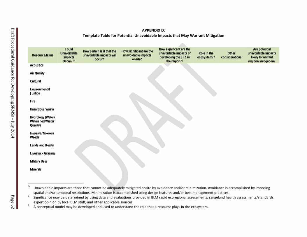
Draft Procedural Guidance for Developing SRMSs – July 2014
Page 62
APPENDIX D: Template Table for Potential Unavoidable Impacts that May Warrant Mitigation
Resource/Issue Could
Unavoidable Impacts Occur?14
How certain is it that the unavoidable impacts will
occur?
How significant are the unavoidable impacts
onsite?
How significant are the unavoidable impacts of developing the SEZ in
the region?2
Role in the ecosystem?3
Other considerations
Are potential unavoidable impacts
likely to warrant regional mitigation?
Acoustics Air Quality Cultural Environmental Justice
Fire Hazardous Waste Hydrology (Water/ Watershed/ Water Quality)
Invasive/ Noxious Weeds
Lands and Realty Livestock Grazing Military Uses
Minerals
14 Unavoidable impacts are those that cannot be adequately mitigated onsite by avoidance and/or minimization. Avoidance is accomplished by imposing
spatial and/or temporal restrictions. Minimization is accomplished using design features and/or best management practices. 2 Significance may be determined by using data and evaluations provided in BLM rapid ecoregional assessments, rangeland health assessments/standards,
expert opinion by local BLM staff, and other applicable sources. 3 A conceptual model may be developed and used to understand the role that a resource plays in the ecosystem.

Draft Procedural Guidance for Developing SRMSs – July 2014
Page 63
Resource/Issue Could
Unavoidable Impacts Occur?14
How certain is it that the unavoidable impacts will
occur?
How significant are the unavoidable impacts
onsite?
How significant are the unavoidable impacts of developing the SEZ in
the region?2
Role in the ecosystem?3
Other considerations
Are potential unavoidable impacts
likely to warrant regional mitigation?
Native American Concerns
Paleontology Recreation Riparian Socioeconomics Soils/Erosion Special Status Species - Animals
Special Status Species - Vegetation
Specially Designated Areas
Transportation Wild Horses and Burros
Wilderness and Lands with Wilderness Characteristics
Wildlife Vegetation
Visual Resources
Draft Procedural Guidance for Developing SRMSs – July 2014 Page 64
APPENDIX E: Mitigation of Impacts on Cultural Resources in Solar Energy Zones
Prior to development on public lands, mitigation of impacts on cultural resources must be
completed in consultation with the appropriate state historic preservation officers (SHPOs) and American Indian tribes, including tribal historic preservation officers when designated by a tribe as their official representative for this purpose. For the solar energy zones (SEZs), evaluation of adverse effects on cultural resources and assessment of whether the impacts are unavoidable and may warrant mitigation require knowledge of the resources present and their significance. This information is not currently available for many of the SEZs. A regional approach to mitigation planning is proposed throughout this report for many of the disciplines evaluated for solar energy development; the mitigation of impacts on cultural resources can also benefit from a regional approach. This appendix outlines a strategy for implementing a regional approach for archaeological resources and addresses issues raised by tribes.
E.1 ARCHAEOLOGICAL RESOURCES
A regional approach to mitigation planning is being proposed to foster predictable, efficient, and thoughtful approaches to mitigating adverse impacts on cultural resources. The BLM’s multiple-use mission includes providing incentives for solar energy development within SEZs and addressing the BLM’s statutory obligations under the National Historic Preservation Act. Many of the SEZs have not been sufficiently surveyed to be able to predict archaeological site density or distribution of historic properties. In addition, few regional research designs have been developed to assist in the determination of important research questions and the locations of greatest interest to the archaeological research community, tribes, and other interested stakeholders.
The combination of an adequate sample survey and a regional research design, approved by the
BLM in consultation with the appropriate SHPO(s), affected federally recognized tribes, and, if determined necessary, the Advisory Council on Historic Preservation, will set the stage for more rapid response time regarding mitigation when the required final project-specific Class III15 survey is being conducted in the SEZ prior to development. It is also necessary in order to develop appropriate “in lieu of” mitigation strategies based on regional priorities for archaeological research and historic preservation, for implementation when onsite mitigation is not possible. This approach is consistent with the process agreed to in the programmatic agreement among the BLM; the SHPOs in Arizona, California, Colorado, Nevada, New Mexico, and Utah; and the Advisory Council on Historic Preservation, regarding solar energy development on lands administered by the BLM (Solar PA), signed in 2012. Section E.1.1 of this appendix discusses the necessary sample surveys for the SEZs. Section E.1.2 describes a proposed approach for regional research designs for the SEZs. Section E.1.3 describes how the results of regional research designs will be used when conducting Class III surveys just prior to development.
15 Class III archaeological inventories are typically completed for 100% of the area of potential effect; however,
Stipulation 4B(4)(a)(iii)-(iv) of the solar programmatic agreement states that while a Class III inventory will normally be carried out for the entire area of potential effect, less than that might be required due to existing adequate inventories or certain geomorphological conditions. If the BLM decides to require less than a Class III inventory for the entire area of potential effect, the agency must base its decision on a professionally defensible rationale and seek the views of the SHPO(s), tribes, and any consulting parties to determine the final inventory strategy.

Draft Procedural Guidance for Developing SRMSs – July 2014 Page 65
E.1.1 Sample Surveys
Survey Status of the SEZs. Class II sample surveys have been completed at nine SEZs in Arizona, California, and Nevada (SWCA 2013a, 2013b, 2013c), including the Agua Caliente SEZ, and a relatively high percentage of the Dry Lake SEZ has been surveyed (and will undergo a Class III survey of any remaining unsurveyed lands prior to development). Class II sample surveys are still needed for the SEZs in Colorado, New Mexico, and Utah, and possibly for the West Chocolate Mountains SEZ. Sample surveys are needed at these SEZs to address cultural resource issues, facilitate solar energy development, and support regional research designs. Summaries of the survey results, as they become available, will be posted on the BLM solar energy program website (http://blmsolar.anl.gov).
Steps in Determining Sample Survey Needs. The following describes the recommended steps
for initial inventory and evaluation of archaeological resources within the remaining SEZs.
1. Determine the number of acres and the percent of the SEZ covered by Class III archaeological surveys that meet current professional standards.
2. Determine whether the Class III surveys that have been conducted within the SEZ adequately sample the environmental variability of the SEZ and allow the BLM to project the distribution and density of historic properties within the SEZ.
3. If Class III survey coverage is less than 10% of the SEZ or does not allow the BLM to properly project distribution and density of historic properties, then develop a professionally designed Class II sample survey, based on known data, that is adequate to predict the density and distribution of historic properties in all environmental strata present in the SEZ.
4. If the unsurveyed area of the SEZ is less than 3,000 acres, complete a Class III inventory, in accordance with current professional standards, of the portions of the SEZ that have not already been surveyed.
E.1.2 Regional Research Design
The purpose of a regional research design is to make the resource identification and evaluation
process more efficient and provide opportunities to focus mitigation efforts on the most important and at-risk cultural resources in the region, rather than limit options to only include testing, evaluating, and excavating sites on a site-by-site basis within the SEZ. The latter process is preferable when there is a high degree of certainty of few cultural conflicts within an SEZ. It does not readily allow for a quick determination of the lands available for development until near the very end of the site characterization process, too late to establish any degree of certainty for the developers, and the subsequent need for onsite mitigation could further delay development. In order to complete a regional research design associated with a particular SEZ, it is recommended that a Class II sample survey of the area be completed that covers all environmental strata represented in the SEZ (or a comparable level of Class III survey data should be available).
Status of the SEZs. As stated in Section E.1.1, 10 of the SEZs have adequate survey data
available, including the Dry Lake SEZ, and nine SEZs require additional surveys to support a regional research design, including the West Chocolate Mountains SEZ. The advantage of a regional research design would be in determining the mitigation strategy and whether onsite and/or regional mitigation would make the most sense for addressing the most important cultural resources in the region. For cases where there is only one SEZ in a region (e.g., the Dry Lake and Afton SEZs), it may be more costly to obtain the regional context than is warranted by the cultural sites present in the SEZs. For example, at

Draft Procedural Guidance for Developing SRMSs – July 2014 Page 66
the Dry Lake SEZ, a substantial percentage of the area had been previously surveyed so the BLM could anticipate that onsite mitigation of impacts on cultural resources within the SEZ would be feasible. It was also clear that the most cost-effective approach for addressing the remaining unsurveyed acreage was to complete the Class III survey. The Afton SEZ, on the other hand, covers more than 29,000 acres, and it would be very expensive to survey 100% of the SEZ, as proposed for the Dry Lake SEZ. Therefore, a Class II sample survey of the Afton SEZ is recommended before deciding on the utility of producing a regional research design, as results of the survey may provide insight as to whether regional mitigation is warranted or not.
Steps in Regional Research Design Preparation. Once sample surveys have been conducted, the next step in determining a mitigation strategy is to prepare a regional research design based on the prehistoric and historic context of the region, the site types and environmental conditions in the SEZ and the region, and the most important research questions that can and should be addressed in the region by site type. Regional research designs should include the following elements:
• Review of the cultural resources Class I regional overview in the relevant land use plans and other existing prehistoric and historic contexts (e.g., “A Prehistoric Context for Southern Nevada,” prepared by the HRA, Inc., Conservation Archaeology, and Gnomon, Inc., June 2012).
• Regional environmental and past/present climate data. • Summary of archaeological and ethnographic research in the region. • Review of the condition of the site record and survey data. • Identification of research themes by chronological period. • Identification of data gaps. • Prioritization of research questions and hypotheses that could realistically be
addressed from the archaeological record for the anticipated site types within SEZs and in the areas of potential effect around them.
• Identification of data that needs to be collected to answer the regional research questions—the site types and features most likely to contain data that answers the posed questions and hypotheses.
• Guidance for measuring progress in implementing the regional research design (e.g., When has a particular question been adequately addressed?, When is it time to introduce new questions and other site/feature types?).
• Identification of mitigation options for individual site types based on their ability to answer specific research questions, including consideration of the following for determining onsite and regional options: o Is the site found within the SEZ capable of answering the research question(s)
posed for that site type? o Is there a similar site in the region also at risk of loss that is better able to
answer the research question(s)? o Is there a similar site in the region that is better able to answer the research
question(s) and that can be more easily protected from the risk of future development?
• Recommendations of standardized field methods for testing and excavation, plus guidance to determine how much stripping/testing/excavation is needed at a particular site given field conditions.

Draft Procedural Guidance for Developing SRMSs – July 2014 Page 67
• Recommendations of sampling approaches and standard procedures for collecting certain samples (e.g., radiocarbon dates, thermoluminescence, obsidian hydration dating, etc.).
• Standard terminology of artifact class descriptions. • Standard data-gathering guidance for certain artifact classes (e.g., flakes, cans,
bottles, ceramics). • Guidelines of historic sites to determine when field work versus archival research is
most appropriate. • Peer review (by regionally knowledgeable contract and academic archaeologists). • Approval by BLM staff (at appropriate field office or state office level), in
consultation with SHPO(s), tribes, and the Advisory Council on Historic Preservation (if necessary).
E.1.3 Class III Inventory
Once a regional research design has been approved, the BLM will have a better understanding of the types of archaeological resources that could be encountered in the SEZ and their general distribution. The regional research design will position the BLM to assist solar energy developers during pre-application meetings in avoiding areas of potential conflict or, at a minimum, to explain the mitigation requirements that may occur if sites of various types are encountered during survey of the proposed project area. Site evaluations based on the research design will result in more certainty regarding the SHPO-preferred treatment options, since the mitigation strategy (whether onsite or regional) will have been approved in advance for the site types in the region. Also, site evaluations based on the research design are less likely to be disputed and to require the involvement of the Advisory Council on Historic Preservation. Availability of a research design could avoid much post-survey uncertainty and time delay, allowing mitigation to proceed efficiently, as spelled out in the approved research design.
The following describes the elements of the Class III inventory of the proposed area of potential effect:
• The final Class III inventory will be based on the area of potential effect16 of a proposed project within the SEZ.
• The inventory will include 100% of the area of potential effect that has not previously been surveyed in accordance with current professional standards.
• The results of the inventory will be evaluated in terms of the regional research design to determine if sites found within the SEZ are significant and capable of answering research questions as posed through the design.
• The BLM should consult with the SHPO on the results of the inventory and their determinations of eligibility and effect.
16 A determination of what constitutes the area of potential effect will be made by the BLM for each proposed
undertaking within an SEZ, based on the type of development proposed, and could include both a disturbance-related and a visual area of potential effect.

Draft Procedural Guidance for Developing SRMSs – July 2014 Page 68
E.1.4 Implementing Regional Mitigation Once the site(s) that may be affected have been identified and the BLM completes its
consultations on their eligibility and effect determinations, the BLM will establish the mitigation strategy in accordance with the approved regional research design to receive the anticipated response of a pro forma signature of acceptance from the SHPO. The mitigation strategy will focus on avoidance or onsite mitigation of adverse effects when possible. When this is not possible and in lieu of mitigation as the only option, mitigation will be based on the regional research and preservation priorities established through the regional mitigation planning process. This may include excavation of more scientifically significant archaeological sites, research on key questions using archival or museum collections, or stabilization or recordation of other at-risk sites.
E.2 ISSUES OF NATIVE AMERICAN CONCERN
Issues of concern to Native American tribes extend well beyond concerns for archaeological
sites. The BLM’s government-to-government consultation with Indian tribes will be carried out in accordance with the National Historic Preservation Act (NHPA), Native American Graves Protection and Repatriation Act, American Indian Religious Freedom Act, Executive Orders 13007 and 13175, and the Department of the Interior Tribal Consultation Policy. The government-to-government consultation process is designed to create an open dialogue for discussing issues of concern to the tribes regarding the proposals under consideration. For example, many aspects of this report regarding ecosystem health and mitigation of impacts on plants and wildlife are relevant to the tribes and should be discussed with them. Additional concerns might include water quality and use; water rights; fishing and hunting rights; treaty rights; jobs; access to public lands and traditional use areas; air, noise, and water pollution; and access to local services, to name a few. The goals regarding tribal consultation, loosely based on the Department of the Interior Tribal Consultation Policy, are (1) to create effective collaboration with the tribes so they have an opportunity to actively participate in the process and (2) to allow informed federal decisionmaking that has considered tribal concerns.
Although a consultation policy is in place that addresses individual projects, there is still room
for improvement at the project-specific level, especially in terms of efficiency and the amount of time needed to sufficiently accomplish what needs to be done. BLM policy requires meetings between BLM management and tribes. The BLM proactively approaches consultation with tribes by hiring BLM liaisons and by negotiating memorandums of understanding governing tribal input as part of the NHPA Section 106 process. Still, limited availability of data and the timing of the consultations are among the biggest issues; rarely is there sufficient time or information for the tribe to diligently consider the ramifications of the proposal on their traditional lands, their people, and their way of life. It is often considered the tribe’s responsibility to identify the resources of importance and share this information on request, but this information is rarely readily accessible to the majority of the tribal community and must be researched. Results of ethnographic studies can be as eye-opening to the tribal community as they are to outsiders, but the studies themselves take time to be completed, as well as reviewed and approved by the tribal council. Little time is typically available during the consultation process to obtain the information, not to mention the difficulty in finding adequate staffing and monetary support to accomplish the task.
So, how can the BLM engage tribes in a more meaningful and effective way? A regional
approach to mitigation planning may provide some answers to that question, and ongoing consultation

Draft Procedural Guidance for Developing SRMSs – July 2014 Page 69
is needed—consultation that is not project-dependent and is therefore not tied to the time constraints and pressures that accompany a specific project. Time is needed to collect data, discuss issues, and develop solutions. If a regional approach is taken now to look at solar energy development across a number of SEZs and look collectively at long-term tribal connections with these areas, the BLM could be ahead of the curve once specific projects are brought forward by the developers. By allowing more time to solve difficult problems, there is less chance of a time delay at the project level, and there is a reduced risk of legal challenges late in the process.
An existing model of long-term, ongoing consultation (not based on individual projects), was initiated in the early 1990s and is continuing to be used currently (Stoffle, Zedeño, and Halmo 2001). It is based on a long-term consultation partnership involving a federal agency (Department of Energy), a group of American Indian tribes, and a team of anthropologists; they call themselves the Consolidated Group of Tribes and Organizations.
Some recommended elements of a regional solar tribal consultation program include: • Initial meetings to discuss a regional approach for consultation with the tribes on
solar projects. • Completion of ethnographic studies in conjunction with the regional research
designs described in E.1 and sharing and openly discussing the results of both studies with the tribes.
• Inquiry into the types of archaeological sites discussed in the research design the tribes are interested in and wish to consult further on under the NHPA Section 106 process, especially regarding determinations on eligibility and treatment.
• Discussion of ways to support tribes in sharing and protecting sensitive information. • Encouragement of dialogue between the tribes and the solar industry to better
inform the tribes about solar energy development and its effects and better inform the industry on the concerns of the tribes. Invite tribes to tour existing solar facilities.
• Initiation of discussions about direct and indirect effects and mitigation strategies before projects come in. Find out which mitigation options the tribes might be interested in trying and which options they clearly oppose. For example, would they support transplanting key plant species like mesquite or rice grass?
• Discussions on potential effects of solar energy development on trails, trail use, and trail connectivity. Discuss mitigation strategies to lessen these effects.
• Joint development of a regional plan for inadvertent discoveries and treatment of human remains that is acceptable to the tribes.
• Discussion on whether there is a way to prioritize important cultural properties (and plant and animal species) across the region. Try to distinguish between deal breakers and possible areas open to negotiation, especially for determining where regional mitigation options may be feasible.
• Discussion of site protection and stabilization, sustainability of resources, and conservation in general throughout the region.
• Formalization of any new approach agreed on with the tribes as a memorandum of understanding/agreement and possibly incorporation of the agreement into the Solar PA as a state-specific agreement.

Draft Procedural Guidance for Developing SRMSs – July 2014 Page 70
Using a regional approach, tribal consultation for the SEZs could be accomplished by each state, with the BLM state or field office (when SEZs are localized) taking the lead for all of the SEZs in that state. However, in some cases, it could make more sense to organize the consultation more around the tribes with an interest in the SEZs and the BLM offices most familiar with those tribes and who have already established relationships. Therefore, it is recommended that state directors take the lead in coordinating tribal consultation for all tribes that have ties and interests in SEZs located within their state and that they work closely with the BLM field personnel who are most familiar with the tribes and have established good working relationships with them. It is also recommended that state directors take the lead in coordinating consultation for a given SEZ for all projects developed within it and that are directly associated with it. For example, if a development is proposed in the Riverside East SEZ in California and includes a transmission line that crosses into Arizona, it is recommended that the BLM California State Office handle all tribal consultations for this project, again working with all appropriate BLM personnel in both California and Arizona who have previously established consulting relationships with the tribes.

Draft Procedural Guidance for Developing SRMSs – July 2014 Page 71
APPENDIX F: Mitigation of Impacts on Visual Resources
F.1 INTRODUCTION
Utility-scale solar energy development often involves a long-term commitment of relatively large areas of land and may result in substantial impacts to visual resource values. Unavoidable impacts to visual resources are those that cannot be adequately mitigated onsite by avoidance and/or by the implementation of design features meant to minimize impacts that lead to a loss or reduction in inventoried visual values. While regional mitigation may not always be warranted for all unavoidable visual resource impacts, it is important to consider the sustained yield aspects of visual values in the context of multiple-use management and to identify locations and opportunities to recover degraded values as new development occupies previously undeveloped and intact landscapes. Sustained yield of visual resource values at a regional scale can be fulfilled by visually restoring inactive land use practices (e.g., abandoned mines) or retrofitting visual resource best management practices into active existing facilities (e.g., transmission towers) that have unmitigated visual impacts and are parallel with development of the solar energy zones (SEZs).
The BLM’s interim policy, Draft Manual Section 1794, “Regional Mitigation” (referred to as the
Regional Mitigation Manual throughout the rest of this appendix) outlines interim policy for taking a landscape-scale regional approach to mitigating project impacts to resources and values managed by the BLM. This interim policy guided the process developed herein for preliminarily identifying the unavoidable visual impacts within the SEZs that may warrant mitigation at a regional level.
This appendix provides supplemental information to use when evaluating whether regional
mitigation is warranted to compensate for certain unavoidable impacts to visual values resulting from solar energy development within the SEZs. Additional sources used to develop this appendix include the BLM’s “Visual Resource Management” Manual MS-8400, “Visual Resource Inventory” Handbook H-8410-1, and “Visual Resource Contrast Rating” Handbook H-8431-1. F.2 PRELIMINARY IDENTIFICATION OF UNAVOIDABLE IMPACTS TO VISUAL RESOURCES
There are two aspects to evaluate when identifying unavoidable impacts to visual resources, with the first being relevant to the visual resource values within the boundary of the SEZ and the second being associated with visual impacts within the viewsheds of specially designated areas that have received special administrative recognition, such as special recreation management areas, areas of critical environmental concern, congressional or Presidential designations that decree protection for scenery and/or landscape settings (e.g., national parks, wilderness areas, national scenic and historic trails, wild and scenic rivers), Native American religious sites, registered and eligible national historic sites, and so forth.
This appendix outlines a progression of basic steps to preliminarily identify unavoidable impacts
to visual resource values that may warrant regional mitigation. These steps essentially mirror those established in Section 2.4 of this report but are minimally tailored to visual resources. The steps are as follows:
1. Define the baseline for assessing unavoidable impacts. a. Assemble and review regional data.

Draft Procedural Guidance for Developing SRMSs – July 2014 Page 72
b. Assemble and review data for the SEZ.
2. Assess unavoidable impacts to visual resources, and identify those that warrant regional mitigation.
a. Review the Draft and Final Solar PEIS impact assessment. b. Review the design features and additional mitigation and minimization measures. c. Assess the unavoidable impacts that cannot be avoided or minimized. d. Evaluate the general regional condition and trends of the visual resource reflected in the
visual resource inventory (VRI). e. Determine the scarcity of the resource at the regional scale. f. Determine the resilience of the resource in the face of change and impact. g. Identify the importance placed on the resource in the land use plan (LUP).
3. Identify regional mitigation goals.
4. Identify candidate mitigation locations, objectives, and actions.
5. Recommend a method for calculating recommended mitigation fees for SEZs.
6. Develop a mitigation monitoring and adaptive management plan.
These steps are discussed in detail, with examples provided from the “Solar Regional Mitigation
Strategy for the Dry Lake Solar Energy Zone” (BLM 2013c).
F.2.1 Define the Baseline for Assessing Unavoidable Impacts The baseline for assessing unavoidable impacts is drawn from VRIs, the impact analysis
performed for the “Programmatic Environmental Impact Statement (PEIS) for Solar Energy Development in Six Southwestern States” (Solar PEIS), and the resource management plan (RMP) decisions on visual resource management (VRM) class designations and management objectives.
F.2.1.1 Assemble and Review Regional and Solar Energy Zone Data from Visual Resource Inventories
All BLM-administered lands are required by the Federal Land Policy and Management Act (FLPMA) to have and maintain a current inventory of visual resource condition. The VRIs examine, describe, and quantify three visual values: scenic quality, public sensitivity for scenic quality, and distance zones (see BLM Handbook H-8410-1).
1. Scenic quality is a measure of the visual appeal of a tract of land and is rated as A, B, or C, with A representing areas with the highest degree of scenic quality and C with the lowest degree. Scenic quality is established according to seven key factors (landform, vegetation, water, color, adjacent scenery, scarcity, and cultural modifications) that are evaluated and scored based on their presence/absence and physical characteristics.
2. Sensitivity is a measure of the public’s concern for the scenic quality and is rated as areas with high, medium, or low levels of public sensitivity. Six factors are evaluated, including type of

Draft Procedural Guidance for Developing SRMSs – July 2014 Page 73
users, amount of use, public interest, adjacent land uses, special areas, and other factors. It is important to note that the rankings of high, medium, and low pertain only to visual sensitivity. There may be situations in which there is low visual sensitivity, but other resources may have resource values of medium or high sensitivity.
3. Distance zones are characterized as areas within a range of distance from where people commonly view the landscape (e.g., well-traveled roads, neighborhoods, campgrounds, rivers, trails, etc.). The foreground/middle-ground distance zone includes areas within 3 to 5 miles from where people commonly view the landscape; the background distance zone includes areas that extend beyond the foreground/middle-ground to 15 miles; and the seldom-seen distance zone includes areas beyond 15 miles or concealed behind intervening topography.
VRI classes are determined by overlaying the three inventoried values. The combination of the individual values assigns VRI Class I, II, III, or IV. The VRI class assignments are derived from the VRI Class Matrix (Figure F.1), where the point of intersection between the three values determines the VRI class.
VRI Class II represents areas with the highest combined values, while VRI Class IV represents areas with lower combined values. The VRI Class I assignment is reserved for areas where congressional legislation or administrative decisions already declare that these lands be managed for preservation.
The VRI is instrumental in answering several questions posed by the procedures for determining the presence of unavoidable visual resource impacts. The VRI will assist with identifying:
• Level of value (locally and regionally). • Condition of and trends affecting the resource. • Scarcity.
The VRI classes do not prescribe management direction; VRI classes and the underlying visual
values serve as quantified information that is considered when making land use decisions during the LUP process and when implementing LUP decisions at the project level.
Figure F.1. Visual Resource Inventory Class Assignment Matrix.

Draft Procedural Guidance for Developing SRMSs – July 2014 Page 74
VRIs were conducted in all SEZ locations identified in the Draft Solar PEIS. The VRIs were not limited to the proposed SEZ footprint only, but covered the entire planning area associated with either the field office or district office areas, depending on the coverage of the LUP that was in effect for the respective SEZ. In most cases, these VRIs adequately cover the ecoregion associated with the SEZ, or other VRIs separate from the Draft Solar PEIS have been completed, filling many gaps. If gaps in VRI data are found, then coordinate with the BLM National Operations Center VRM lead to schedule VRI updates. Example: Dry Lake SEZ. The Dry Lake SEZ is located within the Mojave Basin and Range ecoregion, and data, figures, trends, and statements of value that were used were derived and extrapolated from the following VRIs :
• Southern Nevada District. • Ely District (Nevada). • Palm Springs-South Coast Field Office (California). • Barstow Field Office (California). • Needles Field Office (California). • Ridgecrest Field Office (California).
F.2.1.2 Assemble and Review Regional and Solar Energy Zone Data – Land Use Plan VRM class designations are made in the LUP or RMP, which prescribes the allowable degree of
visual modification that approved land use actions may impose on the naturalistic character of the BLM-administered lands, including energy development activities. The LUP VRM class designations attempt to strike a balance between competing resources and public benefit. Decisions on VRM class designations consider the balance of protective management between the visual resource values expressed in the VRI, other natural and cultural resource sensitivities, natural resource allocations, and desired outcomes. There are four VRM classes, with the greatest protection provided by VRM Class I and II and with the least amount of protection provided by VRM Class IV. The objectives are paraphrased in this section. A complete description of the VRM class objectives may be accessed from Section V of BLM Handbook H-8410-1.
1. VRM Class I Objective. The objective of this class is to preserve the existing character of the landscape with very low levels of visual change that must not attract attention.
2. VRM Class II Objective. The objective of this class is to retain the existing character of the
landscape with low levels of visual change that do not attract the attention of the casual observer.
3. VRM Class III Objective. The objective of this class is to partially retain the existing character of the landscape by allowing for moderate levels of visual change, which may attract attention but may not dominate the view of the casual observer.
4. VRM Class IV Objectives. The objective of this class is to provide for management activities that
require major modifications of the existing character of the landscape and may dominate the view and be the major focus of viewer attention.

Draft Procedural Guidance for Developing SRMSs – July 2014 Page 75
F.2.1.3 Assemble and Review Regional and Solar Energy Zone Data - Solar Programmatic Environmental Impact Statement Visual Resource Sections
The preliminary identification of unavoidable impacts to visual resource values builds from the visual resource impacts analyzed in the Solar PEIS. The Solar PEIS analysis itself is preliminary in nature and assessed the potential for impact in the absence of an actual plan of development. The visual impact analysis is based on a series of assumptions and a range of possibilities discussed in the Solar PEIS.
In general, the Solar PEIS states that “. . . the construction and operation of utility-scale solar energy facilities would introduce major visual changes into non-industrialized landscapes. Solar facilities would normally be expected to attract attention, and, in many cases, would be expected to dominate nearby views. Impacts at longer distances could still be substantial, depending on project size and type, viewer location, and other visibility factors. Mitigation measures would reduce contrasts somewhat; however, in many cases, the contrasts from the strong, regular geometry of the solar collector/reflector arrays, combined with the large size of the facilities, and in some instances, strong reflections or glare from reflective surfaces could not be mitigated effectively. This would be especially true when the facilities were viewed from elevated locations, where the geometry and size of the facilities would be more apparent. Sensitive visual resource areas close to the major facility components with open lines of sight to the facilities could be subject to large impacts from the visual contrasts that would result. Beyond the impacts of a single solar facility, in some locations, viewscapes could include multiple projects with large solar arrays that vary in size, layout, and collector type. Depending on the circumstances, the variety of project sizes and layouts could result in ‘visual clutter’ that would detract from the scenic qualities of the viewed landscape.”
The information and analysis within the Solar PEIS provides insight on how full-scale development within an SEZ is likely to alter the naturalistic character of the local landscape and possibly degrade the scenic values reflected in the VRI.
For each SEZ, the Solar PEIS included: an assessment of visual value as characterized in the VRI; a 25-mile radius viewshed analysis that delineated areas from which the SEZ would be within view; an analysis of the visual change that may occur; and the LUP VRM class and management objective to which the SEZ would be subject. Absent a plan of development, the analysis did not include an evaluation of how the inventoried visual values would be directly affected; however, the content from the analysis of hypothetical development concepts provides insightful information instrumental for identifying the nature of unavoidable impacts.
F.3 ASSESS UNAVOIDABLE IMPACTS TO VISUAL RESOURCES AND IDENTIFY THOSE THAT MAY WARRANT REGIONAL MITIGATION
Assessing unavoidable impacts to visual resources and identifying those impacts that may warrant
regional mitigation consists of four steps conducted by the BLM interdisciplinary team: (1) the three sources of baseline information are used to evaluate condition and trends of the visual resource within the ecoregion and to evaluate how the changes within the SEZ contribute to the condition and trends; (2) the scarcity of visual values subject to impact is assessed; (3) the resiliency of the visual resource is assessed; and (4) LUP decisions on the management of the visual resource are evaluated, as well as how amendments to those decisions would affect the balanced management of visual values in relationship to other competing resources.

Draft Procedural Guidance for Developing SRMSs – July 2014 Page 76
F.3.1 Evaluate the General Regional Condition and Trends of the Visual Resource Reflected in the Visual Resource Inventory
The regional condition of the visual resource can be extrapolated from the scenic quality rating
evaluation for the cultural modification factor, which is one of the seven key evaluation factors (see BLM Handbook H-8410-1) appraised when determining scenic quality. Cultural modification is defined as “any man-caused change in the land form, water form, vegetation, or the addition of a structure which creates a visual contrast in the basic elements (form, line, color, texture) of the naturalistic character of a landscape” (BLM Manual 8400). BLM Handbook H-8410-1 explains that cultural modifications may distract or complement the natural landscape setting and result in either a reduction in value, increase in value, or no change in value. Figure F.2 shows the composite cultural modification scores for the Mojave Basin and Range ecoregion in which the Dry Lake SEZ is located.
Cultural modification can receive a score of 0, a negative score down to -4, or a positive score up
to +2. A score of 0 indicates that either no visual alterations are present, or those that are present do not influence the outcome of scenic quality. A negative score indicates that change adds visual variety that is discordant and inharmonious to the natural landscape. A positive score indicates cultural modifications that add favorably to the visual variety and are visually complementary to the natural landscape.
Cultural modifications and results of other scenic quality factors may be acquired from the VRI geospatial database located at the BLM’s field, district, and state offices. The pertinent visual values and factors are quantified and can be mapped individually or in combination with conditions being extrapolated, numerically tabulated, and graphically illustrated. Example: Dry Lake SEZ and the Mojave Basin and Range Ecoregion. The condition of the visual scenic quality within the Mojave Basin and Range ecoregion, as documented in the regional VRIs, indicate that 47% of the BLM-administered lands remain visually intact with no cultural modifications, or with cultural modifications present that do not contribute to or subtract from the other scenic quality attributes.
Fifty-three percent of the BLM-administered lands within the ecoregion landscape contains cultural modifications that are either discordant or complementary to the landscape’s scenic quality. Of the 53%, 48% received a negative score ranging from -1 to -4, reducing the landscape’s scenic quality, while 5% received a positive score (see Figure F.3).

Draft Procedural Guidance for Developing SRMSs – July 2014 Page 77
The Dry Lake SEZ is located within Scenic Quality Rating Unit (SQRU) 037-Dry Lake Valley and is documented as having cultural modifications that have discordant characteristics resulting in a negative score of -1.5. The cultural modification score was subtracted from the baseline score of 7, which is the sum of the other six scenic quality key evaluation factors, leading to a final outcome of 5.5 (Scenic Quality C).
Locating the Dry Lake SEZ within the culturally modified SQRU 037 will result in clustering new development with existing development, which will help curtail the perpetuating trend of new development sprawling into natural or naturalistic landscapes. Onsite mitigation at the Dry Lake SEZ should be planned and implemented to avoid further reduction in the scenic quality.
Avoiding further reduction in the cultural modification factor could be achieved through well-planned implementation of the visual design features outlined in the “Approved Resource Management Plan Amendments/Record of Decision (ROD) for Solar Energy Development in Six Southwestern States” (Solar PEIS ROD). Although solar energy development in the SEZ will result in increased cultural modification, thoughtful planning of the development patterns, architectural treatments, and repetition of the low visual contrasting qualities of existing and future common elements (e.g., use of Cor-Ten weathering steel transmission towers) may result in visually unifying the SEZ development with the existing scattered facilities that appear to be randomly located within the landscape (see Figure F.4). Visually integrating new and existing facilities may help create the visual impression of well-planned industrial solar energy development that better harmonizes with the landscape setting. If well-executed, the planned development could conceivably maintain the current cultural modification score of the SEZ lands.
Figure F.2. Composite cultural modification score for the Mojave Basin and Range Ecoregion.

Draft Procedural Guidance for Developing SRMSs – July 2014 Page 78
F.3.2 Determine the Scarcity of the Resource at the Regional Scale Section 202(c)(6) of FLPMA requires that LUPs and revisions of LUPs “consider the relative
scarcity of the values involved and the availability of alternative means (including recycling) and sites for realization of those values.” The VRIs provide a quantified appraisal of visual values (i.e., scenic quality, public sensitivity, and distance zones), enabling the ability to determine the relative scarcity of a particular value within the region.
All three visual values can be assessed for scarcity, but the principal value serving as the driver to protect scarce visual resources lies within the scenic quality value, while public sensitivity and distance zones serve as qualifiers. The inventoried visual values are measured in acres, providing information necessary for quantifying the scarcity or abundance of each value at the local and regional scale. While FLPMA does not define a quantified threshold for visual resource scarcity, or for any other resource, the assessment of scarcity is a basic statistical evaluation of the distribution of values across
Figure F.4. Colocation of new development within existing culturally modified landscapes to avoid the appearance of industrial sprawl.
Figure F.3. Scenic Quality Rating Unit 037 where the Dry Lake Solar Energy Zone is located and which has a cultural modification score of -1.5 (Southern Las Vegas Visual Resource Inventory).

Draft Procedural Guidance for Developing SRMSs – July 2014 Page 79
the landscape. The values are first assessed independently and then in combination in the context of the VRI Class Matrix (refer back to Figure F.1).
While scarcity of resources may imply worthiness for preservation, in visual resources, scarcity may serve as either a value worthy of preserving or, in some circumstances, exhibit unique opportunities for development. Therefore, it is critical to review the scarcity of each visual value independently and then in combination with the other two values to best understand the opportunities and constraints on land use allocations and multiple-use management.
F.3.2.1 Scenic Quality Scarcity Scenic quality scarcity should be evaluated from two perspectives. First, note the scoring on the
“Scenic Quality Field Inventory,” BLM Form 8400-1, in which scarcity of scenic landscape features is documented. The second involves evaluating the level of scarcity within the full range of scenic quality values inventoried for the region.
F.3.2.1.1 Scarcity Value within the Scenic Quality Evaluation of the Visual Resource Inventory When inventorying visual resources, scarcity is one of the seven key evaluation factors
considered in the scenic quality evaluation. The “scarcity factor” ranges in score from 1 for common landscapes to 5 or more for landscapes identified as “one of a kind,” “unusually memorable,” or “very rare.” A score of 5 and above, and in some circumstances 4, should be considered scarce. Often a scarcity of this nature means the landscapes are protected under special management, administratively (e.g., area of critical environmental concern, special recreation management area) or legislatively (e.g., national conservation area); however, this is not always the case. When this is not the case, the high scarcity value should justify onsite preservation or possibly regional mitigation. Example: Dry Lake SEZ. The scarcity score within the scenic quality rating is 1, meaning that the landscape has common visual characteristics when compared to other landscapes within the physiographic region.
F.3.2.1.2 Scarcity of Scenic Quality Values A, B and C Apart from the SQRU scarcity score, a closer examination of individual visual resource value (A,
B, and C) acreages and their distribution can also provide insight on overall scarcity. The quantity and distribution of Scenic Quality A, B, and C acreages should be assessed and carefully evaluated. Some field and district office VRIs have shown as little as 2% of Scenic Quality A (e.g., Palm Springs-South Coast Field Office VRI) within the planning area, whereas the remaining 98% is close to an even distribution between Scenic Qualities B and C. This circumstance illustrates a scarcity of Scenic Quality A scenery across the region. Example: Dry Lake SEZ. The scenic quality ratings within the Mojave Basin and Range ecoregion are as follows:
1. Scenic Quality A: 653,808 acres (6.7%) 2. Scenic Quality B: 4,871,253 acres (49.7%) 3. Scenic Quality C: 4,268,449 acres (43.6%)

Draft Procedural Guidance for Developing SRMSs – July 2014 Page 80
When comparing the acreages among the three scenic quality ratings, Scenic Quality A exemplifies a scarce presence across the Mojave Basin and Range ecoregion, whereas Scenic Qualities B and C are much more abundant.
It should also be noted that the least abundant percentage does not always imply a scarce value. For example, if all the values were more closely distributed, such as Scenic Quality A equals 25%, Scenic Quality B equals 35%, and Scenic Quality C equals 40%, then a case for scarcity could be reasonably challenged.
In the case of the Dry Lake SEZ, it is located within an area assigned a Scenic Quality C value, which indicates scarcity as a nonissue at a local and regional scale.
F.3.2.2 Public Sensitivity Scarcity Evaluating sensitivity scarcity as an independent value may have some limitations when
identifying impacts that may warrant regional mitigation. A noticeable trend is that public sensitivity toward scenic quality is gravitating to “high” across the spectrum for all Scenic Quality Ratings (A, B, and C). To differentiate value based on an abundance of high sensitivity would be counterintuitive, but in combination with scenic quality and distance zones, a considerable insight can be developed. While in this circumstance the public sensitivity would not be characterized as scarce, this outcome does indicate that the general public has a high regard for the scenic resources within these areas and that careful consideration should be given to how solar energy development can be visually integrated with the surrounding landscape character.
When assessing public sensitivity as a qualifier of scenic quality scarcity, there may be situations in which the Scenic Quality C landscape is common, and the majority is combined with low and medium public sensitivity, which would not exhibit scarce qualities. However, there may be situations in which a small percent of Scenic Quality C landscape is paired with high public sensitivity and characterized as a scarce setting with a unique quality that may warrant special attention.
F.3.2.3 Distance Zone Scarcity The trend for distance zones across the Mojave Basin and Range ecoregion reveals an increase
of foreground/middle-ground distance zone, while background and seldom seen areas appear to be diminishing. This is likely a symptom of an increase in roads or improvements to existing roads. This trend may result from a variety of reasons, including:
• Multiple-use activities that require construction of new access to BLM-administered lands (e.g.,
oil and gas, transmission line maintenance, etc.) are available for public use. • The transition of private agricultural lands to residential/commercial use places higher
concentrations of people closer to and within the foreground of BLM-administered lands. • Population growth of western communities leads to increased visitation of BLM-administered
lands. Therefore, more people are using previously considered backcountry roads as heavily used travel routes. The foreground distance zone represents areas in which visual change has a greater level of
noticeability. While not of a scarce nature, regional mitigation may be warranted depending how the distance zone values layer with the other two visual values.

Draft Procedural Guidance for Developing SRMSs – July 2014 Page 81
Attention should also be drawn to the less abundant distance zone of background and seldom seen landscapes. The spatial distribution of these backcountry settings may indicate a scarcity of more significance, especially when paired up with the other high visual values, such as medium to high sensitivity and Scenic Qualities A and B. Some VRIs report that as little as 20% or less of the landscape lies within the background and seldom seen distance zones. Some report that the full landscape is within the foreground/middle-ground.
F.3.2.4 Scarcity within the Visual Resource Inventory Classes – Combined Visual Values VRI classes are determined through overlaying the three inventoried values (scenic quality,
sensitivity, and distance zone). The combination of the individual values assigns VRI Class II, III, or IV. The VRI class assignments are derived from the VRI Class Matrix where the point of intersection between the three values determines the VRI class (revisit Figure F.1).
There are 21 possible combinations, with each one representing a unique relationship between the three visual values. The acreage and percent of the combined values present within the SEZ can be determined and compared against the 21 combinations to diagrammatically illustrate their relative commonality or scarcity within the ecoregion.
Once the VRI class is established, it is important to remain mindful of the underlying values that make up each of the 21 possible combinations, as they remain worthy of examination when assessing scarcity in relationship to use. There are 8 possible combinations under VRI Class II; 4 under VRI Class III; and 10 under VRI Class IV.
For a case in point, the 10 different combinations of VRI Class IV have variations in value, and understanding the subtleties may inspire variation in management and/or influence thoughts on the need for regional mitigation. An example of the variation of values within VRI Class IV may include common occurrences of Scenic Quality C, low sensitivity, and a foreground/middle-ground distance zone within a heavily altered energy-producing landscape. In contrast, an example of the variation of values within VRI Class IV may include uncommon occurrences of Scenic Quality C, high sensitivity, and a background distance zone in an unaltered natural landscape along a national historic trail setting. Both are in VRI Class IV, but with vastly different roles and values in the ecoregional service to the public. In the first example, the common VRI Class IV area with existing industrial facilities may represent an area where the SEZ may be located, whereas the less common VRI Class IV area along the national historic trail may represent an opportunity for regional mitigation. Using these examples, it is unlikely that either the public sensitivity or the distance zone value will be affected; however, the scenic quality value may be at risk. The scenic quality values at risk of further reduction within the SEZ may be offset by restoring remnant and noticeable visual impacts present within the viewshed of the national historic trail, which would measurably increase the scenic quality value. It is important to identify VRI classes and also to examine the individual values present within a given landscape along with the corresponding uses to ensure informed decisionmaking on mitigation opportunities, strategies, and requirements. Example: Dry Lake SEZ. The range of values present within the boundaries of the Dry Lake SEZ includes Scenic Quality C, high sensitivity, and a foreground/middle-ground distance zone. Individually these values are common locally and at the ecoregional scale:
• Scenic Quality C: 43% of the BLM-administered lands within the Mojave Basin and Range ecoregion.

Draft Procedural Guidance for Developing SRMSs – July 2014 Page 82
• Sensitivity High: 60% of the BLM-administered lands within the Mojave Basin and
Range ecoregion.
• Foreground/Middle-Ground Distance Zone: 75% of the BLM-administered lands within the Mojave Basin and Range ecoregion.
Approximately 90% of the Dry Lake SEZ is inventoried as VRI Class III, while the other 10% is VRI
Class IV. The visual resource values present within the VRI Class III boundaries of the Dry Lake SEZ include Scenic Quality C, high sensitivity, and a foreground/middle-ground distance zone, and these values are the same as 21% of the BLM acreage within the Mojave Basin and Range ecoregion. Out of 21 possible combinations, this specific layering of values ranks as the second most abundant. This outcome indicates that the Dry Lake SEZ is located within an area that has common visual values. However, it should be noted that even though the SEZ contains common visual values, there remains high public sensitivity within the highly visible foreground and within the proximity to viewers where visual change will have the greatest level of noticeable detail and visual dominance.
The other approximately 10% of the Dry Lake SEZ that was inventoried as VRI Class IV includes Scenic Quality C, medium sensitivity, and a foreground/middle-ground distance zone and is the same as 8% of the BLM acreage within the Mojave Basin and Range ecoregion. While this is a relatively low percentage of the area, it would likely represent more of an opportunity for acceptable visual change rather than a constraint.
F.3.3 Resilience of the Resource in the Face of Change and Impact
Two aspects are measured for visual resource resilience:
1. Ability of the landscape to visually absorb the visual change imposed by development within the SEZ.
2. Ability of the landscape to visually return to a naturalized intact appearance after decommissioning the SEZ operation. F.3.3.1. Visual Absorption of SEZ Development and Operations
The landscape’s relative ability to accept human alteration without loss of landscape character or
visual condition is referred to as “visual absorption.” The ability of the landscape to visually absorb development and maintain its natural scenic characteristics could be considered as having high resilience. Conceptually, the more visual variety the landscape has with respect to topography, vegetation, and other visual attributes, the less difficult it is to place appropriately scaled built features so as not to draw the casual observer’s attention and to preserve the landscape’s visual integrity. Therefore, landscapes with high visual variety tend to have higher visual absorption capability and are considered to be more visually resilient. Inversely, landscapes with less variety, such as slightly rolling plains or valleys with low-growing vegetation, tend to be more visually exposed and considered to have lower visual absorption capability or low visual resilience.
Given that landscapes that seem most suitable for solar energy development are also landscapes with low visual variety, and in consideration of the scale of SEZ development placed within the
Draft Procedural Guidance for Developing SRMSs – July 2014 Page 83
foreground/middle-ground distance zone, the landscape would be expected to have no to low visual resilience.
F.3.3.2. Resilience to Restore the Natural Visual Intactness of the Landscape Restoring visual intactness is directly proportional to the ability to restore the natural
vegetation, habitats, and other biological and physical resources. If determined that the ecological resources have low resilience, especially with respect to vegetation, then it is predictable that the visual resource resilience would have the same result. Coordination between the visual resource and ecological specialists is highly encouraged in order to develop a comprehensive understanding of resiliency between the resources and how they may influence their respective outcome. Example: Dry Lake SEZ. The Dry Lake SEZ is within the foreground/middle-ground distance zone and immediately contiguous to two high-volume highways (U.S. Route 93 and Interstate 15) from where the public would commonly view the landscape. The large scale of development within the SEZ in proximity of the two highways would likely be consistent with only the VRM Class IV objective. The spatial orientation of the Dry Lake SEZ to the casual observer would lead to the conclusion that the SEZ has no visual resilience.
The visual resilience during decommissioning would be consistent with the resilience determination of the ecological resources of the Mojave Basin and Range ecoregion, which has been determined to be of low resilience.
F.3.4 Importance Placed on the Resource in the Land Use Plan The relative importance the LUP places on visual values is an element of the VRM classes. The
more protective VRM Classes I and II imply higher levels of importance, while VRM Class III implies a moderate level of importance, and VRM Class IV implies lower levels of importance. As stated previously, the LUP decisions aim to strike a balance in the management between visual resource values, other natural and cultural resource sensitivities, natural resource allocations, and desired outcomes. Designating a VRM Class IV does not imply that the area has low visual value of little importance, but rather that the competing land use priorities may have outweighed the desire to fully protect these visual values.
The LUP decisions for designating the VRM class objective of a given parcel of BLM-administered
land are legally binding and require conformance by all land use actions that could potentially affect the visual characteristics of the landscape. Proposed land use actions that are found to be out of conformance with the VRM objectives are either denied approval, modified until they demonstrate conformance, or require an LUP amendment to change the VRM objectives of the lands where the land use actions are proposed (see Section F.2.1.2 for definitions of VRM class objectives).
The overarching goal of VRM is to protect scenic values by minimizing adverse visual contrast to
the natural landscape through the implementation of contrast-reducing measures onsite where adverse visual impacts can be reduced. This also includes reducing contrast even in projects that have met VRM objectives. The Solar PEIS ROD contains a thorough list of visual resource design features that can be used to attain this overarching goal. These design features should be fully implemented within the SEZ and also in selected regional mitigation locations to offset any unavoidable visual impacts. In addition to the design features listed in the Solar PEIS ROD, a complete reference volume of visual resource best

Draft Procedural Guidance for Developing SRMSs – July 2014 Page 84
management practices for renewable energy was issued in 2013 by the BLM. The reference volume is titled “Best Management Practices for Reducing Visual Impacts of Renewable Energy Facilities on BLM-Administered Lands” and is available at http://www.blm.gov/wo/st/en/prog/energy/renewable_energy.html. Example: Dry Lake SEZ. The “Proposed Las Vegas Resource Management Plan and Final Environmental Impact Statement” designated the Dry Lake SEZ area as VRM Class III and VRM Class IV. The VRM Class III allocation sits within the eastern half of the SEZ and is bordered by and runs parallel to Interstate 15. The VRM Class III area is also flanked by U.S. Highway 93 on the southern perimeter of the SEZ. The VRM Class IV allocation is located west of the VRM Class III area away from Interstate 15, but it is flanked by U.S. Highway 93.
The VRM Class III objective specifies that development may be seen and may attract visual attention, but it must not visually dominate the landscape. The character and scale of facilities and features commonly associated with solar energy development located within the foreground proximity of the highways would likely visually dominate the landscape and, thus, would not conform to the VRM Class III requirements. This assumption would need to be confirmed through the BLM’s formal process of determining VRM class objective conformance using the Visual Contrast Rating System (see BLM Handbook H-8431-1). If found to be out of conformance with the VRM Class III objective, then the RMP would need to be amended to a VRM Class IV for the entire SEZ in order to properly permit the proposed actions. The VRM Class IV objective permits major modification of the landscape that may dominate views of the project area.
Amending the LUP implies a resource could be impacted in a manner that was not anticipated by the prior land use planning process, thereby modifying the balance among the decisions made on how to best manage the visual values in relation to other competing resource values. Impacting this resource to a greater degree than previously planned may warrant replacing the impaired values in suitable areas outside of the proposed action’s area of impact in order to maintain a balanced approach to managing the visual resources.
F.4 IDENTIFY VISUAL RESOURCE REGIONAL MITIGATION GOALS
Visual resource regional mitigation goals should be high level and broad in scale, promoting achievable concepts to offset adverse impacts that lead to lost or reduced visual values within the SEZ. These goals could be achieved by acquiring, restoring/enhancing, and/or preserving visual values in locations elsewhere in the region that deliver an equal or higher benefit to the public. The goals should also be geared toward identifying locations where visual resource mitigation provides co-benefits to other resources that warrant regional mitigation.
The goals should reflect a product of the four steps that outline how to assess unavoidable impacts to visual resources and identify those that may warrant regional mitigation (Section F.3). The results of each step need to be evaluated independently, but also in unison, in order to establish achievable goals that are supported by the intersections between the general condition and trend of the visual values reflected in the VRI; scarcity of the visual values at the regional scale; resilience in the face of change; and importance placed on the resource in the LUP.

Draft Procedural Guidance for Developing SRMSs – July 2014 Page 85
Lastly, the goals should have a clear nexus and be proportional to the potential unavoidable impacts that may warrant regional mitigation, and they should inform the selection of appropriate locations and actions (see Section 2.4.3. of this report). Example: Dry Lake SEZ. The following visual resource regional mitigation goal and objective were established through an analysis of the factors described to identify unavoidable visual impacts that may warrant regional mitigation.
• Goal: Restore and/or protect the visual resource values altered by development of the SEZ (taking into account the existing condition of visual resource values in the Dry Lake SEZ).
• Objective: Restore and/or protect visual resource values proportionate to expected impacts in
concert with ecosystem restoration.
The following conclusions were made as a result of the aforementioned goal and objective:
1. General condition and trend of the visual values reflected in the VRI. The VRI illustrates a visual condition of the Mojave Basin and Range ecoregion as a landscape that is 53% culturally modified (visually changed). It is reasonable to expect a trend toward an increase of visual change imposed on the landscape, leading to a higher percent of culturally modified landscapes in the future (absent offsetting this trend with regional mitigation).
2. Importance placed on the resource in the LUP. Development within the SEZ will likely not conform to the current RMP VRM Class III objective, and, thus, the RMP will likely need to be amended to allow for a greater degree of visual change. The SEZ will likely become the dominant unnatural visual feature within the Dry Lake Valley as new solar energy facilities are constructed over the life of the SEZ. This degree of visual change was not anticipated in the Las Vegas RMP (BLM 1998) and will likely necessitate a rebalancing of the management of visual resource values.
3. Scarcity of the visual values at the regional scale. The SEZ is located within an area inventoried as Scenic Quality C, which represents 43% percent of the Mojave Basin and Range ecoregion and is considered a regionally common visual value. However, it is paired with high public sensitivity and is within the visually exposed foreground/middle-ground distance zone.
4. Resilience in the face of change. The landscape character where the SEZ is located is not conducive to visually absorbing the proposed scale of solar energy development from where people commonly view the landscape, leading to the conclusion that there would be no resiliency while the SEZ is fully operational. The Dry Lake SEZ is located within a landscape that is also very difficult to successfully revegetate. A long-term visual footprint will likely be left behind and remain over a significant period of time after the SEZ is decommissioned, indicating a low visual resilience.
It is recommended that the values lost be recovered elsewhere through regional mitigation, in
consideration of (1) the present and future change to the landscape’s natural character; (2) the SEZ being located in the foreground of a visually sensitive landscape; (3) the visual change anticipated to occur within the SEZ being more visually dominant than what was foreseen in the RMP; and (4) the low resilience of the landscape during SEZ operation and post decommissioning.

Draft Procedural Guidance for Developing SRMSs – July 2014 Page 86
When factoring the commonality of Scenic Quality C and an indicator of low scenic quality, the recommendation for achieving the goal for restoring and/or protecting the visual resource values altered by development of the SEZ should be pursued through a combined approach, incorporating the stated visual objective into the planning and implementation of the regional mitigation goals and objectives for ecosystem restoration.
The solar regional mitigation strategy for the Dry Lake SEZ identifies the Gold Butte Area of
Critical Environmental Concern (ACEC) as the recommended location for regional mitigation of ecological resource impacts. The visual values within the Gold Butte area are higher than those of the Dry Lake SEZ, which provides opportunity for enhancement or preservation of an area regarded as having high visual resource value in combination with high ecological resource value.
F.5 IDENTIFY CANDIDATE MITIGATION LOCATIONS, OBJECTIVES, AND ACTIONS
Identifying candidate locations for mitigation and establishing objectives and actions for visual resources follows the same recommendations outlined in Section 2.4.4 of this report.
F.5.1 Candidate Locations The VRI serves as the most suitable source of data for initial mapping and screening of potential
candidate location options. Mapping the VRI scenic quality cultural modification factor together with targeted combinations of visual values within the VRI classes will begin to illustrate possible locations and opportunities for acquiring, restoring/enhancing, or preserving visual values in comparison to those values found within the SEZ. The mapping will also reveal potential locations where the public may receive greater value and benefit.
Mitigating an acre of land that has a value equivalent to an acre of SEZ land (in terms of scenic quality, sensitivity, and distance zone) may be a significant challenge when seeking an exact match. Also, if the search for mitigation locations is limited to only those areas equal in value, the opportunity to maximize co-benefits between resources may be circumvented. The range in equitability between values should be considered as an advantage that provides flexibility in selecting mitigation site locations. The mitigation actions can be adjusted, as deemed appropriate, to achieve fairness and equitability between visual values impacted and those to be recovered through mitigation.

Draft Procedural Guidance for Developing SRMSs – July 2014 Page 87
Figure F.5 illustrates initial sampling of potential locations in the Mojave Basin and Range
ecoregion. The map shows where visual values in common with the Dry Lake SEZ can be found, as well as areas with higher values. The legend displays three different areas for initial consideration:
1. The brown hatch represents areas within culturally modified landscapes with the same visual resource values as the Dry Lake SEZ.
2. The red hatch represents areas within the culturally modified lands that match the Dry Lake SEZ distance zone and public sensitivity values but that have higher scenic quality (A and B).
3. The blue hatch represents areas with the same public sensitivity as the Dry Lake SEZ, but the areas have higher scenic quality (A and B) and are located in the full range of all distance zones. Mapping the VRI data begins to illustrate possible locations with variation in equitability. These
options would require field verification on the nature of the existing cultural modifications, whether or not they are active or inactive, and which actions would be required for restoring or enhancing the scenic quality characteristics.
Figure F.5. Visual resource inventory map illustrating possible locations for regional mitigation of impacts on visual resource values.
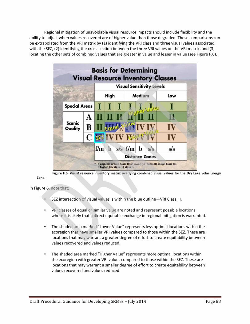
Draft Procedural Guidance for Developing SRMSs – July 2014 Page 88
Regional mitigation of unavoidable visual resource impacts should include flexibility and the ability to adjust when values recovered are of higher value than those degraded. These comparisons can be extrapolated from the VRI matrix by (1) identifying the VRI class and three visual values associated with the SEZ, (2) identifying the cross-section between the three VRI values on the VRI matrix, and (3) locating the other sets of combined values that are greater in value and lesser in value (see Figure F.6).
Figure F.6. Visual resource inventory matrix overlying combined visual values for the Dry Lake Solar Energy Zone.
In Figure 6, note that:
• SEZ intersection of visual values is within the blue outline—VRI Class III.
• VRI classes of equal or similar value are noted and represent possible locations
where it is likely that a direct equitable exchange in regional mitigation is warranted.
• The shaded area marked “Lower Value” represents less optimal locations within the ecoregion that have smaller VRI values compared to those within the SEZ. These are locations that may warrant a greater degree of effort to create equitability between values recovered and values reduced.
• The shaded area marked “Higher Value” represents more optimal locations within the ecoregion with greater VRI values compared to those within the SEZ. These are locations that may warrant a smaller degree of effort to create equitability between values recovered and values reduced.

Draft Procedural Guidance for Developing SRMSs – July 2014 Page 89
F.5.2 Objectives and Actions Mitigation objectives should be built from the opportunities found within the list of possible
mitigation locations. Objectives should be developed through coordinated collaboration between the other resource specialists and should mutually benefit visual resources and other system components (natural, ecological, cultural, recreational, etc.). The nuances between various BLM resource programs should be purposely sought and evaluated when establishing objectives, and supportive actions that facilitate co-benefits when mitigating unavoidable impacts should be developed through collaborative planning.
Examples of actions that could be implemented to recover visual values that also have an ecological, cultural, and recreational benefit may include:
• Restoration of surface disturbance associated with unauthorized and/or closed travel routes. • Vegetation treatments of facilitated land health that integrate visual elements of form, line,
color, and texture into the design. • Reclamation of visibly noticeable abandoned mines involving landform recontouring and/or
revegetation of disturbed surfaces, enhancing the naturalistic character of the landscape by integrating visual elements of form, line, color, and texture into the design.
• River and stream restoration that reestablishes river system stability and enhances the naturalistic character of the landscape by integrating visual elements of form, line, color, and texture into the design.
• Stabilizing and recontouring landscapes that have been subject to visibly excessive cases of accelerated erosion and sedimentation events.
• Recontouring and revegetating barren roadway cuts and fills. • Mitigating the visual delineation of pipeline and transmission line rights-of-way through
vegetation manipulation and reestablishing visually adaptive vegetation colors and textures. • Securing a scenic conservation easement on private lands that demonstrates a measurable
public benefit equal to or of greater value than the visual values reduced at the SEZ. Example: Dry Lake SEZ. Using the Dry Lake SEZ as an example, the combined visual values within the SEZ boundary are Scenic Quality C, high sensitivity, and within the foreground/middle-ground distance zone. The blue square shown on the VRI matrix (refer back to Figure F.1) indicates where the combined values of the SEZ fall within the full range of combinations, which results in a VRI Class III. VRI Class III indicates a moderate visual value.
Location Selection. Given the commonality of the visual resource values within the SEZ footprint and the SEZ’s visual landscape condition score of -1.5 (meaning that the Dry Lake SEZ is located within a landscape that has existing visual intrusions), it is not likely that regional mitigation for visual resources would be warranted as a special and individual effort. However, factoring visual values into the location selection and mitigation planning criteria for other resources warranting regional mitigation (e.g., restoration of creosote-bursage habitat in the Gold Butte ACEC) will promote visual stewardship with measurable and quantifiable results to help offset values lost when amending the VRM class to one of lesser protection.
Identifying and layering multiple resource opportunities with those that warrant regional mitigation will begin to frame the enhanced public benefits and value added for the same mitigation

Draft Procedural Guidance for Developing SRMSs – July 2014 Page 90
dollar invested. These opportunities should inform the final decisions on suitable mitigation locations and provide detail on how mitigation will be implemented to the benefit of an array of natural, scenic, and cultural resources.
The solar regional mitigation strategy for the Dry Lake SEZ (BLM 2013c) identifies the Gold Butte ACEC as the most preferable for regional mitigation of ecological resource impacts. The visual values within the Gold Butte area are higher than those of the Dry Lake SEZ, which provides opportunity for restoration/enhancement or preservation of an area regarded as having high visual resource value in combination with high ecological resource value (see Figure F.7).
The Gold Butte ACEC’s visual resource values include:
VRI Classes. There is a mix of VRI Class I, II, and III within the Gold Butte ACEC, with VRI Class II representing approximately 70% of the area. Scenic Quality. Distribution of scenic quality within the Gold Butte ACEC is:
• Scenic Quality A: Approximately 60% • Scenic Quality B: Approximately 30% • Not inventoried, but within the VRI Class I: Approximately 10%
Sensitivity. Distribution of sensitivity level within the Gold Butte ACEC is:
• High Sensitivity: Approximately 90% • Low Sensitivity: Approximately 11%
Distance Zone. Fifty-nine percent of the Gold Butte ACEC is within the foreground/middle-ground distance zone, which is the same as the Dry Lake SEZ. VRM Class Objectives: The Gold Butte area is managed under a VRM Class II designation managed for retention of the natural visual characteristics of the landscape.
Visual Resource Regional Mitigation Options. In concert with ecological mitigation, options may include:
• If the class in the RMP is amended from VRM Class III to VRM Class IV within the Dry Lake SEZ, the Gold Butte ACEC, involving preservation of biological resources, could be amended from a VRM Class II to a VRM Class I—preservation of the visual resource values to protect the investment, outcome, and integrity of the ecological and visual regional mitigation actions.

Draft Procedural Guidance for Developing SRMSs – July 2014 Page 91
Figure F.7. Map of the Gold Butte Area of Critical Environmental Concern visual resource inventory classes.
• If the ecological mitigation includes surface restoration, then visual design elements of form, line, color, and texture should be included as a part of the restoration planning, with participation from the district office VRM lead. Plans should demonstrate the visual resource benefit that will be accomplished through use of the “Visual Contrast Rating Worksheet,” BLM Form 8400-4, and documentation on how the improvements will reflect enhanced scenic resource values within the VRI.

Draft Procedural Guidance for Developing SRMSs – July 2014 Page 92
F.6 PROCESS FOR CALCULATING RECOMMENDED VISUAL RESOURCE MITIGATION FEES FOR SEZs
Consistent with Section 2.4.5 of this report, compensation in the form of a mitigation fee may be applied to solar projects that cause unavoidable impacts to the visual resources of the public lands. The purpose of the compensation is to acquire nonfederal land, restore or enhance disturbed federal land, or preserve federal land to maintain an existing balance of scenic value for the “public good” within the region. Metrics that are to be used to qualitatively and quantitatively determine important visual resources and problematic trends include VRI factors, proximity of development to adjacent scenic values of importance, and proximity of size and scale to other existing visual alterations.
Cost should be based on the actual level of effort required to accomplish the actions outlined in the SEZ strategy that will either visually restore the naturalistic character of landscape impacts within the selected regional mitigation locations or preserve existing high-quality visual resource integrity through scenic conservation easements over private lands. These costs should be evaluated in unison with other resource mitigation actions (wildlife habitat, vegetation communities, etc.) to make sure that those actions with co-benefits avoid a duplication of costs.
F.7 SPECIALLY DESIGNATED AREAS
In addition to the VRI and LUP management direction for visual resources, consideration is often
given to viewsheds stemming from the presence of specially designated areas (SDAs) near the SEZs. The Solar PEIS addresses the SDAs and the impact that may occur within their respective viewsheds as a result of solar energy development at each SEZ. Specially designated areas include a variety of types of areas that have received recognition or designation because they possess unique or important resource values. While these areas are not available for development of solar energy resources, they could be located near solar energy development areas and could be affected by solar energy development. Many of the SDAs discussed in the Solar PEIS are located on BLM-administered public lands (e.g., wilderness areas, wilderness study areas, special recreation management areas); however, many other SDAs managed by the National Park Service, U.S. Forest Service, and U.S. Fish and Wildlife Service (e.g., national parks, national scenic and historic trails, historic sites, national forests, national wildlife refuges), as well as areas designated and managed by states and localities, were also included in the analysis when they could be affected by solar energy development on public lands. While an SEZ may be in full conformance with the LUP VRM class objectives, overriding concerns regarding visual encroachments into valued views may exist, as seen from the SDAs.
SDAs are within variable ranges of the SEZ, with some within a mile and others out 20 or more miles. Solar facilities will likely be less visually dominant the further away they are from observation locations. Nevertheless, landscapes that seem most suitable to host solar energy development are also low in visual variety and have low visual resilience. Implementing the visual resource design features within the Solar PEIS ROD may substantially reduce the visual dominance of SEZ development.
The Solar PEIS analysis of visual impact of SEZ development on SDAs is a preliminary assessment of the potential scale of impact ranked as weak, moderate, or strong contrast and based on proximity, acreage, and percent of the SDA’s landscape that is within view of the SEZ. The consideration for unavoidable impacts should be limited to those SDAs that are listed as having moderate or strong levels of contrast.

Draft Procedural Guidance for Developing SRMSs – July 2014 Page 93
Determining visual impacts that may warrant regional mitigation includes the human cultural context of the landscape in question, assessment of the degree of visual change, and the level of visual dominance. Both the degree of visual change and how the visual change will dominate the view can be determined using the BLM Visual Resource Contrast Rating process, as described in BLM Handbook H-8431-1.
Assessing visual impact requires analysis, in addition to determining whether or not the development within the SEZ can be seen from an SDA. Building from the visual impact analysis in the Final Solar PEIS, the following steps are recommended in order to initiate a process for understanding the degree of visual impact to the SDAs and the necessity of considering regional mitigation:
1. Use the Final Solar PEIS analysis and summary to list those SDAs identified as potentially having moderate to strong visual contrasts when within view of the SEZ’s solar energy facilities, and include the following information: a. SDA name. b. Type of special designation (e.g., wilderness area, area of critical environmental concern,
special recreation management area, national park unit, national historic trail, etc.). c. Affected area within the special designation (acreage/percent of area). d. Distance from the SEZ to the affected areas within the SDA. e. The type of recreation and other activities within the affected areas. f. The frequency of use by the different recreation and/or other activities. g. The role the affected areas play in the management objectives of the SDA. h. Other forms of cultural modifications within the viewshed. i. The full context of the observer’s horizontal field of view, the amount of potential SEZ
development that could occupy the view, and the orientation of the solar energy development within the field of view.
2. For the specially designated areas listed under Step 1, prepare maps that label the locations of key observation points, show the full context of the SDAs, and illustrate the affected viewshed within the SDAs exposed to the SEZ.
3. Provide the rationale for selecting the key observation points and for identifying which are critical and which are representative key observation points.
4. Provide the critical nature of the affected views in comparison with the other quadrants of the SDA?
5. Prepare visual simulations of plausible forms of solar energy development.
6. Document how people access the key observation points (motorized travel on road, trail hike, river navigation, etc.).
7. Explain how the 10 environmental factors influence the degree of SEZ noticeability when the casual observer is within the visually exposed areas (see BLM Handbook H-8431-1).
8. Provide a detailed assessment of human use within the area and how exposure to the SEZ could affect the recreational experience of the SDAs.

Draft Procedural Guidance for Developing SRMSs – July 2014 Page 94
9. Prepare a Visual Resource Contrast Rating evaluation (BLM Handbook H-8431-1) from selected key observation points, and identify to which VRM class the outcome is closest in conformance.
10. Summarize the level of visual exposure based on the representative VRM class objective closest in alignment with the contrast rating results. Also, summarize the impact to the casual observer, taking all 10 environmental factors, the field of view, and other site conditions into consideration.
11. Using the previously developed information, assess the status of and list any unavoidable impacts to human uses within the SDAs as impacts that may warrant regional mitigation, providing a defensible rationale (e.g., A contrast rating outcome consistent with a VRM Class IV objective from a key observation point is a destination overlook with interpretative panels describing the historic significance of the landscape within view.).
12. Identify a final list of SDAs for which solar energy development would cause unavoidable impacts that warrant regional mitigation.
13. Develop a strategy for regional mitigations (e.g., restoration or enhancement in other areas of the SDA or within other SDAs, reduction in visual contrast of the solar facilities, etc.) for the SDAs that warrant regional mitigation.
14. As part of the process for determining regional mitigation compensation, compare compensatory alternatives with the regional mitigation strategies for other resources, and identify those that overlap to multiply the value (not cost) of the mitigation.
Example: Dry Lake SEZ Development Visibility from Nearby SDAs. For the Solar PEIS, a preliminary analysis of the potential contrasts that might be created by solar energy development in the SEZ was conducted, as seen from the SDAs that are visible from and within 25 miles (40 km) of the SEZ. The analysis was conducted by constructing virtual computer models of the most visually impacting solar energy development technology (solar power towers) located within the Dry Lake SEZ.
The determination of unavoidable visual impacts is based on the Final Solar PEIS analysis and further evaluates those SDAs listed in the Final Solar PEIS as having moderate or strong visual contrast. The goal is to preliminarily identify if these impacts are unavoidable and, if so, whether they may warrant further mitigation.
For the Dry Lake SEZ, the SDAs of concern include:
1. Desert National Wildlife Refuge. 2. Old Spanish National Historic Trail. 3. Arrow Canyon Wilderness. 4. Nellis Dunes Special Recreation Management Area.
An exercise was conducted using Google Earth to: • Reevaluate the impacted viewshed as delineated in the Final Solar PEIS. • Identify potential places where people may be found recreating or conducting other activities
within the affected viewshed.

Draft Procedural Guidance for Developing SRMSs – July 2014 Page 95
• Evaluate the full field of view from locations where people are likely to view the SEZ. • Evaluate the influence of the Visual Contrast Rating System’s 10 environmental factors (see
BLM Handbook H-8431-1, paragraph II.D.2.b.) on the degree of impact on SDA observers.
Specially Designated Area Unavoidable Visual Impact Findings Desert National Wildlife Refuge: The evaluation concluded that the Dry Lake SEZ is not within
view from locations where observers are known to be within the Desert National Wildlife Refuge. According to information provided by the Desert National Wildlife Refuge, the majority of the refuge’s visitation originates at the visitor center, with visitors accessing other areas of interest using the refuge’s network of roads and trails. Views of the Dry Lake SEZ from the refuge’s visitor center and network of roads and trails are obstructed by either the Sheep Range and/or the Las Vegas Range, which are west of the SEZ.
Old Spanish National Historic Trail: According to the BLM Pahrump Field Office archaeologist,
the Old Spanish National Historic Trail is east of the Dry Lake SEZ and lies within the Dry Lake Range. The trail roughly runs parallel to Interstate 15 with views of the Dry Lake SEZ being obstructed by topography within the Dry Lake Range.
Arrow Canyon Wilderness Area: The areas known to have high visitation include the slot canyons from which the development within the SEZ will not be visible. Nevertheless, it is likely that dispersed recreation activities will draw observers to higher elevations that overlook the Dry Lake valley.
The Final Solar PEIS viewshed analysis illustrates an estimated distance range of 9 to 22 miles (14.5 to 35.4 km) from Arrow Canyon to the Dry Lake SEZ, with 4% percent (1,011 acres, or 4.1 km2) of the total area of the Arrow Canyon Wilderness Area as having unobstructed views of the SEZ within the 5- to 15-mile (8.0- to 24.1-km) range, with another 1% of the area (204 acres, or 0.8 km2) within the 15- to 25-mile (24.1- to 40.2-km) range. While views of the solar energy development may be seen, it is unlikely that the visual dominance will be greater than a VRM Class III objective (moderate levels of change may be seen and draw the attention of the casual observer, but the change does not dominate the landscape). This would be a worst case scenario from the closer proximities to the Dry Lake SEZ. The exposure within these areas is very intermittent.
The SEZ is visible from a very small portion of the Arrow Canyon Wilderness, and where visible, impacts from solar energy development within the SEZ are expected to be low; therefore, regional mitigation is not warranted.
Nellis Dunes Special Recreation Management Area: The Nellis Dunes Special Recreation Management Area is a popular off-highway vehicle area. The SEZ is visible from 412 acres (1.7 km2), or 5% of the SRMA, and where visible, impacts from solar energy development within the SEZ are expected to be negligible; therefore, regional mitigation is not warranted.
Conclusion Unavoidable visual impacts to the SDAs are low with no recommendations for regional
mitigation.

Draft Procedural Guidance for Developing SRMSs – July 2014 Page 96
APPENDIX G: BLM Screening Matrix for Candidate Regional Mitigation Locations of Solar Energy Zones
The BLM interdisciplinary team can use this screening tool for evaluating and recommending candidate locations to the BLM authorized officer. See definitions for criteria categories at the end of this appendix.