Draft Planning Proposal: Western Precinct Redgum … Meeting of Council 14 December 2015 20 REF:...
26
Ordinary Meeting of Council 14 December 2015 20 REF: CM292/15 File: PP-2014/8 ITEM 3 DRAFT PLANNING PROPOSAL: WESTERN PRECINCT REDGUM RIDGE ESTATE, REDGUM FOREST WAY, FIGTREE On 15 December 2014 Council resolved to prepare a draft Planning Proposal to facilitate 29 new residential allotments in the western precinct of Redgum Ridge Estate, Lot 815 DP 1193843 Redgum Forest Way, Figtree, together with the establishment of a BioBanking Agreement for the remainder of the land as an enhanced biodiversity offset to the proposed development. The draft Planning Proposal also sought to resolve some minor rezoning anomalies around the existing approved Redgum Ridge Estate subdivision. The draft Planning Proposal was exhibited between 16 March and 17 April 2015. This purpose of this report is to provide feedback on the public exhibition and to seek endorsement of a process to achieve a BioBanking Agreement and Biodiversity Certification covering a larger area, and to finalise the Planning Proposal in two parts. RECOMMENDATION 1 The draft Planning Proposal to correct minor anomalies around the existing approved eastern precinct of Redgum Ridge Estate, Figtree be progressed by: a finalising the Planning Proposal that seeks to amend the Land Zoning Map from E3 Environmental Management to R2 Low Density Residential zone, and make corresponding amendment to the Floor Space Ratio, Minimum Lot Size and Natural Resource Sensitivity Maps; b The final Planning Proposal be referred to the NSW Department of Planning and Environment for the making of arrangements for drafting to give effect to the final proposal; and c Note that the General Manager will thereafter proceed to exercise his delegation issued by the NSW Department of Planning and Environment under Section 69 in relation to the final proposal. 2 Support the establishment of a BioBanking Agreement for Redgum Ridge Estate, covering both the lands zoned E2 Environmental Conservation (Lot 814 DP 1193843 Redgum Forest Way, Figtree – eastern precinct) and proposed to be zoned E2 Environmental Conservation (Lot 815 DP 1193843 Redgum Forest Way, Figtree – western precinct) in accordance with the conditions set in a BioBanking statement issued by the Office of Environment and Heritage. 3 Support in-principle the establishment a Biodiversity Certification Agreement for Redgum Ridge Estate in accordance with Section 126H of the Threatened Species Conservation Act 1995, with Council as the planning authority lodging the Biodiversity Certification application to the Office of Environment and Heritage, subject to the Biodiversity Certification application being reported to Council prior to exhibition.
Transcript of Draft Planning Proposal: Western Precinct Redgum … Meeting of Council 14 December 2015 20 REF:...

Ordinary Meeting of Council 14 December 2015 20
REF: CM292/15 File: PP-2014/8
ITEM 3 DRAFT PLANNING PROPOSAL: WESTERN PRECINCT REDGUM RIDGE ESTATE, REDGUM FOREST WAY, FIGTREE
On 15 December 2014 Council resolved to prepare a draft Planning Proposal to facilitate 29 new residential allotments in the western precinct of Redgum Ridge Estate, Lot 815 DP 1193843 Redgum Forest Way, Figtree, together with the establishment of a BioBanking Agreement for the remainder of the land as an enhanced biodiversity offset to the proposed development. The draft Planning Proposal also sought to resolve some minor rezoning anomalies around the existing approved Redgum Ridge Estate subdivision. The draft Planning Proposal was exhibited between 16 March and 17 April 2015.
This purpose of this report is to provide feedback on the public exhibition and to seek endorsement of a process to achieve a BioBanking Agreement and Biodiversity Certification covering a larger area, and to finalise the Planning Proposal in two parts.
RECOMMENDATION
1 The draft Planning Proposal to correct minor anomalies around the existing approved eastern precinct of Redgum Ridge Estate, Figtree be progressed by:
a finalising the Planning Proposal that seeks to amend the Land Zoning Map from E3 Environmental Management to R2 Low Density Residential zone, and make corresponding amendment to the Floor Space Ratio, Minimum Lot Size and Natural Resource Sensitivity Maps;
b The final Planning Proposal be referred to the NSW Department of Planning and Environment for the making of arrangements for drafting to give effect to the final proposal; and
c Note that the General Manager will thereafter proceed to exercise his delegation issued by the NSW Department of Planning and Environment under Section 69 in relation to the final proposal.
2 Support the establishment of a BioBanking Agreement for Redgum Ridge Estate, covering both the lands zoned E2 Environmental Conservation (Lot 814 DP 1193843 Redgum Forest Way, Figtree – eastern precinct) and proposed to be zoned E2 Environmental Conservation (Lot 815 DP 1193843 Redgum Forest Way, Figtree – western precinct) in accordance with the conditions set in a BioBanking statement issued by the Office of Environment and Heritage.
3 Support in-principle the establishment a Biodiversity Certification Agreement for Redgum Ridge Estate in accordance with Section 126H of the Threatened Species Conservation Act 1995, with Council as the planning authority lodging the Biodiversity Certification application to the Office of Environment and Heritage, subject to the Biodiversity Certification application being reported to Council prior to exhibition.

Ordinary Meeting of Council 14 December 2015 21
4 Support the transfer of the land proposed to be zoned E2 Environmental Conservation (Lot 815 DP 1193843 Redgum Forest Way, Figtree – western precinct) to Council, with funding, following the approval of the Biodiversity Certification application - noting that the transfer of the eastern portion of the forest to Council has previously been supported.
5 Following the endorsement of the Biodiversity Certification application by the Minister for the Environment, the draft Planning Proposal for the western precinct of Redgum Ridge Estate, Figtree (Lot 815 DP 1193843 Redgum Forest Way, Figtree) be progressed by:
a finalising the Planning Proposal that seeks to amend the Land Zoning Map from RU2 Rural Landscape to E4 Environmental Living with a Minimum Lot Size of 1,000m² and Floor Space Ratio of 0.3:1, and rezone the remainder of the site to E2 Environmental Conservation with a Minimum Lot Size of 39.99ha;
b The final Planning Proposal be referred to the NSW Department of Planning and Environment for the making of arrangements for drafting to give effect to the final proposal; and
c Note that the General Manager will thereafter proceed to exercise his delegation issued by the NSW Department of Planning and Environment under Section 69 in relation to the final proposal.
ATTACHMENTS
1 Site Locality Map and Current Zoning 2 Site Locality Map and Aerial 3 Initial Concept Plan 4 Proposed Planning Proposal Maps – Eastern Precinct 5 Proposed Planning Proposal Maps – Western Precinct
REPORT AUTHORISATIONS
Report of: Renee Campbell, Manager Environmental Strategy and Planning Authorised by: Jeannie Nicol, Director Planning and Environment – Future City and
Neighbourhoods (Acting)
BACKGROUND
Redgum Ridge Estate, Figtree is located off O’Briens Road and accessed via George Fuller Drive and Redgum Forest Way. To the north is Brandy and Water Creek, to the south is American Creek and Cordeaux Road, and farmland is to the west of the site. The estate is divided into two parts. The eastern part is zoned R2 Low Density Residential and was granted development approval in 2004 for the creation of 220 residential lots. This subdivision has occurred in stages and is nearing completion.
Ordinary Meeting of Council 14 December 2015 22
As part of the development approval a Vegetation Management Plan (VMP) was established to retain and rehabilitate 26.2 hectares, comprising Red Gum Forest, Rainforest Remnant and riparian corridors (generally Lot 814 DP 1193843). The specific objectives of the VMP included:
The protection and restoration of the Red Gum Forest and Rainforest Remnant adjacent American Creek (including removal of weeds and invasive plants and the implementation of a bushland regeneration program to promote the regeneration of native grasses and groundcovers);
To improve the quality of the riparian vegetation on American, Brandy and Water Creeks;
To minimise the impact of the proposed residential development on native vegetation to be retained; and
To maintain and enhance habitat for native flora and fauna.
Through the development assessment process, Council agreed to the transfer of the floodplain, Red Gum Forest and Rainforest areas to Council, on completion of the VMP obligations.
As part of the assessment of the draft Planning Proposal request for the western precinct, a number of minor mapping discrepancies were identified between Wollongong LEP 2009 maps and the approved subdivision layout, in the eastern part of the Estate. This draft Planning Proposal has provided the opportunity to update the Local Environmental Plan maps for the Redgum Ridge Estate to remove minor inconsistencies between the planning controls and the approved subdivision (Attachments 1 and 4).
The draft Planning Proposal request for the western precinct of Redgum Ridge Estate landholding seeks to complete the Estate development and enable long term management of the identified environmental values of the area. The subject lands comprise 41.28 hectares situated at the western edge of “Redgum Ridge” and are predominantly zoned RU2 Rural Landscape, with the southern steep and densely vegetated side slopes zoned E2 Environmental Conservation (Attachments 1 and 2).
The draft Planning Proposal request seeks to facilitate 29 new large residential allotments in the western precinct of Redgum Ridge Estate, Lot 815 DP 1193843 Redgum Forest Way, Figtree, together with the establishment of a BioBanking Agreement for the remainder of the land as an enhanced biodiversity offset to the proposed development. The 29 low density residential lots range in size from 1,229m² to 1.1 hectares to achieve a rural residential character subdivision (Attachment 3).
Access to the proposed new allotments will be gained via a public road which will be an extension of Redgum Forest Way, servicing the residential estate to the east. The internal road network will consist of a perimeter road to control bushfire management considerations within the site. Full urban reticulation services (power, sewer, water and telecommunications) can be provided from the existing service network within the Redgum Ridge Estate.

Ordinary Meeting of Council 14 December 2015 23
The majority of the higher western end of the ridge and upper moderate slopes have been cleared of native vegetation and are characterised by pasture grasses and scattered individual/small stands of trees. These open grassy woodland areas are being managed by regular slashing and are grazed by feral animals. This area is proposed for large lot low density residential development, ranging in size from 1,229m² to 1.1 hectares. The remainder of the site associated with the steeper ridge side slopes is heavily forested, with the condition of the native vegetation varying from relatively intact and weed-free to areas of remnant canopy with an understorey dominated by Lantana Camara Lantana.
The vegetated ridge slopes are proposed to be conserved. The northern ridge steep side slopes contain Illawarra Lowlands Grassy Woodland vegetation, and the southern ridge steep side slopes contain Illawarra Subtropical Rainforest. In total, the draft Planning Proposal request seeks to retain and protect 28.21 hectares of native vegetation, including 6.73 hectares of Illawarra Lowlands Grassy Woodland and 3.71 hectares of Illawarra Subtropical Rainforest. Both of these vegetation types are Endangered Ecological Communities (EECs) listed within the Threatened Species Conservation Act (1995).It will also protect known habitat for the White-flowered Wax Plant.
RU2 Rural Landscape zoning is no longer appropriate for the subject lands. Agricultural uses are not economically viable given the land holding size and, given the presence of Endangered Ecological Communities (EECs); any further traditional agricultural uses (such as cattle grazing) may threaten the long term conservation and management of the identified vegetation. Vegetated areas containing endangered communities would be best conserved and managed for the long term in accordance with the objectives of the E2 Environmental Conservation zoning, and protected under a Biodiversity Management Plan.
The area (including E2 Environmental Conservation zoned land) is currently subject to a number of key threatening processes, including feral animals and weed invasion. Deer and feral goats have been identified in the Illawarra Biodiversity Strategy as a “high priority for control”, the impacts on biodiversity including overgrazing, trampling, ring-barking, dispersal of weeds, acceleration of erosion, prevention of native species regeneration through grazing, and competition with native fauna for food and resources. A long term management plan for this land is required, as agricultural uses are no longer viable and the status quo scenario is continued pressure from key threatening processes.
On 15 December 2014 Council considered a report on the draft Planning Proposal request and resolved:
1 A draft Planning Proposal be submitted to the NSW Department of Planning and Environment seeking a Gateway determination to rezone part of the site from RU2 Rural landscape to E4 Environmental Living with a Minimum Lot Size of 1,000m² and Floor Space Ratio of 0.3:1 and rezone the remainder of the site E2 Environmental Conservation with a Minimum Lot Size of 39.99ha;

Ordinary Meeting of Council 14 December 2015 24
2 A BioBanking Agreement be established for the lands zoned E2 in accordance with the conditions set in a BioBanking statement issued by the Office of Environment and Heritage (OEH);
3 Advice be sought from the NSW Department of Planning and Environment concerning an appropriate legal framework to recognise that the rezoning is contingent on the establishment of an approved BioBanking Agreement;
4 Advice be sought from the NSW Department of Planning and Environment about any further studies required (e.g. further targeted flora and/or fauna surveys);
5 The draft Planning Proposal also include amendments to the Land Zoning Map, Floor Space Ratio map, Minimum Lot Size Map, Height of Buildings Map, and natural resource Sensitivity Map, to remove inconsistencies with the approved and developed Redgum Ridge Estate Subdivision;
6 Council request authority for the General Manager to exercise plan making delegations in accordance with Council’s resolution of 26 November 2012; and
7 The proponent investigate the provision of additional future access to Cordeaux Road, via Stones Road, from this development.
A Gateway Determination was received on 2 March 2015 and the draft Planning Proposal was exhibited from 16 March to 17 April 2015.
PROPOSAL
As a result of the exhibition, 10 submissions were received, five from Statutory Authorities, three from community members and one each from Neighbourhood Forum 5 and the Escarpment Planning Reference Group. The issues raised in the submissions are discussed later in this report.
Conservation Strategy
A key purpose the draft Planning Proposal is the conservation of the environmentally sensitive areas of the site, whilst facilitating development on the remainder. The determination of the appropriate mechanism and process has evolved during and following the exhibition period process, in discussion with OEH and the landowner.
The draft Planning Proposal request initially proposed an E2 Environmental Conservation zone for the conservation area and an R2 Low Density Residential zone for the land to be developed into 29 lots. Council officers recommended that the R2 Low Density Residential zone be replaced by an E4 Environmental Living zone to limit development to one dwelling house per lot, and preclude dual occupancy and multi-dwelling housing development. This position was supported by Council and was exhibited as part of the draft Planning Proposal.
However, the E4 Environmental Living zone does not “turn-off” the Threatened Species Conservation Act 1995 and precludes a BioBanking Agreement from being established on lands to be developed. A BioBanking Agreement can be used on land zoned E4 Environmental Living to enable conservation.

Ordinary Meeting of Council 14 December 2015 25
Discussions with OEH, Local Land Services (LLS) and the landowner during and after the exhibition period resulted in an amended strategy to achieve conservation of the site values, albeit through a more complex process. The conservation strategy has also been expanded to include the eastern forest which is already proposed to be transferred to Council.
It is proposed that:
1 The proponent submit a BioBanking Agreement to OEH covering the two western areas, as initially proposed (28.21ha currently zoned E2 Environmental Conservation), plus the larger eastern forest (26.2ha in Lot 814 DP 1193843), plus the semi-circular area on the northern side of the proposed road that was identified to contain a dwelling. This results in the overall BioBanking area for conservation totalling 54.41ha. It is noted that the credits for the eastern forest will be slightly lower, as the land has been subject of five years of maintenance through a Vegetation Management Plan, and the landowner has spent over $1 million.
2 The proponent prepare and submit to Council a Biodiversity Certification application, for Council review and endorsement. The Biodiversity Certification application will show the 54.51ha of land to be conserved and the 8.2ha of land to be zoned E4 Environmental Living within which large lot development will occur. The conservation credits required for the development will be obtained from the conservation area, and the balance will be available to be used in other parts of the City (such as West Dapto). This will provide funding for the on-going (in perpetuity) conservation of both the eastern and western forests. A Biocertification Application needs to be submitted by a planning authority (ie Council), rather than a landowner. If the draft is endorsed by Council the following process applies:
a the application is required to be exhibited for a minimum of 30 days. The planning authority is required to publish notice of the application in a newspaper circulating generally throughout the state and on the planning authority’s website;
b when the exhibition period ends, the planning authority must provide a submissions report to the Minister for the Environment; and
c OEH then make recommendations to the Minister for the Environment, who then either confers Biodiversity Certification on the specified land or refuses it.
3 If the Minister for the Environment endorses the Biodiversity Certification application, and is satisfied that the conservation measures for the eastern and western forests is progressing, then Council will finalise the Planning Proposal for the western lands (Attachment 5). There is a small risk to Council, that the conservation outcomes may not be fully achieved if the rezoning of the western lands is progressed now, prior to the lodgement of the BioBanking Agreement and Biodiversity Certification application.

Ordinary Meeting of Council 14 December 2015 26
4 Both the eastern forest and the western forest will be transferred to Council to ensure on-going conservation, with funding provided through the Biocertification process from OEH. Council officers are supportive of taking on the responsibility of managing a large conservation area, as perpetual funding will be available.
Biodiversity Certification is a mechanism to integrate planning for biodiversity conservation with planning for proposed intensification of land use. In this way, the planning authority is able to identify:
areas of high biodiversity value to be protected from development; and
other areas of lower biodiversity value, including cleared land, suitable for development.
The key advantage of the Biodiversity Certification process is that it encourages planning authorities to identify the biodiversity values of the land as part of the strategic planning process, and provides certainty that a positive conservation outcome can be achieved as the land identified for in perpetuity biodiversity protection and management, along with the funding mechanism, are locked in at the strategic planning stage.
Biodiversity Certification may be granted by the Minister for the Environment administering the Threatened Species Conservation Act 1995 (TSC Act) in accordance with Part 7AA. An application for Biodiversity Certification is generally developed in conjunction with a Planning Proposal. Only planning authorities may apply to the Minister for the Environment to have Biodiversity Certification conferred on specified land (TSC Act, s. 126J(1)), and the proponent and OEH have therefore requested Council to undertake the role of lodging the application that has been prepared by the proponent.
Since the exhibition period, the proponent has updated the environmental information to inform the Biocertification process. Additional surveys and assessment of the site have been undertaken to develop a Biodiversity Conservation Strategy in support of an application to seek Biodiversity Certification under Section 126H of the NSW Threatened Species Conservation Act 1995 (TSC Act), including mapping of the tree canopy and targeted flora and fauna surveys. The Biodiversity Conservation Strategy is a strategy for the implementation measures to ensure that the overall effect of Biodiversity Certification is to improve or maintain biodiversity values (TSC Act, s.126K(2)) and has been reviewed and endorsed by OEH.
The proponent will be responsible for the application fee for a BioBanking Agreement. There is no application fee for Biodiversity Certification. The proponent has commissioned and funded the preparation of all the necessary environmental studies and Biodiversity Certification Assessment, and preparation of the Biodiversity Certification Strategy, as required by OEH. Council will be responsible for costs associated with advertisement and exhibition of the application and Biodiversity Certification Strategy, preparation of a submissions report and staff attendance at any meetings required with OEH and consultants.

Ordinary Meeting of Council 14 December 2015 27
Road Connection
The other key issue in the Council resolution was for the proponent to investigate the provision of additional future access to Cordeaux Road, via Stones Road, from this development. The proponent has indicated a willingness to pursue a second access, however negotiations with adjoining landowners have not been successful. The development concept enables a connection to the lands to the west, should a rezoning application for this area be lodged in the future. It is noted that some members of the Mt Kembla community have previous expressed concern about the connection of Mt Kembla with other communities to the north and south. However, Council needs to consider the community as a whole and provide for connectivity by road, bike, foot and public transport.
Eastern Precinct – Anomalies
As noted, the draft Planning Proposal provided the opportunity to resolve some minor mapping discrepancies between the Wollongong LEP 2009 maps and the approved subdivision layout, in the eastern part of the Estate. The discrepancies are delaying development on some approved lots, as a dwelling house cannot be built on the land zoned E3 Environmental Management. No submissions commented on this aspect of the draft Planning Proposal. It is proposed that this aspect of the draft Planning Proposal be finalised under delegated authority immediately (Attachment 4).
CONSULTATION AND COMMUNICATION
The draft Planning Proposal was exhibited between 16 March and 17 April 2015 following the Gateway Determination. The Gateway Determination required that the following public authorities should be consulted:
NSW Rural Fire Service;
Sydney Water; and
NSW Office of Environment and Heritage.
The exhibition was advertised through Council’s website and in the Illawarra Mercury and Advertiser newspapers. Copies of the suite of documents were available for viewing on Council’s website, in Wollongong and Unanderra libraries, and at Council’s Customer Service Centre in the Administration Building, Wollongong. Adjoining property owners and Neighbourhood Forum 5 were notified of the public exhibition by mail. The exhibition was included as an agenda item for the March 2015 meeting of the Escarpment Planning Reference Group and an endorsed submission was subsequently received from the Group.
The abovementioned Public Authorities were notified by mail and were forwarded a CD containing the exhibition materials. The operators of the Eastern Gas Pipeline, Jemena Asset Management Pty Ltd, were also advised in writing of the public exhibition.
Ordinary Meeting of Council 14 December 2015 28
As a result of the public exhibition the website page received 209 views and the draft Planning Proposal exhibition material was downloaded 138 times. A total of 10 submissions were received, as follows:
Office of Environment and Heritage;
NSW Rural Fire Service;
Roads and Maritime Services;
Sydney Water;
Jemena Asset Management Pty Ltd;
Escarpment Planning Reference Group;
Neighbourhood Forum 5; and
Community (three).
Comments were provided on the draft Planning Proposal as follows:
Issues Raised Officer Response
Environment Concern was raised that bushfire management does not compromise BioBanking sites – clearing for APZs and vegetation management should be minimal to avoid diminished BioBank vegetation value.
Suggested that the proposed dwelling site on the north side be deleted, to avoid edge effects and the need for APZs on the land to be BioBanked.
Suggested better from a vegetation perspective to join the two areas to be BioBanked as this would reduce the edge effects and strengthen the capacity of the vegetation to retain its value in the longer term.
These issues will be addressed in consultation with the Office of Heritage and Environment as they work with the proponent to develop a BioBanking Agreement to provide a conservation covenant over areas of retained native vegetation in the proposed offset sites, and for a management plan to be prepared and implemented to manage those offset sites.
The primary measure for the proposed rezoning and subsequent development in order to minimise impacts to ecological values is to avoid and minimise the removal of native vegetation and habitat. The current layout is largely restricted to areas in low condition and avoids and minimises impacts to areas of higher biodiversity value. A BioBanking Agreement (developed in association with OEH) will provide a conservation covenant over areas of retained native vegetation in the proposed Offset sites and a management plan and associated funding

Ordinary Meeting of Council 14 December 2015 29
Issues Raised Officer Response
mechanisms will be prepared and implemented to manage these offset sites. The current proposal is identified as likely to result in a positive net benefit to biodiversity.
Bushfire The NSW Rural Fire Service provided comment on access, asset protection zones and special fire protection purpose development.
Concern was raised that roads should provide a satisfactory level of service in the event of an emergency and given bush fire hazard vegetation is located immediately adjacent to the proposed single public road, the subject development area may be isolated in a bush fire emergency. The RFS recommends consideration of an additional access point to the proposed development, or alternatively a plan of management established in regard to the vegetation adjacent to the proposed thoroughfare. The Escarpment Planning Reference Group also expressed concern in relation to one access/egress road. The RFS also referred to section 4.1.3 (1) of Planning for Bush Fire Protection 2006 for all required road widths and grades for main public roads and perimeter roads.
At subdivision stage, asset protection zones must be provided within property boundaries in accordance with Planning for Bush Fire Protection 2006. Residential lots must achieve a maximum 29kW/m² radiant heat flux. While it is recognised that all the proposed future lots can achieve a building envelope with a maximum 29kW/m² radiant heat flux as indicated, many of the lots have building envelopes constrained to the rear of the site which is not considered practical. Specifically, the dwellings on future lots 1-4, 6-7 and 25-28 must conform to the building envelopes indicated or they will not achieve a 29kW/m² radiant heat flux and therefore will be required to
The Planning Proposal included a bushfire constraints assessment report completed by Australian Bushfire Protection Planners P/L (2014) to inform a suitable development design. The report concluded that “the characteristics of the site, as discussed in this report together with the fire protection measures recommended, provide that the rezoning and subsequent subdivision of the land is suitable in terms of its intended residential land use”. These measures include APZs, access for firefighting operations from roads constructed in accordance with Planning for Bushfire Protection 2006, street water hydrants to comply with AS 2419.2, housing construction standards, internal perimeter road and full urban reticulation services.
The Development Control staff of the NSW Rural Fire Service met with representatives from Australian Bushfire Protection Planners P/L to assess appropriate access to the site, and agreed with the proposal for a dual lane access road, with a managed corridor provided to each side of the road.
The Council resolution has requested that the proponent investigate an alternative second access way. The proponent has indicated a willingness to pursue a second access, however this will require successful negotiations with adjoining landowners. Failing this, the RFS will need to approve

Ordinary Meeting of Council 14 December 2015 30
Issues Raised Officer Response
construct to Bushfire Attack Level (BAL) 40 or BAL Flame Zone requirements under AS 3959-2009 Construction of buildings in bush fire prone areas.
Some of the proposed lots may not be suitable for Special Fire Protection Purpose (SPFF) Developments, such as bed and breakfast accommodation, home based child care and community facilities (permitted uses in E4 zone), which require greater separation distance between development and unmanaged vegetation.
any vegetation plan of management submitted as part of the Development Application.
The Concept Plan shows a perimeter road with the majority of building envelopes adjacent to the road (Attachment 3).
Traffic No objection from Roads and Maritime Services.
Concern raised by a resident that the proposal will add to current traffic congestion at peak hours at the intersection of O’Briens Road and Princes Highway. The traffic generated from houses currently under construction at Redgum and Hilltop Estates is still to be realised. Would support strategy of the development being linked to Cordeaux Road.
The traffic generation characteristics of the future housing development are projected to be moderate, comprising some 290 vehicle trips per day or 20 vehicle trips per peak hour. There is ample capacity within the existing/proposed public road network to accommodate these projected traffic levels.
The RMS is aware of all residential development taking place in the area and has no objection to the Planning Proposal.
The potential for an alternative second access is being investigated.
Eastern Gas Pipeline
Jemena confirms they have a High Pressure Trunk main located in the vicinity if the proposed development area, and a duty of care exists to ensure this gas main is not compromised or damaged during any future development or construction works. Jemena will work with the proponent ensure that a Pipeline Risk Assessment is included as part of the process for determining the suitability of infrastructure (as part of the Development Application). Jemena notes that all costs associated with the risk assessment will be borne by the developer and/or landowner.
Noted – risk assessment to be completed, in conjunction with Jemena, as part of the Development application stage (to be funded by the developer and/or landowner).

Ordinary Meeting of Council 14 December 2015 31
Issues Raised Officer Response
Water The proponent will be required to obtain a Section 73 Certificate from Sydney Water for the management of the servicing aspects of the proposed development, covering extension from the 100 mm main in Red Gum Forest Way, a possible booster pump, and the design and construction of a wastewater main.
Full urban reticulation services (power, sewer, water and telecommunications) can be provided from the existing service network within the Redgum Ridge Estate.
Flooding/ Riparian
Concern voiced by resident that while a flood study has been performed on the immediate vicinity of the proposed new dwellings, no consideration has been given to the impact building these homes will have on the environment and properties downstream. Concern about potential increased runoff and flow rate in the creeks, and the impact on the quality of the creek system downstream. Concern that creek banks have already suffered erosion and deterioration since Redgum Ridge Estate works – particularly at the junction of American and Branch Creeks. Will be an onus on Council to perform extensive clearing of blocked creeks and complete creek bank stabilisation works.
The establishment of the northern BioBank site would prevent any development that may impact on Brandy and Water Creeks. The area proposed for low density residential development would potentially result in surface drainage and stormwater management in the direction of American Creek, although it should be noted proposed is large lot development of a rural residential character, to limit hard surface runoff. A flood study assessment performed by KFW Infrastructure Professional (2014) concluded that the subject draft Planning Proposal outcomes are not constrained by the impacts of flooding. Internal referral to Stormwater division raised no issues of concern.
Drainage and stormwater issues specific to any submitted subdivision plan would be addressed at the Development Application stage.
Zone boundary anomaly comments
Stage 14 zoning anomalies to be rectified, as previously advised, to align with transmission easement, flood line and proposed access road.
Noted.
Rural character and visual impact
The Escarpment Planning Reference Group raised concern that any potential visual impact issues should be addressed, given that development is proposed on a ridgeline. Neighbourhood Forum 5 expressed a desire for development not to be seen
The Commission of Inquiry (COI) recognised that the cleared ridge plateau has potential for limited low density residential development provided that the matter of vegetation management within the site can be satisfactorily achieved.
Ordinary Meeting of Council 14 December 2015 32
Issues Raised Officer Response
from Mount Kembla Village.
Larger lots would have been expected as development moves towards the escarpment.
Adjoining neighbours have expressed a desire to retain the rural ambience of their property should their current fencing be damaged or needs replacing as a result of the proposed development – rural stock fencing is preferred over colourbond fencing material.
A visual assessment at the Development Application stage will be required.
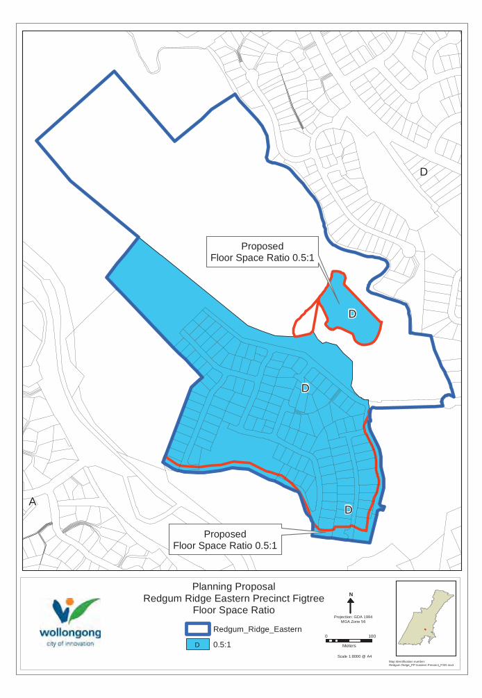
The proponent sought a R2 Low Density residential zoning, in recognition of the proposed development being the finalisation of the existing Redgum Ridge Estate to the east. The Council Officer recommendation was that an E4 Environmental Living zoning more appropriately reflected the environmental setting, given its proximity to the areas of environmental sensitivity. An E4 Environmental Living zoning controls for a more limited range of permitted land uses appropriate to the surrounding environmental setting. Importantly, this E4 zoning won’t allow further subdivision for dual occupancies and multi dwelling houses. The proposal is for the development of 29 large residential lots ranging in size from 1,229m² to 1.1 hectares. The proposed low density minimum lot size of 1000m² is consistent with the E4 zoned land to the south, which also adjoins E2 zoned land.
Planning controls pertaining to fencing are contained in Council’s Development Control Plan which encourages post and wire or timber post and rail fencing.
At its meeting on 2 April 2015 Neighbourhood Forum 5 resolved to support the proposal, but only if:
1 It is demonstrated that the development (including potential two storey houses) cannot be seen from Mount Kembla village;
2 Access in case of bushfire is resolved;
3 Bushfire management does not compromise BioBanking sites; and
4 Trees on the site are protected.

Ordinary Meeting of Council 14 December 2015 33
At its meeting on 25 November 2015 the Escarpment Planning Reference Group raised concern that any potential visual impact issues should be addressed, given that development is proposed on a ridgeline. A Visual Impact Analysis will be required at the development application stage in this regard.
Satisfactory internal referrals were received in relation to environment, geotechnical, traffic and access, flooding, heritage and services and infrastructure issues for consideration.
PLANNING AND POLICY IMPACT
This report contributes to the delivery of Wollongong 2022 objective “The Natural environment is protected and enhanced” under the Community Goal “We value and protect our environment”.
Community Strategic Plan Delivery Program 2012-2017 Annual Plan 2015-16
Strategy 5 Year Action Annual Deliverables
1.6.1 Our urban environment minimizes impacts on habitat and biodiversity and areas of high conservation value are protected.
1.6.1.1 Review planning controls for environmentally sensitive locations.
Continue to assess Planning Proposals against environmental strategies, including the Illawarra Biodiversity Strategy and the Illawarra Escarpment Strategic Management Plan.
Relevant policy and strategies for the evaluation of this draft Planning Proposal include the Illawarra Escarpment Commission of Inquiry (1999), Illawarra Escarpment Strategic Management Plan (2015) and the Illawarra Biodiversity Strategy (2010). The daft Planning Proposal is consistent with the recommendations contained in these policies and strategies.
CONCLUSION
The NSW Government BioBanking scheme aims to encourage and secure investment in conservation by providing both the legal and financial mechanisms to ensure the long term conservation of biodiversity values at BioBank sites. Landowners who establish a BioBank site benefit from the provision of funding to manage the site and improve the biodiversity values on that site, and in so doing increase the viability of threatened species populations and improve the quality of habitat and the condition of native plant communities.
The Development Strategy presented in this draft Planning Proposal has the potential to ensure the revegetation and protection of an important habitat corridor in the local area, linking up a proposed offset site with the area currently being managed under a Vegetation Management Plan, designated as a “future Council reserve”, with ongoing funding.
A long term management plan for this land is required, as agricultural uses are no longer viable and the status quo scenario is continued pressure from key threatening processes. Implementation of a BioBanking Agreement in association with low density

Ordinary Meeting of Council 14 December 2015 34
limited residential development will provide a suitable development outcome whilst significantly enhancing the biodiversity values of those parts of the site to be conserved and protected in perpetuity. The Office of Environment and Heritage has provided in principle support for the use of BioBanking as a mechanism for offsetting proposed development on the subject site and has acknowledged the potential for net conservation gains.
It is recommended that the exhibited Planning Proposal be progressed in two stages:
1 The Planning Proposal for the eastern precinct to correct mapping anomalies be finalised immediately under delegation issued by the NSW Department of Planning and Environment; and
2 The Planning Proposal for the western precinct be finalised under delegation issued by the NSW Department of Planning and Environment, once the Biodiversity Certification application has been endorsed by the Minister for the Environment.

Figtree
Cordeaux Road
O'B
riens R
oad
Odenpa Road
Booreea Boulevarde
Redgum Forest Way
Lamerton Driv
e
Der
ribon
g D
rive
Darragh D
rive
Natan Place
Gibsons Road
William James Drive
Sheringa Grove
Silk
pod
Str
eet
Foy Avenue
Kerrawah Avenue
Hen
nessy
Lan
e
Cra
nes
bill
Way
Jalna Avenue
Cas
caril
la S
treet
Be
lwarra
Ave
nue
Koombala Grove
O'B
riens Lane
Deenyi Close
Gahnia Avenue
Paltarra Place
Bre
ynia
Str
eet
Baker Crescent
Indigo Way
MarrilCirc
uit
Partridge Place
Ban
gala
y S
tree
t
Kimm
ins Place
Mor
inda
Clo
se
Sa
mp
son
Pla
ce
Roseg
um C
lose
Hannah Close
Indigo Way
Ban
gala
y S
tree
t
R2
RU2
R2
E3
E2E2
R2
E4RE1
E4
R2
E4
E3
R2
RU2RE1
RE1
SP2
SP2
RU2
E3
RE1RE1
RU2
RE1
RE1
RE1
Art
er A
venu
e
Mcgregor P
lace
Jaca
rand
a A
venu
e
randaA
ve
Goodbury Avenue
Will
iam
Da
vie
sD
rive
olan
gi C
lose
Sto
ckw
ell P
lace
Welfo
rd P
la
George Fulle
Breynia Street
Morinda Close
RE1
0 300
Meters
Date of Aerial Photography: 2014
Date: 25/11/2015
Redgum Ridge Figtree Zone.mxd
Drawn By: H JonesPlanning Proposal = Redgum RidgeRedgum Ridge Estate Figtree . Lot 815 DP.1193843
Site Locality Map and current Zoning
Redgum Ridge Eastern Precinct
E2 Environmental Conservation
R2 Low Density Residential
RU2 Rural Landscape
E4 Environmental Living
E3 Environmental Management
Future Council Reserve
Redgum Ridge Western Precinct

Figtree
Cordeaux Road
O'B
riens R
oad
Odenpa Road
Booreea Boulevarde
Redgum Forest Way
Lamerton Driv
e
Der
ribon
g D
rive
Darragh D
rive
Natan Place
Gibsons Road
William James Drive
Sheringa Grove
Silk
pod
Str
eet
Foy Avenue
Kerrawah Avenue
Hen
nessy
Lan
e
Cra
nes
bill
Way
Jalna Avenue
Cas
caril
la S
treet
Be
lwarra
Ave
nue
Koombala Grove
O'B
riens Lane
Deenyi Close
Gahnia Avenue
Paltarra Place
Bre
ynia
Str
eet
Baker Crescent
Indigo Way
MarrilCirc
uit
Partridge Place
Ban
gala
y S
tree
t
Kimm
ins Place
Mor
inda
Clo
se
Sa
mp
son
Pla
ce
Roseg
um C
lose
Hannah Close
Indigo Way
Ban
gala
y S
tree
t
Art
er A
venu
e
Mcgregor P
lace
Jaca
rand
a A
venu
e
randaA
ve
Goodbury Avenue
Will
iam
Da
vie
sD
rive
olan
gi C
lose
Sto
ckw
ell P
lace
Welfo
rd P
la
George Fulle
Breynia Street
Morinda Close
0 260
Meters
Date of Aerial Photography: 2014
Date: 25/11/2015
Redgum Ridge Figtree Air.mxd
Drawn By: H JonesPlanning Proposal = Redgum Ridge Estate Figtree . Lot 815 DP.1193843
Site Locality Map
Redgum Ridge Eastern Precinct
Redgum Ridge Western Precinct
Future Council Reserve

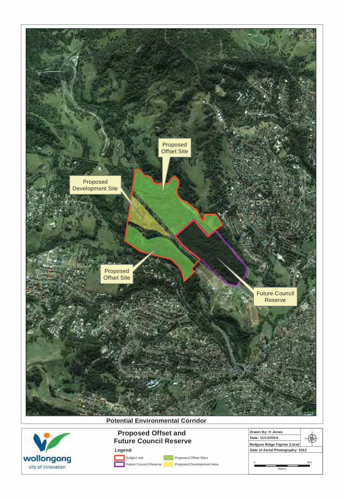
ProposedOffset Site
ProposedDevelopment Site
Future CouncilReserve
ProposedOffset Site
0 500
Meters
Date of Aerial Photography: 2012
Date: 11/11/2014
Redgum Ridge Figtree 2.mxd
Drawn By: H JonesProposed Offset and Future Council ReserveLegend
Subject site
Future Council Reserve
Proposed Offset Sites
Proposed Development Area
Potential Environmental Corridor

E3
E2
R2
E3
R2
Figtree
Cordeaux Heights
Mount Kembla
CORDEAUX ROAD
O'BRIENS ROAD
REDGUM FOREST WAY
DARRAGH DRIVE
HE
NN
ES
SY
LAN
E
FOY AVENUE
SIL
KP
OD
ST
RE
ET
CR
AN
ES
BIL
L W
AY
O'BR
IEN
S LANE
GAHNIA AVENUE
CA
SC
AR
ILLA
ST
RE
ET
INDIGO WAY
BREYNIA STREET
ROSEG
UM C
LOSE
INDIGO WAY
0 80
Meters
Map Identification number: Redgum Ridge_PP_Eatern Precinct _Zoning.mxd
N
Projection: GDA 1994MGA Zone 56
Planning ProposalRedgum Ridge Eastern Precinct Figtree
LEP 2009 Zoning
Scale 1:8000 @ A4
ProposedR2 Low Density Residential
ProposedR2 Low Density Residential
ProposedR2 Low Density Residential
ProposedE3 Environmental Management
Legend
Subject_Land
Redgum_Ridge_Eastern
E2 Environmental Conservation
E3 Environmental Management
R2 Residential Living

F
AB
F
Cordeaux Road
O'B
riens Road
RedgumForest W
ay
Darragh Drive
Silk
pod
Str
eet
Hennessy Lane
Cra
nes
bill
Way
Foy Avenue
Cas
caril
la S
treet
O'B
riens Lane
Baker Crescent
Gahnia Avenue
Bre
ynia S
treet
Sheringa Grove
Booreea Boulevarde
Ban
gala
y S
tree
t
Indigo Way
Mor
inda
Clo
se
Will
iam
Da
vie
s D
rive
Hannah Close
Ba
nga
lay
Str
eet
Indigo Way
Breynia Street
Jaca
rand
a A
venu
e
Mcgregor P
lace
Gov
ett
Cre
sce
nt
George Fuller Drive
Roseg
um C
lose
Abertiller
Morinda Close
0 100
Meters
Map Identification number: Redgum Ridge_PP_Eastern Precinct_MLS.mxd
Scale 1:5000 @ A4
N
Projection: GDA 1994MGA Zone 56
Planning ProposalRedgum Ridge Eastern Precinct Figtree
Minimum Lot Size
ProposedMinimum Lot Size 449sqm
ProposedMinimum Lot Size 39.99Ha
ProposedMinimum Lot Size 449sqm
Redgum_Ridge_Eastern
449sqm
39.99ha
F
AB
0 100
Meters
Map Identification number: Redgum Ridge_PP Eastern Precinct_FSR.mxd
Scale 1:8000 @ A4
N
Projection: GDA 1994MGA Zone 56
Planning ProposalRedgum Ridge Eastern Precinct Figtree
Floor Space Ratio
ProposedFloor Space Ratio 0.5:1
D
D
Redgum_Ridge_Eastern
0.5:1D
ProposedFloor Space Ratio 0.5:1
AD
D
Cordeaux Road
O'B
riens Road
RedgumForest W
ay
Darragh Drive
Silk
pod
Str
eet
Hennessy Lane
Foy Avenue
Cra
nes
bill
Way
Cas
caril
la S
treet
O'B
riens Lane
Gahnia
Avenue
Baker Crescent
Bre
ynia S
treet
Sh
erin
ga G
rove
Indigo Way
Booreea Boulevarde
Ban
gala
y S
tree
t
Mor
inda
Clo
se
Will
iam
Da
vie
s D
rive
Hannah Close
Indigo Way
Ba
nga
lay
Str
eet
Breynia Street
Mcgregor P
lace
Jaca
rand
a A
venu
e
Roseg
umClo
se
Gov
ett
Cre
sce
nt
George Fuller DrMorinda Close
0 100
Meters
Map Identification number: Redgum Ridge_PP_Eastern Precinct_NRB.mxd
Scale 1:8000 @ A4
N
Projection: GDA 1994MGA Zone 56
Planning ProposalRedgum Ridge Eastern Precinct Figtree
Natural Resource Sensitivity (NRS)
Redgum_Ridge_Eastern
Proposed NRS to be removed to reflect subdivision
A
E2
E4
E2
Figtree
Mount Kembla
Cordeaux Heights
CORDEAUX ROAD
WILLIAM JAMES DRIVE
REDGUM FOREST WAY
0 100
Meters
Map Identification number: Redgum Ridge_PP_Western Precinct _Zoning.mxd
N
Projection: GDA 1994MGA Zone 56
Planning ProposalRedgum Ridge Western Precinct Figtree
LEP 2009 Zoning
Scale 1:5000 @ A4
ProposedE4 Environmental Living
Subject site
E2 Environmental Conservation
E4 Environmental Living
ProposedE2 Environmental Conservation
ProposedE2 Environmental Conservation

T
AB
AB
Cordeaux Road
William James Drive
Gahnia Avenue
Redgum Forest Way
0 100
Meters
Map Identification number: Redgum Ridge_PP_Westren Precinct_MLS.mxd
Scale 1:5000 @ A4
N
Projection: GDA 1994MGA Zone 56
Planning ProposalRedgum Ridge Western Precinct Figtree
Minimum Lot Size
ProposedMinimum Lot Size 39.99Ha
ProposedMinimum Lot Size 999sqm
ProposedMinimum Lot Size 39.99Ha
Redgum_Ridge_Western
999sqm
39.99ha
T
AB

A
Cordeaux Road
William James Drive
Redgum Forest Way
Gahnia Avenue
Hennessy L
0 100
Meters
Map Identification number: Redgum Ridge_PP Western Precinct_FSR.mxd
Scale 1:8000 @ A4
N
Projection: GDA 1994MGA Zone 56
Planning ProposalRedgum Ridge Western Precinct Figtree
Floor Space Ratio
Redgum Ridge Western
0.3:1A
ProposedFloor Space Ratio 0.3:1