DRAFT NOTIFICATION FOR PUBLICATION OF …€¦ · Dhalbama falls in sub planning unit 17 of...
30
DRAFT NOTIFICATION FOR PUBLICATION OF PAMOHI/DHALBAMA DEVELOPMENT SCHEME Prepared under section 35(1) of GMDA Act 1985 (Amended) and published under section 39(1)
Transcript of DRAFT NOTIFICATION FOR PUBLICATION OF …€¦ · Dhalbama falls in sub planning unit 17 of...
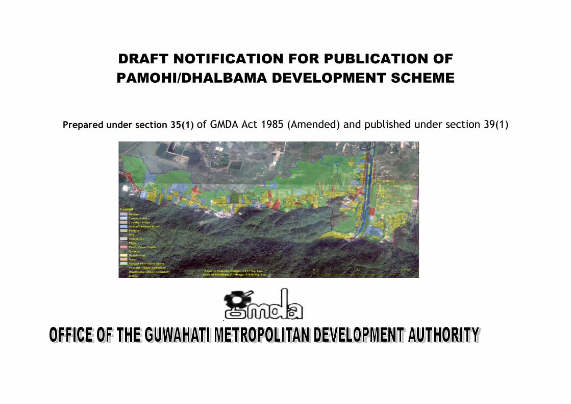
DRAFT NOTIFICATION FOR PUBLICATION OF
PAMOHI/DHALBAMA DEVELOPMENT SCHEME
Prepared under section 35(1) of GMDA Act 1985 (Amended) and published under section 39(1)
STATFED BUILDING, BHANGAGARH, GUWAHATI-781005
(An ISO 9001:2008 Certified Organization)
Tel: 0361-2529650/9824 Fax: 0361-2529991
Tel: 91 361- 252650,361 - 252984
Website: www.gmda.assam.gov.in E-mail: [email protected]
DRAFT NOTIFICATION FOR PUBLICATION OF PAMOHI/DHALBAMA DEVELOPMENT SCHEME
Dated: Guwahati the 19th August, 2019
GMDA/GEN/13/2009(Pt)/2011/70: In exercise of the powers conferred by Section 39 (1) of GMDA Act 1985 (Amended) GMDA is pleased to publish the following notice regarding the publication of the draft Development Scheme for the Pamohi/Dhalbama special scheme area of the Master Plan 2025 notified as development area vide Notification No. GMDA/GEN/13/2009/Pt/70 13 dated 3rd March 2010 and as described in the Schedule-I.
Notice for publication of the draft Development Scheme of Pamohi/Dhalbama special scheme area of Master Plan 2025:
It is notified that the detailed Development Scheme prepared under Section 35(1) for the Pamohi/Dhalbama special scheme area is hereby published.
The details of the Development Scheme together with all relevant papers and maps may be inspected free of cost during office hours at the Office of the Chief Executive Officer, Guwahati Metropolitan Development Authority and will also be available in GMDA’s website: http://www.gmda.gov.in.
Objections/suggestions from any person are invited with respect to the scheme within 2 (two) months from the date of issue of notification.
Sd/- (Shri, Moloy Bora, IAS)
Chief Executive Officer Guwahati Metropolitan Dev. Authority
Bhangagarh, Guwahati-5
I
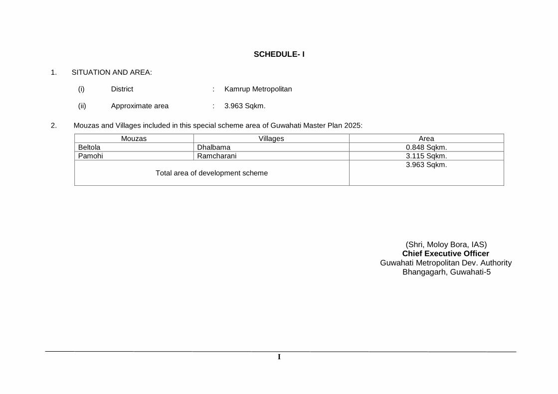
SCHEDULE- I 1. SITUATION AND AREA:
(i) District : Kamrup Metropolitan
(ii) Approximate area : 3.963 Sqkm.
2. Mouzas and Villages included in this special scheme area of Guwahati Master Plan 2025:
Mouzas Villages Area
Beltola Dhalbama 0.848 Sqkm.
Pamohi Ramcharani 3.115 Sqkm.
Total area of development scheme
3.963 Sqkm.
(Shri, Moloy Bora, IAS) Chief Executive Officer Guwahati Metropolitan Dev. Authority
Bhangagarh, Guwahati-5
PROPOSED DEVELOPMENT SCHEME FOR PAMOHI DHALBAMA SPECIAL SCHEME AREA
1 | P a g e
INTRODUCTION
The Master Plan and Zoning Regulation for Guwahati was
published vide the Assam Gazette Extraordinary Notification No.
198 Dispur, Thursday, 9th July 2009 and Corrigendum No. 199
Dispur, Friday, 10th July 2009 and Corrigendum No. 62 Dispur,
Tuesday, 16th March,2010.Certain modification has also been
made in the Master Plan from time to time considering the
requirement of such modifications due to needs of plan
development.
As per the Master Plan 2025 land use classification of the Special
Scheme Area covering Pamohi and Dhalbama village were
indicative only with the final land use to be notified at the time of
finalization of Development Scheme. Accordingly, no specific
land use was earmarked in the Special Scheme Area covering
Pamohi and Dhalbama village except in some portion of Pamohi
village which have been earmarked as Eco-Sensitive Zone to
keep conformity with the adjoining Eco-Sensitive Zone. The total
area of this Development Scheme is about 3.965 sq.km.
As per the Master Plan the Pamohi village of this Special Scheme
Area falls in sub planning unit 13 of planning unit 5 while village
Dhalbama falls in sub planning unit 17 of planning unit 2. The
estimated population by 2025 in sub planning unit 13 is 34,997
while in sub planning unit 17 is 67,191. But actual population of
these two villages is accounts for only 08 to 01 percent. The
estimated population of this Development Scheme by 2035 is
estimated at 11,492.
In Chapter-14 of Master Plan implementation the city has been
divided into IV parts for the purpose of development/re-
development and this area falls in Part-II where large
undevelopment areas are available for new development and as
such detail land use is now required to be finalized with
development control regulation considering this area as a
development area under GMDA Act as has been emphasized in
the Master Plan.
Accordingly, under Section 35 (i) this area of Pamohi and
Dhalbama was declared as development area vide Notification
No. GMDA/GEN/13/2009/13 dated: Guwahati the 3rd March 2010
(Annexure-I) and also issued a notice vide
GMDA/GEN/13/2009/17 dated 3rd March 2010 (Annexure-II)
inviting names of all the claimants of any interest in the land
within the area under this scheme area. Petition received to a
examined and a notification for Development Scheme for
Pamohi-Dhalbama special scheme area was published on 19Th
January 2011.Subsequently it was felt that the existing
development and the area being located on the edge of some
most sensitive areas of city, further survey of existing land use
was required and carried out by the Authority. And based on the
field survey a new Development Scheme was finalized for this
area and published again inviting suggestion and obligation for
finalizing. To make the plan more user friendly and transparent
the whole plan was also converted into GIS platform. Some
provisions of land use zoning and new provision of development
control regulation were also incorporated to accommodate the
PROPOSED DEVELOPMENT SCHEME FOR PAMOHI DHALBAMA SPECIAL SCHEME AREA
2 | P a g e
requirement of new policies of Government with respect to urban
development.
SCOPE AND CONTENT OF DEVELOPMENT SCHEMES:
The scope and content of Development Scheme has been
framed in accordance with clause 36(1) of GMDA Act by making
provision for following matters. The area being bordering Rani
and Garbhanga reserve forest and in the vicinity of Deepor Beel
special measures has to be taken in a Development Scheme.
(i) Layout of new streets or roads with provision for
proposed right of way of different category of road
(ii) The allotment or reservation of land for different uses
(iii) The preservation and protection of the sensitive uses like
hills and waterbodies and channels
(iv) Imposition of condition and restrictions in regard to open
space percentage of building area for a plot, character of
building allowed in different areas, discontinuance of
objectionable uses etc.
(v) The requirement for housing schemes of different income
group, commercial uses schools and hospitals
community facilities and other uses allowed.
(vi) Identification of major drainage channels
(vii) Other matters not inconsistent with the objective of the
Act.
Major highlight of this proposed Development Scheme of
Pamohi and Dhalbama:
(1) The land use plan so drawn up is finalized considering the
trend of development and the land use earmarked in the
adjoining area of the Master Plan.
All Govt. land in the scheme area to be transferred to
GMDA for the purpose of preservation as a recreation
area or for various residential/infrastructure project as per
this Development Scheme.
(2) No change or modification of layout of road network as
suggested in the Master Plan has been proposed.
However, it is proposed that all the local distributors
should have a minimum RoW (Right of Way) of 12 m and
access road should have a minimum RoW of 6 m.
(3) The FAR in plots abutting roads less than 6 m has been
restricted to 100. However additional FAR is proposed if
land is relinquished for widening the road without asking
for compensation of land.
(4) Residential areas have been earmarked as Residential
(High) and Residential (Low) with FAR & Coverage have
been restricted in Residential (Low) zone.
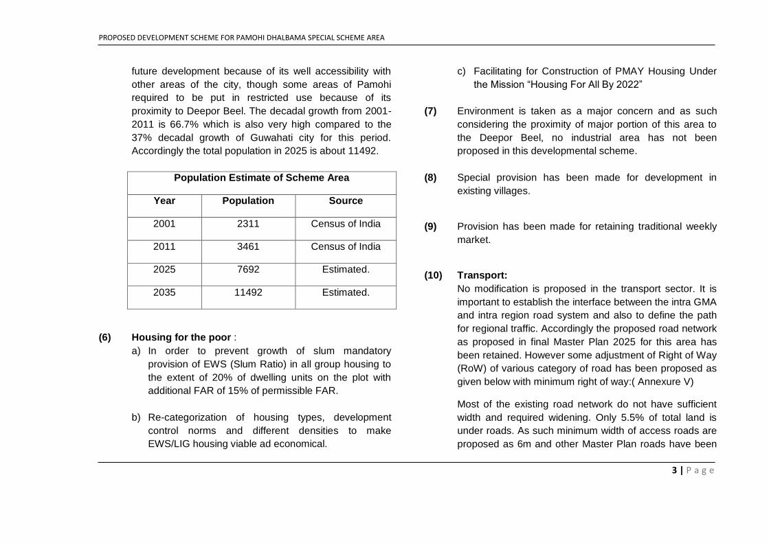
(5) Population and Density:
Population density of the scheme area is only about 873
persons per sq.km.as against the density of 3745 persons
per sq.km. of GMA in 2011.This area has a potential of
PROPOSED DEVELOPMENT SCHEME FOR PAMOHI DHALBAMA SPECIAL SCHEME AREA
3 | P a g e
future development because of its well accessibility with
other areas of the city, though some areas of Pamohi
required to be put in restricted use because of its
proximity to Deepor Beel. The decadal growth from 2001-
2011 is 66.7% which is also very high compared to the
37% decadal growth of Guwahati city for this period.
Accordingly the total population in 2025 is about 11492.
Population Estimate of Scheme Area
Year Population Source
2001 2311 Census of India
2011 3461 Census of India
2025 7692 Estimated.
2035 11492 Estimated.
(6) Housing for the poor :
a) In order to prevent growth of slum mandatory
provision of EWS (Slum Ratio) in all group housing to
the extent of 20% of dwelling units on the plot with
additional FAR of 15% of permissible FAR.
b) Re-categorization of housing types, development
control norms and different densities to make
EWS/LIG housing viable ad economical.
c) Facilitating for Construction of PMAY Housing Under
the Mission “Housing For All By 2022”
(7) Environment is taken as a major concern and as such
considering the proximity of major portion of this area to
the Deepor Beel, no industrial area has not been
proposed in this developmental scheme.
(8) Special provision has been made for development in
existing villages.
(9) Provision has been made for retaining traditional weekly
market.
(10) Transport:
No modification is proposed in the transport sector. It is
important to establish the interface between the intra GMA
and intra region road system and also to define the path
for regional traffic. Accordingly the proposed road network
as proposed in final Master Plan 2025 for this area has
been retained. However some adjustment of Right of Way
(RoW) of various category of road has been proposed as
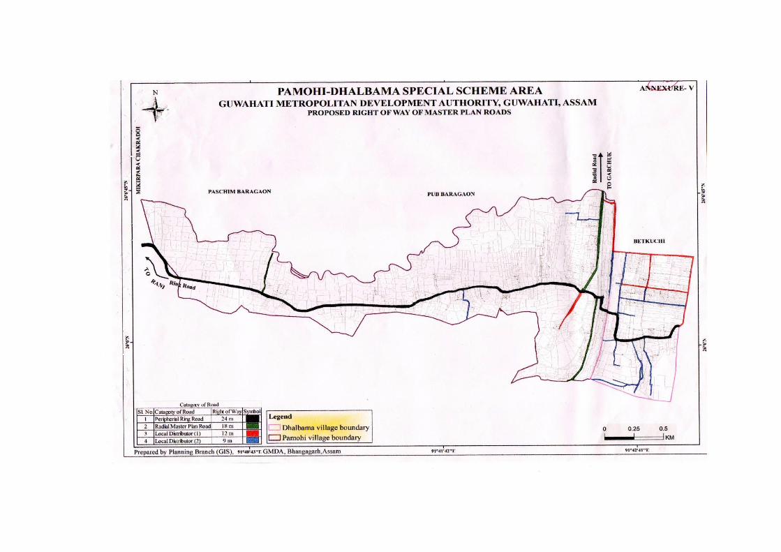
given below with minimum right of way:( Annexure V)
Most of the existing road network do not have sufficient
width and required widening. Only 5.5% of total land is
under roads. As such minimum width of access roads are
proposed as 6m and other Master Plan roads have been
PROPOSED DEVELOPMENT SCHEME FOR PAMOHI DHALBAMA SPECIAL SCHEME AREA
4 | P a g e
proposed 9m-24m, so that land under road is kept at 10-
12%
(I) (1) Peripheral Ring Road - 24 m
(2) Radial Master Plan Road - 18 m
(3) Local Distributors - (a) 12 m
(b) 9 m
(II) The planning of residential neighbourhood
regarding circulation system shall be governed by
the following norms:
(1) The residential plots in new areas shall
generally face an open space including
pedestrians’ movement with a minimum
width of 9 m. The plots may face a vehicular
access road with 9m right of way. The
circulation network within the cluster shall be
so devised that no residential plot is more
than 65 m away from the nearest point of the
vehicular access road.
(2) All vehicles shall be restricted to specific
parking lot or along the vehicular access
road.
(3) Maximum length of cul-de-sac shall be 150 m
and loop road 450 m.
(III) The planning of residential neighbourhood
regarding landscaping shall be governed by the
following norms:
(1) Suitable landscape plans for the residential
area shall be prepared indicating in
reasonable detail, the landscape
development of the parks and roadside
plantation.
(2) Detail landscape plan for one
Neighbourhood Park shall be prepared.
The Master Plan roads are shown in maps
at Annexure no. II
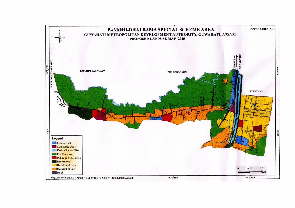
(11) Land Use of Scheme Area:
The details of existing and proposed land use of scheme
area are given in maps at annexure IV & VII. The
proposed land uses proposed in various zone are given
below.
The Pamohi Dhalbama area is on the border of Rani-
Garbhanga reserve forest on its south and Deepor Beel
on west and Pamohi reserve on north. Considering these
sensitive nature of location about 45% of land has been
kept under eco-sensitive zone to check undesired
development near these areas. 20% of land has been in
kept in the low density zone considering the rural nature
of development. No area has been proposed as industrial
zone but cottage handloom and household industries
primarily rural based shall be allowed in some zones.
All other access roads will have a minimum right of
way of 6m
PROPOSED DEVELOPMENT SCHEME FOR PAMOHI DHALBAMA SPECIAL SCHEME AREA
5 | P a g e
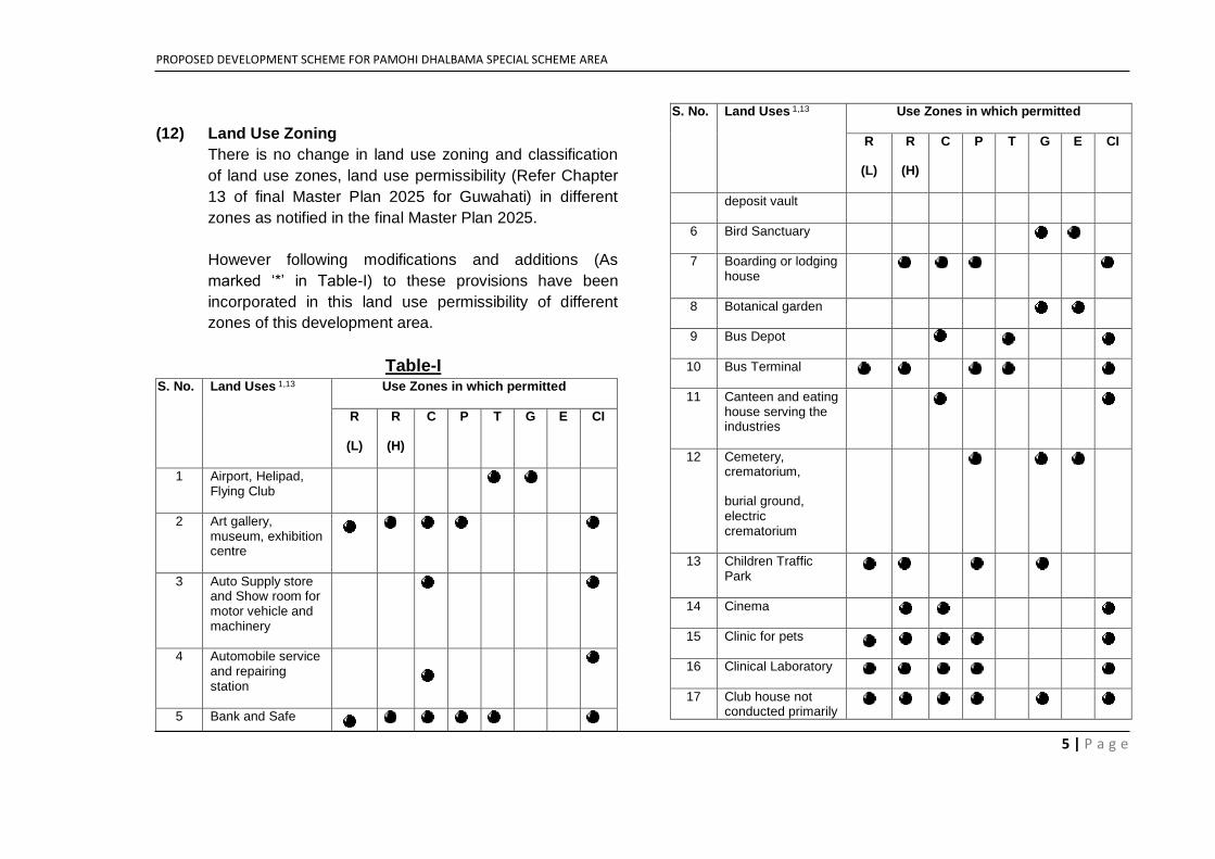
(12) Land Use Zoning
There is no change in land use zoning and classification
of land use zones, land use permissibility (Refer Chapter
13 of final Master Plan 2025 for Guwahati) in different
zones as notified in the final Master Plan 2025.
However following modifications and additions (As
marked ‘*’ in Table-I) to these provisions have been
incorporated in this land use permissibility of different
zones of this development area.
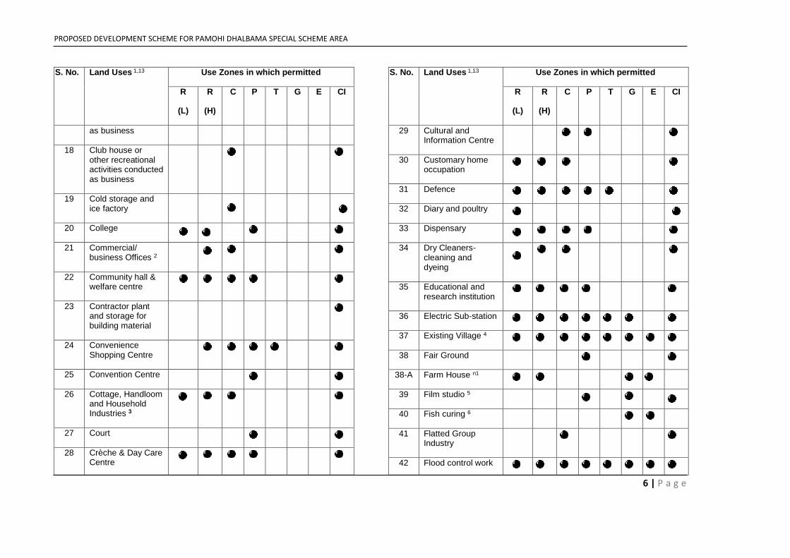
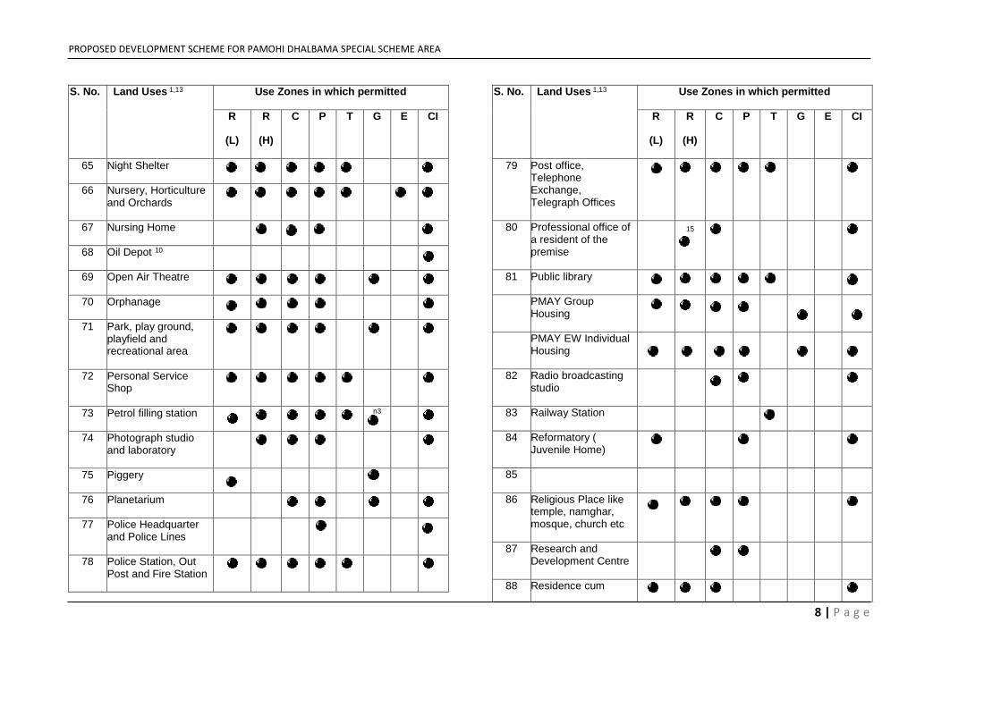
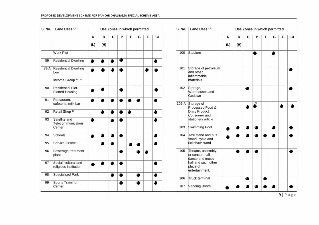
Table-I S. No. Land Uses 1,13 Use Zones in which permitted
R
(L)
R
(H)
C P T G E CI
1 Airport, Helipad, Flying Club
2 Art gallery, museum, exhibition centre
3 Auto Supply store and Show room for motor vehicle and machinery
4 Automobile service and repairing station
5 Bank and Safe
S. No. Land Uses 1,13 Use Zones in which permitted
R
(L)
R
(H)
C P T G E CI
deposit vault
6 Bird Sanctuary
7 Boarding or lodging house
8 Botanical garden
9 Bus Depot
10 Bus Terminal
11 Canteen and eating house serving the industries
12 Cemetery, crematorium,
burial ground, electric crematorium
13 Children Traffic Park
14 Cinema
15 Clinic for pets
16 Clinical Laboratory
17 Club house not conducted primarily
PROPOSED DEVELOPMENT SCHEME FOR PAMOHI DHALBAMA SPECIAL SCHEME AREA
6 | P a g e
S. No. Land Uses 1,13 Use Zones in which permitted
R
(L)
R
(H)
C P T G E CI
as business
18 Club house or other recreational activities conducted as business
19 Cold storage and ice factory
20 College
21 Commercial/ business Offices 2
22 Community hall & welfare centre
23 Contractor plant and storage for building material
24 Convenience Shopping Centre
25 Convention Centre
26 Cottage, Handloom and Household Industries 3
27 Court
28 Crèche & Day Care Centre
S. No. Land Uses 1,13 Use Zones in which permitted
R
(L)
R
(H)
C P T G E CI
29 Cultural and Information Centre
30 Customary home occupation
31 Defence
32 Diary and poultry
33 Dispensary
34 Dry Cleaners-cleaning and dyeing
35 Educational and research institution
36 Electric Sub-station
37 Existing Village 4
38 Fair Ground
38-A Farm House n1
39 Film studio 5
40 Fish curing 6
41 Flatted Group Industry
42 Flood control work
PROPOSED DEVELOPMENT SCHEME FOR PAMOHI DHALBAMA SPECIAL SCHEME AREA
7 | P a g e
S. No. Land Uses 1,13 Use Zones in which permitted
R
(L)
R
(H)
C P T G E CI
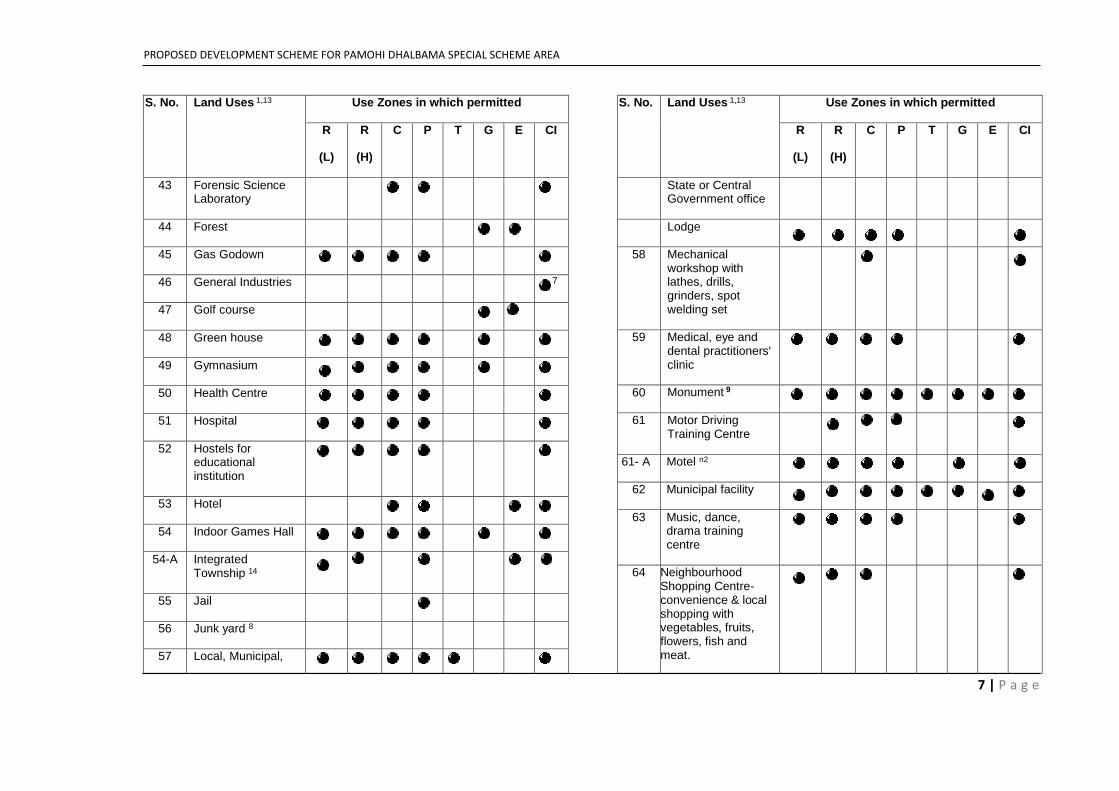
43 Forensic Science Laboratory
44 Forest
45 Gas Godown
46 General Industries 7
47 Golf course
48 Green house
49 Gymnasium
50 Health Centre
51 Hospital
52 Hostels for educational institution
53 Hotel
54 Indoor Games Hall
54-A Integrated Township 14
55 Jail
56 Junk yard 8
57 Local, Municipal,
S. No. Land Uses 1,13 Use Zones in which permitted
R
(L)
R
(H)
C P T G E CI
State or Central Government office
Lodge
58 Mechanical workshop with lathes, drills, grinders, spot welding set
59 Medical, eye and dental practitioners' clinic
60 Monument 9
61 Motor Driving Training Centre
61- A Motel n2
62 Municipal facility
63 Music, dance, drama training centre
64 Neighbourhood Shopping Centre-convenience & local shopping with vegetables, fruits, flowers, fish and meat.
PROPOSED DEVELOPMENT SCHEME FOR PAMOHI DHALBAMA SPECIAL SCHEME AREA
8 | P a g e
S. No. Land Uses 1,13 Use Zones in which permitted
R
(L)
R
(H)
C P T G E CI
65 Night Shelter
66 Nursery, Horticulture and Orchards
67 Nursing Home
68 Oil Depot 10
69 Open Air Theatre
70 Orphanage
71 Park, play ground, playfield and recreational area
72 Personal Service Shop
73 Petrol filling station n3
74 Photograph studio and laboratory
75 Piggery
76 Planetarium
77 Police Headquarter and Police Lines
78 Police Station, Out Post and Fire Station
S. No. Land Uses 1,13 Use Zones in which permitted
R
(L)
R
(H)
C P T G E CI
79 Post office, Telephone Exchange, Telegraph Offices
80 Professional office of a resident of the premise
15
81 Public library
PMAY Group Housing
PMAY EW Individual Housing
82 Radio broadcasting studio
83 Railway Station
84 Reformatory ( Juvenile Home)
85
86 Religious Place like temple, namghar, mosque, church etc
87 Research and Development Centre
88 Residence cum
PROPOSED DEVELOPMENT SCHEME FOR PAMOHI DHALBAMA SPECIAL SCHEME AREA
9 | P a g e
S. No. Land Uses 1,13 Use Zones in which permitted
R
(L)
R
(H)
C P T G E CI
Work Plot
89 Residential Dwelling
89-A Residential Dwelling Low
Income Group 14, n4
90 Residential Plot- Plotted Housing
91 Restaurant, cafeteria, milk bar
92 Retail Shop 12
93 Satellite and Telecommunication Center
94 Schools
95 Service Centre
96 Sewerage treatment plant
97 Social, cultural and religious institution
98 Specialised Park
99 Sports Training Center
S. No. Land Uses 1,13 Use Zones in which permitted
R
(L)
R
(H)
C P T G E CI
100 Stadium
101 Storage of petroleum and other inflammable materials
102 Storage, Warehouses and Godown
102-A Storage of Processed Food & Diary Product Consumer and stationery article
n5
103 Swimming Pool
104 Taxi stand and bus stand, cycle and rickshaw stand
105 Theatre, assembly or concert hall, dance and music hall and such other place of entertainment;
106 Truck terminal
107 Vending Booth
PROPOSED DEVELOPMENT SCHEME FOR PAMOHI DHALBAMA SPECIAL SCHEME AREA
10 | P a g e
S. No. Land Uses 1,13 Use Zones in which permitted
R
(L)
R
(H)
C P T G E CI
108 Vocational Training/Technical Training Institute
109 Watchmen or caretaker's lodges
110 Water Treatment Plant
111 Weekly Market/ Informal Sector Unit
112 Wholesale Trade
113 Wireless transmitting and weather station, Transmission Tower
n6 n6
114 Zoological park
Index of Use Zones:
R (H) – Residential High
R (L) – Residential Low
C – Commercial
P – Public & Semi Public
T – Transportation
G - Green Belt (Recreational and Open Space)
E –Eco Sensitive
C I – Composite Use I
Note:
1 All Existing non nuisance, non-polluting uses to continue in the following
use zones:
- Residential
- Commercial
- Public/Semi-public
- Transportation and Communication
- Composite Use I
All existing non nuisance, non-polluting uses may be allowed to
continue/discontinue after an application for special permission to the
Authority in the following use zones:
- Recreational, Commercial, Public/ Semi Public & Green Belt
- Eco-Friendly.
- All notified forest, water bodies, rivers and upto a distance of 100m from
their boundaries etc. are also classified as Eco-Sensitive Zone with other
Eco-sensitive areas. No construction be allowed in this area. 2 To be permitted in commercial areas to be indicated in Residantial(H)
Zones in Local Area Plans/ Layout Plans 3 In Residential use zone, existing uses to continue and new ones to come on
special permission from the Authority Also refer Annex I 4 No further expansion of residential area 5 In the New Town proposed Recreational Area 6 Only Existing uses to continue 7 Only those industries as listed in Annex I 13 Parks, parking, circulation and utilities can be located in any of the use
zones. In recreation and eco-sensitive zone, these would be permissible
with special permission from the Authority. 14 The following activities shall be permitted only in Eco-Friendly Zone and
not in Eco-Sensitive Zone
- Tourism
PROPOSED DEVELOPMENT SCHEME FOR PAMOHI DHALBAMA SPECIAL SCHEME AREA
11 | P a g e
- Socio-cultural activities
- Bungalow type construction
- Integrated PMAY
- Residential Dwelling Low Income Group, PMAY Scheme
Development of land would be permitted in Eco-Friendly Zone, if an
integrated land development proposal is submitted. Such proposal should
primarly be a PMAY Scheme upto 70% PMAY housing with 35% coverage
and 125 FAR in a plot more than 0.5 Ha. 15 To the maximum of 30 percent of the FAR is allowed n1 Maximum coverage of 25% and maximum FAR of 50 provided the area is
not notified as water bodies forest etc with minimum plot size of 2000sq.m.
with maximum two due dual units n2 A roadside hotel designed primarily for motorists, typically having the
rooms arranged in low blocks with parking directly outside with 25%
coverage & 50 FAR. Provided area is not notified as water bodies, forest
etc. & only on plots along NH & peripheral ring roads n3 In Green Belt/Eco friendly zone it is allowed on Peripheral road by pass
and peripheral ring road as a high way amenity. n4 Maximum coverage of 25% and maximum FAR of 50 with Assam Type
structure in areas not notified water bodied forest etc. n5 Maximum coverage of 40% and maximum FAR of 100 on the plot along
National Highway and peripheral ring roads n6 Only ground basement
Note: For interpretation of land use zoning and development control
regulation Authority may constitute a committee of experts if such situation
arises. The committee may also be given the task of elaborate and add on
the above land use permissibility considering the circumstances that may
come from time to time in the process of implementation of the plan for
subsequent approval of Authority however, any land use change
recommended by this committee will require approval of government.
(13) Housing
New Housing for Urban Poor
New housing should be in the form of one or two room
units, which would be developed through public and private
agencies and through Cooperative Societies or in PPP
mode. As this category constitutes bulk of the housing stock
that has to be catered at an affordable price to the lowest
income bracket as housing for Economically Weaker
Sections (EWS), this is often done by cross-subsidization.
For this purpose, adequate land would be earmarked for
EWS housing. The developers of group housing shall
ensure that minimum 20% of the dwelling units, are
constructed for Community-Service Personnel/EWS and
lower income category. In old built up areas, this may be as
redevelopment schemes or industrial housing, etc.,
whereas, in urban extensions, the acquisition and
development cost of this land should be borne by rest of the
project. Such reserved lands should be handed over to a
designated agency for promoting housing for low income
and weaker sections.
The pattern of EWS housing shall be such as to ensure optional
utilization of land in a sustainable manner. For that purpose,
multi-storied housing will be the preferred option. Apart from
mandatory provision for EWS housing in all group housing
projects/schemes, the primary responsibility for creating
adequate stock of housing for urban poor shall be borne by public
agencies, which can be considered in PPP mode.
PROPOSED DEVELOPMENT SCHEME FOR PAMOHI DHALBAMA SPECIAL SCHEME AREA
12 | P a g e
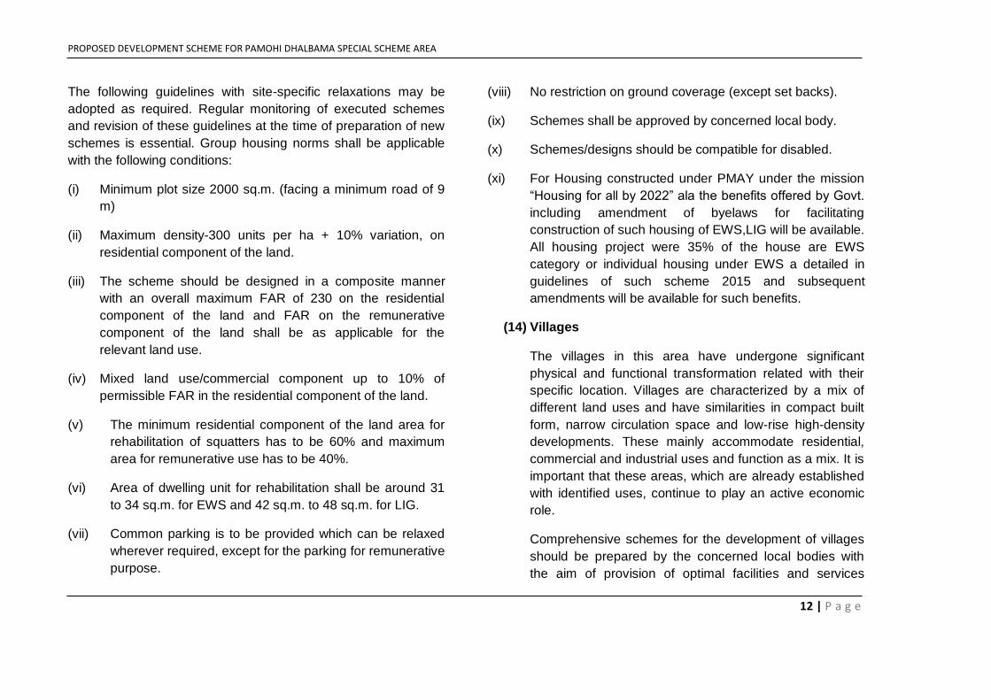
The following guidelines with site-specific relaxations may be
adopted as required. Regular monitoring of executed schemes
and revision of these guidelines at the time of preparation of new
schemes is essential. Group housing norms shall be applicable
with the following conditions:
(i) Minimum plot size 2000 sq.m. (facing a minimum road of 9
m)
(ii) Maximum density-300 units per ha + 10% variation, on
residential component of the land.
(iii) The scheme should be designed in a composite manner
with an overall maximum FAR of 230 on the residential
component of the land and FAR on the remunerative
component of the land shall be as applicable for the
relevant land use.
(iv) Mixed land use/commercial component up to 10% of
permissible FAR in the residential component of the land.
(v) The minimum residential component of the land area for
rehabilitation of squatters has to be 60% and maximum
area for remunerative use has to be 40%.
(vi) Area of dwelling unit for rehabilitation shall be around 31
to 34 sq.m. for EWS and 42 sq.m. to 48 sq.m. for LIG.
(vii) Common parking is to be provided which can be relaxed
wherever required, except for the parking for remunerative
purpose.
(viii) No restriction on ground coverage (except set backs).
(ix) Schemes shall be approved by concerned local body.
(x) Schemes/designs should be compatible for disabled.
(xi) For Housing constructed under PMAY under the mission
“Housing for all by 2022” ala the benefits offered by Govt.
including amendment of byelaws for facilitating
construction of such housing of EWS,LIG will be available.
All housing project were 35% of the house are EWS
category or individual housing under EWS a detailed in
guidelines of such scheme 2015 and subsequent
amendments will be available for such benefits.
(14) Villages
The villages in this area have undergone significant
physical and functional transformation related with their
specific location. Villages are characterized by a mix of
different land uses and have similarities in compact built
form, narrow circulation space and low-rise high-density
developments. These mainly accommodate residential,
commercial and industrial uses and function as a mix. It is
important that these areas, which are already established
with identified uses, continue to play an active economic
role.
Comprehensive schemes for the development of villages
should be prepared by the concerned local bodies with
the aim of provision of optimal facilities and services
PROPOSED DEVELOPMENT SCHEME FOR PAMOHI DHALBAMA SPECIAL SCHEME AREA
13 | P a g e
within the abadis and integration with the surrounding
areas. Towards the latter objectives, development along
the peripheries of the villages should be carefully planned,
wherever necessary for the provision of services and
green/open areas, circulation etc. this aspect should also
be kept in view while preparing layout plans for urban
extension areas.
The Authority should identify these areas where maximum
coverage of 60% and FAR 125 with maximum Ground +
1st floor be allowed even if these villages fall within
Recreational and Open area and Eco-friendly Zone.
(15) Weekly Markets
Weekly market, which is the traditional style of retail
shopping, is quite popular in Guwahati especially among
the lower and middle-income groups. These markets are
held in various areas. Further, parking and other open
spaces within the service markets and commercial
centers should be so planned that weekly markets can
operate in these areas. The specific locations and timings
of operation of such markets should be specified and
regulated by the concerned local body.
(16) Land Use Zoning and Development Control
Regulation
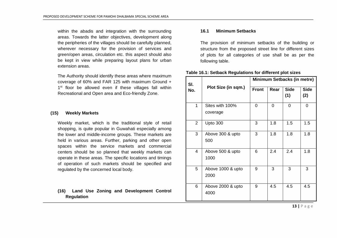
16.1 Minimum Setbacks
The provision of minimum setbacks of the building or
structure from the proposed street line for different sizes
of plots for all categories of use shall be as per the
following table.
Table 16.1: Setback Regulations for different plot sizes
Sl.
No. Plot Size (in sqm.)
Minimum Setbacks (in metre)
Front Rear Side
(1)
Side
(2)
1 Sites with 100%
coverage
0 0 0 0
2 Upto 300 3 1.8 1.5 1.5
3 Above 300 & upto
500
3 1.8 1.8 1.8
4 Above 500 & upto
1000
6 2.4 2.4 1.8
5 Above 1000 & upto
2000
9 3 3 3
6 Above 2000 & upto
4000
9 4.5 4.5 4.5
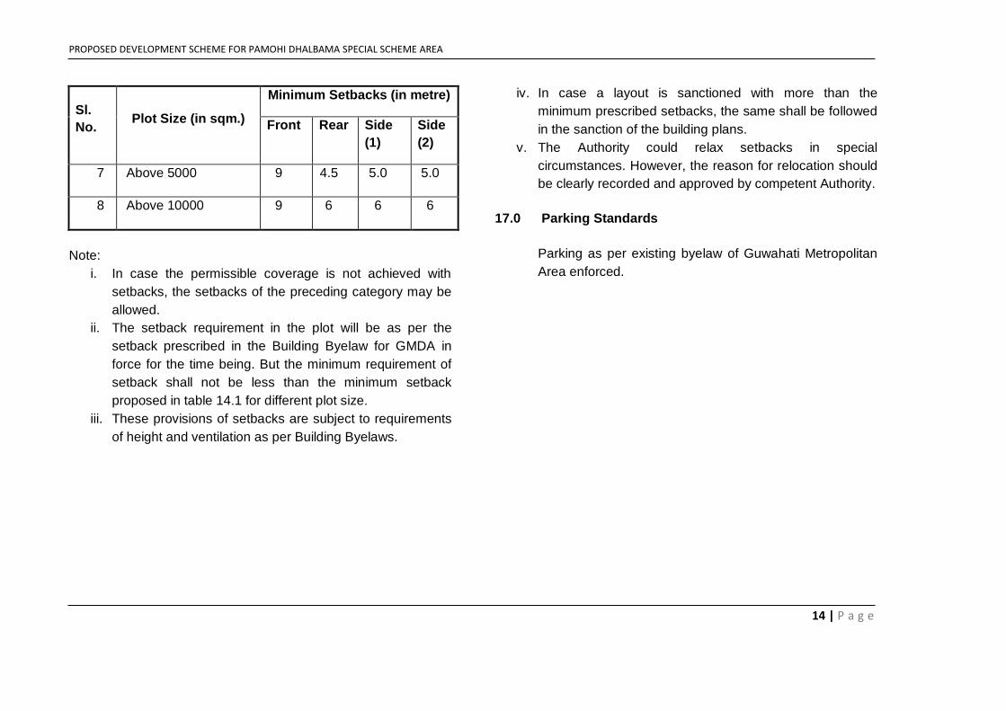
PROPOSED DEVELOPMENT SCHEME FOR PAMOHI DHALBAMA SPECIAL SCHEME AREA
14 | P a g e
Sl.
No. Plot Size (in sqm.)
Minimum Setbacks (in metre)
Front Rear Side
(1)
Side
(2)
7 Above 5000 9 4.5 5.0 5.0
8 Above 10000 9 6 6 6
Note:
i. In case the permissible coverage is not achieved with
setbacks, the setbacks of the preceding category may be
allowed.
ii. The setback requirement in the plot will be as per the
setback prescribed in the Building Byelaw for GMDA in
force for the time being. But the minimum requirement of
setback shall not be less than the minimum setback
proposed in table 14.1 for different plot size.
iii. These provisions of setbacks are subject to requirements
of height and ventilation as per Building Byelaws.
iv. In case a layout is sanctioned with more than the
minimum prescribed setbacks, the same shall be followed
in the sanction of the building plans.
v. The Authority could relax setbacks in special
circumstances. However, the reason for relocation should
be clearly recorded and approved by competent Authority.
17.0 Parking Standards
Parking as per existing byelaw of Guwahati Metropolitan
Area enforced.
PROPOSED DEVELOPMENT SCHEME FOR PAMOHI DHALBAMA SPECIAL SCHEME AREA
15 | P a g e
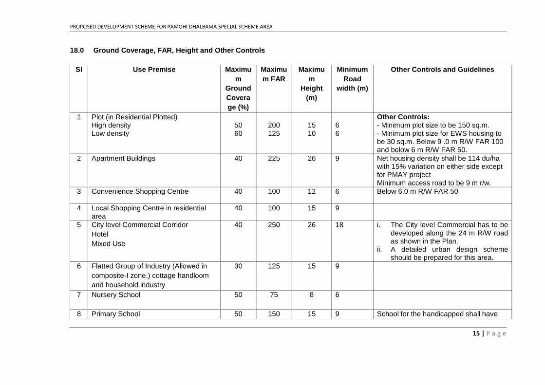
18.0 Ground Coverage, FAR, Height and Other Controls
Sl Use Premise Maximu
m
Ground
Covera
ge (%)
Maximu
m FAR
Maximu
m
Height
(m)
Minimum
Road
width (m)
Other Controls and Guidelines
1 Plot (in Residential Plotted) High density Low density
50 60
200 125
15 10
6 6
Other Controls: - Minimum plot size to be 150 sq.m. - Minimum plot size for EWS housing to be 30 sq.m. Below 9 .0 m R/W FAR 100 and below 6 m R/W FAR 50.
2 Apartment Buildings 40 225 26 9 Net housing density shall be 114 du/ha with 15% variation on either side except for PMAY project Minimum access road to be 9 m r/w.
3 Convenience Shopping Centre 40 100 12 6 Below 6.0 m R/W FAR 50
4 Local Shopping Centre in residential area
40 100 15 9
5 City level Commercial Corridor
Hotel
Mixed Use
40 250 26 18 i. The City level Commercial has to be developed along the 24 m R/W road as shown in the Plan.
ii. A detailed urban design scheme should be prepared for this area.
6 Flatted Group of Industry (Allowed in
composite-I zone,) cottage handloom
and household industry
30 125 15 9
7 Nursery School
50 75 8 6
8 Primary School 50 150 15 9 School for the handicapped shall have
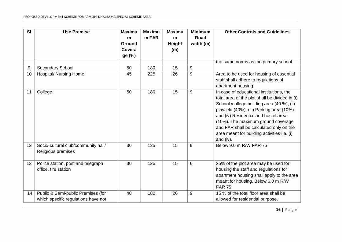
PROPOSED DEVELOPMENT SCHEME FOR PAMOHI DHALBAMA SPECIAL SCHEME AREA
16 | P a g e
Sl Use Premise Maximu
m
Ground
Covera
ge (%)
Maximu
m FAR
Maximu
m
Height
(m)
Minimum
Road
width (m)
Other Controls and Guidelines
the same norms as the primary school
9 Secondary School 50 180 15 9
10 Hospital/ Nursing Home 45 225 26 9 Area to be used for housing of essential
staff shall adhere to regulations of
apartment housing.
11 College 50 180 15 9 In case of educational institutions, the
total area of the plot shall be divided in (i)
School /college building area (40 %), (ii)
playfield (40%), (iii) Parking area (10%)
and (iv) Residential and hostel area
(10%). The maximum ground coverage
and FAR shall be calculated only on the
area meant for building activities i.e. (i)
and (iv).
12 Socio-cultural club/community hall/
Religious premises
30 125 15 9 Below 9.0 m R/W FAR 75
13 Police station, post and telegraph
office, fire station
30 125 15 6 25% of the plot area may be used for
housing the staff and regulations for
apartment housing shall apply to the area
meant for housing. Below 6.0 m R/W
FAR 75
14 Public & Semi-public Premises (for
which specific regulations have not
40 180 26 9 15 % of the total floor area shall be
allowed for residential purpose.
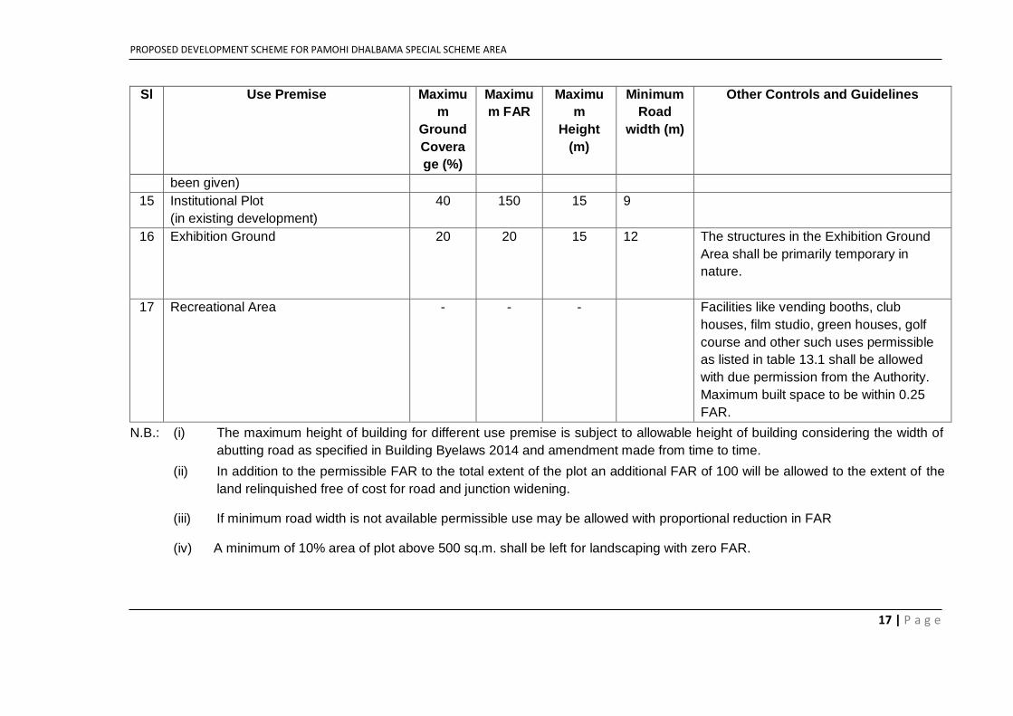
PROPOSED DEVELOPMENT SCHEME FOR PAMOHI DHALBAMA SPECIAL SCHEME AREA
17 | P a g e
Sl Use Premise Maximu
m
Ground
Covera
ge (%)
Maximu
m FAR
Maximu
m
Height
(m)
Minimum
Road
width (m)
Other Controls and Guidelines
been given)
15 Institutional Plot
(in existing development)
40 150 15 9
16 Exhibition Ground 20 20 15 12 The structures in the Exhibition Ground
Area shall be primarily temporary in
nature.
17 Recreational Area - - - Facilities like vending booths, club
houses, film studio, green houses, golf
course and other such uses permissible
as listed in table 13.1 shall be allowed
with due permission from the Authority.
Maximum built space to be within 0.25
FAR.
N.B.: (i) The maximum height of building for different use premise is subject to allowable height of building considering the width of
abutting road as specified in Building Byelaws 2014 and amendment made from time to time.
(ii) In addition to the permissible FAR to the total extent of the plot an additional FAR of 100 will be allowed to the extent of the
land relinquished free of cost for road and junction widening.
(iii) If minimum road width is not available permissible use may be allowed with proportional reduction in FAR
(iv) A minimum of 10% area of plot above 500 sq.m. shall be left for landscaping with zero FAR.
PROPOSED DEVELOPMENT SCHEME FOR PAMOHI DHALBAMA SPECIAL SCHEME AREA
18 | P a g e
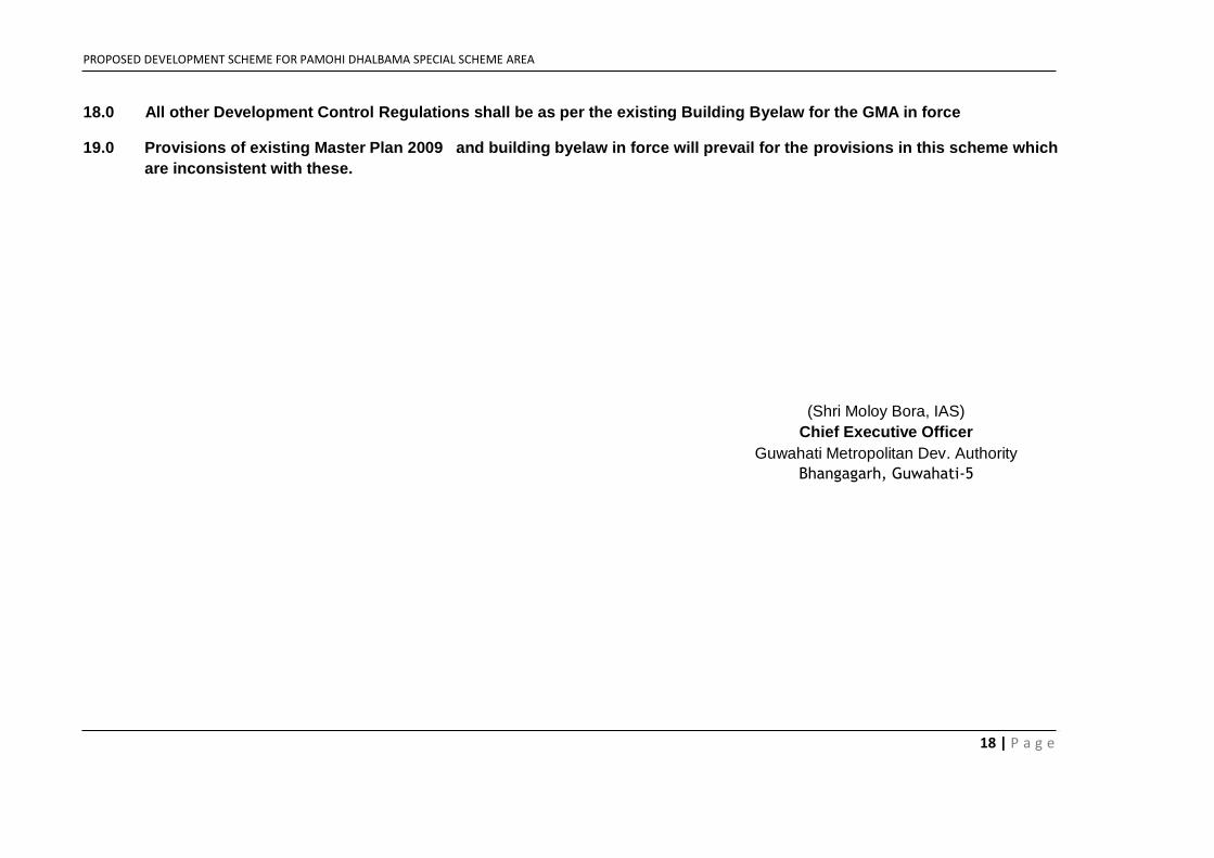
18.0 All other Development Control Regulations shall be as per the existing Building Byelaw for the GMA in force
19.0 Provisions of existing Master Plan 2009 and building byelaw in force will prevail for the provisions in this scheme which
are inconsistent with these.
(Shri Moloy Bora, IAS)
Chief Executive Officer
Guwahati Metropolitan Dev. Authority
Bhangagarh, Guwahati-5
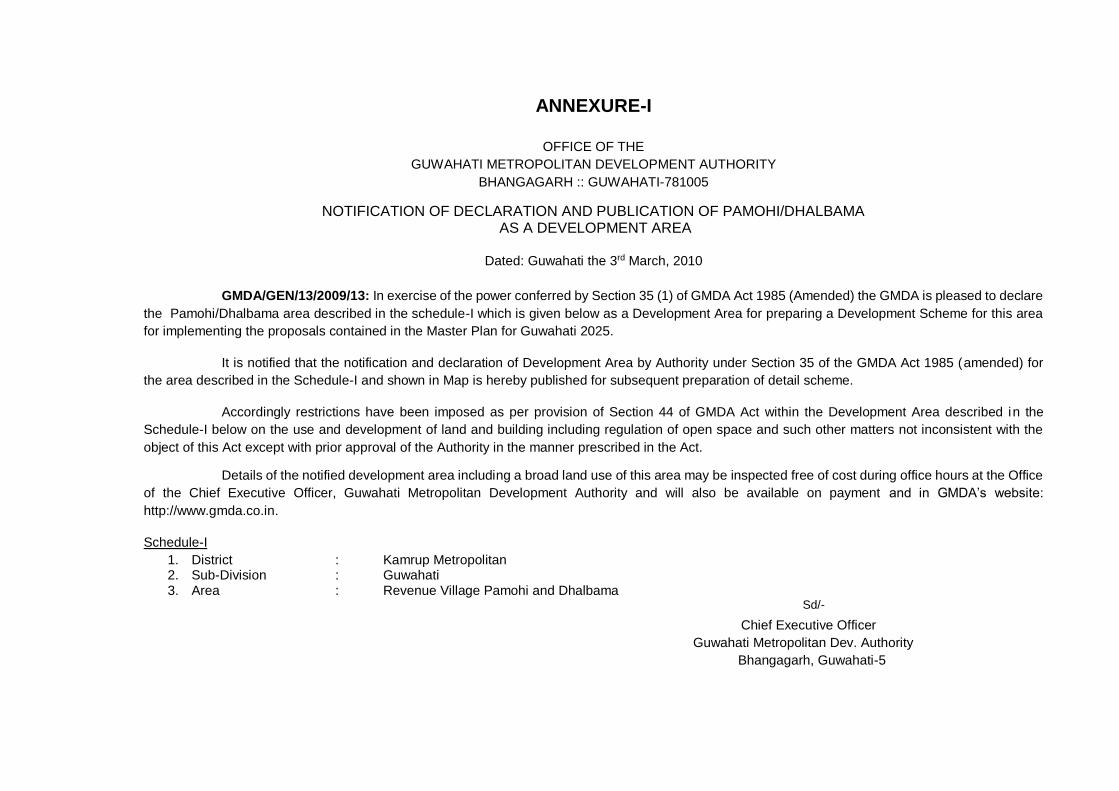
ANNEXURE-I
OFFICE OF THE
GUWAHATI METROPOLITAN DEVELOPMENT AUTHORITY
BHANGAGARH :: GUWAHATI-781005
NOTIFICATION OF DECLARATION AND PUBLICATION OF PAMOHI/DHALBAMA AS A DEVELOPMENT AREA
Dated: Guwahati the 3rd March, 2010
GMDA/GEN/13/2009/13: In exercise of the power conferred by Section 35 (1) of GMDA Act 1985 (Amended) the GMDA is pleased to declare
the Pamohi/Dhalbama area described in the schedule-I which is given below as a Development Area for preparing a Development Scheme for this area
for implementing the proposals contained in the Master Plan for Guwahati 2025.
It is notified that the notification and declaration of Development Area by Authority under Section 35 of the GMDA Act 1985 (amended) for
the area described in the Schedule-I and shown in Map is hereby published for subsequent preparation of detail scheme.
Accordingly restrictions have been imposed as per provision of Section 44 of GMDA Act within the Development Area described in the
Schedule-I below on the use and development of land and building including regulation of open space and such other matters not inconsistent with the
object of this Act except with prior approval of the Authority in the manner prescribed in the Act.
Details of the notified development area including a broad land use of this area may be inspected free of cost during office hours at the Office
of the Chief Executive Officer, Guwahati Metropolitan Development Authority and will also be available on payment and in GMDA’s website:
http://www.gmda.co.in.
Schedule-I
1. District : Kamrup Metropolitan 2. Sub-Division : Guwahati 3. Area : Revenue Village Pamohi and Dhalbama
Sd/-
Chief Executive Officer
Guwahati Metropolitan Dev. Authority
Bhangagarh, Guwahati-5
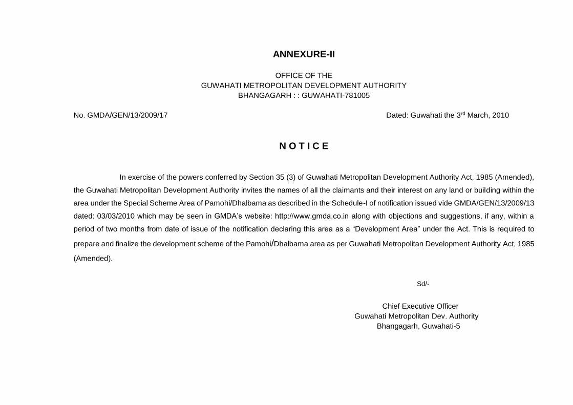
ANNEXURE-II
OFFICE OF THE
GUWAHATI METROPOLITAN DEVELOPMENT AUTHORITY
BHANGAGARH : : GUWAHATI-781005
No. GMDA/GEN/13/2009/17 Dated: Guwahati the 3rd March, 2010
N O T I C E
In exercise of the powers conferred by Section 35 (3) of Guwahati Metropolitan Development Authority Act, 1985 (Amended),
the Guwahati Metropolitan Development Authority invites the names of all the claimants and their interest on any land or building within the
area under the Special Scheme Area of Pamohi/Dhalbama as described in the Schedule-I of notification issued vide GMDA/GEN/13/2009/13
dated: 03/03/2010 which may be seen in GMDA’s website: http://www.gmda.co.in along with objections and suggestions, if any, within a
period of two months from date of issue of the notification declaring this area as a “Development Area” under the Act. This is required to
prepare and finalize the development scheme of the Pamohi/Dhalbama area as per Guwahati Metropolitan Development Authority Act, 1985
(Amended).
Sd/-
Chief Executive Officer
Guwahati Metropolitan Dev. Authority
Bhangagarh, Guwahati-5
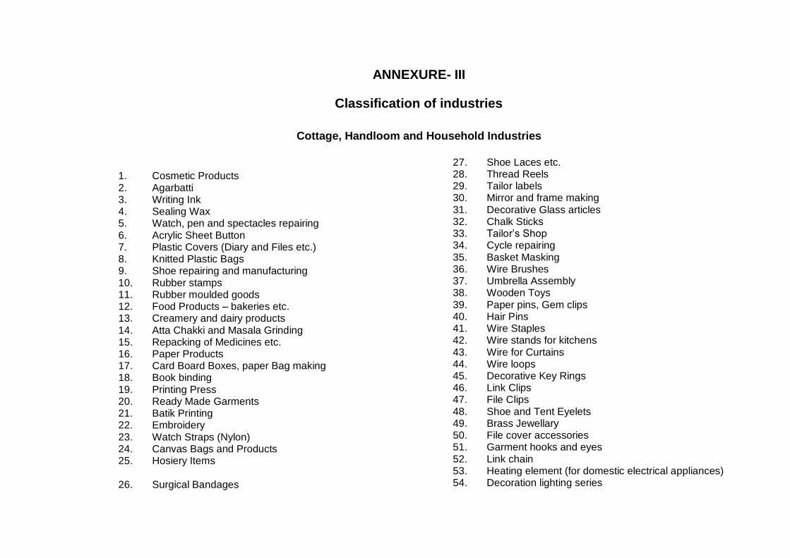
ANNEXURE- III
Classification of industries
Cottage, Handloom and Household Industries
1. Cosmetic Products 2. Agarbatti 3. Writing Ink 4. Sealing Wax 5. Watch, pen and spectacles repairing 6. Acrylic Sheet Button 7. Plastic Covers (Diary and Files etc.) 8. Knitted Plastic Bags 9. Shoe repairing and manufacturing 10. Rubber stamps 11. Rubber moulded goods 12. Food Products – bakeries etc. 13. Creamery and dairy products 14. Atta Chakki and Masala Grinding 15. Repacking of Medicines etc. 16. Paper Products 17. Card Board Boxes, paper Bag making 18. Book binding 19. Printing Press 20. Ready Made Garments 21. Batik Printing 22. Embroidery 23. Watch Straps (Nylon) 24. Canvas Bags and Products 25. Hosiery Items 26. Surgical Bandages
27. Shoe Laces etc. 28. Thread Reels 29. Tailor labels 30. Mirror and frame making 31. Decorative Glass articles 32. Chalk Sticks 33. Tailor’s Shop 34. Cycle repairing 35. Basket Masking 36. Wire Brushes 37. Umbrella Assembly 38. Wooden Toys 39. Paper pins, Gem clips 40. Hair Pins 41. Wire Staples 42. Wire stands for kitchens 43. Wire for Curtains 44. Wire loops 45. Decorative Key Rings 46. Link Clips 47. File Clips 48. Shoe and Tent Eyelets 49. Brass Jewellary 50. File cover accessories 51. Garment hooks and eyes 52. Link chain 53. Heating element (for domestic electrical appliances) 54. Decoration lighting series
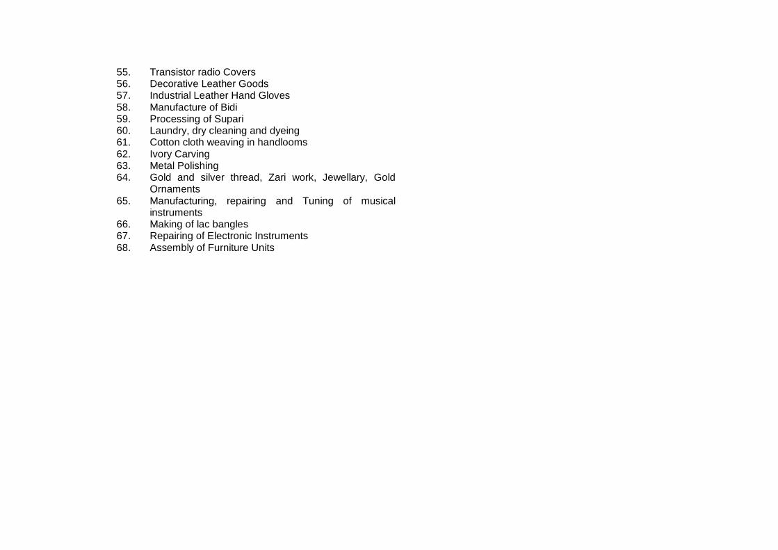
55. Transistor radio Covers 56. Decorative Leather Goods 57. Industrial Leather Hand Gloves 58. Manufacture of Bidi 59. Processing of Supari 60. Laundry, dry cleaning and dyeing 61. Cotton cloth weaving in handlooms 62. Ivory Carving 63. Metal Polishing 64. Gold and silver thread, Zari work, Jewellary, Gold
Ornaments 65. Manufacturing, repairing and Tuning of musical
instruments 66. Making of lac bangles 67. Repairing of Electronic Instruments 68. Assembly of Furniture Units
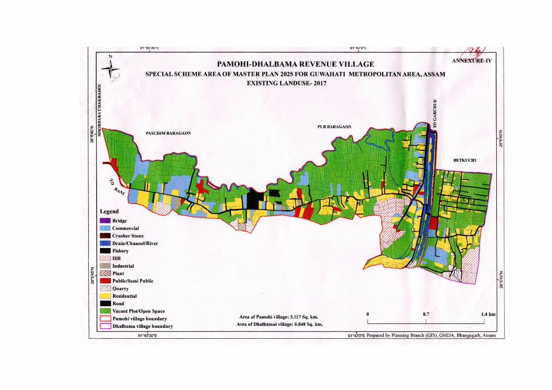
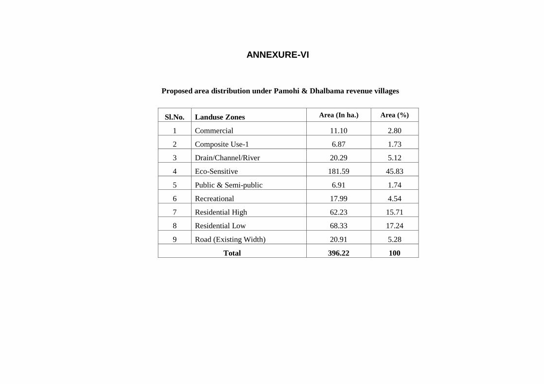
Proposed area distribution under Pamohi & Dhalbama revenue villages
Sl.No. Landuse Zones Area (In ha.) Area (%)
1 Commercial 11.10 2.80
2 Composite Use-1 6.87 1.73
3 Drain/Channel/River 20.29 5.12
4 Eco-Sensitive 181.59 45.83
5 Public & Semi-public 6.91 1.74
6 Recreational 17.99 4.54
7 Residential High 62.23 15.71
8 Residential Low 68.33 17.24
9 Road (Existing Width) 20.91 5.28
Total 396.22 100
ANNEXURE-VI

End of Document