DRAFT - MCAS Yuma › Portals › 152 › Draft... · DRAFT CHOCOLATE MOUNTAINS AERIAL GUNNERY...
135
DRAFT CHOCOLATE MOUNTAINS AERIAL GUNNERY RANGE INTEGRATED NATURAL RESOURCE MANAGEMENT PLAN Prepared by: Department of the Navy, Marine Corps Air Station Yuma In cooperation with: U.S. Department of Interior, Fish and Wildlife Service, Carlsbad Fish and Wildlife Service Office and California Department of Fish and Wildlife October 2013
Transcript of DRAFT - MCAS Yuma › Portals › 152 › Draft... · DRAFT CHOCOLATE MOUNTAINS AERIAL GUNNERY...

DRAFT
CHOCOLATE MOUNTAINS AERIAL GUNNERY RANGE
INTEGRATED NATURAL RESOURCE MANAGEMENT PLAN
Prepared by:
Department of the Navy, Marine Corps Air Station Yuma
In cooperation with:
U.S. Department of Interior, Fish and Wildlife Service,
Carlsbad Fish and Wildlife Service Office
and California Department of Fish and Wildlife
October 2013

DRAFT CHOCOLATE MOUNTAINS AERIAL GUNNERY RANGE INTEGRATED NATURAL RESOURCE MANAGEMENT PLAN
_______________________________________________________________________________
APPROVAL 2013-2017
“Consistent with the use of military installations to ensure the preparedness of the Armed Forces, the Secretaries of the military departments shall carry out the program required by this subsection to provide for-
The conservation and rehabilitation of natural resources on military installations;
The sustainable multipurpose use of the resources, which shall include hunting, fishing, trapping, and nonconsumptive uses; and
Subject to safety requirements and military security, public access to military installations to facilitate the use"
Sikes Act (16 USC 670a) This Integrated Natural Resources Management Plan meets the requirements of the Sikes Act (16 U.S.C. 670a et seq.) as amended.
COLONEL ROBERT C. KUCKUK Commanding Officer Marine Corps Air Station Yuma, Arizona
Date
JIM BARTEL Field Supervisor Carlsbad Fish and Wildlife Service Office
Date
CHARLTON H. BONHAM Director California Department of Fish and Wildlife
Date
DRAFT CHOCOLATE MOUNTAINS AERIAL GUNNERY RANGE INTEGRATED NATURAL RESOURCE MANAGEMENT PLAN
_______________________________________________________________________________
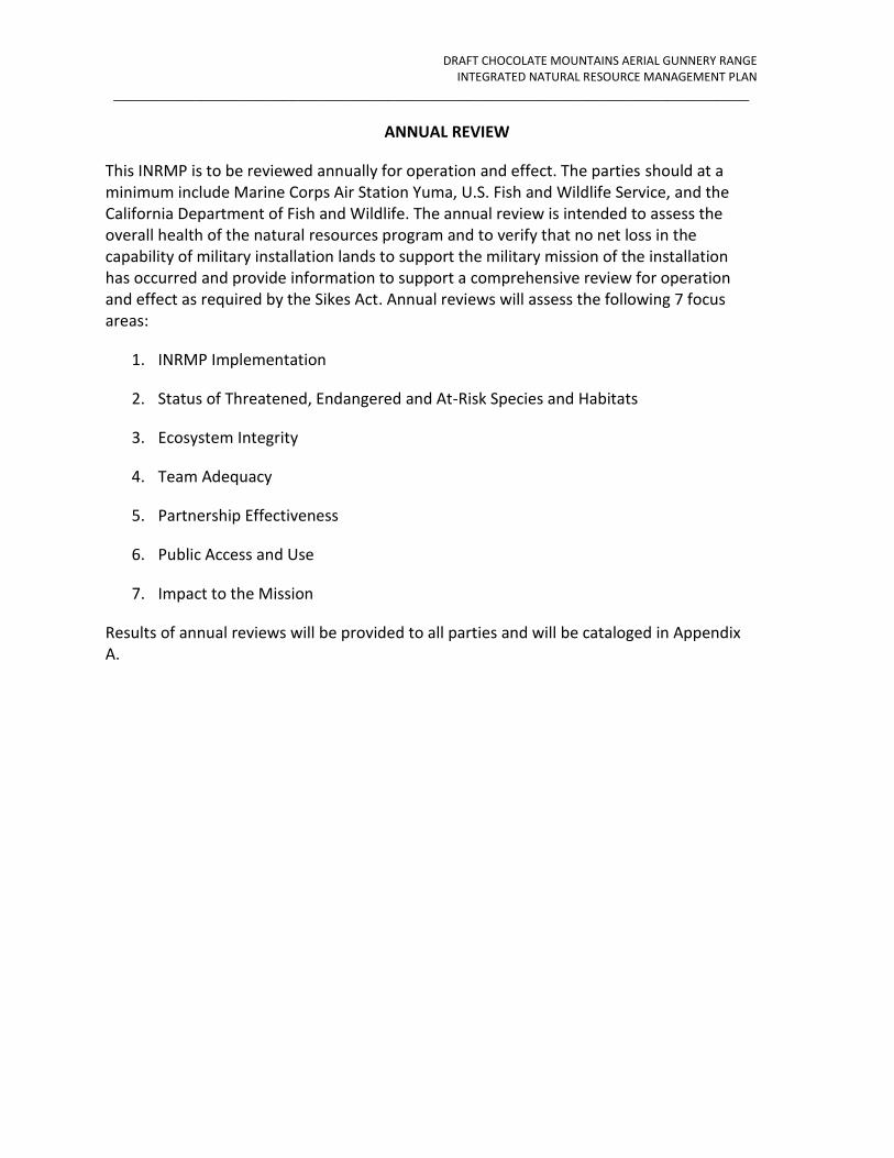
ANNUAL REVIEW
This INRMP is to be reviewed annually for operation and effect. The parties should at a minimum include Marine Corps Air Station Yuma, U.S. Fish and Wildlife Service, and the California Department of Fish and Wildlife. The annual review is intended to assess the overall health of the natural resources program and to verify that no net loss in the capability of military installation lands to support the military mission of the installation has occurred and provide information to support a comprehensive review for operation and effect as required by the Sikes Act. Annual reviews will assess the following 7 focus areas:
1. INRMP Implementation
2. Status of Threatened, Endangered and At-Risk Species and Habitats
3. Ecosystem Integrity
4. Team Adequacy
5. Partnership Effectiveness
6. Public Access and Use
7. Impact to the Mission
Results of annual reviews will be provided to all parties and will be cataloged in Appendix A.

DRAFT CHOCOLATE MOUNTAINS AERIAL GUNNERY RANGE INTEGRATED NATURAL RESOURCE MANAGEMENT PLAN
_______________________________________________________________________________
ANNUAL REVIEW i
TABLE OF CONTENTS
1. INTRODUCTION .................................................................................................... 1-1
1.1 Purpose and Need of the INRMP ....................................................................... 1-1
1.2 CMAGR Overview .............................................................................................. 1-2
1.3 INRMP Authority, Scope, Responsibilities and Management Guidance ............... 1-5 1.3.1 Authority and Scope ............................................................................................... 1-5 1.3.2 Agency Responsibilities .......................................................................................... 1-7
1.4 Management Guidance ..................................................................................... 1-8 1.4.1 National Environmental Policy Act (NEPA) ............................................................ 1-9 1.4.2 Marine Corps Orders ............................................................................................ 1-10 1.4.3 Environmental Inspection and Compliance ......................................................... 1-10
1.5 Background on the INRMP Planning and Interagency Collaboration Process .... 1-12 1.5.1 Overview of the Planning Process and Time Frame ............................................ 1-12 1.5.2 Interagency Collaboration and Intergovernmental Consultation ........................ 1-12 1.5.3 Public Outreach, Information, and Participation Programs ................................. 1-12
1.6 Resource Management Philosophy/Approach ................................................. 1-12 1.6.1 Ecosystem Management Philosophy ................................................................... 1-14
1.7 INRMP Review and Amendment Procedures ................................................... 1-15
2. CMAGR SETTING, HISTORY, AND MISSION ............................................................ 2-1
2.1 CMAGR Setting .................................................................................................. 2-1
2.2 CMAGR Historic Use .......................................................................................... 2-1 2.2.1 Military Use ............................................................................................................ 2-3
2.3 Current and Future Military Mission .................................................................. 2-6
2.4 Military Land and Airspace Use.......................................................................... 2-6
2.5 Military Surface Use and Roads ......................................................................... 2-8 2.5.1 Additional Training, Support, and Range Access Control Areas and Road Network 2-11 2.5.2 Non-Military Surface Use and Roadless Areas ..................................................... 2-16

DRAFT CHOCOLATE MOUNTAINS AERIAL GUNNERY RANGE INTEGRATED NATURAL RESOURCE MANAGEMENT PLAN
_______________________________________________________________________________
ANNUAL REVIEW ii
3. EXISTING ENVIRONMENT ...................................................................................... 3-1
3.1 Physical Environment ........................................................................................ 3-1 3.1.1 Earth Resources ...................................................................................................... 3-1 3.1.2 Climate ................................................................................................................... 3-6 3.1.3 Water Resources .................................................................................................... 3-6
3.2 Air Quality ....................................................................................................... 3-14 3.2.1 Air Quality Setting ................................................................................................ 3-14
3.3 Biotic Environment .......................................................................................... 3-15 3.3.1 Vegetation ............................................................................................................ 3-15 3.3.2 General Wildlife .................................................................................................... 3-26 3.3.3 Special Status Species .......................................................................................... 3-27 3.3.4 Migratory Birds ..................................................................................................... 3-41 3.3.5 Bird and Aircraft Strike Hazard (BASH) Reduction Program ................................ 3-42 3.3.6 Invasive Species .................................................................................................... 3-42
3.4 Cultural Resources .......................................................................................... 3-44
3.5 Information Management ............................................................................... 3-45
3.6 Public Access and Safety .................................................................................. 3-46
3.7 Unauthorized access ....................................................................................... 3-46
3.8 Perimeter Land Use Environment .................................................................... 3-47 3.8.1 Regional Land Use Setting .................................................................................... 3-47 3.8.2 Land Status and Management Responsibilities ................................................... 3-48 3.8.3 Land Use ............................................................................................................... 3-52 3.8.4 Utilities ................................................................................................................. 3-55 3.8.5 Renewable Energy ................................................................................................ 3-56 3.8.6 Surface Transportation......................................................................................... 3-57 3.8.7 Non-Military Land Use Potential in the CMAGR .................................................. 3-58 3.8.8 Recreation ............................................................................................................ 3-60
4. CMAGR NATURAL RESOURCE MANAGEMENT GOALS ............................................ 4-1
4.1 Philosophy, Guiding Principles, and General Approach ...................................... 4-2
4.2 NEPA Support.................................................................................................... 4-4
4.3 Biological Resources Inventory and Monitoring ................................................. 4-5 4.3.1 Threatened or Endangered Species ....................................................................... 4-5 4.3.2 Special Status Species ............................................................................................ 4-7

DRAFT CHOCOLATE MOUNTAINS AERIAL GUNNERY RANGE INTEGRATED NATURAL RESOURCE MANAGEMENT PLAN
_______________________________________________________________________________
iii
4.3.3 Migratory Birds ....................................................................................................... 4-8 4.3.4 BASH Reduction Program ....................................................................................... 4-8 4.3.5 Wildlife Waters ....................................................................................................... 4-9
4.4 Physical Environment Mapping and Ecosystem Management ............................ 4-9 4.4.1 Aerial Orthophotography and Evaluation of Anthropogenic Impacts ................. 4-10 4.4.2 Multi-scale Soils and Erosion Monitoring ............................................................ 4-10 4.4.3 Vegetation mapping ............................................................................................. 4-11 4.4.4 Invasive Species .................................................................................................... 4-12 4.4.5 Soil mapping ......................................................................................................... 4-12
4.5 Cultural Resources .......................................................................................... 4-13
4.6 Information management ............................................................................... 4-13
4.7 Cooperative Initiatives .................................................................................... 4-14
4.8 Recreation ...................................................................................................... 4-14
4.9 Law Enforcement and Control of Public Access ................................................ 4-14
5. PLANNED PROJECTS AND IMPLEMENTATION SCHEDULE ..................................... 5-15
6. REFERENCES ......................................................................................................... 6-1

DRAFT CHOCOLATE MOUNTAINS AERIAL GUNNERY RANGE INTEGRATED NATURAL RESOURCE MANAGEMENT PLAN
_______________________________________________________________________________
LIST OF FIGURES iv
LIST OF FIGURES
Figure 1 Existing Underlying Land Jurisdiction at the CMAGR .................................................... 1-4
Figure 2 CMAGR Vicinity .............................................................................................................. 2-2
Figure 3 CMGR Training and Support facilities ............................................................................ 2-5
Figure 4 Existing Military Surface Use at the CMAGR .................................................................. 2-9
Figure 5 Weapon and surface danger zones and laser safety danger zones at the CMAGR .... 2-10
Figure 6 Roadless areas at the CMAGR ...................................................................................... 2-17
Figure 7 Geologic Map at the CMAGR ......................................................................................... 3-4
Figure 8 Soils at the CMAGR ........................................................................................................ 3-5
Figure 9 Surface Watersheds at the CMAGR ............................................................................. 3-10
Figure 10 Groundwater at the CMAGR ...................................................................................... 3-13
Figure 11 Ecological Systems of the CMAGR as mapped by GAP (USGS) .................................. 3-16
Figure 12 Dark hills to right are misattributed as Bedrock Cliff and Outcrop. .......................... 3-20
Figure 13 White hills misattributed by the GAP map. .............................................................. 3-21
Figure 14 Extensive desert pavements at the SE corner of the CMAGR. ................................ 3-23
Figure 15 Dense vegetation mapped by GAP as riparian forest ................................................ 3-25
Figure 16 Special Status Species within the CMAGR Vicinity ................................................... 3-28
Figure 17 Non-Military Land Use within the CMAGR Vicinity ................................................... 3-51
DRAFT CHOCOLATE MOUNTAINS AERIAL GUNNERY RANGE INTEGRATED NATURAL RESOURCE MANAGEMENT PLAN
_______________________________________________________________________________
LIST OF TABLES v
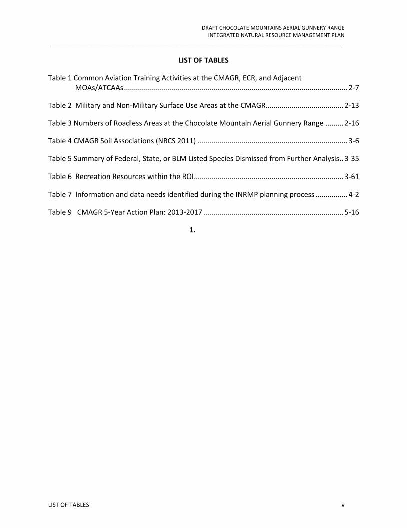
LIST OF TABLES
Table 1 Common Aviation Training Activities at the CMAGR, ECR, and Adjacent MOAs/ATCAAs ................................................................................................................ 2-7
Table 2 Military and Non-Military Surface Use Areas at the CMAGR ....................................... 2-13
Table 3 Numbers of Roadless Areas at the Chocolate Mountain Aerial Gunnery Range ......... 2-16
Table 4 CMAGR Soil Associations (NRCS 2011) ........................................................................... 3-6
Table 5 Summary of Federal, State, or BLM Listed Species Dismissed from Further Analysis .. 3-35
Table 6 Recreation Resources within the ROI ........................................................................... 3-61
Table 7 Information and data needs identified during the INRMP planning process ................ 4-2
Table 9 CMAGR 5-Year Action Plan: 2013-2017 ...................................................................... 5-16
1.

DRAFT CHOCOLATE MOUNTAINS AERIAL GUNNERY RANGE INTEGRATED NATURAL RESOURCE MANAGEMENT PLAN
_______________________________________________________________________________
LIST OF ACRONYMS vi
LIST OF ACRONYMS
°C Celsius
°F Fahrenheit
ACEC Area of Critical Environmental Concern
AGFD Arizona Game and Fish Department
ATCAA air traffic control assigned air space
BGEPA Bald and Golden Eagle Protection Act of 1940
BLM Bureau of Land Management
BMGR Barry M. Goldwater Range
BO Biological Opinion
BSTRC Bob Stump Training Range Complex
CA California
CAA Civil Aeronautics Administration
CAAQS California Ambient Air Quality Standards
CARB California Air Resources Board
CATEX Categorical Exclusions
CDCA California Desert Conservation Area
CDD California Desert District
CDFW California Department of Fish and Wildlife
CDWR California Department of Water Resources
CEC California Energy Commission
CEQ Council on Environmental Quality
CEQA California Environmental Quality Act
CFR Code of Federal Regulations
CH4 methane
CMAGR Chocolate Mountains Aerial Gunnery Range
CMBC Circle Mountain Biological Consultants, Inc.
CMLWOA California Military Lands Withdrawal and Overflights Act of 1994
CNDDB California Natural Diversity Database
CNPS California Native Plant Society
CO carbon monoxide
CO2 carbon dioxide
CVMSHCP Coachella Valley Multiple Species Habitat Conservation Plan
DoD Department of Defense
DoI Department of the Interior
DoN Department of the Navy
DRECP Desert Renewable Energy Conservation Plan
DSM digital soil mapping
DTC Desert Training Center
DRAFT CHOCOLATE MOUNTAINS AERIAL GUNNERY RANGE INTEGRATED NATURAL RESOURCE MANAGEMENT PLAN
_______________________________________________________________________________
LIST OF ACRONYMS vii
DTC/C-AMA Desert Training Center California-Arizona Maneuver Area
DTRO Desert Tortoise Recovery Office
DWMA Desert Wildlife Management Areas
EA Environmental Assessment
ECE Environmental Compliance Evaluation
ECR El Centro Ranges
EIR Environmental Impact Report
EIS Environmental Impact Statement
ESA Endangered Species Act
FLPMA Federal Lands Policy and Management Act
FLTFA Federal Land Transaction Facilitation Act
FONSI Finding of No Significant Impact
FR Federal Register
GAP Gap Analysis Program
GHGs greenhouse gases
GIS Geographic Information System
GOPR Governor’s Office of Planning and Research
GPS Global Positioning System
HQMC Marine Corps Headquarters
ICRMP Integrated Cultural Resources Management Plan
IGR Intergovernmental Review
IID Imperial Irrigation District
INRMP Integrated Natural Resources Management Plan
ISDRA Imperial Sand Dunes Recreational Area
LEIS Legislative Environmental Impact Statement
LWCF Land and Water Conservation Fund
MAGTF Marine Air Ground Task Forces
MBTA Migratory Bird Treaty Act
MCAS Marine Corps Air Station
MCO Marine Corps Order
MOA military operations areas
MOU Memorandum of Understanding
MUC Multiple-Use Classes
N2O nitrous oxide
NAAQS National Ambient Air Quality Standards
NAS Naval Air Station
NECO Northern and Eastern Colorado Desert Coordinated Management Plan
NEPA National Environmental Policy Act
NHL National Historic Landmarks

DRAFT CHOCOLATE MOUNTAINS AERIAL GUNNERY RANGE INTEGRATED NATURAL RESOURCE MANAGEMENT PLAN
_______________________________________________________________________________
LIST OF ACRONYMS viii
NHPA National Historic Preservation Act
NO2 nitrogen dioxide
NOX oxides of nitrogen
NRCS Natural Resources Conservation Service
NRHP National Register of Historic Places
NSW Naval Special Warfare
O3 ozone
OHV off-highway vehicle
OSD Office of Secretary of Defense
Pb lead
PM10 suspended particulate matter less than or equal to 10 microns in diameter
PM2.5 fine particulate matter less than or equal to 2.5 microns in diameter
ppm parts per million
QA quality assurance
QC quality control
RARD Regional Archaeological Research Design
RCNPPA Rare California Native Plant Protection Act
Reclamation U.S. Bureau of Reclamation
REEA West Chocolate Mountains Renewable Energy Evaluation Area
RETI Renewable Energy Transmission Initiative
ROD Record of Decision
ROG reactive organic gases
ROI region of influence
ROW right-of-way
SAIA International Association of Fish and Wildlife Agencies
SCAG The Southern California Association of Governments
SEAL Sea, Air and Land
SO2 sulfur dioxide
SoCal Gas Southern California Gas Company
SPRR Southern Pacific Railroad
SR State Route
SRA State Recreational Area
SSAB Salton Sea Air Basin
SSC Species of Special Concern
StaO Station Order
STATSGO2 State Soil Geographic Database
SWAT special warfare training area
TCP traditional cultural properties

DRAFT CHOCOLATE MOUNTAINS AERIAL GUNNERY RANGE INTEGRATED NATURAL RESOURCE MANAGEMENT PLAN
_______________________________________________________________________________
LIST OF ACRONYMS ix
U.S.C. U.S. Code
UPRR Union Pacific Railroad
USFWS U. S. Fish and Wildlife Service
USGS U.S. Geological Survey
WECO Western Colorado Desert Routes of Travel Designations
WRCC Western Regional Climate Center
WWII World War II

DRAFT CHOCOLATE MOUNTAINS AERIAL GUNNERY RANGE INTEGRATED NATURAL RESOURCE MANAGEMENT PLAN
_______________________________________________________________________________
EXECUTIVE SUMMARY
EXECUTIVE SUMMARY
The Chocolate Mountains Aerial Gunnery Range (CMAGR) in southeastern California has served as a military training range since 1942. The CMAGR currently includes about 228,465 acres (nearly 357 square miles) of withdrawn federal public land administered by the Department of the Interior (DoI) Bureau of Land Management (BLM) and about 229,903 acres (359 square miles) of federal land administered by the Department of the Navy (DoN). The California Military Lands Withdrawal and Overflights Act of 1994 (Public Law [P.L.] 103-433) states that the public lands in the CMAGR are withdrawn from all forms of appropriation under the public land laws (including the mining laws and the mineral leasing and the geothermal leasing laws) and are reserved for use by the Secretary of the Navy for testing and training for aerial bombing, missile firing, tactical maneuvering and air support, and other defense-related purposes. Department of Interior (DoI) Bureau of Reclamation (Reclamation) land is located in several dispersed parcels near the western perimeter of the range and is not withdrawn for military purposes.
In recognition of the fact that military lands contain significant natural resources, Congress enacted the Sikes Act in 1960 to address wildlife conservation and public access on military installations. The Sikes Act (16 U.S.C. § 670-670f), as amended, requires the Secretary of Defense to carry out a program to provide for the conservation and rehabilitation of natural resources on military installations in cooperation with the U.S. Fish and Wildlife Service (USFWS) and the state fish and wildlife agencies. The 1997 amendments to the Sikes Act require the Department of Defense (DoD) to develop and implement an Integrated Natural Resources Management Plan (INRMP) for each military installation with significant natural resources. This INRMP was prepared in cooperation with the USFWS, California Department of Fish and Wildlife, and Bureau of Land Management (BLM) and reflects a mutual agreement of these parties concerning conservation, protection, and management of fish and wildlife resources on the CMAGR.
This INRMP will provide for the management of natural resources for the CMAGR. It incorporates, to the maximum extent practicable, ecosystem management principles and provides the landscape necessary for the sustainment of military land uses. This INRMP is intended principally to guide the effective management of an installation’s natural resources, so as to ensure that its lands remain available and in good condition to support the installation’s military mission, and with “no net loss” in the capability of military installation land to support the military mission of the installation. To ensure frequent and continued use of land for military training, now and in the future, management programs and actions in INRMPs must ensure natural resource utilization is: 1) sustainable; 2) in accordance with laws and regulations; and 3) optimally integrated with existing military installation plans and mission requirements.
This document provides a brief summary of the CMAGR and its natural resources. Also provided is a list of the project activities that are planned for the next five years to initiate the implementation of the INRMP. These project activities are addressed in Chapter 5 Planned Management and Implementation Schedule. For each action, the fiscal year for funding, an estimated funding amount for project completion, and how often a project will occur are identified. In addition, the actions have been prioritized and responsible parties for completing the action, including potential partners, have been identified.

DRAFT CHOCOLATE MOUNTAINS AERIAL GUNNERY RANGE INTEGRATED NATURAL RESOURCE MANAGEMENT PLAN
_______________________________________________________________________________
INTRODUCTION 1-1
1. INTRODUCTION
1.1 PURPOSE AND NEED OF THE INRMP
The purpose of this Integrated Natural Resources Management Plan (INRMP) is to guide implementation of the natural resources program on the Chocolate Mountains Aerial Gunnery Range (CMAGR) from 2013 through 2017.
The purpose of this INRMP is to provide an integrated, comprehensive plan for managing the natural resources of the CMAGR and for managing sustainable public use of those resources to the extent that such management and use is consistent with the military purposes of the range. Natural resources and military use will be managed so that there is no net loss in the capability of the CMAGR to support its military purposes and in a manner that is consistent with ecosystem management principles. Further, management prescribed by this INRMP will benefit threatened and endangered species on the CMAGR consistent with Federal and State recovery actions for these species under the Endangered Species Act (ESA) of 1973 (16 U.S. Code [U.S.C.] 1531 et seq.). These purposes are in accordance with the guidance provided for the CMAGR and for all U.S. military installations by the Sikes Act, as most recently amended by the Sikes Act Improvement Amendments (hereafter referred to as “Sikes Act” [16 U.S.C. 670a et seq.]).
This INRMP fulfills other responsibilities with regard to DoD and Marine Corps policies and legal requirements regarding natural resource planning, including, the DoD Instruction 4715.03 (Natural Resource Conservation), and Marine Corps Order (MCO) P5090.2A (Marine Corps Environmental Compliance Protection Manual). This INRMP was prepared using the Handbook for Preparing, Revising and Implementing Integrated Natural Resources Management Plans on Marine Corps Installations (Headquarters, 2007). Finally, this INRMP continues to provide the benefits that were provided to species by the Northern and Eastern Colorado Desert Coordinated Management Plan (NECO).
CMAGR’s INRMP provides technical guidance to persons planning and/or preparing installation approvals, management actions, orders, instructions, guidelines, Standard Operating Procedures, and other plans, for integrating natural resource management efforts into the Base’s planning and decision-making processes. It is not intended, however, for use by military personnel operating in the field. Field operations and activities are directed to adhere to guidelines, plans, orders, or other approvals that have been developed using this INRMP and have already had environmental compliance review, and where applicable, regulatory approvals and/or permitting. This INRMP does not dictate land use decisions, but rather provides important information to support sound land use and natural resources management decisions. National Historic Preservation Act requirements are not addressed in this INRMP. Cultural resources management issues (archaeological and historical) are addressed separately within CMAGR’s ICRMP.
DRAFT CHOCOLATE MOUNTAINS AERIAL GUNNERY RANGE INTEGRATED NATURAL RESOURCE MANAGEMENT PLAN
_______________________________________________________________________________
INTRODUCTION 1-2
1.2 CMAGR OVERVIEW
The CMAGR is located in Imperial and Riverside counties, California. The CMAGR currently includes about 228,465 acres (nearly 357 square miles) of withdrawn federal public land administered by the Department of the Interior (DoI) Bureau of Land Management (BLM) and about 229,903 acres (359 square miles) of federal land administered by the Department of the Navy (DoN). Approximately 162 acres (about 0.25 square mile) of land administered by the U.S. Bureau of Reclamation (Reclamation) is located inside of the CMAGR boundary; the Reclamation land is not withdrawn for military purposes.
The withdrawn public land (hereafter BLM land) in the CMAGR is currently withdrawn and reserved1 for use as a military range by the California Military Lands Withdrawal and Overflights Act of 1994 (CMLWOA) (Public Law [P.L.] 103-433). CMLWOA states that the public lands in the CMAGR are withdrawn from all forms of appropriation under the public land laws (including the mining laws and the mineral leasing and the geothermal leasing laws) and are reserved for use by the Secretary of the Navy for testing and training for aerial bombing, missile firing, tactical maneuvering and air support, and other defense-related purposes. The BLM and DoN lands in the CMAGR are generally interspersed in a checkerboard pattern of one square-mile (640 acre) sections, but are used collectively and in common to support the air combat training missions and other defense activities that occur at the range (Figure 1). The Reclamation land is located in several dispersed parcels near the western perimeter of the range. Dikes have been constructed on the Reclamation parcels to protect the Coachella Canal from flooding.
The CMAGR supports training by units of the DoN, U.S. Air Force, U.S. Army, U.S. Reserve Components, and U.S. National Guard; however, the Marine Corps is the primary user of this range. Local command for military operation and administration of the CMAGR has been delegated by the Secretary of the Navy to the Commanding Officer, Marine Corps Air Station (MCAS) Yuma, Arizona. The majority of aircraft that are used in training at the range originate from squadrons based at MCAS Yuma and MCAS Miramar. Other regionally-based squadrons that regularly use the CMAGR are stationed in California, at MCAS Camp Pendleton and Naval Air Station (NAS) North Island, and in Arizona, at Luke Air Force Base. Aircraft that originate from other Marine and Naval air stations and Air Force bases or that are launched from DoN aircraft carriers in the Pacific Ocean are also frequently flown in training missions at the CMAGR. In total, roughly 100 squadrons from throughout the nation collectively fly more than 6,000 training flight annually at the CMAGR.
1 As provided by the Federal Land Policy and Management Act of 1976 (43 U.S.C. 1702(j)) “withdrawn”
federal lands are those that are withheld from settlement, sale, location, or entry, under some or all of the general land laws, for the purpose of limiting activities under those laws in order to maintain other public values in the area or reserving the area for a particular public purpose or program; or transferring jurisdiction over an area of Federal land, other than “property” governed by the Federal Property and Administrative Services Act, as amended (40 U.S.C. 472) from one department, bureau or agency to another department, bureau or agency.
DRAFT CHOCOLATE MOUNTAINS AERIAL GUNNERY RANGE INTEGRATED NATURAL RESOURCE MANAGEMENT PLAN
_______________________________________________________________________________
INTRODUCTION 1-3
The training range, which is a component of the national defense training infrastructure is indispensable to the continued and future readiness of Marine Corps and Navy air and ground forces, including Naval Special Warfare (NSW) Sea, Air and Land (SEAL) units and air combat training conducted by other branches of the DoD. The need for quality training that provides a realistic approximation of the conditions that Marines, sailors, airmen, and soldiers will face in combat as individuals and in small or large units cannot be overstated. The U.S. military is fully invested in the principle that high quality training is essential to success and survival in combat. Access to ranges that offer flexible, diverse, and realistic training is essential to preparing tactical forces of the highest possible quality. Thus, the necessity of keeping the CMAGR fully in service can best be understood from two main perspectives: (1) the necessity of providing high quality training and (2) the superlative qualities of the CMAGR for supporting that training.

DRAFT CHOCOLATE MOUNTAINS AERIAL GUNNERY RANGE INTEGRATED NATURAL RESOURCE MANAGEMENT PLAN
_______________________________________________________________________________
INTRODUCTION 1-4
Figure 1 Existing Underlying Land Jurisdiction at the CMAGR

DRAFT CHOCOLATE MOUNTAINS AERIAL GUNNERY RANGE INTEGRATED NATURAL RESOURCE MANAGEMENT PLAN
_______________________________________________________________________________
INTRODUCTION 1-5
1.3 INRMP AUTHORITY, SCOPE, RESPONSIBILITIES AND MANAGEMENT GUIDANCE
This INRMP, developed in partnership with the BLM, USFWS, CDFW, and Reclamation, presents the DoN/USMC’s natural resources management of the range.
1.3.1 Authority and Scope
Legal authority for the INRMP is provided by the Sikes Act. The Sikes Act sets forth resource management policies and guidance for U.S. military installations and requires the preparation of INRMPs for installations—including those, such as the CMAGR, composed of withdrawn lands—with significant natural resources. The Sikes Act requires that the "… Secretary of Defense shall carry out a program to provide for the conservation and rehabilitation of natural resources [16 U.S.C. 670a (a)(1)(A) and (B)]. The Sikes Act further specifies that:
Consistent with the use of military installations to ensure the preparedness of the Armed Forces, the Secretaries of the military departments shall carry out [a natural resources management program] to provide for—
A. the conservation and rehabilitation of natural resources on military installations;
B. the sustainable multipurpose use of the resources, which shall include hunting, fishing, trapping, and non-consumptive uses; and
C. subject to safety requirements and military security, public access to military installations to facilitate the use.
Additionally, the Sikes Act requires that, consistent with the use of military installations to ensure the preparedness of the Armed Forces, each INRMP shall, where appropriate and applicable, provide for:
• fish and wildlife management, land management, forest management, and fish- and wildlife-oriented recreation;
• fish and wildlife habitat enhancement or modifications;
• wetland protection, enhancement, and restoration where necessary for support of fish or wildlife;
• integration of, and consistency among, the various activities conducted under the INRMP;
• establishment of specific natural resources management objectives and time frames for proposed action;

DRAFT CHOCOLATE MOUNTAINS AERIAL GUNNERY RANGE INTEGRATED NATURAL RESOURCE MANAGEMENT PLAN
_______________________________________________________________________________
INTRODUCTION 1-6
• sustained use by the public of natural resources to the extent such use is not inconsistent with the needs of fish and wildlife resources management;
• public access to the military installation that is necessary or appropriate for sustained use by the public of natural resources to the extent that the use is not inconsistent with the needs of fish and wildlife resources, subject to requirements necessary to ensure safety and military security;
• enforcement of natural resource laws and regulations;
• no net loss in the capability of military installation lands to support the military mission of the installation; and
• such other activities as the Secretary of the military department considers appropriate.
Safety and security requirements related to the aerial gunnery mission, as well as the potential for unexploded ordinance at the range preclude public access. Therefore the INRMP for the CMAGR focuses solely of the conservation and rehabilitation of natural resources.
For public safety, flight safety, and operational security reasons, there is no access for recreational or other activities onto the CMAGR to the public, Marines or civilians. This restricted access reduces the scope of natural resource management challenges. MCO P 5090.2A requires that all Marine Corps installations having water and land suitable for the conservation and management of natural resources prepare and implement a comprehensive INRMP that includes all elements of natural resources management applicable to the installation. An INRMP must accomplish the following:
• Preserve access to air, land, and sea space to meet military readiness requirements;
• Comply with applicable natural resources protection requirements (for example, laws, Executive Orders, and regulations);
• Provide public access to installation lands, where practicable, provided such access does not conflict with military readiness and does not harm sensitive installation natural resources; and
• Participate in regional ecosystem management partnerships provided such participation does not conflict with military readiness and does not harm installation natural resources.

DRAFT CHOCOLATE MOUNTAINS AERIAL GUNNERY RANGE INTEGRATED NATURAL RESOURCE MANAGEMENT PLAN
_______________________________________________________________________________
INTRODUCTION 1-7
1.3.2 Agency Responsibilities
The Sikes Act (16 U.S.C. § 670a(a)(2)) states that the INRMP shall reflect the “mutual agreement” of the USFWS, the state fish and wildlife agency, and the DoD “concerning conservation, protection, and management of fish and wildlife resources.” The requirement for mutual agreement is further clarified by the distinction that “nothing in this subchapter enlarges or diminishes the responsibility and authority of any state for the protection and management of fish and resident wildlife (Section 670a(a)(4)(A)(ii)).”
Mutual agreement with the U. S. Fish and Wildlife Service (USFWS) and the California Department of Fish and Wildlife (CDFW) is met through the participation of these agencies in the review/update process, involvement throughout any revision development as noted above, and by signature to the revised document. Coordination with the USFWS and the CDFW is expected to continue indefinitely as the “review, planning, and revision dialogue” will be ongoing. These agencies will participate, to the extent practicable based on staffing availability, in an on-going review process by providing comments, recommendations and input on the status of regional processes, surveys and species.
This INRMP reiterates the CMAGR’s compliance with Section 7of the Endangered Species Act (ESA). Section 7(a)(1) requires federal agencies to use their respective authorities, such as the Sikes Act, to further the purposed of the ESA. Section 7(a)(2) requires formal consultation under the ESA which results in a biological opinion (BO) rendered by the USFWS that determines whether or not an action proposed by a Federal agency will jeopardize the continued existence of a federally listed species or will result in adverse modification of designated critical habitat. The biological opinion is a written statement from the USFWS regarding its opinion and a summary of the information on which the opinion is based, detailing how the agency action affects the species or its critical habitat. It provides nondiscretionary Reasonable and Prudent Measures that should be implemented in conjunction with a proposed action to avoid or minimize impacts. The USFWS also provides nonbinding conservation recommendations as part of the biological opinion. A biological opinion is required for actions that may affect a threatened or endangered species so as to avoid violations under Section 9 of the ESA. Section 9 of the ESA prohibits the ‘take’ of a threatened or endangered species. Take includes the direct killing, harming, or harassing of a species, or destruction of habitat that may be important for the species’ survival or recovery. The term "harass" in this definition has been further defined to mean “...an intentional or negligent act or omission which creates the likelihood of injury to wildlife by annoying it to such an extent as to significantly disrupt normal behavioral patterns which include, but are not limited to, breeding, feeding or sheltering (50 CFR 17.3).” Part of a biological opinion is the issuance of an incidental take authorization which authorizes take, as long as it does not violate the Terms and Conditions established in the biological opinion. Terms and Conditions can involve additional costs relative to mitigation requirements, which may include compensation for lost resources, minimization of, and avoidance of impacts on threatened or endangered species or critical habitat. Such potential costs need to be considered as part of project planning and construction.

DRAFT CHOCOLATE MOUNTAINS AERIAL GUNNERY RANGE INTEGRATED NATURAL RESOURCE MANAGEMENT PLAN
_______________________________________________________________________________
INTRODUCTION 1-8
1.4 MANAGEMENT GUIDANCE
Guidance for the Marine Corps’ INRMP process is provided in the Handbook for Preparing, Revising, and Implementing Integrated Natural Resources Management Plans on Marine Corps Installations (Headquarters, U.S. Marine Corps 2007). This handbook guides the preparation, revision, and implementation of INRMPs in compliance with the Memorandum of Understanding between the DoD, USFWS, and International Association of Fish and Wildlife Agencies, and with the Sikes Act Improvement Act (SAIA) implemented by Office of Secretary of Defense Updated Guidance on Implementation of the SAIA of 10 October 2002. Additional direction is included in MCO 5090.2A, Chapter 11, Natural Resources Management DoN, Headquarters U.S. Marine Corps 1998), which directs installations with land and water suitable for the conservation and management of natural resources to prepare and implement a comprehensive INRMP that fulfills the requirements of the Sikes Act. This order directs that professionally trained personnel are to prepare INRMPs to support the installation operational mission, meet stewardship and legal requirements, and ensure installation resources are managed through an ecosystem approach. It addresses cooperative agreements authorized to implement these plans as well as the need to review and revise the plan.
Ecosystem management is the basis for the management of natural resources on land under Marine Corps jurisdiction. An ecosystem can be defined as a dynamic, natural complex of living organisms interacting with each other and with their associated nonliving environment. Ecosystem management has been defined in various ways (e.g., Leslie et al. 1996); however, all encompass a similar approach to management.
This strategy enables the Air Station to meet its goals and objectives relative to natural resources management and conservation, both locally on the CMAGR and within the region. Goals, such as those for natural resources management, are general expressions of desired future conditions that represent the long-range aim of management. Marine Corps natural resources management goals, as established in MCO P5090.2, are as follows: The Range Management Department advises the Commanding Officer, MCAS Yuma in order to assist him in attaining the following objectives:
• Meet the military mission of the CMAGR.
• Minimize conflicts between the above and the natural resources and wildlife on the Range.
• Maintain active and thoughtful compliance with the appropriate natural resources law and regulations, agency guidance, relevant orders and binding regulatory opinions.
• Remain cognizant of regional natural resources initiatives and trends, maintaining involvement in such as relate to the CMAGR’s specific situation.
DRAFT CHOCOLATE MOUNTAINS AERIAL GUNNERY RANGE INTEGRATED NATURAL RESOURCE MANAGEMENT PLAN
_______________________________________________________________________________
INTRODUCTION 1-9
• Remain cognizant of public opinion and interest groups where these intersect with the CMAGR’s specific situation, interacting with them when circumstances demand.
• Maintain an active, professional and mutually productive relationship with the regulatory authorities who monitor and advise on the CMAGR’s specific situation.
• Anticipate and mitigate for the effects of infrastructure improvements and development on the natural resources on the CMAGR.
• Inventory and evaluate the natural resources on the CMAGR.
• Evaluate and set long-term management and conservation goals.
• Based upon the analysis of the CMAGR’s experiences (both positive and negative) in natural resource management and conservation combined with new information, research findings, regulatory advice, etc. develop future goals, objectives, and actions to improve the CMAGR’s stewardship of its natural resources.
• Maintain natural resources management information systems and programmatic to meet the above aims.
• Maintain an array of relationships with other Marine Corps and DoD installations in order to share information and experiences and co-ordinate actions on matters of mutual interest.
• Participate in regional ecosystem partnerships, provided such participation does not conflict with military readiness requirements and does not harm sensitive natural resources managed by the Marine Corps.
1.4.1 National Environmental Policy Act (NEPA)
NEPA requires federal agencies to consider the environmental impacts of their actions before they are implemented, document those considerations, and involve the public in the process. NEPA applies to the approval of formal plans, programs, and specific projects. Marine Corps policy requires preparation of a Request for Environmental Impact Review (REIR) for all proposed actions that have the potential to physically impact the environment. The REIR helps determine the appropriate level of NEPA analysis. There are 3 levels of environmental analysis and documentation in the NEPA process:
Categorical Exclusions
Environmental Assessment
Environmental Impact Statement

DRAFT CHOCOLATE MOUNTAINS AERIAL GUNNERY RANGE INTEGRATED NATURAL RESOURCE MANAGEMENT PLAN
_______________________________________________________________________________
INTRODUCTION 1-10
1.4.1.1 Categorical Exclusions
Actions that have little or no potential for environmental impacts can be “categorically excluded” from further NEPA analysis. Marine Corps Order (MCO) P5090.2A Chapter 12 identifies 45 types of actions that have been found to have no significant effect individually or cumulatively on the human environment and, therefore, for which neither an EA nor an EIS is required. A Decision Memorandum is used to document the use of a categorical exclusion.
Aboard the CMAGR, most CATEXs are documented in Decision Memorandums for Recurring Actions. The intention is to evaluate route actions such as regular maintenance in one REIR and Decision Memorandum without necessitating preparation of duplicative REIRs or Decision Memorandums from the Range Management Department. Projects that cannot be covered under a CATEX are reviewed by the Range Management Department. Subject to NEPA guidelines, these projects may require an EA or an EIS.
1.4.1.2 Environmental Assessment
An Environmental Assessment (EA) is the analysis to be completed when the action sponsor is uncertain as to whether their action may significantly affect the environment. All EA’s that may impact endangered species or its habitat will be provided to the Service for review and comment prior to the initiation of formal consultation. An EA results in either a ‘Finding of No Significant Impact’ (FONSI) in which case the action can continue (perhaps subject to conditions) or a requirement to prepare an Environmental Impact Statement, the most detailed NEPA requirement.
1.4.1.3 Environmental Impact Statement
An Environmental Impact Statement (EIS) is prepared if significant impacts are possible. A Record of Decision (ROD) is the decision document at the end of the EIS process. An EIS is a full-disclosure document that presents a full and complete discussion of significant impacts, informing the public and decision makers of reasonable alternatives to the proposed action. All proposed projects requiring an EIS will be provided to the Service for review and comment on draft alternatives prior to the initiation of formal consultation.
1.4.2 Marine Corps Orders
Marine Corp Order P5090.2A provides guidance and requirements for a variety of natural resource management issues. Its requirements will be integrated into the Range Management Department’s standard operating procedures for natural resource management.
1.4.3 Environmental Inspection and Compliance
The Marine Corps will conduct internal environmental and natural resource audits and inspections through an Environmental Compliance Evaluation (ECE) Program. MCAS Yuma’s

DRAFT CHOCOLATE MOUNTAINS AERIAL GUNNERY RANGE INTEGRATED NATURAL RESOURCE MANAGEMENT PLAN
_______________________________________________________________________________
INTRODUCTION 1-11
program will be consistent with Marine Corps guidance and policy, and consists of HQMC conducted Benchmark ECE assessments, and annual Self-Audits.
1.4.3.1 Marine Corps: Environmental Compliance Evaluation
HQMC-sponsored Benchmark ECE’s will be conducted once every 3 years, with a formal Annual Validation and report provided during intervening years, as part of the installation’s Self-Audit Program. The results are used as a tool for the commander and the Commandant of the Marine Corps to plan, program, budget, and execute initiatives to achieve compliance. Comparison of the Benchmark ECE results is made for overall trend analysis Marine Corps wide. HQMC has established the following goals for the ECE Program:
• To provide the commander with a tool to evaluate the command's environmental compliance
• To assess compliance levels and, as required, provide recommended corrective actions or improvements
• To provide a forum for the exchange of ideas and successes
• To provide the Commandant of the Marine Corps with a broad evaluation of environmental compliance across the Marine Corps
• To provide a formal interface among installations, Fleet Marine Forces commanders, and the Inspector General of the Marine Corps
• To integrate environmental awareness into every facet and function of the Marine Corps way of life
• To improve overall compliance efforts through a continuous, integrated program
The ECE is an evaluation similar to those conducted by the Inspector General of the Marine Corps or Field Supply Maintenance Analysis Office and is designed to provide commanders with an assessment of their environmental compliance status. It assesses the command's level of compliance, identifies actions necessary to correct deficiencies, provides follow up on the implementation of those proposed actions, and facilitates continuous improvement in compliance efforts through the Self-Audit Program. The most recent ECE for the CMAGR was in 2010.
1.4.3.2 Annual Environmental Compliance Evaluation (Self-Audit Program)
Working in conjunction with the Commandant of the Marine Corps sponsored ECE, MCAS Yuma will conduct annual ECE as part of a Self-Audit Program. The goal of these Self-Audit Programs is to assess compliance by annually reviewing all natural resource projects and

DRAFT CHOCOLATE MOUNTAINS AERIAL GUNNERY RANGE INTEGRATED NATURAL RESOURCE MANAGEMENT PLAN
_______________________________________________________________________________
INTRODUCTION 1-12
programs. These annual self-audits ensure that all requirements are met and ensure the effectiveness of environmental programs.
1.5 BACKGROUND ON THE INRMP PLANNING AND INTERAGENCY COLLABORATION PROCESS
1.5.1 Overview of the Planning Process and Time Frame
The INRMP was developed with the Marine Corps and Interior serving as the lead agencies. CDFW, BLM, and Reclamation served as cooperating agencies. These same agencies have jointly prepared this INRMP and will review and amend the INRMP, as appropriate. At the local planning level for the INRMP, the DoN represented by the commanding officers of MCAS Yuma. The Department of the Interior is represented locally by the USFWS Palm Springs and BLM California Desert District field offices.
1.5.2 Interagency Collaboration and Intergovernmental Consultation
This document was prepared in cooperation with the USFWS, Pacific Southwest Region, Regional Director. The Regional Director in turn designated the Field Assistant Supervisor of the Palm Springs Office as the local representative. Further, Congress directed DON to utilize USFWS resources "to the maximum extent practical" to provide natural resources research on DoD installations [16 U.S.C. 670c-1,670f (b)] .The INRMP was also prepared in cooperation with the Director of CDFW. CDFW has primary jurisdiction over resident wildlife management within the CMAGR and shares a role in the recovery of endangered and threatened species.
1.5.3 Public Outreach, Information, and Participation Programs
Section 2905(d) (1) of the Sikes Act Improvement Act requires each military department to provide “an opportunity for the submission of public comments” for new INRMPs and on changes to certain existing cooperative plans. In addition, as a matter of policy, DoD intends to invite public comment on all new plans and plan amendments.
1.6 RESOURCE MANAGEMENT PHILOSOPHY/APPROACH
In its implementation of ecosystem management as a tool for conserving natural resources on military lands, the DoD established the following principles (U.S. DoD 1994):
• Ecosystem management is the basis for future management of DoD lands and waters. It will blend multiple-use needs and provide a consistent framework for managing DoD installations, ensuring the integrity of ecosystems.
• Ecosystem management is a goal-driven approach to environmental management at a scale compatible with natural processes, recognizes social and economic viability within functioning ecosystems, and is realized through effective partnerships among private and government agencies.

DRAFT CHOCOLATE MOUNTAINS AERIAL GUNNERY RANGE INTEGRATED NATURAL RESOURCE MANAGEMENT PLAN
_______________________________________________________________________________
INTRODUCTION 1-13
• Ecosystem management is a process that considers the environment as a complex system functioning as a whole, not as a collection of parts, and recognizes that people and their social and economic needs are integral parts of the whole.
The goal of ecosystem management, as established by DoD, is to ensure that military lands support present and future training requirements while preserving, improving, and enhancing ecosystem integrity. Over the long-term, this approach will maintain and improve the sustainability and biological diversity of terrestrial and aquatic ecosystems while supporting sustainable economies, human use, and the environment required for realistic training operations (U.S. DoD 2011). DoD Instruction 4715.03, the Natural Resource Conservation Program (U.S. DoD 2011) established the following principles and guidelines:
• Maintain and improve the sustainability and native biological diversity of ecosystems.
• Administer with consideration for ecological units and timeframes. Ecosystem management requires consideration of the effects of installation programs and actions at spatial and temporal ecological scales that are relevant to natural processes.
• Support sustainable human activities. People and their social, economic, and national security needs are an integral part of ecological systems, and management of ecosystems depends upon sensitivity to these issues.
• Develop a vision of ecosystem health. Existing social and economic conditions should be factored into the vision.
• Develop priorities and reconcile conflicts.
• Develop coordinated approaches to work toward ecosystem health. Since ecosystems rarely coincide with ownership and political boundaries, cooperation across ownership is an important component of ecosystem management.
• Rely on best science and available data.
• Use benchmarks to monitor and evaluate outcomes.
• Use adaptive management. Ecosystems are recognized as open, changing, and complex systems. Management should be flexible to accommodate the evolution of scientific understanding of ecosystems.
• Implement through installation plans and programs. An ecosystem’s desirable range of future conditions should be achieved through linkages with other stakeholders.

DRAFT CHOCOLATE MOUNTAINS AERIAL GUNNERY RANGE INTEGRATED NATURAL RESOURCE MANAGEMENT PLAN
_______________________________________________________________________________
INTRODUCTION 1-14
The DoD continues to shift its focus to provide for the protection of individual species through management of ecosystems. This approach requires land managers to form partnerships for information exchange, pool resources for conducting mitigation and studying natural resources, and collaborate to develop a shared vision for ecosystems. 1.6.1 Ecosystem Management Philosophy
The overall approach to managing natural resources reflects the principles of ecosystem management, consistent with DoD and Marine Corps policy. The natural resource management approach seeks to balance the dual goals of maximizing land use for military readiness and maintaining native habitats. The overriding focus is to develop, promote, and refine a comprehensive, ecosystem-based management program for resource conservation. Such an ecosystem-based approach is intended to facilitate maximum support of the Marine Corps military training mission and infrastructure, while simultaneously promoting both the sustainability of native species and habitat diversity, and compliance with applicable laws and regulations.
With one federally endangered species known to exist on the CMAGR, and the presence of numerous additional sensitive plant and animal species, the Marine Corps recognizes the need for an ecosystem approach to natural resource management, as traditional species-by-species (and project-by-project) management is inefficient and impedes mission accomplishment. An ecosystem approach is more efficient and balances the needs of all ecosystem components (including mission, biological, economic, and human elements), provides comprehensive compliance with the ESA, and integrates both DoD and DoI guidelines. The Marine Corp’s strategy for natural resources conservation and management includes habitat enhancement (e.g., exotics control, erosion control) and the avoidance and minimization of adverse impacts through implementation of programmatic instructions (published rules and guidelines for range land users).
Essential to ecosystem management is knowledge of the abundance, diversity, and status of resources both on and off the CMAGR. Development and maintenance of such inventories is aided by the use of GIS, Global Positioning System (GPS), and remote sensing technology, combined with periodic monitoring and surveys. The routine collection of data and the application of state-of-the-art technology maximize the quality and quantity of information available to land managers, enabling adaptive management through the evaluation of potential impacts, biological trends, efficacy of management initiatives and identification of data gaps. Updated information and “lessons learned” are then incorporated into management protocols and programmatic instructions for users of the range. This ability to evaluate land use compatibility and to adaptively manage resource utilization minimizes the dedication of range lands for single species conservation, while maximizing land area available for training.
In considering participation in regional ecosystem conservation initiatives for resolving land use conflicts, the Marine Corps considers the following principles (Brabham 1995):

DRAFT CHOCOLATE MOUNTAINS AERIAL GUNNERY RANGE INTEGRATED NATURAL RESOURCE MANAGEMENT PLAN
_______________________________________________________________________________
INTRODUCTION 1-15
• The overriding mission of DoD is the protection of the national security of the U.S., and military activities on departmental lands are vital to fulfillment of that mission.
• Military lands cannot be used for the mitigation of impacts of non-department actions occurring either on or off of the installation that affect the environment.
• Military lands cannot be set aside as perpetual environmental preserves.
• While conservation is, and shall be, practiced on DoD installations, each installation must maintain the flexibility to adapt our defense mission to political and technological developments.
• The DoD’s first priority shall be to integrate the management of natural and cultural resources with the military mission within the ecosystem supporting the installation.
• Such agreements, and their projects, will not detract from the DoD national security mission, now or in the future.
1.7 INRMP REVIEW AND AMENDMENT PROCEDURES Section 101(b)(2) of the Sikes Act [16 U.S.C. 670a(b)(2)] states that each INRMP “must be reviewed as to operation and effect by the parties thereto on a regular basis, but not less often than every 5 years.” The Sikes Act specifically directs that the INRMPs be reviewed “as to operation and effect,” emphasizing that the review is intended to determine whether existing INRMPs are current and are being implemented to meet the requirements of the Sikes Act, and contribute to the conservation and rehabilitation of natural resources on military installations.
These reviews must be performed by the Marine Corps, USFWS, and CDFW. This means that no less frequently than every 5 years, all three parties to the INRMP must complete a review of the INRMP. Although not expressly required by the Sikes Act, the outcome of this joint review will be documented in a memorandum or letter summarizing the rationale for the conclusions the parties have reached. This documentation will be jointly executed to reflect the parties’ mutual agreement and added to the INRMP.
Although the Sikes Act specifies that a formal review must be completed no less often than every 5 years, DoD guidance specifies that INRMPs shall be reviewed annually with the cooperation of the USFWS and state fish and game agencies. The Marine Corps, USFWS, and CDFW have agreed to meet annually to review the INRMP. These annual reviews will facilitate “adaptive management” by providing an opportunity for the parties to review the goals and objectives of the plan and management programs, as well as the schedule for undertaking proposed actions.
The annual reviews are intended to assess the status of key focus areas: INRMP implementation, partnership effectiveness, INRMP team adequacy, impacts on the

DRAFT CHOCOLATE MOUNTAINS AERIAL GUNNERY RANGE INTEGRATED NATURAL RESOURCE MANAGEMENT PLAN
_______________________________________________________________________________
INTRODUCTION 1-16
mission, status of federally listed species and habitat, ecosystem integrity, and fish and wildlife management. The objectives of the key focus areas are as follows:
1. Assessment of INRMP Implementation. Determine if INRMP projects are properly developed and entered into the system for resourcing. Document funding received, projects accomplished and whether they meet expectations.
2. Assessment of Listed Species and Critical Habitat. Determine if conservation efforts are effective and if the INRMP provides the conservation benefits necessary to preclude designation of critical habitat.
3. Assessment of Partnership Effectiveness. Determine if the partnership between the INRMP team is cooperative and resulting in the effective implementation of the INRMP.
4. Assessment of Team Adequacy for Natural Resources Management. Determine if the Natural Resources Team is adequately supported and appropriately trained to implement INRMPs.
5. Assessment of Ecosystem Integrity. Determine the integrity of the various installation habitats through the development of a simple protocol, using “indicator species” or possibly just the review team’s subjective reasoning and consensus.
6. Assessment of INRMP Impact on the Installation Mission. Measure the level to which existing natural resources compliance requirements and associate actions support the installations’ ability to sustain the current operational mission.
DRAFT CHOCOLATE MOUNTAINS AERIAL GUNNERY RANGE INTEGRATED NATURAL RESOURCE MANAGEMENT PLAN
_______________________________________________________________________________
CMAGR SETTING, HISTORY, AND MISSION 2-1
2. CMAGR SETTING, HISTORY, AND MISSION
2.1 CMAGR SETTING
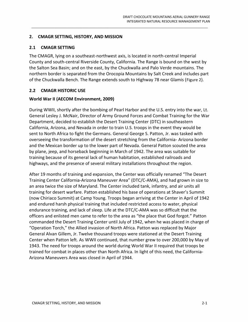
The CMAGR, lying on a southeast-northwest axis, is located in north-central Imperial County and south-central Riverside County, California. The Range is bound on the west by the Salton Sea Basin; and on the east, by the Chuckwalla and Palo Verde mountains. The northern border is separated from the Orocopia Mountains by Salt Creek and includes part of the Chuckwalla Bench. The Range extends south to Highway 78 near Glamis (Figure 2).
2.2 CMAGR HISTORIC USE
World War II (AECOM Environment, 2009)
During WWII, shortly after the bombing of Pearl Harbor and the U.S. entry into the war, Lt. General Lesley J. McNair, Director of Army Ground Forces and Combat Training for the War Department, decided to establish the Desert Training Center (DTC) in southeastern California, Arizona, and Nevada in order to train U.S. troops in the event they would be sent to North Africa to fight the Germans. General George S. Patton, Jr. was tasked with overseeing the transformation of the desert stretching from the California- Arizona border and the Mexican border up to the lower part of Nevada. General Patton scouted the area by plane, jeep, and horseback beginning in March of 1942. The area was suitable for training because of its general lack of human habitation, established railroads and highways, and the presence of several military installations throughout the region.
After 19 months of training and expansion, the Center was officially renamed “The Desert Training Center California-Arizona Maneuver Area” (DTC/C-AMA), and had grown in size to an area twice the size of Maryland. The Center included tank, infantry, and air units all training for desert warfare. Patton established his base of operations at Shaver’s Summit (now Chiriaco Summit) at Camp Young. Troops began arriving at the Center in April of 1942 and endured harsh physical training that included restricted access to water, physical endurance training, and lack of sleep. Life at the DTC/C-AMA was so difficult that the officers and enlisted men came to refer to the area as “the place that God forgot.” Patton commanded the Desert Training Center until July of 1942, when he was placed in charge of “Operation Torch,” the Allied invasion of North Africa. Patton was replaced by Major General Alvan Gillem, Jr. Twelve thousand troops were stationed at the Desert Training Center when Patton left. As WWII continued, that number grew to over 200,000 by May of 1943. The need for troops around the world during World War II required that troops be trained for combat in places other than North Africa. In light of this need, the California-Arizona Maneuvers Area was closed in April of 1944.
DRAFT CHOCOLATE MOUNTAINS AERIAL GUNNERY RANGE INTEGRATED NATURAL RESOURCE MANAGEMENT PLAN
_______________________________________________________________________________
CMAGR SETTING, HISTORY, AND MISSION 2-2
Figure 2 CMAGR Vicinity

DRAFT CHOCOLATE MOUNTAINS AERIAL GUNNERY RANGE INTEGRATED NATURAL RESOURCE MANAGEMENT PLAN
_______________________________________________________________________________
CMAGR SETTING, HISTORY, AND MISSION 2-3
To support the mission of the DTC/C-AMA, several desert airfields were taken over and significantly improved by the Army between 1942 and 1944. One of these wartime training bases was the Blythe Army Air Base, which was originally constructed by the Civil Aeronautics Administration (CAA) in 1940 as Intermediate Flying Field Site 21. With the development of the DTC, the little airfield west of Blythe was identified as an excellent candidate for Army use, and it was officially taken over by the Army in April 1942, under the direction of General Henry H. Arnold, Commanding General of the Army Air Forces. One month later, the first airmen deployed to the DTC, the 46th Bombardment Group, arrived in Blythe, where they continued the work of building base housing, bringing in utilities, and significantly improving the airfield. By September of 1942, the airfield was formally designated the Blythe Army Air Base, with paved runways suitable for heavy aircraft. From the fall of 1942 to 1945, the Blythe Army Air Base supported numerous training exercises in the DTC/C-AMA, and became known for its excellent training of heavy bomber crews who went on to complete hundreds of successful bombing missions in Europe during WWII.
With the end of WWII came a reduction in the military activity in the Colorado Desert region. Civilian buildings and airports converted for use by the military during the war years returned to civilian use. Surplus military barracks were recycled for a variety of uses throughout the local communities. The primary post-war activities in the area were mining and agriculture. Agricultural practices were primarily confined to the mid- to western side of the county, but also developed in the Palo Verde Valley along the lower Colorado River and centered on the town of Blythe.
2.2.1 Military Use
The Marine Corps’ mission is unique among the military services in that, by law, it operates as a combined arms force in three dimensions—land, sea and air (10 U.S.C. § 5063). Specifically, the Marine Corps is required to “be so organized as to include not less than three combat divisions, three air wings, and such other land combat, aviation, and other services as may be organic therein.” In maintaining a high state of training and readiness for its assigned mission, the Marine Corps has become the Nation’s premier combined arms, expeditionary force, ready to respond immediately to crises anywhere in the world in defense of the nation and its allies and interests.
The Marine Corps organizes its ground combat divisions and air wings into Marine Air Ground Task Forces (MAGTFs), which form the fundamental cornerstones of modern Marine Corps combat doctrine. MAGTFs are scalable in size and can be tailored for specific missions (e.g., humanitarian assistance, emergency response, peacekeeping, specific regional threat, and major war abroad). This ability provides the flexibility to address the full spectrum of possible military operations by sizing and tailoring MAGTFs to fit the situation, and optimize forces as needed for forward presence, engagement, crisis response, antiterrorism, and war fighting. Regardless of their size, all MAGTFs are

DRAFT CHOCOLATE MOUNTAINS AERIAL GUNNERY RANGE INTEGRATED NATURAL RESOURCE MANAGEMENT PLAN
_______________________________________________________________________________
CMAGR SETTING, HISTORY, AND MISSION 2-4
composed of common organizational elements that include command, ground combat, air combat, and logistics.
2.2.1.1 CMAGR Operating Area
As an individual range, the CMAGR serves multiple training purposes. Its land and airspace, however, have been configured principally for live-fire training with aircraft weapons in an environment that realistically simulates a tactically diverse and complex air-ground battlefield.
Marine Corps ground combat activities are conducted in the CMAGR in support of aviation training and include artillery and mortar fires and the insertion and extraction of ground combat forces. NSW forces conduct basic individual and advanced small unit training in two ground-training areas that abut restricted airspace on the northern and western perimeters of the CMAGR. These areas contain a variety of individual and small unit ranges used for Marine Corps and Navy land combat forces. Typically, these forces are battalion sized and smaller for the Marine Corps, and NSW teams. All ground-based training at the CMAGR occurs in designated locations that are consistent with the priority needs of aviation training. As an individual range, key assets and capabilities of the CMAGR include:
Restricted land and airspace
Supporting special use airspace
Varied terrain
Authorization for live-fire training with live ordnance
Ability to train with PGMs
Close proximity to air stations and bases

DRAFT CHOCOLATE MOUNTAINS AERIAL GUNNERY RANGE INTEGRATED NATURAL RESOURCE MANAGEMENT PLAN
_______________________________________________________________________________
CMAGR SETTING, HISTORY, AND MISSION 2-5
Figure 3 CMGR Training and Support facilities
DRAFT CHOCOLATE MOUNTAINS AERIAL GUNNERY RANGE INTEGRATED NATURAL RESOURCE MANAGEMENT PLAN
_______________________________________________________________________________
CMAGR SETTING, HISTORY, AND MISSION 2-6
2.3 CURRENT AND FUTURE MILITARY MISSION
The CMAGR is, and will remain, indispensable to Navy and Marine Corps aviation and ground forces training into the foreseeable future. The Marine Corps currently relies and will continue to depend on the CMAGR to support training of operational and student aircrews stationed in the local operating area. In addition to these local squadrons, training deployments by Marine Corps, Navy, Air Force, Air National Guard, and Reserve Component units will continue to use the CMAGR on a frequent basis. The continuing need for the CMAGR is also signified by active plans to replace the AV-8B and F/A-18 aircraft flown by the Marine Corps squadrons at MCAS Yuma and MCAS Miramar with F-35 aircraft, which began in 2012 and extend through 2023. Training operations flown by F-35 aircraft home stationed at MCAS Yuma are expected to occur within the BSTRC, including the CMAGR, and BMGR West, 99 percent of the time (DoN 2010). Further, planning has been completed to home station up to eight squadrons of MV-22 aircraft at MCAS Miramar and up to two squadrons of MV-22 aircraft at MCAS Camp Pendleton. The MV-22s will replace current CH-46E aircraft. Transitioning to MV-22s has already begun for some squadrons at MCAS Miramar. The decisions for basing MV-22s at MCAS Miramar and MCAS Camp Pendleton and the decisions for basing F-35s at MCAS Yuma and MCAS Miramar demonstrate a long-term DoN commitment to these air stations and to the CMAGR and other components of the BSTRC. The CMAGR is also an important training range asset for Marine Corps and Navy ground forces, including NSW units, due to close proximity to the Marine Corps ground forces and NSW home stationed in the San Diego, California, region.
2.4 MILITARY LAND AND AIRSPACE USE
Training for tactical air and ground combat occurs at the CMAGR both as separate and combined arms elements. Air combat training also occurs in the military operations areas (MOA) and air traffic control assigned air space (ATCAA) areas that are adjacent to the CMAGR and at the nearby El Centro Ranges (ECR). Twenty-five types of tactical aviation training activities currently occur on a regular basis at the CMAGR, adjacent MOAs and ATCAAs, and/or ECR to provide aircrews with the repertoire of combat skills they need (Table 1). Types of tactical aviation training other than those listed in Table 1 may also occur at the CMAGR on an irregular or as needed basis. Future requirements for new types of training also will likely emerge to prepare aircrews to meet developing threats or to employ new aircraft, such as the MV-22 and F-35, and weapons systems as they come on line and mature operationally. Of the 25 tactical aviation training activities listed in Table 1, 21 are supported at the CMAGR. Most training sorties involve more than one type of tactical aviation activity and many involve the delivery of one or more types of ordnance.

DRAFT CHOCOLATE MOUNTAINS AERIAL GUNNERY RANGE INTEGRATED NATURAL RESOURCE MANAGEMENT PLAN
_______________________________________________________________________________
CMAGR SETTING, HISTORY, AND MISSION 2-7
Table 1 Common Aviation Training Activities at the CMAGR, ECR, and Adjacent MOAs/ATCAAs
Air Combat Training Activity
Abel/Kane MOAs/ATCAAs
R-2512 at ECR
R-2510A/B at ECR
R-2507N/S/E at CMAGR
Aerial Delivery: aircraft release parachuting personnel, sensors, equipment, or supplies. X X
Aerial Photography: develop proficiency with handheld cameras. X
Aerial Refueling: develop proficiency in day and night aerial refueling. X X
Air Combat Maneuvering: offensive and defensive air-to-air combat tactics. X X X X
Air-to-Air Gunnery: air-to-air gunnery at an airborne target. X
Air-to-Air Missile Firing: engaging an airborne target with an air-to-air missile. X
Air-to-Ground Inert Ordnance Delivery: ground attack with conventional inert ordnance at day or night or in instrument weather conditions.
X X X
Air-to-Ground Live Ordnance Delivery: ground attack with conventional live ordnance at day or night or in instrument weather conditions.
X
All-Weather Operations: missions under all weather conditions, including air-to-air intercepts started beyond visual range where weapons engagement does not depend on visual identification. No weapons are launched or fired.
X
Close Air Support: flights designed to support friendly ground forces by delivering conventional air-to-ground ordnance, as directed by a forward air controller, on enemy positions in close proximity to the supported friendly forces.
X
Combined Strike Tactics: combined air-to-ground strike with coordination of several types of aircraft and aircraft weapons.
X
Direct Air Support Holding: develop proficiency in the tactics of timing a supporting air-to-ground strike from a nearby holding position.
X
Fighter Intercepts: air-to-air weapons intercepts started beyond visual range where weapons engagement depends on visual identification.
X
Formation Flight: develop day or night proficiency in tactical formations and maneuvers. X
Forward Air Control Airborne: control attack/fighter aircraft in close air support or direct air support missions.
X
Helicopter Attack: teach the fundamentals of or develop tactical proficiency in any aspect of helicopter attack.
X
Helicopter/MV-22 External Cargo Lifts: flights in which weights, personnel, cargo, vehicles, or aircraft are suspended from a helicopter or MV-22 and transported.
X
Helicopter/MV-22 Forward Arming and Refueling: develop tactical proficiency in FARP operations.
X
Helicopter/MV-22 Insertions and Extractions: develop tactical proficiency in inserting and extracting ground forces in battlefield areas.
X
Helicopter/MV-22 Night Vision Goggle Operations: day or night flying with helmet mounted, thermal imaging devices.
X X X
Helicopter/MV-22 Landing Zone Operations: flights designed to develop tactical proficiency in forward landing zone operations.
X
Laser Targeting: use of weapons systems with laser target designators to attack ground targets.
X X

DRAFT CHOCOLATE MOUNTAINS AERIAL GUNNERY RANGE INTEGRATED NATURAL RESOURCE MANAGEMENT PLAN
_______________________________________________________________________________
CMAGR SETTING, HISTORY, AND MISSION 2-8
Air Combat Training Activity
Abel/Kane MOAs/ATCAAs
R-2512 at ECR
R-2510A/B at ECR
R-2507N/S/E at CMAGR
Post Maintenance Check Flight: review and validate the conditions of an aircraft following maintenance.
X X
Unmanned Aircraft Systems Operations: flight operations conducted using remotely controlled UASs.
X
Visual Reconnaissance: visually locating targets, assessing topography, or assessing enemy order of battle.
X
2.5 MILITARY SURFACE USE AND ROADS
An inventory of military surface use at the CMAGR was prepared for the draft LEIS to identify how the various areas of the range are used to support training operations and to quantify the area of the range committed to each use. Surface use was categorized in the inventory by activity and by the levels of physical disturbance that the various categories of activities have on the ground surface, vegetative communities, and surface drainages.
The surface use inventory found that currently nearly the entire surface of the CMAGR is used in some capacity to support military training. Each area of the range used for training support can be classified as belonging to either one or both of two broad use categories and to either one or two of nine use subcategories. The two broad use categories include (1) tactical training weapons ranges and (2) other training areas (Error! Reference source
not found.). The weapons ranges category, which includes all of the tactical weapons ranges used for aviation and ground combat training, is subdivided into five subcategories:
Target simulations and other earthwork features
Core weapons impact areas
Secondary weapons impact areas
Weapons delivery containment area
SWATs 4 and 5
The other training areas category, which includes all other areas of the CMAGR that support training operations, is subdivided into four subcategories:
Ground support areas
No live-fire training, support, and range access control areas
Camp Billy Machen
Range access roads
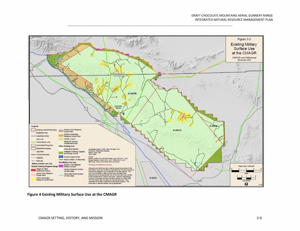
DRAFT CHOCOLATE MOUNTAINS AERIAL GUNNERY RANGE INTEGRATED NATURAL RESOURCE MANAGEMENT PLAN
_______________________________________________________________________________
CMAGR SETTING, HISTORY, AND MISSION 2-9
Figure 4 Existing Military Surface Use at the CMAGR

DRAFT CHOCOLATE MOUNTAINS AERIAL GUNNERY RANGE INTEGRATED NATURAL RESOURCE MANAGEMENT PLAN
_______________________________________________________________________________
CMAGR SETTING, HISTORY, AND MISSION 2-10
Figure 5 Weapon and surface danger zones and laser safety danger zones at the CMAGR

DRAFT CHOCOLATE MOUNTAINS AERIAL GUNNERY RANGE INTEGRATED NATURAL RESOURCE MANAGEMENT PLAN
_______________________________________________________________________________
CMAGR SETTING, HISTORY, AND MISSION 2-11
2.5.1 Additional Training, Support, and Range Access Control Areas and Road Network
The additional training, support, and range access control areas identified in the military surface use inventory include areas of the CMAGR that are external to either its restricted airspace or controlled firing areas and therefore cannot support live-fire training. These areas can be used, however, for any of a number of ground-based training or range management activities such as offsite helicopter or MV-22 landings for troop insertions or extractions, cross-country navigation or path finding exercises for small infantry teams, or staging sites for target maintenance or clearance activities. These peripheral areas are also managed to limit land uses to those that would be compatible with the CMAGR training mission.
A road network has been established at the CMAGR to provide access for constructing and maintaining its infrastructure, conducting range operational clearances, training, and managing natural and cultural resources. The Gas Line and Niland-Blythe roads are used by commercial utility companies to access the gas line and overhead electric transmission lines that cross the range for inspection, maintenance, or repairs.
2.5.1.1 Surface Use Inventory Findings
The observational and quantified findings of the military surface use inventory of the CMAGR are provided in Table 2. The inventory found that about 99.48 percent of the range surface is used to support the military mission of the range and only about 0.56 percent of the range, or about 2,571 acres, has no assigned military mission. The land with no assigned military mission is the area of the range that is north of the Bradshaw Trail and south of the Niland-Blythe Road (Figure 4). Only a small proportion of the range, about 5 percent, supports surface uses that cause or may cause moderate to complete levels of physical disturbance to the ground surface, vegetative communities, and surface drainages. The military surface uses listed in Table 2 that cause or may cause moderate-to-high to complete levels of physical disturbance include:
Target simulations and other earthwork features
Core weapons impact areas
Secondary weapons impact areas
Some ground support sites
Camp Billy Machen and its adjacent operating areas
Range road corridors
Secondary weapons impact areas are included in this list because the interiors of these areas closest to the target are moderately to highly impacted by ordnance deliveries. However, the effects of ordnance impacts typically decrease sharply in these areas with increasing distance from the target such that the levels of disturbance at their outer

DRAFT CHOCOLATE MOUNTAINS AERIAL GUNNERY RANGE INTEGRATED NATURAL RESOURCE MANAGEMENT PLAN
_______________________________________________________________________________
CMAGR SETTING, HISTORY, AND MISSION 2-12
perimeters is negligible. As a result, more than half of the area of the secondary weapons impact areas can be estimated to exhibit less than moderate levels of disturbance. Thus, the proportion of the CMAGR surface that is moderately to completely disturbed by military activities is likely no more than 2 percent, although the draft LEIS reported as about 5 percent to be conservative.
The CMAGR road network includes an aggregate total of 427 miles excluding road segments that traverse target simulations or core weapons impact areas. Some are improved roads, but most are not.

DRAFT CHOCOLATE MOUNTAINS AERIAL GUNNERY RANGE INTEGRATED NATURAL RESOURCE MANAGEMENT PLAN
_______________________________________________________________________________
CMAGR SETTING, HISTORY, AND MISSION 2-13
Table 2 Military and Non-Military Surface Use Areas at the CMAGR
Surface Use Area Associated Surface Disturbance
Total Area in Acres
Percentage of CMAGR Affected*
Military Surface Use
1 Target simulations and other earthwork features
Physical disturbance of entire ground surface, extensive alteration of surface drainage, and complete removal of native vegetation community. Periodic re-grading of target simulations/earthworks keep vegetation communities from re-establishing and re-disrupt surface drainage.
200 0.04
2 Core weapons impact area
Disturbance of ground surface at or near some targets is extensive to complete where high-yield HE ordnance detonations over time result in concentrated and coalescing craters that may reach depths in excess of 10 feet. Vegetative communities are eliminated near targets. Natural surface drainage patterns can be substantially altered. In areas farther from targets where impact craters densities are lower and do not overlap, ground surfaces between craters and vegetative communities are still subject to ordnance blast and shrapnel effects and ejecta from craters. Use over time is likely to subject nearly any ground location in the core weapons impact area to ordnance delivery effects.
2,309 0.5
3 Secondary weapons impact area Clusters of high-yield HE impact craters cause concentrated ground disturbance in some localized areas, especially at and near individual targets, but impact craters numbers and densities generally decrease sharply with increasing distance from targets. Physical disturbance of the ground surface also generally decreases sharply with distance from individual targets and natural processes shaping ground/soil surfaces, surface drainages, and vegetative communities become increasingly predominant. Physical disturbance in the regions of this area closest to the target is moderate to complete; disturbance in the outer region decreases from moderate to negligible with increasing distance from the target.
19,391 4.23
4 Weapons delivery containment area Some scattered ordnance impact craters but, in the context of the broader landscape disturbances to ground surfaces and vegetative and wildlife communities, these impacts are negligible; natural processes shaping ground/soil surfaces, surface drainages, and vegetative and wildlife communities function without discernible constraint from ordnance delivery.
369,788 80.7

DRAFT CHOCOLATE MOUNTAINS AERIAL GUNNERY RANGE INTEGRATED NATURAL RESOURCE MANAGEMENT PLAN
_______________________________________________________________________________
CMAGR SETTING, HISTORY, AND MISSION 2-14
Surface Use Area Associated Surface Disturbance
Total Area in Acres
Percentage of CMAGR Affected*
5 Ground support sites (21 individual sites including FARPs, Firebase Burt/Staging Area, Siphon 8 Bivouac and Work Area, Field ASP, UAS airstrip, and additional training sites)
Moderate to complete levels of disturbance to ground surfaces, surface drainages, and vegetative communities. Disturbances in FARPs, Firebase Burt/Staging Area, and additional training sites result in moderate to high levels of disturbances in areas of concentrated and repeated use by vehicles, troop bivouacs, aircraft landings and takeoffs, aircraft refueling and rearming, and other ground unit work areas such as communications or air control sites. Construction/grading of Siphon 8 Bivouac and Work Area, Field ASP, and UAS airstrip required complete reshaping of the existing ground surface; however, the airstrip and associated ground troop bivouac and work areas are located within a larger inactive and historic rock quarry site in which the ground surfaces, surface drainages, and vegetative communities had been previously and completely altered from the undisturbed natural condition.
429 0.09
6 Camp Billy Machen and associated static ranges
High to complete levels of disturbance to ground surfaces, surface drainages, and vegetative communities as a result of the construction and use of the Camp Billy Machen and associated static ranges.
134 0.03
7 SWATs 4 and 5 Negligible to low levels of disturbance to ground surfaces, surface drainages, and vegetative communities over most of the SWAT live-fire training area. Moderate to high levels of disturbance to ground surfaces, surface drainages, and vegetative communities in some small and dispersed areas (individually less than an acre) where concentrated or repeated use by Navy SEALs has occurred.
31,593 6.9
8 Additional training, support, and range access control areas
Negligible levels of disturbance to ground surfaces, surface drainages, and vegetative communities over most of areas as a result of military training and range support activities. Low to moderate levels of disturbance in some dispersed perimeter areas near public use roads outside of the range likely due to trespass off-highway vehicle (OHV) use by non-military users.
30,817 6.7
9 Range road corridors (427 miles of road segments in aggregate with a standardized corridor width of 15 feet, excludes road segments that traverse target simulations or core weapons impact areas (Lines 1 and 2))
High to complete levels of disturbance to ground surfaces, surface drainages, and vegetative communities within road corridors. Corridors vary in width as they result from lightly-used, single-lane tracks to frequently-used graded roads. Area calculations are based on a standard corridor width of 15 feet to represent an average disturbance and influence zone associated with road maintenance and use.
740 0.16
10 Total Military Surface Use (Sum of Lines 1 - 9) 455,399 99.35
Non-Military Surface Use

DRAFT CHOCOLATE MOUNTAINS AERIAL GUNNERY RANGE INTEGRATED NATURAL RESOURCE MANAGEMENT PLAN
_______________________________________________________________________________
CMAGR SETTING, HISTORY, AND MISSION 2-15
Surface Use Area Associated Surface Disturbance
Total Area in Acres
Percentage of CMAGR Affected*
11 Excess area-—land north of the Bradshaw Trail, which has no assigned military function
Negligible levels of disturbance to ground surfaces, surface drainages, and vegetative communities over most of areas; low to moderate levels of disturbance in some small and dispersed areas likely due to non-military activities including OHV use.
2,778 0.61
12 Inactive railroad corridor (9.28 miles of corridor with a width of 40 feet)
Complete levels of disturbance to ground surfaces, surface drainages, and vegetative communities within the railroad road corridor.
44 <0.01
13 Canal dike corridors (27 miles of aggregate corridor with a width of 15 feet)
Complete levels of disturbance to ground surfaces, surface drainages, and vegetative communities within these graded canal dike corridors.
45 <0.01
14 Total Non-Military Surface Use (Sum of Lines 11 and 15) 2,868 0.63
15 Total Military and Non-Military Surface Use (Sum of Lines 10 and 16) 458,267 100.0
* The percentage for each line is calculated as line area divided by 458,267 acres, the total area of the CMAGR as determined by summing all of the individual surface use areas of the range. The sizes of the individual surface use areas were determined by geographic information system (GIS) analysis. This summation value for the area of the range is 263 acres, or about 0.06 percent, smaller than the total area of the range (458,530 acres) reported elsewhere in this LEIS, including in Section 1.1, which was also determined by GIS analysis. The second and larger figure is the area encompassed by the external boundary of the CMAGR. The summation value is smaller because of overlaps between the polygons representing the many separate use area designations, which are small in any one location but collectively account for a 263-acre underestimate of the area of the range.

DRAFT CHOCOLATE MOUNTAINS AERIAL GUNNERY RANGE INTEGRATED NATURAL RESOURCE MANAGEMENT PLAN
_______________________________________________________________________________
CMAGR SETTING, HISTORY, AND MISSION 2-16
2.5.2 Non-Military Surface Use and Roadless Areas
Dikes developed to protect the Coachella Canal from uncontrolled surface runoff and the inactive Eagle Mountain Railroad are located within the CMAGR along its western and northern boundaries. In aggregate, these two non-military surface uses encompass less than 100 acres. Three other non-military surface uses cross the CMAGR including a natural gas pipeline and two electric power transmission lines). Although these utilities are designated as avoidance areas for ordnance delivery training, the roads that were developed for constructing and servicing these utilities are also used for military transportation. Thus, these dual-purpose road corridors are included in the inventory of military, rather than non-military, surface uses.
Roadless area assessment was limited to identifying the areas within the CMAGR that are not bisected by roads, target simulations, other earthwork features, core and secondary weapons impact areas, ground support areas, railroads, or canal dikes, which collectively occupy about 5 percent of the range surface (Figure 6). Although affected by and needed to support military use, the 95 percent of the range that is roadless remains in a relatively undeveloped, unstructured, and undisturbed condition. Military purposes served by these areas include serving as weapons delivery containment areas; no live-fire training, support, and range access control areas; or SWAT 4 or 5. There are 14 roadless areas in the CMAGR that are 5,000 acres or more in size. Most of these areas, including the largest area encompassing about 139,430 acres, are classified as weapons delivery containment areas.
Table 3 Numbers of Roadless Areas at the Chocolate Mountain Aerial Gunnery Range
Roadless Area Category Number of
Roadless Areas Comments Less than 1,000 acres 241
1,000 acres to 5,000 acres 15
5,001 acres to 10,000 acres 7
10,001 acres to 20,000 acres 2 Roadless areas of 15,954 and 17,690 acres
20,001 acres to 40,000 acres 3 Roadless areas of 22,752, 24,538, and 36,160 acres
40,001 acres to 100,000 acres 1 Roadless area of 73,814 acres
greater than 100,001 acres 1 Largest roadless area is 139,430 acres

DRAFT CHOCOLATE MOUNTAINS AERIAL GUNNERY RANGE INTEGRATED NATURAL RESOURCE MANAGEMENT PLAN
_______________________________________________________________________________
CMAGR SETTING, HISTORY, AND MISSION 2-17
Figure 6 Roadless areas at the CMAGR

DRAFT CHOCOLATE MOUNTAINS AERIAL GUNNERY RANGE INTEGRATED NATURAL RESOURCE MANAGEMENT PLAN
_______________________________________________________________________________
EXISTING ENVIRONMENT 3-1
3. EXISTING ENVIRONMENT
3.1 PHYSICAL ENVIRONMENT
3.1.1 Earth Resources
Geological resources include soils, surface and subsurface geology, geologic structure, seismicity, paleontology, and energy and non-energy mineral resources.
3.1.1.1 Regional Geologic Setting
The CMAGR is located in the Colorado Desert and Salton Sea geomorphic provinces of California, which are situated in the southwestern most portion of the Basin and Range physiographic province. The Basin and Range province (Fenneman 1931) is characterized by generally steep, subparallel, discontinuous mountain ranges that trend northwest to southeast separated by broad, gently sloping to nearly flat, deep alluvial basins. The CMAGR is characterized by the rugged Chocolate Mountains, a range that rises abruptly from broad alluvium-filled desert basins. The Chocolate Mountains stretch more than 60 miles in a northwest to southeast direction and are east of the Salton Sea, south and west of the Chuckwalla Mountains, and southeast of the Orocopia Mountains. The Chocolate Mountains are largely tilted fault blocks comprised of the Southern California batholith and Orocopia Schist of Mesozoic age (about 65 to 250 million years ago), overlain by thrust fragments of an older Precambrian metamorphic complex, with minor Tertiary (about 3 to 65 million years ago) volcanic and intrusive rocks. Pliocene (about 3 to 5 million years ago) and Pleistocene (about 2 to 3 million years ago) marine and nonmarine sedimentary deposits and Holocene (present-day to 10,000 years ago) alluvium occur within the adjacent basins to the east and west.
The Chocolate Mountains occur along the eastern margin of the Imperial Valley and Salton Sea. The Imperial Valley and Salton Sea occur in the Salton Trough, a complex pull-apart rift valley, which was formed by the right-lateral motion of the San Andreas transform fault system, which runs along the western boundary of the CMAGR, and the northwestward progressing 1 spreading ridge complex of the Gulf of California segment of the Eastern Pacific Rise (Alles 2007). The Salton Trough, an extension of the Gulf of California, is separated from the Gulf of California by the Colorado River Delta. The Salton Trough is a Neogene age (23 million years ago to present) basin. This basin has been filled with post-Oligocene interbedded marine and freshwater sediments, which is estimated at over 4 miles thick in some places (Eiders 1979a; 1979b). The great thickness of these sediments demonstrates that considerable sinking of the basin floor has occurred as the sediments accumulated during the past 23 million years.
Late Pleistocene and possibly early Holocene sediments were deposited in ancient Lake Cahuilla. Lake Cahuilla, which occupied the area of the present-day Salton Sea, was a fresh water lake that received inflow from the Colorado River and runoff from the local mountains. A change in course of the Colorado River eliminated most of the inflow to Lake Cahuilla, allowing it to evaporate. Present-day (Holocene) surficial sediments range from
DRAFT CHOCOLATE MOUNTAINS AERIAL GUNNERY RANGE INTEGRATED NATURAL RESOURCE MANAGEMENT PLAN
_______________________________________________________________________________
EXISTING ENVIRONMENT 3-2
clayey and silty alluvium near the Salton Sea, to alluvial and colluvial fans along the base of the Chocolate Mountains. Wind-blown (eolian) fine sands in some adjacent valleys form spectacular dunes like the Sand Hills, which occur along the southwestern corner of the CMAGR. Eolian sand dunes are formed by strong desert winds that transport sand downwind until they form into sheets and dunes.
3.1.1.2 CMAGR Geology
The Chocolate Mountains within the CMAGR are comprised of Proterozoic gneisses and associated rocks that were thrust over the Orocopia Schist and subsequently intruded by at least five different granitic plutons (Norris and Webb 1990). The oldest granitic plutons are early Triassic (about 235 million years old) but most are of Mesozoic age. The Proterozoic (about 0.5 to 2.5 billion years ago) gneisses, the Orocopia Schist, and the thrust fault have all been intruded by some of the youngest (23 million years) granitic intrusives in California (Norris and Webb 1990). Volcanic rocks of similar Oligocene age (about 23 to 34 million years ago) are widely distributed in the Chocolate Mountains. Miocene age (about 5 to 23 million years ago) fanglomerates, with interbedded basaltic flows, unconformably overlie these older rocks and are overlain unconformably by Miocene-Pliocene age marine, lagoonal, and nonmarine deposits of the Bouse Formation (Norris and Webb 1990). Figure 7 provides a geologic map of the CMAGR.
Late Pliocene, Pleistocene, and Holocene alluvial deposits overlie most of the older formations in the Chocolate Mountains and form dissected piedmont slopes around the Range (Norris and Webb 1990). These alluvial fan and terrace deposits have been informally designated as the older, intermediate, and younger alluvium based on their stratigraphic relationships (Dillon 1975). The older alluvium consists of poorly consolidated deposits of sand, silt, and breccia that unconformably overlie the Chocolate Mountains. Conglomerate and other rocks and forms dissected aprons and high-standing terraces. The surfaces of these fans and terraces usually have a well-developed coat of desert pavement and desert varnish. The intermediate alluvium unconformably overlies the older alluvium and consists of locally derived unconsolidated conglomerate, breccia, and sand that form dissected fans, low terraces, and abandoned channel features. The surfaces of the intermediate alluvium have poorly developed desert pavement and varnish. The younger alluvium consists of sands and gravels occurring as channel fill in the present-day washes, as sheet wash deposits on the alluvial plains, and as wind-blown sands of the Sand Hills that unconformably overlie the intermediate alluvium (Dillon 1975). The unconformable relationships between the various alluvial deposits suggest that the base level of erosion has been intermittently lowered by continued subsidence and rifting beneath the Imperial Valley.
3.1.1.3 Soils
The Natural Resources Conservation Service (NRCS) has identified 20 soil series and 7 soil associations (i.e., groups of soil series) within the CMAGR. These soils are described in the State Soil Geographic (STATSGO2) Database developed by the NRCS (2011). The soil

DRAFT CHOCOLATE MOUNTAINS AERIAL GUNNERY RANGE INTEGRATED NATURAL RESOURCE MANAGEMENT PLAN
_______________________________________________________________________________
EXISTING ENVIRONMENT 3-3
associations are shown on Figure 8 and summarized in Table 4. The Tecopa-Rock Outcrop-Lithic Torriorthents and the Upspring-Sparkhule-Rock Outcrop soil associations include rock outcrops and very shallow mountain soils formed in residuum and colluvium. The Vaiva-Rock Outcrop-Quilotosa-Laposa soil association includes hill pediment and fan complex soils on foothills, pediments, and alluvial fans. The Rillito-Gunsight soil association consists of very deep soils on dissected older fans, soils on ancient fans with preserved surfaces, and young to ancient fan soil complexes. The Myoma-Carsitas-Carrizo, Vaiva-Quilotosa-Hyder-Cipriano-Cherioni, and Cajon-Bitterwater-Bitter-Badland soil associations include active fan and wash soils; young fan soil complexes; and fan, lakebed, and badland soil complexes. All soils at the CMAGR are well-drained to excessively well-drained and primarily consist of sandy and rocky loams derived from igneous and metamorphic rocks.

DRAFT CHOCOLATE MOUNTAINS AERIAL GUNNERY RANGE INTEGRATED NATURAL RESOURCE MANAGEMENT PLAN
_______________________________________________________________________________
EXISTING ENVIRONMENT 3-4
Figure 7 Geologic Map at the CMAGR

DRAFT CHOCOLATE MOUNTAINS AERIAL GUNNERY RANGE INTEGRATED NATURAL RESOURCE MANAGEMENT PLAN
_______________________________________________________________________________
EXISTING ENVIRONMENT 3-5
Figure 8 Soils at the CMAGR

DRAFT CHOCOLATE MOUNTAINS AERIAL GUNNERY RANGE INTEGRATED NATURAL RESOURCE MANAGEMENT PLAN
_______________________________________________________________________________
EXISTING ENVIRONMENT 3-6
Table 4 CMAGR Soil Associations (NRCS 2011)
Soil Association Soil Occurrence Erosion Hazard
Water Wind Tecopa-Rock Outcrop-Lithic Torriorthents Mountain soils found on mountain
slopes and areas with rock outcrop Slight Moderate Upspring-Sparkhule-Rock Outcrop
Vaiva-Rock Outcrop-Quilotosa-Laposa
Hill pediment and fan complex soils found on foothills, alluvial fans, and pediments
Slight to Moderate
Moderate to High
Rillito-Gunsight Old alluvial fan soils found on dissected older alluvial fans, in valleys, and on pediments
High to Extremely
High
High to Very High
Myoma-Carsitas-Carrizo Young alluvial fan and wash soils found in mountain washes, on pediments, and on alluvial fans
Slight to Moderate
Moderate to High
Vaiva-Quilotosa-Hyder-Cipriano-Cherioni Cajon-Bitterwater-Bitter-Badland Source: STATSGO2 Database (NRCS 2011).
3.1.2 Climate
The CMAGR is located within the Salton Sea Air Basin (SSAB), which includes all of Imperial County and the southwest third of Riverside County. The climate of the CMAGR is desert, with low humidity, high summer temperatures, and moderate winter temperatures.
Data from the Western Regional Climate Center (WRCC) are available for Eagle Mountain, California, which is located to the west of the CMAGR near Joshua Tree National Park. Data from this location indicate that July is the hottest month with an average maximum temperature of 104.9 degrees Fahrenheit (°F) (40.5 °C). January is the month with the lowest average maximum temperature of 64.4°F (18°C). July is the month with the highest average minimum temperature of 82.6°F (28.1°C). The month with the lowest average minimum temperature is January at 44.3°F (6.8°C) (DoN 2010) (WRCC 2011).
Average precipitation measured at the Eagle Mountain meteorological station is 3.67 inches per year. The driest months are from April through June. August is the wettest month due to the influence of the summer monsoon rain pattern (DoN 2010).
3.1.3 Water Resources
Water resources are defined as sources of water available for use by humans, flora, or fauna, and include surface water, groundwater, near-shore waters, and wetlands. Surface water resources include stormwater, lakes, streams, rivers, and springs. Groundwater is defined as any source of water beneath the ground surface. Surface water and groundwater may be used for potable water, agricultural irrigation, industrial, and recreational purposes.

DRAFT CHOCOLATE MOUNTAINS AERIAL GUNNERY RANGE INTEGRATED NATURAL RESOURCE MANAGEMENT PLAN
_______________________________________________________________________________
EXISTING ENVIRONMENT 3-7
3.1.3.1 Water Resources Setting
The CMAGR is located within the Salton Sea Transboundary and Imperial Reservoir regional watersheds. Surface water is extremely scarce at the CMAGR. There are no naturally occurring perennial surface water features on the range. Within the CMAGR, the Salton Sea Transboundary regional watershed is comprised of portions of four local watersheds; arranged from northwest to southeast they are the Salt Creek, Imperial Valley-Frontal Salton Sea, Alamo River, and Algodones Dunes-Chocolate Mountain watersheds. Ephemeral surface water drainages within these CMAGR watersheds flow seasonally and discharge to the Salton Sea. The Imperial Reservoir regional watershed within the CMAGR is comprised of the Arroyo Seco-Upper Milpitas Wash and Lower Milpitas Wash watersheds. Ephemeral surface water drainages within these CMAGR watersheds flow seasonally and discharge to the Colorado River. Perennial surface waters are present outside the CMAGR and include the Salton Sea, New River, Alamo River, and Colorado River. The Salton Sea, New River, and Alamo River are largely sustained by irrigation return flows. Figure 9 shows the locations of watershed boundaries, washes, and current target areas at the CMAGR.
The CMAGR is underlain by portions of four groundwater basins defined by the California Department of Water Resources ([CDWR] 2003). These basins are designated part of the Colorado River Hydrologic Region. Figure 10 shows the groundwater basins underlying the CMAGR which includes, from north to south, the Chocolate Valley, East Salton Sea, Amos Valley, and Arroyo Seco Valley basins. Groundwater resources within the CMAGR are extremely limited. Bedrock areas of the Chocolate Mountains have limited groundwater potential and are classified by the CDWR as non-water-bearing. More extensive groundwater resources are present in the down-faulted sedimentary basins located east and west of the Chocolate Mountains. Recharge to the groundwater basins is derived chiefly from infiltration of runoff along the base of the Chocolate Mountains. However, high evaporation, low rainfall, and rapid runoff result in minimal groundwater recharge. The amount and quality of groundwater stored in the groundwater basins underlying the CMAGR are not known because very few wells have been drilled on the range.
3.1.3.2 Surface Water
Surface water at the CMAGR is derived from infrequent rainfall events that produce localized flash-flooding and temporary surface water runoff, especially during thunderstorms in the monsoon seasons. Rainfall averages less than 5 inches per year and the pan evaporation rate is 100 inches per year, resulting in a net water loss of up to 95 inches. The combination of low precipitation and high evaporation prevents surface water from infiltrating deeply into CMAGR soils. Thus, most of the year, the desert washes on the CMAGR are dry. During heavy rainstorms, these washes drain surface water runoff from the surrounding landscape. This runoff can be captured in natural catchments such as tinajas (natural bedrock depressions), sand tanks, charcos (mud holes), and playa lakes. Natural springs or seeps are found in some locations on the CMAGR; however, for most of the year they are dry. Groundwater discharges from bedrock joints and fractures within
DRAFT CHOCOLATE MOUNTAINS AERIAL GUNNERY RANGE INTEGRATED NATURAL RESOURCE MANAGEMENT PLAN
_______________________________________________________________________________
EXISTING ENVIRONMENT 3-8
the Chocolate Mountains also are ephemeral and short lived, occurring only after a rainfall event.
Surface water drainages are divided by the Chocolate Mountains. On the western and some of the eastern slopes, runoff drains toward the Salton Sea. Runoff from the east slope of the northern Chocolate Mountains drains to Salt Creek Wash which, in turn, drains to the Salton Sea. Runoff from the east slope of the central portion of the Chocolate Mountains drains to the Salton Sea by way of several mountain passes, the largest of which is Iris Wash. Runoff from the eastern slope of the southern portion of the Chocolate Mountains drains northeastward into Arroyo Seco and Milpitas Washes and then southeastward to the Colorado River.
Artificial tanks, wildlife water sources (guzzlers), and tinajas are the only open water sources within the CMAGR available to wildlife. The artificial water sources largely have been constructed by Desert Wildlife Unlimited in cooperation with the CDFW, the Navy, and the Marine Corps and are designed to collect rainwater using concrete basins and/or natural topography to support on-range wildlife populations. The CDFW manages 26 existing guzzlers within the CMAGR that provide supplemental source of water for desert bighorn sheep and mule deer in the Chocolate Mountains (BLM 2009). In 2009, the BLM and CDFW approved the installation of eight additional guzzlers; three have been built, and are counted among the 26 existing guzzlers, and five are pending (BLM 2009). At Beal Well and Salvation Well, water is pumped to the surface by a windmill. The storage capacity of the tanks and guzzlers ranges from 1,000 to 24,000 gallons. Water can be retained in these systems for a time period of several months to more than one year, depending on weather and wildlife use. The tinajas are ephemeral pools that develop after seasonal storm events in narrow canyons where depressions in exposed bedrock collect and hold rainfall. Within the CMAGR, Tortuga Springs is the only aquifer-fed, natural spring; however, this spring has been reported as dry since 1976 (Lesicka 1990).
Perennial surface water is present in the Coachella Canal, along the western range boundary. Along the length of the CMAGR boundary, portions of the Coachella Canal are lined with concrete to minimize water losses. The water in the canal is kept separate from local storm water runoff by a series of siphons that allow the canal to flow beneath storm water channels. Storm water is directed toward the siphons by a series of low, earthen dikes on the uphill side of the canal. Water in the Coachella Canal is derived from the Colorado River and is diverted at the Imperial Dam, approximately 20 miles upstream from Yuma, Arizona.
Beneficial uses of surface water within the region are largely associated with irrigated agriculture, mining, geothermal energy production, and recreational use (primarily the Salton Sea). Agricultural use is the predominant beneficial use of water in the region. Surface waters in the region also provide habitat for fish and wildlife. Most of the surface water used is imported via canals from the Colorado River. According to the Water Quality Control Plan for the Colorado River Basin (California Regional Water Quality Control Board

DRAFT CHOCOLATE MOUNTAINS AERIAL GUNNERY RANGE INTEGRATED NATURAL RESOURCE MANAGEMENT PLAN
_______________________________________________________________________________
EXISTING ENVIRONMENT 3-9
2006), the potential existing and intermittent beneficial uses of perennial, intermittent, and ephemeral streams and washes is agriculture, municipal use, industry, groundwater recharge, contact and non-contact recreational use, warm freshwater habitat, and wildlife habitat. Beneficial uses of surface waters within the CMAGR are largely limited to groundwater recharge and wildlife habitat.

DRAFT CHOCOLATE MOUNTAINS AERIAL GUNNERY RANGE INTEGRATED NATURAL RESOURCE MANAGEMENT PLAN
_______________________________________________________________________________
EXISTING ENVIRONMENT 3-10
Figure 9 Surface Watersheds at the CMAGR
DRAFT CHOCOLATE MOUNTAINS AERIAL GUNNERY RANGE INTEGRATED NATURAL RESOURCE MANAGEMENT PLAN
_______________________________________________________________________________
EXISTING ENVIRONMENT 3-11
3.1.3.3 Groundwater
There are currently no active water supply wells on the CMAGR. Groundwater use beneath the CMAGR is precluded by Public Water Reserve 65. Water for CMAGR activities is transported to the range. Groundwater resources within the CMAGR are extremely limited. Little rainfall, high evaporation, and rapid runoff result in minimal groundwater recharge. Recharge has been estimated at 6.3 to 9.5 millimeters per year, or 10 to 14 percent of precipitation (CDM Federal Programs 2003). These values are similar to those found at the Yucca Mountain facility in the northern Mojave Desert of Nevada, an area with approximately twice the average annual rainfall that the CMAGR receives. At Yucca Mountain, recharge rates of zero are estimated for relatively flat areas with deep sandy soil, 10 to 20 millimeters per year for flat-lying bedrock ridges, and 100 millimeters per year or more for drainage channels with thin soils overlying fractured bedrock (Bechtel/SAIC 2004).
Bedrock areas of the Chocolate Mountains have limited groundwater potential and are classified by the CDWR (2003) as non-water-bearing. Shallow wells located in the bedrock areas are assumed to tap waters in thin alluvium or fractured bedrock. The water-bearing potential of the bedrock formations is highly limited. Infiltration into bedrock formations at the CMAGR is expected to be significantly less because of the steep slopes of the Chocolate Mountains, which increase runoff and decrease percolation.
More extensive groundwater resources are present in the down-faulted sedimentary basins located east and west of the Chocolate Mountains. The most important hydrologic features of the groundwater basins are the alluvial fans. The aquifers in the intermontane sedimentary basins receive most of their recharge through the coarse sediments deposited in the fans (Planert and Williams 1995). Sinks, which are areas where runoff from the ephemeral desert washes is temporarily impounded against sand dunes, form locally important recharge features along the northeast margin of the Sand Hills, along the southwestern corner of the CMAGR (Loeltz et al. 1975).
Several shallow dug wells in the northern portion of the CMAGR were surveyed by the U.S. Geological Survey (USGS) in 1975 and found to have groundwater at depths of 10 to 38 feet below ground surface (Loeltz et al. 1975). Along the southwestern border of the CMAGR, groundwater is recharged by leakage from the All American Canal and, historically, from the Coachella Canal before it was lined. The USGS surveyed two wells along the canals within the CMAGR, completed at total depths of 550 and 1,000 feet, with water levels of 25 and 154 feet below ground surface. The USGS studies indicate that groundwater in the vicinity of the canals is chemically similar to Colorado River water and that groundwater elevations are higher along the canals, indicating that groundwater is locally derived from canal leakage (Loeltz et al. 1975). There is not enough groundwater data east of the Coachella Canal to develop potentiometric contours for the water table or characterize the groundwater quality beneath the CMAGR.

DRAFT CHOCOLATE MOUNTAINS AERIAL GUNNERY RANGE INTEGRATED NATURAL RESOURCE MANAGEMENT PLAN
_______________________________________________________________________________
EXISTING ENVIRONMENT 3-12
The CMAGR is underlain by portions of four groundwater basins defined by the CDWR (CDWR 2003). These basins are part of the Colorado River Hydrologic Region. Figure 10 shows the groundwater basins underlying the CMAGR, which include, from north to south, the Chocolate Valley, East Salton Sea, Amos Valley, and Arroyo Seco Valley basins.
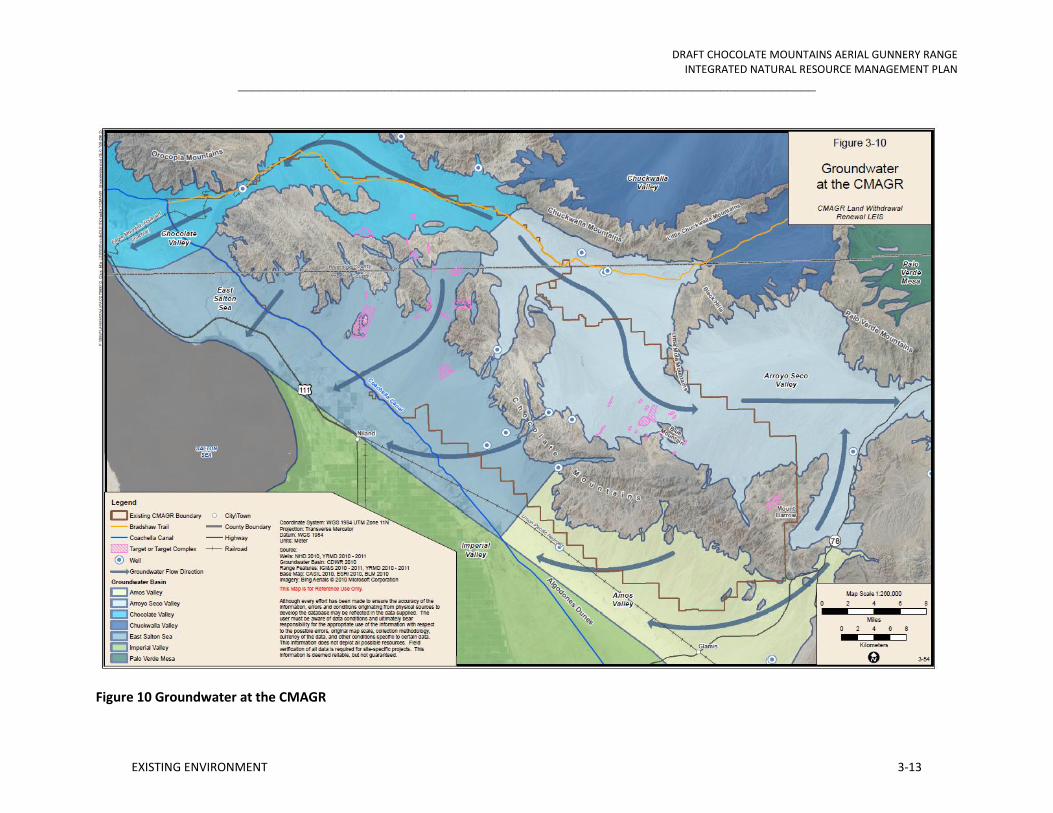
DRAFT CHOCOLATE MOUNTAINS AERIAL GUNNERY RANGE INTEGRATED NATURAL RESOURCE MANAGEMENT PLAN
_______________________________________________________________________________
EXISTING ENVIRONMENT 3-13
Figure 10 Groundwater at the CMAGR

DRAFT CHOCOLATE MOUNTAINS AERIAL GUNNERY RANGE INTEGRATED NATURAL RESOURCE MANAGEMENT PLAN
_______________________________________________________________________________
EXISTING ENVIRONMENT 3-14
3.2 AIR QUALITY
The following sections describe (1) the air quality setting, including regional climate and pollutant descriptions; (2) the regulatory environment, including federal, state, and local involvement and requirements; (3) the project setting; and (3) the existing air quality of the CMAGR and its vicinity, including air quality monitoring results, attainment status, and discussions of the collective emissions sources.
3.2.1 Air Quality Setting
Criteria Pollutants
Air quality is defined by ambient air concentrations of specific pollutants that have been determined by the EPA to be of concern with respect to the health and welfare of the general public. This resource type considers ambient (outdoor) air quality and emissions of air pollutants regulated by the Clean Air Act, as well as the greenhouse gases (GHGs) water vapor, carbon dioxide (CO2), tropospheric ozone, nitrous oxide (N2O), and methane (CH4). Seven major pollutants of concern, called “criteria pollutants,” are carbon monoxide (CO), sulfur dioxide (SO2), nitrogen dioxide (NO2), ozone (O3), suspended particulate matter less than or equal to 10 microns in diameter (PM10), fine particulate matter less than or equal to 2.5 microns in diameter (PM2.5), and lead (Pb). The EPA has established National Ambient Air Quality Standards (NAAQS) for these pollutants. Areas that violate a federal air quality standard are designated as non-attainment areas.
Ambient air quality refers to the atmospheric concentration of a specific compound (amount of pollutants in a specified volume of air) that occurs at a particular geographic location. The ambient air quality levels measured at a particular location are determined by the interactions of emissions, meteorology, and chemistry. Emission considerations include the types, amounts, and locations of pollutants emitted into the atmosphere. Meteorological considerations include wind and precipitation patterns affecting the distribution, dilution, and removal of pollutant emissions. Chemical reactions can transform pollutant emissions into other chemical substances. Ambient air quality data are generally reported as a mass per unit volume (for example, micrograms per cubic meter of air) or as a volume fraction (for example, parts per million [ppm] by volume).
Pollutant emissions typically refer to the amount of pollutants or pollutant precursors introduced into the atmosphere by a source or group of sources. Pollutant emissions contribute to the ambient air concentrations of criteria pollutants, either by directly affecting the pollutant concentrations measured in the ambient air or by interacting in the atmosphere to form criteria pollutants. Primary pollutants, such as CO, SO2, Pb, and some particulates, are emitted directly into the atmosphere from emission sources.
Secondary pollutants, such as O3, NO2, and some particulates, are formed through atmospheric chemical reactions that are influenced by meteorology, ultraviolet light, and other atmospheric processes. PM10 and PM2.5 are generated as primary pollutants by various mechanical processes (for example, abrasion, erosion, mixing, or atomization) or

DRAFT CHOCOLATE MOUNTAINS AERIAL GUNNERY RANGE INTEGRATED NATURAL RESOURCE MANAGEMENT PLAN
_______________________________________________________________________________
EXISTING ENVIRONMENT 3-15
combustion processes. However, PM10 and PM2.5 also can be formed as secondary pollutants through chemical reactions or by gaseous pollutants condensing into fine aerosols. In general, emissions that are considered “precursors” to secondary pollutants in the atmosphere (such as reactive organic gases [ROG] and oxides of nitrogen [NOX], which are considered precursors for O3), are the pollutants for which emissions are evaluated to control the level of O3 in the ambient air.
Existing air quality at a given location can be described by the concentrations of various pollutants in the atmosphere. Pollutants are defined as two general types: (1) “criteria” pollutants and (2) toxic compounds. Criteria pollutants have national and/or state ambient air quality standards. The EPA establishes the NAAQS, while the California Air Resources Board (CARB) establishes the state standards, termed the California Ambient Air Quality Standards (CAAQS). The NAAQS represent maximum acceptable concentrations that generally may not be exceeded more than once per year, except the annual standards, which may never be exceeded. The CAAQS represent maximum acceptable pollutant concentrations that are not to be equaled or exceeded. Areas that do not meet the air quality standard are designated as “non-attainment” areas. A portion of the CMAGR lies within Imperial County and a portion lies within Riverside County. Both areas are non-attainment for Respirable Particulate Matter (PM10), Nitrogen Oxides (NOx), and Ozone precursors (O3). The thresholds for the Imperial County portion of the CMAGR are 100 tons per year for O3 precursors, including NOX and Reactive Organic Gases (ROG), and 70 tons per year for PM10. The thresholds for the Riverside County portion of the CMAGR are 25 tons per year for O3 precursors and 70 tons per year for PM10.The CARB is responsible for enforcing both the federal and state air pollution standards (DoN 2010).
3.3 BIOTIC ENVIRONMENT
3.3.1 Vegetation
Accurate acreages of the native communities in the CMAGR are not available; the best available data are from GAP land cover data (GAP 2008), which covers the entire United States. The GAP map is derived from remotely sensed data and field observations, with the latter being mostly absent from the CMAGR, due to access restrictions. The vegetation is mapped at the level of ecological system, or ecosystem, which defines mapping units based on location, landform, the dominant plant physiogamy, or life form (e.g., shrub or tree), and the most common suites of species. An ecological system is also referred to as a community type, and for the purposes of this document the two may be considered equals. A good example of an ecosystem is ‘Sonora-Mojave Creosotebush (Larrea tridentata)-White Bursage (Ambrosia dumosa) Desert Scrub.’ This ecosystem is found in both the Sonoran and Mohave deserts, and is characterized by ‘scrub’ (=shrubs) of either/both creosote bush and white bursage. There are many variations within this ecosystem (e.g., the presence of big galleta grass [Pleuraphis rigida]), but they are not mapped at this level.
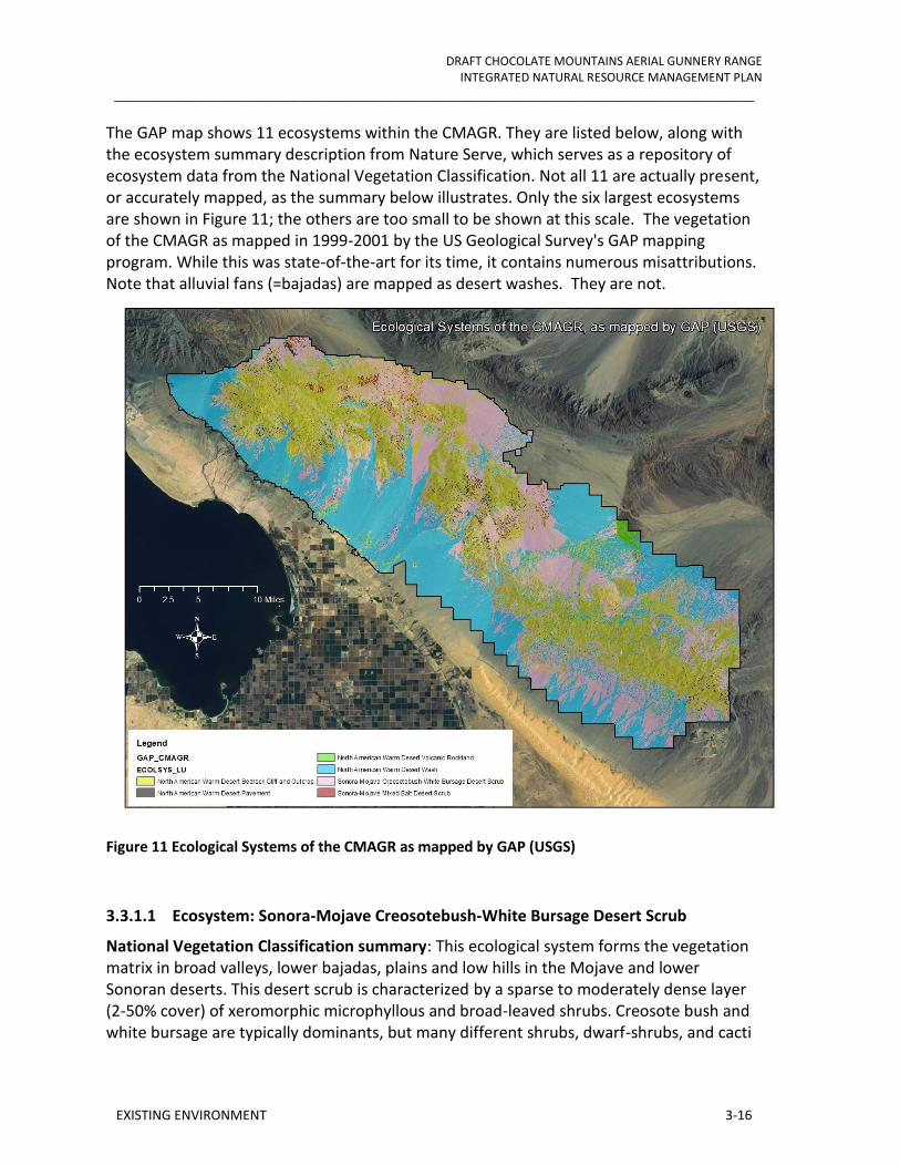
DRAFT CHOCOLATE MOUNTAINS AERIAL GUNNERY RANGE INTEGRATED NATURAL RESOURCE MANAGEMENT PLAN
_______________________________________________________________________________
EXISTING ENVIRONMENT 3-16
The GAP map shows 11 ecosystems within the CMAGR. They are listed below, along with the ecosystem summary description from Nature Serve, which serves as a repository of ecosystem data from the National Vegetation Classification. Not all 11 are actually present, or accurately mapped, as the summary below illustrates. Only the six largest ecosystems are shown in Figure 11; the others are too small to be shown at this scale. The vegetation of the CMAGR as mapped in 1999-2001 by the US Geological Survey's GAP mapping program. While this was state-of-the-art for its time, it contains numerous misattributions. Note that alluvial fans (=bajadas) are mapped as desert washes. They are not.
Figure 11 Ecological Systems of the CMAGR as mapped by GAP (USGS)
3.3.1.1 Ecosystem: Sonora-Mojave Creosotebush-White Bursage Desert Scrub
National Vegetation Classification summary: This ecological system forms the vegetation matrix in broad valleys, lower bajadas, plains and low hills in the Mojave and lower Sonoran deserts. This desert scrub is characterized by a sparse to moderately dense layer (2-50% cover) of xeromorphic microphyllous and broad-leaved shrubs. Creosote bush and white bursage are typically dominants, but many different shrubs, dwarf-shrubs, and cacti

DRAFT CHOCOLATE MOUNTAINS AERIAL GUNNERY RANGE INTEGRATED NATURAL RESOURCE MANAGEMENT PLAN
_______________________________________________________________________________
EXISTING ENVIRONMENT 3-17
may codominate or form typically sparse understories. Associated species may include saltbush (Atriplex canescens), desert holly (Atriplex hymenelytra), brittle bush (Encelia farinosa), Mormon tea (Ephedra nevadensis), ocotillo (Fouquieria splendens), Anderson wolfberry (Lycium andersonii), and beavertail pricklypear (Opuntia basilaris). The herbaceous layer is typically sparse, but may be seasonally abundant with ephemerals. Herbaceous species such as sandmats (Chamaesyce spp.), Reveal’s buckwheat (Eriogonum inflatum), low wollygrass (Dasyochloa pulchella), threeawn (Aristida spp.), Cryptantha spp., Nama spp., and Phacelia spp. are common. This system can often appear as very open sparse vegetation, with the mostly barren ground surface being the predominant feature.
Present in CMAGR? Yes. This is one of the dominant ecosystems in the CMAGR, on both steep slopes and the alluvial fans known as bajadas. The GAP map shows 147,707 acres (59,775 hectares) of this ecosystem in the CMAG. However, this includes vast areas of desert pavements in this ecosystem, areas that clearly should have been mapped as "North American Warm Desert Pavement" (see below).
This ecosystem can be split into the Colorado Sonoran Desert Scrub and the Mohave Desert Scrub. The Colorado Sonoran Desert Scrub, sometimes simply called Creosote Bush, is characterized by widely spaced shrubs, 0.5 to 3 yards tall, on well-drained secondary soils of slopes, fans, and valleys. Creosote bush and white bursage are typically the dominant species in the region, but other shrubs and cacti can form unique associations depending on local soils, topography, and other environmental conditions (Nature Serve 2011). Desert succulents commonly associate as subdominant species in the southern Chocolate Mountains and southern part of the CMAGR and could be categorized as a separate vegetation type known as desert succulent scrub or Sonoran Desert Mixed Scrub. Common associates in this sub-region include jumping cholla (Cylindropuntia bigelovii) and ocotillo (Davis et al. 2008). Succulent scrub areas typically have higher floristic and structural diversity than surrounding areas, which attract more wildlife. Desert pavement often occurs in patches of Colorado Sonoran desert scrub, which limits the density and diversity of plant cover to nearly pure stands of creosote bush in such localities (Brown 1994). The community transitions abruptly to desert dry wash woodland along most desert washes.
The growing season is from winter to early spring, with a flowering period for ephemerals in late February to March, depending on rainfall. It is the dominant plant community below 3,000-foot elevation throughout the Colorado Desert, occurring from the Little San Bernardino Mountains south and east into Baja California.
None of the California Natural Diversity Database (CNDDB) rare associations of Colorado Sonoran desert scrub are documented in the CMAGR and surrounding areas (CNDDB 2011). Major threats to this community type include fire, grazing, off-road vehicles, and invasions of alien species.

DRAFT CHOCOLATE MOUNTAINS AERIAL GUNNERY RANGE INTEGRATED NATURAL RESOURCE MANAGEMENT PLAN
_______________________________________________________________________________
EXISTING ENVIRONMENT 3-18
The Mohave Desert Scrub is similar to the Colorado Sonoran Desert Scrub, and can be found from Death Valley to the Little San Bernardino Mountains in California and east into southern Nevada and northwestern Arizona. Mojave Desert Scrub typically occurs on well-drained, non-alkaline soils of desert flats, bajadas, and slopes, and is generally not found above 4,000-5,000 foot elevation. Mojave Desert Scrub is similar in appearance to Sonoran Desert Scrub, but generally occurs in places of lower winter temperatures and with a correspondingly later growth and flowering season (late March to April for the ephemerals). Like Sonoran Desert Scrub, there are two distinct annual floras for the winter and summer seasons. Threats to this community are similar to those for Sonoran Desert Scrub: fire, grazing, off-road vehicles, and invasions of alien species.
3.3.1.2 Ecosystem: North American Warm Desert Wash (= Desert Dry Wash Woodland)
National Vegetation Classification summary: This ecological system is restricted to intermittently flooded washes or arroyos that dissect bajadas, mesas, plains and basin floors throughout the warm deserts of North America. Although often dry, the intermittent fluvial processes define this system, which are often associated with rapid sheet and gully flow. This system occurs as linear or braided strips within desert scrub-or desert grassland-dominated landscapes. The vegetation of desert washes is quite variable, ranging from sparse and patchy to moderately dense, and typically occurs along the banks, but may occur within the channel. The woody layer is typically intermittent to open and may be dominated by shrubs and small trees such as catclaw acacia (Acacia greggii), splitleaf brickellbush (Brickellia laciniata), desert broom (Baccharis sarothroides), desert willow (Chilopsis linearis), Apache plume (Fallugia paradoxa), white burrobrush (Hymenoclea salsola), singlewhorl burrobrush (Hymenoclea monogyra), black walnut (Juglans microcarpa), desert ironwood (Olneya tesota), blue palo verde (Parkinsonia florida), mesquite (Prosopis spp.), smoke tree (Psorothamnus spinosus), desert peach (Prunus fasciculata), desert sumac (Rhus microphylla), Mexican bladdersage (Salazaria Mexicana), or black greasewood (Sarcobatus vermiculatus). Common upland shrubs such as creosote bush and white bursage are often present along the edges of these washes. Sahara mustard (Brassica tournefortii) is invading washes increasing fuel loads and displacing preferred food sources for the desert tortoise.
Present in CMAGR? Yes. The GAP map shows 154,683 acres (62,598 hectares) of this ecosystem. Examination of imagery reveals that this is a much exaggerated figure. While limited in area, desert wash habitats are vitally important to wildlife and ecological processes throughout the southwestern deserts. Numerous desert washes occur throughout the CMAGR. Salt Creek is the largest wash in the CMAGR area east of the Coachella Canal and forms a lowland divide between the Orocopia Mountains and Chocolate Mountains and flows westward into the Salton Sink. Other large washes within the CMAGR include Arroyo Seco, Mammoth Wash, Milpitas Wash, and Iris Wash. Washes in the region only flow with runoff during seasonal rain events and often form braided channels and sorted sandy substrates in the wash bottoms.

DRAFT CHOCOLATE MOUNTAINS AERIAL GUNNERY RANGE INTEGRATED NATURAL RESOURCE MANAGEMENT PLAN
_______________________________________________________________________________
EXISTING ENVIRONMENT 3-19
Plants typifying dry desert wash woodlands include tree-like shrubs that grow taller and closer together than in the surrounding desert scrub. Tree-like species typically growing in this vegetation type in the CMAGR include blue paloverde, desert ironwood, smoketree, catclaw acacia, and honey mesquite (Prosopis glandulosa) (Nature Serve 2011). Availability of water and depth to groundwater typically affect which combinations of these species occur along a particular stretch of wash. Blue paloverde dominates most of the desert wash woodlands in the CMAGR; with honey mesquite dominated stands being restricted to Salt Creek and its tributaries, ironwood dominated stands occurring in the southern part of the CMAGR, and catclaw acacia-dominated stands growing on bajadas above the Salton Sea and Coachella Canal.
The CNDDB (California Native Diversity DataBase) lists associations of dry desert wash woodland in the CMAGR and surrounding areas. These include stands co-dominated by Munz’s cholla (Cylindropuntia munzii), crown of thorns (Koeberlinia spinosa), and crucifixion thorn (Castela emoryi). These species are described in the special status species section.
This plant community is considered sensitive by the California Resources Agency. Wildlife species richness is much higher in this than other community types in the desert, and this community is slow to recover from disturbance. Threats include invasive exotics (particularly Tamarix), and altered water flows.
3.3.1.3 Ecosystem: North American Warm Desert Bedrock Cliff and Outcrop
National Vegetation Classification summary: This ecological system is found from subalpine to foothill elevations and includes barren and sparsely vegetated landscapes (generally <10% plant cover) of steep cliff faces, narrow canyons, and smaller rock outcrops of various igneous, sedimentary, and metamorphic bedrock types. Also included are unstable scree and talus slopes that typically occur bellow cliff faces. Species present are diverse and may include elephant tree (Bursera microphylla), ocotillo, Bigelow’s nolina (Nolina bigelovii), teddybear cholla (Opuntia bigelovii), and other desert species, especially succulents. Lichens are predominant lifeforms in some areas. May include a variety of desert shrublands less than 2 ha (5 acres) in size from adjacent areas.
Present in CMAGR? Yes. 144,527 acres (58,488 hectares) mapped by GAP, but it is not clear how an area was attributed as bedrock. In the example below, it was noted that GAP called the dark hills bedrock-cliff, but not the paler hills. In truth, neither hold much in the way of exposed bedrock.
Nevertheless, this ecosystem should be found in the Chocolate Mountains. To make sense of the diversity of habitat, this would have to be mapped at a level below ecosystem, e.g., association. In this way we can distinguish between truly bare rock and the deep shade of steep north slopes that may give shade to plant species that are important browse for animals.

DRAFT CHOCOLATE MOUNTAINS AERIAL GUNNERY RANGE INTEGRATED NATURAL RESOURCE MANAGEMENT PLAN
_______________________________________________________________________________
EXISTING ENVIRONMENT 3-20
Figure 12 Dark hills to right are misattributed as Bedrock Cliff and Outcrop.
3.3.1.4 Ecosystem: Sonora-Mojave Mixed Salt Desert Scrub (= Desert Chenopod Scrub)
National Vegetation Classification summary: This ecological system includes extensive open-canopied shrublands of typically saline basins in the Mojave and Sonoran deserts. Stands most often occur around playas and in valley bottoms or basins where evapotranspiration results in saline soils. Substrates are generally fine-textured, saline soils. Vegetation is typically composed of one or more saltbush species, such as fourwing saltbush (Atriplex canescens) or cattle saltbush (Atriplex polycarpa), along with other species of saltbush. Species of Allenrolfea, pickleweed (Salicornia), sea blite (Suaeda), winterfat (Krascheninnikovia lanata), or other halophytic plants are often present to codominant. In some locations, scattered Joshua tree (Yucca brevifolia) may occur, but other Mojavean taxa are typically not present. Graminoid species may include alkai sacaton (Sporobolus airoides) or saltgrass (Distichlis spicata) at varying densities.
Present in CMAGR? Yes. Also known as Desert Chenopod Scrub, this ecosystem consists of areas of low, sparse, microphyllic shrubs growing in or around dry lake beds, or along the floodplains of washes. As mapped by GAP, there are 5184 acres (2098 hectares) of this ecosystem in the CMAGR, exclusively along floodplains. Using imagery alone, it is impossible to tell if this ecosystem is accurately mapped.
3.3.1.5 Ecosystem: North American Warm Desert Playa
National Vegetation Classification summary: This ecological system is composed of barren and sparsely vegetated playas (generally <10% plant cover) found across the warm deserts of North America, extending into the extreme southern end of the San Joaquin Valley in

DRAFT CHOCOLATE MOUNTAINS AERIAL GUNNERY RANGE INTEGRATED NATURAL RESOURCE MANAGEMENT PLAN
_______________________________________________________________________________
EXISTING ENVIRONMENT 3-21
California. Playas form with intermittent flooding, followed by evaporation, leaving behind a saline residue. Salt crusts are common throughout, with small saltgrass beds in depressions and sparse shrubs around the margins. Subsoils often include an impermeable layer of clay or caliche. Large desert playas tend to be defined by vegetation rings formed in response to salinity. Given their common location in windswept desert basins, dune fields often form downwind of large playas. In turn, playas associated with dunes often have a deeper water supply. Species may include iodinebush (Allenrolfea occidentalis), seepweed (Suaeda spp.), saltgrass, spikerush (Eleocharis palustris), Oryzopsis spp., Sporobolus spp., coldenia (Tiquilia spp.), or saltbush. Ephemeral herbaceous species may have high cover periodically.
Present in CMAGR? Unlikely. Each closed basin in the California desert contains a playa, or dry lake bed, but there do not appear to be any closed basins larger than a hectare in the CMAGR. The GAP map shows 91 acres (37 hectares) of playa, but close examination reveals that these are merely white hills, not playas (Figure 13).
Figure 13 White hills misattributed by the GAP map as the North American Warm Desert Playa. The true vegetation is unknown.
3.3.1.6 Ecosystem: North American Warm Desert Volcanic Rockland
National Vegetation Classification summary: This ecological system occurs across the warm deserts of North America and is restricted to barren and sparsely vegetated (<10% plant cover) volcanic substrates such as basalt lava (malpais) and tuff. Vegetation is variable and includes a variety of species depending on local environmental conditions, e.g., elevation, age and type of substrate. Typically scattered creosote bush, desert holly, or other desert shrubs are present.

DRAFT CHOCOLATE MOUNTAINS AERIAL GUNNERY RANGE INTEGRATED NATURAL RESOURCE MANAGEMENT PLAN
_______________________________________________________________________________
EXISTING ENVIRONMENT 3-22
Present in CMAGR? Likely, but undocumented. Tertiary age volcanic rocks are common in the Chocolate Mountains. However, the GAP map shows only 2661 acres (1077 hectares) of this ecosystem, while the Geologic Map of California (Jennings 1977) shows at least 30,000 acres of basalts. Further, as mapped by GAP, the 'volcanic rockland' includes desert pavements, which are another ecosystem (see below).
3.3.1.7 Ecosystem: North American Warm Desert Pavement
National Vegetation Classification summary: This ecological system occurs throughout much of the warm deserts of North America and is composed of unvegetated to very sparsely vegetated (<2% plant cover) landscapes, typically flat basins where extreme temperature and wind develop ground surfaces of fine to medium gravel coated with "desert varnish." This sparsely vegetated system may surround playas in valley bottoms or near washes and, less commonly, on dissected, eroding alluvial fans. Very low cover of desert scrub species such as creosote bush or eastern Mojave buckwheat (Eriogonum fasciculatum) is usually present. However, ephemeral herbaceous species may have high cover in response to seasonal precipitation, including devil’s spineflower (Chorizanthe rigida), desert trumpet, and hairy desert sunflower (Geraea canescens).
Present in CMAGR? Yes, but poorly mapped by GAP, which inadvertently attributes pavements as North American Warm Desert Volcanic Rockland or Sonora-Mojave Creosotebush-White Bursage Desert Scrub (Figure 14). Furthermore, the National Vegetation Classification summary description does not describe the pavements of southeastern California, which often harbor rich floras, including ironwood trees over 30 feet tall in the interfluve watercourses that benefit from the enhanced runoff of the pavement ecosystem.

DRAFT CHOCOLATE MOUNTAINS AERIAL GUNNERY RANGE INTEGRATED NATURAL RESOURCE MANAGEMENT PLAN
_______________________________________________________________________________
EXISTING ENVIRONMENT 3-23
Figure 14 Extensive desert pavements (dark surfaces) at the SE corner of the CMAGR are misattributed by the GAP map. Vista Mine appears in lower right. CMAGR boundary in red.
3.3.1.8 Ecosystem: North American Warm Desert Active and Stabilized Dune
National Vegetation Classification summary: This ecological system occurs across the warm deserts of North America and is composed of unvegetated to sparsely vegetated (generally <10% plant cover) active dunes and sandsheets derived from quartz or gypsum sands. Common vegetation includes white bursage, desert sand verbena (Abronia villosa), sand sagebrush (Artemisia filifolia), saltbrush, Colorado Desert buckwheat (Eriogonum deserticola), creosote bush, big galleta grass, Poliomintha spp., Prosopis spp., Psorothamnus spp., desert sumac, and mesa dropseed (Sporobolus flexuosus). Dune "blowouts" and subsequent stabilization through succession are characteristic processes.
Present in CMAGR? Unlikely. The Algodones Dunes are, however, very close to the southern boundary of the CMAGR. The GAP map shows 110 acres (25 hectares) of this ecosystem in the CMAGR, but they mis-attributed. A review of recent imagery show that they are merely scattered 30 m square pixels with no aeolian (wind-blown) features. Although dune habitat is not present in the CMAGR, the range is essential for the creation and replenishment of the nearby dune habitat. Dunes persist due to a sand “watershed” much as a lake persists due to inflows from creeks or rivers. The upslope areas on the CMAGR are important contributors of wind and waterborne sand that is necessary for the persistence of the due system.

DRAFT CHOCOLATE MOUNTAINS AERIAL GUNNERY RANGE INTEGRATED NATURAL RESOURCE MANAGEMENT PLAN
_______________________________________________________________________________
EXISTING ENVIRONMENT 3-24
3.3.1.9 Ecosystem: North American Warm Desert Riparian Woodland and Shrubland
National Vegetation Classification summary: This ecological system consists of low-elevation (<1200 m) riparian corridors along medium to large perennial streams throughout canyons and desert valleys of the southwestern United States and adjacent Mexico. Rivers include the lower Colorado (into the Grand Canyon), Gila, Santa Cruz, Salt, lower Rio Grande (below Elephant Butte Reservoir in New Mexico to the Coastal Plain of Texas), and the lower Pecos (up to near its confluence with Rio Hondo in southeastern New Mexico). The vegetation is a mix of riparian woodlands and shrublands. Dominant trees include Box elder (Acer negundo), velvet ash (Fraxinus velutina), Fremont cottonwood (Populus fremontii), Goodding's willow (Salix gooddingii), arroyo willow (Salix lasiolepis), netleaf hackberry (Celtis laevigata var. reticulate), western or California sycamore (Platanus racemosa), and Arizona walnut (Juglans major). Shrub dominants include Geyer's willow (Salix geyeriana), silver buffaloberry (Shepherdia argentea), and narrowleaf willow (Salix exigua). Vegetation is dependent upon annual or periodic flooding and associated sediment scour and/or annual rise in the water table for growth and reproduction.
Present in CMAGR? Yes, but more closely resembles the bosque ecosystem, whose National Vegetation Classification summary reads: This ecological system consists of low-elevation (<1100 m) riparian corridors along perennial and intermittent streams in valleys of the warm desert regions of the southwestern U.S. and adjacent Mexico. Rivers include the lower Colorado (within and downstream of the Grand Canyon), Gila, Santa Cruz, Salt, lower Rio Grande, Pecos (up to near its confluence with Rio Hondo), and their tributaries that occur in the desert portions of their range. Dominant trees include honey mesquite and velvet mesquite. Shrub dominants include muel-fat (Baccharis salicifolia), arrow weed (Pluchea sericea), and narrowleaf willow. Woody vegetation is relatively dense, especially when compared to drier washes. Vegetation, especially the mesquites, tap groundwater below the streambed when surface flows stop. Vegetation is dependent upon annual rise in the water table for growth and reproduction.
The GAP map shows 815 acres (330 hectares) of this ecosystem within the CMAGR. It is associated with the downslope side of siphons on the Coachella Canal (Figure 15). This example is near Camp Billy Machen, and just downslope of Siphon 10 of the Coachella Canal. The red line is the CMAGR boundary. Like the Warm Desert North American Wash habitat, this bosque habitat has very high wildlife values relative to the rest of the CMAGR. It is important for cover and foraging habitat for ungulates, carnivores and migrating birds. It is also highly susceptible to tamarisk invasion.

DRAFT CHOCOLATE MOUNTAINS AERIAL GUNNERY RANGE INTEGRATED NATURAL RESOURCE MANAGEMENT PLAN
_______________________________________________________________________________
EXISTING ENVIRONMENT 3-25
Figure 15 Dense vegetation mapped by GAP as riparian forest, but appears to be bosque (see description above).
3.3.1.10 Ecosystem: Inter-Mountain Basins Shale Badland
National Vegetation Classification summary: This widespread ecological system of the Intermountain western U.S. is composed of barren and sparsely vegetated substrates (<10% plant cover) typically derived from marine shales but also includes substrates derived from siltstones and mudstones (clay). In southern Wyoming, the shales are not marine in origin, but often have bentonite, derived from volcanic ash deposition that occurred during several eruptions of the Yellowstone volcanic fields. Landforms are typically rounded hills and plains that form a rolling topography. The harsh soil properties and high rate of erosion and deposition are driving environmental variables supporting sparse dwarf-shrubs, e.g., mat saltbush (Atriplex corrugata), Gardner's saltbush (Atriplex gardneri), birdfoot sagebrush (Artemisia pedatifida), and herbaceous vegetation.
Present in CMAGR? No. Only 217 acres (88 hectares) mapped in the CMAGR, and that is on basalts, not shale.
3.3.1.11 Ecosystem: Mojave Mid-elevation Mixed Desert Scrub
National Vegetation Classification summary: This ecological system represents the extensive desert scrub in the transition zone above creosote bush - white bursage desert scrub and below the lower montane woodlands (700-1800 m elevations) that occur in the eastern and central Mojave Desert. It is also common on lower piedmont slopes in the transition zone into the southern Great Basin. The vegetation in this ecological system is quite variable. Codominants and diagnostic species include blackbrush (Coleogyne

DRAFT CHOCOLATE MOUNTAINS AERIAL GUNNERY RANGE INTEGRATED NATURAL RESOURCE MANAGEMENT PLAN
_______________________________________________________________________________
EXISTING ENVIRONMENT 3-26
ramosissima), California buckwheat (Eriogonum fasciculatum), Mormon tea, spiny hopsage (Grayia spinosa), Lycium spp., spiny menodora (Menodora spinescens), Nolina spp., buckthorn cholla (Opuntia acanthocarpa), bladdersage (Salazaria mexicana), desert sunflower (Viguiera parishii), Joshua tree (Yucca brevifolia), or Mojave yucca (Yucca schidigera). Less common are stands with scattered Joshua trees and a saltbush short-shrub layer dominated by fourwing saltbush, spiny saltbrush (Atriplex confertifolia), or cattle saltbush (Atriplex polycarpa), or occasionally white burrobrush (Hymenoclea salsola). In some areas in the western Mojave, California juniper (Juniperus californica) is common with the yuccas. Desert grasses, including Indian ricegrass (Achnatherum hymenoides), desert needlegrass (Achnatherum speciosum), Bush muhly (Muhlenbergia porteri), James' galleta (Pleuraphis jamesii), big galleta grass, or Sandberg bluegrass (Poa secunda), may form an herbaceous layer. Scattered red cedar (Juniperus osteosperma) or desert scrub species may also be present.
Present in CMAGR? The GAP map shows only 5.6 acres (2.25 hectares) in the CMAGR. There should be much more.
Ecosystems unlikely to occur in the CMAGR in significant acreage, but may be present:
Mojavean Pinyon-Juniper Woodland is common at higher elevations in SE California. The CMAGR reaches 3060 feet at its highest point. This is among the lowest elevations recorded for California juniper, so it may be present in the CMAGR. However, pinyon pine is typically well above 4000 feet, so it is unlikely to be found in the CMAGR.
3.3.2 General Wildlife
Most wildlife species are able to survive by evading the hot and dry extremes of the Colorado Desert’s climate through behavioral and physiological adaptations. Many species are adapted to survive without free water in their environment. As a consequence of harsh climatic extremes, limited habitat resources, and regional geographic barriers, the diversity of animal species in the CMAGR is typically low relative to other parts of the Sonoran and Mojave deserts.
The CMAGR largely lacks surface waters for wildlife with the exception of ephemeral pools that develop after seasonal storm events. Artificial tanks, wildlife water sources (guzzlers), and tinajas (natural bedrock depressions) are the only open water sources within the CMAGR available to wildlife. The CDFW manages 26 existing guzzlers within the CMAGR principally to provide supplemental water for desert bighorn sheep (Ovis canadensis nelsoni) and mule deer (Odocoileus hemionus) in the Chocolate Mountains (BLM 2009). Five additional guzzlers are proposed for future installation. A subset of the sheep and deer also move freely from and back onto the CMAGR to use the drinkers installed along the Coachella Canal.
Smaller mammals that have been documented on the CMAGR include big brown bat (Eptesicus fuscus), canyon bat (Parastrellus hesperus), kit fox (Vulpes macrotis), Botta’s

DRAFT CHOCOLATE MOUNTAINS AERIAL GUNNERY RANGE INTEGRATED NATURAL RESOURCE MANAGEMENT PLAN
_______________________________________________________________________________
EXISTING ENVIRONMENT 3-27
pocket gopher (Thomomys bottae), Merriam’s kangaroo rat (Dipodomys merriami), round-tailed ground squirrel (Spermophilus tereticaudus), desert cottontail (Sylvilagus audubonii), and black-tailed jackrabbit (Lepus californicus), antelope ground squirrel (Ammo spermophilus leucurus), desert woodrat (Neotoma lepida), Audubon cottontail (Sylvilagus audubonii), bobcat (Lynx rufus); coyote (Canis latrans), kit fox (Vulpes macrotis), and gray fox (Urocyon cinereoargenteus) (CMBC 2013).
A representative list of the most common reptile species includes the side-blotched lizard (Uta stansburiana), common chuckwalla (Sauromalus obesus), long-nosed leopard lizard (Gambelia wislizenii), gopher snake (Pituophis melanoleucus), western diamondback rattlesnake (Crotalus atrox), desert iguana (Dipsosaurus dorsalis), zebra-tailed lizard (Callisaurus draconoides), western whiptail lizard (Aspidoscelis tigris), sidewinder (Crotalus cerastes), and desert horned lizard (Phrynosoma platyrhinos) (CMBC 2013).
Bird species include red-tailed hawk (Buteo jamaicensis), mourning dove (Zenaida macroura), lesser nighthawk (Chordeiles acutipennis), black-tailed gnatcatcher (Polioptila melanura), white-crowned sparrow (Zonotrichia leucophrys), black-throated sparrow (Amphispiza bilineata); verdin (Auriparus flavipes); turkey vulture (Cathartes aura), American kestrel (Falco sparverius), common barn owl (Tyto alba), greathorned, owl (Bubo virginianus), chukar (Alectoris chukar), Gambel’s quail (Callipepla gambelii), greater roadrunner (Geococcyx californianus), common poorwill (Phalaenoptilus nuttallii), Say’s phoebe (Sayornis saya), ash-throated flycatcher (Myiarchus cinerascens), western flycatcher (Empidonax difficilis), horned lark (Eremophila alpestris), verdin (Auriparus flaviceps), cactus wren (Campylorhynchus brunneicapillus), rock wren (Salpinctes obsoletus), phainopepla (Phainopepla nitens), blue-gray gnatcatcher (Polioptila caerula), warbling vireo (Vireo gilvus), orange-crowned warbler (Vermivora celata), Lucy’s warbler (Vermivora luciae), yellow-rumped warbler (Dendroica coronata), Townsend’s warbler (Setophaga townsendii), Wilson’s warbler (Wilsonia pusilla), western tanager (Piranga ludoviciana), black-headed grosbeak (Pheucticus melanocephalus), Brewer’s sparrow (Spizella breweri), white-crowned sparrow (Zonotrichia leucophrys), hooded oriole (Icterus cucullatus), yellow-headed blackbird (Xanthocephalus xanthocephalus) great-tailed grackle (Quiscalus mexicanus), and ladder-backed woodpecker (Picoides scalaris),
3.3.3 Special Status Species
Figure 16 shows recorded confirmed locations for special status species in the CMAGR vicinity. Certain special status species have been excluded because they are not known to occur at the
CMAGR; these species are summarized in Table 5.

DRAFT CHOCOLATE MOUNTAINS AERIAL GUNNERY RANGE INTEGRATED NATURAL RESOURCE MANAGEMENT PLAN
_______________________________________________________________________________
EXISTING ENVIRONMENT 3-28
Figure 16 Special Status Species within the CMAGR Vicinity

DRAFT CHOCOLATE MOUNTAINS AERIAL GUNNERY RANGE INTEGRATED NATURAL RESOURCE MANAGEMENT PLAN
_______________________________________________________________________________
EXISTING ENVIRONMENT 3-29
3.3.3.1 Agassiz Desert Tortoise (Gopherus agassizii) – Federally Threatened, State Threatened
On August 20, 1980, the Service published a final rule listing the Beaver Dam Slope population of the desert tortoise in Utah as threatened (45 FR 55654). In the 1980 listing of the Beaver Dam Slope population, the Service concurrently designated 26 square miles of BLM-administered land in Utah as critical habitat. The reason for listing was population declines because of habitat deterioration and past over-collection. Major threats to the desert tortoise identified in the rule included habitat destruction through development, overgrazing, and geothermal development, collection for pets, malicious killing, road kills, and competition with grazing or feral animals.
On August 4, 1989, the Service published an emergency rule listing the Mojave population of the desert tortoise as endangered (54 FR 42270). On April 2, 1990, the Service determined the Mojave population of the desert tortoise to be threatened (55 FR 12178). Reasons for the determination included significant population declines, loss of habitat from construction projects such as roads, housing and energy developments, and conversion of native habitat to agriculture. Livestock grazing and off-highway vehicle (OHV) activity have degraded additional habitat. Also cited as threatening the desert tortoise's continuing existence were: illegal collection by humans for pets or consumption; upper respiratory tract disease (URTD); predation on juvenile desert tortoises by common ravens, coyotes, and kit foxes; fire; and collisions with vehicles on paved and unpaved roads.
On February 8, 1994, the Service designated approximately 6.45 million acres of critical habitat for the Mojave population of the desert tortoise in portions of California (4,750,000 acres), Nevada (1,220,000 acres), Arizona (339,000 acres), and Utah (129,000 acres) (59 FR 5820-5846, also see corrections in 59 FR 9032-9036), which became effective on March 10, 1994 A final Recovery Plan (SUFWS 1994) for the desert tortoise was published in June 1994. The Recovery Plan is the basis and key strategy for recovery and delisting to the desert tortoise. The Plan identified six Recovery units and recommended the establishment of 14 Desert Wildlife Management Areas (DWMA) within the recovery units. Surveys began in 1996
The CMAGR is situated with the Colorado Desert recovery unit. The Recovery Plan established the Chuckwalla DWMA based on the presence of critical habitat. Approximately 40 percent of the range lies within designated desert tortoise critical habitat, that is, most of the Range east of the Chocolate Mountains. Approximately 30 percent of the designated critical habitat on the Range is currently used for military activity.
The Agassiz desert tortoise primarily occurs in the bajadas, mountain foothills, and valleys of the Mojave and Colorado deserts west of the Colorado River. This species usually occurs below 4,000 feet in creosote bush, saltbush scrub habitats, tree yucca (Joshua tree and Mojave yucca) communities, and some ocotillo-creosote habitats (Brennan and Holycross
DRAFT CHOCOLATE MOUNTAINS AERIAL GUNNERY RANGE INTEGRATED NATURAL RESOURCE MANAGEMENT PLAN
_______________________________________________________________________________
EXISTING ENVIRONMENT 3-30
2006, Stebbins 2003). Creosote bush, white bursage, tree yucca, galleta grass, and blackbrush are indicator species of overall desert tortoise habitat (Brennan and Holycross 2006, Nussear et al. 2009). Mojave desert tortoises occupy a wide variety of soil types and substrates that include sand dunes, rocky hillsides, and caliche caves in washes, sandy soils, and desert pavements. Tortoises must have suitable substrates and terrain for digging burrows (Brennan and Holycross 2006, Stebbins 2003). The availability of adequate forage resources consisting of native grasses, herbaceous perennials and annuals, and cacti are important for determining habitat suitability for the Mojave desert tortoise (Brennan and Holycross 2006, Stebbins 2003, Nussear et al. 2009).
The CMAGR is the primary installation harboring desert tortoise habitat in the Colorado Desert in California (USFWS 1990, 1994a). In 1994, about 6.6 million acres in four states were designated as Critical Habitat for the Mojave population of the desert tortoise, including about 183,419 acres (40 percent) of the northeastern half of the CMAGR (USFWS 1994b; see Figure 16. Occurrences of the Mojave desert tortoise in the CMAGR are reported from the northeastern side of the Chocolate Mountains and southward along SR 78 (CNDDB 2011). Suitable habitat occurs for the species throughout the CMAGR, but density estimates are low for the west side of the Chocolate Mountains (Dames & Moore 1995, Nussear et al. 2009). The highest densities of Mojave desert tortoises in the surrounding region had been on the Chuckwalla Bench, but precipitous declines have occurred due to factors affecting the species throughout its range. These have included habitat loss, diseases, excessive predation on young tortoises by ravens and coyote, collecting, shooting, highway and vehicle kills, and other factors.
The recovery plan for the Mojave desert tortoise was recently updated in 2011 (USFWS 2011). Military operations (e.g., construction and operation of bases, ranges, and field maneuvers) have taken place in the Mojave Desert since 1859 and can affect tortoises and their habitats similarly to other large human settlements (i.e., illegal collection of tortoises, trash dumping, increased raven (Corvus corax) populations, domestic predators, OHV use, increased exposure to disease, and increased mortality) (USFWS 1994a; Krzysik 1998; Boarman 2002). The value that military lands can provide for conservation has long been recognized (Stein et al. 2008). Restricted-access military lands provide an extensive network of tortoise habitats that are managed either directly or indirectly for desert tortoise conservation. Military lands with conservation objectives expressed through compliance with the Sikes Act include a great deal of desert tortoise habitat outside of and contiguous with designated tortoise conservation areas (USFWS 2011).
Cardno TEC, Inc. (2012) calculated that approximately 41%, or 187,825 acres (760 km2), of the CMAGR is designated as desert tortoise critical habitat within the Chuckwalla Desert Wildlife Management Area (DWMA) (USFWS 1994b). Target areas within the designated critical habitat are not part of the critical habitat area because the constituent elements for which the area was designated have been removed by military training activities. However, about 95 percent (177,000 acres) of the critical habitat in the CMAGR is in areas of negligible to low military surface use. Approximately 300 acres of military use roads pass

DRAFT CHOCOLATE MOUNTAINS AERIAL GUNNERY RANGE INTEGRATED NATURAL RESOURCE MANAGEMENT PLAN
_______________________________________________________________________________
EXISTING ENVIRONMENT 3-31
through the critical habitat and about 9,300 acres of the critical habitat within the CMAGR are in areas of moderate military use to support the secondary weapons impact areas. Near the northern perimeter of the CMAGR, including some land south of the Bradshaw Trail, some to the critical habitat was acquired through purchases from the Land and Water Conservation Fund (LWCF).
3.3.3.2 Desert bighorn sheep (Ovis canadensis nelsoni) – BLM Sensitive, U.S. Forest Service
Nelson’s desert bighorn is considered as a sensitive species by both the BLM and U.S. Forest Service, it is not otherwise designated by either CDFW or USFWS. It is found in the desert mountains of southeastern California. Desert bighorn sheep favor open, rocky, and steep terrain and avoid dense vegetation that blocks visibility (CDFW 2011). Habitat used by desert bighorn also includes springs and plateaus (BLM 2002). The CMAGR subpopulation is part of a larger Sonoran meta-population.
Long-term survival of local sub-populations of bighorn sheep requires movement of individuals among regional subpopulations to prevent genetic bottlenecks, to maintain viable population numbers, and to recolonize vacant or formerly occupied areas (Bleich et al. 1990 and Schwartz et al. 1986 in BLM 2002). Desert bighorn sheep will move from mountains through valleys to reach preferred habitat sites (Bleich et al.1990 in BLM 2002). The Coachella Canal, Interstate 10, and SR 78 are filter-barriers that inhibit or prevent historical movement of bighorn sheep between regional mountain ranges (BLM 2002). Historical movement corridors from the Chocolate Mountains to the Orocopia Mountains, Chuckwalla Mountains, and Palo Verde Mountains likely remain intact, because little or no development occurs between these mountain ranges.
CDFW offers limited hunting of this subspecies; the agency allowed 24 tags in the Colorado Desert in 2011. Desert bighorn in the CMAGR cannot be hunted because of the safety hazards associated with military training that necessarily keeps the area closed to public use.
3.3.3.3 American badger (Taxidea taxus) – State Sensitive
The American badger is designated as a California Species of Special Concern by the California Fish and Game Commission and has no federal status. The presence/absence of the American badger is not well understood on the CMAGR and there are very few entries in the CNDDB. A desert tortoise surveys were completed in SWATs 4 and 5 in 2012. Although badgers were not observed in a focused survey and habitat assessment , they were detected by diagnostic digs along 52 of 179 (29%) transects (Circle Mountain Biological Consultants, Inc. [CMBC] 2012). It is not unusual to detect American badger and not see the animals. For example, during spring and summer 2011 surveys of Marine Corps Air Ground Combat Center (MCAGCC) in Twentynine Palms, CA, CMBC biologists detected 990 badger digs (and several diagnostic scat) while seeing only one animal (LaRue 2012).

DRAFT CHOCOLATE MOUNTAINS AERIAL GUNNERY RANGE INTEGRATED NATURAL RESOURCE MANAGEMENT PLAN
_______________________________________________________________________________
EXISTING ENVIRONMENT 3-32
3.3.3.4 Couch’s spadefoot (Scaphiopus couchii)- State Sensitive
Couch’s spadefoot is a California Species of Special Concern. It has no federal status. Couch’s spadefoot inhabits desert and arid regions of grassland, prairie, mesquite, creosote bush, thorn forest, sandy washes. In California, it is present in these habitats in the Colorado and Sonoran deserts. Its occurrence in Imperial County is probably not fully documented yet, although well known and well documented habitat exists along the UPRR ROW at the CMAGR’s south border. Couch’s spadefoot may spend most of the year buried underground, emerging only to feed and breed after monsoonal rains have created temporary ponds used for breeding. Larvae are capable of maturing and leaving the ponds within eight days. Since the breeding ponds are ephemeral, and larvae are only present for a shorty time, Couch’s spadefoot is not easily detected unless targeted surveys are conducted.
3.3.3.5 Golden eagle (Aquila chrysaetos) – Federally Protected (BGEPA), State Sensitive
The golden eagle is a California Species of Special Concern and is fully protected. It is federally protected under the Bald and Golden Eagle Protection Act (BGEPA). Most golden eagles in California are resident (e.g. they stay in the state yearlong), but some migrate into California for winter. Those that stay yearlong may move downslope for the winter, or upslope after breeding season. Where they exist, golden eagles are an upper‐trophic aerial predator, and eat small to midsized reptiles, birds, and mammals up to the size of mule deer fawns and coyote pups (Bloom and Hawks 1982). They also are known to scavenge and utilize carrion (Kochert et al. 2002). Golden eagles inhabit a variety of habitats including forests, canyons, shrub lands, grasslands, oak woodlands and arid deserts. 3.3.3.6 Cooper’s hawk (Accipiter cooperii) – Federal and State Sensitive
Cooper’s hawk is identified as a California Species of Special Concern by CDFW (2011) and is federally protected under MBTA. One was observed by CMBC in SWAT 4 flying through a microphyll woodland on the afternoon of 28 April 2012. This medium-sized raptor can be both resident and migratory, depredating small passerines. Cooper’s hawks are more likely to nest in larger landscaped trees, such as various palm species in the region, than in the smaller ironwoods and palo verdes at CMAGR. They are likely to forage throughout the CMAGR, particularly in microphyll woodlands, where they may seek both cover and prey species, but are not likely to nest (CMGC 2013).
3.3.3.7 Vaux’s swift (Chaetura vauxi) - State Sensitive
Vaux’s swift is designated as a California Species of Special Concern and has no federal designation. Individual birds and one small flock of three were observed on three occasions, twice on 13 April 2012 and once on 4 May 2012. This migratory species is considered to be incidental to the CMAGR, foraging over the area as it passes through, but is not expected to nest.

DRAFT CHOCOLATE MOUNTAINS AERIAL GUNNERY RANGE INTEGRATED NATURAL RESOURCE MANAGEMENT PLAN
_______________________________________________________________________________
EXISTING ENVIRONMENT 3-33
3.3.3.8 Swainson’s hawk (Buteo swainsoni) – State Threatened, USFWS Sensitive
Swainson’s hawk is designated as a Threatened species by the California Fish and Game Commission and as a Bird of Conservation Concern by USFWS. They were observed by CMBC on two occasions over SWAT 4, once on 8 April 2012 and a second time on 13 April 2012. As a migrant, Swainson’s hawks likely occur throughout the CMAGR during spring and fall migration periods where they may forage but would not nest. The migration pathway of the Swainson’s hawks are not well characterized in this region. There may well be as-yet undiscovered migratory roosting sites on the CMAGR.
3.3.3.9 Loggerhead shrike (Lanius ludovicianus) – State Sensitive
The loggerhead shrike is considered a California Species of Concern and in the Mojave Desert is not designated by USFWS. They were the most commonly encountered bird species, having been detected in 24 different places by CMBC in April 2012. They are likely to nest in microphyll woodland and forage throughout SWATs 4 and 5.
3.3.3.10 Burrowing owl (Athene cunicularia) - State Sensitive, USFWS Sensitive
The burrowing owl is designated as a California Species of Special Concern by the California Fish and Game Commission and as a Bird of Conservation Concern by USFWS, was detected in 14 places on the CMAGR in 2012. Diagnostic sign of this special status bird species included whitewash (feces), feathers, regurgitated pellets, and zygodactyl (x-shaped) tracks at suitable burrows and coversites in CMBC April 2012 field surveys. Although three sign of burrowing owl were observed on the CMAGR Plot 1, they were most often encountered and detected at caliche caves in the northeastern portions of SWAT 5.
3.3.3.11 Orocopia sage (Salvia greatae) – California Native Plant Society Special Status
Designated by California Native Plant Society (CNPS 2012) as a List 1B.3 species, Orocopia sage is considered to be rare, threatened, or endangered in California and elsewhere; but not very threatened in California (low degree/immediacy of threats or no threats known). It was previously observed along 23 transects on northern portions of SWAT 4 (1 transect) and western portions of SWAT 5 (22 transects) in 2008 (Woodman 2008). In 2012, this medium-sized shrub was observed along two transects in SWAT 4 and five transects in SWAT 5. It is apparent, then, that the species is most common on the southwestern portions of SWAT 5 (CMBC 2013).
3.3.3.12 Sand evening primrose (Camissonia arenaria) – California Native Plant Society Special Status
Sand evening primrose was observed in 2012 at one location in SWAT 4 and one location in SWAT 5. CNPS (2012) considers this plant to be a List 2.2 species, meaning it is rare, threatened, or endangered in California but more common elsewhere; and, specifically, fairly threatened in California (moderate degree/immediacy of threat). The plants may mostly occur in foothill and mountainous areas where the two specimens were found and

DRAFT CHOCOLATE MOUNTAINS AERIAL GUNNERY RANGE INTEGRATED NATURAL RESOURCE MANAGEMENT PLAN
_______________________________________________________________________________
EXISTING ENVIRONMENT 3-34
less likely to be on mid- to low bajadas where most of the survey effort occurred yet no plants were found (CMBC 2013).

DRAFT CHOCOLATE MOUNTAINS AERIAL GUNNERY RANGE INTEGRATED NATURAL RESOURCE MANAGEMENT PLAN
_______________________________________________________________________________
EXISTING ENVIRONMENT 3-35
Table 5 Summary of Federal, State, or BLM Listed Species Dismissed from Further Analysis
Common Name Scientific Name
Federal Status
BLM Status
State Status
Species or Habitat
Habitat Association Present Potential Absent
Special Status Animals
Reptiles
Flat-tailed horned lizard (Phrynosoma (Anota) mcallii)
CA S SSC x
Occurs in Sonoran desert scrub dominated by creosote bush in low dunes and flatlands with a deep, sandy substrate (Brennan and Holycross 2006, Flat-tailed Horned Lizard Interagency Coordinating Committee 2003). Although desert dunes do not occur on the CMAGR, dunes are actively maintained by outflows of blown and waterborne sand from the CMAGR.
Colorado Desert fringe-toed lizard (Uma notata)
None S SSC x
Occurs in open dune fields, washes, river banks, and shrub-invaded sand hummocks with at least sporadic, open patches of fine, unconsolidated or wind-blown sand (Brennan and Holycross 2006, Stebbins 2003).
Birds
Northern harrier (Circus cyaneus)
None None SSC, FP x
Prefers open habitats with lookout perches such as shrubs or fence posts. These habitats include weedy borders of rivers, lakes, streams, freshwater marshes, grasslands, weed fields, pastures, and some croplands (including alfalfa and melons).
Ferruginous hawk (Buteo regalis)
None None SSC, FP x Overwinters in desert scrub and agricultural areas of the Imperial Valley (WFO and CDFW 2008).
Swainson’s hawk (Buteo swainsoni) None S T, FP x
Most often found in grasslands, shrub lands, and agricultural areas, where open land for foraging and trees for roosting and nesting are available. Incidental migrants.
Merlin (Falco columbarius)
None None Watch List, FP
x Occurs in grasslands, shrub lands, woodlands, and agricultural areas with suitable perch sites.
Prairie falcon (Falco mexicanus)
None None FP x
Found in areas where cliffs provide secure nesting sites (WFO and CDFW 2008). This species occurs in all vegetation types in the desert, although sparse vegetation provides the best foraging habitat (WFO and CDFW 2008). Predominantly a winter resident in the Colorado Desert (WFO and CDFW 2008).
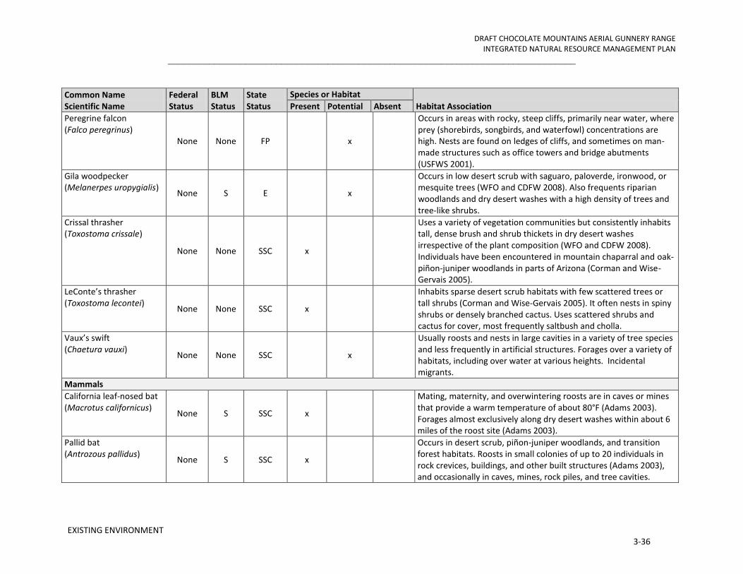
DRAFT CHOCOLATE MOUNTAINS AERIAL GUNNERY RANGE INTEGRATED NATURAL RESOURCE MANAGEMENT PLAN
_______________________________________________________________________________
EXISTING ENVIRONMENT 3-36
Common Name Scientific Name
Federal Status
BLM Status
State Status
Species or Habitat
Habitat Association Present Potential Absent
Peregrine falcon (Falco peregrinus)
None None FP x
Occurs in areas with rocky, steep cliffs, primarily near water, where prey (shorebirds, songbirds, and waterfowl) concentrations are high. Nests are found on ledges of cliffs, and sometimes on man-made structures such as office towers and bridge abutments (USFWS 2001).
Gila woodpecker (Melanerpes uropygialis)
None S E x
Occurs in low desert scrub with saguaro, paloverde, ironwood, or mesquite trees (WFO and CDFW 2008). Also frequents riparian woodlands and dry desert washes with a high density of trees and tree-like shrubs.
Crissal thrasher (Toxostoma crissale)
None None SSC x
Uses a variety of vegetation communities but consistently inhabits tall, dense brush and shrub thickets in dry desert washes irrespective of the plant composition (WFO and CDFW 2008). Individuals have been encountered in mountain chaparral and oak-piñon-juniper woodlands in parts of Arizona (Corman and Wise-Gervais 2005).
LeConte’s thrasher (Toxostoma lecontei)
None None SSC x
Inhabits sparse desert scrub habitats with few scattered trees or tall shrubs (Corman and Wise-Gervais 2005). It often nests in spiny shrubs or densely branched cactus. Uses scattered shrubs and cactus for cover, most frequently saltbush and cholla.
Vaux’s swift (Chaetura vauxi)
None None SSC x
Usually roosts and nests in large cavities in a variety of tree species and less frequently in artificial structures. Forages over a variety of habitats, including over water at various heights. Incidental migrants.
Mammals
California leaf-nosed bat (Macrotus californicus)
None S SSC x
Mating, maternity, and overwintering roosts are in caves or mines that provide a warm temperature of about 80°F (Adams 2003). Forages almost exclusively along dry desert washes within about 6 miles of the roost site (Adams 2003).
Pallid bat (Antrozous pallidus)
None S SSC x
Occurs in desert scrub, piñon-juniper woodlands, and transition forest habitats. Roosts in small colonies of up to 20 individuals in rock crevices, buildings, and other built structures (Adams 2003), and occasionally in caves, mines, rock piles, and tree cavities.

DRAFT CHOCOLATE MOUNTAINS AERIAL GUNNERY RANGE INTEGRATED NATURAL RESOURCE MANAGEMENT PLAN
_______________________________________________________________________________
EXISTING ENVIRONMENT 3-37
Common Name Scientific Name
Federal Status
BLM Status
State Status
Species or Habitat
Habitat Association Present Potential Absent
Western yellow bat (Lasiurus xanthinus)
None None SSC x
Occurs in desert and semi-desert habitats of the southwestern United States (Adams 2003). Commonly roosts beneath dead palm fronds in both native and non-native palm trees, in cottonwoods in riparian gallery forests and woodlands, and in tree-like yuccas (Adams 2003).
Western small-footed myotis (Myotis ciliolabrum) None S None x
Occurs in deserts, chaparral, riparian zones, and western coniferous forests; it is most common above the piñon-juniper woodland zone (Adams 2003). Individuals are known to roost singly or in small groups in cliff and rock crevices, buildings, concrete overpasses, caves, and mines (Adams 2003).
Pocketed free-tailed bat (Nyctinomops femorosaccus)
None None SSC x
Occurs in a variety of plant communities from desert scrub through pine-oak forests, but the species is most common in desert and semi-desert environments (Adams 2003). In California, found primarily in creosote bush and chaparral habitats in or near granite boulders, cliffs, or rocky canyons (Adams 2003) and roosts primarily in crevices of rugged cliffs, high rocky outcrops, and slopes (Adams 2003).
Big free-tailed bat (Nyctinomops macrotis)
None None SSC x
Primarily inhabits rugged, mountainous terrain in desert and semi-desert habitats. Occurs in desert scrub, woodlands, and evergreen forests (Adams 2003) and roosts in rock crevices where cliffs occur and occasionally roosts in buildings, caves, and tree cavities (Adams 2003).
Western mastiff bat (Eumops perotis)
None S SSC x
Most common in areas with desert scrub and broad open expanses (Adams 2003). Foraging habitat includes dry desert washes, flood plains, chaparral, oak woodland, open ponderosa pine forest, grassland, and agricultural areas (Adams 2003). Primarily a cliff-dwelling species that roosts in rock crevices, under exfoliating slabs of rock, in shallow cliff-side caves, and in buildings (Adams 2003).
Plants
Harwood’s rattleweed (Astragalus insularis var. harwoodii)
None None CNPS 2.2, SH S2.2
x Occurs in Sonoran desert scrub in dunes and other areas with a sandy substrate (CNPS 2011, SEINet 2011).

DRAFT CHOCOLATE MOUNTAINS AERIAL GUNNERY RANGE INTEGRATED NATURAL RESOURCE MANAGEMENT PLAN
_______________________________________________________________________________
EXISTING ENVIRONMENT 3-38
Common Name Scientific Name
Federal Status
BLM Status
State Status
Species or Habitat
Habitat Association Present Potential Absent
Peirson’s milk-vetch (Astragalus magdalenae var. peirsonii)
T None E x
Occurrence limited to the Algodones Dunes and Gran Desierto. (CNPS 2011, SEINet 2011). Designated critical habitat for the species occurs in the Algodones Dunes from SR 78 to approximately Mammoth Wash.
Triple-ribbed milk-vetch (Astragalus tricarinatus) E None SH S1.2 x
Occurs on rocky exposed slopes, ridges, and rockslides in upland areas with a decomposed granite substrate (Amsberry and Meinke 2007).
California ayenia (Ayenia compacta)
None None CNPS 2.3, SH S3?1
2
x
Occurs on bajadas and rocky slopes (CNPS 2011, SEINet 2011).
Pink fairy-duster (Calliandra eriphylla) None None
CNPS 2.3, SH S2S3
x Occurs on sandy, rocky soils in washes, gullies, and mesas and in dry desert wash woodlands with blue paloverde, ironwood, and smoketree (CNPS 2011, SEINet 2011).
Saguaro (Carnegiea gigantea) None None
CNPS 2.2, SH 1.2
x Occurs on rocky slopes, bajadas, and well-drained flats with a sandy to gravelly substrate (CNPS 2011, SEINet 2011). In the western part of its range, saguaro is increasingly restricted to dry wash habitats.
Emory’s crucifixion-thorn (Castela emoryi)
None None CNPS 2.3, SH S2S3
x Occurs on sandy to gravelly substrates on bajadas and in dry washes (CNPS 2011, SEINet 2011).
Las Animas colubrine (Colubrina californica)
None None CNPS 2.3, SH S2S3.3
x Occurs along washes and dry slopes with coarse substrates (CNPS 2011, SEINet 2011).
Wiggins’ croton (Croton wigginsii) None S
CNPS 2.2, SH S1.2, RCNPPA
x Grows in the Colorado Desert within Sonoran desert scrub on fine sandy soils of dunes and sand fields in the Algodones Dunes (CNPS 2011, SEINet 2011).
Munz’s cholla (Cylindropuntia munzii) None S
CNPS 1B.3,
SH S1.2 x
Grows in Sonoran desert scrub on sandy to gravelly substrates along washes and canyon walls (CNPS 2011, SEINet 2011).
Desert silver bush (Argythamnia claryana or Ditaxis claryana)
None None CNPS 2.2,
SH S1 x
Grows on sandy substrates in Sonoran and Mojave desert scrub, often near dry washes and on bajadas (CNPS 2011, SEINet 2011).
2 Adding an “?” to the rank represents more certainty than S3S4 (in the range of vulnerable to apparently secure), but less certainty than S3 (vulnerable).

DRAFT CHOCOLATE MOUNTAINS AERIAL GUNNERY RANGE INTEGRATED NATURAL RESOURCE MANAGEMENT PLAN
_______________________________________________________________________________
EXISTING ENVIRONMENT 3-39
Common Name Scientific Name
Federal Status
BLM Status
State Status
Species or Habitat
Habitat Association Present Potential Absent
Crown-of-thorns (Koeberlinia spinosa var. tenuispina)
None None CNPS 2.2, SH S2.2
x
Occurs in the Colorado Desert on rocky or gravelly soils in washes and ravines within Sonoran desert scrub and within dry desert wash woodland dominated by blue paloverde, ironwood, and smoketree (CNPS 2011, SEINet 2011).
Algodones sunflower (Helianthus niveus var. tephrodes)
None S CNPS 1B.2,
SH S1.2 x
Occurs in the Algodones Dunes in dune environments with fine sands and a cover of creosote bush desert scrub (CNPS 2011, SEINet 2011).
Spear-leaf matelea (Matelea parvifolia) None None
CNPS 2.3, SH S2.2
x Occurs in Sonoran and Mojave on gravelly, rocky soils in hills and mountains in desert scrub plant communities and associates with creosote bush (CNPS 2011, SEINet 2011).
Darlington’s blazing star (Mentzelia puberula [oreophila])
None None CNPS 2.2,
SH S2 x
Grows commonly on rock outcrops and talus along canyon walls in creosote bush desert scrub, primarily in the Mojave Desert (CNPS 2011, SEINet 2011).
Slender cottonheads (Nemacaulis denudata var. gracilis)
None None CNPS 2.2,
SH S2 x
Grows in sand dunes and deep sandy soil and associates with sparse desert scrub and coastal strand plant communities (CNPS 2011, SEINet 2011).
Giant Spanish-needle (Palafoxia arida var. gigantea)
None S CNPS 1B.3, SH S2
x Grows in Colorado Sonoran desert scrub and desert dunes with deep, fine, sandy soils (CNPS 2011, SEINet 2011).
Sand food (Pholisma sonorae)
None S CNPS 1B.2, SH S2
x
Occurrence restricted to the Algodones Dunes and deep sands in the Imperial Valley in California, as well as dunes in southwestern Yuma County, Arizona, and northwestern Sonora, Mexico (CNPS 2011, SEINet 2011).
Cove’s cassia (Senna covesii)
None None CNPS 2.2,
SH S1 x
Grows in Sonoran desert scrub or near dry desert washes or slopes with sandy soil (CNPS 2011, SEINet 2011).
Federal Status: Endangered Species Act of 1973 (T = Threatened, E = Endangered, CA = Candidate), BGEPA= Bald and Golden Eagle Protection Act of 1940 BLM Status: S = sensitive State Status: California Department of Fish and Game (SSC = Species of Special Concern, FP = Fully Protected (Fully Protected species may not be taken or possessed at any time and no licenses or permits may be issued for their take except for collecting these species for necessary scientific research and relocation of the bird species for the protection of livestock.) California Native Plant Society Rankings CNPS 1B.2 (1: rare, threatened, or endangered in California and elsewhere, .2: Fairly threatened in California [20-80% occurrences threatened / moderate degree and immediacy of threat])

DRAFT CHOCOLATE MOUNTAINS AERIAL GUNNERY RANGE INTEGRATED NATURAL RESOURCE MANAGEMENT PLAN
_______________________________________________________________________________
EXISTING ENVIRONMENT 3-40
CNPS 1B.3 (1: rare, threatened, or endangered in California and elsewhere, .3: Not very threatened in California [<20% of occurrences threatened / low degree and immediacy of threat or no current threats known]) CNPS 2.2 (2: rare, threatened, or endangered in California but common elsewhere, .2: Fairly threatened in California [20-80% occurrences threatened / moderate degree and immediacy of threat]) CNPS 2.3 (2:rare, threatened, or endangered in California but common elsewhere, .3: Not very threatened in California [<20% of occurrences threatened / low degree and immediacy of threat or no current threats known]) California State Heritage Rankings SH S2.2 (S2: Imperiled; .2: fairly endangered in California [20-80 percent occurrences threatened]) SH S1.2 (S1: Critically Imperiled; .2: fairly endangered in California [20-80 percent occurrences threatened]) SH S3 (S3: Vulnerable) SH S2S3 (S2: Imperiled; S3: Vulnerable) SH S2S3.3 (S2: Imperiled; S3: Vulnerable; .3: not very endangered in California [less than 20 percent of occurrences threatened]) RCNPPA = Rare California Native Plant Protection Act

DRAFT CHOCOLATE MOUNTAINS AERIAL GUNNERY RANGE INTEGRATED NATURAL RESOURCE MANAGEMENT PLAN
_______________________________________________________________________________
EXISTING ENVIRONMENT 3-41
3.3.4 Migratory Birds
The Migratory Bird Treaty Act (MBTA) of 1918 is the primary legislation in the United States established to conserve migratory birds. It implements the United States’ commitment to four bilateral treaties, or conventions, for the protection of a shared migratory bird resource. The MBTA prohibits the taking, killing, or possessing of migratory birds unless permitted by regulation. The species of birds protected by the MBTA appear in Title 50, Section 10.13, of the Code of Federal Regulations (50 CFR 10.13). On December 2, 2003, the President signed the 2003 National Defense Authorization Act. The Act provided that the Secretary of the Interior shall exercise his/her authority under the MBTA to prescribe regulations to exempt the Armed Forces from the incidental taking of migratory birds during military readiness activities authorized by the Secretary of Defense. Effective March 30, 2007 the USFWS published a rule authorizing the take of migratory birds in the course of military readiness activities provide such actions do not have a significant adverse effect on a population of migratory birds.
Migratory bird conservation relative to non-military readiness activities is addressed separately in a Memorandum of Understanding developed in accordance with Executive Order 13186, signed January 10, 2001, “Responsibilities of Federal Agencies to Protect Migratory Birds”. The Memorandum of Understanding (MOU) between the DoD and the USFWS was signed on July 31, 2006. DoD responsibilities discussed in the MOU include, but are not limited to:
• Obtaining permits for import and export, banding, scientific collection, taxidermy, special purposes, falconry, raptor propagation, and depredation activities;
• Encouraging incorporation of comprehensive migratory bird management objectives in the planning of Department of Defense planning documents;
• Incorporating conservation measures addressed in Regional or State Bird Conservation Plans in Integrated Natural Resource Management Plans;
• Managing military lands and activities other than military readiness in a manner that supports migratory bird conservation;
• Avoiding or minimizing impacts to migratory birds, including incidental take and the pollution or detrimental alteration of the environments used by migratory birds; and
• Developing, striving to implement, and periodically evaluating conservation measures for management actions to avoid or minimize incidental take of migratory birds, and, if necessary, conferring with the Service on revisions to these conservation measures.

DRAFT CHOCOLATE MOUNTAINS AERIAL GUNNERY RANGE INTEGRATED NATURAL RESOURCE MANAGEMENT PLAN
_______________________________________________________________________________
EXISTING ENVIRONMENT 3-42
3.3.5 Bird and Aircraft Strike Hazard (BASH) Reduction Program
The Bird and Aircraft Strike Hazard (BASH) Reduction Program (Station Order 3750.1B) was created aboard MCAS Yuma to ensure an integrated bird control and hazard abatement policy, and incident reporting. It is designed to minimize aircraft exposure to potentially hazardous bird and animal strikes. The BASH Program is governed by the Bird and Animal Hazard Working Group and is chaired by the station’s Commanding Officer. The BASH Working Group will meet quarterly to assess the status of the BASH reduction program and to recommend improved procedures and coordination. The station Aviation Safety Officer will coordinate these meetings. The meeting will be held in conjunction with the Commanding Officer’s Safety Council meetings. The BASH Working Group shall consist of:
• Commanding Officer (Chairperson)
• Airfield Operations Officer
• Air Traffic Control Facility Officer
• Range Director
• Aviation Safety Officer
• Natural Resources Specialist
• Pest Management Officer
• Tenant Unit Representatives (i.e., MAG-13, MAWTS-1, VMFT-401)
The Range Management Department has many tasks under the Program but is responsible for maintaining an active bird hazard awareness program, identifying, collecting and storing the remains of bird strikes and maintaining the MBTA depredation permit. Bird remains found either on the runway or on an aircraft which cannot be identified locally may be sent to the Smithsonian Institution Feather Identification Lab.
3.3.6 Invasive Species
Executive Order 13112 requires Federal agencies to (1) identify actions that may affect invasive species, (2) use relevant programs to prevent introduction of invasive species, (3) detect, respond, and control such species, (4) monitor invasive species populations, (5) provide for restoration of native species, (6) conduct research on invasive species, and (7) promote public education (Executive Order 13112, 1999).
Human-induced and natural biological invasions into new regions, whether accidental or deliberate, have increased at unprecedented rates in the past few hundred years (D’Antonio and Vitousek, 1992). Once established, nonnative plant species introductions often lead to changes in ecosystem processes (such as fire frequency, size, and intensity, or

DRAFT CHOCOLATE MOUNTAINS AERIAL GUNNERY RANGE INTEGRATED NATURAL RESOURCE MANAGEMENT PLAN
_______________________________________________________________________________
EXISTING ENVIRONMENT 3-43
altered nutrient levels) that are self-maintaining and evolving, leading to functional as well as compositional ecosystem change (Brooks and others, 2004). In addition to competing with and displacing native species, these introduced species can hybridize with native species and alter conditions to promote the establishment and spread of other nonnative species. They also bring their respective pathogens and parasites (Warburton and others, 2002; Kuperman and others, 2004). Several studies have pointed to various environmental and climatic variables as potential drivers for sustaining or increasing nonnative plant dominance in semiarid ecosystems (Shinneman and Baker, 2009). Nonnative species often garner a foothold over native species due to their ability to thrive under harsher conditions with fewer resources and their ability to be prolific reproducers.
The collection of baseline information allows managers to track the spread of known populations and identify new infestations with the ultimate result of allowing the evaluation of effectiveness of the management actions or treatments. Early detection of new species or infestations enables managers to employ a rapid management response while the populations are still small and manageable.
3.3.6.1 Exotic Mammals and Birds
Exotic, introduced bird species and others typically associated with or tolerant of human development, include the Eurasian collared-dove (Streptopelia decaocto), common raven (Corvus corax), northern mockingbird (Mimus polyglottos), house finch (Carpodacus mexicanus) (CMBC 2013). Common raven, which has been implicated throughout southern California deserts as a predator of smaller desert tortoises, is relatively common, having been detected on 23% transects surveyed (CMBC 2013).
3.3.6.2 Vegetation
The INRMP working group identified 12 invasive plant species of concern for range, including: Sahara mustard, red brome (Bromus madritensis rubens), Lehmann lovegrass (Eragrostis lehmanniana), Arabian grass (Schismus spp.), Russian thistle (Salsola tragus), buffelgrass (Pennisetum ciliare), tamarisk, Mediterranean splitgrass (Schismus barbatus), storksbill (Erodium sp.), tansy mustard (Descurainia pinnata), flixweed (Descurainia sophia), and red-stemmed filaree (Erodium cicutarium). Most invasive plants of concern on the CMAGR are annual species, monitoring should be conducted during the late active growing season, which is slightly variable but typically March-April for winter annuals and July-September for summer annuals.
In the CMAGR, tamarisk occurs as scattered plants in Desert Wash Woodland, Playas, and Seeps and Springs communities. Tamarisk trees can lower water tables or soil moisture sufficiently to eliminate native riparian vegetation around seeps and springs. Exotic grasses such as Mediterranean splitgrass and red brome form a complete ground cover in some places, where they have displaced native annual and perennial grasses and forbs. There are indications that the increase in exotic annual grasses might be enhanced

DRAFT CHOCOLATE MOUNTAINS AERIAL GUNNERY RANGE INTEGRATED NATURAL RESOURCE MANAGEMENT PLAN
_______________________________________________________________________________
EXISTING ENVIRONMENT 3-44
by nitrogen deposition from air pollution originating outside of the CMAGR (e.g., Los Angeles Basin, Coachella Valley). There is some evidence that disturbances such as livestock grazing, off-road vehicle use, and fire have contributed to the spread of exotic annuals.
Mapping efforts may be focused on areas known to be at high risk of invasion (see Brooks and Berry, 2006), including
• roads, trails, campsites and wash corridors
• areas in proximity to other nonnative plant populations
• recently or continually disturbed areas
• areas of high management priority and protection (sensitive or endangered species communities).
A well-designed spatial database will make data entry and analysis efficient and easy to manage. Surveys can be expensive and time consuming and so it is imperative to document where they have occurred, even if no species were found (North American Weed Management Association, 2002). The construction of a spatially explicit database with invasive vegetation information allows managers to visualize the extents and distribution patterns of areas where invasive species are still absent. 3.4 CULTURAL RESOURCES
Cultural resources include buildings, structures, sites, districts, and objects eligible for or included in the National Register of Historic Places (NRHP); cultural items; Indian sacred sites; archeological artifact collections; and archeological sites (Secretary of the Navy Instruction 4000.35A, Department of the Navy Cultural Resources Program; MCO P5090.2A, Environmental Compliance and Protection Manual [21 May 2009] chapter 8 “Cultural Resource Management”). Cultural resources can be divided into three major categories: archeological resources, architectural properties, and traditional cultural properties (NPS 2000).
Archeological resources are material remains of past human life that are capable of contributing to scientific or humanistic understanding of past human behavior, cultural adaptation, and related topics through the application of scientific or scholarly techniques. Archeological resources can include, but are not limited to, village sites, temporary camps, lithic scatters, roasting pits/hearths, milling features, rock art, rock features, and burials.
Architectural properties include real properties such as sites, buildings, structures, works of engineering, industrial facilities, fortifications, landscapes, and districts.
DRAFT CHOCOLATE MOUNTAINS AERIAL GUNNERY RANGE INTEGRATED NATURAL RESOURCE MANAGEMENT PLAN
_______________________________________________________________________________
EXISTING ENVIRONMENT 3-45
Traditional cultural properties are tangible places or objects that are important in maintaining the cultural identity of a community or group and can include archeological sites, buildings, neighborhoods, prominent topographic features, habitats, plants, animals, and minerals.
An Integrated Cultural Resources Management Plan (ICRMP) for the CMAGR was created for MCAS Yuma (Wahoff and Cleland 2010). In addition to the ICRMP, MCAS Yuma developed a cultural affiliation study (Cleland et al. 2010) and a detailed Regional Archaeological Research Design (RARD) (Cleland and Wahoff 2006) for use in the management of cultural resources. These documents, along with the Draft LEIS, served as primary sources upon which the following sections are based.
In addition to these studies, the Marine Corps continues to consult with the State Historic Preservation Office (SHPO) and the Advisory Council on Historic Preservation regarding operational changes at the CMAGR. For example, a Programmatic Agreement was developed to address activities connected to the West Coast basing of the MV-22 Osprey (see CMAGR LEIS, Appendix F). The intended purpose of this Programmatic Agreement was to achieve compliance with Section 106 of the NHPA and to provide an overall framework for the Section 106 process.
3.5 INFORMATION MANAGEMENT
Information management (the collection, analysis, storage, maintenance, presentation, and distribution of data) is fundamental to the integration and implementation of natural resources management and the ability to make informed decisions. Comprehensive, well maintained, and accessible GIS-based data enables managers, planners, military trainers, and other users of the CMAGR to avoid potential land use conflicts through the spatial representation, analysis, and modeling of activities, planned actions, and natural resources.
Types of data required to support management include vegetation types and distributions, plant and animal population sizes and distributions, fire frequency and distribution, floodplain and watershed boundaries, long-term trend monitoring, topographic, soil, land use (e.g., roads, buildings, ranges and training area designations, agricultural and park leases, etc.), other physical features and administrative boundaries. The advantage of linking geospatial natural resources data locations will allow the implementation of effective management plans and adaptive management decisions require an understanding of the temporal and spatial relationships (e.g., proximity, fragmentation, distribution, etc.) within and among the data. As many of the training areas and locations of regulated natural resources are not demarcated in the field, GIS-based maps are the primary tool for implementing programmatic instructions and for integrating land use and natural resources management, in general. This geospatial technology has also provided the Air Station with the potential for facilitated and increased accuracy in, communication of changes in land use and natural resources information. In addition to increased

DRAFT CHOCOLATE MOUNTAINS AERIAL GUNNERY RANGE INTEGRATED NATURAL RESOURCE MANAGEMENT PLAN
_______________________________________________________________________________
EXISTING ENVIRONMENT 3-46
efficiency in daily operations, well maintained and accessible GIS-based data also improves the likelihood of success for long-term master planning.
Natural resources information management is complex because ecosystems and spatial data are complex, and the data necessary to develop composite pictures are inherently cross disciplinary. Ultimately, the utility and efficacy of GIS-based planning and analysis for natural resources management, integration, and implementation requires: 1) skilled and knowledgeable system administrators; 2) assurances of the quality and integrity of the data; and 3) adequate accessibility to the necessary technology by Base users, managers, and planners.
3.6 PUBLIC ACCESS AND SAFETY
Public access is not permitted within the CMAGR. Therefore, there are no recreation opportunities or other recreational uses of the natural resources within the boundaries. Public access to the CMAGR and its road network is prohibited at all times because of the hazards presented by the use of live ordnance and to prevent interruption of military training. However, approximately 36 miles of the Bradshaw Trail from the Coachella Canal east is partially within the CMAGR boundary. The Bradshaw Trail was established is about 1862 and was the first road to cross Riverside County to the Colorado River. The BLM designated the trail as a National Backcountry Byway in 1992 (U.S. Department of Transportation, Federal Highway Administration 2010). Riverside County periodically grades the Bradshaw Trail to maintain its condition for public use. The Legislative EIS for the Renewal of the CMAGR Land Withdrawal proposed realigning the northern boundary of the CMAGR along the southern boundary of the Bradshaw Trail so that the trail was completely outside the range boundary (USMC 2012). In addition, the Niland-Blythe Road and Gas Line Road, receive periodic commercial use to service a transmission line and gas pipeline that cross the range through R-2507N. The transmission line roughly parallels the Niland-Blythe Road along its passage through the center of the range but deviates from the road’s alignment near the range boundaries. A service road provides access to the transmission line at locations that deviate from the Niland-Blythe Road. Commercial entry to the CMAGR to service these utilities is only on an as authorized basis.
3.7 UNAUTHORIZED ACCESS
To protect the general public from intentional or accidental entry onto the CMAGR, a series of signs warning unauthorized personnel not to enter the RTA are posted along the perimeter of the range in areas frequented by visitors. The signs are placed closely enough so that an individual standing anywhere along the range perimeter will be able to see a sign when looking to either the left or right. The warnings are written in both English and Spanish. MCAS Yuma Range Maintenance is responsible for keeping warning signs up to date.
MCAS Yuma periodically conducts a physical patrol of the range boundaries along with local and federal law enforcement officials and maintains access control gates at the entry
DRAFT CHOCOLATE MOUNTAINS AERIAL GUNNERY RANGE INTEGRATED NATURAL RESOURCE MANAGEMENT PLAN
_______________________________________________________________________________
EXISTING ENVIRONMENT 3-47
and exit points to the CMAGR. In addition, MCAS Yuma has conducted public outreach programs to raise awareness of the military training mission at the CMAGR and the associated dangers and hazards.
Unauthorized personnel are not allowed on the CMAGR at any time, but there are occasions where trespassers or “scrappers” access the range despite these patrols, the public outreach and education, and the warning signs. Scrappers are individuals who enter the CMAGR without authorization for the purpose of removing salvageable materials such as aluminum, brass, and copper. Scrappers have been known to be armed and sometimes present a danger to anyone who approaches them. Under Station Order 5532, requirements have been established regarding the use of force by non-law enforcement personnel. Standard procedure is to immediately notify Range Control with a complete description of the trespassers and their location. In accordance with Station Order 3710.6I directives, any live fire exercises are terminated until such a time that the trespassers are removed from the range. Unauthorized personnel and vehicles found within range boundaries or spotted by either an airborne crew or authorized person is cause to abort ordnance training operations in that area, thereby interfering with training activities. In 2009, nearly 245 range hours were lost to unauthorized users. There were 29 recorded incidences of unauthorized users penetrating the CMAGR boundary reported for the 2010 and 2011 calendar years combined (MCAS Yuma 2010-2011).
3.8 PERIMETER LAND USE ENVIRONMENT
The following discussion focuses primarily on existing and future land use conditions within the 5-mile region of influence (ROI); however, a larger planning area within the vicinity of the CMAGR is included to provide a regional land use context.
3.8.1 Regional Land Use Setting
The CMAGR is located in a remote region of the eastern California desert. Land use around the CMAGR ROI has not changed appreciably over the last century. Along the northernmost section of the CMAGR is a series of geologic features with basin and range formations. These stark natural features create a natural buffer along the boundary of the CMAGR. Toward the western region of the CMAGR, the lands remain primarily undeveloped with small nodes of scattered residential dwellings, recreational activities, and renewable natural resource exploration. Toward the southernmost region of the CMAGR is the largest node of development activity, which is primarily industrial in nature with active recreation areas and utility and transportation corridors. This area includes the UPRR ROW and the Reclamation Coachella and Highline Canal system, ultimately expanding toward the Imperial Valley agricultural belt and the Salton Sea State Recreational Area (SRA). Non-Military Land Use at the CMAGR for land uses within the ROI and the vicinity of the CMAGR.
With the exception of the town of Niland, the community of Bombay Beach, and pockets of other outlying communities, very few permanent residential developments are located

DRAFT CHOCOLATE MOUNTAINS AERIAL GUNNERY RANGE INTEGRATED NATURAL RESOURCE MANAGEMENT PLAN
_______________________________________________________________________________
EXISTING ENVIRONMENT 3-48
within the ROI of the Range. This region of the desert is not urbanized, which allows for expanses of natural undisturbed open space, natural resources exploration, utility corridors, agriculture, and multiple recreational activities.
3.8.2 Land Status and Management Responsibilities
Lands within and along the perimeter of the CMAGR are described in this section in terms of land status or jurisdiction. Land status depicts the limits of administration or jurisdiction maintained by the major landholders or administrators. Land status designations are important as they directly determine agency jurisdiction, expenditure of management funds, and basic land use and resource management.
3.8.2.1 Land Status and Management Authorities within the CMAGR
Land jurisdiction within the CMAGR followed a checkerboard pattern with approximately 51 percent of the CMAGR is DoN land and is managed in accordance with the Sikes Act (Figure 1). The remaining land was managed by the BLM in accordance with FLPMA.
The FLPMA provides the BLM with an overarching mandate to manage the public lands and resources under its stewardship under the principles of multiple use and sustained yield. “Multiple use” is a concept that directs management of public lands and their resource values in a way that best meets the present and future needs of Americans, defined as a combination of balanced and diverse resource uses that takes into account the long-term needs of future generations for renewable and nonrenewable resources (BLM 1976). The BLM manages its land within the CMAGR in accordance with the Northern and Eastern Colorado Desert Coordinated Management Plan (NECO; BLM 2002a), an amendment to the 1980 California Desert Conservation Area (CDCA) Plan. The planning area for the NECO Plan encompassed roughly 6,000 square miles (about 3.8 million acres) of federal land under the jurisdiction of the BLM. The withdrawn land portion of the CMAGR contributes less than 6 percent of the federal land addressed in the NECO Plan. The NECO Plan, which was prepared in accordance with the CMLWOA and FLPMA, addresses management of certain critical biological species in the CMAGR but does not speak to the breadth of natural and cultural resources on the range and provides no guidance as to how resources should be managed relative to the effects of military activities on those resources or to preserving the capability of the range to support its military mission.
Among numerous provisions specifying the content and purposes of the INRMP is one that specifies that the plan provide for “no net loss in the capability of military installation lands to support the military mission of the installation…” (16 U.S.C. § 670a(b)(1)(I)). This Sikes Act provision speaks directly to the issue of setting resource management priorities relative to the primary purpose of a military range, which at the broadest scale is to ensure the preparedness of the Armed Forces. Resources are to be conserved and rehabilitated and non-military use managed in such a way that the use of the installation for its intended military mission would not be curtailed or limited by resource protection or sustainability constraints imposed by the lack of appropriately focused conservation or rehabilitation

DRAFT CHOCOLATE MOUNTAINS AERIAL GUNNERY RANGE INTEGRATED NATURAL RESOURCE MANAGEMENT PLAN
_______________________________________________________________________________
EXISTING ENVIRONMENT 3-49
activities or adverse effects from non-military use. The FLPMA includes similar provisions for managing resource values in a manner that will protect and conserve those values while providing for sustainable yields of those resources. The FLPMA provides no equivalency, however, to the policy and procedural guidance provided by the Sikes Act for managing military reservations in a manner that directs and balances resource values and non-military uses relative to the purposes of the reservation.
3.8.2.2 Regional Land Jurisdictions, Greater CMAGR Region – Federal
California Desert Conservation Area Plan: Designated by the FLPMA in 1976, the CDCA is a 25-million acre expanse of land in Southern California. About 10 million acres are administered by the BLM. The Range and surrounding region is included in the CDCA. Congress directed the BLM to prepare and implement a comprehensive, long-range plan for the management, use, development, and protection of the public lands within the CDCA based on the concepts of multiple use, sustained yield, and maintenance of environmental quality. The CDCA establishes goals for protection and use of the desert, designates distinct multiple use classes for the lands involved, and establishes a framework for managing the various resources within these classes. These lands are managed in a controlled balance between higher intensity use and protection. A wide variety of uses, such as mining, livestock grazing, recreation, energy, and utility development, are allowed. Damage that permitted uses cause must be mitigated (BLM 1980).
The Northern and Eastern Colorado Desert Coordinated Management Plan (NECO): The NECO (BLM 2002a) is an amendment to the 1980 CDCA. The NECO is a landscape-scale, multi-agency planning effort that protects and conserves natural resources while simultaneously balancing human uses within a planning area that encompasses over five million acres. Lands within the NECO area are popular for hiking, hunting, rockhounding, and driving for pleasure. Several commercial mining operations, livestock grazing, OHV recreational areas, and utility transmission corridors exist in the area as well. The NECO’s planning boundary extends from the southwestern alignment of the CMAGR northeast toward Interstate 40 and southwest to Interstate 10.
Western Colorado Desert Routes of Travel Designations (WECO) Amendment: The WECO is an amendment to the CDCA that was approved in 2003. The WECO designates preferred routes of travel across public lands managed by the BLM in the WECO Planning Area. The planning area covers approximately 475,000 acres and approximately 2,320 miles of OHV routes in parts of Imperial and San Diego counties. The WECO’s planning boundary extends south and west of the CMAGR toward the Salton Sea. Following the CDCA, as amended, the BLM manages the type and level of OHV use to create an environment that promotes the health and safety of visitors and employees and alleviates conflict between nearby residents and recreational users (BLM 2002b).
Coachella Valley Multiple Species Habitat Conservation Plan (CVMSHCP): The plan establishes a reserve system to protect biodiversity while facilitating development in other

DRAFT CHOCOLATE MOUNTAINS AERIAL GUNNERY RANGE INTEGRATED NATURAL RESOURCE MANAGEMENT PLAN
_______________________________________________________________________________
EXISTING ENVIRONMENT 3-50
parts of the Coachella Valley. The CVMSHCP provides for the protection and enhancement of biological values, with emphasis on the Big Morongo, the Fringe Toed Lizard Preserve, and the Dos Palmas Areas of Critical Environmental Concern. The BLM provides a portion of the federal funding toward development and implementation of the CVMSHCP (BLM 2002c).
3.8.2.3 Regional Land Jurisdiction – State
Regional Comprehensive Plan and Regional Transportation Plan: The Southern California Association of Governments’ (SCAG) Intergovernmental Review (IGR) section, part of the Environmental Planning Division of Planning and Policy, is responsible for performing consistency reviews of regionally significant local plans, projects, and programs. The CMAGR is located within the regional planning boundary of the SCAG. Regionally significant projects are required to be consistent with SCAG’s adopted regional plans and policies such as the Regional Comprehensive Plan and the Regional Transportation Plan. The criteria for projects of regional significance are outlined in California Environmental Quality Act (CEQA) Guidelines, Sections 15125 and 15206 (SCAG 2008).

DRAFT CHOCOLATE MOUNTAINS AERIAL GUNNERY RANGE INTEGRATED NATURAL RESOURCE MANAGEMENT PLAN
_______________________________________________________________________________
EXISTING ENVIRONMENT 3-51
Figure 17 Non-Military Land Use within the CMAGR Vicinity

DRAFT CHOCOLATE MOUNTAINS AERIAL GUNNERY RANGE INTEGRATED NATURAL RESOURCE MANAGEMENT PLAN
_______________________________________________________________________________
EXISTING ENVIRONMENT 3-52
3.8.2.4 Regional Land Jurisdiction – County
The State of California Government Code Section 65300, states that each “county or city shall adopt a comprehensive, long-term general plan for the physical development of the county....” Furthermore, Government Code Section 65302 states that, “The general plan shall consist of a statement of development policies and shall include a diagram or diagrams and text setting forth objectives, principles, standards, and plan proposals.” The CMAGR is located within the management authority of both Riverside and Imperial counties. Both counties have adopted General Plans (Governor’s Office of Planning and Research [GOPR] 2005).
Riverside County General Plan: The Riverside County General Plan covers the entire unincorporated portion of Riverside County and is augmented by 19 more detailed Area Plans covering the County's territory with the exception of the undeveloped desert areas. The goal of the General Plan is to manage the overall pattern of development more effectively. The Area Plans provide a clear and more focused opportunity to enhance community identity within Riverside County and stimulate quality of life at the community level. The Eastern Riverside County Desert Area (Non-Area Plan) governs the land densities north of the Riverside/Imperial County boundary line west toward Coachella Valley and east toward Blythe (Riverside County 2008).
The Imperial County General Plan: The Imperial County General Plan consists of nine elements titled Land Use, Housing, Circulation and Scenic Highways, Noise, Seismic and Public Safety, Agricultural, Conservation and Open Space, Geothermal and Transmission, and Water. Also included in the General Plan is a Land Use Map designating a series of land use categories which identifies locations, and discusses the type and anticipated maximum allowable density of ultimate development within the County (Imperial County 1993).
3.8.3 Land Use
Lands along the perimeter of the CMAGR within the ROI are described in this section in terms of jurisdiction, existing land use, and future land use. The BLM is the single largest jurisdictional entity in the immediate vicinity of the range. No active commercial grazing leases have been identified within the ROI. Land uses within the ROI and the vicinity of the CMAGR are indicated on Figure 17 Non-Military Land Use at the CMAGR.
3.8.3.1 Northern Section
The lands described in this section are located toward the northern boundary of the CMAGR, adjacent to the Dos Palmas Preserve Area of Critical Environmental Concern (ACEC), and the western tip of the Range, north and east toward the Little Chuckwalla Mountains. This northern section of the CMAGR is located within BLM’s Palm Springs-South Coast Field Office and Riverside County Planning Boundaries.
The vast majority of the lands in this area are administered by the BLM, and much of the land is designated as ACECs (see Figure 1). These lands are generally undeveloped and used

DRAFT CHOCOLATE MOUNTAINS AERIAL GUNNERY RANGE INTEGRATED NATURAL RESOURCE MANAGEMENT PLAN
_______________________________________________________________________________
EXISTING ENVIRONMENT 3-53
primarily as open space and conservation with some recreational uses such as hiking, camping, bird watching, hunting, and rockhounding.
In addition to the BLM lands, there are scattered parcels of private and State Trust lands. Privately owned parcels are scattered along the Bradshaw Trail within Riverside County’s jurisdiction. Some parcels have isolated residential dwellings, although the majority appear to be abandoned or are rarely inhabited. Some private parcels have recently been purchased by private developers and donated to the BLM to mitigate for the development or renewable energy on other land in the region. In addition, there are small parcels of State Trust lands in this area that are administered by the California State Lands Commission (Figure 1).
The Riverside County planning department is currently updating their 5-Year General Plan for future land use. General Plan Amendment No. 960 includes the area along the north section of the CMAGR. The “Eastern Riverside County Desert Plan” is the overlying county planning document that encompasses this area of the CMAGR. The draft update states, “Development in areas surrounding the Chocolate Mountain Aerial Gunnery Range shall remain limited and compatible with the Open Space Foundation Component.” Once the updates to the plan are approved, new planning policies will be enacted that will “Prohibit new residential land uses, except construction of a single-family dwelling on a legal residential lot of record, within the current 60 (decibel) dB Community Noise Equivalent Level contours of the Chocolate Mountain Aerial Gunnery Range” (Riverside County 2011).
3.8.3.2 Eastern Mid-section
The lands described in the following sections are located toward the east and south of the mid-section of the CMAGR, and adjacent to the Riverside and Imperial county divide. The BLM El Centro Field Office manages the area south of the county divide. The majority of land within the CMAGR is within the planning jurisdiction of Imperial County. The existing land use within this area is heavily associated with renewable natural resources and utility infrastructure, with the land ownership checkerboard divided between public and private ownership Figure 1. Residential dwellings are scattered throughout this area. Based on a review of aerial photography and limited field reconnaissance, it is difficult to discern if the dwellings on certain privately held parcels are abandoned or seldom used as a weekend retreat.
The Imperial County Comprehensive Plan has delineated future land use of these lands as “Open Space and Recreation Land Uses,” with the majority of the land uses within this category consisting of environmentally sensitive areas, parks, fault zones, floodways and floodplains, agricultural lands, and areas designated for the managed production of mineral resources (Imperial County 2007).

DRAFT CHOCOLATE MOUNTAINS AERIAL GUNNERY RANGE INTEGRATED NATURAL RESOURCE MANAGEMENT PLAN
_______________________________________________________________________________
EXISTING ENVIRONMENT 3-54
3.8.3.3 Southeastern Section
The BLM El Centro Field Office and Imperial County have jurisdiction over the southern section. The land use pattern associated with the southeast ROI is generally industrial in nature, with some recreational activities. The existing Mesquite Gold Mine abuts the CMAGR in this area. The Mesquite Gold Mine is operated as an open pit mine with leaching pads for processing. It is considered to be one of the largest active gold mines in the country (New Gold 2011). Adjacent to the mine site is the newly permitted Mesquite Regional Landfill administered by the Sanitation Districts of Los Angeles County (SDLA). The landfill covers approximately 4,245 acres and is permitted to receive waste by rail. A 5-mile rail spur connects the landfill to the UPRR mainline, near the destinations of Glamis, Algodones Dunes, and the Imperial Sand Dunes Recreational Area (ISDRA) (SDLA 2011).
3.8.3.4 Southwestern Section
The BLM El Centro Field Office and Imperial County have jurisdiction within the Southwestern CMAGR ROI. The existing land use patterns are diverse and include several regionally significant destinations and culturally relevant attractions. In this area of the CMAGR, the UPRR and the Coachella Canal currently act as physical barriers for land use transition.
The town of Glamis is located south of the southernmost reach of the CMAGR. This area is associated with the ISDRA and is considered to be a winter haven for recreational and OHV visitors. The area has very few permanent structures or infrastructure and the land is managed largely by BLM. Imperial County has created a Specific Plan in this area to assist in the management of the temporary population boom that can occur overnight during the winter months and holiday weekends (Imperial County 2007). The ISDRA is further discussed in Section 3.8.8, Recreation .
The existing land use within the ROI of the CMAGR in the southwestern section is primarily uninhabited and transitions from generally recreation in nature to agricultural near the UPRR-Coachella Canal junction. The Imperial County Land Use Plan supports the transition in this area (Imperial County 2007).
The Imperial Valley agricultural belt continues east of the Salton Sea on a northwestern trajectory past the urban area of Niland and south along the Coachella and Highline canal system. Industrial uses within the area include a county waste facility, a major filtration plant south of Camp Dunlap, and small mining and gravel pit operations. Minor residential nodes occur southwest of the CMAGR and adjacent to the Coachella Canal. These residences are primarily mobile home parks/trailer parks with seasonal populations that peak during the winter months. Other residential specific plan developments that focus on recreational mineral spas occur near the town of Frink and northwest of Niland, adjacent to the CMAGR.

DRAFT CHOCOLATE MOUNTAINS AERIAL GUNNERY RANGE INTEGRATED NATURAL RESOURCE MANAGEMENT PLAN
_______________________________________________________________________________
EXISTING ENVIRONMENT 3-55
Slab City is located south of the Coachella Canal and west of Beal Road, north of the town of Niland. Slab City’s foundation is located on the dismantled Fort Dunlap Marine training base. The area is widely known to attract site seeing, winter visitors and local squatters. Slab City has become a fairly organized off the grid community, with a centralized trading center; library; and Leonard Knight’s Salvation Mountain, a religious monument visited by thousands each year.
With the exception of renewable natural resource production, discussed in Section 3.8.5, no other future land uses were identified in this section of the CMAGR ROI.
3.8.4 Utilities
This section identifies major existing electrical transmission lines, petroleum and gas pipelines greater than 16 inches in diameter, and irrigation canals that occur within or adjacent to the CMAGR.
3.8.4.1 Utilities within the CMAGR
Three transmission line corridors and one gas line corridor are located within the CMAGR. The “Gasline” 161-kilovolt (kV) transmission line is maintained by Imperial Irrigation District (IID) and crosses the CMAGR along the Gasline Road alignment. The transmission line shares right-of-way with the Southern California Gas Company (SoCal Gas), which delivers natural gas via a 24-inch-wide natural gas pipeline. The pipeline runs south through Imperial County; transects the CMAGR; and serves Niland, Calipatria, Brawley, Imperial, El Centro, Heber, and Calexico. The “N” 161-kV transmission line, maintained by IID, extends along the western perimeter of the Range, from Camp Billy Machen, northerly along the Coachella Canal and then toward the city of Coachella, California. The “F” 161-kV transmission line, maintained by IID, transects the CMAGR, from the Niland Substation northeasterly toward the city of Blythe, California.
3.8.4.2 Utilities within the CMAGR ROI
Two utility corridors designated by the BLM California Desert District (CDD) are located to the northeast and southwest of the CMAGR and are associated with the expansion of transmission infrastructure in relation to renewable energy development in the region.
The newly expanded Midway Gas Turbine Plant and Substation (Midway) is located south of the CMAGR, and adjacent to the town of Niland. Midway also contains an additional solar generation component. Midway serves as a peaking power plant and links to the greater southwestern power grid and to several lower voltage IID transmission lines located to the south and east of the CMAGR ROI (IID 2011).
The Santa Fe Pacific Pipeline delivers petroleum in pipelines located within the UPRR ROW, along the southwest boundary of the CMAGR, to a petroleum storage facility near the Midway Substation in Niland.

DRAFT CHOCOLATE MOUNTAINS AERIAL GUNNERY RANGE INTEGRATED NATURAL RESOURCE MANAGEMENT PLAN
_______________________________________________________________________________
EXISTING ENVIRONMENT 3-56
The Coachella Canal is located southwest of the CMAGR and was first placed into service in 1949; as a feature of the Coachella Division of the All-American Canal System, Boulder Canyon Project. The Coachella Canal is 123 miles in length and delivers Colorado River water from the All-American Canal to irrigate 78,530 acres of agricultural land in the Coachella Valley of California (Reclamation 2009).
3.8.5 Renewable Energy
The combination of the following federal, state, and local policies, acts, and plans; remoteness of the region; availability of water; existing infrastructures; and geographical expanse of open space, make the lands around the CMAGR eligible for renewable and natural resource development. The following energy policies, plans, and initiatives may influence energy development within the CMAGR ROI.
3.8.5.1 Renewable Energy – Federal
Federal Land Transaction Facilitation Act (FLTFA): The FLTFA, also referred to as the Baca Act, was signed into law on 25 July 2000 (BLM 2000). The FLTFA directs revenues generated from the sale or disposal of certain public lands to an acquisition account. Four agencies, including the BLM, U.S. Forest Service, National Park Service, and U.S. Fish and Wildlife Service, can use the acquisition account to purchase lands located within federally designated areas from willing sellers, and the account also can be used by the BLM to place public lands for sale. The agencies entered into a National Memorandum of Understanding (MOU) in May of 2003 for land purchases governed under the FLTFA. In California, the four regional offices of the agencies entered into an MOU, under a Statewide Interagency Implementation Agreement (BLM 2005).
West Chocolate Mountains Renewable Energy Evaluation Area (REEA): On December 14, 2012, the BLM released the REEA Final EIS, which is proposed to amend the CDCA. The REEA evaluates the potential environmental impacts of allocating federal mineral estate (not including acquired lands) for geothermal energy leasing, testing, and development of geothermal power generation facilities on public lands near the CMAGR. The REEA also was prepared to evaluate the potential environmental impacts of allocating BLM-administered federal surface estate in the same planning area for testing and development of solar and wind power generation facilities (BLM 2012). [see: www.blm.gov/ca/st/en/fo/elcentro/nepa/wcm.html]
3.8.5.2 Renewable Energy – State
The Renewable Energy Transmission Initiative (RETI): California has adopted energy policies that require substantial increases in the generation of electricity from renewable resources. RETI is a statewide initiative that has assisted in identifying the transmission projects needed to accommodate renewable energy goals, support future energy policy, and facilitate transmission corridor designation and transmission and generation siting and permitting (California Energy Commission [CEC] 2010).

DRAFT CHOCOLATE MOUNTAINS AERIAL GUNNERY RANGE INTEGRATED NATURAL RESOURCE MANAGEMENT PLAN
_______________________________________________________________________________
EXISTING ENVIRONMENT 3-57
3.8.5.3 Renewable Energy – County
Riverside and Imperial counties have recently adopted or are in the process of updating land use ordinances that provide for the physical land use planning criteria, development standards, and regulations for potential development pertaining to alternative energy, within the region of influence of the CMAGR.
3.8.5.4 Renewable Energy Projects
Multiple renewable energy projects led by the BLM and applicable California state and county environmental review are currently in different phases of consultation, public participation, and environmental analysis. The majority of these projects are wind energy, followed by solar energy and geothermal.
Two major renewable energy nodes have been identified adjacent to the CMAGR. The first node is adjacent to the northwestern CMAGR boundary, within Riverside County and west of the Little Chuckwalla Mountains, where three applications for wind projects are in various stages of review. The proposed projects in this area appear to be sited primarily on BLM- and Reclamation-managed lands. The second node is located east of the southeastern section of the CMAGR, near New Gold’s Mesquite Mine and east of State Route (SR) 78. This node is located within the previously discussed CDD-designated utility corridor. Five wind energy applications and one solar energy application are currently being reviewed within this area. These projects appear to be sited primarily on BLM- and Reclamation-managed lands, with some sited on privately held lands (BLM 2011b).
3.8.5.5 Mitigation/Compensation
Lands acquired by the BLM under donation agreements, for mitigation/compensation purposes, and with LWCF, are to be managed as avoidance/exclusion areas for land use authorizations that could result in surface-disturbing activities. Four such parcels are located along the CMAGR boundary. Should BLM-California managers have use authorization applications pending, or receive new applications on lands that meet the above criteria, they are required to notify the State Director and set up a briefing to address how to respond to those applications. Should managers have inquiries related to pre-application activities for any land use authorizations on lands that meet the above criteria, they will notify applicants regarding the location of these lands as soon as possible and advise them to avoid these lands or provide details on how they would plan to operate or mitigate their project in a manner consistent with the values of the lands donated or acquired for conservation purposes (California Department of Parks and Recreation 2010).
3.8.6 Surface Transportation
3.8.6.1 Surface Transportation within the CMAGR
As the CMAGR is not open to public use, interior roads are limited to use by authorized military personnel and utility maintenance repair personnel only when the areas to be accessed are not being used for ordnance training. Military road uses include access for

DRAFT CHOCOLATE MOUNTAINS AERIAL GUNNERY RANGE INTEGRATED NATURAL RESOURCE MANAGEMENT PLAN
_______________________________________________________________________________
EXISTING ENVIRONMENT 3-58
explosive ordnance disposal target clearances, target cleanup and maintenance, other ground support activities, and NSWG-1 training. Access along utility lines may be authorized for utility personnel when safety requirements are met (see Section 3.6).
3.8.6.2 Surface Transportation within the CMAGR ROI
The geologic features and the presence of the CMAGR form a natural buffer that influences the regional vehicular traffic network. Over time, a transportation “loop” has been developed throughout the region. Interstate 10 is the principal arterial route in the traffic network and is located north of the CMAGR and north of the Chuckwalla DWMA. Interstate 10 is the southernmost east-west, coast-to-coast Interstate Highway in the United States and supports large amounts of regional traffic.
The CMAGR is bordered by four principal arterials. SR 78 is near the southeast boundary of the CMAGR and passes through the agricultural districts of Brawley before turning north and passing through Algodones Sand Dunes and Glamis, to its terminus in Blythe. Southwest of the CMAGR is SR 111, which is the main north/south corridor through the agricultural districts of Calipatria and Niland. Within the urban area of Niland, the direction of SR 111 transitions to a northwestern trajectory, toward the Coachella Valley, between the CMAGR and the Salton Sea. SR 86 splits off on a north/south trajectory in the southeastern desert region and transects SR 111 near the United States and Mexican border. SR 86 traverses through the Imperial Valley near El Centro and Brawley, and near the western side of the Salton Sea into the Coachella Valley. It joins SR 111 in Coachella and heads into Indio. Major and minor collector roads support the rural and agricultural land uses southwest of the CMAGR (see Figure 1-1, CMAGR Vicinity).
Due to the relatively remote location of the Range in the desert region, there are very few direct access points to the range. The one exception is the Bradshaw Trail, located along the northern-most boundary of the CMAGR (see Section 3.6) and the rural road network associated with Camp Billy Machen and Slab City.
3.8.7 Non-Military Land Use Potential in the CMAGR
The following sections discuss the suitability of the CMAGR for non-military land uses typically located on multiple use public lands.
3.8.7.1 Current Non-Military Land Use within the CMAGR
With the exception of the utility corridors discussed in Section 3.3.4.2 and Reclamation maintained appurtenant dikes, no non-military land uses are allowed within the boundaries of the CMAGR. The CDFW maintains wildlife drinkers 26 existing wildlife guzzlers and the installation of eight additional guzzlers has been approved. The CDCA multiple use categories have not been assigned within the boundaries of the CMAGR.

DRAFT CHOCOLATE MOUNTAINS AERIAL GUNNERY RANGE INTEGRATED NATURAL RESOURCE MANAGEMENT PLAN
_______________________________________________________________________________
EXISTING ENVIRONMENT 3-59
3.8.7.2 Potential Federal Land Use
Non-military land use within the current boundaries of the CMAGR would be dependent on the closure of the CMAGR. A re-designation of land use would be required by the BLM including additional plan amendments to the NECO and CDCA. Under guidance from the FLTFA, the BLM would be the managing federal jurisdiction for the public lands located within the current boundary. The DoN lands within the range would become excess property if the CMAGR were to close and would be either transferred to another federal agency, such as the BLM, or disposed of as surplus through existing GSA authorities.
The BLM would be responsible for developing a management plan and designating Multiple-Use Classes (MUCs) as driven by the CDCA (BLM 1980, Chapter 2). However, approximately 2% to 5% of the CMAGR surface is moderately to completely disturbed by military activities including contamination by military munitions, rendering those areas unsafe for public uses until the land could be decontaminated (CMAGR LEIS 2012). For lands that could be demilitarized and decontaminated for future land uses, the following MUCs are consistent with the current CDCA land uses adjacent to the CMAGR.
Class C (controlled use). These lands include Wilderness and areas “preliminarily recommended” for Wilderness by Congress, such as Wilderness Study Areas. Class C lands contain highly significant resource values, which include wilderness values, but may also include wildlife, cultural, scenic, botanical, geologic, and other values. Congressionally designated Wilderness is by law closed to motorized-vehicles. Access would generally be limited to non-motorized activities, such as hiking or horseback riding (BLM 1980).
Class L (limited use). These lands are managed to protect sensitive, natural, scenic, ecological, and cultural resource values that may exist. Class L allows generally lower-intensity, carefully controlled uses that do not significantly diminish resource values (BLM 1980).
Class M (moderate use). These lands are consistent with the previously identified alternative energy nodes. The lands designated for this category are managed in a controlled balance between higher intensity uses and areas of protection. Class M allows for the widest variety of uses, such as mining, livestock grazing, recreation, energy, and utility development. Any damage caused by permitted uses must be mitigated (BLM 1980).
Class I (intensive use). These lands are managed for concentrated use to meet human needs. Reasonable protection is provided for sensitive natural values, and mitigation of impacts and rehabilitation of impacted areas would occur when possible (BLM 1980).
For additional land uses allowed in MUCs C, L, M, and I, see Chapter Two of the CDCA Plan and Table 1, Multiple-Use Class Guidelines (BLM 1980).

DRAFT CHOCOLATE MOUNTAINS AERIAL GUNNERY RANGE INTEGRATED NATURAL RESOURCE MANAGEMENT PLAN
_______________________________________________________________________________
EXISTING ENVIRONMENT 3-60
3.8.7.3 Potential County Land Use within the CMAGR ROI
As previously discussed in the Land Use Section 3.3.3, Riverside and Imperial counties have addressed the lands associated outside of the Range boundary in similar fashion in their separate Comprehensive Plan documents. Each comprehensive plan generally outlines the land uses within the ROI to be primarily open space, with an emphasis on recreational activities and very low density residential. Should the CMAGR be decommissioned, both Riverside and Imperial counties would need to review and update their Comprehensive Plans to include the lands within the decommissioned Range Boundary. Areas within the Range would need to be decontaminated. This process would need to be completed before potential future land use planning. Utility corridors and natural resource development would be allowed under certain designations.
3.8.8 Recreation
This section discusses applicable federal, state, and local regulations regarding recreational resources and identifies the type of recreational activities available within the ROI of the CMAGR.
3.8.8.1 Recreation within the CMAGR
Public access is not permitted within the CMAGR. Therefore, there are no recreation opportunities or other recreational uses of the natural resources within the boundaries.
3.8.8.2 Recreation Resources within the ROI
Lands adjacent to the current CMAGR boundary are designated as MUC C, L, and M per the CDCA Plan. Recreational uses such as hiking, camping, bird watching, hunting, rockhounding, and other recreational activities are permitted within these categories. These uses are primarily dispersed activities and are low to moderate level uses. Adjacent areas of public lands also are used to a moderate level by hikers. Within the BLM’s Desert District, along the northern section of the CMAGR, Special Recreation Permits are required which allow specified recreational uses of the public lands and related waters. They are issued as a means to manage visitor use, protect natural and cultural resources, and provide a mechanism to accommodate commercial recreational uses. These permits are authorized by the LWCF Act. There are five types of permits that are required: commercial, competitive, vending, individual or group use in special areas, and organized group activity and event use (BLM 2011). Fourteen-day camping limits apply on public lands.
The Bradshaw Trail is also located within this area, and is used by recreational OHV users (www.blm.gov/ca/st/en/fo/palmsprings/bradshaw.html). The BLM also grants permits for land use or special recreation along the trail and allows primitive vehicular camping within 300 feet of the trail except in designated wilderness areas. Seven CDCA wilderness areas are located along the Bradshaw Trail including: Big Maria Mountains, Chuckwalla Mountains, Little Chuckwalla Mountains, Orocopia Mountains, Palen-McCoy, Rice Valley,

DRAFT CHOCOLATE MOUNTAINS AERIAL GUNNERY RANGE INTEGRATED NATURAL RESOURCE MANAGEMENT PLAN
_______________________________________________________________________________
EXISTING ENVIRONMENT 3-61
and Riverside Mountains Wildernesses. These wilderness areas are closed to all motorized and mechanical vehicles, including bicycles (BLM 2011).
The southern region of the CMAGR is within the BLM’s El Centro District. Recreational OHV use is of moderate to high level of usage and is generally associated with the ISDRA. The OHV usage within the ISDRA is the most active and highly impactive uses. The Algodones and Imperial Sand Dunes system is located along this area. Mechanized or motorized vehicles are not permitted in the Algodones wilderness area; however, the BLM does grant permits within the ISDRA for all street legal vehicles used for transportation to recreational sites. This permit is required at all times while in the fee area. Other permits within the ISDRA include commercial, competitive, vending, individual or group use in special areas, and organized group activity and event use. These permits follow the same guidance as the permits within the Desert District.
The following table outlines recreational opportunities within the ROI of the CMAGR.
Table 6 Recreation Resources within the ROI
Recreation Area Primary Access Facilities Primary Season
Anza-Borrego Desert State Park
State Route 78 and State Route 86
500 miles of OHV roads, 12 wilderness areas with hiking and biking trails, and 7 areas of historic and cultural interest
October-May
Imperial Sand Dunes
Interstate 8 and State Route 78
160,000 acres interspersed with OHV and campground facilities which include, but is not limited to, Buttercup, Gecko Rd, Glamis, Gordons Well/Dunebuggy Flats, Mammoth Wash, Ogilby, Osborne, along both sides of the Coachella Canal and Ted Kipf Rd.
October-May
Heber Dunes State Vehicular Recreation Area
Interstate 8 343 acres offering OHV facilities, camping, hiking and picnicking.
October-May
Ocotillo Wells State Vehicular Recreation Area
State Route 78 80,000 acres offering OHV facilities, hiking and biking trails, and bird watching.
October-May
Salton Sea State Recreational Area
State Route 111 Fishing, birding, camping, windsurfing, boating, hiking, picnicking, and hunting.
October-May
Imperial Wildlife Area
State Route 111 Wister Unit, Finney-Ramer Unit, and Hazard Unit; bird blinds, hunting, camping, hiking, and picnicking.
12 months
SOURCE: BLM 2011c, California Department

DRAFT CHOCOLATE MOUNTAINS AERIAL GUNNERY RANGE INTEGRATED NATURAL RESOURCE MANAGEMENT PLAN
_______________________________________________________________________________
CMAGR NATURAL RESOURCE MANAGEMENT GOALS 4-1
4. CMAGR NATURAL RESOURCE MANAGEMENT GOALS
Land jurisdiction within the CMAGR complicated by the fact that it exists in a checkerboard pattern with approximately 51 percent of the land administered by the DoN. The Sikes Act requires the preparation of INRMPs to provide for the conservation and rehabilitation of natural resources so there is “no net loss in the capability of military installation lands to support the military mission of the installation…” The CMLWOA dictates the BLM, in consultation with the Navy, develop a management plan of each withdrawn area. The FLPMA mandates the BLM to manage the public lands and resources under its stewardship under the principles of multiple use and sustained yield. The BLM manages its land within the CMAGR in accordance with the NECO Plan. The NECO Plan, however, provides no guidance as to how to balance managing natural resources in support of the military’s mission.
Prior to this INRMP, natural resource management has been limited to actions taken for the benefit of protected species (e.g., desert tortoise). No comprehensive inventory or survey of CMAGR natural resources exists. This INRMP relies heavily on tortoise survey reports and regional data sets (e.g., GAP, NRCS, and USGSThe broad purpose of this INRMP is to use the findings of inventory and monitoring to develop adaptive management responses to emerging resource conservation and protection problems. Specific purposes include:
• inventory resources that are not currently well enough known to fully achieve the relevant management goals of this INRMP
• measure and track trends within the CMAGR ecosystem that would indicate overall biodiversity and health
• monitor key wildlife populations including protected species and selected game and nongame species
• monitor the effectiveness of compliance actions
• monitor key indicators of environmental effects of ongoing military use
The natural resource management goals presented in this chapter were developed through extensive review of CMAGR Draft LEIS, EAs, existing DoD INRMPs and monitoring programs, meetings/discussions with USFWS, CDFW, and BLM resource managers, monitoring experts, and other stakeholders. This INRMP stresses the importance of regional monitoring partnerships and protocol standardization for understanding landscape-scale ecosystem changes on the CMAGR and Mojave Desert.
During the course of the INRMP planning process, certain gaps were identified in the availability of resource information that would be relevant to the management of selected resources, ecosystem health, biodiversity, and continuing support of the military purposes
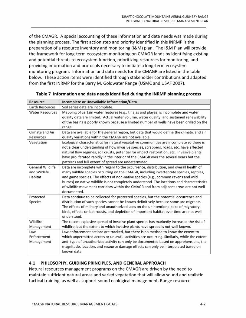
DRAFT CHOCOLATE MOUNTAINS AERIAL GUNNERY RANGE INTEGRATED NATURAL RESOURCE MANAGEMENT PLAN
_______________________________________________________________________________
CMAGR NATURAL RESOURCE MANAGEMENT GOALS 4-2
of the CMAGR. A special accounting of these information and data needs was made during the planning process. The first action step and priority identified in this INRMP is the preparation of a resource inventory and monitoring (I&M) plan. The I&M Plan will provide the framework for long-term ecosystem monitoring on CMAGR lands by identifying existing and potential threats to ecosystem function, prioritizing resources for monitoring, and providing information and protocols necessary to initiate a long-term ecosystem monitoring program. Information and data needs for the CMAGR are listed in the table below. These action items were identified through stakeholder contributions and adapted from the first INRMP for the Barry M. Goldwater Range (USMC and USAF 2007).
Table 7 Information and data needs identified during the INRMP planning process
Resource Incomplete or Unavailable Information/Data
Earth Resources Soil series data are incomplete.
Water Resources Mapping of certain water features (e.g., tinajas and playas) is incomplete and water quality data are limited. Actual water volume, water quality, and sustained renewability of the basins is poorly known because a limited number of wells have been drilled on the range.
Climate and Air Resources
Data are available for the general region, but data that would define the climatic and air quality variations within the CMAGR are not available.
Vegetation Ecological characteristics for natural vegetative communities are incomplete so there is not a clear understanding of how invasive species, scrappers, roads, etc. have affected natural flow regimes, soil crusts, potential for impact restoration, etc. Invasive plants have proliferated rapidly in the interior of the CMAGR over the several years but the patterns and full extent of spread are undetermined.
General Wildlife and Wildlife Habitat
Data are incomplete with regard to the occurrence, distribution, and overall health of many wildlife species occurring on the CMAGR, including invertebrate species, reptiles, and game species. The effects of non-native species (e.g., common ravens and wild burros) on native wildlife is not completely understood. The locations and characteristics of wildlife movement corridors within the CMAGR and from adjacent areas are not well documented.
Protected Species
Data continue to be collected for protected species, but the potential occurrence and distribution of such species cannot be known definitively because some are migrants. The effects of military and unauthorized uses on the unintentional take of migratory birds, effects on bat roosts, and depletion of important habitat over time are not well understood.
Wildfire Management
The recent explosive spread of invasive plant species has markedly increased the risk of wildfire, but the extent to which invasive plants have spread is not well known.
Law Enforcement Management
Law enforcement actions are tracked, but there is no method to know the extent to which unpermitted access or unlawful activities are occurring. Similarly, while the extent and type of unauthorized activity can only be documented based on apprehensions, the magnitude, location, and resource damage effects can only be interpolated based on known data.
4.1 PHILOSOPHY, GUIDING PRINCIPLES, AND GENERAL APPROACH Natural resources management programs on the CMAGR are driven by the need to maintain sufficient natural areas and varied vegetation that will allow sound and realistic tactical training, as well as support sound ecological management. Range resource

DRAFT CHOCOLATE MOUNTAINS AERIAL GUNNERY RANGE INTEGRATED NATURAL RESOURCE MANAGEMENT PLAN
_______________________________________________________________________________
CMAGR NATURAL RESOURCE MANAGEMENT GOALS 4-3
management programs must balance military mission requirements established under Title 10 U.S.C. with federal resource conservation laws, such as the Sikes Act, ESA, and MBTA. CMAGR's natural resources management philosophy is to maintain processes and programs that prevent long-term damage or degradation of the range, allow the range to sustain current and future military training requirements, and achieve the conservation objectives of relevant regulatory requirements. The common foundational elements to CMAGR’s natural resources conservation and management include:
• Meet the military mission of the CMAGR.
• Avoid and minimize adverse effects to federally listed species and other significant natural resources through the implementation of programmatic instructions (published rules and guidelines for land users) and the evaluation of potential impacts of new activities and projects through the NEPA process.
• Native habitat maintenance, restoration, and enhancement through the implementation of the programmatic conservation plans, fire management, exotics species control, erosion control, pollution prevention, etc.
• Inventory, monitor and survey to understand and track the range’s species and habitats, and using this data to evaluate the status, quality, distribution, and trends of those resources and management plans.
• Maintain active and thoughtful compliance with the appropriate natural resources law and regulations, agency guidance, relevant orders and binding regulatory opinions.
• Remain cognizant of regional natural resources initiatives and trends, maintaining involvement in those that relate to CMAGR.
• Remain cognizant of public opinion and interest groups where these intersect with CMAGR’s specific situation, interacting with them when circumstances demand.
• Maintain an active, professional and mutually productive relationship with the regulatory authorities who monitor and advise on CMAGR.
• Evaluate and set long-term management and conservation goals according to the Biological Opinion (BO) and the appropriate recovery plans for the desert tortoise.
• Maintain natural resources management information systems and programmatics to meet the above aims.
• Maintain an array of relationships with Marine Corps Installations Command /West and other DOD organizations in order to share information and experiences and co-ordinate actions on matters of mutual interest.
DRAFT CHOCOLATE MOUNTAINS AERIAL GUNNERY RANGE INTEGRATED NATURAL RESOURCE MANAGEMENT PLAN
_______________________________________________________________________________
CMAGR NATURAL RESOURCE MANAGEMENT GOALS 4-4
Ultimately, the success of the CMAGR's natural resources management is reflected in the long-term sustainability of the range's mission support capability, its species populations and ecosystem functions, and its maintenance of regulatory compliance. Over time, many factors upon which this INRMP is based may change, including military mission requirements, the Federal List of Threatened and Endangered Species, knowledge of the ecology and requirements of listed species and their ecosystem, as well as an understanding of the nature of anthropogenic impacts to those species and their ecosystem. The integration and implementation of the CMAGR’s natural resources management, as outlined in this INRMP, will follow an adaptive management approach that acknowledges uncertainty, monitors the various components of the INRMP, and learns from experience with the end goal of improving future management actions and ecosystem health. Adaptive management can be described as a system for attaining “resilience in the face of surprise” (Lee 1993). Ultimately, the success of this INRMP depends upon the ability to identify changing conditions and adapt management activities to achieve long-term range sustainability. Simply stated, success depends upon adaptation.
4.2 NEPA Support
All proposed projects are subject to the NEPA review process to consider the environmental impacts of the action and to consider reasonable alternatives that would meet the action’s purpose and need. During the review of proposed projects (CATEX, EA, or EIS), Range Management staff will: 1) identify potential effects of the proposed action; 2) identify less damaging alternatives; 3) identify other laws and regulations that may be applicable; 4) ensure that adequate mitigation is planned; 5) assess the level of regulatory interface required; and 6) assess consistency with natural resources management goals, objectives, BOs and conservation programs.
Objective: Provide timely, comprehensive evaluation of impacts of potential projects on range resources.
4.3.2. Federal ESA Compliance The primary legislation regulating actions that may directly or indirectly impact federally listed species is the ESA of 1973, as amended (16 U.S.C. 1531 et seq.). MCAS Yuma regularly consults with the USFWS to ensure that Marine Corps actions are not likely to jeopardize the continued existence of any endangered, threatened or candidate species, and are within compliance with Sections 7 and 9 of the ESA. Pursuant to Section 7 of the ESA, federal agencies must consult with USFWS if their action “may affect” a federally listed endangered or threatened species (50 CFR 402). Such consultations may be formal or informal. When required by Section 7 of the ESA, the installation prepares a Biological Assessment (BA) of the effects of a proposed action on listed species. Section 9 of the ESA prohibits the “take” of a threatened or endangered species. A take includes the direct killing, harming, or harassing of a species, or destruction of habitat that may be important for the species’ survival or recovery.

DRAFT CHOCOLATE MOUNTAINS AERIAL GUNNERY RANGE INTEGRATED NATURAL RESOURCE MANAGEMENT PLAN
_______________________________________________________________________________
CMAGR NATURAL RESOURCE MANAGEMENT GOALS 4-5
Objective I: Special emphasis is provided to manage federally threatened and endangered species and their habitats, to prevent “jeopardy” and to assist in the conservation and recovery of those species.
Objective II: Manage species and habitats in a manner that minimizes impacts to both mission and species, and achieve the species-specific goals established by the ESA and applicable BOs. Listed species management will be adaptive, incorporating knowledge gained over time and accommodating potential changes in natural resources and military training and mission support needs.
Objective III: Proactively collect information on presence or absence, location, habitat availability and suitability, and life history requirements, and offset impacts that do occur.
4.3 BIOLOGICAL RESOURCES INVENTORY AND MONITORING
4.3.1 Threatened or Endangered Species
4.3.1.1 Desert Tortoise - Federally Threatened, State Threatened
The USFWS Desert Tortoise Recovery Office (DTRO) based at the Service's Nevada Fish and Wildlife Office in Reno, Nevada, was established to address population declines and focus on recovery of the Mojave desert tortoise. The establishment of the DTRO is the result of strategies arising from the General Accounting Office's December 2002 audit of recovery actions for the Desert Tortoise and the October 2004 Desert Tortoise Recovery Plan Assessment (USFWS D. T., 2013).
The DTRO focuses exclusively on research, monitoring, recovery plan implementation, and associated recovery permitting, rather than on regulation, and provides a centralized point of contact through which these activities are coordinated. The DTRO strives to facilitate increased scientific understanding and improved recovery progress by increasing research activities outlined in the 2011 Revised Recovery Plan. In addition, the DTRO assists in the coordination between managers and research scientists, and tracking and reporting new information about the efficacy of management actions. The goals of the DRTO include (USFWS D. T., 2013):
• Provide more effective and coordinated research, recovery, and monitoring activities.
• Provide a sound and defensible technical basis for decision-making.
• Assess the short- and long-term benefits of recovery actions.
• Provide information and synthesis in a timely manner and useful format.
• Facilitate communication of progress toward, and maintain an open dialogue

DRAFT CHOCOLATE MOUNTAINS AERIAL GUNNERY RANGE INTEGRATED NATURAL RESOURCE MANAGEMENT PLAN
_______________________________________________________________________________
CMAGR NATURAL RESOURCE MANAGEMENT GOALS 4-6
regarding, desert tortoise recovery goals.
• Provide greater credibility and support for desert tortoise recovery efforts.
Objective I: Continue annual desert tortoise surveys in cooperation with the USFWS’s Desert Tortoise Recovery Office in Reno, NV. The surveys continue to monitor population trends in the designated CMAGR critical habitat within the Chuckwalla Desert Wildlife Management Area (DWMA) in accordance with the requirements of the Biological Opinion (BO# 1-6-95-F-40) issued to MCAS Yuma for training and use of the CMAGR.
The MCAS Yuma has contracted annual desert tortoise surveys with the USFWS which extends through September 2016. The surveys maintain the same level of effort (e.g., 33 transects, associated telemetry to adjust surface counts, as well as data QA/QC), which has been demonstrated in past years to provide an appropriate population estimate. The protocol specifies requirements for trained and permitted desert tortoise handlers and authorized biologist to conduct Line Distance Sampling, a standard methodology used in building statistical models of tortoise population densities by measuring the distance of tortoises from the center of an established line. The USFWS protocol designates the numbers of transects or lines required for each DWMA. The 2007 USFWS protocol requires the surveys must begin the first week in April and must conclude by 31 May. This requirement is secondary to those dates available to non-DoD users for accessing the ranges at CMAGR. Other requirements for the Chuckwalla DWMA applicable to the CMAGR are contained in the protocol.
4.3.1.2 Sonoran Pronghorn (Antilocapra americana sonoriensis) - Proposed Introduction
The Sonoran pronghorn subspecies is recognized by a number of federal, state, and international lists and was one of the first species to gain ESA protection in the United States. The subspecies was listed as endangered throughout its range on 11 March 1967 (32 FR 4001), under the Endangered Species Preservation Act of 15 October 1966. The subspecies was subsequently included on a list of endangered species published in 1967, and the Endangered Species Conservation Act of 1970. When the ESA was signed into law in 1973, the Sonoran pronghorn was placed on the list as an endangered species under section 4(c)(3) of the ESA, the “grandfather clause”. Sonoran pronghorn historically occurred throughout most of southwestern Arizona, northwestern Sonora and portions of southeastern California.
Recovery efforts officially began in 1975 with the first meeting of the Sonoran Antelope Recovery Team. The Sonoran Pronghorn Recovery Plan, dated December 30, 1982 was prepared for the USFWS by the Recovery Team (USFWS, 2013). In summer 2002, the U.S. population of Sonoran pronghorn was almost extirpated due to the most severe drought on record in southern Arizona. In response to the near extirpation of the U.S. population, the USFWS, California Department of Fish and Wildlife (AGFD) and other cooperating

DRAFT CHOCOLATE MOUNTAINS AERIAL GUNNERY RANGE INTEGRATED NATURAL RESOURCE MANAGEMENT PLAN
_______________________________________________________________________________
CMAGR NATURAL RESOURCE MANAGEMENT GOALS 4-7
agency partners began aggressive conservation actions including construction of water developments and forage enhancement plots, supplemental feeding, and a captive breeding program (USFWS, 2013). The captive breeding program was successful and the Sonoran Pronghorn Recovery Team subsequently established a non-essential, experimental population under section 10(j) of the ESA for release of pronghorn from the captive breeding pen into the Kofa National Wildlife Refuge (USFWS, 2013).
With the success of the captive breeding pen, the Sonoran Pronghorn Recovery Team initiated releases into the wild from the captive breeding pen in 2006. As of January 2013, 91 pronghorn have been released. On 4 May 2011 USFWS published a final rule to establish a non-essential, experimental population in historical habitat in the Kofa National Wildlife Refuge and the Barry M. Goldwater Range-East as a nonessential experimental population (76 FR 25593). Nine pronghorn were released onto the Kofa National Wildlife Refuge in January 2013. As of December 2012, wild populations have rebounded to 159 from 29 animals in 2002.
The Recovery Plan is currently under revision. The revised plan sets objective population goals and thresholds for Sonoran pronghorn populations in the U.S. and Mexico; establishes recovery goals and objectives; provides objective, measurable criteria for down-listing and delisting the species; incorporates expanded threats and viability analyses; includes existing, expanded, and new site-specific management and recovery actions, emphasizing habitat management; estimates time and cost required for recovery, identifies partners and parties responsible for implementation of recovery actions; and identifies gaps in the information needed for management and recovery (USFWS, 2013).he 8 March 2012 INRMP kick-off meeting, the Palm Springs USFWS office mentioned the success of the captive breeding program and the possibility of establishing a non-essential, experimental in the Chuckwalla Bench. An analysis of habitat variables (e.g., vegetation composition and landscape) for three sites in Southern California for their suitability for reintroducing Sonoran Pronghorn (USFWS, 2013). The Chuckwalla Bench ranked highest, with suitable amounts of forage, water, and land protection. Blythe Valley ranked second, and Anza Borrego State Park ranked third (USFWS, 2013).
Objective I: Assist in the coordination and provide in-kind and financial support, if available, to the USFWS and Sonoran Pronghorn Recovery Team in their efforts to support the management of a non-essential, experimental population in the Chuckwalla Bench.
4.3.2 Special Status Species
Objective I: Monitor species-of-concern and the likelihood to establish a baseline from which conservation and management strategies can be devised for special status species to avoid future ESA listings by the USFWS. Special status species mentioned in Section 3.7.3 include desert bighorn sheep, American badger, Couch’s spadefoot, golden eagle, Cooper’s hawk, Loggerhead shrike, and burrowing owl.

DRAFT CHOCOLATE MOUNTAINS AERIAL GUNNERY RANGE INTEGRATED NATURAL RESOURCE MANAGEMENT PLAN
_______________________________________________________________________________
CMAGR NATURAL RESOURCE MANAGEMENT GOALS 4-8
There were several species of concern mentioned by agencies participating in the 8 March 2013 INRMP kick-off meeting. CDFW mentioned the potential occurrence of the Couch’s spadefoot. The Couch’s spadefoot occurs along the railroad at the CMAGR’s southwestern boundary. It may eventually be detected on the range, but surveys are problematic, due to the specific meterological conditions that are necessary for successful detection, including, monsoonal rains that leave standing water for breeding pools. USFWS mentioned their concern of the impact of increased energy projects on golden eagle populations. The presence of golden eagles has not been reported on the CMAGR in past BOs, EAs, and EIS. Other species mentioned include burro deer, fringe-toed lizard, burrowing owls, and flat-tailed horned lizard.
4.3.3 Migratory Birds
Objective I: Manage Migratory Bird Treaty Act (MBTA) conservation requirements to minimize conflicts with military mission requirements. Migratory birds reported on the CMAGR include the golden eagle, Vaux’s swift and Swainson’s hawk.
4.3.4 BASH Reduction Program
All the following actions will allow the Air Station to minimize the possibility of harm to birds resulting from its operation. According to Station Order 3750.1B, the Range Director shall:
Maintain required permits for dispersal and depredation programs.
Ensure properly trained personnel are available to conduct bird dispersal activities when required.
Maintain records of dispersal efforts and methods.
Maintain necessary non-lethal equipment and devices required for bird abatement and dispersal.
Advise the Airfield Operations Officer on procedures to abate bird/animal hazards.
Attend the Bird/Aircraft Strike Hazard Working Group quarterly meetings.
In addition, according to Station Order 3750.1B, the Natural Resources Specialist shall:
Provide bird activity analysis to the Airfield Operations Officer and Aviation Safety Officer.
Review all locally generated BASH Reports and attempts to identify all bird remains.
Review low-level routes, training areas, and changes to existing routes/areas for BASH potential.

DRAFT CHOCOLATE MOUNTAINS AERIAL GUNNERY RANGE INTEGRATED NATURAL RESOURCE MANAGEMENT PLAN
_______________________________________________________________________________
CMAGR NATURAL RESOURCE MANAGEMENT GOALS 4-9
Liaison with Arizona Game and Fish Department, U.S .Fish and Wildlife Service, U.S. Department of Agriculture’s Animal and Plant Health Inspection Service, Audubon Society, and other agencies to provide additional information on migratory, local, and seasonal bird activities.
Assist the Aviation Safety Officer with the information and education program.
Send all remains found on MCAS Yuma to the Smithsonian Institute for official review and cataloging.
Attend the BASH Working Group quarterly meetings.
Objective I: Periodically evaluate possible improvements to this successful program that might further reduce BASH incidents.
Objective II: Maintain the existing MBTA depredation permit.
4.3.5 Wildlife Waters
Objective I: Support CDFW installation of five guzzlers on the CMAGR. The Range Management Department will maintain access to the drinkers along the Coachella Canal to allow large mammals to move onto and off the CMAGR to use these drinkers.
4.4 PHYSICAL ENVIRONMENT MAPPING AND ECOSYSTEM MANAGEMENT
The DoD has recognized the value of ecosystem management and has established principles and guidelines for natural resource managers on military installations. Ecosystem management requires a shift from the management of single species or habitats to the management of multiple species and habitats. Regulatory requirements have historically fostered a greater emphasis on a species-by-species management approach. An important component of ecosystem management is adaptive management. Since knowledge of ecological systems and processes is inherently limited (due in part to changing conditions), MCAS Yuma must continuously learn how to manage better. Flexibility and adaptation in the face of uncertainty are critical (Leslie et al. 1996).
Objective I: Implement an ecosystem approach to promote the conservation of native species and habitats, ensure the sustainability and biological diversity of terrestrial and aquatic ecosystems, and facilitate maximum support of the Range's military training mission and infrastructure, while simultaneously ensuring compliance with applicable laws and regulations.
Objective II: Successful ecosystem management strategies require innovative and new approaches to land use decisions and regional involvement. MCAS Yuma will support research efforts to gain the best available scientific information to guide natural resource and conservation decisions in order to successfully implement adaptive management techniques. At the heart of adaptive management is the need to approach all
DRAFT CHOCOLATE MOUNTAINS AERIAL GUNNERY RANGE INTEGRATED NATURAL RESOURCE MANAGEMENT PLAN
_______________________________________________________________________________
CMAGR NATURAL RESOURCE MANAGEMENT GOALS 4-10
management decisions as experiments to be tested (Leslie et al. 1996). Hypothesis testing, assessments of the efficacy of management techniques, and incorporation of knowledge gained over time are key to successful adaptive management.
Objective III: The Installation will work to define and understand its regional relevance and is committed to fulfill its responsibility to regional conservation efforts. This requires the cooperation of and participation with external agencies and forming partnerships necessary to assess and manage ecosystems that extend beyond the boundaries of the CMAGR.
4.4.1 Aerial Orthophotography and Evaluation of Anthropogenic Impacts
The draft Legislative Environmental Impact Statement’s (LEIS) disturbance inventory of the CMAGR found that 99.48 percent of the range surface is used to support the military mission of the range. About 2,571 acres (0.56 percent) of the range that is north of the Bradshaw Trail has no assigned military mission. The levels of surface disturbance associated with military use of the CMAGR ranges from negligible to complete, with approximately 2% to 5% of the CMAGR surface being moderately to completely disturbed by military activities . The roadless area assessment was limited in the draft LEIS to identifying the areas within the CMAGR that are not bisected by roads, target simulations, other earthwork features, core and secondary weapons impact areas, ground support areas, railroads, or canal dikes, which collectively occupy about 5 percent of the range surface.
In 2009 the Air Station contracted an aerial photography and photogrammetry company to collect 1-ft resolution aerial photography (color and infrared), elevation data (2-ft contour maps from LiDAR) and digitized planimetric maps describing authorized and unauthorized road networks on the CMAGR. Human activities, especially vehicle-based activities, can directly impact soils, vegetation, and local hydrology. These disturbances are visible in aerial and high-spatial-resolution satellite imagery and can thus be monitored using repeated imagery acquisitions. With georeferenced imagery in a GIS, surface disturbances such as road widening, new spurs, vegetation damage, and damage to desert pavements can be identified, quantified, and compared from one time period to another.
Objective I: Acquire and develop repeat aerial photographs of the CMAGR to document landscape changes. This effort will allow the Installation to identify well managed areas as well as areas of concern resulting from the creation of new roads, military exercise, and erosion from overland flow.
4.4.2 Multi-scale Soils and Erosion Monitoring
The first component of the planning process is to characterize the CMAGR watershed by summarizing all readily available natural resource information and other relevant data for that watershed. These data are at a broad-based, large watershed scale and include information on Surface runoff, land use and cover, natural resources and wildlife habitat.

DRAFT CHOCOLATE MOUNTAINS AERIAL GUNNERY RANGE INTEGRATED NATURAL RESOURCE MANAGEMENT PLAN
_______________________________________________________________________________
CMAGR NATURAL RESOURCE MANAGEMENT GOALS 4-11
The watershed will be discretized into multiple sub-watersheds to facilitate accurate representation of the changing landscape and channel characteristics will be defined and
documented using watershed modeling techniques. GIS and hydrologic modeling are the major tools used to develop this watershed-based plan. In a GIS, two types of information represent geographic features: locational and descriptive data. Locational (spatial) data are stored using a vector (line) or a raster (grid) data structure. Vector data are object based data models which show spatial features as points, lines, and/or polygons.
Objective I: Establish a soils and erosion monitoring framework to measure and assess changes to soil resources over time (i.e., disturbance to soil, water runoff and flow regime, wind erosion and air quality) on the CMAGR. Protocols emphasize non-intrusive remote sensing methods that are calibrated with ground measurements. Methods are quantitative in nature incorporating spatial-temporal models that document changes to soil resources resulting from both natural causes and human-caused land use changes.
Objective II: Assess current erosion status within the watershed and evaluate possible engineering management practices that will mitigate erosion. To achieve this objective, the Department proposes to 1) develop a GIS-based watershed model; 2) identify sites of severe erosion; 3) implement erosion monitoring devices; 4) evaluate various erosion control measures; and 5) recommend erosion mitigation measures suitable to the sites.
4.4.3 Vegetation mapping
Objective I: To date, the US Geologic Survey GAP map (http://gapanalysis.usgs.gov/gaplandcover/) is the only digitized vegetation map of the CMAGR. This map shows ecosystems, which are broadly defined assemblages such as "Sonoran-Mojave Creosote-White Bursage Desert Scrub." Ecosystems are the appropriate scale for the GAP map, which mapped the entire continental United States. However, for effective land management on the CMAGR, the vegetation map should be at the association level, using the criteria of the Federal Geographic Data Committee, and listed by the National Vegetation Classification System (http://usnvc.org/). For example, within the Sonoran-Mojave Creosote-White Bursage Desert Scrub Ecosystem, the National Vegetation Classification System reports 26 different associations, all of which differ by the species associated with the creosote and white bursage. Some of these species may be critical forage – for example, salt bush (Atriplex) and/or big galleta grass (Pleuraphis rigida).
Also, the GAP analysis (Figure 11) may not have correctly identified the ecosystem types. Hence, a comprehensive vegetation map and GIS database for the CMAGR is needed to effectively manage the vegetation communities on the CMAGR and provide a baseline for ecosystem management. The GIS database will also include a dichotomous key to the vegetation associations. Finally, all plant species new to the Installation shall be delivered to the Installation Representative as a herbarium collection.
Vegetation field sampling and mapping shall follow the protocol established for the MCAS for the BMGR-West (Malusa, 2012), which developed from similar mapping efforts on the

DRAFT CHOCOLATE MOUNTAINS AERIAL GUNNERY RANGE INTEGRATED NATURAL RESOURCE MANAGEMENT PLAN
_______________________________________________________________________________
CMAGR NATURAL RESOURCE MANAGEMENT GOALS 4-12
the BMGR East, Cabeza Prieta National Wildlife Refuge, and Organ Pipe Cactus NM (Malusa 2003, McLaughlin et al., 2007, Osmer et al., 2009, Warren et al., 1981). It is expected that these protocols will be modified by new developments or innovations in desert vegetation field sampling and mapping methodologies. It is also expected that the map shall be similar in detail to those published for Joshua Tree National Park (Keeler-Wolf et al., 2005), and Anza Borrego Desert State Park (Keeler-Wolf et al., 1998). Particular attention will be paid to the habitat needs of species such as desert tortoise, so far as known.
4.4.4 Invasive Species
Objective I: Acquire reliable baseline data on the presence and abundance of invasive nonnative species is a priority in the development of a comprehensive invasive plant monitoring program. This is necessary to accomplish two goals:
1. Identify which exotic species are not yet present at CMAGR but may require early detection monitoring.
2. Map the location, abundance, distribution of established nonnative species (trend assessment), and develop a control plan.
3. Work in partnership with BLM for control wild burro populations.
4.4.5 Soil mapping
The Sikes Act and MCO P5090.2A dictates the implementation of best management practices to control and prevent excessive soil erosion, implement soil conservation measures, and restore or rehabilitate degraded landscapes wherever practicable, subject to budgetary constraints. A soil map is an essential element in environmental and natural resource monitoring. Soil information is a critical resource for developing comprehensive environmental and natural resource monitoring and determining best management practices. The CMAGR’s existing soil information (Figure 8) is inadequate to effectively manage range resources. This effort will directly address this need and provide field-assessed high spatial resolution soil information for the CMAGR at a map scale of 1:24,000 with a 15-30 m raster pixel resolution. The proposed work will couple field based soil sampling with digital soil mapping (DSM) techniques developed specifically for southern Arizona ecosystems.
Objective I: Quantitatively map soil physical, chemical, biological properties and soil taxonomic distribution for the CMAGR using a combination of DSM techniques, field sampling, soil characterization and soil spatial modeling. Additionally, these data may be used to derive maps of soil hydraulic properties and surface soil erosion risk.
Objective II: Project deliverables include: (i) deriving high spatial resolution maps of surface soil physical, chemical, biological and taxonomic properties; (i) attributed soil map units with summary statistics of soil property and taxonomic variability for each map unit;

DRAFT CHOCOLATE MOUNTAINS AERIAL GUNNERY RANGE INTEGRATED NATURAL RESOURCE MANAGEMENT PLAN
_______________________________________________________________________________
CMAGR NATURAL RESOURCE MANAGEMENT GOALS 4-13
and (iii) production of a geodatabase with all relevant data inputs, classes, field data, and soil variable maps for distribution to CMAGR resource managers.
4.5 CULTURAL RESOURCES
MCO P5090.2A dictates installations consult with Federally Recognized Indian Tribes with interests that may be affected by INRMP preparation or revision. The installation will comply with the consultation procedures found in Chapter 8. The focus of this INRMP is conservation, inventorying and monitoring. If however, any projects occur as a result of guidance from this INRMP that are determined to be undertakings under Section 106d of NHPA, formal consultation will be initiated on a case by case basis. Tribes will have opportunities to review and comment on the INRMP.
4.6 INFORMATION MANAGEMENT
The Marine Corps Air Station (MCAS) Yuma Installation Geospatial Information & Services (IGI&S) mission is to create, analyze, manage, and distribute authoritative standardized geospatial information, products, and services to support military readiness and quality of life with emphasis on improving the productivity of tenant organizations and activities aboard Marine Corps Air Station Yuma in accordance with MCO 11000.25. The aim of the IGI&S Office is to support the war fighter, improve installation management, eliminate excess facilities, drive-down support costs, increase use of recycled materials, save energy, conduct proactive community relations, and protect the environment in supporting the military mission by providing tenant organizations and activities the ability to leverage easily accessible, accurate, reliable, and complete datasets.
Over the next five years, the MCAS Yuma IGI&S program will continue to develop and implement methods and standards to improve the quality of MCAS Yuma geospatial data. This will include the development of a standard work flow for the creation of geospatial data. MCAS Yuma will also develop feature class topology standards, as well as create and maintain topology for existing data. Continued development of feature and feature class level metadata to ensure accurate record keeping of spatial data will also be a priority.
IGI&S will continue to develop the asset management business line by validating existing feature classes and ensuring all Real Property data is geospatially correct. IGI&S will work towards ensuring all MCAS Yuma Class 1 and Class 2 properties are accurately represented and maintained in GIS. To aid in the management of installation small assets, such as equipment, the development of installation building floor plans in GIS are essential.
Objective I: The Yuma Range Management Department will focus on continual development of cultural and natural resource data, with an emphasis on cultural and soil surveys. YRMD will begin the development of standard cartographic products for Range’s three main disciplines. MCAS Yuma will possess an official Military Installation Map (MIM). Maintenance to the MIM data layers will continue to be a Range priority.

DRAFT CHOCOLATE MOUNTAINS AERIAL GUNNERY RANGE INTEGRATED NATURAL RESOURCE MANAGEMENT PLAN
_______________________________________________________________________________
CMAGR NATURAL RESOURCE MANAGEMENT GOALS 4-14
4.7 COOPERATIVE INITIATIVES
Objective I: Cooperate with other MCAS Yuma departments (i.e., Environmental, I&L, and Planning) neighboring installations, and agencies on natural resource management issues of mutual interest. Species aboard the CMAGR will benefit from collaboration and contact as the better information that should result for all parties should give rise to more sophisticated and useful management strategies.
Objective II: Establish and maintain the Air Station’s regular contact and highly productive cooperation with regulators. In order to manage its remaining natural resources and achieve both compliance and stewardship, the Air Station looks to its regulators as sources of specialist advice, best practice and assessment. The better and the richer this contact and cooperation is, the higher the potential benefits for the natural resources aboard the CMAGR. This approach has proven very beneficial for the Air Station.
4.8 RECREATION
Public access to the Chocolate Mountain Range is not permitted. As a result, there can be no recreation or other use of the resources of the Range. Although public safety and the protection of military missions are the principal reasons why activities are not permitted in the Range, public use is also restricted in the regions surrounding the Range. In addition, there are no designated wilderness or wildlife areas within the Range.
4.9 LAW ENFORCEMENT AND CONTROL OF PUBLIC ACCESS
The Military Police (MP) will patrol the range for trespassing. If the MP or anyone else observe or suspect violation of Natural or Cultural Resource laws they will be referred to the CLEOs and or State Enforcement agency as appropriate.
DRAFT CHOCOLATE MOUNTAINS AERIAL GUNNERY RANGE INTEGRATED NATURAL RESOURCE MANAGEMENT PLAN
_______________________________________________________________________________
PLANNED PROJECTS AND IMPLEMENTATION SCHEDULE 5-15
5. PLANNED PROJECTS AND IMPLEMENTATION SCHEDULE
The Marine Corps in partnership with USFWS, CDFW, BLM, and the University of Arizona have developed a list of actions planned during the next five years to initiate implementation of the INRMP. The table lists the action items, proposed schedule, frequency, priority, and partners likely to be involved. The priority rankings are high, medium, and low. The list will be reviewed annually to evaluate progress completed and to adapt the list, when appropriate to address emerging issues, changing priorities, available funding, or other issues.

DRAFT CHOCOLATE MOUNTAINS AERIAL GUNNERY RANGE INTEGRATED NATURAL RESOURCE MANAGEMENT PLAN
_______________________________________________________________________________
PLANNED PROJECTS AND IMPLEMENTATION SCHEDULE 5-16
Table 8 CMAGR 5-Year Action Plan: 2013-2017
Action Step Fiscal Year Priority Frequency Comments
Natural Resources
Develop and Adopt an Inventory and Monitoring Plan Years 1, 2 1 One-time
Anthropogenic Impact Study Years 1, 2 1 Re-occurring
Aerial imagery for range and base Years 1, 2 1 One-time
Erosion Study
Years 1, 2 1 Continuous
Comprehensive erosion assessment to prioritize the sites with severe erosion, and examine available engineering management practice that can mitigate erosion
Vegetation Map
Years 1-5 1 One-time
May be possible to complete in less than 5 years, but access limited by range restrictions. Also, roadless areas up to 149,000 acres. Also, veg maps won’t be done until at least year 3 when aerial imagery is completed.
Identify and monitor vegetation plots in several plant communities Years 4 & 5 3 Varies
Invasive species control
TBD 2 Varies
Initiate Action Plan with characterizing and prioritizing the threat, then modeling top 10 species threats, i.e., Sahara mustard) and on-going and potential invasion throughout the range
Soil Map Years 3,4, and 5
2 One-time USGS initially, then other TBD
Installation and maintenance of weather stations and rain gauges TBD 2 One-time
Operate 10 existing remote-access stations, including several dozen rain gauges at specific study locations
Develop and implement fire management plan
TBD 2 One-time Assess fire risk and implement restrictions as appropriate
Information Management (GIS) Annual 1 Continuous
Desert Tortoise Surveys Annual 1 Annual
Participate and implement actions per the Sonoran Pronghorn Recovery Annual 3 Annual
Pronghorn recovery actions as stipulated in the Biological Opinion, recovery plan, or as determined by the interagency

DRAFT CHOCOLATE MOUNTAINS AERIAL GUNNERY RANGE INTEGRATED NATURAL RESOURCE MANAGEMENT PLAN
_______________________________________________________________________________
PLANNED PROJECTS AND IMPLEMENTATION SCHEDULE 5-17
Action Step Fiscal Year Priority Frequency Comments
Plan Recovery Team
Reptile, small mammal, and amphibian surveys and monitoring Years 3, 4, &
5 2 One-time
Inventory distribution and abundance of reptiles, amphibians, and small mammals; 2)develop monitoring protocols for reptiles and amphibians
General bird surveys Years 3, 4, & 5
2 Annual Survey 3 consecutive years, pause 5 to 10 years, repeat.
Bat surveys Years 3, 4, & 5
2 Annual Assist CFDW in conducting bat surveys
Law Enforcement
Hire Additional Range Wardens TBD TBD TBD
Public outreach Annual 2 Annual
Supports public awareness projects to educate base personnel / public about CMAGR cultural resources, natural resources, historical preservation, and conservation activities.
Compile apprehension and illegal entry statistics. Analyze patterns, identify heavily used areas. Monitor those areas to identify any resource concerns
Annual 3 Annual
Continuation of informal coordination w/ law enforcement authorities and anecdotal evidence of border-related impacts
Cooperate with BLM, Reclamation, renewable energy projects, and utility companies regarding proposed actions within existing utility/ transportation corridors
Ongoing 3 As required
Continuation of dialogue and partnership with proponent and supporting action agencies
Participate in local and regional planning and monitoring land use patterns
As required 3 As required Participate in development or review of environmental assessments or impact statements, resource management plans
Install signs, gates, and fences to support road infrastructure and safe and proper public access
As-required 1 Reoccurs as
needed
Install and maintain signage at range entry points, along perimeters, and at all road intersections.

DRAFT CHOCOLATE MOUNTAINS AERIAL GUNNERY RANGE INTEGRATED NATURAL RESOURCE MANAGEMENT PLAN
_______________________________________________________________________________
REFERENCES 6-1
6. REFERENCES
AECOM. 2011. Integrated Cultural Resources Management Plan for the Chocolate Mountain Aerial Gunnery Range, California. Prepared for MCAS Yuma.
Adams R.A. 2003. Bats of the Rocky Mountain West: Natural History, Ecology, and Conservation. University Press of Colorado, Boulder, Colorado, 289 pp.
Alles, D.L. 2007. Geology of the Salton Trough. Western Washington University.
Amsberry K. and R.J. Meinke. 2007. Status evaluation of Astragalus tricarinatus (triple-ribbed milkvetch). Native Plant Conservation Program, Oregon Department of Agriculture for California Department of Fish and Game, 22 pp.
Bechtel/SAIC Company, LLC. 2004. Technical Basis Document No. 1: Climate and Infiltration, Revision 1. Prepared for U.S. Department of Energy, Office of Civilian Radioactive Waste Management, Las Vegas, Nevada.
Bleich, V.C., J.D. Wehausen, and S.A. Holl. 1990. Desert-dwelling mountain sheep: conservation implications of a naturally fragmented distribution. Conservation Biology 4, no. 4: 383-90.
Boarman, W.I. 2002. Threats to desert tortoise populations: A critical review of the literature. U.S. Geological Survey, Western Ecological Research Center, Sacramento, California.
Brennan, T.C., and A.T. Holycross. 2006. A Field Guide to Amphibians and Reptiles in Arizona. Arizona Game and Fish Department.
Brooks, M.L., and Berry, K.H., 2006, Dominance and environmental correlates of alien annual plants in the Mojave Desert, USA: Journal of Arid Environments, v. 67, (Supplement 1), p. 100–124.
Brooks, M.L., and Lair, B.M., 2009, Ecological effects of vehicular routes in a desert ecosystem, in Webb, R.H., Fenstermaker, L., Heaton, J., Hughson, D., McDonald, E., and Miller, D., eds., The Mojave Desert; ecosystem processes and sustainability: Reno, University of Nevada Press, 168–195 p.
Brooks, M.L., D’Antonio, C.M., Richardson, D.M., Grace, J., Keeley, J.J., DiTomaso, J., Hobbs, R., Pellant, M., and Pyke, D., 2004, Effects of invasive alien plants on fire regimes: Bioscience, v. 54, 677–688 p.
Brown, David E. (ed.). 1994. Biotic Communities: Southwestern United States and Northwestern Mexico. University of Utah Press, Salt Lake City, Utah, 344 pp.

DRAFT CHOCOLATE MOUNTAINS AERIAL GUNNERY RANGE INTEGRATED NATURAL RESOURCE MANAGEMENT PLAN
_______________________________________________________________________________
REFERENCES 6-2
California Air Resources Board (CARB). 2011. iADAM Air Quality Data Statistics. Accessed in July 2011at http://www.arb.ca.gov/adam/.
. 2010. “Ambient Air Quality Standards” (table). Accessed 8 September 2010 at http://www.arb.ca.gov/research/aaqs/aaqs2.pdf.
California Department of Fish and Game (CDFG). 2011. Life History Accounts and Range Maps - California Wildlife Habitat Relationships System. Accessed August 2011at http://www.dfg.ca.gov/biogeodata/cwhr/cawildlife.aspx.
California Department of Parks and Recreation. 2010. Draft Land and Water Conservation Fund Program. Accessed on 5 January 2012 at http://parks.ca.gov/pages/1008/files/lwcf_admin_guide_draft_2010.pdf.
California Department of Water Resources (CDWR). 2003. California’s Groundwater. Bulletin 118 Updated 2003. October. 246 pp.
California Energy Commission (CEC). 2010. “Renewable Energy Transmission Initiative.” Accessed on 29 August 2011 at http://www.energy.ca.gov/reti/.
California Native Plant Society (CNPS). 2011. “Inventory of Rare and Endangered Plants” (online edition, v8-01a). Accessed on 30 August 2011.
California Natural Diversity Database (CNDDB). 2011. RareFind 4. September 4.California Regional Water Quality Control Board. 2006. Region 7 Water Quality Control Plan for the Colorado River Basin. June. 106 pp.
CDM Federal Programs Corp. 2003. Final Resource Conservation and Recovery Act, Part B Permit Application, 2003 Update for Marine Corps Air Station Yuma, Munitions Treatment Range, Barry M. Goldwater Range, Arizona.
Central Pacific Railroad Photographic History Museum. 2012. Seventy-Five Years of Progress. An Historical Sketch of the “Southern Pacific” 1869-1944. Accessed on 22 December 2010 at http://cprr.org/Museum/SP_1869-1944/index.html.
Circle Mountain Biological Consultants, Inc. 2013. Focused Survey and Habitat Assessment for Agassiz’s Desert Tortoise on Special Warfare Training Area Ranges 4 and 5 of Chocolate Mountain Aerial Gunnery Range in Riverside and Imperial Counties, California. Prepared for: Marine Corps Air Station Yuma, Yuma, Arizona; Southwest Division Naval Facilities Engineering Command, San Diego California.
Cleland, J. and T. Wahoff. 2006. Regional Archaeological Research Design for Chocolate Mountain Aerial Gunnery Range, Imperial and Riverside Counties, California. Contributions by R. McCorkle Apple, C. Gregory, J. Underwood, and A. York.

DRAFT CHOCOLATE MOUNTAINS AERIAL GUNNERY RANGE INTEGRATED NATURAL RESOURCE MANAGEMENT PLAN
_______________________________________________________________________________
REFERENCES 6-3
Prepared for Naval Facilities Engineering Command, Southwest and U.S. Marine Corps Air Station, Yuma.
Cleland, J.H., D. Earle, and T. Wahoff. 2010. Cultural Affiliation Study for the Chocolate Mountain Aerial Gunnery Range. Prepared for Marine Corps Air Station Yuma. Contract N68711-05-C-2026.
Dames and Moore. 1995. Biological assessment for the desert tortoise for the military use of the Chocolate Mountain Aerial Gunnery Range, California. Prepared for: Marine Corps Air Station Yuma, Yuma, Arizona; Southwest Division Naval Facilities Engineering Command, San Diego California, 38 pp.
Dillon, J.T. 1975. Geology of the Chocolate and Cargo Muchacho Mountains, Southeasternmost California. PhD Dissertation University of California Santa Barbara. September. 405 pp.
Eiders, W.A. 1979a. “Historical Preface: Man and nature on the Colorado Delta.” In Eiders, W.A., editor, Geology and Geothermics of the Salton Trough, prepared for the Geological Society of America 92nd Annual Meeting, San Diego, California. University of California, Riverside Campus Museum Contribution. November 1979. Number 5: v-viii.
Eiders, W.A. 1979b. “The Geological Background of the Geothermal Fields of the Salton Trough.” In Eiders, W.A., editor, Geology and Geothermics of the Salton Trough prepared for the Geological Society of America 92nd Annual Meeting, San Diego, California. University of California, Riverside Campus Museum Contribution. November 1979. Number 5: 119.
Federal Register. (2010b). USFWS proposal to reestablish the Sonoran pronghorn under Section 10(j) of the Endangered Species Act, and to reclassify the reestablished population as a nonessential experimental population (NEP). Vol. 75, No. 23. February 4: http://www.gpo.gov/fdsys/pkg/FR-2010-02-04/pdf/2010-2230.pdf#page=1.
Headquarters, U.S. Marine Corps [HQMC]. 2004. Handbook for preparing, revising and implementing Integrated Natural Resources Management Plans on Marine Corps installations .Facilities & Services Division, Headquarters, U.S. Marine Corps,Washington, D.C. http://www.marines.mil/News/Publications/ELECTRONICLIBRARY/ElectronicLibraryDisplay/tabid/13082/Article/125782/headquarters-us-marine-corps-handbook-for-preparing-revising-and-implementing-i.aspx

DRAFT CHOCOLATE MOUNTAINS AERIAL GUNNERY RANGE INTEGRATED NATURAL RESOURCE MANAGEMENT PLAN
_______________________________________________________________________________
REFERENCES 6-4
----------. 1998. Marine Corps Order P5090.2A (Environmental Compliance and Protection Manual). Office of the Acting Deputy Chief of Staff for Installations and Logistics, Department of the Navy, Headquarters U.S. Marine Corps, Washington, D.C.
Imperial County. 2007. “Imperial County General Plan, Land Use Map: Land Use Element. Imperial County Planning Department. Accessed on 18 August, 2011 at http://www.icpds.com/.
. 1993. Imperial County General Plan, Land Use Element. Planning & Development Services Department, Imperial County. 1993. Accessed on 18 August, 2011 at http://www.icpds.com/.
Imperial Irrigation District (IID). 2011. Solar Project. Imperial Irrigation District. 2011. Accessed on 28 September, 2011 at http://www.iid.com/index.aspx?page=447.
. No Date. IID Water History Timeline. Accessed at http://www.iid.com/Modules/ShowDocument.aspx?documentid=9.
Keeler-Wolf, T., S. San, and D. Hickson. 2005. Vegetation Classification of Joshua Tree National Park, Riverside and San Bernardino Counties, California. A report submitted by California Fish and Game, Wildlife and Habitat Data Analysis Branch, to National Park Service, Tasha LaDaux, Chief of Resources, Joshua Tree National Park, 74485 National Park Drive, Twentynine Palms, California 92277-3597.
Keeler-Wolf, T., K. Lewis, and C. Roye. 1998. Vegetation Mapping of Anza-Borrego Desert State Park and Environs. A report submitted by California Fish and Game, Natural Heritage Division, to the California Department of Parks and Recreation.
Krzysik, A.J. 1998. Desert tortoise populations in the Mojave Desert and a half-century of military training activities. Pages 61-73 in J. Van Abbema (ed.), Proceedings of the International Conference on Conservation, Restoration, and Management of Tortoises and Turtles. New York Turtle and Tortoise Society, New York.
Lesicka, Leon. 1990. Personal communication with Bob McKernan, cited in Final Environmental Impact Statement for the Yuma Training Range Complex, (DoD 1997).
Malusa, J. 2003. Vegetation of the Cabeza Prieta National Wildlife Refuge: Vegetation Classification for the Endangered Sonoran Pronghorn. Report for Organ Pipe Cactus National Monument, National Park Service. NPS Cooperative Agreement CA1248.00.002, Task Agreement UA2-71. Available at: http://sdrsnet.srnr.arizona.edu.
Malusa, J. 2012. Vegetation Mapping at the Barry M. Goldwater Range, Marine Corps Air Station, Arizona. Phase 3: Copper Mountains, Baker Peaks, Wellton Hills, and

DRAFT CHOCOLATE MOUNTAINS AERIAL GUNNERY RANGE INTEGRATED NATURAL RESOURCE MANAGEMENT PLAN
_______________________________________________________________________________
REFERENCES 6-5
Northern Lechuguilla Valley. Annual report submitted to MCAS, Yuma, in compliance with Cooperative Agreement DACA87-05-H-0018, Modification P00012.
McLaughlin, S., S. Marsh, and S. Drake. 2007. Vegetation Mapping of Sonoran Pronghorn Habitat on the Air Force Portion of the Barry M. Goldwater Range, Arizona. A Project of the Desert Southwest Cooperative Ecosystem Studies Unit. Office of Arid Lands Studies, University of Arizona.
Nature Serve. 2011. Nature Serve Explorer: An online encyclopedia of life [web application]. Version 7.1. Nature Serve, Arlington, Virginia. Accessed on 15 August 2011 at http://www.Nature Serve.org/explorer.
New Gold. 2011. New Gold Project Description. 2009. Accessed on 6 September 2011 at http://www.newgold.com/.
Norris, R.M. and R.W. Webb. 1990. Geology of California. Second Edition. New York. John Wiley and Sons. 541 pp.
Nussear, K.E., T.C. Esque, R.D. Inman, Leila Gass, K.A. Thomas, C.S.A. Wallace, J.B. Blainey, D.M. Miller, and R.H. Webb. 2009. “Modeling habitat of the desert tortoise (Gopherus agassizii) in the Mojave and parts of the Sonoran Deserts of California, Nevada, Utah, and Arizona: U.S. Geological Survey Open-File Report 2009-1102,” p. 18
Osmer, E., J. Fehmi, and P. Guertin. 2009. Vegetation mapping of Sonoran Desert Communities on the Barry M. Goldwater Range – East (BMGR-East), Arizona. Report submitted to the 56 RMO/ESM, United States Air Force. Cooperative Agreement DACA 87-05-H-0018, Task Agreement No. 1
Parker, Patricia L. and Thomas F. King. 1998. Guidelines for Evaluating and Documenting Traditional Cultural Properties. National Register Bulletin 38. Revised 1992; 1998. U.S. Department of the Interior, National Park Service: Washington, D.C. Accessed 23 August 2011 at http://www.nps.gov/nr/publications/bulletins/nrb38/.
Riverside County (RC). 2011. Draft Riverside County General Plan, update, Land Use Section. 2011 Riverside County Planning Department. Available by request from Riverside County Planning Department.
. 2008. Riverside County General Plan, updated, Land Use Section. Riverside County Planning Department. October, 2008. Accessed on 1 September 2011 at http://www.tlma.co.riverside.ca.us/planning/).
Sanitation Districts of Los Angeles County. 2007. Mesquite Valley Landfill, project overview. Accessed on 4 January 2012 at http://www.mrlf.org/.
DRAFT CHOCOLATE MOUNTAINS AERIAL GUNNERY RANGE INTEGRATED NATURAL RESOURCE MANAGEMENT PLAN
_______________________________________________________________________________
REFERENCES 6-6
Schaefer, Jerry. 1994. “The Challenge of Archaeological Research in the Colorado Desert: Recent Approaches and Discoveries.” Journal of California and Great Basin Anthropology 16 (1): 60-80.
Schaefer, Jerry, Sinead Ni Ghabhlain, and Mark Becker. 2003. A Class III Cultural Resource Inventory, and Evaluation for the Coachella Canal, Lining Project: Prehistoric and Historic, Sites Along the Northeastern Shore of, Ancient Lake Chauilla [sic], Imperial and Riverside Counties, California. EIC Report Number RI-06999. Confidential report on-file at the Eastern Information Center, available only to qualified persons.
Schaefer, J. and D. Laylander. 2007. “The Colorado Desert: Ancient Adaptations to Wetlands and Wastelands.” In California Prehistory: Colonization, Culture and Complexity, edited by T.L. Jones and K. Klar, Alta Mira Press: Lanham, Maryland.
Schwartz, O.A., V.C. Bleich, and S.A. Holl. 1986. “Genetics and the conservation of mountain sheep Ovis canadensis nelsoni.” Biological Conservation 37: 179-90.
Setmire, Jim, editor. 2000. Eutrophic Conditions at the Salton Sea, A topical paper from the Eutrophication Workshop convened at the University of California at Riverside, September 7-8. Downloaded on 22 December 2010 from: http://www.saltonsea.ca.gov/pdfs/limnology/000907Setmire.pdf.
Stein, B.A., C. Scott, and N. Benton. 2008. Federal lands and endangered species: the role of military and other federal lands in sustaining biodiversity. BioScience 58:339-347.
Southwest Environmental Information Network (SEINet). 2011. Accessed August 2011 at http//:swbiodiversity.org/seinet/index.php.
Stebbins, Robert C. 2003. A Field Guide to Western Reptiles and Amphibians. 3rd Edition. Houghton Mifflin Company, 533 pp.
Southern California Association of Governments (SCAG). 2008. Regional Comprehensive Plan. The Southern California Association of Governments. October, 2008. Accessed on 1 September 2011 at http://www.scag.ca.gov/rcp/index.htm.
U.S. Department of Agriculture, Natural Resources Conservation Service. 2011. U.S. General Soil Map, State Soil Geographic (STATSGO2) Database. United States Department of Agriculture. Accessed on 1 November 2011 at http://soildatamart.nrcs.usda.gov.
U.S. Department of Defense, United States Marine Corps (USMC). 2009b. United States Marine Corps Cultural Resources Program Guide. First Edition (January 2009). Accessed on 2 August 2011 at http://www.marines.mil/unit/logistics/Documents/LFL/LFL-1/CulturalResources/Outreach/2009%20USMC%20Cultural%20Resources%20Program%20Guide.pdf.
DRAFT CHOCOLATE MOUNTAINS AERIAL GUNNERY RANGE INTEGRATED NATURAL RESOURCE MANAGEMENT PLAN
_______________________________________________________________________________
REFERENCES 6-7
. 2007. Integrated Natural Resources Management Plan for Barry M. Goldwater Range, Yuma, Pima, and Maricopa Counties, Arizona. Prepared by Departments of the Air Force and Navy in cooperation with Department of the Interior and Arizona Game and Fish Department
. 2007. MCO 11000.25, Installation Geospatial Information and Services. 26 March.
. 2007. Guidance to Implement the Memorandum of Understanding to Promote the Conservation of Migratory Birds. Office of the Deputy Under Secretary of Defense (Environmental Security), Washington, D.C.
. 2005. Supplemental Guidance for Implementation of the Sikes Act Improvement Act. Available: www.denix.osd.mil/denix/Public/Library/NCR/updated_sikes.html.
. 2004. Supplemental Guidance for Implementation of the Sikes Act Improvement Act. Available: www.denix.osd.mil/denix/Public/Library/NCR/updated_sikes.html.
. 2002. Updated Guidance on Implementation of the Sikes Act Improvement Act. Available: www.denix.osd.mil/denix/Public/Library/NCR/updated_sikes.html.
. 2011. DoD Instruction 4715.03 (Natural Resources Conservation Program). Office of the Deputy Under Secretary of Defense (Environmental Security), Washington, D.C. 18 March.
. 1997. Yuma Training Range Complex Final Environmental Impact Statement. Prepared by Dames & Moore. January.
. 1996. DoD Instruction 4715.3 (Environmental Conservation Program). Office of the Deputy Under Secretary of Defense (Environmental Security), Washington, D.C. 3 May.
. 1994. Memorandum: Implementation of ecosystem management in the DoD. Office of the Under Secretary of Defense. August 8, 1994. Washington, D.C.
U.S. Department of the Interior, Bureau of Land Management (BLM), 2012. Palm Springs-South Coast Field Office. Accessed in January 2012 at http://www.blm.gov/ca/st/en/fo/palmsprings.html.
. 2011. Chuckwalla-Palen Mountains Wilderness Area. Accessed on 4 January 2012 at http://www.blm.gov/ca/st/en/fo/palmsprings/chuckwalla_palen.html.
. 2011. Special Recreation Permits. Accessed on 4 January 2012 at http://www.blm.gov/ca/st/en/prog/recreation/recpermit.html.

DRAFT CHOCOLATE MOUNTAINS AERIAL GUNNERY RANGE INTEGRATED NATURAL RESOURCE MANAGEMENT PLAN
_______________________________________________________________________________
REFERENCES 6-8
. 2012. Final EIS: West Chocolate Mountains Renewable Energy Evaluation Area (REEA). U.S. Department of the Interior Bureau of Land Management, El Centro Field Office. December 2012. Accessed on 15 July 2013 at www.blm.gov/ca/st/en/fo/elcentro/nepa/wcm.html.
. 2011b. California Renewable Energy Projects and Utility Corridors. U.S. Department of the Interior Bureau of Land Management, Desert District, California. September, 2011. Accessed on 26 August 2011 at http://www.blm.gov/pgdata/etc/medialib/blm/ca/pdf/pa/energy/application_maps.Par.30605.File.dat/CDD_Application_Map.pdf.
. 2011c. Recreation. October 2011. Accessed 23 September 2011 at http://www.blm.gov/ca/st/en/fo/elcentro/recreation.html.
. 2011d. Draft Environment Impact Statement and California Desert Conservation Area Plan Amendment for the West Chocolate Mountains Renewable Energy Evaluation Area. Accessed at http://www.blm.gov/ca/st/en/fo/elcentro/nepa/wcm.html.
. 2011e. Wind Energy. Accessed on 26 January 2012 at http://www.blm.gov/ca/st/en/prog/energy/wind.html.
. 2011f. Solar Energy. Accessed on 26 January 2012 at http://www.blm.gov/ca/st/en/prog/energy/solar.html.
. 2009. Environmental Assessment for Eight Wildlife Guzzlers for the CMAGR. California Desert District, El Centro Field Office, 31 pp.
. 2008. Paleontology Resources Management Manual and Handbook H-8270-1, 38 p.
. 2005. California Statewide Interagency Implementation Agreement, Federal Land Transaction Facilitation Act Public Law 106-248. November. U.S. Forest Service, Pacific Southwest Region, U.S. Fish and Wildlife Service, California/Nevada Operations Office, National Park Service, Pacific West Region. Accessed 26 August 2011 and 4 January 2012 at http://www.blm.gov/pgdata/etc/medialib//blm/ca/pdf/pdfs/pa_pdfs/row_lands.Par.a8a9b4fd.File.pdf/FLTFA_Agreement_CA.pdf.
. 2002a. Northern and Eastern Colorado Desert Coordinated Management Plan (NECO). Bureau of Land Management Desert District, California. December 2002, and Final Environmental Impact Statement, July 2002. California Department of Fish and Game. Accessed on 26 August 2011 at http://www.blm.gov/ca/st/en/fo/elcentro/weco.html.

DRAFT CHOCOLATE MOUNTAINS AERIAL GUNNERY RANGE INTEGRATED NATURAL RESOURCE MANAGEMENT PLAN
_______________________________________________________________________________
REFERENCES 6-9
. 2002b. Western Colorado (WECO) OHV Routes of Travel Designation Plan. Bureau of Land Management Desert District, Riverside, California October 2002. Accessed 26 August 2011 at http://www.blm.gov/ca/st/en/fo/elcentro/weco.html.
. 2002c. Coachella Valley Multiple Species Habitat Conservation Plan (CVMSHCP). Bureau of Land Management, Desert District, California. December 2002. Accessed 25 September 2011 at http://www.blm.gov/ca/st/en/fo/palmsprings/coachella_valley.html.
. 2000. Federal Land Transaction Facilitation Act (FLTFA). 25 July 2000. Public Law 106-248, -114 STAT. 613. Accessed on 26 August 2011 at http://www.blm.gov/pgdata/etc/medialib/blm/ut/lands_and_minerals/lands/fltfa.Par.46964.File.dat/Act.pdf.
.1980. California Desert Conservation Area Plan (CDCA), as Amended. U.S. Department of the Interior Bureau of Land Management Desert District, Riverside, California. Accessed on 26 August 2011 at http://www.blm.gov/pgdata/etc/medialib/blm/ca/pdf/cdd/cdcaplan.Par.15259.File.dat/CA_Desert_.pdf .
. 1976. The Federal Land Policy and Management Act, as amended (FLPMA). U.S. Department of the Interior, Bureau of Land Management Office of Public Affairs, Washington, D.C. 69 pp.
U.S. Department of the Navy (DoN). 2011. Preliminary Site Assessment, Chocolate Mountains Aerial Gunnery Range Proposed Boundary Realignment, 40 Miles (64 kilometers) Northwest of Yuma, AZ, Riverside and Imperial Counties, California. Prepared by URS for NAVFAC Southwest and the U.S. Marine Corps. 21 December.
. 2010a. Commander, Navy Installations Command (CNIC), Navy Bird/Animal Aircraft Strike Hazard (BASH) Program Implementing Guidance and the BASH Manual addendum.
. 2010b. Final Environmental Impact Statement for the West Coast Basing of the F-35B. October. Accessed on 1 August 2011 at http://www.usmcjsfwest.com/.
. 2010c. Record of Decision for the U.S. Marine Corps West Coast Basing of the F-35B Aircraft. Dated 9 December. Published in the Federal Register: December 15, 2010 (Volume 75, Number 240).
. 2009a. Final Environmental Impact Statement for the West Coast Basing of the MV-22. Prepared for NAVFAC Southwest, San Diego, CA. October.
. 2003. Proposed Plan/Draft Remedial Action Plan for Chocolate Mountain Aerial Gunnery Range, Installation Restoration Program Sites 1, 4, 5, 7, and 8. July.

DRAFT CHOCOLATE MOUNTAINS AERIAL GUNNERY RANGE INTEGRATED NATURAL RESOURCE MANAGEMENT PLAN
_______________________________________________________________________________
REFERENCES 6-10
. 2000. Operational Risk Management (OPNAV INSTRUCTION 3500.39A and MARINE CORPS ORDER 3500.27A). 26 September.
U.S. Department of Transportation, Federal Highway Administration (FHWA). 2010. National Scenic Byways Program, Official Designations, Bradshaw Trail. Accessed at http://www.byways.org/explore/byways/2172/designation.html.
U.S. Department of Transportation, Federal Transit Administration (FTA). 2006. Transit Noise & Vibration Impact Assessment, FTA-VA-90-1003-06, May.
U.S. Environmental Protection Agency (EPA). 2011. Level III and IV Ecoregions of the Conterminous United States. Updated December 2011. U.S. Environmental Protection Agency, Western Ecology Division. Corvallis, Oregon. Available at: http://www.epa.gov/wed/pages/ecoregions/level_iii_iv.htm.
. 2010. Primary Distinguishing Characteristics of Level III Ecoregions of the Continental United States. Accessed on 6 June 2010 at http://www.epa.gov/wed/pages/ecoregions.htm.
. 2010. Letter from Karen Vitulano, Environmental Review Office Region IX, to Kelly Finn, DoN Naval Facilities Engineering Command Southwest Region, regarding Scoping Comments for the Renewal of the Chocolate Mountain Aerial Gunnery Range Land Withdrawal, Imperial and Riverside Counties, California. 22 December.
. 1998. Final Guidance for Incorporating Environmental Justice Concerns in EPA’s NEPA Compliance Analyses.
U.S. Fish and Wildlife Service (USFWS). 2013. Desert Tortoise Recovery Office. Accessed on 8 March 2013 at http://www.fws.gov/nevada/desert_tortoise/dtro/dtro_recovery_plan.html
. 2011. Revised recovery plan for the Mojave population of the desert tortoise (Gopherus agassizii). Pacific Southwest Region, Sacramento, California. 222 pp.
. 2004. National Wetlands Inventory. Database. Accessed at http://www.fws.gov/wetlands/data/.
. 2001. Species abstract for the American peregrine falcon. Arizona Ecological Services Office, Phoenix, 1 page.
. 1996. Biological Opinion for the Military Use of the Chocolate Mountain Aerial Gunnery Range, California (1-6-95-F-40).
. 1994a. Desert Tortoise (Mojave Population) Recovery Plan. U.S. Fish and Wildlife Service, Portland, Oregon.
DRAFT CHOCOLATE MOUNTAINS AERIAL GUNNERY RANGE INTEGRATED NATURAL RESOURCE MANAGEMENT PLAN
_______________________________________________________________________________
REFERENCES 6-11
. 1994b. Determination of Critical Habitat for the Mojave Population of the Desert Tortoise. Federal Register Vol. 59, No. 26, pages 5820- 5866.
. 1990. Endangered and threatened wildlife and plants; determination of threatened status for the Mojave population of the desert tortoise. Federal Register 55:12178-12191.
U.S. Geological Survey. 2010a. Geothermal Favorability Map Derived From Logistic Regression Models of the Western United States. GIS Shapefiles and Geodatabases. Accessed at http://certmapper.cr.usgs.gov/data/geothermal/western_us/spatial/shape/favorabilitysurface.zip.
. 2010b. Salton Seismic-Imaging Project (SSIP). A Survey to Evaluate Earthquake Hazards and Structure of the Earth's Crust in Imperial and Coachella Valleys. 4 May 2010.
. 2008a. Assessment of Moderate- and High-Temperature Geothermal Resources of the United States. U. S. Geological Survey Fact Sheet 2008-3082. 4 pp.
. 2008b. Earthquakes Hazards Program/Quaternary Fault and Fold Database.
Villarreal, Miguel L., et al. (2011). Villarreal, M.L., van Riper, C III, Lovich, R.E., Palmer, R.L., Nauman, T., Studd, S.E., Drake, S., Rosenberg, A.S. An Inventory and Monitoring Plan for a Sonoran Desert Ecosystem: Barry M. Goldwater Range-West. Open-File Report 2011-1232. U.S. Department of the Interior and U.S. Geological Society.
Warren, P.L., B. K. Mortenson, B.D. Treadwell, J.E. Bowers, and K.L. Reichhardt. 1981. Vegetation of Organ Pipe Cactus National Monument. Tech. Rep. No. 8. Cooperative National Park Resources Studies Unit, 125 Biological Sciences East. University of Arizona, Tucson, AZ 85721.
Weide, M.L. 1976. “A Cultural Sequence for the Yuha Desert.” In Background to Prehistory of the Yuha Desert Region, edited by P.J. Wilke. pp. 81–94. Ballena Press: Ramona, California.
Western Regional Climate Center (WRCC). 2011. “Period of Record Monthly Climate Summary, Eagle Mountain, California (042598), Period of Record: 9/ 1/1933 to 12/31/2010.” Accessed in August 2011 at http://www.wrcc.dri.edu/cgi-bin/cliMAIN.pl?ca2598.