draft management plan 2014 - Parks and Wildlife Service
82
Kalbarri National Park ‘nature’s window’ draft management plan 2014
Transcript of draft management plan 2014 - Parks and Wildlife Service

Kalbarri National Park‘nature’s window’
draft management plan
2014
Department of Parks and Wildlife Locked Bag 104 Bentley Delivery Centre WA 6983 Phone: (08) 9219 9000 Fax: (08) 9334 0498
www.dpaw.wa.gov.au
© State of Western Australia 2014 April 2014
This work is copyright. You may download, display, print and reproduce this material in unaltered form (retaining this notice) for your personal, non-commercial use or use within your organisation. Apart from any use as permitted under the Copyright Act 1968, all other rights are reserved. Requests and enquiries concerning reproduction and rights should be addressed to the Department of Parks and Wildlife.
ISBN 978-1-921703-47-8 (print) ISBN 978-1-921703-48-5 (online)
This draft management plan was prepared by the Conservation Commission of Western Australia through the agency of the Department of Parks and Wildlife.
Questions regarding the use of this material should be directed to:
Planning Branch Department of Parks and Wildlife 17 Dick Perry Avenue, Kensington WA 6151 Locked Bag 104 Bentley Delivery Centre WA 6983
Phone: (08) 9219 9000 Email: [email protected]
The recommended reference for this publication is:
Department of Parks and Wildlife 2014, Kalbarri National Park draft management plan 2014, Department of Parks and Wildlife, Perth.
This document is available in alternative formats on request.
Please note: URLs in this document which conclude a sentence are followed by a full point. If copying the URL please do not include the full point.
Front cover photos
Main Natures Window at The Loop. Photo – Melissa Mazzella (DPaW) Top left Red kangaroo. Photo – Rory Chapple (DPaW) Top right Coastal cliffs. Photo – Rory Chapple (DPaW) Header photo Caption - View of The Loop from Natures Window. Photo – Clare Atkins (DPaW)

draft management plan
2014
Kalbarri National Park‘nature’s window’
Conservation Commission of Western Australia Department of Parks and Wildlife

Page ii
Kalbarri National Park draft management plan
Acknowledgments
Planning team
This draft management plan was prepared by a Department of Parks and Wildlife planning team consisting of Melissa Mazzella, Clare Atkins, David Rose, Sue Hancock, Mike Paxman, Anthony Desmond and Rory Chapple.
The planning team would like to thank the many other department staff who contributed to the preparation of, and commented on, the management plan, particularly Michelle Rumball, Laurina Bullen, Penny Wood, Ian Herford, Dave Atkins and Nigel Sercombe.
Figure 1 was prepared by Burke Stephens and the maps by Aaron Rivers and Sam Hamill.
Aboriginal people
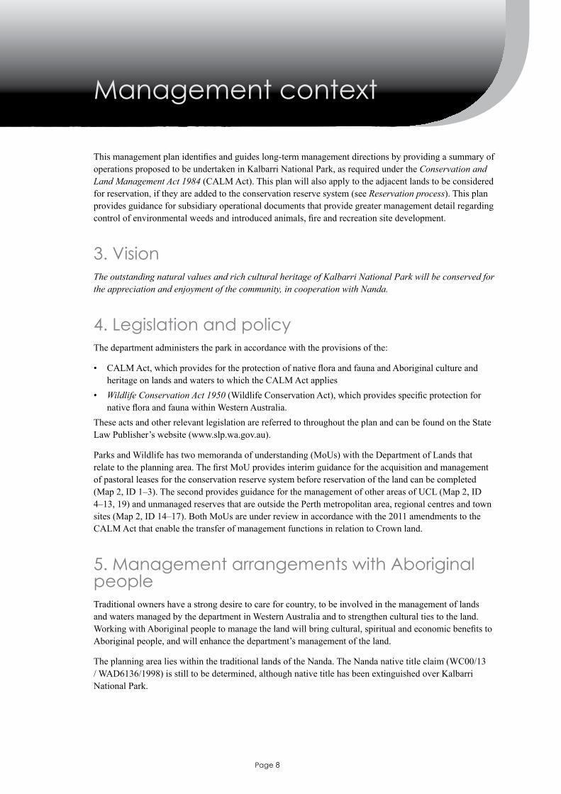
Thank you to the members of the Yamatji Marlpa Aboriginal Corporation and Nanda who contributed to the preparation of this plan.

Page iii
Kalbarri National Park draft management plan
Invitation to commentThe Kalbarri National Park draft management plan is an opportunity to provide information, express your opinion, suggest alternatives and have your say on how the planning area will be managed during the next 10 years.
Make your comments count
What to consider
In making your submission, it is important to understand that legislation and policy impose certain obligations on the Department of Parks and Wildlife (the department) to manage lands and waters vested in the Conservation Commission of Western Australia (the Conservation Commission) and that there may be little room to manage some issues outside of these constraints and responsibilities. Nevertheless, it is important to hear from the public about the management of these issues. There are also some issues that may have a number of management options over the life of the plan, or issues for which the department has developed a proposal and wants to gauge public opinion about management.
Issues that the Conservation Commission and the department would particularly like to seek feedback on during the public comment period of this draft management plan include:
• key performance indicators mentioned through various sections of the plan• managementactionsidentifiedforsectionsofinteresttoyou• the addition of adjacent land to the conservation reserve system• knowledge gaps• valuesnotidentified.
How to make effective commentsIt is important to indicate those strategies and recommendations you agree with as well as those with which you disagree. Each submission is important, but those that give reasons for concerns, give support where appropriate, and offer information and constructive suggestions are most useful.
If you prefer not to write your own submission, you could make a joint submission with others. To ensure your submission is as effective as possible:
• make it clear and concise• list your points according to the subject sections and page numbers in the plan• describebrieflyeachsubjectorissueyouwishtodiscuss• say whether you agree or disagree with any or all of the aims or strategies within each subject or just
thoseofspecificinteresttoyou.Clearlystateyourreasons(particularlyifyoudisagree)andprovidesupporting information where possible
• suggest alternatives to deal with issues with which you disagree.

Page iv
Kalbarri National Park draft management plan
Where to send your commentsSubmissions are welcome for two months after the release of the draft management plan. An electronic copy of the plan and a submission form can be found online at: www.dpaw.wa.gov.au/parks/management-plans/draft-plans-open-for-public-comment or by writing to:
Planning Coordinator Kalbarri National Park draft management plan Department of Parks and Wildlife Locked Bag 104 Bentley Delivery Centre BENTLEY WA 6983
How your comments will be consideredAll submissions will be summarised according to topics discussed. The management plan will then be reviewed in the light of submissions, according to established criteria (see below). A summary of the submissionswillbepreparedalongwiththefinalmanagementplan.
The draft management plan will be amended if a submission:
a) provides additional information of direct relevance to managementb) provides additional information on affected user groups of direct relevance to managementc) indicatesachangein(orclarifies)governmentlegislation,managementcommitmentor
management policyd) proposes strategies that would better achieve management objectivese) indicates omissions, inaccuracies or a lack of clarity.
The draft management plan will not be amended if a submission:
a) clearly supports proposals in the planb) makes general statements and no change is soughtc) makes statements already in the plan or which were considered during the plan preparationd) addresses issues beyond the scope of the plane) is one among several widely divergent viewpoints received on the topic but the actions in the
plan are still considered the preferred optionf) contributesoptionsthatarenotfeasible(generallybecauseofconflictwithexistinglegislation,
government policy, lack of resource capacity or lack of research knowledge to make decisions)g) is based on unclear/factually incorrect informationh) provides details that are not appropriate or necessary for inclusion in a document aimed at
providing management direction over the long term.All submissions are treated as public documents, unless the submitter clearly indicates to the contrary by markingallorpartofthesubmissionas‘confidential’.Itisimportanttonotethatconfidencecannotbeguaranteed under the Freedom of Information Act 1992.

Page v
Kalbarri National Park draft management plan
Contents
Acknowledgments ................................................................................................................................... ii
Invitation to comment ............................................................................................................................ iii
Summary ...................................................................................................................................................1
Introduction ..............................................................................................................................................4
1. Management plan area overview .......................................................................................................42. Key values and threats .......................................................................................................................5
Management context ................................................................................................................................8
3. Vision .................................................................................................................................................84. Legislation and policy .......................................................................................................................85. Management arrangements with Aboriginal people ..........................................................................86. Administration ...................................................................................................................................97. Term of the plan .................................................................................................................................98. Assessing performance ....................................................................................................................109. Consideration of adjacent lands ......................................................................................................1010. Neighbouring land use ...................................................................................................................11
Managing cultural heritage ...................................................................................................................13
Managing visitor use ..............................................................................................................................16
11. Visitor access .................................................................................................................................1912. Visitor activities .............................................................................................................................2113. Commercial operations and tourism ..............................................................................................28
Involving the community .......................................................................................................................29
14. Community involvement and support ...........................................................................................29Managing the natural environment ......................................................................................................31
15. Climate ..........................................................................................................................................3116. Geology, landforms and soils ........................................................................................................3117. Hydrology ......................................................................................................................................3418. Native plants and plant communities ............................................................................................3619. Native animals and habitats ...........................................................................................................3920. Environmental weeds ....................................................................................................................4321. Introduced and other problem animals ..........................................................................................4422. Fire .................................................................................................................................................47
Managing resource use ..........................................................................................................................52
23. Mineral and petroleum operations .................................................................................................5224. Beekeeping ....................................................................................................................................5325. Water resource use .........................................................................................................................5326. Utilities and services .....................................................................................................................54
Research and monitoring ......................................................................................................................56
27. Research requirements ..................................................................................................................56References ...............................................................................................................................................58

Page vi
Kalbarri National Park draft management plan
Maps ........................................................................................................................................................62
Map 1. Planning area ...........................................................................................................................62Map 2. Existing and proposed tenure ..................................................................................................63Map 3. Recreation sites ......................................................................................................................64
Appendices ..............................................................................................................................................65
Appendix 1. Consideration of adjacent lands – further detail ..................................................................................65

Page 1
Summary
Kalbarri National Park, created in 1963, is situated on the lower reaches of the Murchison River, about a six and a half hour drive north of Perth, and is the hinterland for the coastal tourist town of Kalbarri. NestledinWesternAustralia’sCoralCoast,thepark’sspectacularwildflowers,majesticMurchisonGorge,coastal landscapes and vast rolling sandplains provide a stunning setting for visitors to enjoy and engage inawiderangeofrecreationalactivities.Thepark’sAboriginalculturallandscapeandthefascinatinghistory of 17th century European exploration and more recent pastoral station life provide a wealth of storiesthatenhancevisitor’sappreciationandexperiences.
The Kalbarri National Park draft management plan has been prepared to address present management issues and plan for future needs, ensuring the values are conserved in the long term. It does this by providing a summary of policies and guidelines and the operations proposed to be undertaken in the park over the next 10 years. This plan also provides guidance for subsidiary operational documents that provide morespecificmanagementdirectionregardingcontrolofenvironmentalweedsandintroducedanimals,fireandrecreationsitedevelopment.
Throughout the plan, desired outcomes, management actions and key performance indicators are used to highlight management priorities, with a focus on:
• managing cultural heritage• managing visitor use• involving the community• managing the natural environment• managing resource use• research and monitoring.
TheseareusedbytheConservationCommissiontoassessthedepartment’simplementationoftheplan.
LandsidentifiedfortheirsignificantconservationvaluesadjacenttoKalbarriNationalParkareincludedwithin the scope of this plan.
Managing cultural heritage
The park is located within the traditional lands of the Nanda and has many Aboriginal heritage sites including artefacts, mythological places, paintings, a quarry, and midden sites. Ethnographic and archaeological surveys have been conducted over a relatively small portion of Kalbarri National Park and itisthereforehighlyunlikelythatallsiteshavebeenofficiallyrecorded.Thedepartmentwillcontinuetowork with Nanda in protecting Aboriginal heritage sites and values within Kalbarri National Park.
Management arrangements with Aboriginal people may change over the life of this management plan. Jointmanagementmaybeidentifiedasapriority,and,ifresourcesandcapacityallow,ajointmanagementagreement under the Conservation and Land Management Act 1984 (CALM Act) may be considered. Joint management arrangements will require the amendment or review of this management plan. While formal joint management is explored, the department will continue to work to foster cooperative and consultative management arrangements with Nanda.
There is also a range of sites associated with historic development between Perth and Carnarvon. These include stock routes, telegraph lines, the State Barrier Fence and sites associated with early European exploration.
Page 2
Kalbarri National Park draft management plan
The focus of managing cultural heritage in this management plan is to minimise any adverse effects of management activities on Aboriginal and other cultural and heritage values.
Managing visitor use
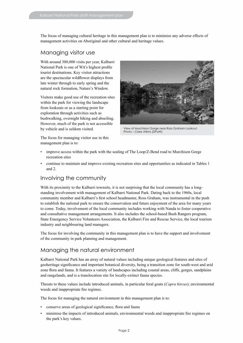
With around 300,000 visits per year, Kalbarri NationalParkisoneofWA’shighestprofiletourist destinations. Key visitor attractions arethespectacularwildflowerdisplaysfromlate winter through to early spring and the naturalrockformation,Nature’sWindow.
Visitors make good use of the recreation sites within the park for viewing the landscape from lookouts or as a starting point for exploration through activities such as bushwalking, overnight hiking and abseiling. However, much of the park is not accessible by vehicle and is seldom visited.
The focus for managing visitor use in this management plan is to:
• improve access within the park with the sealing of The Loop/Z-Bend road to Murchison Gorge recreation sites
• continue to maintain and improve existing recreation sites and opportunities as indicated in Tables 1 and 2.
Involving the community
With its proximity to the Kalbarri townsite, it is not surprising that the local community has a long-standing involvement with management of Kalbarri National Park. Dating back to the 1960s, local communitymemberandKalbarri’sfirstschoolheadmaster,RossGraham,wasinstrumentalinthepushto establish the national park to ensure the conservation and future enjoyment of the area for many years to come. Today, involvement of the local community includes working with Nanda to foster cooperative and consultative management arrangements. It also includes the school-based Bush Rangers program, State Emergency Service Volunteers Association, the Kalbarri Fire and Rescue Service, the local tourism industry and neighbouring land managers.
The focus for involving the community in this management plan is to have the support and involvement of the community in park planning and management.
Managing the natural environment
Kalbarri National Park has an array of natural values including unique geological features and sites of geoheritagesignificanceandimportantbotanicaldiversity,beingatransitionzoneforsouth-westandaridzonefloraandfauna.Itfeaturesavarietyoflandscapesincludingcoastalareas,cliffs,gorges,sandplainsand rangelands, and is a translocation site for locally-extinct fauna species.
Threats to these values include introduced animals, in particular feral goats (Capra hircus); environmental weedsandinappropriatefireregimes.
The focus for managing the natural environment in this management plan is to:
• conserveareasofgeologicalsignificance,floraandfauna• minimisetheimpactsofintroducedanimals,environmentalweedsandinappropriatefireregimeson
thepark’skeyvalues.
View of Murchison Gorge near Ross Graham Lookout. Photo – Clare Atkins (DPaW)

Page 3
Kalbarri National Park draft management plan
Managing resource use
Thisplanidentifiesthemanagementofmining,beekeepingandwaterextractionandotherutilities.
Thefocusformanagingresourceuseistominimisetheimpactsoftheseactivitiesonthepark’skeyvalues.
Research and monitoring
Management of Kalbarri National Park should be based on up-to-date and sound knowledge. Ongoing researchandmonitoringwillassistintheconservationofthepark’skeyvalues.Itwillalsoaidinevaluating the effectiveness of management actions in protecting these values. Priority for research and monitoring include areas where:
• the quality of base data is the poorest• understanding of the effect of management actions is poorest• there have been unanticipated changes in factors affecting the park, such as access or adjacent land
uses• the rates of resource or social change are the highest.
The focus for research and monitoring in this management plan is to increase the knowledge and understanding of key values and management issues.
Adjacent lands of conservation significance
LandsadjacenttoKalbarriNationalPark(seeMap1)hasbeenidentifiedashavingconservationsignificanceandthisplanproposestheirconsiderationforinclusionintheconservationreservesystemand management under the CALM Act. Their reservation will be considered after discussion with relevant stakeholders and is likely to involve the negotiation of an Indigenous land-use agreement (ILUA). An ILUA may include provisions for a joint management agreement; the conduct of customary activities;improvedaccessformanagementandrecreation;protectingNanda’scultureandheritageanddevelopment of interpretive material and tourism and other commercial or employment opportunities. If these lands are added to the conservation reserve system, this plan will also apply to those areas or the plan will be amended to apply to them.

Page 4
Introduction
1. Management plan area overviewThis draft management plan has been prepared by the department on behalf of the Conservation Commission. The plan covers Kalbarri National Park1 (183,004ha) and considers adjacent lands for addition to the conservation reserve system, comprising about 239,778ha (see maps 1 and 2 and Consideration of adjacent lands). These areas are collectively referred to as the planning area (422,782 ha).
Theplanningareaislocatedabout160kmnorthofGeraldtononWesternAustralia’scentralcoast,withinthe local government areas of the Shire of Northampton and the Shire of Shark Bay.
It is situated at the northern limit of the internationally recognised south-west biodiversity hotspot and sits within the Geraldton to Shark Bay Sand Plains national biodiversity hotspot. The planning area is located within the traditional lands of the Nanda (see Managing cultural heritage).
Kalbarri National Park is located on the lower reaches of the Murchison River, which has cut an 80km-long red and white-banded gorge through the rocks underlying the sandplain, as it makes its way to the Indian Ocean (see Map 1). The varied features of the park provide visitors with an array of things to see and do. These features include the Murchison Gorge, a coastal landscape, a vast rolling sandplain, and fossils, as well as the cultural history of Aboriginal Dreamtime, 17th century European exploration and more recent pastoral station life.
The town site of Kalbarri is located at the mouth of the Murchison River and is surrounded by Kalbarri National Park to the south and east (see Map 1). The town site provides goods and services to a growing touristtrade(themaineconomiccontributorforthetown),thelocalfishingindustryandsurroundingagricultural and pastoral activities. With new residential subdivisions, and promotion of Kalbarri as a holiday destination, it is expected that residential and tourist numbers will grow in the long term (see Managing visitor use).
1 Reserve 27004, Class ‘A’, vested in the Conservation Commission with the purpose of national park.
The declared rare flora species, Caladenia bryceana subsp. cracens. Photo – Gemma Phelan (DPaW)
Release of tammar wallaby to establish new populations in the park. Photo – DPaW

Page 5
Kalbarri National Park draft management plan
Some areas adjacent to Kalbarri National Park, characterised by their natural values, areidentifiedinthismanagementplanforinclusion in the conservation reserve system. These areas comprise unallocated Crown land (UCL) including former pastoral leases acquired for conservation, unmanaged reserves, and a reserve vested in the Shire of Northampton. Most of these areas straddle the North West Coastal Highway and adjoin Toolonga Nature Reserve and Eurardy Station to the east and Zuytdorp Nature Reserve and Murchison House Station to the west (see Map 2 and Consideration of adjacent lands). Knowledge and understanding of the values, threats and management issues associated with these areas, particularly those to the north and east of the park, is more limited than that of the national park. Strategies in this plan aim to close knowledge gaps and integrate the management of the park and the adjacent lands to be considered for addition to the conservation reserve system.
This management plan has been prepared to address present management issues and plan for future needs, ensuring the values are conserved in the long term.
2. Key values and threats
Key values
Cultural
The key cultural values of Kalbarri National Park are:
• alonghistoryofNanda’suseoftheareaandmanyAboriginalheritagesitesincludingartefacts,mythological places, paintings, a quarry, and midden sites
• permanentriverpoolsoftheMurchisonRiverwhicharesignificanttoNandacultureandhistory,highlighted by the concentration of cultural sites along the river
• a range of sites associated with historic development between Perth and Carnarvon (for example stock routes, telegraph lines, the State Barrier Fence and sites associated with 17th century European exploration).
Recreation and tourism
The key recreation and tourism values of Kalbarri National Park are:
• spectacular and varied landscapes that provide opportunities for a diverse range of nature-based and geotourismexperiencesincludinghiking;natureappreciation(forexample,wildflowers;coastalandgorgescenery);fishing;canoeing;adventuretourism(forexample,abseiling);andcommercialtourism operations
• beingoneoftheState’stourismicons(around300,000visitsperyear),underpinningthelocalarea’stourism-dependent economy.
Eagle Gorge. Photo – Terese Dimascia (DPaW)
Page 6
Kalbarri National Park draft management plan
Community
The key community values of Kalbarri National Park are:
• a strong inter-relationship between the Kalbarri community and Kalbarri National Park, with a long history of extensive community involvement in nature conservation and visitor service activities andexperiences.Thisdatesbacktothepark’svestingin1963,whichwasinstigatedbycommunityinterest.
• an opportunity for the provision of adventure activities, with the area being used by schools and special-interest recreational groups
• a successful partnership with Kalbarri District High School, through Parks and Wildlife and the DepartmentforCommunities’BushRangersWAprogram
• cooperative arrangements with emergency groups such as the Western Australian Police, Kalbarri VolunteerBushfireService,localgovernmentvolunteerbushfirebrigades,StateEmergencyServiceVolunteers Association, Department of Fire and Emergency Services (DFES) and St John Ambulance
• protection of part of the Kalbarri Water Reserve Public Drinking Water Source Area• opportunities for education about and interpretation of natural and cultural values• a study site for tertiary and other educational institutions.
Natural
The key natural values associated with Kalbarri National Park are:
• uniquegeologicalfeaturesandsitesofgeoheritagesignificance,includingtheTumblagoodaSandstone, the Murchison Gorge and fossils
• botanicalsignificancewiththethird-highestnumberofplantspeciesrecordedinaWesternAustralianpark after Fitzgerald River and Lesueur national parks, and many species at the northern limit of their distribution
• populationsofthreatenedflora,especiallyalongtheMurchisonGorge• a variety of landscapes including coastal areas, cliffs, gorges, sandplains and rangelands• atransitionzoneforsouth-westandaridzonespeciesoffloraandfauna• a large diversity of reptiles, with 75 species in total. The sandplain is a particularly important reptile
habitat• a translocation site for the locally extinct chuditch (Dasyurus geoffroii), woylie (Bettongia penicillata)
and tammar wallaby (Macropus eugenii subsp. derbianus), and the potential to re-introduce other species formerly known in Kalbarri National Park
• an area free of Phytophthora cinnamomi, which provides a refuge for plant species affected by Phytophthora in the north of the South West Botanical Province
• permanent river pools of the Murchison River and the only river in the south-west land division with noknownintroducedfishspecies
• anarealocatedontheboundaryoftwosignificantbiogeographicregions,whichcontributestoacomprehensive, adequate and representative system of protected areas.
Economic
The key economic values of Kalbarri National Park are:
• the main attraction for tourists to Kalbarri, who visit the park to appreciate its natural, cultural and recreationalvalues.Tourismisthebiggestcontributortothetown’seconomy,resultinginKalbarribeing one of the highest earners of tourism revenue of all towns along the Coral Coast (Cervantes to Exmouth). Many local businesses have a tourism focus, with some operating in Kalbarri National Park
• the potential to develop new opportunities in the park (for example, meeting the demand for Aboriginal tourism experiences), which could see greater economic development in the town of Kalbarri, as a result of visitors staying longer.

Page 7
Kalbarri National Park draft management plan
Threats
The main threats to the key values of Kalbarri National Park are:
• damage to natural values by introduced animals, in particular goats (Capra hircus), as well as pigs (Sus scrofa), foxes (Vulpes vulpes), cats (Felis catus) and rabbits (Oryctolagus cuniculus)
• damage to important cultural and heritage sites by weeds, introduced animals, visitor and management activities,fireandmining
• impacts from upstream activities in the Murchison River Catchment (for example, the potential introductionoffishandweeds,salinity,siltationandwaterextraction)
• threattolifeandcommunityassetsfrombushfire• inappropriatefireregimeswhichmayalterspeciescompositionandthreatenfaunahabitats• changing climate, resulting in declining rainfall and higher temperatures, which may impact on
speciescompositionandincreasethefrequency,scaleandintensityofbushfires• environmental impacts from inappropriate and/or poorly managed recreation facilities and activities• a lack of infrastructure to support sustainable recreation and tourism use.
Page 8
Management context
Thismanagementplanidentifiesandguideslong-termmanagementdirectionsbyprovidingasummaryofoperations proposed to be undertaken in Kalbarri National Park, as required under the Conservation and Land Management Act 1984 (CALM Act). This plan will also apply to the adjacent lands to be considered for reservation, if they are added to the conservation reserve system (see Reservation process). This plan provides guidance for subsidiary operational documents that provide greater management detail regarding controlofenvironmentalweedsandintroducedanimals,fireandrecreationsitedevelopment.
3. VisionThe outstanding natural values and rich cultural heritage of Kalbarri National Park will be conserved for the appreciation and enjoyment of the community, in cooperation with Nanda.
4. Legislation and policyThe department administers the park in accordance with the provisions of the:
• CALMAct,whichprovidesfortheprotectionofnativefloraandfaunaandAboriginalcultureandheritage on lands and waters to which the CALM Act applies
• Wildlife Conservation Act 1950 (WildlifeConservationAct),whichprovidesspecificprotectionfornativefloraandfaunawithinWesternAustralia.
These acts and other relevant legislation are referred to throughout the plan and can be found on the State LawPublisher’swebsite(www.slp.wa.gov.au).
Parks and Wildlife has two memoranda of understanding (MoUs) with the Department of Lands that relatetotheplanningarea.ThefirstMoUprovidesinterimguidancefortheacquisitionandmanagementof pastoral leases for the conservation reserve system before reservation of the land can be completed (Map 2, ID 1–3). The second provides guidance for the management of other areas of UCL (Map 2, ID 4–13, 19) and unmanaged reserves that are outside the Perth metropolitan area, regional centres and town sites (Map 2, ID 14–17). Both MoUs are under review in accordance with the 2011 amendments to the CALM Act that enable the transfer of management functions in relation to Crown land.
5. Management arrangements with Aboriginal peopleTraditional owners have a strong desire to care for country, to be involved in the management of lands and waters managed by the department in Western Australia and to strengthen cultural ties to the land. WorkingwithAboriginalpeopletomanagethelandwillbringcultural,spiritualandeconomicbenefitstoAboriginalpeople,andwillenhancethedepartment’smanagementoftheland.
The planning area lies within the traditional lands of the Nanda. The Nanda native title claim (WC00/13 / WAD6136/1998) is still to be determined, although native title has been extinguished over Kalbarri National Park.
Page 9
Kalbarri National Park draft management plan
An Indigenous land-use agreement (ILUA)2 between Nanda and the department may be considered to enable the management of lands in the planning area for which native title has not been extinguished. An ILUA may include provisions for a joint management agreement; the conduct of customary activities; improvedaccessformanagementandrecreation;protectingNanda’scultureandheritage;developmentofinterpretive material; and tourism and other commercial or employment opportunities.
Management arrangements with Aboriginal people may change over the life of this management plan. Ifjointmanagementisidentifiedas a priority and resources and capacity allow, a joint management agreement under the CALM Act may be considered. Joint management arrangements will require the amendment or review of this management plan. In the meantime, the department will continue to work to foster cooperative and consultative management arrangements with Nanda.
Desired outcome
• Nanda are involved in the management of land in the planning area.
Management actions
1. Determine the level of interest in and feasibility of pursuing an ILUA and joint management arrangements with Nanda for the planning area.
2. Work with Nanda to promote their participation in commercial activities, employment and training opportunities.
3. Ensure consultation with Nanda for activities that may impact on cultural and heritage values.
6. AdministrationTheday-to-dayimplementationofthefinalmanagementplanwillbetheresponsibilityofthedepartment’sGeraldtonDistrict,withintheMidwestRegion.TheGeraldtonDistrictcoordinatestheoperational management of Kalbarri National Park and, where applicable, the adjacent lands considered for reservation. Operational management is also supported by staff from the Midwest Region and the department’sspecialistbranches.
As it is not feasible to simultaneously implement all management actions, the progressive implementation of this plan will be guided by priorities and resource availability.
7. Term of the planThismanagementplanwillguidethedepartment’smanagementoftheplanningareaforaperiodof10years from the date that a notice is published in the Government Gazette. During this time, amendments to thefinalmanagementplanareallowedundersection61oftheCALMAct.Ifanamendmentisnecessary,
2 An ILUA is a voluntary agreement about the use and management of lands and/or waters between a native title group and any other people, organisations or government agencies. It can be negotiated at any time and it is not necessary to have a determination by the Federal Court about the existence of native title. Once finalised, an ILUA can be registered with the National Native Title Tribunal, binding all parties.
Consultation with Nanda prior to park development. Photo – Rory Chapple (DPaW)

Page 10
Kalbarri National Park draft management plan
the proposed changes will be released for public comment. At the end of the 10-year period, the management plan may be reviewed and a new management plan prepared. In the event that the plan is not reviewed and replaced by the end of the 10 year period, it will remain as the primary guiding document for the area.
8. Assessing performanceThe Conservation Commission will measure the success of this plan in accordance with section 19(1)(g)(iii) of the CALM Act by using key performance indicators and other mechanisms as appropriate. A set of key performance indicators have been chosen to highlight performance targets for key components of the plan.Theseindicatorsareidentifiedthroughouttheplanandarepresentedwithaperformancemeasure,target and reporting requirements.
The department is required to implement this plan and provide information to the Conservation Commission to enable an assessment of its implementation.
9. Consideration of adjacent landsLands adjacent to Kalbarri National Parkhavebeenidentifiedashavingconservationsignificanceandthisplan proposes they are considered for inclusion in the conservation reserve system and managed under the CALM Act. These lands will make a contribution towards a conservation reserve system that is comprehensive, adequate and representative (CAR) and their reservation will provide protection of cultural and heritage values. Their reservation will be considered after discussion with relevant stakeholders and is likely to involve
the negotiation of an ILUA (see Reservation process and Management arrangements with Aboriginal people). Reservation will assist in meeting obligations under the International Convention on Biological Diversity3 and Australia’s strategy for the national reserve system 2009–2030 (National Reserve System Task Group 2009). The benchmark reservation level for CAR reserve systems is that at least 15 per cent of each bioregion and any subregions within it should be managed as part of the conservation reserve system (see Appendix 1 – Consideration of adjacent lands – further detail) (CALM 2003).
Reservation process
Anyproposalsforadditionstotheconservationreservesystem,orchangesintheclassificationofexistingreserves or the category of land, will be subject to government consideration and determination. Native titleisstilltobedeterminedovertheadjacentlandsconsideredforreservation.Inordertohavean‘affect’onnativetitle,thereservationprocessneedstocomplywiththe‘futureact’provisionsoftheNative Title Act 1993 (Cth) (Native Title Act). Reserve creation is likely to involve the negotiation of an ILUA (see Management arrangements with Aboriginal people).
3 (Rio Convention) at the United Nations Conference on Environment and Development (also known as the ‘Rio Earth Summit’) in Rio de Janeiro, Brazil in 1992.
Floodwaters at Hardabut Pool (2006), an adjacent area to be considered for reservation. Photo – Anthony Raudino (DPaW)

Page 11
Kalbarri National Park draft management plan
Oncetheareasidentifiedforinclusionintheconservationreservesystemhavebeenconsideredandagreed to by key stakeholders, reservation of those areas may proceed. These lands will then become a part of the conservation reserve system. There is a range of vesting options for the potential additions to the conservation estate, and the land will be managed in accordance with the relevant desired outcomes andmanagementactionsidentifiedinthismanagementplan.Ifnecessary,theplanwillbeamendedtoensure its relevance to them.
Landofconservationsignificance,areasthatprovidelinkagestootherconservationareassuchastheShark Bay World Heritage Property or that would improve the management of the planning area (such as introduced species control), will be considered for addition to the conservation reserve system, subject to the usual government consideration and determination. This land would contribute to a national network of wildlife corridors.
Further detail about the adjacent lands, a description of their current land tenure, their conservation significanceandarationalefortheirinclusionintheconservationreservesystemisprovidedin Appendix 1.
Desired outcome
• Theadjacentlandsofconservationsignificanceareconsideredforreservation.
Management actions
1. Implement the proposed tenure changes outlined in Tables 3 to 5 in Appendix 1, subject to consultation and negotiation associated with the reserve creation process.
2. Liaise with relevant stakeholders in planning and managing activities on adjacent lands considered for reservation.
3. ManagelandidentifiedinTables3to5inAppendix1inaccordancewiththismanagementplanifthey become vested in a responsible body and if necessary amend the plan to apply to them.
10. Neighbouring land useTheplanningareaisinfluencedbyactivitiesandeventsbeyonditsboundary.Therefore,effectivemanagement of the planning area cannot be achieved in isolation, but must be integrated in the broader landscape. The planning area is bordered by the ocean to the west and by the Kalbarri town site, pastoral leases and nature reserves to the north, south and east. It is also cut by road reserves (see Map 2). ActivitiesoccurringontheselandsandupstreamalongtheMurchisonRivercaninfluencethesuccessofimplementation of this management plan and conservation of values.
Thedepartmentworkswithneighboursonissuessuchasdividingfences,firemanagement,controlof weeds and introduced animals, straying stock and access to lands managed by the department. Complementary recreation planning and management, and visual landscape management are also important issues affecting neighbours.
Neighbouring lands of particular relevance include:
• a number of residential subdivisions• the Shire-vested reserve (No. 12996) known locally as the river reserve• an area of UCL located between Kalbarri town site and the park along a 15km section of the river
corridor, known locally as Paradise Flat4
• unvested Crown reserve 656.
4 Paradise Flat is popular for bush camping and other various recreational use and is of particular interest for the Nanda community.

Page 12
Kalbarri National Park draft management plan
ImpactsontheenvironmentareparticularlysignificantalongtheinterfacebetweentheparkandtheKalbarri town site (see insert on Map 2) and reserve 656 (see Map 2). Off-road vehicles enter the park from adjacent lands such as the river reserve, Paradise Flat and the rubbish tip and often drive off designatedroads.Theincreasedriskoffireassociatedwiththeproximityoftheurbanareaalsorequirescareful planning and management (see Fire). Cooperative working relationships between the department and neighbouring land managers are most important at this interface.
Introduced animals (including goats, pigs and foxes) impact natural values within the planning area and on neighbouring land (see Introduced and other problem animals). Effective control requires a cooperative approach with neighbouring land managers.
Eurardy Station, which borders Kalbarri National Park to the north-east (see Map 1), was purchased by Bush Heritage Australia in 2005 and is managed for conservation. This provides an important link between the park and adjacent lands considered for reservation to the north and east of the park. The department and Bush Heritage Australia work collaboratively to ensure management is complementary.
Insomeplaces,boundaryfencesdonotcoincidewithofficiallyregisteredboundaries.Fencesmayneedto be realigned or boundaries altered. This will require consultation with neighbouring land managers and the Department of Lands.
Desired outcome
• Improved cooperative working arrangements between the department and neighbouring landowners.
Management actions
1. Continue to work cooperatively with neighbouring land managers to ensure complementary management of lands adjoining the planning area.
2. Undertake surveys and consultation in cases where boundary fences do not align with cadastral boundaries, and seek to make required changes through the Department of Lands.

Page 13
Managing cultural heritage
Aboriginal culture and heritage
Kalbarri National Park lies within Nanda country. For thousands of years, Nanda have lived in the area around Kalbarri, from Woomerangee Hill in the north to Northampton in the south (Jackson & de Grand 1996). Their traditional ways of life are dependent upon an intimate knowledge of the land.
Nanda believe the landscape and features on it were formed by the activities of their ancestors during the Dreamtime, and that spiritual power resides in the landscape. They hold traditional knowledge associated with many prominent features of the park. As part of Nanda culture, the landscape is a living being, and must be treated with respect. Traditionally, Nanda utilise natural resources both inland and along the coast. Such resources are an important aspect of contemporary Nanda associations with their traditional lands.
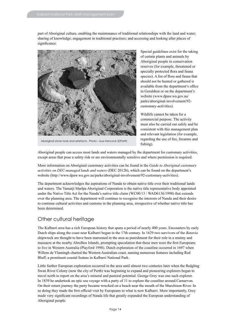
Sixty-sevenAboriginalsiteswithintheparkarerecordedontheDepartmentofAboriginalAffairs’Register of Aboriginal Sites.
Ethnographic and archaeological surveys have been conducted over a relatively small portion of Kalbarri NationalParkanditisthereforehighlyunlikelythatallAboriginalsiteshavebeenofficiallyrecorded.
Under the Aboriginal Heritage Act 1972, Aboriginal sites are protected whether registered or not and it is an offence to alter an Aboriginal site unless permission is granted in accordance with the Aboriginal Heritage Act. Where management actions that may disturb an Aboriginal site (registered or not) are to occur, an assessment is required before the operation proceeds. DPaW will work with the Department of Aboriginal Affairs, Nanda and the Yamatji Marlpa Aboriginal Corporation (which represents the Nanda) to ensure Aboriginal sites are not damaged. This will include
determining what level of assessment is required before ground-disturbing management actions proceed. Inaddition,DPaWwillensurecompliancewiththeStateGovernment’sCultural Heritage Due Diligence Guidelines when these actions are proposed.
DPaW will also work with Nanda in protecting Aboriginal sites and values within Kalbarri National Park. ThismaybethroughmanagingaccesstothosesitesidentifiedbyNanda.
Management arrangements may change over the life of the plan. This may involve the development of an ILUA. See Management arrangements with Aboriginal people for more information.
Activities for Aboriginal customary purposes
Customary activities by Aboriginal people can take a number of forms, including hunting for food, preparing medicine and engaging in artistic and ceremonial events.5 These activities are an important
5 Aboriginal customary purpose is defined by section 103A of the CALM Act.
Nanda carrying out a heritage survey prior to park development. Photo – Rory Chapple (DPaW)
Page 14
Kalbarri National Park draft management plan
part of Aboriginal culture, enabling the maintenance of traditional relationships with the land and water; sharing of knowledge; engagement in traditional practises; and accessing and looking after places of significance.
Special guidelines exist for the taking of certain plants and animals by Aboriginal people in conservation reserves (for example, threatened or speciallyprotectedfloraandfaunaspecies).Alistoffloraandfaunathatshould not be hunted or gathered is availablefromthedepartment’sofficeinGeraldtonoronthedepartment’swebsite (www.dpaw.wa.gov.au/parks/aboriginal-involvement/92-customary-activities).
Wildlife cannot be taken for a commercial purpose. The activity must also be carried out safely and be consistent with this management plan and relevant legislation (for example, regardingtheuseoffire,firearmsandfishing).
Aboriginal people can access most lands and waters managed by the department for customary activities, except areas that pose a safety risk or are environmentally sensitive and where permission is required.
More information on Aboriginal customary activities can be found in the Guide to Aboriginal customary activities on DEC-managed lands and waters(DEC2012b),whichcanbefoundonthedepartment’swebsite (http://www.dpaw.wa.gov.au/parks/aboriginal-involvement/92-customary-activities).
The department acknowledges the aspirations of Nanda to obtain native title over their traditional lands and waters. The Yamatji Marlpa Aboriginal Corporation is the native title representative body appointed undertheNativeTitleActfortheNanda’snativetitleclaim(WC00/13/WAD6136/1998)thatextendsover the planning area. The department will continue to recognise the interests of Nanda and their desire to continue cultural activities and customs in the planning area, irrespective of whether native title has been determined.
Other cultural heritage
The Kalbarri area has a rich European history that spans a period of nearly 400 years. Encounters by early Dutch ships along the coast near Kalbarri began in the 17th century. In 1629 two survivors of the Batavia shipwreck are thought to have been marooned in the area as punishment for their role in a mutiny and massacreatthenearbyAbrolhosIslands,promptingspeculationthatthesemenwerethefirstEuropeansto live in Western Australia (Playford 1998). Dutch exploration of the coastline occurred in 1697 when Willem de Vlamingh charted the Western Australian coast, naming numerous features including Red Bluff, a prominent coastal feature in Kalbarri National Park.
LittlefurtherEuropeanexplorationoccurredintheareauntilalmosttwocenturieslaterwhenthefledglingSwan River Colony (now the city of Perth) was beginning to expand and pioneering explorers began to travelnorthtoreportonthearea’smineralandpastoralpotential.GeorgeGreywasonesuchexplorer.In 1839 he undertook an epic sea voyage with a party of 11 to explore the coastline around Carnarvon. On their return journey the party became wrecked on a beach near the mouth of the Murchison River. In sodoingtheymadethefirstofficialvisitbyEuropeanstowhatisnowKalbarri.Moreimportantly,GreymadeverysignificantrecordingsofNandalifethatgreatlyexpandedtheEuropeanunderstandingofAboriginal people.
Aboriginal stone tools and artefacts. Photo – Sue Hancock (DPaW)
Page 15
Kalbarri National Park draft management plan
IntheyearsfollowingGrey’sexpedition,therewasincreasedEuropeanactivityinthearea.AugustusGregory explored the area in 1848 and discovered lead, promoting the subsequent development of mines atGeraldine,GalenaandMarySprings,whichlietotheeastoftoday’sKalbarriNationalPark.Aroundthis time, the development of the pastoral industry was accelerating and in 1848 Murchison House Station was established to the north of what is now Kalbarri National Park.
In 1894, a telegraph line was constructed between Geraldton and Hamelin Pool which passed through what is now the park. While this was maintained, its easement was also used as a bridle path and provided a stock route used by drovers to transport sheep and cattle between Tamala and Murchison House stations and Northampton. On the way, drovers camped at a number of locations, including Junga Dam and Emu Springs (Mitchell 2009; Patrick 2001).
Despite increasing pastoral and mining interests in the area, there was very little settlement around Kalbarriatthistime.Inthe1900s,smallnumbersoffishermenvisitedthemouthoftheMurchisonRiverand,by1944,somehadsetuppermanentcamps.Thefishingindustrystarteddevelopingandovertheensuing decades it became one of the largest economic contributors to the town. Throughout the 1940s, thenumberoffishingcampsgrewandby1951thetownofKalbarriwasofficiallygazetted.
Whilefishingwasamajordrawcard,somevisitorstoKalbarriwereattractedbythearea’snaturalbeauty.One person in particular, school teacher Ross Graham, passionately lobbied for the area to be declared a national park. His efforts were rewarded in 1963 when Kalbarri National Park was gazetted and his dedication has been recognised with the naming of the Ross Graham Lookout in his honour.
Today, tourism is the largest economic contributor to Kalbarri, which has a population of about 1,500 people.
Desired outcomes
• Work with Nanda to protect and conserve the cultural and heritage values of Aboriginal people.• Assist Aboriginal people in conducting customary activities.• Protect other cultural heritage values.• Improved cross-cultural awareness for Parks and Wildlife staff and other groups using Kalbarri
National Park.
Management actions
1. Continue to work with Nanda to facilitate the practice of customary activities.2. Support the improvement of cross-cultural awareness through Parks and Wildlife staff training and
visitor information.3. Carry out management actions in a manner which is sensitive to the cultural and heritage values of
Nanda.4. Minimise any adverse effects of management activities on Aboriginal and other cultural and heritage
values.
Key performance indicator
Performance measure Target Reporting
Protection of known Aboriginal or other cultural heritage sites
No adverse impacts on known Aboriginal or other cultural heritage sites because of management activities
Everyfiveyears
Page 16
Managing visitor use
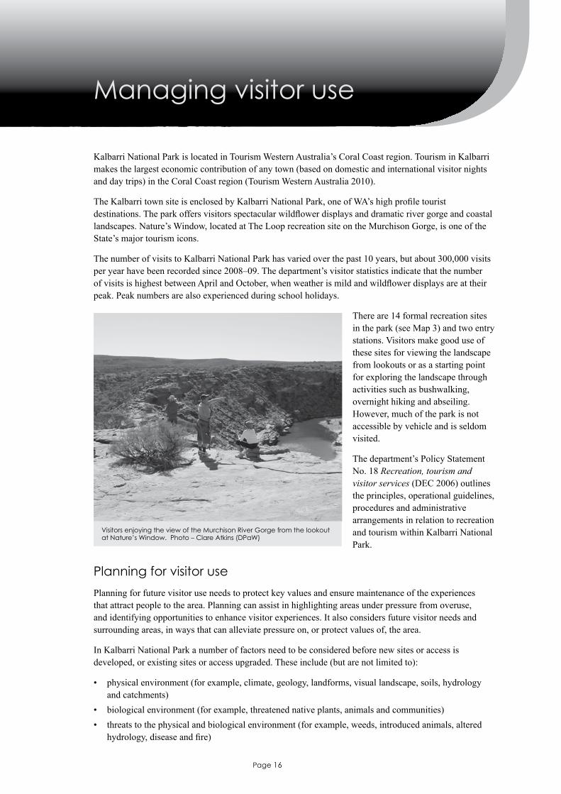
KalbarriNationalParkislocatedinTourismWesternAustralia’sCoralCoastregion.TourisminKalbarrimakes the largest economic contribution of any town (based on domestic and international visitor nights and day trips) in the Coral Coast region (Tourism Western Australia 2010).
TheKalbarritownsiteisenclosedbyKalbarriNationalPark,oneofWA’shighprofiletouristdestinations.Theparkoffersvisitorsspectacularwildflowerdisplaysanddramaticrivergorgeandcoastallandscapes.Nature’sWindow,locatedatTheLooprecreationsiteontheMurchisonGorge,isoneoftheState’smajortourismicons.
The number of visits to Kalbarri National Park has varied over the past 10 years, but about 300,000 visits peryearhavebeenrecordedsince2008–09.Thedepartment’svisitorstatisticsindicatethatthenumberofvisitsishighestbetweenAprilandOctober,whenweatherismildandwildflowerdisplaysareattheirpeak. Peak numbers are also experienced during school holidays.
There are 14 formal recreation sites in the park (see Map 3) and two entry stations. Visitors make good use of these sites for viewing the landscape from lookouts or as a starting point for exploring the landscape through activities such as bushwalking, overnight hiking and abseiling. However, much of the park is not accessible by vehicle and is seldom visited.
Thedepartment’sPolicyStatementNo. 18 Recreation, tourism and visitor services (DEC 2006) outlines the principles, operational guidelines, procedures and administrative arrangements in relation to recreation and tourism within Kalbarri National Park.
Planning for visitor use
Planning for future visitor use needs to protect key values and ensure maintenance of the experiences that attract people to the area. Planning can assist in highlighting areas under pressure from overuse, and identifying opportunities to enhance visitor experiences. It also considers future visitor needs and surrounding areas, in ways that can alleviate pressure on, or protect values of, the area.
In Kalbarri National Park a number of factors need to be considered before new sites or access is developed, or existing sites or access upgraded. These include (but are not limited to):
• physical environment (for example, climate, geology, landforms, visual landscape, soils, hydrology and catchments)
• biological environment (for example, threatened native plants, animals and communities)• threats to the physical and biological environment (for example, weeds, introduced animals, altered
hydrology,diseaseandfire)
Visitors enjoying the view of the Murchison River Gorge from the lookout at Nature’s Window. Photo – Clare Atkins (DPaW)
Page 17
Kalbarri National Park draft management plan
• other management programs (for example, areas baited as part of the Western Shield program)• cultureandheritage(includingNanda’saspirations)• existing and future visitor use, including opportunities outside Kalbarri National Park (for example,
site carrying capacity and demand)• visitor safety• resource use (for example, mineral exploration, utilities)• policy, tenure and legislation• researchandscientificreferenceareas.Consideration of these factors will form an important part of detailed visitor planning, comprehensive site assessment, and consultation with stakeholders and user groups, as well as construction of recreation sites, facilities, trails and roads.
A proposed recreation site hierarchy (major, medium and minor6) shown on Map 3 and Table 1 indicates the range of developments proposed across the park. This tool is used as part of visitor planning to ensure a range of recreation opportunities is provided across the landscape.
Potential recreation opportunities in the adjacent lands considered for reservation are described in Consideration of adjacent lands.
Visitor safety
Thedepartment’svisitorriskmanagementprogramisimplementedinKalbarriNationalParktoidentifyand manage risks that may cause injury or misadventure. This is done in a way that does not render the environment sterile or unnecessarily diminish visitor enjoyment in the process.
SpecificriskstovisitorswithinKalbarriNationalParkinclude:
• extreme temperatures (which increase the risk of dehydration and heat exhaustion), particularly within the Murchison Gorge
• falls and slips from cliff edges and overhangs if visitors stray from formal lookouts and walk trails• visitors becoming injured or lost in remote areas in challenging terrain and having limited
communication for emergency assistance• delaysinemergencyresponseduetoroadconditionsanddifficultieswithcommunication• risksassociatedwithwateractivities(forexample,swimmingandrockfishing).
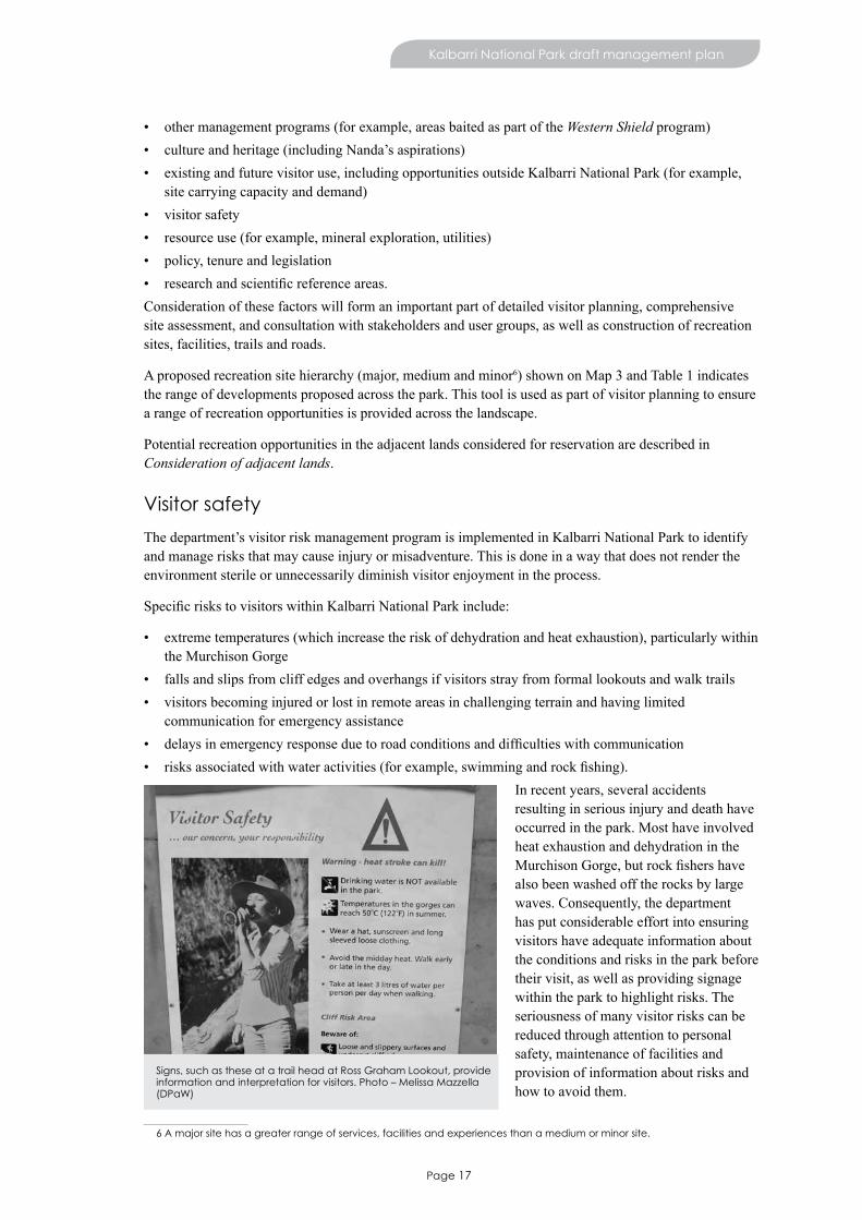
In recent years, several accidents resulting in serious injury and death have occurred in the park. Most have involved heat exhaustion and dehydration in the MurchisonGorge,butrockfishershavealso been washed off the rocks by large waves. Consequently, the department has put considerable effort into ensuring visitors have adequate information about the conditions and risks in the park before their visit, as well as providing signage within the park to highlight risks. The seriousness of many visitor risks can be reduced through attention to personal safety, maintenance of facilities and provision of information about risks and how to avoid them.
6 A major site has a greater range of services, facilities and experiences than a medium or minor site.
Signs, such as these at a trail head at Ross Graham Lookout, provide information and interpretation for visitors. Photo – Melissa Mazzella (DPaW)
Page 18
Kalbarri National Park draft management plan
The department works closely with the Western Australian Police, State Emergency Service Volunteers Association,StJohnAmbulanceandvolunteerbushfirebrigadesinmanagingvisitorsafetywithinKalbarri National Park. Parks and Wildlife is also a member of the Local Emergency Management Committee, which has developed local emergency management arrangements for the Locality of Kalbarri which outlines policies, procedures, strategies and priorities for emergency management in Kalbarri and roles and responsibilities of those involved.
In addition, long distance hikers must register with the park ranger and be provided with information on safety. The department also works with local tour operators and tourism businesses to ensure information is provided to visitors about risks in the park and appropriate safety precautions.
Improved mobile phone communications would help to improve emergency response times and emergency incident outcomes. Options for provision of improved communications within the Murchison Gorge need to be investigated.
Information, interpretation and education
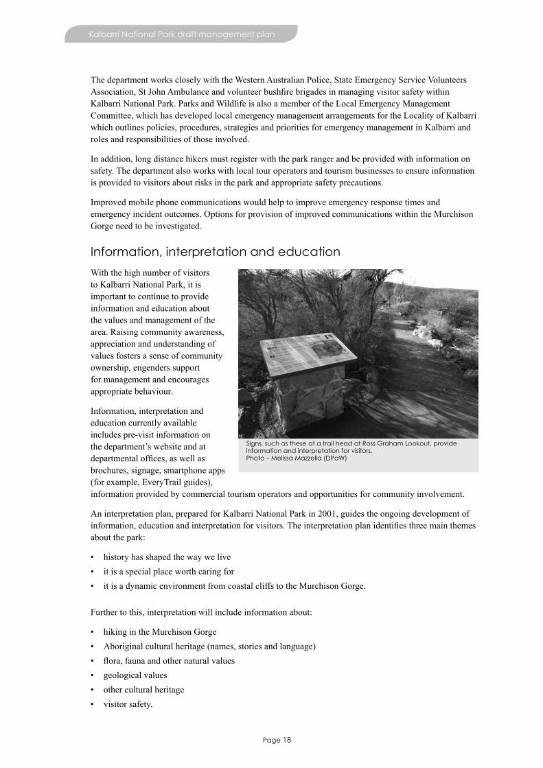
With the high number of visitors to Kalbarri National Park, it is important to continue to provide information and education about the values and management of the area. Raising community awareness, appreciation and understanding of values fosters a sense of community ownership, engenders support for management and encourages appropriate behaviour.
Information, interpretation and education currently available includes pre-visit information on thedepartment’swebsiteandatdepartmentaloffices,aswellasbrochures, signage, smartphone apps (for example, EveryTrail guides), information provided by commercial tourism operators and opportunities for community involvement.
An interpretation plan, prepared for Kalbarri National Park in 2001, guides the ongoing development of information,educationandinterpretationforvisitors.Theinterpretationplanidentifiesthreemainthemesabout the park:
• history has shaped the way we live• it is a special place worth caring for• it is a dynamic environment from coastal cliffs to the Murchison Gorge. Further to this, interpretation will include information about:
• hiking in the Murchison Gorge• Aboriginal cultural heritage (names, stories and language)• flora,faunaandothernaturalvalues• geological values• other cultural heritage• visitor safety.
Signs, such as these at a trail head at Ross Graham Lookout, provide information and interpretation for visitors. Photo – Melissa Mazzella (DPaW)
Page 19
Kalbarri National Park draft management plan
Desired outcomes
• The range of suitable nature-based recreation opportunities is maintained and enhanced. • Risks to visitors are minimised and appropriate visitor behaviour is encouraged.• Community awareness, understanding and appreciation of values are improved through the provision
of interpretation and education.
Management actions
1. Provide for recreation and tourism opportunities consistent with this management plan.2. Undertake annual visitor risk assessments to identify and manage risks associated with all recreation
use, using specialist advice if necessary (for example, geotechnical specialists).3. Provide visitor information regarding appropriate behaviour and risk minimisation.4. Fulfilthedepartment’sobligationsundertheLocalEmergencyManagementCommittee’slocal
emergency management arrangements.5. Investigate options for improving emergency communications in Kalbarri National Park and
implement appropriate solutions. 6. Update and implement the information and interpretation plan for the Kalbarri National Park to
improve visitor experiences and safety.7. Involve Nanda in the communication of cultural and heritage values, including using Nanda language
in interpretation materials and the names of places and trails, where appropriate.
Key performance indicator
Performance measure Target Reporting
Number of incidents reported to the department
The number of serious incidents7 reported remains stable or decreases from the commencement of the plan
Annual
11. Visitor access
Vehicle access
Access to Kalbarri National Park is via two sealed roads:
• George Grey Drive (managed by Main Roads WA), provides access to all eight coastal recreation sites• Ajana–Kalbarri Road (managed by the Shire of Northampton) provides access inland to the gorge
sites.All other roads within Kalbarri National Park are managed by the department and comprise spur roads to the coastal and gorge sites, many of which are sealed. Public road access into and within Kalbarri National Park and the wider planning area is shown on Map 1.
The 32km unsealed road to The Loop, West Loop and Z-Bend has been a major cause of dissatisfaction among visitors to Kalbarri National Park. In dry weather, road surfaces become powdery and corrugated, makingaccessfortwo-wheel-drivevehiclesdifficult.Theseunsealedroadsoftenneedtobeclosedduringwet weather, preventing visitors from accessing iconic sites within the park.
Maintenance of the unsealed The Loop/Z-Bend access roads (in accordance with their type, category and function) also has an environmental impact as basic raw materials for road maintenance are sourced from withinthepark.Regularmaintenanceworkalsocomesatasignificantcosttothedepartment.Toalleviatethe impacts on the environment, improve visitor amenity, and reduce visitor risk, work started in 2013 to seal a section of The Loop/Z-Bend road access to the Murchison Gorge recreation sites.
7 Serious incidents are those requiring medical treatment
Page 20
Kalbarri National Park draft management plan
The feasibility of a coastal road between Kalbarri and Shark Bay/Steep Point was considered in the late 1990s by Main Roads WA as a long-term goal (Main Roads Western Australia 1997). With regard to the northern section of any coast road proposal, the Shark Bay terrestrial reserves and proposed reserve additions management plan (DEC 2012c) notes that ‘the department believes the two-wheel drive proposalhassignificantenvironmental,culturalandsocialimplicationsandisnotconsistentwiththemanagement settings or wilderness quality of the area. Therefore the proposal is not supported by the department.’Thispositionismaintainedinthismanagementplan.
Therearemanyfour-wheel-drivetracksavailableonlyforfireandothermanagementpurposeswithinKalbarri National Park. Opening some of these to the public may be considered, although many of these tracksdonotgotoplacesofinterestforvisitors.Benefittotheenvironmentortovisitorswouldneedtobeidentifiedbeforeanyofthesetracksareopenedtothepublic.
The need for new vehicle access options will be assessed during visitor planning.
All motor vehicles accessing Kalbarri National Park need to be registered under the Road Traffic Act 1974 andalldriversmustpossessacurrentdriver’slicence.Vehiclesarerestrictedtoroadsandtracksopentothe public.
Boat access
Boat access within Kalbarri National Park is limited to non-motorised recreational watercraft such as canoes and kayaks (see Visitor activities).
Access for people with disability
Since 2001, many recreation sites within Kalbarri National Park have been upgraded to provide improved access. The department seeks to ensure that everyone in the community including people with disability can access the facilities, where possible8.
Existing and future facilities within Kalbarri National Park may be reviewed over the life of the plan to determine the possibility of providing universal access. Sites with potential for enhanced access include The Loop, West Loop, Meanarra Hill and the Z-Bend lookout.
8 Depending on people’s disability, they might need the aid of a carer or helper to get to and from the facilities.
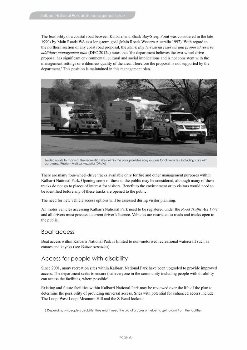
Sealed roads to many of the recreation sites within the park provides easy access for all vehicles, including cars with caravans. Photo – Melissa Mazzella (DPaW)

Page 21
Kalbarri National Park draft management plan
Desired outcome
• To provide safe access that facilitates visitor appreciation of natural, cultural and recreation values withouthavingsignificantadverseimpactsonthosevalues,wherepossible.
Management actions
1. Complete the sealing of road access (including car parks) to The Loop, West Loop and Z Bend.2. Work cooperatively with Main Roads Western Australia and the Shire of Northampton regarding
roads that provide access to Kalbarri National Park.3. Continue to provide access that considers the needs of people with disability.4. Close and rehabilitate tracks that are not required, or that have an unacceptable impact on key values.
12. Visitor activities
Day-use sites
RecreationsiteswithinKalbarriNationalParkareshownonMap3.Table1identifiestheproposedchanges to existing sites, including upgrade of facilities and access.
Table 1. Existing day-use sites in Kalbarri National Park
Site Site hierarchy Proposed changes
The Loop# Major • seal and expand parking area• provide new facilities including toilets,
shelters, lookout and picnic furniture • update signage and interpretation and upgrade
accesstoNature’sWindowandTheLoopTrail
Z-Bend Major • seal and expand parking area• provide new facilities including toilets,
shelters and picnic furniture• update signage and interpretation for, and
upgrade access to the Z-Bend Gorge Trail, Z-Bend Lookout Trail and Four Ways Trail
Meanarra Hill Medium • seal parking area• upgrade lookout and develop a short walk trail
from parking area to the lookout• update signage and interpretation• consider development of a walk trail and a
mountain bike trail connecting with Kalbarri town ship
Hawks Head Medium • continue to maintain existing facilities• consider development of gorge access to
facilitate emergency evacuation for hikers and a day-hike option from Ross Graham Lookout
Ross Graham Lookout Medium • continue to maintain existing facilities

Page 22
Kalbarri National Park draft management plan
Site Site hierarchy Proposed changes
West Loop9 # Medium • relocate, seal and expand parking area• provide new facilities including shelters,
lookout, walk trail, picnic facilities, toilets and interpretation
Entry station (The Loop/Z-Bend)
Minor • redevelop facilities as part of the road realignment and sealing works
• update signage and information
Entry station (Ross Graham Lookout/Hawks Head)
Minor • continue to maintain existing facilities
Red Bluff Major • continue to maintain existing facilities• complete the sealing of spur roads and parking
areaMushroom Rock Minor
Rainbow Valley Minor
Pot Alley Medium
Eagle Gorge Medium
Shell House and Grandstand Rock Gorge
Medium
Island Rock Medium
Natural Bridge/Castle Cove Major# Redevelopment of these sites has commenced and will be completed in 2014
Kalbarri National Park is listed as a high priority for amenity enhancement (that is, sealing roads to major attractions and providing parking spaces, areas of shade and signage) in the Draft Mid West regional planning and infrastructure framework (DoP & WAPC 2011). Existing sites within the park have limited capacity to expand and cater for an increase in the number of peak-time visitors. New recreation sites may be required to take pressure off existing sites and to add to the range of experiences on offer to visitors. The potential development of new sites and opportunities throughout the life of the plan should be considered (see Planning for visitor use).
Bushwalking
TrailswithinKalbarriNationalParkareofvaryingdegreesofdifficultyandprovidevisitorswitharangeof walking and hiking opportunities. The Bigurda Coastal Trail (a three-hour, one-way, 8km walk with views of seascapes) is one of the most popular within the park. Increased use of this trail is anticipated as adjacent residential areas continue to develop. Other trails include the Mushroom Rock Nature Trail (a2kmloop)andTheLoopTrail(athreetofour-hour,8kmloopwalkstartingatNature’sWindow).Hikes along the Murchison Gorge may also involve overnight stays (see Overnight hiking and canoeing).
9 The department is seeking Nanda endorsement for renaming the West Loop recreation site.
Day use shelter at Ross Graham Lookout provides shade and seats for visitors. Photo – Clare Atkins (DPaW)

Page 23
Kalbarri National Park draft management plan
Morespecificdetailontrailsandtrailconditioncanbefoundonthedepartment’swebsiteandthroughsmartphone apps (such as EveryTrail guides).
Bushwalking is an increasingly popular activity in national parks. Opportunities for new trails and experiences will be considered, subject to demand and the protection of natural and cultural values. There is scope for new medium to long distance walk trails in Kalbarri National Park as an alternative to the challenging Loop Trail. Map 3 and Table 2 show existing and potential walk trails in the park.
Table 2. Walk trails within Kalbarri National Park
Trail* Length (km)
Class+ Action
Coastal trails
Mushroom Rock Nature Trail 2 3 • maintain and consider hardening surface
Bigurda Coastal Trail 8 3 • maintain
Potential: Natural Bridge to Red Bluff TBD TBD • investigate demand and feasibility for a trail, possibly dual use
Inland trails
Nature’sWindowTrail 0.5 2/3 • maintain as a class 2 trail with a transition to class 3 through to Nature’sWindow
• seal remainder of the trail from The Loop to the transition point
• develop a node at the trail transition point, installing a new shelter, lookout point and seating
The Loop Trail 8 4 • maintain as a class 4 trail with trail markers
West Loop Lookout Trail 0.5 1 • develop, in partnership with the Nanda community, a universally accessible loop trail at the redeveloped West Loop site to a lookout over the Murchison River Gorge
Visitors enjoy views of the ocean and coastal cliffs on the Bigurda Trail at Natural Bridge and Castle Cove. Photo – Nathan Greenhill (DPaW)
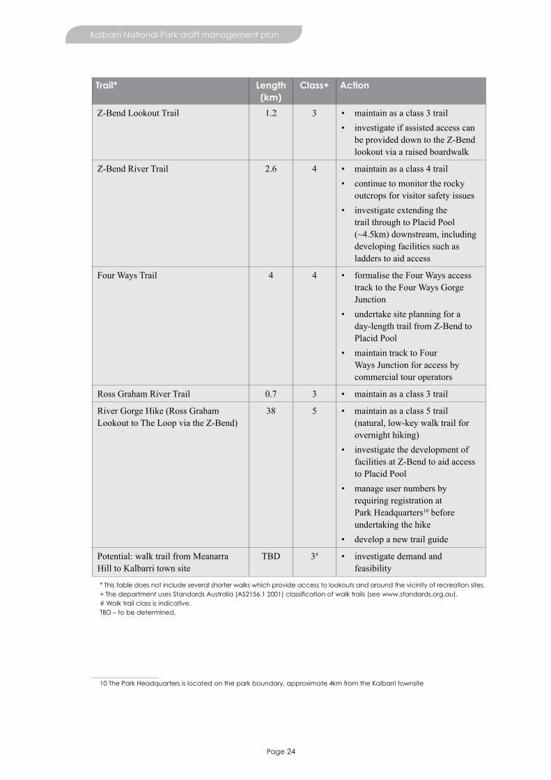
Page 24
Kalbarri National Park draft management plan
Trail* Length (km)
Class+ Action
Z-Bend Lookout Trail 1.2 3 • maintain as a class 3 trail• investigate if assisted access can
be provided down to the Z-Bend lookout via a raised boardwalk
Z-Bend River Trail 2.6 4 • maintain as a class 4 trail• continue to monitor the rocky
outcrops for visitor safety issues • investigate extending the
trail through to Placid Pool (~4.5km) downstream, including developing facilities such as ladders to aid access
Four Ways Trail 4 4 • formalise the Four Ways access track to the Four Ways Gorge Junction
• undertake site planning for a day-length trail from Z-Bend to Placid Pool
• maintain track to Four Ways Junction for access by commercial tour operators
Ross Graham River Trail 0.7 3 • maintain as a class 3 trail
River Gorge Hike (Ross Graham Lookout to The Loop via the Z-Bend)
38 5 • maintain as a class 5 trail (natural, low-key walk trail for overnight hiking)
• investigate the development of facilities at Z-Bend to aid access to Placid Pool
• manage user numbers by requiring registration at Park Headquarters10 before undertaking the hike
• develop a new trail guide
Potential: walk trail from Meanarra Hill to Kalbarri town site
TBD 3# • investigate demand and feasibility
* This table does not include several shorter walks which provide access to lookouts and around the vicinity of recreation sites. + The department uses Standards Australia (AS2156.1 2001) classification of walk trails (see www.standards.org.au).# Walk trail class is indicative.TBD – to be determined.
10 The Park Headquarters is located on the park boundary, approximate 4km from the Kalbarri townsite

Page 25
Kalbarri National Park draft management plan
Overnight stays
Vehicle-based camping
Currently, there are no formally designated vehicle-based camping sites within Kalbarri National Park. Informal vehicle-based camping 11 is not permitted within the park. There is, however, a high demand for camping throughout the Midwest Region. Opportunity for camping will be considered, including on the former part Murchison House Station.
Nature-based accommodation
A number of sites within the park have potential for development including through Naturebank12 (see Commercial operations and tourism).
Overnight hiking and canoeing
Overnight hiking and canoeing13 occur in association with long-distance hiking and canoeing through the Murchison Gorge, predominantly by organised groups. A hike between Ross Graham Lookout and The Loop takes four days, with shorter hikes possible between Ross Graham Lookout and Z-Bend or Z-BendandTheLoop.Locationsforovernightcampingontheseroutesarenotdefinedandvisitorsmustbepreparedtobefullyselfsufficient.Facilitiesarenotprovidedforovernighthikersorcanoeistsandvisitorsareencouragedtoapply‘LeaveNoTrace’practices.Overnighthikersandcanoeistsarerequiredtoobtain lawful authority from Parks and Wildlife to camp overnight in the park and obtain advice (including the code of conduct and safety information) from the park ranger well before commencing their trip. Registration and authorisation are ways of managing hiker numbers, the experience and the impacts.
Key attractions for long distance hikers in the park are the solitude and remote qualities of the Murchison Gorge away from the main visitor sites. Access needs to be carefully controlled to maintain this experience and minimise any associated environmental impacts. Overnight hiking and canoeing are currently not having a marked impact on values or visitor experiences. The burying of toilet waste is not knowntohavecausedenvironmentalorhealthissues,astheMurchisonGorgeisperiodicallyflushedduringfloodevents.Visitorimpactsshould,however,bemonitoredoverthelifeoftheplanandactiontaken if required.
Campfires
Campfiresandfirewoodcollectioncanhavedetrimentaleffectsonthenaturalenvironment.Campfireescapescanstartbushfires,andfirewoodcollectingcanresultinalossofvegetationcover.ForthesereasonscampfiresarediscouragedwithinKalbarriNationalPark.Overnighthikersandcanoeistsmustobtainlawfulauthorityfromthedepartmenttolightcampfiresandthisisarrangedwiththeparkrangeratthe time of registration.
Cycling
Cycling is a growing recreational activity in the Kalbarri town site. Sealing the roads to coastal recreation siteshassignificantlyimprovedcycleaccesstoandwithinKalbarriNationalPark.Withincreasingresidential development adjacent to the park, cycle trails with linkages to Kalbarri town site are likely to be well used. There is potential to develop a mountain bike trail near Meanarra Hill, with a link to the Kalbarritownsite.MeanarraHillisahighlydisturbedenvironmentwithsignificantmanagementissues(for example, erosion). Development of a trail at this site may assist in managing these problems.
There is also potential to develop a dual-use path from Red Bluff to Natural Bridge.
11 Informal vehicle-based camping is in areas that are not signposted for camping or designated as a camping area.
12 Naturebank is a government initiative that aims to assess and release sites within protected areas for the development of low-impact visitor accommodation and experiences.
13 Overnight hiking or canoeing is sometimes referred to as remote, ‘wild’ or backpack camping.
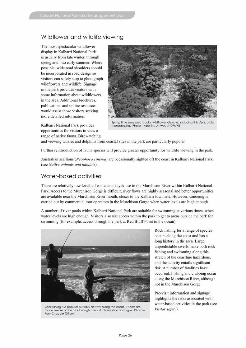
Page 26
Kalbarri National Park draft management plan
Wildflower and wildlife viewing
Themostspectacularwildflowerdisplay in Kalbarri National Park is usually from late winter, through spring and into early summer. Where possible, wide road shoulders should be incorporated in road design so visitors can safely stop to photograph wildflowersandwildlife.Signagein the park provides visitors with someinformationaboutwildflowersin the area. Additional brochures, publications and online resources would assist those visitors seeking more detailed information.
Kalbarri National Park provides opportunities for visitors to view a range of native fauna. Birdwatching and viewing whales and dolphins from coastal sites in the park are particularly popular.
Further reintroduction of fauna species will provide greater opportunity for wildlife viewing in the park.
Australian sea lions (Neophoca cinerea) are occasionally sighted off the coast in Kalbarri National Park (see Native animals and habitats).
Water-based activities
There are relatively low levels of canoe and kayak use in the Murchison River within Kalbarri National Park.AccesstotheMurchisonGorgeisdifficult,riverflowsarehighlyseasonalandbetteropportunitiesare available near the Murchison River mouth, closer to the Kalbarri town site. However, canoeing is carried out by commercial tour operators in the Murchison Gorge when water levels are high enough.
A number of river pools within Kalbarri National Park are suitable for swimming at various times, when water levels are high enough. Visitors also use access within the park to get to areas outside the park for swimming (for example, access through the park at Red Bluff Point to the ocean).
Rockfishingforarangeofspeciesoccurs along the coast and has a long history in the area. Large, unpredictable swells make both rock fishingandswimmingalongthisstretch of the coastline hazardous, andtheactivityentailssignificantrisk. A number of fatalities have occurred. Fishing and crabbing occur along the Murchison River, although not in the Murchison Gorge.
Pre-visit information and signage highlights the risks associated with water-based activities in the park (see Visitor safety).
Spring time sees spectacular wildflower displays, including this Verticordia monadelpha. Photo – Aberline Attwood (DPaW)
Rock fishing is a popular but risky activity along the coast. Fishers are made aware of the risks through pre-visit information and signs. Photo – Rory Chapple (DPaW)
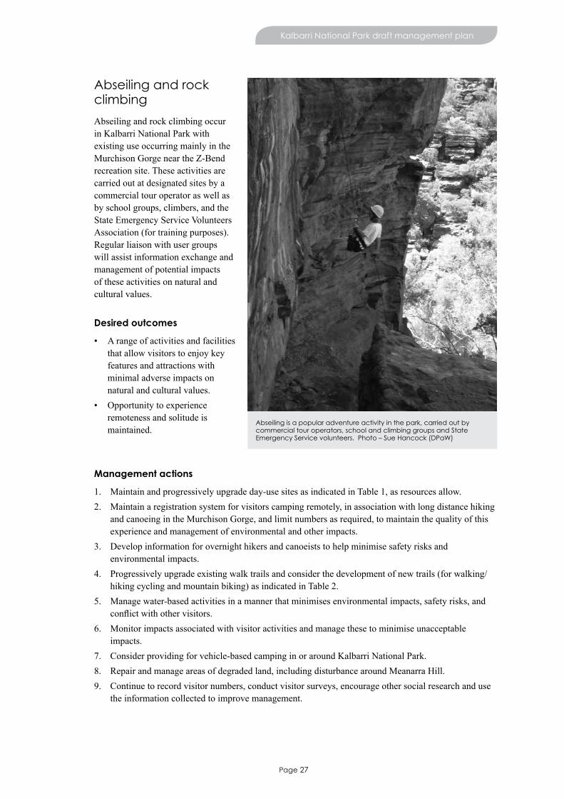
Page 27
Kalbarri National Park draft management plan
Abseiling and rock climbing
Abseiling and rock climbing occur in Kalbarri National Park with existing use occurring mainly in the Murchison Gorge near the Z-Bend recreation site. These activities are carried out at designated sites by a commercial tour operator as well as by school groups, climbers, and the State Emergency Service Volunteers Association (for training purposes). Regular liaison with user groups will assist information exchange and management of potential impacts of these activities on natural and cultural values.
Desired outcomes
• A range of activities and facilities that allow visitors to enjoy key features and attractions with minimal adverse impacts on natural and cultural values.
• Opportunity to experience remoteness and solitude is maintained.
Management actions
1. Maintain and progressively upgrade day-use sites as indicated in Table 1, as resources allow. 2. Maintain a registration system for visitors camping remotely, in association with long distance hiking
and canoeing in the Murchison Gorge, and limit numbers as required, to maintain the quality of this experience and management of environmental and other impacts.
3. Develop information for overnight hikers and canoeists to help minimise safety risks and environmental impacts.
4. Progressively upgrade existing walk trails and consider the development of new trails (for walking/hiking cycling and mountain biking) as indicated in Table 2.
5. Manage water-based activities in a manner that minimises environmental impacts, safety risks, and conflictwithothervisitors.
6. Monitor impacts associated with visitor activities and manage these to minimise unacceptable impacts.
7. Consider providing for vehicle-based camping in or around Kalbarri National Park.8. Repair and manage areas of degraded land, including disturbance around Meanarra Hill.9. Continue to record visitor numbers, conduct visitor surveys, encourage other social research and use
the information collected to improve management.
Abseiling is a popular adventure activity in the park, carried out by commercial tour operators, school and climbing groups and State Emergency Service volunteers. Photo – Sue Hancock (DPaW)
Page 28
Kalbarri National Park draft management plan
Key performance indicator
Performance measure Target Reporting
Community enjoyment of park facilities and services, wildlife and the natural environment displayed in parks
Greater than 85% visitor satisfaction levels
Yearone,theneveryfiveyears
13. Commercial operations and tourismCommercial concessions, such as leases and licences for commercial tourism operations, allow private businesses to offer high-quality tourism and recreation opportunities, facilities and services to the public. This can assist the department in providing quality visitor experiences in Kalbarri National Park. Commercial concessions are granted in consultation with the Conservation Commission, and must be consistent with the purpose of the park, the protection of its values and with the objectives of this management plan.
Local, intrastate and interstate commercial tour operators provide for a range of activities including bushwalking,canoeing,abseiling,scenicflights,andwildflowerandgeneralsightseeingtours.Allcommercial visitor services operating on lands and waters managed by the department require a licence or lease issued by the department. The number of concessions issued may be restricted if necessary to protect natural or cultural values or maintain the quality of the visitor experience.
Leases can be granted for commercial services that occupy land, require exclusive rights of access and require substantial infrastructure. No leases currently exist within Kalbarri National Park.
A number of areas within Kalbarri National Park have the capacity to support low-impact nature-based accommodation. Naturebank is a state government initiative that aims to assess and release sites within protected areas for the development of low-impact visitor accommodation and experiences. Any site chosen as a Naturebank project would need to undergo a detailed assessment and consultation process.
Desired outcome
• Commercialactivitiesarecomplimentarytothedepartment’sfacilitiesandservices,andareprovidedin a way that enriches visitor experiences.
Management actions
1. Evaluate proposals for licences and commercial tourism leases and allow their establishment, if appropriate, according to departmental policy.
2. Monitor commercial tour operations and ensure compliance with licence and lease conditions.3. Consider development of nature-based accommodation opportunities.

Page 29
Involving the community
14. Community involvement and supportEffectivecommunityinvolvementandsupportisacornerstoneofthedepartment’smanagementofKalbarri National Park.
It is a priority for the department to encourage and facilitate community involvement in order to:
• raise awareness of, encourage input to, and generate greater public acceptance of decisions about the area’smanagement
• garneradditionalresourcesforthearea’smanagementandenhanceourabilitytorespondtoemergencies
• provideinformation,educationandinterpretationaboutthearea’svaluestothewidercommunity.
The community of Kalbarri, being surrounded by Kalbarri National Park, has a long-standing involvement withmanagementofthearea.Examplesofcurrentcommunityinvolvementinthearea’smanagementinclude:
• Nanda community participation in discussions about issues pertaining to their culture. This includes protecting heritage sites, undertaking heritage surveys, interpreting Aboriginal culture and using Nanda language in the naming of recreation sites (see Managing cultural heritage)
• the State Emergency Service Volunteers Association and Kalbarri Fire and Rescue Service aid in the suppressionofbushfiresandassistancewithsearchandrescueoperations
• the creation and maintenance of a herbarium, located at the Park Headquarters, by a small but active group of volunteers
• school and university education programs conducted in the park. The Kalbarri District High School Bush Rangers program has a long and active history in the park. Activities have included revegetation works, fauna research and weed removal programs
• engagement with the Kalbarri tourism industry. Tourism is a key income earner for the community and park managers engage with local tour operators, accommodation providers and visitor centre staff to keep them informed about park management issues
• consultation with neighbouring land managers that is crucial to the effective management of the park and the wider planning area (see Neighbouring land use).
Bushrangers from Kalbarri District High School work on walk trail construction between Natural Bridge and Island Rock. Photo – Sue Hancock (DPaW)
Page 30
Kalbarri National Park draft management plan
Community engagement was a critical component in the preparation of this management plan and the community has had a number of opportunities to provide input. This included the distribution of a ‘have yoursay’brochuretoencourageindividualsandorganisationstoregistertheirinterestintheplanningprocess and identify issues to be considered during the development of the plan. Visitor satisfaction surveys and general discussions with departmental staff also provided valuable input. The submissions inresponsetothe‘haveyoursay’brochureanddiscussionswithNandaandvisitorstoKalbarriNationalPark were taken into consideration in the development of this plan.
Desired outcome
• Communityinvolvementandsupportbenefitsparkplanningandmanagement.
Management actions
1. Continue to provide and promote opportunities for the community to be involved in the planning and management of Kalbarri National Park.
2. Continue to support volunteer involvement in departmental programs.

Page 31
Managing the natural environment
15. ClimateThe planning area has a warm semi-arid to arid Mediterranean climate with a winter-dominant rainfall pattern. The area receives an average of 250–500mm rainfall annually, with rainfall averages increasing from north to south. Evaporation is highest during the summer months of January and February and lowest during the winter months, with an average annual evaporation of 2,500mm, which exceeds average rainfall(DoW2006).AveragedailymaximumandminimumtemperaturesatKalbarriinJanuaryare31˚Cand20˚C,andinJulyare20˚Cand10˚C,respectively.
Climate is expected to change over time with predicted increasing temperatures and lower rainfall. This, inturn,islikelytoleadtoanincreasedriskofbushfirefrequencyandintensity(GovernmentofWesternAustralia 2012). Recent droughts have resulted in a decrease in surface and groundwater available for plants. This has resulted in mass plant deaths across Kalbarri National Park, especially in Banksia species (see Native plants and plant communities) and may be an indicator that the Kalbarri area is experiencing an early effect of climate change. Vegetation of the Murchison Gorge is vulnerable, particularly species thataregeographicallyrestricted,attheirrangeextentorsensitivetofire(forexample,malleefowl(Leipoa ocellata) and orchids).
Accurately determining that a species, community or habitat has been directly and adversely affected byvaryingclimaticconditionsisdifficult.Furtherresearchwillbeimportantingainingagreaterunderstanding of the impacts of climate change at a species and community level and management will beadaptedonthebasisofthesefindings.Uncertaintyaboutappropriateresponsestotheeffectsofachanging climate mean that increasing areas held in conservation reserves and managing other threats (suchasweeds,introducedanimals,fireanddisturbance)maybethebestoptionstoprotectbiodiversityin the immediate future. Management must aim to improve the resilience of species and decrease their vulnerability to a changing climate.
A landscape-scale approach that links large, contiguous habitats and enables maintenance of ecological processes, especially those across a range of environmental gradients, is important for responding to varying climatic conditions.
Desired outcome
• Management actions at regional, community and species level consider and adapt to a changing climate.
Management actions
1. Support research into identifying and monitoring the impacts of climate change.2. Implementadaptivemanagementtechniques(particularlyinrelationtofiremanagement)torespond
to impacts of climate change on vulnerable species, communities and ecosystems.3. Improve the resilience of species and communities vulnerable to a changing climate by limiting non-
climatestresses(forexample,disturbance,introducedanimals,weedsandinappropriatefireregimes).
16. Geology, landforms and soilsThe geology of Kalbarri National Park is one of its key values and standout features. The forces of weatheringanderosionhaveshapedthearea,creatingfeaturessuchastheMurchisonGorge,Nature’s

Page 32
Kalbarri National Park draft management plan
Window and the Natural Bridge. Landforms and geological features are key attractions, for their scenic value and for the setting they provide for visitors to undertake a wide range of recreational activities.
ThesefeaturesarealsoareasofsignificanceforNanda.
Geoheritagesitesacknowledgethenationalsignificanceof geological features of the area (Department of Mines and Petroleum 2010). The geological importance of the park is recognised by the two geoheritage sites (site 97 – Murchison Gorge and site 119 – Shell House Coastal Cliffs).
Thepark’smostdramaticgeologicalfeature,the Murchison Gorge, is composed of exposed Tumblagooda Sandstone.14 The gorge is 85km long and has a maximum depth of 150m. The Tumblagooda Sandstone dominates the Murchison Gorge as far inland as Hardabut Pool. This is the location of the Hardabut Fault,whichdefinestheboundarybetweenthePerthandCarnarvon basins (see Figure 1). Here, there is an abrupt transition from sandstone to granite, with an abundance of granite outcrops south of the fault. Granite does not occur within the current park boundary.
Figure 1. Biophysical features of the planning area
The rocky coastal cliffs of the park are mostly sediments of the Tumblagooda Sandstone, as well as deposits of Wittecarra Sandstone, Kockatea Shale15 and Tamala Limestone.16 These cliffs are vulnerable to erosion during storm events as well as undercutting by wave action, with both processes making them unstable.
14 Deposited during the Silurian period (410–435 million years ago).
15 Formed during the early Triassic period (241–251 million years ago).
16 Cretaceous and Pleistocene deposits (55–141 million years ago).
Tumblagooda sandstone at The Loop. Photo – Rory Chapple (DPaW)

Page 33
Kalbarri National Park draft management plan
Mobile dunes, composed of loose siliceous sands17 with occasional outcrops of laterite18, are found along the coast, south of the Kalbarri town site (Hocking et al. 1982). These sand dunes can become unstable in areas where vegetation is damaged. Revegetation is often required to prevent erosion on areas which have beendegradedorimpactedbyfireandfollowingsiteworksortrackclosures.Fencingtopreventgrazingby rabbits, western grey kangaroos (Macropus fuliginosus) and red kangaroos (Macropus rufus) and brushing on coastal dunes are important strategies in the rehabilitation of these areas.
The remainder of the park is characterised by an undulating sandplain plateau, composed of white and yellow quartz sands. The sandplain is steeply divided by the Murchison River and moderately divided at Wittecarra Gully. It is also vulnerable to erosion, especially in disturbed areas, where soil loss can be rapid once the vegetation is removed. Priorities for rehabilitating disturbed areas on the sandplain plateau are:
• access tracks around Meanarra Hill• disused areas for the extraction of basic raw materials such as pits along The Loop/Z-Bend Road that
will not be required once the road is sealed (see Basic raw materials)• existing recreation sites where there is soil loss in cleared areas
• protection of scenic landscapes.
The geology and landforms of the park produce a dramatic and scenic landscape for visitors. Management of this landscape is important, particularly because of the predominantly low vegetation which causes any visual impacts to the landscape to become obvious. Any proposed recreation site, infrastructure or access developments in the park will require careful planning to ensure that visual impacts are minimised (see Managing visitor use).
Geological features within Kalbarri National Park provide valuable insights into geo-evolution and the earliest life forms on land. Fossil impressions (trace fossils) of long-extinct large arthropods have been foundintheTumblagoodaSandstone.Thesetracefossilsareofparticularscientificinterest,providinguniquecluestotheevolutionoftheland’sfirstinhabitants.Itisbelievedthatthetracefossilsnearthe
Z-Bend recreation site were made by ancient arthropods known as Eurypterids, possibly one of the Earth’searliestlanddwellers.Fossilevidence of peculiar worm burrows called Skolithos are also found in the park. Trace fossils are a major attraction to visitors. Fossil sites are, however, vulnerable to human disturbance and activities that may result in damage should be directed to more appropriate areas to ensure the protection of geological values.
Marine invertebrate fossils (mainly sponges, but also molluscs, coral, sea urchins and bryozoans) are found in marine sedimentary layers on a sandstone breakaway near Junga Dam. These fossils, dating back to
the Eocene (38–55 million years ago) are mainly deep-water species but, because many are broken and rolled, they are thought to have washed into shallower water where they were deposited. These fossils provideinsightsintotheenvironmentalandclimaticconditionsofthetimeandhavegreatscientificandhistoric value (Darragh & Kendrick 2008).
17 Siliceous sands are whitish in colour and composed of silica.
18 Laterite soil types are reddish in colour and rich in iron and aluminium.
Fossil impressions of extinct arthropods known as Eurypterids. Photo – Melissa Peake (DPaW)
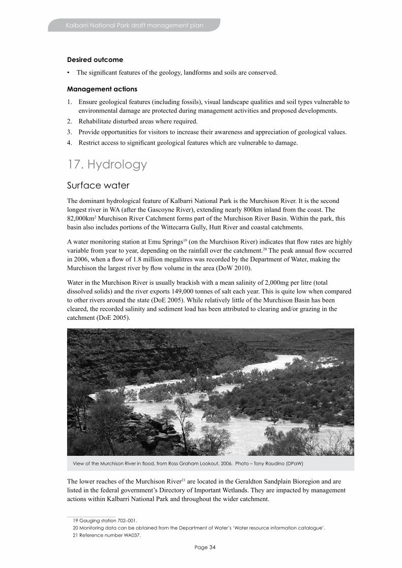
Page 34
Kalbarri National Park draft management plan
Desired outcome
• Thesignificantfeaturesofthegeology,landformsandsoilsareconserved.
Management actions
1. Ensure geological features (including fossils), visual landscape qualities and soil types vulnerable to environmental damage are protected during management activities and proposed developments.
2. Rehabilitate disturbed areas where required.3. Provide opportunities for visitors to increase their awareness and appreciation of geological values.4. Restrictaccesstosignificantgeologicalfeatureswhicharevulnerabletodamage.
17. Hydrology
Surface water
The dominant hydrological feature of Kalbarri National Park is the Murchison River. It is the second longest river in WA (after the Gascoyne River), extending nearly 800km inland from the coast. The 82,000km2 Murchison River Catchment forms part of the Murchison River Basin. Within the park, this basin also includes portions of the Wittecarra Gully, Hutt River and coastal catchments.
A water monitoring station at Emu Springs19(ontheMurchisonRiver)indicatesthatflowratesarehighlyvariable from year to year, depending on the rainfall over the catchment.20Thepeakannualflowoccurredin2006,whenaflowof1.8millionmegalitreswasrecordedbytheDepartmentofWater,makingtheMurchisonthelargestriverbyflowvolumeinthearea(DoW2010).
Water in the Murchison River is usually brackish with a mean salinity of 2,000mg per litre (total dissolved solids) and the river exports 149,000 tonnes of salt each year. This is quite low when compared to other rivers around the state (DoE 2005). While relatively little of the Murchison Basin has been cleared, the recorded salinity and sediment load has been attributed to clearing and/or grazing in the catchment (DoE 2005).
The lower reaches of the Murchison River21 are located in the Geraldton Sandplain Bioregion and are listedinthefederalgovernment’sDirectoryofImportantWetlands.Theyareimpactedbymanagementactions within Kalbarri National Park and throughout the wider catchment.
19 Gauging station 702–001.
20 Monitoring data can be obtained from the Department of Water’s ‘Water resource information catalogue’.
21 Reference number WA037.
View of the Murchison River in flood, from Ross Graham Lookout, 2006. Photo – Tony Raudino (DPaW)
Page 35
Kalbarri National Park draft management plan
Permanent river pools are set in the long, narrow, steep-sided gorge of the Murchison River. Many of these pools have heritage value as camps used by Nanda, 17th century European explorers, and drovers (see Managing cultural heritage).
Surface and groundwater are affected by variations in climate. A change in hydrological regimes will influencespeciesabundance(particularlythosespeciesattheendoftheirrange),vegetationstructureand,in turn, animal habitats in the park.
Groundwater
Groundwater aquifers occur in the porous and fractured Tumblagooda Sandstone and Wittecarra Sandstone,whichunderliethepark.Rechargeoftheaquiferisthroughinfiltrationofrainfall,run-offfromoutcropsandriverflows(whentheseintersectasandstoneoutcrop)duringfloodevents.Groundwater is fresh to brackish where there are sandstone outcrops, with salinity increasing with depth anddistancefromtheseoutcrops(Johnson&Commander2006).Groundwaterflowswestwardtowardsthe ocean south of Kalbarri and towards the river valley near the Murchison River. Groundwater from the Tumblagooda Sandstone aquifer provides public drinking water for the Kalbarri town site (see Water resource use).
Groundwater seeps and soaks occur in the Tumblagooda Sandstone, particularly near the Ross Graham Lookout.Theseprovidevaluablehabitatforfrogs,waterbirds,fishandsmallmammals,especiallyduringdry periods. These springs and seeps are of ongoing cultural importance for the Nanda, being central to the life of Nanda ancestors. For Nanda, it is important these seeps and soaks are kept free of weeds and introduced animals.
Catchment management
Water quality is a catchment-wide issue, with actions occurring outside lands and waters managed by the department impacting on water quality downstream. Management therefore requires an integrated whole-of-catchment approach.
Potential threats to water quality include:
• introduced animal activity (for example, goats and pigs trampling/browsing vegetation and fouling water)
• floodswhichdepositlargeamountsofsedimentintotheMurchisonRiverandaffectthewaterqualitywithin river pools
• nutrients and non-nutrient contaminants from land use within the catchment• potential introduction of pollutants and inappropriate visitor activity in public drinking water source
areas and wellhead protection zones• increases in salinity caused by upstream management practices • groundwater abstraction for mining.
Desired outcome
• Maintain the natural and cultural values of ground and surface water.
Management actions
1. Ensure that proposed developments or operations and activities (for example, recreational use) are managed in a way to minimise impacts on hydrological values.
2. Support the Department of Water in continuing water quality monitoring of the Murchison River Basin.
3. Support relevant authorities and land managers within the Murchison River Catchment in considering the impacts of activities on hydrological values.
Page 36
Kalbarri National Park draft management plan
18. Native plants and plant communitiesKalbarriNationalParkisbotanicallysignificantandlieswithinseveralbroaderareasrecognisednationallyandinternationallyfortheirdiversityofflora.Theparkispartof:
• the South West Australia international biodiversity hotspot22, one of 34 in the world and the only one in Australia
• the Geraldton Hills to Shark Bay Sand Plains national biodiversity hotspot23, one of 15 in Australia• a transition zone between the South West (temperate and eucalypt dominated) and Eremean (arid and
acacia dominated) botanical provinces (see Figure 1). One thousand and twenty-nine native plant species have been recorded within the park. This is comparabletothebotanicalsignificanceoftheStirlingRange(1,543species)andtheFitzgeraldBiosphere Reserve (1,557 species) (Keighery & Gibson 1999).24
The species in the park come from 180 families; with the best represented being Myrtaceae (eucalypts and paperbarks – 188 species), Fabaceae (legumes, peas and wattles – 115 species), Proteaceae (banksias and grevilleas – 78 species) and Asteraceae (daisies – 65 species).
Nineteen species are known to be endemic to the park, including Kalbarri catspaw (Anigozanthos kalbarriensis), Kalbarri lepidosperma (Lepidosperma rupestre) and Xanthoparmelia kalbarriensis. Given its location in a transition zone, the total number of endemic plant species is likely to be higher.
In addition, of all species known from the park, approximately 21 per cent (215 species) are at the northern limit of their natural range, making the health of the Kalbarri environment vital to their genetic diversity.Thelargeproportionofthepark’sfloraatthelimitofitsrange(inparticularspeciesattheirnorthern limit) makes the area particularly vulnerable to the impacts of climate change (see Climate) and changes to hydrological regimes (see Hydrology). Keighery et al. (2000) report that many native plant species—predominately from the Myrtaceae, Proteaceae and Orchidaceae families—were at the northern limits of their range (28, 26 and 25 species respectively). These families make up a large proportion of the overallfloraintheparkandareshowingsignsofdeclinealready.
The widespread death of several proteaceous sandplain species has been reported anecdotally in recent years. The cause of this is unknown, although it has coincided with recent years of drought. The continuation of drought and other climate change impacts will exacerbate this situation, possibly causing largeproportionsofthearea’sfloratodisappear.Therefore,moreresearchandmonitoringandtheimplementationofstrategiestoprotectthearea’sfloraareimportant.
KalbarriNationalParkisrenownedforitscolourfulwildflowers,whichattractalargenumberofvisitorseveryyear.WildflowerappreciationisfurtherdiscussedinVisitor activities.
22 International biodiversity hotspots are areas with exceptional concentrations of endemic species (at least 1,500 plant species) and experiencing exceptional loss of habitat (more than 70 per cent), as identified by Conservation International. (Myers et al. 2000; Conservation International 2012).
23 National biodiversity hotspots are locations in Australia with particularly high levels of biodiversity under threat.
24 Data obtained from NatureMap naturemap.dec.wa.gov.au in April 2012 and Keighery et al. 2000. NatureMap is a spatial database that can be used to find up-to-date records.

Page 37
Kalbarri National Park draft management plan
Flora of conservation significance
Theparkcontainsanumberoffloraspeciesofconservationsignificanceincluding:
• ninespecieslistedas‘threatenedflora’undertheWildlifeConservationAct(Wildlife Conservation (Rare Flora) Notice 2012 (2))—Caladenia barbarella, Caladenia hoffmanii,Beard’smallee(Eucalyptus beardiana), Caladenia bryceana subsp. cracens, Kalbarri spider orchid (Caladenia wanosa), Drakaea concolor, Kalbarri leschenaultia (Lechenaultia chlorantha), Stachystemon nematophorus, and short-petalled beyeria (Beyeria lepidopetala). All these species, with the exception of B. lepidopetala, are also listed as threatened or vulnerable under the Environment Protection and Biodiversity Conservation Act 1999 (EPBC Act)
• 89 priority species including seven Priority 1 species, 38 Priority 2 species, 34 Priority 3 species and 10 Priority 4 species
• 220 species (nearly 21 per cent of all recorded species in the park) recorded at the end of their range. Of these, 98 per cent are at their northern limit (Keighery et al. 2000)
• one relic species25, Psilotum nudum, a primitive species of fern. The Murchison River is its only known location in southern Western Australia (Jaensch & Lane 1993).
Threatstofloraofconservationsignificanceincludegrazingbygoatsandrabbits;diggingandtramplingbypigs;competitionfromweeds;inappropriatefireregimes;disturbancefrommanagementactivities;andchangesinriverflowaffectingriparianvegetation(Patrick2001;May&McKenzie2002).Patrick(2001)
identifiesarangeofstrategiesforprotectingrarefloraintheGeraldtonDistrict,manyofwhichapplytothe protection of species in the park.
These include:
• undertaking more survey and mapping work• adding lands on which rare species are represented to the conservation reserve system
25 Ancient and primitive taxa, of which other members are now extinct, that was abundant over a large area, but now only occurs over a very restricted area.
The declared rare flora species, Stachystemon nematophorus. Photo – Kiera Foster (DPaW)
The declared rare flora species, Drakaea concolor. Photo – Kiera Foster (DPaW)

Page 38
Kalbarri National Park draft management plan
• managing the impacts of pigs, rabbits and weeds• managingrecreationandotheractivitieswhererarefloraislocated• undertaking more research into rare species (for example, population biology, breeding systems and
fireresponses)• managingfireregimes• seed collection and long-term storage (providing a source of seeds for future re-establishment). An interim recovery plan has been prepared for the threatened species B. lepidopetala and Caladenia bryceana subsp. cracens.Guidanceforthemanagementandprotectionofthreatenedandpriorityfloraisalsoprovidedbythedepartment’sDeclared rare and poorly known flora of the Geraldton District (Patrick 2001).
Vegetation associations
The park is dominated by scrub heath on sandplain, with compositional variation. To the south of the Murchison River, the vegetation overlies an undissected plateau, with wide expanses of gently undulating yellow sandplain. Undulating sandplain also lies to the north of the Murchison River, with both areas supportingrichflora.TheMurchisonGorgeisdominatedbylowwoodlandwiththejamtree(Acacia acuminata) and Jacksonia cupulifera scrub with small trees of rock sheoak (Allocasuarina huegeliana) in rocky areas, jam tree and scattered river gum (Eucalyptus camaldulensis)inthelowerflatsofthegorgeand river swamp sheoak (Casuarina obesa) lining the river (Beard 1976).
Other shrubland associations found in the park include: summer-scented wattle (Acacia rostellifera) scrub/heath; York gum (Eucalyptus loxophleba) mallee scrub; umbrella bush (A. ligulata) mallee open scrub and heath on coastal limestone. The following associations are found both within Kalbarri National Park and the adjacent lands considered for reservation: acacia thickets, bowgada and jam scrub with scattered York gum and red mallee; tree heath between the sandhills with banksia, grevillea, acacia and melaleuca species and thickets of umbrella bush and broom bush (Melaleuca uncinata) on dark brown loamy soil.
Twelve vegetation associations occur in the park. The addition of the adjacent lands considered for reservation would result in the protection of eight under-represented vegetation associations (see Consideration of adjacent lands).
Ecological communities
The Kalbarri ironstone community is a Priority 1 Ecological Community, consisting of winter-wet melaleuca/mallee shrublands over herbs, surrounded by sandplains (in the vicinity of Z-Bend and Junga Dam). This community also occurs at Yerina Springs to the south of the park and on Eurardy Station to the north. Generally, ironstone communities occur on shallow red soils (less than 10cm in depth). Many plants that occur in these communities are endemic or near endemic to them, a situation that applies more broadly to all ironstone communities. In the south-west, ironstone soils with unusual plant communities occur in only a small number of places (English & Blyth 2000).
The vegetation of the Directory of Important Wetlands site – Murchison Gorge (lower reaches) has also beenidentifiedasanecosystematrisk,asitcontainsarangeofthreatenedfloraincludingDrakaea concolor, Kalbarri spider orchid, Kalbarri leschenaultia, Stachystemon nematophorus and Hypocalymma longifolium,andpriorityflorasuchasCalytrix harvestiana, Malleostemon sp. Hardabutt Rapids and Murchisonia fragrans.
Drought and drying conditions may be a threat to a number of communities within the park, including river gum communities along the Murchison River and the vegetation of the sandplain. Changes to groundwater are also thought to be impacting sandplain communities (see Hydrology). Plant communities in the vicinity of Wittecarra Gully are likely to be groundwater dependent and impacted by drier conditions.

Page 39
Kalbarri National Park draft management plan
Plant disease
One positive sample of Phytophthora arenariawasconfirmedonthesouthernboundaryofKalbarriNational Park from a single plant over 20 years ago (C Dunn pers. comm. 2012). The disease has not beensubsequentlyidentifiedanddoesnotappeartobeasignificantthreattothepark.Unlikethemoredestructive P. cinnamomi, P. arenaria is thought to be endemic to the northern sandplains of WA and episodic following extreme rainfall events (Rhea et al. 2011). However, using appropriate hygiene practices during soil disturbance activities is still important in keeping the area free of Phytophthora, other plant diseases and weeds. In addition, sealing the Loop/Z-Bend access road will reduce road maintenance requirements; therefore reducing the risk of introduction and spread of Phytophthora and other plant diseases. No other plant diseases have been detected in the park.
Desired outcomes
• Native plants and ecological communities are conserved.• The range of existing native plant species and vegetation associations is maintained.• No outbreaks of plant disease result from management actions.
Management actions
1. Maintain records of plant species and communities of conservation interest.2. Develop,updateandimplementrecoveryplansforthreatenedfloraandecologicalcommunities.3. Undertake an assessment of the conservation status of, and threats to, the Kalbarri Ironstone
ecological community and the vegetation of the Murchison Gorge (lower reaches).4. Conduct condition monitoring and evaluation programs for the Kalbarri Ironstone ecological
community and the vegetation of the Murchison Gorge (lower reaches), where required.5. Continue to apply hygiene practices to minimise the spread of plant disease resulting from
management activities.6. Continue regular observation for outbreaks of plant disease and in particular for any occurrences of
Phytophthora species. If required, prepare and implement a disease control plan consistent with Parks and Wildlife management approaches.
Key performance indicators
Performance measure Target Reporting
The presence of populations of threatenedflora
Maintain or increase viable populationsofthreatenedflora,subject to natural variation, from the commencement of the plan
Everyfiveyears,orasperrecovery plan
The introduction of plant disease
No plant diseases are introduced and/or spread
Annually
19. Native animals and habitatsWhile fauna research has been carried out in Kalbarri National Park, no comprehensive survey has been conducted. Two hundred and seventy native fauna species26 have been recorded in the park. This includes
26 Data obtained from district records and NatureMap (naturemap.dec.wa.gov.au) in January 2012. This spatial database can be used to find up-to-date records.

Page 40
Kalbarri National Park draft management plan
18mammal,144bird,70reptile,eightamphibian,18invertebrateand10fish27 species. It is anticipated that additional survey work across the park will identify more species.
Fauna of conservation significance
Theparkcontainsmanyfaunaspeciesofconservationsignificance,including:
• four threatened species listed under the Wildlife Conservation Act (Wildlife Conservation (Specially Protected Fauna) Notice 2012 (2))–thechuditch,Carnaby’scockatoo(Calyptorhynchus latirostris), malleefowl, and shield-backed trapdoor spider (Idiosoma nigrum), and two species listed under the Wildlife Conservation Act as specially protected – the peregrine falcon (Falco peregrinus) and the Australian sea lion28
• threethreatenedspecieslistedunderEPBCAct–theendangeredCarnaby’scockatooandthevulnerable chuditch and malleefowl
• 15 migratory bird species on the national List of Migratory Species under the EPBC Act, which are listed under international agreements
• sixParksandWildlifepriorityspecies–thePriority2fishgoldengudgeon(Hypseleotris aurea), the Priority 2 reptile stripe-sided robust slider (Lerista axillaris), the Priority 3 reptile Pletholax gracilis subsp. edelensis, the Priority 4 birds Australian bustard (Ardeotis australis) and bush stone-curlew (Burhinus grallarius) and the Priority 5 mammal tammar wallaby
• four species endemic to Kalbarri National Park (the invertebrates Austrogomphus gordoni and Harrisius sp., the reptile stripe-sided robust slider and the golden gudgeon)
• 17speciesatthenorthernlimitoftheirrange(fiveamphibian,twobird,twofish,threemammalandfivereptile)andonereptilespeciesatthesouthernlimitofitsrange–microslider.
Fauna reconstruction
KalbarriNationalParkhasbeenidentifiedasa fauna reconstruction site. This is part of the department’s Western Shield program, which proposes to reconstruct native vertebrate fauna as far as possible through predator control, habitat management and translocation of species no longer found in the park. Three species have been reintroduced to Kalbarri Nation Park to date. The chuditch was introduced in 2000, the woylie between 2000 and 2005 and the tammar wallaby in 2010. These introductions have varied in their success. While the chuditch reintroductions have proven to be successful, woylies and tammar wallabies have not met success criteria.
In other parts of Western Australia, woylie populationshaveexperiencedsignificantdeclines. At a species level, the woylie has declined by around 90 per cent between 1999 and 2010 and, for some populations in the south west, there have been overall declines of up to 95 percent (Wayne 2011). Within the park, woylies have not been recorded since 2006 (the year after translocation ceased), suggesting that the population is now extinct. Tammar wallabies are known to
27 These fish species occur throughout the Murchison River and, although it is likely that these records occur within the planning area, it is difficult to determine.
28 Australian sea lions have been recorded on beaches within Kalbarri National Park. It is likely this part of the coast is used by individuals passing through rather than as a more permanent ‘haul-out’ site or breeding colony.
A chuditch trapped during an annual program to monitor the population health and density of this threatened mammal living in the Murchison Gorge. Photo – Melissa Peake (DPaW)
Page 41
Kalbarri National Park draft management plan
persist but population numbers are low (J Renwick pers. comm. 2012). Fox baiting in the park has also led to an increase in other species such as malleefowl.
The black-footed rock wallaby (Petrogale lateralis) and the quenda (Isoodon obesulus) may also be considered for reintroduction (based on their historic range). These species disappeared in the park because introduced animals, such as goats, pigs, foxes and cats, out-competed them for food and shelter and/or preyed upon them. The historic range of the western barred bandicoot or marl (Perameles bougainville); burrowing bettong or boodie (Bettongia lesueur); rufous hare-wallaby or mala (Lagorchestes hirsutus) and banded hare-wallaby or mernine (Lagostrophus fasciatus) also once included the park. These species are very sensitive to predation and past reintroductions to unfenced areas have had limited success. Therefore their reintroduction to the park is not a priority. However, if reintroduction technologiesandpredatorcontrol(especiallycatcontrol)improvessignificantlyoverthelifeoftheplan,the reintroduction of these species may be considered. With better methods for cat and other predator control, such introductions are more likely to be successful.
Recovery plans exist for a number of threatened species that occur in the park or species that have been or are proposed to be reintroduced to the park: the chuditch (Orell & Morris 1994); woylie (Yeatman & Groom2012);Carnaby’scockatoo(DEC2012a);malleefowl(Benshemesh2007);andforfivespeciesofrock wallaby, including the black-footed rock wallaby (Pearson 2009).
Habitats
TheMurchisonRiverisrecognisedasanimportantfaunahabitat.ItcontainsfishspeciesfromtropicalandsouthernWAandmarksthesouthernboundaryofmanynorthernfishspecies(Allen1982;Allenet al. 2005). The river is the only known habitat for the Murchison River hardyhead (Craterocephalus cuneiceps); is the only other habitat for the golden gudgeon apart from the Gascoyne River; and is the northern limit for the black bream (Mylio butcheri)(Mitchell2009).Importantly,nointroducedfishspecies have been recorded in the Murchison River. This is unusual considering all other major river systems from the Gascoyne River (near Carnarvon) south to the Pallinup River (east of Albany) contain introducedspecies(Mitchell2009).TheabsenceofintroducedfishspeciesintheMurchisonRiveris important and this status needs to be maintained (see Introduced and other problem animals). This requires a whole-of-catchment approach, as any species introduced upstream will impact on the whole river system.
The permanent waterholes of the Murchison River are also inhabited by a variety of frog species and numerousfreshwaterinvertebrates,mainlysmallcrustaceans.Themudflatsalongtheriverareanattractivefeedinggroundforseagulls,ternsandavarietyofmigrantwadersandtheriver’spermanentpools support a large diversity of waterbirds and terrestrial birds which are dependent on fresh water.
The ecology of the Murchison Gorge and associated riparian zones is not well understood, but these areas provide a strong contrast to the surrounding sandplain and so are likely to support a range of species not found in the sandplain. The gorge contains many micro-habitats that provide protection for water-dependentandfire-sensitivefauna.Birds,particularlyCarnaby’scockatoo,usenestinghollowsinrivergum and other tree species growing in the gorge. A number of surveys have recorded locally endemic invertebrate species, so it is likely the gorge supports relict invertebrates, with restricted geographical ranges. Chuditch were translocated to the gorge and annual monitoring suggests they are predominantly found in this area. The gorge also provides a hunting and nesting ground for the peregrine falcon.
The sandplain provides important habitat for a range of fauna species. The sandplain plateau is home to several genera of burrowing and opportunistic breeding frogs including species of Neobatrachus and Heleioporus, the sandhill frog (Arenophryne rotunda) and the turtle frog (Myobatrachus gouldii). It is also a hotspot for reptiles, supporting a wide variety of species. Many bird species are also found on the sandplain plateau, in particular a large number of honeyeater species that are attracted to the sandplain floweringplants,whichprovideanabundanceofnectarduringthefloweringseason.Malleefowlalsoinhabit the sandplain plateau. Tammar wallabies were translocated to the sandplain and have a preference for patches of dense thicket.
Page 42
Kalbarri National Park draft management plan
Animal diseases
The extent of animal disease within Kalbarri National Park is unknown. There is, however, a range of animal diseases that have the potential to be introduced to the park. In particular:
• mammaldiseases−potentiallypathogenicorganismshavebeenlinkedtorecentwoyliedeclines(Thompson et al. 2008)
• Chytridiomycosis, an infectious disease caused by the amphibian chytrid fungus. Two species of frog occurring in the park (Lymnodynastes dorsalis and Crinia pseudinsignifera) have been reported with this disease in other parts of Australia (Australian Wildlife Health Network 2009)
• diseases present in fauna populations that are expressed when individuals or populations become stressed. For example, a wart-like growth disease in western barred bandicoots and the parasites Toxoplasma, Trypanosoma and Theileriaidentifiedinwoylies.
Diseases can be exposed to, and spread within, animal populations through the transportation, trapping andhandlingofanimals,andcanbetransferredtoandfromhumansandstock.Thedepartment’sMinimising disease risk in wildlife management: Standard operating procedures for fauna translocation, monitoring, and euthanasia in the field (Chapman et al. 2011) provides guidance for appropriate hygiene and quarantine protocols.
Desired outcomes
• Native animals and habitats are conserved.• The range of native fauna species is maintained.• Locally extinct mammal fauna are re-established.• No outbreaks of animal disease result from management actions.
Management actions
1. Maintainrecordsoffaunaspeciesandhabitatsofconservationsignificance(inparticularchuditch,woylie,tammarwallaby,Carnaby’scockatooandmalleefowl).
2. Develop, update and implement recovery plans for threatened fauna as required.3. Assess proposed development operations and activities for potential impacts on fauna.4. Continue to implement the Western Shield program including:
• continuing the control of introduced predator species• assessing appropriate fauna reintroductions• carryingoutrelevantfaunareconstructionactivitiesforidentifiedspecies• monitoring threatened fauna and threatening processes.
5. Continue to apply hygiene protocols to management actions undertaken to minimise the spread of animal disease.
6. Reportidentifiedanimaldiseasesandimplementappropriatemanagementifrequired.
Key performance indicators
Performance measure Target Reporting
Presence of threatened and priority fauna species
Maintain or increase populations of threatened and priority fauna species
Everyfiveyears
The protection of fauna from animal disease
No animal diseases are introduced and/or spread as a result of management activities
Annually

Page 43
Kalbarri National Park draft management plan
20. Environmental weedsWeeds displace native plants, particularly on disturbed sites, by competing with them for light, nutrients and water. Other impacts include the prevention of native seedling recruitment, changes to soil nutrients, andchangestotheabundanceofnativefauna.Weedscanalsohaveasignificantadverseimpactonothernaturalvaluesbyalteringanimalhabitats,harbouringpestsanddiseases,andalteringfireregimes.
Weed species within the park are recognised as a threat that needs to be managed. The department has undertaken an invasive plant prioritisation process as a progression from the Environmental weed strategy for Western Australia (CALM 1999), which provides an integrated approach to weed management in WA. The prioritisation process provides a ranking of the threat posed by weed species on a statewide basisagainstspecificcriteria.Informationontheprocessandassessmentforthedepartment’sMidwestRegioncanbefoundonthedepartment’swebsite(seewww.dpaw.wa.gov.au/plants-and-animals/plants/weeds/156-how-does-dpaw-manage-weeds).
Eighty-fourweedspecieshavebeenidentifiedinKalbarriNationalPark.Mostoftheparkisweedfreeand infestations tend to be along the river and access roads and tracks and in the vicinity of recreation sites.
Of the weeds recorded:
• 11 are rated as high priority in the Midwest Environmental Weed Assessment, as part of the Invasive plant prioritisation process for the Midwest (DEC 2010). These are: castor oil plant (Ricinus communis), ice plant (Mesembryanthemum crystallinum), Mediterranean turnip (Brassica tournefortii), Paterson’scurse(Echium plantagineum), ruby dock (Acetosa vesicaria), verbesina (Verbesina encelioides), African love grass (Eragrostis curvula), Lapeirousia anceps, buffel grass (Cenchrus ciliaris), capeweed (Arctotheca calendula) and Brazilian pepper (Schinus terebinthifolius). These will be the focus for weed control in the park
• six are rated as having a high impact on biodiversity in the Environmental Weed Strategy (Mediterranean turnip, buffel grass, African love grass, sandplain lupin (Lupinus cosentinii), ruby dock and great brome (Bromus diandrus))
• three are declared under the Biosecurity and Agriculture Management Act 2007 (BAM Act) (saffron thistle (Carthamus lanatus),Paterson’scurseanddoublegee(Emex australis))
• therearenoWeedsofNationalSignificance29 (although there are three that have been nominated: Paterson’scurse,AfricanlovegrassandBrazilianpepper).
Weeds have entered Kalbarri National Park and spread via the Murchison River, pedestrian and vehicle access, introduced animals (especially goats and pigs), past grazing and escaped stock from adjoining properties. The banks of the Murchison River have been particularly vulnerable to invasion by capeweed.
The development of a weed control plan for the park will be important in prioritising weed species for control effort. The control plan should:
29 The Weeds of National Significance (WoNS) program coordinates the national effort against 20 of Australia’s worst invasive plants (Commonwealth of Australia 2010).
Verbesina enceloides is a weed often found growing along road verges in the park. Photo – Tony Raudino (DPaW)

Page 44
Kalbarri National Park draft management plan
• identifyweedcontrolprioritiesandmapthoseidentifiedasahighpriorityforcontrol• include measures to limit opportunities for the introduction and establishment of new weeds that have
potentialtosignificantlyimpactonkeyvalues• include measures for monitoring, evaluating and documenting weed control effectiveness• be consistent with and complementary to regional weed management approaches• provide a coordinated approach with neighbours and other stakeholders across the broader landscape• include hygiene protocols for management activities to limit the spread of weeds• allow for adaptive management.
Desired outcomes
• Impacts of weeds upon key values are minimised.• No introductions of new weed species or new infestations of existing weed species that impact on key
values.
Management actions
1. Prepare, maintain and implement a weed control plan as outlined above. 2. Regularly monitor areas of new recreation site and road developments and other disturbances to
ensure any new weed infestations are quickly detected and controlled. 3. Develop opportunities to educate the community and visitors about identifying priority weeds species
and appropriate hygiene practices.4. Liaise with neighbouring land managers and implement measures to prevent weeds from adjacent
areas becoming established.
Key performance indicators
Performance measure Target Reporting
Protection against the establishment of new weed species
No new weed species introduced
Every two years
Infestations of high priority weed species
Infestations of established high priority weed species are contained or reduced
Every two years
21. Introduced and other problem animalsIntroduced and other problem animals have the potential to seriously impact on native species and natural systems directly through predation; habitat destruction; competition for food and territory; introduction of disease; and environmental degradation caused by grazing, accelerated erosion and pollution of waterways. The presence of introduced predators within Kalbarri National Park also limits the potential for fauna reconstruction (see Native animals and habitats).
The control of introduced animals requires a planned and prioritised approach. Eradication or even control of all introduced species is not feasible. Priorities for action include species declared under the BAM Act andintroducedanimalssignificantlyimpactingimportanthabitatsorthreatenedspeciesandcommunities.
Themostsignificantthreatstovaluesoftheparkarecausedbygoats,pigs,rabbits,foxesandcats.
FeralgoatsarethemostsignificantintroducedherbivorousspeciesinKalbarriNationalParkandacrossthe region. They have a marked impact on the environment, especially within the Murchison Gorge, where there is shelter and where control options are limited. Goats graze and trample native vegetation; increase soil erosion; cause sedimentation and fouling of waterways; and continually move into the park from surrounding lands. The impact of goats is exacerbated by other declared animals including pigs, rabbits and native herbivores such as kangaroos.

Page 45
Kalbarri National Park draft management plan
In the 20 years before 2005, goat control in the park was sporadic. Since 2006, aerial culling operations have been carried out annually. This control method is used because others, such as trapping and mustering, are not effective due to the rugged and inaccessible terrain of the area. The culling operation occurs in the warmer months when goats tend to congregate along the Murchison River. Where possible, shootings are also coordinated to coincide with goat mustering on Murchison House Station to maximise the effectiveness of the control operations. This type of control has proven to be very effective and goat numbersintheparkaresignificantlylowerfollowingashoot.Theestablishmentofgoatexclusionplotsand the subsequent monitoring of vegetation recovery provide information on the effectiveness of control operations.
Feral pigs have been sighted in Kalbarri National Park since the 1960s and, like goats, they trample vegetation (particularly threatened orchids because pigs seek out their tubers); disturb soil; spread disease; increasesedimentationandfoulingofwaterways;andcompetewithnativefauna.Numbersaredifficulttoestimate, but impacts are concentrated in the Murchison Gorge. Shooting occurs opportunistically during the annual aerial goat control program in the park and poison baits have also been used. To date, no monitoring has been carried out to assess the outcome of these control measures.
Rabbits are widespread, but their impacts are greatest on the coast where grazing on native vegetation is most evident. The success of rehabilitation at coastal sites in the park has been limited because of grazing pressure from rabbits. Rehabilitation sites must be fenced to prevent rabbits from gazing on seedlings.
Foxes and cats are found throughout Kalbarri National Park and the wider region. Preying on native fauna, they have severely reduced the distribution and abundance of native animal species. Foxes are controlledaspartofthedepartment’sWestern Shield fox baiting program. Baiting using 1080 fox baits is implemented at a density of one bait per 20ha. The success of the baiting program is measured by a fauna monitoring program. Monitoring of fox and cat numbers before and after baiting has occurred in recent years (2011–12) to determine whether the baiting is effective. This monitoring demonstrated much lower fox numbers in the park than in surrounding (non-baited) areas. Monitoring should also consider
Goats are the most significant introduced herbivore in the park. Their impacts include grazing and trampling vegetation, increased soil erosion and sedimentation and fouling in the Murchison River. Photo – David Pearson (DPaW)
An area where vegetation has been fenced clearly demonstrates the impacts of grazing by goats. Vegetation on the fenced side (on the left) is flourishing where goats have been excluded. Heavy grazing is evident on the unfenced side (on the right) where goats have not been excluded. Photo – Mike Paxman (DPaW)

Page 46
Kalbarri National Park draft management plan
mesopredator30 release, in which an increase in one or more subordinate predators (for example, feral cats) occurs after the removal or reduction in numbers of a dominant predator (for example, foxes).
Todatethereisnospecificmethodofcontrolforcats,althoughextensiveresearchisbeingcarriedoutbythe department towards the development of an effective cat bait. Anecdotally, it has been suggested that therearemorecatsintheparkthaninsurroundingareasandtheirimpactsaremoresignificant.
Other introduced animals within Kalbarri National Park include:
• feral bees (Apis mellifera) that are present near permanent water, particularly around the Murchison River. Here they inhabit rocky caves, overhangs and tree hollows used for nesting, possibly displacing native fauna and competing for nectar. Management will focus on controlling colonies and swarms around recreation sites
• the house mouse (Mus musculus) which is common close to the Kalbarri town site. Currently, no control measures are used.
Goats, pigs, foxes and other feral animals move across tenures in and out of Kalbarri National Park and neighbouring land. Coordinated control of introduced animals must be undertaken cooperatively with neighbouring land managers to ensure maximum success.
TheMurchisonRiverisfreefromanyintroducedfishspeciesandneedstoremainthiswaytoprotectthepark’snaturalvalues.Introducedfishspeciescanbreedrapidly,beaggressive,displacenativespeciesanddisruptaquaticecosystems.Onceestablished,introducedfishcanbevirtuallyimpossibletoeradicate.PubliceducationisimportanttopreventtheintroductionoffishspeciesandtoencouragerecreationalfishersandvisitorstoreportanyintroducedfishseenintheMurchisonRiver(DoF2010).Giventhelength of the Murchison River and its tributaries, any action will require a coordinated effort.
The development of an introduced animal control plan for Kalbarri National Park will be important in prioritising introduced animal species on which to focus control effort. In particular the control plan should:
• identify control priorities (for example, introduced animals declared under the BAM Act and those impacting on threatened species and communities or areas of high natural value)
• include measures to limit opportunities for the introduction and establishment of new introduced animalswiththepotentialtosignificantlyimpactkeyvalues
• include measures for monitoring, evaluating and documenting control effectiveness• be consistent with and complementary to regional management approaches (that is, consider the
adjacent lands considered for reservation)• provide a coordinated approach with neighbours and other stakeholders across the broader landscape• include capacity for adaptive management. No domestic animals including dogs (Canis spp.), cats and horses (Equus callabus) are permitted within Kalbarri National Park.
Desired outcomes
• Impacts of introduced and other problem animals upon key values are minimised.• No new introduced animal species.
Management actions
1. Prepare and implement an introduced animal control plan as outlined above.2. Continue to control goats, seeking support and assistance from Murchison House Station.3. Continue to control foxes and other introduced animals in collaboration with neighbouring land
managers.
30 Medium-sized predator.

Page 47
Kalbarri National Park draft management plan
4. Continue to undertake research and monitoring of introduced animals and their effects on and interactions with native species, and adapt management accordingly.
5. Consider fencing and rehabilitation of high-value areas to protect them from the impacts of grazing and trampling, particularly from introduced animals.
6. Monitor the severity of impacts caused by other introduced and other problem animals such as feral bees and house mice and investigate methods of control, if required.
7. Maintain and expand the use of goat exclusion plots and conduct an associated monitoring program to measure vegetation recovery, as an indicator of control effectiveness.
8. Work with neighbouring land managers, catchment groups, local government, other relevant agencies and the wider community to increase awareness of the ecological impacts that can result from the releaseofintroducedfishspeciesintonaturalwaterwaysinKalbarriNationalPark.
9. Prohibit domestic animals, except when used as:• guide dogs for visitors with visual impairments• animals required for emergency search and rescue.
Key performance indicators
Performance measure Target Reporting
The number of goats shot per cull, over consecutive years, in relation to effort
The number of goats shot per cull, over consecutive years decreases in relation to effort
Annually
Vegetation recovery in areas where goats have been removed
Vegetation recovery is recorded in areas where goat control occurs
Annually
22. FireOrganisationalresponsibilityforfiremanagementissharedbetweenthedepartment,DFESandlocalgovernment. The relevant arrangements are stipulated in the Emergency Management Act 2005, the accompanying regulations and the State emergency plan for bushfire (Westplan Bushfire) (FESA 2011). Thesedocumentsdefinefouraspectsofemergencymanagement:prevention,preparedness,responseandrecovery.Thedepartment’sfiremanagementactivities,includingprescribedfire,bushfirepreventionandfiresuppressionareregulatedbylegislation(forexampleBush Fires Act 1954 and CALM Act). Further guidanceisprovidedbydepartmentalpolicy(whichisunderreview)andtheConservationCommission’sPosition statement No. 1 Fire management (Conservation Commission 2011).
The department will incorporate guidance from this management plan, the local emergency management arrangementsandinterestedstakeholdersinits‘Prescribedfireplanningprocess’.Thisprocessidentifiesareaswhereprescribedfireistobeappliedoverthecomingthreeyears(sixseasons)(seewww.dpaw.wa.gov.au/management/fire/prescribedburning).Prescribedburnsmaybeundertakenforanumberofpurposes, including the protection of park visitors and surrounding residents, the management of the naturalenvironmentandforscientificresearch.Prescribedfireplansareupdatedtwiceayearandthepublic are given an opportunity to view the proposed prescribed burn areas and provide feedback.
Duringabushfireemergency,prioritywillbegiventotheprotectionofhumanlife,criticalinfrastructureand community assets. Following their consideration, protection of conservation and environmental values will be factored into incident action plans. Where possible, mitigation measures will be applied in a way that does not compromise the integrity of the natural environment.
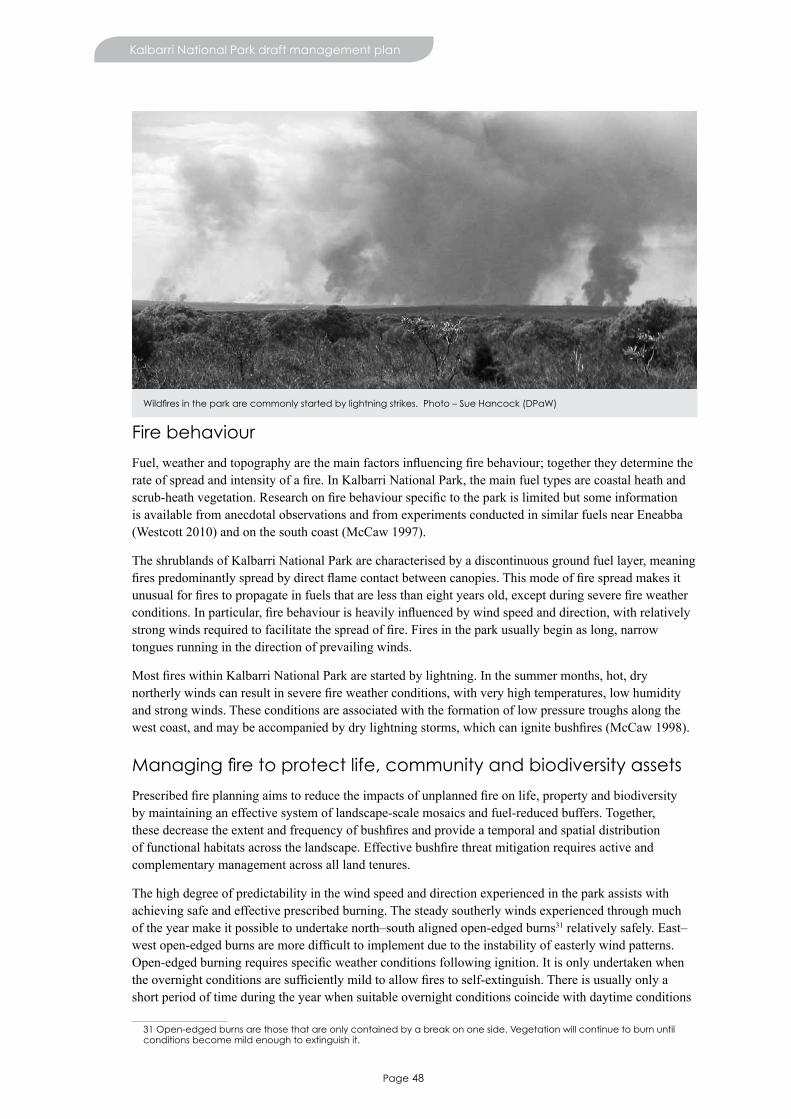
Page 48
Kalbarri National Park draft management plan
Fire behaviour
Fuel,weatherandtopographyarethemainfactorsinfluencingfirebehaviour;togethertheydeterminetherateofspreadandintensityofafire.InKalbarriNationalPark,themainfueltypesarecoastalheathandscrub-heathvegetation.Researchonfirebehaviourspecifictotheparkislimitedbutsomeinformationis available from anecdotal observations and from experiments conducted in similar fuels near Eneabba (Westcott 2010) and on the south coast (McCaw 1997).
The shrublands of Kalbarri National Park are characterised by a discontinuous ground fuel layer, meaning firespredominantlyspreadbydirectflamecontactbetweencanopies.Thismodeoffirespreadmakesitunusualforfirestopropagateinfuelsthatarelessthaneightyearsold,exceptduringseverefireweatherconditions.Inparticular,firebehaviourisheavilyinfluencedbywindspeedanddirection,withrelativelystrongwindsrequiredtofacilitatethespreadoffire.Firesintheparkusuallybeginaslong,narrowtongues running in the direction of prevailing winds.
MostfireswithinKalbarriNationalParkarestartedbylightning.Inthesummermonths,hot,drynortherlywindscanresultinseverefireweatherconditions,withveryhightemperatures,lowhumidityand strong winds. These conditions are associated with the formation of low pressure troughs along the westcoast,andmaybeaccompaniedbydrylightningstorms,whichcanignitebushfires(McCaw1998).
Managing fire to protect life, community and biodiversity assets
Prescribedfireplanningaimstoreducetheimpactsofunplannedfireonlife,propertyandbiodiversityby maintaining an effective system of landscape-scale mosaics and fuel-reduced buffers. Together, thesedecreasetheextentandfrequencyofbushfiresandprovideatemporalandspatialdistributionoffunctionalhabitatsacrossthelandscape.Effectivebushfirethreatmitigationrequiresactiveandcomplementary management across all land tenures.
The high degree of predictability in the wind speed and direction experienced in the park assists with achieving safe and effective prescribed burning. The steady southerly winds experienced through much of the year make it possible to undertake north–south aligned open-edged burns31 relatively safely. East–westopen-edgedburnsaremoredifficulttoimplementduetotheinstabilityofeasterlywindpatterns.Open-edgedburningrequiresspecificweatherconditionsfollowingignition.Itisonlyundertakenwhentheovernightconditionsaresufficientlymildtoallowfirestoself-extinguish.Thereisusuallyonlyashort period of time during the year when suitable overnight conditions coincide with daytime conditions
31 Open-edged burns are those that are only contained by a break on one side. Vegetation will continue to burn until conditions become mild enough to extinguish it.
Wildfires in the park are commonly started by lightning strikes. Photo – Sue Hancock (DPaW)

Page 49
Kalbarri National Park draft management plan
inwhichfirewillspreadthroughthepark’sdiscontinuousfuels.Thesizeofthis‘burningwindow’constrainsthepark’sprescribedburningprogram.
Fuelmodificationisalsousedtoprotectassetsfrombushfire.Thisinvolvespushingovervegetationin areas where fuels are high, allowing it to dry on the ground and then burning. Mulching vegetation, without burning, also occurs. These two methods are used in areas where there are high-value assets (for example, on the boundary with the Kalbarri town site), where the consequences of a prescribed burn escaping would be dire.
Life and community assets
There are many community assets in and around Kalbarri National Park that require protection from bushfire.TheseincludethetownofKalbarri,propertiessurroundingtheparkandthetwoaccessroadstothe town site. Assets within the park are: recreation sites and facilities, the radio communication repeater station and tower on Meanara Hill, infrastructure associated with utilities, and sites of cultural and heritagesignificance.
A vehicle access network within Kalbarri National Park, comprising public access roads and strategic managementtracks,willbemaintained.Wheretemporaryfireaccesstracksareconstructedduringsuppressionactivities,theywillberehabilitatedafterthefireevent.
Bushfirescanposeasignificantrisktovisitorstothedepartment’srecreationsites.ThroughtheKalbarriLocal Area Management Committee (of which the department is a member – see Visitor safety), an evacuation plan has been developed to ensure the safe evacuation of visitors from the park during abushfire.AcrosstheState,thedepartmentmayalsocloserecreationsitesondaysofveryhightocatastrophicfiredangerratingandthisisappliedtotheparkwhenthereisconsiderablelikelihoodofabushfire.
Fire and biodiversity
Naturally,theparkisaveryfire-proneenvironment.Manyspecieshaveadaptedtofire.However,akeythreattothenaturalvaluesoftheparkcanbeinappropriatefireregimes32.Specifically,inappropriatefireregimesaffectbiodiversity,populationviabilityandlong-termconservationofmanyofthespecies,communitiesandhabitatsfoundwithinKalbarriNationalPark.Therefore,burnprescriptionswillreflect
32 A ‘fire regime’ is a description of fire in terms of (a) fire frequency (how often it occurs on a site), (b) fire intensity (how much heat energy is released), (c) season (what time of year it occurs), (d) scale (how big it is), and (e) spatial diversity (how patchy it is at both a landscape and local scale). For more information on fire regimes and the environment, refer to the department’s website www.dpaw.wa.gov.au/management/fire.
A wildfire burning on the park boundary. A rapid response by DPaW staff and members of the Kalbarri Volunteer Bushfire Brigade ensured the fire was contained quickly. Photo – David Pratt
Page 50
Kalbarri National Park draft management plan
ecological,speciesorhabitatrequirements.Nosinglefireregimeisoptimalforallspeciesandanadaptiveapproachforprescribedfireplanningthatconsidersnewresearchisrequired.
Whenexposedtofire,specieshavevariedresponses.Thisistrueinthecaseofindividualfires,aswellaswhenconsideringcumulativefirehistory.InKalbarriNationalPark,vegetationinsandplainareastypicallyrespondswelltofirebutareasthatburnlessfrequentlyandhavesparservegetation—suchassandstonebreakaways,wetrefugeareasandparticularlytheMurchisonGorge—arelikelytohavefire-sensitivespecies.Plantsthatsurvivefire(whichdestroysmostoftheabove-groundparts)andrecoverbyresproutingunaffectedbudsareknownasresprouters.Reseedersareplantsthatarekilledbyfireandrelyon the germination of stored seed to regenerate. The reproductive strategies of reseeding and resprouting speciescontributetoidentifyingappropriatefireregimes.
Somefaunaspeciesrequirespecialconsiderationduringtheprescribedfireplanningprocess.Duringplanningforprescribedburning,habitatsfortammarwallabiesareidentifiedandburningiscarriedoutto protect these where possible. In addition, tammar wallabies prefer a diversity of habitats, so prescribed burning aims for a diversity of fuel ages (and hence greater biodiversity). Consideration should be given tocarryingoutorincreasingfoxbaitingfollowinglargebushfiresbecauseexpansesofburntvegetationprovide limited cover, leaving native fauna more prone to predation.
Community awareness
Engagingwiththepublicisvitaltoensureahighlevelofcommunityawarenessoffire,fire-mitigationstrategiesandfire-suppressionoperations.ThedepartmentwillassistDFESandtheShireofNorthamptonincommunicatingimportantmessagesaboutfiremanagementtoparkvisitorsandthelocalcommunity.Thedepartmentwillalsomakeinformationaboutitsfire-managementpracticesreadilyavailabletothepublic.Parkvisitorswillbemadeawareoftheimportanceofpersonalbushfiresafetybyon-groundstaffand signage.
CommunityinvolvementinfiresuppressionisparticularlystronginKalbarri.Thisinvolvementoccursduetoastrongspiritofcooperationbetweenthedepartment,theKalbarriVolunteerBushfireService,localgovernmentvolunteerbushfirebrigades,DFES,StateEmergencyServiceVolunteersAssociation,andtheWesternAustralianPolice.CollaborativefiremanagementisfacilitatedbytheLocalEmergencyManagementCommittee.Inadditiontorespondingtobushfires,membersofthesegroupsalsoparticipatein search and rescue operations in the park.
Desired outcomes
• Threatofbushfiretolifeandcommunityassetsisreduced.• Stakeholdersareengagedintheprescribedfireplanningprocess.• Sitesofculturalandheritagesignificanceareconsideredindevelopingaprescribedfireplan.
Management actions
1. Maintainanappropriatelevelofbushfiresuppressionpreparednessbyensuringadequateequipment,access to water, strategic access and communication.
2. Continuetoimplementaprescribedfireandfuelmodificationprogramthatincorporatesrelevantfiremanagementpolicies,guidelinesandavailableknowledge(includingfirehistory)to:
• protect the town of Kalbarri, neighbouring properties and other assets (both within and outside thepark)frombushfire
• adaptmanagementandimplementappropriatefiremanagementforfireregime-specificbiotaandhabitats
• establish and maintain a mosaic vegetation structure across the landscape.3. WorkcloselywithDFES,theShireofNorthampton,KalbarriVolunteerBushfireServiceandlocal
governmentvolunteerbushfirebrigades,neighbouringlandmanagers,thecommunityandother

Page 51
Kalbarri National Park draft management plan
authorities to encourage cooperative arrangements and ensure appropriate community protection from fire.
4. Promotepubliceducationandawarenessofthedepartment’sfireplanningandmanagement,theeffectsoffireonthenaturalenvironment,theneedtopreventbushfires,thesafetyandsurvivalofpeople, and protection of property.
5. WorkwithNandainmanagingfire,includingtheapplicationofprescribedfireandprotectionofsitesofculturalandheritagesignificance.
6. Establishandmaintainpost-firemonitoringsitestomeasuretheimpactofbushfireandprescribedfire,andtodevelopanunderstandingofecologicalfirerequirementsofbiota.
7. Developandimplementrecoveryplansafterbushfiresforwhichthedepartmentisresponsible.
Key performance indicators
Performance measure Target Reporting
Theimpactofbushfireandprescribedfireonhumanlifeorcommunity assets
No serious injury to people or damage to community assets attributedtothedepartment’sfiremanagement
Annually
Implementation of the prescribed burn program
Prescribe burn program is kept up to date and implemented
Annually
Theimpactoffiremanagementactivities on known threatened floraandpriorityecologicalcommunities
No adverse impacts on threatenedfloraandpriorityecological communities as aresultoffiremanagementactivities, without appropriate approval
Annually

Page 52
Managing resource use
23. Mineral and petroleum operationsMining in Western Australia is primarily administered by the Department of Mines and Petroleum through the granting of various tenements. The holders of tenements are required to meet certain conditions in order to retain exploration and development rights. These include the requirement that all development projects undergo environmental, heritage and native title assessments. Exploration anddevelopmentproposalsthatmaycausesignificantimpactonkeyvaluesmustbereferredtotheEnvironmental Protection Authority for environmental impact assessment. Furthermore, actions that may haveasignificantimpactonmattersofnationalsignificance33 may also require approval under the EPBC Act.
While legislation provides a process for industry to apply for access to undertake mining and petroleum exploration and development in Kalbarri National Park, the department; the Conservation Commission; and the Minister for Environment, will consider application for access and development proposals on a case-by-case basis. Cases where access and/or development would be incompatible with protecting the park’skeyvalueswillbeclearlyidentifiedasearlyaspossibleingovernmentassessmentprocesses.Thedepartment will work with industry and decision making authorities to ensure impacts are avoided or minimised to acceptable levels.
There are no exploration licences or petroleum tenements over Kalbarri National Park, although there are a number of exploration licences over the adjacent lands considered for reservation (see Consideration of adjacent lands). The latest information on tenements can be found on the Department of Mines and Petroleum’sTengraphdatabase.34
Basic raw materials
Itisthedepartment’spreferencethatbasicrawmaterialsaresourcedfromoutsideKalbarriNationalPark.When this is not feasible, the department will consider access to basic raw materials from within the park on the basis it is for use within the boundary of the park. This may occur for operations such as road building.
33 Under the EPBC Act, matters of national significance include nationally listed threatened species and ecological communities.
34 See www.dmp.wa.gov.au.
Nanda Traditional Owners provide advice about Aboriginal cultural heritage during investigations into sources of basic raw material (gravel) in the park, prior to the commencement of road developments. Photo – Rory Chapple (DPaW)

Page 53
Kalbarri National Park draft management plan
Desired outcome
• Impacts of mineral and petroleum operations and extraction of basic raw materials on key values are minimised.
Management actions
1. Work with the Department of Mines and Petroleum and the Environmental Protection Authority to evaluate proposed mineral and petroleum operations that may impact on Kalbarri National Park and seek to avoid or minimise these impacts.
2. Ensure that any areas disturbed by mineral and petroleum operations are rehabilitated in accordance with the conditions of the mining or exploration tenure or approval documentation as well as departmental rehabilitation standards and guidelines.
3. Rehabilitate areas disturbed by basic raw material extraction in accordance with departmental policies and undertake post-rehabilitation monitoring and evaluation to ensure compliance.
4. Ensure that all mineral and petroleum operations and basic raw material extraction adhere to departmental disease hygiene practices.
24. BeekeepingTherearenoapiarysiteswithinKalbarriNationalPark.Thedepartment’sdraftPolicyStatementNo.41Beekeeping on public land (CALM 2004) indicates that no new apiary sites will be permitted in Kalbarri National Park because there is no historical use.
Desired outcome
• Impacts of beekeeping and introduced honeybees on key values are minimised.
Management actions
1. Do not issue any apiary site permits within Kalbarri National Park.
25. Water resource useWater resource use is regulated under the Rights in Water and Irrigation Act 1914 (RIWI Act) that is administered by the Department of Water, the agency responsible for the protection and management of water resources. Under the RIWI Act, proponents are required to obtain a licence from the Department of Water to extract water within the Gascoyne Groundwater Proclamation Area. The department may, under the CALM Act, issue a water removal permit to proponents seeking to extract water from land vested in the Conservation Commission. Where infrastructure for water abstraction is necessary, a lease may also be required.
Groundwater from the Tumblagooda Sandstone aquifer provides public drinking water for the town of Kalbarri. Water is drawn from six Water Corporation production bores outside the planning area. The bores are located within the gazetted Kalbarri Water Reserve Public Drinking Water Source Area, which covers the town of Kalbarri and parts of Kalbarri National Park to the south and east of the town. There is one monitoring bore in the park, which also provides water to the Park Headquarters. The Water Corporation production bores are surrounded by wellhead protection zones, one of which extends into the park. Wellhead protection zones are for the protection of a drinking water source from contamination in the immediate vicinity of bores (a 500m radius from production bores).
The area of national park within the Kalbarri Water Reserve is a Priority 1 Protection Area (as gazetted under the Country Areas Water Supply Act 1947). The Kalbarri water reserve drinking water source protection plan: Kalbarri and Port Kalbarri town water supply (DoW 2006) provides guidance for protecting water quality. Management activities must be planned to minimise impacts on the values of this drinking water source.
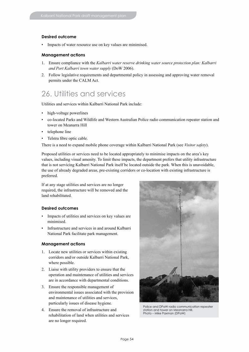
Page 54
Kalbarri National Park draft management plan
Desired outcome
• Impacts of water resource use on key values are minimised.
Management actions
1. Ensure compliance with the Kalbarri water reserve drinking water source protection plan: Kalbarri and Port Kalbarri town water supply (DoW 2006).
2. Follow legislative requirements and departmental policy in assessing and approving water removal permits under the CALM Act.
26. Utilities and servicesUtilities and services within Kalbarri National Park include:
• high-voltage powerlines• co-located Parks and Wildlife and Western Australian Police radio communication repeater station and
tower on Meanarra Hill• telephone line• Telstrafibreopticcable.There is a need to expand mobile phone coverage within Kalbarri National Park (see Visitor safety).
Proposedutilitiesorservicesneedtobelocatedappropriatelytominimiseimpactsonthearea’skeyvalues, including visual amenity. To limit these impacts, the department prefers that utility infrastructure that is not servicing Kalbarri National Park itself be located outside the park. When this is unavoidable, the use of already degraded areas, pre-existing corridors or co-location with existing infrastructure is preferred.
If at any stage utilities and services are no longer required, the infrastructure will be removed and the land rehabilitated.
Desired outcomes
• Impacts of utilities and services on key values are minimised.
• Infrastructure and services in and around Kalbarri National Park facilitate park management.
Management actions
1. Locate new utilities or services within existing corridors and/or outside Kalbarri National Park, where possible.
2. Liaise with utility providers to ensure that the operation and maintenance of utilities and services are in accordance with departmental conditions.
3. Ensure the responsible management of environmental issues associated with the provision and maintenance of utilities and services, particularly issues of disease hygiene.
4. Ensure the removal of infrastructure and rehabilitation of land when utilities and services are no longer required.
Police and DPaW radio communication repeater station and tower on Meanarra Hill. Photo – Mike Paxman (DPaW)

Page 55
Kalbarri National Park draft management plan
5. Work with utility and service providers to minimise environmental and visual impacts.6. Seek to maximise mobile phone coverage.
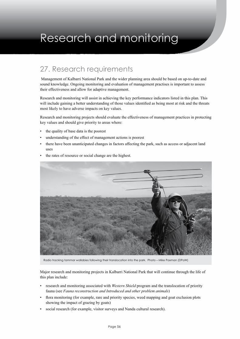
Page 56
27. Research requirements Management of Kalbarri National Park and the wider planning area should be based on up-to-date and sound knowledge. Ongoing monitoring and evaluation of management practises is important to assess their effectiveness and allow for adaptive management.
Research and monitoring will assist in achieving the key performance indicators listed in this plan. This willincludegainingabetterunderstandingofthosevaluesidentifiedasbeingmostatriskandthethreatsmost likely to have adverse impacts on key values.
Research and monitoring projects should evaluate the effectiveness of management practices in protecting key values and should give priority to areas where:
• the quality of base data is the poorest• understanding of the effect of management actions is poorest• there have been unanticipated changes in factors affecting the park, such as access or adjacent land
uses• the rates of resource or social change are the highest.
Major research and monitoring projects in Kalbarri National Park that will continue through the life of this plan include:
• research and monitoring associated with Western Shield program and the translocation of priority fauna (see Fauna reconstruction and Introduced and other problem animals)
• floramonitoring(forexample,rareandpriorityspecies,weedmappingandgoatexclusionplotsshowing the impact of grazing by goats)
• social research (for example, visitor surveys and Nanda cultural research).
Radio tracking tammar wallabies following their translocation into the park. Photo – Mike Paxman (DPaW)
Research and monitoring
Page 57
Kalbarri National Park draft management plan
Desired outcome
• Knowledge and understanding of key values and management issues is increased and aids in implementation of this management plan.
Management actions
1. Conduct integrated research and monitoring programs that facilitate management, with a focus on keyvaluesandthreatsidentifiedinthismanagementplan;theestablishmentofbaselineinformation;meeting key performance indicators; and other departmental research priorities.
2. Encourage and support, wherever possible, external agencies and individuals where their research contributes directly to departmental objectives or the implementation and auditing of this management plan.
3. Ensure relevant information gained through research, monitoring and experience is available to managersandinregionalanddistrictofficelibraries/databases,andiskeptuptodate.
4. Incorporateresearchandmonitoringfindingsintoperformanceassessmentagainsttheobjectivesofthis management plan and adapt future management, if required.

Page 58
References
Allen, GR (1982) A field guide to inland fishes of Western Australia. University of Western Australia Press. Perth, Western Australia.
Allen, MG, Morgan, DL & Gill, HS (2005) Distribution, zoogeography and biology of the Murchison River hardyhead (Craterocephalus cuneiceps Whitley, 1944), an atherinid endemic to the Indian Ocean (Pilbara)DrainageDivisionofWesternAustralia.Ecologyoffreshwaterfish.Vol14,pp209−224.
Australian Wildlife Health Network (2009) Chytridiomycosis – amphibian chytrid fungus in Australia: fact sheet. Australian Wildlife Heath Network.
Beard, JS (1976) The vegetation of the Ajana area, Western Australia. Map and Explanatory Memoir, 1:250,000 series. Vegmap Publications, Perth.
Benshemesh, J (2007) National recovery plan for Malleefowl Leipoa ocellata. Government of South Australia, Adelaide.
Burbidge, AH, Harvey, MS & McKenzie, NL (eds.) (2000). Records of the Western Australian Museum supplement No. 61. Biodiversity of the southern Carnarvon Basin. Western Australian Museum, Perth.
CALM (1999) Environmental weed strategy for Western Australia. Department of Conservation and Land Management, WA.
CALM (2003) Establishment of comprehensive, adequate and representative terrestrial conservation reserve system in Western Australia. Department of Conservation and Land Management, WA.
CALM (2004) Draft policy statement No. 41 (Revised) Beekeeping on public land. Department of Conservation and Land Management. www.dec.wa.gov.au/component/option,com_docman/task,doc_download/gid,3075/Itemid,1/.
Chapman, T, Sims, C & Mawson, P (2011) Minimising Disease Risk in Wildlife Management: Standard Operating Procedures for Fauna Translocation, Monitoring, and Euthanasia in the Field. Department of Environment and Conservation, Kensington.
Commonwealth of Australia (2010) Weeds of national significance update 2010. Commonwealth of Australia. Launceston.
Conservation Commission (2011) Position statement no. 1 – Fire management. Conservation CommissionofWesternAustralia.www.conservation.wa.gov.au/media/14020/fire%20management%20ps%201.pdf.
Conservation International (2012) Hotspots defined. Conservation International. www.conservation.org/where/priority_areas/hotspots/Pages/hotspots_defined.aspx.Accessed15May2012.
Darragh, TA & Kendrick, GW (2008) Silicified Eocene molluscs from the lower Murchison district, southern Carnarvon Basin, Western Australia.RecordsoftheWesternAustralianMuseum,24:217−246.
DEC (2006) Policy statement no.18 Recreation, tourism and visitor services. Department of Environment and Conservation, Kensington. www.dec.wa.gov.au/component/option,com_docman/task,doc_download/gid,4655/Itemid,/.
DEC (2010) Invasive plant prioritisation process for DEC: An integrated approach to environmental weed management in Western Australia. Department of Environment and Conservation, Kensington.
Page 59
Kalbarri National Park draft management plan
DEC (2012a) Carnaby’s cockatoo (Calyptorhynchus latirostris) recovery plan. Department of Environment and Conservation, Perth, Western Australia.
DEC (2012b) Guide to Aboriginal customary activities on DEC-managed lands and waters. Department of Environment and Conservation, Perth.
DEC (2012c) Shark Bay terrestrial reserves and proposed reserve additions management plan no. 75 2012, Department of Environment and Conservation, Kensington.
Department of Agriculture (2001) The state barrier fence of Western Australia 1901–2001. Agricultural Protection Board, South Perth.
Department of Mines and Petroleum (2010) GeoVIEW. Geoheritage sites. www.dmp.wa.gov.au. Accessed 08/03/12.
Department of Planning and Urban Development (1992) Kalbarri plan. Western Australia.
DoE (2005) Stream salinity status and trends in south-west Western Australia. Salinity and land use impacts series, report no. SLUI 38. Natural Resource Management and Salinity Division, Department of Environment, Perth.
DoF (2010) Aquatic invaders: Introduced species are a threat to our aquatic biodiversity. Department of Fisherieswebsite,www.fish.wa.gov.au/docs/pub/IMPFreshwater/index.php?0506Accessed11November2010.
DoP & WAPC (2011) Draft Mid West regional planning and infrastructure framework. Department of Planning and Western Australian Planning Commission. Perth, WA.
DoW (2006) Kalbarri water reserve drinking water source protection plan: Kalbarri and Port Kalbarri town water supply. Department of Water, Water Resource Protection Series, WRP 64.
DoW (2010) Water resources data.Streamflowsites.EmuSprings,MurchisonRiver.kumina.water.wa.gov.au/waterinformation/wrdata/FLOW/702001/han.htm. Accessed 19 August 2010.
DPaW (2013) General conditions for using apiary authorities on Crown land in Western Australia. Department of Parks and Wildlife. See www.dpaw.wa.gov.au/images/documents/plants-animals/animals/Using-Apiary-Authorities-on-Crown-Lands.pdf
English, V & Blythe, J (2000) Shrublands and woodlands on Perth to Gingin Ironstone, interim recovery plan no 61, 2000−2003. Department of Conservation and Land Management, Wanneroo.
EPA (1976) Conservation reserves for Western Australia: As recommended by the Environmental Protection Authority 1976: Systems 1, 2, 3, 5. Western Australia. Environmental Protection Authority.
FESA (2011) State emergency plan for bushfire (Westplan Bushfire). Fire and Emergency Services Authority of WA. WA.
Government of Western Australia (2011) 2011 Statewide vegetation statistics incorporating the CAR reserve analysis (full report). WA Department of Environment and Conservation, Perth. www2.landgate.wa.gov.au/web/guest/downloader.
Government of Western Australia (2012) Adapting to our changing climate. Department of Environment and Conservation, Perth.
Halse, SA, Shiel, RJ, Storey, AW, Edward, DHD, Lansbury, I, Cale, DJ & Harvey MS (2000) Aquatic invertebrates and waterbirds of wetlands and rivers of the southern Carnarvon Basin, Western Australia. Records of the Western Australian Museum Supplement No. 61. Biodiversity of the southern Carnarvon Basin. Western Australian Museum, Perth. Burbidge, AH, Harvey, MS & McKenzie NL (eds.).
Page 60
Kalbarri National Park draft management plan
Hocking, RM, Van de Graaff WJE, Blockley, JG & Butcher, BP (1982) Ajana Western Australia. 1:250 000 Geological Series – Explanatory Notes. Geological Survey of Western Australia, Perth.
Jackson, G & de Grand, D (1996) The Report of an Aboriginal heritage study of the Nanda area central, Kalbarri. Nanda Aboriginal Corporation. Barrel Well Community, Anthropos Australia Pty Ltd.
Jaensch R & Lane J (1993) Western Australia. A Directory of Important Wetlands in Australia (eds S Usback, R James). Australian Nature Conservation Agency, Canberra. pp. 1–178.
Johnson, SL & Commander, DP (2006) Midwest minerals province – groundwater resource appraisal, Department of Water, Perth.
KeigheryG&GibsonN(1999)VascularfloraofthesouthernCarnarvonBasin,WesternAustralia(Abstract). Dampier 300: Biodiversity in Australia, 1699-1999 and beyond, 6 to 10 December 1999: Program and abstracts pp. 55–56.
Keighery GJ, Gibson N, Lyons, MN & Burbidge AH (2000) Flora and vegetation of the southern Carnarvon Basin, Western Australia. Records of the Western Australian Museum supplement 61, pp. 77–154.
Main Roads Western Australia (1997) Roads 2020 Regional roads development strategy. Gascoyne Region. Main Roads Western Australia, Perth.
May, J & McKenzie, N (2002) A biodiversity audit of Western Australia’s biogeographical subregions in 2002. Department of Conservation and Land Management, Kensington.
McCaw, WL (1997) Predicting fire spread in Western Australian mallee-heath shrubland. Thesis (Ph.D.) University of New South Wales.
McCaw,WL(1998)Researchasabasisforfiremanagementinmallee-heathshrublandsofsouth-western Australia. III International conference on forest fire research, 14th conference on fire and forest meteorology,Luso,Coimbra,16/20November,1998,Portugal:proceedings.vol2,pp2355−2348,Portugal.
Mitchell, S (2009) Kalbarri. Department of Environment and Conservation, Kensington, WA.
Myers, N, Mittermeier RA, Mittermeier, CG, da Fonseca, GAB, & Kent, J (2000) Biodiversity hotspots for conservation priorities. Nature403,853−858.
Orell, P & Morris, K (1994) Chuditch recovery plan, 1992-2001. Wildlife Management Program No. 13. Department of Conservation and Land Management, WA.
Patrick, S (2001) Declared rare and poorly known flora in the Geraldton District. Western Australian Wildlife Management Program No. 26. Department of Environment and Conservation, WA.
Pearson, DJ (2009) Recovery plan for five species of rock-wallabies: Black-flanked Rock-wallaby (Petrogale lateralis), Rothschild rock-wallaby (Petrogale rothschildi), Short-eared rock-wallaby (Petrogale brachyotis), Monjon (Petrogale burbidgei) and Nabarlek (Petrogale concinna). Department of Environment and Conservation, Perth, WA.
Playford, P (1998) Voyage of discovery to Terra Australis by Willem de Vlamingh in 1696−97. Western Australian Museum, Perth.
Rhea, AJ, Burgess, TI, Hardy, GE St J, Stukely, MJC & Jung, T (2011) Two novel and potentially endemic species of Phytophthora associated with episodic dieback of Kwongan vegetation in the south-west of Western Australia. Plant pathology, 60, 1055-1068.
Richards, JD (2007) Western barred bandicoot (Perameles bougainville), burrowing bettong (Bettongia lesueur) and banded hare wallaby (Lagostrophus fasciatus) Recovery Plan, 2007-2011. Wildlife Management Program No. 49. Department of Environment and Conservation, WA.

Page 61
Kalbarri National Park draft management plan
Thompson, A, Knowles, G & Eden, P (2008) Disease Synthesis. Progress report of the woylie conservation research project: Diagnosis of recent woylie (Bettongia penicillata ogilbyi) declines in southwestern Australia: a report to the Department of Environment and Conservation Corporate Executive. (ed A Wayne). Department of Environment and Conservation, Kensington, WA, pp. 271-3.
Tourism Western Australia (2010) Australia’s Coral Coast, tourism development priorities. Tourism Western Australia, Perth.
Wayne, A, Maxwell, M, Nichols, P, Pacioni, C, Reiss, A, Smith A, Thompson, A, Vellios, C, Ward, C, Wayne, J, Wilson, I & Williams, M (2011) The Woylie Conservation Research Project: investigating the cause(s) of woylie declines in the Upper Warren. Progress Report. Department of Environment and Conservation, Perth.
Westcott, V (2010) The effect of short inter-fire intervals on the biodiverse, fire-prone Mediterranean-type shrublands of the eneabba sandplain, Western Australia. Thesis (Ph.D.) The University of Melbourne, Victoria.
Yeatman GJ & Groom CJ (2012) National recovery plan for the woylie Bettongia penicillata. Wildlife Management Program no. 51. Department of Environment and Conservation, Perth.

Page 62
Kalbarri National Park draft management plan
Map 1. Planning area
Shire of Northampton
Shire of Shark Bay
KALBARRI
MUR
CHIS
ON
RIVER
ROAD
AJANA
RIVE
R
MURCHISON
GantheaumeBay
KALBARRI
1
5
KALBARRINATIONAL PARK
I N D I A N O C E A N
GEO
RG
EG
REY
LEGEND
Pastoral lease boundary
Major roadsMajor hydrography
Planning area boundary
0 5 10 15 20
Scale
25km
COAS
TAL
HIG
HWAY
Kalbarri National Park
Bluff Point
Shoal Point
Eagle Gorge
Lucky Bay
Sanalwood Bay
GREGORY
Karratha
Kununurra
Albany
Kalgoorlie
PERTH
Geraldton
Locality Map
I N D I A N
O C E A N
W E S T E R N
A U S T R A LI A
Planning Area
N
RiverHutt
HuttLaggoon
11
8
79
12
14KALBARRI
AJANA
ROAD
MURCHISON
RIVER
KALBARRINATIONAL
PARK
Hardabut Pool
Croton
Creek
SeeInset
Gully
Wittecarra
16
2
3
46
YandiHomestead
4
4
3
Mary SpringsHomestead
EurardyHomestead
18
3
19
17
15
13
Murchison HouseHomestead
Map ID
Adjacent lands for consideration
COOLCALA
LAYA
ROAD
DRIVE
Nerren Nerren
NORTH W
EST COASTAL HIG
HWAY
YANDI
NERREN NERREN
EURARDY
MEADOW
COBURN
COOLCALALAYA
MT VIEW
MURCHISON HOUSE
NORT
HW
EST
Halfway Bay
Red Bluff
To Canarvon & Denham
HAMELIN TALISKER
Coburn Homestead Meadow Homestead
CoolcalalayaHomestead
Riverside Homestead
Mt View Homestead
To GeraldtonTo Northhampton
RabbitOld
Proof Fence
Fence
BarrierState
Local Government Authority Boundary
Inset
10
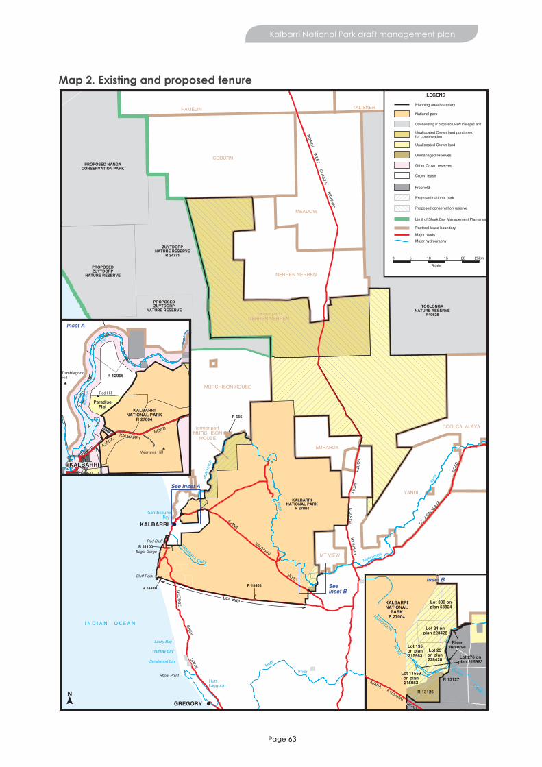
Page 63
Kalbarri National Park draft management plan
Map 2. Existing and proposed tenure
GREGORY
RIVER
KALBARRINATIONAL
PARKR 27004MURCHISON
AJANAKALBARRI
INSET BSeeInset B
N
YANDI
NERREN NERREN
EURARDY
MEADOW
COBURN
COOLCALALAYA
MT VIEW
MURCHISON HOUSE
KALBARRINATIONAL PARK
R 27004
R 18403
ZUYTDORPNATURE RESERVE
R 34771
R 656
R 14440
R 31100
UCL strip
COOLCALA
LAYA
ROAD
KALBARRI
ROAD
AJANA
GEO
RG
E
GREY
DRIVE
HIGHW
AYC
OASTAL
WEST
NO
RTH
NORTH W
EST COASTAL HIG
HWAY
Halfway Bay
Shoal Point
Sanalwood Bay
Lucky Bay
Eagle Gorge
Red Bluff
HuttLaggoon
River
Hutt
RIVER
I N D I A N O C E A N
Wittecarra
Gully
Bluff Point
KALBARRI
GantheaumeBay
MU
RCH
ISO
N
RIVE
R
MURCHISON
HAMELIN TALISKER
TOOLONGANATURE RESERVE
R40628
LEGEND
National park
Unallocated Crown land
Unmanaged reserves
Other Crown reserves
Crown lease
Proposed conservation reserve
Pastoral lease boundary
Major roadsMajor hydrography
Planning area boundary
Proposed national park
Freehold
0 5 10 15 20
Scale
25km
PROPOSED NANGACONSERVATION PARK
PROPOSEDZUYTDORP
NATURE RESERVE
Limit of Shark Bay Management Plan area
RiverReserve
Lot 276 onplan 215983
R 13127
Croton
Creek
ROAD
Other existing or proposed DPaW managed land
Unallocated Crown land purchasedfor conservation
Lot 300 onplan 53824
Lot 24 onplan 228428
Lot 23on plan228428
R 13126
Lot 11559on plan215983
Lot 195on plan215983
former partMURCHISON
HOUSE
former partNERREN NERREN
R 12996
KALBARRINATIONAL PARK
R 27004
ROADKALBARRI
AJANA
Red Hill
TumblagoodaHill
Meanarra Hill
MU
RCH
ISO
N
RIVER
MurchisonHouse
KALBARRI
Inset A
See Inset A
Inset B
PROPOSEDZUYTDORP
NATURE RESERVE
ParadiseFlat

Page 64
Kalbarri National Park draft management plan
Map 3. Recreation sites
MU
RC
HISO
N
RIVER
KALBARRI
Hawks Head
Z Bend
Red BluffMushroom RockRainbow Valley
Pot AlleyEagle Gorge
Island RockNatural Bridge/
Castle Cove
Meanarra HillLookout
Loop-Z Bend Entry Station
Natures Window
The Loop
Gully
Wittecarra
MUR
CHIS
ON
RIVER
Hawks Head/Ross GrahamEntry Station
KALBARRI NATIONAL PARK
KALBARRI NATIONAL PARK
KALBARRI NATIONAL PARK
Bluff Point
Gantheaume Bay
ParadiseFlat
Little Z
I N D I A N O C E A N
KALBARRI
LEGEND
Major hydrography
Planning area boundary
Sealed road (2WD)Proposed Sealed Road
Major recreation siteMedium recreation siteMinor recreation site
Recreation Sites
0 2 4 6
Scale
8km
Locality Map
COASTAL
HIGHWAY
GEORGE
GREY
DR
IVE
AJANA
KALBARRI
ROAD
Adjacent lands for consideration
Kalbarri National Park
West Loop
Ross Graham Lookout
Bracken Point
Bettie Crossing
Toolonga Pt
Thirindine Point
Nats Mia
Nats Yard
Wilgiamia Pool
Goonerburrallager Pool Woonana Pool
Placid Pool
MooliabatanyaPool
WEST
NORTH
Four Ways
Hardabut Pool
Shell House &GrandstandRock Gorge
Page 65
Appendices
Appendix 1. Consideration of adjacent lands – further detailThe Interim Biogeographic Regionalisation for Australia (IBRA) system provides a planning framework for selecting and measuring a CAR system of protected areas. The planning area lies within two IBRA subregions: the Geraldton Hills subregion (part of the Geraldton Sandplains bioregion) and the Edel subregion (part of the Yalgoo bioregion) (see Figure 1).
Theadjacentlandsconsideredforinclusionintheconservationreservesystemidentifiedinthisplanwillincrease representation of the under-represented Geraldton Hills subregion in the conservation reserve system by about 2.6 per cent and the Edel subregion by about 12.2 per cent.
Land within the planning area but outside Kalbarri National Park falls into three categories. These are:
• lands purchased for conservation• UCL and unmanaged reserves• Reserve 31100.
Therationaleforconsideringtheinclusionoftheseconservationandculturallysignificantlandsintheconservation reserve system is given below.
Land purchased for conservation
There are three areas of former pastoral lease in the planning area purchased by the department for inclusion in the conservation reserve system. The areas are the central portion of Nerren Nerren pastoral lease and two portions of Murchison House on the eastern side of the Murchison River. These areas, shownonMap1(MapID1–3)areUCLandaredescribedinTable3.Theywereidentifiedforreservationbecause they:
• will provide better protection for the natural, cultural and recreational values of the Murchison Gorge• have the potential for development of new and/or complementary recreation sites and experiences
(including access to these sites) to those already on offer within Kalbarri National Park• will provide a more practical reserve management boundary.
A recommendation for reservation of portions of former Murchison House Station (Map ID 1) was also included in Conservation reserves for Western Australia: As recommended by the Environmental Protection Authority 1976: systems 1, 2, 3, 5 (EPA 1976).
UCL purchased for conservation is currently managed under an MoU between the department and the Department of Lands. The MoU provides interim guidance for the acquisition and management of pastoralleasesbeforetheirinclusiontotheconservationreservesystemcanbecompleted.Itidentifiesmanagement goals for the department, which include:
• conservation of native plants, animals and habitats• conservation of physical, cultural and scenic resources• conservation of groundwater resources• management of environmental weeds and introduced animals• rehabilitation of areas degraded by past activities• provision of sustainable, high-quality nature-based recreation and tourism opportunities, where
appropriate
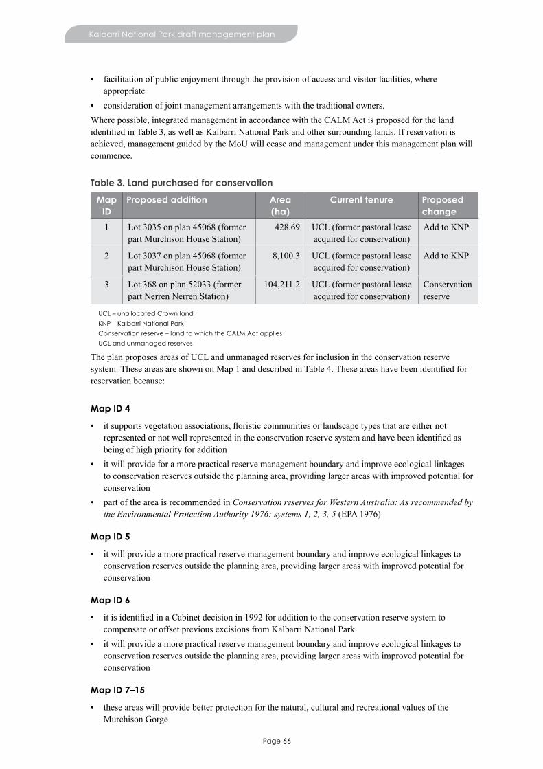
Page 66
Kalbarri National Park draft management plan
• facilitation of public enjoyment through the provision of access and visitor facilities, where appropriate
• consideration of joint management arrangements with the traditional owners.Where possible, integrated management in accordance with the CALM Act is proposed for the land identifiedinTable3,aswellasKalbarriNationalParkandothersurroundinglands.Ifreservationisachieved, management guided by the MoU will cease and management under this management plan will commence.
Table 3. Land purchased for conservation
Map ID
Proposed addition Area (ha)
Current tenure Proposed change
1 Lot 3035 on plan 45068 (former part Murchison House Station)
428.69 UCL (former pastoral lease acquired for conservation)
Add to KNP
2 Lot 3037 on plan 45068 (former part Murchison House Station)
8,100.3 UCL (former pastoral lease acquired for conservation)
Add to KNP
3 Lot 368 on plan 52033 (former part Nerren Nerren Station)
104,211.2 UCL (former pastoral lease acquired for conservation)
Conservation reserve
UCL – unallocated Crown land
KNP – Kalbarri National Park
Conservation reserve – land to which the CALM Act applies
UCL and unmanaged reserves
The plan proposes areas of UCL and unmanaged reserves for inclusion in the conservation reserve system.TheseareasareshownonMap1anddescribedinTable4.Theseareashavebeenidentifiedforreservation because:
Map ID 4
• itsupportsvegetationassociations,floristiccommunitiesorlandscapetypesthatareeithernotrepresentedornotwellrepresentedintheconservationreservesystemandhavebeenidentifiedasbeing of high priority for addition
• it will provide for a more practical reserve management boundary and improve ecological linkages to conservation reserves outside the planning area, providing larger areas with improved potential for conservation
• part of the area is recommended in Conservation reserves for Western Australia: As recommended by the Environmental Protection Authority 1976: systems 1, 2, 3, 5 (EPA 1976)
Map ID 5
• it will provide a more practical reserve management boundary and improve ecological linkages to conservation reserves outside the planning area, providing larger areas with improved potential for conservation
Map ID 6
• itisidentifiedinaCabinetdecisionin1992foradditiontotheconservationreservesystemtocompensate or offset previous excisions from Kalbarri National Park
• it will provide a more practical reserve management boundary and improve ecological linkages to conservation reserves outside the planning area, providing larger areas with improved potential for conservation
Map ID 7–15
• these areas will provide better protection for the natural, cultural and recreational values of the Murchison Gorge
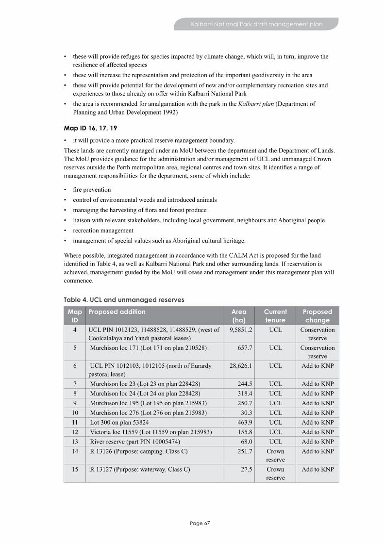
Page 67
Kalbarri National Park draft management plan
• these will provide refuges for species impacted by climate change, which will, in turn, improve the resilience of affected species
• these will increase the representation and protection of the important geodiversity in the area• these will provide potential for the development of new and/or complementary recreation sites and
experiences to those already on offer within Kalbarri National Park• the area is recommended for amalgamation with the park in the Kalbarri plan (Department of
Planning and Urban Development 1992)
Map ID 16, 17, 19
• it will provide a more practical reserve management boundary.These lands are currently managed under an MoU between the department and the Department of Lands. The MoU provides guidance for the administration and/or management of UCL and unmanaged Crown reservesoutsidethePerthmetropolitanarea,regionalcentresandtownsites.Itidentifiesarangeofmanagement responsibilities for the department, some of which include:
• fireprevention• control of environmental weeds and introduced animals• managingtheharvestingoffloraandforestproduce• liaison with relevant stakeholders, including local government, neighbours and Aboriginal people • recreation management• management of special values such as Aboriginal cultural heritage.
Where possible, integrated management in accordance with the CALM Act is proposed for the land identifiedinTable4,aswellasKalbarriNationalParkandothersurroundinglands.Ifreservationisachieved, management guided by the MoU will cease and management under this management plan will commence.
Table 4. UCL and unmanaged reserves
Map ID
Proposed addition Area (ha)
Current tenure
Proposed change
4 UCL PIN 1012123, 11488528, 11488529, (west of Coolcalalaya and Yandi pastoral leases)
9,5851.2 UCL Conservation reserve
5 Murchison loc 171 (Lot 171 on plan 210528) 657.7 UCL Conservation reserve
6 UCL PIN 1012103, 1012105 (north of Eurardy pastoral lease)
28,626.1 UCL Add to KNP
7 Murchison loc 23 (Lot 23 on plan 228428) 244.5 UCL Add to KNP8 Murchison loc 24 (Lot 24 on plan 228428) 318.4 UCL Add to KNP9 Murchison loc 195 (Lot 195 on plan 215983) 250.7 UCL Add to KNP10 Murchison loc 276 (Lot 276 on plan 215983) 30.3 UCL Add to KNP11 Lot 300 on plan 53824 463.9 UCL Add to KNP12 Victoria loc 11559 (Lot 11559 on plan 215983) 155.8 UCL Add to KNP13 River reserve (part PIN 10005474) 68.0 UCL Add to KNP14 R 13126 (Purpose: camping. Class C) 251.7 Crown
reserveAdd to KNP
15 R 13127 (Purpose: waterway. Class C) 27.5 Crown reserve
Add to KNP

Page 68
Kalbarri National Park draft management plan
Map ID
Proposed addition Area (ha)
Current tenure
Proposed change
16 R 14440 (Purpose: Paddock, Rabbit Department. Class C)
15.8 Crown reserve
Add to KNP
17 R 18403 (Purpose: Water and camping, Rabbit Department. Class C)
15.8 Crown reserve
Add to KNP
19 UCL PIN 1005456, 1005466, 1323870, 1185611, 1323869, 1185610, part of 1113766 (adjoining southern boundary of Kalbarri National Park)
27.7 UCL Add to KNP
UCL – unallocated Crown land
KNP – Kalbarri National Park
Conservation reserve – land to which the CALM Act applies
Reserve 31100
This management plan furthers the 1992 government decision that Reserve 31100 be considered for inclusion in the conservation reserve system. The area is shown on Map 1 (Map ID 18) and described in Table 5. This reserve originally contained the Kalbarri town site airstrip, which has since been relocated. Reserve31100wasidentifiedforadditiontoKalbarriNationalParkascompensationfortheareaexcisedfrom the park for the relocation of the airport. The addition of this reserve would also provide a more practical reserve management boundary.
Reserve 31100 is vested in the Shire of Northampton, with the shire responsible for its rehabilitation and management. As the reserve was used as an airstrip, the land currently has degraded natural values and is in need of rehabilitation. Addition of the area to rationalise the park boundary should occur once the area has been successfully rehabilitated.
Table 5. Reserve 31100
Map ID
Proposed addition Area (ha)
Current tenure Proposed change
18 R 31100 Vested in the Shire of Northampton Purpose: Aerial landing ground Class C
32.4 Crown reserve WPL (21 years) approval of Minister
required
Add to KNP
KNP – Kalbarri National Park
Conservation significance of adjacent lands considered for reservation
Theconservationsignificance,threatsandmanagementissuesonlandstobeconsideredforreservationare outlined below.
Geology, landforms and soils
Geology of the adjacent lands considered for reservation to the north-east of the park are part of the VictoriaPlateauandcompriseagentlyundulatingsandplainwithminorfieldsofsanddunes.
The Hardabut Fault lies to the south-east of the park, within the area considered for reservation in the Hardabut Pool area. South of the Hardabut Fault is the Northampton Complex, which contains the oldest rocks in the region and is poorly represented in the conservation reserve system. Addition of UCL and reserves 13126 and 13127 (Map ID 7–15) in the Hardabut Pool area would increase the representation and protection of the important geodiversity in the area (granulite and gneiss). The geodiversity may alsosupportfloraspeciesandvegetationtypesnotcurrentlywellrepresentedintheconservationreservesystem.

Page 69
Kalbarri National Park draft management plan
Former part Murchison House Station35 includes about 30km of the Murchison River and features of geologicalsignificancesuchassandstonegorge.
There is potential for damage to geological features, landforms and soils on these lands from introduced animals and associated erosion, particularly on areas of former pastoral lease.
Native plants and plant communities
Althoughflorasurveyshavebeenconductedontheadjacentlands,furtherworkisrequired.Fourhundredandthirtyplantspecieshavebeenrecorded,withfivespeciesendemictotheseareas.ManyweredocumentedaspartofthesouthernCarnarvonBasinsurvey,conductedin1994and1995,whenflorawassurveyed on Nerren Nerren Station (Keighery et al. 2000).
Theadjacentlandsconsideredforreservationcontainanumberofspeciesofconservationsignificanceincluding:
• threespecieslistedas‘threatenedflora’undertheWildlife Conservation Act (Wildlife Conservation (Rare Flora) Notice 2012 (2))—Hypocalymma longifolium, Kalbarri leschenaultia and Stachystemon nematophorus. This species is also listed as threatened or vulnerable36 under the EPBC Act
• 45 priority species37 comprising 10 Priority 1 species, 12 Priority 2 species, 17 Priority 3 species and six Priority 4 species
• 35 recorded range-end species (eight per cent of all recorded species in the adjacent lands). Of these, 94 per cent are at their northern limit (Keighery et al. 2000).
An interim recovery plan has been prepared for one threatened species in the adjacent lands, H. longifolium.
The vegetation of the adjacent lands is predominantly shrubland comprising acacia or proteaceous species. These lands contain 13 vegetation associations, six of which are not found in Kalbarri National Park. In addition, eight of these vegetation associations are currently underrepresented in the conservation reserve system (less than 15 per cent). Reservation of these areas would protect four of these underrepresented vegetation associations to greater than 15 per cent in conservation reserves (the IBRA benchmark). Representation of the mallee and acacia thicket on coastal dunes (currently not protected in any conservation reserves) would increase by 97.5 per cent. Similarly, the adjacent lands considered for reservation would increase the protection of shrublands of acacia, casuarina, Eucalyptus eudesmioides, Banksia ashbyi and thickets of other mixed species by 66.6 per cent and bowgada scrub and scattered eucalypt and cypress pine by 23.1 per cent. Representation of other vegetation associations would also improve.
35 Former part Murchison House Station refers to the part of Murchison House Station which was once a pastoral lease but has been acquired by the Department for conservation. This term also applies to former part Nerren Nerren Station.
36 A native species is eligible to be included in the endangered category at a particular time if, at that time, (a) it is not critically endangered; and (b) it is facing a very high risk of extinction in the wild in the near future, as determined in accordance with the prescribed criteria. A native species is eligible to be included in the vulnerable category at a particular time if, at that time, (a) it is not critically endangered or endangered; and (b) it is facing a high risk of extinction in the wild in the medium term future, as determined in accordance with the prescribed criteria (Department of Sustainability, Environment, Water, Population and Communities 2012).
37 Priority 1 and 2 flora in particular are still considered to be under threat even though they are not declared as ‘rare’ under the Wildlife Conservation Act.

Page 70
Kalbarri National Park draft management plan
Native animals and habitats
Aswithflora,nativeanimalsurveysoftheadjacentlandsconsideredforreservationhavebeenlimited.Three hundred and seventy-six species have been recorded from these lands, comprising 16 mammals, 97 birds, 50 reptiles and 207 invertebrates. Most of these were documented as part of the southern Carnarvon Basin survey, conducted in 1994 and 1995, when sites on Nerren Nerren and at Hardabut Pool were surveyed for fauna (Burbidge et al. 2000).
The adjacent lands considered for reservation contain the following fauna species of conservation significance:
• three threatened species listed under the Wildlife Conservation Act (Wildlife Conservation (Specially Protected Fauna) Notice 2012 (2)): malleefowl, eastern curlew (Numenius madagascariensis) and shield-backed trapdoor spider and one species listed under the Wildlife Conservation Act as specially protected – the peregrine falcon
• one threatened species listed under EPBC Act: the malleefowl• four migratory bird species on the national List of Migratory Species under the EPBC Act, that are
listed under international agreements: eastern curlew (Numenius madagascariensis), ruddy turnstone (Arenaria interpres), fork-tailed swift (Apus pacificus) and rainbow bee-eater (Merops ornatus)
• three Parks and Wildlife priority species: the Priority 3 reptile, Lerista humphriesi and the Priority 4 birds, Australian bustard and bush stone-curlew
• eight invertebrate species endemic to the adjacent lands considered for reservation • one bird species at the northern limit of its range: red wattlebird (Anthochaera carunculata)• one reptile at the southern limit of its range: micro slider (Lerista micra).
Surveys by Halse et al. (2000) at Hardabut Pool suggest very high invertebrate species richness, which is probably typical of much of the Murchison River within the planning area.
The adjacent lands have not been well surveyed for fauna habitat. The woodlands in the north-eastern part of the park and on the UCL east of the North West Coastal Highway (Map ID 4) are likely to support red-tailed black cockatoos (Calyptorhynchus banksii) and malleefowl. Areas of tree heath in the adjacent lands considered for reservation may also be important bird habitat.
Environmental weeds
Few weeds have been recorded in the adjacent lands considered for reservation, though the area has not been well surveyed. As the majority of these areas are former pastoral lease or UCL that adjoins existing pastoral leases, weeds are likely to exist.
Introduced and other problem animals
Further surveys for introduced animals are required in the adjacent lands considered for reservation and arelikelytoindicatesignificantimpacts.AsisthecaseforKalbarriNationalPark,goats,pigs,rabbits,foxes and cats are believed to impact the adjacent lands. More detail on these species is provided in Introduced and other problem animals.
Other introduced species known from the adjacent lands include:
• camels (Camelus dromedarius) known from wetland soaks in Zuytdorp Nature Reserve to the north of the planning area. Camels are also possibly present in northern parts of the adjacent lands considered for reservation such as former part Nerren Nerren (DEC 2012c). Currently, no control measures are used
• deer (Cervus timorensis) that may be present in the northern parts of the adjacent lands considered for reservation (DEC 2012c), such as the UCL east of the North West Coastal Highway (Map ID 4). Currently, no control measures are used

Page 71
Kalbarri National Park draft management plan
• wild dogs that have recently moved from further inland into northern and north-eastern parts of the adjacent lands considered for reservation and are likely to be present on former part Nerren Nerren Station. Currently, no direct control measures are used.
Fire
Under the MOUs with the Department of Lands (which has legislative responsibility for the management ofUCL),ParksandWildlifeisresponsibleformanagingfirepreparednessonUCLandunmanagedreserves outside the metropolitan area, regional centres and town sites, while local government is responsibleforbushfiresuppression.ThisappliestotheareasofUCLandunmanagedreserveswithintheadjacent lands.
Aboriginal culture and heritage
The adjacent lands considered for reservation are known to contain 19 Aboriginal sites recorded on the Department of Aboriginal Affairs Register of Aboriginal Sites. Sixteen of these are on former part Murchison House Station and are located near water sources. Ethnographic and archaeological surveys have been conducted over a relatively small portion of the adjacent lands considered for reservation and it isthereforehighlyunlikelythatallAboriginalsiteshavebeenofficiallyrecorded.
Other cultural heritage
Part of the State Barrier Fence (known as Fence No. 3), passes through the adjacent lands considered for reservation to the north-east of the park (Department of Agriculture 2001). The State Barrier Fence was originally constructed between 1901 and 1907 and comprises a number of separate fences. Constructed in an arc from north of Kalbarri to east of Ravensthorpe, the State Barrier Fence was designed to keep rabbits, wild dogs, emus (Dromaius novae-hollandiae), kangaroos and other pest and problem animals out of the agricultural and pastoral areas. Parts of the fence are still maintained for this reason today.
Visitor use
There is little or no visitor use in the adjacent lands considered for reservation, mainly as a result of the remoteness and lack of access, especially in areas to the north of Kalbarri National Park. Where visitor use does occur, for example in areas of UCL in the Hardabut Pool area (Map ID 7–15), no recreation sites or facilities are provided and use is unmanaged.
There is great potential for the development of recreation opportunities in the adjacent lands considered for reservation and this will be considered in consultation with Nanda.
Sites including former part Murchison House Station downstream of The Loop and in the Hardabut Pool area (see Map 1 IDs 1, 2 and 7–15 respectively) are likely to provide opportunities for visitors to enjoy landscapes and experiences that are not available in Kalbarri National Park. These may include new opportunities for camping, bushwalking, hiking, sightseeing, abseiling and rock climbing, and for accessing the Murchison River for canoeing and kayaking. Should former part Murchison House Station become part of the conservation reserve, a range of sites that complement experiences already available in the park and in the surrounding landscape may be considered.
Mineral and petroleum operations
There are a number of live and pending mineral exploration licences on adjacent lands.

Page 72
Kalbarri National Park draft management plan
Beekeeping
There are several apiary sites within the adjacent lands considered for reservation. These sites are used about every four years by apiarists to make use of the pollen from York gum. To determine the compatibility of beekeeping with key values of the areas being utilised, an assessment will be conducted atthetimeofrenewaloftheapiarysitepermit.Theassessmentshouldbeconsistentwiththedepartment’sdraft revised Policy Statement No. 41 Beekeeping on public land (CALM 2004) (under review) and the General conditions for using apiary authorities on Crown land in Western Australia (DPaW 2013). Criteriasuchasproximitytothreatenedfloraandecologicalcommunities,weeds,diseaseriskareasandrecreation sites, will be considered during the assessment.


20130117-0314-Web