DRAFT Management Feasibility Study for 325 MN
35
DRAFT Stormwater Management Feasibility Study for 325 Blake Road North, Hopkins MN Prepared for: MINNEHAHA CREEK WATERSHED DISTRICT 18202 Minnetonka Boulevard Deephaven, MN 55391 Prepared by: WENCK ASSOCIATES, INC. AND MINNEHAHA CREEK WATERSHED DISTRICT
Transcript of DRAFT Management Feasibility Study for 325 MN

DRAFT Stormwater Management Feasibility Study
for 325 Blake Road North, Hopkins MN
Prepared for:
MINNEHAHA CREEK WATERSHED DISTRICT 18202 Minnetonka Boulevard
Deephaven, MN 55391
Prepared by:
WENCK ASSOCIATES, INC. AND
MINNEHAHA CREEK WATERSHED DISTRICT
i
Table of Contents
1.0 INTRODUCTION .......................................................................................................... 1‐1
1.1 EXECUTIVE SUMMARY ........................................................................................ 1‐1 1.2 BACKGROUND ..................................................................................................... 1‐1 1.3 STRATEGIC IMPLEMENTATION FRAMEWORK .................................................. 1‐12 1.4 PURPOSE AND SCOPE ....................................................................................... 1‐17 1.5 SITE DESCRIPTION and surrounding subwatersheds ........................................ 1‐17
2.0 STORMWATER TREATMENT ....................................................................................... 2‐1
2.1 STORM WATER Management Basin and Drainage Diversion Feasibility ............ 2‐1 2.1.1 LAKE STREET DIVERSION ..................................................................... 2‐6 2.1.2 POWELL ROAD DIVERSION .................................................................. 2‐6 2.1.3 GENERAL CONSIDERATIONS ................................................................ 2‐7
2.2 PHOSPHORUS REMOVAL .................................................................................... 2‐7
3.0 EASEMENTS ................................................................................................................ 3‐1
4.0 ENVIRONMENTAL ....................................................................................................... 4‐1
4.1 325 BLAKE ROAD SITE ......................................................................................... 4‐1 4.2 LAKE STREET DIVERSION ..................................................................................... 4‐1 4.3 POWELL ROAD DIVERSION .................................................................................. 4‐2
5.0 PRE‐DESIGN COST ESTIMATE ...................................................................................... 5‐1
6.0 REFERENCES ............................................................................................................... 6‐3
Tables Table 2‐1. Storm Water and Loading Computations .................................................................... 2‐8 Table 5‐1. Summary of Pre‐Design Estimated Project Component Costs .................................... 5‐2 FIGURES Figure 1‐1. Minnehaha Creek total phosphorus cumulative load longitudinal profile ............... 1‐18 Figure 1‐2. Minnehaha Creek total phosphorus cumulative load longitudinal profile ................. 1‐9 Figure 1‐3. Minnehaha Creek Community Works Project .......................................................... 1‐16 Figure 1‐4. Site Location and Treatment Watersheds ................................................................ 1‐18 Figure 2‐1. Runoff Captured from Storm Events .......................................................................... 2‐1 Figure 2‐2. Storm Water Infiltration Basin Concept. .................................................................... 2‐2 Figure 2‐3. Proposed Diversions ................................................................................................... 2‐3 Figure 2‐4. Diversion Manhole Concept ....................................................................................... 2‐4 Figure 2‐5. Proposed 325 Blake Road Storm Water Improvements ........................................... 2‐45 Figure 2‐6. Profile of Powell Road Diversion .............................................................................. 2‐46 Figure 3‐1. Powell Road Easements .............................................................................................. 3‐1

1‐1
1.0 Introduction
1.1 EXECUTIVE SUMMARY
Over the last century, urbanization of the areas around Minnehaha Creek has degraded water
quality in the iconic waterway. Ditching of the stream channel, loss of wetlands, bridge crossings and
increased impervious surface have had a variety of negative effects on the ecological integrity of the
creek: disrupted fluvial processes, increased runoff and pollutant loads, decreased infiltration, reduced
baseflow, and fragmented and degraded in‐stream and streambank habitat. Consequently, pursuant to
United States Code Title 33 Section 303(d) (Federal Water Pollution Control Act or Clean Water Act),
Minnehaha Creek is listed as being impaired for chlorides, dissolved oxygen, and its fish community.
Downstream receiving waterbody Lake Hiawatha is impaired for excess nutrients (phosphorus).
As part of a larger comprehensive series of projects, this feasibility study examines opportunities
to manage area‐wide stormwater runoff volumes on property located at 325 Blake Road, Hopkins, in a
manner that addresses pollutant loading to Minnehaha Creek and downstream Lake Hiawatha, reduces
peak runoff rates, and improves baseflow in an expanded and restored section of riparian greenway.
As discussed later in this report, 325 Blake Road is located in a priority project area for the
Minnehaha Creek Watershed District within the subwatershed. The site represents one piece of the
District’s larger strategic initiative to (1) improve the quality and manage the quantity of stormwater
runoff; (2) enhance the ecological integrity of the stream system; and (3) facilitate broader community
goals of economic development and livability by allowing the restored stream system to be integrated
into the developed landscape.
1.2 BACKGROUND
Land use:
The 47.3 square mile (30,290 acre) Minnehaha Creek subwatershed encompasses the entire
Minnehaha Creek Watershed District (MCWD) downstream of the Gray’s Bay dam on Lake Minnetonka
(the headwaters of Minnehaha Creek), and is commonly referred to as the “lower watershed”. It
includes parts of the cities of Plymouth, Wayzata, Minnetonka, St. Louis Park, Hopkins, Edina,
Minneapolis, and Richfield. The subwatershed is drained by the 22‐mile long Minnehaha Creek, which

1‐2
travels through Lake Hiawatha before discharging into to the Mississippi River, downstream of Lock and
Dam No. 1.
Within the priority focus area, between W. 34th and Excelsior Blvd in Hopkins and St. Louis Park,
the incremental urbanization beginning in earnest following World War II has increased stormwater
runoff volumes, sediment and nutrient loads, and habitat degradation. See Historic Aerials below:

1‐3

1‐4

1‐5

1‐6
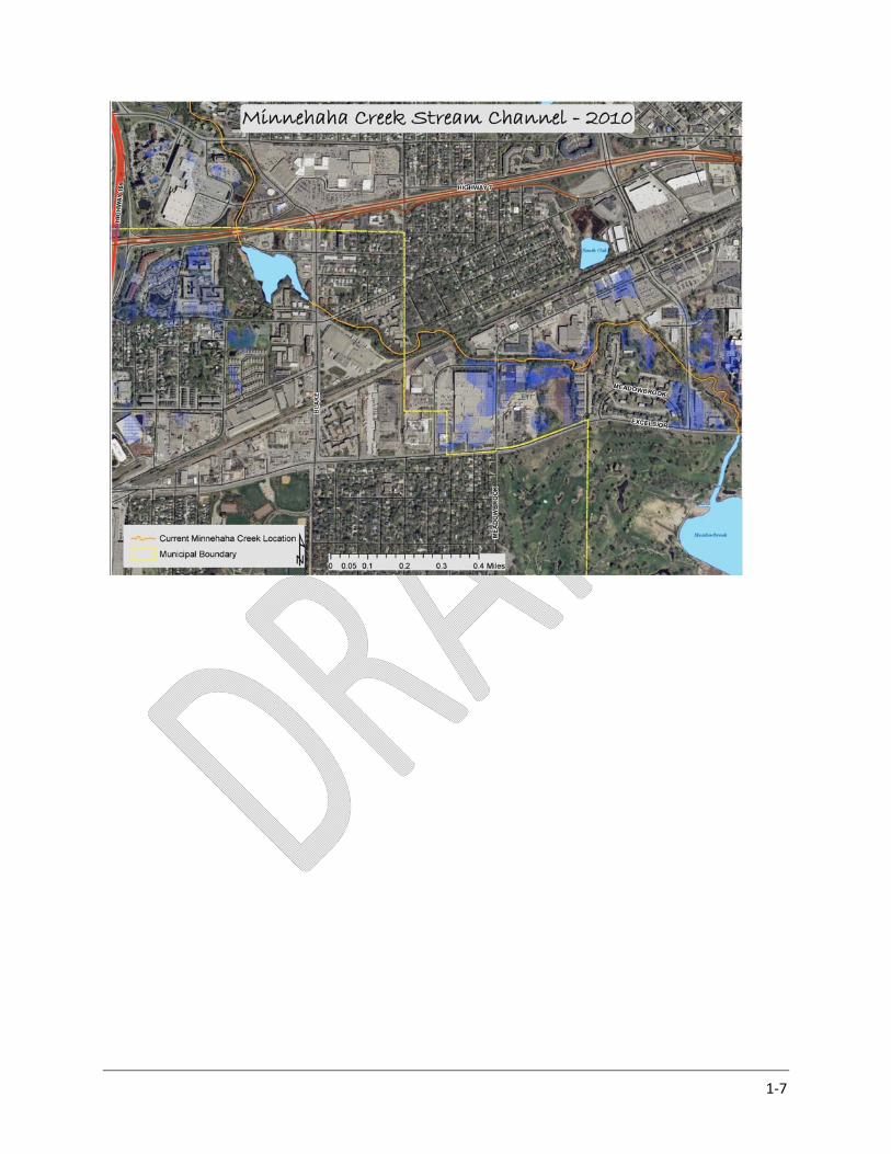
1‐7

1‐8
Pollutant Loading:
Over time these changes in land use have decreased water quality and reduced ecological
integrity. Based on a detailed linkage analysis of the relationship between water quality data (2001 –
2011) and potential source areas, as well as lake responses to watershed loading, the Draft Lake
Hiawatha TMDL calculated Lake Hiawatha’s total phosphorus (TP) loading capacity to be 4,556 lbs/year.
Existing TP loading to Lake Hiawatha was calculated as 6,463 lbs/year, requiring a 29.5% reduction
(1,907 lbs/year) to see in‐lake total phosphorus concentrations move from 70.9 µg/L to meet the site
specific target standard of 50 µg/L (Figure 1 and 2, Draft Lake Hiawatha TMDL, 2013).
Figure 1‐1. Minnehaha Creek total phosphorus cumulative load longitudinal profile (River Mile)

1‐9
Figure 1‐2. Minnehaha Creek total phosphorus cumulative load longitudinal profile (Drainage Area)
Examining the incremental TP loading along Minnehaha Creek provides useful information for
planning and implementing projects. For example, Figure 1‐2 shows total phosphorus loading as a
function of drainage area. The slope of the line between monitoring points shows the change in
phosphorus load for each group as a function of area. Therefore, unit area loads can be derived by
dividing the increase for each subwatershed by the subwatershed area, facilitating a comparison of
contributions from watersheds of different size. The steepest slope on Figure 1‐2 is between West 34th
and Excelsior Blvd., making it a priority drainage area for targeted implementation (Draft Lake Hiawatha
TMDL, 2013).
Stream Channel:
In addition to pollutant loading data, stream channel assessments reveal the need for focus on
this same stretch of Minnehaha Creek. In addition to the regulation of discharge by the Grays Bay Dam,
flow in Minnehaha Creek is controlled by a number of major structures including Browndale Dam, West
54th Street, and Hiawatha Avenue. Many of the more‐than‐100 creek crossings provide grade control
substantial enough to create impoundments that can negatively impact stream habitat. In addition to
stream crossings, stream assessments reveal that hard armored bank stabilization practices and a lack of

1‐10
adequate structural riparian habitat contribute to impaired biotic conditions (MCWD Stream
Assessment, 2003).
Fluvial geomorphic assessments indicate that, although erosion and incision has occurred within
the creek, the channel profile is currently stable due to the moderating effect of the major crossings that
provide grade control. This finding was corroborated by a sediment transport model developed by the
United States Army Corps of Engineers (USACE) that found that the creek is vertically stable and does
not need further control to slow or stop erosion of the bed. While channel incision is not a major
concern, channel width was observed to be expanding in several locations. Eighteen of the 30 reaches
were assessed as stable, eight as stable with a tendency to aggrade or degrade, and six are aggrading.
The sedimentation occurring in aggrading reaches is attributed to the numerous grade control
structures that create impoundments, which allow particulate matter to settle. This sedimentation is
considered detrimental to overall stream ecology (MCWD Stream Assessment, 2003).
When analyzing channel stability and the influencing effect of existing grade control structures,
a distinction can be made between the upper and lower creek, separated by Browndale Dam in the city
of Edina. Above the Browndale Avenue Dam, Minnehaha Creek exhibits a higher degree of stability
relative to downstream reaches. There is less erosion damage, more riparian zone vegetation, and less
intrusion into the Creek corridor by physical infrastructure. While streambank erosion is present along
the entirety of Minnehaha Creek, there is little damage requiring repair in upper reaches regarding
severe bank erosion, damaged streamside infrastructure, or channel incision. Hydrologic stresses are
also smaller within upper reaches and alterations to the streambank are less frequent. Vertical grade
control is adequate. As previously noted, the upper reach impoundments caused by excessive grade
control structures are causing mild aggradation of the bed and sedimentation, degrading aquatic life‐use
quality and diversity. Consequently, typical riparian stream conditions are often replaced by
impounded/wetland conditions. Locations of excessive grade controls causing impoundment and
degradation of upstream habitat include:
• Louisiana Avenue
• Meadowbrook Road
• Blake Road
• Lake Street
• West 34th Street

1‐11
Biology and Habitat:
Minnehaha Creek has been listed on the State of Minnesota’s 303(d) list of Impaired Waters for
its impaired fish community. A fish survey was conducted at nine locations on Minnehaha Creek in 2003.
Most of the fish species between I‐494 and Minnehaha Falls were lake species with few adults,
indicating a lack of suitable habitat for riverine species. Macroinvertebrate sampling on Minnehaha
Creek was conducted as a part of the 2003 MCWD Stream Assessment to assess the current quality of
the benthic community. Family Biotic Index (FBI) was determined at twenty‐two locations. Generally
the indices ranked between Fair and Very Good. The higher FBI scores reflect the presence of less
stress‐tolerant species, although the FBI does not adequately reflect the observed low diversity in
macroinvertebrate populations. The low diversity is an important factor, and reflects the generally poor
aquatic macroinvertebrate habitat in Minnehaha Creek. Poor macroinvertebrate habitat is also a
secondary indicator of poor fisheries habitat.
The observed low diversity of macroinvertebrates reflects the lack of diversity in habitat. Lack of
riparian vegetation, erosion, sediment deposition, removal of large woody debris, sustained high flows,
extreme flood peaks, lowered base flows, and degraded water quality all contribute to limited species
diversity. Limitations in fish habitat are associated with inadequate refuge during the winter and during
periods of low flow. Additionally, stream substrates are homogenous and dominated by small gravels
and sand, and gravel or cobble riffles are infrequent and widely spaced. Large woody debris is largely
absent, limiting direct use by macroinvertebrates and fish and reducing the number of accumulation
points for leaf and other debris (MCWD Comprehensive Plan, 2007).
Conclusions:
Overall, biological productivity in Minnehaha Creek and beneficial use of downstream Lake
Hiawatha is limited by a number of factors: water quality tied to impervious cover in the watershed,
hydrologic variation, low stream gradients resulting from control structures, and a lack of natural
vegetation and woody debris (MCWD Stream Assessment, 2003). As a combined result of these
stressors, the Minnehaha Creek Watershed District has identified the area between West 34th and
Excelsior Blvd. as a strategic focus area for implementing projects. Addressing these issues requires a
multifaceted approach consisting of projects targeted at managing stormwater runoff quality and
quantity, restoring the instream channel and expanding the riparian corridor.

1‐12
1.3 STRATEGIC IMPLEMENTATION FRAMEWORK
Wenck Associates was tasked to prepare this study within the context of the District’s evolving
approach of evaluating investments by both their water resource impacts and the extent to which they
are consistent with and facilitate broader public goals being advanced by public partners and other
stakeholders. The following is a description of that context as articulated and communicated by the
District.
Water Resource Planning Principles:
As outlined in a recent call for abstracts from the Journal of Hydrology, “Understanding the
relationships between water and the landscapes, communities, and jurisdictions through which it flows
has become an increasingly urgent task for science over recent years.”
This call for research acknowledges that the practice of water resource management has
historically been a technical pursuit, often limited by competing interests of development and
infrastructure improvements traditionally planned by public and private sector entities unrelated to
water management. Similarly, while scientific research has characterized the effect of land use on water
quality, land use planning is infrequently integrated into water quality management with measurable
success. Instead, water management agencies have historically reacted to land‐use related impacts to
water, rather than using the development of communities and infrastructure as opportunities for
proactive improvement and protection of water quality (Woljter, 2007).
However, with the advent of concepts such as livable communities, community works, and
other sustainability related initiatives, water resources are ever increasingly integrated into planning
constructs, based upon the knowledge that at the intersection of planning spheres lies the opportunity
to maximize socio‐economic benefits to society while restoring natural systems. These models
recognize that “a healthy community is one that has high levels of social, ecological, human and
economic ‘capital’, the combination of which may be thought of as ‘community capital’” and that “the
challenge for communities in the 21st century will be to increase all four forms of capital simultaneously”
(Hancock, 1999).
Accordingly the Minnehaha Creek Watershed District has planned and explored projects with
increased awareness of the aquatic environments’ influence on livable communities and a refined
understanding of the relationships between water resources, land use, economics, infrastructure and
social systems. The connection among water, green infrastructure and local economies was highlighted
by 1992 findings from the Hennepin County Assessor’s office that concluded that the only sections of
1‐13
Minneapolis to hold or gain property value in the eighties were those located adjacent to lakes, parks, or
parkways (Martin, 2008). This analysis was a precursor to the Hennepin Community Works program, an
environmental‐public works program established to create jobs and enhance tax base. The notion that
natural systems underpin local identity, generate social and economic value, and should guide park and
public works planning was a founding principle of the program. Access to nature by urban residents is
not a new concept, but human and urban health is increasingly believed to be related to sustainability.
Schauman 1998 notes that numerous small changes in an urban landscape, turning paved and built
places to functioning natural areas, will aggregate over time to become of sufficient magnitude to
enhance sustainability. More locally, the Final Report of the Parks and Public Works Commission on
Hennepin Community Works found that “the development of Minnehaha Creek and the chain of lakes
as an open space system has proven to be a strong factor of sustained property values” (Hennepin
Community Works, 1994). These concepts are slowly becoming embedded in spatial planning as
analysts and policy makers have come to understand that a “region’s abilities to compete depend . . . .
increasingly on environmental quality” and that, “water plays a key role in this, as it can provide identity
and a pleasing environment, attract investment, and serve as a binding social element” (Woljter, 2007).
This new paradigm advocates for water resource planning’s migration away from being a largely
technical exercise toward one of increased integration with broader community goals and planning
efforts and collaboration with municipalities and other stakeholders with the mandate and powers to
work toward those complementary goals.
Corridor Restoration Planning & 325 Blake Road:
Consistent with the aforementioned science and planning principles, the Minnehaha Creek
Watershed District has focused strategically on a portion of the Creek system most in need (W. 34th –
Excelsior Blvd), and has done so with forethought as to how water resource projects may best intersect
with broader community objectives. Therefore, stormwater infrastructure feasibility at the 325 Blake
Road site should be considered not in isolation, but rather as one piece of a comprehensive restoration
effort that meets multiple interrelated community objectives. When viewed in concert, the whole is
certainly greater than the sum of its parts. Below is a summary of various project elements planned to
date.
In 2008 the Minnehaha Creek Watershed District was approached by Park Nicollet’s Methodist
Hospital, which was planning site improvements that included improving access to gardens as part of
the medical healing process. Through collaboration and shared vision, MCWD and Park Nicollet were

1‐14
able to implement a larger project at the Methodist Hospital site that oriented a portion of the hospital
campus around a 1,400’ section of restored and remeandered Minnehaha Creek, and provided public
and patient access to nature through a boardwalk trail system.
In 2011 the MCWD and the City of St. Louis Park began planning a related project to restore the
natural meander of the creek through a 4,000‐foot ditched section of Minnehaha Creek immediately
upstream of Methodist Hospital, connecting to a property strategically acquired by MCWD in 2010. This
work, completed in 2013, also added pool and riffle features, woody debris, new canoe launches and
reconnected the Creek to its historic floodplain for the first time since the 1950s. This project included
stormwater management for over 80 acres of untreated runoff directly discharged into the Creek, and
identified two additional major discharge points for future treatment: Louisiana Avenue and Powell
Road. The Powell Road discharge receives 235 acres of untreated stormwater runoff and is one element
of the 325 Blake Road infrastructure investment. In addition to area‐wide stormwater improvements
and a restored channel, the project will include a trail system that provides public access to 27 acres of
new community green space, expanding the profile of this natural system within the urban
environment. The trail system, developed in partnership with the City of St. Louis Park, has the added
benefit of enhancing community connections by bringing Meadowbrook Manor residents within a 10‐
minute walk of the proposed Louisiana Avenue South West Light Rail Station, and providing a local
greenway connection to the Cedar Regional Trail.
Further upstream, the District entered into a strategic partnership with the City of Hopkins that
resulted in the acquisition of 2.6 acres of land along Minnehaha Creek that has been converted to open
space. This land expanded the existing Cottageville Park footprint as guided by the Blake Road Small
Area Plan. The Blake Road Small Area Plan considered the expansion of Cottageville Park to be critical
initiative in providing safe, improved access to green space for the surrounding community. For the
District, the expansion of green space provided the opportunity to manage approximately 30 acres of
area‐wide stormwater runoff while daylighting Minnehaha Creek. As referenced in the 2006 Hennepin
County report, “Daylighting Creeks in Hennepin County”, the enhancement of invisible creeks creates
the potential to transfer underused “ditches” into community amenities with the capacity to catalyze
and leverage private investment in nearby properties.
Building on successful partnership‐driven initiatives upstream and downstream, and thinking
forward about the potential for transit‐oriented development around the South West Light Rail Transit
corridor, MCWD acquired the 17 acres at 325 Blake Road in Hopkins in 2011. This property lies on 1,000
feet of Minnehaha Creek, similar frontage on County Blake Road, connects to the Cedar Regional Trail

1‐15
and lies opposite the Blake Road LRT station. For these reasons, it was considered in the Blake Road
Small Area Plan to also be a strategic asset in efforts to meet a broad range of community goals. The
site was identified as of significant importance to the expansion of Minnehaha Creek greenway,
improvement of pedestrian and bike networks, and “the single greatest opportunity” with regards to
redevelopment in the study area. Furthermore, MCWD also identified the site as an opportunity to
manage large quantities of regional stormwater around the Blake Station and transit‐oriented
redevelopment anticipated to come with it. Within this context, this feasibility study examines only the
practical considerations of stormwater improvements on the 325 Blake Road site.
Beyond the projects discussed above, MCWD continues to explore synergistic opportunities with
both public and private partners within this section of Minnehaha Creek as well as further downstream
in the cities of Edina and Minneapolis. Through these investigations the District remains committed to
visioning and implementing water resource improvements that provide linkages and benefit to the
broader community.

1‐16
1‐3. Minnehaha Creek Community Works Project
1‐17
1.4 PURPOSE AND SCOPE
The primary purpose of this study is to refine the feasibility of using a portion of the District‐
owned land at 325 Blake Road to manage stormwater. As mentioned, the parcel is uniquely positioned
within the surrounding urban landscape to be able to collect and treat stormwater runoff from adjacent
subwatersheds before it discharges into Minnehaha Creek. Managing stormwater that currently enters
the creek untreated could achieve numerous goals of the District by improving the quality and managing
the quantity of water discharging into Minnehaha Creek and Lake Hiawatha.
1.5 SITE DESCRIPTION AND SURROUNDING SUBWATERSHEDS
325 Blake Road is a 16.8‐acre property in Hopkins owned by the Minnehaha Creek Watershed
District (MCWD) that currently houses a cold storage warehouse. Figure 1‐4 shows the triangular
shaped site bordered by County Blake Road on the west, Minnehaha Creek on the north, and the
regional trail and railroad on the south. The parcel was strategically acquired by MCWD for purposes of
expanding the riparian greenway around Minnehaha Creek and improving area wide stormwater
management. The portion of the parcel not required to fulfill these purposes will be sold for
redevelopment, which will allow the District to recover a significant portion of its initial investment. In
order to ensure adequate integration of these uses during future planning, this feasibility study was
commissioned to outline feasible stormwater management options.
The watershed encompassing the site drains approximately 21.1 acres, labeled Outfall
Watershed 3 on Figure 1‐4. Stormwater drains from the parcel via sheet flow and a 21‐inch storm sewer
drain to the creek in the south‐east corner. A small 4.8‐acre area of offsite drainage passes through the
site via a 12‐to‐15 inch storm sewer that discharges to the creek in the north‐east corner of the
property, parallel to Lake Street.
Surrounding subwatersheds are delineated on Figure 1‐4 as Outfall Watersheds 1, 2, 4 and 5.
The total acreage of these subwatersheds is approximately 329.8 acres. Outfall Watershed 1 (58.6
acres) and Outfall Watershed 2 (9.6 acres) currently discharge into Minnehaha Creek upstream of 325
Blake Road, largely untreated. Outfall Watershed 4 (26.5) and Outfall Watershed 5 (235.1) currently
discharge into Minnehaha Creek downstream of 325 Blake Road, largely untreated.

1‐18
Figure 1‐4. Site Location and Treatment Watersheds

2‐1
2.0 Stormwater Treatment
2.1 STORM WATER MANAGEMENT BASIN AND DRAINAGE DIVERSION FEASIBILITY
Stormwater Management Basin:
As discussed in previous sections, approximately 329.8 acres of land surrounding 325 Blake Road
currently drains to Minnehaha Creek, most of which goes untreated. This section of the study evaluates
the feasibility of capturing that runoff and diverting to 325 Blake Road for treatment.
For preliminary feasibility analysis Wenck evaluated the opportunity to capture as much “first
flush” stormwater runoff from surrounding watersheds as possible. This water would then be diverted,
filtered or infiltrated to allow for water quality and base flow improvements to Minnehaha Creek.
Figure 2‐1 demonstrates that phosphorus loads can be reduced by 70 to 90 percent by infiltrating the
runoff from the 0.5‐inch to 1.25‐inch rain events.
Figure 2
at could be occupied by a treatment facility. At this
reliminary level, the infiltration basin was conceptually located adjacent to the creek, in the area
nticipated for future greenway restoration, as shown in Figure 2‐2. Depending on future master
lanning for the site, it may viable to locate this basin in other areas of the property, or to construct
ultiple treatment basins for a “treatment train” approach.
‐1. Runoff Captured from Storm Events
To evaluate the maximum potential for treatment, this analysis assumes the use of an
infiltration/filtration basin. This assumption, while maximizing water quality treatment, is also
conservative in regards to the area of real estate th
p
a
p
m

2‐2
At a conceptual level the bottom of the basin would contain about a 2‐foot layer of sand
xtending down to the creek level. Stormwater would filter through the sand and discharge into the
g of the local groundwater table is expected to occur
creasing groundwater discharge to the creek.
Approximately 7.5 feet of material would need to be excavated based on estimates of the
existing grade. This work could occur concurrent with site redevelopment and the establishment of the
greenway. The size of the basin area depends on the volume of water to be diverted, as discussed in the
next section.
Drainage Diversion Feasibility:
e
creek, augmenting baseflow. Mounding or raisin
in
Figure 2‐2. Storm Water Infiltration Basin Concept.
Adjacent storm sewer networks and their associated subwatersheds were investigated to
determine how much additional untreated low flow could be diverted to the site for treatment. As
previously depicted, low flow carries the bulk of the total nutrient loading. The analysis of storm sewer
etworks concluded that low flow drainage from approximately 247 acres out of the 329.8 offsite acres
y at 325 Blake Road.
Drainage could be diverted to 325 Blake Road through construction of two primary storm sewer
diversio
n
(75%) could feasibly be diverted to a treatment facilit
ns. A portion of the drainage of subwatersheds west of 325 Blake Road (30.3 acres) could be
intercepted and diverted via a constructed storm sewer under Lake Street NE. This pipe would travel
east under Blake Road into 325 Blake Road. This is shown as the Lake Street Diversion in Figure 2‐3.

2‐3
Figure 2
Drainage from the area south of 325 Blake (216.9 acres) could be captured and diverted on
Powell Road through a new storm sewer that would be tunneled under the existing railroad. This is
shown as the Powell Road Diversion in Figure 2‐3. Additional area may also be available for capture, and
will be identified during preliminary design once the site survey is completed.
‐3. Proposed Diversions

2‐4
As stated above, these two diversions would be designed to convey low flows without affecting
the existing storm drainage system’s capacity to convey high flood flows. Figure 2‐4 provides a
schematic of a diversion manhole for the Powell Road Diversion. The specific design would be
determined if the project is ordered and depends on the configuration of the existing system. These
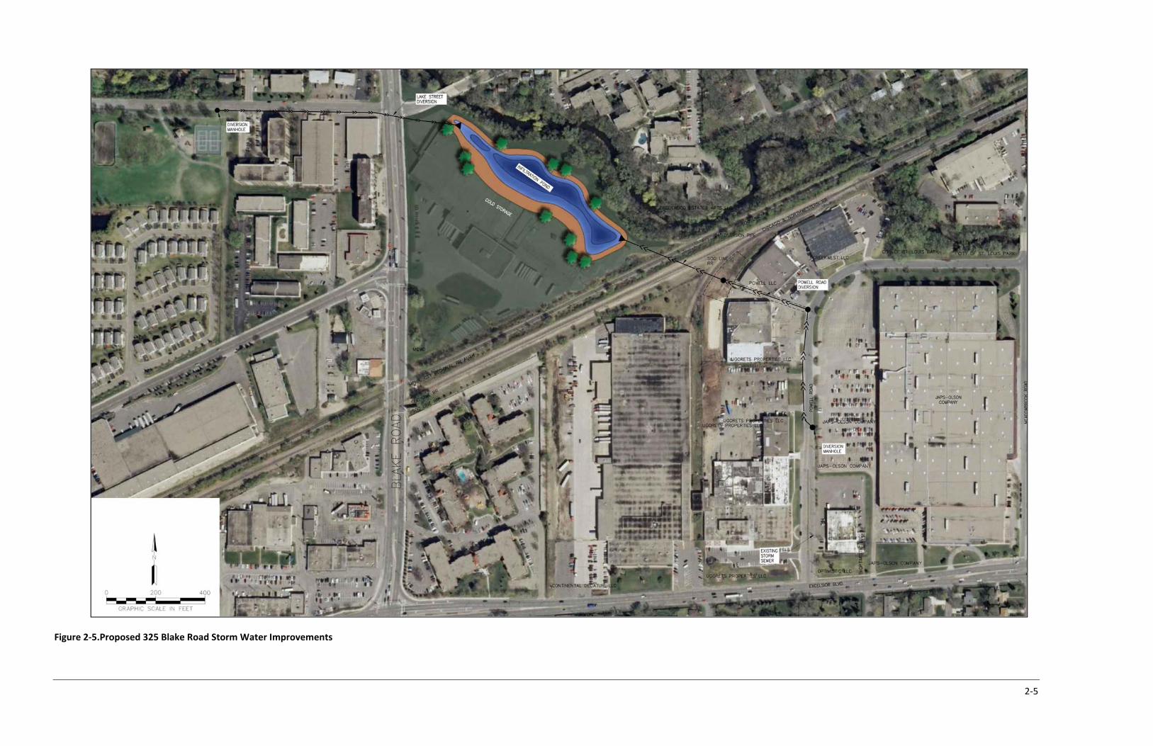
survey‐ level details would be completed during the design phase. Figure 2‐5 shows conceptual
alignments for the diversions. More information related to each diversion is provided below.
Figure 2‐4. Diversion Manhole Concept
2‐5
Figure 2‐5.Proposed 325 Blake Road Storm Water Improvements

2.1.1 LAKE STREET DIVERSION
2‐6
The Lake Street Diversion requires a new 24‐inch‐diameter pipe tied into the existing storm
drainage system under Lake Street, to bring the water east to the 325 Blake Road site. An agreement
will be required with the City of Hopkins to locate this infrastructure and work in right‐of‐way. A
preliminary review of the grades indicates that this is feasible with about 800 feet of 18‐inch diameter
pipe and requires disturbance of only city right‐of‐way and utilities. For cost savings and ease of
logistics, this work may be timed with the proposed reconstruction of the Metropolitan Council
Environmental Services lift station and forcemain on Lake Street, scheduled for construction in 2015.
2.1.2 POWELL ROAD DIVERSION
The grade of the Powell Road segment closest to the 325 Blake Road site was found to be too
low to convey storm water by gravity. If the diversion manhole is located further south (upstream)
sufficient grade to convey storm water to the site is available without substantial loss of tributary
watershed area (See Figure 2‐5). Figure 2‐6 shows a preliminary profile of a 1,250‐foot‐long, 24‐inch
diversion pipe from Powell Road.
The first 550 feet of pipe from the diversion manhole north along Powell Road requires open‐cut
disturbance of only city right‐of‐way and utilities. This work will require an agreement with the City of
St. Louis Park. The next 350 feet of pipe would be open‐cut construction between two private
properties to a new manhole on the east side of the railroad and trail. This section will require an
easement from the property owners for construction and maintenance purposes. The last 350 of pipe
will require tunneling or jacking under the railroad and trail portion. An agreement and permit with the
railroad will be required.
Figure 2‐6. Profile of Powell Road Diversion

2‐7
2.1.3
all
• Review of soil borings to incorporate infiltration characteristics into the basin design
s (preliminarily described in a separate section)
• Coordination with cities (see below)
• Preparation of detailed plans and specifications
Construction of the diversions would ideally be completed with other needed street or utility
improvements, such as sanitary forcemain or road reconstruction projects. Accordingly, it may be
preferable for the District to phase construction of the diversions and bulkhead pipes to be brought
online at a later point in time. This may provide significant cost and permitting advantages.
2.2 PHOSPHORUS REMOVAL
For purposes of producing an estimate, the amount of phosphorus in the storm water was
estimated using typical loading rates from literature (2004 MPCA study “Detailed assessment of
phosphorus sources to Minnesota watersheds” and “Lake St. Croix Total Phosphorus Loading Study”,
ay 7, 2009 Suzanne Magdalene, Ph.D., Science Museum of Minnesota, St. Croix Watershed Research
tation). Annual loads from urban watersheds range from approximately 0.6 to 1 lb/acre/yr. A value of
.75 lb/acre/yr is used for this analysis.
GENERAL CONSIDERATIONS
The information provided in this report is at a feasibility study level and is intended to provide
the basis to decide whether the diversion of regional stormwater to 325 Blake is feasible. As with
capital projects, additional information will be required through the design phase.
Primary design items include:
• Survey to verify existing conditions and add missing information as needed
• Environmental investigation
M
S
0

2‐8
325 Blake Rd Powell Road Lake Street TotalProperty Diversion Diversion
(Portions of (Portion of MC‐61)
MN‐64 and MC‐65)
(Portion of MC‐60)
Dra
% Impervious 85 75 85 77
Runoff (acre‐feet) (from SCS Runoff Eqn.): c
S (Potential Max. Runoff Retention (inches)) 0.64 1.11 0.64 1.020.13 0.22 0.13 0.20
0.5‐inch Event Runoff (acre‐feet) 0.24 1.00 0.34 1.49noff (acre‐feet) 0.89 5.79 1.24 7.79
1.25‐in
Annual TP Load Reduction (90%) (lbs/year): e
a GIS computation from Figure 2‐2
b From land use and soils information in MCWD 2007 Comp Plan
c Q=((P‐Ia)^2)/((P‐Ia)+S) SCS Runoff Equation
d MPCA (2004). Detailed assess. of phosphorus sources to MN wtsds.
e Independent analysis of Mpls‐STP rainfall indicates 90% reduction
inage Area (acres) a 21.1 216.9 29.6 267.6SCS Curve No. b 94 90 94 91
Soil Type b C C C C
Ia (Initial Abstraction (inches))
1.0‐inch Event Ruch Event Runoff (acre‐feet) 1.26 8.93 1.76 11.82
Typical TP Load (lbs) per acre per year d 0.75 0.75 0.75 0.75
Using P‐8 Data (lbs/year) 14 146 20 181
New Drainage Areas Treated by Volume Reduction Infiltration Basin
Runoff volumes were estimated using the Soil Conservation Service (SCS) method. Table 2‐1
the 325 Blake Road site and each diversion. The infiltration pond
hown in Figure 2‐5 has an area of 3.3 acres (extent of the outer area shown in brown). An average
depth o
will remove 90
nt or more of the annual phosphorus load.
shows the detailed computations for
s
f 3.5 feet is needed to hold the 11.5 acre‐feet of runoff from the 1.25‐inch rainfall event. The
volume diverted into the infiltration basin will dissipate by infiltration to shallow groundwater over a
period of a few days. It is estimated that treating this volume by means of infiltration
perce
Table 2‐1. Storm Water and Loading Computations

3‐1
3.0 Easements
Use of city right‐of‐way for the Lake Street Diversion and a portion of the Powell Road Diversio
are not expected to require private easements. The downstream portion of the Powell Road Diversion
shown in Figure 3‐1 below will require private easements
n
for both construction and maintenance
re, Easement 1 includes 6,186 square feet of the
roperty at 7920 Powell Road owned by Powell LLC (PID 20‐117‐21‐23‐0023, see Appendix for Hennepin
County records). Easement 2 includes 16,429 square feet of the property behind 8000 Powell Road
owned by Ugorets Properties, LLC (PID 20‐117‐21‐23‐0009). The property address is shown as 4103
Texas Ave S, St. Louis Park in the Hennepin County records. The District has made contact with both
property owners. At this preliminary stage, both have indicated willingness to work with MCWD on
easements.
Figure 3‐1. Powell Road Easements
purposes. As currently planned and shown in the figu
p

3‐2
The diversion pipe under the railroad and trail will be cased in a larger steel pipe, to comply with
railroad company require needed install the pipeline. The
District has made contact with the railroad indicated that obtaining a permit for this project is
viable. An easement is not anticipated since the diversion pipe may be maintained without access to
railroad
ments. An agreement with the railroad will be
which
property. If problems occur with the pipe under the railroad, the damaged pipe may be slipped
from the casing and replaced with a new pipe.

4‐1
4.0 Environmental
4.1 325 BLAKE ROAD SITE
A Phase I environmental investigation of the 325 Blake Road site was completed prior to the
MCWD’s purchase. The District has followed the Minnesota Pollution Control Agency’s requirements
and the site currently has a No Association Determination (NAD), issued to the District on December 6,
2011. A plan was prepared to allow for soil borings on site to collect infiltration capacity information
and to supplement existing information on the possible presence of subsurface contamination. This
work was completed in accordance with the MPCA‐approved plan to obtain an amended NAD for the
stormwater project and position the District or future redeveloper in obtaining a Certificate of
Completion (COC). Upon completion the boring samples were field screened for the presence of
Volatile Organic Compounds (VOC) using a photoionization detector (PID). All samples returned a non‐
detect reading of 0.0 ppm. Detailed information including what is presently known about the site may
be found in the plan titled “Work Plan for Additional Investigation, Former Atlas Cold Storage, 325 Blake
Road North, Hopkins, Minnesota”, by Wenck Associates, March 2013.
Demolition of the existing commercial buildings will require prior environmental planning to
properly dismantle refrigeration equipment, remove possible asbestos material, and remove any other
hazardous materials (mercury switches, ballasts, etc.) before demolition occurs. A detailed demolition
survey and preliminary cost estimate is being currently being planned by MCWD staff. Equipment
decommissioning, building demolition and any site remediation are not required solely to construct the
stormwater management improvements but would be elements of preparing the property for
redevelopment.
Any soils exported from the site as part of re‐development will need to meet State disposal
criteria. The cost estimate for this feasibility study includes environmental work required to have a
clean site with a COC, ready for development.
4.2 LAKE STREET DIVERSION

4‐2
A plan for assessing and, as necessary, managing environmental conditions will be developed
prior to construction g completed within city
owned right‐of‐way, an agreement ity of Hopkins is needed prior to the work that defines the
responsibility for construction and any possible existing environmental contamination.
.3 POWELL ROAD DIVERSION
a
is
on costs.
of the Lake Street Diversion. Due to construction bein
with the C
4
Similar to the Lake Street Diversion, a plan for assessing and, as necessary, managing
environmental conditions will be developed prior to construction of the Powell Road Diversion. Again,
portion of construction is located within city right‐of‐way, requiring a similar agreement with St. Louis
Park.
The portion of the diversion on private property will need an agreement with the owner(s) to
perform a Phase I investigation. Grading and removal of excess material on the Ugorets property
possible. Exporting this material from the site would be preceded by an investigation and any soil
contamination discovered will need to meet State disposal criteria.
Tunneling under the railroad and trail may require exporting material. This will also need to
meet State disposal criteria. The cost estimate provided in the following section includes environmental
investigations deemed necessary and assumptions of possible remediati

5‐1
5.0 Pre‐Design Cost Estimate
project element and the Lake Street project element would be
phased ction of
storage warehouse is necessary for redevelopment and therefore considered as
predeve
ter
schemes that show a range of
interact
ter facility capital
osts based on approximate ratio of undeveloped to developed land (~24% : 76%).
A range of financial scenarios was evaluated strictly for purposes of advancing this feasibility
study of stormwater infrastructure planning. Final allocation of costs associated with demolition and
site preparation, and site improvements, will be determined as the site moves closer to the
redevelopment phase of planning.
Including a construction contingency, the range of capital costs for the 325 Blake Road
stormwater facility calculated using methodologies 1 and 2 is $1,496,050 to $2,996,550, respectively.
Table 5‐1 below shows a capital cost for 325 Blake Road, with added contingency, within this range
($1,845,336), calculated using methodology 3, allocating predevelopment costs in proportion to the
ratio of expected developed:undeveloped land. The total capital cost of the stormwater improvement
project (facilities plus conveyances), with contingency, is estimated at $3,096,386.
Construction of the Powell Road
over time and timed with other infrastructure improvements where possible. Constru
the stormwater treatment facility at 325 Blake Road would be anticipated to be timed with the
demolition of the existing cold storage warehouse and redevelopment. Demolition and decommission
of the cold
lopment costs. Predevelopment costs are not generally considered to be part of the capital
expense associated with stormwater improvements.
However, as due diligence, and for purposes of estimating the capital costs of the stormwa
facility at 325 Blake Road, the District reviewed three apportionment
ion between predevelopment and stormwater costs: (1) assume all predevelopment costs are
independent of stormwater facility capital costs; (2) assume all predevelopment costs are attributed to
stormwater facility capital costs; and (3) allocate predevelopment costs to stormwa
c

5‐2
Table 5‐1. Summary
325 Blake Rd 325 Blake Rd Powell Road Lake Street TotalPredevelopment Storm Water Storm Water Storm Water Storm Water
$167,714Final Design $19,048 $15,952 $5,000 $5,000 $25,952
0c0 $6,000
$0COC Implementation $19,048 c c $0
$3,000 d $3,000Bidding 0Bidding A 0
1,66710
Hazardous Materials Removal $38,095 $11,905 c c $11,905857
$125,000 $2,014,000$10,000 $85,000
Easeme 000Land Rights TBD d TBD
524$101,190
$1,140,190Capital St $2,794,286Constru $302,100
Annual O&M $15,000 $0 $0 $15,0005,000000
Capital + 20‐year Total Costs: $2,076,286 $1,038,000 $280,000 $3,394,2863,620
lb TP Removal Over 20‐year Life $574 $938
a prorated based on area
b completed
c NA
d easements assumed to be acquired by City of Hopkins
Predevelopment and Stormwater Costs Prorated
of Pre‐Design Estimated Project Component Costs
Summary of Pre‐Design Estimated Project Component Costs
Component Description a Treatment a Diversion Diversion76.2% 23.8%
Preliminary Design $34,286 $115,714 $35,000 $17,000
Permitting $10,000 $15,000 $5,000 $30,00No Association Determination b b cPhase 1 EA c c $3,000 $3,00Certificate of Closure (COC) Plan $3,429 c c
Property SurveysDocuments (Storm Water Components) $15,000 $30,000 $10,000 $55,00ssistance (Storm Water Components) $10,000 $5,000 $5,000 $20,00
Asbestos/Hazardous Materials Survey $5,333 $1,667 c c $Bidding Documents (Demolition) $7,619 $2,381 c c $2,38Bidding Assistance (Demolition) $3,810 $1,190 c c $1,19Decomission Refrigeration System $38,095 $11,905 c c $11,905
Demolition $457,143 $142,857 $0 $0 $142,Construction Est. (Storm Water Components) $1,127,000 $762,000Construction Mgmt (Storm Water Components) $50,000 $25,000
nt Definition $5,000 d $5,
Environmental Remediation $190,476 $59,524 $50,000 $109,Riparian edge restoration/improvement $323,810 $101,190
Capital Predevelopmentorm Water $1,676,286 $938,000 $180,000
ction Contingency $169,050 $114,300 $18,750
Annual Monitoring $5,000 $5,000 $5,000 $120‐Year O&M/Monitoring: $400,000 $100,000 $100,000 $600,
20‐year TP Removal (lbs) 3,620$/

6‐3
6.0 References
Hancock, T., 1999. People, Partnerships and Human Progress: Building Community Capital Hennepin County, 1994. Hennepin Community Works Hennepin County, 2006. Daylighting Creeks in Hennepin County Martin, J., et al. 2008. A County and its Cities: Hennepin Community Works Minnehaha Creek Watershed Distrcit, 2007. Comprehensive Water Resource Management Plan Minnehaha Crek Watershed District, 2003. Stream Assessment Minnesota Pollution Control Agency, 2013. Draft Lake Hiawatha Total Maximum Daily Load Study Schauman, S., and Salisbury, S., 1998. Restoring Nature in the City: Puget Sound Experiences Woljter, J., and Al, N., 2007. Integrating Water Management and Spatial Planning