Draft Ku-ring-gai Multi-Unit Housing · Ku-ring-gai Multi-unit Housing DCP No.55 ... an area of...
20
Effective 22 December 2004 Amended 28 April 2006 Ku-ring-gai Multi-unit Housing DCP No.55 Railway / Pacific Highway Corridor and St Ives Centre 79 of 107 Appendix C Urban Conservation Areas
-
Upload
hoangtuyen -
Category
Documents
-
view
213 -
download
0
Transcript of Draft Ku-ring-gai Multi-Unit Housing · Ku-ring-gai Multi-unit Housing DCP No.55 ... an area of...

Effective 22 December 2004 Amended 28 April 2006
Ku-ring-gai Multi-unit Housing DCP No.55 Railway / Pacific Highway Corridor and St Ives Centre
79 of 107
Appendix C
Urban Conservation Areas

Effective 22 December 2004 Amended 28 April 2006
Ku-ring-gai Multi-unit Housing DCP No.55 Railway / Pacific Highway Corridor and St Ives Centre
80 of 107
Urban Conservation Areas Statement of Significance & Statement of Character
Preamble The National Trust received a National Estate Grant in 1992 to employ consultants to undertake a housing estate study in NSW. The consultants surveyed as much of NSW as was feasible in order to identify the extent and quality of Inter War housing and estate housing. The study identified a number of precincts in NSW considered to be worthy of listing by the Trust. It also found that housing in NSW between 1918 and 1942, is of State heritage significance due to the enormous visual impact it had on the built form of today’s suburbs and towns. In Ku-ring-gai the main housing growth period was after the North Shore Railway was opened in 1890 and between World War 1 and World War 2. Compared to other areas in the Sydney region, Ku-ring-gai was found to contain one of the most extensive and intact Inter War housing areas in the State. The National Trust report, titled; “Housing in NSW Between the Wars” was finalised in 1996 and recommended 28 precincts in Ku-ring-gai for possible listing. All 28 precincts were subsequently classified by the National Trust in 1997. Twenty One (21) of the UCAs in Ku-ring-gai are currently listed on the National Estate Register as Indicative Places and the Australian Heritage Commission is assessing these precincts for possible inclusion in their Register. In 2000, recognising the value of these 28 precincts and the high pressure for development, the Australian Council of National Trusts declared the 28 precincts in Ku-ring-gai “Endangered Places”. SUMMARY STATEMENT OF SIGNIFICANCE Of the 28 UCAs identified by the National Trust, 18 will be potentially affected by residential flat development in the Residential 2(d3) zone. These areas are identified in the following Maps.

Effective 22 December 2004 Amended 28 April 2006
Ku-ring-gai Multi-unit Housing DCP No.55 Railway / Pacific Highway Corridor and St Ives Centre
81 of 107
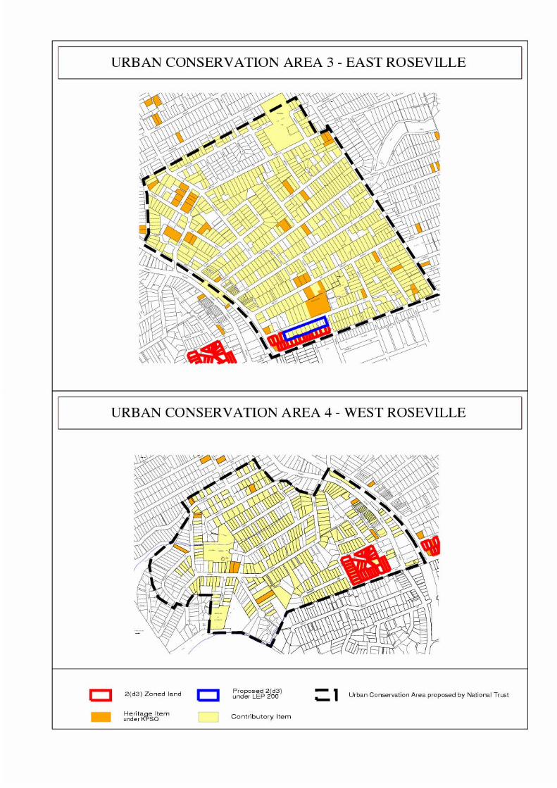
Urban Conservation Area 3 - Roseville (East side)
Description
• The Ku-ring-gai Urban Conservation Area (Roseville East side Precinct) consists of an area of predominately 1920s bungalows with the almost universal use of face brick on medium-sized lots with Federation style houses and interwar flats being located close to the railway line as well as 1920s shops being located in Hill Street.
Statement of Significance The Roseville Urban Conservation Area (3) is an area of outstanding streetscapes of Federation and Interwar period housing, complemented by shops, community buildings and a small number of Inter War flats and enhanced by gardens and street planting. The area is visually distinctive in its overall cohesiveness and consistency of high-quality, mainly single- storey houses from the Federation and Inter-War periods complemented by a small number of flats and is remarkable for the high proportion of contributory items. These buildings combine with large mature private gardens and significant avenue plantings, which help create substantially harmonious streetscapes. The cohesiveness of the area is reinforced by the consistent and generally regular grided settlement pattern, with buildings on similarly-sized allotments and set back uniformly from the street behind low fences. Urban Conservation Area 4 - West Roseville Description
• The Ku-ring-gai Urban Conservation Area (West Roseville Precinct) consists of a predominately 1920s bungalows on medium-sized lots with Federation style houses and interwar flats being located on the Pacific Highway and the almost universal use of face brick. There are few unsympathetic alterations or intrusions into the area.
Statement of Significance The West Roseville Urban Conservation Area (UCA 4) is a notable precinct of mixed housing and commercial development that retains important evidence of the development of Ku-ring-gai in the decades following the coming of the railway in 1890. The layout of the streets and lots as well as much of the building stock provides cohesive evidence of the late nineteenth and early twentieth century subdivisions and development of the area’s original land grants and in particular the growth spurts in the pre-World War 1 and interwar periods. The area is characterised by a predominance of Federation and Interwar period residential development comprising freestanding houses in established gardens. These houses are major contributors to the area’s numerous attractive streetscapes and while varied in architectural character, they feature a compatibility of form, massing materials and detailing. The siting of houses within informally landscaped gardens set back from the street behind low fences/walls and/or hedges and featuring tall trees contributes to the significant aesthetic values of the streetscapes.
Effective 22 December 2004 Amended 28 April 2006
Ku-ring-gai Multi-unit Housing DCP No.55 Railway / Pacific Highway Corridor and St Ives Centre
82 of 107
Effective 22 December 2004 Amended 28 April 2006
Ku-ring-gai Multi-unit Housing DCP No.55 Railway / Pacific Highway Corridor and St Ives Centre
83 of 107
Urban Conservation Area 6 - Lindfield
Description:
• The Ku-ring-gai Urban Conservation Area (Lindfield Precinct) consists predominately of 1920s bungalows on medium-sized lots with Federation style houses being located close to the railway line as well as 1920s shops being located in Lindfield Avenue. There are few unsympathetic alterations or intrusions into the area.
Statement of Significance The Lindfield Urban Conservation Area (UCA6) is an area if highly intact streetscapes that provide evidence of subdivision and development during the Federation and Inter-War periods. They include Federation and Californian bungalows within mature gardens. The residential streetscapes are complemented by a number of distinctive building and landscape features, such as churches, a whist club, tennis club, Lindfield Avenue, and two Inter-War flat buildings. The large number of Federation and Inter-War houses that contribute to the significance of the area is enhanced by individually significant buildings from the same period, including the Inter-War Spanish Mission shops in Lindfield Avenue, landmark churches and a number of large residences, set within a generally grided settlement pattern, which includes a number of historically and visually distinctive laneways. A pocket of homogenous Inter-War housing in Lightcliff Avenue contributes to the significance of the area as a whole, as well as being a significant example of cohesive subdivision and development as an individual entity. The collective value of the built and landscape elements is enhanced by the high visual amenity of the vegetation which results from the quality and distribution of vegetation: within private gardens, as avenue plantings and remnant vegetation that permeates the area. The built environment is softened by the large quantity of established street trees. Houses are set back behind low front fences, with private gardens at front and back that are mostly well landscaped and well maintained, while being generally sympathetic to the house types that they surround. Urban Conservation Area 7 - West Lindfield Description
• The Ku-ring-gai Urban Conservation Area (West Lindfield Precinct) consists of housing in the area consists predominately of 1920s bungalows developed in a single period on medium-to large lots with the almost universal use of face brick.

Effective 22 December 2004 Amended 28 April 2006
Ku-ring-gai Multi-unit Housing DCP No.55 Railway / Pacific Highway Corridor and St Ives Centre
84 of 107

Effective 22 December 2004 Amended 28 April 2006
Ku-ring-gai Multi-unit Housing DCP No.55 Railway / Pacific Highway Corridor and St Ives Centre
85 of 107
Urban Conservation Area 9 - Killara
Description:
• The Ku-ring-gai Urban Conservation Area (Killara Precinct) consists of residences ranging from single-storey 1920s bungalows in the northern section, two storey flats near Killara Station, large 1920s and 1930s mansions in Stanhope Road, large 1920s and 1930s houses in the central section of the precinct and more modest 1930s and 1940s as well as some post-World War 2 houses in the eastern section of the precinct.
Statement of Significance The Killara UCA (UCA 9) is an area of special streetscapes and groups of substantial, intact houses of the Federation and Inter-War periods that provide evidence of a suburb established for ‘gentlemen of means’ around the railway line from the 1890s. The area is distinct in its consistency of high quality intact buildings predominately form the Federation and Inter-War periods, combined with mature extensive private gardens and significant avenue plantings. The area has a high level of visual amenity, based on the large body of vegetation that provides privacy, buffering, height and texture overall, which is reinforced by a large number of tall remnant trees on public and private land. Urban Conservation Area 10 - Culworth Avenue, Killara Note: This precinct is currently being reviewed in Stage 4 of the UCA review. Description
• The Ku-ring-gai Urban Conservation Area (Culworth Avenue Precinct) consists of an area of single-storey Federation period and 1920s bungalows in the southern section, two and three storey flats near Killara Station and large 1930s houses in Marion Street. The uniform appearance of the area stems from its development within a single period as well as the almost universal use of face brick.
• The Culworth Avenue Precinct epitomises the area and era in both the excellent,
intact nature of its houses, their gardens and street plantings

Effective 22 December 2004 Amended 28 April 2006
Ku-ring-gai Multi-unit Housing DCP No.55 Railway / Pacific Highway Corridor and St Ives Centre
86 of 107

Effective 22 December 2004 Amended 28 April 2006
Ku-ring-gai Multi-unit Housing DCP No.55 Railway / Pacific Highway Corridor and St Ives Centre
87 of 107
Urban Conservation Area 11 - Killara Golf Links
Description:
• The Ku-ring-gai Urban Conservation Area (Killara Golf Links Precinct) consists of an area of residences ranging from single–storey 1920s and 1930s bungalows to single and two-storey post World War 2 houses. The uniform appearance of the area stems from its well established landscape.
• The Killara Golf Links Precinct epitomises the area and era in both the excellent,
intact nature of its houses, their gardens and street plantings. Urban Conservation Area 12 - Greengate, Killara Note: Council is currently reviewing this precinct in Stage 4 of the UCA review. Description
• The Ku-ring-gai Urban Conservation Area (Greengate Precinct) consists of an area of residences ranging from the Federation period, 1920s and 1930s bungalows and some post–World War 11 Houses. The Greengate Hotel on the corner of the Pacific Highway and Greengate Road is one of the best, most intact examples of 1930s hotels in the Sydney Region. There are also some excellent examples of 1920s and 1930s residential flat buildings on the Pacific Highway.
• The uniform appearance of the area stems from its well-established landscape.
• The Greengate Precinct epitomises the area and era in both the excellent, intact
nature of its houses, their gardens and street plantings.

Effective 22 December 2004 Amended 28 April 2006
Ku-ring-gai Multi-unit Housing DCP No.55 Railway / Pacific Highway Corridor and St Ives Centre
88 of 107

Effective 22 December 2004 Amended 28 April 2006
Ku-ring-gai Multi-unit Housing DCP No.55 Railway / Pacific Highway Corridor and St Ives Centre
89 of 107
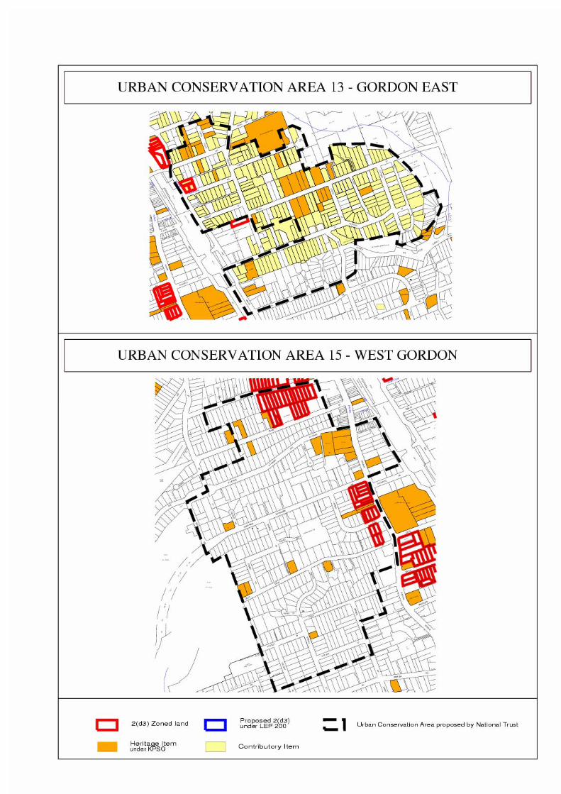
Urban Conservation Area 13 - Gordon (East)
Description
• The Ku-ring-gai Urban Conservation Area (Gordon Precinct) consists of an area of single-storey 1920s bungalows and some one and two storey Federation period houses. The uniform appearance of the area stems from its almost universal use of face brick.
Statement of Significance The Gordon UCA (13) is a relatively intact residential area of Federation and Inter-War period houses that collectively provide evidence of the transformation of the area from agriculture to suburban housing, over a fifty year period, following the opening of the railway in 1890. The collection of Federation and Inter-War houses contributes to attractive streetscapes that are reinforced by a number of other significant characteristics, such as the early subdivisions and development pattern that established a relative consistency in the siting of buildings and provided for generous garden areas. Streets of Federation and Inter-War period houses are often unified by similarities in their mainly single-storey form and materials such as face brickwork and tiled roofs. The houses are set back from the street behind low fences, and are complemented by their gardens, which often include large trees. Remnant eucalypts and the consistent leafy appearance of its streets, including street trees, contribute or a high level of visual amenity. Views from Gordon Station steps to the east reveal the rich variety of indigenous and exotic trees, which dominate the buildings. Urban Conservation Area 15 - West Gordon
• The Ku-ring-gai Urban Conservation Area (West Gordon) consists of an area of single-storey 1920s and 1930s bungalows. The uniform appearance of the area stems from its development within a single period as well as the almost universal use of face brick.
Effective 22 December 2004 Amended 28 April 2006
Ku-ring-gai Multi-unit Housing DCP No.55 Railway / Pacific Highway Corridor and St Ives Centre
90 of 107

Effective 22 December 2004 Amended 28 April 2006
Ku-ring-gai Multi-unit Housing DCP No.55 Railway / Pacific Highway Corridor and St Ives Centre
91 of 107
Urban Conservation Area 17 - Pymble (East)
Description
• The Ku-ring-gai Urban Conservation Area (Pymble Precinct) consists of an area of single-storey and double storey 1930s and 1940s houses. The uniform appearance of the area stems from its well established landscape.
• The centrepiece is the housing surrounding Robert Pymble Park. The houses and Park constitute an excellent example of good civic design.
Statement of Significance Pymble UCA (17) is a cultural landscape comprising outstanding streetscapes that demonstrate the development of an early twentieth-century residential suburb. The large variety of Federation and Inter-War housing on medium to large lots is enhanced by a setting of remnant indigenous forest, exotic street plantings and a network of streets that continue to reflect the early subdivision and development of the area. The development pattern provides evidence of the subdivision of the original land grants for residential development following the arrival of the North Shore Railway line in 1890. The predominance of Federation and Inter-War period housing reflects the two major phases of residential development that occurred in the 50 year period between 1890 and 1940. The UCA contains aesthetically distinctive Inter-War period streetscapes that feature a general uniformity of building setbacks from the street, architectural styles, materials, colour and form. The established nature of the landscape and well –maintained gardens and street planting of indigenous and exotic trees contribute to a high level of streetscape integrity. Urban Conservation Area 18 - Avon Road, Pymble Description
• The Ku-ring-gai Urban Conservation Area (Avon Road, Pymble Precinct) consists of an area of single-storey and double storey 1920s, 1930s and 1940s houses. The uniform appearance of the area stems from its well-established landscape.
• The centrepiece is the landscaping of Pymble Ladies College. Statement of Significance Pymble UCA (18) is an area of three outstanding streetscapes, commenced in the Federation period, but mainly developed in the Inter-War period, within a landscape of dense vegetation and exotic street plantings. The subdivision pattern provides evidence of the original land grants, and of the Federation-period residential development following the arrival of the North Shore Railway Line in 1890. Inter-War period housing predominates. The UCA contains aesthetically distinctive streetscapes of mainly Inter-War period buildings that feature a general uniformity of setback from the street, architectural styles, materials, colour and form. They are enhanced by an established landscape of well maintained gardens and street plantings of indigenous and exotic tree and shrubs, which are incorporated into private front and rear yards which contributes to a high level of streetscape integrity. Of particular significance is the remnant stand of indigenous trees that provides a substantial canopy that extends from the Pacific Highway in a southerly direction along a creek line.

Effective 22 December 2004 Amended 28 April 2006
Ku-ring-gai Multi-unit Housing DCP No.55 Railway / Pacific Highway Corridor and St Ives Centre
92 of 107

Effective 22 December 2004 Amended 28 April 2006
Ku-ring-gai Multi-unit Housing DCP No.55 Railway / Pacific Highway Corridor and St Ives Centre
93 of 107
Urban Conservation Area 19 - Bobbin Head Road, Turramurra
Description
• The Ku-ring-gai Urban Conservation Area (Bobbin Head Road, Turramurra Precinct) consists of an area of single-storey and double storey 1920s, 1930s and 1940s houses. The uniform appearance of the area stems from its well established landscape.
• The precinct contains excellent examples of architect-designed houses such as the
Spanish Mission houses designed by G. Kenworthy on the corner of the Pacific Highway and Warrangi Street.
• The Bobbin Head, Road, Turramurra Precinct epitomises the area and era in both the
excellent, intact nature of its houses, their gardens and street plantings. Urban Conservation Area 20 - Ku-ring-gai Avenue, Turramurra Note: This precinct is one of the early National Trust Conservation Areas and was classified before the Interwar UCA study commenced. It is included within draft LEP 21 which was finalised by Council in 2000 and has been with the Department since early 2001. Description
• The Ku-ring-gai Avenue, Turramurra Urban Conservation Area provides an excellent townscape comprised of mainly two storey mansions dating from the 1890 and set in well established gardens. There is a fine collection of street tree plantings including Brush Box. The streetscapes are strongly characterised by fine fences.

Effective 22 December 2004 Amended 28 April 2006
Ku-ring-gai Multi-unit Housing DCP No.55 Railway / Pacific Highway Corridor and St Ives Centre
94 of 107

Effective 22 December 2004 Amended 28 April 2006
Ku-ring-gai Multi-unit Housing DCP No.55 Railway / Pacific Highway Corridor and St Ives Centre
95 of 107
Urban Conservation Area 21 - Kissing Point Road, Turramurra
Description
• The Ku-ring-gai Urban Conservation Area (Kissing Point Road, Turramurra Precinct) consists of an area of single-storey 1920s and 1930s bungalows. The uniform appearance of the area stems from its well established landscape.
Urban Conservation Area 25 - Heydon Avenue, Warrawee.
• The Ku-ring-gai Urban Conservation Area (Heydon Avenue, Warrawee Precinct) consists of an area of large single-storey 1920s and 1930s bungalows as well as some large 1940s houses. The uniform appearance of the area stems from its well established landscape.
• The Heydon Avenue, Warrawee Precinct epitomises the area and era in both the
excellent, intact nature of its houses, their gardens and street plantings.

Effective 22 December 2004 Amended 28 April 2006
Ku-ring-gai Multi-unit Housing DCP No.55 Railway / Pacific Highway Corridor and St Ives Centre
96 of 107

Effective 22 December 2004 Amended 28 April 2006
Ku-ring-gai Multi-unit Housing DCP No.55 Railway / Pacific Highway Corridor and St Ives Centre
97 of 107
Urban Conservation Area 26 - Mahratta, Wahroonga
Description
• The Ku-ring-gai Urban Conservation Area (Mahratta Precinct) consists of an area of large single-storey 1920s, 1930s and 1940s houses with some post World War 2 houses in the centre of the precinct. The precinct is named after the large red brick, interwar mansion, Mahratta constructed at the corner of the Pacific Highway and Fox Valley Road.
• The uniform appearance of the area stems from its well established landscape. Urban Conservation Area 27 - Wahroonga (East side) Note: This precinct has been reviewed and is graded as State significance. Description
• The Ku-ring-gai Urban Conservation Area (Wahroonga Precinct) consists of an area of large single-storey and two storey 1920s, 1930s and 1940s houses, many of which were designed by prominent architects including Howard Joseland, B J Waterhouse, F Glynn Gilling, L’Anson, Bloomfield and McCulloch and H V Vernon.
• The houses are built on large landscaped lots with well maintained mature trees and botanical gardens, some designed by Paul Soderson. The mature tree plantings along Burns Road make it one of the most picturesque in Ku-ring-gai. Fine fences appropriate to the period also contribute to the rustic character of the precinct.
• The significance of this precinct is largely due to the setting in which the houses are placed, the principal elements in the area being the successful correlation between buildings and its extensive gardens and natural landscape.
Statement of Significance The Wahroonga UCA (27) is of outstanding streetscape significance for its concentration of large Federation period houses set in expansive garden settings on tree-lined streets. Burns Road is an important street of landmark value, which together with Cleveland Street and Water Street, contains the highest concentration of large Federation period houses. The high visual quality of the area is enhanced by its vegetation, through dramatic visual effects and the continuous lush character generated by the combination of individual specimen trees, avenue plantings and well-incorporated indigenous vegetation. The area provides historic evidence of the subdivision pattern of the “Big Island Estate” into large suburban lots with a semi-rural character prompted by the laying of the Hornsby to St Leonards railway in 1890. The way of life for a community on the Upper North Shore, prominent in the professions, industry and commerce, is reflected in these well-crafted detached houses with picturesque gardens, many still sited on large allotments. The architectural fashions and urban design theories evident in this area can be traced to contemporaneous movements in England and the United States. Adaptations for climate are evident in most of the houses. The collection of large Federation period houses is complemented by many more modest Federation period houses as well as Inter-War buildings of various sizes.

Effective 22 December 2004 Amended 28 April 2006
Ku-ring-gai Multi-unit Housing DCP No.55 Railway / Pacific Highway Corridor and St Ives Centre
98 of 107