DRAFT INITIAL STUDY AND MITIGATED NEGATIVE DECLARATION
107
DRAFT INITIAL STUDY AND MITIGATED NEGATIVE DECLARATION 333 and 343 Sacramento Street, Auburn, California PG&E Auburn Sacramento Street Renovation Project May 2020
Transcript of DRAFT INITIAL STUDY AND MITIGATED NEGATIVE DECLARATION
DRAFT
INITIAL STUDY ANDMITIGATED NEGATIVE DECLARATION
333 and 343 Sacramento Street, Auburn, CaliforniaPG&E Auburn Sacramento Street Renovation Project
May 2020

PG&E Auburn Sacramento Street Renovation Project iInitial Study/Mitigated Negative Declaration May 2020
TABLE OF CONTENTS
Section PageIntroduction ............................................................................................................................................. 1
Environmental Factors Potentially Affected .............................................................................................. 7
Determination .......................................................................................................................................... 8
Project Description .................................................................................................................................. 9
I. Aesthetics ........................................................................................................................................... 12
II. Agriculture and Forestry Resources ................................................................................................... 15
III. Air Quality ......................................................................................................................................... 18
IV. Biological Resources ........................................................................................................................ 28
V. Cultural Resources ............................................................................................................................ 33
VI. Energy ............................................................................................................................................. 41
VII. Geology and Soils ........................................................................................................................... 43
VIII. Greenhouse Gas Emissions ........................................................................................................... 48
IX. Hazards and Hazardous Materials .................................................................................................... 52
X. Hydrology and Water Quality ............................................................................................................. 60
XI. Land Use and Planning .................................................................................................................... 65
XII. Mineral Resources .......................................................................................................................... 67
XIII. Noise.............................................................................................................................................. 69
XIV. Population and Housing ................................................................................................................. 77
XV. Public Services ............................................................................................................................... 79
XVI. Recreation ..................................................................................................................................... 81
XVII. Transportation ............................................................................................................................... 83
XVIII. Tribal Cultural Resources ............................................................................................................. 87
XIX. Utilities and Service Systems ......................................................................................................... 90
XX. Wildfire ........................................................................................................................................... 94
XXI. Mandatory Findings of Significance ................................................................................................ 95
References ............................................................................................................................................ 97
Appendices
Appendix A Project PlansAppendix B Photographic LogAppendix C Air Quality and Greenhouse Gas Modeling DataAppendix D Biological Resources SurveyAppendix E Cultural Resources StudiesAppendix F Noise Modeling Input Parameters and Output Results

PG&E Auburn Sacramento Street Renovation Project iiInitial Study/Mitigated Negative Declaration May 2020
Figures
Figure 1 Regional Project Location ..................................................................................................... 3Figure 2 Project Vicinity ...................................................................................................................... 4Figure 3 General Plan Land Use ......................................................................................................... 5Figure 4 Zoning .................................................................................................................................. 6Figure 5 Noise Monitoring Locations ................................................................................................. 72
Tables
Table 1 Existing and Proposed Buildings ......................................................................................... 10Table 2 National and California Ambient Air Quality Standards ........................................................ 21Table 3 PCAPCD-Adopted Thresholds of Significance for Criteria Pollutants ................................... 22Table 4 Estimated Construction Emissions1 ..................................................................................... 24Table 5 Previously Recorded Cultural Resources ............................................................................ 34Table 6 Native American Coordination ............................................................................................. 36Table 7 California Geological Survey Mineral Land Classification System ........................................ 67Table 8 Summary of Ambient Noise Level Survey Results in the Project Area ................................. 71Table 9 Caltrans' Vibration Threshold Criteria for Building Damage.................................................. 73Table 10 Caltrans' Vibration Threshold Criteria for Human Response ................................................ 73Table 11 Ambient and Project Construction Noise Levels at Closest Sensitive Receptors .................. 74Table 12 Project Construction Vibration Levels at Closest Sensitive Receptors .................................. 76

PG&E Auburn Sacramento Street Renovation Project iiiInitial Study/Mitigated Negative Declaration May 2020
Acronyms
AB Assembly Billamsl above mean sea levelAPE Area of Potential EffectsAPI Area of Potential ImpactBMP best management practiceC-3 Regional Commercial zoning districtCAA Clean Air ActCAAQS California Ambient Air Quality StandardsCalEEMod California Emissions Estimator ModelCal EPA California Environmental Protection AgencyCAL FIRE California Department of Forestry and Fire ProtectionCal/OSHA California Occupational Safety and Health AdministrationCalRecycle California Department of Resources Recycling and RecoveryCaltrans California Department of TransportationCARB California Air Resources BoardCBC California Building Standards Code or California Building Standards CodeCCR California Code of RegulationsCDC California Department of ConservationCDFW California Department of Fish and WildlifeCEC California Energy CommissionCESA California Endangered Species ActCEQA California Environmental Quality ActCFR Code of Federal RegulationsCGS California Geological SurveyCH4 methaneCNG compressed natural gasCO carbon monoxideCO2 carbon dioxideCO2e CO2-equivalentsCRHR California Register of Historical ResourcesCUPA certified unified program agencyCVRWQCB Central Valley Regional Water Quality Control BoardCWA Clean Water ActdB decibel(s)dBA A-weighted decibel(s)DOF California Department of FinanceDOT United States Department of TransportationDTSC Department of Toxic Substances ControlEDR Environmental Data Resources, Inc.EO Executive Order

PG&E Auburn Sacramento Street Renovation Project ivInitial Study/Mitigated Negative Declaration May 2020
EPA U.S. Environmental Protection AgencyESA Endangered Species ActFEMA Federal Emergency Management AgencyFHWA Federal Highway AdministrationFTA Federal Transit AdministrationGHG greenhouse gasGWP global warming potentialHCP habitat conservation planHWCL Hazardous Waste Control LawHz HertzIND Industrial land use designationin/sec inch(es) per secondIS Initial StudyITE Institute of Transportation EngineersJJ&A Jacobson James and Associates, Inc.lbs/day pounds per dayLdn Day-Night Noise LevelLED light-emitting diodeLEED Leadership in Energy and Environmental DesignLeq equivalent noise levelLeq[h] A-weighted equivalent sound levelLmax maximum sound levelLn Statistical DescriptorLNG liquefied natural gasM-1 Industrial Park zoningMBTA Migratory Bird Treaty ActMGD million gallons per dayµg/m3 micrograms per cubic meterMLD Most Likely DescendentMRZ Mineral Resource ZoneMS4 Small Municipal Separate Storm Sewer SystemsMT metric tonsNAAQS National Ambient Air Quality StandardsNAHC Native American Heritage CommissionNCIC North Central Information CenterN2O nitrous oxideNO2 nitrogen dioxideNOx nitrogen oxidesNPDES National Pollutant Discharge Elimination SystemNRHP National Register of Historic PlacesOEHHA Office of Environmental Health Hazard Assessment

PG&E Auburn Sacramento Street Renovation Project vInitial Study/Mitigated Negative Declaration May 2020
OSHA Occupational Safety and Health AdministrationPCAPCD Placer County Air Pollution Control DistrictPCB polychlorinated biphenylPCTPA Placer County Transportation AgencyPCWA Placer County Water AgencyPG&E Pacific Gas and Electric CompanyPM particulate matterPM2.5 particulate matter equal to or less than 2.5 micrometers in diameterPM10 particulate matter equal to or less than 10 micrometers in diameterppm parts per millionPRC California Public Resources CodePPV peak particle velocityPUHSD Placer Union High School DistrictRMS root mean squareRCRA Resource Conservation and Recovery Act of 1976ROG reactive organic gasRWQCB Regional Water Quality Control BoardSACOG Sacramento Area Council of GovernmentsSARA Superfund Amendments and Reauthorization ActSB Senate BillSIP State Implementation PlanSMAQMD Sacramento Metropolitan Air Quality Management DistrictSO2 sulfur dioxideSPCC spill prevention, control, and countermeasureSVAB Sacramento Valley Air BasinSWPPP Storm Water Pollution Prevention PlanSWRCB State Water Resources Control BoardTAC toxic air contaminantTCR tribal cultural resourceTHPO Tribal Historic Preservation OfficerUAIC United Auburn Indian CommunityUSC United States CodeUSFWS United States Fish and Wildlife ServiceUST underground storage tankUWMP Urban Water Management PlanVdB vibration decibel(s)VMT vehicle miles traveledVOC volatile organic compoundWDR Waste Discharge Report

PG&E Auburn Sacramento Street Renovation Project 1Initial Study/Mitigated Negative Declaration May 2020
Initial Study/Mitigated Negative Declaration333 and 343 Sacramento Street, Auburn, California
PG&E Auburn Sacramento Street Renovation Project
INTRODUCTION
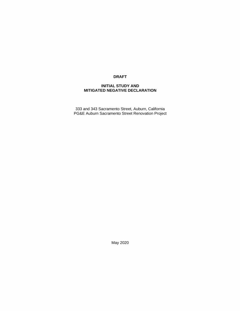
1. Project Overview: The Pacific Gas and Electric Company (PG&E) Auburn Sacramento StreetRenovation project would involve renovating an approximately 7.1-acre portion of the existing PG&EAuburn Service Center at 333 and 343 Sacramento Street, Auburn (see Figure 1 and Figure 2). Theproject would include the renovation of an existing building, demolition of three buildings, and theconstruction of two new buildings and perimeter fencing, to support specialized operations such asstorm, wildfire, or other regional response activities; and to be available for overflow from the PG&EAuburn Regional Center if required to support regional customer support (see Appendix A). Theprimary use of the project site would be to manage wildfire mitigation efforts, wildfire response, andongoing grid-hardening efforts in PG&E’s Sierra Division.
2. Project Title: PG&E Auburn Sacramento Street Renovation Project
3. Lead Agency Name and Address: City of Auburn Planning Department1225 Lincoln WayAuburn, CA 95603
4. Contact Person and Email: Tonya [email protected]
5. Location: 333 and 343 Sacramento Street, Auburn, California
6. Applicant’s Name and Address: Mr. Thomas CrowleyPacific Gas and Electric Company245 Market StreetMail Code 1074CSan Francisco, CA 94105
7. General Plan Land Use Designations: The project site is included in the Industrial (IND) land usedesignation in the City of Auburn General Plan (see Figure 3).
8. Zoning: The project site is partly included in the Industrial Park (M-1) zoning district, and partly includedin the Regional Commercial (C-3) zoning district (see Figure 4).
9. Description of Project: See Project Description section.
10. Surrounding Land Uses and Setting: Land uses in the project vicinity include industrial/commercial,recreation, and open space. Single-story industrial/commercial buildings are across Sacramento Streetto the west of the project site, including a recycling center and storage facility. Single-storyindustrial/commercial buildings (Crossfit Gym) and associated parking areas and a rail line are to thesouth of the project site. Railhead Park is across the rail line. An animal holding area associated withAuburn City (Gold Country) Fairgrounds and Event Center, rail line, and Overlook Park is to the eastand southeast of the project site. To the north of the project site are a paved parking area and a dirtparking area associated with a small commercial center at the corner of Sacramento Street andFairgate Road; the Auburn City (Gold Country) Fairgrounds and Event Center; and the AuburnPerformance Raceway race track, stadium, arena, and sports venue, which is to the northeast of theproject site. The project site has been used as a PG&E service center since 1954, and is developedwith engineering, warehouse, telecommunications, and other miscellaneous buildings, and storage and

PG&E Auburn Sacramento Street Renovation Project 2Initial Study/Mitigated Negative Declaration May 2020
parking areas. There also is an existing compressed natural gas (CNG)/liquefied natural gas (LNG)fueling facility along Sacramento Street.
11. Required Approvals: No Responsible and/or Trustee Agency permits are required. The followingapprovals are expected to be required before the start of project construction:
· Design Review Permit
· Administrative Permit
· Building Permits
· Encroachment Permit
· Site Plan and Building Plan Approvals
· Asbestos Dust Mitigation Plan
· Construction General Permit Order 2009-0009-DWQ

_̂Auburn
S o l a n oC o u n t y
P l a c e rC o u n t y
S a c .C o u n t y
E l D o r a d oC o u n t y
§̈¦5
§̈¦80
Project Location
§̈¦5
N e v a d aC o u n t y
S u t t e rC o u n t y
Y o l oC o u n t y
§̈¦80
A m a d o rC o u n t y
Sacramento
Roseville
WiltonElk Grove
Folsom
Sheridan
Rocklin
Lincoln
Vineyard
Elverta
Fair Oaks
Antelope
El DoradoHills
Rancho Cordova
Granite Bay
WestSacramento
Arden-Arcade
Georgetown
Carmichael
Rio Linda Orangevale
CitrusHeights Diamond Springs
Loomis
CameronPark
Alta Sierra
Rancho Murieta
AuburnLakeTrails
Pollock Pines
North Auburn
Placerville
NorthHighlands Shingle
Springs
Coloma
Meadow Vista
Gold River
Penryn
Newcastle
WheatlandLake of the Pines
ColdSprings
_̂
Project Location
HighwayCity of AuburnCity BoundaryCounty Boundary
AECOM Oakland CA 6/25/2019 USER brownm6 PATH X:\GIS\Projects\60479036_PGE_CRESS\02_Maps\Figure1_Auburn_Regional_Project_Location.mxd
FIGURE 1Regional Project Location
0 105Miles
Source: AECOM 2019
PG&E Auburn Sacramento Street Renovation Project
S a cr am e n toS t
R a c e t r a c k
S t
NMcdaniel
Dr
Tim be r l i neL n
R iv e
r v iew
D r
College Way
Ove r
l oo k
B re wer yL n
Pinecrest Ave
D a l e D r
Knoll
St
C o r a
Ln
S k y r i d g e D r
P o r t l a n dA v e
O r r i n
Dr
H ig h
St
PleasantAve
PacificAve
Sacra
mento
St
Aubu
rnFo
lsom
Rd
GumLn
Pl easantAveS h i r l a n d
C a n a l
B o ar d m a n Ca n a l
Auburn
AECOM Oakland CA 6/25/2019 USER brownm6 PATH X:\GIS\Projects\60479036_PGE_CRESS\02_Maps\Figure2_Auburn_Project_Site_Vicinity_Zoomed In.mxd
FIGURE 2Project Vicinity
Project Site
0 400200Feet
Source: AECOM 2019
PG&E Auburn Sacramento Street Renovation Project

Auburn
AECOM Oakland CA 12/9/2019 USER brownm6 PATH X:\GIS\Projects\60479036_PGE_CRESS\02_Maps\Figure3_Auburn_Project_LandUse.mxd
FIGURE 3Land Use
Project SiteLand Use Designations
Urban Reserve (UR)Urban Low DensityResidential (ULDR)Low Medium DensityResidential (LMDR)Medium DensityResidential (MDR)High Density Residential(HDR)Commercial (COMM)Industrial (IND)Open Space (OS)Open Space Fairground(OSF)
0 400200Feet
Source: AECOM 2019
PG&E Auburn Sacramento Street Renovation Project

S ac ra m en toS t
Racetrack
St
NMcdaniel
Dr
T imbe r l i neL n
R iv e
r vi ew
Dr
Ove r
l oo k
Br ewer yL n
Pinecrest Ave
D a l e D r
Knoll
St
C o r a
Ln
S k y r i d g e D r
P o r t l a n dAv e
O r r i n
Dr
H igh
St
PleasantAve
Sacra
mento
St
Aubu
rn
Folso
m Rd
G umLn
P leasantAveS h i r l a n d
C a n a l
B o ard ma n C an a l
Auburn
AECOM Oakland CA 12/6/2019 USER brownm6 PATH X:\GIS\Projects\60479036_PGE_CRESS\02_Maps\Figure4_Auburn_Project_Zoning.mxd
FIGURE 4Zoning
Project SiteZoning
(10) Office Building DistrictMedium Density Multiple-FamilyResidential(R1-#) Single-Family Residential(R2)Two-Family Residential
(R3) Medium Density Multiple-Family Residential(OB) Office Building District(C-3) Regional Commercial(M-1) Industrial Park District(M-2) Industirial District(OSC) Open Space &Conservation
0 400200Feet
Source: AECOM 2019
PG&E Auburn Sacramento Street Renovation Project
PG&E Auburn Sacramento Street Renovation Project 7Initial Study/Mitigated Negative Declaration May 2020
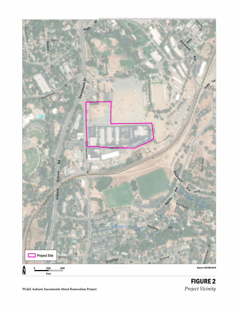
ENVIRONMENTAL FACTORS POTENTIALLY AFFECTED
The environmental factors checked below would be potentially affected by this project, involving at leastone impact that is a Potentially Significant Impact as indicated by the checklist on the following pages.
Aesthetics Agriculture and ForestryResources
Air Quality
Biological Resources Cultural Resources Energy
Geology and Soils Greenhouse GasEmissions
Hazards and HazardousMaterials
Hydrology and WaterQuality
Land Use and Planning Mineral Resources
Noise Population and Housing Public Services
Recreation Transportation Tribal Cultural Resources
Utilities and ServiceSystems
Wildfire Mandatory Findings ofSignificance

PG&E Auburn Sacramento Street Renovation Project 8Initial Study/Mitigated Negative Declaration May 2020
DETERMINATION
On the basis of this initial evaluation:
I find that the proposed project COULD NOT have a significant effect on the environment, and aNEGATIVE DECLARATION will be prepared.
I find that although the proposed project could have a significant effect on the environment, there willnot be a significant effect in this case because revisions in the project have been made by or agreed to bythe project proponent. A MITIGATED NEGATIVE DECLARATION will be prepared.
I find that the proposed project MAY have a significant effect on the environment, and anENVIRONMENTAL IMPACT REPORT is required.
I find that the proposed project MAY have a "potentially significant impact" or "potentially significantunless mitigated" impact on the environment, but at least one effect 1) has been adequately analyzed in anearlier document pursuant to applicable legal standards, and 2) has been addressed by mitigationmeasures based on the earlier analysis as described on attached sheets. An ENVIRONMENTAL IMPACTREPORT is required, but it must analyze only the effects that remain to be addressed.
I find that although the proposed project could have a significant effect on the environment, because allpotentially significant effects (a) have been analyzed adequately in an earlier EIR or NEGATIVEDECLARATION pursuant to applicable standards, and (b) have been avoided or mitigated pursuant to thatearlier EIR or NEGATIVE DECLARATION, including revisions or mitigation measures that are imposedupon the proposed project, nothing further is required.
Signature Date
Printed Name Title
PG&E Auburn Sacramento Street Renovation Project 9Initial Study/Mitigated Negative Declaration May 2020
PROJECT DESCRIPTION
Background
The PG&E Auburn Sacramento Street Renovation project would involve renovating approximately7.1 acres of the approximately 9.5-acre PG&E Auburn Service Center at 333 and 343 Sacramento Street,Auburn (see Figure 1, Figure 2, and Appendix A). The project site has been used as a PG&E servicecenter since 1954, and is developed with engineering, warehouse, telecommunications, and othermiscellaneous buildings, and storage and parking areas. There also is an existing CNG/LNG fueling facilityalong Sacramento Street. The existing PG&E service center would be renovated to support specializedoperations such as storm, wildfire, or other regional response activities; and to be available for overflowfrom the PG&E Auburn Regional Center if required to support regional customer support activities. Theprimary use of the project site would be to manage wildfire mitigation efforts, wildfire response, and ongoinggrid-hardening efforts in PG&E’s Sierra Division. No change would occur to the use of the existingCNG/LNG fueling facility along Sacramento Street as a result of the project.
Operations
The existing PG&E service center accommodates up to approximately 85 personnel; the project would notresult in an increase in employees or contractors using the project site. Following renovation of the projectsite, PG&E employees and contractors would continue to access the project site on a regular basis duringAM and PM peak hours, including approximately 30 office-based personnel that would stay at the projectsite most, if not all day; and 36 crew personnel that would commute to the project site and depart in fleetvehicles. The crew personnel would generally arrive in personal vehicles between 6:00 a.m. and 8:00 a.m.,depart no later than 9:00 a.m. in fleet vehicles, return in fleet vehicles in the early afternoon, and leave theproject site in personal vehicles at approximately 4:00 p.m.
The project site also may be used to assemble crews from PG&E’s service territory to respond toemergency events (e.g., major rain/snow storms or wildfires). This is atypical, and the likelihood of usingthe project site for emergency events is low because PG&E’s regional emergency response is expected tobe focused out of PG&E’s Auburn Regional Center. The use of the project site for this purpose may occurup to a few times per year, and involve response activities lasting from a few days to a few weeks. Up to atotal of approximately 85 personnel are expected to use the project site during emergency events.
No change would occur to the existing hours of operation (6 a.m. to 5 p.m., Monday through Friday andoccasional use on evenings and weekends, including during emergencies).General office and materialdeliveries would occur each day using small and large trucks (dump trucks and flatbed trailers).
No customers would visit the project site, except for existing customers that would continue to use the CNG/LNG fueling facility along Sacramento Street.
Parking
Existing paved parking areas would be repaired and maintained, and approximately 146 parking spaceswould be designated for employee (36) and fleet vehicle parking (110; small and large vehicles).Approximately 50,000 square feet of the northern portion of the project site also have been used foroverflow parking, and is undeveloped except for a gravel surface.
Buildings/Structures
Existing buildings/structures would be renovated or demolished, and new facilities would be constructed toaccommodate PG&E’s office and warehouse needs, and support planned operations (see Table 1 andAppendix A). New structures and buildings would be consistent with the height of existing buildings.Approximately 9,660 square feet of new buildings or structures would be constructed, and approximately
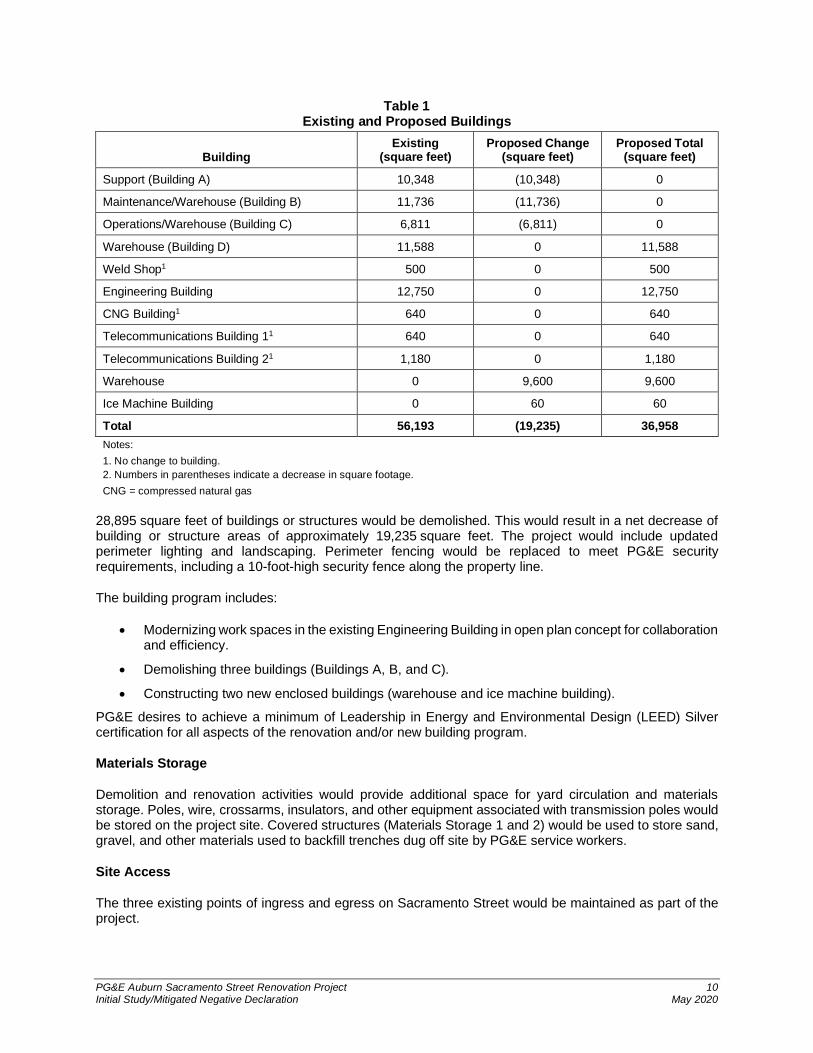
PG&E Auburn Sacramento Street Renovation Project 10Initial Study/Mitigated Negative Declaration May 2020
Table 1Existing and Proposed Buildings
BuildingExisting
(square feet)Proposed Change
(square feet)Proposed Total
(square feet)
Support (Building A) 10,348 (10,348) 0
Maintenance/Warehouse (Building B) 11,736 (11,736) 0
Operations/Warehouse (Building C) 6,811 (6,811) 0
Warehouse (Building D) 11,588 0 11,588
Weld Shop1 500 0 500
Engineering Building 12,750 0 12,750
CNG Building1 640 0 640
Telecommunications Building 11 640 0 640
Telecommunications Building 21 1,180 0 1,180
Warehouse 0 9,600 9,600
Ice Machine Building 0 60 60
Total 56,193 (19,235) 36,958Notes:1. No change to building.2. Numbers in parentheses indicate a decrease in square footage.CNG = compressed natural gas
28,895 square feet of buildings or structures would be demolished. This would result in a net decrease ofbuilding or structure areas of approximately 19,235 square feet. The project would include updatedperimeter lighting and landscaping. Perimeter fencing would be replaced to meet PG&E securityrequirements, including a 10-foot-high security fence along the property line.
The building program includes:
· Modernizing work spaces in the existing Engineering Building in open plan concept for collaborationand efficiency.
· Demolishing three buildings (Buildings A, B, and C).
· Constructing two new enclosed buildings (warehouse and ice machine building).
PG&E desires to achieve a minimum of Leadership in Energy and Environmental Design (LEED) Silvercertification for all aspects of the renovation and/or new building program.
Materials Storage
Demolition and renovation activities would provide additional space for yard circulation and materialsstorage. Poles, wire, crossarms, insulators, and other equipment associated with transmission poles wouldbe stored on the project site. Covered structures (Materials Storage 1 and 2) would be used to store sand,gravel, and other materials used to backfill trenches dug off site by PG&E service workers.
Site Access
The three existing points of ingress and egress on Sacramento Street would be maintained as part of theproject.

PG&E Auburn Sacramento Street Renovation Project 11Initial Study/Mitigated Negative Declaration May 2020
Utilities
Existing sewer and water supply pipes are sized sufficiently to serve the project; the project will result in anet decrease of building or structure areas. No off-site infrastructure improvements are anticipated to benecessary for the project. Existing on-site underground utilities would be maintained, and new buildingsand structures would be connected to existing utilities.
Storm Drain Controls
The impervious surfaces related to buildings at the project site would be reduced; however, these areaswould be repaved with pavement, and used for yard circulation and materials storage. The project sitealready has an existing stormwater drainage system, the majority of which would continue to be used. Minormodifications to the on-site drainage system would be implemented as necessary to tie-in the modifiedfacilities. Stormwater from replaced impervious surface areas would be treated in landscape-basedtreatment areas. PG&E also must comply with the requirements of the West Placer Storm Water QualityDesign Manual, which provides design standards and hydromodification requirements for conformance withthe County’s Small Municipal Separate Storm Sewer Systems (MS4) National Pollutant DischargeElimination System (NPDES) permit requirements. The City of Auburn would verify compliance with theserequirements prior to issuance of grading and/or building permits.
Project Construction
Project construction is expected to begin in Summer/Fall 2020 and extend for up to 12 months, withcompletion and occupancy in 2021. Project construction would include several phases, includingdemolition, site preparation, grading, trenching for utilities, perimeter security, renovation and/ordevelopment of new buildings or structures, and architectural coatings and paving.

PG&E Auburn Sacramento Street Renovation Project 12Initial Study/Mitigated Negative Declaration May 2020
I. AESTHETICS
PotentiallySignificant
Impact
Less ThanSignificant
WithMitigation
Incorporated
LessThan
SignificantImpact
NoImpact
Except as provided in Public Resources CodeSection 21099, would the project:
a) Have a substantial adverse effect on a scenic vista?
b) Substantially damage scenic resources, including,but not limited to, trees, rock outcroppings, andhistoric buildings within a state scenic highway?
c) In nonurbanized areas, substantially degrade theexisting visual character or quality of public views ofthe site and its surroundings? (Public views are thosethat are experienced from publicly accessible vantagepoint). If the project is in an urbanized area, would theproject conflict with applicable zoning and otherregulations governing scenic quality?
d) Create a new source of substantial light or glare whichwould adversely affect day or nighttime views in thearea?
Environmental Setting
The project area is urbanized and is used for industrial/commercial, recreational, and residential purposes.The project site is included in the City of Auburn’s Industrial Park (M-1) zoning district (City of Auburn,2016a). The project site has been used for a PG&E service center since 1954 (see Appendix B). The projectvicinity is mostly built out, and includes surrounding industrial and commercial development and facilitiesand recreational uses. The recreational uses do not have a direct view to the project site, because they areseparated by a roadway, rail line, and existing vegetation. There are no sensitive visual resources or usersin the project area.
Scenic vistas are areas of natural beauty with features such as topography, watercourses, rock outcrops,and natural vegetation that contribute to the landscape’s visual quality. The project site is not in an areadesignated as a scenic vista, and does not contain scenic resources (City of Auburn, 1993). There are nostate-designated highways within the viewshed of the project area. State Route 49, which startsapproximately 2 miles north of the project area, has been deemed eligible for listing as a scenic highway,but has not been officially designated (Caltrans, 2019). No portions of the project area are visible from StateRoute 49.
Regulatory Setting
Federal
No federal regulations related to aesthetics are applicable to the project.

PG&E Auburn Sacramento Street Renovation Project 13Initial Study/Mitigated Negative Declaration May 2020
State
In 2001, the California Legislature passed a bill requiring the California Energy Commission to adopt energyefficiency standards for outdoor lighting for both the public and private sector. In November 2003, theCalifornia Energy Commission adopted changes to the Building Energy Efficient Standards in Title 24. The2016 Building Energy Efficient Standards became effective on January 1, 2017, and specify outdoor lightingrequirements for residential and non-residential development.
Local
Goal 6 of the City of Auburn General Plan Open Space/Conservation Element encourages protection ofvisual resources; and Land Use Goal 3 indicates development should take advantage of Auburn’s uniquecharacter, including, but not limited to, terrain and vegetation.
Impacts
a) Except as provided in Public Resources Code Section 21099, have a substantial adverseeffect on a scenic vista?
The project site is not within a scenic vista, as outlined in the City’s General Plan. Therefore, theproject would have no impact on scenic vistas.
b) Except as provided in Public Resources Code Section 21099, substantially damage scenicresources, including, but not limited to, trees, rock outcroppings, and historic buildingswithin a state scenic highway?
The project site does not contain any scenic resources, as outlined in the City’s General Plan. Noscenic highways are in the project area, and the project would not be visible from State Route 49.Therefore, the project would have no impact on scenic resources.
c) Except as provided in Public Resources Code Section 21099, in nonurbanized areas,substantially degrade the existing visual character or quality of public views of the site andits surroundings? (Public views are those that are experienced from publicly accessiblevantage point). If the project is in an urbanized area, would the project conflict withapplicable zoning and other regulations governing scenic quality?
The project site is in an urbanized area that is mostly built out, and consists of surroundingrecreational uses and industrial and commercial development and facilities. As outlined in theresponse to Impact b), no scenic resources are in the project area, and there are no sensitiveusers.
The project includes renovation of an existing PG&E service center. The project improvementswould be constructed mostly at-grade; would be similar in height and shape to those that currentlyexist; and generally, would be visible only from surrounding public streets and surroundingindustrial/commercial properties. The project would reduce the number of square feet ofbuilding/warehouse space by 19,235 square feet, and would not result in a substantialdemonstrable negative effect on the visual character or quality of the project site or its surroundings.
The 10-foot-high security fencing that would be constructed around the perimeter of the servicecenter would alter the existing visual character of the project area. A 10-foot-high ornamental steelfence would extend along the eastern side of the staff parking area. parallel to Sacramento Street.A 10-foot-high wire mesh fence topped with strands of barbed wire would extend along thenorthern, eastern, and the southern property line of the project site. No fencing would beconstructed on the western (front) property line along Sacramento Street. Ornamental landscaping

PG&E Auburn Sacramento Street Renovation Project 14Initial Study/Mitigated Negative Declaration May 2020
would be installed along the ornamental steel fence that extends parallel to Sacramento Street toenhance the appearance of the project site.
The project site is included in the City of Auburn’s Industrial Park (M-1) zoning district (City ofAuburn, 2016a) and does not conflict with applicable zoning requirements. The project does notconflict with Goal 6 of the City of Auburn General Plan Open Space/Conservation Element relatingto the protection of visual resources. The main viewers of the project site would be motorists onSacramento Street, and users of surrounding industrial/commercial areas and of the project site.These users would have a low interest in the project site from a scenic quality perspective.Therefore, the project’s impact on visual character or quality would be less than significant.
d) Except as provided in Public Resources Code Section 21099, create a new source ofsubstantial light or glare which would adversely affect day or nighttime views in the area?
Existing lighting in parking areas on the project site and around remaining buildings/structureswould be replaced with new fixtures, and lighting would be installed around the proposed newfacilities. New light-emitting diode (LED) site lighting would be constructed, and perimeter securitycameras may be added, as needed. The new lighting would be generally similar to existing lightingon site, and would not create a new source of substantial light or glare. The project would berequired to comply with City standard conditions of approval that require new lighting to be directedso that it does not introduce significant additional glare, or create annoyance to people in the projectarea. Therefore, light or glare emission impacts would be less than significant.

PG&E Auburn Sacramento Street Renovation Project 15Initial Study/Mitigated Negative Declaration May 2020
II. AGRICULTURE AND FORESTRY RESOURCES
PotentiallySignificant
Impact
Less ThanSignificant
WithMitigation
Incorporated
LessThan
SignificantImpact
NoImpact
Would the project:
a) Convert Prime Farmland, Unique Farmland, orFarmland of Statewide Importance (Farmland), asshown on the maps prepared pursuant to theFarmland Mapping and Monitoring Program of theCalifornia Resources Agency, to non-agriculturaluse?
b) Conflict with existing zoning for agricultural use, or aWilliamson Act contract?
c) Conflict with existing zoning for, or cause rezoning of,forest land (as defined in Public Resources Codesection 12220(g)), timberland (as defined by PublicResources Code section 4526), or timberland zonedTimberland Production (as defined by GovernmentCode section 51104(g))?
d) Result in the loss of forest land or conversion of forestland to non-forest use?
e) Involve other changes in the existing environmentwhich, due to their location or nature, could result inconversion of Farmland, to non-agricultural use orconversion of forest land to non-forest use?
Environmental Setting
The project area is urbanized and is used for industrial/commercial and residential purposes. The projectsite is an existing PG&E service yard, and is developed with buildings, parking, and materials storage areas.The project site is included in the City of Auburn’s Industrial Park (M-1) zoning district (City of Auburn,2016a). Permitted uses in the Industrial Park (M-1) zoning district include light industrial uses, such aswarehouses, electrical distribution substations, machine shops, building materials yards, corporation yards,and professional offices.
As shown in the maps prepared pursuant to the California Department of Conservation’s Farmland Mappingand Monitoring Program, the project site is identified as Urban and Built-up Land, and the project area isidentified as Urban and Built-up Land, Other Land, and Grazing Land. No Prime Farmland, UniqueFarmland, or Farmland of Statewide Importance is identified in the project area (CDC, 2016).
Land in the project area is not zoned or used for agricultural purposes, and is not covered by WilliamsonAct contracts (City of Auburn, 2016a; Placer County, 2019a). No current agricultural operations exist on theproject site or in the surrounding areas. The project site and land in the project area are not classified asforest land, pursuant to California Public Resources Code (PRC) Section 12220(g); or timberland, pursuantto PRC Section 4526. Land uses in the project vicinity include industrial/commercial, residential, recreation,and open space.

PG&E Auburn Sacramento Street Renovation Project 16Initial Study/Mitigated Negative Declaration May 2020
Regulatory Setting
Federal
No federal regulations related to agriculture and forestry resources are applicable to the project.
State
The Williamson Act of 1965 (Government Code Section 51200-51207), which also is known as theCalifornia Land Conservation Act, enables local governments to enter into contracts with private landownersto voluntarily restrict specific parcels of land to agricultural and open space uses under a rolling 10-yearcontract. Restricted parcels are assessed for property tax purposes at a rate consistent with their actualuse rather than potential market value. Unless either party files a notice of non-renewal, the contract isautomatically renewed annually for an additional year. The Act also includes findings for cancellation ofWilliamson Act contracts.
Local
Goal 2 of the City of Auburn General Plan Land Use Element encourages maintenance of the open ruralcharacter of County areas and encourages farmsteads, orchards, tree farms, grazing, and horse ranches.
Impacts
a) Convert Prime Farmland, Unique Farmland, or Farmland of Statewide Importance(Farmland), as shown on the maps prepared pursuant to the Farmland Mapping andMonitoring Program of the California Resources Agency, to non-agricultural use?
No Prime Farmland, Unique Farmland, or Farmland of Statewide Importance is in the project area.Land in the project area is not zoned or used for agricultural purposes and is not covered byWilliamson Act contracts. The project site is included in the City’s Industrial Park (M-1) zoningdistrict, and is surrounded by industrial/commercial, residential, and open space uses. Therefore,no impacts would occur.
b) Conflict with existing zoning for agricultural use or a Williamson Act contract?
Land in the project area is not zoned or used for agricultural purposes and is not covered byWilliamson Act contracts. Because no land zoned for agricultural uses or Williamson Act contractsexist in the project area, the project would not conflict with such uses. Therefore, no impacts wouldoccur.
c) Conflict with existing zoning for, or cause rezoning of, forest land (as defined in PublicResources Code section 12220(g)), timberland (as defined by Public Resources Codesection 4526), or timberland zoned Timberland Production (as defined by Government Codesection 51104(g))?
The project site and land in the project area are not zoned or classified as forest land, pursuant toPRC Section 12220(g); or timberland, pursuant to PRC Section 4526. Because no forest land ortimberland exists in the project area, the project would not result in conflicts with or the rezoning ofsuch lands. Therefore, no impacts would occur.
d) Result in the loss of forest land or conversion of forest land to non-forest use?
The project site and land in the project area are not classified as forest land pursuant to PRCSection 12220(g). Because no forest land exists in the project area, the project would not result inconflicts with or the conversion of such uses. Therefore, no impacts would occur.

PG&E Auburn Sacramento Street Renovation Project 17Initial Study/Mitigated Negative Declaration May 2020
e) Involve other changes in the existing environment which, due to their location or nature,could result in conversion of Farmland to non-agricultural use or conversion of forest landto non-forest use?
Because no farmland or forest land exist in the project area, the project would not result in conflictswith or the conversion of such uses. Therefore, no impacts would occur.
PG&E Auburn Sacramento Street Renovation Project 18Initial Study/Mitigated Negative Declaration May 2020
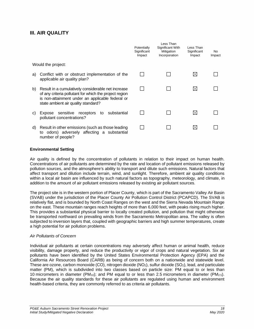
III. AIR QUALITY
Environmental Setting
Air quality is defined by the concentration of pollutants in relation to their impact on human health.Concentrations of air pollutants are determined by the rate and location of pollutant emissions released bypollution sources, and the atmosphere’s ability to transport and dilute such emissions. Natural factors thataffect transport and dilution include terrain, wind, and sunlight. Therefore, ambient air quality conditionswithin a local air basin are influenced by such natural factors as topography, meteorology, and climate, inaddition to the amount of air pollutant emissions released by existing air pollutant sources.
The project site is in the western portion of Placer County, which is part of the Sacramento Valley Air Basin(SVAB) under the jurisdiction of the Placer County Air Pollution Control District (PCAPCD). The SVAB isrelatively flat, and is bounded by North Coast Ranges on the west and the Sierra Nevada Mountain Rangeon the east. These mountain ranges reach heights of more than 6,000 feet, with peaks rising much higher.This provides a substantial physical barrier to locally created pollution, and pollution that might otherwisebe transported northward on prevailing winds from the Sacramento Metropolitan area. The valley is oftensubjected to inversion layers that, coupled with geographic barriers and high summer temperatures, createa high potential for air pollution problems.
Air Pollutants of Concern
Individual air pollutants at certain concentrations may adversely affect human or animal health, reducevisibility, damage property, and reduce the productivity or vigor of crops and natural vegetation. Six airpollutants have been identified by the United States Environmental Protection Agency (EPA) and theCalifornia Air Resources Board (CARB) as being of concern both on a nationwide and statewide level.These are ozone, carbon monoxide (CO), nitrogen dioxide (NO2), sulfur dioxide (SO2), lead, and particulatematter (PM), which is subdivided into two classes based on particle size: PM equal to or less than10 micrometers in diameter (PM10); and PM equal to or less than 2.5 micrometers in diameter (PM2.5).Because the air quality standards for these air pollutants are regulated using human and environmenthealth-based criteria, they are commonly referred to as criteria air pollutants.
PotentiallySignificant
Impact
Less ThanSignificant With
MitigationIncorporation
Less ThanSignificant
ImpactNo
Impact
Would the project:
a) Conflict with or obstruct implementation of theapplicable air quality plan?
b) Result in a cumulatively considerable net increaseof any criteria pollutant for which the project regionis non-attainment under an applicable federal orstate ambient air quality standard?
c) Expose sensitive receptors to substantialpollutant concentrations?
d) Result in other emissions (such as those leadingto odors) adversely affecting a substantialnumber of people?

PG&E Auburn Sacramento Street Renovation Project 19Initial Study/Mitigated Negative Declaration May 2020
Ozone
Ozone is the principal component of smog, and is formed in the atmosphere through a series of reactionsinvolving reactive organic gases (ROGs) or volatile organic compounds (VOCs), and nitrogen oxides (NOX)in the presence of sunlight. Short-term exposure (lasting for a few hours) to ozone can result in breathingpattern changes, reduction of breathing capacity, increased susceptibility to infections, inflammation of thelung tissue, and some immunological changes. In recent years, a correlation between elevated ambientozone levels and increases in daily hospital admission rates, as well as mortality, has also been reported.
Carbon Monoxide
CO is a colorless and odorless gas that, in the urban environment, is associated primarily with theincomplete combustion of fossil fuels in motor vehicles. Vehicle traffic emissions can cause localized COimpacts, and severe vehicle congestion at major signalized intersections can generate elevated CO levels,called hot spots, which can be hazardous to human receptors adjacent to the intersections. Individuals witha deficient blood supply to the heart are the most susceptible to the adverse effects of CO exposure. Theeffects observed include earlier onset of chest pain with exercise, and electrocardiograph changesindicative of decreased oxygen supply to the heart. Inhaled CO has no direct toxic effect on the lungs, butexerts its effect on tissues by interfering with oxygen transport. Therefore, conditions with an increaseddemand for oxygen supply can be adversely affected by exposure to CO.
Nitrogen Dioxide
NO2 is a product of combustion, and is generated in vehicles and in stationary sources, such as powerplants and boilers. It is also formed when ozone reacts with nitrogen oxide in the atmosphere. As notedabove, NO2 is part of the NOX family, and is a principal contributor to ozone and smog generation.Population-based studies suggest that an increase in acute respiratory illness, including infections andrespiratory symptoms in children, is associated with long-term exposure to NO2. Airway contraction andincreased resistance to air flow are observed after short-term exposure to NO2 in healthy subjects.
Sulfur Dioxide
SO2 is a combustion product, with the primary source being power plants and heavy industries that usecoal or oil as fuel. SO2 is also a product of diesel engine combustion. SO2 in the atmosphere contributes tothe formation of acid rain. SO2 can irritate lung tissue and increase the risk of acute and chronic respiratorydisease. This analysis does not directly evaluate SO2, because little to no quantifiable and foreseeableemissions of these substances would be generated by the project.
Lead
Lead is a highly toxic metal that may cause a range of human health effects. Previously, the lead used ingasoline anti-knock additives represented a major source of lead emissions to the atmosphere from mobileand industrial sources. In 1975, unleaded gasoline was introduced for motor vehicles equipped withcatalytic converters. The EPA banned the use of leaded gasoline in highway vehicles in December 1995.As a result of EPA’s regulatory efforts to remove lead from gasoline, emissions of lead from thetransportation sector and levels of lead in the air decreased dramatically. Fetuses, infants, and children aremore sensitive than others to the adverse effects of lead exposure. Exposure to low levels of lead canadversely affect the development and function of the central nervous system, leading to learning disorders,distractibility, inability to follow simple commands, and lower intelligence quotient. In adults, increased leadlevels are associated with increased blood pressure. This analysis does not directly evaluate lead, becauselittle to no quantifiable and foreseeable emissions of these substances would be generated by the project.
Particulate Matter
PM is a complex mixture of extremely small particles that consists of dry solid fragments, solid cores withliquid coatings, and small liquid droplets. PM is made up of a number of components, including acids (suchas nitrates and sulfates), organic chemicals, metals, soot, and soil or dust particles. The size of PM isdirectly linked to the potential for causing health problems. PM10 includes both fine and coarse dust particles;the fine particles are PM2.5. Sources of coarse particles (PM10) include grading, crushing, or grinding

PG&E Auburn Sacramento Street Renovation Project 20Initial Study/Mitigated Negative Declaration May 2020
operations and dust from paved or unpaved roads. Sources of fine particles (PM2.5) include all types ofcombustion activities (motor vehicles, power plants, wood burning, etc.) and certain industrial processes.Once inhaled, these particles can affect the heart and lungs and cause serious health effects. Health studieshave shown a significant association between exposure to PM and premature death. Other importanteffects include aggravation of respiratory and cardiovascular disease, lung disease, decreased lungfunction, asthma attacks, and certain cardiovascular problems such as heart attacks and irregularheartbeat.
Attainment of Federal and State Air Quality Standards
Areas are classified under the federal Clean Air Act (CAA) and California CAA as attainment,non-attainment, or maintenance (previously non-attainment and currently attainment) for each criteriapollutant based on whether the federal and state air quality standards have been achieved. With respect toregional air quality, the project site portion of the SVAB is designated as nonattainment for federal and stateozone standards, and nonattainment for the federal fine particulate matter standard (PM2.5) and state coarseparticulate matter standard (PM10) (PCAPCD, 2017).The air quality standards are presented later in thediscussion of Regulatory Setting.
Toxic Air Contaminants
In addition to criteria air pollutants, EPA and CARB regulate hazardous air pollutants, also known as toxicair contaminants (TACs). TAC collectively refers to a diverse group of air pollutants that are capable ofcausing chronic (i.e., long-duration) and acute (i.e., severe but short-term) adverse effects on human health,including carcinogenic effects. TACs can be separated into carcinogens and noncarcinogens, based on thenature of the effects associated with exposure to the pollutant. For regulatory purposes, carcinogens areassumed to have no safe threshold below which health impacts would not occur. Any exposure to acarcinogen poses some risk of contracting cancer. Noncarcinogens differ in that there is generally assumedto be a safe level of exposure below which no negative health impact is believed to occur. These levels aredetermined on a pollutant-by-pollutant basis.
Regulatory Setting
Federal
National air quality policies are regulated through the Federal CAA. Pursuant to the CAA, the EPA hasestablished nationwide air quality standards to protect public health and welfare, with an adequate marginof safety. These federal standards, known as the National Ambient Air Quality Standards (NAAQS), weredeveloped for six criteria pollutants: ozone, NO2, CO, PM10, PM2.5, SO2, and lead. The NAAQS representsafe levels of each pollutant to avoid specific adverse effects to human health and the environment. Twotypes of NAAQS have been established: primary and secondary standards. Primary standards set limits toprotect public health, especially that of sensitive populations such as asthmatics, children, and seniors.Secondary standards set limits to protect public welfare, including protections against decreased visibilityand damage to animals, crops, and buildings.
The CAA was amended in 1977 to require each state to maintain a State Implementation Plan (SIP) forachieving compliance with NAAQS. In 1990, the CAA was amended again to strengthen regulation of bothstationary and motor vehicle emission sources. Conformity to the SIP is defined under the 1990 CAAamendments as conformity with the SIP’s purpose in eliminating or reducing the severity and number ofviolations of the NAAQS, and achieving expeditious attainment of these standards.
State
In 1988, the State Legislature adopted the California CAA, which established a statewide air pollutioncontrol program. The California CAA requires all air districts in the state to endeavor to meet CaliforniaAmbient Air Quality Standards (CAAQS) by the earliest practical date. Unlike the federal CAA, the CaliforniaCAA does not set precise attainment deadlines. Instead, the California CAA establishes increasinglystringent requirements for areas that will require more time to achieve the standards. CAAQS are generallymore stringent than NAAQS, and incorporate additional standards for sulfates, hydrogen sulfide,visibility-reducing particles, and vinyl chloride. CAAQS and NAAQS are listed together in Table 2.

PG&E Auburn Sacramento Street Renovation Project 21Initial Study/Mitigated Negative Declaration May 2020
Table 2National and California Ambient Air Quality Standards
Pollutant Averaging Time CAAQSb
NAAQSa
Primaryc Secondaryd
Ozone 8 hours1 hour
0.070 ppm0.09 ppm
0.070 ppm–
0.070 ppm–
PM10 Annual arithmetic mean24 hours
20 µg/m3
50 µg/m3–
150 µg/m3–
150 µg/m3
PM2.5 Annual arithmetic mean24 hours
12 µg/m3
–12 µg/m3
35 µg/m315 µg/m3
35 µg/m3
CO 8 hours1 hour
9.0 ppm20 ppm
9 ppm35 ppm
––
NO2 Annual arithmetic mean1 hour
0.03 ppm0.18 ppm
0.053 ppm0.100 ppm
0.053 ppm–
SO2 24 hours3 hours1 hour
0.04 ppm–
0.25 ppm
––
0.075 ppme
–0.5 ppm
–Leadf Calendar quarter
Rolling 3-monthaverage
30-day average
––
1.5 µg/m3
1.5 µg/m3 (certainareas)
0.15 µg/m3
–
1.5 µg/m3
––
Visibility-reducingparticles
8 hours g – –
Sulfates 24 hours 25 µg/m3 – –Hydrogen sulfide 1 hour 0.03 ppm – –Vinyl chloridef 24 hours 0.01 ppm – –Source: CARB, 2016a NAAQS other than ozone, PM, and those based on annual averages or annual arithmetic means are not to be exceeded morethan once a year. The ozone standard is attained when the fourth-highest 8-hour concentration in a year, averaged over 3 years, isequal to or less than the standard. For PM10, the 24-hour standard is attained when the expected number of days per calendaryear with a 24-hour average concentration above 150 µg/m3 is equal to or less than 1. For PM2.5, the 24-hour standard is attainedwhen 98 percent of the daily concentrations, averaged over 3 years, is equal to or less than the standard.
b CAAQS for ozone, CO (except Lake Tahoe), SO2 (1-hour and 24-hour), NO2, and suspended PM (PM10, PM2.5, andvisibility-reducing particles) are not to be exceeded. All others are not to be equaled or exceeded.
c NAAQS Primary Standards: The levels of air quality necessary, with an adequate margin of safety, to protect the public health.d NAAQS Secondary Standards: The levels of air quality necessary to protect the public welfare from known or anticipated adverseeffects of a pollutant.
e Final rule signed June 2, 2010. To attain this standard, the 3-year average of the 99th percentile of the daily maximum 1-houraverage at each monitor within an area must not exceed 75 parts per billion.
f CARB has identified lead and vinyl chloride as toxic air contaminants with no threshold level of exposure for adverse health effectsdetermined. CARB made this determination following the implementation of control measures at levels below the ambientconcentrations specified for these pollutants.
g In 1989, CARB converted both the general statewide 10-mile visibility standard and the Lake Tahoe 30-mile visibility standard toinstrumental equivalents, which are “extinction of 0.23 per kilometer” and “extinction of 0.07 per kilometer” for the statewide andLake Tahoe Air Basin standards, respectively.
µg/m3 = micrograms per cubic meterCAAQS = California Ambient Air Quality StandardsCARB = California Air Resources BoardCO = carbon monoxideNAAQS = National Ambient Air Quality StandardsNO2 = nitrogen dioxidePM = particulate matterPM10 = particulate matter equal to or less than 10 micrometers in diameterPM2.5 = particulate matter equal to or less than 2.5 micrometers in diameterppm = parts per million (by volume)SO2 = sulfur dioxide

PG&E Auburn Sacramento Street Renovation Project 22Initial Study/Mitigated Negative Declaration May 2020
CARB and local air districts bear responsibility for achieving California’s air quality standards, which are tobe achieved through district-level air quality management plans to be incorporated into the SIP. InCalifornia, the EPA has delegated authority to prepare SIPs to CARB; which, in turn, has delegated thatauthority to individual air districts. CARB traditionally has established state air quality standards, maintainedoversight authority in air quality planning, developed programs for reducing emissions from motor vehicles,developed air emission inventories, collected air quality and meteorological data, and approving SIPs.
The California CAA substantially adds to the authority and responsibilities of air districts. The CaliforniaCAA designates air districts as lead air quality planning agencies, requires air districts to prepare air qualityplans, and grants air districts authority to implement transportation control measures.
Local
The PCAPCD is also the agency responsible for enforcing federal and state air quality requirements, andfor establishing air quality rules and regulations in Placer County. The PCAPCD attains and maintains airquality conditions in Placer County through a comprehensive program of education, regulation, voluntaryemission reduction programs, and funding activities. The PCAPCD also inspects stationary sources of airpollution, and responds to citizen complaints, monitors ambient air quality and meteorological conditions,and implements programs and regulations required by the Federal CAA and the California CAA. Under theCalifornia CAA, the PCAPCD is required to develop an air quality attainment plan for nonattainment criteriapollutants in the air district. The PCAPCD, along with the other air districts in the region, prepared theSacramento Regional 8-Hour Ozone Attainment and Reasonable Further Progress Plan (Ozone AttainmentPlan) in July 2017. The PCAPCD adopted the Ozone Attainment Plan on October 12, 2017, and CARBdetermined that the plan meets CAA requirements, and approved it on November 16, 2017, as a revisionto the SIP. The updated ozone SIP was submitted to the EPA on December 18, 2017. Accordingly, the2017 Sacramento Regional 8-Hour Ozone Attainment and Reasonable Further Progress Plan is theapplicable air quality plan for the region.
The PCAPCD also published the 2017 California Environmental Quality Act (CEQA) Handbook, whichprovides air quality guidance when preparing CEQA documents (PCAPCD, 2017).
To evaluate air pollutant emissions from development projects, the PCAPCD recommends significancethresholds for emissions of ROG, NOx, and PM10. The PCAPCD recommends significance thresholds aslisted in Table 3, expressed in pounds per day, which serve as air quality standards that may be used inthe evaluation of air quality impacts associated with construction and operation of development projects.
Table 3PCAPCD-Adopted Thresholds of Significance for Criteria Pollutants
Pollutant/Precursor
Emissions in pounds/dayConstruction
PhaseOperational Phase
Project-LevelOperational PhaseCumulative-Level
Nitrogen oxides 82 55 55Reactive organic gases 82 55 55Suspended particulatematter (PM10)
82 82 82
Source: PCAPCD, 2017.Notes:PCAPCD = Placer County Air Pollution Control DistrictPM10 = particulate matter equal to or less than 10 micrometers in diameter
The PCAPCD states that a project would not result in significant project-level criteria pollutant emissions ofROG, NOx, and PM10, for which the region is designated non-attainment if it does not exceed the constructionand operational significance thresholds. In addition, project impacts would not be considered to becumulatively considerable if emissions do not exceed the PCAPCD cumulative-level significance thresholds.
PG&E Auburn Sacramento Street Renovation Project 23Initial Study/Mitigated Negative Declaration May 2020
The PCAPCD CEQA Air Quality Handbook also presents rules and regulations required and recommendedfor all projects. Project proponents are responsible for compliance with the adopted PCAPCD rules. Ageneral summary of the key PCAPCD rules and regulations that may be applicable to the project ispresented below.
· Rule 202 – Visible Emissions: Rule 202 limits the amount of time during which air pollutantemissions of a certain shade of darkness or degree of opacity may be discharged, specifically tono more than 3 minutes in any 1 hour.
· Rule 205 – Nuisance: Rule 205 prohibits a discharge from any source whatsoever such quantitiesof air contaminants or other material which cause injury, detriment, nuisance or annoyance to anyconsiderable number of persons or to the public, or which endanger the comfort, repose, health orsafety of any such persons or the public.
· Rule 207 – Particulate Matter: Rule 207 restricts PM emissions from any source or singleprocessing unit, exclusive of sources emitting combustion contaminants only, to no more than0.1 grain per cubic foot of gas.
· Rule 218 – Architectural Coatings: Rule 218 requires that architectural coatings supplied, sold,offered for sale, applied, solicited for application, or manufactured for use within the PCAPCD areameet specified maximum VOC (ROG) content levels.
· Rule 228 – Fugitive Dust: Rule 228 is intended to reduce the amount of PM entrained in the ambientair, or discharged into the ambient air, as a result of anthropogenic (man-made) fugitive dustsources by requiring actions to prevent, reduce, or mitigate fugitive dust emissions. The provisionsof Rule 228 apply to any activity or man-made condition capable of generating fugitive dust withinPlacer County.
City of Auburn General Plan Land Element Goal 4 indicates air quality should be enhanced.
Impacts
a) Conflict with or obstruct implementation of the applicable air quality plan?
Air quality plans describe air pollution control strategies to be implemented by a city, county, orregion. The primary purpose of an air quality plan is to bring an area that does not attain federaland state air quality standards into compliance with the requirements of the Federal CAA andCalifornia CAA requirements. The PCAPCD, along with other local air districts in the SVAB, isresponsible for developing and implementing air quality plans to address state and federal airquality planning requirements. As discussed under the Regulatory Setting above, the PCAPCD,along with the other air districts in the region, prepared the Sacramento Regional 8-Hour OzoneAttainment and Reasonable Further Progress Plan (Draft 2017 SIP Revisions) to addressattainment of the federal 8-hour ozone standard. In addition, the 2015 Triennial Report and AirQuality Plan Revision were prepared to address attainment of the California 1-hour and 8-hourozone standards (SMAQMD, 2016). These are the latest plans adopted by the PCAPCD incoordination with the air quality management districts and air pollution control districts of El Dorado,Sacramento, Solano, Sutter, and Yolo counties, and they incorporate land use assumptions andtravel demand modeling provided by Sacramento Area Council of Governments (SACOG).
Two criteria are applicable to determine whether the project would conflict with or obstructimplementation of the air quality plan. The first criterion is whether the project would exceed theestimated air basin emissions used as the basis of the air quality plans, which are based, in part,on projections of population and vehicle miles traveled (VMT). The second criterion is whether theproject would increase the frequency or severity of existing air quality violations, contribute to newviolations, or delay the timely attainment of air quality standards.

PG&E Auburn Sacramento Street Renovation Project 24Initial Study/Mitigated Negative Declaration May 2020
Construction of the project would involve the use of off-road equipment as quantified and describedin response to Impact b). Assumptions for off-road equipment emissions in the air quality plans aredeveloped based on category-specific economic indicators such as employment, expenditures, andfuel use. Because project construction is limited to short-term renovation and demolition activities,and construction activities would not involve unusual characteristics that would necessitate the useof extensive off-road equipment usage, the project would not increase the assumptions for off-roadequipment use in the air quality plans. Furthermore, construction activities would be short-term,and activities would cease on completion. Construction activities would also comply with theapplicable PCAPCD rules and regulations that are designed to reduce and control pollutantemissions from the project’s construction activities. Following construction, day-to-day operationsof the project would not add any substantial new operational activities. The project is limited torenovation and continued use of an existing PG&E service center to increase the efficiency ofPG&E’s regional operations. Therefore, operational emissions are not anticipated to increasebeyond existing conditions. Therefore, the impact would be less than significant.
b) Result in a cumulatively considerable net increase of any criteria pollutant for which the projectregion is non-attainment under an applicable federal or state ambient air quality standard(including releasing emissions which exceed quantitative thresholds for ozone precursors)?
Construction
Construction of the project would result in the temporary generation of ROG, NOx, and PM10emissions from soil excavation and material transport. ROG and NOX emissions are primarilyassociated with mobile equipment exhaust. Fugitive dust emissions are primarily associated withsite preparation, and vary as a function of such parameters as soil silt content, soil moisture, windspeed, acreage of disturbance area, and miles traveled by construction vehicles on- and off-site.
Construction of the project is expected to occur over 12 months, from summer/fall 2020 to summer/fall 2021. Construction-related emissions associated with typical construction activities weremodeled using the California Emissions Estimator Model (CalEEMod), Version 2016.3.2.CalEEMod allows the user to enter project-specific construction information, such as types,number, and horsepower of construction equipment, and number and length of motor vehicle trips.The total criteria pollutant emissions estimated for the project using CalEEMod are presented inTable 4. Additional modeling assumptions and details are provided in Appendix A. The projectwould be considered significant if it would result in emissions that exceed the PCAPCD’s thresholdsof significance.
As shown in Table 4, construction-generated emissions would not exceed applicable emissionthresholds established by PCAPCD. Therefore, the emissions would be less than significant.

PG&E Auburn Sacramento Street Renovation Project 25Initial Study/Mitigated Negative Declaration May 2020
Table 4Estimated Construction Emissions1
Emissions Source ROG (lbs/day) NOX (lbs/day) PM10 (lbs/day)
2019 2 0.7 6.4 0.5
2020 2 1 9.8 0.9
Maximum Daily Emissions 1 9.8 0.9
PCAPCD Threshold 82 82 82
Exceed Threshold No No NoNotes:1 Includes emissions associated with demolition of buildings.2 Emissions were estimated based on construction of the project from 2019 to 2020. Construction is
expected to be delayed by 1 year and occur from summer/fall 2020 to summer/fall 2021.lbs/day = pounds per dayNOx = nitrogen oxidesPCAPCD = Placer County Air Pollution Control DistrictPM10 = particulate matter equal to or less than 10 microns in diameterROG = Reactive Organic Compounds.
Operation
Sources of the project’s operational emissions would include worker commute and material deliverytrips, operation of equipment, and occasional use of a back-up generator. The back-up generatoris already permitted and installed, and has been used by PG&E as power back-up during poweroutages. The project would not alter use of the back-up generator, and emissions would notincrease beyond existing conditions.
The PCAPCD developed the operational criteria pollutant thresholds in Table 3 based on potentialproject sizes for different types of land use development. Although these project sizes are listed asscreening criteria in the CEQA Air Quality Handbook, they provide information on the relativeemissions of various project sizes, and include emissions from area, mobile, energy use, wateruse, and solid waste disposal sources. Operational thresholds for criteria pollutants were based onan 894,262-square-foot general industrial land use, which is most similar to the project (PCAPCD,2017). The proposed new buildings would comprise approximately 9,660 square feet of newbuilding space, which would be substantially less than the project size used to establish criteriapollutant thresholds. Furthermore, the project would not add any substantial new operationalactivities; it involves renovation and continued use of an existing PG&E service center to increasethe efficiency of PG&E’s regional operations. Therefore, the project’s operations would not increaseoperational activities above existing conditions. Therefore, operation of the project would not beexpected to generate emissions that would exceed the PCAPCD’s thresholds of significance, andoperational emissions would be less than significant.
Cumulative
Project construction would temporarily increase air emissions in the SVAB. The project wouldgenerate temporary emissions of ROG, NOx, CO, PM10, and PM2.5 during renovation andconstruction activities. As shown in Table 4, construction emissions associated with the project areexpected to result in daily emissions below the PCAPCD’s thresholds of significance. Because theproposed short-term construction emissions are not anticipated to exceed the PCAPCD’s project-level thresholds, which are considered the allowable amount of emissions for projects not to resultin a cumulatively considerable contribution to regional air quality, project construction emissionswould not result in a cumulatively considerable contribution to regional air quality. Therefore, projectconstruction emissions would be less than cumulatively significant.
PG&E Auburn Sacramento Street Renovation Project 26Initial Study/Mitigated Negative Declaration May 2020
As described above, project operations are not expected to cause a change in emissions fromexisting operations because the project involves renovation and continued use of an existing PG&Eservice center to increase the efficiency of PG&E’s regional operations. The project is also belowthe general industrial project size used to establish PCAPCD criteria pollutant thresholds.Therefore, the project is not expected to generate a cumulatively considerable net increase in airemissions in exceedance of the PCAPCD’s cumulative threshold.
Therefore, the project’s construction-related and operational contribution to a cumulative impactwould be less than cumulatively considerable, resulting in a less-than-significant cumulative airquality impact.
d) Expose sensitive receptors to substantial pollutant concentrations?
Sensitive receptors typically are defined as facilities where sensitive populations (e.g., children,elderly, acutely and chronically ill individuals) are likely to be located. Land uses considered to besensitive receptors include residences, schools, playgrounds, childcare centers, retirement homes,and hospitals. The nearest sensitive receptor to the project site is Railhead Park, approximately0.5 mile away.
Health Effects of Criteria Air Pollutants
As previously discussed, criteria air pollutants may adversely affect human or animal health, reducevisibility, damage property, and reduce the productivity or vigor of crops and natural vegetation. Aspresented in Table 4, construction-related activities would result in emissions of criteria airpollutants, but at levels that would not exceed the PCAPCD thresholds of significance. Projectoperations are anticipated to remain similar to existing conditions. In addition, the project size wouldbe below the PCAPCD screening criteria, indicating that the project would not result in thegeneration of operational-related criteria pollutants and/or precursors that exceed the thresholds ofsignificance. The thresholds of significance were designed to identify those projects that wouldresult in significant levels of air pollution, and to assist the region in attaining the applicable stateand federal ambient air quality standards, which were established using health-based criteria toprotect the public with a margin of safety from adverse health impacts due to exposure to airpollution. For these reasons, the criteria air pollutant emissions associated with construction andoperation of the project would not expose sensitive receptors to substantial criteria pollutantconcentrations. In addition, the project would comply with applicable PCAPCD rules, including butnot limited to Rule 218 (Architectural Coatings), which restricts the VOC/ROG content of coatings;and Rule 228 (Fugitive Dust), which reduces the amount of PM entrained in the ambient air.
Toxic Air Contaminants
The greatest potential TAC emissions would be related to diesel PM emissions associated withactivity by heavy-duty construction equipment. The total duration of construction activities isanticipated to be approximately 12 months; the exposure of sensitive receptors to constructionemissions would be short term, intermittent, and temporary in nature. The dose to which receptorsare exposed is the primary factor used to determine health risk. Dose is positively correlated withtime, meaning that a longer exposure period would result in a higher exposure level for themaximally exposed individual. Therefore, the risks estimated for such an individual are higher if afixed exposure occurs over a longer period of time. Health effects from TACs are often describedin terms of individual cancer risk, which is based on a 30-year lifetime exposure to TACs (OEHHA,2015). Therefore, the total exposure period for construction activities would be approximately3 percent of the total exposure period used for typical health risk calculations (i.e., 30 years).Furthermore, considering that the nearest receptors are Railhead Park visitors, it is not anticipatedthat the receptors would be in proximity of construction activities for an extended period of time.

PG&E Auburn Sacramento Street Renovation Project 27Initial Study/Mitigated Negative Declaration May 2020
Because off-road, heavy-duty equipment would be used for a relatively short time period and wouldnot be in the immediate proximity of sensitive receptors, construction activities would not beanticipated to expose sensitive receptors to substantial TAC concentrations. Concentrations ofmobile-source diesel PM emissions are typically reduced by 70 percent at a distance ofapproximately 500 feet from freeways, which are continuous emission sources; and an 80 percentdecrease at 1,000 feet from distribution centers (CARB, 2005). Studies also indicate that diesel PMemissions and the relative health risk can decrease substantially within 300 feet (CARB, 2005; Zhuet al., 2002). As discussed previously, the nearest off-site sensitive receptors are approximately0.5 mile from the project site. Given the construction schedule, substantial buffer distance to thenearest sensitive receptor, and the highly dispersive nature of diesel PM emissions, constructionof the project would not expose sensitive receptors to substantial TAC concentrations. In addition,TAC emission exposure would also be reduced with implementation of CARB regulations, such asthe Airborne Toxic Control Measure, which limits idling of diesel-fueled commercial motor vehicles.As a result, trucks and off-road equipment would not operate in the immediate vicinity of anysensitive receptor for an extended period of time, and the potential exposure to TAC emissionswould be limited.
In summary, emissions of localized pollutants (e.g., ROG, NOx, CO, PM10, and PM2.5) and TACsfrom construction and operations would be unlikely to lead to substantial pollutant concentrationsat nearby locations. Therefore, the impact on sensitive receptors would be less than significant.
e) Result in other emissions (such as those leading to odors) adversely affecting a substantialnumber of people?
The occurrence and severity of odor impacts depend on numerous factors, including the nature,frequency, and intensity of the source; wind speed, and direction; and the presence of sensitivereceptors. Although offensive odors rarely cause any physical harm, they still can be veryunpleasant, leading to considerable distress and often generating citizen complaints to localgovernments and regulatory agencies. Projects with the potential to frequently expose individualsto objectionable odors are deemed to have a significant impact. Typical facilities that generateodors include wastewater treatment facilities, sanitary landfills, composting facilities, petroleumrefineries, chemical manufacturing plants, and food processing facilities. Project constructionactivities would generate short-term diesel PM exhaust and odors from heavy-duty trucks and off-road construction equipment, which could be considered offensive by some individuals. Potentialodors produced during construction would be attributable to concentrations of unburnedhydrocarbons from tailpipes of construction equipment, architectural coatings, and asphaltpavement application. In general, odors are highest near the source, but disperse quickly, resultingin a reduced off-site exposure. However, construction activities would use typical constructiontechniques in compliance with PCAPCD rules, and the nearest sensitive receptors areapproximately 0.5 mile away. Therefore, the construction-related odor impact would be less thansignificant.
Because operational activities associated with the project are anticipated to remain similar toexisting conditions (e.g., no increase in equipment usage or vehicle trips), operation of the projectwould not add any new odor sources. In addition, this project land use is not a typical facility thatwould generate odors, and operation of the project is not anticipated to increase the use of theback-up generator. Therefore, the operational-related odor impact would be less than significant.

PG&E Auburn Sacramento Street Renovation Project 28Initial Study/Mitigated Negative Declaration May 2020
IV. BIOLOGICAL RESOURCES
PotentiallySignificant
Impact
Less ThanSignificant
WithMitigation
Incorporation
LessThan
SignificantImpact
NoImpact
Would the project:
a) Have a substantial adverse effect, either directly orthrough habitat modifications, on any speciesidentified as a candidate, sensitive, or special statusspecies in local or regional plans, policies, orregulations, or by the California Department of Fishand Game or U.S. Fish and Wildlife Service?
b) Have a substantial adverse effect on any riparianhabitat or other sensitive natural community identifiedin local or regional plans, policies, regulations or bythe California Department of Fish and Game orU.S. Fish and Wildlife Service?
c) Have a substantial adverse effect on state or federallyprotected wetlands (including, but not limited to,marsh, vernal pool, coastal, etc.) through directremoval, filling, hydrological interruption, or othermeans?
d) Interfere substantially with the movement of anynative resident or migratory fish or wildlife species orwith established native resident or migratory wildlifecorridors, or impede the use of native wildlife nurserysites?
e) Conflict with any local policies or ordinancesprotecting biological resources, such as a treepreservation policy or ordinance?
f) Conflict with the provisions of an adopted HabitatConservation Plan, Natural Community ConservationPlan, or other approved local, regional, or statehabitat conservation plan?
No habitat conservation plans (HCPs), natural community conservation plans, or other local, regional, orstate HCPs are applicable to the project site. Therefore, significance criteria IV(f) is not applicable to thisproject, and is not discussed further in this section.
Environmental Setting
The project site is in a developed, suburban setting, surrounded by commercial and residential uses. Theproject site is paved and mostly barren, with scattered patches of ruderal vegetation and a small area ofornamental vegetation, and two oak trees outside of the Engineering Building. The approximately 1.2-acrenorthern portion of the project site is partly covered with gravel, and is being used for parking and equipmentstaging. Grasses and weeds surround the perimeter of the northern portion of the project site, along with asmall patch of California poppy and vetch along the eastern edge. Facilities in the existing PG&E service

PG&E Auburn Sacramento Street Renovation Project 29Initial Study/Mitigated Negative Declaration May 2020
center include multiple buildings that have been vacated or have minimal use, in preparation for demolitionactivities (see Appendix B).
Background research was performed to identify special-status species with the potential to occur within5 miles of the project area. Sources that were consulted included the California Department of Fish andWildlife’s (CDFW’s) California Natural Diversity Database, California Native Plant Society, and UnitedStates Fish and Wildlife Service’s (USFWS’s) Information for Planning and Consultation databases. Priorto any biological surveys or site visits by biologists, the special-status plant, Brandegee’s clarkia (Clarkiabiloba ssp. brandegeeae) was determined to have potential to occur, based on remote habitat assessmentand occurrences within the 5-mile search area.
A reconnaissance-level biological resources survey was subsequently conducted by AECOM biologists onMay 3, 2019 (see Appendix D). Habitat needed to support special-status species with occurrence recordswithin 5 miles of the project area was found to be absent from the developed project area. No special-statusplant or wildlife species were found, and suitable habitat for Brandegee’s clarkia was not identified in theproject area during the biological survey. No signs of bat activity were found inside or outside of anybuildings, or anywhere within the project area. Birds were actively nesting on the exteriors of Buildings B,C, and D, including cliff swallow, Brewer’s blackbird, rock pigeon, and house sparrow. Other wildlifeobserved on the project site were western fence lizard, Anna’s hummingbird, California scrub-jay, northernrough-winged swallow, and California ground squirrel (AECOM, 2019).
Regulatory Setting
Federal
The Clean Water Act (CWA) (33 United States Code [USC] Section 1251) establishes the basic structurefor regulating discharges of pollutants (including dredged or fill material) into waters of the United States,including wetlands; and for regulating quality standards for surface waters. The CWA provides guidance forthe restoration and maintenance of the chemical, physical, and biological integrity of the nation’s waters.CWA Section 404 prohibits the discharge of dredged or fill material into waters of the United States,including wetlands, without a permit from the United States Army Corps of Engineers. CWA Section 401requires that an applicant for a federal license or permit that allows activities with the potential to result in adischarge to waters of the United States, including wetlands, obtain a state Section 401 water qualitycertification. The Endangered Species Act (ESA) (16 [USC Section 1531 et seq.) protects fish and wildlifespecies that are listed as threatened or endangered and their habitats. Endangered refers to species,subspecies, or distinct population segments that are in danger of extinction in all or a significant portion oftheir range. Threatened refers to species, subspecies, or distinct population segments that are consideredlikely to become endangered in the future. The ESA is administered by the USFWS for terrestrial andfreshwater species, and by the National Oceanographic and Atmospheric Administration’s National MarineFisheries Service for marine species and anadromous fishes.
The Migratory Bird Treaty Act (MBTA) (16 USC Section 703–712 et seq.) enacted the provisions of treatiesbetween the United States, Great Britain, Mexico, Japan, and the Soviet Union, and authorizes theU.S. Secretary of the Interior to protect and regulate take of migratory birds. The MBTA is administered byUSFWS. It establishes seasons and bag limits for hunted species; and renders taking, possession, import,export, transport, sale, purchase, and barter of migratory birds, their occupied nests, and their eggs illegal,except where authorized under the terms of a valid federal permit. Activities for which permits may beissued include scientific collecting; falconry and raptor propagation; “special purposes,” which includerehabilitation, education, migratory game bird propagation, and miscellaneous other activities; control ofdepredating birds; taxidermy; and waterfowl sale and disposal. More than 800 species of birds are protectedunder the MBTA. Specific definitions of migratory bird are discussed in each of the international treaties; ingeneral, however, species protected under the MBTA are those that migrate to complete different stagesof their life history, or to take advantage of different habitat opportunities during different seasons. Examplesof migratory bird species include the yellow warbler (Dendroica petechia), barn swallow (Hirundo rustica),and song sparrow (Melospiza melodia).

PG&E Auburn Sacramento Street Renovation Project 30Initial Study/Mitigated Negative Declaration May 2020
State
The California Endangered Species Act (CESA) protects wildlife and plants listed as threatened andendangered by the California Fish and Game Commission, as well as species identified as candidates forsuch listing. It is administered by the CDFW. CESA requires state agencies to conserve threatened andendangered species (Section 2055), and thereby restricts all persons from taking listed species, exceptunder certain circumstances. CESA defines take as any action or attempt to hunt, pursue, catch, capture,or kill. Under certain circumstances, CDFW may authorize limited take, except for species designated asfully protected (see discussion of fully protected species under California Fish and Game Code below). Therequirements for an application for an incidental take permit under CESA are described in Section 2081 ofthe California Fish and Game Code, and in final adopted regulations for implementing Sections 2080and 2081.
Local
The City of Auburn General Plan Open Space/Conservation Element encourages preservation andconservation of natural vegetation, habitat, water, and other biological resources.
The City of Auburn Zoning Ordinance requires a permit before conducting regulated activities that mayremove or otherwise adversely affect native trees in the City of Auburn. The City has two types of permitsfor tree-related activities: (1) tree permit for the removal of native trees or impacts to native trees; and(2) administrative tree permit for minor impacts.
Impacts
a) Have a substantial adverse effect, either directly or through habitat modifications, on anyspecies identified as a candidate, sensitive, or special-status species in local or regionalplans, policies, or regulations, or by the California Department of Fish and Game or U.S. Fishand Wildlife Service?
The project would involve renovation of a PG&E service center. As described above underEnvironmental Setting, the project site does not contain suitable habitat for any special-statusplant or wildlife species (see Appendix D). Therefore, the project would not have an adverse effecton special-status species.
Birds protected under the MBTA and sections of the California Fish and Game Code nest on theproject site; take of active nests is prohibited under these laws and regulations. The nesting seasongenerally is from February 1 through August 31. If building demolition is scheduled during thenesting season, nesting bird surveys would be conducted and buffers established around anyactive nests that are found close enough to the construction area to be disturbed by constructionactivities. There is a low potential for bats to occupy potential roosts on or in the structures prior todemolition. A bat survey would confirm the structures remain unoccupied prior to demolition. Thetake of active nests or bats would be a potentially significant impact. Therefore, implementationof Mitigation Measure BIO-1 and Mitigation Measure BIO-2 is required.
Mitigation Measure BIO-1: Nesting Bird SurveyIf construction activities are scheduled during the nesting season, a qualified biologist shall performpre-construction surveys for nesting birds no more than 14 days prior to the initiation of demolition/construction activities during the early season (January through April); and no more than 30 daysprior to the initiation of these activities during the late season (May through August). If theconstruction site remains inactive for more than 1 month during the breeding season andconstruction would resume during the breeding season, another pre-construction nesting birdsurvey shall be performed prior to reactivation of construction activities on site within the timeframesnoted above. If preconstruction surveys indicate nests are inactive or potential habitat isunoccupied during construction period, no further mitigation is required.

PG&E Auburn Sacramento Street Renovation Project 31Initial Study/Mitigated Negative Declaration May 2020
A qualified biologist shall inspect all trees in the project site and within 200 feet of the site for nests.If an active nest is found in proximity to the project area with potential to be disturbed by theseactivities, the biologist, in consultation with the California Department of Fish and Wildlife, shalldetermine the extent of the construction-free buffer zone to be established around the nest basedon species, location, and planned construction activity (e.g. 50 feet for passerines to 250 to 500feet for raptors). The avoidance buffer shall be flagged in the field.
The buffer zones shall remain in place until the young have fledged, and are foraging independentlyand able to disperse from the area of their own ability. Project activities outside buildings shall beconfined to daylight hours to prevent impacts to foraging nocturnal avian species. A qualifiedbiologist shall monitor the active nests until it is determined the nest is no longer active, at whichtime construction activities may commence within the buffer area. The construction-free buffer zoneflagging shall be maintained until the qualified biologist determines that the nest is no longer active.
Mitigation Measure BIO-2: Bat SurveyNo more than 14 days prior to the initiation of demolition activities, a bat survey shall be conductedby a qualified biologist to confirm the structures are unoccupied. A memorandum documentingcompletion of the survey shall be submitted to the City of Auburn Planning Department. If bats arefound to be present prior to construction, measures to exclude bats or minimize harm to batspresent would be developed for review and approval by the City of Auburn Planning Department,and implemented prior to construction.
With implementation of Mitigation Measure BIO-1 and Mitigation Measure BIO-2, potentialimpacts on nesting birds and bats would be reduced to a less-than-significant level. The impactwould be less than significant with mitigation incorporated.
b) Have a substantial adverse effect on any riparian habitat or other sensitive naturalcommunity identified in local or regional plans, policies, or regulations or by the CaliforniaDepartment of Fish and Game or U.S. Fish and Wildlife Service?
The project would involve renovation of a PG&E service center. No riparian habitat or othersensitive natural community identified in local or regional plans, policies, or regulations (or by theCDFW or USFWS) is present on the project site (see Appendix D). Therefore, no impact wouldoccur.
c) Have a substantial adverse effect on federally protected wetlands (including, but not limitedto, marsh, vernal pool, coastal, etc.) through direct removal, filling, hydrologicalinterruption, or other means?
No topographic features remain in the project site that support the presence of surface orgroundwater for a duration sufficient to allow development of hydric soils or vegetation adapted forwetland conditions. As described under Environmental Setting, no potential wetlands wereobserved on the project site during the field visit on May 3, 2019 (see Appendix D). Therefore, noimpact would occur.
d) Interfere substantially with the movement of any native resident or migratory fish or wildlifespecies or with established native resident or migratory wildlife corridors, or impede theuse of native wildlife nursery sites?
The project site does not contain fish habitat; therefore, the project would have no impact on nativeresident or migratory fish species. As discussed above under Environmental Setting, the projectsite is surrounded by existing commercial and residential development, and does not containhabitat features essential to local and regional wildlife movement, such as linear patches ofundisturbed habitat that link larger habitat patches. Birds nest on some of the project structuresthat would be demolished, and there is a low potential for bats to occupy potential roosts on or inthe structures prior to demolition. As discussed above under Impact a, Mitigation Measure BIO-1

PG&E Auburn Sacramento Street Renovation Project 32Initial Study/Mitigated Negative Declaration May 2020
and Mitigation Measure BIO-2 would be implemented to avoid impacting nesting birds and bats(see Appendix D). Therefore, the impact would be less than significant.
e) Conflict with any local policies or ordinances protecting biological resources, such as a treepreservation policy or ordinance?
Auburn Municipal Code Chapter 161, Tree Preservation, includes provisions for the protection ofnative trees (City of Auburn, 2019a). However, no trees would be removed or impacted duringconstruction of the project, and no ground disturbance is proposed near oak trees outside of theEngineering Building (see Appendix A). Therefore, no impact would occur.

PG&E Auburn Sacramento Street Renovation Project 33Initial Study/Mitigated Negative Declaration May 2020
V. CULTURAL RESOURCES
PotentiallySignificant
Impact
Less ThanSignificant
WithMitigation
Incorporation
LessThan
SignificantImpact
NoImpact
Would the project:
a) Cause a substantial adverse change in thesignificance of a historical resource pursuant to§15064.5?
b) Cause a substantial adverse change in thesignificance of an archaeological resource pursuantto §15064.5?
c) Disturb any human remains, including those interredoutside of formal cemeteries?
Environmental Setting
Area of Potential Impact
The Area of Potential Impact (API) includes approximately 10.2 acres at 333 and 343 Sacramento Street,south of Fairgate Street and immediately east of Sacramento Street, in Auburn. The API for architecturalhistory includes the project site and the buildings situated on the project site. The API contains all locationsof foreseen direct and indirect impacts associated with the project. The API is confined to the parcel onwhich construction would occur, given that project construction essentially constitutes improvements to thelocation, and does not alter the use or setting of the location. The archaeological API includes the entireproject site, and includes all areas of the project site that would be subject to ground-disturbing activities.
Historic Architectural Resources
A California Register of Historical Resources (CRHR) and National Register of Historic Places (NRHP)inventory and evaluation were completed on the PG&E Auburn Service Center (Cardno, Inc., 2018; seeAppendix E). The investigation consisted of reviewing the results of a record search conducted at theCalifornia Historical Resources Information System North Central Information Center (NCIC); focusedarchival and contextual research at PG&E Engineering Archives, PG&E Photographic Archives in SanFrancisco, and local repositories; and an intensive built-environment field survey of PG&E’s utility yard.
Based on this intensive inventory and background research, it was determined that the Auburn ServiceCenter, an assemblage of buildings developed by PG&E in 1954 to serve as the central maintenance andoperations hub for PG&E’s Drum Division, and later the Sierra Division, are more than 45 years old, andtherefore required evaluation and documentation to determine if the property qualified as a CEQA historicalresource.
Archaeological Resources
An intensive pedestrian survey of the archaeological API was conducted on November 6, 2018, by FarWestern (Far Western Anthropological Research Group, 2018; see Appendix E). The entire API wassystematically surveyed using 5- to 10-meter transects. The majority of the API is paved/developed orcovered in gravel. Ground visibility in the survey area varied between 0 to 100 percent, with most visibilitylimited due to pavement, gravel, and grass; however, all visible native ground surfaces were investigated,including surfaces around the perimeter of the paved project site, and around the perimeter of the gravellot at the northeastern portion of the API.

PG&E Auburn Sacramento Street Renovation Project 34Initial Study/Mitigated Negative Declaration May 2020
It appears that portions of the ground surface under the central paved portion of the API may have beengraded at some time, because it lies flat below the upward slope at the southeastern end of the API.
The cut banks of a drainage at the northwesternmost portion of the API revealed the stratigraphy in thatarea, which consists of approximately 30 centimeters of A Horizon above an unweathered C Horizon. Nocultural material was observed in this stratigraphy.
· Despite the site boundaries of P-31-003946 plotting in the eastern extent of the API, no features ofthe site were observed in the API. This was an incorrectly roughly plotted site boundary that doesnot actually intersect the API.
No prehistoric or historic-era archaeological resources were observed in the API.
Background Research
In September of 2018, an NCIC records search was completed for the purpose of this project (NCIC FileNo.: PLA-18-91), PG&E’s MapGuide Database cultural layer was reviewed (Far Western AnthropologicalResearch Group, 2018). The records searches identified 13 previously recorded cultural resources withinthe records search radius, all of which are historic-era in age, and one of which is mapped as intersectingthe API (P-31-003946). The records searches identified 10 previous studies within 0.25 mile of the API,none of which intersect the API (see Table 5).
Table 5Previously Recorded Cultural Resources
PrimaryNumber(P-31-)
Trinomial(CA-PLA-) Age Description
Eligibility for the NRHP orCRHR
IntersectsAPI?
000796 670 Historic-era Boardman Canal (c. pre-1854). Needs to be reevaluated(Formerly NRHP StatusCode 4).
No
000964 841H Historic-era Multiple segments and featuresassociated with the CentralPacific/First TranscontinentalRailroad (1860s), now UnionPacific Railroad. Listed onCalifornia Inventory of HistoricResources (1976) and the Officeof Historic Preservation CaliforniaHistorical Landmarks andCalifornia Historical Resources.
Automatically listed in theCRHR – Includes StateHistorical Landmarks 770and above and Points ofHistorical Interest nominatedafter December 1997 andrecommended for listing bythe State Historic ResourcesCommission.
No
003601 N/A Historic-era Abandoned Mountain QuarriesRailroad Grade (constructedbetween 1911-1912).
Nominated for listing on theNRHP.
No
003678 N/A Historic-era The original components of theCity of Auburn's Auburn Park andParkway District (1948).
Unknown No
003738 N/A Historic-era Historic properties in the City ofAuburn (c. 1848). First known as“North Fork” or “Woods DryDiggings.” Listed on the Office ofHistoric Preservation CaliforniaHistorical Landmarks andCalifornia Historical Resources.
Individual property listed inNRHP by the Keeper. Listedin the CRHR.
No

PG&E Auburn Sacramento Street Renovation Project 35Initial Study/Mitigated Negative Declaration May 2020
Table 5Previously Recorded Cultural Resources
PrimaryNumber(P-31-)
Trinomial(CA-PLA-) Age Description
Eligibility for the NRHP orCRHR
IntersectsAPI?
003794 N/A Historic-era 250 Sacramento Street, structure(constructed c. 1940). Originallybuilt as the Church of theNazarene, now Moose Lodge#2264.
Individual property that iseligible for local listing ordesignation.
No
003797 N/A Historic-era Bernhard House and Winery(1860s and 1874), 277 AuburnFolsom Road.
State Historical Landmarks1-769 and Points of HistoricalInterest designated prior toJanuary 1998 – Needs to bereevaluated using currentstandards.
No
003946 N/A Historic-era Flint Station (1884-1933), StateRelief Agency’s camp for singlemen (1933-41), Camp Flint (1942to 1945), City of Auburn yard/dump/dog pound (1945-to mid-1960s), and Auburn DamOverlook (1968 to present).
Identified in ReconnaissanceLevel Survey: Not evaluated.
Yes, slightlyoverlaps thenortheastextent of theAPI
004071 N/A Historic-era Placer County Central Museum,1279 High Street (1940).
Appears eligible for NRHP asan individual propertythrough survey evaluation.
No
004072 N/A Historic-era 1283 High Street, residentialstructure (c. 1920).
Individual property that iseligible for local listing ordesignation.
No
004073 N/A Historic-era 1285 High Street, residentialstructure (c. 1920).
Individual property that iseligible for local listing ordesignation.
No
004074 N/A Historic-era 1287 High Street, residentialstructure (c. 1920).
Individual property that iseligible for local listing ordesignation.
No
004075 N/A Historic-era 1293 High Street, residentialstructure (c. 1920).
Individual property that iseligible for local listing ordesignation.
No
Notes:API = Area of Potential ImpactCRHR = California Register of Historical ResourcesN/A = Not applicableNRHP = National Register of Historic Places
Additionally, a search of the following inventories was conducted: NRHP, CRHR, California Inventory ofHistoric Resources (1976), and Office of Historic Preservation California Historical Landmarks, CaliforniaHistorical Resources, Directory of Properties in the Historic Property Data File, and ArchaeologicalDeterminations of Eligibility.
One additional cultural resource was identified, the Old Auburn Historic District, located immediately northof the API. This resource is listed on the NRHP (NRHP #70000138), California Inventory of Historic Places(1976), and the Office of Historic Preservation California Historical Resources.

PG&E Auburn Sacramento Street Renovation Project 36Initial Study/Mitigated Negative Declaration May 2020
PG&E met with representatives of the United Auburn Indian Community (UAIC) at the project site onNovember 16, 2018 (see Native American Coordination, below). UAIC representatives and PG&Ecultural resources staff examined the perimeter of the Area of Potential Effects (APE) and observed nocultural material. Underscoring the sensitivity of the area, UAIC representatives noted the proximity ofknown ethnographic village sites in the project vicinity, and requested the presence of a Native Americanmonitor during at least the initial construction of the project to confirm the lack of sensitivity that seemedevident by the survey. If lack of sensitivity of prehistoric archaeological resources is confirmed, tribalmonitoring would cease (Far Western Anthropological Research Group, 2018).
Native American Coordination
A request was sent to the Native American Heritage Commission (NAHC) by PG&E Cultural ResourcesSpecialist Leslie Sakowicz, and a response was received on October 11, 2018. The results of the NAHCsearch identified sacred sites within the project area. UAIC was identified as the point of contact for moreinformation regarding these resources. Six additional contacts were provided; they were contacted via emailand letter as well as by telephone (see Table 6). No concerns were identified by those six additionalcontacts. PG&E met with the UAIC at the API on November 16, 2018. At the meeting, Matthew Moore,Tribal Historic Preservation Officer, and Cherilyn Neider, Cultural Resources Specialist, surveyed theperimeter of the API with PG&E cultural resources specialists, and observed no cultural material.Underscoring the sensitivity of the area, Mr. Moore and Ms. Neider did, however, note the proximity ofknown ethnographic village sites in the vicinity, and requested the presence of a Native American monitorto be present during at least the initial construction of the project to confirm the lack of sensitivity thatseemed evident by the survey. If lack of sensitivity is evident, monitoring will cease. See the table belowfor a summary of contacts and results.
Table 6Native American Coordination
Name and Affiliation Contact Type ResultColfax-Todds Valley ConsolidatedTribePamela Cubbler, TreasurerP.O. Box 4884Auburn CA [email protected](530) 320-3943
PG&E emailed projectdescription and locationinformation on 12/02/2018.PG&E emailed projectdescription and locationinformation on 12/17/2018.Left message regarding theproject and solicitedinformation/concerns.
No response to date.
Colfax-Todds Valley ConsolidatedTribeClyde Prout, ChairmanP.O. Box 4884Auburn, CA [email protected](916) 577-3558
PG&E emailed projectdescription and locationinformation on 12/02/2018.PG&E emailed projectdescription and locationinformation on 12/17/2018.Left message regarding theproject and solicitedinformation/concerns.
No response to date.

PG&E Auburn Sacramento Street Renovation Project 37Initial Study/Mitigated Negative Declaration May 2020
Table 6Native American Coordination
Name and Affiliation Contact Type ResultShingle Springs Band of MiwokIndiansRegina Cuellar, ChairpersonP.O. Box 1340Shingle Springs, CA [email protected](530) 387-4970
PG&E emailed projectdescription and locationinformation on 12/02/2018.PG&E emailed projectdescription and locationinformation on 12/17/2018.Left message regarding theproject and solicitedinformation/concerns.
Email response received12/24/2018 from Kara Perry,Cultural Outreach Coordinator.The email stated the following:Shingle Springs is unaware ofCultural Resources in the vicinity.We would like to be kept up todate and request any CulturalDocumentation related to theproject. If plans change, wewould request any updates.
Tsi Akim MaiduGrayson Coney, Cultural DirectorP.O. Box 510Browns Valley, CA [email protected]
PG&E emailed projectdescription and locationinformation on 12/02/2018.PG&E emailed projectdescription and locationinformation on 12/17/2018.Left message regarding theproject and solicitedinformation/concerns.
No response to date.
Tsi Akim MaiduDon Ryberg, ChairpersonP.O. Box 510Browns Valley, CA [email protected]
PG&E emailed projectdescription and locationinformation on 12/02/2018.PG&E emailed projectdescription and locationinformation on 12/17/2018.Left message regarding theproject and solicitedinformation/concerns.
No response to date.
United Auburn Indian Communityof the Auburn RancheriaGene Whitehouse, Chairperson10720 Indian Hill Road AuburnCA 95603(530) 883-2390 Office
Field meeting with PG&E andMatthew Moore, THPO, andCherlyn Neider, CulturalResources Manager on11/23/2018
Due to high concerns regardingthis area, UAIC will have a tribalrepresentative spot-monitor theinitial phases of construction; ifconcerns are assuaged,monitoring will cease.
Washoe Tribe of Nevada andCalifornia Darrel Cruz, Cult ResDept. THPO919 Highway 395North Gardnerville, NV [email protected]
PG&E emailed projectdescription and locationinformation on 12/02/2018.PG&E emailed projectdescription and locationinformation on 12/17/2018.Called and spoke with Mr.Cruz regarding the projectand solicitedinformation/concerns.
PG&E spoke with Mr. Cruz onthe phone 12/17/2018, and inthat conversation, Mr. Cruzdeferred to UAIC.
Notes:PG&E = Pacific Gas and Electric CompanyTHPO = Tribal Historic Preservation OfficerUAIC = United Auburn Indian Community of the Auburn Rancheria
PG&E Auburn Sacramento Street Renovation Project 38Initial Study/Mitigated Negative Declaration May 2020
Regulatory Setting
Federal
The Archaeological Resources Protection Act was enacted “to secure, for the present and future benefit ofthe American people, the protection of archaeological resources and sites which are on public lands andIndian lands, and to foster increased cooperation and exchange of information between governmentalauthorities, the professional archaeological community, and private individuals.” (Sec. 2(4)(b)).
State
According to PRC 5020.1(j), a “historical resource” includes: 1) a resource listed in, or determined to beeligible by the State Historical Resources Commission, for listing in the CRHR (PRC Section 5024.1); 2) aresource included in a local register of historical resources, as defined in PRC Section 5020.1(k) oridentified as significant in a historical resource survey meeting the requirements of PRC Section 5024.1(g);and 3) any object, building, structure, site, area, place, record, or manuscript that a lead agency determinesto be historically significant or significant in the architectural, engineering, scientific, economic, agricultural,educational, social, political, military, or cultural annals of California, provided the lead agency’sdetermination is supported by substantial evidence in light of the whole record (14 California Code ofRegulations [CCR] Section 15064.5[a]). Generally, resources must be older than 45 years to qualify forlisting on the CRHR.
PRC Section 21083.2 provides that where a project may adversely affect a unique archaeological resource,the lead agency must treat that effect as a significant environmental effect, and provides for more specificmitigation measures if the impact cannot be avoided. PRC Sections 21083.2 and 21084.1 operateindependently to ensure that potential effects on archaeological resources are considered as part of aproject’s environmental analysis. Either of these benchmarks may indicate that a project may have apotential adverse effect on archaeological resources.
Any human remains encountered during ground-disturbing activities are required to be treated inaccordance with CCR Section 15064.5(e) (CEQA), PRC Section 5097.98, California Health and SafetyCode Section 7050.5. California law protects Native American burials, skeletal remains, and associatedgrave goods regardless of their antiquity, and provides for the sensitive treatment and disposition of thoseremains. Specifically, Section 7050.5 of the California Health and Safety Code states that in the event ofdiscovery or recognition of any human remains in any location other than a dedicated cemetery, there shallbe no further excavation or disturbance of the site or any nearby area reasonably suspected to overlieadjacent remains until the coroner of the county in which the remains are discovered has determinedwhether or not the remains are subject to the coroner’s authority. If human remains are determined to beof Native American origin, the county coroner must contact the California NAHC within 24 hours ofidentification. An NAHC representative will then notify a Native American Most Likely Descendant to inspectthe site and provide recommendations for the proper treatment of the remains and associated grave goods.In addition, CEQA Guidelines Section 15064.5 specifies the procedures to be followed in case of thediscovery of human remains on non-federal land. The disposition of Native American burials falls under thejurisdiction of the NAHC.
Local
The City of Auburn General Plan Historic Element Goal 1 encourages the preservation of historic resources.
Impacts
a) Cause a substantial adverse change in the significance of a historical resource pursuant toSection 15064.5?
The cultural resources study for the project included a desktop review, records searches, and aburied-site sensitivity study (Cardno, Inc., 2018). Two previously undocumented historic-erabuildings are present within the API. Based on this intensive built-environment inventory andbackground research, the built-environment resources were evaluated under the criteria of CRHR
PG&E Auburn Sacramento Street Renovation Project 39Initial Study/Mitigated Negative Declaration May 2020
and NRHP. The PG&E Auburn Service Center was found to lack significance, and did not appearto meet any of the criteria for listing in either the CRHR or the NRHP. Therefore, the PG&E AuburnService Center does not appear to be historical resources for the purposes of CEQA, and theproject would have no impact on cultural resources.
b) Cause a substantial adverse change in the significance of an archaeological resourcepursuant to Section 15064.5?
Records searches identified 13 previously recorded cultural resources within the records searchradius, one of which is plotted as intersecting the eastern extent of the API (P-31-003946;Far Western Anthropological Research Group, 2018). A historic-era cultural resource(P-31-003946) is mapped as intersecting the eastern extent of the API; however; the pedestriansurvey did not identify any features or artifacts of the site within the API. The site record for thisresource has not been updated since 1986, and the plot for this site is based on the maps includedin the site record; it is likely that this site boundary was roughly plotted and does not accuratelyrepresent the boundaries of the site.
Implementation of the project would require ground-disturbing construction activities, includingtrenching and excavations for foundations. Although unlikely based on the findings of theburied-site sensitivity model, the inadvertent discovery of buried archaeological resources cannotbe completely eliminated. Ground-disturbing construction activities would have the potential toinadvertently expose and affect previously unknown archaeological resources, including those thatmay be eligible for listing in the CRHR. The inadvertent exposure of a previously unknownarchaeological resource would be a potentially significant impact. Therefore, implementation ofMitigation Measure CUL-1, Mitigation Measure CUL-2, and Mitigation Measure CUL-3 isrequired. With implementation of Mitigation Measure CUL-1, Mitigation Measure CUL-2, andMitigation Measure CUL-3, potential impacts on archeological resources, as defined in CEQASection 15064.5, would be reduced to a less-than-significant level.
Mitigation Measure CUL-1: Cultural Resources Awareness TrainingPrior to the issuance of grading permits, the City shall confirm the applicant has required allconstruction crews to undergo adequate training for the identification of federal- or state-eligiblecultural resources; and that the construction crews are aware of the potential for previouslyundiscovered archaeological resources on site; of the laws protecting these resources, andassociated penalties; and of the procedures to follow should they discover cultural resources duringproject-related work.
Mitigation Measure CUL-2: Cultural MonitorTo address tribal concerns regarding sensitivity concerns, an archeological monitor and tribalmonitor shall be present to spot-monitor during the initial phases of the project construction; and ifit is clear to the monitor that the proposed development is situated on truncated bedrock or otherlandform or soil that is confirmed to contain low potential to contain cultural resources, monitoringwill cease. The type of bedrock will be confirmed during construction by the cultural monitor.
Mitigation Measure CUL-3: Inadvertent Discovery of Buried Archeological ResourcesIf any cultural resources are inadvertently exposed during project implementation, the followingshall be implemented: construction personnel shall stop all work in the vicinity of the discovery andimmediately notify a PG&E cultural resources specialist, who shall determine appropriate actionmeasures. Such measures include stopping ground-disturbing activity near the find; assessmentof the nature and extent of the resource, including its eligibility for listing in the NRHP; coordinationwith the CEQA lead agency; and subsequent recordation and notification based on the results ofthe assessment. If any new cultural resources are encountered during project activities, all workmust be suspended in the vicinity (approximately 100 feet) of the resource, and a PG&E culturalresource specialist shall be immediately notified by calling (925) 708-5051. At that time, the PG&Ecultural resource specialist will coordinate any necessary investigations of the site with appropriatespecialists.

PG&E Auburn Sacramento Street Renovation Project 40Initial Study/Mitigated Negative Declaration May 2020
With implementation of Mitigation Measure CUL-1, Mitigation Measure CUL-2, and MitigationMeasure CUL-3, potential impacts on cultural resources would be reduced to a less-than-significant level. The impact would be less than significant with mitigation incorporated.
c) Disturb any human remains, including those interred outside of formal cemeteries?
CEQA Section 15064.5 assigns special importance to human remains, and specifies proceduresto be used when Native American remains are discovered. These procedures are detailed underPRC Section 5097.98.
No previously recorded archaeological sites known to contain human remains or otherwise havebeen identified within the APE delineated for the project. The likelihood of inadvertently exposingcurrently unknown archaeological resources, including those containing human remains duringconstruction, is low, given the results of the archeological pedestrian survey and buried-sitesensitivity model. Although the likelihood that human remains are present and undiscovered withinthe APE is minimal, it is still possible that construction activities could inadvertently expose andaffect previously unknown archaeological resources that potentially contain human remains. Theinadvertent exposure of previously unidentified human remains would be a potentially significantimpact. Therefore, implementation of Mitigation Measure CUL-3 and Mitigation Measure CUL-4is required.
Mitigation Measure CUL-4: Treatment of Human Remains
The treatment of human remains and of associated or unassociated funerary objects discoveredduring any soil-disturbing activities shall comply with applicable state laws. This shall includeimmediate notification of the Placer County Coroner; and in the event of the coroner’s determinationthat the human remains are Native American, notification of the California NAHC, which shallappoint a most likely descendent (MLD; PRC Section 5097.98). PG&E and the MLD shall make allreasonable efforts to develop an agreement for the treatment, with appropriate dignity, of humanremains and associated or unassociated funerary objects (CEQA Guidelines Section 15064.5[d]).The agreement should take into consideration the appropriate excavation, removal, recordation,analysis, custodianship, curation, and final disposition of the human remains, and associated orunassociated funerary objects. The PRC allows 48 hours for the MLD to make recommendationsafter access has been allowed to the remains. If the MLD and the other parties do not agree on thereburial method, PG&E shall follow Section 5097.98(b) of the PRC, which states that “thelandowner or his or her authorized representative shall reinter the human remains and itemsassociated with Native American burials with appropriate dignity on the property in a location notsubject to further subsurface disturbance.”
With implementation of Mitigation Measure CUL-3 and Mitigation Measure CUL-4, potentialimpacts associated with the discovery of human remains would be reduced to a less-than-significant level because procedures for treatment of human remains established in PRCSection 5097.98 would be followed during ground-disturbing activities. The impact would be lessthan significant with mitigation incorporated.
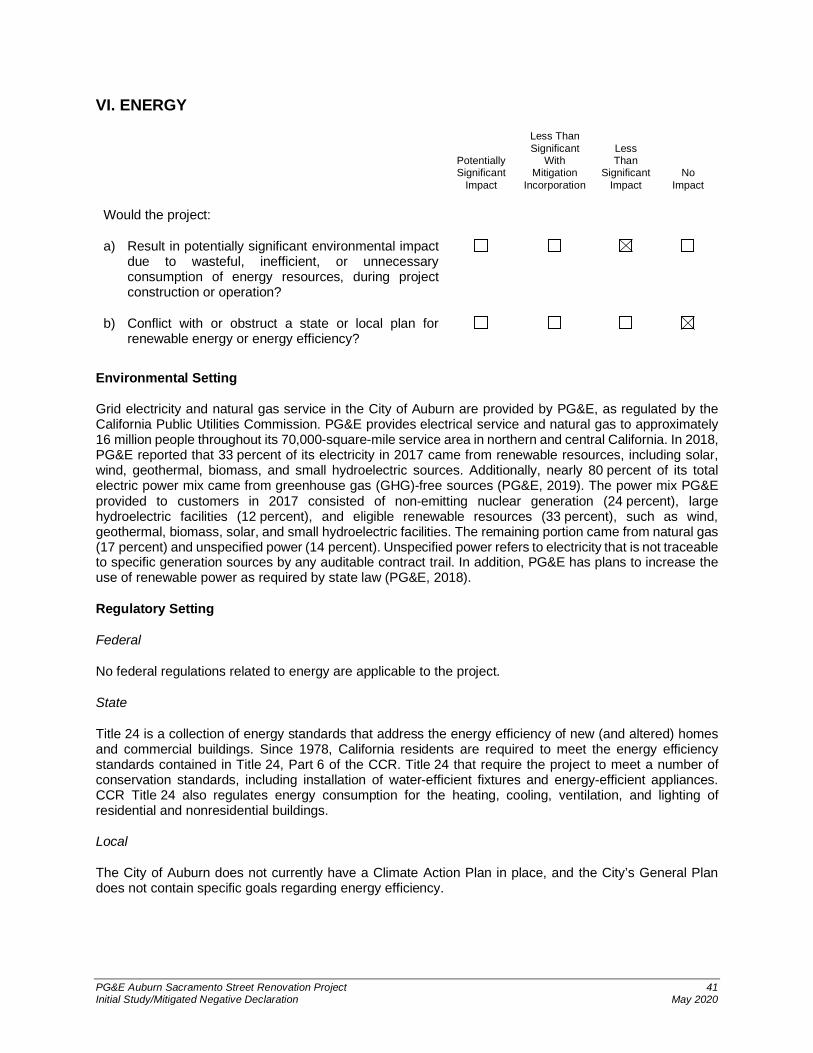
PG&E Auburn Sacramento Street Renovation Project 41Initial Study/Mitigated Negative Declaration May 2020
VI. ENERGY
PotentiallySignificant
Impact
Less ThanSignificant
WithMitigation
Incorporation
LessThan
SignificantImpact
NoImpact
Would the project:
a) Result in potentially significant environmental impactdue to wasteful, inefficient, or unnecessaryconsumption of energy resources, during projectconstruction or operation?
b) Conflict with or obstruct a state or local plan forrenewable energy or energy efficiency?
Environmental Setting
Grid electricity and natural gas service in the City of Auburn are provided by PG&E, as regulated by theCalifornia Public Utilities Commission. PG&E provides electrical service and natural gas to approximately16 million people throughout its 70,000-square-mile service area in northern and central California. In 2018,PG&E reported that 33 percent of its electricity in 2017 came from renewable resources, including solar,wind, geothermal, biomass, and small hydroelectric sources. Additionally, nearly 80 percent of its totalelectric power mix came from greenhouse gas (GHG)-free sources (PG&E, 2019). The power mix PG&Eprovided to customers in 2017 consisted of non-emitting nuclear generation (24 percent), largehydroelectric facilities (12 percent), and eligible renewable resources (33 percent), such as wind,geothermal, biomass, solar, and small hydroelectric facilities. The remaining portion came from natural gas(17 percent) and unspecified power (14 percent). Unspecified power refers to electricity that is not traceableto specific generation sources by any auditable contract trail. In addition, PG&E has plans to increase theuse of renewable power as required by state law (PG&E, 2018).
Regulatory Setting
Federal
No federal regulations related to energy are applicable to the project.
State
Title 24 is a collection of energy standards that address the energy efficiency of new (and altered) homesand commercial buildings. Since 1978, California residents are required to meet the energy efficiencystandards contained in Title 24, Part 6 of the CCR. Title 24 that require the project to meet a number ofconservation standards, including installation of water-efficient fixtures and energy-efficient appliances.CCR Title 24 also regulates energy consumption for the heating, cooling, ventilation, and lighting ofresidential and nonresidential buildings.
Local
The City of Auburn does not currently have a Climate Action Plan in place, and the City’s General Plandoes not contain specific goals regarding energy efficiency.

PG&E Auburn Sacramento Street Renovation Project 42Initial Study/Mitigated Negative Declaration May 2020
Impacts
a) Result in potentially significant environmental impact due to wasteful, inefficient, orunnecessary consumption of energy resources, during project construction or operation?
Project construction would include the operation of construction vehicles, and debris removal.During project construction, equipment operation would comply with the air district standards thatare aimed at reducing air pollution, as outlined in Section III, Air Quality. Such standards, includingminimizing idling, ensuring proper maintenance, and using the required tier-level engines, alsowould minimize the wasteful consumption of energy resources during construction. Additionally,the project would comply with the City’s recycling regulations, which require any commercialbusiness to recycle that would generate more than 4 yards of weekly waste. The City of Auburnpartnered with Recology to accept construction and demolition debris. With implementation ofexisting standards, the project would not result in wasteful or unnecessary consumption of energyduring construction.
PG&E also desires to achieve a minimum of LEED Silver certification for all aspects of theEngineering building renovation and all new building construction. The LEED building certificationprogram is an initiative of the United States Green Building Council. LEED focuses on encouraginga more sustainable approach to the way buildings are designed, constructed, and operated. Fornew construction and major renovations, the LEED program has five main categories in whichpoints toward certification can be earned. LEED certification is achieved by reducing water usage,concentrating on energy performance systems and usage of materials and resources in bothconstruction and operations.
The project would be required to comply with applicable energy efficiency standards included inTitle 24 of the California Administrative Code and the Appliance Efficiency Regulations. Title 24requires that the project meet a number of conservation standards, including installation of water-efficient fixtures and energy-efficient appliances. Title 24 also regulates energy consumption forthe heating, cooling, ventilation, and lighting of residential and non-residential buildings.Compliance with Title 24 would result in a reduction in the use of fuel, water, and energy.Furthermore, the project would comply with CalGreen requirements related to energy and waterconservation.
In addition, because the new buildings would have a lower footprint, project operation would notresult in a new need or use of energy. The project would involve more efficient use of fuel andenergy, because it includes renovation of a portion of an existing PG&E service center in anurbanized area served by existing utilities and services, and would achieve LEED certification.Therefore, the project would not result in a wasteful, inefficient, or unnecessary consumption ofenergy, and the impact would be less than significant.
b) Conflict with or obstruct a state or local plan for renewable energy or energy efficiency?
The project would have no effect on California’s goals of increasing energy efficiency andrenewable use. The project would entail the construction of new energy-efficient buildings.Operational activity, including the number of vehicle trips to the project site, would not increase asa result of the project. Because the project would replace existing buildings and structures withmore energy-efficient structures, and would not increase operational activity or vehicle trips to thesite, it would not conflict with state energy plans; therefore no impacts would occur.

PG&E Auburn Sacramento Street Renovation Project 43Initial Study/Mitigated Negative Declaration May 2020
VII. GEOLOGY AND SOILS
PotentiallySignificant
Impact
Less ThanSignificant
WithMitigation
Incorporation
LessThan
SignificantImpact
NoImpact
Would the project:
a) Directly or indirectly cause potential substantialadverse effects, including the risk of loss, injury, ordeath involving:
i) Rupture of a known earthquake fault, asdelineated on the most recent Alquist-PrioloEarthquake Fault Zoning Map, issued by theState Geologist for the area or based on othersubstantial evidence of a known fault? Refer toDivision of Mines and Geology SpecialPublication 42.
ii) Strong seismic ground shaking?
iii) Seismic-related ground failure, includingliquefaction?
iv) Landslides?
b) Result in substantial soil erosion or the loss of topsoil?
c) Be located on a geologic unit or soil that is unstable,or that would become unstable as a result of theproject, and potentially result in on- or off-sitelandslide, lateral spreading, subsidence, liquefactionor collapse?
d) Be located on expansive soil, as defined inTable 18-1-B of the Uniform Building Code (1994),creating substantial direct or indirect risks to life orproperty?
e) Have soils incapable of adequately supporting theuse of septic tanks or alternative waste water disposalsystems where sewers are not available for thedisposal of waste water?
f) Directly or indirectly destroy a unique paleontologicalresource or site or unique geologic feature?
Environmental Setting
The project area is not in or near an Alquist-Priolo Earthquake Fault Zone (CGS, 2017). The Placer Countyfoothills are traversed by a series of northwest-trending faults, called the Foothills Fault Zone. The BearMountains Fault Zone is the westernmost strand of the Foothills Fault Zone in the Western SierraMetamorphic Belt. Although the Maidu East Fault (part of the Bear Mountains Fault Zone) is approximately0.5 mile west of the project site, this fault trace is of late Quaternary age (i.e., displacement has occurred

PG&E Auburn Sacramento Street Renovation Project 44Initial Study/Mitigated Negative Declaration May 2020
in the last 1.6 million years), and therefore it is not active. The nearest active fault (i.e., displacement hasoccurred in the last 11,700 years, during the Holocene epoch) is the Cleveland Hills fault, approximately42 miles northwest of the project site (Jennings and Bryant, 2010). Active faults are more likely to exhibitsurface fault rupture, and to result in strong seismic ground shaking. The western portion of Placer County,where the project site is located, has generally not been seismically active.
The project site is nearly flat; it slopes gently from approximately 1,280 feet above mean sea level (amsl)at the eastern boundary to approximately 1,273 feet amsl along the western boundary. The project site ison a terrace that is approximately 0.25 mile west of the edge of the steeply sloped North Fork AmericanRiver Canyon.
A project-specific geotechnical report was prepared in November 2019 (Blackburn, 2019). The geotechnicalexploration found that in general, the project site is underlain by fill that overlies decomposed to veryintensely weathered metavolcanic rock. Because the project site was previously developed with the existingPG&E facilities in the 1950s, it is composed of compacted, consolidated, stable artificial fill. The artificial fillis underlain by stable, Jurassic-age metavolcanic rocks (Gutierrez, 2011). The fill depth, composition, andconsistencies are highly variable. For example, at the parking lot the asphalt is over 7 inches of aggregateon top of approximately 15 feet of fill; while the new warehouse would be constructed in an area where fillwas encountered at 2 to 10 feet of fill.
Groundwater was observed at about 10 feet below ground surface, and there are no active springs or seepson the project site (Blackburn, 2019).
Regulatory Setting
Federal
No federal regulations related to geology and soils are applicable to the project.
State
The Alquist-Priolo Geologic Hazards Zone Act was passed in 1972 to mitigate the hazard of surface faultingto structures for human occupancy. The Act has been amended 10 times, and was renamed theAlquist-Priolo Earthquake Fault Zoning Act on January 1, 1994. The Alquist-Priolo Earthquake Fault ZoningAct’s main purpose is to prevent the construction of structures used for human occupancy on the surfacetrace of active faults, as documented in Special Publication 42 by the California Geological Survey (CGS).The Act only addresses the hazard of surface fault rupture, and is not directed toward other earthquakehazards.
The Seismic Hazards Mapping Act of 1990 was enacted, in part, to address seismic hazards not includedin the Alquist-Priolo Act, including strong ground shaking, landslides, and liquefaction. Under this Act, theState Geologist is assigned the responsibility of identifying and mapping seismic hazards. CGS SpecialPublication 117, adopted in 1997 by the State Mining and Geology Board, constitutes guidelines forevaluating seismic hazards other than surface faulting, and for recommending mitigation measures asrequired by PRC Section 2695(a). In accordance with the mapping criteria, the CGS seismic hazard zonemaps use a ground shaking event that corresponds to 10 percent probability of exceedance in 50 years.
The California Building Code (CBC) 2010 (Revised in 2016) is a part of Title 24 in the CCR, also known asthe California Building Standards Code. The CBC incorporates the International Building Code, a modelbuilding code adopted across the U.S. These codes provide minimum standards to protect property andpublic safety by regulating the design and construction of excavations, foundations, building frames,retaining walls, and other building elements to mitigate the effects of seismic shaking and adverse soilconditions. They also regulate grading activities, including drainage and erosion control.

PG&E Auburn Sacramento Street Renovation Project 45Initial Study/Mitigated Negative Declaration May 2020
Local
Goal 3 of the City of Auburn General Plan Safety Element indicates hazards to public health, safety, andwelfare resulting from natural and man-made hazards should be minimized.
Impacts
a) Directly or indirectly cause potential substantial adverse effects, including the risk of loss,injury, or death involving:
i) Rupture of a known earthquake fault, as delineated on the most recent Alquist-PrioloEarthquake Fault Zoning Map issued by the State Geologist for the area or based onother substantial evidence of a known fault? (Refer to California Geological SurveySpecial Publication 42.)
The project site is not within or adjacent to a fault zoned under the Alquist-PrioloEarthquake Fault Zone Act, or any other known fault. The nearest fault zoned under theAlquist-Priolo Act is the Cleveland Hill Fault south of Lake Oroville, approximately 42 milesto the northwest (CGS, 2017). Therefore, the project would not cause substantial adverseeffects from rupture of an earthquake fault, and no impact would occur.
ii) Strong seismic ground shaking?
According to the project-specific geotechnical report, the project would experience groundshaking during a seismic event (Blackburn, 2019). However, the project would implementproject-specific construction techniques as outlined in the geotechnical engineering reportprepared for the project. The project would further comply with the requirements of theCBC, which includes seismic safety design standards; these are uniformly applied toprojects in California. The CBC includes measures to ensure that structures can withstandthe maximum expected ground shaking without catastrophic failure. The project would bedesigned to meet the State standards for structural design and site development throughChapter 16, Section 1613, Earthquake Loads of the CBC, to withstand anticipated seismicground shaking. Although complete avoidance of any damage may not be feasible,industry-standard seismic design measures would be incorporated, in accordance withcurrent building codes. Therefore, the project would not expose people or structures tosubstantial adverse effects relating to strong seismic ground shaking, and impacts wouldbe less than significant.
iii) Seismic-related ground failure, including liquefaction?
As outlined in the project-specific geotechnical report, there is no potential for liquefactionat the project site, because hard soil and rock underlie the site at shallow depths(Blackburn, 2019). Therefore, the project would not expose people or structures tosubstantial adverse effects relating to liquefaction, and no impacts would occur.
iv) Landslides?
As outlined in the project-specific geotechnical report, there is no potential for landslides atthe project site, due to the relatively low topography at the site. Therefore, the project sitewould not be subject to seismically induced landslide hazards, and no impacts wouldoccur.

PG&E Auburn Sacramento Street Renovation Project 46Initial Study/Mitigated Negative Declaration May 2020
b) Result in substantial soil erosion or the loss of topsoil?
Project construction would involve removal of the existing structures and some vegetation toaccommodate the proposed development. The project site would be graded and excavated to formbuilding pads, followed by construction activities to build the buildings and structures. Site gradingand excavation activities would have the potential to cause soil erosion.
As discussed in Section X, Hydrology and Water Quality, disturbances to the project site wouldbe greater than 1 acre, requiring coverage under the statewide NPDES General ConstructionActivities Stormwater Permit (General Permit) through the State Water Resources Control Board(SWRCB). To obtain coverage under the General Permit, a Storm Water Pollution Prevention Plan(SWPPP) would be submitted, which would require implementation of best management practices(BMPs) to minimize erosion and topsoil loss. Potential erosion and transportation of soil particleswould be managed through standard construction BMPs, such as installation of silt fences, whichwould substantially reduce potential sediment transport from the construction site. Other BMPs thatwould be implemented at the project site would include stabilized construction entrances and stormdrain inlet protection. The contractor would be responsible for maintaining these BMPs in good andeffective condition.
In addition, consistent with City of Auburn Municipal Code Section 53.019, the project would berequired to comply with grading and erosion controls, further minimizing the potential for soilerosion. The project also would be required to comply with the City of Auburn’s Zoning OrdinanceChapter 155 as it relates to grading, erosion, and sediment control. With implementation of BMPsrequired by the SWPPP under the NPDES General Permit and an erosion and sediment controlplan, the impact from construction would be less than significant.
Following construction, the project site would be landscaped and/or covered in buildings orhardscape features; therefore, erosion or loss of topsoil would not be expected to continue beyondthe construction period. Although some soil would be removed during landscaping activities, soilwould be replaced, or augmented as needed, and no substantial loss of topsoil would occur.Impacts would be less than significant, because the project site does not support substantialtopsoil and the potential for soil erosion would be minimized with the use of industry-standardBMPs.
c) Be located on a geologic unit or soil that is unstable, or that would become unstable as aresult of the project, and potentially result in on- or off-site landslide, lateral spreading,subsidence, liquefaction, or collapse?
The project site is composed of stable, compacted, artificial fill underlain by stable Jurassic-agemetavolcanic rock. Furthermore, as discussed in the response to Impact a), the project site is notsubject to landslide or liquefaction hazards. Therefore, project-related facilities would not be locatedon unstable geologic units or soils, and no impact would occur.
d) Be located on expansive soil, as defined in Table 18-1-B of the Uniform Building Code (1994,as updated), creating substantial risks to life or property?
According to the project-specific geotechnical report, the project site has a low potential forexpansion, and is not situated on expansive soils (Blackburn, 2019). Therefore, the project wouldnot expose people or structures to substantial adverse effects relating to soil expansion, and noimpact would occur.

PG&E Auburn Sacramento Street Renovation Project 47Initial Study/Mitigated Negative Declaration May 2020
e) Have soils incapable of adequately supporting the use of septic tanks or alternative wastewater disposal systems where sewers are not available for the disposal of waste water?
Septic tanks are not proposed as part of the project, and the project would use the existingconnections to the City’s sewer system. Therefore, no impact would occur.
f) Directly or indirectly destroy a unique paleontological resource or site or unique geologicfeature?
Based on a review of geologic mapping prepared by Gutierrez (2011), the project site is located inJurassic-age metavolcanic rock that is part of the Foothill Melange. Because of the way these rockswere formed—originating from volcanic activity and then buried under the earth’s surface andmetamorphosed under conditions of high temperature and pressure—they do not contain fossils(Duffield et al., 1975). According to the project-specific geotechnical report there are no overlyingnative sediments, only fill (Blackburn, 2019). Therefore, project-related earthmoving activitieswould have no impact on unique paleontological resources.

PG&E Auburn Sacramento Street Renovation Project 48Initial Study/Mitigated Negative Declaration May 2020
VIII. GREENHOUSE GAS EMISSIONS
Environmental Setting
Gases that trap heat in the atmosphere are referred to as GHGs because they capture heat radiated fromthe Sun as it is reflected back into the atmosphere, much like a greenhouse does. The accumulation ofGHGs has been implicated as the driving force for global climate change. The primary GHGs are carbondioxide (CO2), methane (CH4), nitrous oxide (N2O), ozone, and water vapor.
Although the presence of the primary GHGs in the atmosphere are naturally occurring, CO2, CH4, and N2Oalso are emitted from human activities, accelerating the rate at which these compounds occur in the Earth’satmosphere. CO2 emissions are mainly by-products of fossil fuel combustion, whereas CH4 results fromoff-gassing associated with agricultural practices and landfills. Other GHGs include hydrofluorocarbons,perfluorocarbons, and sulfur hexafluoride, and they are generated in certain industrial processes. GHGstypically are reported in carbon dioxide-equivalent (CO2e) measures.
Global warming potential (GWP) is a concept developed to compare the ability of each GHG to trap heat inthe atmosphere relative to CO2. The GWP of a GHG is based on several factors, including the relativeeffectiveness of a gas to absorb infrared radiation and length of time (i.e., lifetime) that the gas remains inthe atmosphere (atmospheric lifetime). The GWP of each gas is measured relative to CO2, the mostabundant GHG. GHGs with lower emission rates than CO2 may still contribute to climate change becausethey are more effective at absorbing outgoing infrared radiation than CO2 (i.e., high GWP). The concept ofCO2-equivalents (CO2e) is used to account for the different GWP potentials of GHGs to absorb infraredradiation.
Regulatory Setting
Federal
The EPA is the federal agency responsible for implementing the federal CAA. The Supreme Court of theUnited States ruled on April 2, 2007, that EPA must consider regulation of motor vehicle emissions, andthat the EPA had the authority to regulate GHGs. In California, CARB is the agency responsible forcoordination and oversight of state and local air pollution control programs, and for implementing theCalifornia CAA.
State
Executive Order (EO) S-3-05, signed in June 2005, proclaimed that California is vulnerable to the impactsof climate change. EO S-3-05 declared that increased temperatures could reduce the Sierra Nevada’ssnowpack, further exacerbate California’s air quality problems, and potentially cause a rise in sea levels.To combat those concerns, the EO established total GHG emissions targets. Specifically, emissions are to
PotentiallySignificant
Impact
Less ThanSignificant
WithMitigation
Incorporation
LessThan
SignificantImpact
NoImpact
Would the project:
a) Generate greenhouse gas emissions, either directlyor indirectly, that may have a significant impact on theenvironment?
b) Conflict with any applicable plan, policy or regulationadopted for the purpose of reducing the emissions ofgreenhouse gases?
PG&E Auburn Sacramento Street Renovation Project 49Initial Study/Mitigated Negative Declaration May 2020
be reduced to the 2000 level by 2010; the 1990 level by 2020; and to 80 percent below the 1990 level by2050.
In 2006, California passed the California Global Warming Solutions Act of 2006 (Assembly Bill [AB] 32;California Health and Safety Code Division 25.5, Sections 38500, et seq.). AB 32 further details and putsinto law the mid-term GHG reduction target established in EO S-3-05, which is to reduce statewide GHGemissions to 1990 levels by 2020, and 80 percent below 1990 levels by 2050. AB 32 also identifies CARBas the state agency responsible for the design and implementation of emissions limits, regulations, andother measures to meet the target.
In April 2015, Governor Edmund Brown issued EO B-30-15, establishing a statewide GHG reduction goalof 40 percent below 1990 levels by 2030. The emission reduction target acts as an interim goal betweenthe AB 32 goal (i.e., achieve 1990 emission levels by 2020) and Governor Brown’s EO S-03-05 goal ofreducing statewide emissions 80 percent below 1990 levels by 2050. In addition, the EO aligns California’s2030 GHG reduction goal with the European Union’s reduction target (i.e., 40 percent below 1990 levelsby 2030) that was adopted in October 2014.
Senate Bill (SB) 32, signed on September 8, 2016, requires California to reduce GHG emissions to40 percent below 1990 levels by 2030. The SB 32 2030 target represents reductions needed to ensureCalifornia can achieve its longer-term 2050 target of a reduction of GHGs 80 percent below 1990 levels perEO B-30-15.
Local
The PCAPCD has established significance thresholds for GHG emissions to evaluate the impacts ofprojects on global climate change (PCAPCD, 2016). The PCAPCD recommends the following approach todetermine if a project’s GHG emissions would result in a significant impact:
· Tier 1 consists of comparing the project’s GHG emissions to the de minimis level of 1,100 metrictons (MT) of CO2e per year. If a project does not exceed this threshold, it would have GHGemissions that are not cumulatively considerable.
· Tier 2 is a bright line threshold level of 10,000 MT CO2e per year, applied to land use projects’construction phase and stationary projects’ construction and operational phases. If a projectexceeds this cap, the project would be deemed to have a cumulatively considerable contribution toglobal climate change. A land use project with GHG operational emissions between 1,100 MT CO2eand 10,000 MT CO2e per year can still be found less than cumulatively considerable when theresults of the project’s related efficiency analysis meets one of the efficiency thresholds below.
· Tier 3 compares the project emissions to efficiency thresholds. The efficiency matrix and de minislevel thresholds are only applied to a land use projects’ operational phase. These thresholds are4.5 MT CO2e per capita for residential projects in an urban area and 5.5 MT CO2e per capita forresidential projects in a rural area. For nonresidential development, the thresholds are 26.5 MTCO2e per 1,000 square feet for projects in urban areas and 27.3 MT CO2e per 1,000 square feetfor projects in rural areas. If a project does not exceed the applicable efficiency threshold, it wouldhave GHG emissions that are not cumulatively considerable.
Impacts
a) Generate greenhouse gas emissions, either directly or indirectly, that may have a significantimpact on the environment?
The impacts associated with GHG emissions generated by the project are related to the emissionsfrom short-term construction. Off-road equipment, materials transport, and worker commutesduring construction of the project would generate GHG emissions. Construction activities would

PG&E Auburn Sacramento Street Renovation Project 50Initial Study/Mitigated Negative Declaration May 2020
involve renovation of an existing industrial/commercial building (Engineering Building), demolitionof three buildings, and construction of new buildings (Warehouse, and Ice Machine building.
Total project construction GHG emissions were estimated using the methodology discussed earlierunder Section III, Air Quality. The estimated construction-related emissions would beapproximately 325 MT CO2e. Additional modeling assumptions and details are provided inAppendix A. Total construction emissions generated by the project are below the bright-linethreshold. Therefore, construction-related GHG emissions would be less than significant.
The PCAPCD developed GHG emission thresholds based on potential project sizes for differenttypes of land use development. The project would comprise approximately 36,958 square feet ofbuilding space in existing and proposed buildings. The operational de minimis threshold of1,100 MT CO2e was developed based on a 99,189-square-foot general industrial land use; theoperational bright-line threshold of 10,000 MT CO2e was developed based on a 901,709-square-foot threshold (PCAPCD, 2017). Project operation would involve continued use of an existing PG&Eservice center and operational activities, including the use of the fueling facility and back-upgenerator, which are not anticipated to increase beyond existing conditions. In addition, the projectwould comply with the most recent 2019 CALGreen requirements, which became effectiveJanuary 1, 2020. The 2019 CALGreen requirements include mandatory measures for all newbuilding construction, which would result in energy conservation and green design features.Therefore, the project is expected to result in an increase in the efficiency of PG&E’s regionaloperations. Because the project development square footage would not exceed the PCAPCDproject size screening criteria used to develop the GHG emission thresholds, operational emissionsgenerated by the project would not exceed the de minimis level of 1,100 MT CO2e, or the bright-line threshold of 10,000 MT CO2e. Therefore, the project’s operational GHG emissions would beless than significant.
b) Conflict with any applicable plan, policy or regulation adopted for the purpose of reducingthe emissions of greenhouse gases?
In 2006, California passed the California Global Warming Solutions Act of 2006 (AB 32; CaliforniaHealth and Safety Code Division 25.5, Sections 38500, et seq.). AB 32 establishes regulatory,reporting, and market mechanisms to achieve quantifiable reductions in GHG emissions, andestablishes a cap on statewide GHG emissions. It requires that statewide GHG emissions bereduced to 1990 levels by 2020. In December 2008, CARB adopted its Climate Change ScopingPlan (Scoping Plan), which contains the main strategies California will implement to achieve therequired GHG reductions required by AB 32 (CARB, 2014).
CARB approved the first update to the Scoping Plan in 2014 (CARB, 2014). The 2014 ScopingPlan update includes a status of the 2008 Scoping Plan measures and other federal, state, andlocal efforts to reduce GHG emissions in California, and potential actions to further reduce GHGemissions by 2020. In 2016, the state legislature passed SB 32, which established a 2030 GHGemissions reduction target of 40 percent below 1990 levels. In response to SB 32 and thecompanion legislation of AB 197, which provides direction for the Scoping Plan Update, CARBreleased a proposed scoping plan on January 21, 2017. The 2017 Scoping Plan was adopted inNovember 2017 (CARB, 2017). Although the Scoping Plan and Scoping Plan updates do includesome measures that would indirectly address GHG emissions levels associated with constructionactivity, including the phasing-in of cleaner technology for diesel engine fleets (includingconstruction equipment) and the development of a Low Carbon Fuel Standard, successfulimplementation of these measures will predominantly depend on the development of future lawsand policies at the state level. Therefore, it is assumed that the project would comply with anymandate or standards set forth by the Scoping Plan updates.
The PCAPCD adopted a comprehensive regional policy and guidance on addressing and mitigatingGHG emission impacts caused by industrial, commercial, and residential development in the SVAB.As mentioned above, the project would not exceed emission thresholds adopted by PCAPCD.

PG&E Auburn Sacramento Street Renovation Project 51Initial Study/Mitigated Negative Declaration May 2020
Because the project’s construction and operational GHG emissions would be less than significant,it also would not generate emissions that would impede the State’s ability to meet GHG reductiongoals. In addition, the project would comply with the most recent 2019 CALGreen requirements,which became effective January 1, 2020. The 2019 CALGreen requirements include mandatorymeasures for all new building construction, which would result in energy conservation and make amajor contribution in meeting the State’s goals established by AB 32 and SB 32 for reduction inGHG emissions (CEC, 2018). Therefore, the project would not conflict with any applicable plan,policy, or regulation for the purpose of reducing GHG emissions, and the impact would be lessthan significant.

PG&E Auburn Sacramento Street Renovation Project 52Initial Study/Mitigated Negative Declaration May 2020
IX. HAZARDS AND HAZARDOUS MATERIALS
Would the project:
a) Create a significant hazard to the public or theenvironment through the routine transport, use, ordisposal of hazardous materials?
b) Create a significant hazard to the public or theenvironment through reasonably foreseeable upsetand accident conditions involving the release ofhazardous materials into the environment?
c) Emit hazardous emissions or handle hazardous oracutely hazardous materials, substances, or wastewithin one-quarter mile of an existing or proposedschool?
d) Be located on a site which is included on a list ofhazardous materials sites compiled pursuant toGovernment Code Section 65962.5 and, as a result,would it create a significant hazard to the public or theenvironment?
e) For a project located within an airport land use planor, where such a plan has not been adopted, withintwo miles of a public airport or public use airport,would the project result in a safety hazard orexcessive noise for people residing or working in theproject area?
f) Impair implementation of or physically interfere withan adopted emergency response plan or emergencyevacuation plan?
g) Expose people or structures, either directly orindirectly, to a significant risk of loss, injury or deathinvolving wildland fires?
Environmental Setting
The project site is an existing PG&E service center, including operations, fleet maintenance, a weld shop,and warehouse buildings. The project site has parking areas for fleet vehicles and staff parking, and storagelaydown and covered spoils areas. There is also an existing CNG/LNG fueling facility along SacramentoStreet.
Hazardous materials previously used at the project site consisted of hydraulic oil, CO2, hydrogen,nitrogen/hydrogen, marking paint, cleaners and solvents, treated wood, CNG, batteries, and diesel fuel.Hazardous wastes were kept in a storage building south of the main building on the project site, and werecharacterized for disposal, as required by applicable federal, state, and local regulations.
AECOM completed the following tasks to evaluate the potential for the presence of recognizedenvironmental conditions at the project site, including potential impacts from known environmental concernsin the surrounding area:
PG&E Auburn Sacramento Street Renovation Project 53Initial Study/Mitigated Negative Declaration May 2020
· Reviewed an Environmental Data Resources, Inc., regulatory database search report of knownunderground storage tanks (USTs), landfills, hazardous waste generation/treatment/storage/disposal facilities, and subsurface contamination in the surrounding area, within specified radii ofthe project site (EDR, 2018).
· Conducted a reconnaissance-level site visit on November 11, 2018 (where accessible) for obviousevidence of potential contamination, such as current hazardous materials storage or use, unusuallystained soils/slabs/pavements, drains/sumps/drums/tanks/electrical transformers, stressedvegetation, and discarded hazardous materials containers.
· Contacted pertinent local regulatory agencies for information about subject property usage andhistory.
Two statewide databases, the SWRCB’s GeoTracker (SWRCB, 2018) and the California Department ofToxic Substances Control’s (DTSC’s) EnviroStor (DTSC, 2016), were reviewed to determine whether anyleaking USTs or hazardous waste and substance sites are present on or adjacent to the project site. Theproject site is listed as a leaking UST cleanup site, with two separate cases because of gasoline in thegroundwater.
· Case 1: In 1988, two 4,000-gallon gasoline USTs, a 6,000-gallon aviation fuel UST, and a500-gallon waste oil UST, all originally installed in 1953, were excavated and removed, along with1,116 cubic yards of contaminated soil from three separate excavations.
· Case 2: Between December 2002 and January 2003, the 10,000-gallon gasoline UST, the4,600-gallon diesel UST, and the 1,000-gallon waste oil UST, along with each dispenser, allassociated product piping, and about 22 cubic yards of soil, were excavated and removed from thesite. Laboratory results showed that a second unauthorized release of petroleum hydrocarbons hadoccurred at the site. Once the excavation was complete, a new 1,000-gallon waste oil UST wasinstalled, which was later removed and replaced with a 500-gallon aboveground storage tank.
The respective cleanups were completed, and the Central Valley Water Board staff issued No FurtherAction letters in January 1997 and February 2011, respectively (SWRCB, 2018).
For Case 2, elevated constituent concentrations were detected in soil, soil vapor, and groundwater beneaththe site. However, a combination of over-excavation and natural attenuation has removed about 22 poundsof petroleum hydrocarbons. No hydrocarbons remain in groundwater above water quality objectives; andthe only constituent detected during the most recent groundwater sampling event in May 2009 was methyltert butyl ethene at 4.1 micrograms per liter. The results of a Tier 2 human health risk assessment showthat the residual constituents are unlikely to pose a threat to commercial use receptors; and given the site’scontinued use as a PG&E service center with operating fuel tanks, a commercial use exposure scenario isappropriate for the site (RWQCB, 2011). Additionally, no supply wells or surface water bodies are locatedwithin 2,000 feet of the site. Consequently, the remaining constituents are unlikely to pose a threat to humanhealth, or further affect waters of the state as they continue to attenuate. Subsequently, no additional activeremediation or monitoring is warranted, and Central Valley Water Board staff concurred with therecommendation for regulatory closure as a low-risk site.
Government Code Section 65962.5 requires the DTSC and the SWRCB to compile and update at leastannually a specified list of hazardous materials and waste sites, designated Cortese sites. The project siteis not included on lists of hazardous materials and waste sites maintained by the DTSC or SWRCB (CalEPA, 2019).
Terracon Consultants, Inc. performed a pre-demolition hazardous materials survey from July 9 through 19,2018. The objective was to identify the presence or absence of asbestos-containing materials, lead-basedpaint/materials, polychlorinated biphenyls (PCBs) sealants, and other hazardous building materials thatwould be impacted by the planned demolition of Buildings A, B, C, and D at the project site. Asbestoscontent was confirmed in 28 of the materials identified, sampled, and analyzed. Lead was detected inmultiple paints and building materials. Other hazardous building materials present include mercury-

PG&E Auburn Sacramento Street Renovation Project 54Initial Study/Mitigated Negative Declaration May 2020
containing thermostats, fluorescent light tubes, compact fluorescent lightbulbs, suspect PCB lightingballasts, and mechanical equipment with refrigerants (Terracon, 2018).
During a mercury assessment conducted by PG&E on March 16, 2017, each of the identified areaspotentially containing mercury was visually inspected for equipment and instrumentation (valves,controllers, gauges, manometers, thermometers, etc.) that have been historically identified as potentiallycontaining mercury. Although the warehouse areas and storage containers typically contained considerablestored materials, diligent attempts were made to visually inspect the stored materials for potential mercury-containing items and for residual-free mercury. No visible suspect mercury residue was found in any of thesurveyed locations. Mercury vapors were measured by a Certified Industrial Hygienist in Building B at theproject site. Specifically, mercury vapors were detected at the following locations: 1) inside a shop vacuumstored in a machine shop; 2) the floor level (seams in the concrete flooring) in the machine shop; and3) inside a metal fire safe on the mezzanine above a meeting room and offices.
On March 22, besides preforming a pre-decontamination mercury vapor assessment in the mezzanine,Jacobson James and Associates, Inc (JJ&A) found approximately 30 mercury-containing switches in themetal fire safe in the mezzanine. One switch was found to be leaking, and five others were no longeroperational. In addition, mercury vapors were detected on and under the wood floor of the mezzanine, andin the wall space that separates the two rooms below the mezzanine. From March 22 to April 7, 2017, JJ&Aconducted two phases of mercury decontamination activities at the project site.
· Phase 1 – Voluntary mercury decontamination activities, which included the detailed reassessmentof mercury impacts in the mezzanine and machine shop of Building B, followed by an assessmentof worker boots and personal vehicles. Subsequent work included mercury decontamination,removal of mercury-impacted building furniture and materials, and site restoration activities. Thedecontamination work was performed from March 22 to April 7, 2017 (JJ&A, 2017).
· Phase 2 – Decontamination of a shared wall inside the breakroom and bull room on the first floorof Building B, which occurred between May 21 and June 15, 2018 (ETCI, 2018).
Schools
Placer High School, approximately 0.4 mile to the north, and Sky Ridge Elementary School, approximately0.8 mile to the south, are the schools closest to the project site (PUHSD, 2019).
Public Airports
The project site is approximately 4 miles from the closest airport, Auburn Municipal Airport; and is outsidethe airport influence area (Placer County Airport Land Use Commission, 2014).
Emergency Operations Plan
The Placer County Emergency Operations Plan describes potential hazards, such as earthquakes, anddefines how Placer County will effectively prepare for, respond to, recover from, and mitigate natural orhuman-caused disasters, including in Auburn (Placer County, 2010).
Fire Safety
According to the California Department of Forestry and Fire Protection (CAL FIRE) Hazard Severity Zonemap for Auburn, the project area is in the Local Responsibility Area Non-Very High Fire Hazard SeverityZone (CAL FIRE, 2008).
The Auburn City Fire Department responds to all calls for emergency services within city limits, includingfires, emergency medical incidents, hazardous materials incidents, public assists, traffic and vehicleaccidents, and other emergency situations. Station Number 2 (Gietzen Station) at 226 Sacramento Street,

PG&E Auburn Sacramento Street Renovation Project 55Initial Study/Mitigated Negative Declaration May 2020
is the closest fire station to the project site. The station is staffed 24 hours a day, and is approximately0.3 mile northwest of the project site (City of Auburn, 2019b).
Regulatory Setting
Federal
The Occupational Safety and Health Administration (OSHA) of the U.S. Department of Labor is responsiblefor implementing and enforcing federal laws and regulations that address worker health and safety,including the Occupational Safety and Health Act. OSHA requires training for those using or otherwisehandling hazardous materials. Training is to include procedures for personal safety, hazardous-materialsstorage and handling, and emergency response. Construction workers and operational employees at theproject site would be subject to these requirements.
Regulations in Code of Federal Regulations (CFR) Title 29 include requirements to manage and controlexposure to lead-based paint and asbestos-containing materials. In California, these requirements areimplemented by the California Occupational Safety and Health Administration (Cal/OSHA) under CCRTitle 8 (see further discussion of CCR Title 8 below).
The removal and handling of asbestos-containing materials is governed primarily by EPA regulations underCFR Title 40. These regulations require that the appropriate state agency be notified before any demolitionor renovation of buildings that could contain asbestos or asbestos-containing materials above a specifiedthreshold.
EPA is responsible for implementing and enforcing federal laws and regulations pertaining to hazardousmaterials. The primary legislation includes the Resource Conservation and Recovery Act of 1976 (RCRA)and the Comprehensive Environmental Response, Compensation, and Liability Act of 1980, as amendedby the Superfund Amendments and Reauthorization Act (SARA) and the Emergency Planning andCommunity Right-to-Know Act (known as SARA Title III). As permitted by RCRA, in 1992, EPA approvedCalifornia’s program called the Hazardous Waste Control Law (HWCL), administered by the DTSC, toregulate hazardous waste in California, discussed in detail below.
Under the Hazardous Materials Transportation Act of 1976, the United States Department of Transportation(DOT), Office of Hazardous Materials Safety, regulates the transportation of hazardous materials andenforces guidelines created to protect human health and the environment and reduce potential impacts toless than significant by creating hazardous material packaging and transportation requirements. DOTprovides hazardous materials safety training programs and supervises activities involving hazardousmaterials. In addition, DOT develops and recommends regulations governing the multimodal transportationof hazardous materials.
The Aboveground Petroleum Storage Act of 1990 and the Spill Prevention, Control, and Countermeasure(SPCC) Rule (amended 2010) of the Oil Pollution Prevention regulation (40 CFR Part 112) require theowner or operator of a tank facility with an aggregate storage capacity greater than 1,320 gallons to notifythe local certified unified program agency (CUPA) and prepare an SPCC plan. The SPCC plan must identifyappropriate spill containment measures and equipment for diverting spills from sensitive areas, and mustdiscuss facility-specific requirements for the storage system, inspections, recordkeeping, security, andtraining.
The CWA (33 USC 1251 et seq.) is the major federal legislation governing water quality. The CWAestablished the basic structure for regulating discharges of pollutants into waters of the United States (notincluding groundwater). The objective of the act is to restore and maintain the chemical, physical, andbiological integrity of the nation’s waters. The CWA establishes the basic structure for regulating thedischarge of pollutants into waters of the United States.
PG&E Auburn Sacramento Street Renovation Project 56Initial Study/Mitigated Negative Declaration May 2020
State
The Cal/OSHA regulations (Title 8) establish requirements for monitoring and personal safety equipmentrelated to worker exposure to hazardous levels of constituents from contaminated soils, vapors, orgroundwater. Workers who are in direct contact with soil or groundwater containing hazardous levels ofconstituents are required to perform all activities in accordance with a hazardous operations site-specifichealth and safety plan, as outlined in Cal/OSHA standards. The primary intent of the Title 8 requirementsis to protect workers; however, compliance with some of these regulations also results in reducing potentialhazards to non-construction workers and local residents as a result of site monitoring and reportingrequirements and other controls.
As permitted by RCRA, in 1992, EPA approved California’s program called the HWCL, administered byDTSC, to regulate hazardous wastes in California. The HWCL differs little from RCRA, although it covers alarger set of materials. Both laws impose cradle-to-grave regulatory systems for handling hazardous wastesin a manner that protects human health and the environment, and would reduce potential resulting impactsto less than significant. The California Health and Safety Code (Section 25141) defines hazardous wasteas a waste or combination of waste that may, “…because of its quantity, concentration, or physical,chemical, or infection characteristics:
(1) Cause or significantly contribute to an increase in mortality or an increase in serious irreversible orincapacitation-reversible illness.
(2) Pose a substantial present or potential hazard to human health or the environment, due to factorsincluding, but not limited to, carcinogenicity, acute toxicity, chronic toxicity, bioaccumulativeproperties, or persistence in the environment, when improperly treated, stored, transported, ordisposed of or otherwise managed.”
These regulations establish criteria for identifying, packaging, and labeling hazardous wastes; prescribemanagement practices for hazardous wastes; establish permit requirements for hazardous-wastetreatment, storage, disposal, and transportation; and identify hazardous waste that commonly would bedisposed of in landfills.
The provisions in Government Code Section 65962.5 are commonly referred to as the “Cortese List” (afterthe Legislator who authored the legislation that enacted it). The list, or a site’s presence on the list, hasbearing on the local permitting process, as well as on compliance with CEQA. Although the regulationmakes reference to the preparation of a “list,” many changes have occurred related to web-basedinformation access since the legislation was enacted in 1992; this information is now largely available onthe Internet sites of the responsible organizations (Cal EPA, 2019). The “Cortese List” includes:
· List of Hazardous Waste and Substances sites from the DTSC EnviroStor database;
· List of Leaking Underground Storage Tank Sites by County and Fiscal Year from the SWRCBGeoTracker database;
· List of solid waste disposal sites identified by the SWRCB with waste constituents above hazardouswaste levels outside the waste management unit;
· List of “active” Cease and Desist Orders and Cleanup and Abatement Orders from the SWRCB;and
· List of hazardous waste facilities subject to corrective action pursuant to Section 25187.5 of theHealth and Safety Code, identified by DTSC.
The California PRC includes fire safety regulations that restrict the use of equipment that may produce aspark, flame, or fire; require the use of spark arrestors on construction equipment that uses an internalcombustion engine; specify requirements for the safe use of gasoline-powered tools in fire hazard areas;and specify fire suppression equipment that must be provided on site for various types of work in fire-proneareas.

PG&E Auburn Sacramento Street Renovation Project 57Initial Study/Mitigated Negative Declaration May 2020
The Porter-Cologne Act is California’s statutory authority for the protection of water quality. Under thePorter-Cologne Act, the State must adopt water quality policies, plans, and objectives that protect theState’s waters for the use and enjoyment of the people. Regional authority for planning, permitting, andenforcement is delegated to the nine Regional Water Quality Control Boards (RWQCBs). The RWQCBsare required to formulate and adopt water quality control plans (also known as basin plans) for all areas ofthe region, and establish water quality objectives in the plans. The Porter-Cologne Act sets forth theobligations of the SWRCB and RWQCBs to adopt and periodically update water quality control plans thatrecognize and reflect the differences in existing water quality, the beneficial uses of the region’sgroundwater and surface water, and local water quality conditions and problems. The Porter-Cologne Actalso authorizes the SWRCB and RWQCBs to issue and enforce waste discharge requirements and toimplement programs for controlling pollution in State waters.
The California Emergency Response Plan is intended to coordinate emergency services provided byfederal, state, and local governments and private agencies. Responding to hazardous-materials incidentsis one part of this plan. The plan is administered by the California Governor’s Office of Emergency Services,which coordinates the responses of other agencies. Emergency response team members respond andwork with local fire and police agencies, emergency medical providers, the California Highway Patrol,CDFW, and the California Department of Transportation (Caltrans).
Local
The designated CUPA for the project is the Placer County Health and Human Services Department. Thedepartment is responsible for: (1) the implementation of the Hazardous Materials Business Plan andemergency response plan; and (2) the storage of hazardous materials in USTs and cleanup of petroleumreleases. The department must be contacted in the event of a release of hazardous wastes or materials tothe environment.
Section 1 of the City of Auburn Ordinance No. 16-03, which amends Sections 100.50, 100.53, 100.54,100.55, 100.56, 10058, and 100.59 of Chapter 100 of Title IX of the Auburn Municipal Code directs thatwhen required by the fire code official (Fire Chief), business owners are to submit a Facility Correction Planto the City Building Department for approval or revision by the City Council. The Facility Correction Planmust demonstrate that hazardous materials stored, dispensed, handled, or used in the facility will betransported, disposed of, or handled in a manner that eliminates the need for further maintenance; that anythreat to public health and safety will be eliminated; and that all federal, state, and local requirements willbe met to ensure the safe closure or correction of the facility.
Impacts
a) Create a significant hazard to the public or the environment through the routine transport,use, or disposal of hazardous materials?
Project construction would include the transport, use, and disposal of hazardous materials typicallyassociated with construction activities, such as fuels, oils and lubricants, paints and paint thinners,glues, and cleaning fluids (e.g., solvents). These materials are associated with the fueling,servicing, and repair of vehicles and equipment and application of architectural coatings.
During project operation, hazardous wastes currently used at the project site would continue to beused, including hydraulic oil, CO2, hydrogen, nitrogen/hydrogen, marking paint, treated wood, CNG,batteries, and diesel fuel. These wastes would be stored in the new materials storage building.PG&E would store, label, and dispose of hazardous materials in accordance with applicablefederal, state, and local regulations; and would report any accidental discharges of hazardousmaterials or other similar substances (where amounts are above the threshold for reportablequantities). All hazardous materials (i.e., fuels) would be transported in appropriate receptacles. Ifthreshold limits are exceeded for fuel storage, an SPCC Plan would be required for the storage offlammable fuel hydrocarbons at the project site. The SPCC Plan would be reviewed by the PlacerCounty Environmental Health Division. Therefore, the potential for significant hazards related tohazardous materials would be less than significant.
PG&E Auburn Sacramento Street Renovation Project 58Initial Study/Mitigated Negative Declaration May 2020
b) Create a significant hazard to the public or the environment through reasonably foreseeableupset and accident conditions involving the release of hazardous materials into theenvironment?
Implementation of the project could release potentially hazardous materials into the environmentvia airborne fugitive dust from on-site demolition of structures or disturbance of soils duringconstruction. This type of release may also expose construction workers to residual soilcontamination. The existing CNG/LNG fueling facility along Sacramento Street would not bechanged and no ground disturbance would occur in this area of the project site; the nearestconstruction activities would be approximately 60 feet to the southwest and would involveconstruction of the Ice Machine building. Compliance with applicable federal, state, and localregulations regarding the creation, monitoring, and abatement of fugitive dust during the demolitionand construction phases of the project; and for the handling, storage, and disposal of solid wastepotentially containing hazardous materials, would ensure that no significant hazards to onsiteworkers, adjacent residences, or the public are created by the demolition activities or the routinetransport, use, or disposal of hazardous substances. The project would also be required to obtaincoverage under the SWRCB’s Construction General Permit. As part of the Construction GeneralPermit, the contractor would be required to prepare and implement an SWPPP that would includeBMPs to prevent accidental spills of hazardous materials during construction. Such BMPs wouldinclude:
· Following manufacturer’s recommendation on the use, storage, and disposal of chemicalproducts;
· Maintaining vehicles and construction equipment in proper working condition to minimize thepotential for fugitive emissions of motor oil, antifreeze, hydraulic fluid, grease, or otherhazardous materials;
· Providing secondary containment for any hazardous materials temporarily stored on site;
· Properly disposing of discarded containers of fuels and other chemicals; and
· Staging construction equipment and equipment washing only in designated locations wherespills or washing water cannot flow into drainage channels.
As discussed in the response to Impact a), the project would involve the storage, use, and transportof relatively small amounts of potentially hazardous materials during operation. Potentiallyhazardous materials will not be manufactured on the project site or stored in large quantities.. Useof small quantities of hazardous materials such as fuels, oils, and lubricants, paints and paintthinners, glues, and cleaning fluids (e.g., solvents) during operation would be incidental to thecontinued use of the site for a utility service center. Hazardous wastes associated with transformerscontaining insulating oil, and sulfur hexafluoride used in gas-filled circuit breakers would beassociated with project operation. PG&E is required to store, label, and dispose of hazardousmaterials in accordance with applicable federal, state, and local regulations, and to report anyaccidental discharges of hazardous materials or other similar substances (where amounts areabove the threshold for reportable quantities). If threshold limits are exceeded for fuel storage, anSPCC Plan is required for the storage of flammable fuel hydrocarbons at the project site. The SPCCPlan would be reviewed by the Placer County Environmental Health Division.
Therefore, the potential for significant hazards related to hazardous materials would be less thansignificant.
c) Emit hazardous emissions or handle hazardous or acutely hazardous materials,substances, or waste within one-quarter mile of an existing or proposed school?
No existing or planned elementary, middle or intermediate, or high schools are within 0.25 mile(1,320 feet) of the project site. Therefore, no impact would occur.

PG&E Auburn Sacramento Street Renovation Project 59Initial Study/Mitigated Negative Declaration May 2020
d) Be located on a site which is included on a list of hazardous materials sites compiledpursuant to Government Code §65962.5 and, as a result, would it create a significant hazardto the public or the environment?
As discussed in the Environmental Setting above, the project site is not included on lists ofhazardous materials sites compiled pursuant to Government Code Section 65962.5. Therefore, noimpact would occur.
e) For a project located within an airport land use plan or, where such a plan has not beenadopted, within two miles of a public airport or public use airport, would the project resultin a safety hazard or excessive noise for people residing or working in the project area?
As discussed in the Environmental Setting section above, the project site is approximately 4 milesfrom the closest airport, Auburn Municipal Airport, and is outside the airport influence area.Therefore, the project would not increase safety hazards for people residing or working in theproject area, and no impact would occur.
f) Impair implementation of or physically interfere with an adopted emergency response planor emergency evacuation plan?
The project site is an existing PG&E service center in an urbanized area. The number of workersand visitors accessing the project site during normal and emergency conditions would not increasebecause of the project; therefore, the project would not adversely affect an emergency evacuation.As discussed in Section XVII, Transportation, construction-related traffic is not expected to posean obstacle to emergency response vehicles, and any temporary increases in traffic volumesrelated to construction activities are expected to be less than significant. Therefore, the projectwould not impair implementation of, or physically interfere with, an adopted emergency responseplan or emergency evacuation plan, and would result in a less-than-significant impact on anemergency response plan or emergency evaluation plan.
g) Expose people or structures, either directly or indirectly, either directly or indirectly, to asignificant risk of loss, injury or death involving wildland fires?
The project site is not adjacent to wildlands, and is in a Local Responsibility Area (CAL FIRE, 2007)and a Non–Very High Fire Hazard Severity Zone (CAL FIRE, 2008). The Auburn City FireDepartment would be responsible for responding to all fires in the project area, in coordination withthe CalFire/Placer County Fire Department. Therefore, the project would not expose people orstructures to a significant risk of loss, injury, or death involving wildland fires, including wherewildlands are adjacent to urbanized areas or where residences are intermixed with wildlands. Noimpact would occur.

PG&E Auburn Sacramento Street Renovation Project 60Initial Study/Mitigated Negative Declaration May 2020
X. HYDROLOGY AND WATER QUALITY
PotentiallySignificant
Impact
Less ThanSignificant
WithMitigation
Incorporation
LessThan
SignificantImpact
NoImpact
Would the project:
a) Violate any water quality standards or wastedischarge requirements or otherwise substantiallydegrade surface or ground water quality
b) Substantially decrease groundwater supplies orinterfere substantially with groundwater rechargesuch that the project may impede sustainablegroundwater management of the basin?
c) Substantially alter the existing drainage pattern of thesite or area, including through the alteration of thecourse of a stream or river or through the addition ofimpervious surfaces, in a manner which would:
i) Result in a substantial erosion or siltation on- oroff-site;
ii) Substantially increase the rate or amount ofsurface runoff in a manner which would result inflooding on- or offsite;
iii) Create or contribute runoff water which wouldexceed the capacity of existing or plannedstormwater drainage systems or providesubstantial additional sources of polluted runoff;or
d) In flood hazard, tsunami, or seiche zones, risk releaseof pollutants due to project inundation?
e) Conflict with or obstruct implementation of a waterquality control plan or sustainable groundwatermanagement plan?
Environmental Setting
The Auburn area generally experiences a Mediterranean-style climate, with hot, dry summers and cold, wetwinters. Rainfall occurs primarily from November through March.
The approximately 9.5-acre project site is approximately 0.75 mile to the west and approximately 800 feetin elevation above the North Fork American River. The project site slopes gently from approximately1,280 feet amsl at the eastern boundary to approximately 1,273 feet amsl along the western boundary. Asmall area in the northeastern portion of the project site drains towards the northeast (see Appendix A).The remainder of the project site drains towards the west-southwest, following the natural elevationcontours. Drainage from the project site flows into Auburn Ravine, which flows westward for approximately

PG&E Auburn Sacramento Street Renovation Project 61Initial Study/Mitigated Negative Declaration May 2020
34 miles to its confluence with the Sacramento River (City of Auburn, 1993; California Department of WaterResources, 2018).
The project site consists of an existing PG&E service center. The project site is mostly covered withimpervious surfaces (i.e., pavement and buildings), except for an undeveloped area in the northern portionof the project site, and a small landscaped area adjacent to Sacramento Street. An existing on-sitestormwater drainage system is present, which conveys runoff from the project site to City of Auburnstormwater drainage lateral lines.
Floodplain mapping provided by the Federal Emergency Management Agency classifies the project site asZone X, an area of minimal flood hazard (FEMA, 2018).
Regulatory Setting
Federal
The CWA is the primary federal legislation governing water quality. The objective of the Act is to restoreand maintain the chemical, physical, and biological integrity of the nation’s waters. The CWA establishesthe basic structure for regulating discharge of pollutants into the waters of the United States and gives theEPA the authority to implement pollution control programs. In California, EPA has delegated authority tothe SWRCB and the RWQCBs.
State
In 2000, the SWRCB adopted the Policy for Implementation of Toxics Standards for Inland Surface Waters,Enclosed Bays, and Estuaries of California (SIP). The SIP establishes implementation provisions forNational Toxics Rule and California Toxics Rule priority pollutant criteria, and provisions for chronic toxicitycontrol.
Placer County Water Agency is the groundwater management agency in Placer County. Placer County,Placer County Water Agency, the City of Roseville, the City of Lincoln, and the Nevada Irrigation Districthave established the West Placer Groundwater Sustainability Agency to manage groundwater in a portionof the North American Sub-basin of the Sacramento Valley Groundwater Basin. A draft GroundwaterSustainability Plan will be developed with a public release draft in early 2021 (West Placer County WaterAgency, 2019).
The project is required by law to comply with the provisions of the SWRCB’s NPDES General Permit forStorm Water Discharges Associated with Construction and Land Disturbance Activities (Order2009-009-DWQ, as amended by Order 2012-0006-DWQ) (Construction General Permit) (SWRCB, 2012).The Construction General Permit regulates stormwater discharges for construction activities under theCWA, and applies to all land-disturbing construction activities that would disturb 1 acre or more.
Local
The project applicant must submit a notice of intent to discharge to the Central Valley Regional WaterQuality Control Board (CVRWQCB), and must prepare and implement an SWPPP that includes BMPs tominimize those discharges. All NPDES permits also have inspection, monitoring and reportingrequirements. CVRWQCB requires dischargers to implement construction and operational design features,and BMPs that are specifically intended to reduce the potential for downstream hydromodification. TheConstruction General Permit also requires implementation of BMPs that are designed to prevent accidentalspills of hazardous materials during the construction phase to the maximum extent practicable, and theSWPPP must include procedures for immediate cleanup should any releases occur. CVRWQCB also hasthe authority to issue waivers to waste discharge reports (WDRs) and/or WDRs for broad categories of low-threat discharge activities that have minimal potential for adverse water quality effects when implementedaccording to prescribed terms and conditions.

PG&E Auburn Sacramento Street Renovation Project 62Initial Study/Mitigated Negative Declaration May 2020
Placer County is subject to the mandates for stormwater discharges as part of the MS4, Phase II of theNPDES small municipal stormwater program (State General Permit Number CAS0000004). This program,which is part of the federal CWA, requires the county to regulate all projects that create and/or replace morethan 2,500 square feet of impervious surface. PG&E is required to comply with the requirements of theWest Placer Storm Water Quality Design Manual (Placer County, 2018b), which provides design standardsfor conformance to the NPDES permit requirements. The design manual also provides hydromodificationmanagement standards that slow and minimize post-construction stormwater runoff, with the goal ofachieving no net increase. Stormwater quality control measures at each project site must be maintained inperpetuity.
Impacts
a) Violate any water quality standards or waste discharge requirements or otherwisesubstantially degrade surface or ground water quality?
The project would require construction over an approximately 7.1-acre portion of the project site.Project construction would require excavation, grading, material stockpiling, and staging at theproject site that would temporarily disturb surface soils. These activities would expose soil to theerosive forces of wind and water. Erosion and construction-related wastes have the potential todegrade water quality and beneficial uses if they enter runoff and flow into waterways, potentiallyaltering the dissolved oxygen content, temperature, pH, suspended sediment and turbidity levels,and/or nutrient content of receiving waters; or causing toxic effects in the aquatic environment.Project-related pollutants could ultimately be transported via the storm drainage system to AuburnRavine, and from there to the Sacramento River, thereby increasing turbidity and degrading waterquality. Therefore, project-related construction activities could violate water quality standards, orotherwise substantially degrade water quality.
Because PG&E is required by law to comply with CVRWQCB requirements to obtain WDRs (ifapplicable) and comply with the provisions therein, to comply with the stormwater design standardscontained in the West Placer Storm Water Quality Design Manual, and to prepare and implementan SWPPP with associated BMPs specifically designed to protect beneficial uses of downstreamwaterbodies in compliance with the federal CWA, the state Porter-Cologne Water Quality Act, andthe regional Basin Plan (Water Quality Control Plan for the Sacramento and San Joaquin RiverBasins [CVRWQCB, 2018]). Potential erosion and transportation of soil particles would bemanaged through standard construction BMPs, such as installation of silt fences, which wouldsubstantially reduce potential sediment transport from the project site. Other construction-relatedcontaminants, such as oil and grease, would be managed through appropriate material handlingand good housekeeping practices at the project site. Other BMPs that would be implemented atthe site would include stabilized construction entrances and storm drain inlet protection. Thecontractor would be responsible for maintaining these BMPs in good and effective condition. Suchmeasures would include the following:
· Minimize Active Construction Area. The number of access routes, size of staging areas, andthe size of the active construction sites would be limited to the minimum necessary to achieveproject objectives; and staging areas, storage, equipment laydown, access routes, and parkingareas would be established on paved or previously disturbed areas to the extent feasible.
· Implement Erosion Control. Standard construction site erosion control measures would beused where sediment from exposed slopes could erode and enter drainage facilities. Areas ofdisturbed soils that slope toward drainages would be stabilized when not actively in use, toreduce erosion potential. Materials used for the erosion control measures and sedimentbarriers would be weed-free.
· Implement Trash Control. Food-related trash items, such as wrappers, cans, bottles, and foodscraps, would be disposed in closed containers (trash cans) and removed from the constructionsite on a regular basis.

PG&E Auburn Sacramento Street Renovation Project 63Initial Study/Mitigated Negative Declaration May 2020
· Hazardous Spill Prevention. Vehicles and equipment would be maintained in proper workingcondition, to minimize potential fugitive emissions of motor oil, antifreeze, hydraulic fluid,grease, or other hazardous materials. Service/maintenance vehicles would carry materials toabsorb leaks or spills. Servicing, refueling, and staging of construction equipment would takeplace only at designated areas where a spill would not flow to drainages. Equipment washing,if needed, would occur only in designated locations where water could not flow into drainagechannels. Hazardous spills would be cleaned up immediately, and contaminated soil would beproperly disposed at a licensed facility.
· Storm drain inlets would be labeled to alert construction workers and site users to thedestination of stormwater, and to prevent direct discharge of pollutants to the storm drain.
· Using filtration materials on storm drains covers to remove sediments from any waterdischarges.
· Stabilizing all areas void of vegetation and maintaining erosion control measures continuouslyfrom October 15 to April 15, to prevent erosion.
With implementation of existing regulations and the above-outlined BMPs, this impact would beless than significant.
b) Substantially decrease groundwater supplies or interfere substantially with groundwaterrecharge such that the project may impede sustainable groundwater management of thebasin?
The project consists of renovating an approximately 7.1-acre portion of an existing PG&E serviceyard that is already almost completely covered with impervious surfaces (i.e., pavement andbuildings). The project would renovate and replace the existing buildings, and would not result inan increase of impermeable surfaces (see Project Description section). New groundwater wellsare not proposed as part of the project, and the continued use of the project site for a PG&E servicecenter would not increase the demand for water supply to the extent that any new regionalgroundwater wells would be necessary to continue to meet regional or local needs. Therefore, noimpact would occur.
c) Substantially alter the existing drainage pattern of the site or area, including through thealteration of the course of a stream or river or through the addition of impervious surfaces,in a manner which would:
i) Result in a substantial erosion or siltation on- or off-site;
The project would not result in additional pervious surfaces being converted to impervioussurface that could generate additional stormwater runoff. The project site already has anexisting stormwater drainage system, the majority of which would continue to be used. Newbuildings or structures and modified paving areas would be tied-in to the existing sitedrainage system. Furthermore, as discussed in Impact a) above, PG&E is required by lawto prepare and implement an SWPPP with associated BMPs that are specifically designedto reduce erosion and siltation; both on and off site. Finally, PG&E also is required tocomply with the requirements of the West Placer Storm Water Quality Design Manual(Placer County, 2018b), which provides design standards and hydromodificationrequirements for conformance with the County’s MS4 NPDES permit requirements.Therefore, the impact would be less than significant.
ii) Substantially increase the rate or amount of surface runoff in a manner which wouldresult in flooding on- or offsite;
As described in the Project Description, the project site currently includes 56,193 squarefeet of buildings. At the conclusion of project construction, the impervious surfaces related

PG&E Auburn Sacramento Street Renovation Project 64Initial Study/Mitigated Negative Declaration May 2020
to buildings at the project site would be 36,958—a reduction of 19,235 square feet ofimpervious surfaces from buildings. However, the remaining square footage would bepaved, and used for yard circulation and materials storage; therefore there would be nonet change in the total extent of impervious surface at the site. The project site already hasan existing stormwater drainage system, the majority of which would continue to be used.New buildings or structures and modified paving areas would be tied-in to the existing sitedrainage system. Finally, PG&E also must comply with the requirements of the West PlacerStorm Water Quality Design Manual (Placer County, 2018b), which provides designstandards and hydromodification requirements for conformance with the County’s MS4NPDES permit requirements. Because the project would not increase the amount ofimpervious surfaces at the project site, the rate and amount of surface runoff would notincrease, and therefore would not result in on- or off-site flooding. Therefore, the impactwould be less than significant.
iii) Create or contribute runoff water which would exceed the capacity of existing orplanned stormwater drainage systems or provide substantial additional sources ofpolluted runoff; or
As discussed in the response to Impact a) and Impact c)iii) above, the project would notincrease the amount of impervious surfaces at the project site. Furthermore, the projectsite already has an existing stormwater drainage system, the majority of which wouldcontinue to be used. Minor modifications to the on-site drainage system would beimplemented as necessary to tie-in the modified facilities. Finally, PG&E also must complywith the requirements of the West Placer Storm Water Quality Design Manual (PlacerCounty, 2018b), which provides design standards and hydromodification requirements forconformance with the County’s MS4 NPDES permit requirements. Because stormwaterrunoff from some of the new/replaced impervious surfaces at the project site cannotfeasibly be collected entirely within treatment areas at these locations, stormwater fromexisting impervious surface areas would also be collected and treated in four newlandscape-based treatment areas placed throughout the project site. The landscape-basedtreatment areas would collect runoff from both existing and replaced impervious areas, thetotal of which would be equal to or greater than the total new/replaced impervious areas.Therefore, the project would not create or contribute runoff water that would exceed thecapacity of existing stormwater drainage systems, or provide additional sources of pollutedrunoff, and the impact would be less than significant.
d) In flood hazard, tsunami, or seiche zones, risk release of pollutants due to projectinundation?
The project site is classified as Zone X, an area of minimal flood hazard (FEMA, 2018). Becausethe project site is approximately 800 feet in elevation above the North Fork American River and theproject area is not seismically active, the project would not be exposed to seiche hazards. Due tothe long distance from the Pacific Ocean, the project would not be exposed to tsunami hazards.Therefore, pollutants would not be transported off site from flood, tsunami, or seiche hazards, andno impact would occur.
e) Conflict with or obstruct implementation of a water quality control plan or sustainablegroundwater management plan?
For the reasons discussed in the response to Impacts a) and b) above, the project would notobstruct implementation of a water quality control plan or sustainable groundwater managementplan. Therefore, no impact would occur.

PG&E Auburn Sacramento Street Renovation Project 65Initial Study/Mitigated Negative Declaration May 2020
XI. LAND USE AND PLANNING
PotentiallySignificant
Impact
Less ThanSignificant
WithMitigation
Incorporation
LessThan
SignificantImpact
NoImpact
Would the project:
a) Physically divide an established community?
b) Cause a significant environmental impact due to aconflict with any applicable land use plan, policy, orregulation adopted for the purpose of avoiding ormitigating an environmental effect?
Environmental Setting
The project site has been used as the PG&E service center since 1954. Existing building/structures on thesite include the Engineering Building, three warehouse buildings, support building, weld shop, CNGbuilding, and two telecommunications buildings. There also is an existing CNG/LNG fueling facility alongSacramento Street.
Land uses in the project vicinity include industrial/commercial, recreation, and open space. Single-storyindustrial/commercial buildings are across Sacramento Street to the west of the project site. Single-storyindustrial/commercial buildings and associated parking areas and a rail line are to the south of the projectsite; Railhead Park is further south. Vacant land is to the east and southeast of the project site; OverlookPark is further east. To the north of the project site are a paved parking area and a dirt parking areaassociated with a small commercial center at the corner of Sacramento Street and Fairgate Road, theAuburn City (Gold Country) Fairgrounds and Event Center, and the Auburn Performance Raceway racetrack, stadium, arena and sports venue, which is to the northeast of the project site.
The project site is included in the City of Auburn’s Industrial (IND) land use designation. The purpose of thisland use designation is to provide for the development of industrial areas where suitable land and servicesexist and with a minimum of land use conflicts. Preferred land uses in the Industrial (IND) land usedesignation include warehousing, industrial parks, and other light industrial businesses.
The northern portion of the project site, which has been used for overflow parking, is included in theRegional Commercial (C-3) zoning district. The proposed project does not include any construction orchange in use of this portion of the property. The remainder of the PG&E property, including the entire areathat composes the project site for the proposed renovation project, is included in the City of Auburn’sIndustrial Park (M-1) zoning district (City of Auburn, 2016a). Permitted uses in the M-1 zoning district includelight industrial uses, including warehouses, electrical distribution substations, machine shops, buildingmaterials yards, corporation yards, and professional offices.
Regulatory Setting
Federal
No federal regulations related to land use are applicable to the project.
State
No state regulations related to land use are applicable to the project.

PG&E Auburn Sacramento Street Renovation Project 66Initial Study/Mitigated Negative Declaration May 2020
Local
The City of Auburn General Plan provides the vision for the City of Auburn. General Plan goals related tothe project include:
· Industrial Goal 8: Provide for the development of industrial areas where suitable land and servicesexist and with a minimum of land use conflicts.
· Open Space Goal 2: Minimize adverse development impacts to the natural environment.
· Noise Goal 2: Protect the economic base of the City by preventing incompatible land uses fromencroaching upon existing or planned noise producing uses.
· Safety Goal 4: Protect all residents from hazardous materials and the hazards associated withtransport of such materials.
Impacts
a) Physically divide an established community?
The project site is in an industrial area that extends along Sacramento Street. The nearestresidential community is approximately 0.1 mile south; it is separated from the project site byRailhead Park, the rail line, and other industrial/commercial land uses. The project would not alterthe industrial land use of the project site or its relationship to the adjacent and nearby land usesand communities. Therefore, the project would not physically divide an established community, andno impact would occur.
b) Cause a significant environmental impact due to a conflict with any applicable land use plan,policy, or regulation adopted for the purpose of avoiding or mitigating an environmentaleffect?
The project entails renovating an existing PG&E service center. The continued use of the site isconsistent with the purpose of the Industrial (IND) land use designation and the Industrial Park(M-1) zoning district. As outlined in this Initial Study (IS), the project would not conflict with erosioncontrol, water quality, or noise provisions adopted by the City with the intent of avoidingenvironmental impacts. Therefore, the project would not conflict with land use plans, policies, orregulations, and associated impacts would be less than significant.

PG&E Auburn Sacramento Street Renovation Project 67Initial Study/Mitigated Negative Declaration May 2020
XII. MINERAL RESOURCES
PotentiallySignificant
Impact
Less ThanSignificant
WithMitigation
Incorporation
LessThan
SignificantImpact
NoImpact
Would the project:
a) Result in the loss of availability of a known mineralresource that would be of value to the region and theresidents of the state?
b) Result in the loss of availability of a locally-importantmineral resource recovery site delineated on a localgeneral plan, specific plan or other land use plan?
Environmental Setting
Sand and gravel mined in Placer County are used for construction. Construction aggregates are animportant building material used in Portland cement concrete, asphalt concrete, plaster, and stucco, andas a road base material. In addition, Placer County is known to contain deposits of other economicallyvaluable minerals such as gold, silver, copper, zinc, and tungsten.
In compliance with the Surface Mining and Reclamation Act, the CGS has established a classificationsystem to indicate the location and significance of key extractive resources (see Table 7).
Table 7California Geological Survey Mineral Land Classification System
Classification Description
MRZ-1 Areas where available geologic information indicates there is little likelihood for the presence ofsignificant mineral resources.
MRZ-2a Areas underlain by mineral deposits where geologic data indicate that significant measured orindicated resources are present.
MRZ-2b Areas underlain by mineral deposits where geologic information indicates that significant inferredresources are present.
MRZ-3a Areas containing known mineral occurrences of undetermined mineral resource significance.
MRZ-3b Areas containing inferred mineral occurrences of undetermined mineral resource significance.
MRZ-4 Areas of no known mineral occurrences where geologic information does not rule out either thepresence or absence of significant mineral resources.
Note:MRZ = Mineral Resource Zone.Source: Loyd, 1995.

PG&E Auburn Sacramento Street Renovation Project 68Initial Study/Mitigated Negative Declaration May 2020
Based on the mineral land classification report for Placer County prepared by Loyd (1995), the project sitehas been classified for mineral resources as follows:
· Placer gold: Mineral Resource Zone (MRZ)-1
· Lode gold, silver, copper, zinc, and tungsten: MRZ-3a
· Construction aggregate: MRZ-4
Furthermore, the project site contains no current or historical mines or mineral prospects (Loyd, 1995).
Regulatory Setting
Federal
No federal regulations related to mineral resources are applicable to the project.
State
No state regulations related to mineral resources are applicable to the project.
Local
Goal 4 of the City of Auburn General Plan Open Space/Conservation Element encourages conservation,utilization, and development of mineral resources.
Impacts
a) Result in the loss of availability of a known mineral resource that would be of value to theregion and the residents of the state?
The City of Auburn General Plan (City of Auburn, 1993) indicates that the only locally importantmineral resource recovery sites are those classified by CGS as MRZ-2. As described in theEnvironmental Setting section above, the project site is not classified as MRZ-2 by CGS, andtherefore does not contain any known, regionally important mineral resource deposits (Loyd, 1995).Therefore, no impact would occur.
b) Result in the loss of availability of a locally important mineral resource recovery sitedelineated on a local general plan, specific plan, or other land use plan?
The City of Auburn General Plan (City of Auburn, 1993) indicates that the only locally importantmineral resource recovery sites are those classified by CGS as MRZ-2. As described in theEnvironmental Setting section above, the project site is not classified as MRZ-2, and there areno mineral resources at the project site or in the immediate project vicinity, which consists ofcommercial and industrial development. Therefore, no impact would occur.

PG&E Auburn Sacramento Street Renovation Project 69Initial Study/Mitigated Negative Declaration May 2020
XIII. NOISE
PotentiallySignificant
Impact
Less ThanSignificant
WithMitigation
Incorporation
LessThan
SignificantImpact
NoImpact
Would the project result in:
a) Generation of a substantial temporary or permanentincrease in ambient noise levels in the vicinity of theproject in excess of standards established in the localgeneral plan or noise ordinance, or applicablestandards of other agencies?
b) Generation of excessive groundborne vibration orgroundborne noise levels?
c) For a project located within the vicinity of a privateairstrip or an airport land use plan or, where such aplan has not been adopted, within two miles of apublic airport or public use airport, would the projectexpose people residing or working in the project areato excessive noise levels?
The project site is not within 2 miles of a public airport or private airstrip, and the project would not includethe development of noise-sensitive facilities that would be affected by existing aircraft noise. Therefore,significance criteria XIII(c) is not applicable to this project and is not discussed further in this section.
Environmental Setting
The existing noise environment in the project area is influenced by:
· Vehicle traffic, including traffic on Auburn-Folsom Road and Sacramento Street to the west;
· Noise from adjacent industrial uses in the project area; and
· The railroad operations south of the project site.
The nearest noise-sensitive receptors are single-family residential uses, approximately 400 feet northwestof the project site (west of Auburn-Folsom Road and Sacramento Street).
Sound, Noise, and Acoustics
Sound is the mechanical energy of a vibrating object transmitted by pressure waves through a liquid orgaseous medium (e.g., air). Noise is defined as sound that is unwanted (i.e., loud, unexpected, orannoying). Acoustics is the physics of sound.
The amplitude of pressure waves generated by a sound source determines the perceived loudness of thatsource. A logarithmic scale is used to describe sound pressure level in terms of decibels (dB). The thresholdof human hearing (near-total silence) is approximately 0 dB. A doubling of sound energy corresponds to anincrease of 3 dB. In other words, when two sources at a given location are each producing sound of thesame loudness, the resulting sound level at a given distance from that location is approximately 3 dB higherthan the sound level produced by only one of the sources. For example, if one automobile produces asound pressure level of 70 dB when it passes an observer, two cars passing simultaneously do not produce140 dB; rather, they combine to produce 73 dB.

PG&E Auburn Sacramento Street Renovation Project 70Initial Study/Mitigated Negative Declaration May 2020
The typical human ear is not equally sensitive to all frequencies of the audible sound spectrum. As aconsequence, when assessing potential noise impacts, sound is measured using an electronic filter thatde-emphasizes the frequencies below 1,000 Hertz (Hz) and above 5,000 Hz in a manner corresponding tothe human ear’s decreased sensitivity to low and extremely high frequencies, instead of the frequency mid-range. This method of frequency weighting is referred to as A-weighting, and is expressed in units ofA-weighted decibels (dBA). All noise levels reported in this section are in terms of A-weighting. There is astrong correlation between A-weighted sound levels and community response to noise. As discussedabove, doubling sound energy results in a 3-dB increase in sound. In typical noisy environments, noise-levelchanges of 1 to 2 dB are generally not perceptible by the healthy human ear; however, people can beginto detect 3-dB increases in noise levels. An increase of 5 dB is generally perceived as distinctly noticeable,and a 10-dB increase is generally perceived as a doubling of loudness. The following are the sound leveldescriptors commonly used in environmental noise analysis:
· Equivalent sound level (Leq): An average of the sound energy occurring over a specified time period.In effect, the Leq is the steady-state sound level containing the same acoustical energy as the time-varying sound that actually occurs during the same period. The 1-hour, A-weighted equivalentsound level (Leq[h]) is the energy average of A-weighted sound levels occurring during a 1-hourperiod.
· Maximum sound level (Lmax): The highest instantaneous sound level measured during a specifiedperiod.
· Day-Night Noise Level (Ldn): The 24-hour Leq with a 10 dB penalty applied during nighttime noise-sensitive hours, 10:00 p.m. through 7:00 a.m. The Ldn attempts to account for the fact that noiseduring this specific period of time is a potential source of disturbance with respect to normalsleeping hours.
· Statistical Descriptor (Ln): The noise level exceeded “n” percent of a specific period of time,generally accepted as an hourly statistic. An L10 would be the noise level exceeded 10 percent ofthe measurement period.
Sound from a localized source (i.e., point source) propagates uniformly outward in a spherical pattern, andthe sound level attenuates (decreases) at a rate of 6 dB for each doubling of distance from a point/stationarysource. Roadways and highways, and to some extent, moving trains consist of several localized noisesources on a defined path; these are treated as “line” sources, which approximate the effect of several pointsources. Sound levels attenuate at a rate of 3 dB for each doubling of distance from a line source.Therefore, noise from a line source attenuates less with distance than noise from a point source withincreased distance.
Groundborne Vibration
Groundborne vibration is energy transmitted in waves through the ground. Vibration attenuates at a rate ofapproximately 50 percent for each doubling of distance from the source. This approach considers only theattenuation from geometric spreading, and tends to provide for a conservative assessment of vibration levelat the receiver.
Vibration is an oscillatory motion that can be described in terms of the displacement, velocity, oracceleration. Vibration typically is described by its peak and root-mean-square (RMS) amplitudes. The RMSvalue can be considered an average value over a given time interval. The peak vibration velocity is thesame as the peak particle velocity (PPV), generally presented in units of inches per second (in/sec). PPVis the maximum instantaneous positive or negative peak of the vibration signal, and is generally used toassess the potential for damage to buildings and structures. The RMS amplitude typically is used to assesshuman annoyance to vibration, and the abbreviation VdB is used in this document for vibration decibels toreduce the potential for confusion with sound decibels.

PG&E Auburn Sacramento Street Renovation Project 71Initial Study/Mitigated Negative Declaration May 2020
Existing Noise Environment
The existing noise environment in the project area is primarily influenced by surface-transportation noiseemanating from vehicular traffic on Auburn-Folsom Road and Sacramento Street. Existing commercial usesalso contribute to the noise environment at existing residential uses in the area due to loading dockactivities, parking lot vehicle movements, and people walking and talking. Railroad operations to the southand intermittent noise from outdoor activities at the surrounding residences (e.g., people talking, operationof landscaping equipment, car doors slamming, and dogs barking), also influences the existing noiseenvironment.
An ambient noise survey was conducted from May 22 to 23, 2019 to establish existing noise conditions inthe project vicinity. Ambient noise measurements were conducted near existing noise-sensitive uses atvarious locations in the project area. Noise measurement locations are shown in Figure 5. The results ofthe noise survey are presented in Table 8. Two short-term measurements of ambient noise levels wereconducted in the project area during daytime hours. As shown in Table 8, measured ambient noise levelsat the noise-sensitive land uses closest to the project area range from 45 to 63 dBA Leq. One long-term(24-hour) measurement was conducted off the project site. Long-term measurement site LT-1 measuredambient noise levels of 64 dBA Ldn, which is relatively low considering that the sound level meter at LT-1was exposed to railroad operational noise.
Table 8Summary of Ambient Noise Level Survey Results in the Project Area
Site Location Date Time Duration
Measured Sound Level, dB
Daytime(7 a.m.–7 p.m.)
Leq Lmax L50 L90 Ldn
LT-1 By Residence at 362Sacramento Street
May 22to 23, 2019
19:00 24 hour 63.8 82.9 52.2 45.7 64.1
ST-1 Northeastern corner ofRailhead Park
May 23,2019
13:39 0:15 mins 45.8 58.5 44.3 40.3 NA
ST-2 In front of South AuburnVeterinary Hospital
May 23,2019
14:06 0:20 mins 59.1 70.7 57.8 53.4 NA
Notes:dB = decibelsL50 = noise level exceeded 50 percent of the timeL90 = noise level exceeded 90 percent of the timeLdn = day-night noise levelLeq = equivalent sound level (the sound energy averaged over a continuous period of time)Lmax = maximum instantaneous sound levelNA = not applicableLT = long-term measurementST = short-term measurement.Noise-level measurements were completed using a Larson Davis Laboratories (LDL) Model 824 precision integrating sound-levelmeter. The meter was calibrated before the measurements using an LDL Model CAL200 acoustical calibrator. The meter wasprogrammed to recorded A-weighted sound levels using a “slow” response. The equipment used complies with all applicablerequirements of the American National Standards Institute for Class 1 sound-level meters (ANSI S1.4).

!.
"/
"/
Sa c ra m en toSt
R a c e t r a c k
S t
NMcdanie l
Dr
T imb er l i n eL n
R iv e
r vi ew
Dr
Ove r
l oo k
B re wer yL n
Pinecrest Ave
D a l e D r
Knoll
St
C o r a
Ln
S k y r i d g e D r
P o r t l a n dA v e
O r r i n
Dr
H igh
St
PleasantAve
PacificAv
e
Sacra
ment o
St
Aubu
rnFo
lsom
Rd
G umLn
Pl easantAveS h i r l a n d
C a n a l
B o a r d m a n C a n a l
Auburn
LT-01
ST-01
ST-02
AECOM Oakland CA 12/6/2019 USER brownm6 PATH X:\GIS\Projects\60479036_PGE_CRESS\02_Maps\Figure5_Auburn_Noise_Monitoring.mxd
FIGURE 5Noise Monitoring Locations
Project Site!. Long-term (LT) Noise Monitoring Location "/ Short-term (ST) Noise Monitoring Location
0 400200Feet
Source: AECOM 2019
PG&E Auburn Sacramento Street Renovation Project

PG&E Auburn Sacramento Street Renovation Project 73Initial Study/Mitigated Negative Declaration May 2020
Regulatory Setting
Federal
No federal regulations related to noise are applicable to the project.
State
Caltrans’ Transportation and Construction Vibration Guidance Manual provides a summary of vibrationcriteria that have been reported by researchers, organizations, and governmental agencies (Caltrans,2013). Chapters 6 and 7 of this manual summarize vibration detection and annoyance criteria from variousagencies, and provide Caltrans’ recommended guidelines and thresholds for evaluating potential vibrationimpacts on buildings and humans from transportation and construction projects. These thresholds aresummarized in Table 9 and Table 10.
Table 9Caltrans' Vibration Threshold Criteria for Building Damage
Structural IntegrityMaximum PPV (in/sec)1
Transient ContinuousExtremely fragile buildings, ruins, monuments 0.12 0.08Fragile buildings 0.20 0.10Historic and some older buildings 0.50 0.25Older residential structures 0.50 0.30New residential structures 1.00 0.50Modern industrial and commercial structures 2.00 0.50Source: Caltrans, 20131. Vibration impacts to buildings are usually discussed in terms of PPV in in/sec.Caltrans = California Department of Transportationin/sec = inches per secondPPV = peak particle velocity
Table 10Caltrans' Vibration Threshold Criteria for Human Response
Human ResponseMaximum PPV (in/sec)1
Transient ContinuousBarely perceptible 0.035 0.012Distinctly perceptible 0.24 0.035Strongly perceptible 0.90 0.10Severely perceptible 2.00 0.40Source: Caltrans, 20131. Vibration impacts to buildings are usually discussed in terms of PPV in in/sec.Caltrans = California Department of Transportationin/sec = inches per secondPPV = peak particle velocity
Local
The City of Auburn’s General Plan Noise Element establishes land use noise compatibility guidelines fordevelopment, and day/night sound level limits for new projects (City of Auburn, 1993). The City’s MunicipalCode (Title IX General Regulations, Chapter 93 Loud and Unusual Noises, Section 9309 Unlawful Acts (J)Construction or repair of buildings) limits construction to Monday through Friday from 7 a.m. to 6 p.m.(masonry and roofing work may start at 6 a.m. between June 1 and September 30), Saturdays from 9 a.m.to 5 p.m., and Sundays and holidays from 10 a.m. to 6 p.m. (City of Auburn, 2016b). Any noise from the

PG&E Auburn Sacramento Street Renovation Project 74Initial Study/Mitigated Negative Declaration May 2020
above activities, including from any equipment used for these activities, is not to produce noise levels inexcess of the following: (a) Saturdays: 80 dBA, when measured at a distance of 25 feet; (b) Sundays andobserved holidays: 70 dBA, when measured at a distance of 25 feet.
Impacts
a) Generation of a substantial temporary or permanent increase in ambient noise levels in thevicinity of the project in excess of standards established in the local general plan or noiseordinance, or applicable standards of other agencies?
Short-term Project-Generated Construction Source Noise
Construction activities are typically carried out in phases, each with its own noise characteristicsbased on the construction equipment mix in use at a given time and duration of the activity. Heavyand impact equipment typically generate higher noise levels than other types of equipment.Demolition of three buildings and construction of proposed buildings and structures would occur onthe project site, and include site preparation (e.g., excavation and construction); material transport;construction of the new facilities and related support structures; and other miscellaneous activities(e.g., paving). Site preparation generates the highest anticipated noise levels because theequipment mix would include earth-moving equipment such as scrapers, dozers, loaders, and amotor grader. The simultaneous operation of on-site construction equipment associated with theproposed project, as identified above, could result in combined noise levels up to approximately86 dB Leq at 50 feet from the center of construction activity. Based on the equipment noise levels,usage factors, and a typical noise-attenuation rate of 6 dB per doubling of distance, exterior noiselevels at noise-sensitive receptors within 100 feet of the project site could be as high as 80 dB Leq.Based on the Federal Highway Administration Roadway Construction Noise Model, noise levels forindividual project equipment can range from 79 to 84 dB Lmax at 50 feet. Table 11 summarizesmodeled construction noise levels compared to existing noise levels at noise-sensitive locationsmeasured during the ambient noise survey.
Table 11Ambient and Project Construction Noise Levels at Closest Sensitive Receptors
Receiver
Distance (feet)From AcousticalCenter BetweenNoise-Sensitive
Receiver locationsand Proposed
Construction Areas
Exterior Noise Level,dBA Leq Interior Noise Level, dBA Leq
AmbientNoise
ProjectNoise
Project Noise,Doors/Windows
Open
Project Noise,Doors/WindowsClosed (EPA)1
LT-012 660 64 58 43 33ST-01 450 46 62 NA NAST-02 330 59 65 50 40
Notes:Refer to Appendix B for modeling input parameters and output results.1. Closed windows typically provide 10 dBA Leq noise attenuation.2. The nearest residences are approximately 400 feet northwest of the project site. The dominant noise source for
these residences is Auburn Folsom Road; they are shielded from the project site by terrain and interveningbuildings. A representative short-term measurement for these residences was taken to the east of Auburn FolsomRoad at ST-02. Residences represented by LT-01 include apartments and balconies at a higher elevation withgreater exposure to the project site.
dBA = A-weighted decibelsEPA = Environmental Protection Agency;Leq = equivalent sound levelLT = long-term measurementST = short-term measurement.Sources: EPA, 1974; FHWA, 2006; FTA, 2018.

PG&E Auburn Sacramento Street Renovation Project 75Initial Study/Mitigated Negative Declaration May 2020
As shown in Table 11, noise-sensitive receptors represented by ST-1 would only be exposed toproject construction during daytime hours because it is a park use. Residential noise-sensitivereceptors are represented by LT-1, and commercial uses are represented by ST-2 in Table 11.Commercial uses are not considered sensitive, and residential uses would not be exposed toexcessive project construction noise due to the distance between the receptors and the project site,and existing traffic noise levels emanating from Auburn-Folsom Road and Sacramento Street.
Noise from permitted construction activities that do not occur during the more noise-sensitive hours(e.g., evening, nighttime, and early morning) is exempt from daytime noise standards. The City ofAuburn Municipal Code does not limit construction noise levels from Monday through Friday;however, the code limits levels at 25 feet on Saturday and Sunday to 80 and 70 dBA, respectively.The operation of heavy construction equipment during project construction would be limited toMonday through Friday. If weekend construction activities are necessary, they would be conductedin accordance with the noise limits established in the City’s Municipal Code. Therefore, projectconstruction would not exceed the City noise standards, and the impact would be less thansignificant.
Increase in Project Area Traffic
After construction, the project would generate vehicle trips to the project site on local roadways.However, the project would not increase the number of employee or vendors trips; therefore therewould be no increase compared to existing traffic volumes on local roadways (i.e., the project wouldnot double traffic on existing roadways, nor increase significantly over existing use). Because theproject would not increase traffic, project-generated traffic noise impacts would be less thansignificant.
Long-term Project-Generated Stationary Source Noise
The operation of the project would continue to generate mechanical equipment operations, parkinglot noise (e.g., opening and closing of vehicle doors, people talking, car alarms), truck deliveriesand trash pickups (e.g., use of forklifts, hydraulic lifts), generators, and heating, ventilation, andcontrol equipment (heating, ventilation, and air conditioning) similar to existing operations. TheCity’s General Plan Noise Element (City of Auburn, 1993) establishes land use noise compatibilityguidelines for development at up to 75 dBA Community Noise Equivalent Level for office buildings,retail, and commercial. The nearest noise-sensitive receptor to the project site are residences,approximately 400 feet northwest of the project site, and adjacent to Auburn-Folsom Road.Therefore, no noise-sensitive receptors are in close proximity to the project site that would beaffected by operational noise on the project site, and no new significant noise sources areproposed. Therefore, the impact of long-term project-generated stationary source noise would beless than significant.
b) Generation of excessive groundborne vibration or groundborne noise levels?
Construction activities have the potential to result in varying degrees of temporary groundbornevibration, depending on the specific construction equipment used and operations involved.Vibration generated by construction equipment spreads through the ground and diminishes inmagnitude with increases in distance.
As discussed above, on-site construction equipment would include scrapers, dozers, loaders, anda motor grader. According to the Federal Transit Administration (FTA), vibration levels associatedwith the use of a large dozer are 0.089 in/sec PPV and 87 VdB (referenced to 1 microinch persecond, based on the RMS velocity amplitude) of 25 feet. Table 12 summarizes modeledconstruction vibration levels at noise-sensitive locations.

PG&E Auburn Sacramento Street Renovation Project 76Initial Study/Mitigated Negative Declaration May 2020
Table 12Project Construction Vibration Levels at Closest Sensitive Receptors
Receiver Location
Distance BetweenNoise-Sensitive Uses
and ProposedConstruction Areas
(feet)
Project, Vibration Levels
PPV VdB
LT-011 By Residence at 362Sacramento Street
660 0.001 44
ST-01 Northeastern corner ofRailhead Park
450 0.001 49
ST-02 In front of South AuburnVeterinary Hospital
330 0.002 53
Notes:1 The nearest residences are approximately 400 feet northwest of the project site. The dominant noise source for
these residences is Auburn Folsom Road; they are shielded from the project site by terrain and interveningbuildings. A representative short-term measurement for these residences was taken to the east of Auburn FolsomRoad at ST-02. Residences represented by LT-01 include apartments and balconies at a higher elevation withgreater exposure to the project site.
PPV = peak particle velocityLT = long-term measurementST = short-term measurement.VdB = vibration decibelsSource: FTA, 2018.
Using FTA’s recommended procedure for applying a propagation adjustment to these referencelevels, predicted worst-case vibration levels of approximately 0.002 in/sec PPV and 53 VdB at theclosest existing sensitive receptor could occur. These vibration levels would not exceed Caltrans’srecommended standard of 0.2 in/sec PPV (Caltrans, 2013) with respect to the prevention ofstructural damage for normal buildings, or the FTA’s maximum-acceptable vibration standard of80 VdB (FTA, 2018) with respect to human annoyance for residential uses. The long-term operationof the project would not include vibration sources, and short-term construction would not result inthe exposure of persons or structures to or generation of excessive groundborne vibration orgroundborne noise levels. There would be truck trips during construction and operation of theproposed project. Heavy truck traffic can generate groundborne vibration, which variesconsiderably depending on vehicle type, weight, and pavement conditions. However, groundbornevibration levels generated from vehicular traffic are not typically perceptible outside of the roadright-of-way for rubber-tired vehicles (FTA, 2018). Therefore, the impact of groundborne vibrationor groundborne noise levels would be less than significant.

PG&E Auburn Sacramento Street Renovation Project 77Initial Study/Mitigated Negative Declaration May 2020
XIV. POPULATION AND HOUSING
PotentiallySignificant
Impact
Less ThanSignificant
WithMitigation
Incorporation
LessThan
SignificantImpact
NoImpact
Would the project:
a) Induce substantial unplanned population growth in anarea, either directly (for example, by proposing newhomes and businesses) or indirectly (for example,through extension of roads or other infrastructure)?
b) Displace substantial numbers of existing people orhousing, necessitating the construction ofreplacement housing elsewhere?
Environmental Setting
The project site is in a commercial/industrial area, and the nearest housing is approximately 400 feetnorthwest of the project site. In 2019, there were approximately 6,350 total housing units in Auburn. Anestimated 6,018 of these housing units were occupied, which equates to a vacancy rate of 5.2 percent(DOF, 2019).
On a typical day, the PG&E service center is expected to be used by approximately 66 staff. Up toapproximately 85 staff are expected to use the project site on the busiest days or during emergencyoperations.
Regulatory Setting
Federal
No federal regulations related to population and housing are applicable to the project.
State
No state regulations related to population and housing are applicable to the project.
Local
Goal 1 of the City of Auburn General Plan Housing Element encourages the provision of housing thatmeet the needs of all Auburn residents in terms of type, density, and cost.
Impacts
a) Induce substantial unplanned population growth in an area, either directly (for example, byproposing new homes and businesses) or indirectly (for example, through extension ofroads or other infrastructure)?
The project would involve renovation of a portion of an existing PG&E service center. The numberof staff using the project site would not increase. The project would not involve construction of anynew housing, or extend roads or other infrastructure off site. Therefore, the project would not causesubstantial population growth, either directly or indirectly, and the project would have no impact.

PG&E Auburn Sacramento Street Renovation Project 78Initial Study/Mitigated Negative Declaration May 2020
b) Displace substantial numbers of existing people or housing, necessitating the constructionof replacement housing elsewhere?
The project would involve renovation of a portion of an existing PG&E service center. No housingis on the project site. Therefore, the project would not displace existing housing. No impact wouldoccur.

PG&E Auburn Sacramento Street Renovation Project 79Initial Study/Mitigated Negative Declaration May 2020
XV. PUBLIC SERVICES
PotentiallySignificant
Impact
Less ThanSignificant
WithMitigation
Incorporation
LessThan
SignificantImpact
NoImpact
a) Would the project result in substantial adversephysical impacts associated with the provision of newor physically altered governmental facilities, need fornew or physically altered governmental facilities, theconstruction of which could cause significantenvironmental impacts, in order to maintainacceptable service ratios, response times or otherperformance objectives for any of the public services:
Fire protection?
Police protection?
Schools?
Parks?
Other public facilities?
Environmental Setting
Fire Protection
The project site is served by the Auburn City Fire Department. The nearest fire station is Station Number 2(Gietzen Station), approximately 0.3 mile northwest of the project site at 226 Sacramento Street. Thestation has two fire engines and one rescue vehicle (City of Auburn, 2019b). The City of Auburn FireDepartment participates in the Western Placer County Fire Chief's Association Cooperative ResponseAgreement, where fire agencies have agreed to automatically support each other on fire incidents usingthe closest available resource. In addition, the City of Auburn has a contractual agreement with the CALFIRE for additional wildfire resources; through this agreement, CAL FIRE responds to incidents in the Cityof Auburn with state-owned and state-operated equipment, just as it would to incidents within a StateResponsibility Area (City of Auburn, 2019b).
Police Protection
The project site is served by the Auburn Police Department at 1215 Lincoln Way, approximately 0.5 milenorth of the project site. The Auburn Police Department has 15 sworn officers (City of Auburn, 2019c).Additional law enforcement assistance is provided in the area by the Placer County Sheriff’s Departmentand the California Highway Patrol.
Schools
The project site is in the Auburn Union Elementary and Placer Union High School Districts (Auburn UnionSchool District, 2018; PUHSD, 2019).

PG&E Auburn Sacramento Street Renovation Project 80Initial Study/Mitigated Negative Declaration May 2020
Parks
Park facilities in the project area are maintained by the Auburn Area Recreation and Park District; seeSection XVI, Recreation, for details related to park locations and amenities.
Other Public Facilities
The City of Auburn Public Library is at 350 Nevada Street, approximately 1 mile northwest of the projectsite. The Canyon View Community Center is at 471 Maidu Drive, approximately 0.75 mile southeast of theproject site.
Regulatory Setting
Federal
No federal regulations related to public services are applicable to the project.
State
No state regulations related to public services are applicable to the project.
Local
Goals 9 and 10 of the City of Auburn General Plan Public Element encourage the development of a landuse pattern that can be adequately served with community facilities and urban services and establishmentof a development rate that allows public service providers to keep pace with growth.
Impacts
a) Result in substantial adverse physical impacts associated with the provision of new orphysically altered governmental facilities, or the need for new or physically alteredgovernmental facilities, the construction of which could cause significant environmentalimpacts, in order to maintain acceptable service ratios, response times, or otherperformance objectives for fire, police, schools, parks, or other public facilities?
The project involves renovating an existing PG&E service center, and would not result in anincrease in the demand for fire/emergency response or law enforcement services. Because theproject would not involve development of new housing that could cause population growth, it wouldnot generate new students or increase the need for new or expanded school facilities, parks, orother public services. Therefore, no impact on public services would occur.

PG&E Auburn Sacramento Street Renovation Project 81Initial Study/Mitigated Negative Declaration May 2020
XVI. RECREATION
PotentiallySignificant
Impact
Less ThanSignificant
WithMitigation
Incorporation
LessThan
SignificantImpact
NoImpact
a) Would the project increase the use of existingneighborhood and regional parks or otherrecreational facilities such that substantial physicaldeterioration of the facility would occur or beaccelerated?
b) Does the project include recreational facilities orrequire the construction or expansion of recreationalfacilities which might have an adverse physical effecton the environment?
Environmental Setting
There are several parks and recreational facilities in close proximity to the project site. Fast Friday’sMotorcycle Speedway is approximately 250 feet northeast of the project site, at 1273 High Street.Speedway racing occurs every Friday night during the summer. The Gold Country Fairgrounds and EventCenter is approximately 650 feet north of the project site, adjacent to and west of the motorcycle speedway.The events center facility hosts a variety of events throughout the year, including the annual Gold CountryFair in September. The events center also includes facilities for recreational vehicle camping. Parking forthe events center and overflow parking for the motorcycle speedway is at 209 Fairgate Road, immediatelyadjacent to and north of the project site. Railhead Park, at 175 Pacific Avenue, is approximately 350 feetsouth of the project site. The park includes two large soccer fields, a small pond, picnic area, playground,and restrooms. The approximately 20-acre Auburn Recreation Park is approximately 500 feet west of theproject site, at 123 Recreation Drive. Park facilities include the Marsha Skinner Memorial Sierra Pool, StellaIrving Dance Studio, three baseball diamonds, basketball courts, bocce ball courts, two playgrounds, picnictables, BBQ pits, and restrooms (Auburn Area Recreation and Park District, 2018). The North ForkAmerican River also is approximately 0.75 mile east of the project site. The river affords opportunities forrafting, kayaking, fishing, hiking, and camping.
Regulatory Setting
Federal
No federal regulations related to recreation are applicable to the project.
State
No state regulations related to recreation are applicable to the project.
Local
Goal 9 of the City of Auburn General Plan Public Element and Goals 3 and 5 of the Open Space/Conservation Element encourage the development of a land use pattern that can be adequately servedwith community recreation facilities, and the creation and protection of open space and recreationalresources.

PG&E Auburn Sacramento Street Renovation Project 82Initial Study/Mitigated Negative Declaration May 2020
Impacts
a) Increase the use of existing neighborhood and regional parks or other recreational facilitiessuch that substantial physical deterioration of the facility would occur or be accelerated?
The project does not involve the construction of any new housing that would generate newresidents who would increase the use of existing recreational facilities. The project consists ofrenovation of an existing PG&E service center in an industrial/commercial area. The project isconfined to the existing PG&E property. Project-related construction equipment and personnelwould be staged on site. Sacramento Street, which provides access to the project site for vehiclesand cyclists, would not require lane closures. Therefore, the project would not affect the use ofexisting neighborhood and regional parks, and no impact would occur.
b) Include recreational facilities or require the construction or expansion of recreationalfacilities which might have an adverse physical effect on the environment?
The project consists of renovation of an existing PG&E service center in an industrial/commercialarea. The project is confined to the existing PG&E property. The project would not require theconstruction or expansion of recreational facilities, which could have an adverse physical effect onthe environment. Therefore, no impact would occur.

PG&E Auburn Sacramento Street Renovation Project 83Initial Study/Mitigated Negative Declaration May 2020
XVII. TRANSPORTATION
PotentiallySignificantImpact
Less ThanSignificantWithMitigationIncorporation
Less ThanSignificantImpact
NoImpact
Would the project:
a) Conflict with a program, plan, ordinance, or policyaddressing the circulation system, including transit,roadway, bicycle and pedestrian facilities?
b) Conflict or be inconsistent with CEQA GuidelinesSection 15064.3, subdivision (b)?
c) Substantially increase hazards due to a geometricdesign feature (e.g., sharp curves or dangerousintersections) or incompatible uses (e.g., farmequipment)?
d) Result in inadequate emergency access?
Environmental Setting
The main access to the project site is from Sacramento Street and Auburn Folsom Road, west of the projectsite.
No federal plans, policies, regulations, or laws related to transportation/traffic apply to the project.
Local public transit is provided by Auburn Transit, which operates a deviated fixed-route service in Auburnand portions of unincorporated Placer County, including one route (Blue) that directly serves the projectsite with stops along Sacramento Street at Auburn Folsom Road and at Pacific Avenue (City of Auburn,2019d). Regional transit in Auburn is provided by Placer County Transit (Placer Commuter Express,Highway 49, Auburn to Light Rail, and Colfax/Alta routes), the Capitol Corridor intercity rail service, andGold Country Stage (Route 5). These services can be accessed at the Capitol Corridor’s Auburn Station(Nevada Street at Fulweller Avenue).
Sidewalks are provided along Auburn Folsom Road and several other roadways in the project area, butmay be discontinuous in some areas (e.g., along portions of Sacramento Street). No dedicated bikewaysare along any project area roadways.
Regulatory Setting
Federal
No federal regulations related to transportation are applicable to the project.
State
No state regulations related to transportation are applicable to the project.

PG&E Auburn Sacramento Street Renovation Project 84Initial Study/Mitigated Negative Declaration May 2020
Local
Relevant local programs, plans, ordinances, and policies include the following:
· Metropolitan/regional plans: SACOG 2016 Metropolitan Transportation Plan/SustainableCommunities Strategy: Building a Sustainable System (SACOG, 2016).
· General plans: City of Auburn General Plan (City of Auburn, 1993); Placer County General Plan(updated May 2013) (Placer County, 2013).
· Local transportation plans: Placer County 2036 Regional Transportation Plan (PCTPA, 2016).
· Transit plans: City of Auburn Short Range Transit Plan (2011); Placer County Transit ShortRange Transit Plan 2018-2025 (PCTPA, 2018).
· Active transportation plans: City of Auburn Bikeway Master Plan (City of Auburn, 2002); PlacerCounty Regional Bikeway Plan (Placer County, 2018a); SACOG Regional Bicycle, Pedestrian,and Trails Master Plan (SACOG, 2015).
These plans, programs, ordinances, and policies include various goals and objectives related to safety,sustainability, efficiency, and other aspects of transportation, such as promoting use of transit and non-motorized (active) transportation modes.
Impacts
a) Conflict with a program, plan, ordinance, or policy addressing the circulation system,including transit, roadway, bicycle, and pedestrian facilities?
OperationThe project site is in a commercial/industrial area, and is a currently operating PG&E service centergenerating existing activity on transportation facilities serving the project site.
Transportation activity related to project operations primarily would involve workers traveling to andfrom the project site, and equipment/material deliveries. As described in the Project Description,the project involves renovation of a portion of an existing PG&E service center, including demolitionor renovation of existing buildings and structures, and construction of new buildings and structures.The project would result in a reduction of approximately 19,235 square feet in total building area atthe project site, and the number of staff on regular days. Up to 85 staff are expected to continueusing the project site during regional response activities and emergency events.
Because the overall employee count at the project site would be lower, the project would representa net decrease in activity on surrounding transit, roadway, bicycle, and pedestrian facilities onregular days. Although the project includes some operational activities related to regional responseduring emergencies (e.g., storms, wildfires), any associated increases in transportation activitywould be temporary, and the number of workers on peak days during these emergency periodswould not exceed the number of workers that have used the existing PG&E service center.
In addition, the project does not involve any physical changes to transit service or to transit,roadway, bicycle, and pedestrian facilities, and existing site ingress and egress along SacramentoStreet would be maintained to provide access for the project, as described in the ProjectDescription.

PG&E Auburn Sacramento Street Renovation Project 85Initial Study/Mitigated Negative Declaration May 2020
Therefore, operation would not conflict with a program, plan, ordinance, or policy addressing thecirculation system, including transit, roadway, bicycle, and pedestrian facilities, and impacts wouldbe less than significant.
ConstructionWith respect to traffic impacts associated with project construction, this analysis used the screeningcriterion recommended by the Institute of Transportation Engineers (ITE) (1988) for assessingeffects of construction projects that create temporary traffic increases. To account for the largepercentage of heavy trucks associated with typical construction projects, ITE recommends athreshold of 50 or more new peak-direction (one-way) trips during the peak hour.
Project construction activities, construction staging, and vehicle parking would occur primarily onthe project site, outside the right-of-way of public roadways. However, construction would involvethe transport of materials and heavy equipment (by truck), and commute trips to and from the siteby construction workers, most (if not all) of which would likely use personal vehicles. Constructiontrucks would be expected to use freeways, major arterials, and other designated haul routes whentraveling to and from the project site.
Although construction trucks and construction worker traffic could result in a temporary, short-termincrease in vehicle traffic in the vicinity of the project site, any such increase would not exceed ITE’srecommended threshold of 50 or more new peak-direction trips during the peak hour, and wouldlikely not be sufficient to have a material effect on transit, roadway, bicycle, or pedestrian facilities.In addition, no travel lane or sidewalk closures, no bus reroutes or bus stop relocations, and noroadway detours are anticipated. Therefore, construction would not conflict with a program, plan,ordinance, or policy addressing the circulation system, including transit, roadway, bicycle, andpedestrian facilities, and impacts would be less than significant.
b) Conflict or be inconsistent with CEQA Guidelines Section 15064.3, subdivision (b)?
Neither the City of Auburn nor Placer County have adopted revised significance thresholds basedon VMT. However, the Governor’s Office of Planning and Research has issued a technical advisoryon the application of VMT thresholds for determining the significance of transportation impactsassociated with land use development, recommending an average VMT per capita or per employeethat is 15 percent below that of existing development as a reasonable threshold.
However, as mentioned under Impact a), the project involves renovating an existing PG&E servicecenter. Therefore, VMT associated with project operations represents existing VMT already on theroadway network. Given the relatively minimal scale of expected construction activities, projectconstruction also is unlikely to substantially increase VMT above existing conditions.
Therefore, project construction and operations would not conflict or be inconsistent with CEQAGuidelines Section 15064.3, subdivision (b), and this impact would be less than significant.
c) Substantially increase hazards due to a geometric design feature (e.g., sharp curves ordangerous intersections) or incompatible uses (e.g., farm equipment)?
As discussed under Impact a), project operations and construction would not involve any physicalchanges to transit, roadway, bicycle, and pedestrian facilities; and existing site ingress and egressalong Sacramento Street would be maintained to provide access for the project. The projectinvolves renovation of a portion of an existing PG&E service center, but would not involve a changeof use at the project site, which is surrounded by several other light industrial and related uses (e.g.,recycling/scrap metal processing, diesel fuel supply, hardware retail, motorcycle speedway).Therefore, the project would not substantially increase hazards due to a geometric design featureor incompatible uses, and this impact would be less than significant.

PG&E Auburn Sacramento Street Renovation Project 86Initial Study/Mitigated Negative Declaration May 2020
d) Result in inadequate emergency access?
Implementing the project would not require any road closures. The addition of worker andconstruction vehicle trips to the roadway network serving the project site would not be substantialrelative to existing traffic volumes, and would not disrupt traffic flows on these roadways becauseroadway network changes would not be required, and the project would be constructed on anexisting PG&E site. Most project construction activities would occur off-road and within the facilityboundary; therefore, traffic flow would not be significantly interrupted on any roadway.Construction-related traffic increases would be minimal relative to existing traffic volumes androadway capacity, and would be temporary. Therefore, the project would not impair or interfere withemergency access to local roads, and would not result in traffic delays that could substantiallyincrease emergency response times or impede emergency vehicle access. Therefore, this impactwould be less than significant.

PG&E Auburn Sacramento Street Renovation Project 87Initial Study/Mitigated Negative Declaration May 2020
XVIII. TRIBAL CULTURAL RESOURCES
PotentiallySignificant
Impact
Less ThanSignificant
WithMitigation
Incorporation
Less ThanSignificant
Impact No Impact
a) Would the project cause a substantial adverse change inthe significance of a tribal cultural resource, defined inPublic Resources Code § 21074 as either a site, feature,place, cultural landscape that is geographically defined interms of the size and scope of the landscape, sacredplace, or object with cultural value to a California NativeAmerican tribe, and that is:
i) Listed or eligible for listing in the California Register ofHistorical Resources, or in a local register of historicalresources as defined in Public Resources Codesection 5020.1(k), or
ii) A resource determined by the lead agency, in itsdiscretion and supported by substantial evidence, tobe significant pursuant to criteria set forth insubdivision (c) of Public Resources Code § 5024.1. Inapplying the criteria set forth in subdivision (c) ofPublic Resource Code § 5024.1, the lead agency shallconsider the significance of the resource to aCalifornia Native American tribe.
Environmental Setting
A tribal cultural resource (TCR) is defined in PRC Section 21074 as a site, feature, place, culturallandscape, sacred place, or object with cultural value to a California Native American tribe, that also iseither (a) included or determined to be eligible for inclusion in the CRHR; or (b) included in a local historicregister as defined in PRC Section 5020.1(k).
As discussed in Section V, Cultural Resources, no known CRHR-eligible or otherwise eligible culturalresources were identified within the project site. A buried site sensitivity model indicates a low to lowestpotential for subsurface prehistoric resources within the APE. The UAIC has noted the proximity of knownethnographic village sites in the project vicinity.
AB 52 requires lead agencies to contact Native American tribes that are culturally or traditionally affiliatedwith the geographic area in which a project is located within 14 days of a determination that an applicationfor a project is complete, or a decision by a public agency to undertake a project. Notified tribes have30 days to request consultation with the lead agency to discuss potential impacts on TCRs, and measuresfor addressing those impacts.
On July 24, 2019, the City of Auburn Planning Division mailed a notification regarding TCRs and CEQA toNative American tribal representatives who requested notification. The City received no responses duringthe 30-day comment period.

PG&E Auburn Sacramento Street Renovation Project 88Initial Study/Mitigated Negative Declaration May 2020
Regulatory Setting
Federal
No federal regulations related to TCRs are applicable to the project.
State
AB 52, approved in September 2014, and effective January 2015, and codified under PRCSection 21080.3.1 and 3.2, establishes a formal consultation process with both federally and non-federallyrecognized California Native American Tribes to identify potential significant impacts to TCRs, as definedby the CEQA statute (PRC Section 21074). TCRs are defined as sites, features, places, culturallandscapes, sacred places, and objects with cultural value to a California Native American tribe that areincluded or determined to be eligible for inclusion in the CRHR or the local register of historical resources;or is a resource that the lead agency, at its discretion and supported by substantial evidence, determinesshould be treated as a TCR.
Prior to the release of a negative declaration, mitigated negative declaration, or environmental impact reportfor a project, the lead agency must provide notice to tribes that are traditionally and culturally affiliated withthe geographic area of a proposed project if the tribe has submitted prior written request to be notified. Thetribe must respond to the lead agency within 30 days of the receipt of notification if it wishes to engage inconsultation on the project. The lead agency must begin the consultation process within 30 days ofreceiving the request for consultation.
Local
No local regulations related to TCRs are applicable to the project.
Impacts
a) Would the project cause a substantial adverse change in the significance of a tribal culturalresource, defined in Public Resources Code § 21074 as either a site, feature, place, culturallandscape that is geographically defined in terms of the size and scope of the landscape,sacred place, or object with cultural value to a California Native American tribe, and that is:
i) Cause a substantial adverse change in the significance of a tribal cultural resourcethat is listed or eligible for listing in the California Register of Historical Resources,or in a local register of historical resources as defined in Public Resources Codesection 5020.1(k)?
As discussed above under Environmental Setting and in Section V, CulturalResources, no known CRHR-eligible or otherwise eligible cultural resources wereidentified within the project site. A low potential to encounter cultural resources within theAPE is expected based on extensive previous ground disturbances, and the results of aburied site sensitivity model and pedestrian survey. Although unlikely, the inadvertentdiscovery of buried archaeological resources that meet the definition of TCRs as definedin PRC Section 5020.1(k) cannot be completely eliminated. Ground-disturbing constructionactivities would have the potential to inadvertently expose and affect previously unknownTCRs. The inadvertent exposure of a previously unknown TCR as defined in PRCSection 5020.1(k) would be a potentially significant impact. The UAIC has noted theproximity of known ethnographic village sites in the project vicinity, and has requested thepresence of a Native American monitor to be present during at least the initial constructionof the project to confirm the lack of sensitivity that seemed evident during the pedestriansurvey. If a lack of sensitivity is evident, monitoring would cease. With implementation ofMitigation Measure CUL-1, Mitigation Measure CUL-2, Mitigation Measure CUL-3,

PG&E Auburn Sacramento Street Renovation Project 89Initial Study/Mitigated Negative Declaration May 2020
and Mitigation Measure CUL-4, described in Section V, Cultural Resources, potentialimpacts on TCRs, as defined in PRC Section 5020.1(k), would be reduced to a less-than-significant level. The impact would be less than significant with mitigationincorporated.
ii) Cause a substantial adverse change in the significance of a tribal cultural resourcethat is determined by the lead agency, in its discretion and supported by substantialevidence, to be significant pursuant to criteria set forth in subdivision (c) of PublicResources Code Section 5024.1?
As discussed above under Impact i, the inadvertent discovery of buried archaeologicalresources meeting the definition of TCRs cannot be completely eliminated. Ground-disturbing construction activities would have the potential to inadvertently expose andaffect previously unknown TCRs. The inadvertent exposure of a previously unknown TCR,as defined in PRC Section 5024.1, would be a potentially significant impact. Withimplementation of Mitigation Measure CUL-1, Mitigation Measure CUL-2, MitigationMeasure CUL-3, and Mitigation Measure CUL-4, described in Section V, CulturalResources, potential impacts on TCRs, as defined in PRC Section 5024.1, would bereduced to a less-than-significant level. The impact would be less than significant withmitigation incorporated.

PG&E Auburn Sacramento Street Renovation Project 90Initial Study/Mitigated Negative Declaration May 2020
XIX. UTILITIES AND SERVICE SYSTEMS
PotentiallySignificant
Impact
Less ThanSignificant
WithMitigation
Incorporation
LessThan
SignificantImpact
NoImpact
Would the project:
a) Require or result in the relocation or construction ofnew or expanded water, wastewater treatment orstorm water drainage, electric power, natural gas, ortelecommunications facilities, the construction orrelocation of which could cause significantenvironmental effects?
b) Have sufficient water supplies available to serve theproject and reasonably foreseeable futuredevelopment during normal, dry and multiple dryyears?
c) Result in a determination by the waste watertreatment provider, which serves or may serve theproject that it has adequate capacity to serve theproject’s projected demand in addition to theprovider’s existing commitments?
d) Generate solid waste in excess of state or localstandards, or in excess of the capacity of localinfrastructure, or otherwise impair the attainment ofsolid waste reduction goals served by a landfill withsufficient permitted capacity to accommodate theproject's solid waste disposal needs?
e) Comply with federal, state, and local managementand reduction statutes and regulations related to solidwaste?
Environmental Setting
The project site is an existing PG&E service center in a commercial/industrial area. The project area isserved by existing utilities and service systems as outlined below.
Sanitary Sewer System
The City wastewater treatment plant is located west of the city in the Ophir area. The plant is permitted todischarge its treated effluent into Auburn Ravine Creek to a maximum flow of 1.65 million gallons per day(MGD). The effluent is treated to what is commonly referred to as tertiary treatment, which is the highestlevel of treatment required by the State of California.
The City also maintains more than 85 miles of wastewater collection lines and more than 1,500 manholesthroughout the City. This network of pipes collects sewage from residences and businesses within the cityand transports it to the treatment plant. The City also maintains 11 sewer lift stations.
Sewer connection fees are collected with the issuance of building permits or at a request to connect to theCity’s sewer system. Wastewater is collected by sewer lines and conveyed to the city treatment plant for

PG&E Auburn Sacramento Street Renovation Project 91Initial Study/Mitigated Negative Declaration May 2020
treatment. The capacity (average dry-weather flow) of the plant is 1.65 MGD. The plant is permitted todischarge its treated effluent into Auburn Ravine Creek (City of Auburn, 2019e).
Water System
Domestic water service to the project site is provided by the Placer County Water Agency. The agencycurrently delivers approximately 116,500 acre-feet per year within its Western Water System and providesapproximately 23,600 acre-feet per year of untreated water to neighboring purveyors for treatment andresale, serving a total population of over 200,000 people in Placer County directly or indirectly with treatedand irrigation water. Auburn is in Upper Zone 1, which includes Auburn and surrounding communities. Dueto its location, upper Zone 1 can only be supplied PG&E water. PG&E diverts water from the Bear and YubaRivers and delivers that water to the agency through the Bear River, Wise Canal, and South Canal. ThePlacer County Water Agency then treats this supply at the Auburn and Bowman water treatment plantsprior to direct deliveries to its customers. It also delivers untreated water to treatment plants in lower Zone 1.The Auburn and Bowman water treatment plants have capacities of 8 MGD and 7 MGD respectively(PCWA, 2015). The 2015 Urban Water Management Plan (UWMP) specifically assesses the availability ofsupplies to meet future demands during normal, single-dry and multiple dry years. According to the plan,the Placer County Water Agency has highly reliable water supplies and does not project a shortage. Inaddition, the plan outlines water shortage actions, for dry years.
Solid Waste
Solid waste in the project area is collected by Recology Auburn Placer, a licensed private disposalcompany. Solid waste is transported to the company’s transfer station on Shale Ridge Road, and then tothe Placer County Western Regional Landfill (City of Auburn, 2019f; Placer County, 2019b).
Recology Auburn Placer is the City of Auburn's franchised refuse collection hauler for residential andcommercial customers.
Other Services
Gas and electric services are provided to Auburn by PG&E (City of Auburn, 2019g). Telephone servicesare provided by AT&T.
Regulatory Setting
Federal
The Safe Drinking Water Act, the principal federal law intended to ensure safe drinking water to the public,was enacted in 1974, and has been amended several times since it came into law. The Safe Drinking WaterAct authorizes the EPA to set national standards for drinking water, called the National Primary DrinkingWater Regulations, to protect against both naturally occurring and man-made contaminants. Thesestandards set enforceable maximum contaminant levels in drinking water, and require all water providersin the United States to treat water to remove contaminants, except for private wells serving fewer than25 people. In California, the State Department of Health Services conducts most enforcement activities. Ifa water system does not meet standards, it is the water supplier’s responsibility to notify its customers.
State
Through the Urban Water Management Planning Act of 1983, the California Water Code requires all urbanwater suppliers in California to prepare and adopt a UWMP, and update it every 5 years. This requirementapplies to all suppliers providing water to more than 3,000 customers, or supplying more than 3,000 acre-feet of water annually. One of the purposes of the UWMPs is to identify measures to meet SB X7-7requirements that mandate a 20 percent reduction of per capita water use and agricultural water use

PG&E Auburn Sacramento Street Renovation Project 92Initial Study/Mitigated Negative Declaration May 2020
throughout the State by 2020. These UWMPs evaluate the water supply capacity and the projected waterdemands of the service area over a 20- or 25-year planning horizon.
The updated state Model Landscape Ordinance requires cities and counties to adopt landscape waterconservation ordinances by February 1, 2016, or to adopt a different ordinance that is at least as effectivein conserving water as the updated Model Landscape Ordinance.
The Sanitary District Act of 1923 (Health and Safety Code Section 6400 et seq.) authorizes the formationof sanitation districts; and enforces the Districts to construct, operate, and maintain facilities for thecollection, treatment, and disposal of wastewater. The Act was amended in 1949 to allow the districts toalso provide solid waste management and disposal services, including refuse transfer and resourcerecovery.
California’s Integrated Waste Management Act of 1989, AB 939, subsequently amended by SB 1016, seta requirement for cities and counties throughout the state to divert 50 percent of all solid waste from landfillsby January 1, 2000 through source reduction, recycling, and composting. To help achieve this, the Actrequired that each city and county prepare and submit a Source Reduction and Recycling Element. AB 939also established the goal for all California counties to provide at least 15 years of ongoing landfill capacity.
In 2007, SB 1016 amended AB 939 to establish a per capita disposal measurement system. The per capitadisposal measurement system is based on two factors: a jurisdiction’s reported total disposal of solid waste,divided by a jurisdiction’s population. The California Integrated Waste Management Board was replaced bythe California Department of Resources Recycling and Recovery (CalRecycle) in 2010. CalRecycle sets atarget per capita disposal rate for each jurisdiction. Each jurisdiction must submit an annual report toCalRecycle with an update of its progress in implementing diversion programs, and its current per capitadisposal rate. In 2016, the statewide residential per capita disposal rate was 4.9 pounds per resident perday, and the statewide employee per capita disposal rate was 11.4 pound per employee per day. In 2011,AB 341 was passed, which sets a State policy goal of not less than 75 percent of solid waste that isgenerated to be source reduced, recycled, or composted by the year 2020. CalRecycle was required tosubmit a report to the legislature by January 1, 2014 outlining the strategy that will be used to achieve thispolicy goal.
On July 17, 2008, the California Building Standards Commission adopted the nation’s first green buildingstandards. The California Green Building Standards Code (Part 11, Title 24, CCR, known as “CALGreen”)was adopted as part of the California Building Standards Code to apply to the planning, design, operation,construction, use, and occupancy of every newly constructed building or structure throughout California,unless otherwise indicated in the code. Section 4.408, Construction Waste Reduction Disposal andRecycling, mandates that, in the absence of a more stringent local ordinance, a minimum of 50 percent ofnon-hazardous construction and demolition debris must be recycled or salvaged. This Code requires thatproject applicants prepare a Waste Management Plan for on-site sorting or construction debris, which issubmitted to the City of Auburn for approval.
Local
Goals 9 and 10 of the City of Auburn General Plan Public Element encourage the development of a landuse pattern that can be adequately served with urban services, and establishment of a development ratethat allows public service providers to keep pace with growth.
Impacts
a) Require or result in the relocation or construction of new or expanded water, wastewatertreatment or storm water drainage, electric power, natural gas, or telecommunications

PG&E Auburn Sacramento Street Renovation Project 93Initial Study/Mitigated Negative Declaration May 2020
facilities, the construction or relocation of which could cause significant environmentaleffects?
Aside from general connection improvements, no new improvements to utilities would need to beconstructed for the project, including for water, wastewater treatment or stormwater drainage,electric power, natural gas, or telecommunications. This impact would be less than significant.
b) Have sufficient water supplies available to serve the project and reasonably foreseeablefuture development during normal, dry and multiple dry years?
Water would continue to be supplied to the project site primarily by the Placer County WaterAgency, to meet potable water demands. The project would not result in an increase in operationalactivity, employees, or site visitors. In addition, the project would include water-efficient features,which would minimize water use compared to existing uses. For these reasons, the existing waterentitlements would be adequate to serve the project. Therefore, this impact would be less thansignificant.
c) Result in a determination by the waste water treatment provider, which serves or may servethe project that it has adequate capacity to serve the project’s projected demand in additionto the provider’s existing commitments?
The project would not result in an increase in operational activity, employees, or site visitors. Inaddition, the project would include water-efficient features, which would minimize water usecompared to existing uses. For these reasons, the project would not require the construction ofnew sewer lines or wastewater treatment facilities, or the expansion of existing facilities to servethe project in addition to the system’s existing commitments. Therefore, this impact would be lessthan significant.
d) Generate solid waste in excess of state or local standards, or in excess of the capacity oflocal infrastructure, or otherwise impair the attainment of solid waste reduction goalsserved by a landfill with sufficient permitted capacity to accommodate the project's solidwaste disposal needs?
The debris generated during construction and the solid waste generated during operation would berecycled whenever feasible, in accordance with applicable laws, ordinances, and regulatoryrequirements. The remaining solid waste generated from project construction and operation wouldnot substantially affect the expected life of the Placer County Western Regional Landfill, becausethe project would not result in an increase in operational activity, employees, or site visitors.Therefore, this impact would be less than significant.
e) Comply with federal, state, and local management and reduction statutes and regulationsrelated to solid waste?
The project would not increase solid waste, because it would not result an increase in operationalactivity, employees, or site visitors. The project would be required to comply with federal, state, andlocal statutes and regulations related to solid waste. Therefore, no impact would occur.

PG&E Auburn Sacramento Street Renovation Project 94Initial Study/Mitigated Negative Declaration May 2020
XX. WILDFIRE
PotentiallySignificant
Impact
Less ThanSignificant
WithMitigation
Incorporation
LessThan
SignificantImpact
NoImpact
If located in or near state responsibility areas or landsclassified as very high fire hazard severity zones, wouldthe project:
a) Substantially impair an adopted emergency responseplan or emergency evacuation plan?
b) Due to slope, prevailing winds, and other factors,exacerbate wildfire risks, and thereby expose projectoccupants to pollutant concentrations from a wildfireor the uncontrolled spread of a wildfire?
c) Require the installation or maintenance of associatedinfrastructure (such as roads, fuel breaks, emergencywater sources, power lines or other utilities) that mayexacerbate fire risk or that may result in temporary orongoing impacts to the environment?
d) Expose people or structures to significant risks,including downslope or downstream flooding orlandslides, as a result of runoff, post-fire slopeinstability, or drainage changes?
Environmental Setting
According to the CAL FIRE Hazard Severity Zone map for Auburn, the project area is not in a high firehazard severity zone (CAL FIRE, 2008). The nearest local or state very high fire hazard severity zones areapproximately 0.25 mile northeast of the project site. The project includes renovation of an existing PG&Eservice center in an urbanized area of Auburn. Therefore, the significance criteria for evaluating wildfire-related impacts are not applicable to this project, and are not discussed further in this IS.

PG&E Auburn Sacramento Street Renovation Project 95Initial Study/Mitigated Negative Declaration May 2020
XXI. MANDATORY FINDINGS OF SIGNIFICANCE
PotentiallySignificant
Impact
Less ThanSignificant
WithMitigation
Incorporation
LessThan
SignificantImpact
NoImpact
a) Does the project have the potential to substantiallydegrade the quality of the environment, substantiallyreduce the habitat of a fish or wildlife species, causea fish or wildlife population to drop below self-sustaining levels, threaten to eliminate a plant oranimal community, substantially reduce the numberor restrict the range of a rare or endangered plant oranimal or eliminate important examples of the majorperiods of California history or prehistory?
b) Does the project have impacts that are individuallylimited, but cumulatively considerable?(“Cumulatively considerable” means that theincremental effects of a project are considerablewhen viewed in connection with the effects of pastprojects, the effects of other current projects, and theeffects of probable future projects)?
c) Does the project have environmental effects whichwill cause substantial adverse effects on humanbeings, either directly or indirectly?
Impacts
a) Does the project have the potential to substantially degrade the quality of the environment,substantially reduce the habitat of a fish or wildlife species, cause a fish or wildlifepopulation to drop below self-sustaining levels, threaten to eliminate a plant or animalcommunity, substantially reduce the number or restrict the range of an endangered, rare, orthreatened species, or eliminate important examples of the major periods of Californiahistory or prehistory?
As evaluated in this IS/MND, the project would not substantially degrade the quality of theenvironment; substantially reduce the habitat of a fish or wildlife species; cause a fish or wildlifepopulation to drop below self-sustaining levels; threaten to eliminate a plant or animal community;substantially reduce the number or restrict the range of an endangered, rare, or threatened species;or eliminate important examples of the major periods of California history or prehistory. However,as discussed in Section IV, Biological Resources, and Section V, Cultural Resources, withimplementation of Mitigation Measures BIO-1 and BIO-2, and Mitigation Measures CUL-1through CUL-4, potential project impacts would be reduced to less than significant on biologicaland cultural resources. Therefore, impacts from the project would be less than significant withmitigation incorporated.
b) Does the project have impacts that are individually limited, but cumulatively considerable?(“Cumulatively considerable” means that the incremental effects of a project are

PG&E Auburn Sacramento Street Renovation Project 96Initial Study/Mitigated Negative Declaration May 2020
considerable when viewed in connection with the effects of past projects, the effects ofother current projects, and the effects of probable future projects.)
The project involves renovation of an existing PG&E service center; implementation of the projectwould not result in an increase in operational and other activities. No other similar projects areplanned in the project area, and the area is currently developed with industrial uses. The projectwould comply with all applicable regulations, as discussed in this document. Projects completed inthe past also implemented mitigation as necessary. Similarly, future projects would be required toimplement mitigation measures for potential impacts. In addition, the project would implementmitigation measures as described in this document to lessen any potential environmental impacts.For example, Mitigation Measure BIO-1 and Mitigation Measure BIO-2 would lower potentialimpacts to migratory birds and bats, while Mitigation Measures CUL-1 thorough CUL-4 wouldlower impacts on cultural resources.
Cumulative impacts relating to GHG emissions and criteria air pollutants are based on the project-level analysis provided previously because the impacts are cumulative in nature. Emissions fromconstruction and operation of the project would not be restricted to the project site boundaries.Therefore, based on the analysis provided above in Section III, Air Quality, and Section VIII,Greenhouse Gas Emissions, the impact would be less than significant.
Therefore, because the project would have no significant impacts, it would not otherwise combinewith impacts of related development to add considerably to any cumulative impacts in the region.Cumulative impacts would be less than significant.
c) Does the project have environmental effects that will cause substantial adverse effects onhuman beings, either directly or indirectly?
Through compliance with applicable regulations, the project’s impact on air quality, noise, andhazardous materials would be less than significant, or no impact would occur. Therefore, the overallimpact would be less than significant with mitigation incorporated.

PG&E Auburn Sacramento Street Renovation Project 97Initial Study/Mitigated Negative Declaration May 2020
REFERENCES
AECOM. 2019. PG&E Auburn Sacramento Street Renovation Project – Biological Resources Survey.Memorandum from Mandi McElroy, Sarah Flaherty, and Jon Stead to Greg Holisko, Pacific Gasand Electric Company. May 15.
Auburn Area Recreation and Park District. 2018. Facilities. Available online at: http://www.auburnrec.com/facilities.php. Accessed June 3, 2019.
Auburn Union School District. 2018. District Boundaries. Available online at: http://www.auburn.k12.ca.us/District-Info/District-Boundaries/index.html. Accessed June 3, 2019.
Blackburn Consulting (Blackburn). 2019. Geotechnical Report PG&E Sacramento Street Facilities.November.
California Air Resources Board (CARB). 2005. Air Quality and Land Use Handbook: A Community HealthPerspective. Available online at: https://ww3.arb.ca.gov/ch/handbook.pdf.
California Air Resources Board (CARB). 2014. First Update to the Climate Change Scoping Plan: Buildingon the Framework. Pursuant to AB 32, the California Global Warming Solutions Act of 2006.Available online at: http://www.arb.ca.gov/cc/scopingplan/2013_update/first_update_climate_change_scoping_plan.pdf.
California Air Resources Board (CARB). 2016. Ambient Air Quality Standards. May 2. Available online at:https://www.arb.ca.gov/research/aaqs/aaqs2.pdf.
California Air Resources Board (CARB). 2017. California’s 2017 Climate Change Scoping Plan. Availableonline at: https://www.arb.ca.gov/cc/scopingplan/scoping_plan_2017_es.pdf.
California Department of Conservation (CDC). 2016 (April). Placer County Important Farmland 2016.Farmland Mapping and Monitoring Program. Division of Land Resources. Available online at:ftp://ftp.consrv.ca.gov/pub/dlrp/FMMP/pdf/2016/pla16.pdf.
California Department of Finance (DOF). 2019. E-5 Population and Housing Estimates for Cities, Counties,and the State, 2011-2019 with 2010 Census Benchmark. Released May 1. Available online at:http://www.dof.ca.gov/Forecasting/Demographics/Estimates/E-5/. Accessed June 3, 2019.
California Department of Forestry and Fire Protection (CAL FIRE). 2007. Local Responsibility Area Map,City of Auburn, Placer County, CA. November 6.
California Department of Forestry and Fire Protection (CAL FIRE). 2008. Very High Fire Hazard SeverityZones in LRA. Fire and Resource Assessment Program. November 24. Available online at:http://www.fire.ca.gov/fire_prevention/fhsz_maps/FHSZ/placer/Auburn.pdf.
California Department of Toxic Substances Control (DTSC). 2016. EnviroStor Database. Available onlineat: http://www.envirostor.dtsc.ca.gov. Accessed November 15, 2018.
California Department of Transportation (Caltrans). 2013 (September). Transportation and ConstructionInduced Vibration Guidance Manual. Sacramento, California.
California Department of Transportation (Caltrans). 2019. Available online at: http://www.dot.ca.gov/hq/LandArch/16_livability/scenic_highways/index.htm.

PG&E Auburn Sacramento Street Renovation Project 98Initial Study/Mitigated Negative Declaration May 2020
California Department of Water Resources. 2018. Figure 1, Assessment Vicinity Map, Auburn Ravine FishPassage Improvement Assessment. Available online at: https://auburnravine.org/wp-content/uploads/2018/08/Auburn-Ravine-DWR-map-Aug-2018-11x17.pdf. Accessed July 3, 2019.
California Energy Commission (CEC). 2018. 2019 Standards Notice of Proposed Action. Available onlineat: https://ww2.energy.ca.gov/title24/2019standards/rulemaking/documents/.
California Environmental Protection Agency (Cal EPA). 2019. Cortese List Data Resources. Availableonline at: https://calepa.ca.gov/SiteCleanup/CorteseList/. Accessed June 19, 2019.
California Geological Survey (CGS). 2017. Alquist-Priolo Earthquake Fault Zone Maps. Available online at:http://maps.conservation.ca.gov/cgs/informationwarehouse/index.html?map=regulatorymaps.Accessed July 2, 2019.
Cardno, Inc. 2018. California Register of Historical Resources and National Register of Historic PlacesInventory and Evaluation Report: PG&E Auburn Service Center Renovation Project. Placer County,California. December. Report prepared for Pacific Gas and Electric Company, San Francisco.
Central Valley Regional Water Quality Control Board (CVRWQCB). 2018. The Water Quality Control Plan(Basin Plan) for the Sacramento and San Joaquin River Basins. Available online at: https://www.waterboards.ca.gov/centralvalley/water_issues/basin_plans/#basinplans. Accessed July 3,2019.
City of Auburn. 1993. City of Auburn General Plan: 1992-2012. November. Available online at:https://www.auburn.ca.gov/DocumentCenter/View/625/City-of-Auburn---General-Plan?bidId=November.
City of Auburn. 2002. City of Auburn Bikeway Master Plan. Prepared by Placer County TransportationPlanning Agency. April.
City of Auburn. 2016a. City of Auburn Zoning Map. Available online at: http://www.auburn.ca.gov/DocumentCenter/View/135/City-of-Auburn-Zoning-Map-PDF?bidId=.
City of Auburn. 2016b. Auburn Municipal Code. Title IX General Regulations, Chapter 93 Loud and UnusualNoises, Section 9309 Unlawful Acts (J) Construction or repair of buildings.
City of Auburn. 2019a. Auburn Municipal Code. 2019 S-24 Supplement. Current through Ordinance 19-02,effective March 25. Available online at: http://library.amlegal.com/nxt/gateway.dll/California/auburn_ca/cityofauburncaliforniamunicipalcode?f=templates$fn=default.htm$3.0$vid=amlegal:auburn_ca.
City of Auburn. 2019b. Fire. Available online at: https://www.auburn.ca.gov/159/Fire. Accessed June 3,2019.
City of Auburn. 2019c. Auburn Police Department, Staff Directory. Available online at: http://www.auburn.ca.gov/Directory.aspx?did=10. Accessed June 3, 2019.
City of Auburn. 2019d. Route Map. Available online at: https://www.auburn.ca.gov/DocumentCenter/View/590/Route-Map?bidId=. Accessed June 3, 2019.
City of Auburn. 2019e. Sewer. Available online at: https://www.auburn.ca.gov/191/Sewer. AccessedJune 3, 2019.
City of Auburn. 2019f. Solid & Hazardous Waste. Available online at: https://www.auburn.ca.gov/189/Solid-Hazardous-Waste. Accessed June 3, 2019.

PG&E Auburn Sacramento Street Renovation Project 99Initial Study/Mitigated Negative Declaration May 2020
City of Auburn. 2019g. Local Utilities. Available online at: https://www.auburn.ca.gov/455/Local-Utilities.Accessed June 3, 2019.
Environmental Data Resources, Inc. (EDR). 2018. Radius Map with GeoCheck®. Prepared for SAFCACleveland Avenue. Inquiry number 5384414.2. Shelton, Connecticut. November 19.
Duffield, W.A., and R.V. Sharp. 1975. Geology of the Sierra Foothills Melange and Adjacent Areas, AmadorCounty, California. U.S. Geological Survey Professional Papers 827:1-30. Available online at:https://pubs.usgs.gov/pp/0827/report.pdf.
ETCI. 2018. Mercury Decontamination Competition Report, Auburn Service Center, 343 SacramentoStreet, Auburn, California. August 21.
Far Western Anthropological Research Group. 2018. Cultural Resources Constraints Report. 343 SacStreet Development. November 27. Report prepared for Pacific Gas and Electric Company, SanFrancisco.
Federal Emergency Management Agency (FEMA). 2018. FEMA Flood Map Service Center, FloodInsurance Rate Map. Available online at: https://msc.fema.gov/portal/search?AddressQuery=auburn%2C%20ca#searchresultsanchor. Accessed July 2, 2019.
Federal Highway Administration (FHWA). 2006. Roadway Construction Noise Model.
Federal Transit Administration (FTA). 2018 (September). Transit Noise and Vibration Impact Assessment.Washington, DC. Prepared by: Harris Miller & Hanson Inc., Burlington, Massachusetts.
Gutierrez, C.I. 2011. Preliminary Geologic Map of the Sacramento 30’ x 60’ Quadrangle, California.California Geological Survey. Sacramento, California.
Institute of Transportation Engineers (ITE). 1988. Summary of a Proposed Recommended Practice, TrafficAccess and Impact Studies for Site Development, by the Transportation Planners Council of theInstitute of Transportation Engineers. ITE Journal. August.
Jacobson James and Associates, Inc. (JJ&A). 2017. Phase 1 Mercury Decontamination CompletionMemorandum, PG&E Auburn Service Center. June 19, 2019.
Jennings, C.W. and W.A. Bryant. 2010. 2010 Fault Activity Map of California. Available online at:http://maps.conservation.ca.gov/cgs/fam/. Accessed July 2, 2019.
Loyd, R. 1995. Mineral Land Classification of Placer County, California. Open-File Report 95-10. CaliforniaDivision of Mines and Geology. Sacramento, California.
Office of Environmental Health Hazard Assessment (OEHHA). 2015. Air Toxics Hot Spots Program RiskAssessment Guidelines. Available online at https://oehha.ca.gov/media/downloads/crnr/2015guidancemanual.pdf.
Pacific Gas and Electric Company (PG&E). 2018. PG&E Clean Energy Deliveries Already Meet FutureGoals. Available online at: https://www.pge.com/en/about/newsroom/newsdetails/index.page?title=20180220_pge_clean_energy_deliveries_already_meet_future_goals. Accessed March2019.
Pacific Gas and Electric Company (PG&E). 2019. Company Profile. Available online at: https://www.pge.com/en_US/about-pge/company-information/profile/profile.page. Accessed March 2019.
Placer County. 2010. Placer County Emergency Operations Plan.

PG&E Auburn Sacramento Street Renovation Project 100Initial Study/Mitigated Negative Declaration May 2020
Placer County General Plan. 2013. Placer County General Plan. Countywide General Plan PolicyDocument. Update approved by Board of Supervisors May 21.
Placer County. 2018a. Placer County Regional Bikeway Plan. 2018 Update. June.
Placer County. 2018b. West Placer Storm Water Quality Design Manual. Available online at:https://www.placer.ca.gov/DocumentCenter/View/1610/West-Placer-Storm-Water-Quality-Design-Manual-PDF. Accessed July 3, 2019.
Placer County. 2019a. County of Placer Zoning Maps. Available online at: http://maps.placer.ca.gov/Html5viewer/Index.html?configBase=http://arcgis/Geocortex/Essentials/REST/sites/LIS_Public/viewers/LIS_Base-Public/virtualdirectory/Resources/Config/Default. Accessed: June 25, 2019.
Placer County. 2019b. Garbage & Recycling. Available online at: https://www.placer.ca.gov/1789/Garbage-Recycling. Accessed June 3, 2019.
Placer County Air Pollution Control District (PCAPCD). 2016. Placer County Air Pollution Control DistrictPolicy – Review of Land Use Projects under CEQA. Available online at: https://www.placerair.org/DocumentCenter/View/2060/Review-of-Land-Use-Projects-Under-CEQA-Policy-PDF. AdoptedOctober 13, 2016.
Placer County Air Pollution Control District (PCAPCD). 2017. CEQA Handbook. Available online at:https://www.placerair.org/1801/CEQA-Handbook.
Placer County Transportation Agency (PCTPA). 2011. City of Auburn Short Range Transit Plan. August.
Placer County Transportation Agency (PCTPA). 2016. Final Placer County 2036 Regional TransportationPlan. February 12.
Placer County Transportation Agency (PCTPA). 2018. Placer County Transit Short Range Transit Plan2018-2025. Final. August 9.
Placer County Water Agency (PCWA). 2015. 2015 Urban Water Management Plan. Available online at:https://cdn.cosmicjs.com/8f300fc0-70c5-11e8-a5be-c3d0d175fd82-PCWA%202015%20UWMP%20-%20Final%207.14.16.pdf
Placer Union High School District (PUHSD). 2019. My School Locator. Available online at: https://betalocator.decisioninsite.com/?StudyID=162328. Accessed June 3.
Regional Water Quality Control Board (RWQCB). 2011. No Further Action Required Memorandum, PacificGas and Electric Company Service Center, 343 Sacramento Street, Auburn, Placer County,LUSTIS # 310397. February 8.
Sacramento Area Council of Governments (SACOG). 2015. Regional Bicycle, Pedestrian, and TrailsMaster Plan. April 16.
Sacramento Area Council of Governments (SACOG). 2016. 2016 Metropolitan TransportationPlan/Sustainable Communities Strategy: Building a Sustainable System. February 18.
Sacramento Metropolitan Air Quality Management District (SMAQMD). 2016. 2015 Triennial ProgressReport. Available online at: http://www.airquality.org/ProgramCoordination/Documents/11)% 20%202015TriennialReportandProgressRevision.pdf. Accessed September 22, 2016.

PG&E Auburn Sacramento Street Renovation Project 101Initial Study/Mitigated Negative Declaration May 2020
State Water Resources Control Board (SWRCB). 2012. National Pollutant Discharge Elimination System(NPDES) General Permit for Storm Water Discharges Associated with Construction and LandDisturbance Activities (Order 2009-009-DWQ, as amended by Order 2012 0006 DWQ. Availableonline at: https://www.waterboards.ca.gov/board_decisions/adopted_orders/water_quality/2012/wqo2012_0006_dwq.pdf.
State Water Resources Control Board (SWRCB). 2018. GeoTracker Database. Available online at:https://geotracker.waterboards.ca.gov/. Accessed November 15, 2018.
Terracon Consultants, Inc. (Terracon). 2018. Pre-Demolition Hazardous Materials Survey, PG&E AuburnService Center, 343 Sacramento Street, Buildings SA, B, C, & D, Auburn, California. July 26.
United States Environmental Protection Agency (EPA). 1974. Information on Levels of Environmental NoiseRequisite to Protect Public Health and Welfare with an Adequate Margin of Safety. March. Availableonline at: https://nepis.epa.gov/Exe/ZyPDF.cgi/2000L3LN.PDF?Dockey=2000L3LN.PDF.
West Placer County Water Agency. 2019. Notice of Intent to Begin Preparation of a GroundwaterSustainability Plan for the North American Subbasin of the Sacramento Valley Groundwater Basin.Available online at: https://westplacergroundwater.com/wp-content/uploads/2019/10/Notice-of-Intent-to-Begin-Preparation-of-a-Groundwater-Sustainability-Plan.pdf. Accessed December 9.
Zhu, Y., W.C. Hinds, S. Kim, and S. Shen. 2002. Study of Ultrafine Particles Near a Major Highway withHeavy-duty Diesel Traffic. Atmospheric Environment. 36:4323–4335.