Draft for OpenGIS Web 3D Service Implementation Standard
95
Open Geospatial Consortium Inc. Date: 2009-11-18 Reference number of this document: OGC 09-104r1 Version: 0.4.0 Category: OpenGIS ® Discussion Paper Editors: Arne Schilling, Thomas H. Kolbe Draft for OpenGIS ® Web 3D Service Implementation Standard To obtain additional rights of use, visit http://www.opengeospatial.org/legal/ . Warning This document is not an OGC Standard. It is distributed for review and comment. It is subject to change without notice and may not be referred to as an OGC Standard. Recipients of this document are invited to submit, with their comments, notification of any relevant patent rights of which they are aware and to provide supporting documentation. Document type: OpenGIS ® Discussion Paper Document subtype: Draft Document stage: Draft proposed version 0.4.0 Document language: English
Transcript of Draft for OpenGIS Web 3D Service Implementation Standard

Open Geospatial Consortium Inc.
Date: 2009-11-18
Reference number of this document: OGC 09-104r1
Version: 0.4.0
Category: OpenGIS® Discussion Paper
Editors: Arne Schilling, Thomas H. Kolbe
Draft for OpenGIS® Web 3D Service Implementation Standard
To obtain additional rights of use, visit http://www.opengeospatial.org/legal/.
Warning
This document is not an OGC Standard. It is distributed for review and comment. It is subject to change without notice and may not be referred to as an OGC Standard.
Recipients of this document are invited to submit, with their comments, notification of any relevant patent rights of which they are aware and to provide supporting documentation.
Document type: OpenGIS® Discussion Paper Document subtype: Draft Document stage: Draft proposed version 0.4.0 Document language: English

OGC 09-104r1
ii
Contents Page
1 Scope ........................................................................................................................1
2 Compliance ..............................................................................................................1
3 Normative references ...............................................................................................1
4 Terms and definitions ..............................................................................................2
5 Conventions .............................................................................................................3 5.1 Abbreviated terms ...............................................................................................3 5.2 UML notation ......................................................................................................4 5.3 Used parts of other documents ............................................................................4
5.4 Platform-neutral and platform-specific standards ...............................................4
5.5 Data dictionary tables ..........................................................................................4
6 W3DS overview .......................................................................................................5 6.1 Definition of Scene ..............................................................................................6 6.2 Free space versus tiled space ...............................................................................7 6.3 Geo-Visualization Pipeline ..................................................................................8 6.4 Historical Background .........................................................................................9 6.5 W3DS Interface .................................................................................................10 6.6 Operation request encoding ...............................................................................11
7 GetCapabilities operation (mandatory) ..................................................................12
7.1 Introduction .......................................................................................................12 7.2 Operation request ..............................................................................................12 7.3 GetCapabilities operation response ...................................................................13
7.3.1 Normal response ...........................................................................................13 7.3.2 OperationsMetadata section contents ...........................................................14
7.3.3 X3D MIME types .........................................................................................17
7.3.4 Contents section contents ..............................................................................17
7.3.5 Capabilities document XML encoding .........................................................28
7.3.6 Capabilities document example ....................................................................28
7.3.7 Exceptions .....................................................................................................34
8 GetScene operation (mandatory) ...........................................................................34
8.1 Introduction .......................................................................................................34 8.1.1 Camera definition..........................................................................................35 8.1.2 World coordinates versus computer graphics coordinates ............................36
8.2 GetScene operation request ...............................................................................37
8.2.1 GetScene request parameters ........................................................................37
8.2.2 GetScene request KVP encoding (optional) .................................................45
8.2.3 GetScene request XML encoding (mandatory) ............................................46
8.3 GetScene operation response .............................................................................47
8.3.1 GetScene exceptions .....................................................................................48
9 GetFeatureInfo operation (optional) ......................................................................49
9.1 Introduction .......................................................................................................49

OGC 09-104r1
iii
9.2 GetFeatureInfo operation request ......................................................................50
9.2.1 GetFeatureInfo request parameters ...............................................................50
9.2.2 GetFeatureInfo request KVP encoding (optional) ........................................53
9.2.3 GetFeatureInfo request XML encoding (mandatory) ...................................53
9.3 GetFeatureInfo operation response ...................................................................54
9.3.1 GetFeatureInfo response example.................................................................54
9.3.2 GetFeatureInfo exceptions ............................................................................55
10 GetLayerInfo operation (optional) .........................................................................56 10.1 Introduction .......................................................................................................56 10.2 GetLayerInfo operation request .........................................................................56
10.2.1 GetLayerInfo request parameters ..................................................................56
10.2.2 GetLayerInfo request KVP encoding (optional) ...........................................59
10.2.3 GetLayerInfo request XML encoding (mandatory) ......................................59
10.3 GetLayerInfo operation response ......................................................................60
10.3.1 Normal response parameters .........................................................................60
10.3.2 Normal response XML encoding ..................................................................61
10.3.3 GetLayerInfo response example ...................................................................62
10.3.4 GetLayerInfo exceptions ...............................................................................63
11 GetTile operation (optional) ..................................................................................63 11.1 Introduction .......................................................................................................63 11.2 GetTile operation request ..................................................................................64
11.2.1 GetTile request parameters ...........................................................................64
11.2.2 GetTile request KVP encoding (optional) ....................................................66
11.2.3 GetTile request XML encoding (mandatory) ...............................................67
11.3 GetTile operation response ................................................................................68 11.3.1 GetTile exceptions ........................................................................................68
Figures Page
Figure 1: A tile level in the TileSet definition can be described as grid with origin at LowerCorner. ..................................................................................................................... 8
Figure 2 — Different balancing schemes between client and server ....................................... 9
Figure 3 — W3DS interface UML diagram ........................................................................... 11
Figure 4 —UML model of W3DS contents section ................................................................. 19
Figure 5 — GetScene parameters defining a virtual viewpoint ............................................. 36
Figure 6 — Axes transformation from real world coordinates (left) to 3D computer graphics coordinate system (right) .................................................................................. 37
Figure 7 — GetScene operation request UML class diagram ................................................ 38
Figure 8 — GetFeatureInfo operation request UML class diagram ..................................... 51
Figure 9 — GetLayerInfo operation request UML class diagram ........................................ 57
Figure 10 — GetTile operation request UML class diagram ................................................. 64

OGC 09-104r1
iv
Tables Page
Table 1 — Contents of data dictionary tables .......................................................................... 5
Table 2 — Operation request encoding .................................................................................. 11
Table 3 — Implementation of parameters in GetCapabilities operation request ................. 12
Table 4— Section name values and contents .......................................................................... 13
Table 5 — Parts of OperationsMetadata section ................................................................... 14
Table 6 — Parts of Operation data structure ......................................................................... 14
Table 7 — Required values of OperationsMetadata section attributes ................................. 15
Table 8 — Optional values of OperationsMetadata section attributes .................................. 15
Table 9 — X3D Encodings and MIME Types ........................................................................ 17
Table 10 — Parameters included in Contents section ............................................................ 18
Table 11 — Parts of Layer data structure .............................................................................. 19
Table 12 — Parts of LODSet data structure .......................................................................... 25
Table 13 — Parts of LOD data structure ............................................................................... 25
Table 14 — Parts of TileSet data structure ............................................................................ 26
Table 15 — Parts of Style data structure ............................................................................... 26
Table 16 — Parts of Background data structure ................................................................... 27
Table 17 — Parameters in GetScene operation request ........................................................ 39
Table 18 — GetScene operation request URL parameters ................................................... 45
Table 19 — Exception codes for GetScene operation ............................................................ 48
Table 20 — Parameters in GetFeatureInfo operation request .............................................. 51
Table 21 — GetFeatureInfo operation request URL parameters ......................................... 53
Table 22 — Exception codes for GetFeatureInfo operation .................................................. 55
Table 23 — Parameters in GetLayerInfo operation request ................................................. 57
Table 24 — GetLayerInfo operation request URL parameters ............................................ 59
Table 25 — Parts of GetLayerInfo operation response ......................................................... 60
Table 26 — Parts of LayerInfo data structure ....................................................................... 60
Table 27 — Parts of LI_Layer data type ................................................................................ 60
Table 28 — Parts of Attribute data structure ........................................................................ 61
Table 29 — Parts of Values data structure ............................................................................ 61
Table 30 — Exception codes for GetLayerInfo operation ..................................................... 63
Table 31 — Parameters in GetTile operation request ........................................................... 65
Table 32 — GetTile operation request URL parameters ...................................................... 66
Table 33 — Exception codes for GetTile operation ............................................................... 69

OGC 09-104r1
v
i. Preface
The previous version of this document was numbered OGC 05-019 (Version 0.3.0), now renumbered OGC 09-104r1. This version contains significant modifications and extensions to the original discussion paper OGC 05-019 and changes some parameter names to harmonize with the current OWS Common Implementation.
Although this specification defines a stand-alone web service for the 3D visualization of geographic data, the document refers strongly to other OGC specifications. It is based on the OWS Common Implementation Specification [OGC 06-121r3]. Concepts and definitions are derived from other OGC Implementation Specifications.
Suggested additions, changes, and comments on this draft version are welcome and encouraged. Such suggestions may be submitted by email message or by making suggested changes in a well commented edited copy of this document.
ii. Document terms and definitions
This document uses the standard terms defined in Subclause 5.3 of [OGC 06-121r3], which is based on the ISO/IEC Directives, Part 2. Rules for the structure and drafting of International Standards. In particular, the word “shall” (not “must”) is the verb form used to indicate a requirement to be strictly followed to conform to this standard.
iii. Document contributor contact points
All questions regarding this document should be directed to the editor or the contributors:
Name Organization
Arne Schilling University of Bonn, Department of Geography
Thomas H. Kolbe University of Berlin
Alexander Zipf University of Heidelberg, Department of Geography
Steffen Neubauer University of Bonn, Department of Geography
iv. Revision history
Date Release Editor Primary clauses
modified
Description
2003-10-25 0.1.0 Thomas H. Kolbe
First internal SIG 3D version

OGC 09-104r1
vi
2004-07-03 0.2.0 Thomas H. Kolbe
Mapping coordinate axes from real world to computer graphics GetScene: BBOX becomes mandatory GetScene: scene’s displacement to local coordinates GetScene: new parameters TRANSFORM,
ENVIRONMENT, MINHEIGHT, MAXHEIGHT
2004-12-15 0.3.0 Udo Quadt Complete restructuring of the document using OGC template
English translation
2009-05-15 0.4.0 Arne Schilling all Major revision. Document now based on OWS Common OGC 06-121r3. Added Operations GetFeatureInfo, GetLayerInfo, and GetTile. Added LOD handling to GetScene operation. Changed default 3D format from VRML to X3D.
v. Changes to the OGC Abstract Specification
The OpenGIS® Abstract Specification does not require changes to accommodate the technical contents of this document.
vi. Future work
Improvements in this document are desirable to improve the acceptance in the industry and scientific community.
Styled LayerDescriptors
The concept of Styled Layer Descriptors is described in the Styled Layer Descriptor Implementation Specification. It enables the user to control the graphical style of 3D graphic elements. The current Symbology Encoding is hardly usable for 3D graphics. Therefore we need some extensions of the SLD for describing e.g. Materials, surfaces, 3D Icons etc. (SLD3D). These extensions could be either integrated into the current standard or implemented as an optional extension within a different namespace. The user styles can be submitted within a POST request.
Add SOAP Interface
A SOAP interface may be desirable, but it is not yet described in the OWS Common Implementation Specification. As soon as the OGC decides on a common framework for adding SOAP interfaces, this may be incorporates in this document.
Misc.
Explanation and use of geo extensions

OGC 09-104r1
vii
Foreword
This version of the specification replaces all previous versions.
Due to the similarity of concepts, this document is partly derived from the Web Map Service Implementation Specification Version 1.3.0 [OGC 06-042] and shares many elements in the GetCapabilities response.
This document includes 4 annexes; Annexes A and B are normative, and Annexes C and D are informative.
Attention is drawn to the possibility that some of the elements of this document may be the subject of patent rights. The OGC shall not be held responsible for identifying any or all such patent rights.

OGC 09-104r1
viii
Introduction
The Web 3D Service (W3DS) is a portrayal service for three-dimensional geodata such as landscape models, city models, textured building models, vegetation objects, and street furniture. Geodata is delivered as scenes that are comprised of display elements, optimized for efficient real time rendering at high frame rates. 3D Scenes can be interactively displayed and explored by internet browsers with 3D plugins, or loaded into virtual globe applications. The W3DS is capable of handling data sets of a wide range of scales, from full globes down to smaller immobile objects such as lanterns which are still of geographic relevance. It can handle data sets consisting of multiple Levels of Detail for each object, thereby greatly increasing performance without sacrificing quality. The representation of geographic objects my range from very detailed and textured models, to prototypic and generic models used for same types of objects, to abstract boxes or symbols. Scenes are retrieved by queries defining the geographic area, information layers, styles, and further parameters, very similar to the Web Map Service (WMS) interface. The formats used for encoding 3D scenes are designed for limited bandwidth networks like the internet and realistic and efficient real time rendering. They avoid overhead produced by e.g. XML tags, and exploit graphics technologies like display lists, re-using scene graph nodes by defining links, indexed geometry arrays, and software shaders. Due to the used formats the contents delivered by the W3DS is not restricted to static objects, it can also include animations and other visual effects, as well as pre-defined behaviors triggered by user interactions.
The role of a W3DS is similar to the role of a WMS. It does not necessarily provide the original geodata but a view on it. This view is called Scene and consists of display elements representing the geometry, appearance, and behavior of geographic objects. It does not contain attributes and semantic information. In contrast to the WMS, the output of a W3DS is not images, but scene graphs consisting of a tree like structure of nodes, groups, transforms, shapes, materials, and geometries. Since attributes are not part of the scene graph, they must be accessed by additional service operations. The W3DS GetFeatureInfo operation is responsible for accessing additional information on objects and functions equivalent to the WMS.
The W3DS can have its own data store or it can retrieve all data from a WFS, forwarding and processing all data on request. Another possibility is to locally cache the content of a WFS and synchronize all data in order to save network bandwidth and processing time during the handling of requests, thus reducing the response times. In the case of a WFS as original data store, we assume that the WFS supports the CityGML application schema, otherwise clients would not benefit from an intermediate 3D portrayal service. In such a setup, the WFS plays the role of a central data repository, that is maintained and updated by the owner of the data. The W3DS then acts as middleware enabling efficient visualization and streaming to the interactive client.
GML already supports many features for describing three-dimensional objects derived from the ISO 19100 series of international standards, like surfaces, solids, and aggregate

OGC 09-104r1
ix
types. CityGML adds semantic and structure to the GML schema and defines very precisely how elements of the urban environment can be modeled in a logical and interchangeable way. It is defined as an application profile of GML and contains a spatial model, an appearance model and a thematic model for various types of real world objects. In contrast to usual 2D vector formats (e.g. SVG), CityGML can represent the geometrical properties of objects in a level of detail that is even sufficient for Virtual Reality applications. However, this specification draft was developed in order to leverage the usage of another set of standards focusing on efficient real time visualization techniques and 3D cartographic features, first and foremost on X3D, which is a W3C standard and KML which has been adopted by the OGC. The advantage of using visualization centric exchange formats is on the one hand the more compact encoding allowing a higher throughput in limited bandwidth networks and on the other hand the support of sophisticated appearance, shading, behavior, and animation models. The W3DS shall support X3D as mandatory format.

OpenGIS® Implementation Specification OGC 09-104r1
1
OpenGIS® Web 3D Service Implementation Standard Draft
1 Scope
This OGC™ document specifies a new standard for web services delivering 3D Scenes. Scenes are collections of graphical 3D elements which can be explored interactively by the user.
This OGC™ document is applicable to servers with the purpose of publishing large and potentially very detailed city and landscape models in a distributed and heterogeneous environment.
2 Compliance
Compliance with this standard shall be checked using all the relevant tests specified in Annex A (normative).
3 Normative references
The following normative documents contain provisions that, through reference in this text, constitute provisions of this document. For dated references, subsequent amendments to, or revisions of, any of these publications do not apply. For undated references, the latest edition of the normative document referred to applies.
ISO 19105:2000, Geographic information — Conformance and Testing
OGC 06-121r3, OpenGIS® Web Services Common Specification, February 2007.
NOTE This OWS Common Specification contains a list of normative references that are also applicable to this Implementation Specification.
OGC 04-046r3, The OpenGIS Abstract Specification, Topic 2: Spatial Referencing by Coordinates, August 2004
OGC 08-007r1, OpenGIS® City Geography Markup Language (CityGML) Encoding Standard, August 2008.
OGC 04-095, OpenGIS® Filter Encoding Implementation Specification, May 2005.
OGC 05-077r4, Symbology Encoding Implementation Specification, July 2006.
OGC 05-078r4, Styled Layer Descriptor profile of the Web Map Service Implementation Specification, June 2007.
OGC 06-042, OpenGIS® Web Map Server Implementation Specification, March 2006.

OGC 09-104r1
2
ISO 8601:2004(E), Data elements and interchange formats - Information interchange - Representation of dates and times, December 2004.
ISO/IEC 19775, Information technology — Computer graphics and image processing — Extensible 3D (X3D), Architecture and base components, http://www.web3d.org/x3d/specifications/
ISO/IEC 19775, Information technology — Computer graphics and image processing — Extensible 3D (X3D), Encoding, Part1 – Part3, http://www.web3d.org/x3d/specifications/
EPSG, European Petroleum Survey Group Geodesy Parameters, Lott, R., Ravanas, B., Cain, J., Girbig, J.-P., and Nicolai, R., eds., http://www.epsg.org/
IETF RFC 2045 (November 1996), Multipurpose Internet Mail Extensions (MIME) PartOne: Format of Internet Message Bodies, Freed, N. and Borenstein N., eds., http://www.ietf.org/rfc/rfc2045.txt
IETF RFC 2616 (June 1999), Hypertext Transfer Protocol – HTTP/1.1, Gettys, J., Mogul, J., Frystyk, H., Masinter, L., Leach, P., and Berners-Lee, T., eds., http://www.ietf.org/rfc/rfc2616.txt
IETF RFC 2396 (August 1998), Uniform Resource Identifiers (URI): Generic Syntax, Berners-Lee, T., Fielding, N., and Masinter, L., eds., http://www.ietf.org/rfc/rfc2396.txt
Extensible Markup Language (XML) 1.0 (Fifth Edition). W3C Recommendation 26 November 2008, http://www.w3.org/TR/xml/
In addition to this document, this standard includes several normative XML Schema Document files as specified in Annex B.
4 Terms and definitions
For the purposes of this standard, the definitions specified in Clause 4 of the OWS Common Implementation Specification [OGC 06-121r3] and in OpenGIS® Abstract Specification shall apply. In addition, the following terms and definitions apply.
4.1 coordinate reference system coordinate system that is related to the real world by a datum [ISO 19111]
4.2 coordinate system set of mathematical rules for specifying how coordinates are to be assigned to points [ISO 19111]

OGC 09-104r1
3
4.3 layer basic unit of geographic information that may be requested as a map from a server
4.4 map portrayal of geographic information as a digital image file suitable for display on a computer screen
4.5 portrayal presentation of information to humans [ISO 19117]
4.6 scene Collection of graphical elements including geometries, materials, textures, behaviors, animations, lights, and viewpoints
5 Conventions
5.1 Abbreviated terms
Most of the abbreviated terms listed in Subclause 5.1 of the OWS Common Implementation Specification [OGC 06-121r3] apply to this document, plus the following abbreviated terms.
API Application Program Interface
COM Component Object Model
COTS Commercial Off The Shelf
EPSG European Petroleum Survey Group
GDI Geodata infrastructure
GeoX3D X3D with a extension for 3D geodata
GML Geography Markup Language
HTTP Hypertext Transfer Protocol
IDL Interface Definition Language
IETF Internet Engineering Task Force
LOD Level of Detail
MIME Multipurpose Internet Mail Extensions
NRW North-Rhine Westphalia
POC Point Of Camera
OGC 09-104r1
4
POI Point Of Interest
RFC Request for Comments
SIG Special Interest Group
SLD Styled Layer Descriptor
URL Uniform Resource Locator
UTC Universal Time Coordinated
5.2 UML notation
Most diagrams that appear in this standard are presented using the Unified Modeling Language (UML) static structure diagram, as described in Subclause 5.2 of [OGC 06-121r3].
5.3 Used parts of other documents
This document uses significant parts of document [OGC 06-121r3]. To reduce the need to refer to that document, this document copies some of those parts with small modifications. To indicate those parts to readers of this document, the largely copied parts are shown with a light grey background (15%).
5.4 Platform-neutral and platform-specific standards
As specified in Clause 10 of OGC Abstract Specification Topic 12 “OpenGIS Service Architecture” (which contains ISO 19119), this document includes both Distributed Computing Platform-neutral and platform-specific standards. This document first specifies each operation request and response in platform-neutral fashion. This is done using a table for each data structure, which lists and defines the parameters and other data structures contained. These tables serve as data dictionaries for the UML model in Annex C, and thus specify the UML model data type and multiplicity of each listed item.
EXAMPLES 1 Platform-neutral standards are contained in Subclauses 8.2.1, and 9.2.1.
The specified platform-neutral data could be encoded in many alternative ways, each appropriate to one or more specific DCPs. This document now specifies encoding appropriate for use of HTTP GET transfer of operations requests (using KVP encoding), and for use of HTTP POST transfer of operations requests (using XML or KVP encoding). However, the same operation requests and responses (and other data) could be encoded for other specific computing platforms, including SOAP/WSDL.
EXAMPLES 2 Platform-specific standards for KVP encoding are contained in Subclauses 8.2.2, and 9.2.2.
EXAMPLES 3 Platform-specific standards for XML encoding are contained in Subclauses 8.2.3, and 9.2.3.
5.5 Data dictionary tables
The UML model data dictionary is specified herein in a series of tables. The contents of the columns in these tables are described in Table 1.

OGC 09-104r1
5
Table 1 — Contents of data dictionary tables
Column title Column contents
Names (left column)
Two names for each included parameter or association (or data structure). The first name is the UML model attribute or association role name. The second name uses the XML encoding capitalization specified in Subclause
11.6.2 of [OGC 06-121r3]. The name capitalization rules used are specified in Subclause 11.6.2 of [OGC
06-121r3]. Some names in the tables may appear to contain spaces, but no names contain spaces.
Definition (second column)
Specifies the definition of this parameter (omitting un-necessary words such as “a”, “the”, and “is”). If the parameter value is the identifier of something, not a description or definition, the definition of this parameter should read something like “Identifier of TBD”.
Data type and value (third column)
or Data type
(if are no second items are included in rows of table)
Normally contains two items: The mandatory first item is often the data type used for this parameter, using
data types appropriate in a UML model, in which this parameter is a named attribute of a UML class. Alternately, the first item can identify the data structure (or class) referenced by this association, and references a separate table used to specify the contents of that class (or data structure).
The optional second item in the third column of each table should indicate the source of values for this parameter, the alternative values, or other value information, unless the values are quite clear from other listed information.
Multiplicity and use (right or fourth column)
or Multiplicity
(if are no second items are included in rows of table)
Normally contains two items: The mandatory first item specifies the multiplicity and optionality of this
parameter in this data structure, either “One (mandatory)”, “One or more (mandatory)”, “Zero or one (optional)”, or “Zero or more (optional)”.
The second item in the right column of each table should specify how any multiplicity other than “One (mandatory)” shall be used. If that parameter is optional, under what condition(s) shall that parameter be included or not included? If that parameter can be repeated, for what is that parameter repeated?
When the data type used for this parameter, in the third column of such a table, is an enumeration or code list, all the values specified by a specific OWS shall be listed, together with the meaning of each value. When this information is extensive, these values and meanings should be specified in a separate table that is referenced in the third column of this table row.
The data type of many parameters, in the third table column, is specified as “Character String type, not empty”. In the XML Schema Documents specified herein, these parameters are encoded with the xsd:string type, which does NOT require that these strings not be empty.
The contents of these data dictionary tables are normative, including any table footnotes.
6 W3DS overview
The specified Web 3D Service (W3DS) creates 3D scenes of landscape and city models that can be explored interactively on the client. It delivers graphical elements for

OGC 09-104r1
6
displaying a complete 3D map or parts of it. The client, which is equipped with modern 3D graphics acceleration hardware can decide how to visualize and explore the scene and is not confined to certain viewpoints (like e.g. in panoramic images). The W3DS is suitable for a Medium Server Medium Client concept, which means that the Server collects the necessary geo data, and generates display elements which are streamed to the Client. The Client is responsible for rendering the display elements on the screen using the rendering techniques of his choice.
The W3DS is designed as Portrayal Service. It does not provide the raw geo data but a 3D representation of the data. The difference is that the geo data itself is organized in features and object with additional attributes, meta data, and semantics, and the result of a Portrayal Service is something that can be viewed in real time. There is no guarantee on the internal structure of the resulting scenes and attribute data is generally missing due to lacking support in current 3D internet formats (e.g. X3D, COLLADA). It is even advisable to re-organize the scene graph structure for a more efficient rendering. For retrieving fully GML compatible and attribute rich geo data, a WFS should be used. The advantage of using visualization-centric formats is that they support a wide range of features for controlling the visual appearance (e.g. textures, surface properties, animations, lighting, atmosphere) and that they can be more efficiently transmitted and encoded.
6.1 Definition of Scene
Geodata is delivered as Scenes that are comprised of display elements, optimized for efficient real time rendering at high frame rates. 3D Scenes can be interactively displayed and explored by internet browsers with 3D plugins, or loaded into virtual globe applications.
The following items try to provide a definition of the term Scene as used in this document
a) A Scene is composed of data from one or multiple layers. b) A Scene may also contain map elements (title, compass, scale bar, legend etc.).
With all these elements the (although not existing) definition of a “3D map” could be fulfilled. It can also contain predefined viewpoints.
c) A Scene must be provided in a CRS that can be used for visualization. Graphics hardware is designed for handling single precision coordinates, which is often not sufficient for global CRSs like WGS-84 and UTM. Also, coordinate values must be provided in Meters or Inches, not angular values since normal graphics APIs cannot handle polar CRSs. If WGS-84 must be used, then the “geo”-extensions (e.g. Geo-X3D) should be implemented.
d) A Scene is composed of “Display Elements” (geometries, triangles, materials, animations, lights, fog).
e) Scenes are usually represented as scene graphs in modern 3D graphics APIs (e.g. OpenSG, Java3D) in the memory. Scene graphs define the hierarchy and structure of the Scene.
f) The structure of a Scene is not necessarily the same as in the underlying data repository. Parts of the Scene may be restructured in order to reduce the number

OGC 09-104r1
7
of geometries, hierarchy levels, materials, and textures and thus accelerate the rendering of display elements.
g) Semantics is usually missing since the used formats (X3D, KML) do not support it.
6.2 Free space versus tiled space
The usual way to access map data is by defining a rectangular bounding box which is used as spatial selection filter. The bounding box can be of arbitrary size which allows very flexible client configurations. This capability is provided by the GetScene operation, which contains parameters for selecting layers, styles, time, CRS, LODs, and a rectangular, axis parallel bounding box.
In many cases it is useful to spatially partition all data in a layer into smaller chunks of data which can be prepared prior to be served by the W3DS server. This applies mostly for terrain data or other data representing 2,5D surfaces. Like in image pyramids, surface data can be made available as a set of adjacent tiles aligned on a grid or raster. For this kind of data, the preferred way of accessing individual tiles is not by defining a bounding box as spatial selection filter, but by using row and column indices referring to the position within the grid.
The W3DS includes a GetTile operation which facilitates the access to tiled data. A TileSet definition provides information on the spatial alignment of the tiles in a hierarchical grid structure (Figure 1).
The general use case for the GetTile operation is that a smart client is dynamically assembling the displayed scene graph from multiple tiles that are downloaded from a W3DS server. Tiles may be available in multiple sizes and resolutions or accuracies, referring for instance to the triangle density of the data. Tile sizes are related by powers of two and share the same origin. This ensures that tiles of several levels seamlessly fit together in a multi-resolution scene, which is the preferred way to achieve perspective views on complex landscapes.
The concept of multiple tile levels is loosely coupled to the concept of LODs. In this document the concept of LOD refers to the presence of multiple representations for a single object. Aggregations of objects are also allowed for lower LODs. This is also the concept used in CityGML. Tile levels refer to the strictly hierarchical organization of spatial subsets of the data of a layer. Dividing a rectangular tile into four quarters defines the next higher level. This higher level shall contain data of higher accuracy, or triangle count. The relation of the data amount (features, textures, triangles etc.) between tile levels should be approximately 1 to 4, to be consistent with already established tiling schemas and image pyramids.

OGC 09-104r1
8
Figure 1: A tile level in the TileSet definition can be described as grid with origin at LowerCorner.
6.3 Geo-Visualization Pipeline
Regarding the portrayal of spatial data, the OGC employs a four level visualization pipeline, which describes visualization as a multi-level process starting from non-graphical object representations stored in a repository (e.g. a database) and ending with the final presentation of graphical entities on a display device (see Doyle and Cuthbert 1998 [1]). The lowest level is built by the spatial data resources. In a selection step the interesting objects are retrieved. The second step transforms the selected spatial objects to a graphical representation, i.e. the spatial objects are mapped to display elements. In the third step the generated display elements are rendered to an image, which in the final step is displayed to the user by an appropriate output device.
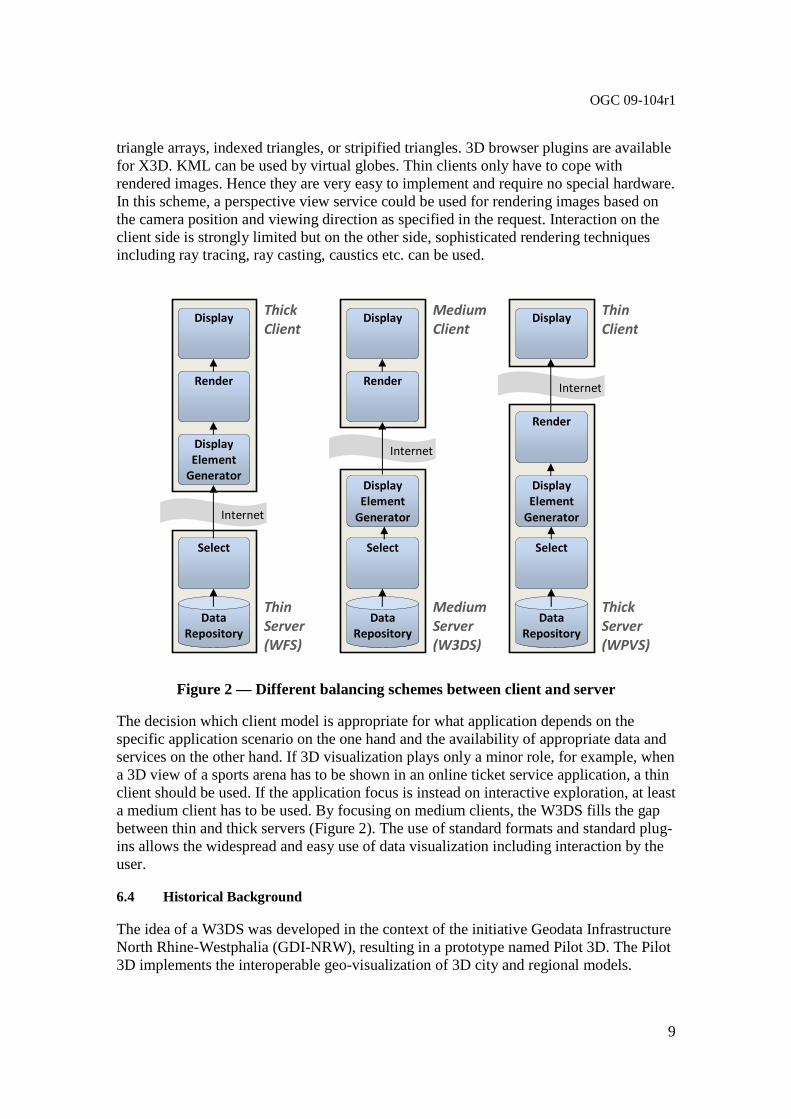
The components of the portrayal pipeline don’t have to reside on the same system; they can be distributed over the internet. However, in client-server applications the lower level components are typically installed on one or more servers while the remaining visualization tasks are handled by the client. According to their complexity clients are classified into thick, medium, and thin clients (Figure 2). Thick clients communicate on the feature level with the server. The advantage is that the client is free to realize any – including very complex - interaction schemes and analytic functions. The drawback, at least regarding web applications, is the high computing, memory, and bandwidth requirements for processing GML 3D data. Medium clients download display elements which can be easily processed by the graphics hardware. Geometries usually consist of
LowerCorner 0,0
1,2 1,1
0,1 0,2
1,0
Tile Indices
(TileRow, TileCol)
Tile Size
Tile Size
TileCol Axis
TileRow Axis
2,0 2,1 2,2
…
…
OGC 09-104r1
9
triangle arrays, indexed triangles, or stripified triangles. 3D browser plugins are available for X3D. KML can be used by virtual globes. Thin clients only have to cope with rendered images. Hence they are very easy to implement and require no special hardware. In this scheme, a perspective view service could be used for rendering images based on the camera position and viewing direction as specified in the request. Interaction on the client side is strongly limited but on the other side, sophisticated rendering techniques including ray tracing, ray casting, caustics etc. can be used.
Figure 2 — Different balancing schemes between client and server
The decision which client model is appropriate for what application depends on the specific application scenario on the one hand and the availability of appropriate data and services on the other hand. If 3D visualization plays only a minor role, for example, when a 3D view of a sports arena has to be shown in an online ticket service application, a thin client should be used. If the application focus is instead on interactive exploration, at least a medium client has to be used. By focusing on medium clients, the W3DS fills the gap between thin and thick servers (Figure 2). The use of standard formats and standard plug-ins allows the widespread and easy use of data visualization including interaction by the user.
6.4 Historical Background
The idea of a W3DS was developed in the context of the initiative Geodata Infrastructure North Rhine-Westphalia (GDI-NRW), resulting in a prototype named Pilot 3D. The Pilot 3D implements the interoperable geo-visualization of 3D city and regional models.
Display
Render
Select
Display
Element
Generator
Internet
Data
Repository
Thick
Client
Thin
Server
(WFS)
Display
Render
Select
Display
Element
Generator
Internet
Data
Repository
Medium
Client
Medium
Server
(W3DS)
Display
Render
Select
Display
Element
Generator
Internet
Data
Repository
Thin
Client
Thick
Server
(WPVS)

OGC 09-104r1
10
Several W3DS implementations are already running and experiences made during the test phase are reflected in this draft specification.
The W3DS discussion paper was picked up in the GDI-3D project carried out at the University of Bonn as a central service for providing city and landscape models in a distributed Spatial Data Infrastructure (SDI-3D). Concepts on how to integrate a range of other OGC services including OpenLS (Geocoder, Routing Service, Directory Service), WFS, CS-W, WPS, and SOS in such a 3D infrastructure were developed and shown in an integrated client. The W3DS was also included in the OGC OWS-6 initiative as experimental interface for providing LOD4 indoor models.
6.5 W3DS Interface
The W3DS interface (currently) specifies 5 operations that can be requested by a client and performed by a W3DS server. Those operations are:
a) GetCapabilities – This operation allows a client to request and receive back service metadata (or Capabilities) documents that describe the abilities of the specific server implementation. This operation also supports negotiation of the standard version being used for client-server interactions.
b) GetScene – This operation allows a client to retrieve 3D Scenes.
c) GetFeatureInfo – This operation allows a client to retrieve attribute data of selected features.
d) GetLayerInfo – This operation allows a client to retrieve information on available attribute names and values of a selected layer.
e) GetTile – This operation allows a client to retrieve single tiles using indices.
These operations have many similarities to other OGC Web Services, including the WMS, WFS, and WCS. Many of these interface aspects that are common with other OWSs are thus specified in the OpenGIS® Web Services Common Implementation Specification [OGC 06-121r3]. Many of these common aspects are normatively referenced herein, instead of being repeated in this standard.
Figure 3 is a simple UML diagram summarizing the W3DS interface. This class diagram shows that the W3DS interface class inherits the getCapabilities operation from the OGCWebService interface class, and adds the GetScene, GetFeatureInfo, GetLayerInfo, and GetTile operations. (This capitalization of names uses the OGC/ISO profile of UML.) A more complete UML model of the W3DS interface is provided in Annex C (informative).

OGC 09-104r1
11
Figure 3 — W3DS interface UML diagram NOTE In this UML diagram, the request and response for each operation is shown as a single parameter that is a data structure containing multiple lower-level parameters, which are discussed in subsequent clauses. The UML classes modeling these data structures are included in the complete UML model in Annex C.
Each of the W3DS operations is described in more detail in subsequent clauses.
6.6 Operation request encoding
The encoding of operation requests shall use HTTP GET with KVP encoding and HTTP POST with XML encoding as specified in Clause 11 of [OGC 06-121r3]. Table 2 summarizes the W3DS Service operations and their encoding methods defined in this standard.
Table 2 — Operation request encoding
Operation name Request encoding
GetCapabilities (required) KVP and optional XML
GetScene XML and optional KVP
GetFeatureInfo XML and optional KVP
GetLayerInfo XML and optional KVP
GetTile XML and optional KVP
OGCWebService {Abstract}
+ getCapabilities(request : GetCapabilities) : ServiceMetadata
(from OGC Web Service)
<<Interface>>
W3DService
+ getScene(request : GetScene) : GetSceneResponse + getFeatureInfo(request : GetFeatureInfo) : GetFeatureInfoResponse + getLayerInfo(request: GetLayerInfo) : GetLayerInfoResponse + getTile(request : GetTile) : GetTileResponse
Each server instance instantiates only one object of this class, and this object always exists while server is available

OGC 09-104r1
12
7 GetCapabilities operation (mandatory)
7.1 Introduction
The mandatory GetCapabilities operation allows clients to retrieve service metadata from a server. The response to a GetCapabilities request shall be an XML document containing service metadata about the server, including specific information about layer properties and how to access data from the server. This clause specifies the XML document that a W3DS server shall return to describe its capabilities.
7.2 Operation request
The GetCapabilities operation request shall be as specified in Subclauses 7.2 and 7.3 of [OGC 06-121r3]. The value of the “service” parameter shall be “W3DS”. The allowed set of service metadata (or Capabilities) XML document section names and meanings shall be as specified in Tables 3 and 7 of [OGC 06-121r3].
The “Multiplicity and use” column in Table 1 of [OGC 06-121r3] specifies the optionality of each listed parameter in the GetCapabilities operation request. Table 3 specifies the implementation of those parameters by W3DS clients and servers.
Table 3 — Implementation of parameters in GetCapabilities operation request
Names Multiplicity Client implementation Server implementation
service service
One (mandatory)
Each parameter shall be implemented by all clients, using specified value
Each parameter shall be implemented by all servers, checking that each parameter is received with specified value request
request One
(mandatory)
AcceptVersions AcceptVersions
Zero or one (optional)
Should be implemented by all software clients, using specified values
Shall be implemented by all servers, checking if parameter is received with specified value(s)
Sections Sections
Zero or one (optional) b
Each parameter may be implemented by each client b
If parameter not provided, shall expect default response
If parameter provided, shall allow default or specified response
Each parameter may be implemented by each server a
If parameter not implemented or not received, shall provide default response
If parameter implemented and received, shall provide specified response
updateSequence updateSequence
Zero or one (optional) b
AcceptFormats AcceptFormats
Zero or one (optional) b
All W3DS servers shall implement HTTP GET transfer of the GetCapabilities operation request, using KVP encoding. Servers may also implement HTTP POST transfer of the GetCapabilities operation request, using XML encoding only.
EXAMPLE 1 To request a W3DS capabilities document, a client could issue the following KVP encoded GetCapabilities operation request with near-minimum contents:
http://hostname:port/path?SERVICE=W3DS&REQUEST=GetC apabilities&ACCEPTVERSIONS=0.3.0,0.4.0&SECTIONS=Contents&UPDATESEQUENCE =XYZ123& ACCEPTFORMATS=text/xml
OGC 09-104r1
13
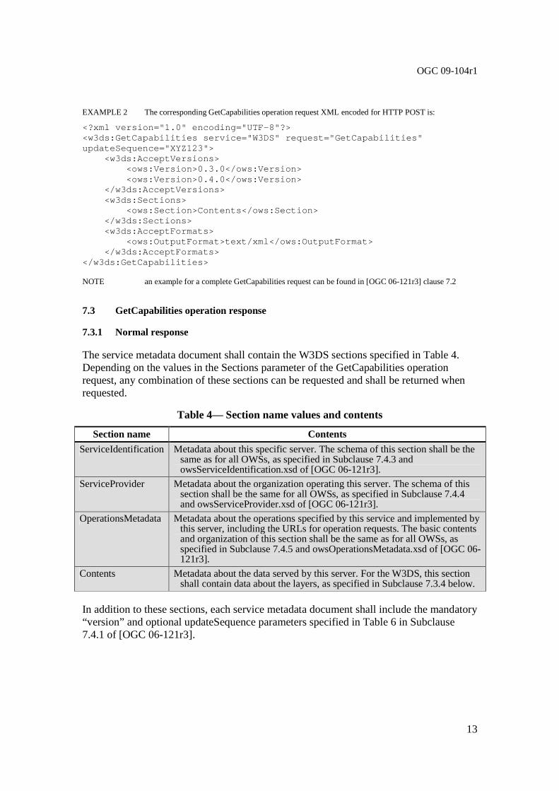
EXAMPLE 2 The corresponding GetCapabilities operation request XML encoded for HTTP POST is:
<?xml version="1.0" encoding="UTF-8"?> <w3ds:GetCapabilities service="W3DS" request="GetCa pabilities" updateSequence="XYZ123"> <w3ds:AcceptVersions> <ows:Version>0.3.0</ows:Version> <ows:Version>0.4.0</ows:Version> </w3ds:AcceptVersions> <w3ds:Sections> <ows:Section>Contents</ows:Section> </w3ds:Sections> <w3ds:AcceptFormats> <ows:OutputFormat>text/xml</ows:OutputForma t> </w3ds:AcceptFormats> </w3ds:GetCapabilities> NOTE an example for a complete GetCapabilities request can be found in [OGC 06-121r3] clause 7.2
7.3 GetCapabilities operation response
7.3.1 Normal response
The service metadata document shall contain the W3DS sections specified in Table 4. Depending on the values in the Sections parameter of the GetCapabilities operation request, any combination of these sections can be requested and shall be returned when requested.
Table 4— Section name values and contents
Section name Contents
ServiceIdentification Metadata about this specific server. The schema of this section shall be the same as for all OWSs, as specified in Subclause 7.4.3 and owsServiceIdentification.xsd of [OGC 06-121r3].
ServiceProvider Metadata about the organization operating this server. The schema of this section shall be the same for all OWSs, as specified in Subclause 7.4.4 and owsServiceProvider.xsd of [OGC 06-121r3].
OperationsMetadata Metadata about the operations specified by this service and implemented by this server, including the URLs for operation requests. The basic contents and organization of this section shall be the same as for all OWSs, as specified in Subclause 7.4.5 and owsOperationsMetadata.xsd of [OGC 06-121r3].
Contents Metadata about the data served by this server. For the W3DS, this section shall contain data about the layers, as specified in Subclause 7.3.4 below.
In addition to these sections, each service metadata document shall include the mandatory “version” and optional updateSequence parameters specified in Table 6 in Subclause 7.4.1 of [OGC 06-121r3].

OGC 09-104r1
14
7.3.2 OperationsMetadata section contents
For the W3DS, the OperationsMetadata section shall contain all parameters as specified in Subclause 7.4.5 and owsOperationsMetadata.xsd of [OGC 06-121r3], extending it by an optional UserDefinedSymbolization element.
Table 5 — Parts of OperationsMetadata section
Names Definition Multiplicity and use
operation Operation
Metadata for one operation that this server interface implements
One or more (mandatory) One for each implemented
operation
parameter Parameter
Parameter valid domain that applies to one or more operations which this server implements a
Zero or more (optional) One for each such parameter with
limited domain
constraint Constraint
Constraint on valid domain of a non-parameter quantity that applies to this server
Zero or more (optional) One for each such quantity with
limited domain
extendedCapabilities ExtendedCapabilities
Metadata about server and software additional abilities
Zero or one (optional) Included when server provides
additional capabilities a This parameter may be an input and/or output parameter of these operations.
Table 6 — Parts of Operation data structure
Names Definition Data type Multiplicity and use
Name name
Name of this operation (request) (for example, GetCapabilities)
Character string type, not empty
One (mandatory)
DCP DCP
Information for a Distributed Computing Platform (DCP) supported for this operation
DCP data structure, See [OGC 06-121r3] Table 15
One or more (mandatory)
One for each supported DCP for this operation request a
parameter Parameter
Parameter valid domain that applies to this operation which this server implements b
ows:DomainType, See [OGC 06-121r3] Table 36
Zero or more (optional)
One for each such parameter with limited domain
constraint Constraint
Constraint on valid domain of a non-parameter quantity that applies to this operation which this server implements c
ows:DomainType, See [OGC 06-121r3] Table 36
Zero or more (optional)
One for each such quantity with limited domain
metadata Metadata
Metadata about this operation and its
Metadata contents or reference to metadata
Zero or more (optional)

OGC 09-104r1
15
Names Definition Data type Multiplicity and use implementation d One for each such
metadata object a At present, only the HTTP DCP is defined, so the Operation subsection only includes one DCP subsection. b This parameter may be an input and/or output parameter of this operation. If one of these Parameter data structures has
the same parameter "name" as a Parameter subsection in the OperationsMetadata subsection, this Parameter subsection shall override the other one for this operation.
c If one of these Constraints has the same quantity "name" as a Constraint subsection in the OperationsMetadata section, this Constraint subsection shall override the other one for this operation.
d Each operation that uses some form of query or filtering should include metadata describing the query or filter languages and associated capabilities implemented by this server. The schema of this query languages metadata is (currently) specific to each OWS type, as defined by that Implementation Specification.
The mandatory values of various (XML) attributes shall be as specified in Table 7. Similarly, the optional attribute values listed in Table 8 shall be included or not depending on whether that operation is implemented by that server. In Table 7 and Table 8, the “Attribute name” column uses dot-separator notation to identify parts of a parent item. The “Attribute value” column references an operation parameter, in this case an operation name, and the meaning of including that value is listed in the right column.
Table 7 — Required values of OperationsMetadata section attributes
Attribute name Attribute value Meaning of attribute value
Operation.name GetCapabilities The GetCapabilities operation is implemented by this server.
GetScene The GetScene operation is implemented by this server.
Table 8 — Optional values of OperationsMetadata section attributes
Attribute name Attribute value Meaning of attribute value
Operation.name GetFeatureInfo The GetFeatureInfo operation is implemented by this server.
GetLayerInfo The GetLayerInfo operation is implemented by this server.
GetTile The GetTile operation is implemented by this server. In addition to the values listed in Table 7 and Table 8, there are many optional values of the “name” attributes and “value” elements in the OperationsMetadata section, which may be included when considered useful. Most of these attributes and elements are for recording the domains of various parameters and quantities.
EXAMPLE 1 The domain of the exceptionCode parameter could record all the codes implemented for each operation by that specific server. Similarly, each of the GetCapabilities operation optional request parameters might have its domain recorded.
EXAMPLE 2 The domain of the Sections parameter in the GetCapabilities operation request could record all the sections implemented by that specific server.

OGC 09-104r1
16
7.3.2.1 HTTP Encoding
All W3DS servers shall specify the encodings that may be sent using HTTP GET or HTTP POST transfer of operation requests. Specifically, an ows:Constraint element shall be included, with either “GetEncoding” or “PostEncoding” as the value of the “name” attribute and specifying different allowed values for each allowed encoding:
a) The value “SOAP” shall indicate that SOAP encoding is allowed when using HTTP POST transfer. The value “SOAP” is only valid for “PostEncoding”.
b) The value “XML” shall indicate that XML encoding is allowed (without SOAP message encapsulation), when using HTTP POST transfer. The value “XML” is only valid for “PostEncoding”.
c) The value “KVP” shall indicate that KVP encoding is allowed. The value “KVP” is valid for “GetEncoding” and “PostEncoding”.
If the HTTP connect point URL is different for different encodings of the operation requests, this ows:Constraint element shall be included in each Post element. If the connect point URL is the same for all encodings of all operation requests, this ows:Constraint element shall be included in the OperationsMetadata element.
7.3.2.2 Parameter values
All W3DS servers shall specify the possible encodings of the responses for each supported operation as specified in Table 5 and Table 6 if additional encodings to the default encoding are available. Specifically, ows:Parameter elements shall be included, with the parameter name in the “name” attribute and the allowed encodings as list of ows:Value elements. If ows:Parameter elements are included, the default encodings shall be included in the list.
An ows:Parameter element with name “ContentEncoding” shall specify whether the content has an additional encoding beyond that present in the media if the operation was successful. Most commonly this indicates that the content can be compressed with gzip or other compression methods. The default value for all operations is plain, meaning that no compression is performed.
An ows:Parameter element with name “ExceptionFormat” shall specify the possible MIME types of the response if the operation failed. The default MIME type for all operations is “text/xml”. The special format “blank” may be applied to the GetScene and the GetTile operation.
Example for Parameter elements of the GetScene operation:
<ows:Parameter name="ContentEncoding"> <ows:AllowedValues>
<ows:Value>plain</ows:Value> <ows:Value>gzip</ows:Value>
OGC 09-104r1
17
</ows:AllowedValues> </ows:Parameter> <ows:Parameter name="ExceptionFormat">
<ows:AllowedValues> <ows:Value>text/xml</ows:Value> <ows:Value>text/plain</ows:Value> <ows:Value>blank</ows:Value>
</ows:AllowedValues> </ows:Parameter>
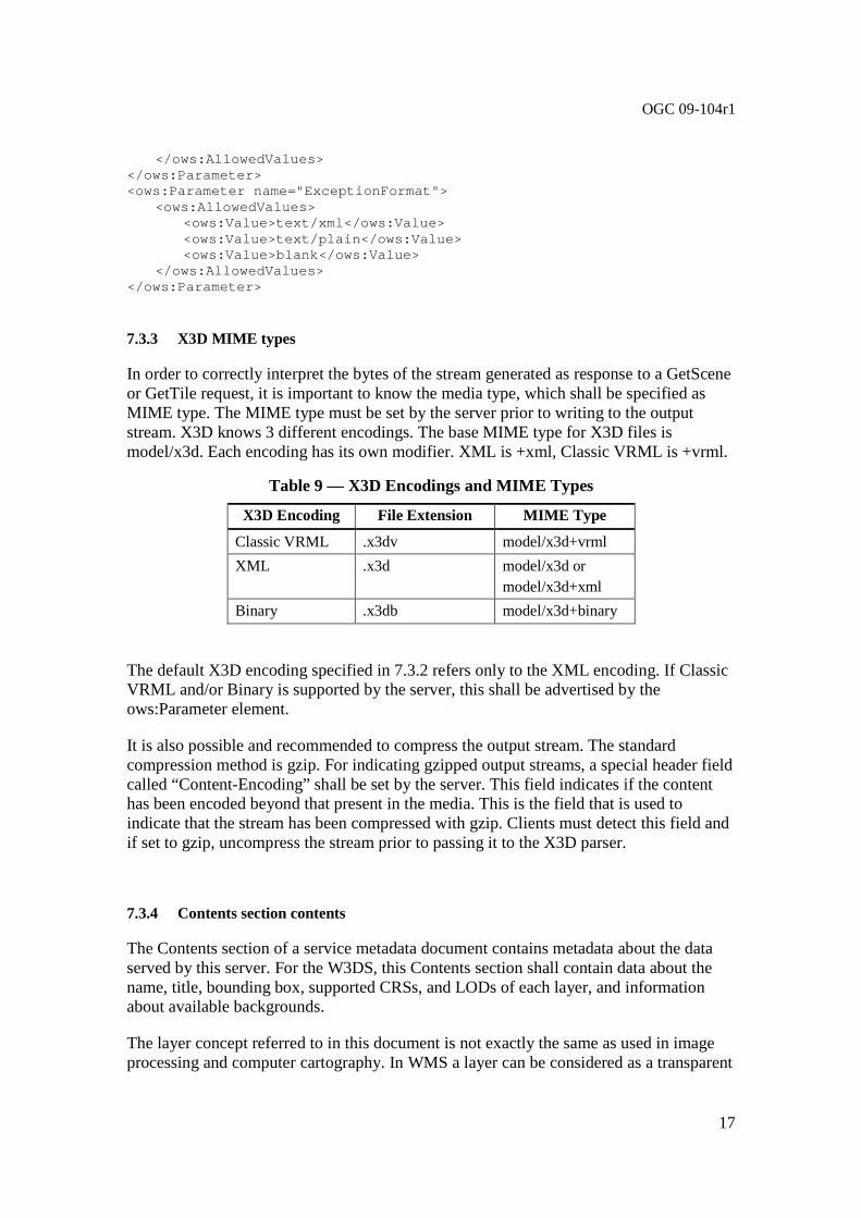
7.3.3 X3D MIME types
In order to correctly interpret the bytes of the stream generated as response to a GetScene or GetTile request, it is important to know the media type, which shall be specified as MIME type. The MIME type must be set by the server prior to writing to the output stream. X3D knows 3 different encodings. The base MIME type for X3D files is model/x3d. Each encoding has its own modifier. XML is +xml, Classic VRML is +vrml.
Table 9 — X3D Encodings and MIME Types
X3D Encoding File Extension MIME Type
Classic VRML .x3dv model/x3d+vrml
XML .x3d model/x3d or model/x3d+xml
Binary .x3db model/x3d+binary
The default X3D encoding specified in 7.3.2 refers only to the XML encoding. If Classic VRML and/or Binary is supported by the server, this shall be advertised by the ows:Parameter element.
It is also possible and recommended to compress the output stream. The standard compression method is gzip. For indicating gzipped output streams, a special header field called “Content-Encoding” shall be set by the server. This field indicates if the content has been encoded beyond that present in the media. This is the field that is used to indicate that the stream has been compressed with gzip. Clients must detect this field and if set to gzip, uncompress the stream prior to passing it to the X3D parser.
7.3.4 Contents section contents
The Contents section of a service metadata document contains metadata about the data served by this server. For the W3DS, this Contents section shall contain data about the name, title, bounding box, supported CRSs, and LODs of each layer, and information about available backgrounds.
The layer concept referred to in this document is not exactly the same as used in image processing and computer cartography. In WMS a layer can be considered as a transparent

OGC 09-104r1
18
sheet with features drawn upon it. The order in which layers are drawn on the map is important because the features may overlap. The order determines what will be visible and what will be hidden. In 3D scenes, the order in which features are drawn on the screen is irrelevant and the visibility is determined solely by the distance to the virtual viewpoint. Features overlap based on the spatial position of the triangles which make up the feature geometries. The layer concept is comparable to the FeatureType in WFS. However, we keep the term layer because it is commonly understandable and in order to make a distinction between WFS, which serves feature for being processed in GIS software and portrayal services, which serve images and display elements for end users.
The Contents section shall include the parameters specified in Table 10 through Table 16.
Table 10 — Parameters included in Contents section
Names Definition Data type and values Multiplicity and use
Layer Meta data describing a data set available from this server
Layer data structure, see Table 11
Zero or more (optional)
Background Meta data describing a background available for a GetScene request
Background data structure, see Table 16
Zero or more (optional)

OGC 09-104r1
19
Figure 4 —UML model of W3DS contents section
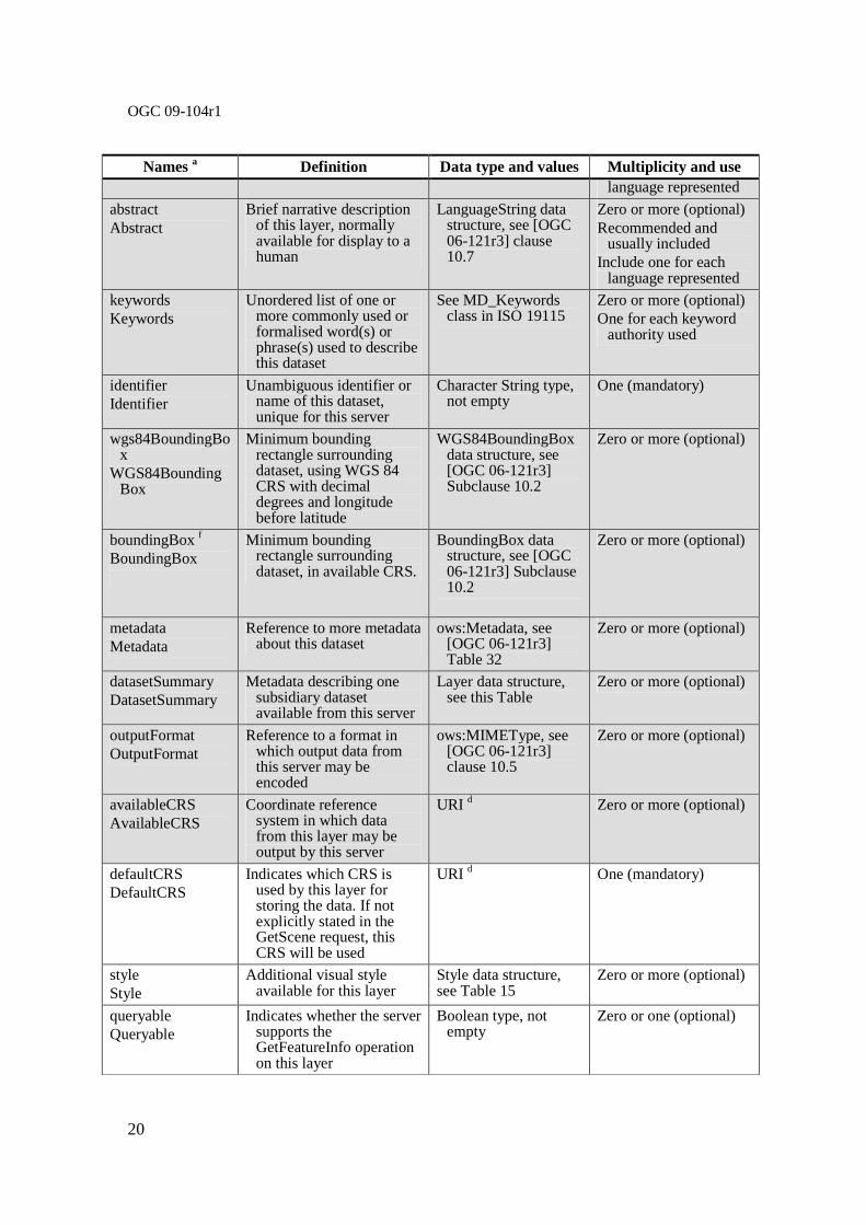
Table 11 — Parts of Layer data structure
Names a Definition Data type and values Multiplicity and use
title Title
Title of this layer, normally used for display to a human
LanguageString data structure, see [OGC 06-121r3] clause 10.7
Zero or more (optional) Recommended and
usually included c Include one for each
1 0..*
+ keywords
+ metadata [0..1]: Any + link [0..1]: URL
+ about [0..1]: URI
Metadata (from OWS Common)
+ metadata
<<DataType>>
Contents
Identification (from OWS Data Identitfication)
+ outputFormat [0..*] : CharacterString
+ availableCRS [0..*] : CharacterString
BasicIdentification (from OWS Data Identitfication)
+ title [0..*] : LanguageString
+ abstract [0..*] : LanguageString
Keywords (from ISO 19115 subset)
+ keyword [1..*] : LanguageString
+ layer
1
0..*
1
0..1 0..1
0..*
<<DataType>> LanguageString
(from ISO 19115 subset)
+ value : CharacterString
+ lang [0..1] : CharacterString
+ code : CharacterString + codeSpace [0..1]: URI
+ type
Code (from ISO 19115 subset)
1
1
Layer
+ defaultCRS : anyURI + queriable [0..1] : Boolean Type
+ cascaded [0..1] : Integer Type + tiled [0..1] : Boolean Type
+ minScaleDenominator [0..1] : Double + maxScaleDenominator [0..1] : Double
+ startTime [0..1] : Date Type + endTime [0..1] : Date Type
<<DataType>>
BoundingBox (From OWS Common)
+ lowerCorner : Sequence <Number>
+ upperCorner : Sequence <Number> + crs [0..1]: URI + dimensions [0..1] : PositiveInteger
+ boundingBox
+ identifier
+ isDefault [0..1]: Boolean Type
Style
+ style
1
0..*
Background
1
0..*
+ background
+ datasetSummary 1
0..*
+ isDefault [0..1]: Boolean Type
+ lodValue : URI
+ defaultRange : Double
LOD
+ lod 0..*
LODSet
+ lodSet
1
0..1
+ crs : URI
+ tileSizes : Sequence<Number>
+ lowerCorner : Sequence<Number,2>
TileSet
+ tileSet
1
0..1
0..*
1
0..*
1
1
DatasetSummary
+ lowerCorner : Sequence <Number, 2>
+ upperCorner : Sequence <Number, 2> + crs [0..1]: URI="urn:ogc:def:crs:CRS::84"
+ dimensions [0..1] PositiveInteger=2
<<DataType>> WGS84BoundingBox (From OWS Common)
+ wgs84BoundingBox
0..* 1
OGC 09-104r1
20
Names a Definition Data type and values Multiplicity and use language represented
abstract Abstract
Brief narrative description of this layer, normally available for display to a human
LanguageString data structure, see [OGC 06-121r3] clause 10.7
Zero or more (optional) Recommended and
usually included Include one for each
language represented
keywords Keywords
Unordered list of one or more commonly used or formalised word(s) or phrase(s) used to describe this dataset
See MD_Keywords class in ISO 19115
Zero or more (optional) One for each keyword
authority used
identifier Identifier
Unambiguous identifier or name of this dataset, unique for this server
Character String type, not empty
One (mandatory)
wgs84BoundingBox
WGS84BoundingBox
Minimum bounding rectangle surrounding dataset, using WGS 84 CRS with decimal degrees and longitude before latitude
WGS84BoundingBox data structure, see [OGC 06-121r3] Subclause 10.2
Zero or more (optional)
boundingBox f BoundingBox
Minimum bounding rectangle surrounding dataset, in available CRS.
BoundingBox data structure, see [OGC 06-121r3] Subclause 10.2
Zero or more (optional)
metadata Metadata
Reference to more metadata about this dataset
ows:Metadata, see [OGC 06-121r3] Table 32
Zero or more (optional)
datasetSummary DatasetSummary
Metadata describing one subsidiary dataset available from this server
Layer data structure, see this Table
Zero or more (optional)
outputFormat OutputFormat
Reference to a format in which output data from this server may be encoded
ows:MIMEType, see [OGC 06-121r3] clause 10.5
Zero or more (optional)
availableCRS AvailableCRS
Coordinate reference system in which data from this layer may be output by this server
URI d Zero or more (optional)
defaultCRS DefaultCRS
Indicates which CRS is used by this layer for storing the data. If not explicitly stated in the GetScene request, this CRS will be used
URI d One (mandatory)
style Style
Additional visual style available for this layer
Style data structure, see Table 15
Zero or more (optional)
queryable Queryable
Indicates whether the server supports the GetFeatureInfo operation on this layer
Boolean type, not empty
Zero or one (optional)

OGC 09-104r1
21
Names a Definition Data type and values Multiplicity and use
cascaded Cascaded
Indicates whether the data of this layer was obtained from another server
Integer type, not empty
Zero or one (optional)
tiled Tiled
Indicates whether the data of this layer is available as set of rectangular tiles
Boolean type, not empty
Zero or one (optional)
minScaleDenominator
MinScaleDenominator
Minimum scale denominator at which it is useful to display data of this layer
Double type, not empty
Zero or one (optional)
maxScaleDenominator
MaxScaleDenominator
Maximum scale denominator at which it is useful to display data of this layer
Double type, not empty
Zero or one (optional)
lodSet LODSet
Description of available discrete LODs of this layer
LODSet data structure, see Table 12
Zero or one (optional)
tileSet TileSet
Description of spatial partitioning into rectangular tiles
TileSet data structure, see Table 14
Zero or one (optional)
startTime StartTime
Earliest data and time at which features are available
Date type, not empty. Data type defined in ISO 8601:2004(E)
Zero or one (optional)
endTime EndTime
Latest data and time at which features are available
Date type, not empty. Data type defined in ISO 8601:2004(E)
Zero or one (optional)
a Although some values listed in the “Name” column appear to contain spaces, they shall not contain spaces. c Software may display the “Identifier” value when the “Title” is absent d The CRS shall be specified using either the European Petroleum Survey Group form ”'EPSG:<POSC Code>” or the
URL format defined in OWS Common. Examples: “EPSG:31467”, "urn:ogc:def:crs:EPSG:6.3:31467 ", see [OGC 06-121r3] clause 10.3 and [OGC 04-046r3]
e The LOD shall be specified using a combination of a prefix and a number, e.g. “CityGML:4” for indoor models f There is no provision for describing disjoint bounding boxes like in WFS
7.3.4.1 OutputFormat
The element OutputFormat specifies a possible Format which can be used for encoding the contents of the layer. The Format is specified as MIME type.
7.3.4.2 AvailableCRS
The element AvailableCRS describes the possible CRSs that can be accepted if the GetScene operation or GetTile operation contains a CRS parameter. The values shall be specified using either the European Petroleum Survey Group form ”EPSG:<POSC Code>” or the URI format defined in OWS Common (for instance "urn:ogc:def:crs:EPSG:6.3:31467", or simply “EPSG:31467”) , see [OGC 06-121r3] clause 10.3 and [OGC 04-046r3].

OGC 09-104r1
22
7.3.4.3 Styles
Each layer may advertise additional styles (server styles) which modify the appearance and characteristics of the underlying data set. The style's Identifier is used in the GetScene request Styles parameter. If only a single style is available, that style is known as the “default” style and need not be advertised by the server. The data structure of Style is listed in Table 15. Each style consists of an Identifier, a Title which may be presented to the user, an Abstract and a list of Keywords. The Abstract should give a brief narrative description of how the visualization is influenced by the style.
Styles usually affect the symbolization of features, for example, the materials can be replaced by another material, including diffuse color, reflection properties, and transparency as defined in the style. Styling can also take the feature attribute values as input for distinguishing features of different categories by color. Styling may also apply different symbols to point and line features including geometric primitives, billboards, textures, and complex 3D proto types. The size of these symbols may be scaled according on feature attribute values. It is recommended to use the Symbology Encoding (SE) and Filter Encoding (FE) as basis for defining server styles (see [OGC 04-095] and [OGC 05-077r4]), and extend the capabilities for styling 3D objects (see [OGC 09-042]).
7.3.4.4 Queryable
The boolean attribute Queryable indicates whether the server supports the GetFeatureInfo operation on that layer. A server may support GetFeatureInfo on some of its layers, but need not support it on all layers. A server shall issue a service exception (code="LayerNotQueryable") if GetFeatureInfo is requested on a Layer that is not queryable.
7.3.4.5 Cascaded
A layer is said to have been “cascaded” if it was obtained from an originating server and then included in the service metadata of a different server. The second server may simply offer an additional access point for the Layer, or may add value by offering additional output formats or re-projection to other CRSs. If a W3DS cascades the content of another W3DS, then it shall increment by 1 the value of the cascaded attribute for the affected layers. If that attribute is missing from the originating server’s service metadata, then the Cascading WMS shall insert the attribute and set it to 1.
7.3.4.6 Tiled
The boolean attribute Tiled indicates whether the server supports the GetTile operation on that layer. A server may support GetTile on some of its layers, but need not support it on all layers. A server shall issue a service exception (code="LayerNotTiled") if GetTile is requested on a layer that is not tiled. If the attribute Tiled is set to true, then also a TileSet shall be defined for this layer. A server shall issue a service exception (code="TileSetNotDefined") if GetTile is requested on a layer that is tiled, but has no TileSet definition.
OGC 09-104r1
23
7.3.4.7 Scale Denominators
The <MinScaleDenominator> and <MaxScaleDenominator> elements define the range of scales for which it is appropriate to generate a map of a Layer. Although the concept of scale originates from 2D map displays, it is not altogether wrong for 3D computer graphics. 3D features are also drawn on the screen with a certain scale. The scale is not explicitly set for a specific scene because the view parameters are defined by other values, however it may be calculated. Moreover, the scale is not uniformly distributed on the screen; it can vary by several magnitudes. It depends on many factors that make this calculation very difficult. The factors include the screen pixel distance, resolution, the projection transformation function (parallel, perspective, distorted or other projections), distance of the object to the virtual camera position, field of view, viewing angles, etc.
Therefore, the <MinScaleDenominator> and <MaxScaleDenominator> elements should be considered as hints for the client in order to determine whether it makes sense to display the layer within a particular scene, not as hard limits. For instance, a layer containing a very big but low detail landscape model can include very high values as minimum and maximum scale denominators in its service meta data.
7.3.4.8 LODSet
The LODSet child node describes a set of Levels of Detail that can be provided by the layer. A layer may contain objects in several representations to choose from. In this document, the term LOD always refers to the concept of Discrete LODs, meaning that multiple representations are available for an object. These representations do not share any vertices or other geometric elements. For instance a building may be represented as simple box geometry, as geometry with additional façade textures, as group containing elements for walls, roofs, windows, doors, or even containing the complete room interior. Each of these representations describes the same object and can be therefore stored in the same layer. However, it is not necessary that all LODs are consistently available for each object. A Client may assemble his scene graph from subsets of the same layer with different LODs and thus reduce the workload of the graphics pipeline.
Each LOD is described in a separate LOD node containing a unique identifier (unique to the containing layer, since LOD nodes must not be cross-referenced by other layers), title, description, and the actual value or magnitude of the LOD. This value is a URI consisting of a prefix and the actual numeric value, separated by a colon, e.g. "CityGML:1". The prefix indicates the spectrum of possible values and how these values must be interpreted. The LOD definitions of CityGML can be found in [08-007r1] clause 6.2. The prefix is optional; if it is omitted then also colon must be omitted and the value must be a floating point number. The numeric value indicates the actual “level” of detail on an ordinal scale. The scale values have a total order, which is connexive (a > b or a < b or a = b) and transitive (a > b > c implies a > c), but no interval or metric may be derived from the values. For instance, “CityGML:4” is more accurate than “CityGML:2”, but not necessarily twice as accurate. The order of the LOD nodes within the LODSet is not defined, but it is recommended to use an order increasing by the LODValue, from lower to higher levels of detail.

OGC 09-104r1
24
In case of multiple LODs, a special group node (e.g. X3D LOD node) may be defined containing all levels as child nodes. The group node acts as a switch and selects one of the child node depending on the distance to the current viewpoint. In order to function properly, this LOD node requires threshold values which are compared to the current distance. The behavior of the server to group all available LODs into an LOD node can be triggered by setting the GetScene parameter LODSelection to “combined”. The threshold values will be taken from the DefaultRange value in the LOD data structure (see Table 13). The DefaultRange value refers to the distance in meters at which the LOD will become visible.
7.3.4.9 TileSet
In some cases it is useful to configure and provide data as set of adjacent rectangular tiles. These tiles may be accessed using indices for tile level, row and column in a GetTile request. In order to enable a GetTile request on the layer, a TileSet definition must be provided which contains information on the spatial alignment of available tiles.
A TileSet consists of multiple levels, each having a different tile size. The tile sizes are strictly related by powers of two, meaning that the next higher level must have a tile size which is exactly half of the tile size of the next lower level. Tile sizes are defines as a list (element TileSizes) of double precision floating point numbers, separated by space. This list is ordered by decreasing tile size. The tile level index corresponds with the position in the TileSizes list, starting at zero.
Each tile level can be described as a grid with origin at the LowerCorner coordinate, which is the lower left or south east corner of the extent covering all data in the layer. The LowerCorner is defined only once in a TileSet. Each tile level therefore shares the same origin. For example, tile level n is defined by a grid originating at LowerCorner and grid size of value n in the TileSizes list. Tile extends are between the grid lines.
This data structure is comparable to an image pyramid or quad tree. Each tile is divided into four quarters in the next higher level representing a higher degree of accuracy. This concept is often used for surface data (terrain, geological strata) and enables continuous multiresolution surface representations.
Example:
<w3ds:TileSet> <ows:Identifier>dem_tileset</ows:Identifier>
<w3ds:CRS>EPSG:4326</w3ds:CRS> <w3ds:TileSizes>180 90 45 22.5 11.25 5.625 2.8125 1 .40625 0.703125 0.3515625 0.17578125</w3ds:TileSizes> <w3ds:LowerCorner>-180.0 -90.0</w3ds:LowerCorner>
</w3ds:TileSet>
7.3.4.10 StartTime and EndTime
The StartTime and EndTime elements can be used to indicate the availability of historical content in a layer. Features may exist only within a defined historical time span. If the

OGC 09-104r1
25
date of construction and/or date of demolition of each building is available, then a reconstruction of past cityscapes becomes possible or the development over time can be analyzed by submitting a series of GetScene requests with different times. Features may be also available in different representations showing temporal changes like extensions, renovations, decay etc. The data format of the Time parameters is defined in ISO 8601:2004(E) . If only one time parameter is included in the layer meta data, then the temporal availability is not limited to a specific time span. For instance, a building data set which is maintained by an authority and updated regularly may have a StartTime indicating the date at which the recording began, and no EndTime, since it must be possible to request the present situation.
Table 12 — Parts of LODSet data structure
Names a Definition Data type and values Multiplicity and use
lod LOD
Set of discrete LODs available for this layer
LOD data structure One or more (mandatory)
a Although some values listed in the “Name” column appear to contain spaces, they shall not contain spaces.
Table 13 — Parts of LOD data structure
Names a Definition Data type and values Multiplicity and use
title Title
Title of this LOD, normally used for display to a human
LanguageString data structure, see [OGC 06-121r3] clause 10.7
Zero or more (optional)
Recommended and usually included b
Include one for each language represented
abstract Abstract
Brief narrative description of this LOD, normally available for display to a human
LanguageString data structure, see [OGC 06-121r3] clause 10.7
Zero or more (optional)
Include one for each language represented
keywords Keywords
Unordered list of one or more commonly used or formalised word(s) or phrase(s) used to describe this dataset
See MD_Keywords class in ISO 19115
Zero or more (optional)
One for each keyword authority used
identifier Identifier
Unambiguous identifier or name of this LOD, unique for the containing layer
Character String type, not empty
One (mandatory)
metadata Metadata
Reference to more metadata about this dataset
ows:Metadata, see [OGC 06-121r3] Table 32
Zero or more (optional)
lodValue LODValue
Optional prefix plus value or magnitude of this LOD
URI One (mandatory)
defaultRange DefaultRange
Default distance threshold value in meters at which the LOD becomes visible
Double Type One (mandatory)

OGC 09-104r1
26
Names a Definition Data type and values Multiplicity and use
isDefault IsDefault
This LOD is used when no LOD is specified for this layer in the request
Boolean type Zero or one (optional) Default is false
a Although some values listed in the “Name” column appear to contain spaces, they shall not contain spaces. b Software may display the “Identifier” value when the “Title” is absent
Table 14 — Parts of TileSet data structure
Names a Definition Data type and values Multiplicity and use
identifier Identifier
Unambiguous identifier or name of this style, unique for this server
Character String type, not empty
One (mandatory)
crs CRS
CRS for which this TileSet is available and in which the data is natively stored on the server
URI One (mandatory)
tileSizes TileSizes
List of tile sizes ordered descending. The unit of the values in defined by the CRS
Ordered sequence of double values
One (mandatory)
lowerCorner LowerCorner
Coordinates of the lower left or south east corner of the tile matrix
Ordered sequence of double values b
One (mandatory) Usually corresponds
with the lowerCorner of the Layer’s BoundingBox
a Although some values listed in the “Name” column appear to contain spaces, they shall not contain spaces. b Only 2 axes shall be used representing east-west direction and south-north direction. The order of the axes and the
increasing direction is defined by the CRS
Table 15 — Parts of Style data structure
Names a Definition Data type and values Multiplicity and use
title Title
Title of this LOD, normally used for display to a human
LanguageString data structure, see [OGC 06-121r3] clause 10.7
Zero or more (optional)
Recommended and usually included b
Include one for each language represented
abstract Abstract
Brief narrative description of this LOD, normally available for display to a human
LanguageString data structure, see [OGC 06-121r3] clause 10.7
Zero or more (optional)
Include one for each language represented
keywords Keywords
Unordered list of one or more commonly used or formalised word(s) or phrase(s) used to describe this dataset
See MD_Keywords class in ISO 19115
Zero or more (optional)
One for each keyword authority used

OGC 09-104r1
27
Names a Definition Data type and values Multiplicity and use
identifier Identifier
Unambiguous identifier or name of this LOD, unique for the containing layer
Character String type, not empty
One (mandatory)
metadata Metadata
Reference to more metadata about this dataset
ows:Metadata, see [OGC 06-121r3] Table 32
Zero or more (optional)
isDefault IsDefault
This style is used when no style is specified for this layer in the request
Boolean type Zero or one (optional) Default is false
a Although some values listed in the “Name” column appear to contain spaces, they shall not contain spaces. b Software may display the “Identifier” value when the “Title” is absent
Table 16 — Parts of Background data structure
Names a Definition Data type and values Multiplicity and use
title Title
Title of this LOD, normally used for display to a human
LanguageString data structure, see [OGC 06-121r3] clause 10.7
Zero or more (optional)
Recommended and usually included b
Include one for each language represented
abstract Abstract
Brief narrative description of this LOD, normally available for display to a human
LanguageString data structure, see [OGC 06-121r3] clause 10.7
Zero or more (optional)
Include one for each language represented
keywords Keywords
Unordered list of one or more commonly used or formalised word(s) or phrase(s) used to describe this dataset
See MD_Keywords class in ISO 19115
Zero or more (optional)
One for each keyword authority used
identifier Identifier
Unambiguous identifier or name of this LOD, unique for the containing layer
Character String type, not empty
One (mandatory)
metadata Metadata
Reference to more metadata about this dataset
ows:Metadata, see [OGC 06-121r3] Table 32
Zero or more (optional)
a Although some values listed in the “Name” column appear to contain spaces, they shall not contain spaces. b Software may display the “Identifier” value when the “Title” is absent
The “Multiplicity and use” columns in Table 5, Table 6, Fehler! Verweisquelle konnte nicht gefunden werden., and Table 10 through Table 16 specify the optionality of each listed parameter and data structure in the GetCapabilities operation response. All the “mandatory” parameters and data structures shall be implemented by all W3DS servers, using a specified value(s).

OGC 09-104r1
28
All other “optional” parameters and data structures, in the GetCapabilities operation response, should be implemented by all W3DS servers using specified values, whenever and wherever each is considered useful information for that server.
7.3.5 Capabilities document XML encoding
A XML schema fragment for a W3DS service metadata document extends ows:CapabilitiesBaseType in owsCommon.xsd of [OGC 06-121r3], and is:
<!-- =========================================================== --> <element name="Capabilities" type="w3ds:CapabilitiesType"/> <!-- =========================================================== --> <complexType name="CapabilitiesType"> <complexContent> <extension base="ows:CapabilitiesBaseType"> <sequence> <element ref="w3ds:Contents" minOccurs="0"/> </sequence> </extension> </complexContent> </complexType> <!-- =========================================================== --> <element name="Contents" type="w3ds:ContentsType"/> <!-- =========================================================== --> <complexType name="ContentsType"> <complexContent> <extension base="ows:ContentsBaseType"> <sequence> <element name="Background" type="w3ds:BackgroundType" minOccurs="0" maxOccurs="unbounded"/> <element name="Layer" type="w3ds:LayerType" minOccurs="0" maxOccurs="unbounded"/> </sequence> </extension> </complexContent> </complexType>
As indicated, this XML Schema Document uses the owsServiceIdentification.xsd, owsServiceProvider.xsd, and owsOperationsMetadata.xsd schemas specified in [OGC 06-121r3]. It also uses an XML Schema Document for the “Contents” section of the W3DS Capabilities XML document, which shall be as attached in the w3dsCapabilities.xsd file. All these XML Schema Documents contain documentation of the meaning of each element, attribute, and type, and this documentation shall be considered normative as specified in Subclause 11.6.3 of [OGC 06-121r3].
7.3.6 Capabilities document example
In response to GetCapabilities operation request, a W3DS server might generate a document that looks like:
<?xml version="1.0" encoding="UTF-8"?>

OGC 09-104r1
29
<w3ds:Capabilities xmlns="http://www.opengis.net/w3 ds/0.4.0" xmlns:w3ds="http://www.opengis.net/w3ds/0.4.0" xmlns:ows="http://www.opengis.net/ows/1.1" xmlns:xlink="http://www.w3.org/1999/xlink" xsi:schemaLocation="http://www.opengis.net/w3ds/0.4 .0/w3dsCapabilities.xsd" version="0.4.0"> <ows:ServiceIdentification> <ows:Title xml:lang="en">Web 3D Service Ref erence Implementation</ows:Title> <ows:Abstract xml:lang="en">W3DS containing some sample data for very detailed 3D city models and an terrain mod el</ows:Abstract> <ows:Keywords> <ows:Keyword>City Model</ows:Keyword> <ows:Keyword>3D</ows:Keyword> <ows:Keyword>Digital Elevation Model</o ws:Keyword> <ows:Keyword>Scene Graph</ows:Keyword> </ows:Keywords> <ows:ServiceType>OGC W3DS</ows:ServiceType> <ows:ServiceTypeVersion>0.4.0</ows:ServiceT ypeVersion> <ows:Fees>none</ows:Fees> <ows:AccessConstraints>none</ows:AccessCons traints> </ows:ServiceIdentification> <ows:ServiceProvider> <ows:ProviderName>University of Bonn, Depar tment of Geography, Cartography</ows:ProviderName> <ows:ProviderSite xlink:href="http://www.gi ub.uni-bonn.de/karto"/> <ows:ServiceContact> <ows:IndividualName>Arne Schilling</ows :IndividualName> <ows:PositionName>Senior Engineer</ows: PositionName> <ows:ContactInfo> <ows:Phone> <ows:Voice>+49 0228 73 2401</ow s:Voice> <ows:Facsimile>+49 0228 73 2401 </ows:Facsimile> </ows:Phone> <ows:Address> <ows:DeliveryPoint>University o f Bonn</ows:DeliveryPoint> <ows:City>Bonn</ows:City> <ows:AdministrativeArea>NRW</ows:AdministrativeArea > <ows:PostalCode>53115</ows:Post alCode> <ows:Country>Germany</ows:Count ry> <ows:ElectronicMailAddress>[email protected] -bonn.de</ows:ElectronicMailAddress> </ows:Address> </ows:ContactInfo> </ows:ServiceContact> </ows:ServiceProvider> <ows:OperationsMetadata> <ows:Operation name="GetCapabilities"> <ows:DCP> <ows:HTTP> <ows:Get xlink:href="http://gdi 3d.giub.uni-bonn.de/W3DS_AIRPORT/W3DS?"> <ows:Constraint name="GetEn coding"> <ows:AllowedValues>
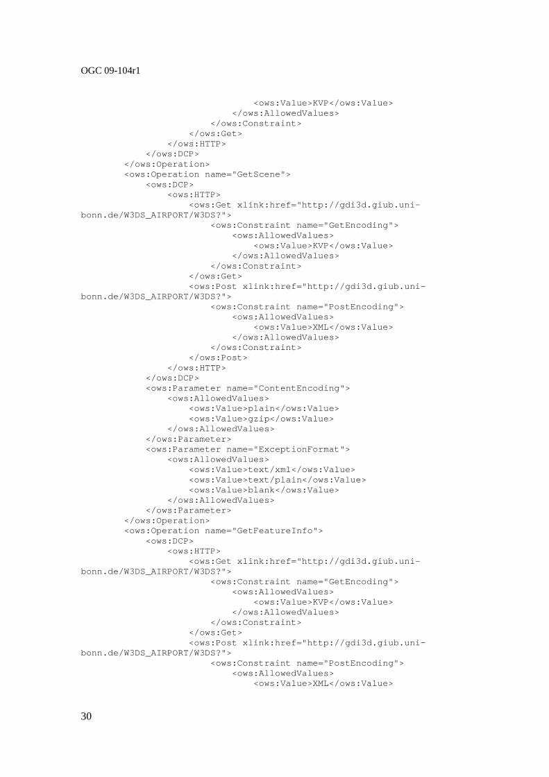
OGC 09-104r1
30
<ows:Value>KVP</ows :Value> </ows:AllowedValues> </ows:Constraint> </ows:Get> </ows:HTTP> </ows:DCP> </ows:Operation> <ows:Operation name="GetScene"> <ows:DCP> <ows:HTTP> <ows:Get xlink:href="http://gdi 3d.giub.uni-bonn.de/W3DS_AIRPORT/W3DS?"> <ows:Constraint name="GetEn coding"> <ows:AllowedValues> <ows:Value>KVP</ows :Value> </ows:AllowedValues> </ows:Constraint> </ows:Get> <ows:Post xlink:href="http://gd i3d.giub.uni-bonn.de/W3DS_AIRPORT/W3DS?"> <ows:Constraint name="PostE ncoding"> <ows:AllowedValues> <ows:Value>XML</ows :Value> </ows:AllowedValues> </ows:Constraint> </ows:Post> </ows:HTTP> </ows:DCP> <ows:Parameter name="ContentEncoding"> <ows:AllowedValues> <ows:Value>plain</ows:Value> <ows:Value>gzip</ows:Value> </ows:AllowedValues> </ows:Parameter> <ows:Parameter name="ExceptionFormat"> <ows:AllowedValues> <ows:Value>text/xml</ows:Value> <ows:Value>text/plain</ows:Valu e> <ows:Value>blank</ows:Value> </ows:AllowedValues> </ows:Parameter> </ows:Operation> <ows:Operation name="GetFeatureInfo"> <ows:DCP> <ows:HTTP> <ows:Get xlink:href="http://gdi 3d.giub.uni-bonn.de/W3DS_AIRPORT/W3DS?"> <ows:Constraint name="GetEn coding"> <ows:AllowedValues> <ows:Value>KVP</ows :Value> </ows:AllowedValues> </ows:Constraint> </ows:Get> <ows:Post xlink:href="http://gd i3d.giub.uni-bonn.de/W3DS_AIRPORT/W3DS?"> <ows:Constraint name="PostE ncoding"> <ows:AllowedValues> <ows:Value>XML</ows :Value>

OGC 09-104r1
31
</ows:AllowedValues> </ows:Constraint> </ows:Post> </ows:HTTP> </ows:DCP> </ows:Operation> <ows:Operation name="GetLayerInfo"> <ows:DCP> <ows:HTTP> <ows:Get xlink:href="http://gdi 3d.giub.uni-bonn.de/W3DS_AIRPORT/W3DS?"> <ows:Constraint name="GetEn coding"> <ows:AllowedValues> <ows:Value>KVP</ows :Value> </ows:AllowedValues> </ows:Constraint> </ows:Get> <ows:Post xlink:href="http://gd i3d.giub.uni-bonn.de/W3DS_AIRPORT/W3DS?"> <ows:Constraint name="PostE ncoding"> <ows:AllowedValues> <ows:Value>XML</ows :Value> </ows:AllowedValues> </ows:Constraint> </ows:Post> </ows:HTTP> </ows:DCP> </ows:Operation> <ows:Operation name="GetTile"> <ows:DCP> <ows:HTTP> <ows:Get xlink:href="http://gdi 3d.giub.uni-bonn.de/W3DS_AIRPORT/W3DS?"> <ows:Constraint name="GetEn coding"> <ows:AllowedValues> <ows:Value>KVP</ows :Value> </ows:AllowedValues> </ows:Constraint> </ows:Get> <ows:Post xlink:href="http://gd i3d.giub.uni-bonn.de/W3DS_AIRPORT/W3DS?"> <ows:Constraint name="PostE ncoding"> <ows:AllowedValues> <ows:Value>XML</ows :Value> </ows:AllowedValues> </ows:Constraint> </ows:Post> </ows:HTTP> </ows:DCP> <ows:Parameter name="ContentEncoding"> <ows:AllowedValues> <ows:Value>plain</ows:Value> <ows:Value>gzip</ows:Value> </ows:AllowedValues> </ows:Parameter> <ows:Parameter name="ExceptionFormat"> <ows:AllowedValues> <ows:Value>text/xml</ows:Value>

OGC 09-104r1
32
<ows:Value>text/plain</ows:Valu e> <ows:Value>blank</ows:Value> </ows:AllowedValues> </ows:Parameter> </ows:Operation> <ows:ExtendedCapabilities SupportSLD="true" UserLayer="false" UserStyle="true" RemoteWFS="false" InlineFeature="f alse"/> </ows:OperationsMetadata> <w3ds:Contents> <ows:DatasetDescriptionSummary> <ows:BoundingBox crs="EPSG:26916"> <ows:LowerCorner>202759.03723318398 3310170.2612183597</ows:LowerCorner> <ows:UpperCorner>213200.2944077917 3320896.6813003295</ows:UpperCorner> </ows:BoundingBox> <ows:WGS84BoundingBox> <ows:LowerCorner>-90.07769903770375 29.888741108449068</ows:LowerCorner> <ows:UpperCorner>-89.97244224350582 29.983057950776132</ows:UpperCorner> </ows:WGS84BoundingBox> </ows:DatasetDescriptionSummary> <w3ds:Background> <ows:Title>Clouded Sky</ows:Title> <ows:Abstract>includes a background sph ere showing an image of a sky with clouds</ows:Abstract> <ows:Identifier>sky1</ows:Identifier> </w3ds:Background> <w3ds:Background> <ows:Title>Blue Color</ows:Title> <ows:Abstract>simple blue colored backg round</ows:Abstract> <ows:Identifier>blue</ows:Identifier> </w3ds:Background> <w3ds:Background> <ows:Title>Gradient Color</ows:Title> <ows:Abstract>includes a gradient color background node from white at horizon to blue</ows:Abstract> <ows:Identifier>gradient</ows:Identifie r> </w3ds:Background> <w3ds:Layer> <ows:Title>DigitalElevationModel</ows:T itle> <ows:Abstract xml:lang="en">Digital Ele vation Model of the Airport and sorrounding areas.</ows:Abstract> <ows:Identifier>dem</ows:Identifier> <ows:BoundingBox crs="EPSG:26916"> <ows:LowerCorner>202759.03723318398 3310170.2612183597</ows:LowerCorner> <ows:UpperCorner>213200.2944077917 3320896.6813003295</ows:UpperCorner> </ows:BoundingBox> <ows:OutputFormat>model/x3d</ows:Output Format> <ows:OutputFormat>model/kml</ows:Output Format> <ows:OutputFormat>model/kmz</ows:Output Format> <ows:AvailableCRS>EPSG:26916</ows:Avail ableCRS> <w3ds:WGS84BoundingBox> <ows:LowerCorner>-90.07769903770375 29.888741108449068</ows:LowerCorner>

OGC 09-104r1
33
<ows:UpperCorner>-89.97244224350582 29.983057950776132</ows:UpperCorner> </w3ds:WGS84BoundingBox> <w3ds:DefaultCRS>EPSG:26916</w3ds:Defau ltCRS> <w3ds:Queriable>true</w3ds:Queriable> <w3ds:Tiled>true</w3ds:Tiled> <w3ds:TileSet> <ows:Identifier>dem_tileset</ows:Id entifier> <w3ds:CRS>EPSG:26916</w3ds:CRS> <w3ds:TileSizes>4000.0 2000.0 1000. 0 500.0</w3ds:TileSizes> <w3ds:LowerCorner>202759.0372331839 8 3310170.2612183597</w3ds:LowerCorner> </w3ds:TileSet> <w3ds:Style> <ows:Title>default</ows:Title> <ows:Identifier>default</ows:Identi fier> <w3ds:IsDefault>true</w3ds:IsDefaul t> </w3ds:Style> </w3ds:Layer> <w3ds:Layer> <ows:Title>Buildings</ows:Title> <ows:Abstract xml:lang="en">Some 3D Buildings.</ows:Abstract> <ows:Identifier>bldgs</ows:Identifier> <ows:BoundingBox crs="EPSG:26916"> <ows:LowerCorner>202759.03723318398 3310170.2612183597</ows:LowerCorner> <ows:UpperCorner>213200.2944077917 3320896.6813003295</ows:UpperCorner> </ows:BoundingBox> <ows:OutputFormat>model/x3d</ows:Output Format> <ows:OutputFormat>model/kml</ows:Output Format> <ows:OutputFormat>model/kmz</ows:Output Format> <ows:AvailableCRS>EPSG:26916</ows:Avail ableCRS> <w3ds:WGS84BoundingBox> <ows:LowerCorner>-90.07769903770375 29.888741108449068</ows:LowerCorner> <ows:UpperCorner>-89.97244224350582 29.983057950776132</ows:UpperCorner> </w3ds:WGS84BoundingBox> <w3ds:DefaultCRS>EPSG:26916</w3ds:Defau ltCRS> <w3ds:Queriable>true</w3ds:Queriable> <w3ds:LODSet> <w3ds:LOD> <ows:Title>LOD1</ows:Title> <ows:Abstract>prismatic buildin g shells</ows:Abstract> <ows:Identifier>bldgs_lod1</ows :Identifier> <w3ds:LODValue>CityGML:1</w3ds: LODValue> <w3ds:DefaultRange>3000.0</w3ds :DefaultRange> </w3ds:LOD> <w3ds:LOD> <ows:Title>LOD2</ows:Title> <ows:Abstract>buildings with ro of structures</ows:Abstract> <ows:Identifier>bldgs_lod2</ows :Identifier> <w3ds:LODValue>CityGML:2</w3ds: LODValue>

OGC 09-104r1
34
<w3ds:DefaultRange>1500.0</w3ds :DefaultRange> </w3ds:LOD> <w3ds:LOD> <ows:Title>LOD3</ows:Title> <ows:Abstract>fully textured co mplex building models</ows:Abstract> <ows:Identifier>bldgs_lod3</ows :Identifier> <w3ds:LODValue>CityGML:3</w3ds: LODValue> <w3ds:DefaultRange>750.0</w3ds: DefaultRange> </w3ds:LOD> </w3ds:LODSet> <w3ds:Style> <ows:Title>default</ows:Title> <ows:Abstract>dont style anything</ ows:Abstract> <ows:Identifier>default</ows:Identi fier> <w3ds:IsDefault>true</w3ds:IsDefaul t> </w3ds:Style> <w3ds:Style> <ows:Title>Cartographic</ows:Title> <ows:Abstract>Shows the buildings i n different colors according to their usage</ows:Abstract> <ows:Identifier>carto</ows:Identifi er> </w3ds:Style> </w3ds:Layer> </w3ds:Contents> </w3ds:Capabilities>
7.3.7 Exceptions
When a W3DS server encounters an error while performing a GetCapabilities operation, it shall return an exception report message as specified in Clause 8 of [OGC 06-121r3]. The allowed exception codes shall include those listed in Table 5 of Subclause 7.4.1 of [OGC 06-121r3], if the updateSequence parameter is implemented by the server.
8 GetScene operation (mandatory)
8.1 Introduction
The GetScene operation returns a 3D scene representing a subset of the natural or manmade structures on the earth surface. Upon receiving a GetScene request, a W3DS shall either satisfy the request or issue a service exception.
The required parameters for retrieving a 3D scene from a W3DS comprise spatial, thematic, and other constraints. The minimum set of parameters include, in addition to the mandatory parameters service, request and version, which are part of every W3DS operation, the spatial extent of the scene given as bounding box, the CRS in which the scene shall be provided, the format, and the list of layers. The bounding box defines a rectangular region with edges perpendicular to the selected CRS.
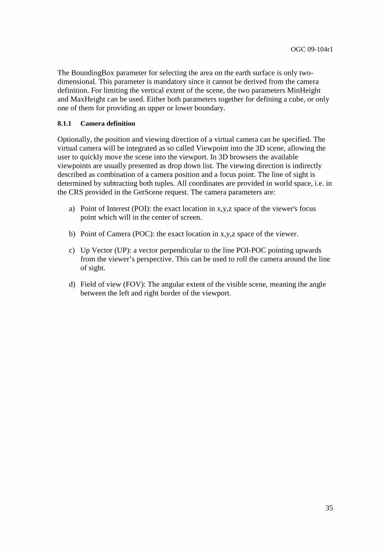
OGC 09-104r1
35
The BoundingBox parameter for selecting the area on the earth surface is only two-dimensional. This parameter is mandatory since it cannot be derived from the camera definition. For limiting the vertical extent of the scene, the two parameters MinHeight and MaxHeight can be used. Either both parameters together for defining a cube, or only one of them for providing an upper or lower boundary.
8.1.1 Camera definition
Optionally, the position and viewing direction of a virtual camera can be specified. The virtual camera will be integrated as so called Viewpoint into the 3D scene, allowing the user to quickly move the scene into the viewport. In 3D browsers the available viewpoints are usually presented as drop down list. The viewing direction is indirectly described as combination of a camera position and a focus point. The line of sight is determined by subtracting both tuples. All coordinates are provided in world space, i.e. in the CRS provided in the GetScene request. The camera parameters are:
a) Point of Interest (POI): the exact location in x,y,z space of the viewer's focus point which will in the center of screen.
b) Point of Camera (POC): the exact location in x,y,z space of the viewer.
c) Up Vector (UP): a vector perpendicular to the line POI-POC pointing upwards from the viewer’s perspective. This can be used to roll the camera around the line of sight.
d) Field of view (FOV): The angular extent of the visible scene, meaning the angle between the left and right border of the viewport.

OGC 09-104r1
36
Figure 5 — GetScene parameters defining a virtual viewpoint
8.1.2 World coordinates versus computer graphics coordinates
For the internal representation of the scene graph which is passed to the rendering pipeline of the client, usually shortened coordinates are used. Coordinates of map projections (for instance UTM, Gauss Kruger) or polar coordinate systems (WGS84) require a very high number of digits for representing smaller objects accurately. Modern graphics hardware is working with single precision floating point numbers with only 32 bits of precision, which is not sufficient to represent city models. The GetScene parameter Translate can be used to shift all coordinates closer to the origin.
Additionally the W3DS will usually do an axes transformation from real world to computer graphics coordinate systems, depending on the output format. Real world coordinates (like UTM, Gauss Kruger or geographical coordinates) are typically using left-hand Cartesian coordinate system with z indicating the height above sea level. Computer graphics coordinate systems used in X3D are based on a right-hand Cartesian coordinate system. Therefore the W3DS automatically switches the axes of the real world CRSs as shown in Figure 6 — Axes transformation from real world coordinates (left) to 3D computer graphics coordinate system (right)
.
FOV
BBox X
BBox Y
POC
BBox X
BBox Y
POI
UP
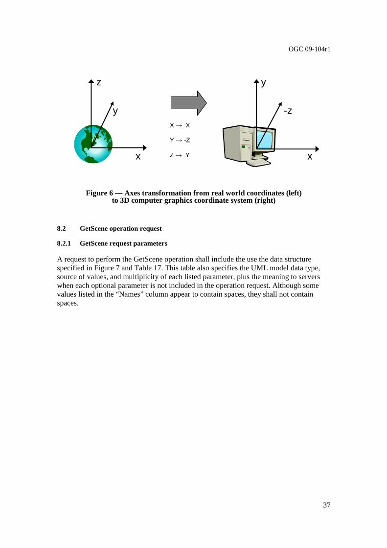
OGC 09-104r1
37
Figure 6 — Axes transformation from real world coordinates (left) to 3D computer graphics coordinate system (right)
8.2 GetScene operation request
8.2.1 GetScene request parameters
A request to perform the GetScene operation shall include the use the data structure specified in Figure 7 and Table 17. This table also specifies the UML model data type, source of values, and multiplicity of each listed parameter, plus the meaning to servers when each optional parameter is not included in the operation request. Although some values listed in the “Names” column appear to contain spaces, they shall not contain spaces.
y
y
x x
-z
z
X → X
Y → -Z
Z → Y

OGC 09-104r1
38
Figure 7 — GetScene operation request UML class diagram NOTE 1 To reduce the need for readers to refer to other documents, the first three parameters listed below are largely copied from Table 21 in Subclause 9.2.1 of [OGC 06-121r3].
+ getCapabilities(request : GetCapabilities) : ServiceMetadata
<<Interface>> OWService {Abstract} (from OWS Web Service)
+ getCapabilities(request : GetCapabilities) : ServiceMetadata + getScene(request : GetScene) : GetSceneResponse + GetFeatureInfo(request : GetFeatureInfo) : GetFeatureInfoResponse + GetLayerInfo(request : GetLayerInfo) : GetLayerInfoResponse + GetTile(request : GetTile) : GetTileResponse
W3DService (from W3DS Service)
<<DataType>> W3DSRequestBase {Abstract}
+ service : CharacterString = “W3DS” {frozen} + request : CharacterString
+ version : CharacterString
<<DataType>> GetSceneResponse
+ content : byte[] + type : ows:MimeType
<<DataType>> GetScene
+ request : CharacterString = “GetScene” {frozen} + crs : URI
+ boundingBox : ows:BoundingBox
+ minHeight : Double + maxHeight : Double
+ spatialSelection : CharacterString + format : ows:MimeType
+ layers : CharacterString + styles : CharacterString
+ lod : CharacterString + lodSelection : CharacterString
+ time : Date + offset : CharacterString
+ exceptions : ows:MimeType + background : CharacterString
+ light : Boolean
+ viewpoints : CharacterString
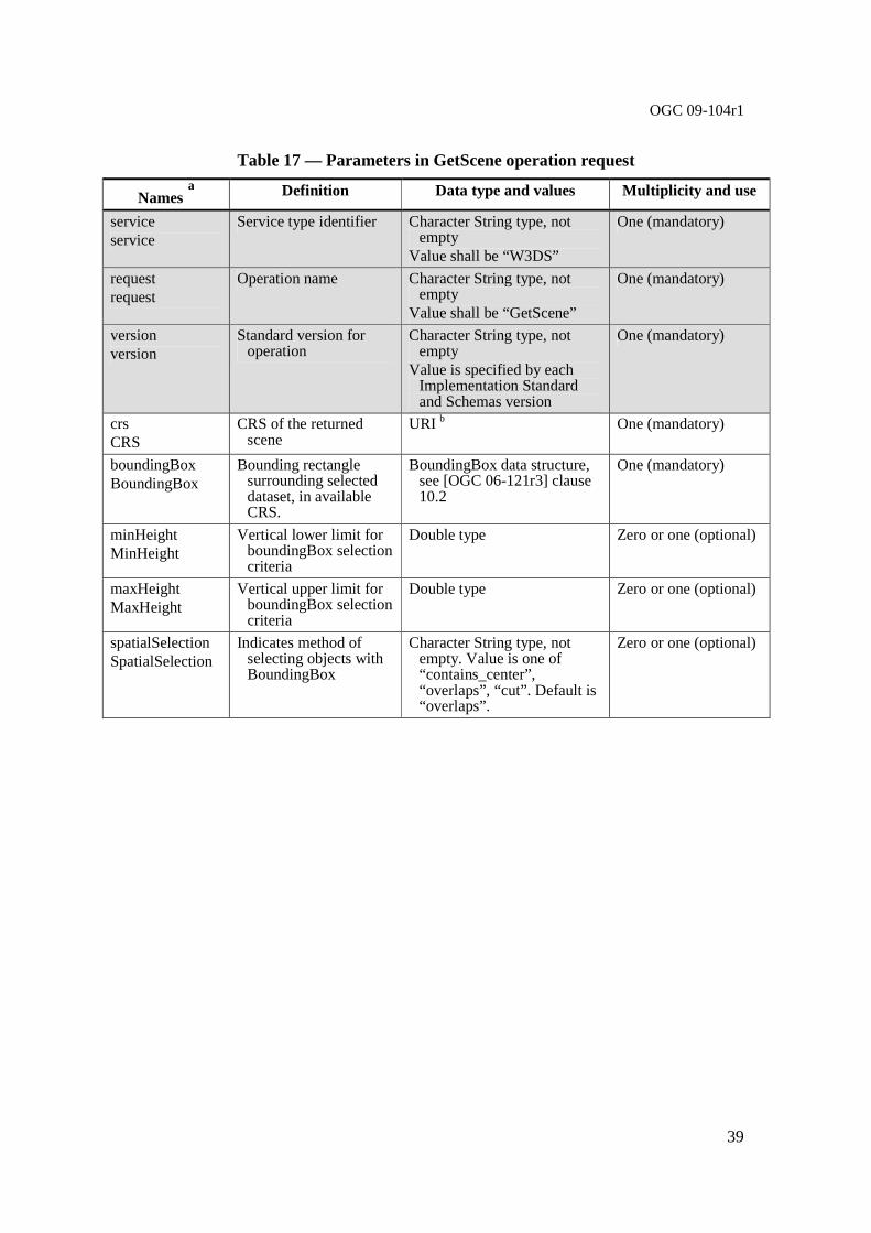
OGC 09-104r1
39
Table 17 — Parameters in GetScene operation request
Names a Definition Data type and values Multiplicity and use
service service
Service type identifier Character String type, not empty
Value shall be “W3DS”
One (mandatory)
request request
Operation name Character String type, not empty
Value shall be “GetScene”
One (mandatory)
version version
Standard version for operation
Character String type, not empty
Value is specified by each Implementation Standard and Schemas version
One (mandatory)
crs CRS
CRS of the returned scene
URI b One (mandatory)
boundingBox BoundingBox
Bounding rectangle surrounding selected dataset, in available CRS.
BoundingBox data structure, see [OGC 06-121r3] clause 10.2
One (mandatory)
minHeight MinHeight
Vertical lower limit for boundingBox selection criteria
Double type Zero or one (optional)
maxHeight MaxHeight
Vertical upper limit for boundingBox selection criteria
Double type Zero or one (optional)
spatialSelection SpatialSelection
Indicates method of selecting objects with BoundingBox
Character String type, not empty. Value is one of “contains_center”, “overlaps”, “cut”. Default is “overlaps”.
Zero or one (optional)

OGC 09-104r1
40
format Format
Format encoding of the scene
ows:MimeType, see [OGC 06-121r3] clause 10.5
One (mandatory)
layers Layers
List of layer to retrieve the data from
Character String type, comma separated list of layer Identifiers
One (mandatory)
styles Styles
List of server styles to be applied to the layers
Character String type, comma separated list of style Identifiers. List must have the same length as in parameter Layers
Zero or one (optional)
lods LODs
List of LODs requested for the layer
Character String type, comma separated list of URIse. List must have the same length as in parameter Layers
Zero or one (optional)
lodSelection LODSelection
Indicates method for selecting LODs
Character String type, either “equals” or “equals_or_smaller” or “combined”
Zero or one (optional)
time Time
Date and time Date type, not empty. Data type defined in ISO 8601:2004(E). Default is “current”
Zero or one (optional)
offset Offset
Offset vector which shall be applied to the scene, i.e. subtracted from the scene
Character String type, list of coordinate value of length 3, separated by comma. Coordinate order in CRS space c
Zero or one (optional)
exceptions Exceptions
Format of exceptions ows:MimeType, see [OGC 06-121r3] clause 10.5
Zero or one (optional)
background Background
Identifier of the background to be used
Character String type, not empty
Zero or one (optional)
light Light
Add light source Boolean type. Default is false Zero or one (optional)
viewpoints Viewpoints
Add Viewpoints to choose from
Character String type, list of tuple value, separated by comma.
Zero or one (optional)
a The name capitalization rules being used here are specified in Subclause 11.6.2 of [OGC 06-121r3]. b The CRS shall be specified using either the European Petroleum Survey Group form ”'EPSG:<POSC Code>” or the URL
format defined in OWS Common. Examples: “EPSG:31467”, "urn:ogc:def:crs:EPSG:6.3:31467 ", see [OGC 06-121r3] clause 10.3 and [OGC 04-046r3].
c This means that the coordinates are described as in the CRS, usually east, north, up. d e.g. 0x00FF00 for green e The LOD shall be specified using a combination of a prefix and a number, e.g. “CityGML:4” for indoor models
NOTE 2 The data type of many parameters is specified as “Character String type, not empty”. In the XML Schema Documents specified herein, these parameters are encoded with the xsd:string type, which does NOT require that these strings not be empty.
NOTE 3 The UML class diagram contained in Subclause C.6 provides a useful graphical view of the contents of the GetScene operation request listed in Tables Table 17 - Table 18.
The “Multiplicity and use” columns in Table 17 and Table 18 specify the optionality of each listed parameter and data structure in the GetScene operation request. All the

OGC 09-104r1
41
“mandatory” parameters and data structures shall be implemented by all W3DS clients, using a specified value(s). Similarly, all the “mandatory” parameters and data structures shall be implemented by all W3DS servers, checking that each request parameter or data structure is received with any specified value(s).
All the “optional” parameters and data structures, in the GetScene operation request, should be implemented by all W3DS clients using specified values, for each implemented W3DS to which that parameter or data structure applies. Similarly, all the “optional” parameters and data structures shall be implemented by all W3DS servers, for each implemented W3DS to which that parameter or data structure applies.
8.2.1.1 CRS
The parameter value for the coordinate reference system (CRS) is defined in [OGC 06-121r3] clause 10.3 and [OGC 04-046r3]. When using a 2D CRS, then the height is measured in meters above sea level.
8.2.1.2 BoundingBox
The mandatory BoundingBox parameter allows a Client to request a particular spatial subset. The value of the BoundingBox parameter is a list of comma-separated real numbers in the form "minx,miny,maxx,maxy". The BoundingBox data structure is defined in [OGC 06-121r3] clause 10.2. The units, ordering and direction of increment of the X and Y axes are as defined by the GetScene CRS parameter.
If a request contains an invalid BoundingBox (e.g., one whose minimum X is greater than or equal to the maximum X, or whose minimum Y is greater than or equal to the maximum Y) the server shall throw a service exception. If the Bounding Box values are not defined for the given CRS (e.g., latitudes greater than 90 degrees in CRS:84), the server should return empty content for areas outside the valid range of the CRS.
The default selection method is that any features that are partly or entirely contained in the Bounding Box shall be returned.
8.2.1.3 MinHeight
By indicating a minimum height the selection of the displayed objects can be further limited. Only objects and/or partial objects are displayed, whose elevation coordinate values are larger or equal to the indicated elevation value. If MinHeight is omitted, there is no restriction of the elevation coordinate values downward. MinHeight refers to the original elevation coordinates of the real world objects before any translation or other transformation takes place.
8.2.1.4 MaxHeight
The MaxHeight parameter is analogous to MinHeight but refers to objects whose elevation coordinate values are lower or equal to the indicated elevation value.

OGC 09-104r1
42
8.2.1.5 SpatialSelection
If a spatial selection method other than intersecting the BoundingBox with the feature’s spatial extent is desired, the SpatialSelection parameter can be used. The default behavior of selecting a feature is to check the spatial relation between the BoundingBox and the feature’s 2D footprint. If the 2D footprint is contained in or intersects with the BoundingBox, then the feature is selected. The according default value of SpatialSelection is “overlaps”.
The second possible value of SpatialSelection is “contains_center”. This spatial selection method shall check whether the feature’s center point is contained or intersects with the BoundingBox. How the center point is computed by the server is not defined, but it shall be inside the convex hull of the feature.
The third possible value of SpatialSelection is “cut”. This spatial selection method shall not return features or part of features that lie outside of the BoundingBox. Features that are completely contained in the BoundingBox shall be returned unmodified. Features that intersect with the borders of the BoundingBox shall be split und parts that lie outside cut away. The parts that lie inside of the BoundingBox shall be included in the GetScene response. Multiple GetScene requests with adjacent BoundingBoxes shall generate feature geometries that fit seamlessly together without gaps or cracks.
8.2.1.6 Format
The mandatory Format parameter specifies the target encoding of the returned scene provided as ows:MimeType, see [OGC 06-121r3] clause 10.5. Available formats are described in the server’s meta data.
8.2.1.7 Layers
The Layers parameter specifies a comma separated list of layer identifiers to be displayed. The concept of the layer is a metaphor to the traditional (two-dimensional) cartography, with which geo objects of different classes were drawn on different foils resulting in a map with an overall view of this foils. The order in which the layers are listed in the Layers parameter does not influence the visual appearance of the generated scene. However, the order of the lists in the (optional) Styles and LOD parameters shall correlate with the Layers list. Each entry in the Layers comma separated list shall refer to a layer identifier as described in the server’s meta data.
8.2.1.8 Styles
The Styles parameter specifies for each layer, which style shall be applied by the server when generating the display elements. The Styles parameter contains a comma separated list of style identifiers. The length of this list shall be equal to the length of the list in the Layers parameter. The order of this list shall correlate with the list in the Layers parameter, meaning that style n shall be applied to layer n. Each entry in this list shall refer to a style identifier as described in the server’s meta data. Blanks may be used to indicate the default style.

OGC 09-104r1
43
Example:
Layers=dtm,buildings,vegetation&Styles=orthophoto,, simple
8.2.1.9 LODs
The parameter LODs specifies for each layer which Level of Detail to choose from when accessing the server’s data repository. The parameter value is a comma separated list of URIs referring to the available Level of Details as specified in the server’s meta data layer section. The length of this list shall be equal to the length of the list in the Layers parameter . The order of this list shall correlate with the list in the Layers parameter, meaning that LOD n shall be selected from layer n.
Each entry in this list shall be a URI consisting of a prefix and the actual numeric value, separated by a colon, e.g. "CityGML:1". The prefix indicates the spectrum of possible values and how these values must be interpreted. The LOD definitions of CityGML can be found in [08-007r1] clause 6.2.
8.2.1.10 LODSelection
In conjunction with the LOD parameter, the LODSelection parameter may be used for telling the server how to interpret the LOD value for each layer. Three selection methods are available: “equals”, “equals_or_smaller”, and “combined”.
The method “equals” is the default selection method. For each feature, the available LODs are compared with the LOD value provided in the GetScene operation. If the specified LOD is available for this feature, then the according model shall be selected and included in the scene. If the specified LOD is not available for this feature, then the feature shall be omitted in the scene altogether.
The method “equals_or_smaller” causes the server to compile a scene from multiple available LODs. Only one LOD for each feature shall be selected. If the specified LOD is available for this feature, then the according model shall be selected and included in the scene. If the specified LOD is not available for this feature, then the server shall select the next lower LOD available for this feature. If no LOD equal or lower than the specified LOD is available for this feature, then this feature shall be omitted in the scene altogether. Cumulative LOD models, e.g. building blocks representing multiple buildings as a single geometry, shall be handled so that no overlaps with higher LODs occur. If a higher LOD for one building included in the block is available, then the block shall be omitted.
The method “combined” causes the server to include multiple LODs for each feature in the scene, if available. Multiple LODs are combined in a “LOD” node which switches between multiple child models depending on the current distance to the viewpoint. The availability of this method depends on the requested format, the “LOD” node is supported by X3D. The server shall include for each feature all LODs equal or smaller than the specified LOD value in the GetScene operation. Cumulative LOD models shall be handled so that overlaps with higher LODs occur.

OGC 09-104r1
44
8.2.1.11 Time
The Time parameter can be used to include a temporal criterion to the feature selection method. The server shall select only features that exist at the given point in time if the layer meta data contains StartTime and/or EndTime elements. In this case the Time parameter includes a date which may be the present system time or a historical date.
The specification of valid parameter values is in accordance with ISO 8601:2004(E). The special keyword “Time=current” may be used to indicate the most current data available at the current timestamp. This is also the default value.
Examples:
Example 1: Time=2003-10-25 Specifies the 25th of October 2003 Example 2: Time=2003-10-25T14:28:43Z Specifies the 25th of October 2003 at 14:28 hours a nd 43 seconds. Z means Zulu time which is equivalent to UTC. Example 3: Time=-1279 Means year 1279 B.C. Ramses II becomes pharaoh of E gypt
8.2.1.12 Offset
Depending on the used CRS, coordinate values of 3D objects may become very big. For example UTM coordinates require a mantissa of 9 digits for achieving accuracy in centimeters. Clients using single precision floating point numbers (32 bit) are not able to handle large coordinates very well. The Offset parameter can be used in order to define a point in 3D which is subtracted from all coordinate values, thus reducing the number of digits. This is useful if no format with geo extension is used.
8.2.1.13 Exceptions
The optional Exceptions parameter specifies the behavior of the server upon detecting an error, e.g. invalid request or internal server error. The default value is “text/xml”. The value shall be one of the MIME types offered in the server’s meta data parameter value, see 7.3.2.2.
If the Exceptions parameter is set to “blank”, then the server shall, upon detecting an error, return a document of the MIME type specified in the format parameter whose content is uniformly “off”, i.e. a document with correct headers according to the format and zero content. This “silent” mode is useful if the scene graph in the client is composed of a large number W3DS GetScene requests and is not prepared to process server exceptions.
8.2.1.14 Background
The optional parameter Background can be used to include a predefined background advertised by the server in its meta data. The value of this parameter refers to an existing background identifier of the server. The background node will be included in the returned

OGC 09-104r1
45
scene. No specific node type is specified, it is up to the server how to implement the background, it may consist of a simple color, a color gradient, a cube or sphere with a projected image, videos, or any scene graph node that is supported by the requested format.
8.2.1.15 Light
The optional parameter Light can be used to include a light source in the scene. Most 3D viewers add a headlight if they find no light source in the scene. In order to enable proper lighting a global light source must be defined. If this parameter is set to true, then the server shall add direct and indirect light components simulating the real solar and atmospheric conditions.
8.2.1.16 Viewpoints
The optional parameter Viewpoints can be used to include a list of viewpoints in the scene the user can choose from. Viewpoints are presented in most viewers as list which can be used to move quickly to another pre-defined position and view direction. If multiple viewpoints are defined, then the first in the list will be used as default viewpoint when loading the scene.
The parameter value contains a comma separated list of tuple values for defining for each viewpoint a) a name, b) the Point of Interest (POI), c) the Point of Camera (POC), d) the up vector (UP), and e) the Field of View (FOV). Thus 11 Values are used to define one viewpoint. In case of multiple viewpoints, all values are appended to the list consecutively. The list of Viewpoints parameter values shall be divisible by 11.
Template:
Viewpoints=NAME,POIx,POIy,POIz,POCx,POCy,POCz,UPx,UPy,UPz,FOV
All tuple values refer to the spatial reference system specified by the CRS parameter. The FOV is given as angle value.
8.2.2 GetScene request KVP encoding (optional)
Servers may implement HTTP GET transfer of the GetScene operation request, using KVP encoding. The KVP encoding of the GetScene operation request shall use the parameters specified in Table 18. The parameters listed in Table 18 shall be as specified in Table 17 above.
Table 18 — GetScene operation request URL parameters
Name and example a Optionality and use Definition and format
service=W3DS Mandatory Service type identifier
request= GetScene Mandatory Operation name version=0.4.0 Mandatory Standard and schema version for this
operation

OGC 09-104r1
46
crs=EPSG:26916 Mandatory Coordinate Reference System of the returned scene
boundingbox=202759.0,3310170.0,213200.0,3320896.0
Mandatory Bounding rectangle surrounding selected dataset, in available CRS.
minheight=0.0 Optional Vertical lower limit for boundingBox selection criteria
maxheight=1000.0 Optional Vertical upper limit for boundingBox selection criteria
spatialselection=contains_center
Optional Indicates method of selecting objects with BoundingBox
format=model/x3d Mandatory Format encoding of the scene layers=dem,bldgs Mandatory List of layer to retrieve the data from
styles=default,Cartographic Optional List of server styles to be applied to the layers
lods=,CityGML:1 Optional List of LODs requested for the layer
lodselection=equals_or_smaller
Optional Indicates method for selecting LODs
time=2009-07-13-07:00 Optional Date and time offset=202000,3310000,0 Optional Offset vector which shall be applied to
the scene, i.e. subtracted from the scene
exceptions=text/xml Optional Format of exceptions
background=sky1 Optional Identifier of the background to be used light=true Optional Add light source
Viewpoints=vpoint1,202000,3310000,200, 202000,3305000,200,0,1,0,60
Optional Add Viewpoints to choose from
a All parameter names are here listed using mostly lower case letters. However, any parameter name capitalization shall be allowed in KVP encoding, see Subclause 11.5.2 of [OGC 06-121r3].
EXAMPLE An example GetScene operation request KVP encoded for HTTP GET is:
http://hostname:port/path?SERVICE=W3DS&REQUEST=GetS cene&VERSION=0.4.0&CRS=EPSG:26916&FORMAT=model/x3d&BoundingBox=202759.0 ,3310170.0,213200.0,3320896.0&LAYERS=Terrain&STYLES=aerial_view_RGB
8.2.3 GetScene request XML encoding (mandatory)
All W3DS servers shall implement HTTP POST transfer of the GetScene operation request, using XML encoding only. The following schema fragment specifies the contents and structure of a GetScene operation request encoded in XML:
<!-- =========================================================== --> <element name="GetScene" type="w3ds:GetSceneType"/> <!-- =========================================================== --> <complexType name="GetSceneType"> <annotation> <documentation>XML encoded W3DS GetScene operation request. </documentation>

OGC 09-104r1
47
</annotation> <complexContent> <extension base="w3ds:W3DSRequestBaseType"> <sequence> <element name="CRS" type="anyURI"/> <element ref="ows:BoundingBox"/> <element name="MinHeight" type="double" minOccurs="0"/> <element name="MaxHeight" type="double" minOccurs="0"/> <element name="SpatialSelection" type="w3ds:SpatialSelectionType" minOccurs="0"/> <element name="Format" type="ows:MimeType" minOccurs="0"/> <element name="Layers" type="w3ds:IdentifierListType"/> <element name="Styles" type="w3ds:IdentifierListType" minOccurs="0"/> <element name="LODs" type="w3ds:IdentifierListType" minOccurs="0"/> <element name="LODSelection" type="w3ds:LODSelectionType" minOccurs="0"/> <element name="Time" type="dateTime" minOccurs="0"/> <element name="Offset" type="w3ds:PositionType3D" minOccurs="0"/> <element name="Exceptions" type="ows:MimeType" minOccurs="0"/> <element name="Background" type="ows:CodeType" minOccurs="0"/> <element name="Light" type="boolean" minOccurs="0"/> <element name="Viewpoints" type="w3ds:ViewpointListType" minOccurs="0"/> </sequence> </extension> </complexContent> </complexType>
EXAMPLE An example GetScene operation request XML encoded for HTTP POST is:
<?xml version="1.0" encoding="UTF-8"?> <w3ds:GetScene service="W3DS" request="GetScene" ve rsion="0.4.0"> <w3ds:CRS>EPSG:26916</w3ds:CRS> <ows:BoundingBox crs="EPSG:26916"> <ows:LowerCorner>202759.03723318398
3310170.2612183597</ows:LowerCorner> <ows:UpperCorner>213200.2944077917
3320896.6813003295</ows:UpperCorner> </ows:BoundingBox> <w3ds:Format>model/x3d</w3ds:Format> <w3ds:Layers> <ows:Identifier>dem</ows:Identifier> <ows:Identifier>bldgs</ows:Identifier> </w3ds:Layers> <w3ds:Styles> <ows:Identifier>default</ows:Identifier> <ows:Identifier>Cartographic</ows:Identifie r> </w3ds:Styles> </w3ds:GetScene>
8.3 GetScene operation response
The response to a valid GetScene request is a document of the MIME type as specified in the Format parameter. The document contains a 3D scene assembled from the features of the selected layers within the specified BoundingBox, converted into the specified

OGC 09-104r1
48
Format and CRS. The coordinate axes will be usually shifted to computer graphics coordinate axes as shown in Figure 5Figure 2.
If the GetScene request contains a list of server style identifiers or user defined styles, then the features from the individual layers are portrayed according to the respective style. In case of server defined styles, the method of how to modify the appearance and other properties of the features may not be transparent to the client. Therefore it is recommended to include a detailed style description in the server’s meta data. In case of user styles included in the GetScene request, the client has full control over the styling.
Some output formats other than the default X3D format may not support elements which are referred to in the parameters Environment, BGColor, and the parameters for defining a virtual camera/viewpoint. For instance a light node may not be available in formats focusing on the geometry description. In this case these parameters may be ignored, and no exception shall be thrown. If the output format allows a camera definition, then a default camera is included in the scene, whose location is derived from the provided POC, POI, Distance, Yaw, Roll, and Pitch parameters.
If the resulting file contains references to additional files which must be loaded by the client, for instance URLs to textures, then those files must be accessible to the client, either stored on the same server as the W3DS or on another server accessible over the Internet. Relative paths in the URL without protocol and server domain may be used for referencing to files in the directory of the W3DS or in subdirectories. Contained URLs may also point to other service end points producing the required MIME type, for instance a WCS may be used as source for terrain textures. Scene graph nodes within the GetScene response might also point to other W3DS servers, using include statements. The configuration and design of how to access the contents of the scene, is up to the system administrator.
In case of an incorrect request or an occurring error while generating the scene, the response must be supplied in the requested format for exceptional cases (parameters EXCEPTION) by the server. With a request via HTTP the MIME type of the returned document must be set by the server according to contents of the resulting file.
8.3.1 GetScene exceptions
When a W3DS server encounters an error while performing a GetScene operation, it shall return an exception report message as specified in Subclause 7.4 of [OGC 06-121r3]. The allowed standard exception codes shall include those listed in Table 19. For each listed exceptionCode, the contents of the “locator” parameter value shall be as specified in the right column of Table 19.
NOTE To reduce the need for readers to refer to other documents, the first three values listed below are copied from Table 20 in Subclause 8.3 of [OGC 06-121r3].
Table 19 — Exception codes for GetScene operation
exceptionCode value Meaning of code “locator” value

OGC 09-104r1
49
MissingParameterValue Operation request does not include a parameter value, and this server did not declare a default value for that parameter
Name of missing parameter
InvalidParameterValue Operation request contains an invalid parameter value
Name of parameter with invalid value
OptionNotSupported Request is for an option that is not supported by this server
Identifier of option not supported
CRSNotSupported Operation request contains a value in the CRS parameter which is not supported by the server
Name of unsupported CRS
InvalidCameraDefinition
Operation request contains an invalid combination of parameters POC, POI, Distance, Pitch, Yaw, and Roll
None, omit “locator” parameter
InvalidListLength Operation request contains Style or LOD parameter whose value does not contain a list of the same length as in parameter Layers
Name of parameter with invalid value
UnknownLayer Operation request contains an identifier in the Layers parameter which is unknown to the server
Identifier of invalid layer
UnknownStyle Operation request contains an identifier in the Style parameter which is unknown to the server
Identifier of invalid style
LODNotSupported Operation request contains a value in the LOD parameter which is not available for the according layer
Name of unsupported LOD
FormatNotSupported Operation request contains a MIME type in the Format parameter which is not supported by the server
Name of unsupported format
ExceptionNotSupported Operation request contains a value in the Exception parameter which is not supported by the server
Name of unsupported exception format
NoApplicableCode No other exceptionCode specified by this service and server applies to this exception
None, omit “locator” parameter
9 GetFeatureInfo operation (optional)
9.1 Introduction
The GetFeatureInfo operation is designed to provide clients with additional attribute information about features within a scene that is currently displayed. The canonical use case for GetFeatureInfo is that a user explores the response of a GetScene request and points at an object within the scene for which to obtain more information. The concept of this operation is that the client determines a location in 3D space by clicking on an object and calculates either the intersection point of the object geometry with the picking ray or the center point of the object and submits this location together with additional parameters to the server. The location can be also determined by other 3D input devices or by any other means. Since the W3DS protocol is stateless, also the current CRS needs to be submitted so that the W3DS is able to reconstruct the location within the CRS of its data store. Also a list of layers shall be provided with the GetFeatureInfo request so that the search for attribute information can be restricted to selected data sets.

OGC 09-104r1
50
The actual method of how the W3DS server decides which features should be selected based on the location, what kind of information is returned, and how this information is structured is left up to the W3DS provider. However, the format of the response must be provided as MIME type, e.g. text/xml, enabling the client to parse the result properly.
The GetFeatureInfo operation is only supported for those Layers for which the attribute queryable="1" (true) has been defined or inherited. A client shall not issue a GetFeatureInfo request for other layers. A W3DS shall respond with a properly formatted service exception response (code = OperationNotSupported) if it receives a GetFeatureInfo request but does not support it.
9.2 GetFeatureInfo operation request
9.2.1 GetFeatureInfo request parameters
A request to perform the GetFeatureInfo operation shall include the data structure specified in Figure 7 and Table 20. This table also specifies the UML model data type, source of values, and multiplicity of each listed parameter, plus the meaning to servers when each optional parameter is not included in the operation request. Although some values listed in the “Names” column appear to contain spaces, they shall not contain spaces.
+ getCapabilities(request : GetCapabilities) : ServiceMetadata
<<Interface>> OWService {Abstract} (from OWS Web Service)
+ getCapabilities(request : GetCapabilities) : ServiceMetadata + getScene(request : GetScene) : GetSceneResponse + GetFeatureInfo(request : GetFeatureInfo) : GetFeatureInfoResponse + GetLayerInfo(request : GetLayerInfo) : GetLayerInfoResponse + GetTile(request : GetTile) : GetTileResponse
W3DService (from W3DS Service)
<<DataType>> W3DSRequestBase {Abstract}
+ service : CharacterString = “W3DS” {frozen} + request : CharacterString
+ version : CharacterString
<<DataType>> GetFeatureInfo
+ request : CharacterString = “GetFeatureInfo” {frozen} + crs : URI
+ format : ows:MimeType
+ layers : CharacterString
+ featureCount : Integer + coordinate : CharacterString
+ exceptions : ows:MimeType
<<DataType>> GetFeatureInfoResponse
+ content : byte[]
+ type : ows:MimeType
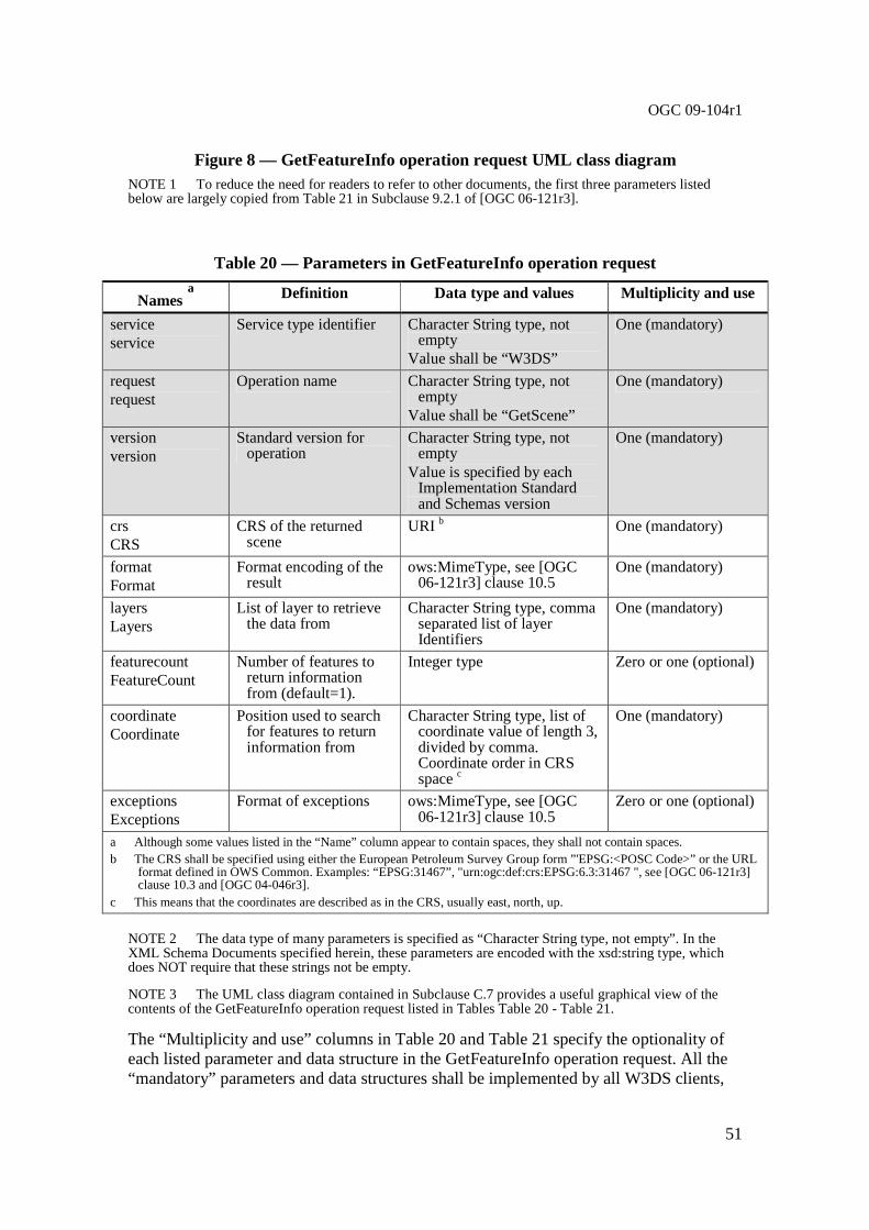
OGC 09-104r1
51
Figure 8 — GetFeatureInfo operation request UML class diagram NOTE 1 To reduce the need for readers to refer to other documents, the first three parameters listed below are largely copied from Table 21 in Subclause 9.2.1 of [OGC 06-121r3].
Table 20 — Parameters in GetFeatureInfo operation request
Names a Definition Data type and values Multiplicity and use
service service
Service type identifier Character String type, not empty
Value shall be “W3DS”
One (mandatory)
request request
Operation name Character String type, not empty
Value shall be “GetScene”
One (mandatory)
version version
Standard version for operation
Character String type, not empty
Value is specified by each Implementation Standard and Schemas version
One (mandatory)
crs CRS
CRS of the returned scene
URI b One (mandatory)
format Format
Format encoding of the result
ows:MimeType, see [OGC 06-121r3] clause 10.5
One (mandatory)
layers Layers
List of layer to retrieve the data from
Character String type, comma separated list of layer Identifiers
One (mandatory)
featurecount FeatureCount
Number of features to return information from (default=1).
Integer type Zero or one (optional)
coordinate Coordinate
Position used to search for features to return information from
Character String type, list of coordinate value of length 3, divided by comma. Coordinate order in CRS space c
One (mandatory)
exceptions Exceptions
Format of exceptions ows:MimeType, see [OGC 06-121r3] clause 10.5
Zero or one (optional)
a Although some values listed in the “Name” column appear to contain spaces, they shall not contain spaces. b The CRS shall be specified using either the European Petroleum Survey Group form ”'EPSG:<POSC Code>” or the URL
format defined in OWS Common. Examples: “EPSG:31467”, "urn:ogc:def:crs:EPSG:6.3:31467 ", see [OGC 06-121r3] clause 10.3 and [OGC 04-046r3].
c This means that the coordinates are described as in the CRS, usually east, north, up.
NOTE 2 The data type of many parameters is specified as “Character String type, not empty”. In the XML Schema Documents specified herein, these parameters are encoded with the xsd:string type, which does NOT require that these strings not be empty.
NOTE 3 The UML class diagram contained in Subclause C.7 provides a useful graphical view of the contents of the GetFeatureInfo operation request listed in Tables Table 20 - Table 21.
The “Multiplicity and use” columns in Table 20 and Table 21 specify the optionality of each listed parameter and data structure in the GetFeatureInfo operation request. All the “mandatory” parameters and data structures shall be implemented by all W3DS clients,

OGC 09-104r1
52
using a specified value(s). Similarly, all the “mandatory” parameters and data structures shall be implemented by all W3DS servers, checking that each request parameter or data structure is received with any specified value(s).
All the “optional” parameters and data structures, in the GetFeatureInfo operation request, should be implemented by all W3DS clients using specified values, for each implemented W3DS to which that parameter or data structure applies. Similarly, all the “optional” parameters and data structures shall be implemented by all W3DS servers, for each implemented W3DS to which that parameter or data structure applies.
9.2.1.1 CRS
The parameter value for the coordinate reference system (CRS) is defined in [OGC 06-121r3] clause 10.3 and [OGC 04-046r3]. When using a 2D CRS, then the height is measured in meters above sea level.
9.2.1.2 Layers
The Layers parameter specifies a comma separated list of layer identifiers from which the server spatially selects features based on the coordinate, and collects attribute information from. The order in which the layers are listed in the Layers parameter determines the order in which the feature information will be displayed in the GetFeaturInfo response. Each entry in the Layers comma separated list shall refer to a layer identifier as described in the server’s meta data.
9.2.1.3 Format
The mandatory Format parameter specifies the target encoding of the returned attribute information provided as ows:MimeType, see [OGC 06-121r3] clause 10.5. Available formats are described in the server’s meta data.
9.2.1.4 FeatureCount
The optional FeatureCount parameter specifies the maximum number of features per layer for which feature information shall be returned. The parameter value shall be a positive integer. The default value is 1 if this parameter is omitted or is other than a positive integer.
9.2.1.5 Coordinate
The mandatory Coordinate parameter provides a location in 3D space within the scene from which feature information will be generated. The parameter value is a list of comma separated floating point numbers describing the x,y, and z values of the coordinate. Note that x, y, z values are not in computer graphics coordinate system, but they shall have the same axis orientation and direction as defined in the CRS parameter. This location should be within or at the border of a feature geometry, but it does not have to be. The W3DS server shall detect the feature(s) which geometry is containing the location or lying nearest to it.

OGC 09-104r1
53
9.2.1.6 Exceptions
The optional Exceptions parameter specifies the behavior of the server upon detecting an error, e.g. invalid request or internal server error. The default value is “text/xml”. The value shall be one of the MIME types offered in the server’s meta data parameter value, see 7.3.2.2.
9.2.2 GetFeatureInfo request KVP encoding (optional)
Servers shall implement HTTP GET transfer of the GetFeatureInfo operation request, using KVP encoding. The KVP encoding of the GetFeatureInfo operation request shall use the parameters specified in Table 21. The parameters listed in Table 21 shall be as specified in Table 20 above.
Table 21 — GetFeatureInfo operation request URL parameters
Name and example a Optionality and use Definition and format
service=W3DS Mandatory Service type identifier
request=GetFeatureInfo Mandatory Operation name
version=0.4.0 Mandatory Standard and schema version for this operation
crs=EPSG:26916 Mandatory Coordinate Reference System of the returned scene
format=text/html Mandatory Format encoding of the result layers=bldgs Mandatory List of layer to retrieve the data from
featurecount=5 Optional Number of features to return information from (default=1)
coordinate=202042.233,3310094.983,334.0
Mandatory Position used to search for features to return information from
exceptions=text/xml Optional Format of exceptions a All parameter names are here listed using mostly lower case letters. However, any parameter name capitalization shall be allowed in KVP encoding, see Subclause 11.5.2 of [OGC 06-121r3].
EXAMPLE An example GetFeatureInfo operation request KVP encoded for HTTP GET is:
http://hostname:port/path?SERVICE=W3DS&REQUEST=GetF eatureInfo&VERSION=0.4.0&CRS=EPSG:26916&FORMAT=text/xml&LAYERS=bldgs&FE ATURECOUNT=5&COORDINATE=202042.233,3310094.983,334.0&EXCEPTIONS=text/ht ml
9.2.3 GetFeatureInfo request XML encoding (mandatory)
All W3DS servers may implement HTTP POST transfer of the GetFeatureInfo operation request, using XML encoding only. The following schema fragment specifies the contents and structure of a GetFeatureInfo operation request encoded in XML:
<!-- =========================================================== --> <element name="GetFeatureInfo" type="w3ds:GetFeatureInfoType"/> <!-- =========================================================== --> <complexType name="GetFeatureInfoType"> <annotation>

OGC 09-104r1
54
<documentation>XML encoded W3DS GetFeatureInfo operation request. </documentation> </annotation> <complexContent> <extension base="w3ds:W3DSRequestBaseType"> <sequence> <element name="CRS" type="anyURI"/> <element ref="ows:BoundingBox"/> <element name="Format" type="ows:MimeType"/> <element name="Layers" type="w3ds:IdentifierListType"/> <element name="FeatureCount" type="integer" minOccurs="0"/> <element name="Coordinate" type="w3ds:PositionType3D"/> <element name="Exceptions" type="ows:MimeType" minOccurs="0"/> </sequence> </extension> </complexContent> </complexType>
EXAMPLE An example GetFeatureInfo operation request XML encoded for HTTP POST is:
<?xml version="1.0" encoding="UTF-8"?> <w3ds:GetFeatureInfo service="W3DS" request="GetFea tureInfo" version="0.4.0"> <w3ds:CRS>EPSG:26916</w3ds:CRS> <w3ds:Format>text/xml</w3ds:Format> <w3ds:Layers> <ows:Identifier>bldgs</ows:Identifier> </w3ds:Layers> <w3ds:FeatureCount>5</w3ds:FeatureCount> <w3ds:Coordinate>202042.233 3310094.983 334.0</ w3ds:Coordinate> <w3ds:Exceptions>text/html</w3ds:Exceptions> </w3ds:GetFeatureInfo>
9.3 GetFeatureInfo operation response
The normal response to a valid GetFeatureInfo operation request shall be a table or equivalent data structure in which the attribute information of each found feature is listed. Each row in this table describes one feature. The response is a document encoded in the MIME type as specified in the Format parameter.
9.3.1 GetFeatureInfo response example
A GetFeatureInfo operation response for W3DS can look like this encoded in text/html:
<html> <head></head> <body> <table width="95%" > <tr> <td bgcolor='#ffffff'><b>Buildings</b></td> </tr> <tr>

OGC 09-104r1
55
<td bgcolor='#fafafa'></td> <td bgcolor='dddddd'>id </td> <td bgcolor='dddddd'>objkey </td> <td bgcolor='dddddd'>strkey </td> <td bgcolor='dddddd'>hsno </td> <td bgcolor='dddddd'>description </td> <td bgcolor='dddddd'>sockelhoehe </td> <td bgcolor='dddddd'>traufhoehe </td> <td bgcolor='dddddd'>height </td> </tr> <tr> <td bgcolor='#fafafa'>1</td> <td bgcolor='#fafafa'>34891270</td> <td bgcolor='#fafafa'>1123 Hochschulgebaeud e</td> <td bgcolor='#fafafa'>2390</td> <td bgcolor='#fafafa'>1</td> <td bgcolor='#fafafa'>Alte Universitaet</td > <td bgcolor='#fafafa'>2.500000</td> <td bgcolor='#fafafa'>15.000000</td> <td bgcolor='#fafafa'>115.347270</td> </tr> <tr> <td bgcolor='#fafafa'></td> </tr> </table> </body> </html>
9.3.2 GetFeatureInfo exceptions
When a W3DS server encounters an error while performing a GetFeatureInfo operation, it shall return an exception report message as specified in Subclause 7.4 of [OGC 06-121r3]. The allowed standard exception codes shall include those listed in Table 22. For each listed exceptionCode, the contents of the “locator” parameter value shall be as specified in the right column of Table 22.
NOTE To reduce the need for readers to refer to other documents, the first four values listed below are copied from Table 20 in Subclause 8.3 of [OGC 06-121r3].
Table 22 — Exception codes for GetFeatureInfo operation
exceptionCode value Meaning of code “locator” value
OperationNotSupported Request is for an operation that is not supported by this server
Name of operation not supported
MissingParameterValue Operation request does not include a parameter value, and this server did not declare a default value for that parameter
Name of missing parameter
InvalidParameterValue Operation request contains an invalid parameter value
Name of parameter with invalid value
OptionNotSupported Request is for an option that is not supported by this server
Identifier of option not supported
CRSNotSupported Operation request contains a value in the CRS parameter which is not supported by the server
Name of unsupported CRS

OGC 09-104r1
56
UnknownLayer Operation request contains an identifier in the Layers parameter which is unknown to the server
Identifier of invalid layer
FormatNotSupported Operation request contains a MIME type in the Format parameter which is not supported by the server
Name of unsupported format
ExceptionNotSupported Operation request contains a value in the Exception parameter which is not supported by the server
Name of unsupported exception format
NoApplicableCode No other exceptionCode specified by this service and server applies to this exception
None, omit “locator” parameter
10 GetLayerInfo operation (optional)
10.1 Introduction
The purpose of the GetLayerInfo request is to collect information on the available attribute names and the values in the attribute table of a specific layer. The attribute table is managed by the W3DS server in a database table, as dbf file, or otherwise. The entries in the attribute table can be linked to the geometries that can be retrieved using the GetScene request.
The GetLayerInfo operation is optional. A W3DS server shall respond with a properly formatted service exception (XML) response (code = OperationNotSupported) if it receives a GetLayerInfo request but does not support it.
The GetLayerInfo request contains a mandatory Layer parameter for identifying the data set from which attribute information shall be received and an optional ColumnName parameter. If only the Layer parameter is used, then the response of the request shall contain only a list of all available attribute or column names in the format specified by the Format parameter. The received attribute names can then be used to receive additional information on the available values in the attribute table. If additionally to the Layer parameter also a ColumnName parameter is present, then the attribute table shall be queried for all available values that the features in the layer may have. The response to such a request contains a full list of unique values. In this list no duplicate values must occur. Examples of XML formatted responses are given in 10.3.3.
10.2 GetLayerInfo operation request
10.2.1 GetLayerInfo request parameters
A request to perform the GetLayerInfo operation shall include the use the data structure specified in Figure 8 and Table 23. This table also specifies the UML model data type, source of values, and multiplicity of each listed parameter, plus the meaning to servers when each optional parameter is not included in the operation request. Although some values listed in the “Names” column appear to contain spaces, they shall not contain spaces.

OGC 09-104r1
57
Figure 9 — GetLayerInfo operation request UML class diagram NOTE 1 To reduce the need for readers to refer to other documents, the first three parameters listed below are largely copied from Table 21 in Subclause 9.2.1 of [OGC 06-121r3].
Table 23 — Parameters in GetLayerInfo operation request
Names a Definition Data type and values Multiplicity and use
service service
Service type identifier Character String type, not empty
Value shall be “W3DS”
One (mandatory)
request request
Operation name Character String type, not empty
Value shall be “GetScene”
One (mandatory)
version version
Standard version for operation
Character String type, not empty
Value is specified by each Implementation Standard and Schemas version
One (mandatory)
layer Layer
The layer to get information from
Character String type, not empty
One (mandatory)
columnnames ColumnNames
A list of column names to get information from
Character String type, comma separated list of column names
Zero or one (optional)
+ getCapabilities(request : GetCapabilities) : ServiceMetadata
<<Interface>> OWService {Abstract} (from OWS Web Service)
+ getCapabilities(request : GetCapabilities) : ServiceMetadata + getScene(request : GetScene) : GetSceneResponse + GetFeatureInfo(request : GetFeatureInfo) : GetFeatureInfoResponse + GetLayerInfo(request : GetLayerInfo) : GetLayerInfoResponse + GetTile(request : GetTile) : GetTileResponse
W3DService (from W3DS Service)
<<DataType>> W3DSRequestBase {Abstract}
+ service : CharacterString = “W3DS” {frozen} + request : CharacterString + version : CharacterString
<<DataType>> GetLayerInfo
+ request : CharacterString = “GetLayerInfo” {frozen} + layer : CharacterString + columnName : CharacterString
+ format : ows:MimeType
<<DataType>> GetLayerInfoResponse
+ content : byte[] + type : ows:MimeType

OGC 09-104r1
58
format Format
Format encoding of the result
ows:MimeType, see [OGC 06-121r3] clause 10.5
One (mandatory)
exceptions Exceptions
Format of exceptions ows:MimeType, see [OGC 06-121r3] clause 10.5
Zero or one (optional)
a Although some values listed in the “Name” column appear to contain spaces, they shall not contain spaces.
NOTE 2 The data type of many parameters is specified as “Character String type, not empty”. In the XML Schema Documents specified herein, these parameters are encoded with the xsd:string type, which does NOT require that these strings not be empty.
NOTE 3 The UML class diagram contained in Subclause C.8 provides a useful graphical view of the contents of the GetLayerInfo operation request listed in Tables Table 23 - Table 24.
The “Multiplicity and use” columns in Table 23 through Table 29 specify the optionality of each listed parameter and data structure in the GetLayerInfo operation request. All the “mandatory” parameters and data structures shall be implemented by all W3DS clients, using a specified value(s). Similarly, all the “mandatory” parameters and data structures shall be implemented by all W3DS servers, checking that each request parameter or data structure is received with any specified value(s).
All the “optional” parameters and data structures, in the GetLayerInfo operation request, should be implemented by all W3DS clients using specified values, for each implemented W3DS to which that parameter or data structure applies. Similarly, all the “optional” parameters and data structures shall be implemented by all W3DS servers, for each implemented W3DS to which that parameter or data structure applies.
10.2.1.1 Layer
The mandatory Layer parameter specifies the layer from which information shall be retrieved. The parameter value shall refer to a layer identifier as described in the server’s meta data. If information from multiple layers needs to be collected, then multiple requests must be sent to the W3DS server. If the layer identifier is not defined in the server’s meta data, then server shall issue a service exception (code = UnknownLayer).
10.2.1.2 ColumnNames
The optional ColumnNames parameter specifies one or several table column(s) or attribute name(s) of the selected layer in the Layer parameter from which all available unique values shall be retrieved. The value is a comma-separated list of one or more attribute names. If all available attributes of a layer shall be queried, then the value of the ColumnNames parameter can be set to “ALLINFO”. If any layer in the ColumnNames parameter is not defined in the service metadata of the server, then the server shall issue a service exception (code = ColumnNameNotDefined).
10.2.1.3 Format
The mandatory Format parameter specifies the target encoding of the returned column and attribute information provided as ows:MimeType, see [OGC 06-121r3] clause 10.5. Available formats are described in the server’s meta data.

OGC 09-104r1
59
10.2.2 GetLayerInfo request KVP encoding (optional)
Servers may implement HTTP GET transfer of the GetLayerInfo operation request, using KVP encoding. The KVP encoding of the GetLayerInfo operation request shall use the parameters specified in Table 24. The parameters listed in Table 24 shall be as specified in Table 23 above.
Table 24 — GetLayerInfo operation request URL parameters
Name and example a Optionality and use Definition and format
service=W3DS Mandatory Service type identifier
request= GetLayerInfo Mandatory Operation name
version=0.4.0 Mandatory Standard and schema version for this operation
layer=Buildings Mandatory The layer to get information from columnnames=id,category Optional A list of column names to get
information from
format=text/xml Mandatory Format encoding of the result
exceptions=text/xml Optional Format of exceptions a All parameter names are here listed using mostly lower case letters. However, any parameter name capitalization shall be allowed in KVP encoding, see Subclause 11.5.2 of [OGC 06-121r3].
EXAMPLE An example GetLayerInfo operation request KVP encoded for HTTP GET is:
http://hostname:port/path?SERVICE=W3DS&REQUEST=GetL ayerInfo&VERSION=0.4.0&LAYER=Buildings&COLUMNNAMES=id,category&FORMAT=t ext/xml
10.2.3 GetLayerInfo request XML encoding (mandatory)
All W3DS servers shall implement HTTP POST transfer of the GetLayerInfo operation request, using XML encoding only. The following schema fragment specifies the contents and structure of a GetLayerInfo operation request encoded in XML:
<!-- =========================================================== --> <element name="GetLayerInfo" type="w3ds:GetLayerInfoType"/> <!-- =========================================================== --> <complexType name="GetLayerInfoType"> <annotation> <documentation>XML encoded W3DS GetLayerInfo operation request. </documentation> </annotation> <complexContent> <extension base="w3ds:W3DSRequestBaseType"> <sequence> <element name="Layer" type="ows:CodeType"/> <element name="ColumnNames" type="w3ds:IdentifierListType"/> <element name="Format" type="ows:MimeType"/> <element name="Exceptions" type="ows:MimeType" minOccurs="0"/> </sequence> </extension> </complexContent> </complexType>
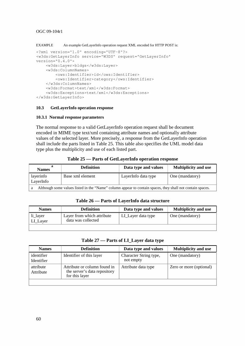
OGC 09-104r1
60
EXAMPLE An example GetLayerInfo operation request XML encoded for HTTP POST is:
<?xml version="1.0" encoding="UTF-8"?> <w3ds:GetLayerInfo service="W3DS" request="GetLayer Info" version="0.4.0"> <w3ds:Layer>bldgs</w3ds:Layer> <w3ds:ColumnNames> <ows:Identifier>id</ows:Identifier> <ows:Identifier>category</ows:Identifier> </w3ds:ColumnNames> <w3ds:Format>text/xml</w3ds:Format> <w3ds:Exceptions>text/xml</w3ds:Exceptions> </w3ds:GetLayerInfo>
10.3 GetLayerInfo operation response
10.3.1 Normal response parameters
The normal response to a valid GetLayerInfo operation request shall be document encoded in MIME type text/xml containing attribute names and optionally attribute values of the selected layer. More precisely, a response from the GetLayerInfo operation shall include the parts listed in Table 25. This table also specifies the UML model data type plus the multiplicity and use of each listed part.
Table 25 — Parts of GetLayerInfo operation response
Names a Definition Data type and values Multiplicity and use
layerinfo LayerInfo
Base xml element LayerInfo data type One (mandatory)
a Although some values listed in the “Name” column appear to contain spaces, they shall not contain spaces.
Table 26 — Parts of LayerInfo data structure
Names Definition Data type and values Multiplicity and use
li_layer LI_Layer
Layer from which attribute data was collected
LI_Layer data type One (mandatory)
Table 27 — Parts of LI_Layer data type
Names Definition Data type and values Multiplicity and use
identifier Identifier
Identifier of this layer Character String type, not empty
One (mandatory)
attribute Attribute
Attribute or column found in the server’s data repository for this layer
Attribute data type Zero or more (optional)

OGC 09-104r1
61
Table 28 — Parts of Attribute data structure
Names Definition Data type and values Multiplicity and use
name Name
Name of this attribute Character String type, not empty
One (mandatory)
type Type
Data type of this attribute Character String type, not empty
One (mandatory)
uniqueCount UniqueCount
Number of unique values for this attribute
Long type Zero or one (optional)
values Values
List of unique values stored in the server’s data repository for the selected layer and attribute/column
Values data type Zero or one (optional)
Table 29 — Parts of Values data structure
Names Definition Data type and values Multiplicity and use
value Value
Unique attribute value Character String type, may be empty
Zero or more (optional)
NOTE The UML class diagram contained in Subclause C.8 provides a graphical view of the contents of the GetLayerInfo operation response listed in Table 25 - Table 29.
10.3.2 Normal response XML encoding
The following schema fragment specifies the contents and structure of a GetLayerInfo operation response, always encoded in XML:
<!-- =========================================================== --> <element name="LayerInfo" type="w3ds:LayerInfoType"/> <!-- =========================================================== --> <complexType name="LayerInfoType"> <sequence> <element name="LI_Layer" type="w3ds:LI_Layer" minOccurs="0" maxOccurs="unbounded"/> </sequence> </complexType> <!-- =========================================================== --> <complexType name="LI_Layer"> <sequence> <element ref="ows:Identifier" /> <element name="Attribute" type="w3ds:Attribute" minOccurs="0" maxOccurs="unbounded"/> </sequence> </complexType> <!-- =========================================================== --> <complexType name="Attribute"> <sequence> <element name="Name" type="ows:CodeType"/>
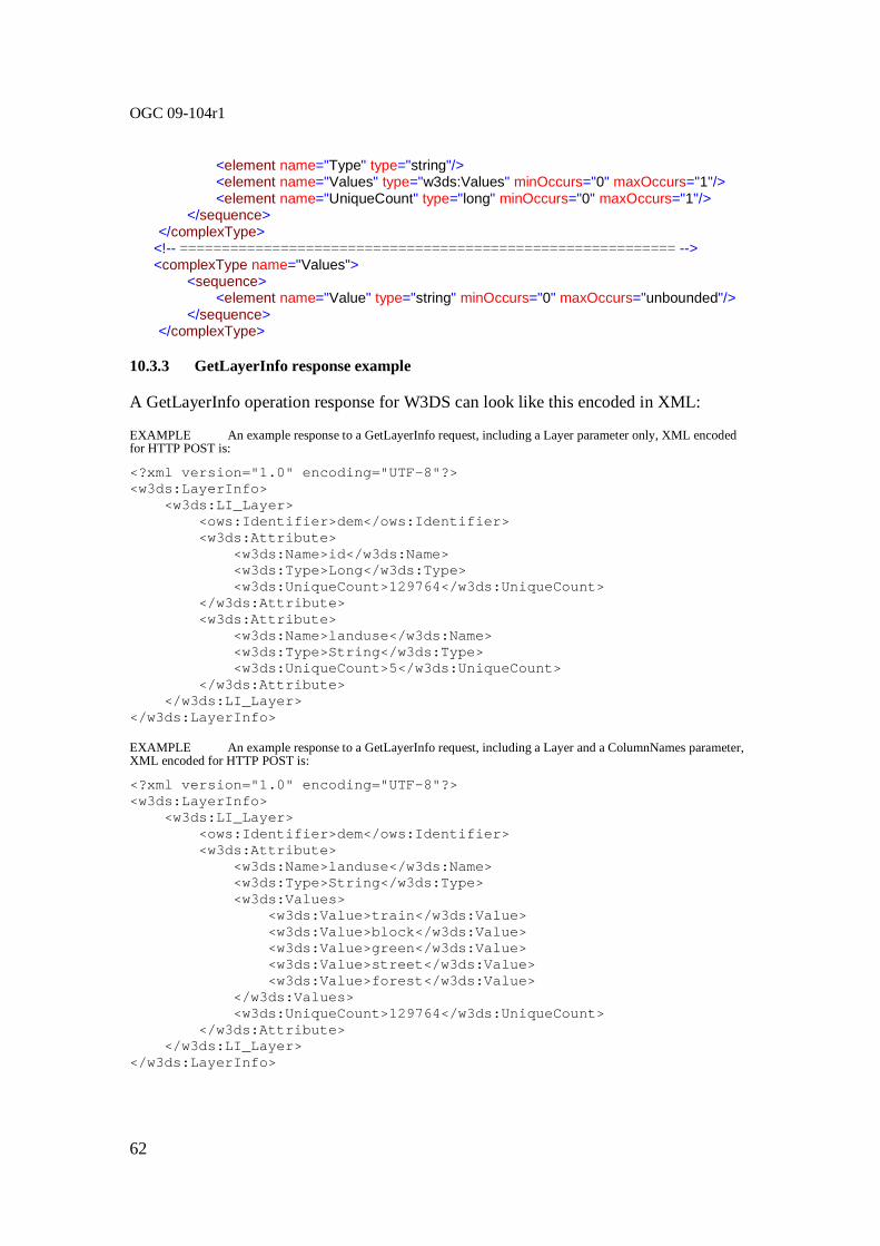
OGC 09-104r1
62
<element name="Type" type="string"/> <element name="Values" type="w3ds:Values" minOccurs="0" maxOccurs="1"/> <element name="UniqueCount" type="long" minOccurs="0" maxOccurs="1"/> </sequence> </complexType> <!-- =========================================================== --> <complexType name="Values"> <sequence> <element name="Value" type="string" minOccurs="0" maxOccurs="unbounded"/> </sequence> </complexType>
10.3.3 GetLayerInfo response example
A GetLayerInfo operation response for W3DS can look like this encoded in XML:
EXAMPLE An example response to a GetLayerInfo request, including a Layer parameter only, XML encoded for HTTP POST is:
<?xml version="1.0" encoding="UTF-8"?> <w3ds:LayerInfo> <w3ds:LI_Layer> <ows:Identifier>dem</ows:Identifier> <w3ds:Attribute> <w3ds:Name>id</w3ds:Name> <w3ds:Type>Long</w3ds:Type> <w3ds:UniqueCount>129764</w3ds:UniqueCo unt> </w3ds:Attribute> <w3ds:Attribute> <w3ds:Name>landuse</w3ds:Name> <w3ds:Type>String</w3ds:Type> <w3ds:UniqueCount>5</w3ds:UniqueCount> </w3ds:Attribute> </w3ds:LI_Layer> </w3ds:LayerInfo> EXAMPLE An example response to a GetLayerInfo request, including a Layer and a ColumnNames parameter, XML encoded for HTTP POST is:
<?xml version="1.0" encoding="UTF-8"?> <w3ds:LayerInfo> <w3ds:LI_Layer> <ows:Identifier>dem</ows:Identifier> <w3ds:Attribute> <w3ds:Name>landuse</w3ds:Name> <w3ds:Type>String</w3ds:Type> <w3ds:Values> <w3ds:Value>train</w3ds:Value> <w3ds:Value>block</w3ds:Value> <w3ds:Value>green</w3ds:Value> <w3ds:Value>street</w3ds:Value> <w3ds:Value>forest</w3ds:Value> </w3ds:Values> <w3ds:UniqueCount>129764</w3ds:UniqueCo unt> </w3ds:Attribute> </w3ds:LI_Layer> </w3ds:LayerInfo>

OGC 09-104r1
63
10.3.4 GetLayerInfo exceptions
When a W3DS server encounters an error while performing a GetLayerInfo operation, it shall return an exception report message as specified in Subclause 7.4 of [OGC 06-121r3]. The allowed standard exception codes shall include those listed in Table 30. For each listed exceptionCode, the contents of the “locator” parameter value shall be as specified in the right column of Table 30.
NOTE To reduce the need for readers to refer to other documents, the first four values listed below are copied from Table 20 in Subclause 8.3 of [OGC 06-121r3].
Table 30 — Exception codes for GetLayerInfo operation
exceptionCode value Meaning of code “locator” value
OperationNotSupported Request is for an operation that is not supported by this server
Name of operation not supported
MissingParameterValue Operation request does not include a parameter value, and this server did not declare a default value for that parameter
Name of missing parameter
InvalidParameterValue Operation request contains an invalid parameter value
Name of parameter with invalid value
OptionNotSupported Request is for an option that is not supported by this server
Identifier of option not supported
UnknownLayer Operation request contains an identifier in the Layers parameter which is unknown to the server
Identifier of invalid layer
ColumnNameNotDefined Operation request contains a column name which is not defined for the selected layer.
Name of invalid column
FormatNotSupported Operation request contains a MIME type in the Format parameter which is not supported by the server
Name of unsupported format
NoApplicableCode No other exceptionCode specified by this service and server applies to this exception
None, omit “locator” parameter
11 GetTile operation (optional)
11.1 Introduction
Data in layers as described in the server’s meta data may be spatially partitioned into rectangular tiles. The GetTile operation is an alternative entry point for accessing tiled layers using tile level, row, and column indices. The information on how to compute these indices is provided by a TileSet definition in the layer element.
The GetTile operation is only supported for those Layers for which the attribute tiled=true has been defined or inherited. A client shall not issue a GetTile request for

OGC 09-104r1
64
other layers. A W3DS shall respond with a properly formatted service exception response (code = OperationNotSupported) if it receives a GetTile request but does not support it.
11.2 GetTile operation request
11.2.1 GetTile request parameters
A request to perform the GetTile operation shall include the data structure specified in Figure 10 and Table 31. This table also specifies the UML model data type, source of values, and multiplicity of each listed parameter, plus the meaning to servers when each optional parameter is not included in the operation request. Although some values listed in the “Names” column appear to contain spaces, they shall not contain spaces.
Figure 10 — GetTile operation request UML class diagram
NOTE 1 To reduce the need for readers to refer to other documents, the first three parameters listed below are largely copied from Table 21 in Subclause 9.2.1 of [OGC 06-121r3].
+ getCapabilities(request : GetCapabilities) : ServiceMetadata
<<Interface>> OWService {Abstract} (from OWS Web Service)
+ getCapabilities(request : GetCapabilities) : ServiceMetadata + getScene(request : GetScene) : GetSceneResponse + GetFeatureInfo(request : GetFeatureInfo) : GetFeatureInfoResponse + GetLayerInfo(request : GetLayerInfo) : GetLayerInfoResponse + GetTile(request : GetTile) : GetTileResponse
W3DService (from W3DS Service)
<<DataType>> W3DSRequestBase {Abstract}
+ service : CharacterString = “W3DS” {frozen} + request : CharacterString + version : CharacterString
<<DataType>> GetTile
+ request : CharacterString = “GetTile” {frozen} + crs : URI + layer : CharacterString
+ style : CharacterString
+ format : ows:MimeType + tileLevel : Integer + tileRow : Integer
+ tileCol : Integer
+ excpetions : ows:MimeType
<<DataType>> GetTileResponse
+ content : byte[]
+ type : ows:MimeType

OGC 09-104r1
65
Table 31 — Parameters in GetTile operation request
Names a Definition Data type and values Multiplicity and use
service service
Service type identifier Character String type, not empty
Value shall be “W3DS”
One (mandatory)
request request
Operation name Character String type, not empty
Value shall be “GetTile”
One (mandatory)
version version
Standard version for operation
Character String type, not empty
Value is specified by each Implementation Standard and Schemas version
One (mandatory)
crs CRS
Coordinate Reference System of the returned tile
URI b One (mandatory)
layer Layer
Identifier of layer to access data from
Character String type One (mandatory)
style Style
Identifier of server style to be applied to the layer
Character String type Zero or one (optional)
format Format
Format encoding of the tile
ows:MimeType, see [OGC 06-121r3] clause 10.5
One (mandatory)
tileLevel TileLevel
Level of requested tile Non negative Integer type One (mandatory)
tileRow TileRow
Row index of requested tile
Non negative Integer type One (mandatory)
tileCol TileCol
Column index of requested tile
Non negative Integer type One (mandatory)
exceptions Exceptions
Format of exceptions ows:MimeType, see [OGC 06-121r3] clause 10.5
Zero or one (optional)
a Although some values listed in the “Name” column appear to contain spaces, they shall not contain spaces. b The CRS shall be specified using either the European Petroleum Survey Group form ”'EPSG:<POSC Code>” or the URL
format defined in OWS Common. Examples: “EPSG:31467”, "urn:ogc:def:crs:EPSG:6.3:31467 ", see [OGC 06-121r3] clause 10.3 and [OGC 04-046r3].
NOTE 2 The data type of many parameters is specified as “Character String type, not empty”. In the XML Schema Documents specified herein, these parameters are encoded with the xsd:string type, which does NOT require that these strings not be empty.
NOTE 3 The UML class diagram contained in Subclause C.9 provides a useful graphical view of the contents of the GetTile operation request listed in Tables Table 31 - Table 32.
The “Multiplicity and use” columns in Table 20 and Table 21 specify the optionality of each listed parameter and data structure in the GetTile operation request. All the “mandatory” parameters and data structures shall be implemented by all W3DS clients, using a specified value(s). Similarly, all the “mandatory” parameters and data structures shall be implemented by all W3DS servers, checking that each request parameter or data structure is received with any specified value(s).
OGC 09-104r1
66
All the “optional” parameters and data structures, in the GetTile operation request, should be implemented by all W3DS clients using specified values, for each implemented W3DS to which that parameter or data structure applies. Similarly, all the “optional” parameters and data structures shall be implemented by all W3DS servers, for each implemented W3DS to which that parameter or data structure applies.
11.2.1.1 CRS
The parameter value for the coordinate reference system (CRS) is defined in [OGC 06-121r3] clause 10.3 and [OGC 04-046r3]. When using a 2D CRS, then the height is measured in meters above sea level.
11.2.1.2 Layer
Identifier of the layer from which to access data. The layer must contain the attribute tiled=true in its meta data, otherwise, a OperationNotSupported exception is thrown.
11.2.1.3 Style
The Styles parameter specifies which server style shall be applied by the server when generating the display elements. The parameter value shall refer to a style identifier as described in the server’s meta data. If this parameter is missing, then the default style is applied.
11.2.1.4 Format
The mandatory Format parameter specifies the target encoding of the returned tile provided as ows:MimeType, see [OGC 06-121r3] clause 10.5. Available formats are described in the server’s meta data.
11.2.1.5 Exceptions
The optional Exceptions parameter specifies the behavior of the server upon detecting an error, e.g. invalid request or internal server error. The default value is “text/xml”. The value shall be one of the MIME types offered in the server’s meta data parameter value, see 7.3.2.2.
11.2.2 GetTile request KVP encoding (optional)
Servers may implement HTTP GET transfer of the GetTile operation request, using KVP encoding. The KVP encoding of the GetTile operation request shall use the parameters specified in Table 32. The parameters listed in Table 32 shall be as specified in Table 31 above.
Table 32 — GetTile operation request URL parameters
Name and example a Optionality and use Definition and format
service=W3DS Mandatory Service type identifier
request= GetTile Mandatory Operation name

OGC 09-104r1
67
version=0.4.0 Mandatory Standard and schema version for this operation
crs=EPSG:26916 Mandatory Coordinate Reference System of the returned tile
layer=dem Mandatory Identifier of layer to access data from
style=default Optional Identifier of server style to be applied to the layer
format= model/x3d Mandatory Format encoding of the result tilelevel=4 Mandatory Level of requested tile
tilerow=45 Mandatory Row index of requested tile
tilecol=123 Mandatory Column index of requested tile exceptions=text/xml Optional Format of exceptions a All parameter names are here listed using mostly lower case letters. However, any parameter name capitalization shall be allowed in KVP encoding, see Subclause 11.5.2 of [OGC 06-121r3].
EXAMPLE An example GetTile operation request KVP encoded for HTTP GET is:
http://hostname:port/path?SERVICE=W3DS&REQUEST=GetT ile&VERSION=0.4.0&CRS=EPSG:26916&FORMAT=model/x3d&LAYER=dem&TILELEVEL=4&TILEROW=45&TILECOL=123&EXCEPTIONS=text/xml
11.2.3 GetTile request XML encoding (mandatory)
All W3DS servers shall implement HTTP POST transfer of the GetTile operation request, using XML encoding only. The following schema fragment specifies the contents and structure of a GetTile operation request encoded in XML:
<!-- =========================================================== --> <element name="GetTile" type="w3ds:GetTileType"/> <!-- =========================================================== --> <complexType name="GetTileType"> <annotation> <documentation>XML encoded W3DS GetTile operation request. </documentation> </annotation> <complexContent> <extension base="w3ds:W3DSRequestBaseType"> <sequence> <element name="CRS" type="anyURI"/> <element name="Layer" type="ows:CodeType"/> <element name="Style" type="ows:CodeType" minOccurs="0"/> <element name="Format" type="ows:MimeType"/> <element name="TileLevel" type="integer"/> <element name="TileRow" type="integer"/> <element name="TileCol" type="integer"/> <element name="Exceptions" type="ows:MimeType" minOccurs="0"/> </sequence> </extension> </complexContent> </complexType>

OGC 09-104r1
68
EXAMPLE An example GetTile operation request XML encoded for HTTP POST is:
<?xml version="1.0" encoding="UTF-8"?> <w3ds:GetTile service="W3DS" request="GetTile" vers ion="0.4.0"> <w3ds:CRS>EPSG:26916</w3ds:CRS> <w3ds:Layer>dem</w3ds:Layer> <w3ds:Style>default</w3ds:Style> <w3ds:Format>model/x3d</w3ds:Format> <w3ds:TileLevel>4</w3ds:TileLevel> <w3ds:TileRow>45</w3ds:TileRow> <w3ds:TileCol>123</w3ds:TileCol> <w3ds:Exceptions>text/xml</w3ds:Exceptions> </w3ds:GetTile>
11.3 GetTile operation response
The response to a valid GetTile request is a document of the MIME type as specified in the Format parameter. The document contains 3D display elements of the selected layer within the spatial extent of the requested tile, specified by the TileLevel, TileRow and TileCol values. The result is converted into the specified CRS. The coordinate axes will be usually shifted to computer graphics coordinate axes as shown in Figure 2.
If the GetTile request contains a server style identifier, then the display elements of the layer are portrayed according to the respective style.
If the resulting document contains references to additional files which must be loaded by the client, for instance URLs to textures, then those files must be accessible to the client, either stored on the same server as the W3DS or on another server accessible over the Internet. Relative paths in the URL without protocol and server domain may be used for referencing to files in the directory of the W3DS or in subdirectories. Contained URLs may also point to other service end points producing the required MIME type, for instance a WCS may be used as source for terrain textures.
If the GetTile request contains a TileLevel, TileRow or TileCol index which is not within the range of the layer as described in the server’s meta data, then the W3DS server shall not respond with an exception report message. The response to a GetTile request shall be always a document of the MIME type as specified in the Format parameter. If any of the indices is out of range, then this document shall contain no content, but all headers that are necessary in order to parse the document correctly.
In case of an incorrect request or an occurring error while accessing the tile, the response must be supplied in the requested format for exceptional cases (parameters EXCEPTION) by the server. With a request via HTTP the MIME type of the returned document must be set by the server according to contents of the resulting file.
11.3.1 GetTile exceptions
When a W3DS server encounters an error while performing a GetTile operation, it shall return an exception report message as specified in Subclause 7.4 of [OGC 06-121r3]. The allowed standard exception codes shall include those listed in Table 33. For each listed

OGC 09-104r1
69
exceptionCode, the contents of the “locator” parameter value shall be as specified in the right column of Table 33.
NOTE To reduce the need for readers to refer to other documents, the first four values listed below are copied from Table 20 in Subclause 8.3 of [OGC 06-121r3].
Table 33 — Exception codes for GetTile operation
exceptionCode value Meaning of code “locator” value
OperationNotSupported Request is for an operation that is not supported by this server
Name of operation not supported
MissingParameterValue Operation request does not include a parameter value, and this server did not declare a default value for that parameter
Name of missing parameter
InvalidParameterValue Operation request contains an invalid parameter value
Name of parameter with invalid value
OptionNotSupported Request is for an option that is not supported by this server
Identifier of option not supported
LayerNotTiled No tiled data is available for the requested layer. The attribute Tiled in the server’s meta data is set to false
Identifier of layer
TileSetNotDefined No TileSet has been defined for the requested layer in the server’s meta data. This indicates a false configuration of the server
Identifier of layer
CRSNotSupported Operation request contains a value in the CRS parameter which is not supported by the server
Name of unsupported CRS
UnknownLayer Operation request contains an identifier in the Layer parameter which is unknown to the server
Identifier of invalid layer
FormatNotSupported Operation request contains a MIME type in the Format parameter which is not supported by the server
Name of unsupported format
ExceptionNotSupported Operation request contains a value in the Exception parameter which is not supported by the server
Name of unsupported exception format
NoApplicableCode No other exceptionCode specified by this service and server applies to this exception
None, omit “locator” parameter
OGC 09-104r1
70
Annex A (normative)
Abstract test suite
In each Implementation Standard document, Annex A shall specify the Abstract Test Suite, as specified in Clause 9 and Annex A of ISO 19105. That Clause and Annex specify the ISO/TC 211 requirements for Abstract Test Suites. Examples of Abstract Test Suites are available in an annex of most ISO 191XX documents, one of the more useful is in ISO 191TBD. Note that this guidance may be more abstract than needed in an OpenGIS® Implementation Standard.
Inclusion of the Abstract Test Suite is expected in version 1.0.0 of each OGC Implementation Standard. In earlier versions, the following paragraph can be used:
An abstract test suite is not provided in this version of this Implementation Standard, but will be provided in version 1.0.0.
A.1 General
A paragraph.

OGC 09-104r1
71
Annex B (normative)
XML Schema Documents
In addition to this document, this standard includes several normative XML Schema Documents. These XML Schema Documents are bundled in a zip file with the present document. After OGC acceptance of a Version 1.0.0 of this standard, these XML Schema Documents will also be posted online at the URL:
http://schemas.opengeospatial.net/W3DS/1.0.0.
In the event of a discrepancy between the bundled and online versions of the XML Schema Documents, the online files shall be considered authoritative.
The W3DS abilities now specified in this document use 8 specified XML Schema Documents included in the zip file with this document. These XML Schema Documents combine the XML schema fragments listed in various subclauses of this document, eliminating duplications. These XML Schema Documents roughly match the UML packages described in Annex C, and are named:
w3dsCommon.xsd
w3dsGetCapabilities.xsd
w3dsCapabilities.xsd
w3dsGetScene.xsd
w3dsGetFeatureInfo.xsd
w3dsGetLayerInfo.xsd
w3dsLayerInfo.xsd
w3dsGetTile.xsd
These XML Schema Documents use and build on the OWS common XML Schema Documents specified [OGC 06-121r3], named:
ows19115subset.xsd
owsCommon.xsd
owsDataIdentification.xsd
owsExceptionReport.xsd
owsGetCapabilities.xsd
owsOperationsMetadata.xsd
owsServiceIdentification.xsd

OGC 09-104r1
72
owsServiceProvider.xsd
All these XML Schema Documents contain documentation of the meaning of each element and attribute, and this documentation shall be considered normative as specified in Subclause 11.6.3 of [OGC 06-121r3].

OGC 09-104r1
73
Annex C (informative)
UML model
C.1 Introduction
This annex provides a UML model of the W3DS interface, using the OGC/ISO profile of UML summarized in Subclause 5.3 of [06-121r3].
Figure C.1 is a simple UML diagram summarizing the W3DS interface. This class diagram shows that the W3DService class inherits the getCapabilities operation from the OGCWebService interface class, and adds the GetScene, GetFeatureInfo, GetLayerInfo, and GetTile operations. (The capitalization of names uses the OGC/ISO profile of UML.)
Figure C.1 — W3DS interface UML diagram
Each of the W3DS operations uses a request and a response data type, each of which is defined by one or more additional UML classes. The following subclauses provide a more complete UML model of the W3DS interface, adding UML classes defining the operation request and response data types.
C.2 UML packages
The W3DS interface UML model is organized in packages, as shown in the package diagram in Figure C.2. These W3DS-specific packages make use of five non-W3DS-
OGCWebService {Abstract}
+ getCapabilities(request : GetCapabilities) : ServiceMetadata
(from OGC Web Service)
<<Interface>>
W3DService
+ getScene(request : GetScene) : GetSceneResponse + getFeatureInfo(request : GetFeatureInfo) : GetFeatureInfoResponse + getLayerInfo(request: GetLayerInfo) : GetLayerInfoResponse + getTile(request : GetTile) : GetTileResponse
Each server instance instantiates only one object of this class, and this object always exists while server is available
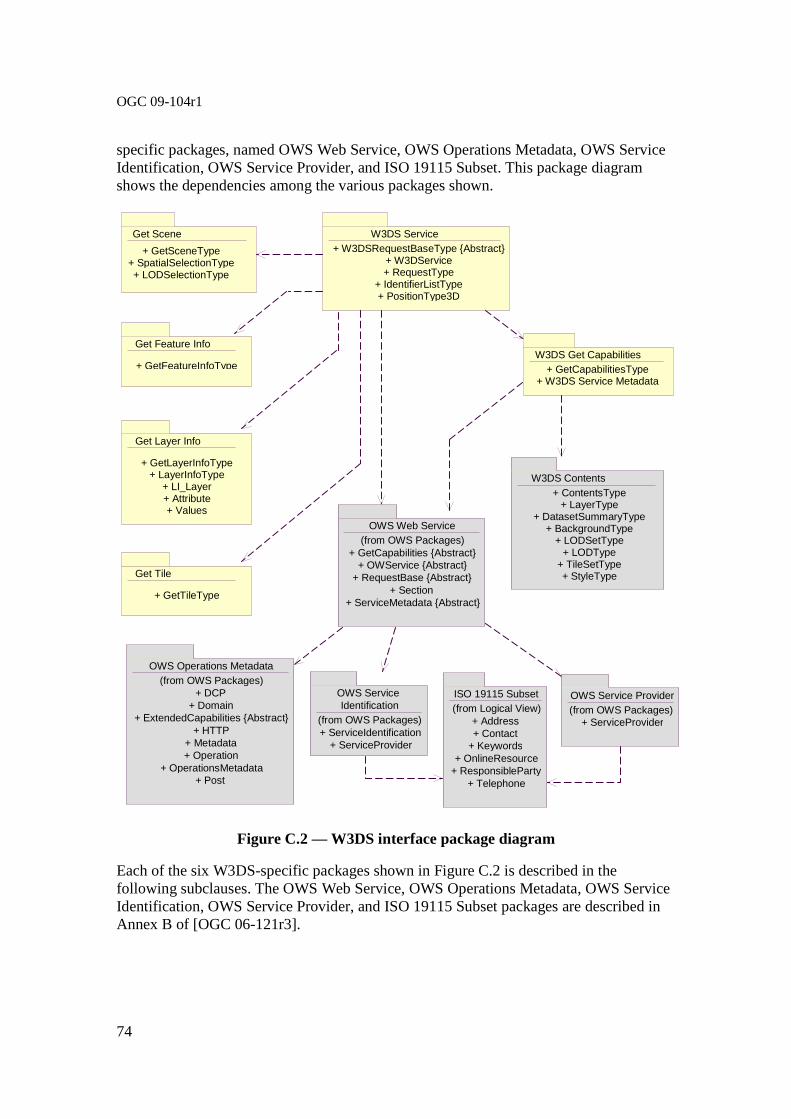
OGC 09-104r1
74
specific packages, named OWS Web Service, OWS Operations Metadata, OWS Service Identification, OWS Service Provider, and ISO 19115 Subset. This package diagram shows the dependencies among the various packages shown.
Figure C.2 — W3DS interface package diagram
Each of the six W3DS-specific packages shown in Figure C.2 is described in the following subclauses. The OWS Web Service, OWS Operations Metadata, OWS Service Identification, OWS Service Provider, and ISO 19115 Subset packages are described in Annex B of [OGC 06-121r3].
OWS Service Identification
(from OWS Packages)+ ServiceIdentification
+ ServiceProvider
ISO 19115 Subset(from Logical View)
+ Address+ Contact
+ Keywords+ OnlineResource
+ ResponsibleParty+ Telephone
W3DS Service + W3DSRequestBaseType {Abstract}
+ W3DService + RequestType
+ IdentifierListType + PositionType3D
OWS Operations Metadata(from OWS Packages)
+ DCP+ Domain
+ ExtendedCapabilities {Abstract} + HTTP
+ Metadata+ Operation
+ OperationsMetadata+ Post
W3DS Get Capabilities + GetCapabilitiesType
+ W3DS Service Metadata
Get Feature Info
+ GetFeatureInfoType
Get Scene + GetSceneType
+ SpatialSelectionType+ LODSelectionType
W3DS Contents+ ContentsType
+ LayerType + DatasetSummaryType
+ BackgroundType + LODSetType
+ LODType + TileSetType + StyleType
OWS Web Service(from OWS Packages)
+ GetCapabilities {Abstract} + OWService {Abstract}
+ RequestBase {Abstract}+ Section
+ ServiceMetadata {Abstract}
OWS Service Provider(from OWS Packages)
+ ServiceProvider
Get Layer Info
+ GetLayerInfoType + LayerInfoType
+ LI_Layer + Attribute + Values
Get Tile
+ GetTileType

OGC 09-104r1
75
C.3 W3DS Service package
The W3DS Service package is shown in the class diagram in Figure C.3. This diagram does not show the classes used by the W3DS operation requests and responses, which are shown (with part of this package) in the GetCapabilites, GetScene, GetFeatureInfo, GetLayerInfo, and GetTile packages. This diagram also shows one used classes from the OWS Web Service package, which is common to all OGC Web Services, plus one used class from the W3DS package.
Figure C.3 — W3DS Service package class diagram
OGCWebService {Abstract}
+ getCapabilities(request : GetCapabilities) : ServiceMetadata
(from OGC Web Service)
<<Interface>>
W3DService
+ getScene(request : GetScene) : GetSceneResponse + getFeatureInfo(request : GetFeatureInfo) : GetFeatureInfoResponse + getLayerInfo(request: GetLayerInfo) : GetLayerInfoResponse + getTile(request : GetTile) : GetTileResponse
Each server instance instantiates only one object of this class, and this object always exists while server is available
RequestBase {Abstract} (from OWS Web Service)
+ service : CharacterString + version : CharacterString + request : CharacterString
<<DataType>> W3DSRequestBase {Abstract}
+ service : CharacterString = “W3DS” {frozen}
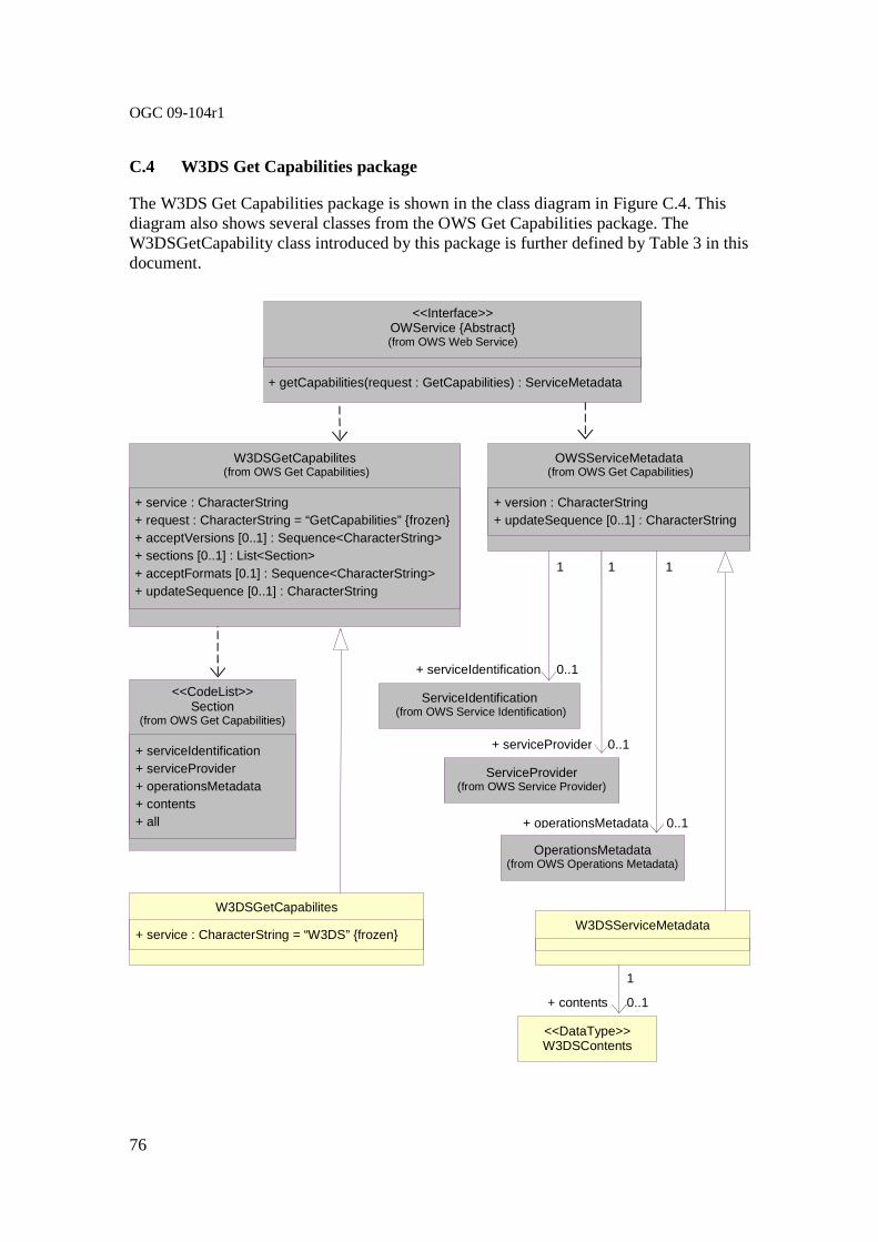
OGC 09-104r1
76
C.4 W3DS Get Capabilities package
The W3DS Get Capabilities package is shown in the class diagram in Figure C.4. This diagram also shows several classes from the OWS Get Capabilities package. The W3DSGetCapability class introduced by this package is further defined by Table 3 in this document.
+ getCapabilities(request : GetCapabilities) : ServiceMetadata
<<Interface>> OWService {Abstract} (from OWS Web Service)
W3DSGetCapabilites (from OWS Get Capabilities)
+ service : CharacterString + request : CharacterString = “GetCapabilities” {frozen} + acceptVersions [0..1] : Sequence<CharacterString> + sections [0..1] : List<Section> + acceptFormats [0.1] : Sequence<CharacterString> + updateSequence [0..1] : CharacterString
<<CodeList>> Section
(from OWS Get Capabilities)
+ serviceIdentification + serviceProvider + operationsMetadata + contents + all
W3DSGetCapabilites
+ service : CharacterString = “W3DS” {frozen}
OWSServiceMetadata (from OWS Get Capabilities)
+ version : CharacterString + updateSequence [0..1] : CharacterString
W3DSServiceMetadata
ServiceIdentification (from OWS Service Identification)
ServiceProvider (from OWS Service Provider)
OperationsMetadata (from OWS Operations Metadata)
+ serviceIdentification
+ serviceProvider
+ operationsMetadata
<<DataType>> W3DSContents
0..1
0..1
0..1
0..1 + contents
1 1 1
1

OGC 09-104r1
77
Figure C.4 — W3DS Get Capabilities package class diagram
C.5 W3DS Contents package
The W3DS Contents package is shown in the class diagram in Figure C.5. This diagram also shows classes from the OWS Common, and OWS Data Identification package. The classes introduced by this package is further defined by Table 10 through Table 16 in this document.
Figure C.5 — W3DS Contents package class diagram
1 0..*
+ keywords
+ metadata [0..1]: Any + link [0..1]: URL
+ about [0..1]: URI
Metadata (from OWS Common)
+ metadata
<<DataType>>
Contents
Identification (from OWS Data Identitfication)
+ outputFormat [0..*] : CharacterString
+ availableCRS [0..*] : CharacterString
BasicIdentification (from OWS Data Identitfication)
+ title [0..*] : LanguageString
+ abstract [0..*] : LanguageString
Keywords (from ISO 19115 subset)
+ keyword [1..*] : LanguageString
+ layer
1
0..*
1
0..1 0..1
0..*
<<DataType>> LanguageString
(from ISO 19115 subset)
+ value : CharacterString
+ lang [0..1] : CharacterString
+ code : CharacterString
+ codeSpace [0..1]: URI
+ type
Code (from ISO 19115 subset)
1
1
Layer
+ defaultCRS : anyURI
+ queriable [0..1] : Boolean Type
+ cascaded [0..1] : Integer Type + tiled [0..1] : Boolean Type
+ minScaleDenominator [0..1] : Double
+ maxScaleDenominator [0..1] : Double
+ startTime [0..1] : Date Type + endTime [0..1] : Date Type
<<DataType>>
BoundingBox (From OWS Common)
+ lowerCorner : Sequence <Number>
+ upperCorner : Sequence <Number>
+ crs [0..1]: URI + dimensions [0..1] : PositiveInteger
+ boundingBox
+ identifier
+ isDefault [0..1]: Boolean Type
Style
+ style
1
0..*
Background
1
0..*
+ background
+ datasetSummary 1
0..*
+ isDefault [0..1]: Boolean Type + lodValue : URI
+ defaultRange : Double
LOD
+ lod 0..*
LODSet
+ lodSet
1
0..1
+ crs : URI
+ tileSizes : Sequence<Number>
+ lowerCorner : Sequence<Number,2>
TileSet
+ tileSet
1
0..1
0..*
1
0..*
1
1
DatasetSummary
+ lowerCorner : Sequence <Number, 2> + upperCorner : Sequence <Number, 2> + crs [0..1]: URI="urn:ogc:def:crs:CRS::84"
+ dimensions [0..1] PositiveInteger=2
<<DataType>>
WGS84BoundingBox (From OWS Common)
+ wgs84BoundingBox
0..* 1

OGC 09-104r1
78
C.6 W3DS Get Scene package
The W3DS Get Scene package is shown in the class diagram in Figure C.6. The GetScene operation is specified in subclause 8. This diagram also shows 2 classes from the OWS Common and OWS Get Capability package. The GetScene class introduced by this package is further defined by Table 17 in this document.
Figure C.6 — W3DS Get Scene package class diagram
+ getCapabilities(request gh GetCapabilities) : ServiceMetadata
+ GetScene(request : GetScene) : GetSceneResponse + GetFeatureInfo(request : GetFeatureInfo) : GetFeatureInfoResponse + GetLayerInfo(request : GetLayerInfo) : GetLayerInfoResponse + GetTile(request : GetTile) : GetTileResponse
W3DService (from W3DS Service)
RequestBase {Abstract} (from OWS Common)
+ service : CharacterString + request : CharacterString + version : CharacterString
<<DataType>> GetSceneResponse
+ content : byte[] + type : ows:MimeType
<<DataType>> GetScene
+ request : CharacterString = “GetScene” {frozen} + crs : URI + boundingBox : ows:BoundingBox + minHeight : Double + maxHeight : Double + spatialSelection : CharacterString + format : ows:MimeType + layers : CharacterString + styles : CharacterString + lod : CharacterString + lodSelection : CharacterString + time : Date + offset : CharacterString + exceptions : ows:MimeType + background : CharacterString + light : Boolean + viewpoints : CharacterString
W3DSRequestBase {Abstract}
+ service : CharacterString = “W3DS” {frozen}
<<Interface>> OGCWebService
(from OWS Get Capabilities)
+ getCapabilities(request : GetCapabilities) : ServiceMetadata

OGC 09-104r1
79
C.7 W3DS Get Feature Info package
The W3DS Get Feature Info package is shown in the class diagram in Figure C.7. The GetFeatureInfo operation is specified in subclause 9. This diagram also shows 2 classes from the OWS Common and OWS Get Capability package. The GetFeatureInfo class introduced by this package is further defined by Table 20 in this document.
Figure C.7 — W3DS Get FeatureInfo package class diagram
+ getCapabilities(request gh GetCapabilities) : ServiceMetadata
+ GetScene(request : GetScene) : GetSceneResponse + GetFeatureInfo(request : GetFeatureInfo) : GetFeatureInfoResponse + GetLayerInfo(request : GetLayerInfo) : GetLayerInfoResponse + GetTile(request : GetTile) : GetTileResponse
W3DService (from W3DS Service)
RequestBase {Abstract} (from OWS Common)
+ service : CharacterString + request : CharacterString + version : CharacterString
<<DataType>> GetFeatureInfoResponse
+ content : byte[] + type : ows:MimeType
<<DataType>> GetFeatureInfo
+ request : CharacterString = “GetFeatureInfo” {frozen} + crs : URI + format : ows:MimeType + layers : CharacterString + featureCount : Integer + coordinate : CharacterString + exceptions : ows:MimeType
W3DSRequestBase {Abstract}
+ service : CharacterString = “W3DS” {frozen}
<<Interface>> OGCWebService
(from OWS Get Capabilities)
+ getCapabilities(request : GetCapabilities) : ServiceMetadata

OGC 09-104r1
80
C.8 W3DS Get Layer Info package
The W3DS Get Layer Info package is shown in the class diagram in Figure C.8. The GetLayerInfo operation is specified in subclause 10. This diagram also shows 2 classes from the OWS Common and OWS Get Capability package. The GetLayerInfo class introduced by this package is further defined by Table 23 in this document.
+ getCapabilities(request gh GetCapabilities) : ServiceMetadata
+ GetScene(request : GetScene) : GetSceneResponse + GetFeatureInfo(request : GetFeatureInfo) : GetFeatureInfoResponse + GetLayerInfo(request : GetLayerInfo) : GetLayerInfoResponse + GetTile(request : GetTile) : GetTileResponse
W3DService (from W3DS Service)
RequestBase {Abstract} (from OWS Common)
+ service : CharacterString + request : CharacterString + version : CharacterString
<<DataType>> GetLayerInfoResponse
<<DataType>> GetLayerInfo
+ request : CharacterString = “GetLayerInfo” {frozen} + layer : CharacterString + columnName : CharacterString + format : ows:MimeType
W3DSRequestBase {Abstract}
+ service : CharacterString = “W3DS” {frozen}
<<Interface>> OGCWebService
(from OWS Get Capabilities)
+ getCapabilities(request : GetCapabilities) : ServiceMetadata
LI_Layer Attribute
+ type : CharacterString + UniqueCount [0..1] : Long
Values
+ value [0..*] : CharacterString
+ li_layer
+ identifier
Code (from ISO 19115 subset)
+ code : CharacterString + codeSpace [0..1]: URI
+ attribute
+ name
+ values
0..*
0..*
0..1
1
1
1

OGC 09-104r1
81
Figure C.8 — W3DS Get LayerInfo package class diagram
C.9 W3DS Get Tile package
The W3DS Get Tile package is shown in the class diagram in Figure C.9. The GetTile operation is specified in subclause 11. This diagram also shows 2 classes from the OWS Common and OWS Get Capability package. The GetLayerInfo class introduced by this package is further defined by Table 31 in this document.
Figure C.9 — W3DS Get Tile package class diagram
+ getCapabilities(request gh GetCapabilities) : ServiceMetadata
+ GetScene(request : GetScene) : GetSceneResponse + GetFeatureInfo(request : GetFeatureInfo) : GetFeatureInfoResponse + GetLayerInfo(request : GetLayerInfo) : GetLayerInfoResponse + GetTile(request : GetTile) : GetTileResponse
W3DService (from W3DS Service)
RequestBase {Abstract} (from OWS Common)
+ service : CharacterString + request : CharacterString + version : CharacterString
<<DataType>> GetTileResponse
+ content : byte[] + type : ows:MimeType
<<DataType>> GetTile
+ request : CharacterString = “GetTile” {frozen} + crs : URI + layer : CharacterString + style : CharacterString + format : ows:MimeType + tileLevel : Integer + tileRow : Integer + tileCol : Integer + excpetions : ows:MimeType
W3DSRequestBase {Abstract}
+ service : CharacterString = “W3DS” {frozen}
<<Interface>> OGCWebService
(from OWS Get Capabilities)
+ getCapabilities(request : GetCapabilities) : ServiceMetadata

OGC 09-104r1
82
Annex D (informative)
Example XML documents
D.1 Introduction
This annex provides more example XML documents than given in the body of this document.
D.2 Level of Detail Selection modes
The following example shows how the LODSelection parameter in the GetScene request controls how multiple Levels of Detail (LODs) of a data set (if available) are handled by the server. The LODSelection parameter specifies whether the scene shall consist of either a single LOD, or a combination of several LODs which can be merged based on the relations between the features.
<?xml version="1.0" encoding="UTF-8"?> <w3ds:GetScene service="W3DS" request="GetScene" ve rsion="0.4.0"> <w3ds:CRS>EPSG:26916</w3ds:CRS> <ows:BoundingBox crs="EPSG:26916"> <ows:LowerCorner>200759.03723318398
3300170.2612183597</ows:LowerCorner> <ows:UpperCorner>223200.2944077917
3330896.6813003295</ows:UpperCorner> </ows:BoundingBox> <w3ds:Format>model/x3d</w3ds:Format> <w3ds:Layers> <ows:Identifier>dem</ows:Identifier> <ows:Identifier>bldgs</ows:Identifier> </w3ds:Layers> <w3ds:LODs> <ows:Identifier/> <ows:Identifier>CityGML:2</ows:Identifier> </w3ds:LODs> <w3ds:LODSelection>equals_or_smaller</w3ds:LODSelection> <w3ds:Offset>200000.0 3310000.0 0.0</w3ds:Offse t> <w3ds:Exceptions>text/xml</w3ds:Exceptions> <w3ds:Light>true</w3ds:Light> <w3ds:Viewpoints>202000.0 3310000.0 1500.0 2025 00.0 3305000.0
200.0 0.0 1.0 0.0 60.0</w3ds:Viewpoints> </w3ds:GetScene>
The LODSelection parameter can have 3 values:
a) equals: exactly the LOD specified in the LODs parameter will be returned b) equals_or_smaller: A combination of the LOD specified in the LODs parameter
and additional lower Levels of Detail will be returned as static scene

OGC 09-104r1
83
c) combined: A combination of the LOD specified in the LODs parameter and additional lower Levels of Detail will be returned as dynamic scene containing special LOD nodes
Figure D.1 — W3DS GetScene operation results. Variations of LOD and LODSelection parameters
D.2 TileSet Definition
The following example shows a TileSet definition as described in the server’s meta data. It covers the entire earth. The TileSizes are described in decimal degrees, since the specified CRS is WGS84 (EPSG:4326). The Origin is at the south pole, -180 degrees. Thus the earth surface is divided into 2 base tiles, one for the western and one for the eastern hemisphere.
<w3ds:TileSet> <ows:Identifier>dem_tileset</ows:Identifier>
<w3ds:CRS>EPSG:4326</w3ds:CRS> <w3ds:TileSizes>180 90 45 22.5 11.25 5.625 2.8125 1 .40625 0.703125 0.3515625 0.17578125</w3ds:TileSizes> <w3ds:LowerCorner>-180.0 -90.0</w3ds:LowerCorner>
</w3ds:TileSet>
Figure D.2 shows a scene which has been composed using multiple W3DS GetTile requests. Each Tile represents a quadratic parcel of the earth surface and is modeled as
A B
C
A: LOD = CityGML:1
LODSelection = equals
B: LOD = CityGML:2
LODSelection = equals
C: LOD = CityGML:2
LODSelection = equals_or_smaller

OGC 09-104r1
84
Triangular Irregular Network (TIN). The coordinates have been transformed into UTM using the CRS parameter.
Figure D.2 — Scene composed of multiple W3DS GetTile requests, rendered in wireframe mode

OGC 09-104r1
85
Bibliography
[1] Guidelines for Successful OGC Interface Standards, OGC document 00-014r1
[2] OGC 09-042, 3D-Symbology Encoding Discussion Draft.
[3] OGC 08-140, 3D Portrayal Services - Use Cases, August 2008.
[4] OGC 09-075r1, OWS-6 3D Flythrough (W3DS) Engineering Report, May 2009.
[5] Open Source Geospatial Foundation (OSGeo): WMS Tiling Client Recommendation, http://wiki.osgeo.org/wiki/WMS_Tiling_Client_Recommendation
[6] D. Luebke, M. Reddy, J. Cohen, A. Varshney, B. Watson, and R. Huebner: Level of Detail for 3D Graphics, Morgan Kaufmann, 2002, ISBN 1-55860-838-9.