Draft Environmental Impact Statement for the Shadura ...
326
Shadura Natural Gas Development Project Draft Environmental Impact Statement December 2012 Prepared by: ARCADIS for U.S. Fish and Wildlife Service General Project Location FWS-R7-R-2012-N233
Transcript of Draft Environmental Impact Statement for the Shadura ...

Shadura Natural Gas Development Project Draft Environmental Impact Statement
December 2012 Prepared by: ARCADIS for
U.S. Fish and Wildlife Service
General Project Location
FWS-R7-R-2012-N233

U.S. Fish and Wildlife Service Mission Statement
The mission of the U.S. Fish and Wildlife Service is working with others to conserve, protect, and enhance fish, wildlife, plants, and their habitats for the continuing benefit of the American people.
National Wildlife Refuge Mission Statement
The mission of the National Wildlife Refuge System is to administer a national network of lands and waters for the conservation, management, and, where appropriate, restoration of the fish, wildlife, and plant resources and their habitats within the United States for the benefit of present and future generations of Americans.
—National Wildlife Refuge System Improvement Act of 1997

DRAFT ENVIRONMENTAL IMPACT STATEMENT FOR THE
SHADURA NATURAL GAS DEVELOPMENT PROJECT
KENAI NATIONAL WILDLIFE REFUGE, AND
KENAI PENINSULA BOUROUGH, ALASKA
December 2012
Prepared by:
ARCADIS, US
3301 C. Street
Suite 200
Anchorage, Alaska
Prepared for:
U.S. Fish and Wildlife Service
Region 7
Alaska Regional Office Branch of Realty Operations
1011 East Tutor Road, MS–211 Anchorage, Alaska 99503
Kenai National Wildlife Refuge 2139 Ski Hill Road
P.O. Box 2139 Soldotna, Alaska 99669-2139


December 21, 2012
Re: Release and review of the Draft Environmental Impact Statement (DEIS) for the Shadura Natural Gas Development Project
Dear Reader,
In 2012, the U.S. Fish and Wildlife Service (Service) received a right-of-way application from NordAq Energy, Inc. for the construction and operation of facilities associated with exploration and production of natural gas in the northwestern portion of the Kenai National Wildlife Refuge. Although the Service owns the land surface in the project area, Cook Inlet Region, Inc. (CIRI) owns the subsurface oil and gas resources. CIRI has entered into a lease with NordAq to develop these gas resources. NordAq’s application for a right-of-way was made subject to ANILCA Section 1110 (b), Access to Inholdings.
This Environmental Impact Statement (EIS) documents the site-specific impact analysis of NordAq’s proposed Shadura Natural Gas Development Project as well as three alternatives. The three alternatives were developed in response to comments that the Service received during scoping. The analysis also evaluated a No Action Alternative.
The public comment period will run for 45 days beginning December 21, 2012, and ending February 4, 2013. During that time, you are welcome to submit written comments to the Service at the address listed below. Also during this period, but after at least 14 days following publication of the Notice of Availability of the DEIS for review, the Service will hold public meetings to provide an opportunity for the public, organizations, and regulatory agencies to provide comments on the DEIS. Notices about the meetings will be placed in local newspapers on the Kenai Peninsula and in Anchorage.
Following the comment period, the Service will prepare a Final EIS (FEIS). The Service is required to respond in the FEIS to all substantive comments on the DEIS. The comment period mentioned above provides you, the public, with an opportunity to make an impact on the content of the document and, therefore, potentially affect the decision that will be made after the FEIS is released. We ask that your comments relate directly to the EIS, that you are as specific as possible, and that you cite the location(s) in the document on which you are commenting.
If you have any questions or wish to obtain additional copies of this document, go to http://alaska.fws.gov/nwr/planning/nepa.htm or contact:
Peter Wikoff, U.S. Fish and Wildlife Service, 1011 East Tudor Rd. MS-231, Anchorage, AK 99503.
Facsimile: 907-786-3976 email: [email protected]


Draft Environmental Impact Statement
Lead Agency: U.S. Fish and Wildlife Service, Region 7
Title to Proposed Action: Shadura Natural Gas Development Project
Affected Jurisdictions: Kenai Peninsula Borough
Review: Copies of the DEIS may be obtained from:
Peter Wikoff, U.S. Fish and Wildlife Service, 1011 East Tudor Rd. MS-231, Anchorage, AK 99503. Facsimile: 907-786-3976 email: [email protected] online: http://alaska.fws.gov/nwr/planning/nepa.htm
Document Designation: Draft Environmental Impact Statement
Abstract: In 2012, the U.S. Fish and Wildlife Service (Service) received a right-of-way application from NordAq Energy, Inc. for the construction and operation of facilities associated with exploration and production of natural gas in the northwestern portion of the Kenai National Wildlife Refuge. Although the Service owns the land surface in the project area, Cook Inlet Region, Inc. (CIRI) owns the subsurface oil and gas resources. CIRI has entered into a lease with NordAq to develop these gas resources. NordAq’s application for a right-of-way was made subject to ANILCA Section 1110 (b), Access to Inholdings.
This EIS examines five alternatives:
Alternative 1 — No Action,
Alternative 2 — The project as proposed in NordAq’s application for a right-of-way permit.
Alternative 3 — Alternative northwestern access with on-Refuge drilling/processing pad.
Alternative 4 — Eastern access with on-Refuge drilling/processing pad.
Alternative 5 — Southern access with on-Refuge drilling/processing pad.
This EIS will assist the Service in arriving at a decision for the Shadura Natural Gas Development Project. The Service has not identified a preferred alternative at this time.


December 2012 v Shadura Draft EIS
Preface An Environmental Impact Statement (EIS) usually is not read like a book — from chapter one to the end. The best way to read an EIS depends on your interests. You may be more interested in effects, whereas others might have more interest in the details of the proposed project or be more concerned about what opportunities were made available to the public to be involved in the environmental assessment process. Many readers probably just want to know what is being proposed and how it will affect them.
This document follows the format established in the National Environmental Policy Act’s regulations (Title 40 Code of Federal Regulations Parts 1500 to 1508). The following paragraphs outline information contained in the chapters and appendices so readers may find the parts of interest without having to read the entire document.
Executive Summary: contains a short, simple discussion to provide the reader and the decision makers with a sketch of the more important aspects of the EIS. The reader can obtain addi-tional, more-detailed information from the actual text of the EIS.
Chapter 1 — Purpose and Need: identifies the proposed Shadura Natural Gas Development Project, describes the purpose and need for this document, provides the legal and regulatory context, and summarizes public involvement.
Chapter 2 — Alternatives: describes the alternatives that were carried forward for evaluation. Six alternatives for implementing the project were identified as reasonable alternatives capa-ble of meeting the purpose and need described in Chapter 1 and screening criteria described in Chapter 2. In addition, the No Action Alternative was included for evaluation in detail.
Chapter 3 — Affected Environment: describes the present condition of the environment that would be affected by implementation of the alternatives.
Chapter 4 — Environmental Consequences: describes the probable direct, indirect, and cu-mulative effects to the human environment that would result from implementing the alterna-tives.
Chapter 5 — Consultation and Coordination: lists the agencies, organizations, and persons consulted during preparation of the DEIS.
Chapter 6 — Preparers and Contributors: identifies the people involved in the research, writ-ing, and internal review of the DEIS.
Chapter 7 — Distribution and Review of the Draft EIS: lists the agencies, organizations, and individuals who received a copy of the DEIS.
Chapter 8 — References Cited: lists the references cited in the DEIS.
Chapter 9 — Glossary: describes the technical terms used in the DEIS.
Index: contains cross references and identifies the pages where key topics can be found.
Appendices: contain information that is important to full comprehension of the NEPA analy-sis, but that was too long to be included in the primary chapters.


December 2012 vii Shadura Draft EIS
Acronyms and Abbreviations used in this EIS
Acronym Spelled Out
μg/L micrograms per liter
AAC Alaska Administrative Code
AADT Annual Average Daily Traffic
ADEC Alaska Department of Environmental Conservation
ADF&G Alaska Department of Fish and Game
ADNR Alaska Department of Natural Resources
ADOT&PF Alaska Department of Transportation and Public Facilities
AHRS Alaska Heritage Resource Survey
ANCSA Alaska Native Claims Settlement Act
ANILCA Alaska National Interest Lands Conservation Act
AOGCC Alaska Oil and Gas Conservation Commission
AQRV air quality related value
AST aboveground storage tank
bgs below ground surface
BLM Bureau of Land Management
BMP best management practice
BOPE blowout prevention equipment
CAA Clean Air Act
CAP Contaminants Assessment Process
CASTNET Clean Air Status and Trends Network
CCP Comprehensive Conservation Plan
CCSRA Captain Cook State Recreation Area
CDP Census Designated Place
CEQ Council on Environmental Quality
CERCLA Comprehensive Environmental Response, Compensation, and Liability Act
CFR Code of Federal Regulations
CH4 Methane
CIRI Cook Inlet Region, Incorporated
CIRIAMS Cook Inlet Region Integrated Air Monitoring System
CO carbon monoxide
CO2-e carbon dioxide equivalent

Acronyms and Abbreviations used in this EIS
December 2012 viii Shadura Draft EIS
Acronym Spelled Out
CWA Clean Water Act
dB decibel
dBA A-weighted decibel scale
DBH diameter at breast height
DEIS Draft Environmental Impact Statement
EA Environmental Assessment
EFH essential fish habitat
EIS Environmental Impact Statement
EO Executive Order
EPA U.S. Environmental Protection Agency
ESA Endangered Species Act
FEMA Federal Emergency Management Agency
G&I ground and inject
GHG greenhouse gas
GMU Game Management (Sub)Unit
hp horsepower
HSE Health, Safety and Environmental
Kenai NWR Kenai National Wildlife Refuge
km kilometer
KPB Kenai Peninsula Borough
LNG Liquefied Natural Gas
MAOP maximum allowable operating pressure
mg/L milligrams per liter
MMSCFD million standard cubic feet per day
MOU Memorandum of Understanding
MBTA Migratory Bird Treaty Act
N2O nitrous oxide
NAAQS National Ambient Air Quality Standards
NEPA National Environmental Policy Act
NHPA National Historic Preservation Act
NO2 nitrogen dioxide
NordAq NordAq Energy, Inc.
NOx nitrogen oxides

Acronyms and Abbreviations used in this EIS
December 2012 ix Shadura Draft EIS
Acronym Spelled Out
O3 ozone
Pb lead
PL Public Law
PM particulate matter
Project Shadura Natural Gas Development Project
PSD Prevention of Significant Deterioration
psig pounds per square inch gauge
RCRA Resource Conservation and Recovery Act
RFFA reasonably foreseeable future action
ROD Record of Decision
ROI Region of Influence
ROW right-of-way
Service United States Fish and Wildlife Service
SHPO State Historic Preservation Officer
SO2 sulfur dioxide
SPCC Spill Prevention Control and Countermeasure
SRU Swanson River Oil and Gas Unit
TDS total dissolved solids
TPY tons per year
TVD total vertical depth
TWUP Temporary Water Use Permit
USACE United States Army Corps of Engineers
USC United States Code
USGS U.S. Geological Survey
VOC volatile organic compound
yd3 cubic yard


December 2012 xi Shadura Draft EIS
Executive Summary The U.S. Fish and Wildlife Service (Service) is evaluating an application for a right-of-way (ROW) permit for a proposed natural gas project within the Kenai National Wildlife Refuge (Kenai NWR), Alaska. This evaluation analyzes the project as directed by the National Environmental Policy Act (NEPA). A Draft Environmental Impact Statement (DEIS) has been prepared in accordance with the requirements of NEPA (42 United States Code [USC] 4371, et seq.), as implemented by the Council on Environmental Quality (CEQ) regulations in 40 Code of Federal Regulations (CFR) 1500–1508.
Cook Inlet Region, Inc. (CIRI) owns the subsurface estate of oil, gas, and coal on a portion of the Kenai NWR. NordAq has leased a portion of this oil and gas estate, in the northwest portion of the Kenai NWR, from CIRI. The Shadura Natural Gas Development Project (Project) will include the infrastructure reasonably necessary to produce known gas reserves from NordAq’s leases and transport that gas to a pipeline. This infrastructure includes a drilling/processing pad, a metering pad, an access road, natural gas gathering lines, and fiber optic communication lines.
Purpose and Need
The purpose of this EIS is to gather information and analyze the probable impacts of the alternatives presented herein, to enable the Service to comply with NEPA guidelines, and to make an informed decision regarding the NordAq Energy, Inc. application for a ROW. The need for this EIS arises from the application for a ROW from NordAq Energy, Inc. (NordAq) to access natural gas leases of portions of the Cook Inlet Region, Inc. owned subsurface beneath the Refuge. The Service must decide on the best alternative to access natural gas leases beneath the Refuge and what stipulations will be required. The Alaska National Interests Land Conservation Act (ANILCA) Section 1110 (b) requires that the Service provide for reasonable access to the subsurface estate.
Planning Context
The Kenai NWR is part of a national system of more than 545 refuges. The Service places an emphasis on managing individual refuges in a manner that reflects the National Wildlife Refuge System mission. The Service is the principal Federal agency responsible for conserving, protecting, and enhancing fish, wildlife, plants, and their habitats for the continuing benefits of the American people.
The mission of the U.S. Fish and Wildlife Service is:
Working with others to conserve, protect, and enhance fish, wildlife, plants, and their habitats for the continuing benefit of the American people.
The National Wildlife Refuge System comprises more than 96 million acres of Federal lands, encompassing national wildlife refuges, wetlands, and special management areas. The System has units in each of the 50 states and in the territories of the United States. The mission of the National Wildlife Refuge System is:
To administer a national network of lands and waters for the conservation, management, and, where appropriate, restoration of the fish, wildlife, and plant resources and their habitats within the United States for the benefit of present and future generations of Americans (National Wildlife Refuge System Improvement Act of 1997).

Executive Summary
December 2012 xii Shadura Draft EIS
Legal and Policy Guidance
The National Wildlife Refuge System Administration Act, as amended, states that each refuge shall be managed to fulfill both the mission of the Refuge System and the purposes for which the individual refuge was established. Refuges throughout the System are influenced by a wide array of laws, treaties, and executive orders. Among the most important are the National Wildlife Refuge System Administration Act of 1966, as amended by the National Wildlife Refuge System Improvement Act of 1997, the Refuge Recreation Act, the Endangered Species Act, and the Wilderness Act. For national wildlife refuges in Alaska, ANILCA provides key management direction. ANILCA sets forth purposes of the refuge, defines provisions for planning and management, and authorizes studies and programs related to wildlife and wildland resources, subsistence opportunities, and recreation and economic uses. NEPA guides planning efforts on refuges.
Planning Area
The Kenai Refuge encompasses 1.98-million acres in southcentral Alaska. The Refuge is located on the 5-million acre Kenai Peninsula and is bordered on the north by Chickaloon Bay; on the east by the Chugach National Forest and Kenai Fjords National Park; on the south by Kachemak Bay; and on the west by Cook Inlet. The Refuge is bordered by a number of communities, including Hope to the northeast; Cooper Landing to the east; Seward to the southeast, Homer to the southwest; Ninilchik, Soldotna, and Kenai to the east; and Sterling in the center.
The Refuge is considered by many to be “Alaska in Miniature.” It consists of the western slopes of the Kenai Mountains and forested lowlands bordering Cook Inlet. Treeless alpine and subalpine habitats are home to mountain goats, Dall sheep, caribou, wolverine, marmots, and ptarmigan. Most of the lower elevations on the Refuge are covered by boreal forests composed of spruce and birch forests intermingled with hundreds of lakes. These boreal forests are home to moose, wolves, black and brown bears, lynx, snowshoe hares, and numerous species of neotropical birds such as olive-sided flycatchers, myrtle warblers, and ruby-crowned kinglets. At sea level, the Refuge encompasses the largest estuary on the Peninsula—the Chickaloon River Flats. The Flats provides a major migratory staging area for thousands of shorebirds and waterfowl, and provides a haul-out area for harbor seals and feeding areas for beluga whales.
Franklin D. Roosevelt established the Kenai National Moose Range (Moose Range) on December 16, 1941, for the purpose of “…protecting the natural breeding and feeding range of the giant Kenai moose on the Kenai Peninsula, Alaska, which in this area presents a unique wildlife feature and an unusual opportunity for the study, in its natural environment, of the practical management of a big-game species that has considerable local economic value…” (Executive Order 8979).
ANILCA substantially affected the Moose Range by altering its boundaries and broadening its purposes from moose conservation to protection and conservation of a broad array of fish, wildlife, habitats, other resources, and educational and recreational opportunities. ANILCA also redesignated the Moose Range as the Kenai National Wildlife Refuge, added nearly a quarter of a million acres of land, and established the 1.32-million acre (534,349 hectare) Kenai Wilderness.
ANILCA broadened the purposes from moose conservation to protection and conservation of a broad array of fish, wildlife, habitats, other resources and education, research, and recreational opportunities. Specifically, the ANILCA-defined purposes for Kenai Refuge are:

Executive Summary
December 2012 xiii Shadura Draft EIS
(i) to conserve fish and wildlife populations and habitats in their natural diversity, including but not limited to moose, bears, mountain goats, Dall sheep, wolves and other furbearers, salmonids and other fish, waterfowl and other migratory and nonmigratory birds;
(ii) to fulfill the international treaty obligations of the United States with respect to fish and wildlife and their habitats;
(iii) to ensure, to the maximum extent practicable and in a manner consistent with the purposes set forth in paragraph (i), water quality and necessary water quantity within the Refuge;
(iv) to provide in a manner consistent with subparagraphs (i) and (ii), opportunities for scientific research, interpretation, environmental education, and land management training; and
(v) to provide, in a manner compatible with these purposes, opportunities for fish and wildlife-oriented recreation.
The Wilderness Act of 1964 also provides additional purposes for the Kenai Wilderness Area.
Management of the Kenai NWR is dictated, in large part, by the legislation that created it and its purposes and goals. The Refuge’s purposes are identified above. Specific long-term goals and objectives for management of resources are presented and discussed in the 2009 Revised Comprehensive Conservation Plan for the Kenai NWR.
Legal and Regulatory Context
The Service was the lead agency for preparing this DEIS with the role of technical analysis and decision-making under NEPA and its implementing regulations (40 CFR 1500–1508). The U.S. Army Corps of Engineers (USACE) was a commenting agency that provided information and document review. Each agency will develop a Record of Decision (ROD) with regard to the NEPA process for those decisions under their jurisdiction. Although unlikely, it is possible that the agencies could arrive at different determinations in their RODs because of different regulatory authorities, regulations, and policies that each agency must follow.
The Project is subject to the regulations and requirements of various surface property owners. Some project infrastructure would be located on a Kenai Peninsula Borough (KPB) ROW and Alaska State lands. Other project infrastructure would be located within the boundaries of the Kenai NWR, a Conservation System Unit established by ANILCA, Public Law (PL) 96–487 and managed by the Service.
In addition, the Project is subject to various other federal, state, and borough regulations and requirements. For example, the Project must meet the requirements of the federal Clean Water Act (CWA), Clean Air Act (CAA), National Historic Preservation Act (NHPA), and Endangered Species Act of 1973 (ESA). It also must meet the requirements of the Alaska Historic Preservation Act, other various statues in the Alaska Administrative Code (AAC), and KPB local ordinances.
As mentioned above, CIRI owns oil, gas, and coal resources in the Project area and has leased a portion of its oil and gas estate to NordAq. CIRI is an Alaska Native Regional Corporation established under the Alaska Native Claims Settlement Act (ANCSA). Private surface and subsurface property rights (including the oil and gas estate leased to NordAq) were conveyed to CIRI pursuant to ANCSA in the settlement of Alaska Native Corporation land claims in the Cook Inlet region.
As noted previously, the Project is partially located within the Kenai NWR, a Conservation System Unit established by ANILCA. Section 1110(b) of Title XI of ANILCA, Transportation and Utility Systems In

Executive Summary
December 2012 xiv Shadura Draft EIS
and Across, and Access Into, Conservation System Units in Alaska, addresses access to inholdings and applies to issuance of a ROW permit.
Regulations at 43 CFR 36.10 require that adequate and feasible access be granted to the owners of valid inholdings, in this case CIRI and NordAq, for economic and other purposes. This access is subject to reasonable regulation to protect the natural and other values of the Kenai NWR. These regulations define “adequate and feasible access” as that which is reasonably necessary and economically practicable, but not necessarily the least costly, for achieving the use and development on the applicant’s non-federal land or occupancy interest. Under these federal regulations, the Service must specify in the ROW permit the route(s) and method(s) of access across the area(s) desired by the applicant, unless it is determined that:
The route or method of access would cause significant adverse impacts on natural or other values of the area and adequate and feasible access otherwise exists; or
The route or method of access would jeopardize public health and safety and adequate and feasible access otherwise exists; or
The route or method is inconsistent with the management plan(s) for the area or purposes for which the area was established and adequate and feasible access otherwise exists; or
The method is unnecessary to accomplish the applicant’s land use objective.
If the Service makes one of the findings above, it must specify in the ROW permit another alternate route(s) and/or method(s) of access that will provide the applicant adequate and feasible access after consultation with the applicant.
In addition, the Service must add terms and conditions to a Title XI ANILCA ROW under 43 CFR 36.9 that would:
To the maximum extent feasible, be compatible with the purposes for which the Kenai NWR was established.
Include requirements for restoration, revegetation, and curtailment of erosion of the surface of the land.
Ensure compliance with applicable air and water quality standards and related facility siting standards established pursuant to law.
Require the minimum necessary width designed to control or prevent damage to the environment, including fish and wildlife habitat.
Prevent damage to public health and safety.
Protect the interests of individuals living in the general area of the ROW who rely on fish, wildlife, and other biotic resources for subsistence purposes.
Employ measures to avoid or minimize adverse environmental, social, or economic impacts.
Public Involvement
In March 2012, the Service informed the public of its intent to conduct an environmental impact analysis of the Project and provided the dates, times, and locations of meetings open to the public. Public notices of the scoping meetings were published on March 8 and 15 in the Anchorage Daily News, Peninsula Clarion, and Homer Tribune. In addition, the Service sent a press release to media outlets announcing its intent to prepare an EIS for the Project. The Service also prepared and mailed 2,012 postcards announcing the scoping meetings and soliciting comments from the public to help identify specific issues and concerns that the Service should consider and document in the EIS.

Executive Summary
December 2012 xv Shadura Draft EIS
Following these notifications, the Service held two public meetings to discuss the Project and receive comments from the public. The first meeting was held in Kenai, Alaska, on March 20, 2012. The second meeting was held in Anchorage, Alaska, on March 22, 2012. The Project was described briefly, and participants were invited to ask questions and submit comments.
After these meetings, the Service published a Notice of Intent to prepare an EIS in the Federal Register on May 17, 2012. It also updated the public about the status of the analysis through information posted on the Kenai NWR’s web site (kenai.fws.gov/current.htm) and Regional web site (alaska.fws.gov/nwr/planning/nepa.htm).
In compliance with Executive Order 13175, Consultation and Coordination with Indian Tribal Governments, federal agencies are required to consult with federally recognized tribal governments during the NEPA process. The Service identified 14 tribal governments and native corporations potentially affected by the project. They were notified by letter dated April 30, 2012 of the opportunity to consult. No requests for consultation were received.
Using comments provided by the public, the Service identified six key or significant issues. These issues were used to define the scope of this NEPA analysis. These key issues were used to analyze environmental effects, prescribe mitigation measures, or both. The six key issues that constituted the overall scope of the NEPA analysis are:
Issue 1: The potential effects of the proposed project on fish, wildlife, and terrestrial and aquatic habitats. This issue was raised by both the public and Service. The project is located within an undeveloped portion of the Kenai NWR; no roads or structures exist in the area. Impacts will include direct loss of wetland and upland habitats to the constructed project footprint (road, pads, pipeline/utility corridor). The project may require alteration of anadromous and/or other fish-bearing streams. Both the project footprint and the project’s long-term operations will disturb and potentially displace some wildlife species and result in habitat fragmentation with potential impacts on wildlife movements.
Sub-issue 1: The potential effects of the proposed Project on the spread of invasive species. Control of exotic plants, such as sweet clover, hawkweed, and canary reed grass, that are spreading into the Kenai NWR is an ongoing problem for the Service. The project’s effects include both serving as a source and a vector—gravel for road and pad construction containing invasive plant seeds, construction and operational traffic introducing additional seeds and plant materials, and soil disturbance during construction and maintenance providing favorable conditions for invasive plant establishment and spread. This sub-issue was raised by the Service.
Sub-issue 2: The potential effects of the proposed Project on the spread of the chytrid fungus. This fungus, which attacks wood frogs, has been spreading in the Kenai NWR. Research suggests one of the sources of the fungus in the Kenai NWR might be associated with gravel roads. The Service is concerned that the new gravel road and pads that NordAq proposes to construct could introduce the fungus to an undisturbed portion of the refuge. This sub-issue was raised by the Service.
Issue 2: The potential effects of the Project on refuge management. As an example, new industrial development and operations in this portion of Kenai NWR would necessitate review and possible revision of fire management planning and response for the area. This could affect the Service’s overall fire management program (management of both wildland fires and prescribed burning) on the northern portion of Kenai NWR. This issue was raised by the Service.

Executive Summary
December 2012 xvi Shadura Draft EIS
Issue 3: The potential effects of the proposed Project on surface and subsurface hydrology and on water quality. This issue was raised by both the public and Service.
Issue 4: Air quality impacts associated with Project construction and operations. The Refuge is designated as a Class II air quality area under the Clean Air Act. This issue was raised by the Service.
Issue 5: The potential effects to recreational uses and users. Construction activities would affect winter recreational use of the project area by trappers, skiers, and snowmachiners. After construction, the level of traffic, noise, and lighting impacts associated with operations may affect recreational users of Captain Cook State Recreation Area (CCSRA) and Kenai NWR, including users of the Swanson River. This issue was raised by both the public and Service.
Issue 6: The potential effects of increased traffic during construction of the access road and pads, during drilling, and during operations, both on and off the Kenai NWR. This issue was raised by both the public and Service.
Five alternatives were analyzed in detail. They include the No Action Alternative (Alternative 1) and NordAq’s proposal as contained in the application for a ROW permit (Alternative 2). Alternatives 3 through 5 involve variations in the location of access routes and some facilities (Figure S–1).
Alternative 1—No Action
The No Action alternative is required by NEPA for comparison with the other alternatives analyzed in the EIS. For this analysis, the No Action alternative would not authorize natural gas development on CIRI leases within the project area. Therefore, under this alternative, the Shadura Natural Gas Development Project would not be developed.
Alternative 2
This alternative is NordAq’s proposed Shadura Natural Gas Development Project, which it would construct, operate, maintain, decommission, and reclaim. Construction would occur in two primary stages. First, a gravel road, gravel storage yards, and a minimal drilling/processing pad would be constructed. Then one natural gas well would be drilled and tested. If the results of this testing were unfavorable, all equipment and gravel would be removed and the affected areas would be restored to approximate preconstruction conditions. If the results of testing were favorable, the second stage would be constructed.
The second stage of construction includes expanding the drilling/processing pad to its final size and configuration; drilling five additional natural gas wells, an industrial water well, and a Class II disposal well; and constructing facilities needed for production. Except where identified for a specific alternative, most of the facilities needed for production would be installed on the drilling/processing pad located on the Kenai NWR. Buried gathering lines would connect the drilling/processing pad to the metering pad, which would be located on State of Alaska land. From the metering pad, a short pipeline would tie into the ConocoPhillips Alaska natural gas pipeline.
The overall construction phase would occur over about 18 months. Once constructed, the Project would operate for about 30 years. At the end of the Project’s useful life, it would be decommissioned and the impacted areas reclaimed.

C O O K I N L E T
CAPTAIN COOKCAPTAIN COOKSTATESTATE
RECREATIONRECREATIONAREAAREA
ADL LEASE - 391596ADL LEASE - 391596
K E N A I N A T I O N A L W I L D L I F E R E F U G EK E N A I N A T I O N A L W I L D L I F E R E F U G E
Gathering Line - Alt.2,4,5 Access Road - Alt.4
Access Road - Alt.3
Gathering Line - Alt.3
Metering Pad - Alt. 2,4,5
Access Road - Alt. 2
Metering Pad - Alt.3
Access Road - Alt.5
Drilling Pad/Processing Pad - Alt. 2,3,4,5
Swanson River UnitSwanson River Unit
Kitchen Lights UnitKitchen Lights Unit
Salmo Lake
Crane Lake
Snipe Lake
Dunlin Lake
Hungry Lake
Plover Lake
Gooseneck Lake
0 1 20.5 Km
FIGURE:
SCALE:0 0.5 10.25 Mi
S-1ALTERNATIVES AND PROJECT
COMPONENTS
SHADURA NATURAL GAS DEVELOPMENT PROJECT DEIS
ARCADIS: NOREIS0014.mxd, 10/08/12, R04
AL A S K AProject
LocationProjection: State Plane Alaska
Zone 4 (feet), NAD83Seward Meridian
RoadsKenai National Wildlife RefugeADL Lease 391596
Oil & Gas Unit BoundariesCaptain Cook SRAKenai Peninsula Borough Lands

Executive Summary
December 2012 xviii Shadura Draft EIS
Under this alternative, the access road would extend from the North Kenai Spur Highway along the west and south sides of Salmo Lake to the drilling/processing pad. The access road outside the Refuge has already been permitted for construction by federal, state, and local agencies as part of another project. Thus, the permitted portion of the access road is not included as part of this alternative because its construction is permitted and it could be constructed before any decision is made on this Project.
Altogether, the access road would be 4.3 miles long. About 2.7 miles of the road would be on the Kenai NWR. The remaining1.6 miles are already permitted for construction on Alaska State and KPB lands. On the Kenai NWR, about 1.7 miles of the road would be constructed in upland areas and about 1.0 mile would involve wetlands. The metering pad, gathering lines, and communication cable would be located along the access road. At its final configuration, the drilling/processing pad would cover about 6.5acres and the metering pad would cover 0.2 acre.
Alternative 3
Alternative 3 was developed specifically to respond to the issue addressing effects of the Proposed Action on wetlands (Issue 1). Under this alternative, the access road would be constructed around the north and east sides of Salmo Lake rather than along the west and south sides. Overall length of the access road would increase to 4.6 miles. About 1.8 miles would be constructed on Alaska State lands, 0.4 miles on KPB lands, and 2.4 miles would be on the Kenai NWR. About 3.7 miles would be constructed in upland areas and about 0.9 mile would be in wetlands. The North Kenai Spur Highway would still provide primary access to the project area.
The metering pad, gathering lines, and communication cable would be located along the access road. Therefore, the metering pad would be located farther north along the ROW for the ConocoPhillips Alaska natural gas pipeline. The size of the pads would not change. The gathering lines and communication cable would parallel the access road similar to Alternative 2. Overall, the construction, production, maintenance, decommissioning, and reclamation of Alternative3 would be the same as for Alternative 2.
Alternative 4
Alternative 4 was developed specifically to respond to issue addressing effects of the Proposed Action on development on the Kenai NWR (Issue 2). Under this alternative, an access road would be constructed to provide access to the drilling/processing pad from the Swanson River Unit, a federal oil and gas lease area, to the east. Use of existing roads within the Swanson River Unit would require a road use agreement between NordAq and the existing federal lessee, Hilcorp Alaska. Altogether, the length of the new access road on the Kenai NWR would be 3.3 miles. About 2.7 miles would be constructed in upland areas and about 0.5 mile would be in wetlands.
The metering pad, gathering lines, and communication cable would be constructed in the same locations as for Alternative 2. Consequently, the gathering lines and communication cable would not follow the access road entirely. Instead, they would be installed cross-country between the drilling/processing pad and the previously permitted road on State of Alaska lands. The segment between the Kenai NWR boundary and metering pad would follow this previously permitted road. The North Kenai Spur Highway would provide primary access to the metering pad.
Alternative 5
Alternative 5 was developed specifically to respond to two issues addressing effects of the Proposed Action (Issues 2 and 3). Under this alternative, an access road would be constructed to provide access to

Executive Summary
December 2012 xix Shadura Draft EIS
the drilling/processing pad from the Swanson River Unit to the southeast. Use of existing roads within the Swanson River Unit would require a road use agreement between NordAq and the existing federal lessee, Hilcorp Alaska. Altogether, the length of the new access road on the Kenai NWR would be 5.5 miles. About 5.3 miles would be constructed in upland areas and about 0.2 mile would be in wetlands.
The metering pad, gathering lines, and communication cable would be constructed in the same locations as for Alternatives 2 and 4. Consequently, the gathering lines and communication cable would not follow the access road entirely. Instead, they would be installed cross-country between the drilling/processing pad and the previously permitted road on State of Alaska lands. The segment between the Kenai NWR boundary and metering pad would follow this previously permitted road. The North Kenai Spur Highway would provide primary access to the metering pad.
Affected Environment
The Project Area is located on the Kenai NWR within the Kenai Lowlands, a subset of the Cook Inlet-Susitna Lowlands physiographic province. This province extends from the town of Homer in the south to the Susitna River floodplain in the north. The Kenai Lowlands comprise most of the western Kenai Peninsula and are bordered by the Kenai Mountains to the east. Glacial features, such as ground moraines, kettles, drumlin fields, eskers, and outwash plains, characterize the area. Elevations in the project area range from approximately 25 to 50 feet above mean sea level.
The project area is located in the Swanson River and Scaup Lake watersheds. These watersheds are part of the Upper Kenai Peninsula Watershed (Hydrologic Unit Code 19020302). They contain numerous surface water features—predominantly lakes, ponds, kettles, and fens. Flowing waters within the project area are limited to small drainages connecting ponds and wetlands.
Lakes and small streams mark the landscape throughout the project and surrounding areas. Lakes and ponds in the area are relatively small and mostly unnamed. Named lakes and rivers include Gull Lake, Dunlin Lake, Salmo Lake, Crane Lake, Snipe Lake, and Swanson River. These lakes and streams are typically frozen between November and May.
The project area consists of flat to gently sloping hills dominated by spruce, paper birch, and mixed forests and wetland communities. These communities are inhabited by a wide variety of animal species. Terrestrial wildlife includes the Kenai brown bear, black bear, lynx, gray wolf, moose, Kenai marten, Trumpeter Swan, Osprey, and about 150 additional species of birds. Aquatic species occurring in the project area include the coho salmon, pink salmon, sockeye salmon, Dolly Varden, rainbow trout, longnose sucker, threespine stickleback, ninespine stickleback, slimy sculpin, and Arctic lamprey. Special-concern species include the Bald Eagle and wood frog.
Existing land uses in the Kenai NWR and vicinity of the Project include fishing, hiking, sightseeing, and camping. The 3,500-acre Captain Cook State Recreation Area is on the west side of the Kenai NWR. CCSRA has designated parking areas, three campgrounds, two picnic areas, a canoe landing on the Swanson River, a boat launching area on Stormy Lake, a swimming beach on Stormy Lake, a maintained nature trail, and cross-country ski trails. Despite being road-accessible, CCSRA is not visited by large numbers of people, largely because of its location at the end of North Kenai Spur Highway. The Swan Lake and Swanson River Canoe Trails, comprising the Kenai Refuge Canoe Trail System, are located in the northern portion of the Kenai NWR. This system is one of two nationally recognized wilderness canoe trails.
In addition, oil and gas development has occurred on the Kenai NWR since the 1950s— there are 13,252 acres of active oil and gas leases. Several oil and gas units have been established within the Kenai

Executive Summary
December 2012 xx Shadura Draft EIS
NWR, including the Swanson River Unit, Beaver Creek Unit, Birch Hill Unit, Sunrise, and Wolf Lake Facilities. Establishment of these units has led to the subsequent construction of well pads, service roads, and buried pipelines.
The project area is located on the northwestern portion of the KPB approximately 13 miles east-northeast of Nikiski. The KPB has a diverse economy, with no single dominant industry. The largest industrial sectors by number of employees include natural resources and mining; trade, transportation, and utilities; local government: educational and health services; and leisure and hospitality. Nikiski is the center of the Peninsula’s oil and gas industry. Residents of the five federally recognized rural communities on the Peninsula (Ninilchik, Port Graham, Nanwalek, Seldovia, and Cooper Landing) may participate in federal subsistence hunts for moose or bear on portions of the Kenai NWR, including the project area.
Nearly 86 percent of the population of the Nikiski area identifies as white. Nearly 8 percent identifies as American Indian or Alaska Native and smaller percentages of people identify as of other races. About 2.6 percent of the population identifies as Hispanic. These percentages are roughly equivalent to those of the KPB as a whole.
Environmental Consequences
The table below provides a comparative summary of the potential impacts of implementing each alternative for the project.

Executive Summary
December 2012 xxi Shadura Draft EIS
Table S–1 Summary of Environmental Consequences
Alternative
Resource/Type of Effect 1 2 3 4 5
Air Quality
Adverse None identified Emissions and fugitive dust generated by vehicles, equipment and well drilling/testing in an undeveloped/ undisturbed area within the northwest portion of the Kenai NWR; less than significant short-term, localized, and intermittent construction effects; less than significant long-term, localized operations effects because emissions would not cause violation of NAAQS nor would they impair visibility within any designated wilderness area or federally mandated PSD Class I area
Similar to Alternative 2; notable difference is emissions would be slightly higher since the access road would be longer; less than significant long-term, localized operations effects
Similar to Alternative 2; notable difference is emissions would be slightly higher since the access road would be longer; less than significant long-term, localized operations effects
Similar to Alternative 2; notable difference is emissions would be slightly higher since the access road would be longer; less than significant long-term, localized operations effects
Beneficial None identified None identified None identified None identified None identified
Geology and Soils
Adverse None identified
Soil compaction and erosion in an undeveloped/ undisturbed area within the northwest portion of the Kenai NWR; less than significant long-term, localized construction and operations effects to soils; None identified to paleontological resources or surface geology
Similar to Alternative 2; notable difference is more soil disturbance; less than significant long-term, localized construction and operations effects to soils.
Similar to Alternative 2; notable difference is more soil disturbance; less than significant long-term, localized construction and operations effects to soils.
Similar to Alternative 2; notable difference is more soil disturbance; less than significant long-term, localized construction and operations effects to soils.
Beneficial None identified None identified None identified None identified None identified

Executive Summary
December 2012 xxii Shadura Draft EIS
Table S–1 Summary of Environmental Consequences
Alternative
Resource/Type of Effect 1 2 3 4 5
Surface Water
Adverse None identified Access road would cross three non-anadromous streams; potential significant but mitigable to less than significant, short-term, localized construction and operations effects
Similar to Alternative 2; notable difference is access road would cross one non-anadromous stream; potential significant but mitigable to less than significant, short-term, localized construction and operations effects
Similar to Alternative 2; notable difference is access road would not cross any streams; potential significant but mitigable to less than significant, short-term, localized construction and operations effects
Similar to Alternative 2; notable difference is access road would not cross any streams; potential significant but mitigable to less than significant, short-term, localized construction and operations effects
Beneficial None identified None identified None identified None identified None identified
Ground Water
Adverse None identified Ground water withdrawn from the deep confined aquifer at the drilling pad water well; less than significant short-term, localized effects to ground water quantity and quality
Similar to Alternative 2; less than significant short-term, localized effects
Similar to Alternative 2;less than significant short-term, localized effects
Similar to Alternative 2;less than significant short-term, localized effects
Beneficial None identified None identified None identified None identified None identified
Vegetation/Wetlands
Adverse None identified Loss of wetland and upland vegetation in an undeveloped/ undisturbed area within the northwest portion of the Kenai NWR; Potential significant but mitigable to less than significant, long-term, localized construction and operations effects
Similar to Alternative 2; notable difference is less wetland disturbance but slightly more upland vegetation disturbance; potential significant but mitigable to less than significant, long-term, localized construction and operations effects
Similar to Alternative 2; notable difference is less wetland disturbance but more upland vegetation disturbance; potential significant but mitigable to less than significant, long-term, localized construction and operations effects
Similar to Alternative 2; notable difference is less wetland disturbance but more upland vegetation disturbance; potential significant but mitigable to less than significant, long-term, localized construction and operations effects
Beneficial None identified None identified None identified None identified None identified

Executive Summary
December 2012 xxiii Shadura Draft EIS
Table S–1 Summary of Environmental Consequences
Alternative
Resource/Type of Effect 1 2 3 4 5
Wildlife
Adverse None identified Loss and fragmentation of habitat in an undeveloped/ undisturbed area within the northwest portion of the Kenai NWR; less than significant, short-term effects to wildlife breeding and birthing periods; potential significant but mitigable to less than significant, long-term, localized and low intensity effects to wildlife and bird species and habitat.
Similar to Alternative 2; notable difference is more habitat disturbed; potential significant but mitigable to less than significant, long-term, localized and low intensity effects to wildlife and bird species and habitat.
Similar to Alternative 2; notable differences are most of project components would be located in areas with high lynx abundance but less long-term disturbance within northwest portion of the Kenai NWR; potential significant but mitigable to less than significant, long-term, localized and low intensity effects to wildlife and bird species and habitat.
Similar to Alternative 2; notable difference is more habitat disturbed relative to other action alternatives but less long-term disturbance within northwest portion of the Kenai NWR; potential significant but mitigable to less than significant, long-term, localized and low intensity effects to wildlife and bird species and habitat.
Beneficial None identified None identified None identified None identified None identified
Aquatic Life
Adverse None identified Potential significant but mitigable to less than significant, short-term, localized effects to fish species from withdrawal of water from Lake Salmo, sedimentation affecting water quality at three non-anadromous stream crossings, and barriers along fish-bearing streams.
Similar to Alternative 2; notable difference is access road would cross only one stream; potential significant but mitigable to less than significant, short-term, localized effects to fish species from withdrawal of water from Lake Salmo, sedimentation affecting water quality at one non-anadromous stream, and barriers along fish-bearing streams.
Similar to Alternative 2; notable difference is access road would not cross any streams; potential significant but mitigable to less than significant, short-term, localized construction and operations effects to fish species from withdrawal of water from Lake Salmo, sedimentation affecting water quality, and barriers along fish-bearing streams.
Similar to Alternative 2; notable difference is access road would not cross any streams; potential significant but mitigable to less than significant, short-term, localized construction and operations effects to fish species from withdrawal of water from Lake Salmo, sedimentation affecting water quality, and barriers along fish-bearing streams.
Beneficial None identified None identified None identified None identified None identified

Executive Summary
December 2012 xxiv Shadura Draft EIS
Table S–1 Summary of Environmental Consequences
Alternative
Resource/Type of Effect 1 2 3 4 5
Special-concern Species
Adverse None identified Potential significant but mitigable to less than significant long-term, localized effects to wood frog population from potential spread of the chytrid fungus and from the deleterious effects of road runoff; less than significant effects to Bald Eagles, aquatic and passerine bird species, and red squirrels.
Similar to Alternative 2; notable difference is a Bald Eagle nest occurs along the access road route; potential significant but mitigable to less than significant effects to wood frog population from potential spread of the chytrid fungus and from the deleterious effects of road runoff; potential significant but mitigable to less than significant effects to Bald Eagle nesting; less than significant effects to aquatic and passerine bird species, and red squirrels.
Similar to Alternative 2; potential significant but mitigable to less than significant, long-term, localized effects to wood frog population from potential spread of chytrid fungus and from the deleterious effects of road runoff; less than significant effects to Bald Eagles, aquatic and passerine bird species, and red squirrels.
Similar to Alternative 2; notable difference is a Bald Eagle nest occurs along the access road route; potential significant but mitigable to less than significant long-term, localized effects to wood frog population from potential spread of the chytrid fungus and from the deleterious effects of road runoff; potential significant mitigable to less than significant effects to Bald Eagle nesting; less than significant effects to aquatic and passerine bird species, and red squirrels.
Beneficial None identified None identified None identified None identified None identified
Land Use
Adverse None identified Displacement of existing land uses and localized disturbances to visitors in an undeveloped/ undisturbed area within the northwest portion of the Kenai NWR; development not consistent with the CCP requiring amendment; less than significant long-term, localized effects
Similar to Alternative 2; notable difference is more acreage of disturbance but less disturbance within the Kenai NWR because access road, gathering lines and communication cable would be constructed around the north and east sides of Salmo Lake the north and east; less than significant long-term, localized effects
Similar to Alternative 2; notable difference is more acreage of disturbance because gathering lines and communication cable would be installed cross-country rather than following the access road entirely but less long-term disturbance within undeveloped/ undisturbed area within the northwest portion of the Kenai NWR because access road would be routed to the east,; less than significant long-term, localized effects
Similar to Alternative 2; notable difference is more acreage of disturbance but less long-term disturbance within undeveloped/ undisturbed area within the northwest portion of the Kenai NW; because access road would be routed to the southeast; less than significant long-term, localized effects

Executive Summary
December 2012 xxv Shadura Draft EIS
Table S–1 Summary of Environmental Consequences
Alternative
Resource/Type of Effect 1 2 3 4 5
Land Use – continued
Beneficial None identified None identified None identified None identified None identified
Recreation
Adverse None identified Displacement of recreational land and degradation of the quality of the recreational experience in an undeveloped/ undisturbed area within the northwest portion of the Kenai NWR; new access road may facilitate poaching; less than significant long-term, localized effects.
Similar to Alternative 2; notable difference is less disturbance within the Kenai NWR and reduced effects near Stormy Lake and the Swanson River because more of the project components would be located farther away from these waterbodies; less than significant long-term, localized effects
Similar to Alternative 2; notable difference is a larger portion of the undeveloped area within the northwest Kenai NWR would remain undisturbed but trailheads and Dolly Varden Campground may be affected; less than significant long-term, localized effects
Similar to Alternative 2; notable difference is a larger portion of the undeveloped area within northwest Kenai NWR would remain undisturbed but trailheads, Dolly Varden Campground and recreation on a short stretch of the Swanson River may be affected; less than significant long-term, localized effects
Beneficial None identified Access road would provide non-vehicular access for recreation opportunities within an undisturbed area within the northwest portion of the Kenai NWR; less than significant effects
Similar to Alternative 2; access road would provide non-vehicular access to recreational areas on north and east sides of Salmo Lake; less than significant effects
Similar to Alternative 2; access road would provide non-vehicular access to recreational areas west of Swanson River Road; less than significant effects
Similar to Alternative 2; access road would provide non-vehicular access to recreational areas west of Swanson River Road; less than significant effects

Executive Summary
December 2012 xxvi Shadura Draft EIS
Table S–1 Summary of Environmental Consequences
Alternative
Resource/Type of Effect 1 2 3 4 5
Wildfire Management
Adverse None identified Increased risk of wildland fires requiring the Service to increase the level of fire suppression; alteration of the natural fire regime could affect the fuel load resulting in a potential increase in the rate of ignitions; development not consistent with the CCP or the Fire Management Plan requiring amendments; less than significant long-term, localized effects
Similar to Alternative 2; notable difference is less disturbance within the Kenai NWR and reduced effects near Stormy Lake and the Swanson River; less than significant long-term, localized effects
Similar to Alternative 2; notable difference is a larger portion of the northwest Kenai NWR would remain undisturbed but trailheads and Dolly Varden Campground may be affected by dust; less than significant long-term, localized effects
Similar to Alternative 2; notable difference is less disturbance within the undeveloped northwest portion of the Kenai NWR; less than significant long-term, localized effects
Beneficial None identified None identified None identified None identified None identified
Transportation
Adverse None identified Additional vehicles and equipment traveling on public roads resulting in potential traffic delays and proportionate increase in the rate of road degradation along with increased maintenance costs; less than significant long-term, localized effects
Similar to Alternative 2; notable difference is that the access road and gathering line would be constructed around the north and east sides of Salmo Lake; less than significant long-term, localized effects
Similar to Alternative 2; notable difference is that the access to the drilling/ processing pad from the Swanson River Unit to the east; less than significant long-term, localized effects
Similar to Alternative 2; notable difference is that the access to the drilling/ processing pad from the Swanson River Unit to the southeast; less than significant long-term effects
Beneficial None identified None identified None identified None identified None identified

Executive Summary
December 2012 xxvii Shadura Draft EIS
Table S–1 Summary of Environmental Consequences
Alternative
Resource/Type of Effect 1 2 3 4 5
Visual Resources
Adverse None identified Long-term, localized effects to visual quality in an undeveloped/ undisturbed area within the northwest portion of the Kenai NWR, potential significant but mitigable to less than significant because facilities would not be visible in the foreground from publically accessible areas
Similar to Alternative 2, notable differences are less disturbance within the Kenai NWR and reduced effects near Stormy Lake and the Swanson River because more of the project components would be located farther away from these waterbodies; potential significant but mitigable to less than significant, long-term, localized effects
Similar to Alternative 2; notable difference is a larger portion of the undeveloped area within the northwest Kenai NWR would remain undisturbed but trailheads and Dolly Varden Campground may be affected by dust; potential significant but mitigable to less than significant, long-term, localized effects
Similar to Alternative 2, a notable differences are a larger portion of the undeveloped area within northwest Kenai NWR would remain undisturbed but trailheads, Dolly Varden Campground and a short stretch of the Swanson River may be affected dust; potential significant but mitigable to less than significant, long-term, localized effects
Beneficial None identified None identified None identified None identified None identified
Noise
Adverse None identified Significant but mitigable to less than significant, long-term, localized effects within an undeveloped/ undisturbed portion of the northwest Kenai NWR
Similar to Alternative 2, notable differences are less disturbance within the Kenai NWR and reduced effects near Stormy Lake and the Swanson River significant but mitigable to less than significant, long-term, localized effects
Similar to Alternative 2, notable difference is a larger portion of the undeveloped area within the northwest Kenai NWR would remain undisturbed; significant but mitigable to less than significant, long-term, localized effects
Similar to Alternative 2, notable difference is a larger portion of the undeveloped area within the northwest Kenai NWR would remain undisturbed; significant but mitigable to less than significant, long-term, localized effects
Beneficial None identified None identified None identified None identified None identified
Cultural Resources
Adverse None identified No historic properties; None identified.
Similar to Alternative 2; no historic properties; None identified
Similar to Alternative 2; no historic properties; None identified
Similar to Alternative 2; no historic properties; None identified
Beneficial None identified None identified None identified None identified None identified

Executive Summary
December 2012 xxviii Shadura Draft EIS
Table S–1 Summary of Environmental Consequences
Alternative
Resource/Type of Effect 1 2 3 4 5
Socioeconomics
Adverse None identified None identified. None identified None identified None identified
Beneficial None identified Less than significant effects to tax revenues; None identified to local economy, employment or housing.
Similar to Alternative 2; less than significant effects to tax revenues; None identified to local economy, employment or housing.
Similar to Alternative 2; less than significant effects to tax revenues; None identified to local economy, employment or housing.
Similar to Alternative 2; less than significant effects to tax revenues; None identified to local economy, employment or housing.
Subsistence
Adverse None identified Less than significant effects to abundance and availability, access to harvest areas, or competition for terrestrial subsistence resources; significant mitigable to less than significant effects on aquatic subsistence resources including fish-bearing streams
Similar to Alternative 2; less than significant effects to abundance and availability, access to harvest areas, or competition for terrestrial subsistence resources; significant mitigable to less than significant effects on aquatic subsistence resources including fish-bearing streams
Similar to Alternative 2; less than significant effects to abundance and availability, access to harvest areas, or competition for terrestrial subsistence resources; less than significant effects to aquatic subsistence resources including fish-bearing streams
Similar to Alternative 2; less than significant effects to abundance and availability, access to harvest areas, or competition for terrestrial subsistence resources; less than significant effects to aquatic subsistence resources including fish-bearing streams
Beneficial None identified None identified None identified None identified None identified
Environmental Justice
Adverse None identified None identified; no disproportionate effects to low-income or minority populations.
Similar to Alternative 2; None identified; no disproportionate effects to low-income or minority populations.
Similar to Alternative 2; None identified; no disproportionate effects to low-income or minority populations.
Similar to Alternative 2; None identified; no disproportionate effects to low-income or minority populations.
Beneficial None identified None identified None identified None identified None identified

Executive Summary
December 2012 xxix Shadura Draft EIS
Table S–1 Summary of Environmental Consequences
Alternative
Resource/Type of Effect 1 2 3 4 5
Hazardous Substances
Adverse None identified Increased quantities of fuels, hazardous substances and wastes within an undeveloped portion of Kenai NWR with proportionate increased risk of inadvertent releases; less than significant long-term, localized effects within an undeveloped portion of the northwest Kenai NWR
Similar to Alternative 2; less than significant long-term, localized effects
Similar to Alternative 2; notable difference is a larger portion of the undeveloped area within the northwest Kenai NWR would remain unaffected; less than significant long-term, localized effects
Similar to Alternative 2; notable difference is a larger portion of the undeveloped area within the northwest Kenai NWR would remain unaffected; less than significant long-term, localized effects
Beneficial None identified None identified None identified None identified None identified


December 2012 xxxi Shadura Draft EIS
Contents CHAPTER 1 —PURPOSE AND NEED .................................................................................... 1–1
1.1 Purpose and Need .................................................................................................................... 1–1 1.2 Shadura Natural Gas Development Project.............................................................................. 1–1 1.3 Planning Context ...................................................................................................................... 1–1 1.4 Legal and Policy Guidance ...................................................................................................... 1–4 1.5 Planning Area ........................................................................................................................... 1–4 1.6 Legal and Regulatory Context ................................................................................................. 1–5
1.6.1 NEPA Requirements ............................................................................................................ 1–7 1.6.2 Title XI of the Alaska National Interest Lands Conservation Act ....................................... 1–7
1.7 Public Involvement .................................................................................................................. 1–8 1.7.1 Scoping ................................................................................................................................ 1–8 1.7.2 Government-to-Government Consultation with Federally Recognized Tribes ................... 1–9 1.7.3 Issue Identification and Issue Statements ............................................................................ 1–9
1.8 Permits and Authorizations Needed to Implement the Project .............................................. 1–10 CHAPTER 2 —ALTERNATIVES ............................................................................................. 2–1
2.1 Process Used to Develop Alternatives ..................................................................................... 2–1 2.2 Alternatives Considered ........................................................................................................... 2–1 2.3 Alternatives Considered in Detail ............................................................................................ 2–2 2.4 Alternative 1—No Action ........................................................................................................ 2–2 2.5 Features common to alternatives 2 Through 5 ......................................................................... 2–2
2.5.1 Construction of Facilities and Drilling of Wells .................................................................. 2–2 2.5.2 Production and Maintenance ............................................................................................. 2–20 2.5.3 Decommissioning and Reclamation .................................................................................. 2–23 2.5.4 Safety/Emergency Response .............................................................................................. 2–23 2.5.5 Mitigation .......................................................................................................................... 2–28
2.6 Alternative 2 ........................................................................................................................... 2–28 2.6.1 Facilities ............................................................................................................................. 2–29 2.6.2 Workforce Requirements ................................................................................................... 2–32 2.6.3 Construction Resources ..................................................................................................... 2–32
2.7 Alternative 3—Natural Gas Development with Northern Access Route ............................... 2–33 2.7.1 Facilities ............................................................................................................................. 2–33 2.7.2 Workforce Requirements ................................................................................................... 2–33 2.7.3 Construction Resources ..................................................................................................... 2–35
2.8 Alternative 4—Natural Gas Development with Eastern Access ............................................ 2–36 2.8.1 Facilities ............................................................................................................................. 2–36 2.8.2 Workforce Requirements ................................................................................................... 2–36 2.8.3 Construction Resources ..................................................................................................... 2–36
2.9 Alternative 5—Natural Gas Development with Southern Access ......................................... 2–39 2.9.1 Facilities ............................................................................................................................. 2–39 2.9.2 Workforce Requirements ................................................................................................... 2–39 2.9.3 Construction Resources ..................................................................................................... 2–41

Contents
December 2012 xxxii Shadura Draft EIS
2.10 Alternatives Considered but Eliminated from Detailed Analysis .......................................... 2–41 2.11 Summary of Alternatives ....................................................................................................... 2–42
CHAPTER 3 —AFFECTED ENVIRONMENT .......................................................................... 3–1 3.1 Physical Environment .............................................................................................................. 3–1
3.1.1 Meteorology and Air Quality ............................................................................................... 3–1 3.1.2 Geology and Soils ................................................................................................................ 3–4 3.1.3 Hydrology ............................................................................................................................ 3–7
3.2 Biological Environment ......................................................................................................... 3–10 3.2.1 Vegetation and Wetlands ................................................................................................... 3–11 3.2.2 Wildlife .............................................................................................................................. 3–19 3.2.3 Aquatic Life ....................................................................................................................... 3–29 3.2.4 Special-Concern Species .................................................................................................... 3–33
3.3 Human Environment .............................................................................................................. 3–38 3.3.1 Land Use ............................................................................................................................ 3–38 3.3.2 Recreation .......................................................................................................................... 3–42 3.3.3 Transportation .................................................................................................................... 3–47 3.3.4 Visual Resources................................................................................................................ 3–49 3.3.5 Noise .................................................................................................................................. 3–51 3.3.6 Cultural Resources ............................................................................................................. 3–51 3.3.7 Socioeconomics ................................................................................................................. 3–53 3.3.8 Subsistence ........................................................................................................................ 3–57 3.3.9 Environmental Justice ........................................................................................................ 3–58 3.3.10 Fire Management ............................................................................................................... 3–59 3.3.11 Hazardous Substances and Wastes .................................................................................... 3–60
CHAPTER 4 —ENVIRONMENTAL CONSEQUENCES .......................................................... 4–1 4.1 Overview .................................................................................................................................. 4–1
4.1.1 Direct and Indirect Effects ................................................................................................... 4–1 4.1.2 Cumulative Effects .............................................................................................................. 4–1 4.1.3 Significance Criteria (elements leading to a significance threshold) ................................... 4–7 4.1.4 Mitigation ............................................................................................................................ 4–8
4.2 Summary of Environmental Consequences ............................................................................. 4–8 4.3 Physical Environment ............................................................................................................ 4–18
4.3.1 Meteorology and Air Quality ............................................................................................. 4–18 4.3.2 Geology and Soils .............................................................................................................. 4–30 4.3.3 Hydrology .......................................................................................................................... 4–35
4.4 Biological Environment ......................................................................................................... 4–49 4.4.1 Vegetation and Wetlands ................................................................................................... 4–49 4.4.2 Wildlife .............................................................................................................................. 4–55 4.4.3 Aquatic Life ....................................................................................................................... 4–62 4.4.4 Special-Concern Species .................................................................................................... 4–65
4.5 Human Environment .............................................................................................................. 4–69 4.5.1 Land Use ............................................................................................................................ 4–69 4.5.2 Recreation .......................................................................................................................... 4–75 4.5.3 Wildfire Management ........................................................................................................ 4–80

Contents
December 2012 xxxiii Shadura Draft EIS
4.5.4 Transportation .................................................................................................................... 4–83 4.5.5 Visual Resources................................................................................................................ 4–87 4.5.6 Noise .................................................................................................................................. 4–93 4.5.7 Cultural Resources ............................................................................................................. 4–98 4.5.8 Socioeconomics ............................................................................................................... 4–101 4.5.9 Subsistence ...................................................................................................................... 4–107 4.5.10 Environmental Justice ...................................................................................................... 4–114 4.5.11 Hazardous Substances and Wastes .................................................................................. 4–116
4.6 Unavoidable Adverse Effects ............................................................................................... 4–120 4.7 Relationship Between Short-term Uses and Long-term Productivity .................................. 4–120 4.8 Irreversible and Irretrievable Commitments of Resources .................................................. 4–121
4.8.1 Irreversible Effects ........................................................................................................... 4–121 4.8.2 Irretrievable Effects ......................................................................................................... 4–121
CHAPTER 5 — CONSULTATION AND COORDINATION...................................................... 5–1 5.1 Government to Government Consulation and Coordination ................................................... 5–1
5.1.1 Endangered Species Act Section 7 Consultation ................................................................. 5–1 5.1.2 National Historic Preservation Act Section 106 Consultation ............................................. 5–1 5.1.3 Air Quality Oil and Gas NEPA Analyses Memorandum of Understanding ........................ 5–1
5.2 List of Agencies, Organizations and Persons Contacted ......................................................... 5–2 CHAPTER 6 — PREPARERS AND CONTRIBUTORS ........................................................... 6–1 CHAPTER 7 — DISTRIBUTION AND REVIEW OF THE DRAFT EIS .................................... 7–1 CHAPTER 8 — REFERENCES CITED .................................................................................... 8–1 CHAPTER 9 — GLOSSARY .................................................................................................... 9–1 INDEX ........................................................................................................................................ I–1

Contents
December 2012 xxxiv Shadura Draft EIS
Tables
Table 1–1 Major Federal, State, and Borough Authorizing Actions .................................................. 1–11 Table 2–1 Schedule for Construction by Stage ..................................................................................... 2–3 Table 2–2 Equipment to be Used to Construct the Project ................................................................... 2–3 Table 2–3 Volumes of Fuels and Petroleum Fluids Stored on the Drilling Pad ................................. 2–21 Table 2–4 Hazardous and Non-Hazardous Waste Management and Disposal ................................... 2–27 Table 2–5 Environmental Commitments ............................................................................................ 2–29 Table 2–6 Estimated Employment Requirements for Alternative 2 ................................................... 2–32 Table 2–7 Summary of Requirements for Gravel under Alternative 2 ............................................... 2–32 Table 2–8 Summary of Requirements for Water under Alternative 2 ................................................ 2–33 Table 2–9 Estimated Employment Requirements for Alternative 3 ................................................... 2–35 Table 2–10 Summary of Requirements for Gravel under Alternative 3 ........................................... 2–35 Table 2–11 Summary of Requirements for Water under Alternative 3 ............................................ 2–36 Table 2–12 Estimated Employment Requirements for Alternative 4 ............................................... 2–38 Table 2–13 Summary of Requirements for Gravel under Alternative 4 ........................................... 2–38 Table 2–14 Summary of Requirements for Water under Alternative 4 ............................................ 2–38 Table 2–15 Estimated Employment Requirements for Alternative 5 ............................................... 2–39 Table 2–16 Summary of Requirements for Gravel under Alternative 5 ........................................... 2–41 Table 2–17 Summary of Requirements for Water under Alternative 5 ............................................ 2–41 Table 2–18 Summary Comparison of Alternatives Considered in Detail ......................................... 2–43 Table 3–1 Monthly Climate Summary Kenai Municipal Airport Weather Station—Temperature ...... 3–1 Table 3–2 Monthly Climate Summary Kenai Municipal Airport Weather Station—Snowfall ............ 3–1 Table 3–3 Monthly Climate Summary Kenai Municipal Airport Weather Station—Wind ................. 3–2 Table 3–4 Regional Earthquake Probabilities ....................................................................................... 3–6 Table 3–5 Swanson River Water Quality ............................................................................................. 3–9 Table 3–6 Surface Water Quality ......................................................................................................... 3–9 Table 3–7 Ground Water Quality in Wells near the Project Area ...................................................... 3–11 Table 3–8 Areal Extent of Vegetation Communities found within the Vegetation Analysis Area .... 3–14 Table 3–9 Wetlands Delineated in the Project Area ........................................................................... 3–17 Table 3–10 Relative Importance of Functions and Values for Wetlands in the Survey Area .......... 3–20 Table 3–11 Mammal Species Potentially in Project Area ................................................................ 3–20 Table 3–12 Fish Species ................................................................................................................... 3–31 Table 3–13 Species of Concern on Kenai NWR ............................................................................... 3–34 Table 3–14 Recent Annual Average Daily Traffic for the North Kenai Spur Highway ................... 3–49 Table 3–15 Known Cultural Resources in the Study Area ............................................................... 3–53 Table 3–16 Population ...................................................................................................................... 3–54 Table 3–17 Personal and Median Household Income....................................................................... 3–54 Table 3–18 Occupied and Vacant Housing ....................................................................................... 3–54 Table 3–19 Industrial Sector Employment ....................................................................................... 3–55 Table 3–20 Major Employers in Nikiski ........................................................................................... 3–56 Table 3–21 Major Occupations in Nikiski—2010 ............................................................................ 3–56 Table 3–22 Subsistence Moose Hunting ........................................................................................... 3–58 Table 3–23 Ethnicity in the Region of Influence .............................................................................. 3–59 Table 3–24 Population Living Below the Poverty Line, 2006–2010 ................................................ 3–59 Table 4–1 Summary of Environmental Consequences ......................................................................... 4–9 Table 4–2 Construction Emissions—Alternative 2, Stages 1 and 2 ................................................... 4–20 Table 4–3 Alaska Regulations for Minor Source Permitting Thresholds ........................................... 4–20 Table 4–4 Operational Emissions—Alternative 2 .............................................................................. 4–21 Table 4–5 Peak Short-Term Emissions ............................................................................................... 4–21

Contents
December 2012 xxxv Shadura Draft EIS
Table 4–6 Air Dispersion Modeling Results—Shadura Drilling/Processing Pad .............................. 4–26 Table 4–7 Areal Extent of Long-term Disturbance of Vegetation from Access Road
Construction ....................................................................................................................... 4–50 Table 4–8 Areal Extent of Short-term Disturbance of Vegetation from Gathering
Line Trenching ................................................................................................................... 4–51 Table 4–9 Projected Sound Levels of Construction and Development Equipment ............................ 4–94 Table 6–1 U.S. Fish and Wildlife Service ............................................................................................ 6–1 Table 6–2 ARCADIS US ...................................................................................................................... 6–1
Figures
Figure 1–1 General Location of the Project ....................................................................................... 1–2 Figure 1–2 Distribution of Leases and CIRI Mineral Estate .............................................................. 1–3 Figure 1–3 Alternatives and Project Components .............................................................................. 1–6 Figure 2–1 Typical Cross Sections of the Access Road ..................................................................... 2–5 Figure 2–2 Gravel Storage and Loading Yard Plan View .................................................................. 2–6 Figure 2–3 Typical Access Road Turnaround and Pullout ................................................................ 2–7 Figure 2–4 Single Lane Clear Span Bridge Detail ............................................................................. 2–9 Figure 2–5 Small Stream Crossing – Culvert ................................................................................... 2–10 Figure 2–6 Stream Rehabilitation..................................................................................................... 2–11 Figure 2–7 Stage 1 Drilling/Processing Pad Layout ........................................................................ 2–12 Figure 2–8 Stage 2 Drilling/Processing Pad Layout ........................................................................ 2–13 Figure 2–9 Metering Pad Layout...................................................................................................... 2–17 Figure 2–10 Typical Gathering Line Plan View ................................................................................ 2–18 Figure 2–11 Alternative 2 – Locations of Primary Project Components ........................................... 2–30 Figure 2–12 Locations of Pullouts and Culverts ................................................................................ 2–31 Figure 2–13 Alternative 3 – Locations of Primary Project Components ........................................... 2–34 Figure 2–14 Alternative 4 – Locations of Primary Project Components ........................................... 2–37 Figure 2–15 Alternative 5 – Locations of Primary Project Components ........................................... 2–40 Figure 3–1 Kenai Peninsula Borough Land Cover Classification .................................................... 3–12 Figure 3–2 Historic Fire Perimeters ................................................................................................. 3–15 Figure 3–3 Distribution of Wetlands along Proposed Project Facilities .......................................... 3–18 Figure 3–4 Historic Brown Bear Presence ....................................................................................... 3–22 Figure 3–5 Wolf Presence ................................................................................................................ 3–24 Figure 3–6 Lynx Abundance ............................................................................................................ 3–25 Figure 3–7 2004 and 2006 Avian Surveys ....................................................................................... 3–26 Figure 3–8 Raptor Survey Results 2005–2011 ................................................................................. 3–27 Figure 3–9 Swan Surveys 2005–2010 .............................................................................................. 3–28 Figure 3–10 ADF&G Anadromous Streams ...................................................................................... 3–30 Figure 3–11 Land Ownership ............................................................................................................. 3–39 Figure 3–12 Management Categories ................................................................................................. 3–41 Figure 3–13 Captain Cook State Recreation Area ............................................................................. 3–43 Figure 3–14 Swanson River and Swan Lake Canoe Area .................................................................. 3–46 Figure 3–15 Bear Baiting Units ......................................................................................................... 3–48 Figure 4–1 Actions for Cumulative Effects Analysis ......................................................................... 4–3 Figure 4–2 Receptors for the Entire Grid ......................................................................................... 4–23 Figure 4–3 Close-in Receptors Grid ................................................................................................. 4–24 Figure 4–4 Predicted 1-Hour NO2 Impacts ...................................................................................... 4–25 Figure 4–5 Viewshed—Alternative 2 ............................................................................................... 4–89

Contents
December 2012 xxxvi Shadura Draft EIS
Appendices
Appendix A Wildlife Interaction and Avoidance and Bear Avoidance Plan Appendix B Birds Commonly Found on the Kenai NWR

December 2012 1–1 Shadura Draft EIS
CHAPTER 1—PURPOSE AND NEED
The U.S. Fish and Wildlife Service (Service) is evaluating an application for a right-of-way (ROW) permit for a proposed natural gas project within the Kenai National Wildlife Refuge (Kenai NWR), Alaska (Figure 1–1). This evaluation will analyze the project as directed by the National Environmental Policy Act (NEPA). This Draft Environmental Impact Statement (DEIS) has been prepared in accordance with the requirements of NEPA (42 United States Code [USC] 4371, et seq.), as implemented by the Council on Environmental Quality (CEQ) regulations in 40 Code of Federal Regulations (CFR) 1500–1508.
This chapter discusses the purpose of and need for this Environmental Impact Statement (EIS), the proposed project, legal and regulatory context, public participation, and the federal and state permits and approvals necessary for the proposed project to proceed.
1.1 PURPOSE AND NEED
The purpose of this EIS is to gather information and analyze the probable impacts of the alternatives presented herein, to enable the Service to comply with NEPA guidelines, and to make an informed decision regarding the NordAq Energy, Inc. application for a ROW. The need for this EIS arises from the application for a ROW from NordAq Energy, Inc. (NordAq) to access natural gas leases of portions of the Cook Inlet Region, Inc. owned subsurface beneath the Refuge. The Service must decide on the best alternative to access natural gas leases beneath the Refuge and what stipulations will be required. The Alaska National Interests Land Conservation Act (ANILCA) Section 1110 (b) requires that the Service provide for reasonable access to the subsurface estate.
1.2 SHADURA NATURAL GAS DEVELOPMENT PROJECT
Cook Inlet Region, Inc. (CIRI) owns the subsurface estate of oil, gas, and coal on a portion of the Kenai NWR (Figure 1–2). NordAq has leased a portion of this oil and gas estate, in the northwest portion of the Kenai NWR, from CIRI. The Shadura Natural Gas Development Project (Project) will include the infrastructure reasonably necessary to produce known gas reserves from NordAq’s leases and transport that gas to a pipeline. This infrastructure includes a drilling/processing pad, a metering pad, an access road, natural gas gathering lines, and fiber optic communication lines. Chapter 2 provides details of the Project.
1.3 PLANNING CONTEXT
The Kenai NWR is part of a national system of more than 545 refuges. The Service places an emphasis on managing individual refuges in a manner that reflects the National Wildlife Refuge System mission. The Service is the principal Federal agency responsible for conserving, protecting, and enhancing fish, wildlife, plants, and their habitats for the continuing benefits of the American people.
The mission of the U.S. Fish and Wildlife Service is:
Working with others to conserve, protect, and enhance fish, wildlife, plants, and their habitats for the continuing benefit of the American people.

Kachemak Bay
Redoubt
Bay
Gompertz Channel
Trading
Bay
Turnagain Arm
KnikArm
ChickaloonBay
C O O K I N L E T
G U L F O FA L A S K A
PROJECT LOCATIONPROJECT LOCATION
K E N A I N A T I O N A LW I L D L I F E R E F U G E
Skilak Lake
Tustumena Lake
Chakachamna Lake
Tuxedni Bay
Hope
Knik
Kenai
Homer
Tyonek
Palmer
Seward
Kasilof
Eklutna
SusitnaHouston Wasilla
Nikiski
Sterling
Girdwood
Soldotna
Seldovia
Big Lake
Portlock
Nanwalek
Kachemak
Ninilchik
Salamatof
Anchorage
Clam Gulch
Moose Pass
Nikolaevsk
Port Graham
Anchor Point
Cooper Landing
Cy Peak
The Ramp
San Juan
Big Rock
The Wedge
Nuka Rock
Lone Rock
Knub Hill
Gore Peak
Bird Peak
Bald Hill
Twin Rocks
South Twin
South Peak
Seal Rocks
Range Peak
North Twin
Near Point
Hat IslandFox Island
Eagle Rock
Eagle Peak
Camel Rock
Birch Hill
Big Island
Black Peak
Vert Island
Truuli Peak
Tonnie Peak
The Sisters
Roscoe Peak
Pye IslandsNuka Island
Nick, Mount
McHugh Peak
Magnet Rock
Long Island
Long Island
Lenore Hill
Hive IslandGull Island
Gull Island
Frozen Rock
Fire Island
Duck Island
Double Peak
Dora Island
Crater Peak
Coach Butte
Chat Island
Bell Island
Bede, Mount
Bear Island
Badger Hill
August Hill
Yukon Island
Twin Islands
Tanaina Peak
Spurr, Mount
Slate Island
Red Mountain
Phoenix Peak
Outer Island
Natoa Island
Mills, Mount
Lucas Island
L V Ray Peak
Iceworm Peak
Holgate Head
Hideout Hill
Grass Island
Goldpan Peak
Flat Islands
Delta Island
Cohen Island
Burnt Island
Bradley Peak
Adair, Mount
Triangle Peak
Suicide Peaks
Rugged Island
Ragged Island
Rabbit Island
Powder Island
Pinnacle Rock
Paradise Peak
Palisade Peak
O'Malley Peak
Kalgin Island
Horn Mountain
Harp Mountain
Epperson Knob
Diablo, Mount
Chisik Island
Cheval Island
Callisto Peak
Bear Mountain
Bear Mountain
Berger Island
Benson, Mount
Bald Mountain
Anderson Peak
Barrel Island
Wrong Mountain
Wolverine Peak
West Twin Peak
Verdant Island
Torbert, Mount
Susitna, Mount
Storm Mountain
Slope Mountain
Sheep Mountain
Rusty Mountain
Round MountainRight Mountain
Ptarmigan Head
Pomeroy, Mount
Organ Mountain
No Name Island
Ninilchik Dome
Jewel Mountain
Halfway Island
Granite Island
Gerdine, Mount
Front Mountain
Eklutna, Mount
Chatham Island
Caribou Island
Caribou Island
Brown Mountain
Beehive Island
Black Mountain
Black Mountain
Barwell Island
Ariadne Island
Temptation Peak
Solars Mountain
Rendezvous Peak
Redoubt Volcano
Pleasure Island
Ohlson Mountain
Ismailof Island
Iliamna Volcano
Freundly Island
Explorer Island
Division Island
Cooper Mountain
Cloudy MountainChiswell Island
Chinitna, Mount
Snowcap Mountain
Russian Mountain
Porcupine Island
Peeking Mountain
Chugachik Island
Beautiful Island
Augustine Island
Ascension, Mount
Thunder Bird Peak
Highland Mountain
Frying Pan Island
Magnificent, Mount
Hurdygurdy Mountain
Gilpatrick Mountain
Little Mount Susitna
Indianhouse Mountain
South Chinitna Mountain
FIGURE:
1-1GENERAL LOCATION OF
THE PROJECT
SHADURA NATURAL GAS DEVELOPMENT PROJECT DEIS
ARCADIS: NOREIS0013.mxd, 06/08/12, R02
AL A S K AProject
Location
SCALE:
0 20 4010 Km
0 10 205 Mi
Projection: State Plane Alaska Zone 4 (feet), NAD83Seward Meridian
Cities/VillagesRoadsRivers/Streams
Project LocationKenai National Wildlife Refuge

W I L D E R N E S S A R E A
K E N A I N A T I O N A L W I L D L I F E R E F U G E
PROJECT LOCATIONPROJECT LOCATION
DRILLING/PROCESSING PAD LOCATIONDRILLING/PROCESSING PAD LOCATIONADL 391597
ADL 391596
ADL 391255
ADL 391254
C-061648
C-061649
C-061647
CIRI 061672
T5N,R9W T5N,R8W
T9N,R7W
T9N,R8W
T5N,R7W
T6N,R9W T6N,R8W T6N,R7W
T4N,R9W T4N,R8W T4N,R7W
T7N,R9W T7N,R8W T7N,R7W
T8N,R9W T8N,R8W T8N,R7W
T5N,R11W
T6N,R11W
T4N,R11W
T7N,R11W
T9N,R11W
T8N,R11W
T9N,R12W
T5N,R10W
T9N,R10W
T6N,R10W
T4N,R12W T4N,R10W
T7N,R10W
T5N,R12W
T6N,R12W
T8N,R10W
T7N,R12W
T8N,R12W
T10N,R7WT10N,R8W
T9N,R6W
T10N,R9W
T5N,R6W
T6N,R6W
T7N,R6W
T3N,R9W
T8N,R6W
T3N,R8W T3N,R7WT3N,R12W
T10N,R10WT10N,R11W
T3N,R11W
T4N,R6W
T10N,R12W
T3N,R10W
T10N,R6W
T3N,R6W
Kenai
Kasilof
Nikiski
Sterling
Soldotna
Salamatof
FIGURE:
1-2DISTRIBUTION OF LEASES &
CIRI MINERAL ESTATE
SHADURA NATURAL GAS DEVELOPMENT PROJECT DEIS
ARCADIS: NOREIS0015.mxd, 10/29/12, R03
AL A S K AProject
Location
Projection: State Plane Alaska Zone 4 (feet), NAD83Seward Meridian
Cities/VillagesRoadsProject LocationOil & Gas Unit Boundaries
Nordaq ADNR LeasesOther ADNR LeasesNordAq CIRI LeasesOther CIRI Leases
CIRI Mineral EstateSubsurface OnlySurface OnlySurface and Subsurface
Kenai National Wildlife RefugeUSFWS Wilderness Area
SCALE:
0 7 143.5 Km
0 4 82 Mi

Chapter 1 Purpose and Need
December 2012 1–4 Shadura Draft EIS
The National Wildlife Refuge System comprises more than 96 million acres of Federal lands, encompassing national wildlife refuges, wetlands, and special management areas. The System has units in each of the 50 states and in the territories of the United States. The mission of the National Wildlife Refuge System is:
To administer a national network of lands and waters for the conservation, management, and, where appropriate, restoration of the fish, wildlife, and plant resources and their habitats within the United States for the benefit of present and future generations of Americans (National Wildlife Refuge System Improvement Act of 1997).
1.4 LEGAL AND POLICY GUIDANCE
The National Wildlife Refuge System Administration Act, as amended, states that each refuge shall be managed to fulfill both the mission of the Refuge System and the purposes for which the individual refuge was established. Refuges throughout the System are influenced by a wide array of laws, treaties, and executive orders. Among the most important are the National Wildlife Refuge System Administration Act of 1966, as amended by the National Wildlife Refuge System Improvement Act of 1997, the Refuge Recreation Act, the Endangered Species Act, and the Wilderness Act. For national wildlife refuges in Alaska, ANILCA provides key management direction. ANILCA sets forth purposes of the refuge, defines provisions for planning and management, and authorizes studies and programs related to wildlife and wildland resources, subsistence opportunities, and recreation and economic uses. NEPA guides planning efforts on refuges.
1.5 PLANNING AREA
The Kenai Refuge encompasses 1.98-million acres in southcentral Alaska. The Refuge is located on the 5-million acre Kenai Peninsula and is bordered on the north by Chickaloon Bay; on the east by the Chugach National Forest and Kenai Fjords National Park; on the south by Kachemak Bay; and on the west by Cook Inlet. The Refuge is bordered by a number of communities, including Hope to the northeast; Cooper Landing to the east; Seward to the southeast, Homer to the southwest; Ninilchik, Soldotna, and Kenai to the east; and Sterling in the center.
The Refuge is considered by many to be “Alaska in Miniature.” It consists of the western slopes of the Kenai Mountains and forested lowlands bordering Cook Inlet. Treeless alpine and subalpine habitats are home to mountain goats, Dall sheep, caribou, wolverine, marmots, and ptarmigan. Most of the lower elevations on the Refuge are covered by boreal forests composed of spruce and birch forests intermingled with hundreds of lakes. These boreal forests are home to moose, wolves, black and brown bears, lynx, snowshoe hares, and numerous species of neotropical birds such as olive-sided flycatchers, myrtle warblers, and ruby-crowned kinglets. At sea level, the Refuge encompasses the largest estuary on the Peninsula—the Chickaloon River Flats. The Flats provides a major migratory staging area for thousands of shorebirds and waterfowl, and provides a haul-out area for harbor seals and feeding areas for beluga whales.
Franklin D. Roosevelt established the Kenai National Moose Range (Moose Range) on December 16, 1941, for the purpose of “…protecting the natural breeding and feeding range of the giant Kenai moose on the Kenai Peninsula, Alaska, which in this area presents a unique wildlife feature and an unusual opportunity for the study, in its natural environment, of the practical management of a big-game species that has considerable local economic value…” (Executive Order [EO] 8979).
ANILCA substantially affected the Moose Range by altering its boundaries and broadening its purposes from moose conservation to protection and conservation of a broad array of fish, wildlife, habitats, other

Chapter 1 Purpose and Need
December 2012 1–5 Shadura Draft EIS
resources, and educational and recreational opportunities. ANILCA also redesignated the Moose Range as the Kenai National Wildlife Refuge, added nearly a quarter of a million acres of land, and established the 1.32-million acre (534,349 hectare) Kenai Wilderness.
ANILCA broadened the purposes from moose conservation to protection and conservation of a broad array of fish, wildlife, habitats, other resources and education, research, and recreational opportunities. Specifically, the ANILCA-defined purposes for Kenai Refuge are:
(i) to conserve fish and wildlife populations and habitats in their natural diversity, including but not limited to moose, bears, mountain goats, Dall sheep, wolves and other furbearers, salmonids and other fish, waterfowl and other migratory and nonmigratory birds;
(ii) to fulfill the international treaty obligations of the United States with respect to fish and wildlife and their habitats;
(iii) to ensure, to the maximum extent practicable and in a manner consistent with the purposes set forth in paragraph (i), water quality and necessary water quantity within the Refuge;
(iv) to provide in a manner consistent with subparagraphs (i) and (ii), opportunities for scientific research, interpretation, environmental education, and land management training; and
(v) to provide, in a manner compatible with these purposes, opportunities for fish and wildlife-oriented recreation.
The Wilderness Act of 1964 also provides additional purposes for the Kenai Wilderness Area.
Management of the Kenai NWR is dictated, in large part, by the legislation that created it and its purposes and goals. The Refuge’s purposes are identified above. Specific long-term goals and objectives for management of resources are presented and discussed in the 2009 Revised Comprehensive Conservation Plan (CCP) for the Kenai NWR.
1.6 LEGAL AND REGULATORY CONTEXT
The Service was the lead agency for preparing this DEIS with the role of technical analysis and decision-making under NEPA and its implementing regulations (40 CFR 1500–1508). The U.S. Army Corps of Engineers (USACE) was a commenting agency that provided information and document review. Each agency will develop a Record of Decision (ROD) with regard to the NEPA process for those decisions under their jurisdiction. Although unlikely, it is possible that the agencies could arrive at different determinations in their RODs because of different regulatory authorities, regulations, and policies that each agency must follow.
The Project is subject to the regulations and requirements of various surface property owners. Some project infrastructure would be located on a Kenai Peninsula Borough (KPB) ROW and Alaska State lands (Figure 1–3). Other project infrastructure would be located within the boundaries of the Kenai NWR, a Conservation System Unit established by ANILCA, Public Law (PL) 96–487 and managed by the Service (Figure 1–3).
In addition, the Project is subject to various other federal, state, and borough regulations and requirements. For example, the Project must meet the requirements of the federal Clean Water Act (CWA), Clean Air Act (CAA), National Historic Preservation Act (NHPA), and Endangered Species Act of 1973 (ESA). It also must meet the requirements of the Alaska Historic Preservation Act, other various statues in the Alaska Administrative Code (AAC), and KPB local ordinances.

C O O K I N L E T
CAPTAIN COOKCAPTAIN COOKSTATESTATE
RECREATIONRECREATIONAREAAREA
ADL LEASE - 391596ADL LEASE - 391596
K E N A I N A T I O N A L W I L D L I F E R E F U G EK E N A I N A T I O N A L W I L D L I F E R E F U G E
Gathering Line - Alt.2,4,5 Access Road - Alt.4
Access Road - Alt.3
Gathering Line - Alt.3
Metering Pad - Alt. 2,4,5
Access Road - Alt. 2
Metering Pad - Alt.3
Access Road - Alt.5
Drilling Pad/Processing Pad - Alt. 2,3,4,5
Swanson River UnitSwanson River Unit
Kitchen Lights UnitKitchen Lights Unit
Salmo Lake
Crane Lake
Snipe Lake
Dunlin Lake
Hungry Lake
Plover Lake
Gooseneck Lake
0 1 20.5 Km
FIGURE:
SCALE:0 0.5 10.25 Mi
1-3ALTERNATIVES AND PROJECT
COMPONENTS
SHADURA NATURAL GAS DEVELOPMENT PROJECT DEIS
ARCADIS: NOREIS0014.mxd, 10/08/12, R04
AL A S K AProject
LocationProjection: State Plane Alaska
Zone 4 (feet), NAD83Seward Meridian
RoadsKenai National Wildlife RefugeADL Lease 391596
Oil & Gas Unit BoundariesCaptain Cook SRAKenai Peninsula Borough Lands

Chapter 1 Purpose and Need
December 2012 1–7 Shadura Draft EIS
As mentioned in Section 1.2, CIRI owns oil, gas, and coal resources in the Project area and has leased a portion of its oil and gas estate to NordAq. CIRI is an Alaska Native Regional Corporation established under the Alaska Native Claims Settlement Act (ANCSA). Private surface and subsurface property rights (including the oil and gas estate leased to NordAq) were conveyed to CIRI pursuant to ANCSA in the settlement of Alaska Native Corporation land claims in the Cook Inlet region.
1.6.1 NEPA Requirements
NEPA is the United States’ basic national charter for protection of the environment. It establishes procedures for how federal agencies make decisions. NEPA procedures insure that environmental information is available to the public and officials before decisions are made and before actions are taken. The information must be of the highest quality practical. Accurate scientific analysis, expert agency comments, and public scrutiny are essential to implementing NEPA. Most importantly, NEPA documents must concentrate on the issues that are truly significant to the action in question, rather than amassing needless detail.
The NEPA process is intended to help public officials make decisions that are based on understanding of environmental consequences and take actions that protect, restore, and enhance the environment (40 CFR 1500.1). In addition, the EIS addresses the Service’s 2009 Revised Comprehensive Conservation Plan and EIS.
1.6.2 Title XI of the Alaska National Interest Lands Conservation Act
As noted above, the Project is partially located within the Kenai NWR, a Conservation System Unit established by ANILCA. Section 1110(b) of Title XI of ANILCA, Transportation and Utility Systems In and Across, and Access Into, Conservation System Units in Alaska, addresses access to inholdings and applies to issuance of a ROW permit.
Regulations at 43 CFR 36.10 require that adequate and feasible access be granted to the owners of valid inholdings, in this case CIRI and NordAq, for economic and other purposes. This access is subject to reasonable regulation to protect the natural and other values of the Kenai NWR. These regulations define “adequate and feasible access” as that which is reasonably necessary and economically practicable, but not necessarily the least costly, for achieving the use and development on the applicant’s non-federal land or occupancy interest. Under these federal regulations, the Service must specify in the ROW permit the route(s) and method(s) of access across the area(s) desired by the applicant, unless it is determined that:
The route or method of access would cause significant adverse impacts on natural or other values of the area and adequate and feasible access otherwise exists; or
The route or method of access would jeopardize public health and safety and adequate and feasible access otherwise exists; or
The route or method is inconsistent with the management plan(s) for the area or purposes for which the area was established and adequate and feasible access otherwise exists; or
The method is unnecessary to accomplish the applicant’s land use objective.
If the Service makes one of the findings above, it must specify in the ROW permit another alternate route(s) and/or method(s) of access that will provide the applicant adequate and feasible access after consultation with the applicant.

Chapter 1 Purpose and Need
December 2012 1–8 Shadura Draft EIS
In addition, the Service must add terms and conditions to a Title XI ANILCA ROW under 43 CFR 36.9 that would:
To the maximum extent feasible, be compatible with the purposes for which the Kenai NWR was established.
Include requirements for restoration, revegetation, and curtailment of erosion of the surface of the land.
Ensure compliance with applicable air and water quality standards and related facility siting standards established pursuant to law.
Require the minimum necessary width designed to control or prevent damage to the environment, including fish and wildlife habitat.
Prevent damage to public health and safety.
Protect the interests of individuals living in the general area of the ROW who rely on fish, wildlife, and other biotic resources for subsistence purposes.
Employ measures to avoid or minimize adverse environmental, social, or economic impacts.
1.7 PUBLIC INVOLVEMENT
Public involvement is an important aspect of the NEPA process. As part of this process, the Service invited the participation of the public, both formally at scoping meetings and through comments and informally through personal contacts.
1.7.1 Scoping
Scoping is the process whereby a topic is examined or evaluated. In terms of NEPA, it is an early phase of the process where ideas, information, and concerns are sought from concerned parties. The goal of scoping is to define the range of issues and topics that should be addressed in the environmental analysis. Specifically, we used the scoping process to:
Identify people and organizations interested in the proposed action;
Identify the key issues to be analyzed in the EIS;
Identify and eliminate from detailed review those issues that will not be significant or that are beyond the purview of this EIS;
Identify any related environmental assessments (EAs) or EISs;
Identify gaps in data and informational needs;
Identify other environmental review and consultation requirements that need to be integrated with the EIS.
The Service considers public participation a critical component in defining the scope of the environmental analysis presented in an EIS. As such, the public was informed about NordAq’s proposed Project and was provided with opportunities to participate in the environmental process.
In March 2012, the Service informed the public of its intent to conduct an environmental impact analysis of the Project and provided the dates, times, and locations of meetings open to the public. Public notices of the scoping meetings were published on March 8 and 15 in the Anchorage Daily News, Peninsula Clarion, and Homer Tribune. In addition, the Service sent a press release to media outlets announcing its intent to prepare an EIS for the Project. The Service also prepared and mailed 2,012 postcards announcing

Chapter 1 Purpose and Need
December 2012 1–9 Shadura Draft EIS
the scoping meetings and soliciting comments from the public to help identify specific issues and concerns that the Service should consider and document in the EIS.
Following these notifications, the Service held two public meetings to discuss the Project and receive comments from the public. The first meeting was held in Kenai, Alaska, on March 20, 2012. The second meeting was held in Anchorage, Alaska, on March 22, 2012. The Project was described briefly, and participants were invited to ask questions and submit comments.
After these meetings, the Service published a Notice of Intent to prepare an EIS in the Federal Register on May 17, 2012. It also updated the public about the status of the analysis through information posted on the Kenai NWR’s web site (kenai.fws.gov/current.htm) and Regional web site (alaska.fws.gov/nwr/planning/nepa.htm).
1.7.2 Government-to-Government Consultation with Federally Recognized Tribes
In compliance with Executive Order 13175, Consultation and Coordination with Indian Tribal Governments, federal agencies are required to consult with federally recognized tribal governments during the NEPA process. The Service identified 14 tribal governments and native corporations potentially affected by the project. They were notified by letter dated April 30, 2012 of the opportunity to consult. No requests for consultation were received.
1.7.3 Issue Identification and Issue Statements
The Service reviewed and analyzed the comments it received during the scoping process. Public response to the notices and meetings included 36 letters, comment forms, and e-mails. In addition, 36 people attended the public meeting in Kenai and 20 people attended the public meeting in Anchorage.
The Service’ process for identifying issues involved three main steps. First, specific comments were arranged into groups of common concerns. These comments and concerns included those raised by the Service itself. Next, a primary issue statement was prepared for each group of comments. Finally, the issue statements were evaluated for applicability to this NEPA analysis.
The analysis of comments initially identified 11 issues. Six of these 11 issues were identified as key or significant. These issues were used to define the scope of this NEPA analysis. These key issues were used to analyze environmental effects, prescribe mitigation measures, or both. Issues are “significant or key” based on the extent of their geographic distribution, the duration of their effects, or the intensity of interest or resource conflict. The decision on an issue’s significance is different than and separate from any determination of the significance of an environmental consequence.
The other four issues were not identified as key because they expressed general opinions and support for the project. For example, several respondents expressed confidence that NordAq could explore for and develop the natural gas resource responsibly. Others stated that the project would provide a new supply of natural gas that is needed in the Cook Inlet and corresponding economic benefits. All the responses expressed support for the Service granting the ROW permit.
The six key issues that constituted the overall scope of the NEPA analysis are:
Issue 1: The potential effects of the proposed project on fish, wildlife, and terrestrial and aquatic habitats. This issue was raised by both the public and the Service. The project is located within an undeveloped portion of the Kenai NWR; no roads or structures exist in the area. Impacts will include direct loss of wetland and upland habitats to the constructed project footprint (road, pads, pipeline/utility corridor). The project may require alteration of anadromous and/or

Chapter 1 Purpose and Need
December 2012 1–10 Shadura Draft EIS
other fish-bearing streams. Both the project footprint and the project’s long-term operations will disturb and potentially displace some wildlife species and result in habitat fragmentation with potential impacts on wildlife movements.
Sub-issue 1: The potential effects of the proposed Project on the spread of invasive species. Control of exotic plants, such as sweet clover, hawkweed, and canary reed grass, that are spreading into the Kenai NWR is an ongoing problem for the Service. The project’s effects include both serving as a source and a vector—gravel for road and pad construction containing invasive plant seeds, construction and operational traffic introducing additional seeds and plant materials, and soil disturbance during construction and maintenance providing favorable conditions for invasive plant establishment and spread. This sub-issue was raised by the Service.
Sub-issue 2: The potential effects of the proposed Project on the spread of the chytrid fungus. This fungus, which attacks wood frogs, has been spreading in the Kenai NWR. Research suggests one of the sources of the fungus in the Kenai NWR might be associated with gravel roads. The Service is concerned that the new gravel road and pads that NordAq proposes to construct could introduce the fungus to an undisturbed portion of the refuge. This sub-issue was raised by the Service.
Issue 2: The potential effects of the Project on refuge management. As an example, new industrial development and operations in this portion of Kenai NWR would necessitate review and possible revision of fire management planning and response for the area. This could affect the Service’s overall fire management program (management of both wildland fires and prescribed burning) on the northern portion of Kenai NWR. This issue was raised by the Service.
Issue 3: The potential effects of the proposed Project on surface and subsurface hydrology and on water quality. This issue was raised by both the public and Service.
Issue 4: Air quality impacts associated with Project construction and operations. The Refuge is designated as a Class II air quality area under the Clean Air Act. This issue was raised by the Service.
Issue 5: The potential effects to recreational uses and users. Construction activities would affect winter recreational use of the project area by trappers, skiers, and snow machiners. After construction, the level of traffic, noise, and lighting impacts associated with operations may affect recreational users of Captain Cook State Recreation Area (CCSRA) and Kenai NWR, including users of the Swanson River. This issue was raised by both the public and Service.
Issue 6: The potential effects of increased traffic during construction of the access road and pads, during drilling, and during operations, both on and off the Kenai NWR. This issue was raised by both the public and Service.
1.8 PERMITS AND AUTHORIZATIONS NEEDED TO IMPLEMENT THE PROJECT
A variety of federal and state permitting actions would be required to implement the proposed Project. Table 1–1 lists the major federal and state permits, approvals, and consultations likely to be required for the Project. This list, however, is not necessarily complete. In addition, various borough and local permitting and approval actions may be required for the alternative selected by the decision makers.

Chapter 1 Purpose and Need
December 2012 1–11 Shadura Draft EIS
Table 1–1 Major Federal, State, and Borough Authorizing Actions
Agency and Permit or Approval Nature of Action Authority
Federal Permits, Approvals, and Authorizing Actions
U.S. Fish and Wildlife Service
ROD for Preferred Alternative Evaluates environmental impacts of Preferred Alternative. National Environmental Policy Act of 1969, 42 USC 432.1 et seq. CEQ, 40
CFR 1501, 1502
ROW Permit Permit for surface disturbance on the Kenai NWR. 43 CFR 36, Title XI, ANILCA, Section 1110(b)
Special Use Permits Permits to cover pre-ROW permit activities, such as
surveying and staking routes and conducting biological
and cultural resource surveys.
National Wildlife Refuge System Administration Act, 16 USC 668dd-ee;
Refuge Recreation Act, 16 USC 460k-460k-4
Consultation process, endangered or
threatened species
Reviews impacts on federally listed and candidate
threatened and endangered fish, wildlife, and plant
species.
Section 7 of the Endangered Species Act of 1973, as amended (16 USC
1344), 33 CFR 323, 325
U.S. Army Corps of Engineers
Permit to Discharge Dredged or Fill
Material (Section 404 Permit)
Authorizes placement of dredged or fill material in waters
of the United States or adjacent wetlands.
Section 404, Clean Water Act, 40 CFR 122-123; 33 CFR 323 and 325
U.S. Environmental Protection Agency
National Pollutant Discharge Elimination
System General Permit for Discharge of
Stormwater from Construction Activities
Permit to regulate stormwater that is contaminated by
pollutants derived from on-site operations and for
construction activities associated with road and pad
development.
Clean Water Act, 33 USC 1342(1)(2).
Advisory Council on Historic Preservation
Consultation on cultural and historic
resources, if necessary
Protects cultural and historic resources. Coordinated with
the Alaska State Historic Preservation Officer.
National Historic Preservation Act Section 106 and 36 CFR 800
State Permits, Approvals, and Authorizing Actions
Alaska State Historic Preservation Office
Archaeological consultation Archaeological Clearance. Programmatic agreement or
consultation for cultural inventory, evaluation, and
mitigation.
Alaska Historic Preservation Act, Alaska Statute 41.35

Chapter 1 Purpose and Need
December 2012 1–12 Shadura Draft EIS
Table 1–1 Major Federal, State, and Borough Authorizing Actions
Agency and Permit or Approval Nature of Action Authority
Alaska Department of Natural Resources
Water Use Permit Permit for water use in support of drilling and production
activities.
11 Alaska Administrative Code 93
Land Use Permit Permit for surface improvements. 11 Alaska Administrative Code 83 and 11 Alaska Administrative Code 96
Pipeline ROW Permit for pipeline. Alaska Statute 38.35
Alaska Department of Environmental Conservation
Air Quality Permit Permit to operate the Project. Alaska Statute 46.14
Oil Discharge Prevention and
Contingency Plan
Approved plan to respond to accidental releases. 18 Alaska Administrative Code 75
Temporary Drilling Waste Storage Plan
Approval
State approval to temporarily store drilling wastes. 18 Alaska Administrative Code 60
Alaska Oil and Gas Conservation Commission
Permit to Drill and Sundry Notice State approval for drilling (Permit to Drill) and conducting
down-hole activities (Sundry Notice).
20 Alaska Administrative Code 25
Alaska Department of Fish and Game
Fish Habitat Permit Permit to cross a fish-bearing stream. 5 Alaska Administrative Code 95
Kenai Peninsula Borough Approval ROW Approval Approval to use KPB ROW KPB Local Ordinance

December 2012 2–1 Shadura Draft EIS
CHAPTER 2—ALTERNATIVES
This chapter covers four primary topics. First, it describes the process used to develop the alternatives considered in this analysis. Second, it describes the alternatives that were analyzed in detail. The specific features of these alternatives are fully described. Third, it identifies each alternative eliminated from detailed consideration and briefly describes the rationale for the exclusion. Fourth, it presents, in summary and comparative form, the components of the alternatives.
2.1 PROCESS USED TO DEVELOP ALTERNATIVES
The process of developing alternatives for the Project involved four steps. First, the Service conducted project scoping to identify the key issues of concern (refer to Chapter 1). These issues would define the scope of the impact assessment. This scoping identified concerns that were both internal to the Service and that were raised by the public. It also considered environmental and project-design elements.
The second step consisted of formulating alternatives using the key issues of concern. Key issues are used to develop alternatives to the Project that avoid, eliminate, reduce, minimize, or mitigate potential effects. In addition, each alternative has to meet the purpose of and need for the Project.
The third step involved assessing the potential alternatives for reasonableness. The NEPA process requires that alternatives evaluated in detail be reasonable. The regulations for implementing NEPA discuss the need for reasonable alternatives in the NEPA process (40 CFR 1500.1(e) and 1502.14). In addition, CEQ’s 40 Most Asked Questions about NEPA (Question 2a) state, in part, that “reasonable alternatives include those that are practical or feasible from the technical and economic standpoint and using common sense” (CEQ 1981).
Based on this direction, the Service focused the screening of alternatives on technical, environmental, and economic feasibility. Technical considerations included the feasibility of constructing and operating the facilities. Environmental considerations included the potential for significant effects and the feasibility of successfully mitigating them. Economic considerations included potential costs and benefits of implementing the alternative (the Service, however, does not have to select an alternative based on economics, profit, or convenience to the leaseholder).
Finally, the last step involved the elimination of some alternatives from detailed consideration. If an alternative did not pass the technical, environmental, and economic screening for feasibility, it was not considered further in the analysis.
2.2 ALTERNATIVES CONSIDERED
The process described above resulted in the development of several alternatives that specifically responded to one or more of the issues. Although a number of alternatives were developed, they were not all analyzed in detail. Some were deemed unreasonable during the feasibility screening. Others were eliminated after initial analysis indicated they were not reasonable or that conditions had changed.
The alternatives developed for this NEPA analysis are described in two overall groups. The alternatives analyzed in detail are described first. The alternatives that were considered but eliminated from detailed analysis are described subsequently (Section 2.10).

Chapter 2 Alternatives
December 2012 2–2 Shadura Draft EIS
2.3 ALTERNATIVES CONSIDERED IN DETAIL Five alternatives were analyzed in detail. They include the No Action Alternative (Alternative 1) and NordAq’s proposal as contained in the application for a ROW permit (Alternative 2). Alternatives 3 through 5 involve variations in the location of access routes and some facilities. The No Action Alternative is described first. Features common to the four action alternatives are described next. Finally, descriptions of features unique to each action alternative follow.
2.4 ALTERNATIVE 1—NO ACTION The No Action alternative is required by NEPA for comparison with the other alternatives analyzed in the EIS. For this analysis, the No Action alternative would not authorize natural gas development on CIRI leases within the project area. Therefore, under this alternative, the Shadura Natural Gas Development Project would not be developed.
2.5 FEATURES COMMON TO ALTERNATIVES 2 THROUGH 5 Under these alternatives, the Shadura Natural Gas Development Project would be constructed, operated, maintained, decommissioned, and reclaimed. Construction would occur in two primary stages. First, a gravel road, gravel storage yards, and a minimal drilling/processing pad would be constructed. Then one natural gas well would be drilled and tested. If the results of this testing were unfavorable, all equipment and gravel would be removed and the affected areas would be restored to approximate preconstruction conditions. If the results of testing were favorable, the second stage would be constructed.
The second stage of construction includes expanding the drilling/processing pad to its final size and configuration; drilling five additional natural gas wells, an industrial water well, and a Class II disposal well; and constructing facilities needed for production. Except where identified for a specific alternative, most of the facilities needed for production would be installed on the drilling/processing located on the Kenai NWR. The metering pad would be located on State of Alaska land.
Once constructed, the Project would operate for about 30 years. At the end of the Project’s useful life, it would be decommissioned and the impacted areas reclaimed. The following sections discuss these phases of the Project.
2.5.1 Construction of Facilities and Drilling of Wells
This section describes the procedures, techniques, and resources that would be used to construct the access road; drilling, processing, and metering pads; and ancillary facilities. The two stages of construction would extend about 18 months (Table 2–1).
2.5.1.1 Stage 1—Construction of Initial Facilities and Drilling of Initial Natural Gas Well
This stage includes construction of the access road, construction of the initial drilling pad, and drilling of one natural gas well. A variety of equipment (Table 2–2) would be used to construct the facilities. A construction camp would not be built because of the Project’s proximity to existing services and access—particularly in Nikiski.
2.5.1.1.1 Surveying, Clearing, and Staging
Construction would begin with surveying and staking an 80-foot wide ROW (40 feet on either side of the centerline). Within this ROW, only vegetation that would impede the operation of equipment and construction would be removed. In addition, general clearing of wetlands or open meadows would not occur—only select clearing would occur in these areas. Areas that need a no-surface entry buffer (an area

Chapter 2 Alternatives
December 2012 2–3 Shadura Draft EIS
surrounding a site where no equipment would operate) would be staked—for example, around known bear dens or archaeological sites. Finally, all clearing activities would occur outside of the local bird nesting timeframe (e.g., before May 1 or after July 15) to minimize the risk of “take” to migratory birds, active nests and/or eggs. In addition, if an active eagle nest is located within 660 feet of these activities during nesting season, (March 1 to September 1), guidance would be sought from the Service before any work occurred.
Table 2–1 Schedule for Construction by Stage
Task/Activity Duration
Days Start Date
Completion Date
Stage 1 Engineering preparation, final permits. 30 April 22, 2013 May 22, 2013
Clearing of the road right-of-way and drilling pad 9 April 22, 2013 April 29, 2013
Place gravel and grade into 18-foot-wide access road from the end of the existing road on State of Alaska land to the drilling pad. This will include two gravel storage and loading yards.
60 May 22, 2013 June 21, 2013
Drill and test on a 24-hour per day schedule. 100 June 21, 2013 October 29, 2013
Demobilize testing equipment and evaluate testing results. 20 October 29, 2013 November 18, 2013
Stage 2 Construct the drilling pad to the final configuration and grade. 45 November 18, 2013 January 2, 2014
Drill water well and mobilize drill rig, refine base. 40 January 2, 2014 February 11, 2014
Drill Shadura wells 2 through 4, construct and test gathering lines, and complete tie-in to ConocoPhillips Alaska natural gas pipeline.
129 February 11, 2014 June 20, 2014
Begin production. June 20, 2014
Drill Shadura wells 5 and 6. 85 June 20, 2014 September 13, 2014
Source: Warthen 2012
Table 2–2 Equipment to be Used to Construct the Project
Equipment Gross Weight
(tons) Number of Units Notes
Feller-Buncher 300 20 1 Clearing mature forest and large trees
LGP Fecon Mulcher 15 2 Track mounted, majority of clearing
Hydro-Ax 16 1 Light clearing (<6 inches in diameter)
Excavator 320 26 1 Excavation and embankment
Excavator, 345 50 1 Excavation and embankment
Dozer, D7 LGP 30 1 ROW preparation
Dozer, D5 LGP 11 1 Gravel spreading
Dump Trucks, End 15 3–6 Gravel hauling for road construction
Dump Trucks, Side 45 8 Gravel hauling, pit to gravel yard
Wheel Loaders, 980 33 2 Gravel handling, pit & gravel yard
Motor Grader, 140 24 1 Construction and maintenance
Truck, Fuel 15 1 Department of Transportation highway legal
Truck, Service 10 1 Department of Transportation highway legal
Trucks, Light 4 6 Supervision, crew, supervisors
Source: Warthen 2012

Chapter 2 Alternatives
December 2012 2–4 Shadura Draft EIS
Methods used for removing trees and brush would vary with size. Trees and brush with a diameter at breast height (DBH) of 6 inches or less would be cleared with a Hydro Axe. Woody debris would be left on site and scattered within the clearing limits. Trees with a DBH of greater than 6 inches would not be cut, where practicable. Where cutting is needed, trees with a DBH of greater than 6 inches would be felled by hand or feller buncher (a type of harvester used in logging). Stumps would be cut to within 6 inches of the ground surface. Felled trees would be moved to the edge of the clearing limits or removed and disposed of in a manner that does not create a fire hazard. Brushy material may be crushed or mulched and used for restoration activities. Table 2–2 lists the equipment that may be used for clearing trees.
2.5.1.1.2 Construction of the Access Road
After surveying and clearing are completed, the access road would be constructed to the drilling/processing pad. The road would have an 18-foot-wide travel surface (Figure 2–1). On average, it would be 26 feet wide at the base in uplands and 28 feet wide at the base in wetlands. The minimum depth of gravel fill would vary from 24 inches on uplands to 30 inches in wetlands (Figure 2–1).
Construction would involve installing culverts, laying geotextile fabric, and placing gravel. If snow were present, heavy equipment would pack the snow or remove it by side casting. No blading of vegetation would occur. Culverts would then be installed, and geotextile fabric would be deployed. The type of geotextile that may be used (permeable or impermeable) would vary with the project component and the presence or absence of wetlands. For example, in wetlands permeable geotextile would be installed to increase the stability of subgrades. Following deployment of the geotextile, gravel would be placed in lifts and compacted.
Culverts would be installed as needed to maintain hydrologic connectivity and prevent water from pooling up gradient of the road. In wetlands, the excavations for the culverts may have to be dewatered. Methods used to control sedimentation during dewatering would include placement of weed-free straw bales and discharging water into natural depressions. Wherever possible, water from excavations would be discharged to upland areas. If the wetland were not located near upland areas, water would be discharged into other wetlands. In either instance, discharges would follow conditions on quality and quantity of discharge effluent as outlined in wastewater discharge permits issued by the regulatory agencies.
2.5.1.1.3 Construction of Gravel Storage Yards, Pullouts, and Turnarounds
Gravel storage and loading yards would be constructed to facilitate the transportation of gravel for the Project. Gravel would be transported from existing gravel pits in the KPB to these yards using side-dump tractor-trailer rigs. The 200-foot long by 150-foot wide oval yards would accommodate the turning radius of these rigs. End dump trucks would then be used to transport the gravel from the yards to road’s active construction area. Figure 2–2 shows the typical layout for the gravel storage and loading yards.
Pullouts would be constructed along the access road at approximately ¼-mile intervals based on line-of-sight. They would be 10 feet wide and 100 feet long with 50-foot transitions. Figure 2–3 shows the typical layout for pullouts. The purpose of the pullouts is to facilitate the safe passing of vehicles without drivers having to back up.
Temporary turnarounds would be constructed for end dump trucks to turn around after delivering gravel. They would be constructed at 400- to 500-foot intervals along the access road. This would reduce the distances that dump trucks would need to back up. The turnarounds would be constructed only in naturally cleared areas. In addition, geofabric would be deployed before the gravel to protect the underlying vegetation. Upon completion of use, excavators and vacuum trucks would remove the gravel

FIGURE:
2-1Source: Warthen, 2012
Projection:State Plane, Alaska Zone 4, NAD83
TYPICAL CROSS SECTIONS OF THE ACCESS ROAD
SHADURA NATURAL GAS DEVELOPMENT PROJECT DEIS
ARCADIS: NOREIS0022.mxd, 08/29/12, R02
AL A S K AProject
Location
TYPICAL ACCESS ROAD & PIPE TRENCH SECTION - UPLANDSA
TYPICAL ACCESS ROAD & PIPE TRENCH SECTION - WETLANDSB
SCALE: AS SHOWN
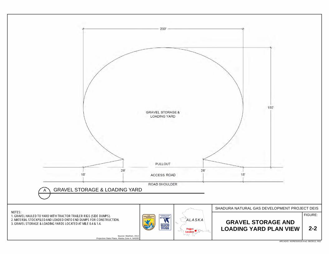
FIGURE:
2-2Source: Warthen, 2012
Projection:State Plane, Alaska Zone 4, NAD83
GRAVEL STORAGE ANDLOADING YARD PLAN VIEW
SHADURA NATURAL GAS DEVELOPMENT PROJECT DEIS
ARCADIS: NOREIS0018.mxd, 08/29/12, R02
AL A S K AProject
Location
GRAVEL STORAGE & LOADING YARDA
NOTES:1. GRAVEL HAULED TO YARD WITH TRACTOR TRAILER RIGS (SIDE DUMPS).2. MATERIAL STOCKPILED AND LOADED ONTO END DUMPS FOR CONSTRUCTION.3. GRAVEL STORAGE & LOADING YARDS LOCATED AT MILE 0.4 & 1.4.
ACCESS

FIGURE:
2-3Source: Warthen, 2012
Projection:State Plane, Alaska Zone 4, NAD83
TYPICAL ACCESS ROADTURNAROUND AND PULLOUT
SHADURA NATURAL GAS DEVELOPMENT PROJECT DEIS
ARCADIS: NOREIS0019.mxd, 08/29/12, R03
AL A S K AProject
Location
TYPICAL CONSTRUCTION TURNAROUNDA
SCALE: AS SHOWN
ACCESS
ACCESS
TYPICAL ACCESS ROAD PULLOUTB

Chapter 2 Alternatives
December 2012 2–8 Shadura Draft EIS
and geofabric. Only three to four turnarounds would exist simultaneously because they would be built and removed as construction of the access road progressed.
2.5.1.1.4 Construction of Steam Crossings
Single-lane clear span bridges and culverts would be used to cross streams. In general, clear span bridges with bulkhead footings would be used to cross anadromous streams (Figure 2–4). Culverts would be used to cross non-anadromous streams (Figure 2–5). The bridges would be wide enough to accommodate the access road without affecting the stream (Figure 2–4). No equipment or vehicles would enter the stream at any time during construction or operation.
Although construction of the bridge would not require work in the stream, disturbance around the crossing may require silt fencing or restoration and mulching to eliminate or reduce unintended sedimentation and degradation of water quality. If stabilization of the stream banks around the crossing is required, appropriate methods would be followed, such as those outlined in Streambank Revegetation and Protection, A Guide for Alaska (Walter et al. 2005). Figure 2–6 shows a typical section of such stabilization efforts. Detailed designs for stream crossings would be submitted to the Service, USACE, and Alaska Department of Fish and Game (ADF&G) for review and approval before construction starts. If necessary, a water truck with a spreader bar would be used to spread clean water on the construction site to control the generation of fugitive dust.
2.5.1.1.1 Construction of Stage 1 Drilling Pad and Drilling of Initial Natural Gas Well
Upon completion of the access road, construction of the Stage 1 or test drilling pad would begin. This gravel pad would have a working surface of 350 feet by 450 feet (Figure 2–7) and cover about 3.7 acres. The same techniques and equipment used to construct the access road would be used to construct the pad. The approximate depth of gravel fill would be 3 feet. The pad would have a berm around the perimeter constructed of gravel overlying geotextile fabric. Final grading of the pad would include a surface that is sloped to a stormwater collection area (Figure 2–7).
With completion of the test pad, the drilling rig would be set up and one natural gas well would be drilled. Drilling and testing of the well would take about three months (Table 2–1). If the results of this testing were unfavorable, all equipment would be removed from the drilling pad and the gravel would be removed from the pad, road, and pullouts. Then the affected areas would be restored to approximate preconstruction conditions. The Service would determine when restoration meets the standard of approximate preconstruction conditions. If the results of testing were favorable, the second stage would be constructed.
2.5.1.2 Stage 2—Construction of Production Facilities and Drilling of Additional Wells
If results of testing on the first well were favorable, the drilling pad would be expanded to its final size and configuration and five additional natural gas wells, one industrial water well, and one Class II disposal well would be drilled. The facilities needed for production also would be constructed.
2.5.1.2.1 Expansion of Drilling/Processing Pad and Drilling of Wells
The same techniques and equipment used to construct the Stage 1 drilling pad would be used to expand the pad to its final configuration. At its final configuration, the drilling pad’s 500-foot by 550-foot working surface (Figure 2–8) would cover about 6.5acres. A berm of gravel overlying geotextile fabric would be constructed around the pad’s perimeter. Final grading of the pad would result in a surface that is sloped to a stormwater collection sump (Figure 2–8). The following facilities would be installed on the pad:
Six natural gas development wells;
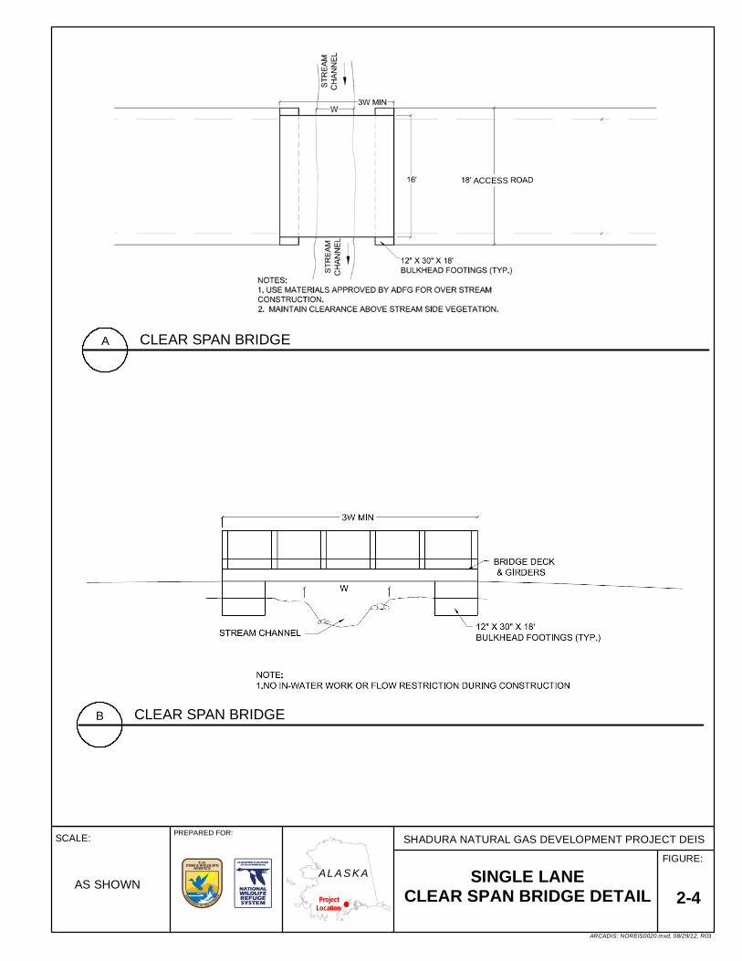
FIGURE:
SCALE:
2-4SINGLE LANE
CLEAR SPAN BRIDGE DETAIL
SHADURA NATURAL GAS DEVELOPMENT PROJECT DEIS
ARCADIS: NOREIS0020.mxd, 08/29/12, R03
AL A S K AProject
Location
PREPARED FOR:
AS SHOWN
CLEAR SPAN BRIDGEA
CLEAR SPAN BRIDGEB
ACCESS

FIGURE:
SCALE:
2-5SMALL STREAM CROSSING-
CULVERT
SHADURA NATURAL GAS DEVELOPMENT PROJECT DEIS
ARCADIS: NOREIS0055.mxd, 08/29/12, R01
AL A S K AProject
Location
AS SHOWN
CORRUGATED ARCH PIPEA
CORRUGATED ARCH PIPE - (UP STREAM)B

FIGURE:
SCALE:
2-6STREAM REHABILITATION
SHADURA NATURAL GAS DEVELOPMENT PROJECT DEIS
ARCADIS: NOREIS0056.mxd, 08/29/12, R01
AL A S K AProject
Location
NA
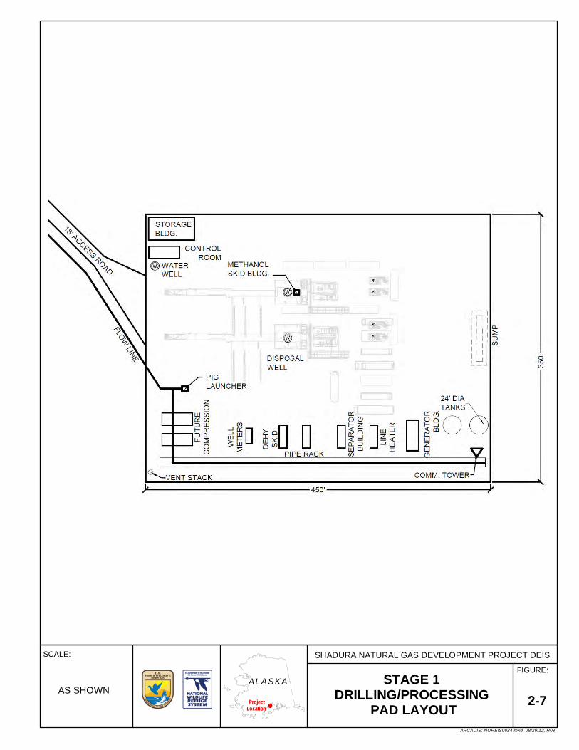
FIGURE:
SCALE:
2-7STAGE 1
DRILLING/PROCESSING PAD LAYOUT
SHADURA NATURAL GAS DEVELOPMENT PROJECT DEIS
ARCADIS: NOREIS0024.mxd, 08/29/12, R03
AL A S K AProject
Location
AS SHOWN

FIGURE:
SCALE:
2-8STAGE 2
DRILLING/PROCESSING PAD LAYOUT
SHADURA NATURAL GAS DEVELOPMENT PROJECT DEIS
ARCADIS: NOREIS0113.mxd, 08/29/12, R00
AL A S K AProject
Location
AS SHOWN

Chapter 2 Alternatives
December 2012 2–14 Shadura Draft EIS
One water well;
One Class II disposal well;
One prefabricated 500-gallon aboveground storage tank (AST) for storing methanol at each well (six total), with each tank including an in-line chemical pump for injecting the methanol into the associ-ated gathering line;
One well house for each natural gas well with a heat exchanger and line heater;
Indirect line heater for each well to facilitate good separation and prevent formation of hydrates;
One pipe rack area used to consolidate the gathering lines and direct flow;
One natural gas-fired electrical generator and one diesel backup electrical generator in one building;
One control room and microwave relay tower; and
Pig launcher and receiver facility.
The drilling/processing pad would have the smallest footprint possible while still allowing for safe operations. The design considered feasibility, safety, and minimal disturbance of the land. In addition, equipment would be prefabricated off site as much as possible and transported to the pad via truck to help minimize the overall size of the pad.
At project start up, compression would not be needed. At a future time; however, it may be necessary. If compression is needed, projections are for the installation of a Solar Turbines Centaur 40 or similar natural gas turbine compressor set. This compressor would be housed in a building near the pipe rack (Figure 2–8).
2.5.1.2.1.1 Drilling of Water and Disposal Wells
The water and disposal wells would be drilled before the second gas well is drilled. A truck-mounted water well rig would be used to drill the water well. This well would penetrate and withdraw groundwater from a suitable aquifer. The water would be used for temporary living quarters, mixing of drilling fluids, and emergency response fire suppression.
A conventional drilling rig (uses drill pipe to drill the well) would be used to drill the Class II disposal well. This well would be used for disposing of fluids generated during drilling and water produced during the production of natural gas. The disposal of fluids would occur in intervals in confined aquifers approved by both the Alaska Oil and Gas Conservation Commission (AOGCC) and U.S. Environmental Protection Agency (EPA) Underground Injection Control program. Injection intervals are expected to vary from 3,500 feet to 10,500 feet true vertical depth (TVD) in the Sterling, Beluga, and Tyonek Formations. Completion of the casing and testing of the formation’s integrity would occur with every casing or tubing installed. Additionally, testing of Blow-Out Prevention Equipment (BOPE) would occur throughout drilling operations following the requirements of AOGCC regulations.
2.5.1.2.1.2 Drilling of Additional Gas Wells
The same drilling rig used to drill the test natural gas well would drill the additional five wells. It would be diesel powered and driven either by electromotive diesel generators or direct drive, with approximately 2,000 horsepower (hp). Diesel fuel would be transported to the drilling pad by truck and transferred into double-walled ASTs.
Water produced during drilling would not be discharged onto the ground. Instead, it would be discharged into the disposal well. Facilities for handling the produced water would have a lined and bermed secondary containment area.

Chapter 2 Alternatives
December 2012 2–15 Shadura Draft EIS
During drilling operations, drilling mud and cuttings would be circulated to the surface. An on-site grind and inject (G&I) facility would grind the solids and mix them with liquid to form slurry. This slurry would then be injected into the Class II disposal well.
Drilling fluids are exploration fluids that consist of residual drilling muds, formational waters, and completion brines. These fluids are exempt from classification as hazardous under the Resource Conservation and Recovery Act (RCRA). At completion, drilling fluids would be circulated out of the hole and disposed of in the disposal well. Incidental spills occurring during operations would be contained in a bermed and lined cell adjoining the drilling rig. Vacuum trucks would be staged nearby to collect the spills. Portable secondary containment devices or “duck ponds” would be placed beneath all machinery that handles fluids and beneath all outlets during transfers.
The company representative, toolpusher, driller, and qualified mud engineers would be responsible for ensuring that sound oilfield practices are followed. They would direct and maintain downhole mud properties and volumes. They also would maintain the quantities of basic mud materials on site. Chemical testing would characterize the wastes to determine their final and appropriate disposition. Depending on characterization, drilling solids would be ground and injected into the Class II disposal well or disposed at the KPB Central Peninsula Landfill. Although unlikely, some drill cuttings may be reused following any necessary treatment or undergo beneficial reuse.
2.5.1.2.1.3 Handling of Solid Wastes
Solids wastes would be temporarily stored in transfer storage containers before disposal. A company representative would handle all waste management activities and be responsible for proper manifesting of waste for transport and off-site disposal. All contractors working on the Project would be encouraged to use waste minimization and recycling practices. Whenever possible, environmentally friendly products would be used to reduce waste streams.
Solid, non-burnable wastes would be deposited into large dumpsters located at the staging area. These containers would be hauled to an off-site approved disposal facility. Any food wastes that could attract wildlife would be stored in enclosed containers and hauled as needed to an approved disposal center. Household and approved industrial garbage would be hauled to the KPB Central Landfill.
Non-hazardous solid waste would be classified, segregated, and labeled as general refuse, RCRA exempt, or RCRA non-exempt. It would then be stored in designated satellite accumulation, recycle accumulation, and universal waste accumulation areas, or appropriately labeled dumpsters. Non-hazardous solid wastes anticipated during construction, drilling, and production include metal, combustibles (paper, cardboard, wood), oily waste rags and spill absorbent pads, and litter.
2.5.1.2.1 Construction of Production Facilities
Production facilities include processing facilities, metering facilities, gathering lines, communication and electrical cables, and other miscellaneous facilities used in the production of natural gas from the wells. These facilities are discussed below.
2.5.1.2.1.1 Processing Facilities
Processing facilities include those facilities needed to process the natural gas produced from the six wells. Processing facilities include:
Two generators, a primary gas-fired generator and a backup diesel generator;
One dehydration unit comprised of glycol contactor/cooler/reboiler, heat exchanger, filter, and inline heater;

Chapter 2 Alternatives
December 2012 2–16 Shadura Draft EIS
500-gallon diesel fuel storage;
One 500-barrel (21,000-gallon) produced water holding tank; and
One storage building.
The approximate locations of these facilities are shown on (Figure 2–8).
2.5.1.2.1.2 Metering Facilities
A metering pad would be constructed adjoining the transport pipeline that would receive the gas. This 80-foot by 100-foot pad would extend from a pullout along the access road (Figure 2–9). It would cover 0.2 acre with approximately 3 feet of gravel fill. The following facilities would be placed on the metering pad:
One control room and microwave relay tower;
One pig launcher and receiver area at the end of the gathering line;
One blow down area for the gathering lines (before the meter station);
One meter station (after the pig receiver);
One natural gas-fired electrical generator and one diesel backup electrical generator; and
One tie-in to the transport pipeline.
The location of the metering pad depends on the alternative.
2.5.1.2.1.3 Installation of Gathering Lines
Gathering lines would be constructed to connect the wells, processing facilities, and metering facilities. Between pads, these lines would be buried in a trench. The utility trench and work areas would occupy an area about 14 feet wide. Within the trench, two gathering lines would be installed.
The primary gathering line would be an 8-inch maximum diameter line to transport natural gas. It would be designed and constructed to comply with accepted industry practices and codes, and for a maximum allowable operating pressure (MAOP). A typical MOAP is about 1,300 pounds per square inch gauge (psig). Before being put into service, each gathering line would be hydro-tested to 150 percent of its MAOP.
The second gathering line would be an 8-inch maximum diameter backup line constructed of steel or spoolable fiber-reinforced pipe. This line would serve several functions, including:
Providing a spare line during routine maintenance and testing;
Providing a spare line if the primary gathering line becomes damaged or plugged; and
Allowing additional capacity to transport gas in the future, if the need arises.
Construction would begin by excavating a trench about 4 feet wide and averaging 4 feet deep. If the frost line were sufficiently deep, frozen blocks of soil up to 4 feet thick would be cut, removed, and stacked along the trench (Figure 2–10). If the ground were not frozen, the vegetative mat and organic soils would be removed and stockpiled separately from underlying non-organic silts, sands, and gravels. A vegetative mat is made by cutting the vegetation and root/soil mass into a block with the root/soil mass cut as deeply as possible. The mat can then be lifted out of the ground, stored temporarily, and replanted.
In general, the gathering lines would be installed from the adjacent road or ground surface. Trucks and side-booms would typically operate from the road surface. Some equipment, however, may still need to operate in the area cleared for construction of the gathering lines.

FIGURE:
2-9Source: Warthen, 2012
Projection:State Plane, Alaska Zone 4, NAD83
METERING PAD LAYOUT
SHADURA NATURAL GAS DEVELOPMENT PROJECT DEIS
ARCADIS: NOREIS0026.mxd, 08/29/12, R02
AL A S K AProject
Location
METERING PAD DETAILA
ACCESS
ACCESS
GATHERING LINES FROM PROCESSING PAD

FIGURE:
2-10Source: Warthen, 2012
Projection:State Plane, Alaska Zone 4, NAD83
TYPICAL GATHERING LINEPLAN VIEW
SHADURA NATURAL GAS DEVELOPMENT PROJECT DEIS
ARCADIS: NOREIS0057.mxd, 08/29/12, R01
AL A S K AProject
Location
TYPICAL ACCESS ROAD & PIPE TRENCH PLAN VIEWA

Chapter 2 Alternatives
December 2012 2–19 Shadura Draft EIS
Because the trench would cross wetlands, the excavation may need to be dewatered. Control of sedimentation during dewatering would involve weed-free straw bales and discharging water into natural depressions or into other sections of the open trench. Wherever possible, the water would be discharged onto upland areas. If the dewatering site were not located near upland areas, the water would be discharged into wetlands. In either instance, discharges would follow conditions regarding the quality and quantity of discharge effluent as outlined in wastewater discharge permits issued by the regulatory agencies.
When working in wetlands, an open trench can act as a sump and drain them. Earth fill or sandbags would be used to dam the trench at intervals to prevent this occurrence. In addition, the water would be removed and properly discharged while the trench is open. If wetland soils were not excessively saturated, construction would occur similar to conventional cross-country construction techniques.
Where wetland soils are saturated or inundated, gathering lines may be installed using the push-pull technique. This technique involves welding the lines together outside the wetland and stringing them into place using a backhoe. The lines would be equipped with buoys and pushed or pulled on rollers along the water-filled trench. Once the lines have been floated into the trench, the buoys would be removed allowing the lines to sink to the bottom. Gathering lines installed in wetlands would typically be fitted with buoyancy control measures.
Where construction has the potential to block the passage of surface water, either the open-cut or open-cut isolation methods of construction would be used. Open cut is the most common method. It is accomplished by excavating a trench across the wetland and pulling or carrying the pipe into position. Excavation of the trench is accomplished using conventional equipment, such as mechanical ditchers or excavators.
The open-cut isolated method would be used at locations where surface sheet flow makes an open cut impractical. This method involves damming the water to permit excavation while maintaining positive flow around the trench using pumps or dams and flumes. When the crossing is completed and the wetland stabilized with culverts installed, all dams would be removed and surface flow restored to its natural condition over the wetland.
After the gathering lines are installed, the trench would be backfilled. If the ground were frozen, the frozen blocks would be replaced from where they were removed. If the ground was thawed, underlying non-organic soils would be placed first, followed by organic soils, and finally the vegetative mat. All non-organic soils would be placed in lifts of sufficient thickness to protect the gathering lines and then compacted. Compressing the soils helps minimize the possibility that the backfilled trench would act as a subsurface drain in wetland areas. All remaining soil would be placed in the trench and mounded to reduce subsidence that occurs in disturbed soil with time. The vegetative mat contains indigenous seeds and plants that would assist with the re-establishment of native vegetation and provide for a diversity of vegetation types.
2.5.1.2.1.4 Communications Systems
Systems would be constructed so the Company could monitor the project equipment from its offices in Kenai. Equipment would be connected by a fiber optic cable. Between the pads, this cable would be buried in the trench with the gathering lines. Data would be transmitted from drilling and metering equipment to the processing equipment via the cable. From the processing equipment, data would be transmitted to the Company’s Kenai offices via microwave relay.
Microwave towers also would be constructed on the pads. These towers would serve as a backup system of communications. Towers with minimum heights of 50 feet would be required to provide the line-of-sight needed to transmit microwave radio signals to and from the pads. The antenna support would likely consist of a treated telephone pole or an equivalent low profile Rohn® tower (or similar unit).

Chapter 2 Alternatives
December 2012 2–20 Shadura Draft EIS
2.5.1.2.1.5 Electrical Power Utilities
Electrical power would not be available on site. Therefore, generators would be installed on each pad to supply electrical power. Primary electrical power would be generated using a natural gas fired, 30-kilowatt generators. One generator would be located with the processing equipment (Figure 2–8) and one would be installed with the metering equipment. Natural gas from the wells would be used to fire both generators.
In addition to primary generation, a backup generator would be installed on each pad. These generators would be diesel-fired. Diesel fuel would be transported to the pads by truck and transferred into double-walled ASTs. These 20-kilowatt generators would be smaller because they would not be running all the equipment—only the minimal equipment needed during an emergency or backup situation. The generators would be tested regularly.
2.5.1.2.1.6 Miscellaneous Facilities
Supervisory personnel would use temporary facilities during drilling and testing of the wells. It is anticipated on-site personnel accommodations would require trailers on the drilling pad, including one or more of the following:
Office trailer,
Living quarter trailers to accommodate the day Company Man and day toolpusher,
Skid-mounted trailer with sinks and toilets used as a break room, and
Mud logging trailers.
2.5.1.3 Workforce Requirements
Most of the active workforce assigned to develop the Project would be involved in construction-related activities. Only minimal personnel would be required to operate the Project after the road and pads are constructed, gathering lines and utility lines are installed, and wells are drilled and completed. The workforce required for the Project would vary by alternative.
2.5.1.4 Construction Resource Requirements
Construction of the Project would require gravel and water. The 1976 CIRI/U.S./State of Alaska settlement authorizes CIRI and its lessees to make reasonable use of gravel sources on the Kenai NWR. The gravel, however, is expected to be obtained from KPB-permitted commercial borrow pits outside the Kenai NWR. All vehicles used to haul gravel would comply with Alaska Department of Transportation and Public Facilities (ADOT&PF) specifications and requirements for hauling on State-maintained roads. The volume of gravel required for constructing the Project would vary by alternative. Consequently, the volumes are presented in Sections 2.6 through 2.9.
Water would be required for construction, drilling, and production. Until the water well is drilled, water would be obtained under Alaska Department of Natural Resources (ADNR) Temporary Water Use Permits (TWUPs). Water used during construction would be from Salmo Lake. Appropriate testing of surface water sources would ensure that the water meets water quality standards of the Alaska Department of Environmental Conservation (ADEC) for discharge into the waters of the United States. The volumes of water required for constructing the Project are presented by alternative in Sections 2.6 through 2.9.
2.5.2 Production and Maintenance
2.5.2.1 Access Road
Routine maintenance of the access road would occur on a year-round basis or as ground and site conditions permit. Summer (late spring to early fall) road maintenance could include the addition of

Chapter 2 Alternatives
December 2012 2–21 Shadura Draft EIS
gravel and blading of the road consistent with “traveled road maintenance operations” in the area. Other routine maintenance could include cleaning out culverts. Noxious weeds also would require yearly control (spraying of herbicides) along roads. Winter (late fall to early spring) maintenance would include blading snow from the road and some blading of the road when necessary and permitted by weather conditions. Dust abatement procedures would not be routinely employed on the access road during production and maintenance. Procedures to abate dust would only be used with prior approval from the Kenai NWR manager.
2.5.2.2 Wells
Maintenance of wells includes routine maintenance and workovers. Both are described below.
2.5.2.2.1 Routine Maintenance
A maintenance person (a “pumper”) may visit each well up to once per day. These visits would be used to ensure the equipment is functioning properly. The automated monitoring of equipment, however, may allow the pumper to visit less frequently. The pumper would routinely calculate balances between wells and various points in the system to ensure that the volumes match within acceptable tolerances. Major leaks in the gathering lines would cause a loss of pressure that would be detected using the static pressure on the meter. If a leak were detected, a well could be shut in. Leaks would then be pinpointed using pressures measured in the field, and the problem would be corrected. Maintenance of the various mechanical components of the gas production would occur at intervals recommended by manufacturers or as needed based on-site visits.
The computerized monitoring system would remotely monitor operations of the wells and processing and metering equipment. Operational conditions that would be monitored include rates of gas and water production, gathering line pressure, and separator pressure. This monitoring would help identify abnormal conditions. Maintenance personnel would be dispatched immediately to the site if a problem were identified.
Periodically, contractors would deliver methanol and diesel fuel and refill the ASTs on the drilling pad. Only highway-legal commercial tanker trucks that comply with ADEC’s applicable regulations in 18 AAC 75 would make the deliveries. Transfers would only occur within lined and bermed containment using established fuel transfer procedures, including placing secondary containment beneath fueling ports.
All contractors would have approved and current oil and fuel storage and Spill Prevention Control and Countermeasure (SPCC) plans. Contractors also would have written plans and procedures for transferring fuel. A minimum of two qualified personnel would always be present during fuel transfer operations. Spill response kits would be stationed on the pad in clearly marked containers. Table 2–3 identifies the volumes of fuels and petroleum fluids that would be stored on the drilling pad.
Table 2–3 Volumes of Fuels and Petroleum Fluids Stored on the Drilling Pad
Substance Volume Storage Container Diesel fuel 180 barrels (7,560 gallons) 200-barrel (8,400-gallon), double-walled ASTs
Oils, greases <55 gallons Would be stored in the manufactures designated containers
Source: Warthen 2012
2.5.2.2.1 Workovers
Workovers may be required periodically to ensure that the wells are maintained in good condition and are capable of extracting natural gas as efficiently as possible. A workover uses a truck-mounted unit (sometimes including electric line and slickline units). Workovers can include repairs to the well bore

Chapter 2 Alternatives
December 2012 2–22 Shadura Draft EIS
equipment (casing, tubing, velocity strings), the wellhead, or the production formation. These workovers may require venting pressure for safety reasons if gas in the well is under pressure. Routine repairs would occur only during daylight hours and usually would be completed within one day. Several days may be required to complete a workover in some limited situations. The frequency of workovers cannot be predicted because the requirements vary from well to well.
In some instances, a conventional drilling rig would be mobilized to the drilling pad to re-drill or re-complete (with casing, plugs and cement) a well to optimize hydrocarbon recovery. These jobs require planning and temporary shutdowns of process machinery. Most commonly, the rig would be used to seal off zones and install production tubing, sliding sleeves, packers, and plugs. Vacuum trucks and blow-down tanks may also be required during the work in case any produced water or condensate must be handled and disposed.
2.5.2.3 Waste Management
Solid, non-burnable wastes would be deposited into large, secured dumpsters approved for use on the Kenai NWR. These containers would be hauled to an off-site facility approved by the KPB for waste disposal. No wastes would be burned. Any food wastes that could attract wildlife would be stored in enclosed containers, which would be hauled periodically to an approved disposal center.
2.5.2.4 Gathering Lines
The gathering lines would be inspected, monitored, and maintained following an established maintenance and testing protocol. The monitoring of various operational aspects of the gathering lines, such as operating pressure, would occur from the Company’s offices in Kenai via telemetry. The gathering lines would be routinely inspected when the drilling, processing, and metering pads are visited. Finally, various maintenance procedures would be conducted on the lines to ensure long-term operations. Activities associated with inspecting, monitoring, and maintaining the gathering lines would include:
Monitoring gathering line operating pressure and flow rates via telemetry;
Maintaining gathering lines with maintenance and cleaning pigs, which remove sludge, debris, fluids, and other byproducts that precipitate out of the process stream;
Testing for in-line corrosion with corrosion coupons;
Conducting a chemical-inhibition program (passive or impressed current cathodic protection also may be installed, depending on soil conditions found during gathering line construction); and
Performing visual and gas detection inspections along the gathering lines.
2.5.2.5 Electrical Utilities
Inspection and maintenance of electrical utilities (generators and electrical cables) would be minimal. Any work conducted on electrical utilities would be performed by licensed contractors. One or two repairs may be necessary during the life of the Project that would involve a sub-contractor coming on-site for small-scale work.
2.5.2.6 Processing and Metering Pads
Equipment and facilities installed on the processing and metering pads would be inspected, monitored, and maintained following an established maintenance and testing protocol. Monitoring of various operational aspects would occur from the Company’s offices in Kenai via telemetry. The equipment would be routinely inspected while visiting the pads. Finally, various maintenance procedures would be conducted on the lines to ensure long-term operations. Activities associated with inspecting, monitoring, and maintaining equipment and facilities on the pads would include:
Maintaining generators and production and metering equipment;

Chapter 2 Alternatives
December 2012 2–23 Shadura Draft EIS
Launching and receiving pigs for gathering line maintenance and cleaning operations;
Operating and maintaining the water and Class II disposal wells;
Transferring dry gas via gathering lines to the nearby pipeline, and
Monitoring gas flow and production operations.
2.5.3 Decommissioning and Reclamation
At the end of commercial production, the Shadura Natural Gas Development Project would be decommissioned. Site assessments would be conducted on the pads and along the routes of the access road and gathering lines. These assessments would determine whether any previously unrecognized contamination has occurred. If such contamination were found, it would be cleaned up in accordance with ADEC requirements.
All facilities would be removed from the pads. Wells would be plugged and abandoned and the location cleared by AOGCC per 20 AAC 25. Wellheads, tubing and casings would be cut at least 5 feet below natural grade. Well cellars would be removed and backfilled. ADNR and the Kenai NWR manager would inspect operations during plugging and abandonment.
The gathering lines, electrical lines, and fiber optic cable would be abandoned in place or removed if required. If the gathering lines could be used again in the future, they would be purged of liquids and treated with diesel or nitrogen. If not, they would be purged, cleaned, and abandoned in place. If required to remove the facilities, excavators would retrieve gathering lines, the electric lines, and fiber optic cable and restore the surface to its original condition. Lines pulled from the ground would be disposed of or reused offsite.
Then the gravel pads and roads would be removed and all disturbances would be reclaimed, unless directed otherwise by the Kenai NWR manager. The access road and pads would be restored in steps. Gravel and culverts would be removed. The ground surface would be graded and overburden would be replaced to blend with natural contours, if needed. The goal would be to reclaim disturbed areas to match surrounding habitats and to return the disturbed area to as near its original physical condition and biological productivity and diversity as practicable.
The Service would require NordAq to post a bond for restoration at the time the ROW permit is issued. The amount of the bond would be determined based upon cost estimates provided by a neutral third party. The bond amount would be escalated periodically (probably every 5 years) over the life of the project based upon the Consumer Price Index.
2.5.4 Safety/Emergency Response
2.5.4.1 Geologic Hazards
Geologic hazards that may affect this Project include earthquakes. The facilities would be constructed to withstand earthquakes as required by the Uniform Building Code. In the event that an earthquake disrupts production and flow anywhere in Cook Inlet pipeline grid, measures would be taken to shut-in wells safely. Flashing and audible alarms would be installed on all pads and their statuses relayed to the Company’s operations control room.
2.5.4.2 Oil Spill Prevention, Fires, and Explosions
A small release from construction and drilling operations could result in an incidental release to the environment. Consequently, prevention, reporting, response, and clean-up procedures would be implemented to address any such accidental release. Appropriate equipment would be available to control

Chapter 2 Alternatives
December 2012 2–24 Shadura Draft EIS
and respond to an accidental release. Flashing and audible alarms would be installed on all pads and their statuses relayed to the Company’s operations control room. A SPCC would be developed for all storage of fuel in quantities that exceed 55 gallons.
2.5.4.2.1 Risk of Discharge
Minor operational spills could result from a variety of causes, including failures of hoses and lines, overflows of tanks, and leaks from equipment. Typically, spills of this nature are less than 10 gallons of diesel fuel or lubricants. Minor spills normally would be detected within several hours, if not immediately because the operations area is confined. Very small spills (such as equipment leaks) may go undetected for longer periods. Minor spills typically would be contained on site and removed by on-site personnel as soon as they are detected. Routine inspection of equipment by personnel can detect leaks or spills.
The drill rig would operate in full containment, which means that in the event of a rupture or failure during drilling activities, a discharge would likely be retained by the rig’s secondary containment. Drilling operations would be monitored closely by the work crews and a leak resulting from a hose or valve connection would result in an immediate shutdown of operations.
Drilling operations would rely on constant monitoring of mud weight and wellbore pressures and constant vigilance or visual leak detection. Before beginning any operations involving the transfer of fluids that contain oil, visual inspections would occur to ensure no leaks are present. Transfer operations would be conducted with a visual observer at all times.
Before operations begin, employees and contractors would be trained in the proper procedures for transferring fuel. They also would be trained to ensure that standard operating procedures are adhered to during all aspects of the drilling and construction project.
2.5.4.2.2 Typical Standard Operating Procedures
Typical standard operating procedures used by staff and operators are provided below.
2.5.4.2.2.1 Spill Prevention Procedures
Park vehicles and equipment away from bodies of water, 100 feet minimum. Do not park near the edge of pads.
Check all fueling equipment and vehicles for leaks prior to starting of refueling operations.
Inspect all hoses, connections, valves, etc. before starting any fluid transfers.
Be sure that valves are in the proper on/off position and that each connection is tightened.
Position equipment so that valves, piping, tanks, etc. are protected from damage by other vehicles.
Drip liners must be in place under any potential leak source.
Check all tank and container levels to prevent overfilling.
Be prepared to stop the transfer immediately if a problem arises.
Never leave fueling operations unattended.
Ensure that two people are present for all fuel operations.
o One person would be stationed at the shut-off switch or valve for fuel supply.
o The second person would be in direct control of the fuel nozzle.
2.5.4.2.2.2 Spill Response Procedures
Verify that adequate drip liners and absorbents are on hand and used.

Chapter 2 Alternatives
December 2012 2–25 Shadura Draft EIS
Ensure that all hose connections and the area directly under the fuel nozzle have drip liners in place.
Be aware of Emergency Response Plan for notification of spills.
2.5.4.2.2.3 Fueling Procedures
Fill out the checklist for each fueling of equipment on a daily basis and for any bulk receipt of fuel.
Ensure that two people are present for all fuel operations.
o One person would be stationed at the shut-off switch or valve for fuel supply.
o The second person would be in direct control of the fuel nozzle.
Place drip containment liners under all hose connections.
Connect electrical bonding straps.
Position a drip liner below tank fill opening.
Place the nozzle into tank fill opening.
If the fuel hose is equipped with ball valve type of nozzle, start the flow by turning the valve slowly to adjust flow of fuel.
If the fuel hose is equipped with a squeeze or trigger type of nozzle, pull back on the trigger slowly to start flow of fuel.
Ensure that the nozzle is held firmly by the fuel nozzle person, but do not lock it on.
Turn on the diesel pump switch and/or valve on the bulk truck. Visually inspect how full the tank is to determine when to stop fueling: look into the fuel inlet if possible.
If a leak or problem occurs, immediately shut off the pump switch and/or valve.
Release the trigger or manually close the ball valve when fueling is complete.
When the fuel tank is full, turn off pump switch or valve on bulk truck.
Allow the nozzle to empty into the tank completely, then remove nozzle from the tank, keeping nozzle inverted and over the drip liner until it is returned to the bulk truck or another tank.
Replace the filler cover on the tank.
When fueling procedures are completed, close and secure all valves and supplies.
2.5.4.2.2.4 Secondary Containment
No permanent or fixed tanks would be used during drilling or construction operations. All mobile fuel storage tanks would be double walled and would have secondary containment per ADEC or ADNR requirements. If required, secondary containment areas would be designed to store fluids in a bermed and lined area of the drilling pad that is capable of containing 110 percent of the cumulative volume of the fluids.
Secondary containment would be visually inspected daily for the presence of fluids with a visible sheen, ruptures, oil leaks, or spills. The secondary containment areas would be maintained free of debris and other material that might interfere with the effectiveness of the system, including excessive accumulated snow and snowmelt.
Small fuel transfers on site would use drip pans to collect small releases. Drip pans and curbing would be provided at transfer locations. One small storage container would be used to store waste fuels, such as lubricating oils. This container would be stored in impermeable lined and diked secondary containment area.

Chapter 2 Alternatives
December 2012 2–26 Shadura Draft EIS
2.5.4.2.2.5 Oil Spill Prevention and Response Training
Employees and contractors would comply with all applicable local, state, and federal regulations. Spill prevention would be an important part of operations. Regular maintenance, inspections, and accurate record keeping by trained personnel also would be an integral part of spill prevention. ADEC and the Service would be notified of all reportable spills.
Spill prevention training for employees and contractors would include familiarization of Alaska’s pollution prevention regulations. All project personnel would successfully complete Safety, Health, and Environment training before starting work on drilling activities.
2.5.4.3 Hazardous Substances
Non-hazardous solid waste would be classified, segregated, and labeled as general refuse, RCRA exempt or RCRA non-exempt. It would then be stored in designated satellite accumulation, recycle accumulation, and universal waste accumulation areas, or appropriately labeled dumpsters.
All contractors working on the Project would be encouraged to use waste minimization and recycling practices. Whenever possible, environmentally friendly products would be used to reduce waste.
A health, safety, and environmental (HSE) company representative would be designated who would address all waste management activities. This representative would handle all waste management activities and be responsible for the proper manifesting of waste for transport and off-site disposal.
For the proposed project, hazardous materials are defined as any substance, pollutant, or contaminant listed as hazardous under the Comprehensive Environmental Response, Compensation, and Liability Act (CERCLA) of 1980, and hazardous wastes are defined as any substance listed under the RCRA of 1976. The terms do not include petroleum, including diesel oil (or any fraction thereof), that is not otherwise specifically listed or designated as a hazardous substance under CERCLA Section 101(14), 423 USC 9601(14); nor do the terms include natural gas. Table 2–4 lists the hazardous and non-hazardous wastes likely to be used on the Project, along with the applicable management and disposal programs.
Hazardous materials used during construction and drilling would be limited to batteries. Neither construction nor drilling would produce hazardous materials. On the drilling pad, batteries would be stored as far away from drilling activities as practicable. They would be placed within secondary containment area that is diked and lined. This area would be capable of containing 110 percent of cumulative stored fluid or hazardous materials should a release occur.
2.5.4.1 Employee Safety and Training
All employees and contractors would attend a project orientation and kickoff meeting to facilitate a safe and environmentally compliant project site. In addition, they would participate in daily tailgate meetings. A company representative would be responsible for training contractors about permit stipulations and tracking compliance. Training would also cover the contingency plans. Additional specialized training would be provided to employees as needed, including topics such as traffic safety and permit compliance requirements. A company representative would monitor construction activities and would coordinate with the Kenai NWR manager to protect the resources of the Kenai NWR and for approval of field changes.
A detailed plan for production operations and maintenance would be prepared to guide and train personnel. Additional orientation and constant training would be carried out to ensure safe operations are maintained, and the manual would be continuously updated to reflect production operations as they change.

Chapter 2 Alternatives
December 2012 2–27 Shadura Draft EIS
Table 2–4 Hazardous and Non-Hazardous Waste Management and Disposal
Type Source Activity Handling Management Notes Hazardous Wastes Batteries Construction, Drilling, and
Production Separate and place in designated hazardous waste containers
Manage batteries through the KPB hazardous waste program
Methanol (freeze protect)
Construction and Production
Store in lined containment during construction
Store in 500-gallon AST on drilling/processing pad during production
Recover fluids for freeze protection or other approved reuse
Non-Hazardous Wastes Metal Construction, Drilling, and
Production Segregate, package, crush and palletize
Transport away from site for beneficial reuse (preferred) or disposal in the KPB Central Landfill
Combustibles (paper, cardboard, wood)
Construction, Drilling, and Production
Reduce volume by compacting Package and transport to KPB Central Landfill
Oily Waste Rags, Spill Absorbent Pads
Construction, Drilling, and Production
Reduce volume by first burning in “Smart Ash” incinerator off site
Analyze incinerator bottom ash and provide results to the KPB Central Landfill for approval prior to packaging and transport
Litter Construction, Drilling, and Production
Containerize (in sealed boxes or plastic garbage bags)
Collect litter, household garbage on an as-needed basis to maintain the site in an orderly condition and transport off-site for disposal at the KPB Central Landfill
Propylene Glycol Production Store in 50-gallon drums within secondary containment
Dispose in Class II underground or recycle for reuse
Emergency plans would be developed to cover all potential emergencies, including fires, employee injuries, and chemical releases. These plans would be posted at all field facilities. The plans would include the contacts and telephone numbers for all medical and emergency services. All employees and subcontractors would be trained on these plans when they are hired and refresher courses would be presented annually.
During construction, all companies and contractors would follow the 2010 Alaska Safety Handbook, State of Alaska Physical Agent Data Sheets, and individual safety plans.
During drilling operations, Petroleum Drilling and Production Standards, as outlined under 8 AAC 61 would be followed. Additionally, the drilling program for the wells would be described in detail in an Application for Permit to Drill that would be filed with the AOGCC. In the Application for Permit to Drill, the drilling mud program, casing design, formation evaluation program, cementing programs, and other engineering information would be presented to ensure a safe drilling program. After rigging up and passing required BOPE tests, each well would be spudded and drilled to the depth permitted by AOGCC. Both flashing and audible alarms would be installed and the status relayed to the operations control room, located on all pads.
2.5.4.2 Public Safety
Limits on access, signs, and alarms would help maintain the public’s safety in the project area. Gates would be installed at the entrances to access roads, which would prevent entry by unauthorized vehicles. The appropriate signage would be posted around facilities to warn of the potential danger of gas field operations. During drilling, a safety radius would be maintained at appropriate distances around the

Chapter 2 Alternatives
December 2012 2–28 Shadura Draft EIS
drilling rig and other operations. Flashing and audible alarms would be installed on all pads to provide warnings.
The greatest potential for leaks or ruptures in a natural gas gathering line occurs during production. Most ruptures are the result of heavy equipment accidentally striking the line. The materials used in the gathering lines would be designed and selected in accordance with applicable standards. Standards are established to minimize the potential for a leak or rupture. In addition, markers installed along the trench would clearly identify the location of the gathering lines. Remote sensors or daily inspections of the flow meters would help reduce the probability of a rupture through prompt detection of leaks.
2.5.4.3 Wildlife Interaction
Common human-wildlife interactions include the unintentional attraction of wildlife because of the improper containment or disposal of food, the deliberate feeding of wildlife, or both. The improper handling of garbage or foods may attract wildlife. If the feeding or attraction of wildlife occurs, animals may change their behavior, potentially exposing personnel to injury or diseases. Human-wildlife interactions can also include the unintentional injury of wildlife through collisions with vehicles and approaching sick, injured, or apparently orphaned wildlife to give assistance.
A Wildlife Awareness Interaction and Bear Avoidance Plan has been developed for the Project (Appendix A). This plan would guide the activities of personnel relative to wildlife. The Plan details how to avoid attracting, harassing, or injuring wildlife. For example, wintering moose use river valleys in the Kenai NWR to find food and relief from deep snow. Therefore, the plan identifies the potential for moose-vehicle collisions along the North Kenai Spur Highway and the access road. It also defines safe driving practices and speed limits that would be implemented to minimize the potential for collisions.
A major focus of wildlife training would be brown and black bears. Personnel would become familiar with procedures to avoid attracting, harassing, or injuring bears. The plan includes guidance for preventing bears from associating humans and drilling operations with food, preventing human-bear interactions, understanding controls used to prevent this interaction, protecting both workers and bears, and monitoring and reporting.
Human-wildlife interactions also include trapping and subsistence harvest. Personnel would be made aware of this and would be sensitive to local trapping activities and local subsistence harvest.
2.5.5 Mitigation
Table 2–5 summarizes elements that have been incorporated into the Project to reduce impacts to the environment.
2.6 ALTERNATIVE 2
Under this alternative, which is NordAq’s proposed project, the access road would be extend from the North Kenai Spur Highway along the west and south sides of Salmo Lake to the drilling/processing pad. As shown in Figure 2–11, the access road outside the Refuge has already been permitted for construction by federal, state, and local agencies as part of another project. The permitted portion of the access road is not included as part of the analysis of direct or indirect effects of this alternative because its construction is permitted and it could be constructed before any decision is made on this Project. The potential effects of constructing the permitted portion of the road, however, were considered in the analysis of cumulative effects.

Chapter 2 Alternatives
December 2012 2–29 Shadura Draft EIS
Table 2–5 Environmental Commitments
Resource Environmental Commitment
Air quality Use natural gas powered equipment instead of diesel-powered equipment when feasible to minimize com-bustion related emissions (including greenhouse gases [GHGs]).
Operate all equipment in accordance with manufacturer’s recommendations to minimize emissions (includ-ing GHG).
Use modern, well-maintained machinery and vehicles meeting applicable emission performance standards to minimize construction-related emissions (including GHG).
Visual Resources If the access road passes through forested areas, include sweeping curves to avoid a linear path and help camouflage the project route during operations.
Production facilities would be painted a color to best match the surrounding environment to help camouflage it.
Water Quality Erect silt fences around immediate stream crossings to contain sediment during construction, place mulch from clearing activities within the ROW to contain sediment during construction, and use weed-free straw bales when traversing wetlands.
Use continuous gravel berms around pad perimeters to contain water and any possible spills, and grade pads to direct surface water runoff into a lined retention pond.
Fish and Wildlife Maximize winter construction period.
Reduced direct habitat impacts by reducing the size of the project footprint.
Avoid high-value habitats, such as high-value wetlands and forests.
Locate the drilling/processing and meter pads more than 100 feet from the nearest lakes, grade to allow for drainage and collection of surface water runoff, and install berms that provide adequate containment to prevent contamination of surrounding habitats.
Use single lane clear span brides instead of culverts to cross anadromous streams.
Clear vegetation outside the Service’s recommended time periods for avoiding vegetation clearing so it would not destroy bird nests with eggs (May 1 – July20).
Avoid construction during moose hunting season (Aug 10 – Sep 20).
Implement mitigation to minimize erosion and the potential transport of sediment to the streams.
Wetlands Design the Project to avoid wetlands to the extent practical. Avoid disturbance to all high-value wetlands.
Vegetation Reclaim disturbed areas with native vegetation.
Construction would start with mobilization of equipment and materials by truck to the alternate day use parking lot on CCSRA. This lot would serve as the initial staging area for the permitted portion of the road (Figure 2–11). Following construction of the road on State lands, the staging area would move from the parking lot on CCSRA to the newly constructed road.
2.6.1 Facilities
Altogether, the access road would be 4.3 miles long. About 2.7 miles of the road would be on the Kenai NWR. The remaining1.6 miles are already permitted for construction on Alaska State and KPB lands. On the Kenai NWR, about 1.7 miles of the road would be constructed in upland areas and about 1.0 mile would involve wetlands.
Overall, the access road would cover approximately 12.4 acres. About 8.9 acres would be on the Kenai NWR. The remaining 3.5 acres would be on Alaska State and KPB lands and part of the previously permitted road.
The access road would cross three streams between the North Kenai Spur Highway and the drilling/processing pad (Figure 2–12). None of the streams is anadromous. Consequently, culverts would be used to cross them. No equipment or vehicles would enter the stream at any time during construction or operation.

C O O K I N L E T
CAPTAIN COOKCAPTAIN COOKSTATESTATE
RECREATIONRECREATIONAREAAREA
ADL LEASE - 391596ADL LEASE - 391596
K E N A I N A T I O N A L W I L D L I F E R E F U G EK E N A I N A T I O N A L W I L D L I F E R E F U G E
Gathering Lines
Staging Area
Drilling/Processing Pad
Metering Pad
Swanson River UnitSwanson River Unit
Gull Lake
Crane Lake
Snipe Lake
Dunlin Lake
Stormy Lake
Gooseneck Lake
0 1.25 2.50.625 Km
FIGURE:
SCALE:0 0.75 1.50.375 Mi
2-11ALTERNATIVE 2 - LOCATIONS OF
PRIMARY PROJECT COMPONENTS
SHADURA NATURAL GAS DEVELOPMENT PROJECT DEIS
ARCADIS: NOREIS0049.mxd, 08/30/12, R04
AL A S K AProject
LocationData Soure: Kenai NWR DataProjection: State Plane Alaska Zone 4 (feet), NAD83
Seward Meridian
ADL Lease 391596Captain Cook SRAOil & Gas Unit BoundariesKenai National Wildlife Refuge
Access RoadGathering LinesSection Permitted For ConstructionDrilling/Processing PadStaging Area

Drilling/Processing Pad
T8N,R9WT8N,R9WT8N,R10WT8N,R10WT7N,R9WT7N,R9WT7N,R10WT7N,R10W
Swanson RiverUnit
Swans
on Riv
er
Swanson River
KENAI SPUR HWY
Salmo Lake
Crane Lake
Snipe Lake
Dunlin Lake
Hungry Lake
8 97
4512 6
2 1
3
5 46
11
14
23
12
26 25
20
13
24
17
2829
21
35 32
16
36 3331
30
19
18
3
34
27
22
15
10
3
3
10
15
22
27
34
FIGURE:
SCALE:
2-12LOCATIONS OF PULLOUTS
AND CULVERTS
SHADURA NATURAL GAS DEVELOPMENT PROJECT DEIS
ARCADIS: NOREIS0114.mxd, 08/29/12, R00
AL A S K AProject
Location
PREPARED FOR:
0 0.5 10.25 Km
0 0.50.25 Mi
Projection: State Plane Alaska Zone 4 (feet), NAD83Seward Meridian
ADNR Active State Lease
Captain Cook State Recreation Area
Kenai National Wildlife Refuge
Kenai Peninsula Borough Parcel
Pullout
Stream Crossing/Culvert
WETLAND
Proposed Route / Alternative-2
Alternative-3
Alternative-4
Alternative-5
Oil & Gas Unit Boundary
Existing Pipelines
Roads
ADNRKNWR
CCSRA
KPB

Chapter 2 Alternatives
December 2012 2–32 Shadura Draft EIS
Approximately 11 pullouts would be constructed along the access road. All would be located on the Kenai NWR. These pullouts would be spaced at approximately ¼-mile intervals based on line-of-sight (Figure 2–12).
2.6.2 Workforce Requirements
Table 2–6 shows the estimated employment requirements for construction, operation, decommissioning, and reclamation of the Project under Alternative 2.
Table 2–6 Estimated Employment Requirements for Alternative 2
Work Category Number of Workers Number of Days Notes Construction (gravel) Access Road 40 24 Drilling/Processing Pad 40 21 Metering Pad 40 14 Equipment Installation
Machinery on Pads 40 180 Gathering Lines 25 90 Drilling Wells 65 300
Production and Maintenance Access Road, Equipment 6 10,950 Daily for 30 years Workovers, Re-drills 65 720 3 workovers and 2 re-drills per well Decommissioning/Reclamation Equipment Removal 40 240 Gravel Removal/Reclamation 40 25
Source: Dickinson 2012
2.6.3 Construction Resources
Overall, construction of Alternative 2 is expected to require about 61,970 cubic yards (yd3) of gravel (Table 2–7). Gravel would be hauled from the gravel pits in side-dump tractor-trailer trucks that can haul 18 yd3 of gravel per load. Consequently, the Project would require about 3,440 roundtrips of the side dump trucks to transport the gravel to the gravel storage yards. Assuming the trucks could make a maximum of 110 roundtrips per day, about 31 days would be required to transport all the gravel from gravel pits to the gravel storage yards. Altogether, gravel would cover 15.9 acres in the project area.
Table 2–7 Summary of Requirements for Gravel under Alternative 2
Facility Amount Unit Rate Total Volume (yd3) Gravel
Access Road
Wetlands 5,140 linear feet 2.55 yd3/foot 14,060
Uplands 9,090 linear feet 1.63 yd3/foot 14,820
Total 28,880
Drilling/Processing Pad 275,000 square feet 0.1128 yd3/ft2 31,010
Metering Pad 8,000 square feet 0.1128 yd3/ft2 900
Pullouts (n=11) 1,000 square feet 0.07 yd3/ft2 810 Turnarounds 1,260 square feet 0.2937 yd3/ft2 370
Total 61,970
Source: Warthen 2012

Chapter 2 Alternatives
December 2012 2–33 Shadura Draft EIS
Table 2–8 provides water quantities calculated for use as part of the TWUPs acquired for construction, drilling, and production.
Table 2–8 Summary of Requirements for Water under Alternative 2
Activity Max Daily Volume
(gallons) Estimated Total
(gallons) Construction (one time only) Temporary Turnouts 36,000 1,346,000 Drilling (one time only) Makeup Water 126,000 45,360,000 Production (Annual) Non-potable Office Water 500 182,500
Source: Dickinson 2012
2.7 ALTERNATIVE 3—NATURAL GAS DEVELOPMENT WITH NORTHERN ACCESS ROUTE
Alternative 3 was developed specifically to respond to the issue addressing effects of the Proposed Action on wetlands (Issue 1). The discussion of this alternative focuses on the specifics of Alternative 3. Unless specifically discussed below, the construction, production, maintenance, decommissioning, and reclamation of Alternative3 would be the same as described under Section 2.5—Features Common to Alternatives 2 through 5.
2.7.1 Facilities
Under this alternative, the access road would be constructed around the north and east sides of Salmo Lake rather than along the west and south sides (Figure 2–13). Overall length of the access road would increase to 4.6 miles. About 1.8 miles would be constructed on Alaska State lands, 0.4 miles on KPB lands, and 2.4 miles would be on the Kenai NWR. About 3.7 miles would be constructed in upland areas and about 0.9 mile would be in wetlands. The North Kenai Spur Highway would still provide primary access to the project area.
The metering pad, gathering lines, and communication cable would be located along the access road. Therefore, the metering pad would be located farther north along the ROW for the ConocoPhillips Alaska natural gas pipeline (Figure 2–13). The size of the pads would not change. The gathering lines and communication cable would parallel the access road similar to Alternative 2.
With the longer access road, more pullouts and turnarounds would have to be constructed under Alternative 3. Approximately 17 pullouts would be required along the access road (Figure 2–12), which would be six more than under Alternative 2. Several additional temporary turnarounds also would be needed.
The access road would cross one stream between the North Kenai Spur Highway and the drilling/processing pad (Figure 2–12). A culvert would be used to cross this stream because it is non-anadromous. No equipment or vehicles would enter the stream at any time during construction or operation.
2.7.2 Workforce Requirements
Table 2–9 shows the estimated employment requirements for construction, operation, decommissioning, and reclamation of the Project under Alternative 3.

C O O K I N L E T
CAPTAIN COOKCAPTAIN COOKSTATESTATE
RECREATIONRECREATIONAREAAREA
ADL LEASE - 391596ADL LEASE - 391596
K E N A I N A T I O N A L W I L D L I F E R E F U G EK E N A I N A T I O N A L W I L D L I F E R E F U G E
Gathering Lines
Staging Area
Drilling/Processing Pad
Metering Pad
Swanson River UnitSwanson River Unit
Gull Lake
Salmo Lake
Crane Lake
Snipe Lake
Dunlin Lake
Stormy Lake
Gooseneck Lake
0 1.25 2.50.625 Km
FIGURE:
SCALE:0 0.75 1.50.375 Mi
2-13ALTERNATIVE 3 - LOCATIONS OF
PRIMARY PROJECT COMPONENTS
SHADURA NATURAL GAS DEVELOPMENT PROJECT DEIS
ARCADIS: NOREIS0050.mxd, 08/29/12, R03
AL A S K AProject
LocationData Soure: Kenai NWR DataProjection: State Plane Alaska Zone 4 (feet), NAD83
Seward Meridian
ADL Lease 391596Captain Cook SRAOil & Gas Unit BoundariesKenai National Wildlife Refuge
Access RoadGathering LinesPadsStaging Area

Chapter 2 Alternatives
December 2012 2–35 Shadura Draft EIS
Table 2–9 Estimated Employment Requirements for Alternative 3
Work Category Number of Workers Number of Days Notes Construction (gravel) Access Road 40 45 Drilling/Processing Pad 40 21 Metering Pad 40 14 Equipment Installation
Machinery on Pads 40 180 Gathering Lines 25 95 Drilling Wells 65 300
Production and Maintenance Access Road, Equipment 6 10,950 Daily for 30 years Workovers, Re-drills 65 720 3 workovers and 2 re-drills per well Decommissioning/Reclamation Equipment Removal 40 240 Gravel Removal/Reclamation 40 28
2.7.3 Construction Resources
Construction of Alternative 3 is expected to require about 77,380 yd3 of gravel (Table 2–10). Using the side-dump tractor-trailer trucks, the Project would require about 4,300 roundtrips of the trucks to transport the gravel to the gravel storage yards. Assuming the trucks could make a maximum of 110 roundtrips per day, the Project would require about 39 days to transport all the gravel from gravel pits to the storage yards. Altogether, gravel would cover 21.6 acres in the project area.
Table 2–10 Summary of Requirements for Gravel under Alternative 3
Facility Amount Unit Rate Total Volume (yd3) Gravel
Access Road
Wetlands 4,600 feet 2.55 yd3/foot 11,730
Uplands 19,700 feet 1.63 yd3/foot 32,110
Total 43,840
Drilling/Processing Pad 275,000 square feet 0.1128 yd3/ft2 31,010
Metering Pad 8,000 square feet 0.1128 yd3/ft2 900
Pullouts (n=17) 1,000 square feet 0.07 yd3/ft2 1,260 Turnarounds 1,260 square feet 0.2937 yd3/ft2 370
Total 77,380
Table 2–11 provides water quantities calculated for use as part of the TWUPs acquired for construction, drilling, and production.

Chapter 2 Alternatives
December 2012 2–36 Shadura Draft EIS
Table 2–11 Summary of Requirements for Water under Alternative 3
Activity Max Daily Volume
(gallons) Estimated Total
(gallons) Construction (one time only) Temporary Turnouts 36,000 2,080,000 Drilling (one time only) Makeup Water 126,000 45,360,000 Production (Annual) Non-potable Office Water 500 182,500
2.8 ALTERNATIVE 4—NATURAL GAS DEVELOPMENT WITH EASTERN ACCESS
Alternative 4 was developed specifically to respond to issue addressing effects of the Proposed Action on development on the Kenai NWR (Issue 2). The discussion of this alternative focuses on the specifics of Alternative 4. Unless specifically discussed below, the construction, production, maintenance, decommissioning, and reclamation of Alternative 4 would be the same as described under Section 2.5—Features Common to Alternatives 2 through 5.
2.8.1 Facilities
Under this alternative, an access road would be constructed to provide access to the drilling/processing pad from the Swanson River Unit, a federal oil and gas lease area, to the east (Figure 2–14). Use of existing roads within the Swanson River Unit would require a road use agreement between NordAq and the existing federal lessee, Hilcorp Alaska. Altogether, the length of the new access road on the Kenai NWR would be 3.3 miles. About 2.7 miles would be constructed in upland areas and about 0.5 mile would be in wetlands.
The metering pad, gathering lines, and communication cable would be constructed in the same locations as for Alternative 2. Consequently, the gathering lines and communication cable would not follow the access road entirely. Instead, they would be installed cross-country between the drilling/processing pad and the previously permitted road on State of Alaska lands (Figure 2–14). The segment between the Kenai NWR boundary and metering pad would follow this previously permitted road. The North Kenai Spur Highway would provide primary access to the metering pad. Approximately 12 pullouts would be required along the access road (Figure 2–12). Finally, the access road would not cross any streams.
2.8.2 Workforce Requirements
Table 2–12 shows the estimated employment requirements for construction, operation, decommissioning, and reclamation of the Project under Alternative 4.
2.8.3 Construction Resources
Construction of Alternative 4 is expected to require about 64,910 yd3 of gravel (Table 2–13). Using the side-dump tractor-trailer trucks, the Project would require about 3,610 roundtrips of the trucks to transport the gravel to the gravel storage yards. Assuming the trucks could make a maximum of 110 roundtrips per day, the Project would require about 33 days to transport all the gravel from gravel pits to the storage yards. Altogether, gravel would cover 17.6 acres in the project area.

C O O K I N L E T
CAPTAIN COOKCAPTAIN COOKSTATESTATE
RECREATIONRECREATIONAREAAREA
ADL LEASE - 391596ADL LEASE - 391596
K E N A I N A T I O N A L W I L D L I F E R E F U G EK E N A I N A T I O N A L W I L D L I F E R E F U G E
Gathering Lines
Staging Area
Drilling/Processing Pad
Metering Pad
Swanson River UnitSwanson River Unit
Gull Lake
Crane Lake
Snipe Lake
Dunlin Lake
Stormy Lake
Gooseneck Lake
0 1.25 2.50.625 Km
FIGURE:
SCALE:0 0.75 1.50.375 Mi
2-14ALTERNATIVE 4 - LOCATIONS OF
PRIMARY PROJECT COMPONENTS
SHADURA NATURAL GAS DEVELOPMENT PROJECT DEIS
ARCADIS: NOREIS0051.mxd, 08/29/12, R03
AL A S K AProject
LocationData Soure: Kenai NWR DataProjection: State Plane Alaska Zone 4 (feet), NAD83
Seward Meridian
ADL Lease 391596
Captain Cook SRA
Oil & Gas Unit Boundaries
Kenai National Wildlife Refuge
Access Road
Gathering Lines
Drilling/Processing Pad
Staging Area

Chapter 2 Alternatives
December 2012 2–38 Shadura Draft EIS
Table 2–12 Estimated Employment Requirements for Alternative 4
Work Category Number of Workers Number of Days Notes Construction (gravel) Access Road 40 28 Drilling/Processing Pad 40 21 Metering Pad 40 14 Equipment Installation
Machinery on Pads 40 180 Gathering Lines 25 90 Drilling Wells 65 300
Production and Maintenance Access Road, Equipment 6 10,950 Daily for 30 years Workovers, Re-drills 65 720 3 workovers and 2 re-drills per well Decommissioning/Reclamation Equipment Removal 40 240 Gravel Removal/Reclamation 40 20
Table 2–13 Summary of Requirements for Gravel under Alternative 4
Facility Amount Unit Rate Total Volume (yd3) Gravel
Access Road
Wetlands 2,810 feet 2.13 yd3/foot 8,190
Uplands 14,450 feet 1.63 yd3/foot 23,550
Total 31,740
Drilling/Processing Pad 275,000 square feet 0.1128 yd3/ft2 31,010
Metering Pad 8,000 square feet 0.1128 yd3/ft2 900
Pullouts (n=12) 1,000 square feet 0.07 yd3/ft2 890 Turnarounds 1,260 square feet 0.2937 yd3/ft2 370
Total 64,910
Gravel for the access road to the drilling/processing pad would come from gravel pits located near the intersection of the Swanson River Road and Sterling Highway. This would minimize the distance the gravel would have to transported and minimize the need for the trucks to haul gravel through town.
Table 2–14 provides water quantities calculated for use as part of the TWUPs acquired for construction, drilling, and production.
Table 2–14 Summary of Requirements for Water under Alternative 4
Activity Max Daily Volume
(gallons) Estimated Total
(gallons) Construction (one time only) Temporary Turnouts 36,000 1,468,000 Drilling (one time only) Makeup Water 126,000 45,360,000 Production (Annual) Non-potable Office Water 500 182,500

Chapter 2 Alternatives
December 2012 2–39 Shadura Draft EIS
2.9 ALTERNATIVE 5—NATURAL GAS DEVELOPMENT WITH SOUTHERN ACCESS
Alternative 5 was developed specifically to respond to two issues addressing effects of the Proposed Action (Issues 2 and 3). The discussion of this alternative focuses on the specifics of Alternative 5. Unless specifically discussed below, the construction, production, maintenance, decommissioning, and reclamation of Alternative 5 would be the same as described under Section 2.5—Features Common to Alternatives 2 through 5.
2.9.1 Facilities
Under this alternative, an access road would be constructed to provide access to the drilling/processing pad from the Swanson River Unit to the southeast (Figure 2–15). Use of existing roads within the Swanson River Unit would require a road use agreement between NordAq and the existing federal lessee, Hilcorp Alaska. Altogether, the length of the new access road on the Kenai NWR would be 5.5 miles. About 5.3 miles would be constructed in upland areas and about 0.2 mile would be in wetlands.
The metering pad, gathering lines, and communication cable would be constructed in the same locations as for Alternatives 2 and 4. Consequently, the gathering lines and communication cable would not follow the access road entirely. Instead, they would be installed cross-country between the drilling/processing pad and the previously permitted road on State of Alaska lands (Figure 2–15). The segment between the Kenai NWR boundary and metering pad would follow this previously permitted road. The North Kenai Spur Highway would provide primary access to the metering pad. Approximately 21 pullouts would be required along the access road (Figure 2–12). Finally, the access road would not cross any streams.
2.9.2 Workforce Requirements
Table 2–15 shows the estimated employment requirements for construction, operation, decommissioning, and reclamation of the Project under Alternative 5.
Table 2–15 Estimated Employment Requirements for Alternative 5
Work Category Number of Workers Number of Days Notes Construction (gravel) Access Road 40 50 Drilling/Processing Pad 40 21 Metering Pad 40 14 Equipment Installation
Machinery on Pads 40 180 Gathering Lines 25 90 Drilling Wells 65 300
Production and Maintenance Access Road, Equipment 6 10,950 Daily for 30 years Workovers, Re-drills 65 720 3 workovers and 2 re-drills per well Decommissioning/Reclamation Equipment Removal 40 240 Gravel Removal/Reclamation 40 30

C O O K I N L E T
CAPTAIN COOKCAPTAIN COOKSTATESTATE
RECREATIONRECREATIONAREAAREA
ADL LEASE - 391596ADL LEASE - 391596
K E N A I N A T I O N A L W I L D L I F E R E F U G EK E N A I N A T I O N A L W I L D L I F E R E F U G E
Gathering Lines
Staging Area
Drilling/Processing Pad
Metering Pad
Swanson River UnitSwanson River Unit
Salmo Lake
Crane Lake
Snipe Lake
Dunlin Lake
Stormy Lake
Hungry Lake
Plover Lake
Gooseneck Lake
0 1.25 2.50.625 Km
FIGURE:
SCALE:0 0.75 1.50.375 Mi
2-15ALTERNATIVE 5 - LOCATIONS OF
PRIMARY PROJECT COMPONENTS
SHADURA NATURAL GAS DEVELOPMENT PROJECT DEIS
ARCADIS: NOREIS0053.mxd, 08/29/12, R03
AL A S K AProject
LocationData Soure: Kenai NWR DataProjection: State Plane Alaska Zone 4 (feet), NAD83
Seward Meridian
ADL Lease 391596Captain Cook SRAOil & Gas Unit BoundariesKenai National Wildlife Refuge
Access RoadGathering LinesDrilling/Processing PadStaging Area

Chapter 2 Alternatives
December 2012 2–41 Shadura Draft EIS
2.9.3 Construction Resources
Construction of Alternative 5 is expected to require about 82,380 yd3 of gravel (Table 2–16). Using the side-dump tractor-trailer trucks, the Project would require about 4,580 roundtrips of the trucks to transport the gravel to the gravel storage yards. Assuming the trucks could make a maximum of 110 roundtrips per day, the Project would require about 42 days to transport all the gravel from gravel pits to the storage yards. Altogether, gravel would cover 24.6 acres in the project area.
Table 2–16 Summary of Requirements for Gravel under Alternative 5
Facility Amount Unit Rate Total Volume (yd3) Gravel
Access Road
Wetlands 1,020 feet 2.13 yd3/foot 3,130
Uplands 27,860 feet 1.63 yd3/foot 45,410
Total 48,540
Drilling/Processing Pad 275,000 square feet 0.1128 yd3/ft2 31,010
Metering Pad 8,000 square feet 0.1128 yd3/ft2 900
Pullouts (n=21) 1,000 square feet 0.07 yd3/ft2 1,560 Turnarounds 1,260 square feet 0.2937 yd3/ft2 370
Total 82,380
Gravel for the access road to the drilling/processing pad would come from gravel pits located near the intersection of the Swanson River Road and Sterling Highway. This would minimize the distance the gravel would have to transported and minimize the need for the trucks to haul gravel through town.
Table 2–17 provides water quantities calculated for use as part of the TWUPs acquired for construction, drilling, and production.
Table 2–17 Summary of Requirements for Water under Alternative 5
Activity Max Daily Volume
(gallons) Estimated Total
(gallons) Construction (one time only) Temporary Turnouts 36,000 2,596,000 Drilling (one time only) Makeup Water 126,000 45,360,000 Production (Annual) Non-potable Office Water 500 182,500
2.10 ALTERNATIVES CONSIDERED BUT ELIMINATED FROM DETAILED ANALYSIS
Several potential alternatives were considered for this analysis but were eliminated from detailed study for various reasons. These alternatives are listed below, and the reasons they were excluded from further consideration are described.

Chapter 2 Alternatives
December 2012 2–42 Shadura Draft EIS
Alternative Considered: Use of helicopters to develop the project instead of a gravel access road.
Reasons Considered: This alternative was considered in response to a comment submitted during scoping for the DEIS concerning noise and disturbance associated with the access road.
Reasons Dropped: This alternative was eliminated from detailed consideration because it was not reasonable. The drilling rig needed to reach to the target formations would be large and heavy. It is questionable whether it could be broken down and transported to the drilling pad via helicopter. In addition, the size of helicopter needed for this project would generate substantial noise during the many trips needed to and from project facilities during construction. Frequent helicopter access to project facilities also would be required during the 30 years of production as well. The economic feasibility of using only helicopters to access project facilities is unlikely.
Alternative Considered: Route the access road and gathering lines east from the drilling pad to the existing infrastructure in the Swanson River Unit instead of routing them to the northwest.
Reasons Considered: This alternative was considered to concentrate disturbances as close to the existing disturbances associated with the Swanson River Unit to the extent practicable.
Reasons Dropped: Gas produced from the Swanson River Unit is sold for local distribution and storage. The pipeline that transports all of the Unit’s gas has been reestablished as a multidirectional line that can flow gas into various customers and can be used for storage when the demand is less than supply. With the bi-directional operation of that pipeline, NordAq cannot guarantee its contractual delivery requirements if its gas is placed in the Swanson River Unit system for transportation.
Alternative Considered: Place the natural gas processing equipment on a separate pad from the drilling pad off the Kenai NWR.
Reasons Considered: This alternative was considered to see if moving the processing equipment from the drilling pad to a separate pad off the Kenai NWR would minimize adverse effects on the Refuge.
Reasons Dropped: Splitting the processing equipment from the drilling pad would not decrease adverse effects. Overall disturbance would increase. In addition, the gathering lines between the drilling and processing pads would be more susceptible to freezing, corrosion, and rupture because of the hydrates that can form in unprocessed gas. The formation of hydrates could result in freezing, failures with instrumentation, and in the worst case, ruptures of the gathering lines.
2.11 SUMMARY OF ALTERNATIVES
The following tables summarize the alternatives considered in detail and the likely environmental consequences of each. Table 2–18 contains the summary of alternatives. This table contrasts the five alternatives in terms of their physical characteristics.

Chapter 2 Alternatives
December 2012 2–43 Shadura Draft EIS
Table 2–18 Summary Comparison of Alternatives Considered in Detail
Alternative Parameter 1 2 3 4 5 Access Road – Length by Surface Owner (miles) State of Alaska Uplands 0 0 1.5 0 0 Wetlands 0 0 0.3 0 0 Total 0 0 1.8 0 0 Kenai NWR Uplands 0 1.7 1.8 2.7 5.3 Wetlands 0 1.0 0.6 0.5 0.2 Total 0 2.7 2.4 3.3 5.5 KPB Uplands 0 0 0.4 0 0 Wetlands 0 0 0 0 0 Total 0 0 0.4 0 0 Total Length 0 2.7 4.6 3.3 5.5 Facilities Surface Area by Surface Owner (acres) Access Road1 State of Alaska Uplands 0 0 4.8 0 0 Wetlands 0 0 0.6 0 0 Total 0 0 5.4 0 0 Kenai NWR Uplands 0 5.4 5.8 8.6 16.6 Wetlands 0 3.5 2.3 2.0 0.8 Total 0 8.9 8.1 10.6 17.4 KPB Uplands 0 0 1.1 0 0 Wetlands 0 0 0 0 0 Total 0 0 1.1 0 0 Total for Access Road 0 8.9 14.6 10.6 17.4 Pullouts – Area by Surface Owner (acres) State of Alaska 0 0.0 0.1 0.0 0.0 Kenai NWR 0 0.3 0.2 0.3 0.5 KPB lands 0 0.0 0.0 0.0 0.0 Total for Pullouts 0 0.3 0.3 0.3 0.5 Pads (acres) Drilling/Processing Pad 0 6.5 6.5 6.5 6.5 Metering Pad 0 0.2 0.2 0.2 0.2 Total for Pads 0 6.7 6.7 6.7 6.7 Total Area of Long-term Disturbance – Area by Surface Owner (acres) State of Alaska 0 0.2 5.7 0.2 9.0 Kenai NWR 0 15.7 14.8 18.9 23.7 KBP lands 0 0 1.1 0 0 Total Area for all Long-term Disturbance (acres) 0 15.9 21.6 17.6 24.6

Chapter 2 Alternatives
December 2012 2–44 Shadura Draft EIS
Table 2–18 Summary Comparison of Alternatives Considered in Detail
Alternative Parameter 1 2 3 4 5 Gravel Placement (cubic yards) Access Road Uplands 0 14,820 32,110 23,550 45,410 Wetlands 0 14,060 11,730 8,190 3,130 Total 0 28,880 43,840 31,740 48,540 Drilling/Processing Pad 0 31,010 31,010 31,010 31,010 Metering Pad 0 900 900 900 900 Pullouts 0 810 1,260 890 1,560 Turnarounds2 (four) 0 370 370 370 370 Total 0 61,970 77,380 64,910 82,380 Notes: 1. The areal extent of disturbance by access roads is based on a 26-foot width (fill slope toe to fill slope toe) in upland areas and
a 28-foot width (toe to toe) in wetlands. 2. Turnarounds are temporary facilities that require gravel. Consequently, they are not included in the long-term disturbance
estimates but are included in the estimates for gravel required to construct the project.

December 2012 3–1 Shadura Draft EIS
CHAPTER 3—AFFECTED ENVIRONMENT
3.1 PHYSICAL ENVIRONMENT
3.1.1 Meteorology and Air Quality
3.1.1.1 Meteorology and Climate
The climate of south central Alaska is in the subarctic zone (Service 2009c). The climate of the Cook Inlet Basin is in the transitional climate zone (KPB 2008) between the maritime and continental zones. Occasionally during the winter months, this area will experience short periods of extreme cold, high winds, or both (KPB 2008).
Without the moderating effect of the Gulf of Alaska, the air mass temperatures in the Cook Inlet area are more extreme compared to other areas on the peninsula (KPB 2008). Table 3–1 summarizes the monthly temperatures for the Kenai Municipal Airport station (a National Weather Service/Federal Aviation Administration station) for the period of record—1949 through 2012. The Kenai Municipal Airport is located in Kenai (Figure 4–1), approximately 15 miles southwest of the project area. The average annual temperature at the Kenai airport is 34.2 degrees Fahrenheit. The average maximum temperature is 42.4 degrees Fahrenheit and the average minimum temperature is 25.9 degrees Fahrenheit.
Table 3–1 Monthly Climate Summary Kenai Municipal Airport Weather Station—Temperature
Temperature by Month (°F) Category Jan Feb Mar Apr May Jun Jul Aug Sep Oct Nov Dec AnnualAverage Maximum
20.9 26.7 32.7 42.7 53.1 58.8 62.1 62.0 55.4 42.2 29.5 22.7 42.4
Average Minimum
4.0 8.0 13.1 26.3 35.4 42.9 47.6 45.9 39.0 27.7 14.1 7.2 25.9
Average 12.5 17.4 22.9 34.5 42.9 47.6 45.9 39 47.2 35.1 21.8 14.9 34.2
Source: WRCC 2012
The Cook Inlet basin lies in the rain shadow of the Kenai Mountains and receives 15 to 30 inches of precipitation annually (KPB 2008). Sterling receives about 17 inches of total precipitation per year and the Kenai airport receives about 19 inches (Service 2009c). The Sterling Federal Aviation Administration station is located approximately 19 miles south of the project area (Figure 4–1). Kenai Municipal Airport and Sterling are the weather stations closest to the project area. The monthly snowfall summary for the Kenai Municipal Airport station is shown in Table 3–2. The average total snowfall at the Kenai airport is 61.2 inches. The average snow depth is 4 inches.
Table 3–2 Monthly Climate Summary Kenai Municipal Airport Weather Station—Snowfall
Snowfall by Month (inches) Category Jan Feb Mar Apr May Jun Jul Aug Sep Oct Nov Dec AnnualAverage Total 9.5 10.3 8.6 3.5 0.3 0.0 0.0 0.0 0.1 4.8 10.3 13.8 61.2
Average Depth
12 13 12 3 0 0 0 0 0 1 3 8 4
Source: WRCC 2012

Chapter 3 Affected Environment
December 2012 3–2 Shadura Draft EIS
The monthly wind speed and wind direction summaries for the Kenai Municipal Airport station are shown in Table 3–3. The average annual wind speed at the Kenai airport is 7.9 miles per hour. The average annual wind direction at the Kenai airport is north-northeast. Prevailing wind direction is based on the hourly data from 1992–2002 and is defined as the direction with the highest percent of frequency. Wind directions are from where the wind blows.
Table 3–3 Monthly Climate Summary Kenai Municipal Airport Weather Station—Wind
Wind by Month Wind Jan Feb Mar Apr May Jun Jul Aug Sep Oct Nov Dec AnnualSpeed (mph)
7.6 8.0 8.9 8.4 8.7 8.3 8.3 7.1 7.5 7.2 7.1 7.7 7.9
Direction NNE NNE NNE N SSW SSW SSW S NNE NNE NNE NNE NNE
Source: WRCC 2012
3.1.1.2 Air Quality
3.1.1.2.1 Air Quality Programs
The CAA, last amended in 1990, requires EPA to establish National Ambient Air Quality Standards (NAAQS) for pollutants considered harmful to public health and the environment. The NAAQS describe thresholds for monitored air chemistry concentrations of six “criteria pollutants”: nitrogen dioxide (NO2); sulfur dioxide (SO2); carbon monoxide (CO); lead (Pb); ozone (O3); and particulate matter (PM10 and PM2.5). Threshold concentrations for these pollutants, designed to protect human health, are called “primary standards”. A more detailed discussion of the NAAQS and background air quality is provided in Section 4.3.1.
The CAA also established “secondary standards” to protect public welfare, including ecosystems. In most cases, however, the secondary NAAQS are identical to the primary NAAQS and may not be protective of sensitive ecosystems. Therefore, in addition to comparing monitored and modeled air quality values to the NAAQS, NEPA analyses involve evaluating specific natural resource impacts known as Air Quality Related Values (AQRVs), which include visibility. Mitigation measures would likely be required if the emissions from any activity caused or contributed to a NAAQS violation or an impact to AQRVs.
The CAA established the Prevention of Significant Deterioration of Air Quality (PSD) program to protect the air in relatively clean areas. One purpose of the PSD program is to protect public health and welfare, including natural resources, from adverse effects that might occur even though NAAQS are not violated. Another purpose of the PSD program is to preserve, protect, and enhance the air quality in national parks, natural wilderness areas, national monuments, national seashores, and other areas of special national or regional natural, recreational, scenic, or historic value (42 U.S.C. 7401 et seq.).
The PSD program includes a classification approach for controlling air pollution. Class I areas include international parks, national wilderness areas and national memorial parks in excess of 5,000 acres, and national parks in excess of 6,000 acres that were in existence as of August 7, 1977, when the CAA was amended. The CAA allows only moderate air quality deterioration in these areas. Pollution increases causing a violation of any of the NAAQS; however, are not permissible in either Class I or Class II areas. The PSD program also allows for Class III areas, but there are no Class III areas. The PSD regulatory program generally consists of permitting and planning requirements to limit air quality deterioration and to prevent adverse impacts on AQRVs in Class I areas.
The PSD program focuses primarily on large industrial stationary sources of air pollution that would be located outside the National Wildlife Refuge boundaries. ADEC manages EPA’s PSD program by issuing

Chapter 3 Affected Environment
December 2012 3–3 Shadura Draft EIS
air quality control permits that outline specific limits and stipulations for each facility. Under the PSD program, the Assistant Secretary for Fish and Wildlife and Parks (the Federal Land Manager for the U.S. Department of the Interior) has an affirmative responsibility to protect visibility and AQRVs in all Class I areas from the adverse effects of air pollution.
Beyond the NAAQS and PSD program, the CAA established a national goal of preventing any future, and remedying any existing, human-made impairment in Class I areas. AQRVs are a resource identified by the Federal Land Manager that may be adversely affected by a change in air quality. The resource may include visibility or a specific scenic, cultural, physical, biological, ecological, or recreational resource identified by the Federal Land Manager for a particular area.
“Visibility Impairment” under the CAA visibility protection regulations is defined as “any humanly perceptible change in visibility.” Although the CAA has a very low threshold for “visibility impairment” (any change), additional considerations come into play in determining whether the impact is adverse. EPA’s visibility protection regulations define an adverse impact on visibility as “Visibility impairment which interferes with the management, protection, preservation, or enjoyment of the visitor’s visual experience of the Federal Class I area. This determination must be made on a case-by-case basis taking into account the geographic extent, intensity, duration, frequency and the time of visibility impairments…” (40 CFR 51.301).
In addition to federal air quality programs, the State of Alaska operates the Title V and minor source permitting programs. The KPB borough currently has no ordinances that regulate air quality (KPB 2008).
3.1.1.2.2 Memorandum of Understanding
On June 23, 2011 the U.S. Department of Agriculture (U.S. Forest Service), the U.S. Department of the Interior (Bureau of Land Management [BLM], the Service, and the National Park Service), and the EPA entered into a Memorandum of Understanding (MOU) pertaining to the how to address air quality issues and oil and gas development on federal lands. The MOU establishes a framework set of procedures that the five agencies will use to analyze and mitigate potential impacts associated with oil and gas development on Federal lands to the air quality and visibility, as well as other AQRVs. The MOU framework is to be used during the NEPA process when making Federal oil and gas decisions and applies at the planning, leasing, and field development stages (Merrigan et al. 2011).
3.1.1.2.3 Existing Air Quality
Areas of the country where air pollution levels persistently exceed the NAAQS can be designated as nonattainment. The Kenai Peninsula is designated as an attainment area (KPB 2005, EPA 2012a). Consequently, all areas in the KPB meet the NAAQS and air quality in the KPB is generally good (KPB 2008).
Except for industrial point sources of air pollution, the most widely noticed air pollution in the KPB results from natural phenomena, including volcanic emissions of ash and sulfuric gases and smoke from forest fires (KPB 2005). Sources of air pollution include non-point sources, such as vehicles and wood burning (KPB 2005).
Existing industrial sources of air pollution in the project area include several industrial and energy processing facilities located in the Cook Inlet and the Kenai and Nikiski areas (KPB 2008). Sources include four petrochemical facilities in Nikiski, the Chugach Beluga power plant, the Conoco-Phillips Kenai natural gas facility, and the Agrium Urea nitrogenous fertilizer plant (KPB 2005). Typical air pollutants from these types of sources include PM, CO, NO, SO, ammonia, and hydrocarbons. Impacts

Chapter 3 Affected Environment
December 2012 3–4 Shadura Draft EIS
from these emissions tend to be localized and prevailing winds transport pollutants from the project area toward the Lower Cook Inlet and the open sea (KPB 2008).
Temperature inversions are not common in the area. When they do occur; however, air pollution has been visible in the Kenai NWR (Johnston 2001a as cited in MWH Americas Inc. 2002). A brown haze has been observed over the Cook Inlet and the northern lowlands of the KNWR (Service 2009c). In addition, low visibility due to fog is sometimes an issue (KPB 2008).
Alaska has developed an ambient air-monitoring plan with monitoring sites located in Anchorage, Fairbanks, Juneau, Matanuska Susitna Valley, Noatizk, and Seward (ADEC 2012). Although no major monitoring programs occur in the KPB, ADEC does monitor specific problem sites, as needed. It also conducts annual and routine spot inspections of the major petrochemical facilities in Nikiski (KPB 2005). Recently, the Upper Cook Inlet air-monitoring network was expanded to include the upper Kenai Peninsula as part of the Cook Inlet Region Integrated Air Monitoring System (CIRIAMS). CIRIAMS is intended to provide real-time data from continuous particulate monitors (ADEC 2012). A site was planned for the Kenai/Soldotna area in 2011, but budget cuts and staff shortages have affected ADEC’s ability to conduct the monitoring.
The Clean Air Status and Trends Network (CASTNET) is a national air quality-monitoring network that provides long-term monitoring of air quality in rural areas. CASTNET’s purpose is to determine trends in regional atmospheric concentrations of nitrogen, sulfur, and ozone and fluxes in the deposition of sulfur and nitrogen pollutants in order to evaluate the effectiveness of national and regional air pollution control programs (EPA 2012b). No CASTNET monitoring sites were identified for the Kenai Peninsula.
Vistas and scenery can be diminished by uniform haze causing loss of visual range. The IMPROVE long-term monitoring program tracks changes in visibility. It also determines the causal mechanism for impairment of visibility in National Parks and Wilderness Areas. Congress included legislation in the 1977 CAA to prevent future impairment and remedy existing impairment of visibility in Class I areas.
The PSD permitting program is a CAA permitting program for new and modified major sources of air pollution such as power plants, manufacturing facilities, and other facilities that emit air pollution. ADEC manages EPA’s PSD program by issuing air quality control permits that outline specific limits and stipulations for each facility.
The closest Class I area to the project area is the Tuxedni Wilderness Area, more than 62 miles (100 kilometers [km]) to the southwest across Cook Inlet, but not downwind of the project area (as noted above average annual wind direction is north-northeast). The Kenai NWR and most of the land in the KPB are classified as Class II areas. Under PSD, Class II air sheds allow some industrial development (KPB 2008).
3.1.2 Geology and Soils
3.1.2.1 Regional Physiography and Geology
The Project Area is located within the Kenai Lowlands, a subset of the Cook Inlet-Susitna Lowlands physiographic province. This province extends from the town of Homer in the south to the Susitna River floodplain in the north. The Kenai Lowlands comprise most of the western Kenai Peninsula and are bordered by the Kenai Mountains to the east. Glacial features, such as ground moraines, kettles, drumlin fields, eskers, and outwash plains, characterize the area (Wahrhaftig 1965). Elevations in the project area range from approximately 25 to 50 feet above mean sea level.
Bedrock in the northern Kenai Peninsula and Cook Inlet consists of Tertiary sedimentary deposits of the Kenai Group (65.5 to 2.6 million years ago). The Kenai Group is more than 20,000 feet thick in the Cook

Chapter 3 Affected Environment
December 2012 3–5 Shadura Draft EIS
Inlet trough and thins to approximately 5,000 feet thick beneath the project area. As a whole, the Kenai Group generally consists of siltstone, fine sandstone, and shale deposited in terrestrial and deltaic environments. The uppermost unit of the Kenai Group is the Sterling Formation. This formation contains sandstones that are major reservoirs of hydrocarbons at the Swanson River and Beaver Creek Units, among others (Hartman et al. 1972). Quaternary (2.6 million years and younger) glacial deposits overlie the Swanson Formation throughout the Kenai Peninsula.
3.1.2.2 Project Area Geology
Glacial activity has produced thick deposits of glacial and associated sediments across the Kenai Lowlands. No bedrock exposures are present within or near the project area. Coastal erosion processes have also influenced topography in the northern portion of the project area near Dunlin and Crane Lakes (Reger et al. 2007).
Surficial geology of the project area is dominated by ground moraine deposits derived from the Kenai Mountains and deposited approximately 27,000 to 32,000 years ago. Later phases of glaciations were less extensive and the project area was, at various times, covered by large glacial lakes and outwash plains. The extremely active glacial and depositional history of the area (Van Patten 2005) has produced a complex assortment of till deposits (unconsolidated, poorly sorted silt, sand, gravel, and boulders) and lacustrine (lake) sediments in the area. Loess (windblown silt) is also commonly interbedded with till, lake, and morainal deposits. Glacial outwash and fluvial deposits are likely present along the Swanson River.
3.1.2.3 Soils
Soil mapping has been conducted for the entire project area at a reconnaissance level (Rieger et al. 1979). In addition, soils in the northwestern portion of the project area have been mapped at roughly the scale of an Order II soil survey (Van Patten 2005). Two soil types dominate the project area—Typic Cryorthods and Sphagnic Borofibrists (Rieger et al. 1979). Permafrost is not present in the project area (Jorgenson et al. 2008).
Typic Cryorthods are well-drained soils found on moraines, terraces, low hills, and outwash plains. They have typically formed in thick ash-influenced deposits of loess that overlie gravelly to very gravelly glacial till, gravelly loam, or very gravelly sand. Typic Cryorthods also occur in areas where a thinner silt mantle overlies the gravelly substrate. The 2005 survey maps two soil units with similar textural properties as the Typic Cryorthods that also occupy similar landscape positions in the northwestern portion of the project area. Naptowne and Cohoe series soils are well-drained silt loams found on moraines where loess overlies very gravelly sand. These soils have thin (0 to 3 inches) surface organic horizons and are susceptible to erosion when the organic material is removed. The Natural Resources Conservation Service rates both soils as having a moderate hazard of erosion by water and a severe hazard of erosion by wind (Van Patten 2005).
The Sphagnic Borofibrists are very poorly drained, fibrous organic soils that have formed in depressions among moraines (including fens and kettles) and on low parts of terraces and floodplains. These soils consist of a peat mat approximately 5 to 10 feet thick that may overlie a mineral substrate composed of marl. The water table in the area of the Sphagnic Borofibrists is typically near the surface and free water may be present between peat horizons. Other soil components are present, but are often restricted to specific landscape positions, such as the edges of large muskegs, sandy floodplains, or stabilized dunes.
The Sphagnic Borofibrists of the reconnaissance soil survey are mapped, in areas, as Starichkof and Doroshin soils, 0 to 4 percent slopes (Van Patten 2005, map unit 676). Wind and water erosion hazards

Chapter 3 Affected Environment
December 2012 3–6 Shadura Draft EIS
for these soils are slight because of flat slopes, organic binding, and high water table. The presence of numerous fens and kettles throughout the project area suggests that the Starichkof and Doroshin soils are the dominant soil series. Topographic depressions within the project area also contain Nikolai series soils. Nikolai soils are mineral soils that have formed on loamy till and have a thicker muck horizon and a thinner peat horizon than the Starichkof and Doroshin soils (Van Patten 2005).
3.1.2.4 Geologic Hazards
The Kenai Peninsula is extremely active seismically. Major faults in the region parallel Cook Inlet. They include the Sterling, Border Ranges, and Eagle River faults on the Kenai Peninsula and the Bruin Bay and Lake Clark faults on the mainland east of Cook Inlet. Small earthquakes (magnitude 4.0 or less) occur frequently in the region, but are not typically associated with damage (KPB 2011). Larger earthquakes capable of substantially damaging Project infrastructure are likely to occur in the Kenai Peninsula region during the operational life of the Project (Table 3–4). The U.S. Geological Survey (USGS) identifies the probability of a magnitude 8.0 or greater earthquake occurring within 62 miles of the project area over the 30-year operational life of the project as approximately 70 percent (USGS 2012a).
Table 3–4 Regional Earthquake Probabilities
Earthquake Magnitude Probability of Occurrence (%)1
1 Year 30 Years 9 0.15 45.1 8 0.24 70.3 7 2.7 56.1 6 10.5 96.4 5 46.8 100 Note: 1. Probability of occurrence for an earthquake to occur within a 62-mile radius of drilling/
processing pad in the given period. Source: USGS 2012a
Seismically induced ground shaking is the most substantial direct geologic hazard present within the project area. Peak ground accelerations in the project area for earthquakes with return intervals of 475 and 2,475 years are 30 to 40 %g and 60%g, respectively (USGS 1999).
Earthquakes can cause soil liquefaction where loosely packed, waterlogged sediments come loose from the intense shaking of the earthquake. Liquefaction resulting from the March 27, 1964 magnitude 9.2 earthquake was greatest in the area of unconsolidated glacial deposits north of Tustumena Lake, especially where the ground was saturated with water. Liquefaction is likely to have occurred approximately 2,100 years ago based on tightly folded lake sediments in CCSRA (Reger et al. 2007). Saturated soils and the likely presence of similar lake sediments underlying portions of the project area suggest that liquefaction hazards may be present.
Ground fractures in the area north of Tustumena Lake were observed after the 1964 earthquake. Vertical cracks exhibiting approximately one to two feet of horizontal and vertical displacement were observed frequently east of the Swanson River Unit. Similar fracturing is expected to have occurred within the project area (Tysdal 1976).
Geologic hazards in the project area also include the deposition of volcanic ash. This ash can decrease water infiltration and increase surface water runoff. In addition, large volumes of ash can adversely affect water and soil quality.

Chapter 3 Affected Environment
December 2012 3–7 Shadura Draft EIS
3.1.2.5 Paleontology
Freshwater mollusk and clam shells and plant remains are commonly found in lake sediments at the picnic area in the CCSRA. These remains date to a maximum of approximately 3,700 years before present era (Reger et al. 2007). If present within the project area, these would not be considered scientifically significant paleontological resources because of their young age and local abundance.
Numerous Pleistocene (2.6 million to 10,000 years ago) mammalian and avian fossils have been recovered from loess and fluvial gravel deposits across Alaska, predominantly in non-glaciated areas. Pleistocene fossils are not likely present within the project area because animals were less common in glaciated regions, such as the Kenai Peninsula, and because glacial activity likely destroyed or buried earlier fossils (Pewe 1975).
3.1.3 Hydrology
Within the Kenai Lowlands, ground water generally flows towards Cook Inlet. Locally, however, it is influenced by topography and the hydrologic properties of aquifers (Glass 2001). An extensive hydrologic network is present in the western Kenai Peninsula. It consists of glacial rivers; non-glacial streams; numerous lakes, ponds, and other wetlands; and multiple aquifers. Many of the existing streams follow the course of large glacial meltwater channels.
Most water used in the region for domestic or industrial purposes is obtained from unconsolidated aquifers. These aquifers occur within the thick sequence of complexly interbedded glacial, outwash, fluvial, lacustrine, and loess deposits. The composition and hydrologic properties of these deposits vary over short horizontal and vertical distances. Therefore, water levels and well yields may also vary substantially among closely spaced wells (Van Patten 2005).
3.1.3.1 Surface Water
The project area is located in the Swanson River and Scaup Lake watersheds. These watersheds are part of the Upper Kenai Peninsula Watershed (Hydrologic Unit Code 19020302). They contain numerous surface water features—predominantly lakes, ponds, kettles, and fens. Flowing waters within the project area are limited to small drainages connecting ponds and wetlands. The Swanson River and multiple small, non-glacial streams are located just outside of the project area.
Historical discharge data from Bishop Creek, northwest of the project area, indicate that streamflow in non-glacial drainages is greatest during April and May because of snowmelt (USGS 2012b). However, streamflow may be influenced by timing of ice melt, spring seepage, and storm events. Most lakes in the project area are frozen from November to May, whereas the Swanson River and other local streams freeze later and thaw earlier (Service 2009b). Flood hazards are possible within the project area, but Federal Emergency Management Agency (FEMA) has not analyzed them (FEMA 1999).
Named lakes near the project area include Salmo, Gull, Dunlin, Crane, and Snipe lakes. Multiple unnamed ponds and lakes are also present. As precipitation or snowmelt cause water levels to rise, many of the ponds and depressions that would otherwise be isolated become connected through surface water flow. Lakes formed in moraine depressions are perched above the regional aquifer and are associated with near-surface perched ground water (Anderson and Jones 1972).
Four main surface water drainage systems are present in the project area north of the proposed drilling/processing pad. First, Gull Lake drains to Dunlin Lake, which in turn, drains directly to Cook Inlet. Second, the pond immediately north of the proposed access road drains north into Salmo Lake, which drains to the Swanson River. Crane Lake is connected to down-gradient ponds and the Swanson River via small, incised streams. Finally, the ponds northwest of the proposed drilling/processing pad drain to the

Chapter 3 Affected Environment
December 2012 3–8 Shadura Draft EIS
Swanson River. The small pond immediately south of the location for the drilling/processing pad does not appear to be connected to other waters via surface water hydrology.
The extensive wetlands, particularly peatlands, present in the project area complicate the hydrology of surface water and ground water. As described in Section 3.1.2.3, thick peat deposits are prevalent in the depressions that have formed in moraines. With the exception of near surface layers, the saturated hydraulic conductivity of peat is low, producing perched water conditions.
Under typical conditions, surface flows contribute the majority of discharge from peatlands. A substantial proportion of discharge, however, comes from subsurface flow through macropores, also referred to as “pipes”, which have diameters ranging from fractions of an inch to one foot (Anderson and Jones 1972, Smart et al. 2012). Pipes form branching networks and may be several hundred yards long. The depth of pipes, and of individual pipes, can vary greatly as pipes form at the boundary of soil horizons, at the peat-mineral interface, and elsewhere within the soil profile. Over the course of a year, pipes may contribute approximately 14 to 49 percent of total streamflow from a peatland-dominated catchment and the proportion increases during low-flow periods (Holden et al. 2002, Smart et al. 2012). Functionally, pipe networks serve to connect peatlands to stream networks, thereby altering stream water chemistry and temperature. Soil pipe networks are difficult to locate and define because pipes are often only visible at stream banks or where the pipe roof has collapsed (Holden 2004).
Soil pipe densities are poorly understood, but based on work conducted in northern England, a range of 25 to 75 pipes per linear kilometer of peatlands (or 40 to 120 per linear mile) may be expected within the project area (Holden 2005). Soil pipe networks have not been identified within the project area; however, collapsed pipe roofs have been observed within the peatlands in the Anchor Stream headwaters catchment (Gracz 2012). Similar geomorphic configuration of peatlands northwest of the proposed drilling/processing pad, and to a lesser extent to the southeast, along with the nature and orientation of the kettle ponds suggest that pipe networks are likely present.
Natural condition-based water quality standards have not been established for project area waters (ADEC 2011). No water bodies within the project area are known to fail to meet Alaska Water Quality Standards. In addition, none are listed as impaired water bodies in Alaska’s Final 2010 Integrated Water Quality Monitoring and Assessment Report (ADEC 2010).
Surface waters are generally neutral to slightly acidic in the Project vicinity (ADEC 2010, USGS 2012c). Although non-glacial streams of the Kenai Lowlands generally have good water quality, they may have naturally occurring high concentrations of iron (Anderson and Jones 1972). Table 3–5 summarizes water quality data for the Swanson River and Table 3–6 summarizes water quality data for other surface water locations within a 6-mile radius of the proposed drilling/processing pad.
Concentrations of dissolved ions, metals, and dissolved solids in the Swanson River are generally higher than in the other water bodies (manganese being the notable exception). Higher flow rates and hydraulic capacity for erosion and sediment transport in the Swanson River are the likely sources of the difference.
Water sampled from kettles tends to have a greater concentration of cations than water in isolated wetlands, such as spring fens or depressions. In addition, this water has relatively high concentrations of magnesium and iron when compared to other natural waters on the Kenai Peninsula. These conditions reflect a strong ground water influence on kettle porewater chemistry (Gracz et al. 2008).

Chapter 3 Affected Environment
December 2012 3–9 Shadura Draft EIS
Table 3–5 Swanson River Water Quality
Date
Sample Date 10/4
/195
7
11/1
/195
7
2/20
/195
8
12/2
/195
8
11/1
/196
7
8/20
/196
9
9/30
/197
0
5/7/
1998
7/7/
1998
Distance (miles)/Direction1 3.5/SE 3.5/SE 3.5/SE 3.5/SE 3.5/SE 2.7/NW 2.7/NW 2.7/NW 2.7/NWField Parameters Discharge (cubic feet/second) -- -- -- -- 99 22 65 185 64 pH (s.u.) 7.5 7.5 7.3 7.0 7.6 8.3 7.8 7.7 8.2 Specific Conductance (µs/cm) 130 130 223 171 158 229 202 97 179 Laboratory Parameters2 Hardness (as CaCO3) 55 57 93 75 71 96 79 -- -- Arsenic (µg/L) -- -- -- -- -- -- 9.0 -- -- Calcium 16 15 27 21 20 29 22 -- -- Chloride 2.0 2.5 4.0 3.5 2.8 4.3 6.0 -- -- Iron 0.0 230 1,000 1,100 390 270 560 -- -- Magnesium 3.7 4.8 6.2 5.5 5.0 6.5 5.7 -- -- Manganese 0.0 0.0 0.0 0.0 -- 0.0 50 -- -- Potassium 1.1 1.4 2.6 1.8 2.5 2.5 2.7 -- -- Sodium 5.5 6.0 8.8 6.5 6.9 13 9.3 -- -- Sulfate 1.5 3.0 3.3 1.0 1.0 0.2 0.0 -- -- TDS3 84 88 137 105 106 144 120 -- --
Notes: 1. Distance and direction from proposed drilling pad. 2. All units are milligrams per liter (mg/L), except as noted. 3. TDS = total dissolved solids Source: USGS 2012c
Table 3–6 Surface Water Quality
Location Bishop Creek Shadura Lake Rainbow Lake Gruskka Lake Scaup Lake Sample Date 3/30/1990 10/18/1977 5/22/1975 5/22/1975 Fall 2000 Distance (miles)/Direction1 5.3/W 5.3/SW 5.8/SE 5.5/E 6.7/NE Field Parameters pH (s.u.) 6.6 5.4 6.9b 7.0 6.3 Specific Conductance (µs/cm) 106 12 37 115 13 μmho Laboratory Parameters2 Hardness (as CaCO3) 44.8 7.0 15 53 12 Calcium 13 2.6 3.8 17 -- Chloride 4.8 2.1 2.2 2.4 -- Iron 780 30 60 310 -- Magnesium 3.0 0.2 1.3 2.5 -- Manganese 190 -- 20 240 -- Potassium 1.5 0.4 0.9 1.6 -- Sodium 4.3 1.0 1.8 2.9 -- Sulfate 1.4 3.3 0.7 1.5 -- TDS3 74 11 20 65 --
Notes: 1. All units are milligrams per liter (mg/L), except as noted. 2. Distance and direction from proposed drilling pad. 3. TDS - total dissolved solids Source: MWH Americas Inc. 2002, U.S. Geological Survey 2012c

Chapter 3 Affected Environment
December 2012 3–10 Shadura Draft EIS
3.1.3.1 Ground Water
Three principal aquifers are present in the Kenai Lowlands: the unconfined aquifer, upper confined aquifer, and deep confined aquifer. These aquifers are well defined near Kenai, Soldotna, and Nikiski, but not within or near the project area. The unconfined aquifer is the main source of water for domestic wells in the Kenai Lowlands. The upper confined aquifer supplies much of the industrial water in the Nikiski area. The confining layer separating the unconfined and upper confined aquifer occurs approximately 70 to 100 feet below ground surface (bgs) near Nikiski, but is poorly defined elsewhere (ENSR Consulting and Engineering [ENSR] 1990). Additionally, the confining layer leaks and allows for recharge from the unconfined to upper confined aquifer (Nelson 1981). The lower contact between the upper confined aquifer and the lower confining layer is approximately 200 feet bgs near Nikiski and is also undefined elsewhere (ENSR 1990, Brabets et al. 1999). The top of the deep confined aquifer occurs at approximately 340 feet bgs near Nikiski (ENSR 1990).
The unconfined aquifer, which is the main source of water for domestic wells along the Cook Inlet Spur, also is the main source of water used by oil and gas operations in the Swanson River Unit. Most data regarding hydrologic conditions near the project area come from water well logs and aquifer tests. Semi-confined to confined aquifer conditions likely occur beneath the project area, because most water wells in the area record static water levels substantially higher (10 to 40 feet) than levels encountered during drilling.
Well logs from southeast of the project area near the Swanson River (Section 5, Township 8 North, Range 9 West) suggest an upper layer of clay that extends from near the surface to 12 to 24 feet bgs. In contrast, upper sediments in wells farther north of the Swanson River (Sections 21, 28, and 33, Township 8 North, Range 9 West) consist of a wider mix of peat, clay, sand, and gravel (ADNR 2012). The upper confining layer within the project area is likely to resemble the upper layer observed in logs farther from the Swanson River and the upper confined aquifer is expected to be semi-confined within the project area.
The confined or semi-confined aquifer has potential to be artesian within the project area (Anderson and Jones 1972). Most well logs reviewed indicated sustained flow rates of 45 to 60 gallons per minute from wells completed between 60 and 140 feet bgs (ADNR 2012). Heavy pumping from the upper confined aquifer has been associated with reduced streamflow near Nikiski (Brabets et al. 1999), indicating hydrologic communication between the aquifer and affected stream.
Ground water in the Cook Inlet Basin has naturally occurring high concentrations of radon, arsenic, manganese, iron, and dissolved solids that occasionally exceed drinking water standards or EPA Secondary Maximum Concentration Levels. These concentrations are directly related to the geologic materials that comprise the aquifers and chemical conditions within the aquifers. In addition, Kenai Peninsula water wells generally have higher proportions of sodium, chloride, and silica than wells from elsewhere in the Cook Inlet Basin (Glass 2001).
Ground water quality data for wells within a 6-mile radius of the proposed drilling pad are summarized in Table 3–7. Most wells had iron concentrations greater than the EPA Secondary Maximum Concentration Level of 300 micrograms per liter (μg/L). The deep well (USGS 604640150514503) listed in Table 3–7 was completed in the Kenai Group at a depth of 12,582 feet bgs (USGS 2012c). As is typical for water produced from deep bedrock aquifers and hydrocarbon reservoirs, water from the deep aquifer is much lower quality than the upper glacial aquifers (Argonne National Laboratory et al. 2004).
3.2 BIOLOGICAL ENVIRONMENT
The diverse habitat in the Kenai NWR supports a variety of mammals, birds, and aquatic life. This section discusses the vegetation and wetland communities in the project area and wildlife that are likely to use these communities.

Chapter 3 Affected Environment
December 2012 3–11 Shadura Draft EIS
Table 3–7 Ground Water Quality in Wells near the Project Area
Parameter Units
USGS Water Quality Station
6046
4015
0514
503
6046
4015
0514
502
6043
2615
0550
001
6045
4415
0500
001
6046
1615
0490
401
6046
4215
1054
501
Sample Date m/dd/yy 3/3/1959 3/5/1959 2/5/1959 11/23/1957 9/19/1958 7/31/1969 Distance/ Direction1 miles 2.8/ENE 2.8/ENE 3.0/SSE 3.7/W 4.3/W 5.3/W Well Depth ft 12,582 -- -- 130 156 160 pH s.u. 6.8 7.3 8.1 7.4 7.2 8.5 Specific Conductance uS/cm 49,400 232 231 269 302 377 Hardness (as CaCO3) mg/L 20,000 100 97 130 150 38 Chloride mg/L 21,400 0 0 2 3.5 5 Calcium mg/L 7,820 32 29 40 46 7.6 Fluoride mg/L 2.4 0 0 0 0.2 1 Iron μg/L 2,000 170 700 1,200 430 370 Magnesium mg/L 59 5.7 6 7.6 7.3 4.8 Manganese μg/L 40 120 300 20 700 50 Nitrate mg/L 0 0.1 0.2 0 0 0.8 Potassium mg/L 138 3.5 3 3.7 3.7 10 Silica mg/L 55 32 39 35 23 18 Sodium mg/L 4,720 6.2 9 6.4 7 76 Sulfate mg/L 79 4 0 0.5 2 0 TDS2 mg/L 36,100 154 162 183 189 246
Notes: 1. Distance and direction from proposed well pad. 2. TDS = total dissolved solids. Source: USGS 2012c
3.2.1 Vegetation and Wetlands
3.2.1.1 Vegetation
This section describes the vegetation communities found in the project area (Figure 3–1). A formal on-site vegetation survey was not conducted in the proposed project area; however wetlands surveys were conducted during the summers of 2011 and 2012 that provide information on wetlands in the project area (ARCADIS 2011). Information from the KPB Land Cover Classification dataset (O’Brien 2006) was also used to supplement vegetation data. The overall topography of the project area consists of flat to gently sloping hills dominated by spruce (Picea spp.), paper birch (Betula papyrifera), and mixed forests and wetland communities (Table 3–8). The major community types found within the vegetation analysis area are discussed below. The analysis area includes an area large enough to evaluate direct and indirect effects to vegetation and to facilitate discussion of habitats in the wildlife section.
3.2.1.1.1 Conifer Communities
Black spruce (Picea mariana) forests are generally present along with organic soils and the density of black spruce forests increases as drainage improves. Poorly drained spruce forests usually have a thick moss mat (Hylocomium splendens, Pleurozium schreberi, Sphagnum spp.). Common understory shrubs include prickly rose (Rosa acicularis), willows (Salix spp.), bog labrador tea (Ledum groenlandicum), bog

G o m p e r t z C h a n n e l
K E N A I N A T I O N A L W I L D L I F E R E F U G E
W I L D E R N E S S A R E AW I L D E R N E S S A R E A
Alternative-3
Alternative-2
Alternative-5
Alternative-4
Drilling/Processing Pad
CAPTAIN COOKSTATE
RECREATIONAREA
ADL LEASE - 391596
N u m b e r T h r e e B a y
C O O K I N L E T
Swanson River UnitSwanson River Unit
Birch Hill UnitBirch Hill Unit
Kit Lake
Ice Lake
Snag Lake
Gull Lake
Fish Lake
Flat Lake
Salmo Lake
Crane Lake
Decoy Lake
Quill Lake
Snipe Lake
Drake Lake
Dunlin Lake
Hungry LakeCashka Lake
Plover Lake
Sucker LakeAnertz Lake
Oolka, Lake
Gruskka LakePintail Lake
Sabaka, LakeRainbow Lake
Shadura Lake
Doghouse Lake
Killdeer Lake
Gooseneck Lake
Bufflehead Lake
Dolly Varden Lake0 1.5 30.75 Km
FIGURE:
SCALE:0 1 20.5 Mi
3-1KENAI PENINSULA BOROUGH
LAND COVER CLASSIFICATION
SHADURA NATURAL GAS DEVELOPMENT PROJECT EIS
ARCADIS: NOREIS0033.mxd, 05/18/12, R03
AL A S K AProject
Location
PREPARED FOR:
Projection: State Plane Alaska Zone 4 (feet), NAD83Seward Meridian
Drilling/Processing Pad
RoutesAlternative-2
Alternative-3
Alternative-4
Alternative-5
ADL Lease 391596Wilderness AreaCaptain Cook SRAKenai National Wildlife RefugeLand Cover Project BoundaryKenai Peninsula Borough Lands
Land Cover ClassificationsAlder
Alder/Willow
Aspen
Barren - wet
Black cottonwood (balsam poplar)
Black spruce
Herbaceous
Lake
Mixed conifer
Mixed deciduous
Mixed forest
Mountain hemlock
Other shrub
Paper birch
Sparsely vegetated
Stream
Urban/Cultural
Wetland - graminoid
Wetland - halophytic
Wetland - shrub
White/Lutz/Sitka spruce
Willow

Chapter 3 Affected Environment
December 2012 3–13 Shadura Draft EIS
blueberry (Vaccinium uliginosum), lingonberry (V. vitis-idaea), and twinflower (Linnaea borealis). Where an herbaceous layer is present, common herbs include Reedgrass (Calamagrostis spp.), wood horsetail (Equisetum sylvaticum), and hare’s-tail cottongrass (Eriophorum vaginatum). Lichens including Peltigera aphthosa and P. canina are typically found in black spruce forests (Viereck et al. 1992). Slightly more than 25 percent of the vegetation analysis area is comprised of conifer forests and roughly 20 percent is black spruce (Table 3–8). The remaining 5 percent is primarily sitka spruce (Picea sitchensis) which is typically found in alluvial floodplains.
3.2.1.1.1 Deciduous Communities
Paper birch forests occur on upland slopes of south-central Alaska and usually support a shrub layer of green alder (Alnus crispa), prickly rose, and high-bush cranberry (Viburnum edule). The herb layer is typically dominated by bluejoint (Calamagrostis canadensis) and horsetails (Equisetum spp.; Viereck et al. 1992). Paper-birch forests comprise about 11 percent of the analysis area (Table 3–8).
Black cottonwood/balsam poplar (Populus trichocarpa, P. balsamifera) forests occur on moist, well-drained areas of flood plains in south-central Alaska. Older stands have a more developed understory, which typically consists of prickly rose, high-bush cranberry, devil’s club (Oplopanax horridus), bluejoint, and horsetails (Viereck et al. 1992). Black cottonwood/balsam poplar vegetation type makes up less than 5 percent of the area within the vegetation analysis area (Table 3–8).
Mixed deciduous forests occur in taiga regions and are usually composed of paper birch, aspen (Populus tremuloides), and balsam poplar. Typically, understory vegetation includes alder, prickly rose, high-bush cranberry, and horsetail. Mixed deciduous forests make up less than 5 percent of the area within the vegetation boundary.
3.2.1.1.2 Mixed Forest Communities
In a mixed forest, neither conifer nor deciduous species clearly dominate. Both contribute 25 to 75 percent of the total canopy cover (Viereck et al. 1992). Any of the species from the conifer or deciduous communities may be present to varying degrees, depending on the site. Mixed forest communities encompass about 29 percent of the analysis area (Table 3–8).
3.2.1.1.1 Shrub Communities
The shrub communities consist of two primary types. Willow-dominated communities make up less than 5 percent of the analysis area. These communities may range from thickets to open scrub. Alder scrub/shrub communities occur on steep slopes and flood plains and comprise less than 5 percent of the area within the vegetation boundary.
3.2.1.1.2 Wetland and Aquatic Communities
Wetland communities are present within the analysis area and are described in detail in Section 3.2.1.4. In general, these communities are composed of shrubs and herbaceous species. Dominant shrub species include dwarf black spruce, dwarf birch (Betula nana), and Labrador tea (Ledum groenlandicum). Graminoids dominate the herbaceous community and common species include common cottongrass (Eriophorum angustifolium), and horsetail (Viereck et al. 1992).
3.2.1.1.1 Other Communities
Herbaceous habitats in the project area are primarily graminoid and cumulatively comprise less than 5 percent of the vegetation analysis area.

Chapter 3 Affected Environment
December 2012 3–14 Shadura Draft EIS
Table 3–8 Areal Extent of Vegetation Communities found within the Vegetation Analysis Area
Vegetation Community1 Areal Extent
(percent) Conifer Black Spruce 20 White/Lutz/Sitka Spruce 5 Mountain Hemlock <1 Mixed Conifer <1 Total 25 Deciduous Paper Birch 11 Black Cottonwood (Balsam Poplar) 2 Aspen <1 Mixed Deciduous 2 Total 15 Mixed Forest 29 Shrub Willow 3 Alder 1 Alder/Willow <1 Other Shrub <1 Total 6 Wetlands and Aquatic Wetlands 17 Lake 5 Stream <1 Barren – wet <1 Total 22 Other Herbaceous 2 Sparsely Vegetated <1 Urban/Cultural 1 Total 3
Total 100
Note: 1. Vegetation communities with less than 1 percent cover within the project area are not discussed in detail. Source: O’Brien 2006
3.2.1.2 Fires
The Swanson River fire occurred in 1969. It burned more than half of the vegetation analysis area (Figure 3–2). Large tracts of coniferous forests were burned and replaced with deciduous forests. These deciduous forests provided excellent winter food for moose (Alces alces) and hares. Consequently, they also provide

Number Three Bay
G o m p e r t z C h a n n e l
C O O K I N L E T
K E N A I N A T I O N A L W I L D L I F E R E F U G E
W I L D E R N E S S A R E AW I L D E R N E S S A R E A
ISLAND LAKE FIRE (1970)ISLAND LAKE FIRE (1970)
SWANSON RIVER FIRE (1969)SWANSON RIVER FIRE (1969)
NO NAME ID (1888)NO NAME ID (1888)
KENAI BURN (1947)KENAI BURN (1947)
Alternative-3
Alternative-2
Alternative-5
Alternative-4
Drilling/Processing Pad
CAPTAIN COOKCAPTAIN COOKSTATESTATE
RECREATIONRECREATIONAREAAREA
ADL LEASE - 391596
Kitchen Lights UnitKitchen Lights Unit
Swanson River UnitSwanson River Unit
Birch Hill UnitBirch Hill Unit
Beaver Creek UnitBeaver Creek Unit
Kit Lake
Ice Lake
Snag LakeGull Lake
Grus Lake
Kivi LakeFish Lake
Flat Lake
Duck LakeTern Lake Weed Lake
Salmo Lake
Scaup Lake
Crane Lake Krein Lake
Decoy LakeQuill Lake
Snipe Lake
Canoe Lake
Drake Lake
Akula LakeTrout Lake
Curlew Lake
Dunlin Lake
Suneva Lake
Hungry LakeCashka Lake
Plover Lake
Sucker LakeAnertz Lake
Oolka, LakeBreeze Lake Martin LakeBishop Lake
Spruce LakeErmine Lake
Sunrise Lake
Gruskka LakePintail Lake
Daniels Lake
Sabaka, LakeRainbow Lake
Contact LakeShadura LakeDabbler Lake
Skookum Lake
Georgina Lake
Doghouse Lake
Killdeer Lake
Boundary Lake
Gooseneck Lake
Waterfowl Lake
Puppy Dog Lake
Bufflehead Lake
Timberlost Lake
Mink Creek Lake
Dolly Varden Lake
Big Merganser LakeLittle Merganser Lake
0 2 41 Km
FIGURE:
SCALE:0 1.5 30.75 Mi
3-2HISTORIC FIRE PERIMETERS
SHADURA NATURAL GAS DEVELOPMENT PROJECT EIS
ARCADIS: NOREIS0029.mxd, 05/18/12, R03
AL A S K AProject
Location
PREPARED FOR:
Projection: State Plane Alaska Zone 4 (feet), NAD83Seward Meridian
Historic FiresNo Name ID (1888)Island Lake (1970)Kenai Burn (1947)Swanson River Fire (1969)
Drilling/Processing Pad
RoutesAlternative-2
Alternative-3
Alternative-4
Alternative-5
Oil & Gas Unit BoundariesADL Lease 391596Wilderness AreaCaptain Cook SRAKenai National Wildlife RefugeKenai Peninsula Borough Lands

Chapter 3 Affected Environment
December 2012 3–16 Shadura Draft EIS
excellent food for their predators, including the lynx (Lynx Canadensis), wolf (Canis lupus), and coyote (Canis latrans; Service 2009b).
3.2.1.3 Invasive Plants
Exotic plant species have already colonized the Swanson River and Swanson oil and gas pads, but are not documented in the project area (Morton 2012). The most noxious species of concern are reed canarygrass (Phalaris arundinacea), sweet clover (Melilotus spp.), and hawkweed (Hieracium caespitosum and H. umbellatum). All four species spread aggressively and compete with native vegetation. Once established, all species are difficult to eradicate; however, sweet clover and reed canarygrass may be managed mechanically and both hawkweeds may be managed with herbicides. Soil disturbance and the use of potentially infested equipment and materials from off-site increase the risk of invasive species introduction (Kenai Peninsula Cooperative Weed Management Area 2010a, b, c, University of Alaska Alaska Natural Heritage Program 2011a, b, c).
3.2.1.4 Wetlands
USACE regulates activities that affect jurisdictional waters of the U.S. (WUS), including wetlands, under Section 404 of the Clean Water Act (CWA) and navigable waters under Section 10 of the Rivers and Harbor Act. Wetlands were identified in the general project area through interpretation of the Service’s National Wetland Inventory (NWI) data, KPB land classification data, and high-quality aerial photography. The mapped wetlands are assumed to be under the jurisdiction of USACE because of the apparent connection to a traditionally navigable waterway, the Swanson River. Wetlands and other WUS in the analysis area are described below using Cowardin et al. (1979).
3.2.1.4.1 Freshwater Emergent Wetlands
Freshwater emergent wetlands are semi-permanently flooded to saturated areas. This type is characterized by erect, rooted, perennial, woody vegetation that is present for most of the growing season. Dominant species rarely exceed 20 feet in height and normally remain standing at least until the beginning of the next growing season. Dominant shrubs include Dwarf Birch, Bog Blueberry, Low-bush Cranberry (Vaccinium vitis-idaea), Labrador Tea, Leatherleaf (Chamaedaphne calyculata), Bog Rosemary (Andromeda polifolia), and Sweet Gale (Myrica gale). Most saplings and shrubs are small or stunted because of saturated environmental conditions. Mosses and lichens are rarely found in this type. Trees and shrubs have relatively wide, flat leaves that are shed during the cold or dry season. The ground layer consists of persistent emergent vegetation species including Cottongrass (Eriophorum spp.), Sedges (Carex spp.), Bluejoint Grass (Calamagrostis canadensis), horsetails (Equisetum spp.), and Buck Bean (Menyanthes trifoliata). The surface or ground substrate is saturated to the surface for extended periods during the growing season, but surface water of any depth is seldom present or found in small depressional pockets.
3.2.1.4.2 Freshwater Forested/Shrub Wetlands
Freshwater forested and shrub wetlands are palustrine emergent saturated areas containing either broad leaved deciduous or needle-leaved evergreen vegetation. Areas with broad-leaved deciduous vegetation in the upper canopy consist predominately of trees and shrubs less than 20 feet tall. The remaining upper canopy consists of saplings and shrubs including Dwarf Birch, Bog Blueberry, Low-bush Cranberry, Labrador Tea, Leatherleaf, Cloudberry (Rubus chamaemorus), Bog Rosemary, Crowberry (Empetrum nigrum), and Sweet Gale. The ground layer consists of persistent emergent vegetation species, including Cottongrass, Sedges, Bluejoint Grass, and Horsetails. The saturated soils in this type are usually dominated by perennial plants, excluding various species of mosses and lichens, for most of the growing season in most years.

Chapter 3 Affected Environment
December 2012 3–17 Shadura Draft EIS
3.2.1.4.3 Lakes
Lakes and ponds are characterized by permanently flooded areas with unconsolidated bottoms. Lake unconsolidated bottoms consist of at least 25 percent small stones and less than 30 percent vegetation. Named lakes within the project area include Salmo, Crane, and Snipe Lakes. Additional information on these lakes is provided in Section 3.2.3, Aquatic Life.
3.2.1.4.4 Wetlands along Proposed Facilities
During 2012, about 330 acres of the project area where the proposed facilities would be located were surveyed for wetlands using the USACE’s wetland delineation manuals and the Alaska Regional Supplement (Figure 3–3). Wetlands were classified to the class level, according to the system guidelines outlined in Cowardin et al. 1979. The survey determined that wetlands, including riverine and pond habitats, encompassed approximately 17 percent of the 330-acre survey area. Six wetland types, representing 13 Cowardin classifications, were documented in the survey area (Table 3–9).
Table 3–9 Wetlands Delineated in the Project Area
Wetland Type/Cowardin Classification Areal Extent
(acres) Forested Wetland
Palustrine, Forested, Broad-Leaved Evergreen, Saturated 2.0 Palustrine, Forested, Needle-Leaved Evergreen, Saturated 4.1
Scrub-Shrub Wetland Palustrine, Scrub-Shrub, Broad-Leaved Deciduous, Saturated 0.8 Palustrine, Scrub-Shrub, Broad-Leaved Evergreen, Saturated 7.0 Palustrine, Scrub-Shrub, Needle-Leaved Evergreen, Saturated 8.2 Palustrine, Scrub-Shrub, Broad-Leaved Evergreen, Needle-Leaved Evergreen, Saturated 1.7
Scrub-Shrub/Emergent Wetland Palustrine, Scrub-Shrub, Broad-Leaved Evergreen, Persistent Emergent, Broad-Leaved
Deciduous, Saturated 14.2
Palustrine, Scrub-Shrub, Needle-Leaved Evergreen, Persistent Emergent, Broad-Leaved Deciduous, Saturated
1.2
Palustrine, Scrub-Shrub, Broad-Leaved Deciduous, Emergent, Persistent, Saturated 6.4 Emergent Wetland
Palustrine, Persistent, Emergent, Saturated 4.0 Palustrine, Persistent, Emergent, Scrub-Shrub, Saturated 6.1
Riverine Riverine, Lower Perennial, Unconsolidated Bottom 0.2
Pond Palustrine, unconsolidated bottom, permanently flooded 0.3
Total 56.2
Source: ARCADIS 2012b
3.2.1.4.4.1 Forested Wetlands
Approximately 6 acres of forested wetlands occur in the survey area. The hydric soils within these wetlands generally have an organic layer greater than five inches (ARCADIS 2012b). Typically, soils were saturated to the surface with a high water table present.
Black spruce dominated the hydrophytic vegetation throughout the palustrine forested wetlands with shrub stratum dominance of Labrador tea. One forested wetland sampling point that was dominated by paper birch was located near a stream with notable bird activity (ARCADIS 2012b).

Alternative-3
Alternative-2
Alternative-5
Alternative-4
T8N,R9WT8N,R9WT8N,R10WT8N,R10WT7N,R9WT7N,R9WT7N,R10WT7N,R10W
Swanson RiverUnit
Swans
on Riv
er
KENAI SPUR HWY
Salmo Lake
Crane Lake
Snipe Lake
Dunlin Lake
Hungry Lake
8 97
4512 63
2 1 5 463
11
14
23
12
26 25
20
13
24
17
2829
21
35 32
16
36 3331
30
19
18
34
27
22
15
10
3
3
10
15
22
27
34
FIGURE:
SCALE:
3-3DISTRIBUTION OF WETLANDSALONG PROPOSED PROJECT
FACILITIES
SHADURA NATURAL GAS DEVELOPMENT PROJECT EIS
ARCADIS: NOREIS0124.mxd, 09/25/12, R00
AL A S K AProject
Location
PREPARED FOR:
0 0.75 1.50.375 Km
0 0.5 10.25 Mi
Projection: State Plane Alaska Zone 4 (feet), NAD83Seward Meridian
ADNR Active State Lease
Captain Cook State Recreation Area
Kenai National Wildlife Refuge
Kenai Borough Parcel
Drilling/Processing Pad
RoutesAlternative-2
Alternative-3
Alternative-4
Alternative-5
Wetlands Oil & Gas Unit Boundary
Existing Pipelines
Roads
ADNRKNWR
CCSRA
KPB
DRILLING/DRILLING/PROCESSING PADPROCESSING PAD

Chapter 3 Affected Environment
December 2012 3–19 Shadura Draft EIS
3.2.1.4.4.2 Scrub-Shrub Wetlands
This wetland type was abundant in the survey area and was dominated by shrubs including willow, Labrador tea, crowberry, leatherleaf, and bog rosemary. Dwarf birch and dwarf black spruce trees frequently occur as well (ARCADIS 2012b). Graminoids such as bluejoint grass and sedges were present. Bryophytes are also common in this wetland type. All scrub-shrub sites sampled in the survey area had saturated soils with a thick layer of peat (between 2 and 18 inches).
3.2.1.4.4.3 Scrub-Shrub Emergent Wetland
This wetland type is similar to saturated scrub-shrub wetlands, but with an increased presence of herbaceous hydrophytes, such as bluejoint grass, horsetails, cottongrass, and bryophytes. Shrub presence may have been reduced; however, the species composition was very similar to saturated scrub-shrub wetland. All scrub-shrub emergent wetlands sampled in the survey area had saturated soils. On average, the peat layer in the soil was similar to, but not as thick as, the saturated-scrub shrub wetland, ranging from 1.5 to 12 inches (ARCADIS 2012b).
3.2.1.4.4.4 Emergent Wetland
In the survey area, this wetland type was dominated by bluejoint grass. Some small shrubs and saplings may be present; however, they are not as abundant as in the saturated scrub-shrub persistent emergent wetland habitats. Many of these sites were hummocky and had an organic layer of 2 inches or less (ARCADIS 2012b). All persistent emergent wetland sites sampled had saturated soils.
3.2.1.4.4.5 Riverine and Pond
Riverine habitats within the survey area consisted of perennial streams with water flowing throughout the year with a low to high gradient and a slow to fast flow velocity. Pond habitats were areas consisting of open water that was typically surrounded by dense vegetation.
3.2.1.4.5 Wetland Function and Values
Wetland functions result from both biotic and abiotic components of specific wetlands and include all processes necessary for the self-maintenance of the wetlands ecosystem, such as primary production and nutrient cycling. Wetland functions were documented at select areas in the survey area to capture site-specific information that may assist in determining loss of wetland function. The wetland function criteria outlined in the State of Washington Department of Transportation’s Wetland Functions Characterization Tool for Linear Projects (Null et al. 2000) was used to determine wetland functions. Wetland types were than ranked into categories of low, medium, and high importance.
Table 3–10 summarizes the results of the analysis of functions and values of wetlands in the survey area. Overall, these wetlands were primarily in pristine condition. They have been subject to minimal human disturbance, which has contributed to their present condition.
3.2.2 Wildlife
3.2.2.1 Mammals
Several studies have been conducted by ADF&G and the Service in the project area that evaluate specific mammal distribution and population dynamics. These studies were used to develop a list of species of mammals that may use the habitat within the general project area (Table 3–11).

Chapter 3 Affected Environment
December 2012 3–20 Shadura Draft EIS
Table 3–10 Relative Importance of Functions and Values for Wetlands in the Survey Area
Relative Importance by Type of Wetland
Functions and Values Forested Scrub- Shrub
Scrub-Shrub Emergent Emergent Pond Riverine
Flood Flow Alteration Low High High Medium Low Low
Sediment Removal Low1 Low1 Low1 Low1 Low Low
Nutrient & Toxicant Removal Low1 Low1 Low1 Low1 Low Low
Erosion Control and Shoreline Stabilization
Low High High Low Low Low
Production of Organic Matter & Export Low High High High Medium High
General Habitat Suitability High High High High High High
Anadromous Fish Habitat Low Low Low Low Medium High
General Heterogeneity High High High High High High
Moose Habitat High High High Medium Low Low
Note: 1. Rated low because of a lack of an up-gradient source; pristine environment. Source: ARCADIS US 2012b
Table 3–11 Mammal Species Potentially in Project Area
Group/ Common Name Scientific Name Habitat Preference Carnivores
Kenai Brown Bear Ursus arctos kenai Coniferous Forests, Deciduous Forests, Shrubs, Wetlands/Aquatic
Black Bear Ursus americanus Coniferous Forests, Deciduous Forests, Shrubs, Wetlands/Aquatic
Coyote Canis latrans Coniferous Forests, Deciduous Forests, Herbaceous, Urban/Cultural
Lynx Lynx canadensis Coniferous Forest, Wetlands/Aquatic
Mink Mustela vison Coniferous Forests, Deciduous Forests, Wetlands/Aquatic
Red Fox Vulpes vulpes Coniferous Forests, Deciduous Forests, Shrubs, Urban/Cultural
River Otter Lutra canadensis Wetlands/Aquatic
Gray Wolf Canis latrans Coniferous Forests, Deciduous Forests
Masked Shrew Sorex cinereus Coniferous Forests, Deciduous Forests, Wetlands/Aquatic, Herbaceous
Ermine Mustela ermine Forest edges, Wetlands/Aquatic
Kenai Marten Martes americana kenaiensis
Coniferous Forests, Deciduous Forest
Pikas/Hares/Rabbits
Snowshoe Hare Lepus americanus Coniferous Forests, Shrubs, Wetlands/Aquatic
Beaver Castor canadensis Coniferous Forests, Deciduous Forests, Wetlands/Aquatic
Muskrat Ondatra zibethicus Wetlands/Aquatic
Porcupine Erethizon dorsatum Coniferous Forests, Deciduous Forests, Shrubs
Ungulates
Moose Alces alces Deciduous, Shrub, Wetlands/Aquatic
Sources: Service 1996, Reid 2006, Johnson 2008

Chapter 3 Affected Environment
December 2012 3–21 Shadura Draft EIS
3.2.2.1.1 Brown Bear
The Interagency Brown Bear Study Team was formed in 1984 to gather information on brown bears in the Kenai Peninsula (Harper 2007). The Service telemetry data from 1987 to 2006 show higher brown bear presence in the surrounding habitat than within the immediate project area (Figure 3–4). Bears use the project area during seasonal differences or for migration (Service 2012b).
Brown bear habitat preference and use changes seasonally and coincides with variations in diet. These habitats include coniferous and deciduous forests, shrubs, and wetlands and aquatic areas (Reid 2006). In spring and summer, 24 percent of their diet consists of vegetation and 76 percent terrestrial meat (e.g., moose, caribou, and rodents). The dominant food resource in the fall is salmon (60 percent) followed by terrestrial meat (21 percent) and vegetation (20 percent; Hilderbrand et al. 1999). Bears will concentrate around salmon spawning streams and sedge flats (herbaceous wetlands), for feeding. Vegetation diet includes berries, grasses, sedges, cow parsnip, and roots (Eide et al. 2008).
In a telemetry study between 1995 and 2003, there were no confirmed brown bear dens within the project area. The study also modeled relative probability of brown bear den sites based on favorable den locations, high elevation, steep slopes, and areas away from potential human contact. The modeling indicated the project area has mostly a zero to 20 percent probability that the area is used for brown bear denning with a small section on the south east section of the project area having a 20 to 40 percent probability (Goldstein et al. 2010).
3.2.2.1.2 Black Bear
Although black bears (Ursus americanus) inhabit the project area, no sighting or relative abundance records are maintained specific to the project area. Black bears live in shrub and forested areas close to wetlands and bodies of water (Reid 2006, Johnson 2008). Black bears feed on vegetation, berries, moose calves, and salmon (Service 2009b). Research suggests black bears in the north-central Kenai Peninsula tend to den in excavated dens from 189 to 233 days of the year. Fall entrance and spring emergence from the den are related to weather and the availability of food (Schwartz et al. 1986). Based on harvest data from ADF&G, the population of black bears within the Kenai NWR has remained stable or increased since 1985 (Service 2009b).
3.2.2.1.3 Moose
Moose like to browse on early successional species of plants that can be found in deciduous forests and shrub habitats (Service 1996). Species of preference include the paper birch, quaking aspen, and several species of willow. Moose are also known to browse in wetland and aquatic areas (Reid 2006).
Although the population of moose in the Kenai NWR has generally increased since 1985, the population within the project area (game management unit [GMU] 15A) has been in decline (Service 2009b). In 2001, the population in GMU 15A was estimated at 2,068 moose (Rausch et al. 2008). The decline in population could be attributed to a continually maturating forest since the last major fire in 1969 because aged forests have a more limited supply of food resources for moose than early successional habitats (Service 2009b).
Seasonally, moose may travel up to 60 miles to calve, rut, and reach winter habitat. Rutting and breeding season occurs in late September and early October. Typically, female moose give birth to one calf in May or June, but twinning rates can increase if food is plentiful (Rausch et al. 2008).
Moose are an important resource for both human and carnivore species in the Kenai NWR. They serve as a food source for the gray wolf as well as black and brown bears. Scavenger species that feed on moose carcasses include coyotes, lynx, Bald Eagles (Haliaeetus leucocephalus), Common Ravens (Corvus corax), and wolverines (Gulo gulo katschemakensis; Service 1996).

G o m p e r t z C h a n n e lC O O K I N L E T
Alternative-3
Alternative-2
Alternative-5
Alternative-4
Drilling/Processing Pad
CAPTAIN COOKCAPTAIN COOKSTATESTATE
RECREATIONRECREATIONAREAAREA
ADL LEASE - 391596
N u m b e r T h r e e B a y
Swanson River UnitSwanson River Unit
Salmo Lake
Crane Lake
Snipe Lake
Dunlin Lake
Hungry Lake
Plover Lake
Gooseneck Lake
0 1.25 2.50.625 Km
FIGURE:
SCALE:0 0.75 1.50.375 Mi
3-4HISTORIC BROWN BEAR
PRESENCE
SHADURA NATURAL GAS DEVELOPMENT PROJECT EIS
ARCADIS: NOREIS0034.mxd, 05/18/12, R03
AL A S K AProject
Location
PREPARED FOR:
Projection: State Plane Alaska Zone 4 (feet), NAD83Seward Meridian
ADL Lease 391596Wilderness AreaCaptain Cook SRAKenai National Wildlife RefugeKenai Peninsula Borough Lands
Drilling/Processing Pad
RoutesAlternative-2
Alternative-3
Alternative-4
Alternative-5
Bear Tracking 1987 - 2005Bear Tracking 2006

Chapter 3 Affected Environment
December 2012 3–23 Shadura Draft EIS
3.2.2.1.1 Gray Wolf
By 1915, humans had extirpated gray wolves from the Kenai Peninsula. The wolves naturally recolonized on the Peninsula in the late 1960s. Through monitoring of the population and territories of wolf packs, the Kenai NWR has estimated that there are 80 to 90 wolves in five to seven wolf packs in GMU 15A. The range of the Swanson River pack overlaps the entire project area (Figure 3–5;Service 2009b, 2012b).
Wolves prefer to use coniferous and deciduous forests with an abundance of moose or caribou (Rangifer tarandus) and minimal human presence (Thurber et al. 1994, Reid 2006). Research suggests that wolves may travel along secondary roads, but avoid main roads and highways (Thurber et al. 1994). Wolf dens are typically excavated in areas with well-drained soils. Wolves breed in February and March and give birth to litters in their dens in May or June. In the winter months, their diet primarily consists of moose and caribou. In the summer months, their diet consists mainly of small mammals, such as voles, squirrels, snowshoe hares (Lepus americanus), and beavers (Castor canadensis), allowing closer proximity to their dens (Stephenson and Boertje 2008).
3.2.2.1.2 Lynx
The abundance of lynx is cyclically linked to the abundance of its main prey, snowshoe hares. When densities of snowshoe hares are low, lynx must revert to consuming squirrels, grouse, and voles. When populations of snowshoe hare are high, however, reproductive success of lynx increases (Stephenson 2008, Service 2009b).
Lynx have shown preference for post-burn forests and young mature forest remnants like those observed after a forest fire in 1947 in the Kenai NWR (Service 2009b). Coniferous and deciduous forests in successional communities provide the main habitat for the lynx (Reid 2006, Stephenson 2008). The abundance of lynx is high within the project area (Figure 3–6; MWH Americas Inc. 2002).
3.2.2.2 Birds
The Kenai NWR provides habitats for spring and fall migrating birds, as well as for bird breeding, nesting, and brood rearing. Many birds depend on the Kenai NWR for all or some portion of their life cycle (Service 2009b). The Service has documented the occurrence of 154 species of birds on the Kenai NWR and their seasonal abundance (Service 2008a, 2012a). The Service has conducted avian surveys on the Kenai NWR; however, minimal studies have been conducted in the project area. As a part of the Long Term Ecological Monitoring Program, the Service conducted avian points in 2004 and 2006 near the project area (Figure 3–7). Although the occurrence of only 35 species has been documented in the project area; all 154 species known to occur on the Refuge have the potential to occur in the project area (Service 2012c). A complete list of species occurring on the refuge with seasonal abundance and associated habitat types is included as Appendix B. Species of special concern are discussed in Section 3.2.4.
The Kenai NWR conducts aerial surveys of Bald Eagles and Trumpeter Swans (Cygnus buccinators) within its boundaries. In 2011, two Bald Eagle nests and one Osprey nest were detected near the project area (Service 2012b, Figure 3–8). In 2010, five Trumpeter swans were observed within the project area (Service 2012b, Figure 3–9).
The Migratory Bird Treaty Act (MBTA) of 1918 (amended in 1936 and 1972) prohibits the taking of migratory birds, unless authorized by the Secretary of Interior. Executive Order 13186 (Responsibilities of Federal Agencies to Protect Migratory Birds) provides for the conservation of migratory birds and their habitats and requires the evaluation of the effects of Federal actions on migratory birds, with an emphasis on species of concern. Federal agencies are required to support the intent of the migratory bird conventions by integrating bird conservation principles, measures, and practices into agency activities and

Number Three Bay
G o m p e r t z C h a n n e lC O O K I N L E T
K E N A I N A T I O N A L W I L D L I F E R E F U G E
Alternative-3
Alternative-2
Alternative-5
Alternative-4
Drilling/Processing Pad
CAPTAIN COOKCAPTAIN COOKSTATESTATE
RECREATIONRECREATIONAREAAREA
ADL LEASE - 391596
Swanson River
Swanson R
iver
Swans
on Riv
er
ELEPHANT LAKE PACK
SWANSON RIVER PACK
POINT POSSESSION PACKPOINT POSSESSION PACK
BEAR LAKEBEAR LAKEPACK (BLP)PACK (BLP)
Kitchen Lights UnitKitchen Lights Unit
Swanson River UnitSwanson River Unit
BirchBirchHillHillUnitUnit
Beaver Beaver Creek UnitCreek Unit
Kit Lake
Ice Lake
Snag LakeGull Lake
Grus Lake
Kivi LakeFish Lake
Flat Lake
Tern Lake Weed Lake
Salmo Lake
Crane Lake Krein Lake
Decoy Lake
Quill LakeSnipe Lake
Canoe Lake
Drake Lake
Akula Lake
Curlew Lake
Dunlin Lake
Suneva Lake
Hungry LakeCashka Lake
Plover Lake
Sucker LakeAnertz Lake
Oolka, Lake
Breeze LakeBishop Lake
Ermine Lake
Gruskka LakePintail Lake
Daniels Lake
Sabaka, LakeRainbow Lake
Contact LakeShadura LakeDabbler Lake
Skookum Lake
Georgina Lake
Doghouse Lake
Killdeer Lake
Boundary Lake
Gooseneck Lake
Waterfowl Lake
Puppy Dog Lake
Bufflehead Lake
Timberlost Lake
Mink Creek Lake
Dolly Varden Lake
0 2 41 Km
FIGURE:
SCALE:0 1.5 30.75 Mi
3-5WOLF PRESENCE
SHADURA NATURAL GAS DEVELOPMENT PROJECT EIS
ARCADIS: NOREIS0039.mxd, 05/18/12, R03
AL A S K AProject
Location
PREPARED FOR:
Data Source: KeNWR DataProjection: State Plane Alaska Zone 4 (feet), NAD83
Seward Meridian
Drilling/Processing Pad
RoutesAlternative-2
Alternative-3
Alternative-4
Alternative-5
Oil & Gas Unit BoundariesADL Lease 391596Wilderness AreaCaptain Cook SRAKenai National Wildlife RefugeKPB Lands
Wolf Lake Home Ranges 1993-2000Bear Lake (BLP)Elepahnt Lake (ELP)Point Possession (PPP)Swanson River (SRP)

Number Three Bay
G o m p e r t z C h a n n e lC O O K I N L E T
K E N A I N A T I O N A L W I L D L I F E R E F U G E
Alternative-3
Alternative-2
Alternative-5
Alternative-4
Drilling/Processing Pad
CAPTAIN COOKCAPTAIN COOKSTATESTATE
RECREATIONRECREATIONAREAAREA
ADL LEASE - 391596
Swanson River
Swanson R
iver
Swans
on Riv
er
Kitchen Lights UnitKitchen Lights Unit
Swanson River UnitSwanson River Unit
BirchBirchHillHillUnitUnit
Beaver Beaver Creek UnitCreek Unit
Kit Lake
Ice Lake
Snag LakeGull Lake
Grus Lake
Kivi LakeFish Lake
Flat Lake
Tern Lake Weed Lake
Salmo Lake
Crane Lake Krein Lake
Decoy Lake
Quill LakeSnipe Lake
Canoe Lake
Drake Lake
Akula Lake
Curlew Lake
Dunlin Lake
Suneva Lake
Hungry LakeCashka Lake
Plover Lake
Sucker LakeAnertz Lake
Oolka, Lake
Breeze LakeBishop Lake
Ermine Lake
Gruskka LakePintail Lake
Daniels Lake
Sabaka, LakeRainbow Lake
Contact LakeShadura LakeDabbler Lake
Skookum Lake
Georgina Lake
Doghouse Lake
Killdeer Lake
Boundary Lake
Gooseneck Lake
Waterfowl Lake
Puppy Dog Lake
Bufflehead Lake
Timberlost Lake
Mink Creek Lake
Dolly Varden Lake
0 2 41 Km
FIGURE:
SCALE:0 1.5 30.75 Mi
3-6LYNX ABUNDANCE
SHADURA NATURAL GAS DEVELOPMENT PROJECT EIS
ARCADIS: NOREIS0044.mxd, 05/18/12, R03
AL A S K AProject
Location
PREPARED FOR:
Data Source: Harding ESE (2000).Projection: State Plane Alaska Zone 4 (feet), NAD83
Seward Meridian
Drilling/Processing Pad
RoutesAlternative-2
Alternative-3
Alternative-4
Alternative-5
Oil & Gas Unit BoundariesADL Lease 391596Wilderness AreaCaptain Cook SRAKenai National Wildlife RefugeKenai Peninsula Borough Lands
Lynx AbundanceHighLowMedium

Number Three Bay
G o m p e r t z C h a n n e l
C O O K I N L E T
W I L D E R N E S S A R E AW I L D E R N E S S A R E A
Alternative-3
Alternative-2
Alternative-5
Alternative-4
Drilling/Processing Pad
CAPTAIN COOKCAPTAIN COOKSTATESTATE
RECREATIONRECREATIONAREAAREA
ADL LEASE - 391596 K E N A I N A T I O N A L W I L D L I F E R E F U G E
Swanson River UnitSwanson River Unit
Kitchen Lights UnitKitchen Lights Unit
Beaver Creek UnitBeaver Creek Unit
Birch Hill UnitBirch Hill Unit
Owl Lake
Kit Lake
Ice Lake
Wik Lake
Snag LakeGull Lake
Grus Lake
Kivi LakeFish Lake
Flat Lake
Duck LakeTern Lake Weed Lake
Long LakeWolf Lake
West LakeLili Lake Rock LakeLoon Lake
Clam Lake
Salmo Lake
Crane Lake Krein Lake
Decoy LakeQuill Lake Goose Lake
Snipe Lake
Canoe Lake
Drake Lake
Gavia Lake
Akula Lake Trout Lake
Otter Lake
Rhode LakeQuake Lake
Dunlin Lake
Suneva Lake
Cashka LakePlover Lake
Sucker LakeAnertz Lake
Island Lake
Oolka, LakeBreeze Lake Martin LakeBishop Lake
Spruce LakeErmine Lake
Forest LakeKonova Lake
Weasel LakeBeaver Lake
Finger Lake Silver Lake Meadow Lake
Sunrise Lake
Gruskka LakePintail Lake
Daniels Lake
Sabaka, LakeRainbow Lake
Contact LakeShadura LakeParsons LakeDogbone Lake Dabbler Lake
Skookum Lake
Douglas Lake
Campfire Lake
Georgina Lake
Killdeer Lake
Char-Vic Lake
Boundary Lake
Duckbill Lake
Big Mink LakeIvanoff, Lake
Yearling LakeMosquito Lake
Gooseneck Lake
Waterfowl Lake
Porcupine Lake
Puppy Dog Lake
Salamatof Lake Chickadee Lake
Bufflehead Lake
Timberlost Lake
Mink Creek Lake
Little Mink Lake
Camp Island Lake
Dolly Varden Lake
Big Merganser LakeLittle Merganser Lake
0 2 41 Km
FIGURE:
SCALE:0 1.5 30.75 Mi
3-72004 & 2006 AVIAN SURVEYS
SHADURA NATURAL GAS DEVELOPMENT PROJECT EIS
ARCADIS: NOREIS0037.mxd, 05/16/12, R03
AL A S K AProject
Location
PREPARED FOR:
Projection: State Plane Alaska Zone 4 (feet), NAD83Seward Meridian
Drilling/Processing Pad
RoutesAlternative-2
Alternative-3
Alternative-4
Alternative-5
Oil & Gas Unit BoundariesADL Lease 391596Wilderness AreaCaptian Cook SRAKenai Peninsula Borough Lands
Kenai National Wildlife Refuge
Survey Locations

G o m p e r t z C h a n n e lC O O K I N L E T
Alternative-3
Alternative-2
Alternative-5
Alternative-4
Drilling/Processing Pad
CAPTAIN COOKCAPTAIN COOKSTATESTATE
RECREATIONRECREATIONAREAAREA
ADL LEASE - 391596ADL LEASE - 391596
N u m b e r T h r e e B a y
K E N A I N A T I O N A L W I L D L I F E R E F U G EK E N A I N A T I O N A L W I L D L I F E R E F U G E OSPREY
OSPREY
Swanson River UnitSwanson River Unit
Salmo Lake
Crane Lake
Snipe Lake
Dunlin Lake
Hungry Lake
Plover Lake
Gooseneck Lake
0 1.25 2.50.625 Km
FIGURE:
SCALE:0 0.75 1.50.375 Mi
3-8RAPTOR SURVEY RESULTS
2005 - 2011
SHADURA NATURAL GAS DEVELOPMENT PROJECT EIS
ARCADIS: NOREIS0036.mxd, 05/18/12, R04
AL A S K AProject
Location
PREPARED FOR:
Data Soure: KeNWR DataProjection: State Plane Alaska Zone 4 (feet), NAD83
Seward Meridian
Drilling/Processing Pad
RoutesAlternative-2
Alternative-3
Alternative-4
Alternative-5
ADL Lease 391596Wilderness AreaCaptain Cook SRAKenai National Wildlife RefugeKPB Lands
Year, Activity2005, Inactive2007, Inactive2010, Inactive2011, Inactive
2011, Active
Note: Osprey nests labeled, all others are Bald Eagle nests.

G o m p e r t z C h a n n e lC O O K I N L E T
Alternative-3
Alternative-2
Alternative-5
Alternative-4
Drilling/Processing Pad
CAPTAIN COOKCAPTAIN COOKSTATESTATE
RECREATIONRECREATIONAREAAREA
ADL LEASE - 391596ADL LEASE - 391596
N u m b e r T h r e e B a y
K E N A I N A T I O N A L W I L D L I F E R E F U G EK E N A I N A T I O N A L W I L D L I F E R E F U G E
Swanson River UnitSwanson River Unit
Salmo Lake
Crane Lake
Snipe Lake
Dunlin Lake
Hungry Lake
Plover Lake
Gooseneck Lake
0 1.25 2.50.625 Km
FIGURE:
SCALE:0 0.75 1.50.375 Mi
3-9SWAN SURVEYS 2005 - 2010
SHADURA NATURAL GAS DEVELOPMENT PROJECT EIS
ARCADIS: NOREIS0035.mxd, 05/16/12, R03
AL A S K AProject
Location
PREPARED FOR:
Projection: State Plane Alaska Zone 4 (feet), NAD83Seward Meridian
Drilling/Processing Pad
RoutesAlternative-2
Alternative-3
Alternative-4
Alternative-5
ADL Lease 391596Wilderness AreaCaptain Cook SRAKenai National Wildlife RefugeKenai Peninsula Borough Lands
SwanSurvey2010 (Single Swan)2010 (Brood)2010 (Pair)2009 (Brood)2008 (Brood)
2008 (Pair)2005 (Brood)2005 (Active Nest)2005 (Single Swan)2005 (Group)2005 (Pair)

Chapter 3 Affected Environment
December 2012 3–29 Shadura Draft EIS
by avoiding or minimizing, to the extent practicable, adverse impacts on migratory birds when conducting agency actions (Service 1918). All but six avian species on the Kenai NWR are protected under the MBTA: Rock Ptarmigan (Lagopus muta), Ruffed Grouse (Bonasa umbellus), Spruce Grouse (Dendragapus canadensis), White-tailed Ptarmigan (Lagopus leucura), Wild Turkey (Meleagris gallopavo), and Willow Ptarmigan (Dendroica coronata) (Service 2008a).
3.2.2.2.1 Raptors
Fourteen of the 18 species of raptors documented on the Kenai NWR may breed in the project area (Service 2009b). Only two species of raptor, however, commonly occur on the Kenai NWR—the Bald Eagle and Northern Harrier (Circus cyaneus; Service 2008a). Bald Eagles are discussed in detail in Section 3.2.4.2. The Northern Harrier nests on the ground and is primarily observed in marshy wetlands and herbaceous vegetation communities (Sibley 2003).
3.2.2.2.2 Waterfowl
3.2.2.2.2.1 Trumpeter Swans
Trumpeter Swans are common on Kenai NWR in the Spring, Summer, and Fall (Rosenberg and Rothe 2008, Service 2008a). Figure 3–9 shows the most recent swan observations within the project area from surveys conducted by Kenai NWR biologists in 2005, 2008, 2009, and 2010. Trumpeter Swans have historically nested in lakes on the Kenai NWR, but in 2010 only five observations were documented in the project vicinity (Service 2012b). The birds prefer to nest in undisturbed marshes adjacent to small lakes and often return to the same water bodies annually. Trumpeter Swans begin nesting as early as spring thaw permits because their young have a long development period (Rosenberg and Rothe 2008).
3.2.2.2.2.2 Other Waterfowl
Within the project area, there are more than 1,900 acres of wetland habitats that may be used by waterfowl and water birds. Waterfowl use of lakes in the Kenai lowlands increases with the presence of shallow water and floating-leafed aquatic plants, shoreline marsh communities, and the presence of islands. Ponds with steep shorelines, supporting few emergent plants or invertebrates offer limited habitat for waterfowl (Rosenberg 1986). Common species of waterfowl and waterbirds that occur on the Kenai NWR are listed in Appendix B.
3.2.2.3 Passerines
Although 54 species of passerines have been recorded on the Kenai NWR, only 22 species have been documented in the project area (although all 54 have the potential to occur, Service 2008a). For a list of all avian species documented on the Refuge, refer to Appendix B).
3.2.3 Aquatic Life
Lakes and small streams mark the landscape throughout the project and surrounding areas (Figure 3–10). Lakes and ponds in the area are relatively small and mostly unnamed. Named lakes and rivers include Gull Lake, Dunlin Lake, Salmo Lake, Crane Lake, Snipe Lake, and Swanson River (Figure 3–10). These lakes and streams are typically frozen between November and May. During the summer months, temperatures of these water bodies rarely exceed 68°F (Kenai Fishery Resource Office 1995).
3.2.3.1 Fish
A review of the ADF&G Catalog of Waters Important for the Spawning, Rearing, or Migration of Anadromous Fishes indicated that the Swanson River, located adjacent to the project area, is anadromous

G o m p e r t z C h a n n e l
K E N A I N A T I O N A L W I L D L I F E R E F U G E
Alternative-3
Alternative-2
Alternative-5
Alternative-4
Drilling/Processing Pad
CAPTAIN COOK STATERECREATION AREA
ADL LEASE - 391596
N u m b e r T h r e e B a y
S w a n s o n Ri v e r
(247-90-10020/Pp)
(247-90-10020-2002/COsr)
(247-90-10020-2011/COsr)
(247-90-10020-2002/COsr)
(247-90-10020-2011/COsr)
(247-90-10020-2002-0010/COr)
(247-90-10020/COs,Pp,Sp,DVp)
Swanson River UnitSwanson River Unit
Gull Lake
Salmo Lake
Crane Lake
Snipe Lake
Dunlin Lake
Stormy Lake
Hungry Lake
Plover Lake
Killdeer Lake
Gooseneck Lake
FIGURE:
3-10ADF&G ANADROMOUS
STREAMS
SHADURA NATURAL GAS DEVELOPMENT PROJECT EIS
ARCADIS: NOREIS0045.mxd, 05/16/12, R02
AL A S K AProject
Location
PREPARED FOR:
0 0.85 1.70.425 Km
0 0.5 10.25 Mi
Data Source: ADF&G 2011 Anadromous Waters CatalogProjection: State Plane Alaska Zone 4 (feet), NAD83
Seward Meridian
RoadsDrilling/Processing Pad
RoutesAlternative-2
Alternative-3
Alternative-4
Alternative-5
Oil & Gas Unit BoundariesKenai National Wildlife RefugeADL Lease 391596Captain Cook SRAKenai Peninsula Borough Lands
2011 ADF&G Anadromous Streams2011 ADF&G Anadromous Points
SCALE:
Species: CO - Coho Salmon DV - Dolly Varden P - Pink Salmon S - Sockeye SalmonCode: p - present, r - rearing, s - spawning
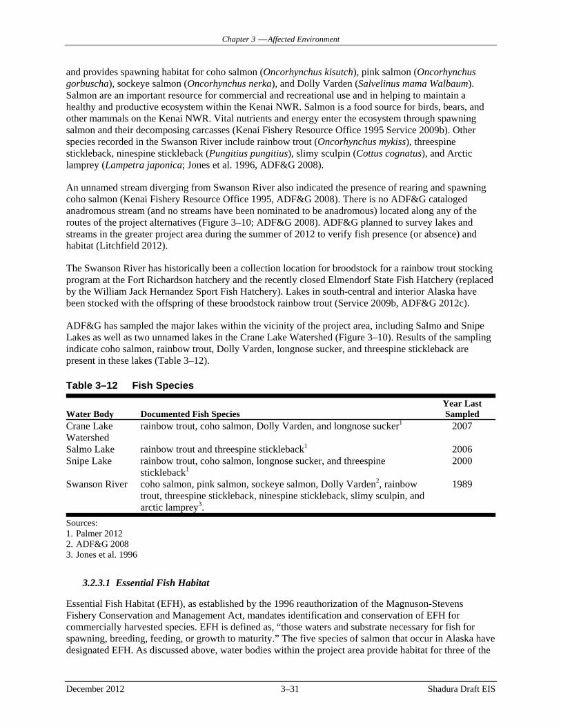
Chapter 3 Affected Environment
December 2012 3–31 Shadura Draft EIS
and provides spawning habitat for coho salmon (Oncorhynchus kisutch), pink salmon (Oncorhynchus gorbuscha), sockeye salmon (Oncorhynchus nerka), and Dolly Varden (Salvelinus mama Walbaum). Salmon are an important resource for commercial and recreational use and in helping to maintain a healthy and productive ecosystem within the Kenai NWR. Salmon is a food source for birds, bears, and other mammals on the Kenai NWR. Vital nutrients and energy enter the ecosystem through spawning salmon and their decomposing carcasses (Kenai Fishery Resource Office 1995 Service 2009b). Other species recorded in the Swanson River include rainbow trout (Oncorhynchus mykiss), threespine stickleback, ninespine stickleback (Pungitius pungitius), slimy sculpin (Cottus cognatus), and Arctic lamprey (Lampetra japonica; Jones et al. 1996, ADF&G 2008).
An unnamed stream diverging from Swanson River also indicated the presence of rearing and spawning coho salmon (Kenai Fishery Resource Office 1995, ADF&G 2008). There is no ADF&G cataloged anadromous stream (and no streams have been nominated to be anadromous) located along any of the routes of the project alternatives (Figure 3–10; ADF&G 2008). ADF&G planned to survey lakes and streams in the greater project area during the summer of 2012 to verify fish presence (or absence) and habitat (Litchfield 2012).
The Swanson River has historically been a collection location for broodstock for a rainbow trout stocking program at the Fort Richardson hatchery and the recently closed Elmendorf State Fish Hatchery (replaced by the William Jack Hernandez Sport Fish Hatchery). Lakes in south-central and interior Alaska have been stocked with the offspring of these broodstock rainbow trout (Service 2009b, ADF&G 2012c).
ADF&G has sampled the major lakes within the vicinity of the project area, including Salmo and Snipe Lakes as well as two unnamed lakes in the Crane Lake Watershed (Figure 3–10). Results of the sampling indicate coho salmon, rainbow trout, Dolly Varden, longnose sucker, and threespine stickleback are present in these lakes (Table 3–12).
3.2.3.1 Essential Fish Habitat
Essential Fish Habitat (EFH), as established by the 1996 reauthorization of the Magnuson-Stevens Fishery Conservation and Management Act, mandates identification and conservation of EFH for commercially harvested species. EFH is defined as, “those waters and substrate necessary for fish for spawning, breeding, feeding, or growth to maturity.” The five species of salmon that occur in Alaska have designated EFH. As discussed above, water bodies within the project area provide habitat for three of the
Table 3–12 Fish Species
Water Body Documented Fish Species Year Last Sampled
Crane Lake Watershed
rainbow trout, coho salmon, Dolly Varden, and longnose sucker1 2007
Salmo Lake rainbow trout and threespine stickleback1 2006 Snipe Lake rainbow trout, coho salmon, longnose sucker, and threespine
stickleback1 2000
Swanson River coho salmon, pink salmon, sockeye salmon, Dolly Varden2, rainbow trout, threespine stickleback, ninespine stickleback, slimy sculpin, and arctic lamprey3.
1989
Sources: 1. Palmer 2012 2. ADF&G 2008 3. Jones et al. 1996

Chapter 3 Affected Environment
December 2012 3–32 Shadura Draft EIS
five salmon species, including coho, pink, and sockeye salmon. EFH for these salmon species is described below as stated in the final 2005 EFH Environmental Impact Statement of National Marine Fisheries Service (NMFS 2005).
3.2.3.1.1 Freshwater Eggs
EFH for coho, pink, and sockeye salmon eggs is the general distribution area for this life stage, located in gravel substrates in those waters identified in ADF&G’s Catalog of Waters Important for the Spawning, Rearing, or Migration of Anadromous Fishes (ADF&G 2008).
3.2.3.1.2 Coho salmon EFH
3.2.3.1.2.1 Freshwater Larvae and Juveniles
EFH for larval and juvenile coho salmon is the general distribution area for this life stage, located in those waters identified in ADF&G’s Catalog of Waters Important for the Spawning, Rearing, or Migration of Anadromous Fishes (ADF&G 2008) and contiguous rearing areas within the boundaries of ordinary high water. Fry generally migrate to a lake, slough, or estuary and rear in these areas for up to two years.
3.2.3.1.2.2 Estuarine Juveniles
Estuarine EFH for juvenile coho salmon is the general distribution area for this life stage, located in estuarine areas, as identified by the salinity transition zone (ecotone) and the mean higher tide line, within nearshore waters. Juvenile coho salmon require year-round rearing habitat and migration habitat from April to November to provide access to and from the estuary.
3.2.3.1.2.3 Freshwater Adults
EFH for coho salmon is the general distribution area for this life stage, located in freshwaters as identified in ADF&G’s Catalog of Waters Important for the Spawning, Rearing, or Migration of Anadromous Fishes (ADF&G 2008). EFH is also wherever there are spawning substrates consisting mainly of gravel containing less than 15 percent fine sediment (less than 2 mm diameter) from July to December.
3.2.3.1.3 Pink Salmon EFH
3.2.3.1.3.1 Freshwater Larvae and Juveniles
EFH for larval and juvenile pink salmon is the general distribution area for this life stage, located in those waters identified in ADF&G’s Catalog of Waters Important for the Spawning, Rearing, or Migration of Anadromous Fishes (ADF&G 2008) and contiguous rearing areas within the boundaries of ordinary high water during the spring, generally migrate in darkness in the upper water column. Fry leave streams within 15 days and the duration of migration from a stream towards sea may last 2 months.
3.2.3.1.3.2 Estuarine Juveniles
Estuarine EFH for juvenile pink salmon is the general distribution area for this life stage, located in estuarine areas, as identified by the salinity transition zone (ecotone) and the mean higher tide line, within nearshore waters and generally present from late April through.
3.2.3.1.3.3 Freshwater Adults
EFH for pink salmon is the general distribution area for this life stage, located in freshwaters identified in ADF&G’s Catalog of Waters Important for the Spawning, Rearing, or Migration of Anadromous Fishes (ADF&G 2008). EFH is also wherever there are spawning substrates consisting of medium to course gravel containing less than 15 percent fine sediment (less than 2 mm diameter), 15 to 50 cm in depth from June through September.

Chapter 3 Affected Environment
December 2012 3–33 Shadura Draft EIS
3.2.3.1.4 Sockeye EFH
3.2.3.1.4.1 Freshwater Larvae and Juveniles
EFH for larval and juvenile sockeye salmon is the general distribution area for this life stage, located in those waters identified in ADF&G’s Catalog of Waters Important for the Spawning, Rearing, or Migration of Anadromous Fishes (ADF&G 2008) and contiguous rearing areas within the boundaries of ordinary high water. Juvenile sockeye salmon require year-round rearing habitat. Fry generally migrate downstream to a lake or, in systems lacking a freshwater lake, to estuarine and riverine rearing areas for up to 2 years. Fry migration occurs from approximately April to November and smolts generally migrate during the spring and summer.
3.2.3.1.4.2 Estuarine Juveniles
Estuarine EFH for juvenile sockeye salmon is the general distribution area for this life stage, located in estuarine areas, as identified by the salinity transition zone (ecotone) and the mean higher tide line, within nearshore waters. Under-yearling, yearling, and older smolts occupy estuaries from March through early August.
3.2.3.1.4.3 Freshwater Adults
EFH for sockeye salmon is the general distribution area for this life stage, located in freshwaters identified in ADF&G’s Catalog of Waters Important for the Spawning, Rearing, or Migration of Anadromous Fishes (ADF&G 2008). EFH is also wherever there are spawning substrates consisting of medium to course gravel containing less than 15 percent fine sediment (less than 2 mm diameter) and finer substrates can be used in upwelling areas of streams and sloughs from June through September. Sockeye often spawn in lake substrates, as well as in streams.
3.2.4 Special-Concern Species
3.2.4.1 Threatened or Endangered Species
Federally listed threatened and endangered (T&E) species are those species formally listed by the Service or National Marine Fisheries Service (NMFS) under authority of the Endangered Species Act (ESA) of 1973, as amended. No known federally endangered T&E species occur on the Kenai NWR (Service 2009b).
3.2.4.2 Other Special-Concern Species
The ADF&G Comprehensive Wildlife Conservation Strategy for the State of Alaska derived a list of State Species of Concern from various conservation plans, lists, and organizations. These include the Service, NatureServe (a network of natural heritage programs and The Nature Conservancy that ranks special concern species within the state), Audubon Alaska (AA), Alaska Shorebird Conservation Plan (ACSP, compiled by the Service), and Boreal Partners in Flight (BPIF, a partnership for the conservation of bird populations; ADF&G 2006c). The mammal, fish, amphibian, and common avian Species of Concern are included in Table 3–13 along with their ranking and habitat information. Several organizations have updated their lists of special-concern species since the publication of the Comprehensive Wildlife Conservation Strategy and those changes have been included in Table 3–13.
3.2.4.2.1 Amphibians
The wood frog (Rana sylvatica) is distributed throughout south-central and southeast Alaska, including the Kenai NWR. Wood frogs inhabit diverse habitats, including mixed forests (coniferous and deciduous), open meadows (herbaceous), and muskeg ponds (wetlands and aquatic). Wood frogs rely on aquatic habitats for breeding and early development, but are considered terrestrial otherwise. They have the

Chapter 3 Affected Environment
December 2012 3–34 Shadura Draft EIS
Table 3–13 Species of Concern on Kenai NWR
Common Name Species Name Jurisdiction1 Status1 Common Habitats
Observed by the Service near
Project Vicinity2 Other Information Kenai brown bear
Ursus arctos kenai ADF&G, SOA State Species of Concern
Coniferous Forests, Deciduous Forests, Shrub, Wetlands/Aquatic3
See Section 3.2.2.1.1 for further discussion
Little brown bat Myotis lucifugus ADF&G, NatureServe
Rare or uncommon, long-term concern
Coniferous Forests, Wetlands/Aquatic4
Ermine Mustela erminea ADF&G, NatureServe
Not rare, long-term concern
Forest edges, Wetlands/Aquatic5
Kenai marten Martes americana kenaiensis
ADF&G Conservation status not yet assessed
Coniferous Forests, Deciduous Forests6
In 2002, marten were found in the western Kenai Lowlands for the first time in 100 years7
Kenai wolverine Gulo gulo katschemakensis
ADF&G, NatureServe
Rare or uncommon Coniferous Forests8 The population on Kenai NWR has declining harvest and population estimates9
Dusky shrew Sorex monticolus ADF&G, NatureServe
Conservation status not yet assessed
Shrub, Coniferous Forests, Herbaceous3
Pygmy shrew Sorex hoyi ADF&G, NatureServe
Conservation status not yet assessed
Coniferous Forests, Deciduous Forests, Herbaceous3
Alaska marmot Marmota broweri ADF&G, NatureServe
Not rare, long-term concern
Not found within Project Area (cite range map)10
Marmot spp. den in rocky areas adjacent to tundra
Northern bog lemming
Synaptomys borealis ADF&G, NatureServe
Not rare, long-term concern
Wetlands/Aquatic, open Forests3
Northern red-backed vole
Clethrionomys rutilus
ADF&G, NatureServe
Conservation status not yet assessed
Coniferous Forests3
Kenai red squirrel
Tamiasciurus hudsonicu kenaiensis
ADF&G, NatureServe
Conservation status not yet assessed
Coniferous Forests11 X
Singing vole Microtus miurus ADF&G, NatureServe
Not rare, long-term concern
Wetlands/Aquatic3
Tundra vole Microtus oeconomus
ADF&G, NatureServe
Conservation status not yet assessed
Wetlands/Aquatic3
Longnose sucker
Catostomus catostomus
ADF&G, NatureServe
Secure Wetlands/Aquatic12 X Occur in Crane Lake and Snipe Lake13

Chapter 3 Affected Environment
December 2012 3–35 Shadura Draft EIS
Table 3–13 Species of Concern on Kenai NWR
Common Name Species Name Jurisdiction1 Status1 Common Habitats
Observed by the Service near
Project Vicinity2 Other Information Threespine stickleback
Gasterosteus aculeatus
ADF&G, NatureServe
Secure Wetlands/Aquatic14 X Occur in Salmo Lake and Snipe Lake13
Wood frog Rana sylvatica ADF&G, NatureServe
Rare or uncommon, long-term concern
Wetlands/Aquatic, Coniferous Forests, Deciduous Forests, Herbaceous15
Horned Grebe Podiceps auritus ADF&G, NatureServe
Rare or uncommon Wetlands/Aquatic16
Bald Eagle Haliaeetus leucephalus
ADF&G, USFS, NatureServe
USFS: sensitive; NatureServe: rare or uncommon breeding population
Wetlands/Aquatic, Coniferous Forests, Deciduous Forests16
Hudsonian Godwit
Limosa haemastica ADF&G, Service, BLM, Audubon Alaska, ASCP, NatureServe
Service: bird of conservation concern; BLM: sensitive; Audubon Alaska: relative abundance, breeding distribution; ASCP: species of high concern; NatureServe: rare or uncommon breeding population
Wetlands/Aquatic, Coniferous Forests16
Wilson’s Snipe Gallingo delicata ADF&G, NatureServe
Rare or uncommon breeding population
Wetlands/Aquatic17 X
Arctic Tern Sterna paradisaea ADF&G, Service, NatureServe
Service: bird of conservation concern; NatureServe: Secure
Coniferous Forests, Wetlands/Aquatic18
Swainson’s Thrush
Catharus ustulatus ADF&G, NatureServe
Rare or uncommon breeding population
Coniferous Forests, Deciduous Forests16
X
American Robin
Turdus migratorius ADF&G, NatureServe
Rare or uncommon breeding population
All habitat types16 X
Varied Thrush Ixoreus naevius ADF&G, BPIF, Audubon Alaska19 NatureServe
BPIF: potential negative response to loss of forest cover; NatureServe: Secure
Coniferous Forests16 X

Chapter 3 Affected Environment
December 2012 3–36 Shadura Draft EIS
Table 3–13 Species of Concern on Kenai NWR
Common Name Species Name Jurisdiction1 Status1 Common Habitats
Observed by the Service near
Project Vicinity2 Other Information Fox Sparrow Passerella iliaca ADF&G,
NatureServe Rare or uncommon breeding population
Shrub16
Golden-crowned Sparrow
Zonotrichia atricapilla
ADF&G, NatureServe, BPIF20
Rare or uncommon breeding population
Shrub, Herbaceous16
White-crowned Sparrow
Zonotrichia leucophrys
ADF&G, NatureServe
Rare or uncommon breeding population
Shrub, Herbaceous16 X
Dark-eyed Junco
Junco hyemalis ADF&G, NatureServe
Rare or uncommon breeding population
Coniferous Forests, Deciduous Forests, Shrub16
X
Pine Siskin Carduelis pinus ADF&G, NatureServe
Secure Coniferous Forests, Deciduous Forests, Shrub16
Bank Swallow Riparia riparia ADF&G, NatureServe
Secure breeding population
Wetland/Aquatic, Herbaceous16
Boreal Chickadee
Poecile hudsonica ADF&G, NatureServe
Secure Coniferous Forests16 X
Common Loon Gavia immer ADF&G, NatureServe
Not rare, long-term concern
Wetlands/Aquatic16 X
Great Horned Owl
Bubo virginianus ADF&G, NatureServe
Secure Coniferous Forests, Deciduous Forests, Herbaceous16
Hairy Woodpecker
Picoides villosus ADF&G, NatureServe
Not rare, long-term concern
Coniferous Forests, Deciduous Forests16
Lesser Yellowlegs
Tringa flavipes ADF&G, Audubon Alaska19, NatureServe
Secure breeding population
Wetlands/Aquatic16 X
Northern Harrier
Circus cyaneus ADF&G, NatureServe
Not rare, long-term concern breeding population
Wetlands/Aquatic, Herbaceous16
Red-necked Grebe
Podiceps grisegena
ADF&G, NatureServe
Not rare, long-term concern breeding population
Wetlands/Aquatic16

Chapter 3 Affected Environment
December 2012 3–37 Shadura Draft EIS
Table 3–13 Species of Concern on Kenai NWR
Common Name Species Name Jurisdiction1 Status1 Common Habitats
Observed by the Service near
Project Vicinity2 Other Information Short-billed Dowitcher
Limnodromus griseus
ADF&G, Audubon Alaska19, NatureServe
Secure breeding population
Wetlands/Aquatic16 X
Violet-green Swallow
Tachycineta thalassina
ADF&G, NatureServe
Secure breeding population
Wetlands/Aquatic16
Sources: 1. ADF&G 2006c 2. Service 2012c 3. Reid 2006 4. ADF&G 2005 5. ADF&G 2006b 6. Shepherd and Melchior 2008 7. Baltensperger 2008 8. Taylor 2008 9. Bailey 2010 10. ADF&G 2006a 11. Earnest 2008 12. Mansfield 2004 13. Palmer 2012 14. ADF&G 2006d 15. Broderson and Tessler 2008 16. Sibley 2003 17. USGS no date 18. Cornell 2011 19. Audubon Alaska 2010 20. U.S. Geological Survey 2010
Chapter 3 Affected Environment
December 2012 3–38 Shadura Draft EIS
ability to survive winters by hibernating (by freezing solid) under a layer of snow covered in dead vegetation. In the spring (April and May), wood frogs come out of hibernation and make their way to shallow ponds for breeding, which lasts only a few weeks. Wood frog eggs hatch within a week of fertilization and then metamorphosis to froglets. After eight weeks, wood frogs leave the pond for terrestrial habitats (Broderson and Tessler 2008, Reeves and Trust 2008, Reeves et al. 2010).
Recent research suggests an increase in the frequency of amphibian abnormalities during developmental life stages in the Kenai NWR because of multiple stressors, such as toxic metals, organic contaminants, and dragonfly predators. Field studies support the theory that contaminants interfere with amphibian development. Deformations may result in increased predation-inflicted injuries (Reeves et al. 2010).
The chytrid fungus (Batrachochytrium dendrobatidis) is an increasing threat to the wood frog. It was first detected on Kenai NWR in 2002 in one pond and was detected in 2006 in three different ponds. All four ponds were located along the same gravel access road and the Swan Lake recreational canoe route. These ponds are located south and east of the project area. No other species of amphibians, reptiles, or fish were nearby that could have spread the fungus (Reeves and Green 2006, Reeves 2008).
3.2.4.2.1 Bald Eagles
Although no longer federally listed, the Bald Eagle remains protected under both the MBTA and the Bald and Golden Eagle Protection Act. Kenai NWR biologists have conducted Bald Eagle/Osprey nest surveys since 1957. Results from the surveys in 2005, 2007, 2009, 2010, and 2011 are included in Figure 3–8. In 2011, two Bald Eagle nests were observed near the project area (Service 2012b).
3.3 HUMAN ENVIRONMENT
3.3.1 Land Use
3.3.1.1 Land Ownership
A number of entities own and manage the lands within the project area as shown in Figure 3–11. Surface ownership proximate to the Project includes federal lands within the Kenai NWR, Alaska State lands, and KPB ROW. The proposed drilling/processing pad would be located on surface lands managed by Kenai NWR and on subsurface in-holdings owned by CIRI.
Subsurface ownership is shown on Figure 1–2. CIRI owns the subsurface estate of oil, gas, and coal in the northwest portion of the Kenai NWR, including the project area. NordAq has leased a portion of this oil and gas estate from CIRI. Private surface and subsurface property rights (including the oil and gas estate leased to NordAq) were conveyed to CIRI pursuant to ANCSA in the settlement of Alaska Native Corporation land claims in the Cook Inlet region.
Most land within the Kenai Peninsula is held in the public trust by the federal government. The State of Alaska manages lands for forestry, fish and wildlife protection, and recreation. Private landowners, private corporations, and Native corporations also own lands within the Kenai Peninsula.
3.3.1.2 Existing Land Uses
Existing land uses in the Kenai NWR and vicinity of the Project include fishing, hiking, sightseeing, and camping, which is most obvious in spring, summer, and fall (Service 2009b). Hunting is predominantly a fall activity, but can occur throughout the year for some wildlife species, such as black bears, snowshoe hares, and red squirrels. In winter months, land uses include cross-country skiing, snowshoeing, trapping, ice fishing, and snowmachine travel (Service 2009b). Recreational uses are discussed in Section 3.3.2.

Captain CookState Recreation
Area
Swanson River Oil Field
Dave SpencerWilderness
Area
Kenai National Wildlife Refuge
Cook Inlet
Swanson
River
Alternative-3
Alternative-2
Alternative-5
Alternative-4
Drilling/Processing Pad
FIGURE:
3-11LAND OWNERSHIP
SHADURA NATURAL GAS DEVELOPMENT PROJECT EIS
ARCADIS: NOREIS0066.mxd, 05/18/12, R02
AL A S K AProject
LocationProjection: State Plane Alaska Zone 4 (feet), NAD83
Seward Meridian
Drilling/Processing Pad
RoutesAlternative-2
Alternative-3
Alternative-4
Alternative-5
Kenai National Wildlife Refuge Boundary
Captain Cook State Recreation Area
Wilderness Area
Oil/Gas Unit Boundary
Swanson River
Surface OwnerBorough
Federal
Native
State
Private
0 1.5 30.75 Km
0 1 20.5 Mi
SCALE:

Chapter 3 Affected Environment
December 2012 3–40 Shadura Draft EIS
Oil and gas development has occurred on the Kenai NWR since the 1950s. Several oil and gas units have been established within the Kenai NWR, including the Swanson River Unit, Beaver Creek Unit, Birch Hill Unit, Sunrise, and Wolf Lake Facilities. Establishment of these units has led to the subsequent construction of well pads, service roads, and buried pipelines. To support these units and others, two major buried pipelines cross the general area. The first is a natural gas pipeline from ConocoPhillips’ Tyonek platform to the Kenai Liquefied Natural Gas (LNG) Facility. The second is the 40-mile-long Nikiski Alaska Pipeline from Tesoro’s Kenai Refinery to the Ted Stevens Anchorage International Airport. Active facilities within the Nikiski area include the Tesoro Kenai Alaska Refinery, Nikiski Terminal, Kenai Pipeline Facility, Kenai LNG Facility, two buried pipelines, a power line between Swanson River Unit and Nikiski, a buried pipeline from Wolf Lake pad to Beaver Creek Unit, and a buried pipeline from Beaver Creek Unit to the ENSTAR buried pipeline within the Kenai NWR.
Several residences are located near the project area. Gray Cliff is a relatively small subdivision platted in the early 1980s. The Gray Cliff residential area is located northeast of where the Kenai Spur Highway ends. In addition, there are a number of Service-owned administrative and recreational cabins within Kenai NWR that are used year-round. There are also several privately owned cabins within the Kenai NWR that are located on Tyonek surface owned lands near the project area.
Timber harvesting and logging are also land uses conducted within the Kenai Peninsula. There are no logging facilities or timber sale areas near the Project.
3.3.1.3 Land Use Management
Most project infrastructure is subject to the regulations and requirements of ANILCA PS 96-487. The Project would require a number of permits as summarized in Table 1–1.
The 2009 Revised CCP developed long-term goals and objectives for management of resources within the Kenai NWR and provides policy guidance. Effective as of the issuance of the ROD for the 2009 Revised CCP, four management categories have been adopted (Service 2009a). The categories progress from most to least protective as follows: Wilderness, Minimal, Moderate, and Intensive. Implementation of these general management categories by the Service is subject to existing valid rights.
The project area is located within Kenai NWR lands in the Minimal Management category (Figure 3–12). Lands within the Minimal management category are to be maintained in pristine conditions and as areas with important fish and wildlife and wilderness values (Service 2009a). These areas generally would not be subject to planned habitat manipulation. Restrictions are placed on motorized access, recreation, and economic uses. Lands in this category represent the Service’s recommendations for future Wilderness designation.
The project area is located within the Lowland Lakes System, an area with numerous lakes that provide a variety of aquatic habitats for wildlife. The Lowland Lakes System is identified in the 2009 Revised CCP as having special values because the area has unique geologic features.
The nearest designated Wilderness Area is more than eight miles southeast of the project area. Even though lands within the project area are not designated as Wilderness, these lands have important natural, scenic, and recreational value. There are no designated Wild and Scenic Rivers within the Kenai NWR. Current and proposed management direction for the Kenai NWR provides adequate protection for all river-related values (Service 2009b).
Some Project facilities may be located on State of Alaska lands immediately north of the Kenai NWR boundary. As shown in Table 1–1, any surface improvements on State of Alaska land would require a Land Use Permit from the ADNR.

Captain CookState Recreation
Area
Swanson River Oil Field
Dave SpencerWilderness
Area
Kenai National Wildlife Refuge
Cook Inlet
Swanson
River
Alternative-3
Alternative-2
Alternative-5
Alternative-4
Drilling/Processing Pad
FIGURE:
3-12MANAGEMENT CATEGORIES
SHADURA NATURAL GAS DEVELOPMENT PROJECT EIS
ARCADIS: NOREIS0067.mxd, 05/18/12, R02
AL A S K AProject
LocationProjection: State Plane Alaska Zone 4 (feet), NAD83
Seward Meridian
Drilling/Processing Pad
RoutesAlternative-2
Alternative-3
Alternative-4
Alternative-5
Kenai National Wildlife Refuge Boundary
State_Parks
Wilderness Area
Oil/Gas Unit Boundary
Kenai Peninsula Borough Lands
Swanson River
CCP Management CategoryIntensive
Minimal
State/Private
Wilderness
0 1.5 30.75 Km
0 1 20.5 Mi
SCALE:

Chapter 3 Affected Environment
December 2012 3–42 Shadura Draft EIS
Equipment and materials for the proposed Project would be staged at a parking lot along the North Kenai Spur Highway on the CCSRA (Figure 2–11). The CCSRA is adjacent to a portion of both access alternatives and supports recreational use. Land uses include fishing, camping, hiking, canoeing, hunting, and wildlife viewing.
Some proposed Project infrastructure would be located on a KPB road ROW within the KPB Coastal Zone and Designated Recreational Use Area (KPB 2008). The KPB Coastal Management Plan was adopted by ordinance on April 30, 1990. The coastal zone boundary is not subject to additional local permits or zoning regulations because no new permits or zoning are imposed in the Management Plan (KPB 2008).
3.3.2 Recreation
The Kenai NWR and CCSRA are located adjacent to each other on the northwestern Kenai Peninsula. Areas of both the Kenai NWR and CCSRA near the project area are accessible via North Kenai Spur Highway, which intersects State Highway 1 (the Sterling Highway) in Soldotna. Portions of the Kenai NWR and CCSRA that are located near the project area offer year-round recreational opportunities.
3.3.2.1 Captain Cook State Recreation Area
CCSRA is managed by ADNR. Despite being road-accessible, it is not visited by large numbers of people, largely because of its location at the end of North Kenai Spur Highway and the availability of more popular recreational areas closer to Anchorage (Alaska Division of Parks and Outdoor Recreation 2010). In 2011, 9,325 people visited CCSRA. Seventy percent of these visitors were identified as residents of KPB. No recreationists visited CCSRA in October, November, or December 2011 (Alaska Travel Industry Association 2012a).
CCSRA is approximately 3,500 acres in size and is located 25 miles north of the city of Kenai. CCSRA has designated parking areas, three campgrounds, two picnic areas, a canoe landing on the Swanson River, a boat launching area on Stormy Lake, a swimming beach on Stormy Lake, a maintained nature trail, and cross-country ski trails (Figure 3–13). Visitors come to CCSRA to walk along the beach on Cook Inlet, camp, cross-country ski, swim, canoe, fish, and view wildlife. All-terrain vehicles are allowed in designated areas within CCSRA. One of the three camping areas allows for recreational vehicles.
The largest lake within CCSRA is Stormy Lake, which has a perimeter of approximately six miles. Visitors use Stormy Lake for fishing, swimming, kayaking, canoeing, and boating. At one location on the south shore, there is a boat-in tent site. Anglers can fish for resident populations of rainbow trout and Arctic char. During the winter, there are opportunities for ice fishing.
The Swanson River winds through the easternmost portion of CCSRA until it reaches the Cook Inlet. Visitors use the Swanson River for fishing, kayaking, and canoeing. Anglers have opportunities to catch rainbow trout and coho salmon, among other fish species, in this portion of the river. Recreationists can canoe from the Kenai NWR to CCSRA on the Swanson River.
There are opportunities for wildlife viewing within CCSRA. Visitors may see moose, bears, Beluga whales, and bald eagles. Belugas can be spotted in the Cook Inlet and may sometimes be seen at the mouth of the Swanson River as they follow prey such as salmon and eulachon (Alaska Travel Industry Association 2012b). Wildlife viewing on the Peninsula is discussed in more detail in subsequent sections.
3.3.2.2 Kenai National Wildlife Refuge
The Kenai NWR is the most accessible and most visited of the 16 refuges in Alaska. In part, its popularity is derived from its location—it is one of only two Alaskan refuges accessible from the highway system

G o m p e r t z C h a n n e l
K E N A I N A T I O N A L W I L D L I F E R E F U G E
Alternative-3
Alternative-2
Alternative-5
Alternative-4
CAPTAIN COOK STATECAPTAIN COOK STATERECREATION AREARECREATION AREA
ADL LEASE - 391596
Swanson River
Swanson River
Swans
on Riv
er Drilling/Processing Pad Swanson River UnitSwanson River Unit
Birch Hill UnitBirch Hill UnitKitchen Lights UnitKitchen Lights Unit
Kit Lake
Gull Lake
Salmo Lake
Crane Lake
Decoy Lake
Quill Lake
Snipe Lake
Curlew Lake
Dunlin Lake
Stormy Lake
Hungry LakeCashka Lake
Plover Lake
Gruskka LakePintail LakeGooseneck Lake
Bufflehead Lake
0 1 20.5 Km
FIGURE:
SCALE:0 0.75 1.50.375 Mi
3-13CAPTAIN COOK STATERECREATION AREA
SHADURA NATURAL GAS DEVELOPMENT PROJECT EIS
ARCADIS: NOREIS0031.mxd, 05/18/12, R05
AL A S K AProject
Location
PREPARED FOR:
Projection: State Plane Alaska Zone 4 (feet), NAD83Seward Meridian
Drilling/Processing Pad
RoutesAlternative-2
Alternative-3
Alternative-4
Alternative-5
Oil & Gas Unit BoundariesADL Lease 391596Wilderness AreaKenai Peninsula Borough Lands
Captain Cook SRAKenai National Wildlife RefugeSwanson River Canoe Trail
St o rm yLa k e
DiscoveryCampgound
DiscoveryPicnic Area
Canoe Landing
BoatLaunchCross-Counrty
Ski TrailsTentCamping
Swim Beach
Overlook
Picnic Area
Tent Camping
CAPTIAN COOK STATE CAPTIAN COOK STATE RECREATION AREARECREATION AREA
K N W RK N W R
NORTH KENAI ROAD
Swan
son R
iver
Swanson RiverCanoe Trail
SEE INSET

Chapter 3 Affected Environment
December 2012 3–44 Shadura Draft EIS
and is located close to Anchorage, which is home to more than half the state’s population (Service 2009b). In 2004, approximately 4.5 million people traveled through the Kenai NWR along the Sterling Highway (Service 2009b).
Approximately half a million people spend extended time within the Kenai NWR each year (ARCADIS US 2012b). These numbers are expected to increase. The population of Anchorage, the source of most recreational visitors to the Kenai NWR, has been increasing in recent years. The population of the KPB has also been increasing (Service 2009b). From 2000 to 2010, the population increased by 5,000 people, an increase of 11.5 percent.
One of the stated purposes of the Kenai NWR is “to provide, in a manner compatible with these [other] purposes, opportunities for fish and wildlife-oriented recreation” (Service 2009b). Visitors have been coming to the Kenai Peninsula for recreational purposes for more than 100 years. There was a boom in recreation in the Kenai NWR in the late 1950s and early 1960s, corresponding with the discovery of oil in the Swanson River Unit in 1957 (Service 2009b). During the summer months, the more popular months for visitors to the area, recreationists come to fish, canoe, camp, hike, hunt, bird-watch, view wildlife, and flight-see. During winter months, recreational activities include cross-country skiing, ice fishing, snowmachining, hunting, snowshoeing, and dog mushing. These recreational opportunities are described in further detail below.
Of the Refuge’s 1.9 million acres, there are 13,252 acres of active oil and gas leases (Service 2009b). Access and seismic line roads associated with oil and gas activities have allowed for greater recreational access to previously hard to access or remote areas of the Kenai NWR. As an example, the Swanson River, Swan Lake, and Mystery Creek access roads, originally built to support oil and gas operations, are now open to public vehicles, which has increased recreational opportunities (Service 2009b).
3.3.2.3 Fishing
Fishing is a popular recreational activity in the Kenai NWR. Anglers come from around the world to the Kenai Peninsula to fish for sockeye, coho, pink, and Chinook salmon, as well as rainbow and Dolly Varden trout. The 82-mile long Kenai River, located in part within the Kenai NWR, is the most heavily fished river in the State of Alaska, with an average of 275,000 angler-days in recent years. The closest portion of the Kenai River to the Project is approximately 25 miles away via road.
The ADF&G conducts a mail survey annually to estimate sport fishing harvest, total catch, and angler days. In 2010, the results of the survey indicated that there were 1,531 anglers on the Swanson River in 2010. These anglers reported harvesting coho salmon, sockeye salmon, pink salmon, Dolly Varden, and rainbow trout. There were 602 anglers on the Swanson River Canoe Route Lakes. These anglers reported harvesting coho salmon, Dolly Varden, and rainbow trout. The survey indicated that there were 114,814 anglers on the Kenai River, guided and unguided, in 2010. These anglers reported harvesting Chinook salmon, coho salmon, sockeye salmon, pink salmon, chum salmon, lake trout, Dolly Varden, rainbow trout, Arctic grayling, whitefish, and smelt.
The Swanson River is known for a regionally large coho salmon run (approximately 20,000 per year). The coho salmon run is from late July to late September. In 2010, 1,074 coho salmon were reportedly harvested on the Swanson River. Anadromous Dolly Varden also can be caught from early July to September.
Rainbow trout can be caught throughout the year. The best time is late fall or early winter after salmon anglers have left, and the trout may be feeding on salmon carcasses and eggs. The ADF&G estimates that 95 percent of rainbow and steelhead trout caught yearly by anglers are released back to the river.

Chapter 3 Affected Environment
December 2012 3–45 Shadura Draft EIS
3.3.2.4 Swan Lake and Swanson River Canoe Trails
The Kenai Refuge Canoe Trail System was originally constructed in the 1960s for recreationists seeking a remote wilderness experience (Service 2009b). The Swan Lake and Swanson River Canoe Trails (Canoe Trails), comprising the Kenai Refuge Canoe Trail System, are located in the northern portion of the Kenai NWR (Figure 3–14) and this system is one of two nationally recognized wilderness canoe trails. The routes are identified as National Recreational Trails (Service 2009b). Beyond canoeing, the Canoe Trails are also used by recreationists for observing waterfowl, moose, and songbirds. The Swan Lake Canoe Trail is a 60-mile trail comprised of 30 lakes with interconnecting portages; it also includes a portion of the Moose River (ARCADIS US 2012b). The Swanson River Canoe Trail, considered the more challenging of the two, consists of more than 40 lakes and 46 miles of the river. The entire route can be traveled in less than one week. The Canoe Trails are used year-round for a variety of activities including canoeing, camping, fishing (including ice fishing), cross-country skiing, trapping, and wildlife viewing. The lakes thaw out in mid-May and freeze again in early October. Moose, beavers, bald eagles, waterfowl, and loons are the most commonly seen wildlife on the Canoe Trails. Black and brown bears, coyotes, wolves, lynx, and land otters may also be spotted occasionally (Service 2008b). Opportunities to fish for rainbow trout in the summer and coho salmon in the fall are favorable on the Swanson River.
Canoeists gain access to the trails by Swanson River and Swan Lake Roads. Self-registration logs are located at four entrance points to the Canoe Trails. Although these logs only capture a portion of trail users, they have documented visitors from all 50 states and a number of foreign countries. Registrations are thought to represent approximately 30 percent of use (Service 2009b). This suggests that the canoe trail system received approximately 3,500 visitors in 2004. Weekend recreationists from Anchorage are the predominant users, though people from local, Peninsula communities are well represented
3.3.2.5 Wildlife Viewing
The Kenai NWR and CCSRA offer opportunities for viewing wildlife. In the Kenai NWR, wildlife can be viewed from the lakes and rivers, on foot, or from a small airplane. Every Alaskan ecosystem is represented in the Kenai NWR, except Arctic tundra. The forests, at lower elevations, as in the project area, are home to moose, wolves, wolverine, coyote, red fox, mink, black and brown bears, and lynx. Along the rivers, river otters, and beavers can be observed.
As the Refuge’s original name (Kenai National Moose Range) suggests, moose are a popular attraction on the Peninsula. Alaskan/Yukon bull moose are considered the largest in North America. Moose can be observed year-round in the Kenai NWR. In the summer months, moose spend time wading in lakes and ponds and foraging for aquatic plants.
The Kenai Peninsula is a popular destination for birding enthusiasts. A checklist of the birds of the Kenai Peninsula documents hundreds of birds whose occurrence is considered common, uncommon, rare, extremely rare, and accidental on the Peninsula.
Backcountry hiking is another way for recreationists to experience the Kenai NWR. There are more than 250 miles of established trails and portages on the Kenai NWR providing access to lakes, rivers, mountains, scenic vistas, wildlife viewing opportunities, and hunting and fishing access. Numerous high standard and simple trailheads provide parking and orientation for visitors. Several trails are one-way trails to natural features, whereas others are loop trails and water routes. The Swan Lake and Swanson River Canoe Trails are designated National Recreation Trails and are one of only three Wilderness canoe systems established in the United States. The two routes represent a nationally significant trail/portage system that connects more than 70 lakes and 60 miles of river access. Visitors wanting to experience wilderness and wildlife dependent recreational opportunities often find themselves using one of Kenai NWR’s established hiking trails, canoe portages, interpretive trails, or winter ski trails.

Number Three Bay
G o m p e r t z C h a n n e l
K E N A I N A T I O N A L W I L D L I F E R E F U G E
D A V E S P E N C E RD A V E S P E N C E RW I L D E R N E S S A R E AW I L D E R N E S S A R E A
Alternative-3
Alternative-2
Alternative-5
Alternative-4
Drilling/Processing Pad
CAPTAIN COOKCAPTAIN COOKSTATESTATE
RECREATIONRECREATIONAREAAREA
ADL LEASE - 391596
D A V E S P E N C E RD A V E S P E N C E RW I L D E R N E S S A R E AW I L D E R N E S S A R E A
Swanson River
Swanson RiverWEST ENTRANCE
Swan Lake Canoe Route
EAST ENTRANCESwan Lake
Canoe Route
ENTRANCESwanson River Canoe Route
Swanson River
Swan Lake Road
Swans
on River
Road
SWAN LAKE AREA
SWANSON RIVER AREA
Swanson River UnitSwanson River Unit
Birch Hill UnitBirch Hill Unit
Kitchen Lights UnitKitchen Lights Unit
Beaver Creek UnitBeaver Creek Unit
Lo Lake
Owl Lake
Pot Lake
Hat Lake Dog LakePan Lake
Odd Lake
Wild Lake
Lynx Lake
Gene Lake
Snag LakeGull Lake
Lost Lake
Leaf Lake
Pond LakeLure Lake
Grus Lake
Teal Lake
Duck LakeTern Lake Weed Lake
Swan LakeLong LakeWolf Lake
Salmo Lake
Scaup Lake
Elder LakeWoods Lake
Berry Lake
Junco LakeCrane Lake Krein Lake
Mouse LakeDecoy LakeQuill Lake Goose Lake Chick Lake
Snipe LakeArrow Lake Buteo Lake
Vixen Lake
Birch LakeCanoe Lake
Drake Lake
Raven LakeGavia Lake
Akula Lake Trout Lake
Otter Lake
McLain LakeTundra Lake
Curlew Lake Pepper Lake
Wonder Lake
Dunlin Lake
Lonely Lake Embryo LakeStormy Lake
Antler Lake
Jigsaw LakeCoyote Lake
Cashka LakePlover LakeSucker Lake Frank, LakeAnertz Lake
Oolka, LakeBreeze Lake Martin Lake
Spruce LakeCygnet Lake
Forest Lake
Swanson Lake
Campers Lake Olsjold Lake
Redpoll LakeNekutak Lake
Sunrise Lake
Takukak LakeGruskka Lake
Portage LakeSabaka, LakeRainbow Lake
Contact LakeShadura Lake Mallard LakeDabbler Lake
Skookum Lake
Bratlie, Lake
Killdeer Lake
Snowflake Lake
Gooseneck Lake
Porcupine Lake
Konchanee Lake
Birch Tree Lake
Bufflehead Lake
Mink Creek Lake
Red Squirrel Lake
Dolly Varden Lake
Big Merganser Lake
0 2 41 Km
FIGURE:
SCALE:0 1.5 30.75 Mi
3-14SWANSON RIVER AND SWAN
LAKE CANOE AREA
SHADURA NATURAL GAS DEVELOPMENT PROJECT EIS
ARCADIS: NOREIS0030.mxd, 05/18/12, R05
AL A S K AProject
Location
PREPARED FOR:
Projection: State Plane Alaska Zone 4 (feet), NAD83Seward Meridian
Drilling/Processing Pad
RoutesAlternative-2
Alternative-3
Alternative-4
Alternative-5
Oil & Gas Unit BoundariesADL Lease 391596Wilderness AreaCaptain Cook State Recreation AreaKenai National Wildlife RefugeSwanson River/Swan Lake Canoe AreasKenai Peninsula Borough Lands
Portages (Generalized)Campgrounds

Chapter 3 Affected Environment
December 2012 3–47 Shadura Draft EIS
3.3.2.1 Hunting
The project area is located within GMU 15A. Moose, black bears, brown bears, caribou, mountain sheep, wolves, wolverines, and Dall Sheep are hunted within GMU 15A. Mountain goat and Dall sheep, however, inhabit the mountainous ecosystems of the western portion of GMU 15A and are not found in the project area. GMU 15A is a controlled use area in that it is closed to the use of aircraft for hunting moose, including the transportation of moose hunters, their hunting gear, or parts of moose. The general season for hunting moose runs from August 20 through September 20. In 2010, the ADF&G reports that there were 908 hunters who hunted for moose in GMU 15A. Of these, 119 hunters were successful.
There is no closed season for black bear hunting. In 2010, the ADF&G reports that there were 168 resident and non-resident hunters who hunted for black bears in GMU 15A. Of these, 58 were successful. In addition, black bear baiting occurs May 1 through June 30 in Kenai NWR. A randomized drawing occurs in April, when participants choose their one-square mile baiting areas (Williams 2012). Several of these baiting areas are located in the project area. (Figure 3–15). The wolf hunting general season runs from August 10 through April 30. The wolverine hunting general season runs from September 1 through March 31.
3.3.2.1 Trapping
Trapping is another recreational activity that occurs on the Kenai Peninsula. Beavers, coyotes, lynx, marten, mink, muskrats, river otters, short-tailed weasels, and wolverines are furbearing species found on the Kenai Peninsula. Generally speaking, trapping occurs in the winter months and may be done in conjunction with snowmachining. Most trappers travel via highway to access traplines, then use snowshoes or snowmachines to travel along traplines (ARCADIS US 2012c). Trapping can vary widely from year to year, depending on snow conditions, fur prices, animal populations, and other factors. During the 2008–2009 season, 48 beavers, 33 lynx, 26 marten, 19 river otters, and no wolverines were reported harvested in GMU 15A (Harper 2010). Harvests were monitored through mandatory sealing for beaver, lynx, marten, river otter, and wolverine.
3.3.2.2 Snowmachining
More than half of the Kenai NWR (63 percent) is open to snowmachining December 1 through April 30, depending upon adequate snow cover. The open season for snowmachine use has varied from zero to 150 days from 1976 through 2006. During three winters in that period, there was inadequate snow accumulation the entire season. During the other 27 years, snowmachines were allowed in designated areas for an average of 109 days each winter.
3.3.3 Transportation
There are approximately 650 miles of State-maintained roads in the KPB and more than 100 miles of maintained refuge roads within the Kenai NWR (Service 2009b). The Seward and Sterling highways are the primary highways on the Kenai Peninsula. Other major roads include the Kenai Spur and North Kenai Spur highways and Kalifornski Road (K-Beach Road).
The accessibility of the Kenai NWR is influenced by natural features, such as lakes and rivers, and by human development, such as roads, trails, and seismic lines. Oil and gas exploration and development have had a substantial influence on road access and use within the Kenai NWR. Roads that are open for public use provide access for seasonal residences and recreational uses within the Kenai NWR. Access roads originally built to support oil and gas operations are now open to the public for hiking, snowmachining, horseback riding, and vehicle travel. More than 1,800 miles of historic seismic lines, cleared during exploration for oil and gas, traverse Kenai NWR lands north of the Kenai River. The seismic lines allow access for hikers and snowmachines.

Alternative-3
Alternative-2
Alternative-5
Alternative-4
T8N,R9WT8N,R9WT8N,R10WT8N,R10WT7N,R9WT7N,R9WT7N,R10WT7N,R10W
3 4
14
29
66
46
16
31
48
68
8685
65
87
67
47
30
15 17
45
28
49
88
32
105104
2
84
106103
44
69
5
64
1
27
64
89
107
44
18
503332
18
Swanson RiverUnit
Swans
on Riv
er
KENAI SPUR HWY
Salmo Lake
Crane Lake
Snipe Lake
Dunlin Lake
Hungry Lake
FIGURE:
SCALE:
3-15BEAR BAITING UNITS
SHADURA NATURAL GAS DEVELOPMENT PROJECT EIS
ARCADIS: NOREIS0123.mxd, 09/21/12, R01
AL A S K AProject
Location
PREPARED FOR:
0 0.75 1.50.375 Km
0 0.5 10.25 Mi
Projection: State Plane Alaska Zone 4 (feet), NAD83Seward Meridian
ADNR Active State Lease
Captain Cook State Recreation Area
Kenai National Wildlife Refuge
Kenai Borough Parcel
Drilling/Processing Pad
RoutesAlternative-2
Alternative-3
Alternative-4
Alternative-5
Oil & Gas Unit Boundary
Existing Pipelines
Roads
Bear Baiting Units
ADNRKNWR
CCSRA
KPB
DRILLING/DRILLING/PROCESSING PADPROCESSING PAD

Chapter 3 Affected Environment
December 2012 3–49 Shadura Draft EIS
Starting at Kenai, the paved North Kenai Spur Highway ends in the CCSRA approximately 0.25 mile east of the Swanson River Bridge. An unmaintained two-track path continues from the CCSRA to the Gray Cliffs subdivision. This trail provides access by all-terrain vehicles and snowmachines. With respect to future roads, the “Kenai Spur Highway Extension Project” (or North Road Extension Project), has been in the conceptual and design stage for many years. If built, the road would begin where the existing paved road ends in the CCSRA at (Milepost [MP] 38.42) and would extend through the contiguous KPB property, a distance of approximately 26 miles.
The ADOT&PF tracks Annual Average Daily Traffic (AADT) counts for the North Kenai Spur Highway. The AADTs are based on weekly traffic counts calculated for traffic in both directions. Table 3–14 provides a summary of recent traffic counts for several locations along the North Kenai Spur Highway, including where the highway starts at Kenai and where the existing paved road ends in the CCSRA at ADOT&PF MP 38.42. AADT at the junction of the North Kenai Spur Highway and Sterling Highway was 13,860 vehicles in 2010 (ADOT&PF 2011b). The ADDT at the junction with Halbouty Road located more than 8 miles from where the North Kenai Spur Highway ends (the northernmost MP with available data) was 330 vehicles in 2010.
Table 3–14 Recent Annual Average Daily Traffic for the North Kenai Spur Highway
Route/MP1 Name/Description Length (miles)
2008 AADT2
2009 AADT
2010 AADT
0.000 Junction with Sterling Highway (in Kenai) 1.030 15,809 13,519 13,860
1.321 Junction with Frontier Avenue 0.475 12,080 14,158 14,610
6.270 Junction with Beaver Loop 1.820 8,922 9,157 9,449
19.266 Junction with Miller Loop 2.164 5,570 4,506 4,512
25.342 Junction with Nikiski Avenue 1.409 3,139 3,220 3,226
29.653 Junction with Halbouty Road 9.134 300 318 330
Notes: 1. MP = Mile Post. 2. AADT = Annual Average Daily Traffic. Source: ADOT&PF 2011b
3.3.4 Visual Resources
Visual resources include land, water, vegetation, animals, and structures that are visible on the land. The intrinsic beauty of the project area is a valued resource. Visual resources are important to both visitors and local residents. The character of the landscape, potential viewing locations, and number of viewers are important factors to consider when describing the visual resources of an area. Visual resources, and their analysis, address the importance of the inherent aesthetics of the landscape, the public value of viewing the natural landscape, and the contrast or change in the landscape resulting from proposed facilities.
3.3.4.1 Special Values
Special values, including scenic value, are identified and described in the Service’s 2009 Revised CCP as mandated by Section 304(g) of the ANILCA (Service 2009b). The Service’s 2009 Revised CCP identifies ecosystems and places as having special value within the Kenai NWR; these include the Chickaloon Watershed and Estuary, Harding Icefield, Kenai River and its Tributaries, Lowland Lakes System, Skilak Wildlife Recreation Area, Tustamena Lake and its Watershed, and Tustumena-Skilak Benchlands. There are no designated Scenic Byways, National Wild and Scenic Rivers, scenic trails, or scenic floats near the Project. There is a scenic overlook within the CCSRA, located approximately two miles west of the project area.

Chapter 3 Affected Environment
December 2012 3–50 Shadura Draft EIS
3.3.4.2 Landscape Character
The Kenai NWR lies within the Kenai Mountains and the Kenai Lowlands. The project area is within the Kenai Lowlands, which consists of low ridges, hills, muskeg, and thousands of lakes (Service 2009b). Relief ranges from 50 to 250 feet, and most of the land is less than 500 feet above mean sea level (Service 2009b).
The project area is relatively flat and largely undeveloped. The lowlands are generally wet with organic soils supporting wetland communities, such as black spruce and ericaceous species. Uplands in the area generally consist of mixed forest and tall shrub communities.
The Swanson River sweeps around the eastern and southern edges of the project area and lakes of varying size dot the landscape. Larger lakes in the area include Salmo, Dunlin, Gull, Crane, and Snipe. Multiple streams interconnect some of the lakes.
The existing landscape character reflects influences of human activities. Existing modifications to the landscape character have resulted from development near the Project, including the CCRSA immediately north of the project area, a public road located immediately northwest of the project area, seismic lines from past exploration activity exist in the northwestern portion of the project area, and the Swanson River Oil and Gas Unit is located immediately southeast and east of the project area.
3.3.4.3 Visual Sensitivity
“Sensitivity of landscape viewshed” is the extent that features are noticeable or apparent in the landscape. Areas that are visible from many locations or at close range are relatively more sensitive to modifications of the landscape. Viewing distance and screening by vegetation or topography are aspects considered in evaluating the sensitivity of the landscape. Visual sensitivity is relative to the number of people who view the area and the degree of public concern for scenic quality. Factors typically considered when measuring public concern include type of users, amount of public use, public interest, and adjacent land uses. Areas identified within the vicinity of the project area that may have visual sensitivity include areas of public use, such as the CCRSA, Swanson River, seismic lines, and areas that the Service’s 2009 Revised CCP identifies as having special value such as the Lowland Lakes System.
The CCSRA provides multiple recreational opportunities. They include canoeing, boating, beach combing, bird watching, wildlife viewing, berry picking, and fishing in Stormy Lake (Alaska Division of Parks and Outdoor Recreation 2010). There is also a scenic overlook, a campground, two designated tent camping areas, and two picnic areas.
The Swanson River has outstandingly remarkable value for fish, wildlife, and recreation (Service 2009b). Fishing, canoeing, camping, wildlife viewing, and seasonal hunting and trapping are also very popular on the Swanson River (Service 2009b).
Seismic lines from past exploration activity are located throughout the project area. Seismic lines provide a means of public access to the Kenai NWR for recreational purposes, such as for snowmachine and Nordic ski trails (Service 2009b).
Although the canoe routes along the Swanson River are outside of the project area, these canoe routes are the only nationally designated trails in the Alaska refuge system. Annually, they provide thousands of visitors the opportunity to enjoy mixed forest and wetland habitats and their associated wildlife (Service 2009b).

Chapter 3 Affected Environment
December 2012 3–51 Shadura Draft EIS
3.3.5 Noise
Noise level (or volume) is generally measured in decibels (dB) using the A-weighted sound pressure level (dBA). The A-weighting scale is an adjustment to the actual sound power levels to be consistent with that of human hearing response. The dB measurement is on a logarithmic scale. To the average human ear, the apparent increase in “loudness” doubles for every 10-dB increase in noise.
The area adjacent to the proposed project area is undeveloped, and therefore, ambient noise levels are generally low and representative of undeveloped lands. Ambient sound levels were measured at five-kilometer intervals from 257 sites across two million acres of the Kenai NWR during the last three weeks in June in 2004 and 2006 (Service 2009b). The mean sound level averaged was 45.1 dB; however, values ranged from 32 to 95 dB (Service 2009b).
Although there are no stationary noise sources within the project area, road noises can be heard within portions of the Kenai NWR. During a period of peak vehicle traffic, noise was measured on and adjacent to the Sterling Highway in July 2004. Highway noise averaged 72 dB on the highway, although values as high as 120 dB were recorded for short periods. Where the Sterling Highway passes through forested areas, most vehicle-generated noise was reduced to background levels in the first 328 to 656 feet from the highway (Service 2009b). Where the highway passed through open areas, vehicles could be heard above background noise levels more than 1,640 feet from the highway (Service 2009b).
Hunters and recreationists have complained about noise from the Swanson River Field and drill rig and helicopter use in the Kenai NWR (MWH Americas Inc. 2002). The Kenai NWR biologist and other biologists use aircraft flying at relatively low altitudes to conduct inventories of moose, wolves, lynx, bears, and waterfowl (Service 2009b). Noise is also generated by the seasonal use of floatplanes on the lakes, hunting activities during the hunting season, and snowmachine use during the winter.
Some locations are more susceptible to the effects of noise, such as residential areas located in close proximity to localized sources of noise. The nearest community to the project area is Nikiski located approximately five miles from the Project. The Gray Cliff subdivision is located northeast of where the North Kenai Spur Highway ends. In addition, there are a number of seasonal-use cabins within the Kenai NWR. There are also several privately owned cabins within the Kenai NWR located on Tyonek surface-owned lands near the project area.
Currently the State of Alaska and KPB do not have general regulations limiting noise (KPB 2005). Residents report noise issues in some portions of the KPB from float planes, snowmachines, four-wheelers, and industrial equipment, such as gas compression stations (KPB 2005).
3.3.6 Cultural Resources
The study area and the area of potential effects were defined as legal sections containing project elements or alternatives and a two-mile buffer on all sides. The affected cultural resources environment was examined by completing a records search through the Alaska Heritage Resource Survey (AHRS) site files on March 29, 2012. The following legal sections (Seward Meridian) were reviewed:
Township 7 North, Range 9 West 3, 4, 5, 6, 7, 8, 9, and 10
Township 7 North, Range 10 West 1, 2, 3, 10, 11, 12, 13, and 14
Township 8 North, Range 9 West 6, 7, 8, 9, 15, 16, 17, 18, 19, 20, 21, 22, 23, 26, 27, 28, 29, 30, 31, 32, 33, and 34
Township 8 North, Range 10 West 1, 2, 3, 9, 10, 11, 12, 13, 14, 15, 16, 22, 23, 24, 25, 26, 27, 34, 35, and 36

Chapter 3 Affected Environment
December 2012 3–52 Shadura Draft EIS
The records search and literature review was supplemented for the Project by recent pedestrian cultural resources surveys completed for project-related features (Federal Subsistence Management Program 2010, Mobley 2011). Mobley’s survey covered about 2.5 miles of the access route for the Project. Mobley had previously completed a negative survey for the well pad (Shadura #1) and the recent survey was for the access road. The ARCADIS survey covered all project facilities, including alternative access roads and pads. None of the surveys identified any cultural sites.
Because no sites have been reported in the project area, only a brief cultural context is presented here. The general cultural context for this area is adapted from the Kenai NWR Revised CCP (Service 2009b). The prehistory of southwest Alaska is grouped into the Paleoarctic (10,000 to 6,000 years ago), the Northern Archaic (6,000 to 3,000 years ago), the Kachemak tradition (3,000 to 1,000 years ago), and the Late Prehistoric (after 1,000 years ago). Sites or individual artifacts may be identifiable as prehistoric or Alaska Native, but not identifiable to a prehistoric period or tradition. The Service (2009b) indicates that sites or individual artifacts associated with the Paleoarctic and Northern Archaic are present in the Kenai region, but are poorly represented. Indications of intensive, long-term occupation begin with Kachemak related materials dating as early as 1,000 BC (3,000 years ago). Late Prehistoric occupations are related to the historic Kenai Dena’ina and Eskimo groups that occupied the region at the time of earliest recorded European contact in the late 1700s.
The prehistoric cultural resources of the region reflect long-term occupation by Dena’ina and Eskimo groups still present in the region, and the contemporary Alaska Native peoples value the story of adaptation that these resources tell. The Kenai Peninsula as a whole is rich in prehistoric and historic sites and buildings (Service 2009b). In general, prehistoric sites are more common and larger sites occur on the Kenai Peninsula on dry terraces near rivers and lakes that support anadromous fish populations. The two archaeological districts in the Kenai NWR occur along the Kenai River drainage. The project area is in the lowland lakes system dominated by small lakes that support resident (non-anadromous) fish populations. Cultural resources are generally small and scarce in this portion of the Peninsula.
The historic period of the Kenai Peninsula is dominated by the early European exploration and trade, periods of mineral prospecting and minor gold rushes, and the fishing industry. Oil exploration in the region began in the 1950s.The project area itself is within the Kenai NWR and, aside from oil and gas exploration and production, no development has taken place in the area. In general, historic cultural development along the northwest side of the Kenai Peninsula has been along the coast of Cook Inlet.
Few cultural resources surveys have been conducted in the general area of the project. Those that have been completed have been predominantly for roads and developments along the coast west of the project and for oil and gas projects associated with the existing Swanson River Unit east and south of the project. Several past cultural resources surveys along the coast have included areas along the lower Swanson River west of the project. The existing information does not fully represent the cultural resource sites that are present, but gives an idea of the types of sites that are present and the types of settings in which they are likely to be found.
3.3.6.1 Records Search Results
The results of the records search through the AHRS for the project area are summarized in Table 3–15. Current information does not include any reported sites within ¼ mile of the Project or alternatives. The records search yielded 11 previously recorded sites in the study area. All of these sites, except the Swanson River Unit No 1 Discovery Well (KEN-00054) are located along the Swanson River, particularly near the coast of Cook Inlet or near larger lakes.

Chapter 3 Affected Environment
December 2012 3–53 Shadura Draft EIS
Table 3–15 Known Cultural Resources in the Study Area
AHRS No.1 Site Type Age or Affiliation Buildings or Structures?
Cemetery or Burials?
NRHP eligible?
KEN-00054 Historic oil well 1957 yes no no KEN-00096 Prehistoric and historic
settlement Tanaina – 1800s no no yes
KEN-00097 Prehistoric settlement Tanaina no no yes KEN-00099 Prehistoric and historic
settlement Tanaina – through 1890 no no yes
KEN-00112 Prehistoric settlement Undetermined no no unknown KEN-00113 Prehistoric cache pits Undetermined no no unknown KEN-00114 Prehistoric habitation Undetermined no no unknown KEN-00253 Prehistoric habitation Undetermined no no unknown KEN-00434 Historic cabin, ruins Dena’ina – early 1900s no no unknown KEN-00547 Prehistoric cache pits Dena’ina no no unknown KEN-00548 Historic structural debris Undetermined no no unknown
Note: 1. All AHRS site numbers in Kenai Borough begin with KEN-
The Alaskan Native habitation and settlement sites are characterized by house depressions and cache pits and may yield information on prehistoric and early historic settlement and subsistence. These include Dena’ina (or Tanaina) settlements that endured through the late 1800s. The larger settlements with relatively undisturbed features, particularly those with unique or unusual features, are considered good examples of Alaskan Native settlements. These sites have the potential to yield important information about the prehistory and early history of the region and potentially eligible for the National Register of Historic Places (NRHP). The five remaining prehistoric Alaska Native sites are settlement or cache pit sites of undetermined age. These sites have not been evaluated for eligibility.
Reported historic sites include the Swanson River Unit No. 1 Discovery Well and two small historic sites near the Swanson River east of the Project. The Swanson River Unit No 1 Discovery Well (KEN-00054) was proposed for nomination to the NRHP for its key role in the development of the Alaskan oil and gas industry. However, the Alaska Historical Commission determined that the site is not eligible. The other two historic sites are the ruins of an early 1900s cabin and a scatter of historic structural debris. These sites have not been evaluated for eligibility.
There have been few cultural resources surveys in the study area, and fewer still in the interior. Previous surveys and impact assessments for the Swanson River Oil and Gas Field have observed that few sites are found in the interior away from the Swanson River or larger lakes with anadromous fish populations. The Project is predominantly within this kind of interior setting. Most of the small lowland lakes in this area do not have anadromous fish populations. Investigators generally attribute the paucity of archaeological sites in the interior to the low quantity and diversity of subsistence resources (lack of concentrated biomass). Mobley (2011) noted that in addition to areas near larger drainages and lakes with anadromous fish populations, elevated and forested areas in the interior have a higher potential for human use and more favorable conditions for preservation of cultural materials. Based on the characterization of the general project area by the Service (2009b) and Mobley (2011), the project area can be characterized as having low archaeological potential. Higher potential areas may occur along the coast and near Salmo Lake.
3.3.7 Socioeconomics
The Project is located on the northwestern portion of the KPB approximately 13 miles east-northeast of Nikiski, an industrialized community that is home to the region’s oil and gas industry. For the purposes of

Chapter 3 Affected Environment
December 2012 3–54 Shadura Draft EIS
identifying socioeconomic characteristics that could be affected, the region of influence for the Project includes the Nikiski Census Designated Place (CDP), Sterling CDP, the City of Soldotna, and the City of Kenai. The following discussion focuses on population, employment, income, and characteristics of the communities within the region of influence. Demographic information is provided in Section 3.3.9.
3.3.7.1 Population
The Project is located within and immediately adjacent to the Nikiski CDP. Population information for the communities within the region of influence is presented in Table 3–16. For comparative purposes, Table 3–16 also presents population data for the KPB and the State of Alaska.
Table 3–16 Population
Population
Year Nikiski
CDP Sterling
CDP City of Kenai
City of Soldotna
Kenai Peninsula Borough
State of Alaska
1990 2,743 3,802 6,327 3,482 40,802 550,043
2000 4,327 4,705 6,942 3,759 49,691 626,932
2010 4,493 5,617 7,100 4,163 55,400 710,231
Source: U.S. Census Bureau 1991, 2001, 2011b
3.3.7.1 Income
Personal and median household income data for communities in the region of influence is presented in Table 3–17. Comparative data also are provided for the Kenai Peninsula Borough and State of Alaska.
Table 3–17 Personal and Median Household Income
Income Nikiski CDP ($)
Sterling CDP ($)
City of Kenai ($)
City of Soldotna ($)
Kenai Peninsula Borough ($)
State of Alaska ($)
Personal 25,271 32,672 27,921 28,559 29,127 30,726
Median Household
48,958 64,545 52,701 46,548 57,454 66,521
Source: U.S. Census Bureau 1991
3.3.7.2 Housing
Housing data for the communities within the region of influence are presented in Table 3–18. Almost 85 percent of the 1,998 housing units in the Nikiski CDP are occupied. Of the 309 vacant units, 129 are seasonal use structures. Only 35 units were identified as being available for rent, and 20 for sale (U.S. Census Bureau 1991).
Table 3–18 Occupied and Vacant Housing
Number of Units
Category Nikiski
CDP Sterling
CDP City of Kenai
City of Soldotna
Kenai Peninsula Borough
State ofAlaska
Total Housing Units 1,998 3,347 3,166 1,968 30,578 306,967
Occupied Housing Units 1,689 2,254 2,809 1,720 22,161 258,058
Vacant Housing Units 309 1,093 357 248 8,417 48,909
Source:U.S. Census Bureau 1991

Chapter 3 Affected Environment
December 2012 3–55 Shadura Draft EIS
3.3.7.3 Economy
The KPB has a diverse economy, with no single dominant industry. The largest industrial sectors by number of employees include natural resources and mining; trade, transportation, and utilities; local government: educational and health services; and leisure and hospitality (Table 3–19).
Table 3–19 Industrial Sector Employment
Sector
Portion of Total Employed (%) NikiskiCDP
SterlingCDP
City ofKenai
City of Soldotna
Kenai Peninsula Borough
State ofAlaska
Natural Resources and Mining 19.6 17.0 14.9 12.8 4.8 4.8
Construction 6.1 7.8 4.8 4.9 6.5 6.5
Manufacturing 6.1 3.3 4.6 2.8 2.8 2.8
Trade, Transportation, and Utilities 18.5 19.7 19.1 21.7 20.5 20.5
Information 1.1 1.0 1.6 1.2 2.1 2.1
Financial Activities 2.1 3.0 3.2 3.1 4.8 4.8
Professional and Business Services 6.0 5.5 4.8 4.0 8.5 8.5
Educational and Health Services 11.1 17.2 15.2 19.6 13.4 13.4
Leisure and Hospitality 9.1 7.1 10.8 10.3 9.7 9.7
Federal Government1 -- -- -- -- 2.3 5.4
State Government 3.8 4.4 5.0 4.6 8.2 8.2
Local Government 13.1 10.8 11.9 12.6 14.9 14.9
Other 3.4 3.2 3.9 2.3 3.6 3.6
Unknown 0.1 0.0 0.1 0.1 0.3 0.3
Note: 1. Federal Government employment available at only Borough and State Level. Source: Alaska Department of Labor and Workforce Development 2012
Nikiski is the center of the Peninsula’s oil and gas industry. It hosts the Tesoro Alaska refinery, the East Forelands complex that supports the offshore production platforms in Cook Inlet, and a number of smaller production- and transportation-related infrastructure. This is reflected in employment figures—about 20 percent of all workers are employed in the natural resources and mining sector, which includes oil and gas industry employment.
The economic importance of these jobs is magnified by the high wages in the sector in the State and on the Kenai Peninsula. The average monthly wage in the State of Alaska in 2010 was $3,977 ($47,724 per annum), whereas the average monthly wage in the oil and gas extraction subsector (which includes oil and gas producers) was $14,275 ($171,300 per annum) and the in the oil and gas industry subsector (which includes oil and gas exploration and oilfield services) was $9,951 ($119,412 per annum). In the KPB, the average monthly wage was $3,432 ($41,184 per annum), while the average wage in the oil and gas sector (including both the oil and gas extraction and oil and gas industry subsectors) was $8,881 ($106,587 per annum; Alaska Department of Labor and Workforce Development 2012). Each high wage position at an oil and production company generates approximately 4.6 indirect and induced jobs throughout the economy (McDowell Group 2011).
The economy of Nikiski has suffered a series of setbacks in recent years because of the closing of the Agrium fertilizer plant and the intermittent operation of the LNG facility. Both the closing and intermittent operation are directly attributable to declining natural gas production in Cook Inlet. These

Chapter 3 Affected Environment
December 2012 3–56 Shadura Draft EIS
closings resulted in the direct loss of more than 300 high-paying jobs, as well as associated contractor and support personnel jobs. Employment in the oil and gas-related sectors has been decreasing over time as oil and gas fields have matured and production has declined; however, oil and gas producers and refiners still employ 837 individuals directly, and account for approximately 2,311 indirect and 1,552 induced jobs throughout the Peninsula (McDowell Group 2011).
The continuing importance of the oil and gas industry in Nikiski is evidenced by the top employers in the area and the economic sectors in which they work; five of the top ten employers include a petroleum refiner, an oil and gas producer, and three oil field service companies (Table 3–20 and Table 3–21).
Table 3–20 Major Employers in Nikiski
Kenai Peninsula Borough School District
ASRC Energy Services O&M Inc.
Kenai Peninsula Borough
State of Alaska
Tesoro Alaska Petroleum Company
Peak Oilfield Service Company
Wal-Mart Associates, Inc.
Central Peninsula General Hospital
VECO Alaska Inc.
Chevron USA Inc.
Source: Alaska Department of Labor and Workforce Development 2012
Table 3–21 Major Occupations in Nikiski—2010
Sector Number of Workers Roustabouts, Oil and Gas 68
Retail Salespersons 67
Teachers and Instructors, All Other 61
Personal Care Aides 59
Cashiers 51
Office Clerks, General 39
Meat, Poultry, and Fish Cutters and Trimmers 39
Construction Laborers 38
Home Health Aides 37
Food Preparation Workers 35
Operating Engineers and Other Construction Equipment Operators 31
Service Unit Operators, Oil, Gas, and Mining 30
Carpenters 29
Laborers and Freight, Stock, and Material Movers, Hand 29
Heavy and Tractor-Trailer Truck Drivers 27
Source: Alaska Department of Labor and Workforce Development 2012

Chapter 3 Affected Environment
December 2012 3–57 Shadura Draft EIS
Commercial fishing is an important component of the economy and culture of the KPB, as well as those of Nikiski. Seven residents of Nikiski currently hold permits for the drift gillnet salmon fishery in Cook Inlet, while 22 hold setnet salmon fishery permits. Commercial fishing and the oil and gas industry have coexisted on the Peninsula for more than six decades; the beaches of Nikiski near the Tesoro refinery are known to be particularly productive (Alaska Commercial Fisheries Entry Commission 2011).
Although tourism is an important component of the Peninsula’s economy, this is less so in Nikiski and the northern portion of the Kenai Peninsula because of the number of industrial facilities in the area and the comparative lack of state and federal recreational areas when compared to other portions of the Peninsula. Tourism-related businesses with North American Industrial Classification System codes 71 and 72 account for only 11 percent of business licenses in Nikiski. In the Borough as a whole, more than 20 percent of businesses are engaged in tourism-related endeavors (Alaska Department of Commerce Community and Economic Development 2011).
3.3.7.4 Unemployment
As of February 2012, the unemployment rate for the KPB stood at 10.2 percent, higher than the statewide average of 8.0 percent. Unemployment is generally seasonal, with winter unemployment rates 3 to 4 percent higher than those of the summer months (Alaska Department of Labor and Workforce Development 2012). Month-over-month unemployment rates have generally declined since 2010.
3.3.8 Subsistence
Subsistence hunting and fishing regulations in Alaska differ significantly depending upon ownership of the land. Federal regulations allow subsistence hunting by residents of rural communities, while prohibiting subsistence hunting by residents of urban areas. Much of the Kenai Peninsula is considered non-rural under federal subsistence management regulations. Only five communities (Ninilchik, Port Graham, Nanwalek, Seldovia, and Cooper Landing) are identified as rural communities (Federal Subsistence Management Program 2011).
As recently as 1985, subsistence activities were reportedly not occurring in the Refuge (Service 2009b). Through various procedural and legal processes, subsistence hunting and fishing have become recognized uses on the Refuge.
3.3.8.1 Hunting
Residents of the five federally recognized rural communities may participate in federal subsistence hunts for moose or bear on portions of the Kenai NWR, including GMU 15A in which the proposed project is located. The moose hunting season in GMU 15A usually occurs between August 10 and September 20. The black bear subsistence hunt season is year-round; Ninilchik residents can take up to two bears, with residents of the other four communities limited to one bear per person (Federal Subsistence Management Program 2010). Information on the subsistence hunts for moose between 2001 and 2010 are shown on Table 3–22.
3.3.8.1 Fishing
Waters near the project area (the Swanson River and Stormy Lake) are known to support coho, sockeye, and pink salmon at various life stages, as well as to support Dolly Varden and rainbow trout. Federal regulations provide for the subsistence harvest of fish species in selected locations on the Kenai Peninsula. Residents of Cooper Landing, Hope, and Ninilchik; however, have been granted a customary and traditional use determination for waters north of the Kenai River (Federal Subsistence Management

Chapter 3 Affected Environment
December 2012 3–58 Shadura Draft EIS
Program 2011). This determination allows the subsistence harvest of salmon, trout, and Dolly Varden/char with a federal subsistence fishing permit, but exempts the subsistence fisher from needing to hold a state license. The seasons, harvest and possession limits, and methods and means are the same as for the taking of those species under Alaska sport fishing regulations in effect at the time. None of the selected subsistence fishing locations is found near the project area or in any of the watersheds crossed by the Project. Accordingly, subsistence fishing does not occur near the Project.
Table 3–22 Subsistence Moose Hunting
Year Permits Issued Permits Hunted Successful Hunters 2010 59 33 4
2009 64 51 6
2008 64 41 8
2007 102 67 8
2006 32 21 3
2005 24 12 1
2004 30 19 3
2003 40 25 3
2002 43 27 7
2001 46 33 7
Source: Eskelin 2012
3.3.9 Environmental Justice
3.3.9.1 Minority Populations
Nearly 86 percent of the population of the Nikiski CDP identifies as white, with nearly 8 percent identifying as American Indian or Alaska Native, and smaller percentages of people of other races (Table 3–23). 2.6 percent of the population identifies as Hispanic. These percentages are roughly equivalent to those of the KPB as a whole. The population of the Nikiski CDP is considerably less diverse than the State, wherein only 66.7 percent of the population identifies as white and 14.8 percent identifies as American Indian or Alaska Native (U.S. Census Bureau 2011b).
There are 19 Census Blocks that are located adjacent to or near the proposed project; the population of these Blocks is 222, of whom 183 (82.4 percent) identify as white, and 12.6 percent identify as American Indian or Alaska Native. The highest concentration of those identifying as American Indian or Alaska Native is found in Census Block 2160, where 2 of the 5 individuals in the Block identify as such. This Census Block is located approximately 5 miles to the west of the location of the proposed drilling pad (U.S. Census Bureau 2011b).
CIRI is the Alaska Native regional corporation for the Kenai Peninsula. Three village corporations are located near the Project: Kenai Native Association, Inc., Salamatof Native Association, and Point Possession, Inc. There are two federally recognized Indian Reorganization Act (IRA) tribes located in the area. They are the Kenaitze Indian Tribe (approximately 1,240 tribal members) and the Village of Salamatof (approximately 140 tribal members).

Chapter 3 Affected Environment
December 2012 3–59 Shadura Draft EIS
Table 3–23 Ethnicity in the Region of Influence
Race Nikiski CDP Sterling CDP City of Kenai
City of Soldotna
Kenai Peninsula Borough State of Alaska
Number % Number % Number % Number % Number % Number % Total population 4,493 100 5,617 100 7,100 100 4,163 100 55,400 100 710,231 100
One Race 4,287 95.4 5,373 95.7 6,537 92.1 3,879 93.2 52,293 94.4 658,356 92.7
White 3,847 85.6 5,044 89.8 5,670 79.9 3,574 85.9 46,857 84.6 473,576 66.7
Black or African American
5 0.1 8 0.1 49 0.7 11 0.3 269 0.5 23,263 3.3
American Indian and Alaska Native
347 7.7 246 4.4 632 8.9 181 4.3 4,081 7.4 104,871 14.8
Asian 50 1.1 44 0.8 104 1.5 66 1.6 631 1.1 38,135 5.4
Native Hawaiian and Other Pacific Islander
16 0.4 6 0.1 21 0.3 12 0.3 119 0.2 7,409 1.0
Some Other Race
22 0.5 25 0.4 61 0.9 35 0.8 336 0.6 11,102 1.6
Two or More Races
206 4.6 244 4.3 563 7.9 284 6.8 3,107 5.6 51,875 7.3
Source: U.S. Census Bureau 2011b
3.3.9.2 Low-Income Populations
Data on the low-income population (defined as those individuals living below the poverty line) in the region of influence is shown in Table 3–24. Data for the KPB and State of Alaska are shown for comparative purposes.
Table 3–24 Population Living Below the Poverty Line, 2006–2010
Nikiski CDP
Sterling CDP
City of Kenai
City of Soldotna
Kenai Peninsula Borough
State of Alaska
Sample Size 4,683 5,278 6,984 3,857 52,541 674,801
Number in Poverty 478 304 719 345 5,015 64,245
Percent in Poverty 10.2 5.8 10.3 8.9 9.5 9.5
Source: U.S. Census Bureau 2011a
3.3.10 Fire Management
Fire management includes the full range of activities necessary to conserve, protect, and enhance habitat for wildlife and to maintain desired ecological conditions. Fire management activities include preparedness, emergency suppression operations, wild land fire use, fire prevention, education, monitoring, research, prescribed fire, hazardous fuel reduction, and mechanical treatments.
Within the Kenai NWR, fire management is conducted in accordance with the Kenai NWR Fire Management Plan, as well as Service and Department of Interior policies and approved interagency fire management plans (Service 2001a). The Fire Management Plan outlines fire management objectives and provides appropriate guidelines for fire suppression, fire use, and fuels management activities needed to guide land-use decisions to achieve specific resource management objectives (Service 2001a). Within three years of the 2009 CCP approval, the Fire Management Plan is scheduled to be updated. In addition,

Chapter 3 Affected Environment
December 2012 3–60 Shadura Draft EIS
KPB has prepared an All-Hazard Mitigation Plan that includes measures to address the hazards associated with wildfires (KPB 2011).
The Project area is located within an area that allows both prescribed and wildland fires (Service 2009b). Prescribed fires are fires ignited to meet specific management objectives. Management-ignited prescribed fire and wildland fire use have been the primary tools use to mimic or restore natural fire regimes. The Kenai NWR relies on prescribed fire and wildland fire use to accomplish management objectives, including the reduction of hazardous fuels, wildlife habitat enhancement, and restoration of natural fire regimes.
Wildfire is a natural landscape process within forests of the Kenai Peninsula (Service 2009b). Human-caused ignitions, however, have also increased in recent years and increased fuel loads from beetle-killed trees, as well as drier and warmer weather, suggest that wildfire risk may be increasing (Service 2009b).
The project area is located within the Lowland Lakes System. Extensive peatlands are interspersed among spruce in the Kenai Lowlands on the northern part of the Kenai NWR (Service 2009b). The project area is located within an area in which historic wildfires occurred between 1960 and 1997 (Service 2009b). The Swanson River fire that occurred in 1969 burned over half of the area as shown on Figure 3–2. Large tracts of coniferous forests were burned and replaced with deciduous forests.
Fire suppression includes management actions intended to protect identified resources from a fire, extinguish a fire, or alter a fire’s direction of spread. Suppression of wildfire has increased because of concerns about an increasing human population and urban development outside the Kenai NWR boundaries (Service 2009b).
3.3.11 Hazardous Substances and Wastes
Hazardous substances are defined in Section 101(14) of CERCLA and hazardous wastes are defined under the RCRA of 1976. Petroleum products, including diesel oil and natural gas, are not specifically listed or designated as hazardous substances under CERCLA. Drilling fluids and are RCRA-exempt, including residual drilling muds, formational waters, and completion brines.
Limited development has occurred proximate to the project area. The Kenai NWR was the first national wildlife refuge in Alaska to complete a Contaminants Assessment Process (CAP; Service 2009b). The purpose of the CAP is to document existing and potential contamination issues affecting national wildlife refuges by assessing known or suspected contaminant sources, contaminated areas, contaminant-transport pathways, and areas vulnerable to spills and/or contamination. Based on the results from the CAP as summarized in the Kenai NWR Contaminant Assessment (Parson 2001), no contamination has been identified in the immediate Project vicinity; however, several potentially contaminated sites were identified within the Kenai NWR.
The potentially contaminated sites are primarily associated with oil and gas development in the Swanson River and Beaver Creek Fields. Spilled materials include antifreeze, methanol, hydraulic fluid, solvents, diesel fuel, triethylene glycol, crude oil, xylene, and produced water (MWH Americas Inc. 2002).

December 2012 4–1 Shadura Draft EIS
CHAPTER 4—ENVIRONMENTAL CONSEQUENCES
This chapter presents the evaluation of the potential environmental consequences of each of the alternatives on the physical, biological, and human environments. Where appropriate, the discussion also identifies mitigation. Overall, the chapter is organized by resource area similar to Chapter 3.
4.1 OVERVIEW
An environmental impact or consequence is defined as a modification or change in the existing environment brought about by the action taken. Effects can be direct, indirect, or cumulative and can be temporary (short term) or permanent (long term). Effects can also vary by project phase (construction, operation, decommissioning, and reclamation) and in degree, ranging from only a slight discernible change to a drastic change in the environment. The terms “effect” and “impact” are synonymous as used in this EIS.
4.1.1 Direct and Indirect Effects
Direct and indirect effects are two of the three types of effects that CEQ specifically addresses. Direct effects are those that are caused by the action taken and occur at the same time and place. Indirect effects are those caused by the action taken and occur later in time or are farther removed in distance from the action.
The analysis of environmental effects discussed in this chapter considers the context, duration, intensity, and type of impact. Context is the setting within which an effect is analyzed, such as an affected locality or region, affected commercial or cultural interests, or society as a whole. In this EIS, the intensity of impacts to resources is evaluated within a local context (i.e., project area) or regional context, as appropriate. The contribution of direct and indirect effects to cumulative impacts was evaluated in a regional context.
The duration of an effect considers whether the impact would occur in the short term or the long term. Short-term effects are temporary, transitional, or impacts directly associated with drilling activities. Long-term effects would last a year or more after completion of drilling or would be permanent.
Intensity is a measure of the relative degree of severity of an effect. The intensity of the impact considers whether the effect would be negligible, minor, moderate, or major. Negligible impacts would not be detectable and would have no discernible effect. Minor impacts would be slightly detectable, but would not be expected to have an overall effect. Moderate impacts would be clearly detectable and could have an appreciable effect. Moderate impacts suggest the need for additional care in following standard procedures, employing best management practices (BMPs), or applying precautionary measures to minimize adverse impacts. Major impacts would have a substantial, highly noticeable effect. In general, major impacts are likely to be considered significant in the context of a NEPA analysis.
Finally, effects were evaluated in terms of whether they would be beneficial or adverse. Beneficial impacts would improve resources, conditions, or both. Adverse impacts would deplete or negatively alter resources, conditions, or both.
4.1.2 Cumulative Effects
Cumulative impact is the “cumulative effect on the environment that results from the incremental impact of the action when added to “other past, present, and reasonably foreseeable future actions, regardless of

Chapter 4 Environmental Consequences
December 2012 4–2 Shadura Draft EIS
what agency (federal or non-federal) or person undertakes such other actions”. Cumulative impacts can result from individually minor but collectively significant actions taking place over time. CEQ regulations implementing NEPA require that the cumulative impacts of a proposed action be assessed (40 CFR Parts 1500–1508).
This EIS may identify significant direct or indirect impacts for certain resources while finding that there are no significant cumulative impacts for the same resource. In addition, the converse may occur where a less than significant direct or indirect project-level impact may tip the scale and cause a significant cumulative impact to the same resource. This difference is normally because of the different geographical context (Region of Influence [ROI]) for measuring direct and indirect versus cumulative impacts. The ROI for cumulative impact analysis is generally larger than the ROI for project-related impacts. This is because impacts to resources at a project level can result in synergistic impacts to the same resources at a larger scale, such as regional air quality or the population levels of a certain species.
This EIS uses a variety of methods, depending on the resource area, to determine cumulative socioeconomic and environmental effects. Methods for gathering and assessing data regarding cumulative impacts include interviews, use of checklists, trends analysis, and forecasting. In general, past, present, and reasonably foreseeable future actions are assessed by resource area. Cumulative impacts from the six alternatives would occur in all resource areas as described in this chapter.
Cumulative impacts were assessed for impacts on the environment that would result from the incremental effects of the Shadura Natural Gas Development Project added to other past, present, and reasonably foreseeable future actions (RFFAs) occurring within the analysis area. To be included in the analysis, the effects of these other actions had to overlap the effects of this Project in time, space, or both. RFFAs include other oil and gas projects, subsistence activities, and human activities. Under NEPA, past and present actions become part of the existing affected environment. Therefore, the analysis of cumulative impacts focuses on RFFAs. The RFFAs included in the cumulative impacts analysis were defined as projects or actions that would result in effects that would overlap the direct or indirect effects of the Shadura Natural Gas Development Project in time, space, or both.
A variety of RFFAs were considered in the impact analysis. They included projects on and off the Kenai NWR (Figure 4–1). All are described briefly below.
4.1.2.1 Existing Nearby Oil and Gas Units
Swanson River Oil and Gas Unit (SRU), just east of the drilling pad’s location produces natural gas from the Sterling and Beluga formations, and oil from the Hemlock formation. Facilities include 43 miles of roads, 65 well pads, 140 wells, and a large compressor plant. Twenty-eight wells have been shut in for various reasons and 64 wells have been permanently plugged. Two depleted Tyonek formation gas pools are used for natural gas storage. Swanson River Unit Gas Storage is located in the unit area. The operator injects gas usually when temperatures are above 32°F until the reservoir (depleted gas sandstone) is refilled. Stored gas is then re-produced into the Cook Inlet pipeline grid to meet spiking and high winter seasonal demand. SRU produced 122 barrels of oil per day from eight oil wells and 1 million standard cubic feet per day (MMSCFD) from four gas wells in February 2012.
Hilcorp Alaska, the Alaska division of Houston-based Hilcorp Energy Company recently acquired the SRU. Because oil reservoirs are nearly depleted, Hilcorp is actively drilling and re-working existing wells to increase production within the unit. This will probably extend the production life of the unit for several more years to come.

Redoubt
Bay
Trading
Bay
Turnagain Arm
ChickaloonBay
C O O K I N L E T
K E N A I N A T I O N A LW I L D L I F E R E F U G E
Skilak Lake
Tustumena Lake
Chakachamna Lake
Tuxedni Bay
Shirleyville
Shadura Appraisal Well
Shadura Exploratory Well #1Shadura South
Birch Hill Unit
Swanson River Unit
Beaver Creek Unit
Buccaneer Seismic
Apache Seismic
Shadura Unit
Homer
Kenai
Tyonek
Kasilof
Nikiski
SterlingSoldotna
Ninilchik
Salamatof
Anchorage
Clam Gulch
Nikolaevsk
Anchor Point
Cooper Landing
West Fork
Wolf LakeLNG Plant
West Eagle
West Nicolai
Sunrise Lake #2
Kenai Loop 1 & 3Eagle Rock
Birch Hill
Black Peak
Truuli Peak
The Sisters
Fire Island
Coach Butte
Lucas Island
Holgate Head
Hideout Hill
Burnt Island
Kalgin Island
Epperson Knob
Bear Mountain
Bald Mountain
Ptarmigan Head
Ninilchik Dome
Caribou Island
Caribou Island
Explorer Island
Cooper Mountain
Russian MountainCecil Rhode Mountain
FIGURE:
4-1ACTIONS FOR CUMMULATIVE
EFFECTS ANALYSIS
SHADURA NATURAL GAS DEVELOPMENT PROJECT DEIS
ARCADIS: NOREIS0062.mxd, 04/19/12, R01
AL A S K AProject
Location
SCALE:
0 20 4010 Km
0 10 205 Mi
Projection: State Plane Alaska Zone 4 (feet), NAD83Seward Meridian
Shadura Appraisal WellShadura SouthShadura Exploratory Well #1Drilling Prospects
Apache SeismicBeaver Creek UnitBirch Hill Unit
Buccaneer SeismicShadura UnitSwanson River Unit
Kenai National Wildlife Refuge

Chapter 4 Environmental Consequences
December 2012 4–4 Shadura Draft EIS
Beaver Creek field is located south of the Shadura Unit. Facilities include 5 miles of roads, 7 well pads, 2 active oil wells, 9 active gas wells, a gas lift compressor, and 2 natural gas-fired electrical generators. In February 2012, Beaver Creek produced 123 barrels of oil a day from two wells and 8 MMSCFD from five wells on average for that month.
The West Fork gas pool, which is located on CIRI mineral estate, was discovered in 1960 with initial production in 1978. Marathon drilled five gas wells at West Fork, but shut-in the entire field in by November 2005. Marathon attempted to restart regular production, but again shut-in the field in January 2009. Marathon planned to conduct a production test on one well in 2011 to try to re-initiate gas production under its most recent annual Plan of Development approved by the Service, but the pool remains shut-in.
The Wolf Lake gas pool, also on CIRI mineral estate, was discovered in1983 by Atlantic Richfield Company. Four gas wells were drilled into the pool from 1983 to 2006, but production problems forced Marathon to shut-in the field after failed attempts at commercial production in 2009 (AOGCC 2012). Wolf Lake field is shut-in and Marathon has no plans to restart production at this time under their most recent annual Plan of Development approved by the Service.
Wolf Lake and West Fork each have one developed pad with road access and pipeline gathering lines flowing back into the Cook Inlet grid.
4.1.2.2 Hilcorp Seismic and Production from newly acquired Gas Fields
Hilcorp Alaska, the Alaska division of Houston-based Hilcorp Energy Co. purchased all of Chevron’s Cook Inlet oil and gas assets in 2011. Marathon Oil Corp. announced April 9, 2012 that it had agreed to sell of all of its Alaska assets to Hilcorp (Bailey 2012b). The sale included 17 million barrels of oil equivalent of net proved reserves across 10 fields in the Cook Inlet, as well as natural gas storage, and interests in natural gas pipeline transmission systems. Marathon pipeline assets include the Cook Inlet Gas Gathering System that crosses Cook Inlet and the Kenai Nikiski pipeline. The acquisition adds gas fields in the Beaver Creek, Cannery Loop, Kasilof, Kenai, Ninilchik, and Sterling and Birch Hill units to Hilcorp’s Kenai Peninsula operations.
4.1.2.3 Sunrise Natural Gas Project
The Sunrise natural gas development is located 5 miles east of the SRU and is tied back into the SRU. CIRI, the resource owner, told Alaska state legislators in June 2009 that Marathon has been evaluating the prospect for several years and has shot 2-D seismic survey (Petroleum News 2009). In March 2010, Marathon drilled a gas exploration well in its Sunrise prospect, in Cook Inlet Region Inc. land inside the Kenai NWR. The company has not released the results of that drilling, other than saying that it encountered a zone of interest. Early completion data suggest the recent Cook Inlet exploration well is targeting a different prospect than the one encountered by a well drilled in the area 40 years ago. Marathon drilled the Sunrise LK2 well about one mile west of the Sunrise Lake Unit No. 1 well, which Forest Oil drilled in 1970 to a depth of 14,500 feet. Forest encountered gas shows in the Tyonek formation below 11,000 feet, but not in commercial quantities (Lidji 2010).
4.1.2.4 Birch Hill Natural Gas Project
This is an area where gas has been known since the 1960s, with a well drilled in 1965 at the north satellite, Birch Hill (Nelson 2009). Birch Hill has a shut-in Tyonek formation gas well. The final 2004 EIS selected an alternative that included a 3.83-mile gravel access road from Swanson River field to the existing Birch Hill unit 22–25 pad. The satellite is some three miles northeast of the northern Swanson River field boundary. Access will be via existing Swanson River field roads and the new road will

Chapter 4 Environmental Consequences
December 2012 4–5 Shadura Draft EIS
originate from the ARCO Bufflehead ROW to the location of the former Bufflehead pad and then proceed north to the existing Birch Hill well. In addition to the natural gas flowline, other utilities might be buried in the pipeline trench. They include a 3- to 4-inch high-density polyethylene line for transport of produced water from the satellite to Swanson River facilities; a 4- to 6-inch steel secondary product line for possible use as a redundant gas or water line; and electrical, communication or other service lines.
Additional development drilling is not anticipated to occur until 2013 or later. Full-scale development of the north satellite, Birch Hill, would include some 3.4 miles of new gravel access roads, 5.3 miles of new buried pipelines and utilities, and two drill pads totaling 5.5 acres. Permitting efforts, including surveying the preferred ROW for the gravel road identified in the EIS, were initiated under the 43rd plan of development. The Birch Hill Unit is now owned by Hilcorp Alaska and the company is working on a plan of development for the unit, which may commence in 2013.
4.1.2.5 Apache Seismic and Exploratory Drilling for Oil
Apache, which is focused on the historic areas of identified oil accumulations in Cook Inlet, has acquired acreage it plans to drill. In 2011, it began a three-year 1,200-square mile 3-D seismic shoot in Cook Inlet employing 220 people on the west side of Cook Inlet deploying nodes and is imaging the deep subsurface with new 3-D seismic technology. Crews will work until mid-December 2011 and then start back up January 15. Twelve small drill rigs will be used to drill the holes onshore; offshore air guns will be used (Nelson 2011a).
The onshore portions of the survey would occur during winter and the offshore would occur during spring, summer, and fall. The proposed activity includes use of helicopter-supported drill rigs for shot-hole method onshore and in tidal areas; and use of air gun arrays and receiver nodes offshore. Shallow holes will be bored from track mounted or hand held drills. Explosive charges will be placed at the bottom of the holes and detonated one hole at a time. Geophones (nodes) will be placed on the surface to record data. Offshore, nodal receiver units will record data from air gun sources and retrieved using marine vessels, including modified landing craft, bowpickers, and small support vessels. The equipment will be retrieved and redeployed across the project area as seasons and other restrictions allow until completed. Both onshore and offshore operations will be conducted as weather and permit restrictions allow. Vegetative clearing on state lands will be minimized. The project will be supported from existing facilities located on the west side of Cook Inlet at West Forelands. The Division geophysical exploration permit only authorizes activity on state surface lands and waters. Depending on survey node and source positions, individual landowners that would be affected will be contacted and permission for access obtained (ADNR 2011). Apache has not yet announced plans to drill an exploratory well in the North Kenai area. Apache has announced plans to partner with CIRI to survey CIRI mineral estate, but firm details have not been made public.
4.1.2.6 Buccaneer Gas Exploratory and Development Drilling and Production
Australian independent Buccaneer Energy is progressing with development of its 52-billion-cubic-foot Kenai Loop field just east of the Kenai airport on the Kenai Peninsula. Buccaneer drilled the Kenai Loop #1 and #3 on an Alaska Mental Health Trust lease in 2011. Buccaneer has some 66,000 acres onshore and at one prospect, Kenai Loop. On land, the company also plans to drill in its West Nicolai Creek gas prospect at Shirleyville and in its West Eagle gas prospect in the southern Kenai Peninsula. The field started production on January 13, 2012 from the Kenai Loop #1 well, which produced an average of 11 MMSCFD in March 2012.
The company is in the process of gathering 3-D seismic data over the field and hopes to drill three to four more wells. Buccaneer sees its onshore West Nicolai Creek prospect as a gas prospect close to the

Chapter 4 Environmental Consequences
December 2012 4–6 Shadura Draft EIS
existing gas infrastructure. Buccaneer plans to shoot seismic at this prospect next winter, with a view to drilling a well in 2013.
At West Eagle, on the Kenai Peninsula about six miles east of Armstrong’s North Fork unit, the company has reprocessed the existing seismic data for the area with the intention of drilling new wells. West Eagle has both oil and gas potential. Buccaneer claims more than 100 billion cubic feet of gas and 30 million barrels of oil could exist in this area.
Onshore prospects could go on line in the second half of 2013, with the offshore prospects following about a year later, assuming presumably that the exploration drilling proves successful. Buccaneer thinks that increased drilling in the Cook Inlet basin can increase the gas reserves in the basin to a level capable of supporting gas supplies for Fairbanks, in Alaska’s interior, and the continued export of liquefied natural gas, as well as supporting local utility gas needs (Bailey 2012a).
Buccaneer is also looking at the potential of LNG use in Alaska. Buccaneer believes that LNG can be moved from the Cook Inlet to Fairbanks very competitively (Nelson 2011a). The company wants to drill as many as eight Cook Inlet wells in 2012 (Lidji 2011).
4.1.2.7 Nikiski LNG
Shadura gas will be sold directly into the pipeline that connects the Tyonek A platform from offshore to the LNG plant in Nikiski. The Kenai LNG Plant, which began operating in 1969, has exported approximately two-thirds of Cook Inlet gas production for decades to Tokyo electric utilities. The North Cook Inlet gas field (Tyonek A platform) was discovered in 1962 and primarily feeds the Kenai LNG Plant. Net production was 52 MMSCFD in 2009 (ConocoPhillips Alaska No date).
In February 2011, employees were notified that the plant would be shutting down later in the spring. The plant offered 30-plus jobs, with another 30-plus jobs on the Tyonek A platform (Dischner 2011).
If the plant does not liquefy gas, it could be used to handle imported LNG or refurbished as an export facility. Cook Inlet utilities have testified that a likely shortage of natural gas in Cook Inlet over the next several years will result in imports of LNG and regasification. Longer term, if North Slope natural gas becomes available in South-central Alaska or if there is a significant discovery of natural gas in Cook Inlet, the plant could be refurbished and serve as an LNG export facility (Nelson 2011b). ConocoPhillips bought out Marathon’s interest in the facility and is the sole owner of the plant and export terminal (Lidji 2011).
4.1.2.8 CIRI Mineral Leasehold Exploration and Development
CIRI owns additional leasehold surrounding the Shadura Unit boundary. It is assumed CIRI will continue to offer for lease the acreage surrounding Shadura that may not currently be under lease, but still may be developed under the terms of ANILCA. It is assumed that one or more exploratory wells and additional seismic may be drilled in the future.
4.1.2.9 Shadura Natural Gas Development
Shadura full field development would include the full development of the Shadura field, including the addition of one or two satellite drill sites (one to north and one to south) with buried gathering lines back to the drilling or processing pads. In addition, NordAq would improve conditioning and transportation infrastructure as necessary.

Chapter 4 Environmental Consequences
December 2012 4–7 Shadura Draft EIS
4.1.2.10 Shadura 3D Seismic Program
NordAq proposes to conduct a 48-square-mile, three-dimensional (3D) seismic acquisition program in the northern portion of the Refuge during the winter of 2012–13. The purpose of the survey is to image the sub-surface rock strata of the Shadura geologic discovery to help in planning for exploration and development. The proposed survey area is located west of the Swanson River Oil and Gas Unit and east of the Cook Inlet coastline. A small portion of the survey will be conducted off the Kenai NWR.
A seismic survey consists of sending energy (source) waves into the earth and recording (receivers) the speed and intensity of the return signal as it bounces off rocks of different densities. A seismic source, in this case dynamite charges placed in 25-foot-deep holes, is used to generate the seismic waves. A 3D program consists of a grid pattern of sources and receivers placed over the geologic target. The source charges are placed in holes in lines that run at 45 or 90-degree angles to the equally spaced receivers. Source energy signals bounce back to the surface where they are recorded by receivers on the surface. Following retrieval of the survey equipment, data are compiled and processed by computers. The result is a three dimensional image of the rock stratigraphy and structure.
This seismic survey would employ heliportable drilling units and autonomous (cable-free) receivers. This method provides for minimal intrusion on the surveyed landscape. Survey data would be acquired by sequentially deploying sources and crews via helicopter, detonating charges one at a time across the survey area, recording return signals, and then retrieving autonomous (cable free) receivers.
4.1.2.11 Kenai Spur Highway Extension
The Kenai Spur Highway Extension Project, also referred to as the North Road Extension Project, has been in the planning stage for many years. Since December 2004, KPB has been seeking state and federal funding to proceed with extending Kenai Spur Highway to improve residential access. The project would include 26 miles of new road construction, widening and paving the existing corridor from the end of pavement at Milepost 39.5 to about Milepost 65.5. KPB platted a ROW for road construction for the entire length of this project. KPB has subdivisions along this stretch of ROW and has sold numerous parcels. Residents currently have only a heavily damaged dirt trail to access these lands. This project will address environmental damage, provide appropriate road access to residential and recreational parcels, and encourage economic development in the area. Following preparation of a preliminary assessment, it was determined that an EIS would be required, effectively taking the project off the Alaska Department of Transportation’s road construction list. A Supplement to the Memorandum of Agreement between KPB and Alaska Department of Transportation has been executed, which modifies the contract to allow KPB to proceed with the environmental work. KPB is still seeking funding for the road project.
4.1.3 Significance Criteria (elements leading to a significance threshold)
Each resource section in this chapter includes a discussion of factors used to determine the significance of direct, indirect, and cumulative impacts (40 CFR 1508.7 through 1508.8) and proposed mitigation, as appropriate for that resource. Impacts are defined as direct, indirect, and cumulative effects and are assigned a “significance rating”:
Significant Effects
Significant but Mitigable to less than Significant Effects
Less than Significant Effects
No Effects
Beneficial Effects

Chapter 4 Environmental Consequences
December 2012 4–8 Shadura Draft EIS
4.1.4 Mitigation
For impacts identified for each resource in the top two significance categories (significant or significant but mitigable to less than significant), measures were identified where practicable to mitigate the adverse effects. New mitigation was not identified for impacts in the next two categories (less than significant or no impact); however, SOPs, BMPs, or other standard practices would be implemented to ensure impacts are minimized. Beneficial impacts are also described when applicable.
Mitigation is divided into two categories:
Regulatory and administrative mitigation which is required in compliance with federal environmen-tal laws and regulations that are SOPs or BMPs, or that are part of an on-going program to minimize impacts through careful project design
Additional mitigation, which is proposed by the Service, other agencies, or the public and which may be implemented, depending on funding availability.
The Service has listed these additional mitigations to provide the public and regulatory agencies with information on all possible mitigations. The final determination on mitigation commitments will be outlined in the Record of Decision.
4.2 SUMMARY OF ENVIRONMENTAL CONSEQUENCES
Table 4–1 provides a comparative summary of the potential direct and indirect effects of the alternatives. The sections that follow present the environmental consequences for each resource area.

Chapter 4 Environmental Consequences
December 2012 4–9 Shadura Draft EIS
Table 4–1 Summary of Environmental Consequences
Alternative
Resource/Type of Effect 1 2 3 4 5
Air Quality
Adverse None identified Emissions and fugitive dust generated by vehicles, equipment and well drilling/testing in an undeveloped/ undisturbed area within the northwest portion of the Kenai NWR; less than significant short-term, localized, and intermittent construction effects; less than significant long-term, localized operations effects because emissions would not cause violation of NAAQS nor would they impair visibility within any designated wilderness area or federally mandated PSD Class I area
Similar to Alternative 2; notable difference is emissions would be slightly higher since the access road would be longer; less than significant long-term, localized operations effects
Similar to Alternative 2; notable difference is emissions would be slightly higher since the access road would be longer; less than significant long-term, localized operations effects
Similar to Alternative 2; notable difference is emissions would be slightly higher since the access road would be longer; less than significant long-term, localized operations effects
Beneficial None identified None identified None identified None identified None identified
Geology and Soils
Adverse None identified
Soil compaction and erosion in an undeveloped/ undisturbed area within the northwest portion of the Kenai NWR; less than significant long-term, localized construction and operations effects to soils; None identified to paleontological resources or surface geology
Similar to Alternative 2; notable difference is more soil disturbance; less than significant long-term, localized construction and operations effects to soils.
Similar to Alternative 2; notable difference is more soil disturbance; less than significant long-term, localized construction and operations effects to soils.
Similar to Alternative 2; notable difference is more soil disturbance; less than significant long-term, localized construction and operations effects to soils.
Beneficial None identified None identified None identified None identified None identified

Chapter 4 Environmental Consequences
December 2012 4–10 Shadura Draft EIS
Table 4–1 Summary of Environmental Consequences
Alternative
Resource/Type of Effect 1 2 3 4 5
Surface Water
Adverse None identified Access road would cross three non-anadromous streams; potential significant but mitigable to less than significant, short-term, localized construction and operations effects
Similar to Alternative 2; notable difference is access road would cross one non-anadromous stream; potential significant but mitigable to less than significant, short-term, localized construction and operations effects
Similar to Alternative 2; notable difference is access road would not cross any streams; potential significant but mitigable to less than significant, short-term, localized construction and operations effects
Similar to Alternative 2; notable difference is access road would not cross any streams; potential significant but mitigable to less than significant, short-term, localized construction and operations effects
Beneficial None identified None identified None identified None identified None identified
Ground Water
Adverse None identified Ground water withdrawn from the deep confined aquifer at the drilling pad water well; less than significant short-term, localized effects to ground water quantity and quality
Similar to Alternative 2; less than significant short-term, localized effects
Similar to Alternative 2;less than significant short-term, localized effects
Similar to Alternative 2;less than significant short-term, localized effects
Beneficial None identified None identified None identified None identified None identified
Vegetation/Wetlands
Adverse None identified Loss of wetland and upland vegetation in an undeveloped/ undisturbed area within the northwest portion of the Kenai NWR; Potential significant but mitigable to less than significant, long-term, localized construction and operations effects
Similar to Alternative 2; notable difference is less wetland disturbance but slightly more upland vegetation disturbance; potential significant but mitigable to less than significant, long-term, localized construction and operations effects
Similar to Alternative 2; notable difference is less wetland disturbance but more upland vegetation disturbance; potential significant but mitigable to less than significant, long-term, localized construction and operations effects
Similar to Alternative 2; notable difference is less wetland disturbance but more upland vegetation disturbance; potential significant but mitigable to less than significant, long-term, localized construction and operations effects
Beneficial None identified None identified None identified None identified None identified

Chapter 4 Environmental Consequences
December 2012 4–11 Shadura Draft EIS
Table 4–1 Summary of Environmental Consequences
Alternative
Resource/Type of Effect 1 2 3 4 5
Wildlife
Adverse None identified Loss and fragmentation of habitat in an undeveloped/ undisturbed area within the northwest portion of the Kenai NWR; less than significant, short-term effects to wildlife breeding and birthing periods; potential significant but mitigable to less than significant, long-term, localized and low intensity effects to wildlife and bird species and habitat.
Similar to Alternative 2; notable difference is more habitat disturbed; potential significant but mitigable to less than significant, long-term, localized and low intensity effects to wildlife and bird species and habitat.
Similar to Alternative 2; notable differences are most of project components would be located in areas with high lynx abundance but less long-term disturbance within northwest portion of the Kenai NWR; potential significant but mitigable to less than significant, long-term, localized and low intensity effects to wildlife and bird species and habitat.
Similar to Alternative 2; notable difference is more habitat disturbed relative to other action alternatives but less long-term disturbance within northwest portion of the Kenai NWR; potential significant but mitigable to less than significant, long-term, localized and low intensity effects to wildlife and bird species and habitat.
Beneficial None identified None identified None identified None identified None identified
Aquatic Life
Adverse None identified Potential significant but mitigable to less than significant, short-term, localized effects to fish species from withdrawal of water from Lake Salmo, sedimentation affecting water quality at three non-anadromous stream crossings, and barriers along fish-bearing streams.
Similar to Alternative 2; notable difference is access road would cross only one stream; potential significant but mitigable to less than significant, short-term, localized effects to fish species from withdrawal of water from Lake Salmo, sedimentation affecting water quality at one non-anadromous stream, and barriers along fish-bearing streams.
Similar to Alternative 2; notable difference is access road would not cross any streams; potential significant but mitigable to less than significant, short-term, localized construction and operations effects to fish species from withdrawal of water from Lake Salmo, sedimentation affecting water quality, and barriers along fish-bearing streams.
Similar to Alternative 2; notable difference is access road would not cross any streams; potential significant but mitigable to less than significant, short-term, localized construction and operations effects to fish species from withdrawal of water from Lake Salmo, sedimentation affecting water quality, and barriers along fish-bearing streams.
Beneficial None identified None identified None identified None identified None identified

Chapter 4 Environmental Consequences
December 2012 4–12 Shadura Draft EIS
Table 4–1 Summary of Environmental Consequences
Alternative
Resource/Type of Effect 1 2 3 4 5
Special-concern Species
Adverse None identified Potential significant but mitigable to less than significant long-term, localized effects to wood frog population from potential spread of the chytrid fungus and from the deleterious effects of road runoff; less than significant effects to Bald Eagles, aquatic and passerine bird species, and red squirrels.
Similar to Alternative 2; notable difference is a Bald Eagle nest occurs along the access road route; potential significant but mitigable to less than significant effects to wood frog population from potential spread of the chytrid fungus and from the deleterious effects of road runoff; potential significant but mitigable to less than significant effects to Bald Eagle nesting; less than significant effects to aquatic and passerine bird species, and red squirrels.
Similar to Alternative 2; potential significant but mitigable to less than significant, long-term, localized effects to wood frog population from potential spread of chytrid fungus and from the deleterious effects of road runoff; less than significant effects to Bald Eagles, aquatic and passerine bird species, and red squirrels.
Similar to Alternative 2; notable difference is a Bald Eagle nest occurs along the access road route; potential significant but mitigable to less than significant long-term, localized effects to wood frog population from potential spread of the chytrid fungus and from the deleterious effects of road runoff; potential significant mitigable to less than significant effects to Bald Eagle nesting; less than significant effects to aquatic and passerine bird species, and red squirrels.
Beneficial None identified None identified None identified None identified None identified
Land Use
Adverse None identified Displacement of existing land uses and localized disturbances to visitors in an undeveloped/ undisturbed area within the northwest portion of the Kenai NWR; development not consistent with the CCP requiring amendment; less than significant long-term, localized effects
Similar to Alternative 2; notable difference is more acreage of disturbance but less disturbance within the Kenai NWR because access road, gathering lines and communication cable would be constructed around the north and east sides of Salmo Lake the north and east; less than significant long-term, localized effects
Similar to Alternative 2; notable difference is more acreage of disturbance because gathering lines and communication cable would be installed cross-country rather than following the access road entirely but less long-term disturbance within undeveloped/ undisturbed area within the northwest portion of the Kenai NWR because access road would be routed to the east,; less than significant long-term, localized effects
Similar to Alternative 2; notable difference is more acreage of disturbance but less long-term disturbance within undeveloped/ undisturbed area within the northwest portion of the Kenai NW; because access road would be routed to the southeast; less than significant long-term, localized effects
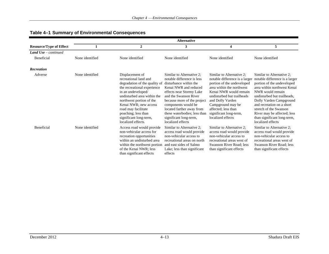
Chapter 4 Environmental Consequences
December 2012 4–13 Shadura Draft EIS
Table 4–1 Summary of Environmental Consequences
Alternative
Resource/Type of Effect 1 2 3 4 5
Land Use – continued
Beneficial None identified None identified None identified None identified None identified
Recreation
Adverse None identified Displacement of recreational land and degradation of the quality of the recreational experience in an undeveloped/ undisturbed area within the northwest portion of the Kenai NWR; new access road may facilitate poaching; less than significant long-term, localized effects.
Similar to Alternative 2; notable difference is less disturbance within the Kenai NWR and reduced effects near Stormy Lake and the Swanson River because more of the project components would be located farther away from these waterbodies; less than significant long-term, localized effects
Similar to Alternative 2; notable difference is a larger portion of the undeveloped area within the northwest Kenai NWR would remain undisturbed but trailheads and Dolly Varden Campground may be affected; less than significant long-term, localized effects
Similar to Alternative 2; notable difference is a larger portion of the undeveloped area within northwest Kenai NWR would remain undisturbed but trailheads, Dolly Varden Campground and recreation on a short stretch of the Swanson River may be affected; less than significant long-term, localized effects
Beneficial None identified Access road would provide non-vehicular access for recreation opportunities within an undisturbed area within the northwest portion of the Kenai NWR; less than significant effects
Similar to Alternative 2; access road would provide non-vehicular access to recreational areas on north and east sides of Salmo Lake; less than significant effects
Similar to Alternative 2; access road would provide non-vehicular access to recreational areas west of Swanson River Road; less than significant effects
Similar to Alternative 2; access road would provide non-vehicular access to recreational areas west of Swanson River Road; less than significant effects

Chapter 4 Environmental Consequences
December 2012 4–14 Shadura Draft EIS
Table 4–1 Summary of Environmental Consequences
Alternative
Resource/Type of Effect 1 2 3 4 5
Wildfire Management
Adverse None identified Increased risk of wildland fires requiring the Service to increase the level of fire suppression; alteration of the natural fire regime could affect the fuel load resulting in a potential increase in the rate of ignitions; development not consistent with the CCP or the Fire Management Plan requiring amendments; less than significant long-term, localized effects
Similar to Alternative 2; notable difference is less disturbance within the Kenai NWR and reduced effects near Stormy Lake and the Swanson River; less than significant long-term, localized effects
Similar to Alternative 2; notable difference is a larger portion of the northwest Kenai NWR would remain undisturbed but trailheads and Dolly Varden Campground may be affected by dust; less than significant long-term, localized effects
Similar to Alternative 2; notable difference is less disturbance within the undeveloped northwest portion of the Kenai NWR; less than significant long-term, localized effects
Beneficial None identified None identified None identified None identified None identified
Transportation
Adverse None identified Additional vehicles and equipment traveling on public roads resulting in potential traffic delays and proportionate increase in the rate of road degradation along with increased maintenance costs; less than significant long-term, localized effects
Similar to Alternative 2; notable difference is that the access road and gathering line would be constructed around the north and east sides of Salmo Lake; less than significant long-term, localized effects
Similar to Alternative 2; notable difference is that the access to the drilling/ processing pad from the Swanson River Unit to the east; less than significant long-term, localized effects
Similar to Alternative 2; notable difference is that the access to the drilling/ processing pad from the Swanson River Unit to the southeast; less than significant long-term effects
Beneficial None identified None identified None identified None identified None identified

Chapter 4 Environmental Consequences
December 2012 4–15 Shadura Draft EIS
Table 4–1 Summary of Environmental Consequences
Alternative
Resource/Type of Effect 1 2 3 4 5
Visual Resources
Adverse None identified Long-term, localized effects to visual quality in an undeveloped/ undisturbed area within the northwest portion of the Kenai NWR, potential significant but mitigable to less than significant because facilities would not be visible in the foreground from publically accessible areas
Similar to Alternative 2, notable differences are less disturbance within the Kenai NWR and reduced effects near Stormy Lake and the Swanson River because more of the project components would be located farther away from these waterbodies; potential significant but mitigable to less than significant, long-term, localized effects
Similar to Alternative 2; notable difference is a larger portion of the undeveloped area within the northwest Kenai NWR would remain undisturbed but trailheads and Dolly Varden Campground may be affected by dust; potential significant but mitigable to less than significant, long-term, localized effects
Similar to Alternative 2, a notable differences are a larger portion of the undeveloped area within northwest Kenai NWR would remain undisturbed but trailheads, Dolly Varden Campground and a short stretch of the Swanson River may be affected dust; potential significant but mitigable to less than significant, long-term, localized effects
Beneficial None identified None identified None identified None identified None identified
Noise
Adverse None identified Significant but mitigable to less than significant, long-term, localized effects within an undeveloped/ undisturbed portion of the northwest Kenai NWR
Similar to Alternative 2, notable differences are less disturbance within the Kenai NWR and reduced effects near Stormy Lake and the Swanson River significant but mitigable to less than significant, long-term, localized effects
Similar to Alternative 2, notable difference is a larger portion of the undeveloped area within the northwest Kenai NWR would remain undisturbed; significant but mitigable to less than significant, long-term, localized effects
Similar to Alternative 2, notable difference is a larger portion of the undeveloped area within the northwest Kenai NWR would remain undisturbed; significant but mitigable to less than significant, long-term, localized effects
Beneficial None identified None identified None identified None identified None identified
Cultural Resources
Adverse None identified No historic properties; None identified.
Similar to Alternative 2; no historic properties; None identified
Similar to Alternative 2; no historic properties; None identified
Similar to Alternative 2; no historic properties; None identified
Beneficial None identified None identified None identified None identified None identified
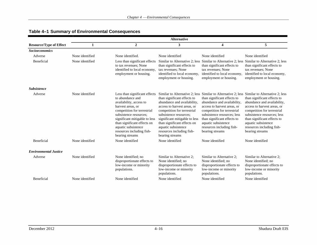
Chapter 4 Environmental Consequences
December 2012 4–16 Shadura Draft EIS
Table 4–1 Summary of Environmental Consequences
Alternative
Resource/Type of Effect 1 2 3 4 5
Socioeconomics
Adverse None identified None identified. None identified None identified None identified
Beneficial None identified Less than significant effects to tax revenues; None identified to local economy, employment or housing.
Similar to Alternative 2; less than significant effects to tax revenues; None identified to local economy, employment or housing.
Similar to Alternative 2; less than significant effects to tax revenues; None identified to local economy, employment or housing.
Similar to Alternative 2; less than significant effects to tax revenues; None identified to local economy, employment or housing.
Subsistence
Adverse None identified Less than significant effects to abundance and availability, access to harvest areas, or competition for terrestrial subsistence resources; significant mitigable to less than significant effects on aquatic subsistence resources including fish-bearing streams
Similar to Alternative 2; less than significant effects to abundance and availability, access to harvest areas, or competition for terrestrial subsistence resources; significant mitigable to less than significant effects on aquatic subsistence resources including fish-bearing streams
Similar to Alternative 2; less than significant effects to abundance and availability, access to harvest areas, or competition for terrestrial subsistence resources; less than significant effects to aquatic subsistence resources including fish-bearing streams
Similar to Alternative 2; less than significant effects to abundance and availability, access to harvest areas, or competition for terrestrial subsistence resources; less than significant effects to aquatic subsistence resources including fish-bearing streams
Beneficial None identified None identified None identified None identified None identified
Environmental Justice
Adverse None identified None identified; no disproportionate effects to low-income or minority populations.
Similar to Alternative 2; None identified; no disproportionate effects to low-income or minority populations.
Similar to Alternative 2; None identified; no disproportionate effects to low-income or minority populations.
Similar to Alternative 2; None identified; no disproportionate effects to low-income or minority populations.
Beneficial None identified None identified None identified None identified None identified

Chapter 4 Environmental Consequences
December 2012 4–17 Shadura Draft EIS
Table 4–1 Summary of Environmental Consequences
Alternative
Resource/Type of Effect 1 2 3 4 5
Hazardous Substances
Adverse None identified Increased quantities of fuels, hazardous substances and wastes within an undeveloped portion of Kenai NWR with proportionate increased risk of inadvertent releases; less than significant long-term, localized effects within an undeveloped portion of the northwest Kenai NWR
Similar to Alternative 2; less than significant long-term, localized effects
Similar to Alternative 2; notable difference is a larger portion of the undeveloped area within the northwest Kenai NWR would remain unaffected; less than significant long-term, localized effects
Similar to Alternative 2; notable difference is a larger portion of the undeveloped area within the northwest Kenai NWR would remain unaffected; less than significant long-term, localized effects
Beneficial None identified None identified None identified None identified None identified

Chapter 4 Environmental Consequences
December 2012 4–18 Shadura Draft EIS
4.3 PHYSICAL ENVIRONMENT
4.3.1 Meteorology and Air Quality
4.3.1.1 Resource-Specific Significance Criteria
Construction activities are most likely to affect air quality on or near the project area. Fugitive (airborne) dust would be generated during soil-disturbing activities. Operation of heavy equipment and vehicular traffic associated with construction personnel and equipment would result in pollutants associated with vehicle exhaust. Pollutants would be generated from drilling and testing wells, from natural gas- and diesel-fired generators, and from other ancillary equipment during construction.
Operation of the drilling rig and production of natural gas would generate emissions from combustion activities during operation activities.
Impacts to air quality would be considered significant if the proposed activities were to:
contribute to an existing violation of any NAAQS or applicable permit or
impair visibility within any federally mandated PSD Class I area or sensitive Class II area.
4.3.1.2 Alternative 1
4.3.1.2.1 Direct and Indirect Effects
Implementation of this alternative would result in no direct or indirect effects to air quality because none of the Project’s facilities would be constructed. Existing conditions under the no action would continue into the future.
4.3.1.2.2 Cumulative Effects
Implementation of this alternative would result in no cumulative effects because no project-related direct or indirect effects to air quality would occur. Existing conditions under the no action would continue into the future.
4.3.1.2.3 Mitigation
Because no project-related direct, indirect, or cumulative effects would occur to air quality, mitigation measures are not proposed.
4.3.1.3 Effects Common to Action Alternatives
The factors common to all action alternatives were included in the air dispersion modeling effort presented for Alternative 2. Therefore, the impacts common to all action alternatives are predicted to be similar to impacts presented for Alternative 2.
4.3.1.3.1 Direct and Indirect Effects
Because impacts from modeling are predicted to be similar to impacts described for modeling under Alternative 2, the direct and indirect impacts from operational activities are predicted to be similar to impacts from Alternative 2.

Chapter 4 Environmental Consequences
December 2012 4–19 Shadura Draft EIS
4.3.1.3.2 Cumulative Effects
Because impacts from modeling are predicted to be similar to impacts described for modeling under Alternative 2, the cumulative impacts from operational activities are expected to be similar to cumulative impacts from Alternative 2.
4.3.1.3.3 Mitigation
Because impacts from modeling are predicted to be similar to impacts described for modeling under Alternative 2, the suggested mitigation for operational activities is expected to be similar to that identified for Alternative 2.
4.3.1.4 Alternative 2
Air impacts generated from Alternative 2 during construction activities would be both temporary and short-term. Impacts during operational activities would be long term in nature.
4.3.1.4.1 Direct and Indirect Effects
4.3.1.4.1.1 Construction
Air quality impacts associated with construction would include emissions from construction equipment and fugitive dust. There would be no open burning during construction. Air emissions during construction would be localized, intermittent, and short term.
Earth-moving equipment and other equipment used during construction are sources of combustion emissions, including nitrogen oxides (NOx), CO, volatile organic compounds (VOCs), SO2, PM10, and PM2.5. Fugitive dust would result from activities associated with limited land clearing, grading, and excavation. Vehicles traveling on paved and unpaved roads would also generate fugitive dust. The amount of dust generated is a function of construction activities, silt and moisture content of the soil, wind speed, frequency of precipitation, vehicle traffic, vehicle types, and roadway characteristics. Emissions would be greater during the drier summer months and in areas where working with fine-textured soils. Much of the construction would occur during the winter and gravel would be used to construct the access road. These factors contribute to reduced fugitive emissions.
Estimated emissions from construction (ARCADIS 2012a) were calculated using emission factors and equations from EPA’s Emissions Factors & AP 42, Compilation of Air Pollutant Emission Factors (EPA 2011). A conservative scenario was assumed to estimate emissions. Emissions from drilling and testing of the initial well were also estimated. Stage 2 of construction includes the expansion of the drilling pad and construction of the metering pad. Table 4–2 shows total estimated emissions for Stages 1 and 2. A control efficiency of 55 percent for the application of water spray on only the road was assumed in the emission estimates. Because the road base material is inherently moist in this region, water trucks would be employed only during periods of dry conditions. Emissions for Stage 1 and Stage 2 occur over a 6-month and approximate 10-month period, respectively. Emission estimates for construction activities contained in Table 4–2 are below the minor source permitting thresholds, based on the calculated tons of emissions by pollutant during Stage 1 or Stage 2 and the minor source permitting thresholds in Alaska regulations (Table 4–3).
GHG emissions estimates for construction activities (ARCADIS 2012a) are shown in Table 4–2. These emissions included CO2, CH4, and N2O (i.e., the principal GHGs) resulting from combustion of fuel gas and diesel by stationary and mobile (on-road and non-road) equipment associated with the construction. Alternative 2 would not be subject to the mandatory reporting of greenhouse gases (GHGs) because the

Chapter 4 Environmental Consequences
December 2012 4–20 Shadura Draft EIS
CO2 equivalent (CO2-e) emissions from construction activities would not exceed the regulatory threshold of 25,000 metric tons per year (TPY). Furthermore, the referenced regulatory thresholds only apply to stationary source emissions, whereas construction-phase emissions are primarily from mobile sources.
Table 4–2 Construction Emissions—Alternative 2, Stages 1 and 2
Construction Emissions (tons) Pollutant1 Stage 1 Stage 2 TSP/PM30 27.1 6.6 PM10 8.1 2.0 PM2.5 2.0 0.7 NOx 16.5 13.1 CO 8.2 4.2 SOx 0.017 0.003 TOC/VOC 1.7 1.1 CO2equivalent 2,390.2 2,231.8 Time Period May 22, 2013 – Nov 18, 2013 Nov 18, 2013 – Sept 13, 2014 Duration 6 months ~10 months
Note: 1. For combustion emissions, both PM30 and PM2.5 emissions are assumed to equal PM10 emissions. Source: (ARCADIS 2012a)
Table 4–3 Alaska Regulations for Minor Source Permitting Thresholds
Pollutant Emissions
(tons per year) PM10 15
NOx 40
SOx 40
Lead 0.6
CO 100a
Note: a. when within 6.5 miles of a CO non-attainment area. Source: Alaska Administrative Code Title 18, §50.502
4.3.1.4.1.2 Operations
Should well testing be successful, six wells and associated production facilities would be operated over a 30-year period. Operation activities would generate combustion-related pollutants such as NOx, CO, PM, VOCs, and SO2.
Annual emissions during operations are provided in Table 4–4. Estimated emissions from construction (ARCADIS 2012a) were calculated using emission factors and equations from EPA’s Emissions Factors & AP 42, Compilation of Air Pollutant Emission Factors (EPA 2011). Peak short-term emissions from operations are summarized in Table 4–5. Emissions contained in Table 4–4, which are based on conservative estimates for the equipment listed in Table 2–2 (ARCADIS 2012a), are below the minor source permitting thresholds for all pollutants.

Chapter 4 Environmental Consequences
December 2012 4–21 Shadura Draft EIS
Table 4–4 Operational Emissions—Alternative 2
Pollutant Operations Emissions (tons) TSP/PM30 0.6 PM10 0.6 PM2.5 0.5 NOx 10.8 CO 6.4 SOx 0.044 TOC/VOC 0.8 CO2equivalent 29,396.7 Time Period June 20, 2014 – June 20, 2015 Duration Initial 1st Year
Source: (ARCADIS 2012a)
Table 4–5 Peak Short-Term Emissions
Production/Operation Short-term Emissions (lb/hr) Emission Source Area TSP (PM30) PM10 PM2.5 NOx CO SOx TOC/VOCMetering Pad 0.010 0.010 0.010 0.343 0.105 0.000 0.031 Gathering Lines/Access Rd 8.24 2.10 0.211 0.077 0.083 0.001 0.011 Drilling/Processing Pad 0.399 0.399 0.399 1.78 1.29 0.154 0.632 Total 8.65 2.51 0.62 2.19 1.48 0.16 0.67
Notes: 1 Short-term emission rates for primary and backup equipment includes the higher emission rate from the two pieces of
equipment. 2 Optional turbine (for compression) included in these emission estimates. Source: (ARCADIS 2012a)
Dispersion modeling was performed to evaluate the potential impacts on ambient air quality of project emissions during the operating phase. The impact analysis was conducted using the EPA model AERMOD (version 12060). EPA guidance recommends use of AERMOD to evaluate the impacts of industrial and commercial emission sources. AERMOD was applied using the most recent five years of meteorological surface data (2007–2011) from Kenai Municipal Airport, together with upper air data from Anchorage. Kenai Municipal Airport is located on the east shore of Cook Inlet at the mouth of the Kenai River, approximately 15 miles southwest of the project site. The western side of the Kenai Peninsula is relatively flat, with shrub lands, wetlands, and boreal forest predominant. The airport is expected to provide meteorology representative of the northwestern Kenai Peninsula, including the project area.
For the air dispersion analysis, receptor locations were placed in the model using Cartesian grids in the following manner:
25-meter receptor spacing along the signage boundary approximately 400 meters from the pad, 50-meter spacing from the boundary receptors out an additional 1,000 meters, 100-meter spacing out an additional 1,000 meters, 250-meter spacing out to 5 kilometers, 500-meter spacing out to 10 kilometers, and 1,000-meter spacing out to 15 kilometers.

Chapter 4 Environmental Consequences
December 2012 4–22 Shadura Draft EIS
The receptor elevations for the receptors grids were developed with AERMAP (version 11103) using the available NED terrain elevation datasets. The boundary receptors are located at the proposed distance for the placement of signage that will restrict public access to the development pad site. The receptor grid model setup is shown in Figure 4–2 and Figure 4–3.
Air quality impacts of project operations were predicted for all relevant criteria pollutants, including NO2, CO, SO2, PM10, and PM2.5. Predicted impacts are summarized in Table 4–6. Peak impacts for CO, SO2, PM10, and PM2.5. are all below the federal Class II Significant Impact Levels (SILs), which means that the project will not contribute significantly to ambient concentrations for these pollutants and averaging times, relative to NAAQS or Class II increments. Alaska does not have any relevant ambient air quality standards that differ from the federal NAAQS.
Peak predicted impacts exceed the SILs for 1-hour and annual average NO2. Background concentrations for NO2 were therefore evaluated to assess whether the project is likely to cause or contribute to a NAAQS exceedance. Background NO2 concentrations were calculated using onsite measurements collected in 2008–2009 at the Chevron Swanson River site, located about 4 miles southeast of the Shadura project site. The Swanson River measurements are representative of ambient air quality on the northwest Kenai Peninsula, but the measurements provide a conservative estimate of background air quality because Chevron was operating an oil and gas production facility at Swanson River while monitoring was being conducted. Predicted project impacts plus background are below the NAAQS for 1-hour and annual average NO2, as shown in Table 4–6. The area with predicted impacts above the SIL for 1-hour average NO2 (7.5 µg/m3) is depicted in Figure 4–4. The Significant Impact Area extends to a distance of 2.17 miles (3.5 km) from the project site. Figure 4–4 also shows the areas of predicted maximum impacts for the 98th percentile NO2 (without background). Predicted maximum ambient impacts are located at the southwestern boundary receptors.
Project impacts on visibility were also evaluated for the nearest designated wilderness area imbedded within the Kenai NWR, which is located about 5.84 miles (11 km) east of the project site. Visual effects screening (i.e. plume blight) was performed using the EPA screening model VISCREEN. Estimated peak short-term emissions of NOx and PM2.5 were used as input for VISCREEN and the FLAG-recommended values were chosen for background ozone concentration and background visual range. VISCREEN predictions indicate that no screening criteria are exceeded inside the wilderness area. The nearest federally designated Class I area to the project is the Tuxedni Wilderness, more than 62 miles (100 km) to the southwest, across Cook Inlet. No significant impacts to visibility or air quality are expected at that distance.
The ambient modeling analysis showed predicted impacts from the project-related emissions of NOx and particulates extending out to only a short distance from the production pad footprint. The formation of secondary fine particulates and ozone usually occur over further distance downwind of the source and may affect visibility in the area. This is because the emitted pollutants need time to mix and react with other necessary reactants in the air to form secondary PM2.5 and ozone. This project is proposing to use fuel with low nitrogen and sulfur contents (i.e. ultra low sulfur diesel and natural gas), therefore, limiting the amount of formation of secondary PM2.5 in the area. Any formation of secondary particulates would occur out of the modeling domain and it was determined that the project impacts would be insignificant after a short distance from the production pad. In addition, the modeling analysis included a conservative visibility screening assessment using VISCREEN to determine the potential impacts of a plume on the nearest wilderness area. The VISCREEN analysis showed that the impacts from the expected emissions were below the current screening criteria meeting the Service’s requirements on NEPA reviews in Alaska.
Based on estimated emissions, the project would not exceed either major source or state minor source permit thresholds. Title V and PSD permitting would not apply. Alternative 2 may be subject to the mandatory reporting of GHGs, because the potential CO2-e emissions from stationary sources (26,600 metric TPY) exceed the regulatory threshold of 25,000 metric TPY by a small margin.

Number Three Bay
G o m p e r t z C h a n n e lC O O K I N L E T K E N A I N A T I O N A L
W I L D L I F E R E F U G E
Alternative-2
Drilling/Processing Pad
CAPTAIN COOKCAPTAIN COOKSTATESTATE
RECREATIONRECREATIONAREAAREA
ADL LEASE - 391596
Swanson River
Swanson R
iver
Swans
on Riv
er
100 Meter Spacing
250 Meter Spacing
500 Meter Spacing
50 Meter Spacing
Kitchen Lights UnitKitchen Lights Unit
Swanson River UnitSwanson River Unit
BirchBirchHillHillUnitUnit
Beaver Beaver Creek UnitCreek Unit
Lo Lake
Owl Lake
Pot Lake
Hat Lake Dog LakePan Lake
Odd Lake
Ice Lake
Wik Lake
Hook Lake
Wild Lake
Gene Lake
Lost Lake
Leaf Lake
Pond Lake
Grus Lake
Nest Lake
Kivi LakeFish Lake
Flat Lake
Teal Lake
Duck Lake
Tern LakeWeed Lake
Swan LakeLong Lake
Wolf LakeWest Lake Rock Lake Loon Lake
Clam Lake
Salmo Lake
Scaup Lake
Elder LakeWoods Lake
Berry LakeJunco Lake
Crane LakeKrein Lake
Mouse LakeDecoy Lake Rifle Lake
Quill Lake Goose Lake Chick LakeArrow Lake
Birch LakeCanoe Lake
Drake LakeRaven LakeGavia Lake
Akula LakeTrout Lake
Cabin LakeOtter Lake
Rhode LakeQuake Lake
Grebe Lake
McLain LakeTundra Lake
Curlew LakePepper Lake
Dunlin Lake
Lonely Lake
Paddle Lake
Suneva Lake
Willow Lake Jigsaw Lake
Hungry Lake Cashka LakeSucker Lake
Anertz Lake
Island Lake Oolka, Lake Breeze Lake Martin Lake
Bishop Lake Spruce Lake
Ermine Lake
Cygnet Lake
Forest Lake
Konova LakeWeasel Lake
Beaver Lake
Finger Lake Silver Lake Meadow Lake
Swanson Lake
Redpoll Lake
Sunrise Lake
Channel Lake
Gruskka Lake
Daniels LakePortage Lake
Sabaka, LakeRainbow Lake
Contact LakeShadura Lake
Parsons LakeDogbone Lake
Mallard Lake
Bernice Lake
Dabbler Lake
Skookum Lake
Douglas Lake
Kayak IslandsDuckling LakeCampfire Lake
Georgina Lake
Bratlie, Lake
Foreland Lake
Char-Vic Lake
Boundary LakeDuckbill Lake
Big Mink Lake
Ivanoff, Lake Yearling LakeMosquito Lake
Porcupine LakeKonchanee Lake
Puppy Dog Lake
Salamatof Lake Chickadee Lake Moosehorn Lake
Timberlost Lake
Mink Creek Lake
Little Mink Lake
Camp Island Lake
Red Squirrel Lake
Dolly Varden Lake
Big Merganser Lake
Lower Salamatof Lake
Little Merganser Lake
0 3 61.5 Km
FIGURE:
SCALE:0 2 41 Mi
4-2PROPOSED RECEPTOR GRID
SHADURA NATURAL GAS DEVELOPMENT PROJECT EIS
ARCADIS: NOREIS0128.mxd, 10/31/12, R00
AL A S K AProject
Location
PREPARED FOR:
Projection: UTM Zone 5 (meters), NAD83
Receptor Locations
Drilling/Processing Pad
Alternative-2
Oil & Gas Unit BoundariesADL Lease 391596Wilderness AreaCaptain Cook SRAKenai National Wildlife RefugeKenai Peninsula Borough Lands

Alternative-2
Drilling/Processing Pad
100 Meter Spacing50 Meter Spacing
25 Meter Spacing
Snipe Lake
0 350 700175 Meters
FIGURE:
SCALE:0 1,000 2,000500 Feet
4-3CLOSE-IN RECEPTORS GRID
SHADURA NATURAL GAS DEVELOPMENT PROJECT EIS
ARCADIS: NOREIS0129.mxd, 10/31/12, R00
AL A S K AProject
Location
PREPARED FOR:
Projection: UTM Zone 5 (meters), NAD83
Receptor Locations
Drilling/Processing Pad
Alternative-2

CAPTAIN COOKCAPTAIN COOKSTATESTATE
RECREATIONRECREATIONAREAAREA
Swans
on Riv
er
K E N A I N AT I O N A L W I L D L I F E R E F U G EK E N A I N AT I O N A L W I L D L I F E R E F U G E
Drilling/Processing Pad
1020
30
40
50
40
7.5
7.5
Swanson River UnitSwanson River Unit
Salmo Lake
Crane Lake
Snipe Lake
Gooseneck Lake
0 500 1,000250 Meters
FIGURE:
SCALE:0 2,000 4,0001,000 Feet
4-4PREDICTED 1-HOUR NO2
IMPACTS
SHADURA NATURAL GAS DEVELOPMENT PROJECT EIS
ARCADIS: NOREIS0130.mxd, 10/31/12, R00
AL A S K AProject
Location
PREPARED FOR:
Projection: UTM Zone 5 (meters), NAD83
Alternative-27.5 ug/m3 (SIL)10 ug/m320 ug/m330 ug/m340 ug/m350 ug/m3
Drilling/Processing PadOil & Gas Unit BoundariesCaptain Cook SRAKenai National Wildlife Refuge

Chapter 4 Environmental Consequences
December 2012 4–26 Shadura Draft EIS
Table 4–6 Air Dispersion Modeling Results—Shadura Drilling/Processing Pad
Pollutant CO PM10 PM2.5 SO2 NO2
1 Averaging Period Averaging Period Averaging Period Averaging Period Averaging Period
Model Year 1-hr
(µg/m3) 8-hr
(µg/m3) 24-hr
(µg/m3) Annual (µg/m3)
24-hr (µg/m3)
Annual (µg/m3)
1-hr 4th High (µg/m3)
3-hr (µg/m3)
24-hr (µg/m3)
Annual (µg/m3)
1-hr 8th High (µg/m3)
Annual (µg/m3)
2007 47.94 16.06 0.94 0.20 0.94 0.20 0.77 0.70 0.36 0.070 55.76 1.28
2008 47.92 19.25 0.90 0.20 0.90 0.20 0.76 0.66 0.32 0.069 59.67 1.21
2009 48.22 18.32 0.95 0.21 0.95 0.21 0.74 0.66 0.34 0.073 58.29 1.40
2010 46.84 21.37 0.88 0.22 0.88 0.22 0.78 0.68 0.37 0.075 62.26 1.43
2011 47.14 16.13 0.96 0.20 0.96 0.20 0.78 0.63 0.32 0.070 60.68 1.30
Maximum Impact (µg/m3) 48.22 21.37 0.96 0.22 0.96 0.22 0.78 0.70 0.37 0.075 62.26 1.43
Significant Impact Level (SIL) (µg/m3)
2,000 500 5 1 1.2 0.3 7.85 25 --3 -- 7.5 1
Predicted Impacts Exceed SIL No No No No No No No No No No Yes Yes
Class II PSD Increments (µg/m3)4 -- -- 30 17 9 4 -- 512 91 20 -- 25
5-Year Run - Maximum 8th Highest Daily 1-Hour Conc. (µg/m3)
N/A N/A N/A N/A N/A N/A N/A N/A N/A N/A 56.50 N/A
Background Concentration (µg/m3) 2 N/A N/A N/A N/A N/A N/A N/A N/A N/A N/A 115 14
Total Predicted Impact (µg/m3) N/A N/A N/A N/A N/A N/A N/A N/A N/A N/A 171.5 15.4
AKAAQS/NAAQS (µg/m3)5 40,000 10,000 150 -- 35 15 196 1,300 -- -- 188 100
Notes: 1. The NO2/NOx ratios of 0.8 (1-hour) and 0.75 (annual average) were not applied to the reported results. 2. The NO2 background monitoring data, maximum 8th highest daily 1-hour (98th-percentile), is from the Swanson River Station (62.726 N, -150.864 W) located less than 4 miles
to the southeast of the drilling/processing pad. 3. Dashes (--) represent pollutant averaging period having no current SILs or Increments. 4. PSD = Prevention of Significant Deterioration 5. Alaska has not yet adopted the 1-hour NO2 standard. AKAAQS = Alaska Ambient Air Quality Standards. NAAQS = National Ambient Air Quality Standards.

Chapter 4 Environmental Consequences
December 2012 4–27 Shadura Draft EIS
Impacts to air quality from the Project’s operations are considered acceptable because they are not expected to cause or contribute to a violation of any NAAQS or increment, nor would they impair visibility within any designated wilderness area or federally mandated PSD Class I area.
4.3.1.4.1 Cumulative Effects
The cumulative impact analysis area considered is the airshed surrounding the project area. Past, ongoing, or RFFAs that would have a cumulative effect on air resources in the project area and vicinity would include the following types of effects: fugitive PM from surface disturbance, air emissions from the use of equipment and vehicles, and air emissions from prescribed or wildland fire.
The projects included in the cumulative effects analysis would generate emissions from activities similar to those under this alternative. These emissions would vary over time, coming on line and going off line over the lifetime of the Shadura Project. Sources would include existing gas fields, industrial sources south of Shadura, and vehicle exhaust from traffic on and off the Kenai.
It was assumed that all activities included in the cumulative effects assessment would comply with local, state, and federal air quality regulations and standards. Operators would adhere to all applicable ambient air quality standards, permit requirements (including preconstruction, testing, and operating permits), standards for motorized equipment, and other regulations, as required. Control measures would be implemented in construction and operations areas, as needed, to control fugitive dust.
The cumulative effects for Alternative 2 would not be expected to vary markedly from background, except that the Project would contribute slightly to the cumulative effects on air resources. Some intermittent and short-term effects on air quality would likely occur in the immediate vicinity of the Project, more so during the construction phase. These local effects would be dispersed by prevailing winds. The effects on air quality from fugitive dust emissions would be minimized through construction during the winter and dust suppression.
Because project impacts exceed the SILs for 1-hour and annual average NO2, the potential for a NAAQS exceedance due to cumulative impacts of the Shadura project plus other projects was also considered. Several other oil and gas exploration and production projects are operating or proposed on the Kenai, as discussed above in Section 4.1.2. The potential for cumulative impacts to exceed the NAAQS is considered low for the following reasons: (1) the existing or proposed production sites are widely separated; (2) emission sources generally have low release heights, so peak impacts from each of these projects will drop off rapidly with distance; and (3) the background concentration used to assess ambient concentrations in the vicinity of the Shadura project already includes the impact of operations from the nearest (Swanson River) project. Projects on the Kenai are generally separated by at least 2.5 to 3 miles (4-5 km), as shown in Figure 1–2. There are three projects within 10 km. Peak project impacts for 1-hour NO2 are predicted to occur within 373 miles (600 m) of the project site, as shown in Figure 4–4. The peak predicted impact drops from 56.5 µg/m3 to 30 µg/m3 at 900 m, and is reduced to the SIL (7.5 µg/m3 ) at 2.18 miles (3.5 km). As noted above, the Swanson River 1-hour NO2 monitoring data used to calculate the background value provided in Table 4–6 include the impact of emissions during 2008–2009 from the Chevron Swanson River facility.
Consequently, cumulative effects to air quality are considered less than significant because they would not likely contribute to an existing violation of any NAAQS or applicable permit nor would they impair visibility within any federally mandated PSD Class I area.

Chapter 4 Environmental Consequences
December 2012 4–28 Shadura Draft EIS
4.3.1.4.2 Mitigation
The following measures are recommended to reduce air quality impacts associated with Alternative 2 (these measures are in addition to those required by state, federal, and local regulatory agencies, such as the use of ultra-low sulfur diesel fuel for all diesel-fuel construction equipment):
use gasoline-powered construction equipment in place of diesel-powered equipment where practicable to minimize combustion related emissions (including GHGs);
operate all fossil-fueled construction equipment in accordance with manufacturer’s recommendations to minimize construction-related emissions (including GHGs) resulting from incomplete combustion;
use modern, well-maintained machinery and vehicles meeting applicable emission performance standards to minimize combustion related emissions (including GHGs);
retrofit construction equipment engines by replacing diesel particulate matter filters with diesel oxidation catalysts where practicable to minimize combustion related emissions (including GHGs);
shut down idling fossil-fueled equipment when not in use, if practicable, to minimize combustion related emissions (including GHGs);
maintain on-road and off-road vehicle tire pressures to manufacturer’s specifications to minimize combustion related emissions (including GHGs);
implement best management practices during construction activities to mitigate fugitive dust and reduce particulate matter emissions;
use dust abatement techniques, such as applying a dust retardant chemicals, as needed during construction to control fugitive dust emissions beyond control achieved with watering;
reduce the amount of the disturbed land area where possible to control fugitive dust emissions;
cover or maintain at least two feet of freeboard for all trucks hauling dirt, sand, soil, or other loose materials to control fugitive dust emissions;
reuse construction debris and use locally made construction materials to the extent practicable to reduce associated GHG emissions; and
minimize tree removal necessary for construction to the extent practicable, and replace vegetation (trees, shrubs and grasses) to offset the loss of carbon sequestration associated with tree removal.
4.3.1.5 Alternative 3
Air impacts generated from Alternative 3 during construction activities would be both temporary and short term. Impacts during operation activities would be long term in nature.
4.3.1.5.1 Direct and Indirect Effects
Air quality impacts associated with construction would include emissions from construction equipment and fugitive dust. There would be no open burning during construction. Air emissions during construction would be localized, intermittent, and short term.
Emission estimates are presented for Alternative 2 in Table 4–2. Construction emissions are predicted to be slightly higher for Alternative 3 due to the increased length of access roads.
Air modeling was not conducted for operations activities for Alternative 3. Impacts from operations would be similar to the impacts described for the modeling effort conducted for Alternative 2 because the drilling operations remain the same in Alternate 3. However, overall project impacts are predicted to be slightly higher due to increased length of access roads under Alternative 3. Because the length of access

Chapter 4 Environmental Consequences
December 2012 4–29 Shadura Draft EIS
road would increase by 1.9 miles to 4.6 miles under Alternative 3, there would be a corresponding increase in emissions from road construction and vehicle travel. The increase in air emissions would not be near operations. Table 4–6 presents the modeling results and a discussion of impacts follows the table. Impacts to air quality from the Project’s operations are considered acceptable because they are not expected to cause or contribute to a violation of any NAAQS or increment, nor would they impair visibility within any designated wilderness area or federally mandated PSD Class I area.
4.3.1.5.2 Cumulative Effects
Impacts to Alternative 3 would be similar to the effects described for the modeling effort conducted for Alternative 2. Consequently, the cumulative impacts remain unchanged from Alternative 2.
4.3.1.5.3 Mitigation
Impacts from modeling are predicted to be similar to impacts described for modeling under Alternative 2. Therefore, the suggested mitigation for impacts described for modeling under Alternative 2 are predicted to remain unchanged from Alternative 2.
4.3.1.6 Alternative 4
Air impacts generated from Alternative 4 during construction activities would be both temporary and short term. Impacts during operation activities would be long term in nature.
4.3.1.6.1 Direct and Indirect Effects
Air quality impacts associated with construction would include emissions from construction equipment and fugitive dust. There would be no open burning during construction. Air emissions during construction would be localized, intermittent, and short term.
Emission estimates are presented for Alternative 2 in Table 4–2. Construction emissions are predicted to be slightly higher for Alternative 4 due to the increased length of access roads.
Air modeling was not conducted for operations activities for Alternative 4. However, impacts from operations under Alternative 4 would be similar to the impacts described for the modeling effort conducted for Alternative 2 because the drilling operations remain the same in Alternate 4. Overall project impacts are predicted to be slightly higher due to increased length of access roads under Alternative 4. Because the length of the access road would increase by 0.6 miles to 3.3 miles under Alternative 4, there would be a corresponding increase in emissions from road construction and vehicle travel. The increase in air emissions would not be near operations. Table 4–6 presents the modeling results and a discussion of impacts follows the table. Impacts to air quality from the Project’s operations are considered acceptable because they are not expected to cause or contribute to a violation of any NAAQS or increment, nor would they impair visibility within any designated wilderness area or federally mandated PSD Class I area.
4.3.1.6.2 Cumulative Effects
Impacts from modeling are predicted to be similar to impacts described for modeling under Alternative 2. Consequently, the cumulative impacts from operational activities remain unchanged from Alternative 2.
4.3.1.6.3 Mitigation
Impacts from modeling are predicted to be similar to impacts described for modeling under Alternative 2. Therefore, the suggested mitigation for operational activities remains unchanged from Alternative 2.

Chapter 4 Environmental Consequences
December 2012 4–30 Shadura Draft EIS
4.3.1.7 Alternative 5
Air impacts generated from Alternative 5 during construction activities would be both temporary and short-term. Impacts during operation activities would be long term in nature.
4.3.1.7.1 Direct and Indirect Effects
Air quality impacts associated with construction would include emissions from construction equipment and fugitive dust. There would be no open burning during construction. Air emissions during construction would be localized, intermittent, and short-term.
Emission estimates are presented for Alternative 2 in Table 4–2. Construction emissions are predicted to be slightly higher for Alternative 5 because of the increased length of access roads.
Air modeling was not conducted for operations activities for Alternative 5. However, impacts to from operations under Alternative 5 would be similar to the impacts described for the modeling effort conducted for Alternative 2 because the drilling operations remain the same in Alternate 5. Overall project impacts are predicted to be slightly higher due to the increased length of access roads under Alternative 5. Because the length of access road increases by 2.8 miles to 5.5 miles under Alternative 5, there would be a corresponding increase in emissions from road construction and vehicle travel. The increase in air emissions would not be near operations. Table 4–6 presents the modeling results and a discussion of impacts follows the table. Impacts to air quality from the Project’s operations are considered acceptable because they are not expected to cause or contribute to a violation of any NAAQS or increment, nor would they impair visibility within any designated wilderness area or federally mandated PSD Class I area.
4.3.1.7.2 Cumulative Effects
Impacts from modeling are predicted to be similar to impacts described for modeling under Alternative 2. Consequently, the cumulative impacts from operational activities remain unchanged from Alternative 2.
4.3.1.7.3 Mitigation
Impacts from modeling are predicted to be similar to impacts described for modeling under Alternative 2. Therefore, the suggested mitigation for operational activities remains unchanged from Alternative 2.
4.3.2 Geology and Soils
4.3.2.1 Resource-Specific Significance Criteria
Factors considered when determining whether an alternative would have a significant impact on geologic and soil resources were evaluated and distinguished by the degree to which the impact would:
Result in soil compaction that impairs natural vegetative productivity or promotes erosion,
Result in loss of soil (through increased erosion) that impairs natural vegetative productivity, or
Disturb or destroy scientifically significant paleontological resources.
4.3.2.2 Alternative 1
4.3.2.2.1 Direct and Indirect Effects
Under the No Action Alternative, no new adverse or beneficial direct or indirect effects to geologic or soil resources would occur because no project would be implemented. Current resource conditions and trends would continue.

Chapter 4 Environmental Consequences
December 2012 4–31 Shadura Draft EIS
4.3.2.2.2 Cumulative Effects
With no direct or indirect effects to geology or soils resources, Alternative 1 would not contribute effects to the cumulative effects of other projects or activities in the project area. Exploration and development of CIRI leases on lands surrounding the Shadura Field would remain a RFFA. The types of impacts to soils due to regional oil and gas development would be similar to those described for the action alternatives below. Implementation of fire management practices are anticipated to result in increased soil susceptibility to erosion (Service 2009b).
4.3.2.2.3 Mitigation
No resource-specific mitigation measures are recommended for the No Action Alternative.
4.3.2.3 Effects Common to Action Alternatives
4.3.2.3.1 Direct and Indirect Effects
4.3.2.3.1.1 Geology and Physiography
The type and intensity of direct and indirect impacts to geologic resources and project area physiography would be similar under the action alternatives; therefore, these impacts are not assessed for individual action alternatives. Direct impacts to physiography would be limited to topographic alterations in areas where placement of up to 3 feet of gravel for the access road and pads would create negligible, local changes to topography. These changes would not reduce visual screening or other topographic characteristics. Slight changes to surface water runoff would occur and are discussed in Section 4.3.3. All impacts to topography would be restored to approximately pre-construction contours at the end of the Project’s life; therefore, impacts to physiography and topography would be local, long-term, and negligible under all action alternatives.
Gravel resources used for construction would be obtained from KPB-permitted commercial borrow pits outside the Kenai NWR. No other geological materials would be used during construction or operation under any of the action alternatives. Therefore, no adverse impacts to surficial geological resources would occur. Impacts to subsurface geologic conditions of the project area and surrounding oil and gas fields because of well drilling, completion, stimulation, and production would be negligible.
Scientifically significant paleontological resources are not anticipated to be present within the project area; therefore, no impacts to paleontological resources are anticipated to occur as a result under any of the action alternatives.
No indirect impacts to geologic resources would occur under the action alternatives.
4.3.2.3.1.2 Soils
Under each of the action alternatives, soils would be directly impacted by road and pad construction, gravel placement, and trench excavation. Although similar types of affects would occur under each action alternative, the intensity of impact would differ for each alternative.
Soil impacts would primarily consist of compaction during gravel placement for roads and pads. Soils would also be directly disturbed in small areas for bridge and culvert installation and could be disturbed in small areas of cuts for road and pad construction. Direct disturbance and soil compaction would also occur during construction of the gathering lines and cable within the access road ROW. Construction timing would affect the intensity of effects on soils; winter construction would produce considerably fewer impacts than construction on thawed ground.

Chapter 4 Environmental Consequences
December 2012 4–32 Shadura Draft EIS
Soil compaction would decrease soil permeability and water infiltration, leading to a loss of soil function and an increase in surface water runoff. Increased levels of soil erosion resulting from greater surface water runoff are not anticipated because of the flat topography and thick vegetative cover off site. Although some soil functions can be restored after compaction, the structure and function of natural soil cannot be fully recreated (Hanks and Lewandowski 2003). Without implementation of a proper restoration plan, effects of soil compaction are anticipated to be local, long-term, and major. With implementation of a restoration plan, including mitigation measures described in Section 4.3.2.3.3, impacts from soil compaction would be local, long term, and moderate.
Upland soils within the project area are susceptible to erosion by wind and water if the protective vegetative cover is removed (Van Patten 2005). In addition to directly impacting cohesive soil structures, increasing bare ground distribution at the expense of canopy, microbiotic, and litter covers decreases the effective saturated conductivity of soil, which, in turn, decreases infiltration and increases runoff and soil loss (Jadczyszyn and Niedswiecki 2005). Wind erosion is similarly most prevalent in silty and fine sandy soils with disturbed vegetation.
Winter road and pad construction would limit direct disturbance of soils and vegetative cover. Vegetation clearing activities that would leave tree and brush roots intact would reduce direct disturbance of surface soils, loss of native soil cohesion, and potential for increased erosion rates. No ground clearance using bladed equipment, such as bulldozers, would occur, except where cuts for road or pad construction are required. As depicted in Figure 2–1, cut areas would be stabilized and seeded. Similarly, bridge and culvert installation would include techniques to stabilize stream banks, silt fencing, and other construction practices that would minimize erosion of disturbed soils. Impacts to soil productivity from direct disturbance during road and pad construction are anticipated to be local and long term. Impact intensity is anticipated to be moderate during thawed ground conditions and minor during frozen conditions.
Frozen block excavation of the gathering line and fiber optic cable trench is anticipated to leave most vegetative cover, roots, and soil structures intact, except where the actual block cuts are made. Removal and stockpiling of the entire vegetative mat under thawed conditions would preserve soil structures and vegetation. Moderate degradation of stockpiled soils in these areas could occur depending on the length of stockpiling and weather conditions. Restoration may not be as quick or effective along portions of the trench excavated under thawed conditions as for those portions excavated using frozen block techniques. In areas of thin snow cover or poorly frozen soils, matting would be used to prevent equipment wheels and tracks from disturbing native vegetative cover and soil structures. Minor amounts of soil compaction are anticipated in these areas.
In addition to reclamation activities to be determined in the restoration plan, erosion controls and construction practices included in the Project’s Stormwater Pollution Prevention Plan—as required under the National Pollutant Discharge System General Permit for Discharge of Stormwater from Construction Activities—would reduce runoff and soil erosion. Gathering line hydrostatic test water would be disposed in accordance with State of Alaska Wastewater General Permit 2009DB0004, and as such will not cause thermal or physical erosion. Overall, construction-related impacts to soil erosion and productivity would be local, long term, and moderate under the action alternatives.
4.3.2.3.2 Cumulative Effects
Under all of the action alternatives, past, ongoing, and future oil and gas development on the northern Kenai Peninsula and Cook Inlet would contribute to depletion of hydrocarbon resources in the area. Multiple oil and gas operations would withdraw hydrocarbon resources from the same reservoir as proposed for development under the action alternatives. Development of the Swanson River Unit, Birch Hill Unit, Sunrise Lake #2 well, Beaver Creek Unit, Shadura Field, and any prospects identified by the Buccaneer Seismic or Apache Seismic surveys are not expected to create overlapping impacts. Seismic

Chapter 4 Environmental Consequences
December 2012 4–33 Shadura Draft EIS
surveys could disturb or compact soils during placement and removal of geophones and source-point drilling. Extraction and sale of hydrocarbons because of the aforementioned projects would create cumulative impacts to the availability of oil and gas resources in the northern Kenai Peninsula and Cook Inlet that are anticipated to be major and long-term.
Full development of the Shadura Field and other CIRI mineral leases surrounding the Shadura Unit would create impacts to soil resources that would overlap with past, ongoing, and future activities. If similar construction timing and techniques are used as proposed for RFFAs, cumulative physiographic and soil compaction, erosion, and productivity impacts from proposed oil and gas operations are anticipated to be moderate. Implementation of fire management practices are anticipated to create local, medium-scale impacts to soils because due to increased soil susceptibility to erosion. When considered along with other RFFAs, variations in scale of impacts to soil resources among action alternatives (as discussed below) would not create different levels of cumulative effects. Cumulative effects on soil resources are anticipated to be regional, long term, and moderate to major under each of the action alternatives.
4.3.2.3.3 Mitigation
Implementation of the restoration plan would require mechanical seedbed preparation as determined necessary by CIRI and the Service. Mechanical seedbed preparation techniques (e.g., surface roughening through disking or ripping) relieve soil compaction, break up large blocks of soils, and prepare the soil surface for reseeding. In areas of compacted soil, seedbed preparation is a critical component of establishing a temporary vegetative cover (ADOT&PF 2011a).
4.3.2.4 Alternative 2
4.3.2.4.1 Direct and Indirect Effects
Under Alternative 2, the types of impacts that would occur to soils would be the same as described in Section 4.3.2.3.1.2. Under this alternative, approximately 15.7 acres of Kenai NWR soils would be affected by road and pad construction and gravel placement (9.2 acres for the access road, pullouts, and turnarounds and 6.5 acres for the drilling/processing pad). Because trench excavation may require vehicle operation beyond the roadbed or construction during thawed conditions, an additional 4.6 acres of Kenai NWR soils could be disturbed by vehicle operation or trench excavation in the area between the access road gravel toe and far side of the trench along the length of the access road (an area 14 feet wide by 2.7 miles long). Therefore, under Alternative 2, approximately 19.4 acres of soils could be directly impacted on Kenai NWR. Construction-related impacts to soil erosion and productivity would be local, long term, and moderate under Alternative 2.
4.3.2.4.2 Cumulative Effects
Under Alternative 2, cumulative effects to geologic and soils resources would be the same as described in Section 4.3.2.3.2. Cumulative effects on the availability of oil and gas resources in resources in the northern Kenai Peninsula and Cook Inlet are anticipated to be major and long-term. Cumulative effects on soil resources are anticipated to be regional, long term, and moderate to major under Alternative 2.
4.3.2.4.3 Mitigation
No resource-specific mitigation measures are recommended for Alternative 2 in addition to those described in Table 2–5.

Chapter 4 Environmental Consequences
December 2012 4–34 Shadura Draft EIS
4.3.2.5 Alternative 3
4.3.2.5.1 Direct and Indirect Effects
Under Alternative 3, the types of impacts that would occur to soils would be the same as described in Section 4.3.2.3.1.2. Under this alternative, approximately 14.8 acres of Kenai NWR soils would be affected by road and pad construction and gravel placement (8.2 acres for the access road, pullouts, and turnarounds and 6.7 acres for the drilling/processing pad). Because trench excavation may require vehicle operation beyond the roadbed or construction during thawed conditions, an additional maximum of 4.1 acres of soils could be disturbed by vehicle operation or trench excavation in the area between the access road gravel toe and far side of the trench along the length of the access road (an area 14 feet wide by 2.4 miles long). Therefore, under Alternative 3, approximately 18.9 acres of soils could be directly impacted on Kenai NWR. Construction-related impacts to soil erosion and productivity would be local, long term, and moderate under Alternative 3.
4.3.2.5.2 Cumulative Effects
Under Alternative 3, cumulative effects to geologic and soils resources would be the same as described in Section 4.3.2.3.2. Cumulative effects on the availability of oil and gas resources in resources in the northern Kenai Peninsula and Cook Inlet are anticipated to be major and long-term. Cumulative effects on soil resources are anticipated to be regional, long term, and moderate to major under Alternative 3.
4.3.2.5.3 Mitigation
No resource-specific mitigation measures are recommended for Alternative 3 in addition to those described in Table 2–5.
4.3.2.6 Alternative 4
4.3.2.6.1 Direct and Indirect Effects
Under Alternative 4, the types of impacts that would occur to soils would be the same as described in Section 4.3.2.3.1.2. Under this alternative, approximately 17.4 acres of Kenai NWR soils would be affected by road and pad construction and gravel placement (10.9 acres for the access road, pullouts, and turnarounds and 6.5 acres for the drilling/processing pad).
Cross-country trench excavation and gathering line and cable installation would require vehicle operation outside existing areas of disturbance. Although construction is scheduled for winter months, operations could occur during periods of thawed ground or low snowpack, in which compaction or direct disturbance of soils would occur from vehicle operations or excavation. Vehicle operation outside of the 14-foot work area would be expected to affect areas adjacent to the work area. An area 18 feet in width (same width as the gravel access road travel surface) could be affected by vehicle operations. Therefore, a maximum area of 12.8 acres (32 feet wide by 3.3 miles long) of Kenai NWR soils could be directly impacted by construction of the gathering lines and utility trench.
Therefore, under Alternative 4, approximately 30.2 acres of soils could be directly impacted on Kenai NWR. Construction-related impacts to soil erosion and productivity would be local, long term, and moderate under Alternative 4.
4.3.2.6.2 Cumulative Effects
Under Alternative 4, cumulative effects to geologic and soils resources would be the same as described in Section 4.3.2.3.2. Cumulative effects on the availability of oil and gas resources in resources in the

Chapter 4 Environmental Consequences
December 2012 4–35 Shadura Draft EIS
northern Kenai Peninsula and Cook Inlet are anticipated to be major and long-term. Cumulative effects on soil resources are anticipated to be regional, long term, and moderate to major under Alternative 4.
4.3.2.6.3 Mitigation
No resource-specific mitigation measures are recommended for Alternative 4 in addition to those described in Table 2–5.
4.3.2.7 Alternative 5
4.3.2.7.1 Direct and Indirect Effects
Under Alternative 5, the types of impacts that would occur to soils would be the same as described in Section 4.3.2.3.1.2. Under Alternative 5, approximately 24.4 acres of Kenai NWR soils would be affected by road and pad construction and gravel placement (17.9 acres for the access road, pullouts, and turnarounds and 6.5 acres for the drilling/processing pad.
Cross-country trench excavation and gathering line and cable installation would require vehicle operation outside existing areas of disturbance. Although construction is scheduled for winter months, operations could occur during periods of thawed ground or low snowpack, in which compaction or direct disturbance of soils would occur from vehicle operations or excavation. Vehicle operation outside of the 14-foot work area would be expected to affect areas adjacent to the work area. An area 18 feet in width (same width as the gravel access road travel surface) could be affected by vehicle operations. Therefore, a maximum area of 21.3 acres (32 feet wide by 5.5 miles long) of Kenai NWR soils could be directly impacted by operations and construction of the gathering lines and utility trench.
Therefore, under Alternative 5, approximately 45.7 acres of soils could be directly impacted on Kenai NWR. Construction-related impacts to soil erosion and productivity would be local, long term, and moderate under Alternative 5.
4.3.2.7.2 Cumulative Effects
Under Alternative 5, cumulative effects to geologic and soils resources would be the same as described in Section 4.3.2.3.2. Cumulative effects on the availability of oil and gas resources in resources in the northern Kenai Peninsula and Cook Inlet are anticipated to be major and long-term. Cumulative effects on soil resources are anticipated to be regional, long term, and moderate to major under Alternative 5.
4.3.2.7.3 Mitigation
No resource-specific mitigation measures are recommended for Alternative 4 in addition to those described in Table 2–5.
4.3.3 Hydrology
4.3.3.1 Surface Water
4.3.3.1.1 Resource-Specific Significance Criteria
Factors considered when determining whether an alternative would have a significant impact on surface water resources were evaluated and distinguished by the degree to which the impact would:
Alter the existing pattern of surface water flow or drainage in a manner that would adversely affect the uses of the water within or outside the project area;

Chapter 4 Environmental Consequences
December 2012 4–36 Shadura Draft EIS
Increase the hazard of flooding or the amount of damage that could result from flooding;
Reduce the availability of, or accessibility to, one or more of the beneficial uses of a surface water resource;
Degrade surface water quality in a manner that would reduce the existing or potential beneficial uses of the water;
Be out of compliance with existing or proposed water quality standards or with other regulatory requirements related to protecting or managing water resources; or
Be out of compliance with the Clean Water Act or Safe Drinking Water Act.
4.3.3.1.2 Alternative 1
4.3.3.1.2.1 Direct and Indirect Effects
Under the No Action Alternative, no new adverse or beneficial direct or indirect impacts to surface water resources would occur. Current resource conditions and trends would continue.
4.3.3.1.2.2 Cumulative Effects
With no direct or indirect effects to surface water resources, Alternative 1 would not contribute effects to the cumulative effects of other projects or activities in the project area. Multiple RFFAs are located within the Swanson River (Swanson River Unit, Sunrise Lake #2 well, Shadura Appraisal well, Shadura South well) and Scaup Lake (Swanson River Unit, Birch Hill Unit) watersheds. Seismic surveys are not anticipated to create noticeable impacts to surface waters. Implementation of Kenai NWR management actions would have effects on surface water quality in both watersheds.
Development of these projects could create similar types of impacts to surface water resources (e.g., sedimentation, hydrocarbon contamination) as described below for the action alternatives. Multiple releases of oil and gas-related contaminants to water bodies on the Kenai NWR have occurred and there is potential for future occurrences (Service 2001b). It is likely that some of the RFFAs would rely on produced water pipelines to transport fluids to off-site disposal locations. Produced water pipelines have historically been one of the leading contributors to surface water pollution on the KNWR (Service 2001b), and would likely be in the future as well.
Historically, pipelines (oil, gas, and produced water) have been one of the leading contributors to water pollution in the Swanson River and Scaup Lake watersheds (Service 2001b). For example, between 1997 and 2001, seven of the eight largest pipeline spills in the Cook Inlet region occurred within the Swanson River field (Epstein 2002). At Swanson River Field, an average of seven spills per year was reported between 1957 and 1999. At Beaver Creek Field, an average of four spills per year was reported between 1988 and 1998. These figures represent reported spills only, and the likely number of releases was likely higher (Service 2001b).
Natural gas pipeline releases in the Cook Inlet region occurred at an average rate of three releases per year for the period September 15, 2003 to September 15, 2005. The median spill volume during that period was 56 gallons (Epstein 2012). The three primary causes of releases from oil pipelines in the Cook Inlet region are corrosion, human error/maintenance problems, and pipeline infrastructure failure, such as valves and fittings (Epstein 2002, 2012). Between 1997 and 2002, for the state of Alaska as a whole, non-process water spills at oil exploration and production facilities and oil transmission lines were a result of structural or mechanical failures 61 and 64 percent of the time, respectively (ADEC 2003). Therefore, although corrosion of aging pipelines is a known concern on the Kenai NWR (Service 2001b), other factors are likely to contribute to cumulative effects on surface water quality.

Chapter 4 Environmental Consequences
December 2012 4–37 Shadura Draft EIS
4.3.3.1.2.3 Mitigation
No resource-specific mitigation measures are recommended for Alternative 1.
4.3.3.1.3 Effects Common to Action Alternatives
4.3.3.1.3.1 Direct and Indirect Effects
Under all action alternatives, impacts to surface water resources could result from multiple activities, including road, pad, and trench construction; culvert installation; surface and ground water consumption; well drilling, completion, and stimulation; and unanticipated hydrocarbon releases and spills. In general, two types of impacts to surface water resources could occur: impacts to surface water flow characteristics and impacts to surface water quality. All impacts to surface water quality discussed below have potential to alter water quality so that it does not meet standards for existing or beneficial uses or other State and Federal regulatory standards. As described below, reasonably anticipated overall impacts to surface water resources are anticipated to be local, short term, and minor to moderate for all action alternatives.
Impacts to surface water flows would most likely occur during construction of the access road and trench. Discharge from wetlands to downgradient systems (e.g., Swanson River) is a key function of wetlands and hydrologic connection between wetlands and downgradient systems is a measurable component of wetland functionality (Hall et al. 2003). Due to the prevalence of kettle wetlands throughout much of the project area, surface water and shallow ground water flows are interdependent. Therefore, potential effects on the unconfined aquifer are discussed together with surface water, whereas impacts to deeper aquifers are discussed below in Section 4.3.3.2.
Along the access road, surface water drainage and flow patterns would be maintained by installation of bridges and culverts within the construction ROW. The number and location of bridges and culverts would vary among the alternatives, but the types of impacts to surface water hydrology would be similar. Installation of clear span bridges would not involve any disturbance of the streambed, or entry into the stream by any equipment; therefore, no impacts to surface water flows would occur during bridge construction. Table 2–5 includes a commitment to use bridges for streams inhabited by anadromous species of fish.
As described in Section 2.5.1.1.2., culverts would be installed where needed to maintain hydrologic connectivity and prevent ponding upgradient of the road. Roads can impede water flow through wetlands even if culverts are installed and they can divide wetlands into individual water bodies with distinct chemical characteristics (Winter 1988). Within the project area, however, it is likely that a substantial portion of flow through peat-dominated kettle wetlands would be through subsurface peat pipes that are not present in most types of wetlands. Within the upper unconfined aquifer, peat pipes can represent substantial preferential flow pathways and may carry 14 to 49 percent of total flow as demonstrated in similar catchments (Holden et al. 2002, Smart et al. 2012). Placement of the gravel roadbed would be expected to create compaction of the upper portions of the unconfined aquifer and potential restriction of some peat pipes. However, peat pipe systems have been shown to alter pipe diameter and orientation dynamically over short time periods in response to land management practices or changing environmental conditions (Holden 2005, Holden et al. 2011). Consequently, most of the subsurface flow through peat pipes is expected to be maintained beneath the roadbed and impacts to flow characteristics and water quality would be minor.
Impacts to surface and shallow ground water flow from trench construction are more difficult to assess. It is unlikely that excavated frozen soil blocks can be replaced such that flow across the trench through peat pipes is maintained. Similarly, replacement of the vegetative mat removed under thawed conditions and compaction of trench fill is expected to decrease hydraulic conductivity at the trench boundary. As a result, it is expected that the natural subsurface drainage patterns of the kettle wetlands would be affected.
Chapter 4 Environmental Consequences
December 2012 4–38 Shadura Draft EIS
However, because of the dynamic nature of the peat pipes, it is uncertain how these features would respond to changes in hydraulic conductivity along the trench alignment. Possible scenarios could include ponding upstream of the trench, redirection of shallow ground water flow parallel to the trench alignment, or reestablishment of similar preconstruction flow conditions due to peat pipe morphologic changes. Because the potential impacts of trench construction on surface water and shallow ground water flow are difficult to predict, implementation of mitigation measures described in Section 4.3.3.1.3.3 are recommended for all action alternatives to avoid potential significant impacts. With implementation of these measures, impacts from trench construction to surface and shallow ground water flow are anticipated to be local, short term, and minor.
Dewatering of wetlands and reduced streamflow could reduce the availability and accessibility of surface water resources within the Swanson River and Scaup Lake watersheds. Dewatering could result from three potential processes under the action alternatives: wetlands draining into trenches; redirection or ponding of shallow ground water upgradient of the trench; and drawdown of perched water during extraction of ground water from the proposed water well. Drainage of wetlands into trenches would lower the water table of wetlands upgradient and downgradient of the trench, potentially affecting wetland functions. Similarly, reducing the amount of inflow to wetlands via redirection, ponding, or drawdown would cause a decline in the water table (Winter 1988).
Under all action alternatives, water withdrawn from Salmo Lake prior to development of a water well would be conducted under ADNR TWUPs as described in Section 2.5.1.4. It is highly unlikely that ADNR would approve TWUPs for these purposes if potentially significant adverse impacts to surface water quality to Salmo Lake and its outflow would occur. Therefore, under all action alternatives, adverse impacts to surface water quality and availability due withdrawal from Salmo Lake are anticipated to be local, negligible to minor, and short term.
Excavation of the trench during frozen conditions would minimize flow from wetlands into the trench. Under frozen conditions, no wetland drainage is anticipated to occur. If thawed conditions were encountered, portions of the trench excavated in areas of wetlands would be dammed with earthen fill or sandbags to prevent surface flow into the trench. Under thawed condition, minor drainage to the trench could still occur, but would create minor, short-term impacts to water levels. As discussed above, the potential impacts to shallow ground water flow resulting from trench construction, especially with regard to peat pipes, are very difficult to predict. Potential dewatering impacts would be reduced with the implementation of mitigation measures described in Section 4.3.3.1.3.3.
Ground water withdrawal from the upper confined or semi-confined aquifer would likely reduce surface flows and impact wetlands (Brabets et al. 1999); however, extraction from the upper confined or semi-confined aquifer would not occur under any action alternative. Ground water would be extracted from the deep confined aquifer, which is not expected to be in hydrologic communication with the near-surface unconfined aquifer (ENSR 1990). No impacts to the availability and accessibility of surface water resources are anticipated under the action alternatives because of ground water withdrawal.
Impacts to surface water quality are most likely to result from access road, pad, and trench construction and vehicle operation on roads. Sedimentation and increased turbidity are the most likely impacts to result from these activities. Introduction of sediment to surface water typically occurs when sand-sized or smaller particles are transported by stormwater via saltation or suspension from disturbed soils or roadways to natural water bodies. These impacts are most likely to occur where the access road and trench cross streams and wetlands. No open water crossings would be used under any alternative.
As described in Section 2.5.1.1.4, streams no equipment or vehicles would enter streams during construction of clear-span bridges or culverts. Introduction of sediments derived from areas of disturbance
Chapter 4 Environmental Consequences
December 2012 4–39 Shadura Draft EIS
around bridge footings would be minimized by use of silt fencing or restoration and mulching practices, where necessary (Figure 2–4). Installation of culverts would require minimal excavation (6 to 12 inches) of the streambed (Figure 2–5). Silt fences would be installed around the perimeter of culvert construction to prevent downstream transport of sediment (Table 2–5). During culvert construction, water pumped from upstream to downstream of the construction area would be filtered and passed through an energy dissipation device to minimize streambed erosion at the point of discharge. Sedimentation and turbidity impacts to surface waters during road, bridge, and culvert installation are anticipated to be local, short term, and less than significant.
Trench construction and gathering line installation methods tailored for site-specific surface water and shallow ground water conditions would include push-pull, open-cut, and open-cut isolated methods where applicable. These methods typically allow for trench excavation and gathering line installation while maintaining natural flow of surface waters and minimizing equipment entry into areas of saturated or inundated soils. Trench excavations within wetlands typically have high potential to loosen sediments and enable their transport. Most wetland soils within the project area; however, are dominantly composed of peat with lesser amounts of mineral soils (Van Patten 2005). Impacts to surface water quality because of sedimentation during trench excavation and gathering line installation are anticipated to be local, short-term, and less than significant. As discussed above, trench construction could significantly affect shallow ground water flow, water quality within wetlands could also be affected; however, implementation of mitigation measures described in Section 4.3.3.1.3.3 would be expected to maintain present flow conditions and minor to moderate impacts to surface water quality are anticipated.
Surface water quality could be degraded under the action alternatives because of unintentional releases of hydrocarbons or produced water (brine) via drilling rig leaks, well blowouts, gathering line ruptures, equipment leaks, or liquids spilled from transport trucks. Under each of the action alternatives, produced water would be transported off the KNWR for off-site disposal during Stage 1 only. Produced water typically contains concentrations of TDS and other constituents (i.e., iron, chloride) that are substantially higher than observed for project area surface waters and may exceed state standards for domestic, agricultural, or livestock uses. Produced water from oil and gas (non-coal bed methane) wells also typically contains elevated concentrations of hydrocarbons, such as benzene, toluene, ethylbenzene, and xylenes (BTEX), as well as chemical additives used during drilling and well completion and stimulation that can accumulate in stream or lake sediments, including those in downstream waters (Ramierez 2002, Argonne National Laboratory et al. 2004).
The drilling/processing and metering pads would be the focus of activities and would be the most likely locations for a fuel spill to occur. Implementation of precautionary and response measures to contain releases as described in Section 2.5.4.2.1 would minimize impacts to surface water quality. As required under 40 CFR 112, the Project would incorporate spill controls and countermeasures as outlined in a required Spill Prevention, Control, and Countermeasure Plan and Stormwater Pollution Prevention Plan. Spills and introduction of produced water to surface water and shallow ground water, including during truck loading operations, would be minimized through implementation of these plans.
Spills at the drilling/processing pad are not expected to create minor adverse impacts to surface water quality because of the pad design that contains water and potential spills and directs surface water runoff to a lined retention pit (Figure 2–7 and Figure 2–8). Under all action alternatives, the drilling/processing pad would be approximately 600 feet north of the closest water body, an unnamed lake. Spill prevention and containment measures implemented at the drilling and processing pad are anticipated to adequately contain releases onsite and allow for cleanup of spills. No spills at the drilling/processing pad are expected to reach the aforementioned unnamed lake. Therefore, impacts resulting from releases at the drilling/processing pad are anticipated to be local, short term, and minor.

Chapter 4 Environmental Consequences
December 2012 4–40 Shadura Draft EIS
Under all action alternatives, the metering pad would be accessible by vehicle year-round. Daily inspection, monitoring, and maintenance activities are anticipated to identify releases at the metering pad in a timely manner that would minimize the risk of significant impacts to surface waters. Operation-related leaks and spills at the meter station pig receiver, blow down area, and generators are not likely to be of sufficient volume to affect Salmo Lake.
Certain types of releases, such as truck spills (potential release of diesel fuel or produced water), would be difficult to immediately contain and could impact local surface water quality. The potential for spills to affect surface water quality adversely is primarily determined by the volume of the spill and distance from the spill to the receiving water body. Potential spill volumes would be the same for all action alternatives.
Statewide, from 1995 to 2002, 1,390 spills occurred at oil exploration and production facilities. Spills of less than 10 gallons accounted for 53 percent of reported incidents, spills of 10 to 99 gallons made up 33 percent, and spills of 100 gallons or more accounted for 14 percent of the spills. Although the mean volume of all spills was 167 gallons, the mean volume of spills of 100 gallons or more was 1,088 gallons (ADEC 2003). Based on these statistics, most spills under the action alternatives are anticipated to be less than 10 gallons, but there is potential for spills exceeding 100 gallons to occur. If spills of more than 100 gallons occur in proximity to surface water bodies outside of the bermed drilling/processing pad, they would likely have moderate to major impacts on surface water quality. Although the types of effects to water quality would be similar under all action alternatives, the potential impact intensity would be different and are described for individual action alternatives below.
All action alternatives would involve a substantially smaller number of facilities and substantially fewer miles of gathering lines than currently exist in the Cook Inlet region (more than 1,000 miles) or the Swanson River and Beaver Creek fields (more than 60 miles) (Epstein 2002). If any gathering line releases occur, they would be expected to occur at rates much lower than three per year over the operational life of the Project because of less pipeline mileage. Structural or mechanical failures of pipeline or exploration and production facilities are expected to be the most likely causes and locations of spills under the action alternatives.
Because the gathering lines would follow similar routes under each of the action alternatives, hydrostatic testing of the primary gathering line would require use of a similar volume of water obtained from the project water supply well. Under all action alternatives, gathering line hydrostatic test water would be discharged in accordance with State of Alaska Wastewater General Permit 2009DB0004, and as such, would meet discharge effluent standards, would not introduce sediments to receiving waters, and would not cause a violation of the Alaska Water Quality Standards.
Overall effects to surface water resources could be local, short term to long term, and minor to major for all action alternatives. Mitigation measures to maintain surface water and shallow ground water flow are recommended for all action alternatives. Reasonably anticipated impacts to surface water resources would be local, short term, and minor to moderate.
4.3.3.1.3.2 Cumulative Effects
In addition to the Project, multiple RFFAs are located within the Swanson River (Swanson River Unit, Sunrise Lake #2 well, Shadura Appraisal well, Shadura South well) and Scaup Lake (Swanson River Unit, Birch Hill Unit) watersheds. Additionally, implementation of the Kenai NWR management actions would have effects on surface water quality in both watersheds.
Development of these projects would create similar types of impacts to surface water resources as described for the action alternatives. However, it is uncertain what types of construction methods, mitigation measures, or routing constraints analyses would be used for these actions. Therefore, the level

Chapter 4 Environmental Consequences
December 2012 4–41 Shadura Draft EIS
of cumulative effects on surface waters is difficult to assess. It is likely that all of the oil and gas RFFAs transport fluids via buried gathering, production, distribution, or wastewater pipelines. Historically, pipelines (oil, gas, and produced water) have been one of the leading contributors to water pollution in the Swanson River and Scaup Lake watersheds (Service 2001b).
For example, between 1997 and 2001, seven of the eight largest pipeline spills in the Cook Inlet region occurred within the Swanson River field (Epstein 2002). At Swanson River Field, an average of seven spills per year was reported between 1957 and 1999. At Beaver Creek Field, an average of four spills per year was reported between 1988 and 1998. These figures represent reported spills only, and the likely number of releases was likely higher (Service 2001b).
Natural gas pipeline releases in the Cook Inlet region occurred at an average rate of three releases per year for the period September 15, 2003 to September 15, 2005. The median spill volume during that period was 56 gallons (Epstein 2012). The three primary causes of releases from oil pipelines in the Cook Inlet region are corrosion, human error/maintenance problems, and pipeline infrastructure failure, such as valves and fittings (Epstein 2002, 2012). Between 1997 and 2002, for the state of Alaska as a whole, non-process water spills at oil exploration and production facilities and oil transmission lines were a result of structural or mechanical failures 61 and 64 percent of the time, respectively (ADEC 2003). Therefore, although corrosion of aging pipelines is a known concern on the Kenai NWR (Service 2001b), other factors are likely to contribute to cumulative effects on surface water quality. Adverse impacts from full development of the oil and gas projects on surface water quality are likely to be local, short term to long term, and moderate to major.
Implementation of fire management policies is anticipated to create adverse, local, short-term impacts to surface water quality because of increased soil erosion and sedimentation rates and introduction of chemicals to waters during fire suppression activities. Other management actions, such as management of the Alaska Pipeline corridor in the Moose River/Mystery Creek Unit , would have beneficial impacts on surface water quality over the long term (Service 2009b).
When considered along with other RFFAs, variations in scale of impacts to surface water resources among action alternatives (as discussed below) would not create different levels of cumulative effects. Under all action alternatives, cumulative effects on surface water quality and availability within the Swanson River and Scaup Lake watersheds are anticipated to be adverse, local, short term to long term, and moderate to major.
4.3.3.1.3.3 Mitigation
For all of the action alternatives, the following mitigation measure is recommended to maintain the flow of shallow groundwater across the gathering line trench alignment where subsurface peat pipes are encountered:
The excavated trench would be inspected by a Professional Wetland Scientist (PWS) who would identify intersected peat pipes. Based on observations of peat pipe diameter, density, and frequency along the trench alignment, the PWS would identify locations where natural flow rates are likely to be significantly affected by the trench. In these locations, the PWS would provide construction crews with the horizontal and vertical position of the peat pipes. If trench blocks were excavated under frozen conditions, a hole would be drilled or melted from the block so that upon replacement in the trench, the hole approximately aligns with the peat pipe. Stainless steel or PVC tubing would be inserted into the hole and cut flush with the edges of the block prior to the block being moved into the trench. Under thawed conditions, stainless steel or PVC tubing would be inserted into the peat pipe on the upgradient side of the trench wall, extending as far across the trench as possible to facilitate flow across the trench to the appropriate downgradient position. Installed tubing diameter would be selected to match the

Chapter 4 Environmental Consequences
December 2012 4–42 Shadura Draft EIS
approximate diameter of the natural peat pipe, but would not be installed for peat pipes less than 3 inches in diameter.
4.3.3.1.4 Alternative 2
4.3.3.1.4.1 Direct and Indirect Effects
As described for all action alternatives, sedimentation and turbidity impacts to surface waters during road, bridge, and culvert installation are anticipated to be local, short term, and minor under Alternative 2. A total of 1.0 miles of Kenai NWR wetlands would be crossed by the road and gathering line trench. Adverse impacts to surface water and shallow ground water flow could occur from trench construction as described in Section 4.3.3.1.3.1. Based on a range of 40 to 120 peat pipes per linear mile, 40 to 120 peat pipes up to one foot in diameter may be intersected by the trench (Anderson and Jones 1972, Holden 2005). Trench construction would have local, short term, and minor impacts on surface water and shallow ground water flow under Alternative 2 with implementation of the mitigation measures described in Section 4.3.3.1.3.3.
Under Alternative 2, any transportation-related spills at the metering pad would be most likely to have impacts to beneficial uses of surface water because of the pad’s proximity to Salmo Lake and an anadromous tributary of Swanson River. Under Alternative 2, the metering pad would be located approximately 330 feet from Salmo Lake and 820 feet from the stream crossing between Salmo Lake and Swanson River.
Overall effects to surface water resources could be local, short term to long term, and minor to major for Alternative 2. Mitigation measures described in Section 4.3.3.1.3.3 to maintain surface water and shallow ground water flow are recommended for Alternative 2. Reasonably anticipated impacts to surface water resources would be local, short term, and minor to moderate.
4.3.3.1.4.2 Cumulative Effects
Under Alternative 2, cumulative effects to surface water resources would be the same as described in Section 4.3.3.1.3.2. Cumulative effects on surface water flow characteristics are anticipated to be minor to moderate and long-term. Cumulative effects on surface water quality are anticipated to be regional, short term to long term, and moderate to major.
4.3.3.1.4.3 Mitigation
No resource-specific mitigation measures are recommended for Alternative 2 in addition to those described in Table 2–5 and Section 4.3.3.1.3.3.
4.3.3.1.5 Alternative 3
4.3.3.1.5.1 Direct and Indirect Effects
A total of 0.6 mile of Kenai NWR wetlands would be crossed by the road and gathering line trench. As described for all action alternatives in Section 4.3.3.1.3.3, sedimentation and turbidity impacts to surface waters during road, bridge, and culvert installation are anticipated to be local, short term, and minor under Alternative 2. Adverse impacts to surface water and shallow ground water flow could occur from trench construction as described in Section 4.3.3.1.3.1. Based on a range of 40 to 120 peat pipes per linear mile, 24 to 72 peat pipes up to one foot in diameter may be intersected by the trench (Anderson and Jones 1972, Holden 2005). Trench construction would have local, short term, and minor impacts on surface water and shallow ground water flow under Alternative 2 with implementation of the mitigation measures described in Section 4.3.3.1.3.3.

Chapter 4 Environmental Consequences
December 2012 4–43 Shadura Draft EIS
Releases at the metering pad (transportation- or infrastructure-related) or from the gathering lines could have impacts to beneficial uses of surface water because of the pad’s proximity to Salmo Lake and Cook Inlet. Under Alternative 3, the metering pad would be located approximately 750 feet upgradient from Salmo Lake and 1,900 feet from Cook Inlet. The gathering line alignment is a minimum of approximately 250 feet upgradient of Salmo Lake. A large gathering line rupture and release in that area could create moderate to major impacts to water quality in Salmo Lake.
Overall effects to surface water resources could be local, short term to long term, and minor to major for Alternative 3. Mitigation measures described in Section 4.3.3.1.3.3. to maintain surface water and shallow ground water flow are recommended for Alternative 3. Reasonably anticipated impacts to surface water resources would be local, short term, and minor to moderate.
4.3.3.1.5.2 Cumulative Effects
Under Alternative 3, cumulative effects on surface water resources would be the same as described in Section 4.3.3.1.3.2. Cumulative effects on surface water flow characteristics are anticipated to be minor to moderate and long-term. Cumulative effects on surface water quality are anticipated to be regional, short term to long term, and moderate to major.
4.3.3.1.5.3 Mitigation
No resource-specific mitigation measures are recommended for Alternative 3 in addition to those described in Table 2–5 and Section 4.3.3.1.3.3.
4.3.3.1.6 Alternative 4
4.3.3.1.6.1 Direct and Indirect Effects
Under Alternative 4, the access road to the drilling pad and the gathering lines would follow separate route alignments. No road stream crossings would be constructed between the SRU and the drilling/processing pad. Three gathering line trench stream crossings would be constructed in the same locations as those indicated on Figure 2–12. Under Alternative 4, cross-country gathering line construction techniques would be used between the drilling pad and metering pad. Because equipment would not be able to operate from the access road, trench construction has higher likelihood of disturbing soils and introducing sediment to surface waters.
Adverse impacts to surface water and shallow ground water flow could occur from trench construction as described in Section 4.3.3.1.3.3. A total of 1.0 miles of Kenai NWR wetlands would be crossed by the gathering line trench. Based on a range of 40 to 120 peat pipes per linear mile, 40 to 120 peat pipes up to one foot in diameter could be intersected by the trench (Anderson and Jones 1972, Holden 2005). Trench construction would have local, short term, and minor impacts on surface water and shallow ground water flow under Alternative 4 with implementation of the mitigation measures described in Section 4.3.3.1.3.3.
Under Alternative 4, transportation-related spills at the metering pad would be most likely to have impacts to beneficial uses of surface water because of the pad’s proximity to Salmo Lake and an anadromous tributary of Swanson River. Under Alternative 4, the metering pad would be located approximately 330 feet from Salmo Lake and 820 feet from the stream crossing between Salmo Lake and Swanson River.
Overall effects to surface water resources could be local, short term to long term, and minor to major for Alternative 4. Mitigation measures described in Section 4.3.3.1.3.3 to maintain surface water and shallow ground water flow are recommended for Alternative 4. Reasonably anticipated impacts to surface water resources would be local, short term, and minor to moderate.

Chapter 4 Environmental Consequences
December 2012 4–44 Shadura Draft EIS
4.3.3.1.6.2 Cumulative Effects
Under Alternative 4, cumulative effects on surface water resources would be the same as described in Section 4.3.3.1.3.2. Cumulative effects on surface water flow characteristics are anticipated to be minor to moderate and long-term. Cumulative effects on surface water quality are anticipated to be regional, short term to long term, and moderate to major.
4.3.3.1.6.3 Mitigation
No resource-specific mitigation measures are recommended for Alternative 4 in addition to those described in Table 2–5 and Section 4.3.3.1.3.3.
4.3.3.1.7 Alternative 5
4.3.3.1.7.1 Direct and Indirect Effects
Under Alternative 5, the access road to the drilling pad and the gathering lines would follow separate route alignments. No road stream crossings would be constructed between the SRU and the drilling/processing pad. Three gathering line trench stream crossings would be constructed in the same locations as those indicated on Figure 2–12. Under Alternative 5, cross-country gathering line construction techniques would be used between the drilling pad and metering pad. Because equipment would not be able to operate from the access road, trench construction has higher likelihood of disturbing soils and introducing sediment to surface waters.
Adverse impacts to surface water and shallow ground water flow could occur from trench construction as described in Section 4.3.3.1.3.1. A total of 1.0 miles of Kenai NWR wetlands would be crossed by the gathering line trench. Based on a range of 40 to 120 peat pipes per linear mile, 40 to 120 peat pipes up to one foot in diameter could be intersected by the trench (Anderson and Jones 1972, Holden 2005). Trench construction would have local, short term, and minor impacts on surface water and shallow ground water flow under Alternative 5 with implementation of the mitigation measures described in Section 4.3.3.1.3.3.
Under Alternative 2, transportation-related spills at the metering pad would be most likely to have impacts to beneficial uses of surface water because of the pad’s proximity to Salmo Lake and an anadromous tributary of Swanson River. Under Alternative 2, the metering pad would be located approximately 330 feet from Salmo Lake and 820 feet from the stream crossing between Salmo Lake and Swanson River.
Overall effects to surface water resources could be local, short term to long term, and minor to major for Alternative 5. Mitigation measures described in Section 4.3.3.1.3.3. to maintain surface water and shallow ground water flow are recommended for Alternative 5. Reasonably anticipated impacts to surface water resources would be local, short term, and minor to moderate.
4.3.3.1.7.2 Cumulative Effects
Under Alternative 5, cumulative effects on surface water resources would be the same as described in Section 4.3.3.1.3.2. Cumulative effects on surface water flow characteristics are anticipated to be minor to moderate and long-term. Cumulative effects on surface water quality are anticipated to be regional, short term to long term, and moderate to major.
4.3.3.1.7.3 Mitigation
No resource-specific mitigation measures are recommended for Alternative 5 in addition to those described in Table 2–5 and Section 4.3.3.1.3.3.

Chapter 4 Environmental Consequences
December 2012 4–45 Shadura Draft EIS
4.3.3.2 Ground Water
4.3.3.2.1 Resource-Specific Significance Criteria
Factors considered when determining whether an alternative would have a significant impact on ground water resources were evaluated and distinguished by the degree to which the impact would:
Alter the existing pattern of ground water flow in a manner that would adversely affect the uses of the water within or outside the project area;
Reduce the availability of, or accessibility to, one or more of the beneficial uses of a ground water resource;
Degrade ground water quality in a manner that would reduce the existing or potential beneficial uses of the water;
Be out of compliance with existing or proposed water quality standards or with other regulatory requirements related to protecting or managing water resources;
Be out of compliance with the Safe Drinking Water Act.
4.3.3.2.2 Alternative 1
4.3.3.2.2.1 Direct and Indirect Effects
Under the No Action Alternative, no new adverse or beneficial direct or indirect impacts to ground water resources would occur because the Project would not be implemented. Current resource conditions and trends would continue.
4.3.3.2.2.2 Cumulative Effects
With no direct or indirect impacts, effects to ground water under Alternative 1, this alternative would not contribute to the cumulative effects of other projects and activities in the project area. Multiple RFFAs are located within the Kenai Lowlands. Seismic exploration RFFAs are not anticipated to contribute to cumulative effects on groundwater. Development of oil and gas exploration and production RFFAs would create similar types of impacts to ground water resources as described below in Section 4.3.3.2.3.1 for the action alternatives. Multiple releases of oil and gas-related contaminants to shallow ground water have occurred on the Kenai NWR and the potential exists for future occurrences of accidents that could contaminate ground water (e.g., flowline breaks, well blowouts, and other spills).
4.3.3.2.2.3 Mitigation
No resource-specific mitigation measures are recommended for Alternative 1
4.3.3.2.3 Effects Common to Action Alternatives
4.3.3.2.3.1 Direct and Indirect Effects
Potential effects on ground water resources under the action alternatives may result in changes to ground water quality and availability. Activities that could affect ground water quality include well drilling and development, waste fluid injection, and storage and transportation of chemicals. Ground water availability would potentially be affected by ground water withdrawal and aquifer drawdown.
Ground water quality could be degraded under the action alternatives as a result of unintentional drilling rig leaks, well blowouts, gathering line ruptures, equipment leaks, or spilled liquids from transport trucks. Use of geotextile fabrics and a pad design that directs surface water runoff to a lined retention pit at the drilling/processing pad and implementation of precautionary and response measures to contain releases as described in Sections2.5.1 and 2.5.4 would minimize fluid infiltration and would be identical under all

Chapter 4 Environmental Consequences
December 2012 4–46 Shadura Draft EIS
action alternatives. Therefore, impacts to ground water quality because of potential releases would be the same under all action alternatives. However, certain types of releases, such as truck spills, would be difficult to immediately contain and could impact local ground water quality. Potential impacts to shallow ground water from truck spills are described under Section 4.3.3.1, and are not discussed in this section. No impacts to ground water beneath the shallow unconfined aquifer are anticipated to occur because of gathering line releases or other releases to the ground surface.
Proper implementation of standard drilling, completion, and production practices are effective at protecting groundwater quality in aquifers. The AOGCC regulatory framework has been designed, in part, to protect ground water resources. However, well drilling and completion activities present numerous potential pathways for contamination of ground water resources.
Loss of drilling fluid circulation can release drilling fluids into aquifers. Typically, drilling mud coats the borehole, preventing fluid loss to the surrounding formation; however, in very porous formations (e.g., karstic limestones), substantial volumes of drilling fluid may enter the formation before it is effectively sealed from the borehole. If formation pore space contains water, aquifer contamination can occur. Similarly, shallow aquifers (less than 200 feet) near the drilling pad have water, that while high in some metals, contain low dissolved solids and have beneficial domestic and industrial uses (Table 3–7). Deeper aquifers (200 to more than 1,000 feet) may also have beneficial uses, but water quality data from these aquifers are not available. Water associated with hydrocarbon-bearing formations and produced water typically has dissolved solid levels high enough to render them unusable for purposes other than industrial uses.
Unanticipated problems with installation and cementing of casing could result in introduction of drilling or production fluids to aquifers. Proper cement seals around casing strings are essential to prevent upward migration of formation fluids and gas or loss of drilling fluids to the formation. During other production projects, aquifers and nearby water wells have been affected by gas wells due to uphole migration of gases as a result of inadequate placement of casing cement, or surface activities (Tiemann and Vann 2012, University of Wyoming 2012). Problems in cementing are mostly from poor placement, lack of centralization of the casing string, and gas migration in the cement as it sets, resulting in insufficient height of cement in the annulus, failure to get cement around the casing and mud displacement, and gas migration in the cement through microchannels (King 2012). Cementing anomalies can be detected using cased hole logs (such as cement bond logs or sonic tools) and pressure tests, and mitigated through remedial cement squeeze operations. Improper cementing must be corrected as required under 20 AAC 25.030.
In order to protect beneficial uses of ground water resources in the unconfined, upper confined, and lower confined aquifers, drilling and injection wells would be drilled, cased, and cemented in accordance with Alaska regulations. Similarly, the disposal well would only target aquifers for injection that have no known beneficial uses in accordance with Alaska regulations. Correct implementation of an approved casing and cementing program would provide sufficient protection for ground water resources. Drilling, completion, production, and injection methods and locations would be the same under all action alternatives; therefore impacts resulting from these activities would also be the same. Significant impacts to local ground water quality could occur under the action alternatives, but are not likely. For all action alternatives, adverse impacts to ground water resources due to drilling, completion, production, and injection activities are expected to be local, short-term, and negligible to minor.
Under the action alternatives, the same volume of ground water would be withdrawn from the deep confined aquifer at the drilling pad water well, primarily for use as makeup water for drilling fluid. Withdrawal (particularly for drilling fluid makeup) would likely occur over extended periods. Withdrawal of ground water from the confined aquifer at the drilling/processing pad would likely create a substantial

Chapter 4 Environmental Consequences
December 2012 4–47 Shadura Draft EIS
cone of depression around the water well. However, the closest active water well that could be potentially affected by ground water drawdown is more than 2 miles from the drilling/processing pad (ADNR 2012). As discussed in Section 4.3.3.1.3.1, the presence of a thick confining layer between the upper semi-confined aquifer and deep confined aquifer elsewhere in the Kenai Lowlands indicates that hydrologic communication between the deep confined aquifer and the unconfined aquifer is unlikely and existing water wells are not likely to be affected (ENSR 1990). Therefore, ground water withdrawal is expected to have negligible impacts on ground water availability or shallow ground water, lake or wetland water levels.
4.3.3.2.3.2 Cumulative Effects
When considered along with other RFFAs, the types, scale, and intensities of the Project’s impacts to ground water resources under the action alternatives are not anticipated to significantly increase the level of cumulative effects within the Kenai Lowlands region beyond those described for Alternative 1. Cumulative effects on ground water quantity and quality under the action alternatives are anticipated to be adverse, local, short term, and minor to moderate.
4.3.3.2.3.3 Mitigation
No resource-specific mitigation measures are recommended in addition to those described in Table 2–5.
4.3.3.2.4 Alternative 2
4.3.3.2.4.1 Direct and Indirect Effects
Drilling, completion, production, and injection methods and locations would be identical under Alternative 2 as under the other action alternatives. Therefore, impacts to ground water resources because of these activities would be the same as described in Section 4.3.3.2.3.1 for all action alternatives. Significant impacts to local ground water quality could occur under Alternative 2, but are not likely because the wells would be drilled and completed using regulated and accepted methods. Under Alternative 2, adverse impacts to ground water resources because of drilling, completion, production, and injection activities are expected to be local, short-term, and negligible to minor.
Ground water withdrawals and locations would identical under Alternative 2 as under the other action alternatives. Therefore, impacts to ground water resources due to water withdrawals would be the same as described in Section 4.3.3.2.3.1 for all action alternatives. Under Alternative 2, ground water withdrawal is expected to have negligible impacts on ground water availability or shallow ground water, lake or wetland water levels.
4.3.3.2.4.2 Cumulative Effects
Under Alternative 2, cumulative effects on ground water quality and availability would be the same as described for all action alternatives in Section 4.3.3.2.3.2. Consequently, cumulative effects on ground water quantity and quality under Alternative 2 are anticipated to be adverse, local, short term, and minor to moderate.
4.3.3.2.4.3 Mitigation
No resource-specific mitigation measures are recommended in addition to those described in Table 2–5.
4.3.3.2.5 Alternative 3
4.3.3.2.5.1 Direct and Indirect Effects
Drilling, completion, production, and injection methods and locations would be identical under Alternative 3 as under the other action alternatives. Therefore, impacts to ground water resources due to

Chapter 4 Environmental Consequences
December 2012 4–48 Shadura Draft EIS
these activities would be the same as described in Section 4.3.3.2.3.1 for all action alternatives. Significant impacts to local ground water quality could occur under Alternative 3, but are not likely because the wells would be drilled and completed using regulated and accepted methods. Under Alternative 3, adverse impacts to ground water resources due to drilling, completion, production, and injection activities are expected to be local, short-term, and negligible to minor.
Ground water withdrawals and locations would identical under Alternative 3 as under the other action alternatives. Therefore, impacts to ground water resources due to water withdrawals would be the same as described in Section 4.3.3.2.3.1 for all action alternatives. Under Alternative 3, ground water withdrawal is expected to have negligible impacts on ground water availability or shallow ground water, lake or wetland water levels.
4.3.3.2.5.2 Cumulative Effects
Under Alternative 3, cumulative effects on ground water quality and availability would be the same as described for all action alternatives in Section 4.3.3.2.3.2. Therefore, cumulative effects on ground water quantity and quality under Alternative 3 are anticipated to be adverse, local, short term, and minor to moderate
4.3.3.2.5.3 Mitigation
No resource-specific mitigation measures are recommended for Alternative 3 in addition to those described in Table 2–5.
4.3.3.2.6 Alternative 4
4.3.3.2.6.1 Direct and Indirect Effects
Drilling, completion, production, and injection methods and locations would be identical under Alternative 4 as under the other action alternatives. Therefore, impacts to ground water resources due to these activities would be the same as described in Section 4.3.3.2.3.1 for all action alternatives. Significant impacts to local ground water quality could occur under Alternative 4, but are not likely because the wells would be drilled and completed using regulated and accepted methods. Under Alternative 4, adverse impacts to ground water resources due to drilling, completion, production, and injection activities are expected to be local, short-term, and negligible to minor.
Ground water withdrawals and locations would identical under Alternative 4 as under the other action alternatives. Therefore, impacts to ground water resources due to water withdrawals would be the same as described in Section 4.3.3.2.3.1 for all action alternatives. Under Alternative 4, ground water withdrawal is expected to have negligible impacts on ground water availability or shallow ground water, lake or wetland water levels.
4.3.3.2.6.2 Cumulative Effects
Under Alternative 4, cumulative effects on ground water quality and availability would be the same as described for all action alternatives in Section 4.3.3.2.3.2. Cumulative effects on ground water quantity and quality under Alternative 4 are anticipated to be adverse, local, short term, and minor to moderate.
4.3.3.2.6.3 Mitigation
No resource-specific mitigation measures are recommended for Alternative 4 in addition to those described in Table 2–5.

Chapter 4 Environmental Consequences
December 2012 4–49 Shadura Draft EIS
4.3.3.2.7 Alternative 5
4.3.3.2.7.1 Direct and Indirect Effects
Drilling, completion, production, and injection methods and locations would be identical under Alternative 5 as under the other action alternatives. Therefore, impacts to ground water resources due to these activities would be the same as described in Section 4.3.3.2.3.1 for all action alternatives. Significant impacts to local ground water quality could occur under Alternative 5, but are not likely because the wells would be drilled and completed using regulated and accepted methods. Under Alternative 5, adverse impacts to ground water resources due to drilling, completion, production, and injection activities are expected to be local, short-term, and negligible to minor.
Ground water withdrawals and locations would identical under Alternative 5 as under the other action alternatives. Therefore, impacts to ground water resources due to water withdrawals would be the same as described in Section 4.3.3.2.3.1 for all action alternatives. Under Alternative 5, ground water withdrawal is expected to have negligible impacts on ground water availability or shallow ground water, lake or wetland water levels.
4.3.3.2.7.2 Cumulative Effects
Under Alternative 5, cumulative effects on ground water quality and availability would be the same as described for all action alternatives in Section 4.3.3.2.3.2. Consequently, cumulative effects on ground water quantity and quality under Alternative 5 are anticipated to be adverse, local, short term, and minor to moderate.
4.3.3.2.7.3 Mitigation
No resource-specific mitigation measures are recommended in addition to those described in Table 2–5.
4.4 BIOLOGICAL ENVIRONMENT
4.4.1 Vegetation and Wetlands
Impacts to vegetation and wetland habitats vary among alternatives depending on length of access road, number of pullouts and turnarounds, and number of pads.
4.4.1.1 Resource-Specific Significance Criteria
Factors considered when determining whether an alternative would have a significant impact to vegetation and wetlands include the extent or degree to which its implementation would result in:
A long-term loss or degradation of unique or high-quality plant communities;
A measurable reduction in diversity within high-quality plant communities;
Transmission of invasive species to the project area;
Losses in size and functions of local and regional wetland resources;
Non-compliance with policies and regulations related to wetlands conservation and protection (including EO 11990, Protection of Wetlands and Section 404 of the Clean Water Act); or
Habitat fragmentation

Chapter 4 Environmental Consequences
December 2012 4–50 Shadura Draft EIS
4.4.1.2 Alternative 1
4.4.1.2.1 Direct and Indirect Effects
Under Alternative 1, no project development would occur. Consequently, there would be no direct or indirect impacts to vegetation or wetlands. Undisturbed conditions and existing management efforts would continue into the future as they currently occur.
4.4.1.2.2 Cumulative Effects
With no direct or indirect effects to vegetation or wetlands resulting from Alternative 1, implementation of this alternative would not contribute to the cumulative effects of other projects and activities in the project area. Development of the other RFFAs would continue to affect vegetation and wetlands in the general project area.
4.4.1.2.3 Mitigation
No resource-specific mitigation measures are recommended under this alternative.
4.4.1.3 Effects Common to Action Alternatives
4.4.1.3.1 Direct and Indirect Effects
Both short- and long-term effects to vegetation are expected to occur under all action alternatives as construction of the Project disturbs, removes, or displaces vegetation. Alteration of wetland hydrology can change the soil chemistry and the plant and animal community. Alteration that reduces or increases the natural amount of water entering a wetland or the period of saturation and inundation can, in time, cause the ecosystem to change to an upland system or, conversely, to a riverine or lacustrine system. Roads can impound a wetland, even if culverts are used. Such inadvertent impoundment and hydrologic alteration can change the functions of the wetland (Winter 1988).
The overall impacts to the vegetation community because of construction and operation would result in moderate habitat fragmentation and a long-term loss of plant resources. This would not constitute a loss of unique or high-quality vegetation communities or rare plant species. Additionally, compensatory mitigation would reduce any significant impacts to wetland habitats.
Impacts to upland vegetation communities because of access road construction and gathering line trenching under each alternative were estimated using KPB land classification data (Table 4–7 and Table 4–8). The data have not been ground-truthed and serve as a rough estimation of the disturbance to the different vegetation communities in the project area.
Table 4–7 Areal Extent of Long-term Disturbance of Vegetation from Access Road Construction
Extent of Disturbance by Alternative (acres) Vegetation Community 1 2 3 4 5 Coniferous Forest 0.0 2.3 2.3 0.6 0.0 Deciduous Forest 0.0 2.0 3.0 6.0 5.3 Mixed Forest 0.0 2.1 2.7 0.1 4.7 Shrub 0.0 1.7 4.2 1.6 3.3 Other 0.0 0.4 0.0 0.0 0.9 Total 0.0 8.5 12.2 8.3 14.2

Chapter 4 Environmental Consequences
December 2012 4–51 Shadura Draft EIS
EO 13112, Invasive Species, requires that a federal agency “…not authorize, fund, or carry out actions that it believes are likely to cause or promote the introduction or spread of invasive species in the United States or elsewhere unless, pursuant to guidelines it has prescribed, the agency has determined and made public its determination that the benefits of such actions clearly outweigh the potential harm caused by invasive species; and that all feasible and prudent measures to minimize risk of harm would be taken in conjunction with actions.” The primary purpose of this EO is to reduce ecological and economic effects of invasive plant and animal species to agriculture, industry, recreation, and the environment.
Table 4–8 Areal Extent of Short-term Disturbance of Vegetation from Gathering Line Trenching
Extent of Disturbance by Alternative (acres) Vegetation Community 1 2 3 4 5 Coniferous Forest 0.0 0.3 0.3 0.3 0.3 Deciduous Forest 0.0 0.2 0.3 0.2 0.2 Mixed Forest 0.0 0.3 0.4 0.3 0.3 Shrub 0.0 0.2 0.7 0.2 0.2 Other 0.0 0.0 0.0 0.0 0.0 Total 0.0 1.0 1.7 1.0 1.0
Disturbed areas may be prone to colonization by invasive species. The removal of native vegetation would increase the potential for expansion of non-native plants, including noxious weeds. Non-native plants colonize disturbed areas and, once established, may reduce the diversity in native plant communities. Incorporation of BMPs into the Project designed to control noxious weeds and development and implementation of a Hazard Analysis – Critical Control Point (HACCP) Plan would minimize potential for the establishment of noxious weeds and ensure the effects from noxious weeds would be short term and minor. Project BMPs that would minimize noxious weed impacts include keeping vegetation disturbances to a minimum for as short a timeframe as possible and determining (to the extent practicable) that the gravel source is free of weeds before trucking any on to the Refuge.
Potentially invasive species of concern found in the Swanson River Unit on the Kenai NWR include:
Hawkweed spp. (Hieracium caespitosum and H. umbellatum)—spreads aggressively (by stolons, rhizomes, and seeds) in meadows, wetlands, and along roads forming dense mats and crowding out native plants KPCWMA 2010a. Herbicides offer the most effective control; no biological control agents are currently available AKNHP 2011a.
Sweetclover spp. (Melilotus alba and M. officinalis)—competes with native vegetation, quickly spreading along riparian areas and colonizing open waste areas KPCWMA 2010c. Mechanical methods can be used to control sweetclover spread, but the seeds remain viable for a long time AKNHP 2011c.
Reed canarygrass (Phalaris arundinacea)—forms dense, persistent stands that prevent growth of any other vegetation. Once established, it is nearly impossible to eradicate KPCWMA 2010b. Reed canarygrass reproduces through seeds and/or rhizomes, seeds are dispersed by moving water AKNHP 2011b.
Under all alternatives, all disturbed areas would be reclaimed. Vegetation would be reestablished in a timely manner to reduce the exposure time of bare, unvegetated surfaces to potential erosion and the effects of the surrounding environment. Areas would be reseeded with a clean, native seed mix.

Chapter 4 Environmental Consequences
December 2012 4–52 Shadura Draft EIS
EO 11990, Protection of Wetlands, requires that federal agencies “…avoid to the extent possible the long- and short-term adverse impacts associated with the destruction or modification of wetlands and to avoid direct or indirect support of new construction in wetlands wherever there is a practicable alternative…” The project facilities have been designed and sited to limit direct impacts to wetlands and other waters of the U.S. Compensatory mitigation as required by USACE would be implemented for disturbance to wetlands.
Impacts to wetlands would occur from the construction of the access roads and installation of the gathering lines and fiber optic cable. However, some of this activity would be limited to winter to minimize disturbance to wetlands. Pullouts and turnarounds constructed along the access road would be placed to avoid wetlands. No direct wetland disturbance would occur from placement of the drilling/processing or metering pads.
During construction, direct and long-term disturbance would occur from the construction of the gravel access roads. Potentially impacted wetlands were determined to be low to high functioning wetlands depending on the function and value parameter relative to the habitat type (ARCADIS US 2012b). The function and value of these wetlands would be permanently lost; however, because of the amount of the remaining low to high functioning wetlands adjacent to the project area, the overall impact to wetland functions and values are expected to be moderate.
Impacts to wetlands would occur from the installation of the 3.6-mile long gathering lines and fiber optic cable adjacent to the access road. This installation would disturb relatively small areas of wetland functionality during construction of an approximately six-foot-wide and four-foot-deep gathering line trench. After installation of the gathering lines and cable, the trench would be filled and vegetative mats would be deposited, restoring wetland functionality.
Wetlands adjacent to the access road would be affected by dust from the gravel; however, deposition of the dust would have minor impacts. Additionally, sedimentation disruption could reduce infiltration and increase surface runoff from access roads and pads affecting adjacent wetlands. Impacts from the operation of the gathering lines and fiber optic cable would be negligible because their operation would occur several feet below wetland habitat. Although the placement of an access road in wetlands could reduce their important ecological hydrologic connectivity, proper installation of culverts at appropriate locations would maintain hydrologic connectivity and prevent water from pooling up gradient of the road. Where culverts are to be constructed in fish-bearing waters, crossing structures would maintain channel width, grade, substrate composition, and sediment transport conditions of the natural streambed. Any alteration to wetland habitat will be reduced through 2:1 compensatory mitigation as determined by the USACE.
Fuel spills are unlikely, but may potentially occur from trucks transporting fuel, during generator fueling operations, or from onsite tanks storing fuel. An SPCC plan would be in place for all storage of fuel in quantities exceeding 55 gallons. If an accidental oil spill were to occur during operations, impacts on wetlands would be minor to moderate because of the small amount of freshwater forested and shrub wetland habitat scattered along the access road. The SPCC would take potential effects to wetlands into account.
Most impacts to vegetation and wetlands would be long term, lasting the duration of the Project. An HACCP would be developed to manage better the risk of introducing invasive species to the Kenai NWR and would include determining (to the extent practicable) that the gravel source used is free of weeds before any is trucked onto the Kenai NWR. With no accidental fuel spills, impacts would be considered minor because they would occur in relatively small areas with common resources.

Chapter 4 Environmental Consequences
December 2012 4–53 Shadura Draft EIS
4.4.1.3.2 Cumulative Effects
Cumulative effects on vegetation and wetlands take into consideration past, ongoing, and future actions of developments in the project and adjacent areas. There are three ongoing or potential projects within the Shadura Unit (Shadura Appraisal Well, Shadura Exploratory Well #1, and Shadura South) that could contribute to loss of vegetation and wetland communities in the area (Figure 4–1). The addition of the Shadura Natural Gas Development Project to the cumulative wetland habitat fragmentation in the area would be minor, considering the small amount of wetland habitat affected by the project. Additionally, compensatory mitigation is planned for unavoidable impacts to wetlands per the habitat value designation conducted by the USACE, which would reduce any significant effects. The ongoing and future projects within the region could potentially use the constructed access road increasing traffic further. Increased traffic to the project area could affect wetlands through increased dispersion and disposition of dust from paved and gravel roads, to the wetlands adjacent to the access road.
4.4.1.3.3 Mitigation
The following mitigation measures would minimize impacts to vegetation and wetland communities:
Access road would use existing ice road pathway wherever practical;
Use of mulch from clearing activities to contain sediment during construction;
Use of certified weed-free straw bales when traversing wetlands;
Design route and project components to minimize unavoidable wetland impacts;
Implement a site-specific monitoring and mitigation plan for invasive species before the start of construction activities in consultation with the Service, including prevention measures including cleaning construction equipment that could act as a vector for invasive species and a monitoring plan;
Use of stainless steel or PVC tubing to maintain natural flow where peat pipes are likely to be affected by the gathering line trench (for more information, refer to Section 4.3.3.1.3.3); and
Reseed with native plants to increase the rate of revegetation, reduce habitat fragmentation, and to minimize any colonization by invasive species.
Compensatory mitigation for unavoidable impacts to wetlands at a ratio of 2:1 acres. Using the mitigation ratio would preserve wetlands through the In Lieu Fee (ILF) for Preservation. The rationale for the ratio is based on the functional value of the wetlands potentially impacted.
4.4.1.4 Alternative 2
4.4.1.4.1 Direct and Indirect Effects
Under Alternative 2, construction and operation of the access road, drilling/processing pad, and metering pad are expected to disturb permanently 15.9 acres of habitat. Approximate disturbance due to access road construction and gathering line trenching of the upland vegetation communities in the project area under Alternative 2 can be found in Table 4–7 and Table 4–8. During construction, direct and long-term disturbance of 3.5 acres of freshwater forested and shrub wetlands would occur from the construction of the gravel access road.
4.4.1.4.2 Cumulative Effects
Cumulative effects associated with Alternative 2 would be similar to those identified in Section 4.4.1.3.2 for all action alternatives.

Chapter 4 Environmental Consequences
December 2012 4–54 Shadura Draft EIS
4.4.1.4.3 Mitigation
Mitigation associated with Alternative 2 would not differ from the mitigation common to all action alternatives.
4.4.1.5 Alternative 3
4.4.1.5.1 Direct and Indirect Effects
Under Alternative 3, a total of 21.6 acres of vegetation (including 2.9 acres of wetlands) would be affected by construction of the access road, pullouts, turnarounds, drilling/processing pad, and metering pad (Figure 2–13). Approximate disturbance due to access road construction and gathering line trenching of the upland vegetation communities in the project area under Alternative 3 can be found in Table 4–7 and Table 4–8.
The access road associated with Alternative 3 would be 4.6 miles long, 0.9 miles of which would traverse wetland habitat. The access road would cover 11.7 acres of upland and 2.9 acres of freshwater forested and shrub wetlands. Temporary impacts to wetlands would also occur from the installation of the 4.0-mile gathering lines with the fiber optic cable adjacent to the access road.
4.4.1.5.2 Cumulative Effects
The cumulative effects associated with Alternative 3 would be similar to those identified in Section 4.4.1.3.2 for all alternatives. Under this alternative, however, the disturbance to wetlands would be reduced slightly because the access road crosses more uplands areas.
4.4.1.5.3 Mitigation
Mitigation associated with Alternative 3 would not differ from the mitigation common to all alternatives.
4.4.1.6 Alternative 4
4.4.1.6.1 Direct and Indirect Effects
Under Alternative 4, a road use agreement would be required with Hilcorp Alaska and only 3.3 miles of new road would be constructed. In addition, the gathering lines and communication cable would not follow the access road. The new access road would affect 0.5 acres of wetlands. Overall, 17.6 acres of habitats would be disturbed. Approximate disturbance from access road construction and gathering line trenching of the upland vegetation communities in the project area under Alternative 4 are summarized in Table 4–7 and Table 4–8. Temporary impacts to wetlands would also occur from the installation of the 3.6-mile long gathering lines and fiber optic cable. Construction of the access roads, drilling/processing pad, and metering pad would result in effects common to those under all alternatives.
4.4.1.6.2 Cumulative Effects
Cumulative effects associated with Alternative 4 would be similar to those discussed in Section 4.4.1.3.2 for all alternatives.
4.4.1.6.3 Mitigation
Mitigation associated with Alternative 4 would be the same as identified for all alternatives.

Chapter 4 Environmental Consequences
December 2012 4–55 Shadura Draft EIS
4.4.1.7 Alternative 5
4.4.1.7.1 Direct and Indirect Effects
Under Alternative 5, the access road would affect 17.4 acres of habitats, including 0.8 acre of wetlands. The route for the access roads would be longer, so more pullouts and turnoffs would be constructed, which would result in a larger footprint. Approximate disturbance from access road construction and gathering line trenching of the upland vegetation communities in the project area under Alternative 5 are summarized in Table 4–7 and Table 4–8. Temporary impacts to wetlands would also occur from the installation of the 3.6-mile long gathering lines and fiber optic cable. Although the gathering lines and communication cable would not follow the access road, habitat disturbance because of their installation would be short term and of low impact. The impacts from construction of the access roads, drilling/processing pad, and metering pad would result in direct effects similar to those described for all alternatives. Indirect effects would be similar to those associated with all alternatives.
4.4.1.7.2 Cumulative Effects
Cumulative effects associated with Alternative 5 would be similar to those discussed in Section 4.4.1.3.2 for all alternatives.
4.4.1.7.3 Mitigation
Mitigation associated with Alternative 5 would be no different from the mitigation common to all alternatives.
4.4.2 Wildlife
The analysis focused on mammals and birds. Special-concern species of wildlife are addressed in Section 0.
4.4.2.1 Mammals
4.4.2.1.1 Resource-Specific Significance Criteria
Factors considered when determining whether an alternative would have a significant impact wildlife include the extent or degree to which its implementation would result in:
A substantial, long-term (> 2 years) reduction in the quantity or quality of habitat critical to the survival of local populations of common wildlife species;
A substantial, long-term (> 2 years) reduction in the presence, abundance, or success of common wildlife species due to noise disturbance associated with construction or operation of project facilities;
A substantial, long-term (>2 years) reduction in the populations of common wildlife species due to increased hunting, trapping, and poaching as a result of construction of access roads;
Injury or mortality to common wildlife species, such that species populations would not recover within 2 years; or
Disturbance to bear denning locations.
4.4.2.1.2 Alternative 1
4.4.2.1.2.1 Direct and Indirect Effects
Under Alternative 1, no project development would occur. Consequently, there would be no direct or indirect impacts to mammals. Undisturbed conditions and existing management efforts would continue into the future as they currently occur.

Chapter 4 Environmental Consequences
December 2012 4–56 Shadura Draft EIS
4.4.2.1.2.2 Cumulative Effects
With no direct or indirect effects to mammals resulting from Alternative 1, implementation of this alternative would not contribute to the cumulative effects of other projects and activities in the project area. Development of the other RFFAs would continue to affect mammals in the general project area.
4.4.2.1.2.3 Mitigation
No resource-specific mitigation measures are recommended under this alternative.
4.4.2.1.3 Effects Common to Action Alternatives
4.4.2.1.3.1 Direct and Indirect Effects
Indirect effects to wildlife populations from habitat alteration would be localized, long term, and minor because of the small size of the disturbed area relative to the availability of the surrounding habitats. Competition and a shortage of resources could arise from individuals displaced from the project area into surrounding habitats; therefore, the population of the displaced species would be expected to decrease proportionately with the amount of habitat lost.
Breeding and birthing periods are sensitive times for animals and increased human presence and construction activity during these periods could result in displacement or stress of animals. Mammals occurring on the Kenai NWR and potentially in the project area include wolves, moose, lynx, brown bears, and black bears. Moose breed from September to October, which would coincide with Stage 1 drilling and testing (Rausch et al. 2008). Wolves breed during February and March (Stephenson and Boertje 2008), lynx mate in March and early April (Stephenson 2008), black bears breed from June to July and brown bears breed from May to July (ADF&G 2012a, b), all of which coincide with Stage 2 drilling and installation of the gathering lines in 2014. Stage 2 drilling and gathering line installation would also coincide with bears emerging from their dens in the spring (Schwartz et al. 1986). Expected effects on wildlife breeding and birthing periods are anticipated to be short in duration (involving a single breeding season), minor to moderate in intensity (depending on the species), and not significant overall.
As discussed in Section 3.2.2, the moose population, within the project area (GMU 15A) has been in decline since 1985 due to a continually maturing forest Service 2009c. Moose in the project area could be directly and indirectly affected on an individual level, but impacts on the population would be negligible to minor because of the small amount of disturbance relative to the amount of similar surrounding habitat.
Construction of the Project’s components would result in noise and visual disturbance from equipment and human activity. Habituation of vehicle use and human activity can be expected for some species; however, noise and ground activities may disturb some species and cause temporary or long-term displacement (Service 2009b). Noise levels from the electrical generators and compressors at the proposed drilling/processing and metering pads are currently unknown; however, the equipment would installed to comply with all permit stipulations and would not exceed the EPA outdoor noise exposure threshold of 55dBAdn. For more information on noise associated with project activity, refer to Section 4.5.6.4.1.
During construction and operations, human-wildlife interactions may occur, including unintentional attraction of wildlife due to improper containment or disposal of anthropogenic food sources; deliberate feeding of wildlife; approaching sick, injured or apparently orphaned wildlife to give assistance; or unintentional injury of wildlife due to collisions with vehicles. Overall, these interactions would be limited and occur primarily during construction. Therefore, they would be minor and short term.

Chapter 4 Environmental Consequences
December 2012 4–57 Shadura Draft EIS
4.4.2.1.3.2 Cumulative Effects
Cumulative effects take into consideration past, ongoing, and future actions within the home ranges of wildlife species and the project area. There are three ongoing and potential projects (Shadura Appraisal Well, Shadura Exploratory Well # 1, and Shadura South) within the Shadura Unit as well as developments in the adjacent Swanson River, Birch Hill, and Beaver Units (Figure 4–1). Mammals within the project area potentially travel among the different units. Additional development would increase habitat fragmentation and noise disturbance in the area. Cumulative effects would potentially affect mammals on an individual level with impacts on the population level being negligible to minor due to the small size of the disturbed area relative to the availability of the surrounding habitat.
4.4.2.1.3.3 Mitigation
Several measures have been identified to minimize the adverse effects of the Project on wildlife. They include:
Implementation of a Wildlife Awareness Interaction and Bear Avoidance Plan and training of personnel on how to avoid attracting, harassing, or injuring wildlife;
Ensure all vehicles remain on established roadways;
Identify and avoid bear denning locations before starting construction;
Ensure all vehicle traffic follows posted speed limits to prevent accidents with wildlife; and
Use of appropriate bear safe garbage disposal containers.
4.4.2.1.4 Alternative 2
4.4.2.1.4.1 Direct and Indirect Effects
Under Alternative 2, construction of the access road, pullouts, turnarounds, and pads would disturb 15.9 acres of wildlife habitats, including foraging and shelter, for a variety of animals.
4.4.2.1.4.2 Cumulative Effects
Cumulative effects under Alternative 2 would be similar to those common to all alternatives.
4.4.2.1.4.3 Mitigation
No additional mitigation measures have been identified for Alternative 2 beyond those common to all alternatives.
4.4.2.1.5 Alternative 3
4.4.2.1.5.1 Direct and Indirect Effects
Construction of the access roads, pullouts, turnarounds, and pads would disturb 21.6 acres of wildlife habitats under Alternative 3.
4.4.2.1.5.2 Cumulative Effects
Cumulative effects under Alternative 3 would be similar to those common to all alternatives.
4.4.2.1.5.3 Mitigation
No additional mitigation measures have been identified for Alternative 3 beyond those common to all alternatives.

Chapter 4 Environmental Consequences
December 2012 4–58 Shadura Draft EIS
4.4.2.1.6 Alternative 4
4.4.2.1.6.1 Direct and Indirect Effects
Construction of the access roads, pullouts, turnarounds, and pads would disturb 17.6 acres of wildlife habitats. The direct and indirect effects under Alternative 4 for most species would be similar to those identified for all Alternatives because there is minimal known difference in mammal presence between the alternatives and the impact to habitats is similar. Lynx, however, have shown a higher abundance along the access road and drilling pad locations under Alternative 4 (Figure 3–6). With most project components located in areas with high lynx abundance there is the potential for greater wildlife-human interactions and effects on the lynx at the individual level. Direct and Indirect effects could impact lynx and other mammals on an individual level with population impacts being negligible to minor due to the small size of the disturbed area relative to the availability of the surrounding habitat.
4.4.2.1.6.2 Cumulative Effects
The cumulative effects under Alternative 4 would be consistent with effects under all alternatives because differences in mammal presence between the alternatives are minimal and the magnitude of habitat disturbed is relatively the same.
4.4.2.1.6.3 Mitigation
No additional mitigation measures have been identified for Alternative 4 beyond those common to all alternatives.
4.4.2.1.7 Alternative 5
4.4.2.1.7.1 Direct and Indirect Effects
Under Alternative 5, construction of the access roads, pullouts, turnarounds, and pads would disturb 24.6 acres of wildlife habitats, which is a greater direct habitat disturbance and fragmentation than under all alternatives. The direct and indirect effects under Alternative 5 are consistent with those common to all alternatives because there is no known difference in mammal presence between the two alternatives and impacts to habitat are relatively similar. Under this alternative, however, lynx have shown a high abundance throughout all project components, which would increase the likelihood of wildlife-human interactions and effects on lynx at the individual level.
4.4.2.1.7.2 Cumulative Effects
Cumulative effects under Alternative 5 are consistent with those common to all alternatives; however, this alternative would result in greater habitat disturbance.
4.4.2.1.7.3 Mitigation
No additional mitigation measures have been identified for Alternative 5 beyond those common to all Alternatives.
4.4.2.2 Birds
4.4.2.2.1 Resource-Specific Significance Criteria
Factors considered when determining whether an alternative would have a significant impact to birds include the extent or degree to which its implementation would result in:
A substantial, long-term (>2 years) reduction in the quantity or quality of habitat critical to the survival of local bird species;

Chapter 4 Environmental Consequences
December 2012 4–59 Shadura Draft EIS
A substantial, long-term (> 2 years) reduction in the presence, abundance, or success of common avian species due to noise disturbance associated with construction or operation of project facilities;
A reduction in the population, habitat, or viability of a species of concern or sensitive species that would result in a trend toward endangerment or the need for federal listing; or
Any loss of critical habitat, or nesting habitat critical to birds under the Migratory Bird Treaty Act, in the project area.
4.4.2.2.2 Alternative 1—No Action
4.4.2.2.2.1 Direct and Indirect Effects
Under Alternative 1, no project development would occur. Consequently, there would be no direct or indirect impacts to birds. Undisturbed conditions and existing management efforts would continue into the future as they currently occur.
4.4.2.2.2.2 Cumulative Effects
With no direct or indirect effects to birds resulting from Alternative 1, implementation of this alternative would not contribute to the cumulative effects of other projects and activities in the project area. Development of the other RFFAs would continue to affect birds in the general project area.
4.4.2.2.2.3 Mitigation
No resource-specific mitigation measures are recommended under this alternative.
4.4.2.2.3 Effects Common to Action Alternatives
4.4.2.2.3.1 Direct and Indirect Effects
Many species of birds protected under the MBTA use the project area over the course of the year. Loss of habitat would affect nesting and foraging activities of common species in the area. The Bald Eagle is designated a special-concern species and is discussed in Section 0.
Construction of the access road, drilling/processing pad, and metering pad would increase noise and visual disturbance from equipment and human activity. These disturbances could displace birds in the project vicinity to adjacent habitats. Noise levels from the industrial equipment at the proposed drilling/processing pad are currently unknown, however the equipment would comply with all permit stipulations and would not exceed the EPA outdoor noise exposure threshold of 55dBAdn. For more information on noise associated with project activity, refer to section 4.5.6. In order to comply with the MBTA, no vegetation would be cleared during the peak of avian breeding season on the refuge (May 1 through July 15). Displacement of birds by construction is expected to be of low intensity but long term because project construction and operation would reduce available nesting and foraging habitat in addition to causing noise and visual disturbance.
All alternatives would result in habitat fragmentation. Avian response to habitat fragmentation is species specific. Some species, such as the Varied Thrush, avoid edge habitats created from fragmenting habitats for reasons such as microclimatology or increased predation. For these species, utilized habitat is likely less than the actual habitat type availability. On the other hand, some avian species, such as the White-crowned Sparrow, prefer early successional habitats. Fragmentation may increase the availability of habitats for these species. Avian species that avoid edge habitat would lose more habitat than the footprint associated with the alternative. Implementation of any of the alternatives, however, is not expected to result in major losses of avian habitat because of the abundance of similar undisturbed habitats near the project area.

Chapter 4 Environmental Consequences
December 2012 4–60 Shadura Draft EIS
There have been numerous studies on avian nesting success with regard to fragmentation of habitat and the resulting edge effect. The edge effect is generally thought to result in an ecological trap, meaning that birds are attracted to nest along forest edges because of the increased vegetation density (e.g., cover), but they actually experience increased nest predation, and thus, reduced nest success (Glennon and Kretser 2005). The idea that predators use edges as travel or forage lanes is one of the most commonly cited hypotheses in the literature on avian nest predation versus success; however, in reviewing a number of studies, (Chalfoun et al. 2002) found that few tests have been performed for this hypothesis. Chalfoun et al. 2002 (Chalfoun et al. 2002) also found that avian nest predation rates have been most prevalent in more fragmented landscapes and that the response of nest predator species to habitat fragmentation appears to be taxon-specific and context-dependent.
Operations and routine maintenance along the access road and on the pads would result in periodic human presence, which may disrupt or displace birds. Habituation of vehicle use and human activity would be expected of some species; however direct mortality, reduced habitat use, stress, and lowered productivity could all potentially reduce wildlife presence in the project area (Service 2009b). Birds, such as Ravens, Crows, Magpies, and Gray Jays, could potentially out-compete native birds for resources or prey upon them, the nests, or their young. The potential for attracting these types of birds, however, would be minimized because food and garbage would not be stored on location.
4.4.2.2.3.2 Cumulative Effects
Development of the Shadura Unit, in addition to the existing Swanson River Unit, Beaver Creek Unit, Birch Hill Unit, and other development in the region would increase habitat fragmentation on the Kenai Peninsula and NWR (Figure 4–1). Cumulative effects due to construction and operation would be low to moderate under all Alternatives considered. Because this work is occurring on a National Wildlife Refuge in an area that is currently undeveloped and undisturbed, while the habitat may be common in the region it is nonetheless of high-value in terms of its location on the Kenai NWR and its value to the species that take refuge, forage and nest in this habitat. Operation and development of additional projects in the vicinity may stress the avian population potentially resulting in displacement and/or nest abandonment.
4.4.2.2.3.3 Mitigation
The following measures have been identified to minimize the effects of project construction and operation on the avian community in the region:
No vegetation clearing would occur during the peak of local nesting season (May 1 through July 15);
To avoid potential attractive nuisance issues or unintentional “take,” no open pits or containers of oily waste or similar residue should be located in the project area;
If an active nest is encountered at any time during project activity, the nest is to be left in place and protected (via a suitable buffer) until the young hatch and depart;
To the extent practicable, light sources would be oriented and light output would be minimized to avoid interference with avian behavior.
4.4.2.2.4 Alternative 2
4.4.2.2.4.1 Direct and Indirect Effects
Construction related to Alternative 2 would disturb 15.9 acres of avian habitats. This disturbance would primarily consist of coniferous, deciduous, and mixed forest habitats. In addition, 3.5 acres of wetlands would be disturbed.

Chapter 4 Environmental Consequences
December 2012 4–61 Shadura Draft EIS
4.4.2.2.4.2 Cumulative Effects
Cumulative effects under Alternative 2 are consistent the cumulative effects expected under all alternatives.
4.4.2.2.4.3 Mitigation
No resource-specific mitigation measures are recommended for Alternative 2 in addition to those identified in Section 4.4.2.2.3.3 for all action alternatives.
4.4.2.2.5 Alternative 3
4.4.2.2.5.1 Direct and Indirect Effects
Construction related to Alternative 3 would disturb 21.6 acres of avian habitats, primarily composed of shrub, deciduous, and mixed forests, along with 2.9 acre of wetlands.
4.4.2.2.5.2 Cumulative Effects
Cumulative effects associated with Alternative 3 are consistent with those described under all Alternatives.
4.4.2.2.5.3 Mitigation
No resource-specific mitigation measures are recommended for Alternative 3 in addition to those identified in Section 4.4.2.2.3.3 for all action alternatives.
4.4.2.2.6 Alternative 4
4.4.2.2.6.1 Direct and Indirect Effects
Construction related to Alternative 4 would disturb 17.6 acres of avian habitats, primarily composed of deciduous forests along with 2.0 acres of wetlands
4.4.2.2.6.2 Cumulative Effects
Cumulative effects associated with Alternative 4 are consistent with those described under all Alternatives.
4.4.2.2.6.3 Mitigation
No resource-specific mitigation measures are recommended for Alternative 4 in addition to those identified in Section 4.4.2.2.3.3 for all action alternatives.
4.4.2.2.7 Alternative 5
4.4.2.2.7.1 Direct and Indirect Effects
Construction related to Alternative 5 would disturb 24.6 acres of avian habitat, primarily composed of shrub communities and deciduous and mixed forests along with 0.8 acres of wetlands. Loss of habitat would affect available nesting habitat and foraging activities of common bird species in the area.
4.4.2.2.7.2 Cumulative Effects
Cumulative effects associated with Alternative 5 are consistent with those described under all Alternatives.

Chapter 4 Environmental Consequences
December 2012 4–62 Shadura Draft EIS
4.4.2.2.7.3 Mitigation
No resource-specific mitigation measures are recommended for Alternative 5 in addition to those identified in Section 4.4.2.2.3.3 for all action alternatives.
4.4.3 Aquatic Life
4.4.3.1 Resource-Specific Significance Criteria
Factors considered when determining whether an alternative would have a significant impact to aquatic life include the extent or degree to which its implementation would result in:
Long-term (> 2-year) impact on populations and/or habitat of federal or state species of concern that would result in a trend toward endangerment or the need for federal listing;
Long-term loss of habitat for single or multiple common fish species;
Creation of a fish barrier; or
Contamination of water that violated regulatory compliance levels.
4.4.3.2 Alternative 1
4.4.3.2.1 Direct and Indirect Effects
Under Alternative 1, no project development would occur. Consequently, there would be no direct or indirect impacts to aquatic life. Undisturbed conditions and existing management efforts would continue into the future as they currently occur.
4.4.3.2.2 Cumulative Effects
With no direct or indirect effects to aquatic life resulting from Alternative 1, implementation of this alternative would not contribute to the cumulative effects of other projects and activities in the project area. Development of the other RFFAs would continue to affect aquatic life in the general project area.
4.4.3.2.3 Mitigation
No mitigation would be necessary under the No Action Alternative.
4.4.3.1 Effects Common to Action Alternatives
4.4.3.1.1 Direct and Indirect Effects
Construction activity may temporarily disturb streams and surrounding areas; however, impacts would be minimized by following fish habitat permit stipulations, such as avoiding in-water work during spawning periods.
Water from the fish-bearing Salmo Lake would be withdrawn and used for construction. The withdrawal of water from this lake could potentially increase stress on wildlife and fish within the Lake, potentially affecting their life stages. However, impacts would be minimized by adhering to permit stipulations outlined in the temporary water use permit and fish habitat permit.
During construction of the access road, potential impacts to water quality include erosion of sediment into the streambed and degradation of water quality by fugitive dust and contaminated runoff. The higher levels of traffic over bridges and culverts during construction could also contribute to these types of impacts on stream water quality. Lakes within the project area could be indirectly affected by water

Chapter 4 Environmental Consequences
December 2012 4–63 Shadura Draft EIS
contamination in streambeds that feed into these lakes. The degree of water quality degradation would be minimized by construction occurring over the winter months along with implementation of an HACCP, BMPs, and a SPCC plan.
Direct and indirect effects during operation would be similar to construction, but with reduced traffic and no water withdrawals.
Overall, direct and indirect effects would be less than significant. Implementation of any of the alternatives would not result in long-term impacts on populations or habitats of federal or state species of concern that would result in a trend toward endangerment or the need for federal listing. It also would not create any fish barriers or cause contamination of water that would violate regulatory compliance levels.
4.4.3.1.2 Cumulative Effects
Cumulative effects take into consideration past, ongoing, and future actions of developments impacting aquatic life within the project area. There are three ongoing and potential projects (Shadura Appraisal Well, Shadura Exploratory Well # 1, and Shadura South) within the Shadura Unit. If any use the access road and traffic increases, an increase in contaminated runoff could potentially result. Additionally, if other developments withdraw water from lakes within the project area, stresses on fish species may increase during the withdrawal.
Based on the current understanding of these projects, cumulative effects are not expected to be significant. Some water quality degradation may occur, but implementation is not expected to result in long-term impacts on populations or habitats of federal or state species of concern that would result in a trend toward endangerment or the need for federal listing. They also are unlikely to create fish barriers or cause contamination of water that would violate regulatory compliance levels.
4.4.3.1.3 Mitigation
Measures that have been identified to help minimize the adverse effects of the Project on aquatic life include:
If necessary, culverts would be installed remove fish barriers and allow fish passage. Where culverts are to be constructed in fish-bearing waters, crossing structures would maintain channel width, grade, substrate composition, and sediment transport conditions of the natural streambed.
If necessary, a water truck with a clean filtration system would be used on site.
4.4.3.2 Alternative 2
4.4.3.2.1 Direct and Indirect Effects
The gravel access road in Alternative 2 would cross three streams. Although the occurrence is not documented, these streams could be fish-bearing and could support coho salmon. Construction of bridges and properly installed culverts for stream crossings would allow for fish passage.
4.4.3.2.2 Cumulative Effects
Cumulative effects under Alternative 2 would be consistent with those common to all alternatives.
4.4.3.2.3 Mitigation
If it is determined that the three streams crossed are anadromous, a bridge would be used for the stream crossing. Construction of bridges and culverts for stream crossings would allow for fish passage. No

Chapter 4 Environmental Consequences
December 2012 4–64 Shadura Draft EIS
resource-specific mitigation measures are recommended for Alternative 2 in addition to those identified in Section 4.4.3.1.3 for all action alternatives.
4.4.3.3 Alternative 3
4.4.3.3.1 Direct and Indirect Effects
Under Alternative 3, the gravel access road would cross one fish bearing non-anadromous stream with a culvert. No direct or indirect effects in addition to those discussed for all action alternatives are expected under Alternative 3.
Direct and indirect effects would be less than significant. Implementation of Alternative 3 would not result in long-term impacts on populations or habitats of federal or state species of concern that would result in a trend toward endangerment or the need for federal listing. It also would not create any fish barriers or cause contamination of water that would violate regulatory compliance levels.
4.4.3.3.2 Cumulative Effects
Cumulative effects associated with Alternative 3 would be similar to the effects identified for all action alternatives, but more limited. Direct and indirect effects would be less because the access road would cross only one fish-bearing, non-anadromous stream. Consequently, cumulative effects would also be reduced slightly.
Based on the current understanding of these projects, cumulative effects are expected be less than significant. Implementation is not expected to result in long-term impacts on populations or habitats of federal or state species of concern that would result in a trend toward endangerment or the need for federal listing. It also is unlikely to create fish barriers or cause contamination of water that would violate regulatory compliance levels.
4.4.3.3.3 Mitigation
No resource-specific mitigation measures are recommended for Alternative 3 in addition to those identified in Section 4.4.3.1.3 for all action alternatives.
4.4.3.4 Alternative 4
4.4.3.4.1 Direct and Indirect Effects
In Alternative 4, the access road would not cross any streams. All other direct and indirect effects associated with Alternative 4 would be similar to those identified as common to all action alternatives. Consequently, direct and indirect effects would be less than significant. Implementation of Alternative 4 would not result in long-term impacts on populations or habitats of federal or state species of concern that would result in a trend toward endangerment or the need for federal listing. It also would not create any fish barriers or cause contamination of water that would violate regulatory compliance levels.
4.4.3.4.2 Cumulative Effects
Cumulative effects associated with Alternative 4 would be similar to the effects described for all action alternatives, but more limited because the access road would not cross any fish-bearing, non-anadromous stream.
Based on the current understanding of these projects, cumulative effects are expected be less than significant. Implementation is not expected to result in long-term impacts on populations or habitats of

Chapter 4 Environmental Consequences
December 2012 4–65 Shadura Draft EIS
federal or state species of concern that would result in a trend toward endangerment or the need for federal listing. It also is unlikely to create fish barriers or cause contamination of water that would violate regulatory compliance levels.
4.4.3.4.3 Mitigation
No resource-specific mitigation measures are recommended for Alternative 4 in addition to those identified in Section 4.4.3.1.3 for all action alternatives.
4.4.3.5 Alternative 5
4.4.3.5.1 Direct and Indirect Effects
Under Alternative 5, the access road would not cross any fish-bearing streams. All other direct and indirect effects associated with Alternative 5 would be similar to those identified for all action alternatives. Consequently, direct and indirect effects would be less than significant. Implementation of Alternative 5 would not result in long-term impacts on populations or habitats of federal or state species of concern that would result in a trend toward endangerment or the need for federal listing. It also would not create any fish barriers or cause contamination of water that would violate regulatory compliance levels.
4.4.3.5.2 Cumulative Effects
Cumulative effects associated with Alternative 5 would be similar to the effects identified for all Alternatives, but more limited. Direct and indirect effects would be less because the access road would not cross any fish-bearing stream.
Based on the current understanding of these projects, cumulative effects are expected be less than significant. Implementation is not expected to result in long-term impacts on populations or habitats of federal or state species of concern that would result in a trend toward endangerment or the need for federal listing. It also is unlikely to create fish barriers or cause contamination of water that would violate regulatory compliance levels.
4.4.3.5.3 Mitigation
No resource-specific mitigation measures are recommended for Alternative 5 in addition to those identified in Section 4.4.3.1.3 for all action alternatives.
4.4.4 Special-Concern Species
No direct, indirect, or cumulative impacts would occur to T&E species under any of the alternatives because no federally endangered T&E species are known to occur on the Kenai NWR. Consequently, this section focuses on species of special-concern, which are species considered rare or uncommon by ADF&G or considered sensitive by another State or Federal organization.
4.4.4.1 Resource-Specific Significance Criteria
Factors considered when determining whether an alternative would have a significant impact to special-concern species include the extent or degree to which its implementation would result in:
A reduction in the population, habitats, or viability of a species of special concern that would result in a trend toward endangerment or the need for federal listing; or
The introduction of chytrid fungus into the project area that could result in mortality of wood frogs.

Chapter 4 Environmental Consequences
December 2012 4–66 Shadura Draft EIS
4.4.4.2 Alternative 1
4.4.4.2.1 Direct and Indirect Effects
Under Alternative 1, no project development would occur. Consequently, there would be no direct or indirect impacts to special-concern species. Undisturbed conditions and existing management efforts would continue into the future as they currently occur.
4.4.4.2.2 Cumulative Effects
With no direct or indirect effects to special-concern species resulting from Alternative 1, implementation of this alternative would not contribute to the cumulative effects of other projects and activities in the project area. Development of the other RFFAs would continue to affect special-concern species in the general project area.
4.4.4.2.3 Mitigation
No mitigation would be required under the no action alternative.
4.4.4.3 Effects Common to Action Alternatives
4.4.4.3.1 Direct and Indirect Effects
The Wood Frog may be the most sensitive species in the project area. They are vulnerable to the chytrid fungus, a known invasive species on the Kenai NWR. Chytrid is lethal to wood frogs and the introduction or spread of the fungus because of project activity would be high intensity and long term. Although the spread of chytrid through the Kenai NWR by traffic on the proposed gravel road is a concern, traffic would be minimal because the road would not be open to the public. Furthermore, during operations an average of one truck would drive the road per day.
Runoff contaminated with heavy metals from vehicles traveling roads has also been shown to have harmful effects on wood frog populations on the Kenai NWR. Levels of contaminants are correlated with the volume of traffic on the roads (Reeves et al. 2009). As noted above, however, the volume of traffic on the access road would be minimal—averaging about one truck per day. Consequently, the potential for contamination of the road surface with heavy metals would be negligible.
The introduction of the chytrid fungus into the project area and contamination of habitats adjacent to the access road with heavy metals could be major impacts if they occur in the project area extensively. Ensuring that use of the access road is minimal is expected to minimize the potential for introduction of the chytrid fungus and heavy metal contamination. With minimal potential, the impacts would be less than significant.
Historically, Bald Eagles have occurred in the project area, primarily in the widespread and common wetlands/aquatic habitats and coniferous and deciduous forests. In addition, as of Spring 2012 no active Bald Eagle nests are known within range of the Project’s disturbances, even when considering nest buffers that are commonly established per federal guidelines. Considering the limited loss of common and widespread habitats and lack of nests near the Project, construction would not result in a trend toward endangerment or the need for federal listing of the Bald Eagle. Consequently, the effects would be less than significant.
With the potential disturbance of aquatic habitats and wetlands, any of the alternatives may affect the Common Loon, Wilson’s Snipe, Lesser Yellowlegs Short-billed Dowitchers, Longnose sucker, and

Chapter 4 Environmental Consequences
December 2012 4–67 Shadura Draft EIS
threespine stickleback. Although Common Loons may experience some low-intensity noise or visual disturbance effects from construction, operation, or both, they are more likely to occur on lakes outside of the affected area and not be affected. Common Snipe, Lesser Yellowlegs, and Short-billed Dowitchers also may experience some low-intensity noise or visual disturbance effects from construction, operations, or both, but all of the affected habitats are commonly found on the Kenai NWR and major displacement of, or disturbance to, these species of concern are not expected. Longnose sucker and threespine stickleback occur in lakes within the project area, are not expected to be affected based on the same reasoning presented for aquatic life (Section 4.4.3.1.1).
Special-concern species of passerine birds may experience adverse effects from construction and operation. Although the habitat types where construction would occur are common in the region, the work is occurring on a National Wildlife Refuge in an area that is currently undeveloped and undisturbed. The habitats are of high value in terms of their location on the Kenai NWR and their value to the species that take refuge, forage, and nest in this habitat. The effects on passerines could result in displacement or nest abandonment; the overall impact is anticipated to be of moderate intensity. For example, because Varied Thrush and Boreal Chickadee are both found primarily in coniferous forests, effects on them would be of low intensity because coniferous forests are common in the region.
Some nests of Kenai red squirrels may be lost to construction of the access road, drilling/processing pad, and meter pad because the squirrels are year-round residents of the Refuge. The impacts of this loss are expected to be low intensity and less than significant; however, because all habitats of the squirrel are common locally and the potential loss of some nests would not result in a trend toward endangerment or the need for federal listing.
4.4.4.3.2 Cumulative Effects
Cumulative effects take into consideration past, ongoing, and future actions of developments within the home ranges of wildlife species and the Project area. Further development of the Shadura Unit (Shadura Appraisal Well, Shadura Exploratory Well #1, and Shadura South), in addition to the existing Swanson River Unit, Birch Hill Unit and Beaver Creek Unit would increase habitat fragmentation on the Kenai Peninsula and NWR. This additional fragmentation could increase stress on resident and migratory populations of special-concern species that use the area. Even though the habitats in the project area are common in the region, development and operation of additional projects nearby could compound the stress on these species. This increased stress may result in higher levels of displacement or a depression in reproduction possibly for the lifetime of the project.
4.4.4.3.3 Mitigation
Additional mitigation measures have been identified to help minimize the potential for significant adverse effects of the Project on special-concern species:
Minimize the potential spread of chytrid fungus by minimizing traffic on the access road and ensuring, to the extent practicable, that the source of gravel for the road is clean;
Establish 660-foot buffers around active Bald Eagle nests and minimize activities within these buffers during the nesting season.
4.4.4.4 Alternative 2
4.4.4.4.1 Direct and Indirect Effects
Construction would disturb 23.8 acres of habitats potentially used by special-concern species on the Kenai NWR. Implementation of this alternative, however, is not expected to affect Bald Eagles.

Chapter 4 Environmental Consequences
December 2012 4–68 Shadura Draft EIS
4.4.4.4.2 Cumulative Effects
Cumulative effects under Alternative 2 are expected to be consistent with those common to all action alternatives.
4.4.4.4.3 Mitigation
No resource-specific mitigation measures are recommended for Alternative 2 in addition to those identified in Section 4.4.4.3.3 for all action alternatives.
4.4.4.5 Alternative 3
4.4.4.5.1 Direct and Indirect Effects
Construction would disturb 21.6 acres of wildlife habitats, primarily composed of shrub, coniferous, and deciduous forests, along with 2.9 acre of wetlands. The general loss of this acreage could affect breeding, hunting, and foraging activities of individual members of the species of concern that occur in the area. The Bald Eagle nest that occurs along the access road would not be physically disturbed or removed. If Bald Eagles occupied the nest during the nesting season (spring or summer), human activity could disturb the birds. Although the nest has not been identified as active since it was first located in 2005, construction activities during the nesting season could disturb the birds if the nest is occupied. Establishing a 660-foot buffer around the nest during active use would minimize disturbance of the birds.
Although no brown bears have been observed along the route of the access road, their presence is likely (Service 2012b). The primary concern would be denning. Implementation of this alternative, however, construction would avoid known denning locations. Other effects of construction, operation, and decommissioning activities under Alternative 3 would be similar to those identified as common to all alternatives.
4.4.4.5.2 Cumulative Effects
Cumulative effects associated with Alternative 3 would be similar to the effects identified for all action alternatives.
4.4.4.5.3 Mitigation
No resource-specific mitigation measures are recommended for Alternative 3 in addition to those identified in Section 4.4.4.3.3 for all action alternatives.
4.4.4.6 Alternative 4
4.4.4.6.1 Direct and Indirect Effects
Construction would disturb 17.6 acres of habitat, primarily composed of deciduous and coniferous forests along with 2.0 acres of wetlands. The general loss of this acreage could affect breeding, hunting, and foraging activities of individual members of the species of concern that occur in the area. The overall effect of this loss; however, is anticipated to be of low intensity and would not result in a reduction in the population, availability of habitats, or viability of any species that would result in a trend toward endangerment or the need for federal listing. The effects of the other construction, operation, and decommissioning activities under Alternative 4 would be similar to those identified for all Alternatives. Consequently, the direct and indirect effects of implementing Alternative 4 would be less than significant.

Chapter 4 Environmental Consequences
December 2012 4–69 Shadura Draft EIS
4.4.4.6.2 Cumulative Effects
Cumulative effects associated with Alternative 4 would be similar to the effects identified for all action alternatives.
4.4.4.6.3 Mitigation
No resource-specific mitigation measures are recommended for Alternative 4 in addition to those identified in Section 4.4.4.3.3 for all action alternatives.
4.4.4.7 Alternative 5
4.4.4.7.1 Direct and Indirect Effects
Construction would disturb 24.6 acres of habitats, primarily composed of shrub communities and deciduous and coniferous forests along with 0.8 acre of wetlands. The general loss of this acreage could affect breeding, foraging, and hunting activities of individual members of the species of concern that occur in the area. The overall effect of this loss; however, is anticipated to be of low intensity and would not result in a reduction in the population, availability of habitats, or viability of any species that would result in a trend toward endangerment or the need for federal listing.
If the Bald Eagle nest that occurs along the access route is determined to be active at any point before or during construction, a 660-foot buffer would be established around it in order to limit disturbance. The nest has not been identified as active, however, since it was first identified in 2005. Therefore, the potential for adverse effects to Bald Eagles is expected to be negligible.
The primary concern for brown bears that could occur along the route of the access road would be adversely affecting denning. Implementation of this alternative would avoid known denning locations. Other effects of construction, operation, and decommissioning activities under Alternative 5 would be similar to those identified for all alternatives.
Overall, the direct and indirect effects of implementing Alternative 5 would be less than significant.
4.4.4.7.2 Cumulative Effects
Cumulative effects associated with Alternative 5 would be with those identified as common to all action alternatives.
4.4.4.7.3 Mitigation
No resource-specific mitigation measures are recommended for Alternative 5 in addition to those identified in Section 4.4.4.3.3 for all action alternatives.
4.5 HUMAN ENVIRONMENT
4.5.1 Land Use
For this analysis, direct land use impacts are defined as displacement of existing land uses and changes in access to recreational areas. Indirect impacts are potential effects to neighboring land uses.
The project is subject to the regulations and requirements of various surface property owners. The analysis of impacts to land uses included an assessment of whether the proposed activities would be compatible with existing or planned land uses.

Chapter 4 Environmental Consequences
December 2012 4–70 Shadura Draft EIS
4.5.1.1 Resource-Specific Significance Criteria
Factors considered when determining whether an alternative would have a significant impact on land use were evaluated and distinguished by the degree to which the impact would result in:
Displacement of or adverse effects to relatively large blocks of existing land uses;
Development that is inconsistent with adopted laws, regulations, or the long-term goals of approved land use plans or policies.
4.5.1.2 Alternative 1
4.5.1.2.1 Direct and Indirect Effects
Under Alternative 1, no project development would occur. Consequently, there would be no direct or indirect impacts to existing land uses or approved land use plans or policies. Undisturbed conditions and existing uses would continue into the future as they currently occur.
4.5.1.2.2 Cumulative Effects
With no direct or indirect effects to existing land uses or approved land use plans or policies resulting from Alternative 1, implementation of this alternative would not contribute to the cumulative effects of other projects and activities in the project area. Development of the other RFFAs could continue to affect existing land uses or approved land use plans or policies in the general project area.
4.5.1.2.3 Mitigation
No mitigation would be necessary under Alternative 1.
4.5.1.3 Effects Common to Action Alternatives
4.5.1.3.1 Direct and Indirect Effects
Land and mineral ownership would not change under any of the alternatives. Under implementation of any of the action alternatives, direct effects would include long-term displacement of undeveloped recreational land within the Kenai NWR by the drilling/processing pad and access road for the 30-year life of the Project. For any of the action alternatives, the metering pad would affect State of Alaska land.
Implementation of any of the action alternatives would result in long-term displacement of a total of less than 25 acres. The access road would account for most of this displacement. Under any of the action alternatives, the total disturbance for the various pads would be 6.7 acres and the pullouts would displace no more than 0.5 acres. Gravel for road construction would be transported from existing gravel pits in the KPB to storage yards using side-dump tractor-trailer rigs. The gathering lines would be installed from the adjacent road or ground surface; however, some areas may require limited clearing for construction of the gathering lines.
In addition to the acreage displaced for project facilities, the noise, dust, lights, sights, and bustle of activity associated with construction, including presence of gravel trucks, construction workers, and equipment, could adversely affect the sense of solitude, remoteness, or the wilderness experience for some visitors to the Kenai NWR and a the eastern portion of the CCSRA near the alternate day use parking lot. Land uses potentially affected would include wildlife-dependent recreation or the quality of wilderness experience within the Kenai NWR. In the immediate vicinity of project activities that displace or disturb wildlife, opportunities for hunting and trapping may be reduced.

Chapter 4 Environmental Consequences
December 2012 4–71 Shadura Draft EIS
During construction, existing land uses would be affected by project-related vehicles and equipment traveling on the public roads and within the Kenai NWR, as well as by operation of equipment used on the Kenai NWR, primarily the drill rigs. Drilling would occur 24 hours a day for three about months. Construction activities would create disturbances of medium to high intensity at the access road and pad sites during the 18-month construction period. The noise and visual disturbances associated with the presence of humans and equipment could displace wildlife to adjacent habitats. The sights and sounds associated with the construction activities would generally be limited to the immediate vicinity of the construction activities.
Indirect effects to existing land uses that would be most noticeable would be the transport of gravel from the gravel pits to the storage yards. Additional vehicles, primarily gravel trucks, would travel from the gravel storage and loading yards to the access road and drilling/processing pad within the Kenai NWR; however, gravel placement would be complete within 42 days or less. Road construction would occur in incremental phases to minimize the amount of disturbance at any given time.
Construction would be avoided during moose hunting season (Aug 10 – Sep 20). Construction activities occurring during winter months would not occur during the period of intensive hunting, fishing, and recreation activity and result in minimal effects to opportunities for solitude and primitive recreation uses. Winter trapping could be affected in the immediate vicinity of construction activities if wildlife is displaced or disturbed. Effects to subsistence uses and availability of wildlife and aquatic resources are analyzed in Section 4.5.9.
Effects to wildlife-dependent recreation would be minimized because all vegetation clearing activities would occur before May 1 or after July 15 and construction activities would be avoided within 660 feet of active eagle nests during nesting season (March 1 to September 1). Overall effects to existing land uses, including fishing, hunting, trapping and recreational activities, would less than significant because construction impacts would be localized and temporary.
Construction of the access road in an area that previously had no development or limited access would increase the potential opportunities for fishing, hunting, trapping, and other recreational uses within a portion of the Kenai NWR. The access road would be gated to prevent vehicular access; however, the new road would provide additional access to recreational areas via walking, horse riding, or snow machine use. Poaching may increase as a result of the new access road. Effects associated with the access road within the Kenai NWR would be long-term for the 30-year life of the project.
During production and maintenance, effects would be confined to small areas and would be of low to medium intensity. During operations, routine maintenance of the access road, inspections of equipment, and well workovers could affect the quality of the recreational experience for some visitors to the Kenai NWR. With implementation of the noise mitigation measures identified in Section 4.5.6.3.3, noise effects would be minimized. Overall effects to existing land uses would be less than significant under any of the action alternatives because the footprint for the project facilities would be relatively small and noise effects would be minimal.
None of the action alternatives would be consistent with the CCP guidance because the access road and other industrial facilities would be constructed within a Minimal management area. Under the CCP, lands within the Minimal management category are to maintain the natural environment with very little evidence of human-caused change and ground-disturbing activities are to be avoided whenever possible. With the exception of cabins, no roads or permanent structures are generally allowed.
Under the CCP, mechanized and motorized equipment may be allowed in areas in the Minimal management category lands when the overall impacts are temporary or where its use furthers management

Chapter 4 Environmental Consequences
December 2012 4–72 Shadura Draft EIS
goals. Compatible economic activities may be allowed where the evidence of those activities does not last past the season of use. Temporary structures may be allowed in situations in which removal is planned after the period of authorized use, and the site can be rehabilitated using plants native to the immediate area. All economic activities and facilities require authorizations from the Service.
If a transportation or utility system, as defined in section 1102 of ANILCA, is proposed to cross an area with Minimal management, the authorization process would incorporate a corresponding CCP amendment to change the management category in the affected area from Minimal management to Moderate or Intensive management, as appropriate. Implementation of any of the action alternatives would be inconsistent with the currently approved land use plan and would require an amendment to the CCP. Impacts would be less than significant because the CCP could be amended to remove the inconsistency.
4.5.1.3.2 Cumulative Effects
Implementation of any of the action alternatives would increase the total acreage of disturbance associated with oil and gas infrastructure within the Kenai NWR. The project roads would be gated to prevent vehicle use; however, the new roads would increase potential opportunities to access the Kenai NWR for recreation or poaching. In addition, the access road may increase the potential for other development projects t occur in the area.
Based the RFFAs near the project, oil and gas development would continue to occur within the Kenai Peninsula. In addition, residential and commercial development would continue to expand outward from Kenai along the highway and local road network. Implementation of any of the action alternatives would contribute an additive effect with other regional development would reduce opportunities for solitude and primitive recreation and the remoteness characteristics. In combination with the impacts of activities underway or reasonably foreseeable in the surrounding areas, any of the action alternatives would result in long-term introduction of industrial facilities within remote, undeveloped areas within the Kenai NWR over the 30-year life of the project. The footprint for the project facilities would be relatively small. With implementation of noise mitigation measures as described in Section 4.5.6.3.3, noise effects would be minimal during operations. No significant cumulative effects to existing land uses are anticipated under any of the action alternatives.
4.5.1.3.3 Mitigation
The following measure has been identified to address the less than significant adverse effects of the Project on land use:
Amend the CCP to change the management category and remove the inconsistency with the current management designation for land use in the Project area.
4.5.1.4 Alternative 2
4.5.1.4.1 Direct and Indirect Effects
Under Alternative 2, installation of the Project facilities would result in long-term displacement of 15.9 acres of existing land uses. Of the total acreage affected, 15.7 acres would be within the Kenai NWR and 0.2 acres would be State of Alaska lands. The access road would account for most of this displacement. Implementation of any of the action alternatives would result in long-term displacement of a total of less than 25 acres. The access road would account for most of this displacement. Altogether, the access road would occupy 2.7 miles on the Kenai NWR and would cover approximately 8.9 acres on the Kenai NWR.

Chapter 4 Environmental Consequences
December 2012 4–73 Shadura Draft EIS
Initially, the construction staging area would be located at the alternate day use parking lot on CCSRA. This lot would serve as the initial staging area for the permitted portion of the road (Figure 2–11). Following construction of the road on State lands, the staging area would move from the parking lot on CCSRA to the newly constructed road. In addition, part of the gathering line would be located in the eastern portion of the CCSRA.
As described under effects common to action alternatives, indirect effects would extend beyond the project facilities and affect the quality of the recreational experiences within the immediate vicinity of project-related activities. The sights and sounds associated with construction activities, as well as the presence of equipment and workers could adversely affect the sense of solitude, remoteness, or the wilderness experience for some visitors to the northwest portion of the Kenai NWR and the eastern portion of the CCSRA. Overall impacts to existing land uses would less than significant during construction because sights and sounds would be limited to the immediate vicinity of the construction activities and temporary during the 18-month construction period.
During operations and maintenance, routine maintenance of the access road, inspections of equipment, and well workovers could affect the quality of the recreational experience for some visitors the northwest portion of the Kenai NWR and the eastern portion of the CCSRA near the existing alternate day use parking lot. Direct effects to recreational land within the Kenai NWR would be less than significant because the footprint of the facilities needed for production would be relatively small. Indirect land use effects would similar to those described under effects common to action alternatives and would be less than significant for the same reasons.
4.5.1.4.2 Cumulative Effects
Overall, cumulative effects under this alternative would be similar to those identified under effects common to action alternatives and would be less than significant for the same reasons.
4.5.1.4.3 Mitigation
Mitigation associated with this alternative would be the same as identified for effects common to action alternatives.
4.5.1.5 Alternative 3
4.5.1.5.1 Direct and Indirect Effects
Similar to Alternative 2, the metering pad, gather lines and communication cable for this alternative would parallel the access road displacing undeveloped land in the northwest portion of the Kenai NWR and on State of Alaska and KPB lands.
Compared to Alternative 2, the access road and gathering line would be farther east and longer under this alternative and road construction require more pullouts and turnarounds. In addition, the road would require more gravel and the number of roundtrips necessary to transport that gravel would be greater. Alternative 3 would displace current land uses from 21.6 acres, 14.8 acres of which would be within the Kenai NWR.
In general, the construction, production, maintenance, decommissioning, and reclamation of Alternative3 would be the same as for the other action alternatives. In contrast to the other action alternatives, however, the access road for Alternative 3 would affect State of Alaska and KPB lands in addition to land within the Kenai NWR. Although the overall footprint would be different and slightly larger under this alternative, the portion of the footprint within the Kenai NWR would be smaller. Direct and indirect

Chapter 4 Environmental Consequences
December 2012 4–74 Shadura Draft EIS
effects to existing land uses and public access to recreational areas would be similar to those described under effects common to action alternatives and would be less than significant for the same reasons.
4.5.1.5.2 Cumulative Effects
Overall, cumulative effects under this alternative would be similar to those identified under effects common to action alternatives and would be less than significant for the same reasons.
4.5.1.5.3 Mitigation
Mitigation associated with this alternative would be the same as identified for effects common to action alternatives.
4.5.1.6 Alternative 4
4.5.1.6.1 Direct and Indirect Effects
Under Alternative 4, the gathering lines and communication cable would not follow the access road entirely. Instead, they would be installed cross-country between the drilling/processing pad and the previously permitted road on State of Alaska lands (Figure 2–14). The segment between the Kenai NWR boundary and metering pad would follow this previously permitted road. As described under effects common to action alternatives, this alternative would displace undeveloped land in the northwest portion of the Kenai NWR. The primary access for this alternative would be Swanson River road, a road used by both industry and recreational users of the Kenai NWR. Most of the road displacement would occur closer to the existing disturbances associated with the Swanson River oil and gas development rather than in the undisturbed northwest portion of the Kenai NWR.
Construction, production, maintenance, decommissioning, and reclamation of Alternative 4 would be the same as for the other alternatives. The footprint would be different and slightly smaller under this alternative; however, direct and indirect effects to existing land uses would be similar to those described under effects common to action alternatives and would be less than significant for the same reasons.
4.5.1.6.2 Cumulative Effects
Overall, cumulative effects under this alternative would be similar to those identified under effects common to action alternatives and would be less than significant for the same reasons.
4.5.1.6.3 Mitigation
Mitigation associated with this alternative would be the same as identified for effects common to action alternatives.
4.5.1.7 Alternative 5
4.5.1.7.1 Direct and Indirect Effects
Similar to Alternative 4, most of the road displacement would occur closer to the existing disturbances associated with the Swanson River oil and gas development rather than in the undisturbed northwest portion of the Kenai NWR. Compared to the other action alternatives, the access road under Alternative 5 would be longer and would necessitate the construction of more pullouts and turnarounds. In addition, the road would require more gravel and the number of roundtrips necessary to transport that gravel would be greater.

Chapter 4 Environmental Consequences
December 2012 4–75 Shadura Draft EIS
Construction, production, maintenance, decommissioning, and reclamation of Alternative 5 would be the same as for the other alternatives. The footprint would be different and slightly larger under this alternative; however, direct and indirect effects to existing land uses would be similar to those described under effects common to action alternatives and would be less than significant for the same reasons.
4.5.1.8 Cumulative Effects
Overall, cumulative effects under this alternative would be similar to those identified under effects common to action alternatives and would be less than significant for the same reasons.
4.5.1.8.1 Mitigation
Mitigation associated with this alternative would be the same as identified for effects common to action alternatives.
4.5.2 Recreation
In general, the pursuits of recreational anglers, recreational hunters and trappers, road-bound visitors, and water-borne visitors (i.e., those traveling on the Swanson River or other water bodies in the area) could be directly impacted by the noise and dust associated with construction and operations and by the location of project facilities. Indirect impacts could be realized by changes in the biological or physical environment that impact the abundance of fish or wildlife species.
4.5.2.1 Resource-Specific Significance Criteria
Implementation of an alternative would have a significant impact if it:
substantially alters the area available for recreation,
substantially alters the quality of the recreational experience for users, or
substantially alters the physical or biological environment so that the continuation of current recreational activities are precluded.
An impact may be short term or long term. A short-term impact is one that lasts for one to two recreational seasons (i.e., two consecutive summers or winters). A long-term impact is one that lasts for more than two recreational seasons.
4.5.2.2 Alternative 1
4.5.2.2.1 Direct and Indirect Effects
Implementation of the No Action Alternative would result in no direct or indirect impacts to road-bound or water-borne recreationalists, recreational anglers, recreational hunters or trappers, or aquatic or terrestrial species because there would be no disturbances beyond existing conditions.
4.5.2.2.2 Cumulative Effects
With no direct or indirect effects to recreation, Alternative 1 would not contribute effects to the cumulative effects of other projects or activities in the project area. The types of impacts to recreation from other past, present, and RFFAs would be similar to those described for the action alternatives below.
4.5.2.2.3 Mitigation
No mitigation would be necessary under the No Action Alternative.

Chapter 4 Environmental Consequences
December 2012 4–76 Shadura Draft EIS
4.5.2.3 Effects Common to Action Alternatives
4.5.2.3.1 Direct and Indirect Effects
Direct and indirect effects could be realized during both construction and operation of all action alternatives. Effects would be greatest during construction, when heavy construction equipment and drilling activities would occur; effects during operations would be reduced due to the small number of vehicle movements per day and the reduction in noise emissions following the cessation of initial drilling.
4.5.2.3.1.1 Road-bound Visitors
Road-bound visitors are those whose recreational activities are constrained to the immediate vicinity of the road system. The initial staging area would be located at the alternate day use parking lot within the CCSRA. This would reduce the parking capacity in the CCSRA and could deter road-bound visitors from recreating in the eastern portion of CCSRA, where Discovery Campground and Discovery Picnic Area are located. This staging area, however, would have no direct impact on the Discovery Campground, nor on the nearby picnic area. In addition, the distance between the campground and picnic area and the staging area, in combination with the local topography, and vegetative screening, suggest that noise from activities from all action alternatives at the staging area would not be noticeable in the campground or picnic area. Therefore, impacts to road-bound visitors would be less than significant because of the distance of developed recreational areas from the staging area.
4.5.2.3.1.2 OHV Users
Off-highway vehicle (OHV) users are those who recreate using off-highway vehicles (i.e., snowmachines and all-terrain vehicles). OHV users may be impacted by all action alternatives by a reduction in parking space for vehicles and trailers because of the establishment and use of the initial staging area. Snowmachine users would also be impacted by construction and operation of the access road, drilling/processing pad, and metering pad; snowmachine use of these areas would be prohibited, which could reduce slightly the area in which they could recreate when the Kenai NWR is open to snowmachine use. In addition, some users may try to bypass the gate and trespass onto the access road with their all-terrain vehicles, which would increase the need for Refuge law enforcement patrols in this area.
These impacts would be less than significant for several reasons. Alternative parking areas are available in the immediate vicinity. The acreage represented by the footprints of the access road, drilling/processing pad, and metering pad are not significant compared to the acreage available for snowmachine use on the Kenai NWR specifically and the northern Kenai Peninsula generally. Finally, large undeveloped areas in which those users seeking a more remote experience could recreate can be found in close proximity to the area where the action alternatives would be sited.
4.5.2.3.1.3 Water-borne Visitors
Construction and operations-related activities would be conducted year-round, and thus have the potential to affect water-borne recreationalists (i.e., those traveling the Swanson River or one of the lakes in the area) during the open water season. At its nearest point, the access road in Alternatives 2 and 3 would be approximately 0.4 mile from the Swanson River and more than one mile from any portion of Stormy Lake. The distance of Project components from locations typically used by water-borne visitors, topography, and vegetation of the area suggest that the movement, noise, and light associated with implementation of all action alternatives would be screened from water-borne visitors. Additionally, no action alternative would routinely use any developed boat launches in the area. Therefore, impacts to water-borne visitors are projected to be less than significant.

Chapter 4 Environmental Consequences
December 2012 4–77 Shadura Draft EIS
4.5.2.3.1.4 Recreational Anglers
As presented in Chapter 3, recreational fishing pressure is relatively light near the project area; the existing fishing pressure is generally focused on the Swanson River, although anglers also ply the waters of lakes in the area during both summer and winter. All action alternatives have been designed and would be operated to minimize impacts to wetlands, waterways, and aquatic habitats and species. Because all action alternatives are projected to have less than significant impacts to water-borne recreationalists, and because all action alternatives are anticipated to have less than significant impacts to aquatic habitats and species, construction, development, and operation of all action alternatives are anticipated to have less than significant impacts to recreational anglers.
4.5.2.3.1.5 Recreational Hunters and Trappers
Construction would include the use of heavy equipment and the generation of associated noise and light. Construction could occur throughout the year, and thus could overlap with trapping activities and hunting seasons for moose, wolves, wolverine, and bear. Construction activities may cause target species to displace from the project area to adjacent lands or otherwise alter their regular movement patterns. This may lead to reduced hunting and trapping opportunities in the immediate vicinity of all action alternatives during construction. Impacts to recreational hunters and trappers would be less than significant because large areas of GMU 15A would be unaffected by any action alternative, and prey displaced from the project area would likely remain in GMU 15A; therefore animals would continue to be available to hunters and trappers in GMU 15A.
During operations, the areas adjacent to the access road and pullouts may provide new browsing habitat for moose. Willow (a preferred browse species for moose) is an early successional species frequently found along the margins of developed transportation corridors. Use of the corridor by moose may also increase the use of the corridor by their predators, including wolves. The extent of new browse created along the access road and pullouts would not substantially increase habitat for moose, however, so opportunities to hunt moose or wolf would not be measurably increased.
Moose more readily habituate to human activity than other species found in the area. Displacement of moose from the project area would likely be minimal in terms of numbers of animals and displacement distance. Therefore, moose would remain available to recreational hunters in GMU 15A.
Wolves, on the other hand, are less likely to habituate and more likely to disperse from an area of intensive human activity. Therefore, wolf hunting in the immediate vicinity of the project area may be negatively impacted. These wolves would likely disperse to other areas of GMU 15A, however, and remain available to hunters, albeit in a different locale. Because of this, impacts to moose and wolf hunting are expected to be less than significant.
The long-term operation of any action alternative may trigger changes in the distribution and movement of bear during the spring, summer, and fall. Bear will generally avoid areas of human activity; however, given the proximity of residential, commercial, and industrial developments to the west of the project area and the proximity of industrial development to the east of the project area, it is reasonable to expect that bear that frequent the project area would be habituated to some extent to human activity. Bear that displace from the immediate vicinity would likely remain in GMU 15A because of the size of the Unit, and would thus remain available to recreational hunters licensed to hunt in GMU 15A.
Any displacement of predators (e.g., wolves, bear, lynx) because of construction and operation of any action alternative may result in increased populations of prey species pursued by recreational trappers. Displacement of lynx, for instance, could result in increases in snowshoe hare or marten populations. Conversely, activities could also result in the displacement of some target species (e.g., lynx and marten), and impacts to aquatic environments could reduce either the numbers or desirability of beaver and river

Chapter 4 Environmental Consequences
December 2012 4–78 Shadura Draft EIS
otter. The presence of infrastructure and activities associated with all action alternatives may reduce the experience of those who use the area for trapping; however, undeveloped areas are located in close proximity that could provide a more remote experience.
Overall, direct and indirect effects realized under any action alternative would not substantially alter the area available for recreation or the quality of the recreational experience. In addition, construction and operation of any action alternative would not substantially alter the physical or biological environment in a way that precludes the continuation of current recreational activities. Therefore, direct and indirect effects of any action alternative on recreational hunters and trappers would be less than significant.
4.5.2.3.2 Cumulative Effects
Implementation of any action alternative would increase the extent of oil and gas infrastructure in the northwestern portion of the Kenai NWR. Identified RFFAs would also entail expansion of oil and gas infrastructure, cumulatively resulting in such infrastructure extending into areas that currently lack oil and gas-related infrastructure and fragmenting the area with the presence of access roads and pads. Construction and operation activities of all action alternatives, in combination with those associated with RFFAs, would affect the recreational experience of hunters, trappers, and others that seek a remote recreational experience. These cumulative effects, however, are expected to be less than significant given the overall sizes of the Kenai NWR and GMU 15A, and the undeveloped areas therein that would continue to provide recreational opportunities.
4.5.2.3.3 Mitigation
Because direct, indirect, and cumulative effects under all action alternatives would be less than significant, no resource-specific mitigation measures are recommended.
4.5.2.4 Alternative 2
4.5.2.4.1 Direct and Indirect Effects
Direct and indirect effects under Alternative 2 would be functionally identical to those presented in the all action alternatives discussion above.
4.5.2.4.2 Cumulative Effects
The cumulative effects of Alternative 2 would be similar to those identified in the all action alternatives discussion.
4.5.2.4.3 Mitigation
No resource-specific mitigation measures are recommended for Alternative 2.
4.5.2.5 Alternative 3
4.5.2.5.1 Direct and Indirect Effects
Overall, direct and indirect effects to recreationalists under Alternative 3 would be similar to those identified for all action alternatives, but with a few differences. The less than significant impacts to users of Stormy Lake and the Swanson River would be further reduced under Alternative 3 because more of the Project’s components would be located farther away from these waterbodies.
Chapter 4 Environmental Consequences
December 2012 4–79 Shadura Draft EIS
4.5.2.5.2 Cumulative Effects
The cumulative effects of Alternative 3 would be similar to those identified in the all action alternatives discussion.
4.5.2.5.3 Mitigation
No resource-specific mitigation measures are recommended for Alternative 3.
4.5.2.6 Alternative 4
4.5.2.6.1 Direct and Indirect Effects
Direct effects under Alternative 4 would be functionally identical to, but less than, those presented in the all action alternatives discussion above. The access road under Alternative 4 would be routed to the east, which would leave the area where the gathering lines are buried without the long-term disturbance of a gravel access road and vehicle traffic visible to recreationists in the vicinity. Therefore, a larger portion of the northwest Kenai NWR would remain functionally in its current state.
4.5.2.6.2 Cumulative Effects
Although the cumulative effects of Alternative 4 would be similar to those identified in the all action alternatives discussion above, they would be somewhat less due to the routing of the access road to the east, which would reduce physical fragmentation in the area.
4.5.2.6.3 Mitigation
No resource-specific mitigation measures are recommended for Alternative 4.
4.5.2.7 Alternative 5
4.5.2.7.1 Direct and Indirect Effects
Overall, direct and indirect effects to recreationalists under Alternative 5 would be similar to those identified in the all action alternatives discussion above, but with a few differences. The southern access road would be routed within approximately 600 feet of a stretch of the Swanson River. Although slopes and vegetative screening would likely obscure direct views of project-related activities, at times vehicle noise could be audible on the river, vehicle lights could be visible, and dust raised by vehicle movements could be seen. This portion of the Swanson River is used by water-borne recreationalists, anglers, and moose hunters. The potential effects of these activities on recreationists would be less than significant. Exposure of recreationists to project-related activities on the Swanson River would be limited because only about 0.75 mile of the access road would be close to the Swanson River. Impacts to anglers would be less than significant because, as discussed elsewhere, impacts to water resources and aquatic resources would be less than significant. Impacts to hunters would be less than significant. Although project-related activity along this short stretch of the Swanson River could degrade the hunting experience for some individuals, project-related activities would not impact other stretches of the river. Moose that may be displaced from this short stretch of river would likely be available either upriver or downriver of this stretch, and thus the availability of moose to hunters would not be impacted. Finally, the application of water to the gravel access road would limit the potential generation of dust, which would reduce the visibility of project construction and operations activities to recreationalists on the river.

Chapter 4 Environmental Consequences
December 2012 4–80 Shadura Draft EIS
4.5.2.7.2 Cumulative Effects
Although the cumulative effects of Alternative 5 would be similar to those identified in the all action alternatives discussion above, they would be somewhat less because of the routing of the access road to the east, which would reduce physical fragmentation in the area.
4.5.2.7.3 Mitigation
No resource-specific mitigation measures are recommended for Alternative 5.
4.5.3 Wildfire Management
Each alternative was evaluated for its potential to affect the frequency and intensity of wildland fires and its consistency with adopted laws and regulations, or approved fire management plans or policies.
4.5.3.1 Resource-Specific Significance Criteria
Factors considered when determining whether an alternative would have a significant impact on wildfire management were evaluated and distinguished by the degree to which the project would result in:
A substantial increase in the potential frequency and intensity of accidental ignitions of wildland fires which could result in significant damage to private development, or
Development that is inconsistent with adopted laws, regulations, or the long-term goals of approved fire management plans or policies.
4.5.3.2 Alternative 1
4.5.3.2.1 Direct and Indirect Effects
Under Alternative 1, no project development would occur. Consequently, there would be no direct or indirect impacts to wildland fire occurrence or approved fire management plans or policies. Undisturbed conditions and existing uses would continue into the future as they currently occur.
4.5.3.2.2 Cumulative Effects
With no direct or indirect effects to existing wildland fire occurrence or fire management plans or policies resulting from Alternative 1, implementation of this alternative would not contribute to the cumulative effects of other projects and activities in the project area. Development of the other RFFAs could continue to affect existing wildland fire occurrence or approved fire management plans or policies in the general project area.
4.5.3.2.3 Mitigation
No mitigation would be necessary under Alternative 1.
4.5.3.3 Effects Common to Action Alternatives
4.5.3.3.1 Direct and Indirect Effects
Under implementation of any of the action alternatives, roads and structures would be constructed within the Kenai NWR. Increased human presence and equipment use in the project area would result in a proportionate increase in the potential frequency and intensity of wildland fires from accidental ignition. The increased potential for accidental ignition is anticipated to represent a low to moderate risk that is

Chapter 4 Environmental Consequences
December 2012 4–81 Shadura Draft EIS
short term, primarily during the 18-month construction period. During production and maintenance of any of the action alternatives, the risk of wildland fires would be similar to current conditions.
Implementation of any of the action alternatives would change two aspects of the Service’s strategy for managing fire in the project area. First, the Service would have to increase the current level of suppression to a higher level to protect the new structures. Based on the Kenai NWR 2001 Fire Management Plan, the Service currently applies “Moderate Suppression” for any wildfires in the project area. Wildland fire use is allowed if ignition is natural, and prescriptive criteria are met, and habitat manipulation includes prescribed fire. In the event of a wildland fire within Moderate Suppression areas, the Service would let them burn unless life, property, or significant resource values are at risk (Service 2001a).
Second, increased suppression efforts would affect the overall fire regime within the project area. Alteration of the natural fire regime could affect the fuel load resulting in a potential increase in the rate of ignitions. Under the CCP, both prescribed and wildland fires are allowed in the project area, although the use of prescribed fire is limited because the area is in the Minimal management category. Use of fire is a principle management tool to improve wildlife habitats, reduce hazardous accumulations of fuels, maintain or restore natural fire regimes and it is the default management action for areas in the Minimal management category (Service 2009a).
Implementation of any of the action alternatives would not be consistent with the CCP or the Fire Management Plan because the proposed facilities would be located within a Moderate Suppression area and would increase the need for the Service to more actively suppress wildlife fires. An amendment to the CCP and Fire Management Plan to change the fire management category would be required for the project to be consistent with the plans. Overall, effects would be less than significant because the current management designations for the project area could be amended in the plans to remove the inconsistency.
4.5.3.3.2 Cumulative Effects
As discussed above, the direct and indirect effects of any of the action alternatives would not be consistent with the CCP and Fire Management Plan and the Service would have to amend the plans to change the management category to ensure consistency. RFFAs also would occur in areas that would require changes to the fire management category to ensure consistency. Overall, effects would be less than significant because the current management designations for the project area could be amended in the plans to remove the inconsistency. Consequently, the cumulative effects would be less than significant.
4.5.3.3.3 Mitigation
One measure has been identified to address the less than significant adverse effects of the Project on fire management:
Amend the CCP and Fire Management Plan to change the management category and remove the inconsistency with the current management designation in the CCP and Fire Management Plan in the project area.
4.5.3.4 Alternative 2
4.5.3.4.1 Direct and Indirect Effects
Direct and indirect effects under this alternative would be similar to those identified under effects common to action alternatives and would be less than significant for the same reasons.

Chapter 4 Environmental Consequences
December 2012 4–82 Shadura Draft EIS
4.5.3.4.2 Cumulative Effects
Overall, cumulative effects under this alternative would be similar to those identified under effects common to action alternatives and would be less than significant for the same reasons.
4.5.3.4.3 Mitigation
Mitigation associated with this alternative would be the same as identified for effects common to action alternatives.
4.5.3.5 Alternative 3
4.5.3.5.1 Direct and Indirect Effects
Direct and indirect effects under this alternative would be similar to those identified under effects common to action alternatives and would be less than significant for the same reasons.
4.5.3.5.2 Cumulative Effects
Overall, cumulative effects under this alternative would be similar to those identified under effects common to action alternatives and would be less than significant for the same reasons.
4.5.3.5.3 Mitigation
Mitigation associated with this alternative would be the same as identified for effects common to action alternatives.
4.5.3.6 Alternative 4
4.5.3.6.1 Direct and Indirect Effects
Direct and indirect effects under this alternative would be similar to those identified under effects common to action alternatives and would be less than significant for the same reasons.
4.5.3.6.2 Cumulative Effects Cumulative Effects
Overall, cumulative effects under this alternative would be similar to those identified under effects common to action alternatives and would be less than significant for the same reasons.
4.5.3.6.3 Mitigation
Mitigation associated with this alternative would be the same as identified for effects common to action alternatives.
4.5.3.7 Alternative 5
4.5.3.7.1 Direct and Indirect Effects
Direct and indirect effects under this alternative would be similar to those identified under effects common to action alternatives and would be less than significant for the same reasons.
4.5.3.7.2 Cumulative Effects Cumulative Effects
Overall, cumulative effects under this alternative would be similar to those identified under effects common to action alternatives and would be less than significant for the same reasons.

Chapter 4 Environmental Consequences
December 2012 4–83 Shadura Draft EIS
4.5.3.7.3 Mitigation
Mitigation associated with this alternative would be the same as identified for effects common to action alternatives.
4.5.4 Transportation
The analysis of transportation impacts addresses the effects of the Proposed Action and its alternatives on the public transportation system and local traffic circulation. Project-related vehicles and equipment traveling on public roads could affect local traffic circulation, resulting in travel delays or creating safety problems.
4.5.4.1 Resource-Specific Significance Criteria
Factors considered when determining whether an alternative would have a significant impact to transportation facilities include the extent or degree to which its implementation would result in:
A substantial increase in number of vehicle trips in relation to existing number of vehicle trips (AADT) on public roads both on and off the Kenai NWR.
4.5.4.2 Alternative 1
4.5.4.2.1 Direct and Indirect Effects
Under Alternative 1, no project development would occur. Consequently, there would be no direct or indirect impacts to the public transportation system or local traffic circulation. Existing uses and traffic circulation would continue into the future as they currently occur.
4.5.4.2.2 Cumulative Effects
Under this alternative, exploration and development of CIRI leases on lands surrounding the Shadura Field would remain a RFFA and ongoing oil and gas development, other regional growth, and planned transportation improvements would result in impacts to public transportation and local traffic. With no direct or indirect effects to the public transportation system or local traffic circulation under Alternative 1, there would be no cumulative effects either.
4.5.4.2.3 Mitigation
Because there would be no impacts under Alternative 1, no resource-specific mitigation measures would be necessary.
4.5.4.3 Effects Common to Action Alternatives
4.5.4.3.1 Direct and Indirect Effects
Under implementation of any of the action alternatives, the project-related vehicles would result in an increased number of vehicles on public roads relative to current average daily traffic. The potential risk of traffic accidents would increase proportionately with the additional project-related vehicles. More vehicles and heavy equipment traveling on the public roads would accelerate the rate of roads degradation, resulting in increased maintenance requirements and associated costs.
During the construction period, public travel may be adversely affected by short-term traffic delays associated with additional vehicles on the roads, along with oversize equipment travel to and from the Project area. Most of the traffic effects would be limited to the 18-month construction period, primarily

Chapter 4 Environmental Consequences
December 2012 4–84 Shadura Draft EIS
during hauling of gravel for construction of the access roads. Under any of the action alternatives, gravel for road construction would be transported from existing gravel pits in the KPB to storage yards using side-dump tractor-trailer rigs. The side-dump tractor-trailer trucks would make a maximum of 110 roundtrips per day to transport gravel from the gravel pits to the storage yards and noticeable traffic delays could occur; however, gravel transport would be short term and limited to approximately 42 or less. Disruptions to local traffic circulation would be short term because delays to public travel would typically be no more than 15 or 20 minutes in duration. The effects to public transportation would be of low intensity, temporary in duration, and primarily limited to the immediate areas near the gravel pits.
As identified in Chapter 2, the estimated employment is similar for all the action alternatives. Under any of the action alternatives, phasing of construction, development, and operations would reduce the required workforce at any given time; therefore, not all of these positions would exist at the same point in time. Because of this phasing, as further described in Section 4.5.8, the 120-person workforce required for construction of the access road and various pads may only require 20 employees at any given time. For this analysis, it is assumed that a maximum of 40 employees would travel on public roads at any given time using light trucks and passenger vehicles for the life of the project. Workers would make daily roundtrips from off-refuge housing to access the Project area. Drill crews would generally be comprised of no more than 12 people working 24 hours a day using two 12-hour shifts for a duration of up to three months. Project employees would receive specialized training, including traffic safety.
The public would not typically use the project roads because the new access roads would be gated to prevent motor vehicle use by the public; however, gates can be damaged and locks broken to gain vehicular access. Control measures may include manned stations during times of high activity, or automatic systems such as card activated gates. Upon cessation of production operations, the gravel roads would be removed (unless directed otherwise by the Kenai NWR Manager).
During production and maintenance under any of the action alternatives, routine maintenance of the access road would occur on a year-round basis or as ground and site conditions permit. Summer (late spring to early fall) road maintenance could include the addition of gravel and blading of the road. Winter (late fall to early spring) maintenance would include blading snow from the road and some blading of the road when necessary and permitted by weather conditions.
Compared to existing conditions, the increased average daily traffic associated with any of the action alternatives would represent a relatively small increase in the AADT on existing public roads because most of the project-related traffic would not be traveling on public roads. Therefore, the increase in traffic during construction of the access road and pads, during drilling, and during operations would be less than significant both on and off the Kenai NWR.
4.5.4.3.2 Cumulative Effects
As very little road access currently exists, new road construction under implementation of any of the action alternatives comes with the likelihood of encroachment from unauthorized access and extensive habitat degradation to Kenai NWR resources because of illegal access via ATVs, trucks and snow-machines. Increased poaching is also a concern. In addition, the establishment and spread of exotic, invasive and injurious species is likely.
Based on the RFFAs, continued oil and gas development has the potential to increase regional vehicular traffic resulting in proportionate increases in the risk of traffic accidents, travel delays, and accelerated degradation of public roads, along with increased maintenance requirements and associated costs. Residential and other ongoing development within the Kenai Peninsula would also generate more traffic on the Kenai Spur Highway. Planned and funded capital improvements include the North Kenai Spur

Chapter 4 Environmental Consequences
December 2012 4–85 Shadura Draft EIS
Highway Extension. Under any of the action alternatives, additional project-related vehicular traffic would increase the AADT on public roads by a relatively small amount compared to current conditions. As a result, the cumulative effects would not be significant in the context of the other regional growth and planned transportation improvements.
4.5.4.3.3 Mitigation
No significant impacts would result under implementation of any of the action alternatives; therefore, no mitigation measures would be necessary.
4.5.4.4 Alternative 2
4.5.4.4.1 Direct and Indirect Effects
Under implementation of Alternative 2, the Kenai Spur Highway would be the primary access to the project area. The new access road would be 2.7 miles long and located entirely within the Kenai NWR. This alternative would require 31 days for gravel transport and 11 pullouts within the Kenai NWR. During road construction, gravel trucks would make approximately 110 roundtrips per day and noticeable traffic delays would occur; however, gravel transport would be short-term and limited to approximately 31 days.
Under this alternative, the average number of daily vehicles traveling on the Kenai Spur Highway would increase by less than 15 percent relative to current conditions. Compared to current conditions, the increased traffic associated with this alternative would represent a relatively small increase in AADT on existing public roads because most of the project-related traffic would not be traveling on public roads. Under Alternative 2, direct and indirect effects to the public transportation system and local traffic circulation would be similar to those described for effects common to action alternatives. Since the increased traffic under this alternative would represent a relatively small increase in AADT, effects to public roads during construction of the access road and pads, during drilling, and during operations would be less than significant both on and off the Kenai NWR.
4.5.4.4.2 Cumulative Effects
Under Alternative 2, cumulative effects to the public transportation system and local traffic circulation would be similar to those described under effects common to action alternatives. Overall, cumulative effects would be less than significant for the same reasons.
4.5.4.4.3 Mitigation
No significant impacts would result from Alternative 2; therefore, no mitigation measures would be necessary.
4.5.4.5 Alternative 3
4.5.4.5.1 Direct and Indirect Effects
The access road and gathering line for this alternative would be constructed around the north and east sides of Salmo Lake, rather than along the west and south sides. Unlike the other action alternatives, this alternative would require road construction on both State of Alaska and KPB land in addition to Kenai NWR land. Compared to Alternative 2, the access road under Alternative 3 would be 1.9 miles longer; however, the portion of the access road on the Kenai NWR would be 0.3 miles shorter. Compared to Alternative 2, gravel transport would require 8 additional days and 6 additional pullouts would be required within the Kenai NWR. During road construction, gravel trucks would make approximately 110

Chapter 4 Environmental Consequences
December 2012 4–86 Shadura Draft EIS
roundtrips per day and noticeable traffic delays would occur; however, gravel transport would be limited to approximately 39 days.
Compared to current conditions, the increased traffic associated with this alternative would be comparable to Alternative 2 and would represent a relatively small increase in AADT on existing public roads because most of the project-related traffic would not be traveling on public roads. Although the primary access route and road footprint under this alternative would be different compared to Alternative 2, direct and indirect effects to the public transportation system and local traffic circulation would be similar to those described for effects common to action alternatives. Since the increased traffic under this alternative would represent a relatively small increase in AADT, effects to public roads during construction of the access road and pads, during drilling, and during operations would be less than significant both on and off the Kenai NWR.
4.5.4.5.2 Cumulative Effects
Under this alternative, cumulative effects to the public transportation system and local traffic circulation would be similar to those described under effects common to action alternatives. Overall, cumulative effects would be less than significant for the same reasons.
4.5.4.5.3 Mitigation
No significant impacts would result from Alternative 3; therefore, no mitigation measures would be necessary.
4.5.4.6 Alternative 4
4.5.4.6.1 Direct and Indirect Effects
In contrast to Alternatives 2 and 3, the Swanson River Road would provide primary access to the drilling/processing pad for this alternative. Use of existing roads within the SRU would require a road use agreement between NordAq and Hillcorp Alaska. The Swanson River Road is a road used by both industry and recreational users of the Kenai NWR. Increased industrial traffic would result in a proportionate increased risk of traffic accidents, travel delays, and accelerated road wear and tear. During road construction, gravel trucks would make approximately 110 roundtrips per day and noticeable traffic delays would occur; however, gravel transport would be short-term and limited to approximately 33 days.
During operations, effects to public roads would be minimal because the additional traffic associated with this alternative would represent an increase of less than 15 percent compared to the current AADT on the Swanson River Road because most of the project-related traffic would not be traveling on public roads. Although the primary access route and road footprint under this alternative would be different compared to Alternatives 2 and 3, direct and indirect effects to the public transportation system and local traffic circulation, would be similar to those described for effects common to action alternatives. Because the increased traffic under this alternative would represent a relatively small increase in AADT, effects to public roads during construction of the access road and pads, during drilling, and during operations would be less than significant both on and off the Kenai NWR.
4.5.4.6.2 Cumulative Effects
Under this alternative, cumulative effects to the public transportation system and local traffic circulation would be similar to those described under effects common to action alternatives. Overall, cumulative effects would be less than significant for the same reasons.

Chapter 4 Environmental Consequences
December 2012 4–87 Shadura Draft EIS
4.5.4.6.3 Mitigation
No significant impacts would result from Alternative 4; therefore, no mitigation measures would be necessary.
4.5.4.7 Alternative 5
4.5.4.7.1 Direct and Indirect Effects
Similar to Alternative 4, the Swanson River Road would provide primary access to the drilling/processing pad under this alternative. Use of existing roads within the SRU would require a road use agreement between NordAq and Hillcorp Alaska. The Swanson River Road is a road used by both industry and recreational users of the Kenai NWR. Increased industrial traffic would result in a proportionate increased risk of traffic accidents, travel delays and accelerated road wear and tear. During road construction, gravel trucks would make approximately 110 roundtrips per day and noticeable traffic delays would occur; however, gravel transport would be short-term and limited to approximately 33 days.
During operations, effects to public roads would be minimal because the additional traffic associated with this alternative would represent an increase of less than 15 percent compared to the current AADT on the Swanson River Road because most of the project-related traffic would not be traveling on public roads. Although the primary access route and road footprint under this alternative would be different compared to Alternatives 2 and 3, direct and indirect effects to the public transportation system and local traffic circulation would be similar to those described for effects common to action alternatives. Since the increased traffic under this alternative would represent a relatively small increase in AADT, effects to public roads during construction of the access road and pads, during drilling, and during operations would be less than significant both on and off the Kenai NWR.
4.5.4.7.2 Cumulative Effects
Under this alternative, cumulative effects to the public transportation system and local traffic circulation would be similar to those described under effects common to action alternatives. Overall, cumulative effects would be less than significant for the same reasons.
4.5.4.7.3 Mitigation
No significant impacts would result from Alternative 5; therefore, no mitigation measures would be necessary.
4.5.5 Visual Resources
This section describes the effects of the Proposed Action and its alternatives on visual resources at key publically accessible viewpoints from which the project facilities could potentially be seen. For this analysis, the key publically accessible viewing areas within the project area are the Stormy Lake Scenic Overlook within the CCSRA, the Swanson River, and the Kenai Spur Highway. When analyzing impacts to visual resources, factors considered include variations in vegetation, existing modifications to the landscape character, distance from which facilities would be viewed, and the length of time intrusions would be visible.
4.5.5.1 Resource-Specific Significance Criteria
Effects to visual resources would be considered adverse if implementation of an alternative noticeably increased visual contrast or substantially reduced scenic attractiveness as seen in the foreground view

Chapter 4 Environmental Consequences
December 2012 4–88 Shadura Draft EIS
(within ½ mile) from key publically accessible viewing areas. An alternative would have significant effects to visual resources based on the extent or degree to which its implementation would result in:
Project facilities would degrade the scenic attractiveness in the foreground view from publically accessible key viewpoints.
All action alternatives would require a drilling rig with a mast height of approximately 125 feet, microwave towers approximately 50–75 feet in height, with the surrounding tree canopy approximately 50 feet in height. Under any of the action alternatives, NordAq would avoid cutting trees with a DBH of greater than 6 inches, where practicable. Where tree felling is required, clearing angle points would be established within the ROW at ¼-mile intervals to limit the line-of-sight distances along the ROW.
4.5.5.2 Alternative 1
4.5.5.2.1 Direct and Indirect Effects
Under Alternative 1, no project development would occur. Consequently, there would be no direct or indirect impacts to visual resources. Existing conditions would continue into the future as they currently occur.
4.5.5.2.1 Cumulative Effects
With no direct or indirect effects to existing visual resources resulting from Alternative 1, implementation of this alternative would not contribute to the cumulative effects of other projects and activities in the project area. Development of the other RFFAs could continue to affect visual resources in the general project area.
4.5.5.2.2 Mitigation
No mitigation would be necessary under the No Action Alternative.
4.5.5.3 Effects Common to Action Alternatives
4.5.5.3.1 Direct and Indirect Effects
Under any of the action alternatives, project-related structures and facilities would introduce new elements and visual contrasts compared to the existing landscape character. The project components with the highest potential to affect the visual character of the area adversely are the drill rig, access road, metering pad, drilling/processing pad, and microwave towers. The potential viewers of the project activities would be local residents, motorists on the Kenai Spur Highway, and recreational users within the Kenai NWR and CCSRA.
During the construction period, the presence of workers, vehicles, and heavy equipment and bustle of activities would detract from the visual quality of the landscape in the immediate vicinity of the access road, metering pad, and drilling/processing pad. Although slopes and vegetative screening would likely obscure direct views of project-related activities, at times vehicle lights and dust raised by vehicle movements could be visible from publically accessible key viewpoints. As described in Section 2.5.1.1.2, clean water would be applied to the disturbance areas as needed to control the generation of fugitive dust.
All action alternatives would require a drilling rig with a mast height of approximately 125 feet, microwave towers approximately 50–75 feet in height, with the surrounding tree canopy approximately 50 feet in height. The drilling rig would be visible from some publically accessible areas for the 18-month construction period. With the exception of one high bluff along the Kenai Spur Highway as shown on Figure 4–5 the drill rig would not be visible to travelers on the Kenai Spur Highway. The drill rig would

")
")
CAPTAIN COOKSATE
RECREATION AREA
Swanson River Unit
Proposed Drilling/Processing Pad
Dave SpencerWilderness
Area
KENAI NATIONAL WILDLIFE REFUGEGompertz Channel
Swanson
River
Metering Pad
Birch Hill Unit
Kitchen Lights UnitCOOK INLET
FIGURE:
K4-5
VIEWSHEDALTERNATIVE 2
SHADURA NATURAL GAS DEVELOPMENT PROJECT EIS
ARCADIS: NOREIS0000.mxd, 00/00/00, R00
AL A S K AProject
Location
PREPARED FOR:
Projection: State Plane Alaska Zone 4 (feet), NAD83Seward Meridian
") Proposed Drilling Pad
") Proposed Metering Pad
Alternative-2
Kenai National Wildlife Refuge Boundary
Captain Cook State Recreation Area
Wilderness Area
OG_Unit_Boundaries
Areas Where Drill Rig May Be Visible
Areas Where Communication Tower May Be Visible
Kenai Peninsula Borough Lands
1/2 Mile Buffer
3 Mile Buffer
0 2 41 Km
0 1 20.5 Mi
SCALE:
Notes: Tree canopy height was set to 50 feet.Height of drill rig was set at 125 feet.
Height of communication tower set at 70 feet.

Chapter 4 Environmental Consequences
December 2012 4–90 Shadura Draft EIS
be more than 3 miles from the Stormy Lake Scenic Overlook and not visible from the overlook. The project would also not be visible from the Swanson River because the trees lining the river would provide screening and the low topography would not offer vantage points for viewing the project facilities.
Road construction would occur in a staged approach so effects to visual resources would occur at different locations during the 18-month construction period. Minimal cut and fill would be required during road construction. As described in Table 2–5, for the portions of the road located in forested areas within the Kenai NWR, the road would be installed using sweeping curves, rather than a linear path. Road curves would minimize the line-of-sight distances and would help camouflage the route. Under any of the action alternatives, trees with a DBH of greater than 6 inches would not be cut, where practicable; therefore, the tree canopy would block views of the road from some locations. With the exception of the northernmost portion of the Kenai Spur Highway, the access road would not be visible from public roads because views would be screened by topography or vegetation. Few people are likely to the view the project facilities from the Kenai Spur Highway because northeast of Nikiski road traffic is light. During construction, effects to visual resources would be temporary and localized because the project activities would only be visible from specific locations within the project area.
Night lighting would be visible during the construction period because drilling would occur on a 24-hour basis. Permanent lighting may be installed for safety and security. Night lighting typically consists of low-pressure sodium vapor fixtures arranged around the site so equipment can be safely operated during darkness. The effects of lights on dark skies would adversely affect the visual character of undeveloped areas and may displace wildlife. Effects to wildlife are analyzed in Section 4.4.2 and recreation is addressed in Section 4.5.2. During operations, motion activated lighting could be used on production facilities, where practicable, and as long as lighting complies with operational needs and safety requirements. With implementation of this mitigation measure, visual effects associated with night lighting would be minimized during operations.
Flights are very popular in Alaska and occur numerous times day and night using private aircraft. The project facilities would be visible from some aviation flights over the project area. Effects to visual resources would be less than significant because project facilities could only be viewed from specific locations, facilities would not be in the foreground view, and would only be visible for a brief period.
If production occurs, implementation of any of the action alternatives would result in long-term changes in the existing landscape from the addition of project-related structures. The access road and production facilities would appear as visible alterations to the existing landscape within portions of the Kenai NWR for the 30-year life of the project. As described in Table 2–5, production facilities would be painted a color that best matches the surrounding environment to help camouflage them. Upon cessation of production operations, the gravel roads would be removed (unless directed otherwise by the Kenai NWR Manager).
Although the visual characteristics of the existing landscape would be significantly altered by the project facilities, the visual effects would localized and the facilities would remain largely unseen by the typical Kenai NWR and CCSRA visitors. The project facilities are not anticipated to noticeably increase visual contrast or substantially reduce scenic attractiveness as seen from foreground views (within ½ mile) or middle ground view (within ½ mile to 3 miles) because the production facilities would be painted to blend with the surrounding environment and topography and vegetation would block most views. With implementation of the environmental commitments outlined in Table 2–5, dust control measures as described in Section 2.5.1.1.2, along with the mitigation measure described in Section 4.5.5.3.3, impacts to visual resources would be less than significant because the proposed project facilities would not be visible in the foreground view from key publically accessible viewpoints.

Chapter 4 Environmental Consequences
December 2012 4–91 Shadura Draft EIS
4.5.5.3.2 Cumulative Effects
Implementation of any of the action alternatives would increase the areal extent of oil and gas infrastructure in the northwestern portion of the Kenai NWR by 23.8 acres. Identified RFFAs would increase the areal extent of oil and gas infrastructure further and extend it into undeveloped areas that currently lack oil and gas-related facilities. The oil and gas facilities would affect the overall scenic attractiveness for recreational users seeking a remote experience in this portion of the Kenai NWR. In addition, ongoing oil and gas exploration, development, and production activities within the Swanson River corridor during the life of the project would have adverse, long-term impacts on river-related recreational values because of declining visual quality resulting from such activities (Service 2009b). The project facilities would not be visible from the Swanson River or in the foreground view of other key publically accessible viewing areas; therefore, would not contribute to cumulative effects to visual resources in the Swanson river corridor. Overall, cumulative effects to visual resources would be less than significant because the footprint of the project facilities would be relatively small and implementation of the environmental commitments described in Table 2–5 and Section 2.5.1.1.2, along with the mitigation measure described in Section 4.5.5.3.3, would minimize long-term effects to visual resources.
4.5.5.3.3 Mitigation
The following measure has been identified to address the less than significant adverse effects of the Project on visual resources:
Where practicable, use motion-sensitive or switch-activated lighting rather than continuous night lighting for production facilities as long as lighting complies with operational needs and safety requirements.
Production facilities would be painted a color to best match the surrounding environment to help camouflage the facilities from view.
4.5.5.4 Alternative 2
4.5.5.4.1 Direct and Indirect Effects
As described under effects common to action alternatives, the drilling rig would be visible from some publically accessible areas for the 18-month construction period. Slopes and vegetative screening would likely obscure direct views of most construction-related activities; however, at times vehicle lights and dust raised by vehicle movements could be visible from publically accessible key viewpoints.
Although the visual characteristics of the existing landscape would be altered by the project facilities for the 30-year life of the project, the visual effects would localized and the facilities would remain largely unseen by the typical Kenai NWR and CCSRA visitors. The project facilities are not anticipated to noticeably increase visual contrast or substantially reduce scenic attractiveness as seen from foreground views (within ½ mile) or middle ground view (within ½ mile to 3 miles) because the production facilities would be painted to blend with the surrounding environment and topography and vegetation would block most views. With implementation of the environmental commitments outlined in Table 2–5, dust control measures as described in Section 2.5.1.1.2, along with the mitigation measure described in Section 4.5.5.3.3, impacts to visual resources would be less than significant because the proposed project facilities would not be visible in the foreground view from key publically accessible viewpoints.
4.5.5.4.2 Cumulative Effects
Overall, cumulative effects under this alternative would be similar to those identified under effects common to action alternatives and would be less than significant for the same reasons.
Chapter 4 Environmental Consequences
December 2012 4–92 Shadura Draft EIS
4.5.5.4.3 Mitigation
Mitigation associated with this alternative would be the same as identified for effects common to action alternatives.
4.5.5.5 Alternative 3
4.5.5.5.1 Direct and Indirect Effects
Compared to Alternative 2, the project facilities would have a different footprint under this alternative; however, direct and indirect effects to visual resources would be similar to those described for effects common to action alternatives. The less than significant effects to views from Stormy Lake and the Swanson River would be further minimized under Alternative 3 because more of the project-related facilities would be located farther away from these viewing areas. Impacts to visual resources would be less than significant because the project activities and facilities for this alternative would not be visible in the foreground view from key publically accessible viewing areas.
4.5.5.5.2 Cumulative Effects
Overall, cumulative effects under this alternative would be similar to those identified under effects common to action alternatives and would be less than significant for the same reasons.
4.5.5.5.3 Mitigation
Mitigation associated with this alternative would be the same as identified for effects common to action alternatives.
4.5.5.6 Alternative 4
4.5.5.6.1 Direct and Indirect Effects
Under Alternative 4, a larger portion of northwest Kenai NWR would remain without the visual intrusion of oil and gas facilities than under Alternatives 2 or 3. Construction, production, maintenance, decommissioning, and reclamation of Alternative 4 would be the same as described for all action alternatives. Although slopes and vegetative screening would likely obscure direct views of project-related activities, at times vehicle lights and dust raised by vehicle movements could be visible from the Swanson River, around trailheads, and Dolly Varden campground. Direct and indirect effects to existing visual resources would be similar to those described under effects common to action alternatives and would be less than significant for the same reasons.
4.5.5.6.2 Cumulative Effects
Compared to Alternatives 2 and 3, a larger portion of northwest Kenai NWR would remain without long-term visual intrusion of oil and gas facilities under this alternative. Overall, however, cumulative effects under this alternative would be similar to those identified under effects common to action alternatives and would be less than significant for the same reasons.
4.5.5.6.3 Mitigation
Mitigation associated with this alternative would be the same as identified for effects common to action alternatives.

Chapter 4 Environmental Consequences
December 2012 4–93 Shadura Draft EIS
4.5.5.7 Alternative 5
4.5.5.7.1 Direct and Indirect Effects
Under Alternative 5, the access road would be routed to the east and closer to the existing disturbances associated with the Swanson River oil and gas development rather than in the undisturbed northwest portion of the Kenai NWR. Because the access road would be to the east, this alternative would leave the area where the gathering lines are buried without the long-term visual intrusion of an access road clearly visible to recreationists. Visual effects to undeveloped recreational areas in the northwest portion of the Kenai NWR would be short term and primarily limited to the 18-month construction period.
Under this alternative, a larger portion of northwest Kenai NWR would remain without the visual intrusion of oil and gas facilities. Although slopes and vegetative screening would likely obscure direct views of project-related activities, at times vehicle lights and dust raised by vehicle movements could be visible from the Swanson River, around trailheads, and Dolly Varden campground.
Construction, production, maintenance, decommissioning, and reclamation of Alternative 5 would be the same as described for all action alternatives. Compared to Alternative 2 and 3, the footprint for this alternative would be different and slightly larger footprint; however, direct and indirect effects to existing land uses would be similar to those described under effects common to action alternatives. Slopes and vegetative screening would likely obscure direct views of project-related activities. With implementation of the environmental commitments outlined in Table 2–5 and dust control measures as described in Section 2.5.1.1.2, impacts to visual resources would be less than significant because the proposed project facilities would not be visible in the foreground view from key publically accessible viewpoints.
4.5.5.7.2 Cumulative Effects
Compared to the other alternatives, a larger portion of northwest Kenai NWR would remain without long-term visual intrusion of oil and gas facilities under this alternative. Overall, cumulative effects under this alternative would be similar to those identified under effects common to action alternatives and would be less than significant for the same reasons.
4.5.5.7.3 Mitigation
Mitigation associated with this alternative would be the same as identified for effects common to action alternatives.
4.5.6 Noise
The significance of the impacts to ambient noise was determined by the estimating the anticipated noise levels generated by each alternative and the nearest sensitive receptors that could potentially be affected.
4.5.6.1 Resource-Specific Significance Criteria
Factors considered when determining whether an alternative would have a significant impact on noise were evaluated and distinguished by the degree to which the impact would result in:
An increase in background noise resulting in noise levels above the EPA guideline of 55 dBA.
4.5.6.2 Alternative 1
4.5.6.2.1 Direct and Indirect Effects
Under Alternative 1, no project development would occur. Consequently, there would be no direct or indirect impacts to ambient noise. Existing conditions would continue into the future as they currently occur.

Chapter 4 Environmental Consequences
December 2012 4–94 Shadura Draft EIS
4.5.6.2.2 Cumulative Effects
With no direct or indirect effects to ambient noise resulting from Alternative 1, implementation of this alternative would not contribute to the cumulative effects of other projects and activities in the project area. Development of the other RFFAs could continue to affect ambient noise in the general project area.
4.5.6.2.3 Mitigation
No mitigation would be necessary under Alternative 1.
4.5.6.3 Effects Common to Action Alternatives
4.5.6.3.1 Direct and Indirect Effects
Under implementation of any of the action alternatives, noise levels would increase near project-related activities compared to ambient conditions. Sensitive noise receptors would be recreationists and wildlife within the Kenai NWR and the eastern portion of the CCSRA, as well as occupants of seasonal cabins within the Kenai NWR. Noise effects from construction would be and localized and temporary because they would be limited to the 18-month construction period. Analysis of the effects to wildlife is in Section 4.4.2 and effects to recreational resources are addressed in Section 4.5.2.
During the construction period, the most noticeable noise impacts would be associated with additional vehicular traffic traveling on the public roads and within the Kenai NWR and operation of equipment used on the Kenai NWR, primarily the drill rigs. Drilling would occur 24 hours a day for a duration of three months.
Noise resulting from additional project-related vehicular traffic and equipment traveling on the Kenai Spur Highway would be most noticeable the transport of gravel from the gravel pits to the storage yards. Additional vehicles, primarily gravel trucks, would travel from the gravel storage and loading yards to the access road and drilling pad within the Kenai NWR; however, gravel placement would be complete within 42 days or less.
Construction noise levels are rarely steady in nature, but instead fluctuate depending on the numbers and types of equipment in use at any given time. Equipment used during construction activity also would generate elevated noise levels associated with installation of gravel, drilling, installation of the gathering lines, and reclamation. Sound levels that would be generated by typical construction equipment are shown in Table 4–9.
Table 4–9 Projected Sound Levels of Construction and Development Equipment
Noise Source Estimated Sound Level (dBA) at
45 feet 90 feet 180 feet 360 feet 720 feet 1,440 feet Dump Truck 76 70 64 58 52 46
Pneumatic Tool 85 79 73 67 61 55
Grader 83 77 71 65 59 53
Front-End Loader 79 73 67 61 55 49
Excavator 81 75 69 63 57 51
Backhoe 78 72 66 60 54 48
Dozer 82 76 70 64 58 52
Generator 81 75 69 63 57 51
Source: Federal Highway Administration 2006

Chapter 4 Environmental Consequences
December 2012 4–95 Shadura Draft EIS
Construction-related sound levels experienced by a noise sensitive receptor near construction activity would be a function of distance. The propagation of noise depends on many factors, including atmospheric conditions, ground cover, and presence of any natural or man-made barriers. As a general rule, noise decreases by approximately 6 dBA with every doubling of distance from the source (Bell 1982). Therefore, noise levels at various distances from a source can be predicted using this formula. This formula is conservative because atmospheric adsorption, ground attenuation, and blocked line of sight cause additional attenuation. Therefore, the levels here may overestimate the noise of each source at the distances listed.
The noise that is audible to recreationists within the Kenai NWR or CCSRA would depend on the ambient noise from other sources and variables, such as wind direction and distance. It is likely that Project activities would be intermittently audible rather than continuously audible, depending on the location of the recreationists at any given time. Noise from Project activities may be more audible during the winter due to variations in climatic factors and vegetation, which would draw the attention of people toward the Project area. Motor vehicle access to the area is limited, however, and fewer recreationists are anticipated be present. In addition, many of the recreations that may be present in winter are likely to be involved in snowmachining with associated snowmachine noise.
To analyze potential impacts to recreationists, a distance of two miles was used for calculation of potential noise from construction equipment. Noise levels from the industrial equipment at the proposed drilling/processing pad are currently unknown; however, for this analysis noise is assumed to be 85 dBA at 50 feet. Consequently, extrapolating from Table 4–9, the estimated noise levels at a distance of two miles from the source would be about 40 dBA. This noise level would be below the EPA outdoor noise exposure threshold of 55 dBA (EPA 1974). The exact noise level would depend on the number of sources operating at this distance, vegetation, and other factors that could attenuate the noise.
Based on ambient sound measurements at numerous sites throughout the Kenai NWR, the mean sound level is estimated to be 45.1 dBA (Service 2009b). At a distance of two miles, the estimated construction noise level of 40 dBA is not likely to be discernible over the mean sound levels in the Kenai NWR and effects to sensitive receptors and the recreational experience would be less than significant.
Under any of the action alternatives, operation and maintenance of the production facilities would result in noise effects over the life of the Project. For all action alternatives, most of the facilities needed for production would be installed on the drilling/processing located on the Kenai NWR; however, the metering pad would be on State of Alaska land. With implementation of the mitigation measures identified in Section 4.5.6.3.3, noise effects would be minimal. Noise effects would be less than significant because long-term noise effects would be of low intensity and limited in geographic extent.
4.5.6.3.2 Cumulative Effects
Under implementation of any of the action alternatives, ongoing and foreseeable oil and gas development within the Kenai Peninsula has the potential to increase noise levels above current ambient conditions within the Kenai NWR and CCSRA. This alternative, in combination with past actions, other present actions, or RFFAs would not contribute significant cumulative noise impacts because the projects would be spread too far apart to result in cumulative noise effects and the noisier construction and drilling phases are unlikely to occur simultaneously.
Ongoing and foreseeable oil and gas development within the Kenai Peninsula has the potential to increase noise levels above current ambient conditions within the Kenai NWR and CCSRA. This alternative, in combination with past actions, other present actions, or RFFAs would not contribute significant

Chapter 4 Environmental Consequences
December 2012 4–96 Shadura Draft EIS
cumulative noise impacts because the projects would be spread too far apart to result in cumulative noise effects and the noisier construction and drilling phases are unlikely to occur simultaneously.
4.5.6.3.3 Mitigation
The following measures have been identified to address the less than significant adverse effects of the Project on noise:
Muffle or otherwise control exhaust noise from compressors so that operational noise will not exceed 49 dB measured at 30 feet from the source.
Where noise impacts to existing sensitive receptors are an issue, noise levels will be required to be no greater than 55 decibels measured at a distance of one-quarter mile from the appropriate booster (field) compressor. When background noise exceeds 55dBA, noise levels will be no greater than 5dBA above background.
House compressors and generators in insulated building(s) to reduce the amount of “outside” noise that could be heard.
In those areas with sensitive resources, including people, the decibel level would be required to be no greater than 50 decibels measured at a distance of one-quarter mile from the compressor.
To minimize the effects of continuous noise on bird populations, reduce noise levels to 49 dBA or less particularly during the bird nesting season (1 April through 30 June). Constant noise generators should be located far enough away from sensitive habitats or muffled such that noise reaching those habitats is less than 49 dBA.
4.5.6.4 Alternative 2
4.5.6.4.1 Direct and Indirect Effects
Under this alternative, noise effects near the gravel pit would be temporary because gravel transport would be complete in approximately 31 days. Under Alternative 2, direct and indirect noise effects would be similar to those described under effects for action alternatives and would be less than significant for the same reasons.
4.5.6.4.2 Cumulative Effects
Under this alternative, cumulative noise effects would be similar to those identified for effects common to action alternatives. The effects would be less than significant because the projects would be spread too far apart to result in cumulative noise effects and the noisier construction and drilling phases are unlikely to occur simultaneously.
4.5.6.4.3 Mitigation
Mitigation associated with this alternative would be the same as identified for effects common to action alternatives.
4.5.6.5 Alternative 3
4.5.6.5.1 Direct and Indirect Effects
In contrast to Alternative 2, the access road and gathering line under this alternative would be constructed around the north and east sides of Salmo Lake. Unlike the other action alternatives, the access road would result in noise effects on both State of Alaska and KPB land in addition to affecting land within the Kenai NWR. Noise effects near the gravel pit would be temporary because gravel transport would be complete

Chapter 4 Environmental Consequences
December 2012 4–97 Shadura Draft EIS
in approximately 39 days. Overall, direct and indirect noise effects would be similar to those described under effects for action alternatives and would be less than significant for the same reasons.
4.5.6.5.2 Cumulative Effects
Under this alternative, cumulative effects to noise would be similar to those identified for effects common to action alternatives and would be less than significant for the same reasons.
4.5.6.5.3 Mitigation
Mitigation associated with this alternative would be the same as identified for effects common to action alternatives.
4.5.6.6 Alternative 4
4.5.6.6.1 Direct and Indirect Effects
Compared to Alternatives 2 and 3, project facilities under Alternative 4 would be more widely dispersed. This alternative could also result in increased noise near two gravel pits, one of which would be on Swanson River Road. Noise effects near the gravel pits would be temporary because gravel transport would be complete in approximately 33 days. Overall, direct and indirect noise would be similar to those described for all the action alternatives and they would be less than significant for the same reasons.
4.5.6.6.2 Cumulative Effects
Under this alternative, cumulative effects to noise would be similar to those identified for effects common to action alternatives and would be less than significant for the same reasons.
4.5.6.6.3 Mitigation
Mitigation associated with this alternative would be the same as identified for effects common to action alternatives.
4.5.6.7 Alternative 5
4.5.6.7.1 Direct and Indirect Effects
Compared to the other action alternatives, the project facilities under Alternative 5 would have a larger and more dispersed footprint. Noise effects near the gravel pits would be temporary because gravel transport would be complete in approximately 42 days. This alternative would also result in increased noise near the gravel pit on Swanson River Road. Still, direct and indirect noise effects would be similar to those described under effects for action alternatives and would be less than significant for the same reasons.
4.5.6.7.2 Cumulative Effects
Under this alternative, cumulative effects to noise would be similar to those identified for effects common to action alternatives and would be less than significant for the same reasons.
4.5.6.7.3 Mitigation
Mitigation associated with this alternative would be the same as identified for effects common to action alternatives.

Chapter 4 Environmental Consequences
December 2012 4–98 Shadura Draft EIS
4.5.7 Cultural Resources
Cultural resources are districts, landscapes, sites, buildings, structures, and objects that represent past prehistoric and historic human events and activities. These can include the locations (sites) of historic or culturally important events even if no buildings, structure or objects associated with the event remain at the site (National Park Service 2002). Cultural resources can also include districts, landscapes, sites, buildings, structures or objects that possess traditional cultural significance for the beliefs, customs and practices of living communities, also known as traditional cultural properties or TCPs (National Park Service 1998). Cultural resources that are listed or eligible for listing on the National Register for Historic Places (NRHP) under the National Register Criteria for Evaluation (36 CFR 60.4) are historic properties (36 CFR 800.16(l)(1)). Section 106 of the National Historic Preservation Act (16 USC 470–470t) requires that any Federal agency that is directly or indirectly providing funding for, permitting, licensing, or approving an activity or undertaking must take into account potential effects to historic properties.
Cultural sites that have not been adequately documented or that have not been determined to be not eligible for the NRHP are considered potentially eligible and are considered historic properties. Many cultural resources on the refuge have been documented by archaeologists, but only limited areas of the refuge have been systematically inventoried for cultural resources. Undocumented sites probably exist on the refuge. Any sites discovered during preconstruction surveys, during construction, or during operation would be documented by archaeologists. These sites would be considered historic properties unless they are officially determined to be not eligible and appropriate steps would be taken to avoid impacts and to protect, preserve or mitigate the sites.
4.5.7.1 Resource-Specific Significance Criteria
The significance of impacts to historic properties is assessed by evaluating the degree to which the impacts would:
Cause adverse effects to a historic property. Adverse effects could include: ground disturbance within a documented or undocumented cultural resource; damage to or alteration of any contributing or associated building, structure or cultural feature; displacement or removal of any contributing or associated object or cultural feature; altering aspects of the historic landscape or setting that make a site culturally significant; or restricting access to traditional cultural places or resources, including culturally important plant, animal or material resources. Any of these adverse effects to historic properties are considered significant impacts, but may be mitigable to less than significant through the implementation of an approved Historic Property Treatment Plan (treatment plan).
4.5.7.2 Alternative 1
4.5.7.2.1 Direct and Indirect Effects
Under Alternative 1, no project development would occur. Consequently, there would be no direct or indirect impacts to cultural resources. Existing conditions would continue into the future as they currently occur.
4.5.7.2.2 Cumulative Effects
With no direct or indirect effects to cultural resources resulting from Alternative 1, implementation of this alternative would not contribute to the cumulative effects of other projects and activities in the project area. Development of the other RFFAs could affect cultural resources in the general project area.

Chapter 4 Environmental Consequences
December 2012 4–99 Shadura Draft EIS
4.5.7.2.3 Mitigation
No mitigation would be necessary under Alternative 1.
4.5.7.3 Effects Common to Action Alternatives
4.5.7.3.1 Direct and Indirect Effects
There would be no known direct effects to reported historic properties from implementation of any of the action alternatives. The possibility exists, however, that undocumented historic properties exist within or near the project area. If such undocumented historic properties were identified during construction, they would be avoided and protected or an approved treatment plan would be developed and implemented. Indirect effects to documented or undocumented historic properties near the project may occur because of increased human presence related to the project.
4.5.7.3.2 Cumulative Effects
There is extensive past, present, and reasonably foreseeable future development in the oil and gas fields and related facilities in the general area around the project. Closer past and present developments include the SRU to the east and the Beaver Creek Unit to the south. However, there is a low potential for historic properties in the project area and a low potential for this project to contribute to cumulative effects to historic properties. Nevertheless, continued exploration and development in the region increases the potential for the discovery of undocumented sites and the possibility of damage to those sites.
4.5.7.3.3 Mitigation
If any historic properties are identified that may be affected by any of the action alternatives, the sites would be avoided and protected from direct effects to the extent feasible. Any sites identified near areas of proposed disturbance would be staked with an appropriate protective buffer as no surface entry areas. If a historic property cannot reasonably be avoided and protected from adverse effects, an approved treatment plan would be developed to mitigate the adverse effect to the property. In the case of archaeological resources that are considered eligible for the NRHP under Criterion D of the Criteria for Evaluation (36 CFR 60.4(d)) for their potential to yield information important in prehistory or history, the principal component of the treatment plan would be a data recovery plan to collect and preserve a representative sample of the cultural information that the site contains. Avoidance and protection or implementation of an approved treatment plan would mitigate any potential adverse effects to less than significant.
4.5.7.4 Alternative 2
4.5.7.4.1 Direct and Indirect Effects
Alternative 2 would have no direct effects to reported historic properties. The possibility exists, however, that undocumented historic properties exist within or near the project area. If such undocumented historic properties were identified during construction, they would be avoided and protected or an approved treatment plan would be developed and implemented. Indirect effects to documented or undocumented historic properties near the project may occur as a result of increased human presence related to the project.
4.5.7.4.2 Cumulative Effects
Alternative 2 would have no direct effects to reported historic properties, and the potential for indirect effects is very low. Consequently, Alternative 2 would not contribute to cumulative effects to historic properties.

Chapter 4 Environmental Consequences
December 2012 4–100 Shadura Draft EIS
4.5.7.4.3 Mitigation
If any historic properties are identified that may be affected by Alternative 2, the sites would be avoided and protected from direct effects to the extent feasible. If the sites cannot be avoided, an approved treatment plan would be developed and implemented. Avoidance and protection or implementation of an approved treatment plan would mitigate any potential adverse effects to less than significant.
4.5.7.5 Alternative 3
4.5.7.5.1 Direct and Indirect Effects
Alternative 3 would have no direct effects to reported historic properties. The possibility exists, however, that undocumented historic properties exist within or near the project area. If such undocumented historic properties were identified during construction, they would be avoided and protected or an approved treatment plan would be developed and implemented. Indirect effects to documented or undocumented historic properties near the project may occur as a result of increased human presence related to the project.
4.5.7.5.2 Cumulative Effects
Alternative 3 would have no direct effects to reported historic properties, and the potential for indirect effects is very low. Therefore, Alternative 3 would not contribute to cumulative effects to historic properties.
4.5.7.5.3 Mitigation
If any historic properties are identified that may be affected by Alternative 3, the sites would be avoided and protected from direct effects to the extent feasible. If the sites cannot be avoided, an approved treatment plan would be developed and implemented. Avoidance and protection or implementation of an approved treatment plan would mitigate any potential adverse effects to less than significant.
4.5.7.6 Alternative 4
4.5.7.6.1 Direct and Indirect Effects
Alternative 4 would have no direct effects to reported historic properties. Previous cultural resource surveys in and around the SRU have identified a small number of cultural resources. Except for historic resources related to oil and gas development, reported cultural resources have been found near the Swanson River. There is a low potential for historic properties in portions of the project that are located away from the Swanson River or from larger lakes connected by anadromous drainages to the Swanson River. Alternative 4 has a low potential for the discovery of cultural resources along the access route. If any sites are found, these sites would be avoided or the effects would be mitigated to less than significant. Indirect effects to documented or undocumented historic properties near the project may occur as a result of increased human presence related to the project.
4.5.7.6.2 Cumulative Effects
Alternative 4 would have no effects to reported historic properties and there is little potential for undocumented historic properties. There would be no contribution to cumulative effects to cultural resources. Continued development of the fields increases the potential for the discovery of undocumented sites and the possibility of damage to those sites.

Chapter 4 Environmental Consequences
December 2012 4–101 Shadura Draft EIS
4.5.7.6.3 Mitigation
If any historic properties are identified that may be affected by Alternative 4, the sites would be avoided and protected from direct effects to the extent feasible. If the sites cannot be avoided, an approved treatment plan would be developed and implemented. Avoidance and protection or implementation of an approved treatment plan would mitigate any potential adverse effects to less than significant.
4.5.7.7 Alternative 5
4.5.7.7.1 Direct and Indirect Effects
Alternative 5 would have no direct effects to reported historic properties. Previous cultural resource surveys in and around the Swanson River Unit have identified a small number of cultural resources. Except for historic resources related to oil and gas development, reported cultural resources have been found near the Swanson River. There is a low potential for historic properties in portions of the project that are located away from the Swanson River or from larger lakes connected by anadromous drainages to the Swanson River. Alternative 5 has a low potential for the discovery of cultural resources. If any sites are found, these sites would be avoided or the effects would be mitigated to less than significant. Indirect effects to documented or undocumented historic properties near the project may occur as a result of increased human presence related to the project.
4.5.7.7.2 Cumulative Effects
Alternative 5 would have no effects to reported historic properties and there is little potential for undocumented historic properties. There would be no contribution to cumulative effects to cultural resources. Continued development of the fields increases the potential for the discovery of undocumented sites and the possibility of damage to those sites.
4.5.7.7.3 Mitigation
If any historic properties are identified that may be affected by Alternative 5, the sites would be avoided and protected from direct effects to the extent feasible. If the sites cannot be avoided, an approved treatment plan would be developed and implemented. Avoidance and protection or implementation of an approved treatment plan would mitigate any potential adverse effects to less than significant.
4.5.8 Socioeconomics
The following evaluations of the direct and indirect effects of the Proposed Action and Alternatives on socioeconomics near the project area is based on information presented in Chapters 2 and 3. A number of measures are used to assess the economic effects that a given alternative could have on the regional economy. This analysis is focused on the project-induced direct effects on population and employment, and the indirect and induced effects that increases in employment or population may generate.
The primary catalyst for changes to socioeconomic resources is a change in economic activity such as industrial output (value of goods and services), employment, and income. Changes in employment have the potential to affect population, housing, and associated community services and infrastructure.
The phasing of construction, development, and operations activities is an important consideration that affects the socioeconomic impacts of the alternatives. It is important to note that not all of these positions would exist at the same time. For instance, the 120 positions identified for construction of the access road, drilling/processing pad, and metering pad would be filled by 40 individuals; the access road would be constructed first by a crew of 40 individuals, then that crew would move on to developing the drilling

Chapter 4 Environmental Consequences
December 2012 4–102 Shadura Draft EIS
pad. If drilling is successful, 40 individuals would be employed to construct the processing pad, and then those 40 individuals would be used to construct the metering pad. Because of this phasing, 120 positions may only generate 40 jobs. Similarly, because the wells would be drilled in series by a single rig rather than in parallel by multiple rigs, the 65 positions created to drill the first well would be maintained to complete all 6 wells.
4.5.8.1 Resource-Specific Significance Criteria
During the public scoping process, no specific issues relating to socioeconomics were identified. Many public comments spoke to the potential creation of jobs and employment opportunities that could result from all action alternatives. Consequently, factors considered in determining whether an alternative would have a significant impact on the socioeconomic structure of the ROI would include the extent or degree to which its implementation:
Creates a number of employment positions in excess of what the regional labor market could provide.
Changes the local housing market or vacancy rates, particularly when compared to the availability of affordable housing.
4.5.8.2 Alternative 1
4.5.8.2.1 Direct and Indirect Effects
There would be no direct or indirect socioeconomic effects realized under Alternative 1. Under the No Action Alternative, no economic benefits to the federal, state, and borough governments would be realized, and no positive economic benefits of new construction and operations jobs in the KPB would be realized.
4.5.8.2.2 Cumulative Effects
With no direct or indirect effects to existing socioeconomic environment resulting from Alternative 1, implementation of this alternative would not contribute to the cumulative effects of other projects and activities in the project area. Development of the other RFFAs could affect the socioeconomic environment in the general project area.
4.5.8.2.3 Mitigation
No significant impacts would result from Alternative 1; therefore, no mitigation measures would be necessary.
4.5.8.3 Effects Common to Action Alternatives
4.5.8.3.1 Direct and Indirect Effects
Because all action alternatives involve the extraction of privately owned natural gas, neither the state nor federal governments would realize any royalty payments from production. The federal government would realize an increase in revenue from increased personal income tax, and the state and federal governments would realize increased corporate income tax payments. These payments would be less than significant when compared to overall state and federal tax revenues, and thus are not discussed further in this analysis.
Small increases in sales tax revenue would accrue to the KPB during all phases of all action alternatives. Sales tax revenue would be collected directly (from the sales of goods and services) and indirectly (from

Chapter 4 Environmental Consequences
December 2012 4–103 Shadura Draft EIS
the increased sales of goods spurred by the employment of individuals). These sales tax revenues would accrue during all phases of the Proposed Action, and thus they would be realized in both the short term and long term. The increased sales tax revenue from all action alternatives is projected to be nominal, and thus is not discussed further in this analysis.
4.5.8.3.1.1 Stage 1 of Construction
Stage 1 would involve the construction of the access road and initial drilling pad, and the drilling and testing of an initial well. Approximately 40 individuals would be employed to construct the road and initial drilling pad; these individuals would be employed for a period of approximately 60 days in the May-June timeframe. A pool of experienced laborers is and would be available in the local and regional labor market to fill these positions.
Drilling and testing of the initial well would take approximately 100 days. About 65 individuals would drill and test the well over a period of 100 days. The project proponent would contract with a drilling company for an existing drilling rig and crew to drill this initial well. Consequently, the rig crew is anticipated to be sourced locally or regionally. Similarly, the project proponent would contract with a well services firm to conduct testing of the initial well and these individuals are expected to be sourced either locally or regionally.
Because of the small numbers of individuals required to construct the access road and initial drilling pad, and to drill and test the initial well, and because a robust oil and gas workforce is available locally and regionally, Stage 1 Construction would not create a number of positions in excess of what the regional labor market could provide. In addition, because the small number of positions are expected to be filled by local labor, there would be no migration of workers to the area, and no changes to the local housing market or vacancy rates attributable to Stage 1 Construction.
4.5.8.3.1.2 Stage 2 of Construction
Stage 2 would involve a broader range of activities conducted over a longer timeframe. Civil construction workers would be required to expand the drilling pad and construct the metering pad. These activities would occur during the winter, and would require approximately 40 individuals working over a period of less than 60 days. A pool of experienced laborers is and would be available in the local and regional labor market to fill these positions.
Installation of facilities on the drilling/processing pad and metering pad, installation of the gathering pipelines, and drilling of the production, disposal, and water wells would require a greater workforce than other Stage 2 activities. In total, these actions would require 130 individuals employed over a period of approximately 254 days. The socioeconomic impacts of these actions would be minimized by the phasing of the work. For instance, the development of the pads would be completed prior to installation of the gathering lines. Therefore, the civil construction crews responsible for development of the pads would be available for the civil portion of the installation of the gathering lines, reducing the need for multiple civil construction crews. Similarly, the drilling of the wells would require only a single drilling rig and crew of 65, rather than multiple rigs and multiple crews. It is anticipated that the rig and crew that drill the initial well would also drill subsequent wells and no new hiring would be necessary. In essence, recycling of personnel from one stage or task to another would allow the local or regional labor pools to accommodate the manpower requirements of all action alternatives.
Installation of equipment on the drilling/processing pad and metering pad would require approximately 40 people working over a 180-day period. This includes the workforce necessary to fabricate the equipment and facilities at existing construction yards and fabrication shops on the Kenai Peninsula. The small number of positions required for construction and installation of this equipment would be fulfilled by the

Chapter 4 Environmental Consequences
December 2012 4–104 Shadura Draft EIS
local or regional labor pools. In the recent past, fabrication facilities on the Kenai Peninsula have successfully increased staffing levels according to the amount of fabrication work.
Operation of all action alternatives would be the least manpower-intensive phase. Only approximately six individuals would be required for the routine operation of the facilities located on the drilling/processing pad and metering pad. These individuals are expected to be hired from the local or regional labor pool. The recent closure of the Agrium plant and the now-intermittent operation of the Nikiski LNG plant, along with the presence of other processing facilities and hydrocarbon production in the region, results in a labor pool of sufficient size to meet the demand for these six positions. Therefore, the operation of all action alternatives would not create a number of operator positions in excess of what the regional labor market could provide. In addition, because these operator positions would be expected to be filled by local labor, there would be no migration of workers to the area and no changes to the local housing market or vacancy rates attributable to the operation of any action alternative.
During operation of any action alternative, well workovers and redrilling activities would be undertaken to maintain natural gas production volumes. It is currently anticipated that each of the five wells would have three workovers and two redrilling efforts conducted over the 30-year life of each of the wells. It is anticipated that these activities would be completed by drilling and well service contractors using crews mobilized locally or regionally; these crews would not be hired specifically to work on the Shadura Project, but would be assigned to the work on an as-needed basis. Because of the sporadic nature of these activities, the employment offered by workovers and redrilling efforts would not trigger any in-migration of workers to the area. Consequently, no changes would occur to the local housing market or vacancy rates that could be attributed to the workover or redrilling of wells as part of any action alternative.
As presented above, only a small number of positions would be created during Stages 1 and 2, and only six permanent operating positions would be required by any of the action alternatives. In addition, few well workovers or redrills are anticipated during the projected 30-year life of any action alternative. As presented in Chapter 3, there are relatively large numbers of workers in the local and regional labor pools who have experience with civil construction and/or oil and gas operations. Therefore, it is not anticipated that any action alternative would create a number of employment positions in excess of what the local or regional labor market could provide, or would trigger an in-migration of workers that would change the local housing market or vacancy rates, particularly when compared to the availability of affordable housing.
4.5.8.3.2 Cumulative Effects
Several oil and gas fields are operating in the KPB near the project area, and there are numerous exploration projects underway or planned for the near future. These activities are also set against the backdrop of increased employment in the North Slope oilfields and increased exploration activity on the North Slope.
Any action alternative, in combination with the RFFAs, would not cumulatively result in the creation of a number of positions that could not be filled by the local or regional labor pools, or a number such that an in-migration of workers would be triggered, which could change the local housing market or vacancy rates. The Proposed Action and the RFFAs are all either of short temporal duration (i.e., seismic exploration shoots, exploration well drilling) or scope (i.e., small reservoir developments that tie-back to existing infrastructure).
Employment in the oil and gas industry on the Kenai Peninsula has fallen in recent years as presented in Chapter 3; while some out-migration from the area has also likely occurred. Many of these former workers have remained and represent a currently under-utilized labor pool that is available to meet the

Chapter 4 Environmental Consequences
December 2012 4–105 Shadura Draft EIS
cumulative employment demands of these RFFAs. In addition, operators and oil field service companies have become adept at scheduling work and projects to avoid large swings in employment. Both operators and service companies are served by maintaining a steady number of employees. It is reasonable to expect that future projects would be staggered or otherwise scheduled to facilitate the most efficient use of existing labor and equipment, thus minimizing the need for outside labor and maximizing the use of local or regional labor.
Each RFFA represents a small incremental demand for labor and the collective demands for labor from all RFFAs combined would also be small. Given the size of the current local and regional oil and gas-related labor pools, the presence of larger local and regional labor pools with past oil and gas-related experience and the likely temporal phasing of RFFAs, any action alternative in combination with the RFFAs would not cumulatively result in the creation of a number of jobs that could not be filled by the local or regional labor pools. Accordingly, the Alternatives and RFFAs would not trigger an in-migration of workers that would change the local housing market or vacancy rates. Therefore, there would be less than significant cumulative socioeconomic impacts realized due to any action alternative.
4.5.8.3.3 Mitigation
No significant impacts would result from any action alternative; therefore, no mitigation measures would be necessary.
4.5.8.4 Alternative 2
4.5.8.4.1 Direct and Indirect Effects
Direct and indirect effects realized under Alternative 2 would be identical to those described in Section 4.5.8.3.1 above.
4.5.8.4.2 Cumulative Effects
Cumulative effects realized under Alternative 2 would be identical to those described in Section 4.5.8.3.2 above.
4.5.8.4.3 Mitigation
No significant impacts would result from Alternative 2; therefore, no mitigation measures would be necessary.
4.5.8.5 Alternative 3
4.5.8.5.1 Direct and Indirect Effects
The direct and indirect socioeconomic effects that would be realized under Alternative 3 are functionally identical to those described above for any action alternative in Section 4.5.8.3.1. The additional length of access road would not affect the number of positions required in either Stage 1 or Stage 2, but would result in an increase in schedule of 21 days to complete Stage 1 construction. The operational characteristics under Alternative 3 would not be altered from those discussed in Section 4.5.8.3.1. Because of the similarities in scope and duration between Alternative 3 and all other action alternatives, the less than significant impacts described for any action alternative would be realized for Alternative 3.
4.5.8.5.2 Cumulative Effects
Cumulative effects realized under Alternative 3 would be functionally identical to those described in Section 4.5.8.3.2 above.

Chapter 4 Environmental Consequences
December 2012 4–106 Shadura Draft EIS
4.5.8.5.3 Mitigation
No significant impacts would result from Alternative 3; therefore, no mitigation measures would be necessary.
4.5.8.6 Alternative 4
4.5.8.6.1 Direct and Indirect Effects
The direct and indirect socioeconomic effects that would be realized under Alternative 4 are functionally identical to those described above for any action alternative in Section 4.5.8.3.1. The additional length of access road would not affect the number of positions required in either Stage 1 or Stage 2, but would result in an increase in schedule of 4 days to complete Stage 1 construction. The operational characteristics under Alternative 4 would not be altered from those discussed in Section 4.5.8.3.1. Because of the similarities in scope and duration between Alternative 4 and all other action alternatives, the less than significant impacts described in Section 4.5.8.3.1 would be realized for Alternative 4.
4.5.8.6.2 Cumulative Effects
Cumulative effects realized under Alternative 4 would be functionally identical to those described in Section 4.5.8.3.2 above.
4.5.8.6.3 Mitigation
No significant impacts would result from Alternative 4; therefore, no mitigation measures would be necessary.
4.5.8.7 Alternative 5
4.5.8.7.1 Direct and Indirect Effects
The direct and indirect socioeconomic effects that would be realized under Alternative 5 are functionally identical to those described above for any action alternative in Section 4.5.8.3.1. The additional length of access road would not affect the number of positions required in either Stage 1 or Stage 2, but would result in an increase in schedule of 26 days to complete Stage 1 construction. The operational characteristics under Alternative 5 would not be altered from those discussed in Section 4.5.8.3.1. Because of the similarities in scope and duration between Alternative 5 and all other action alternatives, the less than significant impacts described for any action alternative would be realized for Alternative 5.
4.5.8.7.2 Cumulative Effects
Cumulative effects realized under Alternative 5 would be functionally identical to those described in Section 4.5.8.3.2 above.
4.5.8.7.3 Mitigation
No significant impacts would result from Alternative 5; therefore, no mitigation measures would be necessary.

Chapter 4 Environmental Consequences
December 2012 4–107 Shadura Draft EIS
4.5.9 Subsistence
ANILCA Section 810 requires an evaluation of the effects on subsistence uses for any action to withdraw, reserve, lease, or otherwise permit the use, occupancy, or disposition of public lands. This evaluation consists of:
A finding of whether or not a proposed action would have a significant restriction on subsistence uses,
A notice and hearing if an action is found to have a significant restriction on subsistence uses, and
A three-part determination prior to authorization of any action if there is a significant restriction on subsistence uses.
The following serves as the basis for that evaluation.
The proposed action would not result in significant direct impacts to subsistence resources or habitats. The proposed project would not result in the placement of any infrastructure or materials in the Swanson River, and all project activities would be conducted approximately one-half mile away from the Swanson River. Therefore, because no components of the proposed project disturb fish-bearing streams, there would be no direct impacts to the habitat used by fish because of the placement of infrastructure. Potential impacts from spills during normal activities would be negligible to non-existent because the proposed project is located approximately one-half mile from the Swanson River (and thus well away from waters that may be fished), and the development and implementation of an SPCC and adherence to BMPs related to the use, transfer, and storage of liquids will minimize the likelihood and magnitude of liquid spills. Impacts from spills during abnormal activities (e.g., loss of well control and dispersal of well control fluids) would be minimized because the wells would be drilled according to AOGCC regulations designed to ensure safe drilling, because the wells are targeting natural gas (which would disperse to the atmosphere upon release), and because drilling and well control fluids would likely be contained to the drilling pad, and would be unlikely to be dispersed as far away as the Swanson River.
A limited amount of state lands would be impacted by the proposed project; the habitats of these lands are suitable for bear and moose. The removal of a limited amount of these habitats would not be a significant direct impact given the extensive suitable habitats surrounding the project area. The availability of bear or moose near the proposed project and in the Kenai NWR would not be impacted by the proposed project. Project-related activities may cause moose and bear individuals to displace from the vicinity of the activity to adjacent lands with suitable habitat. Although moose and bear may displace from the immediate vicinity of all action alternatives, they would remain available for subsistence harvest given the size of the area open for subsistence harvest. Project controls, including a prohibition of hunting by workers from project facilities and low speed limits on the access road, would minimize the potential of direct mortality because of project activities. Therefore, no change in the availability of moose and bear would result from project activities.
The proposed activity would not increase competition for any subsistence resource. Subsistence hunting for moose and bear is limited to residents of select communities on the Kenai Peninsula. These communities are located distant from the project area and are unlikely to experience an increase in population because of the proposed project. Therefore, because there would be no project-related increase in the population of these communities, there would be no project-related increase in competition for moose and bear subsistence hunts. The proposed project’s workforce needs would be met by local workers. Consequently, there would be no project-related population increase and no increased competition for aquatic subsistence resources.

Chapter 4 Environmental Consequences
December 2012 4–108 Shadura Draft EIS
4.5.9.1 Resource-Specific Significance Criteria
The analysis of impacts to subsistence focuses on the non-commercial, customary, and traditional hunting, fishing, and trapping activities of rural residents within the project area. As presented in Chapter 3, the primary subsistence harvests conducted in the Refuge are for bear, moose, and salmonids (Coho salmon and rainbow trout). There is no evidence of subsistence gathering activities in the project area, and therefore, impacts to non-biological terrestrial resources (e.g., berries) are not addressed in this section. A significant impact to subsistence would occur if an alternative results in a:
Reduction in the abundance or availability of subsistence resources due to project impacts on population or habitats, (derived from analysis of impacts to the biological environment in Section 4.4.2),
A significant restriction on subsistence uses/significant reduction in access to subsistence harvest areas; or,
Increase in competition for subsistence resources.
4.5.9.2 Alternative 1
4.5.9.2.1 Direct and Indirect Effects
There would be no direct or indirect effects related to the reduction in the abundance or availability of subsistence resources, restriction on subsistence uses, or an increase in competition for subsistence resources under Alternative 1.
4.5.9.2.2 Cumulative Effects
With no direct or indirect effects to the abundance or availability of subsistence resources, restrictions on subsistence uses, or competition for subsistence resources resulting from Alternative 1, implementation of this alternative would not contribute to the cumulative effects of other projects and activities in the project area. Development of the other RFFAs, however, could affect the abundance or availability of subsistence resources, restrictions on subsistence uses, or competition for subsistence resources in the general project area.
4.5.9.2.3 Mitigation
Because there would be no effects to subsistence activities and resources under Alternative 1, no mitigation measures are necessary.
4.5.9.3 Effects Common to Action Alternatives
The subsistence-related effects of all action alternatives, and the cumulative effects of RFFAs in combination with any of the action alternatives, are functionally identical with respect to terrestrial subsistence resources (i.e. moose and bear). Effects related to aquatic subsistence resources differ across action alternatives, and are discussed in the individual sections below.
4.5.9.3.1 Direct and Indirect Effects
4.5.9.3.1.1 Reduction in the Abundance or Availability of Subsistence Resources
All action alternatives would result in less than significant impacts on the abundance and availability of subsistence resources including moose, bear, and aquatic resources. The number of moose and bear in the vicinity of the action alternatives may be reduced due to non-project-related human activities, including

Chapter 4 Environmental Consequences
December 2012 4–109 Shadura Draft EIS
poaching and increased harvest due to improved access. The reduction in the numbers of moose and bear due to improved access would likely be minor given the preference of hunters for motorized transport, and the prohibition of motorized use of the access road under all action alternatives.1 ADF&G management reports for moose and bear do not identify poaching as a source of mortality for these species in GMU 15, and thus, such illegal activities are not projected to result in a reduction in the abundance or availability of subsistence resources.
The number of moose and bear near the action alternatives would not be reduced because of project-related vehicular collisions. Speed limits on the access road would be established and enforced to minimize the potential for collisions.
The abundance of moose or bear in the project vicinity may be reduced due to project-related activities including noise and light from construction and operations activities and vehicle traffic. These project-related activities may cause moose and bear individuals to displace from the vicinity of the activity to adjacent lands with suitable habitat. Although moose and bear may displace from the immediate vicinity of all action alternatives, they would remain available for subsistence harvest given the size of the area open for subsistence harvest.
4.5.9.3.1.2 Restriction on Subsistence Uses/Reduction in Access to Subsistence Harvest Areas
The construction and operation of the full build-out drilling/processing pad under all action alternatives could result in a reduction of approximately 6.5 acres of land available for subsistence harvest, and a restriction on subsistence uses of these lands. Subsistence use would be prohibited on the drilling/processing pad, thus, representing a reduction in access to the physical area covered by the footprint of the drilling/processing pad that may have been used in the past for subsistence harvesting of moose or bear. Despite prohibitions on motorized use of the access road and hunters’ transportation preferences, the access road under all alternatives would improve access to subsistence harvest areas.
The reduction of approximately 6.5 acres of land available for subsistence harvest, and a restriction on subsistence uses of these lands, would be less than significant when compared with the approximately 804,000 acres of land in the Kenai NWR located north of the Sterling Highway that would remain available for subsistence hunting.
4.5.9.3.1.3 Increase in Competition for Subsistence Resources
Increases in local or regional population would not be realized under any action alternative. Consequently, an increase in competition for subsistence resources based on increases in population would not occur under any action alternative.
All action alternatives would result in slightly improved access to the vicinity of the proposed project; although the access road envisioned under each action alternative would be closed to non-project motorized traffic, it would be open to the public for non-motorized travel. This would result in improved access during the non-winter months; winter access would not be improved, as the area is currently easily accessible by snowmachine and other means of travel from the Kenai Spur Highway. Improved access
1 During the 2008–09 moose hunting season in GMU 15A, only 6 of 113 successful hunters reported using a non-motorized means of overland transport (Harper 2010b). Only 10 percent of successful bear hunters in GMUs 7 and 15 reported using a non-motorized means of overland transport.

Chapter 4 Environmental Consequences
December 2012 4–110 Shadura Draft EIS
could result in increased numbers of recreational hunters working the area, and thus increased competition for subsistence resources.2
Given the large areas open to subsistence hunting in the project area, the projected lack of increased population as a result of any action alternative, and the transportation preferences of hunters, there would be less than significant impacts in terms of increased competition for subsistence resources under all action alternatives.
4.5.9.3.2 Cumulative Effects
4.5.9.3.2.1 Reduction in the Abundance or Availability of Subsistence Resources
Development of all action alternatives, in conjunction with RFFAs, would increase habitat fragmentation in the area. Cumulative effects from habitat fragmentation would potentially affect the abundance or availability of subsistence resources (bear and moose) on an individual level, with impacts on the population levels being negligible to minor due to the small size of the disturbed areas relative to the availability of the surrounding habitat.
The abundance of moose or bear may be reduced due to project-related activities in combination with those of RFFAs. Increases in the cumulative number of areas impacted by noise and light from construction and operations activities and vehicle traffic would result in further displacement of moose and bear individuals from these areas, and could result in concentration of individuals in lesser or un-impacted areas. Concentration of individual moose may result in increased predation, thus, reducing the abundance of this subsistence resource. Although moose and bear may displace from the immediate vicinity of all action alternatives and the vicinity of RFFAs, they would remain available for subsistence harvest given the size of the area available for subsistence hunting.
As presented above, reductions in the abundance of moose and bear from illegal activities or vehicle mortality would be negligible due to any action alternative. With implementation of similar measures for RFFAs as are included in all action alternatives (low speed limits, restriction of motorized use of new roads), the cumulative effect on abundance of moose and bear would be less than significant.
4.5.9.3.2.2 Restriction on Subsistence Uses/Reduction in Access to Subsistence Harvest Areas
All action alternatives and RFFAs would, if completed, result in both improved access to subsistence harvest areas and restrictions on subsistence uses of areas developed for use under the action alternatives and RFFAs. Many of the RFFAs would connect to existing infrastructure, and therefore, represent extensions of existing road and pad complexes. These projects would likely result in an improvement in access to subsistence harvest areas due to the placement of gravel roads and other infrastructure. Other RFFAs are seismic exploration projects that would be temporary and transient in nature, and would only temporarily reduce access to subsistence harvest areas. Overall, the areas that would no longer be accessible for subsistence harvests and lands where subsistence uses would be restricted would be less than significant given the very large areas in which subsistence harvest activities could continue.
2 During the 2008–09 moose hunting season in GMU 15A, only 6 of 113 successful hunters reported using a non-motorized means of overland transport (Harper 2010b). Only 10 percent of successful bear hunters in GMUs 7 and 15 reported using a non-motorized means of overland transport. Hunters’ preference for motorized transport, and the prohibition of using motorized vehicles on the access road, suggests that the increase in competition would be small.

Chapter 4 Environmental Consequences
December 2012 4–111 Shadura Draft EIS
4.5.9.3.2.3 Increase in Competition for Subsistence Resources
Many of the RFFAs, like all of the action alternatives, would not result in increases in local or regional population. Therefore, there would be no increase in competition for subsistence resources based on a cumulative increase in population.
Many of the RFFAs represent extensions of existing road and pad complexes; in combination with all action alternatives, this would result in a cumulative increase in access to areas used for subsistence harvesting. The effect of this cumulative increase in access would be minor given continued prohibitions of motorized use and the transport preferences of recreational hunters, who represent competition for subsistence resources such as moose and bear.
Given the large areas open to subsistence hunting in the area, the projected lack of cumulative increases in population, and the transportation preferences of recreational hunters, there would be less than significant cumulative impacts in terms of increased competition for subsistence resources.
4.5.9.3.3 Mitigation
Because there would be no significant cumulative effects to subsistence activities and resources, no mitigation measures are necessary.
4.5.9.4 Alternative 2
4.5.9.4.1 Direct and Indirect Effects
Direct and indirect effects to subsistence terrestrial resources under Alternative 3 would be as presented in the any action alternative discussion above.
Hunting regulations prohibit the shooting of game on, from, or across the drivable surface of any constructed road or highway. Therefore, in addition to the area occupied by the drilling/processing pad from and on which subsistence harvests would be restricted, the 9.2 acres of access road and pullouts located on Kenai NWR would represent a further area on which subsistence harvests would be restricted.
The access road would cross three streams. Although not currently identified as anadromous streams, these streams may provide habitat for coho salmon. The location and design of project components; mitigation measures (including bridging of the streams) and project operation measures presented in Chapter 2 (including road maintenance and approved dust abatement measures to reduce the potential for increases in turbidity or siltation due to the generation of dust and erosion of the roadbed) would minimize or eliminate any potential impacts to anadromous or non-anadromous waters and aquatic subsistence species therein.
4.5.9.4.2 Cumulative Effects
Cumulative effects to subsistence terrestrial resources under Alternative 2 would be as presented in the any action alternative discussion above.
Cumulative effects to subsistence aquatic resources under Alternative 2 would be less than significant. As presented in the discussion above, less than significant effects to aquatic resources (including Coho salmon, a subsistence species) would be realized during construction and operation under Alternative 2. Additional projects proposed by the project proponent near Alternative 2 would be conducted in the same watershed as Alternative 2. If these additional projects use the Alternative 2 access road and traffic increases, the chances of a material spill contaminating waterways increases. Additionally, increased traffic could result in increased turbidity or siltation because of dust or erosion of the roadbed. Mitigation measures, including road maintenance and approved dust abatement measures, would reduce these effects

Chapter 4 Environmental Consequences
December 2012 4–112 Shadura Draft EIS
to less than significant. Permits and authorizations issued for RFFAs would result in those projects generating less than significant impacts to aquatic resources. Thus, less than significant cumulative effects would be realized for aquatic resources, including subsistence resources.
4.5.9.4.3 Mitigation
Because there would be less than significant effects to subsistence activities and resources under the Proposed Action, no mitigation measures are necessary.
4.5.9.5 Alternative 3
4.5.9.5.1 Direct and Indirect Effects
Direct and indirect effects to subsistence terrestrial resources under Alternative 3 would be as presented in the any action alternative discussion above.
Hunting regulations prohibit the shooting of game on, from, or across the drivable surface of any constructed road or highway. Therefore, in addition to the area occupied by the drilling/processing pad from and on which subsistence harvests would be restricted, the 8.3 acres of access road and pullouts located on Kenai NWR would represent a further area on which subsistence harvests would be restricted.
The access road would cross a single stream. Although not currently identified as an anadromous stream, this stream may provide habitat for coho salmon. The location and design of project components; mitigation measures (including bridging of the stream); and project operation measures presented in Chapter 2 (including road maintenance and approved dust abatement measures to reduce the potential for increases in turbidity or siltation due to the generation of dust and erosion of the roadbed) would minimize or eliminate any potential impacts to anadromous or non-anadromous waters and aquatic subsistence species therein.
4.5.9.5.2 Cumulative Effects
Direct and indirect effects to subsistence terrestrial resources under Alternative 3 would be as presented in the any action alternative discussion above.
Cumulative effects to subsistence aquatic resources under Alternative 3 would be less than significant. As presented in the discussion above, less than significant effects to aquatic resources (including Coho salmon, a subsistence species) would be realized during construction and operation under Alternative 3. Implementation of the RFFAs would result in less than significant impacts to aquatic resources. Considering the direct and indirect effects of all these projects combined, less than significant cumulative effects would be realized for aquatic resources, including subsistence resources.
4.5.9.5.3 Mitigation
Because there would be less than significant effects to subsistence activities and resources under Alternative 3, no mitigation measures are necessary.
4.5.9.6 Alternative 4
4.5.9.6.1 Direct and Indirect Effects
Direct and indirect effects to subsistence terrestrial resources under Alternative 4 would be as presented in the any action alternative discussion above.
Hunting regulations prohibit the shooting of game on, from, or across the drivable surface of any constructed road or highway. Therefore, in addition to the area occupied by the drilling/processing pad

Chapter 4 Environmental Consequences
December 2012 4–113 Shadura Draft EIS
from and on which subsistence harvests would be restricted, the 10.9 acres of access road and pullouts located on Kenai NWR would represent a further area on which subsistence harvests would be restricted.
No direct or indirect effects to aquatic subsistence resources would be realized under Alternative 4. The access road in Alternative 4 would not cross any streams, and the location and design of project components and project operations presented in Chapter 2 would minimize or eliminate any potential impacts to anadromous or non-anadromous waters and aquatic subsistence species.
4.5.9.6.2 Cumulative Effects
Cumulative effects to terrestrial subsistence resources under Alternative 4 would be as presented in the any action alternative discussion above. Additionally, because there would be no alternative-specific effects to aquatic subsistence resources under Alternative 4, no cumulative effects would occur under Alternative 4.
4.5.9.6.3 Mitigation
Cumulative effects under Alternative 4 would be as presented in the any action alternative discussion above.
4.5.9.7 Alternative 5
4.5.9.7.1 Direct and Indirect Effects
Direct and indirect effects to subsistence terrestrial resources under Alternative 5 would be as presented in the any action alternative discussion above.
Hunting regulations prohibit the shooting of game on, from, or across the drivable surface of any constructed road or highway. Therefore, in addition to the area occupied by the drilling/processing pad from and on which subsistence harvests would be restricted, the 17.9 acres of access road and pullouts located on Kenai National Wildlife Refuge would represent a further area on which subsistence harvests would be restricted.
No direct or indirect effects to aquatic subsistence resources would be realized under Alternative 5. The access road in Alternative 5 would not cross any streams, and the location and design of project components and project operations presented in Chapter 2 would minimize or eliminate any potential impacts to anadromous or non-anadromous waters and aquatic subsistence species.
4.5.9.7.2 Cumulative Effects
Cumulative effects to terrestrial subsistence resources under Alternative 5 would be as presented in the any action alternative discussion above. Additionally, because there would be no alternative-specific effects to aquatic subsistence resources under Alternative 5, no cumulative effects would occur under Alternative 5.
4.5.9.7.3 Mitigation
Because there would be less than significant effects to subsistence activities and resources under Alternative 5, no mitigation measures are necessary.

Chapter 4 Environmental Consequences
December 2012 4–114 Shadura Draft EIS
4.5.10 Environmental Justice
Executive Order 12898 and its accompanying memorandum have the primary purpose of ensuring that “each Federal agency shall make achieving environmental justice part of its mission by identifying and addressing, as appropriate, disproportionately high and adverse human health or environmental effects of its programs, policies, and activities on minority populations and low-income populations.”
As presented in Chapter 3, both minority and low-income populations are present near the Proposed Action, including those identifying as American Indian or Alaska Native; however, there is no known concentration of either minority or low-income populations in the vicinity.
4.5.10.1 Resource-Specific Significance Criteria
An evaluation of environmental justice must examine whether disproportionate and adverse human health and environmental impacts fall upon minority or low-income populations. For this section, a significant impact would result from changes in any social, economic, physical, environmental, or health conditions that disproportionately and significantly affect low-income or minority populations.
4.5.10.2 Alternative 1
4.5.10.2.1 Direct and Indirect Effects
No impacts would be realized under Alternative 1, and therefore no impacts could be disproportionately realized by low-income or minority populations.
4.5.10.2.2 Cumulative Effects
No cumulative effects would be realized under Alternative 1, and therefore, no impacts could be disproportionately realized by low-income or minority populations.
4.5.10.2.3 Mitigation
Because no effects would be disproportionately realized by low-income or minority populations, no mitigation is required.
4.5.10.3 Effects Common to Action Alternatives
4.5.10.3.1 Direct and Indirect Effects
As presented in the other sections of Chapter 4, all action alternatives would have no or less than significant impacts for most resource areas. The area in which all action alternatives would be conducted is sparsely populated, and there are no known concentrations of either minority or low-income populations near the project area. There would be no disproportionate effects to low-income populations or minority populations based upon the geographic proximity of such populations to the area where all action alternatives would be located.
Some populations (residents from select communities as described in Chapter 3) have been afforded preferential rights to the subsistence hunting of moose and bear on the Kenai NWR, including in the vicinity of all action alternatives. As presented in Sections 4.4.2 and 4.5.9, all action alternatives would have less than significant effects on subsistence resources and the harvest of subsistence resources. By definition, all subsistence-related effects, including less than significant effects, would be realized only by those engaged in subsistence activities. These effects would be realized by all residents of the select communities, including Alaska Natives; however, because the preferential right is determined by

Chapter 4 Environmental Consequences
December 2012 4–115 Shadura Draft EIS
residence and not race, these effects would not be disproportionately realized by minority populations including Alaska Natives.
4.5.10.3.2 Cumulative Effects
As presented in the other sections of Chapter 4, all action alternatives, in combination with the identified RFFAs, would have no or less than significant cumulative impacts for most resource areas. Given the location of all action alternatives and many of the RFFAs, there would be no disproportionate effects to low-income populations or minority populations based upon the geographic proximity of such populations to the action alternatives or RFFAs.
As presented above, no effects of any action alternative would be disproportionately realized by low-income or minority populations. Permits and authorizations for all RFFAs would ensure that these projects also have no effects that are disproportionately realized by low-income or minority populations. Therefore, no cumulative effects would be disproportionately realized by low-income or minority populations.
4.5.10.3.3 Mitigation
Because no cumulative effects would be disproportionately realized by low-income or minority populations, no mitigation is required.
4.5.10.4 Alternative 2
4.5.10.4.1 Direct and Indirect Effects
Some populations (residents from select communities as described in Chapter 3) have been afforded preferential rights to the subsistence harvesting of aquatic species in the vicinity of Alternative 2. The regulations governing these harvests are identical to those governing recreational harvests of these species. Therefore, any impacts to aquatic species that could affect subsistence harvesting of aquatic resources would be realized by both recreational fishers and subsistence harvesters, and the effects would not be disproportionately realized by minority populations including Alaska Natives. Other direct and indirect environmental justice-related effects realized under Alternative 2 would be identical to those described above for all action alternatives.
4.5.10.4.2 Cumulative Effects
Cumulative environmental justice-related effects realized under Alternative 2 would be identical to those described above for all action alternatives.
4.5.10.4.3 Mitigation
Because no effects would be disproportionately realized by low-income or minority populations under Alternative 2, no mitigation is required.
4.5.10.5 Alternative 3
4.5.10.5.1 Direct and Indirect Effects
Direct and indirect environmental justice-related effects realized under Alternative 3 would be identical to those described above for all action alternatives.

Chapter 4 Environmental Consequences
December 2012 4–116 Shadura Draft EIS
4.5.10.5.2 Cumulative Effects
Cumulative environmental justice-related effects realized under Alternative 3 would be identical to those described above for all action alternatives.
4.5.10.5.3 Mitigation
Because no effects would be disproportionately realized by low-income or minority populations under Alternative 3, no mitigation is required.
4.5.10.6 Alternative 4
4.5.10.6.1 Direct and Indirect Effects
Direct and indirect environmental justice-related effects realized under Alternative 4 would be identical to those described above for all action alternatives.
4.5.10.6.2 Cumulative Effects
Cumulative environmental justice-related effects realized under Alternative 4 would be identical to those described above for all action alternatives.
4.5.10.6.3 Mitigation
Because no effects would be disproportionately realized by low-income or minority populations, no mitigation is required.
4.5.10.7 Alternative 5
4.5.10.7.1 Direct and Indirect Effects
Direct and indirect environmental justice-related effects realized under Alternative 5 would be identical to those described above for all action alternatives.
4.5.10.7.2 Cumulative Effects
Cumulative environmental justice-related effects realized under Alternative 5 would be identical to those described above for all action alternatives.
4.5.10.7.3 Mitigation
Because no effects would be disproportionately realized by low-income or minority populations, no mitigation is required.
4.5.11 Hazardous Substances and Wastes
Numerous federal, state, and local laws regulate the storage, use, recycling, disposal, and transportation of hazardous materials, wastes, and fuels. NordAq would comply with all appropriate federal, state, and local regulatory requirements to minimize impacts to the environment or human health and safety. Although not defined as hazardous substances under RCRA, fuels and drilling fluids are included in the analysis for potential spills or accidental releases. Most wastes generated at oil and gas production facilities are exempt from the RCRA regulations for hazardous wastes from point of generation to point of disposal.
Chapter 4 Environmental Consequences
December 2012 4–117 Shadura Draft EIS
For facilities with an aboveground storage capacity of more than 1,320 gallons of oil or petroleum products, the federal regulations (Title 40 CFR Part 112) require an SPCC plan. The goal of the SPCC is to prevent spills from reaching waterways.
All spills occurring on the Kenai NWR, including those within the Project boundaries, must be reported to the Kenai MWR manager or his representative. Oil spills must be reported to the U.S. Coast Guard National Response Center, as required by Title 40 CFR Part 125. Spills or releases of reportable quantities that occur beyond the boundary of the facility must be reported to EPA and local agencies. Table 302.4 under CFR Part 302, Designation, Reportable Quantities, and Notification provides the reportable quantity for each hazardous substance, as defined in Section 101(14) of CERCLA. Transportation of hazardous materials is addressed in federal regulations (Title 49 CFR Parts 171–180). The methods for assessing potential hazards associated with hazardous materials, fuels, and wastes for each Project alternative generally include the following:
Reviewing and evaluating each of the alternatives to identify the potential quantities of fuels and hazardous substances required and the quantities of wastes generated; and
Assessing whether the proposed Project activities would comply with applicable regulations and site-specific management plans for fuels, hazardous substances, and wastes.
4.5.11.1 Resource-Specific Significance Criteria
Factors considered when determining whether an alternative would have a significant impact associated with hazardous materials and wastes were evaluated and distinguished by the degree to which the project components would:
Endanger the public or environment during the transport, storage, or use of fuels or hazardous substances or generation, transport, and disposal of wastes through accidental releases.
4.5.11.2 Alternative 1
4.5.11.2.1 Direct and Indirect Effects
Under Alternative 1, no project development would occur. Consequently, there would be no direct or indirect effects associated with fuels, hazardous substances or wastes. Existing conditions and uses of the project area would continue into the future as they currently occur.
4.5.11.2.1 Cumulative Effects
With no direct or indirect effects associated with fuels, hazardous substances or wastes resulting from Alternative 1, implementation of this alternative would not contribute to the cumulative effects of other projects and activities in the project area. Development of the other RFFAs could result in effects associated with fuels, hazardous substances or wastes.
4.5.11.2.2 Mitigation
Because there would be no impacts under Alternative 1, no mitigation would be necessary.
4.5.11.3 Effects Common to Action Alternatives
4.5.11.3.1 Direct and Indirect Effects
Compared to the current conditions, implementation of any of the action alternatives would result in increased amounts of fuels and hazardous substances transported, stored and used within the Kenai NWR,

Chapter 4 Environmental Consequences
December 2012 4–118 Shadura Draft EIS
along with additional quantities of hazardous and non-hazardous wastes generated. Table 2–3 identifies the volumes of fuels and petroleum fluids that would be stored on the drilling pad.
The risk of a release would increase proportionate to the increased quantities of fuels, hazardous substances and wastes transported and stored within the Kenai NWR, as well as proportional to the transport distances. Implementation of precautionary and response measures to contain releases as described in Sections 2.5.1.2.1.3, 2.5.2, 2.5.4 and 2.5.5 and compliance with regulatory requirements would minimize the likelihood of a spill or release and would facilitate quick response and remediation of inadvertent spills. Table 2–4 describes the management procedures for hazardous and non-hazardous wastes and disposal.
The risk of a spill or release would be proportional to the quantities of fuels, hazardous substances or wastes transported, stored, and used. Spills are unlikely, but may potentially occur from trucks transporting fuel, during generator fueling operations, or from leakage of on-site fuel storage tanks. Typically, spills during operations would be less than 10 gallons of diesel fuel or lubricants. With the exception of very small equipment leaks, spills would generally be detected within a few hours, if not immediately because the operations area is confined.
Under any of the action alternatives, the quantities of fuels stored would be relatively small and secondary containment would minimize the potential for releases. In the event of a spill or release, impacts would be short term in duration, localized in extent, and unlikely to endanger the public or environment. Implementation of precautionary and response measures to contain releases as previously described would minimize environmental impacts in the event of an inadvertent spill. For these reasons, impacts associated with fuels, hazardous substances and wastes would be less than significant for all of the action alternatives.
4.5.11.3.2 Cumulative Effects
Implementation of any of the action alternatives in combination with anticipated regional population growth and ongoing oil and gas development, would continue to increase the quantities of fuels and hazardous substances used and the amounts of wastes generated. Regional efforts to use recyclable materials and to recycle waste materials would help offset the general regional increase in wastes. With continued compliance with regulatory requirements, cumulative impacts would be less than significant under any of the action alternatives.
4.5.11.3.3 Mitigation
Effects from hazardous substances and wastes would be less than significant under implementation of any of the action alternatives, so no resource-specific mitigation is proposed.
4.5.11.4 Alternative 2
4.5.11.4.1 Direct and Indirect Effects
Under Alternative 2, the quantities of fuels and hazardous substances transported, stored, and used and the hazardous and non-hazardous wastes generated would be the same as those described under effects common to action alternatives. Implementation of standard operating procedures and compliance with regulatory requirements would minimize the risk of human or environmental exposure to fuels, hazardous substances, or wastes during construction and production. Impacts would be less than significant.

Chapter 4 Environmental Consequences
December 2012 4–119 Shadura Draft EIS
4.5.11.4.2 Cumulative Effects
Under Alternative 2, cumulative effects would be the same as those identified under effects common to action alternatives and would be less than significant for the same reasons.
4.5.11.4.3 Mitigation
Effects from hazardous substances and wastes would be less than significant, so no resource-specific mitigation is proposed.
4.5.11.5 Alternative 3
4.5.11.5.1 Direct and Indirect Effects
Although this alternative would have a different footprint, direct and indirect effects associated with the use of fuels and hazardous substances and generation of wastes would be the same as those described under effects common to action alternatives. Impacts would be less than significant for the same reasons.
4.5.11.5.2 Cumulative Effects
Under this alternative, cumulative effects would be the same as those identified under effects common to action alternatives and would be less than significant for the same reasons.
4.5.11.5.3 Mitigation
Effects from hazardous substances and wastes would be less than significant, so no resource-specific mitigation is proposed.
4.5.11.6 Alternative 4
4.5.11.6.1 Direct and Indirect Effects
Although this alternative would have a different footprint, direct and indirect effects associated with the use of fuels and hazardous substances and generation of wastes would be the same as those described under effects common to action alternatives. Impacts would be less than significant for the same reasons.
4.5.11.6.2 Cumulative Effects
Under this alternative, cumulative effects would be the same as those identified under effects common to action alternatives and would be less than significant for the same reasons.
4.5.11.6.3 Mitigation
Effects from hazardous substances and wastes would be less than significant, so no resource-specific mitigation is proposed.
4.5.11.7 Alternative 5
4.5.11.7.1 Direct and Indirect Effects
Although this alternative would have a different footprint, direct and indirect effects associated with the use of fuels and hazardous substances and generation of wastes would be the same as those described under effects common to action alternatives. Impacts would be less than significant for the same reasons.

Chapter 4 Environmental Consequences
December 2012 4–120 Shadura Draft EIS
4.5.11.7.2 Cumulative Effects
Under this alternative, cumulative effects would be the same as those identified under effects common to action alternatives and would be less than significant for the same reasons.
4.5.11.7.3 Mitigation
Effects from hazardous substances and wastes would be less than significant, so no resource-specific mitigation is proposed.
4.6 UNAVOIDABLE ADVERSE EFFECTS
There are unavoidable impacts that could occur because of implementing any of the action alternatives. Some of these impacts would be short term, whereas others could be long term. These unavoidable impacts, which have been described earlier, could include:
The generation of fugitive dust, pollutants, and GHGs during construction that could impact air quality in the region (short term).
Loss of soil productivity while covered by the Project’s access road and pads (long term).
Loss of vegetation and a reduction in the areal extent of native plant communities (long term).
Increase in the potential the spread of invasive species (short and long term).
Increase in the fragmentation of habitats in the project area (short and long term).
Loss of wildlife habitats (long term).
Need for the Service to amend the CCP and Kenai NWR Fire Management Plan (short and long term).
Presence of industrial facilities within the Kenai NWR (short and long term).
Displacement of some wildlife-dependent recreational opportunities (short and long term).
Increase in potential for poaching in the project area resulting from new access road (short and long term).Increase in the potential frequency and intensity of wildland fires and the need for the Service to more actively suppress wildlife fires, and alteration of the natural fire regime (short and long term).
Increased traffic on public roads with proportionate increase in risk of traffic accidents, accelerated road degradation and increased maintenance costs.
Increased noise levels and disturbance from construction that could affect humans and wildlife use of the project and nearby areas (short term).
Increased quantities of fuels, hazardous substances, and wastes stored within the Kenai NWR.
4.7 RELATIONSHIP BETWEEN SHORT-TERM USES AND LONG-TERM PRODUCTIVITY
Short-term uses are those that generally occur on a year-to-year basis. Examples are wildlife use of forage, timber management, recreation, and uses of water resources. Long-term productivity is the capability of the land to provide resources, both market and non-market, for future generations.
In this context, long-term impacts to site productivity would be those that last beyond the life of the project. The Project would adversely affect long-term productivity by reducing the productivity of soil and vegetation while the Project’s facilities are operational. At the end of the Project’s life, all facilities

Chapter 4 Environmental Consequences
December 2012 4–121 Shadura Draft EIS
would be decommissioned and restored. Consequently, productivity of the soils and vegetation disturbed by the project would return.
Implementation of the action alternatives would eliminate soil and vegetative productivity from approximately 19 acres (Alternative 4) to 33 acres (Alternative 5) while the area is used for Project facilities. This productivity would be lost for about 30 years. Upon decommissioning and reclaiming the Project, soil and vegetative productivity would return and be available for future generations.
4.8 IRREVERSIBLE AND IRRETRIEVABLE COMMITMENTS OF RESOURCES
An irreversible or irretrievable commitment of resources would occur when resources would be consumed, committed, or lost because of the project. The commitment of resources would be irreversible if the Project started a process (chemical, biological, or physical) that could not be stopped. As a result, the resource or its productivity or its utility would be consumed, committed, or lost forever. Commitment of a resource would be considered irretrievable when the Project would directly eliminate the resource, its productivity, or its utility for the life of the Project and possibly beyond.
No irreversible or irretrievable effects would occur to air quality, visual resources, or noise resources. The following is a listing of the effects that would occur to the other resources analyzed in this EIS.
4.8.1 Irreversible Effects
Removal of natural gas,
Consumption of non-renewable energy or materials to construct and operate the Project,
Sand and gravel used to construct the access road and pads that would later be unavailable for other uses.
Consumption of groundwater from deep confined aquifer.
4.8.2 Irretrievable Effects
Loss of vegetative and wildlife habitat for the life of the Project until reclamation is successful.
Loss of wetlands over the life of the project.
Increased access to undeveloped areas within the Kenai NWR.
Loss of remote recreational experience over the life of the Project.


December 2012 5–1 Shadura Draft EIS
CHAPTER 5— CONSULTATION AND COORDINATION
Agencies, companies, organizations, and persons consulted by the Service include the following:
5.1 GOVERNMENT TO GOVERNMENT CONSULATION AND COORDINATION
In compliance with Executive Order 13175, Consultation and Coordination with Indian Tribal Governments, federal agencies are required to consult with federally recognized tribal governments during the NEPA process. The Service identified 14 tribal governments and native corporations potentially affected by the project:
Cook Inlet Region, Inc. Kenaitze Indian Tribe Native Village of Nanwalek Native Village of Port Graham Native Village of Tyonek Ninilchik Native Association Ninilchik Village Point Possession, Incorporated Port Graham Corporation Salamatof Native Corporation Seldovia Native Association, Inc. Seldovia Village Tribe Tyoneck Native Corporation Village of Salamantoff
They were notified by letter dated April 30, 2012 of the opportunity to consult. No requests for consultation were received.
5.1.1 Endangered Species Act Section 7 Consultation
The Kenai NWR consulted with the Service’s Endangered Species Program on species listed as threatened or endangered or proposed for listing as threatened or endangered. This consultation involved both the occurrence of these species and the potential effects of the alternatives on these species.
5.1.2 National Historic Preservation Act Section 106 Consultation
The Kenai NWR evaluated the potential for the alternatives to affect historic properties. The determination was that no Historic Properties will be Affected by the project. Consultation with the State Historic Preservation Officer (SHPO) resulted in SHPO’s concurrence with that determination.
5.1.3 Air Quality Oil and Gas NEPA Analyses Memorandum of Understanding
As discussed in Chapter 3, the U.S. Department of Agriculture (U.S. Forest Service), the U.S. Department of the Interior (BLM, the Service, and the National Park Service), and the EPA entered into an MOU that establishes a framework set of procedures that the five agencies will use to analyze and mitigate potential impacts from oil and gas development on federal lands on air quality. Following this framework, the Service’s Air Quality Branch consulted and coordinated with the four other agencies on the air quality analyses conducted for the Shadura Natural Gas Development Project.

Chapter 5 Consultation and Coordination
December 2012 5–2 Shadura Draft EIS
5.2 LIST OF AGENCIES, ORGANIZATIONS AND PERSONS CONTACTED
U.S Forest Service U.S. Army Corps of Engineers, Kenai, Alaska U.S. Bureau of Land Management, Anchorage, Alaska U.S. Environmental Protection Agency – Region 10, Seattle, Washington U.S. Geological Survey Alaska Department of Commerce, Community, and Economic Development Alaska Department of Environmental Conservation Alaska Department of Fish and Game Alaska Department of Labor and Workforce Development Alaska Department of Natural Resources, Division of Oil and Gas Alaska Department of Natural Resources, Division of Parks and Outdoor Recreation Alaska Department of Transportation and Public Facilities Kenai River Center Kenai Peninsula Borough NordAq Energy, Inc.

December 2012 6–1 Shadura Draft EIS
CHAPTER 6— PREPARERS AND CONTRIBUTORS
This EIS was prepared by ARCADIS US, a third-party contractor, under the direction of the Service. Technical input regarding the proposed project was provided by NordAq. Table 6–1 and Table 6–2 present the names of the individuals and their area or areas of responsibility from the Service and ARCADIS US who were involved in the preparation of this EIS.
Table 6–1 U.S. Fish and Wildlife Service
Name Project Responsibility Alaska Regional Office, Anchorage, Alaska
Doug Campbell Chief, Branch of Realty Operations, Document Review
Peter Wikoff Natural Resource Planner, NEPA Review, Document Review Kenai National Wildlife Refuge, Kenai, Alaska Andy Loranger Refuge Manager, Document Review
Stephen Miller Deputy Refuge Manager, Document Review
Claire Caldes Refuge Operations Specialist, Document Review
John Morton Supervisory Fish and Wildlife Biologist, Document Review
Todd Eskelin Document Review
Mark Laker Ecologist, GIS Data
Debbie Corbett Cultural Resources, including coordination with SHPO
Kenai Field Office, Soldotna, Alaska
Lynnda Kahn Fish and Wildlife Biologist, Document Review
Doug Palmer Field Office Supervisor, Document Review
Branch of Air Quality, Lakewood, Colorado
Catherine Collins Air Quality Branch Environmental Engineer, Document Review
Tim Allen Air Quality Branch, Document Review
Table 6–2 ARCADIS US
Name Project Responsibility Education David Cameron Project Manager, Document Review B.A. Biology
M.S. Terrestrial Ecology 34 years of experience
Jason Adams Geology, Soils, Surface Water, Ground Water
M.S. Geological Sciences B.S. Earth Sciences 5 years of experience
Claire Booth Air Quality Emission Estimates B.S. Civil Engineering M.S. Environmental Engineering 7 years of experience
Teri Buck GIS, graphics B.A. Geology M.S. Library & Information Science, GIS Certificate, 9 Years of Experience

Chapter 6 Preparers and Contributors
December 2012 6–2 Shadura Draft EIS
Table 6–2 ARCADIS US
Name Project Responsibility Education Paul Cartier GIS, graphics B.S. Biology
M.S. Environmental Science 7 years of experience
Jim Cesario Air Quality Emission Estimates B.S. Mechanical Engineering Technology M.S. Environmental Systems Management 22 years of experience
Kathryn Cloutier Land Use, Wildfire Management, Transportation, Visual Resources, Noise, and Hazardous Substances and Wastes
B.A. Biology/Pre-medicine M.S. Environmental Management/ Natural Resources 25 Years of experience
Rachel Cruz Biological Resources, Visual Resources
B.S. Environmental Science 9 Years of experience
Bonnie Easley-Appleyard Biological Resources B.S. Biology M.A. Organizational Leadership M.A. Public Service 3 years of experience
Cecily Foo Biological Resources B.A. Biology 2 years of experience
Brian Havelock Alternative Development B.A. Cultural Geography 17 years of experience
Russ Jalbert Air Quality, Modeling B.S. Comprehensive Science B.S. Meteorology 18 years of experience
Dick Londergan Air Quality, Modeling B.S., M.S., PhD. physics 38 years experience
Conrad Mulligan Socioeconomics, Subsistence, Environmental Justice
M.Sc. Marine Policy B.A. International Politics 14 years of experience
Susan Riggs Meteorology, Air Quality B.S. Biology M.S. Environmental Science 20 years of experience
Carl Spath Cultural Resources B.A. AnthropologyM.A. Anthropology/Ethnohistory PhD. Anthropology/Archaeology/Agronomy 35 years of experience
Stevens, Gina Public Involvement, Document Control, Database Management, Word Processing
7 years of experience
Lindsay Warren Recreation B.A. Environmental Biology 6 years of experience
Womack, Carrie Public Involvement, Document Control, Word Processing
B.S. Animal Science 25 years of experience

December 2012 7–1 Shadura Draft EIS
CHAPTER 7— DISTRIBUTION AND REVIEW OF THE DRAFT EIS
The following list identifies elected officials, agencies, tribes, libraries, organizations, and individuals who received a copy of the DEIS or a notification of the availability of the Draft EIS. In addition, the Draft EIS is available for review on the internet at http://alaska.fws.gov/nwr/planning/nepa.htm.
Elected Officials U.S. Senator Mark Begich U.S. Senator Lisa Murkowski U.S. Congressman Don Young Alaska Governor Sean Parnell Alaska State Senator Thomas Wagoner Alaska State Representative Mike Chenault Alaska State Representative Mike Hawker Alaska State Representative Kurt Olson
Federal, State, Regional, and Local Agencies and Cities National Marine Fisheries Service National Park Service U.S Forest Service U.S. Army Corps of Engineers, Kenai, Alaska U.S. Bureau of Land Management, Anchorage, Alaska U.S. Environmental Protection Agency – EIS Filing Section, Washington, DC U.S. Environmental Protection Agency – Region 10, Seattle, Washington U.S. Environmental Protection Agency – Region 10, Alaska Operations Office, Anchorage, Alaska U.S. Geological Survey Alaska Department of Environmental Conservation Alaska Department of Fish and Game Alaska Department of Natural Resources Alaska Department of Transportation and Public Facilities Alaska Division of Parks and Outdoor Recreation State of Alaska ANILCA Program Kenai River Center Kenai Peninsula Borough City of Kenai City of Soldotna

Chapter 7 Distribution and Review of the Draft EIS
December 2012 7–2 Shadura Draft EIS
Tribes and Tribal Organizations Cook Inlet Region, Inc. Kenaitze Indian Tribe Native Village of Nanwalek Native Village of Port Graham Native Village of Tyonek Ninilchik Native Association Ninilchik Village Point Possession, Incorporated Port Graham Corporation Salamatof Native Corporation Seldovia Native Association, Inc. Seldovia Village Tribe Tyoneck Native Corporation Village of Salamantoff
Organizations Center for Biological Diversity

December 2012 8–1 Shadura Draft EIS
CHAPTER 8— REFERENCES CITED
Alaska Commercial Fisheries Entry Commission. 2011. Permit Holder Database [Web Page]. Alaska Commercial Fisheries Entry Commission. Located at: http://www.cfec.state.ak.us/plook/. Accessed: April 12, 2012.
Alaska Department of Commerce Community and Economic Development. 2011. Business License Database [Web Page]. Alaska Department of Commerce, Community and Economic Development, Division of Corporations, Business and Professional Licensing. Located at: http://commerce.alaska.gov/CBP/Main/CBPLSearch.aspx?mode=BL. Accessed: April 12.
Alaska Department of Environmental Conservation. 2003. Statewide Summary of Oil and Hazardous Spill Data – Fiscal Years 1996-2002 – Provisional Report. Alaska Department of Environmental Conservation, Division of Spill Prevention and Response, Juneau, Alaska. 148 pages.
Alaska Department of Environmental Conservation. 2010. Alaska’s Final 2010 Integrated Water Quality Monitoring and Assessment Report. Alaska Department of Environmental Conservation, Juneau, Alaska. 20 pages + appendices.
Alaska Department of Environmental Conservation. 2011. 18 AAC 70 Water Quality Standards. Amended as of May 26, 2011.
Alaska Department of Environmental Conservation. 2012. Alaska’s 2012 Air Monitoring Network Plan. [Web Page]. Located at: http://dec.alaska.gov/air/am/am_airmonplan.htm.
Alaska Department of Fish and Game. 2005. Little Brown Bat [Web Page]. Alaska Department of Fish and Game. Located at: http://www.adfg.alaska.gov/index.cfm?adfg=animals.listall. Accessed: April 2012.
Alaska Department of Fish and Game. 2006a. Alaska Marmot [Web Page]. Alaska Department of Fish and Game Located at: http://www.adfg.alaska.gov/index.cfm?adfg=animals.listall. Accessed: April 2012.
Alaska Department of Fish and Game. 2006b. Ermine [Web Page]. Alaska Department of Fish and Game. Located at: http://www.adfg.alaska.gov/index.cfm?adfg=animals.listall. Accessed: April 2012.
Alaska Department of Fish and Game. 2006c. Our Wealth Maintained: A Strategy for Conserving Alaska’s Diverse Wildlife and Fish Resources. A Comprehensive Wildlife Conservation Strategy Emphasizing Alaska’s Nongame Species. Alaska Department of Fish and Game, Juneau, Alaska. 182 pages + appendices.
Alaska Department of Fish and Game. 2006d. Threespine Stickleback [Web Page]. Alaska Department of Fish and Game. Located at: http://www.adfg.alaska.gov/index.cfm?adfg=animals.listall. Accessed: April 2012.
Alaska Department of Fish and Game. 2008. Catalog of waters important for spawning, rearing, or migration of anadromous fishes. [Web Page]. Located at: http://www.adfg.alaska.gov/sf/SARR/AWC/index.cfm?ADFG=maps.liability. Accessed: March 29, 2012.

Chapter 8 References Cited
December 2012 8–2 Shadura Draft EIS
Alaska Department of Fish and Game. 2012a. Black Bear (Ursus americanus). Species Profile [Web Page]. Alaska Department of Fish and Game. Located at: http://www.adfg.alaska.gov/index.cfm?adfg=blackbear.main. Accessed: April 2012.
Alaska Department of Fish and Game. 2012b. Brown Bear (Ursus arctos). Species Profile [Web Page]. Alaska Department of Fish and Game. Located at: http://www.adfg.alaska.gov/index.cfm?adfg=brownbear.main. Accessed: April 2012.
Alaska Department of Fish and Game. 2012c. Hatcheries and Stocking [Web Page]. Located at: http://www.adfg.alaska.gov/index.cfm?adfg=fishingSportStockingHatcheries.elmendorf. Accessed: March 30, 2012.
Alaska Department of Labor and Workforce Development. 2012. Alaska Local and Regional Information [Web Page]. Department of Labor and Workforce Development, Research and Analysis Section. Located at: http://live.laborstats.alaska.gov/alari/. Accessed: April 12, 2012.
Alaska Department of Natural Resources. 2011. State of Alaska Online Public Notice: Apache Alaska Corporation, Cook Inlet 3D Seismic Survey—Geophysical Exploration Permit MLUPCI–11–003 [Web Page]. Alaska Department of Natural Resources. Located at: http://notes3.state.ak.us/pn/pubnotic.nsf/4bd38265476109fc8925702a006aef55/052cbbb46eecffe5892578e7005e9c83?OpenDocument. Accessed: April 2012.
Alaska Department of Natural Resources. 2012. Well Log Tracking System (WELTS) [Web Page]. Division of Mining, Land and Water. Located at: http://www.navmaps.alaska.gov/welts/.
Alaska Department of Transportation and Public Facilities. 2011a. Alaska Storm Water Pollution Prevention Plan Guide. Alaska Department of Transportation and Public Facilities, Juneau, Alaska. 14 pages + appendices.
Alaska Department of Transportation and Public Facilities. 2011b. Annual Traffic Volume Report, Central Region, 2008–2009–2010. [Web Page]. Alaska State Department of Transportation and Public Facilities, Highway Data Section. Located at: http://www.dot.state.ak.us/stwdplng/mapping/trafficmaps/trafficdata_reports_cen/2010_ATVR_FINAL_All_Posted.pdf. Accessed: Accessed on March 26, 2012.
Alaska Division of Parks and Outdoor Recreation. 2010. Captain Cook State Recreation Area [Web Page]. Alaska Department of Natural Resources. Located at: http://dnr.alaska.gov/parks/units/captcook.htm. Accessed: April 5, 2012.
Alaska Oil and Gas Conservation Commission. 2012. Online Well Information Database, 2012 [Web Page]. Alaska Oil and Gas Conservation Commission. Located at: http://aogweb.state.ak.us/publicdata. Accessed: December 6, 2012.
Alaska Travel Industry Association. 2012a. Captain Cook State Recreation Area [Web Page]. Alaska Travel Industry Association. Located at: http://www.travelalaska.com/Destinations/Parks%20and%20Public%20Lands/Captain%20Cook%20State%20Recreation%20Area.aspx. Accessed: April 5, 2012.
Alaska Travel Industry Association. 2012b. Kenai National Wildlife Refuge [Web Page]. Alaska Travel Industry Association. Located at: http://www.travelalaska.com/Destinations/

Chapter 8 References Cited
December 2012 8–3 Shadura Draft EIS
Parks%20and%20Public%20Lands/Kenai%20National%20Wildlife%20Refuge.aspx. Accessed: April 5, 2012.
Anderson, G., and S. Jones. 1972. Water Resources of the Kenai—Soldotna Area, Alaska. Open-File Report 72–7. United States Department of the Interior Geological Survey, Water Resources Division, Alaska District. 81 pages.
ARCADIS US, Inc. 2011. NordAq Energy, Inc., Shadura Natural Gas Development Project, Wetland Preliminary Jurisdictional Determination. ARCADIS US, Inc., Anchorage, Alaska. 12 pages + appendices.
ARCADIS US, Inc. 2012a. Modeling backup, construction and operational emission calculations, assumptions and stack parameters. ARCADIS US, Inc., Boulder Colorado.
ARCADIS US, Inc. 2012b. NordAq Energy, Inc. Shadura Natural Gas Development Project Preliminary Jurisdictional Determination. ARCADIS US, Inc., Anchorage, Alaska. 13 pages + appendices.
ARCADIS US, Inc. 2012c. Shadura Natural Gas Project Cultural Resource Inventory, Kenai Peninsula, Alaska. ARCADIS US, Inc., Anchorage, Alaska. 10 pages + appendix.
Argonne National Laboratory, J. A. Veil, M. G. Pruder, D. Elock, and R. J. Redweik, Jr. 2004. A White Paper Describing Produced Water from Production of Crude Oil, Natural Gas, and Coal Bed Methane. Argonne National Laboratory. 79 pages.
Audubon Alaska. 2010. Alaska Watchlist 2010. Highlighting Declining and Vulnerable Bird Populations. Audubon Alaska, Anchorage, Alaska. 8 pages.
Bailey, A. 2012a. Buccaneer outlines Cook Inlet plans. Pursuing opportunities onshore and offshore; jack-up rig expected to arrive in Cook Inlet in early July; will seek gas & oil at Cosmo. Petroleum News 17(14).
Bailey, A. 2012b. Marathon to exit Alaska. Petroleum News 17(16).
Bailey, T. 2010. Refuge Notebook: Unveiling the secret lives of elusive wolverines, Part 2 [Web Page]. Peninsula Clarion. Located at: http://peninsulaclarion.com/stories/111910/out_738600096.shtml.
Baltensperger, A. 2008. Refuge Notebook: Kenai Lowlands Marginal Habitat for Expanding Marten [Web Page]. Peninsula Clarion. Located at: http://kenai.fws.gov/overview/notebook/2008/may/23may2008.html.
Bell, L. H. 1982. Industrial Noise Control, Fundamentals and Applications. Mercel Dekker, New York, New York.
Brabets, T. P., G. L. Nelson, J. M. Dorava, and A. M. Milner. 1999. Water-Quality Assessment of the Cook Inlet Basin, Alaska—Environmental Setting. Water-Resources Investigations Report 99-4025. 67 pages.
Broderson, K., and D. Tessler. 2008. Frogs and Toads [Web Page]. Alaska Department of Fish and Game. Located at: http://www.adfg.alaska.gov/static/education/wns/frogs_and_toads.pdf. Accessed: April 2012.

Chapter 8 References Cited
December 2012 8–4 Shadura Draft EIS
Chalfoun, A. D., F. R. Thompson, and M. J. Ratnaswamy. 2002. Nest predators and fragmentation: a review and meta-analysis. Conservation Biology 16:306-318.
ConocoPhillips Alaska. No date. Kenai Liquefied Natural Gas Plant and North Cook Inlet Gas Field, Alaska. ConocoPhillips Alaska, Anchorage, Alaska. 1 page.
Cornell Lab of Ornithology. 2011. Arctic Tern [Web Page]. Located at: http://www.allaboutbirds.org/guide/Arctic_Tern/lifehistory. Accessed: April 2, 2012.
Council on Environmental Quality. 1981. Forty most asked questions concerning CEQ’s National Environmental Policy Act regulations (40 CFR 1500–1508). Federal Register 46(55):18026-18038.
Cowardin, L. M., V. Carter, F. C. Golet, and E. T. LaRoe. 1979. Classification of Wetlands and Deepwater Habitats of the United States. FWS/OBS79/31. U.S. Fish and Wildlife Service, Office of Biological Services, Washington, D.C.
Dickinson, P. 2012. Personal communication [April 25 e-mail to B. Havelock, Arcadis-US, Anchorage, Alaska. RE: Answers to Questions on Shadura Natural Gas Development Project]. NoradAq Energy, Inc., Kenai, Alaska. 4 pages.
Dischner, M. 2011. Kenai LNG plant to close doors [Web Page]. Juneau Empire. Located at: http://juneauempire.com/stories/021011/sta_783465583.shtml. Accessed: April 2012.
Earnest, J. R. 2008. Red Squirrel [Web Page]. Alaska Department of Fish and Game. Located at: http://www.adfg.alaska.gov/static/education/wns/red_squirrel.pdf. Accessed: April 2012.
Eide, S., S. D. Miller, and L. Van Daele. 2008. Brown Bear (Ursus arctos) [Web Page]. Alaska Department of Fish and Game. Located at: http://www.adfg.alaska.gov/static/education/wns/brown_bear.pdf. Accessed: April 2012.
ENSR Consulting and Engineering. 1990. Hydrogeologic Investigation Ammonia-Urea Plant, North Kenai, Alaska. ENSR Consulting and Engineering, Anchorage, Alaska.
Epstein, L. 2002. Lurking Below: Oil and Gas Pipeline Problems in the Cook Inlet Watershed. Cook Inletkeeper, Homer, Alaska. 28 pages.
Epstein, L. 2012. Personal communication [October 23 e-mail to J. Adams. RE: Oil and Gas Pipeline Spills]. The Wilderness Society, Anchorage, Alaska.
Eskelin, T. 2012. Personal communication [April 12 e-mail to C. Mulligan, ARCADIS US, Inc., Seattle, Washington. RE: Subsistence Moose Hunting Permits and Success]. Kenai National Wildlife Refuge, Kenai, Alaska. 2 pages.
Federal Emergency Management Agency. 1999. Flood Insurance Rate Map. Kenai Peninsula Borough, Alaska.
Federal Highway Administration. 2006. Highway Traffic Noise. Construction Noise Handbook. Final Report. August 2006. FHWA–HEP–06–015, DOT–VNTSC–FHWA–06–02, NTIS No. PB2006–109102 [Web Page]. U.S. Department of Transportation, Federal Highway Administration. Located at: http://www.fhwa.dot.gov/environment/noise/construction_noise/handbook/. Accessed: April 24, 2012.

Chapter 8 References Cited
December 2012 8–5 Shadura Draft EIS
Federal Subsistence Management Program. 2010. Subsistence Management Regulations for the Harvest of Wildlife on Federal Public Lands in Alaska; Effective July 1, 2010–June 30, 2012 [Web Page]. Federal Subsistence Management Program. Located at: http://alaska.fws.gov/asm/law.cfml?law=2&wildyr=2010. Accessed: April 12.
Federal Subsistence Management Program. 2011. Subsistence Management Regulations for the Harvest of Fish and Shellfish on Federal Public Lands and Waters in Alaska; Effective April 1, 2011–March 31, 2013 [Web Page]. Federal Subsistence Management Program. Located at: http://alaska.fws.gov/asm/law.cfml?law=1&fishyr=2009. Accessed: April 12.
Glass, R. L. 2001. Ground-Water Quality in the Cook Inlet Basin, Alaska, 1999. Water-Resources Investigations Report 01-4208. 35 pages + appendices.
Glennon, M., and H. Kretser. 2005. Impacts to Wildlife from Low Density, Exurban Development. Information and Considerations for the Adirondack Park. Adirondack Communities & Conservation Program Technical Paper No. 3. Adirondack Communities & Conservation Program, Saranac Lake, New York. 53 pages.
Goldstein, M. I., A. J. Poe, L. H. Suring, R. M. Nielson, and T. L. McDonald. 2010. Brown Bear Den Habitat and Winter Recreation in South-Central Alaska. Journal of Wildlife Management 74(1):35-42.
Gracz, M. 2012. Personal communication [May 21 e-mail to J. Adams, ARCADIS US, Inc., Boulder, Colorado. RE: KWF Data]. Kenai Watershed Forum, Kenai, Alaska. 1 page.
Gracz, M., K. Noyes, P. North, and G. Tande. 2008. Wetland Mapping and Classification of the Kenai Lowland, Alaska [Web Page]. Kenai Watershed Forum. Located at: http://www.kenaiwetlands.net. Accessed: May 20, 2012.
Hall, J., J. Powell, S. Carrick, T. Rockwell, G. Hollands, T. Walter, and J. White. 2003. Wetland Functional Assessment Guidebook. Operational Draft Guidebook for Assessing the Functions of Slope/Flat Wetland Complexes in the Cook Inlet Basin Ecoregion, Alaska, using the HGM Approach. Alaska Department of Environmental Conservation and U.S. Army Corps of Engineers, Juneau, Alaska. 104 pages + appendices.
Hanks, D., and A. Lewandowski. 2003. Protecting Urban Soil Quality: Examples for Landscape Codes and Specifications [Web Page]. USDA Natural Resources Conservation Service. Located at: http://soils.usda.gov/sqi/management/files/protect_urban_sq.pdf. Accessed: May 29, 2012.
Harper, P., editor. 2007. Brown Bear Management Report of Survey-Inventory Activities 1 July 2004 - 30 June 2006. Alaska Department of Fish and Game, Juneau, Alaska. 339 pages.
Harper, P., editor. 2010. Furbearer Management Report of Survey and Inventory Activities 1 July 2006–30 June 2009. Alaska Department of Fish and Game, Juneau, Alaska. 357 pages.
Hartman, D. C., G. H. Passel, and L. McGee. 1972. Kenai Group of Cook Inlet, Alaska. Alaska Division of Geological Survey Special Report 5. Alaska Division of Geological Survey, Juneau, Alaska. 4 pages.
Hilderbrand, G. V., S. G. Jenkins, C. Schwartz, C., T. A. Hanley, and R. C.T. 1999. Effect of seasonal differences in dietary meat intake on changes in body mass and composition in wild and captive brown bears. Canadian Journal of Zoology 77(10):1623.

Chapter 8 References Cited
December 2012 8–6 Shadura Draft EIS
Holden, J. 2004. Hydrological connectivity of soil pipes determined by ground-penetrating radar tracer detection. Earth Surface Processes and Landforms 29(4):437-442.
Holden, J. 2005. Controls of soil pipe frequency in upland blanket peat. Journal of Geophysical Research 110:1-11.
Holden, J., T. P. Burt, and M. Vilas. 2002. Application of ground-penetrating radar to the identification of subsurface piping in blanket peat. Earth Surface Processes and Landforms 27(3):235-249.
Holden, J., R. P. Smart, K. J. Dinsmore, A. J. Baird, M. F. Billett, and P. J. Chapman. 2011. Morphological change of natural pipe outlets in blanket peat. Earth Surface Processes and Landforms 37:109-118.
Jadczyszyn, J., and J. Niedswiecki. 2005. Relation of Saturated Hydraulic Conductivity to Soil Losses. Polish Journal of Environmental Studies 14(4):431-435.
Johnson, L., 2008, Black Bear [Web Page]. Alaska Department of Fish and Game. Located at: http://www.adfg.alaska.gov/static/education/wns/black_bear.pdf. Accessed: April 2012.
Jones, R. N., D. A. Faurot, J. A. Booth, and M. L. McCosh. 1996. Resident Fishery Resources of the Swanson River Watershed, Kenai National Wildlife Refuge, Alaska (1988-1989). Alaska Fisheries Data Series 96-4. Kenai Fishery Resource Office.
Jorgenson, T., K. Yoshikawa, M. Kaneviskiy, Y.Shur, V. Romanovsky, S. Marchenko, G. Grosse, J. Brown, and B. Jones. 2008. Permafrost Map of Alaska.: 9th International Conference on Permafrost., Institute of Northern Engineering, University of Alaska Fairbanks.
Kenai Fishery Resource Office. 1995. Fishery Management Plan, Kenai National Wildlife Refugre FY 1996-2000.
Kenai Peninsula Borough. 2005. Kenai Peninsula Borough Comprehensive Plan. Kenai Peninsula Borough, Soldotna, Alaska.
Kenai Peninsula Borough. 2008. Kenai Peninsula Borough Coastal Zone Management Plan. LaRoche and Associates and Kenai Peninsula Borough Coastal Management Program, Soldotna, Alaska. 240 pages + appendices.
Kenai Peninsula Borough. 2011. Kenai Peninsula Borough All-Hazard Mitigation Plan [Web Page]. Kenai Peninsula Borough. Located at: http://www2.borough.kenai.ak.us/emergency/hazmit/plan.htm.
Kenai Peninsula Cooperative Weed Management Area. 2010a. Orange Hawkweed [Web Page]. Located at: http://www.kenaiweeds.org/invasive-species-detail.php?species=19. Accessed: March 22, 2012.
Kenai Peninsula Cooperative Weed Management Area. 2010b. Reed Canarygrass [Web Page]. Located at: http://www.kenaiweeds.org/invasive-species-detail.php?species=21. Accessed: March 22, 2012.
Kenai Peninsula Cooperative Weed Management Area. 2010c. White Sweetclover (Melilotus alba) Pea family [Web Page]. Located at: http://www.kenaiweeds.org/invasive-species-detail.php?species=9. Accessed: March 22, 2012.

Chapter 8 References Cited
December 2012 8–7 Shadura Draft EIS
King, G. E. 2012. Hydraulic fracturing 101: what every representative, environmentalist, regulator, reporter, investor, university researcher, neighbor and engineer should know about estimating frac risk and improving frac performance in unconventional gas and oil wells. Society of Petroleum Engineers Hydraulic Fracturing Technology Conference, 6–8 February 2012. Society of Petroleum Engineers, The Woodlands, Texas.
Lidji, E. 2010. Is Sunrise stalking something new? Marathon exploration well is shallower than a previous well in the region, suggesting a different target at the CI prospect. Petroleum News 15(15).
Lidji, E. 2011. Nikiski LNG plant to continue buying gas. Buccaneer to potentially sell Kenai Loop supplies into Conoco owned facility over the winter; collects ACES credits. Petroleum News 16(52).
Litchfield, G. 2012. Personal communication [April 5 E-mail to B. Easley-Appleyard. RE: Anadromous Streams- Shadura Project]. Kenai Peninsula Borough, Kenai, Alaska. 2 pages.
Mansfield, K. 2004. Longnose Sucker [Web Page]. Alaska Department of Fish and Game. Located at: http://www.adfg.alaska.gov/static/education/wns/longnose_sucker.pdf. Accessed: April 2012.
McDowell Group. 2011. The Role of the Oil and Gas Industry in Alaska’s Economy. McDowell Group, Anchorage, Alaska. 52 pages.
Merrigan, K. A., D. J. Hayes, and B. Perciasepe. 2011. Personal communication [June 23 Memorandum of Understanding among the U.S. Department of Agriculture, U.S. Department of the Interior, and U.S. Environmental Protection Agency. RE: Air Quality Analyses and Mitigation for Federal Oil and Gas Decisions through the National Environmental Policy Act Process]. U.S. Department of Agriculture, U.S. Department of the Interior, and U.S. Environmental Protection Agency, Washington, D.C. 17 pages + appendices.
Mobley, C. O. 2011. Archaeological Survey for the Shadura Well #1 Access Road, Kenai Peninsula, Alaska. Prepared for NordAq Energy, Inc., Anchorage. 16 pages.
Morton, J. M. 2012. Personal communication [C. Foo. RE: Invasive Plants on Kenai NWR]. Biologist, Kenai National Wildlife Refuge, Soldotna, Alaska.
MWH Americas Inc. 2002. Swanson River Satellites Natural Gas Exploration and Development Project Environmental Impact Statement. Prepared for the U.S. Fish and Wildlife Service, July 2002.
National Marine Fisheries Service. 2005. Final Environmental Impact Statement for Essential Fish Habitat Identification and Conservation in Alaska [Web Page]. National Marine Fisheries Service. Located at: http://www.fakr.noaa.gov/habitat/seis/efheis.htm. Accessed: April 2012.
National Park Service. 1998. National Register Bulletin 38: Guidelines for Evaluating and Documenting Traditional Cultural Properties [Web Page]. U.S. Department of the Interior, National Park Service, National Register, History and Education. Located at: http://www.cr.nps.gov/nr/publications/bulletins.htm. Accessed: April 2012.
National Park Service. 2002. National Register Bulletin 15: How to Apply the National Register Criteria for Evaluation [Web Page]. U.S. Department of the Interior, National Park Service, National Register, History and Education. Located at: http://www.cr.nps.gov/nr/publications/bulletins.htm. Accessed: April 2012.

Chapter 8 References Cited
December 2012 8–8 Shadura Draft EIS
Nelson, G. L. 1981. Hydrology and the Effects of Industrial Pumping in the Nikiski Area, Alaska. Water Resources Investigations 81–685. U.S. Geological Survey, Anchorage, Alaska. 22 pages.
Nelson, K. 2009. Chevron permitting Birch Hill pads, road. North Swanson project includes evaluation of existing Birch Hill well, possible second pad between Birch Hill and Swanson River. Petroleum News 14(48).
Nelson, K. 2011a. Cook Inlet energy projects under way. RDC annual conference hears updates from Apache, Buccaneer, Furie, Cook Inlet Energy, Enstar, CINGSA and Cook Inlet Region Inc. Petroleum News 16(49).
Nelson, K. 2011b. Market will determine fate of LNG plant. Petroleum News 16(44).
Null, W., G. Skinner, and W. Leonard. 2000. Wetland Functions Characterization Tool for Linear Projects. Washington State Department of Transportation, Environmental Affairs Office, Olympia, Washington. 14 pages + appendices.
O’Brien, L. E. 2006. Kenai Peninsula Land Cover Classification. U.S. Fish and Wildlife Service, Kenai National Wildlife Refuge, Soldotna, Alaska.
Palmer, D. 2012. Personal communication [March 30 phone call with and e-mail to B. Easley-Appleyard, ARCADIS US, Inc., Anchorage, Alaska. RE: Lower Swanson River Watershed information]. Kenai Fish and Wildlife Field Office, Kenai, Alaska.
Parson, T. A. S. 2001. Kenai National Wildlife Refuge Contaminant Assessment, prepared for U.S. Fish and Wildlife Service, January 2011. [Web Page]. Located at: http://alaska.fws.gov/fisheries/contaminants/process.htm. Accessed: March 29, 2012.
Petroleum News. 2009. Swanson River gas satellites a go; Chevron, Marathon moving ahead. Petroleum News 14(29).
Pewe, T. L. 1975. Quaternary Geology of Alaska. United States Government Printing Office, Washington.
Ramierez, P., Jr. 2002. Oil Field Produced Water Discharges into Wetlands in Wyoming. U.S. Fish and Wildlife Service Contaminant Report Number R6/718C/02. U.S. Fish and Wildlife Service, Cheyenne, Wyoming. 19 pages.
Rausch, R. A., B. Gasaway, C. Schwartz. Charles, J. Crouse, and S. Crouse. 2008. Moose [Web Page]. Alaska Department of Fish and Game. Located at: http://www.adfg.alaska.gov/static/education/wns/moose.pdf. Accessed: April 5, 2012.
Reeves, M. K. 2008. Batrachochytrium dendrobatidis in Wood Frogs (Rana sylvastica) from Three National Wildlife Refuges in Alaska, USA. Herpetological Review 39(1):68-70.
Reeves, M. K., and E. D. Green. 2006. Ranasylvatic (Wood Frog) Chytridoimycosis. Herpetological Review 37(4):450.
Reeves, M. K., P. Jensen, C. L. Dolph, M. Holyoak, and K. A. Trust. 2010. Multiple stressors and the cause of amphibian abnormalities. Ecological Monographs 80(3):423-440.

Chapter 8 References Cited
December 2012 8–9 Shadura Draft EIS
Reeves, M. K., M. Perdue, and A. G. Rappoport. 2009. FY10 Environmental Contaminants Program On-Refuge Investigations Sub-Activity. AK – Effects of Roads and Climate on Water Quality and Temperature in Lentic Wetlands: Do Roads Facilitate Amphibian Malformations through Poor Water Quality and Thermal Disturbance? U.S. Fish and Wildlife Service, Alaska Fish and Wildlife Field Office, Anchorage, Alaska. 44 pages.
Reeves, M. K., and K. A. Trust. 2008. Contaminants as Contributing Factors to Wood Frog Abnormalities on the Kenai National Wildlife Refuge, Alaska. Final Report: AFWFO TR–08–01. U.S. Fish and Wildlife Service, Anchorage, Alaska. 56 pages + appendices.
Reger, R. D., A. G. Sturmann, E. E. Berg, and P. A. C. Burns. 2007. A Guide to the Late Quaternary History of Northern and Western Kenai Peninsula, Alaska.
Reid, F. A. 2006. Mammals of North America. Houghton Mifflin Company, China.
Rieger, S., D. B. Schoephorster, and C. E. Furbush. 1979. Exploratory Soil Survey of Alaska. United States Department of Agriculture, Soil Conservation Service, Washington, D.C. 213 pages.
Rosenberg, D. 1986. Wetland Types and Bird Use of Kenai Lowlands. U.S. Fish and Wildlife Service, Region 7, Office of Special Studies, Anchorage, Alaska.
Rosenberg, D., and T. Rothe. 2008. Alaska Wildlife Notebook Series—Swans [Web Page]. Alaska Department of Fish and Game. Located at: http://www.adfg.alaska.gov/static/education/wns/swans.pdf. Accessed: April 2012.
Schwartz, C., C., S. D. Miller, and A. W. Franzmann. 1986. Denning ecology of three black bear populations in Alaska. International Conference on Bear Research and Management 7:281-291.
Shepherd, P., and H. Melchior. 2008. Marten [Web Page]. Located at: http://www.adfg.alaska.gov/static/education/wns/marten.pdf. Accessed: April 2012.
Sibley, D. A. 2003. The Sibley Field Guide to Birds of Western North America. Alfred A. Knopf, Inc., New York.
Smart, R. P., J. Holden, K. J. Dinsmore, A. J. Baird, M. F. Billett, P. J. Chapman, and R. Grayson. 2012. The dynamics of natural pipe hydrological behaviour in blanket peat. Hydrological Processes DOI:10.112/hyp.9242.
Stephenson, R. O. 2008. Lynx [Web Page]. Alaska Department of Fish and Game. Located at: http://www.adfg.alaska.gov/static/education/wns/lynx.pdf. Accessed: April 2012.
Stephenson, R. O., and R. D. Boertje. 2008. Wolf [Web Page]. Alaska Department of Fish and Game. Located at: http://www.adfg.alaska.gov/static/education/wns/wolf.pdf. Accessed: April 2012.
Taylor, K. 2008. Wolverine [Web Page]. Alaska Department of Fish and Game. Located at: http://www.adfg.alaska.gov/static/education/wns/wolverine.pdf. Accessed: April 2012.
Thurber, J. M., R. O. Peterson, T. D. Drummer, and S. A. Thomasma. 1994. Gray Wolf Response to Refuge Boundaries and Roads in Alaska. Wildlife Society Bulletin 22(1):61-68.

Chapter 8 References Cited
December 2012 8–10 Shadura Draft EIS
Tiemann, M., and A. Vann. 2012. Hydraulic Fracturing and Safe Drinking Water Act Issues. A CRS Report for Congress. Congressional Research Service, Washington, D.C. 34 pages.
Tysdal, R. G. 1976. A Preliminary Evaluation of Selected Earthquake-Related Geologic Hazards in the Kenai Lowland, Alaska. Open File report 76–270. U.S. Geological Survey, Menlo Park, California. 30 pages.
U.S. Census Bureau. 1991. 1990 Census Summary File 1—Alaska [Web Page]. U.S. Census Bureau. Located at: http://www2.census.gov/census_1990/1990STF1.html and http://censtats.census.gov/cgi-bin/pl94/pl94data.pl. Accessed: April 12, 2012.
U.S. Census Bureau. 2001. 2000 Census Summary File 1—Alaska [Web Page]. U.S. Census Bureau. Located at: http://factfinder2.census.gov/faces/nav/jsf/pages/index.xhtml. Accessed: April 12, 2012.
U.S. Census Bureau. 2011a. 2010 American Community Survey 5 Year Estimates—Alaska [Web Page]. U.S. Census Bureay. Located at: http://factfinder2.census.gov/faces/nav/jsf/pages/index.xhtml. Accessed: April 12, 2012.
U.S. Census Bureau. 2011b. 2010 Census Summary File 1—Alaska [Web Page]. U.S. Census Bureau. Located at: http://factfinder2.census.gov/faces/nav/jsf/pages/index.xhtml. Accessed: April 12, 2012.
U.S. Environmental Protection Agency. 1974. Information on Levels of Environmental Noise Requisite to Protect Public Health and Welfare with an Adequate Margin of Safety. (USEPA 550/9-74-004). [Web Page]. Located at: http://www.nonoise.org/library/levels74/levels74.htm. Accessed: June 14, 2012.
U.S. Environmental Protection Agency. 2011. Emissions Factors & AP 42, Compilation of Air Pollutant Emission Factors [Web Page]. U.S. Environmental Protection Agency. Located at: http://www.epa.gov/ttnchie1/ap42/. Accessed: April 13, 2012.
U.S. Environmental Protection Agency. 2012a. Currently Designated Nonattainment Areas for All Criteria Pollutants [Web Page]. U.S. Environmental Protection Agency. Located at: http://www.epa.gov/oaqps001/greenbk/ancl.html. Accessed: April 5, 2012.
U.S. Environmental Protection Agency. 2012b. Currently Designated Nonattainment Areas for All Criteria Pollutants, Green Book, EPA. [Web Page]. Located at: http://www.epa.gov/oaqps001/greenbk/ancl.html. Accessed: Webpage accessed April 5, 2012.
U.S. Fish and Wildlife Service. 1918. Migratory Bird Treaty Act.
U.S. Fish and Wildlife Service. 2001a. Kenai National Wildlife Refuge 2001 Fire Management Plan. U.S. Fish and Wildlife Service, Soldotna, Alaska. 56 pages.
U.S. Fish and Wildlife Service. 2001b. Kenai National Wildlife Refuge Contaminant Assessment. U.S. Fish and Wildlife Service, Region 7, Anchorage, Alaska. 88 pages.
U.S. Fish and Wildlife Service. 2008a. Bird List [Web Page]. U.S. Fish and Wildlife Service. Located at: http://alaska.fws.gov/nwr/kenai/Wildlife/birds/birdlist.htm. Accessed: March 12, 2012.
U.S. Fish and Wildlife Service. 2008b. Mammals [Web Page]. Located at: http://alaska.fws.gov/nwr/kenai/Wildlife/mammals/mammals.htm. Accessed: March 12, 2012.

Chapter 8 References Cited
December 2012 8–11 Shadura Draft EIS
U.S. Fish and Wildlife Service. 2009a. Record of Decision, Revised Comprehensive Conservation Plan and Environmental Impact Statement, Kenai National Wildlife Refuge, November 17, 2009. [Web Page]. Located at: http://alaska.fws.gov/nwr/planning/pdf/kenai/kenai_rod.pdf. . Accessed: April 10, 2012.
U.S. Fish and Wildlife Service. 2009b. Revised Comprehensive Conservation Plan and Environmental Impact Statement for the Kenai National Wildlife Refuge. Volume 1. U.S. Fish and Wildlife Service, Region 7, Anchorage, Alaska. 661 pages.
U.S. Fish and Wildlife Service. 2009c. Revised Comprehensive Conservation Plan and Environmental Impact Statement, Kenai National Wildlife Refuge, Volume 1, August 2009. [Web Page]. Located at: http://alaska.fws.gov/nwr/planning/pdf/kenai_vol1/Kenai%20CCP%20Cover&FrontMatter.pdf. Accessed: April 5, 2012.
U.S. Fish and Wildlife Service. 2011. Birds Protected By The Migratory Bird Treaty Act [Web Page]. Located at: http://www.fws.gov/migratorybirds/RegulationsPolicies/mbta/mbtandx.html. Accessed: April 5, 2012.
U.S. Fish and Wildlife Service, 2012a, Kenai National Wildlife Refuge Species. Kenai National Wildlife Refuge, Soldotna, Alaska.
U.S. Fish and Wildlife Service, 2012b, Kenai National Wildlife Refuge Shadura Database. U.S. Fish and Wildlife Service, Soldotna, Alaska.
U.S. Fish and Wildlife Service. 2012c. Unpublished Long-term Monitoring Ecological Monitoring Program Survey Results 2004–2006. Kenai National Wildlife Refuge, Kenai, Alaska.
U.S. Fish and Wildlife Service, and Kenai National Wildlife Refuge. 1996. Moose/Habitat Management Plan. U.S. Fish and Wildlife Service, Kenai, Alaska.
U.S. Geological Survey. 1999. Probabilistic Seismic Hazard Maps of Alaska. U.S. Geological Survey, Washington, D.C.
U.S. Geological Survey. 2010. Boreal Partners In Flight: Priority Species for Conservation [Web Page]. Located at: http://alaska.usgs.gov/science/biology/bpif/priority_spp.php. Accessed: May 18, 2012.
U.S. Geological Survey. 2012a. 2009 Earthquake Probability Mapping [Web Page]. U.S. Geological Survey. Located at: https://geohazards.usgs.gov/eqprob/2009/. Accessed: April 2012.
U.S. Geological Survey. 2012b. USGS Surface-Water Monthly Statistics for the Nation, USGS 15267000 Bishop C NR Kenai, AK [Web Page]. Located at: http://waterdata.usgs.gov/nwis/monthly/?referred_module=sw&site_no=15267000&por_15267000_1=623504,00060,1,1977-03,1979-09&format=html_table&date_format=YYYY-MM-DD&rdb_compression=file&submitted_form=parameter_selection_list. Accessed: March 16, 2012.
U.S. Geological Survey. 2012c. USGS Water Data for the Nation. U.S. Geological Survey, Washington, D.C.
U.S. Geological Survey. no date. Common Snipe [Web Page]. Located at: http://www.mbr-pwrc.usgs.gov/infocenter/i2300id.html. Accessed: April 3, 2012.

Chapter 8 References Cited
December 2012 8–12 Shadura Draft EIS
University of Alaska Alaska Natural Heritage Program. 2011a. Orange Hawkweed, Meadow Hawkweed [Web Page]. Located at: http://aknhp.uaa.alaska.edu/services/AKNHP.cfc?method=downloadDocumentByUsdaCode&documentType=species_bio&usdaCode=HIAU. Accessed: March 22, 2012.
University of Alaska Alaska Natural Heritage Program. 2011b. Reed canarygrass [Web Page]. Located at: http://aknhp.uaa.alaska.edu/services/AKNHP.cfc?method=downloadDocumentByUsdaCode&documentType=species_bio&usdaCode=PHAR3. Accessed: March 22, 2012.
University of Alaska Alaska Natural Heritage Program. 2011c. White Sweetclover [Web Page]. Located at: http://aknhp.uaa.alaska.edu/services/AKNHP.cfc?method=downloadDocumentByUsdaCode&documentType=species_bio&usdaCode=MEAL12. Accessed: March 23, 2012.
University of Wyoming. 2012. Hydraulic Fracturing—A Wyoming Energy Forum, September 26–27, 2011, University of Wyoming, School of Energy Resources, Laramie, Wyoming. 11 pages.
Van Patten, D. J. 2005. Soil Survey of Western Kenai Peninsula Area, Alaska. U.S. Department of Agriculture, Natural Resources Conservation Service, Washington, D.C. 617 pages.
Viereck, L. A., C. T. Dyrness, A. R. Batten, and K. J. Wenzlick. 1992. The Alaska Vegetation Classification System. General Technical Report PNW–GTR–286. U.S. Forest Service, Pacific Northwest Research Station, Portland, Oregon. 278 pages.
Wahrhaftig, C. 1965. Physiographic Divisions of Alaska. Geological Survey Professional Paper 482. U.S. Government Printing Office, Washington, D.C. 56 pages.
Walter, J., D. Hughes, and N. J. Moore. 2005. Streambank Revegetation and Protection. A Guide for Alaska. Revised 2005. Alaska Department of Fish and Game, Division of Sport Fish, Juneau, Alaska. 91 pages.
Warthen, R. 2012. Personal communication [19 March letter to D. Campbell, (U.S. Fish and Wildlife Service) and D. Casey, (U.S. Army Corps of Engineers). RE: Applications Submitted under Section 1110(b) of the Alaska National Interest Lands Act (ANILCA)—Application for Transportation and Utility Systems and Facilities SF299 and Application for Department of the Army Permit, 33 CFR 325]. NordAq Energy, Inc., Anchorage, Alaska. 3 pages + exhibits.
Western Regional Climate Center. 2012. Climatological Summary – Kenai FAA Airport [Web Page]. Western Regional Climate Center. Located at: http://www.wrcc.dri.edu/cgi-bin/cliMAIN.pl?ak4546. Accessed: April 6, 2012.
Williams, J. 2012. Refuge Notebook: New drawing system for black bear bating permits [Web Page]. Peninsula Clarion. Located at: http://peninsulaclarion.com/outdoors/2012-03-16/new-drawing-system-for-black-bear-baiting-permits. Accessed: April 5.
Winter, T. C. 1988. A conceptual framework for assessing cumulative impacts on the hydrology of nontidal wetlands. Environmental Management 12(5):605-620.

December 2012 9–1 Shadura Draft EIS
CHAPTER 9— GLOSSARY
Class I Area – Class I areas are areas of special national or regional natural, scenic, recreational, or historic value for which the Prevention of Significant Deterioration regulations provide special protection.
CO2 equivalent or CO2-e – a measure for describing how much global warming a given type and amount of greenhouse gas may cause using the functionally equivalent amount or concentration of carbon dioxide (CO2) as the reference.
Completion – A generic term used to describe the events and equipment necessary to bring a wellbore into production once drilling operations have been concluded, including but not limited to the assembly of downhole tubulars and equipment required to enable safe and efficient production from an oil or gas well.
Deltaic – pertaining to an area of deposition or the deposit formed by a flowing sediment-laden current as it enters an open or standing body of water, such as a river spilling into a gulf. As a river enters a body of water, its velocity drops and its ability to carry sediment diminishes, leading to deposition.
Fluvial – pertaining to an environment of deposition by a river or running water. Fluvial deposits tend to be well sorted, especially in comparison with alluvial deposits, because of the relatively steady transport provided by rivers.
Increment – the maximum increase in ambient concentration allowed in an area above the baseline concentration.
Interbedded – describes beds (layers) of rock lying between or alternating with beds of a different kind of rock.
Irretrievable Commitment of a Resource – occurs when a project directly eliminates the resource, its productivity, or its utility for the life of the project and possibly beyond.
Irreversible Commitment of a Resource – occurs when a project starts a process (chemical, biological, or physical) that cannot be stopped. As a result, the resource or its productivity or its utility would be consumed, committed, or lost forever.
Kettle – a steep-sided hollow without surface drainage especially in a deposit of glacial drift.
Lacustrine – pertaining to an environment of deposition in lakes, or an area having lakes. Because deposition of sediment in lakes can occur slowly and in relatively calm conditions, organic-rich source rocks can form in lacustrine environments.
Loam – rich, friable (crumbly) soil with nearly equal parts of sand and silt, and somewhat less clay.
Loess – unstratified, geologically recent deposit of silty or loamy material that is usually buff or yellowish brown and is deposited chiefly by the wind.
Marl – earthy mixture of fine-grained minerals, which range widely in composition.
Moraine – an accumulation of earth and stones carried and finally deposited by a glacier.

Chapter 9 Glossary
December 2012 9–2 Shadura Draft EIS
Muskeg – a usually thick deposit of partially decayed vegetable matter of wet boreal regions.
National Elevation Dataset – is the primary elevation data product of the U.S. Geological Survey. It is a seamless dataset with the best available raster elevation data of the conterminous United States, Alaska, Hawaii, and territorial islands.
Pig – A device with blades or brushes inserted in a pipeline to clean out rust, wax, scale, and debris.
Saltation – the leaping movement of sand or soil particles as they are transported in a fluid medium over an uneven surface.
Significant Impact Level – a numerical value that represents a threshold of insignificant modeled source impact.
Slickline – A thin nonelectric cable used for selective placement and retrieval of wellbore hardware, such as plugs, gauges, and valves.
Till – unstratified glacial drift consisting of clay, sand, gravel, and boulders intermingled.
Toolpusher – The location supervisor for the drilling contractor. The toolpusher is usually a senior, experienced individual who has worked his way up through the ranks of the drilling crew positions. The job is largely administrative, including ensuring that the rig has sufficient materials, spare parts and skilled personnel to continue efficient operations.
Workover – The repair or stimulation of an existing production well for the purpose of restoring, prolonging or enhancing the production of hydrocarbons.

December 2012 I–1 Shadura Draft EIS
Index Acts
Alaska National Interest Lands Conservation Act, 1–1, 1–4, 1–5, 1–7, 1–8, 1–11, 3–40, 3–49, 4–6, 4–72, 4–107
Alaska Native Claims Settlement Act, 1–7, 3–38
Bald and Golden Eagle Protection Act, 3–38
Clean Air Act, 1–5, 1–10, 3–2, 3–3, 3–4
Clean Water Act, 1–5, 1–11, 3–16, 4–36, 4–49
Comprehensive Environmental Response, Compensation, and Liability Act, 2–26, 3–60, 4–117
Endangered Species Act, 1–4, 1–5, 1–11, 3–33
Migratory Bird Treaty Act, 3–23, 3–29, 3–38, 4–59
National Environmental Policy Act, 1–1, 1–4, 1–5, 1–7, 1–8, 1–9, 1–11, 2–1, 2–2, 3–2, 3–3, 4–1, 4–2, 4–22
National Historic Preservation Act of 1966, 1–5, 1–11, 4–98
Safe Drinking Water Act, 4–36, 4–45, 8–10
Bald and Golden Eagle Protection Act, 3–38
Birch Hill Oil and Gas Unit, 3–40, 4–5, 4–32, 4–36, 4–40, 4–60, 4–67
Canoe Trails, 3–45
Captain Cook State Recreation Area, 1–10, 2–29, 3–6, 3–7, 3–42, 3–43, 3–45, 3–49, 3–50, 4–70, 4–73, 4–76, 4–87, 4–88, 4–90, 4–91, 4–94, 4–95
City of Kenai, 3–54, 3–55, 3–59
City of Soldotna, 1–4, 3–4, 3–10, 3–42, 3–54, 3–55, 3–59
Cook Inlet, 1–1, 1–4, 1–7, 1–9, 2–23, 3–1, 3–3, 3–4, 3–6, 3–7, 3–10, 3–38, 3–42, 3–52, 3–55, 3–57, 4–2, 4–4, 4–5, 4–6, 4–7, 4–21, 4–22, 4–32, 4–33, 4–34, 4–35, 4–36, 4–40, 4–41, 4–43
Cook Inlet Region, Incorporated (CIRI), 1–1, 1–3, 1–7, 2–2, 2–20, 3–38, 3–58, 4–4, 4–5, 4–6, 4–31, 4–33, 4–83
Council on Environmental Quality, 1–1, 1–11, 2–1, 4–1, 4–2
Crane Lake, 3–5, 3–7, 3–17, 3–29, 3–31, 3–34, 3–50

Index
December 2012 I–2 Shadura Draft EIS
Dolly Varden Campground, 4–13, 4–14, 4–15, 4–92, 4–93
Dunlin Lake, 3–5, 3–7, 3–29, 3–50
Executive Order, 1–4, 1–9, 3–23, 4–49, 4–51, 4–52, 4–114
Fugitive Dust, 2–8, 4–9, 4–19, 4–27, 4–28, 4–29, 4–30, 4–62, 4–88, 4–120
Gray Cliff, 3–40, 3–49, 3–51
Gull Lake, 3–7, 3–29
Hazard Analysis – Critical Control Point Plan, 4–51, 4–52, 4–63
Hiking, 3–38, 3–42, 3–45, 3–47
Hunting, 2–29, 3–38, 3–42, 3–44, 3–45, 3–47, 3–50, 3–51, 3–57, 3–58, 4–55, 4–68, 4–69, 4–70, 4–71, 4–77, 4–79, 4–107, 4–108, 4–109, 4–110, 4–111, 4–112, 4–113, 4–114
Kenai Lowlands, 3–4, 3–5, 3–7, 3–8, 3–10, 3–34, 3–50, 3–60, 4–45, 4–47
Kenai Mountains, 1–4, 3–1, 3–4, 3–5, 3–50
Kenai Peninsula Borough (KPB), 1–5, 1–12, 2–4, 2–15, 2–20, 2–22, 2–27, 2–29, 2–33, 2–43, 3–1, 3–3, 3–4, 3–6, 3–11, 3–12, 3–16, 3–38, 3–42, 3–44, 3–47, 3–49, 3–51, 3–53, 3–54, 3–55, 3–56, 3–57, 3–58, 3–59, 3–60, 4–7, 4–31, 4–50, 4–70, 4–73, 4–84, 4–85, 4–96, 4–102, 4–104
Kenai Spur Highway, 2–28, 2–29, 2–33, 2–36, 2–39, 3–40, 3–42, 3–49, 3–51, 4–7, 4–84, 4–85, 4–87, 4–88, 4–90, 4–94, 4–109
Migratory Bird Treaty Act, 3–23, 3–29, 3–38, 4–59
Mystery Creek, 3–44, 4–41
National Ambient Air Quality Standards, 3–2, 3–3, 4–9, 4–18, 4–22, 4–26, 4–27, 4–29, 4–30
National Register of Historic Places, 3–53, 4–98
Nikiski, 2–2, 3–3, 3–4, 3–10, 3–40, 3–49, 3–51, 3–53, 3–54, 3–55, 3–56, 3–57, 3–58, 3–59, 4–4, 4–6, 4–90, 4–104
Prevention of Significant Deterioration, 3–2, 3–3, 3–4, 4–9, 4–18, 4–22, 4–26, 4–27, 4–29, 4–30
Safe Drinking Water Act, 4–36, 4–45
Salmo Lake, 2–20, 2–28, 2–33, 3–7, 3–17, 3–29, 3–31, 3–35, 3–50, 3–53, 4–11, 4–12, 4–13, 4–14, 4–38, 4–40, 4–42, 4–43, 4–44, 4–62, 4–85, 4–96
Scaup Lake, 3–7, 3–9, 4–36, 4–38, 4–40, 4–41
Scoping, 1–8, 1–9, 2–1, 2–42, 4–102

Index
December 2012 I–3 Shadura Draft EIS
Snipe Lake, 3–17, 3–29, 3–31, 3–34, 3–35
Spill Prevention, Control, and Countermeasure Plan, 4–39
Stormwater, 1–11, 2–8, 4–32, 4–38, 4–39
Stormwater Pollution Prevention Plan, 4–32, 4–39
Stormy Lake, 3–42, 3–50, 3–57, 4–13, 4–14, 4–15, 4–76, 4–78, 4–87, 4–90, 4–92
Stormy Lake Scenic Overlook, 4–87, 4–90
Swan Lake, 3–38, 3–44, 3–45, 3–46
Swan Lake Canoe Area, 3–46
Swanson River, 1–10, 2–36, 2–38, 2–39, 2–41, 2–42, 3–5, 3–6, 3–7, 3–8, 3–9, 3–10, 3–14, 3–16, 3–23, 3–29, 3–31, 3–40, 3–42, 3–44, 3–45, 3–46, 3–49, 3–50, 3–51, 3–52, 3–53, 3–57, 3–60, 4–2, 4–4, 4–7, 4–13, 4–14, 4–15, 4–22, 4–26, 4–27, 4–32, 4–36, 4–37, 4–38, 4–40, 4–41, 4–42, 4–43, 4–44, 4–51, 4–57, 4–60, 4–67, 4–74, 4–75, 4–76, 4–77, 4–78, 4–79, 4–86, 4–87, 4–90, 4–91, 4–92, 4–93, 4–97, 4–100, 4–101, 4–107
Swanson River Oil and Gas Unit (SRU), 3–50, 4–2, 4–4, 4–7, 4–43, 4–44, 4–86, 4–87, 4–99, 4–100
Traditional Cultural Property, 4–98
Tuxedni Wilderness, 3–4, 4–22
Wilderness Area, 1–5, 3–4, 3–40


Appendix A
Wildlife Interaction and Avoidance
and Bear Avoidance Plan


Wildlife Interaction and Avoidance and Bear Avoidance Plan
Shadura Natural Gas Development and Seismic Survey Projects
NordAq Energy, Inc 3000 A Street, Suite 410 Anchorage, Alaska 99503
December 2012


Wildlife Interaction and Avoidance and Bear Avoidance Plan Shadura Natural Gas Development Project
NordAq Energy i
Contents
1 INTRODUCTION AND PROJECT SUMMARY .................................................................................... 1
2 WILDLIFE IN PROJECT AREA ........................................................................................................... 3
2.1 BIRDS ................................................................................................................................................ 3
2.1.1 Bald Eagle and Raptor Nest Disturbance Avoidance ............................................................... 5
2.1.2 Other Birds – Swans ................................................................................................................ 5
2.2 TERRESTRIAL MAMMALS ...................................................................................................................... 8
2.2.1 Bears ........................................................................................................................................ 8
2.2.2 Moose ...................................................................................................................................... 8
2.2.3 Other Terrestrial Mammals ..................................................................................................... 8
2.3 TERRESTRIAL MAMMAL INTERACTIONS ................................................................................................... 8
2.3.1 Vehicle safety .......................................................................................................................... 9
2.3.2 Waste management ................................................................................................................ 9
2.4 WILDLIFE AVOIDANCE AND INTERACTION TRAINING ................................................................................ 10
2.4.1 Bear Den Avoidance .............................................................................................................. 10
2.4.2 Other Den Site Avoidance ...................................................................................................... 10
2.4.3 Moose Avoidance .................................................................................................................. 10
2.4.4 Training Topics ...................................................................................................................... 10
2.4.5 Being Aware of “At‐Risk” Locations and Activities ................................................................ 11
3 REPORTING AND PRIMARY COMMUNICATIONS .......................................................................... 12
Tables
Table 1 Birds of Prey with the Potential to Occur in the Study Area, Seasonal Presence in the Project Area, Nesting Habitat Descriptions and Preferences and Nest Encounter Potential ........................................................................................................................ 4
Figures
Figure 1 Location of Proposed Project Facilities ......................................................................... 2 Figure 2 Study Area and Nest Locations .................................................................................... 7


Wildlife Interaction and Avoidance and Bear Avoidance Plan Shadura Natural Gas Development Project
NordAq Energy 1
1 INTRODUCTION AND PROJECT SUMMARY
NordAq Energy, Inc. (NordAq), an Anchorage-based independent oil company with offices in Alaska, proposes to conduct a 3 dimensional (3D) seismic and an exploratory drilling program in the Kenai National Wildlife Refuge (KNWR). The proposed projects would be conducted on State of Alaska (State) lands as well as KNWR administered lands that are underlain by Cook Inlet Region, inc (CIRI) oil, gas and coal estates. NordAq has leased a portion of this oil and gas estate from CIRI with the intent to drill and produce natural gas.
NordAq’s Shadura Natural Gas Development project (Development project) will include the infrastructure reasonably necessary to produce known natural gas reserves from NordAq’s leases and transport that gas to market via an existing pipeline.
NordAq is also proposing to undertake a 3D seismic acquisition program on the Kenai Peninsula in the northern portion of the KNWR during the winter months of 2012-13. The proposed survey area is located west of the Swanson River Oil and Gas Unit and east of the Cook Inlet coastline. The purpose of the survey is to image the sub-surface rock strata of the Shadura geologic discovery to help in planning for exploration and development of the CIRI mineral estate leased to NordAq.
The entire survey will be supported from a staging area outside of the KNWR and will use heliportable drilling units and autonomous (cable-free) receivers. Heliportable seismic survey methods are used commonly in remote areas with difficult terrain and will provide for minimal intrusion on the surveyed landscape.
The following plan has been developed to help ensure the conservation of wildlife resources and the protection and safety of project personnel. This document, along with field training, provides field crews and construction personnel with an understanding of the importance of wildlife conservation and safety precautions to prevent injury to wildlife or humans.

T8N,
R10W
T8N,
R9W
Crane Lake
Dunl in Lake
K E N A I N A T I O N A L K E N A I N A T I O N A L W I L D L I F E R E F U G EW I L D L I F E R E F U G E
C A P T A I N C A P T A I N C O O K C O O K
S T A T E R E C . S T A T E R E C . A R E AA R E A
SHADURA #1 EXPLORATORY WELL
SalmoLake
NORTH KENAI S
PUR RO
AD
PROJECT START STATE OF ALASKA LAND
Swanson River
Drilling/Processing Pad
Metering Pad
11
14
12
13
23 24
15
10
22
12
7
3
18
19
6
FIGURE:
SCALE:
1LOCATION OF
PROJECT FACILITIES
SHADURA NATURAL GAS DEVELOPMENT PROJECT
ARCADIS: NOREIS0120.mxd, 09/21/12, R01
AL A S K AProject
Location
0 0.35 0.70.175 Km
0 0.25 0.50.125 Mi
Projection: State Plane Alaska Zone 4 (feet), NAD83Seward Meridian
Shadura #1 Exploratory WellAccess RoadRoads
Administrative BoundariesKenai National Wildlife RefugeCaptain Cook State Recreation Area

Wildlife Interaction and Avoidance and Bear Avoidance Plan Shadura Natural Gas Development Project
NordAq Energy 3
2 WILDLIFE IN PROJECT AREA
Information in this plan is from the following sources:
Final Finding of the Director. Cook Inlet Areawide 1999 Oil and Gas Lease Sale. ADNR/DOG, January 20, 1999
Supplement to Cook Inlet Areawide Oil and Gas Lease Best Interest Finding. Shorebirds. ADNR/DOG. May 20, 2000.
National Bald Eagle Management Guidelines. USFWS, May 2007. (http://www.fws.gov/pacific/eagle/NationalBaldEagleManagementGuidelines.pdf)
Conservation Assessment for Trumpeter Swan (Cygnus buccinators). USDA Forest Service, Eastern Region, December 18, 2002
Armstrong, R.H. (1995) Guide to the Birds of Alaska. 4th Edition. D. Graydon, Anchorage and Portland: Alaska Northwest Books 324pp.
Sibley, D. A. (2003). The Sibley Guide to the Birds of Western North America. A. A. Knopf, New York, NY: Knopf Publishing Group. 474pp.
The Birds of North America Online. Cornel Lab of Ornithology, 2010 Summer 2012 field surveying activities undertaken by Arcadis staff in conjunction with the
Shadura Natural Gas Environmental Impact Statement (EIS) development.
NordAq has confirmed that no endangered or threatened wildlife, as listed on the U.S. Fish and Wildlife Service’s (USFWS) endangered list, is present within the project area.
Wildlife is abundant in the Kenai Peninsula during the summer in the project area, however, many of these animals leave during early fall, moving to follow food, migrating to wintering grounds or hibernating during winter. Habitat in the project area consists of wetlands and intermediate stage - predominantly black spruce forest. No marine wildlife will be encountered through the Development project. While many of the wildlife noted below will be absent from the study area during the winter months, when NordAq would undertake its 3D Seismic surveying operations, during the Development project timeframe, the following wildlife may be encountered.
2.1 Birds
All hawks, owls, falcons, eagles and ravens are protected by federal law under the Migratory Bird Treaty Act (MBTA) of 1918. Bald Eagles (Haliaeetus leucocephalus) and Golden Eagles (Aquila chrysaetos) are also protected by federal law under the Bald and Golden Eagle Protection Act (BGEPA) of 1940. Both the MBTA and BGEPA are administered by the USFWS.1
1 The MBTA makes it unlawful to pursue, hunt, take, capture or kill; attempt to take, capture or kill; possess, offer to or sell, barter, purchase, deliver or cause to be shipped, exported, imported, transported, carried or received any migratory bird, part, nest, egg or product, manufactured or not.
The BGEPA is specific to Bald and Golden Eagles and imposes criminal and civil penalties on anyone (including associations, partnerships and corporations) in the United States (U.S.) or within its jurisdiction who, unless excepted, takes, possesses, sells, purchases, barters, offers to sell or purchase or barter, transports, exports or imports at any time or in any manner a bald or golden eagle, alive or dead; or any part, nest or egg of these eagles; or violates any permit or regulations issued under the Act.

Wildlife Interaction and Avoidance and Bear Avoidance Plan Shadura Natural Gas Development Project
NordAq Energy 4
The MBTA offers protection to over one thousand species of migratory birds, including waterfowl, shorebirds, seabirds, wading birds, raptors, and passerines. The list of these birds is presented on the USFWS’s Migratory Bird Program website (http://www.fws.gov/migratorybirds/RegulationsPolicies/mbta/mbtandx.html).
Table 1 Birds of Prey with the Potential to Occur in the Study Area, Seasonal Presence in the Project Area, Nesting Habitat Descriptions and Preferences and Nest Encounter Potential
Common Name
Scientific Name Seasonal
Presence in Project Area1
Nesting Habitat Description Nest Observation Potential – Yes or
No American Kestrel
Falco sparverius Rare Tree cavities No
Bald Eagle* Haliaeetus
leucocephalus Year-Round
Prominent trees near water feature where prey is abundant
Yes
Boreal Owl Aegolius funereus
Year-Round Tree cavities in mixed coniferous
and deciduous woodlands No
Common Raven
Corvus corax Year-Round Various habitats, including cliffs,
rocky outcrops, open and forested habitats
No
Golden Eagle* Aquila chrysaetos Summer Cliff ledges. Less often in
prominent trees No
Great Gray Owl*
Strix nebulosa Year-Round Tree tops in boreal forests No
Great Horned Owl*
Bubo virginianus Year-Round Tree tops in woodland areas;
roosts during the day in trees and on sheltered cliff ledges
No
Gyrfalcon Falco rusticolus Year-Round Cliff ledges No
Red-tailed Hawk*
Buteo jamaicensis
harlani Summer
Tall trees with open feeding areas nearby
Yes
Merlin* Falco
columbarius Summer Trees in forest with open areas Yes
Northern Goshawk
Accipiter gentilis Year-Round Tall trees in varied forest types,
especially mature forests No
Northern Harrier
Circus cyaneus Summer Ground in fields, marshes, or open
areas in or near woodlands Yes
Northern Hawk Owl
Curnia ulula Year-Round Tree cavities in open spruce woods and around bogs or burned areas
Yes
Osprey* Pandion haliaetus
Summer Dead trees or other prominent trees with support near water
feature No
Peregrine Falcon*
Falco peregrines Year-Round Cliff ledges No
Rough-legged Hawk
Buteo lagopus Summer Cliff ledges No
Sharp-shinned Hawk
Accipiter striatus Summer Trees in mature mixed forests and
coniferous woodlands No
1As defined by Armstrong 1995, Sibley 2003 *Featured Species in the Alaska Department of Fish and Game’s Wildlife Action Plan
Interfering with avian wildlife is against NordAq’s company policy. Company personnel and contractors will follow these rules:
Never feed, approach or harass any avian wildlife.

Wildlife Interaction and Avoidance and Bear Avoidance Plan Shadura Natural Gas Development Project
NordAq Energy 5
All vehicle traffic must remain on established roadways
All vehicle traffic will follow posted speed limits.
All encounters with avian wildlife will be reported to NordAq’s on site supervisor
During the summer 2012 field investigation undertaken in support of the Shadura EIS, five occupied and seven unoccupied raptor nests were identified in areas surrounding the project area (Figure 2). The majority of raptor nests were located in mature spruce and cottonwood trees adjacent to the Swanson River, Hungry Lake and Shadura Lake.
2.1.1 Bald Eagle and Raptor Nest Disturbance Avoidance
To avoid disturbing any Bald Eagle nests or nesting activities, NordAq will:
Keep a distance between the activity and the nest (distance buffers). The buffer areas serve to minimize visual and auditory impacts associated with human activities near nest sites. Buffers will be large enough to protect existing nest trees and provide for alternative or replacement nest trees.
o Maintain a buffer of at least 330 feet (100 meters) between project activities and the nest (including active and alternate nests). If such a buffer distance is not capable of being maintained and activity is required to be closer than 330 feet, NordAq will maintain as large a distance buffer as possible.
o Restrict all clearing, external construction, and landscaping activities within 660 feet of the nest to outside the nesting season (the nesting season for Bald Eagles and other area raptors is from April to mid-August).
Maintain preferably forested (or natural) areas between the activity and around nest trees (landscape buffers).
Not intentionally feed Bald Eagles or raptors. Artificially feeding these birds can disrupt their essential behavioral patterns and put them at increased risk from power lines, collision with windows and cars, and other mortality factors.
2.1.2 Other Birds – Swans
During the summer 2012 field investigations undertaken to support the Shadura EIS, swan nesting sites were identified in areas surrounding the Development project area (Figure 2). As the nest locations were made with the use of a helicopter, is was not viable to navigate closer to determine the exact species of swan that may occupy the nests. While Trumpeter Swans (Cygnus buccinator) and Tundra Swans (Cygnus columbianus) can be within the KNWR area, it is undetermined at this time, the exact swan species noted during the 2012 field investigations. As such, except where noted otherwise, NordAq will refer to any such nests as ‘swan’ nests.
Trumpeter swans are protected by federal law under the MBTA and will comply with all of its requirements.
To avoid disturbing any swan nests or nesting activities, NordAq will:
Keep a distance between the activity and the nest (distance buffers). The buffer areas serve to minimize visual and auditory impacts associated with human activities near nest sites. Buffers will be large enough to protect existing nest trees and provide for alternative or replacement nest trees.

Wildlife Interaction and Avoidance and Bear Avoidance Plan Shadura Natural Gas Development Project
NordAq Energy 6
o Maintain a buffer of at least 300 feet between project activities and the nest (including active and alternate nests). If such a buffer distance is not capable of being maintained and activity is required to be closer than 300 feet, NordAq will maintain as large a distance buffer as possible.
o Restrict all clearing, external construction, and landscaping activities within 600 feet of the nest to outside the nesting season (the nesting season for trumpeter swans is typically from late April to mid June).
Maintain preferably forested (or natural) areas between the activity and around nest trees (landscape buffers).
Not intentionally feed any swans. Artificially feeding swans can disrupt their essential behavioral patterns and put them at increased risk human activity related mortality factors.

C O O K I N L E T
CAPTAIN COOK STATE CAPTAIN COOK STATE RECREATION AREARECREATION AREA
ADL LEASE - 391596ADL LEASE - 391596Nest-013Nest-013
Nest-97
Nest-350
Nest-011
Nest-008
Nest-007
Nest-484Nest-484
Nest-348Nest-348Nest-349Nest-349
Nest-424Nest-424
Nest-010Nest-010
Nest-004Nest-004
Nest-003Nest-003
898
4
9
8
1 55 3
8
2 4
99
3
124
3 5 45
3
7
6
7
6
11
11
6
7
14
23
12
26 25
20
1315
22
27
242120
17
28
10
29
17
16
2829
24
21
14
35
10
23
27
32
17
32
20
16
12
36
2222
16 13
33
17
15
20
22
21
10
21
10
15
33
16
3434
15
19
18
31
30
19
18
6
7
2
2
18
19
30
31
343332
18
31
19
36
11
23
35
14
34 3533
35
26
32
23
11
29
14
28 27 26 25 30 29 28 2730 26
Swanson River UnitSwanson River Unit
Beaver Creek UnitBeaver Creek Unit
FIGURE:
2STUDY AREA ANDNEST LOCATIONS
2012 AERIAL RAPTOR SURVEYNORDAQ SHADURA NATURAL GAS DEVELOPMENT PROJECT
ARCADIS: NOREIS0125.mxd, 09/26/12, R00
AL A S K AProject
Location
0 2 41 Km
0 1.5 30.75 Mi
Projection: State Plane Alaska Zone 4 (feet), NAD83Seward Meridian
Identified Raptor NestsActiveInactiveInactive-Abandoned
Swan Locations Raptor Study AreaPadsKenai National Wildlife RefugeCaptain Cook SRA
ADL Lease 391596Oil & Gas Unit BoundariesWilderness AreaRoads
Access Road
SCALE:

Wildlife Interaction and Avoidance and Bear Avoidance Plan Shadura Natural Gas Development Project
NordAq Energy 8
2.2 Terrestrial Mammals
NordAq recognizes that the proposed projects are located in areas of potential wildlife use. NordAq recognized that many mammals are protected by federal or state regulations and will comply with all applicable regulations. Should advice be sought regarding these regulations, NordAq will contact the applicable agency listed in Section 3 of this document.
2.2.1 Bears
Brown (grizzly) bears (Ursus arctos) and black bears (Ursus americanus) are concentrated around the Swanson River in late summer and fall, but both species are not likely to be active during winter portions of the project. Nonetheless, habitats such as den sites must not be either disturbed or created. NordAq will work with Alaska Division of Fish & Game to identify dens in the project area. Dens will be avoided to the greatest extent possible.
2.2.2 Moose
Moose (Alces alces) are large ungulates that usually have very limited energy reserves during winter and may move quite slowly. They are likely to seek hard surfaces such as prepared roadways for travel. These conditions coupled with winter darkness increase the likelihood of animal-vehicle collisions. Moose browse will not be created or disturbed as part of this project.
2.2.3 Other Terrestrial Mammals
Other mammals include coyote (Canis latrans incolatus), red fox (Vulpes vulpes), wolf (Canis lupus), lynx (Lynx canadensis), mink (Mustela vison), river otter (Lutra canadensis), snowshoe hare (Lepus americanus), porcupine (Erethizon dorsatum), Kenai wolverine (Gulo gulo katschemakensis) marten (Martes americana), muskrat (Ondatra zibethhicus), weasel (Mustela ermine), beaver (Castor canadensis), Alaska marmot (Marmota broweri), and Kenai red squirrel (Tamiasciurus hudsonicu kenaiensis).
NordAq has confirmed that the Development project does not occur within the Kenai Lowlands Caribou herd core summer habitat.
2.3 Terrestrial Mammal Interactions
Interfering with terrestrial wildlife is against NordAq’s company policy. Company personnel and contractors will follow these rules:
Never feed, approach or harass any wildlife.
All vehicle traffic must remain on established roadways.
All vehicles traffic will follow posted speed limits.
All visual citing of or encounters with terrestrial mammals will be reported to NordAq’s on-site supervisor.
Bear guards will be provided to survey crews and those staff who will be working in isolated regions of the project area. Bear guards will not be provided for personnel involved in drilling operations.

Wildlife Interaction and Avoidance and Bear Avoidance Plan Shadura Natural Gas Development Project
NordAq Energy 9
2.3.1 Vehicle safety
All vehicle traffic will follow posted speed limits Personnel will be made aware for the potential of moose-vehicle collisions on the Kenai
Spur Highway and gravel roads Work sites will be designed with sufficient visibility Personnel will travel to the work site in crew vehicles or in as few vehicles as needed to
eliminate the probability of vehicle-wildlife interaction
2.3.2 Waste management
The biggest impact of human activities on bears and other wildlife is caused by poor waste handling practices. Bears are constantly searching for food and they have learned, in some areas of the Kenai Peninsula, to associate human activity (including oil and gas facilities) as a reliable food source. Garbage dumps and dumpsters, in particular, have become major attractants for bears. Proper food waste management is critical to ensuring bears and other wildlife does not become conditioned to associate NordAq’s activity with a food source.
When bears emerge from dens (April/May) they start foraging for food. Extra care is necessary to keep food waste properly stored and disposed of so that bears cannot gain access. If the bears do not find food at project locations, they typically will avoid human activities. All waste will be stored in secured bear-proof dumpsters before being backhauled for offsite disposal on a regular basis.
Work locations will be illuminated in the immediate work areas to maintain safe visibility at all times. Personnel will be reminded to be extra cautious when working and to remain within the lighted work areas, avoid drifts around the pad perimeter, and always perform a 360-degree visual sweep and peer around corners before exiting facilities.
NordAq’s waste management plan includes:
Segregating food waste from burnable dumpsters and prohibiting storing food waste in dumpsters and vehicles that are not secure.
Only use designated receptacles fo r food waste inside facilities or those that are secure from wildlife access.
Placing dumpsters in a section of the pad with good visibility and lighting and away from high traffic areas.
Provide designated waste containers for any hazardous or poisonous materials that may be generated by NordAq’s operations. NordAq will ensure that these containers are stored in such a manner as to prevent leaks and spills.
Backhaul food waste to approved dumpsters.
Prohibiting littering of all kind on or near any NordAq location.
Revisiting NordAq’s project area following decommission of the facilities to clean up any debris.
Wildlife Interaction and Avoidance and Bear Avoidance Plan Shadura Natural Gas Development Project
NordAq Energy 10
2.4 Wildlife Avoidance and Interaction Training
2.4.1 Bear Den Avoidance
Project activities will avoid known brown bear (grizzly bear), and black bear dens by ½ mile during construction activities.
Any bear den identified during field operations will result in additional communications with ADF&G.
2.4.2 Other Den Site Avoidance
Project personnel will actively avoid any known or witnessed denning sites of wildlife within the project area. Personnel will immediately report the location of any witnessed denning site to NordAq’s on-site representative.
2.4.3 Moose Avoidance
During winter months, moose have limited energy reserves and may move quite slow. During summer months when moose have abundant food sources and high energy reserves, they are able to move quickly and cover large sections of terrain in small amounts of time. Cows with their young are particularly easily agitated and have been known to charge persons that it considers are a threat or that get too close. Moose citings will be reported to NordAq’s on-site representative and if possible alternative working arrangements made until any moose have moved out of the working area.
2.4.4 Training Topics
Nordaq's mandatory environmental pre-spud and pre-construction training program will include bear awareness, watching the "Working in Bear Country" DVD (a copy will be maintained on site) and reading/signing off on this Bear Avoidance Plan (copy also kept on site). Wildlife Awareness also will be reinforced by inclusion as a topic in daily safety meetings. For training purposes at various employee meetings, the following items will be addressed.
Food waste management
The single biggest influence an individual can make is to handle food waste correctly.
Eliminate associations of food sources with facilities and vehicles.
Dispose of food waste in bear-proof dumpsters and backhaul on a regular basis for disposal offsite.
Site safety and communication
Make sure personnel are adequately trained to operate radios or other communications equipment.
Provide training through various means, including new employee orientation, safety meetings, and tailgate discussions.
Contact the HSE advisor for recent sighting information. HSE advisor will maintain a file of bear / wildlife observation reports and post notices at project sites.
Wildlife Interaction and Avoidance and Bear Avoidance Plan Shadura Natural Gas Development Project
NordAq Energy 11
Recognize signs of wildlife presence (moose / bear droppings, territorial marking) etc.
Report any bear / wildlife sightings immediately to the NordAq onsite representative and HSE advisor, preferably before the bear enters the exploration pad or staging area.
Use the buddy system during outside jobs and designate a bear / wildlife lookout.
Make loud noises before walking into any areas with poor visibility.
Work with other operations being conducted simultaneously if possible to insure each operation’s actions are compatible with providing protection from and avoidance of bears or other wildlife.
2.4.5 Being Aware of “At-Risk” Locations and Activities
Specific locations and/or activities lead to increased human-bear interaction. These are described below and will be reinforced by inclusion into NordAq’s Development project training program.
At-Risk Locations
Remote work sites such as surveying locations and water withdrawal locations.
NordAq facilities that have low activity levels (i.e. not monitored 24 hr/day).
At-Risk Activities
All night-time activities.
Surveying.
Operating heavy equipment during construction and maintenance of service road and turnouts.
Working as a laborer to support gravel road construction and maintenance, and during cleanup activities.
Spring clean-up activities.

Wildlife Interaction and Avoidance and Bear Avoidance Plan Shadura Natural Gas Development Project
NordAq Energy 12
3 REPORTING AND PRIMARY COMMUNICATIONS
In the event that advice is required in dealing with a wildlife incident, the individuals listed below will be contacted immediately.
ADF&G/DWC-Wildlife Soldotna Attn: Wildlife Biologist 43961 Kalifornsky Beach Road, Suite B Soldotna, AK 99669-8276 Phone: (907) 260-2905
ADF&G/DWC-Wildlife Soldotna Attn: Fish and Wildlife Technician 43961 Kalifornsky Beach Road, Suite B Soldotna, AK 99669-8276 Phone: (907) 262-2931
United States Fish & Wildlife Service Attn: Chief of USFWS Migratory Bird Management 1011 East Tudor Road Anchorage, Alaska 99503 Phone: 907-786-3443 1-800-368-8890 Fax: 907-786-3641 E-mail: [email protected]
Kenai USFWS Field Office Attn: Kenai Field Operations Manager 43655 Kalifornsky Beach Road Soldotna, Alaska 99669 Telphone: 907 262-9863 Fax: 907 262-7145
Any vehicle-animal collisions or strange animal behavior will be reported to the NordAq HSE advisor. Any wildlife mortalities should be reported to the ADF&G or USFWS contacts above, for mammals or birds, respectively. Because carcasses may attract bears or foxes, local officials will be contacted regarding salvage and/or disposal of the carcass.

Appendix B
Birds Commonly found on the
Kenai National Wildlife Refuge


Table B–1 Birds Commonly Found on Kenai NWR, Seasonal Presence, and Associated Vegetation Communities
Common Name Scientific Name Common on the Kenai NWR1
Vegetation2 Observed by the Service Near Project Vicinity3 Spring Summer Fall Winter
Alder Flycatcher Empidonax alnorum*Ɨ X X X Shrub, Wetlands/Aquatic X American Pipit Anthus rubescens*Ɨ X X X Herbaceous American Robin Turdus migratorius*°Ɨ X X X All Vegetation Types X American Wigeon Anas americana*Ɨ X X X Wetlands/Aquatic Arctic Tern Sterna paradisaea*°Ɨ X X Wetlands/Aquatic Bald Eagle Haliaeetus leucocephalus*°Ɨ X X X X Deciduous Forests; Wetlands/Aquatic Bank Swallow Riparia riparia*°Ɨ X X Wetlands/Aquatic Barrow’s Goldeneye Bucephala islandica*Ɨ X X X Wetlands/Aquatic Black-billed Magpie Pica pica*Ɨ X X X X Other (Herbaceous) Black-capped Chickadee Parus atricapillus*Ɨ X X X X Coniferous Forests, Deciduous Forests X Bonaparte’s Gull Larus philadelphia*Ɨ X X X Wetlands/Aquatic Boreal Chickadee Parus hudsonicus*°Ɨ X X X X Coniferous Forests X Cackling Goose Branta canadensis*Ɨ X X X Wetlands/Aquatic Common Goldeneye Bucephala clangula*Ɨ X X X X Wetlands/Aquatic Common Loon Gavia immer*°Ɨ X X X Wetlands/Aquatic X Common Merganser Mergus merganser*Ɨ X X X X Wetlands/Aquatic Common Raven Corvus corax*Ɨ X X X X All Vegetation Types X Common Redpoll Carduelis flammea*Ɨ X X X X Deciduous Forests, Shrub X Common Snipe Gallinago gallinago*°Ɨ X X X Wetlands/Aquatic X Dark-eyed Junco Junco hyemalis*°Ɨ X X X Coniferous Forests, Deciduous Forests, Shrub X Downy Woodpecker Picoides pubescens*Ɨ X X X X Coniferous Forests, Deciduous Forests X Fox Sparrow Passerella iliaca*°Ɨ X X X Shrub Glaucous-winged Gull Larus glaucescens*Ɨ X X X Wetlands/Aquatic Golden-crowned Sparrow Zonotrichia atricapilla*°Ɨ X X X Shrub, Other (Herbaceous) Gray Jay Perisoreus canadensis*Ɨ X X X X Coniferous Forests X Great Horned Owl Bubo virginianus*°Ɨ X X X X Coniferous Forests, Deciduous Forests Greater Scaup Aythya marila*Ɨ X X Wetlands/Aquatic Greater White-fronted Goose Anser albifronsƗ X Wetlands/Aquatic, Other (Herbaceous) Greater Yellowlegs Tringa melanoleuca*Ɨ X X X Wetlands/Aquatic X Green-winged Teal Anas crecca*Ɨ X Wetlands/Aquatic Hairy Woodpecker Picoides villosus*°Ɨ X X X X Coniferous Forests, Deciduous Forests Herring Gull Larus argentatus*Ɨ X X X Wetlands/Aquatic Horned Grebe Podiceps auritus*°Ɨ X X Wetlands/Aquatic Hudsonian Godwit Limosa haemastica*°Ɨ X Wetlands/Aquatic Lapland Longspur Calcarius lapponicusƗ X Other (Herbaceous) Least Sandpiper Calidris minutilla*Ɨ X X X Wetlands/Aquatic X Lesser Yellowlegs Tringa flavipes*°Ɨ X X X Wetlands/Aquatic X

Table B–1 Birds Commonly Found on Kenai NWR, Seasonal Presence, and Associated Vegetation Communities
Common Name Scientific Name Common on the Kenai NWR1
Vegetation2 Observed by the Service Near Project Vicinity3 Spring Summer Fall Winter
Lincoln’s Sparrow Melospiza lincolnii*Ɨ X X X Shrub, Other (Herbaceous) X Mallard Anas platyrhynchos*Ɨ X X X Wetlands/Aquatic X Mew Gull Larus canus*Ɨ X X X Wetlands/Aquatic X Northern Harrier Circus cyaneus*°Ɨ X X Other (Herbaceous) Northern Pintail Anas acuta*Ɨ X X X Wetlands/Aquatic Northern Shoveler Anas clypeata*Ɨ X Wetlands/Aquatic Orange-crowned Warbler Vermivora celata*Ɨ X X X Shrub X Pine Siskin Carduelis pinus*°Ɨ X X X X Coniferous Forests, Deciduous Forests, Shrub Red-necked Grebe Podiceps grisegena*°Ɨ X X Wetlands/Aquatic Ruby-crowned Kinglet Regulus calendula*Ɨ X X X Coniferous Forests, Deciduous Forests X Sandhill Crane Grus canadensis*Ɨ X X X Wetlands/Aquatic; Other (Herbaceous) X Savannah Sparrow Passerculus sandwichensis*Ɨ X X X Wetlands/Aquatic, Other (Herbaceous) X Semipalmated Plover Charadrius mongolus*Ɨ X X X Wetlands/Aquatic Short-billed Dowitcher Limnodromus griseus°Ɨ X X X Wetlands/Aquatic X Snow Goose Chen caerulescensƗ X Wetlands/Aquatic, Other (Herbaceous) Spotted Sandpiper Actitis macularia*Ɨ X X X Wetlands/Aquatic Spruce Grouse Dendragapus canadensis* X X X X Coniferous Forests Swainson’s Thrush Catharus ustulatus°Ɨ X X X Coniferous Forests, Deciduous Forests X Three-toed Woodpecker Picoides tridactylus*°Ɨ X X X X Coniferous Forests Tree Swallow Tachycineta bicolor*Ɨ X X Coniferous Forests, Deciduous Forests X Trumpeter Swan Cygnus buccinator*Ɨ X X X Wetlands/Aquatic Varied Thrush Ixoreus naevius*°Ɨ X X X Coniferous Forests X Violet-green Swallow Tachycineta thalassina*°Ɨ X X Other (Herbaceous) White-crowned Sparrow Zonotrichia leucophrys*°Ɨ X X X Shrub, Other (Herbaceous) X Willow Ptarmigan Lagopus lagopus* X X X X Shrub Yellow-rumped Warbler Dendroica coronata*Ɨ X X X Coniferous Forests, Shrub X
Notes: * = Nests on Kenai NWR (Service 2008a) ° = Species of Greatest Conservation Need (ADF&G 2006c) Ɨ = Migratory (Service 2011) 1Service 2008a 2Sibley 2003 3Service 2012c


U.S. Department of the Interior U.S. Fish and Wildlife Service
Kenai National Wildlife Refuge 2139 Ski Hill Road P.O. Box 2139 Soldotna, Alaska 99669-2139
Alaska Regional Office Branch of Realty Operations 1011 East Tutor Road, MS–211 Anchorage, Alaska 99503 [email protected]
http://alaska.fws.gov/nwr/planning/nepa.htm
December 2012