Draft Environmental Impact StatementDraft Environmental Impact Statement San Juan Mine Deep Lease...
184
U.S. Department of the Interior Office of Surface Mining Reclamation and Enforcement Draft Environmental Impact Statement San Juan Mine Deep Lease Extension Mining Plan Modification May 2018 Office of Surface Mining Reclamation and Enforcement Western Region 1999 Broadway, Suite 3320 Denver, CO 80202-3050
Transcript of Draft Environmental Impact StatementDraft Environmental Impact Statement San Juan Mine Deep Lease...

U.S. Department of the Interior
Office of Surface Mining Reclamation and Enforcement
Draft Environmental Impact Statement San Juan Mine Deep Lease Extension
Mining Plan Modification
May 2018
Office of Surface Mining Reclamation and Enforcement Western Region 1999 Broadway, Suite 3320 Denver, CO 80202-3050

-Page Intentionally Left Blank-
Draft Environmental Impact Statement for the San Juan Mine Deep Lease Extension
San Juan County, New Mexico Draft (X) Final ( )
Lead Agency: U.S. Department of the Interior, Office of Surface Mining Reclamation and
Enforcement (OSMRE) Cooperating Agencies: U.S. Environmental Protection Agency Bureau of Land Management U.S. Fish and Wildlife Service New Mexico Mining and Minerals Division Responsible Officials: David Berry Regional Director OSMRE, Western Region 1999 Broadway, Suite 3320 Denver, CO 80202 For Information Contact: Ms. Gretchen Pinkham Project Coordinator, OSMRE 1999 Broadway, Suite 3320 Denver, CO 80202-3050 [email protected] 303-293-5088
Abstract
This Draft EIS evaluates impacts that would result from the San Juan Coal Company’s Mining Plan Modification for the Deep Lease Extension (DLE) at the existing San Juan Mine located near Waterflow, New Mexico. The San Juan Mine is the sole provider of coal to the San Juan Generating Station and this action would extend mining operations through 2033. Mining operations in the DLE have been ongoing since 2008. Under the Mining Plan Modification, the San Juan Coal Company would perform underground longwall mining to supply approximately 3 million tons of coal per year to the San Juan Generating Station. The mine plan decision would authorize the recovery of up to 53 million tons of coal, but not expand the existing state and federal mine permit areas. Land use on the surface of the DLE would remain primarily open space for grazing and wildlife habitat.
Scoping was performed from March 22 to May 8, 2017, with 5 public meetings held in Albuquerque, Farmington, and Shiprock, New Mexico and Durango and Towoac, Colorado. The Draft EIS considered the comments received during the scoping period and evaluated the potential impacts of three alternatives: the Proposed Action, an Action Alternative considering continued mining following potential shut-down of the Generating Station in 2022, and the No Action Alternative. The No Action would result in the shutdown of mining operations in the DLE in 2019. Preparation of this Draft EIS cost approximately $1,107,508 and took an estimated 3,341 labor hours to complete.

-Page Intentionally Left Blank-

Draft Environmental Impact Statement San Juan Mine Deep Lease Extension Executive Summary
ES-1
EXECUTIVE SUMMARY
BACKGROUND AND OVERVIEW The United States (U.S.) Department of the Interior (DOI), Office of Surface Mining Reclamation and Enforcement (OSMRE), Western Region, is preparing an Environmental Impact Statement (EIS) to evaluate the impacts of implementing the Deep Lease Extension (DLE) Mining Plan Modification, Federal Coal Lease NM-99144, at the San Juan Mine (the Project). The San Juan Mine, operated by the San Juan Coal Company (SJCC), began operations in 1973 as an open-pit mine; it then transitioned to an underground mine in 2002 to follow the Fruitland coal formation as it deepened. The Project proposes to continue underground mining within the DLE using longwall mining techniques. San Juan Mine is the exclusive provider of coal to the San Juan Generating Station (Generating Station); historical coal production has been approximately 6 million tons of coal per year, but the shutdown of Generating Station Units 2 and 3 in December 2017 reduced production to approximately 3 million tons per year (tpy). The Project would provide coal to the Generating Station through 2033. An indirect effect of the Project would be the combustion of the coal at the Generating Station, which is also analyzed in this Draft EIS. This Draft EIS has been prepared in accordance with the National Environmental Policy Act of 1969 (NEPA) as amended, 42 U.S. Code (USC) 4321-4347; the Council on Environmental Quality’s (CEQ’s) regulations for implementing the NEPA, 40 Code of Federal Regulations (CFR) Parts 1500 through 1508; the DOI’s NEPA regulations, 43 CFR Part 46; and the OSMRE NEPA Handbook.
The OSMRE is responsible for creating a Mine Plan Decision Document, including a recommendation to aid the Assistant Secretary of Interior for Land and Minerals Management (ASLM) in the approval or disapproval of mining activities for that lease. SJCC submitted a Mining Plan Modification to begin mining within the DLE on January 22, 1998. The New Mexico MMD approved the Mining Plan Modification for the DLE on October 22, 1999. In 2008, OSMRE developed a Mine Plan Decision Document for the DLE Mining Plan Modification, relying on the U.S. Bureau of Land Management’s (BLM’s) 1998 decision record for NEPA compliance. The Mining Plan Modification was approved by the ASLM on January 17, 2008. The OSMRE Mine Plan Decision Document included a Finding of No Significant Impact signed by the OSMRE in 2007.
The OSMRE’s NEPA analysis was challenged in WildEarth Guardians v. U.S. Office of Surface Mining et al., Case 1:14-cv-00112–RJ–CG (D.N.M. 2016). In the legal proceedings, the OSMRE requested and received a voluntary remand, as approved by the U.S. District Court for the District of New Mexico on August 31, 2016. The court-approved voluntary remand required the OSMRE to prepare an EIS that rigorously analyzes the reasonably foreseeable impacts of the mining plan approval, including examination of air quality impacts. The OSMRE must complete the EIS and Record of Decision (ROD), and the Mine Plan Decision Document must be signed by the ASLM by August 31, 2019.
Draft Environmental Impact Statement San Juan Mine Deep Lease Extension Executive Summary
ES-2
Therefore, in addition to the NEPA guidelines cited above, this Draft EIS has been prepared in accordance with the Court’s order and the NEPA regulations listed in Section 1. It evaluates the potential impacts of mining within the DLE area per the Mining Plan Modification approved by the ASLM in 2008, including the indirect impacts (including air quality) of combustion of the total volume of coal to be mined for power generation. This EIS also analyzes the impacts of other reasonable alternatives, including the No Action alternative.
The Draft EIS considers both current and future operations at the San Juan Mine and the indirect effects of combustion of the coal. Mining of the DLE was initiated upon ASLM’s approval of the Mining Plan Modification in 2008; therefore, the timing of the Court’s order requires that the EIS include both a retrospective and prospective analysis component. For the retrospective component (2008-2017), the EIS addresses mining at a rate of approximately 6 million tpy and indirect effects of combustion at the Generating Station Units 1, 2, 3, and 4, with Units 1 and 4 equipped with selective non-catalytic reduction (SNCR) emission control devices beginning in January 2016. For the prospective component (2018-2033), which considers compliance with the revised State Implementation Plan (SIP) for Regional Haze, the EIS addresses mining at a rate of approximately 3 million tpy and the indirect effects of combustion at the Generating Station Units 1 and 4 equipped with SNCR emission control devices.
San Juan Mine The San Juan Mine began as a surface mining operation in 1973 to supply coal to the adjacent Generating Station. San Juan Mine is the exclusive supplier of coal to the Generating Station, until their contract expires in 2022. The first surface coal lease for the mine was granted on September 29, 1972, to the Public Service Company of New Mexico (PNM), Tucson Electric Power Company (TEP), and Western Coal Company. The mine began as a surface operation using truck and shovel and dragline mining techniques to mine coal on BLM, State of New Mexico, and private lands.
In 2001, the ASLM approved a Mining Plan Modification for the San Juan Mine to allow the San Juan Mine to transition from a surface mining operation to an underground longwall mining operation. Following approval, SJCC began mining underground in 2002 in the Deep Lease area pursuant to Federal Coal Lease NM-028093, which was approved by the BLM in 1980, and approved by the ASLM on January 11, 2001. Mining in the Deep Lease Area is not under review as part of the Proposed Action for this Draft EIS.
In 1998, the BLM issued its decision record for the Proposed Coal Leasing Area RMP Amendment/Environmental Assessment, which amended the 1988 Farmington RMP to include Federal Coal Lease NM-99144 for the San Juan Mine’s DLE (BLM/FFO 1998). With the addition of the DLE to the Deep Lease area, the total surface acreage of the leased area at San Juan Mine (Surface, Deep Lease, New Mexico State Leases, and DLE) is 18,509 acres. Mining in the Deep Lease area is not under review as part of the Proposed Action for this EIS. This EIS pertains to the acreage associated with the DLE.
Draft Environmental Impact Statement San Juan Mine Deep Lease Extension Executive Summary
ES-3
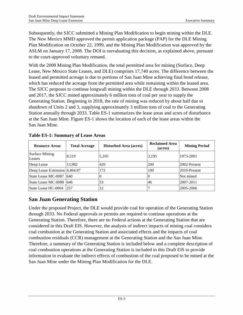
Subsequently, the SJCC submitted a Mining Plan Modification to begin mining within the DLE. The New Mexico MMD approved the permit application package (PAP) for the DLE Mining Plan Modification on October 22, 1999, and the Mining Plan Modification was approved by the ASLM on January 17, 2008. The DOI is reevaluating this decision, as explained above, pursuant to the court-approved voluntary remand.
With the 2008 Mining Plan Modification, the total permitted area for mining (Surface, Deep Lease, New Mexico State Leases, and DLE) comprises 17,740 acres. The difference between the leased and permitted acreage is due to portions of San Juan Mine achieving final bond release, which has reduced the acreage from the permitted area while remaining within the leased area. The SJCC proposes to continue longwall mining within the DLE through 2033. Between 2008 and 2017, the SJCC mined approximately 6 million tons of coal per year to supply the Generating Station. Beginning in 2018, the rate of mining was reduced by about half due to shutdown of Units 2 and 3, supplying approximately 3 million tons of coal to the Generating Station annually through 2033. Table ES-1 summarizes the lease areas and acres of disturbance at the San Juan Mine. Figure ES-1 shows the location of each of the lease areas within the San Juan Mine.
Table ES-1: Summary of Lease Areas
Resource Areas Total Acreage Disturbed Area (acres) Reclaimed Area (acres) Mining Period
Surface Mining Leases 8,519 5,105 3,195 1973-2001
Deep Lease 13,982 420 200 2002-Present Deep Lease Extension 4,464.87 172 100 2010-Present State Lease MC-0087 640 0 0 Not mined State Lease MC-0088 646 53 46 2007-2011 State Lease HC-0004 257 12 7 2005-2006
San Juan Generating Station Under the proposed Project, the DLE would provide coal for operation of the Generating Station through 2033. No Federal approvals or permits are required to continue operations at the Generating Station. Therefore, there are no Federal actions at the Generating Station that are considered in this Draft EIS. However, the analysis of indirect impacts of mining coal considers coal combustion at the Generating Station and associated effects and the impacts of coal combustion residuals (CCR) management at the Generating Station and the San Juan Mine. Therefore, a summary of the Generating Station is included below and a complete description of coal combustion operations at the Generating Station is included in this Draft EIS to provide information to evaluate the indirect effects of combustion of the coal proposed to be mined at the San Juan Mine under the Mining Plan Modification for the DLE.

LegendSan Juan GeneratingStation PropertyBoundary
Project BoundariesLease BoundaryPermit BoundaryDeep Lease AreaDeep Lease Extension
M:\Projects\0394667_San_Juan_Mine_EIS\maps\_!Condensed_EIS\_EIS_1.3-1_Lease_Areas_8X11.mxd, REVISED: 03/20/2018, SCALE: 1:73,009 when printed at 8.5x11 DRAWN BY: Under Map Properties
0 1 20.5Miles
¯_̂
Source: Esri - World Topoographic Map; NAD 1983 StatePlane New Mexico West FIPS 3003 Feet
Environmental ResourcesManagement
www.erm.com
Figure ES-1Lease Areas within the
San Juan MineSan Juan Mine DLE EIS
San Juan County, New Mexico
ERM
Project Location
£¤64
£¤64
Waterflow

Draft Environmental Impact Statement San Juan Mine Deep Lease Extension Executive Summary
ES-5
The Generating Station began operations in 1973 with the construction of Unit 2. Units 1, 3, and 4 were subsequently constructed and became operational between 1976 and 1982. All four units at the Generating Station operated through 2017, historically generating 1,683 mega-watts (MW) of electricity and serving more than 2,000,000 customers in New Mexico, Arizona, Colorado, Utah, and California. Two units were retired on December 31, 2017, and two units (Units 1 and 4) currently generate approximately 847 MW of energy. Table ES-2 summarizes the utilities that have historically owned and currently own the units at the Generating Station.
Table ES-2: Summary of San Juan Generation Station Power Generation
Unit Pre-2018 Generation
Post-2018 Generation Pre-2018 Owners Post-2018 Owners
1 340 MW 340 MW PNM (170 MW) TEP (170 MW)
PNM (170 MW) TEP (170 MW)
2 340 MW 0 MW PNM (170 MW) TEP (170 MW) Unit no longer in operation
3 496 MW 0 MW
PNM (248 MW) Southern CA Public Power Authority (207.7 MW) Tri-State Generation and Transmission (41 MW)
Unit no longer in operation
4 507 MW 507 MW
PNM (195 MW) MSR Public Power Agency (146 MW) City of Anaheim (50.9 MW) City of Farmington (43 MW) Los Alamos County (36.5 MW) Utah Associated Municipal Power Systems (35.6 MW)
PNM (392 MW) City of Farmington (43 MW) Los Alamos County (36.5 MW) Utah Associated Municipal Power Systems (35.6 MW)
Total 1,683 MW 847 MW Source: PNM 2017 MW - megawatts
As the operating agent, PNM manages the Generating Station for all the co-owners and, in addition, owns 66.4 percent of the total plant capacity. The Generating Station is located entirely on private lands owned by PNM and TEP.
In October 2014, the U.S. Environmental Protection Agency (EPA) approved New Mexico’s revised State Implementation Plan (SIP) for Regional Haze. The revised SIP required PNM to install SNCR technology for reduction of nitrogen oxides on Units 1 and 4 by January 31, 2016, and the shut-down of Units 2 and 3 by December 31, 2017. The retirement of Units 2 and 3 reduced power generated from the Generating Station by approximately half, dropping from 1,683 MW to 847 MW and correspondingly, reduced the demand for coal at the San Juan Mine by half, from approximately 6 million tpy to 3 million tpy, thereby extending the life of the mine and the duration of coal combustion at the Generating Station from the original proposal in the Mine Plan Decision Document. Units 1 and 4 would continue to operate for the duration of the current coal supply contract with SJCC (through June 30, 2022), and the contract could be

Draft Environmental Impact Statement San Juan Mine Deep Lease Extension Executive Summary
ES-6
renewed through 2033. To continue operations through 2033, PNM must renew its New Mexico Environment Department (NMED) operating air permit by November 2021.
PURPOSE AND NEED The purpose of the Proposed Action is established by the Mineral Leasing Act of 1920, which requires the evaluation of SJCC’s proposed Mining Plan Modification for the DLE to continue underground mining and reclamation operations to develop Federal coal lands included in Federal Coal Lease NM-99144. The OSMRE is the agency responsible for making a recommendation to the ASLM to approve, disapprove, or approve with conditions the proposed Mining Plan Modification under 30 CFR. The ASLM will decide whether the Mining Plan Modification is approved, disapproved, or approved with conditions. Mining cannot continue in the DLE beyond August 31, 2019 (the deadline of the voluntary remand) without this approval.
The purpose of this action is to evaluate the environmental effects of coal mining on the proposed portions of Federal Coal Lease NM-99144 within the San Juan Mine, which will assist the OSMRE in developing a recommendation to the ASLM whether to approve, disapprove, or approve with conditions the Federal Mining Plan Modification. ASLM approval of the Federal Mining Plan Modification is necessary to mine the reserves.
The need for this action is to provide the SJCC the opportunity to mine the Federal coal obtained under Federal Coal Lease NM-99144 (issued by the BLM in 1998) located at the San Juan Mine.
The applicant’s objective for the Project (proposed Mining Plan Modification) is to allow continued operations at the San Juan Mine within the DLE through 2033. The Project would be accomplished in a manner consistent with the approved BLM lease agreement, the BLM Resource Recovery and Protection Plan, and all pertinent Federal and state regulations.
AGENCY AUTHORITY AND ACTIONS This Draft EIS is intended to satisfy the NEPA requirements of the court-approved voluntary remand to re-evaluate the environmental impacts of the PAP for the Mining Plan Modification submitted by the SJCC to the New Mexico MMD on January 22, 1998. The New Mexico MMD approved the underground mining permit for the DLE in 1999, and the BLM approved the lease for the DLE in 1998. The Court’s order has no bearing on these decisions or approvals; however, both the BLM and the New Mexico MMD are participating as Cooperating Agencies for this EIS to provide information and reviews, as requested by the OSMRE.
In addition to this NEPA review, the OSMRE’s Federal action requires two other consultations: Section 7 of the Endangered Species Act (ESA) and Section 106 of the National Historic Preservation Act (NHPA). These consultations are being implemented in parallel to the NEPA process; each analysis provides useful information to the others, but they follow separate tracks and satisfy separate legal requirements.

Draft Environmental Impact Statement San Juan Mine Deep Lease Extension Executive Summary
ES-7
Lead Agency – Office of Surface Mining Reclamation and Enforcement The OSMRE is the Lead Agency directing EIS preparation for the Project. The OSMRE will make a recommendation to the ASLM about decisions on the proposed DLE Mining Plan Modification, specifically whether to approve, approve with conditions, or disapprove the proposed Mining Plan Modification, and associated reclamation activities, in the DLE of the San Juan Mine.
Cooperating Agencies As defined in the NEPA regulations (40 CFR 1508.5), “cooperating agency” means any Federal agency other than a Lead Agency, which has jurisdiction by law or special expertise with respect to any environmental impact involved in a proposal (or a reasonable alternative) for legislation significantly affecting the quality of the human environment. A State or local agency of similar qualifications may, by agreement with the lead agency, become a cooperating agency. There are four Cooperating Agencies on this EIS, and each is providing technical assistance to the OSMRE in the development of this Draft EIS: BLM, New Mexico MMD, U.S. Fish and Wildlife Service (FWS), and EPA. The role of each is described in the following subsection.
Bureau of Land Management
In 1998, the BLM issued a decision record for the Proposed Coal Leasing Area RMP Amendment/Environmental Assessment, which amended the 1988 Farmington Resource Management Plan to include the Federal Coal Lease NM–99144 for the San Juan Mine’s DLE for the proposed maximum economic recovery of coal reserves. The BLM also approved the surface lease for the lands occupied by the San Juan Mine, which are located on federal land overseen by the BLM. The BLM also approved the Resource Recovery and Protection Plan and provided comments on the OSMRE’s original 2008 decision. The BLM will provide technical assistance to the OSMRE in the preparation of this Draft EIS and will also consult with the OSMRE to identify and evaluate potential impacts to cultural resources under Section 106 of the NHPA.
New Mexico Mines and Minerals Division
The New Mexico MMD approved the PAP for the Mining Plan Modification for the DLE in 1999. The New Mexico MMD has provided technical assistance to the OSMRE in the preparation of this Draft EIS.
U.S. Fish and Wildlife Service
As Lead Agency, the OSMRE is required to consult with the FWS under Section 7 of the ESA before making any decision regarding the Project. The ESA consultation is being conducted concurrent with the NEPA process, and the FWS is participating as a cooperating agency in the EIS process. The FWS also consulted and provided comments on the Mining Plan for the DLE on December 19, 2000. In 2005, OSMRE consulted with and provided a BA to FWS for the Mining Plan Modification. FWS provided a letter of concurrence on July 7, 2005.
Draft Environmental Impact Statement San Juan Mine Deep Lease Extension Executive Summary
ES-8
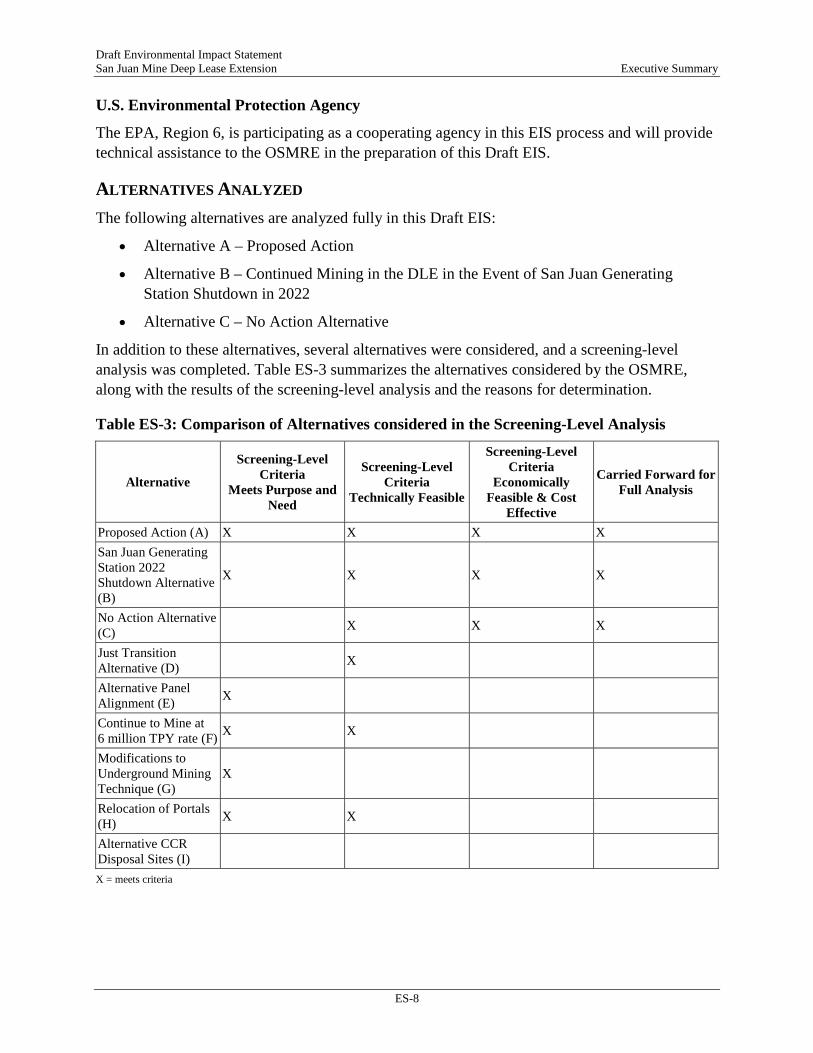
U.S. Environmental Protection Agency
The EPA, Region 6, is participating as a cooperating agency in this EIS process and will provide technical assistance to the OSMRE in the preparation of this Draft EIS.
ALTERNATIVES ANALYZED The following alternatives are analyzed fully in this Draft EIS:
• Alternative A – Proposed Action
• Alternative B – Continued Mining in the DLE in the Event of San Juan GeneratingStation Shutdown in 2022
• Alternative C – No Action Alternative
In addition to these alternatives, several alternatives were considered, and a screening-level analysis was completed. Table ES-3 summarizes the alternatives considered by the OSMRE, along with the results of the screening-level analysis and the reasons for determination.
Table ES-3: Comparison of Alternatives considered in the Screening-Level Analysis
Alternative
Screening-Level Criteria
Meets Purpose and Need
Screening-Level Criteria
Technically Feasible
Screening-Level Criteria
Economically Feasible & Cost
Effective
Carried Forward for Full Analysis
Proposed Action (A) X X X X San Juan Generating Station 2022 Shutdown Alternative (B)
X X X X
No Action Alternative (C) X X X
Just Transition Alternative (D) X
Alternative Panel Alignment (E) X
Continue to Mine at 6 million TPY rate (F) X X
Modifications to Underground Mining Technique (G)
X
Relocation of Portals (H) X X
Alternative CCR Disposal Sites (I) X = meets criteria
Draft Environmental Impact Statement San Juan Mine Deep Lease Extension Executive Summary
ES-9
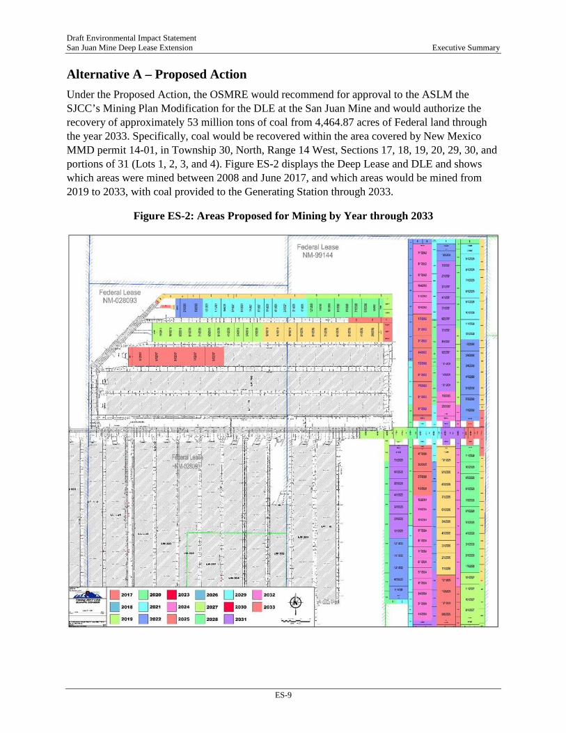
Alternative A – Proposed Action Under the Proposed Action, the OSMRE would recommend for approval to the ASLM the SJCC’s Mining Plan Modification for the DLE at the San Juan Mine and would authorize the recovery of approximately 53 million tons of coal from 4,464.87 acres of Federal land through the year 2033. Specifically, coal would be recovered within the area covered by New Mexico MMD permit 14-01, in Township 30, North, Range 14 West, Sections 17, 18, 19, 20, 29, 30, and portions of 31 (Lots 1, 2, 3, and 4). Figure ES-2 displays the Deep Lease and DLE and shows which areas were mined between 2008 and June 2017, and which areas would be mined from 2019 to 2033, with coal provided to the Generating Station through 2033.
Figure ES-2: Areas Proposed for Mining by Year through 2033
Draft Environmental Impact Statement San Juan Mine Deep Lease Extension Executive Summary
ES-10
Coal would be recovered using longwall mining techniques. The San Juan Mine has a current contract with the Generating Station to supply coal through June 30, 2022. This alternative assumes that the supply contract will be extended to 2033, which was the operating assumption at the time of the court-approved voluntary remand. The contracted tonnage per year from 2008 through the end of 2017 was approximately 6 million tons of coal. The contract was amended to approximately 3 million tons of coal per year beginning January 2018, after the shut-down of Units 2 and 3 at the Generating Station. No changes to the current workforce would occur under the Proposed Action.
Alternative B – Action Alternative, Continued Mining in the DLE in the Event of San Juan Generating Station Shutdown in 2022 Although PNM has made no announcement regarding early shut down of the Generating Station, on July 3, 2017, they issued a 2017-2036 Integrated Resource Plan (IRP). IRPs are prepared every three years for the New Mexico Public Resources Commission. In the 2017 IRP, PNM has analyzed cost-effective power supply plans under two scenarios:
• The Generating Station retires after the end of the current coal supply agreement, terminating on June 30, 2022.
• The Generating Station continues to operate beyond 2022.
The purpose of an IRP is to identify the most cost-effective resource mix that would meet the projected electricity demands of PNM’s customers over the next 20 years, and to develop a 4-year action plan that is consistent with that resource mix. PNM prepared the 2017 IRP for the period 2017 through 2036, examining all cost-effective resource options under a wide variety of possible futures for its energy portfolio. The most significant finding of the IRP is that retiring PNM’s 497-MW share of the Generating Station in 2022 would provide long-term cost savings for PNM’s customers, assuming that PNM is able to recover the full cost of the remaining plant investment after the Generating Station retirement. The four-year action plan in the IRP is designed to test the assumptions in the report and maintain flexibility to adjust the mix of replacement supplies as the price and capabilities of renewable energy, natural gas, and energy storage technologies evolve over the next four years. The four-year action plan provided in the IRP is as follows:
• File for abandonment of the Generating Station with the New Mexico Public Regulation Commission no later than July 1, 2018;
• Secure the required Palo Verde Nuclear Generating Station leased capacity;
• Issue Requests for Proposals for energy storage, renewable energy and flexible natural gas resources to validate the assumptions in the IRP and to further refine the mix of replacement resources assuming the San Juan Generating Station retires in 2022;

Draft Environmental Impact Statement San Juan Mine Deep Lease Extension Executive Summary
ES-11
• Define the Generating Station replacement resource siting requirements by conducting a power flow study; and,
• Pursue securitization legislation to provide additional long-term customer cost savings and to provide funds for replacement resources.
In this alternative, the OSMRE would recommend to the ASLM that the DLE be approved, but with the condition that coal would only be supplied to the Generating Station until 2022 and the remaining reserves from 2023 through 2033 would go to the open market. If a mine does not have an identified generating station as the market, the OSMRE has analyzed coal combustion effects using a “typical” local generating station. This approach allows for a reasonable approximation of the potential combustion-related effects. In the case of the San Juan Mine DLE, the analysis of the combustion-related effects at the Generating Station through 2033 would provide such a reasonable level analysis in the event of shutdown and the San Juan Mine identifying a new market for its coal. Under this alternative, it is assumed that mining, coal preparation and crushing methods at the San Juan Mine would remain consistent with methods employed under the Proposed Action. Additionally, given the high level of uncertainty associated with projecting the potential post-June 2022 SJCC clients, it is assumed that the average rate of coal mined from the San Juan Mine would remain consistent with the Proposed Action rate of approximately 3 million tpy.
Using the Generating Station as the “typical” local generating station for approximation of potential combustion-related effects under Alternative B assumes that any coal combustion would be within the emission profiles analyzed in this Draft EIS for the indirect effects of the Proposed Action. Specifically, assumptions for this Alternative include the following:
1. The potential future combustion of coal would be with similar types of emission controls, CCR handling and storage, and air emission profiles for all air pollutants.
2. The potential future use of coal would be with similar types and scales of transport from the mine to the location of combustion.
If the alternate use after 2022 falls outside the bounds of the analysis (less emission control, new form of transit, new use altogether), then the OSMRE or another federal agency with an action associated with the new use (such as approval of a new rail line or spur) would conduct an independent or supplemental NEPA analysis to analyze new impacts or impacts outside the bounds of those analyzed in this EIS.
Under this alternative, all of the direct mining-related effects, and the indirect effects of coal combustion, would be comparable to those for the Proposed Action. These assumptions reflect a higher level of uncertainty relative to the assessment of the indirect effects of coal combustion under Alternative B as compared to under the Proposed Action.
Draft Environmental Impact Statement San Juan Mine Deep Lease Extension Executive Summary
ES-12
Alternative C – No Action Alternative Under the No Action Alternative, the OSMRE would recommend that the ASLM not approve the Mining Plan Modification for the DLE at the San Juan Mine. Mining within the DLE would cease on August 31, 2019, and the SJCC would continue reclamation activities of past surface mining operations (Juniper Pit) and all surface disturbance from underground mining operations. Mining could legally continue without the DLE; however, as a practical matter for an underground mine of this type, this alternative assumes that all mining would cease at the San Juan Mine after the completion of the second-to-last panel of the 400 district due to technical, economic, and other considerations. Specifically, the final panel of the 400 district is divided between the Deep Lease area and DLE. Coal quality varies throughout each longwall panel, as the panel length generally ranges from 2 to 3.5 miles. The panel length utilized by the San Juan Mine allows higher quality coal to be mined and stockpiled in either Juniper or Northfield coal stockpiles. As the lower quality coal is mined and delivered to the surface, blending can occur between the high-quality stockpiled coal and low-quality coal to ensure the product delivered to the Generating Station meets the requirements of the contract. Within the last panel of the 400 district, the lower-quality coal is found on the Deep Lease area portion. Without the higher quality coal from the DLE side to blend with the low-quality coal, the Generating Station likely could not burn the lower British thermal units (BTU) range of coal without risking damage to its boilers. Moreover, accessing the State lease located in Township 30 North, Range 14 West, Section 32, requires mining portions of the DLE to set up the infrastructure for a longwall operation. Without the approval to mine the DLE, the State lease coal could not be feasibly or safely mined. The workforce would be reduced to only those necessary for reclamation. Any access roads and drill pads would be reclaimed during the few years following shutdown.
Following cessation of mining, any coal remaining in the coal stockpiles would be delivered to the Generating Station. Stockpiles of coal from the San Juan Mine would allow the Generating Station to continue operations using coal from the San Juan Mine through approximately August 2020 (assuming a December 2019 completion of mining, 6-month supply in SJCC stockpiles and 2 month-supply in Generating Station Force Majeure Stockpiles, and an August 2019 disapproval). CCR from the Generating Station would be placed in Juniper Pit in accordance with the reclamation plan for as long as the Generating Station continues to operate using coal from the San Juan Mine; however, upon shut-down of the Generating Station, without the additional CCR to use in reclaiming Juniper Pit, more disturbance of native or reclaimed areas would be required to fill the pit and complete the final design. This additional disturbance would result in a net loss of approximately 1.5 million cubic yards of CCR. Displacing this loss of CCR material with spoil material would require 15 feet of material to be removed over 60 acres of reclamation or native ground. Because this scenario is not part of the current reclamation plan, it does not account for designing proper drainage and creation of landforms, which could increase the acres needing to be disturbed to facilitate reclamation. Final regrade of former surface operations would be completed approximately ten years after the shutdown. Reclamation of the support facilities would also occur during this time. Once reclamation is complete, the areas

Draft Environmental Impact Statement San Juan Mine Deep Lease Extension Executive Summary
ES-13
would be monitored until a Phase III (i.e., final) bond release has been achieved on all formerly disturbed areas. Under the No Action Alternative, SJCC would require approximately 110 employees to complete reclamation activities; all other employees would be laid off.
In addition, an indirect effect of the No Action Alternative is that combustion of coal from the San Juan Mine at the Generating Station would cease in 2020.
PROTECTIVE MEASURES, STANDARD OPERATING PROCEDURES, AND BEST MANAGEMENT PRACTICES APPLICABLE TO ALL ACTION ALTERNATIVES SJCC has included many protective measures within the New Mexico MMD Permit 14-01 that are currently implemented at the mine and would continue under the Proposed Action; these include mitigation measures for certain environmental impacts, standard operating procedures, and BMPs that are designed to avoid or minimize potential impacts related to operation of the San Juan Mine. Because these protective measures are included in New Mexico MMD permit 14-01 as part of the Proposed Action, they are not listed as specific mitigation measures in each resource evaluation. However, if the project is approved, they would become part of the ROD and therefore be binding on SJCC as an enforceable part of the Proposed Action and must be completed in order to comply with the terms of approvals.
COMPARISON OF POTENTIAL ENVIRONMENTAL EFFECTS OF EACH ALTERNATIVE The NEPA analysis addressed resource areas identified during the scoping process. An impacts analysis was conducted for each resource area, resulting in projected impacts to resources and suggestions of mitigation measures where appropriate. The environmental consequences would vary in duration and significance among the environmental resources. Short-term impacts would occur during and/or immediately following construction activities (e.g., access road construction, installation of ventilation equipment). Long-term impacts would persist for the duration of the mining permit period (through 2033) and reclamation phase (through 2043) and account for post-reclamation activities, including monitoring. Permanent impacts would persist beyond, or occur after, reclamation.
The magnitude of impacts is classified as major, moderate, minor, or “no impact.” Significant impacts that are identified as “major” would result in substantial adverse changes to the environment and would exceed established relevant regulatory standards (such as water quality objectives, National Ambient Air Quality Standards (NAAQS), noise ordinances, etc.). Impacts not identified as “major” are considered less than significant and described as either “moderate” or “minor.” The determination of whether an impact is moderate or minor is specific to each resource category. Quantitative thresholds are applied, where appropriate, to determine the level of significance (for example, quantitative thresholds are commonly used to determine impact levels in the areas of noise and air quality). Other issues are assessed qualitatively based on context and intensity.
Table ES-4 contains a summary of potential impacts by resource area.

Draft Environmental Impact Statement San Juan Mine Deep Lease Extension Executive Summary
ES-14
MITIGATION MEASURES Based on the effects analyses in the EIS, the potential for major effects were identified for cultural resources. All other potential impacts were determined to be minor or moderate in magnitude, and therefore, less than significant. Consequently, the OSMRE has identified mitigation measures listed below to avoid and/or minimize potential impacts to cultural resources in order to reduce impacts to minor levels. No other mitigation measures are recommended by the OSMRE.
• The OSMRE will require SJCC to design any new surface infrastructure, such as access roads, drill pads, and ventilation shafts, to avoid historic properties and sites of unevaluated NRHP eligibility.
• If surface infrastructure cannot be sited to avoid cultural resources, the OSMRE will require additional archaeological investigations in the form of limited testing and/or data recovery for historic properties and sites of unevaluated NRHP eligibility. The complexity of the investigation will be determined on a site-by-site basis in consultations between the OSMRE, SJCC, BLM Farmington Field Office, and New Mexico State Historic Preservation Officer.
• Monitoring of historic properties and sites of unevaluated NRHP eligibility will be conducted within 30 to 90 days following subsidence. If monitoring suggests subsidence will cause adverse effects to a historic property(s), the OSMRE will require a treatment plan to avoid or mitigate negative impacts to be developed and implemented in consultations with OSMRE, SJCC, BLM Farmington Field Office, and New Mexico State Historic Preservation Officer.
Draft Environmental Impact Statement San Juan Mine Deep Lease Extension Executive Summary
ES-15
Table ES-4: Impacts of Alternatives by Resource Area
Alternative A – Proposed Action Alternative B – Cont. Mining in DLE after Generating Station Shutdown in
2022 Alternative C – No Action
Air Quality Future emissions, especially for coal handling operations, would remain the same as the post-2017 environmental baseline; air quality impacts would be minor and long-term. All of the maximum predicted concentrations for operations after the completion of the measures in the New Mexico SIP are less than, and in most instances well below, the applicable NAAQS/NMAAQS; this finding includes the 1-hour SO2 standard that was not met before 2017. Therefore, impacts to air quality from emissions of criteria pollutants would be long-term but below the ambient air quality significance levels and therefore minor. The modeled visibility impairment levels even on the highest visibility impact days are well below the accepted significance level of 5 percent, which indicates that implementation of the New Mexico SIP will improve regional air quality. Consequently, the future impacts on regional haze and visibility in Class I areas would be long-term, but minor.
These conditions for use of mined coal after 2022 indicate that the air pollutant emissions and effects for Alternative B are comparable to the San Juan Mine emissions and effects under the Proposed Action.
Compared to the emissions and effects under the Proposed Action the overall emissions would be greatly reduced, by about 90 percent or more, if the reclamation operations are comparable to current surface operations at San Juan Mine to dispose of CCR. The larger emission sources would taper off sharply between 2018 and early 2020, which would eliminate the effects of these sources in the years 2020 through 2033 under the Proposed Action. Therefore, air quality impacts under the No Action Alternative would be permanent, but minor (since the effects of the emissions under the Proposed Action is considered minor, removal of emissions is also considered minor).
Climate Change GHG emissions would amount to about 34 percent of total coal mining emissions in New Mexico, but less than 0.8 percent of national coal mining GHG emissions. Therefore, GHG emissions from the San Juan Mine are considered permanent but minor. Under this alternative, the Generating Station would produce a cumulative total of approximately 97.5 million tons of CO2e. Combustion of the coal from the San Juan Mine would contribute about 0.3 percent of CO2 emissions from fossil-fuel-fired electric power generation nationwide. Therefore, while the Proposed Action would indirectly contribute to the effects of climate change, its contribution relative to other sources would be minor but permanent.
GHG emissions and effects for Alternative B are comparable to the San Juan Mine emissions and effects under the Proposed Action (permanent and minor). The indirect GHG emissions and effects from coal combustion for Alternative B are comparable to the indirect GHG emissions and effects of coal combustion at the Generating Station under the Proposed Action.
Compared to the GHG emissions and effects under the Proposed Action the overall GHG emissions would be greatly reduced, by about 90 percent or more, if the reclamation operations are comparable to current surface operations at San Juan Mine to dispose of CCR (beneficial and permanent).

Draft Environmental Impact Statement San Juan Mine Deep Lease Extension Executive Summary
ES-16
Alternative A – Proposed Action Alternative B – Cont. Mining in DLE after Generating Station Shutdown in
2022 Alternative C – No Action
Geology and Soils Impacts of subsidence would be moderate but permanent. Within the San Juan Mine permit area, no non-commercial buildings or occupied non-commercial dwellings are present that would be impacted by subsidence. No domestic water sources including surface water drainages or drinking water supply wells would be impacted by subsidence; therefore, no impacts are anticipated. Surface disturbances to soil would be long-term but minor. Following the completion of mining in 2033 and implementation of the Soil Handling Plan, Reclamation Plan, and Revegetation Plan all prior impacts would be remediated. Impacts to geologic features from the installation of roads in the DLE would be minor because no existing or proposed unique geologic features are located within or around the permit area; no impacts to unique geologic features would occur. Removal and permanent alteration of the coal resources within the permit area would be conducted according to all permit conditions and would maximize the economic recovery of the resources; no adverse impacts to mineral resources would result from implementation of the Proposed Action. While ground-disturbing activities associated with the Proposed Action may damage or destroy paleontological resources, these protocols would ensure that any impacts are minimized. Impacts to paleontological resources would be permanent, but moderate.
Under this alternative, the impacts to geological resources including soils, mineral resources, and paleontological resources would be identical to those for the Proposed Action.
The impacts to geological resources under this alternative would be less than the Proposed Action. Specifically, the area of impact associated with subsidence and land disturbance would be reduced resulting in lesser potential impacts to topography, soils, and paleontological resources. At the cessation of mining, reclamation would be implemented in accordance with the mining permit (OSMRE 2008); however, due to lack of CCR, additional surface disturbance would be required which would result in long-term moderate adverse impacts to geology and soils. The only permanent effects to geology and soils would be subsidence. With regard to mineral resources, cessation of mining would prevent the maximum recovery of the coal within the DLE; therefore, this is considered a long-term minor adverse effect.

Draft Environmental Impact Statement San Juan Mine Deep Lease Extension Executive Summary
ES-17
Alternative A – Proposed Action Alternative B – Cont. Mining in DLE after Generating Station Shutdown in
2022 Alternative C – No Action
Archaeology and Cultural Resources Impacts would be permanent and minor-to-major if cultural resources are impacted; however, implementation of avoidance and mitigation measures would reduce impacts to minor.
Alternative B would result in the same impacts to cultural resources as Alternative A.
Cessation of mining activities within the DLE would result in no impacts to cultural resources, including no adverse effects to historic properties from the construction of surface facilities. Due to lack of CCR, reclamation would result in greater surface disturbance which could affect cultural resources. Cultural resources located above areas previously mined could still be subject to subsidence impacts. Continued subsidence in previously mined areas could have moderate-to-major adverse impacts on any cultural resources, including adverse effects on historic properties.
Water Resources / Hydrology Based on the lack of usable groundwater, the slow rate of recovery is not likely to adversely affect water availability due to low baseline yield, poor quality and minimal use from these two aquifers, and potential impacts are considered moderate (outside of random fluctuations of natural processes) and permanent. The potential for contamination of the underlying regional aquifer at the San Juan Mine is minor. Impacts to groundwater from historic and future placement of CCR in former surface mining pits, although permanent, are considered minor. Impacts to surface water quality are anticipated to be minor, although long-term. The potential for generation of acid mine drainage at the San Juan Mine is minor. Mercury and selenium would continue to be deposited into the San Juan River watershed, but long-term surface water quality impacts would be minor compared to baseline conditions.
Under Alternative B, no changes to the mine plan would result and impacts to groundwater and surface water quantity and quality would be as described under the Proposed Action, with the exception that deposition of heavy metals from burning of coal mined in the DLE would be reduced in the San Juan River.
Short-term impacts to surface water quality could occur during demolition of mine facilities; however, SJCC would be required to obtain necessary permits, which may include a Construction Stormwater General Permit under CWA Section 402. Compliance with this permit requires the preparation of an Erosion Control and Sediment Plan and Stormwater Pollution Prevention Plan describing best management practices to prevent discharge into waters of the U.S. Implementation of the plans would minimize impacts into nearby waters of the U.S.

Draft Environmental Impact Statement San Juan Mine Deep Lease Extension Executive Summary
ES-18
Alternative A – Proposed Action Alternative B – Cont. Mining in DLE after Generating Station Shutdown in
2022 Alternative C – No Action
No changes to the water use would occur under the Proposed Action and SJCC would maintain the ability to use as much water as the rights allow for the Project life. Given the current water right appropriations, water drawn from the San Juan River would continue as stated in the agreements; therefore, there would be no impacts to surface water quantity in the San Juan River. Impacts to water quantity from subsidence due to underground mining would be minor and long-term.
Reclamation of mined lands would restore surface water drainage and natural stormwater flow as well as natural groundwater flow; therefore, impacts to water quality would likely be minor but long-term.
Vegetation Construction of mine facilities would result in permanent but minor impacts to vegetation communities in that even following reclamation, the community type and composition would be altered in accordance with reclamation standards designed to return disturbed areas to grazing and wildlife land uses. Surface disturbance associated with vegetation removal could adversely impact naturally occurring seed sources by reducing seed yield and/or viability and, subsequently, decrease the success of native plant re-colonization although these impacts would likely be long-term and minor. Surface disturbance would also result in short-term minor increases in potential for spread of noxious weeds. Accounting for fugitive dust control measures, potential impacts to vegetation from fugitive dust would be short-term and minor. Emissions from coal combustion is not expected to increase risks to vegetation above those already present, nor would they increase the risk of metals not currently identified as potential risks to a level of concern. Therefore, impacts would be long-term and moderate.
All of the mining techniques, including the indirect effects of coal combustion, would be identical to those for Alternative A with the exception of a potential increase in transportation and related infrastructure, which could result in additional surface disturbing activities. Therefore, impacts would be as described for the Proposed Action.
Cessation of mining activities within the DLE would result in no impacts to vegetation resources; however, due to lack of CCR, reclamation would result in greater surface disturbance which would result in long-term adverse effects to vegetation. Vegetation resources located above areas previously mined could still be subject to subsidence impacts. Subsidence in previously mined areas could have short-term minor impacts on vegetation resources, although these impacts would be expected mostly for individual plants or small areas located along subsidence cracks.
Wildlife and Habitats Fugitive dust on unpaved access roads could impair wildlife respiratory functions and eyesight. Impacts to wildlife from fugitive dust emissions would be minor and short-term due to dust control best management practices already in place.
Potential impacts related to the San Juan Mine would be the same as described for the Proposed Action. Given the shorter duration of emissions as compared to the Proposed Action, the ERA results indicate that minor impacts as described for the
Cessation of mining activities within the DLE would result in no impacts to wildlife resources, although reclamation would result in greater surface disturbance which could result in short-term adverse effects to wildlife. Wildlife resources

Draft Environmental Impact Statement San Juan Mine Deep Lease Extension Executive Summary
ES-19
Alternative A – Proposed Action Alternative B – Cont. Mining in DLE after Generating Station Shutdown in
2022 Alternative C – No Action
Operation of existing facilities within the San Juan Mine that produce noise and unanticipated noises generated could have a minor and short-term impact on individual animals in the area; however, these noise levels and the frequency with which such noise is generated are not expected to be different from what is currently experienced by wildlife under existing conditions. Impacts to wildlife associated with noise generated during operation of existing facilities within the DLE would be minor, as wildlife are expected to be acclimated to noises associated with existing Project components. Impacts to wildlife resulting from human activity associated with operation of the San Juan Mine would range from minor to moderate depending upon the activity occurring, the proximity of the activity, and the species encountered. Impacts due to ground-disturbing activities are expected to be moderate and long-term for smaller terrestrial burrowing species. Larger, more mobile species are expected to experience minor impacts. Loss or avoidance of foraging, breeding, or nesting habitats associated with these species would be minor. Impacts to wildlife from habitat loss during the active mining and reclamation activities would be considered short-term and moderate; habitat would be re-established as a result of on-going reclamation to establish grazing and wildlife habitat. Construction of ancillary facilities and roads would result in moderate impacts to wildlife as a result of longer-term habitat loss. No aquatic species occur within the DLE. Hence, no impacts to aquatic life within the DLE are anticipated under the Proposed Action. While risks associated with chemical exposure to little brown bats occur under current conditions, no substantive additional risks to bats or other terrestrial wildlife are expected to occur within the deposition area as a result of proposed future emissions and impacts from the Proposed
Proposed Action would occur but no additional exposures to aquatic habitats or to aquatic biota from Generating Station emissions would occur after 2022 when Generating Station operations would cease. Given the proportionally shorter duration as compared to the Proposed Action, potential impacts within the San Juan River and other perennial waterbodies within the deposition area as a result of the Alternative B are likely to be less than that of the Proposed Action. Any impacts beyond 2022 from deposition are unknown and would require a site-specific analysis. Hence, potential impacts within the San Juan River and perennial waterbodies within the deposition area as a result of the Alternative B are classified as long-term and minor.
located above areas previously mined could still be subject to subsidence impacts. Potential impacts, within the deposition area, are likely to be less than that of the Proposed Project. Hence, potential indirect impacts within the deposition area as a result of the No Action Alternative are classified as no impact.

Draft Environmental Impact Statement San Juan Mine Deep Lease Extension Executive Summary
ES-20
Alternative A – Proposed Action Alternative B – Cont. Mining in DLE after Generating Station Shutdown in
2022 Alternative C – No Action
Action are not expected to increase the concentration of metals to a level of concern. Potential impacts to aquatic biota within the deposition area as a result of the Proposed Project are classified as minor and long-term. Based on this projected amount of flow affected, the effect of Project-specific depletions would not be expected to substantially affect aquatic species or their habitat, relative to baseline conditions and are considered minor. Special Status Species The Proposed Action would have no impact on special status amphibians or their habitat. Impacts to special status raptors species are expected to minor, but long-term. Impacts to nesting habitat would be minor and long-term. For smaller birds, although ground disturbance activities and habitat loss could impact prey and nectar availability, effects would be minor, and short-term. Impacts to nesting habitat are expected to be minor and long-term. Impacts to special status songbird and hummingbird species resulting from increased human activity levels within the San Juan Mine are expected to be minor, but long-term. The effects for prairie dogs at a population level would be minor and long-term. The Proposed Action would have no impact on the New Mexico meadow jumping mouse or its habitat. Displacement of pronghorn within the Mine area due the Proposed Action would minor, and short-term. Impacts to bats could occur from human activity and operation of equipment, and associated noise. Collective impacts to special status bats species are expected to be minor and long-term.
Under this alternative, all of the mining techniques, including the indirect effects of coal combustion, would be identical to those for Alternative A, with the exception that the deposition area would be located in the vicinity of wherever the coal may be combusted following shut-down of the Generating Station in 2022. As a result, potential impacts to special status species from deposition are unknown beyond 2022 and would require a site-specific analysis.
Cessation of mining activities within the DLE would result in no impacts to special status species, including no adverse effects from the construction of surface facilities. Habitat for special status species located above areas previously mined would still be subject to subsidence impacts. Subsidence in previously mined areas would have permanent moderate impact on habitat and special status plants, although these impacts would be expected mostly for individual plants or small areas located along subsidence cracks. Emissions from the Generating Station and subsequent potential exposures / indirect impacts to listed fish in perennial surface waterbodies in the deposition area would cease in 2019. Given the proportionally shorter duration of emissions and potential for entrainment as compared to the Proposed Project, it is reasonable to infer that potential impacts within the deposition area as a result of
Draft Environmental Impact Statement San Juan Mine Deep Lease Extension Executive Summary
ES-21
Alternative A – Proposed Action Alternative B – Cont. Mining in DLE after Generating Station Shutdown in
2022 Alternative C – No Action
No special status plants are known to occur within the mine. Therefore, subsidence would have no impact on special status plants. Potential impacts to special status plants from fugitive dust would be short-term and minor. No uncontrolled discharge from the San Juan Mine lease area to downstream waters would occur, so no direct impacts to special status fish species would occur from ground disturbing activities or runoff. Therefore, the Proposed Action would have no impact on special status fish or their habitat. Emissions from coal combustion is not expected to increase risks above those already present for special status terrestrial plant species and would not increase the risk of metals not currently identified as potential risks to a level of concern. The potential risk to federally listed and special status carnivorous, insectivorous, and herbivorous species from coal combustion emissions are expected to be minor and long-term. The potential impacts to listed fish in portions of the San Juan River within the deposition area as a result of the Proposed Action are classified as long-term and minor.
the No Action Alternative are likely to be substantively less than that of the Proposed Project.
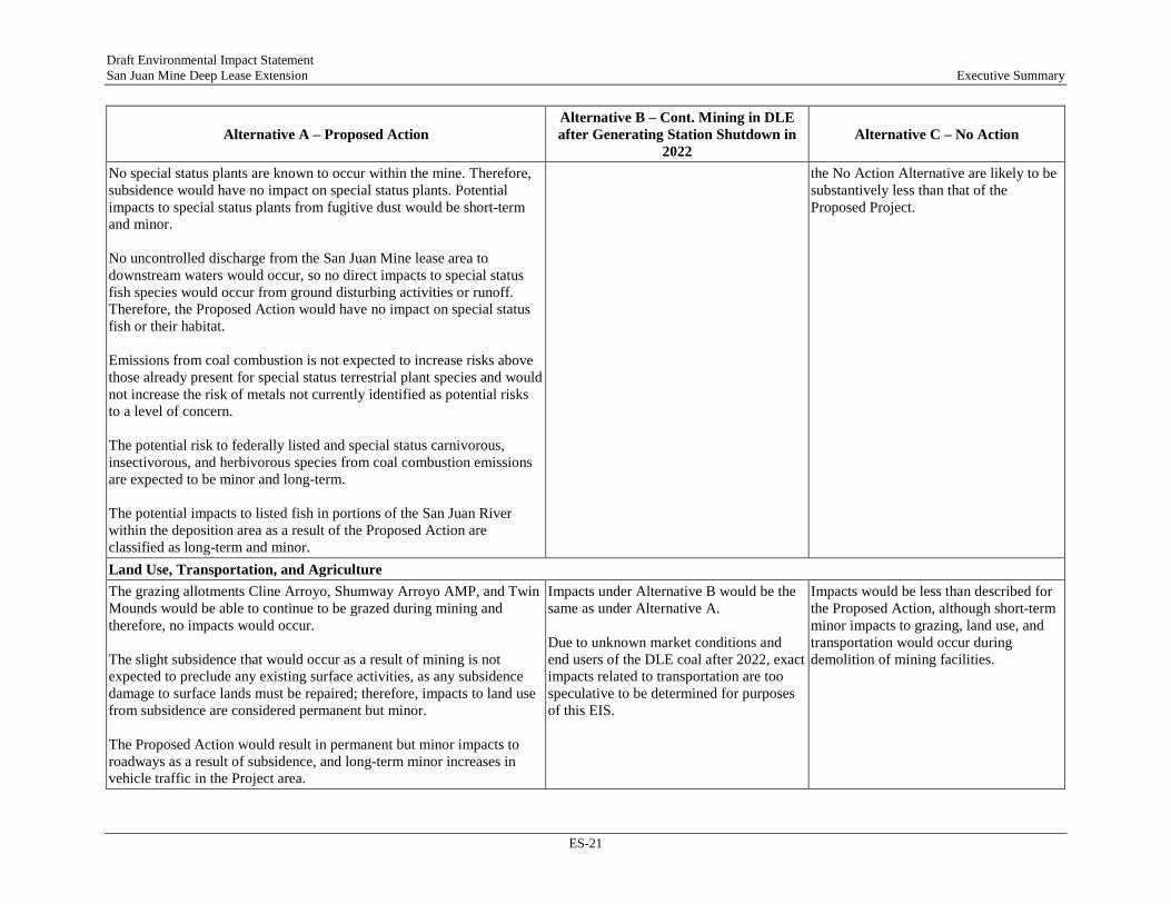
Land Use, Transportation, and Agriculture The grazing allotments Cline Arroyo, Shumway Arroyo AMP, and Twin Mounds would be able to continue to be grazed during mining and therefore, no impacts would occur. The slight subsidence that would occur as a result of mining is not expected to preclude any existing surface activities, as any subsidence damage to surface lands must be repaired; therefore, impacts to land use from subsidence are considered permanent but minor. The Proposed Action would result in permanent but minor impacts to roadways as a result of subsidence, and long-term minor increases in vehicle traffic in the Project area.
Impacts under Alternative B would be the same as under Alternative A. Due to unknown market conditions and end users of the DLE coal after 2022, exact impacts related to transportation are too speculative to be determined for purposes of this EIS.
Impacts would be less than described for the Proposed Action, although short-term minor impacts to grazing, land use, and transportation would occur during demolition of mining facilities.

Draft Environmental Impact Statement San Juan Mine Deep Lease Extension Executive Summary
ES-22
Alternative A – Proposed Action Alternative B – Cont. Mining in DLE after Generating Station Shutdown in
2022 Alternative C – No Action
Recreation Because noise levels are low and would not increase above baseline conditions, there would be no impacts to the recreational experience. Trucks and equipment used during mining activities would not result in impacts on recreational resources because they would primarily travel on roadways contained within the San Juan Mine. Therefore, impacts to recreation due to surface activities associated with mining would be short-term and minor. The DLE area is located at long viewing distances from other recreational viewpoints. No designated Federal or state recreation areas lie immediately adjacent to the DLE; the closest recreation areas are beyond the viewing distance from the DLE area. Stack emissions from the Generating Station would continue to be one of the primary elements capturing the attention of the casual observer in the region. While the Proposed Action would not affect access to regional recreation areas, effects to visibility at recreational areas is considered a long-term moderate impact. The Proposed Action would not conflict with or be incompatible with recreation-related policies or objectives of the BLM/FFO RMP or the New Mexico MMD Mine Permit. Therefore, no long-term or permanent impacts to recreational opportunities within the DLE would result from the Proposed Action.
Under Alternative B, the mining techniques in the DLE area would be identical to those described in the Proposed Action. Potential recreational effects would therefore be the same as those described under the Proposed Action.
No impacts to recreational activities or facilities would occur beyond 2019. The No Action Alternative would avoid short-term impacts to recreational opportunities on the DLE due to surface activities associated with mining and permanent impacts to the recreational viewshed, which would occur as a result of subsidence. Therefore, the under the No Action Alternative no impacts to recreation and recreational facilities in the DLE and region would occur.
Social and Economic Values No impacts to social and economic values would occur under the Proposed Action. San Juan Mine would continue to provide economic revenue and jobs to economies of San Juan County, the region, and State of New Mexico under the Proposed Action. These impacts would continue through the life of the mine.
Economic impacts from Alternative 2 would be similar to the Proposed Action because the operations under both scenarios would recover the same amount of coal and be fundamentally the same. Therefore, mining operations would continue to provide revenue to the economy of the region throughout the life of the mine.
The consequence of closing both San Juan Mine and the Generating Station represents a major permanent impact to the economies of San Juan County and the region. The No Action Alternative would ultimately result in the loss 897 jobs and of $356 million in annual economic activity for the Four Corners Region.
Draft Environmental Impact Statement San Juan Mine Deep Lease Extension Executive Summary
ES-23
Alternative A – Proposed Action Alternative B – Cont. Mining in DLE after Generating Station Shutdown in
2022 Alternative C – No Action
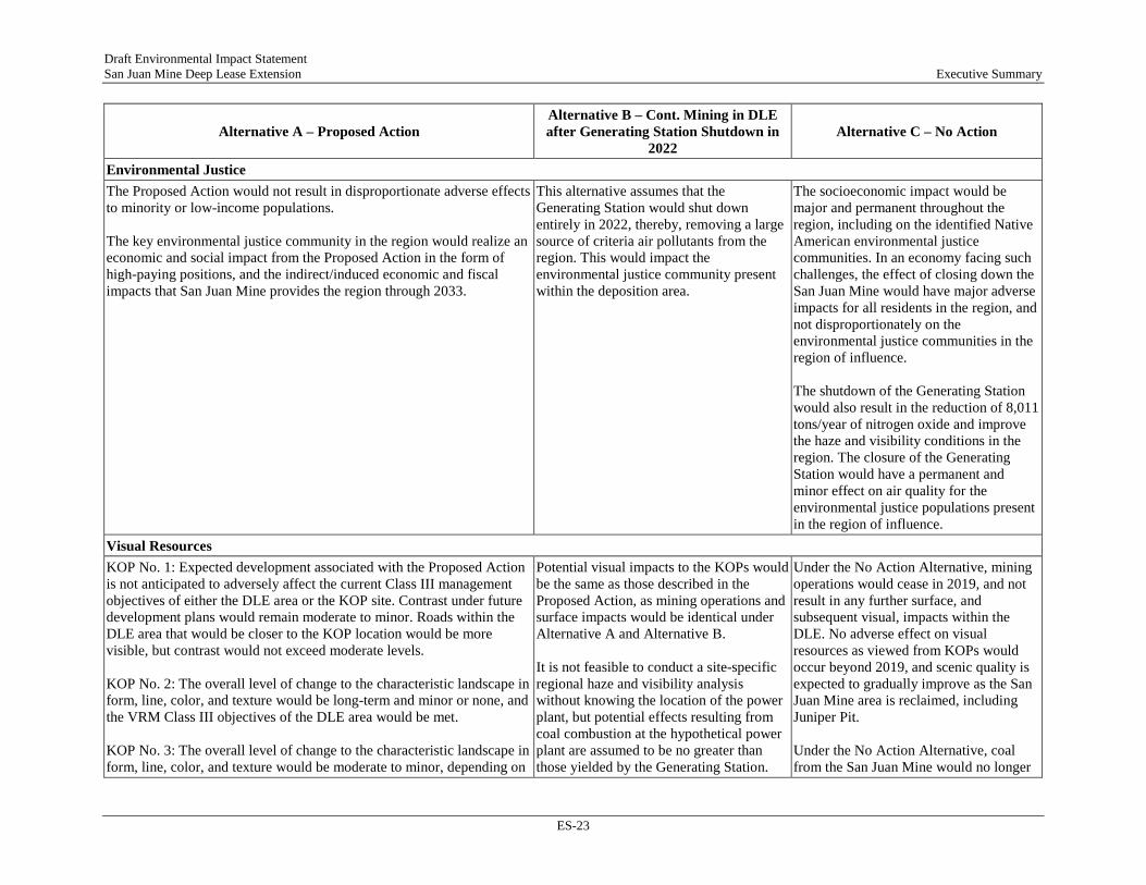
Environmental Justice The Proposed Action would not result in disproportionate adverse effects to minority or low-income populations. The key environmental justice community in the region would realize an economic and social impact from the Proposed Action in the form of high-paying positions, and the indirect/induced economic and fiscal impacts that San Juan Mine provides the region through 2033.
This alternative assumes that the Generating Station would shut down entirely in 2022, thereby, removing a large source of criteria air pollutants from the region. This would impact the environmental justice community present within the deposition area.
The socioeconomic impact would be major and permanent throughout the region, including on the identified Native American environmental justice communities. In an economy facing such challenges, the effect of closing down the San Juan Mine would have major adverse impacts for all residents in the region, and not disproportionately on the environmental justice communities in the region of influence. The shutdown of the Generating Station would also result in the reduction of 8,011 tons/year of nitrogen oxide and improve the haze and visibility conditions in the region. The closure of the Generating Station would have a permanent and minor effect on air quality for the environmental justice populations present in the region of influence.
Visual Resources KOP No. 1: Expected development associated with the Proposed Action is not anticipated to adversely affect the current Class III management objectives of either the DLE area or the KOP site. Contrast under future development plans would remain moderate to minor. Roads within the DLE area that would be closer to the KOP location would be more visible, but contrast would not exceed moderate levels. KOP No. 2: The overall level of change to the characteristic landscape in form, line, color, and texture would be long-term and minor or none, and the VRM Class III objectives of the DLE area would be met. KOP No. 3: The overall level of change to the characteristic landscape in form, line, color, and texture would be moderate to minor, depending on
Potential visual impacts to the KOPs would be the same as those described in the Proposed Action, as mining operations and surface impacts would be identical under Alternative A and Alternative B. It is not feasible to conduct a site-specific regional haze and visibility analysis without knowing the location of the power plant, but potential effects resulting from coal combustion at the hypothetical power plant are assumed to be no greater than those yielded by the Generating Station.
Under the No Action Alternative, mining operations would cease in 2019, and not result in any further surface, and subsequent visual, impacts within the DLE. No adverse effect on visual resources as viewed from KOPs would occur beyond 2019, and scenic quality is expected to gradually improve as the San Juan Mine area is reclaimed, including Juniper Pit. Under the No Action Alternative, coal from the San Juan Mine would no longer

Draft Environmental Impact Statement San Juan Mine Deep Lease Extension Executive Summary
ES-24
Alternative A – Proposed Action Alternative B – Cont. Mining in DLE after Generating Station Shutdown in
2022 Alternative C – No Action
the phase of operations and the proximity of activities and structures to the viewer. Therefore, impacts to visual resources from subsidence would be permanent, but minor. Coal mined within the DLE would be burned by the Generating Station, which would result in indirect adverse effects to visibility and regional haze.
be burned by the Generating Station after 2020. Therefore, the indirect effect of the No Action Alternative would be a permanent and moderate impact to visibility and haze in the region.
Noise and Vibration Mining-related vibrations would be less than the threshold of 0.2 in/sec at the closest sensitive receptor. Similarly, vibration levels from construction equipment such as dozers, graders, backhoes, etc. used during surface activities are typically less than 0.089 in/sec at 25 feet from the source. Therefore, there would be no discernible impacts from ground-borne vibration associated with underground or surface activates in the San Juan Mine DLE. Noise levels from transportation of coal and CCR, personal vehicle use and reclamation activities were calculated to be below threshold levels of 90 dBA Ldn for daytime-only operations at the nearest residential area located off US 64/CR 6700. Therefore, impacts would be minor.
For this alternative, coal would likely be transported to the existing stockpiles before being hauled offsite. Transport of coal to the selected generation station may involve transport via existing regional transportation routes or by accessing a rail distribution site. Under Alternative B, impacts to sensitive receptors would remain materially the same as described for the Proposed Action. Transportation of coal along adjacent roads could result in greater noise levels at the nearby residences.
Impacts from existing mining activities have been assessed previously and are not expected to differ appreciably in nature from what is described above until August 2019 when all mining activities would cease. Thus, there would be no noise associated with mining activities after August 2019.
Hazardous and Solid Waste The chemical volumes required for the proposed San Juan Mine DLE operations would not trigger EPCRA reporting. Therefore, any impact from an accidental release or spill of these materials would be minor. The potential for impacts from a release or spill is considered long-term and would exist for the Project life (through the end of reclamation).
Under Alternative B, impacts relative to hazardous wastes and materials would remain materially the same as described for the Proposed Action.
Final regrade of former surface operations would be completed approximately ten years after the shutdown. Reclamation of the support facilities would also occur during this time. Impacts associated with these activities relative to hazardous wastes and materials would be materially the same as those described for the Proposed Action.

Draft Environmental Impact Statement San Juan Mine Deep Lease Extension Executive Summary
ES-25
Alternative A – Proposed Action Alternative B – Cont. Mining in DLE after Generating Station Shutdown in
2022 Alternative C – No Action
Impacts related to hazardous waste and solid waste would be short-term and predominately associated with disposal of demolition materials. Because these activities would occur in compliance with all environmental laws and regulations, these impacts would be expected to be minor and short-term.
Health and Safety Given the Proposed Action would not present new or increase the existing safety risks at the mine and given the facility’s better than industry average safety violation rate, it is expected that the Proposed Action would have a minor impact on worker safety. As the Proposed Action would have similar diesel emissions, DPM health risks would likely meet target health goals. Therefore, potential impacts related to DPM are considered long-term but minor. The HHRA process is designed to conservatively estimate health risks. Therefore, the risk assessment results, which are all well below not-to-exceed thresholds, lead to predicted incremental risks from air toxics emissions to be long-term but minor.
Impacts on worker safety would remain the same as for Alternative A as there would be no changes to mining practices. Impacts on public health in the ROI would be positive relative to Alternative A due to the removal of a large source of air pollution.
The health benefits of removal of the air emissions due to the Generating Station would be the same as described for Alternative B, except they would occur 2 years sooner; however, the adverse economic impacts would be greater than described for Alternative B. Because of the association between health and socioeconomic status, lower levels of employment and economic activity would likely result in lower health for the local population due to issues like poorer nutritional status and more difficulty in accessing health care.

Draft Environmental Impact Statement San Juan Mine Deep Lease Extension Executive Summary
ES-26
-Page Intentionally Left Blank-

Draft Environmental Impact Statement San Juan Mine Deep Lease Extension Table of Contents
i
TABLE OF CONTENTS
1. Introduction ..............................................................................................................................1 1.1. Permit Review Process and Voluntary Remand ..............................................................1 1.2. Project Location ...............................................................................................................2 1.3. Project Background ..........................................................................................................4 1.4. Purpose and Need for Action ...........................................................................................7 1.5. Agency Authority and Actions .........................................................................................8 1.6. Public Participation ..........................................................................................................9
2. Description of the Proposed Action and Alternatives ........................................................11 2.1. Description of Current Operations .................................................................................11 2.2. Alternatives Screening-Level Analysis ..........................................................................26 2.3. Regulatory Framework, Protection Measures, Standard Operating Procedures, and
BMPs Applicable to all Action Alternatives ..................................................................36
3. Affected Environment ...........................................................................................................46 3.1. Air Quality ......................................................................................................................47 3.2. Climate Change ..............................................................................................................48 3.3. Geology and Soils ..........................................................................................................50 3.4. Archaeology and Cultural Resources .............................................................................51 3.5. Water Resources/Hydrology ..........................................................................................53 3.6. Vegetation ......................................................................................................................57 3.7. Wildlife ...........................................................................................................................58 3.8. Special Status Species ....................................................................................................58 3.9. Land Use/Transportation/Agricultural ...........................................................................60 3.10. Recreation .......................................................................................................................61 3.11. Social and Economic Values ..........................................................................................61 3.12. Environmental Justice ....................................................................................................63 3.13. Visual Resources ............................................................................................................63 3.14. Noise and Vibration .......................................................................................................64 3.15. Hazardous and Solid Wastes ..........................................................................................65 3.16. Health and Safety ...........................................................................................................65
4. Environmental Consequences and Mitigation Measures ...................................................67 4.1. Air Quality ......................................................................................................................68 4.2. Climate Change ..............................................................................................................78 4.3. Geology and Soils ..........................................................................................................83 4.4. Archaeology and Cultural Resources .............................................................................86 4.5. Water Resources/Hydrology ..........................................................................................89 4.6. Vegetation ......................................................................................................................96 4.7. Wildlife and Habitats ...................................................................................................100 4.8. Special Status Species ..................................................................................................104
Draft Environmental Impact Statement San Juan Mine Deep Lease Extension Table of Contents
ii
4.9. Land Use, Transportation, and Agriculture ..................................................................114 4.10. Recreation .....................................................................................................................116 4.11. Social and Economic Values ........................................................................................117 4.12. Environmental Justice ..................................................................................................121 4.13. Visual Resources ..........................................................................................................125 4.14. Noise and Vibration .....................................................................................................128 4.15. Hazardous and Solid Wastes ........................................................................................130 4.16. Health and Safety .........................................................................................................133 4.17. Short-Term Uses Versus Long-Term Productivity ......................................................142 4.18. Irreversible and Irretrievable Commitment of Resources ............................................143 4.19. Mitigation Measures .....................................................................................................144
5. Consultation and Coordination ..........................................................................................145 5.1. Government-to-Government Consultation ...................................................................145 5.2. Endangered Species Act Section 7 Consultation .........................................................146 5.3. National Historic Preservation Act Section 106 Consultation .....................................146 5.4. Public Participation ......................................................................................................147
6. Preparers and Contributors................................................................................................149 6.1. U.S. DOI, OSMRE .......................................................................................................149 6.2. Catalyst Environmental Solutions ................................................................................149 6.3. Environmental Resources Management .......................................................................149
APPENDICES
Appendix A Supporting Documents
Draft Environmental Impact Statement San Juan Mine Deep Lease Extension Table of Contents
iii
LIST OF TABLES
Table 1.3-1: Summary of Lease Areas .........................................................................................5 Table 1.3-2: Summary of San Juan Generating Station Power Generation .................................7 Table 1.5-1: Cooperating Agencies for the NEPA Process ..........................................................9 Table 2.1-1: Recent Coal Production Volumes at the San Juan Mine .......................................12 Table 2.1-2: Underground Mining Equipment Used at the San Juan Mine ...............................15 Table 2.1-3: Above-Ground Equipment Use at the San Juan Mine ...........................................15 Table 2.1-4: San Juan Mine Disposal of Minor TRI Constituents (lb/year) ..............................23 Table 2.1-5: Reduction in Air Emissions at the Generating Station under the SIP ....................24 Table 2.2-1: Screening Level Analysis of Identified Alternatives .............................................27 Table 2.2-2: Total Planned Mined Tons of Coal from the Deep Lease Extension by Year .......30 Table 2.3-1: Applicable Laws, Regulations, and Additional Protection Measures in Place
at San Juan Mine ....................................................................................................37 Table 3.2-1: Annual GHG Emissions from the Generating Station in 2016 and 2017 ..............50 Table 3.5-1: Average Results of Water Quality Sampling in Stevens Arroyo from
2008-2017 ..............................................................................................................54 Table 3.6-1: Vegetation Communities in Deep Lease Extension from 1997-1998 Survey .......57 Table 3.8-1: Special Status Species with Potential to Occur within the Vicinity of the
San Juan Mine or Region of Influence of Deposition from the Generating Station ....................................................................................................................58
Table 3.11-1: Population in the Region of Influence from 2010 to 2015 ....................................61 Table 3.11-2: Average Annual Government Revenues Generated by San Juan Mine from
2008-2016 ..............................................................................................................62 Table 3.12-1: Poverty Rates by County .......................................................................................63 Table 4.1-1: Alternative A – Modeled Pollutant Emissions from San Juan Mine .....................71 Table 4.1-2: Annual and Total Generating Station Emissions 2018-2033 .................................72 Table 4.1-3: Criteria Pollutant Contributions, Post 2017 Scenario, and Comparison to
Air Quality Standards ............................................................................................73 Table 4.1-4: Comparison of Future Regional Haze Effects in Class I Areas Modeled to
Represent Future Control Options for Generating Station Emissions ...................74 Table 4.4-1: Potential Types of Impacts Considered for Cultural Resources ............................86 Table 4.6-1: Potential Types of Impacts to Vegetation Considered in the Analysis ..................97 Table 4.8-1: Potential Types of Impacts to Special Status Species Considered in the
Analysis................................................................................................................106 Table 4.11-1: Comparison of No Action Alternative to Baseline Conditions ...........................119 Table 4.11-2: Economic Effects of the No Action Alternative on the Region ...........................120 Table 4.11-3: Impact of the No Action Alternative in State of New Mexico ............................120 Table 4.14-1: Noise Impact Determination Surrounding Sensitive Receptors ..........................129 Table 4.16-1: Chemicals Evaluated in the Human Health Risk Assessment .............................138 Table 4.16-2: Risk Summary for Mine and Generating Station Emissions, 2008-2033 ............140

Draft Environmental Impact Statement San Juan Mine Deep Lease Extension Table of Contents
iv
LIST OF FIGURES
Figure 1.2-1: Project Location Map ...............................................................................................3 Figure 1.3-1: Lease Areas within the San Juan Mine ....................................................................6 Figure 2.1-1: Stratigraphic Cross Section of San Juan Basin ......................................................12 Figure 2.1-2: Photograph of Aboveground Ventilation System at the San Juan Mine ...............13 Figure 2.1-3: Typical Longwall Equipment Arrangement ..........................................................14 Figure 2.1-4: Photograph of an Active Coal Stockpile at the San Juan Mine .............................17 Figure 2.1-5: Overview of Mine Operations ...............................................................................18 Figure 2.1-6: Location of Water Supply Intake for San Juan Mine and Generating Station .......21 Figure 2.1-7: Photograph of Reclamation Activity and Completed Reclamation at Piñon Pit ...22 Figure 2.1-8: Overview of San Juan Generating Station Facilities .............................................25 Figure 2.2-1: Areas Proposed for Mining by Year through 2033 ................................................31 Figure 3.5-1: Location of Surface Water and Groundwater Monitoring Sites at the San Juan
Mine .......................................................................................................................55 Figure 4.1-1: Projects Considered in the Cumulative Impacts Analysis .....................................69 Figure 4.16-1: Particle Size Comparison .....................................................................................136 Figure 4.16-2: Human Health Exposure Pathways ......................................................................138

Draft Environmental Impact Statement Section 1 San Juan Mine Deep Lease Extension Introduction
1
1. INTRODUCTION
The United States (U.S.) Department of the Interior (DOI), Office of Surface Mining Reclamation and Enforcement (OSMRE), Western Region, is preparing an Environmental Impact Statement (EIS) to evaluate the impacts of implementing the Deep Lease Extension (DLE) Mining Plan Modification, Federal Coal Lease NM-99144, at the San Juan Mine (the Project). The San Juan Mine, operated by the San Juan Coal Company (SJCC), began operations in 1973 as an open-pit mine; it then transitioned to an underground mine in 2002 to follow the Fruitland coal formation as it deepened. The Project proposes to continue underground mining within the DLE using longwall mining techniques. San Juan Mine is the exclusive provider of coal to the San Juan Generating Station (Generating Station); historical coal production has been approximately 6 million tons of coal per year, but the shutdown of Generating Station Units 2 and 3 in December 2017 reduced mine production to approximately 3 million tons per year (tpy). The Project would provide coal to the Generating Station through 2033. An indirect effect of the Project would be the combustion of the coal at the Generating Station, which is also analyzed in this Draft EIS. This Draft EIS has been prepared in accordance with the National Environmental Policy Act of 1969 (NEPA) as amended, 42 U.S. Code (USC) 4321-4347; the Council on Environmental Quality’s (CEQ’s) regulations for implementing the NEPA, 40 Code of Federal Regulations (CFR) Parts 1500 through 1508; the DOI’s NEPA regulations, 43 CFR Part 46; and the OSMRE NEPA Handbook.
1.1. PERMIT REVIEW PROCESS AND VOLUNTARY REMAND For an entity to mine Federal coal reserves in New Mexico, the entity must have a Federal coal lease from the U.S. Bureau of Land Management (BLM), a Resource Recovery and Protection Plan prepared and approved by the BLM, an approved mining permit from the New Mexico Mining and Minerals Division (MMD), and in some instances, a Mine Plan Decision Document giving approval from the Assistant Secretary for Land and Minerals Management (ASLM) for mining the Federal lease. The permit review process is established by the Surface Mining Control and Reclamation Act (SMCRA) of 1977, as amended (30 USC 1201–1328), and the cooperative agreement between the State of New Mexico and the DOI Secretary in accordance with Section 523(c) of SMCRA, and 30 USC 1273(c). Coal mining operations in New Mexico, including mining of Federal coal leases, require submittal of a Permit Application Package (PAP) to the New Mexico MMD. Once the New Mexico MMD reviews the PAP and determines it to be administratively complete, if the PAP involves Federal coal, the PAP is sent to the OSMRE to aid in the OSMRE's determination as to whether a Mine Plan Decision Document is to be prepared for recommendation to the ASLM according to 30 CFR 746.13. The PAP also informs the OSMRE what mining operations are planned to help determine if an adequate environmental analysis was conducted or if the OSMRE will be required to do its own analysis. The New Mexico MMD is responsible for the technical aspect of the PAP review before the mining permit can be approved. If a Mine Plan Decision Document is required for an action at the mine, the following process occurs. The state completes its technical analysis, then approves the mining permit application and issues a findings document. The OSMRE is responsible for creating a Mine Plan Decision Document to aid the ASLM in the approval or disapproval of mining activities for that lease.
Draft Environmental Impact Statement Section 1 San Juan Mine Deep Lease Extension Introduction
2
The New Mexico MMD approved the underground mining permit for the DLE on October 22, 1999 for Federal Coal Lease NM-99144. The OSMRE submitted a Mining Plan Decision Document to the ASLM, which was approved by the ASLM on January 17, 20081. The OSMRE Mine Plan Decision Document included a Finding of No Significant Impact signed by the OSMRE in 2007. In addition, the OSMRE Mine Plan Decision Document included a copy of the BLM 1998 decision record on the amendment to the 1988 Farmington Resource Management Plan (RMP) that was prepared to incorporate the Federal Coal Lease NM–99144 for the San Juan Mine’s DLE into the RMP and was used to prepare a Finding of No Significant Impact.
The OSMRE’s NEPA analysis was challenged in WildEarth Guardians v. U.S. Office of Surface Mining et al., Case 1:14-cv-00112–RJ–CG (D. NM 2016). In the legal proceedings, the OSMRE requested and received a voluntary remand, as approved by the U.S. District Court for the District of New Mexico on August 31, 2016. The court-approved voluntary remand required the OSMRE to prepare an EIS that rigorously analyzes the reasonably foreseeable impacts of the mining plan approval, including examination of air quality impacts. The OSMRE must complete the EIS and Record of Decision (ROD), and the Mining Plan Decision Document must be signed by the ASLM by August 31, 2019.
This EIS has been prepared in accordance with the Court’s order and the NEPA regulations. It evaluates the potential impacts of mining within the DLE area per the Mining Plan Modification approved by the ASLM in 2008, including the indirect impacts (including air quality) of combustion of the total volume of coal to be mined for power generation. This EIS also analyzes the impacts of other reasonable alternatives, including the No Action alternative.
The EIS considers both current and future operations at the San Juan Mine and the indirect effects of coal combustion. Mining of the DLE was initiated upon ASLM’s approval of the Mining Plan Modification in 2008; therefore, the timing of the Court’s order requires that the EIS include both a retrospective and prospective analysis component. For the retrospective component (2008-2017), the EIS addresses mining at a rate of approximately 6 million tpy and indirect effects of combustion at the Generating Station Units 1, 2, 3, and 4, with Units 1 and 4 equipped with SNCR emission control devices beginning in January of 2016. For the prospective component (2018-2033), which considers compliance with the revised State Implementation Plan (SIP) for reduction of regional haze from the Generating Station, the EIS addresses mining at a rate of approximately 3 million tpy and the indirect effects of coal combustion at the Generating Station Units 1 and 4 equipped with selective non-catalytic reduction (SNCR) emission control devices.
1.2. PROJECT LOCATION The San Juan Mine is located in the Four Corners region of the U.S. in northwestern New Mexico, approximately 4 miles northeast of Waterflow, at the end of San Juan County Road 6800, in western San Juan County. It is located approximately one mile north of the Navajo Nation Reservation and less than one mile south of the Ute Mountain Ute Reservation. Figure 1.2-1 shows the location of the San Juan Mine. The DLE lies in Sections 17, 18, 19, 20, 29, 30, and portions of 31, Township 30 North, Range 14 West New Mexico Prime Meridian.
1 The timeframe between the MMD permit approval in 1999 and ASLM approval of the Mining Plan Modification is related to the implementation of operations at the mine by the operator.
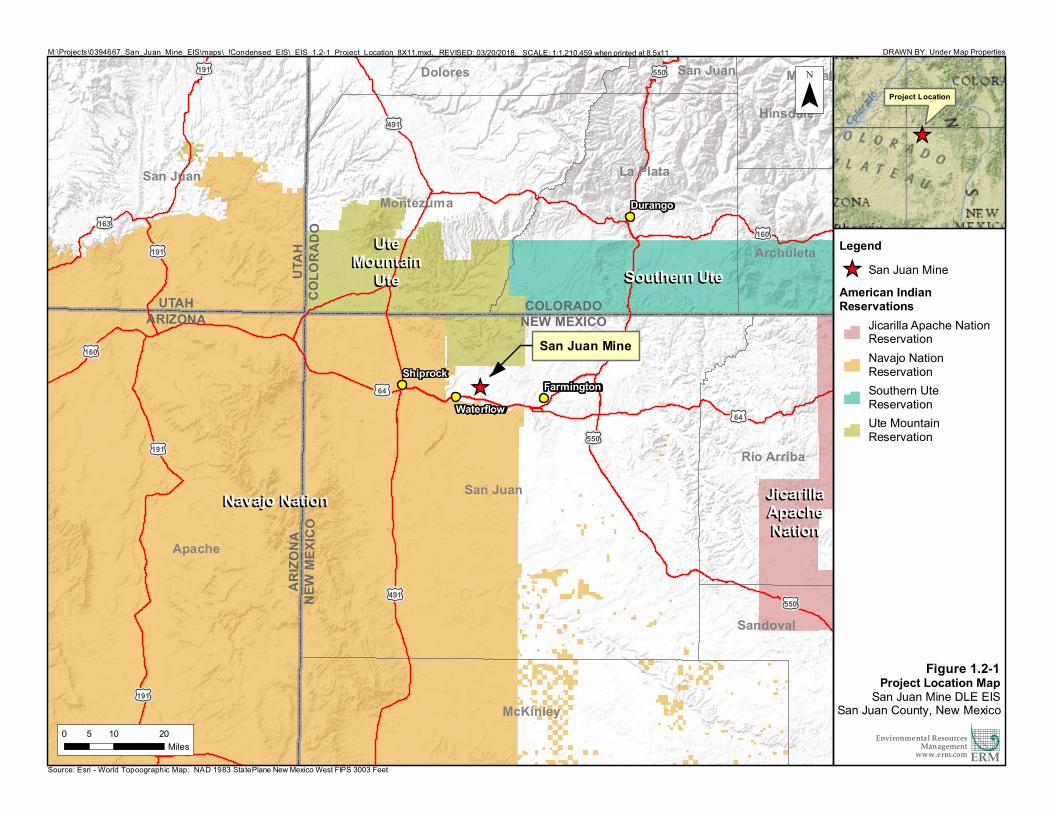
Source: Esri - World Topoographic Map; NAD 1983 StatePlane New Mexico West FIPS 3003 Feet
M:\Projects\0394667_San_Juan_Mine_EIS\maps\_!Condensed_EIS\_EIS_1.2-1_Project_Location_8X11.mxd, REVISED: 03/20/2018, SCALE: 1:1,210,459 when printed at 8.5x11
_̂
ARIZO
NANE
W M
EXIC
OARIZONA
UTAHNEW MEXICOCOLORADOCOLO
RADO
UTAH
Apache
McKinley
Sandoval
Archuleta
Dolores
Hinsdale
La Plata
Mineral
Montezuma
San Juan
Rio Arriba
San Juan
San Juan
£¤191 £¤550
£¤550
£¤64
£¤160
£¤163
£¤191
£¤191
£¤160
£¤491
£¤64
£¤191
£¤491
£¤550
Southern UteSouthern UteUteUte
MountainMountainUteUte
Navajo NationNavajo Nation JicarillaJicarillaApacheApacheNationNation
Durango
FarmingtonShiprock
Waterflow
Legend_̂ San Juan MineAmerican IndianReservations
Jicarilla Apache NationReservationNavajo NationReservationSouthern UteReservationUte MountainReservation
DRAWN BY: Under Map Properties
0 10 205Miles
¯_̂
Environmental ResourcesManagement
www.erm.com
Figure 1.2-1Project Location Map
San Juan Mine DLE EISSan Juan County, New Mexico
ERM
San Juan Mine
Project Location

Draft Environmental Impact Statement Section 1 San Juan Mine Deep Lease Extension Introduction
4
1.3. PROJECT BACKGROUND This EIS addresses the potential direct impacts of underground mining within the DLE at the San Juan Mine; the indirect impacts of coal combustion, including air quality and related indirect impacts and disposal of coal combustion residuals (CCR); and cumulative impacts of mining within the DLE in combination with other past, current, and reasonably foreseeable future projects in the impacted area. The following sub-sections provide background information on the San Juan Mine and the Generating Station to provide context for the Proposed Action, affected environment, and analysis of environmental consequences.
1.3.1. San Juan Mine The Public Service Coal Company began acquiring surface and mineral leases in the 1960s for coal extraction from San Juan Mine. The individual surface leases consisted of several Federal, state, and private leases that were acquired at various times, collectively known as the Fruitland Leases. In the early 1970s, Public Service Coal Company transferred the surface mining leases to Western Coal Company, which began mining at San Juan Mine in 1973. The mine began as a surface operation using truck and shovel and dragline mining techniques. In 1980, Western Coal Company subleased the mining rights to Utah International, Inc. Utah International, Inc. then subleased the mining leases to SJCC, then a subsidiary of Utah International, Inc. The Deep Lease (Federal Coal Lease NM-28093) was acquired in 1980 to allow for continuation of mining using underground mining techniques once permits were obtained. In the early 1980s, Broken Hill Proprietary Company Limited (BHP) acquired Utah International, Inc. BHP changed its name to BHP Billiton in 2001; during this transition period, SJCC and all surface and underground leases were transferred to BHP Billiton. In 2016, Westmoreland Coal Company purchased SJCC from BHP Billiton and acquired the mining leases and permits for operation of San Juan Mine.
The ASLM approved the original Mine Plan Decision Document for the San Juan Mine on Federal Coal Lease NM-0315559 on January 1, 1986. In 2001, the ASLM approved a Mining Plan Modification to allow the San Juan Mine to transition from a surface mining operation to an underground longwall mining operation. Following approval, SJCC began mining underground in 2002 in the Deep Lease area pursuant to Federal Coal Lease NM-028093, which was approved by the BLM in 1980 and approved by the ASLM on January 11, 2001.
In 1998, the BLM issued its decision record for the Proposed Coal Leasing Area Resource Management Plan (RMP) Amendment/Environmental Assessment, amending the 1988 Farmington RMP to include Federal Coal Lease NM-99144 for the San Juan Mine’s DLE (BLM-FFO 1998). With the addition of the DLE to the Deep Lease area, the total surface acreage of the leased area at San Juan Mine (BLM and New Mexico leases) is 18,509 acres. This EIS pertains to the acreage associated with the DLE, not the Deep Lease area.
SJCC submitted a Mining Plan Modification to begin mining within the DLE on January 22, 1998. The New Mexico MMD approved the Mining Plan Modification for the DLE on October 22, 1999. In 2008, OSMRE developed a Mine Plan Decision Document for the DLE Mining Plan Modification, relying on the BLM’s 1998 decision record for NEPA compliance. The Mining Plan Modification was approved by the ASLM on January 17, 2008. The DOI is reevaluating this decision, as explained in Section 1.1, pursuant to the voluntary remand approved by the U.S. District Court.
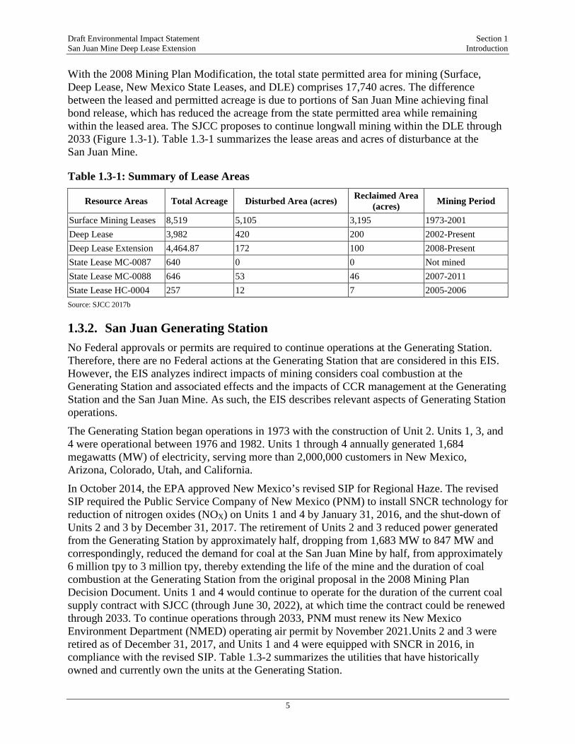
Draft Environmental Impact Statement Section 1 San Juan Mine Deep Lease Extension Introduction
5
With the 2008 Mining Plan Modification, the total state permitted area for mining (Surface, Deep Lease, New Mexico State Leases, and DLE) comprises 17,740 acres. The difference between the leased and permitted acreage is due to portions of San Juan Mine achieving final bond release, which has reduced the acreage from the state permitted area while remaining within the leased area. The SJCC proposes to continue longwall mining within the DLE through 2033 (Figure 1.3-1). Table 1.3-1 summarizes the lease areas and acres of disturbance at the San Juan Mine.
Table 1.3-1: Summary of Lease Areas
Resource Areas Total Acreage Disturbed Area (acres) Reclaimed Area (acres) Mining Period
Surface Mining Leases 8,519 5,105 3,195 1973-2001 Deep Lease 3,982 420 200 2002-Present Deep Lease Extension 4,464.87 172 100 2008-Present State Lease MC-0087 640 0 0 Not mined State Lease MC-0088 646 53 46 2007-2011 State Lease HC-0004 257 12 7 2005-2006 Source: SJCC 2017b
1.3.2. San Juan Generating Station No Federal approvals or permits are required to continue operations at the Generating Station. Therefore, there are no Federal actions at the Generating Station that are considered in this EIS. However, the EIS analyzes indirect impacts of mining considers coal combustion at the Generating Station and associated effects and the impacts of CCR management at the Generating Station and the San Juan Mine. As such, the EIS describes relevant aspects of Generating Station operations.
The Generating Station began operations in 1973 with the construction of Unit 2. Units 1, 3, and 4 were operational between 1976 and 1982. Units 1 through 4 annually generated 1,684 megawatts (MW) of electricity, serving more than 2,000,000 customers in New Mexico, Arizona, Colorado, Utah, and California.
In October 2014, the EPA approved New Mexico’s revised SIP for Regional Haze. The revised SIP required the Public Service Company of New Mexico (PNM) to install SNCR technology for reduction of nitrogen oxides (NOX) on Units 1 and 4 by January 31, 2016, and the shut-down of Units 2 and 3 by December 31, 2017. The retirement of Units 2 and 3 reduced power generated from the Generating Station by approximately half, dropping from 1,683 MW to 847 MW and correspondingly, reduced the demand for coal at the San Juan Mine by half, from approximately 6 million tpy to 3 million tpy, thereby extending the life of the mine and the duration of coal combustion at the Generating Station from the original proposal in the 2008 Mining Plan Decision Document. Units 1 and 4 would continue to operate for the duration of the current coal supply contract with SJCC (through June 30, 2022), at which time the contract could be renewed through 2033. To continue operations through 2033, PNM must renew its New Mexico Environment Department (NMED) operating air permit by November 2021.Units 2 and 3 were retired as of December 31, 2017, and Units 1 and 4 were equipped with SNCR in 2016, in compliance with the revised SIP. Table 1.3-2 summarizes the utilities that have historically owned and currently own the units at the Generating Station.
LegendSan Juan GeneratingStation PropertyBoundaryTownshipSection
Project BoundariesLease BoundaryPermit BoundaryDeep Lease AreaDeep Lease Extension
M:\Projects\0394667_San_Juan_Mine_EIS\maps\_!Condensed_EIS\_EIS_1.3-1_Lease_Areas_8X11.mxd, REVISED: 03/21/2018, SCALE: 1:73,009 when printed at 8.5x11 DRAWN BY: Under Map Properties
0 1 20.5Miles
¯_̂
Source: Esri - World Topoographic Map; NAD 1983 StatePlane New Mexico West FIPS 3003 Feet
Environmental ResourcesManagement
www.erm.com
Figure 1.3-1Lease Areas within the
San Juan MineSan Juan Mine DLE EIS
San Juan County, New Mexico
ERM
Project Location
£¤64
£¤64
Waterflow
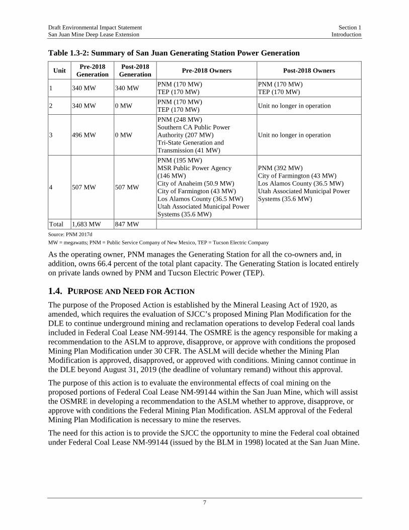
Draft Environmental Impact Statement Section 1 San Juan Mine Deep Lease Extension Introduction
7
Table 1.3-2: Summary of San Juan Generating Station Power Generation
Unit Pre-2018 Generation
Post-2018 Generation Pre-2018 Owners Post-2018 Owners
1 340 MW 340 MW PNM (170 MW) TEP (170 MW)
PNM (170 MW) TEP (170 MW)
2 340 MW 0 MW PNM (170 MW) TEP (170 MW) Unit no longer in operation
3 496 MW 0 MW
PNM (248 MW) Southern CA Public Power Authority (207 MW) Tri-State Generation and Transmission (41 MW)
Unit no longer in operation
4 507 MW 507 MW
PNM (195 MW) MSR Public Power Agency (146 MW) City of Anaheim (50.9 MW) City of Farmington (43 MW) Los Alamos County (36.5 MW) Utah Associated Municipal Power Systems (35.6 MW)
PNM (392 MW) City of Farmington (43 MW) Los Alamos County (36.5 MW) Utah Associated Municipal Power Systems (35.6 MW)
Total 1,683 MW 847 MW Source: PNM 2017d MW = megawatts; PNM = Public Service Company of New Mexico, TEP = Tucson Electric Company
As the operating owner, PNM manages the Generating Station for all the co-owners and, in addition, owns 66.4 percent of the total plant capacity. The Generating Station is located entirely on private lands owned by PNM and Tucson Electric Power (TEP).
1.4. PURPOSE AND NEED FOR ACTION The purpose of the Proposed Action is established by the Mineral Leasing Act of 1920, as amended, which requires the evaluation of SJCC’s proposed Mining Plan Modification for the DLE to continue underground mining and reclamation operations to develop Federal coal lands included in Federal Coal Lease NM-99144. The OSMRE is the agency responsible for making a recommendation to the ASLM to approve, disapprove, or approve with conditions the proposed Mining Plan Modification under 30 CFR. The ASLM will decide whether the Mining Plan Modification is approved, disapproved, or approved with conditions. Mining cannot continue in the DLE beyond August 31, 2019 (the deadline of voluntary remand) without this approval.
The purpose of this action is to evaluate the environmental effects of coal mining on the proposed portions of Federal Coal Lease NM-99144 within the San Juan Mine, which will assist the OSMRE in developing a recommendation to the ASLM whether to approve, disapprove, or approve with conditions the Federal Mining Plan Modification. ASLM approval of the Federal Mining Plan Modification is necessary to mine the reserves.
The need for this action is to provide the SJCC the opportunity to mine the Federal coal obtained under Federal Coal Lease NM-99144 (issued by the BLM in 1998) located at the San Juan Mine.
Draft Environmental Impact Statement Section 1 San Juan Mine Deep Lease Extension Introduction
8
The applicant’s objective for the Project (proposed Mining Plan Modification) is to allow continued operations at the San Juan Mine within the DLE through 2033. The Project would be accomplished in a manner consistent with the approved BLM lease agreement, the BLM Resource Recovery and Protection Plan, and all pertinent Federal and state regulations.
1.5. AGENCY AUTHORITY AND ACTIONS This EIS satisfies the NEPA requirements of the court-approved voluntary remand to re-evaluate the environmental impacts of the PAP for the Mining Plan Modification submitted by the SJCC to the New Mexico MMD on January 22, 1998. The New Mexico MMD approved the underground mining permit for the DLE in 1999, and the BLM approved the lease for the DLE in 1998. The Court’s order has no bearing on these decisions or approvals; however, the OSMRE requested that both the BLM and the New Mexico MMD participate as Cooperating Agencies for this EIS.
In addition to this NEPA review, the OSMRE’s Federal action requires two other consultations: Section 7 of the Endangered Species Act (ESA) and Section 106 of the National Historic Preservation Act (NHPA). These consultations are being implemented in parallel to the NEPA process; each analysis provides useful information to the others, but they follow separate tracks and satisfy separate legal requirements.
1.5.1. Lead Agency – Office of Surface Mining Reclamation and Enforcement The OSMRE is the Lead Agency directing EIS preparation for the Project. The OSMRE will make a recommendation to the ASLM about decisions on the proposed DLE Mining Plan Modification, specifically whether to approve, approve with conditions, or disapprove the proposed Mining Plan Modification, and associated reclamation activities, in the DLE of the San Juan Mine.
1.5.2. Cooperating Agencies As defined in the NEPA regulations, (40 CFR 1508.5), “cooperating agency” means any Federal agency other than a Lead Agency, which has jurisdiction by law or special expertise with respect to any environmental impact involved in a proposal (or a reasonable alternative) for legislation significantly affecting the quality of the human environment. A State or local agency of similar qualifications may, by agreement with the lead agency, become a cooperating agency. There are four Cooperating Agencies on this EIS, and each is providing technical assistance to the OSMRE in the development of this EIS: BLM, New Mexico MMD, U.S. Fish and Wildlife Service (FWS), and U.S. Environmental Protection Agency (EPA). The role of each is described in Table 1.5-1.
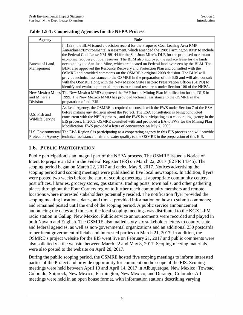
Draft Environmental Impact Statement Section 1 San Juan Mine Deep Lease Extension Introduction
9
Table 1.5-1: Cooperating Agencies for the NEPA Process
Agency Role
Bureau of Land Management
In 1998, the BLM issued a decision record for the Proposed Coal Leasing Area RMP Amendment/Environmental Assessment, which amended the 1988 Farmington RMP to include the Federal Coal Lease NM–99144 for the San Juan Mine’s DLE for the proposed maximum economic recovery of coal reserves. The BLM also approved the surface lease for the lands occupied by the San Juan Mine, which are located on Federal land overseen by the BLM. The BLM also approved the Resource Recovery and Protection Plan and consulted with the OSMRE and provided comments on the OSMRE’s original 2008 decision. The BLM will provide technical assistance to the OSMRE in the preparation of this EIS and will also consult with the OSMRE along with the New Mexico State Historic Preservation Officer (SHPO) to identify and evaluate potential impacts to cultural resources under Section 106 of the NHPA.
New Mexico Mines and Minerals Division
The New Mexico MMD approved the PAP for the Mining Plan Modification for the DLE in 1999. The New Mexico MMD has provided technical assistance to the OSMRE in the preparation of this EIS.
U.S. Fish and Wildlife Service
As Lead Agency, the OSMRE is required to consult with the FWS under Section 7 of the ESA before making any decision about the Project. The ESA consultation is being conducted concurrent with the NEPA process, and the FWS is participating as a cooperating agency in the EIS process. In 2005, OSMRE consulted with and provided a BA to FWS for the Mining Plan Modification. FWS provided a letter of concurrence on July 7, 2005.
U.S. Environmental Protection Agency
The EPA Region 6 is participating as a cooperating agency in this EIS process and will provide technical assistance in air and water quality to the OSMRE in the preparation of this EIS.
1.6. PUBLIC PARTICIPATION Public participation is an integral part of the NEPA process. The OSMRE issued a Notice of Intent to prepare an EIS in the Federal Register (FR) on March 22, 2017 (82 FR 14745). The scoping period began on March 22, 2017 and ended May 8, 2017. Notices advertising the scoping period and scoping meetings were published in five local newspapers. In addition, flyers were posted two weeks before the start of scoping meetings at appropriate community centers, post offices, libraries, grocery stores, gas stations, trading posts, town halls, and other gathering places throughout the Four Corners region to further reach community members and remote locations where interested stakeholders potentially resided. The notification flyer provided the scoping meeting locations, dates, and times; provided information on how to submit comments; and remained posted until the end of the scoping period. A public service announcement announcing the dates and times of the local scoping meetings was distributed to the KGXL-FM radio station in Gallup, New Mexico. Public service announcements were recorded and played in both Navajo and English. The OSMRE also mailed sixty-six stakeholder letters to county, state, and federal agencies, as well as non-governmental organizations and an additional 230 postcards to pertinent government officials and interested parties on March 21, 2017. In addition, the OSMRE’s project website for the EIS went live on February 21, 2017 and public comments were also solicited via the website between March 22 and May 8, 2017. Scoping meeting materials were also posted to the website on April 28, 2017.
During the public scoping period, the OSMRE hosted five scoping meetings to inform interested parties of the Project and provide opportunity for comment on the scope of the EIS. Scoping meetings were held between April 10 and April 14, 2017 in Albuquerque, New Mexico; Towoac, Colorado; Shiprock, New Mexico; Farmington, New Mexico; and Durango, Colorado. All meetings were held in an open house format, with information stations describing varying

Draft Environmental Impact Statement Section 1 San Juan Mine Deep Lease Extension Introduction
10
aspects of the Project located throughout the venue and subject matter experts available to answer questions and describe the process and analysis. During all scoping meetings, opportunity to comment in written and oral form via a court reporter was provided; translation services were provided for Navajo speakers at the Shiprock meeting and Ute Mountain Ute speakers at the Towoac meeting. Written, oral, and video comments were also received via email, fax, and the U.S. Postal Service mail.
The OSMRE received a total of 3,556 comments during the scoping period. Pursuant to NEPA regulations 40 CFR 1500.4(g), comments received during the scoping process were reviewed to identify additional significant environmental issues for the EIS. Many comment letters received during the scoping period addressed more than one topic. The OSMRE catalogued all issues identified in scoping comments, both written and oral, in a database, and identified comments in the section of this EIS where the issue is addressed. The topics that received the greatest number of comments during the scoping period were related to air quality and climate change, socioeconomics and environmental justice, alternatives, and water resources. The scope of this EIS reflects the scope of the OSMRE responses to the comments received during the scoping period. The scoping process identified several issues, which are addressed in the EIS, as indicated below:
• The potential for adverse effects to air quality from combustion of mined coal (Section 4.1);
• The potential effects of the Project on climate change, and subsequent effects to other resource areas (Section 4.2, and as applicable, Sections 4.7, 4.8, and 4.16);
• The potential for the Project to adversely affect human health, through air emissions and effects to water quality (Section 4.16)
• The potential for the Project to adversely affect drinking water quality (Section 4.5);
• The potential effects to groundwater quality resulting from placement of CCR during reclamation (Section 4.5);
• The potential loss of economic revenue from the operation of the San Juan Mine under the No Action Alternative (Section 4.11); and
• Consideration of an alternative describing a transition away from coal-fired power (Section 2).
Potential impacts of the Project are discussed in environmental consequences (Section 4). Following publication of this Draft EIS and receipt of comments received during the public review period, the OSMRE will prepare and publish a Final EIS that will include a detailed response to all comments received on the Draft EIS.
Draft Environmental Impact Statement Section 2 San Juan Mine Deep Lease Extension Description of the Proposed Action and Alternatives
11
2. DESCRIPTION OF THE PROPOSED ACTION AND ALTERNATIVES
The Proposed Action involves the OSMRE’s consideration of SJCC’s Mining Plan Modification for the DLE, beginning operations in 2008 and continuing through 2033. CEQ and DOI NEPA regulations require the Lead Agency to rigorously explore and objectively evaluate all reasonable alternatives, including the No Action Alternative. If applicable, alternatives that are outside the Lead Agency’s jurisdiction may be evaluated, if such alternatives would accomplish the Proposed Action’s purpose and need (40 CFR 1502.14).
This EIS describes the environmental consequences of continued mining in the DLE and the indirect effect of combustion of the coal at the Generating Station. As such, the current operation of the San Juan Mine and the current activities related to coal combustion at the Generating Station are essential to understanding and analyzing past and future operations and are described in Section 2.1. Section 2.2 outlines the screening-level analysis used by the OSMRE for all of the alternatives explored and evaluated. If an alternative satisfies all screening-level analysis criteria, it is carried forth for full analysis in the EIS. Section 2.3 provides a discussion of the alternatives that were carried forth for more detailed analysis in the EIS. Section 2.4 provides a description of federal and state regulatory framework, protective measures and best management practices (BMPs) that are included as part of the description of all action alternatives to minimize potential impacts.
2.1. DESCRIPTION OF CURRENT OPERATIONS
2.1.1. San Juan Mine Current Operations The San Juan Mine is located on the western flank of the San Juan Basin (Figure 2.1-1; coal-bearing formations are shown in black). The underground mining operation targets the Fruitland Formation Number 8 coal seam, the shallowest coal-bearing formation; the seam averages 11 feet in thickness in the permit area. Mined coal is transported by either chain conveyor or mobile equipment to conveyor belts that remove it from the mine. At the surface, coal is conveyed to a stacking tube. The coal is then loaded into large-capacity haul trucks using front-end loaders and taken to coal stockpiles or taken to the preparation plant where it is crushed, sampled, and transported by covered conveyor to the Generating Station.
The SJCC has a contract with the Generating Station’s owners to supply coal until June 30, 2022. Beginning January 1, 2018, annual coal production from both the Deep Lease and the DLE decreased from approximately 6 million tpy to 3 million tpy due to the closure of Units 2 and 3 at the Generating Station in accordance with New Mexico’s revised SIP. Workforce reductions occurred in June of 2016 and November of 2017 at San Juan Mine as a result of these changes. The tonnage of coal supplied per year is subject to change depending on the Generating Station’s demand for power. Recent production volumes are provided in Table 2.1-1.

Draft Environmental Impact Statement Section 2 San Juan Mine Deep Lease Extension Description of the Proposed Action and Alternatives
12
Figure 2.1-1: Stratigraphic Cross Section of San Juan Basin
Source: OSMRE 2015 Note: Generalized geological cross-section through the San Juan Basin. Coal-bearing beds are shown in black. The San Juan Mine produces from the shallowest formation, the Fruitland Formation.
Table 2.1-1: Recent Coal Production Volumes at the San Juan Mine
Year Total Volume from San Juan Mine (tons) Volume Mined from the DLE (tons) 2008 6,300,468 132,797 2009 6,499,195 426,081 2010 4,691,591 366,135 2011 3,983,023 584,224 2012 5,414,381 4,522,410 2013 5,989,380 5,207,177 2014 8,799,594 2,152,365 2015 6,505,549 2,861,045 2016 4,316,558 2,171,830 Source: SJCC 2017c
Mining in the DLE commenced upon approval in 2008 (Table 2.1-1). Total volumes include volumes mined from the DLE, the Deep Lease, and other state leases located within the San Juan Mine permit area. Volumes of coal mined from the DLE have expanded as the Deep Lease nears completion. The first single mining panel exclusively in the DLE began in May 2012.

Draft Environmental Impact Statement Section 2 San Juan Mine Deep Lease Extension Description of the Proposed Action and Alternatives
13
2.1.1.1. Longwall Mining Longwall mining is the primary mining method used for the San Juan Mine underground operation. The mine layout consists of main and sub-main entries to access the coal reserve. Room and pillar methods are used to support the mains and sub-mains. The underground mine is operated as a bleederless mine, meaning the mined-out areas of longwall panels are sealed and not ventilated.
Subsidence occurs progressively behind the longwall mining area, resulting in a surface expression that generally ranges from four to eight feet. The amount of subsidence depends on the thickness of coal extracted and depth to coal: shallower depth to coal and thicker coal units generally creates more subsidence. Surface disturbance associated with the underground mining operation is limited to access roads and drill pads for boreholes (described below), along with long-term support and ventilation facilities. This disturbance represents a relatively small percentage of the lease area (approximately 8-12 percent).
San Juan Mine has constructed a redundant ventilation system comprised of two fans, one 20-foot ventilation shaft, and four portals (Figure 2.1-2). This redundant system allows for maintenance and backup in case of a failure of one of the attached fans. The existing ventilation system is expected to be used throughout the life of the mine. The ventilation shaft is provided with an emergency escape system.
Figure 2.1-2: Photograph of Aboveground Ventilation System at the San Juan Mine
Source: Catalyst Environmental Solutions 2016
In addition to the ventilation and transportation systems, the active mining face includes several additional supporting systems, including electrical power distribution, water for dust and fire

Draft Environmental Impact Statement Section 2 San Juan Mine Deep Lease Extension Description of the Proposed Action and Alternatives
14
prevention, groundwater discharge2 (if needed), compressed air for general mine use, nitrogen gas to prevent spontaneous combustion, rock dust (pulverized limestone) to prevent coal dust ignition, atmospheric monitoring sensors, and communications and personnel tracking.
Mine layouts consist of main and sub-main entries where coal removal is required to access the reserve. Mains and sub-mains typically have five to nine entries depending on mining conditions, ventilation, and access requirements. The entries are used for intake and return air ventilation, coal haulage, and personnel and material transportation. The entries are separated as necessary by stoppings to facilitate ventilation. Coal in the pillars of mains and sub-mains developments is typically not recovered. Coal may also be left in the roof and floor of the entries and crosscuts to assist in ground control.
Longwall panel layouts consist of gate roads and bleeders to define blocks 5,000 to 15,000 feet in length and generally 1,000 feet wide. Gate roads are developed from mains and sub-mains. Room and pillar methods are used to develop the gate roads and bleeders. The size and configuration of longwall gate pillars are based on geology and depth of cover. The longwall is set up to extract coal across the face for 1,000 feet (Figure 2.1-3). Coal in the pillars of gate road developments is typically not recovered. The longwall operations extract most of the coal from roof to floor of the seam; however, some roof and floor coal may be left adjacent to gate roads as the face is profiled to meet the height of the gate road entries. Where conditions dictate, roof or floor coal may be left along the face of the panel to facilitate safe and efficient operation of the longwall equipment or maintain required coal quality.
Figure 2.1-3: Typical Longwall Equipment Arrangement
Source: SJCC 2017c
Normal mining progression involves the shearer slicing a three-foot web of coal along the width of the face, with the AFC and shields moving up to position for the next pass. The large open area behind the supports eventually subsides after mining is complete, thus forming an area known as the gob or goaf. The shields are enclosed at the rear to protect both the miners and the 2 A portion of the groundwater inflow and the water imported into the mine is removed through evaporation by the ventilation system. Some of the water is also retained in the gob at the subsided longwall panels. Surplus water in the underground workings is pumped to the surface to one of the seven evaporation ponds (above the Juniper Pit highwall). Water in the ponds is allowed to evaporate, per the requirements of Permit 2197 from the New Mexico State Engineer. For the calendar year 2016, as much as 86.85 acre-feet of water evaporated.
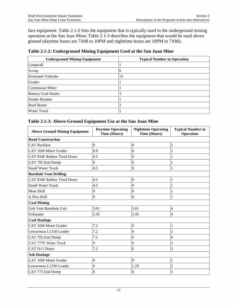
Draft Environmental Impact Statement Section 2 San Juan Mine Deep Lease Extension Description of the Proposed Action and Alternatives
15
face equipment. Table 2.1-2 lists the equipment that is typically used in the underground mining operation at the San Juan Mine; Table 2.1-3 describes the equipment that would be used above ground (daytime hours are 7AM to 10PM and nighttime hours are 10PM to 7AM).
Table 2.1-2: Underground Mining Equipment Used at the San Juan Mine
Underground Mining Equipment Typical Number in Operation Longwall 1 Scoop 6 Personnel Vehicles 15 Grader 1 Continuous Miner 1 Battery Coal Hauler 3 Feeder Breaker 1 Roof Bolter 2 Water Truck 1
Table 2.1-3: Above-Ground Equipment Use at the San Juan Mine
Above Ground Mining Equipment Daytime Operating Time (Hours)
Nighttime Operating Time (Hours)
Typical Number in Operation
Road Construction CAT Backhoe 9 0 2 CAT 16M Motor Grader 0.8 0 1 CAT 834F Rubber Tired Dozer 4.5 0 1 CAT 785 End Dump 9 0 1 Small Water Truck 4.5 0 1 Borehole Vent Drilling CAT 834F Rubber Tired Dozer 4.5 0 1 Small Water Truck 4.5 0 1 Mote Drill 9 0 1 A Plus Drill 9 0 1 Coal Mining Gob Vent Borehole Unit 3.01 3.01 4 Exhauster 2.45 2.45 4 Coal Haulage CAT 16M Motor Grader 7.2 0 1 Letourneau L1350 Loader 7.2 0 2 CAT 785 End Dump 7.2 0 6 CAT 777F Water Truck 9 0 2 CAT D11 Dozer 7.2 0 3 Ash Haulage CAT 16M Motor Grader 0 9 1 Letourneau L1350 Loader 0 1.29 2 CAT 775 End Dump 0 9 5

Draft Environmental Impact Statement Section 2 San Juan Mine Deep Lease Extension Description of the Proposed Action and Alternatives
16
Above Ground Mining Equipment Daytime Operating Time (Hours)
Nighttime Operating Time (Hours)
Typical Number in Operation
CAT 777F Water Truck 0 9 1 CAT D10 Dozer 0 9 1 CAT D11 Dozer 2.57 9 1 Reclamation CAT 16M Motor Grader 1 9 1 CAT 980F Loader 9 0 1 Letourneau L1400 Loader 1.8 9 1 CAT 785 End Dump 1.8 9 4 CAT 777F Water Truck 1.8 9 2 CAT D10 Dozer 9 9 2 CAT D11 Dozer 3.86 9 3 Personal Vehicles Light-Duty Trucks 2-5 0-5 48 Heavy-Duty Trucks 1-8 0-8 9 Car/SUV 1 0-1 2 Van 1 1 1
Short-Term Ventilation Shafts The DLE is ventilated by the main shaft, a 20-foot finished diameter installation intended to be in service for the life of the mine. From time to time, SJCC will install smaller diameter ventilation shafts designed to meet specific short-term needs. The ventilation shafts are installed by drilling from the surface, offset approximately 300 to 500 feet from the longwall panel setup room before the mining of coal in the panel. Spacing, location, and design of these shafts are ultimately dependent on anticipated volumes of methane (CH4) and the resulting required fresh air for dilution. The shafts are used to provide ventilation to the longwall seal line, consisting of either intake air via an open shaft, or exhaust air achieved by mounting a centrifugal fan onto the shaft. Where a fan is used, a powerline must be extended from current SJCC facilities to the shaft site. Typically, the shafts will be drilled to accommodate a casing of up to 72 inches in diameter. Each shaft will generally be drilled to the depth of the Fruitland Formation Number 8 coal seam. Smooth steel casing will be installed from the surface to the top of the Fruitland Formation Number 8 seam.
Barrier Pillars A barrier pillar is a large block of solid coal left in place to support the open room and protect active mine workings (mains or submains). Barrier pillars vary in size, and designs are primarily based on life expectancy required for the barrier and the depth of overburden. In certain cases, a barrier pillar may also be sized to protect surface areas from subsidence due to caving over the longwall panel. Barrier pillars may also be left between groups of longwall panels to separate the mine into discrete mining districts. This may be necessary to ensure ventilation can be maintained and controlled, to facilitate sealing off mining areas to control spontaneous combustion.

Draft Environmental Impact Statement Section 2 San Juan Mine Deep Lease Extension Description of the Proposed Action and Alternatives
17
Mining Setup and Coal Delivery Development using room and pillar mining techniques uses a system of continuous miners, haulage vehicles, and a conveyor system to cut and transport the coal out of the mine. Continuous miners cut the coal from the seam. The cut coal is then loaded from the miners into battery-powered haulage vehicles for transport to the feeder-breaker. Alternatively, coal mined from the longwall is dropped onto a conveyor of steel chains and metal bars, which transports the coal to the stage loader where it is sent through the feeder-breaker to crush and reduce the coal grain size. It is then transferred to the main conveyor for transport out of the mine. The conveyor system operates approximately 12 hours per day, 4 days per week. At the surface, coal is conveyed to a stacking tube. The coal is then loaded into large-capacity haul trucks using front-end loaders and taken to the coal preparation plant where it is crushed, sampled, and stacked. Figure 2.1-5 shows the location of these features and other surface features at the San Juan Mine.
There are two active coal stockpiles at the San Juan Mine, known as Juniper and Northfield, each with a capacity of approximately 3 million tons. Surface haulage vehicles typically operate 18 hours per day for 10 shifts per week3. The coal stockpiles are constructed by the coal haulers dumping coal on top of the stockpile and periodically compacting (Figure 2.1-4). Support equipment is used to level and maintain the stockpile for future dumping. Runoff is controlled by ditches, ponds, in-pit drainage, and other means to comply with New Mexico Administrative Code (NMAC) 19.8.9 and New Mexico MMD Permit 14-01. The coal stockpiles and associated haul roads will continue to be used through the life of mine and will be one of the last facilities to be reclaimed at closure of the mine.
Figure 2.1-4: Photograph of an Active Coal Stockpile at the San Juan Mine
Source: Catalyst Environmental Solutions 2016
3 This will be reduced to 9 hours per day and five shifts per week starting in 2019.

LegendSan Juan Generating StationProperty Boundary
Project BoundariesLease BoundaryPermit BoundaryDeep Lease AreaDeep Lease Extension
San Juan Mine GroundwaterMonitoring Wells@? Abandoned@? Active
San Juan Mine CoalCombustion Residual Disposal
Future CCR Disposal2016-2018 CCR DisposalHistoric CCR Disposal
Surface Coal ConveyanceStructures
Coal Plant ConveyorCrusherHaulroadSample BuildingConveyor/Stackout TubeStockpile
Oil and Gas WellsM Abandoned
Active9 Mined OutK Sealed
San Juan Mine Existing andSealed Gob VentilationBoreholes
ActiveSealed
Other Existing InfrastructureGas PipelinesUnderground Conveyor BeltEvaporation PondsMain Underground VentilationFan
M:\Projects\0394667_San_Juan_Mine_EIS\maps\_!Condensed_EIS\_EIS_2.1-5_Mining_Operations_8X11.mxd, REVISED: 03/20/2018, SCALE: 1:61,769 when printed at 8.5x11 DRAWN BY: Under Map Properties
0 0.75 1.50.375Miles
¯
Source: Esri - World Topoographic Map; NAD 1983 StatePlane New Mexico West FIPS 3003 Feet
Environmental ResourcesManagement
www.erm.com
Figure 2.1-5Overview of Mine Operations
San Juan Mine DLE EISSan Juan County, New Mexico
ERM
£¤64
£¤64
UndergroundVentilation Fan
San Juan GeneratingStation Raw Water
Reservoir
Crusher
SampleBuilding
ConveyorStockpile
Stockpile
Stackout
Haulroad
Haulroad
1,000Feet

Draft Environmental Impact Statement Section 2 San Juan Mine Deep Lease Extension Description of the Proposed Action and Alternatives
19
The coal preparation plant is a crushing and stacking facility. Water is used for dust suppression and housekeeping purposes to remove accumulations of coal fines from the equipment, and any surface water drainage flows to a sedimentation pond sized for runoff from a 100-year magnitude/6-hour duration precipitation event. The coal fines and sediment retained in the sedimentation ponds are periodically excavated and placed in the bottom of the mining pits during reclamation; there is no discharge from this facility area.
Coal delivered to the Generating Station is loaded into a subgrade hopper. Fully enclosed conveyer belt feeder systems transfer the coal from the hopper into enclosed single-roll crushers, coal quality samplers, and scales. The coal is crushed to the contract specifications of 1.25-inch minus diameter to accommodate Generating Station pulverizing mills. Pulverized coal is delivered to coal stacking structures at the Generating Station by an interconnected conveyor and flop gate system, which places the coal into one of the two Generating Station stockpiles (Surgepile C or D).
The Generating Station burns low-rank, low-sulfur, sub-bituminous coal that is mined from the San Juan Mine. Coal heating values range from 8,500 to 10,500 British Thermal Units (BTU) per pound (lb). The coal sales agreement between the SJCC and the Generating Station specifies that coal delivered to the plant be no less than 9,000 BTU/lb on average for each day on which deliveries take place. Coal stockpiles are maintained so that coal delivery and quality requirements can be met at all times, by blending if necessary.
2.1.1.2. Buildings and Support Facilities San Juan Mine buildings and support facilities are located in two areas. The 90-acre main facilities area consists of an engineering and production building, safety building, equipment maintenance shop, weld shop, carpentry shop, vehicle fueling area, warehouse, storage yard, change rooms, coal preparation plant, wash bay, waste facility, sewage facility, security offices, and other administrative buildings. A 25-acre area near the underground portals consists of a vehicle fueling area, storage building and yard, conveyor system, stack out tube, pump house, and small maintenance shop. All of these facilities are currently in use and maintained in good condition and are designed to comply with NMAC 19.8.20.2079, which regulates support facilities for surface mining activities.
2.1.1.3. Water Supply The Generating Station supplies water diverted from the San Juan River to the mine via an 8-inch steel pipe for all uses except potable water. The Generating Station provides potable water via a 3-inch polyvinyl chloride pipe. The San Juan Mine does not have an intake or diversion.
The water rights are held by PNM, TEP, and Arizona Public Service Company (APS) along with the Four Corners Power Plant participants (originally Utah International) and allows diversion of 51,600 acre-feet (AF) of water/year from the San Juan River to supply water to the Four Corners Power Plant, the Generating Station, the Navajo Mine, the La Plata Mine, and the San Juan Mine. The rights are filed with the New Mexico Office of the State Engineer (NMOSE) under Permit 2838, first issued in 1955, and Permit SJ-2197, first issued in 1989. There is a contract between PNM, TEP, and SJCC, which provides water to the San Juan Mine. The first point of diversion that was installed on the San Juan River was the intake that supplies the Four Corners Power Plant, and then water lines branch off the main line to transport water to the other facilities. In 1979, Utah International, then holder of the water rights, applied for a second point
Draft Environmental Impact Statement Section 2 San Juan Mine Deep Lease Extension Description of the Proposed Action and Alternatives
20
of diversion that would supply up to 10,585 AF/year of water to the Generating Station, La Plata Mine, and San Juan Mine. The intake is owned and operated by PNM (Figure 2.1-6). On average, San Juan Mine uses approximately 256 AF/year (Ecosphere 2017a).
2.1.1.4. Surface Water Management SMCRA, NMAC 19.8.9, and the Clean Water Act (CWA) all require that discharge of runoff from disturbed areas is managed to protect receiving waters from excessive sediment or pollutants. Diversion structures (berms or ditches) are used to convey surface water runoff from active mining and reclamation areas to containment or treatment facilities such as the former mining pits or sediment ponds. The retained water is used to suppress dust on haul roads, evaporates, or discharged in accordance with the National Pollutant Discharge Elimination System (NPDES) permit conditions. The NPDES permit requires ponds to contain runoff from a 10-year/24-hour storm event; ponds without spillways are required to hold a 100-year/6-hour storm event (NMAC 19.8.9). The NPDES permit also specifies effluent limitations.
The SJCC also has a General NPDES Permit under Sector H for stormwater and point-source water discharge from coal mine and coal-mining facilities. The SJCC complies with the permit through use of structures (e.g., diversions, check dams, sediment traps, sediment ponds, impoundments) and BMPs (e.g., minimized disturbance areas and surface stabilization such as mulching and temporary seeding).
SJCC maintains a Nationwide Permit (NWP) 50 with the U.S. Army Corps of Engineers (USACE), which allows the installation of low-water crossings and culverts on access roads where Waters of the U.S. are present (e.g., Shumway Arroyo and Hutch Arroyo). Where feasible, SJCC avoids Waters of the U.S. to minimize environmental impacts. Reclamation of these areas is completed in accordance with the New Mexico MMD permit 14-01.
2.1.1.5. Reclamation and Coal Combustion Residuals Reclamation of access roads and drill pads is accomplished by creating soil windrows at the sides of access roads or drill pads. When they are no longer in use, the soil is moved back to replicate the pre-disturbance conditions. The seedbed is then prepared, and the area is seeded with a native seed mix suitable for livestock grazing and wildlife habitat. Mulch is applied to the seeded area and then crimped. Equipment that is used during reclamation at the San Juan Mine is shown in Table 2.1-3.

Legend[i San Juan Mine[i Navajo Mine
[¾Four Corners PowerPlant
[¾San Juan GeneratingStation
Water Features!< Water Intake
Water Pipelines -Schematic Location
M:\Projects\0394667_San_Juan_Mine_EIS\maps\_!Condensed_EIS\_EIS_2.1-6_Water_Intake_Location_8X11.mxd, REVISED: 03/20/2018, SCALE: 1:90,000 when printed at 8.5x11 DRAWN BY: Under Map Properties
0 1 20.5Miles
¯NEW MEXICOCOLORADO
Environmental ResourcesManagement
www.erm.com
Figure 2.1-6Location of Water SupplyIntake for San Juan Mine
and Generating StationSan Juan Mine DLE EIS
San Juan County, New Mexico
ERMSource: Esri - World Topoographic Map; NAD 1983 StatePlane New Mexico West FIPS 3003 Feet

Draft Environmental Impact Statement Section 2 San Juan Mine Deep Lease Extension Description of the Proposed Action and Alternatives
22
Reclamation of the former surface mining operation was completed contemporaneously as mining progressed (Figure 2.1-7). Two pits remain open to facilitate the placement of CCR from the Generating Station. One of these, Piñon Pit, will be fully reclaimed by 2023, while Juniper Pit will remain open for the life of the mine to provide access to the underground operation. Once CCR placement has reached its permitted level (more than 10 feet below the final surface), spoil and topsoil is placed over the top of the CCR and shaped to conform with the final surface reclamation design. Topdressing or topsoil substitute is placed last. SJCC soil surveys determined that soil types found in the San Juan Mine lease generally lack soil horizons containing topsoil. SJCC therefore uses a topsoil substitute material for reclamation4 that promotes plant growth. The seedbed is prepared, the area is seeded, mulch is applied, and the remaining steps of the revegetation plan are carried out to establish a diverse vegetation cover. Reclaimed areas are irrigated from May to mid-October for the first two years. For the first four to six weeks, the area is irrigated for 5 daytime hours at 1.15-inches of water per application, applied every second or third day. For the remainder of the irrigation season the application rate is reduced to 0.5 inches per week.
Figure 2.1-7: Photograph of Reclamation Activity and Completed Reclamation at Piñon Pit
Source: SJCC 2017b
The reclamation topography is designed using geomorphic principles5 to approximate the pre-mine relief and contour, stabilize the surface, prevent excessive erosion, and introduce topographic diversity to support the designated post-mine land use of grazing and wildlife habitat.
Composition and Reporting of CCR San Juan Mine receives CCR from the Generating Station for use in reclamation of the pits of the former surface mining operation, as approved by SJCC’s underground mining permit. Coal combustion byproducts include fly ash, boiler slag, bottom ash, and residues from flue gas desulfurization (FGD). The composition of CCR is primarily silicon dioxide, aluminum oxide, and calcium sulfate; as well as trace levels of arsenic, barium, beryllium, boron, chromium, copper, lead, mercury, selenium, zinc, and other metals at the part per million (ppm) levels. The SJCC reports the release of constituents from the placement of CCR and other mining operations 4 Topsoil substitute must be approved by the New Mexico MMD. The quantity of suitable reclamation material is in accordance with New Mexico MMD Permit 14-01, calculated and reported on an annual basis. 5 The geomorphic approach re-establishes pre-mine drainage densities using hydrologic principles to stabilize drainages and control erosion. The resulting topography is more diverse, blends better into the natural environment, and provides a more diverse wildlife habitat in comparison to the prior methods.
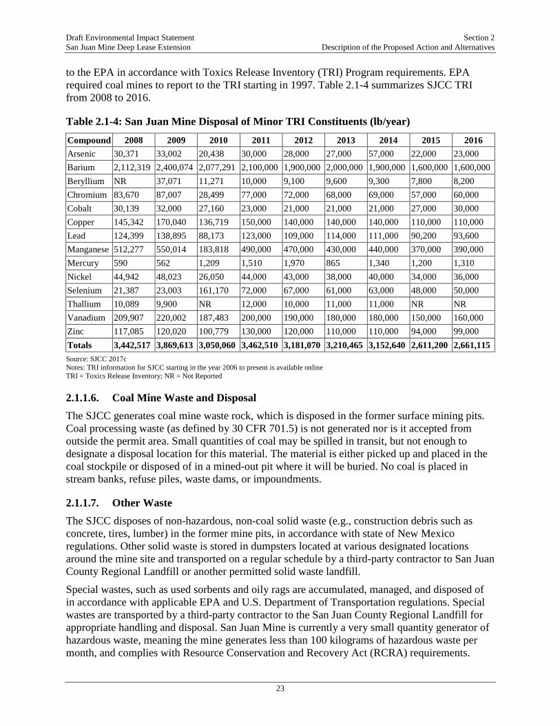
Draft Environmental Impact Statement Section 2 San Juan Mine Deep Lease Extension Description of the Proposed Action and Alternatives
23
to the EPA in accordance with Toxics Release Inventory (TRI) Program requirements. EPA required coal mines to report to the TRI starting in 1997. Table 2.1-4 summarizes SJCC TRI from 2008 to 2016.
Table 2.1-4: San Juan Mine Disposal of Minor TRI Constituents (lb/year)
Compound 2008 2009 2010 2011 2012 2013 2014 2015 2016 Arsenic 30,371 33,002 20,438 30,000 28,000 27,000 57,000 22,000 23,000 Barium 2,112,319 2,400,074 2,077,291 2,100,000 1,900,000 2,000,000 1,900,000 1,600,000 1,600,000 Beryllium NR 37,071 11,271 10,000 9,100 9,600 9,300 7,800 8,200 Chromium 83,670 87,007 28,499 77,000 72,000 68,000 69,000 57,000 60,000 Cobalt 30,139 32,000 27,160 23,000 21,000 21,000 21,000 27,000 30,000 Copper 145,342 170,040 136,719 150,000 140,000 140,000 140,000 110,000 110,000 Lead 124,399 138,895 88,173 123,000 109,000 114,000 111,000 90,200 93,600 Manganese 512,277 550,014 183,818 490,000 470,000 430,000 440,000 370,000 390,000 Mercury 590 562 1,209 1,510 1,970 865 1,340 1,200 1,310 Nickel 44,942 48,023 26,050 44,000 43,000 38,000 40,000 34,000 36,000 Selenium 21,387 23,003 161,170 72,000 67,000 61,000 63,000 48,000 50,000 Thallium 10,089 9,900 NR 12,000 10,000 11,000 11,000 NR NR Vanadium 209,907 220,002 187,483 200,000 190,000 180,000 180,000 150,000 160,000 Zinc 117,085 120,020 100,779 130,000 120,000 110,000 110,000 94,000 99,000 Totals 3,442,517 3,869,613 3,050,060 3,462,510 3,181,070 3,210,465 3,152,640 2,611,200 2,661,115 Source: SJCC 2017c Notes: TRI information for SJCC starting in the year 2006 to present is available online TRI = Toxics Release Inventory; NR = Not Reported
2.1.1.6. Coal Mine Waste and Disposal The SJCC generates coal mine waste rock, which is disposed in the former surface mining pits. Coal processing waste (as defined by 30 CFR 701.5) is not generated nor is it accepted from outside the permit area. Small quantities of coal may be spilled in transit, but not enough to designate a disposal location for this material. The material is either picked up and placed in the coal stockpile or disposed of in a mined-out pit where it will be buried. No coal is placed in stream banks, refuse piles, waste dams, or impoundments.
2.1.1.7. Other Waste The SJCC disposes of non-hazardous, non-coal solid waste (e.g., construction debris such as concrete, tires, lumber) in the former mine pits, in accordance with state of New Mexico regulations. Other solid waste is stored in dumpsters located at various designated locations around the mine site and transported on a regular schedule by a third-party contractor to San Juan County Regional Landfill or another permitted solid waste landfill. Special wastes, such as used sorbents and oily rags are accumulated, managed, and disposed of in accordance with applicable EPA and U.S. Department of Transportation regulations. Special wastes are transported by a third-party contractor to the San Juan County Regional Landfill for appropriate handling and disposal. San Juan Mine is currently a very small quantity generator of hazardous waste, meaning the mine generates less than 100 kilograms of hazardous waste per month, and complies with Resource Conservation and Recovery Act (RCRA) requirements.
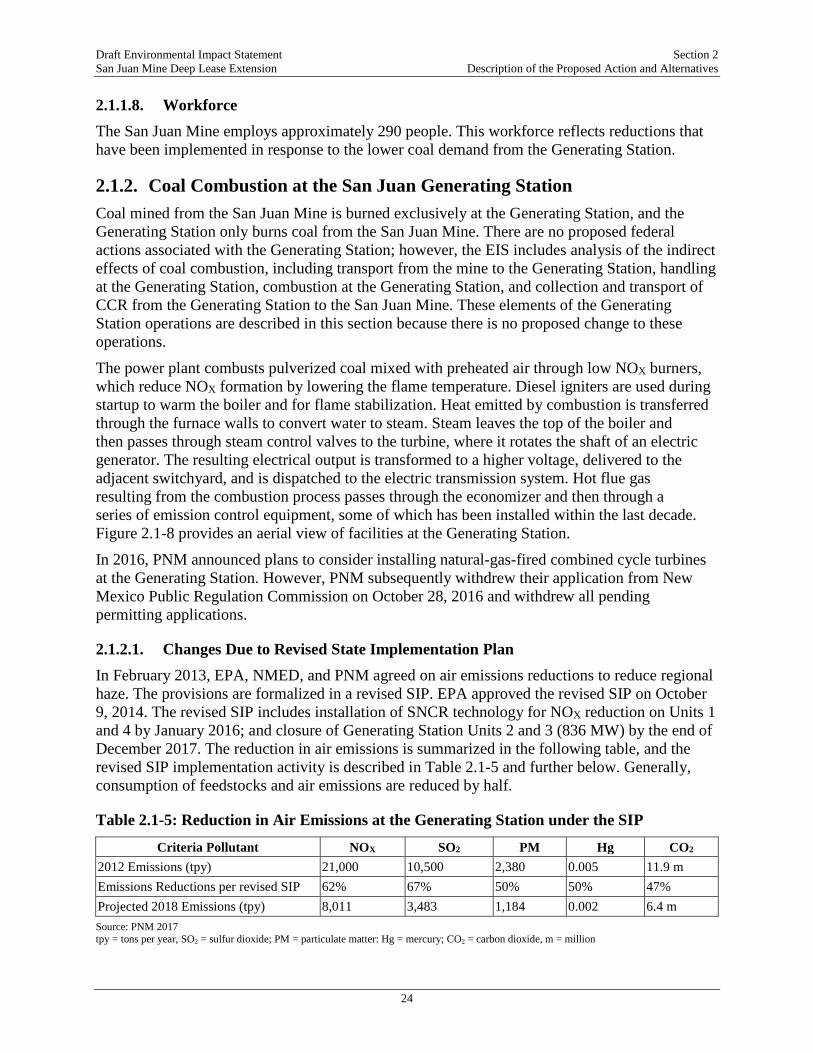
Draft Environmental Impact Statement Section 2 San Juan Mine Deep Lease Extension Description of the Proposed Action and Alternatives
24
2.1.1.8. Workforce The San Juan Mine employs approximately 290 people. This workforce reflects reductions that have been implemented in response to the lower coal demand from the Generating Station.
2.1.2. Coal Combustion at the San Juan Generating Station Coal mined from the San Juan Mine is burned exclusively at the Generating Station, and the Generating Station only burns coal from the San Juan Mine. There are no proposed federal actions associated with the Generating Station; however, the EIS includes analysis of the indirect effects of coal combustion, including transport from the mine to the Generating Station, handling at the Generating Station, combustion at the Generating Station, and collection and transport of CCR from the Generating Station to the San Juan Mine. These elements of the Generating Station operations are described in this section because there is no proposed change to these operations.
The power plant combusts pulverized coal mixed with preheated air through low NOX burners, which reduce NOX formation by lowering the flame temperature. Diesel igniters are used during startup to warm the boiler and for flame stabilization. Heat emitted by combustion is transferred through the furnace walls to convert water to steam. Steam leaves the top of the boiler and then passes through steam control valves to the turbine, where it rotates the shaft of an electric generator. The resulting electrical output is transformed to a higher voltage, delivered to the adjacent switchyard, and is dispatched to the electric transmission system. Hot flue gas resulting from the combustion process passes through the economizer and then through a series of emission control equipment, some of which has been installed within the last decade. Figure 2.1-8 provides an aerial view of facilities at the Generating Station.
In 2016, PNM announced plans to consider installing natural-gas-fired combined cycle turbines at the Generating Station. However, PNM subsequently withdrew their application from New Mexico Public Regulation Commission on October 28, 2016 and withdrew all pending permitting applications.
2.1.2.1. Changes Due to Revised State Implementation Plan In February 2013, EPA, NMED, and PNM agreed on air emissions reductions to reduce regional haze. The provisions are formalized in a revised SIP. EPA approved the revised SIP on October 9, 2014. The revised SIP includes installation of SNCR technology for NOX reduction on Units 1 and 4 by January 2016; and closure of Generating Station Units 2 and 3 (836 MW) by the end of December 2017. The reduction in air emissions is summarized in the following table, and the revised SIP implementation activity is described in Table 2.1-5 and further below. Generally, consumption of feedstocks and air emissions are reduced by half.
Table 2.1-5: Reduction in Air Emissions at the Generating Station under the SIP
Criteria Pollutant NOX SO2 PM Hg CO2 2012 Emissions (tpy) 21,000 10,500 2,380 0.005 11.9 m Emissions Reductions per revised SIP 62% 67% 50% 50% 47% Projected 2018 Emissions (tpy) 8,011 3,483 1,184 0.002 6.4 m Source: PNM 2017 tpy = tons per year, SO2 = sulfur dioxide; PM = particulate matter: Hg = mercury; CO2 = carbon dioxide, m = million

Draft Environmental Impact Statement Section 2 San Juan Mine Deep Lease Extension Description of the Proposed Action and Alternatives
25
Figure 2.1-8: Overview of San Juan Generating Station Facilities
Installation of SNCR on Units 1 and 4 Between January 1, 2016 and December 31, 2017, Units 2 and 3 operated as described above. By January 2016, SNCR systems were operational. The SNCRs function by injecting urea into the boilers where it decomposes to ammonia and reacts with NOX to form nitrogen and water. Urea is delivered to the Generating Station in dry form (pellets) via truck. The revised SIP required PNM to meet an average NOX emission rate of no greater than 0.23 lb/million BTU (MMBtu) on a combined (Units 1 and 4) daily rolling 30 boiler-operating-day average basis, which has been achieved.
2.1.2.2. Coal Combustion and Emissions Controls Before 2008, the units at the facility operated Electrostatic Precipitators (ESPs) to control particulate matter (PM) emissions, and FGD systems to control sulfur dioxide (SO2) emissions. The FGD system is capable of removing up to 96 percent of the SO2 from the flue gas by injecting limestone slurry into the gas stream, which reacts with sulfur to form gypsum, which along with other CCR is collected and taken by San Juan Mine for reclamation of the mine pits.
During late 2007 through early 2009, PNM installed an activated carbon injection system and fabric filter baghouses in the gas path between the existing ESPs and FGDs on all four units to minimize mercury (up to 98 percent removal) and PM emissions. The baghouses then capture the activated carbon and also control PM at a removal rate of approximately 99.9 percent. The ESPs (previously designed to capture PM) were permanently deactivated in 2009, but they ESPs remain in place to decrease the flow velocity and augment PM removal.

Draft Environmental Impact Statement Section 2 San Juan Mine Deep Lease Extension Description of the Proposed Action and Alternatives
26
2.1.2.3. Coal Combustion Residual Production Combustion of coal at the Generating Station results in approximately 25 percent of the initial coal volume being converted to ash (i.e., approximately 750,000 tons of ash will be produced per year after shut-down of Units 2 and 3 in 2017). Ash produced in the combustion process consists of bottom ash and fly ash. The total production rate of furnace bottom ash for Units 1 and 4 is approximately 20 tons per hour during full load conditions. The furnace bottom ash is collected and removed by means of a jet pump system and delivered via sluice water pipelines to dewatering bins. In the bins, the sluice water is decanted and the bottom ash is loaded on to the San Juan Mine.
Fly ash constitutes approximately 80-percent of the Generating Station’s total CCR output. Units 1 and 4 produce fly ash at a total rate of approximately 82 tons per hour. The fly ash handling system then removes the fly ash from the baghouse hoppers and conveys it to silos where it is collected by San Juan Mine.
At full load conditions, gypsum is produced at a rate of approximately 18 tons per hour for Units 1 and 4. Gypsum is collected by the San Juan Mine at the gypsum stack out conveyor.
2.1.2.4. Workforce The Generating Station workforce currently consists of 282 union and non-union employees. Seventy-seven are Native American.
2.2. ALTERNATIVES SCREENING-LEVEL ANALYSIS A total of nine alternatives were considered in the screening analysis of the EIS, while three alternatives (including the No Action alternative) were carried through for full analysis in the EIS. The alternatives were developed based on alternative technologies, removal rates, and locations. The following screening-level analysis criteria were used to determine which alternatives would be subject to detailed analysis in this EIS:
• The alternative meets the purpose and need of the Proposed Action.
• The alternative is technically feasible within the Project timeframe.
• The alternative is economically feasible.
Although not included as a criterion for the screening-level analysis, the timing of approval of the DLE Mining Plan Modification in 2008 by the ASLM relative to the 2016 voluntary remand significantly reduces the number or alternatives that would be considered reasonable. Once underground mining of the DLE commenced in 2008 and continued for 10 years under the State-approved mine plan, there were few reasonable alternatives besides the Proposed Action and No Action. However, the analysis did identify an action alternative that met the screening-level criteria.
Table 2.2-1 provides the results of the screening-level analysis of the full range of alternatives considered in this EIS.

Draft Environmental Impact Statement Section 2 San Juan Mine Deep Lease Extension Description of the Proposed Action and Alternatives
27
Table 2.2-1: Screening Level Analysis of Identified Alternatives
Alternative Description Screening-Level Criteria Meets Purpose and Need
Screening-Level Criteria Technically Feasible
Screening-Level Criteria Economically Feasible & Cost
Effective
Carried Forward for Full Analysis
Proposed Action (A)
See Section 2.2.1 Yes Yes Yes Yes
San Juan Generating Station 2022 Shutdown (B)
See Section 2.2.2 Yes Yes Yes Yes
No Action (C) See Section 2.2.3 No Yes No Yes Just Transition Alternative (D)
Under this alternative, the mine would shut down as described under the No Action Alternative. A more detailed description is provided in Section 2.2.4
No. Under this alternative, the San Juan Mine would not continue to mine coal from DLE under the Federal Coal Lease afforded SJCC by the BLM, and therefore would not meet the purpose and need. This Alternative would not provide sufficient coal reserves to the Generating Station through SJCC’s current contract.
Yes. Closure of the San Juan Mine is technically feasible and SJCC would continue to reclaim all disturbed areas in accordance with its underground mining permit requirements.
No. This Alternative would not meet BLM’s mission to facilitate maximum economic recovery of mineral resources and would result in reduction of workforce at the San Juan Mine and loss of associated revenue.
No.
Alternative Panel Alignment (E)
SJCC would revise the proposed panel alignment for mining within the DLE or use one long panel to span the entire DLE north to south, rather than developing the main panels in the center and having two mining districts. This Alternative would require relocation of the longwall infrastructure. All other aspects of the Proposed Action would continue as described.
Yes. Under this Alternative, the San Juan Mine would continue to mine coal from DLE. However, this alternative may not provide sufficient coal reserves to fulfill SJCC contract requirements with Generating Station because of inefficiencies related to reorienting the mining sequence.
No. San Juan Mine would need to conduct additional mining with continuous miners than under the proposed Mining Plan Modification, and there are limited opportunities to revise mining sequences once mining in a specified direction has been initiated. Because mining in the DLE commenced in 2008 and is ongoing, there are very limited opportunities to consider an alternate panel alignment,
No. In addition to the increased use of continuous miners, longwall relocation would be required twice as often with a horizontal alignment. Longwall relocations require a substantial amount of time, manpower, and cost to complete. Currently, the 500 district is aligned to only require relocating the longwall four times. The 600 district would require relocating the longwall three times. Utilizing a horizontal
No

Draft Environmental Impact Statement Section 2 San Juan Mine Deep Lease Extension Description of the Proposed Action and Alternatives
28
Alternative Description Screening-Level Criteria Meets Purpose and Need
Screening-Level Criteria Technically Feasible
Screening-Level Criteria Economically Feasible & Cost
Effective
Carried Forward for Full Analysis
timing, or sequence, and the changes here would not be technically feasible.
alignment would increase the number of relocations required by six. The average cost for each longwall move is approximately $10 million; therefore, implementation of this alternative would increase costs by approximately $60 million.
Continue to Mine at 6 Million TPY Rate (F)
SJCC would continue to mine coal at a rate of 6 million tpy, which is the historical rate of mining, and twice the coal demand required after December 2017. Therefore, approximately half of the coal mined each year would be delivered to the Generating Station, and SJCC would need to either stockpile the remaining coal or find another customer to purchase the coal.
Yes. Under this Alternative, the San Juan Mine would continue to mine coal from DLE. This Alternative would provide sufficient coal reserves to the Generating Station through SJCC’s current contract.
No. SJCC would be required to obtain additional permit modifications to store the excess coal that is mined and would have to change the permit boundary. This Alternative would also result in greater surface disturbance than the Proposed Action. Stockpiled coal would require greater storage area and coal fines could be transported via wind off permit boundaries while SJCC is securing a different customer for the coal
No. More coal would be extracted than is required for the Generating Station. According to SJCC estimates, the infrastructure costs, including additional haul roads and need for additional haul trucks and labor would result in an approximate 10-20 percent increase in operating expenses due to increased equipment hours, operator hours, and fuel usage. These operational changes are estimated to increase annual costs by approximately $6 million per year.
No
Modifications to Underground Mining Technique (G)
SJCC would use alternative technology to mine the coal within the DLE, such as room-and-pillar mining. All other aspects of the Proposed Action would be implemented as described in Section 2.2.1.
Yes. Under this Alternative, the San Juan Mine would continue to mine coal from DLE. This Alternative would provide sufficient coal reserves to the Generating Station through SJCC’s current contract.
No. It is not technically feasible to alter the coal mining technique after 8 years of mining the DLE. Further, the longwall system that San Juan Mine uses is highly automated, resulting in employees being less exposed to hazards such as fall of ground, respirable dust, and gases. Use of an alternative mining technology such as room-and-pillar techniques would expose
No. This Alternative would require a complete change in mining equipment and techniques. According to SJCC estimates, the infrastructure costs, including additional haul roads, new equipment, and additional labor would result in a substantial increase in operating expenses.
No
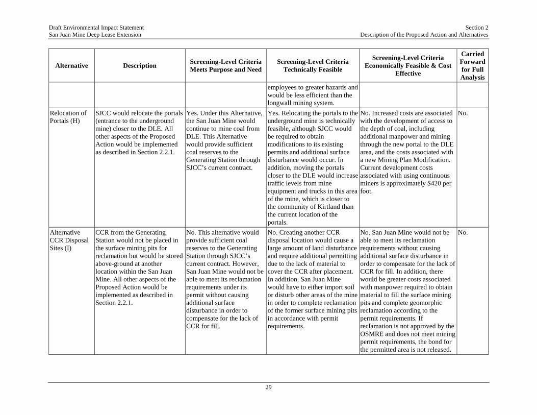
Draft Environmental Impact Statement Section 2 San Juan Mine Deep Lease Extension Description of the Proposed Action and Alternatives
29
Alternative Description Screening-Level Criteria Meets Purpose and Need
Screening-Level Criteria Technically Feasible
Screening-Level Criteria Economically Feasible & Cost
Effective
Carried Forward for Full Analysis
employees to greater hazards and would be less efficient than the longwall mining system.
Relocation of Portals (H)
SJCC would relocate the portals (entrance to the underground mine) closer to the DLE. All other aspects of the Proposed Action would be implemented as described in Section 2.2.1.
Yes. Under this Alternative, the San Juan Mine would continue to mine coal from DLE. This Alternative would provide sufficient coal reserves to the Generating Station through SJCC’s current contract.
Yes. Relocating the portals to the underground mine is technically feasible, although SJCC would be required to obtain modifications to its existing permits and additional surface disturbance would occur. In addition, moving the portals closer to the DLE would increase traffic levels from mine equipment and trucks in this area of the mine, which is closer to the community of Kirtland than the current location of the portals.
No. Increased costs are associated with the development of access to the depth of coal, including additional manpower and mining through the new portal to the DLE area, and the costs associated with a new Mining Plan Modification. Current development costs associated with using continuous miners is approximately $420 per foot.
No.
Alternative CCR Disposal Sites (I)
CCR from the Generating Station would not be placed in the surface mining pits for reclamation but would be stored above-ground at another location within the San Juan Mine. All other aspects of the Proposed Action would be implemented as described in Section 2.2.1.
No. This alternative would provide sufficient coal reserves to the Generating Station through SJCC’s current contract. However, San Juan Mine would not be able to meet its reclamation requirements under its permit without causing additional surface disturbance in order to compensate for the lack of CCR for fill.
No. Creating another CCR disposal location would cause a large amount of land disturbance and require additional permitting due to the lack of material to cover the CCR after placement. In addition, San Juan Mine would have to either import soil or disturb other areas of the mine in order to complete reclamation of the former surface mining pits in accordance with permit requirements.
No. San Juan Mine would not be able to meet its reclamation requirements without causing additional surface disturbance in order to compensate for the lack of CCR for fill. In addition, there would be greater costs associated with manpower required to obtain material to fill the surface mining pits and complete geomorphic reclamation according to the permit requirements. If reclamation is not approved by the OSMRE and does not meet mining permit requirements, the bond for the permitted area is not released.
No.
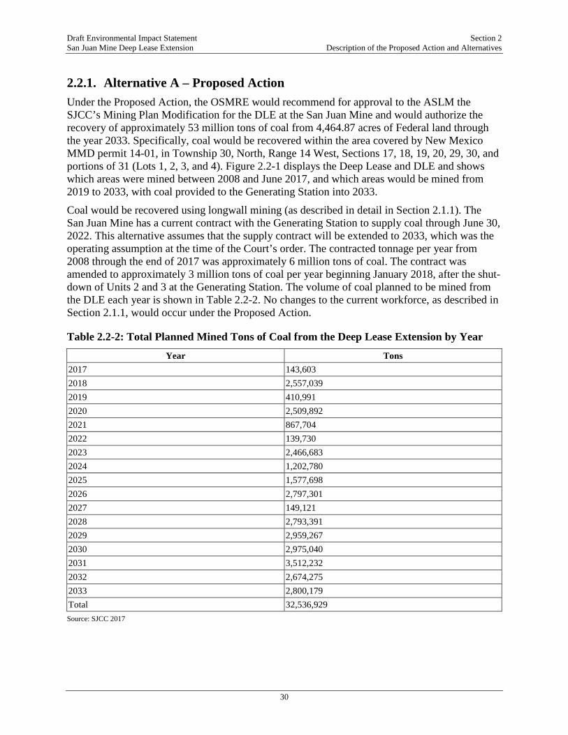
Draft Environmental Impact Statement Section 2 San Juan Mine Deep Lease Extension Description of the Proposed Action and Alternatives
30
2.2.1. Alternative A – Proposed Action Under the Proposed Action, the OSMRE would recommend for approval to the ASLM the SJCC’s Mining Plan Modification for the DLE at the San Juan Mine and would authorize the recovery of approximately 53 million tons of coal from 4,464.87 acres of Federal land through the year 2033. Specifically, coal would be recovered within the area covered by New Mexico MMD permit 14-01, in Township 30, North, Range 14 West, Sections 17, 18, 19, 20, 29, 30, and portions of 31 (Lots 1, 2, 3, and 4). Figure 2.2-1 displays the Deep Lease and DLE and shows which areas were mined between 2008 and June 2017, and which areas would be mined from 2019 to 2033, with coal provided to the Generating Station into 2033.
Coal would be recovered using longwall mining (as described in detail in Section 2.1.1). The San Juan Mine has a current contract with the Generating Station to supply coal through June 30, 2022. This alternative assumes that the supply contract will be extended to 2033, which was the operating assumption at the time of the Court’s order. The contracted tonnage per year from 2008 through the end of 2017 was approximately 6 million tons of coal. The contract was amended to approximately 3 million tons of coal per year beginning January 2018, after the shut-down of Units 2 and 3 at the Generating Station. The volume of coal planned to be mined from the DLE each year is shown in Table 2.2-2. No changes to the current workforce, as described in Section 2.1.1, would occur under the Proposed Action.
Table 2.2-2: Total Planned Mined Tons of Coal from the Deep Lease Extension by Year
Year Tons 2017 143,603 2018 2,557,039 2019 410,991 2020 2,509,892 2021 867,704 2022 139,730 2023 2,466,683 2024 1,202,780 2025 1,577,698 2026 2,797,301 2027 149,121 2028 2,793,391 2029 2,959,267 2030 2,975,040 2031 3,512,232 2032 2,674,275 2033 2,800,179 Total 32,536,929 Source: SJCC 2017

Draft Environmental Impact Statement Section 2 San Juan Mine Deep Lease Extension Description of the Proposed Action and Alternatives
31
Figure 2.2-1: Areas Proposed for Mining by Year through 2033
Source: Ecosphere 2017a
2.2.2. Alternative B – Continuation of San Juan Mine Operations Following Generating Station Shut-Down in 2022
Although PNM has made no announcement about an early shut down of the Generating Station, it issued a 2017-2036 Integrated Resource Plan (IRP) on July 3, 2017. IRPs are prepared every three years for the New Mexico Public Resources Commission. The purpose of an IRP is to identify the most cost-effective resource mix that would meet the projected electricity demands of PNM’s customers over the next 20 years, and to develop a four-year action plan that is consistent with that resource mix. PNM prepared the 2017 IRP for the period 2017 through 2036, examining all cost-effective resource options under a wide variety of possible futures for its energy portfolio.
Draft Environmental Impact Statement Section 2 San Juan Mine Deep Lease Extension Description of the Proposed Action and Alternatives
32
In the 2017 IRP, PNM has analyzed cost-effective power supply plans under two scenarios:
• The Generating Station retires after the end of the current coal supply agreement, terminating on June 30, 2022.
• The Generating Station continues to operate beyond 2022.
The most significant finding of the IRP is that retiring PNM’s 497-MW share of the Generating Station in 2022 would provide long-term cost savings for PNM’s customers, assuming that PNM is able to recover the full cost of the remaining plant investment after the Generating Station retirement. The four-year action plan in the IRP is designed to test the assumptions in the report and maintain flexibility to adjust the mix of replacement supplies as the price and capabilities of renewable energy, natural gas, and energy storage technologies evolve over the next four years. The four-year action plan provided in the IRP is as follows:
• File for abandonment of the Generating Station with the New Mexico Public Regulation Commission no later than July 1, 2018;
• Secure the required Palo Verde Nuclear Generating Station leased capacity;
• Issue Requests for Proposals for energy storage, renewable energy, and flexible natural gas resources to validate the assumptions in the IRP and to further refine the mix of replacement resources assuming the Generating Station retires in 2022;
• Define the Generating Station replacement resource siting requirements by conducting a power flow study; and
• Pursue securitization legislation to provide additional long-term customer cost savings and to provide funds for replacement resources.
In this alternative, the OSMRE would recommend to the ASLM that the DLE be approved, but with the condition that coal would only be supplied to the Generating Station until 2022 and the remaining reserves from 2023 through 2033 would go to the open market. If a mine does not have an identified generating station as the market, the OSMRE has analyzed coal combustion effects using a “typical” local generating station. This approach allows for a reasonable approximation of the potential combustion-related effects. In the case of the San Juan Mine DLE, the analysis of the combustion-related effects at the Generating Station through 2033 in this EIS would provide such a reasonable level analysis in the event of shutdown and the San Juan Mine identifying a new market for its coal.
Under this alternative, it is assumed that mining, coal preparation and crushing methods at the San Juan Mine would remain consistent with methods employed under the Proposed Action. Additionally, given the high level of uncertainty associated with projecting the potential post-June 2022 SJCC clients, it is assumed that the average rate of coal mined from the San Juan Mine would remain consistent with the Proposed Action rate of approximately 3 million tpy.
Using the Generating Station as the “typical” local generating station for approximation of potential combustion-related effects under Alternative B assumes that any coal combustion would be within the emission profiles analyzed in this EIS for the indirect effects of the Proposed Action. Specifically, assumptions for this Alternative include the following:

Draft Environmental Impact Statement Section 2 San Juan Mine Deep Lease Extension Description of the Proposed Action and Alternatives
33
1. The potential future combustion of coal would be with similar types of emission controls, CCR handling and storage, and air emission profiles for all air pollutants.
2. The potential future use of coal would be with similar types and scales of transport from the mine to the location of combustion.
These assumptions reflect a higher level of uncertainty relative to the assessment of the indirect effects of coal combustion under Alternative B as compared to under the Proposed Action, because the potential use after 2022 is not known. If the alternate use after 2022 falls outside the bounds of the analysis in this EIS (less emission control, new form of transit, new use), then the OSMRE or another federal agency with an action associated with the new use (such as approval of a new rail line or spur) would conduct an independent or supplemental NEPA analysis to analyze new impacts or impacts outside the bounds of those analyzed in this EIS.
Under this alternative, all of the direct mining-related effects, and the indirect effects of coal combustion, would be the same those for the Proposed Action.
2.2.3. Alternative C – No Action Alternative Under the No Action Alternative, the OSMRE would recommend that the ASLM not approve the Mining Plan Modification for the DLE at the San Juan Mine. Mining within the DLE would cease on August 31, 2019, and the SJCC would continue reclamation activities of past surface mining operations (Juniper Pit) and all surface disturbance from underground mining operations.
Mining could legally continue in the Deep Lease without the DLE; however, as a practical matter for an underground mine of this type, this alternative assumes that all mining would cease at the San Juan Mine after the completion of the second-to-last panel of the 400 district due to technical, economic, and other considerations. Specifically, the final panel of the 400 district is divided between the Deep Lease area and DLE. Coal quality varies throughout each longwall panel, as the panel length generally ranges from 2 to 3.5 miles. The panel length used by the San Juan Mine allows higher quality coal to be mined and stockpiled in either Juniper or Northfield coal stockpiles. As the lower quality coal is mined and delivered to the surface, blending can occur between the high-quality stockpiled coal and low-quality coal to ensure the product delivered to the Generating Station meets the requirements of the contract. Within the last panel of the 400 district, the lower quality coal is found on the Deep Lease area portion. Without the higher quality coal from the DLE side to blend with the low-quality coal, the Generating Station likely could not burn the lower BTU range of coal without risking damage to its boilers. Moreover, accessing the State lease located in Township 30 North, Range 14 West, Section 32, requires mining portions of the DLE to set up the infrastructure for a longwall operation. Without the approval to mine the DLE, the State lease coal could not be feasibly or safely mined.
Following cessation of mining, any coal remaining in the coal stockpiles would be delivered to the Generating Station. Stockpiles of coal from the San Juan Mine would allow the Generating Station to continue operations using coal from the San Juan Mine through approximately August 2020 (assuming a December 2019 completion of mining, 6-month supply in SJCC stockpiles and 2 month-supply in Generating Station Force Majeure Stockpiles, and an August 2019 disapproval). CCR from the Generating Station would be placed in Juniper Pit in accordance with the reclamation plan for as long as the Generating Station continues to operate using coal from the San Juan Mine; however, upon shut-down of the Generating Station, without the additional CCR to use in reclaiming Juniper Pit, more disturbance of native or reclaimed areas
Draft Environmental Impact Statement Section 2 San Juan Mine Deep Lease Extension Description of the Proposed Action and Alternatives
34
would be required to fill the pit and complete the final design. This additional disturbance would result in a net loss of approximately 1.5 million cubic yards of CCR. Displacing this loss of CCR material with spoil material would require 15 feet of material to be removed over 60 acres of reclamation or native ground. Because this scenario is not part of the current reclamation plan, it does not account for designing proper drainage and creation of landforms, which could increase the acres needing to be disturbed to facilitate reclamation. Final regrade of former surface operations would be completed approximately ten years after the shutdown. Reclamation of the support facilities would also occur during this time. Once reclamation is complete, the areas would be monitored until a Phase III (i.e., final) bond release has been achieved on all formerly disturbed areas.
Under the No Action Alternative, SJCC would require approximately 110 employees to complete reclamation activities; all other employees would be laid off. In addition, an indirect effect of the No Action Alternative is that combustion of coal from the San Juan Mine at the Generating Station would cease in 2020.
2.2.4. Alternative D – “Just” Transition Alternative Several comments received during the scoping period for this EIS requested that the OSMRE include consideration of a “Just” Transition Alternative. This Alternative is similar to the No Action Alternative; however the timing of the shutdown would change and additional measures would be implemented to reduce the impacts to resources affected by mine shutdown. These suggested measures include:
• Identification of a specific date for mine and power plant closure in order to provide for advance planning;
• Ensure full and effective reclamation of the San Juan Mine and the Generating Station;
• “Seize opportunities to utilize the San Juan Mine site for the development of renewable energy”6;
• “Other Interior Department agencies, including the Bureau of Indian Affairs, BLM, Department of Energy, and Department of Commerce should be tapped for their expertise to help devise an effective transition plan”;
• “Environmental justice must be a primary goal. This must include eliminating air and water pollution that disproportionately affects Tribal communities, and stopping climate pollution that is fueling climate changes in the American Southwest”;
• Creation of a timeline for alternative generation sources to be installed and continue providing electricity to the grid; and
• Implementation of a program of retraining for alternative employment opportunities of mine and power plant employees as well as helping nearby Tribal communities find new and more fruitful revenue streams.
The analysis provided for the No Action Alternative helps inform the Just Transition Alternative, by providing a comprehensive socioeconomic impact analysis of the shutdown of both the San Juan Mine and the Generating Station. This analysis provides important data and modeling 6 Bullets in quotations include direct quotes from comment letters received during the scoping period requesting OSMRE evaluate a “Just Transition” alternative.
Draft Environmental Impact Statement Section 2 San Juan Mine Deep Lease Extension Description of the Proposed Action and Alternatives
35
results that characterize the loss of employment, the loss of direct revenue, as well as the loss of the multiplier effects that characterize changes to the economic vitality to the region.
With regard to identifying a specific date for mine a closure and ensuring full and effective reclamation of the San Juan Mine, these analyses are already specified in both the Proposed Action and Action Alternative B, as well as the No Action Alternative, providing a range of scenarios for mine closure and analysis of reclamation activities. As discussed in Section 1, there is no action to be considered at the Generating Station; therefore, identification of a specific date for shut-down of the Generating Station and reclamation of the Generating Station site is beyond the scope of this NEPA analysis. Similarly, development of renewable energy or alternative energy sources at the San Juan Mine site is speculative at this point, and if feasible, would occur following reclamation of the mine and OSMRE’s decision-making process.
The suggested measure to identify other industries or employers that could replace the revenue and jobs provided by San Juan Mine and the Generating Station, facilitating their introduction into the regional economy in an orderly manner, and providing for training of current employees at the mine and generating station to obtain this employment are beyond the scope of NEPA analysis. Although the responsibility of the entire community, this planning is most directly the purview of economic development councils.
Specifically, in 2017 the Northwest New Mexico Council of Governments (COG) sponsored a comprehensive strategic planning process to assess the extent of the economic impact that changes to the region’s energy industries have had and will have on Cibola, McKinley, and San Juan counties, and provided recommended actions for the region as a whole, and for each of the three counties individually, to strengthen their economic foundation. The COG report, titled Regional Economic Assessment & Strategy for the Coal-Impacted Four Corners Region; Final Report, February 8, 2017, directly addresses the question of a Just Transition Alternative for the Four Corners region as a whole, including San Juan Mine and Generating Station. While the focus on assessing adverse impacts is on the coal and coal-related power generation sector, strategies for economic resiliency encompass all economic sectors and geographic areas within the three counties. Funding for the COG study is through the Federal Economic Development Administration’s program, “Partnership for Opportunity and Workforce and Economic Revitalization,” or POWER.
The COG study notes that the coal mining and associated power production industries have historically been key economic engines in the Four Corners region of Northwest New Mexico, and that changes in regional, national, and international energy markets, as well as changes in state and Federal energy policy, have resulted in a decline of investment in these industries in the region. In turn, the region has suffered a reduction of employment, income, and taxes supported by the energy sector. In response to these changes, the counties in the Four Corners region are proactively seeking economic development strategies to strengthen and diversify its economy and stabilize the financial base for its communities and governments.
The COG report documents the findings of this strategic planning process, which relied on close collaboration with the COG and other regional partners, such as local economic development organizations, Tribes/Pueblos, and businesses. Findings at this stage of the strategic planning process support Phase I of a three-phase POWER initiative. Phase II will include work at local institutions to develop paid internships, apprenticeships, and other on-the-job learning opportunities to help displaced workers re-enter the workforce with a new career, and Phase III

Draft Environmental Impact Statement Section 2 San Juan Mine Deep Lease Extension Description of the Proposed Action and Alternatives
36
will implement recommendations made in Phase I to promote job opportunities in high-growth sectors.
The COG report also notes that both its 2017 study and the POWER planning process build on past and current economic development efforts in the region. Throughout Northwest New Mexico, extensive work has been done to identify and develop key economic sectors/clusters, including those in the retail, health care, energy (including renewable energy resources), tourism, agriculture, manufacturing, logistics/transportation, and construction sectors. Local education institutions have developed training programs to provide the local population a means to develop the necessary skills for jobs in these sectors. This planning process ties together efforts throughout the region and identifies regional strategies to promote this wide spectrum of industries, as well as identify target growth businesses for each county in the region.
The OSMRE has determined that consideration of “Just” Transition Alternatives can be well-informed by the socioeconomic analysis and modeling provided for the No Action Alternative in this EIS, but that further consideration is more properly conducted by economic development councils. In this context, the 2017 COG study could be considered as Phase 1 of the Just Transition Alternative.
The OSMRE has also determined that further considerations such as those provided in the COG study are beyond the scope of the analysis of the No Action Alternative, because any such post-shutdown industries and employment opportunities are entirely speculative and subject to market forces beyond the control and ability to predict of the OSMRE or other regulatory agencies. In addition, many of the potential future industries or employment opportunities would likely have associated NEPA reviews required that would address the consequences of the implementation of such a plan.
2.3. REGULATORY FRAMEWORK, PROTECTION MEASURES, STANDARD OPERATING PROCEDURES, AND BMPS APPLICABLE TO ALL ACTION ALTERNATIVES
This section summarizes compliance with regulatory requirements and permit-required protective measures, which address most of the environmental consequences of the Proposed Action; where applicable, the EIS identifies additional mitigation measures. Table 2.3-1 provides a summary of the applicable laws, ordinances, regulations, and standards for each resource that would apply to all alternatives. The Technical Resource Document (TRD) includes detailed discussion of each of the regulations included in Table 2.3-1 and how each regulation pertains to that particular resource. In addition to the state and federal laws listed in Table 2.3-1, SJCC has included many protective measures within the New Mexico MMD Permit 14-01, in accordance with the New Mexico Surface Mining Act, that are currently implemented at the mine and would continue under the Proposed Action; these include protective measures for certain environmental impacts, standard operating procedures, and BMPs that are designed to avoid or minimize potential impacts related to operation of the San Juan Mine. Because these protective measures are included in New Mexico MMD permit 14-01 as part of the Proposed Action, they are not listed as specific mitigation measures in each resource evaluation.

Draft Environmental Impact Statement Section 2 San Juan Mine Deep Lease Extension Description of the Proposed Action and Alternatives
37
Table 2.3-1: Applicable Laws, Regulations, and Additional Protection Measures in Place at San Juan Mine
Level of Regulation or Protection Applicable Laws, Regulations, Protection Measures, and Best Management Practices
Air Quality Federal Clean Air Act (42 USC 7401)
Title V Permits (42 USC 7661) National Ambient Air Quality Standards (NAAQS) Air Toxics and Federal Hazardous Air Pollutants Clean Air Act, Regional Haze Rule (40 CFR § 51) Production Tax Credit for Refined Coal Mercury and Air Toxics Standards (MATs) Federal Acid Rain Program Federal Prevention of Significant Deterioration New Source Review Program (40 CFR Parts 51.166 and 52.21.) Coal Preparation Plant New Source Performance Standards (40 CFR Part 60) Mobile Source Regulations (40 CFR Part 89.112) State New Mexico Air Programs (20.2.72 NMAC) New Mexico Ambient Air Quality Standards (NMAAQS) New Mexico Surface Mining Act (19.8.1 NMAC) San Juan Mine The San Juan Mine would not exceed emissions limits set forth in its report emissions as required to NMED. Climate Change Federal Mandatory Reporting of Greenhouse Gases Rule (40 CFR Part 98) Continuous Emission Monitoring (40 CFR Part 75) EPA Clean Power Plan Greenhouse Gas Major Source Permitting – the Tailoring Rule (40 CFR Part 51) State Executive Order 2009-047 on Climate Change Leadership NMED Greenhouse Gas Permitting and Reporting for Title V Facilities San Juan Mine The San Juan Mine would accurately collect and report GHG emissions to EPA and NMED. Geology and Soils Federal Antiquities Act of 1906 Paleontological Resources Preservation Act of 2009
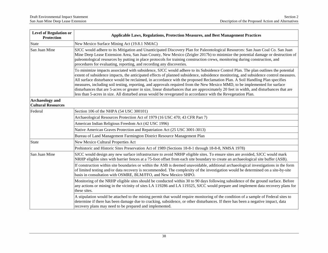
Draft Environmental Impact Statement Section 2 San Juan Mine Deep Lease Extension Description of the Proposed Action and Alternatives
38
Level of Regulation or Protection Applicable Laws, Regulations, Protection Measures, and Best Management Practices
State New Mexico Surface Mining Act (19.8.1 NMAC) San Juan Mine SJCC would adhere to its Mitigation and Unanticipated Discovery Plan for Paleontological Resources: San Juan Coal Co. San Juan
Mine Deep Lease Extension Area, San Juan County, New Mexico (Zeigler 2017b) to minimize the potential damage or destruction of paleontological resources by putting in place protocols for training construction crews, monitoring during construction, and procedures for evaluating, reporting, and recording any discoveries.
To minimize impacts associated with subsidence, SJCC would adhere to its Subsidence Control Plan. The plan outlines the potential extent of subsidence impacts, the anticipated effects of planned subsidence, subsidence monitoring, and subsidence control measures. All surface disturbance would be reclaimed, in accordance with the proposed Reclamation Plan. A Soil Handling Plan specifies measures, including soil testing, reporting, and approvals required from the New Mexico MMD, to be implemented for surface disturbances that are 5-acres or greater in size, linear disturbances that are approximately 20 feet in width, and disturbances that are less than 5-acres in size. All disturbed areas would be revegetated in accordance with the Revegetation Plan.
Archaeology and Cultural Resources
Federal Section 106 of the NHPA (54 USC 300101) Archaeological Resources Protection Act of 1979 (16 USC 470; 43 CFR Part 7) American Indian Religious Freedom Act (42 USC 1996) Native American Graves Protection and Repatriation Act (25 USC 3001-3013) Bureau of Land Management Farmington District Resource Management Plan State New Mexico Cultural Properties Act Prehistoric and Historic Sites Preservation Act of 1989 (Sections 18-8-1 through 18-8-8, NMSA 1978) San Juan Mine SJCC would design any new surface infrastructure to avoid NRHP eligible sites. To ensure sites are avoided, SJCC would mark
NRHP eligible sites with barrier fences at a 75-foot offset from each site boundary to create an archaeological site buffer (ASB).
If construction within site boundaries or within the ASB is deemed unavoidable, additional archaeological investigations in the form of limited testing and/or data recovery is recommended. The complexity of the investigation would be determined on a site-by-site basis in consultation with OSMRE, BLM/FFO, and New Mexico SHPO.
Monitoring of the NRHP eligible sites should be conducted within 30 to 90 days following subsidence of the ground surface. Before any actions or mining in the vicinity of sites LA 119286 and LA 119325, SJCC would prepare and implement data recovery plans for these sites.
A stipulation would be attached to the mining permit that would require monitoring of the condition of a sample of Federal sites to determine if there has been damage due to cracking, subsidence, or other disturbances. If there has been a negative impact, data recovery plans may need to be prepared and implemented.
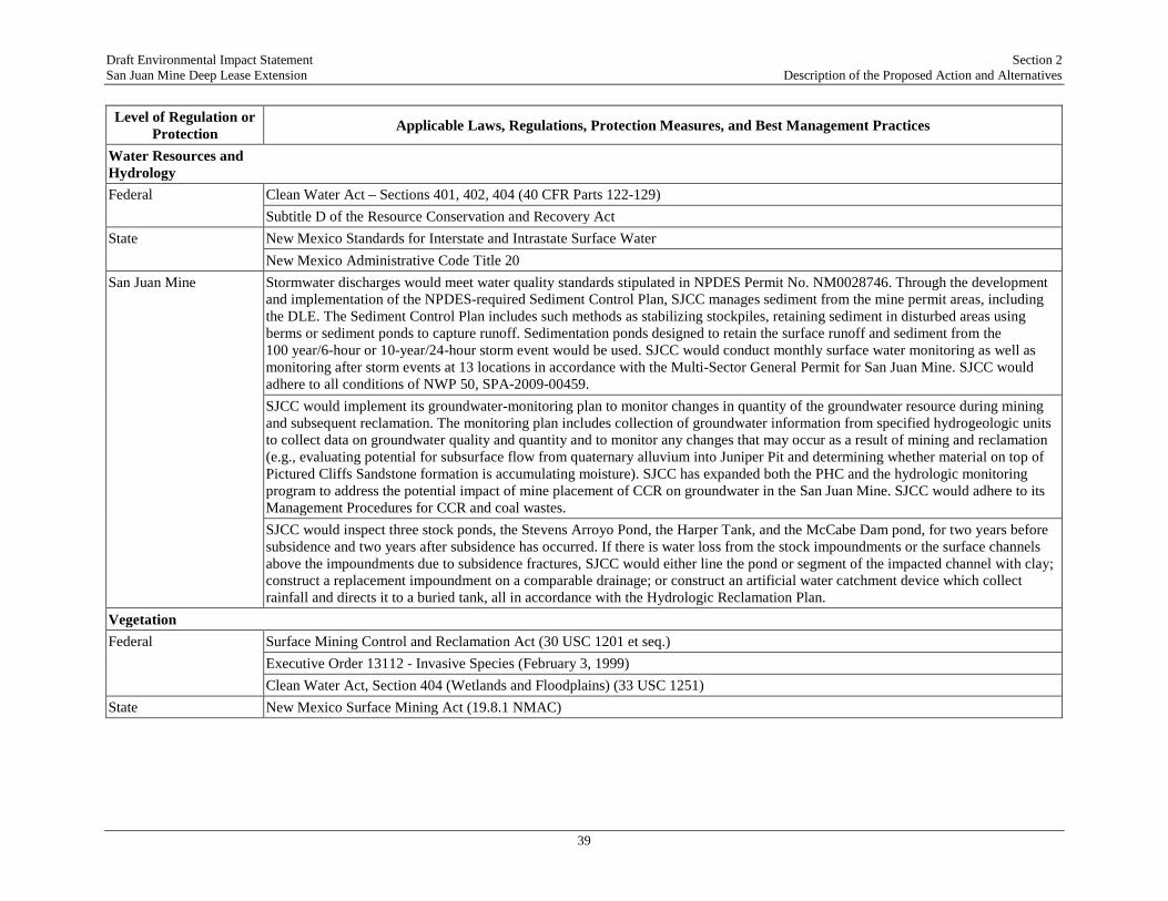
Draft Environmental Impact Statement Section 2 San Juan Mine Deep Lease Extension Description of the Proposed Action and Alternatives
39
Level of Regulation or Protection Applicable Laws, Regulations, Protection Measures, and Best Management Practices
Water Resources and Hydrology
Federal Clean Water Act – Sections 401, 402, 404 (40 CFR Parts 122-129) Subtitle D of the Resource Conservation and Recovery Act State New Mexico Standards for Interstate and Intrastate Surface Water New Mexico Administrative Code Title 20 San Juan Mine Stormwater discharges would meet water quality standards stipulated in NPDES Permit No. NM0028746. Through the development
and implementation of the NPDES-required Sediment Control Plan, SJCC manages sediment from the mine permit areas, including the DLE. The Sediment Control Plan includes such methods as stabilizing stockpiles, retaining sediment in disturbed areas using berms or sediment ponds to capture runoff. Sedimentation ponds designed to retain the surface runoff and sediment from the 100 year/6-hour or 10-year/24-hour storm event would be used. SJCC would conduct monthly surface water monitoring as well as monitoring after storm events at 13 locations in accordance with the Multi-Sector General Permit for San Juan Mine. SJCC would adhere to all conditions of NWP 50, SPA-2009-00459.
SJCC would implement its groundwater-monitoring plan to monitor changes in quantity of the groundwater resource during mining and subsequent reclamation. The monitoring plan includes collection of groundwater information from specified hydrogeologic units to collect data on groundwater quality and quantity and to monitor any changes that may occur as a result of mining and reclamation (e.g., evaluating potential for subsurface flow from quaternary alluvium into Juniper Pit and determining whether material on top of Pictured Cliffs Sandstone formation is accumulating moisture). SJCC has expanded both the PHC and the hydrologic monitoring program to address the potential impact of mine placement of CCR on groundwater in the San Juan Mine. SJCC would adhere to its Management Procedures for CCR and coal wastes.
SJCC would inspect three stock ponds, the Stevens Arroyo Pond, the Harper Tank, and the McCabe Dam pond, for two years before subsidence and two years after subsidence has occurred. If there is water loss from the stock impoundments or the surface channels above the impoundments due to subsidence fractures, SJCC would either line the pond or segment of the impacted channel with clay; construct a replacement impoundment on a comparable drainage; or construct an artificial water catchment device which collect rainfall and directs it to a buried tank, all in accordance with the Hydrologic Reclamation Plan.
Vegetation Federal Surface Mining Control and Reclamation Act (30 USC 1201 et seq.) Executive Order 13112 - Invasive Species (February 3, 1999) Clean Water Act, Section 404 (Wetlands and Floodplains) (33 USC 1251) State New Mexico Surface Mining Act (19.8.1 NMAC)
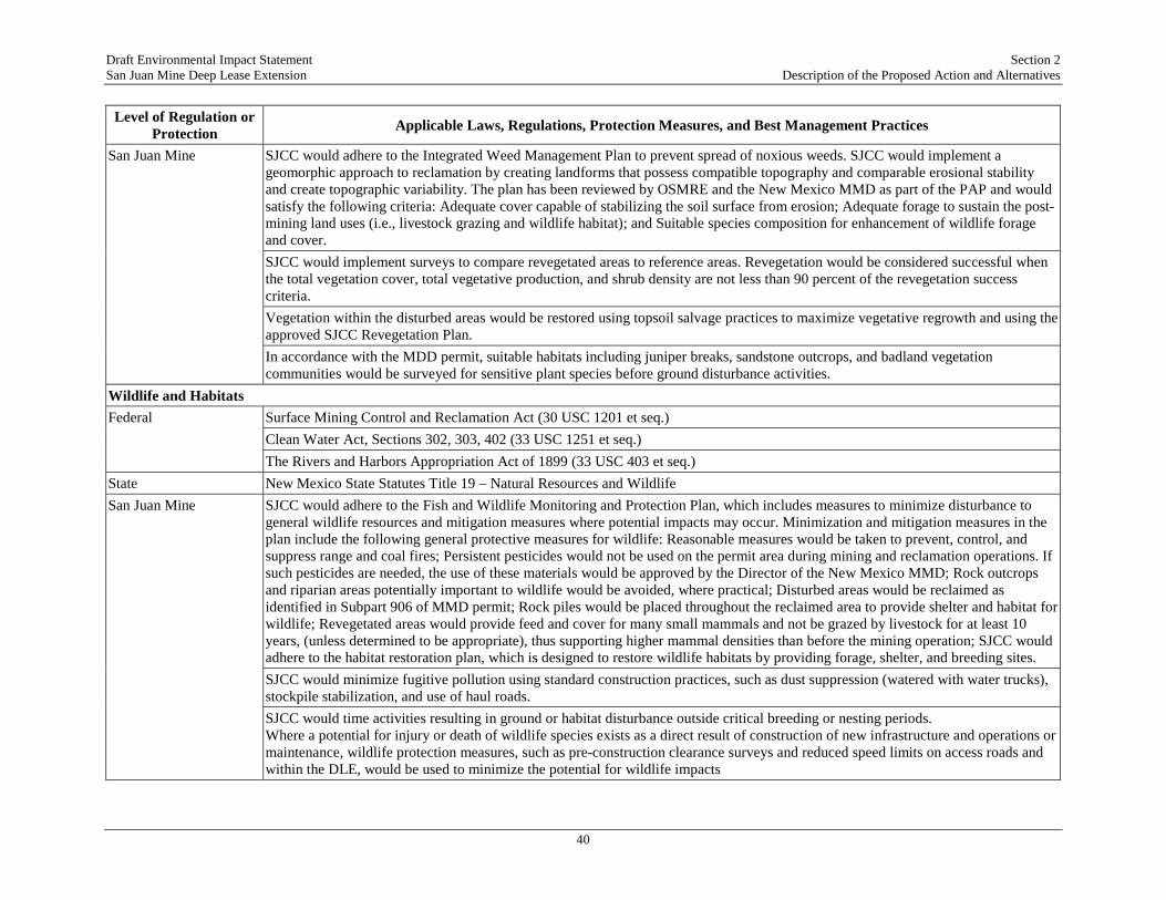
Draft Environmental Impact Statement Section 2 San Juan Mine Deep Lease Extension Description of the Proposed Action and Alternatives
40
Level of Regulation or Protection Applicable Laws, Regulations, Protection Measures, and Best Management Practices
San Juan Mine SJCC would adhere to the Integrated Weed Management Plan to prevent spread of noxious weeds. SJCC would implement a geomorphic approach to reclamation by creating landforms that possess compatible topography and comparable erosional stability and create topographic variability. The plan has been reviewed by OSMRE and the New Mexico MMD as part of the PAP and would satisfy the following criteria: Adequate cover capable of stabilizing the soil surface from erosion; Adequate forage to sustain the post-mining land uses (i.e., livestock grazing and wildlife habitat); and Suitable species composition for enhancement of wildlife forage and cover.
SJCC would implement surveys to compare revegetated areas to reference areas. Revegetation would be considered successful when the total vegetation cover, total vegetative production, and shrub density are not less than 90 percent of the revegetation success criteria.
Vegetation within the disturbed areas would be restored using topsoil salvage practices to maximize vegetative regrowth and using the approved SJCC Revegetation Plan.
In accordance with the MDD permit, suitable habitats including juniper breaks, sandstone outcrops, and badland vegetation communities would be surveyed for sensitive plant species before ground disturbance activities.
Wildlife and Habitats Federal Surface Mining Control and Reclamation Act (30 USC 1201 et seq.) Clean Water Act, Sections 302, 303, 402 (33 USC 1251 et seq.) The Rivers and Harbors Appropriation Act of 1899 (33 USC 403 et seq.) State New Mexico State Statutes Title 19 – Natural Resources and Wildlife San Juan Mine SJCC would adhere to the Fish and Wildlife Monitoring and Protection Plan, which includes measures to minimize disturbance to
general wildlife resources and mitigation measures where potential impacts may occur. Minimization and mitigation measures in the plan include the following general protective measures for wildlife: Reasonable measures would be taken to prevent, control, and suppress range and coal fires; Persistent pesticides would not be used on the permit area during mining and reclamation operations. If such pesticides are needed, the use of these materials would be approved by the Director of the New Mexico MMD; Rock outcrops and riparian areas potentially important to wildlife would be avoided, where practical; Disturbed areas would be reclaimed as identified in Subpart 906 of MMD permit; Rock piles would be placed throughout the reclaimed area to provide shelter and habitat for wildlife; Revegetated areas would provide feed and cover for many small mammals and not be grazed by livestock for at least 10 years, (unless determined to be appropriate), thus supporting higher mammal densities than before the mining operation; SJCC would adhere to the habitat restoration plan, which is designed to restore wildlife habitats by providing forage, shelter, and breeding sites.
SJCC would minimize fugitive pollution using standard construction practices, such as dust suppression (watered with water trucks), stockpile stabilization, and use of haul roads.
SJCC would time activities resulting in ground or habitat disturbance outside critical breeding or nesting periods. Where a potential for injury or death of wildlife species exists as a direct result of construction of new infrastructure and operations or maintenance, wildlife protection measures, such as pre-construction clearance surveys and reduced speed limits on access roads and within the DLE, would be used to minimize the potential for wildlife impacts

Draft Environmental Impact Statement Section 2 San Juan Mine Deep Lease Extension Description of the Proposed Action and Alternatives
41
Level of Regulation or Protection Applicable Laws, Regulations, Protection Measures, and Best Management Practices
Special Status Species Federal Endangered Species Act (16 USC 1531-1544) Migratory Bird Treaty Act (16 USC 703-712) Bald and Golden Eagle Protection Act (16 USC 668-668c)
Fish and Wildlife Conservation Act (16 USC 2901-2911) Memorandum of Understanding between FWS and OSMRE on Threatened and Endangered Species Coordination
State New Mexico Threatened and Endangered Species Act (NMSA 17-2-41) San Juan Mine All riparian areas identified as unique wildlife habitat would be checked at least once per year by a qualified biologist to ensure that
the original function and value of the area is maintained. If subsidence appears to be impacting riparian areas, protection and/or mitigation measures would be implemented on a site-specific basis in coordination with New Mexico MMD. Results of riparian area monitoring, including any project related impacts to the areas and protection and mitigation measures implemented, if any, would be included in annual mine progress reports.
For the protection of raptors: Annual raptor and riparian monitoring would continue to be conducted to identify and assess measures implemented during the previous year, specific protection measures to be implemented, and recommend modifications to the plan; A raptor nest activity survey of the San Juan Mine would be conducted during the period of April-June of each year by a qualified professional biologist. The primary protection measure for raptor species in the project area is avoidance. SJCC personnel would notify the New Mexico MMD immediately if raptors are found nesting on or within 825 feet of project facilities, or if safety issues warrant something different. In cases where existing project features (e.g., ventilation shafts, utility drill holes, gob vent bore holes) are located within a raptor nest buffer zone, no extensive maintenance activities would be allowed, only agreed activities would be allowed during the restricted period (i.e., March 01 through June 30). After each nesting season, an annual meeting would be held during August and between SJCC and BLM representatives with the New Mexico MMD invited to review potential impacts of any current active nest sites on next year’s mining operations.
Other Migratory Birds: Pre-disturbance surveys for ground nesting birds would be conducted before any ground disturbing activities. Monitoring protocol and protection measures for bald eagle, northern goshawk, common black hawk, ferruginous hawk, western burrowing owl, and American and Arctic peregrine falcons would be as described for raptors (see Section 905.A(1)). If deemed necessary by FWS, suitable mountain plover habitat (i.e., areas with vegetation less than 6 inches in height) within 0.25 miles of proposed surface disturbance (as identified in annual reports) would be surveyed before disturbance if such disturbance is to occur between March 15 and August 15. Surveys would be conducted by a qualified professional biologist within one week before proposed disturbance to detect the presence of nesting plovers. If Empidonax flycatchers are seen at San Juan Mine during other monitoring activities, an effort would be made to observe the individual(s) until it can be determined whether or not the bird is a southwestern willow flycatcher.
SJCC would adhere to the Fish and Wildlife Monitoring and Protection Plan, which includes: The design and construction of electric power lines on the DLE would meet the guidelines set forth in Olendorff et al. (1981) and the Avian Power Line Interaction Committee (2012).

Draft Environmental Impact Statement Section 2 San Juan Mine Deep Lease Extension Description of the Proposed Action and Alternatives
42
Level of Regulation or Protection Applicable Laws, Regulations, Protection Measures, and Best Management Practices
Land Use, Transportation, and Agriculture
Federal Surface Mining Control and Reclamation Act (30 USC 1201 et seq.) Federal Land Policy and Management Act (43 USC 1701-1785) Federal Mining Leasing Act of 1920 (30 USC 181 et seq.) Taylor Grazing Act (43 USC 1269) Farmland Protection Policy Act (7 USC 4201) State New Mexico Surface Mining Act (19.8.1 NMAC) San Juan Mine Any subsidence that occurs along Barker Dome Road would be remediated through the use of a road grader to fill in cracks and
smooth the surface. Haul roads and ramps and gate roads would be reclaimed.
Remediation would include smoothing the surface and filling in sections where it is needed on public roads such as Barker Dome. Roads strictly associated with mining operations such as those behind the longwall mining area would be reclaimed, mainly through the use of a rubber tire dozer.
SJCC would monitor re-route locations of existing commercial pipelines and ensure that pipelines are not being impacted by mine subsidence. Secondary gathering pipelines would continue to be subsided in-place in cooperation with the commercial owners.
SJCC would install “phase raisers” to minimize or eliminate damage to wooden power poles of commercial power lines. Existing roadways that would be affected by subsidence would be repaired by filling and/or blading to minimize adverse effects. Recreation Federal Federal Land Policy and Management Act (43 USC 1701-1785) Bureau of Land Management Farmington District Resource Management Plan State New Mexico Mining and Minerals Division 2014 San Juan Mine Permit 14-01, Subpart 811, Land Use Information New Mexico Outdoor Recreation Act, NMSA § 16-1-4 San Juan Mine There are no additional protection measures or best management practices related to recreation. Social and Economic Values
Federal CEQ Regulations for Implementing NEPA (40 CFR Part 1508.14) State There are no applicable state laws or regulations pertaining to social and economic values San Juan Mine There are no additional protection measures or best management practices related to social and economic values

Draft Environmental Impact Statement Section 2 San Juan Mine Deep Lease Extension Description of the Proposed Action and Alternatives
43
Level of Regulation or Protection Applicable Laws, Regulations, Protection Measures, and Best Management Practices
Environmental Justice Federal Executive Order 12898 – Federal Actions to Address Environmental Justice in Minority and Low-Income Populations CEQ Guidance Under NEPA (1997) Executive Order 13175 – Consultation and Coordination with Indian Tribal Governments (2000) Presidential Memorandum on Tribal Consultation (Obama 2009) Secretarial Order 3317 – DOI Tribal Consultation Policy State There are no applicable state laws or regulations pertaining to environmental justice San Juan Mine There are no additional protection measures or best management practices related to environmental justice Visual Resources Federal Federal Land Policy and Management Act (43 USC 1701-1785) National Historic Preservation Act (36 CFR Part 800.5(a)(2)) State New Mexico Night Sky Protection Act (NMSA §§ 74-12-1 through 74-12-11) San Juan Mine SJCC would implement reclamation measures, including re-contouring the disturbed surface to match natural contours and re-
vegetation with the appropriate seed mixtures, to diminish the short-term visual contrast over time. As part of reclamation, the SJCC would continue to windrow soil adjacent to construction areas where surface disturbances are less
than five acres or are linear and 20 feet wide, and soil is placed back into the disturbance area after construction. The former surface mining areas would be reclaimed using geomorphic procedures where reclamation occurs contemporaneously with mining in the DLE.
Noise and Vibration Federal U.S. Department of Housing and Urban Development (24 CFR Part 51) Mine Safety and Health Administration (30 CFR Part 62) OSMRE Applicable Vibration Regulations (30 CFR Part 816.67) State New Mexico Surface Mining Act (19.8.1 NMAC) San Juan Mine There are no additional protection measures or best management practices related to noise and vibration Hazardous and Solid Waste
Federal Surface Mining Control and Reclamation Act (30 USC 1201 et seq.) Solid Waste Disposal Act/ Resource Conservation and Recovery Act (42 USC 6901 et seq.) Asbestos Hazard Emergency Response Act (15 USC 52) Clean Air Act (42 USC 7401 et seq.)

Draft Environmental Impact Statement Section 2 San Juan Mine Deep Lease Extension Description of the Proposed Action and Alternatives
44
Level of Regulation or Protection Applicable Laws, Regulations, Protection Measures, and Best Management Practices
Toxic Substances Control Act (15 USC 2601-2692) Spill Prevention, Control, and Countermeasure Rule (40 CFR Part 112) Emergency Planning and Community Right-to-Know Act (42 USC 11001) U.S. Department of Justice, Bureau of Alcohol, Tobacco, and Firearms, and Explosives Regulations (27 CFR Part 55 Subpart K) Federal Insecticide, Fungicide, and Rodenticide Act (7 USC 136) State New Mexico Hazardous Waste Act (NMSA § 74-4-1) New Mexico Solid Waste Act (20.9.1-20.9.25 NMAC) New Mexico Surface Mining Act (NMSA § 69-25A-20) New Mexico Water Quality Act (NMSA § 74-6-1) New Mexico Ground Water Protection Act (NMSA § 74-6B-1) San Juan Mine Handling and disposal of toxic substances would occur as described in the Waste Management Plan All ASTs at the San Juan Mine are constructed of welded steel or fiberglass and are compatible with the type of material stored within
the tank, including conditions of storage such as pressure and temperature. Used oil would continue to be picked up by a recycling facility and burned for energy recovery. Any asbestos-containing material would be managed properly and disposed of in an approved special waste landfill. Before any renovation or demolition of buildings, a comprehensive inspection with sampling, if necessary, would be conducted
SJCC would continue to manage CCR material at the San Juan Mine using the following procedures: Placing the CCR material in pits away from major drainages; Covering the material with natural overburden to reduce potential fugitive air emissions; Placing a final cover of approximately 10 feet of backfill material to provide a natural water barrier; Grading the area to its approximate original contour and reclaiming it with native plant species; Monitoring ground water, surface water, and vegetation to ensure that no adverse environmental impacts have occurred
SJCC would adhere to the Transformer Management Plan, which has been developed for the San Juan Mine to ensure that no PCBs are present above regulated limits in any transformers, other oil-filled equipment, or any associated oil or dielectric fluids at the mine site.
SJCC would adhere to all plans and procedures outlined in the SPCC Plan (last updated on September 16, 2014), which contains detailed information on oil, petroleum products, and other hazardous materials that are stored at San Juan Mine.
SJCC would adhere to the Landfarm Management Plan, which has been prepared for the San Juan Mine to ensure the treatment of petroleum-contaminated soil at the mine meets the both Federal and New Mexico standards. The plan includes: Acceptance procedures including a description of materials that may not be treated at the landfarm; Analytical and recordkeeping requirements; and Landfarm operating and remediation standards.
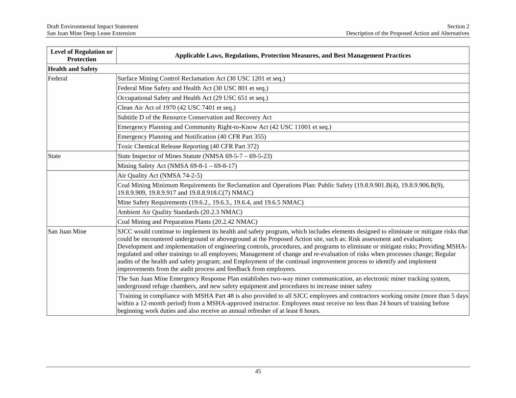
Draft Environmental Impact Statement Section 2 San Juan Mine Deep Lease Extension Description of the Proposed Action and Alternatives
45
Level of Regulation or Protection Applicable Laws, Regulations, Protection Measures, and Best Management Practices
Health and Safety Federal Surface Mining Control Reclamation Act (30 USC 1201 et seq.) Federal Mine Safety and Health Act (30 USC 801 et seq.) Occupational Safety and Health Act (29 USC 651 et seq.) Clean Air Act of 1970 (42 USC 7401 et seq.) Subtitle D of the Resource Conservation and Recovery Act Emergency Planning and Community Right-to-Know Act (42 USC 11001 et seq.) Emergency Planning and Notification (40 CFR Part 355) Toxic Chemical Release Reporting (40 CFR Part 372) State State Inspector of Mines Statute (NMSA 69-5-7 – 69-5-23) Mining Safety Act (NMSA 69-8-1 – 69-8-17) Air Quality Act (NMSA 74-2-5) Coal Mining Minimum Requirements for Reclamation and Operations Plan: Public Safety (19.8.9.901.B(4), 19.8.9.906.B(9),
19.8.9.909, 19.8.9.917 and 19.8.8.918.C(7) NMAC) Mine Safety Requirements (19.6.2., 19.6.3., 19.6.4, and 19.6.5 NMAC) Ambient Air Quality Standards (20.2.3 NMAC) Coal Mining and Preparation Plants (20.2.42 NMAC) San Juan Mine SJCC would continue to implement its health and safety program, which includes elements designed to eliminate or mitigate risks that
could be encountered underground or aboveground at the Proposed Action site, such as: Risk assessment and evaluation; Development and implementation of engineering controls, procedures, and programs to eliminate or mitigate risks; Providing MSHA-regulated and other trainings to all employees; Management of change and re-evaluation of risks when processes change; Regular audits of the health and safety program; and Employment of the continual improvement process to identify and implement improvements from the audit process and feedback from employees.
The San Juan Mine Emergency Response Plan establishes two-way miner communication, an electronic miner tracking system, underground refuge chambers, and new safety equipment and procedures to increase miner safety
Training in compliance with MSHA Part 48 is also provided to all SJCC employees and contractors working onsite (more than 5 days within a 12-month period) from a MSHA-approved instructor. Employees must receive no less than 24 hours of training before beginning work duties and also receive an annual refresher of at least 8 hours.
Draft Environmental Impact Statement Section 3 San Juan Mine Deep Lease Extension Affected Environment
46
3. AFFECTED ENVIRONMENT
The OSMRE’s guidelines for implementing NEPA (OSMRE 1989) state that:
“the EIS should provide concise analysis and conclusions, helpful to decisionmakers. Technical analyses and data may be an important part of EIS preparation but generally are not included in the text. Such material should be incorporated by reference, summarized in the text, or, if needed to substantiate statements made in the EIS, put in an appendix.”
The OSMRE has prepared a TRD that supports the preparation of this EIS. It contains an extensive description of data supporting the description of the affected environment, and of the analysis of environmental consequences of the alternatives. The TRD is incorporated by reference in to this EIS, and is available at the OSMRE website (https://www.wrcc.osmre.gov/initiatives/sanJuanMine/documentLibrary.shtm), and at information repositories that include this EIS.
This section provides a brief description of the affected environment by resource area. The environmental baseline conditions present at the time of publication of an EIS are typically used as the benchmark against which to determine impacts, and these conditions typically reflect the No Action Alternative. However, when an EIS considers a continuing operations project, such as the DLE Mining Plan Modification, the existing conditions are not necessarily an adequate benchmark to determine impacts because they will not differ from the Proposed Action of continuation of the same activity. The EPA provides the following guidance on addressing impacts of ongoing operations:
“Often the current condition is used as the benchmark for comparing the environmental effects of the alternatives. However, the current condition typically may not adequately represent how actions have impacted resources in the past and present or how resources might respond to future impacts. Designating existing environmental conditions as a benchmark may focus the environmental impact assessment too narrowly, overlooking cumulative impacts of past and present actions or limiting assessment to the Proposed Action and future actions. For example, if the current environmental condition were to serve as the condition for assessing the impacts of relicensing a dam, the analysis would only identify the marginal environmental changes between the continued operation of the dam and the existing degraded state of the environment. In this hypothetical case, the affected environment has been affected for more than 50 years with accompanying declines in flows, reductions in fish stocks, habitat loss, and disruption of hydrologic functions. If the assessment took into account the full extent of continued impacts, the significance of the continued operation would more accurately express the state of the environment and thereby better predict the consequences of relicensing the dam” (EPA 1999a).
Following this guidance, the environmental baseline discussion in this EIS includes identification of environmental benchmarks, specific to each resource category if relevant, against which the potential effects of continued operations would be compared. For most environmental resources,

Draft Environmental Impact Statement Section 3 San Juan Mine Deep Lease Extension Affected Environment
47
these environmental benchmarks would be existing regulatory requirements (air quality and water quality standards, for example) as listed in Table 2.3-1 and described in detail for each resource area in the TRD.
As agreed to in the court-approved voluntary remand, the OSMRE has analyzed the effects starting in 2008, the date of the OSMRE’s recommendation to the ASLM to approve the San Juan DLE. Although NEPA is typically forward-looking, the nature of the Court’s order requires that this EIS include a retrospective analysis for each environmental resource, describing the effects from 2008 to 2017. This discussion is contained in the description of the affected environment, as the impacts of mining within the DLE at a rate of 6 million tpy and combustion of the coal at the Generating Station with all four units operating. The EIS analyzes the consequences of the past 9 years of mining through comparison of current conditions to environmental benchmarks.
In addition, as a result of the reduced emissions mandated by the New Mexico SIP and Federal agreements, the contribution to deposition of Hg, selenium (Se), and arsenic (As) from the three large local power plants (Generating Station, Four Corners Power Plant, and Navajo Generating Station) will be reduced approximately 50 percent to 75 percent after 2018, compared to pre-2017. This is in response to: (1) installation of mercury air toxics control standards (MATS) controls on all coal-fired power plants by April 16, 2015, (2) the shutdown of the three units at Four Corners Power Plant, and two units at the Generating Station to comply with best available retrofit technology (BART) requirements to meet visibility and regional haze goals, and (3) the shutdown of all three units at Navajo Generating Station in 2019. Since mining under the DLE began in 2008, changes to the affected environment as a result of compliance with the SIP were considered for each resource area and determined to primarily affect air quality and climate change. These changes are considered part of the baseline environment because they are not part of the Proposed Action, directly or indirectly.
3.1. AIR QUALITY Air quality in the San Juan Basin is affected by a variety of sources. Large stationary sources such as the Four Corners Power Plant and the Generating Station emit substantial amounts of NOX, SO2, particulate matter less than 10 microns in diameter (PM10), and particulate matter less than 2.5 microns in diameter (PM2.5). Oil and gas production facilities in the region emit mainly NOX and VOCs along with some SO2, PM10, and PM2.5. Light motor vehicles, diesel-powered construction equipment, commercial trucks, and commercial and general aviation aircraft used in the region are another source of these pollutants. Non-combustion sources of PM10 and PM2.5 include fugitive dust from roads, construction, demolition, mining, and earthmoving, as well as wind-blown dust and forest fires.
3.1.1. Criteria Pollutants Ambient air monitoring data within a 100-kilometer radius from larger sources shows that air quality in the Project area is in compliance with National Ambient Air Quality Standards (NAAQS) for criteria pollutants. Regional air monitoring data for criteria pollutants from active stations in the Four Corners area indicate that the ambient air conditions in the region are in attainment of the Federal and state ambient air standards. Before 2015, the ozone standard was 0.075 ppm, and there was no exceedance of this standard before 2015. The current standard is
Draft Environmental Impact Statement Section 3 San Juan Mine Deep Lease Extension Affected Environment
48
0.072 ppm; there have been no exceedances of this standard since its adoption, and ozone concentrations have generally decreased at all regional monitoring locations.
3.1.2. Visibility There are two mandatory Class I areas within a 100-kilometer radius of the San Juan Mine that represents the extent to which atmospheric visibility affects are generally evaluated; the TRD also evaluated other individual Class I parks and wilderness areas for the years 2006 to 2015. Evaluation of the trends in regional visibility as measured as a composite for the ten Class I areas within 300 km of the site show that the annual average of all, monitored deciviews (dVs) in Class I areas have generally decreased, indicating that regional visibility has improved during the 10-year period. This is attributed to improved control of air pollution from sources such as power plants (IMPROVE 2017).
3.1.3. Mercury Deposition Mercury is emitted from electrical-generating units in three forms, each of which has specific physical and chemical properties that determine how far it travels in the atmosphere before depositing to the landscape. Before 2008, U.S. coal-fired power plants accounted for over half of the U.S. controllable emissions of the quickly depositing forms of Hg (EPA 2017b). National Hg emissions from domestic anthropogenic sources declined from about 63 tons in 2008 to about 55 tons in 2014, the latest data year available in the EPA National Emissions Inventory (EPA 2017d). More than 75 percent of this decline (5.9 tpy) can be attributed to reductions in Hg emissions from fossil-fueled electric generation plants (EPA 2017d).
Annual sampling data from four Mercury Deposition Network (MDN) sites located at Sycamore Canyon Wilderness (Arizona), Molas Pass and Mesa Verde National Park (Colorado), and Navajo Lake (New Mexico) were compared and aggregated to provide an estimate of historical Hg deposition in the Four Corners region. The average deposition results from these four monitoring stations for the10-year period from 2006 through 2015 were correlated with annual precipitation from seven rain gages during the same 10-year period to obtain estimated Hg deposition (NADP 2017). The average correlated results after 2012 suggest a reversal in the general stabilization of the rate of Hg deposition in the region over the prior decade owing to increases in coal-fired generation in Asia. From 2006 to 2012, the estimated average deposition rate was 20.3 ng/m2 per millimeter precipitation, with an average annual variability less than 20 percent, which indicates that results were reasonably consistent. The trending analysis for the MDN data over the 10-year period of 2006 to 2015 suggests that Hg deposition in the Western region has been increasing (NADP 2017). These historical increases in Hg deposition are due in part to trans-Pacific transport of Hg from sources in Asia, with the largest domestic source being coal-fired power plant emissions (Strode et al. 2008).
3.2. CLIMATE CHANGE The earth’s atmosphere consists of greenhouse gases (GHGs), so-called because like the glass panes of a greenhouse, these gases have the capability to absorb reflected infrared radiation from the earth’s surface. In turn, this causes additional heat to be retained in the lower atmosphere, which on regional and global scales can affect weather patterns and climate. Certain atmospheric gases that act as GHGs are both naturally-occurring and are emitted by human activities, primarily including water vapor, carbon dioxide (CO2), CH4, and nitrous oxide (N2O). Other
Draft Environmental Impact Statement Section 3 San Juan Mine Deep Lease Extension Affected Environment
49
GHG constituents are only created by human activities, such as hydrofluorocarbons (HFCs) (e.g., refrigerants) and sulfur hexafluoride (SF6). GHGs trap solar energy in the atmosphere and this tends to increase surface temperatures. Excessive buildup of GHGs can change Earth’s climate and result in undesirable effects on ecosystems, which affects human health and welfare (EPA 2017e). Over the past century, human activities have released large amounts of CO2 and other GHGs into the atmosphere. The majority of human-caused GHGs are the by-product of burning fossil fuels to release energy in the form of heat, although deforestation, industrial processes, and some agricultural practices and numerous other natural resources also emit GHGs into the atmosphere.
Compared to 1990, annual GHG emissions in the U.S. have increased by about 3.5 percent, based on 2015 reported data. This reflects a general decrease of 10 percent since the highest reported year of 2007 (7,349,000 metric tonnes [MT] carbon dioxide equivalent [CO2
e]) which represented a 15 percent increase compared to 1990. However, year-to-year, emissions are shown to increase or decrease due to changes in the economy, the price of fuel, weather, and other factors. In 2015 (the most recent year with available results), overall GHG emissions decreased about 2 percent from 2014 levels. This decrease was attributed to an overall decrease in fossil fuel combustion, and a continuing trend away from coal towards natural gas as the fuel source for electrical generation (EPA 2017f).
SJCC submits annual Federal and New Mexico reports on San Juan Mine GHG emissions associated with underground mining and secondary crushing on the surface. One metric of emission intensity is the GHG emitted per ton of coal produced. This value varies between 0.10 to 0.20 tons GHG per ton coal produced at the San Juan Mine and averaged 0.16 for the six years from 2011-2016 (SJCC 2017a; Ecosphere 2017b). A minor amount (approximately 5 percent of total mine emissions) of additional CH4 release occurs with the secondary crushing of the coal in a closed building during processing at the surface in the coal preparation plant. When compared to the statewide inventory, reported GHG emissions for the San Juan Mine were approximately 58 percent of the total coal-mining GHG emissions for the state of New Mexico in 2013 (NMED 2016).
Mobile GHG emissions from the San Juan Mine result from support vehicles and equipment in the form of engine exhaust. As an underground mine, the level of operation for above-ground engine-driven equipment is much less than for a surface coal mine of comparable output. Between 2008 and 2016, the engine exhaust CO2 emissions averaged less than 0.1 percent of the total mine CH4 emissions on a CO2e basis (SJCC 2017a). Consequently, these surface GHG emissions are viewed as negligible compared to the underground mining and coal crushing emissions CH4.
GHG emissions from past and future operations of the Generating Station are quantified and evaluated in order to evaluate the potential indirect effects of combustion of the coal produced at the San Juan Mine. Average GHG emissions at the Generating Station for 2016 and 2017 are listed in Table 3.2-1. The total annual CO2
e emissions from the Generating Station is 11,365,795 MT. This value is well below the NMED Title V permit limit of 17,827,333 MT. For comparison, the total annual GHG emissions from coal mining at the San Juan Mine is less than 900,000 MT/year. Of the total CO2
e, almost all results from combustion-related emissions of CO2.
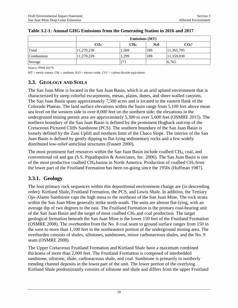
Draft Environmental Impact Statement Section 3 San Juan Mine Deep Lease Extension Affected Environment
50
Table 3.2-1: Annual GHG Emissions from the Generating Station in 2016 and 2017
Emissions (MT) CO2 CH4 N20 CO2e
Total 11,270,238 1,569 189 11,365,795 Combustion 11,270,239 1,299 189 11,359,030 Storage 271 6,765 Source: PNM 2017b MT = metric tonnes, CH4 = methane, N2O = nitrous oxide, CO2
e = carbon dioxide equivalents
3.3. GEOLOGY AND SOILS The San Juan Mine is located in the San Juan Basin, which is an arid upland environment that is characterized by steep colorful escarpments, mesas, plains, dunes, and sheer-walled canyons. The San Juan Basin spans approximately 7,500 acres and is located in the eastern flank of the Colorado Plateau. The land surface elevations within the basin range from 5,100 feet above mean sea level on the western side to over 8,000 feet on the northern side; the elevations in the underground mining permit area are approximately 5,300 to over 5,600 feet (OSMRE 2015). The northern boundary of the San Juan Basin is defined by the prominent Hogback outcrop of the Cretaceous Pictured Cliffs Sandstone (PCS). The southern boundary of the San Juan Basin is loosely defined by the Zuni Uplift and northern limit of the Chaco Slope. The interior of the San Juan Basin is defined by gently dipping to flat-lying sedimentary rocks and a few widely distributed low-relief anticlinal structures (Fassett 2000).
The most prominent fuel resources within the San Juan Basin include coalbed CH4, coal, and conventional oil and gas (S.S. Papadopulos & Associates, Inc. 2006). The San Juan Basin is one of the most productive coalbed CH4 basins in North America. Production of coalbed CH4 from the lower part of the Fruitland Formation has been on-going since the 1950s (Huffman 1987).
3.3.1. Geology The four primary rock sequences within this depositional environment change are (in descending order): Kirtland Shale, Fruitland Formation, the PCS, and Lewis Shale. In addition, the Tertiary Ojo-Alamo Sandstone caps the high mesa to the northeast of the San Juan Mine. The rock strata within the San Juan Mine generally strike north-south. The units are almost flat-lying, with an average dip of two degrees to the east. The Fruitland Formation is the primary coal-bearing unit of the San Juan Basin and the target of most coalbed CH4 and coal production. The target geological formation beneath the San Juan Mine is the lower 150 feet of the Fruitland Formation (OSMRE 2008). The overburden from the No. 8 coal seam to ground surface ranges from 150 in the west to more than 1,100 feet in the northeastern portion of the underground mining area. The overburden consists of shales, siltstones, sandstones, minor carbonaceous shales, and the No. 9 seam (OSMRE 2008).
The Upper Cretaceous Fruitland Formation and Kirtland Shale have a maximum combined thickness of more than 2,000 feet. The Fruitland Formation is composed of interbedded sandstone, siltstone, shale, carbonaceous shale, and coal. Sandstone is primarily in northerly trending channel deposits in the lower part of the unit. The lower portion of the overlying Kirtland Shale predominantly consists of siltstone and shale and differs from the upper Fruitland
Draft Environmental Impact Statement Section 3 San Juan Mine Deep Lease Extension Affected Environment
51
Formation mainly in its lack of carbonaceous shale and coal (Huffman 1987). Fruitland Formation coal seams tend to be lens-shaped, and most are only minable in localized areas.
The PCS conformably overlies the deep-water marine deposits of the Lewis Shale Formation and consists of alternating sandstone, gray siltstone, and interlacing mudstone beds within the Lewis Shale. The upper two-thirds of the PCS consists of a generally coarsening upward sequence of light gray, very fine-grained, massive sandstone while the lower one-third of the formation consists of interbedded shale and sandstone. The total thickness of the PCS varies due to depositional irregularities but averages 120 feet in the San Juan Mine area.
Very few faults have been mapped at the surface of the San Juan Basin (Huffman 1987). In regard to seismicity, the San Juan Mine is situated in a Seismic Zone 1, bordering on a Seismic Zone 2, as defined by the National Oceanic and Atmospheric Administration in 1969. Zone 1 is defined as the region where only minor damage is expected from seismic events. In Zone 2, moderate damage is possible. In this respect, the mine is located in a low earthquake hazard area.
3.3.2. Paleontology A paleontological survey of the DLE was conducted in May 2017 (Zeigler 2017a). The survey focused on the Kirtland Formation exposures within the DLE area, which are designated as Potential Fossil Yield Category 4-5 by the BLM due to the presence of several scientifically significant fossil groups. The survey comprised a five-square mile area and included documentation of all encountered vertebrate, trace, and plant fossil material. Fossil material observed during the survey included three groups: unidentifiable vertebrate skeletal material, identifiable vertebrate skeletal material, and, petrified wood. The survey identified 50 individual fossil-bearing localities that included petrified wood, unidentifiable vertebrate skeletal material and material tentatively identified as pertaining to the trionychid turtle genus Aspideretoides, Crocodylia Indeterminate, Dinosauria Indeterminate, and Hadrosauridae.
3.4. ARCHAEOLOGY AND CULTURAL RESOURCES The DLE is located in an area long inhabited by Native American Tribes, and cultural resources are present on the DLE. The cultural resource present on the DLE vary from artifacts (i.e., tools, pottery) to architectural features (i.e. stone wall, shelter) to traditional use areas (i.e., hunting or foraging areas). Based on data provided by the New Mexico State Historic Preservation Officer (SHPO), there have been 86 previous cultural resources investigations that encompass all or part of the area of potential effect (APE). These investigations include surveys performed for the permitting of the original San Juan Mine as well as subsequent investigations for other projects. The most extensive cultural resource investigation in the APE was the Class III cultural resources inventory performed by Alpine Archaeological Consultants in 1997 (Horn 1997). The 1997 Class III inventory for the DLE project identified 83 archaeological sites and 140 isolated archaeological finds/occurrences within the study area. Based on the results of the survey the BLM recommended 36 sites as not eligible for listing on the NRHP, 46 sites as eligible, and one site as unevaluated (i.e., requiring additional investigations to determine NRHP eligibility). A complete list of all investigations performed at the mine is provided in the TRD.
In a letter summarizing the findings of the inventory dated July 2, 1998 (OSMRE 2008), the New Mexico SHPO provided the following National Register of Historic Places (NRHP) eligibility determinations for the 83 identified sites: 30 sites were determined eligible for listing on the

Draft Environmental Impact Statement Section 3 San Juan Mine Deep Lease Extension Affected Environment
52
NRHP, 35 sites were determined not eligible for listing on the NRHP and 18 sites were not evaluated for NRHP eligibility. The letter states that additional investigations (e.g., subsurface testing, ethnographic studies) were necessary to determine the NRHP eligibility of the 18 sites with no eligibility determination. In a letter dated April 5, 1999, the BLM provided the New Mexico SHPO with a letter from SJCC providing additional information on project facilities and potential impacts to cultural resources due to subsidence caused by mining activities. To avoid impacts, SJCC made the following findings/commitments: (1) All significant sites would be avoided by surface development activities. If they could not be avoided, SJCC would prepare and implement a data recovery plan; (2) Impacts to significant sites from subsidence would be unlikely, with only small surface cracks developing. SJCC proposed to prepare and implement a data recovery plan at three sites that contain features or are in a setting that could be impacted by cracking or subsidence: sites LA 119286 and LA 119325 on BLM land and LA 199326 on New Mexico state land; and (3) A stipulation for monitoring of the condition of Federal sites determined eligible or of unevaluated eligibility to assess damage due to cracking, subsidence or other disturbances. In the event of impacts, data recovery plans would be prepared and implemented.
Based on the findings of the Class III inventory (Horn 1997) and the commitments outlined above, the BLM determined that development of the DLE would have no adverse effect on historic properties. In a letter from the BLM to SJCC dated April 29, 1999, the BLM informed SJCC that they had not received comments from the New Mexico SHPO within 10 working days of submitting their determination of no adverse effect. The BLM stated that per Section F 2. (iii) of the Protocol Agreement between the BLM and the New Mexico SHPO, the BLM had determined that the development of the Federal portion of the DLE would have no adverse effect if the following requirements were followed: (1) Before any actions or mining in the vicinity of sites LA 119286 and LA 119325, SJCC would prepare and implement data recovery plans for these sites; (2) All other historic properties would be avoided by surface facilities or activities; and (3) A stipulation would be attached to the mining permit that would require monitoring of the condition of a sample of Federal sites to assess damage due to cracking, subsidence or other disturbances. In the event of a negative impact, data recovery plans may need to be prepared and implemented.
Underground coal mining began in the DLE in 2000. In accordance with BLM and New Mexico MMD, SJCC developed and implemented a plan to monitor the effects of subsidence on archaeological sites within the DLE before the mining activities (Simpson and Meininger 2017). Before mining activities, the monitoring plan was changed to take a phased approach to subsidence monitoring. The phased approach involved the monitoring of surface transects above longwall mining panels and data recovery excavations at impacted sites as underground mining activities expanded within the DLE (Simpson and Meininger 2017). In 2006, it was determined that the continued expansion of the mine would result in subsurface mining beneath nine additional archaeological sites. Based on the results of the first four phases of subsidence monitoring, the New Mexico MMD determined that regular monitoring of archaeological sites that could be impacted by subsidence should be carried out at regular intervals before and after mining (Simpson and Meininger 2017). As a result, Phase V of the monitoring plan was developed to provide a procedure for future site monitoring.

Draft Environmental Impact Statement Section 3 San Juan Mine Deep Lease Extension Affected Environment
53
Cultural resource investigations were conducted between 2010 and 2013, including monitoring the installation of underground mine vents; a reconnaissance survey requested by the BLM Farmington Field Office (BLM/FFO) to relocate registered sites in advance of seismic survey activities; survey and monitoring of groundwater observation wells; an impact assessment at site LA 119301; and, an assessment and update of site LA 119287 (Simpson and Meininger 2017). During this period subsurface longwall mining continued to expand with in the DLE. As part of the Phase V subsidence-monitoring program between 2011 and 2014, 62 archaeological sites were evaluated. In 2017, an additional 55 sites within the DLE were evaluated to assess their current condition and eligibility for listing on the NRHP as part of the current EIS effort (Simpson and Meininger 2017).
3.5. WATER RESOURCES/HYDROLOGY
3.5.1. Surface Water Hydrology The San Juan River is the prominent water feature in the San Juan Basin, serving as the primary watershed and drainage network. The San Juan Mine is located approximately 3 miles north of the San Juan River. The water features present in the DLE and San Juan Mine are predominantly ephemeral and intermittent streams that convey water only after precipitation events. Considering that the local climate is characterized by occurrences of summer rains that fall almost entirely during brief, but frequently intense, thunderstorms/rain events, stream flows are widely variable, going from no discharge (dry channels) to peak discharge followed by a gradually diminishing discharge over several subsequent hours. These rapidly varying flows can transport large amounts of sediment and cause extensive changes in the shape of the channels after single events (Ecosphere 2017d).
The only perennial riparian feature present in the DLE and San Juan Mine is the Shumway Arroyo, which flows into the San Juan River. The Shumway Arroyo serves as the primary surface water drainage at the San Juan Mine and has a small base flow that begins below its confluence with the Westwater Arroyo in the vicinity of the Generating Station. Stevens Arroyo and Hutch Canyon are the primary surface water features within the eastern portions of the San Juan Mine coal lease including the area of the DLE. The middle segment of the Shumway Arroyo starts at the confluence of two branches downstream of Youngs Lake and flows to the southwest through the San Juan Mine. Hutch Canyon and an unnamed tributary enter the middle segment of the Shumway Arroyo within the coal lease and upstream of the confluence with the Westwater Arroyo. The total drainage area of the Shumway Arroyo upstream of the Westwater confluence is 108.8 square miles. Before mining, most of the south surface mining tract drained to the Shumway Arroyo. However, the southern-most portion of this tract drained directly to the San Juan River (Ecosphere 2017d).
The Westwater Arroyo, a major tributary of the Shumway Arroyo, has a drainage area of 26.5 square miles and joined the main Shumway Arroyo drainage channel in the western portion of the San Juan Mine. The Westwater Arroyo originates on Ute Mountain Ute tribal lands (north of the San Juan Mine) and crosses the Lewis Shale and the PCS. It then flows south along the contact between the PCS and the Fruitland Formation near the western boundary of the coal lease to the confluence with the Shumway Arroyo. The segment of the Westwater Arroyo upgradient of the San Juan Mine boundary drains an area of 16.3 square miles. Before mining,
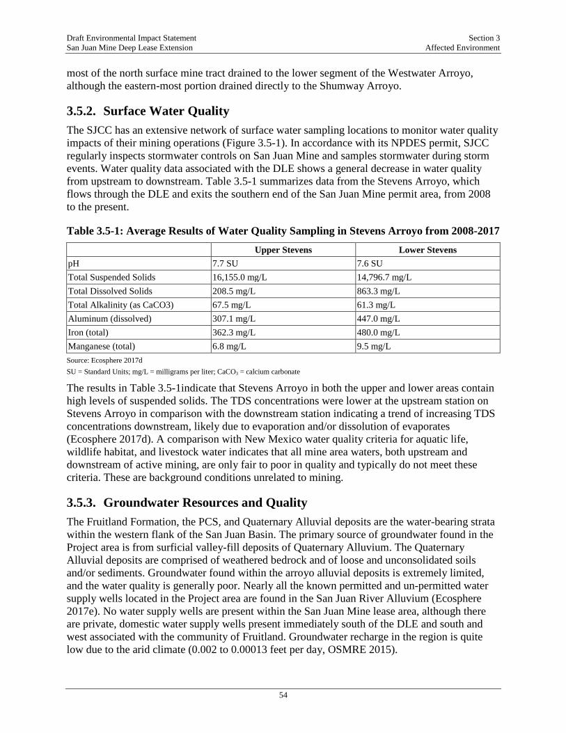
Draft Environmental Impact Statement Section 3 San Juan Mine Deep Lease Extension Affected Environment
54
most of the north surface mine tract drained to the lower segment of the Westwater Arroyo, although the eastern-most portion drained directly to the Shumway Arroyo.
3.5.2. Surface Water Quality The SJCC has an extensive network of surface water sampling locations to monitor water quality impacts of their mining operations (Figure 3.5-1). In accordance with its NPDES permit, SJCC regularly inspects stormwater controls on San Juan Mine and samples stormwater during storm events. Water quality data associated with the DLE shows a general decrease in water quality from upstream to downstream. Table 3.5-1 summarizes data from the Stevens Arroyo, which flows through the DLE and exits the southern end of the San Juan Mine permit area, from 2008 to the present.
Table 3.5-1: Average Results of Water Quality Sampling in Stevens Arroyo from 2008-2017
Upper Stevens Lower Stevens pH 7.7 SU 7.6 SU Total Suspended Solids 16,155.0 mg/L 14,796.7 mg/L Total Dissolved Solids 208.5 mg/L 863.3 mg/L Total Alkalinity (as CaCO3) 67.5 mg/L 61.3 mg/L Aluminum (dissolved) 307.1 mg/L 447.0 mg/L Iron (total) 362.3 mg/L 480.0 mg/L Manganese (total) 6.8 mg/L 9.5 mg/L Source: Ecosphere 2017d SU = Standard Units; mg/L = milligrams per liter; CaCO3 = calcium carbonate
The results in Table 3.5-1indicate that Stevens Arroyo in both the upper and lower areas contain high levels of suspended solids. The TDS concentrations were lower at the upstream station on Stevens Arroyo in comparison with the downstream station indicating a trend of increasing TDS concentrations downstream, likely due to evaporation and/or dissolution of evaporates (Ecosphere 2017d). A comparison with New Mexico water quality criteria for aquatic life, wildlife habitat, and livestock water indicates that all mine area waters, both upstream and downstream of active mining, are only fair to poor in quality and typically do not meet these criteria. These are background conditions unrelated to mining.
3.5.3. Groundwater Resources and Quality The Fruitland Formation, the PCS, and Quaternary Alluvial deposits are the water-bearing strata within the western flank of the San Juan Basin. The primary source of groundwater found in the Project area is from surficial valley-fill deposits of Quaternary Alluvium. The Quaternary Alluvial deposits are comprised of weathered bedrock and of loose and unconsolidated soils and/or sediments. Groundwater found within the arroyo alluvial deposits is extremely limited, and the water quality is generally poor. Nearly all the known permitted and un-permitted water supply wells located in the Project area are found in the San Juan River Alluvium (Ecosphere 2017e). No water supply wells are present within the San Juan Mine lease area, although there are private, domestic water supply wells present immediately south of the DLE and south and west associated with the community of Fruitland. Groundwater recharge in the region is quite low due to the arid climate (0.002 to 0.00013 feet per day, OSMRE 2015).
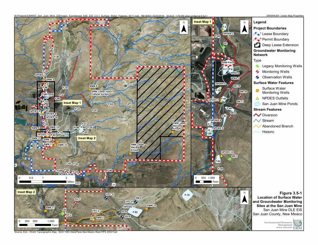
LegendProject Boundaries
Lease BoundaryPermit BoundaryDeep Lease Extension
Groundwater MonitoringNetworkType@A Legacy Monitoring Wells@A Monitoring Wells@A Observation Wells
Surface Water Features")
Surface WaterMonitoring Wells
#* NPDES OutfallsSan Juan Mine Ponds
Stream FeaturesDiversionStreamAbandoned BranchHistoric
M:\Projects\0394667_San_Juan_Mine_EIS\maps\_!Condensed_EIS\_EIS_3.5-1_Surface_Water_Features_8X11.mxd, REVISED: 03/20/2018, SCALE: 1:78,000 when printed at 8.5x11 DRAWN BY: Under Map Properties
¯
Source: Esri - World Topoographic Map; NAD 1983 StatePlane New Mexico West FIPS 3003 Feet
Environmental ResourcesManagement
www.erm.com ERM0 500 1,000250
Feet
0 1 20.5Miles
¯
¯
0 500 1,000Feet
Inset Map 1
Inset Map 2
Inset Map 2
Inset Map 1
Figure 3.5-1Location of Surface Water
and Groundwater MonitoringSites at the San Juan Mine
San Juan Mine DLE EISSan Juan County, New Mexico

Draft Environmental Impact Statement Section 3 San Juan Mine Deep Lease Extension Affected Environment
56
The Fruitland Formation No. 8 coal seam is the major water-bearing layer of the geologic unit (although it produces low yields and water quality is poor). In the DLE, the No. 8 coal seam ranges in depth from 150 to 1,200 feet below ground surface, while south of the mine lease it shallows to beneath the San Juan River Alluvium. The No. 9 coal seam, which is stratigraphically located approximately 100 feet above the No. 8 coal seam, contains isolated perched water-bearing sands (Ecosphere 2017e). No springs or seeps are known to issue from the Fruitland Formation. The PCS is a well-cemented marine sand and is nearly 120 feet thick in the ROI. Due to low permeability, poor water quality, and low production rates, it is considered a poor aquifer and it is restricted only to marginal livestock watering (OSMRE 2015).
The groundwater flow in the general vicinity of the San Juan Mine is from the formation outcrop areas at higher elevations to the north and northeast of the ROI toward the formation sub-crop within the San Juan River alluvium, on the southern end of the ROI. Based on review of the piezometer data, the general groundwater flow within the San Juan Mine lease area is consistent with the regional depiction (north-northwest to the south-southeast). The potentiometric data indicates that the No. 8 Coal Seam occurs primarily under confined conditions, except in limited areas along the western perimeter of the analysis area near the coal outcrop. The data also indicate that by 1998, the potentiometric surface of the No. 8 Coal Seam depicted from wells 17CC and 32CD had become depressed due to natural gas extraction operations, which extract large volumes of water to support natural gas production.
Development of SJCC’s underground mine has also caused drawdown of the potentiometric surface of the No. 8 Coal Seam to the east and the south of the surface mine area. Periodically, groundwater has been encountered underground in the DLE since mining began in 2008, and to ensure the safety of miners and conform to regulatory requirements, water is pumped to a discharge pond on the surface. Water from the discharge pond is pumped to the San Juan Mine evaporation ponds where it remains until evaporation takes place, per the NMOSE Permit Number SJ2197 (Ecosphere 2017e). Overall, the data indicate that natural gas production has the dominant effect in altering the groundwater flow patterns, but that underground mining did have a secondary effect through drawdown of a portion of the water in the PCS. Based on the aquifer transmissivity and regional groundwater setting, recovery of the water elevations is estimated to occur over hundreds of years.
Groundwater monitoring has been conducted at the San Juan Mine since 1973, both in the Fruitland Formation (No. 8 Coal Seam) and the PCS. The quality of groundwater in the region from these formations is not suitable for drinking and exceeds New Mexico standards for most parameters. Groundwater quality in the Project area is similar, though with higher levels of TDS and associated compounds. These are background conditions unrelated to mining.
Water quality characterization of the alluvium was carried out at the San Juan Mine in 2012 and 2013. Baseline water quality in the Westwater Arroyo alluvium indicated high concentration of TDS and SO4 before mining and mine placement of CCR. Samples of alluvial well GE (located in the Westwater Arroyo and upgradient of CCR disposal sites at the San Juan Mine) taken before 1977 show that TDS exceeded the New Mexico water quality regulatory threshold of 10,000 mg/L. The high TDS is a natural background condition. The high chloride, Na, and SO4 in the alluvial wells before 1977 are likely associated with natural oxidation products from the weathered coals and carbonaceous shale near the Fruitland Formation outcrop and the chloride salts in the PCS. Recharge from high precipitation events, surface water flows, and historical impoundment of water can leach salts into shallow alluvial groundwater. PCS groundwater
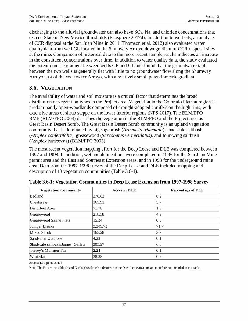
Draft Environmental Impact Statement Section 3 San Juan Mine Deep Lease Extension Affected Environment
57
discharging to the alluvial groundwater can also have SO4, Na, and chloride concentrations that exceed State of New Mexico thresholds (Ecosphere 2017d). In addition to well GE, an analysis of CCR disposal at the San Juan Mine in 2011 (Thomson et al. 2012) also evaluated water quality data from well GL located in the Shumway Arroyo downgradient of CCR disposal sites at the mine. Comparison of historical data to the more recent sample results indicates an increase in the constituent concentrations over time. In addition to water quality data, the study evaluated the potentiometric gradient between wells GE and GL and found that the groundwater table between the two wells is generally flat with little to no groundwater flow along the Shumway Arroyo east of the Westwater Arroyo, with a relatively small potentiometric gradient.
3.6. VEGETATION The availability of water and soil moisture is a critical factor that determines the broad distribution of vegetation types in the Project area. Vegetation in the Colorado Plateau region is predominantly open-woodlands composed of drought-adapted conifers on the high rims, with extensive areas of shrub steppe on the lower interior regions (NPS 2017). The BLM/FFO RMP (BLM/FFO 2003) describes the vegetation in the BLM/FFO and the Project area as Great Basin Desert Scrub. The Great Basin Desert Scrub community is an upland vegetation community that is dominated by big sagebrush (Artemisia tridentata), shadscale saltbush (Atriplex confertifolia), greasewood (Sarcobatus vermiculatus), and four-wing saltbush (Atriplex canescens) (BLM/FFO 2003).
The most recent vegetation mapping effort for the Deep Lease and DLE was completed between 1997 and 1998. In addition, wetland delineations were completed in 1996 for the San Juan Mine permit area and the East and Southeast Extension areas, and in 1998 for the underground mine area. Data from the 1997-1998 survey of the Deep Lease and DLE included mapping and description of 13 vegetation communities (Table 3.6-1).
Table 3.6-1: Vegetation Communities in Deep Lease Extension from 1997-1998 Survey
Vegetation Community Acres in DLE Percentage of DLE Badland 278.82 6.2 Cheatgrass 165.91 3.7 Disturbed Area 71.78 1.6 Greasewood 218.58 4.9 Greasewood Saline Flats 15.24 0.3 Juniper Breaks 3,209.72 71.7 Mixed Shrub 165.28 3.7 Sandstone Outcrops 4.23 0.1 Shadscale saltbush/James’ Galleta 305.97 6.8 Torrey’s Mormon Tea 2.24 0.1 Winterfat 38.88 0.9 Source: Ecosphere 2017f Note: The Four-wing saltbush and Gardner’s saltbush only occur in the Deep Lease area and are therefore not included in this table.

Draft Environmental Impact Statement Section 3 San Juan Mine Deep Lease Extension Affected Environment
58
3.7. WILDLIFE The DLE and San Juan Mine support a variety of natural vegetation communities and landscape features that offer a diversity of wildlife habitat types. The various landscape features present on the San Juan Mine and surrounding area, such as washes and gullies, rock outcrops and hillsides, and cliffs and taluses, all contribute to the diversity of wildlife in the area as they provide microhabitats for wildlife uniquely adapted to or dependent on these features.
The potential for occurrence of wildlife species in the vicinity of the San Juan Mine and in the region of influence for deposition from the Generating Station was determined through review of publicly available information and biological surveys conducted within the ROI and DLE. The most commonly observed wildlife in the San Juan Mine DLE area include Pronghorn antelope (Antilocapra americana), coyotes (Canis latrans), desert cottontail (Sylvilagus audobonii), black-tailed jackrabbit (Lepus californicus), Ord’s kangaroo rat (Dipodomys ordii), pack rat (Neotoma spp.) and several lizards including western whiptail (Cnemidophorus tigris), sagebrush lizard (Sceloporus graciosus), and lesser earless lizard (Holbrookia maculata) (Ecosphere 2017g).
3.8. SPECIAL STATUS SPECIES Based on a critical review of all threatened and endangered species listed by the State of New Mexico, BLM, Navajo Nation Heritage Program, and the FWS, and coordination with the FWS, the species listed in Table 3.8-1 are considered to have potential to occur within the region of influence of the San Juan Mine and/or the Generating Station.
Designated critical habitat for the Colorado pikeminnow and razorback sucker and proposed critical habitat for the yellow-billed cuckoo is present in the vicinity of the San Juan Mine. The FWS has published the final critical habitat designation for the Colorado pikeminnow and Razorback sucker along with San Juan River and have proposed critical habitat for the yellow-billed cuckoo along the San Juan River as well.
Table 3.8-1: Special Status Species with Potential to Occur within the Vicinity of the San Juan Mine or Region of Influence of Deposition from the Generating Station
Species Common Name Scientific Name Listing Status
Amphibians Northern Leopard Frog Lithobates pipiens NESL Group 2 Birdsa American Dipper Cinclus mexicanus NHP Group 3
Bald Eagle Haliaeetus leacocephalus NNHP Group 2, BLM sensitive species; state-threatened species
Bendire’s Thrasher Toxostoma bendirei FWS BCC and a BLM sensitive species Brewer’s Sparrow Spizella breweri FWS BCC Burrowing Owl Athene cunicularia FWS BCC and a BLM sensitive species Ferruginous Hawk Buteo regalis NNHP Group 3 species and a BLM sensitive species
Golden Eagle Aquila chrysaetos NNHP Group 3 species and a BLM sensitive species. Also protected under the BGEPA
Grace’s Warbler Dendroica graciae FWS BCC

Draft Environmental Impact Statement Section 3 San Juan Mine Deep Lease Extension Affected Environment
59
Species Common Name Scientific Name Listing Status
Gray Vireo Vireo vicinior FWS BCC and state-threatened species Lesser Yellowlegs Tringa flavipes FWS BCC Loggerhead Shrike Lanius ludovicianus BLM sensitive species Long-eared Owl Asio otus FWS BCC
Mexican Spotted Owl Strix occidentalis lucida NNHP Group 3 species, and a BLM threatened species (Peripheral)
Olive-sided Flycatcher Contopus cooperi FWS BCC Peregrine Falcon Falco peregrinus BLM sensitive species and a state threatened species
Pinyon Jay Gymnorhinus cyanocephalus FWS BCC and a BLM sensitive species
Prairie Falcon Falco mexicanus BLM sensitive species Rufous Hummingbird Selasphorus rufus FWS BCC
Southwestern Willow Flycatcher Empidonax traillii extimus
NNHP Group 2 species, a federally endangered species, a BLM endangered species (Verified), and a state endangered species
Virginia’s Warbler Vermivora virginiae FWS BCC Willow Flycatcher Empidonax traillii FWS BCC Yellow-billed cuckoo (western)
Coccyzus americanus occidentalis
NNHP Group 2 species, a federally endangered species, and a BLM threatened (Verified) species
Fish
Colorado Pikeminnow Ptychocheilus lucius Federal and New Mexico endangered species, a NNHP Group 2 species, and a BLM endangered species (Hypothetical)
Razorback Sucker Xyrauchen taxanus Federal and New Mexico endangered species, a NNHP Group 2 species, and a BLM endangered species (Hypothetical)
Roundtail Chub Gila robusta New Mexico threatened species and a NNHP Group 2 species. Mammals Canada Lynx Lynx canadensis Federally threatened species Gunnison’s Prairie Dog Cynomys gunnisoni BLM sensitive species New Mexico Meadow Jumping Mouse Zapus hudsonius luteus Federally endangered species and a BLM endangered species
(Peripheral) Pronghorn Antelope Antilocapra americana NNHP Group 3 species Spotted Bat Euderma maculatum State threatened species, and a BLM sensitive species Townsend’s Big-eared Bat Corynorhinus townsendii BLM sensitive species
Plants
Aztec Gilia and Brack Hardwall Cactus
Aliciella formosa and Sclerocactus cloverase ssp. brackii
State endangered species and a BLM sensitive species
Mancos Milkvetch Astragalus humillimus NNHP Group 2 species, a federally endangered species, and a state endangered species
Mancos Saltbush Proatriplex pleiantha BLM sensitive species
Mesa Verde Cactus Sclerocactus mesae-verdae
NNHP Group 2 species, a federally threatened species, and a state endangered species
Naturita Milkvetch Astragalus naturitensis NNHP Group 3 species
Draft Environmental Impact Statement Section 3 San Juan Mine Deep Lease Extension Affected Environment
60
Species Common Name Scientific Name Listing Status
Parish’s Alkali Grass Puccinellia parishii BLM sensitive species and a state endangered species San Juan Milkweed Asclepias sanjuanesnsis BLM sensitive species Source: BLM 2016, NNHP 2008, NMDGF 2017 BCC = Birds of Conservation Concern; NMDGF = New Mexico Department of Fish and Game; NNHP = Navajo Natural Heritage Program
3.9. LAND USE/TRANSPORTATION/AGRICULTURAL The San Juan Mine lies on mostly public land administered by the BLM/FFO, as well as state and private lands. It is generally bordered by the Ute Mountain Ute Indian Reservation to the north; the BLM/FFO-administered Piñon Mesa Specially Designated Area (SDA) to the east; BLM and private lands to the south; and BLM, state, and private lands to the west. The town of Kirtland, New Mexico is adjacent to the south end of the DLE. The two primary uses of the San Juan Permit area are surface coal mining and livestock grazing, and to a lesser extent, wildlife habitat, oil and gas production, surface gravel mining, and recreation. The designated use of the land following mining is grazing and wildlife habitat. The land within the San Juan Mine and the DLE permit area does not contain any croplands or designated Prime or Unique Farmlands (NRCS 1998).
The DLE area contains portions of three grazing allotments administered by the BLM/FFO: Cline Arroyo, Shumway Arroyo Allotment Management Plan (AMP), and Twin Mounds. Approximately 63 percent of the Cline Arroyo allotment, 9 percent of the Shumway Arroyo AMP allotment, and 12 percent of the Twin Mounds allotment are situated in the DLE (Ecosphere 2017c).
There have been 80 oil and gas wells drilled within the underground mine area and five oil and gas wells in the surface mine area. Of the five located in the surface mine area, three were inactive as of January 1989 (Ecosphere 2017c). In the Deep Lease and DLE, the oil and gas estate is Federal, except in the NW ¼, NW ¼ of Section 18 and Section 32. Minerals in NW ¼, NW ¼ of Section 18 are private; and minerals in Section 32 are owned by the State of New Mexico.
No U.S. or State highways cross the DLE section. County road (CR) 6800 from Highway 64 is used for access to the main facilities of the mine, while access roads built along each mine panel of the underground mine allow for the construction of gob vent boreholes and refuge safety chambers. CR 6400 (from Kirtland) or Barker Dome Road are also public roads used for access to the mine (SJCC 2017b). The DLE is open to all vehicular travel, with no limitations or restriction on off-highway vehicle (OHV) uses. Observations indicate that there is light OHV use within the DLE (Ecosphere 2017c). Based on data provided by SJCC, daily employee-based traffic on CR 6800 consists of 200 employees during dayshift, 100 during swing shift, and 60 during night and weekend shifts (SJCC 2017b). Average daily traffic for US Highway 64 counted between CR 6500 and CR 6800 in 2016 totaled 17,910 vehicles, which was less than the 19,720 vehicles counted at the same location in 2012 and similar to the 2009 count of 17,600 (Farmington Metropolitan Planning Office 2017).
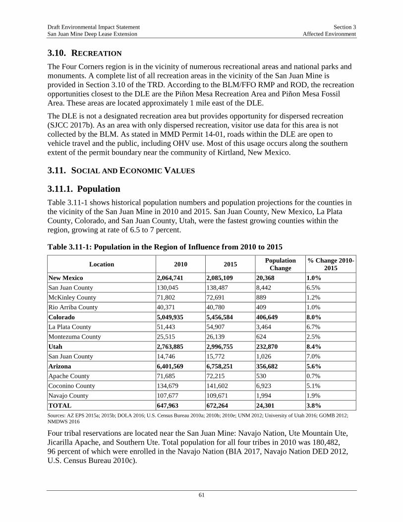
Draft Environmental Impact Statement Section 3 San Juan Mine Deep Lease Extension Affected Environment
61
3.10. RECREATION The Four Corners region is in the vicinity of numerous recreational areas and national parks and monuments. A complete list of all recreation areas in the vicinity of the San Juan Mine is provided in Section 3.10 of the TRD. According to the BLM/FFO RMP and ROD, the recreation opportunities closest to the DLE are the Piñon Mesa Recreation Area and Piñon Mesa Fossil Area. These areas are located approximately 1 mile east of the DLE.
The DLE is not a designated recreation area but provides opportunity for dispersed recreation (SJCC 2017b). As an area with only dispersed recreation, visitor use data for this area is not collected by the BLM. As stated in MMD Permit 14-01, roads within the DLE are open to vehicle travel and the public, including OHV use. Most of this usage occurs along the southern extent of the permit boundary near the community of Kirtland, New Mexico.
3.11. SOCIAL AND ECONOMIC VALUES
3.11.1. Population Table 3.11-1 shows historical population numbers and population projections for the counties in the vicinity of the San Juan Mine in 2010 and 2015. San Juan County, New Mexico, La Plata County, Colorado, and San Juan County, Utah, were the fastest growing counties within the region, growing at rate of 6.5 to 7 percent.
Table 3.11-1: Population in the Region of Influence from 2010 to 2015
Location 2010 2015 Population Change
% Change 2010-2015
New Mexico 2,064,741 2,085,109 20,368 1.0% San Juan County 130,045 138,487 8,442 6.5% McKinley County 71,802 72,691 889 1.2% Rio Arriba County 40,371 40,780 409 1.0% Colorado 5,049,935 5,456,584 406,649 8.0% La Plata County 51,443 54,907 3,464 6.7% Montezuma County 25,515 26,139 624 2.5% Utah 2,763,885 2,996,755 232,870 8.4% San Juan County 14,746 15,772 1,026 7.0% Arizona 6,401,569 6,758,251 356,682 5.6% Apache County 71,685 72,215 530 0.7% Coconino County 134,679 141,602 6,923 5.1% Navajo County 107,677 109,671 1,994 1.9% TOTAL 647,963 672,264 24,301 3.8% Sources: AZ EPS 2015a; 2015b; DOLA 2016; U.S. Census Bureau 2010a; 2010b; 2010e; UNM 2012; University of Utah 2016; GOMB 2012; NMDWS 2016
Four tribal reservations are located near the San Juan Mine: Navajo Nation, Ute Mountain Ute, Jicarilla Apache, and Southern Ute. Total population for all four tribes in 2010 was 180,482, 96 percent of which were enrolled in the Navajo Nation (BIA 2017, Navajo Nation DED 2012, U.S. Census Bureau 2010c).
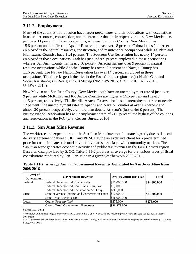
Draft Environmental Impact Statement Section 3 San Juan Mine Deep Lease Extension Affected Environment
62
3.11.2. Employment Many of the counties in the region have larger percentages of their populations with occupations in natural resources, construction, and maintenance than their respective states. New Mexico has just over 11 percent in those occupations, whereas, San Juan County, New Mexico has 15.6 percent and the Jicarilla Apache Reservation has over 18 percent. Colorado has 9.4 percent employed in the natural resources, construction, and maintenance occupations while La Plata and Montezuma Counties have 11.4 percent. The Southern Ute Reservation has nearly 17 percent employed in those occupations. Utah has just under 9 percent employed in those occupations whereas San Juan County has nearly 16 percent. Arizona has just over 9 percent in natural resource occupations while Apache County has over 13 percent and Navajo County has 11.6 percent. The Navajo Nation Reservation has over 14 percent employed in those occupations. The three largest industries in the Four Corners region are (1) Health Care and Social Assistance; (2) Retail; and (3) Mining (NMDWS 2016; CDLE 2015; ALS 2016; UTDWS 2016).
New Mexico and San Juan County, New Mexico both have an unemployment rate of just over 9 percent while McKinley and Rio Arriba Counties are higher at 15.5 percent and nearly 11.5 percent, respectively. The Jicarilla Apache Reservation has an unemployment rate of nearly 12 percent. The unemployment rates in Apache and Navajo Counties at over 18 percent and almost 20 percent, respectively, are more than double Arizona’s (just under 9 percent). The Navajo Nation Reservation has an unemployment rate of 21.5 percent, the highest of the counties and reservations in the ROI (U.S. Census Bureau 2010d).
3.11.3. San Juan Mine Revenue The workforce and expenditures at the San Juan Mine have not fluctuated greatly due to the coal delivery agreement between SJCC and PNM. Having an exclusive client for a predetermined price for coal eliminates the market volatility that is associated with commodity markets. The San Juan Mine generates economic activity and public tax revenues in the Four Corners region. Based on data provided by SJCC, Table 3.11-2 provides an average for the various types of fiscal contributions produced by San Juan Mine in a given year between 2008-2016.
Table 3.11-2: Average Annual Government Revenues Generated by San Juan Mine from 2008-2016
Level of Government Government Revenue Avg. Payment per Year Total
Federal Federal Underground Coal Royalty $17,000,000 $24,800,000 Federal Underground Coal Black Lung Tax $7,000,000 Federal Underground Reclamation Act Levy $800,000 State State Severance, Excise, and Conservation Taxes $5,800,000 $21,800,000 State Gross Receipts Taxa $16,000,000 Local County Property Taxb $275,000 $275,000 Grand Total Government Revenues $48,875,000 Source: SJCC 2017b a Recent tax adjustments negotiated between SJCC and the State of New Mexico has reduced gross receipts tax paid for San Juan Mine by 90 percent. b SJCC protested the valuation of San Juan Mine with San Juan County, New Mexico, and reduced their property tax payment from $275,000 to $150,000 in 2017.
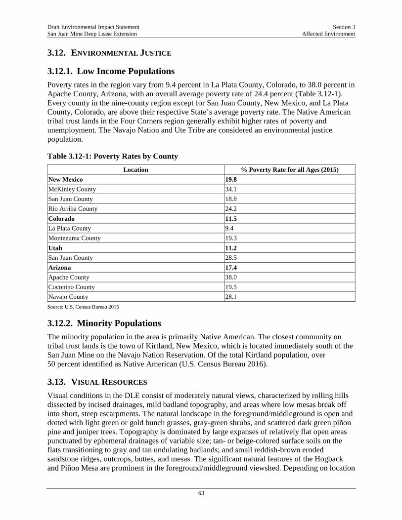
Draft Environmental Impact Statement Section 3 San Juan Mine Deep Lease Extension Affected Environment
63
3.12. ENVIRONMENTAL JUSTICE
3.12.1. Low Income Populations Poverty rates in the region vary from 9.4 percent in La Plata County, Colorado, to 38.0 percent in Apache County, Arizona, with an overall average poverty rate of 24.4 percent (Table 3.12-1). Every county in the nine-county region except for San Juan County, New Mexico, and La Plata County, Colorado, are above their respective State’s average poverty rate. The Native American tribal trust lands in the Four Corners region generally exhibit higher rates of poverty and unemployment. The Navajo Nation and Ute Tribe are considered an environmental justice population.
Table 3.12-1: Poverty Rates by County
Location % Poverty Rate for all Ages (2015) New Mexico 19.8 McKinley County 34.1 San Juan County 18.8 Rio Arriba County 24.2 Colorado 11.5 La Plata County 9.4 Montezuma County 19.3 Utah 11.2 San Juan County 28.5 Arizona 17.4 Apache County 38.0 Coconino County 19.5 Navajo County 28.1 Source: U.S. Census Bureau 2015
3.12.2. Minority Populations The minority population in the area is primarily Native American. The closest community on tribal trust lands is the town of Kirtland, New Mexico, which is located immediately south of the San Juan Mine on the Navajo Nation Reservation. Of the total Kirtland population, over 50 percent identified as Native American (U.S. Census Bureau 2016).
3.13. VISUAL RESOURCES Visual conditions in the DLE consist of moderately natural views, characterized by rolling hills dissected by incised drainages, mild badland topography, and areas where low mesas break off into short, steep escarpments. The natural landscape in the foreground/middleground is open and dotted with light green or gold bunch grasses, gray-green shrubs, and scattered dark green piñon pine and juniper trees. Topography is dominated by large expanses of relatively flat open areas punctuated by ephemeral drainages of variable size; tan- or beige-colored surface soils on the flats transitioning to gray and tan undulating badlands; and small reddish-brown eroded sandstone ridges, outcrops, buttes, and mesas. The significant natural features of the Hogback and Piñon Mesa are prominent in the foreground/middleground viewshed. Depending on location
Draft Environmental Impact Statement Section 3 San Juan Mine Deep Lease Extension Affected Environment
64
and atmospheric haze conditions, distant views of the La Plata Mountains, Sleeping Ute Mountain, the Carrizo Mountains, and Shiprock and the Chuska Mountains are visible in the background viewshed (>15 miles) to the north, northwest, west, and southwest, respectively.
As a result of the transition from surface to underground mining operations in 2001, pre-2017 conditions within the mine area do not vary greatly from the conditions of the initial mine approval in 2008. The location of the mining activities in the DLE between 2008 and 2017 was largely distant from any potential casual observers that would be recreating in Piñon Mesa or who reside in Kirtland (the nearest residential area to the San Juan Mine); observable activity at the DLE is fragmented by topographic screening where the rolling hills and badlands setting obstructs direct line-of-sight views into the DLE.
3.14. NOISE AND VIBRATION Underground mining operations commenced in 2001; since then, sources of noise and vibration have been limited to mining operations related to gob vent boreholes (GVBs), the main ventilation shaft, coal stockpiling areas, haul roads, coal plant site, and on-going reclamation activities at the former surface mining pits. Data collected between 2001 and 2017 characterizes ambient noise levels at various areas of the mine are considered to represent noise levels under typical weather and operational conditions; a total of nine separate noise measurements were collected and are summarized in the TRD. There are no noise sensitive receptors in the DLE or San Juan Mine lease and permit area; rather, the land is vacant or limited to mining, industrial, and recreational activities. Residential areas and other sensitive receptors do exist adjacent to the San Juan Mine lease, within the community of Kirtland. The sections of Kirtland adjacent to the analysis area are a mix of residential and other land uses, including neighborhoods along US 64 on both sides of the highway and an area accessed from CR 6480 (an east-west oriented road) and CR 6500 (a north-south road). There are approximately 400 residences within 2,640 feet (½ mile) of the permit boundary as well as the Riverside Golf Course and various industrial and commercial uses. Among the most potentially sensitive land uses are approximately 25 residences located along the north side CR 6480 that have direct, unobstructed line-of-sight exposure to the DLE area. Other potentially sensitive land uses include approximately 100 residences along US 64 adjacent to the southern boundary of the San Juan Mine lease area. These residences are mixed with commercial and industrial development. This area along US 64 is generally buffered by an escarpment and more gently rolling topographic features that slope downward from the mine to the highway.
Currently, reclamation takes place at two former surface mine pits, the Piñon and Juniper pits, which remain open to facilitate the disposal of CCR. The Piñon Pit is located north of the Generating Station and approximately 3.5 miles from sensitive receptor areas. The distance from the sensitive receptors along with intervening terrain is expected to be sufficient to attenuate noise generated at the Piñon Pit to levels that would not be perceptible to the nearest sensitive receptors. The southern-most extent of the Juniper Pit reclamation area is approximately 3,000 feet from US 64 where the nearest noise receptors are located. Before 2017, reclamation activities at the Piñon and Juniper Pits were located at a distance greater than 3,000 feet from the nearest noise receptors. The distance along with intervening terrain is expected to have been sufficient to attenuate noise generated at those reclamation sites to levels that would not be perceptible to the nearest sensitive receptors. As such, reclamation of the Piñon Pit and
Draft Environmental Impact Statement Section 3 San Juan Mine Deep Lease Extension Affected Environment
65
Juniper Pit have likely not perceptibly contributed to noise levels at the nearest sensitive receptors before 2017.
3.15. HAZARDOUS AND SOLID WASTES Hazardous wastes along with universal wastes and electronic wastes (i.e., e-waste) at San Juan Mine are collected and accumulated in the Waste Management Building before off-site disposal at an approved hazardous waste treatment, storage, or disposal facility. Used oil is generated and accumulated in tanks and containers at the Maintenance Building and in drums near the Waste Management Building. According to its “Waste Management Plan” and “San Juan Waste Manifests from 2010 - 2014” (as supplemented by shipping manifests from 2008, 2009, 2015, and 2016), the San Juan Mine is regulated as a conditionally exempt small quantity generator (SJCC 2017b). This means that it generates 220 pounds (lb) (100 kilograms) or less of hazardous waste in a given month and no more than 2,200 lb (1,000 kilograms) are accumulated at any one time. Municipal solid waste is generated at the San Juan Mine and is accumulated in green roll-off dumpsters at the mine, which are managed by the San Juan County Landfill. Certain materials including plastic, paper, cardboard, paperboard may be separated from the waste stream and recycled (Ecosphere 2017m).
3.16. HEALTH AND SAFETY
3.16.1. Worker Health The U.S. Mine Safety and Health Administration (MSHA) is the agency that enforces compliance with mandatory mine health and safety standards. According to MSHA, between January 2016 and June 2017 the San Juan Mine received 23 “Rules to Live By” safety violations (MSHA 2017a). All citations/orders issued by MSHA to San Juan Mine before 2017 have been addressed and closed. In 2017, 70 percent of the citations/orders issued have been addressed and closed (MSHA 2017b). In terms of work-related injuries, San Juan Mine reported 20 MSHA recordable injuries in 2014, 16 MSHA recordable injuries in 2015, and 15 MSHA recordable injuries in 2016. No fatal work injuries occurred at San Juan Mine between 2008 and 2017 (San Juan Mine 2017).
3.16.2. Public Health Public health information was obtained primarily from the New Mexico Indicator-Based Information System, operated by the New Mexico Department of Health (NMDOH); and the Colorado Health Information Dataset, operated by the Colorado Department of Public Health and the Environment (CDPHE). Summaries of pertinent health issues are provided below and include respiratory illnesses, diabetes, cancer, and environmental lead.
Respiratory illnesses refer to both chronic and long-term diseases (such as asthma) as well as acute infections (such as pneumonia) that affect the airway. Air pollution is a known environmental factor that can exacerbate both chronic and acute respiratory diseases and trigger new cases (WHO 2017). Overall, San Juan, Montezuma, and La Plata Counties respiratory illness indicator rates are similar to their respective states in terms of respiratory health, with the exception of invasive pneumococcal diseases in San Juan County. In San Juan County, the death rate in adults aged 65 years and older due to pneumococcal disease is close to double the statewide rate (NM-IBIS 2015).
Draft Environmental Impact Statement Section 3 San Juan Mine Deep Lease Extension Affected Environment
66
PM air pollution is one known environmental risk factor for diabetes (Rajagopalan and Brook 2012). The diabetes death rate in Montezuma and La Plata Counties (16.6 and 11.9 per 100,000 people, respectively) is similar to the state of Colorado (15.3 per 100,000 people) and the U.S. (15.2 per 100,000) people (CDPHE 2017). San Juan County as well as the state of New Mexico are about 10 percentage points above the national diabetes death rate (27.9 and 26.3 per 100,000 population) (NM-IBIS 2017).
Lung cancer is one of the leading forms of cancer in New Mexico and Colorado as well as nationally, and there are many environmental and lifestyle factors that are believed to contribute to lung cancer (WHO 2016). Outdoor air pollution, including diesel exhaust, metals, and dust, are linked to lung cancer, as well as cigarette smoking (WHO 2016). The majority of lung cancers diagnosed each year are associated with long-term cigarette smoking, which is a lifestyle factor (NM-IBIS 2014). In San Juan County in 2013 through 2015, the percentage of adults who smoked was 19 percent, which is slightly higher than the national rate in 2015 (15.1 percent) (NM-IBIS 2016; CDC 2016). The EPA has rated the potential for PM2.5 to cause lung cancer as a “3” on a five-point scale, where a “1” indicates a proven carcinogen.7 PM measured as PM2.5, is the metric and size range of most concern for human health.
Environmental lead is a common toxic metal that can adversely affect many parts of the body, including the nervous system, blood, hormonal system, kidneys, and reproductive system. According to a 2012 NDMOH study, in the city of Farmington (which is located in the region of influence and deposition area), four percent of children under three years of age had elevated levels of lead in their blood, which is four times that of San Juan County (0.93 percent of children), and close to 16 times the state percentage (0.28 percent of children) (NM-IBIS 2012; Grover 2017). Lead exposure most commonly comes from human activities, including past use of leaded gasoline, some industrial facilities emissions, past use of lead-based paint in homes, and lead compounds found in household items, such as water pipes, ammunition, and batteries (EPA 2017g). The reason for the higher blood-lead levels in children in Farmington is not known; however, trace amounts of lead in ground and surface water could be a potential source of exposure.
7 EPA derived five categories for determining causality: (1) causal relationship; (2) likely to be a causal relationship; (3) suggestive of a causal relationship; (4) inadequate to infer a causal relationship; and (5) not likely to be a causal relationship (EPA 2009).

Draft Environmental Impact Statement Section 4 San Juan Mine Deep Lease Extension Environmental Consequences and Mitigation Measures
67
4. ENVIRONMENTAL CONSEQUENCES AND MITIGATION MEASURES
The OSMRE’s guidelines for implementing NEPA (OSMRE 1989) state:
“The EIS is an information source for use in decision making; therefore, it must be clear and concise. Analysis and description should be presented in direct proportion to their importance in the decision-making process. Although acquiring available information to be used in evaluating impacts is an important part of preparing an EIS, the purpose of the EIS is to analyze impacts and not to describe the environment in minute detail. The context, intensity and duration of the impacts on the environment that may or would result from the proposed action and reasonable alternatives should be analyzed.”
The OSMRE has prepared a TRD that supports the preparation of this EIS. It contains an extensive description of data, analyses, and numerical modeling supporting the analysis of environmental consequences of the alternatives. The TRD is incorporated by reference in to this EIS and is available at the OSMRE website (https://www.wrcc.osmre.gov/initiatives/sanJuanMine/documentLibrary.shtm), and at information repositories that include this EIS.
Environmental consequences of the Proposed Action and alternatives (2018-2033) are determined relative to the baseline conditions presented in Section 3. The environmental effects of mining, power production, atmospheric emissions of power production, deposition of atmospheric emissions, and the effects to all relevant environmental resources are explicitly considered in this EIS, including the cumulative effects of these activities for the Project duration. The environmental consequences would vary in duration and significance among the environmental resources. Short-term impacts would occur during and/or immediately following construction activities (e.g., access road construction, installation of ventilation equipment). Long-term impacts would persist for the duration of the mining permit period (through 2033) and reclamation phase (through 2043) and account for post-reclamation activities, including monitoring. Permanent impacts would persist beyond, or occur after, reclamation.
The magnitude of impacts is classified as major, moderate, minor, or “no impact.” Significant impacts that are identified as “major” would result in substantial adverse changes to the environment and would exceed established relevant regulatory standards (such as water quality objectives, NAAQS, noise ordinances, etc.). Impacts not identified as “major” are considered less than significant and described as either “moderate” or “minor.” The determination of whether an impact is moderate or minor is specific to each resource category but follows a consistent approach. A moderate impact is one that would result in an adverse change to the environment outside the range of natural fluctuation but would not exceed regulatory standards. A minor impact is one in which an impact would occur but would be within the natural fluctuation of the baseline setting. In cases where no impact would occur, this conclusion is noted. Quantitative thresholds are applied, where appropriate, to determine the level of significance (for example, quantitative thresholds are commonly used to determine impact levels in the areas of noise and air quality). Other issues are assessed qualitatively based on context and intensity.

Draft Environmental Impact Statement Section 4 San Juan Mine Deep Lease Extension Environmental Consequences and Mitigation Measures
68
To be considered for cumulative impacts, the other projects must have effects on the environment, and those effects must be of a similar type to that for the proposed action and alternatives. By its nature, a cumulative impact assessment evaluates effects that may be individually minor, but cumulatively major. Criteria for assessing if a cumulative impact is minor, moderate, or major, each analysis relies upon the threshold or significance criteria provided in the resource analyses.
A review of existing and proposed projects in the relative vicinity of the San Juan Mine identified that the following types of projects have the potential for cumulative impacts when considered in combination with the Proposed Action: Energy Generation and Transmission Projects, Oil and Gas Projects, Mining Projects, Transportation Projects, Water-Related Projects, and Other Development Projects. The TRD provides a comprehensive list of these project types and includes a brief description of each project, as well as a rationale for why each project is either carried forward or excluded from the cumulative effects analysis. Figure 4.1-1 shows the location of all projects considered in the cumulative impact analysis.
4.1. AIR QUALITY Quantitative modeling was conducted to evaluate the potential air quality impacts of the Proposed Action, including the effects of coal combustion at the Generating Station. Air dispersion modeling was performed to quantify concentrations of regulated pollutants resulting from stationary and mobile source emissions both before the implementation of the SIP and after. These emissions are compared to Federal and New Mexico ambient air quality standards. Assessments of regional haze and regional ozone effects were also conducted as part of the review of environmental consequences. Estimated mining emissions are based on actual emissions measured in 2016 and predicted emissions from the Generating Station are based on historical operating data reported to the EPA. In addition to criteria pollutants, estimated future emissions of non-criteria HAPs are based on historical operating data and regulatory air emissions factors published by the EPA.
Extensive modeling was conducted to assess the potential effects to air quality. This includes a near-field Ambient Air Quality Modeling Report (AECOM 2017a), and dispersion and deposition modeling analysis (AECOM 2017f). In addition, the results of previously conducted regional ozone modeling studies were extrapolated to assess the potential contributions of the San Juan Mine and Generating Station on regional conditions. In this way, the cumulative effects of 16 years of combustion of coal at the Generating Station can be evaluated. A summary of the results of this analysis is provided below; detailed descriptions of the analyses and results are included in the TRD.

!(
!(
!(
!(
!(
!(
!(
!(!(
!(
!(
!(
!(
!(
!(
!(!(
!(
!(!(
!(
!(
!(
!(
!(
!(!(
!(!(
!(
!(!(
!(!(
!(!(
!(!(!(
!( !(
!(
!(
!( !(
!(
!(
!(
!(
!(!(
!(
!(!( !(
!(
!(
!(
!(
!(
!(
!(
!(
!(!(!( !(!(̂
_1
2
3
4
5
6
7
89
10
11
12
13
14
15
1617
18
19
20
2122
23
24
25
2627
28
29
30
3132
33
34
3536
3738
39
40 43
44
45
4647
48
49
50
54
5657
58
59
60
61
62
63
64
65
66
67
68 69
707172
7374
ARIZO
NANE
W ME
XICO
ARIZONAUTAH
NEW MEXICOCOLORADO
COLO
RADO
UTAH
LegendProject Facilities
_̂ San Juan M ineProjects ConsideredType!( Energy Generation and Transmission!( M ining!( Transportation!( Water!( Other
FILE: M:\Projects\0394667_San_Juan_Mine_EIS\maps\_!Condensed_EIS\_EIS_4.1-1_Cumulative_Projects_11X17.mxd, REVISED: 03/20/2018 , SCALE: 1:3,413,773 when printed at 11x17
DRAWN BY: Kara Batdorff
0 50 10025M iles
Environmental Resources Managementwww.erm.com
Source: ESRI Imagery 2016; GCS WGS 1984ERM
Figure 4.1-1Projects Considered in the
Cumulative AnalysisSan Juan M ine DL E EIS
San Juan County, New M exico
¯
San Juan Mine
Energy Generation and Transmission1. Four Corners Power Plant2. Navajo Generating Station3. Escalante Generating station4. Animas/Bloomfield Power Plant5. Comanche Generating Station6. M ilagro Power Plant7. Cimarron Solar Facility8. Coronado Generating Station9. Springerville Generating Station10. Fountain V alley Power Plant11. Front Range Power Plant12. M artin Drak e Generating Station13. Nucla Generating Station14. Bluffview Power Plant15. Delta-Person Generating Project
16. Reeves Generating Project17. V alencia Power Plant18. Energy U tility Corridor Planning19. Sunshine Wind Project20. San Juan Refinery-Bloomfield21. San Juan River Gas Plant22. Transwestern Phoenix Expansion Project23. M id-American Pipeline24. Ciniza Refinery25. Western Oil and Gas Proposed Drilling26. Oil and Gas Development on BL M L ands –Farmington Field Office27. Oil and Gas Development on BL M and U SFSL ands – Tres Rios Field Office28. Southern U te Indian Tribe Development ofFruitland Coal Bed M ethane
M ining29. Kayenta M ineComplex30. El Segundo M ine31. King II Coal M ine32. Burnham M ine33. BAR-D In-StreamGravel M ine34. Navajo M ine35. L a Plata M ine36. M cKinley M ine37. Chimney Rock M ine38. Coal Gulch M ine39. Carbon Junction M ine40. Peacock M ine41. Black Diamond M ine
42. De-Na-Z in M ine43. Gateway M ine
Transportation44. Improvements to U S Hwy 16045. Improvements to U .S. Highway 491
Water46. Animas-L a Plata Project47. Durango Pumping Plant48. Navajo Water SettlementAgreement49. Enlargement of StevensReservoir50. L ong Hollow ReservoirDevelopment51. Jicarilla Apache NationNavajo River Water SupplyProject52. Navajo Indian IrrigationProject and San Juan IrrigationProjects53. Kutz Pumping Plant
54. Gallegos Pumping Plant55. M oncisco Pumping Plant56. Navajo Dam Power Plant57. Hogback Diversion Damand Irrigation Project58. Navajo-Gallup Water SupplyProject59. Fruitland-CambridgeIrrigation Project60. Navajo ReservoirOperations
Other61. Sanostee Prison62. Three SpringsResidential andCommercial63. Shiprock Airport64. San Juan RiverEcosystem RestorationProject65. Gold King M ineEmergency Response66. V erde TransmissionProject67. Proposed Housing andCommercial Development(Burnham Chapter)
68. Burnham Airstrip

Draft Environmental Impact Statement Section 4 San Juan Mine Deep Lease Extension Environmental Consequences and Mitigation Measures
70
-Page Intentionally Left Blank-
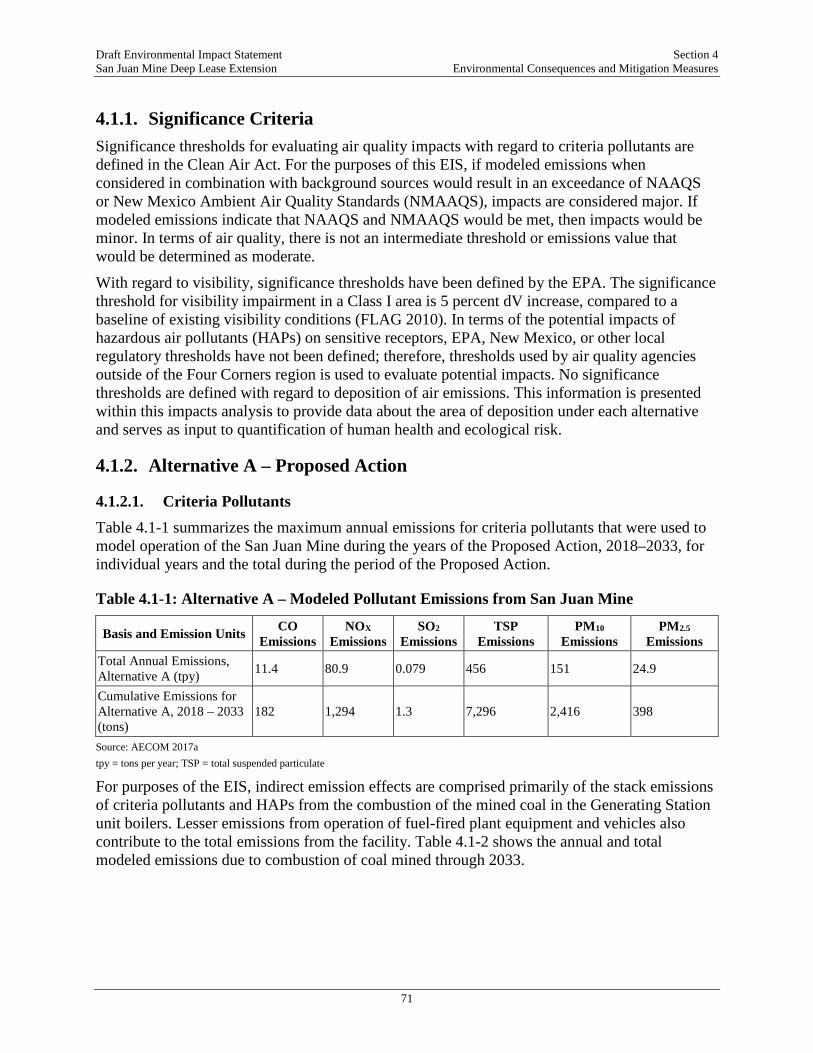
Draft Environmental Impact Statement Section 4 San Juan Mine Deep Lease Extension Environmental Consequences and Mitigation Measures
71
4.1.1. Significance Criteria Significance thresholds for evaluating air quality impacts with regard to criteria pollutants are defined in the Clean Air Act. For the purposes of this EIS, if modeled emissions when considered in combination with background sources would result in an exceedance of NAAQS or New Mexico Ambient Air Quality Standards (NMAAQS), impacts are considered major. If modeled emissions indicate that NAAQS and NMAAQS would be met, then impacts would be minor. In terms of air quality, there is not an intermediate threshold or emissions value that would be determined as moderate.
With regard to visibility, significance thresholds have been defined by the EPA. The significance threshold for visibility impairment in a Class I area is 5 percent dV increase, compared to a baseline of existing visibility conditions (FLAG 2010). In terms of the potential impacts of hazardous air pollutants (HAPs) on sensitive receptors, EPA, New Mexico, or other local regulatory thresholds have not been defined; therefore, thresholds used by air quality agencies outside of the Four Corners region is used to evaluate potential impacts. No significance thresholds are defined with regard to deposition of air emissions. This information is presented within this impacts analysis to provide data about the area of deposition under each alternative and serves as input to quantification of human health and ecological risk.
4.1.2. Alternative A – Proposed Action
4.1.2.1. Criteria Pollutants Table 4.1-1 summarizes the maximum annual emissions for criteria pollutants that were used to model operation of the San Juan Mine during the years of the Proposed Action, 2018–2033, for individual years and the total during the period of the Proposed Action.
Table 4.1-1: Alternative A – Modeled Pollutant Emissions from San Juan Mine
Basis and Emission Units CO Emissions
NOX Emissions
SO2 Emissions
TSP Emissions
PM10 Emissions
PM2.5 Emissions
Total Annual Emissions, Alternative A (tpy) 11.4 80.9 0.079 456 151 24.9
Cumulative Emissions for Alternative A, 2018 – 2033 (tons)
182 1,294 1.3 7,296 2,416 398
Source: AECOM 2017a tpy = tons per year; TSP = total suspended particulate
For purposes of the EIS, indirect emission effects are comprised primarily of the stack emissions of criteria pollutants and HAPs from the combustion of the mined coal in the Generating Station unit boilers. Lesser emissions from operation of fuel-fired plant equipment and vehicles also contribute to the total emissions from the facility. Table 4.1-2 shows the annual and total modeled emissions due to combustion of coal mined through 2033.
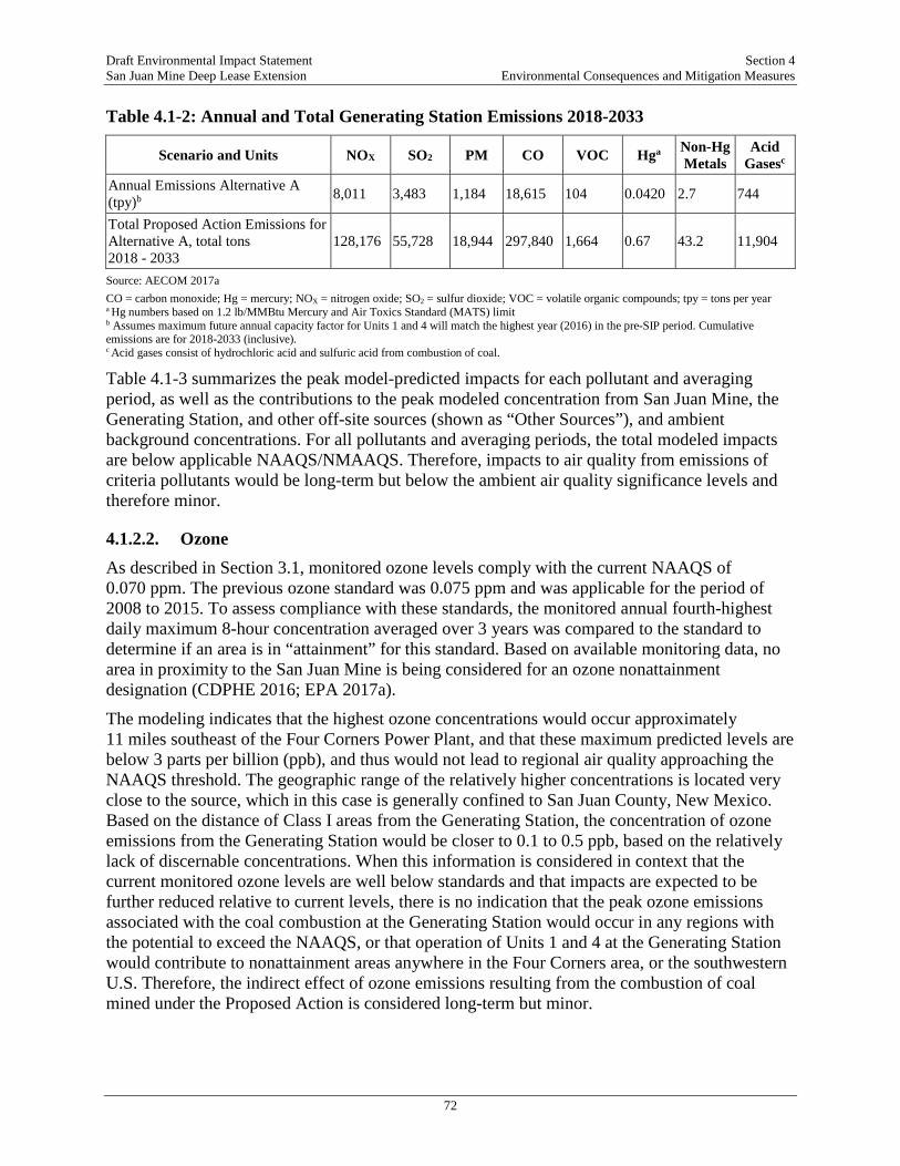
Draft Environmental Impact Statement Section 4 San Juan Mine Deep Lease Extension Environmental Consequences and Mitigation Measures
72
Table 4.1-2: Annual and Total Generating Station Emissions 2018-2033
Scenario and Units NOX SO2 PM CO VOC Hga Non-Hg Metals
Acid Gasesc
Annual Emissions Alternative A (tpy)b 8,011 3,483 1,184 18,615 104 0.0420 2.7 744
Total Proposed Action Emissions for Alternative A, total tons 2018 - 2033
128,176 55,728 18,944 297,840 1,664 0.67 43.2 11,904
Source: AECOM 2017a CO = carbon monoxide; Hg = mercury; NOX = nitrogen oxide; SO2 = sulfur dioxide; VOC = volatile organic compounds; tpy = tons per year a Hg numbers based on 1.2 lb/MMBtu Mercury and Air Toxics Standard (MATS) limit b Assumes maximum future annual capacity factor for Units 1 and 4 will match the highest year (2016) in the pre-SIP period. Cumulative emissions are for 2018-2033 (inclusive). c Acid gases consist of hydrochloric acid and sulfuric acid from combustion of coal.
Table 4.1-3 summarizes the peak model-predicted impacts for each pollutant and averaging period, as well as the contributions to the peak modeled concentration from San Juan Mine, the Generating Station, and other off-site sources (shown as “Other Sources”), and ambient background concentrations. For all pollutants and averaging periods, the total modeled impacts are below applicable NAAQS/NMAAQS. Therefore, impacts to air quality from emissions of criteria pollutants would be long-term but below the ambient air quality significance levels and therefore minor.
4.1.2.2. Ozone As described in Section 3.1, monitored ozone levels comply with the current NAAQS of 0.070 ppm. The previous ozone standard was 0.075 ppm and was applicable for the period of 2008 to 2015. To assess compliance with these standards, the monitored annual fourth-highest daily maximum 8-hour concentration averaged over 3 years was compared to the standard to determine if an area is in “attainment” for this standard. Based on available monitoring data, no area in proximity to the San Juan Mine is being considered for an ozone nonattainment designation (CDPHE 2016; EPA 2017a).
The modeling indicates that the highest ozone concentrations would occur approximately 11 miles southeast of the Four Corners Power Plant, and that these maximum predicted levels are below 3 parts per billion (ppb), and thus would not lead to regional air quality approaching the NAAQS threshold. The geographic range of the relatively higher concentrations is located very close to the source, which in this case is generally confined to San Juan County, New Mexico. Based on the distance of Class I areas from the Generating Station, the concentration of ozone emissions from the Generating Station would be closer to 0.1 to 0.5 ppb, based on the relatively lack of discernable concentrations. When this information is considered in context that the current monitored ozone levels are well below standards and that impacts are expected to be further reduced relative to current levels, there is no indication that the peak ozone emissions associated with the coal combustion at the Generating Station would occur in any regions with the potential to exceed the NAAQS, or that operation of Units 1 and 4 at the Generating Station would contribute to nonattainment areas anywhere in the Four Corners area, or the southwestern U.S. Therefore, the indirect effect of ozone emissions resulting from the combustion of coal mined under the Proposed Action is considered long-term but minor.
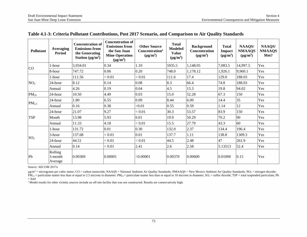
Draft Environmental Impact Statement Section 4 San Juan Mine Deep Lease Extension Environmental Consequences and Mitigation Measures
73
Table 4.1-3: Criteria Pollutant Contributions, Post 2017 Scenario, and Comparison to Air Quality Standards
Pollutant Averaging Period
Concentration of Emissions from the Generating Station (µg/m3)
Concentration of Emissions from
the San Juan Mine Operation
(µg/m3)
Other Source Concentrationa
(µg/m3)
Total Modeled
Value (µg/m3)
Background Concentration
(µg/m3)
Total Impact (µg/m3)
NAAQS/ NMAAQS
(µg/m3)
NAAQS/ NMAAQS
Met?
CO 1-hour 5,934.01 0.34 1.10 5935.5 1,148.05 7,083.5 14,997.5 Yes 8-hour 747.72 0.06 0.20 748.0 1,178.12 1,926.1 9,960.1 Yes
NO2 1-hour 111.56 < 0.01 < 0.01 111.6 17.4 129.0 188.03 Yes 24-hour 8.12 0.14 0.08 8.3 66.4 74.8 188.03 Yes Annual 4.26 0.19 0.04 4.5 15.3 19.8 94.02 Yes
PM10 24-hour 10.50 4.49 0.03 15.0 52.28 67.3 150 Yes
PM2.5 24-hour 1.80 6.55 0.09 8.44 6.00 14.4 35 Yes Annual 0.16 0.38 <0.01 0.55 0.59 1.14 12 Yes
TSP 24-hour 21.07 9.27 < 0.01 30.3 53.57 83.9 150 Yes Month 13.98 5.93 0.01 19.9 50.29 70.2 90 Yes Annual 11.33 4.18 < 0.01 15.5 27.79 43.3 60 Yes
SO2
1-hour 131.72 0.01 0.30 132.0 2.37 134.4 196.4 Yes 3-hour 137.68 < 0.01 0.01 137.7 1.11 138.8 1309.3 Yes 24-hour 44.51 < 0.01 < 0.01 44.5 2.48 47 261.9 Yes Annual 0.14 < 0.01 2.41 2.6 2.58 5.13513 52.4 Yes
Pb Rolling 3-month Average
0.00369 0.00001 <0.00001 0.00370 0.00600 0.01000 0.15 Yes
Source: AECOM 2017a µg/m3 = micrograms per cubic meter; CO = carbon monoxide; NAAQS = National Ambient Air Quality Standards; NMAAQS = New Mexico Ambient Air Quality Standards; NO2 = nitrogen dioxide; PM2.5 = particulate matter less than or equal to 2.5 microns in diameter; PM10 = particulate matter less than or equal to 10 microns in diameter; SO2 = sulfur dioxide; TSP = total suspended particulate; Pb = lead a Model results for other vicinity sources include an off-site facility that was not constructed. Results are conservatively high.

Draft Environmental Impact Statement Section 4 San Juan Mine Deep Lease Extension Environmental Consequences and Mitigation Measures
74
4.1.2.3. PM2.5 The AERMOD analysis of direct and indirect effects of the Proposed Action and the related coal combustion at the Generating Station included a near-field analysis of PM2.5 concentrations that would occur within a 50-kilometer range (see Section 3.1 of the TRD). The modeled concentrations for PM2.5 are well below the NAAQS for both averaging times and are predicted to occur in the less-developed areas west of the facilities. The modeling results show that the reduction in emissions for post-2017 operations has the intended effect of improving local air quality; therefore, impacts from emissions of dust are anticipated to be long-term but minor.
4.1.2.4. Regional Haze and Visibility Impacts The EPA and state of New Mexico have taken action addressing regional haze effects of future Generating Station operation through the development and approval of the New Mexico SIP (EPA 2014) using the BART Analysis Addendum as supporting information for the Generating Station (NMED 2013). As part of this process, EPA conducted a prior regional haze assessment (NMED 2013) for the post-SIP controls that will be applied to the Generating Station.
The changes in visibility conditions under either the federal or New Mexico BART Plans at the 16 Class I areas within 300 kilometers of the Generating Station were assessed using CALPUFF, in comparison to modeled baseline conditions (Table 4.1-4). The CALPUFF visibility modeling analysis was performed for several scenarios, including a baseline with operation of all four units at Generating Station, and a post-2017 scenario after implementation of either the FIP or SIP measures.
Table 4.1-4: Comparison of Future Regional Haze Effects in Class I Areas Modeled to Represent Future Control Options for Generating Station Emissions
Class I Area
Modeled Visibility
Impacts - Pre-SIP Baseline
Modeled Visibility Impacts - EPA FIP
Modeled Visibility
Impacts - New Mexico
Approved SIP
Difference in Visibility Effects between Baseline and New Mexico
SIP
Difference Between New Mexico
Approved SIP and Federal FIP
dVa dV dV dV dV Arches 3.51 1.13 1.37 -2.14 0.24 Bandilier 1.40 0.49 0.52 -0.88 0.03 Black Canyon 1.41 0.42 0.52 -0.89 0.10 Canyonlands 4.66 1.57 1.99 -2.67 0.42 Capitol Reef 2.39 0.83 0.89 -1.50 0.06 Grand Canyon 0.93 0.33 0.33 -0.60 0.00 Great Sand Dunes 1.54 0.50 0.57 -0.97 0.07 La Garita 1.94 0.58 0.71 -1.23 0.13 Maroon Bells 0.71 0.28 0.26 -0.45 -0.02 Mesa Verde 5.22 2.33 2.80 -2.42 0.47 Pecos 1.27 0.48 0.47 -0.80 -0.01 Petrified Forest 0.52 0.22 0.19 -0.33 -0.03 San Pedro 2.21 0.75 0.87 -1.34 0.12 West Elk 1.59 0.46 0.58 -1.01 0.12

Draft Environmental Impact Statement Section 4 San Juan Mine Deep Lease Extension Environmental Consequences and Mitigation Measures
75
Class I Area
Modeled Visibility
Impacts - Pre-SIP Baseline
Modeled Visibility Impacts - EPA FIP
Modeled Visibility
Impacts - New Mexico
Approved SIP
Difference in Visibility Effects between Baseline and New Mexico
SIP
Difference Between New Mexico
Approved SIP and Federal FIP
dVa dV dV dV dV Weiminuche 2.95 0.92 1.21 -1.74 0.29 Wheeler Peak 1.12 0.45 0.40 -0.72 -0.05 Source: AECOM 2017b Note: dV = deciview; Values shown boldface are reductions in modeled visibility dV (negative dV values), which corresponds to improvement in visibility impacts. a A dV is the unit of impairment of light. Each dV corresponds to a 10 times reduction in light transfer from perfectly clear air.
In summary, EPA found that the New Mexico SIP resulted in the best visibility improvement evaluated at a fraction of the cost of the FIP control technology option (EPA 2013b). Additionally, the state alternative closely matched the EPA FIP scenario’s visibility estimates for both the incremental improvement in dV impacts and the number of days exceeding the 0.5 dV threshold for several Class I areas (AECOM 2017a). The modeled visibility impairment levels even on the highest visibility impact days are well below the accepted significance level of 5 percent, which indicates that implementation of the New Mexico SIP will have the intended beneficial effect on regional air quality. Consequently, the future impacts on regional haze and visibility in Class I areas would be long-term but minor.
4.1.3. Alternative B – Continuation of San Juan Mine Operations Following Generating Station Shut-Down in 2022
These conditions for use of mined coal after 2022 indicate that the air pollutant emissions and effects for Alternative B are comparable to the San Juan Mine emissions and effects under the Proposed Action.
4.1.4. Alternative C – No Action Alternative Under this alternative, all but minor air pollutant emissions and effects would be curtailed at the end of operations for the San Juan Mine and Generating Station generating units. The operation of surface equipment for reclamation of disturbed areas at San Juan Mine would continue for an undefined period of several years after mining ceases. Information is not available at this time to estimate the rate of pollutant emissions for this operation, so detailed quantification of emissions is beyond the scope of this study. However, compared to the emissions and effects under the Proposed Action, the overall emissions would be greatly reduced, by about 90 percent or more, if the reclamation operations are comparable to current surface operations at San Juan Mine to dispose of CCR. The larger emission sources would taper off sharply between 2018 and early 2020, which would eliminate the effects of these sources in the years 2020 through 2033 under the Proposed Action. Therefore, air quality impacts under the No Action Alternative would be permanent but minor (since the effects of the emissions under the Proposed Action is considered minor, removal of emissions is also considered minor). Power plant decommissioning and dismantling would involve environmental abatement and salvage work; however, these tasks are not presently defined, and therefore this analysis is beyond the scope of this study. The work would be subject to review and permitting at the time that it occurs.

Draft Environmental Impact Statement Section 4 San Juan Mine Deep Lease Extension Environmental Consequences and Mitigation Measures
76
4.1.5. Cumulative Effects Regional air pollutant emissions and resultant air quality and regional haze effects will change due to many factors, the primary ones being economic trends in industrial activity, pace of energy resource development, transportation fuel consumption rate, and population growth. Within this generalized framework, it cannot be predicted with certainty the extent to which the mix of all these activities will collectively contribute to cumulative air quality effects. Normal seasonal and year-to-year fluctuations are of greater magnitude than the incremental trends that could be attributed to specific projects.
4.1.5.1. Cumulative Effects for NAAQS Pollutants As a result of the SIP, air emission contributions from the San Juan Mine and the Generating Station moving forward would be less than under historic conditions. The ambient air impacts from operation of the Four Corners Power Plant and Navajo Mine, and other background sources, were accounted for in near-field dispersion modeling analyses and in regional assessments described above. In terms of cumulative effects, foreseeable reductions in mining and generation emissions at these facilities have been implemented pursuant to the federal implementation plan at Four Corners Power Plant (EPA 2011c).
Measured ambient ozone levels at the Bloomfield and Shiprock, New Mexico, and at the Mesa Verde National Park SLAMS sites have generally declined in recent years but are still at levels more than 90 percent of the federal NAAQS for ozone (EPA 2017a). To avoid possible re-designation as an ozone non-attainment area, NMAC 20.2.72.1 requires the adoption of more-stringent regulations to constrain emissions of NOX and volatile organic compounds (VOCs) in areas where the ambient ozone concentration is within 95 percent of the NAAQS. Declining emissions of ozone precursors (NOX and VOC) in the San Juan Basin due to coal-fired generating unit retirements, and the economic and regulatory drivers suggest that cumulative ozone effects would remain steady or likely decrease during the Proposed Action. If that trend does not occur then state requirements for additional NOX and VOC controls would take effect and would drive further emission reductions.
The net effect of economic and regulatory drivers affecting gas and oil operations is that emissions from this sector are predicted to be largely unchanged or reduced in the north and south sections of the San Juan Basin. The North and South San Juan Basins are considered to be relatively older basins that have been in decline for a number of years, based on the historical production data. The current oil and gas activity in these basins is primarily targeted at maintaining steady production levels, while some equipment turnover will continue to trigger New Source Performance Standard (NSPS) requirements that will reduce emissions (WRAP 2013).
Taken together, the trends described in this analysis indicate that future air quality cumulative effects will be minor. The Four Corners area is in attainment for criteria pollutants, and air quality is expected to improve, given the economic, technical, and regulatory drivers that will reduce air emissions. Therefore, cumulative effects of the Proposed Action in combination with other projects considered in this analysis are minor.

Draft Environmental Impact Statement Section 4 San Juan Mine Deep Lease Extension Environmental Consequences and Mitigation Measures
77
4.1.5.2. Cumulative Effects on Regional Haze The EPA and state of New Mexico have taken action addressing future regional haze effects of the Generating Station operation through the development and approval of the settlement provisions in the Generating Station NSR Permit (NMED 2015), which implements the approved New Mexico SIP addressing regional haze requirements (79 FR 196 [October 9, 2014]). Federal requirements stipulate that, beginning with the baseline visibility condition for a specific Class I area, a state is to calculate the rate of visibility improvement (“uniform rate of progress”) required to reach that area’s natural background visibility (no manmade impairment) by 2064. The dV haze index is the metric of regional haze impairment. It is calculated from modeled light extinction values and expresses uniform changes in the degree of haze in terms of common increments across the entire range of visibility conditions, from pristine to extremely hazy. The dV is a useful measure for comparing low and high visibility days and tracking changes in visibility because a one-dV change can typically be perceived by most human observers.
Future visibility conditions due to foreseeable actions in the region are expected to generally improve. A refined analysis of regional haze progress was performed to support the FIP and the New Mexico SIP processes. The cumulative effects analysis for regional haze encompassed 16 mandatory federal Class I areas within a 300-kilometer radius from the San Juan Mine and Generating Station, and covering northeastern Arizona, southwestern Colorado, the Navajo Nation, and northwestern New Mexico. As part of the FIP process that addressed regional haze contributions specifically from Four Corners Power Plant, EPA conducted a regional haze assessment (EPA 2011) that included post-SIP controls that will be applied to the Generating Station. The proximity of the Four Corners Power Plant to the San Juan Mine and Generating Station support the use of this analysis to evaluate cumulative regional haze effects. It was shown in this study that after implementation of the FIP provisions for NOX and PM10 emissions from Four Corners Power Plant and implementation of the New Mexico SIP at the Generating Station, the greatest visibility benefits, reductions of up to several deciviews, will be realized in those Class I areas nearest to San Juan Mine. Model-predicted deciview impact differences for operations under the Proposed Action showed that the New Mexico SIP measures would lead to significant future improvements in visibility for all 16 surrounding Class I areas (EPA 2013a).
In addition, future regional haze cumulative effects will be regulated under updated Regional Haze rules, issued by the EPA in January 2017 (82 FR 6 [January 10, 2017]) that apply after 2018. In the updated rules, the EPA clarified the relationship between long-term strategies in the individual state plans and the long-term strategy obligations of all states. The rate of progress in some Class I areas may be meeting or exceeding the uniform rate of progress that would lead to natural visibility conditions by 2064, but this does not excuse states from conducting the required analysis in updated SIPs and determining whether additional progress would be reasonable with additional measures (82 Fed. Reg. 6 [January 10, 2017]).
During the period of 2018 to 2033, existing and future large contributors to regional haze, including oil and gas production and continued operation of the two coal-fired power plants in the San Juan Basin, will continue to contribute to regional haze cumulative effects. However, as described in this analysis, these sectors are required to operate with improved emissions controls and overall large emission reductions due to state and federal regulatory drivers (NMED 2015; EPA 2011a; 81 FR 107 [June 3, 2016]). The resulting reduction in long-term emissions of haze precursors from these sources means that regional haze cumulative effects will tend to decrease over this period. Therefore, when considering contributions from the Generating Station in

Draft Environmental Impact Statement Section 4 San Juan Mine Deep Lease Extension Environmental Consequences and Mitigation Measures
78
combination with the other emission sources considered in the cumulative effects analysis, cumulative effects related to regional haze are anticipated to be minor.
4.2. CLIMATE CHANGE GHG emissions from a source, or even a group of sources, cannot be directly attributed to any specific climate change impact area. Only global emissions can be potentially related to global impacts, which is the goal of climate modeling efforts. Therefore, designating a specific impact area for the climate change resource, while possible, would not be directly related to emissions from the sources affected by the Proposed Action. There are no direct source-impact relationships for the GHG emissions associated with the DLE and the Generating Station.
4.2.1. Significant Criteria There are no specific significance criteria related to climate change or greenhouse gas emission that can be related to a regulatory standard for emissions from the San Juan Mine; therefore, these emissions are considered in the context of other sources. For the Generating Station, the Title V permit sets forth specific GHG emissions limits, and emissions have been below these limits. A major impact would occur if modeled future emissions exceeded the Title V permit levels. Emissions that meet the limits set forth in the Title V permit are considered minor.
4.2.1. Alternative A: Proposed Action
4.2.1.1. Direct Effects Due to San Juan Mine GHG Emissions GHG emissions from the San Juan Mine are the result of the CH4 released by underground extraction from the coal seam and primary crushing of the coal. These emissions are captured by the GVB wells and the mine ventilation shaft and are reported pursuant to the requirements of 40 CFR Part 98. The CH4 emissions from this operation are characterized by high volumetric flow and low concentrations. A minor amount (approximately 5 percent of total mine emissions) of additional CH4 release occurs with the secondary crushing of the coal in a closed building during processing at the surface in the coal preparation plant (Ecosphere 2017b). Under the Proposed Action, SJCC would mine approximately 3 million tpy through 2033. Accordingly, estimated annual GHG emissions from the San Juan Mine would remain as described in Section 3 (480,000 MT CO2
e per year). These GHG emissions would amount to approximately 34 percent of total coal mining emissions in New Mexico (NMED 2016), assuming total statewide coal mining emissions remained at 2013 levels, but less than 0.8 percent of national coal mining GHG emissions, assuming total national coal mining emissions remained at 2015 levels. Therefore, GHG emissions from the San Juan Mine are considered permanent (once emitted emissions remain in the environment) but minor.
Additional activities at the mine contribute smaller amounts of GHGs to the overall direct effects. These activities may include carbon black emissions from the operation of diesel stationary and mobile equipment; process fuel combustion emissions from heaters, engines, boilers, etc. These releases would be small compared to the CH4 released from the mined coal. Reported overall CO2 emissions for the San Juan Mine reflect operation of the surface combustion equipment and engine-driven equipment and their very low potential to contribute to climate change effects. Historic data for fuel-combustion exhaust CO2 emissions at San Juan Mine (2008 to 2015) averaged less than 0.1 percent of the total mine CH4 emissions on a CO2
e
Draft Environmental Impact Statement Section 4 San Juan Mine Deep Lease Extension Environmental Consequences and Mitigation Measures
79
basis (SJCC 2017a). This corresponds to GHG emissions of less than 1,000 MT per year, and therefore fuel-combustion contribution to impacts are minor. This relative ratio would not be changed under the Proposed Action, since the combustion of fuel by surface equipment can be assumed roughly proportional to the amount of coal mined.
4.2.1.2. Indirect Effects of Coal Combustion Coal mined under the DLE would be transported to the Generating Station and combusted to produce electricity. The combustion of the coal mined within the DLE would indirectly result in generation of GHG emissions from the Generating Station.
Key concepts in projecting future emissions for the Generating Station are capacity factor and potential to emit. Capacity factor is defined as actual utilization divided by theoretical design capacity. For generating units, this factor is typically expressed as actual MW-hrs generated in a year versus design rating in MW times 8,760 hours per year (maximum theoretical MW-hrs). Since generating units must be periodically shut down for maintenance and seldom operate at full design rating (load) to extend equipment life, capacity factor is always less than 100 percent, typically in the range of 80 to 95 percent for base load generating units, depending on overall reliability. Potential-to-emit (PTE) is defined as maximum theoretical emissions for a pollutant at permitted operating conditions. Absent an operational limit in a facility permit, PTE is determined assuming maximum allowable emission rate at 100 percent capacity factor (full rated load for 8,760 hours per year). However, since actual capacity factor is less than 100 percent, theoretical PTE is normally never achieved unless limited by permit condition.
In comparison to the GHG emissions due to coal combustion at the Generating Station, mobile and fugitive source GHG emissions at the plant are estimated to amount to only 0.5 percent of total GHG emissions related to the Generating Station (Ecosphere 2017b). Therefore, GHG emissions from power plant stacks are the best measure of future GHG emission effects from the facility. Based on projections from the Generating Station, the future GHG emission rates were conservatively estimated assuming a maximum future capacity factor and PTE equal to reported values for calendar year 2016, the highest level during the years preceding the Proposed Action (PNM 2017b).
Estimated annual GHG emissions from the Generating Station during the period of the Proposed Action would be approximately 6.1 million tons CO2
e/year (the same as described in Section 3.2). Under the Proposed Action, between 2018 and 2033, the Generating Station would produce a total of approximately 97.5 million tons of CO2
e (AECOM 2017c). Putting this contribution on a national scale, which may be more indicative of the indirect contribution to climate change, the cumulative combustion of the coal from the San Juan Mine between 2018 and 2033 would contribute about 0.3 percent of CO2 emissions from fossil-fuel fired electric power generation nationwide assuming national emissions remained the same as calendar year 2015 data (EPA 2017f). The GHG emissions lead to levels above natural fluctuation but the levels are compliant with the regulatory standard set by the NMED Title V permit. Therefore, while the Proposed Action would contribute to the effects of climate change, its contribution relative to other sources would be minor but permanent (i.e., within EPA precision limits of -2 to +5 percent).
4.2.1.3. GHG Emissions Monetization Policy A protocol to estimate what is referenced as the “social cost of carbon” (SCC) associated with GHG emissions was developed by a federal Interagency Working Group (IWG), to assist
Draft Environmental Impact Statement Section 4 San Juan Mine Deep Lease Extension Environmental Consequences and Mitigation Measures
80
agencies in addressing Executive Order 12866, which requires federal agencies to assess the cost and the benefits of proposed regulations as part of their regulatory impact analyses. The SCC is an estimate of the economic damages associated with an increase in CO2 emissions and is intended to be used as part of a cost-benefit analysis for proposed rules. As explained in the Executive Summary of the 2010 SCC Technical Support Document “the purpose of the [SCC] estimates…is to allow agencies to incorporate the social benefits of reducing CO2 emissions into cost-benefit analyses of regulatory actions that have small, or ‘marginal,’ impacts on cumulative global emissions.” While the SCC protocol was created to meet the requirements for regulatory impact analyses during rulemakings, there have been requests by public commenters and project applicants to expand the use of SCC estimates to project-level NEPA analyses.
The decision was made not to expand the use of the SCC protocol for a number of reasons. Most notably, this action is not a rulemaking for which the SCC protocol was originally developed. Second, on March 28, 2017, the President issued Executive Order 13783, which, among other actions, withdrew the Technical Support Documents upon which the protocol was based and disbanded the earlier IWG on Social Cost of Greenhouse Gases. The Order further directed agencies to ensure that estimates of the social cost of greenhouse gases used in regulatory analyses “are based on the best available science and economics” and are consistent with the guidance contained in Office of Management and Budget Circular A-4, “including with respect to the consideration of domestic versus international impacts and the consideration of appropriate discount rates” (E.O. 13783, Section 5(c)). In compliance with Office of Management and Budget Circular A-4, interim protocols have been developed for use in the rulemaking context. However, the Circular does not apply to project decisions, so there is no Executive Order requirement to apply the SCC protocol to project decisions.
Further, NEPA does not require a cost-benefit analysis (40 CFR Part 1502.23), although it does require consideration of “effects” that include “economic” and “social” effects (40 CFR Part 1508.8(b)). Without a complete monetary cost-benefit analysis, which would include the social benefits of the proposed action to society as a whole and other potential positive benefits, inclusion solely of an SCC cost analysis would be unbalanced, potentially inaccurate, and not useful in facilitating an authorized officer’s decision. Any increased economic activity, in terms of revenue, employment, labor income, total value added, and output, that is expected to occur with the proposed action is simply an economic impact, rather than an economic benefit, inasmuch as such impacts might be viewed by another person as negative or undesirable impacts due to potential increase in local population, competition for jobs, and concerns that changes in population will change the quality of the local community. Economic impact is distinct from “economic benefit” as defined in economic theory and methodology, and the socioeconomic impact analysis required under NEPA is distinct from cost-benefit analysis, which is not required.
Finally, the SCC, protocol does not measure the actual incremental impacts of a project on the environment and does not include all damages or benefits from carbon emissions. The SCC protocol estimates economic damages associated with an increase in CO2 emissions—typically expressed as a one metric ton increase in a single year - and includes, but is not limited to, potential changes in net agricultural productivity, human health, and property damages from increased flood risk over hundreds of years. The estimate is developed by aggregating results “across models, over time, across regions and impact categories, and across 150,000 scenarios” (Rose 2014). The dollar cost figure arrived at based on the SCC calculation represents the value

Draft Environmental Impact Statement Section 4 San Juan Mine Deep Lease Extension Environmental Consequences and Mitigation Measures
81
of damages avoided if, ultimately, there is no increase in carbon emissions. However, the dollar cost figure is generated in a range and provides little benefit in assisting the authorized officer’s decision for project level analyses. For example, in a recent EIS, the OSMRE estimated that the selected alternative had a cumulative SCC ranging from approximately $4.2 billion to $22.1 billion depending on dollar value and the discount rate used. The cumulative SCC for the no action alternative ranged from $2.0 billion to $10.7 billion. Given the uncertainties associated with assigning a specific and accurate SCC resulting from 14 additional years of operation under the Mine Plan Modification, and that the SCC protocol and similar models were developed to estimate impacts of regulations over long time frames, this analysis quantifies direct and indirect GHG emissions and evaluates these emissions in the context of U.S. and State/County GHG emission inventories.
To summarize, an analysis of SCC was forgone because (1) it is not engaged in a rulemaking for which the protocol was originally developed; (2) the IWG, technical supporting documents, and associated guidance have been withdrawn; (3) NEPA does not require cost-benefit analysis; and (4) the full social benefits of coal-fired energy production have not been monetized, and quantifying only the costs of GHG emissions but not the benefits would yield information that is both potentially inaccurate and not useful.
4.2.2. Alternative B: Continuation of San Juan Mine Operations Following Generating Station Shut-Down in 2022 For the time period of 2018 to June 2022, coal from the San Juan Mine would be used at the Generating Station, until the shutdown of Generating Station Units 1 and 4 in June 2022. During this period, indirect GHG emission effects are comprised primarily of CO2 emissions from the combustion of the mined coal in the Generating Station unit boilers. Lesser emissions of other GHG compounds, N2O and CH4 due to incomplete combustion, and operation of fuel-fired plant equipment and vehicles also contribute to the total GHG emissions from the facility. The annual GHG emissions due to combustion of coal mined in the DLE in 2018 through 2021 at the Generating Station would be 6.1 MT CO2
e/yr, as for the Proposed Action.
Alternative B assumes that the remaining coal reserves produced after June 2022 through 2033 would go to market for different customers. For the purposes of this evaluation, it is assumed that mining, coal preparation, and crushing methods at the San Juan Mine would remain consistent with methods employed under the Proposed Action. Given the high level of uncertainty associated with projecting the potential SJCC clients after June 2022, it is assumed that the average rate of coal mined from the San Juan Mine would remain consistent with the Proposed Action rate of approximately 3 million tpy. Using the Generating Station as an appropriate “typical” local generating station for the purposes of this assessment, the indirect GHG emissions and effects for Alternative B are comparable to the San Juan Mine emissions and effects under the Proposed Action.
4.2.3. Alternative C: No Action Alternative Compared to the GHG emissions and effects under the Proposed Action the overall GHG emissions would be greatly reduced, by about 90 percent or more, if the reclamation operations are comparable to current surface operations at San Juan Mine to dispose of CCR, resulting in a minor and permanent effect.

Draft Environmental Impact Statement Section 4 San Juan Mine Deep Lease Extension Environmental Consequences and Mitigation Measures
82
4.2.4. Cumulative Effects Regional levels of GHG emissions will change due to many factors, the primary ones being economic trends in industrial activity, pace of energy resource development, transportation fuel consumption rate, and population growth. However, within this generalized framework, it cannot be predicted with certainty the extent to which the mix of all these activities will collectively contribute to the global phenomenon of climate change. GHG emissions from a source, or even a group of sources, cannot be directly attributed to any specific climate change impact area. Only global emissions can be potentially related to global impacts, which is the goal of climate modeling efforts. Therefore, designating a specific cumulative impact for the climate change resource cannot be related to emissions from the sources affected by the Proposed Action.
On larger geographic scale, the cumulative effect of climatic changes in a given region can be measured even if those affects are not driven by GHG sources in the region. Temperatures in the Southwest, including the Four Corners region, are increasing more quickly than in other regions of the U.S. as a result of climate change. Even small increases in temperature can dry soils and vegetation, increasing the risk of wildfires. In 2012, wildfires burned 9.2 million acres across eight states, reducing air quality, damaging property, and costing more than $1 billion. Water resources, already over-tapped in many areas, will become even scarcer as a result of increased evaporation and snowmelt caused by higher temperatures, affecting agriculture, recreation, stream flow, and hydroelectric power, among other resources (EPA 2013b).
As described in Section 3.2.1, with the exception of the Generating Station’s NMED Title V permit limits for GHG emissions, no Federal or state rules or regulations currently limit or curtail emissions of GHGs from the San Juan Mine or other sources in the state of New Mexico. Therefore, at present no regulatory mechanism exists for assessing in a quantitative manner the significance of the GHG emissions or cumulative effects. Draft guidance on climate change analysis was published by the Federal CEQ in December 2014 (CEQ 2014), which indicated that a quantitative analysis of GHG emissions the relationship to climate change is not required in project-level NEPA analysis. Based on this guidance, this analysis has adopted a qualitative approach.
Qualitative understanding of direct and indirect GHG emission trends in the region can be drawn by considering trends and foreseeable changes in the larger contributors described in the preceding section. With respect to utility electrical generation, there is an ongoing shift from coal to natural-gas-fired generating systems. Recent retirement of coal-fired units at the Generating Station and Four Corners Power Plant is only a part of the regional and national trend. In 2011, power plants and major industrial facilities in New Mexico emitted more than 40 million MT of carbon pollution (EPA 2013). The retirement between 2015 and 2017 of three generating units at Four Corners Power Plant, and two units at the Generating Station, are predicted to remove more than 11 MMT from that portion of the inventory (PNM 2017, AECOM 2017).
Overall, several studies over the past 10 years suggest that oil and gas development in the San Juan Basis, and the related air emissions will be relatively unchanged in the foreseeable future. Current data from the state of New Mexico indicates that gas production in northwest New Mexico has declined steadily, starting with the economic downturn in 2007-2008, to a level in 2016 that was less than 60 percent of the 2006 rate (OCD 2017). The net effect of reduced gas production in the San Juan Basin means that emissions of CH4 in the region will tend to decline over the coming decades. The North and South San Juan Basins are considered to be relatively
Draft Environmental Impact Statement Section 4 San Juan Mine Deep Lease Extension Environmental Consequences and Mitigation Measures
83
older basins that have been in decline for a number of years, based on the historical production data. The current oil and gas activity in these basins is primarily targeted at maintaining flat levels of production, while some equipment turnover and controls requirements continue to reduce emissions (WRAP 2013).
In a general sense, individual energy projects, including the Proposed Action that affects the San Juan Mine and Generating Station, are independent of the larger contributors to regional air cumulative effects. That is, the Proposed Action of continuing the DLE development at the San Juan Mine will not necessarily create additional oil and gas projects or have GHG impacts that affect the population in the area to an extent that can be identified with associated cumulative GHG emissions. As described in this EIS, the GHG contributions from both facilities affected by the Proposed Action will decline in the years 2018 to 2033. Taken together with the general declining trends in sectors that are the larger contributors to regional GHG emissions, it is expected that future climate change cumulative effects that are either directly or indirectly related to the Proposed Action will be minor.
4.3. GEOLOGY AND SOILS The region of influence for geology and soils includes the immediate areas of disturbance at the underground permit area including the DLE, which is situated on the western flank of the San Juan Basin in northwestern New Mexico. The planned land disturbances would occur only within the previously unmined areas of the San Juan Mine including the DLE. No land disturbances are planned at the other portions of the San Juan Mine with the exception of on-going reclamation activities.
4.3.1. Significance Criteria Impacts to geology and soils are considered major if the Proposed Action or alternatives would result in:
• Substantial changes to topographic features that could result in elimination of key features of the landscape or significantly change surface relief;
• Construction or clearing on slopes that are prone to mass movement or have very high susceptibility to erosion, such that accelerated erosion, sedimentation, or disruption of unstable slopes would occur;
• Loss of soil or adverse impacts to soil productivity, such that revegetation would be ineffective;
• Destruction of unique geologic features or resources, including mineral resources;
• Loss of coal resources due to mining operations and handling; or
• Destruction of significant paleontological resources.
4.3.2. Alternative A – Proposed Action Under the Proposed Action, impacts to topography as a result of mining operations within the DLE would occur over the extent of the DLE due to subsidence. The underground longwall coal removal process would result in subsidence occurring progressively behind the longwall mining area. The amount of subsidence would depend on the thickness of coal extracted and the depth to
Draft Environmental Impact Statement Section 4 San Juan Mine Deep Lease Extension Environmental Consequences and Mitigation Measures
84
coal with shallower depths to coal generally creating more subsidence; the depth of subsidence is estimated at 7 to 9 feet along the longwall panels and from 1.5 to 6.5 feet along the mine development entries (OSMRE 2008). Within the DLE, no non-commercial buildings or occupied non-commercial dwellings are present within the area that would be impacted by subsidence. In addition, as discussed in Section 3.5, Hydrology and Water Quality, no domestic water sources including surface water drainages or drinking water supply wells would be impacted by subsidence; therefore, no impacts are anticipated. Other structures that may be impacted by subsidence within the DLE consist of commercial pipelines and overhead electric power lines. Major commercial pipelines have been and would continue to be re-routed as applicable to avoid subsidence effects. As part of the permit conditions, SJCC would be required to monitor re-route locations and ensure that pipelines are not being impacted by mine subsidence. Secondary gathering pipelines would continue to be subsided in-place in cooperation with the commercial owners. With respect to commercial power lines, SJCC would install “phase raisers” to minimize or eliminate damage to wooden power poles. Existing roadways that would be affected by subsidence would be repaired by filling and/or blading to minimize adverse effects. In order to minimize impacts associated with subsidence, SJCC developed a Subsidence Control Plan that is included as part of the approved mining plan (OSMRE 2008). With the implementation of this control plan, the adverse effects of subsidence would be moderate, but permanent.
Within the DLE, minimal above-ground facilities are proposed (i.e., pads for GVBs, access roads) because infrastructure for the mine is already located within the San Juan Mine permit area. All surface disturbance would be present for the duration of mining (through 2033), but would be reclaimed, in accordance with the proposed Reclamation Plan that is included as part of the approved mining plan (OSMRE 2008). The plan specifies backfilling and grading standards, soil handling requirements, and a revegetation plan with the objectives of minimizing erosion/soil loss and preserving/protecting topsoil resources. In addition, a Soil Handling Plan contained within the Mine Permit specifies measures to be implemented for surface disturbances that are 5-acres or greater in size, linear disturbances that are approximately 20 feet in width, and disturbances that are less than 5-acres in size. Before surface disturbances that are 5-acres or greater in size, a site-specific investigation would be conducted to identify sources of suitable topsoil and to determine the salvageable depth.
All disturbed areas would be revegetated in accordance with the Revegetation Plan that is included as part of the approved mining plan (OSMRE 2008). Therefore, surface disturbances to soil would be long-term (lasting for the duration of the permit period), but minor. Following the completion of mining in 2033 and implementation of the Soil Handling Plan, Reclamation Plan, and Revegetation Plan, no surface impacts would occur and all prior impacts would be remediated.
The minable coal occurs within the Fruitland Formation and would be mined using the longwall underground method, which would avoid impacts to the overlaying strata. Impacts to geologic features from the installation of primary and ancillary roads in the DLE would be minor because no existing or proposed unique geologic features are located within or around the permit area. Mining of the coal resources within the DLE would be conducted according to all permit conditions and would maximize the economic recovery of the resources; therefore, no major impacts would occur. A small percentage of coal resources would be lost as pillars, and at the top and bottom of coals seams. The permanent loss of coal resources in the permit area is considered normal given current mining technology and the nature of the coal extraction in the Fruitland
Draft Environmental Impact Statement Section 4 San Juan Mine Deep Lease Extension Environmental Consequences and Mitigation Measures
85
Formation. Mining of coal would not adversely impact any other mineral resources in the area. Oil and gas resources would not be affected by the proposed coal mining operations under the Proposed Action, although all existing wells within the DLE would be plugged and abandoned as the mining activities progress. Therefore, no adverse impacts to mineral resources would result from implementation of the Proposed Action.
Under the Proposed Action, the greatest potential for adverse impacts is to paleontological resources. These impacts could occur as a result of subsidence and during ground-disturbing activities. SJCC has prepared a Mitigation and Unanticipated Discovery Plan for Paleontological Resources (Zeigler 2017b) in accordance with the underground mining permit. While ground-disturbing activities associated with the Proposed Action may damage or destroy paleontological resources, protocols in the plan would ensure that any impacts are minimized. Therefore, impacts to paleontological resources would be permanent, but moderate.
4.3.3. Alternative B – Continuation of San Juan Mine Operations Following Generating Station Shut-Down in 2022
Under this alternative, the impacts to geological resources including soils, mineral resources, and paleontological resources would be identical to those for the Proposed Action.
4.3.4. Alternative C – No Action Alternative Under the No Action Alternative, the mining operations would cease in 2019; accordingly, the impacts to geological resources under this alternative would be less than the Proposed Action. Specifically, the area of impact associated with subsidence and land disturbance would be reduced resulting in lesser potential impacts to topography, soils, and paleontological resources. At the cessation of mining, reclamation would be implemented in accordance with the mining permit (OSMRE 2008); however, without CCR, additional surface disturbance would be required to complete reclamation of the surface mining pits, which would also have to be reclaimed. This would result in a long-term moderate adverse effect. Therefore, other than subsidence, no permanent effects to geology and soils would occur. With regard to mineral resources, cessation of mining would prevent the maximum recovery of the coal within the DLE; therefore, this is considered a long-term minor adverse effect.
4.3.5. Cumulative Effects Although effects on geology and soils would stem from all existing and proposed earth-disturbing activities in the Four Corners region through 2033, these impacts are site-specific and would not occur on a regional level. Erosion and sedimentation from the San Juan Mine could affect water quality in adjacent arroyos, which discharge to the San Juan River. Potential erosion at other mines and construction sites in the vicinity also could affect water quality of the San Juan watershed. However, all mines and construction projects would be required to implement erosion control measures are part of their underground permit and General Construction NPDES permits. Therefore, the cumulative effect of erosion at all sites would be minor because the conditions of these permits would prevent long-term adverse impacts.
Cumulative impacts on paleontological resources would only occur if other projects were to impact the same resources impacted by the Proposed Action. Since paleontological resources are localized and mostly underground, they would only be impacted by projects that involve ground-
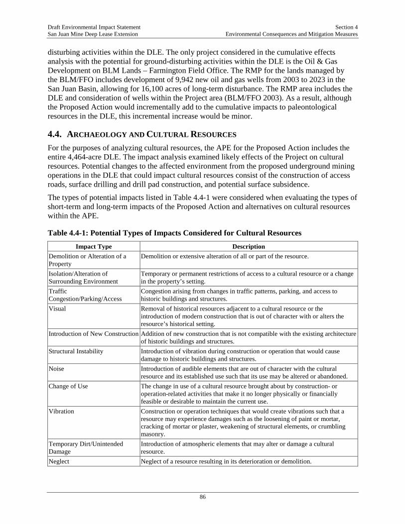
Draft Environmental Impact Statement Section 4 San Juan Mine Deep Lease Extension Environmental Consequences and Mitigation Measures
86
disturbing activities within the DLE. The only project considered in the cumulative effects analysis with the potential for ground-disturbing activities within the DLE is the Oil & Gas Development on BLM Lands – Farmington Field Office. The RMP for the lands managed by the BLM/FFO includes development of 9,942 new oil and gas wells from 2003 to 2023 in the San Juan Basin, allowing for 16,100 acres of long-term disturbance. The RMP area includes the DLE and consideration of wells within the Project area (BLM/FFO 2003). As a result, although the Proposed Action would incrementally add to the cumulative impacts to paleontological resources in the DLE, this incremental increase would be minor.
4.4. ARCHAEOLOGY AND CULTURAL RESOURCES For the purposes of analyzing cultural resources, the APE for the Proposed Action includes the entire 4,464-acre DLE. The impact analysis examined likely effects of the Project on cultural resources. Potential changes to the affected environment from the proposed underground mining operations in the DLE that could impact cultural resources consist of the construction of access roads, surface drilling and drill pad construction, and potential surface subsidence.
The types of potential impacts listed in Table 4.4-1 were considered when evaluating the types of short-term and long-term impacts of the Proposed Action and alternatives on cultural resources within the APE.
Table 4.4-1: Potential Types of Impacts Considered for Cultural Resources
Impact Type Description Demolition or Alteration of a Property
Demolition or extensive alteration of all or part of the resource.
Isolation/Alteration of Surrounding Environment
Temporary or permanent restrictions of access to a cultural resource or a change in the property’s setting.
Traffic Congestion/Parking/Access
Congestion arising from changes in traffic patterns, parking, and access to historic buildings and structures.
Visual Removal of historical resources adjacent to a cultural resource or the introduction of modern construction that is out of character with or alters the resource’s historical setting.
Introduction of New Construction Addition of new construction that is not compatible with the existing architecture of historic buildings and structures.
Structural Instability Introduction of vibration during construction or operation that would cause damage to historic buildings and structures.
Noise Introduction of audible elements that are out of character with the cultural resource and its established use such that its use may be altered or abandoned.
Change of Use The change in use of a cultural resource brought about by construction- or operation-related activities that make it no longer physically or financially feasible or desirable to maintain the current use.
Vibration Construction or operation techniques that would create vibrations such that a resource may experience damages such as the loosening of paint or mortar, cracking of mortar or plaster, weakening of structural elements, or crumbling masonry.
Temporary Dirt/Unintended Damage
Introduction of atmospheric elements that may alter or damage a cultural resource.
Neglect Neglect of a resource resulting in its deterioration or demolition.

Draft Environmental Impact Statement Section 4 San Juan Mine Deep Lease Extension Environmental Consequences and Mitigation Measures
87
4.4.1. Significance Criteria The significance of these potential impacts was assessed using the following criteria:
• Major: Impacts that potentially could cause irretrievable loss of the cultural resource and/or degradation of a resource defined by applicable laws, regulations, and/or policy.
• Moderate: Impacts that potentially could cause some readily apparent change (ranging between significant and insignificant) to a cultural resource.
• Minor: Impacts that potentially could be detectable but slight or impacts in the lower limit of detection that potentially could cause an insignificant change or stress to a cultural resource.
• None: No discernible or measurable impacts.
4.4.2. Alternative A—Proposed Action Alternative A has the potential to affect 80 archaeological resources consisting of 28 historic properties, 22 resources of unevaluated NRHP eligibility, and 30 resources not eligible for listing on the NRHP. All 80 archaeological sites could be negatively impacted by surface disturbance associated with development drilling and sampling from the construction of access roads and drill pads and drilling sampling bores and for the installation of ventilation shafts. Whether these activities have an adverse effect on a historic property would depend on the extent of the impacts and whether the impacts alter, directly or indirectly, any of the characteristics that qualify the property for listing on the NRHP.
Surface subsidence caused by continued expansion of underground mining activities could result in adverse minor or major impacts to these resources. A 2007 study of subsidence impacts at sites within the SJCC DLE indicates that a number of variables influence the severity of impacts to archaeological sites by subsidence (Baker and Estrada 2007). These variables include local geology, soil types, depth of coal deposits, topography, and type of archaeological site (artifact scatter, multi-component stratified, intact architecture, rock shelters). The 2007 study concluded that artifact scatters are subject to relatively minor impacts such as surface cracking or slumping while stratified multicomponent sites, sites with surface features (masonry walls, upright stone slabs), and rock shelter sites could be subject to more major impacts.
Sixty-five of the archaeological resources within the APE consist of artifact scatters or artifact scatters and features, which could be subject to minor to moderate impacts due to subsidence. The remaining 15 resources have standing structural ruins such as masonry walls, kivas, isolated room ruins, or cairns or are rock shelter sites (sites LA 39137, LA 119271, LA 119282, LA 119284, LA 119286, LA 119287, LA 119307, LA 119318, LA 119320, LA 119321, LA 119324, LA 119325, LA 124832, and LA 128826). Whether subsidence would have an impact on any of the archaeological resources in the APE would depend on local geology, soil types, depth of coal deposits, topography, and type of archaeological site. The 65 artifact scatters and artifact scatters with non-standing features could be subject to minor to moderate impacts from cracking and slumping caused by subsidence. The 15 sites with standing structural ruins or within rock shelters could suffer moderate to major permanent impacts due to feature or rock shelter collapse caused by subsidence; however, these potential adverse impacts were assessed as part of the Section 106 consultations between the SJCC, the BLM, and the New Mexico SHPO for the initial DLE project in 1998. As previously stated, in a letter dated April 29, 1999, the BLM

Draft Environmental Impact Statement Section 4 San Juan Mine Deep Lease Extension Environmental Consequences and Mitigation Measures
88
determined that mining within the DLE would have no adverse effect on historic properties if the stated conditions were met. Subsequent archaeological site evaluations and updates conducted as part of the DLE, Phase V subsidence monitoring program (Myers and Simpson 2014), and site evaluations and updates for this EIS (Simpson and Meininger 2017) made similar management recommendations to prevent or mitigate adverse effects to historic properties within the current APE: (1) No additional work to protect archaeological sites that are not eligible for listing on the NRHP; (2) SJCC intends to design any new surface infrastructure to completely avoid NRHP eligible sites. To ensure sites are avoided, SJCC would mark NRHP eligible sites with barrier fences at a 75-foot offset from each site boundary to create an ASB; (3) If construction within site boundaries or within the archaeological site buffer is deemed unavoidable, then additional archaeological investigations in the form of limited testing and/or data recovery is recommended. The complexity of the investigation would be determined on a site-by-site basis in consultation with OSMRE, BLM/FFO, and New Mexico SHPO; (4) In terms of future underground mining and associated subsidence of the ground surface, monitoring of the NRHP eligible sites should be conducted within 30 to 90 days following subsidence.
Based on these previous recommendations, the OSMRE has identified the following mitigation measures to avoid and/or minimize impacts to cultural resources within the APE:
• The OSMRE would require SJCC to design any new surface infrastructure, such as access roads, drill pads, and ventilation shafts, to avoid historic properties and sites of unevaluated NRHP eligibility.
• If surface infrastructure cannot be sited to avoid cultural resources, OSMRE would require additional archaeological investigations in the form of limited testing and/or data recovery for historic properties and sites of unevaluated NRHP eligibility. The complexity of the investigation would be determined on a site-by-site basis in consultations between OSMRE, SJCC, BLM/FFO, and New Mexico SHPO.
• Monitoring of historic properties and sites of unevaluated NRHP eligibility should be conducted within 30 to 90 days following subsidence. If monitoring suggests subsidence is causing or will cause adverse effects to a historic property(s), OSMRE would require a treatment plan to avoid or mitigate negative impacts to be developed and implemented in consultations with OSMRE, SJCC, BLM/FFO, and New Mexico SHPO.
Implementation of these avoidance and mitigation measures would reduce impacts to historic properties.
If determined necessary through consultation, the OSMRE would negotiate and implement a Programmatic Agreement (PA) for the SJCC DLE Mining Plan Modification Project. The PA would provide a process for compliance with NHPA pursuant to 36 CFR 800.14(b) in parallel with NEPA. Specifically, 36 CFR 800.4(b)(2) states that an agency may defer final identification and evaluation of historic properties if it is specifically provided for in a PA or documents used by an agency to comply with NEPA. Accordingly, the identification and evaluation of historic properties within the APE would be completed as specific aspects are refined pursuant to 36 CFR 800.4(b)(1) and 36 CFR 800.4(c). The PA would provide procedures and responsibilities for the ongoing identification, evaluation, and mitigation of historic properties and procedures to minimize impacts to historic properties. The PA would also contain additional information including standards, guidelines, and unanticipated discovery protocols. Alternatively, pursuant to

Draft Environmental Impact Statement Section 4 San Juan Mine Deep Lease Extension Environmental Consequences and Mitigation Measures
89
36 CFR 800.8(c), OSMRE could utilize “the process and documentation required for the preparation of an… EIS/ROD to comply with section 106 in lieu of the procedures set forth in §§ 800.3 through 800.6…” In other words, the OSMRE could use the NEPA process to identify historic properties (36 CFR 800.3), assess adverse effects (36 CFR 800.4), and resolve adverse effects (36 CFR 800.6). This would negate the need to develop and implement a PA.
4.4.3. Alternative B— Continuation of San Juan Mine Operations Following Generating Station Shut-Down in 2022
Under this alternative, all of the mining techniques, including the indirect effects of coal combustion, would be identical to those for Alternative A. There would be increased vehicle traffic to transport the coal to another generating station. However, because vehicle traffic would be confined to existing roads, this would not result in additional impacts to cultural resources. As a result, Alternative B would result in the same impacts to cultural resources as Alternative A.
4.4.4. Alternative C—No Action Alternative Cessation of mining activities within the DLE would result in no additional impacts beyond 2019 to cultural resources in the DLE, although additional surface disturbance and impacts to cultural resources could result during reclamation due to lack of CCR. Cultural resources located above areas previously mined would still be subject to subsidence impacts. Continued subsidence in previously mined areas could have negative impacts on any cultural resources, including historic properties. Artifact scatters with non-standing features could be subject to minor to moderate impacts from cracking and slumping caused by subsidence while sites with standing structural ruins or within rock shelters could suffer moderate to major impacts due to feature or rock shelter collapse. The extent and significance of these impacts would depend on local geology, soil types, depth of coal deposits, topography, and type of archaeological site. If subsurface mining ceased in the DLE, cultural resources located above unmined areas would not be negatively impacted by subsidence.
4.4.5. Cumulative Effects Similar to paleontological resources, cumulative impacts on cultural resources would only occur if other projects were to impact the same resources impacted by the Proposed Action. Since archaeological resources are localized and mostly underground, they would only be impacted by projects that involve ground-disturbing activities within the DLE. The only project considered in the cumulative effects analysis with the potential for ground-disturbing activities within the DLE is the Oil & Gas Development on BLM Lands – Farmington Field Office. It should be noted that archaeological resources are generally avoided by oil and gas wells and associated access roads, since there is some flexibility in their placement. As a result, although the Proposed Action would incrementally add to the cumulative impacts to archaeological resources in the DLE, this incremental increase would be minor.
4.5. WATER RESOURCES/HYDROLOGY This section provides an analysis of potential environmental impacts on groundwater and surface water resources (including waters of the U.S.) that could occur under each of the Project alternatives, addressing the cumulative effects over the nine years that mining has already
Draft Environmental Impact Statement Section 4 San Juan Mine Deep Lease Extension Environmental Consequences and Mitigation Measures
90
occurred within the DLE as well as potential future impacts to water resources. The primary focus of this impact assessment is to predict the effects of the Project alternatives on the prevailing hydrologic balance with respect to the quality and quantity of surface water and groundwater systems. The impact assessment considers the severity of potential direct and indirect impacts as well as the geographic extent, duration, and overall context of potential impacts.
The assessment of impacts related to the San Juan Mine DLE area (both during mining and after reclamation) builds on the baseline hydrologic and geologic information contained in the San Juan Mine Permit 14-01, including the analysis of Probable Hydrologic Consequences results, long-term monitoring of surface water and groundwater resources at adjacent areas at the San Juan Mine, published studies by the USGS, and the Cumulative Hydrologic Impact Assessment of the Navajo Mine (OSMRE 2012b), located due south of the San Juan Mine. The analysis of potential impacts to groundwater and surface water is based on a qualitative assessment of water use, and comparison of the water quality monitoring data available to State of New Mexico standards and NPDES permit limits. These standards provide a metric against which to evaluate potential changes to water quality due to the Project Alternatives. The analysis of potential impacts to surface water from operation of the Generating Station consists of an evaluation of the potential effects to surface water quality from deposition of air emissions.
4.5.1. Significance Criteria Magnitude of impacts to water resources (both surface water and groundwater) are determined by the following criteria:
• Major: Adverse impacts that are Project-related impacts outside the random fluctuations of natural processes that would likely result in a violation of water-quality standards (e.g., NPDES permit limits or State of New Mexico water quality standards) or that economically, technically, or legally eliminate use of the resource. Beneficial impacts: those that would improve water quality or contribute to or restore water resources capability to the region, such as to greatly increase the potential for human or ecological use.
• Moderate: Impacts that are outside of the random fluctuations of natural processes but do not cause a significant loss of the use of the resource. Moderate beneficial impacts would simply extend the beneficial use beyond natural variations about the current mean value.
• Minor: Changes that would affect the quantity or quality but not the use of water or are similar to those caused by random fluctuations in natural processes.
• None: Impacts that are not discerned or cannot be measured.
4.5.2. Alternative A – Proposed Action
4.5.2.1. Surface Water Surface water drawn from the San Juan River for use at the San Juan Mine is obtained according to the water rights Permit 2838. No changes to water use would occur under the Proposed Action, and SJCC would maintain the ability to use as much water as the rights allow for the

Draft Environmental Impact Statement Section 4 San Juan Mine Deep Lease Extension Environmental Consequences and Mitigation Measures
91
Project life. Given the current water right appropriations, water drawn from the San Juan River would continue as stated in the agreements; therefore, impacts to surface water quantity in the San Juan River would be minor and would not change under the Proposed Action.
Three existing stock impoundments within the underground mining tract in the DLE do provide seasonal water supply for wildlife and livestock. Inspections of these ponds are required by New Mexico MMD Permit 14-01 for the two years before subsidence along with the two years after subsidence has occurred. The surface water supplies for these impoundments are not likely to be affected by mine subsidence given that surface tensile cracks do not persist within stream channels. However, if there is water loss directly from the impoundments or the surface channels above the impoundments due to subsidence fractures, SJCC would either line the pond or segment of the impacted channel with clay; construct a replacement impoundment on a comparable drainage; or construct an artificial water catchment device which collect rainfall and directs it to a buried tank, all in accordance with the Hydrologic Reclamation Plan required by Permit 14-01. Therefore, impacts to water quantity from subsidence due to underground mining would be long-term but minor.
Water quality impacts to surface waters from underground mining would be minor and limited to potential effects related to construction of access roads and ventilation system, and related stormwater discharges. Background water quality data for the Shumway Arroyo and Westwater Arroyo from 1979 demonstrate naturally elevated levels of metals, chloride and Na as well as dissolved and total solids, as described in the affected environment. As described above in Section 3.5.1, natural conditions in and around the San Juan Mine produce naturally high sediment loads, often in excess of water quality standards. In accordance with New Mexico MMD and EPA regulations for surface water discharges, little to no stormwater is discharged from the San Juan Mine (i.e., it is a “zero discharge facility”). All water discharges would be covered under an NPDES permit where required (including the Multi-sector general permit for Sector H coal mining). Historic monitoring of stormwater discharges has shown that with the use of structural and non-structural BMPs, sedimentation basins, and designs to accommodate a 100-year/6-hour or 10-year/24-hour storm event, discharges from the San Juan Mine have better water quality and contain less sediment that the background undisturbed conditions (Ecosphere 2017d). Therefore, impacts to surface water quality are anticipated to be minor, although long-term, lasting through the duration of mining and reclamation.
As described below in the discussion of groundwater quality, a fate and transport assessment was conducted as part of the permit process to evaluate potential effects to surface water quality from placement of CCR during reclamation of former surface mining pits. These analyses concluded that surface water in the San Juan River would not be adversely affected by the leachate because of the hydrologic and geologic environment of the area, along with factors, such as, dilution and natural attenuation of the leachate (MMD 2014). Therefore, impacts are considered permanent but minor.
In addition to the potential water quality impacts resulting from mining in the DLE, combustion of the coal mined from the DLE at the Generating Station represents a source of atmospheric Hg and Se in the Four Corners region. As emissions deposit in the region, recent studies have determined that emissions from coal-fired power plants in the region contribute low levels of Hg, Se, and other pollutants to local surface waters (OSMRE 2015). Because prevailing winds are generally from the southwest to the north and northeast, emissions from the Generating Station have little potential to affect surface water quality in the San Juan River watershed. Air quality

Draft Environmental Impact Statement Section 4 San Juan Mine Deep Lease Extension Environmental Consequences and Mitigation Measures
92
modeling and emissions deposition modeling have defined the area that would be affected by Generating Station emissions and is discussed in greater detail in the TRD. As a result of the reduced emissions mandated by the New Mexico SIP and Federal agreements, the contribution to deposition of Hg, Se, and As from the three local power plants (Generating Station, Four Corners Power Plant, and Navajo Generating Station) have been reduced approximately 50 percent to 75 percent after 2018. Therefore, while Hg and Se would continue to be deposited into the San Juan River watershed, surface water quality impacts would be minor compared to baseline conditions.
4.5.2.2. Impacts to Waters of the U.S. The San Juan Mine currently has coverage under NWP 50, SPA-2009-00459 authorizing impacts to waters of the U.S. within the San Juan Mine, including the DLE, resulting from the construction of roads, boreholes, and drill pads. The anticipated impacts to waters of the U.S. between 2015 and 2033 total 0.038 acre and 144 linear feet within the DLE. With the implementation of required conditions of the NWP, impacts are considered minor and permanent.
4.5.2.3. Groundwater The primary groundwater quantity impact due to mining operations would be the loss of the saline coal-seam aquifer from the Fruitland Formation No. 8 coal seam. With the advance of underground mining, the inflow of groundwater from the coal seam and from the overlying and underlying strata would result in drawdown of groundwater levels and changes to groundwater flow directions beyond the active mine area. In addition, mine subsidence following removal of the coal seam would result in the fracturing of the overlying strata, which can cause reduction of groundwater elevations in saturated units within the fracture interval above the subsided longwall panels, which would reduce groundwater storage. However, evaluation of groundwater within the DLE and adjacent areas within the San Juan Mine lease area have shown that the Fruitland Formation has low permeability and contains groundwater with varying chemical concentrations but with overall poor quality (as described in Section 3.5.3, Affected Environment).
Comparisons of the modeled and measured drawdown at No. 8 coal seam wells located within the underground mine area near the DLE show that that drawdown in these wells preceded underground mining, likely as a result of the oil and gas extraction wells located within the San Juan Mine lease area which have contributed to the depressurization of the No. 8 coal seam within the permit area and downdip (east) of the permit area. The OSMRE reviewed the groundwater modeling conducted as part of the mine permit application package PHC in its 2008 Mining Plan Decision Document. This modeling estimated the volume of mine inflow compared to groundwater drawdown and results showed that the extent of groundwater drawdown is limited to the No. 8 coal seam and PCS formations and that drawdown in the overburden is of limited extent beyond the boundary of the DLE. Following mining of each longwall panel, groundwater modeling, along with groundwater monitoring, has shown that a rubble zone is created as the roof fragments and subsides into the mined-out area (known as “gob” behind the longwall). The gob is characterized by high porosity and is able to store much larger volumes of water than the coal. Mine water accumulates in this area and has a higher transmissivity and specific yield than the groundwater in the No. 8 coal seam. Groundwater monitoring in the Deep Lease Area following underground mining showed the inflow rate to the active mine area
Draft Environmental Impact Statement Section 4 San Juan Mine Deep Lease Extension Environmental Consequences and Mitigation Measures
93
averaged 47.1 gallons per minute between January 2006 and March 2009. The results of groundwater modeling indicate that the potentiometric surfaces of the No. 8 coal seam layer and the PCS are still predicted to be slightly depressed in year 2200, although approaching equilibrium by this time. SJCC developed a groundwater-monitoring plan, which would be implemented as part of the New Mexico MMD permit to monitor changes in quantity of the groundwater resource during mining and subsequent reclamation. The monitoring plan includes collection of groundwater information from specified hydrogeologic units and the goal is to collect data on groundwater quality and quantity and to monitor any changes that may occur as a result of mining and reclamation such that if changes are detected mining and reclamation operations can be adjusted to prevent adverse effects. However, based on the lack of usable groundwater, the slow rate of recovery is not likely to adversely affect water availability due to low baseline yield, poor quality and minimal use from these two aquifers; therefore, potential impacts are considered moderate (may be outside of random fluctuations of natural processes) and permanent.
One permitted well (SJ2055) is located less than ¼ mile south of the DLE boundary and within the area modeled to approach a five-foot drawdown by the end of mining in 2033. This well is screened at a depth interval from 80 to 150 feet and produces water at a rate of approximately 0.1 gallon per minute. No other water supply wells lie within the estimated underground mining-induced 5-foot draw zone of the No. 8 coal seam, the PCS, or the overburden (MMD 2014). Since modeling was conducted before 2008, the mine plan for the DLE was adjusted to avoid mining beneath a former landfill in Kirtland and proposed mining in the DLE would be 1,000 feet further from well SJ2055 than originally planned, which would avoid drawdown effects on the well. Therefore, minor and long-term effects to groundwater quantity and water supply are anticipated as a result of the Proposed Action.
The SJCC expanded both the Probable Hydrologic Consequences analysis and the hydrologic monitoring program to address the potential impact of mine placement of CCR on groundwater in the San Juan Mine. SJCC’s Management Procedures for CCR and for coal wastes are provided in New Mexico MMD Permit 14-01 Section 900(B)(4) Spoil, Coal Processing Waste, and Non-Coal Waste Removal, Handling Storage, Transportation, and Disposal Areas and Structures.
It is expected that mining operations may slightly alter groundwater quality; however, water quality monitoring in the region, mine vicinity, and at the San Juan Mine indicates that the water available is of limited quantity and of poor water quality, with total dissolved solids (TDS) ranging from 2,630 to 26,000 milligrams per liter (mg/L). Consequently, the No. 8 coal seam aquifer is not currently used for drinking or other domestic purposes and does not meet State of New Mexico groundwater quality standards for such purposes. Mine-related impacts are evaluated relative to the natural background of poor water quality.
While not conducted within the DLE, CCR from the coal mined at the DLE and burned at the Generating Station is returned to the San Juan Mine to backfill former surface mining pits. Multiple studies have been conducted to determine the potential for leachate from CCR placement to contaminate the underlying groundwater quality. The studies measured the physical characteristics of fresh and buried CCR that affect their unsaturated hydraulic properties and determined the chemical, mineralogical, and leaching characteristics of these materials, and developed a numerical simulation of water migration through an unsaturated column of cover material and buried CCR. Modeling by Thomson et al. (2012, as cited in MMD 2014) estimates surface mine recharge rates of less than 0.4 millimeter per year for reclaimed pits in the analysis

Draft Environmental Impact Statement Section 4 San Juan Mine Deep Lease Extension Environmental Consequences and Mitigation Measures
94
area, while Stone 1983 estimates an average mine backfill recharge rates of approximately 1 millimeter per year at the nearby Navajo Mine. Although recharge rates are slow, basal saturation of mine spoils has occurred within portions of the southern surface mine tract. Approximately 19 feet of basal saturation has developed within spoils around well SM-5. The source of saturation in spoil in this area is a combination of inflows from the underlying PCS and lateral inflows from the adjacent weathered and un-weathered Fruitland Formation. The CCRs in the studies cited above were found to have a dry bulk density of about 1,100 kilograms per cubic meter (kg/m3) and 800 kg/m3 for fly and bottom ash, respectively, although both were determined to be highly compressible with variable density based on effective stress. The saturated hydraulic conductivity of these materials was about 1x10⁻⁴ centimeters per second (cm/s) for fly ash, 5x10⁻³ cm/s for bottom ash, and less than 8.5x10⁻⁶ cm/s for spoil material used for cover. Soil moisture characteristic curves were measured to permit calculation of unsaturated hydraulic conductivities. Acid digestion and subsequent elemental analysis of the fly and bottom ash found them to consist primarily of Al, barium, calcium, potassium, Na, and silicon. The mineralogy of these samples is dominated by amorphous glass along with mullite, quartz, calcite, and clay minerals. FGD sludge primarily consists of gypsum. Based on the multiple numerical simulations of water flow through cover material into buried CCR presented in Thomson et al. (2012, as cited in MMD 2014), very low infiltration rates are predicted as a result of the low hydraulic conductivity of the cover material and water uptake by vegetation. The rate of re-saturation of the mine spoil is expected to be extremely slow due to the arid climate and low rate of recharge. Further, the study found that the very low to no downward flow of groundwater through the unsaturated CCR and the low concentrations of heavy metals in the CCR indicate that the potential for contamination of the underlying regional aquifer at the San Juan Mine is minor but permanent (Thomson et al. 2012).
In addition, a fate and transport assessment of the mine was conducted as part of the permit process for New Mexico MMD Permit 14-01. This assessment identified factors, such as, the low groundwater volume and velocity in the No. 8 coal seam and a high dilution potential of the San Juan River alluvium would help lessen the impacts of leachate emanating from the CCR into the San Juan River alluvium. Consequently, while alluvial groundwater, downgradient from the CCR disposal sites, might be impacted by leachate emanating from the CCR, the fate and transport analysis conducted as part of the permit process indicated that the San Juan River would not be adversely affected by the leachate because of the hydrologic and geologic environment of the area, along with factors, such as, dilution and natural attenuation of the leachate. Based on the factors listed above, the fate and transport analysis estimated that the contribution of CCR leachate discharge to mean annual flow in the San Juan River was 0.00004 percent under normal flow and 0.01 percent under historical low flow conditions. Therefore, impacts to groundwater from historic and future placement of CCR in former surface mining pits, although permanent, are considered minor.
In 2010, in cooperation with the New Mexico MMD, the US Geologic Survey initiated a 4-year assessment of hydrologic conditions at the San Juan Mine. The purpose of the hydrologic assessment is to identify groundwater flow paths away from San Juan Mine CCR buried in the surface pits that might allow metals that may be leached from CCR to eventually reach wells or streams after regional dewatering ceases and groundwater recovers to predevelopment levels. The hydrologic assessment, undertaken between 2010 and 2013, included compilation of existing data. The study is still under review and will be published online when completed.
Draft Environmental Impact Statement Section 4 San Juan Mine Deep Lease Extension Environmental Consequences and Mitigation Measures
95
New Mexico MMD, a cooperating agency for that EIS, has indicated the publication date is not known.
4.5.3. Alternative B – Continuation of San Juan Mine Operations Following Generating Station Shut-Down in 2022
Under Alternative B, no changes to the mine plan would result and impacts to groundwater and surface water quantity and quality would be as described under the Proposed Action, with the exception that deposition of heavy metals from burning of coal mined in the DLE would be reduced in the San Juan River if the coal is supplied to a facility outside of the San Juan watershed. The depositions would be shifted to the vicinity of wherever the coal is combusted.
4.5.4. Alternative C – No Action Alternative Short-term impacts to surface water quality could occur during demolition of mine facilities; however, SJCC would be required to obtain necessary permits, which may include a Construction Stormwater General Permit under Clean Water Act Section 402. Compliance with this permit requires the preparation of an Erosion Control and Sediment Plan and Stormwater Pollution Prevention Plan describing best management practices to prevent discharge into surface water. Reclamation of mined lands would restore surface water drainage and natural stormwater flow as well as natural groundwater flow; therefore, impacts to water quality would likely be minor but long-term.
4.5.5. Cumulative Effects Potential cumulative impacts to groundwater quantity would occur if multiple projects required the extraction of groundwater resources, thereby over-drawing aquifer resources. Potential cumulative impacts to groundwater quality would occur if potential surface and sub-surface releases from the Proposed Action or alternatives in combination with other projects considered caused an impairment of groundwater quality.
Past, current, and proposed mining at the San Juan Mine has resulted, is resulting, and is expected to result in a local drawdown of groundwater levels in the Fruitland Formation and in the underlying PCS. However, as described in Section 3.5, the effects of drawdown are minor because there are no potable water wells completed in the Fruitland Formation and the PCS that would be impacted; further, these units are not capable of providing a sustainable water supply. The potential exists for other ground-disturbing activities that to affect groundwater quantity within the region of influence including continued operation of the Generating Station and oil and gas extraction from wells completed in the same formations, which could result in a cumulative effect to groundwater resources in these formations. The potential also exists for placement of CCR in the former surface pits at the San Juan Mine to adversely affect groundwater quality through the leaching of materials and cumulative effects to result from similar placement of CCR during reclamation of the other mines included in this cumulative effect analysis. These potential cumulative effects are addressed in Section 4.14, Hazardous Materials and Waste.
Potential cumulative effects to surface water resources would result if the Proposed Action would contribute to a regional impairment of surface water quality. Minor contributions to cumulative impacts on surface waters are expected from the surface disturbance associated with
Draft Environmental Impact Statement Section 4 San Juan Mine Deep Lease Extension Environmental Consequences and Mitigation Measures
96
the placement of new pads for mining vent in the DLE. However, SJCC operates under NPDES permits and implements BMPs to minimize stormwater runoff; therefore, the cumulative effects of the Proposed Action would be minor. In addition to the direct impacts of the Proposed Action on surface water quality, the cumulative effects of deposition of metals from the combustion of coal, including the Generating Station could affect surface water quality. Although modeling and ERAs for the Proposed Action found that the depositional area of emissions from the Generating Station is less than 50 kilometers, 16 other power plants are located in the region of influence. In addition, the background levels of metals in soil and water are elevated. Taken together with the effect of emissions and transport of mercury and selenium from Asia, such effects could be cumulatively major on water quality. Hg and Se deposition from the Generating Station was decreased by nearly half as a result of implementation of the SIP. Therefore, while this is considered a potentially major, long-term cumulative impact, no additional mitigation measures are proposed that would further reduce the Generating Station contribution beyond what would occur as a result of compliance with the SIP, which substantially reduced emissions.
4.6. VEGETATION For the purposes of this analysis, and to identify broad patterns in vegetation structure, vegetation modeling and mapping has been conducted across the Mine region of influence. To determine the potential effects of the San Juan Mine on vegetation, the Mine region of influence is defined as the area encompassing the San Juan Mine permit and lease boundary, plus a one-mile buffer (see Figure 3.6-1 in the TRD). A one-mile buffer was included in the Mine region of influence to account for impacts that may occur to vegetation as a result of mining, but outside of the active mining areas. For example, wind born dust may affect plants located adjacent to, but outside, the permit and lease boundary and within the one-mile buffer.
This section also includes an analysis of potential ecological risks to vegetation from the combustion of coal at the Generating Station, and the resulting deposition of air emissions. For this analysis, a separate region of influence (hereafter referred to as the Generating Station region of influence) was defined and is comprised of the deposition area, plus an expanded area to more fully analyze potential effects to the San Juan River. The deposition area was defined using air dispersion modeling that determined the area in which future air emissions from the Generating Station are anticipated to increase baseline concentrations of chemicals of potential concern by more than 1 percent. The expansion area for the San Juan River was incorporated to conservatively include an additional segment of the San Juan River downstream of the deposition area that could be affected by future migration of deposited materials.
Impacts of the Proposed Action and alternatives were assessed by overlaying the location of proposed activities and disturbance areas on known vegetation communities to determine potential acreages of impacts. The impact analysis examined likely effects of the Project on vegetation resources.
In addition, an ecological risk assessment (ERA) (AECOM 2017d) conducted for non-special-status terrestrial plants was based on: (1) the comparison of conservative plant-protective soil screening levels to the concentrations of constituents in soils within the deposition area under current conditions; (2) the predicted concentrations in soils following 16 years of future emissions from the Generating Station; and (3) other nearby San Juan Mine sources from 2018 through 2033. The ERA approach for evaluating the potential impacts of future emissions from the Generating Station/San Juan Mine and other nearby sources is consistent with the following

Draft Environmental Impact Statement Section 4 San Juan Mine Deep Lease Extension Environmental Consequences and Mitigation Measures
97
EPA guidance documents: Guidelines for Ecological Risk Assessment (EPA 1998a), Ecological Risk Assessment Guidance for Superfund: Process for Designing and Conducting Ecological Risk Assessments (EPA 1997), and the Screening Level Ecological Risk Assessment Protocol for Hazardous Waste Combustion Facilities (EPA 1999b). A maximum exposure scenario was evaluated in the ERA. This exposure scenario evaluated the 95 percent upper confidence limit on the arithmetic mean constituent of potential ecological concern (COPEC) concentrations and conservative exposure assumptions. If the hazard quotient (HQ) reflective of total potential risk was greater than 1 for the maximum exposure scenario, then additional information was considered in the report to characterize the potential risk. This could include consideration of alternative toxicity or uptake information, alternative exposure parameters, alternative media concentrations, or an assessment of risks associated with naturally occurring background conditions (AECOM 2017d).
Table 4.6-1 lists the types of potential impacts listed below were considered when evaluating impacts.
Table 4.6-1: Potential Types of Impacts to Vegetation Considered in the Analysis
Impact Type Description Deposition Temporary or permanent impacts from deposition of air emissions from the Generating Station. Off-road travel Temporary or permanent impacts from vehicles travelling off of established roads.
Reclamation While reclamation activities seek to return temporarily disturbed areas to their pre-disturbance condition to the extent feasible, reclamation may result in temporary or permanent changes in vegetation community type and community composition.
Surface disturbance
Temporary removal (until an area can be revegetated) or permanent removal of vegetation in association with mining operations and surface subsidence.
Weed invasion Introduction and establishment of weeds such that original vegetation community composition or type is altered.
Windborne dust
Generation and settlement of dust related to mining and reclamation activities, causing potential impacts to plant physiology or physical injuries to plants.
4.6.1. Significance Criteria The significance of these potential impacts was assessed using the following criteria:
• Major: Effects that result in economically, technically, or legally eliminating the resource and subsequently make it eligible for listing under the Federal Endangered Species Act, or which limit recovery of a listed species;
• Moderate: Effects that are outside of the random fluctuations of natural processes but do not cause a significant loss of the resource;
• Minor: Changes that would affect the quality of vegetation but are similar to those caused by random fluctuations in natural processes;
• No Impact: Effects that are not predicted or cannot be measured.
Draft Environmental Impact Statement Section 4 San Juan Mine Deep Lease Extension Environmental Consequences and Mitigation Measures
98
4.6.2. Alternative A—Proposed Action As a result of mining activities, vegetation may be removed in association with construction of gob vents, rescue chambers, ventilation shafts, and access roads in the DLE. Surface disturbance has also occurred in association with temporary overburden (spoil) stockpiles that have been created for use as ash cover (through the life of the mine) in preparation for final reclamation. However, no additional removal of vegetation communities is proposed for the continued use of the coal-handling and transportation facilities. Since current and future mining would remain underground, mining activity would not physically remove native vegetation. Surface disturbance associated with vegetation removal could adversely impact naturally occurring seed sources by reducing seed yield and/or viability and, subsequently, decrease the success of native plant re-colonization although these impacts would likely be long-term and minor. Surface disturbance would also result in short-term minor increases in potential for spread of noxious weeds.
All areas proposed to be mined under the Proposed Action would be reclaimed. Other areas of disturbance, such as those associated with other access roads, are gradually reclaimed once those areas have been mined and the roads are no longer needed. In reclaimed areas, the density and diversity of vegetation species would be modified in areas reclaimed following mining activities. However, reclamation would restore vegetation within the disturbed areas using topsoil salvage practices to maximize vegetative regrowth and using the approved SJCC Revegetation Plan (MME 2014). Therefore, vegetation removal would result in long-term impacts until disturbed areas were reclaimed in accordance with the OSMRE reclamation standards. Surface disturbance associated with vegetation removal could adversely impact naturally occurring seed sources by reducing seed yield and/or viability and, subsequently, decrease the success of native plant re-colonization although these impacts would likely be minor.
Reclamation would result in the restoration of vegetative cover, though the species composition and density would be different from that which was disturbed. Revegetation would replace existing plant communities with native grass, forb, and shrub species to establish post-mining land uses of livestock grazing and wildlife habitat. As a result, species composition within the existing vegetation communities would change from vegetation areas described in Section 3.6 and be replaced with native seed mix that would increase the vegetative cover in most reclaimed areas. Implementation of the revegetation plans would establish a diverse, stable, and self-sustaining vegetation community composed of native species capable of meeting the post-mining land use. Restoration activities include invasive plant prevention activities and ecologically based integrated invasive plant management (i.e., species-specific mechanical, chemical, biological control) as part of the reclamation process to prevent the establishment and expansion of invasive plants in reclaimed areas. To obtain bond release, the presence of invasive plants, such as cheatgrass, cannot be used to demonstrate the reclaimed area has met revegetation success standards. The plan has been reviewed by the OSMRE and the New Mexico MMD as part of the PAP. Once reclaimed, there would be permanent and minor impacts to vegetation communities in that the community type and composition would be altered in accordance with reclamation standards designed to return disturbed areas to grazing and wildlife land uses. While the species composition of reclaimed areas may vary from the original plant communities, the cover and productivity of these communities is expected to be similar to original plant communities.

Draft Environmental Impact Statement Section 4 San Juan Mine Deep Lease Extension Environmental Consequences and Mitigation Measures
99
Vegetation communities not directly impacted by mining activities within the Mine region of influence may be affected by wind-borne dust, off-road travel, and weed invasion. Fugitive dust that settles on plants can block photosynthesis, respiration, and transpiration and can cause physical injuries to plants. Air-borne dust concentrations decrease with increasing distance from the source, with the majority of dust deposition that can impact plant photosynthesis settling within 100 meters of the dust source in arid condition. Potential impacts from fugitive dust would be localized and decreased through the implementation of fugitive dust control measures. Accounting for these measures, potential impacts to vegetation from fugitive dust would be short-term and minor.
An ERA conducted for the project evaluated total potential risks to non-special-status terrestrial plants were assessed by comparing current conditions and deposition-related soil concentrations against ecological screening values (see Section 3.6 of the TRD). Based on this evaluation, combustion of coal mined under the Proposed Action and subsequent deposition of metals resulting from the emissions produced during combustion is not expected to increase risks above those already present, nor would they increase the risk of metals not currently identified as potential risks to a level of concern (AECOM 2017d). The indirect effects of coal combustion are within the range of natural fluctuation of the existing natural baseline conditions for some metals have potential for moderate adverse effects to plants. The OSMRE therefore consider that continued mining and combustion of coal under the Proposed Action would result in long-term moderate impacts owing to the natural baseline.
4.6.3. Alternative B—Continuation of San Juan Mine Operations Following Generating Station Shut-Down in 2022
Under this Alternative, all of the potential impact, including the indirect effects of coal combustion, would be identical to those for Alternative A, with the exception of a potential increase in transportation and related infrastructure if coal is transported to a different generating station following the closure of the Generating Station in 2022, which could result in additional surface disturbing activities.
4.6.4. Alternative C—No Action Alternative Cessation of mining activities within the DLE would result in no impacts to vegetation resources, including no impacts from the construction of surface facilities in the DLE. However, surface disturbance associated with providing fill to replace CCR used in reclamation would result in long-term moderate impacts to vegetation. In addition, vegetation resources located above areas previously mined could still be subject to subsidence impacts. Subsidence in previously mined areas could have short-term minor impacts on vegetation resources, although these impacts would be expected mostly for individual plants or small areas located along subsidence cracks.
4.6.5. Cumulative Effects Resource extraction and development activities that would remove native vegetation could result in cumulative impacts to native vegetation types and associated habitat functions, seed variability, and biological activity and nutrient content in the soil. These extraction and development activities would not result in any direct impacts to crops, as no crops are located within the DLE area. The Proposed Action would result in minor long-term impacts to

Draft Environmental Impact Statement Section 4 San Juan Mine Deep Lease Extension Environmental Consequences and Mitigation Measures
100
vegetation within the ROI since these areas would be reclaimed following mining and, therefore, would not contribute to any permanent cumulative effects. In comparison to potential areas of disturbance associated with future oil and gas development, the Proposed Action would represent a minor component of the total expected cumulative disturbance to vegetation within the ROI.
For future Generating Station emissions, the deposition of COPECs within the deposition area was shown to have a minor impact to both native plants and agricultural crop plants, with all plant HQs resulting from Generating Station emissions well below 1 for all COPECs. Potential cumulative human health impacts from the consumption of crops is further discussed in Section 4.2.16, Health and Safety. These emissions therefore would not contribute appreciably to those risks that are already present under baseline conditions or cause the concentrations of any COPECs currently below levels of concern to increase to a level of concern. Over the life of the Project, sources other than the Generating Station and the DLE Project would be expected to contribute COPECs to the local environment. Other local sources of COPECs include other power plants within the region, as well as industrial and municipal discharge, runoff and emissions, vehicle emissions, and agriculture. These other sources would be expected to increase the levels of some COPECs above those anticipated to occur from future Station operations and baseline conditions, but these increases have not been quantified, but are expected to be within the range of background, naturally-high concentrations in soil.
4.7. WILDLIFE AND HABITATS To determine the potential effects of the San Juan Mine on wildlife and habitats, the region of influence considered for wildlife and habitats is the same as described in Section 4.6, Vegetation. Impacts to wildlife may include direct impacts from habitat loss, alteration, and fragmentation, and incidental mortality from vehicle collisions, vegetation clearing with heavy equipment, or construction activities. Impacts may also include indirect impacts from noise and human presence. Direct impacts to wildlife and their habitat were determined using best available data for the wildlife species known or with potential to occur within the DLE based on habitat and distribution.
Indirect effects of coal combustion at the Generating Station were addressed by an ERA (AECOM 2017d) conducted for non-special status terrestrial and aquatic wildlife. The ERA was based on the comparison of conservative wildlife-protective soil screening levels to the concentrations of constituents in the environment (soil and water) within the deposition area under current conditions as well as the predicted concentrations of COPECs in the environment following 16 years of future emissions from the Generating Station and other nearby San Juan Mine sources, from 2018 through 2033. The results of the ERA are described in detail in Section 3.7 of the TRD and incorporated by reference herein.
4.7.1. Significance Criteria The criteria used to determine impacts to wildlife are defined as follows:
• Major: Impacts that could affect a species at the population level;
• Moderate: Effects that are outside of the random fluctuations of natural processes but do not cause a significant loss of the resource, e.g., significant mortality, habitat loss, or stress;
Draft Environmental Impact Statement Section 4 San Juan Mine Deep Lease Extension Environmental Consequences and Mitigation Measures
101
• Minor: Changes that would affect the quality of wildlife/habitat but are similar to those caused by random fluctuations in natural processes, e.g., habitat loss in relatively small proportion;
• No Impact: Impacts that are not measurable or would not impact wildlife or wildlife habitat.
4.7.2. Alternative A – Proposed Action Potential impacts related to the Proposed Action would not substantially impact existing wildlife resources on a population or range-wide level but would range from moderate to minor on an individual basis depending upon the species size and mobility. Specifically, wildlife populations occurring in the region of influence are not expected to be irreversibly impacted due to the availability of thousands of acres of similar habitats adjacent to the region of influence, and the fact that large portions of the region of influence would be reclaimed to meet reclamation criteria equal to or greater in vegetative cover and production than pre-mining conditions. Finally, the projected future contaminant emissions are not expected to increase the ecological risks to which wildlife species are currently exposed under baseline conditions.
Habitat fragmentation would be limited under the Proposed Action to access roads needed to support underground mining operations but as the mining activities advance, these roads would be reclaimed when no longer needed. Native species would be used for reclamation and non-native species are actively managed. Reclamation activities are designed to return disturbed areas to their natural hydrology and to reestablish native plant communities in accordance with approved post-mining lands uses. Impacts to wildlife from habitat loss during the active mining and reclamation activities in the region of influence would be considered short-term and moderate. In general, the Proposed Action would result in some minor and short-term changes to biodiversity in that there would be some changes to ecosystems within the Mine region of influence; however, these communities would be reclaimed following mining operations using native seed mixes that would reduce the potential for permanent loss of biodiversity.
Fugitive dust created during construction, mining, and transportation on unpaved access roads could impair wildlife respiratory functions and eyesight. The impact of dust pollution on wildlife is expected to be localized near ground-disturbance areas and would be minimized by standard construction practices, such dust control methods as dust suppression, stock pile stabilization, and use of haul roads to minimize airborne dust. Therefore, impacts would be minor and short-term.
Noise is expected to be generated during operational activities and active mining, operation of haul trucks and reclamation equipment, and construction of new infrastructure such as roads and vents. Operation of existing facilities within the San Juan Mine that produce noise and unanticipated noises generated could have a minor and short-term impact on individual animals in the area, causing flight or stress behaviors that could negatively affect those individuals; however, these noise levels and the frequency with which such noise is generated are not expected to be different from what is currently experienced by wildlife under existing conditions. Wildlife may temporarily avoid areas where human disturbances are occurring or may permanently abandon areas where human presence is more permanent. Alterations of nesting, foraging, hunting, and breeding behavior in some individuals could result. Wildlife may be especially sensitive to human presence during periods of their annual cycles, such as migration

Draft Environmental Impact Statement Section 4 San Juan Mine Deep Lease Extension Environmental Consequences and Mitigation Measures
102
or breeding seasons. Impacts are considered minor to moderate depending upon the activity occurring, the proximity of the activity, and the species encountered.
Direct impacts from ground disturbance would occur from active mining, road construction, development of borrow pits, and construction of vents. Permanent losses of soil horizon habitats would reduce the abundance of ground-dwelling wildlife, particularly small mammals. It is inevitable that some small mammals would be lost in the earth moving process associated with construction of new mining infrastructure. Small mammals that occur within the region of influence may experience mortality as topsoil is stripped; however, disturbance would not be expected to affect a species’ regional population. Impacts to wildlife from ground disturbance would be considered moderate due to temporary and potentially permanent ground loss during the life of the mining and construction activities.
Smaller terrestrial burrowing species such as small mammals and reptiles, by nature, occupy smaller home-ranges and would be less capable of fleeing areas of active operations, maintenance, or other ground disturbing activities and could be subject to injury, death, or displacement due to ground disturbance or habitat fragmentation. Project infrastructure could also add cover or perching areas for predators such as fox or raptors, and increased mortality of small mammals could result. These impacts would be limited to individuals located in close proximity to such activities and would not be expected to cause population level impacts due to the amount of similar habitat within and surrounding the region of influence. Some small mammals would also be displaced during mining but would return as suitable habitat is replaced. The placement of rockpiles throughout the reclaimed area would provide shelter and nesting sites for various small mammal species. Impacts due to ground disturbing activities are expected to be moderate and long-term for smaller terrestrial burrowing species occurring in the immediate vicinity of the project components. Larger and more mobile species such as birds, bats, rabbits, carnivores, and big game would likely temporarily flee the immediate terrestrial impact areas and access adjacent habitats or would remain unaffected by the Proposed Action. Loss or avoidance of foraging, breeding, or nesting habitats associated with these species would be minor as most of these species occupy larger home-ranges and would make use of adjacent undisturbed habitats. Therefore, bigger species with greater mobility and larger home ranges are expected to experience short-term and minor impacts.
Vehicular traffic could have an adverse effect on wildlife, resulting in injury or mortality from wildlife/vehicle collisions with construction equipment and employee vehicles. Impacts to wildlife are considered long-term and moderate due to some animals’ inability to avoid vehicles. Impacts are not considered to affect any species at the population level.
4.7.2.1. ERA Results The ERA results for terrestrial wildlife show that, with the exception of the little brown bat, there is a minor potential for adverse ecological impacts to wildlife. However, while risks associated with chemical exposure to little brown bats occur under current conditions, no substantive additional risks to bats or other terrestrial wildlife are expected to occur within the deposition area as a result of proposed future emissions (AECOM 2017d). Impacts of pollutant deposition on wildlife are minor and long-term.

Draft Environmental Impact Statement Section 4 San Juan Mine Deep Lease Extension Environmental Consequences and Mitigation Measures
103
With regard to aquatic species, the findings from the ERA are summarized in Tables 3.7-8 and 3.7-9 in the TRD. These results indicate that some metals are predicted to incrementally increase the concentrations some metals that already exceed their respective water quality criteria for the protection of aquatic life. Consistent with the prior finding, added (incremental) risks to aquatic biota in the San Juan River due to metals (including Hg) in future emissions related to the Proposed Action would be minor. Further, no metals are predicted to exceed their sediment quality guidelines for the protection of sediment-dwelling biota. Concentrations of metals (including Hg) that currently pose a minor risk to aquatic biota in the San Juan River are not anticipated to increase to a level of concern. Based on these results, potential impacts to aquatic biota within the San Juan River as a result of the Proposed Action are classified as minor and long-term.
4.7.3. Alternative B—Continuation of San Juan Mine Operations Following Generating Station Shut-Down in 2022
Potential impacts related to the San Juan Mine would be the same as described for the Proposed Action. Given the shorter duration of emissions as compared to the Proposed Action, the ERA results indicate that minor impacts as described for the Proposed Action would occur but no additional exposures to aquatic habitats or to aquatic biota from Generating Station emissions would occur after 2022 when operations would cease. Given the proportionally shorter duration as compared to the Proposed Action, potential impacts within the San Juan River and other perennial waterbodies within the deposition area as a result of the Alternative B are likely to be less than that of the Proposed Action.8 Any impacts from deposition after 2022 are unknown and would require site-specific analysis. Hence, potential impacts within the San Juan River and perennial waterbodies within the deposition area as a result of the Alternative B are classified as long-term and minor.
4.7.4. Alternative C—No Action Alternative Cessation of mining activities within the DLE would result in no impacts to wildlife resources, including no adverse effects from the construction of surface facilities. Wildlife resources located above areas previously mined could still be subject to subsidence impacts. Reclamation could result in short-term minor impacts to wildlife resources due to additional surface disturbance.
Emissions from the Generating Station and subsequent potential exposures/indirect impacts to terrestrial and aquatic biota would cease in 2020. Given the proportionally shorter duration of emissions and potential for entrainment as compared to the Proposed Action, it is reasonable to infer that potential impacts within the deposition area as a result of the No Action Alternative are likely to be less than that of the Proposed Action. Hence, potential indirect impacts within the deposition area as a result of the No Action Alternative are classified as no impact.
4.7.5. Cumulative Effects The Proposed Action would result in minor long-term impacts to wildlife habitat within the region of influence since these areas would be reclaimed following mining (for wildlife habitat and grazing uses) and, therefore, would not contribute to any permanent cumulative effects. In 8 Assumes a proportional relationship of potential impacts as a function of duration
Draft Environmental Impact Statement Section 4 San Juan Mine Deep Lease Extension Environmental Consequences and Mitigation Measures
104
comparison to potential area of disturbance associated with future oil and gas development, the Proposed Action would represent a minor component of the total expected cumulative disturbance to wildlife habitat within the region of influence. The projects considered in this analysis have affected and are expected to continue to affect wildlife through habitat loss and fragmentation, impacts from noise and human disturbance, and chemical exposures similar in type to those described in Section 4.7.2. Given the abundance of the available adjacent habitats, the Proposed Action is not expected to contribute appreciably to wildlife impacts resulting from past, present, and reasonably foreseeable activities.
As discussed in Section 3.1, emissions from the Station result in the deposition of metals and other compounds in the surrounding area. Air dispersion model simulations were completed to estimate the deposition area over which these contaminants would be deposited and to evaluate the relative contribution of the Generating Station to the concentrations of these contaminants relative to baseline conditions. The results of the deposition models indicate the emissions are dispersed less than 17.9 miles from the Generating Station. The contribution from other regional and global sources of Hg, Se, and As was also evaluated. These contaminants have the potential to adversely affect wildlife both within the deposition area, which extends beyond the DLE, and on the aquatic environment in the San Juan River within the DLE and San Juan River buffer area. For future Generating Station emissions, the deposition of COPECs within the deposition area was shown to have a minor impact. Further, Generating Station emissions would not cause the concentrations of any COPECs currently below levels of concern to increase to a level of concern, or contribute appreciably to those risks that are already present under existing background conditions. Over the life of the Project, sources other than the Generating Station and the DLE Project would be expected to contribute COPECs to the local environment. The Electric Power Research Institute model examined the projected future contribution of As, Hg, and Se from other regional and global sources, as these COPECs are globally distributed. These results focus on impacts to special status fish species, specifically federally endangered fish, and are discussed in Section 4.8. Other local sources of COPECs include other power plants within the region, as well as industrial and municipal discharge, runoff and emissions, vehicle emissions, and agriculture. These other sources would be expected to increase the levels of some COPECs above those anticipated to occur from future San Juan DLE operations and baseline conditions but have not been quantified.
4.8. SPECIAL STATUS SPECIES This section addresses the potential effects of the alternatives to special status plant and wildlife species. Special status species are those that are protected or proposed to be protected under the Federal ESA. In addition, agencies and organizations such as BLM, NMDGF, and tribal governments maintain lists of special concern or sensitive species that are also appropriate to consider in this NEPA analysis. For purposes of this environmental analysis, special status plants and animals include species that are proposed for Federal listing as threatened or endangered or considered candidates for listing, and species noted as sensitive or of special concern by other Federal agencies and state or tribal governments. The special status species identified may also be protected by other Federal legislation including the Migratory Bird Treaty Act and Bald and Golden Eagle Protection Act. To determine the potential effects of the San Juan Mine on special status species, the region of influence is the same as described in Sections 4.6 and 4.7.
Draft Environmental Impact Statement Section 4 San Juan Mine Deep Lease Extension Environmental Consequences and Mitigation Measures
105
Impacts were determined through a comparison of the type and anticipated extent of disturbance, available habitat, and potential for species to occur within that area. Impacts to special status plants may include direct impacts from surface disturbance (impacts to individual plants and plant communities), deposition of dust, weed invasion, and windborne dust. Impacts to special status terrestrial wildlife may include direct impacts from habitat loss, alteration, and fragmentation, and incidental mortality from vehicle collisions, vegetation clearing with heavy equipment, or construction activities. Impacts may also include indirect impacts from noise and human presence. Direct impacts to wildlife and their habitat were determined using best available data for the wildlife species known or with potential to occur within the ROIs based on habitat and distribution.
This section also includes an analysis of potential ecological risks to special status species from the combustion of coal at the Generating Station, and the deposition of air emissions. The ERA approach for evaluating the potential impacts of atmospheric deposition of future emissions from the Generating Station/San Juan Mine and other nearby sources in the affected ecosystem is consistent with the EPA guidance documents: Guidelines for Ecological Risk Assessment (EPA 1998a), Ecological Risk Assessment Guidance for Superfund: Process for Designing and Conducting Ecological Risk Assessments (EPA 1997), and the Screening Level Ecological Risk Assessment Protocol for Hazardous Waste Combustion Facilities (EPA 1999b). To estimate potential ecological risk, scenarios were developed to estimate a maximum potential exposure scenario for groups of species to each COPEC. Metals and other inorganic constituents, such as methylmercury and hexavalent Cr, were the primary COPECs for this evaluation. Organic constituents such as PAHs, dioxins, furans, VOCs (benzene and acrolein), sulfuric acid, hydrogen chloride, and hydrogen fluoride also are emitted from stacks at low concentrations and were evaluated in the Four Corners Power Plant ERA. However, these organic constituents were not quantitatively evaluated in the ERA, as they are not considered to be major risk drivers in terms of ecological risk (AECOM 2017 d).
Potential ecological risk associated with exposure to surface soil, sediment, and surface water was evaluated in the ERA (AECOM 2017d). In order to identify total potential risks, EPCs were determined to represent both current conditions within the ERA Study Area and deposition-related contributions associated with continued operation of the Generating Station and San Juan Mine.
The ERA considered a maximum exposure scenario, represented by the lower of the maximum detected concentration and the 95 percent upper confidence level (95UCL) as the maximum EPC (unless sufficient samples were not available to calculate a UCL, in which case the maximum concentration was used as the exposure point concentration [EPC]). The 95UCL, or the 95 percent upper confidence level of the arithmetic mean, is defined as a value that, when repeatedly calculated for randomly drawn subsets of size n from a population, equals or exceeds the population arithmetic mean 95 percent of the time. Arithmetic average concentrations also were calculated but were not used to quantify risks in the ERA. The averages were used, if needed, to provide additional context in the characterization of potential risks in the report text.
These exposures were then compared to toxicity data to calculate an HQ, which is a method for screening potential ecological risks. To assess potential risks to these receptors, HQs were calculated for each COPEC/receptor combination (AECOM 2017d). HQs were calculated by comparing the maximum EPC for each constituent in each medium to the appropriate ecological screening value (ESV) (i.e., an estimate of effects) using the following formula: HQ = EPC/ESV.
Draft Environmental Impact Statement Section 4 San Juan Mine Deep Lease Extension Environmental Consequences and Mitigation Measures
106
When the HQ is less than 1 (i.e., the EPC was less than the ESV), exposure to the COPEC is assumed to fall below the range associated with adverse effects and COPECs do not pose an unacceptable risk. For HQs greater than 1 calculated in the maximum exposure scenario, additional information was considered to further characterize the potential for risk. This could include consideration of alternative toxicity or uptake information, alternative exposure parameters, alternative EPCs, or an assessment of risks associated with naturally occurring background conditions. All of the inorganic COPECs evaluated in the ERA are naturally occurring elements found throughout natural ecosystems and it is not unusual for HQs above 1 to be calculated at naturally occurring background levels of inorganic constituents (Tannenbaum et al. 2003). Therefore, it is important to consider background conditions in the interpretation of the HQs above 1. Background in this context refers to media or locations that are not influenced by releases from a particular site (e.g., the Generating Station or San Juan Mine), and may be described as naturally occurring or anthropogenic (EPA 2002). Background conditions in soil and upstream conditions within and discharging into the San Juan River were considered to provide context for the HQs within the ERA Study Area (Section 6.5 in AECOM 2017d).
Table 4.8-1 list the types of potential impacts considered when evaluating the types of short-term and long-term impacts of the Project and alternatives on special status species.
Table 4.8-1: Potential Types of Impacts to Special Status Species Considered in the Analysis
Impact Type Description
Ground Disturbance
Temporary or permanent removal of habitat and direct mortality to flora and fauna can result from ground disturbance activities. Temporary removal (until an area can be revegetated) or permanent removal of vegetation in association with mining operations and surface subsidence. Ground disturbance activities associated with the Proposed Action would mainly affect vegetation, terrestrial wildlife, and habitat within the Mine region of influence.
Human Activity Human activity can result in temporary or permanent displacement of special status wildlife, as well as increased stress. Human activities associated with the Project would mainly affect terrestrial wildlife and habitat within the Mine region of influence.
Noise Temporary or permanent impacts to special status wildlife can occur as a result of noise, including displacement, nest abandonment, and increased stress. Noise associated with the Project would mainly affect terrestrial wildlife and habitat within the Mine region of influence.
Habitat Loss and Fragmentation
Temporary or permanent habitat loss may occur through habitat removal and construction of infrastructure. Construction of linear features, such as roads, may also result in habitat fragmentation. Direct habitat loss as a result of the Project would occur within the Mine region of influence and would mainly affect terrestrial wildlife, but would not be expected for aquatic wildlife species and habitat.
Off-Road Travel Temporary or permanent impacts from vehicles travelling off of established roads.
Reclamation While reclamation activities seek to return temporarily disturbed areas to their pre-disturbance condition to the extent feasible, reclamation may result in temporary or permanent changes in vegetation community type and community composition, and could impact special status species.
Surface Disturbance
Temporary or permanent impacts from compaction or removal of vegetation as part of construction of mine-related infrastructure could impact special status species.
Weed Invasion Introduction and establishment of weeds such that original vegetation community composition or type is altered.

Draft Environmental Impact Statement Section 4 San Juan Mine Deep Lease Extension Environmental Consequences and Mitigation Measures
107
Impact Type Description
Windborne Dust Generation and settlement of dust related to mining and reclamation activities, causing potential impacts to plant physiology or physical injuries to special status flora and fauna.
Deposition
Temporary or permanent impacts from deposition of air emissions from the combustion of coal at the Generating Station. Within the Mine ROI, this would primarily affect terrestrial habitat and species; however, within the Generating Station ROI, aquatic habitats and habitats could be affected.
4.8.1. Significance Criteria The criteria used to determine impacts to special status species are defined as follows:
• Major: Impacts that could affect a species at the population level.
• Moderate: Effects that are outside of the random fluctuations of natural processes but do not cause a significant loss of the resource, e.g., significant mortality, habitat loss, or stress.
• Minor: Changes that would affect the quality of vegetation, wildlife, or habitat but are similar to those caused by random fluctuations in natural processes, e.g., habitat loss in relatively small proportion.
• No Impact: Change or activity would not impact special status vegetation, wildlife or wildlife habitat.
4.8.2. Alternative A – Proposed Action Under the Proposed Action, no direct or indirect impacts would occur to special status amphibians or fish. No special status plants are known to occur within the Mine region of influence. Therefore, proposed mining would have no impact on special status plants. Potential direct and indirect impacts could occur to special status birds and mammals from mining. As proposed, the Proposed Action includes best management practices for wildlife species as part of the PAP. This would be accomplished by timing activities resulting in ground or habitat disturbance outside critical breeding or nesting periods. Similarly, where a potential for injury or death of wildlife species exists as a direct result of construction of new infrastructure and operations or maintenance, wildlife protection measures, such as pre-construction clearance surveys and reduced speed limits on access roads and within the DLE, will be used to minimize the potential for wildlife impacts.
4.8.2.1. Terrestrial Wildlife
Direct Impacts from Mining Special status raptors with the potential to occur within the Mine ROI include the burrowing owl, ferruginous hawk, golden eagle, long-eared owl, and prairie falcon. Ground disturbance activities could impact prey availability (e.g., rodents and small mammals). However, since much of the mining activities would occur underground, impacts to the availability of prey would be minor and short-term (lasting only for the duration of construction associated with the placement of mine vents). Impacts to special status raptors species are expected to minor, but long-term. Impacts to nesting habitat would be minor and long-term.
Draft Environmental Impact Statement Section 4 San Juan Mine Deep Lease Extension Environmental Consequences and Mitigation Measures
108
Special status songbirds (Passeriformes) shorebirds, and hummingbirds with the potential to occur within the Mine ROI include the American dipper, Bendire’s thrasher, Brewer’s sparrow, lesser yellowlegs, loggerhead shrike, pinyon jay, rufous hummingbird, and yellow-billed cuckoo. For these smaller birds, although ground disturbance activities and habitat loss could impact prey and nectar availability, effects would be minor, and short-term. Impacts to nesting habitat are expected to be minor and long-term. Impacts to special status songbird and hummingbird species resulting from increased human activity levels within the Mine ROI are expected to be minor, but long-term.
Potential impacts to special status mammal habitat from mining would not be substantial on a population or range-wide level but would range from moderate to minor on an individual basis depending upon the species size and mobility. Though some of these impacts could result in the loss of individuals, the effects for prairie dogs at a population level would be minor and short-term. Prairie dogs are relatively resilient The Proposed Action would have no impact on the New Mexico meadow jumping mouse or its habitat. Displacement of pronghorn within the Mine region of influence due the Proposed Action would minor, but long-term. Impacts to bats could occur from human activity and operation of equipment, and associated noise. Collective impacts to special status bats species are expected to be minor and long-term.
Specifically, populations occurring in the Mine ROI are not expected to be irreversibly impacted due to the availability of thousands of acres of similar habitats adjacent to the Mine ROI. Further, post-mining reclamation efforts would restore habitats to meet reclamation criteria equal to or greater in vegetative cover and production than pre-mining conditions. Therefore, effects resulting from habitat disturbance would be long-term.
Indirect Impacts from Coal Combustion To assess potential ecological risks to terrestrial wildlife and evaluate potential bioaccumulation in the food chain, three trophic levels were selected for evaluation in terrestrial ecosystems associated with the Generating Station region of influence (AECOM 2017d). These trophic levels include Trophic Level 2 - herbivores, Trophic Level 3 – insectivores, and Trophic Level 4 – carnivores. Terrestrial wildlife was evaluated directly or by using surrogate species based on their diet and trophic levels described above. The detailed results of the ERA are presented in Table 3.8-7 of the TRD.
No total potential risk HQs exceeded 1 for carnivorous birds or mammals, represented in the food web by the red-tailed hawk, and as such, potential risk to this trophic guild is expected to be minor and long-term. Similarly, no total potential risk HQs exceeded 1 for insectivorous and herbivorous birds or mammals, represented in the food web by the American robin and dusky shrew (insectivores) and meadow vole (herbivore), and, as such, potential risk to these trophic guilds is expected to be negligible. Since these results were predicted using conservative assumptions, potential risk to federally listed and special status carnivorous species (burrowing owl, ferruginous hawk, golden eagle, loggerhead shrike, long-eared owl, Mexican spotted owl, peregrine falcon, pinyon jay, and prairie falcon), insectivorous species (e.g., Bendire’s thrasher, Brewer’s sparrow, Grace’s warbler, gray vireo, olive-sided flycatcher, Virginia’s warbler and New Mexico meadow jumping mouse) and herbivorous species (e.g., Gunnison’s prairie dog and pronghorn) potentially present within the Generating Station ROI are expected to be minor and long-term. Although not specifically represented by a surrogate species, potential risk to the

Draft Environmental Impact Statement Section 4 San Juan Mine Deep Lease Extension Environmental Consequences and Mitigation Measures
109
rufous hummingbird, which is considered an omnivore, is expected to have potential risks similar to the lower trophic level herbivores and higher trophic level carnivores.
The NOAEL-based HQ for the bald eagle was above 1 for Hg while the LOAEL-based HQ was less than 1. The eagle’s Hg HQ (NOAEL-based HQ of 2.5) was driven by its consumption of fish from the San Juan River. Although the eagle may feed on fish within the San Juan River, it is unlikely to provide 100 percent of the diet for the species given the size of its home range. Site-specific methylmercury fish tissue data were not available from the San Juan River so concentrations were assumed to be equal to total mercury concentrations. Therefore, dietary estimates of methylmercury and associated risks to the bald eagle are likely to be overestimated, and the HQ above 1 is not necessarily indicative of risks, particularly at the population level. Therefore, risks to the bald eagle due to exposure within the Generating Station ROI are expected to be minor and long-term, and similar to background risks (AECOM 2017d).
No observed adverse effects level (NOAEL)-based HQs above 1 were identified for the little brown bat for cadmium, nickel, Se, and zinc (Se also had a lowest observed adverse effects level [LOAEL]-based HQ slightly above 1) (AECOM 2017d). Risks to the little brown bat were driven by its consumption of terrestrial invertebrates, which were modeled from soil COPEC concentrations using uptake factors because site-specific tissue concentrations were not available. The uptake factors were derived for invertebrate species that are confined to the soil and, therefore, more highly exposed to chemicals in soil. In addition to the overestimation of dietary contributions of COPECs in the food web, bats generally hibernate or display wintering feeding behaviors that differ from their feeding behaviors throughout the remainder of the year. Given the other conservative assumptions incorporated into the food web model (i.e., likely overestimating tissue body burdens and COPEC bioavailability), the risks to bats, including the spotted bat and Townsend’s big-eared bat, due to exposure within the Generating Station region of influence are expected to be minor and long-term, and similar to background risks.
NOAEL-based HQs above 1 were identified for the willow flycatcher for copper, methylmercury, and selenium (selenium also had a LOAEL-based HQ slightly above 1). Risks to the flycatcher were driven by consumption of aquatic invertebrates. Concentrations of most metals were found to be consistent with background indicating that potential risks may be attributable to natural geologic sources within the area. Conservative assumptions in this food web model (all diet from the San Juan River within the Generating Station ROI and 100 percent COPEC bioavailability in consumed tissues), may overestimate population-level risks to these receptors. For example, the assumption that the flycatcher resides and feeds within the ERA Study Area 100 percent of the time may also lead to an overestimate of risk, since the species breeds in the southwestern United States but winters outside the region.
4.8.2.2. Fish
Direct Impacts from Mining No uncontrolled discharge from the San Juan Mine lease area to downstream waters would occur, thus no direct affect to special status fish species would occur from ground disturbing activities or runoff. Fish are not expected to avoid suitable habitat within the Mine ROI due to other activities associated with the Proposed Action. Therefore, the Proposed Action would have no impact on special status fish or their habitat.
Draft Environmental Impact Statement Section 4 San Juan Mine Deep Lease Extension Environmental Consequences and Mitigation Measures
110
Surface water drawn from the San Juan River for use at the Generating Station and San Juan Mine is obtained according to water rights for consumptive use held by SJCC. Water diversion may affect the amount and quality of habitat available for Colorado pikeminnow and razorback sucker. However, the full amount of the consumptive water right available under Permit 2838 has been accounted for in the San Juan River Basin Recovery Implementation Plan water accounting and factored into the flow recommendations for the San Juan River (USBOR 2006; FWS 2006). Given the findings of the FWS Biological Opinion (2001) that the full consumptive water right available under Permit 2838 is not likely to adversely affect Colorado pikeminnow and razorback sucker or their critical habitat, diversion under Alternative A is also unlikely to adversely affect these listed fish.
The operation of the intake structure has the potential to result in entrainment of listed fish species. No entrainment studies have been conducted at this diversion.9 Because the fish drift with the currents, it is assumed that they would be entrained in direct proportion to the amount of flow diverted and the proportion of larvae that enter the drift upstream of the diversion point.
Colorado pikeminnow larvae typically enter the drift from mid-July to early August and drift passively for 3 to 6 days after emergence (FWS 2009). Larvae would be subject to loss at the diversion for about 30 days. Mean daily flows from mid-July to mid-August averaged about 1,030 cubic feet per second (cfs) during this time period from 2003 to 2013 (USGS Gage 09365000). All uses associated with this diversion (Generating Station and San Juan Mine irrigation use) account for an average diversion rate of 26.5 cfs throughout the year. Using this information, approximately 2.6 percent of the flow (= 26.5 ⁄ 1030) would be diverted at the intake. Based on about 26 percent of the population spawning above the APS Weir and 2.6 percent loss of those individuals, it is estimated that about 0.68 percent10 of the population of larvae could be lost to the diversion.
Colorado pikeminnow generally spawn at temperatures of 18 to 23°C (FWS 2002). These cold temperatures make conditions less suitable for spawning near Farmington and for some distance downstream. Known spawning locations are located further downstream in “the Mixer” (RM 130-134) and in the Four Corners area (RM 119), and spawning has not been documented above the APS Weir (FWS 2009). Thus, it is likely that the area above the APS Weir would not be used for spawning to the same extent as areas further downstream, if it is used at all. Therefore, it is likely that entrainment of larval Colorado pikeminnow will be substantially less than the 1.4 to 1.8 percent estimated above. In their biological opinion, FWS (2001) concluded that the fish passage structure at the PNM Weir (which includes fish becoming trapped at the intake grate and pump intake screen at the PNM facility [pers. comm. Gilbert, 2017 October]) is not likely to jeopardize the continued existence of the Colorado pikeminnow and is not likely to destroy or adversely modify designated critical habitat. Therefore, potential impacts are considered long-term but minor.
The diversion of water at the intake could entrain razorback sucker. Razorback sucker spawn on the ascending limb of the hydrograph during the spring. Larvae are found in the drift from late March to early July. Spawning is assumed to potentially occur between RM 100 and 180, with the effort spread evenly throughout the reach (FWS 2009); the intakes are about 16 miles below 9APS submitted a Proposal for Information Collection to EPA in 2005, in compliance with proposed Section 316(b) rules. These studies were initiated for the cooling intakes in Morgan Lake, but never completed, as the proposed rules were withdrawn by EPA. These studies were never initiated at the San Juan River intakes (R. Grimes, APS, pers. comm., as cited in OSMRE 2015). 10 26 percent of population • 0.026 loss = 0.68 percent population loss

Draft Environmental Impact Statement Section 4 San Juan Mine Deep Lease Extension Environmental Consequences and Mitigation Measures
111
the potential spawning reach and, thus are estimated to affect about 20 percent of the potential habitat (OSMRE 2015). Average flow during the spawning season between 2003 and 2007 ranged from 717 to 6,455 cfs (FWS 2009).
All uses associated with this diversion (Generating Station and San Juan Mine) account for an average diversion rate of 26.5 cfs throughout the year. Assuming the average diversion rate, the Proposed Action would divert up to 3.7 percent (= 26.5 ⁄ 717) of the flow during the spawning season. Based on about 20 percent of the population spawning above the APS Weir and 3.7 percent loss of those individuals, it is estimated that about 0.74 percent11 of the population of naturally spawned larvae could be lost to the diversion. With the reduced diversions (shutdown of Units 2 and 3) described above and assuming an equal distribution of larvae over time, the loss due to entrainment would be reduced to levels less than 0.74 percent of the population.
In their biological opinion, FWS (2001) concluded that the fish passage structure at the PNM Weir (which includes fish becoming trapped at the intake grate and pump intake screen at the PNM facility [pers. comm. Gilbert, 2017 October]) is not likely to jeopardize the continued existence of the razorback sucker and is not likely to destroy or adversely modify designated critical habitat. Therefore, potential impacts from entrainment are considered long-term but minor.
Indirect Impacts from Coal Combustion The transport and deposition of air emissions from local, regional sources, global sources, and natural conditions in the San Juan River is a current concern for listed fish and is the focus of this subsection. Findings from the ERA suggest that current concentrations of barium, copper, Pb, Hg, and methylmercury in surface waters of the San Juan River may pose an adverse impact to the Colorado pikeminnow and razorback sucker. However, EPA (1989) noted that “in most natural waters, there is sufficient sulfate or carbonate to precipitate the barium present in the water as a virtually non-toxic compound.” Hence, there is uncertainty with respect to potential risks due to Ba, which may be overestimated.
Further, in comparing tissue burdens of mercury in fish modeled from water concentrations to no observed effect concentration-based critical body residues, the ERA indicates a potential risk to early life stage fish for several metals, including Hg, methylmercury, and Se, and adult fish due to cadmium, lead, and Se. The ERA noted that adult fishes may be less likely to be continually (chronically) exposed to a maximum concentration due larger foraging ranges and potential migration outside of the deposition area (AECOM 2017d). The findings of the ERA suggest that there is potential for adverse impacts to fish in the San Juan River based on the current conditions of both natural and anthropogenic sources (AECOM 2017d).
An assessment was also conducted to assess the potential risk to aquatic biota (including special status fish) due to the future emission, transport, and deposition from the combustion of coal mined under the Proposed Action at the Generating Station (AECOM 2017d).12 Modeling of future concentrations in the San Juan River show that contributions from the Proposed Action are predicted to have a minor (in some cases, not detectable using current analytical methods)
11 20 percent of population • 0.037 loss = 0.74 percent population loss 12 The San Juan River and the Generating Station raw water reservoir were identified as aquatic exposure units of interest in the ERA (AECOM 2017d).

Draft Environmental Impact Statement Section 4 San Juan Mine Deep Lease Extension Environmental Consequences and Mitigation Measures
112
contribution to water concentrations in the San Juan River. In addition, based on predicted surface water quality and modeled fish tissue burdens, the ERA results indicate that emissions from the Proposed Action would not substantially increase the risk relative to current (cumulative baseline13) conditions (AECOM 2017d). Based on the findings of the ERA, added impacts to listed fish in the San Juan River as a result of air emissions from the Proposed Action and atmospheric deposition in the San Juan River are classified as minor (as compared to baseline) but long-term.
4.8.2.3. Plants As mentioned above, no special status plants are present within the Mine region of influence. In order to calculate total potential indirect impacts to special status plants from chemicals released from coal combustion at the Generating Station current conditions and deposition-related soil concentrations were compared against ESVs. To conduct this analysis, soil samples were matched to different habitat types to identify representative soil data sets for each of the federally listed and special status plants and compared to baseline levels in the ERA (AECOM 2017d). Based on the results of the analysis (shown in Tables 3.8-4 and 3.8-5 of the TRD), emissions from coal combustion is not expected to increase risks above those already present for special status terrestrial plant species and would not increase the risk of metals not currently identified as potential risks to a level of concern.
4.8.3. Alternative B – Continuation of San Juan Mine Operations Following Generating Station Shut-Down in 2022
Under this alternative, all of the mining techniques, including the indirect effects of coal combustion, would be identical to those for Alternative A, with the exception that the deposition area would be located in the vicinity of wherever the coal may be combusted following shut-down of the Generating Station in 2022. As a result, potential impacts to special status species from deposition are unknown beyond 2022 and would require a site-specific analysis.
4.8.4. Alternative C – No Action Alternative Cessation of mining activities within the DLE would result in no impacts to special status species, including no adverse effects from the construction of surface facilities. Habitat for special status species located above areas previously mined would still be subject to subsidence impacts. Subsidence in previously mined areas would have permanent moderate impact on habitat and special status plants, although these impacts would be expected mostly for individual plants or small areas located along subsidence cracks.
Emissions from the Generating Station and subsequent potential exposures/indirect impacts to listed fish in perennial surface waterbodies in the deposition area would cease in 2019. Given the proportionally shorter duration of emissions and potential for entrainment as compared to the Proposed Project, it is reasonable to infer that potential impacts within the deposition area as a result of the No Action Alternative are likely to be substantively less than that of the Proposed Project.
13 Cumulative includes current contributions from all existing global, regional, and local natural and industrial to the San Juan River. Hence, current (baseline) current water quality in the San Juan River is a measure of cumulative contributions from all existing multiple sources.
Draft Environmental Impact Statement Section 4 San Juan Mine Deep Lease Extension Environmental Consequences and Mitigation Measures
113
4.8.5. Cumulative Effects The contribution from other regional and global sources of mercury, selenium, and arsenic was also evaluated. These contaminants have the potential to adversely affect special status species both within the deposition area, which extends beyond the Deep Lease/DLE, and on the aquatic environment in the San Juan River downstream of the Deposition Area. For future Generating Station emissions, the deposition of COPECs within the Deposition Area was shown to have a minor impact, with all wildlife and fish HQs (including special status species) resulting from Generating Station emissions well below 1 for all COPECs, and that Generating Station emissions would not cause the concentrations of any COPECs currently below levels of concern to increase to a level of concern, or contribute appreciably to those risks that are already present under existing background conditions. Over the life of the project, sources other than the Generating Station, Four Corners Power Plant, and Navajo Generating Station would be expected to contribute COPECs to the local environment. Other local sources of COPECs include other power plants within the region, as well as industrial and municipal discharge, runoff and emissions, vehicle emissions, and agriculture. These other sources would be expected to increase the levels of some COPECs above those anticipated to occur from future Generating Station operations and baseline conditions but have not been quantified. The EPRI model of global sources and transport of Hg and Se with subsequent fate in the aquatic environment (discussed at length in OSMRE 2015) examined the projected future contribution of As, Hg and Se from these other regional sources, and as well as global sources (primarily from Asia), as these COPECs are globally distributed. Other COPECs besides As, Hg, and Se are not expected to receive significant contributions from atmospheric deposition from out-of-basin sources. The results of these analyses are described in the following paragraph.
The ERA also evaluated several future scenarios related to As, Hg, and Se contributions from other regional sources as well as from China ranging from no change, low increase, and high increase in China Hg emissions between 2016 and 2050 (AECOM 2017d). These scenarios represent potential future changes in global Hg emissions over time, that are unrelated to the operation of the Generating Station, but which could affect species in the region. The combination of current conditions and Generating Station-related impacts can be viewed as future cumulative impacts if contributions from other sources remain constant. If Hg emissions are expected to increase in the future, then the comparison of San Juan River fish tissue Hg and Se HQs for “Current Conditions + Generating Station Only Contributions” scenario and HQs for “Combined Source Contributions” scenario (this scenario included future emissions from China, the Generating Station, Four Corners Power Plant, and Navajo Generating Station). Note that Navajo Generating Station will be shut down before 2020, the Four Corners Power plant has much lower emissions owing to shutdown of Units 1, 2, and 3, and the Generating Station shut down two units by January 1, 2018. In the evaluation of the Combined Source Contributions scenario, potential risks to special status fish and the bald eagle due to Hg and to the willow flycatcher due to Se and HG could not be ruled out in all segments of the San Juan River Study Area, but risks from cumulative effects to these species are considered minor.
For all compounds and ecological receptors evaluated, HQs exceeding 1 were entirely due to current background conditions; Generating Station emissions associated with the proposed future operations of the Generating Station did not result in any HQs greater than 1, nor contribute appreciably to those risks already present under current conditions. These existing conditions are the result of geological conditions, anthropogenic sources other than the project facilities, as well
Draft Environmental Impact Statement Section 4 San Juan Mine Deep Lease Extension Environmental Consequences and Mitigation Measures
114
as the historic operation of the Generating Station. These findings do not mean that the Generating Station would not contribute to ecological risk during the life of the proposed project, but they do indicate that such contributions would be minor as compared to current conditions.
4.9. LAND USE, TRANSPORTATION, AND AGRICULTURE This section contains a qualitative assessment of impacts to land use, agriculture, and transportation. Assessment of impacts on land use and agricultural resources is based on the type and amount of disturbance that would be caused by construction, operations, and reclamation of the Project facilities. Potential adverse impacts that are considered include land use changes that would be inconsistent with existing land use plans and/or major loss of agricultural fields or grazing areas.
4.9.1. Significance Criteria The magnitude of impact on agricultural resources is based on the amount and type of loss, with a major impact defined as one that would permanently remove cropland or grazing area or make such lands largely unavailable for future farming and/or grazing activity. Impacts on transportation were assessed based on the amount of disturbance to access and the potential for long-term impacts on public roads and traffic flows. A major impact would occur if the Project would result in an increase in traffic on public roadways, which would result in substantial reductions in traffic flow, or if the Project resulted in road closures. A minor impact would occur if the Project resulted increases in traffic on public roadways, which do not adversely affect traffic flow or public access.
4.9.2. Alternative A – Proposed Action The Proposed Action would have no adverse effects to existing land use. Underground mining is an approved activity under the terms of SJCC’s lease with the BLM/FFO. This land use is compatible with recreation on the surface of the lease area, as well as ongoing grazing according to the terms of the grazing units defined by the BLM. The only land use that would be affected would be ongoing oil and gas development, since existing wells would require plugging and abandonment before mining in those areas. In addition, no impact would occur to existing grazing units. The grazing allotments Cline Arroyo, Shumway Arroyo AMP, and Twin Mounds would be able to continue to be grazed during mining. Similarly, all above surface activities that currently take place, such as all-terrain vehicle/utility vehicle riding would continue under the Proposed Action (SJCC 2017b). The slight subsidence that would occur as a result of mining is not expected to preclude any existing surface activities; therefore, impacts to land use from subsidence are considered permanent but minor. No other agriculture or farming occurs within the DLE, and there is no Prime Farmland within the permit boundary (NRCS 2017b). Although there is Avalon sandy loam, a “Farmland of Statewide Importance,” within the DLE, this area has not been farmed (NRCS 2017b, SJCC 2017b).
The installation of GVBs and minor access roads in the DLE would result in long-term minor surface disturbance. Due to the past operations of the San Juan Mine, existing buildings and support facilities already exist in two areas of the San Juan Mine Lease. Both sites already meet Title 30 CFR 81.181 requirements for support facilities. The existing infrastructure would minimize the need for construction efforts and would have no impact on transportation, agriculture or land use.

Draft Environmental Impact Statement Section 4 San Juan Mine Deep Lease Extension Environmental Consequences and Mitigation Measures
115
Most employees enter the San Juan Mine through CR 6800, which is accessible from Highway 64. Some contractors use CR 6400 from Kirtland or Barker Dome Road, another public road that is used to access the underground gate roads. Access roads for the underground mine are built along each panel in order to allow for construction of gob vents and boreholes and refuge chambers. Any subsidence that occurs along Barker Dome Road would be remediated using a road grader to fill in cracks and smooth the surface. Haul roads, gate roads, and ramps would be reclaimed in accordance with the underground mining permit for the DLE (Ecosphere 2017c). Before the shut-down of Units 2 and 3, employee-based traffic due to San Juan Mine was 200 employees during dayshift, 100 during swing shift, and 60 during night and weekend shifts, for a total of 360 employees. As operations reduce workforce and eventually end in 2033, traffic volumes on Highway 64, CRs 6800 and 6400, and Barker Dome Road are expected to be reduced. San Juan Mine employee-based traffic dropped by approximately 25 percent from current levels beginning in 2018 and will remain at this level until the end of the Project in 2033. Mine-related traffic would be reduced from 2017 levels for the duration of the life of the mine and thus the potential for traffic-related accidents would also be reduced. Therefore, the Proposed Action would have no impact on traffic-related accidents.
Subsidence effects in relation to longwall mining practices such as the ones occurring in the DLE generally range from 4-8 feet. Remediation would include smoothing the surface and filling in sections where it is needed on public roads such as Barker Dome. Roads strictly associated with mining operations such as those behind the longwall mining area would be reclaimed, mainly using a rubber tire dozer. Therefore, the Proposed Action would result in permanent but minor impacts to roadways due to subsidence.
4.9.3. Alternative B – Continuation of San Juan Mine Operations Following Generating Station Shut-Down in 2022
As all mining techniques under Alternative B would be identical to the techniques in the Proposed Action (Alternative A), including the indirect effects of coal combustion, the effects on land use, transportation and agriculture would be the same. The only difference would be that the remaining coal reserves from 2023-2033 would go to market. Due to unknown market conditions and end users of the DLE coal, exact impacts related to transportation of the coal after 2022 are too speculative to be determined for purposes of this EIS. Therefore, the effect on land use, transportation, and agriculture would be as described for Alternative A.
4.9.4. Alternative C – No Action Alternative As mining would halt in 2019, no further subsidence would occur. Therefore, effects would be less than described in the Proposed Action (Alternative A) and the Continuation of San Juan Mine Operations Following Generating Station Shut-Down in 2022 (Alternative B).
4.9.5. Cumulative Effects The Proposed Action would result in only minor impacts to existing land use, because proposed mining is underground and would not preclude continuation of existing land uses on the surface of the DLE. The Proposed Action and alternatives would result in the plugging and abandonment of existing oil and gas wells within the DLE; however, oil and gas development would continue within other areas of the BLM/FFO RMP area. Therefore, the Project contribution to land use

Draft Environmental Impact Statement Section 4 San Juan Mine Deep Lease Extension Environmental Consequences and Mitigation Measures
116
and changes in existing and planned land use would be minor. The Project would not result in an increase in traffic on surrounding roadways, although it would result in minor increases in truck traffic on access roads within the DLE for the duration of mining which could increase noise, dust, and light in this area; the contribution of traffic from the San Juan Mine to any cumulative traffic impacts would be minor.
With regard to loss of grazing areas and access to grazing lands, mining activities would not preclude grazing within the DLE. Therefore, the Proposed Action would not contribute to cumulative effects on grazing. Deposition of heavy metals from emissions from the Generating Station combined with the emissions from other power plants in the region could result in cumulative effects to crop growth; however, as discussed in the cumulative effects analysis for vegetation (see Section 4.6), ERAs conducted for the Proposed Action found that these emissions would not contribute appreciably to those risks already present under baseline conditions. Therefore, cumulative effects to crop growth are considered long-term and minor.
4.10. RECREATION Short and long-term impacts on recreation resulting from the Proposed Action and alternatives were assessed in a qualitative manner by considering the direct and indirect impacts caused by construction activities, mining, maintenance activities, and post-reclamation land use.
4.10.1. Significance Criteria A major impact on recreational resources would occur if implementation of the Proposed Action or alternatives would directly or indirectly result in any of the following conditions: (1) Substantial reduction or displacement of existing recreational opportunities, such as wildlife viewing, hunting, or other existing recreational activities within the recreation region of influence; (2) Conflict with or incompatibility with recreation-related policies or objectives of existing applicable management plans; (3) Major impact on scenic, or cultural quality, or other factors that contribute to the recreational opportunities and experience within the recreation region of influence; or (4) A reduction of public access to public recreation areas or opportunities.
A moderate impact to recreational resources is one that would result in an adverse change to the recreational opportunities or resources, but which would not conflict with applicable management plans or substantially reduce or displace recreational opportunities. A minor impact to recreational resources would result in some change to recreation but which would not be noticeable outside the regular fluctuation in access and availability of recreational opportunities.
4.10.2. Alternative A – Proposed Action Under the Proposed Action, public access to specific sites where construction is occurring would potentially be restricted temporarily during development of these facilities for safety purposes. Similarly, public access may be restricted in certain areas in order to plug and abandon existing oil wells within the DLE. During this time, public access to other areas of the DLE would remain open. Dispersed recreational activities would not be affected by the Proposed Action. In addition, opportunities for dispersed recreation would be available in adjacent publicly accessible land areas. Though mining activities would raise the ambient noise level in the immediate area, these noise levels are expected to be similar to existing conditions; therefore, there would be no
Draft Environmental Impact Statement Section 4 San Juan Mine Deep Lease Extension Environmental Consequences and Mitigation Measures
117
impacts to the recreational experience due to changes in the noise environment. Trucks and equipment used during mining activities would not result in impacts on recreational resources because they would primarily travel on roadways contained within the San Juan Mine that do not offer recreational opportunities. Therefore, impacts to recreation due to surface activities associated with mining would be short-term and minor. Mining would result in permanent changes to site topography due to subsidence. As the topography of the DLE is generally flat, with some rolling hills, potential effects to enjoyment of recreational activities associated with the viewshed are anticipated to be minor but permanent.
The DLE area is located at long viewing distances (typically greater than 15 miles) from other recreational viewpoints. Therefore, the recreational experiences at these recreation areas, and throughout the region of influence, would be similar to the existing conditions, and mining activities would not impact these regional recreation resources. Regional recreation opportunities could also be affected by impacts to visual resources and regional haze produced from emissions from the Generating Station, which would burn the coal mined within the DLE. Stack emissions from the Generating Station would continue to be one of the primary elements capturing the attention of the casual observer in the region of influence. While the Proposed Action would not affect access to regional recreation areas, effects to visibility at recreational areas is considered a long-term moderate impact.
4.10.3. Alternative B - Continuation of San Juan Mine Operations Following Generating Station Shut-Down in 2022
Under Alternative B, potential recreational effects would therefore be the same as those described under Alternative A above.
4.10.4. Alternative C – No Action Alternative The No Action Alternative would avoid short-term impacts to recreational opportunities on the DLE due to surface activities associated with mining and permanent impacts to the recreational viewshed that would occur as a result of subsidence. Therefore, no impacts to recreation and recreational facilities would occur.
4.10.5. Cumulative Effects The Proposed Action would neither directly or indirectly alter the recreation experience at any public recreation areas in the region and would not preclude continued recreation within the DLE area. Therefore, it would not cumulatively contribute to impacts caused by other projects in the Four Corners region.
4.11. SOCIAL AND ECONOMIC VALUES This socioeconomic analysis relies on economic modeling to quantify and describe how San Juan Mine operation, as described under each Alternative, would affect the local San Juan County economy, the Four Corners Region economy, and the State of New Mexico economy. For this analysis, economic impacts are described in the terms of Jobs, Labor Income, Direct Impacts, Indirect Impacts, and Induced Impacts. The proceeding section provides the input data used in the IMPLAN modeling that generated the economic impact estimates for the alternatives
Draft Environmental Impact Statement Section 4 San Juan Mine Deep Lease Extension Environmental Consequences and Mitigation Measures
118
analyzed below. The TRD includes detailed description of the analytical methods and findings summarized in this section.
4.11.1. Significance Criteria There are no established regulatory thresholds of significance to classify socioeconomic impacts under NEPA. However, this section categorizes impacts as major, moderate, minor, or no impact. An impact is considered major if it would result in a substantial adverse change to the regional economy, demographic profile, and/or social well-being. An impact is considered moderate or minor if it would not result in substantial adverse socioeconomic effects but could still have some effect. In cases where no impact or no change to baseline conditions would occur, this conclusion is noted. Where possible, effects are quantified, or at a minimum, qualitatively discuss the context and intensity of the impact.
4.11.2. Alternative A- Proposed Action Economic impacts are represented by the difference between the baseline conditions described above and the estimates for annual economic activity forecasted for San Juan Mine operations from 2018-2033. Under the Proposed Action, San Juan Mine would generally have the same economic impact in 2018-2033 as in 2017, resulting in no impact to the baseline conditions present in the region. The aggregated effects, as opposed to annual effects, of on-going mine operations include:
• The estimated cumulative labor income of $27 million annually would amount to over $400 million over the 15-year period and continue to provide a key economic role in the Four Corners Region. In addition, the ongoing support of 290 jobs with an average annual salary over $75,000, in a region with median annual salary of $45,000, represent a base of good-paying jobs for the Four Corners Region.
• The value-added in the region of $154 million annually would amount to over $2.3 billion over 15 years. The value-added associated with San Juan Mine in the regional economy amounts to 0.62 percent of the total value-added in the regional economy which is substantial considering that these 290 jobs comprise only 0.1 percent of total employment in the region (as modeled by IMPLAN).
4.11.3. Alternative B - Continuation of San Juan Mine Operations Following Generating Station Shut-Down in 2022
Under Alternative B, San Juan Mine would produce the same amount of coal as under the Proposed Action, but it would only provide coal to the Generating Station until 2022 when the power plant would shut down. SJCC would potentially seek a buyer on the open market and transport the coal off-site from 2023-2033. Considering that, under Alternative B, San Juan Mine would perform operations with the intent to recover the same amount of coal as the Proposed Action, economic impacts under Alternative B would be very similar, if not identical, to the Proposed Action. Further, San Juan Mine would need a similarly sized workforce and level of expenditure to perform operations under Alternative B as the Proposed Action.
The only foreseeable difference in operation at San Juan Mine under Alternative B would be a reconfiguration of the surface stockpile area and transport method (i.e., truck, rail). These types of facilities would require additional expenditure and workforce for facility construction and new
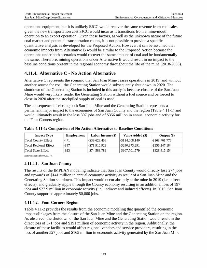
Draft Environmental Impact Statement Section 4 San Juan Mine Deep Lease Extension Environmental Consequences and Mitigation Measures
119
operations equipment, but it is unlikely SJCC would recover the same revenue from coal sales given the new transportation cost SJCC would incur as it transitions from a mine-mouth operation to an export operation. Given these factors, as well as the unknown nature of the future coal market and potential transportation routes, it is not possible to provide a specific quantitative analysis as developed for the Proposed Action. However, it can be assumed that economic impacts from Alternative B would be similar to the Proposed Action because the operations under both scenarios would recover the same amount of coal and be fundamentally the same. Therefore, mining operations under Alternative B would result in no impact to the baseline conditions present in the regional economy throughout the life of the mine (2018-2033).
4.11.4. Alternative C - No Action Alternative Alternative C represents the scenario that San Juan Mine ceases operations in 2019, and without another source for coal, the Generating Station would subsequently shut down in 2020. The shutdown of the Generating Station is included in this analysis because closure of the San Juan Mine would very likely render the Generating Station without a fuel source and be forced to close in 2020 after the stockpiled supply of coal is used.
The consequence of closing both San Juan Mine and the Generating Station represents a permanent major impact to the economies of San Juan County and the region (Table 4.11-1) and would ultimately result in the loss 897 jobs and of $356 million in annual economic activity for the Four Corners region.
Table 4.11-1: Comparison of No Action Alternative to Baseline Conditions
Impact Type Employment Labor Income ($) Value Added ($) Output ($) Total County Effect -471 -$39,628,458 -$114,008,140 -$168,761,776 Total Regional Effect -897 -$71,910,923 -$290,873,291 -$356,247,184 Total State Effect -923 -$74,589,783 -$307,701,579 -$328,915,154 Source: Ecosphere 2017k
4.11.4.1. San Juan County The results of the IMPLAN modeling indicate that San Juan County would directly lose 274 jobs and upwards of $141 million in annual economic activity as result of a San Juan Mine and the Generating Station shutdown. This impact would occur abruptly at the mine in 2019 (i.e., direct effects), and gradually ripple through the County economy resulting in an additional loss of 197 jobs and $27.9 million in economic activity (i.e., indirect and induced effects). In 2015, San Juan County supported approximately 50,000 jobs.
4.11.4.2. Four Corners Region Table 4.11-2 provides the results from the economic modeling that quantified the economic impacts/linkages from the closure of the San Juan Mine and the Generating Station on the region. As observed, the shutdown of the San Juan Mine and the Generating Station would result in the direct loss of 371 jobs and $191 million of economic activity in the region. Additionally, the closure of these facilities would affect regional vendors and service providers, resulting in the loss of another 527 jobs and $165 million in economic activity generated by the San Juan Mine

Draft Environmental Impact Statement Section 4 San Juan Mine Deep Lease Extension Environmental Consequences and Mitigation Measures
120
and the Generating Station. In total, the closure of both facilities would result in the elimination of nearly 900 jobs and $356 million in economic activity.
Table 4.11-2: Economic Effects of the No Action Alternative on the Region
Impact Type Employment Labor Income ($) Value Added ($) Output ($) Direct Effect -371 -$42,837,338 -$216,065,709 -$191,191,285 Indirect Effect -215 -$18,144,873 -$53,814,075 -$126,540,562 Induced Effect -312 -$10,928,713 -$20,993,507 -$38,515,337 Total Regional Effect -898 -$71,910,923 -$290,873,291 -$356,247,184 Source: Ecosphere 2017k
4.11.4.3. State of New Mexico To provide wide view of the economic linkages and impacts produced by San Juan Mine and the Generating Station, Table 4.11-3 provides the economic modeling results for the State of New Mexico under the scenario that both facilities shutdown.
Table 4.11-3: Impact of the No Action Alternative in State of New Mexico
Impact Type Employment Labor Income ($) Value Added ($) Output ($) Direct Effect 467 -$53,461,219 -$262,235,311 -$240,671,676 Indirect Effect 109 -$8,184,780 -$20,443,414 -$43,511,288 Induced Effect 346 -$12,943,784 -$25,022,855 -$44,732,191 Total State Effect 923 -$74,589,783 -$307,701,579 -$328,915,154 Source: Ecosphere 2017k
4.11.4.4. Public Revenues Estimates in the loss to public revenue from the facilities’ shutdown are provided in Table 3.11-37 of the TRD. As observed, the shutdown from these facilities would result in the loss of nearly $15 million in public revenue, with San Juan County bearing approximately a third of this impact ($4.5 million). The U.S. Federal Government operates on a budget in the trillions, and the loss of $7.5 million is not anticipated to have an effect on the Federal Government’s ability to provide services. The State of New Mexico spent $18 billion in 2016. A reduction of $3 million represents a decrease of less than 0.1 percent on the State’s budget, which would not affect the State’s ability to provide services. The No Action Alternative would also result in a loss of $4.5-million in property tax revenue for San Juan County. San Juan County is projected to spend $133 million in 2017, and the decrease of $4.5 million would represent a 3.4 percent drop in available funds for public services. At the local level, a 3.4 percent decrease in available funding could have a permanent major impact on the County’s ability to provide the same level of service as the baseline.
4.11.4.5. Indicators of Social and Economic Well-Being Economic conditions are a key determinant of social and economic well-being. A key factor is employment and the availability of jobs. The shutdown of the two facilities would result in the direct loss of 371 jobs and $191 million in economic activity in the region. This effect would gradually ripple throughout the region, resulting in the additional loss of 527 jobs and

Draft Environmental Impact Statement Section 4 San Juan Mine Deep Lease Extension Environmental Consequences and Mitigation Measures
121
$165 million in economic activity in the region (Ecosphere 2017k). Collectively, this decrease in regional employment levels would have an adverse impact on the number of households below the poverty level, on public assistance, and without healthcare.
4.11.4.6. Population and Demographics The total loss of 898 jobs in the region would result in a portion of people relocating out of the region for employment purposes. At a minimum, the loss of 371 jobs would slightly deter job seekers from moving to the Four Corners Region, especially San Juan County since that is where most of the San Juan Mine and the Generating Station employees reside. However, the population in the region is expected to grow by 6.9 percent. Considering this sizable growth curve, the loss of jobs at the San Juan Mine and the Generating Station would result in a minor reduction in the regional population.
4.11.5. Cumulative Effects San Juan Mine serves as a large source of employment, income, and public revenue in the region. While mining operations and workforce at San Juan Mine have been decreased to account for the shutdown of Generating Station Units 1 and 4, the DLE would render an aggregated economic impact (total from 15 years of operation, 2018-2033) of $400 million in labor payroll, 290 jobs/year, and over $2.3 billion in economic activity. The direct social and economic effects of the Proposed Action in combination with the other projects would result in an increase in economic activity.
The No Action Alternative is the only Alternative that results in a major adverse socioeconomic impact. No reasonably foreseeable future projects would generate adverse socioeconomic impacts, but rather provide increases to employment and economic activity, and thus no adverse cumulative impacts are expected. While the reasonably foreseeable future projects would provide increased economic activity, the loss of jobs, social benefits, economic activity, and public revenue as result of the shutdown of San Juan Mine and the Generating Station would not be replaced in the foreseeable future.
4.12. ENVIRONMENTAL JUSTICE Environmental Justice is defined by the EPA as “[t]he fair treatment and meaningful involvement of all people regardless of race, color, national origin, or income with respect to the development, implementation, and enforcement of environmental laws, regulations, and policies. Fair treatment means that no group of people including racial, ethnic, or socioeconomic groups should bear a disproportionate share of the negative environmental consequences resulting from industrial, municipal, and commercial operations or the execution of federal, state, local, and tribal programs and policies” (EPA 1998b).
The CEQ’s environmental justice guidance (CEQ 1997) states that the analysis should consider relevant data concerning the potential for multiple or cumulative exposures to human health or environmental hazards in the affected population. This analysis considers multimedia and cumulative impacts and references other sections of the EIS for additional detail. Although the analysis is formally organized by individual resource category, cumulative and multiple impacts (if present) are addressed in the most relevant resource category for those impacts.
Draft Environmental Impact Statement Section 4 San Juan Mine Deep Lease Extension Environmental Consequences and Mitigation Measures
122
This section discusses how environmental justice populations are identified, and those that are present in the region. Additionally, this section identifies the potential impacts to environmental justice populations as result of the Proposed Action and Alternatives. An environmental justice analysis consists of three steps: (1) Identify whether an alternative has potential adverse social, economic, or health impacts; (2) Determine if potential adverse impacts would disproportionately affect minority or low-income populations based on population and participation in potentially affected activities; (3) Determine if disproportionate adverse impacts are major.
The region is characterized by a high population of minority residents (Native American) and low-income residents on Native American tribal trust lands. While minorities and low-income residents in the region reside in places other than tribal trust lands, this analysis focuses on Native American populations. In addition, the city of Farmington is a mixture of minority/ low-income populations and non-environmental justice populations. As such, impacts to residents of the city of Farmington would not disproportionately affect minorities or low-low income residents.
The remainder of this section focuses on identifying the presence and significance of adverse social, economic, or health impacts of each alternative, and whether major impacts disproportionately affect a minority or low-income population. This analysis is based on the information presented in other resource sections in this EIS. Where other resource sections have identified adverse impacts in comparison to the baseline condition, this section describes the potential associated social, economic, or health impacts and determines whether major impacts would disproportionately affect Native Americans.
4.12.1. Significance Criteria The levels of significance of impacts are classified as major, moderate, minor, or no impact. An impact is considered major if it would result in a substantial adverse change to the environment, which would disproportionately affect a low-income, or minority population. An impact is considered moderate or minor if it would not result in substantial adverse environmental effects but could still have some effect that would disproportionately affect a low-income or minority population.
4.12.2. Alternative A – Proposed Action Many environmental effects would occur only within the DLE, the area proposed for underground mining. The DLE is uninhabited, thus, no communities would be directly impacted from the mining operation (i.e., effects of subsidence on a residence). However, some effects from the underground mine would have an off-site effect on the greater area, including socioeconomics and visual resources. There would also be indirect effects as a result of coal combustion, primarily to air quality and human health.
4.12.2.1. Cultural Resources The DLE has been thoroughly surveyed and all potentially eligible resources have been identified and catalogued. If a site cannot be avoided during a surface activity, this site would be recovered. In those areas where surface subsidence is anticipated from underground mining, monitoring protocols have been established and if a historic property/resource is showing signs

Draft Environmental Impact Statement Section 4 San Juan Mine Deep Lease Extension Environmental Consequences and Mitigation Measures
123
of being adversely impacted from subsidence, a treatment plan must be developed to mitigate these effects. Further, considering that the majority of cultural/historic sites present on the DLE are of Native American origin, the OSMRE and SHPO would consult with Tribes in the area before implementing a treatment measure. Therefore, potential effects to cultural resources are expected to be minor and not result in a disproportionate impact to the Native American populations in the region.
4.12.2.2. Socioeconomics Approximately half the San Juan Mine workforce is Native American, rendering a total of 85 jobs for Native Americans in the region. These are relatively high-paying jobs with an average annual salary of over $75,000 in an area with a median annual salary of $45,000. Under the Proposed Action, there would be no impact to socioeconomics in the region and the key environmental justice community would realize a continuance of socio-economic activity from the Proposed Action in the form of high-paying positions, and the indirect/induced economic and fiscal benefits that San Juan Mine provides the region.
4.12.2.3. Noise and Vibration Noise and vibration impacts were evaluated for sensitive receptors, with the closest receptors approximately 550 feet from the DLE in Kirtland, New Mexico. Since most of the proposed activities under the Proposed Action occur underground, the majority of noise generated at the DLE is from construction and vehicle trips during operations. These impacts would not exceed the significance thresholds or result in major adverse effects to the nearby residential community. Therefore, no major disproportionate impacts from noise or vibration to the Native American residents directly south of the mine would occur.
4.12.2.4. Visual Resources Impacts to visual resources as result of the Proposed Action are expected to be minor. These impacts include subsidence of the DLE surface, surface construction impacts (i.e., dust), and observation of proposed surface facilities (i.e., gob vents). Residents and viewers from nearby tribal trust lands would not experience disproportionate effects from the proposed activities/facilities, as these features would result in minor impacts to the visual resources.
4.12.2.5. Air Quality The air quality analysis determined that while air toxics are present in the area surrounding Generating Station, including the environmental justice communities in the deposition zone (i.e., town of Kirtland), the maximum-modeled concentrations of criteria pollutants were below NAAQS values, and remained below the NAAQS even when added to background concentrations. Because the NAAQS are health-based standards, and maximum concentrations are below the NAAQS, health impacts due to emissions of criteria pollutants are considered long-term (lasting for the duration of the Proposed Action) but minor for surrounding environmental justice communities.
As noted in Section 3.1, there is a degree of uncertainty around whether the PM2.5 NAAQS fully protects sensitive subpopulations (i.e. environmental justice populations). The air quality analysis, however, found that both the maximum 24-hour and maximum annual concentrations of PM2.5 would terminate at the boundary of DLE and would not be present in any inhabited

Draft Environmental Impact Statement Section 4 San Juan Mine Deep Lease Extension Environmental Consequences and Mitigation Measures
124
areas. In conclusion, the potential health risk to environmental justice populations within the deposition zone would be long-term but minor, and not represent a disproportionate major impact to the Native Americans living in this area.
4.12.2.6. Public Health and Safety Considering that there are no environmental justice populations present within the DLE area, potential public health and safety issues are limited to off-site inhalation of air toxins emitted from the Generating Station and ingestion through the deposition of air toxins in drinking water supplies and via the food chain. As discussed above in Air Quality, while criteria pollutants are present in the deposition zone, the level of pollution would be below the federally regulated NAAQS, even when added to background concentrations. Therefore, potential human health effects in the region from criteria air pollutants would be long-term but minor and would not disproportionately adversely affect a low-income or minority population.
The human health risk assessment (HHRA) analyzed potential ingestion of air toxins via the food chain and drinking water. The HHRA analysis found that human health risks from ingestion are well below not-to-exceed thresholds, and while exposure would be long-term, effects would be minor. It also concluded that health risks due to acute inhalation were also well below target not-to-exceed health goals for non-cancer effects, indicating no adverse health effects would be expected. Therefore, the HHRA found no disproportionate adverse impacts to low-income or minority populations related to public health and safety would result from the Proposed Action.
4.12.3. Alternative B – Continuation of San Juan Mine Operations Following Generating Station Shut-Down in 2022
The potential on-site and local effects to environmental justice populations in the region would be the same under Alternative B as the Proposed Action. However, this scenario assumes that the Generating Station would shut down entirely in 2022, thereby, removing a large source of criteria air pollutants from the ROI. It is unknown where the coal produced by San Juan Mine after 2022 would be combusted or otherwise used. This analysis assumes that it occurs near an environmental justice community similar to that at the Generating Station location, and that the level of air emission controls would be similar to those at the Generating Station. Under these conditions, the effects would not represent a disproportionate major impact to the environmental justice community in the area.
4.12.4. Alternative C – No Action Alternative Under the No Action Alternative, the San Juan Mine and Generating Station would shut down, therefore, none of the impacts described for the Proposed Action related to cultural resources, noise, public health or visual resources would occur and there would be no related environmental justice impacts. However, the socioeconomic impact of the No Action Alternative would be major and would adversely affect the identified environmental justice populations. Up to 145 jobs for Native Americans would be terminated at the San Juan Mine under the No Action Alternative. Under the No Action Alternative, the total loss of economic activity in the region would be upwards of $356 million per year. This impact would have pervasive effect on the entire region, including environmental justice communities, and would be manifested in increased unemployment levels, increased poverty levels, and potentially a decline in population as people move out of the region for work and a decreased job-base deters job-seekers from
Draft Environmental Impact Statement Section 4 San Juan Mine Deep Lease Extension Environmental Consequences and Mitigation Measures
125
moving to the region. In an economy facing such challenges, the effect of closing down the San Juan Mine would have major adverse impacts for all residents in the region, and not disproportionately on the environmental justice communities in the region. Whether the adverse effects would be long-term or permanent is speculative.
The closure of the Generating Station would result in the elimination of approximately 1,184 tons/year of dust and 0.002 tons/year of Hg, amongst the other emissions estimates provided in Table 2.1-7 in Section 2.1. Removing a large source of criteria air pollutants from the region would improve the air quality and human health impact to the environmental justice community (i.e., Kirtland residents) present within the deposition zone. Further, the shutdown of the Generating Station would also result in the reduction of 8,011 tons/year of nitrogen oxide and improve the haze and visibility conditions. The closure of the Generating Station would have a permanent and minor effect on air quality for the environmental justice populations present in the region.
4.12.5. Cumulative Effects The analysis determined that the Proposed Action would not result in a significant and disproportionate impact on the environmental justice populations in the ROI. Therefore, direct effects from the Proposed Action on sensitive resources for environmental justice populations would not serve as a significant contributor to a larger cumulative effect when combined with a reasonably foreseeable future action.
The No Action Alternative would result in a major disproportionate socioeconomic impact to environmental justice populations as result of the loss of employment, income, and worsening economic conditions. While none of the reasonably foreseeable future actions would adversely affect the socioeconomic conditions in the region, rather contributing employment opportunities and economic activity, the future projects/actions would be unable to replace the economic impact of San Juan Mine and San Juan Generating Station on the local Native American community in the near future.
4.13. VISUAL RESOURCES Federal agencies have developed various systems, or methodologies, for describing, analyzing, and managing visual resources on public lands. For example, BLM uses the Visual Resource Management (VRM) System and the U.S. Forest Service uses the Scenery Management System. On nonpublic lands, variations of both systems and other methodologies are used. Considering that the Project occurs entirely on lands managed by the BLM/FFO, the BLM VRM methodology is used as the approach in this analysis to determine potential effects to visual resources.
Visual impacts are caused by introducing new features or changing existing features in the scenic environment. Changes include adding new features, colors, or textures to the environment that are uncharacteristic to the locality or region. Changes also occur when aesthetic features of the landscape are made less visible. Impacts of the Proposed Action, Action Alternative, and the No Action Alternative were evaluated according to the level of change they would cause to the existing landscape character. The assessment of impacts takes into consideration the following factors: scenic integrity, viewer sensitivity, visual quality, viewer exposure, and overall visual sensitivity.

Draft Environmental Impact Statement Section 4 San Juan Mine Deep Lease Extension Environmental Consequences and Mitigation Measures
126
The method used to evaluate impacts to visual resources included development of a computerized viewshed analysis model to determine from what surrounding areas the activities within the DLE could be visible; a review of BLM visual resources inventory (VRI) and VRM classifications for the area and identification of sensitive receptors and key observation points (KOPs), developed in consultation with the BLM. Next, a visual resources contrast rating (VRCR) analysis was conducted which included site visits to each KOP location to photograph and document existing landscape conditions and completion of BLM Visual Contrast Rating Worksheet for each KOP.
4.13.1. Significance Criteria The following effects levels were used to classify the contrast levels identified for the Proposed Action and alternatives:
• Major – contrast from the Project is substantially greater than acceptable for the VRM class. Project would cause a substantial long-term effect on the landscape character/scenic quality of the existing visual environment of a sensitive viewer.
• Moderate – contrast is somewhat greater than acceptable for the VRM class. Project would cause a noticeable, but not substantial, change in the landscape character/scenic quality, or would cause a noticeable, but not substantial, change to the visual environment of a sensitive viewer.
• Minor – contrast is acceptable for the VRM class. Project would cause negligible or no change in the landscape character/scenic quality or the visual environment of a sensitive viewer
• No Impact – visual contrast is imperceptible.
4.13.2. Alternative A – Proposed Action Based on field observations and review of historic documentation, there would not have been much change in the view from 2008 to December 2017, except for reclamation activities taking place at pit-mining operations within the San Juan Mine permit boundary, a decrease in the number of oil and gas pads, and view-specific changes as noted under each KOP description. As of March 2008, oil and gas pads and equipment had created the greatest visual contrast of any activity conducted within the DLE area. The TRD contains detailed descriptions of potential visual impacts at each KOP. Construction activities, equipment, materials, and disturbance that are temporary have the potential for low contrast against the existing landscape of the DLE area due to their differences in form, line, texture, and color. Construction equipment, drill rigs, temporary structures, and access roads—as well as excavation and dust clouds—may be seen at various locations within the DLE as mining activities progress. Short-term construction activities are not anticipated to create a level of contrast that would alter existing VRM objectives for all classified lands.
The grading and construction of access roads and installation of surface features (e.g., GVBs, rescue chambers) create adverse short-term visual impacts as these elements add a moderate degree of visual contrast noticeable to the casual observer in the foreground/middleground distance zone and typically do not repeat the existing patterns of form, line, color, and texture currently existing in the landscape. However, reclamation measures—including re-contouring
Draft Environmental Impact Statement Section 4 San Juan Mine Deep Lease Extension Environmental Consequences and Mitigation Measures
127
the disturbed surface to match natural contours and re-vegetation with the appropriate seed mixtures—are expected to slowly diminish the short-term visual contrast in these areas over time. As part of reclamation, the SJCC windrows soil adjacent to construction areas where surface disturbances are less than five acres or are linear and 20 feet wide, and soil is placed back into the disturbance area after construction (MMD 2014, Subpart 906B). Subsidence would result from underground mining in the DLE. No subsidence faulting or cracking was observed when comparing the 2008 and 2016 aerial photos. Potential subsidence in the DLE area is not expected to be noticeable from the KOPs, as these effects would occur across a large landscape and the lowering of the surface level by 4-8 feet is not expected to change the character or scenic value of the ROI. Therefore, impacts to visual resources from subsidence would be permanent, but minor.
Though conditions were clear at the time of the VRCR and pollution-related haze was at a minimum, haze and smog could build up and reduce visibility on certain days and under certain environmental/atmospheric conditions. Coal mined within the DLE would be burned by the Generating Station, which would result in indirect adverse effects to visibility and regional haze.
4.13.3. Alternative B – Continuation of San Juan Mine Operations Following Generating Station Shut-Down in 2022
Potential visual impacts to the KOPs would be the same as those described for the Proposed Action. If a new transportation asset is developed (i.e., road, rail), this proposal would be analyzed under a future NEPA review. It is not feasible to conduct a site-specific regional haze and visibility analysis without knowing the location of the power plant, but potential effects resulting from coal combustion at the hypothetical power plant are assumed to be no greater than those yielded by the Generating Station.
4.13.4. Alternative C – No Action Alternative Under the No Action Alternative, no adverse effect on visual resources as viewed from KOPs would occur beyond 2019, and scenic quality is expected to gradually improve as the San Juan Mine area is reclaimed, including Juniper Pit. Over the ten-year period, the scenic quality and sensitivity in the ROI would experience a permanent and moderate effect as reclamation activities return the landscape to a natural setting where contrast levels would be unperceivable. Coal from the San Juan Mine would no longer be burned by the Generating Station after 2020. Therefore, the indirect effect of the No Action Alternative would be a permanent and moderate impact to visibility and haze in the region.
4.13.5. Cumulative Effects The only other project(s) within a 5-mile radius of the DLE that may contribute to a cumulative impact would be future oil and gas development. BLM’s multiuse mandate under the Federal Land Policy Management Act (FLPMA) allows for federal lands to be leased for multiple purposes (where feasible). The DLE has experienced oil and gas development in the past and it is reasonable to expect that portions of the DLE (or BLM/FFO District lands) would be explored for resources in the future. If developed, the presence of oil/gas equipment (i.e., drill masts, trucks, derricks) on the DLE would represent an additional visual impact to KOPs 1 and 3 and yield a potentially significant cumulative impact. There are no other reasonably foreseeable
Draft Environmental Impact Statement Section 4 San Juan Mine Deep Lease Extension Environmental Consequences and Mitigation Measures
128
future actions that are proposed in the immediate DLE viewshed (5-mile radius) that would result in a cumulative visual impact. Visibility and regional haze conditions in the region may be affected by emissions from the Generating Station. The emissions and criteria pollutants (i.e., particulate matter, sulfur dioxide, and nitrogen dioxide) that foster haze and poor visibility are regulated on a regional level to account for all the key emission sources in a large area or state.
4.14. NOISE AND VIBRATION The region of influence for this analysis is 1 mile from the San Juan Mine and DLE boundary, which is the maximum distance that noise associated with operations at the San Juan Mine is reasonably expected to result in a perceptible increase in noise and vibration. The methodology for evaluating potential noise impacts from mining activities associated with the Project is based on the procedures of ISO 9613-2:1996, Acoustics – Attenuation of Sound during Propagation Outdoors – Part 2: General Method of Calculation (1996). The calculation used for the analysis presented in the EIS used spreadsheet-based calculations based on the ISO 9613-2:1996 standard. The procedure essentially involved determining the maximum noise levels during the various stages of mining activities, based on noise data from equipment manufacturers, the Federal Highway Administration’s database of construction equipment noise levels (FHWA 2006), and field measurements around the existing mining areas, and then propagating those maximum noise levels from the area of activity to the nearest residential dwellings.
4.14.1. Significance Criteria Impacts for noise are based on the 24-hour day-night average noise level (Ldn) noise metric for activities that are performed during daytime and nighttime hours. The EPA guideline for acceptable noise levels for sensitive receivers uses the 24-hour noise metric to evaluate nighttime noise exposure and sets a noise level of 55 A-weighted decibels (dBA) Ldn as the acceptable limit for outdoor use areas (EPA 1974). Because no other enforceable noise standards apply to the Project, the EPA-acceptable noise levels are used as the criteria for evaluating Project noise impacts for activities that generate noise during the nighttime hours between 10 p.m. and 7 a.m.
Thresholds used to evaluate potential noise and/or vibration impacts are based on applicable criteria; noise or vibration impacts would be considered major if:
• Hourly sound levels from construction or mining activities reach 90 dBA at residences.
• Vibration from short-term construction at the mine would exceed 0.2 in/sec peak particle velocity (PPV) at residential structures based on Federal Transit Authority guidelines.
• The 24-hour Ldn of 55 dBA were exceeded at residences.
4.14.2. Alternative A – Proposed Action The noise monitoring conducted in March 2017 show that typical existing San Juan Mine operations are currently not a significant source of unwanted noise in surrounding residential areas. The distances between these current operations and sensitive receptors are greater than 2.5 miles in most cases and sufficient to attenuate noise to levels that do not create annoyance or cause community impacts. In some areas, intervening terrain also creates a barrier between noise sources and sensitive receptors. No noise-related complaints have been received since surface mining with blasting was discontinued in 1999 (Ecosphere 2017l). Along US 64 in Kirtland,
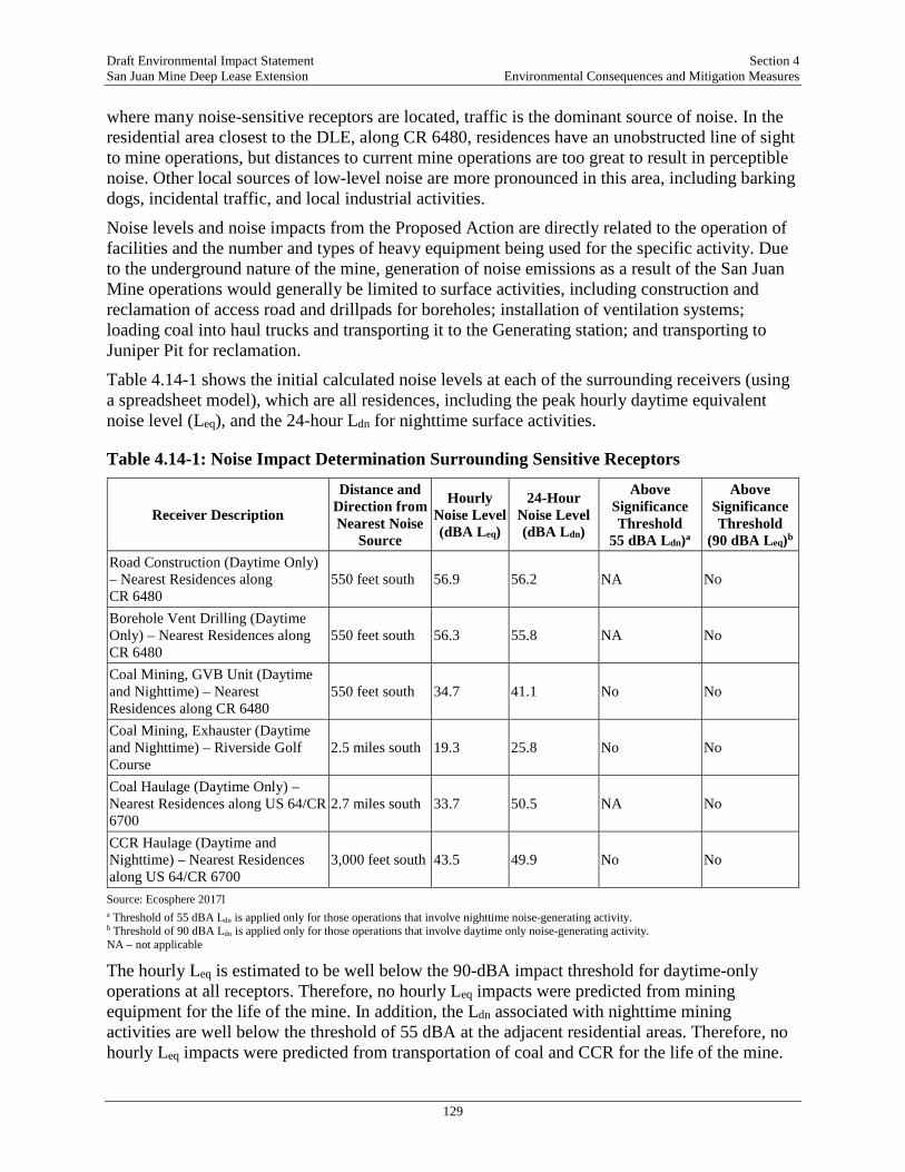
Draft Environmental Impact Statement Section 4 San Juan Mine Deep Lease Extension Environmental Consequences and Mitigation Measures
129
where many noise-sensitive receptors are located, traffic is the dominant source of noise. In the residential area closest to the DLE, along CR 6480, residences have an unobstructed line of sight to mine operations, but distances to current mine operations are too great to result in perceptible noise. Other local sources of low-level noise are more pronounced in this area, including barking dogs, incidental traffic, and local industrial activities.
Noise levels and noise impacts from the Proposed Action are directly related to the operation of facilities and the number and types of heavy equipment being used for the specific activity. Due to the underground nature of the mine, generation of noise emissions as a result of the San Juan Mine operations would generally be limited to surface activities, including construction and reclamation of access road and drillpads for boreholes; installation of ventilation systems; loading coal into haul trucks and transporting it to the Generating station; and transporting to Juniper Pit for reclamation.
Table 4.14-1 shows the initial calculated noise levels at each of the surrounding receivers (using a spreadsheet model), which are all residences, including the peak hourly daytime equivalent noise level (Leq), and the 24-hour Ldn for nighttime surface activities.
Table 4.14-1: Noise Impact Determination Surrounding Sensitive Receptors
Receiver Description
Distance and Direction from Nearest Noise
Source
Hourly Noise Level (dBA Leq)
24-Hour Noise Level (dBA Ldn)
Above Significance Threshold
55 dBA Ldn)a
Above Significance Threshold
(90 dBA Leq)b Road Construction (Daytime Only) – Nearest Residences along CR 6480
550 feet south 56.9 56.2 NA No
Borehole Vent Drilling (Daytime Only) – Nearest Residences along CR 6480
550 feet south 56.3 55.8 NA No
Coal Mining, GVB Unit (Daytime and Nighttime) – Nearest Residences along CR 6480
550 feet south 34.7 41.1 No No
Coal Mining, Exhauster (Daytime and Nighttime) – Riverside Golf Course
2.5 miles south 19.3 25.8 No No
Coal Haulage (Daytime Only) – Nearest Residences along US 64/CR 6700
2.7 miles south 33.7 50.5 NA No
CCR Haulage (Daytime and Nighttime) – Nearest Residences along US 64/CR 6700
3,000 feet south 43.5 49.9 No No
Source: Ecosphere 2017l a Threshold of 55 dBA Ldn is applied only for those operations that involve nighttime noise-generating activity. b Threshold of 90 dBA Ldn is applied only for those operations that involve daytime only noise-generating activity. NA – not applicable
The hourly Leq is estimated to be well below the 90-dBA impact threshold for daytime-only operations at all receptors. Therefore, no hourly Leq impacts were predicted from mining equipment for the life of the mine. In addition, the Ldn associated with nighttime mining activities are well below the threshold of 55 dBA at the adjacent residential areas. Therefore, no hourly Leq impacts were predicted from transportation of coal and CCR for the life of the mine.
Draft Environmental Impact Statement Section 4 San Juan Mine Deep Lease Extension Environmental Consequences and Mitigation Measures
130
In addition, the Ldn associated with nighttime mining activities are well below the threshold of 55 dBA at the adjacent residential areas. These impacts would be minor. Further, as discussed above, no perceptible impact from ground-borne vibrations would occur from the mining activities.
4.14.3. Alternative B – Continuation of San Juan Mine Operations Following Generating Station Shut-Down in 2022
Under this alternative, all of the mining techniques would be identical to those for the Proposed Action. However, coal would be required to be transported to an alternative generating station. Transport of coal to the selected generation station may involve transport via existing regional transportation routes or by accessing a rail distribution site. Impacts to sensitive receptors would remain materially the same as described for the Proposed Action. Transportation of coal along adjacent roads would result in greater noise levels at the nearby residences; however, as described in Section 3.9, exact noise impacts from transportation of coal are too speculative to be determined for purposes of this EIS.
4.14.4. Alternative C – No Action Alternative Impacts from existing mining activities have been assessed previously and are not expected to differ appreciably in nature from what is described above until August 2019 when all mining activities would cease. Thus, there would be no noise associated with mining activities after August 2019.
4.14.5. Cumulative Effects The cumulative effects ROI for noise and ground-borne vibration includes all proposed construction and development projects in and around the San Juan Mine Area through the completion of reclamation activities expected to be completed by the year 2053. Potential noise and ground-borne vibration caused by activities at the San Juan Mine are localized to the Lease Area and would not contribute cumulatively to the impacts caused by construction or mining activities at other locations in the region. Noise and ground-borne vibrations result from mining and construction projects, as well as transit, and everyday activities (i.e., lawn mowers). Coal removal and reclamation mining activities could produce noise for residents living within 1 mile of the San Juan Mine, which can cause annoyance. Other reasonably foreseeable future construction projects that would expose the same receptors to noise and vibration at the same time as mining activities could further exceed thresholds; however, the only project occurring within the 1-mile radius is the existing Generating Station and this operation is not expected to contribute major noise or vibration effects for sensitive receptors in addition to the project-specific effects produced from mining activities. Therefore, cumulative impacts with regard to noise and vibration would be minor.
4.15. HAZARDOUS AND SOLID WASTES In order to assess the impacts associated with handling, storage, and disposal of hazardous materials and solid wastes, the chemicals and the amounts stored on-site were reviewed to determine the need for and appropriateness of their use and measures to prevent spills were evaluated for effectiveness. Preventative measures include engineering controls such as

Draft Environmental Impact Statement Section 4 San Juan Mine Deep Lease Extension Environmental Consequences and Mitigation Measures
131
secondary containment and administrative controls such as worker training and safety management programs. In addition, the measures to respond to accidents were reviewed. These measures include engineering controls such as spill cleanup and spill containment equipment and administrative controls such as training and written emergency response plans. For chemicals or solid wastes that have the potential to migrate off-site and affect the public, an analysis of the theoretical impacts on the public or the environment of a worst-case spill was performed.
4.15.1. Significance Criteria The criteria for defining significance under NEPA (CFR 1508.27) includes the degree to which a release of a hazardous material or waste would affect public health or safety and the environment, the degree to which a release of a hazardous material or waste would be highly controversial, and the degree to which the possible impacts of a release of a hazardous material or waste is highly uncertain or involves unique or unknown risks. A major impact would be a spill or release of a hazardous material that migrates off-site with major impacts to public receptors and/or the environment. A moderate impact would occur if a spill or release of a hazardous material migrated off-site with minor impacts to public receptors or the environment. A minor impact would occur if a spill or release of a material not defined by the EPA as a hazardous material occurred and did not migrate offsite.
4.15.2. Alternative A – Proposed Action No new hazardous materials would be brought onsite or new wastes generated under the Proposed Action. Existing hazardous materials and waste storage areas for the San Juan Mine are adequately sized to handle the hazardous materials or wastes associated with the San Juan Mine DLE Area. None of the hazardous materials currently in use at the San Juan Mine are stored in threshold quantities that trigger Emergency Planning and Community Right-to-Know Act (EPCRA) reporting. The trigger threshold volume that requires EPCRA reporting varies by chemical, and some chemicals do not require reporting under the provision regardless of the volume in which they are stored onsite. The chemical volumes required for the proposed San Juan Mine DLE operations would not trigger EPCRA reporting. Therefore, any impact from an accidental release or spill of these materials would be minor. The potential for impacts from a release or spill is considered long-term and would exist for the Project life (through the end of reclamation). Hazardous and universal wastes and special wastes would continue to be accumulated, managed, and disposed of in accordance with applicable EPA and Department of Transportation regulations (Ecosphere 2017m). The hazardous materials and waste storage, handling, transportation, and disposal management programs for the existing San Juan Mine meet regulatory requirements for these activities; therefore, these programs along with the engineering controls identified in the programs are adequate for mitigating any potential hazardous materials releases or spills.
CCR generated from Units 1 and 4 would continue to be placed in in Piñon and Juniper Pits for reclamation. Estimated annual storage amount would be 962,000 tons per year. The environmental consequences of the past placement of CCR for use in reclamation is addressed fully, including groundwater monitoring, in Section 4.5, Water Resources and Hydrology. The conclusion from that section is that the potential impacts of placement of CCR within the San Juan Mine would be permanent but minor. The EPA’s Final Rule for Hazardous and Solid Waste Management System; Disposal of Coal Combustion Residuals from Electrical Utilities

Draft Environmental Impact Statement Section 4 San Juan Mine Deep Lease Extension Environmental Consequences and Mitigation Measures
132
(December 19, 2014) specifies closure and post-closure requirements applicable to the Generating Station and the Piñon and Juniper Pits. The Final Rule provides operators time to develop site-specific closure and post-closure management plans for areas where CCR have been disposed or where they will be disposed. These measures ensure that hazards related to CCR would be permanent but minor.
4.15.3. Alternative B – Continuation of San Juan Mine Operations Following Generating Station Shut-Down in 2022
Under this alternative, impact from mining operations would be identical to those for the Proposed Action; however, coal would be required to be transported to an alternative generating station and ash would not be available for use in reclamation after 2020 once coal is no longer supplied to the Generating Station. Transport of coal to the selected generation station may involve transport via existing regional transportation routes or by accessing a rail distribution site. Due to unknown market conditions and end users of DLE coal, transport methods and routes and exact impacts are too speculative to be determined for purposes of this EIS. CCR from the Generating Station would be placed in Juniper Pit for as long as the Generating Station continues to operate until 2022. Therefore, impacts would remain materially the same as described for the Proposed Action.
4.15.4. Alternative C – No Action Alternative Impacts from existing mining activities have been assessed in this EIS and are not expected to differ appreciably in nature from what is described above until August 2019 when mining would cease. Thus, there would be no hazardous waste- or material-related risks associated with mining activities after August 2019. Impacts associated with operation of the Generating Station until 2020 would remain materially the same as described for the Proposed Action. After shutdown, PNM would decommission all facilities that are not required or permitted subject to the land use agreement for private land. PNM has not yet developed a decommissioning plan. Impacts related to hazardous waste and solid waste would be short-term and predominately associated with disposal of demolition materials. Because these activities would occur in compliance with all environmental laws and regulations, these impacts would be expected to be minor and short-term.
4.15.5. Cumulative Effects The cumulative effects ROI for hazardous and solid wastes includes all major permitted mine sites and generating stations in the region of the San Juan Mine through the year 2053. Cumulative effects that could occur with regard to hazardous and solid waste include the generation of such wastes that exceed the capacity of local permitted landfills. All facilities included within this cumulative effect’s analysis would be required to dispose of hazardous waste in accordance with all state and Federal regulations. Furthermore, the San Juan County Landfill has the capacity to accommodate the generated waste for a projected life of 101 years. The potential impacts from an accidental release of hazardous or solid waste from the San Juan Mine would be limited to the release area of the specific material and would not contribute cumulatively to the impacts caused by other hazardous waste generating or managing facilities at other locations in the Four Corners region. With specific reference to mining and generation
Draft Environmental Impact Statement Section 4 San Juan Mine Deep Lease Extension Environmental Consequences and Mitigation Measures
133
stations, cumulative effects could occur as result of disposal of CCR as part of reclamation activities at the mine. This issue is addressed in Section 4.5, Water Resources/Hydrology.
4.16. HEALTH AND SAFETY This section describes the potential direct and indirect impacts on both public health and safety and worker health and safety of the Proposed Action and alternatives. The public health analysis considers exposure to air emissions from mining and from burning the coal; the worker health and safety analysis considers the adequacy of the SJCC’s worker health and safety program. The primary issues related to environmental health include impacts on public health from air emissions due to mining and combustion of coal; impacts on public health from air emissions depositing and affecting soil, water, and the food chain; and impacts on worker health and safety from mining.
The analysis for worker safety focuses on occupational hazards within the workplace. In occupational settings, workplace health and safety is mandated by MSHA and OSHA regulations. The impact assessment methodology for worker safety includes identification of the risks associated with the work activities encountered by employees working at the San Juan Mine and a review of the adequacy of occupational safety programs to protect those employees. In addition, the safety record of the mine is compared to the industry standard.
The analysis for public health focuses on the human health risks from exposure to contaminants in air emissions produced by the proposed activities at the mine and from the combustion of coal at the Generating Station and were evaluated in a detailed HHRA (AECOM 2017e). Below is a discussion of the different criteria for assessing air pollution:
• Criteria Pollutants. EPA has established NAAQS for the criteria pollutants that are based on protecting human health. Individual states have the option to adopt more stringent standards and to include additional regulated pollutants. All states in the Four Corners region—New Mexico, Arizona, Utah, and Colorado—have adopted the NAAQS as promulgated by EPA, as have the American Indian nations in the Four Corners region—Navajo Nation, Hopi Tribe, and Southern Ute Indian Tribe. In addition, New Mexico has established specific NMAAQS to supplement the Federal standards (20.2.3 NMAC). These additional standards apply to NO2, SO2, CO, and total suspended particulate (TSP). EPA’s process for establishing NAAQS is exhaustive and thorough. Their mandate is to protect human health with an adequate margin of safety. Federal regulations require all six of the NAAQS (e.g., the criteria pollutants) be evaluated periodically to ensure they remain health protective. Each of these evaluations represents an extensive process consisting of examining the available health data and assessing whether the existing air concentration standard is adequately health-protective. In addition, an independent committee of non-EPA experts conducts peer review of the EPA’s work and provides the EPA Administrator with advice and recommendations about the scientific adequacy of EPA’s evaluation. Therefore, in general, if the NAAQS are being met, human health, including sensitive subpopulations, is protected; however, there is some uncertainty about the protectiveness of the NAAQS for sensitive populations exposed to PM2.5. The ROI is in attainment (i.e., concentrations are below NAAQS) for the criteria pollutants and the Proposed Action emissions would not result in any exceedances of NAAQS values even when emissions are added to the background concentrations currently present.

Draft Environmental Impact Statement Section 4 San Juan Mine Deep Lease Extension Environmental Consequences and Mitigation Measures
134
• Air Toxics. Air toxics, also called HAPs, can be emitted from coal combustion, and as fugitive coal dust and operation of mobile equipment at the mine. Establishing guidelines and standards for air toxics is not the lengthy and rigorous procedure required for the criteria pollutants; however, guidelines and standards are peer reviewed, periodically updated, and based on the best available health information. Like the criteria pollutants, the EPA and other agency guidelines and standard recommendations for air toxics are established to protect public health with an adequate margin of safety.
Other public health and safety concerns, including potential for traffic accidents (Section 4.9), disproportionate impacts to environmental justice populations (Section 4.11), potential for noise to affect nearby residents (Section 4.14), and public exposure to hazardous materials (Section 4.15) are addressed in other resource sections noted.
4.16.1. Significance Criteria A potentially major impact on public health is one that would result in one or more of the following conditions:
• Air emissions of the criteria pollutants that exceed health-based regulatory limits of the CAA, i.e., NAAQS and NMAAQS;
• Air emissions of air toxics that exceed chronic or acute health standards or guidelines (CalEPA 2017; USDOE 2016; EPA 2017h); and
• Health risks that exceed regulatory goals for HHRA established by government and public health agencies.
Impacts that are below the thresholds above are considered minor.
4.16.2. Alternative A – Proposed Action
4.16.2.1. Worker Safety Under the Proposed Action, no new work processes would be introduced that might present new or increase existing safety risks to Proposed Action workers. The existing SJCC health and safety programs that were developed to comply with the applicable MSHA health and safety standards would cover the work processes included in the Proposed Action. In terms of San Juan Mine’s safety record, while the facility has received MSHA safety citations/orders, the facility has addressed them within the same calendar year. The MSHA “Rules to Live By” safety violation rate for the facility is also well below the industry average, indicating that SJCC’s current performance is one that is more protective of workers than the industry standard. Given the Proposed Action would not present new or increase the existing safety risks at the mine and given the facility’s better than industry average safety violation rate, it is expected that the Proposed Action would have a minor impact on worker safety.
4.16.2.2. Public Health Regarding direct impacts from mining, there are no houses located within the DLE area proposed for underground mining. As this area is uninhabited, no communities would be directly impacted from the mining operation (e.g., effects of subsidence on a residence). Nearby residences (the nearest are in the town of Kirtland approximately 550 feet from the DLE) could have health/

Draft Environmental Impact Statement Section 4 San Juan Mine Deep Lease Extension Environmental Consequences and Mitigation Measures
135
nuisance impacts from noise or off-site traffic. Those impacts are addressed in Sections 4.14, Noise and Vibration, and 4.9, Land Use, Transportation, and Agriculture, respectively. Potential health impacts addressed here are related to air emissions from the mine and from the Generating Station and are anticipated to primarily affect communities within the deposition area of the ROI.
Impacts from Air Emissions—Criteria Pollutants The maximum-modeled concentrations of criteria pollutants due to emissions from the mine and the Generating Station were below NAAQS values and remained below the NAAQS even when added to background concentrations (see Section 3.1, Air Quality). Because the NAAQS are health-based standards, and maximum concentrations are below the NAAQS, health impacts due to emissions of criteria pollutants are considered long-term but minor for the general population. Although lead concentrations were below the NAAQS, the HHRA performed a supplemental evaluation of the impact of lead emissions on children’s blood-lead levels and concluded the potential increase in blood-lead levels in children was extremely small and did not contribute to increases in blood-lead levels in children that would be associated with any measurable health effects (AECOM 2017e). Children are the most sensitive subpopulation for lead exposures.14
As noted above, there is some uncertainty around whether the PM2.5 NAAQS fully protects sensitive subpopulations. PM2.5 is the primary PM size range of concern for human health. PM2.5 particles are not visible to the naked eye and are able to penetrate to areas of the lungs where gas exchange occurs that larger particles cannot reach. Figure 4.16-1 shows a particle size comparison. There are two main areas of uncertainty surrounding the protectiveness of the PM2.5 NAAQS. First, EPA has noted that the toxicity of PM can vary by composition.15 Diesel particulate matter (DPM) is less than 2.5 microns in diameter, so DPM is included in the PM2.5 fraction of PM. DPM is an air toxic and is considered “likely to be carcinogenic to humans” by EPA and “carcinogenic to humans” by the World Health Organization (EPA 2003b; IARC 2012). Consequently, the carcinogenic health effects of PM2.5 may vary according to how much of the 2.5-micron size fraction contains DPM and/or other carcinogens, such as heavy metals. The NAAQS included an evaluation of the potential carcinogenicity of diesel exhaust as part of its last evaluation of PM (EPA 2009) and concluded that for PM2.5 as a whole, the evidence was “suggestive of a causal relationship” (the third out of five levels of certainty in assessing whether an exposure causes an effect) between long-term exposure to PM2.5 and lung cancer. Information on possible carcinogenic effects of DPM was part of the data used to establish the PM2.5 NAAQS, but the NAAQS is not specific to DPM toxicity. Other components of PM2.5 may cause lung cancer besides diesel exhaust, e.g., heavy metals in coal dust such as As and nickel. The potential carcinogenic and non-cancer health effects of heavy metals in coal were directly assessed in the HHRA. The health effects of DPM were not quantified in the HHRA but would be similar to the health effects estimated for diesel emissions in the Final EIS for the Four Corners Power Plan and Navajo Mine Energy Project (OSMRE 2015). In the Four Corners Power Plant, cancer risks and non-cancer toxic effects were evaluated and met not-to-exceed target health risk goals. As the Proposed Action would have similar diesel emissions, DPM
14 The maximum predicted increases in child blood lead levels were 0.000035 micrograms of lead per deciliter of blood (AECOM 2017e). The national Center for Disease Control recommendation of the maximum amount of lead in children is 5 micrograms per deciliter (CDC 2012). 15 EPA initiated the process of conducting its next review of particulate matter in 2014; this review is in progress (EPA 2016).
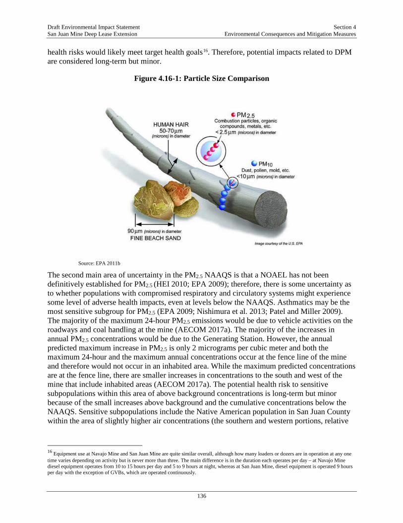
Draft Environmental Impact Statement Section 4 San Juan Mine Deep Lease Extension Environmental Consequences and Mitigation Measures
136
health risks would likely meet target health goals16. Therefore, potential impacts related to DPM are considered long-term but minor.
Figure 4.16-1: Particle Size Comparison
Source: EPA 2011b
The second main area of uncertainty in the PM2.5 NAAQS is that a NOAEL has not been definitively established for PM2.5 (HEI 2010; EPA 2009); therefore, there is some uncertainty as to whether populations with compromised respiratory and circulatory systems might experience some level of adverse health impacts, even at levels below the NAAQS. Asthmatics may be the most sensitive subgroup for PM2.5 (EPA 2009; Nishimura et al. 2013; Patel and Miller 2009). The majority of the maximum 24-hour PM2.5 emissions would be due to vehicle activities on the roadways and coal handling at the mine (AECOM 2017a). The majority of the increases in annual PM2.5 concentrations would be due to the Generating Station. However, the annual predicted maximum increase in PM2.5 is only 2 micrograms per cubic meter and both the maximum 24-hour and the maximum annual concentrations occur at the fence line of the mine and therefore would not occur in an inhabited area. While the maximum predicted concentrations are at the fence line, there are smaller increases in concentrations to the south and west of the mine that include inhabited areas (AECOM 2017a). The potential health risk to sensitive subpopulations within this area of above background concentrations is long-term but minor because of the small increases above background and the cumulative concentrations below the NAAQS. Sensitive subpopulations include the Native American population in San Juan County within the area of slightly higher air concentrations (the southern and western portions, relative
16 Equipment use at Navajo Mine and San Juan Mine are quite similar overall, although how many loaders or dozers are in operation at any one time varies depending on activity but is never more than three. The main difference is in the duration each operates per day – at Navajo Mine diesel equipment operates from 10 to 15 hours per day and 5 to 9 hours at night, whereas at San Juan Mine, diesel equipment is operated 9 hours per day with the exception of GVBs, which are operated continuously.
Draft Environmental Impact Statement Section 4 San Juan Mine Deep Lease Extension Environmental Consequences and Mitigation Measures
137
to the mine, of the deposition area) and any others in the deposition area with compromised respiratory or circulatory systems.
Impacts of Air Emissions—Air Toxics The potential impacts of air toxic emissions were assessed by performing an HHRA to evaluate the health effects from residual air toxics contained in fugitive coal dust from the mine and from burning the mined coal at the Generating Station (AECOM 2017e). The HHRA Protocol (EPA 2005) recommends three exposure scenarios for persons living in the vicinity of a source: (1) residential exposure; (2) farm products consumption exposure (beef, pork, chickens, eggs, milk); and (3) fish consumption exposures. While local residents are more likely to raise and eat sheep than beef or pork, the risk estimates for all three species would be similar. All three exposure scenarios consider the potential exposure of both adults and children through direct and indirect exposure pathways. These pathways include inhalation of air toxics dispersed in ambient air and ingestion of trace amounts of air toxics that enter the food chain through plant uptake and animal ingestion.
Compounds enter the food chain through deposition from air to soil, deposition on crops and forage, and deposition into watersheds and their associate water bodies. The HHRA used health-protective (i.e., more likely to overestimate than underestimate exposure) assumptions of the amount of exposure that might occur. These exposure assumptions are HHRA protocol default values for all sites recommended by EPA (EPA 2005). For fish ingestion, site-specific exposure assumptions were used that accounted for the local advisories for fish consumption that are in effect for two of the seven water bodies evaluated: Morgan Lake and Lake Farmington. For the other five water bodies, the EPA’s default fish ingestion rate from the protocol document (EPA 2005) was used.
Figure 4.16-2 in the TRD shows the pathways of exposure assessed in the risk assessment within the deposition area. Figure 3.16-9 in the TRD shows the specific location within the deposition area where risks were calculated for residents and farmers. These locations were selected by looking at where people lived and where the highest predicted air concentrations occur. The HHRA also included a pathway to evaluate the health effects of dioxins to nursing infants from mother’s milk. Health risks from this pathway were found to be minor, dioxins from the Proposed Action (Post-SIP period, 2018-2033) represented an increased dioxin exposure to nursing infants of less than 0.007 percent of the average daily dose (i.e., background level) for the U.S. population17 (AECOM 2017e). Dioxins from the Pre-SIP period, 2008-2017, represented an increased dioxin exposure to nursing infants of less than 0.012 percent of the average daily dose (i.e., background level) for the U.S. population18 (AECOM 2017e). Step 1 of the risk assessment, the selection of chemicals of potential concern (COPCs), was based on two previous studies performed by the Electrical Power Research Institute (EPRI 2009) and input from the OSMRE as to the air toxics that would be emitted from burning coal and/or were trace elements in coal dust. Based on this analysis, 30 chemicals (including two chemical groups –
17 Percentages of average daily dose ranged from 0.0001 percent to 0.0061 percent, depending on the scenario (AECOM 2017e). Because dioxins are ubiquitous in the environment, all nursing mothers pass some dioxins to their infants in milk, and this level has been measured and an average daily dose for the population calculated by EPA (EPA 2005). This average was used as the comparison value in the HHRA. 18 Percentages of average daily dose ranged from 0.0002 percent to 0.0113 percent, depending on the scenario (AECOM 2017e). Because dioxins are ubiquitous in the environment, all nursing mothers pass some dioxins to their infants in milk, and this level has been measured and an average daily dose for the population calculated by EPA (EPA 2005). This average was used as the comparison value in the HHRA.

Draft Environmental Impact Statement Section 4 San Juan Mine Deep Lease Extension Environmental Consequences and Mitigation Measures
138
dioxins and polyaromatic hydrocarbons [PAHs]) were evaluated in the risk assessment and are summarized on Table 4.16-1.
Figure 4.16-2: Human Health Exposure Pathways
Table 4.16-1: Chemicals Evaluated in the Human Health Risk Assessment Aluminum Cobalt Selenium Sulfuric Acid Antimony Copper Silver Dioxins Arsenic Iron Vanadium Individual carcinogenic PAHs Barium Lead Zinc Acrolein Beryllium Manganese Chlorine Benzene Boron Mercury Hydrogen Chloride Naphthalene Cadmium Molybdenum Hydrogen Cyanide Chromium Nickel Hydrogen Fluoride Source: AECOM 2017e
The results of the quantitative risk calculations were evaluated against EPA’s not-to-exceed risk thresholds. Because EPA’s default assumption is that there is no exposure to a carcinogen that is completely safe, cancer is evaluated as an increased likelihood of occurring as a result of exposure to a particular chemical. This increased risk of developing cancer from a site-related environmental exposure is defined as the excess cancer risk, that is, in excess of a background cancer risk of approximately one chance in 40 (0.4, or 4 x 10⁻¹) for the U.S. population (National Cancer Institute 2017). For cancer risks, the not-to-exceed thresholds range from a risk of 10-4 to 10-6, or a cancer risk of one in 10,000 to a risk of one in a million. Risks of cancer below one chance in a million are considered negligible. For chemicals with non-cancer toxicity, evidence shows that there is a safe level. Non-cancer acceptable thresholds are a hazard index of 1 (unity). At a hazard index of one, the site dose is equal to the safe dose and no adverse effects would be
Draft Environmental Impact Statement Section 4 San Juan Mine Deep Lease Extension Environmental Consequences and Mitigation Measures
139
expected. For hazard indices greater than one there is relative increase in risk of adverse effects as the calculated hazard index increases from a hazard index of 1.
The results of the HHRA are presented in Table 4.16-2 for the baseline period 2008-2017, and the period 2018 through 2033 (AECOM 2017e). As shown on the table, cancer risks are 100 to a 1,000-times lower than the one in a million not-to-exceed risk threshold for cancer. Non-cancer hazards are also 100 to a 1,000-times lower than a hazard index of 1 for non-cancer effects. The highest cancer risks for the combined period before and after compliance with the SIP (reflecting the incremental risk from 2008-2033) were found for farmers and fishermen fishing in Morgan Lake (the cooling water forebay for the adjacent Four Corners Power Plant), and the highest non-cancer hazards were for adults and children eating fish from Morgan Lake19. However, even in these cases the hazardous indices were substantially below 1.
Cancer risks and non-cancer hazards are based on long-term regular exposure over many years, based on an estimate of the average concentrations that are emitted over time. For air emissions, there are short-term “spikes” of higher concentrations of chemicals that could result in an immediate health effect. The HHRA also examined the potential for these “acute” health risks from inhaling these short-term, maximum concentrations emitted from the Generating Station. The health risks due to acute inhalation were also well below target not-to-exceed health goals for non-cancer effects, indicating no adverse health effects are expected.
The HHRA process is designed to conservatively estimate health risks. Therefore, the risk assessment results, which are all well below not-to-exceed thresholds, lead to predicted incremental risks from air toxics emissions to be long-term but minor.
4.16.3. Alternative B – Continuation of San Juan Mine Operations Following Generating Station Shut-Down in 2022
All mining techniques under Alternative B would be identical to the techniques in the Proposed Action, with the exception that the coal reserves of 2023 through 2033 may be exported to a non-local market, rather than burned locally. Impacts on worker safety would remain the same as for Alternative A as there would be no changes to mining practices. Impacts on public health in the ROI would be positive relative to Alternative A due to the removal of a large source of air pollution. With the closing of the Generating Station, there would be a significant reduction in air pollution in the area. The positive health impacts on air pollution-related diseases due to lower concentrations of air pollutants cannot be readily quantified due to the complexity of health causes and outcomes, particularly for the Native American population. Improvements in outdoor air quality may not have a large benefit to the Native American population due to: (1) the poor indoor air quality of many homes that burn coal for heating, and (2) because improvements in air quality would not impact other health factors for Native Americans such as poverty and lack of access to health care. Because the mine would continue operations, Section 3.11, Social and Economic Values, concluded that economic conditions for Alternative B would be similar to Alternative A.
19 Risk calculations assume people are eating fish at the rate recommended by the existing fish advisories for the lake.

Draft Environmental Impact Statement Section 4 San Juan Mine Deep Lease Extension Environmental Consequences and Mitigation Measures
140
Table 4.16-2: Risk Summary for Mine and Generating Station Emissions, 2008-2033
Baseline (2008-2017) After Implementation of the SIP (2018-2033)
Baseline through Proposed Action (2008-2033)
Receptor Scenario Cancer Risk Hazard Index Cancer Risk Hazard Index Cancer Risk Hazard Index Residenta resident-adult 6E-09 8E-03 7E-09 3E-03 1E-08 1E-02 resident-child 4E-09 8E-03 3E-09 3E-03 7E-09 1E-02 Farmerb farmer-adult 2E-08 6E-03 2E-08 4E-03 4E-08 9E-03 farmer-child 2E-08 6E-03 8E-09 4E-03 2E-08 1E-02 Fisher at Animas Riverc fisher-adult 9E-09 8E-03 7E-09 5E-03 2E-08 1E-02 fisher-child 5E-09 8E-03 3E-09 4E-03 9E-09 1E-02 Fisher at Chaco Riverc fisher-adult 7E-09 8E-03 7E-09 5E-03 1E-08 1E-02 fisher-child 5E-09 8E-03 3E-09 4E-03 8E-09 1E-02 Fisher at Lake Farmington fisher-adult 6E-09 8E-03 7E-09 4E-03 1E-08 1E-02 fisher-child 5E-09 8E-03 3E-09 5E-03 8E-09 1E-02 Fisher at Jackson Lakec fisher-adult 9E-09 9E-03 8E-09 6E-03 2E-08 1E-02 fisher-child 5E-09 9E-03 3E-09 5E-03 9E-09 1E-02 Fisher at La Plata Riverc fisher-adult 9E-09 8E-03 7E-09 5E-03 2E-08 1E-02 fisher-child 5E-09 8E-03 3E-09 4E-03 9E-09 1E-02 Fisher at Middle San Juan River (east)c fisher-adult 7E-09 8E-03 7E-09 5E-03 1E-08 1E-02 fisher-child 5E-09 8E-03 3E-09 4E-03 8E-09 1E-02 Fisher at Middle San Juan River (west)c fisher-adult 7E-09 8E-03 7E-09 5E-03 1E-08 1E-02 fisher-child 5E-09 8E-03 3E-09 5E-03 8E-09 1E-02 Fisher at Mancos Riverc fisher-adult 7E-09 8E-03 7E-09 5E-03 1E-08 1E-02 fisher-child 5E-09 8E-03 3E-09 4E-03 8E-09 1E-02 Fisher at Morgan Lakec,d fisher-adult 2E-08 2E-02 2E-08 2E-02 3E-08 4E-02 fisher-child 1E-08 2E-02 8E-09 2E-02 2E-08 4E-02 Fisher at Upper San Juan Riverc fisher-adult 6E-09 8E-03 7E-09 4E-03 1E-08 1E-02 fisher-child 4E-09 8E-03 3E-09 4E-03 7E-09 1E-02 Source: AECOM 2017 SIP – State Implementation Plan Notes: All fishers are located at the worst-case resident location, the only difference being the source of fish. Risks and hazards are expressed in scientific notation, where “E” is the power of 10. Specifically, for cancer risks, the notation “5E-09” is 5 x 10⁻⁹, well below the de minimis not-to-exceed threshold of 1 x 10⁻⁶. Similarly, the non-cancer hazard index of 5E-03 is 0.005, well below the hazard index threshold of 1. a Results are for worst-case resident out of eight locations considered. b Results are for worst-case farmer out of seven locations considered. c All drinking water for fishers assumed to come from Lake Farmington. d Risk for Morgan Lake fisher was computed by multiplying Middle San Juan River (east) fisher by ratio of Morgan Lake ingestion rate to Protocol (EPA 2005) ingestion rate and then adding that value to the calculated Morgan Lake fisher risk. This accounts for the fact that Middle San Juan River is the main source of water for Morgan Lake

Draft Environmental Impact Statement Section 4 San Juan Mine Deep Lease Extension Environmental Consequences and Mitigation Measures
141
4.16.4. Alternative C – No Action Under this alternative, the health benefits of removal of the air emissions due to the Generating Station would be the same as described for Alternative B, except they would occur two years sooner; however, the adverse economic impacts would be greater than described for Alternative B. Section 3.11, Social and Economic Values, discusses the major socioeconomic impacts that the loss of approximately 900 jobs and associated spending would have in the region. Because of the association between health and socioeconomic status, lower levels of employment and economic activity would likely result in lower health for the local population due to issues like poorer nutritional status and more difficulty in accessing health care.
4.16.5. Cumulative Effects Potential cumulative impacts to public health that could be possible are those associated with future projects that could emit air pollutants into the atmosphere and are close enough to the deposition area to also be a deposition concern, and any health effects due to increased GHG emissions and associated climate change. These include oil and gas development projects planned for Navajo and BLM land in San Juan County, some of which may result in wells within the deposition area. A recent study by the CDPHE looked at the potential public health effects due to air emissions from oil and gas development in Colorado (CDPHE 2017). The study consisted of two parts: (1) a screening level risk assessment for air emissions of 62 VOCs20 using data from more than 10,000 samples collected at 31 locations in Colorado, and (2) an evaluation of the available epidemiological studies on health effects for those living near oil and gas development. Twelve studies with 27 different health effects were included in the evaluation. The risk assessment found that all air emissions were at least four times lower than short-term and long-term safe levels for non-carcinogens; some chemicals were 10,000 times lower than safe levels. For the four chemicals contributing the majority of the cancer risk (benzene, formaldehyde, ethylbenzene, and acetaldehyde), cumulative cancer risks were below a risk of 1 x 10⁻⁴ (1 increased cancer due to exposure in 10,000), EPA’s maximum not-to-exceed target risk threshold.
The epidemiological review found the available studies to be of limited quality and that firm conclusions could not be drawn from the data. The study concluded that populations living near oil and gas operations do have some possibility of harmful health effects, but no substantial or moderate evidence confirmed health effects (evidence of health effects was rated as substantial, moderate, or limited). Higher-quality studies would be required to confirm or dispute health effects. Overall, the study concluded that the risk of health effects was likely low and there was no need for immediate health action by the CDPHE. However, they recommended ongoing exposure monitoring and systematic analyses of health effect of those living nearby.
Based on the CDPHE analysis, oil and gas development is unlikely to cause any cumulative health concerns for volatile air toxic chemicals. When the air toxics emitted from coal handling and burning are compared to the list emitted from oil and gas (CPHDE 2017), only acrolein and benzene were reported as potentially emitted from both sources; however, no data for acrolein were available in the CDPHE data set. Benzene was the compound driving health risks in the
20 Compounds that meet EPA’s definition of “volatile” are those with a Henry’s Law constant greater than or equal to 1 x 10⁻⁵ atmosphere cubic meters per mole (atm-m3/mole) or a vapor pressure greater than or equal to 1 millimeter of Hg (EPA 2017h).
Draft Environmental Impact Statement Section 4 San Juan Mine Deep Lease Extension Environmental Consequences and Mitigation Measures
142
CDPHE study. Benzene risks for the Proposed Action are very low, five or more orders of magnitude lower than what was estimated for oil and gas development (the maximum cancer risks estimated in the HHRA were on the order of 10-8; benzene was only one of several carcinogens evaluated in the risk assessment, maximum benzene risks were estimated in the 10-10 cancer risk range [AECOM 2017e]). These risks from the Proposed Action do not significantly increase the potential risks from oil and gas development and would not result in combined cancer risks exceeding EPA’s not-to-exceed target of 1 x 10⁻⁴. Therefore, cumulative effects on health due to increased emissions of volatile air toxics are considered minor.
There is also a group of semi-volatile compounds emitted by both sources: PAHs. The CDPHE study did not include an analysis of the potential health effects of PAHs, as no data for these compounds were available to the agency. Therefore, there may be some potential for cumulative effects due to emissions of PAHs, but the potential cumulative effect is likely to be minor. The highest cancer risks from PAHs, estimated in the risk assessment, were in the 10-9 range21.
In addition to the potential health effects from emissions, climate change is recognized as a fundamental threat to global food security, community well-being, cultural and social prosperity, and sustainable development (IPCC 2013). Climate change is already exerting serious adverse effects on the health of communities in some areas of the U.S., and these effects are anticipated to continue, including major shifts in patterns and distribution of vector-borne diseases, food insecurity due to disruptions to agricultural food systems, increased frequency and severity of natural disasters, and adverse effects to air quality. The Proposed Action would contribute to GHGs and would contribute to global climate change. The potential effects of climate change in the area of the Proposed Action are low water levels (drier weather and less snow pack), flooding (increase in extreme storm events), and wildfires (increase in air pollution). These impacts have the potential to adversely affect human health, particularly for Native American populations who already have higher rates of respiratory diseases that would be exacerbated by increases in air pollution and communities near the San Juan River. Therefore, cumulative impacts to the public, particularly sensitive populations, due to climate change are possible but cannot be quantified.
4.17. SHORT-TERM USES VERSUS LONG-TERM PRODUCTIVITY Title 1, Section 102 (c)(iv) of NEPA requires that the relationship between local short-term uses of the environment and the maintenance and enhancement of long-term productivity be addressed. Short-term impacts are changes to the environment experienced during implementation of the Proposed Action or alternatives that generally would revert to pre-disturbance conditions within a few years after the disturbance occurred. Short-term uses of the environment associated with the alternatives include changes to the physical environment due to mining and from energy and utility use during the construction of facilities and roads associated with alternatives.
Under the No Action Alternative, short-term socioeconomic impacts would be experienced due to lack of jobs and current coal and energy production that would be lost. Short-term impacts associated with the Action Alternatives include:
21 The highest PAH risks were due to PAHs in cow’s milk (AECOM 2017).
Draft Environmental Impact Statement Section 4 San Juan Mine Deep Lease Extension Environmental Consequences and Mitigation Measures
143
• Coal would be mined to generate electricity that would be distributed to markets in the southwest.
• The local workforce and economies would have continued employment, tax revenue, and generation of direct and indirect revenues associated with continued operation of the San Juan Mine.
• Mining and hauling coal would involve short-term increases in fugitive emissions and equipment-generated noise and would increase the use of fossil fuels for operation of mining equipment.
• Use of borrow area materials would create short-term ground-disturbing impacts to land that would be reclaimed according to established procedures.
• Mining activities would result in short-term risks to surface water quality.
Long-term uses impacts under the No Action Alternative would be decreased emissions of greenhouse gases and criteria pollutants, potential for a substantial reduction in long-term, reliable, and uninterrupted baseload generation in the southwest due to lack of coal to supply the Generating Station. Long-term uses impacts associated with the Action Alternatives include:
• The removal of coal resources permanently removed from the geologic formation and the U.S. coal reserves.
• Emissions of criteria pollutants and greenhouse gases, which would remain in the environment beyond the period of mine reclamation.
• Impacts to sub-surface cultural and paleontological resources; however, impacts would be minimized through implementation of BMPs and mitigation conditions included in the Mine Plan Decision Document.
• Permanent changes to topography due to subsidence from proposed mining activities.
4.18. IRREVERSIBLE AND IRRETRIEVABLE COMMITMENT OF RESOURCES A resource commitment is considered irreversible when primary or secondary impacts from its use limit future use options. A resource commitment is considered irretrievable when the use or consumption of the resource is neither renewable nor recoverable for use by future generations. Irretrievable commitment applies to the loss of production, harvest, or natural resources.
The removal of coal during mining would be an irreversible and irretrievable commitment of resources. The coal would be irreversibly committed from the geologic formations and irretrievably committed when it is burned for electrical generation. Underground mining would result in subsidence of the DLE, which would be irreversible. The loss of the coal seam aquifer would be an irreversible impact. Hydraulic conductivity and recharge rate to groundwater would be irreversibly impacted. Because of the length of time required for aquifer recharge, this commitment would be considered irreversible and irretrievable. Ground-disturbing activities associated with the Project could damage or destroy previously undiscovered paleontological resources, which would be an irreversible impact. Previously undiscovered cultural resources, including archeological resources, traditional cultural properties, and human remains, could be irreversibly affected by mining activities.
Draft Environmental Impact Statement Section 4 San Juan Mine Deep Lease Extension Environmental Consequences and Mitigation Measures
144
4.19. MITIGATION MEASURES Based on the effects analyses discussed in Section 4.1 to 4.16, the potential for major effects were identified for cultural resources. All other potential impacts were determined to be minor or moderate in magnitude, and therefore, less than significant. Consequently, the OSMRE has identified mitigation measures to avoid and/or minimize potential impacts to cultural resources in order to reduce impacts to minor levels, which would be adopted as part of the Record of Decision and included in the Mine Plan Decision Document. These measures are listed below. No other mitigation measures are recommended by the OSMRE.
• The OSMRE shall require SJCC to design any new surface infrastructure, such as access roads, drill pads, and ventilation shafts, to avoid historic properties and sites of unevaluated NRHP eligibility.
• If surface infrastructure cannot be sited to avoid cultural resources, the OSMRE shall require additional archaeological investigations in the form of limited testing and/or data recovery for historic properties and sites of unevaluated NRHP eligibility. The complexity of the investigation shall be determined on a site-by-site basis in consultations between the OSMRE, SJCC, BLM/FFO, and New Mexico SHPO.
• Monitoring of historic properties and sites of unevaluated NRHP eligibility shall be conducted within 30 to 90 days following subsidence. If monitoring suggests subsidence is causing or will cause adverse effects to a historic property(s), the OSMRE shall require a treatment plan to avoid or mitigate negative impacts to be developed and implemented in consultations with OSMRE, SJCC, BLM/FFO, and New Mexico SHPO.

Draft Environmental Impact Statement Section 5 San Juan Mine Deep Lease Extension Consultation and Coordination
145
5. CONSULTATION AND COORDINATION
This section describes the consultation, coordination, and outreach efforts that occurred between the Project applicants, tribal officials, the public, and key stakeholders during development of the EIS. Consultation and coordination contributes to a successful and collaborative EIS process, with the goal of identifying key issues and sources of information early in the EIS process so that they can inform the preparation and analysis of project actions. The process ensures that each agency’s information requirements for their own permit review process are adequately addressed. Early involvement with Federal, tribal, state, and local governments establishes a solid working relationship among agencies and governments, building trust and credibility while broadening the sources of available data for use in development of the EIS. Many agency staff also serve as subject matter experts in the development and review process. In addition, the cooperation among agencies and governments ensures that a diverse and comprehensive set of issues and concerns are evaluated, as each participating agency and government investigates its regulatory interest or special concerns.
5.1. GOVERNMENT-TO-GOVERNMENT CONSULTATION Pursuant to NEPA and the U.S. DOI’s policy for government-to-government consultations [i.e., Executive Order 13175, Secretarial Order 3317, 36 CFR Part 800.2(c)(2)(ii)], in April 2017, the OSMRE invited the following Native American Tribes to engage in government-to-government consultation:
• Navajo Nation
• Pueblo of Acoma
• Pueblo of Laguna
• Ohkay Owingeh
• Pueblo of Tesuque
• Pueblo of Zia
• White Mountain Apache Tribe
• Hopi Tribe
• Kiowa Tribe of Oklahoma
• Ute Mountain Ute Tribe
• Southern Ute Indian Tribe
• Apache Tribe of Oklahoma
The invitation letter included information on the government-to-government process, proposed action, a map of the San Juan Mine and DLE, a weblink to the project website, the scoping meetings, and how to submit a comment. Of the tribes contacted, the Hopi Tribe requested to be kept informed about Project milestones/updates, and no other tribes expressed an interest in consulting with the OSMRE on the government-to-government level. The White Mountain Apache Tribe did not find any tribal resources potentially affected by the Project and opted out of consultation. The Pueblo of Tesuque expressed an interest in consulting with the OSMRE. The OSMRE has been in contact with the Pueblo of Tesuque and will continue consultation for the duration of the NEPA process. The government-to-government consultation process remains open throughout the NEPA process, where Tribes can request a consultation at any time during the NEPA process.
Draft Environmental Impact Statement Section 5 San Juan Mine Deep Lease Extension Consultation and Coordination
146
5.2. ENDANGERED SPECIES ACT SECTION 7 CONSULTATION Consultation with the FWS is required by the Fish and Wildlife Coordination Act (16 USC 661 et seq.) and ESA of 1973 (16 USC 1531 et seq.) before initiation of a project that may affect any federally listed species or its habitat. The San Juan Mine DLE Mine Plan Modification project is considered a major Federal Action and, consultation occurred in accordance with Section 7 of the ESA. As a cooperating agency, FWS was involved early in the NEPA process. The OSMRE established a Section 7 Working Group that met regularly via teleconference and in-person on several occasions to provide updates on relevant studies (e.g., emissions and deposition modeling) and to obtain data and technical expertise necessary for completion of the EIS and BA. The OSMRE initiated informal consultation under Section 7 of the ESA via a workshop on May 24, 2017. The OSMRE obtained an official list of threatened and endangered species under the ESA for species that could occur within the Mine ROI and Generating Station ROI, along with any critical habitats from the FWS through the Information for Planning and Conservation (IPaC) system on October 17, 2017. The OSMRE submitted the Draft BA to FWS in Spring 2018 to initiate the formal consultation process. The consultation process between the OSMRE and FWS will result in a determination of whether the Proposed Action or Alternatives is likely to jeopardize the continued existence of a listed species or destroy or adversely modify critical habitat and will identify appropriate conservation measures.
5.3. NATIONAL HISTORIC PRESERVATION ACT SECTION 106 CONSULTATION Section 106 of the NHPA and its implementing regulations require a Federal Agency with direct or indirect jurisdiction over a Federal, federally-assisted, or federally-permitted or -approved undertaking to take into account the effects of the undertaking on historic properties included in or eligible for the NRHP, afford the ACHP a reasonable opportunity to comment on the undertaking, and consult with applicable tribal historic preservation officers, SHPOs, and Native American Tribes. Section 101(b)(4) of NEPA established a federal policy of preserving not only important natural aspects of our national heritage but also historical and cultural aspects. Accordingly, regulations implementing NEPA (40 CFR Part 1502.16[g]) stipulate that Federal agencies consider the consequences of their undertakings on historic and cultural resources. The regulations that govern NHPA implementation allow for a parallel NEPA and Section 106 process in an effort to streamline the environmental compliance process. The following were contacted in May 2017, requesting identification of their interest in participation in the Section 106 process:
• ACHP
• Navajo Nation
• Pueblo of Acoma
• Pueblo of Laguna
• Ohkay Owingeh
• Pueblo of Tesuque
• Pueblo of Zia
• White Mountain Apache Tribe
• Hopi Tribe
• Kiowa Tribe of Oklahoma
• Ute Mountain Ute Tribe
• Southern Ute Indian Tribe
• Apache Tribe of Oklahoma
• New Mexico SHPO
• The Cooperating Agencies
Draft Environmental Impact Statement Section 5 San Juan Mine Deep Lease Extension Consultation and Coordination
147
The Project is considered an “undertaking” under Section 106 of the NHPA (54 USC 300101 et seq.), as amended, which requires that any Federal or Federally-assisted project or any project requiring Federal licensing or permitting take into account the effect of the undertaking on historic properties, which are properties that are listed or eligible for listing in the NRHP.
The regulations that govern NHPA implementation allow for “coordination” of Section 106 and NEPA reviews (36 CFR 800.8(a)) or “substitution” of NEPA review for the Section 106 process (36 CFR 800.8(c)). Under the latter, an agency may “use the process and documentation required for the preparation of an Environmental Assessment/Finding of No Significant Impact or an EIS/ROD to comply with section 106 in lieu of the procedures set for in §§ 800.3 through 800.6 if the agency official has notified in advance the SHPO/THPO and the Council that it intends to do so…” and specific standards are met, which are set forth in §§ 800.8(c)(1) through 800.8(c)(5). In March 2013, the Council on Environmental Quality, Executive Office of the President and the Advisory Council on Historic Preservation issued a document entitled “NEPA and NHPA: A Handbook for Integrating NEPA and Section 106.” The objective of this handbook is to provide guidance for both “coordination” of Section 106 and NEPA reviews pursuant to 36 CFR 800.8(a) and “substitution” of NEPA reviews for the Section 106 process pursuant to 36 CFR 800.8(c). Chapter V of the handbook, “Road Map for Substitution,” lists and describes eight standards for meeting the substitution requirements under 36 CFR 800.8(c). These are:
1. Notification (36 CFR 800.8(c));
2. Identifying consulting parties (36 CFR 800.8(c)(1)(i));
3. Identifying historic properties (36 CFR 800.8(c)(1)(ii)) and involving the public (36 CFR 800.8(c)(1)(iv));
4. Consulting on effects (36 CFR 800.8(c)(1)(iii));
5. Resolving adverse effects (36 CFR 800.8(c)(1)(v));
6. Providing opportunity for review and objection (36 CFR 800.8(c)(2-3));
7. Terminating the substitution process (as a result of an objection under 36 CFR 800.8(c)(2)(ii)); and
8. Concluding the substitution process (36 CFR 800.8(c)(4)).
Attachment C of the handbook provides a checklist for preparing or reviewing a draft EA or EIS used for Section 106 purposes.
5.4. PUBLIC PARTICIPATION On March 22, 2017, the OSMRE published a NOI in the Federal Register to announce the intent to prepare an EIS for the San Juan Mine Deep Lease Extension Mining Plan Modification Project. The NOI provided information on the Scoping Meetings; how to submit a comment; background on the Project; the Mining Plan Modification for the DLE; alternatives and related impacts under Consideration; and Public Comment Procedures. The publication of the NOI initiated a 47-day scoping period, which was held from March 22 to May 8, 2017.

Draft Environmental Impact Statement Section 5 San Juan Mine Deep Lease Extension Consultation and Coordination
148
5.4.1. Scoping Meetings The scoping meetings were conducted as open-house workshops with information stations placed around the meeting space to allow visitors to learn at their own pace and about the particular issues they were most interested in. The information stations were attended by the OSMRE and the OSMRE consultant technical experts who will develop the resource analyses in the EIS. The open-house format allowed visitors to arrive at any time during the scoping meeting and did not require attendance at a formal presentation in order to learn about the project and NEPA process. Visitors could also ask questions of the OSMRE and the OSMRE consultant technical experts before providing their formal comments on the process or project. In total, 290 people attended the five scoping meetings and 3,556 comments were received during the 47-day scoping period (March 22-May 8, 2017), with 146 comments submitted at the scoping meetings (both oral and written) and 3,410 comment letters submitted via email and letters.
5.4.2. Review of the Draft EIS Before publication of the Draft EIS, the OSMRE distributed a Preliminary Draft EIS to the Cooperating Agencies for early review and comment. The revised and approved document has been published as the Draft EIS, which was made available to the public via a Notice of Availability in the Federal Register. There will be a minimum 45-day public comment period following the publication of the Draft EIS. After receipt of comments on the Draft EIS, OSMRE and the cooperating agencies will prepare responses to the public and agency comments and revise the EIS as necessary. After comments, responses, and any revised analyses are incorporated into the Final EIS, it will be reviewed by the OSMRE and the cooperating agencies, if appropriate, and the public will be notified of the availability of the Final EIS.
Draft Environmental Impact Statement Section 6 San Juan Mine Deep Lease Extension Preparers and Contributers
149
6. PREPARERS AND CONTRIBUTORS
6.1. U.S. DOI, OSMRE Name Contribution
Marcelo Calle Program Manager Elizabeth Schaeffer Program Manager
Gretchen Pinkham Project Manager; Land Use; Visual Resources; Noise; Socioeconomics; Environmental Justice; Hazardous Materials and Wastes
Nicole Caveny Deputy Project Manager Jeremy Iliff Cultural Resources Roberta Martinez-Hernandez
Air Quality; Climate Change; Water Resources; Geology and Soils; Public Health and Safety
Ed Vasquez Wildlife; Vegetation; Special Status Species Erica Trent Biological Resources Amy McGregor Geology and Soils Jacob Mulinix Geology and Soils
6.2. CATALYST ENVIRONMENTAL SOLUTIONS Name Contribution
Dan Tormey, PhD, PG Project Manager; Technical Plan and Review, Coordination of NEPA with other consultations and programs
Megan Schwartz Deputy Project Manager; Water Resources Maravilla Clemens Land Use, Agriculture, Transportation Lindsey Garner, PhD Administrative Record Charles Piechowski Recreation Ben Pogue Public Involvement; Visual Resources; Socioeconomics, Environmental Justice Paden Voget, PE Noise, Hazardous Materials and Wastes David Blankenhorn, PG Geology and Soils, Quality Assurance/Quality Control
6.3. ENVIRONMENTAL RESOURCES MANAGEMENT Name Contribution
Justin Bedard Cultural Resources Robert W. Farmer Air Quality and Climate Change Griffin Fraser Graphics, Geographic Information Systems Kris Hiatt Production Kara Lagerloaf Public Health Greg Lockard Cultural Resources Becky Moores Vegetation, Wildlife, Special Status Species Steven C. Peterson Vegetation and Terrestrial Wildlife Ecological Risk Sharon J. Quiring Public Health Christopher R Rutledge Wildlife, Vegetation, Special Status Species Mark F. Shibata Aquatic Resources and Ecological Risk Emily Smith Production

Draft Environmental Impact Statement Section 6 San Juan Mine Deep Lease Extension Preparers and Contributers
150
-Page Intentionally Left Blank-