Draft Environmental Impact Report/ Environmental Assessment and

U.S. Customs and Border Protection Ajo Housing Development Project
Draft Environmental Assessment Ajo, Arizona
Prepared for:
U.S. General Services Administration
U.S. Customs and Border Protection
Prepared by:
EcoPlan Associates, Inc.
701 W. Southern Ave., Suite 203
Mesa, AZ 85210
November 2010

Contents
Appendices ............................................................................................................................... ii
Figures ............................................................................................................................... ii
Tables ............................................................................................................................... ii
Acronyms and Abbreviations ..................................................................................................... iii
Chapter 1 Introduction ......................................................................................................... 1
1.1 Explanation of an Environmental Assessment ........................................ 1
1.2 Location ................................................................................................... 1
1.3 Background and Overview ...................................................................... 1
Chapter 2 Project Purpose and Need .................................................................................. 5
2.1 Purpose of the Project .............................................................................. 5
2.2 Need for the Project ................................................................................. 5
Chapter 3 Alternatives .......................................................................................................... 7
3.1 Alternatives Considered but Eliminated from Further Study .................. 7
3.2 Alternatives Considered in Detail .......................................................... 11
Chapter 4 Affected Environment and Environmental Consequences............................ 16
4.1 Ownership, Jurisdiction, and Land Use ................................................. 16
4.2 Title VI/Environmental Justice .............................................................. 16
4.3 Social and Economic Resources ............................................................ 18
4.4 Biological Resources ............................................................................. 19
4.5 Cultural Resources ................................................................................. 24
4.6 Air Quality Analysis .............................................................................. 27
4.7 Noise Analysis ....................................................................................... 28
4.8 Visual Resources.................................................................................... 29
4.9 Water Resources .................................................................................... 29
4.10 Floodplains............................................................................................. 30
4.11 Hazardous Materials .............................................................................. 31
Chapter 5 Cumulative Impacts .......................................................................................... 34
Chapter 6 Public Involvement/Project Coordination ...................................................... 35
6.1 Agency Coordination ............................................................................. 35
6.2 Public Involvement ................................................................................ 39
Environmental Assessment i Ajo Housing Development Project

Chapter 7 Conclusion.......................................................................................................... 41
7.1 Summary of Impacts .............................................................................. 41
7.2 Best Management Practices ................................................................... 41
7.3 Mitigation Measures .............................................................................. 42
Chapter 8 Project Preparers and Contributors................................................................ 43
Chapter 9 Bibliography....................................................................................................... 44
Chapter 10 Appendices ......................................................................................................... 46
Appendices
Appendix A USFWS Threatened, Endangered, and Special Status Species
Appendix B Scoping Letter and Mailing List
Appendix C Agency Responses
Appendix D Ajo Copper News Notice
Appendix E Public Scoping Meeting Handout
Appendix F Public Comments
Figures
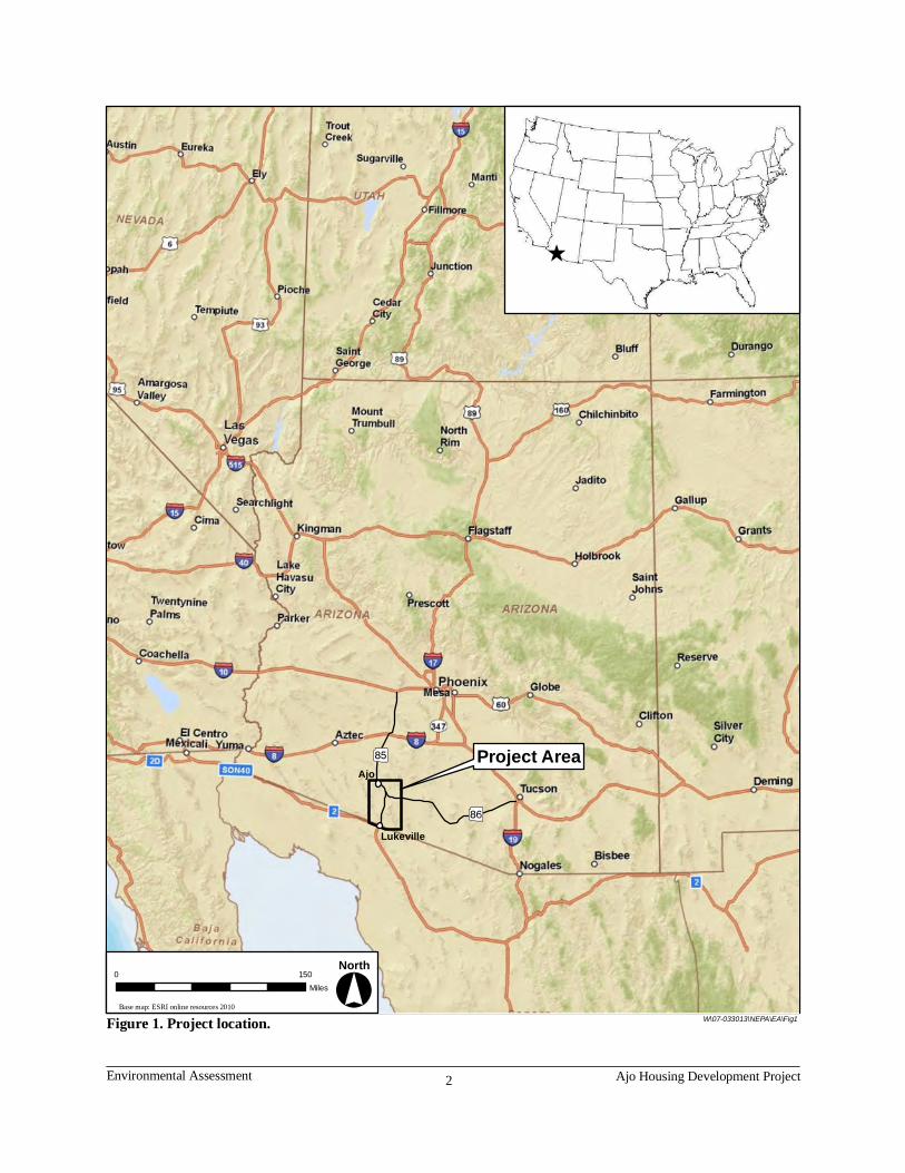
Figure 1. Project location. ................................................................................................... 2
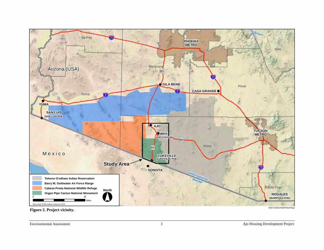
Figure 2. Project vicinity..................................................................................................... 3
Figure 3. Alternative locations. ........................................................................................... 9
Figure 4. Preferred Alternative site. .................................................................................. 12
Tables
Table 1. 2000 total minority and total below poverty level............................................. 18
Table 2. Economic structure comparison......................................................................... 18
Table 3. USFWS threatened, endangered, and candidate species with potential to occur in the Preferred Alternative area. ............................................................. 21
Table 4. Other special status species occurring within 3 miles of the project area and the potential effect of the Preferred Alternative on these species............... 22
Table 5. Public scoping comments. ................................................................................. 40
Table 6. Results of environmental analysis. .................................................................... 41
Environmental Assessment ii Ajo Housing Development Project

Acronyms and Abbreviations
ACHP Advisory Council on Historic Preservation ADEQ Arizona Department of Environmental Quality AGFD Arizona Game and Fish Department APE Area of Potential Effects ASTM American Society for Testing and Materials AZDA Arizona Department of Agriculture AZPDES Arizona Pollutant Discharge Elimination System BG Block Group BLM Bureau of Land Management CBP U.S. Customs and Border Protection CEQ Council on Environmental Quality CFR Code of Federal Regulations Corps U.S. Army Corps of Engineers CT Census Tract CWA Clean Water Act EA Environmental Assessment EcoPlan EcoPlan Associates, Inc. EO Executive Order EPA U.S. Environmental Protection Agency ESA Environmental Site Assessment FEMA Federal Emergency Management Agency FIRM Flood Insurance Rate Map FM&E Facilities Management and Engineering Division GSA U.S. General Services Administration LEED Leadership in Energy and Environmental Design MOU Memorandum of Understanding mph miles per hour NAAQS National Ambient Air Quality Standards NEPA National Environmental Policy Act NESHAP National Emissions Standards for Hazardous Air Pollutants NHPA National Historic Preservation Act NRHP National Register of Historic Places OBP Office of Border Patrol OCRHP Office of Cultural Resources and Historic Preservation OFO Office of Field Operations OPCNM Organ Pipe Cactus National Monument PDEQ Pima County Department of Environmental Quality PM10 particulate matter less than 10 microns in diameter POE Port of Entry RACM Regulated Asbestos-Containing Material SHPO State Historic Preservation Office SR 85 State Route 85 SWPPP Storm Water Pollution Prevention Plan U.S. United States
Environmental Assessment iii Ajo Housing Development Project

U.S.C. U.S. Code USFWS U.S. Fish and Wildlife Service
Environmental Assessment iv Ajo Housing Development Project

Chapter 1 Introduction
1.1 Explanation of an Environmental Assessment This Environmental Assessment (EA) is being prepared to comply with the National Environmental Policy Act (NEPA) of 1969, as amended (42 U.S. Code [U.S.C] 4321), as implemented by Council on Environmental Quality (CEQ) regulations (40 Code of Federal Regulations [CFR] 1500–1508), and policies of the U.S. General Services Administration (GSA) and the U.S. Customs and Border Protection (CBP) as the lead federal agencies. The EA process provides steps and procedures to evaluate the potential social, economic, and environmental impacts of a Preferred Alternative while providing an opportunity for local, state, or federal agencies to provide input and/or comment through scoping, public information meetings, and/or a public hearing. The social, economic, and environmental considerations are evaluated and measured, as defined in the CEQ regulations, by their magnitude of impacts.
1.2 Location The proposed CBP housing is in Ajo, Arizona, in southwestern Arizona, approximately 40 miles north of the U.S.–Mexico international border and the Lukeville Port of Entry (POE). The Lukeville POE at Lukeville, Arizona, is situated on the U.S.–Mexico border in southwestern Arizona about 122 miles east of the San Luis POE at Yuma, Arizona, and 116 miles west of the Mariposa POE in Nogales, Arizona (Figure 1). Lukeville, Why (a small community between Lukeville and Ajo), and Ajo are unincorporated communities under the jurisdiction of Pima County, Arizona. Across the U.S.–Mexico border is the town of Sonoita, Sonora, Mexico. The communities of Lukeville, Why, and Ajo are served by Arizona State Route 85 (SR 85), which connects the metropolitan Phoenix area to the U.S.–Mexico border, and State Route 86, which connects the Tucson metropolitan area to the U.S.–Mexico border.
Organ Pipe National Monument, under the jurisdiction of the U.S. Department of the Interior National Park Service, essentially surrounds Lukeville, and the Cabeza Prieta National Wildlife Refuge, under the jurisdiction of the U.S. Fish and Wildlife Service (USFWS), is in proximity to the communities of Lukeville, Why, and Ajo. The Barry M. Goldwater Gunnery Range, under the jurisdiction of the U.S. Department of the Interior Bureau of Land Management (BLM) and the U.S. Department of Defense Air Force, is north, east, and west of Ajo. The Tohono O’Odham Nation boundary is east of Why and Ajo. The Lukeville POE and supporting communities are isolated by distance from the major population centers of Tucson, Gila Bend, and Phoenix (Figure 2).
1.3 Background and Overview The POE facility in Lukeville and Ajo Station in Why employ approximately 280 total staff members. The Lukeville POE is known for its traffic entry into and from Mexico because of the Mexican resort town of Rocky Point, where U.S. citizens vacation year-round. The amount of non-commercial traffic makes this POE unique. The amount of non-commercial traffic has increased over the years, causing major inbound traffic delays from Mexico to the United States, with wait times of up to four hours. This problem used to exist only on holidays; now it has increased to four to five times a week.
Environmental Assessment 1 Ajo Housing Development Project
Ajo
Lukeville
0 150 Miles
Figure 1. Project location. W\07-033013\NEPA\EA\Fig1 Base map: ESRI online resources 2010
^
Project Area ?Í
?Ï
° North
Environmental Assessment 2 Ajo Housing Development Project
AJO WHY
LUKEVILLE
SONOITA
TUCSONMETRO
PHOENIXMETRO
(LUKEVILLE POE)
SAN LUIS(SAN LUIS POE)
(MARIPOSA POE)
Study Area InternationalBorder
(AJO STATION)
CASA GRANDE
YUMA
NOGALES
GILA BEND
Pima
Pinal
Yuma
Maricopa
Gila
La Paz
Santa Cruz
!"a$
!"̀$
!"d$
!"a$
?Í
?Í
?Ï
Tohono O'odham Indian Reservation
Cabeza Prieta National Wildlife Refuge Organ Pipe Cactus National Monument
Barry M. Goldwater Air Force Range
0 50 Miles
M e x i c o
W\07-033013\NEPA\EA\FiBase map: ESRI online resources 2010
Arizona (USA)
!"̀$
° North
Fi vici igure 2. Project n ty. g2
Environmental Assessment 3 Ajo Housing Development Project

The need to staff the POE for 24-hour service has been the driving factor behind the expansion of the POE. The former operation schedule at this POE was from 8 a.m. to 6 p.m. The POE has a requirement to expand its operation to help the traffic and allow for 24-hour processing and screening of passengers and vehicles, which cannot happen until the POE can be properly staffed.
Improvements to the POE to add two inbound lanes are tentatively scheduled to be bid for construction in late 2010. The Ajo Station in Why is scheduled for an approximately 68,000square-foot expansion/addition, with an estimated completion date of December 2011. The expanding capabilities and facilities will result in increased staffing of up to 410 employees in the near future. This staffing will consist of Office of Border Patrol (OBP) and Office of Field Operations (OFO) personnel (Coachman 2010).
The OFO field office in Tucson, Arizona, submitted a request to the CBP Facilities Management and Engineering Division (FM&E) in 2007 for a solution to resolve the limited availability of housing at the Lukeville POE. The FM&E, the OBP, and the OFO partnered to conduct a Housing Program Feasibility Study completed by Garrison Architects in 2009. The study evaluated the existing conditions and needs, possible alternatives, and viable alternatives, and recommended a Preferred Alternative. The study is documented in CBP Housing Program Feasibility Study, Ajo, Arizona—Complete Report (Garrison Architects 2009). The alternatives and the evaluation of social, economic, and environmental impacts in this EA are based on the data developed in the 2009 CBP Housing Program Feasibility Study and a subsequent market survey, U.S. Customs and Border Protection Market Survey of Housing for the Area of Ajo and Why, Arizona, May 2010 (CBP 2010).
The existing government-owned housing is limited to 17 units: four three-bedroom single-family mobile homes in Ajo owned by the CBP, three three-bedroom single-family homes at the Lukeville GSA Housing Complex owned by the CBP, and 10 three-bedroom single-family homes at the Lukeville GSA Housing Complex owned by the GSA. Less than 30 percent of the Border Patrol personnel use the local Why or Ajo rental markets. Most personnel use distant housing markets in Gila Bend, Casa Grande, Tucson, and the metro Phoenix area. The lack of available or suitable housing in the area results in staff commuting more than 100 miles one way to the metro Tucson area or up to 175 miles one way to the metro Phoenix area. The unreasonably long commute has resulted in staff retention issues (CBP 2010).
Due to the current construction of a border fence in the Ajo/Lukeville area, numerous contractors in the area are renting available apartment and hotel accommodations, contributing to the lack of available housing in the area.
Environmental Assessment 4 Ajo Housing Development Project

Chapter 2 Project Purpose and Need
2.1 Purpose of the Project The purpose of the project is to address the immediate housing needs for mission-critical CBP personnel on the U.S.–Mexico border at Lukeville, Arizona. The goal is to provide safe, comfortable, and affordable housing for CBP personnel and their families within a reasonable distance of the CBP employee assignments at the Lukeville POE in Lukeville, Arizona, and Ajo Station in Why, Arizona.
The ability to provide quality housing options to CBP personnel is important to the recruitment and retention of staff. The number of housing units proposed in the current project is limited by available funding and is thus focused on immediate needs. This project is not intended to satisfy the needs of the projected 410-personnel staffing level; it is intended to provide housing in sufficient quantity to meet immediate needs—approximately 56 total units to be constructed in phases.
Housing provided by this project would be available to CBP staff at market rental rates. The housing makeup would be a mix of one-, two-, and three-bedroom homes. The majority would be one-bedroom homes, consistent with the staff demographic of single employees. There would be no requirement or mandatory directive for personnel to rent government-owned housing. The CBP does not designate where staff members reside or require staff members to occupy government-owned housing. Should any government-owned housing be unoccupied, the units would not be available to the general public for rent.
2.2 Need for the Project There is insufficient nearby housing available to accommodate CBP personnel who currently work at the Lukeville POE and Ajo Station in Why, Arizona. With the projected increase of additional personnel, the demand for suitable housing will also increase. Existing government-owned housing available for CBP employees is substandard and is scheduled for demolition or replacement. Other housing options for CBP employees in the vicinity of the Lukeville POE are limited due to a scarcity of quality available rental properties and limited by their distance from basic amenities such as shopping and health care (Garrison Architects 2009 and CBP 2010).
Approximately 280 CBP personnel currently staff the Lukeville POE and Ajo Station. The combined OFO and OBP staffing projections for the next several years are expected to approach approximately 410 employees. With only 30 percent of current CBP agents using the existing area housing market, the majority of staff members commute long distances (100 to 175 miles one way) across remote desert areas. This has resulted in staff retention issues, financial costs, and additional stress from 3- to 4-hour round-trip commute times (Garrison Architects 2009).
Environmental Assessment 5 Ajo Housing Development Project

The CBP Housing Program Feasibility Study (Garrison Architects 2009) notes the following needs:
1. Add housing in sufficient numbers and type to accommodate OFO staff growth at Lukeville POE.
2. Add housing in sufficient numbers and type to relieve and accommodate the existing and growing OBP staff at Ajo Station.
3. Locate new housing within a short commute of both the Lukeville POE and Ajo Station.
4. Specify housing to be rapidly deployable, durable, locally serviceable, climate appropriate, and affordable.
Interviews with CBP staff members indicated that up to 90 percent of the OFO personnel would desire CBP housing, and about 30 percent of the OBP personnel would desire CBP housing. The staffing demographics of the OFO personnel were 80 percent single men and women and 20 percent couples or families. Demographics for OBP staff is not known but is assumed to be of similar proportions. Therefore, the recommended housing was predominantly one-bedroom units (60–70 percent) and the remainder two- and three-bedroom units (CBP 2010).
The immediate housing needs of additional personnel cannot be met by the existing availability of housing in the private sector. The available rental properties in the area are limited or of poor quality. The majority of the houses sampled by the CBP meet the minimum requirements that the CBP would rate under a “Poor” condition code (U.S. Department of the Interior 2008). Fewer than 10 of the houses sampled would require no alterations or modifications if purchased by the government. The majority of the houses surveyed in these markets are substandard or will require the government to invest large sums of money to bring the house up to CBP living standards of a condition rating of “Fair” or “Good.”
The CBP found that the availability of adequate one- and two-bedroom housing units in Ajo is nonexistent. Short-term rental properties were also nonexistent at the time of the survey (spring 2010) due to use by contractors from the border fence construction. In addition, CBP staff would prefer long-term residential housing as opposed to short-term housing such as hotels or boarding houses. The communities of Lukeville and Why also did not have adequate housing available at the time of the survey (CBP 2010).
Environmental Assessment 6 Ajo Housing Development Project

Chapter 3 Alternatives
3.1 Alternatives Considered but Eliminated from Further Study The CBP Housing Program Feasibility Study (Garrison Architects 2009) examined the best sites to place new housing in the Lukeville/Ajo areas. The option of the government purchasing existing housing was eliminated based on the results of the study. As noted earlier, there was a limited supply of available properties in fair or good condition, and due to efforts needed to bring the properties up to acceptable condition, the project need of rapidly deployable and affordable homes could not be met. The May 2010 Market Survey (CBP 2010) results confirmed the 2009 study. The survey concluded that the communities of Lukeville, Why, and Ajo did not have enough existing available quality housing to accommodate the CBP personnel needs.
The CBP Housing Program Feasibility Study (Garrison Architects 2009) looked at a number of potential sites in Lukeville, Why, and Ajo. Each site was subject to evaluation based on the following criteria:
1. Property Acquisition–the potential ease of acquisition, willing seller, lack of encumbrances on the property
2. Site Usability–constraints or limitations due to geography, floodplains, and adjacent land use
3. Exposure to Environmental Hazards–this could include air quality, water quality, water supply, and soil contamination
4. Site Access–access during construction and connectivity to the local road network
5. Adjacency–related to land use, classification of nearby properties
6. Access to Utilities and Resources–availability of water, power, gas, telecommunications, sewer or septic systems, and waste disposal
7. Expansion–the ability to expand the housing facilities through additional property acquisition or phasing on-site
8. Sustainability–the ability to develop within the local infrastructure and opportunities to develop housing with renewable energy sources and water harvesting, and potentially achieve a Leadership in Energy and Environmental Design (LEED) rating
9. Community Interests–provide housing that reinforces local identity or is compatible with regional building styles
10. Resident Interests–locating housing in a desirable area, providing amenities, establishing a sense of community, and minimal disruption if built in phases
11. Security–the ability to provide a secure location
12. Cost–includes acquisition, site development, housing construction, maintenance, and tenant-borne costs
13. Schedule–impacts to a start date and duration of construction
Because the surveys concluded that existing housing could not meet the needs of CBP personnel, six action alternatives were formulated that would develop new housing supplies in the
Environmental Assessment 7 Ajo Housing Development Project

Lukeville, Why, and Ajo areas. Three of the alternatives were in Lukeville, one alternative was in Why, and two alternatives were in Ajo. Five of the six alternatives were eliminated from further study and are discussed below. The alternatives and Preferred Alternative numbering reflects the alternatives numbering used in the CBP Housing Program Feasibility Study (Garrison Architects 2009), and while not sequential in this EA, is preserved for clarity in reference to the CBP Housing Program Feasibility Study.
3.1.1 Lukeville Alternative 1 Lukeville Alternative 1 is adjacent to and east of the Lukeville POE on an abandoned, privately owned recreational-vehicle-park property (Figure 3). This alternative would provide new housing contiguous to the POE and allow for the greatest flexibility in the configuration of new housing through phased construction on generally level land. Development of the site would include 19 one-bedroom attached units initially and a future phase adding 16 one-bedroom units. Several existing buildings (abandoned) would require demolition. A new septic system would be needed as well as new connections to power and communications. Costs were deemed to be relatively high due to lack of infrastructure, and the acquisition would include undevelopable land as a buffer between the U.S.–Mexico border and housing.
Lukeville Alternative 1 was eliminated from further consideration because of the potential difficulty in property acquisition, the high cost of the land and development, and the remoteness of the location from the nearest town where goods and services for personnel are available.
3.1.2 Lukeville Alternative 2 Lukeville Alternative 2 is on Lukeville POE property, which currently includes 10 single-family homes leased to CBP personnel (Figure 3). This alternative would not require the acquisition of property and would provide new housing contiguous to existing POE housing. This site would require demolishing the existing homes, temporarily relocating the occupants, and constructing 32 units in two phases. The units would be studio and one-bedroom units. Utilities are available; however, a new septic system would be needed. Costs were determined to be relatively low due to the property already being in government ownership and utilities being present.
Lukeville Alternative 2 was eliminated from further consideration because of the negative impact of using POE property for housing when proposed expansion needs for the POE are currently unknown, and the remoteness of the location from the nearest town where goods and services for personnel are available.
Environmental Assessment 8 Ajo Housing Development Project

Figure 3. Alternative locations.
" "
"
"
?Í
?Í
?Í
?Í
?Ï
?Ï
UNITED STATESMEXICO
ARIZONA
AreaEnlarged
Pima Co.
Lukeville Alternative 3
Lukeville Alternative 2
Lukeville Alternative 1
Ajo Alternative 3
Ajo Alternative 2Ajo Alternative 1
Base map: ESRI online resources 2010
Sonoita
Ajo
W\07-033013\NEPA\EA\Fig3
AjoStation
Why!
0 8Miles
Lukeville POE
° North
Environmental Assessment 9 Ajo Housing Development Project
3.1.3 Lukeville Alternative 3 Lukeville Alternative 3 is at the same location as Lukeville Alternative 2. Instead of demolishing the 10 existing GSA-owned units, the units would be completely renovated into 20 one-bedroom duplexes within the existing house shells (Figure 3). This alternative would take advantage of existing infrastructure and utilities of the POE and provide new housing that is contiguous to existing POE housing. It would be built in one phase. This alternative restricts opportunities for future Lukeville POE expansion due to the limited size of the POE. Costs were determined to be comparatively low due to government ownership of the parcel, but the site could only accommodate 20 units, which is fewer than other alternatives.
Lukeville Alternative 3 was eliminated from further consideration because of the negative impact of using POE property for housing when proposed expansion needs for the POE are currently unknown, and the remoteness of the location from the nearest town where goods and services for personnel are available.
3.1.4 Ajo Alternative 2 Ajo Alternative 2 proposes to use several adjacent and currently vacant, unimproved, privately owned and for-sale properties on Rasmussen Road in Ajo immediately east of the commercial strip along SR 85 (Figure 3). This alternative has convenient access to the local road network and is within easy walking distance of retail and commercial outlets in Ajo. This site is the largest property considered and could accommodate up to 100 units (a mixture of one-, two-, and three- bedroom homes). The majority of development could occur in the initial phase. Due to the size of the proposed development and terrain, a sanitary waste pump station would be required. The unimproved properties would require extensive site drainage improvements that would reduce the area available for development. Utility infrastructure is available at the property lines but would have to be extended to serve the development. Environmental concerns are present due to extensive use as an illegal dump; the site is essentially natural, with extensive native vegetation, including the potential for the endangered Acuña cactus. Costs would be higher than the other alternatives due to topography, drainage issues, and need for a sanitary waste pump station.
Ajo Alternative 2 was eliminated from further consideration because of the substantial costs to install drainage and utility infrastructure as well as potential additional environmental permitting associated with Clean Water Act Sections 401 and 404, potential impacts to endangered plant species, and cleanup of multiple unauthorized dump sites.
3.1.5 Ajo Alternative 3 Ajo Alternative 3 proposes the acquisition of 30 acres of undeveloped BLM-owned land adjacent to the Ajo Station in Why (Figure 3). The location would allow convenient access to work for the agents, a sense of community, and a relatively short drive to the schools, commerce, and culture of Ajo. The site could accommodate up to 100 units (mix of one-, two-, and three-bedroom units). No utilities are present at the site; utilities would need to be extended from the expanded Ajo Station to the south.
Environmental Assessment 10 Ajo Housing Development Project

Availability of water is a primary concern because the capacity of the Why well may not support 100 housing units. If the Why system cannot meet the capacity, a new well, storage system, and reverse osmosis system would need to be constructed. Land acquisition would require a land grant from the BLM, which could take 6 months to 2 years. The unimproved nature of the property would require installation of all utility infrastructure, including on-site septic systems. Costs were considered to be high for this site due to lack of utilities and the need to factor in the cost of a new water system.
Ajo Alternative 3 was eliminated from further consideration because of the application and approval requirements for a BLM land grant, the unimproved nature of the property requiring new infrastructure, and the potential requirement to drill a new well.
3.2 Alternatives Considered in Detail Through the preceding evaluation, five of the six action alternatives were eliminated from further consideration. The remaining action alternative and the No Action Alternative are described in this section.
3.2.1 Preferred Alternative The Preferred Alternative is Ajo Alternative 1 (Figure 3). This alternative proposes acquiring seven contiguous parcels in Ajo. The first parcel is addressed as 55 S. Sahuaro St. and currently supports a partially occupied mobile home park. The next is a small, unaddressed parcel immediately adjacent to the southwestern corner of the 55 S. Sahuaro St. parcel. The remaining five parcels consist of vacant parcels addressed as 801, 811, 821, 831, and 841 W. Esperanza Ave., immediately north of the 55 S. Sahuaro St. parcel (Figure 4). The 55 S. Sahuaro St. parcel was originally intended to have 40 mobile home units and currently has utilities in-ground and ready for hookup to existing public and private utilities. Four lots are leased by the GSA at this site, each with a CBP-owned mobile home, and eight lots are occupied by private tenants. The location has convenient access to local roads, is within walking distance to amenities in Ajo, is in a location that would foster a sense of community within the CBP and requires the lowest amount of development costs of the Ajo alternatives (Figure 4).
The 2009 Pima County Planned Land Use indicates that the Preferred Alternative site is located in a Medium Intensity Urban planned area (Pima County Development Services 2010a).
Environmental Assessment 11 Ajo Housing Development Project

ash
Figure 4. Preferred Alt ti it0 500
Feet Base: ESRI online resources 2010
801–841 W. Esperanza Ave.
55 S. Sahuaro St.
Unaddressed Parcel
Guest House Rd.
GuestHouse
Inn
Pima County Flood Control District
CurleySchool
W. Esperanza Ave.
Montecito St.
S. Sahuaro St.
W\07-033013\NEPA\EA\Fig4
BLM Managed
Land
NorthW
Perro De Nieve
S. Sahuaro St.
Wash
South
° North
Preferred Alternative Boundary
erna ve s e.
Environmental Assessment 12 Ajo Housing Development Project

Environmental Assessment 13 Ajo Housing Development Project
Specific components of this alternative include:
• Construction of up to 56 total units if development funding becomes available. Housing would be of a modular type—Southern Border style model. (Renderings of the Southern Border style model are illustrated in Figures 5 and 6). The units would feature energy-efficient orientation (east–west alignment), an all-electric heating, ventilating, and air conditioning system, metal roofing, ceiling assembly with R-36 insulation, Low-E high-performance windows, R-30 wall insulation, and R-35 floor insulation.
• Construction in the initial phase of 12 one-bedroom units, eight two-bedroom units, and two three-bedroom single-family modular homes.
• Modification of existing water, sewer, power, and communications utilities. Site design will include detailed analysis of existing utilities.
• Construction of 25-foot-wide paved internal circulation roads with concrete curbs and 5-foot-wide paved sidewalks.
• Development of landscaping using indigenous low-water use plants and decomposed granite ground cover.
• Placement of overhead street lighting.
• Construction of a common area with picnic tables, barbeque pit, and shade structure.
Project construction is proposed to begin in 2011.
Construction of the Preferred Alternative would occur in conformance with the Federal Leadership in High Performance and Sustainable Buildings Memorandum of Understanding (MOU) of January 2006. The MOU seeks to establish and follow a common set of sustainable Guiding Principles for integrated design, energy performance, water conservation, indoor air quality, and materials aimed at helping Federal agencies and organizations:
• Reduce the total ownership cost of facilities;
• Improve energy efficiency and water conservation;
• Provide safe, healthy, and productive built environments; and
• Promote sustainable environmental stewardship.

Figure 5. Southern border style, front elevation.
Figure 6. Southern border style, rear elevation.
3.2.2 No Action Alternative
Under the No Action Alternative, the GSA would not construct new housing for CBP employees. Housing opportunities in the nearby communities of Lukeville, Why, and Ajo would continue to be limited and in short supply. The existing housing locations of personnel would continue to be in near and distance communities, including one-way commutes of 100–175 miles. Recruitment and retention of employees would continue to be hampered by the unavailability of local housing options. Lower success rates in recruitment and retention may affect the timetable to extend the hours of operation at the Lukeville POE. Lines to reenter the United States would continue to occur, causing substantial delays to motorists.
Environmental Assessment 14 Ajo Housing Development Project

The No Action Alternative does not meet the project purpose and need to provide housing in sufficient numbers and types to accommodate the existing OFO and OBO staff growth and to locate new housing within a short commute of Lukeville and Why. In addition, this alternative does not meet the need that housing be rapidly deployable, durable, locally serviceable, climate appropriate, and affordable.
Environmental Assessment 15 Ajo Housing Development Project

Chapter 4 Affected Environment and Environmental Consequences
4.1 Ownership, Jurisdiction, and Land Use The Preferred Alternative site is within the jurisdictional boundaries of Pima County in the unincorporated town of Ajo. Nearby land uses include residential single-family and multi-family housing to the north and south, a bed and breakfast to the south, a Pima County Regional Flood Control District detention basin to the east, and BLM-managed land to the west. The Preferred Alternative site is approximately one-half mile west of Ajo center (downtown) and approximately one-third mile from commercial businesses to the north along SR 85. The nearest school is approximately one-half mile east of the Preferred Alternative. The former Curley School, approximately one-quarter mile to the east, has been converted to apartments and art studios. No institutional or public service facilities (government services, police, fire) are adjacent to the Preferred Alternative (Pima County Assessor’s Office 2010) (Figure 4).
Preferred Alternative
The Preferred Alternative would require the acquisition of approximately 12.74 acres of land from private owners. Twelve mobile home residences are on the Preferred Alternative site. Eight of the 12 existing mobile home residences are privately owned, and the ground space is leased to the individual tenants by the property owners. The remaining four mobile homes are leased by the CBP. The Preferred Alternative would require the acquisition of eight residences on the property, the relocation of the current residents, and the relocation of the four CBP tenants. The Preferred Alternative would not have an effect on land use because the property is currently used as residential housing and is zoned as mixed-dwelling by Pima County (Pima County Development Services 2010b). All infrastructure, including utilities and roadways, is on-site. No change to surrounding transportation or circulation patterns would occur with the Preferred Alternative. There would be no encroachment on the adjacent BLM-managed lands. The Preferred Alternative would have no adverse impacts on land ownership, jurisdiction, or use.
No Action Alternative The No Action Alternative would have no effect on current land ownership, jurisdiction, or land use at the Preferred Alternative site because no property acquisition would occur.
4.2 Title VI/Environmental Justice
Title VI of the Civil Rights Act of 1964 and related statutes ensure that individuals are not excluded from participation in, denied the benefits of, or subjected to discrimination under any program or activity receiving federal financial assistance on the basis of race, color, or national origin. Executive Order 12898 Federal Actions to Address Environmental Justice in Minority Populations and Low-Income Populations (1994) directs that federal programs, policies, and activities do not have disproportionately high and adverse human health and environmental effects on minority and low-income populations.
The 2010 Census is currently in progress. Census data will not be available to the public until April 2011, and reports for various data sets will be released from April 2011 through September 2013. Therefore, data from the 2000 U.S. Census (Census 2000a) were used for the analysis of environmental justice concerns. Data specific to the area were evaluated to assess the
Environmental Assessment 16 Ajo Housing Development Project

demographic composition at the Census Tract (CT) and Block Group (BG) levels and were compared with the percentages of corresponding community, town, and county occurrences. The Preferred Alternative is in CT 50, BG 4.
Table 1 summarizes the demographic data obtained from the 2000 Census for the BG of interest (BG 4), the town of Ajo (CT 50), and Pima County. Demographic data are included for racial and ethnic minorities and persons living below the poverty level.
For environmental justice evaluations, a racial or ethnic minority population is an aggregate composed of the following categories: Black/African American, American Indian and Alaska Native, Asian, Native Hawaiian and Other Pacific Islander, Other Races, Two or More Races, and Hispanic. Table 1 lists the aggregate of these minority populations in the selected BG, Ajo and Pima County (Census 2000a).
In following Office of Management and Budget Directive 14, the Census Bureau uses a set of income thresholds that vary by family size and composition to determine the poverty level. If the total income for a family or unrelated individual falls below the relevant poverty threshold, the family or unrelated individual is classified as being “below the poverty level” (Census 2000b).
Data from the 2000 Census indicate that minority populations and persons living below the poverty level occur in the study area. Minority populations and persons living below the poverty level, however, do not represent a majority in the BG. The data indicate that the percentage of minority populations and persons living below the poverty level for the BG (39.1 percent) is slightly lower than the corresponding percentage for the town of Ajo (46.5 percent) and similar to the corresponding percentage for Pima County (38.9 percent). The percentage of minority or low-income citizens in the Preferred Alternative BG (15.7 percent) is slightly lower than the corresponding percentage for the town of Ajo (22.2 percent) and similar to the corresponding percentage for Pima County (14.7 percent).
Preferred Alternative
The Preferred Alternative would replace the 12 existing units on the property. Eight of the 12 units are not CBP-owned and would face permanent relocation, while the occupants in the remaining four units would only require temporary displacement. Relocating the population in eight units may slightly decrease the minority population during construction; however, upon completion, it is assumed that the minority population percentages would remain similar with the addition of CBP personnel. On the other hand, the percentage of the population living below the poverty level could be expected to decline because CBP personnel pay rates exceed the poverty level. Therefore, the Preferred Alternative is expected to have no adverse impacts on minority populations and a slight positive impact on the percentage of people living below the poverty level.
Environmental Assessment 17 Ajo Housing Development Project

Table 1. 2000 total minority and total below poverty level.
Area
Total Population for Whom Total
Minority Is Determined
Total Minoritya Total Population for Whom Poverty
Is Determined
Below Poverty Level
# % # %
CT 50, BG 4 1,080 431 39.9 1,080 170 15.7 CT 50, Ajo, Arizona 3,720 1,730 46.5 3,710 827 22.2 Pima County 843,746 325,764 38.6 823,638 120,778 14.7
Source: Census 2000a. BG = Block Group, CT = Census Tract, # = No., % = Percentage. a “Total Minority” is composed of all people who consider themselves Non-White racially plus those who consider themselves
White Hispanic.
No Action Alternative
The No Action Alternative would have no impact on environmental justice populations because it would not involve any development of the Preferred Alternative site and would not cause any changes in minority population or the percentage of people living below the poverty level to occur in the project area.
4.3 Social and Economic Resources Ajo had a population of approximately 4,350 in 2007, an increase of 16.9 percent since 2000 (3,720). Ajo was formerly a substantial mining town, with Phelps Dodge (formerly the New Cornelia Copper Co.) operating mining activities from the early 1910s until 1983. Since the end of mining operations in Ajo, the community has experienced a decline in population and economic base (Parkhurst 2001). The population of Ajo has declined from approximately 6,000 in the mid-1980s to approximately 4,350 in 2007 (City Data 2010). With the closing of the Ajo copper mine in 1983, the Ajo community and Pima County have worked in partnership to achieve the following goals: to redefine a vision for Ajo, to help create a new economic base, to attract new residents and visitors to build the community, and to find new funding and investment interests to reinvigorate this small, diverse, and dynamic town in unincorporated Pima County (Huckleberry 2010).
The economic base of Ajo is a mix of education, health and social services, arts and entertainment, recreation, accommodation and food service, public administration, retail trade, real estate, and rental and leasing.
Table 2 illustrates the six categories representing a majority the economic employment structure of Ajo compared with the same categories in Pima County and the State of Arizona (Census 2000a).
Table 2. Economic structure comparison. Category* Ajo Pima County Arizona Education, health and social services 16.9 22.5 18.0 Arts and entertainment, recreation, accommodation and food service 15.3 10.5 10.1 Public administration 13.1 5.8 5.4 Retail trade 12.8 12.0 12.3 Real estate, rental and leasing 1.7 2.6 2.6
* Economic structure categories do not total 100 percent because not all U.S. Census 2000 industry categories were included.
Environmental Assessment 18 Ajo Housing Development Project

The median household income of Ajo was $32,477 in 2008. By comparison, the median household income of Pima County was $46,599, and the median household income of the State of Arizona was $50,958 in 2008 (City Data 2010).
Preferred Alternative
The addition of up to 56 housing units in Ajo would contribute positively to the local economy. New residents would contribute economically to the Ajo business base by purchasing goods and services locally. Construction of the housing is expected to use local and outside contractors, though the extent of the distribution of labor and equipment is unknown at this time. The GSA will use a bid process to secure contractors for site preparation, infrastructure, construction, and housing/landscaping elements.
Upon completion of construction, the Preferred Alternative may reduce the number of CBP/OFO employees seeking to rent or purchase existing homes in Ajo. However, because CBP does not mandate housing requirements for its employees, employees are free to rent or purchase housing from private individuals regardless of the construction of CBP/OFO housing. The Preferred Alternative housing would be offered to CBP/OFO personnel at fair market rates and not discounted. With the near-term CBP/OFO staffing needs reaching approximately 410, the potential of 56 GSA/CBP-owned housing units will only satisfy a portion of overall demand. The Ajo real estate market would continue as an option for CBP personnel.
The Preferred Alternative would result in the displacement of the existing residents in eight units at the development site. Residents to be displaced would be compensated through the Uniform Relocation Assistance and Real Property Acquisition Policies Act of 1970. The GSA would provide assistance in locating suitable replacement housing and compensate moving costs and other related expenses.
In summary, the Preferred Alternative is expected to result in positive impacts to the local economy through construction activities and the attraction of long-term residents. A slight adverse impact is expected to the local housing market through the increase of additional units in the area. Minor adverse impacts are also expected due to the displacement of eight housing units; however, these impacts will only be temporary and will be offset through monetary compensation. In addition, the full brunt of this action would be attenuated through phasing the construction of the 56 units.
No Action Alternative
The No Action Alternative would not impact the local business economy of Ajo because no housing units would be constructed. CBP/OFO employees would still have the option to rent or purchase private properties in Ajo; however, there would be no guarantee that any CBP/OFO employees would choose to purchase or rent properties in Ajo. No housing units would be displaced.
The biological resources study area consisted of the Preferred Alternative site and a visual survey of surrounding properties. Biological resources information was collected during a pedestrian survey of the Preferred Alternative site on January 20, 2010. During the pedestrian survey,
Environmental Assessment 19 Ajo Housing Development Project
4.4 Biological Resources

photos were taken, vegetation was recorded, and the likelihood for special status species occurrence was assessed based on habitat characteristics. Additional background information on the project area was obtained from aerial photos, topographic maps, Geographic Information System data, various natural history/biological texts, unpublished technical documents, and state and federal agency coordination and websites (EcoPlan Associates, Inc. 2010a).
The project area lies between approximately 1,800 feet and 1,840 feet in elevation1 on terrain that descends to the northeast among rolling hills and low mountains on the southwestern edge of, but within the developed extent of, Ajo. Ajo lies at the northeastern foot of the Little Ajo Mountains, a low desert range in western Pima County. The project area lies at the northeastern foot of Camelback Mountain, one of the peaks that make up the Little Ajo Mountains, which rises to an elevation of nearly 2,440 feet within a half-mile to the southwest.
Soils in the project area are of the Lithic Camborthids–Rock Outcrop–Lithic Haplargids Association. This association consists of well-drained, shallow, gravelly and cobbly, moderately coarse to moderately fine-textured soils on gentle to steep slopes and rock outcrops on hills and mountains formed of residual materials weathered from granitic rocks, schists, volcanic tuffs and conglomerates, basalt, and some shale and sandstone (Hendricks 1985, Richard et al. 2000).
4.4.1 Vegetation The native plant community of the project area is foothill paloverde–triangle-leaf bursage– brittlebush–dominated Arizona upland subdivision of Sonoran desertscrub (Turner and Brown 1994). Other common trees, shrubs, and cacti in the project area include saguaro, golden cholla, jumping cholla, Engelmann’s hedgehog cactus, ocotillo, sangre de drago, creosote bush, desert wolfberry, desert ironwood, blue paloverde, organpipe cactus, and graythorn.
Nearly all of the native vegetation formerly occupying terrain within the limits of the original mobile home park was removed, probably at the time of initial construction in the late 1930s. Several ironwood trees persist as large, healthy trees. Some previously disturbed areas are reverting to native vegetation, including paloverde, creosote bush, and triangle-leaf bursage. Blue and foothill paloverde and velvet mesquite trees are common as native landscaping within the Preferred Alternative site. Small saguaros, organ pipe cacti, Leconte’s barrel cacti, and ocotillo have also been incorporated into the landscaping of some occupied residences. Also occurring on disturbed terrain in the project area are scattered desertbroom and clumps of exotic buffelgrass.
4.4.2 Wildlife No mammals or reptiles were observed during the January 20, 2010, survey. Mammals and reptiles that may be present include, but are not limited to, pocket mice, kangaroo rats, squirrels, woodrats, mule deer, javelinas, coyotes, side-blotched lizards, whiptail lizards, tree lizards, desert spiny lizards, zebra-tailed lizards, desert tortoises, gopher snakes, and rattlesnakes. Birds commonly seen in the area include ash-throated flycatchers, cactus wrens, Gambel’s quail, Gila woodpeckers, ravens, roadrunners, various sparrows, verdins, red-tailed hawks, and turkey vultures. No signs of nesting activity were observed during the survey.
1 Elevations in this document are referenced to mean sea level.
Environmental Assessment 20 Ajo Housing Development Project

4.4.3 Threatened and Endangered Species The U.S. Fish and Wildlife Service (USFWS) list of endangered, threatened, proposed, and candidate species for Pima County, Arizona, was reviewed by a qualified biologist (EcoPlan Associates, Inc. 2010a) to determine which species may occur in the Preferred Alternative area.
The USFWS list of federally threatened, endangered, proposed, candidate, and conservation agreement species potentially occurring in Pima County are included in Appendix A. Appendix A also includes a brief assessment of each species’ likelihood of occurrence in the Preferred Alternative area based on the species’ range/distribution and habitat requirements. With the exception of the Acuña cactus and the lesser long-nosed bat, which are discussed in Table 3, these species are not expected to occur in the Preferred Alternative area.
Table 3. USFWS threatened, endangered, and candidate species with potential to occur in the Preferred Alternative area.
Name Status Habitat Requirements Potential for Occurrence Acuña cactus
Echinomastus erectocentrus var. acuñensis
C Restricted to granite substrates, well-drained knolls, and gravel ridges between major washes in Sonoran desertscrub habitat.
Elevation: 1,300 to 2,000 feet.
The project area lies within the known distribution of this cactus. There are known locality records for the species within one mile of the project area. However, much of the project limits is disturbed, and no individuals of the species were detected during a survey of the project limits.
Lesser long-nosed bat
Leptonycteris curasoae yerbabuenae
E Desertscrub and semidesert grassland habitat with agave and columnar cacti present as food plants.
Elevation: 1,600 to 11,500 feet.
Known maternity roost sites lie within the foraging range of the project area. The project area lies within suitable foraging habitat for the species including organ pipe and saguaro cacti representing, known food resource plants of the species. The species is likely to forage in the project area.
C = Candidate, E = Endangered (USFWS 2010)
4.4.4 Other Special Status Species The Arizona Game and Fish Department (AGFD) On-line Environmental Review Tool was accessed to determine special status species known to occur within 3 miles of the Preferred Alternative site. Two special status species occur in the area and are evaluated in Table 4. Special status species are identified by federal and state agencies to conserve rare species, avoid future federal threatened or endangered status, and avoid impacts during construction activities. These species are not listed as federally threatened, endangered, proposed, or candidate species.
Preferred Alternative
Vegetation
The Preferred Alternative would result in removal of most of the existing vegetation at the Preferred Alternative site. No threatened or endangered plants are known to occur at the Preferred Alternative site. Removal of mature native tree and cactus species would be subject to the Arizona Native Plant Law administered by the Arizona Department of Agriculture (AZDA) and the Pima County Protected Plant Ordinance. Native plant removal would be minimized to the extent practicable. The construction contractor would be required to contact AZDA at least
Environmental Assessment 21 Ajo Housing Development Project

60 calendar days prior to construction to arrange for proper native plant treatment. The Preferred Alternative is expected to have no adverse impacts to any threatened or endangered plants.
Wildlife
Clearing and grading of the Preferred Alternative site is likely to result in some displacement of small reptiles, mammals, and birds, and could injure or kill small reptiles and mammals if present during these activities. Species likely to be displaced, injured, or killed are common and widely distributed and, as a result, construction of the Preferred Alternative would not appreciably impact the size or future viability of their populations. The Preferred Alternative is unlikely to alter existing wildlife movement patterns or result in substantial fragmentation of habitat.
Table 4. Other special status species occurring within 3 miles of the project area and the potential effect of the Preferred Alternative on these species.
Species Habitat Potential Occurrence Potential Effect Reptiles Sonoran Prefer terrain above The project area lies in foothill The Preferred Alternative is Desert the valley floor on paloverde–triangle-leaf bursage– highly disturbed and would not tortoise rocky bajadas and brittlebush–dominated rolling to low be expected to support desert Gopherus hillsides within mountainous terrain within the tortoises. However, the agassizii Sonoran desertscrub
where natural shelter sites (caves, rock piles, pack rat nests, dense vegetation) provide suitable retreats and hibernation sites. (Brennan and Holycross 2006). Elevation: 500–5,300 feet.
known distribution of the species. AGFD (2010) indicates that HDMS has numerous records of desert tortoises within 1 mile of the subject property. Peter Holm (OPCNM, personal communication), whose residence in Ajo lies within one-half mile of the project area, has observed tortoises on undisturbed BLM lands southwest of Ajo. He estimates that adjacent BLM lands support a “normal” population (i.e., sufficiently dense to support a reproductive population) of desert tortoises right up to the edge of town.
proximity of the property immediately adjacent to undisturbed BLM land where tortoises are known to occur indicates the potential that foraging tortoises could travel from adjacent habitat to the Preferred Alternative site, perhaps using natural and artificial objects and structures as shelter sites. Project construction may impact individual desert tortoises but will not lead to a trend toward federal listing or loss of viability.
Environmental Assessment 22 Ajo Housing Development Project

Species Habitat Potential Occurrence Potential Effect Mexican Prefer rocky or The Preferred Alternative site lies in Proximity of the Preferred rosy boa boulder-strewn slopes foothill paloverde–triangle-leaf Alternative site immediately Lichanura in rolling to low bursage–brittlebush–dominated adjacent to undisturbed BLM trivirgata mountainous, often rolling to low mountainous terrain land where boas are known to trivirgata rocky terrain within
Sonoran and Mohave desertscrub, and Interior Chaparral (Brennan and Holycross 2006). Elevation: 200 to >5,000 feet.
within the known distribution of the species. Sabra Schwartz (AGFD, personal communication) indicates that HDMS has numerous records of Mexican rosy boas within one mile of the Preferred Alternative site. An OPCNM (2010) employee whose residence in Ajo lies within one-half mile of the project area has observed boas on roads within residential neighborhoods in Ajo near his house. He estimates that adjacent undisturbed BLM lands support a “normal” population (i.e., sufficiently dense to support a reproductive population) of rosy boas right up to the edge of town.
occur and observations of boas crossing roads within residential neighborhoods within Ajo near the Preferred Alternative site indicate the potential for foraging boas to travel from adjacent habitat to the Preferred Alternative site, perhaps using natural and artificial objects as shelter sites. Despite the highly disturbed nature of the Preferred Alternative site, boas using rodent burrows and artificial shelter sites may potentially occur on the Preferred Alternative site. Project construction may impact individual Mexican rosy boas but will not lead to a trend toward federal listing or loss of viability.
Threatened and Endangered Species
The Preferred Alternative would result in removal of most vegetation at the Preferred Alternative site, including potential foraging habitat of the lesser long-nosed bat. Only minimal foraging habitat was observed during a survey of the Preferred Alternative site. Saguaro or organ pipe cacti observed on the Preferred Alternative site appear to be part of residential landscaping.
As mitigation for the lesser long-nosed bat, any saguaros and organ pipe cacti occurring within areas disturbed by project construction shall be salvaged and incorporated into landscaping of the Preferred Alternative site. The Preferred Alternative would not adversely affect the lesser long-nosed bat or its habitat.
No Acuña cactus was observed at the Preferred Alternative site. The Preferred Alternative would not adversely impact the Acuña cactus.
BLM Sensitive Species and USFWS Species of Concern
The Preferred Alternative may have minor adverse impacts to individual Mexican rosy boas and Sonoran Desert tortoises but will not lead to a trend toward federal listing or loss of viability.
The AGFD provides “Guidelines for Handling Sonoran Desert Tortoises Encountered on Development Projects.” These guidelines include the following recommendations:
• The contractor shall employ a qualified biologist to complete preconstruction surveys for Sonoran Desert tortoises and to conduct a Sonoran Desert tortoise awareness program.
Environmental Assessment 23 Ajo Housing Development Project
4.5
Preconstruction surveys for Sonoran Desert tortoises shall be conducted within 48 hours prior to construction in areas that will be disturbed.
• If any Sonoran Desert tortoises are encountered during construction, the contractor shall adhere to the AGFD “Guidelines for Handling Sonoran Desert Tortoises Encountered on Development Projects,” revised October 23, 2007.
No Action Alternative
Vegetation
The No Action Alternative would not have any impact on vegetation because it would not involve any development.
Wildlife
The No Action Alternative would not have any impact on wildlife because it would not involve any development.
Threatened and Endangered Species
The No Action Alternative would not have any impact on threatened and endangered species because it would not involve any development.
BLM Sensitive Species and USFWS Species of Concern
The No Action Alternative would not have any impact on BLM sensitive species because it would not involve any development.
Cultural Resources Cultural resources are sites, buildings, structures, districts, and objects as defined by the National Historic Preservation Act (NHPA), as amended. Cultural resources included in, or eligible for inclusion in, the National Register of Historic Places (NRHP) are termed “historic properties” regardless of their age. “Traditional cultural properties” having heritage value for contemporary communities (often, but not necessarily, Native American groups) also can be listed in the NRHP because of their association with historic cultural practices or beliefs that are important in maintaining the cultural identities of such communities.
Section 106 of the NHPA requires federal agencies to take into account the effects of their activities and programs on NRHP-eligible properties. Regulations for Protection of Historic Properties (36 CFR Part 800) define a process for federal agencies to consult with the State Historic Preservation Office (SHPO), Native American groups, other interested parties, and when appropriate, the Advisory Council on Historic Preservation (ACHP) to ensure that historic properties are duly considered as federal projects are planned and implemented. The steps in the “Section 106 consultation process” involve:
• Identifying the area where a proposed undertaking could affect cultural resources—the area of potential effects. (Undertakings can include approvals, funding, issuance of permits, and so forth.)
Environmental Assessment 24 Ajo Housing Development Project

• Identifying and evaluating the eligibility for listing in the NRHP of properties that might be affected by the proposed undertaking.
• Assessing the potential effects of the undertaking on eligible properties.
• Consulting with SHPO, Native American groups, other interested parties, and the ACHP, as appropriate, to determine ways to avoid or reduce any adverse effects (impacts) if such are anticipated.
• If necessary, providing the ACHP a reasonable opportunity to comment on the proposed undertaking and the effects on properties determined to be eligible for NRHP listing.
• Proceeding with the undertaking under the terms of a Programmatic Agreement, a Memorandum of Agreement, or in consideration of ACHP comments, if required. If a federal agency decides a proposed action is an “undertaking,” the agency has an obligation to determine the undertaking’s effect on historic properties and to consult with SHPO (and sometimes the ACHP) regarding that determination. There are three possible effect determinations:
– “No historic properties affected”
– “No adverse effect”
– “Adverse effect”
Executive Order (EO) 13006 mandates that “the Federal government shall utilize and maintain, wherever operationally appropriate and economically prudent, historic properties and districts, especially those located in our central business areas.” The EO also directs that Federal agencies “shall give first consideration to historic properties within historic districts.”
Preferred Alternative
A review of a historical and archaeological records database maintained by the Arizona State Museum was conducted. No archaeological or architectural surveys have been conducted at the Preferred Alternative site and, as such, there are no known archaeological or historical resources on the properties. The Ajo Townsite Historic District, which is on the National Register of Historic Places, was identified as near the Preferred Alternative site (GSA 2010, Huckleberry 2010). The GSA determined the undertaking (project) will not have an affect on the Ajo Townsite Historic District and is therefore not included in the Area of Potential Effects (APE). The GSA also determined there are no historic properties within the APE. Except for one outbuilding, current structures are modern modular homes. The outbuilding is a previous office associated with prior military housing dating to the 1940s. The building is not associated with the Ajo Townsite, has been abandoned for decades, and has no integrity of design, setting, materials, workmanship, feeling, or association; therefore, no further evaluation of eligibility is warranted.
Consultation under Section 106 of the National Historic Preservation Act was initiated with a determination that there are no historic properties present within the APE (see consultation letter and consulted parties in Appendix B). Concurrence from the consulting parties is pending.
Environmental Assessment 25 Ajo Housing Development Project

No Action Alternative
The No Action Alternative will have no impacts on archaeological or historic properties because no development will occur.
Environmental Assessment 26 Ajo Housing Development Project

4.6 Air Quality Analysis The 1990 Clean Air Act, its amendments, and NEPA require that air quality impacts be addressed in the preparation of environmental documents. The U.S. Environmental Protection Agency (EPA) established National Ambient Air Quality Standards (NAAQS) for six “criteria” pollutants: carbon monoxide, nitrogen dioxide, ozone, particulate matter, sulfur dioxide, and lead. Primary and secondary standards for NAAQS have been established for most of the criteria pollutants. The EPA is authorized to designate those locations that have not met the NAAQS as nonattainment and to classify these nonattainment areas according to their degree of severity.
The Ajo area is classified as nonattainment for particulate matter less than 10 microns in diameter (PM10) due to unstable mine tailings and paved and unpaved roads in the dry climate. In 2006, the EPA issued a Clean Data Finding (71 Federal Register 6352, February 8, 2006) for Ajo. The Arizona Department of Environmental Quality (ADEQ) is currently developing an attainment demonstration and maintenance plan in support of redesignation to attainment (ADEQ 2010). In 2004, the EPA redesignated the Ajo area as an attainment area for sulfur dioxide (68 Federal Register 62239).
Federally funded projects are subject to the General Conformity Rule. The General Conformity Rule requires that actions taken by federal agencies in nonattainment and maintenance areas do not interfere with a state’s plans to meet national standards for air quality.
Preferred Alternative
The Preferred Alternative would have some short-term deterioration of air quality due to construction activities. Construction-related effects of the project would be limited to short-term increased fugitive dust and mobile-source emissions during construction. Short-term increases in fugitive dust would not be expected to affect the area PM10 nonattainment status. The moving and handling of soil during construction would increase the potential for emissions of fugitive dust; however, any deterioration of air quality would be a localized, short-term condition that would be discontinued when the project is completed and disturbed soils have been stabilized or permanently covered. The addition of residential housing does not constitute a point source, and the small scale of the Preferred Alternative would not result in substantial traffic generation. All internal circulation roads would be paved, and undeveloped areas would be stabilized with landscaping or decomposed granite.
Construction vehicle exhaust and dust generation would be expected. Proper construction control measures, including site watering, using a gravel pad to reduce carrying material off-site, limiting access points, limiting construction vehicle speed, and ensuring a limited disturbed surface area at one time, are typical dust abatement measures. Long-term air quality impacts would not be expected as a result of the Preferred Alternative. Under the Preferred Alternative, the project would be subject to Pima County Air Quality Control Ordinances and require completion of an Air Quality Activity Permit Application for construction (Pima County Department of Environmental Quality 2010). The Preferred Alternative is expected to have short-term minor adverse impacts for fugitive dust and slightly positive long-term impacts for fugitive dust due to paving and stabilizing much of the development site.
Environmental Assessment 27 Ajo Housing Development Project

No Action Alternative
The No Action Alternative would have minimal to no effect on air quality because it would not involve any development. Currently undeveloped portions of the Preferred Alternative site contain open, exposed soil areas and deteriorated pavement subject to dust generation.
The Noise Control Act of 1972 (42 U.S.C. 4901) found “that inadequately controlled noise presents a growing danger to the health and welfare of the Nation’s population, particularly in urban areas; that the major sources of noise include transportation vehicles and equipment, machinery, appliances, and other products in commerce; and that, while primary responsibility for control of noise rests with State and local governments, Federal action is essential to deal with major noise sources in commerce control of which require national uniformity of treatment.” The Noise Control Act of 1972 was amended by the Quiet Communities Act of 1978 (42 U.S.C. 4913) to promote the development of effective state and local noise control programs, to provide funds for noise research, and to produce and disseminate educational materials to the public on the harmful effects of noise and ways to effectively control it.
Noise-sensitive receptors are land uses associated with indoor or outdoor activities that may be subject to stress or substantial interference from noise. These generally include residences, hotels/motels, nursing homes, schools, and libraries.
Noise-sensitive receptors identified in the area of the Preferred Alternative site include a bed and breakfast adjacent to the south side of the site and residential dwellings north, south, east, and west of the site. No schools, libraries, hospitals, or public facilities (parks, recreational areas, and service offices) are in the vicinity of the Preferred Alternative site.
Preferred Alternative
The Preferred Alternative would not result in the generation of noise other than short-term increases in noise levels from construction equipment and activities. Construction activities would be limited to daylight hours and, therefore, would not affect ambient noise levels at night in surrounding residential areas. Noise levels related to construction would be temporary and only last for the duration of construction activities. Residential construction activities in the State of Arizona and Pima County are not governed by any noise-related ordinances. Internal combustion engines used for any purpose on the Preferred Alternative or related to work on the Preferred Alternative shall be equipped with a muffler of a type recommended by the manufacturer. No internal combustion engine shall be operated without its muffler being in good working condition. The Preferred Alternative would have minor adverse impacts on noise that would last only during construction.
No Action Alternative
The No Action Alternative would not have noise impacts because it would not involve any development.
4.7 Noise Analysis
Environmental Assessment 28 Ajo Housing Development Project


![[DRAFT] Environmental Management Framework](https://static.fdocuments.in/doc/165x107/61c7a7aa5dac2441ea5d1d9c/draft-environmental-management-framework.jpg)