Draft Burrup Rock Art Strategy - JTSI comments BURRUP ROCK ART STRATEGY ... print and reproduce this...
28
DRAFT BURRUP ROCK ART STRATEGY A monitoring, analysis, and decision-making framework to protect Aboriginal rock art located on Murujuga (Burrup Peninsula) Department of Water and Environmental Regulation Report: Draft September 2017
Transcript of Draft Burrup Rock Art Strategy - JTSI comments BURRUP ROCK ART STRATEGY ... print and reproduce this...

DRAFT BURRUP ROCK ART STRATEGY
A monitoring, analysis, and decision-making framework to
protect Aboriginal rock art located on Murujuga (Burrup
Peninsula)
Department of Water and Environmental Regulation
Report: Draft
September 2017

Department of Water and Environmental Regulation
168 St Georges Terrace
Perth Western Australia 6000
Telephone +61 8 6364 7000
Facsimile +61 8 6364 7001
National Relay Service 13 36 77
www.dwer.wa.gov.au
© Government of Western Australia
September 2017
This work is copyright. You may download, display, print and reproduce this material in unaltered form only
(retaining this notice) for your personal, non-commercial use or use within your organisation. Apart from any
use as permitted under the Copyright Act 1968, all other rights are reserved. Requests and inquiries
concerning reproduction and rights should be addressed to the Department of Water and Environmental
Regulation.
Disclaimer
This document has been published by the Department of Water and Environmental Regulation. Any
representation, statement, opinion or advice expressed or implied in this publication is made in good faith and
on the basis that the Department of Water and Environmental Regulation and its employees are not liable for
any damage or loss whatsoever which may occur as a result of action taken or not taken, as the case may be
in respect of any representation, statement, opinion or advice referred to herein. Professional advice should
be obtained before applying the information contained in this document to particular circumstances.
The Department of Water and Environmental Regulation was established by the Government of Western
Australia on 1 July 2017. It is a result of the amalgamation of the Department of Environment Regulation,
Department of Water and the Office of the Environmental Protection Authority. This publication may contain
references to previous government departments and programs. Please email the Department of Water and
Environmental Regulation to clarify any specific information.
This publication is available at our website <www.dwer.wa.gov.au> or for those with special needs it can be made available in alternative formats such as audio, large print, or Braille.

Draft Burrup Rock Art Strategy
Opportunity to comment
The release of this draft strategy provides an opportunity for stakeholders to respond with views and contribute to the development of a long-term framework to guide the monitoring and protection of Aboriginal rock art located on the Burrup Peninsula (Murujuga). Written submissions are encouraged from all stakeholders and interested community members. To ensure that your submission is as effective as possible, please:
clearly state your views and which section of the document you are referring to;
where possible, support your response with evidence and your reasons; and
suggest alternatives that you believe will result in a better outcome to address any issues.
Please note that by making a written submission you are consenting to your submission being treated as a public document. Your name will be published, however your contact address will be withheld for privacy. If you do not consent to your submission being treated as a public document, you should either mark it as confidential, or specifically identify the parts that you consider confidential, and include an explanation. The Department of Water and Environmental Regulation may request that a non-confidential summary of the material is also given. It is important to note that, even if your submission is treated as confidential by the Department, it may still be disclosed in accordance with the requirements of the Freedom of Information Act 1992, or any other applicable written law. The Department reserves the right before publishing a submission to delete any content that could be regarded as racially vilifying, derogatory or defamatory to an individual or an organisation. Written submissions must be received by 5pm (WST) on 1 December 2017. Submissions may be lodged by email (preferred) to [email protected] or hard copies can be mailed to: Project Manager Draft Burrup rock art strategy Department of Water Environmental Regulation Locked Bag 33 CLOISTERS SQUARE WA 6850
Draft Burrup Rock Art Strategy
Contents
Opportunity to comment _______________________________________________________________
Executive Summary _________________________________________________________________ 1
1.0 Purpose ________________________________________________________________________ 2
2.0 Introduction ____________________________________________________________________ 2
2.1 Monitoring of the Burrup Rock Art _______________________________________________________ 6
2.2 Senate Inquiry into the protection of Aboriginal rock art of the Burrup Peninsula _________________ 8
3.0 Scope _________________________________________________________________________ 8
4.0 Monitoring and analysis __________________________________________________________ 9
4.1 Colour change and spectral mineralogy ___________________________________________________ 9 4.1.1 Methods for monitoring and analysis ____________________________________________________________ 9 4.1.2 Collection and reporting of annual monitoring data and analysis program _____________________________ 10
4.2 Other studies _______________________________________________________________________11 4.2.1 Air quality _________________________________________________________________________________ 11 4.2.2 pH _______________________________________________________________________________________ 12 4.2.3 Microbiology _______________________________________________________________________________ 12 4.2.4 Source of pollutants _________________________________________________________________________ 13
5.0 Management responses _________________________________________________________ 13
5.1 Joint management – Murujuga National Park______________________________________________13
6.0 Governance ___________________________________________________________________ 14
7.0 Funding _______________________________________________________________________ 14
8.0 Stakeholders and consultation ____________________________________________________ 15
9.0 Custodian _____________________________________________________________________ 15
10.0 Communication _______________________________________________________________ 15
11.0 Evaluation and review __________________________________________________________ 16
12.0 References ___________________________________________________________________ 17
13.0 Appendices ___________________________________________________________________ 18
Appendix A - Senate Inquiry into the protection of Aboriginal rock art of the Burrup Peninsula Terms of Reference _____________________________________________________________________________18
Appendix B - Burrup Rock Art Stakeholder Reference Group - Terms of Reference ___________________19
Appendix C – Summary of industry licences and approvals ______________________________________21
ii

Draft Burrup Rock Art Strategy
Department of Water and Environmental Regulation 1
Executive Summary
This strategy outlines a long-term framework to guide the protection of Aboriginal rock art
located on the Burrup Peninsula (Murujuga).
This area of the Pilbara is privileged to have one of the largest collections of engraved rock art
anywhere in the world. The rock art (petroglyphs) are of immense cultural and spiritual
significance to Aboriginal people, and of national and international heritage value. A number of
state and Commonwealth mechanisms are in place to protect the unique ecological and
archaeological features of the Burrup Peninsula. The Murujuga National Park created in
January 2013 also recognises the cultural heritage value of the rock art and its environment.
The Burrup Peninsula and surrounds is host to industry that contributes to the local, state, and
national economy and provides employment in the area. In response to concerns that industrial
emissions may be impacting the rock art, a range of scientific studies have been conducted
over the past 15 years. These studies have included measurements of air quality, microclimate,
dust deposition, colour change, mineral spectrometry, microbiological analyses, accelerated
weathering studies, and air dispersion modelling. The conclusions of some of these studies
have been contested, and recent independent reviews commissioned by the Department of
Water and Environmental Regulation (DWER) have identified a range of improvements that
could be made to provide robust, reliable results about emissions and their impact on the rock
art in which stakeholders and the public can have confidence.
This strategy aims to build on the previous work on the Burrup Peninsula to deliver a
scientifically rigorous approach to monitoring and management that will provide an appropriate
level of protection to the rock art. It provides the monitoring and analysis required to determine
whether accelerated change is occurring to the rock art; outlines other studies required to
determine the causes and conditions that may result in deterioration of the rock art; and
describes a risk-based approach for the management of impacts to the rock art that is
consistent with the Government’s responsibilities under the Environmental Protection Act 1986.
Principles and governance arrangements detailed in the strategy will ensure that scientific
studies are undertaken with rigour and that review mechanisms are in place to provide
assurance that the best scientific information is available to guide management actions.
The development and implementation of this strategy will be consultative and collaborative with stakeholders, including Traditional Owners, community groups and industry.
Draft Burrup Rock Art Strategy
Department of Water and Environmental Regulation 2
1.0 Purpose The purpose of this strategy is to provide a long-term framework for the monitoring and
analysis of changes to the Aboriginal rock art located at the Burrup Peninsula and to
describe a process by which management responses will be put in place to address any
changes to the rock art.
2.0 Introduction The Burrup Peninsula is an island in the Dampier Archipelago located in the Pilbara region of
Western Australia. It is a unique ecological and archaeological area containing one of the
largest collections of engraved rock art in the world. The images have been created by
Aboriginal people over many thousands of years by pecking and/or engraving into the surface-
weathered coat of the rocks. Murujuga is the Aboriginal name for the island in the Dampier
Archipelago generally known as the Burrup Peninsula.
Aboriginal people throughout the Pilbara believe that rock engravings are the work of creation
spirit-beings known as Marrga who during the Dreaming times formulated the rules of social
conduct for human beings to follow. The Marrga left the engravings behind as permanent visual
reminders of how the Law should be followed. As well as being a constant reminder of the Law,
they were also places of continuing spiritual power1.
1 Western Australian Department of Environment and Conservation, 2013, Murujuga National Park management plan
78. Available at: https://www.dpaw.wa.gov.au/images/documents/parks/management-plans/decarchive/murujuga-national-park-management-web-final.pdf

Draft Burrup Rock Art Strategy
Department of Water and Environmental Regulation 3
Figure 1: Map of the Burrup Peninsula location, tenure and land use2
Some of the rock art has been estimated by archaeologists to be over 30,000 years old. It has cultural and historical importance, depicting flora, fauna (including species no longer found in the area and others that are extinct), Aboriginal reactions to the arrival of Europeans and Asians, and the first known depiction of a human face. The Burrup Peninsula and its rock art provide important tourism value to the Pilbara. Visitors to the area are able to access the rock art as well undertake guided tours. The Murujuga Aboriginal Corporation (MAC) has plans
2 https://www.dpaw.wa.gov.au/images/documents/parks/management-plans/decarchive/murujuga-national-park-management-web-final.pdf

Draft Burrup Rock Art Strategy
Department of Water and Environmental Regulation 4
for the creation of a Living Knowledge Centre with the purpose of promoting the conservation, protection and interpretation of cultural values and sites on the Burrup Peninsula.
A range of industry is also located on the Burrup Peninsula, including, salt, iron ore,
liquefied natural gas export and ammonia production.
Several mechanisms have been established to protect the Burrup rock art from potential
impacts. These are summarised in Table 1.
Table 1: Summary of State and Commonwealth Protection
Mechanism
(and responsible government)
Date Protections
Murujuga National Park
established, covering the
Northern Burrup Peninsula
(WA)
17 January
2013
Increased protection of rock art by applying the provisions
of the Conservation and Land Management Act 1984
(CALM Act).
The focus of the Murujuga National Park Management
Plan (2013) is to ensure protection and awareness of the
cultural and natural values of the area.
Management of Murujuga National Park is administered
by the Department of Biodiversity, Conservation and
Attractions (DBCA) in accordance with the policy direction
provided by the Murujuga Park Council (MPC). MPC
comprises representatives from the Murujuga Aboriginal
Corporation, the Department of Biodiversity, Conservation
and Attractions, and a representative appointed by the
Minister for Aboriginal Affairs.
The Rangers of Murujuga Land and Sea Unit (MLSU)
conduct the practical management of the Park and the
surrounding sea country and islands along with DBCA
staff.
Aboriginal Heritage Act 1972
(WA)
Various Specific localities on the Burrup have been declared
Protected Places under the Aboriginal Heritage Act 1972.
Consent is required from the Western Australian Minister for
Aboriginal Affairs for any activity which will negatively
impact Aboriginal heritage sites.
Burrup and Maitland
Industrial Estates
Agreement
(WA)
January
2003
The State Government entered into the Burrup and
Maitland Industrial Estates Agreement (the Burrup
Agreement) with three Aboriginal groups (Ngarluma
Yindjibarndi, the Yaburara-Mardudhunera and the Woon-
goo-tt-oo). This agreement enabled the State Government
to compulsorily acquire native title rights and interests in
the area of the Burrup Peninsula and certain parcels of
land near Karratha.
The Burrup Agreement allows for industrial development
to progress across southern parts of the Burrup Peninsula,
provides for the development of a conservation estate
(Murujuga National Park) and ensures the protection of
Aboriginal heritage.
The Department of Jobs, Tourism, Science and Innovation
is the lead agency for the development of the Burrup

Draft Burrup Rock Art Strategy
Department of Water and Environmental Regulation 5
Strategic Industrial Area and LandCorp is the estate
manager.
Burrup Maitland Industrial
Estates Agreement
Additional Deed
(WA)
16 January 2003
The State Government committed to organise and fund a
minimum four-year study into the effects of the industrial
emissions on rock art within and in the vicinity of part of
the industrial estate on the Burrup Peninsula.
The four-year scientific rock art monitoring program,
included:
- two studies for the monitoring of ambient
concentrations of air pollutants and microclimate and
deposition undertaken by CSIRO Atmospheric
Research; and
- two further programs for artificial fumigation of rock
surfaces and fieldwork on rock surface colour
changes undertaken by CSIRO Manufacturing and
Infrastructure Technology. Following completion of these studies, in 2009 the Burrup
Rock Art Monitoring Management Committee (see below) recommended that the studies on ambient air quality and
rock microbiology monitoring be suspended and only
recommenced if warranted by a major increase in
emissions or if evidence becomes available to require
further monitoring.
Environment Protection and
Biodiversity Conservation Act
1999 (EPBC Act) - Listing of
the Dampier Archipelago as
a National Heritage place (Cth)
3 July 2007 Any proposed action that could have a significant impact on
the National Heritage listed portion of the Burrup Peninsula
must be referred to the Australian Government Minister for
the Environment and Energy as a matter of national
environmental significance for assessment and decision.
Actions that commenced prior to 16 July 2000 (being the
commencement date of the EPBC Act) are exempt from the
assessment and approval provisions of the EPBC Act.
EPBC Act Conservation
Agreements
(Cth)
Various At the time of listing on the National Heritage List, EPBC Act
Conservation Agreements were signed by the then
Commonwealth Minister for the Environment and Water
Resources with Woodside Energy Ltd and with Hamersley
Iron Pty Ltd and Dampier Salt Ltd (Rio Tinto). Under the
Conservation Agreements, these companies provide
funding for research, management and monitoring of the
National Heritage values of the place.
Yara Pilbara Nitrates Pty Ltd
EPBC Act approval (EPBC
2008/4546) for
construction of the
Technical Ammonium
Nitrate Facility
(Cth)
14
September
2011
Approval includes conditions related to:
- contributing funds to implementation of the rock art
monitoring program and reporting of results;
- providing the Department of the Environment and
Energy (DotEE) with a management plan in the event
that accelerated changes in the rock art are detected;
and
- air quality monitoring and emissions limits.

Draft Burrup Rock Art Strategy
Department of Water and Environmental Regulation 6
2.1 Monitoring of the Burrup Rock Art
In 2002, the Western Australian Government established the Burrup Rock Art Monitoring
Management Committee3 (BRAMMC) in response to concerns about possible adverse impacts
on the rock art from industrial air emissions. BRAMMC commissioned investigations to
establish whether industrial emissions were having adverse impacts on the rock art. These
studies included measurements of air quality, microclimate, dust deposition, colour change,
mineral spectrometry, microbiological analyses, accelerated weathering studies, and air
dispersion modelling studies. The results of these studies are available on the Department of
Water and Environmental Regulation (DWER) website at www.der.wa.gov.au/our-work/major-
initiatives/36-burrup-rock-art-monitoring-program. In 2009, after reviewing the evidence in these study reports, BRAMMC concluded that there
was no scientific evidence of any measurable impact of industrial emissions on the rate of
deterioration of the Burrup rock art. The study reports were also provided to scientists in the
United States and Europe for peer review. BRAMCC recommended a technical working group
replace BRAMCC, and that colour contrast and spectral mineralogy monitoring of rock art
continue on an annual basis for ten years and be reviewed after five years. The Burrup Rock Art Technical Working Group4 (BRATWG) was established to oversee the
colour change and spectral mineralogy monitoring program and other studies between
September 2010 and June 2016. The monitoring program was funded with contributions
from industry on the Burrup Peninsula - Yara Pilbara, Woodside Energy and Rio Tinto
Iron Ore. The then Department of Environment Regulation (DER) managed the monitoring
program from the expiry of BRATWG's tenure in June 2016 until the formation of DWER.
3Membership of BRAMMC included representatives in atmospheric science, archaeology, chemistry, land
conservation and mineral science from the WA Museum, the Chemistry Centre, Department of Environment
and Conservation, Department of Indigenous Affairs, Aboriginal Representatives, Professionals, Local
Government representatives, Department of State Development (observer and secretariat). Associate
Professor Frank Murray of Murdoch University was the chairman of the Committee. 4 Membership of BRATWG included an expert in the rock art monitoring field and representatives from the
Western Australian Museum, Burrup industries, Department of Indigenous Affairs, and Department of Parks
and Wildlife. Associate Professor Frank Murray of Murdoch University was the chairman of the working group.
DER provided secretariat services to the group.
Woodside Energy Ltd
approval for Pluto Liquefied
Natural Gas Development
(WA)
December
2007 Offsets package for Pluto LNG required the
rehabilitation/restoration of degraded areas that fall both
outside of the lease and outside of areas of potential
industrial development.
The program initiated as a result of this requirement aims to
rehabilitate and restore degraded areas on the Burrup
Peninsula. The program includes rock art site rehabilitation
and restoration.
Licences and approvals to
industry located on the Burrup
Peninsula under the EPBC Act
and Environmental Protection
Act 1986 (EP Act)
(Cth and WA)
Various Air quality monitoring and emissions limits as shown in
summary of rock art licence conditions at attachment C.
Draft Burrup Rock Art Strategy
Department of Water and Environmental Regulation 7
Annual monitoring to detect changes in the condition of the rock art has been undertaken since
2004. The monitoring and analysis for all this time has been conducted by CSIRO. Annual
monitoring reports for each year can be found on DWER’s website at www.der.wa.gov.au/our-
work/major-initiatives/36-burrup-rock-art-monitoring-program. The latest report submitted by CSIRO to the Western Australian Government in June 2017 entitled Burrup Peninsula
Aboriginal Petroglyphs: Colour Change & Spectral Mineralogy 2004-2016 is also available on
the website. The conclusions of CSIRO’s 2004-2016 monitoring report indicate that there has been some
small but statistically significant change to the rocks in some dimensions of colour. CSIRO
further concluded that there has been no difference in the rate of change between the control
sites and those sites closer to industry. It was noted by the report authors that further
observations would assist to determine whether the colour of the rocks has changed with a
clearer trend emerging over time or whether the variation was random fluctuations. CSIRO
considered that the conclusion of colour change would be clearer if change was detected
across all three dimensions of colour and not only in one or two.
There are few studies around the world comparable with the Burrup rock art monitoring
program. There are limitations and complexities with monitoring the Burrup rock art, including
the paramount requirement to use non-invasive techniques to ensure the rocks are not marked;
and problems associated with the collection of data in remote, exposed locations, often at high
temperatures, with rocks that have uneven and rough surfaces with a range of orientations.
A number of shortcomings in the design, data collection and analysis elements of the
monitoring program were raised by Dr John Black on behalf of the Friends of Australian
Rock Art. Independent reviews conducted by Data Analysis Australia, which were
commissioned by DER in 2016 and 2017, confirmed that considerable improvements could
be made to the existing monitoring design and analysis. Data from one of the three main instruments used for monitoring over the 13 years were
considered to be unreliable for drawing any conclusions on colour change in the rock art.
Data Analysis Australia (the independent reviewer), concluded that there were significant
problems with cross-calibration between instruments, inconsistent error-prone data
management, and clear errors in the data.5 Data Analysis Australia also determined that the
analysis methodology could be significantly improved by using different models and
undertaking further analysis. Some of these issues were remedied in CSIRO’s 2004-2016
monitoring report. The lessons of the past 13 years of monitoring will inform future monitoring and management of
the Burrup rock art.
The framework outlined in this strategy is intended to address the limitations of the past
monitoring and analysis program, and provide advice to Government where a management
response is recommended.
5 Data Analysis Australia, November 2016, Review of Statistical Aspects of Burrup Peninsula Rock Art Monitoring.
Draft Burrup Rock Art Strategy
Department of Water and Environmental Regulation 8
2.2 Senate Inquiry into the protection of Aboriginal rock art of the Burrup
Peninsula
On 30 November 2016, the Australian Government Senate referred a range of matters
concerning the protection of Aboriginal rock art of the Burrup Peninsula to the Senate
Environment and Communications References Committee for inquiry. Submissions to the
inquiry raised a number of issues relating to the adequacy of the Western Australian
government monitoring program.
The terms of reference for the inquiry are at Appendix A.
The findings of the Senate Inquiry are due to be handed down in a report on 18 October 2017.
3.0 Scope This strategy has been developed having regard to the principles of ecologically sustainable development, including the precautionary principle and principle of intergenerational equity, to ensure that "where there are threats of serious or irreversible damage, lack of full scientific certainty should not be used as a reason for postponing measures to prevent environmental degradation"; and "the present generation should ensure that the health, diversity and productivity of the environment is maintained or enhanced for the benefit of future generations"6.
Importantly, the precautionary principle (as outlined in section 4A of the Environmental Protection Act 1986) requires that management decisions should be guided by —
(a) careful evaluation to avoid, where practicable, serious or irreversible damage to the environment; and
(b) an assessment of the risk-weighted consequences of various options. Accordingly, this strategy focuses on:
areas of monitoring and analysis required to determine whether change is
occurring to the rock art located on the Burrup Peninsula;
undertaking monitoring and analysis with suitable scientific rigour to deliver
reliable results;
new studies to determine the current pollution load on the Burrup Peninsula, the
source of that pollution and the pollution load that may result in deterioration of
the rock art; and
governance arrangements to ensure that:
o monitoring and reporting is undertaken in such a way as to provide
confidence to the community, Traditional Owners, industry and scientists
about the integrity, robustness, and effectiveness of the monitoring data and
results; and
6 Environmental Protection Act, 1986.

Draft Burrup Rock Art Strategy
Department of Water and Environmental Regulation 9
o Governments are provided with accurate and appropriate recommendations
regarding the protection of the rock art, consistent with legislative responsibilities.
This strategy has been informed by the findings of the following reports and reviews:
Black, J., Box, I., Diffey, S., Inadequacies of research used to monitor change to rock
art and regulate industry on Murujuga (Burrup Peninsula), Australia: Rock Art
Research, Volume 34, No. 2. (in Press)
Data Analysis Australia, May 2017, Review of CSIRO Report on Burrup Peninsula
Rock Art Monitoring.
Data Analysis Australia, November 2 016, Review of Statistical Aspects of Burrup
Peninsula Rock Art Monitoring.
Duffy, N., Ramanaidou, E., Alexander, D., Lau, D., June 2017, Burrup Peninsula
Aboriginal Petroglyphs: Colour Change & Spectral Mineralogy 2004-2016, CSIRO
Mineral Resources. This strategy has been designed to provide a long-term framework for the protection of
the rock art. It will need to be regularly reviewed and updated as studies are completed,
knowledge is gained and conditions on the Burrup Peninsula potentially change. All
changes to the strategy will be published in a timely way in consultation with key
stakeholders. Some of the actions outlined below are intended to be short to medium-term strategies
and some will provide longer-term guidance.
4.0 Monitoring and analysis Industry has grown on the Burrup Peninsula since some of the studies were undertaken
in the early 2000s. It is timely that further studies into issues including air quality,
microbiology, and accelerated weathering are undertaken.
The continuation of annual colour change and spectral mineralogy monitoring is also key to
enable a reliable long-term picture of the condition of the petroglyphs on the Burrup
Peninsula to be determined.
4.1 Colour change and spectral mineralogy
Improved monitoring of colour contrast and spectral mineralogy should be continued on an
annual basis with review after five years. The following principles will govern this monitoring
and analysis to ensure transparency in the process and confidence that it will be undertaken
to a high standard.
4.1.1 Methods for monitoring and analysis
The independent reviews conducted by Data Analysis Australia in 2016 and 2017
recommended that the monitoring and analysis program be redesigned to:

Draft Burrup Rock Art Strategy
Department of Water and Environmental Regulation 10
incorporate more robust and contemporary statistical analyses;
include the monitoring of more sites, in particular control sites; and
review the number of replicate measurements at each point.
The State Government will develop a revised method for the collection and analysis of data
incorporating these recommendations. The methods will be developed by qualified persons
contracted by DWER, taking into account the following principles:
Individuals and organisations that have been involved with the monitoring and
analysis of rock art colour change and spectral mineralogy to date will be consulted
together with additional experts as needed.
Guidance will be sought from Traditional Owners on appropriate access to land, the
design of the monitoring program and other matters as required7.
International practices and standards developed for the monitoring and management
of rock art will be reviewed for relevance to the Burrup rock art.
Published papers and government commissioned reports will be considered,
including the reports listed in this strategy under Section 3.0 Scope.
Research questions will be defined in consultation with key stakeholders.
Equipment and procedures used for the monitoring program will be reviewed to
ensure that best practice techniques and processes are used.
The number of measurement sites will be calculated to ensure that statistically
significant conclusions may be drawn from analysis of the data.
Additional control sites away from all major sources of emissions including from
industry and shipping will be incorporated to the greatest extent practicable, and to
discern between both those emission sources where possible.
The sampling method and analysis will be reviewed at least every five years by
experts that are independent of key stakeholders.
Statistical analysis will support the examination of long-term trends to understand
whether there are issues affecting multiple sites and to contrast sites near and far
from pollutant emission sources.
Data analysis will be certified by a suitably qualified statistician.
4.1.2 Collection and reporting of annual monitoring data and analysis program
The contract for the monitoring and analysis program will be managed by DWER in accordance
with State Supply Commission policies. It would be desirable for the data collection and analysis
to be undertaken by separate parties. If data collection and analysis are undertaken by separate
parties, the statisticians undertaking the analysis will need to acquire and maintain an adequate
understanding of the data collection process, techniques and equipment.
The following principles should be used for the annual monitoring program.
7 Research will be undertaken according to the Murujuga Research Protocols (2015).

Draft Burrup Rock Art Strategy
Department of Water and Environmental Regulation 11
Data collection should follow a documented and detailed protocol (developed as part
of the method above) and ensure that any departures from this protocol are
documented.8
All data should be systematically archived and held by DWER, with consistent
naming conventions, both to provide a baseline record and to facilitate comparisons
with future data. The archival data format should enable ready access to the data via
standard statistical software.9
The methods and results should be published on the DWER website to enable
interested third parties to be informed about the monitoring program and its findings
and to allow review and comment.
The annual monitoring and analysis report should be reviewed by an independent
third party commissioned by DWER.
4.2 Other studies
To protect the rock art, an understanding of the sensitivity of the rock art to pollutant
loads needs further examination.
Understanding the resistance of Burrup rocks to acid deposition will assist in the implementation of appropriate management actions. A 2008 report written by CSIRO10
outlines the results of measuring acid deposition fluxes in the Burrup area; however, it uses a global assessment of ecosystem sensitivity to acidic deposition contained in a report by Cinderby et a/.11 to assert that the Burrup area is in a critical load class that can cope with
an acid deposition flux of about 200 meq m-2 yr-1. The applicability of this figure has since
been questioned, and one of the Cinderby report authors has indicated that it is not relevant to the Burrup rocks12. The monitoring of colour change and spectral mineralogy will determine if change is occurring
to the condition of the rock art. However, in order to protect the rock art, a better
understanding of the current and likely future pollutant load of the Burrup Peninsula, the
source of these pollutants and the impact of the pollutants on the rock art is required. Further
studies in the following areas should be undertaken to inform the recommendation of
management responses to government.
4.2.1 Air quality
8 Recommendation from Data Analysis Australia, 2016, Review of Statistical Aspects of Burrup Peninsula Rock Art
Monitoring 9 Recommendation from Data Analysis Australia, 2016, Review of Statistical Aspects of Burrup Peninsula Rock Art
Monitoring 10 Gillet, R., September 2008, Burrup Peninsula Air Pollution Study: Report for 2004/2005 and 2007/2008, CSIRO Marine and Atmospheric Research 11 Cinderby, S., Cambridge, H.M., Hererra, R., Hicks, W.K., Kuylenstierna, J.C.I., Murray, F. and Olbrich, K., 1998, Global Assessment of Ecosystem Sensitivity to Acidic Deposition. 20 p. + map. ISBN: 91 88714 58 6 12 Dr Johan Kuylenstierna, Australian Government Senate Inquiry into the Protection of Aboriginal rock art of the Burrup Peninsula Submission No. 1, Expert advice to the Environment and Communications References Committee Inquiry into the Protection of Aboriginal rock art of the Burrup Peninsula, Available at: www.aph.gov.au/Parliamentary_Business/Committees/Senate/Environment_and_Communications/BurrupPeninusla/Submissions.

Draft Burrup Rock Art Strategy
Department of Water and Environmental Regulation 12
Current air and meteorological monitoring in the Burrup Peninsula is reliable and targeted, but improvement would inform a detailed cumulative spatial analysis. Ambient air monitoring has been undertaken by Woodside Energy Limited since 2009. This monitoring has included oxides of nitrogen, ozone, hydrocarbons (benzene, toluene and xylenes) and collection of meteorological data. Most industrial activities in the area are included in the National Pollution lnventory (NPI) which provides annually aggregated estimates of emissions based on reporting methodologies rather than measurement. The introduction of a long-term and coordinated monitoring network across all industries would expand the knowledge base to manage the air quality in the region and result in more informed decision-making. The network should measure exposure of the rock art to air pollutants. 4.2.2 pH
Extreme weathering experiments were undertaken by CSIRO in 201613 to simulate the effect of air pollution on the rock art and surrounding weathered rocks. Samples of the rocks were immersed in solutions of four pollutants including nitric acid, sulfuric acid, ammonia and ammonium nitrate. The results of this study indicate the pH at which dissolution of the weathered gabbros and granophyres is triggered for aluminium, magnesium and iron.14 Reports commissioned by the then DER and other published scientific literature show that changes to pH levels on rock surfaces would accelerate the erosion of the petroglyphs on the Burrup peninsula. Any changes (not just a threshold level) to rock surface pH will therefore need to be a focus of future monitoring. Regular measurements of the pH of the surface of gabbro and granophyre rocks on the Burrup Peninsula will assist to provide an early indication of conditions that may impact the rock art. Monitoring stations including rainwater gauges should be installed on the Burrup Peninsula to measure rainfall, pH, cations and anions as well as deposition flux of nitrogen and sulfur. 4.2.3 Microbiology
Microbial action may increase weathering of rock art. Between 2004 and 2008, an assessment was undertaken of microorganisms on rock surfaces at the Burrup Peninsula.15 The objectives of the monitoring were to assess the microbiology of rock surfaces, monitor microbiological difference (if any) of rock art sites from low and high emissions risk areas, and characterise the gross number and diversity of microorganisms on rock surfaces. This study found that there were no differences evident in the gross number and broad diversity of microorganisms associated with samples collected from sites close to and distant from industrial emissions on the Burrup Peninsula. As industry has expanded since 2008, a further study to assess microbiological numbers and composition (particularly as the Technical Ammonium Nitrate plant becomes operational) would
13 Ramanadiou, E., Walton, G., Winchester, D., August 2017, Extreme Weathering Experiments on the Burrup
Peninsula /Murujuga weathered gabbros and granophyres, CSIRO Mineral Resources. 14 Any figures used to determine critical load estimates for pollutants that may impact the rock art will be subject to expert review. 15 O'Hara, G., September 2008, Monitoring of microbial diversity of the Burrup Peninsula, School of Biological Sciences and Biotechnology, Murdoch University

Draft Burrup Rock Art Strategy
Department of Water and Environmental Regulation 13
be valuable. Repetition of this study from time to time would ensure that up-to-date knowledge of microorganisms on rock surfaces at the Burrup Peninsula is maintained.
4.2.4 Source of pollutants
Studies that assist in determining the source of pollutants which may impact on the rock art will support the development of targeted management recommendations to Government. Monitoring to measure levels of pollutants at particular sites should enable a determination of the source of the pollution and link any change in the condition of the rock art to critical loads for pollutants and their source (industry, shipping or another cause). In addition to industrial and shipping emissions, other possible causes of change to the rock art, for example, guano (bird droppings), should also be investigated.
5.0 Management responses The application of the precautionary principle outlined in the objects of the Environmental
Protection Act 1986 is relevant to the consideration of a management response.
The precautionary principle provides that where there are threats of serious or irreversible
damage, lack of full scientific certainty should not be used as a reason for postponing
measures to prevent environmental degradation. As stated previously, when applying the
precautionary principle in decision-making, decisions should be guided by careful evaluation
to avoid, where practicable, serious or irreversible damage to the environment; and an
assessment of the risk-weighted consequences of various options.
In line with this, monitoring and analysis of previously collected data and any new data
collected under the framework outlined above will inform the development of a range of
management options. DWER will work with the Burrup Rock Art Stakeholder Reference
Group (BRASRG) to recommend a range of management options to Government for
consideration.
5.1 Joint management – Murujuga National Park
The Murujuga National Park is jointly managed by the Department of Biodiversity,
Conservation and Attractions (DBCA), representatives of the Murujuga Aboriginal
Corporation (MAC) and the Department of Planning, Lands and Heritage. Park planning and
strategic management is the responsibility of the Murujuga Park Council. The Murujuga Park
Council is comprised of representatives from MAC, DBCA, and a representative nominated
by the Minister for Aboriginal Affairs. The Murujuga National Park Management Plan16
identifies collaborative approaches between government agencies (federal, state and local),
the MAC and industry partners to protect and promote the cultural values of Murujuga. The
plan describes how National Heritage listed values will be protected, how research can be
conducted, and how access and facilities for visitors, tourism opportunities, education and
interpretation of the cultural values can be provided.
Some of the most easily observed adverse impacts on the rock art are from vandalism and
16 Available at: www.dpaw.wa.gov.au/images/documents/parks/management-plans/decarchive/murujuga-national-park-management-web-final.pdf

Draft Burrup Rock Art Strategy
Department of Water and Environmental Regulation 14
graffiti. Strategies implemented under the Murujuga National Park Management Plan to
manage visitor access and activities, have the potential to reduce damage to the rock art
from people.
The Murujuga Land and Sea Unit (MLSU) consists mostly of local language group Aboriginal
people employed by MAC and engaged by DBCA to provide land management services for
the Murujuga National Park. The mission of the MLSU is to protect the cultural, natural, and
marine values of Murujuga, including the surrounding waters of the Dampier Archipelago, and
to identify, protect and monitor the rock art for future generations.17 The MLSU may be able
to assist with data collection for some of the monitoring studies outlined in Section 4
Monitoring and Analysis above.
6.0 Governance DWER has responsibility for day-to-day implementation of this strategy, including contracting
of data collection and analysis; reviews; commissioning of other scientific investigations and
additional studies; and facilitating consultation with key stakeholders.
DWER will provide an annual report on the implementation of this strategy to the Minister and
publish it on the Department’s website.
DWER will ensure key stakeholders have opportunities to provide input through targeted
consultation as required.
To assist with communication and stakeholder engagement, a Burrup Rock Art Stakeholder
Reference Group is proposed to be established which will include representatives from state
and local government, the Murujuga Aboriginal Corporation, industry and community. The
proposed terms of reference for the Burrup Rock Art Stakeholder Reference Group are at
Appendix B.
DWER will manage the commissioning of studies and ensure these are reviewed by an
expert in the relevant field. This includes reports that provide key evidence used to support
the implementation or otherwise of management strategies.
Annual monitoring reports, review reports and other scientific studies will continue to be
published on DWER’s website. These reports will also be provided to the Minister for
Environment and the Burrup Rock Art Stakeholder Reference Group.
7.0 Funding DWER will support the development and implementation of this strategy including secretariat
support to the stakeholder reference group, contract management and oversight.
17 Murujuga Land and Sea Unit Strategic Plan 2015-2017. Available at: www.murujuga.org.au/murujuga-land-sea-unit/mlsu-strategic-plan/
Draft Burrup Rock Art Strategy
Department of Water and Environmental Regulation 15
Historically, the monitoring program and scientific studies have been funded by Yara Pilbara,
Rio Tinto and Woodside. It is recommended that prescribed premises located on the Burrup
Peninsula and near surrounds provide reasonable annual funding as a requirement of a
licence condition and based on emissions. This money would be put into a special purpose
account to fund ongoing monitoring (including review) and scientific studies.
8.0 Stakeholders and consultation DWER will consult key stakeholders in the development and implementation of this strategy
and as part of the five-year review process18 or any other review carried out more frequently.
Key stakeholders include:
Murujuga Aboriginal Corporation
Western Australian Minister for Environment
Commonwealth Minister for the Environment
Friends of Australian Rock Art
Western Australian government agencies including DWER; the Department of Biodiversity, Conservation and Attractions; the Department of Planning, Lands and Heritage; the Department of Jobs, Tourism, Science and Innovation.
Western Australian Museum
Commonwealth Department of the Environment and Energy
City of Karratha
Pilbara Ports Authority
Occupiers of licensed prescribed premises on the Burrup Peninsula Ongoing engagement and information sharing with key stakeholders will also be facilitated
through a Burrup Rock Art Stakeholder Reference Group as required (Appendix B).
9.0 Custodian DWER has the primary responsibility for the development and implementation of the strategy.
10.0 Communication Information on monitoring of the Burrup rock art will be published on DWER’s website at
www.der.wa.gov.au/our-work/major-initiatives/36-burrup-rock-art-monitoring-program.
Information includes this strategy, annual reports detailing the results of data collection and
analysis, and progress in implementing this strategy, reviews and other scientific
investigations.
18 See Section 11.0 Evaluation and review for an explanation of the five-yearly review.

Draft Burrup Rock Art Strategy
Department of Water and Environmental Regulation 16
11.0 Evaluation and review This document will be reviewed every five years from the date of final publication, or earlier
as determined by DWER. Five yearly reviews will ensure that the strategy remains relevant,
supports appropriate governance procedures, and reflects the best available scientific
knowledge and management practices applicable to protecting the rock art located on the
Burrup Peninsula.

Draft Burrup Rock Art Strategy
Department of Water and Environmental Regulation 17
12.0 References Black, J., Box, I., Diffey, S., 2017, Inadequacies of research used to monitor change to rock
art and regulate industry on Murujuga (Burrup Peninsula), Australia. Rock Art Research,
Volume 34, No. 2. (in Press) Data Analysis Australia, May 2017, Review of CSIRO Report on Burrup Peninsula Rock Art Monitoring. Data Analysis Australia, November 2016, Review of Statistical Aspects of Burrup Peninsula Rock Art Monitoring. Duffy, N., Ramanaidou, E., Alexander, D., Lau, D., June 2017, Burrup Peninsula Aboriginal Petroglyphs: Colour Change & Spectral Mineralogy 2004-2016, CSIRO Mineral Resources. Gillet, R., September 2008, Burrup Peninsula Air Pollution Study: Report for 2004/2005 and 2007/2008, CSIRO Marine and Atmospheric Research. Murujuga Aboriginal Corporation, Murujuga Research Protocols (2015). O’Hara, G., September 2008, Monitoring of microbial diversity of the Burrup Peninsula, School of Biological Sciences and Biotechnology, Murdoch University. Ramanadiou, E., Walton, G., Winchester, D., August 2017, Extreme Weathering Experiments on the Burrup Peninsula / Murujuga weathered gabbros and granophyres, CSIRO Mineral Resources. Western Australian Department of Environment and Conservation, 2013, Murujuga National Park management plan 78. Available at www.dpaw.wa.gov.au/images/documents/parks/

Draft Burrup Rock Art Strategy
Department of Water and Environmental Regulation 18
13.0 Appendices
Appendix A - Senate Inquiry into the protection of Aboriginal rock art of the
Burrup Peninsula Terms of Reference
The Commonwealth’s responsibility under the Environment Protection and Biodiversity
Conservation Act 1999 to protect the globally significant and National Heritage listed
Aboriginal rock art of the Burrup Peninsula in Western Australia, with particular reference to:
a. the total industrial pollution load from existing industrial activities and port zone on the
Burrup Peninsula in Western Australia, and its existing impacts on Aboriginal rock art;
b. the projected additional pollution load from the Yara Pilbara Fertilisers Pty Ltd
ammonium nitrate plant, including the likely impacts on the Aboriginal rock art, human
health and the environment;
c. the accuracy and adequacy of reports used by the Western Australian and
Commonwealth governments when setting the relevant technical, environmental and
cultural conditions regulating the construction and operation of the Yara Pilbara
Fertilisers Pty Ltd ammonium nitrate plant in an area of highly significant Aboriginal
rock art;
d. the rigour and adequacy of the monitoring, analysis, compliance and enforcement
performed by the Western Australian and Commonwealth government agencies in
carrying out their legislated responsibilities in overseeing industries on the Burrup
Peninsula;
e. the projected level of fugitive gas and nitric acid leaks from the Yara Pilbara fertiliser
and ammonium nitrate plants, their effects on human health, likely effects on rock art
and the general environment, and the adequacy of the company responses;
f. the failure by Yara Pilbara Fertilisers Pty Ltd, the Western Australian Government or
the Federal Government to include risk analysis of establishing an ammonium nitrate
plant in close proximity to the rock art, a gas hub and major port and in a cyclone
surge zone;
g. the adequacy of the Yara Pilbara plans to protect the communities of Dampier and
Karratha and the rock art sites from the consequences of any explosion caused by
‘sympathetic detonation’ or other factors, including the ability to douse the nitrate
stores with sufficient water to prevent a spontaneous explosion; and
h. any related matters.

Draft Burrup Rock Art Strategy
Department of Water and Environmental Regulation 19
Appendix B - Burrup Rock Art Stakeholder Reference Group - Terms of
Reference
The Department of Water and Environmental Regulation (DWER) has the primary
responsibility for the day-to-day implementation of the Burrup rock art strategy, including
contracting of experts to undertake data collection and analysis, independent reviews; and
commissioning of other scientific studies. DWER also provides advice to government on the
progress of the strategy and to inform decision making. DWER recognises the benefit of seeking informed discussion from a diverse group of
stakeholders to inform the development and implementation of the Burrup rock art strategy.
Terms of Reference
The Burrup Rock Art Stakeholder Reference Group has an informal liaison role which is
intended to facilitate engagement between key government, industry and community
representatives on the development and implementation of the Burrup rock art strategy. ·:
The role of the stakeholder reference group is to:
1. consult, inform and educate other stakeholders on matters referred by DWER for
input or comment; this includes input into strategy development, implementation
and 5 yearly reviews.
2. share information with the group on issues of relevance to the Burrup rock art strategy; and
3. contribute constructively to the monitoring and management of rock art, being considerate of the views of other stakeholders.
Proposed Membership
One representative from the Murujuga Aboriginal Corporation
Dr John Black
One representative of industry on the Burrup Peninsula
One representative from the Western Australian Museum
One representative from the UWA Centre for Rock Art Research and Management
One representative from Department of Jobs, Tourism, Science and Innovation
One representative from the Department of Biodiversity, Conservation and Attractions
One representative from the Department of Planning, Lands and Heritage
One representative from the Pilbara Development Commission in the Department of Primary Industry and Regional Development
One representative from the City of Karratha
One representative from the Department of Water and Environmental Regulation (Chair)
Members of the stakeholder reference group will be appointed by the Minister for
Environment. DWER will also provide secretariat support. Sitting fees are not
applicable.
Draft Burrup Rock Art Strategy
Department of Water and Environmental Regulation 20
Tenure and meeting arrangements: The term of appointment of the Chair and members of the committee is three years.
The committee will meet at least annually, or as determined by the Chair.

Appendix C – Summary of industry licences and approvals
Activity on the Burrup Peninsula and conditions imposed under Parts IV and V of the Environmental Protection Act 1986 and Environment
Protection and Biodiversity Conservation Act 1999 relevant to the Burrup rock art strategy
Project name Company Approvalsi Conditions
relating to rock art Conditions relating to air
Technical Ammonium Nitrate Facility
Yara Pilbara Nitrates Pty Ltd (previously Burrup Nitrates Pty Ltd)
EPBC 2008/4546 EPBC 2008/4546: contribute funding to the program and include additional monitoring sites (Condition 10); provide a management plan to the Commonwealth Minister for Environment if changes are detected (Condition 11).
EPBC 2008/4546: Condition 9: Minimum of 24 months baseline data for
Ammonia, Nitrogen Oxides, Sulphur Oxides; and Total Suspended
Particulates (TSP) at three locations near the rock art followed by a
further five years.
Ministerial Statement 870 Condition 5: Condition 5 requires an ambient
air quality monitoring programme to the satisfaction of the CEO of DEC.
Yara Pilbara Fertilisers Yara Pilbara Fertilisers Pty Ltd
Licence L7997/2002/11
- Licence L7997/2002/11 limits point source emissions to air for NOx:
Limit of 130mg/m3 (60 minute average) stack test at Primary Reformer stack (36m height, fitted with low NOx burner)
Limit of 360mg/m3 (60 minute average) stack test at Package Boiler stack (30m height, 50tph and 150tph package boilers)
Pluto LNG Woodside Energy Ltd
EPBC 2006/2968 Ministerial Statement 850
Ministerial Statement 757
Ministerial Statement 747
Ministerial Statement 733
Licence L8752/2013/2
- Ministerial Statement 757 Condition 11: requires a Front End Engineering
Design Report which sets out base emission rates for major sources for
the plant and design and emission standards followed by an Air Quality
Management Plan which includes modelling, proposed targets and
standards and an emissions monitoring programme which includes
nitrogen compounds, butane, toluene, ethylene, xylene, ozone, acrylene
and hydrogen sulphide emissions from the plant; and an ambient air
monitoring programme and a nitrogen deposition monitoring
programme.
Licence L8752/2013/2 provides the following limits:
100mg/m3 of oxides of nitrogen stack test average over a period not less than 30 minutes from gas turbines (40 to 50m height);
140mg/m3 of oxides of nitrogen stack test average over a period not less than 30 minutes from gas turbines (40 to 50m height);
No dark smoke emissions of a shade of Ringelmann 3 or greater over a continuous 30 minute period from flares.
Also requires monitoring for oxides of nitrogen, dark smoke emissions
and volumes of hydrocarbons flared.
Woodside Onshore Gas Treatment Plant
Woodside Energy Ltd
EPBC 2006/3191 Licence L5491/1984/18
- Licence L5491/1984/18 limits emissions of oxides of nitrogen:
350mg/m3 from gas turbines and furnace exhaust stacks;
100mg/m3 at LNG 4 and 5.
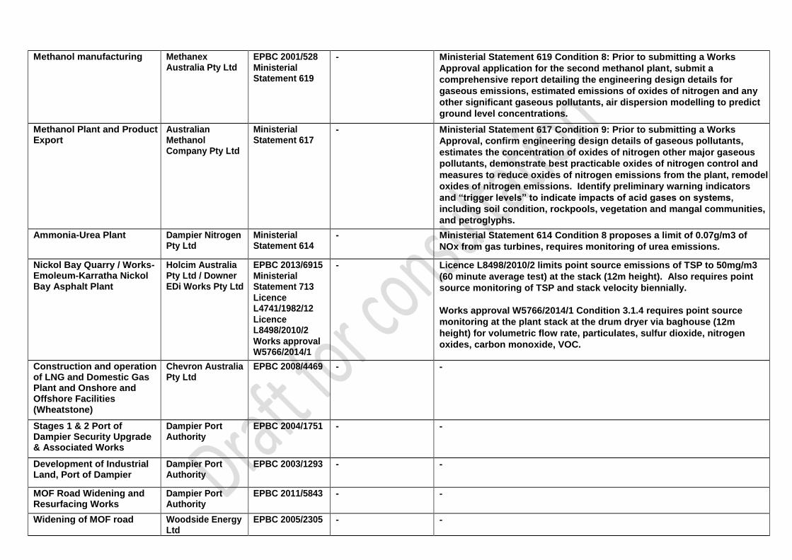
Methanol manufacturing Methanex Australia Pty Ltd
EPBC 2001/528 Ministerial Statement 619
- Ministerial Statement 619 Condition 8: Prior to submitting a Works
Approval application for the second methanol plant, submit a
comprehensive report detailing the engineering design details for
gaseous emissions, estimated emissions of oxides of nitrogen and any
other significant gaseous pollutants, air dispersion modelling to predict
ground level concentrations.
Methanol Plant and Product Export
Australian Methanol Company Pty Ltd
Ministerial Statement 617
- Ministerial Statement 617 Condition 9: Prior to submitting a Works
Approval, confirm engineering design details of gaseous pollutants,
estimates the concentration of oxides of nitrogen other major gaseous
pollutants, demonstrate best practicable oxides of nitrogen control and
measures to reduce oxides of nitrogen emissions from the plant, remodel
oxides of nitrogen emissions. Identify preliminary warning indicators
and “trigger levels” to indicate impacts of acid gases on systems,
including soil condition, rockpools, vegetation and mangal communities,
and petroglyphs.
Ammonia-Urea Plant Dampier Nitrogen Pty Ltd
Ministerial Statement 614
- Ministerial Statement 614 Condition 8 proposes a limit of 0.07g/m3 of
NOx from gas turbines, requires monitoring of urea emissions.
Nickol Bay Quarry / Works-Emoleum-Karratha Nickol Bay Asphalt Plant
Holcim Australia Pty Ltd / Downer EDi Works Pty Ltd
EPBC 2013/6915 Ministerial Statement 713
Licence L4741/1982/12
Licence L8498/2010/2
Works approval W5766/2014/1
- Licence L8498/2010/2 limits point source emissions of TSP to 50mg/m3
(60 minute average test) at the stack (12m height). Also requires point
source monitoring of TSP and stack velocity biennially.
Works approval W5766/2014/1 Condition 3.1.4 requires point source
monitoring at the plant stack at the drum dryer via baghouse (12m
height) for volumetric flow rate, particulates, sulfur dioxide, nitrogen
oxides, carbon monoxide, VOC.
Construction and operation of LNG and Domestic Gas Plant and Onshore and Offshore Facilities (Wheatstone)
Chevron Australia Pty Ltd
EPBC 2008/4469 - -
Stages 1 & 2 Port of Dampier Security Upgrade & Associated Works
Dampier Port Authority
EPBC 2004/1751 - -
Development of Industrial Land, Port of Dampier
Dampier Port Authority
EPBC 2003/1293 - -
MOF Road Widening and Resurfacing Works
Dampier Port Authority
EPBC 2011/5843 - -
Widening of MOF road Woodside Energy Ltd
EPBC 2005/2305 - -

Methanol plant GTL Resources EPBC 2001/521 - -
Dimethyl ether plant Japan DME Pty Ltd EPBC 2001/509 - -
King Bay East Rock Quarry & Industrial Estate Development
Stephen Nicholson EPBC 2003/1150 - -
Site preparations Woodside Energy Limited
EPBC 2005/2391 - -
Quarry and Industrial site King Bay
BGC Contracting Pty Ltd and Dampier Port Authority
Ministerial Statement 634
- -
Adjustment of alignment of Product Services Corridor near the Dampier Public Wharf
LandCorp and Department of Mineral and Petroleum Resources
Ministerial Statement 616
- -
Marine Load Out Facility Jan De Nul (Australia) Pty Ltd and Tideway B.V
Works Approval W5662/2014/1
- -
SLC Bulk Materials Facility Leighton Contractors Pty Ltd
Licence L8677/2012/1
- -
Toll Energy Yards - Dampier Supply Base
Toll Energy Logistics Pty Ltd
Licence L8511/2010/2
- -
Parker Point Wastewater Treatment Plant
Pilbara Iron Pty Ltd Licence L8139/2007/2
- -
22

24
i Approvals made under the Environment Protection and Biodiversity Conservation Act 1999 can be accessed from the Department of the Environment and Energy’s website: http://epbcnotices.environment.gov.au/referralslist/ Ministerial Statements can be accessed from the Environmental Protection Authority’s website: http://www.epa.wa.gov.au/all-ministerial-statements Licences and works approvals can be accessed from the Department of Water and Environmental Regulation’s website: https://www.der.wa.gov.au/our-work/licences-and-works-approvals/current-licences