
Dr Clive Bealey (ornithologist) - African Bird Club
14
1 DJIBOUTI FRANCOLIN CONSERVATION PROJECT REPORT ON FIRST PHASE 2004 Dr Clive Bealey (ornithologist) c/o World Pheasant Association 7-9 Shaftesbury Street Fordingbridge Hampshire SP6 1RF UK Dr Henry Ford (botanist) Mr Houssein A. Rayaleh (research 77 Great Pulteney Street ecologist) Bath BA2 4DL Le Ministère de l’Habitat, de UK l’Urbanisme, de l’Environnement et de l’Aménagement du Territoire Djibouti. On behalf of the World Pheasant Association September 2004
Transcript of Dr Clive Bealey (ornithologist) - African Bird Club
1
DJIBOUTI FRANCOLIN CONSERVATION PROJECT
REPORT ON FIRST PHASE 2004
Dr Clive Bealey (ornithologist) c/o World Pheasant Association
7-9 Shaftesbury Street Fordingbridge Hampshire SP6 1RF
UK
Dr Henry Ford (botanist) Mr Houssein A. Rayaleh (research 77 Great Pulteney Street ecologist) Bath BA2 4DL Le Ministère de l’Habitat, de UK l’Urbanisme, de l’Environnement et de l’Aménagement du Territoire Djibouti.
On behalf of the World Pheasant Association
September 2004
2
CONTENTS
SUMMARY 3 1. BACKGROUND 3
2. AIMS AND OBJECTIVES 4
3. PROGRESS AGAINST OBJECTIVES 4
3.1 Map areas of suitable habitat 4
3.2 Interview local people to determine their knowledge 5
of the francolin and their use of the habitat that this species inhabits
3.3 Assess methods for population estimation, such as 6
line-transects and call-playback carried out at dawn and dusk
3.4 Assess habitat use by comparing habitat at sites where birds 6
are recorded during sampling with randomly selected sites
3.5 Build a consortium in Djibouti with conservation 6
organisations, including the Wildlife Protection Organisation
4 RECORDS OF FRANCOLIN NUMBERS 7
5. FURTHER WORK 7
6. CONCLUSIONS AND RECOMMENDATIONS FOR 8
PHASE 2
6.1 Conclusions 8
6.2 Recommended Actions for Phase 2 8
ACKNOWLEDGEMENTS 9
REFERENCES 10
Table 1 10
Appendix 1 13
Map 1 7
3
SUMMARY
The Djibouti francolin Francolinus ochropectus is a Critically Endangered bird species inhabiting only two mountainous areas in Djibouti, east Africa. The population is estimated to be only 500-1000 birds in its stronghold, the Forêt du Day in the Goda Massif, where only about 14-15 km2 of its preferred habitat remains. The World Pheasant Association, with Djiboutian counterparts, has, therefore, launched a conservation programmes for the species. The first, exploratory phase, was carried out in February 2004 to assess the extent of the remaining habitat, undertake pilot work for detailed research on the species’ population and habitat requirements, initiate a questionnaire survey of local people and build a consortium in Djibouti with conservation organisations, under the auspices of the Ministère de l’Habitat, de l’Urbanisme, de l’Environnement, et de l’Aménagement du Territoire. Nearly all of the juniper forest, widely reported to be the species’ key habitat, was dead. Most of the francolin activity was, however, associated with other forest/vegetation types at lower altitudes. This may have been due to a normal seasonal altitudinal migration during the breeding season and the francolin may move higher up to juniper forest during the hottest summer months. The total number of adult birds recorded was higher than on previous surveys, but the area covered was not directly comparable. Young birds were also recorded. Ongoing work by the Djiboutian counterpart aims to assess francolin numbers and habitat selection and whether the birds are attempting to use the juniper forest areas during the hot summer period. Other surveyors will assess land use, hunting and other social pressures among the local population. Further research, using radio-tracking, is needed to assess francolin movements, habitat selection and requirements and other aspects of the species’ ecology and biology in the remaining habitat blocks. Urgent action is required to implement Protected Area status for the Forêt du Day, together with management plans for both the habitat and the Djibouti Francolin. Additional requirements include replanting the juniper forest and raising the awareness of the local community about the issues involved. The involvement of local stakeholders in a Protected Area Management Group is also needed to ensure longer-term survival of the francolin if the population can survive the current threats 1. BACKGROUND
The Djibouti francolin Francolinus ochropectus is Critically Endangered (BirdLife International 2000, Fuller et al. 2000, IUCN 2003), which makes it one of the world’s most threatened bird species. It is considered so highly threatened because a rapid population decline has been observed, which is thought to have exceeded 90% in the last 20 years (BirdLife International 2000, Fuller et al. 2000). Furthermore, this decline is thought likely to continue into the future, even though the precise nature of the factors that are causing it are not known. The species’ stronghold is considered to be the Forêt du Day in the Goda Massif where there is thought to be about 14-15 km2 of suitable habitat (Fuller et al. 2000). It also occurs in the adjacent Mabla Mountains about 80km to the north-east, from where it was first recorded in 1985. The population in the Forêt du Day was estimated at about 500-1,000 birds in 1998 (G and H Welch in litt in Fuller et al. 2000), whereas there was an unknown number of birds in the Mabla Mountains.
4
The species has been subject to several surveys and short-term visits by foreign ornithologists since the early 1980s and most recently Geoff and Hilary Welch in late 1998. The outcome of their visit on behalf of IUCN as part of the development of the Djibouti National Biodiversity Strategy and Action Plan is the basis for this project. Their recommendations are reflected in targets set for the species in Threatened Birds of the World (BirdLife International 2000) and the IUCN/WPA Partridge, Quail and Francolin action plan 2000-2004 (Fuller et al. 2000). The two critical issues for this species appear to be the tiny global range that the species occupies (and thus its apparently very small population size), and the rate at which its habitat is deteriorating, as evidenced by a high proportion of dead and dying trees. The reasons why its juniper woodland habitat is deteriorating are not known and several reasons have been suggested, including high levels of grazing, acid rain, climate change and fungal disease. Hunting, collection of fuelwood and other human disturbance are cited as issues on the lower slopes (Fuller et al. 2000). 2. AIMS AND OBJECTIVES
Against this background we aim to ensure the long-term survival of the Djibouti francolin and its habitat in its global stronghold of the Goda Massif. However, there is relatively little detailed and reliable information on the population status and ecology of the Djibouti francolin because it has not been subject to intensive and systematic conservation assessment so far. The first phase of the project (late winter 2004) was designed to identify suitable methods and establish field logistics. The particular objectives were:
1. Map areas of suitable habitat; 2. Interview local people to determine their knowledge of the francolin and their use
of the habitat that this species inhabits; 3. Assess methods for population estimation, such as line-transects and call-playback
carried out at dawn and dusk; 4. Assess habitat use by comparing habitat at sites where birds are recorded during
sampling with randomly selected sites; and 5. Build a consortium in Djibouti with conservation organisations, including the
Wildlife Protection Organisation. 3. PROGRESS AGAINST OBJECTIVES
The core period for field work in the Goda Massif February inclusiveTravel through the survey areas was entirely on foot with longer walks between camps aided by camels. 3.1 Map areas of suitable habitat
Copies of a detailed map of the region were obtained from the Ministère de l’Habitat, de l’Urbanisme, de l’Environnement, et de l’Aménagement du Territoire office in Djibouti. This was based on a survey carried out by l’Institut Géographique National, Paris in 1947 and was of scale 1:20,000. This map showed contours at 25 metre intervals, plus main tracks, settlements and wadis. This original was enlarged for use in the field. In the field, bird population estimation and the mapping of habitat were carried out simultaneously as sample areas were travelled through with the guide(s). Approximately 70km2 of the Goda Massif was surveyed, although the effective population estimation area for sampling the francolin was much less than this due to restricted visibility (what restricted visibility?) and detection range. It is estimated that approximately 40km of survey ‘transect’ was walked in the region. We assumed that the effective average maximum detection distance for francolins was 150m either side of the transect (for both sightings and calls) and therefore the area sampled was estimated at 1,200ha or 17% of the area.
5
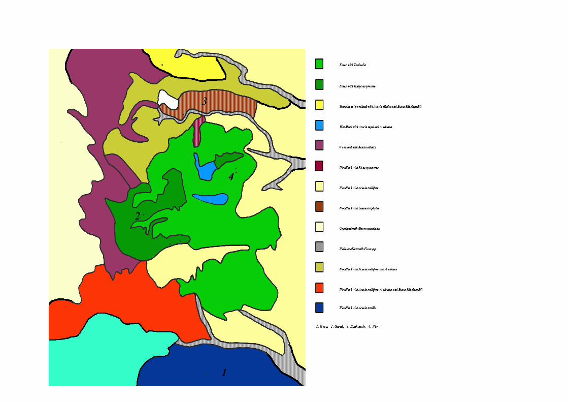
Vegetation mapping was conducted throughout potentially suitable habitat on the Goda Massif. The main settlements and prominent landscape features visited were: Garab, Barabarré, Nararte, Adonta, Hamboka, Bankoualé, Disay, Satabou, Mandah, Wer and Dittilou in the centre and north of the area and Diddinto/Fôha in the south. These are shown in Map 1. Local vegetation types were described in some detail, listing dominant tree and shrub species with other community composites where known. Due to the lack of field guides, Afar or ‘temporary’ names of some species were used during the early stages until scientific names could be ascertained. Main forest, savannah or other vegetation types were mapped from vantage points using binoculars to assess species composition. Photographs were extensively used to record vegetation types and vertical zonation and species of interest. A general description of the Goda Massif and its vegetation follows.
General topography
The Goda massif is a small plateau at 1700m 25 km north of the Gulf of Tadjoura. The landscape is one of largely horizontally layered basaltic deposits and rhyolites weathered and eroded to form steep sided wadis and river valleys of great complexity. The rock types are often of great variety within a small area. Cliffs and scree slopes dominate the wadi sides with some limited terraced agricultural land where terrain and water permit. The river systems are typically narrow and steep at their origin and broaden out with boulder strewn broad-bottomed wadis. They flow to the east and south where the wadis empty into the Gulf of Tadjoura with wide fan shaped alluvial deposits. To the west the plateau slopes more gradually and becomes increasingly arid.
Rainfall
The prevailing winds are from the east and they bring rain typically in August and September, with another peak between December and February, but this is not a regular annual event. Much water is trapped by the canopy as clouds sweep over the summits of the plateau and falls as droplets under the trees. Randa received an average of 29 cm per year between 1956 and 1966, which was 10cm more than any other station for the same period (Audru et al. 1987).
General vegetation description
The summits of the massif are covered with a relict forest of Juniperus procera. These trees reach a maximum of some 20m and many are obviously of great age. They are associated with an understorey of Buxus hildenbrandtii, an evergreen of some 5 m. and Tarchonanthus camphoratus, a member of the Asteracea whose habit is reminiscent of the elder. They are generally dominant over the plateau and whilst often found on the cliffs and slopes under the plateau they are rarely found under 1200m. Scattered throughout the juniper forests are strangling figs, Ficus vasta (?) and on the scarp edges Dracaena ombet can be seen. Areas within the forest are glades of Acacia etbaica and Acacia sayal. There are a great number of small shrubs and when the rainfall is adequate, a great variety of herbs with legumes and grasses being particularly well represented. Below the summit, and towards the south and east, the Juniperus procera forest is replaced by one dominated by Terminalia brownii with Terminalia catappa. In general this area presents a greater variety of woody species than the Juniperus forest, with Ziziphus, Commiphora spp. Grewia spp. Combretum molle, Vepris glomerata and Buxus all present. With increasing aridity, transitional areas of Acacia etbaica and Buxus hildenbrandtii are found giving way to Acacia grasslands. Typically Acacia seyal seems to be found on the gentler slopes. The African olive, Olea africana, is found throughout the Terminalia and Juniperus woodland To the north a small tree, Lannea triphylla, dominates the southern facing slopes before giving way to the Acacia dominated grasslands. The wadis are ubiquitous throughout the western area and are lined throughout with a range of fig trees. The slopes of the
6
narrower gulleys are sometimes dominated by Ficus sycamorus. Elsewhere the wadis are often edged with a variety of figs, Ficus salicifolia, Ficus plumosa, Ficus ingens, amongst others.
Current status
In their Report to the Ministry of Agriculture of Djibouti on the Vegetation and Potentialities for Pastoralism, Audru et al (1987) make no mention of the health of the forest while noting that some areas had become degraded and dominated by Tarchonanthus camphoratus . Eleven years later, Welch and Welch (1998) mention the presence of several healthy young junipers “though it is said that all junipers are considered to be diseased”. Otherwise they imply that the forest ecosystem was healthy after the rains in August 1998. The websites illustrating Djibouti invariably show a paradise of forest junipers with lush undergrowth and streams and waterfalls. We were therefore unprepared for what we saw and were silenceed by the scenes that met us when we reached the site of the old Governor’s Rest House at Garab and stood on the edge of the escarpment surrounded by dead juniper. In general 65% of the juniper is dead, with another 30% moribund (these percentages are visual estimates, not based on actual counts). In only one area, the eastern edge of Mandah, is there a grove of healthy trees, including several fine young trees and one magnificent individual of over 20m height. The main area of moribund trees is the Western end of Bara Bare, towards Eeli Daba. Many trees (60% of the dead trees) still had their leaves on and had probably died the previous year.
7
8
Another 20% still had small branches. We were assured that the trees have died largely within the last three years. Effects of the loss of the dominant tree species could not be assessed during the trip partly because the die-off was so recent and partly because the winter rains were heavier than usual, resulting in rapid growth of ground and shrub layer vegetation. Understorey shrubs such as Buxus hildebrandti were also dying although where this species was co-dominant in other forest types, it appeared quite healthy. In many places, the only healthy canopy trees were isolated specimens of strangling fig Ficus vasta(?). We saw no signs of disease, though some spore bodies of a fungus were found. Human activity is negligible, except for grazing, which is intense and which would account for the lack of regeneration. Pollution is unlikely as the forest is north, and therefore not really downwind, of Djiboutiville, the nearest source of pollution. Cutting and barking occur only on a very small scale and stacks of split logs, presumably juniper and Buxus, were seen outside settlements. Similar forests in Ethiopia are not as obviously affected, showing mainly bark peeling (Ensermu Worati in litt to Henry Ford 2004), and those in Saudi Arabia appear to be more affected by tourist pressures than the climate (Barth and Strunk 2000)). Our provisional conclusion, therefore, is that the most probable cause of the death is lack of rain as happened to similar forests in Arizona (Allen and Breshears 1998). A copy of the base field map of the Goda Massif has been scanned into the MapInfo computer package and a reference latitude and longitude grid inserted. Information from field observations on vegetation has been superimposed on the base map and will be used to calculate areas of forest and other vegetation community types. Records of francolin observations have also been superimposed on the MapInfo base and vegetation maps from which francolin densities will be calculated, stratified by habitat classification. 3.2 Interview local people to determine their knowledge of the francolin and
their use of the habitat that this species inhabits
Pilot questionnaire surveys looking at pastoral land-use and attitudes of people living in the Forêt du Day region were conducted when pastoralists were encountered during the survey. The questionnaire was devised under consultation with informed inhabitants of the Goda Massif. Questions relating to stock numbers and type, forest use and historical/recent hunting for francolin were asked. Twelve people were interviewed under the pilot, from different cultural backgrounds, and as it seemed suitable for eliciting unbiased information the questionnaire is currently being used much more extensively throughout the study area 3.3 Assess methods for population estimation, such as line-transects and
call-playback carried out at dawn and dusk
Pilot work on quantitative samples for calculating francolin densities and recording habitat use was carried out during field surveys. Recording methods were further refined during trials with the Djiboutian counterpart at the end of the expedition. Transect recording was trialled by Welch & Welch (1998), who found it extremely difficult to use due to the steep slopes and generally difficult terrain. The unlimited distance point count method (Bibby et al 1992) was trialled as the field recorder can reach a pre-selected location, stratified by vegetation type and the ‘point’ can be used as a vegetation sampling station. It was also decided that a tape lure, consisting of recorded francolin calls, would be used at the recording point, as the species appeared to be relatively sparse and secretive. This method has been successfully used to study other rare birds in the region (see for example, Borghesio & Ndang’ang’a, 2003). Tape recordings of francolin calls were made in the field by Henry Ford and transferred to tape
9
after ‘cleaning up’ in the UK. Samples of field data sheets are shown in Appendix 1 and numbers of francolin recorded are given in Section 4 3.4 Assess habitat use by comparing habitat at sites where birds are
recorded during sampling with randomly selected sites
This objective became part of 3.3 above but is reported separately. A comprehensive francolin habitat use recording form was devised at the start of fieldwork and the data collected subsequently using this form are being analysed. The form is shown in Appendix 1. In addition, a strategy for randomly sampling habitat not used by the francolin was devised, in order to obtain comparative data. 3.5 Build a consortium in Djibouti with conservation organisations, including
the Wildlife Protection Organisation
Meetings with key Ministerial staff and a representative from the French Embassy were arranged before and after the field visit to the Goda Massif. This was to highlight the importance of the project as part of the process of building a consortium of interested parties in Djibouti. The UK-Djibouti team had high level meetings with the following:
1. Mr Aboubaker Douale Waiss, Secrétaire Général du Ministère de l’Habitat, de l’Urbanisme, de l’Environnement et de l’Aménagement du Territoire Djibouti;
2. Mr Dini Abdallah, Deputy Director of Direction de l’Aménagement du Territoire et de l’Environnement; and
3. Mr Jean-Pierre Galland, Chef de Service de Co-operation et d’Action Culturelle/Ambassade de France.
In addition, every opportunity was taken to discuss the project and the conservation of the francolin and forest with clan heads and key stakeholders in the region. 4 RECORDS OF FRANCOLIN NUMBERS
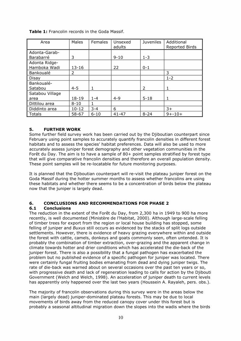
As noted above, surveys of birds and habitat were carried out simultaneously. When francolins were seen or heard, information on bird numbers and behaviour was recorded together with data on the habitat, including the main tree and shrub species and their health. Details of habitat type were also recorded between bird encounter sites in order to map overall areas of key habitats. In addition, photographs of habitat and topography were taken at all recording stops. Numbers of francolin encountered during fieldwork are shown in Table 1. This gives the total number of adult birds as a minimum of 105-124 plus another 9-10+ reported by locals. This is higher than the 65 adult birds recorded by Welch & Welch (1998) but realistic comparisons can only be made through also comparing survey effort and areas of suitable habitat covered. The highest numbers of calling males were located in the wadi and wadi edge areas of Adonta Ridge-Hamboka Wadi, Satabou village and Diddinto area. These areas were dominated by non-juniper woodland, often with a high proportion of Ficus species.
10
Table 1: Francolin records in the Goda Massif.
Area Males Females Unsexed adults
Juveniles Additional Reported Birds
Adonta-Garab-Barabarré
3
9-10
1-3
Adonta Ridge-Hamboka Wadi
13-16
22
0-1
Bankoualé 2 3
Disay 1-2
Bankoualé-Satabou
4-5
1
2
1
Satabou Village area
18-19
1-4
4-9
5-18
1
Dittilou area 8-10 1
Diddinto area 10-12 3-4 6 3+
Totals 58-67 6-10 41-47 8-24 9+-10+
5. FURTHER WORK
Some further field survey work has been carried out by the Djiboutian counterpart since February using point samples to accurately quantify francolin densities in different forest habitats and to assess the species’ habitat preferences. Data will also be used to more accurately assess juniper forest demography and other vegetation communities in the Forêt du Day. The aim is to have a sample of 80+ point samples stratified by forest type that will give comparative francolin densities and therefore an overall population density. These point samples will be re-locatable for future monitoring purposes. It is planned that the Djiboutian counterpart will re-visit the plateau juniper forest on the Goda Massif during the hotter summer months to assess whether francolins are using these habitats and whether there seems to be a concentration of birds below the plateau now that the juniper is largely dead. 6. CONCLUSIONS AND RECOMMENDATIONS FOR PHASE 2 6.1 Conclusions
The reduction in the extent of the Forêt du Day, from 2,300 ha in 1949 to 900 ha more recently, is well documented (Ministère de l’Habitat, 2000). Although large-scale felling of timber trees for export from the region or local house building has stopped, some felling of juniper and Buxus still occurs as evidenced by the stacks of split logs outside settlements. However, there is evidence of heavy grazing everywhere within and outside the forest with cattle, camels, donkeys and goats commonly seen, often untended. It is probably the combination of timber extraction, over-grazing and the apparent change in climate towards hotter and drier conditions which has accelerated the die-back of the juniper forest. There is also a possibility that a fungal pathogen has exacerbated the problem but no published evidence of a specific pathogen for juniper was located. There were certainly fungal fruiting bodies emanating from dead and dying juniper twigs. The rate of die-back was warned about on several occasions over the past ten years or so, with progressive death and lack of regeneration leading to calls for action by the Djibouti Government (Welch and Welch, 1998). An acceleration of juniper death to current levels has apparently only happened over the last two years (Houssein A. Rayaleh, pers. obs.). The majority of francolin observations during this survey were in the areas below the main (largely dead) juniper-dominated plateau forests. This may be due to local movements of birds away from the reduced canopy cover under this forest but is probably a seasonal altitudinal migration down the slopes into the wadis where the birds
11
probably concentrate their breeding (Urban et al, 1986). This was reflected in Welch and Welch’s (1999) survey where the highest recorded densities were in the wadi at Hamboka during the breeding season. It is not known how important the plateau forest is for the francolins during the hot summer season. Information on the birds’ survival rates at all times of the year is desperately needed, especially now this potentially vital aspect of their ecology has probably been removed. 6.2 Recommended Actions for Phase 2
Research
1. A survey to assess accurately francolin densities and habitat selection in the Goda Massif. This would be an extension of the pilot survey and would probably require the recording of 80+ point samples. These would be stratified by forest/habitat type but would randomly sample habitat with and without francolins. 2. An assessment of detailed use of available habitats and local movements. This can only be done by radio-tracking and would require the licensed capture and tagging of up to twenty birds of mixed sex and age. These birds would then be regularly tracked by radio-telemetry to observe habitat preferences and lateral/altitudinal movements. 3. Further work on aspects of francolin biology such as diet, breeding success, survival and condition (e.g. parasite loads) can all be carried-out during the above two major components of field research. Protection measures
1. Immediate implementation of protected status of the “Forêts de Day et de Mabla” as recently decreed by the Ministère de l’Habitat, de l’Urbanisme, de l’Environnement et de l’Aménagement du Territoire (Espace No. 7, January-February 2004). 2. Put in place management plans for these areas (which ones?), incorporating:
a. reductions in timber extraction over the whole area; b. reductions in grazing stock numbers over the whole area; and c. exclusion zones within the juniper forest where regeneration under a zero grazing
regime can be implemented. Results of the stakeholder survey will aid construction of the management plan. 3. Put in place a local project to grow juniper trees from seed stock, for re-stocking non-intervention areas within the next five years. 4. Involve local stakeholders by convening a Protected Area Management Group in each of the Goda and Mabla sections. ACKNOWLEDGEMENTS
We would like to thank Philip McGowan of the World Pheasant Association for project management and, with Alain Hennache, WPA-France, co-ordinating financial support. We were guided and looked after in the field expertly by Mr Houmed Ali aided by Mr Yayo Ali, Mr Ali Hassan, Mr Nour and Mr Hamadou. Grateful thanks are extended to the project sponsors: African Bird Club, Aviornis, Club Des Exotiques, Conservation des Espèces et des Populations Animales, Landau Zoo, Partridge, Quail and Francolin Specialist Group, Royal Society for the Protection of Birds, Société d'Encouragement pour la Conservation des Animaux Sauvages, Stiftung Avifauna Protecta, World Pheasant Association, WPA-France, WPA-Germany, Zoologische Gesellschaft für Arten- und Populationsschutz e.V.
12
REFERENCES
Allen, C.D.A. and Breshears, D.D.A. (1998) Drought induced shift of a forest woodland ecotone: rapid landscape response to climate variation. Proc. Natl. Acad. Sci. 95: 14830-14842. Audru, J., Cesar. J., Forgiarini, G., and Lebrun, J-P. (1987) La Vegetation et les potentialities pastorales de la Republique de Djibouti. Institut d'Elevage et de Medecine Veterinaire des pays tropicaux. CEDEX . ISBN 2-85985-134-8 Barth, H-J. and Strunk, H. (2000) The die-back phenomenon of Juniperus procera at the Al-Soudah family park. Report to Deutsche Forschungs Gemeinschaft (DFG), National Commission for Wildlife Conservation and Development (NCWCD), Riyadh. Downloaded on 13 September 2004 from http://www.uni-regensburg.de/Fakultaeten/phil_Fak_III/ Geographie/phygeo/downloads/barthjuniperus.pdf Bibby, C.J., Burgess, N.D and Hill, D.A. (1992) Bird Census Techniques. Academic Press, London. BirdLife International (2000) Threatened Birds of the World. Birdlife International, Birdlife Conservation Series, Cambridge. Borghesio, L. and Ndang’ang’a, P.K. (2003) Habita selection and the conservation status of Fischer’s turaco Tauraco fischeri on Unguja, Tanzania. Oryx, 37(4), 444-453. Ministère de l’Habitat (2000) Monographie Nationale pour la Diversité Biologique. Ministère de l’Habitat, de l’Urbanisme, de l’Environnement, et de l’Aménagement du Territoire, Government of Djibouti. IUCN (2003) 2003 IUCN Red List of Threatened Species. <www.redlist.org>. Downloaded on 20 January 2004. Magin, G. (2004) Djibouti. In Important Bird Areas in Africa and Associated Islands. Pisces Publications, Newbury, UK and BirdLife International, Cambridge, UK. Urban, E.K., Fry, C.H and Keith, S. (1986) The Birds of Africa Vol. 2. Academic Press, London. Welch, H.J. and Welch, G.R. (1998) A Report on the Birds of Djibouti and the Bankoualé Palm Livistona carinensis. Biodiversity Report No. 4. Privately published.
13
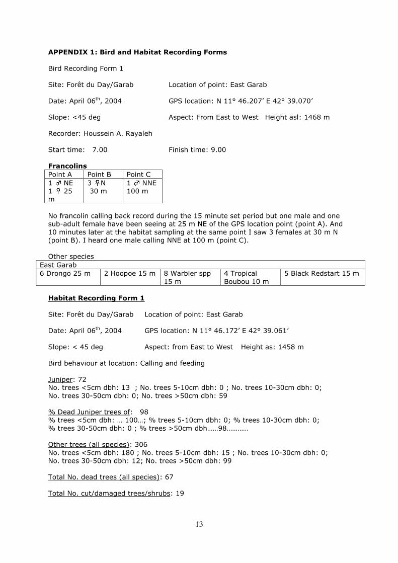
APPENDIX 1: Bird and Habitat Recording Forms
Bird Recording Form 1 Site: Forêt du Day/Garab Location of point: East Garab Date: April 06th, 2004 GPS location: N 11° 46.207’ E 42° 39.070’ Slope: <45 deg Aspect: From East to West Height asl: 1468 m Recorder: Houssein A. Rayaleh Start time: 7.00 Finish time: 9.00 Francolins
Point A Point B Point C 1 ♂ NE 1 ♀ 25 m
3 ♀N 30 m
1 ♂ NNE 100 m
No francolin calling back record during the 15 minute set period but one male and one sub-adult female have been seeing at 25 m NE of the GPS location point (point A). And 10 minutes later at the habitat sampling at the same point I saw 3 females at 30 m N (point B). I heard one male calling NNE at 100 m (point C). Other species
East Garab 6 Drongo 25 m
2 Hoopoe 15 m 8 Warbler spp 15 m
4 Tropical Boubou 10 m
5 Black Redstart 15 m
Habitat Recording Form 1
Site: Forêt du Day/Garab Location of point: East Garab Date: April 06th, 2004 GPS location: N 11° 46.172’ E 42° 39.061’ Slope: < 45 deg Aspect: from East to West Height as: 1458 m Bird behaviour at location: Calling and feeding Juniper: 72 No. trees <5cm dbh: 13 ; No. trees 5-10cm dbh: 0 ; No. trees 10-30cm dbh: 0; No. trees 30-50cm dbh: 0; No. trees >50cm dbh: 59 % Dead Juniper trees of: 98 % trees <5cm dbh: … 100…; % trees 5-10cm dbh: 0; % trees 10-30cm dbh: 0; % trees 30-50cm dbh: 0 ; % trees >50cm dbh……98………… Other trees (all species): 306 No. trees <5cm dbh: 180 ; No. trees 5-10cm dbh: 15 ; No. trees 10-30cm dbh: 0; No. trees 30-50cm dbh: 12; No. trees >50cm dbh: 99 Total No. dead trees (all species): 67 Total No. cut/damaged trees/shrubs: 19
14
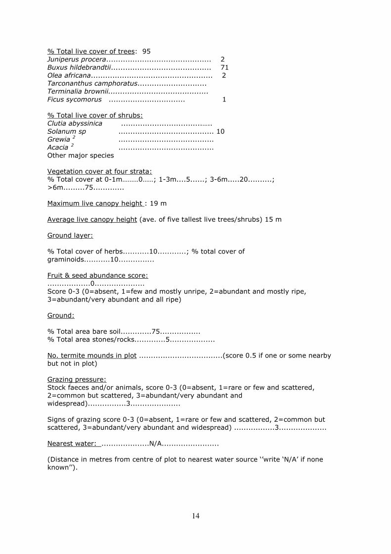
% Total live cover of trees: 95 Juniperus procera............................................ 2 Buxus hildebrandtii.......................................... 71 Olea africana................................................... 2 Tarconanthus camphoratus............................. Terminalia brownii.......................................... Ficus sycomorus ................................ 1 % Total live cover of shrubs: Clutia abyssinica ..................................….. Solanum sp ........................................ 10 Grewia 2 ........................................ Acacia 2 ........................................ Other major species Vegetation cover at four strata: % Total cover at 0-1m………0……; 1-3m....5......; 3-6m.....20..........; >6m.........75............. Maximum live canopy height : 19 m Average live canopy height (ave. of five tallest live trees/shrubs) 15 m Ground layer: % Total cover of herbs...........10............; % total cover of graminoids...........10............... Fruit & seed abundance score: ..................0..................... Score 0-3 (0=absent, 1=few and mostly unripe, 2=abundant and mostly ripe, 3=abundant/very abundant and all ripe) Ground: % Total area bare soil.............75................. % Total area stones/rocks.............5................... No. termite mounds in plot ...................................(score 0.5 if one or some nearby but not in plot) Grazing pressure: Stock faeces and/or animals, score 0-3 (0=absent, 1=rare or few and scattered, 2=common but scattered, 3=abundant/very abundant and widespread)................3..................... Signs of grazing score 0-3 (0=absent, 1=rare or few and scattered, 2=common but scattered, 3=abundant/very abundant and widespread) .................3.................... Nearest water: ....................N/A........................
(Distance in metres from centre of plot to nearest water source ‘’write ‘N/A’ if none known’’).