Downtown Martinez CBTP final report Downtown Martinez 2009.pdf · Downtown Martinez CBTP...
93
Downtown Martinez Community-Based Transportation Plan Prepared for: Downtown Martinez CBTP Stakeholder Committee City of Martinez Metropolitan Transportation Commission Prepared by: January 28, 2009
Transcript of Downtown Martinez CBTP final report Downtown Martinez 2009.pdf · Downtown Martinez CBTP...
Downtown Martinez
Community-Based Transportation Plan
Prepared for:
Downtown Martinez CBTP Stakeholder Committee City of Martinez Metropolitan Transportation Commission Prepared by:
January 28, 2009
DOWNTOWN MARTINEZ COMMUNITY-BASED TRANSPORTATION PLAN
Acknowledgments
Downtown Martinez Community-Based Transportation Plan Stakeholder Committee
Amtrak Anthony Chapa Shannon Davis Andrew Felden Richard Guy
Boys and Girls Clubs of the Diablo Valley Tuong Troung
Caltrans Lee Goldenberg
Capitol Corridor Joint Powers Authority Carl Malvo
Contra Costa County Community Development Department John Greitzer
Contra Costa County Employment & Human Services Paul Branson
County Connection Cindy Dahlgren Anne Muzzini
East Bay Bicycle Coalition Joe Eno
Housing Authority of County of Contra Costa Joseph Villarreal
Main Street Martinez Leanne Peterson George Bell
Martinez Adult Education Kathy Farewell
Martinez City Council Mark Ross
Martinez Junior High School Helen Rossi
Martinez Planning Commission Donna Allen Harriett Burt Frank Kluber
Martinez Resident Frances Ferrante Jerry Johnson Doug Sibley
Martinez Rotary Gary Hernandez
Martinez Senior Community Center Kathi Curry
RES Success Ian Bremner
Vicente Martinez Alternative High School and Briones School Carol Adams
City of Martinez Tim Tucker, City Engineer Anjana Mepani, Assistant Planner Consultants Wilbur Smith Associates Carol Levine, Project Manager Sebastian Petty Paige Williams Robert Betts
Funding provided by a $60,000 grant from the Metropolitan Transportation Commission. Copies of this report are available by calling 925-372-3515 or for download from the City of Martinez website at www.cityofmartinez.org/depts/planning/transportation_plan.asp.
DOWNTOWN MARTINEZ COMMUNITY-BASED TRANSPORTATION PLAN
102269
Wilbur Smith Associates Page i
Table of Contents
Section Page
EXECUTIVE SUMMARY AND INTRODUCTION ........................................................ ES-1 Key Findings and Issues................................................................................ES-2 Recommended Solutions ..............................................................................ES-3
CHAPTER 1: COMMUNITY PROFILE....................................................................... 1 The Study Area ............................................................................................ 1 Socio-Economic Characteristics ......................................................................... 5
CHAPTER 2: TRANSPORTATION .........................................................................15 Travel to Work ............................................................................................ 15 Roadway Network ........................................................................................ 17 Transit...................................................................................................... 17 Pedestrian and Bicycle Facilities ...................................................................... 23 Access to Schools ......................................................................................... 24
CHAPTER 3: RELEVANT STUDIES, REPORTS AND PLANS............................................27 Local Studies .............................................................................................. 27 Contra Costa County Studies ........................................................................... 29 Regional Studies .......................................................................................... 31
CHAPTER 4: COMMUNITY OUTREACH ..................................................................35 Outreach Strategy........................................................................................ 35
CHAPTER 5: TRANSPORTATION SOLUTIONS ..........................................................41 Introduction ............................................................................................... 41 Recommended Transportation Solutions ............................................................. 42 Prioritization of Solutions ............................................................................... 57
CHAPTER 6: IMPLEMENTATION ..........................................................................61 Considerations for Implementation.................................................................... 61 Funding..................................................................................................... 66 Next Steps ................................................................................................. 75
DOWNTOWN MARTINEZ COMMUNITY-BASED TRANSPORTATION PLAN
102269
Page ii Table of Contents
Tables Page
Table 1: Population and Age (Adjusted).......................................................................................................................................... 6 Table 2: Population by Race (Adjusted)........................................................................................................................................... 6 Table 3: Hispanic Population (Adjusted)......................................................................................................................................... 7 Table 4: Language Spoken at Home................................................................................................................................................. 7 Table 5: Place of Birth........................................................................................................................................................................ 8 Table 6: Place of Residence in 1995 ................................................................................................................................................. 8 Table 7: Disability Status of the Civilian Non-Institutional Population...................................................................................... 9 Table 8: Population in Households ................................................................................................................................................ 10 Table 9: Households by Type.......................................................................................................................................................... 10 Table 10: Employment Status (Adjusted) ...................................................................................................................................... 11 Table 11: Occupations...................................................................................................................................................................... 11 Table 12: 1999 Income by Household / Poverty Status by Household.................................................................................... 12 Table 13: Gross Rent as a Percentage of Household Income in 1999 ...................................................................................... 12 Table 14: Tenure by Year Householder Moved into Owner-or Renter Occupied Unit ......................................................... 13 Table 15: Place of Work................................................................................................................................................................... 15 Table 16: Travel Mode to Work...................................................................................................................................................... 15 Table 17: Vehicle Availability of Households ............................................................................................................................... 16 Table 18: Travel Time to Work....................................................................................................................................................... 16 Table 19: Transit Service to Martinez ............................................................................................................................................ 18 Table 20: Weekday Fixed-Route Transit Bus Schedules – County Connection....................................................................... 19 Table 21: Weekend Fixed-Route Transit Bus Schedules – County Connection ...................................................................... 19 Table 22: Weekday Fixed-Route Transit Bus Schedules – Tri-Delta Transit ........................................................................... 19 Table 23: Weekday Fixed-Route Transit Bus Schedules – WestCAT........................................................................................ 20 Table 24: Amtrak Schedules ............................................................................................................................................................ 20 Table 25: Distribution of Destinations/Services within Downtown Martinez ........................................................................ 32 Table 26: Number of Jobs Accessible by Auto & Transit from Downtown Martinez ........................................................... 33 Table 27: Peak Period Commute Accessibility to Low Income Jobs (<150% of Poverty Level) from Downtown
Martinez............................................................................................................................................................................ 33 Table 28: Accessibility to Essential Destination Establishments from Downtown Martinez within 30 Minutes by Auto
and Transit ....................................................................................................................................................................... 33 Table 29: Most Important Transportation Needs ........................................................................................................................ 38 Table 30: Most Beneficial Transportation Solutions.................................................................................................................... 39 Table 31: Open House Voting Results .......................................................................................................................................... 40 Table 32: Downtown Martinez Community Shuttle Preliminary Service Characteristics...................................................... 44 Table 33: Downtown Martinez Community Shuttle Preliminary Cost Estimate.................................................................... 44 Table 34: Cost Estimates for Pedestrian Access and Safety Treatments................................................................................... 46 Table 35: Cost of Bicycle Network Improvements...................................................................................................................... 48 Table 36: Estimated Costs for Bus Stop Amenities .................................................................................................................... 51 Table 37: MTC Hours of Operation and Headway Objectives for Lifeline Routes................................................................ 53 Table 38: Additional Annual Service Hours and Estimated Cost to Meet Full MTC Lifeline Service Objectives ............ 54 Table 39: Cost of Bulk Transit Pass Purchases............................................................................................................................ 56 Table 40: Solutions Prioritization Matrix....................................................................................................................................... 60 Table 41: Option A- Additional annual service hours and estimated cost for 30 minute headways during weekday peak
hours ................................................................................................................................................................................. 64
DOWNTOWN MARTINEZ COMMUNITY-BASED TRANSPORTATION PLAN
102269
Wilbur Smith Associates Page iii
Table 42: Option B- Additional annual service hours and estimated cost for provision of 12 hour service span and 60 minute headways on Saturdays and Sundays ............................................................................................................... 64
Table 43: Potential Funding Sources.............................................................................................................................................. 74
Figures Page
Figure 1: Study Area ........................................................................................................................................................................... 2 Figure 2: Zoning/Land Use............................................................................................................................................................... 3 Figure 3: Destinations......................................................................................................................................................................... 4 Figure 4: Existing Transit Routes ................................................................................................................................................... 22 Figure 5: Existing Bicycle Facilities ................................................................................................................................................ 25 Figure 6: Proposed Community Shuttle Route............................................................................................................................. 45 Figure 7: Proposed Bicycle Network Improvements................................................................................................................... 49 Figure 8: Existing Bus Stops and Amenities ................................................................................................................................. 52 Appendices
Appendix A: Project Fact Sheet Appendix B: Community Survey Appendix C: Student Survey

This page intentionally left blank
DOWNTOWN MARTINEZ COMMUNITY-BASED TRANSPORTATION PLAN
102269
Wilbur Smith Associates Page ES-1
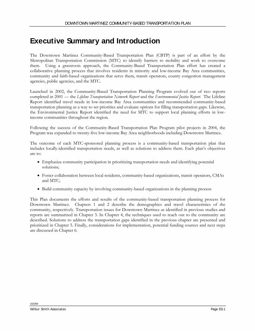
Executive Summary and Introduction
The Downtown Martinez Community-Based Transportation Plan (CBTP) is part of an effort by the Metropolitan Transportation Commission (MTC) to identify barriers to mobility and work to overcome them. Using a grassroots approach, the Community-Based Transportation Plan effort has created a collaborative planning process that involves residents in minority and low-income Bay Area communities, community and faith-based organizations that serve them, transit operators, county congestion management agencies, public agencies, and the MTC. Launched in 2002, the Community-Based Transportation Planning Program evolved out of two reports completed in 2001 — the Lifeline Transportation Network Report and the Environmental Justice Report. The Lifeline Report identified travel needs in low-income Bay Area communities and recommended community-based transportation planning as a way to set priorities and evaluate options for filling transportation gaps. Likewise, the Environmental Justice Report identified the need for MTC to support local planning efforts in low-income communities throughout the region. Following the success of the Community-Based Transportation Plan Program pilot projects in 2004, the Program was expanded to twenty-five low-income Bay Area neighborhoods including Downtown Martinez. The outcome of each MTC-sponsored planning process is a community-based transportation plan that includes locally-identified transportation needs, as well as solutions to address them. Each plan’s objectives are to:
• Emphasize community participation in prioritizing transportation needs and identifying potential solutions;
• Foster collaboration between local residents, community-based organizations, transit operators, CMAs and MTC;
• Build community capacity by involving community-based organizations in the planning process This Plan documents the efforts and results of the community-based transportation planning process for Downtown Martinez. Chapters 1 and 2 describe the demographics and travel characteristics of the community, respectively. Transportation issues for Downtown Martinez as identified in previous studies and reports are summarized in Chapter 3. In Chapter 4, the techniques used to reach out to the community are described. Solutions to address the transportation gaps identified in the previous chapter are presented and prioritized in Chapter 5. Finally, considerations for implementation, potential funding sources and next steps are discussed in Chapter 6.
DOWNTOWN MARTINEZ COMMUNITY-BASED TRANSPORTATION PLAN
102269
Page ES-2 Executive Summary and Introduction
KEY FINDINGS AND ISSUES Through review of existing documents and outreach to the community, it is possible to paint a picture of what it is like to live, work, and travel in Downtown Martinez. The following key findings were compiled from review of general community characteristics, socio-economic demographics, previous plans and studies, input from the Stakeholder Committee, and responses to the Community Survey.
• Downtown Martinez is not adjacent to major freeways and is not directly served by the Bay Area Rapid Transit District (BART) trains. Martinez is served by frequent regional Amtrak trains.
• The Downtown Martinez area maintains a historic character, with an established Historic Overlay District to preserve this quality. Plans for the Downtown focus on encouraging pedestrian traffic within the area.
• Downtown Martinez is adjacent to the shoreline, which includes the Martinez Regional Shoreline and Waterfront Park. The San Francisco Bay Trail also goes through this area. The downtown is separated from the shoreline by the increasingly busy Union Pacific railroad tracks.
• Housing units in Downtown Martinez are largely renter-occupied and residents pay a larger percentage of their total income towards rent than do other City of Martinez and Contra Costa County residents.
• Downtown Martinez has a significantly higher percentage of residents with disabilities. These residents are also more likely to be non-seniors.
• A much higher percentage of households in the Downtown had incomes below the poverty level in 1999 when compared to the City and County as a whole. Median household income is also significantly less than that of other households in the surrounding City and County.
• Downtown Martinez residents are predominantly native born and typically speak English at home.
• There are a greater number of non-family households than family households within the Downtown. Almost half of the total households are single-person households.
• Downtown residents tend to have shorter commute times than do other City and County residents. They are also more likely to work within the County.
• Downtown Martinez residents own fewer cars than other residents in the City and County. Subsequently, they are more likely to ride transit, bike, or walk to work.
• The Martinez Intermodal Facility, which is located in the Downtown, is a primary transfer station and serves both rail and fixed-route bus operators.
• Regional transit access is readily available from the main roads in Downtown Martinez but transit service is not available within the neighborhood.
• Transit service is infrequent, particularly in evenings and on weekends. Local shopping and medical destinations, particularly those north of Highway 4, are not well served by existing transit service.
• Most streets are low volume neighborhood streets. However, the major arterials (Alhambra Avenue, Berrellesa Street, and Pacheco Boulevard) are high-speed and difficult to cross.
DOWNTOWN MARTINEZ COMMUNITY-BASED TRANSPORTATION PLAN
102269
Wilbur Smith Associates Page ES-3
RECOMMENDED SOLUTIONS The following nine transportation solutions are recommended for Downtown Martinez addressing the transportation gaps identified by the community. The improvements listed below were reviewed and prioritized based upon project support from the community, effectiveness in mitigating transportation gaps, and potential for implementation. The recommended transportation solutions:
1. Transit Orientation and Outreach – This program would identify and connect target populations with the substantial transit information, resources and training already available. In addition, a Transit Guide would be prepared focused on the Downtown Martinez community.
2. Downtown Martinez Community Shuttle – This shuttle would connect the Downtown Martinez community with key civic, shopping, medical and transit destinations.
3. Pedestrian Access and Safety Improvements – This solution would identify and implement pedestrian safety improvements such as roadway crossings and sidewalk repair.
4. Bicycle Network Improvements – These improvements would enhance the City’s existing network of bicycle facilities by providing continuous access to key destinations in and beyond Downtown Martinez.
5. Bicycle Parking Improvements – This solution would provide bicycle parking (bicycle racks and bicycle lockers) throughout the Downtown and at key destinations.
6. Bus Stop Amenities and Improvements – These improvements would provide benches, bus shelters, lighting and other amenities at bus stops in Downtown Martinez.
7. Lifeline Bus Service Improvements – This solution would provide more frequent bus service and longer bus service hours for designated Lifeline transit routes for weekday and weekend transit service.
8. Taxi Fare Vouchers – This program would provide taxi vouchers for those needing a ride when transit or other options are not available.
9. Transit Fare Subsidy/Pass Provision – This program would provide low-cost or no-cost transit passes for those that qualify.

This page intentionally left blank
DOWNTOWN MARTINEZ COMMUNITY-BASED TRANSPORTATION PLAN
102269
Wilbur Smith Associates Page 1
Chapter 1: Community Profile
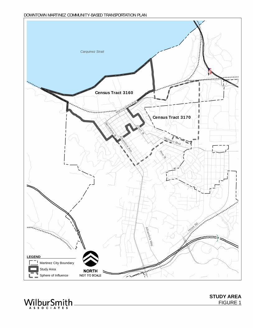
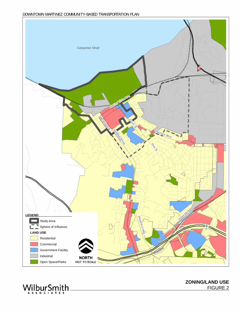
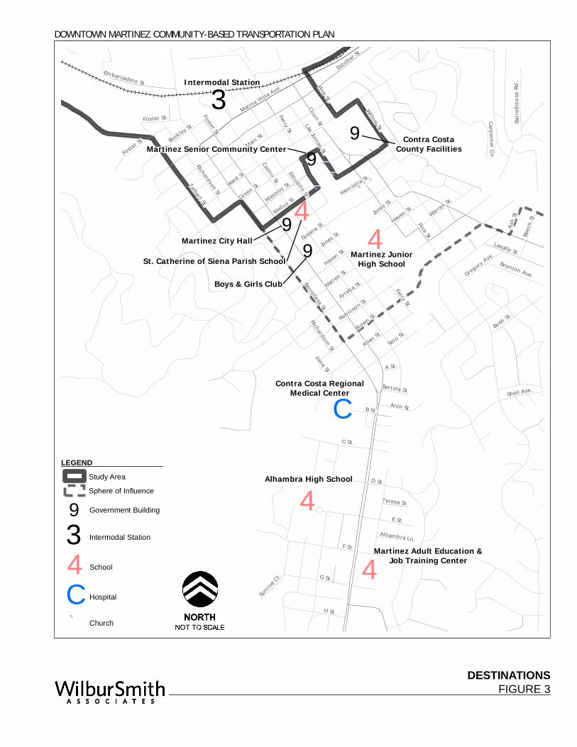
THE STUDY AREA The City of Martinez is located in Central Contra Costa County primarily west of Interstate 680, north and south of State Route 4 and on the southern bank of the Carquinez Strait. As shown in Figure 1, the Study Area is located in the northern part of the city and includes Downtown Martinez. As the county seat for Contra Costa County, many county government offices and services can be found in Downtown. The Study Area boundary is formed by Census Tract 3160. The area to the southwest, represented by Census Tract 3170, has been designated as the “Sphere of Influence” for this study. This additional area has been included because of its similarities to the Study Area in terms of travel patterns and availability of transportation facilities and services. The absence of a clear geographic or land use distinction between the two tracts and the fact that many of the destinations of Study Area residents are located in the Sphere of Influence was a further reason to include Tract 3170 in the formulation of the Plan. The location of the Downtown near the Carquinez Strait shoreline and the railroad corridor reflect Martinez’s early role in trade and industrial operations. However, the significance of the city’s location on the water has lessened with the decline of the industries and importance of water transportation. More important in today’s society is the distance of Downtown from major freeway corridors. State Route 4 to the south and Interstate 680 to the east provide regional access to the community. Still, these freeways are one to two miles from the Downtown requiring travel on local streets and hampering access from the rest of the region. Alhambra and Berrellesa Streets are the main access routes between Downtown and State Route 4, and Pacheco Boulevard and Marina Vista Avenue connect Downtown to Solano County and Central Contra Costa via Interstate 680. The nearest BART station, North Concord/Martinez Station, is more than 8 miles east of Downtown. Land Use The study area is a mix of commercial and residential land uses and government facilities. Large areas of industrial uses and open space exist in the northern edge of the Downtown near the shoreline. Of particular note is the Martinez Regional Shoreline and Waterfront Park which provides hiking trails and open space for recreational activities. A map of land use in the Downtown area is included in Figure 2. Existing commercial, mixed-use, and government buildings are generally one to three stories tall and have few if any setbacks. The Downtown area is the cultural and historic heart of Martinez; buildings date from many eras. A Downtown Historic Overlay District has also been established through parts of this area in order to preserve its historic character. Commercial uses are generally concentrated around Main and Ferry Streets, while government facilities are clustered along Court Street. Destinations Primary destinations for Downtown Martinez residents are shown in Figure 3. In the Sphere of Influence these include Contra Costa County facilities, Martinez Junior High School, St. Catherine of Siena Parish School, Martinez City Hall, Martinez Senior Community Center, Intermodal Station, numerous churches and the Boys and Girls Club. Other important destinations to the south include the Contra Costa Regional Medical Center, Alhambra High School, and the Martinez Adult Education and Job Training Center.
STUDY AREAFIGURE 1
Alhambra Ave.
Howe Rd.
Berrellesa St.
Court St.Marina Vista Ave.
Alhambra Way.Pine St.
Pacheco Blvd.
Carquinez Strait
DOWNTOWN MARTINEZ COMMUNITY-BASED TRANSPORTATION PLAN
·|}þ4
§̈¦680
LEGEND Martinez City Boundary
Study Area
Sphere of Influence
Census Tract 3170
Census Tract 3160
ZONING/LAND USEFIGURE 2
Alhambra Ave.
Howe Rd.
Berrellesa St.
Court St.Marina Vista Ave.
Alhambra Way.Pine St.
Pacheco Blvd.
Carquinez Strait
DOWNTOWN MARTINEZ COMMUNITY-BASED TRANSPORTATION PLAN
·|}þ4
§̈¦680
LEGEND Study Area
Sphere of Influence
LAND USEResidential
Commercial
Government Facility
Industrial
Open Space/Parks
DESTINATIONSFIGURE 3
44
4
4
4
9
9
®3
®C
9
¯̀
¯̀¯̀
¯̀
¯̀¯̀
9
Pine St.
Marina Vista Ave.
Berrellesa St.
Ward St.
Brown St.
Escobar St
.
Ferry St.
F St.
E St.
G St.
C St.
Warren St.
Bush St.
Susana St.
Allen St.
Talbart St.
Raap
Ave.
H St.
D St.
Soto St.Robinson St.
Lasalle St.
B St.
Haven St.
Willow St.
Jones St.
Buckley St.
Las Juntas St.
Masonic St.
Arch St.
Shell St.
Boynton Ave.
Beech
St.
Castro St.
Embarcadero St.
Foster St.
Carpenter Cir.
Barrel
hous
e Rd.
Gregory Ave.
Ash St.
Sunrise
Ct.
Bertola St.Richardson St.
Teresa St.
Ilene St.
Alhambra Ln.
Haven St.
Henrietta St.
Mellus St.
Pine St.
Foster St.
Shell Ave.
Green St.
Court St.
Jones St.
Main St.
Richardson St.
Warren St.
Arreba St.
A St.
Ferry St.
Foster St.
Estudillo St.
Intermodal Station
Martinez City Hall
Alhambra High School
Martinez JuniorHigh School
Contra Costa RegionalMedical Center
Martinez Senior Community Center
St. Catherine of Siena Parish School
Contra CostaCounty Facilities
Martinez Adult Education &Job Training Center
Boys & Girls Club
DOWNTOWN MARTINEZ COMMUNITY-BASED TRANSPORTATION PLAN
LEGEND Study Area
Sphere of Influence
9 Government Building
®3 Intermodal Station
4 School
®C Hospital
¯̀ Church
DOWNTOWN MARTINEZ COMMUNITY-BASED TRANSPORTATION PLAN
102269
Wilbur Smith Associates Page 5
SOCIO-ECONOMIC CHARACTERISTICS The Study Area of Downtown Martinez is contained within Census Tract 3160 and the Sphere of Influence within Tract 3170 in the City of Martinez. Using Census 2000 data1 it is possible to provide a socio-economic picture of the population. This includes a description of age, ethnic, economic, employment and travel characteristics of the community with comparison of the demographics of the downtown area to those of the City of Martinez and Contra Costa County as a whole. The Contra Costa County Correctional Facility is located in the Study Area (Tract 3160). This population is counted within the Census 2000 and, as 40 percent of the total population in Tract 3160, significantly influences the socio-economic character of the area. Since the inmate population is not relevant to this study’s purpose, the census data for Tract 3160, the City of Martinez, and Contra Costa County has been adjusted where possible to exclude this correctional facility population. Adjusted population is noted in the tables below. Census data was obtained primarily from Census Summary Files 1 and 3, while a small portion of the data came from Summary File 4. Summary File 1 presents counts and basic cross tabulations of information collected from all people and housing units in the tract. Summary Files 3 and 4 are based on questions from the long form questionnaire, which is collected from 1 in 6 households or, in other words, a sampling of the tract population. Summary Files 3 and 4 provide additional data that is not contained within Summary File 1, particularly on the topics of income, occupation, and transportation. Thus, it should be noted that population totals or other markers may differ slightly between tables based on Summary File 1 or those based upon Summary Files 3 and 4. The following demographic analysis includes:
• Population and age
• Ethnicity
• Language
• Place of birth and residence
• Disability
• Households
• Employment
• Income and poverty status
• Household tenure and costs
• Place of work
• Travel mode to work
• Vehicle availability
• Travel time to work
1 Census 2000 is the most comprehensive resource of socio-economic data available at this time. While there are more current
sources of projected demographic data (such as ABAG’s Projections 2007), these do not provide the range of data fields and cross-tabulations that are available through the US Census.
DOWNTOWN MARTINEZ COMMUNITY-BASED TRANSPORTATION PLAN
102269
Page 6 Chapter 1: Community Profile
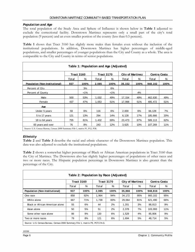
Population and Age The total population of the Study Area and Sphere of Influence is shown below in Table 1 adjusted to exclude the correctional facility. Downtown Martinez represents only a small part of the city’s total population (9 percent) and an even smaller portion of the county (less than 0.5 percent). Table 1 shows that Tract 3160 has slightly more males than females even without the inclusion of the institutional populations. In addition, Downtown Martinez has higher percentages of middle-aged populations, and smaller percentages of younger populations than the City and County as a whole. The area is comparable to the City and County in terms of senior populations.
Table 1: Population and Age (Adjusted)
Tract 3160 Tract 3170 City of Martinez Contra Costa
Total % Total % Total % Total %
Population (Non-Institutional) 937 100% 2,085 100% 35,152 100% 948,102 100%
Percent of City 3% 6%
Percent of County <1% <1% 4%
Male 500 53% 1,032 49% 17,154 49% 462,630 49%
Female 437 47% 1,053 51% 17,998 51% 485,472 51%
Age
Under 5 years 59 6% 116 6% 2,000 6% 66,128 7%
5 to 17 years 121 13% 294 14% 6,128 17% 185,666 20%
18 to 64 years 755 81% 1,432 69% 23,473 67% 589,113 62%
65 years and over 76 8% 243 12% 3,625 10% 107,269 11% Source: U.S. Census Bureau, Census 2000 Summary File 1, matrix P1, P12, P38.
Ethnicity Table 2 and Table 3 describe the racial and ethnic character of the Downtown Martinez population. This data was also adjusted to exclude the institutional populations. Table 2 shows a somewhat higher percentage of Black or African American populations in Tract 3160 than the City of Martinez. The Downtown also has slightly higher percentages of populations of other races and two or more races. The Hispanic population percentage in Downtown Martinez is also greater than the percentage of the City.
Table 2: Population by Race (Adjusted)
Tract 3160 Tract 3170 City of Martinez Contra Costa
Total % Total % Total % Total %
Population (Non-Institutional) 937 100% 2,085 100% 35,866 100% 948,816 100%
One race 858 92% 1,964 94% 34,172 95% 900,102 95%
White alone 667 71% 1,739 83% 29,064 81% 621,490 66%
Black or African American alone 55 6% 44 2% 1,201 3% 88,813 9%
Asian alone 50 5% 51 2% 2,378 7% 103,993 11%
Some other race alone 86 9% 130 6% 1,529 4% 85,806 9%
Two or more races 79 8% 121 6% 1,694 5% 48,714 5%
Source: U.S. Census Bureau, Census 2000 Summary File 1, matrix P3, PCT17A-G.
DOWNTOWN MARTINEZ COMMUNITY-BASED TRANSPORTATION PLAN
102269
Wilbur Smith Associates Page 7
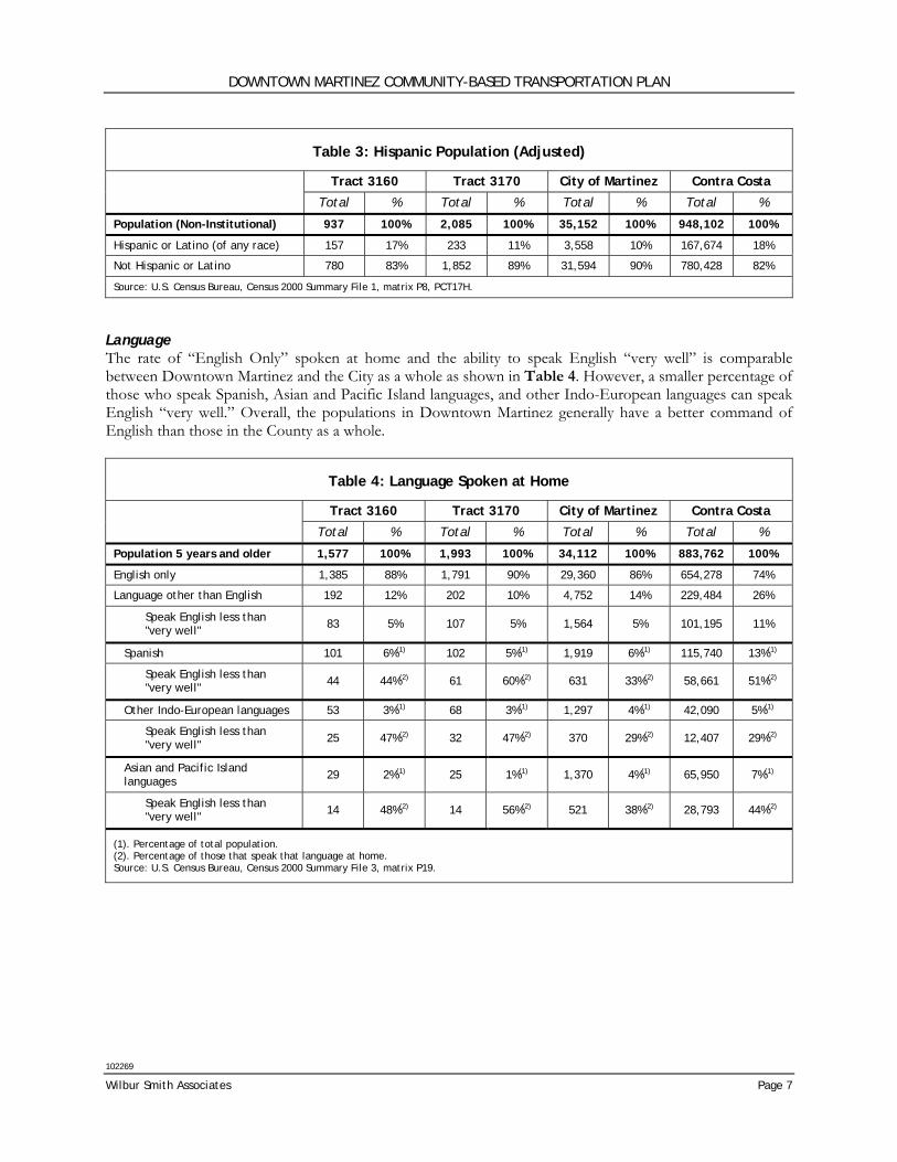
Table 3: Hispanic Population (Adjusted)
Tract 3160 Tract 3170 City of Martinez Contra Costa
Total % Total % Total % Total %
Population (Non-Institutional) 937 100% 2,085 100% 35,152 100% 948,102 100%
Hispanic or Latino (of any race) 157 17% 233 11% 3,558 10% 167,674 18%
Not Hispanic or Latino 780 83% 1,852 89% 31,594 90% 780,428 82%
Source: U.S. Census Bureau, Census 2000 Summary File 1, matrix P8, PCT17H.
Language The rate of “English Only” spoken at home and the ability to speak English “very well” is comparable between Downtown Martinez and the City as a whole as shown in Table 4. However, a smaller percentage of those who speak Spanish, Asian and Pacific Island languages, and other Indo-European languages can speak English “very well.” Overall, the populations in Downtown Martinez generally have a better command of English than those in the County as a whole.
Table 4: Language Spoken at Home
Tract 3160 Tract 3170 City of Martinez Contra Costa
Total % Total % Total % Total %
Population 5 years and older 1,577 100% 1,993 100% 34,112 100% 883,762 100%
English only 1,385 88% 1,791 90% 29,360 86% 654,278 74%
Language other than English 192 12% 202 10% 4,752 14% 229,484 26%
Speak English less than "very well" 83 5% 107 5% 1,564 5% 101,195 11%
Spanish 101 6%(1) 102 5%(1) 1,919 6%(1) 115,740 13%(1)
Speak English less than "very well" 44 44%(2) 61 60%(2) 631 33%(2) 58,661 51%(2)
Other Indo-European languages 53 3%(1) 68 3%(1) 1,297 4%(1) 42,090 5%(1)
Speak English less than "very well" 25 47%(2) 32 47%(2) 370 29%(2) 12,407 29%(2)
Asian and Pacific Island languages 29 2%(1) 25 1%(1) 1,370 4%(1) 65,950 7%(1)
Speak English less than "very well" 14 48%(2) 14 56%(2) 521 38%(2) 28,793 44%(2)
(1). Percentage of total population. (2). Percentage of those that speak that language at home. Source: U.S. Census Bureau, Census 2000 Summary File 3, matrix P19.
DOWNTOWN MARTINEZ COMMUNITY-BASED TRANSPORTATION PLAN
102269
Page 8 Chapter 1: Community Profile
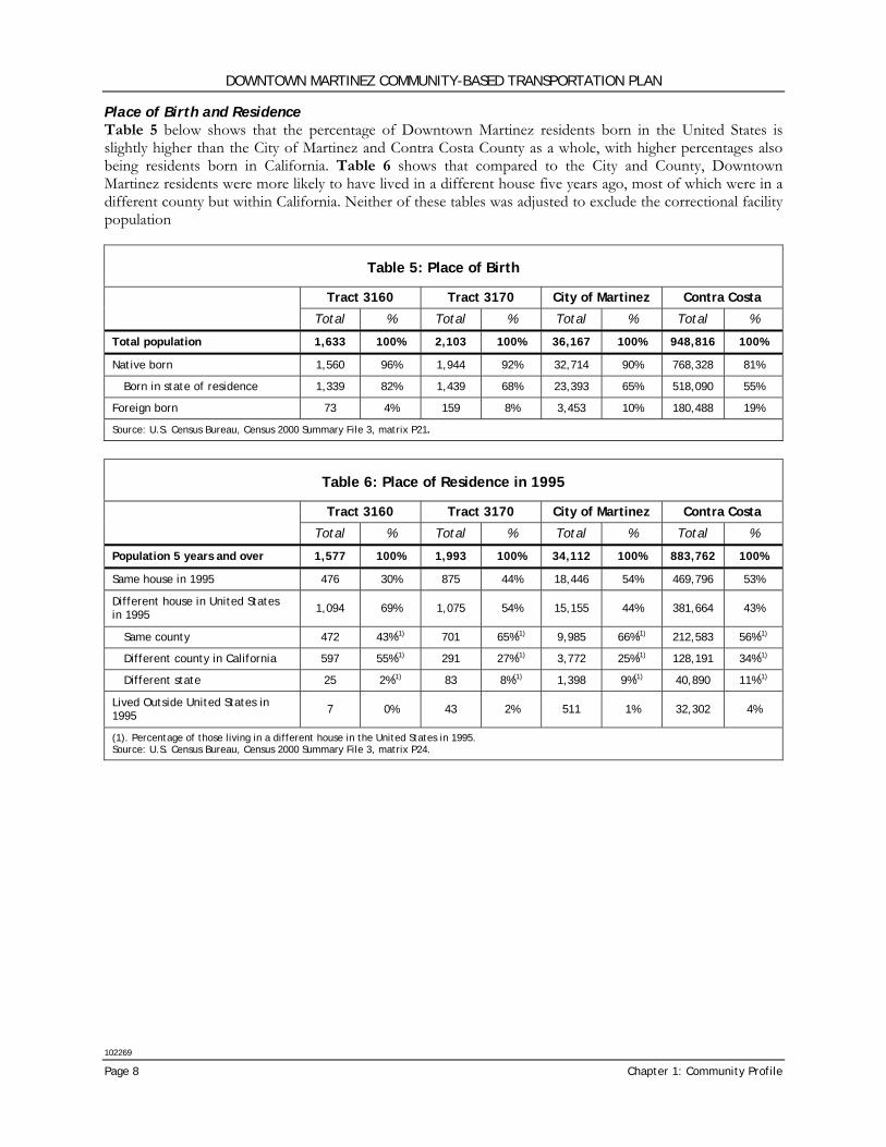
Place of Birth and Residence Table 5 below shows that the percentage of Downtown Martinez residents born in the United States is slightly higher than the City of Martinez and Contra Costa County as a whole, with higher percentages also being residents born in California. Table 6 shows that compared to the City and County, Downtown Martinez residents were more likely to have lived in a different house five years ago, most of which were in a different county but within California. Neither of these tables was adjusted to exclude the correctional facility population
Table 5: Place of Birth
Tract 3160 Tract 3170 City of Martinez Contra Costa
Total % Total % Total % Total %
Total population 1,633 100% 2,103 100% 36,167 100% 948,816 100%
Native born 1,560 96% 1,944 92% 32,714 90% 768,328 81%
Born in state of residence 1,339 82% 1,439 68% 23,393 65% 518,090 55%
Foreign born 73 4% 159 8% 3,453 10% 180,488 19%
Source: U.S. Census Bureau, Census 2000 Summary File 3, matrix P21.
Table 6: Place of Residence in 1995
Tract 3160 Tract 3170 City of Martinez Contra Costa
Total % Total % Total % Total %
Population 5 years and over 1,577 100% 1,993 100% 34,112 100% 883,762 100%
Same house in 1995 476 30% 875 44% 18,446 54% 469,796 53%
Different house in United States in 1995 1,094 69% 1,075 54% 15,155 44% 381,664 43%
Same county 472 43%(1) 701 65%(1) 9,985 66%(1) 212,583 56%(1)
Different county in California 597 55%(1) 291 27%(1) 3,772 25%(1) 128,191 34%(1)
Different state 25 2%(1) 83 8%(1) 1,398 9%(1) 40,890 11%(1)
Lived Outside United States in 1995 7 0% 43 2% 511 1% 32,302 4%
(1). Percentage of those living in a different house in the United States in 1995. Source: U.S. Census Bureau, Census 2000 Summary File 3, matrix P24.
DOWNTOWN MARTINEZ COMMUNITY-BASED TRANSPORTATION PLAN
102269
Wilbur Smith Associates Page 9
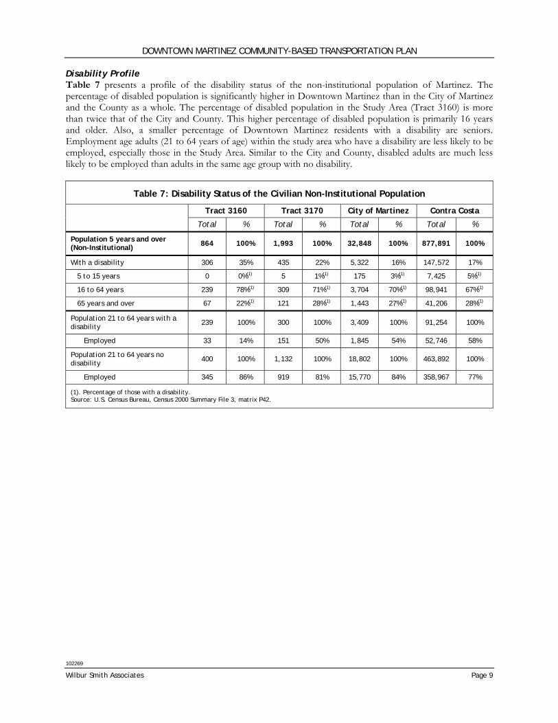
Disability Profile Table 7 presents a profile of the disability status of the non-institutional population of Martinez. The percentage of disabled population is significantly higher in Downtown Martinez than in the City of Martinez and the County as a whole. The percentage of disabled population in the Study Area (Tract 3160) is more than twice that of the City and County. This higher percentage of disabled population is primarily 16 years and older. Also, a smaller percentage of Downtown Martinez residents with a disability are seniors. Employment age adults (21 to 64 years of age) within the study area who have a disability are less likely to be employed, especially those in the Study Area. Similar to the City and County, disabled adults are much less likely to be employed than adults in the same age group with no disability.
Table 7: Disability Status of the Civilian Non-Institutional Population
Tract 3160 Tract 3170 City of Martinez Contra Costa
Total % Total % Total % Total %
Population 5 years and over (Non-Institutional) 864 100% 1,993 100% 32,848 100% 877,891 100%
With a disability 306 35% 435 22% 5,322 16% 147,572 17%
5 to 15 years 0 0%(1) 5 1%(1) 175 3%(1) 7,425 5%(1)
16 to 64 years 239 78%(1) 309 71%(1) 3,704 70%(1) 98,941 67%(1)
65 years and over 67 22%(1) 121 28%(1) 1,443 27%(1) 41,206 28%(1)
Population 21 to 64 years with a disability 239 100% 300 100% 3,409 100% 91,254 100%
Employed 33 14% 151 50% 1,845 54% 52,746 58%
Population 21 to 64 years no disability 400 100% 1,132 100% 18,802 100% 463,892 100%
Employed 345 86% 919 81% 15,770 84% 358,967 77%
(1). Percentage of those with a disability. Source: U.S. Census Bureau, Census 2000 Summary File 3, matrix P42.
DOWNTOWN MARTINEZ COMMUNITY-BASED TRANSPORTATION PLAN
102269
Page 10 Chapter 1: Community Profile
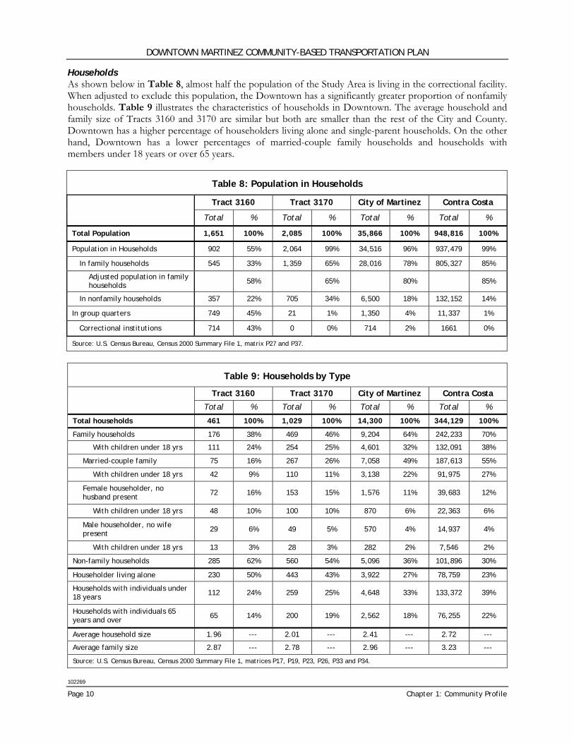
Households As shown below in Table 8, almost half the population of the Study Area is living in the correctional facility. When adjusted to exclude this population, the Downtown has a significantly greater proportion of nonfamily households. Table 9 illustrates the characteristics of households in Downtown. The average household and family size of Tracts 3160 and 3170 are similar but both are smaller than the rest of the City and County. Downtown has a higher percentage of householders living alone and single-parent households. On the other hand, Downtown has a lower percentages of married-couple family households and households with members under 18 years or over 65 years.
Table 8: Population in Households
Tract 3160 Tract 3170 City of Martinez Contra Costa
Total % Total % Total % Total %
Total Population 1,651 100% 2,085 100% 35,866 100% 948,816 100%
Population in Households 902 55% 2,064 99% 34,516 96% 937,479 99%
In family households 545 33% 1,359 65% 28,016 78% 805,327 85%
Adjusted population in family households 58% 65% 80% 85%
In nonfamily households 357 22% 705 34% 6,500 18% 132,152 14%
In group quarters 749 45% 21 1% 1,350 4% 11,337 1%
Correctional institutions 714 43% 0 0% 714 2% 1661 0%
Source: U.S. Census Bureau, Census 2000 Summary File 1, matrix P27 and P37.
Table 9: Households by Type
Tract 3160 Tract 3170 City of Martinez Contra Costa
Total % Total % Total % Total %
Total households 461 100% 1,029 100% 14,300 100% 344,129 100%
Family households 176 38% 469 46% 9,204 64% 242,233 70%
With children under 18 yrs 111 24% 254 25% 4,601 32% 132,091 38%
Married-couple family 75 16% 267 26% 7,058 49% 187,613 55%
With children under 18 yrs 42 9% 110 11% 3,138 22% 91,975 27%
Female householder, no husband present 72 16% 153 15% 1,576 11% 39,683 12%
With children under 18 yrs 48 10% 100 10% 870 6% 22,363 6%
Male householder, no wife present 29 6% 49 5% 570 4% 14,937 4%
With children under 18 yrs 13 3% 28 3% 282 2% 7,546 2%
Non-family households 285 62% 560 54% 5,096 36% 101,896 30%
Householder living alone 230 50% 443 43% 3,922 27% 78,759 23%
Households with individuals under 18 years 112 24% 259 25% 4,648 33% 133,372 39%
Households with individuals 65 years and over 65 14% 200 19% 2,562 18% 76,255 22%
Average household size 1.96 --- 2.01 --- 2.41 --- 2.72 ---
Average family size 2.87 --- 2.78 --- 2.96 --- 3.23 ---
Source: U.S. Census Bureau, Census 2000 Summary File 1, matrices P17, P19, P23, P26, P33 and P34.
DOWNTOWN MARTINEZ COMMUNITY-BASED TRANSPORTATION PLAN
102269
Wilbur Smith Associates Page 11
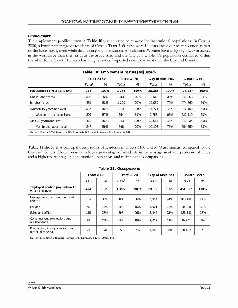
Employment The employment profile shown in Table 10 was adjusted to remove the institutional populations. In Census 2000, a lower percentage of residents of Census Tract 3160 who were 16 years and older were counted as part of the labor force, even while discounting the institutional populations. Women have a slightly lower presence in the workforce than men in both the Study Area and the City as a whole. Of population contained within the labor force, Tract 3160 also has a higher rate of reported unemployment than the City and County.
Table 10: Employment Status (Adjusted)
Tract 3160 Tract 3170 City of Martinez Contra Costa
Total % Total % Total % Total %
Population 16 years and over 773 100% 1,753 100% 28,385 100% 723,737 100%
Not in labor force 322 42% 533 30% 8,435 30% 249,068 34%
In labor force 451 58% 1,220 70% 19,950 70% 474,669 66%
Women 16 years and over 357 100% 910 100% 14,774 100% 377,103 100%
Women in the labor force 204 57% 554 61% 9,758 66% 220,110 58%
Men 16 years and over 416 100% 843 100% 13,611 100% 346,634 100%
Men in the labor force 247 59% 666 79% 10,192 75% 254,559 73%
Source: Census 2000 Summary File 3, matrix P43, and Summary File 1, matrix P38.
Table 11 shows that principal occupations of residents in Tracts 3160 and 3170 are similar; compared to the City and County, Downtown has a lower percentage of residents in the management and professional fields and a higher percentage in construction, extraction, and maintenance occupations.
Table 11: Occupations
Tract 3160 Tract 3170 City of Martinez Contra Costa
Total % Total % Total % Total %
Employed civilian population 16 years and over 404 100% 1,155 100% 19,169 100% 451,357 100%
Management, professional, and related 134 33% 421 36% 7,914 41% 185,100 41%
Service 45 11% 190 16% 1,931 10% 60,299 13%
Sales and office 115 28% 298 26% 5,946 31% 126,183 28%
Construction, extraction, and maintenance 89 22% 169 15% 2,033 11% 40,341 9%
Production, transportation, and material moving 21 5% 77 7% 1,335 7% 38,497 9%
Source: U.S. Census Bureau, Census 2000 Summary File 3, Matrix P50.
DOWNTOWN MARTINEZ COMMUNITY-BASED TRANSPORTATION PLAN
102269
Page 12 Chapter 1: Community Profile
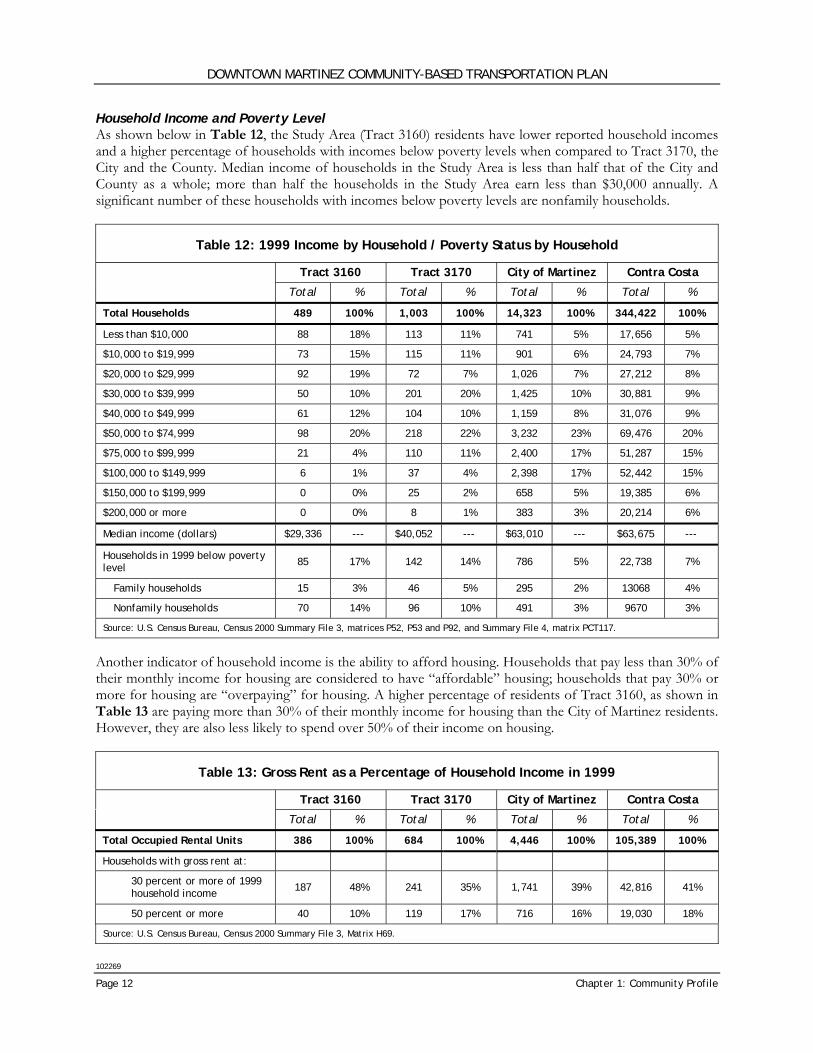
Household Income and Poverty Level As shown below in Table 12, the Study Area (Tract 3160) residents have lower reported household incomes and a higher percentage of households with incomes below poverty levels when compared to Tract 3170, the City and the County. Median income of households in the Study Area is less than half that of the City and County as a whole; more than half the households in the Study Area earn less than $30,000 annually. A significant number of these households with incomes below poverty levels are nonfamily households.
Table 12: 1999 Income by Household / Poverty Status by Household
Tract 3160 Tract 3170 City of Martinez Contra Costa
Total % Total % Total % Total %
Total Households 489 100% 1,003 100% 14,323 100% 344,422 100%
Less than $10,000 88 18% 113 11% 741 5% 17,656 5%
$10,000 to $19,999 73 15% 115 11% 901 6% 24,793 7%
$20,000 to $29,999 92 19% 72 7% 1,026 7% 27,212 8%
$30,000 to $39,999 50 10% 201 20% 1,425 10% 30,881 9%
$40,000 to $49,999 61 12% 104 10% 1,159 8% 31,076 9%
$50,000 to $74,999 98 20% 218 22% 3,232 23% 69,476 20%
$75,000 to $99,999 21 4% 110 11% 2,400 17% 51,287 15%
$100,000 to $149,999 6 1% 37 4% 2,398 17% 52,442 15%
$150,000 to $199,999 0 0% 25 2% 658 5% 19,385 6%
$200,000 or more 0 0% 8 1% 383 3% 20,214 6%
Median income (dollars) $29,336 --- $40,052 --- $63,010 --- $63,675 ---
Households in 1999 below poverty level 85 17% 142 14% 786 5% 22,738 7%
Family households 15 3% 46 5% 295 2% 13068 4%
Nonfamily households 70 14% 96 10% 491 3% 9670 3%
Source: U.S. Census Bureau, Census 2000 Summary File 3, matrices P52, P53 and P92, and Summary File 4, matrix PCT117.
Another indicator of household income is the ability to afford housing. Households that pay less than 30% of their monthly income for housing are considered to have “affordable” housing; households that pay 30% or more for housing are “overpaying” for housing. A higher percentage of residents of Tract 3160, as shown in Table 13 are paying more than 30% of their monthly income for housing than the City of Martinez residents. However, they are also less likely to spend over 50% of their income on housing.
Table 13: Gross Rent as a Percentage of Household Income in 1999
Tract 3160 Tract 3170 City of Martinez Contra Costa
Total % Total % Total % Total %
Total Occupied Rental Units 386 100% 684 100% 4,446 100% 105,389 100%
Households with gross rent at:
30 percent or more of 1999 household income 187 48% 241 35% 1,741 39% 42,816 41%
50 percent or more 40 10% 119 17% 716 16% 19,030 18%
Source: U.S. Census Bureau, Census 2000 Summary File 3, Matrix H69.
DOWNTOWN MARTINEZ COMMUNITY-BASED TRANSPORTATION PLAN
102269
Wilbur Smith Associates Page 13
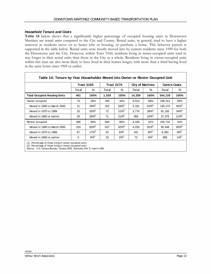
Household Tenure and Costs Table 14 below shows that a significantly higher percentage of occupied housing units in Downtown Martinez are rental units compared to the City and County. Rental units, in general, tend to have a higher turnover as residents move on to better jobs or housing, or purchase a home. This behavior pattern is supported in the table below. Rental units were mostly moved into by current residents since 1990 for both the Downtown and the City. However, within Tract 3160, residents living in renter-occupied units tend to stay longer in their rental units than those in the City as a whole. Residents living in owner-occupied units within this tract are also more likely to have lived in their homes longer, with more than a third having lived in the same home since 1969 or earlier.
Table 14: Tenure by Year Householder Moved into Owner-or Renter Occupied Unit
Tract 3160 Tract 3170 City of Martinez Contra Costa
Total % Total % Total % Total %
Total Occupied Housing Units 461 100% 1,029 100% 14,359 100% 344,129 100%
Owner occupied 75 16% 345 34% 9,913 69% 238,413 69%
Moved in 1990 to March 2000 21 28%(1) 202 59%(1) 5,181 52%(1) 130,173 55%(1)
Moved in 1970 to 1989 25 33%(1) 72 21%(1) 3,776 38%(1) 81,165 34%(1)
Moved in 1969 or earlier 29 39%(1) 71 21%(1) 956 10%(1) 27,075 11%(1)
Renter occupied 386 84% 684 66% 4,446 31% 105,716 31%
Moved in 1990 to March 2000 319 83%(2) 627 92%(2) 4,033 91%(2) 95,448 90%(2)
Moved in 1970 to 1989 67 17%(2) 42 6%(2) 341 8%(2) 9,383 9%(2)
Moved in 1969 or earlier 0 0%(2) 15 2%(2) 72 2%(2) 885 1%(2)
(1). Percentage of those living in owner-occupied units. (2). Percentage of those living in renter-occupied units. Source: U.S. Census Bureau, Census 2000, Summary File 3, matrix H38.

This page intentionally left blank
DOWNTOWN MARTINEZ COMMUNITY-BASED TRANSPORTATION PLAN
102269
Wilbur Smith Associates Page 15
Chapter 2: Transportation
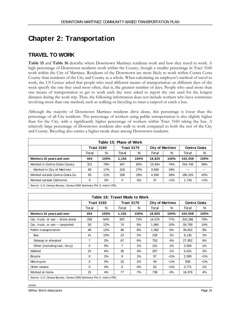
TRAVEL TO WORK Table 15 and Table 16 describe where Downtown Martinez residents work and how they travel to work. A high percentage of Downtown residents work within the County, though a smaller percentage in Tract 3160 work within the City of Martinez. Residents of the Downtown are more likely to work within Contra Costa County than residents of the City and County as a whole. When calculating an employee’s method of travel to work, the US Census asked that people who used different means of transportation on different days of the week specify the one they used most often, that is, the greatest number of days. People who used more than one means of transportation to get to work each day were asked to report the one used for the longest distance during the work trip. Thus, the following information does not include workers who have commutes involving more than one method, such as walking or bicycling to meet a carpool or catch a bus. Although the majority of Downtown Martinez residents drive alone, this percentage is lower than the percentage of all City residents. The percentage of workers using public transportation is also slightly higher than for the City, with a significantly higher percentage of workers within Tract 3160 taking the bus. A relatively large percentage of Downtown residents also walk to work compared to both the rest of the City and County. Bicycling also carries a higher mode share among Downtown residents.
Table 15: Place of Work Tract 3160 Tract 3170 City of Martinez Contra Costa Total % Total % Total % Total %
Workers 16 years and over 404 100% 1,155 100% 18,820 100% 442,008 100%
Worked in Contra Costa County 321 79% 947 82% 13,844 74% 254,749 58%
Worked in City of Martinez 69 17% 316 27% 3,665 19% --- ---
Worked outside Contra Costa Co. 83 21% 208 18% 4,939 26% 185,525 42%
Worked outside California 0 0% 0 0% 37 <1% 1,734 <1%
Source: U.S. Census Bureau, Census 2000 Summary File 3, matrix P26.
Table 16: Travel Mode to Work
Tract 3160 Tract 3170 City of Martinez Contra Costa Total % Total % Total % Total %
Workers 16 years and over 404 100% 1,155 100% 18,820 100% 442,008 100%
Car, truck, or van -- drove alone 258 64% 837 72% 14,575 77% 310,286 70%
Car, truck, or van -- carpooled 50 12% 74 6% 1,960 10% 59,769 14%
Public transportation 48 12% 98 8% 1,082 6% 39,652 9%
Bus 41 10% 24 2% 228 1% 8,135 2%
Subway or elevated 7 2% 67 6% 753 4% 27,952 6%
Other (including taxi, ferry) 0 0% 7 1% 101 1% 3,565 1%
Walked 24 6% 38 3% 267 1% 6,631 2%
Bicycle 9 2% 8 1% 57 <1% 2,085 <1%
Motorcycle 0 0% 23 2% 49 <1% 838 <1%
Other means 0 0% 0 0% 92 <1% 3,771 1%
Worked at home 15 4% 77 7% 738 4% 18,976 4%
Source: U.S. Census Bureau, Census 2000 Summary File 3, matrix P30.
DOWNTOWN MARTINEZ COMMUNITY-BASED TRANSPORTATION PLAN
102269
Page 16 Chapter 2: Transportation
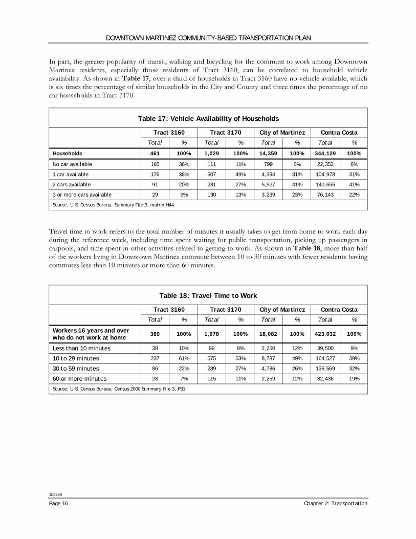
In part, the greater popularity of transit, walking and bicycling for the commute to work among Downtown Martinez residents, especially those residents of Tract 3160, can be correlated to household vehicle availability. As shown in Table 17, over a third of households in Tract 3160 have no vehicle available, which is six times the percentage of similar households in the City and County and three times the percentage of no car households in Tract 3170.
Table 17: Vehicle Availability of Households
Tract 3160 Tract 3170 City of Martinez Contra Costa
Total % Total % Total % Total %
Households 461 100% 1,029 100% 14,359 100% 344,129 100%
No car available 165 36% 111 11% 799 6% 22,353 6%
1 car available 176 38% 507 49% 4,394 31% 104,978 31%
2 cars available 91 20% 281 27% 5,927 41% 140,655 41%
3 or more cars available 29 6% 130 13% 3,239 23% 76,143 22%
Source: U.S. Census Bureau, Summary File 3, matrix H44.
Travel time to work refers to the total number of minutes it usually takes to get from home to work each day during the reference week, including time spent waiting for public transportation, picking up passengers in carpools, and time spent in other activities related to getting to work. As shown in Table 18, more than half of the workers living in Downtown Martinez commute between 10 to 30 minutes with fewer residents having commutes less than 10 minutes or more than 60 minutes.
Table 18: Travel Time to Work
Tract 3160 Tract 3170 City of Martinez Contra Costa
Total % Total % Total % Total %
Workers 16 years and over who do not work at home
389 100% 1,078 100% 18,082 100% 423,032 100%
Less than 10 minutes 38 10% 99 9% 2,250 12% 39,500 9%
10 to 29 minutes 237 61% 575 53% 8,787 49% 164,527 39%
30 to 59 minutes 86 22% 289 27% 4,786 26% 136,569 32%
60 or more minutes 28 7% 115 11% 2,259 12% 82,436 19%
Source: U.S. Census Bureau, Census 2000 Summary File 3, P31.

DOWNTOWN MARTINEZ COMMUNITY-BASED TRANSPORTATION PLAN
102269
Wilbur Smith Associates Page 17
ROADWAY NETWORK Regional access to Downtown Martinez is provided primarily via State Route 4, which extends east-west between Interstate 80 to the west near the City of Hercules and to the east to the City of Stockton in San Joaquin County. Access from State Route 4 to Downtown is provided primarily by two interchanges: one at Alhambra Avenue, which serves as the primary interchange, and the second at Center Avenue. Interstate 680, also provides north-south regional access to the Study Area approximately three miles to the east; the interchanges at Pacheco Boulevard and Marina Vista Avenue provide access to the Downtown approximately 3 miles and 1.5 miles, respectively from Downtown. The current local roadway system is composed of a grid network of both one- and two-way streets. While the majority of streets are two-way, several major streets operate as one-way couplets. These major roadways serve as primary circulation facilities within Downtown Martinez and connect regional access points, including freeway interchanges, to the downtown area. The primary one-way couplets are Alhambra Avenue/Berrellesa Street, which runs north-south, and Marina Vista Avenue/Escobar Street, running east-west. Another major two-way street is Court Street/Pacheco Boulevard, which provides access to the Court House and other County offices. A majority of intersections, particularly along the minor and residential streets, are unsignalized and are either two- or four-way stop controlled. Four-way stop controls are most prevalent along Main Street and Ferry Street.
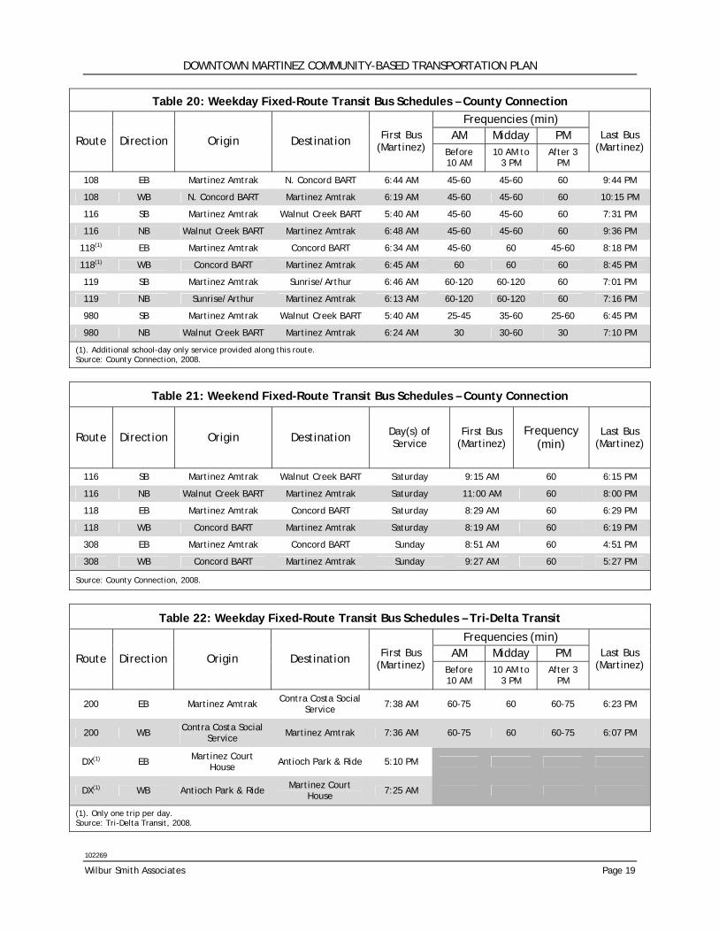
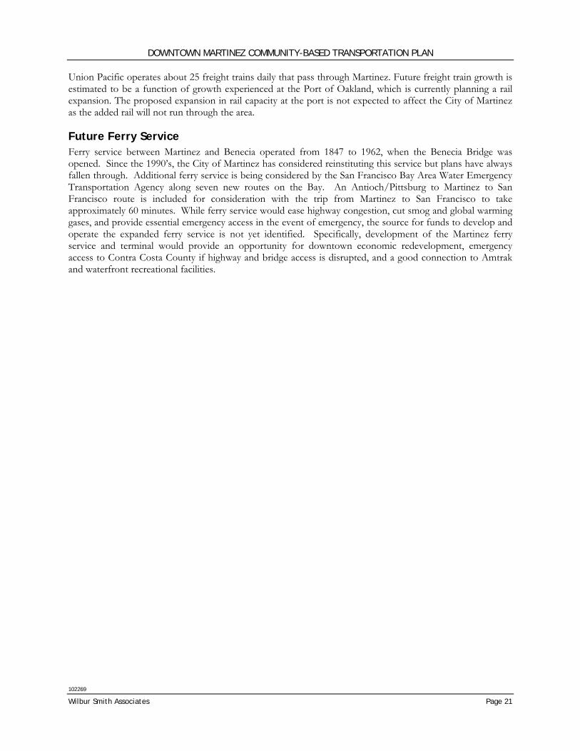
TRANSIT Transit service in Martinez is available for both regional and local trips. Local bus service includes all public transit routes that begin and end within Central Contra Costa County and is provided mainly through the Central Contra Costa Transit Authority (CCCTA) operated as County Connection. Additional regional bus service, which includes connections to other areas within the County, is provided by the Eastern Contra Costa Transit Authority (ECCTA) operated as Tri-Delta Transit, and the Western Contra Costa Transit Authority (WCCTA) operated as WestCAT. County Connection also provides paratransit service, called County Connection LINK, for the area. The Martinez Intermodal Station (Amtrak Station) located in Downtown provides access to local, regional and long distance rail service. Ferry service to Martinez currently does not exist but is being considered for the future by the San Francisco Bay Area Water Emergency Transportation Authority. Martinez Intermodal Station The Martinez Intermodal Station (Amtrak Station) is located along the northern edge of the Downtown, on Marina Vista Avenue. The station, which was built in 2001, serves as the main point for bus-to-bus and bus-to-rail transfers. The station has an enclosed waiting area, passenger restrooms and a staffed ticket counter. The station and ticket counter are open 7 days a week from 5 AM to 11 PM. There are plans to expand to supply additional parking capacity and to eventually provide shuttle bus service to a future ferry terminal. Fixed Route Bus In total, 9 bus routes provide service to Martinez (Table 19). All of these routes begin and terminate at the Martinez Intermodal Station except for Tri-Delta Route DX, which terminates at the Martinez Court House. These routes, along with bus stop locations for Tri-Delta Transit and WestCAT, are shown in
DOWNTOWN MARTINEZ COMMUNITY-BASED TRANSPORTATION PLAN
102269
Page 18 Chapter 2: Transportation
Figure 4. Bus stops are provided near the Court House and other county facilities, the Intermodal Station, and Martinez Junior High School. These stops are provided mostly along major arterials, including Alhambra Avenue, Berrellesa Street, Court Street, and Main Street. Commuter routes provide weekday services between Martinez and the eastern, western and central areas of Contra Costa County. The local routes provide weekday and limited weekend service to communities within Martinez and surrounding areas within Central Contra Costa County. Supplemental service on local Route 118 operates on school days only and is coordinated with school bell times. Many BART stations are served including North Concord, Walnut Creek, Concord, Pleasant Hill and El Cerrito del Norte Stations. Four of the County Connection routes (Routes 108, 116, 118, and 308) and WestCAT Route 30Z are classified as part of the Lifeline Transportation Network identified by the Metropolitan Transportation Commission (MTC). The Lifeline Transportation Network was defined as part of the 2001 update of the Regional Transportation Plan to identify which public transit services are most vital to disadvantaged neighborhoods. All of the County Connection “lifeline” routes through Downtown Martinez were selected because they serve clusters of CalWORKs households, moving people from welfare to work. Many of the routes also serve as major trunkline routes, operating along a major corridor with high frequency and carrying a large number of passengers. According to CCCTA’s Short Range Transit Plan, service improvements are expected to occur on these “lifeline” routes through the allocation of new State Transportation Assistance (STA) funds. Service by operator is summarized below. Table 20, Table 22, and Table 23 summarize weekday bus service within the study area of County Connection, Tri-Delta, and WestCAT routes, respectively. Table 21 shows weekend bus service provided by County Connection.
Table 19: Transit Service to Martinez
County Connection
• Route 108 (Local/Weekday)
• Route 116 (Local)
• Route 118 (Local)
• Route 119 (Local/Weekday)
• Route 308 (Local/Weekend)
• Route 980 (Commuter)
Tri-Delta Transit
• Route 200 (Commuter)
• Route DX (Commuter)
WestCAT
• Route 30Z (Commuter)
DOWNTOWN MARTINEZ COMMUNITY-BASED TRANSPORTATION PLAN
102269
Wilbur Smith Associates Page 19
Table 20: Weekday Fixed-Route Transit Bus Schedules – County Connection Frequencies (min)
AM Midday PM Route Direction Origin Destination First Bus (Martinez) Before
10 AM 10 AM to
3 PM After 3
PM
Last Bus (Martinez)
108 EB Martinez Amtrak N. Concord BART 6:44 AM 45-60 45-60 60 9:44 PM
108 WB N. Concord BART Martinez Amtrak 6:19 AM 45-60 45-60 60 10:15 PM
116 SB Martinez Amtrak Walnut Creek BART 5:40 AM 45-60 45-60 60 7:31 PM
116 NB Walnut Creek BART Martinez Amtrak 6:48 AM 45-60 45-60 60 9:36 PM
118(1) EB Martinez Amtrak Concord BART 6:34 AM 45-60 60 45-60 8:18 PM
118(1) WB Concord BART Martinez Amtrak 6:45 AM 60 60 60 8:45 PM
119 SB Martinez Amtrak Sunrise/Arthur 6:46 AM 60-120 60-120 60 7:01 PM
119 NB Sunrise/Arthur Martinez Amtrak 6:13 AM 60-120 60-120 60 7:16 PM
980 SB Martinez Amtrak Walnut Creek BART 5:40 AM 25-45 35-60 25-60 6:45 PM
980 NB Walnut Creek BART Martinez Amtrak 6:24 AM 30 30-60 30 7:10 PM
(1). Additional school-day only service provided along this route. Source: County Connection, 2008.
Table 21: Weekend Fixed-Route Transit Bus Schedules – County Connection
Route Direction Origin Destination Day(s) of Service
First Bus (Martinez)
Frequency (min)
Last Bus (Martinez)
116 SB Martinez Amtrak Walnut Creek BART Saturday 9:15 AM 60 6:15 PM
116 NB Walnut Creek BART Martinez Amtrak Saturday 11:00 AM 60 8:00 PM
118 EB Martinez Amtrak Concord BART Saturday 8:29 AM 60 6:29 PM
118 WB Concord BART Martinez Amtrak Saturday 8:19 AM 60 6:19 PM
308 EB Martinez Amtrak Concord BART Sunday 8:51 AM 60 4:51 PM
308 WB Concord BART Martinez Amtrak Sunday 9:27 AM 60 5:27 PM
Source: County Connection, 2008.
Table 22: Weekday Fixed-Route Transit Bus Schedules – Tri-Delta Transit
Frequencies (min) AM Midday PM Route Direction Origin Destination First Bus
(Martinez) Before 10 AM
10 AM to 3 PM
After 3 PM
Last Bus (Martinez)
200 EB Martinez Amtrak Contra Costa Social Service 7:38 AM 60-75 60 60-75 6:23 PM
200 WB Contra Costa Social Service Martinez Amtrak 7:36 AM 60-75 60 60-75 6:07 PM
DX(1) EB Martinez Court House Antioch Park & Ride 5:10 PM
DX(1) WB Antioch Park & Ride Martinez Court House 7:25 AM
(1). Only one trip per day. Source: Tri-Delta Transit, 2008.
DOWNTOWN MARTINEZ COMMUNITY-BASED TRANSPORTATION PLAN
102269
Page 20 Chapter 2: Transportation
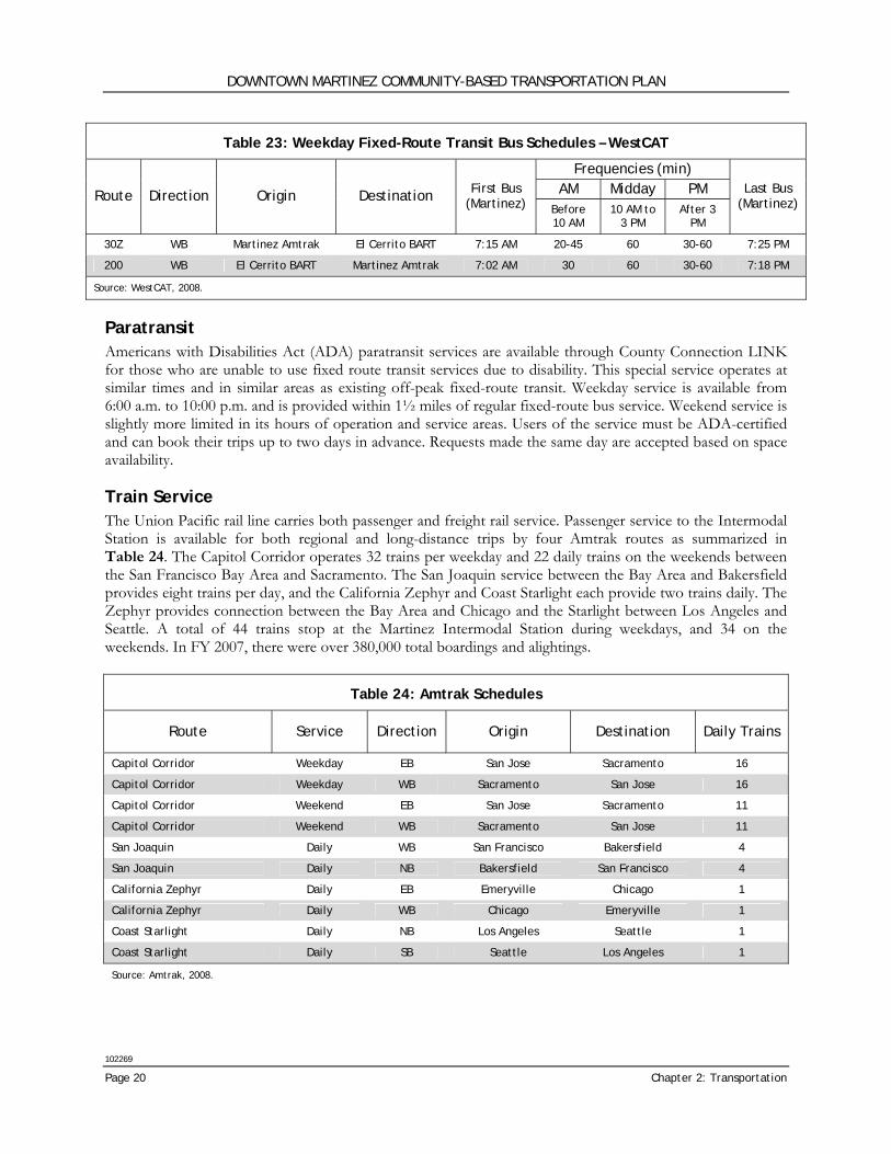
Table 23: Weekday Fixed-Route Transit Bus Schedules – WestCAT
Frequencies (min) AM Midday PM Route Direction Origin Destination First Bus
(Martinez) Before 10 AM
10 AM to 3 PM
After 3 PM
Last Bus (Martinez)
30Z WB Martinez Amtrak El Cerrito BART 7:15 AM 20-45 60 30-60 7:25 PM
200 WB El Cerrito BART Martinez Amtrak 7:02 AM 30 60 30-60 7:18 PM
Source: WestCAT, 2008.
Paratransit Americans with Disabilities Act (ADA) paratransit services are available through County Connection LINK for those who are unable to use fixed route transit services due to disability. This special service operates at similar times and in similar areas as existing off-peak fixed-route transit. Weekday service is available from 6:00 a.m. to 10:00 p.m. and is provided within 1½ miles of regular fixed-route bus service. Weekend service is slightly more limited in its hours of operation and service areas. Users of the service must be ADA-certified and can book their trips up to two days in advance. Requests made the same day are accepted based on space availability. Train Service The Union Pacific rail line carries both passenger and freight rail service. Passenger service to the Intermodal Station is available for both regional and long-distance trips by four Amtrak routes as summarized in Table 24. The Capitol Corridor operates 32 trains per weekday and 22 daily trains on the weekends between the San Francisco Bay Area and Sacramento. The San Joaquin service between the Bay Area and Bakersfield provides eight trains per day, and the California Zephyr and Coast Starlight each provide two trains daily. The Zephyr provides connection between the Bay Area and Chicago and the Starlight between Los Angeles and Seattle. A total of 44 trains stop at the Martinez Intermodal Station during weekdays, and 34 on the weekends. In FY 2007, there were over 380,000 total boardings and alightings.
Table 24: Amtrak Schedules
Route Service Direction Origin Destination Daily Trains
Capitol Corridor Weekday EB San Jose Sacramento 16
Capitol Corridor Weekday WB Sacramento San Jose 16
Capitol Corridor Weekend EB San Jose Sacramento 11
Capitol Corridor Weekend WB Sacramento San Jose 11
San Joaquin Daily WB San Francisco Bakersfield 4
San Joaquin Daily NB Bakersfield San Francisco 4
California Zephyr Daily EB Emeryville Chicago 1
California Zephyr Daily WB Chicago Emeryville 1
Coast Starlight Daily NB Los Angeles Seattle 1
Coast Starlight Daily SB Seattle Los Angeles 1
Source: Amtrak, 2008.
DOWNTOWN MARTINEZ COMMUNITY-BASED TRANSPORTATION PLAN
102269
Wilbur Smith Associates Page 21
Union Pacific operates about 25 freight trains daily that pass through Martinez. Future freight train growth is estimated to be a function of growth experienced at the Port of Oakland, which is currently planning a rail expansion. The proposed expansion in rail capacity at the port is not expected to affect the City of Martinez as the added rail will not run through the area. Future Ferry Service Ferry service between Martinez and Benecia operated from 1847 to 1962, when the Benecia Bridge was opened. Since the 1990’s, the City of Martinez has considered reinstituting this service but plans have always fallen through. Additional ferry service is being considered by the San Francisco Bay Area Water Emergency Transportation Agency along seven new routes on the Bay. An Antioch/Pittsburg to Martinez to San Francisco route is included for consideration with the trip from Martinez to San Francisco to take approximately 60 minutes. While ferry service would ease highway congestion, cut smog and global warming gases, and provide essential emergency access in the event of emergency, the source for funds to develop and operate the expanded ferry service is not yet identified. Specifically, development of the Martinez ferry service and terminal would provide an opportunity for downtown economic redevelopment, emergency access to Contra Costa County if highway and bridge access is disrupted, and a good connection to Amtrak and waterfront recreational facilities.
EXISTING TRANSIT ROUTESFIGURE 4
!
!
!!
!
!
!
!
!
!
!!
!
!
®3
Pine St.
Marina Vista Ave.
Berrellesa St.
Ward St.
Brown St.
Escobar St
.
Ferry St.
F St.
E St.
G St.
C St.
Warren St.
Bush St.
Susana St.
Allen St.
Talbart St.
Raap
Ave.
H St.
D St.
Soto St.Robinson St.
Lasalle St.
B St.
Haven St.
Willow St.
Jones St.
Buckley St.
Las Juntas St.
Masonic St.
Arch St.
Shell St.
Boynton Ave.
Beech
St.
Castro St.
Embarcadero St.
Foster St.
Carpenter Cir.
Barrel
hous
e Rd.
Gregory Ave.
Ash St.
Sunrise
Ct.
Bertola St.Richardson St.
Teresa St.
Ilene St.
Alhambra Ln.
Haven St.
Henrietta St.
Mellus St.
Pine St.
Foster St.
Shell Ave.
Green St.
Court St.
Jones St.
Main St.
Richardson St.
Warren St.
Arreba St.
A St.
Ferry St.
Foster St.
Estudillo St.
Intermodal Station
DOWNTOWN MARTINEZ COMMUNITY-BASED TRANSPORTATION PLAN
LEGEND Study Area
Sphere of Influence
®3 Intermodal Station
BUS ROUTESThe County Connection Routes: 108, 116, 118, 119, 308, 980
Tri Delta Transit Route 200, DX
WestCAT Transit Route 30Z
! Bus Stops (Tri Delta & WestCAT)
DOWNTOWN MARTINEZ COMMUNITY-BASED TRANSPORTATION PLAN
102269
Wilbur Smith Associates Page 23
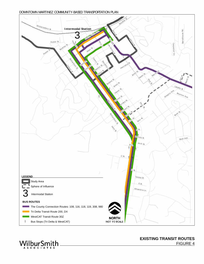
PEDESTRIAN AND BICYCLE FACILITIES Bicycle facilities found in Martinez include:
• Class I – separated path
• Class II – marked lanes on a roadway
• Class III – designated routes with no separate right-of-way area Bicycle facilities in the Downtown include both Class II and Class III facilities. These facilities are shown in Figure 5. Alhambra Avenue and Berrellesa Street include on-street striped bicycle lanes (Class II facilities) through the study area with the exception of northbound Alhambra Avenue between Haven and Bertola Streets which is a signed Class III route. Marina Vista Avenue and Escobar Street also include bicycle lanes from Court Street to the east. The bicycle lane on Marina Vista is westbound, while the lane on Escobar Street is eastbound. A segment of Ferry Street between Escobar Street heading north into Martinez Regional Shoreline Park also has Class II bicycle lanes. Finally, Pine Street south from Susana Street, continuing on Jones Street to Pacheco Boulevard has Class II bicycle lanes. Segments of the San Francisco Bay Trail are designated in Downtown Martinez but are currently unsigned as such. These include Marina Vista Avenue west from the Benicia-Martinez Bridge, Escobar Street, Talbart Street to Carquinez Scenic Drive. In addition, Alhambra Avenue and Berrellesa Street are also designated as part of the Bay Trail from Escobar Street to Highway 4. Most, but not all, of the streets within the Downtown have sidewalks. A majority of the crossing locations are at least partially marked with crosswalks. Complete pedestrian crosswalks are most prevalent along Alhambra Avenue, Main Street, and Ferry Street. The Martinez Downtown Specific Plan identified a number of pedestrian-priority streets, which serve the primary Downtown retail streets adding to the historic small-town character of the Downtown. These streets generally have wider sidewalks, lower traffic speeds, and pedestrian amenities, such as lighting and landscaping. The pedestrian-priority streets identified in the Plan are:
• Main Street (east of Berrellesa Street)
• Ferry Street (north of Green Street)
• Las Juntas (north of Ward)
• Estudillo (north of Main)
• Castro (north of Ward) The City was recently awarded funding for its Marina Vista Streetscape Project, which will improve pedestrian and bicycle facilities around the Intermodal Station. Improvements include the addition of bicycle lanes, pedestrian crossings, bulbouts, brick sidewalks, pedestrian-scale streetlights, and street trees. Marina Vista Avenue had been identified in the Downtown Specific Plan as one of the three Gateway Corridors to Downtown, prioritizing the corridor for streetscape and pedestrian and bicycle facility improvements.
DOWNTOWN MARTINEZ COMMUNITY-BASED TRANSPORTATION PLAN
102269
Page 24 Chapter 2: Transportation
ACCESS TO SCHOOLS Downtown Martinez is served by the Martinez Unified School District, which includes schools from grades K-12. The district has over 4,000 students and eight schools, including four elementary schools, one middle school, one high school, one continuation high school, and one independent study school. Only the middle school, Martinez Junior High, is located within the Downtown study area. County Connection Route 118 provides special additional service coordinated with school bell times to the school. The main bus stop near the middle school is located less than two blocks away, and is served by Routes 118 and 108. Saint Catherine of Siena School, which is also located within the study area, is a private Catholic K-8 elementary school. Bus stops along Alhambra Avenue and Berrellesa Street are located within a block of the school. Other schools that are part of the Martinez Unified School District are not located within the study area, but are served by some of the bus routes that run through the Downtown. Other schools in adjacent cities are also served by these routes as well. Route 118 also provides service to Morello Park Elementary in Martinez; Mt. Diablo High in Concord and Diablo Valley College in Pleasant Hill. Route 108 serves John Muir Elementary and Hidden Valley Elementary Schools and provides limited service to Diablo Valley College as well. Finally, Route 116 provides service to Alhambra High School and the Martinez Adult Education & Job Training Center in Martinez.
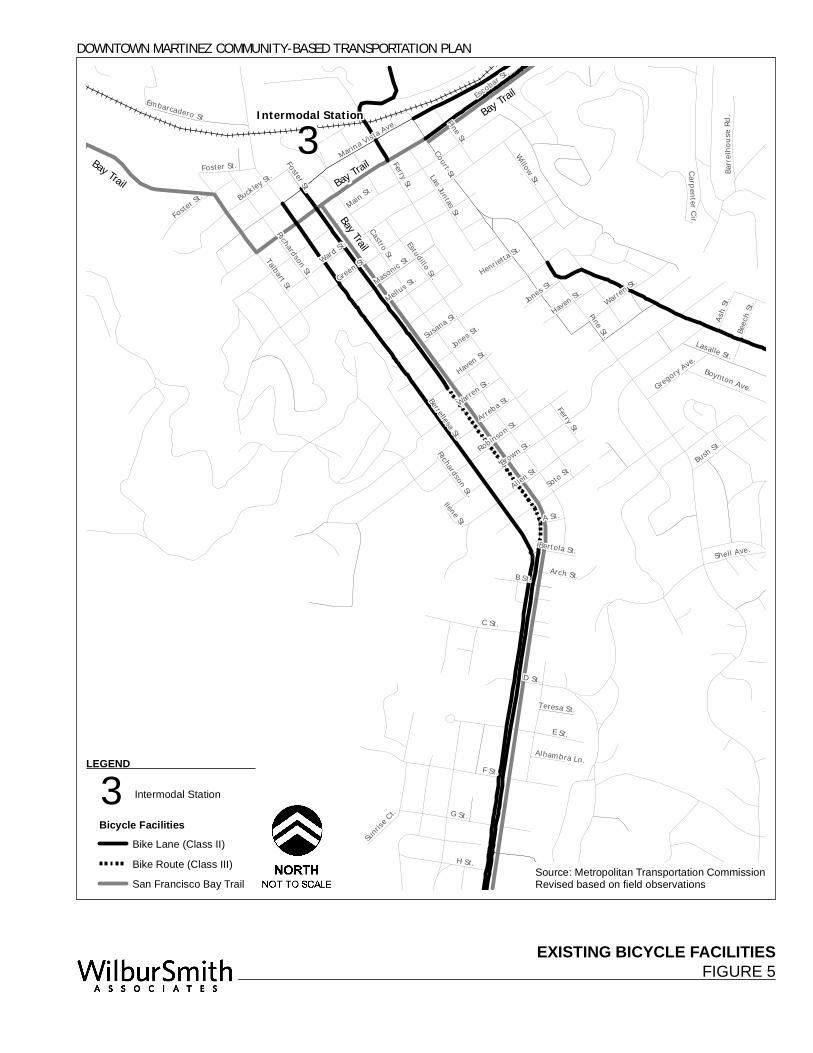
EXISTING BICYCLE FACILITIESFIGURE 5
®3
Pine St.
Marina Vista Ave.
Berrellesa St.
Ward St.
Brown St.
Escobar St
.
Ferry St.
F St.
E St.
G St.
C St.
Warren St.
Bush St.
Susana St.
Allen St.
Talbart St.
Raap
Ave.
H St.
D St.
Soto St.Robinson St.
Lasalle St.
B St.
Haven St.
Willow St.
Jones St.
Buckley St.
Las Juntas St.
Masonic St.
Arch St.
Shell St.
Boynton Ave.
Beech
St.
Castro St.
Embarcadero St.
Foster St.
Carpenter Cir.
Barrel
hous
e Rd.
Gregory Ave.
Ash St.
Sunrise
Ct.
Bertola St.Richardson St.
Teresa St.
Ilene St.
Alhambra Ln.
Haven St.
Henrietta St.
Mellus St.
Pine St.
Foster St.
Shell Ave.
Green St.
Court St.
Jones St.
Main St.
Richardson St.
Warren St.
Arreba St.
A St.
Ferry St.
Foster St.
Estudillo St.
Intermodal Station
DOWNTOWN MARTINEZ COMMUNITY-BASED TRANSPORTATION PLAN
Source: Metropolitan Transportation CommissionRevised based on field observations
Bay Trail Bay Trail
Bay Trail
Bay Trail
LEGEND
®3 Intermodal Station
Bicycle FacilitiesBike Lane (Class II)
Bike Route (Class III)
San Francisco Bay Trail

This page intentionally left blank
DOWNTOWN MARTINEZ COMMUNITY-BASED TRANSPORTATION PLAN
102269
Wilbur Smith Associates Page 27
Chapter 3: Relevant Studies, Reports and Plans
This section summarizes the findings of relevant local, county and regional studies that relate to transportation for the Downtown Martinez community and its residents. Some of these documents are quite dated; consequently, the needs identified in these documents may have been mitigated or other needs may have surfaced. Community outreach, as described in Chapter 4, was used to determine which of these needs still required improvements and/or continued to be of concern.
LOCAL STUDIES City of Martinez Downtown Specific Plan, July 2006 The Downtown Specific Plan was prepared to guide public and private investment to ensure that future development and infrastructure projects help realize the Martinez community’s goals and visions for the future of Downtown. The overall circulation plan is based on providing convenient access to Downtown Martinez for all transportation modes and encouraging pedestrian activity within Downtown wherever possible. The Plan established one of its goals as improving the circulation system in Downtown by maintaining and improving the grid system, providing for convenient access to, and circulation within, Downtown for all modes of transportation, and enhancing walkability in Downtown. Traffic circulation policies identified to help achieve this goal include: C-1-1. Use the multi-modal street hierarchy for Downtown identified in the Plan to prioritize street
improvement projects and target them to appropriate types of streets. C-1-2. Provide enhanced transit amenities within the Downtown, including bus stops and shelters, transit
information, and facilities at the Intermodal Station. C-1-3. Develop strong pedestrian connections between the Waterfront, the Intermodal Station, and the
Downtown Core using streetscape improvements to encourage pedestrian mobility at the sidewalk level.
C-1-4. Do not permit any further street closures in the Downtown area, except for possible future conversion of streets to pedestrian malls.
C-1-5. Provide continuous bike lanes on major streets approaching Downtown and within Downtown where warranted by traffic volumes.
C-1-6. Improve way-finding signage, including directional, destination-related, and signage for parking facilities as well as signs identifying regional trails.
The Plan also defines three corridors as Multi-Modal Streets, which make up the Gateway Corridors. These corridors are intended to serve auto, transit, and bicycle circulation and balance the needs of all these modes. Thus, they have been prioritized for pedestrian and bicycle facility improvements. The Multi-Modal Streets identified are:
• Alhambra Gateway Corridor – Alhambra Avenue/Berrellesa Street
• Marina Vista Gateway Corridor – Marina Vista Avenue/Escobar Street (east of Berrellesa Street)
• Pacheco Gateway Corridor – Court Street/Pine Street/Pacheco Boulevard
DOWNTOWN MARTINEZ COMMUNITY-BASED TRANSPORTATION PLAN
102269
Page 28 Chapter 3: Relevant Studies, Reports and Plans
City of Martinez General Plan, 1973 The City of Martinez General Plan serves as the planning guideline for the future of the City including the goals, policies, and programs outlining the community’s vision for economic vitality, livable neighborhoods, and environmental protection. The goal the Circulation Element is to provide residents with access to jobs, goods, and services in a manner that is respectful of the natural environment. The Central Martinez Specific Area Plan states that the Martinez circulation system should provide a network for all types of movement, including automobile, bicycle, pedestrians, and equestrian routes, and that Martinez should be provided with an efficient vehicular system with a variety of streets designated according to primary use. It should be noted that the General Plan is in the process of being updated. City of Martinez Transportation Element, January 1992 The City of Martinez Transportation Element is an amendment to the previous General Plan and replaces the 1973 Circulation Element. The Transportation Element recognizes the need for a broad approach to address local and regional transportation issues. The Plan supports the development of a balanced transportation system and includes plans, goals, and policies for bikeways, rail, ferry, and transit and parking facilities. Some of the relevant goals and policies established in the Element include: IV. Promote bicycle use.
A. Implement the bikeway plan. 1. Add bike lanes whenever possible in conjunction with road reconstruction or
restriping projects in accordance with the bikeway plan. 2. Seek funding sources to implement the bikeway plan in locations where more than
restriping is required. B. Provide ancillary facilities necessary to encourage bicycling. 1. Provide secure bicycle parking at all parks, schools, and public buildings. C. Increase bicycle safety. D. Promote bicycle education.
V. Encourage commute alternatives. B. Enhance and plan for transit needs.
2. Work with transit providers to obtain better bus service in Martinez. 3. Work with transit providers to provide bus turnout and shelters as bus stops.
6. Support the provision of ferry service to Martinez. C. Support intermodal transportation facility.
1. Continue to develop the AMTRAK station as a multi-modal terminal to provide facilities for both local and intercity transit services.
VI. Encourage pedestrian travel. A. Provide and maintain sidewalks where required.
1. Require new developments to include sidewalks except in rural residential areas. 2. Promote the addition of sidewalks to existing streets except in rural residential areas.
DOWNTOWN MARTINEZ COMMUNITY-BASED TRANSPORTATION PLAN
102269
Wilbur Smith Associates Page 29
CONTRA COSTA COUNTY STUDIES Contra Costa Countywide Comprehensive Transportation Plan, 2004 Update, May 2004 As stated in the Plan, the Comprehensive Transportation Plan (CTP), prepared by the Contra Costa Transportation Authority (CCTA), is intended to provide the overall direction and coordinated approach for achieving and maintaining a balanced and functional transportation system within Contra Costa while strengthening links between land use decisions and transportation. It outlines the Authority’s vision for Contra Costa County and establishes goals, strategies, specific projects, and other actions for achieving that vision. One of the main goals established by the Authority to direct the actions of the Plan is the expansion of safe, convenient, and affordable alternatives to the single-occupant vehicle. The strategies identified to help achieve this goal are as follows: 3.1 Help fund the expansion of existing transit services, and maintenance of existing operations,
including BART, bus transit, school buses, and paratransit. 3.2 Link transit investments to increased coordination and integration of public transit services, and
improved connections between travel modes. 3.3 Require local jurisdictions to incorporate policies and standards that support transit, bicycle, and
pedestrian access in new developments. 3.4 Support transit-oriented and pedestrian-friendly developments. 3.5 Invest in trails, walkways, and pedestrian-oriented improvements. 3.6 Promote formation of more carpools and vanpools, and greater use of transit, bicycling, and walking. 3.7 Support the expansion of a coordinated system of transit and paratransit service to address the
mobility needs of low-income, elderly, young, and disabled travelers. 3.8 Encourage local jurisdictions to develop bicycle facilities and to connect those facilities into a
coordinated network. Central Contra Costa Updated Action Plans, July 2000 Prepared by TRANSPAC, the Regional Transportation Planning Committee for Central Contra Costa, which operates under the CCTA, the Action Plan has been incorporated into the Countywide CTP. As one of the key components of the Authority’s Growth Management Program, the Action Plan is intended to reduce cumulative regional traffic impacts of forecast development. The development of the Plan is in direct response to the goals, objectives, and issue identified by the Central Contra Costa jurisdictions, including the City of Martinez. Although much of the focus of this Plan is on responding to future growth in traffic and automobile use, the Plan also addresses goals and actions regarding the use of alternative modes. The Action Plan is currently being revised. Some of these actions include: Action 5. Promote the expansion and development of an effective transit network within and through
Contra Costa County, including feeder service to BART. Action 16. Pursue funding to implement regional and local pedestrian and bicycle plans and work with
CCTA to assess the feasibility of developing a Countywide Bicycle Plan which meets Caltrans’ Bicycle Lane Account planning requirements. Bicycle and pedestrian plans should address how to provide and/or improve access to regional activity and transit centers.
DOWNTOWN MARTINEZ COMMUNITY-BASED TRANSPORTATION PLAN
102269
Page 30 Chapter 3: Relevant Studies, Reports and Plans
Central Contra Costa Transit Authority Short Range Transit Plan, FY 2005-2014, June 2006 The 2006 Central Contra Costa Transit Authority (CCCTA), or County Connection, Short Range Transit Plan (SRTP) serves as a general plan of likely future service scenarios that may be implemented within the time frame of the plan and provides justification for funding requests consistent with the Plan and its established goals and objectives. The three main summary goals established for both fixed-route and paratransit services are as follows: I. Efficiency – To operate as efficiently, economically, and safely as possible in order to maximize the
cost of transit service to both users and taxpayers and ensure the financial security of the system. II. Effectiveness – To provide an effective, innovative alternative to the use of the private automobile
through the administration, finance, and operation of various mass transit services. III. Equity – To contribute to the area’s economic well-being by improving access to employment,
shopping, and other important activity centers through the provision of a transit system to the general public including those without other means of transportation available to them, the mobility-limited, senior citizens, low-income persons, and youth.
Contra Costa Paratransit Improvement Study, Final Report and Action Plan, March 2004 The CCTA’s Paratransit Improvement Study developed a set of prioritized recommendations and an action plan to improve the efficiency and effectiveness of the paratransit services in Contra Costa County. The following guidelines were used in the development of service plan strategies:
• Universal access including an accessible infrastructure;
• Flexible mobility options with a cost-effective mix of accessible shared-ride, public transportation services; and
• Maximum utility and investment in accessible conventional transit (mobility management strategies) to encourage a shift from paratransit to conventional public transit.
Some of the objectives established in developing recommendations were to:
• Preserve the integrity of paratransit (both ADA and non-ADA) services for individuals with a disability who are unable to use accessible conventional transit; and
• Provide flexible mobility options for the County’s senior and disabled communities with a cost-effective mix of accessible shared-ride public transportation services.
Contra Costa Countywide Bicycle and Pedestrian Plan, December 2003 The Contra Costa Countywide Bicycle and Pedestrian Plan (CBPP) was developed in response to the goal established in the Countywide CTP of promoting alternatives to the single-occupant automobile, such as walking and bicycling, and need for a countywide bicycle plan. The Plan provides an evaluation of existing bicycle and pedestrian facilities and conditions, outlines and identifies the needs of the County and local communities, and offers guidance on achieving and implementing the established goals. As stated in the Plan, the CBPP is to serve as the foundation for improving safety and attractiveness of bicycling and walking in Contra Costa. Five goals were established in the Plan: 1. Expand, improve, and maintain facilities for bicycling and walking 2. Improve safety for bicyclists and pedestrians 3. Encourage more people to bicycle and walk 4. Support local efforts to encourage walking and bicycling 5. Plan for the needs of bicyclists and pedestrians
DOWNTOWN MARTINEZ COMMUNITY-BASED TRANSPORTATION PLAN
102269
Wilbur Smith Associates Page 31
Implementation actions were identified on both the Authority level and the local level. The four local actions necessary for implementation of the CBPP were to:
• Identify projects, assess their feasibility, design, and seek funding;
• Review and revise local plans and policies to incorporate policies that promote development patterns that improve the safety, convenience, and attractiveness of walking and bicycling;
• Develop local bicycle and pedestrian plans; and
• Modify local ordinances, development standards, and guidelines. A number of the bicycle and pedestrian improvement projects proposed in this Plan include projects within the Downtown Martinez area, ranging from the construction of new facilities to extensions and gap closures. Those identified in the Plan include projects along the following corridors:
• Alhambra Avenue/Berrellesa Street
• Bay Trail
• Marina Vista Avenue
• North Court Street It should be noted that some of these projects may have been completed since the study was completed. One of the priority corridors identified for bikeway improvements is the Crockett/Martinez connector bikeway, which spans from the Carquinez Bridge to the existing bike lanes on Alhambra Avenue in Downtown Martinez.
REGIONAL STUDIES Lifeline Transportation Network Report: 2001 Regional Transportation Plan for the San Francisco Bay Area, December 2001 The purpose of this report was to identify transit services serving low-income individuals and families who are in critical need of these services. This report also made recommendations to communities where there may be transportation gaps. The Lifeline Transportation Network Report identifies Downtown Martinez as having a high concentration of households participating in the CalWORKs program and is served by several routes included in the lifeline network. The Lifeline Transportation Network Report identifies routes that are critical to low-income areas because they provide:
• Direct Service to a neighborhood with a high concentration of households participating in the CalWORKs program for moving people from welfare to work;
• Service directly to areas with high concentrations of essential destinations;
• Core line trunkline route operating along a major corridor carrying a large number of passengers and running at frequent headways as identified by the transit operator; or
• A key regional link. The study concluded that low-income residents need greater access to public transit services later during the day, more frequently during the day and more extensively on weekends. The MTC-adopted service objectives for proposed Lifeline Transit Routes, including County Connection and WestCAT routes serving Downtown Martinez, include the following service goals:
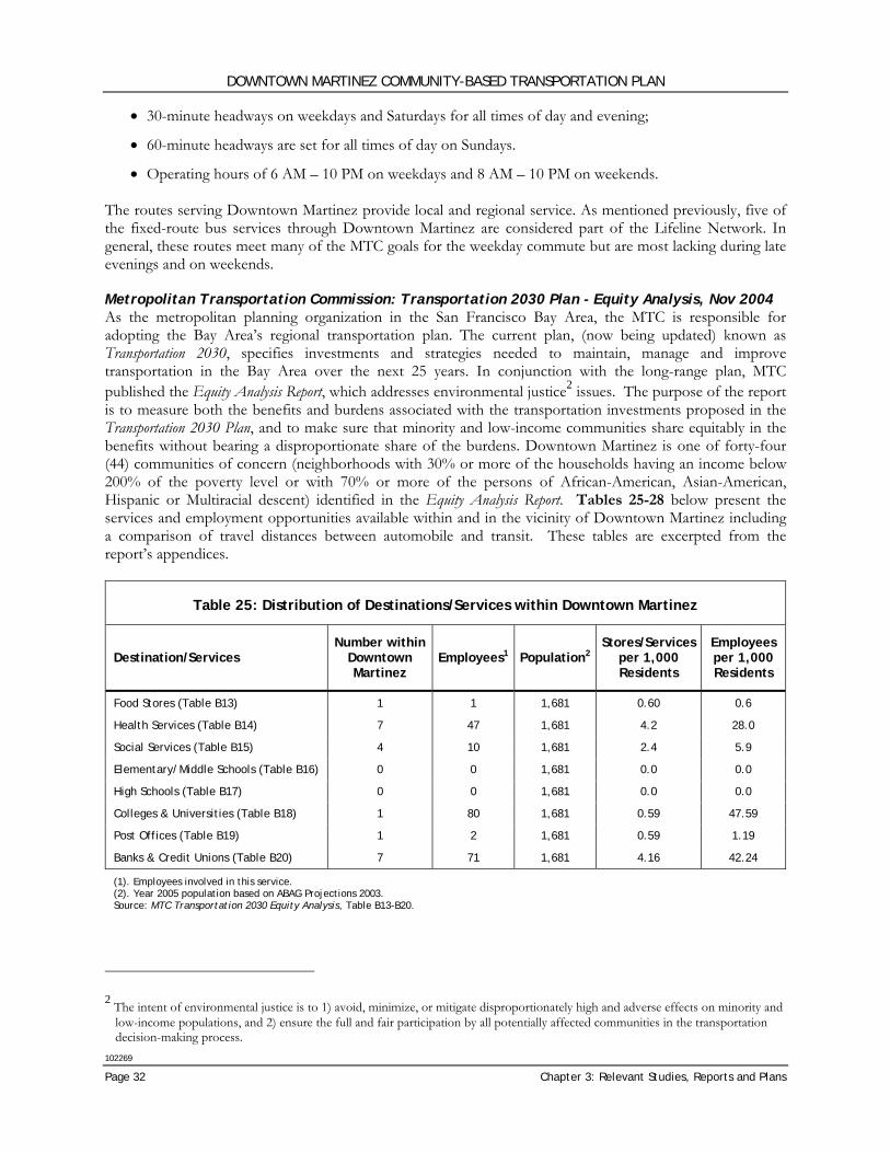
DOWNTOWN MARTINEZ COMMUNITY-BASED TRANSPORTATION PLAN
102269
Page 32 Chapter 3: Relevant Studies, Reports and Plans
• 30-minute headways on weekdays and Saturdays for all times of day and evening;
• 60-minute headways are set for all times of day on Sundays.
• Operating hours of 6 AM – 10 PM on weekdays and 8 AM – 10 PM on weekends. The routes serving Downtown Martinez provide local and regional service. As mentioned previously, five of the fixed-route bus services through Downtown Martinez are considered part of the Lifeline Network. In general, these routes meet many of the MTC goals for the weekday commute but are most lacking during late evenings and on weekends. Metropolitan Transportation Commission: Transportation 2030 Plan - Equity Analysis, Nov 2004 As the metropolitan planning organization in the San Francisco Bay Area, the MTC is responsible for adopting the Bay Area’s regional transportation plan. The current plan, (now being updated) known as Transportation 2030, specifies investments and strategies needed to maintain, manage and improve transportation in the Bay Area over the next 25 years. In conjunction with the long-range plan, MTC published the Equity Analysis Report, which addresses environmental justice2 issues. The purpose of the report is to measure both the benefits and burdens associated with the transportation investments proposed in the Transportation 2030 Plan, and to make sure that minority and low-income communities share equitably in the benefits without bearing a disproportionate share of the burdens. Downtown Martinez is one of forty-four (44) communities of concern (neighborhoods with 30% or more of the households having an income below 200% of the poverty level or with 70% or more of the persons of African-American, Asian-American, Hispanic or Multiracial descent) identified in the Equity Analysis Report. Tables 25-28 below present the services and employment opportunities available within and in the vicinity of Downtown Martinez including a comparison of travel distances between automobile and transit. These tables are excerpted from the report’s appendices.
Table 25: Distribution of Destinations/Services within Downtown Martinez
Destination/Services Number within
Downtown Martinez
Employees1 Population2 Stores/Services
per 1,000 Residents
Employees per 1,000 Residents
Food Stores (Table B13) 1 1 1,681 0.60 0.6
Health Services (Table B14) 7 47 1,681 4.2 28.0
Social Services (Table B15) 4 10 1,681 2.4 5.9
Elementary/Middle Schools (Table B16) 0 0 1,681 0.0 0.0
High Schools (Table B17) 0 0 1,681 0.0 0.0
Colleges & Universities (Table B18) 1 80 1,681 0.59 47.59
Post Offices (Table B19) 1 2 1,681 0.59 1.19
Banks & Credit Unions (Table B20) 7 71 1,681 4.16 42.24
(1). Employees involved in this service. (2). Year 2005 population based on ABAG Projections 2003. Source: MTC Transportation 2030 Equity Analysis, Table B13-B20.
2 The intent of environmental justice is to 1) avoid, minimize, or mitigate disproportionately high and adverse effects on minority and
low-income populations, and 2) ensure the full and fair participation by all potentially affected communities in the transportation decision-making process.
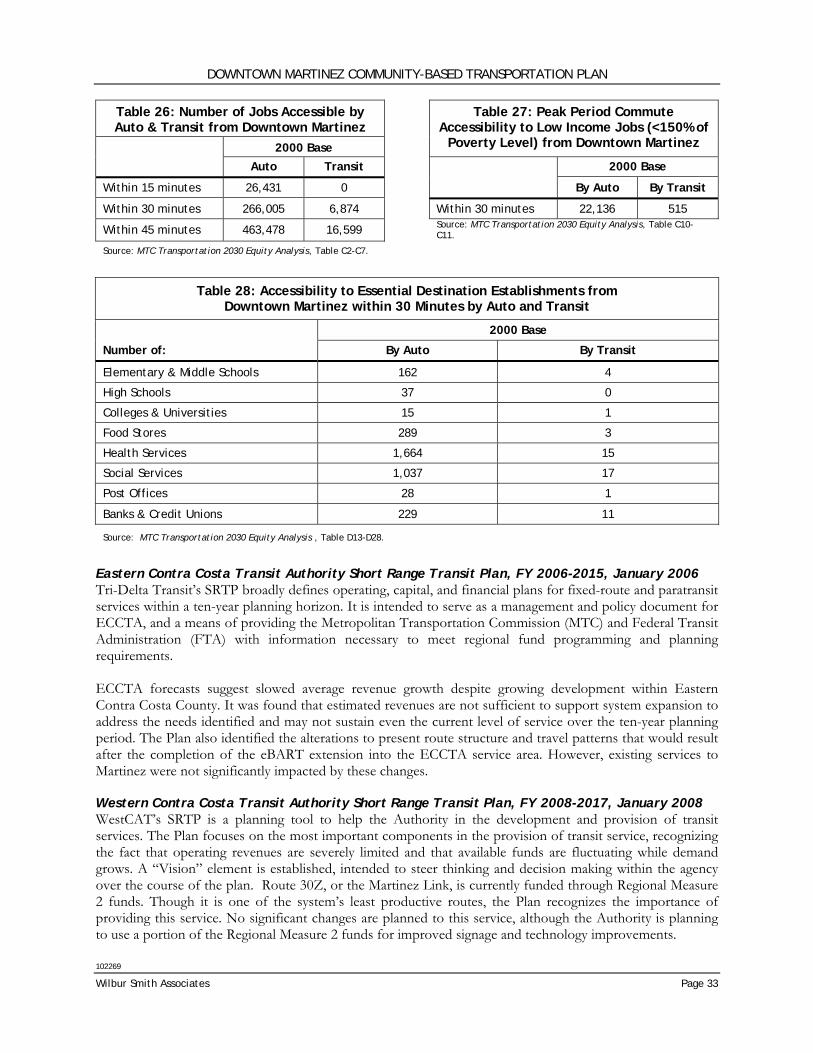
DOWNTOWN MARTINEZ COMMUNITY-BASED TRANSPORTATION PLAN
102269
Wilbur Smith Associates Page 33
Table 26: Number of Jobs Accessible by Auto & Transit from Downtown Martinez
2000 Base
Table 27: Peak Period Commute Accessibility to Low Income Jobs (<150% of
Poverty Level) from Downtown Martinez
Auto Transit 2000 Base
Within 15 minutes 26,431 0 By Auto By Transit
Within 30 minutes 266,005 6,874 Within 30 minutes 22,136 515
Within 45 minutes 463,478 16,599 Source: MTC Transportation 2030 Equity Analysis, Table C10-C11.
Source: MTC Transportation 2030 Equity Analysis, Table C2-C7.
Eastern Contra Costa Transit Authority Short Range Transit Plan, FY 2006-2015, January 2006 Tri-Delta Transit’s SRTP broadly defines operating, capital, and financial plans for fixed-route and paratransit services within a ten-year planning horizon. It is intended to serve as a management and policy document for ECCTA, and a means of providing the Metropolitan Transportation Commission (MTC) and Federal Transit Administration (FTA) with information necessary to meet regional fund programming and planning requirements. ECCTA forecasts suggest slowed average revenue growth despite growing development within Eastern Contra Costa County. It was found that estimated revenues are not sufficient to support system expansion to address the needs identified and may not sustain even the current level of service over the ten-year planning period. The Plan also identified the alterations to present route structure and travel patterns that would result after the completion of the eBART extension into the ECCTA service area. However, existing services to Martinez were not significantly impacted by these changes. Western Contra Costa Transit Authority Short Range Transit Plan, FY 2008-2017, January 2008 WestCAT’s SRTP is a planning tool to help the Authority in the development and provision of transit services. The Plan focuses on the most important components in the provision of transit service, recognizing the fact that operating revenues are severely limited and that available funds are fluctuating while demand grows. A “Vision” element is established, intended to steer thinking and decision making within the agency over the course of the plan. Route 30Z, or the Martinez Link, is currently funded through Regional Measure 2 funds. Though it is one of the system’s least productive routes, the Plan recognizes the importance of providing this service. No significant changes are planned to this service, although the Authority is planning to use a portion of the Regional Measure 2 funds for improved signage and technology improvements.
Table 28: Accessibility to Essential Destination Establishments from Downtown Martinez within 30 Minutes by Auto and Transit
2000 Base
Number of: By Auto By Transit
Elementary & Middle Schools 162 4
High Schools 37 0
Colleges & Universities 15 1
Food Stores 289 3
Health Services 1,664 15
Social Services 1,037 17
Post Offices 28 1
Banks & Credit Unions 229 11
Source: MTC Transportation 2030 Equity Analysis , Table D13-D28.

This page intentionally left blank
DOWNTOWN MARTINEZ COMMUNITY-BASED TRANSPORTATION PLAN
102269
Wilbur Smith Associates Page 35
Chapter 4: Community Outreach
Outreach to the Downtown Martinez community was crucial to the success of this community-based planning process. It was important that all affected groups (residents, employees, business owners and visitors) were given the opportunity to discuss transportation needs and deficiencies as well as respond to the solutions formulated as a result of the process. The components of the outreach effort included a Stakeholder Committee, community survey, project website and a community open house. In this chapter, the outreach methodology is described followed by a summary of the input collected during the outreach process.
OUTREACH STRATEGY The outreach strategy described here is designed to fully involve Downtown Martinez residents, workers, businesses, public agencies, disabled, seniors, and youth in the discussion of transportation needs, gaps and potential solutions for the Downtown Martinez transportation network. The study looked at travel by walking, bicycling, driving, and transit. With everyone’s busy schedules, it was important to go to the community rather than expect them to come to the CBTP. Stakeholder Committee The Stakeholder Committee was composed of neighborhood residents and business owners, school officials, representatives from public agencies providing services in the community, and from community-based organizations representing residents, disabled, seniors and youth. The Committee was selected by the City of Martinez to guide the planning process. The City continued to look for relevant and interested community representatives to serve on the committee throughout the process. Committee members worked with their neighbors, the organizations they represent and other interested people to learn about transportation issues, identify and evaluate possible solutions, and recommend a list of improvements that would make it safer and more comfortable for people to walk, bike, drive, and use a bus in Downtown Martinez. The Committee met five times during the planning process to oversee the preparation of the community-based transportation plan. Project Website A project website was developed and maintained by Wilbur Smith Associates providing project status updates. Visitors to the website were able to download project reports, find project contacts for additional information, join the project mailing list and complete the Community Survey. The website address was www.DowntownMartinezCBTP.com. At completion of the CBTP, posted materials can be found at the City of Martinez website at www.cityofmartinez.org/depts/planning/transportation_plan.asp. Project Fact Sheet A project fact sheet was developed and updated through the process describing the purpose and timeline for the project. The fact sheet served as an introduction to and advertisement for the project. The fact sheet was posted on the website, distributed with the Community Survey, and included in organization newsletters. The Project Fact Sheet is included in Appendix A.
DOWNTOWN MARTINEZ COMMUNITY-BASED TRANSPORTATION PLAN
102269
Page 36 Chapter 4: Community Outreach
Community Survey The Community Survey was used to solicit input from the community (residents and workers) regarding their travel patterns, difficulties and needs. Surveys were distributed at different events, meetings and organizations to get response from a good cross-section of the community. Survey Instrument The survey, prepared by Wilbur Smith Associates with input from the Stakeholder Committee, was designed to identify the travel difficulties respondents are currently experiencing as well as to gather feedback and priorities on suggested potential solutions. The Community Survey is included in Appendix B. The survey questions focused on:
• How and where respondents and their families currently travel to work, school, errands, and recreation;
• For what trip types (work, school, errand, etc) respondents and their families need better transportation;
• What specific transportation needs they and their families have in making daily trips;
• Which potential solutions would most benefit them; and
• What other solutions they would recommend. Distribution Methodology Advertisement of the project and distribution of the community survey was performed by the City of Martinez with support from Wilbur Smith Associates. Media advertising, the CBTP website, organization newsletters and community/organization events were utilized. Members of the Stakeholder Committee also assisted in distribution of the survey to their organizations and community groups. Completed surveys were collected from a representative cross-section of the community including residents, employees, students, seniors, disabled community, transit users, pedestrians and bicyclists. At total of 229 completed surveys were finally collected. Although a Spanish version was available at most distribution points and on-line, no surveys in Spanish were completed. Distribution of the survey included:
Media/newsletter advertising
• Article in Martinez News-Gazette on July 15, 2008.
• Article in Contra Costa Times on August 11, 2008.
• Announcements on Public Access TV Station.
• Article in July 2008 Ride On – newsletter of the East Bay Bicycle Coalition.
• St. Catherine of Siena – Notice in bulletin and announcements made. 250 surveys and a collection box provided at the church.
• Announcement and survey distributed in Senior Center bulletin in August. Surveys and a collection box were available at the Center.
Community Organizations/Events
• RES Success
• Martinez United Methodist Church
DOWNTOWN MARTINEZ COMMUNITY-BASED TRANSPORTATION PLAN
102269
Wilbur Smith Associates Page 37
• Surveys were distributed at Farmer’s Market with assistance from RES Success on August 14, 2008.
• A presentation was made at the Martinez Senior Center for senior center members and other community members at 10 a.m. on August 15, 2008.
• Surveys were distributed at Martinez Early Childhood Center.
• Martinez Adult Education – 250 surveys and a collection box were provided.
• Eden survey provided by e-mail to property manager.
• Friends Outside survey sent by e-mail.
Transit Riders
• Surveys distributed at Martinez Amtrak Station on August 7, 2008 to boarding passengers in the AM/midday and to arriving passengers in the PM. A collection box was provided in the station. Approximately 40 surveys handed out; 10 completed surveys were collected at the station.
• On-board County Connection Bus Routes 108, 116, 118 on August 12, 2008 - 11, 9, and 21 surveys were collected on each route, respectively.
Miscellaneous
• The survey was available in English and Spanish on-line using SurveyMonkey, an on-line survey tool, linked from the CBTP website. The City of Martinez homepage also provided information on the survey under latest news including a link to the project website. 37 surveys were collected from SurveyMonkey.
• Surveys and collection boxes were provided at the Library and City Hall. Spanish surveys were available through City Hall. 15 surveys were collected at the Library and 11 at City Hall.
• The Senior Center and the Martinez Adult Education Center both had a significant number of responses to the survey with 47 surveys and 65 surveys collected, respectively representing almost 50 percent of total respondents.
• Surveys were distributed to residents on the project mailing list. Community Survey Results As previously mentioned, a total of 229 surveys were collected with the majority of the respondents either living or working in the study area. A small percentage (15 percent) replied that they neither lived nor worked in the study area. These surveys have been included in the following analysis for two reasons: 1) the boundaries of the study area are not conspicuously apparent and it was felt that respondents may have incorrectly answered in the negative and 2) because respondents took the time to fill out the survey, they had an interest in or need for better transportation within the study area. The background questions showed that the majority of respondents either live or work in the study area with 17 percent both living and working in the study area. Based on the demographic make up of Downtown Martinez, as reported in the Downtown Martinez Community-Based Transportation Plan Background Report, the community survey captured a representative cross section of study area users and residents. 74 percent of surveys received were from respondents between 18 to 64 years of age, a rate of response that closely mirrors this group’s actual representation among study area residents (72 percent). Seniors, however, responded to the survey at a slightly elevated rate (seniors accounted for 19% of survey responses but comprise only 10% of the study area’s population). This response to the survey can be attributed to the wide distribution of the survey to seniors through the Senior Bulletin and participation of the Martinez Senior Center. The survey did capture a percentage of the disabled community in the study area. However, the majority of residents were
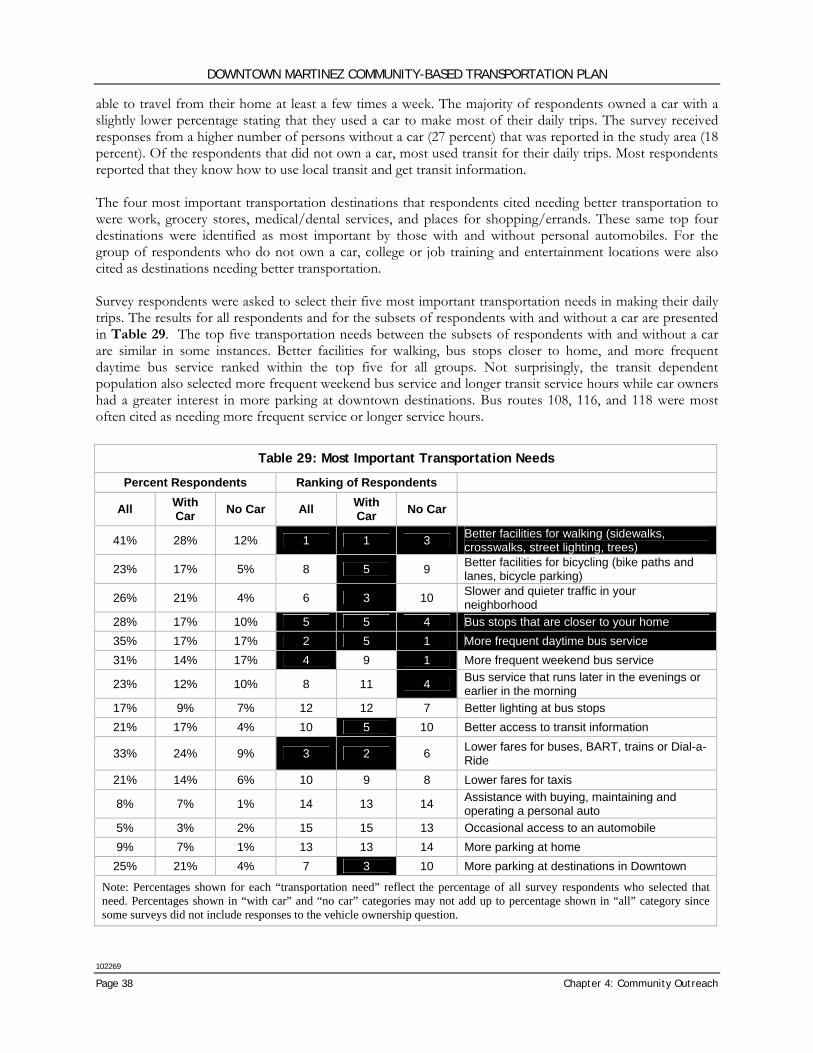
DOWNTOWN MARTINEZ COMMUNITY-BASED TRANSPORTATION PLAN
102269
Page 38 Chapter 4: Community Outreach
able to travel from their home at least a few times a week. The majority of respondents owned a car with a slightly lower percentage stating that they used a car to make most of their daily trips. The survey received responses from a higher number of persons without a car (27 percent) that was reported in the study area (18 percent). Of the respondents that did not own a car, most used transit for their daily trips. Most respondents reported that they know how to use local transit and get transit information. The four most important transportation destinations that respondents cited needing better transportation to were work, grocery stores, medical/dental services, and places for shopping/errands. These same top four destinations were identified as most important by those with and without personal automobiles. For the group of respondents who do not own a car, college or job training and entertainment locations were also cited as destinations needing better transportation. Survey respondents were asked to select their five most important transportation needs in making their daily trips. The results for all respondents and for the subsets of respondents with and without a car are presented in Table 29. The top five transportation needs between the subsets of respondents with and without a car are similar in some instances. Better facilities for walking, bus stops closer to home, and more frequent daytime bus service ranked within the top five for all groups. Not surprisingly, the transit dependent population also selected more frequent weekend bus service and longer transit service hours while car owners had a greater interest in more parking at downtown destinations. Bus routes 108, 116, and 118 were most often cited as needing more frequent service or longer service hours.
Table 29: Most Important Transportation Needs
Percent Respondents Ranking of Respondents
All With Car No Car All With
Car No Car
41% 28% 12% 1 1 3 Better facilities for walking (sidewalks, crosswalks, street lighting, trees)
23% 17% 5% 8 5 9 Better facilities for bicycling (bike paths and lanes, bicycle parking)
26% 21% 4% 6 3 10 Slower and quieter traffic in your neighborhood
28% 17% 10% 5 5 4 Bus stops that are closer to your home 35% 17% 17% 2 5 1 More frequent daytime bus service 31% 14% 17% 4 9 1 More frequent weekend bus service
23% 12% 10% 8 11 4 Bus service that runs later in the evenings or earlier in the morning
17% 9% 7% 12 12 7 Better lighting at bus stops 21% 17% 4% 10 5 10 Better access to transit information
33% 24% 9% 3 2 6 Lower fares for buses, BART, trains or Dial-a-Ride
21% 14% 6% 10 9 8 Lower fares for taxis
8% 7% 1% 14 13 14 Assistance with buying, maintaining and operating a personal auto
5% 3% 2% 15 15 13 Occasional access to an automobile 9% 7% 1% 13 13 14 More parking at home 25% 21% 4% 7 3 10 More parking at destinations in Downtown
Note: Percentages shown for each “transportation need” reflect the percentage of all survey respondents who selected that need. Percentages shown in “with car” and “no car” categories may not add up to percentage shown in “all” category since some surveys did not include responses to the vehicle ownership question.
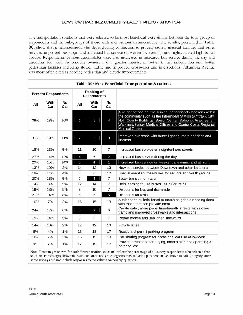
DOWNTOWN MARTINEZ COMMUNITY-BASED TRANSPORTATION PLAN
102269
Wilbur Smith Associates Page 39
The transportation solutions that were selected to be most beneficial were similar between the total group of respondents and the sub-groups of those with and without an automobile. The results, presented in Table 30, show that a neighborhood shuttle, including connection to grocery stores, medical facilities and other services, improved bus stops, and increased bus service on weekends, evenings and nights ranked high for all groups. Respondents without automobiles were also interested in increased bus service during the day and discounts for taxis. Automobile owners had a greater interest in better transit information and better pedestrian facilities including slower traffic and improved crosswalks and intersections. Alhambra Avenue was most often cited as needing pedestrian and bicycle improvements.
Table 30: Most Beneficial Transportation Solutions
Percent Respondents Ranking of Respondents
All With Car
No Car All With
Car No Car
39% 28% 10% 1 1 4
A neighborhood shuttle service that connects locations within the community such as the Intermodal Station (Amtrak), City Hall, County Buildings, Senior Center, Safeway, Walgreens, Wal-mart, Kaiser Medical Offices and Contra Costa Regional Medical Center
31% 19% 11% 2 2 3 Improved bus stops with better lighting, more benches and shelters
18% 13% 5% 11 10 7 Increased bus service on neighborhood streets
27% 14% 12% 4 6 2 Increased bus service during the day 29% 15% 14% 3 4 1 Increased bus service on weekends, evening and at night 13% 10% 3% 14 12 13 New bus service between Downtown and other locations 19% 14% 4% 8 6 12 Special event shuttles/buses for seniors and youth groups 20% 15% 5% 7 4 7 Better transit information 14% 8% 5% 12 14 7 Help learning to use buses, BART or trains 19% 13% 5% 8 10 7 Discounts for bus and dial-a-ride 21% 14% 8% 6 6 5 Discounts for taxis
10% 7% 3% 15 15 13 A telephone bulletin board to match neighbors needing rides with those that can provide them
24% 17% 6% 5 3 6 Create safer, more pedestrian-friendly streets with slower traffic and improved crosswalks and intersections
19% 14% 5% 8 6 7 Repair broken and unaligned sidewalks
14% 10% 3% 12 12 13 Bicycle lanes
6% 4% 1% 18 18 17 Residential permit parking program 10% 7% 3% 15 15 13 Car sharing program for occasional car use at low cost
9% 7% 1% 17 15 17 Provide assistance for buying, maintaining and operating a personal car
Note: Percentages shown for each “transportation solution” reflect the percentage of all survey respondents who selected that solution. Percentages shown in “with car” and “no car” categories may not add up to percentage shown in “all” category since some surveys did not include responses to the vehicle ownership question.
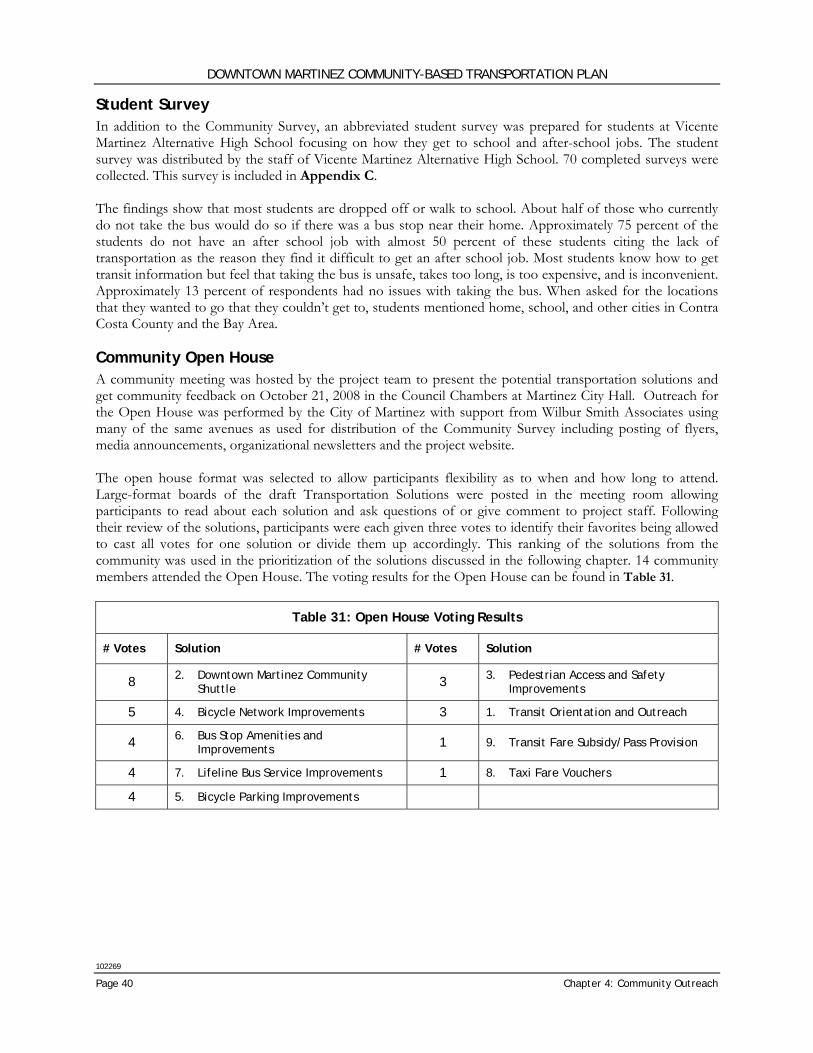
DOWNTOWN MARTINEZ COMMUNITY-BASED TRANSPORTATION PLAN
102269
Page 40 Chapter 4: Community Outreach
Student Survey In addition to the Community Survey, an abbreviated student survey was prepared for students at Vicente Martinez Alternative High School focusing on how they get to school and after-school jobs. The student survey was distributed by the staff of Vicente Martinez Alternative High School. 70 completed surveys were collected. This survey is included in Appendix C. The findings show that most students are dropped off or walk to school. About half of those who currently do not take the bus would do so if there was a bus stop near their home. Approximately 75 percent of the students do not have an after school job with almost 50 percent of these students citing the lack of transportation as the reason they find it difficult to get an after school job. Most students know how to get transit information but feel that taking the bus is unsafe, takes too long, is too expensive, and is inconvenient. Approximately 13 percent of respondents had no issues with taking the bus. When asked for the locations that they wanted to go that they couldn’t get to, students mentioned home, school, and other cities in Contra Costa County and the Bay Area. Community Open House A community meeting was hosted by the project team to present the potential transportation solutions and get community feedback on October 21, 2008 in the Council Chambers at Martinez City Hall. Outreach for the Open House was performed by the City of Martinez with support from Wilbur Smith Associates using many of the same avenues as used for distribution of the Community Survey including posting of flyers, media announcements, organizational newsletters and the project website. The open house format was selected to allow participants flexibility as to when and how long to attend. Large-format boards of the draft Transportation Solutions were posted in the meeting room allowing participants to read about each solution and ask questions of or give comment to project staff. Following their review of the solutions, participants were each given three votes to identify their favorites being allowed to cast all votes for one solution or divide them up accordingly. This ranking of the solutions from the community was used in the prioritization of the solutions discussed in the following chapter. 14 community members attended the Open House. The voting results for the Open House can be found in Table 31.
Table 31: Open House Voting Results
# Votes Solution # Votes Solution
8 2. Downtown Martinez Community Shuttle 3 3. Pedestrian Access and Safety
Improvements
5 4. Bicycle Network Improvements 3 1. Transit Orientation and Outreach
4 6. Bus Stop Amenities and Improvements 1 9. Transit Fare Subsidy/Pass Provision
4 7. Lifeline Bus Service Improvements 1 8. Taxi Fare Vouchers
4 5. Bicycle Parking Improvements
DOWNTOWN MARTINEZ COMMUNITY-BASED TRANSPORTATION PLAN
102269
Wilbur Smith Associates Page 41
Chapter 5: Transportation Solutions
INTRODUCTION The following transportation solutions are recommended to address the needs identified by the Downtown Martinez community through input from the Stakeholder Committee, Community Survey and Open House. The improvements listed below were reviewed and prioritized based upon project support, potential for implementation and effectiveness in mitigating transportation gaps. Description of the methodology utilized for prioritization is included at the end of this chapter. To be realized, some of these projects will require a significant commitment by residents, community organization, governmental (city, county and regional) agencies. Others will be easier to implement. Estimated cost, potential lead agency(s), funding sources and timeframe for implementation are described for each solution. Some solutions represent improvements to existing facilities or programs; others are unique to the neighborhood. The timeframe for implementation is described as Short-Term (1-3 years), Medium-Term (3-8 years) or Long-Term (8 years or more). Evaluation and prioritization of the recommended solutions follows the project descriptions. The recommended transportation solutions are:
1. Transit Orientation and Outreach
2. Downtown Martinez Community Shuttle
3. Pedestrian Access and Safety Improvements
4. Bicycle Network Improvements
5. Bicycle Parking Improvements
6. Bus Stop Amenities and Improvements
7. Lifeline Bus Service Improvements
8. Taxi Fare Vouchers
9. Transit Fare Subsidy/Pass Provision
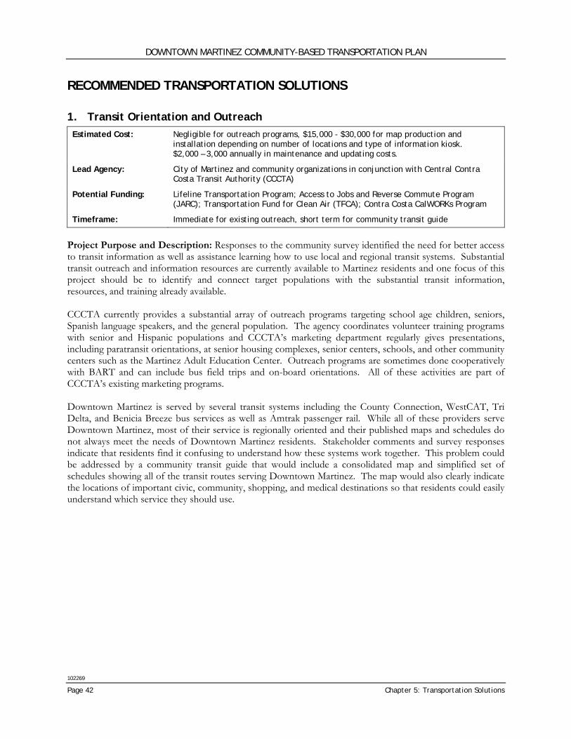
DOWNTOWN MARTINEZ COMMUNITY-BASED TRANSPORTATION PLAN
102269
Page 42 Chapter 5: Transportation Solutions
RECOMMENDED TRANSPORTATION SOLUTIONS 1. Transit Orientation and Outreach Estimated Cost: Negligible for outreach programs, $15,000 - $30,000 for map production and
installation depending on number of locations and type of information kiosk. $2,000 – 3,000 annually in maintenance and updating costs.
Lead Agency: City of Martinez and community organizations in conjunction with Central Contra Costa Transit Authority (CCCTA)
Potential Funding: Lifeline Transportation Program; Access to Jobs and Reverse Commute Program (JARC); Transportation Fund for Clean Air (TFCA); Contra Costa CalWORKs Program
Timeframe: Immediate for existing outreach, short term for community transit guide
Project Purpose and Description: Responses to the community survey identified the need for better access to transit information as well as assistance learning how to use local and regional transit systems. Substantial transit outreach and information resources are currently available to Martinez residents and one focus of this project should be to identify and connect target populations with the substantial transit information, resources, and training already available. CCCTA currently provides a substantial array of outreach programs targeting school age children, seniors, Spanish language speakers, and the general population. The agency coordinates volunteer training programs with senior and Hispanic populations and CCCTA’s marketing department regularly gives presentations, including paratransit orientations, at senior housing complexes, senior centers, schools, and other community centers such as the Martinez Adult Education Center. Outreach programs are sometimes done cooperatively with BART and can include bus field trips and on-board orientations. All of these activities are part of CCCTA’s existing marketing programs. Downtown Martinez is served by several transit systems including the County Connection, WestCAT, Tri Delta, and Benicia Breeze bus services as well as Amtrak passenger rail. While all of these providers serve Downtown Martinez, most of their service is regionally oriented and their published maps and schedules do not always meet the needs of Downtown Martinez residents. Stakeholder comments and survey responses indicate that residents find it confusing to understand how these systems work together. This problem could be addressed by a community transit guide that would include a consolidated map and simplified set of schedules showing all of the transit routes serving Downtown Martinez. The map would also clearly indicate the locations of important civic, community, shopping, and medical destinations so that residents could easily understand which service they should use.
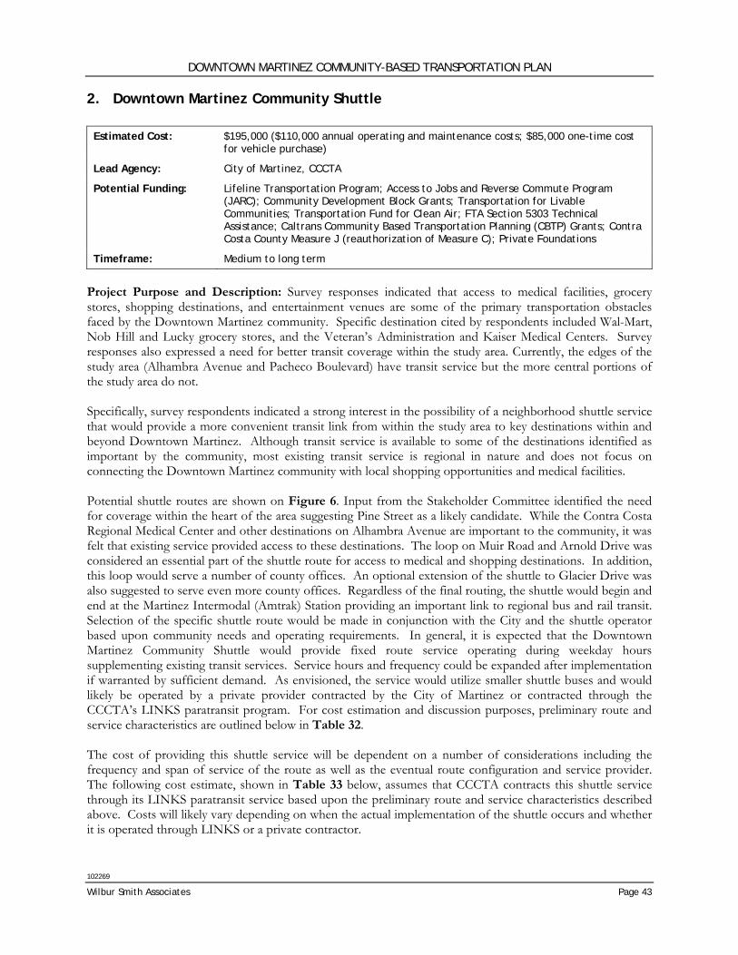
DOWNTOWN MARTINEZ COMMUNITY-BASED TRANSPORTATION PLAN
102269
Wilbur Smith Associates Page 43
2. Downtown Martinez Community Shuttle Estimated Cost: $195,000 ($110,000 annual operating and maintenance costs; $85,000 one-time cost
for vehicle purchase)
Lead Agency: City of Martinez, CCCTA
Potential Funding: Lifeline Transportation Program; Access to Jobs and Reverse Commute Program (JARC); Community Development Block Grants; Transportation for Livable Communities; Transportation Fund for Clean Air; FTA Section 5303 Technical Assistance; Caltrans Community Based Transportation Planning (CBTP) Grants; Contra Costa County Measure J (reauthorization of Measure C); Private Foundations
Timeframe: Medium to long term
Project Purpose and Description: Survey responses indicated that access to medical facilities, grocery stores, shopping destinations, and entertainment venues are some of the primary transportation obstacles faced by the Downtown Martinez community. Specific destination cited by respondents included Wal-Mart, Nob Hill and Lucky grocery stores, and the Veteran’s Administration and Kaiser Medical Centers. Survey responses also expressed a need for better transit coverage within the study area. Currently, the edges of the study area (Alhambra Avenue and Pacheco Boulevard) have transit service but the more central portions of the study area do not. Specifically, survey respondents indicated a strong interest in the possibility of a neighborhood shuttle service that would provide a more convenient transit link from within the study area to key destinations within and beyond Downtown Martinez. Although transit service is available to some of the destinations identified as important by the community, most existing transit service is regional in nature and does not focus on connecting the Downtown Martinez community with local shopping opportunities and medical facilities. Potential shuttle routes are shown on Figure 6. Input from the Stakeholder Committee identified the need for coverage within the heart of the area suggesting Pine Street as a likely candidate. While the Contra Costa Regional Medical Center and other destinations on Alhambra Avenue are important to the community, it was felt that existing service provided access to these destinations. The loop on Muir Road and Arnold Drive was considered an essential part of the shuttle route for access to medical and shopping destinations. In addition, this loop would serve a number of county offices. An optional extension of the shuttle to Glacier Drive was also suggested to serve even more county offices. Regardless of the final routing, the shuttle would begin and end at the Martinez Intermodal (Amtrak) Station providing an important link to regional bus and rail transit. Selection of the specific shuttle route would be made in conjunction with the City and the shuttle operator based upon community needs and operating requirements. In general, it is expected that the Downtown Martinez Community Shuttle would provide fixed route service operating during weekday hours supplementing existing transit services. Service hours and frequency could be expanded after implementation if warranted by sufficient demand. As envisioned, the service would utilize smaller shuttle buses and would likely be operated by a private provider contracted by the City of Martinez or contracted through the CCCTA’s LINKS paratransit program. For cost estimation and discussion purposes, preliminary route and service characteristics are outlined below in Table 32. The cost of providing this shuttle service will be dependent on a number of considerations including the frequency and span of service of the route as well as the eventual route configuration and service provider. The following cost estimate, shown in Table 33 below, assumes that CCCTA contracts this shuttle service through its LINKS paratransit service based upon the preliminary route and service characteristics described above. Costs will likely vary depending on when the actual implementation of the shuttle occurs and whether it is operated through LINKS or a private contractor.
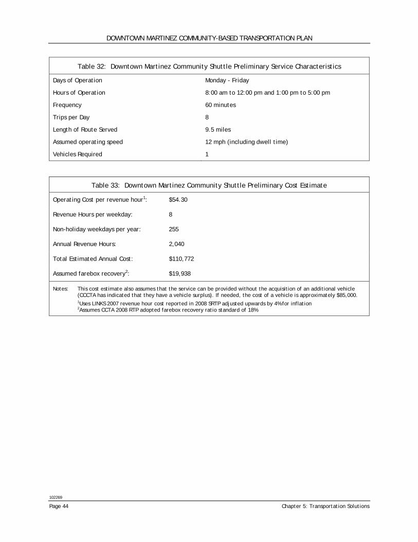
DOWNTOWN MARTINEZ COMMUNITY-BASED TRANSPORTATION PLAN
102269
Page 44 Chapter 5: Transportation Solutions
Table 32: Downtown Martinez Community Shuttle Preliminary Service Characteristics
Days of Operation Monday - Friday
Hours of Operation 8:00 am to 12:00 pm and 1:00 pm to 5:00 pm
Frequency 60 minutes
Trips per Day 8
Length of Route Served 9.5 miles
Assumed operating speed 12 mph (including dwell time)
Vehicles Required 1
Table 33: Downtown Martinez Community Shuttle Preliminary Cost Estimate
Operating Cost per revenue hour1: $54.30
Revenue Hours per weekday: 8
Non-holiday weekdays per year: 255
Annual Revenue Hours: 2,040
Total Estimated Annual Cost: $110,772
Assumed farebox recovery2: $19,938
Notes: This cost estimate also assumes that the service can be provided without the acquisition of an additional vehicle (CCCTA has indicated that they have a vehicle surplus). If needed, the cost of a vehicle is approximately $85,000.
1Uses LINKS 2007 revenue hour cost reported in 2008 SRTP adjusted upwards by 4% for inflation 2Assumes CCTA 2008 RTP adopted farebox recovery ratio standard of 18%
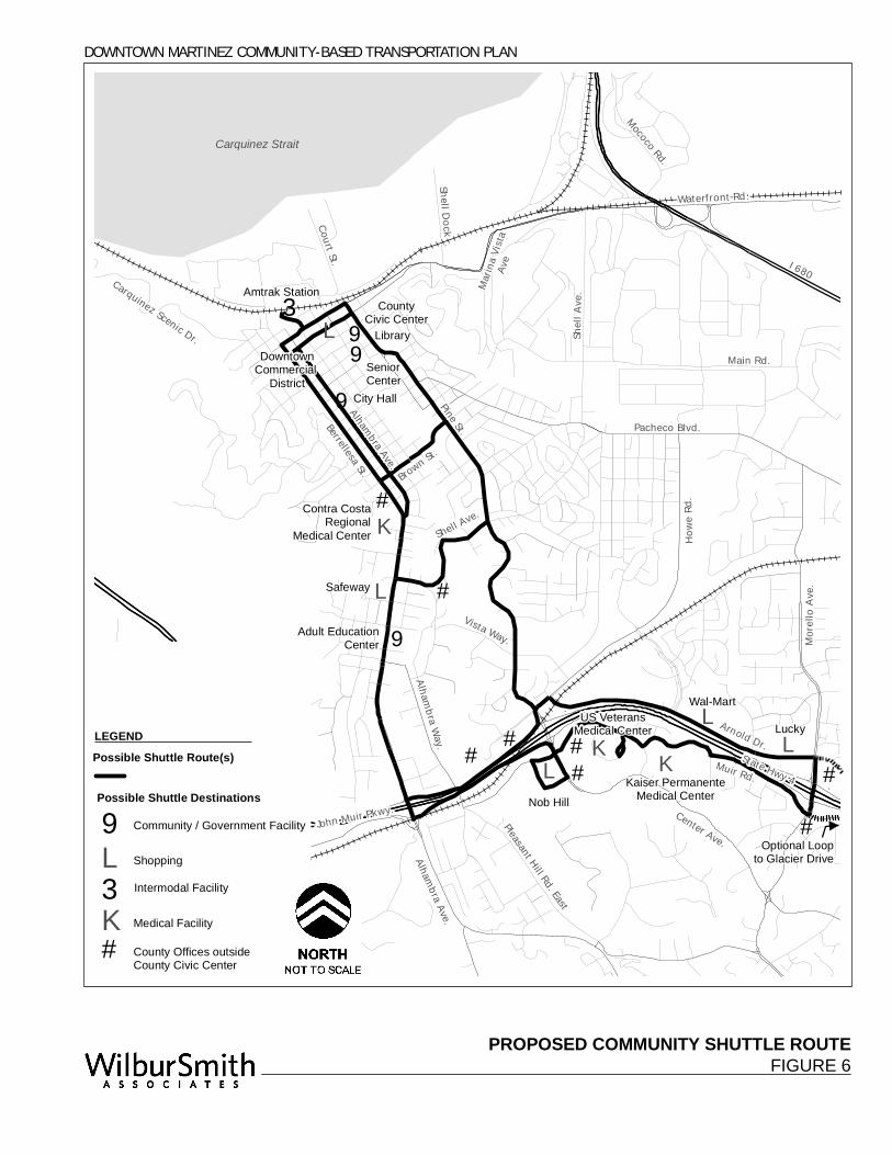
PROPOSED COMMUNITY SHUTTLE ROUTEFIGURE 6
"9
"3"L "9
"K
"9
"L
"L"K
"K"L
"L
"9
#
###
#
#
#
#
Vista Way.
Howe
Rd.
Carquinez Scenic Dr.
State Hwy 4
Shell Ave.
Pine St.
Alhambra Ave.
Muir Rd.
Main Rd.
Pacheco Blvd.
Center Ave.
Shell A
ve.
Arnold Dr.
Berrellesa St. Brown St.
Franklin Canyon Rd.
Morel
lo Av
e.
Alhambra Way.
Dutra R
d.
Waterfront Rd.
Pleasant Hill Rd. East
Mococo Rd.
Court St.
Shell Dock .
Unnamed Street .
Wolcu
tt Ln.
Marin
a Vista
Ave
Alhambra Ave.
.
.
.State Hwy 4 .
John Muir Pkwy.
I 680
Carquinez Strait
DOWNTOWN MARTINEZ COMMUNITY-BASED TRANSPORTATION PLAN
Amtrak StationCounty
Civic Center
SeniorCenter
Contra CostaRegional
Medical Center
Safeway
Adult EducationCenter
Nob Hill
Kaiser PermanenteMedical Center
US VeteransMedical Center
Wal-Mart
LuckyLEGEND
Possible Shuttle Destinations
Possible Shuttle Route(s)
Intermodal Facility
DowntownCommercial
DistrictCity Hall
Community / Government Facility
Shopping"L
Medical Facility"K"3
"9
County Offices outside County Civic Center
#
Optional Loopto Glacier Drive
Library
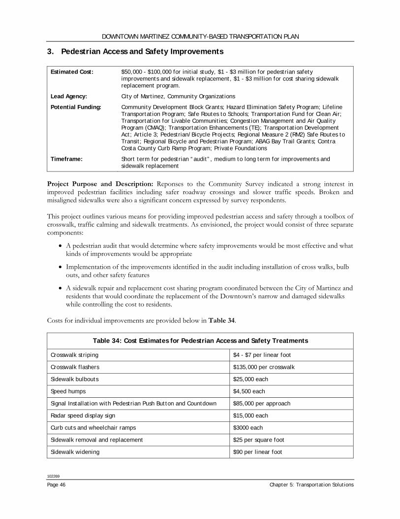
DOWNTOWN MARTINEZ COMMUNITY-BASED TRANSPORTATION PLAN
102269
Page 46 Chapter 5: Transportation Solutions
3. Pedestrian Access and Safety Improvements Estimated Cost: $50,000 - $100,000 for initial study, $1 - $3 million for pedestrian safety
improvements and sidewalk replacement, $1 - $3 million for cost sharing sidewalk replacement program.
Lead Agency: City of Martinez, Community Organizations
Potential Funding: Community Development Block Grants; Hazard Elimination Safety Program; Lifeline Transportation Program; Safe Routes to Schools; Transportation Fund for Clean Air; Transportation for Livable Communities; Congestion Management and Air Quality Program (CMAQ); Transportation Enhancements (TE); Transportation Development Act; Article 3; Pedestrian/Bicycle Projects; Regional Measure 2 (RM2) Safe Routes to Transit; Regional Bicycle and Pedestrian Program; ABAG Bay Trail Grants; Contra Costa County Curb Ramp Program; Private Foundations
Timeframe: Short term for pedestrian “audit”, medium to long term for improvements and sidewalk replacement
Project Purpose and Description: Reponses to the Community Survey indicated a strong interest in improved pedestrian facilities including safer roadway crossings and slower traffic speeds. Broken and misaligned sidewalks were also a significant concern expressed by survey respondents. This project outlines various means for providing improved pedestrian access and safety through a toolbox of crosswalk, traffic calming and sidewalk treatments. As envisioned, the project would consist of three separate components:
• A pedestrian audit that would determine where safety improvements would be most effective and what kinds of improvements would be appropriate
• Implementation of the improvements identified in the audit including installation of cross walks, bulb outs, and other safety features
• A sidewalk repair and replacement cost sharing program coordinated between the City of Martinez and residents that would coordinate the replacement of the Downtown’s narrow and damaged sidewalks while controlling the cost to residents.
Costs for individual improvements are provided below in Table 34.
Table 34: Cost Estimates for Pedestrian Access and Safety Treatments
Crosswalk striping $4 - $7 per linear foot
Crosswalk flashers $135,000 per crosswalk
Sidewalk bulbouts $25,000 each
Speed humps $4,500 each
Signal Installation with Pedestrian Push Button and Countdown $85,000 per approach
Radar speed display sign $15,000 each
Curb cuts and wheelchair ramps $3000 each
Sidewalk removal and replacement $25 per square foot
Sidewalk widening $90 per linear foot
DOWNTOWN MARTINEZ COMMUNITY-BASED TRANSPORTATION PLAN
102269
Wilbur Smith Associates Page 47
4. Bicycle Network Improvements Estimated Cost: $15,000 - $30,000
Lead Agency: City of Martinez
Potential Funding: Bicycle Transportation Account; Community Development Block Grants; Hazard Elimination Safety Program; Safe Routes to Schools; Transportation Fund for Clean Air; Transportation for Livable Communities; Congestion Management and Air Quality Program (CMAQ); Transportation Enhancements (TE); Transportation Development Act, Article 3; Pedestrian/Bicycle Projects; Regional Measure 2 (RM2) Safe Routes to Transit; Recreational Trails Program (RTP); Regional Bicycle and Pedestrian Program; ABAG Bay Trail Grants; Private Foundations
Timeframe: Short term
Project Purpose and Description: The Community Survey and Stakeholder discussions indicated interest in improving bicycle safety and wayfinding through Downtown Martinez streets. The Contra Costa County Bicycle Plan shows a more extensive bicycle network in the study area than currently exists on the ground. Although adding Class II bike lanes does not currently appear to be feasible along many of the streets identified in the County Plan, adding and improving Class III facilities through the use of signage, sharrows (shared lane markings), and other street markings will help guide bicyclists and alert cars to their presence. Bicycle network improvements should be targeted towards several different street segments with a goal of enhancing the City’s network of bicycle facilities to provide continuous access to key destinations in and beyond Downtown Martinez. The following project description uses the following designations to differentiate between different bicycle facilities:
• Class I Shared-Use Path: Class I bicycle facilities provide a completely separated right of way for the exclusive use of bicycles and pedestrians with cross-flow minimized.
• Class II Bike Lane: Class II bicycle facilities provide a striped lane for exclusive one-way bike travel on a street or highway. Motorists may drive in a bike lane only to park where parking is permitted, to enter or leave the roadway, or to prepare for a right-hand turn within 200 feet from an intersection.
• Class III Bike Route: Class III bicycle facilities provide for shared use with pedestrian or motor vehicle traffic. Class III facilities use signage and lane markings to create connectivity between other bicycle facilities and designate the preferred bicycle route through a high demand corridor. Other signage and pavement markings can be used on Class III routes to provide additional warning to motorists and bicyclists such as the Share the Road (W16-1) plaque in conjunction with the Bicycle Warning (W11-1) sign or the Shared Roadway Bicycle Marking (commonly referred to as ‘sharrow’).
The City of Martinez should consider adding and enhancing Class III bicycle facilities at the following locations (see Figure 7):
• Alhambra Avenue between Bertola and Haven Streets: Alhambra Avenue has Class II bike facilities prior to and after this segment and are key parts of Martinez’s bicycle network. While the street segments indicated are already designated as Class III lanes and have bike route signage, they could benefit from additional “share-the-road” signage and sharrows. (3900 ft)
• Court Street between Marina Vista Avenue and Thompson Street, and Pine Street between Thompson and Susana Streets: Adding Class III bicycle facilities including signage and sharrows to these segments of Court and Pine Streets would serve to connect existing Class II facilities on Pine and Jones Streets with the core of Downtown as well as Class II facilities on Marina Vista Avenue and Escobar Street. (2100 ft)
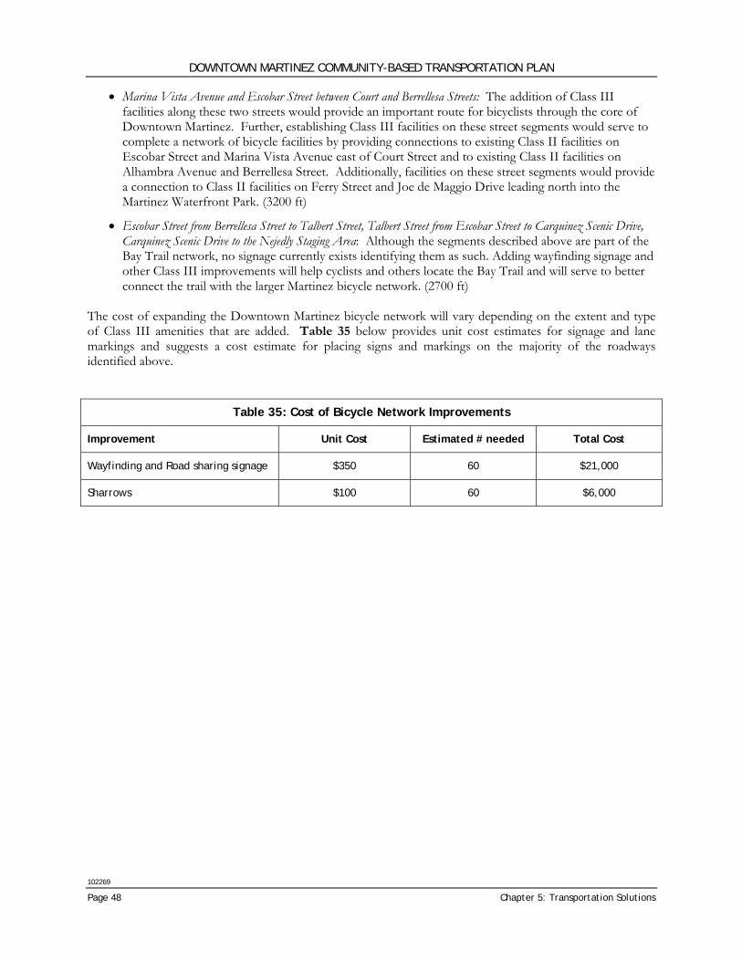
DOWNTOWN MARTINEZ COMMUNITY-BASED TRANSPORTATION PLAN
102269
Page 48 Chapter 5: Transportation Solutions
• Marina Vista Avenue and Escobar Street between Court and Berrellesa Streets: The addition of Class III facilities along these two streets would provide an important route for bicyclists through the core of Downtown Martinez. Further, establishing Class III facilities on these street segments would serve to complete a network of bicycle facilities by providing connections to existing Class II facilities on Escobar Street and Marina Vista Avenue east of Court Street and to existing Class II facilities on Alhambra Avenue and Berrellesa Street. Additionally, facilities on these street segments would provide a connection to Class II facilities on Ferry Street and Joe de Maggio Drive leading north into the Martinez Waterfront Park. (3200 ft)
• Escobar Street from Berrellesa Street to Talbert Street, Talbert Street from Escobar Street to Carquinez Scenic Drive, Carquinez Scenic Drive to the Nejedly Staging Area: Although the segments described above are part of the Bay Trail network, no signage currently exists identifying them as such. Adding wayfinding signage and other Class III improvements will help cyclists and others locate the Bay Trail and will serve to better connect the trail with the larger Martinez bicycle network. (2700 ft)
The cost of expanding the Downtown Martinez bicycle network will vary depending on the extent and type of Class III amenities that are added. Table 35 below provides unit cost estimates for signage and lane markings and suggests a cost estimate for placing signs and markings on the majority of the roadways identified above.
Table 35: Cost of Bicycle Network Improvements
Improvement Unit Cost Estimated # needed Total Cost
Wayfinding and Road sharing signage $350 60 $21,000
Sharrows $100 60 $6,000
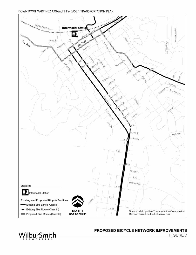
PROPOSED BICYCLE NETWORK IMPROVEMENTSFIGURE 7
Pine St.
Marina Vista Ave.
Berrellesa St.
Ward St.
Brown St.
Escobar St
.
Ferry St.
F St.
Alhambra Way.
Vista Way.
E St.
G St.
C St.
Warren St.
Bush St.
Susana St.
Allen St.
Talbart St.
Raap
Ave.
H St.
Ldu Dr.
30 Hil
l Rd.
D St.
Soto St.Robinson St.
Pinon Dr.
Lasalle St.
B St.
Haven St.
Walnut St.
Willow St.
Jones St.
Buckley St.
Wallin St.
Las Juntas St.
Masonic St.
Arch St.
Shell St.
Boynton Ave.
Beech
St.
Sentinel Dr.
Castro St.
Embarcadero St.
Foster St.
Carpenter Cir.
Barrel
hous
e Rd.
Saxon St.
Wayne St.
Gregory Ave.
Ash St.
Date
St.
K St.
Elm St
.
Sunrise
Ct.
Bertola St.Richardson St.
Via Co
rdova L
n.
Teresa St.
Tuolu
mne A
ve.
Ilene St.
Alhambra Ln.
Cooper Ave.
Haven St.
Henrietta St.
Mellus St.
Pine St.
Foster St.
Shell Ave.
Green St.
Court St.
Jones St.
Main St.
Richardson St.
Warren St.
Arreba St.
A St.
Ferry St.
Foster St.
Estudillo St.
Intermodal Station
DOWNTOWN MARTINEZ COMMUNITY-BASED TRANSPORTATION PLAN
Source: Metropolitan Transportation CommissionRevised based on field observations
Bay Trail Bay Trail
LEGEND
Intermodal Station
Existing and Proposed Bicycle FacilitiesExisting Bike Lanes (Class II)Existing Bike Route (Class III)Proposed Bike Route (Class III)
DOWNTOWN MARTINEZ COMMUNITY-BASED TRANSPORTATION PLAN
102269
Page 50 Chapter 5: Transportation Solutions
5. Bicycle Parking Improvements Estimated Cost: $10,000 - $20,000
Lead Agency: City of Martinez
Potential Funding: Bicycle Transportation Account; Safe Routes to Schools; Transportation Fund for Clean Air; Transportation for Livable Communities; Congestion Management and Air Quality Program (CMAQ); Transportation Enhancements (TE); Transportation Development Act, Article 3, Pedestrian/Bicycle Projects; Regional Measure 2 (RM2) Safe Routes to Transit; Private Foundations
Timeframe: Short to medium term
Project Purpose and Description: Community Survey responses and discussions with Stakeholders indicated interest in expanding bicycle parking facilities in Downtown Martinez. Providing secure parking facilities for bicycles around Downtown will complement Martinez’s bicycle network and help promote cycling as a mode of access for the Downtown. Additionally, careful placement of bike racks and bike parking facilities can prevent potential pedestrian conflicts and keep bicycles from blocking or impeding sidewalk access. Signage to the existing lockers at the Martinez Intermodal Station and advertisement of their availability would also be a benefit to bicyclists needing this long-term parking. Bicycle parking improvements in Downtown Martinez can include both the installation of bike racks at key sites throughout the Downtown as well as signage to and advertisement of the availability of existing bicycle lockers at the Martinez Intermodal Station. In addition, provisions for bicycle parking with new development or redevelopment projects should be considered as part of the project approval process. Bicycle Racks: Where they are not currently available, small bike racks accommodating one to two bicycles should be installed throughout the Downtown, particularly near active civic, governmental and commercial land uses. Bike racks should only be installed where there is sufficient room without interfering with pedestrian access. The cost of bike racks will vary based on the number and type installed as well as installation costs related to their specific location. General estimates provided by the MTC suggest that a rack typically costs between $700 to $1300 to purchase and install. Installation of 15 additional bike racks throughout the core area of Downtown Martinez would provide approximately one new bike rack for every two blocks and would cost between $10,500 and $19,500. Bicycle Lockers: Bicycle lockers are currently provided at the Martinez Intermodal Station allowing users to securely store their bikes for extended periods of time. Signage to these lockers as well as advertisement of their availability and terms of use would benefit potential users. Need and locations for additional long-term bicycle parking in Downtown Martinez should be considered as part of this improvement program. New, electronic bicycle lockers can be provided for approximately $2,500 plus additional installation costs of $500 per locker.3 Additional maintenance costs will be incurred but can be offset by charging for locker use.
3 Cost estimate provided by BART.
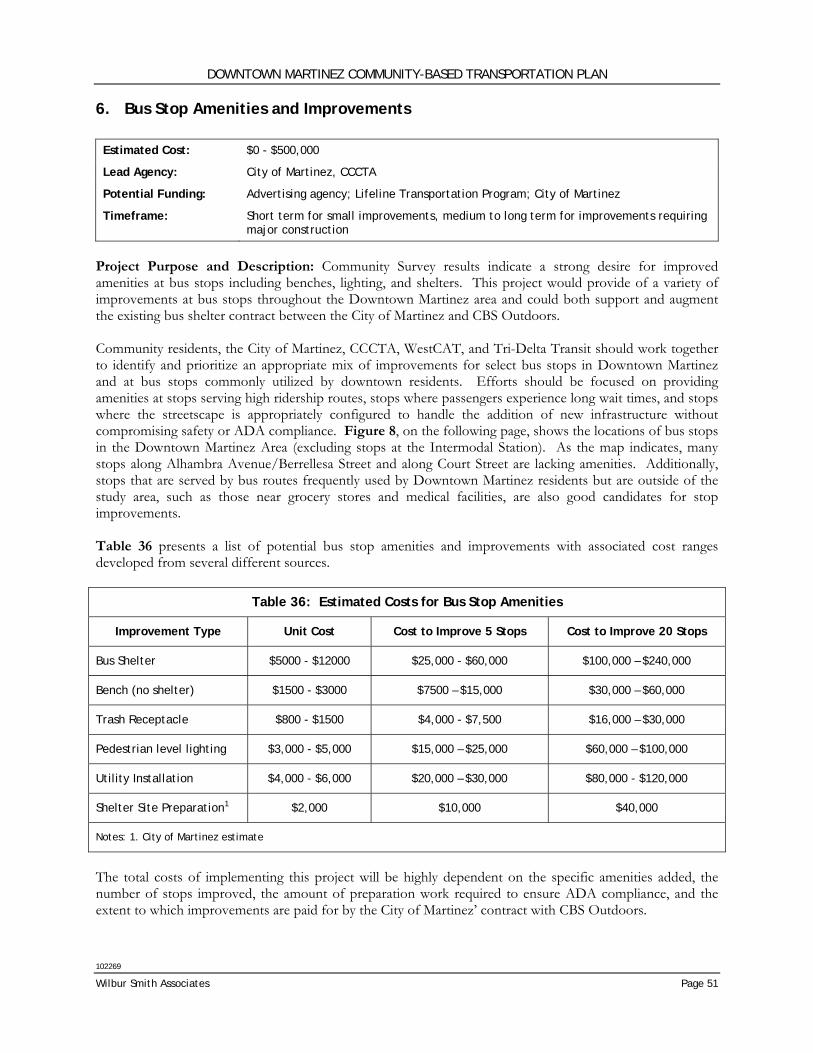
DOWNTOWN MARTINEZ COMMUNITY-BASED TRANSPORTATION PLAN
102269
Wilbur Smith Associates Page 51
6. Bus Stop Amenities and Improvements Estimated Cost: $0 - $500,000
Lead Agency: City of Martinez, CCCTA
Potential Funding: Advertising agency; Lifeline Transportation Program; City of Martinez
Timeframe: Short term for small improvements, medium to long term for improvements requiring major construction
Project Purpose and Description: Community Survey results indicate a strong desire for improved amenities at bus stops including benches, lighting, and shelters. This project would provide of a variety of improvements at bus stops throughout the Downtown Martinez area and could both support and augment the existing bus shelter contract between the City of Martinez and CBS Outdoors. Community residents, the City of Martinez, CCCTA, WestCAT, and Tri-Delta Transit should work together to identify and prioritize an appropriate mix of improvements for select bus stops in Downtown Martinez and at bus stops commonly utilized by downtown residents. Efforts should be focused on providing amenities at stops serving high ridership routes, stops where passengers experience long wait times, and stops where the streetscape is appropriately configured to handle the addition of new infrastructure without compromising safety or ADA compliance. Figure 8, on the following page, shows the locations of bus stops in the Downtown Martinez Area (excluding stops at the Intermodal Station). As the map indicates, many stops along Alhambra Avenue/Berrellesa Street and along Court Street are lacking amenities. Additionally, stops that are served by bus routes frequently used by Downtown Martinez residents but are outside of the study area, such as those near grocery stores and medical facilities, are also good candidates for stop improvements. Table 36 presents a list of potential bus stop amenities and improvements with associated cost ranges developed from several different sources.
Table 36: Estimated Costs for Bus Stop Amenities
Improvement Type Unit Cost Cost to Improve 5 Stops Cost to Improve 20 Stops
Bus Shelter $5000 - $12000 $25,000 - $60,000 $100,000 – $240,000
Bench (no shelter) $1500 - $3000 $7500 – $15,000 $30,000 – $60,000
Trash Receptacle $800 - $1500 $4,000 - $7,500 $16,000 – $30,000
Pedestrian level lighting $3,000 - $5,000 $15,000 – $25,000 $60,000 – $100,000
Utility Installation $4,000 - $6,000 $20,000 – $30,000 $80,000 - $120,000
Shelter Site Preparation1 $2,000 $10,000 $40,000
Notes: 1. City of Martinez estimate
The total costs of implementing this project will be highly dependent on the specific amenities added, the number of stops improved, the amount of preparation work required to ensure ADA compliance, and the extent to which improvements are paid for by the City of Martinez’ contract with CBS Outdoors.
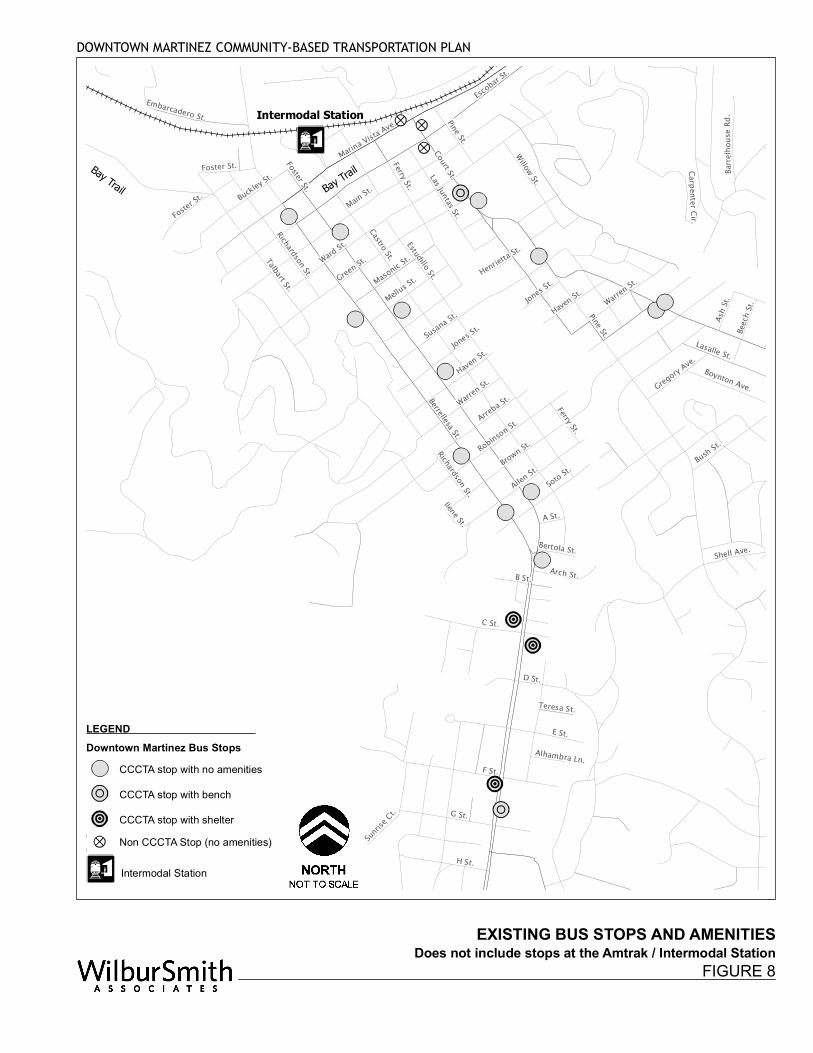
EXISTING BUS STOPS AND AMENITIES
Pine St.
Marina Vista Ave.
Berrellesa St.
Ward St.
Brown St.
Escobar St
.
Ferry St.
F St.
Alhambra Way.
Vista Way.
E St.
G St.
C St.
Warren St.
Bush St.
Susana St.
Allen St.
Talbart St.
Raap
Ave.
H St.
Ldu Dr.
30 Hil
l Rd.
D St.
Soto St.Robinson St.
Pinon Dr.
Lasalle St.
B St.
Haven St.
Walnut St.
Willow St.
Jones St.
Buckley St.
Wallin St.
Las Juntas St.
Masonic St.
Arch St.
Shell St.
Boynton Ave.
Beech
St.
Sentinel Dr.
Castro St.
Embarcadero St.
Foster St.
Carpenter Cir.
Barrel
hous
e Rd.
Saxon St.
Wayne St.
Gregory Ave.
Ash St.
Date
St.
K St.
Elm St
.
Sunrise
Ct.
Bertola St.Richardson St.
Via Co
rdova L
n.
Teresa St.
Tuolu
mne A
ve.
Ilene St.
Alhambra Ln.
Cooper Ave.
Haven St.
Henrietta St.
Mellus St.
Pine St.
Foster St.
Shell Ave.
Green St.
Court St.
Jones St.
Main St.
Richardson St.
Warren St.
Arreba St.
A St.
Ferry St.
Foster St.
Estudillo St.
Intermodal Station
DOWNTOWN MARTINEZ COMMUNITY-BASED TRANSPORTATION PLAN
Bay Trail Bay Trail
Does not include stops at the Amtrak / Intermodal StationFIGURE 8
LEGEND Downtown Martinez Bus Stops
CCCTA stop with no amenities CCCTA stop with benchCCCTA stop with shelterNon CCCTA Stop (no amenities)
Intermodal Station
DOWNTOWN MARTINEZ COMMUNITY-BASED TRANSPORTATION PLAN
102269
Wilbur Smith Associates Page 53
7. Lifeline Bus Service Improvements Estimated Cost: $320,000 - $2,300,000
Lead Agency: CCCTA
Potential Funding: Transportation Development Act Funds (TDA); State Transit Assistance Funds (STA); Lifeline Transportation Program; Property Taxes (used primarily for paratransit); Contra Costa County Measure J (reauthorization of Measure C); Private Foundations
Timeframe: Short to medium term depending on funding environment
Project Purpose and Description: This project would enhance service on CCCTA routes 108, 116, 118, and 308 closer to the span of service and frequency specified in the Metropolitan Transportation Commission’s Service Objectives for Lifeline Suburban Transit Operators and Routes4. The Lifeline Service Objectives were developed as part of a 2001 study by the MTC to identify crucial public transit links meeting the needs of low income persons throughout the San Francisco Bay Area. The above routes are all part of the Lifeline Transportation Network identified by MTC, but none currently meets the full MTC Lifeline Service Objectives shown below in Table 37. Survey results indicate that these routes are very important to the Downtown Martinez Community; in the survey, there was strong support and interest expressed in increased frequency of bus service for weekdays as well as expanded service hours and frequency on weekends. Currently route 108 operates only during weekdays. Routes 116 and 118 provide service Monday through Saturday. Route 308 provides Sunday service only along a route similar to route 118. Achieving full Lifeline Service Objectives on all of these routes would effectively require a doubling of existing service which is not financially feasible at this time. The estimated cost for this expanded service would exceed $3,000,000 as shown below in Table 38. In light of the cost limitations of implementing full Lifeline Service Objectives on all these routes, this project is proposed to enhance service on CCCTA routes 108, 116, 118, and 308 by moving them closer to the Lifeline Objectives through the expansion of service hours on weekends, and increasing frequency to every 30 minutes during weekday morning and afternoon peak hours. Two options are proposed for these improvements and discussed more fully in the following chapter. Please note that because of the similarity in routing for routes 118 and 308, they are treated as parts of the same service for this Lifeline analysis or, in other words, route 118 provides weekday and Saturday service while route 308 provides Sunday service.
Table 37: MTC Hours of Operation and Headway Objectives for Lifeline Routes
Weekday Saturday Sunday
Suburban Transit Operators/Routes
6:00 am – 10:00 pm 30 minute
6:00 am – 10:00 pm 30 minute
8:00 am – 10:00 pm 30 minute
Source: Lifeline Transportation Network Report: 2001 Regional Transportation Plan for the San Francisco Bay Area
4 Metropolitan Transportation Commission. Lifeline Transportation Network Report: 2001 Regional Transportation Plan for the San Francisco
Bay Area. December 2001.

DOWNTOWN MARTINEZ COMMUNITY-BASED TRANSPORTATION PLAN
102269
Page 54 Chapter 5: Transportation Solutions
Table 38:
Additional Annual Service Hours and Estimated Cost to Meet Full MTC Lifeline Service Objectives
Route Weekdays Saturdays Sundays Total
108 4,080 2,496 2,436 9,012
116 8,670 1,872 3,248 13,790
118 7,650 2,288 0 9,938
308 0 0 1,508 1,508
Total 20,400 6,656 7,192 34,248
Total Cost 1 $1,686,264 $550,185 $594,491 $2,830,940
Farebox Recovery 2 $303,528 $99,033 $107,008 $509,569
Net Annual Cost $1,382,736 $451,152 $487,482 $2,321,371
Notes: 1. Assumes CCCTA fiscal year 2008-2009 Revenue hour cost of $81.66. 2. Assumes CCTA 2008 RTP adopted farebox recovery ratio standard of 18 percent.
DOWNTOWN MARTINEZ COMMUNITY-BASED TRANSPORTATION PLAN
102269
Wilbur Smith Associates Page 55
8. Taxi Fare Vouchers Estimated Cost: $20,000 - $50,000 annually depending on number and value of vouchers offered
Lead Agency: Community organizations
Potential Funding: Transportation Development Act Funds (TDA); Transportation Fund for Clean Air; State Transit Assistance Funds (STA); Access to Jobs and Reverse Commute Program (JARC); Lifeline Transportation Program; Property Taxes (used primarily for paratransit); Private Foundations
Timeframe: Medium term
Project Purpose and Description: This project would provide subsidized taxi vouchers as an alternative transportation option for transit-dependent residents of Downtown Martinez. Because bus service in Downtown Martinez is limited late at night and on weekends, subsidized access to taxis is a potential solution for filling key transportation gaps. Both improved late night transportation options and lower taxi fares were cited in the community survey as beneficial transportation solutions. Taxi vouchers would be made available to qualified individuals for taxi trips supplementing their regular travel options. While the taxi voucher program could be used for regular commuting, generally these programs are intended for occasional use such as when a car has broken down or is otherwise not available, when it is necessary to work late and transit is not available, or when other types of emergencies arise. Regular commuting may be better served by other shuttles or carpooling alternatives. Taxi service from Martinez to nearby regional centers including Concord, Pleasant Hill, and Walnut Creek is comparatively expensive and will likely average between $20 and $30 per trip. Costs for administering the program must also be considered. The cost of providing taxi vouchers will vary based on the level of discount provided through the program and the number of vouchers made available.
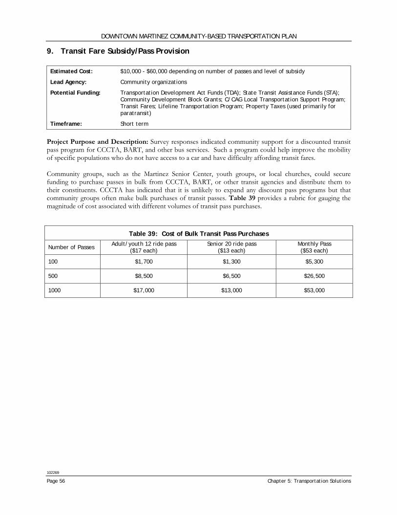
DOWNTOWN MARTINEZ COMMUNITY-BASED TRANSPORTATION PLAN
102269
Page 56 Chapter 5: Transportation Solutions
9. Transit Fare Subsidy/Pass Provision Estimated Cost: $10,000 - $60,000 depending on number of passes and level of subsidy
Lead Agency: Community organizations
Potential Funding: Transportation Development Act Funds (TDA); State Transit Assistance Funds (STA); Community Development Block Grants; C/CAG Local Transportation Support Program; Transit Fares; Lifeline Transportation Program; Property Taxes (used primarily for paratransit)
Timeframe: Short term
Project Purpose and Description: Survey responses indicated community support for a discounted transit pass program for CCCTA, BART, and other bus services. Such a program could help improve the mobility of specific populations who do not have access to a car and have difficulty affording transit fares. Community groups, such as the Martinez Senior Center, youth groups, or local churches, could secure funding to purchase passes in bulk from CCCTA, BART, or other transit agencies and distribute them to their constituents. CCCTA has indicated that it is unlikely to expand any discount pass programs but that community groups often make bulk purchases of transit passes. Table 39 provides a rubric for gauging the magnitude of cost associated with different volumes of transit pass purchases.
Table 39: Cost of Bulk Transit Pass Purchases
Number of Passes Adult/youth 12 ride pass ($17 each)
Senior 20 ride pass ($13 each)
Monthly Pass ($53 each)
100 $1,700 $1,300 $5,300
500 $8,500 $6,500 $26,500
1000 $17,000 $13,000 $53,000
DOWNTOWN MARTINEZ COMMUNITY-BASED TRANSPORTATION PLAN
102269
Wilbur Smith Associates Page 57
PRIORITIZATION OF SOLUTIONS The nine projects recommended in the CBTP would improve access and mobility for the Downtown Martinez community. However, there are limited funds and City/County agency and community organization staff time to implement these projects at one time. Consequently, it is necessary to prioritize solutions to make the best use of limited funds and staff time to implement these projects and give the community the most ‘bang for the buck’. In addition, future funding opportunities may shift priorities as new funding sources become available. Criteria used in the evaluation were categorized by ‘Effectiveness’ and ‘Feasibility’ with the goal to 1) identify the solutions that would most benefit the community as described by ‘Effectiveness’ and 2) identify the solutions that would be the easiest to implement as described by ‘Feasibility’. By this approach, solutions that would have the most benefit to the community but may be difficult to implement would not lose their high importance; conversely, solutions that may not be most important to the community but could be easily implemented would not be overlooked. These categories are described by:
• Effectiveness – The first two criteria (Community and Transportation) reflect the relative effectiveness of the solution in meeting the transportation needs of the community.
• Feasibility – The remaining two criteria (Funding & Cost and Implementation) assess the feasibility or potential for implementation of the solution.
Four criteria were selected to be used in the prioritization. These criteria further describe the relative effectiveness of the project and the project’s probability for implementation. Each potential solution was evaluated by these criteria with a rating of High (H), Medium (M) or Low (L) with High reflecting the best scoring for that criteria. For the purposes of quantifying the results, High was given a value of 3 points, Medium a value of 2 points, and Low a value of 1 point. The evaluation was based upon input from the Stakeholder Committee, Downtown Martinez community through both the survey and Open House, discussions with public agency staff, the overriding goals of the community-based planning process, and existing City planning documents. The criteria used for this evaluation were: Effectiveness Criteria Community
• Has community support – The success of any project requires that it has the support of the community not only for calculation of potential usage but also to support agency staff or community leaders in their efforts to make the project a reality. Does the solution have the community and political support necessary for success?
• Benefits the population with the greatest need – Does this solution target the population with the greatest barriers to mobility?
• Benefits a large portion of the study area – Does this solution benefit a large portion of the study area rather than a select few?
Transportation
• Solves a major transportation gap(s) – Does this solution provide access that didn’t exist before (higher rating) as opposed to improving existing access?
• Benefits extend beyond the study area – Do the benefits of this solution extend beyond Downtown Martinez and also benefit other residents of the City of Martinez and neighboring communities?
• Easy to use – Will potential patrons of this solution find it understandable and accessible?
DOWNTOWN MARTINEZ COMMUNITY-BASED TRANSPORTATION PLAN
102269
Page 58 Chapter 5: Transportation Solutions
Feasibility Criteria Funding and Cost
• Cost effective – Is the cost reasonable as compared to the number of people who would benefit? • Funding available from existing sources – Can funding for this solution be found from existing
sources? • Funding likely or identified – Are funding sources likely or been identified? • Low-cost or no-cost – Can the project be implemented at no-cost, for less than $50,000 or by
grants or outside funding sources? Implementation
• Ease of Implementation – Does this project involve the cooperation of many jurisdictions and agencies? Does this project trigger various compliance requirements that would result in adherence to state, federal and local regulations?
• Potential for project champion – Is there a group or individual in either the public or private sector that might champion this project? Can a project champion or sponsor be identified?
• Compatible with existing plans – Is this solution directly identified in an agency planning document or is it supportive of existing local, county or regional plans?
• Does not require infrastructure improvements – Can this solution be implemented without significant infrastructure improvements?
Results The results of the solution prioritization are shown in Table 40 below. The proposed solutions and rationale behind prioritization include:
1. Transit Orientation and Outreach – Responses to the community survey and input from the Stakeholder Committee identified the need for better access to transit information as well as assistance in learning how to use the local and regional transit systems available to Downtown Martinez residents. Although transit information is readily available by phone or the internet, many potential users are not aware of these informational sources. There are already programs available through CCCTA to provide this training outreach so this would be a low cost solution. Hence this solution also rated high in Feasibility.
2. Downtown Martinez Community Shuttle – While the Downtown Martinez area has relatively good regional transit, there is limited transit coverage within the study area itself providing connection to local shopping and medical destinations. The community shuttle would provide this connection and expand transit coverage to the study area outside the corridor served on Alhambra Avenue and Pacheco Boulevard. The Community Survey and Stakeholder Committee expressed a great need for this service. While the shuttle would be relatively expensive to operate, equipment would be available from CCCTA to defray the cost of providing the shuttle.
3. Pedestrian Access and Safety Improvements – Responses to the Community Survey indicated a strong interest in improved pedestrian facilities from safer roadway crossings to repaired sidewalks. These improvements can be done in a piece-meal fashion as funding becomes available. In fact, some improvements could be made with existing City funds.
4. Bicycle Network Improvements – While these improvements are particular to one group of people (bicyclists), they are relatively low cost to implement. In addition, local and regional cyclist groups are supportive of these improvements and could be enlisted as project champions.
DOWNTOWN MARTINEZ COMMUNITY-BASED TRANSPORTATION PLAN
102269
Wilbur Smith Associates Page 59
5. Bicycle Parking Improvements – Like Solution #4 above, these improvements are relatively low cost to implement and could be done in a piece-meal fashion as funds become available.
6. Bus Stop Amenities and Improvements – The Community Survey indicated a strong desire for improved amenities at bus stops including benches, lighting and shelters. While these improvements would improve the transit experience, they are not critical to the use of transit. Some improvements would be easy to implement; others would be more costly due to the narrow street rights-of-way in the study area.
7. Lifeline Bus Service Improvements – More frequent service and longer service hours was frequently requested in the Community Survey. However, these improvements would be very costly to implement.
8. Taxi Fare Vouchers – This program would provide a convenient alternative for trips that cannot be made by transit and when other options are not available. However, funding is difficult to secure for this type of program and the program would require ongoing administration. This is a program that could be best offered by a community organization.
9. Transit Fare Subsidy/Pass Provision – While the need for transit fare subsidies was noted by respondents to the Community Survey, it did not rank highest among the options. Funding for this type of program is difficult to obtain but could be offered by a community organization willing to fund and administer the program for its members.
Summary Effectiveness Ranking – Community support was assessed through combination of input from the Stakeholder Committee, responses to the Community Survey and voting at the Open House. As shown in Table 40, the two transit options (#2 and #7) were rated highest in their ability to provide a necessary service and to benefit a significant portion of the Downtown Martinez community. The Transit Orientation and Outreach program (#1) rated relatively high in the effectiveness ranking because of its community support and ability to benefit a significant portion of the population. The Pedestrian Access and Safety Improvements (#3), Bicycle Network Improvements (#4), and Bus Stop Amenities and Improvements (#6) were tied in their rated. While these programs were supported by the community, they were considered improvements to existing services and did not provide new access that is not currently available. Feasibility Ranking – The highest rated solutions for feasibility (#1, #3, #4, and #5) are all low cost solutions; some can be implemented piece-meal as funding becomes available. The Downtown Martinez Community Shuttle (#2) rated relatively high in feasibility because it would serve a significant portion of the community and has a great potential for a project champion because of the community’s support. Similarly, Bus Stop Amenities and Improvements (#6) rated relatively high in feasibility since partial funding has been identified. Overall Ranking – As to be expected, the Transit Orientation and Outreach (#1), Downtown Martinez Community Shuttle (#2), Pedestrian Access and Safety Improvements (#3), and Bicycle Network Improvements (#4) were rated the highest overall. These projects represent the greatest benefit to the community both for their ability to benefit a large segment of the population and/or for their ease of implementation.

DOWNTOWN MARTINEZ COMMUNITY-BASED TRANSPORTATION PLAN
102269
Page 60 Chapter 5: Transportation Solutions
Table 40: Solutions Prioritization Matrix
Tran
sit
Ori
enta
tion
and
Out
reac
h
Dow
ntow
n M
arti
nez
Com
mun
ity
Shut
tle
Pede
stri
an A
cces
s an
d Sa
fety
Im
prov
emen
ts
Bicy
cle
Net
wor
k Im
prov
emen
ts
Bicy
cle
Park
ing
Impr
ovem
ents
Bus
Stop
Am
enit
ies
and
Impr
ovem
ents
Life
line
Bus
Serv
ice
Impr
ovem
ents
Taxi
Far
e Vo
uche
rs
Tran
sit
Fare
Sub
sidy
/Pas
s Pr
ovis
ion
Solution 1 2 3 4 5 6 7 8 9
EFFECTIVENESS
Community Has community/political support 2 3 3 2 2 3 3 2 2
Benefits the population with the greatest need 3 3 2 1 1 2 3 3 3
Benefits a large portion of the study area 2 3 3 3 3 3 3 2 2
Transportation
Solves a major transportation gap(s) 3 3 1 2 1 1 3 2 2
Benefits extend beyond the study area 2 2 1 2 2 1 3 1 1
Easy to use 2 3 3 3 3 3 3 1 1
Effectiveness Subtotal 14 17 13 13 12 13 18 11 11
FEASIBILITY
Funding and Cost
Cost effective 3 3 3 3 3 2 1 2 1
Funding available from existing sources 3 1 3 3 3 1 1 1 1
Funding likely or identified 1 1 3 1 1 3 1 1 1
Low-cost or no-cost 3 1 2 3 3 2 1 2 2
Implementation
Ease of Implementation 3 2 2 2 2 3 1 1 1
Potential for project champion 3 3 3 3 3 3 1 2 2
Compatible with existing plans 3 3 3 3 3 3 2 3 3
Does not require Infrastructure improvements 3 2 1 2 2 1 2 3 3
Feasibility Subtotal 22 16 20 20 20 18 10 15 14
TOTAL POINTS 36 33 33 33 32 31 28 26 25 H (3 points) = Solution was best for this criteria; M (2 points) = Solution was average for this criteria; L (1 point) = Solution scored poorly for this criteria
DOWNTOWN MARTINEZ COMMUNITY-BASED TRANSPORTATION PLAN
102269
Wilbur Smith Associates Page 61
Chapter 6: Implementation
Once a potential project has been identified and given the approval of the community and City agencies, it is still far from a ‘done deal’. This final chapter of the Downtown Martinez CBTP discusses many of the stumbling blocks that may be encountered during the implementation process. In addition, a listing of potential funding sources is included followed by a discussion of Next Steps to be taken for implementation of the transportation solutions of the Downtown Martinez CBTP.
CONSIDERATIONS FOR IMPLEMENTATION There were many issues to consider when evaluating the various proposed solutions, not the least being the potential for implementation. Regardless of how beneficial a project might be for improving access for a community, it is necessary to include in that evaluation what stumbling blocks will be faced during the implementation process. These deterrents can take the form of environmental or engineering constraints, lack of funding resources and/or community or political opposition to the project. The potential for implementation was included as part of the prioritization evaluation in Chapter 5; however, it is important to highlight some of the potential challenges that might be encountered during the implementation process. 1. Transit Orientation and Outreach Linking members of the Downtown Martinez community with existing transit orientation and information resources will help address the needs identified in the Community Survey. Survey responses indicated that seniors and Adult Education Center attendees were particularly interested in transit information and orientation. These and other community groups can take a lead role in assessing the needs of their constituents and then contacting CCCTA’s marketing department to arrange an appropriate orientation program. In addition to producing a consolidated route map and set of schedules for transit routes serving Downtown Martinez, the community transit guide would need to be installed in information signs or kiosks at key locations throughout the Downtown including the Intermodal Station, City Hall, and the center of the downtown commercial district. Installing these and maintaining these signs will constitute the primary cost of implementing this project. 2. Downtown Martinez Community Shuttle Implementing a successful community shuttle serving the Downtown Martinez community will require careful consideration of a number of factors: Market Study: While the community survey results suggested that seniors and Martinez Adult Education Center attendees were particularly interested in a shuttle, further market analysis should be undertaken prior to commitment of limited resources with implementation of this project. Targeted information regarding the potential market for a community shuttle will be crucial to appropriately designing the service and focusing outreach efforts. Service Characteristics: Although the preliminary cost estimate detailed in Table 33, page 44, for this solution assumes a weekday service operating at 60 minute headways between 8:00 am to 12:00 pm and 1:00 pm to 5:00 pm, additional market and cost analysis should be undertaken to determine the service’s appropriate days of operation, span of service, and frequency.
DOWNTOWN MARTINEZ COMMUNITY-BASED TRANSPORTATION PLAN
102269
Page 62 Chapter 6: Implementation
Service Provider: The cost estimate assumes that the shuttle service could be contracted through CCCTA’s LINKS paratransit provider. CCCTA has indicated that they are not opposed to such a shuttle being operated by a private contractor, however, and exploring this option further could potentially result in a more cost effective or flexible service solution. The example of two recently instituted community shuttles in Concord may also be instructive in considering how best to implement this project. CCCTA recently implemented a similar community shuttle operating on a flexible route for Concord’s Monument Corridor with service contracted through LINKS. The shuttle operates every weekday at 60 minute headways between 7:00 am and 7:00 pm. Conversations with the agency indicate, however, that the route has suffered from consistently low ridership despite heavy marketing efforts. Coordinating with CCCTA in the early planning phases of the Downtown Martinez Community Shuttle will be critical in order to insure that any service provided is appropriately matched with ridership needs and demands and does not detract from CCCTA’s other services. The Mt Diablo Adult Services Center in Concord also operates a senior community shuttle. This service is targeted towards a specific population. The shuttle operates midday only and links senior residential communities near the center with nearby shopping amenities. Service is provided on a sign up basis and the route is adjusted in advance based on special requests and passenger needs. The route is between 7 and 13 miles long and service runs 5 to 10 trips weekly depending on demand. The vehicle used to run the service was originally donated by CCCTA, but a new vehicle has just been secured through a 5310 grant from MTC. The shuttle program is funded by a CBD grant through the City of Concord and costs only $30,000- $35,000 annually. Since service operates only midday, some costs are shared with other transportation services as the same driver and vehicle are used to provide transportation services for the Adult Services Center patrons. Staff at the Mt Diablo Adult Services Center will be a valuable resource during the planning phase of the Downtown Martinez Community Shuttle, particularly when considering whether the shuttle should be operated by a private contractor. 3. Pedestrian Access and Safety Improvements Implementing an adequate and cost effective program of pedestrian improvements will require a more detailed assessment of pedestrian needs in the pedestrian audit. However, some key elements of a program would include:
• Crosswalk improvements – As previously mentioned, Alhambra Avenue and Berrellesa Street were most often identified as locations needing improved crosswalks. Since these are relatively high traffic and high speed roadways, treatments beyond the typical striped crosswalk may be warranted. Priority locations would be at bus stops or other key destinations. Crosswalk flashers could be a good alternative for some locations.
• Sidewalk replacement was often cited as a significant pedestrian need. Many of the sidewalks in Martinez are old. The mature street trees provide much needed shade but also have done damage to the sidewalks. While these repairs are typically the responsibility of the property owner, there can be significant ramifications to an onslaught of sidewalk repair citations from the City. It is important consider that 1) many residents are probably unaware of their responsibility for sidewalk repairs, 2) much of the sidewalk damage is caused by the city-owned mature trees on the street-side, and 3) this financial burden may significant for some residents, particularly in a community which has qualified for a community-based plan in the first place. This may be a program that the City could undertake on its own.
• Sidewalk bulbouts can be used to shorten the crossing distance for pedestrians thereby lessening their exposure to vehicle traffic. They could also be incorporated into bus stop improvements providing a location for bus shelter or bench where sidewalks are narrow and other right-of-way is not
DOWNTOWN MARTINEZ COMMUNITY-BASED TRANSPORTATION PLAN
102269
Wilbur Smith Associates Page 63
available. However, bulbouts are expensive and can result in a loss of on-street parking, depending upon the intersection configuration.
• Speed humps can be used to slow traffic down but are not recommended for high volume corridors like Alhambra Avenue and Berrellesa Street. They can also pose problems for buses and emergency vehicles.
• Traffic signals could be used to slow and stop traffic. However, these are costly and may not be warranted by the traffic volumes. The same is true for stop signs.
• Education and enforcement campaign could be used to slow traffic down and educate the driving and walking public of their responsibilities in sharing the road. Portable speed trailers are often used to alert motorists to their travel speeds. Unfortunately, the behavior modifications resulting from these campaigns, even when they include traffic citations, are often short-lived.
4. Bicycle Network Improvements When adding signage and sharrows along Marina Vista Avenue and Escobar Street, particular care should be taken to provide wayfinding signage directing bicycles to the correct entrance to the Martinez Intermodal Station. In addition, signage directing bicyclists from Alhambra Avenue to the Intermodal Station should be provided. 5. Bicycle Parking Improvements Downtown Martinez has narrow sidewalks in many areas and, as discussed earlier, care should be taken when installing bicycle parking facilities to insure that neither the rack itself nor the parked bicycles impede pedestrians or compromises ADA compliance. Other communities are using on-street parking spaces as an alternative to locating bicycle racks on the sidewalk. Depending on the parking space dimensions and other criteria, one on-street parking space can fit approximately 10 bicycles. One or two parking spaces devoted to bicycle parking can perhaps meet the demand. However, it was noted by the Stakeholder Committee that converting auto parking to bicycle parking would likely not be a popular solution. Additional study, including site evaluations and discussion with cyclists should be undertaken to determine the exact number and best sites for bicycle parking facilities in the Downtown. 6. Bus Stop Amenities and Improvements Although the direct costs of bus shelters as well as their basic installation and maintenance costs may be covered under the City of Martinez’s agreement with CBS Outdoors, other bus stop amenities including benches, lighting, and trashcans may require separate funding. It is expected that the City of Martinez would be responsible for the cost of any site enhancements such as sidewalk widening, concrete pads, and curb cuts necessary to prepare the bus stop for a shelter and ensure its compliance with ADA regulations. Such eventualities are likely since many of the sidewalks in and around Downtown Martinez are very narrow and would require substantial improvements and reconfiguration to accommodate a bus shelter. Adding bulbouts or widening sidewalks to accommodate expanded bus stops will dramatically increase the costs of this project. To reduce site preparation costs, the City should work with the transit agencies to identify stops where the sidewalk and adjacent land is already configured in such a way that a shelter can be placed without violating ADA standards or interfering with bus loading operations. Issues to consider for prioritizing bus shelter and other improvements are:
1. Bus stops that carry higher ridership and/or have heavy pedestrian traffic and can, perhaps, be funded through the CBS Outdoors agreement;
2. Bus stops located in the public right-of-way that physically can accommodate improvements without significant infrastructure improvements;
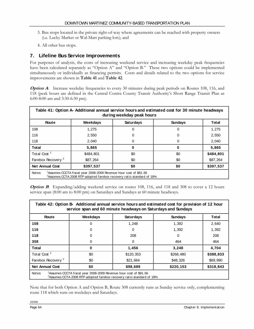
DOWNTOWN MARTINEZ COMMUNITY-BASED TRANSPORTATION PLAN
102269
Page 64 Chapter 6: Implementation
3. Bus stops located in the private right-of-way where agreements can be reached with property owners (i.e. Lucky Market or Wal-Mart parking lots); and
4. All other bus stops. 7. Lifeline Bus Service Improvements For purposes of analysis, the costs of increasing weekend service and increasing weekday peak frequencies have been calculated separately as “Option A” and “Option B.” These two options could be implemented simultaneously or individually as financing permits. Costs and details related to the two options for service improvements are shown in Table 41 and Table 42. Option A: Increase weekday frequencies to every 30 minutes during peak periods on Routes 108, 116, and 118 (peak hours are defined in the Central Contra County Transit Authority’s Short Range Transit Plan as 6:00-8:00 am and 3:30-6:30 pm).
Table 41: Option A- Additional annual service hours and estimated cost for 30 minute headways during weekday peak hours
Route Weekdays Saturdays Sundays Total
108 1,275 0 0 1,275
116 2,550 0 0 2,550
118 2,040 0 0 2,040
Total 5,865 0 0 5,865
Total Cost 1 $484,801 $0 $0 $484,801
Farebox Recovery 2 $87,264 $0 $0 $87,264
Net Annual Cost $397,537 $0 $0 $397,537
Notes: 1Assumes CCCTA fiscal year 2008-2009 Revenue hour cost of $81.66 2Assumes CCTA 2008 RTP adopted farebox recovery ratio standard of 18%
Option B: Expanding/adding weekend service on routes 108, 116, and 118 and 308 to cover a 12 hours service span (8:00 am to 8:00 pm) on Saturdays and Sundays at 60 minute headways.
Table 42: Option B- Additional annual service hours and estimated cost for provision of 12 hour service span and 60 minute headways on Saturdays and Sundays
Route Weekdays Saturdays Sundays Total
108 0 1,248 1,392 2,640
116 0 0 1,392 1,392
118 0 208 0 208
308 0 0 464 464
Total 0 1,456 3,248 4,704
Total Cost 1 $0 $120,353 $268,480 $388,833
Farebox Recovery 2 $0 $21,664 $48,326 $69,990
Net Annual Cost $0 $98,689 $220,153 $318,843
Notes: 1Assumes CCCTA fiscal year 2008-2009 Revenue hour cost of $81.66 2Assumes CCTA 2008 RTP adopted farebox recovery ratio standard of 18%
Note that for both Option A and Option B, Route 308 currently runs as Sunday service only, complementing route 118 which runs on weekdays and Saturdays.
DOWNTOWN MARTINEZ COMMUNITY-BASED TRANSPORTATION PLAN
102269
Wilbur Smith Associates Page 65
8. Taxi Fare Vouchers A major challenge for the taxi voucher program will be developing a suitable administrative structure to oversee the distribution of vouchers and determine income and need based eligibility. Similar to the transit subsidy program, a taxi voucher program has the potential for misuse. Considerations include:
1. The level of subsidy including whether the voucher would be provided at discount or for free;
2. A plan for distribution of the vouchers;
3. Standards for determining who would be eligible for the vouchers;
4. Determine how to administer the program to insure that the vouchers reaches those in need and that the program is not misused; and
5. Resolve issues of equity among Contra Costa County and/or City of Martinez residents. For example, if a voucher program was instituted for residents of Downtown Martinez, the program would have to be made available through community or private organizations. Otherwise, the vouchers would have to be made available to all residents meeting the economic criteria and it would not be possible to differentiate between recipients based solely on geographic boundaries.
One other consideration is that grants and funding sources secured to provide taxi vouchers may have conditions and requirements attached as to how the funding is used and how vouchers are distributed. For example, it may be a condition of the grant that the monies be used only for seniors or students, etc. 9. Transit Fare Subsidy/Pass Provision Structuring and administering a discounted transit pass program will be challenging and will require consideration of the following factors:
1. The level of subsidy including whether the pass would be provided at a discount or for free;
2. A plan for distribution of the subsidy;
3. Standards for determining who would be eligible for the subsidy;
4. Determine how to administer the program to insure that the subsidy reaches those in need and that the program is not misused; and
5. Resolve issues of equity among Contra Costa County and/or City of Martinez residents. For example, if a subsidy program was instituted for residents of Downtown Martinez, the program would have to be made available through community or private organizations. Otherwise, the subsidy would have to be made available to all residents meeting the economic criteria and it would not be possible to differentiate between recipients based solely on geographic boundaries.
One other consideration is that grants and funding sources secured to purchase transit passes may have conditions and requirements attached as to how the funding is used and how passes are distributed. For example, it may be a condition of the grant that the monies be used only for seniors or students, etc.
DOWNTOWN MARTINEZ COMMUNITY-BASED TRANSPORTATION PLAN
102269
Page 66 Chapter 6: Implementation
FUNDING The following funding sources were identified as potential resources for implementation of the proposed solutions of the CBTP. The competition for these funds is fierce; to compete, a project must be well-defined, be included in local plans for the jurisdiction and have the support of the community and public agencies. In addition, funding sources will change over time; while some grant programs may end, other new programs and sources of funding will be instituted. The following list provides current funding sources that may be utilized. Following the list, the funding sources appropriate to each solution are summarized in Table 43 Federal At the federal level, funding for transportation projects is generally provided for capital projects, including highway and rail construction, and specific projects designated by Congress. Federal government funding is distributed to serve a range of distinct purposes. Sources of funding are presented below. Safe, Accountable, Flexible, Efficient Transportation Equity Act (SAFETEA-LU) Signed into law in August 2005, SAFETEA-LU authorizes more than $250 billion in funding for federal surface transportation programs over the next five years, expiring September 30, 2009. Replacing TEA-21, SAFETEA-LU maintains many of the same programs including Transportation Enhancements, Congestion Management and Air Quality and Recreational Trails while introducing several new programs described below. Transportation Enhancements (TE) - Transportation Enhancement funds are to be used for transportation-related capital improvement projects that enhance quality-of-life in or around transportation facilities. Projects must be over and above required mitigation and normal transportation projects, and the project must be directly related to the transportation system. The projects should have a quality-of-life benefit while providing the greatest benefit to the greatest number of people. Projects include facilities for pedestrians and bicycles, safety and educational activities for pedestrians and bicyclists, acquisition of scenic easements and scenic or historic sites, and landscaping and other scenic beautification. A 20 percent local match is required in most instances. Congestion Management and Air Quality Program (CMAQ) - This program will fund the construction of bicycle and pedestrian facilities as well as bicycle safety programs such as brochures, maps and public service announcements. The projects must be mainly for transportation rather than recreation and included in Transportation Improvement Projects (TIP). It requires a 20 percent local or state match. Recreational Trails Program (RTP) - This program provides funds to develop and maintain recreational trails for motorized and non-motorized recreational trails users. Funds are distributed through California State Parks. Uses can include maintenance, new trail development, purchase of right-of-way and education programs including monitoring and patrol programs. A local match of 12 percent is required for these funds. Safe Routes to School (SRTS) - The goal of this new program is to enable and encourage primary and middle school children to walk and bicycle to school by making it a safer and more appealing alternative and also to facilitate planning, development and implementation of projects and activities that will improve safety and reduce traffic, fuel consumption, and air pollution in the vicinity of schools. Eligible projects include those related to infrastructure (planning, design, and construction) and non-infrastructure (such as public awareness campaigns). Note that this program is separate from the California State-legislated Safe Routes to School (SR2S) program discussed below. Access to Jobs and Reverse Commute Program (JARC) JARC funds are primarily distributed through MTC’s Lifeline Program although certain grants may be available directly from the Program. The Access to Jobs and Reverse Commute Program (JARC) is a
DOWNTOWN MARTINEZ COMMUNITY-BASED TRANSPORTATION PLAN
102269
Wilbur Smith Associates Page 67
discretionary funding source that funds projects and services designed to transport low-income persons to work, training and child care and supports development of transportation services between urban centers and suburban employment opportunities. Funds can be used for capital improvements or operating expenses requiring a 20 percent local match for capital projects and 50 percent local match for operating expenses. Eligible projects include:
• New or expanded transportation projects or services that provide access to transportation;
• Promoting public transportation by low-income workers, including the use of public transportation by workers with nontraditional work schedules;
• Promoting the use of transit vouchers for welfare recipients and eligible low-income individuals;
• Promoting the use of employer-provided transportation, including the transit pass benefit program under section 132 of the Internal Revenue Code of 1986;
• Subsidizing the costs associated with adding reverse commute bus, train, carpool, van routes, or service from urbanized areas and other than urbanized areas to suburban workplaces;
• Subsidizing the purchase or lease by a nonprofit organization or public agency of a van or bus dedicated to shuttling employees from their residences to a suburban workplace; or
• Facilitating public transportation services to suburban employment opportunities. Community Development Block Grants (CDBG) The Community Development Block Grants (CDBG) program is a federal program of grants to larger cities and urban counties, administered by the U.S. Department of Housing and Urban Development (HUD). CDBG funds allocate annual grants to develop viable communities by providing decent housing, a suitable living environment, and opportunities to expand economic opportunities, principally for low- and moderate-income persons. CDBG funds may be used for:
• acquisition of real property;
• relocation and demolition;
• rehabilitation of residential and non-residential structures;
• construction of public facilities and improvements, such as water and sewer facilities, streets, neighborhood centers, and the conversion of school buildings for eligible purposes;
• public services, within certain limits;
• activities relating to energy conservation and renewable energy resources; and
• provision of assistance to profit-motivated businesses to carry out economic development and job creation/retention activities.
FTA Section 5303 Technical Assistance Federal Transit Administration (FTA) Section 5303 funds are used to support planning activities in metropolitan areas. These funds are distributed by the Metropolitan Transportation Commission and are available to all public transit operators within the Bay Area including Tri Delta Transit. Eligible projects include the development of short range transit plans, route restructuring studies, technical assistance for implementing technology upgrades and similar projects. Section 5303 grants require a 20 percent local match. Hazard Elimination Safety Program (HES) The Hazard Elimination Safety Program (HES) is a federal safety program monitored by Caltrans that provides funds for safety improvements on any public road, any public surface transportation facility, any
DOWNTOWN MARTINEZ COMMUNITY-BASED TRANSPORTATION PLAN
102269
Page 68 Chapter 6: Implementation
publicly-owned bicycle or pedestrian pathway or trail, and for any traffic calming measure. These funds serve to eliminate or reduce the number and severity of traffic accidents at locations selected for improvement. Activities that are eligible include preliminary engineering, right-of-way costs and construction expenses. Any local agency may apply for these safety funds for up to 90 percent of project costs requiring a local match of 10 percent. State State level funding for transportation projects is used for capital projects and is also used to assume the maintenance costs associated with street and highway resurfacing. Additionally, state funds also are used for the local match required for many federal grants. Safe Routes to School Program The Safe Routes to School (SR2S) program, originally designated for five years, was extended in 2007 for an indefinite period. This program is administered by Caltrans using funds from the Hazard Elimination Safety program. Projects must be on a route to school and must improve bicycle and pedestrian travel. Eligible projects are rehabilitation, new bikeways and sidewalks, and traffic calming. Grants are allocated competitively. A 10 percent match for most projects is required. Applications are typically due in May or June of each year. Note that this is a separate program from the federal SRTS enacted under SAFETEA-LU. Caltrans Community Based Transportation Planning (CBTP) Grants The CBTP grant program is primarily used to seed planning activities that encourage livable communities. CBTP grants assist local agencies to better integrate land use and transportation planning, to develop alternatives for addressing growth and to assess efficient infrastructure investments that meet community needs. These planning activities are expected to help leverage projects that foster sustainable economies, increase available affordable housing, improve housing/jobs balance, encourage transit-oriented and mixed-use development, expand transportation choices, reflect community values, and include non-traditional participation in transportation decision making. CBTP grants are awarded by Caltrans and requite a 20 percent local match. Bicycle Transportation Account (BTA) The Bicycle Transportation Account (BTA) is a competitive grant program run by the Caltrans Bicycle Facilities Unit. The projects funded by this program are those that promote or otherwise benefit bicycling for commuting purposes. The fund has grown dramatically in recent years from $360,000 per year to the current $7 million dollars. Local agencies must provide a 10 percent match of the project cost from sources other than the BTA. To be eligible for BTA funds, the jurisdiction must have an adopted Bicycle Transportation Plan (BTP) that meets the requirements of Section 891.2 of the Streets and Highways Code, complies with the regional transportation plan and has been adopted no earlier than four years prior to July 1 of the fiscal year in which BTA funds are granted. A minimum local match of 10 percent of total project cost is required. Regional / Local Funding at the regional and local level has the greatest flexibility in terms of which types of costs can be covered (i.e. capital or operations). These funds can often be used as the local match required by state and federal grant programs. Local funding is often closely tied with voter-approved measures that specify how the money will be used on specific projects. Local Lifeline Transportation Program MTC’s Transportation 2030 Plan seeks $216 million over the next 25 years to address mobility needs for residents of low income communities. In response to this need, MTC has instituted the Lifeline Transportation Program to distribute this program including JARC and STA funds. It is anticipated that these funds will be available starting in the Fiscal Year 2008, In the interim, MTC has launched the Lifeline Program with an additional $18 million for the region through a combination of CMAQ, JARC and STA
DOWNTOWN MARTINEZ COMMUNITY-BASED TRANSPORTATION PLAN
102269
Wilbur Smith Associates Page 69
funds. The Lifeline Program replaces the Low Income Flexible Transportation Program (LIFT) grants previously distributed by MTC. Lifeline monies can be used for capital or operating purposes for projects which are developed through a collaborative process between public agencies, transit operators, community-based organizations and other community stakeholders including outreach to unrepresented stakeholders. Lifeline funds are earmarked for projects that address transportation gaps and/or barriers identified through a Community-Based Transportation Plan (CBTP), countywide or regional Welfare-to-Work Transportation Plan or are otherwise documented as a need within the community and that improve a range of transportation choices by adding new or expanded services. Eligible operating projects include enhanced fixed route transit services, shuttles, children’s programs, taxi voucher programs, improved access to autos, and capital improvement projects. Capital projects that do not require ongoing funding are encouraged and may include the purchase of vehicles, the provision of bus shelters, benches, lighting, sidewalk improvements or other enhancements to improve transportation access for residents of low-income communities. Strategies specific to meeting the transportation needs of elderly or disabled residents of low-income communities may also be considered for Lifeline funds. Lifeline funding requires a 20 percent local match. Transportation Development Act, Article 3, Pedestrian/Bicycle Projects Transportation Development Act (TDA) Article 3 funds are return-to-source funds generated from the sales tax on gasoline. They are returned to the source county for local transportation projects; two percent of these funds are set-aside for bicycle and pedestrian projects. These funds can be used for engineering, right-of-way acquisition, construction, retrofitting to comply with American Disabilities Act (ADA), route improvements, and purchase and installation of facilities such as parking, benches, rest rooms, changing areas, showers which are adjacent to bicycle trails, bicycle traffic generators and are accessible to the general public. Each county decides its own formula for allocating the funds to the local jurisdictions within that county. These funds can be used directly for bicycle and pedestrian projects or as the local match for competitive State and Federal sources. Projects must be approved by a local Bicycle Advisory Committee and be included in the bicycle plan, transportation element or other adopted plan. Transportation for Livable Communities (TLC) The purpose of this funding source is to support community-based transportation projects that bring new vibrancy to downtown areas, commercial cores, neighborhoods, and transit corridors. TLC provides funding for projects that are developed through an inclusive community planning effort, provide for a range of transportation choices, and support connectivity between transportation investments and land uses. Both capital and planning grant programs are available. The capital program will fund transportation infrastructure improvements to pedestrian, bicycle and transit facilities. The key objectives of this program are to encourage pedestrian, bicycle and transit trips; support a community’s larger infill development or revitalization effort; and provide for a wider range of transportation choices, improved internal mobility, and stronger sense of place. Project activities eligible for funding include bicycle and pedestrian paths and bridges; on-street bike lanes; pedestrian plazas; pedestrian street crossings; streetscaping such as median landscaping, street trees, lighting, furniture; traffic calming design features such as pedestrian bulb-outs or transit bulbs; transit stop amenities; way-finding signage; and gateway features. Funds can be used for preliminary engineering (design and environmental), right-of-way acquisition, and/or construction. TLC capital grants allocate federal Surface Transportation Program (STP) or Congestion Mitigation and Air Quality (CMAQ) Improvements Program Funds with grants ranging from $500,000 to $3 million per projects. A local match of 11.5 percent of the total project is required. The most recent call for projects were due on June 23, 2006. Projects in the early or conceptual stage of their development are eligible for Transportation for Livable Communities (TLC) planning grants of up to $75,000, which are awarded to help sponsors refine and elaborate promising project ideas.
DOWNTOWN MARTINEZ COMMUNITY-BASED TRANSPORTATION PLAN
102269
Page 70 Chapter 6: Implementation
Regional Measure 2 (RM2) Safe Routes to Transit The $22.5 million Safe Routes to Transit (SR2T) Program received Bay Area voter approval in March 2004 through Regional Measure 2, the $1 bridge toll to implement the Regional Traffic Relief Plan. Of the SR2T funds, $2.5 million are allocated directly to City CarShare projects (with $750,000 already encumbered) and the remaining $20 million will be allocated on a competitive grant basis. To be eligible, projects must have a “bridge nexus,” that is, reduce congestion on one or more state toll bridges by facilitating walking or bicycling to transit services or City CarShare pods. Specific projects can be funded under SR2T for:
• Secure bicycle storage at transit stations/stops/pods; • Safety enhancements for ped/bike station access to transit stations/stops/pods; • Removal of ped/bike barriers near transit stations; and • System wide transit enhancements to accommodate bicyclists or pedestrians.
Regional Bicycle and Pedestrian Program In December 2003, as part of the development of the long-range Transportation 2030 Plan, the Metropolitan Transportation Commission created the Regional Bicycle and Pedestrian Program to fund construction of the Regional Bicycle Network, regionally significant pedestrian projects as well as bicycle/pedestrian projects serving schools or transit. Furthermore, the Commission committed $200 million to support the regional program over a 25-year period with yearly allocations of $8 million. These funds are distributed through the county’s Congestions Management Agency, and can be used to provide bicycle or pedestrian access to regional activity centers, major transit stations, schools and facilities on the regional bicycle network. Locally, these funds are distributed by the Contra Costa Transportation Authority. Transportation Fund for Clean Air (TFCA) The Transportation Fund for Clean Air (TFCA) is a grant program funded by a $4 surcharge on motor vehicles registered in the Bay Area. This generates approximately $22 million per year in revenue. TFCA's goal is to implement the most cost-effective projects in the Bay Area that will decrease motor vehicle emissions, and therefore improve air quality. Projects must be consistent with the 1988 California Clean Air Act and the Bay Area Ozone Strategy. TFCA funds covers a wide range of project types, including purchase or lease of clean fuel buses; purchase of clean air vehicles; shuttle and feeder bus service to train stations; ridesharing programs to encourage carpool and transit use; bicycle facility improvements such as bike lanes, bicycle racks, and lockers; arterial management improvements to speed traffic flow on major arterials; smart growth; and transit information projects to enhance the availability of transit information. Applications are submitted through the Bay Area Air Quality Management District or through the County Congestion Management Agency. ABAG Bay Trail Grants Funds are available for development of the San Francisco Bay Trail through the Association of Bay Area Governments (ABAG) Bay Trail Grant Program. These funds can be used for acquisition, planning, design, and construction. The current funding cycle is complete; the program will resume in the future. Contra Costa County Measure J (reauthorization of Measure C) First adopted by voters of Contra Costa County in 1988 as Measure C, Contra Costa County’s Sales Tax Expenditure Plan implemented a ½ cent local transportation sales tax to fund major local transportation projects and programs. Reauthorized in 2004 as Measure J, the tax has been extended to the year 2034. The purpose of the measure is to provide funding for “the construction and improvement of state highways, the construction, maintenance, improvement, and operation of local streets, roads, and highways, and the construction, improvement, and operation of public transit systems.” The Expenditure Plan includes projects for improvements to highways, arterials, transit facilities and services, bicycle and pedestrian facilities, and transportation projects that support all alternative modes of travel and reflects projects and programs of
DOWNTOWN MARTINEZ COMMUNITY-BASED TRANSPORTATION PLAN
102269
Wilbur Smith Associates Page 71
countywide, sub-regional and local interest. Funding for projects is distributed according to the following categories:
• Capital Improvement Projects • Countywide Capital and Maintenance Programs • Other Countywide Programs • Subregional Projects and Programs – (Subregions: East, West, Southwest and Central Contra Costa
County which contains Martinez)
Contra Costa CalWORKs Program The CalWORKs program was designed to help counties implement programs and services to serve low income families as part of the federal welfare reform requirements. In compliance with CalWORKs, each county is required to design, within state and federal parameters, programs and services to assist low-income job-seekers to become, and stay, employed. The County of Contra Costa has prepared a CalWORKs plan in which it will engage in collaborative efforts between the Employment and Human Services and other agencies to provide training and supportive services to Welfare-to-Work program members. The County makes payments for necessary transportation costs of the program’s participants. Based on the availability of funding, special transportation programs are made available to transport participants to address long-term transportation needs, including:
• ‘Rides to Success’ – Providing door to door service for Welfare-to-Work (WTW) participants from home to their WTW activities;
• ‘Children’s Transportation Project’ – The program provides transportation for children to and from school when public transportation is not available or safe for children to ride alone;
• ‘KEYES Auto Loan Program’ – The program provides autos on loan to individuals who have been employed for a period of at least three months and require an automobile for work.
Contra Costa County Curb Ramp Program The Countywide Curb Ramp Program is an annual program designed to install ADA-compliant curb ramps at locations throughout the unincorporated areas of the County. The program is funded at $50,000 per year and a total of $350,000 for the next seven years. These funds can be used for the installation, repair, or retrofit of curb ramps, and sidewalks within the unincorporated public road rights-of-way to provide improved access for individuals with mobility impairments. Non-Traditional In addition to the sources listed above, there are several non-traditional funding sources that are available for the implementation of project and program recommendations. The following paragraphs briefly describe several of the innovative ways that communities have funded similar projects. The Mello-Roos Community Facilities Act of 1982 In 1978 Californians enacted Proposition 13, which limited the ability of local public agencies to increase property taxes based on a property’s assessed value. In 1982, the Mello-Roos Community Facilities Act of 1982 (Government Code §53311-53368.3) was created to provide an alternate method of financing needed improvements and services. The Act allows any county, city, special district, school district or joint powers authority to establish a Mello-Roos Community Facilities District (a “CFD”) which allows for financing of public improvements and services. The services and improvements that Mello-Roos CFDs can finance include streets, sewer systems and other basic infrastructure, police protection, fire protection, ambulance services, schools, parks, libraries, museums and other cultural facilities. By law, the CFD is also entitled to recover expenses needed to form the CFD and administer the annual special taxes and bonded debt.
DOWNTOWN MARTINEZ COMMUNITY-BASED TRANSPORTATION PLAN
102269
Page 72 Chapter 6: Implementation
California Conservation Corps (CCC) The program provides emergency assistance and public service conservation work for city, county, state, federal and non-profit organizations. Both urban and rural projects are eligible and are selected on the basis of environmental and natural resource benefits and public use and on-the-job training opportunities. Use of the CCC would be effective at reducing project costs. Grant and Foundation Opportunities Private foundations provide excellent opportunities for funding specific capital projects or single event programs. Generally to qualify for these types of funds, a Bicycle Advisory Committee or established non-profit group acting in its behalf must exist. In general, private foundations are initially established for specific purposes, e.g. children and youth need, promotion of certain professional objectives, educational opportunities, the arts, and community development. An excellent source of information about foundations and their funding potential can be found in the Foundation Directory, available at many public libraries or on-line at www.fconline.fdncenter.org/. Several foundations to consider are: Kaiser Permanente Cares for Communities – This national community benefit grant program was created to improve the health of communities served by Kaiser Permanente and to increase access to affordable health care. The program focuses on:
• Vulnerable populations • Evidence-based medicine • Education • Public policy
Through the community benefit program, Kaiser Permanente joins with public, nonprofit and private organizations to focus on health issues and problems at the community level. The specific study areas that Kaiser Permanente is involved in include meeting community health goals centered around healthy living and active living programs, improving access to health services, educating consumers and policy makers on community health needs and issues, and providing health coverage for low-income families. The California Endowment – The mission of the California Endowment is to expand access to affordable, quality health care for underserved individuals and communities, and to promote fundamental improvements in the health status of all Californians. A 2002 Roadblocks to Health study conducted by the Transportation and Land Use Coalition revealed that residents of Contra Costa’s low-income neighborhoods had the worst access to health care of the three counties it studied. One of the Endowment’s focuses is on policy changes at the local, regional and state levels seeking lasting reforms and improvements in the way health and mental health services are delivered. As such, the county would be eligible to pursue grants under the Endowments’ “Access to Health”’ goal which funds proposals that are designed to expand health coverage, simplify enrollment in health programs and improve the effectiveness of health systems. The projects that The California Endowment can finance include programs to increase coordination between health and transit agencies, coordination of health care clinic location with transportation routes and creation of health van shuttle programs between home and health facilities. Eligible applicants are nonprofit organizations, independent sponsored projects of a nonprofit organization, and government and public agencies. Surdna Foundation - The Community Revitalization program of the Surdna Foundation seeks to transform environments and enhance the quality of life in urban places, increase their ability to attract and retain a diversity of residents and employers, and insure that urban policies and development promote social equity. Zellerbach Family Foundation - The Mission of the Zellerbach Family Foundation is to be a catalyst for constructive social change by initiating and investing in efforts that strengthen families and communities.
DOWNTOWN MARTINEZ COMMUNITY-BASED TRANSPORTATION PLAN
102269
Wilbur Smith Associates Page 73
The areas focusing on improving human service systems and strengthening communities would support local community improvement efforts. Bikes Belong Coalition - Bikes Belong is the national coalition of bicycle suppliers and retailers working together to put more people on bicycles more often. Through national leadership, grassroots support, and promotion, we work to make bicycling safe, convenient, and fun. Bikes Belong Coalition will support non-profit organizations and public agencies with development of facilities, education programs and advocacy efforts. Kodak American Greenways Awards Program – Through the support of Eastman Kodak, The Conservation Fund, and the National Geographic Society, small grants are available to stimulate the planning and design of greenways in communities throughout the United States. Community organizations are given priority in awarding of these grants although public agencies may apply. Grant applications are selected according to the importance of the project to local greenway development efforts, community support for the project and likelihood of tangible results. Funds can be used for the planning and technical assistance needed to complete a greenway project. Adopt-A-Trail/Path Programs - Modeled upon the Southern California program of highway maintenance contributions, this program would post signs to indicate which individual or group has contributed to the development, installation or maintenance of a particular bike facility. Trail construction also can be considered by school or civic groups as a year-long project. Memorial Funds - These programs are advertised as potential donor projects to be funded via ongoing charitable contributions or funds left to a particular project through a will. Most memorial projects include the location of a memorial plaque at a location specific to the improvement or at a scenic vista point. Revenue-Producing Operations - As part of the development of a trail or bike path, plans can include the location of a revenue-producing operation adjacent to the proposed improvement. For example, bicycle rental facilities, food and drink establishments, bike storage facilities and equipment centers, or equestrian centers would be appropriate uses. The on-going lease revenues from these operations then could be used for trail/path maintenance.
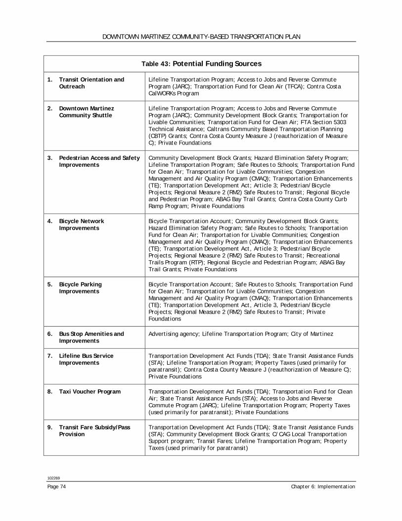
DOWNTOWN MARTINEZ COMMUNITY-BASED TRANSPORTATION PLAN
102269
Page 74 Chapter 6: Implementation
Table 43: Potential Funding Sources
1. Transit Orientation and Outreach
Lifeline Transportation Program; Access to Jobs and Reverse Commute Program (JARC); Transportation Fund for Clean Air (TFCA); Contra Costa CalWORKs Program
2. Downtown Martinez Community Shuttle
Lifeline Transportation Program; Access to Jobs and Reverse Commute Program (JARC); Community Development Block Grants; Transportation for Livable Communities; Transportation Fund for Clean Air; FTA Section 5303 Technical Assistance; Caltrans Community Based Transportation Planning (CBTP) Grants; Contra Costa County Measure J (reauthorization of Measure C); Private Foundations
3. Pedestrian Access and Safety Improvements
Community Development Block Grants; Hazard Elimination Safety Program; Lifeline Transportation Program; Safe Routes to Schools; Transportation Fund for Clean Air; Transportation for Livable Communities; Congestion Management and Air Quality Program (CMAQ); Transportation Enhancements (TE); Transportation Development Act; Article 3; Pedestrian/Bicycle Projects; Regional Measure 2 (RM2) Safe Routes to Transit; Regional Bicycle and Pedestrian Program; ABAG Bay Trail Grants; Contra Costa County Curb Ramp Program; Private Foundations
4. Bicycle Network Improvements
Bicycle Transportation Account; Community Development Block Grants; Hazard Elimination Safety Program; Safe Routes to Schools; Transportation Fund for Clean Air; Transportation for Livable Communities; Congestion Management and Air Quality Program (CMAQ); Transportation Enhancements (TE); Transportation Development Act, Article 3; Pedestrian/Bicycle Projects; Regional Measure 2 (RM2) Safe Routes to Transit; Recreational Trails Program (RTP); Regional Bicycle and Pedestrian Program; ABAG Bay Trail Grants; Private Foundations
5. Bicycle Parking Improvements
Bicycle Transportation Account; Safe Routes to Schools; Transportation Fund for Clean Air; Transportation for Livable Communities; Congestion Management and Air Quality Program (CMAQ); Transportation Enhancements (TE); Transportation Development Act, Article 3, Pedestrian/Bicycle Projects; Regional Measure 2 (RM2) Safe Routes to Transit; Private Foundations
6. Bus Stop Amenities and Improvements
Advertising agency; Lifeline Transportation Program; City of Martinez
7. Lifeline Bus Service Improvements
Transportation Development Act Funds (TDA); State Transit Assistance Funds (STA); Lifeline Transportation Program; Property Taxes (used primarily for paratransit); Contra Costa County Measure J (reauthorization of Measure C); Private Foundations
8. Taxi Voucher Program Transportation Development Act Funds (TDA); Transportation Fund for Clean Air; State Transit Assistance Funds (STA); Access to Jobs and Reverse Commute Program (JARC); Lifeline Transportation Program; Property Taxes (used primarily for paratransit); Private Foundations
9. Transit Fare Subsidy/Pass Provision
Transportation Development Act Funds (TDA); State Transit Assistance Funds (STA); Community Development Block Grants; C/CAG Local Transportation Support program; Transit Fares; Lifeline Transportation Program; Property Taxes (used primarily for paratransit)
DOWNTOWN MARTINEZ COMMUNITY-BASED TRANSPORTATION PLAN
102269
Wilbur Smith Associates Page 75
NEXT STEPS The effectiveness of this CBTP will be measured by the success in moving forward to implement the recommended solutions to close transportation gaps. The responsibility for implementation of the CBTP will primarily fall on the shoulders of the City of Martinez, Contra Costa County and community organizations. Their commitment will determine whether this plan sits on the shelf or becomes an active and effective planning tool. The community will also share some of this responsibility; they will be charged with reminding public officials of the importance of these projects and making the commitment to work closely with the lead agencies. Now that the CBTP is completed, what are the next steps to be taken to insure implementation of the plan? Tasks would need to be refined by staff and additional steps may be necessary depending on the funding source(s) or how the various lead agencies choose to implement the recommendations in the report. The length of time it may take to fully implement the recommendations for each solution may vary depending on capital acquisitions, staffing, participation from local jurisdictions, and funding. The following four steps will assist in directing a plan of action. 1. Continue community involvement The planning process for the CBTP was designed to ensure participation by members of the community and appropriate public agencies. Although the bulk of the implementation process will be the responsibility of public agencies, the public should continue to be involved to monitor progress and lobby for results. 2. Find a champion The project will have the greatest possibility of success if a project champion can be found. This can be a person, public agency, community group or public official. Their task will be to keep the project alive and to remind the responsible party of the importance of the project when interest or progress starts to fade. 3. Define work plan and timeline Starting with the high priority projects, it will be necessary to develop a work plan and timeline for each solution. A clear understanding of the steps needed for implementation will make it easier to focus on each task and know what needs to be accomplished and who is the best person to lead the task. Major milestones should be set to gauge the effectiveness of the effort. 4. Secure funding The most significant barrier to implementing any of the recommended solutions is, of course, the lack of available funds. Although grants are difficult to get without a well-defined project, it is in everyone’s best interest to identify and secure funding (even partial funding) as soon as possible.

Appendix A Project Fact Sheet
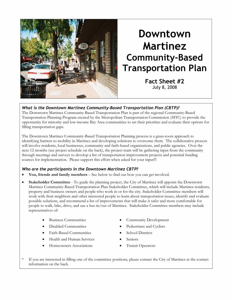
Downtown Martinez
Community-Based Transportation Plan
Fact Sheet #2 July 8, 2008
What is the Downtown Martinez Community-Based Transportation Plan (CBTP)? The Downtown Martinez Community-Based Transportation Plan is part of the regional Community-Based Transportation Planning Program created by the Metropolitan Transportation Commission (MTC) to provide the opportunity for minority and low-income Bay Area communities to set their priorities and evaluate their options for filling transportation gaps. The Downtown Martinez Community-Based Transportation Planning process is a grass-roots approach to identifying barriers to mobility in Martinez and developing solutions to overcome them. The collaborative process will involve residents, local businesses, community and faith-based organizations, and public agencies. Over the next 12 months (see project schedule on the back), the project team will be gathering input from the community through meetings and surveys to develop a list of transportation improvement projects and potential funding sources for implementation. Please support this effort when asked for your input!!!
Who are the participants in the Downtown Martinez CBTP? � You, friends and family members – See below to find out how you can get involved.
� Stakeholder Committee - To guide the planning project, the City of Martinez will appoint the Downtown Martinez Community-Based Transportation Plan Stakeholder Committee, which will include Martinez residents, property and business owners and people who work in or for the city. Stakeholder Committee members will work with their neighbors and other interested people to learn about transportation issues, identify and evaluate possible solutions, and recommend a list of improvements that will make it safer and more comfortable for people to walk, bike, drive, and use a bus in/out of Martinez. Stakeholder Committee members may include representatives of:
� Business Communities � Disabled Communities � Faith-Based Communities � Health and Human Services � Homeowners Associations
� Community Development � Pedestrians and Cyclists � School Districts � Seniors � Transit Operators
* If you are interested in filling one of the committee positions, please contact the City of Martinez at the contact information on the back.
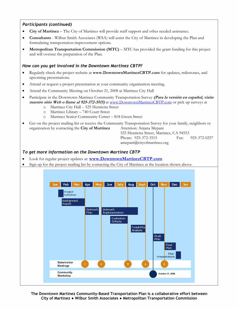
The Downtown Martinez Community-Based Transportation Plan is a collaborative effort between City of Martinez � Wilbur Smith Associates � Metropolitan Transportation Commission
Participants (continued)
� City of Martinez – The City of Martinez will provide staff support and other needed assistance. � Consultants - Wilbur Smith Associates (WSA) will assist the City of Martinez in developing the Plan and
formulating transportation improvement options. � Metropolitan Transportation Commission (MTC) – MTC has provided the grant funding for this project
and will oversee the preparation of the Plan.
How can you get involved in the Downtown Martinez CBTP?
� Regularly check the project website at www.DowntownMartinezCBTP.com for updates, milestones, and upcoming presentations.
� Attend or request a project presentation at your community organization meeting. � Attend the Community Meeting on October 21, 2008 at Martinez City Hall � Participate in the Downtown Martinez Community Transportation Survey (Para la versión en español, visite
nuestro sitio Web o llame al 925-372-3515) at www.DowntownMartinezCBTP.com or pick up surveys at o Martinez City Hall – 525 Henrietta Street o Martinez Library – 740 Court Street o Martinez Senior Community Center – 818 Green Street
� Get on the project mailing list or receive the Community Transportation Survey for your family, neighbors or organization by contacting the City of Martinez Attention: Anjana Mepani 525 Henrietta Street, Martinez, CA 94553 Phone: 925-372-3515 Fax: 925-372-0257 [email protected]
To get more information on the Downtown Martinez CBTP
� Look for regular project updates at: www.DowntownMartinezCBTP.com � Sign up for the project mailing list by contacting the City of Martinez at the location shown above.
Appendix B Community Survey
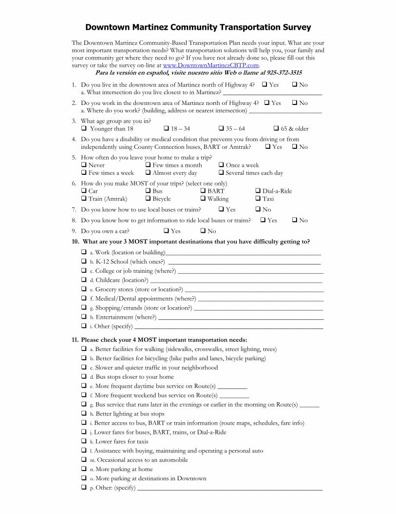
Downtown Martinez Community Transportation Survey The Downtown Martinez Community-Based Transportation Plan needs your input. What are your most important transportation needs? What transportation solutions will help you, your family and your community get where they need to go? If you have not already done so, please fill out this survey or take the survey on-line at www.DowntownMartinezCBTP.com.
Para la versión en español, visite nuestro sitio Web o llame al 925-372-3515
1. Do you live in the downtown area of Martinez north of Highway 4? � Yes � No a. What intersection do you live closest to in Martinez? ______________________________
2. Do you work in the downtown area of Martinez north of Highway 4? � Yes � No a. Where do you work? (building, address or nearest intersection) ______________________
3. What age group are you in? � Younger than 18 � 18 – 34 � 35 – 64 � 65 & older
4. Do you have a disability or medical condition that prevents you from driving or from independently using County Connection buses, BART or Amtrak? � Yes � No
5. How often do you leave your home to make a trip? � Never � Few times a month � Once a week � Few times a week � Almost every day � Several times each day
6. How do you make MOST of your trips? (select one only) � Car � Bus � BART � Dial-a-Ride � Train (Amtrak) � Bicycle � Walking � Taxi
7. Do you know how to use local buses or trains? � Yes � No
8. Do you know how to get information to ride local buses or trains? � Yes � No
9. Do you own a car? � Yes � No 10. What are your 3 MOST important destinations that you have difficulty getting to?
� a. Work (location or building)_______________________________________________ � b. K-12 School (which ones?) ______________________________________________ � c. College or job training (where?) ____________________________________________ � d. Childcare (location?) ____________________________________________________ � e. Grocery stores (store or location?) __________________________________________ � f. Medical/Dental appointments (where?) ______________________________________ � g. Shopping/errands (store or location?) _______________________________________ � h. Entertainment (where?) __________________________________________________ � i. Other (specify) _________________________________________________________
11. Please check your 4 MOST important transportation needs:
� a. Better facilities for walking (sidewalks, crosswalks, street lighting, trees) � b. Better facilities for bicycling (bike paths and lanes, bicycle parking) � c. Slower and quieter traffic in your neighborhood � d. Bus stops closer to your home � e. More frequent daytime bus service on Route(s) _________ � f. More frequent weekend bus service on Route(s) _________ � g. Bus service that runs later in the evenings or earlier in the morning on Route(s) ______ � h. Better lighting at bus stops � i. Better access to bus, BART or train information (route maps, schedules, fare info) � j. Lower fares for buses, BART, trains, or Dial-a-Ride � k. Lower fares for taxis � l. Assistance with buying, maintaining and operating a personal auto � m. Occasional access to an automobile � n. More parking at home � o. More parking at destinations in Downtown � p. Other: (specify) ________________________________________________________
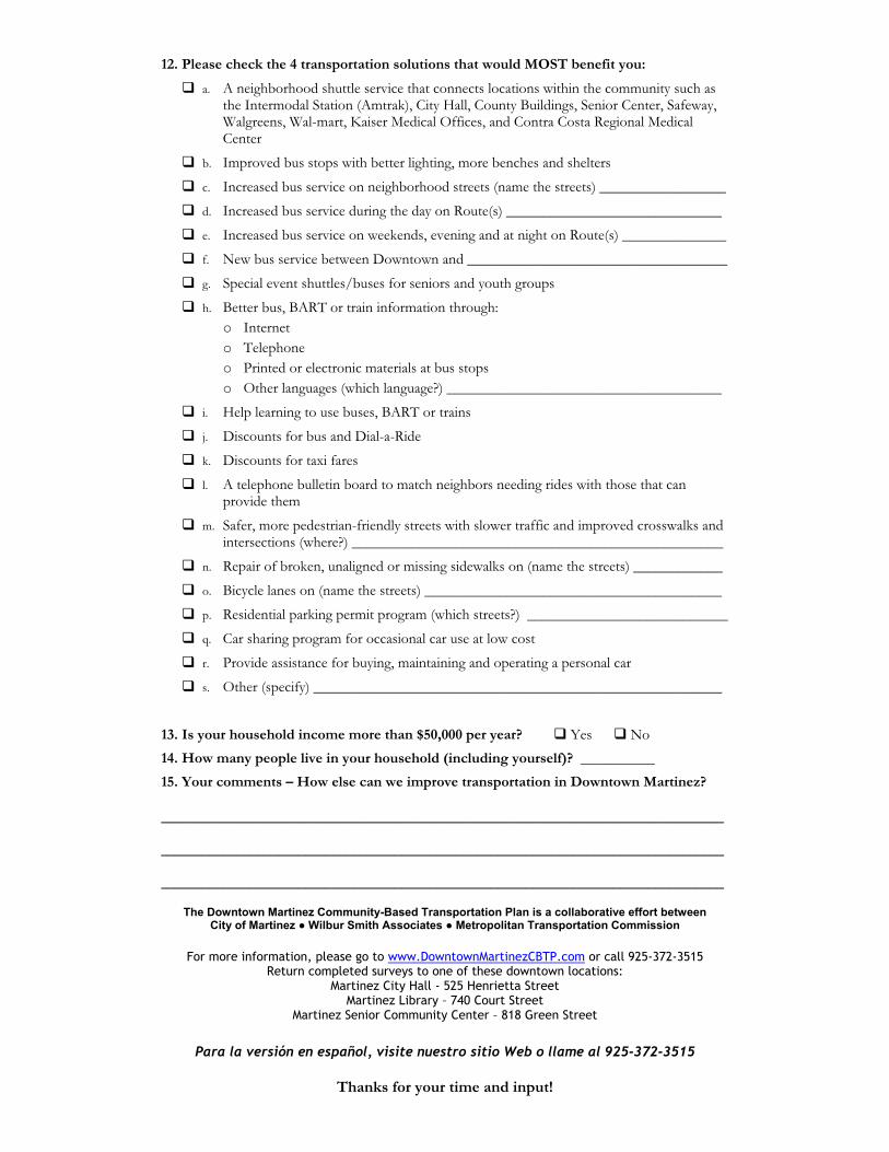
12. Please check the 4 transportation solutions that would MOST benefit you:
� a. A neighborhood shuttle service that connects locations within the community such as the Intermodal Station (Amtrak), City Hall, County Buildings, Senior Center, Safeway, Walgreens, Wal-mart, Kaiser Medical Offices, and Contra Costa Regional Medical Center
� b. Improved bus stops with better lighting, more benches and shelters
� c. Increased bus service on neighborhood streets (name the streets) _________________
� d. Increased bus service during the day on Route(s) _____________________________
� e. Increased bus service on weekends, evening and at night on Route(s) ______________
� f. New bus service between Downtown and ___________________________________
� g. Special event shuttles/buses for seniors and youth groups
� h. Better bus, BART or train information through: o Internet o Telephone o Printed or electronic materials at bus stops o Other languages (which language?) _____________________________________
� i. Help learning to use buses, BART or trains
� j. Discounts for bus and Dial-a-Ride
� k. Discounts for taxi fares
� l. A telephone bulletin board to match neighbors needing rides with those that can provide them
� m. Safer, more pedestrian-friendly streets with slower traffic and improved crosswalks and intersections (where?) __________________________________________________
� n. Repair of broken, unaligned or missing sidewalks on (name the streets) ____________
� o. Bicycle lanes on (name the streets) ________________________________________
� p. Residential parking permit program (which streets?) ___________________________
� q. Car sharing program for occasional car use at low cost
� r. Provide assistance for buying, maintaining and operating a personal car
� s. Other (specify) _______________________________________________________
13. Is your household income more than $50,000 per year? � Yes � No
14. How many people live in your household (including yourself)? __________
15. Your comments – How else can we improve transportation in Downtown Martinez? __________________________________________________________________________________
__________________________________________________________________________________
__________________________________________________________________________________
The Downtown Martinez Community-Based Transportation Plan is a collaborative effort between City of Martinez � Wilbur Smith Associates � Metropolitan Transportation Commission
For more information, please go to www.DowntownMartinezCBTP.com or call 925-372-3515
Return completed surveys to one of these downtown locations: Martinez City Hall - 525 Henrietta Street
Martinez Library – 740 Court Street Martinez Senior Community Center – 818 Green Street
Para la versión en español, visite nuestro sitio Web o llame al 925-372-3515
Thanks for your time and input!

Appendix C Student Survey
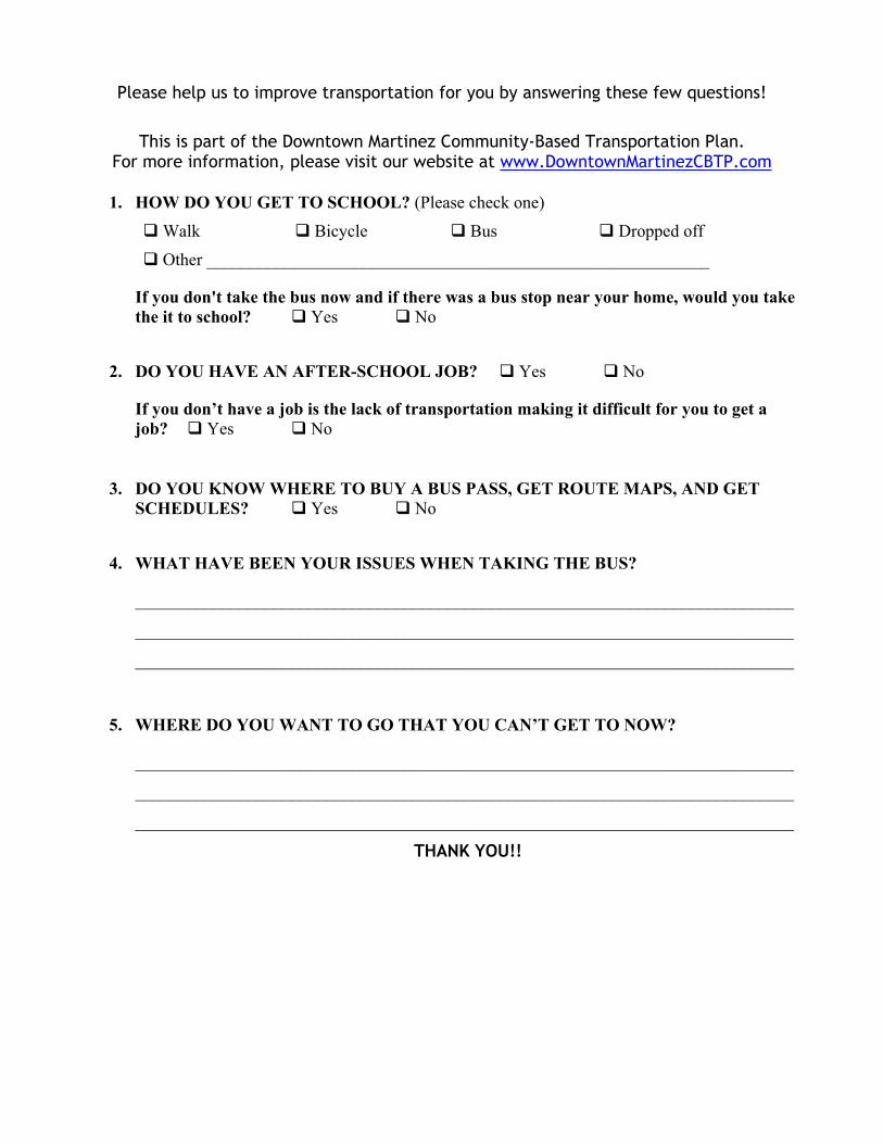
Please help us to improve transportation for you by answering these few questions!
This is part of the Downtown Martinez Community-Based Transportation Plan. For more information, please visit our website at www.DowntownMartinezCBTP.com
1. HOW DO YOU GET TO SCHOOL? (Please check one)
� Walk � Bicycle � Bus � Dropped off
� Other __________________________________________________________
If you don't take the bus now and if there was a bus stop near your home, would you take the it to school? � Yes � No
2. DO YOU HAVE AN AFTER-SCHOOL JOB? � Yes � No
If you don’t have a job is the lack of transportation making it difficult for you to get a job? � Yes � No
3. DO YOU KNOW WHERE TO BUY A BUS PASS, GET ROUTE MAPS, AND GET SCHEDULES? � Yes � No
4. WHAT HAVE BEEN YOUR ISSUES WHEN TAKING THE BUS?
____________________________________________________________________________
____________________________________________________________________________
____________________________________________________________________________
5. WHERE DO YOU WANT TO GO THAT YOU CAN’T GET TO NOW?
____________________________________________________________________________
____________________________________________________________________________
____________________________________________________________________________
THANK YOU!!