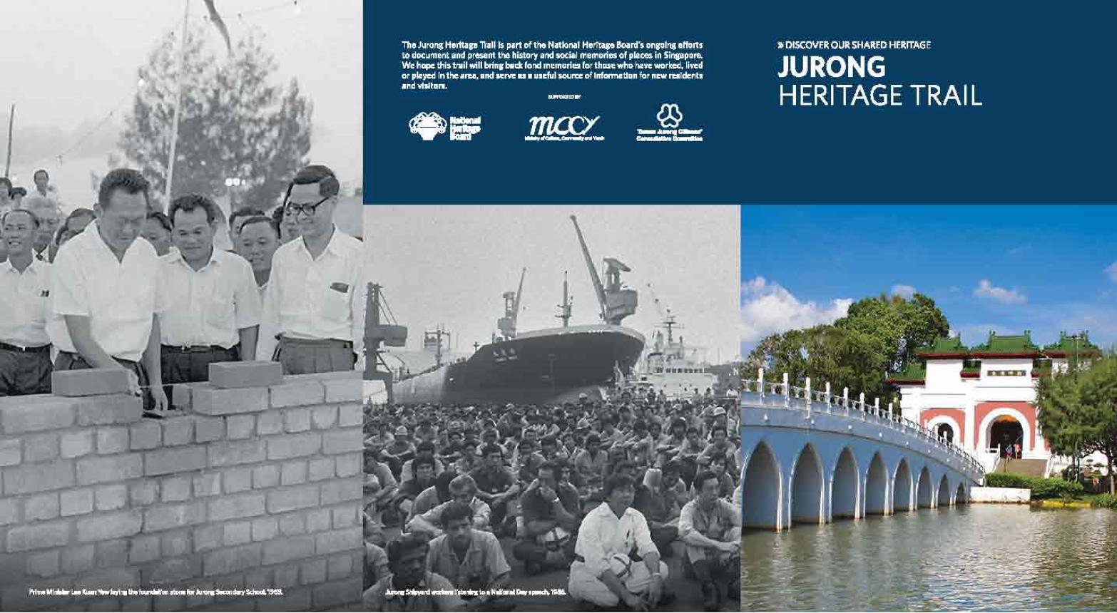
Download Jurong Heritage Trail booklet
78
Transcript of Download Jurong Heritage Trail booklet

Introduction p. 2
Early History Historical extent of JurongThe Orang Laut and Selat SamulunEarly accounts of JurongThe gambier pioneers: opening up the interiorEvolution of land use in Jurong
Growth of communities p. 18Villages and social lifeNavigating JurongBeginnings of industryEarly educational institutions
Tide of change: World War II p. 30101 Special Training SchoolKranji-Jurong defence line
Backbone of the nation: Jurong in the Singapore Story p. 35Industrialisation, Jurong and the making of modern SingaporeGoh’s folly?Housing and building a liveable Jurong
Jurong Heritage Trail p. 44Legacy of old JurongHawker centres in JurongHong Kah VillageChew Boon Lay and the Peng Kang areaLeading the Forces: the Singapore Armed Forces in JurongSAFTIArmy Museum of SingaporeSingapore Discovery CentreIndustrial HeritageFormer Jurong Town HallJurong PortJurong ShipyardJurong Fishery PortThe Jurong RailwayJurong and Singapore’s waste managementAround Sungei JurongJurong LakeChinese Garden and Japanese GardenJurong HillJurong BirdparkPandan Reservoir and Sungei PandanFormer Jurong Drive-In CinemaFormer Tang DynastySingapore Science Centre
Religious Institutions in Jurong p. 68Masjid HasanahTong Whye TempleTuas Tua Pek Kong TempleArulmigu Murugan TempleChurch of St Francis of Assisi
Our Museum @ Taman Jurong p. 71
Jurong Bird Park (p. 64)2 Jurong Hill
One of the most-loved places in Jurong, the Jurong Bird Park is the largest avian park in the Asia Pacific region with over 400 species of birds.
Jurong Fishery Port (p. 57)Fishery Port RoadEstablished in 1969 at the former Tanjong Balai, this fishery port handles most of the fish imported into Singapore and is also a marketing distribution centre for seafood. The Jurong Fishery Port and Market are open to public visits.
Jurong Hill (p. 63)1 Jurong Hill
Currently the highest ground in Jurong, this hill provides a vista of Jurong Industrial Estate. In the late 1960s, the hill was transformed into a recreational space. Visiting heads of state and dignitaries commemorated their visit to Jurong by planting trees in the Garden of Fame on the hill.
Jurong Lake (p. 62)Bounded by Yuan Ching Road and Boon Lay Way, accessible from various points
Jurong Lake is one of the scenic green spaces earmarked for leisure and recreation in Jurong. In 1971, the upper section of Jurong River was dammed, creating Jurong Lake. The Nature Society of Singapore has catalogued some 123 species of birds in the area.
Jurong Port (p. 55)37 Jurong Port Road
Jurong’s deep harbour made it suitable for a modern port to be developed. Jurong Port officially began operations in 1965 with two
ship berths and handled a diverse range of cargo including metals, raw sugar, industrial chemicals and timber. The port is not open for public access.
Jurong Railway (p. 58)A remaining track can be found at Ulu Pandan Park Connector, between Clementi Ave 4 and 6
Opened in 1966, Jurong Railway was another means to transport raw materials and export finished products from the industrial estate. Operations ceased in the mid-1990s.
Jurong’s brickworks industry and dragon kilns (p. 24)85 Lorong Tawas (Thow Kwang Industry) and 97L Lorong Tawas (Jalan Bahar Clay Studios), both off Jalan Bahar
Thow Kwang Industry and Jalan Bahar Clay Studios currently host Singapore’s last two remaining dragon kilns. Jurong was known for its brickworks industry, which played a critical role in the construction of Singapore’s public estates in the 1960s. Brickworks operated in Jurong as early as the 1920s.
Jurong Shipyard (p. 56)29 Tanjong Kling Road
Jurong Shipyard enabled Singapore to establish itself as a major player in the shipping and shipbuilding industry. The shipyard began operations in 1964 to construct and repair ships and vessels. It is not open for public access.
Jurong Town Hall (p. 54)9 Jurong Town Hall Road
Constructed as the headquarters of the Jurong Town Corporation, the building gained Conservation Status for its unique architecture and symbolic history in Singapore’s industrialisation. The building is also a national monument.
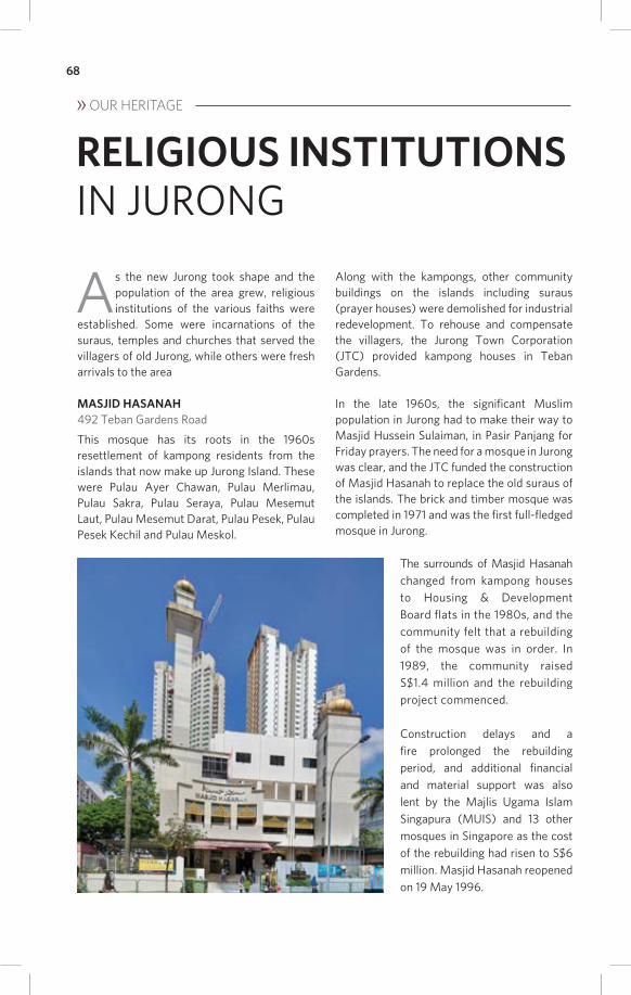
Masjid Hasanah (p. 68)492 Teban Gardens Road
Following the resettlement of villagers from Jurong’s surrounding islands in the 1960s, Masjid Hasanah was built to replace the old suraus (small prayer houses) of the islands. With community support, the mosque was rebuilt and reopened in 1996.
Nanyang University (p. 28)12 Nanyang Drive (Library and Administration Building); Yunnan Garden (Memorial); Jurong West Street 93 (Arch)
The creation of Nanyang University is a milestone in local and regional education and a marker of community action. Established in 1955, Nanyang University was the first Chinese university outside of China. The abovementioned three focal points of the university are national monuments.
Old Jurong Road (p. 2)Accessible from Bukit Batok Road or Jurong West Avenue 2Before the development of Jurong in the 1960s, Jurong Road was the only road leading to south-western Singapore.
Our Museum @ Taman Jurong (p. 71)1 Yung Sheng Road
Our Museum @ Taman Jurong is Singapore’s first community museum, showcasing exhibitions co-created with the Taman Jurong community.
Pandan Reservoir and Sungei Pandan (p. 65)Accessible from West Coast Road or Jalan Buroh
Before the Pandan Reservoir was constructed in 1974, the swamps of Sungei Pandan were where Singapore’s most productive prawn farming ponds used to thrive. Today, the reservoir is a facility for water sports, such as canoeing, rowing and sport fishing.
SAFTI (p. 51)500 Upper Jurong Road
Following Singapore’s independence in 1965, the Singapore Armed Forces Training Institute (SAFTI) was established to provide formal training for officers to lead its armed forces. Formerly located at Pasir Laba Camp, the institute moved to its current premises in 1995.
Science Centre Singapore (p. 67)15 Science Centre Road
One of the first such facilities in Asia when it opened in 1977, the centre aims to promote and inculcate a love for scientific learning. It houses over a thousand exhibits in its 14 galleries.
Singapore Discovery Centre (p. 53)510 Upper Jurong Road
Begun from the idea of setting up a National Defence Exhibition Centre, Singapore Discovery Centre (SDC) opened in 1996, focusing on National Education to inspire a sense of confidence in the future of Singapore and in the Singapore Armed Forces (SAF).
Tong Whye Temple (p. 69)212 Jurong East Street 32
Tong Whye Temple was established in 1932 by Hokkien migrants from southern Fujian in China. The migrants, who settled at the 10.5 milestone of Jurong Road, named the temple after their hometown temple in Quanzhou.
Tuas Tua Pek Kong Temple (p. 69)118 Boon Lay Drive
This temple found its origins in the Japanese Occupation of Singapore. Following the death of 39 villagers by invading Japanese forces in 1942, a group of eight villagers founded the Tua Pek Kong temple in an attap hut in Tuas, seeking spiritual solace.


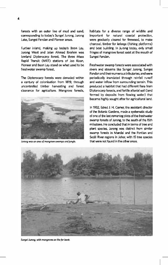


Prawn farming, 1960s.


29
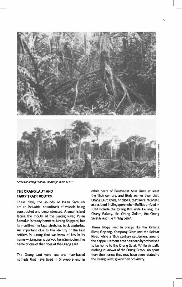
Opening of Nanyang University, 1958.


50
The many methods of making it up the hill
did have a dramatic eff ect on the leg muscles
of some, as Major (National Service) Paul
Supramaniam testifi ed:
“Once you were used to running up Peng Kang Hill in boots, often with your Standard Battle Order (SBO) and helmet, to be able to just run in PT kit (physical training kit of a t-shirt and shorts) felt like you were fl ying! We were so fi t, and we were so honed that when we were in PT kit, we felt like we could defy gravity! That was the most positive, exhilarating experience. Nothing else quite matched it, not even being commissioned!”
The sinew-straining, backbone-testing aspects
of Peng Kang Hill and its nearby elevations
made Pasir Laba the perfect place for a military
proving ground. It was said that while recruits
of many races including Malays, Chinese,
Indians and Eurasians passed through the
gates of SAFTI, all inside were of one colour – a
deep sun-burnt brown.
The area was a military focal point since the
1930s, when the colonial authorities installed a
pair of artillery batteries at
the end of Pasir Laba Road
for coastal defence. The
two six-inch guns, part of
the Faber Fire Command,
were intended to protect
the western approach
to Sembawang Naval
Base from potential naval
assaults.
During the Japanese
invasion of Singapore in
February 1942, the Pasir
Laba Battery was used to
shell Imperial Army troops
embarking to cross the
Straits of Johor. However,
Malaya Command had
ordered ammunition to
be conserved for a drawn-
out siege of Singapore,
and the battery fi red only
40 rounds from the night of February 8 to
4.30am the next morning.
The Japanese then began to bombard the Pasir
Laba area with artillery and dive-bombing
planes. By 8.15am, the battery had been hit
several times and the 44th Indian Infantry
Brigade in the area was in retreat. Amid the
confusion, Allied troops that were attempting
to withdraw from Pasir Laba by sea were also
hit by friendly fi re, from the Fort Siloso Battery
on Sentosa. Demolition parties arrived and by
6.30pm, the guns, magazines, lights and stores
of the Pasir Laba Battery were destroyed to
prevent the Japanese from using them.
Following Singapore’s independence in 1965,
the new nation needed to establish a formal
training structure for offi cers to lead its armed
forces. Existing regiments and battalions such
as the First Singapore Infantry Regiment (1 SIR)
had been led by Malaysians or British offi cers.
The camp chosen to house the new Singapore
Armed Forces Training Institute (SAFTI) was
Pasir Laba Camp, in the western reaches of
Jurong near the intersection of Upper Jurong
Road and Pasir Laba Road.
Pasir Laba Battery before the war, 1930s.

51
The fi rst Instructors’ Preparatory Course
commenced on 15 February 1966 at the
temporarily empty Jurong Town Primary School.
With Pasir Laba chosen over Pulau Ubin and
Pulau Tekong, the fi rst intake of Offi cer Cadets
began training on 1 June 1966 at Pasir Laba Camp,
while permanent facilities were being built.
On June 1966, SAFTI was offi cially opened by
Dr Goh Keng Swee, then Minister for Interior
and Defence. SAFTI’s fi rst Director was then
– Lieutenant Colonel Kirpa Ram Vij, who was
seconded from the civil service and had been
a volunteer offi cer in the Singapore Military
Forces (the SAF’s precursor).
With the fi rst group of 117 offi cer cadets
graduating from SAFTI on 16 July 1967, the
institute gradually grew its training capabilities.
Starting off with the Offi cer Cadet School (OCS)
and School for Infantry Section Leader Training
(SISL), SAFTI added schools for artillery, armour,
signals, combat engineer and other service
arms in the 1970s. By the 1980s, some 2,000
graduates were passing through SAFTI each year
and the institute saw a need to expand to cope
with the increased training demands.
In 1987, plans for the new SAFTI Military Institute
(SAFTI MI) to be located on an 88-hectare site within a
stone’s throw of Pasir Laba Camp were announced.
SAFTI had grown into an integral part of the SAF’s
identity, and its acronym was retained for the name
of the new institute. SAFTI MI was opened by Prime
Minister Goh Chok Tong on 25 August 1995.
Where the old SAFTI generally trained offi cers
for the army, navy and air force separately, the
new institute brought training for the three arms of
the Republic of Singapore Air Force, the Republic of
Singapore Navy and the Singapore Army together to
enhance operational integration and understanding.
SAFTI
500 Upper Jurong Road
Present-day SAFTI MI.
Defence Minister Dr Goh Keng Swee reviewing the fi rst offi cers’ commissioning parade at SAFTI, Pasir Laba Camp, on 16 July 1967.

52
The tri-service training
philosophy is refl ected
in SAFTI MI’s most
prominent landmark,
a 60m-tall three-sided
tower guarded by a pair
of stone lions previously
mounted at Merdeka
Bridge. The prominent
‘Merdeka Lions’ were
donated to the Ministry
of Defence in March
1988 and have been
sited at the SAFTI
Military Institute since
1995.
The architectural layout of SAFTI MI
emphasises triangular motifs, representing
the unity of the tri-services. These motifs can
be found in the institute’s three-sided tower,
the triangular Singapore Discovery Centre and
the entrance. Other landmarks here include
the commissioning parade ground and the
100m-long suspension bridge connecting
SAFTI MI to the former SAFTI grounds in Pasir
Laba Camp. Infl uences of local architectural
styles such as Chinese monasteries, Malay
kampong houses and Peranakan terrace
houses, can also be seen in the buildings of
SAFTI MI.
ARMY MUSEUM OF SINGAPORE
520 Upper Jurong Road
By a serene lake in the SAFTI Military Institute
compound stands the Army Museum of
Singapore (ARMS). Opened in September
2007 to coincide with the 40th year of National
Service celebrations, the museum preserves
the heritage of the Singapore Army.
ARMS informs visitors of the circumstances
surrounding the birth of the Singapore Army, and
how National Service has become a part of the
nation’s social fabric. It honours the contributions
and celebrates the experiences of Singapore’s
soldiers through galleries showcasing the Army’s
development since its formative years.
March-past of the fi rst batch of 117 offi cer cadets at SAFTI, 1967.
View of exterior of Army Museum of Singapore.

53
SINGAPORE DISCOVERY CENTRE
510 Upper Jurong Road
The idea for setting up a National Defence
Exhibition Centre surfaced as early as 1989. This
name was then changed to the SAFTI Exhibition
Centre (SEC) and it was to be developed in
tandem with the building of SAFTI Military
Institute and housed within its grounds. The focus
of the centre was National Education (NE) with
the objective to instil in Singaporeans a sense of
confi dence in the future of Singapore and in the
Singapore Armed Forces (SAF).
During the development of the SEC, it
was decided that the centre would take
a diff erent approach from the traditional
museum experience to become a “discovery
centre” where visitors can enjoy state-of-
the-art simulators and interactive exhibits.
The centre’s architecture was designed to
refl ect its links to the SAF, with a prominent
triangular roof incorporated to represent the
tri-services: the Army, Air Force and Navy.
The SEC underwent a fi nal name change to
become the Singapore Discovery Centre (SDC)
and was offi cially opened by then president
Mr Ong Teng Cheong on 23 November 1996.
In 2005, SDC underwent a major redevelopment
to meet the changing needs of National Education.
The centre was reopened on 18 July 2006 by then
Minister for Defence, Mr Teo Chee Hean. The
opening of the revamped SDC signifi ed a new
chapter for SDC. It has since evolved into the go-
to place to celebrate the Singapore Story.
SDC’s mission today is to share the Singapore
Story and to inspire a desire to contribute to
Singapore’s future.
HERITAGE TREE
Sea Fig (Ficus superba)
This deciduous strangling fi g grows mostly
in coastal areas and develops a vast crown
formed by many large spreading branches.
From these grow many aerial roots, as well as
from the trunk and the base of lower limbs.
This tree is located at 16 Nanyang Drive, at the
Nanyang Technological University.
Singapore Discovery Centre (SDC) today.
Trunk girth: 4.8m Height: 15m
Starting construction works for the new SDC, 2005

54
JURONG’S INDUSTRIAL HERITAGE
A number of industrial facilities built in the
1960s and 1970s have become integral facets
of Jurong’s identity, even if some of them are
no longer used for their original purposes.
These facilities include the old Jurong Town
Hall, Jurong Port and Jurong Shipyard as well
as the old Jurong Railway, and feature as stops
on our heritage trail.
FORMER JURONG TOWN HALL
9 Jurong Town Hall Road
The late 1960s had seen the demands of
managing the industrial estate in Jurong grow
exponentially. It was decided that the Economic
Development Board (EDB) should concentrate
on economic promotion, wooing and engaging
investors and helping fi nance projects. To
manage Jurong and other industrial estates, the
Jurong Town Corporation (JTC) was formed in
1968 by an Act of Parliament.
Constructed as the headquarters of the JTC,
the Jurong Town Hall has been described as a
building “deserving recognition as the island’s
singular icon outside the Central Area.”
The JTC operated from temporary premises,
including a former canning factory owned by
Chew Boon Lay, for six years before moving
into the S$7m Jurong Town Hall in 1974. The
Town Hall had been completed by Architects
Team 3 in 1968, with Lim Chong Keat, who
also designed the Singapore Conference Hall,
as principal architect. An elongated building
reminiscent of a ship with two connected
blocks of unequal length, the Town Hall’s a
58m clock tower with one of the largest digital
clocks in the region is a landmark for visitors
to Jurong.
Jurong Town Hall carried enormous symbolism
as an expression of the nation’s confi dence
in industrialism as a pillar of development.
Sitting on a vantage point, the building served
as a panopticon and crown of the Jurong area,
while the hard granolith fi nishes, heaviness of
its inverted form and modular, angular patterns
emphasise the industrial character.
Jurong Town Hall today.
Jurong Town Hall as it was being constructed in 1973.

55
A Garden of Fame on the grounds
commemorates the visits of various dignitaries,
with former Prime Minister of China Li Peng,
Sultan Hassanal Bolkiah of Brunei and former
South Korean President Chun Doo Hwan
having planted trees here. The garden is an
expansion of an earlier garden on Jurong Hill
where distinguished visitors planted trees.
By the turn of the 21st century, JTC had
outgrown the Town Hall, and in 2000 moved
to a larger building across Jurong Town Hall
Road. The move to JTC Summit also saw
the organisation change its name to JTC
Corporation. The Town Hall was then occupied
by iHub, a space for start-up companies.
The Town Hall’s history and iconic architecture
was dignifi ed with the granting of Conservation
Status by the Urban Redevelopment Authority
in November 2005.
JURONG PORT
37 Jurong Port Road
The natural deepwater harbour of Jurong,
from Tanjong Gul to the waters around Pulau
Samulun and Pulau Damar Laut, was one
of the main reasons Jurong was selected as
Singapore’s fi rst industrial town.
Jurong Port stands on what used to be Kampong
Pulau Damar Darat, Kampong Tanjong Balai
and Pulau Damar Laut, to the east of the mouth
of the Sungei Jurong. In 1963, wharves were
constructed here by the Economic Development
Board (EDB) to allow raw materials to be shipped
in and fi nished products to be shipped out from
the factories of Jurong.
Offi cially beginning operations in 1965 with
two ship berths, Jurong Port handled a diverse
range of cargo, including steel plates, copper
slag, clinker (stony residue from coal burning
or furnaces), metals, cement, machinery, raw
sugar, potash, grain, beans, seeds, industrial
chemicals, scrap iron, timber and farm animals.
The Port was run by the EDB, with management
assistance from the Port of Singapore Authority
(PSA), before coming under the charge of the
Jurong Town Corporation in 1968.
Wang Swee Chuang (b. 1951), an operations
manager at the port in the late 1970s, recalled:
“For a long time, we didn’t even have an offi ce building. We had a site offi ce provided by one of the contractors working on one of our projects. It was a wooden, zinc-roofed shack. We had to use public toilets.
“There were no proper carparks and our cars were often parked under conveyors carrying fertiliser, sugar - the cars used to get coated, and a major concern of offi cers in the port was car corrosion. But this is an industrial port, not like the Port of Singapore Authority (PSA) where things come in containers.
Jurong port, shipyard and Jurong Island in the distance.

56
“Things (were) a lot more comfortable (after) we got our administration building. But the environment is still harsher for staff who work in the open. But some of them like it, the space, the sea breeze. Our staff are hardy men.”
With the expansion of Jurong Industrial Estate
in the 1970s, Jurong Port also grew, adding
deepwater berths and other port infrastructure.
The port hit the million ton mark for cargo
handled in 1970, and also started supply
and support services for the off shore oil, gas
and marine industries. In the 1990s, the port
reclaimed land and constructed facilities on
Pulau Damar Laut in a S$200m project, adding
deepwater berths, a Cement Terminal and a
causeway to the mainland.
A Container Terminal was started in 2001, as
well as a warehousing complex. By the middle
of the 2000s, Jurong Port began to handle
general cargoes previously handled at Pasir
Panjang Wharves.
JURONG SHIPYARD
29 Tanjong Kling Road
In the 1960s, part of the government’s
economic strategy involved making Singapore
a major player in shipping, shipbuilding and
repair, second only perhaps to the Asian leader
Japan. The ship repair facilities at the Singapore
Harbour Board dockyard in Keppel Harbour
were also groaning under the strain of growing
demand for shipbuilding and repair services.
Towards this end, the Economic Development
Board (EDB) worked with Japanese company
Ishikawa-Harima Heavy Industries to establish
and operate a shipyard at Pulau Samulun, with
the EDB holding 49% of the shares. According
to Joe Pillay, then chief of the Projects
Divison at the EDB, the deal with Ishikawa-
Harima spurred interest from other Japanese
manufacturers to invest in Jurong.
Jurong Shipyard was incorporated in April
1963 to construct, maintain and repair all
manner of ships and vessels, and also housed
workshops for the construction, manufacture
and assembly of heavy equipment.
While Pulau Samulun, overlooking the ancient
trade route of the Samulun Strait, possessed
a natural deepwater harbour, there were also
challenges to overcome before a shipyard
could be built. Yip Yue Wai, who began work at
the shipyard in his 20s, recalled:
“(There was) mud everywhere. There was no bridge linking the main island and Pulau Samulun. At the time, we used 44-gallon barrels to build rafts to enter and exit Pulau Samulun. Everything was inconvenient.”
Other workers made their way across by
sampan, before a pontoon bridge was built, and
water had to be transported from the mainland.
The kampong on Pulau Samulun, including
a school, a clinic, a mosque and houses,
was demolished and the villagers relocated
by June 1964. A fl oating dock was used to
start shipbuilding and repair services, while a Jurong Port, 1975.

57
drydock, slipway, quays, machinery shops and
administration buildings were constructed.
Jurong Shipyard began operations in 1964 and
in its fi rst year, built 11 vessels worth more
than $5m. The fi rst ship constructed there,
the 160-ton Tanjong Rambah, was launched in
December 1964 and by the time the shipyard
was offi cially opened on 5 November 1965, it
had already repaired 100 ships.
JURONG FISHERY PORT
Fishery Port Road
This fi shery port established in 1969 at the former
Tanjong Balai handles most of the fi sh imported
into Singapore. The Jurong Fishery Port is also a
marketing distribution centre for seafood, with a
wholesale fi sh market and shops.
The Fishery Port had come about after port
facilities were built at Tanjong Balai for a
diff erent purpose entirely. Lim Ho Hup, a former
director with the Economic Development Board
(EDB), recalled:
“(Singapore) used to have a barter trade area at the Telok Ayer Basin. A lot of barter trade (was) coming from Indonesia. They bring their copra,
rubber and all that. It was not desirable that they should be doing the barter trade in the centre of the city. (At Tanjong Balai), the Japanese were trying to build a submarine base. So the thinking was: if it’s good enough for a submarine base, it’s good enough for a lot of ships
“The idea was to build that and fence it off for barter trade purposes. It turns out that by the time we built it, there was Konfrontasi (a period of political and economic freeze between Indonesia and Malaysia, which Singapore was a part of) and there was no barter trade!
“We were wondering what to do with it, then the Primary Production (Department) people came up with the idea...to build (a fi shery port) on the other side of the river. We had built a port for barter trade and the barter trade was not there...we convinced everybody (and) that (became)the fi rst fi sheries port.”
Besides vessels from Indonesia and those
operating in the Indian and Pacifi c Oceans, the
Fishery Port also receives seafood via trucks
from Malaysia and Thailand, as well as by air
from countries including Australia, Bangladesh,
China, India, Myanmar, Taiwan and Vietnam.
An average of 200 to 250 tonnes of fi sh is
Jurong Shipyard, 1960s.

58
then sold at 110 market lots, with some 100
fi sh merchants licensed by the Agri-Food &
Veterinary Authority of Singapore (AVA) for
wholesale activities.
Between 2,000 to 3,000 fish mongers and
retailers, as well as staff of eateries and
seafood processing plants arrive each day
to purchase prawns, crabs, lobsters, squid
and popular species of fish including sea
bream, mackerel, gold-banded scad, red
snapper, pomfret, grouper and threadfin. The
Jurong Fishery Port and Market are open to
public visits.
THE OLD JURONG RAILWAY
Ulu Pandan Park Connector
As the production of the Jurong Industrial Estate
grew steadily from the late 1960s, planners
sought another option besides Jurong Port for
the transport of raw materials and the export of
fi nished products. Their gaze turned north and
the Economic Development Board (EDB) worked
with Keretapi Tanah Melayu (KTM, Malayan
Railways Limited) to develop Jurong Railway at
a cost of S$5.9m. The Jurong line branched off
from the main Malaysia-Singapore railway, and
was the fi rst new line built by KTM since World
War II.
The Jurong line was constructed between
September 1963 and early 1966, with around
19.3km of track laid, and was offi cially opened
on 5 March 1966 by Dato Ahmad bin Perang,
the general manager of KTM and Hon Sui Sen,
then chairman of the EDB and later Minister for
Finance.
Starting from the Bukit Timah Railway Station
next to King Albert Park, the Jurong Line ran
through Pasir Panjang and ended at Shipyard
Road, near the Mobil refi nery. Three branch
lines led to the National Iron and Steel Mills
(NatSteel), the heavy industries section of the
estate and to the wharves of Jurong Port.
Regular cargo services utilised the railway to
transport clinker (a residue of steel mills and
furnaces used to make cement) and timber
from peninsular Malaysia into Jurong, and
brought manufactured products the other
way. Changing trends in logistics led to more
effi cient methods of transportation however,
and the Jurong Railway ceased operations in
the mid-1990s.
Since then, the unused railway tracks of the
Jurong Line have been a haunt for explorers
and wildlife enthusiasts. Walks along the
Railway lines leading to the wharfs in Jurong, 1960s.
Co
urt
esy
of
Dr.
La
i Ch
ee
Kie
n

59
tracks take in bridges across the Sungei Pandan
among other crossings and can yield surprising
fl ora and fauna in patches of land reclaimed by
nature, as well as surrounding creeks, marshes
and ponds.
JURONG AND SINGAPORE’S
WASTE MANAGEMENT
A comprehensive waste management system
has made Singapore the only nation in the
world where all toilet waste is channelled into
sewers, through the Deep Tunnel Sewerage
System. A number of important facilities in
the national waste management system are
located in Jurong, including three ‘waste-to-
energy’ incineration plants in Tuas.
At these facilities, solid waste is reduced to
some 10% of its original volume, with energy
also being generated during the process. The
Tuas Incineration Plant was the second such
facility in Singapore and completed in 1986 at a
cost of S$200 million. Tuas South Incineration
Plant is the nation’s largest, sitting on 10.5ha of
reclaimed land, and incinerates 3,000 tonnes
of refuse a day.
The fi rst incineration plant built here through
a public-private partnership is the Keppel
Seghers Tuas Waste-to-Energy Plant, which
treats some 800 tonnes of solid waste daily
on a compact 1.6ha site. This plant can also
generate about 22 megawatts of green energy.
Ash and non-incinerable waste is collected from
plants and transited through the Tuas Marine
Transfer Station, before being transported by
tugboats to Semakau Landfi ll. Located in the midst
of a crescent of islands including Pulau Senang,
Pulau Pawai, Pulau Sebarok and the refi nery island
of Pulau Bukom, Semakau is the world’s fi rst
man-made off shore landfi ll. The landfi ll stands
on 350ha of reclaimed land, the result of a S$610
million project completed in 2003.
Despite its use as a landfi ll, Semakau boasts
a thriving marine eco-system with mangrove
swamps that act as a biological canary in the
mine, signalling any potential leakages of
waste. In January 2015, more than 700 coral
colonies naturally grown here were transported
to the Sisters Island Marine Park.
Rare marine fl ora has also been found in lagoons
on Semakau, including the giant Neptune’s Cup
Sponge, a species previously thought extinct
worldwide before its rediscovery in 2011 near
St John’s Island. Neptune’s Cup Sponges can
grow more than a meter in diameter and height,
and in the past were coveted by collectors and
used as tubs for babies. Semakau is open to the
public for selected recreational activities.
Oil refi neries at Jurong Island, offi cially opened in 2000.
60
TOPONYMY OF JURONG
Jurong Road
Jurong may derive from the Malay words jerung
(a species of shark), jurang (a gap or gorge) or
jurung (a corner).
Jurong Island
From January 1999, land reclamation to join
10 small islands to the south of the Samulun
Strait was begun. These were Pulau Pesek,
Pulau Pesek Kechil, Pulau Ayer Chawan, Pulau
Sakra, Pulau Ayer Merbau, Pulau Meskol, Pulau
Merlimau, Pulau Seraya, Pulau Mesemut Laut
and Pulau Mesemut Darat. The S$1.3 billion
project was the largest land reclamation
project in Singapore at the time.
Six districts on Jurong Island, now a
petrochemical, petroleum and natural gas hub,
refl ect the names of the former islets: Pesek,
Chawan, Sakra, Merbau, Merlimau and Seraya.
Jalan Ahmad Ibrahim
Named after Ahmad bin Ibrahim, a unionist and
politician who was Singapore’s fi rst Minister for
Health following self-government in 1959. He
later became Minister for Labour, and passed
away at the age 35 while in offi ce.
Jalan Boon Lay
Named after rubber magnate Chew Boon Lay,
who owned sizable tracts of land in Jurong (see
box story on Chew Boon Lay).
Jalan Peng Kang
Peng Kang was previously the name of a district
on the west of the Sungei Jurong, and derives
from the Hokkien word for the process of
boiling gambier in its commercial preparation.
This road was renamed Corporation Road in
the 1970s.
Jalan Buroh, Jalan Jentera, Jalan Pabrik
Derived from the Malay words for labour,
machinery and factory respectively, refl ecting
the industrial character of the area. The latter
two were renamed Innovation Drive and Jurong
Pier Road.
Jalan Perkakas
Perkakas is the Malay word for a tool or
appliance. This road was renamed Chin Bee
Road, after Chew Boon Lay’s grandson. A Chin
Bee Road ran off the old Boon Lay Road before
the development of Jurong New Town.
Jalan Gudang
Derived from the Malay word for warehouses.
This road was renamed Jurong Port Road.
Jalan Bandaran
Bandaran is the Malay word for municipal. Later
renamed Pioneer Road, refl ecting the Pioneer
Industries tax incentive scheme that helped draw
investment into Jurong Industrial Estate.
AROUND THE SUNGEI JURONG
Through the ages, the Sungei Jurong has
been the major local landmark, the economic
lifeblood of the community and a formidable
obstacle to travel within the area. The name
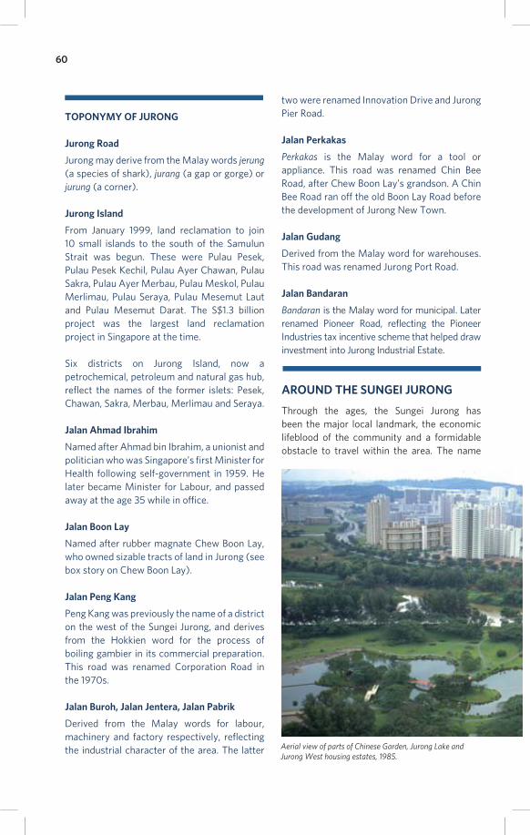
Aerial view of parts of Chinese Garden, Jurong Lake and Jurong West housing estates, 1985.

61
Jurong itself may have its roots in the river;
an 1828 survey map, one of the fi rst in the
colonial period to feature the name, shows the
Sungei Jurong. The earliest known pictorial
representation of Jurong is of the river, a
lithograph by the artists of the Perry Expedition
on the American East India Squadron (See
Early accounts of Jurong).
The headwaters of Sungei Jurong were also
a place where low-lying marshlands fl ooded
with brackish water during high tides, creating
a small ecosystem unique in Singapore. Flora
and fauna here, including birdlife, would have
been vibrant and rich in biodiversity, and the
area remains a great place to spot seldom seen
birds today.
Before the industrial development of Jurong,
crocodiles were a common sight with travellers
crossing the Sungei Jurong noting up to 12
crocodiles on its mudbanks. Old-timers of
Kampong Tebing Terjun told the story of a
midwife who was summoned to a night birth
in Kampong Sungei Attap across the Sungei
Jurong. In her haste to reach the delivery in
time, she tried to help the boatman by using
hands to paddle the waters. Like lightning,
a crocodile snapped off her hand, and the
unfortunate woman was unable to continue her
profession as a midwife. As late as the 1980s,
there were signs in the Chinese and Japanese
Gardens warning of crocodiles.
The Chettiar community in Singapore is more
commonly associated with money lending,
but a number of Chettiars also invested in
plantations and property. In the early 20th
century, Chettiar families owned two prominent
rubber estates adjacent to the Sungei Jurong,
the Arunachalam Chettiar and Chithambaram
Chettiar estates at the 11th and 12th milestones
of Jurong Road. Other Chettiars are also
known to have owned pineapple and rubber
plantations in Jurong.
From at least the early 20th century, a string of
kampongs existed on both banks of the Sungei
Jurong. Kampong Tanjong Balai stood at the
mouth of the river, while Kampong Java Teban
was on the east bank and villagers there ferried
passengers travelling on the old West Coast
Road across the river by boat.
Near the river’s macabre-sounding tributary
of Sungei China Mati, also on the east bank,
was Kampong Tebing Terjun. Finally, Kampong
Sungei Jurong was at the 11th milestone, near
the river’s headwaters.
Chettiar moneylenders in their offi ce, 1960s.

62
JURONG LAKE
During the development of the industrial town
in the 1960s, EDB planners decided to convert
the Sungei Jurong into a lake, rendering it
easier to provide water for industrial purposes
and create social and leisure amenities around
the water. The upper section of the river
was dammed in 1971, creating Jurong Lake.
Rainfall in Jurong East and Jurong West is now
channelled to the lake via canals and drains,
turning it into a reservoir.
Jurong Lake Park was constructed on the west
bank of the lake, while the Chinese Garden
and Japanese Garden were established on two
man-made islets. A third islet forms part of the
Jurong Country Club golf course.
The Nature Society of Singapore has catalogued
some 123 species of birds in the Jurong Lake
area, including rarely seen birds such as the
Grey-headed fi sh eagle, which breeds here and
is nationally threatened.
For more on the recreational activities such
as fi shing available at Jurong Lake, as well as
the natural heritage of the area, please visit
http://www.abcwaterslearningtrails.sg/web/
jurong-lake.php
CHINESE GARDEN AND JAPANESE GARDEN
These two gardens are best remembered as
well-loved locations for wedding photography
in the 1970s and 1980s. The Chinese Garden
has also hosted Chinese New Year and
Mid-Autumn Lantern Festival celebrations.
Designed by Taiwanese architect Professor
Yu Yuen-Chen, the 11.3ha Chinese Garden
(Yu Hua Yuan) was built between 1971
and 1975. Its design principles were based
on classical northern Chinese imperial
architecture, in particular the Song Dynasty
period (960-1279). Its major features include
ornate bridges, pavilions and a seven-storey
pagoda, some of which were inspired by the
Summer Palace in Beijing.
The Chinese Garden was opened by Minister
for Finance Hon Sui Sen on 18 April 1975 and
drew half a million visitors in its fi rst eight
months. Later additions to the garden include
the Bonsai Garden and the Live Turtle and
Tortoise Museum. The museum houses more
than 1,000 tortoises and turtles of some 50
species, including the rare Snake-head Turtle,
Spider Tortoise and the six-legged Asian Brown
Tortoise. For more information, please visit
http://www.turtle-tortoise.com.
Jointly fi nanced by the Singapore and
Japanese governments, the Japanese Garden
was designed to the aesthetics of gardens
in the Muromachi period (1392-1568) and
the Momoyama period (1568-1615). The
garden was constructed under the direction
of Professor Kinsaku Nakane, a well-renown
fi gure in the design, restoration and scholarship
of Japanese gardens responsible for gardens in
China, the United States of America and Japan.
Featuring distinctly Japanese stone paths
and Toro stone lanterns, rock waterfalls and
a winding stream, the 12.14ha garden was
opened by Minister for Defence Dr Goh Keng
Swee on 16 February 1973. Also known by
Chinese Garden, 1980.
The Chinese Garden at sunset.

63
its Japanese name Seiwaen, the garden also
contained some 500 tons of rocks from Japan
worth more than $150,000 and donated by the
Japanese Chamber of Commerce, as well as
some 5,000 Nishiki koi (carp) in its waters.
JURONG HILL
1 Jurong Hill
The highest ground in Jurong, this hill is also
known by its Malay name Bukit Peropok. Before
the development of Jurong New Town, there
were a series of rivers and tidal swamps at the
foot of Bukit Peropok on its south side, including
Sungei Peropok, Sungei Simpang Pak Chalong
and Sungei Simpang Gunong. Kampong Damar
Darat stood to the hill’s southeast, while other
hills in the area included Bukit Sesop and Bukit
Batu Berandam.
The second wave of transformation of Jurong
in the late 1960s saw the establishment of
recreational spaces and social amenities to
leaven the heavy industrial character of the
area. Parks and lakes were built as part of this
eff ort, and it was decided that 12% of the land
in Jurong Industrial Estate was to be set aside
for green spaces.
In 1968, the Jurong Town Corporation (JTC)
converted Jurong Hill into a park with a sunken
garden, miniature waterfall and streams. A
spiralling Lookout Tower was opened in 1970 at
Mdm Quah Kim Poh’s family having a relaxing day at Jurong Hill.
Co
urt
esy
of
Md
m Q
ua
h K
im P
oh
Jurong Hill remains as a green oasis amidst the industrial estate.

64
the top of the hill, and many remember a
Japanese teppanyaki restaurant here. The tower
off ered visitors panoramic views of Jurong as well
as Malaysia and Indonesia in the distance, and
families fl ocked to the hill as a place to relax and
for children to explore the green spaces.
The hill also hosted a Garden of Fame where
heads of state and other dignitaries planted
trees to commemorate their visits to Jurong
Industrial Estate. Those who have done so
include Chinese leader Deng Xiaoping, British
monarch Queen Elizabeth II, Japanese Crown
Prince Akihito, President Suharto of Indonesia,
Prime Minister of Canada Pierre Trudeau and
President of Singapore Benjamin Sheares.
The fi rst tree here was planted by Princess
Alexandra of the United Kingdom in 1969,
while the last was planted by economic advisor
to Singapore and pioneer of industrialisation
Dr. Albert Winsemius in 1984. A total of 30
trees were planted here between 1969 and
1984, before a lack of space saw a new Garden
of Fame established on the grounds of the
Jurong Town Hall.
JURONG BIRD PARK
2 Jurong Hill
One of the most well-loved places in Jurong,
the Jurong Bird Park is Singapore’s fi rst wildlife
park, and was the brainchild of Dr Goh Keng
Swee. Impressed by a visit to a zoo with a
free-fl ight aviary in Rio de Janeiro in 1967, he
proposed the idea of a bird park for Singapore
at the inaugural meeting of the Jurong Town
Corporation in June 1968.
Jurong Bird Park occupies 20.2ha of land on the
western side of the hill, with the park designed
by John James Yealland, the London Zoological
Society’s Curator of Birds and J. Toovey, an
aviary architect. The park opened on 3 January
1971 at a cost of S$3.5 million.
Today, Jurong Bird Park has over 5,000 birds
of 400 species, and continues to be a popular
attraction for local and overseas visitors. The
largest avian park in the Asia Pacifi c, the park
also includes an avian hospital and an award-
winning Breeding and Research Centre which
off ers visitors a glimpse into the growth
process of the park’s feathered residents. Here,
incubation rooms, nurseries, weaning rooms
and a food preparation room provide a behind-
the-scenes look at the work of avian keepers
and the early stages of a bird’s life.
Other attractions include a nine-storey tall
lory fl ight aviary with nine multi-coloured lory
species, the Waterfall Aviary housing more
than 600 birds, hornbill and toucan exhibits,
as well as habitats for penguins, macaws
and fl amingos. The bird park also carries
out conservation and research programmes,
including a project to increase the numbers of
oriental pied hornbills on Pulau Ubin.
FORMER JURONG REPTILE PARK &
CROCODILE PARADISE
Harking back to the days when gimlet-eyed,
deceptively languid crocodiles basked on river
banks in Jurong, the Jurong Crocodile Paradise
opened in December 1988. One of the main
attractions then was a man who for the benefi t
of visitors, would place a S$10 note in the open
jaws of a 400kg crocodile named Hulk and
retrieve it with his mouth.
Located next to the Jurong Bird Park, the
Crocodile Paradise was built at a cost of S$10
million and housed 2,500 saltwater crocodiles.
Later renamed Jurong Reptile Park, it grew into
the largest such park in Southeast Asia with
more than 50 species of reptiles including
crocodiles, komodo dragons, snakes and
tortoises. The park closed in 2006 and was
remade into a retail and food destination.
An animal presentation held at the Bird Park, 1989.

65
PANDAN RESERVOIR AND SUNGEI PANDAN
Accessible from West Coast Road or
Jalan Burroh
Before the industrialisation of Jurong,
swampy ground around the Sungei Jurong
and Sungei Pandan provided for the
most productive prawn farming ponds in
Singapore. Prawn ponds here could yield as
much as a ton of the crustaceans per acre,
far higher than ponds elsewhere on the
island. Prawn farming sustained a number of
kampongs and villagers, and continued until
the mid-1960s.
In 1974, the Pandan Reservoir was built by
enclosing the swamps of the Sungei Pandan
estuary with a 6.2km earthern dyke. A tidal
gate was built to allow freshwater from the
river to enter the reservoir, and to loose
excess water into the sea. Raw water from
the reservoir is treated at the Choa Chu
Kang Waterworks before being distributed in
western Singapore.
The reservoir and river also serve as
recreation sites, with the mouth of the
Sungei Pandan having hosted the Republic of
Singapore Yacht Club (RYSC) between 1966
and 1999. The RYSC was established in 1826
as the Singapore Yacht Club and is the oldest
recreational or social club in Singapore, and
the fi rst yacht club in Asia. In 1999, it moved
to West Coast Ferry Road.
Under the Public Utilities Board (PUB)’s
Active, Beautiful, Clean (ABC) Waters
programme, Pandan Reservoir underwent
a renewal with the addition of water sports
facilities. Activities such as canoeing and
kayaking, rowing, sailing, sport fishing, radio
control and electric boat sailing are available
here, and the reservoir’s amenities centre
also houses the Singapore Canoe Federation.
Fringes of mangroves, once ubiquitous in the
area, remain at the mouth of Sungei Pandan.
These hubs of biodiversity are homes to a wide
range of birds and sea animals (see page 13).
FORMER JURONG DRIVE-IN CINEMA
11 Japanese Garden Road
From raucous, generator-powered open-
air cinemas in the kampongs to glamourous
theatres in town, the movies have always
occupied a special place in the hearts of
Singaporeans. Mention Jurong and many fi lm
fans will recall the former open-air cinema on
Yuan Ching Road.
The Jurong Drive-In Cinema, run by Cathay
Organisation, was the fi rst and only drive-in
theatre in Singapore. The cinema opened on 14
July 1971 and movie lovers cruised in to catch
the British comedy Doctor in Trouble. As the
confi nes of the car provided a more romantic
and private movie viewing experience than the
usual theatres, the Drive-In proved to be a hit
with young adults and couples.
Teban Garden and Pandan Garden estates overlooking the Pandan Reservoir.

66
Accommodating some 900 cars and 300
people in the gallery in front of the elevated,
tilted 14.3m by 30.4m screen, Cathay ran
screenings at 7pm and 9.30pm each day.
Tickets cost $2 for adults and $1 for children,
and movie soundtracks were played over
899 standing speakers as well as individual
speakers attached to each car.
Ann Tan (b. 1963) remembered her experience
watching a fi lm at the drive-in cinema:
“The most memorable thing is that before the movie starts, the fi eld near the screen would be where motorists race with one another… They would compete to see whose engine is better and the loudest. Usually we would reach slightly earlier and watch them compete, but they would all quieten down when the show was starting.”
One of the most popular movies shown at
the Jurong Drive-In was 1971’s The Big Boss,
starring Bruce Lee. The fi lm broke the Drive-
in’s box offi ce record, taking in $12,000 in one
night. Lam Chun See (b. 1952) recalled:
“This movie was such a big hit that all the tickets were sold out in the regular theatres in town; and so in desperation, my brothers and I headed for the Jurong Drive-In.”
While the novelty of the Drive-In drew large
crowds early on, a host of factors detracted
from the viewing experience. The sound system
was poor and handling gatecrashers and unruly
audience members proved to be a headache for
the management, especially when there was a
long line of cars waiting to enter the cinema.
By the 1980s, attendances had dwindled to
some 200 viewers each night. Jurong residents
also complained of motorcycle riders illegally
using the Drive-In’s grounds for circuit racing
after the theatre had closed for the night.
However, the fi nal nail in the coffi n for the
cinema was the widespread availability of
pirated videotapes. Cathay closed the Jurong
Drive-In on 30 September 1985, with only
50 cars present at the fi nal two screenings.
The former cinema grounds were later
occupied by the Fairway Club.
FORMER TANG DYNASTY CITY
Junction of Yuan Ching Road and
Jalan Ahmad Ibrahim
In the late 1980s, there were eff orts by a
number of parties to capture a slice of the
movie-making business from Hong Kong,
which was to be handed over by the British to
China in 1997. One of these projects was the
Tang Dynasty City, built on 12ha of land to the
west of Jurong Lake in 1989.
The Jurong Drive-In Cinema on opening night, 14 July 1971.
Families buying ice-cream from a vendor at the cinema.
Families buying ice-cream from a vendor at the cinema.
Co
urt
esy
of
Md
m C
hia
an
d M
r Le
e

67
Conceived and fi nanced by Hong Kong tycoon
Deacon Chiu, Tang Dynasty City positioned
itself as a theme park recreating Chang’An
(now Xian), the ancient Chinese capital of the
illustrious Tang Dynasty period (CE 618-907).
Notable features here included a replica of the
Great Wall of China surrounding the park, life-
sized replicas of terracotta warriors and Tang-
style landscaping.
The park was to also contain three fi lm studios, to
make use of the period architecture and locations
for movies and television series. However, these
facilities were never completed and little fi lm
production took place here other than occasional
appearances in local television dramas.
The project cost more than S$100 million and
opened in January 1992. While Chiu expected
around 900,000 visitors each year, the park
never became a big draw due to high admission
prices and attractions that did not appeal to
either tourists or locals. Tang Dynasty City
closed in 1999 and after a number of aborted
attempts at reviving it with a new concept, the
park was demolished in 2008.
SCIENCE CENTRE SINGAPORE
15 Science Centre Road
The roots of the Science Centre Singapore
lie in the decision to concentrate focus of the
National Museum of Singapore on art and
history in 1969. Science and technology were
also important fi elds for a nation aspiring to
move up the industrial value chain, and an
institution to educate and inspire the public in
these areas was vital.
Parliament passed the Science Centre act
in 1970 and a design competition for the
centre was won by local fi rm Raymond Woo
and Associates Architects. Their design
was described variously as a spaceship, an
inverted cup or a moon buggy, and a 10-acre
site in Jurong East chosen to house the S$20m
Science Centre Singapore.
Offi cially opened on 10 December 1977 by Dr
Toh Chin Chye, the Minister for Health and
former Minister for Science and Technology,
the Science Centre Singapore became the fi rst
public education and exhibition institution of
its sort in Singapore. It was also one of the fi rst
of such facilities in Asia. The Science Centre
Singapore aimed to showcase exhibitions
on the physical, life and applied sciences,
technology and industry, thereby promoting
and inculcating a love for scientifi c learning.
The Science Centre’s 14 galleries house
more than a thousand exhibits that have
utilised interactive interfaces and inventive
presentation techniques to educate and
entertain. More than 29 million have visited
since its opening. The centre has also used
outreach activities, especially targeting
students and the young, to creatively explain
scientifi c concepts and stimulate imagination.
In 1979, the International Council of Museums
declared the Science Centre Singapore to be one
of the top institutions of its kind in the world. Later
additions to the centre have included the Omni-
Theatre, Kinetic Garden, the Marquee (to host
events and functions) and an Annexe Building for
exhibitions and conferences.
The Singapore Science Centre.
Then Minister for Environment, Mr Ong Pang Boon, toured the Science Centre’s Eco Garden during its offi cial opening, 1977.
68
RELIGIOUS INSTITUTIONS IN JURONG
As the new Jurong took shape and the
population of the area grew, religious
institutions of the various faiths were
established. Some were incarnations of the
suraus, temples and churches that served the
villagers of old Jurong, while others were fresh
arrivals to the area
MASJID HASANAH
492 Teban Gardens Road
This mosque has its roots in the 1960s
resettlement of kampong residents from the
islands that now make up Jurong Island. These
were Pulau Ayer Chawan, Pulau Merlimau,
Pulau Sakra, Pulau Seraya, Pulau Mesemut
Laut, Pulau Mesemut Darat, Pulau Pesek, Pulau
Pesek Kechil and Pulau Meskol.
Along with the kampongs, other community
buildings on the islands including suraus
(prayer houses) were demolished for industrial
redevelopment. To rehouse and compensate
the villagers, the Jurong Town Corporation
(JTC) provided kampong houses in Teban
Gardens.
In the late 1960s, the signifi cant Muslim
population in Jurong had to make their way to
Masjid Hussein Sulaiman, in Pasir Panjang for
Friday prayers. The need for a mosque in Jurong
was clear, and the JTC funded the construction
of Masjid Hasanah to replace the old suraus of
the islands. The brick and timber mosque was
completed in 1971 and was the fi rst full-fl edged
mosque in Jurong.
The surrounds of Masjid Hasanah
changed from kampong houses
to Housing & Development
Board flats in the 1980s, and the
community felt that a rebuilding
of the mosque was in order. In
1989, the community raised
S$1.4 million and the rebuilding
project commenced.
Construction delays and a
fi re prolonged the rebuilding
period, and additional fi nancial
and material support was also
lent by the Majlis Ugama Islam
Singapura (MUIS) and 13 other
mosques in Singapore as the cost
of the rebuilding had risen to S$6
million. Masjid Hasanah reopened
on 19 May 1996.

69
TONG WHYE TEMPLE
212 Jurong East Street 32
This temple that has stood in Jurong for more
than eighty years bears a heritage carried
across the South China Sea. Established in
1932 by Hokkien migrants from southern Fujian
in China, Tong Whye Temple is named after a
temple in their hometown of Quanzhou.
To invoke divine protection for the perilous
journey by ship to Nanyang, or what the
Chinese called Singapore, the Quanzhou
migrants carried a statue of Guan Di Shen Jun
(Guan Yu, a general of the Three Kingdoms
period of AD 220-280 who was deifi ed) and
incense from the original Tong Whye Temple.
Arriving in Singapore, the Quanzhou villagers
settled at the 10.5 milestone of Jurong Road,
and the Guan Di Shen Jun was installed on an
altar in an attap house. A permanent temple
between two farms owned by the Hu family
was built in 1932 to house the deity statue, and
named Tong Whye Temple. Another temple of
the same name was also established in Geylang
by others from the same village in Quanzhou.
A stage for Chinese opera was built nearby, and
the Pei De village school was established next to
the temple in 1946. The school had close to 500
students in its heyday, but closed in the 1980s.
One of the most signifi cant days celebrated by
the temple is Guan Di Shen Jun’s birthday on the
24th day of the sixth month of the lunar calendar.
Tan Kim Leong, a temple offi cial, recalled:
“In the past, whenever it was Guan Di Shen Jun’s birthday, the whole kampong turned up for the celebrations. People would bring offerings of
chickens and ducks to the temple. It was bustling and lively, and up to a thousand people turned up to watch the operas.”
In 1967, the temple was moved to Track 17,
Jurong Road to accommodate road widening.
Track 17 was redeveloped for housing in 1981
and the temple moved to its present location.
TUAS TUA PEK KONG TEMPLE
118 Boon Lay Drive
Home to Chinese and Malay fi shermen, Tuas
Village was one of the earliest settlements in
the area having been founded on the banks of
the Sungei Tuas in the 1880s. Fishermen here
used traditional net fi shing methods, with the
name of the village derived from the Malay
word menuas or hauling up a net. At its peak,
hundreds of boats plied the waters between
western Singapore and Indonesia, bringing
their catch to Tuas or Pasir Panjang.
In 1942, 39 residents of Tuas Village were killed
by invading Japanese forces. This spread fear
among the 2,000 villagers, and the Chinese in
Tuas - some 70% Teochew and 30% Hokkien -
sought spiritual succour. A group of eight villagers
founded the Tua Pek Kong Keng in an attap hut,
enshrining Tua Pek Kong, the God of Prosperity
worshipped by Chinese in Southeast Asia.
The temple was moved to a brick and tiled
roof building in 1954, before the industrial
redevelopment of Tuas changed the landscape
of the area in the 1960s and 1970s. Many of
the villagers were resettled in Boon Lay, and
the Tua Pek Kong temple was reopened at 118
Boon Lay Drive in 1987.
The interior of Tong Whye Temple.
The prayer hall of the Tuas Tua Pek Kong Temple.

70
ARULMIGU MURUGAN TEMPLE
281 Jurong East Street 21
Established in 1993 and completed and
consecrated in 2004, the Arulmigu Murugan
Temple is the only Hindu temple in the Jurong
area. The temple was built through the eff orts of
the community, which raised S$4 million towards
its construction. At its consecration in 2004, the
temple drew more than 15,000 devotees.
Parts of the temple, including the intricately
sculpted rajagopuram (the temple’s main
tower) in the Dravidian style, were worked
by temple craftsmen from India. Today, the
Arulmigu Murugan Temple services around
1,000 worshippers each day, with the fi gure
rising to 3,000 over the weekends and higher
during festivals like Deepavali. Most devotees
are Hindus from the Jurong, Yuhua, Teban and
Boon Lay areas, while there are also non-Hindu
Chinese worshippers.
The temple’s presiding deity is Lord Murugan,
to which a six-foot statue is dedicated, and
festival days are in his honour. Other deities
enshrined here include Sri Vinayagar, Sri
Durga, Sri Indumban, Sri Ambal, Sri Sivan, Sri
Anjenayar and Sri Muneeswaran.
This is the only Hindu temple in Singapore to
feature a yagasalai, a permanent fi xture for
prayers involving the use of fi re. These prayers
are performed for between 10 to 12 days
each month. The Arulmigu Murugan Temple
also distributes food to the needy on the last
Saturday of each month and conducts religious
classes for hymn recitals.
CHURCH OF ST FRANCIS OF ASSISI
200 Boon Lay Avenue
In the 1950s, Catholics in the Jurong area had
to travel some distance to St Joseph’s Church at
the junction of Chestnut Drive and Upper Bukit
Timah Road. Fr. Joachim Teng, the parish priest
of St Joseph’s, then established the Chapel
of Fatima in Tuas Village in 1958. This was a
single-storey wooden chapel accommodating
some 100 worshippers. The fi rst priests at the
chapel, including Fr. Thomas di Pasquale, were
Italian Franciscans who preached in Mandarin
to villagers, distributed food and provisions to
the needy and provided free medical care.
Another chapel, the Taman Jurong Chapel, was
set up in 1967 in a shophouse along Hu Ching
Road to cater to workers in the industrial estate,
including shipyard and plywood industry workers
from Malaysia, India and the Philippines. Two
years later, a third chapel was built at Gek Poh
Road near the 14th milestone of Jurong Road,
before urban redevelopment in the 1970s saw
the government acquire the land on which the
Gek Poh and Tuas chapels were located.
Gek Poh Chapel and Taman Jurong Chapel
were then merged to form the Church of St
Francis of Assisi, with the church opening at
Boon Lay Place in 1976. With its ties to Our
Lady of Fatima (a title for the Virgin Mary) and
St. Francis of Assisi, the church is among the
few Catholic churches in Singapore to have two
Feast Days dedicated to canonised saints.
The church was renovated and expanded in
2002, and today hosts a congregation of about
3,000. It holds services in English, Mandarin,
Tamil, Malayalam and Tagalog, and continues its
tradition of social service by off ering free lunches
on every day of the week except Sunday.

71
OUR MUSEUM @ TAMAN JURONG
We end our trail of Jurong with the fi rst
community museum in Singapore,
Our Museum@Taman Jurong,
a vibrant space for community memories,
heritage and art. Located at the heart of the
Taman Jurong, the museum prominently
features elements of Jurong’s history and
culture in its exhibitions.
The museum’s exhibitions are co-created with
Jurong residents and community curators,
schools and community organisations. Previous
exhibitions have included art installations of
residents and their connection to the changing
landscape of Jurong, an imagined day in
Jurong in the 1970s and a showcase of popular
recreational sites in the area through memories
of its residents.
Apart from the rich local history and heritage that the museum features, it also has programmes for children to try their hands at fun and interactive worksheets and craft activities.
Our Museum@Taman Jurong is a collaboration between the National Heritage Board, Taman Jurong Citizens Consultative Committee, Taman Jurong Community Arts and Culture Club and the People’s Association.
Our Museum@Taman Jurong is open every Monday to Friday from 3pm to 9pm, every Saturday from 10am to 9pm and Sundays from 10am to 6pm and is located at the Taman Jurong Community Club. The museum is closed on public holidays. Admission to the museum is free. For more information, please visit http://www.facebook.com/OMATTJ.
Visitors enjoying an exhibition, “Play at TJ: Our Memories of Recreational Sites in Taman Jurong”, at Our Museum@Taman Jurong, 2015
1 Yung Sheng Road

72
Books and journals
40 years and 40 stories of National Service, p. 38. (2007).
Singapore: Landmark Books.
Ann Kway Association. (1982). Souvenir magazine of the 60th anniversary of the Ann Kway Association 1922-1982.Singapore: Ann Kway Association.
Arulmigu Murugan Temple. (2004). Commemorative magazine. Singapore: Arulmigu Murugan Temple.
Baker, J. (2005). The eagle in the Lion City: America, Americans and Singapore. Singapore: Landmark Books.
Barnard, T. (2014). Nature contained: Environmental histories of Singapore. Singapore: NUS Press.
Burdon, T. (1955). The fi shing industry of Singapore. Singapore: Donald Moore.
Chapman, F. S. (1997). The jungle is neutral. Singapore:
Times Books International.
Chan, K. L. (1994, October). Operation Gustavus:
Clandestine network of Force 136. Pointer.
Cheong, C. (1993). New frontiers: 25 years of the Jurong Town Corporation. Singapore: Times Editions.
Chia, L. S. (1988). The coastal environmental profi le of Singapore. Manila: International Center for Living Aquatic
Resources Management.
Church of St. Francis of Assisi. (1976). Jurong St Francis of Assisi opening day souvenir issue. Singapore: Church of
St. Francis of Assisi.
Corner, E. J. H. (1978). The freshwater swamp-forest of
South Johore and Singapore. Gardens’ Bulletin Supplement, 1. Singapore Botanic Gardens.
De Koninck, R., Drolet, J. & Girard, M. (2008). Singapore: An atlas of perpetual territorial transformation. Singapore:
NUS Press.
Dunlop, P. (2000). Street names of Singapore. Singapore:
Who’s Who Publishing. Economic Development
Board. (1968). The Jurong story. Singapore: Economic
Development Board.
Frost, M. R. & Balasingamchow, Y-M. (2009). Singapore: A biography. Singapore: Editions Didier Millet.
Gibson-Hill, C. A. (1954). Singapore: Notes on the
history of the Old Strait, 1580-1850. Journal of the Malayan Branch of the Royal Asiatic Society. Singapore:
JMBRAS.
Goh, K. S. (1972). The economics of modernization. Singapore: Marshall Cavendish.
Gough, R. (2000). SOE: Singapore 1941-42. Singapore:
SNP Editions.
Hack, K., Margolin, J-L & Delaye, K. (Eds). Singapore from Temasek to the 21st century: Reinventing the global city. Singapore: NUS Press.
Huff , W. G. (1994). The economic growth of Singapore: Trade and development in the twentieth century. New York:
Cambridge University Press.
Humphrey, J. W. (1986). Geographic analysis of Singapore’s population. Singapore: Department of Statistics.
Jackson, J. C. (1968). Planters and speculators: Chinese and European agricultural enterprise in Malaya, 1786-1921. Kuala Lumpur: University of Malaya Press.
Kartini, B. Y. (1986). Vanishing landscapes: Malay kampungs in Singapore. Singapore: National University of
Singapore.
Koh, T., et al. (Eds.). (2006). Singapore: The encyclopedia. Singapore: Editions Didier Millet.
Kong, L. (2007). Singapore hawker centres: People, places, food. Singapore: National Environment Agency.
Lee, P. P. (1974). Chinese society in nineteenth and early twentieth century Singapore: A socioeconomic analysis. Ithaca: Cornell University.
Lim, I. (1999). Secret societies in Singapore. Singapore:
Singapore History Museum.
Loh, G. (1995). Jurong Shipyard Limited: What’s behind the name? Singapore: Times Academic Press.
Low, S. C. (1955). Gambier and pepper planting in Singapore, 1819-1860. Singapore: University of Malaya.
Makepeace, W., Brooke, G. E, & Braddell, R. J. S. (1991). One hundred years of Singapore, Vol. 2. Singapore: Oxford
University Press.
Menon, R. (1995). To command: The SAFTI Military Institute. Singapore: Landmark Books.
Murfett, M, Miksic, J., Farrell, B. & Chiang, M. S. (2011).
Between two oceans: A military history of Singapore from 1275 to 1971. Singapore: Marshall Cavendish.
National Archives of Singapore. (1993). Kampong days: Village life and times in Singapore revisited. Singapore:
National Archives of Singapore.
Oral History Department. (1990). Recollections: People and places. Singapore: Oral History Department.
Savage, V. & Yeoh, B. (2013). Singapore street names: A study of toponymics. Singapore: Marshall Cavendish.
Sandhu, K. S. & Wheatley, P. (1989). Management of success: The moulding of modern Singapore. Singapore:
Institute of Southeast Asia Studies.
BIBLIOGRAPHY
73
Sopher, D. E. (1977). The sea nomads: A study of the maritime boat people of Southeast Asia. Singapore:
National Museum Publication.
Singapore guide and street directory. (1966). Singapore:
Ministry of Culture.
Singapore Hokkien Huay Kuan. (2006). Guardian of the South Seas: Thian Hock Keng and Singapore Hokkien Huay Kuan. Singapore: Singapore Hokkien Huay Kuan.
St John’s Chapel. (2004). St John’s Chapel: Celebrating 120 years of God’s faithfulness. Singapore: St John’s Chapel.
Tan, S. S. (2007). Goh Keng Swee: A portrait. Singapore:
Editions Didier Millet.
Tan, Y. S., Lee, T. J. & Tan, K. (2009). Clean green and blue: Singapore’s journey towards environmental and water sustainability. Singapore: ISEAS Publishing.
Tong Whye Temple. (2010). A commemorative issue of the 78th anniversary of the founding of Tong Whye Temple and the 30th anniversary of the conclusion of renovations (Mandarin). Singapore: Tong Whye Temple.
Tuas Tua Pek Kong Keng Management Council. (2012).
Tuas Tua Pek Kong Keng: A commemorative issue for the 68th anniversary of the birth of the temple and the 25th anniversary of the conclusion of temple renovations (Mandarin). Singapore: Tuas Tua Pek Kong Keng.
Turnbull, C. M. (2005). A history of modern Singapore 1819-2005. Singapore: NUS Press.
Uhde, J. & Ng, Y. (2010). Latent images: Film in Singapore. Singapore: Ridge Books.
Wong, H. S. (2010). Singapore through 19th century prints and paintings. Singapore: Editions Didier Millet.
Wong, Y. C. (2007). Singapore 1:1: Island. Singapore:
Urban Redevelopment Authority.
Yee, A. T. K. et al. (2010). The present extent of mangroves in Singapore. Nature in Singapore, 3, p. 139-145. Singapore:
National University of Singapore.
York, F. W. & Phillips, A. R. (1996). Singapore: A history of trams, trolleybuses and buses. Surrey: DTS Publishing.
Yuen, C. et al. (1996). Jurong journeys. Singapore: The
Oracle Works.
Newspaper articles
The Business Times (1977)
The Singapore Free Press (1837, 1854, 1848, 1887, 1931,
1948, 1951-52, 1957, 1959)
The Straits Times (1854-55, 1883, 1903-04, 1908, 1936,
1946, 1950, 1963, 1965-66, 1968-71, 1973, 1975, 1977-
80, 1986-88, 2001, 2003, 2006-07, 2011, 2013-14)
Oral history interviews
Haji Saleh bin Abdul Wahab (Interview with National
Heritage Board, 2014).
Haji Shafi e Mohammad Arif (Interview with National
Heritage Board, 2013).
Kamsani bin Haji Alias (Interview with National Heritage
Board, 2014).
Lee, Karen (Interview with National Heritage Board,
2014).
Lim Ho Hup (Interview of Oral History Centre, National
Archives of Singapore, Accession No. 002247, 2002).
Lim Kwang Boon (Interview of Oral History Centre,
National Archives of Singapore, Accession No. 000917,
1988).
Mane, Francis (Interview with National Heritage Board,
2013).
Pillay, J. Y. (Interview of Oral History Centre, National
Archives of Singapore, Accession No. 001583, 1995).
Ng, Benson (Interview with National Heritage Board,
2013).
Ng Lee Kar (Interview of Oral History Centre, National
Archives of Singapore, Accession No. 000165, 1982).
Soh Ah Choo (Interview with National Heritage Board,
2015).
Tan, Ann (Interview with National Heritage Board,
2014).
Tan I Tong (Interview of Oral History Centre, National
Archives of Singapore, Accession No. 002198, 1999).
Tan Kim Leong (Interview with National Heritage Board,
2013).
Tan Kim Wah (Interview of Oral History Centre,
National Archives of Singapore, Accession No. 000212,
1983).
Tan Suan Chyang (Interview with Taman Jurong
Community Club, 2013).
Tan Teck Yoke (Interview with National Heritage Board,
2012).
Too Peng San (Interview with National Heritage Board,
2013).
Woo Lee Tuan (Interview with Taman Jurong
Community Club, 2013).

74
Online pages
Soo, S. E. (n.d.). Interview with Toh Ah Lian. Retrieved
from www.hsse.nie.edu.sg/staff /blackburn/
oralhistoryKampongtoHDBlife.doc
Masjid Hasanah. www.hasanah.org.sg
Church of St Francis of Assisi.
www.sfa-parish.org.sg/history
Agri-Food & Veterinary Authority of Singapore.
www.ava.gov.sg
Ministry of Defence. www.mindef.gov.sg
Jurong Bird Park. www.birdpark.com.sg
The Live Tortoise and Turtle Museum.
www.turtle-tortoise.com
Science Centre Singapore. www.science.edu.sg
Singapore Infopedia. infopedia.nl.sg
Remember Singapore.
remembersingapore.wordpress.com
The Long and Winding Road.
thelongnwindingroad.wordpress.com
Nature Society Singapore. www.nss.org.sg
Good Morning Yesterday.
goodmorningyesterday.blogspot.sg
CREDITSArmy Museum of Singapore
Jurong Bird Park
JTC Corporation
Rulang Primary School
Science Centre Singapore
Singapore Botanic Gardens
Singapore Discovery Centre
St John’s Chapel
Taman Jurong Community Club
Mr Benson Ng
Mr Chew Kheng Chuan
Mdm Chia Joon Lang
Mr Francis Mane
Mr Haji Shafi e Mohammad Arif
Mdm Karen Lee
Dr Lai Chee Kien
Mr Lee Ah Ba
Mr Liaw Boon Eng
Mdm Ong Chwee Im
Mdm Quah Kim Poh
Ms Sandy Lee
Mdm Soh Ah Choo
Mr T Rajantharan
Mr Tan Kim Leong
Mr Tan Teck Yoke
Mr Too Peng San
Mrs Yulianti Tan
PHOTO CREDITS:Collection of National Museum of Singapore - p9, p11,
p14, p30, p32, p57
National Heritage Board - p7, p13, p29, p33, p43, p44,
p51, p55, p62, p61, p65, p66, p67, p68, p69, p70, p71
National Archives of Singapore - p4, p6, p10, p15,
p17, p18, p19, p20, p21, p22, p23, p27, p28, p29, p30,
p35, p36, p37, p39, p46, p49, p51, p52, p58, p61,
p62, p66, p67
The Straits Times © Singapore Press Holdings.
Reprinted with Permission. - p8, p16, p17, p27, p28,
p32, p36, p45, p56
JTC Corporation - p4, p38, p41, p54
Singapore Tourism Board - p60
Army Museum of Singapore - p52
Singapore Discovery Centre - p53
National Parks Board - p53

75
>> PROJECT TEAM
Josephine Sin
Stefanie Tham
Lawrence Low
>> PRIMARY RESEARCHERS AND WRITER
Singapore History Consultants
>> COPYWRITER AND FURTHER RESEARCH
Alvin Chua
>> DESIGNER
Oxygen Studios Designs Pte Ltd
2EZ Asia Pte Ltd
>> PHOTOGRAPHER
Alex Heng
NO PART OF THIS PUBLICATION MAY BE
REPRODUCED, STORED IN A RETRIEVAL SYSTEM, OR
TRANSMITTED IN ANY FORM OR BY ANY MEANS,
ELECTRONIC, MECHANICAL, PHOTOCOPYING,
RECORDING OR OTHERWISE, WITHOUT THE PRIOR
PERMISSION OF THE PUBLISHER.
FOR ALL COPYRIGHT MATTERS, PLEASE CONTACT
THE NATIONAL HERITAGE BOARD. EVERY EFFORT HAS
BEEN MADE TO ENSURE THAT THE INFORMATION
CONTAINED IN THIS BROCHURE IS ACCURATE AT
THE TIME OF PUBLICATION. NATIONAL HERITAGE
BOARD SHALL NOT BE HELD LIABLE FOR ANY
DAMAGES, LOSSES, INJURY OR INCONVENIENCE
ARISING IN CONNECTION WITH THE CONTENTS OF
THIS BROCHURE.
PUBLISHED BY THE NATIONAL HERITAGE BOARD IN
APRIL 2015. REPRINTED IN JUNE 2016.

76
“60 stalls” (六十档) at Yung Sheng Road and “Market I” (p. 44)3 Yung Sheng Road
Yung Sheng Food Centre, popularly called “60 stalls” (六十档), was the fi rst hawker centre built by the Government to house resettled road-side hawkers in the early 1970s. Together with the old “Market I”, it was redeveloped to form today’s Taman Jurong Market and Food Centre in 2005.
Army Museum of Singapore (p. 52)520 Upper Jurong Road
The Army Museum of Singapore (ARMS) is situated around a serene lake in the SAFTI Military Institute compound. Opened in September 2007 to coincide with the 40th year of National Service celebrations, the museum preserves the heritage of the Singapore Army, honours the contributions and celebrates the experiences of our soldiers. The exhibition area comprises 8 galleries that showcase the Army’s development since its formative years.
Arulmigu Murugan Temple (p. 70)281 Jurong East Street 21
Established in 1993, the Arulmigu Murugan Temple is the only Hindu temple in the Jurong area. It is also the only Hindu temple in Singapore to feature a yagasalai, a permanent fi xture for prayers involving the use of fi re.
Chew Boon Lay and the Peng Kang area (p. 47)Area encompassing Boon Lay Way, Jalan Boon Lay, Boon Lay Drive and Boon Lay AvenueJurong was formerly covered with plantations, and Chew Boon Lay was a famous rubber plantation owner in Jurong. In the early 1900s, rubber planting took off and replaced gambier, which was once so popular that a district of Jurong was named ‘Peng Kang’, which may have come from a Malay term for boiling gambier leaves.
Chinese Garden (p. 62)1 Chinese Garden Road
Best remembered by locals as a location for wedding photography, the garden was inspired by classical northern Chinese imperial architecture. Its iconic features include ornate bridges, pavilions and a seven-storey pagoda.
Church of St Francis of Assisi (p. 70)200 Boon Lay Avenue
The Church of St Francis of Assisi was formed with the merging of the two Catholic chapels in early Jurong: Gek Poh Chapel and Taman Jurong Chapel. The church holds services in English, Mandarin, Tamil, Malayalam and Tagalog.
Former Jurong Drive-In Cinema (p. 65)Formerly at 11 Japanese Garden Road
Opened in 1971, the former drive-in cinema was the first of its kind in Singapore, and was popular amongst couples. It closed in 1985 and the former cinema grounds are occupied by Fairway Club.
Former Tang Dynasty City (p. 66)Formerly at junction of Yuan Ching Road and Jalan Ahmad Ibrahim
Tang Dynasty City was a theme park modelled after Chang’An (now Xi’an), the capital of the Tang Dynasty period. It closed in 1999 and was demolished in 2008, leaving the site unoccupied.
Hong Kah Village (p. 20 & 45)Formerly at 12 milestone, Jurong Road
Located at the 12 milestone until the late 1980s, this village was one of the earliest known Christian villages located in Singapore’s hinterland. The name ‘Hong Kah’ comes from the Hokkien and Teochew term for ‘bestowing a religion’, and is a colloquial name for Chinese Christians. The village no longer exists.
Japanese Garden (p. 62)1 Chinese Garden Road
A joint project by the Singapore and Japanese governments, the Japanese Garden is also known by its Japanese name Seiwaen. The garden features Japanese stone paths, Toro stone lanterns, rock waterfalls and a winding stream.
LIST OF HERITAGE SITES